at roads & streets framework and the transport design … · at roads & streets framework...
TRANSCRIPT
Board Meeting| 24 October 2017 Agenda item no. 11.1
Open Session
AT Roads & Streets Framework and the Transport Design Manual Recommendation That the Board:
i. Note the development of the draft Roads and Streets Framework (RSF) and the draft Transport Design Manual (TDM) to improve strategic guidance on modal priorities for the transport network and the development of place context-sensitive design solutions.
ii. Note that there has been wide engagement with the Council, mana whenua, NZTA and other key stakeholders on the draft Framework and Manual commencing in October 2016 and continuing until September 2017.
iii. Approve the final versions of the Roads and Streets Framework and the Transport Design Manual, which will then be tested and embedded (where appropriate) across the business.
iv. Note that the Roads and Streets Framework and the Transport Design Manual will be brought back to the Board in 12 months for review and update as required.
Executive summary 1. The scale and pace of growth in Auckland combined with increasing intensification and the development of Auckland’s urban areas and
Greenfields is placing increased pressure on an already constrained strategic transport network and limited road space to deliver multi-modal transport objectives. The Auckland region is comprised of 70% rural and 30% urban areas, with the majority of people living and working in the urban area. There is the expectation that Auckland’s roads and streets need to provide for a wider range of benefits for rural and urban areas, including liveability, sustainability and economic growth whilst providing for efficient and safe movement if Auckland is to meet the Mayor’s vision.
2. In response, the draft Roads and Street Framework and Transport Design Manual have been developed as complementary documents. The Framework has been developed to describe and balance the intended strategic and local place and movement functions of roads and streets and the levels of service for the rural and urban users’ perspective, which then informs the Transport Design Manual in providing the design and technical specifications for capital improvement projects and operational expenditure. Both documents when applied together will provide guidance to internal staff (e.g. Council family project teams), external parties (e.g. Government agencies, consultants and developers etc.) about AT’s requirements for the planning, design, construction and vesting of assets that will be managed by AT.
3. The final Roads and Streets Framework and Transport Design Manual (Section 1) is attached. (Attachment 2).

Board Meeting| 24 October 2017 Agenda item no. 11.1
Open Session
Previous deliberations 4. The Customer Focus Committee held on 2 October 2017 proposed that the final versions of the Framework and the Manual be considered at
the AT Board’s 24 October 2017 meeting, and if approved then adopted and implemented across the business.
Strategic context 5. The draft Roads and Streets Framework and the Transport Design Manual are based on best practice approaches and being applied in other
international cities, such as London, Melbourne, Portland and Stockholm. The Framework and Manual have been developed in response to feedback from the Auckland Transport Code of Practice feedback. This included a lack of strategic direction for roads and streets in Auckland and an identified gap in AT’s current documents which have not provided a robust approach to resolve conflicts between different modal priorities and balancing the strategic transport network with the place-making requirements of Auckland’s centres and public spaces.
6. Attachment 1 shows how the Framework and Manual align with Auckland’s plans and policies, providing a link between the Auckland Plan, strategic networks (including ATAP direction) and the design and delivery of the existing and future road and street network. In addition to new capital projects, the Frameworks also help define the strategic direction for short term operational improvements, which are implemented through network operating plans.
7. Both documents have been developed internally and governed by a technical working group reporting to a Steering Group. These groups included AT, NZTA and Auckland Council staff. Case studies, inter-disciplinary working groups and best practice learnings have been used to apply and refine the approach for the Framework and adapt it for an Auckland rural and urban context. Both documents have been subject to internal consultation and feedback from the Council, mana whenua, NZTA and other key stakeholders, and have been further refined as a result.
8. Eleven case studies contributed to the development of the draft Framework in 2016. In 2017, the draft Framework process was used to guide development of future typologies for the city centre. Current projects where the draft Framework and Manual are contributing include Supporting Growth, Manukau Metro Centre, Otahuhu, Onehunga and Henderson town centres, local streets around the East-West Link, the bus priority programme, the 3-year cycling programme, Dominion Rd Mass Transit and HLC projects underway in Northcote and Mt Roskill.
Background 9. The Roads and Streets Framework sets out:
a. The approach and vision b. The framework process to determine the typology and integrate modal priority for different roads and streets (covering rural and urban
areas), and how to apply the tools to support strategic direction and mitigate impacts. Local context and place is established by using all place specific Auckland Council documents, such as structure plans, the Unitary Plan and Local Board Plans. The movement context

Board Meeting| 24 October 2017 Agenda item no. 11.1
Open Session
will be established by existing data and transport documents such Network Operating Plans, traffic modelling data and Corridor Management Plans
c. The detailed description of the nine urban and three rural road and street typologies and expected levels of services d. Key transport / land use metrics for planning liveable, connected neighbourhoods, particularly in Greenfields e. The Annex, describing key functions of roads and street, performance indicators, types of tools, alignment with ATAP/ONRC and modal
priority design features. 10. The Transport Design Manual contains three sections:
a. Design guidance, which includes the design guides, such as the Urban Street & Road Design Guide, Waitakere Ranges Design Guide, Local Paths Design Guide
b. Detailed technical requirements, such as minimum standards, considerations and drawings required to undertake accurate and detailed designs based on a component approach for facilities.
c. Detailed specifications for the supply and construction of materials and products. d. The existing AT Code of Practice was updated to provide a transitionary role until the Transport Design Manual is approved.
11. Please find attached in Attachment 2, the Roads and Streets Framework and Section 1 of the Transport Design Manual. Section 2 and 3 are very detailed technical documents which can be supplied if requested.
External Consultation/Engagement 12. The Council, mana whenua and key stakeholders have provided a strong level of overall support for the Framework and the Manual. Some of
the broad themes emerging from their feedback are presented below: a. The Council and wider Council family were pleased that both documents reflect people and place aspirations better, and would enable
a cultural shift in how AT would design and deliver transport projects to support these local and regional aspirations. Feedback was that it was good that the framework recognised that road space is limited and that it would provide more certainty to developers and a ‘one’ AT approach to roads and streets.
b. Cycling, walking and disability advocates supported the elevation of people / place considerations, better guidance for developers and that the integrated strategic approach clarified place and modal priorities better.
c. NZTA supports the documents in principle, recognising that it is important to consider place and movement and set clear modal priorities. A continuing dialogue with NZTA and MoT on these documents will be important to ensure Government understands the multi-modal and place-sensitive approach and how it can add value to road function classifications, such as ONRC.

Board Meeting| 24 October 2017 Agenda item no. 11.1
Open Session
d. Mana whenua support the inclusion of Te Aranga principles / core Maori values and the focus on local solutions. Better management of storm water quality is a particular focus for mana whenua.
e. Freight stakeholders support the Framework’s ability to help resolve conflicts for road safety, support key freight corridors and consider freight separate from service delivery. Strong support was also given to the view that road space has been looked at.
f. Civil engineering, planning / design contractors believe both documents will provide more project certainty upfront, strengthen links to Council / Local Board plans, and potentially support developers to improve project time / certainty. They suggested an industry user group to test / improve application of these documents over time.
g. Emergency services support the evidence-based approach set out in the Framework, and the need to manage modal conflicts near key fire stations is important. Emergency services are already working closely with ATOC on communication for traffic and incident management.
Next steps 13. Following approval by the Board, both documents will be made available on the AT website in the latter part of November 2017 14. User guidelines will be developed by the end of the Calendar year 15. Training will be rolled out for practitioners, focussing initially on internal AT staff, the Council family and NZPI / IPENZ consultants who do work
for developers.
Attachment Attachment Number Description 1 Auckland context for the Framework and Manual 2 Roads and Streets Framework and the Transport Design Manual (Section 1) – attachment saved in the Resource
Centre in Boardbooks.

Board Meeting| 24 October 2017 Agenda item no. 11.1
Open Session
Document ownership Submitted by Liz Halsted
Head of Innovation, Digital and Sustainability Chris Beasley Principal Technical Specialist Andrew Scoggins Chief Engineer
Recommended by Cynthia Gillespie Chief Strategy and Development Officer Greg Edmonds Chief Infrastructure Officer
Approved for submission David Warburton
Chief Executive
Glossary
Acronym Description NZTA New Zealand Transport Agency ATAP Auckland transport alignment project ATOC Auckland Transport Operations Centre RSF Roads & Streets Framework TDM Transport Design Manual

Board Meeting| 24 October 2017 Agenda item no. 11.1
Open Session
Attachment 1.

1
Roads & Streets Framework and the
Transport Design Manual
Liz Halsted, Strategy & Development & Chris Beasley, Design Office
AT Board Presentation - October 2017
Attachment 2

2
The RASF balances and integrates the
strategic and local place and movement
functions of roads and streets as we are
working to shape our city.
The TDM provides the design and
technical specifications to transform
conditions for all modes and to act as
catalysts for change.
Roads & Streets Framework (RASF) and
Transport Design Manual (TDM) - Overview
People come first. We have been engaging with key stakeholders, including the Auckland
Council family, Local Boards, Manu Whenua, NZTA, Freight Haulage Association. There
has been a strong level of support overall.
3
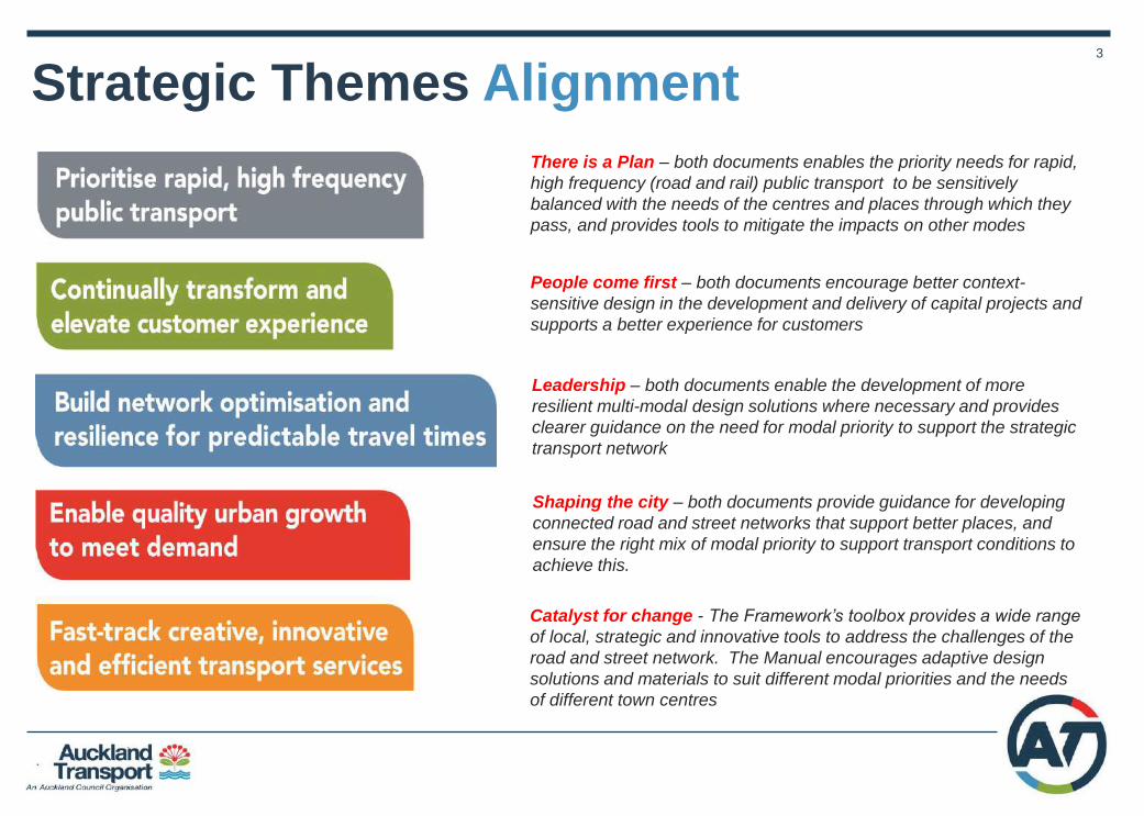
Strategic Themes Alignment
There is a Plan – both documents enables the priority needs for rapid,
high frequency (road and rail) public transport to be sensitively
balanced with the needs of the centres and places through which they
pass, and provides tools to mitigate the impacts on other modes
People come first – both documents encourage better context-
sensitive design in the development and delivery of capital projects and
supports a better experience for customers
Leadership – both documents enable the development of more
resilient multi-modal design solutions where necessary and provides
clearer guidance on the need for modal priority to support the strategic
transport network
Shaping the city – both documents provide guidance for developing
connected road and street networks that support better places, and
ensure the right mix of modal priority to support transport conditions to
achieve this.
Catalyst for change - The Framework’s toolbox provides a wide range
of local, strategic and innovative tools to address the challenges of the
road and street network. The Manual encourages adaptive design
solutions and materials to suit different modal priorities and the needs
of different town centres

4
RASF & TDM – Strategic context
Auckland Plan
Operations &
Maintenance
Transport Design
Manual Design Guidance,
Technical Standards
Roads & Streets
Framework Typologies, Challenges
Modal priority
‘Movement’ ATAP, Network Plans ,
Supporting Growth
The RASF /
TDM bring
‘Place’ &
‘Movement’
together Project
Mandate
Start of
project
(Gate zero)
Strategic Development &
design
End of
Project Delivery & operation
‘Place’ Unitary plan, Centre Plans,
Developments
• RASF integrates the Council family of
strategies and provides the strategic
direction for designing/delivering
improvement projects
• The TDM provides the design and technical
specification to deliver capital improvements
that are aligned to strategic direction
Network Operating Plans

5
Determine the ‘Place’ form & function based on:
1. AC Unitary Plan land use zones / overlays e.g. residential, business, industrial,
mixed use, open space etc.
2. AC centre hierarchy e.g. City centre, Metro centre, Town centre, neighbourhood,
etc.
3. Centre Plans / Area Plans / Panuku Plans that influence future development
4. Private development proposals e.g. future urban and brownfield / SHA proposals
5. Assess significance of the place based on local, neighbourhood, district, sub-
regional, or city wide function.
Determine the ‘Movement’ form & function based on:
1. Road classification and function (e.g. arterial, connector, local road)
2. Strategic network function as outlined in ATAP and AT network plans (e.g. public
transport, freight, cycle, pedestrian, general traffic)
3. Supporting modelling, traffic analysis, network operating plans, safety, speed, etc
4. Assess strategic significance of modes based on role in network
Auckland direction setting documents shape
the typology
6
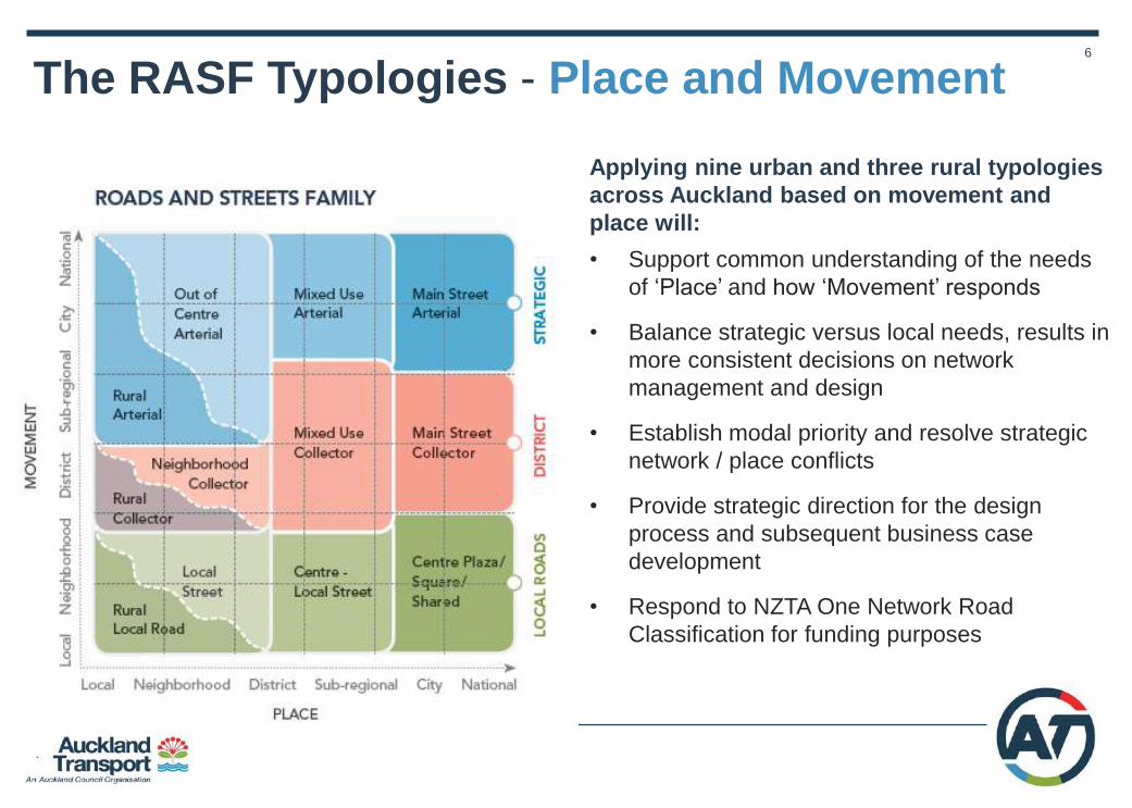
Applying nine urban and three rural typologies
across Auckland based on movement and
place will:
• Support common understanding of the needs
of ‘Place’ and how ‘Movement’ responds
• Balance strategic versus local needs, results in
more consistent decisions on network
management and design
• Establish modal priority and resolve strategic
network / place conflicts
• Provide strategic direction for the design
process and subsequent business case
development
• Respond to NZTA One Network Road
Classification for funding purposes
The RASF Typologies - Place and Movement

7
The Six RASF Challenges
Living Unlocking Moving Providing welcoming and
inclusive places for all which
support vital economic and
community activities . People
focussed.
Improving accessibility and quality
of places identified as areas for
major growth to deliver the homes,
jobs and economic sectors that
Auckland needs .Shaping our City
Helping people, goods and services to get
from A to B and enabling efficient and
reliable movement by a range of different
modes. Reliable and resilient transport
providing integrated transport choices
Functioning Protecting Sustaining Ensuring essential access for
deliveries and servicing and
upgrading utilities, ensure
assets fit for purpose . Resilient
Improving safety and reducing
severity of accidents, particularly
vulnerable road users, and strive to
design out crime. People first.
Reducing emissions from the road network,
supporting greener, cleaner, quieter
streets, strive to improve water quality and
encouraging a healthier more active city
8
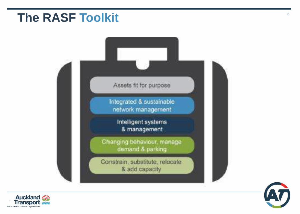
The RASF Toolkit
9
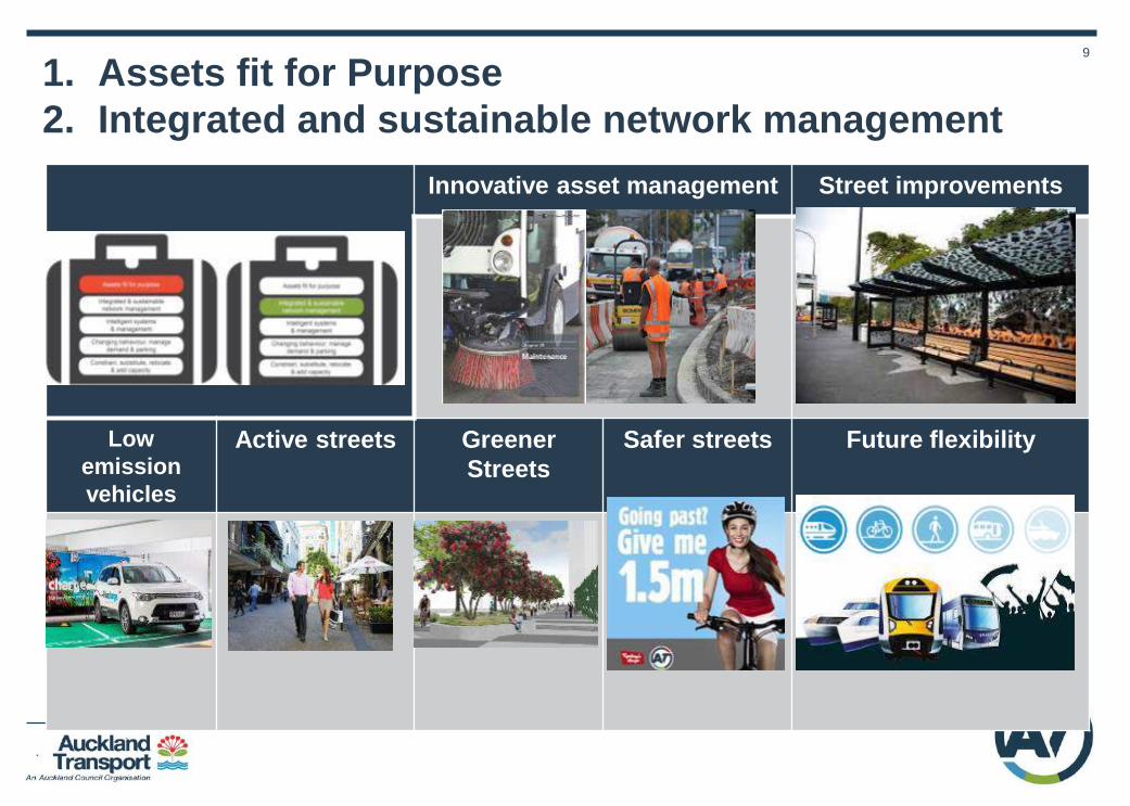
1. Assets fit for Purpose
2. Integrated and sustainable network management
Innovative asset management Street improvements
Low
emission
vehicles
Active streets Greener
Streets
Safer streets Future flexibility

10
3. Intelligent systems and management
More efficient people
movement
Real time traffic management
Incident management Congestion hot spot busting Flexible lanes
& management
Targeted
Enforcement

11
4. Changing behaviour, managing demand and parking
Re-timing & remoding
deliveries
Next generation travel
demand management
Active network
management
Land use planning Rationalise & reallocate
parking
12
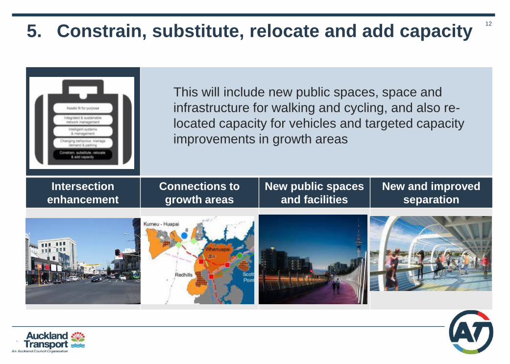
5. Constrain, substitute, relocate and add capacity
Intersection
enhancement
Connections to
growth areas
New public spaces
and facilities
New and improved
separation
This will include new public spaces, space and
infrastructure for walking and cycling, and also re-
located capacity for vehicles and targeted capacity
improvements in growth areas

13
The RASF Process
1. Determine Place &
Movement typology
2. Assess modal priorities & challenges
across broad spectrum
3. Establish modal priorities & impact on wider network
4. Identify impacts and opportunities across broad
spectrum
5. Identify tools to mitigate impacts
6. Design, implement and monitor benefits Roads and
Streets
Framework
• All modes
• All day • Compare to default
modal priority
• Living • Unlocking
• Moving • Functioning • Protecting • Sustaining
Consider: • Road space capacity • Alternative routes • Lower speed • Time of day • Assess impacts e.g. parking
If a decision cannot
be made during any
of the steps at an
officer level, it is
escalated to Roads
and Streets Steering
group

14
Transport Design Manual
• Customers are users
• Designs the strategic outcomes
• New document structure
• Incorporates ATCoP
• Expanded construction
specifications
• Identity & Branding
Section 1 – Design Guidance
Section 2 – Code of Practice
Section 3 – Specifications for Infrastructure Works

15
Recommendations
1. Approve the final versions of the Framework and the Manual,
which will then be implemented across the business.
Next Steps
• Following approval, the both documents will be made available on
the AT website by mid-November 2017
• User guidelines will be developed by December 2017 and used for
training practitioners, including developers, AT and the wider
Council family.

16
1. Key Stakeholders – Summary Feedback
2. Case study examples
• Karangahape Road (K-Rd)
• Manukau Metro Centre
• Whenuapai Structure Plan
• Piha Road, Waitakere Ranges
Appendices

17
Strong level of support overall. Comments include:
• Auckland Council / ADO / Panuku / AT internal teams – reflects people & place aspirations
better, enable operational & cultural shift for AT, help determine modal priorities and
manage conflicts with place
• Cycling, walking, disability advocates – elevation of people / place considerations
important, better guidance for developers, clarifies strategy better
• Government bodies (NZTA, MoT) – useful that typologies bring together place & movement,
help set modal priorities, important to consider alignment with ONRC
• Mana Whenua – support inclusion of Te Aranga principles / core Maori values, want local
solutions, better management of storm water quality should be a focus
• Freight / Heavy haulage – provides ability to resolve conflicts for road safety, support key
freight corridors and splitting freight from service delivery
• Civil engineering, Planning / Design contractors – provides more project certainty upfront,
links to Council/Local Board plans, support developers to improve project time / certainty.
Suggest industry user group to test / improve application
• Emergency services – support evidence-based approach, manage modal conflicts near
key fire station important, work closely with ATOC / Communication for traffic & incident
management
Key Stakeholders - Feedback Summary
18
Karangahape Rd
Application to Main Street

19
K-Rd Case Study Summary
MODAL PRIORITIES
Car travel and service delivery is not prioritised at peak times.
TYPOLOGY
Main Street Arterial
*REFER TO K ROAD CASE STUDY REPORT FOR FURTHER DETAIL
Low
Place
Medium
Place
High
Place

20
Step 1: Determine the typology
2025 Typologies
• Current function is already Main St with
high place significance, strategic
significance for buses / cycling.
Increasing pedestrian activity on the Main
St.
• Significant redevelopment potential in
vicinity from the future CRL station, which
will increase mixed use activity and THAB
residential development as indicated in
the Unitary Plan
• Therefore, K-Rd should be a higher
quality version of main street arterial.

21
• High pedestrian flows along/across K-Rd, key attractors are retail, night life,
and in future CRL station / redevelopment in back streets / apartment living.
• Cycle Connector, critical link between western suburbs / City Centre / further
east via Grafton. No feasible alternative routes for directness.
• Bus FTN route connecting western suburbs to City Centre, City / Inner Link &
Nite-rider. Future interchange with CRL station, NW Busway link to Pitt St and
LRT on Queen. No feasible alternative routes for directness. Some rerouting
post CRL possible.
• Important arterial traffic route, on-street parking / access to AT off-street
carpark on Mercury lane. Alternative routes / reduced lane capacity / parking
removal are options. At grade private carpark ripe for redevelopment.
• Service delivery loading is available on-street but retiming/relocation are
options
Freight network usually via Motorway to Port, but over-dimension/over-size
route. Off peak, permit controlled.
• Safety: pedestrian crashes are increasing trend, high collective risk (Dsi)
Steps 2-4: Determine modal priority
22
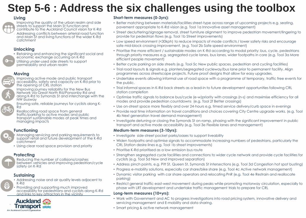
Living • Improving the quality of the urban realm and side
streets to support the Main St function and contribute to the Auckland Council vision for K-Rd
• Addressing conflicts between arterial road function and Main St and living functions of the wider K-Rd catchment
Unlocking • Retaining and enhancing the significant social and
economic exchange occurring on K-Rd
• Utilising under-used side streets to support permeability and urban realm
Moving • Improving active mode and public transport
accessibility, safety and capacity on K-Rd prior to the opening of CRL station
• Improving journey reliability for the New Bus Network via Great North Rd/Ponsonby Rd and along K-Rd to Symonds St and interchange with the NW busway
• Ensuring safe, reliable journeys for cyclists along K-Rd
• Reallocating road space from general traffic/parking to active modes and public transport sustainable modes at peak times and managing impacts
Functioning • Managing servicing and parking requirements to
support retail and future development of the K-Rd catchment
• Using clear road space provision and priority
Protecting • Reducing the number of collisions/crashes
between vehicles and improving pedestrian/cycle safety on K-Rd
Sustaining • Addressing noise and air quality levels adjacent to
K-Rd
• Providing and supporting much improved accessibility for pedestrians and cyclists along K-Rd and links to key attractors in the vicinity
Step 5-6 : Address the six challenges using the toolbox Short-term measures (0-3yrs):
• Better matching between materials/facilities street-type across range of upcoming projects e.g. seating,
pavement appropriate to K-Rd vision (e.g. Tool 1a Innovative asset management)
• Street decluttering/signage removal, street furniture alignment to improve pedestrian movement/lingering to
provide for pedestrian flows (e.g. Tool 1b Street improvements)
• Low speed environment (<30kph) to reduce impacts of mode conflicts / lower safety risks and encourage
safe mid-block crossing improvement. (e.g. Tool 2b Safe speed environment)
• Prioritise the more efficient / sustainable modes on K-Rd according to modal priority: bus, cycle, pedestrians
through priority measures e.g. segregated cycle lanes, bus lanes, wider footpaths in core (e.g. Tool 3a More
efficient people movement)
• Better cycle parking on side streets (e.g. Tool 5c New public spaces, pedestrian and cycling facilities)
• Trial road layouts & signals e.g. planters/segregated cycleway/bus lane prior to permanent facility. Align
programmes across streetscape projects. Future proof designs that allow for easy upgrades.
• Undertake events allowing informal use of road space with a programme of temporary, traffic free events for
the public.
• Trial informal spaces in K-Rd back streets as a lead-in to future development opportunities following CRL
station completion
• Optimise traffic signals to balance bus/cycle (e-w)priority with crossings (n-s) and maximise efficiency for all
modes and provide pedestrian countdowns (e.g. Tool 2f Better crossings)
• Use on-street space more flexibly and over 24-hours e.g. timed service delivery/curb space in evenings
• Provide real time information on travel conditions and choices covering City Centre upgrade works. (e.g. Tool
4b Next generation travel demand management)
• Investigate detuning or closing the Symonds St on-ramp, phasing with the significant improvement in public
transport and active mode accessibility (e.g. Tool 3e Flexible lanes and management)
Medium-term measures (3-10yrs):
• Investigate side-street pocket parks/oases to support liveability
• Widen footpaths and optimise signals to accommodate increasing numbers of pedestrians, particularly the
CRL Station desire lines e.g. Tool 1b street improvements)
• Prioritise K-Rd prioritised as a low emission bus route
• Strengthen segregated cycle facilities and connections to wider cycle network and provide cycle facilities for
cyclists (e.g. Tool 5d New and improved separation)
• Address pinch points, e.g. Pitt St, Queen St, Symonds St intersections (e.g. Tool 3d Congestion hot spot busting)
• Progress e-mobility solutions, especially car share/bike share (e.g. Tool 4c Active network management)
• Dynamic visitor parking with car share operators and relocating PnR (e.g. Tool 4e Restrain and reallocate
parking)
• Restrict general traffic east-west movement during peaks while promoting motorway circulation, especially to
phase with LRT development and undertake traffic management trials to prepare for CRL
Long-term measures (10+yrs):
• Work with Government and AC to progress investigations into road pricing system, innovative delivery and
servicing management and E-mobility and data sharing.
• Smart pricing & active network management
23
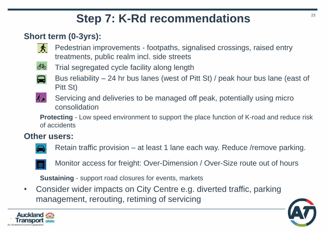
Short term (0-3yrs):
• Pedestrian improvements - footpaths, signalised crossings, raised entry
treatments, public realm incl. side streets
• Trial segregated cycle facility along length
• Bus reliability – 24 hr bus lanes (west of Pitt St) / peak hour bus lane (east of
Pitt St)
• Servicing and deliveries to be managed off peak, potentially using micro
consolidation
Protecting - Low speed environment to support the place function of K-road and reduce risk
of accidents
Other users:
• Retain traffic provision – at least 1 lane each way. Reduce /remove parking.
• Monitor access for freight: Over-Dimension / Over-Size route out of hours
Sustaining - support road closures for events, markets
• Consider wider impacts on City Centre e.g. diverted traffic, parking
management, rerouting, retiming of servicing
Step 7: K-Rd recommendations

24
K-Rd: Outcome of RASF process - Project design
mandate
Long Term option (east of Pitt) o Phasing to occur post CRL / LRT
o Low speed zone, better wayfinding e.g. to K’Rd Station
o Footpaths widened for high pedestrian use, urban realm
improvements, mid block treatments for ped. crossings
o Permanent segregated cycle lane
o 1 lane each way for mixed traffic, carriageway width
reduced,
o Servicing off-peak , consolidated loading zones
o Road looked at over 24 hr period.
Short Term option (east of Pitt): o Low speed zone
o Higher quality pedestrian facilities, improved urban realm,
decluttered footpaths
o 24 hr bus lane west of Pitt / peak lane east of Pitt
o Trial segregated cycle lane with moveable planters to trial
different layouts e.g. for special events
o Remove / relocate parking as required
o Servicing off peak
o General traffic - 1 lane each way
Before
After

25
Manukau Metro
Centre Application to Metro Centre
Network

26
Manukau Transport Study
• 600ha area – over 200ha
controlled by Council (orange)
and Crown (green) entities.
• Council portfolio – 95ha in 40
properties, including AT car
parks.
• Opportunity for Panuku
Development Agency to
facilitate significant
redevelopment to support
growth & improve accessibility
• Important link to Auckland
Airport
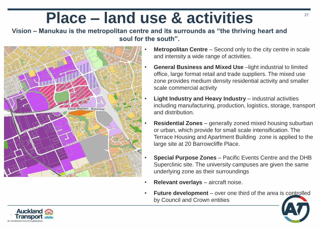
27 Place – land use & activities Vision – Manukau is the metropolitan centre and its surrounds as “the thriving heart and
soul for the south”.
• Metropolitan Centre – Second only to the city centre in scale
and intensity a wide range of activities.
• General Business and Mixed Use –light industrial to limited
office, large format retail and trade suppliers. The mixed use
zone provides medium density residential activity and smaller
scale commercial activity
• Light Industry and Heavy Industry – industrial activities
including manufacturing, production, logistics, storage, transport
and distribution.
• Residential Zones – generally zoned mixed housing suburban
or urban, which provide for small scale intensification. The
Terrace Housing and Apartment Building zone is applied to the
large site at 20 Barrowcliffe Place.
• Special Purpose Zones – Pacific Events Centre and the DHB
Superclinic site. The university campuses are given the same
underlying zone as their surroundings
• Relevant overlays – aircraft noise.
• Future development – over one third of the area is controlled
by Council and Crown entities

28
Movement networks – overview Strategic road
Primary arterial
Secondary arterial
PT - FTN
PT – Connector
Freight– Principal
route
Freight– Secondary
route
Cycle Expressway
Future Mass Rapid
Transit
SH Ramps
N.B. State Highways omitted.
Over Dimension routes not
shown.
Rail Station Bus Station
29
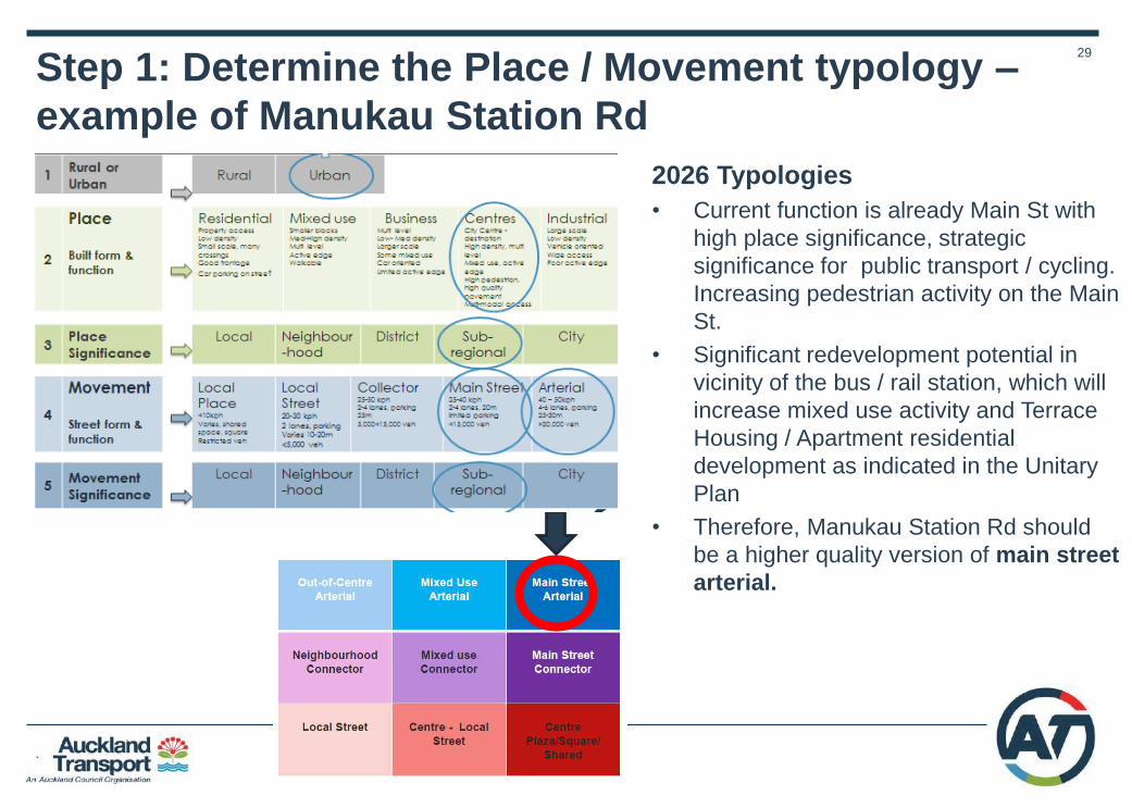
Step 1: Determine the Place / Movement typology –
example of Manukau Station Rd
2026 Typologies
• Current function is already Main St with
high place significance, strategic
significance for public transport / cycling.
Increasing pedestrian activity on the Main
St.
• Significant redevelopment potential in
vicinity of the bus / rail station, which will
increase mixed use activity and Terrace
Housing / Apartment residential
development as indicated in the Unitary
Plan
• Therefore, Manukau Station Rd should
be a higher quality version of main street
arterial.

30
Step 1 contd: Determine typologies for wider
Manukau network • High place value typologies applied in
centre to reflect Panuku development
aspirations.
• Main St arterial applied to Manukau
Station Rd to reflect enhanced Main St
function
• Mixed use arterial applied to Great
South, Cavendish and Lambie to
reflect high movement value and
mixed use (residential / commercial).
• Analysis focused on four key corridors
– Manukau Station, Great South,
Cavendish and Lambie – most have
competing land use / transport drivers.

31
• Bus FTN - very high bus volumes getting to/from Great South Rd and the
Manukau Bus Station. Current LRT thought is further north, so this will remain
bus PT focused.
• Walking - increased demand in future as it develops - Ronwood Ave will
also serve this function, Cavendish will be general traffic/freight focused, so
Manukau Station Road is a key east-west connector.
• Cycling – trial segregated lanes on key routes where justified
• Freight - on freight network, important link SH20-1, but relatively lower
priority given that motorway-motorway connection exists.
• General traffic - moderate traffic volumes for road of this scale, but again
the parallel motorway will take most of new demand.
• Consider service & delivery to support town centre, control access as centre
becomes busier.
Step 2-4: Determine modal priorities for
different roads
32
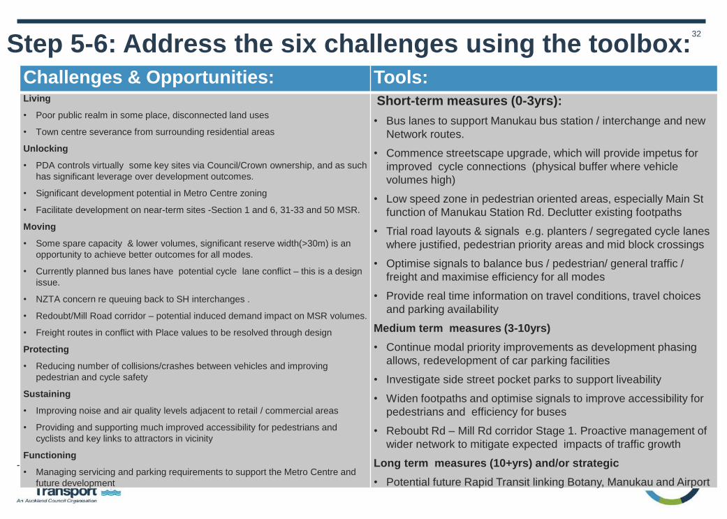
Step 5-6: Address the six challenges using the toolbox:
Challenges & Opportunities: Tools: Living
• Poor public realm in some place, disconnected land uses
• Town centre severance from surrounding residential areas
Unlocking
• PDA controls virtually some key sites via Council/Crown ownership, and as such
has significant leverage over development outcomes.
• Significant development potential in Metro Centre zoning
• Facilitate development on near-term sites -Section 1 and 6, 31-33 and 50 MSR.
Moving
• Some spare capacity & lower volumes, significant reserve width(>30m) is an
opportunity to achieve better outcomes for all modes.
• Currently planned bus lanes have potential cycle lane conflict – this is a design
issue.
• NZTA concern re queuing back to SH interchanges .
• Redoubt/Mill Road corridor – potential induced demand impact on MSR volumes.
• Freight routes in conflict with Place values to be resolved through design
Protecting
• Reducing number of collisions/crashes between vehicles and improving
pedestrian and cycle safety
Sustaining
• Improving noise and air quality levels adjacent to retail / commercial areas
• Providing and supporting much improved accessibility for pedestrians and
cyclists and key links to attractors in vicinity
Functioning
• Managing servicing and parking requirements to support the Metro Centre and
future development
Short-term measures (0-3yrs):
• Bus lanes to support Manukau bus station / interchange and new
Network routes.
• Commence streetscape upgrade, which will provide impetus for
improved cycle connections (physical buffer where vehicle
volumes high)
• Low speed zone in pedestrian oriented areas, especially Main St
function of Manukau Station Rd. Declutter existing footpaths
• Trial road layouts & signals e.g. planters / segregated cycle lanes
where justified, pedestrian priority areas and mid block crossings
• Optimise signals to balance bus / pedestrian/ general traffic /
freight and maximise efficiency for all modes
• Provide real time information on travel conditions, travel choices
and parking availability
Medium term measures (3-10yrs)
• Continue modal priority improvements as development phasing
allows, redevelopment of car parking facilities
• Investigate side street pocket parks to support liveability
• Widen footpaths and optimise signals to improve accessibility for
pedestrians and efficiency for buses
• Reboubt Rd – Mill Rd corridor Stage 1. Proactive management of
wider network to mitigate expected impacts of traffic growth
Long term measures (10+yrs) and/or strategic
• Potential future Rapid Transit linking Botany, Manukau and Airport
33
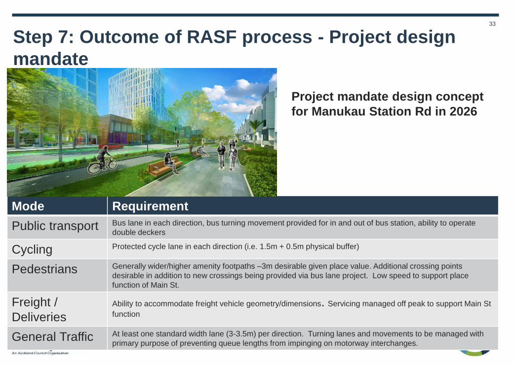
Step 7: Outcome of RASF process - Project design
mandate
Project mandate design concept
for Manukau Station Rd in 2026
Mode Requirement
Public transport Bus lane in each direction, bus turning movement provided for in and out of bus station, ability to operate
double deckers
Cycling Protected cycle lane in each direction (i.e. 1.5m + 0.5m physical buffer)
Pedestrians Generally wider/higher amenity footpaths –3m desirable given place value. Additional crossing points
desirable in addition to new crossings being provided via bus lane project. Low speed to support place
function of Main St.
Freight /
Deliveries
Ability to accommodate freight vehicle geometry/dimensions. Servicing managed off peak to support Main St
function
General Traffic At least one standard width lane (3-3.5m) per direction. Turning lanes and movements to be managed with
primary purpose of preventing queue lengths from impinging on motorway interchanges.

34
Whenuapai Structure Plan
Application to Greenfield Area

35
Whenuapai Study area
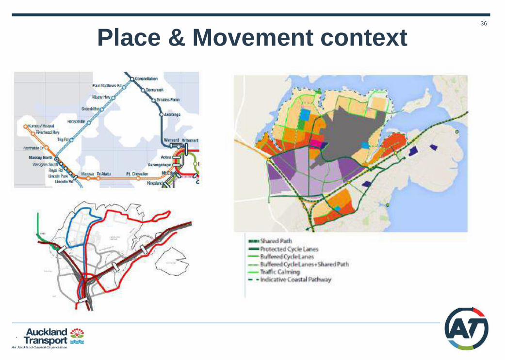
36
Place & Movement context

37
Step 1. Determine typologies for Whenuapai
*REFER TO K ROAD CASE STUDY REPORT FOR FURTHER DETAIL
Totara – Riverlea – Dale
Block typologies
38
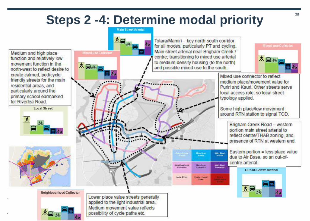
Steps 2 -4: Determine modal priority

39 Step 5-6: Address the six challenges using the toolbox

40
Example of neighbourhood network
41
Piha Road, Waitakere Ranges Application to Rural Road in
Landscape Heritage Area

42
Piha Road, Waitakere - Case Study Summary TYPOLOGY Rural Arterial
Secondary arterial – priority for
reliable journeys for general
traffic. Pedestrian activity
around walking tracks/scenic
lookouts, increasing cycling.
High risk rural safety issues.
Place – route traverses through
Heritage landscape area, bush living,
Waitakere regional park. National,
regional or local level of significance
depending on site / feature

43
Step 1. Determine typology for Piha Road
2025 Typologies
• Current function is arterial road
winding through high significance
landscape / conservation, heritage
area.
• By 2025, the typology will remain the
same, but the place and movement
functions will be under increasing
pressure from demand for recreation,
tourism, residential development.
National
44
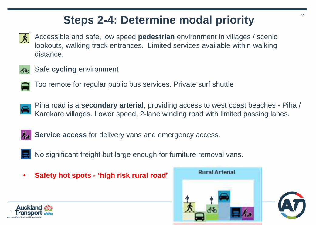
• Accessible and safe, low speed pedestrian environment in villages / scenic
lookouts, walking track entrances. Limited services available within walking
distance.
• Safe cycling environment
• Too remote for regular public bus services. Private surf shuttle
• Piha road is a secondary arterial, providing access to west coast beaches - Piha /
Karekare villages. Lower speed, 2-lane winding road with limited passing lanes.
• Service access for delivery vans and emergency access.
• No significant freight but large enough for furniture removal vans.
• Safety hot spots - ‘high risk rural road’
Steps 2-4: Determine modal priority

45
Living
• Protecting heritage / landscape / cultural values in the face of population and development pressure along the route
• Protecting and enhancing the route as the main Gateway for West Coast beaches / Piha / Karekare village
Unlocking • Potential for enhancing the routes experience with
multiple AC organisations and balancing with the aspirations of the local community
• Response to targeted growth requires large investment in infrastructure facilities at villages, contained residential development
Moving • Managing the conflicts between active modes and
private transport along route, around visitor centres, walkways entrances, scenic lookouts
• Improving journey reliability for the general traffic along the corridor
• Ensuring safe, reliable journeys for cyclists • Future reallocating road space between private /public
transport and active modes and managing impacts
Functioning • Managing and servicing the volume of holidays / event
traffic when the usually resident population can swell significantly
Protecting • High risk rural road - reducing the number of
collisions/crashes between vehicles and improving pedestrian/cycle safety on this route
Sustaining • Protect and enhance high heritage / conservation /
landscape / natural environment /experience while being resilient to future population increase and seasonal holiday traffic.
• Providing and supporting accessibility for pedestrians and cyclists along Piha Rd and links to key beaches in the vicinity
Short-term measures (0-3yrs):
• Subject to Waitakere Ranges heritage area / design guidelines
• Better matching between use of local materials/facilities street-type for scenic Piha route(e.g. Tool 1a Innovative
asset management)
• Low speed environment (<30kph) to reduce impacts of mode conflicts / lower safety risks and encourage safe
crossing improvement around key attractors / walkway entrances, etc. (e.g. Tool 2b Safe speed environment)
• Prioritise active modes on Piha Rd according to modal priority in specific locations, e.g. cycling through priority
measures e.g. segregated cycle lanes on uphill sections (e.g. Tool 3a More efficient people movement)
• Trial road layouts e.g. buffers /segregated cycleway prior to permanent facility. Align programmes across projects.
Future proof designs that allow for easy upgrades.
• Optimise road management to balance car/bus/cycle (e-w)priority with crossings (n-s) and maximise efficiency
for all modes and improve pedestrian priority in villages(e.g. Tool 2f Better crossings)
• Provide real time information on travel conditions and choices for visiting West Coast beaches and attractions.
(e.g. Tool 4b Next generation travel demand management)
Medium-term measures (3-10yrs):
• Subject to Waitakere Ranges heritage area / design guidelines
• Widen footpaths to accommodate increasing numbers of pedestrians, particularly the desire lines around key
attractors, Piha village e.g. Tool 1b street improvements)
• Prioritise low emission vehicles and provide charging facilities as uptake of these vehicles increases e.g. bikes and
cars
• Strengthen segregated cycle facilities and connections to wider cycle network and provide cycle facilities for
cyclists (e.g. Tool 5d New and improved separation)
• Address pinch points, e.g. Piha intersections, stopping areas for attractions (e.g. Tool 3d Congestion hot spot
busting)
• Progress e-mobility solutions, especially car share/bike share (e.g. Tool 4c Active network management) as part of
Auckland’s west coast / Waitakere ranges travel management
• Dynamic visitor parking with car share operators and relocating PnR (e.g. Tool 4e Restrain and reallocate parking)
Long-term measures (10+yrs):
• Subject to Waitakere Ranges heritage area / design guidelines
• Work with AT / AC to progress investigations into innovative delivery and servicing management and E-mobility
and data sharing.
• Active network management
Step 5- 6 : Address the six challenges using the toolbox
46
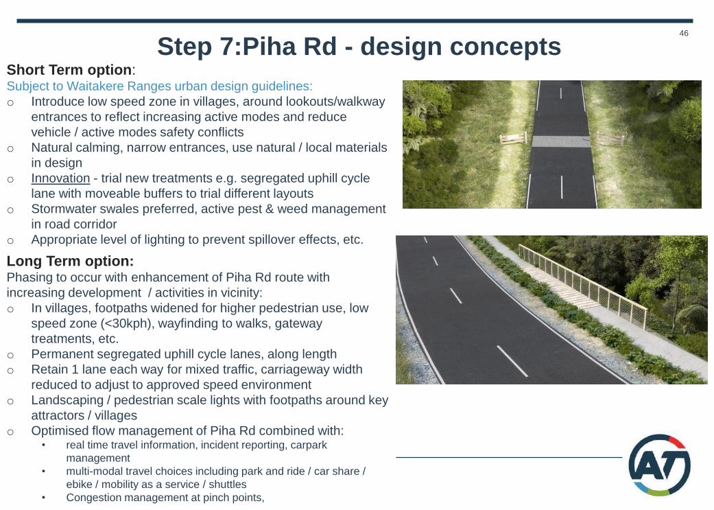
Step 7:Piha Rd - design concepts
Long Term option: Phasing to occur with enhancement of Piha Rd route with
increasing development / activities in vicinity:
o In villages, footpaths widened for higher pedestrian use, low
speed zone (<30kph), wayfinding to walks, gateway
treatments, etc.
o Permanent segregated uphill cycle lanes, along length
o Retain 1 lane each way for mixed traffic, carriageway width
reduced to adjust to approved speed environment
o Landscaping / pedestrian scale lights with footpaths around key
attractors / villages
o Optimised flow management of Piha Rd combined with: • real time travel information, incident reporting, carpark
management
• multi-modal travel choices including park and ride / car share /
ebike / mobility as a service / shuttles
• Congestion management at pinch points,
Short Term option: Subject to Waitakere Ranges urban design guidelines:
o Introduce low speed zone in villages, around lookouts/walkway
entrances to reflect increasing active modes and reduce
vehicle / active modes safety conflicts
o Natural calming, narrow entrances, use natural / local materials
in design
o Innovation - trial new treatments e.g. segregated uphill cycle
lane with moveable buffers to trial different layouts
o Stormwater swales preferred, active pest & weed management
in road corridor
o Appropriate level of lighting to prevent spillover effects, etc.