asx / media announcement 20 february 2017
TRANSCRIPT

1 | P a g e
Artemis Resources Limited ARBN: 80 107 051 749 Level 3, IBM Building, 1060 Hay Street, West Perth, WA Australia, 6006 PO Box R933 Royal Exchange NSW Australia, 1225 Phone: +61 2 9078 7670 Facsimile: +61 2 9078 7661 Email: [email protected] Website: artemisresources.com.au
Directors: Executive Chairman David Lenigas Executive Directors Ed Mead Alex Duncan-Kemp Non-Executive Directors George Frangeskides Campbell Baird
Company Secretary: Guy Robertson
Corporate Information ASX Code: ARV
ASX / Media Announcement 20 February 2017
NEW STYLE OF GOLD MINERALISATION FOR THE WEST PILBARA DISCOVERED AT PURDY’S REWARD GOLD
PROJECT- KARRATHA, WESTERN AUSTRALIA. Archean sediment hosted gold mineralisation identified.
Typical sediment style deposits of this type are Witswatersrand, Nullagine and Marble Bar which are conglomerate hosted.
Assays confirm gold mineralisation is typical of this style with fine to coarse gold.
Geochemical assays from orientation traverse identifies gold anomalies coincident with high levels of prospector activity.
Free gold continues to be found at surface at Purdy’s Reward Gold Project by prospectors.
Programme of Work for drilling and costeans has been approved by the Government.
Heritage survey requested and expected in March.
David Lenigas, Artemis’s Chairman, commented; “The results from the new Ionic Leach geochemistry techniques have now been received and they confirm a completely new style of gold mineralisation for this area of the West Pilbara akin to the Witswatersrand style Archean sedimentary hosted deposits. These deposits are similar to those being discovered in the East Pilbara, around Marble Bar and Nullagine, by TSX listed company Novo Corp. Novo’s work has identified predominantly fine gold mineralisation, whereas Purdy’s Reward not only has fine gold but coarse gold in the form of nuggets. This makes the Purdy’s Reward discovery significant for the area and highly prospective. This is the first time that this type of geology and gold mineralisation has been confirmed as Archean sedimentary and associated with conglomerates and fine grained sediments with mafic appearance.” Figure 1: New Conglomerate Package identified at Purdy’s Reward:
For
per
sona
l use
onl
y

2 | P a g e
Artemis Resources Limited (“Artemis” or “the Company”) (ASX: ARV) is pleased to report the identification of a new gold mineralisation style for the Karratha area at Purdy’s Reward, West Pilbara (Figure 6).
Results (Figure 2, 3 and 4) from a geochemical orientation sampling traverse at the Purdy’s Reward Gold project, and additional mapping support a model of Archean sedimentary (conglomerate) hosted gold.
The gold occurrence at Purdy’s is considered analogous to the conglomerate hosted mineralisation outlined by Novo Resources in their Beaton’s Creek Project near Nullagine, but Purdy’s Reward is significantly older in age. The style of mineralisation is referred to the Witswatersrand style, after the Witswatersrand gold province in South Africa that has significant gold in Archean sedimentary conglomerates.
The traverse (Figure 2) straddles the unconformity between the older Archean basement in the north and the overlying the Mt Roe Basalt to the south.
The samples were collected along a 1 km long traverse; samples for analysis using the ultra-sensitive ALS Global Ionic Leach™ technique were collected at 25 metre intervals. For comparison purposes at every 100 metre sample point an additional sample was collected and analysed using a conventional digest (Supertrace).
Within the central area of the traverse numerous prospector metal detecting pits were present. The area of the detecting pits corresponds to where significant anomalism in both the Ionic and Supertrace results occur. The results are expressed as “Response Ratios” for both techniques. This is to enhance the response to background signal of the data and to perform basic levelling on the results; this allows direct comparison of the results from the different methods. As such these values do not have a unit type.
Figure 2: Purdy’s Reward orientation geochemical sampling traverse:
The Ionic data (Figure 3) shows a stronger anomaly to background response compared to the Supertrace data. Neither technique (Figure 4) shows significant correlation between the strong gold responses and the typical pathfinder elements: arsenic, silver, bismuth, molybdenum, antimony and tungsten.
This lack of pathfinder elements (Figure 4) indicates the gold is not derived from a shear system or from supergene alteration of a shear system. The data suggests that the Purdy’s Reward gold is from an alluvial source, albeit Archean in age. The lesser gold responses on the right hand side of Figure 4, which are at the northern end of the traverse (Figure 2) do show coincident gold, silver, arsenic responses indicating there is a secondary zone of mineralisation in the area which is shear system related.
For
per
sona
l use
onl
y

3 | P a g e
Figure 3: Comparison of Ionic Leach and Supertrace gold results. Ionic Leach gives a far superior response to Supertrace. (Data from both techniques has been ratioed to allow the results to be compared)
Figure 4: Gold and Pathfinder Element Responses.
Figure 5: Conglomerate hosted gold from surface at Purdy’s Reward Gold Project:
0.00
5.00
10.00
15.00
20.00
25.00
7676100 7676300 7676500 7676700 7676900 7677100
Comparison of Ionic Leach & Supertrace Au RR Results
Ionic Au RR ST Au RR
0.00
5.00
10.00
15.00
20.00
25.00
7676000 7676200 7676400 7676600 7676800 7677000 7677200
High Gold Response & No Pathfinder Element Responses
Ag As Ionic Au RR
For
per
sona
l use
onl
y
4 | P a g e
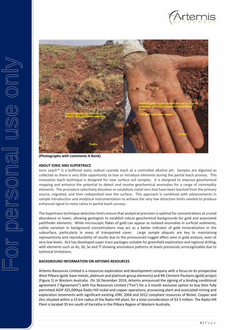
(Photographs with comments A Ronk) ABOUT IONIC AND SUPERTRACE Ionic Leach™ is a buffered static sodium cyanide leach at a controlled alkaline pH. Samples are digested as collected so there is very little opportunity to lose or introduce elements during the partial leach process. This innovative leach technique is designed for near surface soil samples. It is designed to improve geochemical mapping and enhance the potential to detect and resolve geochemical anomalies for a range of commodity elements. The procedure selectively dissolves or solubilizes metal ions that have been leached from the primary source, migrated, and then redeposited near the surface. This approach is combined with advancements in sample introduction and analytical instrumentation to achieve the very low detection limits needed to produce enhanced signal to noise ratios in partial leach surveys. The Supertrace technique detection limits ensure that analytical precision is optimal for concentrations at crustal abundance or lower, allowing geologists to establish robust geochemical backgrounds for gold and associated pathfinder elements. While microscopic flakes of gold can appear as isolated anomalies in surficial sediments, subtle variation in background concentrations may act as a better indicator of gold mineralization in the subsurface, particularly in areas of transported cover. Large sample aliquots are key to maintaining representivity and reproducibility of results due to the pronounced nugget effect seen in gold analysis, even at very low levels. ALS has developed super trace packages suitable for greenfield exploration and regional drilling, with elements such as As, Sb, Se and Tl showing anomalous patterns at levels previously unrecognizable due to technical limitations. BACKGROUND INFORMATION ON ARTEMIS RESOURCES Artemis Resources Limited is a resources exploration and development company with a focus on its prospective West Pilbara (gold, base metals, platinum and platinum group elements) and Mt Clement-Paulsens (gold) project (Figure 1) in Western Australia. On 16 December 2016, Artemis announced the signing of a binding conditional agreement (“Agreement”) with Fox Resources Limited (“Fox”) for a 3 month exclusive option to buy their fully permitted AGIP 425,000tpa Radio Hill nickel and copper operations, processing plant and associated mining and exploration tenements with significant existing JORC 2004 and 2012 compliant resources of Nickel, Copper and Zinc situated within a 15 km radius of the Radio Hill plant, for a total consideration of $3.5 million. The Radio Hill Plant is located 35 km south of Karratha in the Pilbara Region of Western Australia.
For
per
sona
l use
onl
y

5 | P a g e
Figure 5: Artemis Resources Projects (100% owned and under JV and option agreements to acquire)
CONTACTS For further information on this update or the Company generally, please visit our website at www.artemisresources.co.au or contact:
Investors / Shareholders Edward Mead Executive Director Telephone: +61 407 445 351 Email: [email protected]
Media David Tasker Professional Public Relations Telephone: +61 433 112 936 Email: [email protected]
For
per
sona
l use
onl
y

6 | P a g e
COMPETENT PERSONS STATEMENT The information in this document that relates to Exploration Results and Exploration Targets is based on information compiled or reviewed by Allan Younger, who is a Member of the Australasian Institute of Mining and Metallurgy. Mr Younger is a consultant to the Company, and is employed by Indigo Geochemistry Pty Ltd. Mr Younger has sufficient experience which is relevant to the style of mineralisation and type of deposit under consideration and to the activity which he is undertaking to qualify as a Competent Person as defined in the 2012 Edition of the ‘Australasian Code for Reporting of Exploration Results, Mineral Resources and Ore Reserves’. Mr Younger consents to the inclusion in the report of the matters based on his information in the form and context in which it appears. FORWARD LOOKING STATEMENTS AND IMPORTANT NOTICE This report contains forecasts, projections and forward looking information. Although the Company believes that its expectations, estimates and forecast outcomes are based on reasonable assumptions it can give no assurance that these will be achieved. Expectations, estimates and projections and information provided by the Company are not a guarantee of future performance and involve unknown risks and uncertainties, many of which are out of Artemis’ control. Actual results and developments will almost certainly differ materially from those expressed or implied. Artemis has not audited or investigated the accuracy or completeness of the information, statements and opinions contained in this presentation. To the maximum extent permitted by applicable laws, Artemis makes no representation and can give no assurance, guarantee or warranty, express or implied, as to, and takes no responsibility and assumes no liability for (1) the authenticity, validity, accuracy, suitability or completeness of, or any errors in or omission from, any information, statement or opinion contained in this report and (2) without prejudice to the generality of the foregoing, the achievement or accuracy of any forecasts, projections or other forward looking information contained or referred to in this report. Investors should make and rely upon their own enquiries before deciding to acquire or deal in the Company’s securities.
JORC Code, 2012 Edition – Table 1
Section 1 Sampling Techniques and Data
(Criteria in this section apply to all succeeding sections.)
Criteria JORC Code explanation Commentary
Sampling techniques
Nature and quality of sampling (eg cut channels, random chips, or specific specialised industry standard measurement tools appropriate to the minerals under investigation, such as down hole gamma sondes, or handheld XRF instruments, etc). These examples should not be taken as limiting the broad meaning of sampling.
Include reference to measures taken to ensure sample representivity and the appropriate calibration of any measurement tools or systems used.
Aspects of the determination of mineralisation that are Material to the Public Report.
In cases where ‘industry standard’ work has been done this would be relatively simple (eg ‘reverse circulation drilling was used to obtain 1 m samples from which 3 kg was pulverised to produce a 30 g charge for fire assay’). In other cases more explanation may be required, such as where there is coarse gold that has inherent sampling problems. Unusual commodities or mineralisation types (eg submarine nodules) may warrant disclosure of detailed information.
A minus 5mm sieved soil sample was collected.
2 field duplicates were submitted for analysis, 1:25 for Ionic data; none for Supertrace data.
For
per
sona
l use
onl
y

7 | P a g e
Criteria JORC Code explanation Commentary
Drilling techniques
Drill type (eg core, reverse circulation, open-hole hammer, rotary air blast, auger, Bangka, sonic, etc) and details (eg core diameter, triple or standard tube, depth of diamond tails, face-sampling bit or other type, whether core is oriented and if so, by what method, etc).
Not applicable
Drill sample recovery
Method of recording and assessing core and chip sample recoveries and results assessed.
Measures taken to maximise sample recovery and ensure representative nature of the samples.
Whether a relationship exists between sample recovery and grade and whether sample bias may have occurred due to preferential loss/gain of fine/coarse material.
Not applicable
Logging Whether core and chip samples have been geologically and geotechnically logged to a level of detail to support appropriate Mineral Resource estimation, mining studies and metallurgical studies.
Whether logging is qualitative or quantitative in nature. Core (or costean, channel, etc) photography.
The total length and percentage of the relevant intersections logged.
All soil samples are geologically logged by the geologist in the field.
It is not considered that these samples will be used to support appropriate Mineral Resource estimation, mining studies or metallurgical studies.
Logging is considered to be semi-quantitative given the nature of the alteration of these surficial rock chips and the inability to obtain detailed geological information.
Sub-sampling techniques and sample preparation
If core, whether cut or sawn and whether quarter, half or all core taken.
If non-core, whether riffled, tube sampled, rotary split, etc and whether sampled wet or dry.
For all sample types, the nature, quality and appropriateness of the sample preparation technique.
Quality control procedures adopted for all sub-sampling stages to maximise representivity of samples.
Measures taken to ensure that the sampling is representative of the in situ material collected, including for instance results for field duplicate/second-half sampling.
Whether sample sizes are appropriate to the grain size of the material being sampled.
2 duplicates were collected for analysis.
A sample size of 0.5kg was collected and considered appropriate and representative for the grain size and style of mineralisation
Quality of assay data and laboratory tests
The nature, quality and appropriateness of the assaying and laboratory procedures used and whether the technique is considered partial or total.
For geophysical tools, spectrometers, handheld XRF instruments, etc, the parameters used in determining the analysis including instrument make and model, reading times, calibrations factors applied and their derivation, etc.
Nature of quality control procedures adopted (eg standards, blanks, duplicates, external laboratory checks) and whether acceptable levels of accuracy (ie lack of bias) and precision have been established.
ALSglobal Laboratories (Perth) were used for the analysis work carried out on the Artemis Resources Ltd soil samples. The laboratory techniques below:
Ionic LeachTM – buffered cyanide digest-ICP finish
Supertrace Aqua Regia digest- ICP finish. For
per
sona
l use
onl
y

8 | P a g e
Criteria JORC Code explanation Commentary
Verification of sampling and assaying
The verification of significant intersections by either independent or alternative company personnel.
The use of twinned holes.
Documentation of primary data, data entry procedures, data verification, data storage (physical and electronic) protocols.
Discuss any adjustment to assay data.
At least two company personnel verify all significant results.
All geological mapping and sampling information is completed firstly on to paper maps and survey books before being transferred to Microsoft Excel spreadsheets. All electronic field data is then transferred into a Microsoft Access database for validation and compilation. Physical maps and sampling data are returned to the Artemis head office for scanning and storage. Electronic copies of all information are backed up daily.
Data has been normalized by a constant allow the different techniques and individual elements to be comparable.
Location of data points
Accuracy and quality of surveys used to locate drill holes (collar and down-hole surveys), trenches, mine workings and other locations used in Mineral Resource estimation.
Specification of the grid system used.
Quality and adequacy of topographic control.
A Garmin GPS76 hand-held GPS is used to define the location of the rock chip sample locations. Standard practice is for the GPS to track the location of the user constantly and the location of the soil samples are recorded electronically as ‘waypoints’ at the time of sampling. Sample locations are considered to be accurate to within 5m.
Grid system used for Artemis Resources Ltd sampling is MGA 94 (Zone 50)
Data spacing and distribution
Data spacing for reporting of Exploration Results.
Whether the data spacing and distribution is sufficient to establish the degree of geological and grade continuity appropriate for the Mineral Resource and Ore Reserve estimation procedure(s) and classifications applied.
Whether sample compositing has been applied.
Soil sampling has been completed as an orientation traverse over specific geological targets.
Data from soil samples will not be used in resource and reserve estimations. Sampling is based on specific geological targets to understand geochemical distribution.
No sample compositing is used in this report.
Orientation of data in relation to geological structure
Whether the orientation of sampling achieves unbiased sampling of possible structures and the extent to which this is known, considering the deposit type.
If the relationship between the drilling orientation and the orientation of key mineralised structures is considered to have introduced a sampling bias, this should be assessed and reported if material.
Most samples have been obtained whilst conducting reconnaissance geological mapping which was seeking to identify mineralised structures/lodes.
As the sampling was not targeting specific lithologies, there should be no bias in these samples.
Sample security
The measures taken to ensure sample security.
The chain of custody is managed by the project geologist who places calico sample bags in polyweave sacks. Up to 10 calico sample bags are placed in each sack. Each sack is clearly labelled with:
Artemis Resources Ltd
Address of laboratory
Sample range
Samples are then transported to Perth from Karratha with Bishop Transport.
Collected from the transport depot by the project geologist and delivered to the laboratory.
Audits or reviews
The results of any audits or reviews of sampling techniques and data.
No audit of soil sampling data has been completed to date. Data is validated when loading into the database.
For
per
sona
l use
onl
y

9 | P a g e
Section 2 Reporting of Exploration Results
(Criteria listed in the preceding section also apply to this section.)
Criteria JORC Code explanation Commentary
Mineral tenement and land tenure status
Type, reference name/number, location and ownership including agreements or material issues with third parties such as joint ventures, partnerships, overriding royalties, native title interests, historical sites, wilderness or national park and environmental settings.
The security of the tenure held at the time of reporting along with any known impediments to obtaining a licence to operate in the area.
E47/1745 is currently subject to an Application for Forfeiture (plaint).
See map elsewhere in this report for locations.
Exploration done by other parties
Acknowledgment and appraisal of exploration by other parties.
The most significant historic exploration identified to date at Purdy’s Reward (E45/1745) was completed by Westfield Minerals NL during 1971, targeting nickel and copper. This work included soil sampling, reverse circulation and diamond drilling, and magnetic and IP surveying.
All exploration and analysis techniques conducted by Acclaim Exploration & Westfield Minerals are considered to have been appropriate given the available techniques at the time.
Geology Deposit type, geological setting and style of mineralisation.
At Purdy’s Reward, gold mineralisation has been identified as being associated with mafic lithologies.
As exploration is at an early stage at Purdy’s Reward, further work is required to determine the geological setting and provenance of the gold mineralisation.
Mineralisation occurs as coarse, flat, and rounded nuggety gold within mafic lithologies.
Drill hole Information
A summary of all information material to the understanding of the exploration results including a tabulation of the following information for all Material drill holes: o easting and northing of the drill
hole collar o elevation or RL (Reduced Level –
elevation above sea level in metres) of the drill hole collar
o dip and azimuth of the hole o down hole length and interception
depth o hole length.
If the exclusion of this information is justified on the basis that the information is not Material and this exclusion does not detract from the understanding of the report, the Competent Person should clearly explain why this is the case.
Not applicable to the current soil sampling.
Data aggregation methods
In reporting Exploration Results, weighting averaging techniques, maximum and/or minimum grade truncations (eg cutting of high grades) and cut-off grades are usually Material and should be stated.
Where aggregate intercepts incorporate short lengths of high
No upper or lower cut-off grade was applied.
No metal equivalents are used for reporting.
For
per
sona
l use
onl
y

10 | P a g e
Criteria JORC Code explanation Commentary
grade results and longer lengths of low grade results, the procedure used for such aggregation should be stated and some typical examples of such aggregations should be shown in detail.
The assumptions used for any reporting of metal equivalent values should be clearly stated.
Relationship between mineralisation widths and intercept lengths
These relationships are particularly important in the reporting of Exploration Results.
If the geometry of the mineralisation with respect to the drill hole angle is known, its nature should be reported.
If it is not known and only the down hole lengths are reported, there should be a clear statement to this effect (eg ‘down hole length, true width not known’).
Not applicable
Diagrams Appropriate maps and sections (with scales) and tabulations of intercepts should be included for any significant discovery being reported These should include, but not be limited to a plan view of drill hole collar locations and appropriate sectional views.
Appropriate maps and sections are available in the body of this announcement.
Balanced reporting
Where comprehensive reporting of all Exploration Results is not practicable, representative reporting of both low and high grades and/or widths should be practiced to avoid misleading reporting of Exploration Results.
Reporting of results in this report is considered balanced.
Other substantive exploration data
Other exploration data, if meaningful and material, should be reported including (but not limited to): geological observations; geophysical survey results; geochemical survey results; bulk samples – size and method of treatment; metallurgical test results; bulk density, groundwater, geotechnical and rock characteristics; potential deleterious or contaminating substances.
No other significant exploration work has been done by Artemis.
Further work The nature and scale of planned further work (eg tests for lateral extensions, depth extensions or large-scale step-out drilling).
Diagrams clearly highlighting the areas of possible extensions, including the main geological interpretations and future drilling areas, provided this information is not commercially sensitive.
Artemis has plans in place to follow-up this mapping and sampling with further geochemical sampling, trenching, and drilling. POW applications have recently been lodged for Purdy’s Reward.
For
per
sona
l use
onl
y