assessment (local plan sites) - havant.gov.uk · 4 climate change a. hayling island is most...
TRANSCRIPT

Strategic Flood Risk Assessment (Local Plan Sites) | November 2018
ffEm fEmsowrhtf
Strategic Flood Risk Assessment
(Local Plan Sites) November 2018

1
Havant Borough Local Plan 2036
Document ref:

Strategic Flood Risk Assessment (Local Plan Sites) | November 2018
Strategic Flood Risk Assessment (Local Plan Sites)
Purpose of this paper To provide the evidence to show that flood risk has been fully taken into account in
selecting sites for allocation in the Havant Borough Local Plan 2036 (HBLP2036)
Why? During the Regulation 18 Consultation on the draft Local Plan, the Environment
Agency (EA) raised concern that the supporting information did not adequately
demonstrate that the Council had taken a sequential approach to site selection, and
as such risked the plan being found unsound.
Objectives ▪ To set out the approach the Council has taken to flood risk in making decisions
on site allocations in the HBLP2036
▪ To review flood risk in detail for proposed allocation sites
▪ To demonstrate that there is a reasonable prospect of development on proposed
allocation sites being safe from flooding during their lifetime
Any queries about the report should be sent to:
Email [email protected]
Telephone 023 9244 6539
Address: Havant Borough Council
Public Service Plaza
Civic Centre Way
Havant
PO9 2AX
Maps included in this document are © Crown copyright and database rights Ordnance Survey License number 100019217 (2019).

Strategic Flood Risk Assessment (Local Plan Sites) | November 2018
Contents Page
Table of Contents
1. INTRODUCTION ......................................................................................................................... 1
Local Plans and Flood Risk ........................................................................................................................................... 1
What is a Strategic Flood Risk Assessment ................................................................................................................ 2
Previous SFRA work ....................................................................................................................................................... 3
2. SFRA SITE REVIEW PROCESS ................................................................................................. 5
Stage A: Site Screening .................................................................................................................................................. 5
Stage B: Site Review ....................................................................................................................................................... 6
Site Review Table ............................................................................................................................................................ 7
3. FINDINGS .................................................................................................................................. 21
Summary ........................................................................................................................................................................ 21
Implications for HBLP2036 ........................................................................................................................................... 21
Future Planning Applications ...................................................................................................................................... 22
APPENDIX A: SEQUENTIALLY PREFERABLE SITES ............................................................... 23
APPENDIX B: FZ1 SITES IN EMSWORTH AND ON HAYLING ISLAND .................................... 24
APPENDIX C: DETAILED SITE REVIEWS ................................................................................... 26

Strategic Flood Risk Assessment (Local Plan Sites) | November 2018
1
1. Introduction 1.1 This document sets out the approach Havant Borough Council has taken in to site selection in
the light of flood risk in putting forward site allocations in the Havant Borough Local Plan 2036
(HBLP2036). It has been prepared to support the Regulation 19 Pre-submission Plan.
Local Plans and Flood Risk 1.2 The National Planning Policy Framework (NPPF)1 and associated Planning Practice Guidance
on Flood Risk and Coastal Change (PPG)2 emphasise the active role Local Planning
Authorities should take in ensuring that flood risk is understood and managed effectively and
sustainably throughout all stages of the planning process. The NPPF outlines that Local Plans
should be supported by a Strategic Flood Risk Assessment (SFRA).
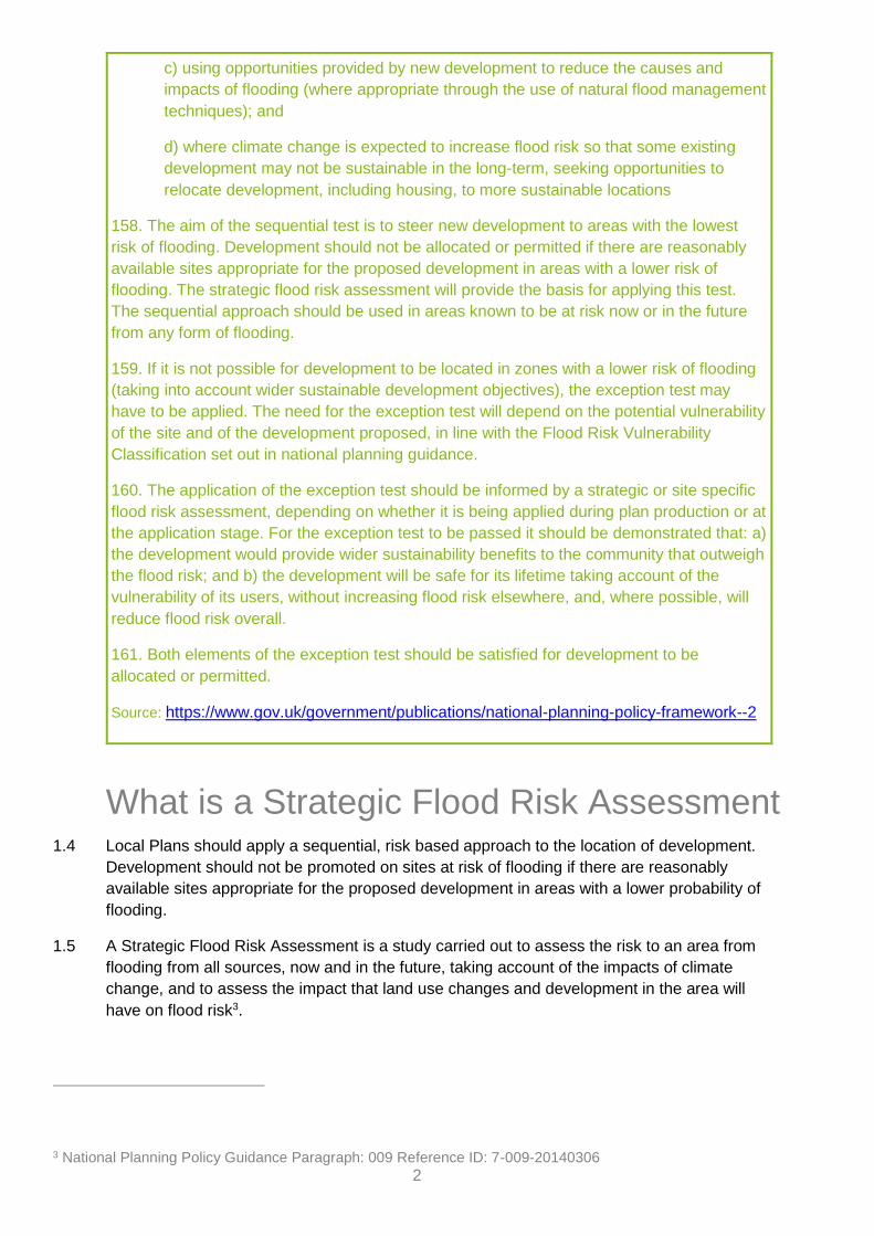
1.3 The overall approach of the NPPF to flood risk in local plans is set out in paragraphs 155-161.
Figure 1
Paragraphs 155-161 of the National Planning Policy Framework
Planning and flood risk
155. Inappropriate development in areas at risk of flooding should be avoided by directing
development away from areas at highest risk (whether existing or future). Where
development is necessary in such areas, the development should be made safe for its
lifetime without increasing flood risk elsewhere.
156. Strategic policies should be informed by a strategic flood risk assessment, and should
manage flood risk from all sources. They should consider cumulative impacts in, or
affecting, local areas susceptible to flooding, and take account of advice from the
Environment Agency and other relevant flood risk management authorities, such as lead
local flood authorities and internal drainage boards.
157. All plans should apply a sequential, risk-based approach to the location of
development – taking into account the current and future impacts of climate change – so as
to avoid, where possible, flood risk to people and property. They should do this, and
manage any residual risk, by:
a) applying the sequential test and then, if necessary, the exception test as set out
below;
b) safeguarding land from development that is required, or likely to be required, for
current or future flood management;
1 National Planning Policy Framework (2018) www.gov.uk/guidance/national-planning-policy-framework--2 2 National Planning Policy Guidance on Flood Risk (2014) www.gov.uk/guidance/flood-risk-and-coastal-change
2
c) using opportunities provided by new development to reduce the causes and
impacts of flooding (where appropriate through the use of natural flood management
techniques); and
d) where climate change is expected to increase flood risk so that some existing
development may not be sustainable in the long-term, seeking opportunities to
relocate development, including housing, to more sustainable locations
158. The aim of the sequential test is to steer new development to areas with the lowest
risk of flooding. Development should not be allocated or permitted if there are reasonably
available sites appropriate for the proposed development in areas with a lower risk of
flooding. The strategic flood risk assessment will provide the basis for applying this test.
The sequential approach should be used in areas known to be at risk now or in the future
from any form of flooding.
159. If it is not possible for development to be located in zones with a lower risk of flooding
(taking into account wider sustainable development objectives), the exception test may
have to be applied. The need for the exception test will depend on the potential vulnerability
of the site and of the development proposed, in line with the Flood Risk Vulnerability
Classification set out in national planning guidance.
160. The application of the exception test should be informed by a strategic or site specific
flood risk assessment, depending on whether it is being applied during plan production or at
the application stage. For the exception test to be passed it should be demonstrated that: a)
the development would provide wider sustainability benefits to the community that outweigh
the flood risk; and b) the development will be safe for its lifetime taking account of the
vulnerability of its users, without increasing flood risk elsewhere, and, where possible, will
reduce flood risk overall.
161. Both elements of the exception test should be satisfied for development to be
allocated or permitted.
Source: https://www.gov.uk/government/publications/national-planning-policy-framework--2
What is a Strategic Flood Risk Assessment 1.4 Local Plans should apply a sequential, risk based approach to the location of development.
Development should not be promoted on sites at risk of flooding if there are reasonably
available sites appropriate for the proposed development in areas with a lower probability of
flooding.
1.5 A Strategic Flood Risk Assessment is a study carried out to assess the risk to an area from
flooding from all sources, now and in the future, taking account of the impacts of climate
change, and to assess the impact that land use changes and development in the area will
have on flood risk3.
3 National Planning Policy Guidance Paragraph: 009 Reference ID: 7-009-20140306
3
1.6 Where an initial Assessment shows that land outside flood risk areas cannot appropriately
accommodate all the necessary development, it may be necessary to increase the scope of
the Assessment to a more detailed level to provide the information necessary for application of
the Exception Test where appropriate. The exception test should demonstrate that there are
wider benefits to the community which outweigh flood risk and that the development will be
safe for its lifetime.
Previous SFRA work 1.7 Preceding the SFRA work summarised in this report, a body of work on flood risk had already
been completed, most notably the Strategic Flood Risk Assessment undertaken for the
Partnership for Urban South Hampshire (PUSH SFRA).
The PUSH SFRA (2007, 2012 and 2016)
1.8 In 2007, a Strategic Flood Risk Assessment was commissioned by PUSH and undertaken by
Atkins on behalf of the partner authorities to inform the development of the South East Plan
and partner authority Local Plans. A light touch review was undertaken in 2012 at which time
small amendments were made to the GIS mapping.
1.9 To ensure that it continued to provide a robust, contemporary and sound analysis of flood
risks from all sources, the PUSH SFRA was updated in 2016, to update mapping outputs4 and
to add guidance documents for each Local Authority area5. Some key findings of the Havant
specific part of the PUSH SFRA are summarised below:
Figure 2
Key findings from PUSH SFRA - Havant Guidance
Sources of Flood Risk
a. The council has approximately 56 km of coastal frontage (including 42 km around Hayling Island) and 32 km of main river.
b. The primary source of flood risk is the sea. The secondary source of flood risk to Havant Borough is from fluvial sources including the Lavant Stream, the Hermitage Stream and associated tributaries. Historically, Havant has also been susceptible to flooding from other sources including; groundwater, surface water and flooding caused by infrastructure failure.
Key physical characteristics that may constrain development
a. Development land is limited by past development and environmental designations b. The topography of Havant Borough ranges from sea level to approximately 80
metres above ordnance datum (mAOD). Hayling Island is entirely below approximately 9 mAOD.
c. Many springs used by Portsmouth Water d. Implementations of SuDS may be difficult in parts of the borough with less
permeable geology
4 PUSH SFRA maps 5 PUSH SFRA – Havant Guidance

4
Climate Change
a. Hayling Island is most vulnerable to climate change, particularly in the South. b. It is anticipated that climate change will result in an increase in fluvial flood flows.
This may put additional pressure on areas adjacent to the streams in Havant.
Source: PUSH SFFRA, Havant Guidance Document (2016)
Local Plan Sustainability Appraisal (Regulation 18 Consultation)
1.10 The Sustainability Appraisal accompanying the Local Plan, flood risk was considered. The SA
framework contains a specific objective regarding Flood Risk.
Figure 3
HBLP2036 Sustainability Appraisal - Objective 5
To reduce the risk of flooding from all sources and the resulting detriment to public
wellbeing, the economy and the environment. Take a sequential approach to
development and avoid putting more people and property at risk of being affected by
flooding, where possible. Manage flood risk where necessary.
1.11 With regard to objective 5 more specifically, the SA report 6 explains at paragraph 4.14 that
‘The National Planning Policy Framework (NPPF) states that Local Plans should apply a
sequential, risk-based approach to the location of development to avoid where possible flood
risk to people and property and manage any residual risk, taking account of the impacts of
climate change (Paragraph 100, NPPF). This has been carried out through the assessment of
objective 5 as an assessment of a ‘’strong negative effect’’ would have highlighted a site as
not suitable for development due to flood risk. No sites have been assessed as having a
‘’strong negative effect’’. While some of the sites which have not been recommended for
inclusion in the draft plan have a lower risk of flooding than some that have been
recommended for inclusion, there were overriding reasons for these sites not to be included.
For this reason, the Council had to consider some sites which were partially in flood zones 2
and/or 3. Out of the sites which have been recommended for inclusion in the draft plan, the
majority are not situated in flood zones 2 and/or 3. However, there are some sites which are
partially in flood zone 2 and/or 3. In these instances the sites have been assessed as having a
‘’negative effect’’ and recommendations regarding site design and layout have been made to
avoid development in the flood zones. In conjunction with the requirements of proposed
policies E12 and E13, it is considered that flood risk can be mitigated on these sites.’
1.12 During the Regulation 18 Consultation on the draft Local Plan, the Environment Agency (EA)
raised concern that the supporting information did not adequately demonstrate that the
Council had taken a sequential approach to site selection, and as such risked the plan being
found unsound. This document has been developed in partnership with the Environment
Agency to satisfy these concerns.
6 HPLB2036 Regulation 18 draft: http://www.havant.gov.uk/localplan/regulatory-requirements

Strategic Flood Risk Assessment (Local Plan Sites) | November 2018
5
2. SFRA Site Review Process 2.1 The council applied a multi-stage process for this Local Plan Sites SFRA.
Stage A: Site Screening 2.2 The first stage was to compile a spreadsheet of all the potential allocation sites in the
borough, including both those identified by the council, as well as those submitted by
landowners and developers. With the help of GIS mapping, these sites were overlaid onto
EA Flood Zone mapping7, as well as climate change mapping from the PUSH SFRA.
Together, these two mapping layers allowed the council to identify those sites at risk of
flooding now and in the future. A sample extract is shown at Figure 4 below. As well as this
mapping, both the EA and Havant’s coastal defence team the Eastern Solent Coastal
Partnership (ESCP) reviewed the long list of sites and noted any additional ones of concern,
even where the available mapping did not identify the site.
Figure 4
Flood Risk Mapping
Current Day Zones 2 & 3 (EA Flood Map) vs Climate Change 2115 (PUSH SFRA)
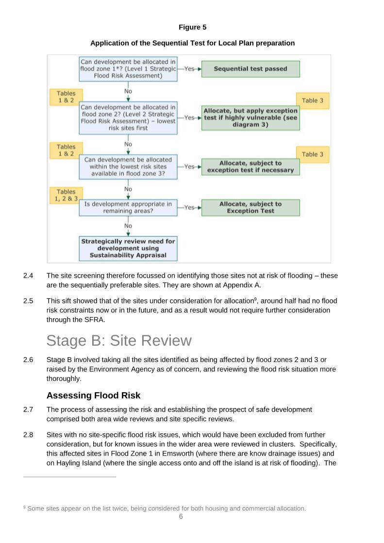
2.3 In line with the flood risk management hierarchy, the starting point was to make the
assumption that only those sites where flood risk could be avoided should be taken forward.
This is in line with national guidance on applying the sequential test the sites selection for the
Local Plan8:
7 Up to date flood zone mapping from the EA is available at https://flood-map-for-planning.service.gov.uk/ 8 Diagram 2: Paragraph: 021 Reference ID: 7-021-20140306, National Guidance on Flood Risk and
Coastal Change. https://www.gov.uk/guidance/flood-risk-and-coastal-change
6
Figure 5
Application of the Sequential Test for Local Plan preparation
2.4 The site screening therefore focussed on identifying those sites not at risk of flooding – these
are the sequentially preferable sites. They are shown at Appendix A.
2.5 This sift showed that of the sites under consideration for allocation9, around half had no flood
risk constraints now or in the future, and as a result would not require further consideration
through the SFRA.
Stage B: Site Review 2.6 Stage B involved taking all the sites identified as being affected by flood zones 2 and 3 or
raised by the Environment Agency as of concern, and reviewing the flood risk situation more
thoroughly.
Assessing Flood Risk
2.7 The process of assessing the risk and establishing the prospect of safe development
comprised both area wide reviews and site specific reviews.
2.8 Sites with no site-specific flood risk issues, which would have been excluded from further
consideration, but for known issues in the wider area were reviewed in clusters. Specifically,
this affected sites in Flood Zone 1 in Emsworth (where there are know drainage issues) and
on Hayling Island (where the single access onto and off the island is at risk of flooding). The
9 Some sites appear on the list twice, being considered for both housing and commercial allocation.

7
sites are listed, with commentary for the group, at Appendix B. The findings of this group
review apply equally to sites in Emsworth and on Hayling Island, which were assessed more
fully.
2.9 For sites affected directly by tidal or fluvial flood risk, i.e. those in Flood Zone 2 or 3, a fact
sheet was produced. The sheets for each of the sites are found at Appendix C. They record
factual information initially, and then go on to assess for each site whether
• The sequential test could be passed
• The exception test could be passed
• There was a reasonable prospect of delivering safe development.
2.10 It should be noted that proposed site of Havant Thicket Reservoir has not been considered
further through this assessment. While it is noted that flood risk can arise from a reservoir, it
is not possible to assess this at the Local Plan level. The detailed work on flood risk arising
from the reservoir will take place at the detailed design and planning stage.
Sequential Approach at Site Level
2.11 In the first instance the review of individual sites focussed on establishing whether it was
possible to avoid flood risk by taking the sequential approach within the site. On this basis,
the extent of the area affected by flood risk for each site was mapped, making it possible to
establish those sites which only had very small areas affected by flood risk now and in the
future. These sites are considered appropriate to be taken forward in the Local Plan, with
appropriate policy safeguards in the allocation policies.
2.12 Alternatively, where a greater part of the site was affected, it was considered whether a site
area remained which would make a viable allocation, taking into account the proposed use,
site size, access points etc. These sites are also considered appropriate to be taken forward
in the Local Plan, with appropriate policy safeguards in the allocation policies. In some
cases, this involved allocating for a lower site yield than initially anticipated.
The Exception Test
2.13 Taking this sequential approach within each site was not possible in all cases. Where flood
risk could not be avoided in this way, further evidence (FRAs from past planning
applications, and Site specific FRA information from site promoters) was sought to
understand whether other methods could be employed to make the site safe for
development. Where supported by evidence, sites with a reasonable prospect of delivering
safe development were considered appropriate for inclusion in the Local Plan. Where no or
insufficient evidence was available, these sites have not been further considered for
inclusion in the Local Plan, unless the council considered there to be an overriding
sustainability reason for their inclusion.
Site Review Table 2.14 The information gathered through the stages described in this chapter, is pulled together in
Table 1 on the following pages.

Strategic Flood Risk Assessment (Local Plan Sites) | November 2018
8
Site Review Summary Table
Area of HBC
Site ref Site Name Proposed Dev Type
Sequential Test Commentary Sequ. Test
Passed
Exception Test Commentary Possible to pass
Exc. Test
Prospect of Safe Delivery Commentary and Conclusion for SA of HBLP2036
Acceptable for
HBLP2036 allocation
EMS EM1 Emsworth Victoria Cottage Hospital
Housing In FZ1 - Sequentially Preferable site - no site specific fluvial or tidal issues.
Yes not needed - sequential test passed
not required
Area has known drainage capacity issues. This is being addressed by a specific policy in the Local Plan which requires development to reduce post development runoff.
Yes
EMS EM2 Gas Site, Palmer's Road
Housing A small area in the eastern part of the site lies in the flood zone. According to information available a small area in the middle of the site is additionally affected by climate change. Advice from EA indicates that this is likely to increase once more detailed modelling work is completed (EA project).
No No detailed information available to demonstrate that this could be made safe.
No While the flood risk is acknowledged, and it has not been possible to be conclusive about the extent of the future risk taking into account climate change, the council considers that there are sustainability benefits in allocating the site. This is a brownfield site, with likely contamination issues due to its previous use as a gas holder. Therefore, there are safety benefits in seeking redevelopment of the site, which could address both the flood risk and the contamination. The policy will need to acknowledge the flood risk and set requirements for it to be addressed. It is equally acknowledged that less vulnerable uses could be considered, but these are unlikely to create sufficient value to make development viable.
Yes
EMS EM3 Fowley Cottage
Housing Southern part of site affected by tidal FZ 2&3; coverage increases with climate change. Sequential approach on site is possible: Site remains developable while avoiding areas at risk of flooding.
No Safe development is achievable by taking the sequential approach on site.
Yes Safe development is achievable by taking the sequential approach on site. Policy to stipulate that areas at risk of flooding now and in the future must be avoided.
Yes
EMS EM4 Land at Selangor Avenue
Housing In FZ1 - Sequentially Preferable site - no site specific fluvial or tidal issues.
Yes not needed - sequential test passed
not required
Area has known drainage capacity issues. This is being addressed by a specific policy in the Local Plan which requires development to reduce post development runoff.
Yes
9
Area of HBC
Site ref Site Name Proposed Dev Type
Sequential Test Commentary Sequ. Test
Passed
Exception Test Commentary Possible to pass
Exc. Test
Prospect of Safe Delivery Commentary and Conclusion for SA of HBLP2036
Acceptable for
HBLP2036 allocation
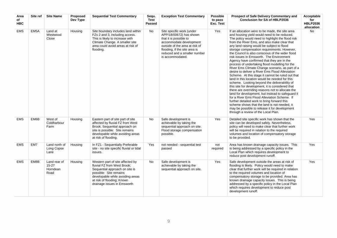
EMS EM5A Land at Westwood Close
Housing Site boundary includes land within FZs 2 and 3, including access. This is likely to increase with Climate Change. A smaller site area could avoid areas at risk of flooding.
No Site specific work (under APP/18/00672) has shown that it is possible to accommodate development outside of the area at risk of flooding, if the site area is reduced and a smaller number is accommodated.
Yes If an allocation were to be made, the site area and housing yield would need to be reduced. The policy would need to highlight the flood risk from the River Ems, and also make clear that any land raising would be subject to flood storage compensation requirements. However, the Council is also conscious of the wider flood risk issues in Emsworth. The Environment Agency have confirmed that they are in the process of undertaking flood modelling for the River Ems Climate Change scenario, as part of a desire to deliver a River Ems Flood Alleviation Scheme. At this stage it cannot be ruled out that land in this location would be needed for this scheme. Looking beyond the deliverability of this site for development, it is considered that there are overriding reasons not to allocate the land for development, but instead to safeguard it for a River Ems Flood Alleviation Scheme. If further detailed work to bring forward this scheme shows that the land is not needed, it may be possible to release it for development through a review of the Local Plan.
No
EMS EM6B West of Coldharbour Farm
Housing Eastern part of site part of site affected by fluvial FZ from West Brook. Sequential approach on site is possible: Site remains developable while avoiding areas at risk of flooding.
No Safe development is achievable by taking the sequential approach on site. Flood storage compensation possible.
Yes Detailed site specific work has shown that the site can be developed safely. Nevertheless, policy will need to make clear that further work will be required in relation to the required volumes and location of compensatory storage to be provided.
Yes
EMS EM7 Land north of Long Copse Lane
Housing In FZ1 - Sequentially Preferable site - no site specific fluvial or tidal issues.
Yes not needed - sequential test passed
not required
Area has known drainage capacity issues. This is being addressed by a specific policy in the Local Plan which requires development to reduce post development runoff.
Yes
EMS EM8B Land rear of 15-27 Horndean Road
Housing Western part of site affected by fluvial FZ from West Brook; Sequential approach on site is possible: Site remains developable while avoiding areas at risk of flooding; Known drainage issues in Emsworth
No Safe development is achievable by taking the sequential approach on site.
Yes Safe development outside the areas at risk of flooding is likely. Policy would need to make clear that further work will be required in relation to the required volumes and location of compensatory storage to be provided. Area has known drainage capacity issues. This is being addressed by a specific policy in the Local Plan which requires development to reduce post development runoff.
Yes

10
Area of HBC
Site ref Site Name Proposed Dev Type
Sequential Test Commentary Sequ. Test
Passed
Exception Test Commentary Possible to pass
Exc. Test
Prospect of Safe Delivery Commentary and Conclusion for SA of HBLP2036
Acceptable for
HBLP2036 allocation
EMS EM9 Land South of Long Copse Lane
Housing In FZ1 - Sequentially Preferable site - no site specific fluvial or tidal issues.
Yes not needed - sequential test passed
not required
Area has known drainage capacity issues. This is being addressed by a specific policy in the Local Plan which requires development to reduce post development runoff.
Yes
EMS EM10 Land west of Westbourne
Housing In FZ1 - Sequentially Preferable site - no site specific fluvial or tidal issues.
Yes not needed - sequential test passed
not required
Area has known drainage capacity issues. This is being addressed by a specific policy in the Local Plan which requires development to reduce post development runoff.
Yes
EMS n/a Interbridges West
Commercial Largely in FZ1 - small part on the edge of the central part of the site at risk of flooding;
No not required - less vulnerable use
not required
There is a good prospect of safe delivery. The vast majority of the site is free from flood risk. Policy to stipulate that areas at risk of flooding now and in the future must be avoided. Area has known drainage capacity issues. This is being addressed by a specific policy in the Local Plan which requires development to reduce post development runoff.
Yes
EMS STR1 Southleigh Key Sites While there are sequentially preferable smaller sites in the borough, there are none that could accommodate the quantum or type of comprehensive development proposed here.
Yes This is a very large site with plans for substantial areas of open space. Flood Risk can be avoided within the site.
Yes Policy to stipulate that areas at risk of flooding now and in the future must be avoided, including for flood risk management infrastructure/surface water management. It is acknowledged that this will require some reworking of the draft Masterplan, which is expected in any case as the evidence base on a range of issues is refined. Further work will be required in relation to the required volumes and location of flood storage to be provided. This is a very large site with plans for substantial areas of open space, which gives sufficient flexibility in terms of site layout. HBC is confident that flood risk can be avoided and/or mitigated within the site.
Yes
H&B BD1 Langstone Technology Park
Commercial In FZ1 - Sequentially Preferable site
Yes not needed - sequential test passed
not required
no flood risk Yes
H&B BD10 Land North of Regional Business Centre
Commercial Site currently in FZ1, but whole of the site affected by climate change
No not required - less vulnerable use
not required
It is not possible at this point to conclude that there is a reasonable prospect of safe development. Further detailed work may be able to conclude that safe delivery is possible. In the absence of this information, it is not possible to conclude that the site is suitable for allocation.
No
11
Area of HBC
Site ref Site Name Proposed Dev Type
Sequential Test Commentary Sequ. Test
Passed
Exception Test Commentary Possible to pass
Exc. Test
Prospect of Safe Delivery Commentary and Conclusion for SA of HBLP2036
Acceptable for
HBLP2036 allocation
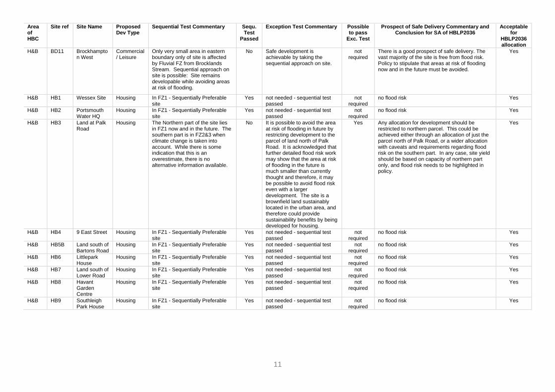
H&B BD11 Brockhampton West
Commercial / Leisure
Only very small area in eastern boundary only of site is affected by Fluvial FZ from Brocklands Stream. Sequential approach on site is possible: Site remains developable while avoiding areas at risk of flooding.
No Safe development is achievable by taking the sequential approach on site.
not required
There is a good prospect of safe delivery. The vast majority of the site is free from flood risk. Policy to stipulate that areas at risk of flooding now and in the future must be avoided.
Yes
H&B HB1 Wessex Site Housing In FZ1 - Sequentially Preferable site
Yes not needed - sequential test passed
not required
no flood risk Yes
H&B HB2 Portsmouth Water HQ
Housing In FZ1 - Sequentially Preferable site
Yes not needed - sequential test passed
not required
no flood risk Yes
H&B HB3 Land at Palk Road
Housing The Northern part of the site lies in FZ1 now and in the future. The southern part is in FZ2&3 when climate change is taken into account. While there is some indication that this is an overestimate, there is no alternative information available.
No It is possible to avoid the area at risk of flooding in future by restricting development to the parcel of land north of Palk Road. It is acknowledged that further detailed flood risk work may show that the area at risk of flooding in the future is much smaller than currently thought and therefore, it may be possible to avoid flood risk even with a larger development. The site is a brownfield land sustainably located in the urban area, and therefore could provide sustainability benefits by being developed for housing.
Yes Any allocation for development should be restricted to northern parcel. This could be achieved either through an allocation of just the parcel north of Palk Road, or a wider allocation with caveats and requirements regarding flood risk on the southern part. In any case, site yield should be based on capacity of northern part only, and flood risk needs to be highlighted in policy.
Yes
H&B HB4 9 East Street Housing In FZ1 - Sequentially Preferable site
Yes not needed - sequential test passed
not required
no flood risk Yes
H&B HB5B Land south of Bartons Road
Housing In FZ1 - Sequentially Preferable site
Yes not needed - sequential test passed
not required
no flood risk Yes
H&B HB6 Littlepark House
Housing In FZ1 - Sequentially Preferable site
Yes not needed - sequential test passed
not required
no flood risk Yes
H&B HB7 Land south of Lower Road
Housing In FZ1 - Sequentially Preferable site
Yes not needed - sequential test passed
not required
no flood risk Yes
H&B HB8 Havant Garden Centre
Housing In FZ1 - Sequentially Preferable site
Yes not needed - sequential test passed
not required
no flood risk Yes
H&B HB9 Southleigh Park House
Housing In FZ1 - Sequentially Preferable site
Yes not needed - sequential test passed
not required
no flood risk Yes
12
Area of HBC
Site ref Site Name Proposed Dev Type
Sequential Test Commentary Sequ. Test
Passed
Exception Test Commentary Possible to pass
Exc. Test
Prospect of Safe Delivery Commentary and Conclusion for SA of HBLP2036
Acceptable for
HBLP2036 allocation
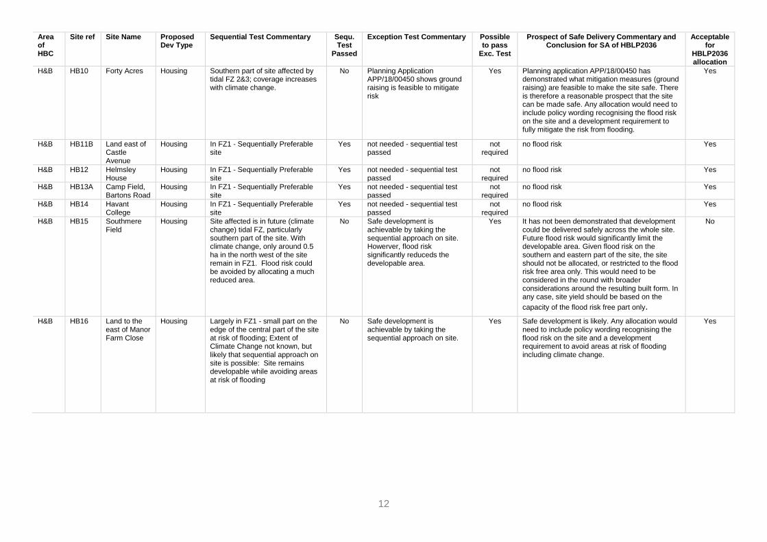
H&B HB10 Forty Acres Housing Southern part of site affected by tidal FZ 2&3; coverage increases with climate change.
No Planning Application APP/18/00450 shows ground raising is feasible to mitigate risk
Yes Planning application APP/18/00450 has demonstrated what mitigation measures (ground raising) are feasible to make the site safe. There is therefore a reasonable prospect that the site can be made safe. Any allocation would need to include policy wording recognising the flood risk on the site and a development requirement to fully mitigate the risk from flooding.
Yes
H&B HB11B Land east of Castle Avenue
Housing In FZ1 - Sequentially Preferable site
Yes not needed - sequential test passed
not required
no flood risk Yes
H&B HB12 Helmsley House
Housing In FZ1 - Sequentially Preferable site
Yes not needed - sequential test passed
not required
no flood risk Yes
H&B HB13A Camp Field, Bartons Road
Housing In FZ1 - Sequentially Preferable site
Yes not needed - sequential test passed
not required
no flood risk Yes
H&B HB14 Havant College
Housing In FZ1 - Sequentially Preferable site
Yes not needed - sequential test passed
not required
no flood risk Yes
H&B HB15 Southmere Field
Housing Site affected is in future (climate change) tidal FZ, particularly southern part of the site. With climate change, only around 0.5 ha in the north west of the site remain in FZ1. Flood risk could be avoided by allocating a much reduced area.
No Safe development is achievable by taking the sequential approach on site. Howerver, flood risk significantly reduceds the developable area.
Yes It has not been demonstrated that development could be delivered safely across the whole site. Future flood risk would significantly limit the developable area. Given flood risk on the southern and eastern part of the site, the site should not be allocated, or restricted to the flood risk free area only. This would need to be considered in the round with broader considerations around the resulting built form. In any case, site yield should be based on the
capacity of the flood risk free part only.
No
H&B HB16 Land to the east of Manor Farm Close
Housing Largely in FZ1 - small part on the edge of the central part of the site at risk of flooding; Extent of Climate Change not known, but likely that sequential approach on site is possible: Site remains developable while avoiding areas at risk of flooding
No Safe development is achievable by taking the sequential approach on site.
Yes Safe development is likely. Any allocation would need to include policy wording recognising the flood risk on the site and a development requirement to avoid areas at risk of flooding including climate change.
Yes
13
Area of HBC
Site ref Site Name Proposed Dev Type
Sequential Test Commentary Sequ. Test
Passed
Exception Test Commentary Possible to pass
Exc. Test
Prospect of Safe Delivery Commentary and Conclusion for SA of HBLP2036
Acceptable for
HBLP2036 allocation
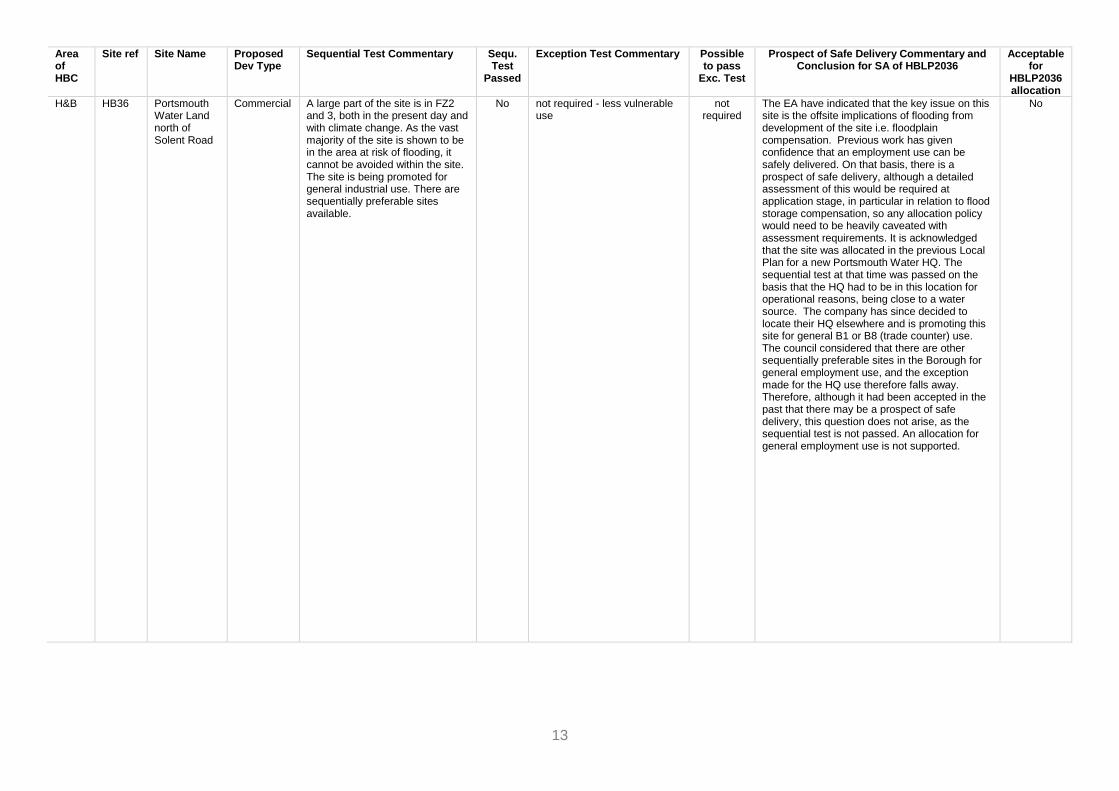
H&B HB36 Portsmouth Water Land north of Solent Road
Commercial A large part of the site is in FZ2 and 3, both in the present day and with climate change. As the vast majority of the site is shown to be in the area at risk of flooding, it cannot be avoided within the site. The site is being promoted for general industrial use. There are sequentially preferable sites available.
No not required - less vulnerable use
not required
The EA have indicated that the key issue on this site is the offsite implications of flooding from development of the site i.e. floodplain compensation. Previous work has given confidence that an employment use can be safely delivered. On that basis, there is a prospect of safe delivery, although a detailed assessment of this would be required at application stage, in particular in relation to flood storage compensation, so any allocation policy would need to be heavily caveated with assessment requirements. It is acknowledged that the site was allocated in the previous Local Plan for a new Portsmouth Water HQ. The sequential test at that time was passed on the basis that the HQ had to be in this location for operational reasons, being close to a water source. The company has since decided to locate their HQ elsewhere and is promoting this site for general B1 or B8 (trade counter) use. The council considered that there are other sequentially preferable sites in the Borough for general employment use, and the exception made for the HQ use therefore falls away. Therefore, although it had been accepted in the past that there may be a prospect of safe delivery, this question does not arise, as the sequential test is not passed. An allocation for general employment use is not supported.
No
14
Area of HBC
Site ref Site Name Proposed Dev Type
Sequential Test Commentary Sequ. Test
Passed
Exception Test Commentary Possible to pass
Exc. Test
Prospect of Safe Delivery Commentary and Conclusion for SA of HBLP2036
Acceptable for
HBLP2036 allocation
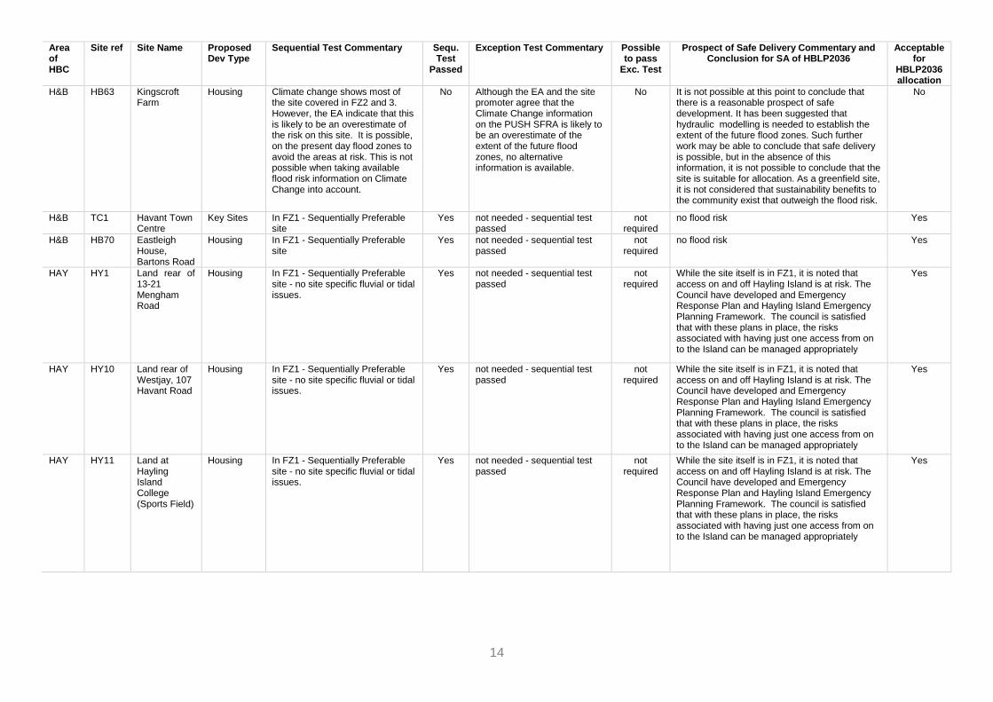
H&B HB63 Kingscroft Farm
Housing Climate change shows most of the site covered in FZ2 and 3. However, the EA indicate that this is likely to be an overestimate of the risk on this site. It is possible, on the present day flood zones to avoid the areas at risk. This is not possible when taking available flood risk information on Climate Change into account.
No Although the EA and the site promoter agree that the Climate Change information on the PUSH SFRA is likely to be an overestimate of the extent of the future flood zones, no alternative information is available.
No It is not possible at this point to conclude that there is a reasonable prospect of safe development. It has been suggested that hydraulic modelling is needed to establish the extent of the future flood zones. Such further work may be able to conclude that safe delivery is possible, but in the absence of this information, it is not possible to conclude that the site is suitable for allocation. As a greenfield site, it is not considered that sustainability benefits to the community exist that outweigh the flood risk.
No
H&B TC1 Havant Town Centre
Key Sites In FZ1 - Sequentially Preferable site
Yes not needed - sequential test passed
not required
no flood risk Yes
H&B HB70 Eastleigh House, Bartons Road
Housing In FZ1 - Sequentially Preferable site
Yes not needed - sequential test passed
not required
no flood risk Yes
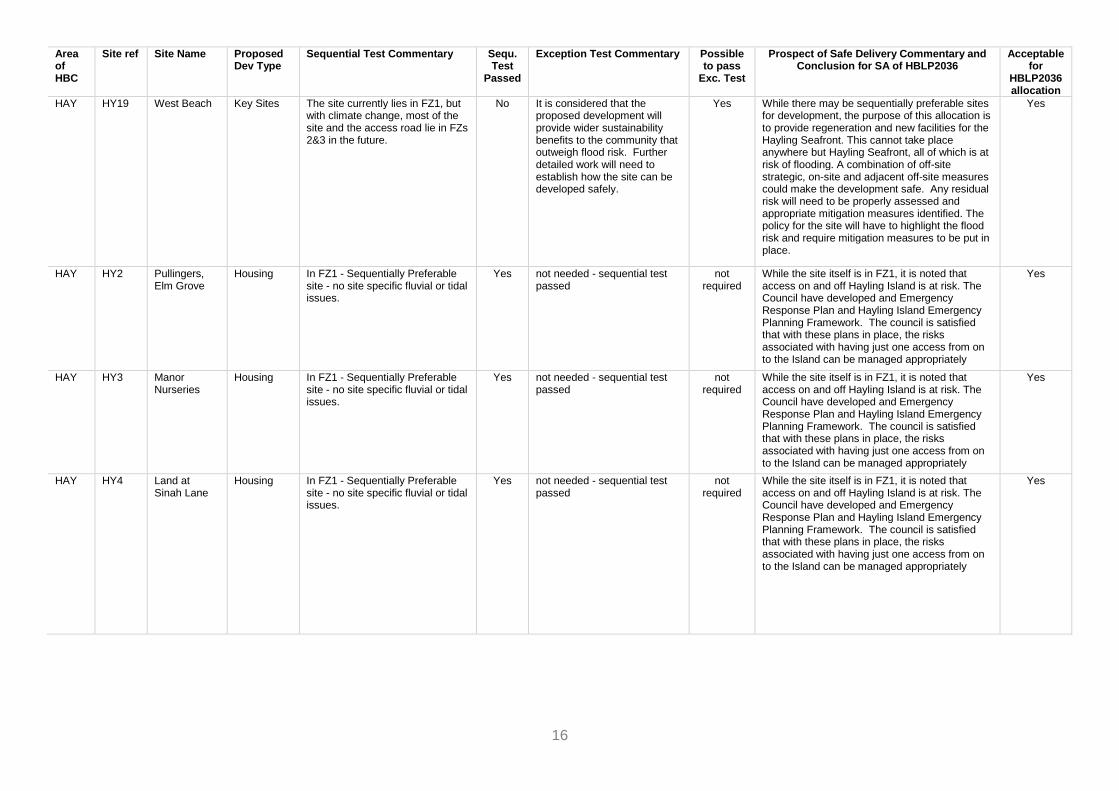
HAY HY1 Land rear of 13-21 Mengham Road
Housing In FZ1 - Sequentially Preferable site - no site specific fluvial or tidal issues.
Yes not needed - sequential test passed
not required
While the site itself is in FZ1, it is noted that access on and off Hayling Island is at risk. The Council have developed and Emergency Response Plan and Hayling Island Emergency Planning Framework. The council is satisfied that with these plans in place, the risks associated with having just one access from on to the Island can be managed appropriately
Yes
HAY HY10 Land rear of Westjay, 107 Havant Road
Housing In FZ1 - Sequentially Preferable site - no site specific fluvial or tidal issues.
Yes not needed - sequential test passed
not required
While the site itself is in FZ1, it is noted that access on and off Hayling Island is at risk. The Council have developed and Emergency Response Plan and Hayling Island Emergency Planning Framework. The council is satisfied that with these plans in place, the risks associated with having just one access from on to the Island can be managed appropriately
Yes
HAY HY11 Land at Hayling Island College (Sports Field)
Housing In FZ1 - Sequentially Preferable site - no site specific fluvial or tidal issues.
Yes not needed - sequential test passed
not required
While the site itself is in FZ1, it is noted that access on and off Hayling Island is at risk. The Council have developed and Emergency Response Plan and Hayling Island Emergency Planning Framework. The council is satisfied that with these plans in place, the risks associated with having just one access from on to the Island can be managed appropriately
Yes

15
Area of HBC
Site ref Site Name Proposed Dev Type
Sequential Test Commentary Sequ. Test
Passed
Exception Test Commentary Possible to pass
Exc. Test
Prospect of Safe Delivery Commentary and Conclusion for SA of HBLP2036
Acceptable for
HBLP2036 allocation
HAY HY16 The Nab Car Park, Southwood Road
Key Sites Significant proportion of the site area is in FZ2&3, including the access road. With climate change, almost the entirety of the site will be in FZ 2&3 in the future.
No It is considered that the proposed development will provide wider sustainability benefits to the community that outweigh flood risk. Further detailed work will need to establish how the site can be developed safely.
Yes While there may be sequentially preferable sites for development, the purpose of this allocation is to provide regeneration and new facilities for the Hayling Seafront. This cannot take place anywhere but Hayling Seafront, all of which is at risk of flooding. A combination of off-site strategic, on-site and adjacent off-site measures could make the development safe. Any residual risk will need to be properly assessed and appropriate mitigation measures identified. The policy for the site will have to highlight the flood risk and require mitigation measures to be put in place.
Yes
HAY HY17 Beachlands Key Sites The site currently lies in FZ1, but with climate change, significant parts are shown to be at risk in the future. The access road also lies in FZs 2&3 in the future.
No It is considered that the proposed development will provide wider sustainability benefits to the community that outweigh flood risk. Further detailed work will need to establish how the site can be developed safely.
Yes While there may be sequentially preferable sites for development, the purpose of this allocation is to provide regeneration and new facilities for the Hayling Seafront. This cannot take place anywhere but Hayling Seafront, all of which is at risk of flooding. A combination of off-site strategic, on-site and adjacent off-site measures could make the development safe. Any residual risk will need to be properly assessed and appropriate mitigation measures identified. The policy for the site will have to highlight the flood risk and require mitigation measures to be put in place.
Yes
HAY HY18 Eastoke Corner
Key Sites Significant proportion of the site area is in FZ2, including the access road to the west, and the road running through the site. The road running norther is unaffected in the current day, but becomes vulnerable in the climate change scenario. The area of the undeveloped green on the corner of Rails Lane and the Seafront is in FZ1, and remains largely unaffected by the climate change scenario.
No It is considered that the proposed development will provide wider sustainability benefits to the community that outweigh flood risk. Further detailed work will need to establish how the site can be developed safely.
tbc While there may be sequentially preferable sites for development, the purpose of this allocation is to provide regeneration and new facilities for the Hayling Seafront. This cannot take place anywhere but Hayling Seafront, all of which is at risk of flooding. A combination of off-site strategic, on-site and adjacent off-site measures could make the development safe. Any residual risk will need to be properly assessed and appropriate mitigation measures identified. The policy for the site will have to highlight the flood risk and require mitigation measures to be put in place.
Yes
16
Area of HBC
Site ref Site Name Proposed Dev Type
Sequential Test Commentary Sequ. Test
Passed
Exception Test Commentary Possible to pass
Exc. Test
Prospect of Safe Delivery Commentary and Conclusion for SA of HBLP2036
Acceptable for
HBLP2036 allocation
HAY HY19 West Beach Key Sites The site currently lies in FZ1, but with climate change, most of the site and the access road lie in FZs 2&3 in the future.
No It is considered that the proposed development will provide wider sustainability benefits to the community that outweigh flood risk. Further detailed work will need to establish how the site can be developed safely.
Yes While there may be sequentially preferable sites for development, the purpose of this allocation is to provide regeneration and new facilities for the Hayling Seafront. This cannot take place anywhere but Hayling Seafront, all of which is at risk of flooding. A combination of off-site strategic, on-site and adjacent off-site measures could make the development safe. Any residual risk will need to be properly assessed and appropriate mitigation measures identified. The policy for the site will have to highlight the flood risk and require mitigation measures to be put in place.
Yes
HAY HY2 Pullingers, Elm Grove
Housing In FZ1 - Sequentially Preferable site - no site specific fluvial or tidal issues.
Yes not needed - sequential test passed
not required
While the site itself is in FZ1, it is noted that access on and off Hayling Island is at risk. The Council have developed and Emergency Response Plan and Hayling Island Emergency Planning Framework. The council is satisfied that with these plans in place, the risks associated with having just one access from on to the Island can be managed appropriately
Yes
HAY HY3 Manor Nurseries
Housing In FZ1 - Sequentially Preferable site - no site specific fluvial or tidal issues.
Yes not needed - sequential test passed
not required
While the site itself is in FZ1, it is noted that access on and off Hayling Island is at risk. The Council have developed and Emergency Response Plan and Hayling Island Emergency Planning Framework. The council is satisfied that with these plans in place, the risks associated with having just one access from on to the Island can be managed appropriately
Yes
HAY HY4 Land at Sinah Lane
Housing In FZ1 - Sequentially Preferable site - no site specific fluvial or tidal issues.
Yes not needed - sequential test passed
not required
While the site itself is in FZ1, it is noted that access on and off Hayling Island is at risk. The Council have developed and Emergency Response Plan and Hayling Island Emergency Planning Framework. The council is satisfied that with these plans in place, the risks associated with having just one access from on to the Island can be managed appropriately
Yes

17
Area of HBC
Site ref Site Name Proposed Dev Type
Sequential Test Commentary Sequ. Test
Passed
Exception Test Commentary Possible to pass
Exc. Test
Prospect of Safe Delivery Commentary and Conclusion for SA of HBLP2036
Acceptable for
HBLP2036 allocation
HAY HY5 Land north of Tournerbury Lane
Housing In FZ1 - Sequentially Preferable site - no site specific fluvial or tidal issues.
Yes not needed - sequential test passed
not required
While the site itself is in FZ1, it is noted that access on and off Hayling Island is at risk. The Council have developed and Emergency Response Plan and Hayling Island Emergency Planning Framework. The council is satisfied that with these plans in place, the risks associated with having just one access from on to the Island can be managed appropriately
Yes
HAY HY6 Northney Marina
Housing Small area on edge of site in tidal FZ2&3 (increases with climate change), but access road substantially affected by FZ2&3.
No Detailed FRA work has demonstrated that proposed buildings will remain safe and not subject to flooding. Flooding on access is considered to be predicable with several days advance notice, so can be managed by means of a robust flood risk management plan.
Yes Detailed FRA work has demonstrated that proposed buildings can remain safe and not subject to flooding, by siting proposed residential development on the highest ground within the site, and raising the level of the commercial area. Flooding on access is considered to be predicable with several days advance notice, so can be managed by means of a robust flood risk management plan. Policy would have to require that this is prepared as part of application.
Yes
HAY HY7 Fathoms Reach
Housing In FZ1 - Sequentially Preferable site - no site specific fluvial or tidal issues.
Yes not needed - sequential test passed
not required
While the site itself is in FZ1, it is noted that access on and off Hayling Island is at risk. The Council have developed and Emergency Response Plan and Hayling Island Emergency Planning Framework. The council is satisfied that with these plans in place, the risks associated with having just one access from on to the Island can be managed appropriately
Yes
HAY HY8 Rook Farm Housing In FZ1 - Sequentially Preferable site - no site specific fluvial or tidal issues.
Yes not needed - sequential test passed
not required
While the site itself is in FZ1, it is noted that access on and off Hayling Island is at risk. The Council have developed and Emergency Response Plan and Hayling Island Emergency Planning Framework. The council is satisfied that with these plans in place, the risks associated with having just one access from on to the Island can be managed appropriately
Yes

18
Area of HBC
Site ref Site Name Proposed Dev Type
Sequential Test Commentary Sequ. Test
Passed
Exception Test Commentary Possible to pass
Exc. Test
Prospect of Safe Delivery Commentary and Conclusion for SA of HBLP2036
Acceptable for
HBLP2036 allocation
HAY HY9 Land south of Stoke Barn
Housing In FZ1 - Sequentially Preferable site - no site specific fluvial or tidal issues.
Yes not needed - sequential test passed
not required
While the site itself is in FZ1, it is noted that access on and off Hayling Island is at risk. The Council have developed and Emergency Response Plan and Hayling Island Emergency Planning Framework. The council is satisfied that with these plans in place, the risks associated with having just one access from on to the Island can be managed appropriately
Yes
HAY HY46 Land north of Selsmore Road
Housing Currently, a very small part in the south eastern corner of the site is affected by Flood Zones 2 and 3. The area at risk of flooding increases notably with climate change, covering the likely access point off Selsmore Road and a large part of the site.
No Flood Risk on site could be avoided. This would require a much reduced area / housing yield. No information available to demonstrate that a safe access could be delivered, particularly in the climate change scenario.
No While a much reduced development could be brought forward on land not at risk of flooding, it has not been demonstrated that safe access could be delivered. While risk on the site could be avoided by reducing substantially the developable area and therefore the number of homes, it has not been demonstrated that safe access is achievable. Together, these call into question the desirability of an allocation on this greenfield site.
No
HAY HY49 41 Station Road
Housing In FZ1 - Sequentially Preferable site - no site specific fluvial or tidal issues.
Yes not needed - sequential test passed
not required
While the site itself is in FZ1, it is noted that access on and off Hayling Island is at risk. The Council have developed and Emergency Response Plan and Hayling Island Emergency Planning Framework. The council is satisfied that with these plans in place, the risks associated with having just one access from on to the Island can be managed appropriately
Yes
HAY BD77 Northney Marina
Commercial Small area on edge of site in tidal FZ2&3 (increases with climate change), but access road substantially affected by FZ2&3.
No proposed use classed as mixture of 'water compatible' and 'less vulnerable'. Exception test not required. Nevertheless, floor levels may be raised to lift buildings out of flood risk.
not required
Detailed FRA work has demonstrated that proposed buildings can remain safe and not subject to flooding, by siting proposed residential development on the highest ground within the site, and raising the level of the commercial area. Flooding on access is considered to be predicable with several days advance notice, so can be managed by means of a robust flood risk management plan. Policy would have to require that this is prepared as part of application.
Yes
LEI TC2 Leigh Park District Centre
Key Sites In FZ1 - Sequentially Preferable site
Yes not needed - sequential test passed
not required
no flood risk Yes
LEI LP1 Strouden Court
Housing In FZ1 - Sequentially Preferable site
Yes not needed - sequential test passed
not required
no flood risk Yes

19
Area of HBC
Site ref Site Name Proposed Dev Type
Sequential Test Commentary Sequ. Test
Passed
Exception Test Commentary Possible to pass
Exc. Test
Prospect of Safe Delivery Commentary and Conclusion for SA of HBLP2036
Acceptable for
HBLP2036 allocation
LEI LP2 Land at Riders Lane
Housing Very close to the fluvial FZ for the Hermitage Stream. Extent inreases into western part of site with climate change. Sequential approach on site is possible: Site remains developable while avoiding areas at risk of flooding.
No Safe development is achievable by taking the sequential approach on site.
Yes The draft policy already suggests that the open space required to support the development should be the western part of the site. Strengthen policy wording to recognise flood risk on the site and include a requirement to avoid areas at risk of flooding including climate change. In addition, clarify that any flood storage and attenuation needs to be located outside of the areas at risk of flooding.
Yes
LEI LP3 Land at Dunsbury Way
Housing In FZ1 - Sequentially Preferable site
Yes not needed - sequential test passed
not required
no flood risk Yes
LEI LP4 Scottish and Southern Energy Offices
Housing In FZ1 - Sequentially Preferable site
Yes not needed - sequential test passed
not required
no flood risk Yes
LEI LP5A Cabbagefield Row
Housing In FZ1 - Sequentially Preferable site
Yes not needed - sequential test passed
not required
no flood risk Yes
LEI LP6 Colt Site Housing In FZ1 - Sequentially Preferable site
Yes not needed - sequential test passed
not required
no flood risk Yes
LEI n/a Havant Thicket Reservoir
Reservoir Not assessed further as proposed development is a reservoir. Many factors govern where this can be located - it would not be appropriate to apply the sequential test to this type of facility.
n/a not required - water use not required
It is noted that flood risk can arise from a reservoir, it is not possible to assess this a the Local Plan level. The detailed work on flood risk arising from the reservoir will take place at the detailed design and planning stage. The policy needs to reflect this.
Yes
LEI LP127 Land east if A3(M) at Hulbert Road
Commercial / Housing
In FZ1 - Sequentially Preferable site
Yes not needed - sequential test passed
not required
no flood risk Yes
LEI BD63 Dunsbury Park
Commercial In FZ1 - Sequentially Preferable site
Yes not needed - sequential test passed
not required
no flood risk Yes
LEI BD65 Land South of Fulflood Road
Commercial In FZ1 - Sequentially Preferable site
Yes not needed - sequential test passed
not required
no flood risk Yes
LEI BD83 Leigh Park Gas Holder
Commercial In FZ1 - Sequentially Preferable site
Yes not needed - sequential test passed
not required
no flood risk Yes
LEI BD84 Velocity, Stanbridge Road
Commercial In FZ1 - Sequentially Preferable site
Yes not needed - sequential test passed
not required
no flood risk Yes
LEI BD85 Colt Site, New Lane
Commercial In FZ1 - Sequentially Preferable site
Yes not needed - sequential test passed
not required
no flood risk Yes
WAT TC3 Waterlooville Town Centre
Key Sites In FZ1 - Sequentially Preferable site
Yes not needed - sequential test passed
not required
no flood risk Yes
WAT WV1 154 London Road
Housing In FZ1 - Sequentially Preferable site
Yes not needed - sequential test passed
not required
no flood risk Yes

20
Area of HBC
Site ref Site Name Proposed Dev Type
Sequential Test Commentary Sequ. Test
Passed
Exception Test Commentary Possible to pass
Exc. Test
Prospect of Safe Delivery Commentary and Conclusion for SA of HBLP2036
Acceptable for
HBLP2036 allocation
WAT WV2 Padnell Grange
Housing In FZ1 - Sequentially Preferable site
Yes not needed - sequential test passed
not required
no flood risk Yes
WAT WV3 Woodcroft Primary School
Housing In FZ1 - Sequentially Preferable site
Yes not needed - sequential test passed
not required
no flood risk Yes
WAT WV4 Blue Star Housing In FZ1 - Sequentially Preferable site
Yes not needed - sequential test passed
not required
no flood risk Yes
WAT WV5 Woodcroft Farm
Housing In FZ1 - Sequentially Preferable site
Yes not needed - sequential test passed
not required
no flood risk Yes
WAT WV6 Campdown Housing In FZ1 - Sequentially Preferable site
Yes not needed - sequential test passed
not required
no flood risk Yes
WAT WV7 South Downs College
Housing In FZ1 - Sequentially Preferable site
Yes not needed - sequential test passed
not required
no flood risk Yes
WAT WV9 Land at Waterlooville Golf Club
Housing In FZ1 - Sequentially Preferable site
Yes not needed - sequential test passed
not required
no flood risk Yes
WAT WV10 Land south of Purbrook Heath Road
Housing Northern parcel lies in FZ2&3; southern part along London Road in FZ1; no climate change data is available
No Flood risk could be avoided if only the southern part along London Road was allocated.
Yes Flood risk could be avoided if only the southern part along London Road was allocated or policy would have to stipulate that areas at risk of flooding now and in the future must be avoided.
Yes
WAT WV11 Land at Crookhorn College
Housing In FZ1 - Sequentially Preferable site
Yes not needed - sequential test passed
not required
no flood risk Yes
WAT WV69 Land north of High Bank Avenue, Widley
Housing In FZ1 - Sequentially Preferable site
Yes not needed - sequential test passed
not required
no flood risk Yes
WAT BD54 Former BAE Systems Park
Commercial Small area in southern part of site affected by tidal FZ2. Sequential approach on site is possible: Site remains developable while avoiding areas at risk of flooding.
No Safe development is achievable by taking the sequential approach on site.
not required
Safe development is achievable by taking the sequential approach on site. Policy to stipulate that areas at risk of flooding now and in the future must be avoided.
Yes

Strategic Flood Risk Assessment (Local Plan Sites) | November 2018
21
3. Findings
Summary 3.1 This review has pulled together flood risk information for all the sites proposed for allocation
in the Havant Borough Local Plan 2036.
3.2 Some have been shown to be free from the risk of tidal or fluvial flooding. For others, there
are area wide policy approaches which make them acceptable, and for others again, it is
possible to avoid flood risk within the site.
3.3 Those sites with more fundamental issues the prospect of safe delivery have been assessed
in greater detail. Only those sites, where either further evidence has shown that there is a
reasonable prospect that flood risk may be overcome, or where there are overriding
sustainability reasons why the site should be allocated have been suggested for allocation.
3.4 This documents views flood risk in isolation. This is of course not the only factor to be
considered in determining whether to take forward a site as a development allocation in the
Local Plan. The findings of this report have formed just one part of the Sustainability
Appraisal of the Local Plan, where the final conclusion as to whether to allocate a site is
drawn.
Implications for HBLP2036 3.5 As well as determining which sites are suitable for allocation, the work has highlighted a
number of other matters to take forward into the Local Plan.
a) For sites that are subject to flood risk, even where it has been determined through this
assessment that safe delivery is possible, the site allocation policy will need to highlight
the flood risk and set a development requirement that it must be dealt with satisfactorily
before development can go ahead, together with any more site specific requirements
established through this assessment.
b) This assessment has focussed on tidal and fluvial flood risk. However, at site specific
level, other forms of flooding, including from surface water are equally important. It is
proposed that the Local Plan includes two topic policies covering Flood Risk and
Drainage. Together, these will ensure developers fully consider flood risk and drainage
and deliver a package of measures to ensure sites are safe from flooding and flood risk
and drainage are adequately managed into the future. They include requirements to:
• Undertake site specific flood risk assessments
• meet the sequential and exception tests as set out in the NPPF;
• demonstrate that development will be safe over its lifetime without increasing
flood risk elsewhere;
• put in place appropriate flood warning and evacuation plans
• make contributions towards any identified flood alleviation scheme(s).

22
• Reduce run-off rates to below the pre-development rate, or, if this is not possible,
to allow no increase in surface water run-off compared with the pre-development
rate;
• Design drainage systems so that they meet the drainage needs of the
development in full over the lifetime of the development and do not increase flood
risk elsewhere;
• Incorporates sustainable drainage systems, unless there is clear evidence that
this would be inappropriate;
c) The Council will continue to work with its partners to bring about strategic flood risk
management schemes, this includes Coastal Defence Schemes and fluvial flood risk
management schemes, particularly in Emsworth. Any schemes known at the time of
writing will be highlighted in the Council’s Infrastructure Delivery Plan and/or relevant
policies in the plan, and land will be safeguard for their delivery.
Future Planning Applications 3.6 The information presented in this report will facilitate decisions on the strategic allocation of
sites for future development. This does not preclude the need for developers to undertake
site specific flood risk assessments (FRAs). This document, by its very nature, is a high level
assessment of flood risk at the local authority level. It does not provide sufficiently detailed
information to satisfy all of the requirements of a site specific FRA as outlined in the National
Planning Policy Framework. As such these will still be required on sites in FZ 2&3 or of 1 ha
or more in size. These will also have to consider all sources of flooding.

23
Appendix A: Sequentially
Preferable Sites Group I. Sites unaffected by tidal of fluvial flood risk
Site Ref
Site Name
Area of the Borough
Commentary
BD1 Langstone Technology Park Havant & Bedhampton In FZ1 - Sequentially Preferable site
HB1 Wessex Site Havant & Bedhampton In FZ1 - Sequentially Preferable site
HB2 Portsmouth Water HQ Havant & Bedhampton In FZ1 - Sequentially Preferable site
HB4 9 East Street Havant & Bedhampton In FZ1 - Sequentially Preferable site
HB5B Land south of Bartons Road Havant & Bedhampton In FZ1 - Sequentially Preferable site
HB6 Littlepark House Havant & Bedhampton In FZ1 - Sequentially Preferable site
HB7 Land south of Lower Road Havant & Bedhampton In FZ1 - Sequentially Preferable site
HB8 Havant Garden Centre Havant & Bedhampton In FZ1 - Sequentially Preferable site
HB9 Southleigh Park House Havant & Bedhampton In FZ1 - Sequentially Preferable site
HB11B Land east of Castle Avenue Havant & Bedhampton In FZ1 - Sequentially Preferable site
HB12 Helmsley House Havant & Bedhampton In FZ1 - Sequentially Preferable site
HB13A Camp Field, Bartons Road Havant & Bedhampton In FZ1 - Sequentially Preferable site
HB14 Havant College Havant & Bedhampton In FZ1 - Sequentially Preferable site
HB70 Eastleigh House, Bartons Road Havant & Bedhampton In FZ1 - Sequentially Preferable site
TC1 Havant Town Centre Havant & Bedhampton In FZ1 - Sequentially Preferable site
BD63 Dunsbury Park Leigh Park In FZ1 - Sequentially Preferable site
BD65 Land South of Fulflood Road Leigh Park In FZ1 - Sequentially Preferable site
BD83 Leigh Park Gas Holder Leigh Park In FZ1 - Sequentially Preferable site
BD84 Velocity, Stanbridge Road Leigh Park In FZ1 - Sequentially Preferable site
BD85 Colt Site, New Lane Leigh Park In FZ1 - Sequentially Preferable site
LP1 Strouden Court Leigh Park In FZ1 - Sequentially Preferable site
LP3 Land at Dunsbury Way Leigh Park In FZ1 - Sequentially Preferable site
LP4 Scottish and Southern Energy Offices Leigh Park In FZ1 - Sequentially Preferable site
LP5A Cabbagefield Row Leigh Park In FZ1 - Sequentially Preferable site
LP6 Colt Site Leigh Park In FZ1 - Sequentially Preferable site
TC2 Leigh Park District Centre Leigh Park In FZ1 - Sequentially Preferable site
LP127 Land east if A3(M) at Hulbert Road Leigh Park In FZ1 - Sequentially Preferable site
TC3 Waterlooville Town Centre Waterlooville In FZ1 - Sequentially Preferable site
WV1 154 London Road Waterlooville In FZ1 - Sequentially Preferable site
WV2 Padnell Grange Waterlooville In FZ1 - Sequentially Preferable site
WV3 Woodcroft Primary School Waterlooville In FZ1 - Sequentially Preferable site
WV4 Blue Star Waterlooville In FZ1 - Sequentially Preferable site
WV5 Woodcroft Farm Waterlooville In FZ1 - Sequentially Preferable site
WV6 Campdown Waterlooville In FZ1 - Sequentially Preferable site
WV7 South Downs College Waterlooville In FZ1 - Sequentially Preferable site
WV9 Land at Waterlooville Golf Club Waterlooville In FZ1 - Sequentially Preferable site
WV11 Land at Crookhorn College Waterlooville In FZ1 - Sequentially Preferable site
WV69 Land north of High Bank Avenue Waterlooville In FZ1 - Sequentially Preferable site
24
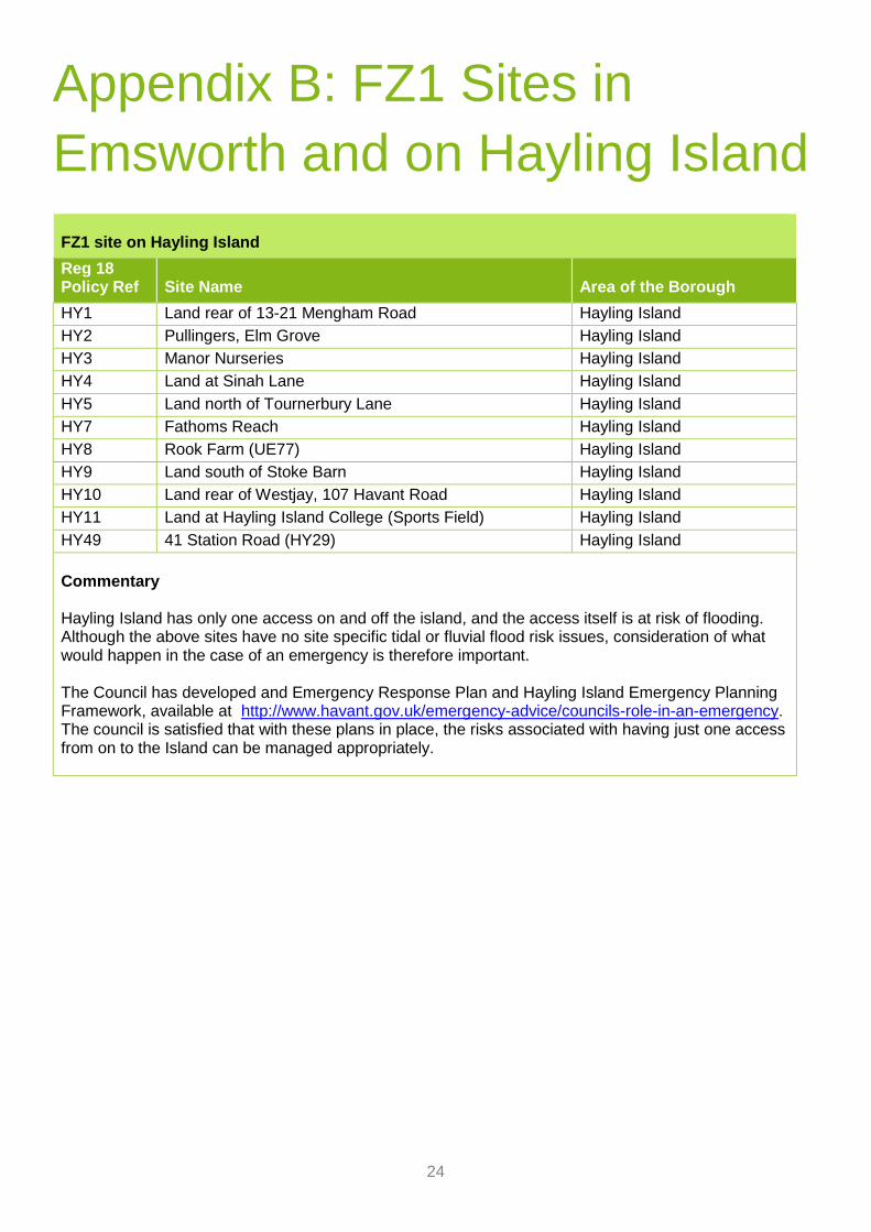
Appendix B: FZ1 Sites in
Emsworth and on Hayling Island FZ1 site on Hayling Island
Reg 18 Policy Ref
Site Name
Area of the Borough
HY1 Land rear of 13-21 Mengham Road Hayling Island
HY2 Pullingers, Elm Grove Hayling Island
HY3 Manor Nurseries Hayling Island
HY4 Land at Sinah Lane Hayling Island
HY5 Land north of Tournerbury Lane Hayling Island
HY7 Fathoms Reach Hayling Island
HY8 Rook Farm (UE77) Hayling Island
HY9 Land south of Stoke Barn Hayling Island
HY10 Land rear of Westjay, 107 Havant Road Hayling Island
HY11 Land at Hayling Island College (Sports Field) Hayling Island
HY49 41 Station Road (HY29) Hayling Island
Commentary Hayling Island has only one access on and off the island, and the access itself is at risk of flooding. Although the above sites have no site specific tidal or fluvial flood risk issues, consideration of what would happen in the case of an emergency is therefore important. The Council has developed and Emergency Response Plan and Hayling Island Emergency Planning Framework, available at http://www.havant.gov.uk/emergency-advice/councils-role-in-an-emergency. The council is satisfied that with these plans in place, the risks associated with having just one access from on to the Island can be managed appropriately.

25
FZ1 Sites in Emsworth
Reg 18 Policy Ref
Site Name
Area of the Borough
EM1 Emsworth Victoria Cottage Hospital Emsworth
EM4 Land at Selangor Avenue Emsworth
EM7 Land North of Long Copse Lane Emsworth
EM9 Land South of Long Copse Lane (UE46) Emsworth
EM10 Land west of Westbourne Emsworth
Commentary National Guidance on Flood Risk states that ‘Within each flood zone, surface water and other sources
of flooding also need to be taken into account in applying the sequential approach to the location of
development’10. Therefore, ways in which drainage capacity in Emsworth, and across the Borough,
is proposed to be addressed through the Local Plan is set out in this section, and the conclusions
reflected in the Site Assessment Table at Appendix 1 for sites in Emsworth.
The adopted Local Plan included a specific policy on Managing Flood Risk in Emsworth. That policy
required development to reduce post development runoff in order to reduce pressure on the drainage
system and aim to improve the existing standard of protection. In the Local Plan 2036, these
provisions are proposed to be integrated into a Drainage Infrastructure Policy and a Flood Risk
Management policy, both covering the whole borough. The intention is not to remove the policy
requirements previously in place for Emsworth, rather it is to maintain these and apply the good
practice established here across the borough, given the additional pressure the planned development
will have on the borough’s drainage system. The policy requirements include that
• Run-off rates have been reduced to below the pre-development rate, or, if this is not possible,
there is no net increase in surface water run-off compared with the pre-development rate;
• Drainage systems meet the drainage needs of the development in full over the lifetime of the
development and do not increase flood risk elsewhere;
• The drainage strategy incorporates sustainable drainage systems, unless there is clear
evidence that this would be inappropriate;
• Where necessary, a contribution has been made towards any identified flood alleviation
scheme(s).
These policies will be carried forward into any site allocations, where they apply, as a development
requirement which states that planning will only be granted where the developer provides a drainage
solution which reduces surface water run-off and makes a contribution towards identified flood
alleviation schemes in the area.
As such, it is considered that concerns about flood risk in Emsworth for those sites which do not have
additional site specific fluvial or tidal issues is adequately addressed by these policy requirements.
On that basis, it is concluded in this report that there is a reasonable prospect of these sites being
safe over their lifetime without increasing the risk of flooding elsewhere.
10 NPPG Paragraph: 019 Reference ID: 7-019-20140306

26
Appendix C: Detailed Site
Reviews

27
Hayling Seafront: The Nab Car Park, Southwood Road - Site Ref: HY16
Basic Information
The Site: The site lies on the seafront in the South East of Hayling Island.
Site Area: 0.27ha Allocation Proposal: Residential (‘more vulnerable’) and community centre (‘less vulnerable’)
Flood Risk Information
Source / Pathway: The dominant source of flooding to this site will be tidal flooding. The pathway will be overtopping of the frontage to the south of the site. Level of Flood Risk: The site currently lies within flood zone 2. However with climate change and associated sea level rise some of the site will be within flood zone 2 & 3 within the development lifetime (Estimated 2085). Also tidal flooding during a design event will make safe access and exit impossible. Ground levels on the access road into the site are around 3.7-4.0m AOD. This could result in a depth of flooding between 0.5 and 1 metre, which could increase if waves are particularly large The present day 1:200 year extreme tidal flood level for Chichester Harbour is 3.4 mAOD, increasing to a predicted 4.5 mAOD by the year 2115 (design tide level), due to the effects of climate change. In addition, the present day 1:1000 year extreme tidal flood level for Chichester Harbour is 3.6 mAOD, increasing to a predicted 4.7 mAOD by the year 2115. The impact of waves can be significant in this area. It is a high energy frontage with a dynamic shingle defence which is vulnerable to modification by certain wave events
Current Day Zones 2 & 3 vs Climate Change 2115. Source: EA Flood Map and PUSH SFRA
Sequential Approach - Can areas of flood risk be avoided?
No – climate change assumptions show a large portion of the site, and the access, in FZ 2 & 3 in the future.
If flood risk cannot be avoided, what is the preferred approach?
Off-site strategic measures: The North Solent Shoreline Management Plan (2010) identifies a policy of Hold the Line for the entire Hayling open coast. The Eastoke Sectoral Strategy identified the option of ‘rock revetment with groynes, recharge and recycling’ as the preference for delivering flood and erosion protection to a 1 in 200 year standard of protection, in line with this Hold the Line policy. The £5m scheme to implement this multi-faceted approach was completed in November 2013. The South Hayling Beach Management Plan identifies a strategy for delivering the beach management approach along the open coast over the five-year period to 2022).

28
Hayling Seafront: The Nab Car Park, Southwood Road - Site Ref: HY16
Funding has also been secured for the period of 2022-2027, to undertake beach management activities to protect the area from a 1/200yr return period flood event (0.5% annual exceedance probability). It is acknowledged that funding has not yet been identified beyond this period, but the council considers it likely that off-site strategic management will continue, given the number of residential properties in the area that benefit from it. The programme this has continually been renewed for the last five period as it protects around 1,500 properties. On-site measures: Discussions held with Havant Council Engineers confirmed that the site acts as a relief area for tidal flooding in the local area. Through careful management of the flood boards, the car park is utilised as a storage area and conveyance route for tidal flood water and overtopping, which is drained via the open concrete channel into the underground drainage ultimately discharging into the harbour in the east of Hayling Island. In order to maintain the potential flood storage of the car park a similar volume of storage would need to be provided below any structures constructed on the site. This will need to consider the volume of storage and conveyance required not only now, but into the future, as overtopping volumes are likely to increase, so as not to increase the risk of flooding locally. Potentially this would mean having storage below the proposed car park. Similarly, the possibility of tide-locked conditions on the surface water outfalls(s) will also be considered in liaison with the relevant statutory authorities. To avoid immediate danger, development at the Nab Car Park would be constructed on a raised podium with no habitable space at ground level, only parking and shared access points. Flood mitigation measures should also be considered such anti-flood valves; stop boards; raised electrical sockets and plant; as well as tying into the existing and any planned seafront flood defences. A flood response plan would also need to be prepared & accepted by the LPA taking advice from the Emergency Planner and Emergency Services which would need to look at conditions experienced in a design and extreme flood event. Adjacent off site measures: A developer could undertake some raising of the access roads, if acceptable in planning terms, to tie into higher land to the west or north of the sites. This would reduce reliance upon continued funding and implementation of the beach management scheme and reduce the residual risk of flooding from breach or overtopping of the shingle beach. However, it is acknowledged that this is a built up area, so the acceptability of this solution will have to be carefully considered. The degree of raising that will be required would have to be informed by both design tide levels and potential overtopping impacts, and then assessed in terms of the visual and practical impact on the area. It would be preferred that a combination of all the options are employed to ensure that the development is safe and does not increase flood risk elsewhere. It is likely that some residual risk will remain, so there will need to be a robust Flood Response Plan which will show how flood risk will be managed i.e. through evacuation or safe refuge.
Conclusion on prospect of safe development in light of flood risk
A combination of feasible measures should ensure that the site can be made safe. The site lies within a stretch of development along this area of coast. It is therefore considered that there is a reasonable prospect that strategic measures will continue to attract funding. On site measures are also likely to be deliverable. Site specific work
will need to confirm this, fully assessing the risk and delivering appropriate mitigation measures.
Implications for Local Plan 2036
While the flood risk is acknowledged, and further detailed site level work is required to ascertain how the site can deliver safe development, the council considers that there are sustainability benefits in allocating the site, as it forms part of a wider regeneration strategy for Hayling Seafront. The policy will need to acknowledge the flood risk and set requirements for it to be addressed. It is equally acknowledged that less vulnerable uses could be considered, but these are unlikely to create sufficient value to make development viable and/or bring about wider improvements to the Seafront.

29
Hayling Seafront: Eastoke Corner – Site Ref: HY18
Basic Information
The Site: The site lies on the seafront in the South East of Hayling Island. Site Area: 2.9ha Allocation Proposal: retail, leisure and public conveniences (‘less vulnerable’); residential (‘more vulnerable’). The emerging proposals for the Eastoke are focused on improving the leisure offer for the island in the seaward side, south of the road. The existing green area on the northern corner of Rails Lane has been identified for potential residential development.
Flood Risk Information
Source / Pathway: The dominant source of flooding to this site will be tidal flooding. The primary flood risk to the sites is from tidal sources with fluvial, groundwater and artificial sources of flooding generating a low risk at both sites. The pathway will be overtopping of the frontage to the south of the site. Level of Flood Risk: Significant proportion of the site area is in FZ2, including the access road to the west, and the road running through the site. The road running norther is unaffected in the current day, but becomes vulnerable in the climate change scenario. The area of the undeveloped green on the corner of Rails Lane and the Seafront is in FZ1, and remains largely unaffected by the climate change scenario. The present day 1:200-year extreme tidal flood level for Chichester Harbour is 3.4m AOD, increasing to a predicted 4.5m AOD by the year 2115 (design tide level), due to the effects of climate change. The present day 1:1000-year extreme tidal flood level for Chichester Harbour is 3.6m AOD, increasing to a predicted 4.7m AOD by the year 2115. Ground levels on the access road into the site are around 3.7-4.0m AOD.
Current Day Zones 2 & 3 vs Climate Change 2115. Source: EA Flood Map and PUSH SFRA
Sequential Approach - Can areas of flood risk be avoided?
The residential element is proposed on that part of the site which is and remains in FZ1, avoiding the areas at risk. Nevertheless, the remainder of the site, which is proposed for leisure and retail uses, and the road running through the site is at risk of flooding (FZ2) both in the present day and the climate change scenario.
If flood risk cannot be avoided, what is the preferred approach?
Off-site strategic measures: The North Solent Shoreline Management Plan (2010) identifies a policy of Hold the Line (through evolution) for the entire Hayling open coast. The Eastoke Sectoral Strategy identified the option of ‘rock revetment with groynes, recharge and recycling’ as the preference for delivering flood and erosion protection to a 1 in 200 year standard of protection, in line with this Hold the Line policy. The £5m scheme to implement this multi-faceted approach was completed in November 2013. The South Hayling Beach Management Plan identifies a strategy for delivering the beach management approach along the open coast over the five-year period to 2022). Funding has also been secured for the period of 2022-2027, to undertake

30
Hayling Seafront: Eastoke Corner – Site Ref: HY18
beach management activities to protect the area from a 1/200yr return period flood event (0.5% annual exceedance probability). This funding also covers a feasibility study for Eastoke drainage improvement scheme. It is acknowledged that funding has not yet been identified beyond this period, but the council considers it likely that off-site strategic management will continue, given the number of residential properties in the area that benefit from it. The programme this has continually been renewed for the last five period as it protects around 1,500 properties. On-site measures: On the northern green area finished floor levels for residential and commercial should be set above the design flood level of the lifetime of the development according to the higher vulnerability classification. Whilst the area is in FZ1 it could be a precautionary principle to incorporate flood mitigation measures such anti-flood valves; stop boards; raised electrical sockets and plant. Safe access and egress for the site may not be possible during an extreme tidal flood event, therefore occupants may be reliant on the provision of safe internal refuge. Any residential development will need to demonstrate that safe internal refuge, above the 1:200 year design tide level of 4.5m AOD for Chichester Harbour in 2115, can be provided, and Flood Warning and Evacuation plan is likely to be needed.
A developer could implement land raising on the southern part of the site to reduce reliance upon continued funding and implementation of the beach management scheme, and reduce the residual risk of flooding from breach or overtopping of the shingle beach. The access through the site to the Promenade has a flood board integrated into the wall/footway. During storm flood events seawater has been known to come over at this point and flow into the corner of the road at the junction with Bembridge Close. It enters Southern Water’s system at this point and flows out into Fishery Creek when the tide has cleared. A solution for this, which could include raising the level of the path to create a hump will be considered in any design. It would be preferred that a combination of all the options are employed to ensure that the development is safe and does not increase flood risk elsewhere. It is likely that some residual risk will remain, so there will need to be a robust Flood Response Plan which will show how flood risk will be managed.
Conclusion on prospect of safe development in light of flood risk
The seafront areas within FZ2 are being proposed for intensification of the less vulnerable leisure and retail uses that currently exist in order to enhance the attractiveness of the area for visitors. These are considered acceptable
in FZ2. The more vulnerable residential uses are being proposed in FZ1. A combination of feasible measures should ensure that the site can be made safe. The site lies in a developed area of coast. It is therefore considered that there is a reasonable prospect that strategic measures will continue to attract funding. On site measures are
also likely to be deliverable. Site specific work will need to confirm this, fully assessing the risk and delivering appropriate mitigation measures.
Implications for Local Plan 2036
While the flood risk is acknowledged, and further detailed site level work is required to ascertain how the site can deliver safe development, the council considers that there are sustainability benefits in allocating the site, as it forms part of a wider regeneration strategy for Hayling Seafront. The policy will need to acknowledge the flood risk and set requirements for it to be addressed. It is equally acknowledged that less vulnerable uses could be considered, or the residential element removed from the scheme, but this approach is unlikely to create sufficient value to make development viable and/or bring about wider improvements to the Seafront.
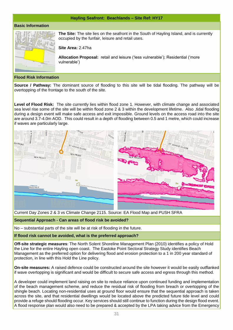
31
Hayling Seafront: Beachlands – Site Ref: HY17
Basic Information
The Site: The site lies on the seafront in the South of Hayling Island, and is currently occupied by the funfair, leisure and retail uses. Site Area: 2.47ha Allocation Proposal: retail and leisure (‘less vulnerable’); Residential (‘more vulnerable’)
Flood Risk Information
Source / Pathway: The dominant source of flooding to this site will be tidal flooding. The pathway will be overtopping of the frontage to the south of the site.
Level of Flood Risk: The site currently lies within flood zone 1. However, with climate change and associated sea level rise some of the site will be within flood zone 2 & 3 within the development lifetime. Also ,tidal flooding during a design event will make safe access and exit impossible. Ground levels on the access road into the site are around 3.7-4.0m AOD. This could result in a depth of flooding between 0.5 and 1 metre, which could increase if waves are particularly large.
Current Day Zones 2 & 3 vs Climate Change 2115. Source: EA Flood Map and PUSH SFRA
Sequential Approach - Can areas of flood risk be avoided?
No – substantial parts of the site will be at risk of flooding in the future.
If flood risk cannot be avoided, what is the preferred approach?
Off-site strategic measures: The North Solent Shoreline Management Plan (2010) identifies a policy of Hold the Line for the entire Hayling open coast. The Eastoke Point Sectoral Strategy Study identifies Beach Management as the preferred option for delivering flood and erosion protection to a 1 in 200 year standard of protection, in line with this Hold the Line policy. On-site measures: A raised defence could be constructed around the site however it would be easily outflanked if wave overtopping is significant and would be difficult to secure safe access and egress through this method.
A developer could implement land raising on site to reduce reliance upon continued funding and implementation of the beach management scheme, and reduce the residual risk of flooding from breach or overtopping of the shingle beach. Locating non-residential uses at ground floor would ensure that the sequential approach is taken across the site, and that residential dwellings would be located above the predicted future tide level and could provide a refuge should flooding occur. Key services should still continue to function during the design flood event. A flood response plan would also need to be prepared & accepted by the LPA taking advice from the Emergency

32
Hayling Seafront: Beachlands – Site Ref: HY17
Planner and Emergency Services which would need to look at conditions experienced in a design and extreme flood event. Adjacent off site measures: A developer could undertake some raising of the access roads, if acceptable in planning terms, to tie into higher land to the north of the site. This would reduce reliance upon continued funding and implementation of the beach management scheme, and reduce the residual risk of flooding from breach or overtopping of the shingle beach. It would be preferred that a combination of all the options are employed to ensure that the development is safe. If there is a risk (actual or residual) of flooding to the access and egress route remains after the implementation of a set of agreed measures, there will need to be a robust Flood Response Plan which will show how flood risk will be managed i.e. through evacuation or safe refuge. This must be acceptable to the LPA once consulted with the Emergency Planner and Emergency Services.
Conclusion on prospect of safe development in light of flood risk
A combination of feasible measures should ensure that the site can be made safe. Therefore HBC believe that the measures have a reasonable prospect of delivery. Site specific work will need to confirm this, fully assessing the risk and delivering appropriate mitigation measures.
Implications for Local Plan 2036
While the flood risk is acknowledged, and further detailed site level work is required to ascertain how the site can deliver safe development, the council considers that there are sustainability benefits in allocating the site, as it forms part of a wider regeneration strategy for Hayling Seafront. The policy will need to acknowledge the flood risk and set requirements for it to be addressed. It is equally acknowledged that less vulnerable uses could be considered, or the residential element removed from the scheme, but this approach is unlikely to create sufficient value to make development viable and/or bring about wider improvements to the Seafront.

33
Hayling Seafront: West Beach – Site Ref: HY19
Basic Information
The Site: The site lies on the seafront in the South West of Hayling Island, to the north of the Inn on the Beach. Site Area: 4.42ha Allocation Proposal: Watersports centre, public toilets, changing facilities (less vulnerable), short term holiday accommodation (more vulnerable)
Flood Risk Information
Source / Pathway: The dominant source of flooding to this site will be tidal flooding. The pathway will be overtopping of the frontage to the south of the site. Level of Flood Risk: The site currently lies in FZ1, but with climate change, much of the site and the access road lie in FZs 2&3 in the future.
Current Day Zones 2 & 3 vs Climate Change 2115. Source: EA Flood Map and PUSH SFRA
Sequential Approach - Can areas of flood risk be avoided?
No – in the future the site lies entirely within FZ2&3.
If flood risk cannot be avoided, what is the preferred approach?
It is considered that in this case, the risk to more vulnerable uses on the site can be dealt with by means of a flood warning and evacuation plan, since the proposal is for short term holiday lets, rather than any more permanent residential accommodation. This will allow their use to be prevented in the event of an impending flood.
Conclusion on prospect of safe development in light of flood risk
It is considered likely, that an acceptable solution can be found for the more vulnerable uses proposed here, which relies on avoiding their use at times of a likely flood event, thereby avoiding danger to life.
Implications for Local Plan 2036
While the flood risk is acknowledged, and further detailed site level work is required to ascertain how the site can deliver safe development, the council considers that there are sustainability benefits in allocating the site, as it forms part of a wider regeneration strategy for Hayling Seafront. The policy will need to acknowledge the flood risk and set requirements for it to be addressed. It is equally acknowledged that less vulnerable uses could be considered, or the residential element removed from the scheme, but this approach is unlikely to create sufficient value to make development viable and/or bring about wider improvements to the Seafront.
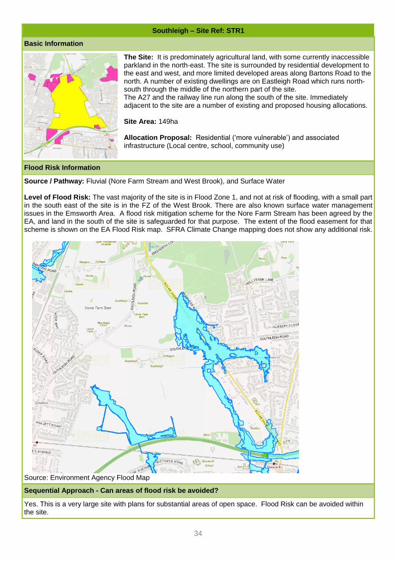
34
Southleigh – Site Ref: STR1
Basic Information
The Site: It is predominately agricultural land, with some currently inaccessible parkland in the north-east. The site is surrounded by residential development to the east and west, and more limited developed areas along Bartons Road to the north. A number of existing dwellings are on Eastleigh Road which runs north-south through the middle of the northern part of the site. The A27 and the railway line run along the south of the site. Immediately adjacent to the site are a number of existing and proposed housing allocations. Site Area: 149ha Allocation Proposal: Residential (‘more vulnerable’) and associated infrastructure (Local centre, school, community use)
Flood Risk Information
Source / Pathway: Fluvial (Nore Farm Stream and West Brook), and Surface Water Level of Flood Risk: The vast majority of the site is in Flood Zone 1, and not at risk of flooding, with a small part in the south east of the site is in the FZ of the West Brook. There are also known surface water management issues in the Emsworth Area. A flood risk mitigation scheme for the Nore Farm Stream has been agreed by the EA, and land in the south of the site is safeguarded for that purpose. The extent of the flood easement for that scheme is shown on the EA Flood Risk map. SFRA Climate Change mapping does not show any additional risk.
Source: Environment Agency Flood Map
Sequential Approach - Can areas of flood risk be avoided?
Yes. This is a very large site with plans for substantial areas of open space. Flood Risk can be avoided within the site.

35
Southleigh – Site Ref: STR1
If flood risk cannot be avoided, what is the preferred approach?
While flood risk can be avoided, additional mitigation measure will be planned in during the masterplanning of the site, avoiding flood risk from the river and paying particular attention to drainage. The initial framework masterplan envisages drainage attenuation in the form of lakes and ponds in the south of the site. This will have to include sufficient capacity to mitigate the post development rate of flow, and must also avoid or compensate the loss of storage created under the agreed scheme shown above.
Conclusion on prospect of safe development in light of flood risk
Given the size of the site, and in comparative terms limited extent of the flood risk, there is a high degree of confidence that development can take place in the light of flood risk. HBC is confident that flood risk can be avoided and/or mitigated within the site.
Implications for Local Plan 2036
Policy to stipulate that areas at risk of flooding now and in the future must be avoided, including for flood risk management infrastructure, including surface water management. It is acknowledged that this will require some reworking of the draft Masterplan, which is expected in any case as the evidence base on a range of issues is refined. Further work will be required in relation to the required volumes and location of flood storage to be provided. This is a very large site with plans for substantial areas of open space, which gives sufficient flexibility in terms of site layout.

36
West of Coldharbour Farm – Site Ref: EM6B
Basic Information
The Site: The land west of Coldharbour Farm is located directly north of the A27 and is sandwiched between the A27 Service Station to the west and Coldharbour Farm Road to the east. The Emsworth Recreation Ground is situated to the north-east. The site is directly adjacent to the Southleigh Strategic Site. Outline planning permission was granted in October 2014 (reference APP/14/00360) for residential development to provide 53 dwellings with new vehicular access from Coldharbour Farm Road. This has since expired and a revised layout is being explored. Site Area: 1.66ha Allocation Proposal: Residential (‘more vulnerable’)
Flood Risk Information
Source / Pathway: Fluvial. Level of Flood Risk: Eastern part of site part of site affected by fluvial FZ from West Brook. The Climate Change data from the PUSH SFRA does not show a change to this situation. Current Day Zones 2 & 3 Source: EA Flood Map
Sequential Approach - Can areas of flood risk be avoided?
Sequential approach on site is possible. Site remains developable while avoiding areas at risk of flooding. However, flood storage compensation will be needed.
If flood risk cannot be avoided, what is the preferred approach?
Detailed site specific work has shown, and the EA have agreed, that the site can be developed safely, and that flood storage compensation is acceptable in principle. However, further work will be required in relation to the required volumes and location of compensatory storage to be provided. This additional work should be included within an up to date Flood Risk Assessment.
Conclusion on prospect of safe development in light of flood risk
Detailed site specific work has shown that the site can be developed safely, and that flood storage compensation possible.
Implications for Local Plan 2036
Policy will need to make clear that further work will be required in relation to the required volumes and location of compensatory storage to be provided.

37
Land at Westwood Close – Site Ref: EM5A
Basic Information
The Site: The sites is located in Northern Emsworth, to the west of Westwood Close. It extends from Westwood Close eastwards to the edge of the River Ems floodplain Site Area: 1 ha Allocation Proposal: Residential (‘more vulnerable’)
Flood Risk Information
Source / Pathway: Fluvial: The River Ems flows immediately to the east of the site. The site boundary follows the outline of the current day flood zone. Level of Flood Risk: The site boundary follows the outline of the current day flood zone, staying fully in FZ1. While the PUSH SFRA assumptions for climate change do not indicate an increase in the future, it is understood that this is unlikely to be accurate. Detailed modelling is needed to understand the extent accurately.
Current Day Zones 2 & 3 vs Climate Change 2115. Source: EA Flood Map and PUSH SFRA
Sequential Approach - Can areas of flood risk be avoided?
Detailed flood risk work by the site promoter (under APP/18/00672) has demonstrated that areas at risk of flooding can be avoided, by pulling the site boundary back and reducing the number of homes.
If flood risk cannot be avoided, what is the preferred approach?
n/a
Conclusion on prospect of safe development in light of flood risk
Detailed flood risk work by the site promoter has demonstrated that safe development is possible.
Implications for Local Plan 2036
If an allocation were to be made, the site area and housing yield would need to be reduced. The policy would need to highlight the flood risk from the River Ems, and also make clear that any land raising in the flood zones would be subject to flood storage compensation requirements. However, the Council is also conscious of the wider flood risk issues in Emsworth. The Environment Agency have confirmed that they are in the process of undertaking flood modelling for the River Ems Climate Change scenario, as part of a desire to deliver a River Ems Flood Alleviation Scheme. At this stage it cannot be ruled out that land in this location would be needed for this scheme. Looking beyond the deliverability of this site for development, it is considered that there are overriding reasons not to allocate the land for development, but instead to safeguard it for a River Ems Flood Alleviation Scheme. If further detailed work to bring forward this scheme shows that the land is not needed, it may be possible to release it for development through a future review of the Local Plan.

38
Gas Site, Palmer’s Road – Site Ref: EM2
Basic Information
The Site: The site is a cleared area of land following the dismantling of a gasholder. It lies on Palmers Road, behind the commercial units fronting onto North Street in Emsworth. The River Ems runs to the east of the site. Site Area: 0.47 ha Allocation Proposal: Residential (‘more vulnerable’)
Flood Risk Information
Source / Pathway: Fluvial: The River Ems flows immediately to the east of the site. Level of Flood Risk: A small area in the eastern part of the site lies in the flood zone. While the PUSH SFRA assumptions for climate change indicate only a small increase in the future, in the middle of the site. It is understood that this is unlikely to be accurate. The EA are in the process of undertaking detailed modelling. It is expected that this will show an increase in flood risk in the climate change scenario.
Current Day Zones 2 & 3 vs Climate Change 2115. Source: EA Flood Map and PUSH SFRA
Sequential Approach - Can areas of flood risk be avoided?
The present day flood zones could be avoided, but the climate change scenario is likely to be more extensive. The site is small, so it is unlikely that areas at flood risk can be entirely avoided.
If flood risk cannot be avoided, what is the preferred approach?
The likely built form in this location is flats, giving confidence that all living accommodation could be provided above the flood level.
Conclusion on prospect of safe development in light of flood risk
The flood risk is acknowledged. It is not possible at this time to fully assess the risk, as information on the climate change flood risk (EA study) is yet to be completed. It should be noted, however, that based on the information currently available only a small part of the site is affected by the climate change scenario. In addition, the likely built form means that future residents are likely to be accommodated above flood level.
Implications for Local Plan 2036
While the flood risk is acknowledged, and it has not been possible to be conclusive about the extent of the future risk taking into account climate change, the council considers that there are sustainability benefits in allocating the site. This is a brownfield site, with likely contamination issues due to its previous use as a gas holder. Therefore, there are safety benefits in seeking redevelopment of the site, which could address both the flood risk and the contamination. The policy will need to acknowledge the flood risk and set requirements for it to be addressed. It is equally acknowledged that less vulnerable uses could be considered, but these are unlikely to create sufficient value to make development viable.

39
Fowley Cottage – Site Ref: EM3
Basic Information
The Site: The site lies in southern Emsworth. It extends from Warblington Road south to the shore of Chichester Harbour. It comprises a single large house in extensive grounds. Site Area: 0.96 ha Allocation Proposal: Residential (‘more vulnerable’)
Flood Risk Information
Source / Pathway: The dominant source of flooding to this site will be tidal flooding. The pathway will be overtopping of the frontage to the south of the development. Level of Flood Risk: Currently, a small part at the southern end of the site is affected by Flood Zones 2 and 3. The area at risk of flooding increases notably with climate change.
Current Day Zones 2 & 3 vs Climate Change 2115. Source: EA Flood Map and PUSH SFRA
Sequential Approach - Can areas of flood risk be avoided?
The site area is approximately 1ha, with about half remaining unaffected by the extent of the 2115 tidal flood zone, which takes climate change into consideration. Access to the site is to the north and is not at risk of flooding. The draft allocation assumed 7 dwellings for this site. Even with only half a hectare available, this would still result in a low density scheme of 14dph, demonstrating that the development should easily be accommodated outside of the areas at risk of flooding.
If flood risk cannot be avoided, what is the preferred approach?
n/a
Conclusion on prospect of safe development in light of flood risk
The proposed allocation for 7 dwellings can be accommodated outside of the areas at risk of flooding.
Implications for Local Plan 2036
Any allocation would need to include policy wording recognising the flood risk on the site and a development requirement to avoid areas at risk of flooding including climate change.

40
Forty Acres – Site Ref: HB10
Basic Information
The Site: The site lies to the south of Havant Road, west of the A3(M) at Bedhampton. Site Area: 23.1ha Allocation Proposal: Residential (‘more vulnerable’)
Flood Risk Information
Source / Pathway: The dominant source of flooding to this site will be tidal flooding. The pathway will be overtopping of the frontage to the south of the development. Level of Flood Risk: Currently, most of the site lies in Flood Zone 1, with the southern part of the site affected by Flood Zones 2 and 3. The area at risk of flooding increases notably with climate change.
Current Day Zones 2 & 3 vs Climate Change 2115. Source: EA Flood Map and PUSH SFRA
Sequential Approach - Can areas of flood risk be avoided?
The site area is approximately 23ha, with about one third remaining unaffected by the extent of the 2115 tidal flood zone, which takes climate change into consideration. Access to the site is to the north and is not at risk of flooding. The draft allocation assumed 300 dwelling for the site. A planning application has been made for 322 dwellings and a care home. With this quantum of development it is not possible to avoid the areas at risk of flooding.
If flood risk cannot be avoided, what is the preferred approach?
An application has been made under reference APP/18/00450 for 322 dwellings and a care home. The application is accompanied by a Flood Risk Assessment. This has assessed the extent of the area at risk over the lifetime of the development. The potential tidal flood levels over the development lifetime (100 years for residential development) are estimated at 4.4mAOD. A topographic survey has shown existing ground levels to be below 4.4mAOD. The applicant therefore proposes to raise existing ground levels to a minimum of 4.4.mAOD and will set finished floor levels at 4.7mAOD.
Conclusion on prospect of safe development in light of flood risk
Through the flood mitigation proposals the applicant has demonstrated that the development and future occupants can be kept safe up to and including the extreme flood event.
Implications for Local Plan 2036
Any allocation would need to include policy wording recognising the flood risk on the site and a development requirement to fully mitigate the risk from flooding.

41
Kingscroft Farm – Site Ref: HB63
Basic Information
The Site: The site is located to the south of the Abrams Place development, which lies off Ranalagh Road. Immediately to the east of the site lies the Marples Way industrial area. The current use is fields and paddocks. Site Area: 7.9ha Allocation Proposal: Residential (‘more vulnerable’)
Flood Risk Information
Source / Pathway: Tidal and Fluvial: The site is bordered to the north and west by the Hermitage Stream which is designated as a Main River by the Environment Agency. Ordnance Survey mapping indicates that the Hermitage Stream is tidally influenced along much of its length adjacent to the site, and the EA have confirmed that the risk to the site is largely tidal. A branch of the Hermitage Stream runs as a 1500mmm culvert under the site. Level of Flood Risk: Only a small part of the site is affected by flood risk in the current day. However, climate change assumptions show a large portion of the site being in FZ 2 & 3 in the future. The EA indicate that this is likely to be an overestimate of the risk on this site, but hydraulic modelling would be required to accurately assess the flood risk. The EA have confirmed that the site benefits from fluvial defences along the Hermitage Stream for the 1 in 100 years which area in good condition. Furthermore, the culverting of the branch of the Hermitage Stream at the site provides additional fluvial defence for the 1 in 5 scenario.
Current Day Zones 2 & 3 vs Climate Change 2115. Source: EA Flood Map and PUSH SFRA
Sequential Approach - Can areas of flood risk be avoided?
It is possible, based on the present day flood zones to avoid the areas at risk. This would involve limiting the development yield and locating community infrastructure such as open space on the vulnerable areas. However, when taking available flood risk information on Climate Change into account, this is not possible, as the majority of the site is affected. Although the EA and the site promoter agree that the Climate Change information on the PUSH SFRA is likely to be an overestimate of the extent of the future flood zones, no alternative information is available.
If flood risk cannot be avoided, what is the preferred approach?
No alternative approach has been explored.
Conclusion on prospect of safe development in light of flood risk
It is not possible at this point to conclude that there is a reasonable prospect of safe development. It has been suggested that hydraulic modelling is needed to establish the extent of the future flood zones. Such further work may be able to conclude that safe delivery is possible, but this is not possible with the information currently available.

42
Kingscroft Farm – Site Ref: HB63
Implications for Local Plan 2036
It is not possible at this point to conclude that there is a reasonable prospect of safe development. The information available at present does indicate that the site could be made safe, and therefore does not support and allocation. As a greenfield site, it is not considered that sustainability benefits to the community exist that outweigh the flood risk.

43
Land at Palk Road – Site Ref: HB3
Basic Information
The Site: The site is located to the south of the railway line and to the north of Hermitage Stream. Residential development lies to the north of the site. It is currently used for open storage in association with Portsmouth Water’s operation. Site Area: 1.28ha Allocation Proposal: Residential (‘more vulnerable’)
Flood Risk Information
Source / Pathway: Fluvial. Level of Flood Risk: The Northern part of the site lies in FZ1 now and in the future. The southern part is in FZ2&3 when climate change is taken into account. While there is some indication that this is an overestimate, there is no alternative information available.
Current Day Zones 2 & 3 vs Climate Change 2115. Source: EA Flood Map and PUSH SFRA
Sequential Approach - Can areas of flood risk be avoided?
It is possible to avoid the area at risk of flooding in future by restricting development to the parcel of land north of Palk Road.
If flood risk cannot be avoided, what is the preferred approach?
No alternative approach has been explored.
Conclusion on prospect of safe development in light of flood risk
Safe delivery is possible by avoiding flood risk. It is acknowledged that further detailed flood risk work may show that the area at risk of flooding in the future is much smaller than currently thought and therefore, it may be possible to avoid flood risk even with a larger development area. The site is a brownfield land sustainably located in the urban area, and therefore could provide sustainability benefits by being developed for housing.
Implications for Local Plan 2036
Given uncertainties about flood risk on the southern part of the site, any allocation for development should be restricted to the northern parcel. This could be achieved either through an allocation of just the parcel north of Palk Road, or a wider allocation with caveats and requirements regarding flood risk on the southern part. This will need to be balanced with broader considerations around the resulting built form through the SA process. In any case, site yield should be based on capacity of northern part only.

44
Land at Selsmore Road – Site Ref: HY46
Basic Information
The Site: The site lies to the north of Selsmore Road in the South East part of Hayling Island. It is currently used as paddocks. It is bounded by residential development to the south and west, with residential curtilage and trees to the north and east. Site Area: 1.35ha Allocation Proposal: Residential (‘more vulnerable’)
Flood Risk Information
Source / Pathway: The dominant source of flooding to this site will be tidal flooding. The pathway will be overtopping of the frontage to the east of the development. Level of Flood Risk: Currently, a very small part in the south eastern corner of the site is affected by Flood Zones 2 and 3. The area at risk of flooding increases notably with climate change, covering the likely access point off Selsmore Road and a large part of the site. The subject site is approximately 2.700 AOD at its lowest point. The access points to the site are at a higher risk of flooding than the site itself. Selsmore Road in the present day has a potential flood depth of up to 300mm along the majority of the road in a low risk scenario. Velocity of flooding could potentially reach over 0.25m/s. Predicted flood levels indicate that more of Selmore Road will eventually lie within FZ3.
Current Day Zones 2 & 3 vs Climate Change 2115. Source: EA Flood Map and PUSH SFRA
Sequential Approach - Can areas of flood risk be avoided?
Flood Risk on site could be avoided. This would require a much reduced area / housing yield, of around 10 dwellings. Flood risk on the access cannot be avoided.
If flood risk cannot be avoided, what is the preferred approach?
The site promoter suggest that it would be reasonable and appropriate to the design of any proposed residential units to set the finished floor level at least 375mm above ground level. In the unlikely event of an incursion, the floor level would therefore remain above the maximum projected surface water level. This takes in to account the PUSH SFRA Climate Change information where the subject site could potentially be in flood zone 2 by 2115. Additional low level protection measures are also suggested:
• Seal service entry connections
• All service outlets within the building to be a minimum of 450mm above floor level.
• External doors to have slotted jamb provisions for flood boards.
• All drain and service access covers at ground level to have locking covers and frames.
Conclusion on prospect of safe development in light of flood risk

45
Land at Selsmore Road – Site Ref: HY46
While a much reduced development could be brought forward on land not at risk of flooding, it has not been demonstrated that safe access could be delivered.
Implications for Local Plan 2036
While risk on the site could be avoided by reducing substantially the developable area and therefore the number of homes, it has not been demonstrated that safe access is achievable. Together, these call into question the desirability of an allocation on this greenfield site.

46
Northney Marina – Site Ref: HY6
Basic Information
The Site: The site lies at the north end of Hayling Island, off Northney Road to the rear of the Langstone Hotel, immediately adjacent to Chichester Harbour. Site Area: 5.13 ha Allocation Proposal: Residential (‘more vulnerable’), Commercial (‘less vulnerable’) and Marina (‘water compatible’)
Flood Risk Information
Source / Pathway: The dominant source of flooding to this site will be tidal flooding. The pathway will be overtopping of the frontage to the north of the site. Level of Flood Risk: The majority of the site falls within Flood Zone 1 at the present day, according to the Environment Agency Flood Map for Planning. It is therefore estimated to have a low probability of flooding from the sea. However, due to the susceptibility of the site to sea level rise, a progressively greater proportion of the site is at a high probability of flooding over the next 100 years. 100 years is the assumed lifetime of residential development. According to the Partnership for Urban South Hampshire Strategic Flood Risk Assessment, an area in the centre of the site is expected to be at high probability of flooding from the sea. The duration and frequency of flooding will increase with time as sea levels rise, and could be very frequent towards the end of the development lifetime. LiDAR data suggests that minimum site levels are in the region of 3.3m AOD. The design tidal event for assessing risk to residential development in this area is the 0.5% probability extreme tidal event in 2115, during which the tide level is predicted to reach 4.5m AOD. Maximum flood depths in the area at risk could therefore reach 1.2m AOD, without an allowance for wave heights. This poses a hazard to people on a scale classified as ‘danger for most’ using the DEFRA/Environment Agency report FD2320/TR2 “Flood Risk Assessment Guidance for New Development”. The site is accessed via Northney Road, which falls within Flood Zone 3 at the present day, according to the Environment Agency Flood Map for Planning. It is therefore estimated to have a high probability of flooding from the sea. Northney Road experiences inundation during very high tides. The risk of flooding will increase if left unmitigated. Road levels vary, however minimum levels between Langstone Bridge and Northney Marina are in the region of 2.5m AOD. Maximum flood depths could therefore reach around 2 metres during the design event, without an allowance for wave heights. This poses a hazard to people on a scale classified as ‘danger for most’ (including the emergency services). The North Solent Shoreline Management Plan policy for this area of coastline is ‘Hold the Line’ however there are no schemes being developed currently to implement this policy and, due to the limited economic benefits in comparison to other schemes nationally, it is unlikely that central government funding will be available to meet the cost of any risk management work.
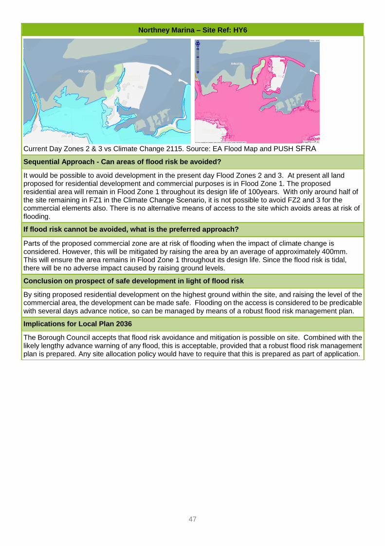
47
Northney Marina – Site Ref: HY6
Current Day Zones 2 & 3 vs Climate Change 2115. Source: EA Flood Map and PUSH SFRA
Sequential Approach - Can areas of flood risk be avoided?
It would be possible to avoid development in the present day Flood Zones 2 and 3. At present all land proposed for residential development and commercial purposes is in Flood Zone 1. The proposed residential area will remain in Flood Zone 1 throughout its design life of 100years. With only around half of the site remaining in FZ1 in the Climate Change Scenario, it is not possible to avoid FZ2 and 3 for the commercial elements also. There is no alternative means of access to the site which avoids areas at risk of flooding.
If flood risk cannot be avoided, what is the preferred approach?
Parts of the proposed commercial zone are at risk of flooding when the impact of climate change is considered. However, this will be mitigated by raising the area by an average of approximately 400mm. This will ensure the area remains in Flood Zone 1 throughout its design life. Since the flood risk is tidal, there will be no adverse impact caused by raising ground levels.
Conclusion on prospect of safe development in light of flood risk
By siting proposed residential development on the highest ground within the site, and raising the level of the commercial area, the development can be made safe. Flooding on the access is considered to be predicable with several days advance notice, so can be managed by means of a robust flood risk management plan.
Implications for Local Plan 2036
The Borough Council accepts that flood risk avoidance and mitigation is possible on site. Combined with the likely lengthy advance warning of any flood, this is acceptable, provided that a robust flood risk management plan is prepared. Any site allocation policy would have to require that this is prepared as part of application.

48
Land at Riders Lane – Site Ref LP2
Basic Information
The Site: The former Riders Lane allotment site comprises a large area of open space to the north-east of the Hermitage Stream in Leigh Park. Site Area: 1.94ha Allocation Proposal: Residential (‘more vulnerable’)
Flood Risk Information
Source / Pathway: The dominant source of flooding to this site will be fluvial flooding from the Hermitage stream. Level of Flood Risk: The site lies very close to the fluvial floodzone for the Hermitage Stream. The extent increases into the western part of the site with climate change.
Current Day Zones 2 & 3 vs Climate Change 2115. Source: EA Flood Map and PUSH SFRA
Sequential Approach - Can areas of flood risk be avoided?
Although it is noted that the climate change information in the PUSH SFRA is out of date and is likely to overestimate the extent of the climate change outline, a precautionary approach has been taken. On that basis, an assessment has been made as to the whether the draft allocation can be accommodated outside of the area at risk of flooding. The area of the site that remains unaffected by the extent of the 2115 climate change tidal flood zone is approximately 1.9ha in size. The draft allocation assumes about 65 dwellings for this site. Using only the part of the site not at risk of flooding, this would result in a development of approximately 34dph. This would be relatively low density, showing that even if additional space is required for infrastructure, the suggested number is deliverable in principle. Access to the site is to the east, away from the area at risk of flooding.
If flood risk cannot be avoided, what is the preferred approach?
n/a

49
Land at Riders Lane – Site Ref LP2
Conclusion on prospect of safe development in light of flood risk
The proposed allocation for 65 dwellings can be accommodated outside of the areas at risk of flooding.
Implications for Local Plan 2036
The draft policy already suggests that the open space required to support the development should be the western part of the site. Strengthen policy wording to recognise flood risk on the site and include a requirement to avoid areas at risk of flooding including climate change. In addition, clarify that any flood storage and attenuation needs to be located outside of the areas at risk of flooding.
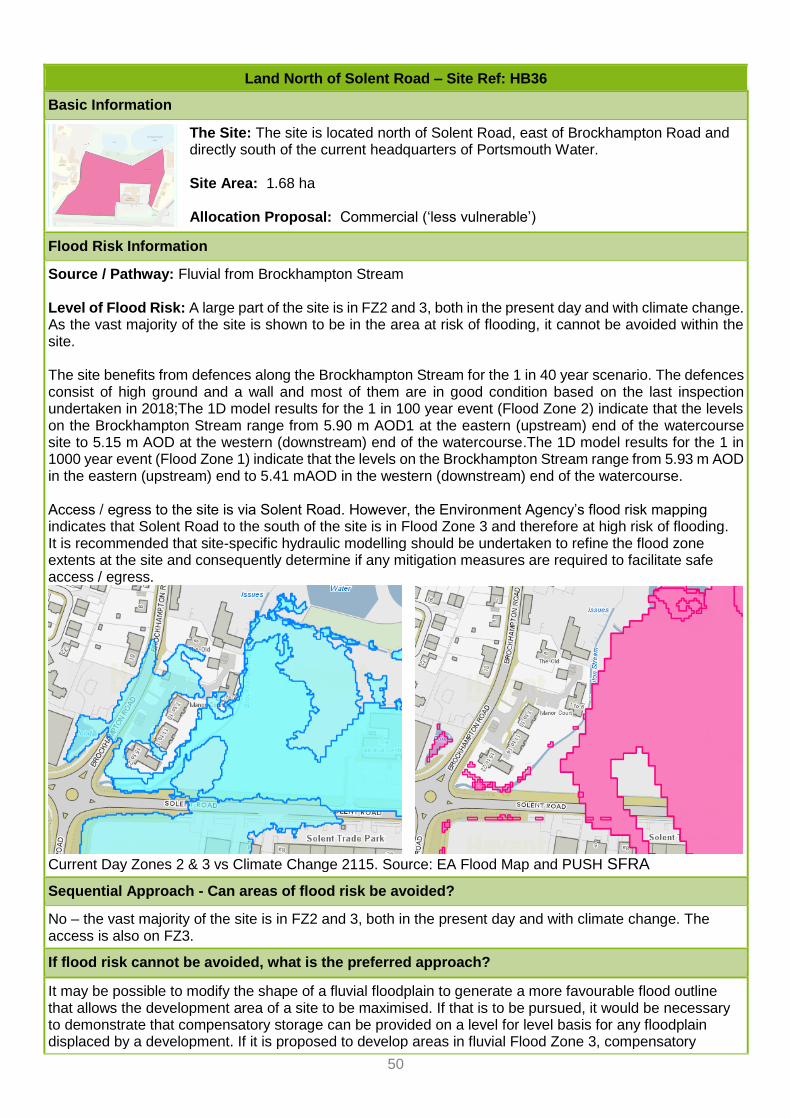
50
Land North of Solent Road – Site Ref: HB36
Basic Information
The Site: The site is located north of Solent Road, east of Brockhampton Road and directly south of the current headquarters of Portsmouth Water. Site Area: 1.68 ha Allocation Proposal: Commercial (‘less vulnerable’)
Flood Risk Information
Source / Pathway: Fluvial from Brockhampton Stream Level of Flood Risk: A large part of the site is in FZ2 and 3, both in the present day and with climate change. As the vast majority of the site is shown to be in the area at risk of flooding, it cannot be avoided within the site. The site benefits from defences along the Brockhampton Stream for the 1 in 40 year scenario. The defences consist of high ground and a wall and most of them are in good condition based on the last inspection undertaken in 2018;The 1D model results for the 1 in 100 year event (Flood Zone 2) indicate that the levels on the Brockhampton Stream range from 5.90 m AOD1 at the eastern (upstream) end of the watercourse site to 5.15 m AOD at the western (downstream) end of the watercourse.The 1D model results for the 1 in 1000 year event (Flood Zone 1) indicate that the levels on the Brockhampton Stream range from 5.93 m AOD in the eastern (upstream) end to 5.41 mAOD in the western (downstream) end of the watercourse. Access / egress to the site is via Solent Road. However, the Environment Agency’s flood risk mapping indicates that Solent Road to the south of the site is in Flood Zone 3 and therefore at high risk of flooding. It is recommended that site-specific hydraulic modelling should be undertaken to refine the flood zone extents at the site and consequently determine if any mitigation measures are required to facilitate safe access / egress.
Current Day Zones 2 & 3 vs Climate Change 2115. Source: EA Flood Map and PUSH SFRA
Sequential Approach - Can areas of flood risk be avoided?
No – the vast majority of the site is in FZ2 and 3, both in the present day and with climate change. The access is also on FZ3.
If flood risk cannot be avoided, what is the preferred approach?
It may be possible to modify the shape of a fluvial floodplain to generate a more favourable flood outline that allows the development area of a site to be maximised. If that is to be pursued, it would be necessary to demonstrate that compensatory storage can be provided on a level for level basis for any floodplain displaced by a development. If it is proposed to develop areas in fluvial Flood Zone 3, compensatory

51
Land North of Solent Road – Site Ref: HB36
storage would be required. The feasibility of providing compensation at the site depends on ground conditions and groundwater levels below the site. It would also be necessary to demonstrate through hydraulic modelling that the proposed compensatory storage is effective at mitigating the loss of floodplain and effective at maintaining the current level of flood risk to neighbouring property.
Conclusion on prospect of safe development in light of flood risk
The EA have indicated that the key issue on this site is the offsite implications of flooding from development of the site i.e. floodplain compensation. Previous work has given confidence that an employment use can be safely delivered. On that basis, there is a prospect of safe delivery, although a detailed assessment of this would be required at application stage, in particular in relation to flood storage compensation, so any allocation policy would need to be heavily caveated with assessment requirements
Implications for Local Plan 2036
It is acknowledged that the site was allocated in the previous Local Plan for a new Portsmouth Water HQ. The sequential test at that time was passed on the basis that the HQ had to be in this location for operational reasons, being close to a water source. The company has since decided to locate their HQ elsewhere and is promoting this site for general B1 or B8 (trade counter) use. The council considers that there are other sequentially preferable sites in the Borough for general employment use, and the exception made for the HQ use therefore falls away. Therefore, although it had been accepted in the past that there may be a prospect of safe delivery, this question does not arise, as the sequential test is not passed. An allocation for general employment use is not supported.

52
Former BAE Systems Park – Site Ref: BD54
Basic Information
The Site: The site is located within the Brambles Business Park to the south of Elettra Avenue in Waterlooville. Site Area: 5.7ha Allocation Proposal: Commercial / Leisure (‘less vulnerable’)
Flood Risk Information
Source / Pathway: The dominant source of flooding to this site will be fluvial flooding. Level of Flood Risk: Currently, a small part in the south western corner of the site is affected by Flood Zones 2 and 3. The PUSH SFRA does not show any additional flood risk in the future.
Current Day Zones 2 & 3 vs Climate Change 2115. Source: EA Flood Map and PUSH SFRA
Sequential Approach - Can areas of flood risk be avoided?
Yes, the small area in the south western part of the site could be avoided.
If flood risk cannot be avoided, what is the preferred approach?
n/a
Conclusion on prospect of safe development in light of flood risk
Avoid area at risk of flooding; note flood risk in policy and stipulate that area must be avoided.
Implications for Local Plan 2036
Allocation acceptable.
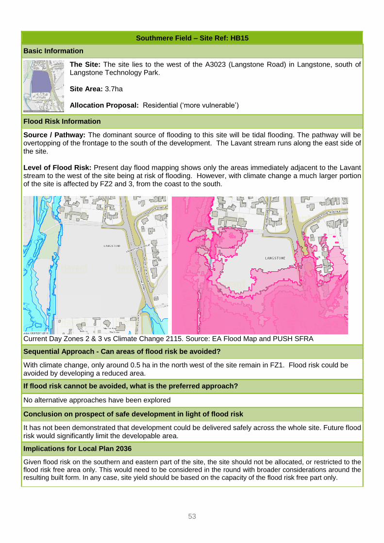
53
Southmere Field – Site Ref: HB15
Basic Information
The Site: The site lies to the west of the A3023 (Langstone Road) in Langstone, south of Langstone Technology Park. Site Area: 3.7ha Allocation Proposal: Residential (‘more vulnerable’)
Flood Risk Information
Source / Pathway: The dominant source of flooding to this site will be tidal flooding. The pathway will be overtopping of the frontage to the south of the development. The Lavant stream runs along the east side of the site. Level of Flood Risk: Present day flood mapping shows only the areas immediately adjacent to the Lavant stream to the west of the site being at risk of flooding. However, with climate change a much larger portion of the site is affected by FZ2 and 3, from the coast to the south.
Current Day Zones 2 & 3 vs Climate Change 2115. Source: EA Flood Map and PUSH SFRA
Sequential Approach - Can areas of flood risk be avoided?
With climate change, only around 0.5 ha in the north west of the site remain in FZ1. Flood risk could be avoided by developing a reduced area.
If flood risk cannot be avoided, what is the preferred approach?
No alternative approaches have been explored
Conclusion on prospect of safe development in light of flood risk
It has not been demonstrated that development could be delivered safely across the whole site. Future flood risk would significantly limit the developable area.
Implications for Local Plan 2036
Given flood risk on the southern and eastern part of the site, the site should not be allocated, or restricted to the flood risk free area only. This would need to be considered in the round with broader considerations around the resulting built form. In any case, site yield should be based on the capacity of the flood risk free part only.

54
Brockhampton West – Site Ref BD11
Basic Information
The Site: The site lies to the south of the A27 in the Brockhampton area, to the west of the teardrop junction. Site Area: 9.29ha Allocation Proposal: Commercial / Leisure (‘less vulnerable’)
Flood Risk Information
Source / Pathway: The dominant source of flooding to this site will be fluvial flooding from the watercourse to the east of the site (Brooklands stream) Level of Flood Risk: Present day flood mapping shows only the areas immediately adjacent to the Brooklands stream to the east of the site being at risk of flooding. This area increases to a small degree with climate change, but still leaves the vast majority of the sites free from flood risk.
Current Day Zones 2 & 3 vs Climate Change 2115. Source: EA Flood Map and PUSH SFRA
Sequential Approach - Can areas of flood risk be avoided?
Yes – the vast majority of the site is free from flood risk.
If flood risk cannot be avoided, what is the preferred approach?
n/a
Conclusion on prospect of safe development in light of flood risk
There is a good prospect of safe delivery. The vast majority of the site is free from flood risk.
Implications for Local Plan 2036
Allocation acceptable in flood risk terms. Policy would have to stipulate that small areas at risk of flooding now and in the future must be avoided.

55
Land South of Purbrook Heath Road – Site Ref: WV10
Basic Information
The Site: The site is an L-shaped parcel of land adjacent to Purbrook Heath Road to the north of the site, and London Road (A3) to the west of the site. Site Area: 3.76 ha Allocation Proposal: Residential ‘more vulnerable’
Flood Risk Information
Source / Pathway: The dominant source of flooding to this site will be fluvial flooding from the watercourse immediately to the north of the site, and another running through the site. Level of Flood Risk: The site is split into a northern parcel and southern parcel running along Purbrook Heath Road and London Road respectively. The northern parcel is sandwiched between two identified Environment Agency (EA) main rivers. The majority of the northern parcel lies in Flood Zones 2 and 3. The southern parcel is in Flood Zone 1. No Climate Change Data available.
Current Day Zones 2 & 3 Source: EA Flood Map
Sequential Approach - Can areas of flood risk be avoided?
Flood risk could be avoided if only the southern part along London Road was allocated.
If flood risk cannot be avoided, what is the preferred approach?
n/a
Conclusion on prospect of safe development in light of flood risk
Flood risk could be avoided if only the southern part along London Road was allocated.
Implications for Local Plan 2036
Allocation acceptable in flood risk terms, although the area would need to be reduced and/or policy would have to stipulate that areas at risk of flooding now and in the future must be avoided.
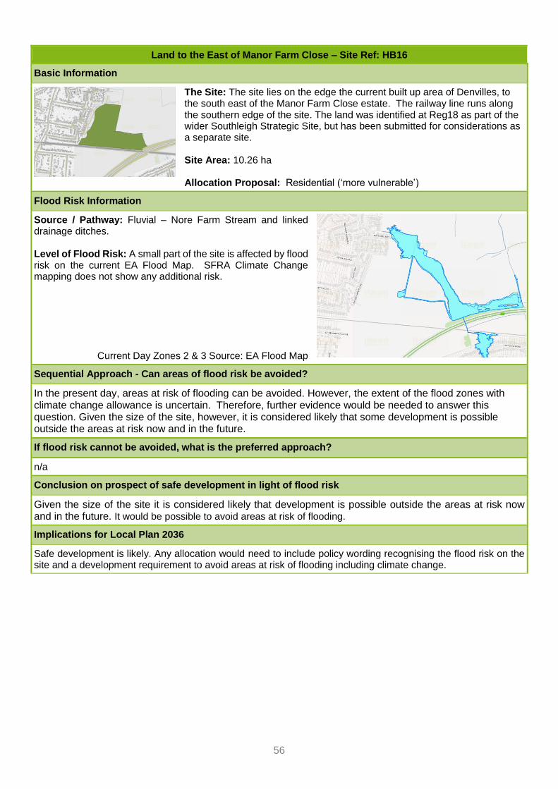
56
Land to the East of Manor Farm Close – Site Ref: HB16
Basic Information
The Site: The site lies on the edge the current built up area of Denvilles, to the south east of the Manor Farm Close estate. The railway line runs along the southern edge of the site. The land was identified at Reg18 as part of the wider Southleigh Strategic Site, but has been submitted for considerations as a separate site. Site Area: 10.26 ha Allocation Proposal: Residential (‘more vulnerable’)
Flood Risk Information
Source / Pathway: Fluvial – Nore Farm Stream and linked drainage ditches. Level of Flood Risk: A small part of the site is affected by flood risk on the current EA Flood Map. SFRA Climate Change mapping does not show any additional risk.
Current Day Zones 2 & 3 Source: EA Flood Map
Sequential Approach - Can areas of flood risk be avoided?
In the present day, areas at risk of flooding can be avoided. However, the extent of the flood zones with climate change allowance is uncertain. Therefore, further evidence would be needed to answer this question. Given the size of the site, however, it is considered likely that some development is possible outside the areas at risk now and in the future.
If flood risk cannot be avoided, what is the preferred approach?
n/a
Conclusion on prospect of safe development in light of flood risk
Given the size of the site it is considered likely that development is possible outside the areas at risk now and in the future. It would be possible to avoid areas at risk of flooding.
Implications for Local Plan 2036
Safe development is likely. Any allocation would need to include policy wording recognising the flood risk on the site and a development requirement to avoid areas at risk of flooding including climate change.
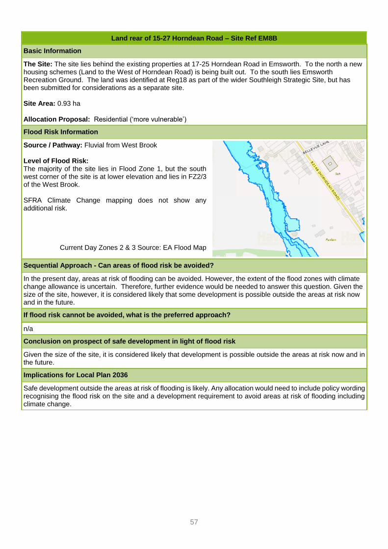
57
Land rear of 15-27 Horndean Road – Site Ref EM8B
Basic Information
The Site: The site lies behind the existing properties at 17-25 Horndean Road in Emsworth. To the north a new housing schemes (Land to the West of Horndean Road) is being built out. To the south lies Emsworth Recreation Ground. The land was identified at Reg18 as part of the wider Southleigh Strategic Site, but has been submitted for considerations as a separate site. Site Area: 0.93 ha Allocation Proposal: Residential (‘more vulnerable’)
Flood Risk Information
Source / Pathway: Fluvial from West Brook Level of Flood Risk: The majority of the site lies in Flood Zone 1, but the south west corner of the site is at lower elevation and lies in FZ2/3 of the West Brook. SFRA Climate Change mapping does not show any additional risk.
Current Day Zones 2 & 3 Source: EA Flood Map
Sequential Approach - Can areas of flood risk be avoided?
In the present day, areas at risk of flooding can be avoided. However, the extent of the flood zones with climate change allowance is uncertain. Therefore, further evidence would be needed to answer this question. Given the size of the site, however, it is considered likely that some development is possible outside the areas at risk now and in the future.
If flood risk cannot be avoided, what is the preferred approach?
n/a
Conclusion on prospect of safe development in light of flood risk
Given the size of the site, it is considered likely that development is possible outside the areas at risk now and in the future.
Implications for Local Plan 2036
Safe development outside the areas at risk of flooding is likely. Any allocation would need to include policy wording recognising the flood risk on the site and a development requirement to avoid areas at risk of flooding including climate change.

58
Land North of Regional Business Centre – Site Ref: BD10
Basic Information
The Site: The site lies on the north side of the eastern end fo Harts Farm Way, one of the Borough’s established employment areas. Site Area: 0.96ha Allocation Proposal: Commercial (‘less vulnerable’)
Flood Risk Information
Source / Pathway: Fluvial (Lavant Stream); may be tidally influenced Level of Flood Risk: Site currently in FZ1, but eastern boundary affected by climate change.
Current Day Zones 2 & 3 vs Climate Change 2115. Source: EA Flood Map and PUSH SFRA
Sequential Approach - Can areas of flood risk be avoided?
With current day flood risk
If flood risk cannot be avoided, what is the preferred approach?
No detailed information is available to determine whether other solutions could overcome the issue and make the site safe.
Conclusion on prospect of safe development in light of flood risk
It is not possible to avoid flood risk on site, once climate change scenario has been taken into account. No detailed information is available to determine whether other solutions could overcome the issue and make the site safe.
Implications for Local Plan 2036
Currently available information does not support an allocation.

59
Interbridges West
Basic Information
The Site: The is bounded entirely by the A27 which curves gently around the norther boundary of the site, and the Havant to Brighton and London Victoria Railway line, which runs in a straight line along the southern boundary. Most of the site is greenfield, while a small part occupied by a petrol filling station. Site Area: 6.88ha Allocation Proposal: Commercial (‘less vulnerable’)
Flood Risk Information
Source / Pathway: Fluvial from West Brook Level of Flood Risk: A small area in the far east of the site is affected by flood risk now and in the future. The vast majority of the site lies in FZ1.
Current Day Zones 2 & 3 vs Climate Change 2115. Source: EA Flood Map and PUSH SFRA
Sequential Approach - Can areas of flood risk be avoided?
Yes – the vast majority of the site is free from flood risk.
If flood risk cannot be avoided, what is the preferred approach?
n/a
Conclusion on prospect of safe development in light of flood risk
There is a good prospect of safe delivery. The vast majority of the site is free from flood risk.
Implications for Local Plan 2036
Allocation acceptable in flood risk terms. Policy would have to stipulate that small areas at risk of flooding now and in the future must be avoided.