ashfield district council - meetings, agendas, and … · · 2015-09-27ashfield . district...
TRANSCRIPT

ASHFIELD DISTRICT COUNCIL
ADDENDUM TO AGENDA
AND SUMMONS
Meeting: CABINET ................................................................... Date: MONDAY, 15TH FEBRUARY, 2010 .......................... Please find attached the following papers: AGENDA ITEM 3 Local Development Framework: Core Strategy Development Plan Document – Preferred Option Consultation (pages 1 to 6) IMPORTANT: This addendum and the accompanying papers should be inserted in your agenda at the appropriate page.
ASHFIELDAddendum.doc

AGENDA ITEM: 3.
REPORT TO: CABINET DATE: 15TH FEBRUARY 2010
HEADING:
LOCAL DEVELOPMENT FRAMEWORK : CORE STRATEGY DEVELOPMENT PLAN DOCUMENT – PREFERRED OPTION CONSULTATION
REPORT BY: LEADER/HEAD OF COMMUNITY & ECONOMIC PROMOTION
KEY DECISION: NO SUBJECT TO CALL-IN: YES
________________________________________________________________________
PURPOSE OF REPORT:
To approve public consultation on the Local Development Framework (LDF) Core Strategy Development Plan Document (DPD) – Preferred Option stage of the process during March/April 2010 to support the delivery of the Corporate Plan and progress the Local Development Framework.
IMPLICATIONS: 1. Corporate Plan:
The development of planning policy across the areas suggested fits across the environmental, economic and community objectives of the Corporate Plan in providing a supportive Local Development Framework to enable effective “place shaping”.
2. Human Resources:
There are no direct HR implications. 3. Legal:
The recommendations are supported to ensure the appropriate consultation takes place.
4. Financial:
No comments. 5. Environmental/Sustainability:
The recommendations in the report have no direct implications on these issues. 6. Diversity/Equality:
The report proposes broad inclusive consultation. An equality impact assessment of the proposed consultation process may highlight a need to target harder to reach and/or under-represented groups.
1
7. Community Safety:
To follow if applicable.
8. Employees/Trade Unions (UNISON/GMB) Not applicable.
RECOMMENDATION(S)
1. Cabinet is recommended to approve the proposed consultation exercise on the Preferred Option stage of the Core Strategy DPD.
2. Cabinet is requested to agree to grant delegated authority to the Head of Community and Economic Promotion (in consultation with the Portfolio Holder) to make any minor changes/amendments to any documents prepared for the consultation exercise.
REASONS FOR RECOMMENDATION(S) To reflect current Government guidance, ensure that the timetable laid down in the Local Development Scheme (LDS) is met and ensure a supportive and inclusive Local Development Framework. ALTERNATIVE OPTIONS CONSIDERED (with reasons why not adopted)
Not to approve public consultation on the Core Strategy Preferred Option DPD. This option has not been pursued due to the following reasons: a) If the District does not have a ‘5 year housing land supply’ then there is the
potential for planning applications to be received that, if refused and appealed, could not be legitimately defended because of the Council’s failure to plan for growth. It is likely that these applications could be of substantial size and are likely to be in either the Green Belt or Countryside, in locations which the Council itself would not prefer (An example for members to consider is Sharp Hills Wood in Rushcliffe Borough which was recently granted permission on appeal for these very reasons). In such circumstances, the risk of the appellant being awarded costs would be high thus exacerbating the financial risk to the Council;
b) The potential loss of significant Growth Point funding (in Hucknall) and HCA
‘single conversation’ money for affordable housing and infrastructure; c) Unplanned development with insufficient associated infrastructure resulting
from planning applications from developers (as a consequence of a) above). Any such “planning by appeal” could be viewed as a lack of democratic and community leadership.
d) Potential loss of significant amounts of Housing & Planning Delivery Grant
monies (HPDG). This year the Council has been awarded some £444,000 (the highest amount in Nottinghamshire). Falling behind an agreed timetable would significantly lessen the HPDG award for next year.
2

e) Any delay would be contrary to the agreed Local Development Scheme
programme for the Local Development Framework approved by the Council f) The Councils previous agreement to ‘align’ Core Strategies with the Greater
Nottingham Authorities (Gedling, City, Rushcliffe, Broxtowe and Erewash) under the Joint Planning Board arrangements. This could have the potential for negative press coverage and a damaged reputation for Ashfield as it would make Ashfield the only Council not to ‘align’ our timetable for consultation on the Core Strategy. Other Greater Nottingham authorities are going out to consultation on February 15th, 2010.
g) Not to progress the Core Strategy would also be contrary to statements
outlined in the “ refreshed Corporate Plan” (under 4.5 “Place Shaping”)
Background documents PPS12: Local Spatial Planning Companion Guide to PPS12: Creating Local Development Frameworks
LOCAL DEVELOPMENT FRAMEWORK CORE STRATEGY DEVELOPMENT PLAN DOCUMENT – PREFERRED OPTION CONSULTATION
The Core Strategy Development Plan Document is the first of the Development Plan Documents (DPDs) to be produced under the Local Development Framework system and all other DPDs will have to conform to it. The Core Strategy will set out a spatial vision for Ashfield to 2026 and will link closely to the Ashfield Partnership Sustainable Community and Neighbourhood Renewal Strategy for Ashfield. The Hucknall part of Ashfield district will also need to closely “align” with other local authorities core strategies in the Greater Nottingham area (Nottingham City, Broxtowe, Erewash, Gedling and Rushcliffe). The lead members of all these authorities (including Ashfield) are now members of the Greater Nottingham Joint Planning Advisory Board (GNJPAB) and have agreed to co-ordinate the production and consultation arrangements for their core strategies. The consultation period on these authorities Core Strategies runs from February 15th, 2010 for an 8 week period. The Core Strategy for Ashfield will set out:
• a series of objectives to achieve the vision; • a spatial development strategy to meet the objectives and accommodate
new development; • policies to guide the overall scale, type and location of new development and
investment.
It will not include details of all land allocations and development control policies which will be produced in other DPDs. Some strategic sites (large sites over 500 dwellings and strategic employment site) are included in the Core Strategy Preferred Option DPD.
3
The Issues and Options stage of the Core Strategy DPD was consulted upon between June and July 2009 when 1635 representations were received from 78 individuals/organisations. The Spatial Growth Options stage was consulted on in November 2009 and 437 comments were received from 230 individuals/organisations. All of the comments received are contained in a report which is available to view on the Council’s website. This Preferred Option stage is a follow-on from previous consultation stages.
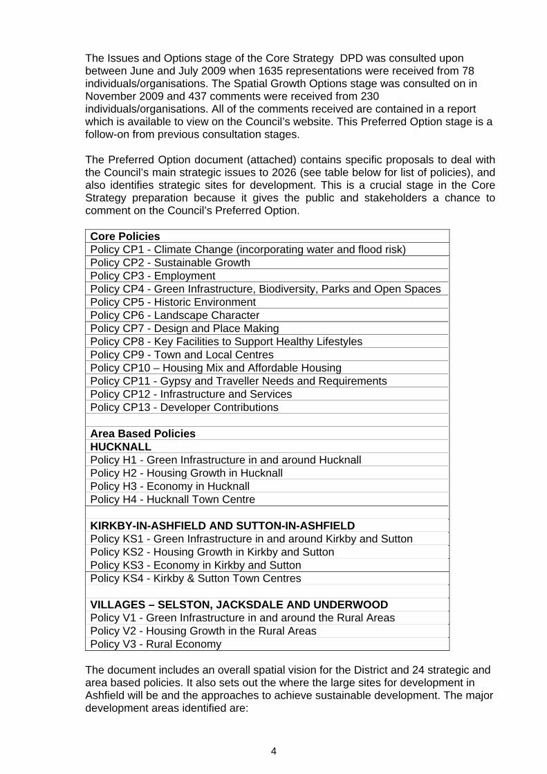
The Preferred Option document (attached) contains specific proposals to deal with the Council’s main strategic issues to 2026 (see table below for list of policies), and also identifies strategic sites for development. This is a crucial stage in the Core Strategy preparation because it gives the public and stakeholders a chance to comment on the Council’s Preferred Option.
Core Policies Policy CP1 - Climate Change (incorporating water and flood risk) Policy CP2 - Sustainable Growth Policy CP3 - Employment Policy CP4 - Green Infrastructure, Biodiversity, Parks and Open Spaces Policy CP5 - Historic Environment Policy CP6 - Landscape Character Policy CP7 - Design and Place Making Policy CP8 - Key Facilities to Support Healthy Lifestyles Policy CP9 - Town and Local Centres Policy CP10 – Housing Mix and Affordable Housing Policy CP11 - Gypsy and Traveller Needs and Requirements Policy CP12 - Infrastructure and Services Policy CP13 - Developer Contributions Area Based Policies HUCKNALL Policy H1 - Green Infrastructure in and around Hucknall Policy H2 - Housing Growth in Hucknall Policy H3 - Economy in Hucknall Policy H4 - Hucknall Town Centre KIRKBY-IN-ASHFIELD AND SUTTON-IN-ASHFIELD Policy KS1 - Green Infrastructure in and around Kirkby and Sutton Policy KS2 - Housing Growth in Kirkby and Sutton Policy KS3 - Economy in Kirkby and Sutton Policy KS4 - Kirkby & Sutton Town Centres VILLAGES – SELSTON, JACKSDALE AND UNDERWOOD Policy V1 - Green Infrastructure in and around the Rural Areas Policy V2 - Housing Growth in the Rural Areas Policy V3 - Rural Economy
The document includes an overall spatial vision for the District and 24 strategic and area based policies. It also sets out the where the large sites for development in Ashfield will be and the approaches to achieve sustainable development. The major development areas identified are:
4
• Land at Rolls Royce, Hucknall – this site could deliver up to 900 houses and
38Ha of employment land; • Two sites in Kirkby/Sutton –
o Off Lowmoor Road (close to Sutton Parkway Station) – this site could accommodate up to 1,000 houses; and
o South of the A38/ to the rear of Ashfield School, west of Sutton Road, Kirkby – which could accommodate a minimum of 1,000 houses.
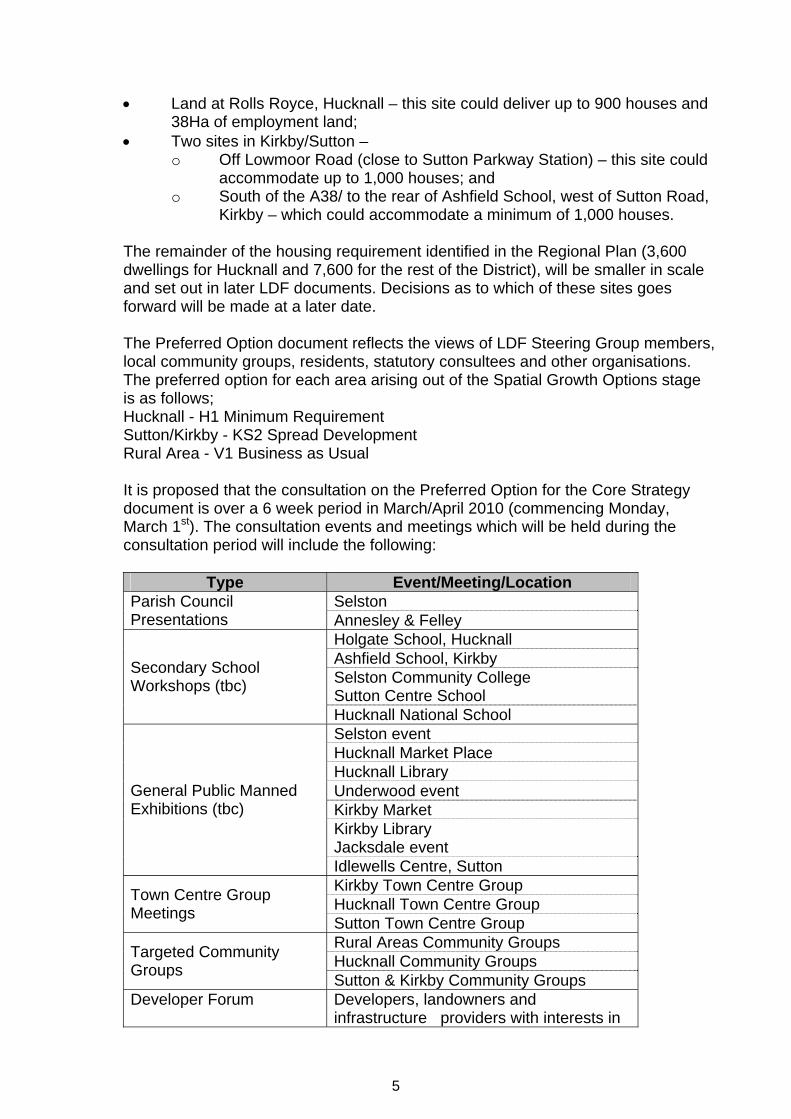
The remainder of the housing requirement identified in the Regional Plan (3,600 dwellings for Hucknall and 7,600 for the rest of the District), will be smaller in scale and set out in later LDF documents. Decisions as to which of these sites goes forward will be made at a later date. The Preferred Option document reflects the views of LDF Steering Group members, local community groups, residents, statutory consultees and other organisations. The preferred option for each area arising out of the Spatial Growth Options stage is as follows; Hucknall - H1 Minimum Requirement Sutton/Kirkby - KS2 Spread Development Rural Area - V1 Business as Usual It is proposed that the consultation on the Preferred Option for the Core Strategy document is over a 6 week period in March/April 2010 (commencing Monday, March 1st). The consultation events and meetings which will be held during the consultation period will include the following:
Type Event/Meeting/Location
Selston Parish Council Presentations Annesley & Felley
Holgate School, Hucknall Ashfield School, Kirkby Selston Community College Sutton Centre School
Secondary School Workshops (tbc)
Hucknall National School Selston event Hucknall Market Place Hucknall Library Underwood event Kirkby Market Kirkby Library Jacksdale event
General Public Manned Exhibitions (tbc)
Idlewells Centre, Sutton Kirkby Town Centre Group Hucknall Town Centre Group Town Centre Group
Meetings Sutton Town Centre Group Rural Areas Community Groups Hucknall Community Groups Targeted Community
Groups Sutton & Kirkby Community Groups Developer Forum Developers, landowners and
infrastructure providers with interests in
5
6
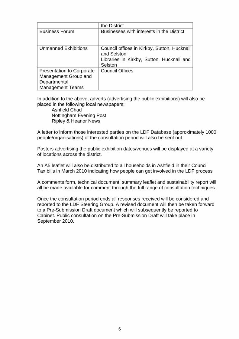
the District Business Forum
Businesses with interests in the District
Unmanned Exhibitions Council offices in Kirkby, Sutton, Hucknall and Selston Libraries in Kirkby, Sutton, Hucknall and Selston
Presentation to Corporate Management Group and Departmental Management Teams
Council Offices
In addition to the above, adverts (advertising the public exhibitions) will also be placed in the following local newspapers; Ashfield Chad Nottingham Evening Post Ripley & Heanor News A letter to inform those interested parties on the LDF Database (approximately 1000 people/organisations) of the consultation period will also be sent out. Posters advertising the public exhibition dates/venues will be displayed at a variety of locations across the district. An A5 leaflet will also be distributed to all households in Ashfield in their Council Tax bills in March 2010 indicating how people can get involved in the LDF process
A comments form, technical document, summary leaflet and sustainability report will all be made available for comment through the full range of consultation techniques. Once the consultation period ends all responses received will be considered and reported to the LDF Steering Group. A revised document will then be taken forward to a Pre-Submission Draft document which will subsequently be reported to Cabinet. Public consultation on the Pre-Submission Draft will take place in September 2010.

ASHFIELD DEVELOPMENT FRAMEWORK
CORE STRATEGY
PREFERRED OPTION
MARCH 2010
Ashfield Development Framework, Core Strategy Preferred Option, March ‘09

CONTENTS
Page No.
1. Introduction The Core Strategy Evidence Base Sustainability Appraisal and Habitat Regulation Assessment How Do I Have My Say? Next Steps Working in Partnership with Neighbouring Local Authorities Working in Partnership with Infrastructure and Service Providers Links to the Sustainable Community Strategy 2. A Portrait of Ashfield Background Social Characteristics Economic Characteristics Environmental Characteristics Key Issues Facing Ashfield The Vision for Ashfield Objectives for Realising the Vision Key Diagram 3. Core Policies 3.1 Climate Change (incorporating water and flood risk) – Policy CP1 3.2 Sustainable Growth – Policy CP2 3.3 Employment – Policy CP3 3.4 Green Infrastructure, Biodiversity, Parks and Open Spaces – Policy
CP4 3.5 Historic Environment – Policy CP5 3.6 Landscape Character – Policy CP6 3.7 Design and Placemaking – Policy CP7 3.8 Key Facilities to Support Healthy Lifestyles – Policy CP8 3.9 Town and Local Centres – Policy CP9 3.10 Housing Mix and Affordable Housing – Policy CP10 3.11 Gypsy and Traveller Needs and Requirements – Policy CP11 3.12 Infrastructure and Services – Policy CP12 3.13 Developer Contributions – Policy CP13 4. Area Based Policies 4.1 HUCKNALL Green Infrastructure in and around Hucknall – Policy H1 Housing Growth in Hucknall - Policy H2 Economy in Hucknall – Policy H3 Hucknall Town Centre – Policy H4 4.2 KIRKBY-IN-ASHFIELD AND SUTTON-IN-ASHFIELD Green Infrastructure in and around Kirkby and Sutton – Policy KS1
Ashfield Development Framework, Core Strategy Preferred Option, March ‘09
Housing Growth in Kirkby and Sutton – Policy KS2 Economy in Kirkby and Sutton – Policy KS3 Kirkby & Sutton Town Centres – Policy KS4 4.3 VILLAGES – SELSTON, JACKSDALE AND UNDERWOOD Green Infrastructure in and around the Rural Areas – Policy V1 Housing Growth in the Rural Areas – Policy V2 Rural Economy – Policy V3 5. Implementation Implementation Monitoring Risks Flexibility and Contingency APPENDICES
1. Glossary 2. Schedule of Policies 3. Key Facts and Statistics 4. Evidence Base 5. Monitoring Framework 6. Implementation, Risks and Mitigation Schedule 7. Bibliography
Ashfield Development Framework, Core Strategy Preferred Option, March ‘09
HOW TO READ, USE AND COMMENT ON THIS CORE STRATEGY PREFERRED OPTION DOCUMENT
This preferred option document sets out policies that will direct the future development of Ashfield to 2026. It contains:
• Background information about Ashfield Where we are now Ashfield social, economic and environmental characteristics Our ‘Vision’ for change The key issues facing Ashfield
• The Core Policies These are policies that will affect all of Ashfield, for example, employment, landscape, infrastructure and services.
• Area Based Policies These are policies designed to tackle issues relating to specific parts of Ashfield. This section is broken down further into Hucknall, Kirkby and Sutton and the Villages of Selston, Jacksdale and Underwood
• Implementation of the policies We would like your comments on the Spatial Vision, the Spatial Objectives and the Policies. To help, the policy chapters are split into 6 parts:
1. What you have already told us in previous consultations 2. The proposed policy 3. The Reasoned Justification; why we need the policy. 4. How the policy links to the Core Strategy Objectives and Regional
policy 5. The evidence base 6. Other options
The document uses a number of technical terms and acronyms – where these are not explained in the text itself they are explained in the glossary in Appendix 1. It is important to read the whole document to understand all policies as they are interdependent. They must be read together in relation to their combined effect upon any development proposals. A number of issues, particularly relating to health and education, will crosscut a substantial number of policies within the Core Strategy.
Ashfield Development Framework, Core Strategy Preferred Option, March ‘09

Ashfield Development Framework, Core Strategy Preferred Option, March ‘09
When making comments, you should consider whether any alternative suggestions that you may be proposing would meet the Spatial Vision and Spatial Objectives set out in Section 2. Please remember to make clear which Policy or paragraph number you are commenting on and whether you are supporting or objecting. Please also refer to page numbers where appropriate.
All comments must be received no later than Monday 12th April 2010. The Council will be unable to accept any comments that are received after that date. Where possible we prefer that comments are made electronically, as this is the quickest and easiest way of responding. Alternatively, there is a comment form for you to send back – if you do not have a copy, you can obtain one from the council’s offices or by visiting our website www.ashfield-dc.gov.uk/ldf. Or you can email us at [email protected] or telephone us on 01623 457246. When commenting please use a separate sheet for each comment, marking each sheet with the paragraph or policy number to which you are referring. Please be aware that your comments will be available for people to read and the Council will be putting a summary of the responses on the website. The comments will be used to help develop the Core Strategy further for the pre-submission stage. The Council acknowledges that this Preferred Option document is lengthy. This is because the Council has to justify the policy approach it is taking and has to meet various “tests of soundness” as laid down by central government. Numerous references are therefore made as to how the council has arrived at its “Preferred Option”, including earlier public consultation, research studies and other evidence, and the findings of the Sustainability Appraisal.
1.0 INTRODUCTION 1.1 Changes in planning legislation have sought to introduce a simpler and
more effective planning system, strengthening community involvement in planning. The Local Plan for the Council is therefore being replaced by the Local Development Framework. This will consist of a number of documents taking into account the local demands of development and growth, while seeking to protect the environment and the well-being of local communities. A number of new terms and abbreviations have been introduced as a result of the new planning system and a glossary is included in Appendix 1 of this document to provide clarification.
1.2 The Local Development Framework is like a ‘folder’ of planning documents.
For Ashfield it will include Development Plan Documents (Core Strategy, Site Specific Allocations, Development Control Policies and Proposals Maps) a Statement of Community Involvement setting out how consultation will take place on planning documents, a Local Development Scheme, setting out a timetable for the preparation of planning documents, and an Annual Monitoring Report. The Local Development Framework will eventually replace the saved policies contained in the Ashfield Local Plan Review (2002) and a schedule of which Local Development Framework documents will contain which Policies is included in Appendix 2.
1.3 The Local Development Framework will include policies and proposals in
Development Plan Documents for spatial planning (including the development and use of land) within Ashfield for the period to 2026, and will be consistent with the council’s Sustainable Community Strategy.
1.4 All policies contained within the Local Development Framework are
interdependent. They must be read together in relation to their combined effect upon any development proposals. A number of issues, particularly relating to health and education, will crosscut a substantial number of policies within the Core Strategy. This reflects that health inequalities and education are key issues for Ashfield and key indicators for sustainable communities.
1.5 Waste and Minerals Development Plan Documents will be prepared by
Nottinghamshire County Council which will need to be in conformity with the Regional Spatial Strategy. Together with the Regional Spatial Strategy, the Development Plan Documents produced by the council will form the ‘Statutory Development Plan’ for the area when all are completed.
1.6 The Core Strategy will be the key strategic planning document. It will
perform the following functions;
• define a spatial vision for Ashfield to 2026, within the context of an overall vision for Greater Nottingham;
• set out a number of objectives to achieve the vision; • set out a spatial development strategy to meet these objectives
Ashfield Development Framework, Core Strategy Preferred Option, March ‘096

• set out strategic policies to guide and control the overall scale, type and location of new development (including identifying any particularly large or important sites) and infrastructure investment; and
• to indicate the numbers of new homes to be built over the plan period. 1.7 The first public stage in preparing this Core Strategy was the Issues
and Options Consultation, which took place in June/July 2009. A further public consultation on Ashfield’s Spatial Growth Options was undertaken in October/ November 2009. These previous two consultations have helped to shape this Preferred Option document, which sets out how the Council considers the area should develop over the period to 2026. We are now looking for your views on the strategy set out in this document.
1.8 The Core Strategy must take account of the Government’s adopted
East Midlands Regional Plan. This was published by the Secretary of State in March 2009 and sets out the number of new homes which will have to be built in each council area, together with guidance on how to provide for new jobs and work places, up until 2026. It also includes policies and guidance on how the expected level of growth can occur in a sustainable way with all the infrastructure, parks and open space, community facilities and so forth that people need in their daily lives.
1.9 The Regional Plan is currently being ‘partially’ reviewed, the topics
under review that may be relevant to Ashfield are:
• Spatial Development Options (housing); • Transport; • Renewable and Low Carbon Energy; • Aggregates.
1.10 The East Midlands Regional Assembly (EMRA), who write the
Regional Plan, are currently awaiting advice from the Government as to whether to continue the housing provision aspect (Spatial Development Options) of the review.
1.11 This Preferred Option document describes where the new homes, jobs
and infrastructure will go; how development will be made to be as sustainable as possible; how the growth will benefit our existing communities whilst recognising what is special about Ashfield. This includes the historic environment, the culture and heritage, the town centres, and the more rural villages, together with the countryside that surrounds them. Evidence Base
1.12 It is a requirement of the new planning system that the preparation of the Core Strategy must be informed by an up-to-date evidence base on key aspects of the social, economic and environmental characteristics of an area. Key facts and statistics for the District can be found in
Ashfield Development Framework, Core Strategy Preferred Option, March ‘097
Sustainability Appraisal and Habitat Regulations Assessment
1.13 A Sustainability Appraisal (SA) is being carried out alongside the Core
Strategy as it develops. It is an integral part of the plan making process, which is intended to test and improve the sustainability of the Core Strategy. The first stage was a Sustainability Appraisal Scoping Report, which was published alongside the Core Strategy Issues and Options document.
1.14 A Sustainability Appraisal has been published alongside this Preferred
Options document and it contains the sustainability objectives and appraisals of, not only the Council’s ‘Preferred Option’, but also the ‘rejected’ options.
1.15 A Habitats Regulation Assessment is an assessment of the potential
effects of a plan on European Sites (Special Protection Areas and Special Areas of Conservation), a plan should only be approved after determining that it will not adversely effect the integrity of such sites.
1.16 There is a European designated Natura 2000 site (SPA/SAC) close to
the District, this is know as the Birklands and Bilhaugh SAC located close to Edwinstowe in Newark and Sherwood District Council’s boundary. It will therefore it be necessary to carry out an Appropriate Assessment Scoping Report on the Core Strategy. This will ensure that the Core Strategy does not have a negative impact on the integrity of any European sites. Where it is deemed likely that the plan will have a negative impact on the integrity of a Natura 2000 site appropriate mitigation measures will need to be suggested within the document, or the document will have to be altered to ensure no adverse effect is had.
How Do I Have My Say on the Core Strategy?
1.17 One of the key aspects of the new planning system is the recognition of
the need for the ‘earliest and fullest public involvement’ in the preparation of the new plan. This is in accordance with the Council’s Statement of Community Involvement. This document is the third stage in the consultation process which the council is following. The aim is to encourage public involvement at this stage, before agreement of the content of the final document which will be formally submitted to the Secretary of State for consideration by independent examination.
Ashfield Development Framework, Core Strategy Preferred Option, March ‘098

1.18 All of Ashfield’s planning documents will be widely consulted on in order to ensure that all views are fully considered. Consultation takes place with three designated consultation bodies (Environment Agency, English Heritage and Natural England), other statutory consultation bodies, stakeholders and other interested bodies, groups and individuals in line with the Council’s Statement of Community Involvement and this includes anyone who has asked to be kept informed about the preparation of the Local Development Framework.
1.19 In addition the council will be publicising the availability of the report in
a variety of ways to involve the general public. If you are aware of any individual or organisation who may wish to be informed then please let us know and we will contact them.
1.20 We do need your views and welcome your input. If you have any
comments on this document, please submit them online at www.ashfield-dc.gov.uk/ldf or alternatively fill in the comments form and return it to the address below:
Planning Policy and Projects Ashfield District Council Urban Road Kirkby-in-Ashfield Nottinghamshire NG17 8DA
All comments should reach us no later than 5pm on 12th April 2010.
1.21 If you wish to be kept informed of progress either on the Core Strategy
or other planning documents please let us know. We will then add your name and address to our contact mailing list.
1.22 Comments received on both the Issues and Options and Spatial
Growth Options consultations have formed this Preferred Options document. A report of consultation, setting out the comments received (both formally and informally) has been prepared and is available on the Council’s website.
1.23 Comments may be made on any aspect of this document, and on as
many or as few of the issues as are relevant to you or your organisation. Equally, if you think there are any other approaches or options which are not considered in the document, please let us know in your response.
Next steps
1.24 All comments received during this period of consultation will be
carefully considered by the Council. The comments will be used to inform the ‘Pre-Submission’ draft of Ashfield’s Core Strategy, to be published in September 2010. Whilst all views are taken into account, it
Ashfield Development Framework, Core Strategy Preferred Option, March ‘099
Ashfield Development Framework, Core Strategy Preferred Option, March ‘0910
will not be possible to meet everyone’s wishes and aspirations. Difficult choices will have to be made to arrive at a strategy which meets all the needs of the area. In order to let you know how Ashfield has responded to your comments a report of this consultation will be published.
1.25 Based on consultation and evidence, the Core Strategy at the Pre-
Submission stage is considered to be ‘sound’ (see Glossary) by the Council, and major changes to it will only be made exceptionally.
1.26 If necessary, any changes will be made. If these changes are material
there will be further consultation, and the Core Strategy will then be submitted to the Secretary of State for independent examination. The Planning Inspectorate will then organise a Hearing (which will be open to the public). An Independent Inspector will then test both the legal compliance and the soundness of the Core Strategy. People who made representations will have a right to take part should they wish to do so. However the Inspector has the final say on which matters he/she will consider. Written representations carry equal weight and will also be considered by the Inspector.
1.27 The Inspector will then prepare a report on the Core Strategy, which
will be binding on the council. If the Inspector finds the Core Strategy ‘sound’, then the council will make changes to reflect the Inspector’s recommendations and they will be adopted.
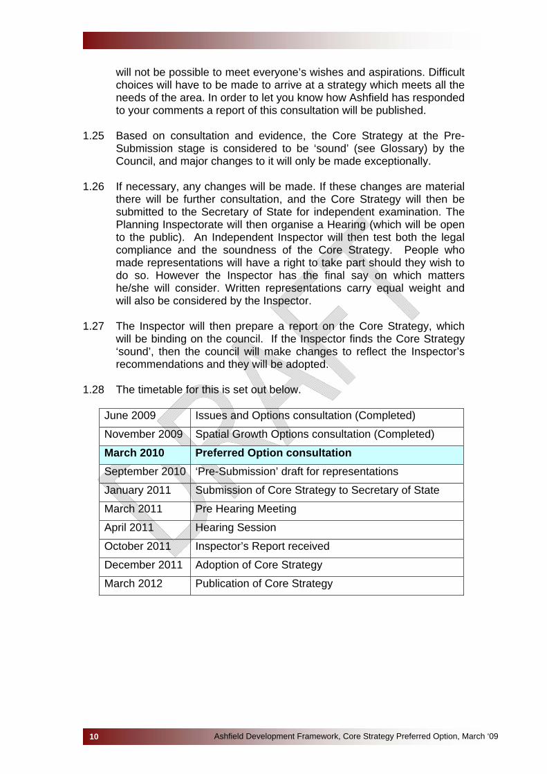
1.28 The timetable for this is set out below.
June 2009 Issues and Options consultation (Completed)
November 2009 Spatial Growth Options consultation (Completed)
March 2010 Preferred Option consultation September 2010 ‘Pre-Submission’ draft for representations
January 2011 Submission of Core Strategy to Secretary of State
March 2011 Pre Hearing Meeting
April 2011 Hearing Session
October 2011 Inspector’s Report received
December 2011 Adoption of Core Strategy
March 2012 Publication of Core Strategy
Ashfield Development Framework, Core Strategy Preferred Option, March ‘0911
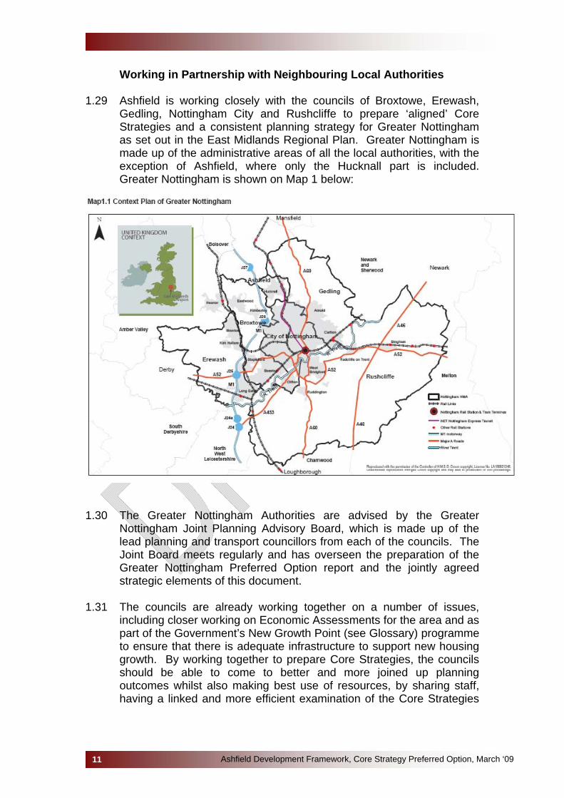
Working in Partnership with Neighbouring Local Authorities 1.29 Ashfield is working closely with the councils of Broxtowe, Erewash,
Gedling, Nottingham City and Rushcliffe to prepare ‘aligned’ Core Strategies and a consistent planning strategy for Greater Nottingham as set out in the East Midlands Regional Plan. Greater Nottingham is made up of the administrative areas of all the local authorities, with the exception of Ashfield, where only the Hucknall part is included. Greater Nottingham is shown on Map 1 below:
1.30 The Greater Nottingham Authorities are advised by the Greater
Nottingham Joint Planning Advisory Board, which is made up of the lead planning and transport councillors from each of the councils. The Joint Board meets regularly and has overseen the preparation of the Greater Nottingham Preferred Option report and the jointly agreed strategic elements of this document.
1.31 The councils are already working together on a number of issues,
including closer working on Economic Assessments for the area and as part of the Government’s New Growth Point (see Glossary) programme to ensure that there is adequate infrastructure to support new housing growth. By working together to prepare Core Strategies, the councils should be able to come to better and more joined up planning outcomes whilst also making best use of resources, by sharing staff, having a linked and more efficient examination of the Core Strategies

and being able to access more funding such as through the Government’s Housing and Planning Delivery Grant.
1.32 These advantages are recognised in the East Midlands Regional Plan.
Policy 17 says:-
“…Local Development Frameworks should contain policies to manage the release of housing across both local planning authority areas and the wider Housing Market Area.
To achieve this, in the following Housing Market Areas joint development plan documents will be expected, with the development of joint Core Strategies across Housing Market Areas particularly encouraged.”
The policy specifically mentions Nottingham Core Housing Market Area and Hucknall. However, the councils have decided to cooperate on a voluntary partnership basis to align their Core Strategies at this time, rather than prepare a formal single joint Core Strategy.
1.33 Ashfield District is bounded by a further four Local Authorities; Newark
and Sherwood, Mansfield, Bolsover and Amber Valley, in the remainder of the District (outside Hucknall) (see Map 2 below). Discussions with these councils have also taken place to ensure a similar joined up approach to planning. This area is described in the Regional Plan as being part of the Northern Sub-Region. Joint studies have been undertaken, including Strategic Housing Land Availability Assessments (SHLAA), Economic Masterplan, Strategic Housing Market Assessment (SHMA) and Employment Land Studies (ELS).
Map 2: Context Plan for the District
Ashfield Development Framework, Core Strategy Preferred Option, March ‘0912

Working in Partnership with Infrastructure and Service Providers
1.34 Government guidance has significantly increased the role of spatial
planning in infrastructure and service provision, seeking proactive co-ordination of the delivery of the infrastructure required to support Local Development Frameworks. A greater emphasis is also placed on the “delivery” of Local Development Frameworks, particularly to ensure that the vital infrastructure necessary to support planned housing and development is in place when required.
1.35 The Core Strategy will need to be demonstrably “deliverable” to
succeed at examination and be found “sound”. This includes providing details of how the infrastructure required to support the Core Strategy will be provided. The test will be whether there is a reasonable prospect of provision of infrastructure.
1.36 Ashfield are working proactively with infrastructure and service
providers (PCT, Education, Highways, Police etc.) to determine the needs arising from the anticipated growth of the District, and to coordinate the Core Strategy with other strategies.
1.37 Infrastructure planning and delivery studies are now needed to plan for
and co-ordinate the delivery of essential infrastructure to support future development, in particular to support the housing requirement over the Core Strategy period. Infrastructure is considered in a much broader sense than in the past, when it was limited to utilities and social infrastructure. It now includes many land use categories, such as green open space, places of worship, telecommunications equipment etc.
1.38 Ashfield District Council, along with other neighbouring authorities, has
already jointly looked at infrastructure capacity and requirements within the area as initial work (Infrastructure Capacity Study). An Infrastructure Delivery Plan is currently being developed, this is a two-way process, with Ashfield understanding the infrastructure and service providers’ strategies, business plans, and funding timeframes and, in turn, for infrastructure and service providers to ensure their strategies take account of the Core Strategy.
1.39 A significant amount of expenditure for the delivery of services,
including healthcare, education, police and waste management, is determined on the basis of funding formulae, underpinned by population forecasts. The Infrastructure Delivery Plan will bring together this information. In doing so, infrastructure planning may reveal gaps in public funding for infrastructure provision, which will be assisted by developer contributions.
Ashfield Development Framework, Core Strategy Preferred Option, March ‘0913

Ashfield Development Framework, Core Strategy Preferred Option, March ‘0914
Links to the Ashfield Sustainable Community Strategy
1.40 Sustainable Community Strategies are key long-term strategy documents for improving the quality of life and services in a local area. Every council is expected to have a Community Strategy, developed and agreed with its Local Strategic Partnership, in Ashfield’s case this is the ‘Ashfield Partnership’.
1.41 The Ashfield Partnership consists of many key local stakeholders and
service providers who have a responsibility to progress the quality of life at a local level. These include health representatives or representatives of the police for example.
1.42 The purpose of a Sustainable Community Strategy is to set the overall
strategic direction and long-term vision for the economic, social and environmental wellbeing of a local area – typically 10-20 years – in a way that contributes to sustainable development in the UK. It tells the ‘story of the place’ – the distinctive vision and ambition for the area, backed by clear evidence and analysis. The Sustainable Community Strategy will need to be fully reflected in the Core Strategy, which will set out how the spatial planning elements will be delivered.
1.43 The Ashfield Partnership is currently reviewing its Sustainable
Community Strategy and public consultation events for both the Community Strategy Review and this Core Strategy have taken place to ensure that the key issues for the District are fully reflected in both documents. It is anticipated that the revised Community Strategy for Ashfield will be adopted by the Ashfield Partnership in the Summer 2010.
1.44 The Core Strategy Spatial Vision, Strategic Objectives (Section 2) and
the Policies to deliver these take forward the themes, vision and objectives of the Sustainable Community Strategy and seek to deliver its priorities. Monitoring of the Core Strategy will be fundamental to assessing its effectiveness in delivering the Sustainable Community Strategy (the monitoring framework is set out in Section 5 and Appendix 5 of this document).
1.45 For more information on Ashfield Partnership’s progress towards the
adoption of the Sustainable Community Strategy, please contact the Partnership team on 01623 457428.

2.0 A PORTRAIT OF ASHFIELD 2.0 The District has excellent road links to much of the country due to its
location beside the M1 motorway. Junction 26 of the M1, which is outside the District, provides a good link to Hucknall now that new routes around Bulwell are complete. Junction 27 of the M1 lies within the District and provides a major link to Ashfield’s three towns and junction 28 can be easily accessed via the A38 and other major routes including the Mansfield-Ashfield Regeneration Route (MARR).
2.1 Ashfield District covers an area of 10,956 hectares and is located on
the western side of Nottinghamshire in the East Midlands Region. It adjoins seven districts within the county including Nottingham City to the south and Mansfield to the north and east, as well as part of the western boundary with Derbyshire.
2.2 There are three Main Urban Areas in the District where housing, jobs
and services are generally concentrated. The southernmost is Hucknall which lies immediately north of Nottingham and is defined as a Sub-Regional Centre in the Regional Plan. Kirkby-in-Ashfield and Sutton-in-Ashfield are to the north of the District and include the adjoining settlements of Kirkby Woodhouse/Annesley Woodhouse/ Nuncargate, Huthwaite, Stanton Hill and Skegby areas respectively. Sutton has the largest of the three town centres being identified as a Sub-Regionally important shopping centre with Hucknall being identified as a ‘major District town centre’ and Kirkby being the smallest of the three town centres, defined as a ‘District centre’. Three villages of Jacksdale, Selston and Underwood also contain significant residential areas, but lack the concentration of employment opportunities and services found in the main centres. The remainder of the District is primarily countryside but containing a number of smaller settlements including New Annesley (Annesley village), Teversal and Fackley.
2.3 Two parish council’s serve the local community, Annesley and Felley
Parish Council and Selston Parish Council. Both Council’s have Parish Plans which have been taken into account within this document.
2.4 The District has excellent road links to much of the country due to its
location beside the M1 motorway. Junction 26 of the M1, which is outside the District, provides a good link to Hucknall now that new routes around Bulwell are complete. Junction 27 of the M1 lies within the District and provides a major link to Ashfield’s three towns and junction 28 can be easily accessed via the A38 and other major routes including the Mansfield-Ashfield Regeneration Route (MARR).
Social Characteristics
2.5 The population of the District in 2008 was 116,450 of which 48.9% were male and 51.1% female. The population density of Ashfield in 2007 averaged 1,058 people per square kilometre, compared with an
Ashfield Development Framework, Core Strategy Preferred Option, March ‘0915

average of 279 for the region and 390 people per square kilometre for England overall. 61.6% of the population are working age compared to 62.2% in England. The ethnic make up of the District is predominantly white. At the time of the 2001 Census 98.9% of the District population had an ethnic group of ‘white’. This compares to 93.5% in the East Midlands region and 91.3% in England and Wales.
2.6 In line with national trends, Ashfield shows evidence of a growing
elderly population and shrinking average household size. Most of this shrinkage is attributable to a growing number of single elderly households.
2.7 Ashfield has a history of industrialised wealth as a result of coal mining
and textile industries. Both declined in the 1980’s creating high unemployment and widespread deprivation throughout the District. Since this time the District has benefited from new employment opportunities and improvements to transport links including re-established railway links to Nottingham and the recently developed tram system in Hucknall. However, regeneration projects in recent years have transformed Ashfield and the District is fast becoming a more desirable place to work and live and has a wide range of visitor attractions. People moving in and out of the district will have a demographic impact, particularly where this affects the structure of the working population.
2.8 In the District there were a total of 12,543 crimes between April 2008
and March 2009. This represents a 5% increase on the same period in 2007/08. Ashfield ranked sixth out of the eight Nottinghamshire Crime and Disorder Reduction Partnerships during 2008/09 financial year for levels of crime. When asked what is most important factor in making somewhere a good place to live, 64% of Ashfield respondents to the 2008 Place Survey stated ‘the level of crime’, making crime the most common factor amongst Ashfield respondents.
2.9 Overall Ashfield performed poorly in terms of community safety issues
in the 2008 Place Survey. Ashfield ranked 348th out of 353 local authorities for NI 41 (Perceptions of Drunk or Rowdy Behaviour) and ranked 349th for NI 42 (Perceptions of Drug Use or Drug Dealing). Ashfield also came 345th for NI 17 (Perceptions of ASB), 351st for NI 27 (feeling local Police and other services seek their views about crime and ASB) and 353rd for NI 21 (feeling that local Police and local services are dealing successfully with crime and ASB). ‘Teenagers Hanging Around on the Streets’ was the issue most people were concerned about with 59% of people viewing this as a very or fairly big problem, this was followed by ‘Drug Use’ (54%) and ‘Vandalism, Graffiti and Deliberate Damage to Property’ (48%).
2.10 The Nottingham Core Strategic Housing Market Assessment found that
Ashfield was drawing many people of working age out of Nottingham.
Ashfield Development Framework, Core Strategy Preferred Option, March ‘0916
Ashfield generally shows a net inflow of people with significant inflows to Ashfield from Nottingham, Gedling and Broxtowe and outflows to Mansfield and Newark and Sherwood.
2.11 Existing policy and housing strategy documents distinguish 3 main
housing market areas within Ashfield – North (Kirkby-in-Ashfield, Sutton-in-Ashfield and surrounding settlements); South (Hucknall) and Rural (Selston, Jacksdale, Underwood and other small rural settlements). However, the Affordable Housing Viability Study further breaks these down into submarket areas. The housing market in Ashfield operates largely on a micro level. Migrations data and local knowledge suggests people in Ashfield do not generally move between the three main housing areas.
2.12 Key demographic, economic and social factors influencing housing
need and demand in Ashfield District include:
• Shrinking, often elderly, households occupying large properties – increasing levels of under-occupation, particularly among owner-occupiers aged over 50;
• Migration from Nottingham has a significant impact, particularly in Hucknall. The majority of people who move from Nottingham are in the 25-44 age group; often moving with young children. This will increase the level of demand for family homes;
• Actions by local government to improve transport links between Ashfield, Nottingham and Mansfield appear to have had an effect on both local and wider housing markets, both increasing house prices along the NET Tram Route and levelling out prices around the Mansfield to Ashfield Regeneration Route (A617);
• Incomes are generally skewed towards the lower end of the earnings scale. The most common (mode) income in the district is between £10,000 and £20,000pa. Within the overall picture there is variation between the different settlements.
2.13 The average house price within the District is £114,416 which
compares well to the regional and national averages which are £161,879 and 226,648 respectively (Communities & Local Government – mean house prices based on Land Registry data 3rd quarter 2009). However when income levels in Ashfield are taken into account affordability is an issue in the District. The Ashfield Housing Needs Assessment 2008 identifies that around 40% of households in the area cannot afford to purchase a typical lower quartile property if borrowing 3.5 times their household income with a 10% deposit.
2.14 The health of people in Ashfield is generally worse than the England
average. This can be seen in a number of areas:
• Levels of GCSE achievement, physical activity in children and people diagnosed with diabetes are worse than the England average
Ashfield Development Framework, Core Strategy Preferred Option, March ‘0917

• There are health inequalities within Ashfield by gender and level of deprivation. For example men from the most deprived areas have on average 6 years shorter life expectancy than those from the least deprived areas
• Over the last ten years deaths from all causes have decreased for men and women in Ashfield, although not as quickly as the England average rates, and they remain above average for England
• Early deaths from heart disease and stroke have also decreased in this period and remain close to the average for England
• Lifestyle indicators are generally worse than the average for England. Smoking kills about 210 people in Ashfield each year
• On average both men and women in Ashfield live shorter lives than in England as a whole.
2.15 Lone parent families are of many diverse economic and social
backgrounds, and it is important to avoid attaching any stigma or assumptions. However, a significant proportion of lone parent households in Ashfield emerge as a result of teenage pregnancy (compared to other nearby local authority statistics).
Economic Characteristics
2.16 In relation to the local economy the District can be seen to be within two functional economic areas:
a) Mansfield-Ashfield which includes the towns of Kirkby-in-Ashfield,
and Sutton-in-Ashfield; and b) Greater Nottingham which includes Hucknall.
2.17 This is reflected in commuting patterns with the links between the
Hucknall and Nottingham city being extremely strong with between 30% and 40% of the workforce travelling from the south eastern corner of the district to Nottingham. Although jobs have been created in Ashfield, the district has significantly less jobs than working population (in 2006 the ratio of total jobs to working-age population was 0.66%). Consequently Ashfield is a net exporter of labour and this is likely to be linked to job quality, with residents travelling to better paid jobs outside the District.
2.18 The District has an over reliance on the manufacturing sector and for
Ashfield to prosper in an era of increasing globalisation there is a need to promote a more diverse local economy moving towards ‘high value-added’ services and manufacturing. This requires higher level skills, so businesses in the District can compete in both national and international markets. From the State of Ashfield Report 2008 and Experian’s analysis of the local economy, it can be seen that Ashfield faces a number of additional issues as:
Ashfield Development Framework, Core Strategy Preferred Option, March ‘0918
• The District needs to build on the Local Enterprise Growth Initiative by continue to encourage entrepreneurship and support to enable small business to survive and grow
• With exceptions, levels of productivity in various sectors are lower than the UK average
• The unemployment rate in Ashfield has generally remained higher than in the East Midlands and UK average with local high concentrations at a ward level within Hucknall, Kirkby-in-Ashfield and Sutton-in-Ashfield
• A disproportionate number of people in the District work in semi-skilled and unskilled occupations. Further the District has a low educational base. There is a need to increase the skills and education in the labour market as low level skills creates a barrier to higher tech and higher value business locating in the region
• Ashfield has a relatively low proportion of employment in the knowledge driven sectors, ranking 275th out of 408 districts nationally.
2.19 The socio-economic profile of the District is weighted towards skilled
and unskilled manual trades such as manufacturing and construction (evolving as a natural progression of a post coalmining community). As a result of historical, cultural and socio-economic factors some areas of Ashfield demonstrate income levels that are significantly lower than average compared to neighbouring areas or regional figures.
2.20 The District’s working population has grown over the period 1998 to
2008. However whilst the working population is growing, it is also becoming older. Consequently, over time there needs to be a greater focus on retaining older workers in the labour market to ensure that a shortfall in the supply of workers does not prevent the District from realising its economic potential.
2.21 Economic underperformance is inextricably linked to low levels of
educational attainment and a corresponding lack of skills. Whilst employment projections forecast a strong employment demand for people with intermediate and higher level skills, the concern is that too many residents currently lack skills at the right level to respond to these labour market changes and will thus struggle to compete effectively. In terms of the very well qualified – those qualified to NVQ level 4 or above – Ashfield falls well below regional and national averages. In the UK 29% of the working age population are qualified to this level; this falls slightly in the East Midlands to 26%, but Ashfield records a figure of under 16%– in other words close to half of the national average. The situation for the well-qualified – NVQ level 3 – is slightly less severe but Ashfield is still lagging behind regional and national figures. The District also has a higher proportion of residents with no qualifications. The issue is most apparent amongst young people, with 21% of those aged 16-24 in both districts possessing no qualifications, compared with 14% regionally, and 17% nationally.
Ashfield Development Framework, Core Strategy Preferred Option, March ‘0919
Environmental Characteristics 2.22 The problems of traffic congestion and its associated air quality and
safety problems are rising in the District. Significant action to encourage greater use of alternative modes of travel is required to improve this situation. Ashfield faces increased congestion within the towns and poorer air quality. This will affect not only the quality of life for residents of the District but also the ability to attract new jobs, investment and tourism to the area. According to the Department for Transport, the East Midlands region has the highest increase in traffic on major roads (25.4% between 1994 and 2004) compared to all other regions, the national increase is 20.7%.
2.23 Climate change is the greatest environmental challenge facing the
world today. Rising global temperatures will bring changes in weather patterns, rising sea levels and increased frequency and intensity of extreme weather events, the effects will be felt here in the UK and internationally. Climate change is widely recognised as the most significant issue for spatial planning, cutting across all land use sectors and affecting the environment, economy, and quality of life in Ashfield.
2.24 No Air Quality Management Areas (AQMA) have been declared within
the District following a statutory review in August 2001. However the Council is committed to developing a Local Air Quality Strategy.
2.25 Ensuring that existing and future residents and users have good
access to services and facilities is an objective of the Council and the Local Transport Plan. The County Council have identified that 99% of residents in Ashfield are less than a 10 minute walk from a bus stop with an hourly service. Community transport also has an role to play in the District in meeting the needs of particular users of the service.
2.26 The average amount of household waste is approximately 373kg per
head. There are 35 local recycling centres throughout Ashfield District, with households having recycling ‘green-lid’ bins collected alternately with the ‘black-lid’ bins. The Council also offers a ‘blue-box’ recycling service monthly. Ashfield achieves almost 28% of household waste which is recycled. In 2007 Ashfield was ranked 12th in the UK for recycling ‘dry recyclables’.
2.27 Ashfield’s countryside, country parks, urban parks and open space is
of particular importance and quality. The District holds a variety of nature conservation sites (see Policies CP4 and CP5), these are located throughout the District and a number of parks have been awarded a Green Flag, a national quality standard for parks.
Key Issues specific to Ashfield 2.28 Ashfield is expected to accommodate 11,200 new homes before 2026.
These numbers are split between Hucknall (3,600) and the Rest of the
Ashfield Development Framework, Core Strategy Preferred Option, March ‘0920

District (7,600). This growth would increase the numbers of houses in the District by approximately 20%. A number of interrelated issues need to be addressed if sustainable growth is to be delivered in Ashfield. These set the context for the overall vision and objectives of this plan.
2.29 Ashfield has a number of key advantages that should drive growth.
These include:
• Its proximity to good national regional and local transport links; • Its proximity to Nottingham City, Mansfield, Chesterfield and
Sheffield; • Attractive rural settings and generally high quality environment in
some locations; • The network of Main Urban Areas (Hucknall, Kirkby-in-Ashfield and
Sutton-in-Ashfield) each with their own ‘sense of place’ providing accessible local services and facilities;
• The relative affordability of houses; • The availability of employment sites.
2.30 However, it is underperforming in a number of key respects:
• Two out of the three town centres struggle to compete with neighbours;
• Infrastructure deficits and gaps in service provision in some areas; • Limited design quality of more recent development; • Low skilled workforce and an economy dominated by
manufacturing activities; • Areas of high social deprivation; • Higher than average health issues; • High crime and fear of crime levels; • Low educational attainment. • A culture of worklessness were young people have grown up in an
environment where there is a lack of work and this is accepted as normal.
2.31 The following vision and objectives set out how the Core Strategy aims
to address these issues in order to deliver the growth agenda in a way that benefits existing, as well as new, communities.
Ashfield Development Framework, Core Strategy Preferred Option, March ‘0921
The Vision for Ashfield
“By 2026 Ashfield District will be a place which is economically strong and diverse and meets the community’s needs in a sustainable manner with climate change being at the forefront of the Council’s priorities. The District will increase its quality of life through planning development to help reduce crime, anti-social behaviour and the fear of crime, promoting well-being and improving health and reducing health inequalities. The regeneration of the District will continue through a policy of concentrating development in and adjoining the urban areas of Sutton-In-Ashfield, Kirkby-In-Ashfield and Hucknall. The needs of the rural areas including Selston, Jacksdale and Underwood will be catered for, providing a fair and equal access to jobs and services across the District. Housing will be well planned and well designed meeting sustainable development initiatives and zero carbon targets. All residents will have the opportunity of living in a decent home, which they can afford, in a community where they want to live. Strategic high quality employment sites will be established including the Rolls Royce complex at Hucknall, which will help diversify and create knowledge-based jobs. Access to educational opportunities will be improved to meet the challenges faced in skills deprivation, leading to an increase in the number of qualified people. People interested in entering local trades or other vocational jobs will have easy access to training and apprenticeships while further learning will be offered throughout the District. Growth within the District will be accommodated in a manner that achieves the protection, restoration and enhancement of the environmental assets and creates safer environments including Green Infrastructure networks and habitat creation. Continued investment in the three town centres of Hucknall, Kirkby-In-Ashfield and Sutton-In-Ashfield will ensure their future viability and vitality as the main service centres in the District.”
Ashfield Development Framework, Core Strategy Preferred Option, March ‘0922
Objectives for Realising the Vision 2.32 Working in partnership with other organisations, the following
objectives have been identified as central to achieving the delivery of the spatial vision for Ashfield :
SO1 Economic Prosperity for All: Assist in creating a prosperous, environmentally sustainable and economically vibrant District through the provision of a good quality range and choice of sites and premises particularly in locations at Rolls Royce in Hucknall and along the MARR in Sutton. Promote learning, raise skill levels, encourage a culture of enterprise and tackle worklessness by creating the necessary support and infrastructure.
SO2 High Quality New Housing: Provide good quality, environmentally sustainable and well planned/designed housing in the most appropriate locations within the towns of Hucknall, Sutton and Kirkby and, to a lesser extent, the villages of Selston Jacksdale and Underwood to ensure that the urban concentration aims of the East Midlands Regional Plan are met and to meet the needs of all sections of the existing and future population.
SO3 Safe Communities: Improve community safety, reduce crime and the fear of crime through the development of good quality well planned environments concentrating, in particular, on the most deprived areas of the District including Kirkby East and Sutton East. However, opportunities to reduce crime and disorder should be maximised through out the District.
SO4 Cohesive Communities: Promote social inclusion to reduce inequalities through the location and distribution of employment, housing, health, leisure, recreational and other community facilities and working to reduce anti social behaviour;
SO5 Regeneration: Make the maximum use of previously developed land for appropriate new uses taking into account the results from the Strategic Housing Land Availability Assessments for both Hucknall and the Rest of the District;
SO6 Addressing Climate Change: Minimise energy use, tackle climate change, promote renewable energy generation, match the vulnerability of land use to flood risk, managing surface water in a sustainable manner and make the most efficient use of resources to reduce the causes of climate change;
SO7 Vibrant Town Centres: Promote and develop the roles of Sutton, Kirkby and Hucknall as the main service centres of the District by ensuring they provide a range of town centre uses in a well planned and attractive environment. Also support shopping areas in the outlying District to ensure they provide appropriate services to satisfy local needs;
Ashfield Development Framework, Core Strategy Preferred Option, March ‘0923
SO8 Reducing the Need to Travel by Car: Reduce congestion and improve accessibility by good spatial planning recognising existing land use patterns and by making efficient use of existing infrastructure and promote quality public transport, cycling and walking opportunities to help reduce the need to travel by car and improve access to jobs, homes and services;
SO9 Opportunities for all: Support the provision of accessible and varied opportunities for leisure, cultural and recreational activities particularly where this helps to promote healthy lifestyles;
SO10 Environmentally Responsible: Ensure development in the District takes into account environmental capacity, in particular its ability to support development and activities without harm, ensure development proposals fully consider the District’s Coal Mining legacy issues to ensure the stability of the land and the need to conserve and enhance natural resources and the natural, built and historic environment, including the re-use of historic and interesting buildings where appropriate. In particular opportunities to protect enhance and expand Ashfield’s green infrastructure, including its biodiversity, should be identified;
SO11 Natural Assets: Protect and enhance Ashfield’s green infrastructure including biodiversity by safeguarding and enhancing important natural assets including both habitats and wildlife species;
SO12 Character of the District: Protect important areas of countryside by protecting the Green Belt, particularly to prevent coalescence of settlements, and by identifying other key areas of countryside for protection including green wedges;
SO13 Timely and Viable Infrastructure: Ensure necessary infrastructure is provided as part of new developments to ensure there is no adverse effect on existing communities and that benefit from new infrastructure provision is gained by both new and existing residents.
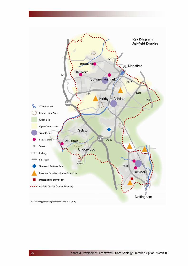
Key Diagram 2.33 The Key Diagram on the following page shows the areas for growth
and areas of constraint, key transport links, sustainable urban extension locations, and the hierarchy of town centres. More detailed diagrams for each of the three areas (Hucknall, Kirkby and Sutton and the Villages) can be found in the ‘Area Based Policies’ section of this document.
Ashfield Development Framework, Core Strategy Preferred Option, March ‘0924
Ashfield Development Framework, Core Strategy Preferred Option, March ‘0925

CORE POLICIES
Ashfield Development Framework, Core Strategy Preferred Option, March ‘0926

3.1 CLIMATE CHANGE 3.1.1 Climate change is one of the biggest challenges facing the area. It is
a global problem requiring local action. Major changes in attitude and practices are required if we are to make changes to the earth’s climate and reverse the effects of global warming.
3.1.2 National, regional and local objectives to address climate change will not be achieved without substantial efforts to reduce energy consumption and increase energy produced from naturally occurring, renewable sources.
AT THE ISSUES AND OPTIONS AND SPATIAL GROWTH OPTIONS YOU TOLD US THAT… • There may be an issue about the viability of requiring a percentage of
energy in new developments to be derived from renewable sources in light of the current economic climate;
• We need to consider the protection and conservation of the area’s heritage when considering renewable energy infrastructure;
• You agreed that the Council’s should require large scale developments to meet higher levels of CO2 reduction;
• The Council should refuse development on Flood Zones 2 and 3 except in exceptional circumstances;
• Non-residential uses could be safely sited in Flood Zone 3;
• Climate Change should underpin the whole document and any future planning decisions that are made.
POLICY CP1 – CLIMATE CHANGE Sustainable Energy
1) All development proposals will be required to deliver high levels of building sustainability in advance of national standards in order to mitigate against and adapt to climate change.
2) All development, including major refurbishment, will be required to
demonstrate the following:
a) How it makes effective use of resources and materials, minimises water use and CO2 emissions;
b) How it is sited and designed to withstand the long term impacts of climate change, particularly the effect of rising temperatures;
c) The adaptation of the building form and construction to make installation of sustainability measures viable.
Ashfield Development Framework, Core Strategy Preferred Option, March ‘0927
The onus will be on developers to robustly justify why full compliance with policy requirements is not viable.
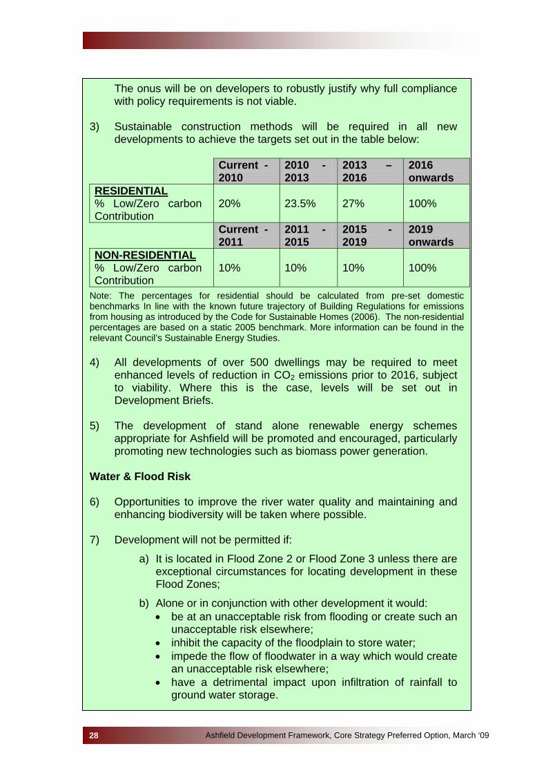
3) Sustainable construction methods will be required in all new developments to achieve the targets set out in the table below:
Current -
2010 2010 - 2013
2013 – 2016
2016 onwards
RESIDENTIAL % Low/Zero carbon Contribution
20% 23.5% 27% 100%
Current - 2011
2011 - 2015
2015 - 2019
2019 onwards
NON-RESIDENTIAL % Low/Zero carbon Contribution
10% 10% 10% 100%
Note: The percentages for residential should be calculated from pre-set domestic benchmarks In line with the known future trajectory of Building Regulations for emissions from housing as introduced by the Code for Sustainable Homes (2006). The non-residential percentages are based on a static 2005 benchmark. More information can be found in the relevant Council’s Sustainable Energy Studies. 4) All developments of over 500 dwellings may be required to meet
enhanced levels of reduction in CO2 emissions prior to 2016, subject to viability. Where this is the case, levels will be set out in Development Briefs.
5) The development of stand alone renewable energy schemes
appropriate for Ashfield will be promoted and encouraged, particularly promoting new technologies such as biomass power generation.
Water & Flood Risk 6) Opportunities to improve the river water quality and maintaining and
enhancing biodiversity will be taken where possible. 7) Development will not be permitted if:
a) It is located in Flood Zone 2 or Flood Zone 3 unless there are exceptional circumstances for locating development in these Flood Zones;
b) Alone or in conjunction with other development it would: • be at an unacceptable risk from flooding or create such an
unacceptable risk elsewhere; • inhibit the capacity of the floodplain to store water; • impede the flow of floodwater in a way which would create
an unacceptable risk elsewhere; • have a detrimental impact upon infiltration of rainfall to
ground water storage.
Ashfield Development Framework, Core Strategy Preferred Option, March ‘0928

unless adequate measures to mitigate the effects on the overall flooding regime are undertaken.
9) Sustainable Urban Drainage Systems will be utilised in all new
development unless it can be demonstrated that it is not feasible or viable.
Reasoned Justification 3.1.3 This policy does not address all aspects of climate change as this issue
is embedded throughout this document. Further guidance can be found at Policy CP2 (Sustainable Growth), Policy CP7 (Design and Place Making), Policy CP4 (Green Infrastructure, Biodiversity and Open Spaces).
3.1.4 The UK Government is actively seeking to reduce greenhouse gas
emissions and has set targets in the Climate Change Act 2008 to reduce carbon dioxide (CO2) emissions by 80% below current levels by 2050. More recent guidance, including the supplement to PPS1 on Climate Change and Building a Greener Future: Towards Zero Carbon Development, pave the way for the delivery of more resource-efficient buildings in general and carbon zero homes by 2016.
3.1.5 Ashfield District Council has signed the Nottingham Declaration on
Climate Change which is a public statement of intent to work with the local community and businesses to respond to the challenges of climate change. This includes cutting gas emissions such as carbon dioxide and preparing for the changes climate change will bring.
3.1.6 The Local Development Framework needs to ensure the use and development of land will help slow down the rate of (but also be resilient to the effects of) climate change. In this respect the Local Development Framework's task will be to:
• reduce consumption of natural and non-renewable resources; • reduce pollution to levels that do not damage natural systems; • help improve air quality; • reduce dependence on non-renewable energy sources and
promote renewable energy use and development; • effectively manage and reduce the impacts of flood risk across the
area.
3.1.7 It is the Council’s priority to avoid flooding wherever possible as set out in the Ashfield Strategic Flood Risk Assessment. Therefore, except in exceptional circumstances, it is not anticipated that development will take place within Flood Zones 2 and 3.
3.1.8 Link to Core Strategy Objectives:
• SO6 Addressing Climate Change;
Ashfield Development Framework, Core Strategy Preferred Option, March ‘0929
• SO8 Reducing the Need to Travel by Car; • SO10 Environmentally Responsible; • SO11 Natural Assets.
3.1.9 National and Regional Policy Framework:
• PPS1: Delivering Sustainable Development; • Supplement to PPS1: Planning and Climate Change; • PPS22: Planning for Renewable Energy; • PPS25: Development and Flood Risk; • PPS25: Development and Flood Risk - Practice Guide; • East Midlands Regional Plan: Policies 32, 35, 39 and 40.
3.1.10 Local Policies, Strategies and Evidence Base:
• Greater Nottingham Local Transport Plan; • Derbyshire Local Transport Plan; • The Ashfield Sustainable Community Strategy; • The Local Area Agreement (LAA); • Towards a Sustainable Energy Policy for Nottinghamshire; • Ashfield Strategic Flood Risk Assessment; • Greater Nottingham and Ashfield Water Cycle Study.
Alternative Options not selected No reasonable alternatives for the climate change policy exist. The policy reflects national, regional and local policies and guidance. Any alternative option to not encourage energy efficient development, the use of renewable energy schemes and managing flood risk would undermine attempts to positively impact upon climate change and deliver the most efficient use of scarce energy resources. However, the following options relating to more specific elements of this topic have been identified: Option 1: Require Level 6 (zero carbon) of the Code for Sustainable Homes
(CSH) immediately This option would bring many benefits, but CSH only applies to residential development and would not address the need to improve performance of non-residential buildings. National policy does not propose all new housing be ‘Zero Carbon’ until 2016. Developers are also likely to need time to adjust to building property to a much tighter standard than is currently in place. This option would have to be balanced against achieving the wider delivery targets of the Local Development Framework. Also, evidence contained within ‘Towards a Sustainable Energy Policy for Nottinghamshire’ has tested the viability of the targets detailed in Policy CP1 and the report concluded that the costs in implementing development incorporating the targets would be ‘reasonable’.
Ashfield Development Framework, Core Strategy Preferred Option, March ‘0930
Option 2: Apply a threshold for renewable energy provision in residential
developments at 50 dwellings This option would use a site size threshold for renewable energy equipment to be provided. While a policy of this nature would aid sustainable development, substantial growth will be taking place in Ashfield between now and 2026 (a large proportion of which would be on smaller sites) a threshold trigger would not be sufficient to deliver the ‘critical mass’ required to achieve the benefits of shared on or off-site renewable energy technologies. The evidence base document allows for all developments and does not assume thresholds. Sustainability Appraisal The building sustainability element of this policy performed very positively in relation to SA objectives covering energy, waste and natural resources. It also displayed some more marginal positive outcomes in relation to housing and employment objectives. Very few negative impacts were attributed to this policy. One such was the potential harm to landscape character from wind turbine developments – though this was felt that this could be mitigated by careful siting and design.
Ashfield Development Framework, Core Strategy Preferred Option, March ‘0931
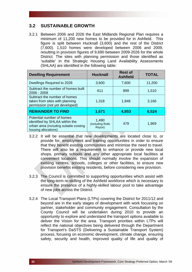
3.2 SUSTAINABLE GROWTH 3.2.1 Between 2006 and 2026 the East Midlands Regional Plan requires a
minimum of 11,200 new homes to be provided for in Ashfield. This figure is split between Hucknall (3,600) and the rest of the District (7,600). 1,510 homes were developed between 2006 and 2009, resulting in provision figures of 9,690 between 2009-2026 for the whole District. The sites with planning permission and those identified as ‘suitable’ in the Strategic Housing Land Availability Assessments (SHLAA) are identified in the following table:
Dwelling Requirement Hucknall Rest of Ashfield TOTAL
Dwellings Required to 2026 3,600 7,600 11,200 Subtract the number of homes built 2006 - 2009 611 899 1,510
Subtract the number of homes taken from sites with planning permission (not yet developed)
1,318 1,848 3,166
REMAINDER TO FIND 1,671 4,853 6,524 Potential number of homes identified by SHLAA within the urban area (including suitable existing housing allocations)
1,490 (including Rolls
Royce) 479 1,969
3.2.2 It will be essential that new developments are located close to, or provide for, employment and training opportunities in order to ensure that they benefit existing communities and minimise the need to travel. There will also be a requirement to enhance or provide new local shops, primary schools and any other appropriate local facilities at convenient locations. This should normally involve the expansion of existing centres, schools, colleges or other facilities, to ensure new provision benefits existing residents, before considering new provision.
3.2.3 The Council is committed to supporting opportunities which assist with
the long-term re-skilling of the Ashfield workforce which is necessary to ensure the presence of a highly-skilled labour pool to take advantage of new jobs across the District.
3.2.4 The Local Transport Plans (LTPs) covering the District for 2011/12 and
beyond are in the early stages of development with work focussing on partner, stakeholder and community engagement. Consultation by the County Council will be undertaken during 2010 to provide an opportunity to explore and understand the transport options available to deliver the Vision for the area. Transport priorities within LTPs will reflect the national objectives being delivered through the Department for Transport’s DaSTS (Delivering a Sustainable Transport System) process, focusing on economic development, climate change, ensuring safety, security and health, improved quality of life and quality of
Ashfield Development Framework, Core Strategy Preferred Option, March ‘0932

opportunity through maximising accessibility and reducing dependence upon the private car.
AT THE ISSUES AND OPTIONS AND SPATIAL GROWTH OPTIONS YOU TOLD US THAT… • The East Midlands Regional Plan figures should be treated as a
minimum (developers and agents), other people responding considered the housing provision to be too large;
• The Sustainable Urban Extensions approach was supported (mainly by developers). Members of the public objected to Greenfield and Green Belt development;
• Major new development should only be located within or close to existing urban areas;
• The Hucknall Growth Option: H1 (Minimum Growth – Rolls Royce) was the most preferred option;
• The most preferred growth option for the rural areas of the District was option V1 (minimum growth – ‘Business as Usual’);
• The growth options for Sutton-in-Ashfield and Kirkby-in-Ashfield were less clear, information from the local community groups event suggested that large urban extensions would be most preferable, with a fairly even number of respondents to the public consultation suggesting either large urban extensions or spreading development were preferred. The majority of responses were opposed to Green Belt development.
• Major new development should only be permitted in association with the provision of new public transport infrastructure and services highway capacity improvements;
• Focus should be on the promotion and development of public transport (especially bus) facilities;
Note: other relevant information is also contained within other policy areas of this document
POLICY CP2 - SUSTAINABLE GROWTH 1) Development in Ashfield will be primarily focused towards locations
within or adjoining the Main Urban Areas of Hucknall, Kirkby-in-Ashfield and Sutton-in-Ashfield. The locations are set out below and illustrated on the key diagram. Smaller scale development of the District’s towns and villages will follow in the Site Specific Development Plan Document.
• Approximately 1,600 homes in or adjoining Hucknall, including a
Sustainable Urban Extension at Rolls Royce.
• Approximately 4,600 homes in or adjoining Kirkby-in-Ashfield and Sutton-in-Ashfield, including two Sustainable Urban Extensions at the following locations: − East of Kirkby/Sutton, off Lowmoor Road;
Ashfield Development Framework, Core Strategy Preferred Option, March ‘0933
− West of Kirkby, south of A38.
• Approximately 200 homes in the rural areas of Selston, Jacksdale and Underwood.
2) Existing local facilities will be supported to include retail, leisure, social,
cultural, faith, community and health facilities, or where necessary providing new facilities to meet local needs but not undermining existing nearby centres. Retail, leisure and cultural development will be located in the Town Centres of Hucknall, Kirkby-in-Ashfield and Sutton-in-Ashfield and to a lesser extend in the local centres in accordance with Policy CP10: Town and Local Centres.
3) The need to travel, especially by private car, will be reduced by locating
new developments, which are expected to generate significant travel demand, on sites which are well served by public transport (or with the potential to be well served), and where the operation of local highway networks will not be compromised.
4) A hierarchical approach to ensure the delivery of sustainable transport
networks will be adopted which will seek to provide (in order of preference):
a) Area wide travel demand management (policies to reduce travel by private car and incentives to use public transport, walking and cycling for appropriate journeys including intensive travel planning);
b) Improvements to public transport services, and walking and cycling facilities;
c) Optimisation of existing highway network to prioritise public transport and encourage walking and cycling;
d) Major highway capacity enhancements to deal with residual car demand.
5) Where new development gives rise to the need for additional transport
infrastructure, it should be in accordance with the priorities of the relevant Local Transport Plans covering the District. New development, singly or in combination with other proposed development, must demonstrate that a sufficient package of measures are proposed as part of the development to ensure that the integrity of the transport system as a whole is not threatened.
6) New or expanded educational facilities may be required and will be
determined by the scale of development and planned in such a way as to integrate existing and new communities.
7) Development will be designed to promote healthier lifestyles and for
people to be active outside their homes and places of work. 8) A high quality design will be required, creating a sense of place by
strengthening the distinctive heritage and cultural qualities and the
Ashfield Development Framework, Core Strategy Preferred Option, March ‘0934

townscape of the towns and villages through the development’s design, landscaping and use of public art to enhance the character of its surroundings and be in accordance with the environmental character of the area.
9) All buildings will be resilient to climate change, designed with the future
climate in mind and highly water efficient, subject to Policy CP1: Climate Change, as a minimum, but with consideration of higher standards where viability studies demonstrate this is achievable.
10) The principle of the open countryside areas will be retained, but its
boundaries will be amended, where necessary, to accommodate the Sustainable Urban Extensions. A more detailed Green Belt and Countryside boundary review to allow for smaller scale development of towns and villages will follow in the Site Specific Development Plan Document.
11) Strategic Green Infrastructure will be provided or enhanced in
conjunction with the locations for development. 12) The above criteria also relate to the development of Gypsy, Traveller
and Travelling Showpeople sites, in addition to Policy CP11.
Reasoned Justification
3.2.5 The locations of the Sustainable Urban Extensions (large sites over 500 dwellings) have been selected based on evidence and the findings of the sustainability appraisal, and informed by consultation on the Issues and Options and Area Based Spatial Growth Options. These new developments will be of high quality design, and will incorporate measures to mitigate and reduce the causes of climate change. Where appropriate, it will also look to resolve existing flooding issues.
3.2.6 Development elsewhere in the District will be mainly concentrated in
the larger and more accessible towns (Hucknall, Kirkby-in-Ashfield and Sutton-in-Ashfield) identified in the Accessibility of Settlements Study, reflecting the need to meet sustainability objectives. The villages of Selston, Jacksdale and Underwood will only be allocated small scale development in the form of small scale infill and rounding off settlement boundaries which will be set out in the Site Specific Development Plan Document.
3.2.7 New employment is needed not only to compliment population growth,
but also to provide a range of employment opportunities to existing residents, as unemployment is an issue in the District.
3.2.8 Transport is a major contributor to climate change, and congestion has
adverse economic impacts, as well as being detrimental to air quality. Upgrading existing infrastructure and providing new infrastructure will
Ashfield Development Framework, Core Strategy Preferred Option, March ‘0935
therefore be aimed at reducing the need to travel, especially by private car. There will be a focus on changing people’s travel behaviour and improving opportunities for journeys to be made by public transport. Major improvements to highway capacity for private cars will be a last resort.
3.2.9 A sustainable good quality transport system is essential to support the
economic and social wellbeing of Ashfield. Traffic congestion is costly, inefficient and destructive to the environment. An emphasis on public transport, and on promoting walking and cycling for short journeys, will be the most sustainable way to plan for Ashfield’s travel needs supported with pro-active, area-wide travel demand management. This approach is consistent with national, regional and local transport policies promoted through the Local Transport Plans for Ashfield.
3.2.10 Planning Policy Statement 1 (PPS1): Delivering Sustainable
Development provides guidance on air quality issues and requires LDF documents to take account of environmental issues such as air quality and pollution. PPS23: Planning and Pollution Control advises that the planning system plays a key role in determining the location of development which may give rise to pollution, either directly or indirectly. It also requires that the existing, and likely future, air quality in an area should be considered.
3.2.11 Travel demand management is about encouraging people to travel less
and use sustainable means of travel where possible when they do need to make journeys (‘Smarter Choices’). There are techniques for influencing people's travel behaviour towards more sustainable options such as encouraging school, workplace and individualised or personal travel planning. They also seek to improve public transport and marketing services such as travel awareness campaigns, setting up websites for car share schemes, supporting car clubs and encouraging teleworking. These techniques can be very effective at changing travel behaviour, but some, such as personal travel plans, can be expensive when provided to large numbers of people.
3.2.12 Travel Plans will be required for significant new developments, showing
how these objectives are to be met. Existing major employers, schools, and other generators of travel demand will be strongly encouraged to develop Green Travel Plans. Initiatives will also include the promotion of more efficient and sustainable use of private vehicles, such as car sharing and car clubs, and low emission vehicles.
3.2.13 The Sustainable Urban Extensions may incorporate employment and
training opportunities in order to ensure that new development benefits existing communities and in order to minimise the need to travel. There may also be a requirement to enhance or provide new local shops, primary schools and any other appropriate local facilities at convenient locations. Expansion of existing centres, schools, colleges or other facilities, to ensure new provision benefits existing residents should be considered before considering new provision.
Ashfield Development Framework, Core Strategy Preferred Option, March ‘0936
3.2.14 Design should incorporate the principles of Building for Life, Manual for
Streets and other current good practice guidance, in order to give new communities a sense of identity and local distinctiveness, and ensure they are desirable and convenient places to live. In many instances there will be opportunities for the development to assist in the regeneration of adjacent or nearby communities.
3.2.15 The East Midlands Regional Plan enshrines the continuing principle of
the Green Belt, however, it also accepts that the existing tight boundaries need to change to accommodate major growth. In line with Planning Policy Guidance Note 2: Green Belts, only appropriate development will be permitted in the Green Belt.
3.2.16 The open countryside areas comprise the rural parts of the District
lying outside the Main Urban Areas and Named Settlements. These areas were defined in the Ashfield Local Plan Review (2002), the principal of this will continue until a review takes place at the Site Specific Development Plan Document/Proposals Map stage of the Ashfield Development Framework.
3.2.17 New and enhanced strategic Green Infrastructure is required to
mitigate effects of growth and make good existing deficiencies. Wherever possible it should be multifunctional, for instance, in providing adequate open spaces for recreation, assisting in providing for more biodiversity and in managing flood risk, or providing opportunities for growing local food.
3.2.18 Link to Core Strategy Objectives
• SO1 Economic prosperity for all • SO2 High quality new housing • SO4 Cohesive Communities • SO5 Regeneration • SO6 Addressing Climate Change • SO7 Vibrant town centres • SO8 Reducing the need to travel • SO11 Natural assets • SO13 Timely and viable infrastructure
3.2.19 National and Regional Policy Framework
• PPS1: Delivering Sustainable Development; • PPS12: Local Spatial Planning; • PPS13: Transport • East Midlands Regional Plan: Policies 3, 13a, Three Cities
SRS2, Three Cities SRS3 and Northern SRS1. 3.2.20 Local Policies and Strategies and Evidence Base
• Appraisal of Sustainable Urban Extensions;
Ashfield Development Framework, Core Strategy Preferred Option, March ‘0937

• Existing Local Plan allocations; • Greater Nottingham Local Transport Plan; • North Nottinghamshire Local Transport Plan; • Ashfield SHLAA for Hucknall; • Ashfield SHLAA for Nottingham Outer (remainder of District
outside Hucknall); • Ashfield Sustainable Community Strategy; • Accessible Settlements Study; • Greater Nottingham and Ashfield Infrastructure Capacity Study.
Alternative Options not selected No other reasonable alternatives for sustainable growth exist. The policy reflects national, regional and local policies and guidance. Any alternative option would not encourage sustainable development. However, alternative locations for the growth were considered at the ‘Spatial Growth Options’ consultation stage for this Core Strategy. Representations regarding these preferred locations have been reflected in the Preferred Option. Sustainability Appraisal
Given that the Sustainable Urban Extensions in Kirkby and Sutton would be developed on greenfield sites, the SA identified potentially significant negative impacts on biodiversity and green infrastructure, as well as on use of natural resources. Mitigation measures were possible but were likely to be only partial in their impact. Mitigation would also be important to reduce other potentially negative outcomes in relation to increased waste generation and energy use. However, the other locations proposed for Kirkby, Sutton and the Villages were all (predominantly) on greenfield sites and as such all would have the same negative impacts on biodiversity and green infrastructure without the positive impacts of greater infrastructure/service provision. The Strategic Site proposed in Hucknall is predominantly located on ‘brownfield’ land and as such the SA identifies positive impacts on biodiversity and green infrastructure compared to the other options for Hucknall which would be located on greenfield/Green Belt land. A key aspect of this SA assessment related to transport access and the increased levels of travel. Clearly each site presents its own unique set of transport issues and opportunities. Set against these largely negative aspects however, is the vital importance of sites within the Spatial Strategy to deliver the required housing stock and enterprise. Taken together these elements will form the base for economic prosperity and must therefore be considered as very major positives within the SA. Large strategic sites will require a comprehensive set of infrastructure developments from new local schools, health and community facilities to cultural and recreational facilities. These will help to ensure that the policy performs well against such SA criteria as; improving health, expanding social capital and improving community safety.
Ashfield Development Framework, Core Strategy Preferred Option, March ‘0938

3.3 ECONOMY 3.3.1 The preferred approach of the Council is to put an emphasis on
developing a more concentrated resilient economy where growth and new development would be concentrated into more sustainable locations with good access to public transport and local facilities. This approach is reflected in the Preferred Options economic Core and Area Policies.
3.3.2 The other options adopted have been:
• The use of employment land/property studies as a basis to determine employment land requirements;
• Adopting an approach that safeguards well located land that meets business needs or is a locally valuable site, releasing poor quality land.
AT THE ISSUES AND OPTIONS AND SPATIAL GROWTH OPTIONS YOU TOLD US THAT… • The planning system emphasis on employment land was too narrow;
• Safeguard well located land employment land but be flexible in relation to alternative uses if the site no longer meets modern business needs;
• Providing sufficient high-quality and sustainable employment sites attractive to the market which are in sustainable locations. Land adjacent to the Mansfield Ashfield Regeneration Route, at Rolls Royce and the Sustainable Urban Extension at Whyburn Farm were identified as having the potential to provide high quality employment land;
• Work with Gedling Borough Council in relation to employment generation uses;
• Don’t simply concentrate on the expansion of the knowledge economy, reflect on the requirements of other sectors of the economy such as B2 and B8 use;
• Promote a thriving rural economy, which respects its character;
• Town centres were seen as have potential for employment opportunities. This was particularly seen with Hucknall due to the tram, rail and motorway links;
• Responses placed an emphasis on growth to help the regeneration of the Ashfield economy, addressing the low wages, low skill economy and how Ashfield lags behind in productivity. The majority of responses considered Option Three should be adopted which looks to broaden the economic base on the District but which concentrated growth in the existing urban areas, with the MARR route and Rolls Royce at Hucknall being identified as potential employment sites. This includes:
Looking to developing key economic sectors to increase opportunities in the high
added value service and manufacturing sectors;
Ashfield Development Framework, Core Strategy Preferred Option, March ‘0939

Ensuring that there are a range of employment sites and premises available to allow for growth, particularly of small to medium sized businesses;
Having a more flexible approach to other employment generating opportunities on existing employment sites;
Working with partners to develop an entrepreneurial ethos and improve education and skill levels in the District;
Provide conditions and support which allow small and medium sized businesses to flourish;
Tackling social issues relating to deprivation, health and crime which have a detrimental impact on the local economy;
Maintaining and enhancing a hierarchy of town centres. Giving protection to existing employment sites that will attract employers, which
are in locations that are accessible to public transport and are near areas suffering from deprivation.
• It was put forward that both the Sustainable Urban Extension (SUE)
sites around Hucknall and the key M1 junctions around the Greater Nottingham conurbation should be given consideration in terms of employment opportunities.
POLICY CP3 – DELIVERING ECONOMIC PROSPERITY 1) The Council will work with partners to develop a sustainable, diverse and
resilient economy that breaks out of the low wage, low skills equilibrium, and narrow the productivity/Gross Value Added gap between the District and the United Kingdom.
Economic Masterplanning will be utilised to update information on the local economy and inform appropriate actions. Employment land studies/Property Studies will provide guidance on the quality and quantity of employment land requirements.
2) The Council and its partners will look to achieve these objectives
through:
• Providing for sustainable economic development by reducing commuting and providing for indigenous business growth;
• Providing a flexible portfolio of employment land that will help to: facilitate the growth of new and existing indigenous businesses; support priority specific business sectors identified locally or by the Regional Economic Strategy
• Retaining and protecting employment sites, particularly where they support less-skilled jobs in and near deprived areas or have the potential to provide start up or grow-on space. Subject to Area Based Policies, alternative uses on employment sites will be permitted where:
The proposed use provides substantial employment opportunities whilst meeting sustainability objectives sets out in Policy CP2;
The propose development is within a local or Regional Economic Strategy priority sector;
Ashfield Development Framework, Core Strategy Preferred Option, March ‘0940

The proposed development is for educational purposes which will assist in improving skills in the working age population provided they are accessible by a choice of means of transport;
The site is no longer viable for economic development purposes or is environmentally unacceptable;
• Office development will be supported within the town centres of Hucknall, Sutton in Ashfield and Kirkby in Ashfield and on Strategic Sites identified in Area Based Policies or Site Specific Development Plan Documents.
• Facilitating employment and learning through measures including: Encouraging investment in education and training at existing facilities or new facilities to the north or west of the Mansfield Ashfield Regeneration Route or on sites where the location is accessible by a choice of means of travel;
Promoting training and employment agreements, where appropriate, to facilitate increased opportunities for employment and skills development of local people;
Utilising Section 106 contributions towards regeneration, training, workforce development in order to tackle economic/social exclusion, where existing employment sites are granted permission for a higher value alternative use.
• Facilitating the start up, survival and expansion of new businesses including:
Working with partners to assist and support new and existing small and medium sized enterprises;
Work with partners to provide small workspace and incubator space within the District and/or neighbouring districts;
Developing flexible policies to permit existing businesses located in the District to expand;
Encourage working from home where there is no significant adverse impact on neighbouring amenity.
• Encourage economic development of an appropriate scale to diversify and support the rural economy of the District.
• Working with partners to develop a distinct image and civic pride for the Mansfield/Ashfield area as a means to facilitate economic progress and increase awareness of what the Mansfield/Ashfield has to offer.
For the purposes of this policy and Area Based Policies employment land or employment floorspace comprising Class B1, B2 or B8 of the Town & Country Planning (Use Classes) Order 1987 or any subsequent amendment.
Ashfield Development Framework, Core Strategy Preferred Option, March ‘0941
Reasoned Justification The Need for Economic Transformation 3.3.3 The Council and its partners have clear ambitions to address the
challenges faced by Ashfield. The emphasis is upon creating a thriving enterprise culture that can develop new ideas, seize commercial opportunities and make full use of a constantly growing information technology. It remains a priority for the Council and its partners to support enterprise and innovation, and for bringing about improvements in learning, skills and pay.
Economic Masterplan
3.3.4 Ashfield and Mansfield District Councils are working together to develop a joint policy approach to economic development, called an Economic Masterplan. It will take into account the aspects of the local area’s development which influence or can influence the economy. This approach is supported by both national policy guidance and local evidence, especially the Government’s ‘place shaping’ agenda, which shows that by working together to solve complex issues this will help achieve more sustainable economic and social improvements in the future. This includes addressing neighbourhood levels of deprivation which is often the cause of social exclusion and worklessness, together with low skills and a lack of confidence.
3.3.5 The basis for the Economic Masterplan is the understanding that ‘real’
economies work across local authority boundaries. Mansfield-Ashfield forms one functional economic area (FEAs) and as such a joint Economic Masterplan will help ensure future economic and regeneration policy relates to this market area. Hucknalll forms part of the Greater Nottingham FEA, and the Masterplan will take account of requirements for Hucknall. The Local Development Framework plays an important role in the implementation of the Economic Masterplan and issues identified via the Local Economic Assessment LEA.
Priority Business Sectors
3.3.6 Analysis of the Ashfield and Mansfield local economy has identified priority sectors at a local level. It reflect those sectors which have the largest share of output and jobs in the districts’ economy, are currently under represented in the districts and those sectors that have a strong potential source of future growth. 10 broad sectors were identified that could potentially drive productivity in Ashfield and Mansfield but this has been narrowed down to five sectors to fit into an integrated growth strategy. The sectors are: Business Services, Wholesale, Health, Manufacturing of Transport Equipment and Transport & Logistics. The Regional Economic Strategy identifies additional sectors of Construction and Food and Drink. Employment Land
3.3.7 A well-planned infrastructure improves productivity and creates environments in which people want to live and work. The Regional
Ashfield Development Framework, Core Strategy Preferred Option, March ‘0942
Economic Strategy and employment land studies identify that changes in the industrial structure are likely to reduce anticipated land requirements for employment purposes. Nevertheless, it is necessary to ensure that land is available to meet the needs of knowledge based sectors and for the needs of the manufacturing sector which remains an important area of the local economy. The development of land and property across Ashfield needs to be reflective of activity in Mansfield and vice versa. This can be seen in the approach adopted in the joint Mansfield Ashfield Property Study. Employment land studies and/or property studies will be utilised to inform the quality and quantity of employment land require required for other economic development purposes.
3.3.8 Pinxton Lane, South West of Oakham and Rolls Royce have been
identified as strategic employment sites. That is a site which has been identified as playing a major long-term role in the local economy, and can accommodate uses that serve a regional market. Strategic employment sites are anticipated to contribute to the delivery of regional objectives of jobs growth, providing a choice of quality sites and supporting the growth of existing and emerging key sectors. They should be well located with respect to infrastructure, servicing and public and private transport, being consistent with current and emerging planning and transport policy. A site would not necessarily need to fulfil all this criteria to be designated as a strategic employment site
3.3.9 Viable employment sites are an important source of jobs and cater for
a range of numerous businesses and enterprises. Therefore, employment sites need to be protected as they remain an important economic driver for the District and can help to support less-skilled jobs for less-skilled workers in and near deprived areas. However, the planning policy framework needs to reflect the changing economic environment and gives some flexibility in relation to employment opportunities in the none-business space sectors.
Inward Investment and Commercial Property
3.3.9 Patterns of investment across the area suggest that the majority of inward investment tends to come from locally owned enterprises who are reinvesting and expanding or firms from neighbouring areas looking to relocate but retain their existing workforce. Some business may initially be based on home working but as they expand they are likely to require small offices or industrial premises. The Local Enterprise Growth Initiative (LEGI) project aims to provide specific types of business accommodation and related business support to match the needs of businesses located in the districts of Ashfield, Bolsover and Mansfield. Within Ashfield it is specifically identified that:
• Incubation space is required, including a specific need in the Hucknall area, to act as feeders to growth to companies in accommodation at Sherwood Park;
Ashfield Development Framework, Core Strategy Preferred Option, March ‘0943
• The office and workspace developments at Sherwood Business Park are likely to provide accommodation for ‘high end’ users, leaving a gap for emergent SME’s.
3.3.10 As is highlighted in the Council’s Economic Regeneration Strategy,
planning policies will need to be accompanied by business support in the form of advice on business planning, marketing, ICT development and skills, staff training and possibly financial incentives.
Skills 3.3.11 The Leitch Review of Skills emphasised that skills will be increasingly
imperative for individual economic inclusion and with an aging population it is necessary to go beyond improving skills of young people. This is particularly important in Ashfield which has one of the lowest percentages of working Age people qualified to level 4 of all 408 districts in the country. It is important that stronger links are developed between education and employment and a number of schemes are being utilised by the Alliance for Enterprise programme. Potentially West Nottinghamshire College could look to relocate along the Mansfield Ashfield Regeneration Route. It is anticipated that section 106 contributions could assist in funding training courses to improve skills of local people. In addition, given the need to improve the skills levels in the District, there is a need to allow for greater flexibility to support education uses on employment land.
Image and Perceptions
3.3.12 Evidence from the Experian Study suggests that both Ashfield and Mansfield Districts suffer in the way that they are portrayed and perceived. This may deter investors who believe that the premises and workforce of the area are unsuitable for less mature, higher value-added industries. Based on the strengths and weakness identified in the Experian Report four main areas were identified for action:
• Place shaping – ensuring that the area has a desirable ‘back
cloth’ or quality of place to attract businesses to the region; • Positioning the key sectors – highlighting the assets that should
be attractive to specific sectors/ subsectors; • Place branding – dispelling misconceptions and building a
positive brand and perception of the region as a location to do business; and
• Supporting businesses – directly assisting businesses in locating to the area and supporting in-movers.
3.3.13 Link to Core Strategy Objectives:
• SO1 Economic Prosperity for All • SO5 Regeneration • SO4 Cohesive Communities • SO6 Addressing Climate Change • SO7 Vibrant Town Centres
Ashfield Development Framework, Core Strategy Preferred Option, March ‘0944
• SO8 Reducing the Need to Travel by Car • SO11 Natural Assets • SO13 Timely and Viable Infrastructure
3.3.14 National and Regional Policy Framework
• PPS1: Delivering Sustainable Development. • PPS4: Planning and Prosperous Economies. • East Midlands Regional Plan: Policies 18, 19, 20, 24 Three
Cities SRS 4 and Northern SRS 3. • A Flourishing Region. Regional Economic Strategy for the East
Midlands 2006 – 2020. 3.3.15 Local Policies, Strategies and Evidence Base
• East Midlands Northern Sub Region Employment Land Review. March 2008.
• Experian (2009). Ashfield and Mansfield: Economic Analysis • Innes England (2010) Mansfield & Ashfield Districts Joint Property
Strategy. • Nottinghamshire Local Area Agreement 2008 -2011. • Ove Arup & Partners Ltd (2008) East Midlands Northern Sub
Region Employment Land Review. • Roger Tym & Partners & Innes England (2007) Nottingham City
Region Employment Land Study. • Roger Tym & Partners (2009) Nottingham City Region
Employment Land Provision Study Update. • Sustainable Community and Neighbourhood Renewal Strategy
2006-21 Alternative Options not selected –
A number of different alternatives were considered in relation to specific elements of the economy. • Ensuring sufficient new jobs are available. The alternatives to the use of
employment land studies were: Planning for a higher level of employment land requirement to
encourage economic growth above projected levels. Set no targets for a balance of, or the need for, particular types of
employment. • Creating a viable role for existing industries and businesses. The
alternatives to adopting an approach that safeguards well located land that meets business needs were:
Safeguard all forms of employment land. Allowing business investment decisions to be the key driver in
determining which land should remain in employment use.
The majority of responses considered that employment land studies should be
Ashfield Development Framework, Core Strategy Preferred Option, March ‘0945

Ashfield Development Framework, Core Strategy Preferred Option, March ‘0946
utilised to ensuring there was sufficient land for employment generating development. The issues with the alternatives were that by allowing for greater growth, land could simply remain vacant as protected employment sites. Setting no targets left uncertainty within the market place reflecting market imperfections. There was substantial supported for safeguarding well-located land. With the changing industrial structure, to safeguard all land could potentially leave vacant employment land or premises, which could be more efficiently used for other purposes. Allowing businesses investment decisions to determine the location of employment land could potentially result in a lack of employment opportunities, as employment land would be lost to higher value uses. In the context of the overall economy three broad policy options were set out to tackle the issues facing the District. The alternatives identified were to:
• Continue with “Business as Usual” - This option would mean a continuation of the existing approach as set out in the EE5a of the Core Strategy Issues and Options consultation.
• Provide an emphasis on developing a more resilient economy - This approach would put an increased emphasis on growth to help the regeneration of the Ashfield economy, addressing Ashfield’s low wage, low skill economy and how Ashfield lags behind in productivity. It would look to broaden the economic base of the District
The background evidence together with virtually all responses placed an emphasis on growth to help regeneration. Therefore, Option One 'Business as Usual' was not seen as an option that should be taken forward. Option Two would give growth but the majority of responses considered Option Three should be adopted, which concentrates growth in the existing urban areas and/or the MARR route. With its emphasis on urban concentration and the MARR, this Option conforms to the policies within the East Midlands Regional Plan. It was also reinforced through the consultations that economy could not be seen in relation to the administrative boundaries of local councils. This is recognised in the Preferred Option. Sustainability Appraisal This policy saw very positive outcomes in relation to employment, economic structure and developing a strong culture of enterprise and innovation. The policy also performed well against the criteria relating to health, crime reduction and growing social capital. There was a possible minor negative in relation to the provision of new housing, reflecting the situation where the policy could inhibit the redevelopment of some employment land for housing purposes. However the recognition in clause (i) that certain type of land release would be appropriate should help to minimise such an effect. Focusing development on the most accessible locations meant that the policy was generally seen as having positive impacts on transport infrastructure and helps by supporting the use of sustainable transport
modes. The policy showed some negative attributes in relation to biodiversity, landscape, natural resources, and waste and energy reduction. These are more pronounced in locations on the urban fringe. However given the likely scale of strategic employment sites it was felt that significant mitigation measures could be implemented to minimise negative consequences.
Ashfield Development Framework, Core Strategy Preferred Option, March ‘0947

Ashfield Development Framework, Core Strategy Preferred Option, March ‘0948
3.4 BIODIVERSITY, GREEN INFRASTRUCTURE, PARKS AND OPEN SPACES
3.4.1 The East Midlands Regional Plan states that Green Infrastructure
comprises:
“networks of multi-functional green space which sit within and contribute to, the type of high quality natural and built environment required to deliver sustainable communities. Delivering, protecting and enhancing these networks requires the creation of new assets to link with river corridors, woodlands, nature reserves, urban green spaces, historic sites and other existing assets.”
3.4.2 It is important that Green Infrastructure assets are ‘multi-functional’, a
bridleway, for example, may encourage physical activity but also provide a route into the countryside, a Local Nature Reserve may provide accessible biodiversity and also allow local residents to learn about nature, allotments may encourage healthy lifestyles and also reduce food miles.
3.4.3 There are parts of Ashfield that suffer from a poor quality environment
and where there is a lack of accessible and/or good quality green space. Therefore efforts to improve green infrastructure should be targeted to help address deficiencies as well as providing infrastructure where growth is planned.
AT THE ISSUES AND OPTIONS AND SPATIAL GROWTH OPTIONS YOU TOLD US THAT… • New development should provide or improve access to Green
Infrastructure and mitigate any impacts on it;
• Standards/initiatives developed by Natural England, the Wildlife Trusts and The Woodland Trust should be adopted;
• The Council should be promoting and providing access to the countryside by walking/cycling/public transport;
• The Council should be improving local awareness of Green Infrastructure;
• The loss of open space to facilitate physical improvements to existing open space identified for retention is not acceptable because this would result in a permanent loss of resource for communities and biodiversity;
• There should be a clear hierarchy of sites and a framework for biodiversity protection;
• Important species take years to establish and if they are constantly disturbed, there is no chance of them spreading or biodiversity increasing;
• Not all countryside is equally suitable for access by large numbers of
Ashfield Development Framework, Core Strategy Preferred Option, March ‘0949
POLICY CP4 –GREEN INFRASTRUCTURE, BIODIVERSITY, PARKS AND OPEN SPACES 1) A strategic approach to the delivery, protection and enhancement of
Green Infrastructure will be achieved through the establishment of a network of green corridors and assets at regional, sub-regional and local levels. This approach will require that: -
a) Existing Green Infrastructure corridors and assets are protected and enhanced to maintain the integrity of the overall green infrastructure network.
b) Where new development has an adverse impact on Green Infrastructure or Biodiversity, the need for and benefit of the development will be weighed against the harm caused. Alternative scheme designs that minimise impact should be considered before the use of mitigation (either on-site or off-site, as appropriate).
c) Major new developments will enhance the Strategic Green Infrastructure and Biodiversity network (on-site, off-site or through contributions as appropriate).
d) Linkages between Green Infrastructure assets will be preserved,
enhanced or created to improve public access and biodiversity value. 2) New or enhanced corridors and assets should be multi-functional by
requiring their design to take into account the following:
a) Accessibility to Green Infrastructure assets or corridors and the countryside;
b) Sustainable movement corridors, connecting communities to employment and services;
c) Physical activity, recreation and well-being opportunities for local residents;
d) Educational resource for local residents;
e) Biodiversity opportunities and habitat connectivity;
f) Tackling and adapting to climate change;
g) Achieving a sense of place though the expression of cultural and/or
people. Areas of particular sensitivity due to wildlife value or by virtue of its tranquillity need protection from access by large numbers of people;
• Awareness of the importance of the environment in the local community needs to be raised;
• The impact of new development to the surrounding environment needs to be considered;
• New developments need substantial tree planting;
• The use of green roofs should be promoted to encourage biodiversity;

historic values;
h) Opportunities for developing a sense of community and social cohesion;
i) Flood prevention and sustainable water management. 3) Parks and Open Spaces will be protected from development.
Exceptions may be made if the open space is identified as surplus to demand and alternative provision would be preferable. Alternative scheme designs that minimise impact should be considered before the use of mitigation (on-site, off-site or through contributions as appropriate).
4) Designated national, regional and local sites of biological or geological
importance will be protected in line with the hierarchy of designations and the potential for mitigation.
Reasoned Justification
3.4.4 Green Infrastructure planning involves the identification of strategic
networks of existing and proposed green spaces or corridors, to provide benefit to both communities and wildlife. Through the protection, maintenance, enhancement and extension of these networks, multi-functional benefits can be realised for local communities, businesses, visitors and the environment. These benefits include:
• recreational activity, health and well being; • sense of community and social cohesion; • sustainable movement corridors; • wildlife habitat and species protection; • flood prevention and sustainable water management; • climate-change mitigation; • economic stimulus.
3.4.5 The Council will look to work in partnership with the voluntary sector,
landowners and local communities to deliver, protect and enhance “Environmental Infrastructure” (which includes green spaces and corridors) as a key contribution towards the creation of sustainable communities as outlined in Policy 28 of the East Midlands Regional Plan. Furthermore, the Council and the relevant partners will work to increase biodiversity in the region through habitat protection and creation as outlined in Policy 29 of the East Midlands Regional Plan.
3.4.6 The local approach to Green Infrastructure and Biodiversity is set out in
the Council’s Green Infrastructure and Biodiversity Strategy. This examines the connectivity of greenspaces at a local level and identifies green infrastructure network opportunities (including important links between communities and the aforementioned subregional/regional corridors). The strategy ensures that the Green Infrastructure network
Ashfield Development Framework, Core Strategy Preferred Option, March ‘0950
is protected and enhanced and that Green Infrastructure and Biodiversity are factored into new developments at an early stage.
3.4.7 Corridors and assets at both a strategic and local scale have been
identified within Ashfield’s Green Space Strategy and Green Infrastructure and Biodiversity Strategy. Regionally significant green infrastructure and proposals related to larger strategic development sites have been identified and are considered in more detail in the Area Based Policies section of this document. Other local green infrastructure will be considered in more detail in the Site Specific Development Plan Document.
3.4.8 The policy reflects the Nottinghamshire Local Biodiversity Action Plan
aims to conserve and enhance existing wildlife and to redress past losses through habitat conservation, restoration, recreation and targeted action for priority species. The Biodiversity Action Plan includes Habitat Action Plans for woodland, grassland, wetland and farmland habitats.
3.4.9 The Greenwood Community Forest, while included as a corridor, is an
initiative area, and, as such, smaller projects that accord with priorities throughout the Greenwood Area will be taken forward.
3.4.10 New residential development will place additional demands on current
green infrastructure assets and generate demands for new assets. In some cases new residential development may impact directly on Green Infrastructure corridors and assets. When considering a proposal for development, the need for development and the benefits it will bring to the area should be weighed against any negative impacts. This could include looking at whether the assets are surplus to requirements, whether the development will only impact on a small area of a major asset or corridor or if a wider need exists for the development and there is no better location for it. If the benefits of the proposal do outweigh the impacts then designs that minimise negative impacts are expected. If the adverse impact cannot be negated through reasonable means then mitigation should be provided taking the form of on or off site mitigation, as appropriate. The form and nature of mitigation will depend on the context of the site and will be determined on a case-by-case basis, with reference to the Green Infrastructure and Biodiversity Strategy and the Green Space Strategy. This will ensure that new provision relates well to the overall green infrastructure network, meets the locally adopted standards for green space provision and is suitable to the site.
3.4.11 Link to Core Strategy Objectives:
• SO3: Safe Communities • SO4: Cohesive Communities • SO10: Environmentally Responsible • SO11: Natural assets
Ashfield Development Framework, Core Strategy Preferred Option, March ‘0951
3.4.12 National and Regional Policy Framework
• PPS1: Delivering Sustainable Development; • PPS9 and the PPS9 Companion Guide: Biodiversity and
Geological Conservation; • PPG17: Planning for Open Space, Sport and Recreation; • East Midlands Regional Plan: Policies 28, 29 and 30.
3.4.13 Local Policies, Strategies and Evidence Base
• 6Cs Growth Point – ‘Towards a GI Strategy: Sub-regional Strategic Framework Consultation Draft
• Ashfield Greenspace Strategy • Ashfield Green Infrastructure and Biodiversity Strategy • Greenwood Strategic Plan (2000) • Nottinghamshire Rights of Way Improvement Plan 2007-2012 • Towards a Sustainable Energy Policy for Nottinghamshire • Ashfield Strategic Flood Risk Assessment • Greater Nottingham and Ashfield Water Cycle Study
Alternative Options not selected The East Midlands Regional Plan requires that a Green Infrastructure approach be adopted through Core Strategies and therefore no alternatives to the strategic level or multi-functional approach have been considered. Sustainability Appraisal The policy understandably has very positive effects on Biodiversity, Landscape and Natural Resources, but it also shows significant benefits in terms of Transport, Health, Heritage and Social Inclusion. The SA suggested a broadly neutral impact from this policy on the provision of new housing and employment opportunities; any development constraint being balanced by very positive impacts on quality of life factors. The only negative issue identified related to the possible increase in the fear of crime when new elements of the green network are opened up, both in terms of lack of natural surveillance and Rights of Way issues. These factors could be mitigated through good design and management.
Ashfield Development Framework, Core Strategy Preferred Option, March ‘0952
3.5 HISTORIC ENVIRONMENT 3.5.1 The historic environment is an important asset for Ashfield District. It is
a physical record of our history and is central to our heritage and our identity. The historic environment is important as a way of defining an area, as a focal point of civic pride and as a draw for tourism and investment. However this environment can be fragile and once gone it cannot be replaced. Therefore careful management is necessary to ensure its importance is recognised and that it can continue to contribute to the success and growth of the District. The Council is committed to protecting and where opportunities arise, enhancing the historic environment of the District.
AT THE ISSUES AND OPTIONS AND SPATIAL GROWTH OPTIONS YOU TOLD US THAT… • It was thought that the document had very little reference to the historic
environment.
• The use of characterisation techniques should be used to asses and understand the wider historic environment (both urban and rural) of the district, to include features of local importance as well as townscapes/landscapes and archaeological significance.
• The historic environment should play a critical role in sustainable development at the heart of all spatial planning work.
• There needs to be a better appreciation of the wider archaeological and historical resources within Ashfield, utilising the Nottinghamshire’s Historic Environment Record.
POLICY CP5 – HISTORIC ENVIRONMENT The Council will protect, conserve and enhance the historic environment throughout Ashfield including the character and setting of important historic buildings, spaces and places. This includes Conservation Areas, Listed Buildings (both statutory and locally listed), Scheduled Monuments, registered and locally listed parks and gardens, and archaeological remains. All new development must respect and enhance the local character and distinctiveness of the area in which it would be situated, particularly in areas with high heritage value.
Reasoned Justification 3.5.2 Preferred Option CP5 reflects the importance of Ashfield’s historic
environment, and the need to preserve and enhance it in line with
Ashfield Development Framework, Core Strategy Preferred Option, March ‘0953
PPG15 Planning and the Historic Environment, and PPG16 Archaeology and Planning.
3.5.3 The principles set out in the preferred option are consistent with Policy
27 of the East Midlands Regional Plan (2009), which requires that the historic environment should be understood, conserved and enhanced, in recognition of its own intrinsic value, and its contribution to the Region’s quality of life.
3.5.4 The District of Ashfield contains many formally designated historic
assets including: • 4 Conservation Areas; • 79 Listed Buildings; • 9 Scheduled Ancient Monuments; • 2 Historic Parks and Gardens.
3.5.5 Ashfield’s four designated conservation areas include Kirkby Cross,
Lower Bagthorpe, Teversal and New Annesley. The former two areas have been subject to Conservation Appraisals, which provide a basis for making sustainable decisions about their future through the development of management proposals. Teversal and Annesley Conservation Area Appraisals are soon to be completed and will feed into the Generic Development Control Policies Development Plan Document.
3.5.6 Listed Buildings are buildings that appear on the Secretary of State's
'List of Buildings of Special Architectural or Historic Interest', prepared by the Department of Culture Media and Sport. Listing is not meant to fossilise a building, but to ensure that the architectural and historic interest of the building is carefully considered before any alterations, either outside or inside, are agreed. Listed buildings are graded to show their relative architectural or historic interest:
• Grade I buildings are of exceptional interest (there are two in Ashfield);
• Grade II* buildings are particularly important buildings of more than special interest (four in Ashfield);
• Grade II buildings are of special interest, warranting every effort to preserve them.
3.5.7 Buildings need not be listed to be of importance to the historic
environment. The council is proposing to introduce a scheme by which buildings of local importance are identified, using specific criteria. It is envisaged that this status would be a material consideration in assessing planning applications affecting such buildings.
3.5.8 Archaeological remains are important for their historical and
educational interest and may also be important features in the landscape. The Nottinghamshire Historic Environment Records (HERs) contain details of all known sites, structures, landscapes or other areas
Ashfield Development Framework, Core Strategy Preferred Option, March ‘0954
of archaeological interest in Ashfield. They include Scheduled Monuments such as the Market Cross in Kirkby Cross Conservation Area.
3.5.9 Historic parks and gardens are important in historical and landscape
terms and may also be of wildlife and recreational value. Ashfield has two designed landscapes on the English Heritage Register of Parks and Gardens of Special Historic Interest, including Hardwick Hall Grounds (that part within Ashfield) which is Grade I of international importance and Annesley Hall which is Grade II* of exceptional interest.
3.5.10 Beyond Ashfield’s list of designated historic features it is important to
recognise the characteristics of the wider historic environment, both urban and rural, to include features of local importance as well as townscape/landscape and archaeological significance. English Heritage promotes characterisation techniques which can be employed to better understand the character of places and help to ensure the Local Development Framework is sound and locally distinctive.
3.5.11 Links to Strategic Objectives:
• SO9 Opportunities for all • SO10 Environmentally Responsible • SO12 Character of the District
3.5.12 National and Regional Policy Framework:
• PPS1: Delivering Sustainable Development; • PPG15: Planning and the Historic Environment; • PPG16: Archaeology and Planning; • Draft PPS15: Planning and the Historic Environment; • East Midlands Regional Plan: Policy 26 – Protecting and
Enhancing the Region’s Natural and cultural Heritage and Policy 27 – Regional Priorities for the Historic Environment;
• Heritage Protection for the 21st Century - White Paper 3 .5.13 Local Policies, Strategies and Evidence Base
• Greater Nottingham Landscape Character Assessment (2009) ; • Making the Past Part of Our Future, English Heritage’s Strategy
for 2005 to 2010;
Alternative Options not selected An alternative option would be to not have a policy to protect the historic environment within the Core Strategy. This approach would rely solely on national guidance from PPG15: Planning and the Historic Environment and PPG16: Archaeology and Planning (soon to be replaced by Draft PPS15), coupled with the Policy 27 of the East Midlands Regional Plan.
Ashfield Development Framework, Core Strategy Preferred Option, March ‘0955
This option has been discounted as the historic environment makes an important contribution to quality of life through its role in the character of the places where we live, and in defining who we are and where we have been. It is also a source of education and understanding. This option would not be in line with Government Policy and would not be sustainable. Sustainability Appraisal The policy scores very positively in relation to protection and enhancement of Ashfield’s heritage and landscape/townscape character. It also has positive outcomes on criteria such as safety and crime reduction, reducing reliance on cars and energy consumption. Housing and employment objectives along with most other criteria show either no or neutral impacts. In the case of use of natural resources, the policy presents a minor negative impact ameliorated by the encouragement given to the use of local sourced materials. The incorporation of the concept of buildings being adaptable and
Ashfield Development Framework, Core Strategy Preferred Option, March ‘0956

3.6 LANDSCAPE CHARACTER 3.6.1 People value landscape for many different reasons, not all of them
related to traditional concepts of aesthetics and beauty. It can provide habitats for wildlife and evidence of how people have lived on the land and harnessed its resources. Landscape has social and community value, as an important part of people’s day-to-day lives. It has economic value, providing the context for economic activity and often being a central factor in attracting business and tourism.
3.6.2 The European Landscape Convention (ELC) came into effect in the UK
in March 2007. The ELC was the first international convention on landscape and is dedicated exclusively to the protection, management and planning of all landscapes in Europe. It provides an international context for landscape and emphasises its importance alongside biodiversity and cultural heritage.
3.6.3 Landscape Character Assessment is an important tool for
implementing the ELC within the UK. Landscape character assessment has emerged as an appropriate way to look at landscape because it provides a structured approach to identifying character and distinctiveness as well as value. It helps to ensure development contributes to and respects landscape character when it happens, and as such will inform all development decisions.
AT THE ISSUES AND OPTIONS AND SPATIAL GROWTH OPTIONS YOU TOLD US THAT… • Landscape Character should be protected and enhanced.
• The Landscape Character Assessment will need to become a vital tool in the Local Development Framework process.
• Awareness of the importance of the environment in the local community needs to be raised.
• The impact of new development to the surrounding environment needs to be considered.
• New development needs substantial tree planting.
• Little reference to the historic environment within green infrastructure and landscape character.
POLICY CP6 – LANDSCAPE CHARACTER New development in and adjoining the countryside will be located and designed so that it is sensitive to its landscape setting, retaining and enhancing the distinctive qualities of the landscape character area in which it would be situated.
Ashfield Development Framework, Core Strategy Preferred Option, March ‘0957
Development must take into account the three landscape character areas (with associated sub-areas), which have been identified in the Landscape Character Assessment for Ashfield. They are:
• Magnesian Limestone Ridge • Nottinghamshire Coalfields • Sherwood
Reasoned Justification
3.6.4 Distinction in landscape is created through the interplay between
people and place and encompasses all land, not just land designated for its natural beauty. It arises from unique patterns and combinations of different components and elements. It results from the way that different environments - both natural (the influences of geology, soils, climate, flora and fauna) and cultural (the historical and current impact of land use, settlement, and enclosure) interact together and are perceived by us.
3.6.5 The Landscape Character Assessment is an important decision making
tool, which systematically classifies the landscape into distinctive areas based on the interaction between topography, geology, land use, vegetation pattern and human influence. Its role is to ensure that future change does not undermine the characteristics or features of value within a landscape. Landscape character assessment is an approach that make a significant contribution to the sustainable objectives of environmental protection; prudent use of natural resources; and maintaining and enhancing the quality of life for present and future generations.
3.6.6 Approximately half of the District of Ashfield is countryside and
therefore its landscapes are an important part of its character. They have physical, historical, cultural, visual and aesthetic value, impacting on the day to day life of Ashfield’s residents and visitors. The preferred option will offer a more comprehensive methodology for landscape conservation, enhancement and creation, providing guidance for the protection of different landscape character areas and sub areas in Ashfield.
3.6.7 Both PPS7 and the Regional Plan require Local Authorities to prepare
Landscape Character Assessments to inform the preparation of Local Development Frameworks.
3.6.8 The Greater Nottingham Landscape Character Assessment was adopted in 2009 and includes the whole of Ashfield District. The document identifies seven themes which combine to define landscape character and are the most appropriate to use for identifying landscape change.
Ashfield Development Framework, Core Strategy Preferred Option, March ‘0958
3.6.9 The Landscape Character Assessments or any updates will be utilised in the formation of planning policies, in the allocation of land for development, for development control activities, and for processes such as environmental assessment. Any development on the fringe of Zones will need to take into account not only the landscape character of the Policy Zone it is located in but also the impact on any adjacent Policy Zone, which may not be set out above. 3.6.10 The approach to Landscape Character should be set out in Design and
Access Statements accompanying planning application submissions. 3.6.11 Links to Core Strategy Objectives
• SO9 Opportunities for all • SO10 Environmentally Responsible • SO11 Natural Assets • SO12 Character of the District
3.6.12 National and Regional Policy Framework
• PPS1: Delivering Sustainable Development (2005). • PPG2: Green Belts (1995). • PPS7: Sustainable Development in Rural Areas (2004). • PPS9: Biological and Geological Conservation (2005). • Countryside Agency Countryside Character Volume 4: East
Midlands (1999). • East Midlands Regional Plan: Policy 31 – Priorities for the
Management & Enhancement of the Region’s Landscape (2009)
3.6.13 Local Policies, Strategies and Evidence Base • Greater Nottingham Landscape Character Assessment (2009). • Nottinghamshire Landscape Character Assessment (1999). • Greenwood Strategic Plan (2000). • Ashfield Greenspace Strategy. • Ashfield Green Infrastructure and Biodiversity Strategy.
Alternative Option not selected An alternative option would be not to use the Landscape Character Assessment for Ashfield when assessing new developments. This option was discounted as it would be contrary to Policy 31 of the East Midlands Regional Plan, which requires that Local Authorities should prepare a Landscape Character Assessment to inform the preparation of Local Development Frameworks. Sustainability Appraisal The policy understandably has very positive effects on Biodiversity, Landscape and Natural Resources, but it also shows significant benefits in terms of Health and Heritage. The SA suggests a broadly neutral impact from
Ashfield Development Framework, Core Strategy Preferred Option, March ‘0959
this policy on the provision of new housing and employment opportunities; any development constraint being balanced by added value brought about by very positive impacts on visual quality. The only possible negative feature id entified was in relation to Energy where a potential conflict could exist between developments for renewable energy and areas of landscape character. Such conflict could be minimised through careful design and siting.
Ashfield Development Framework, Core Strategy Preferred Option, March ‘0960
3.7 DESIGN AND PLACE MAKING 3.7.1 The quality and local distinctiveness of the natural, historic and built
environment in Ashfield is an important asset for the area and has a significant impact on everyday life. The importance of new development complementing and relating to its surroundings, while being safe and accessible for all, is established in the Core Strategy Vision and Aims.
3.7.2 The quality of design and the public realm varies considerably across
Ashfield. Many of the villages, in particular the Conservation Areas of Bagthorpe and Teversal, are undoubtedly attractive, with sensitive modern infill development complementing local vernacular architecture. However the overall current public perception is that the towns within the District, especially Sutton and Kirkby, have poor standards of design and a lack of local identity. The planned growth and regeneration of these towns offers a unique opportunity to turn this around, securing the highest design standards and quality in new developments, public realm and town centres, to deliver attractive, lively, distinctive, safe, healthy and sustainable communities.
3.7.3 It is important to recognise the characteristics of the District, both urban and rural, to include features of local importance as well as townscape/landscape and archaeological significance. This means a greater awareness is needed relating to the use of and design of buildings, streets, open spaces and landscaping and particularly how these elements relate to each other to create a sense of place.
3.7.4 The Council will utilise characterisation techniques promoted by English Heritage to better understand the character of places and help to ensure the Local Development Framework is sound and locally distinctive. Townscape characterisation will complement the recently completed Landscape Character Assessment Document for Ashfield (see Policy CP6), the two completed Conservation Area Appraisals (Kirkby Cross and Bagthorpe) and the Town Centre Masterplans for Hucknall, Sutton-in-Ashfield and Kirkby-in-Ashfield.
AT THE ISSUES AND OPTIONS AND SPATIAL GROWTH OPTIONS YOU TOLD US THAT… • It was thought that the Core Strategy should set out policies on design.
• It was thought that development should be required to meet a high Building for Life standard and the guidance in Manuals for Streets.
• It was considered very important to engage with the local community regarding local distinctiveness and design.
• The use of characterisation techniques should be used to assess and understand the wider historic environment (both urban and rural) of the district, to include features of local importance as well as townscapes/landscapes and archaeological significance.
Ashfield Development Framework, Core Strategy Preferred Option, March ‘0961

POLICY CP7 – DESIGN AND PLACE MAKING 1) All development must be designed to a high standard that enhances the
qualities and assets that contribute towards a strong sense of place to public realm, townscape, landscape, historic and cultural characteristics.
2) Development must have regard to its local context and will be considered
acceptable where it will:
• Encourage place-making by enhancing townscape and landscape character, green infrastructure, river corridors and street patterns;
• Have regard to local character, form and scale, and promoting high standards of contemporary design in buildings, spaces and the public
realm between them, particularly in terms of:
− Texture and grain; − Structure (street grid and spaces); − Character and appearance of townscape/landscape/open
space; − Density and mix; − Scale in relation to surrounding topography, views, vistas,
skylines; − Massing in relation to other buildings and spaces, particularly
the setting of heritage assets; − Local materials; − Creation of a sense of identity and legibility using landmarks
important in local and long distance views.
• Improve the public realm in terms of permeability, legibility and accessibility, and create a safe, inclusive and attractive environment that is designed to reduce the dominance of motor vehicles;
• Be adaptable to changing environmental, social and economic conditions, including flexibility of form and layout to respond to evolving needs and climate change; and
• Incorporate measures to reduce crime and the fear of crime (including appropriate infrastructure) as a high priority. Maximise use of crime reduction opportunities such as the appropriate inclusion of active frontages to provide natural surveillance and the use of suitable enclosure treatments to reflect distinctions between public and private spaces.
3) All development proposals must demonstrate how they have been
designed to perform highly when assessed against officially endorsed current best practice guidance and standards for design and place making.
Ashfield Development Framework, Core Strategy Preferred Option, March ‘0962
Reasoned Justification 3.7.5 It is important that the design and layout of all new developments are
sympathetic to the positive, note worthy and aesthetic qualities of the area, particularly in terms of scale, design, materials and space between buildings.
3.7.6 But good design is not just about appearance. It is also about the way
places function – enabling and encouraging people to live healthy lifestyles, reducing opportunities for crime, creating accessible environments which are inclusive for all sectors of society, increasing opportunities for social interaction and allowing easy cleansing and maintenance.
3.7.7 The principles set out in this document are consistent with Policy 2 of
the East Midlands Regional Plan (2009) which states that, ‘the layout, design and construction of new development should be continuously improved, including in terms of reducing CO2 emissions and providing resilience to future climate change.’
3.7.8 Protection and enhancement of the amenity value of the rural and
urban environment is considered to be a key element in the creation of sustainable development in PPS1: Delivering Sustainable Development (2005). There is a need to protect and enhance the quality, character and amenity value of the countryside and urban areas as a whole. Crime and the fear of crime is a key issue in the District and where ever possible opportunities should be taken to tackle this issue.
3.7.9 Policy CP7 sets out strategic design and access objectives which are
in line with PPS1 and relevant good practice, such as ‘By Design’, CABE and DETR (2000). All new developments should aspire to the highest standards of design and construction. Good design and landscaping should be integrated into the development process at an early stage.
3.7.10 It is intended that the broad principles of urban design included in the
policy will be supported by further documents, which will provide more detailed design guidance for specific areas or sites. These could include district-wide design guidance, masterplans, design briefs or design codes for specific sites and village design statements. This will create a layered approach with many items of supporting material eventually forming part of the Local Development Framework. The Council is already committed to the production of a district-wide Design Supplementary Planning Document.
3.7.11 New developments must be accessible to all and provide opportunities
to meet the needs of the population. The ‘Manual for Streets’ is the preferred approach which sets out guidance for residential street design. It aims to ensure streets are places where people want to live
Ashfield Development Framework, Core Strategy Preferred Option, March ‘0963
and spend time in, rather than just transport corridors. New developments should also accord with the Code for Sustainable Homes standards, take into account ‘Building for Life’ criteria and the importance of developing places of distinctive character and legibility. All residential developments should achieve a minimum of a ‘good’ standard, as defined by Buildings for Life.
3.7.12 Links to Core Strategy Objectives
• SO1 Economic Prosperity for All • SO2 High Quality New Housing • SO3 Safe Communities • SO4 Cohesive Communities • SO5 Regeneration • SO6 Addressing Climate Change • SO7 Vibrant Town Centres • SO8 Reducing the Need to Travel by Car • SO9 Opportunities for all • SO10 Environmentally Responsible • SO11 Natural Assets • SO12 Character of the District
3.7.13 National and Regional Policy Framework
• PPS1: Delivering Sustainable Development (2005); • PPS 3: Housing (2006); • PPS12: Local Spatial Planning; • PPG15: Planning and the Historic Environment; • East Midlands Regional Plan: Policy 2 – Promoting Better design
(2009). 3.7.14 Local Policies, Strategies and Evidence Base
• Ashfield Local Plan Review; • Sustainable Community Strategies for Greater Nottingham
authorities; • Planning for Places – Delivering good design through core
strategies (CABE); • Nottingham Core Affordable Housing Viability Assessment; • By Design – Urban Design in the Planning System: Towards Better
Practice (DETR and CABE) (2000); • By Design – A Better Place to Live: A Companion Guide to PPG3
(DTLR) (2001); • Preparing Design Codes – A Practical Manual (CLG) (2006);
Ashfield Development Framework, Core Strategy Preferred Option, March ‘0964
Ashfield Development Framework, Core Strategy Preferred Option, March ‘0965
Alternative Options not selected One option would be to set out the detailed criteria based policy on what makes good design, with different requirements depending on the size and location of a proposed development. This could help to ensure that high design standards are achieved in a constrained manner. This option was discounted because a highly detailed policy in a Core Strategy would be very restrictive, possibly resulting in standard and unimaginative design solutions. It would not allow designs to adapt to changing circumstances, for example, to respond to new building products and technologies that improve thermal efficiency and contribute to the reduction of carbon outputs. It is considered that a more detailed approach would be more appropriately included in a Supplementary Planning Document. Sustainability Appraisal This policy scores very positively in relation to the protection and enhancement of Ashfield’s and Greater Nottingham’s heritage and landscape/ townscape character. It also has positive outcomes on criteria such as safety and crime reduction, reducing reliance on cars and energy consumption. Housing and employment objectives along with most other criteria show either no or neutral impacts. In the case of using resources, the policy presents a minor negative impact ameliorated by the engagement given to the use of local sourced materials. The incorporation of the concept of buildings being adaptable and incorporating certain features to counter the effects of climate change should produce positive outcomes in relation to health improvements.
Ashfield Development Framework, Core Strategy Preferred Option, March ‘0966
3.8 KEY FACILITIES TO SUPPORT HEALTHY LIFESTYLES 3.8.1 Good access to key facilities is essential for the health and wellbeing of
communities. In order to achieve this planning polices must address accessibility for all members of the community to education, health services, sport, leisure, culture, and other community facilities (for example, community halls, etc).
3.8.2 The Council has been working in partnership with other local service
providers to develop an Infrastructure Delivery Plan. This will help to deliver the necessary infrastructure (e.g. local facilities) which will be required to accommodate the planned level of growth.
3.8.3 For the purposes of this policy community facilities will include the
following:
• Schools and nurseries; • Post offices; • Public houses; • Places of worship; • Community centres/halls, or village halls; • Visitor centres • Health centres, GP surgeries, dentists etc; • Libraries; • Leisure centres; • Emergency Services Facilities; • Convenience shops under 500 square metres floorspace;
The list above is not exhaustive.
AT THE ISSUES AND OPTIONS AND SPATIAL GROWTH OPTIONS YOU TOLD US THAT…
• It is essential that new growth is supported by an appropriate level of infrastructure (e.g. key facilities);
• New or enhanced facilities in association with new facilities as appropriate;
• Joint/shared provision of facilities;
• Annesley and Selston should be allowed to grow in order to sustain facilities;
• Developer contributions should be sought to fund new facilities;
POLICY CP8 - KEY FACILITIES TO SUPPORT HEALTHY LIFESTYLES 1) New, extended or improved community facilities will be supported where
they meet a local need. In particular, improved or new community

facilities should be provided to support major new residential development (especially in Sustainable Urban Extensions). New residential development of a smaller scale will be required to provide an appropriate contribution to community facilities where appropriate.
2) Community facilities should:-
a) Be located within Town Centres or local centres and Selston wherever appropriate;
b) Be in locations accessible by a range of sustainable transport modes suitable to the scale and function of the facility;
c) Where possible, be located alongside or shared with other local community facilities.
d) Provided in or adjacent to Sustainable Urban Extensions where necessary.
3) The loss of community facilities will be resisted, unless there is sufficient
evidence that the facility is no longer needed, or it is no longer viable. 4) Priority will be given to community facilities that provide the opportunity
for healthy lifestyles and improve well-being throughout Ashfield.
Reasoned Justification 3.8.4 Community facilities play an important part in people’s lives and
contribute to quality of life and sense of place. The Core Strategy will encourage proposals where they will increase the range or quality of community facilities in Ashfield.
3.8.5 If community facilities are to serve the entire community they need to
be accessible, hence the need for them to be located near to public transport and also be accessible by walking and cycling. For community facilities that are intended to serve a wide catchment area the most appropriate location would be in the town centres of Hucknall, Kirkby-in-Ashfield or Sutton-in-Ashfield or in the local centres (which includes Huthwaite, Stanton Hill, and Jacksdale) as these are the places that are accessible to the widest number of people and present the opportunity for linked trips. Although Selston is not identified as a local centre the size of population also means it is a priority area for community facilities. Location of these facilities at town or local centres may not always be possible, especially in the rural areas, and the specific circumstances of and need for facilities should be taken into account.
3.8.6 A healthy life for all and a reduction in health inequalities is a vital part
of this Strategy. The Council is working with partners to address access to health care and other community facilities across Ashfield
Ashfield Development Framework, Core Strategy Preferred Option, March ‘0967

and Greater Nottingham. Local authorities and primary care trusts have a duty to carry out a joint strategic needs assessment of health and wellbeing in their area. This helps them to understand the needs of the whole community; so that they can work together to put in place services that meet these needs. The Council will support and work with NHS organisations to ensure the development of health facilities where needed in new development areas, and with primary care providers to ensure a fair distribution of primary care facilities across Ashfield.
3.8.7 The location alongside (two uses on the same site/building) or shared
facilities (two uses using the same space) offers a way for community facilities to be viable in a location where they may not have been previously.
3.8.8 To protect community facilities it is necessary to put in place a
mechanism to control alternative uses to ensure that its continued use as a community facility is fully explored. It is expected that the evidence submitted regarding the need for the facility would be appropriate to the scale and type of the facility and will address what other alternative facilities in the locality could meet any shortfall in provision. The loss of facilities that would result in additional car journeys will be resisted.
3.8.9 Sites that are developed for housing may add extra pressure onto demand for existing community facilities or lead to the need for entirely new community facilities. This is especially true in relation to the Sustainable Urban Extensions, which will form new communities. The impact on or the need for new community facilities will be examined when allocating sites or considering planning applications.
3.8.10 Link to CS objectives:
• SO3 Safe Communities • SO4 Cohesive Communities • SO7 Vibrant Town Centres • SO8 Reducing the Need to Travel by Car • SO9 Opportunities for all • SO13 Timely and Viable Infrastructure
3.8.11 National and Regional Policy Framework
• PPS1: Delivering Sustainable Development; • PPS3: Housing; • PPS7: Sustainable Development in Rural Areas.
3.8.12 Local Policies, Strategies and Evidence Base
• Greater Nottingham and Ashfield Infrastructure Capacity Study; • Sustainable Settlements Work/Tribal; • Ashfield Retail Study;
Ashfield Development Framework, Core Strategy Preferred Option, March ‘0968
Alternative Options not selected There are no alternative options to this policy. In order to deliver the spatial objectives, it is vital that the Council adopts a Strategy which seeks to ensure that services and facilities are in place to support the planned level of growth for Ashfield District. Consultation prior to this Preferred Options document has demonstrated that the availability of, and accessibility to community facilities is a very important aspect of day to day life for the residents of Ashfield. Sustainability Appraisal This policy displays a very strong positive impact in relation to the growth and development of social capital. Helping to facilitate new health centres and other community facilities such as local police or leisure services will also be a major positive in terms of improving safety and health. The impact on environmental factors, housing provision or economic factors would be broadly neutral although there may be a cumulative jobs dividend especially where new school building occurs. Similarly the provision of new Places of Worship would provide the opportunity for people to enjoy and value local heritage. As with all polices concerned with the provision of new built facilities there is likely to be the negative impact in terms of the use of natural resources , waste and energy consumption, but each of these is capable of some mitigation.
Ashfield Development Framework, Core Strategy Preferred Option, March ‘0969
3.9 THE ROLE OF THE TOWN CENTRES AND LOCAL CENTRES
3.9.1 The Nottingham urban area is the largest conurbation in the East
Midlands, and is often considered to be the Region’s capital. It is a centre for knowledge-intensive industries such as research and development, and is designated as both a ‘Core City’ and a ‘Science City’. Greater Nottingham currently has a local economy which employs more than 300,000 people and is currently worth more than £11.6 billion per annum. This has positive implications for Ashfield and it is crucial that the Core Strategy supports the role of Nottingham City as the region’s principal shopping, leisure and cultural destination.
3.9.2 Other retail centres such as Derby, Sheffield/Meadowhall, Mansfield,
and Newark have an influence on shopping patterns for Ashfield due to their proximity and the range of services that they offer. This is threatening the viability of town centres and local centres in Ashfield. In particular, Kirkby-in-Ashfield and Hucknall town centres are in decline which is evident by the marked rise in vacant units over the past few years. Defining the role and setting out the hierarchy of each retail centre within Ashfield will enable the Council to manage the scale and type of development for each area and it will direct jobs and services to areas which are well served by public transport.
AT THE ISSUES AND OPTIONS AND SPATIAL GROWTH OPTIONS YOU TOLD US THAT…
• The majority of respondents considered their needs to be a balanced approach to employment generating development between the City Centre and District Centres.
• Town centres were seen as having potential for employment opportunities.
Hucknall in particular was regarding as offering opportunities for employment due to the tram, rail and motorway links.
• The close proximity of Sutton-in-Ashfield and Kirkby-in-Ashfield was an
issue. It was unlikely in terms of comparison goods that retail companies will locate in both centres. Therefore, it was unlikely that Kirkby could compete with Sutton in this area.
• In Kirkby-in-Ashfield traffic was an issue. In particular it was consider that
there were too many traffic lights which prevented traffic flow. It was generally considered that the redevelopment of the Precinct was necessary to improve the physical appearance of the town centre.
• There is no centre to Selston. Ribbon development has been allowed to
evolve with a lack of shopping facilities.
Ashfield Development Framework, Core Strategy Preferred Option, March ‘0970
POLICY CP9 – THE ROLE OF TOWN CENTRES AND LOCAL CENTRES 1) The following network and hierarchy of centres will be promoted:
• Sub Regional Centre: Sutton-in-Ashfield; • Major District Centre: Hucknall; • District Centre: Kirkby–in-Ashfield; • Local Centres: Huthwaite, Stanton Hill, Outram Street (Sutton),
Annesley Road (Hucknall), Watnall Road (Hucknall), Jacksdale. 2) The boundaries of centres will be defined in the Site Specific
Development Plan Document and on the Proposals Map. New retail development and other town centre uses (apart from those to meet purely local needs) will be located within the defined centre boundaries.
3) New development should be appropriate in scale and nature to the role
and function of the centre and the area it serves, and improve its environment and accessibility for people with mobility problems.
4) Retail development in out-of-centre locations will be strictly controlled.
Proposals will need to demonstrate their suitability through a sequential site approach and also provide a robust assessment of impact on nearby centres.
Reasoned Justification:
3.9.3 Ashfield is served by a diverse range of distinctive town and local
centres all of which serve important roles in meeting the various needs of its many neighbourhoods. It is also important for all centres to continue to act as a focus for community life where residents can live, socialize and help to strengthen social cohesion. To maintain this it is vital to preserve, and where needed, add to the diverse range of (predominantly) retail facilities already present within them. This is essential in ensuring the continued vibrancy and prosperity of centres, particularly in challenging and ever-changing economic circumstances. This approach is reaffirmed by Planning Policy Statement 4: Planning for Sustainable Growth.
3.9.4 The retail hierarchy and network, has been developed using evidence
taken from the Ashfield Retail Study; the East Midlands Regional Plan and the Greater Nottingham and Ashfield District Accessible Settlements Study. The existence of a hierarchy will help to guide new development to appropriately sized centres across the conurbation and ensure that future growth is adequately balanced across Ashfield.
3.9.5 Sutton–in-Ashfield has been identified as a Sub Regional Centre by the
East Midlands Regional Plan. As such, Sutton-in-Ashfield will be
Ashfield Development Framework, Core Strategy Preferred Option, March ‘0971
required to sustain and enhance its existing town centre and retail functions. Hucknall has been identified as a Major District Centre due to its size and because of its proximity to Nottingham City. Kirkby-in-Ashfield is identified as a District Centre; it is smaller in scale than Sutton-in-Ashfield and Hucknall. Developments proposed for each town centre must be appropriate in size, scale and nature.
3.9.6 Patterns of retail activity will inevitably evolve as Ashfield
accommodates sustained growth up to 2026. To meet the needs of the growing population, the enhancement of existing centres will be necessary to ensure access to a mix of facilities based on local need. In addition to this, it may be necessary to provide new retail facilities of an appropriate scale to meet local needs; but this must not undermine existing nearby centres.
3.9.7 Town Centres have the potential to play a more significant role within
the local economy. PPS4 recognises the role that offices in particular can play in creating diverse town centres. Anti social behaviour and crime can be an issue in town centres and the Council needs to work with partners to improve the town centre environment and reduce the fear of crime and disorder.
3.9.8 The impact of out-of-centre retail/town centre development (which
includes proposals to vary conditions on existing facilities to widen the range of goods sold) remains a threat to the continued vitality and viability of centres throughout Ashfield, which could affect their economic performance. Promoting the hierarchy of centres will help to achieve and redress balance across retail growth and focus new activity on existing named centres, rather than compromise viability and vitality by supporting unsustainable out-of-centre proposals that do not encourage sustainable methods of travel. Proposals for out-of-centre retail development and town centre uses will therefore be required to strongly demonstrate the need for such development and how it will not impact on nearby centres, or undermine regenerative activities within them.
3.9.9 Links to Strategic Objectives:
• SO4 Cohesive Communities • SO5 Regeneration • SO6 Addressing Climate Change • SO7 Vibrant Town Centres • SO8 Reducing the Need to Travel by Car • SO9 Opportunities for all
3.9.10 National and Regional Policy Framework
• PPS1: Delivering Sustainable Development; • PPS4: Planning for Sustainable Economic Growth; • East Midlands Regional Plan: Policy Northern SRS 2;
Ashfield Development Framework, Core Strategy Preferred Option, March ‘0972

Ashfield Development Framework, Core Strategy Preferred Option, March ‘0973
3.9.11 Local Policies, Strategies and Evidence Base
• Ashfield Retail Study; • Greater Nottingham Retail Study; • Greater Nottingham and Ashfield District Accessible Settlements
Study.
Alternative Options not selected No reasonable alternatives for other mechanisms of planning balanced retail/town centre growth exist or were provided by responses to the Issues and Options consultation. All who commented on the hierarchy agreed that one was necessary, but that there was differing opinions on particular areas/centres which further growth was necessary. The options of key interest are TC3b, c, d and TC4, all options which address the issue of TC3. These do not generally conflict as there are no alternative choices for approaches such as the policy of developing a hierarchy of centres. However amendments to the proposed hierarchy can be explored in more detail through Option TC3c which could see the current role of existing centres changed and also TC3d to assess whether underperforming centres can improve their commercial appeal by particular means. The hierarchy policy based around Option TC3b will be expected to be kept under continual review, as a hierarchy will never be fully ‘set in stone’ and always be flexible enough to alter. Changes to economic circumstances may also mean that a particular centre may wish to diversify its role, and therefore potentially alter its position within the Ashfield/Greater Nottingham retail hierarchy during the Core Strategy’s lifespan. In promoting the economic role of town centres (principally covered by EE5a, but also affected by the decision between EE4a and b) there is clearly a choice aimed at concentrating new office development either within Nottingham City Centre, or allowing a more dispersed pattern of delivery around the conurbation. Following a path that EE4b advocates would possibly focus more attention on town centres (as well as supply from SUE sites) to provide office-based development, but emphasis would need to be placed on this approach still only providing a new supply of floor space at a lesser scale than that earmarked within or adjoining the city centre. Sustainability Appraisal This policy performed very well against the majority of SA objectives. In particular the concentration of shops and services in a range of established centres maximises transport accessibility and helps to reduce the need to travel by car. Thriving commercial centres will also contribute very significantly to the economic health of the conurbation and help to create and retain jobs, although it should be noted that some of the jobs will be comparatively low paid and/or part time. The policy scores modest positives in relation to health, social capital and community safety objectives. This is because of the

encouragement given to the co-location of health and community service outlets and the increased levels of pedestrian activity likely as a result of trips made for multiple purposes. Any possible negative impacts on existing centres from the creation of new centres should be controlled by the insurance written into the policy to help safeguard the established network of existing centres and prevent out of centre retailing. There would be minor positive benefits in relation to housing and townscape due to the policy’s call for environmental improvement and the opportunities presented through initiatives such as “living over the shop”. Impacts on heritage and resources are neutral or unclear and whilst there may be minor negative impacts on energy and waste issues – these are likely to be exacerbated if alternative forms of development were to be promoted.
Ashfield Development Framework, Core Strategy Preferred Option, March ‘0974
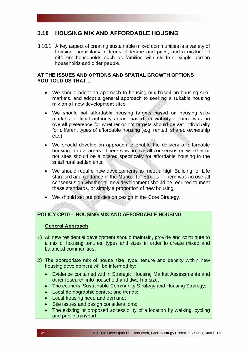
3.10 HOUSING MIX AND AFFORDABLE HOUSING 3.10.1 A key aspect of creating sustainable mixed communities is a variety of
housing, particularly in terms of tenure and price, and a mixture of different households such as families with children, single person households and older people.
AT THE ISSUES AND OPTIONS AND SPATIAL GROWTH OPTIONS YOU TOLD US THAT…
• We should adopt an approach to housing mix based on housing sub-markets, and adopt a general approach to seeking a suitable housing mix on all new development sites.
• We should set affordable housing targets based on housing sub-markets or local authority areas, based on viability. There was no overall preference for whether or not targets should be set individually for different types of affordable housing (e.g. rented, shared ownership etc.)
• We should develop an approach to enable the delivery of affordable housing in rural areas. There was no overall consensus on whether or not sites should be allocated specifically for affordable housing in the small rural settlements.
• We should require new developments to meet a high Building for Life standard and guidance in the Manual for Streets. There was no overall consensus on whether all new development should be required to meet these standards, or simply a proportion of new housing.
• We should set out policies on design in the Core Strategy.
POLICY CP10 - HOUSING MIX AND AFFORDABLE HOUSING
General Approach 1) All new residential development should maintain, provide and contribute to
a mix of housing tenures, types and sizes in order to create mixed and balanced communities.
2) The appropriate mix of house size, type, tenure and density within new
housing development will be informed by:
• Evidence contained within Strategic Housing Market Assessments and other research into household and dwelling size;
• The councils’ Sustainable Community Strategy and Housing Strategy; • Local demographic context and trends; • Local housing need and demand; • Site issues and design considerations; • The existing or proposed accessibility of a location by walking, cycling
and public transport.
Ashfield Development Framework, Core Strategy Preferred Option, March ‘0975
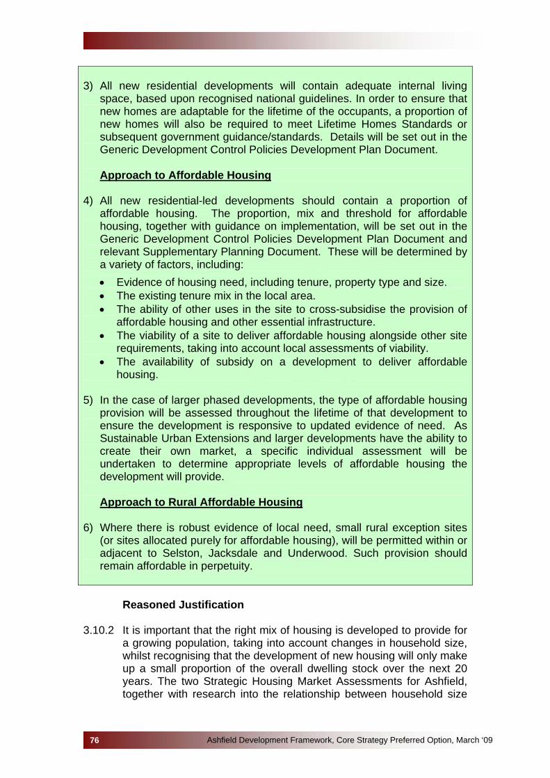
3) All new residential developments will contain adequate internal living
space, based upon recognised national guidelines. In order to ensure that new homes are adaptable for the lifetime of the occupants, a proportion of new homes will also be required to meet Lifetime Homes Standards or subsequent government guidance/standards. Details will be set out in the Generic Development Control Policies Development Plan Document.
Approach to Affordable Housing
4) All new residential-led developments should contain a proportion of
affordable housing. The proportion, mix and threshold for affordable housing, together with guidance on implementation, will be set out in the Generic Development Control Policies Development Plan Document and relevant Supplementary Planning Document. These will be determined by a variety of factors, including:
• Evidence of housing need, including tenure, property type and size. • The existing tenure mix in the local area. • The ability of other uses in the site to cross-subsidise the provision of
affordable housing and other essential infrastructure. • The viability of a site to deliver affordable housing alongside other site
requirements, taking into account local assessments of viability. • The availability of subsidy on a development to deliver affordable
housing. 5) In the case of larger phased developments, the type of affordable housing
provision will be assessed throughout the lifetime of that development to ensure the development is responsive to updated evidence of need. As Sustainable Urban Extensions and larger developments have the ability to create their own market, a specific individual assessment will be undertaken to determine appropriate levels of affordable housing the development will provide.
Approach to Rural Affordable Housing
6) Where there is robust evidence of local need, small rural exception sites
(or sites allocated purely for affordable housing), will be permitted within or adjacent to Selston, Jacksdale and Underwood. Such provision should remain affordable in perpetuity.
Reasoned Justification 3.10.2 It is important that the right mix of housing is developed to provide for
a growing population, taking into account changes in household size, whilst recognising that the development of new housing will only make up a small proportion of the overall dwelling stock over the next 20 years. The two Strategic Housing Market Assessments for Ashfield, together with research into the relationship between household size
Ashfield Development Framework, Core Strategy Preferred Option, March ‘0976
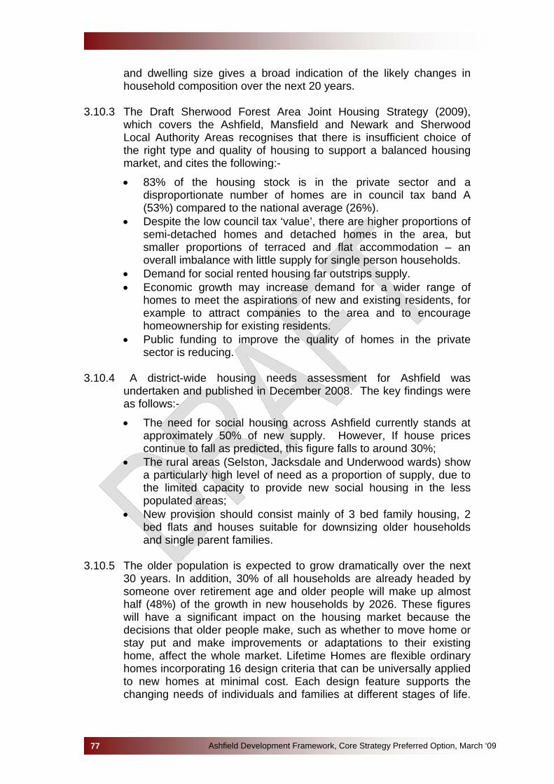
and dwelling size gives a broad indication of the likely changes in household composition over the next 20 years.
3.10.3 The Draft Sherwood Forest Area Joint Housing Strategy (2009),
which covers the Ashfield, Mansfield and Newark and Sherwood Local Authority Areas recognises that there is insufficient choice of the right type and quality of housing to support a balanced housing market, and cites the following:-
• 83% of the housing stock is in the private sector and a disproportionate number of homes are in council tax band A (53%) compared to the national average (26%).
• Despite the low council tax ‘value’, there are higher proportions of semi-detached homes and detached homes in the area, but smaller proportions of terraced and flat accommodation – an overall imbalance with little supply for single person households.
• Demand for social rented housing far outstrips supply. • Economic growth may increase demand for a wider range of
homes to meet the aspirations of new and existing residents, for example to attract companies to the area and to encourage homeownership for existing residents.
• Public funding to improve the quality of homes in the private sector is reducing.
3.10.4 A district-wide housing needs assessment for Ashfield was
undertaken and published in December 2008. The key findings were as follows:-
• The need for social housing across Ashfield currently stands at approximately 50% of new supply. However, If house prices continue to fall as predicted, this figure falls to around 30%;
• The rural areas (Selston, Jacksdale and Underwood wards) show a particularly high level of need as a proportion of supply, due to the limited capacity to provide new social housing in the less populated areas;
• New provision should consist mainly of 3 bed family housing, 2 bed flats and houses suitable for downsizing older households and single parent families.
3.10.5 The older population is expected to grow dramatically over the next
30 years. In addition, 30% of all households are already headed by someone over retirement age and older people will make up almost half (48%) of the growth in new households by 2026. These figures will have a significant impact on the housing market because the decisions that older people make, such as whether to move home or stay put and make improvements or adaptations to their existing home, affect the whole market. Lifetime Homes are flexible ordinary homes incorporating 16 design criteria that can be universally applied to new homes at minimal cost. Each design feature supports the changing needs of individuals and families at different stages of life.
Ashfield Development Framework, Core Strategy Preferred Option, March ‘0977

However, to require all new housing development to meet the Lifetime Home Standards could undermine the viability of a development.
3.10.6 It is important for the Core Strategy to plan for the delivery of both
market and affordable housing. The East Midlands Regional Plan sets an indicative target of 9,200 affordable housing units to be provided within the Nottingham Outer HMA over the period 2006-2026. Planning Policy Statement 3 states that targets for affordable housing should be developed taking into account the viability of new development. The Nottingham Core Affordable Housing Viability Assessment (April 2009) concluded that there is a wide ranging picture of viability across Ashfield District. Given the wide disparities, the study recommends split targets for the District. It also recommends that new development of a significant scale, such as Sustainable Urban Extensions are tested separately for their viability.
3.10.7 Given the complex picture across the District in relation to viability, the
overall approach to affordable housing and mechanisms to assist delivery is outlined in a Supplementary Planning Document. A financial viability toolkit has been devised to assess the viability of development on a site-by-site basis where necessary.
3.10.8 In the smaller settlements of Selston, Jacksdale and Underwood
where significant growth is not proposed, there may still be a local need for affordable housing that is justified by a robust local assessment. It is therefore considered appropriate to make provision within the Core Strategy for rural exception development, or provision to allow for the allocation of sites purely for affordable housing for these villages. In allocating rural affordable housing, priority will be given to people that have a connection to that settlement who are unable to afford market housing.
3.10.9 Issues concerning Building for Life Standards and Design are
addressed in Policy CP7. 3.10.10 Link to Core Strategy Objectives:
• SO2 High Quality New Housing (to meet the needs of all sectors of existing and future population)
• SO4 Cohesive Communities 3.10.11 National and Regional Policy Framework
• PPS1: Delivering Sustainable Development (2005); • PPS3: Housing (2006); • East Midlands Regional Plan: Policy 1 (Regional Core
Objectives), Policy 12 (Development in the Three Cities Sub-Area), Policy 14 (Regional Priorities for Affordable Housing), Policy 15 (Regional Priorities for Affordable housing).
Ashfield Development Framework, Core Strategy Preferred Option, March ‘0978

3.10.12 Local Policies, Strategies and Evidence Base
• Ashfield Housing Strategy 2004/5-2009/10; • Nottingham Outer HMA Strategic Housing Market Assessment
2007; • Nottingham Core Strategic Housing Market Assessment 2007; • Nottingham Core Affordable Housing Viability Assessment (for
Ashfield) 2009; • Sherwood Forest Area Joint Housing Strategy 2009.
Alternative Options not selected Option 1: Adopt an approach that doesn’t attempt to influence housing mix: This option has been discounted as although it may encourage more development in the short term, the Core Strategy is a long term plan for the District and it would not contribute to the objectives in helping to create cohesive communities and meeting all housing needs. In addition, the public consultation responses were not supportive of this option.
Option 2: Adopt an approach to housing mix based across the whole of
Ashfield. This option has been discounted as it was considered that specific local issues may not be fully addressed. The public consultation responses were not supportive of this option. Option 3: Set an overall target for the number of affordable homes to be
developed in Ashfield based on viability.
This option has been discounted as it was considered that it would not reflect local variations in viability. The public consultation responses were not supportive of this option. A more appropriate and targeted approach would be to base targets at HMA level, subject to viability.
Option 4: Set targets for different types of affordable housing. It was considered more appropriate to assess this issue at a more local level, dependent upon specific housing need in the area. Sustainability Appraisal This policy shows major positive effects in relation to both qualitative aspects, housing needs and health. Some positive benefits also arise in connection with reduction of crime rates and improvements to social capital, these often flow from generally improved housing conditions especially in relation to affordable housing provision. Effects in relation to employment
Ashfield Development Framework, Core Strategy Preferred Option, March ‘0979
Ashfield Development Framework, Core Strategy Preferred Option, March ‘0980
and transport objectives are neutral. As the policy promotes new building there will be inevitably be negative SA impacts caused by increased use of natural resources, additional energy requirements and additional waste generation, though the extent of these can be substantially reduced through mitigation measures. Environmental impacts depend on the location of each individual development; although the provision of affordable housing exceptions in rural areas may have more implications for biodiversity, green infrastructure and landscape character than similar provision elsewhere.
3.11 GYPSY, TRAVELLER AND TRAVELLING SHOWPEOPLE NEEDS AND REQUIREMENTS
3.11.1 The Housing Act 2004 requires Local Authorities to include gypsies
and travellers in their accommodation assessments and to take a strategic approach to demonstrating how needs will be addressed. Gypsies, Travellers and Travelling Showpeople are believed to experience the worst educational status of any disadvantaged group in England, a concern which has been directly linked to the lack of good quality authorised sites. It is anticipated that through the provision of suitable sites, problems associated with unauthorised encampments should be overcome.
3.11.2 There is currently a shortfall of authorised Gypsy and Traveller sites
throughout the East Midlands. However Ashfield District presently only has a small gypsy and traveller population. Local need is assessed through Gypsy and Traveller Accommodation Assessments (GTAAs) which will be reviewed on a regular basis. A partnership group of Local Authority officers and key stakeholders has been established to monitor Gypsy and Traveller accommodation needs on an annual basis. This information will ultimately feed into a review of the GTAA recommendations post 2011.
AT THE ISSUES AND OPTIONS AND SPATIAL GROWTH OPTIONS YOU TOLD US THAT…
• We should adopt an approach to housing mix based on housing sub-areas, or adopt a general approach to seeking a suitable housing mix on all new development sites.
• The Government Office for the East Midlands response stressed that
there is a requirement for Local Authorities to consider the needs of Gypsies, Travellers and Travelling Showpeople through their Local Development Framework including their Core Strategy. It was also stressed that criteria must not be used as an alternative to site allocations in DPDs where there is an identified need for pitches.
Ashfield Development Framework, Core Strategy Preferred Option, March ‘0981

POLICY CP11 – PROVISION FOR GYPSIES, TRAVELLERS AND TRAVELLING SHOWPEOPLE 1) Sites for permanent Gypsy and Traveller caravan accommodation or for
Travelling Showpeople will be identified or permitted where an identified need can be demonstrated in line with Gypsy and Traveller Accommodation Assessments.
2) As part of creating sustainable and mixed communities, sites will be
located within or adjacent to the existing settlements.
3) Existing permanent provision will be safeguarded from alternative development.
This Policy should be read in conjunction with Policy CP2
Reasoned Justification 3.11.3 Circular 1/2006 places a requirement on Regional bodies and Local
Authorities to undertake Gypsy and Traveller Accommodation Assessments. The findings of such assessments in relation to pitch provision should feed into both Regional Plans and Local Development Frameworks. Circular 4/07 also requires Local Authorities to make provision for Travelling Showpeople. It states that the Core Strategy should set out criteria for the location of Travelling Showpeople sites which will be used to guide the allocation of sites in the relevant Development Plan Document. These criteria can also be used in respect to planning applications on unallocated sites that may come forward. The criteria contained in policy CP2 Sustainable Growth relates to Gypsy, Traveller and Travelling Showpeople’s development.
3.11.4 Policy 16 of the East Midlands Regional Plan requires Local
Authorities to identify land for additional pitch provision based on clearly evidenced assessments of need, and sets out minimum pitch requirements to 2012. The Regional Plan also requires periodic updates of Gypsy and Traveller Accommodation Assessments in order to inform Local Development Frameworks post 2012. Redistribution of requirements is considered possible through joint or closely co-ordinated Local Development Frameworks.
3.11.5 The Nottinghamshire Gypsy and Traveller Accommodation
Assessment (2007) sets out permanent pitch requirements for each local authority for the period 2007-2011, and also states there is a requirement for a transient site somewhere within Nottinghamshire. The East Midlands Regional Plan translates the findings of the Gypsy and Traveller Accommodation Assessment into minimum pitch requirements for each Local Authorities – in Ashfield this is currently 8 pitches. This study will be reviewed in 2011.
Ashfield Development Framework, Core Strategy Preferred Option, March ‘0982
3.11.6 It is therefore considered that a general policy approach in providing
for Gypsies, Travellers and Travelling Showpeople should be contained within the Core Strategy in order to provide guidance on where such provision should generally be steered. The proposed policy facilitates provision of Gypsy and Traveller sites in accordance with sustainable development principles.
3.11.7 Link to Core Strategy Objectives:
• SO2: High Quality New Housing (to meet the needs of all sectors of existing and future population);
• SO4: Cohesive Communities. 3.11.8 National and Regional Policy Framework
• PPS1: Delivering Sustainable Development (2005), paragraphs 14-16;
• PPS3: Housing (2006), paragraphs 20-24; • Circular 1/2006: Planning for Gypsy and Traveller Caravan Sites; • Circular 4/2007: Planning for travelling showpeople; • East Midlands Regional Plan: Policy 16;
3.11.9 Local Policies, Strategies and Evidence Base
• Nottinghamshire Gypsy and Traveller Accommodation Assessment (GTAA) (excluding Bassetlaw) - May 2007.
Ashfield Development Framework, Core Strategy Preferred Option, March ‘0983
Alternative Options not selected The provision of Gypsy and Traveller sites is a requirement under circular, there is no alternative option. The approach outlined above in terms of directing development to more sustainable locations complies with Policy 3 of the East Midlands Regional Plan on the distribution of new development and Policy 16 on the Regional priorities for Gypsies, Travellers and Travelling Showpeople. Sustainability Appraisal The main positive outcomes of this policy were in meeting the identified housing needs of the conurbation and in helping to reduce health inequalities. Most other criteria were assessed as either neutral or uncertain.

Ashfield Development Framework, Core Strategy Preferred Option, March ‘0984
3.12 INFRASTRUCTURE AND SERVICES 3.12.1 The provision of adequate infrastructure and services to meet the
needs of the existing community and to meet the needs of new development is essential and has been identified by communities as one of their biggest concerns. New development should not overburden existing infrastructure or communities.
3.12.2 Delivering infrastructure on time is, therefore, important in ensuring
that local services, facilities and the transport network can cope with added demand that arises from housing growth and other new development. Infrastructure will be delivered as an integral part of a development, by contributions towards those needs, and through funding from relevant providers and partners. Ashfield District Council will work with service and infrastructure providers and community stakeholders to monitor the provision of services and infrastructure in relation to the growth of development and to meet any identified needs and shortfalls.
3.12.3 For the purposes of this document ‘infrastructure’ includes, in broad
terms: education, health, leisure, green infrastructure, emergency services, social services, community, transport, utilities and flood risk.
AT THE ISSUES AND OPTIONS AND SPATIAL GROWTH OPTIONS YOU TOLD US THAT… • It is vital that new growth is supported by appropriate infrastructure;
• A separate Infrastructure Plan is important;
• Planning Policy Statement 3: Housing - the 15-year period split into 3 x 5-year phases with less detailed information required on each successive phase could serve as a useful model for viability and delivery assessment in the Core Strategy;
• Very few locations in Ashfield could support major new growth without significant investment in public transport infrastructure or services;
• New development should be located in areas with good existing public transport or areas with the potential to develop public transport.
POLICY CP12 – INFRASTRUCTURE AND SERVICES 1) New development must be supported by the required infrastructure at
the appropriate stage. The Council will work in partnership with infrastructure and service providers, grant funders, the development industry and other delivery agencies in seeking the provision of necessary infrastructure to support new development.
2) An Infrastructure Delivery Plan will be produced to identify the
infrastructure/service requirements necessary to support new

development across Ashfield and will indicate where and when this will be provided. It will also set out the scale of funding necessary to achieve this and the possible sources of funding available from a range of agencies, including local authorities, and from developments.
3) Before granting planning permission for development, the Council will
have to be satisfied that the infrastructure requirements arising from the scheme will be met by the time it is needed. Contributions for new infrastructure will be sought from development giving rise to the need.
4) The Council will seek to secure funding from Government and other
sources to support infrastructure requirements.
Reasoned Justification 3.12.4 In line with the guidance in Planning Policy Statement 12, an
Infrastructure Capacity Study has been prepared for Greater Nottingham and the whole of Ashfield District. This study identifies if, and where, there are deficits in infrastructure and service provision within the study area and ascertains what additional infrastructure is needed to support the level of growth. It was prepared with the assistance of all the main infrastructure, service and utility providers. This includes, for example, the local highways authorities, education authority and water companies.
3.12.5 The Infrastructure Capacity Study will be used, alongside other
evidence, to inform and provide background information in the preparation of each of the documents in the Ashfield Development Framework. The intention is that it is a ‘living document’ and will be updated on a regular basis.
3.12.6 An Infrastructure Delivery Plan for Ashfield is currently being
prepared; it will take full account of the Homes and Communities Agency’s (HCA) Local Investment Plan (LIP). The LIP is being informed by the process known as the ‘Single Conversation’, which is being conducted between the HCA and local authorities. The Single Conversation will, in part, identify local investment priorities and shape the HCA’s proposed investment for the area.
3.12.7 The Infrastructure Delivery Plan will be critically important to the
delivery of not only Core Strategy vision and objectives, but also where the identified priorities and objectives of public bodies and other service providers need to be delivered through the planning system. The Plan will also assist in providing a basis for making bids for public funding, from sources such as Growth Point Funding, from the HCA and through East Midlands Development Agency’s Sub Regional Investment Plan.
Ashfield Development Framework, Core Strategy Preferred Option, March ‘0985
3.12.8 Link to Core Strategy Objectives:
• SO3 Safe Communities • SO4 Cohesive Communities • SO9 Opportunities for all • SO13 Timely and viable infrastructure
3.12.9 National and Regional Policy Framework
• PPS1 1: Delivering Sustainable • PPS12 12: Local Spatial Planning • East Midlands Regional Plan: Policy 57
3.12.10Local Policies, Strategies and Evidence Base
• Greater Nottingham Local Transport Plan • North Nottinghamshire Local Transport Plan • Ashfield Sustainable Community Strategy • Local Area Agreement • Greater Nottingham and Ashfield Infrastructure Capacity Study • Ashfield Affordable Housing Viability Assessment • Appraisal of Sustainable Urban Extensions for Greater
Nottingham • Ashfield Strategic Flood Risk Assessment • Greater Nottingham Water Cycle Study • Greater Nottingham Core Transportation Model • Ashfield Transport Study
Ashfield Development Framework, Core Strategy Preferred Option, March ‘0986
Alternative Options not selected No other reasonable alternatives exist. The policy reflects national, regional and local policies and guidance. Sustainability Appraisal Securing appropriate levels of infrastructure will be essential in delivering key aspects of the Core Strategy Vision. The impact is therefore very positive in meeting housing, employment and related development needs across the board. This will produce consequential benefits for health, social capital and community safety. Impacts on heritage and landscape/ townscape character are uncertain. Negative outcomes will affect the SA objectives on waste minimisation, energy consumption and natural resource usage and mitigation measures will be required. The impact on transport objectives will be mixed depending on the location a certain developments and the method used to service them.
3.13 DEVELOPER CONTRIBUTIONS 3.13.1 Where new development creates a need for new or improved
infrastructure, services or facilities, contributions from developers will be sought to make the development acceptable in planning terms.
3.13.2 Contributions towards local infrastructure, services and facilities are
negotiated for individual sites and for each specific need arising from the development of the site. Where possible these works will be required through planning conditions. However planning obligations may be needed for specific site implementation of infrastructure, services or facility requirements, or for a financial contribution from the developer in lieu of provision on site.
AT THE ISSUES AND OPTIONS AND SPATIAL GROWTH OPTIONS YOU TOLD US THAT… • The majority of respondents suggested it would be more appropriate to
use planning obligations to support the provision of infrastructure;
• Support for making use of more standard formulae with greater ability for financial contributions to be pooled was equal to support for the introduction of a Community Infrastructure Levy.
POLICY CP13 - DEVELOPER CONTRIBUTIONS 1) Planning obligations will be sought to secure infrastructure necessary
to support new development either individually or collectively and to achieve Core Strategy objectives.
2) All development will be expected to:
• Meet the reasonable cost of new infrastructure required as a consequence of the proposal;
• Where appropriate, contribute to the delivery of necessary infrastructure to enable the cumulative impacts of developments to be managed, including identified transport infrastructure requirements; and
• Provide for the future maintenance of facilities provided as a result of the development.
3) Where existing employment sites are granted permission for a higher
value alternative use a reasonable contribution will be required towards regeneration, training, workforce development and to tackle economic/social exclusion in the District.
4) The mechanism by which developer contributions are achieved will be
monitored and reviewed to meet national policy. Details of planning contributions, and when use standardised formulae to calculate contributions, will be set out in the Generic Development Policies Development Plan Document and/or Supplementary Planning Documents.
Ashfield Development Framework, Core Strategy Preferred Option, March ‘0987

Reasoned Justification
3.13.3 Where new development creates a need for new or improved
infrastructure, contributions from developers will be sought to make the development acceptable in planning terms. Contributions from a particular development will be fairly and reasonably related in scale and kind to the relevant scheme.
3.13.4 Developments will contribute as necessary to meet all on and off site
infrastructure requirements to enable development to take place satisfactorily.
3.13.5 The requirements will reflect the nature of the site and the
infrastructure, services and facility it is necessary to provide. However obligations may include:
• Affordable housing (including supported housing); • Open Space (including play areas, sport and recreation); • Community facilities (including youth activities and meeting
venues); • Regeneration, training and workforce development; • Cultural facilities (including libraries and archaeology); • Health and social care facilities; • Education (including early years provision and community
education); • Police/crime reduction measures; • Transport infrastructure (including footpaths, bridleways, cycle
ways and roads); • Public transport (including services and facilities); • Drainage and flood protection; • Environmental improvements; • Waste recycling facilities; • Fire services; • Shopping facilities; • Green Infrastructure; • Information and Communication Technology.
3.13.6 In Ashfield there are a number of issues in relation social and
economic exclusion and an over reliance on a manufacturing sector which is declining in terms of jobs provided. There is a significant amount of older industrial premises in the District, often located in secondary locations and close to residential areas. These premises offer low cost accommodation and offer the opportunity for people to work close to where they live. However the substantial difference between employment and other higher land value uses means that they are under pressure for development to the detriment of local employment opportunities. Provision is made for obligations to support regeneration, training and workforce development. The objective of this provision is to ensure that where the loss of an
Ashfield Development Framework, Core Strategy Preferred Option, March ‘0988

existing employment site occurs, it is not at the expense of the local economy and it contributes towards tackling social/economic exclusion.
3.13.7 Where the necessary provision is not made directly by the
developer, contributions will be secured through planning obligations. Contributions will be sought from various types of developments that fall above specified size thresholds to be identified in the Generic Development Policies Development Plan Document and/or Supplementary Planning Documents.
3.13.8 Planning obligation agreements will be drafted by the local planning
authority with the developer being responsible for the costs resulting from the drafting, administering and monitoring the agreement.
3.13.9 The Government is currently revising the way that developer
contributions are collected and has delayed the implementation of a Community Infrastructure Levy (CIL) until April 2010. The CIL is based on capturing increases in the value of land or property arising as a result of development. The decisions as to whether it is appropriate to use the CIL as a mechanism for funding infrastructure will be considered further once Government policy and guidance is finalised. The Government is due to set size thresholds for developments below which CIL would not be payable.
3.13.10 Link to Core Strategy Objectives:
• Developer contributions contribute towards all the Strategic Objectives.
3.13.11 National and Regional Policy Framework
• PPS1 1: Delivering Sustainable • PPS12 12: Local Spatial Planning • East Midlands Regional Plan: Policy 57 • ODPM Circular 05/2005 – Planning Obligations • Community Infrastructure Levy – Detailed proposals and draft
regulations for the introduction of Community Infrastructure Levy, Consultation (July 2009)
3.13.12 Local Policies, Strategies and Evidence Base
• Greater Nottingham Local Transport Plan; • North Nottinghamshire Local Transport Plan; • Ashfield Sustainable Community & Neighbourhood Renewal
Strategy; • Nottinghamshire Local Area Agreement; • Greater Nottingham and Ashfield Infrastructure Capacity Study; • Ashfield Affordable Housing Viability Assessment; • Appraisal of Sustainable Urban Extensions for Greater
Nottingham;
Ashfield Development Framework, Core Strategy Preferred Option, March ‘0989
• Ashfield Strategic Flood Risk Assessment; • Greater Nottingham Water Cycle Study; • Greater Nottingham Core Transportation Model; • Ashfield Transport Study (draft).
Ashfield Development Framework, Core Strategy Preferred Option, March ‘0990
Alternative Options not selected – Alternative 1 – Introduce a Community Infrastructure Levy (CIL) to help fund most new infrastructure requirements. Alternative 2 – Continue to use Planning Obligations but make more use of standard formulae, with greater ability for financial contributions to be pooled for use across Greater Nottingham and its surrounding area. Sustainability Appraisal Here the SA weighed the pros and cons of introducing a Community Infrastructure levy or continuing to judge development proposals individually and assessing an appropriate level and range of planning obligation. Each approach has its advantages; a standard levy on development gives clarity, consistency and transparency but may have unintended consequence of thwarting development ambitions on regeneration sites. These are often the ones most in need of support and subsidy because of higher than average development costs. Conversely Planning Obligations individually negotiated are difficult to apply consistently, but they can be sensitive to local factors and thus enable development which might not otherwise happen to be implemented. The policy as set out above allows both approaches depending on the direction of National Policy; each approach displays a virtually identical set of positive outcomes against SA objectives.

AREA BASED
POLICIES
Ashfield Development Framework, Core Strategy Preferred Option, March ‘0991
4.1 HUCKNALL 4.1.1 Hucknall is a historic town with a history stretching back to the 7th or 8th
century. The town grew as a textile centre before expanding rapidly in the 19th century with the discovery of coal. In the 1930’s it became a centre for jet engines technology when Rolls Royce established a base in the town. However by the 1980s the railways had withdrawn and the coal mines were closing sending the town into decline. Recent years have seen a recovery especially since the town became a terminus for the Nottingham Express Tram (NET) in 2004.
4.1.2 Hucknall is the second largest settlement in Ashfield and has a population of
30,667 (June 2008 resident population estimate, Office for National Statistics). Its population is predominantly white, with a slightly higher proportion of families and old people than the national average.
4.1.3 The town is located in the south of the District bordering Gedling and
Broxtowe and is positioned in a very competitive part of the country, midway between Nottingham (7 to the miles south) and Mansfield (9 miles to the north) and within easy reach of Derby, Leicester and Sheffield. The town can be easily accessed by car via the A611 from Junction 27 of the M1 to the north and Nottingham City to the south. Hucknall’s location and excellent transport links enables residents to easily access employment, shopping and leisure facilities outside of the town. The Robin Hood Railway Line and Nottingham Express Transit (NET) tram system in particular, provide excellent links to Nottingham City.
4.1.4 The settlement is suburban in character with residential development
forming the main use. A small part of the settlement of Bestwood is included within the District boundary. A range of services are provided by the Town Centre including shops, community facilities and professional services that meet the day to day needs of residents and visitors alike. Recent house building has been intensive in the town. However, this is currently supported by the employment opportunities provided by industrial estates within Hucknall at Wigwam Lane and Watnall Road, and at Sherwood Business Park to the north and others located in Nottingham City. Conversely, there has been some loss of existing employment sites within the town as these sites have proved to be no longer viable for employment purposes. It is anticipated that these losses will continue in the short term and as such the poorer quality employment sites have been considered for release through the Nottingham City Region Employment Land Study (NCRELS) and subsequent Strategic Housing Land Availability Assessment (SHLAA).
4.1.5 The previous reliance in the town on traditional industries (coal mining,
textiles and engineering) has led to relatively high levels of deprivation in employment, skills levels, income and health. Whilst Hucknall’s economy has adapted there is still much to be done. The identification of a Strategic High Quality Employment site at Rolls Royce to the south-west of the town will encourage the diversification of the skills base and employment and will
Ashfield Development Framework, Core Strategy Preferred Option, March ‘0992
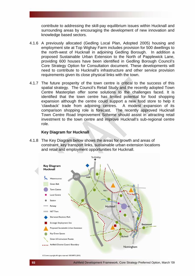
contribute to addressing the skill-pay equilibrium issues within Hucknall and surrounding areas by encouraging the development of new innovation and knowledge based sectors.
4.1.6 A previously allocated (Gedling Local Plan, Adopted 2005) housing and
employment site at Top Wighay Farm includes provision for 500 dwellings to the north-west of Hucknall in adjoining Gedling Borough. In addition a proposed Sustainable Urban Extension to the North of Papplewick Lane, providing 600 houses have been identified in Gedling Borough Council’s Core Strategy Option for Consultation document. These developments will need to contribute to Hucknall’s infrastructure and other service provision requirements given its close physical links with the town.
4.1.7 The future prosperity of the town centre is critical to the success of this
spatial strategy. The Council’s Retail Study and the recently adopted Town Centre Masterplan offer some solutions to the challenges faced. It is identified that the town centre has limited potential for food shopping expansion although the centre could support a new food store to help it ‘clawback’ trade from adjoining centres. A modest expansion of its comparison shopping role is forecast. The recently approved Hucknall Town Centre Road Improvement Scheme should assist in attracting retail investment to the town centre and improve Hucknall’s sub-regional centre role.
Key Diagram for Hucknall
4.1.8 The Key Diagram below shows the areas for growth and areas of
constraint, key transport links, sustainable urban extension locations and retail and employment opportunities for Hucknall.
Ashfield Development Framework, Core Strategy Preferred Option, March ‘0993

AT THE ISSUES AND OPTIONS AND SPATIAL GROWTH OPTIONS YOU TOLD US THAT… • With regard to the Area Spatial Growth Options consultation, 47% (42
people) chose Option H1 - minimum housing growth requirement, in line with the Regional Plan; 42% (37 people) chose Option H2 - growth to assist regeneration, higher than the Regional Plan requirement; and 11% (10 people) chose Option H3 – higher growth, to allow for longer term planning to 2031;
• The majority of people felt that the Council should not provide for more housing than identified in the Regional Plan;
• A small number of respondents thought that providing for additional level of growth would enable flexibility in the choice of sites, and would ensure a supply of deliverable sites;
• Generally accepted that Rolls Royce is the preferred location for new development, and the land south of Hucknall towards the A611 would also be a logical extension to the town;
• It was felt it is important to ensure that Hucknall and Bulwell do not merge;
• It was thought that Green Belt and Countryside should not be released for development. Specific objections were made to the loss of land at Whyburn Farm, Hucknall;
• It was raised that Hucknall may be more attractive as an office location once the workplace levy is imposed in Nottingham as it has good access links via the tram;
• The residents of Hucknall value their existing green space;
• Most people thought that Hucknall town centre was in need of regeneration;
• Concerned that Hucknall should not receive housing redistributed from other district areas;
• Hucknall town centre was seen to have potential for employment opportunities particularly due to the tram, rail and motorway links;
• It was thought that development should not be permitted where it would compromise the integrity of Hucknall’s overall green infrastructure network.
Natural, Historic & Built Environment
4.1.9 The natural environment of Ashfield is a resource that should be
protected and enhanced so that future generations can enjoy it. In Hucknall the Core Strategy must be capable of delivering the minimum levels of residential and employment growth, but it should be delivered
Ashfield Development Framework, Core Strategy Preferred Option, March ‘0994
in such a way as to avoid any loss of or damage to international and national sites, minimises any adverse impacts on local sites and positively uses new development to act as a catalyst for habitat creation and enhancement. This approach seeks a balance between development and biodiversity as a central issue. However, the range of SSSIs, SINCs and Ancient Woodland in Hucknall is limited.
4.1.10 The whole of the area is within the boundaries of the Greenwood
Community Forest and development proposals should look to facilitate the objectives of the Community Forest.
4.1.11 In Ashfield, it is Hucknall that is at the greatest risk of flooding from
watercourses. Approximately 917 residential properties and 100 commercial properties are potentially at risk from the Baker Lane Brook and the River Leen, both of which are defined as Main Rivers. Further, additional waters into the River Leen and its tributaries will significantly increase the risk of flooding down stream in the City of Nottingham. Consequently, the River Leen and Day Brook Strategic Flood Risk Assessment recommends that the starting point for discussions with developers of land within the River Leen catchment should, where possible, be pre-development greenfield rates. The Strategic Flood Risk Assessment for Ashfield identifies a number of potential areas in Hucknall which have experienced flooding to some degree in the past.
4.1.12 Within Hucknall the Landscape Character Areas are:
• Magnesian Limestone Ridge; • Sherwood Region.
4.1.13 Because of its association with Lord Byron, Hucknall attracts tourists
from all over the world to visit his birthplace at Newstead Abbey, just north of the town, and his final resting place in St. Mary Magdalene Church in the heart of the town. The medieval core of the town, centred on the open space adjacent to St Mary Magdalene Church and the existing market place area, encapsulates the beginnings of Hucknall as a small rural settlement. The area stretches along High Street, Watnall Road, Annesley Road and South Street where it is characterised by narrow streets bounded by small, two-storey units within a dense built area.
4.1.14 During the 19th century a number of cottages and other buildings of
heritage significance were built, most notably the public library built in 1887 immediately south of the church. The next significant expansion of the town, still in evidence today, formed a number of well defined predominantly residential streets close to the town centre with the introduction of pre-1919 Victorian terraced housing. Whether these terraced houses were setback or not, the addition of these streets produced a consistent, well defined building line and domestic scale to the edge of the town. Further housing areas have extended the town’s boundary edge from the 1950’s and here began the inclusion of
Ashfield Development Framework, Core Strategy Preferred Option, March ‘0995
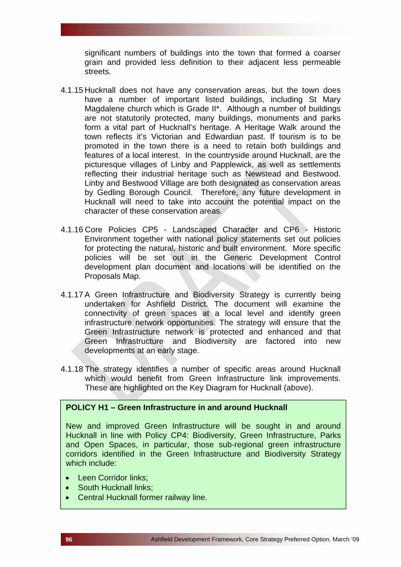
significant numbers of buildings into the town that formed a coarser grain and provided less definition to their adjacent less permeable streets.
4.1.15 Hucknall does not have any conservation areas, but the town does
have a number of important listed buildings, including St Mary Magdalene church which is Grade II*. Although a number of buildings are not statutorily protected, many buildings, monuments and parks form a vital part of Hucknall’s heritage. A Heritage Walk around the town reflects it’s Victorian and Edwardian past. If tourism is to be promoted in the town there is a need to retain both buildings and features of a local interest. In the countryside around Hucknall, are the picturesque villages of Linby and Papplewick, as well as settlements reflecting their industrial heritage such as Newstead and Bestwood. Linby and Bestwood Village are both designated as conservation areas by Gedling Borough Council. Therefore, any future development in Hucknall will need to take into account the potential impact on the character of these conservation areas.
4.1.16 Core Policies CP5 - Landscaped Character and CP6 - Historic
Environment together with national policy statements set out policies for protecting the natural, historic and built environment. More specific policies will be set out in the Generic Development Control development plan document and locations will be identified on the Proposals Map.
4.1.17 A Green Infrastructure and Biodiversity Strategy is currently being
undertaken for Ashfield District. The document will examine the connectivity of green spaces at a local level and identify green infrastructure network opportunities. The strategy will ensure that the Green Infrastructure network is protected and enhanced and that Green Infrastructure and Biodiversity are factored into new developments at an early stage.
4.1.18 The strategy identifies a number of specific areas around Hucknall
which would benefit from Green Infrastructure link improvements. These are highlighted on the Key Diagram for Hucknall (above).
POLICY H1 – Green Infrastructure in and around Hucknall New and improved Green Infrastructure will be sought in and around Hucknall in line with Policy CP4: Biodiversity, Green Infrastructure, Parks and Open Spaces, in particular, those sub-regional green infrastructure corridors identified in the Green Infrastructure and Biodiversity Strategy which include:
• Leen Corridor links; • South Hucknall links; • Central Hucknall former railway line.
Ashfield Development Framework, Core Strategy Preferred Option, March ‘0996
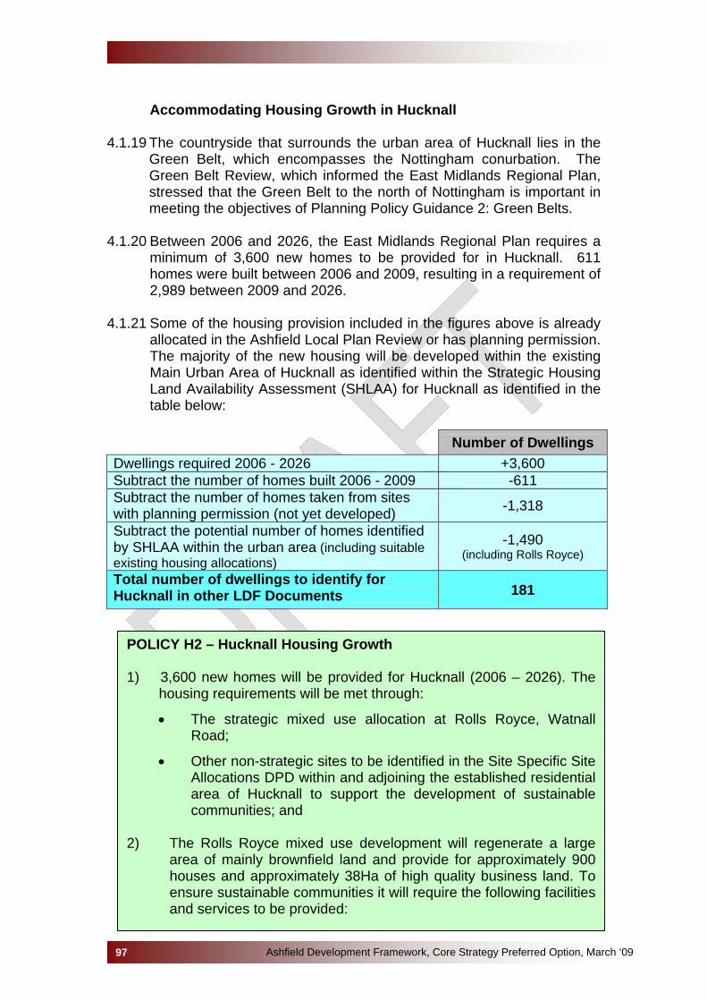
Accommodating Housing Growth in Hucknall
4.1.19 The countryside that surrounds the urban area of Hucknall lies in the
Green Belt, which encompasses the Nottingham conurbation. The Green Belt Review, which informed the East Midlands Regional Plan, stressed that the Green Belt to the north of Nottingham is important in meeting the objectives of Planning Policy Guidance 2: Green Belts.
4.1.20 Between 2006 and 2026, the East Midlands Regional Plan requires a
minimum of 3,600 new homes to be provided for in Hucknall. 611 homes were built between 2006 and 2009, resulting in a requirement of 2,989 between 2009 and 2026.
4.1.21 Some of the housing provision included in the figures above is already
allocated in the Ashfield Local Plan Review or has planning permission. The majority of the new housing will be developed within the existing Main Urban Area of Hucknall as identified within the Strategic Housing Land Availability Assessment (SHLAA) for Hucknall as identified in the table below:
Number of Dwellings Dwellings required 2006 - 2026 +3,600 Subtract the number of homes built 2006 - 2009 -611 Subtract the number of homes taken from sites with planning permission (not yet developed) -1,318
Subtract the potential number of homes identified by SHLAA within the urban area (including suitable existing housing allocations)
-1,490 (including Rolls Royce)
Total number of dwellings to identify for Hucknall in other LDF Documents 181
POLICY H2 – Hucknall Housing Growth 1) 3,600 new homes will be provided for Hucknall (2006 – 2026). The
housing requirements will be met through:
• The strategic mixed use allocation at Rolls Royce, Watnall Road;
• Other non-strategic sites to be identified in the Site Specific Site Allocations DPD within and adjoining the established residential area of Hucknall to support the development of sustainable communities; and
2) The Rolls Royce mixed use development will regenerate a large area of mainly brownfield land and provide for approximately 900 houses and approximately 38Ha of high quality business land. To ensure sustainable communities it will require the following facilities and services to be provided:
Ashfield Development Framework, Core Strategy Preferred Option, March ‘0997
• Primary School; • Local Health Facilities; • Open Space and Allotments; • Creation of new Green Infrastructure links; • Protection and enhancement of areas of biological importance; • New bus route to link between Hucknall Town Centre and the site. • Improvements to the surrounding road network.
Specific Details of the requirement will be included in the Site Specific Allocations Development Plan Document and a Development Brief for the site.
Economy and Jobs 4.1.22From an economic aspect, Hucknall forms part of the Greater
Nottingham functional economic area (FEA) and should be seen in this context. It is anticipated that the working population of Greater Nottingham will increase by 13,400 people between 2003 and 2016. This needs to be balanced with a proportional rise in employment opportunities to meet the increased demand for jobs, but existing problems of unemployment and worklessness also need to be addressed.
4.1.23 The Nottingham City Region Employment Land Study identified that
office development will be the major driver of economic growth across Greater Nottingham. The primary focus for new office and commercial development will be Nottingham City Centre and, more especially, the Regeneration Zones located around its periphery. With Hucknall, the excellent public transport links with the development of the Regeneration Zones together with service sector institutions (hospitals, universities and government agencies) will provide employment opportunities for local people. In order to promote and strengthen the role played by localised economies serving communities around the conurbation, a range of suitable sites for new office-based development, and to a lesser extent industry and warehousing, will need to be provided across Greater Nottingham. This includes a Strategic Employment Site at Rolls Royce which provides for a 38 hectare business park together with residential development opportunities. It is anticipated that Rolls Royce will remain as a major employer within the Hucknall area.
4.1.24 Hucknall office market is currently relatively small comprising very
small offices, typically above shops comprising accountants, solicitors, etc. The Nottingham City Region Employment Land Study (NCRELS) identified that for offices should only be released where it is demonstrated there is a there is a lack of demand in the long term or there are unacceptable impacts on the environment or amenity or the supply has been increased by better-quality sites. Two allocated employment land allocations in Hucknall, are identified as suitable for offices, the A611/Annesley Road and Watnall Road (Aerial Way).
Ashfield Development Framework, Core Strategy Preferred Option, March ‘0998
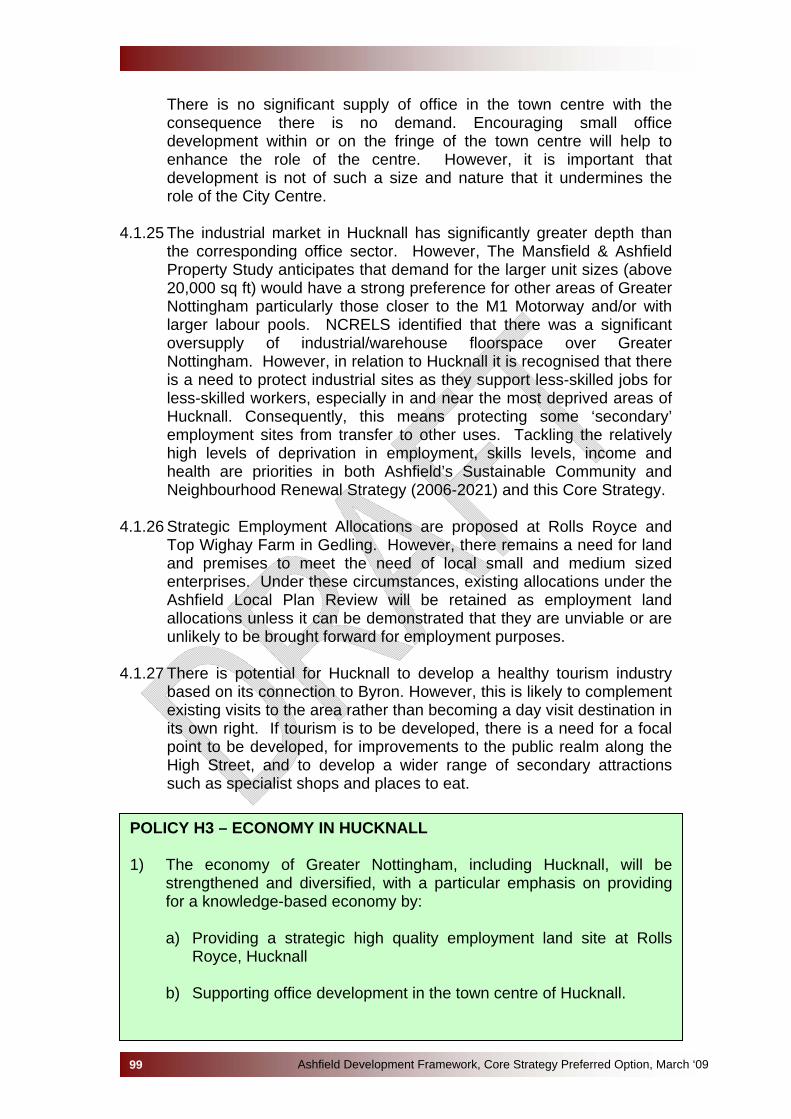
There is no significant supply of office in the town centre with the consequence there is no demand. Encouraging small office development within or on the fringe of the town centre will help to enhance the role of the centre. However, it is important that development is not of such a size and nature that it undermines the role of the City Centre.
4.1.25 The industrial market in Hucknall has significantly greater depth than
the corresponding office sector. However, The Mansfield & Ashfield Property Study anticipates that demand for the larger unit sizes (above 20,000 sq ft) would have a strong preference for other areas of Greater Nottingham particularly those closer to the M1 Motorway and/or with larger labour pools. NCRELS identified that there was a significant oversupply of industrial/warehouse floorspace over Greater Nottingham. However, in relation to Hucknall it is recognised that there is a need to protect industrial sites as they support less-skilled jobs for less-skilled workers, especially in and near the most deprived areas of Hucknall. Consequently, this means protecting some ‘secondary’ employment sites from transfer to other uses. Tackling the relatively high levels of deprivation in employment, skills levels, income and health are priorities in both Ashfield’s Sustainable Community and Neighbourhood Renewal Strategy (2006-2021) and this Core Strategy.
4.1.26 Strategic Employment Allocations are proposed at Rolls Royce and
Top Wighay Farm in Gedling. However, there remains a need for land and premises to meet the need of local small and medium sized enterprises. Under these circumstances, existing allocations under the Ashfield Local Plan Review will be retained as employment land allocations unless it can be demonstrated that they are unviable or are unlikely to be brought forward for employment purposes.
4.1.27 There is potential for Hucknall to develop a healthy tourism industry
based on its connection to Byron. However, this is likely to complement existing visits to the area rather than becoming a day visit destination in its own right. If tourism is to be developed, there is a need for a focal point to be developed, for improvements to the public realm along the High Street, and to develop a wider range of secondary attractions such as specialist shops and places to eat.
POLICY H3 – ECONOMY IN HUCKNALL 1) The economy of Greater Nottingham, including Hucknall, will be
strengthened and diversified, with a particular emphasis on providing for a knowledge-based economy by:
a) Providing a strategic high quality employment land site at Rolls
Royce, Hucknall b) Supporting office development in the town centre of Hucknall.
Ashfield Development Framework, Core Strategy Preferred Option, March ‘0999
c) Reviewing employment allocations/permissions and where required providing for new allocations, against the following criteria:
• Providing for an adequate supply of developable employment land with a range of sites in terms of quality, size and location, which are accessible by a choice of means of transport.
• Taking into account evidence of the impact of Greater Nottingham Council’s employment land allocations, permissions and proposals.
• Sites will be located in or adjoining the urban area of Hucknall; • The need to support and provide employment opportunities to
deprived communities.
d) Safeguard existing employment sites in accordance with Policy CP3.
2) To support farm diversification in the green belt the conversion to
employment uses of buildings worthy of retention will be supported where the proposals accord with the sustainable growth criteria set out in Policy CP2.
3) Support will be given to appropriate tourism related initiatives, including
schemes which improve the accessibility of tourist assets.
Hucknall Town Centre 4.1.28 Hucknall is one of three towns within the Ashfield and is identified as a
Major District Centre in the East Midlands Regional Plan due to its size and because of its close proximity to Nottingham. Situated in the south of the District, the town has a very strong connecting with Nottingham City which is thought to attract over 45% of Hucknall’s comparison trade. Other retail centres such as Derby, Sheffield/Meadowhall, Mansfield, and Newark also have an influence on shopping patterns for Hucknall due to their proximity and the range of services that they offer. This is threatening the viability of the town centre.
4.1.29 Hucknall’s main shopping area is along Baker Street and High Street
which links the Market Place and St Mary Magdalene Church in the west, to the NET station and the recently built Tesco’s in the east. The town also has two local shopping centres: Annesley Road – approximately 50 shops extending from the north of the town centre, and Watnall Road – approximately 35 shops extending to the west of the town centre. A weekly market is held in the Market Place.
4.1.30 A Town Centre Masterplan was formally adopted by the Council in
November 2009 following a series of public consultation events. The Masterplan sets out a vision and strategy for the future development of Hucknall Town Centre, which will ensure its future vitality and viability. The vision is based on five themes:
Ashfield Development Framework, Core Strategy Preferred Option, March ‘09100
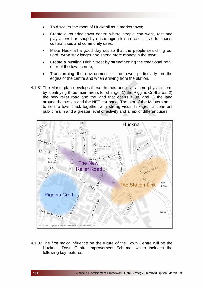
Ashfield Development Framework, Core Strategy Preferred Option, March ‘09101
• To discover the roots of Hucknall as a market town;
• Create a rounded town centre where people can work, rest and play as well as shop by encouraging leisure uses, civic functions, cultural uses and community uses;
• Make Hucknall a good day out so that the people searching out Lord Byron stay longer and spend more money in the town;
• Create a bustling High Street by strengthening the traditional retail offer of the town centre;
• Transforming the environment of the town, particularly on the edges of the centre and when arriving from the station.
4.1.31 The Masterplan develops these themes and gives them physical form
by identifying three main areas for change; 1) the Piggins Croft area, 2) the new relief road and the land that opens it up, and 3) the land around the station and the NET car park. The aim of the Masterplan is to tie the town back together with strong visual linkages, a coherent public realm and a greater level of activity and a mix of different uses.
4.1.32 The first major influence on the future of the Town Centre will be the
Hucknall Town Centre Improvement Scheme, which includes the following key features:
Ashfield Development Framework, Core Strategy Preferred Option, March ‘09102
• Provision of a town centre relief road between Annesley Road and Station Street;
• A new 2-way bus only link between Watnall Road/High Street;
• Pedestrianisation of the High Street between Market Place and Watnall Road;
• 2-way traffic remaining on the stretch of High Street between the Byron Cinema and Watnall Road.
Alternative Options not selected 1) An alternative option would be to plan for higher growth than the Regional Plan requirement (as set out in the Spatial Growth Options consultation - Option H2). This option would involve the allocation of two large sites – part of the Rolls Royce site for both housing development and high quality employment and the area to the south east of Hucknall between the Main Urban Area and the A611 Hucknall By-Pass. The latter area of land is currently in Green Belt. The two sites combined could deliver approximately
POLICY H4 – Hucknall Town Centre 1) The town centre of Hucknall will be strengthened and regenerated in line
with the priority projects set out in the Town Centre Masterplan or any updated plan. The three main areas for change are:
• Piggins Croft; • The Relief Road and High Street (HTCIS); • The Station Approach.
2) Development Plan Documents will make provision, in addition to existing
commitments, for a minimum net increase in comparison and convenience floor space in line with the Ashfield Retail Study.
3) To ensure the future vitality and viability of Hucknall Town Centre, new
retail development will be accommodated within the defined town centre boundary. Where this cannot be accommodated within the defined town centre boundary, a sequential approach will be followed in line with current national planning policy guidance.
4) The scale of retail development will need to be appropriate to the role of
Hucknall Town Centre as set out in Policy CP9: Town and Local Centres. 5) The Hucknall Town Centre Road Improvement Scheme will be
implemented, which incorporates a pedestrianisation priority scheme for the High Street between Baker Street and Watnall Road and a relief road from Annesley Road to Station Road in accordance with the Hucknall Town Centre Masterplan.
Ashfield Development Framework, Core Strategy Preferred Option, March ‘09103
1,500 dwellings. The sites within the Main Urban Area identified in the Strategic Housing Land Availability Assessment (SHLAA) would also be delivered. This option is considered unnecessary to plan for growth beyond the requirements of the Regional Plan. 42% of respondent to the Area Based Spatial Options were in favour of this approach. 2) Another alternative option would be to plan for higher growth to allow for long term planning to 2031 (as set out in the Spatial Growth Options consultation - Option H3). This option would involve the allocation of a large site at Whyburn Farm, north of Hucknall. This site could accommodate between 3,700 and 5,500 houses and an area for employment uses. The sites within the Main Urban Area identified in the Strategic Housing Land Availability Assessment (SHLAA) would also be delivered. The Government Office for the East Midlands has stated that this is not a reasonable option, as it would provide over and above the requirements of the Regional Plan. The quantum of development, taking in to account the proposed Gedling sites, would lead to a significant over-provision of housing, which would be too much for a sub-regional centre. This option would result in a large release of Green Belt. Only 11% of respondent to the Area Based Spatial Options were in favour of this approach. Three broad policy options were set out, at the Issues and Options stage, to tackle the economic issues facing the District. Given the needs for the regeneration of the Area, Option One 'Business as Usual' was not seen as an option that should be taken forward. Virtual all responses placed an emphasis on growth to help the regeneration of the Ashfield economy, reflected in both Options Two and Three. However, Option Two “Provide an emphasis on developing a more resilient economy”, did not have an emphasis on urban concentration reflected in Option Three. In terms of the Town Centres, the alternative would be to allow more-out-of-centre retail development. However, Ashfield Retail Study identifies that large scale out-of-centre development should be resisted as it threatens the vitality of the Centres. This approach would also be contrary to national guidance in Planning Policy Statement 4. Sustainability Appraisal This option will increase the supply of housing in Hucknall and will meet the housing requirements of the East Midlands Regional Plan, it maybe possible to provide a high proportion of affordable housing on site to meet the assessed needs in the Housing Market Needs Assessment. The site is large enough to provide new health facilities and could provide or enhance existing community facilities through either on site provision or developer contributions.

The site is located within the existing urban area and is on a Brownfield site therefore it is anticipated that the impact on the landscape character would be minimal. Due to the site being mixed use, high quality businesses and new jobs will be created on the Business park development which would ensure less’ out-commuting ‘ and therefore lead to improvements in air quality.
Ashfield Development Framework, Core Strategy Preferred Option, March ‘09104
4.2 KIRKBY-IN-ASHFIELD & SUTTON-IN-ASHFIELD 4.2.1 The towns of Kirkby-in-Ashfield and Sutton-in-Ashfield are located in
the northern part of Ashfield District. For the purposes of the Core Strategy:
• Sutton-in-Ashfield includes Huthwaite, Stanton Hill and Skegby
within the urban area, together with surrounding countryside including the villages of Teversal and Fackley. (The Sutton-in-Ashfield wards)
• Kirkby-in-Ashfield includes Annesley, Annesley Woodhouse, Nuncargate and Kirkby Woodhouse within the urban area together with the surrounding countryside including the village of New Annesley and Sherwood Business Park off Junction 27 of the M1. (The Kirkby-in-Ashfield wards together with Woodhouse)
4.2.2 Kirkby-in-Ashfield is the smallest of the three main centres in the
District, with a population of 26,959 (mid 2008). It is strongly influenced by Sutton-in-Ashfield in terms of the provision of retail and service facilities. The original settlement was located around what is now known as Kirkby Cross and in 1261 was granted a market and fair. It was largely an agricultural community although framework knitting was introduced into the village in the 18th Century. In 1803 a man named Brown began building an inn at a crossroads in the countryside. The inn was never completed and became known as Brown’s Folly (Kirkby Folly). However, through the 19th century mining, hosiery, the railways and associated housing saw the area around the crossroads rapidly develop as East Kirkby. The name East Kirkby has now largely disappeared as further development has seen the original settlement at Kirkby Cross merge with East Kirkby to form Kirkby-in-Ashfield. The mines have gone, together with the extensive railway sidings and large parts of the hosiery industry but new job opportunities have been created in manufacturing industry on estates located around the town.
4.2.3 Sutton-in-Ashfield is the largest of the three main towns having a
population of 46,146 (mid 2008). It is located in the most elevated portion of Nottinghamshire and, together with Mansfield, is defined as a Sub-Regional Centre by the East Midlands Regional Plan. The textile industry was introduced into Sutton during the latter years of the 17th century, as stocking frames are mentioned in local wills. Much of the rapid increase in the population around the turn of the 19th century was due to the Unwin family who built a textile factory at Eastfield Side. It is said that they “procured from London and elsewhere a great number of young people as apprentices”. This marked the turning point in the character of the settlement as further textile firms were established throughout the 19th century. The prominent local feature of Kings Mill Reservoir was constructed in the 1830s when the Duke of Portland had a medieval mill pond expanded to provide the head waters for a dozen mills along the River Maun and for his water meadows. As with the
Ashfield Development Framework, Core Strategy Preferred Option, March ‘09105

rest of Ashfield, coal had a major role to play in employment with Teversal Colliery being sunk in 1868 followed by Sutton Colliery (1873), Silverhill Colliery (1875) and New Hucknall Colliery (1878).
4.2.4 Coal and textiles were responsible for the change in the character of
the two towns. From rural communities based on agriculture they became large urban towns with an industrial base and a rapidly increasing population. Today the two towns are closely linked both on a geographic basis and the economic roles they play.
4.2.5 Both towns benefit from access to regular bus services connecting
them with the surrounding area and local towns. However, access by the population to cars can be limited with over 40% of households in some wards having no access to a car. Kirkby-in-Ashfield, for a small town, has good railway links with a station on the edge of the town centre and at Sutton Parkway. At the height of the railways, Sutton-in-Ashfield had three stations with the “Penny Emma” service linking the Town Station to Sutton Junction. The town no longer has any stations, however, Sutton Parkway is located immediately to the south of the town.
4.2.6 To the south of the urban area of Kirkby-in-Ashfield is the Parish of
Annesley and Felly. The community served by the Parish Council includes the settlement of New Annesley, a small part of Annesley Woodhouse, a small part of the built area of Selston and an extensive rural area extending to the west of the M1. The Parish Council has produced a Parish Plan for the period 2006 to 2012, which includes a vision to improve the existing infrastructure and recreation facilities whilst retaining the semi rural environment.
Key Diagram for Sutton and Kirkby 4.2.7 The Key Diagram below shows the areas for growth and areas of
constraint, key transport links, sustainable urban extension locations and retail and employment opportunities for Kirkby-in-Ashfield and Sutton-in-Ashfield
Ashfield Development Framework, Core Strategy Preferred Option, March ‘09106
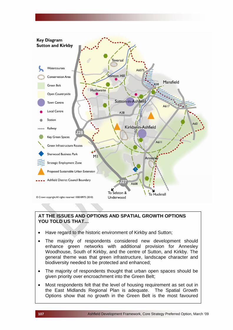
Ashfield Development Framework, Core Strategy Preferred Option, March ‘09107
AT THE ISSUES AND OPTIONS AND SPATIAL GROWTH OPTIONS YOU TOLD US THAT… • Have regard to the historic environment of Kirkby and Sutton;
• The majority of respondents considered new development should enhance green networks with additional provision for Annesley Woodhouse, South of Kirkby, and the centre of Sutton, and Kirkby. The general theme was that green infrastructure, landscape character and biodiversity needed to be protected and enhanced;
• The majority of respondents thought that urban open spaces should be given priority over encroachment into the Green Belt;
• Most respondents felt that the level of housing requirement as set out in the East Midlands Regional Plan is adequate. The Spatial Growth Options show that no growth in the Green Belt is the most favoured
option. Option KS1 (growth on the two large sites) received the majority of support from individual comments.
• The need for social regeneration was highlighted. Examples included Sutton East and Central, Kirkby East and West wards;
• There was widespread support for allocating sufficient employment land that is attractive to the market and is in a sustainable location. Land adjacent to the Mansfield Ashfield Regeneration Route/Hamilton Road and to the ProLogis site (South West of Oakham) was put forward;
• Virtually all responses placed an emphasis on growth to help the regeneration of the Ashfield economy;
• Discussions with business groups/partnerships suggested: that the Council should encourage growth by planning for higher levels of employment land, there is a need to focus on high technology manufacturing as well as offices, that businesses are not concerned with district boundaries and there is a need to take into account accommodation needs of new and expanding small businesses;
• An emphasis was placed on the regeneration of town centres in relation to employment opportunities, housing and improving the environment.
• For Kirkby-in-Ashfield the poor environment of The Precinct was highlighted together with the problems related to traffic in the town centre;
• It was stressed that local shopping centres, such as Stanton Hill, provide a valuable local facility for many local residents;
• There was a focus on the promotion and development of public transport (especially bus) facilities and the feasibility of developing further the rail links, improve cycling and walking links.
Natural, Historic & Built Environment
4.2.8 As with Hucknall, there is a need to deliver the minimum levels of
growth, but it should be delivered in such a way as to avoid any loss of or damage to international and national sites, minimises any adverse impacts on local sites and positively uses new development to act as a catalyst for habitat creation and enhancement. However, compared to Hucknall, there are significantly more SSSIs SINCS and Ancient Woodlands which need to be taken into account. In addition, Local Nature Reserves are currently designated at Portland Park, Bentinck Banks and Brierley Forest Park. It is proposed that the area around Sutton Lawn Dam and Kings Mill Reservoir will also be designated as a Local Nature Reserve.
4.2.9 The whole of the area is within the boundaries of the Greenwood
Community Forest and development proposals should look to facilitate the objectives of the Community Forest.
Ashfield Development Framework, Core Strategy Preferred Option, March ‘09108
4.2.10 Five rivers rise in the area eventually flowing into the River Trent. (The
Rivers Erewash, Leen, Idle, Maun & Meden). These rivers form a limited flood risk in the two towns but the Strategic Flood Risk Assessment for Ashfield identifies a number of potential areas, which have experienced some degree of flooding in the past. The topography of the two towns means that with more extreme rainfall events, anticipated through climate change, the risk of surface water flooding is increased.
4.2.11 All three regional Landscape Character Areas, i.e., Magnesian
Limestone ridge, Nottinghamshire coalfields and Sherwood are applicable to the Kirkby-in-Ashfield and Sutton-in-Ashfield Area.
4.2.12 Any development on the fringe of Zones will need to take into account
not only the landscape character of the Policy Zone it is located in but also the impact on any adjacent Policy Zone, which may not be set out above.
4.2.13 The built environment of both Kirkby-in-Ashfield and Sutton-in-Ashfield
includes substantial areas of late nineteenth and early twentieth century terraced housing, interwar estates, post war estates and extensive areas of modern housing. The traditional industries have been replaced by industrial estates providing local job opportunities, often reflecting a standard “shed” type design. The major exception to this being parts of the Sherwood Business Park where a number of substantial offices have been built in landscaped settings. Three conservation areas are designated in this part of the District, Kirkby Cross, Teversal and New Annesley. Kirkby Cross reflects its link to its farming past and early rural industry. Teversal, standing on a hilltop looking out to Hardwick Hall, is designated as a conservation area due to its wealth of historic buildings. Extensive use of local stone and traditional roofing materials adds to the character of the village. In contrast, New Annesley Conservation Area is a reflection of its industrial heritage as a ‘model mining village’ built in a rural environment.
4.2.14 The area also has a number of Ancient Monuments, 6 in the Kirkby
area and 2 in Sutton. It is essential that archaeological remains are protected and are not needlessly or thoughtlessly destroyed.
4.2.15 There are a number of listed buildings through this area including the
ruins of All Saints Church, (Grade I) adjacent to Annesley Hall (Grade II) and Felly Priory (Grade II). In addition, historic parks and gardens are located at: Annesley Hall and part of the gardens to Hardwick Hall although the Hall itself is not within Ashfield. However, it can be seen that buildings or structures and historic gardens such as Skegby Hall, which are not statutorily protected are important to the local cultural heritage. An example of this can be seen with the Skegby Heritage Trail. The Trail identifies various buildings and structures such as The
Ashfield Development Framework, Core Strategy Preferred Option, March ‘09109
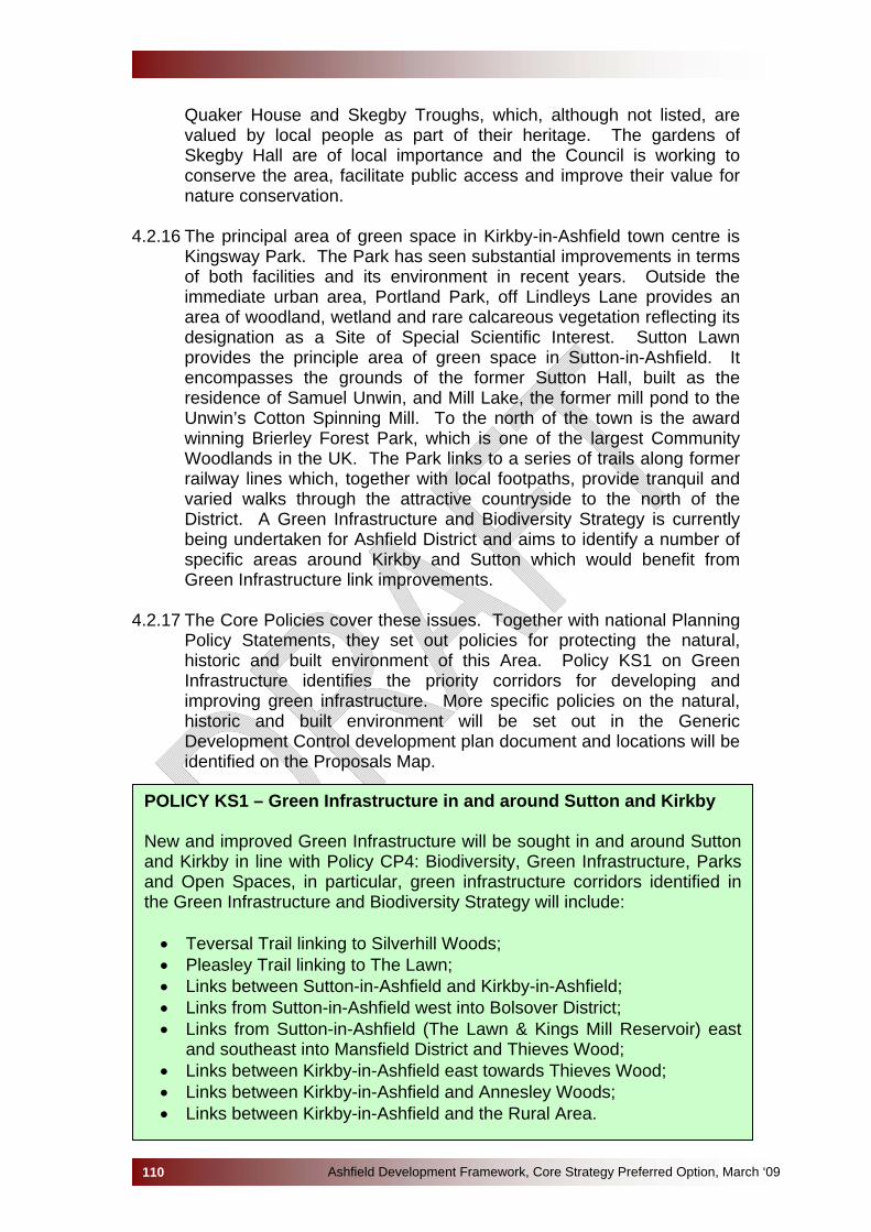
Quaker House and Skegby Troughs, which, although not listed, are valued by local people as part of their heritage. The gardens of Skegby Hall are of local importance and the Council is working to conserve the area, facilitate public access and improve their value for nature conservation.
4.2.16 The principal area of green space in Kirkby-in-Ashfield town centre is
Kingsway Park. The Park has seen substantial improvements in terms of both facilities and its environment in recent years. Outside the immediate urban area, Portland Park, off Lindleys Lane provides an area of woodland, wetland and rare calcareous vegetation reflecting its designation as a Site of Special Scientific Interest. Sutton Lawn provides the principle area of green space in Sutton-in-Ashfield. It encompasses the grounds of the former Sutton Hall, built as the residence of Samuel Unwin, and Mill Lake, the former mill pond to the Unwin’s Cotton Spinning Mill. To the north of the town is the award winning Brierley Forest Park, which is one of the largest Community Woodlands in the UK. The Park links to a series of trails along former railway lines which, together with local footpaths, provide tranquil and varied walks through the attractive countryside to the north of the District. A Green Infrastructure and Biodiversity Strategy is currently being undertaken for Ashfield District and aims to identify a number of specific areas around Kirkby and Sutton which would benefit from Green Infrastructure link improvements.
4.2.17 The Core Policies cover these issues. Together with national Planning
Policy Statements, they set out policies for protecting the natural, historic and built environment of this Area. Policy KS1 on Green Infrastructure identifies the priority corridors for developing and improving green infrastructure. More specific policies on the natural, historic and built environment will be set out in the Generic Development Control development plan document and locations will be identified on the Proposals Map.
POLICY KS1 – Green Infrastructure in and around Sutton and Kirkby New and improved Green Infrastructure will be sought in and around Sutton and Kirkby in line with Policy CP4: Biodiversity, Green Infrastructure, Parks and Open Spaces, in particular, green infrastructure corridors identified in the Green Infrastructure and Biodiversity Strategy will include:
• Teversal Trail linking to Silverhill Woods; • Pleasley Trail linking to The Lawn; • Links between Sutton-in-Ashfield and Kirkby-in-Ashfield; • Links from Sutton-in-Ashfield west into Bolsover District; • Links from Sutton-in-Ashfield (The Lawn & Kings Mill Reservoir) east
and southeast into Mansfield District and Thieves Wood; • Links between Kirkby-in-Ashfield east towards Thieves Wood; • Links between Kirkby-in-Ashfield and Annesley Woods; • Links between Kirkby-in-Ashfield and the Rural Area.
Ashfield Development Framework, Core Strategy Preferred Option, March ‘09110

Accommodating Housing Growth in Kirkby and Sutton 4.2.18 Accommodating growth in this Area takes into account that the
countryside to the south and west of the urban area of the town of Kirkby-in-Ashfield lies in the Green Belt, which encompasses the Nottingham conurbation.
4.2.19 The settlements of Kirkby-in-Ashfield and Sutton-in-Ashfield are
suburban in character with residential development forming the main use. Between 2001-2009, the average number of new dwellings built per year in Kirkby-in-Ashfield and Sutton-in-Ashfield was 315.
4.2.20 Between 2006 and 2026, the East Midlands Regional Plan (2009)
requires a minimum of 7,600 new homes to be provided for in Ashfield District, with the exclusion of Hucknall. Net completions of new homes built between 2006 and 2009 amount to 899 units, resulting in a requirement of 6,701 to be provided between 2009 and 2026.
4.2.21 Some of the housing provision included in the figures above is already
allocated in the Ashfield Local Plan Review or has planning permission. The majority of the new housing will be developed within or adjacent to the existing Main Urban Area as identified within the Strategic Housing Land Availability Assessment (SHLAA). See table below:
Number of Dwellings Dwellings required 2006 - 2026 7,600 Subtract the number of homes built 2006 - 2009 -899 Subtract the number of homes taken from sites with planning permission (not yet developed) -1,848
Subtract the potential number of homes identified by SHLAA within the urban area (including suitable existing housing allocations)
-479
Total number of dwellings to identify for Kirkby-in-Ashfield & Sutton-in-Ashfield 4,374
4.2.22 The above housing requirement also includes a small amount of
development in the Rural Villages of Selston, Jacksdale and Underwood. It is anticipated that this will account for approximately 200 new dwellings, and is addressed in Policy V2. The remaining balance of requirement for the Sutton and Kirkby areas is therefore 4,174.
4.2.23 Policy KS2 identifies that small scale infill will be acceptable in rural
settlements. Infill is regarded as an area which can accommodate one or two dwellings within a small gap in existing development. However,
Ashfield Development Framework, Core Strategy Preferred Option, March ‘09111
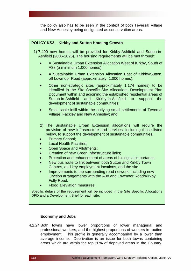
the policy also has to be seen in the context of both Teversal Village and New Annesley being designated as conservation areas.
POLICY KS2 – Kirkby and Sutton Housing Growth
1) 7,400 new homes will be provided for Kirkby-Ashfield and Sutton-in-Ashfield (2006-2026). The housing requirements will be met through:
• A Sustainable Urban Extension Allocation West of Kirkby, South of A38 (a minimum 1,000 homes);
• A Sustainable Urban Extension Allocation East of Kirkby/Sutton, off Lowmoor Road (approximately 1,000 homes);
• Other non-strategic sites (approximately 1,174 homes) to be identified in the Site Specific Site Allocations Development Plan Document within and adjoining the established residential areas of Sutton-in-Ashfield and Kirkby-in-Ashfield to support the development of sustainable communities;
• Small scale infill within the outlying small settlements of Teversal Village, Fackley and New Annesley; and
2) The Sustainable Urban Extension allocations will require the
provision of new infrastructure and services, including those listed below, to support the development of sustainable communities.
• Primary School; • Local Health Facilities; • Open Space and Allotments; • Creation of new Green Infrastructure links; • Protection and enhancement of areas of biological importance; • New bus route to link between both Sutton and Kirkby Town
Centres, and key employment locations, and the site. • Improvements to the surrounding road network, including new
junction arrangements with the A38 and Lowmoor Road/Kirkby Folly Road.
• Flood alleviation measures. Specific details of the requirement will be included in the Site Specific Allocations DPD and a Development Brief for each site.
Economy and Jobs
4.2.24 Both towns have lower proportions of lower managerial and
professional workers, and the highest proportions of workers in routine employment. This profile is generally accompanied by a lower than average income. Deprivation is an issue for both towns containing areas which are within the top 20% of deprived areas in the Country.
Ashfield Development Framework, Core Strategy Preferred Option, March ‘09112
4.2.25 The Regional Economic Strategy (2006) and the East Midlands
Regional Plan (2009) highlight the need for the economic, social and environmental regeneration of the northern part of Ashfield together with neighbouring authorities. However, the anticipated change in the industrial structure introduces uncertainty into the future of the District. While the manufacturing industry will retain an important role in Kirkby-in-Ashfield and Sutton-in-Ashfield, there is a need to diversify the local economy by providing opportunities for increasing the potential supply of offices. Employment land and property studies have identified a net requirement of up to 49.3 ha of employment land. Given the priority to facilitate the regeneration of the local economy and adopt a precautionary approach, it is considered that a requirement of 49.3 ha should be adopted for employment land requirements.
4.2.26 To facilitate jobs and economic development employment sites have
been allocated in the past at various points off the A38 with access to Junction 28 of the M1 being key. Sherwood Business Park was developed as an Enterprise Zone off Junction 27 of the M1 and provides office, industrial and warehouse units for a national and regional market. However, this development is now completed. Smaller allocations around both towns provide for a local market. The majority of sites allocated under the Ashfield Local Plan Review having seen some development with Pinxton Lane and South West Oakham providing quality strategically located sites. From the Mansfield and Ashfield Property Study it is anticipated that there is a net employment land requirement in this Area of 47 hectares for the period from 2009 to 2026.
4.2.27 If required, it is anticipated that additional high quality employment land
allocations will be located along the Mansfield-Ashfield Regeneration Route (MARR). The Council will be working with Mansfield District Council to identify potential employment sites along the MARR, which will look to stimulate development for innovative and high value businesses. If sites are required in Ashfield, it is anticipated they will be located to the north or west of the MARR to integrate with the existing urban area of Mansfield. Land to the south of the MARR is undeveloped land, which retains its predominantly rural character.
4.2.28 Although the area is dominated by manufacturing industry one of the
biggest employers in the District is Kings Mill Hospital. The current redevelopment of the Hospital offers opportunities to improve access to high quality health care, thereby reducing health deprivation, and to diversify the local economic base.
Ashfield Development Framework, Core Strategy Preferred Option, March ‘09113

POLICY KS3 - ECONOMY IN KIRKBY-IN-ASHFIELD & SUTTON-IN-ASHFIELD 1) The economy of Kirkby-in-Ashfield and Sutton-in-Ashfield will be
strengthened and diversified by:
a) Supporting office development in the town centres of Kirkby-in-Ashfield and Sutton-in-Ashfield.
b) Retaining the strategic employment land at South West Oakham and
Pinxton Lane, Sutton-in-Ashfield,
c) Reviewing employment allocations/permissions and where required providing for new allocations, against the following criteria:
• Providing for an adequate supply of developable employment land with a range of sites in terms of quality, size and location, which are accessible by a choice of means of transport.
• Taking into account evidence of the impact of neighbouring Council’s employment land allocations, permissions and proposals.
• If additional strategic employment land is required, the Council will primarily consider locations to the north or west of the Mansfield Ashfield Regeneration Route.
• For other employment land, a sequential approach will be adopted with an emphasis on locations in or adjoining the urban areas of Kirkby-in-Ashfield and Sutton-in-Ashfield;
• The need to support and provide employment opportunities to deprived communities.
d) Safeguard existing employment sites in accordance with Policy CP3 2) Small scale employment development will be encouraged in the rural
settlements of New Annesley, Teversal and Fackley if it;
• Assists in the retention or expansion of rural businesses within the context of the settlement;
• Encourages working from home, providing there is no significant adverse impact on neighbouring amenity;
• Promotes tourism and day visitor related development providing there is no significant adverse impact on neighbouring amenity.
4) To support farm diversification in the Green Belt or the countryside the
conversion to employment uses of buildings worthy of retention will be supported where the proposals accord with the sustainable growth criteria set out in Policy CP2.
Ashfield Development Framework, Core Strategy Preferred Option, March ‘09114
Town Centre and Local Centre Priorities 4.2.29 The main shopping centre of Kirkby-in-Ashfield runs predominately
along Lowmoor Road/Kingsway and Station Street. It has suffered as a retail centre reflecting its close proximity to other significant centres of Sutton-in-Ashfield and Mansfield. The townscape is relatively poor with a lack of notable high quality buildings. The Centre suffers from high vacancy rates, particularly in the Precinct, which has been in decline for a considerable number of years and presents a poor, threatening environment. Lowmoor Road was pedestrianised to improve the shopping environment and links to the Precinct. Environment improvements, including the statue of Harold Larwood, have sought to improve the civic space; nevertheless, there remains a lack of vibrancy with areas of poor quality space. The town is well served by car parks around the Centre but as these are under used, this tends to reinforce the image of a Centre in decline. Independent retailers dominate the town with a variety of small businesses but these do not act as a significant shopper attraction. It has a weak comparison goods sector and there are relatively few multiple retailers present in the centre to draw shoppers, and increasingly the town centre provision is dominated by the discount and the value market sector.
4.2.30 It is recognised that the town centre is fragmented in terms of its
streets and spaces, with both a lack of focus and a lack of a genuine circuit of pedestrian movement. The traffic system contributes towards these issues and is a major source of local concern regarding traffic congestion.
4.2.31 For Kirkby-in-Ashfield the vision for the town centre is to “arrest
decline, tackle those areas where the fabric has become neglected, restore pride and confidence, and make Kirkby-in-Ashfield a vibrant local centre of choice for its catchment population.” (Masterplans for Sutton-in-Ashfield and Kirkby-in-Ashfield 2007.)
4.2.32 Retailing alone is unlikely to be sufficient to sustain the Centre,
therefore, other potential uses will need to be encouraged. People are drawn into the town centre by a number of leisure, community and health facilities including the Ashfield Community Hospital, doctors/dentists, a library, the Festival Hall Leisure Centre and various community facilities. The Council occupies a substantial office building on the edge of centre but there are few other office facilities in or on the edge of the town centre. One of the two secondary schools in Kirkby-in-Ashfield, Kirkby College is also located in the town centre. It is important that these facilities are retained and other uses developed including residential and employment opportunities.
Ashfield Development Framework, Core Strategy Preferred Option, March ‘09115
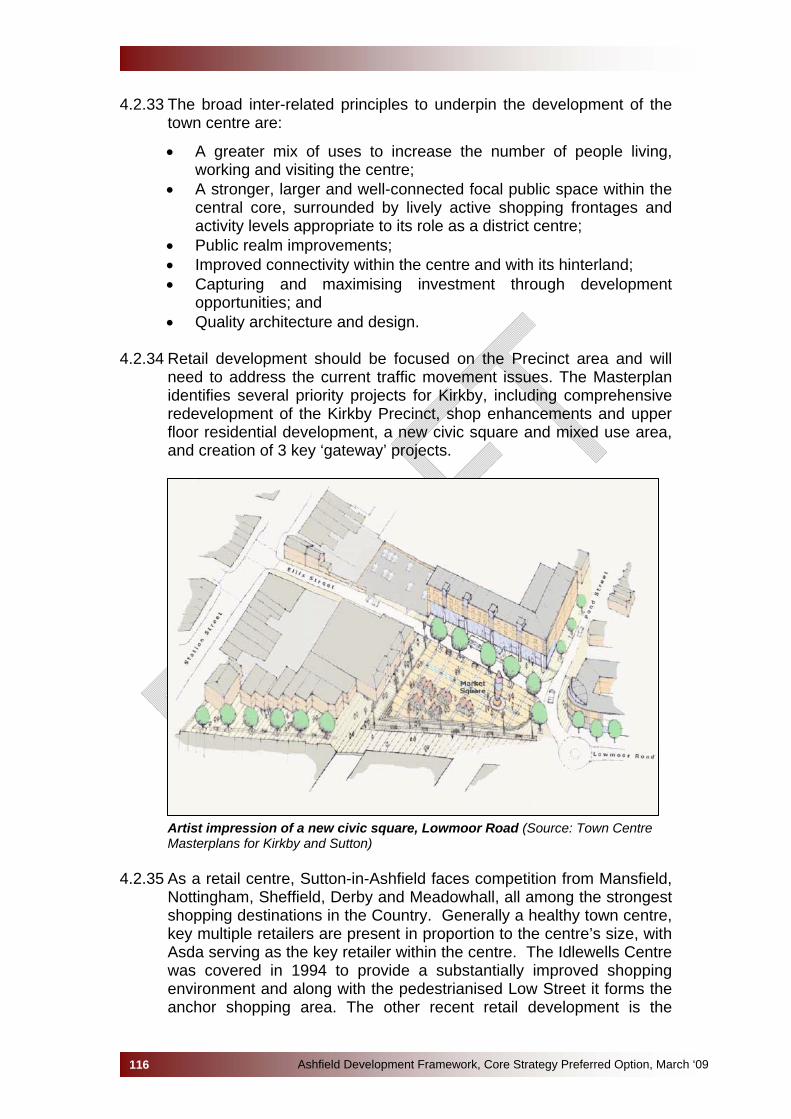
4.2.33 The broad inter-related principles to underpin the development of the town centre are:
• A greater mix of uses to increase the number of people living, working and visiting the centre;
• A stronger, larger and well-connected focal public space within the central core, surrounded by lively active shopping frontages and activity levels appropriate to its role as a district centre;
• Public realm improvements; • Improved connectivity within the centre and with its hinterland; • Capturing and maximising investment through development
opportunities; and • Quality architecture and design.
4.2.34 Retail development should be focused on the Precinct area and will
need to address the current traffic movement issues. The Masterplan identifies several priority projects for Kirkby, including comprehensive redevelopment of the Kirkby Precinct, shop enhancements and upper floor residential development, a new civic square and mixed use area, and creation of 3 key ‘gateway’ projects.
Artist impression of a new civic square, Lowmoor Road (Source: Town Centre Masterplans for Kirkby and Sutton)
4.2.35 As a retail centre, Sutton-in-Ashfield faces competition from Mansfield,
Nottingham, Sheffield, Derby and Meadowhall, all among the strongest shopping destinations in the Country. Generally a healthy town centre, key multiple retailers are present in proportion to the centre’s size, with Asda serving as the key retailer within the centre. The Idlewells Centre was covered in 1994 to provide a substantially improved shopping environment and along with the pedestrianised Low Street it forms the anchor shopping area. The other recent retail development is the
Ashfield Development Framework, Core Strategy Preferred Option, March ‘09116
Broad Centre on Forest Road/Station Road which opened in 2002. Overall, there is an over-representation of convenience retailing, building societies and travel agents and an under-representation of restaurants, cafes and bars. There are a number of out-of-centre retail providers in Homebase, Aldi and Wicks on Station Road and the B & Q Superstore located to the north east of the town centre.
4.2.36 The townscape is of mixed quality. There has been substantial
investment within the public realm with the pedestrianisation of Portland Square, and the improvements to the Market Place. Investment in or on the edge of town can be seen in the Idlewells Centre, New Leisure Centre, refurbished bus station and the New Ashfield Homes Offices on Brook Street. However, the town centre becomes fragmented around Market Place and Kings Street, with boarded shop frontages, a vacant site and decaying buildings. There is a need to look for investment in this area and for opportunities to improve connections within and across the centre creating attractive links between different areas.
4.2.37 The priority for Sutton-in-Ashfield town centre is to reinforce its role as
a sub-regional shopping and service centre. The vision for Sutton-in-Ashfield is “To create an active and vibrant town centre through encouraging a mix of uses that will increase the number of people living, working and visiting the centre, set in an environment Sutton-in-Ashfield residents are proud of.” Five broad inter-related principles have been identified to achieve the vision:
• A greater mix of uses to increase the number of people living, working and visiting the town centre, and to extend their use of the centre, appropriate to its role as a sub-regional town centre;
• A well connected public realm; • Improved transport and movement; • Capturing and maximising investment through development
opportunities; and • Quality architecture and design.
4.2.38 The Town Centre Core identifies the main shopping area centred
around Asda, Portland Square, Forest Street (north-west), Low Street and the Idlewells Centre. It is anticipated that there are opportunities to improve the retail offer from:
• Redevelopment of Asda’s current site with improved connections to Portland Square and Fox Street;
• Redevelopment of the area around Kings Street. 4.2.39 To improve perceptions of natural surveillance at night there is the
opportunity to introduce mixed uses into the centre by increased residential use, particularly above shops.
4.2.40 If Sutton Centre School is redeveloped as an Academy, this retains an
education use within the town centre. Alternatively, if the school moves
Ashfield Development Framework, Core Strategy Preferred Option, March ‘09117

to another location this could be the catalyst for the redevelopment of the area between Low Street and High Pavement as a Business and Community Quarter.
Artist impression of a new cultural quarter, Sutton (Source: Town Centre Masterplans for Kirkby and Sutton)
4.2.41 The Masterplans for Sutton-in-Ashfield and Kirkby-in-Ashfield 2007
provide an evidence base for a wide variety of projects for improvements to both town centres.
Ashfield Development Framework, Core Strategy Preferred Option, March ‘09118
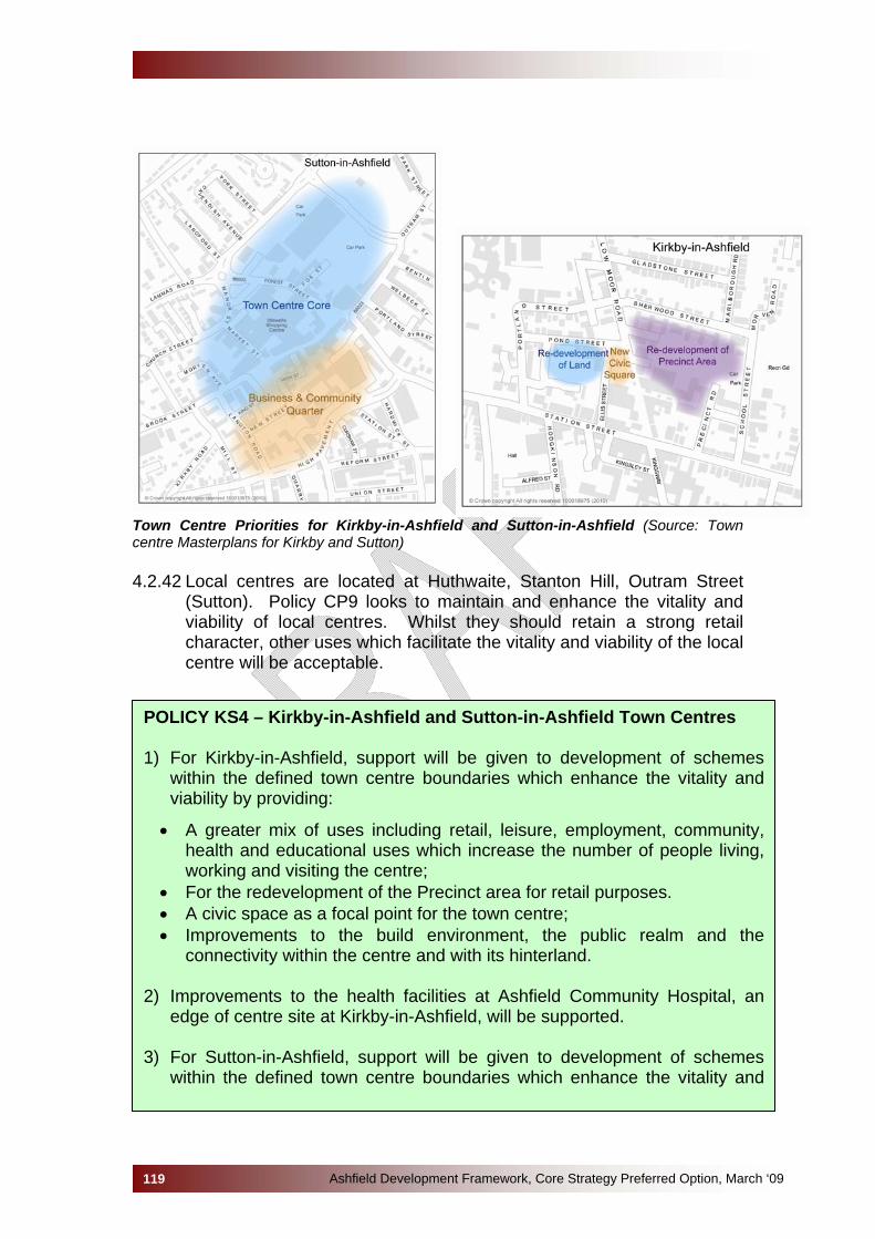
Ashfield Development Framework, Core Strategy Preferred Option, March ‘09119
Town Centre Priorities for Kirkby-in-Ashfield and Sutton-in-Ashfield (Source: Town centre Masterplans for Kirkby and Sutton) 4.2.42 Local centres are located at Huthwaite, Stanton Hill, Outram Street
(Sutton). Policy CP9 looks to maintain and enhance the vitality and viability of local centres. Whilst they should retain a strong retail character, other uses which facilitate the vitality and viability of the local centre will be acceptable.
POLICY KS4 – Kirkby-in-Ashfield and Sutton-in-Ashfield Town Centres 1) For Kirkby-in-Ashfield, support will be given to development of schemes
within the defined town centre boundaries which enhance the vitality and viability by providing:
• A greater mix of uses including retail, leisure, employment, community, health and educational uses which increase the number of people living, working and visiting the centre;
• For the redevelopment of the Precinct area for retail purposes. • A civic space as a focal point for the town centre; • Improvements to the build environment, the public realm and the
connectivity within the centre and with its hinterland.
2) Improvements to the health facilities at Ashfield Community Hospital, an edge of centre site at Kirkby-in-Ashfield, will be supported.
3) For Sutton-in-Ashfield, support will be given to development of schemes
within the defined town centre boundaries which enhance the vitality and
viability and reinforce its role as a sub-regional centre by providing:
• For the Town Centre Core to remain as the principle retail centre but with opportunities for residential use above shops;
• For the development of a Business and Community Quarter between Low Street and High Pavement and to the south of Market Place to including retail, office, café/restaurants and educational uses together with civic space;
• For other areas of the town centre to be utilised for a mix of uses including small scale retail, offices, leisure, employment, community, health and educational;
• Improvements to the built environment, the public realm, connectivity
within the centre and to removing barriers to movement. • 4) Development Plan Documents will make provision, In addition to existing
commitments, for a minimum net increase in comparison and convenience floor space as identified in the Ashfield Retail Study.
5) To ensure the future vitality and viability of Sutton and Kirkby Town Centres,
new retail development will be accommodated within the defined town centre boundaries. Where this cannot be accommodated within the defined town centre boundary, a sequential approach will be followed in line with current national planning policy guidance.
6) The scale of any retail development will be appropriate to the role of the
respective Town Centre as set out in Policy CP9: Town and Local Centres. 4.2.43 National and Regional Policy Framework
• PPS1: Delivering Sustainable Development. • PPS4: Planning for Sustainable Economic Growth. • East Midlands Regional Plan: • A Flourishing Region. Regional Economic Strategy for the East
Midlands 2006 – 2020. 4.2.44 Local Policies, Strategies and Evidence Base
• Ashfield Strategic Housing Land Availability Assessment • East Midlands Northern Sub Region Employment Land Review.
March 2008. • Experian (2009). Ashfield and Mansfield: Economic Analysis • Innes England (2010) Mansfield & Ashfield Districts Joint Property
Strategy. • Nottinghamshire Local Area Agreement 2008 -2011. • Ove Arup & Partners Ltd (2008) East Midlands Northern Sub
Region Employment Land Review. • Ove Arup & Partners Ltd (2007).” The Masterplans for Sutton-in-
Ashfield and Kirkby-in-Ashfield.
Ashfield Development Framework, Core Strategy Preferred Option, March ‘09120
• Sustainable Community and Neighbourhood Renewal Strategy 2006-21
Alternative Options not selected The East Midlands Regional Plan identifies the Area as a regional priority for economic, social and environmental regeneration with an emphasis on strengthening the Sub-Regional Centre of Mansfield-Ashfield by providing new jobs, houses, services and facilities in and around the urban areas. Therefore, any options have to be seen in this context. The Strategic Housing Land Availability Assessment identifies there are insufficient sites within the urban area to meeting the housing requirements. The alternative approach was to develop urban green space but it was clear from the consultation that this approach was not acceptable to the majority of respondents and it would have negative impacts upon biodiversity and the urban environment. An alternative would have been to take a more dispersed approach to growth throughout the urban and rural parts of the Area. However, the general consensus at the Spatial Growth Options consultation was that by taking an approach based on urban concentration the vitality of the existing settlements would be enhanced and sustained, and development could help to deliver new facilities and infrastructure. It was also considered that to take any other approach would be contrary to the regional 'concentration and regeneration' strategy. Consequently, three options in terms of growth in relation to housing were identified: • KS1, focus growth on major urban extensions located to the west of
Kirkby-in-Ashfield and to the west of Sutton-in-Ashfield/Kirkby-in-Ashfield with smaller extensions to the existing urban areas;
• KS2, spread development throughout Kirkby and Sutton in broad areas identified, including an area to the west of Kirkby-in-Ashfield, which is in the Green Belt;
• KS3 followed a similar approach to KS2 but with no growth in the Green Belt.
From the consultation, Option KS1 received the support of the majority and this also has advantages associated with economies of scale. However, the Preferred Option identifies sites which are smaller than set out in the Spatial Growth Options Consultation which means that approximately 1,000 additional homes will be required on extensions to the urban area, possibly including sites in the Green Belt. These will be included in the Site Specific Allocations Development Plan Document. Three broad policy options were set out, at the Issues and Options stage, to tackle the economic issues facing the District. Given the needs for the regeneration of the Area, Option One 'Business as Usual' was not seen as an option that should be taken forward. Virtually all responses placed an
Ashfield Development Framework, Core Strategy Preferred Option, March ‘09121
Ashfield Development Framework, Core Strategy Preferred Option, March ‘09122
emphasis on growth to help the regeneration of the Ashfield economy, reflected in both Options Two and Three. However, Option Two “Provide an emphasis on developing a more resilient economy”, did not have an emphasis on urban concentration reflected in Option Three. In terms of the Town Centres, the alternative would be to allow more-out-of-centre retail development. However, Ashfield Retail Study identifies that large scale out-of-centre development should be resisted as it threatens the vitality of the Centres. This approach would also be contrary to national guidance in Planning Policy Statement 4. In terms of Kirkby-in-Ashfield, a further alternative would be to manage the decline of the Centre. However, the vision is to arrest decline and make Kirkby-in-Ashfield a vibrant local centre and this approach is reflected in the Preferred Option. Sustainability Appraisal This option could deliver the greatest affordable housing benefits for Kirkby and Sutton. The site is of a large enough size for the provision of a new health centre and would increase the scope to provide open space and play facilities on site, with the opportunity for new or enhanced community facilities. These developments could be large enough to incorporate some employment into development. This could ensure less car use and therefore lead to an improvement in air quality. The sites are both located within the countryside but they do not impact on any Site of Special Scientific Interest. Both sites form substantial development sites with the opportunity to utilise Sustainable Drainage Systems (SUDS) on a wider scale, with the sites being of large enough scale to ensure that renewable energy is financially viable.
4.3 VILLAGES (SELSTON, JACKSDALE & UNDERWOOD) 4.3.1 The Nottinghamshire villages of Selston, Jacksdale and Underwood
are situated in the south west of Ashfield District. Selston forms the largest settlement, with a population of 6,629 Jacksdale and Underwood are smaller with a population of 3,168 and 2,881 respectively (mid 2008 estimates, ONS). The local community is also served by Selston Parish Council which covers the three villages and a small area of what is associated with New Brinsley off Plainspot Road.
4.3.2 Today, the villages of Selston, Jacksdale, and Underwood are largely
residential areas which are served by a range of community services and facilities relating to health, education, leisure and recreation. In Selston there is a secondary school, library and leisure centre, which also serves the surrounding areas. Jacksdale and Underwood have fewer community facilities, although Jacksdale has a small library and both have good access to facilities in Selston.
4.3.3 In terms of retail provision, Jacksdale has a small shopping area
(defined as a ‘local centre’ in Policy CP9) which contains a small supermarket and a range of smaller shops. Although Selston is the largest village, the retail offer is limited to just one small supermarket and a small number of shops.
4.3.4 Although there are a limited number of employment units in the
villages, there are many employment opportunities in the surrounding areas (e.g. Sherwood Business Park). Despite the lack of employment opportunities and retail facilities within the villages, there are public transport services to Nottingham, Alfreton, Kirkby-in-Ashfield, Sutton-in-Ashfield, and Mansfield.
4.3.5 Selston, Jacksdale, and Underwood have largely retained their village-
like character due to the existence of the Green Belt boundary. Consequently, there are now a limited number of suitable Brownfield sites for new residential development within the villages.
Key Diagram for Rural settlements
4.3.6 The Key Diagram below shows the areas of constraint (defined by the
Green Belt); the key transport links; and retail and employment opportunities for the rural settlements of Selston, Jacksdale, and Underwood.
Ashfield Development Framework, Core Strategy Preferred Option, March ‘09123
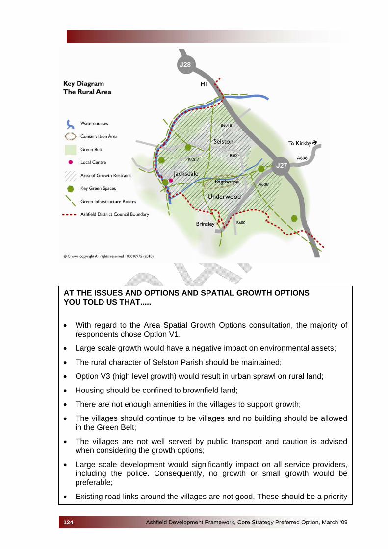
Ashfield Development Framework, Core Strategy Preferred Option, March ‘09124
AT THE ISSUES AND OPTIONS AND SPATIAL GROWTH OPTIONS YOU TOLD US THAT.....
• With regard to the Area Spatial Growth Options consultation, the majority of respondents chose Option V1.
• Large scale growth would have a negative impact on environmental assets;
• The rural character of Selston Parish should be maintained;
• Option V3 (high level growth) would result in urban sprawl on rural land;
• Housing should be confined to brownfield land;
• There are not enough amenities in the villages to support growth;
• The villages should continue to be villages and no building should be allowed in the Green Belt;
• The villages are not well served by public transport and caution is advised when considering the growth options;
• Large scale development would significantly impact on all service providers, including the police. Consequently, no growth or small growth would be preferable;
• Existing road links around the villages are not good. These should be a priority

prior to development taking place;
• Policy 3 of the East Midlands Regional Plan recognises that all sizes of settlements may require some growth to support existing communities, and makes provision for the needs of rural communities. In this way, the policy anticipates sensitive levels of growth to rural villages in order to improve access to services and deliver affordable rural housing needs, without significantly altering rural character and tranquillity;
• Option V1, will clearly not deliver the affordable housing that is needed in the rural areas, as development sites will not be of sufficient size to trigger contributions. Further, such sites will not generate the scale of development required to help support and deliver local services and will not reduce the need to travel.
Natural, Historic & Built Environment 4.3.7 With limited growth anticipated in the rural areas it is important to
protect the natural environment. SSSIs are currently identified at Friezeland Grasslands, Underwood, and Bagthorpe Meadows, there are a number of SINCs in this Area, ancient woodland is located at Millington Springs and it is proposed to designate a Local Nature Reserve in Jacksdale.
4.3.8 The whole of the Area is within the boundaries of the Greenwood
Community Forest and development proposals should look to facilitate the objectives of the Community Forest.
4.3.9 The principal source of flood risk in the Rural Area is to Jacksdale from
the River Erewash and the Bagthorpe Brook. Approximately 32 residential properties and 14 commercial properties are identified as falling with Flood Zone 2 or Flood Zone 3. The Strategic Flood Risk Assessment for Ashfield identifies a number of other sources of flooding together with their location with flooding within and adjacent to the villages of Selston, Underwood and Jacksdale.
4.3.10 In terms of Landscape Character Assessment the Rural Area falls
within the Magnesian Limestone Ridge and the Nottinghamshire Coalfields.
4.3.11 The villages form part of the Hidden Valleys, which is the historical
gateway to Robin Hood’s Sherwood Forest. This area has a rich industrial and cultural heritage relating to the textile and mining industries, and to the works of D. H. Lawrence and Lord Byron. The undulating landscape boasts an array of panoramic views of the surrounding open countryside, ancient woodland, villages and small hamlets, some of which inspired the literary works of D. H. Lawrence and Lord Byron.
Ashfield Development Framework, Core Strategy Preferred Option, March ‘09125

4.3.12 Lower Bagthorpe Conservation Area, which forms part of the Hidden Valleys, is situated in the valley between the villages of Selston and Underwood. It is a small hamlet nestling alongside Bagthorpe Brook, which has retained much of its character as a pastoral farming settlement. This is largely due to the dispersed nature of the settlement, the local architectural features, and the surrounding field patterns (linear strips enclosed by mature hedgerows). The conservation area includes the ruins of Wansley Hall, a Scheduled Ancient Monument.
4.3.13 The villages are surrounded by open countryside, which benefits from
an array of interconnecting public rights of way (both footpaths and bridleways), rivers and smaller watercourses. The Nottinghamshire Green Belt plays a significant role in the protection of the green infrastructure network surrounding the villages of Selston, Jacksdale, and Underwood. The planned low level growth for the villages will ensure that these networks continue to be protected.
4.3.14 A Green Infrastructure and Biodiversity Strategy is currently being
undertaken for Ashfield District and it aims to identify a number of specific areas around the rural areas which would benefit from Green Infrastructure link improvements.
4.3.15 Core Policies cover these issues. Together with national policy
statements, they set out policies for protecting the natural, historic and built environment. A local area policy on Green Infrastructure is set out below. More specific policies will be set out in the Generic Development Control Development Plan Document and locations will be identified on the Proposals Map.
POLICY V1 – Green Infrastructure in and around the rural areas New and improved Green Infrastructure will be sought in and around the villages of Selston, Jacksdale and Underwood in line with Policy CP4: Biodiversity, Green Infrastructure, Parks and Open Spaces, in particular, those green infrastructure corridors identified in the Green Infrastructure and Biodiversity Strategy which will include:
• Links between the Rural Area and Kirkby-in-Ashfield. • Links along the Erewash Valley. • Links between Jacksdale and Ironville.
Accommodating Housing Growth in the Villages
4.3.16 Between 2006 and 2026, the East Midlands Regional Plan requires a
minimum of 7,600 new homes to be provided for in the north of Ashfield District (excluding Hucknall). 899 homes were built between 2006 and 2009, resulting in a requirement of 6,701 between 2009 and 2026 (see table below):
Ashfield Development Framework, Core Strategy Preferred Option, March ‘09126
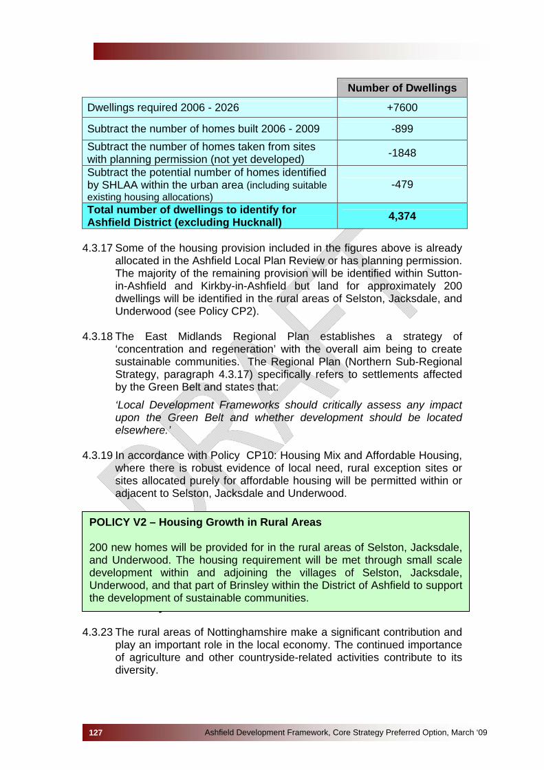
Number of Dwellings
Dwellings required 2006 - 2026 +7600
Subtract the number of homes built 2006 - 2009 -899 Subtract the number of homes taken from sites with planning permission (not yet developed) -1848
Subtract the potential number of homes identified by SHLAA within the urban area (including suitable existing housing allocations)
-479
Total number of dwellings to identify for Ashfield District (excluding Hucknall) 4,374
4.3.17 Some of the housing provision included in the figures above is already
allocated in the Ashfield Local Plan Review or has planning permission. The majority of the remaining provision will be identified within Sutton-in-Ashfield and Kirkby-in-Ashfield but land for approximately 200 dwellings will be identified in the rural areas of Selston, Jacksdale, and Underwood (see Policy CP2).
4.3.18 The East Midlands Regional Plan establishes a strategy of
‘concentration and regeneration’ with the overall aim being to create sustainable communities. The Regional Plan (Northern Sub-Regional Strategy, paragraph 4.3.17) specifically refers to settlements affected by the Green Belt and states that:
‘Local Development Frameworks should critically assess any impact upon the Green Belt and whether development should be located elsewhere.’
4.3.19 In accordance with Policy CP10: Housing Mix and Affordable Housing,
where there is robust evidence of local need, rural exception sites or sites allocated purely for affordable housing will be permitted within or adjacent to Selston, Jacksdale and Underwood.
Economy and Jobs
POLICY V2 – Housing Growth in Rural Areas 200 new homes will be provided for in the rural areas of Selston, Jacksdale, and Underwood. The housing requirement will be met through small scale development within and adjoining the villages of Selston, Jacksdale, Underwood, and that part of Brinsley within the District of Ashfield to support the development of sustainable communities.
4.3.23 The rural areas of Nottinghamshire make a significant contribution and play an important role in the local economy. The continued importance of agriculture and other countryside-related activities contribute to its diversity.
Ashfield Development Framework, Core Strategy Preferred Option, March ‘09127
4.3.24 If sustainable rural communities are to be achieved there needs to be opportunities for people to work within rural communities. This objective is identified in Selston Parish Plan which looks to facilitate the growth of small local businesses. Farm diversification and the conversion of rural buildings for alternative uses offer the potential to provide farmers with another income source and to assist the rural economy. Therefore, development which helps to strengthen or assists with diversification of the rural economy and which provides a source of local employment opportunities will be supported. However, there are sustainability issues as premises in the rural area can be highly dependent upon the private car and this could encourage ‘reverse commuting’ from urban areas. The need to strengthen the rural economy needs to be balanced against the economic sustainability of the towns and rural settlements and the negative impact on sustainable development in the countryside. Planning Policy Statement 7 and the Draft Planning Policy Statement 4 provide guidance on the appropriate form and scale of rural development.
4.3.25 An analysis of the supply of existing employment sites identified
relatively few significant employment sites in the rural areas. Within the Rural Area there has been a loss of 2.88 hectares of employment land to housing for the period 2001 to 2009. Although this may appear a relatively small loss it’s impact is significant greater within rural areas with their limited employment sites. Consequently, it is important to protect the remaining employment sites within the rural areas for employment purposes.
POLICY V3 - RURAL ECONOMY 1) New employment development will be directed to the rural settlements
of Jacksdale, Selston and Underwood. Small scale development, the conversion or extension of existing buildings and the provision of infrastructure for employment related development will be encouraged in locations within the rural settlements.
2) To support farm diversification in the green belt the conversion to
business use of buildings worthy of retention will be supported where the proposals accord with the sustainable growth criteria set out in Policy CP2.
3) The Council will retain and safeguard employment sites in the rural
area from development for other purposes. Alternative uses outlined in Preferred Option CP3 will not be permitted unless they generate substantial employment opportunities.
Policy V3 should be read in conjunction with Preferred Option CP3
Ashfield Development Framework, Core Strategy Preferred Option, March ‘09128

Ashfield Development Framework, Core Strategy Preferred Option, March ‘09129
Alternative Options not selected Spatial Growth Option V2: A small amount of growth to sustain facilities This option would involve the allocation of a range of small sites in the Green Belt, adjacent to the settlements of Selston, Jacksdale, and Underwood. The main advantage of this option relates to the benefits it would bring to the rural areas in terms of improvements to existing service provision (e.g. schools, health centres, retail facilities etc.). Reasons for not selecting this option:
• In terms of new service provision/facilities, this option may not be large enough in scale to bring significant benefits to the community;
• This option would result in the loss of Green Belt land and open countryside;
• It would impact on existing services (e.g. police, fire, health, education etc.);
• It would result in the loss of rural character of this area. • The East Midlands Regional Plan has specified that there should be
no loss of Green Belt land in the northern area of the District. • Public consultation responses have indicated that this option is not
favourable. Spatial Growth Option V3: Large settlement extension This option would look to allocate a large settlement extension in the Green Belt. Reasons for not selecting this option:
• Significant loss of Green Belt; • Loss of open countryside; • The existing infrastructure would need to be significantly improved
(schools, roads, health provision, public transport) due to the rural nature of this area.
• It would result in a considerable loss of rural character. • The East Midlands Regional Plan has specified that there should be
no loss of Green Belt land in the northern area of the District. • Public consultation responses have strongly indicated that this option
is not favourable or suitable for such a rural area. Sustainability Appraisal These policies understandably have very positive effects on Biodiversity, Landscape and Natural Resources, but the SA shows significant benefits in terms of Transport, Health, Heritage and Social Inclusion could have been gained from more extensive development in this area. The SA suggested a broadly neutral impact from this policy on the provision of new housing and employment opportunities; any development constraint being balanced by very positive impacts on quality of life factors. The only negative issue

identified related to the possible increase in the fear of crime when new elements of the green network are opened up, both in terms of lack of natural surveillance and Rights of Way issues. These factors could be mitigated through good design and management.
Ashfield Development Framework, Core Strategy Preferred Option, March ‘09130
5.0 IMPLEMENTATION AND MONITORING
Implementation 5.1 As the Core Strategy is a spatial plan, the implementation of its
objectives and policies cannot be achieved solely through the use of Council powers and resources. Instead, the success of the Ashfield Development Framework depends on partnership working with a range of public, private and voluntary bodies. The role of the Core Strategy is to provide a clear and robust framework for development in order that investment and action can be co-ordinated and geared to efficient and effective delivery and to create the right environment that encourages such investment into Ashfield.
5.2 A key factor of successful implementation of Core Strategy policies is
the infrastructure required to bring forward development. There is acknowledgement that past public under-investment has lead to pressure on a range of public services across the country.
5.3 An Infrastructure Capacity Study has been undertaken and work is
currently progressing, in partnership with the local infrastructure and service providers, on producing an Infrastructure Delivery Plan. The issues raised by infrastructure and service providers have been taken into account in the development of the Core Strategy.
Monitoring
5.4 The East Midlands Regional Plan states that annual monitoring will
track delivery of development and the related components of sustainable communities.
5.5 The new planning system places great importance on the process of
continual plan review. The separation of the documents within the Ashfield Development Framework means that each document can be reviewed and amended individually. A key component of this process is the requirement to produce an Annual Monitoring Report (AMR) which is prepared and submitted to the Secretary of State in December each year. The AMR assesses the effectiveness of the policies contained within each Development Plan Document of the Ashfield Development Framework.
5.6 Progress towards the Core Strategy’s vision will be measured against a
number of Performance Indicators. The development of a monitoring framework will be gradual and evolutionary as the plan is put into place and as the spatial approach to planning is developed. The indicators identified in Appendix 5 seek to provide a consistent basis for monitoring the performance of the Core Strategy policies against the aims and objectives, and where possible, repeat national, regional and local indicators and targets identified by the Government, East
Ashfield Development Framework, Core Strategy Preferred Option, March ‘09131

Ashfield Development Framework, Core Strategy Preferred Option, March ‘09132
Midlands Regional Assembly, Ashfield Corporate Plan and the Local Area Agreement.
Risks
5.7 There are a number of risks to the delivery of the Core Strategy aims,
objectives and policies, not least because delivery of most new development is dependant on market conditions. For example, delivery of affordable housing may be dependant on public funding as well as the developers. Delivery of sustainable construction methods will depend on the willingness of developers to embrace energy efficiency technologies. More significantly, objectives regarding employment growth will depend on economic conditions and the relative attractiveness of Ashfield as a place for business investment.
5.8 One of the most significant risks is that the necessary infrastructure to
enable development is not provided. The infrastructure providers have provided information based on best possible knowledge, however, future provision will inevitably rely on funding for such works. In some cases this will need to be considered in a regional and sub-regional context where infrastructure providers have competing demands for funding, including the growth points of Greater Nottingham and Newark and Sherwood.
5.9 A full schedule of risks and appropriate mitigation measures is detailed
in Appendix 6.
Flexibility and Contingency 5.10 In providing flexibility there needs to be a balance between providing
certainty for the local community and development industry and allowing for changes in circumstances so that policies do not become quickly out of date. A number of policies in the Core Strategy are criteria based therefore allowing for variations for individual circumstances within an overarching policy approach. Some policies also make reference to viability which also allows for flexibility.
5.11 In relation to housing provision, accommodating growth policies for
each area provides for large sites and also the smaller sites identified through the Strategic Housing Land Availability Assessments (SHLAA) so as to ensure that there is an element of choice when identifying allocations in the Site Specific Development Plan Document.
5.12 The policies will be monitored through the Annual Monitoring Report
which will gather information on each of the indicators shown in Appendix 4. The information in the Monitoring Report will then show whether the targets are being met. Where targets are not met over a sustained period, this will trigger a review of the Core Strategy policies.