waikato regional council waikato district council … · waikato regional council waikato district...
TRANSCRIPT
WAIKATO REGIONAL COUNCIL WAIKATO DISTRICT COUNCIL
WAIPA DISTRICT COUNCIL and
HAMILTON CITY COUNCIL
Notices of Requirement and Application for Resource Consents
in respect of Southern Links
Requiring Authorities NZ Transport Agency and Hamilton City Council
Resource Consent Applicants
NZ Transport Agency and Hamilton City Council
Volume 1
HEARINGS REPORT
OF HEARINGS COMMISSIONERS
24th October, 2014
Phil Mitchell Consultant AUCKLAND
Doug Arcus Barrister
HAMILTON
David Hill Independent Hearings
Commissioner AUCKLAND
Shane Solomon Consultant
TAUPIRI
i
CONTENTS
1. INTRODUCTION 1
2. PROCESS 3
3. PROPOSAL 8
4. SUBMISSIONS 10
5. PRELIMINARY ISSUES 12
6. EFFECTS 16
7. PLANNING INSTRUMENTS 61
8. STATUTORY FRAMEWORK 65
9. LAPSE AND STAGING 70
10. CONCLUSIONS 73
11. CONDITIONS 74
12. RECOMMENDATIONS AND DECISIONS 76
13. APPENDIX 1 77
1
HEARINGS REPORT
1. INTRODUCTION
It was clear from the outset that the Southern Links Project as it was put to us was a Future proof or Route Protection designation. Ms Janissen made that point in her opening1 and observed: It is unlike other recent projects in the Waikato Region, for which designations have been sought. Those other projects such as sections of the Waikato Expressway, have been progressed to a stage where a significant level of details and design exists. Subject to confirmation of the designations and the granting of necessary resource consent, construction occurs within a relatively short period of time.2 We Commissioners sitting in respect of the Southern Links were the same constituted panel who heard and made recommendations/decisions in respect of alterations to the Waikato Expressway (Hamilton Section) earlier this year. We therefore understand and accept that submission. As an integral part of the project being a future proof one, the lapse period for the designation was sought at 20 years. We deal with the lapse period in Section 9 of this Hearings Report but the lapse period is indicative of the future proofing of the project. Future proofing in the manner proposed is not unusual. NZTA pointed to the Cambridge bypass which is currently in the course of construction but the route for which was designated as long ago as 1973. In addition, we note that in respect of the Waikato Expressway (Hamilton Section) designation alterations to which we have just considered, the initial route protection took place in 2004. We accept that a designation for route protection only is a legitimate and appropriate planning step for requiring authorities to take. However, as Ms Janissen observed in her reply: More recently in particular with the RONS (Roads of National Significance) projects, the trend has been to seek designation for major roading projects and, once confirmed, to commence construction shortly thereafter3. As a result, the concept of long term “future proofing” of alignments has become less common. More importantly, the public have developed expectations of more immediate construction timeframes for such projects, together with seeing a more detailed level of design than would be available for such projects. To some extent it is those expectations which the requiring authorities in this case have had to grapple with, and explain that early construction and/or greater levels of detail are simply not applicable to this particular Project.4
1 Janissen opening submission para. 4 2 Janissen opening submission para.5
3 Examples include the Victoria Park tunnel, Waterview connection project and McKays to Peka Peka projects
4 Janissen reply paras. 42 and 43
2
In many respects the case the Requiring Authorities put before us was something of a hybrid in that it had significant elements of route protection but at the same time the conditions offered were more in the nature of resource consent conditions - more detailed than one might expect for an old-fashioned route protection designation but not enough to cover the detail of ultimate construction. We accept that future proofing designations are a valid planning instrument today and because of the “route protection” nature of the proposal there is not as much detail as many submitters would have preferred. Having said that, we acknowledge the legitimate concerns of many submitters who cannot presently have completely answered their detailed questions and concerns. Throughout the whole of this case, we have been alert to the difficulty faced by the submitters having insufficient detail. We have therefore been seeking a balance between the level of detail required now while at the same time adequately addressing the legitimate concerns of submitters.
3
2. PROCESS
2.1 Appointment
Pursuant to s34A of the Resource Management Act 1991 (RMA), we independent commissioners have been appointed as follows: Doug Arcus, David Hill, Philip Mitchell and Shane Solomon have been appointed
by Waikato District Council (Waikato DC), Waipa District Council (Waipa DC) and Hamilton City Council (HCC) to hear and make a recommendation in respect of each of the Notices of Requirement (NoR) lodged by the NZ Transport Agency (NZTA) for the construction and operation of Southern Links; and
The same commissioners have been appointed by HCC to hear and determine a
NoR lodged by HCC for major and minor arterial routes in the Peacocke Area within Hamilton City; and
Phil Mitchell and David Hill have been appointed by Waikato Regional Council
(WRC) and Shane Solomon has been appointed by the Waikato River Authority (WRA) to hear and determine applications for resource consents made by NZTA and HCC in respect of the three bridges which are part of the Southern Links; Project.
Our delegations included all procedural matters associated with the primary delegations; and
We were to conduct a joint hearing.
2.2 Proposals
A summary of the proposals before us is set out in Section 3 of this Report.
2.3 Notification
The NoRs for Southern Links were lodged with HCC, Waikato DC and Waipa DC on 12th August 2013. On 20th September 2013 the requiring authorities provided a response to a request for further information from the councils.
Subsequently the five NoRs and resource consent applications to WRC for Southern Links were publically notified by the respective councils on 29th January 2014. The requiring authorities had previously provided approval for an extended notification period for submissions to close on 28th February 2014. We note this resulted in a notification period of 22 working days.
2.4 Submissions
By the close of the submission period:
81 submissions were received on the NoRs.
A further six submissions were subsequently received over the following week.
In addition a further submission appeared to have been lodged on time but was misplaced.
4
7 submissions were received on the resource consents, although 4 of these addressed matters that were the subject of the NoRs.
We deal with the late submissions in Section 5 of this Report.
2.5 Case Management
We had the matter under case management from April 2014 until the Hearings during which time we issued:
(a) Directions dated 23.4.14 dealing with pre-Hearing evidence exchange; (b) Minute dated 24.4.14 relating to late submissions; (c) Amended directions dated 26.5.14 setting a new pre-Hearing evidence exchange
timetable; and (d) Minute and directions dated 7.7.14 relating to delegations.
During the Hearing we issued a Minute dated 30th July 2014, recording our decision to adjourn the Hearing and providing Directions for the Reconvened Hearing.
2.6 Hearings
We conducted a joint hearing in respect of all matters before us at the Airport Hotel Conference Centre, Airport Road, Hamilton from Monday 21st July 2014 to Friday 25th July (inclusive) and Monday 28th July and Wednesday 30th July (the Substantive Hearing). In the course of this Substantive Hearing we heard:
(a) NZTA submissions and evidence in support of its NoRs and its application to
WRC; (b) HCC submissions and evidence in support of its NoR and applications to WRC;
and (c) Submitters both for and against all matters before us.
At the Substantive Hearing we did not hear from the s42A Report authors or the Requiring Authorities in reply. For reasons which we record in our Minute and Further Directions dated 30th July 2014, we adjourned the Substantive Hearing prior to the s42A Reports being presented and the Requiring Authorities’ reply. We reconvened the Hearing on Monday 1st September 2014 in the Airport Hotel Conference Centre, Airport Road (the Reconvened Hearing). In the course of the Reconvened Hearing we heard:
(a) The evidence of the Requiring Authorities on ecology, which was not presented at
the Substantive Hearing due to illness of the witness; (b) The authors of the s42A Report including additional evidence relating to noise
and ecology; and (c) The Requiring Authorities in reply including additional evidence relating to noise,
ecology, social effects and conditions.
In the course of either or both of the Hearings we heard from the persons set out in Appendix 1.
5
2.7 Site Visit
During the course of the Substantive Hearing, several gaps in the proceedings provided us with the opportunity to undertake site visits of particular localities to better understand the evidence given by both the Requiring Authorities and the submitters. In particular we visited the following localities:
Raynes Road Western Lea Drive
Narrows Road Pencarrow Road
Middle Road Day Road
Ohaupo Road
Tamahere Drive
Ingram Road
Proposed Site of the Mangakotukutuku Bridge
Peacockes Road
Proposed site of Gardens Bridge
2.8 Definitions
In this Hearings Report we use the following terms: Applicants NZ Transport Agency (NZTA) and Hamilton City Council
(HCC); CNVMP Construction Noise and Vibration Management Plan; EiC Evidence in Chief; Expressway The Waikato Expressway – Hamilton Section running
between Horotiu in the north and Tamahere in the south; Future Proof The growth management strategy for the territorial areas
within the jurisdiction of Hamilton City Council and both Waikato and Waipa District Councils;
HCC Hamilton City Council; Hearings Report This Report (Volume 1) which is part of and is common to
Volumes 2-9 which follow so that all nine volumes are to be read together;
HNZ Heritage New Zealand under the Pouhere Taonga Act 2014; (formerly New Zealand Historic Places Trust);
LGA The Local Government Act 2002; NoR Notice of Requirement for a designation under RMA ss168
and 168A; NZTA NZ Transport Agency Opus Opus International Consultants Limited; Peacocke Area That area in the south of Hamilton City subject in the
Hamilton Proposed District Plan to the Peacocke Structure Plan;
PSP Peacocke Structure Plan PWA Public Works Act 1981; Reconvened Hearing That part of the Hearing conducted on 1st September 2014; Requiring Authorities NZTA and HCC; RMA The Resource Management Act 1991 and its amendments; RoNS Roads of National Significance;
6
S42A Reports The reports prepared in accordance with RMA s42A by: MWH in respect of the NZTA NoRs; MWH in respect of the HCC NoR;
Mr Brian Richmond, WRC Consents Officer in respect of the applications to WRC;
SH State Highway; Southern Links The proposed project of 32 kilometres (km) of future
transport network, including 21 km of state highway and 11km of urban arterial roads in the south of Hamilton City but also including adjacent areas in both Waipa and Waikato Districts as described in Section 3 of this Report;
Substantive Hearing That part of the Hearing conducted from 28th - 30th July 2014;
TPJV Titanium Park Joint Venture; Waikato DC Waikato District Council; Waipa DC Waipa District Council WRA Waikato River Authority; WRAL Waikato Regional Airport Ltd: WRC Waikato Regional Council.
2.9 Format of these Decisions and Recommendations
The RMA matters before us are for a number of separate proposals which could be considered one by one. However, a number of expert disciplines cover more than one of the proposals. In addition we recognise that although there are several RMA matters before us, Southern Links is to be regarded as a single network. We have therefore adopted the approach of the Requiring Authorities of considering the matters before us discipline by discipline.
In addition, for legal and logistical reasons, we are required to arrive at several different recommendations and decisions namely a:
1. Recommendation in respect of the NoR lodged by NZTA for alterations to the
existing State Highway designation within the HCC jurisdiction; and 2. Recommendation in respect of the NoR lodged by NZTA for a new regional
strategic highway within the HCC jurisdiction; and
3. Recommendation in respect of the NoR lodged by NZTA for a new regional strategic highway within the Waipa DC jurisdiction; and
4. Recommendation in respect of the NoR lodged by NZTA for a new regional
strategic highway within the Waikato DC jurisdiction; and 5. Decision on the NoR lodged by HCC for the arterial roads within Hamilton City
(Peacocke area); and 6. Decision on the application for resource consent made to WRC by NZTA in
respect of a bridge across the Waikato River at the Narrows; and 7. Decision on the application for a resource consent made to WRC by HCC in
respect of a bridge across the Waikato River (Gardens Bridge); and

7
8. Decision on the application for a resource consent made to WRC by HCC in respect of a bridge across the Mangakotukutuku Stream (Mangakotukutuku Bridge).
Much of the evidence overlapped the jurisdiction for those various recommendations and decisions. We have therefore preferred to consider the case in totality in one Hearings Report and then follow the Hearings Report with a set (each contained in separate volumes) of individual Recommendations and Decisions based on this one Hearings Report. This Hearings Report (Volume 1) is part of and is common to Volumes 2-9 which follow so that all nine volumes are to be read together.
8
3. PROPOSAL 3.1 Southern Links
Southern Links is a proposed project of 32 kilometres (km) of future transport network, including 21km of state highway and 11km of urban arterial roads in the south of Hamilton City but also including inter-connected roading corridors in adjacent areas in both Waipa and Waikato Districts. Once completed, the Project will link SH1 from Greenwood Street in Hamilton City (to the west), to Tamahere and the Waikato Expressway (in the east) and SH3 from the intersection of SH3/SH21 (in the south). The HCC urban arterial roads will establish the key transport network within the Peacocke Area and become the basis for future urban development there. As we have observed in Section 1 of this Hearings Report, it was clear from the outset that the proposal ...is a “future proof” or route protection designation.5
3.2 NoRs
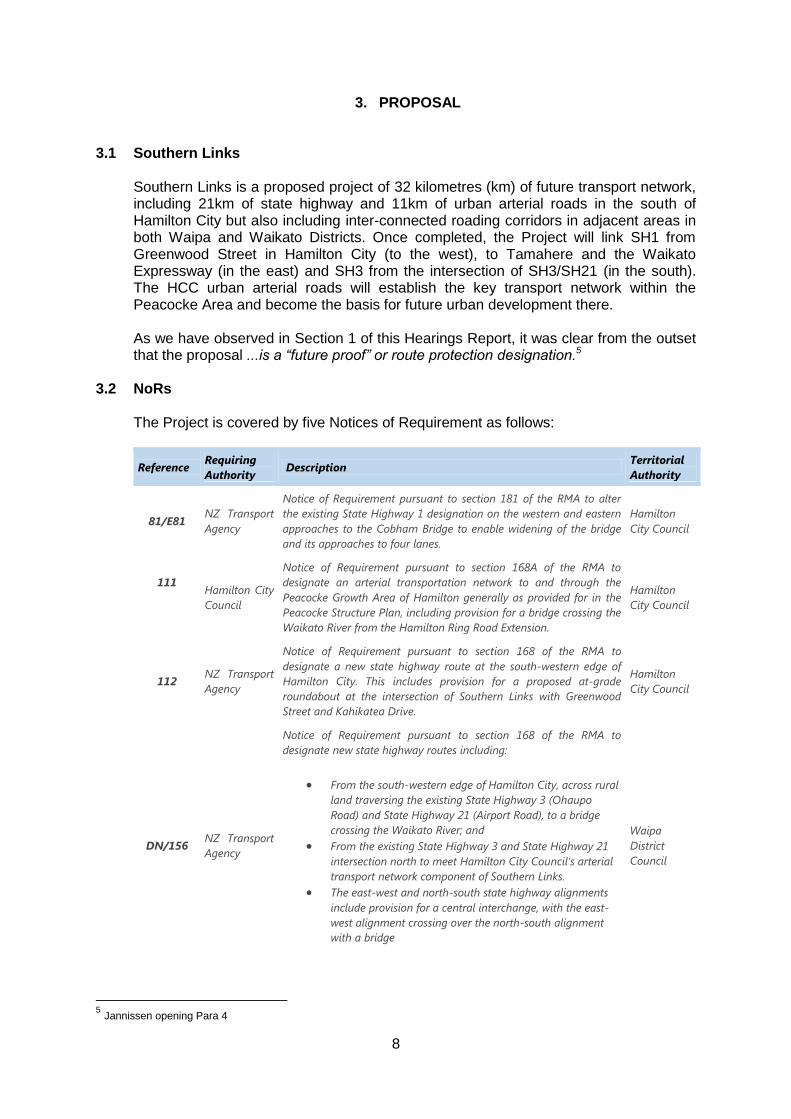
The Project is covered by five Notices of Requirement as follows:
Reference Requiring
Authority Description
Territorial
Authority
81/E81 NZ Transport
Agency
Notice of Requirement pursuant to section 181 of the RMA to alter
the existing State Highway 1 designation on the western and eastern
approaches to the Cobham Bridge to enable widening of the bridge
and its approaches to four lanes.
Hamilton
City Council
111
Hamilton City
Council
Notice of Requirement pursuant to section 168A of the RMA to
designate an arterial transportation network to and through the
Peacocke Growth Area of Hamilton generally as provided for in the
Peacocke Structure Plan, including provision for a bridge crossing the
Waikato River from the Hamilton Ring Road Extension.
Hamilton
City Council
112 NZ Transport
Agency
Notice of Requirement pursuant to section 168 of the RMA to
designate a new state highway route at the south-western edge of
Hamilton City. This includes provision for a proposed at-grade
roundabout at the intersection of Southern Links with Greenwood
Street and Kahikatea Drive.
Hamilton
City Council
DN/156 NZ Transport
Agency
Notice of Requirement pursuant to section 168 of the RMA to
designate new state highway routes including:
From the south-western edge of Hamilton City, across rural
land traversing the existing State Highway 3 (Ohaupo
Road) and State Highway 21 (Airport Road), to a bridge
crossing the Waikato River; and
From the existing State Highway 3 and State Highway 21
intersection north to meet Hamilton City Council’s arterial
transport network component of Southern Links.
The east-west and north-south state highway alignments
include provision for a central interchange, with the east-
west alignment crossing over the north-south alignment
with a bridge
Waipa
District
Council
5 Jannissen opening Para 4
9
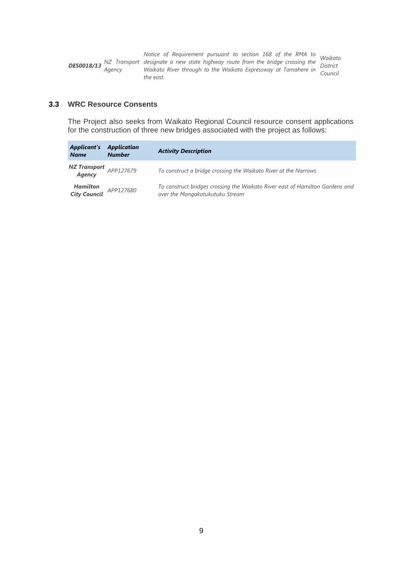
DES0018/13 NZ Transport
Agency
Notice of Requirement pursuant to section 168 of the RMA to
designate a new state highway route from the bridge crossing the
Waikato River through to the Waikato Expressway at Tamahere in
the east.
Waikato
District
Council
3.3 WRC Resource Consents
The Project also seeks from Waikato Regional Council resource consent applications for the construction of three new bridges associated with the project as follows:
Applicant’s
Name
Application
Number Activity Description
NZ Transport
Agency APP127679 To construct a bridge crossing the Waikato River at the Narrows
Hamilton
City Council APP127680
To construct bridges crossing the Waikato River east of Hamilton Gardens and
over the Mangakotukutuku Stream
10
4. SUBMISSIONS
4.1 NZTA and HCC NoRs
As noted in Section 2, including the late submissions (which we consider in Section 5 following of this Hearings Report) there were 88 submissions to the NoRs. Although the content of any one submission may be directed at just one of the NoRs many submitters referred in their submissions to more than one or all of the NoRs. We were encouraged by the Requiring Authorities to regard Southern Links as one project. We have therefore preferred to view the submissions globally. The S42A Report observed (and we agree) that: The matters raised in the submissions vary, which reflects the complexity and size of the project. Generally those matters raised in the submissions can be categorised as relating either to the effects of the proposed works including construction and operation and the effects of the proposed designations including the extended lapse period.6 The S42A Report summarised the principal matters raised by submitters as follows: a) Impacts on road networks as a result of the project; b) Vehicular access to property; c) Noise and vibration effects, both construction and operational; d) Social effects, including community severance and disruption; e) Visual and landscape effects of the project; f) Consequences of the 20 year lapse period such as blight and uncertainty for
landowners; g) Air quality effects (dust during construction and vehicle emissions during both
construction and operation); h) The necessity of the project and whether there has been adequate consideration
of alternatives.7
A summary table of the submissions was included in the S42A Report8 4.2 Applications to WRC
As also noted in Section 2.4, there were seven submissions lodged in respect of the WRC applications for three bridges, although 4 of these submissions addressed matters related to the NoRs. All submitters in respect of the WRC applications were also submitters to one or more of the NoRs. Four of the WRC submitters appeared before us9
. One of the WRC submitters tabled a brief of evidence but did not appear (HNZ). We gained the impression that, with the possible exception of Mangakotukutuku Stream Care Group, the submissions to WRC were essentially part of the wider concerns about the whole Southern Links project, and the WRC submissions were lodged for completeness rather than out of any particular concern about any of the three bridges. Certainly there was no expert evidence which challenged some aspect of any of the three bridges.
6 S42A Report para.4.1
7 Ibid para.4.2
8 Ibid. Appendix C
9 Submitters Bevan, Fletcher, Mangakotukutuku Stream Care Group and Riverside Golf Club
11
Accordingly we formed the view that the WRC consents should follow the outcome of the NoRs.
4.3 Submissions in Support
A number of submissions were generally in support of the proposal. Future Proof in particular was very keen that Southern Links and its key interchanges be completed for the reason that the Project is a key assumption underpinning the growth settlement plan for the sub region. The National Road Carriers supported the proposal recognising the efficiencies it would create for its members.
4.4 Consideration of Submissions Rather than deal with the submissions submission by submission, we have considered effects in Section 6 of this Hearings Report under similar headings as were presented to us in evidence at the Hearings, as follows: (a) Transportation Planning & Traffic Management (b) Noise (c) Vibration (d) Visual & Landscape (e) Social (f) Ecology (g) Storm water & Drainage (h) Air (i) Contaminated Material (j) Aviation (k) Archaeology (l) Positive Effects
12
5. PRELIMINARY ISSUES 5.1 Late Submissions
The submissions lodged by the following were late: Submission #74 Fletcher, Charles and Marion. Submission #75 Turner, Christine. Submission #76 Litchfield, Hugh William. Submission #77 Clentworth, Michael J. Submission #85 Harrison, Philip Andrew. And Submission #86 St Stephens Church Via Jane Manson. We considered them and on 24th April, 2014 issued a Minute allowing those submissions and recording: Accordingly those submissions are valid and the submitters may participate in the proceedings accordingly. It was subsequently discovered that the submission of M N & M M Shaw had been lodged within the required time but had been misplaced (and was not therefore taken into consideration in the initial s42A Report). When the circumstances were reported to us, we advised the Hearings Administrator that in our view the submission was valid and should be treated by all parties accordingly. We heard Mr Shaw at the Substantive Hearing.
5.2 Scope
Counsel for each of the requiring authorities made submissions in relation to “out of scope” matters. These arise in respect of: matters that are outside our jurisdiction under RMA; evidence that is given by a particular submitter which is outside the scope of that
submitter’s formal submission.
(1) Jurisdiction a) Public Works Act 1981 (PWA)
Several submitters saw the proceedings before us as a means to advance their case for compensation under the PWA in respect of land proposed to be taken, whether that be by way of timing or value. Compensation to any directly affected landowner is dealt with either by negotiation between the parties or under the provisions of the PWA. Those submissions, discussions, negotiations and settlement arrangements have no place in the RMA jurisdiction. Accordingly we take that issue no further in these proceedings.
b) Separate Approvals
There are a number of additional statutory approvals which will be required before the Project could proceed. Some of these are under RMA (consents for
13
earthworks, stormwater, discharge and the like). In that respect we recognise ecology will again be an issue in that process. As we observed in the Waikato Expressway Decision, in our view conditions relating to ecology may be better suited in resource consent conditions rather than a designation conditions. However, because those consents will not be sought until the detailed design stage (i.e. some years hence), we have included the relevant ecology conditions in the respective NoRs, noting that this is the approach adopted by the Requiring Authorities and the s42A Report writers. Other approvals are required under separate legislative processes: Heritage New Zealand approvals under the Heritage New Zealand Pouhere Taonga Act 2014; Department of Conservation under the Wildlife Act 1953; and Local Authority procedures under the Reserves Act 1977. We have no jurisdiction to deal with any of those matters.
c) Loss of Property Value
A number of people expressed concern about their property values. However, there was no quantitative evidence tendered on that issue. There is now significant case law in the Environment Court to confirm that any change of property valuation is likely to be as a result of an effect which we are duty bound to consider anyway. The movement in valuation is simply corroboration of that effect or effects. Were we to take into account property valuations as a separate issue then that may amount to “double counting”. Ms Janissen put the position as follows: 42.1 The potential impact of the Project on property values is better assessment as a
reflection of effects (eg noise, landscape, vibration and dust), rather than
attempting to speculate the market’s response to these effect[s] as a resulting
change in property value.
42.2 The proposed designation and resource consent conditions will adequately
address the direct effects of the Project. Therefore, no additional compensation
for reduced property values is required.10
We accept that submission. We address property values no further.
(2) Evidence Outside the Scope of a Formal Submission
Hamilton City Council lodged a submission generally in support of Southern Links. The submission did not raise any concerns with the proposed Greenwood Street roundabout. However, evidence tendered by Mr Ryan from Hamilton City Council sought safety improvements on that roundabout along with a range of other amendments to the NoR conditions.
10
Janissen Opening Submissions para.42
14
Ms Janissen submitted that Mr Ryan’s evidence was out of scope because it was not within the HCC formal submission. Mr Ryan generally accepted that and withdrew various sections of his written statement. In our assessment, nothing turned on Mr Ryan’s evidence and we do not need to discuss scope further.
5.3 Consultation
Several submitters suggested there had been a lack of consultation. Evidence on consultation was given for the Requiring Authorities by Mr Eccles We are satisfied that there has been more than adequate consultation, although, as might be expected, not every party consulted necessarily feels that has been the case. Furthermore, that consultation has been on-going.
We consider that adequate consultation has occurred in respect of all NoRs and consents before us, particularly in that it has allowed stakeholders to understand the proposal and afforded them the opportunity to raise their concerns with the Requiring Authorities and express those concerns in their submissions and at the Substantive Hearing. Although there is no obligation to consult on an applicant for a resource consent nor on a requiring authority in respect of a designation11, we are also satisfied that parties with concerns about the proposal have been able to ensure that their issues have been identified and taken into account in our deliberations.
5.4 Witness Conflicts In several instances in this case, witnesses who appeared at the hearing had appropriate qualifications and experience for them to be accepted as experts in a particular field but they also had either a personal interest in the outcome (e.g. an interest in affected property) or their employer as a party was advancing a particular position on the matters under consideration. Counsel for HCC, Ms Le Bas drew our attention to Briggs v Christchurch City Council[1], a case in which the Environment Court criticised one such expert for giving evidence as an expert when they were in a position of conflict or arguing their own cause. Some of those experts at this hearing who had such a conflict (e.g. Mr Keyte) recognised the conflict and declared it. Furthermore, those witnesses did not claim to be an expert (despite their relevant expertise) and/or did not refer to the Court’s Code of Conduct for expert witnesses. In addition, if they were a submitter, they did not pre-circulate their evidence (as there was no direction to pre-exchange any submitter evidence other than expert evidence). The approach from some other expert witnesses with a potential conflict was not as careful or considered. Where such a potential conflict arises, it does not go to admissibility of the evidence but rather to the weight to be accorded that evidence. What we say here therefore is
11
RMA s36A [1]
Briggs v Christchurch City Council ENC C45/08, 24.4.08
15
that, where we perceived a potential conflict of the kind we identify in this Section of our Hearings Report, and whether or not a witness declared that potential conflict and/or took the appropriate steps in that regard, we took particular care in weighing the evidence of that expert.
5.5 Decision Time Limits Before us were five NoRs and three applications for resource consents. The RMA prescribes no time limits for delivering a recommendation or decision in respect of a NOR but RMA s115 requires that notice of a decision on a resource consent must be given within 15 working days after the end of the hearing. The Reconvened Hearing ended on 1st September, 2014. Accordingly notice of the decision in respect of the resource consents should have been given by the 22nd September, 2014. Before the Reconvened Hearing ended, we intimated to the parties that we considered that because Southern Links was to be considered as one project, our decision on the WRC resource consents should be issued at the same time as the recommendations and decisions on the NoRs. Given that the Hearing had been lengthy and the issues of the whole Project relatively complex, we thought it unlikely that we could deliver a comprehensive report and decisions covering all matters (including the consents) within the time prescribed for the resource consents. RMA s37 gives us power to extend any time limit under the act but if any extension is in excess of doubling the time limit then pursuant to RMA s37A(5) we must first have the approval of the Applicants/s to extend. We invited the Applicantss to consider and indicate their attitude to an extension of time under RMA s37 and 37A to the end of October 2014 to deliver our recommendations and decisions. We record that before the end of the Hearing: Counsel for each of NZTA and HCC both agreed under RMA s37A(5) to the
extension of time for notification of the WRC resource consent decision to 31st October, 2014.
We therefore immediately made an oral decision granting a waiver accordingly.
16
6. EFFECTS
6.1 Approach
As we have recorded in Section 2 of this Hearings Report, the proposal under consideration involves five separate NORs by two different Requiring Authorities (NZTA and HCC) to three Territorial Authorities (HCC, Waikato DC, and Waipa DC), as well as three resource consent applications to WRC for bridge structures (one by NZTA and two by HCC). Whilst we are required to make separate decisions/recommendations on each NOR and resource consent application, the Southern Links proposal is an integrated, regional scale transportation project. We note that various issues have overlapping jurisdictional boundaries and hence are relevant to both the NoRs (territorial local authority jurisdiction) and the resource consents (WRC jurisdiction). In this section of the Hearings Report we have considered effects across all the matters before us discipline by discipline
6.2 Transportation Planning & Traffic Management;
While some Transportation Planning issues are relatively localised in scale (for example how the proposed Peacocke Structure Plan and Southern Links proposal need to inter-relate) the transport planning implications of Southern Links predominantly need to be considered and assessed in an integrated, overall manner. A slightly different situation arises in respect of traffic safety and traffic management issues, because the associated effects occur at a variety of scales. That is to say that while the overall traffic flows and consequences need to be looked at in an integrated whole-of-proposal manner (because traffic management at one part of the transport network directly affects traffic management at other locations), a number of the traffic related effects are localised and site-specific and also need to be assessed at that scale.
Accordingly, we have considered transportation planning and traffic management issues at a variety of scales, dependant on the relevant circumstances relating to each matter, as we set out further below.
6.2.1 The Requiring Authorities’ Evidence
The high level rationale for the Southern Links Project was provided by Mr Robert Brodnax. He explained the importance of having an efficient roading network to cater for the on-going growth in the Waikato economy12. He also explained the relevant national and regional level statutory and policy context13 whilst also explaining the importance of Southern Links in augmenting the current Waikato Expressway project and how Southern Links will bolster the overall benefits of the expressway and the benefits it will promote14. Whilst stressing the longer term benefits of the proposal, if it was ultimately constructed, Mr Brodnax acknowledged that there is currently no investment allocated in the 2012 National Land Transportation Programme for the design and construction of Southern Links, nor in HCC’s Long Term Plan15. Mr Brodnax stated that investment in Southern Links will be strategically driven nationally to ensure optimal activities and timing, and that in the shorter term, central government investment will likely continue to focus on the so-called “Roads of National Significance”, or RoNS, rather than Southern Links, the funding for which will be
12
Brodnax EiC – paras 9 -15 13
Ibid – paras 16-43 14
Ibid – para 79 15
Ibid – para 30
17
limited in the medium term16. He went on to explain17 that the designation of the project route is necessary to achieve interim and long term protection of the land and that the short term goal is to route protection to safeguard the future transport corridor.
Mr Dowsett then set out the background to the project, noting that the origins of Southern Links derive from studies and investigations that were initiated in the early 1960’s18 and which had been updated and refocused at various times since then. He went on to refer to NZTA’s objectives for Southern Links19 which are to:
Contribute to the objectives of the New Zealand Transport Strategy, the LTMA
and the WRLTS
Contribute to the Transport Agency, HCC, Waikato District Council, Waipa District Council and Waikato Regional Council’s strategic objectives for integrated land use planning, urban growth and economic development including Future Proof;
Contribute to and support the HCC strategies, in particular Access Hamilton and Hamilton’s Urban Growth Strategy;
Support economic development for the Hamilton and southern/south-western Waikato sub-region, including appropriate provision for accommodating utilities and services within the road corridor;
Contribute to the objectives of the Waikato Expressway (improve journey time and reliability, ease congestion, improve transport connections for economic growth, access to markets, transport efficiency and road safety);
Develop an appropriate road hierarchy in the sub-region;
Improve options for public transport, walking/cycling and demand management, both within Hamilton City and Waikato and Waipa District Council areas adjoining Hamilton City;
Improve amenity and safety through reduced conflict and crash potential along the existing SH1, SH3, SH21, existing key arterial and collector routes within Hamilton City and key local roads;
Minimise and mitigate adverse environmental, cultural and social effects; and
Protect the long-term function of the State highway and the key arterial or collector road networks.
He also explained that these objectives had been developed collaboratively with HCC20, noting that HCC had additional objectives for those elements of Southern Links that were within its jurisdiction. In that regard, Mr Denton stated as follows21:
23 … [T]he delivery of the Project will facilitate the achievement of HCC’s strategic
objectives for facilitating economic development and the provision for integrated
16
Brodnax EiC – para 34 17
Ibid – paras 49 and 92 18
Dowsett EiC – para 13 19
NZTA NoR Para 3.3.2 20
Dowsett EiC para 27 21
Denton EiC – para 23 - 25
18
land use planning and infrastructure to support the Peacocke Structure Plan and broader requirements for regional and city wide infrastructure.
24 The Project will provide the opportunity to complete HCC’s strategic transport network. In doing so, this will enable the redistribution of freight and regional trips from the south (including the Waikato Regional Airport and Titanium Park) to appropriate corridors and improve connectivity around Hamilton which will reduce travel trips and demand on existing transport networks.
25 The use of the RMA designation tool clearly signals HCC’s infrastructure intent and will secure sufficient land to facilitate the provision of an integrated transport system, three waters infrastructure network and associated network utilities to support the future urban development of the Peacocke Structure Plan Area and reduce the risk of ‘build out’ from ongoing development in the area.
Whilst important in understanding the rationale for the project, these various objectives are also important in terms of the s171 and s168A evaluations we are required to exercise and we return to that matter later in this decision. Mr Dowsett identified a number of issues associated with the Hamilton transport network, namely22: 29.1 Much of the traffic from the south which travels along SH1 and SH3 has a
destination within Hamilton City, causing congestion in the central business district.
29.2 The existing transport network in the south of Hamilton experiences congestion at peak times.
29.3 The current route for SH1, between Kahikatea Drive and the State Highway 26 roundabout at Hillcrest, does not adequately cater for the mix of heavy vehicles bound for the west of Hamilton City and local commuter trips.
29.4 SH3 between Airport Road and Lorne Street experiences congestion and conflict between freight and local journeys.
29.5 The southern access to the Hamilton Western Corridor is predicted to become progressively worse with sections of SH1 and SH3 experiencing unacceptable levels of service by 2020.
30 The pressure on the network from future growth is a concern for the economic
performance of the region. Significant residential, commercial and industrial growth is planned in the Peacocke area and to the south of Hamilton. The forecasted increase will put a heavy strain on the roading network in the region.12
31 A “whole of network” approach is required to ensure this growth does not compromise access to commercial and industrial areas within Hamilton. This has been reinforced in Mr Brodnax’s evidence.
22
Dowsett EiC– para 29
19
32 The Project will help to resolve existing issues, but more importantly, will help alleviate the predicted efficiency and capacity issues from future growth as forecasted in the Future Proof Strategy.
Mr Dowsett then set out his assessment of why a 20 year lapse period for the NoRs was required. We discuss that in Section 9.1 of this Hearings Report. In addition to setting out HCC’s objectives for the project, Mr Denton explained to us:
HCC’s role in previous transport route assessments (as generally described by Mr Dowsett23
How roading was only part of the infrastructure requirements for the growth of Hamilton to the south of the current urban area in the Peacocke Structure Plan area, and that of similar importance are the “three waters” considerations (i.e. water supply, wastewater servicing, and stormwater management) and other utilities in that regard24. In response to our questions, Mr Denton explained the importance of the proposed new bridge adjacent to Hamilton Gardens in providing a platform to convey services from the north-east across the Waikato River.
Although HCC currently has no funding budgeted to acquire land from the approximately 44 property owners directly affected by the HCC NoR, s 185 of the RMA is available to landowners at any time and HCC will likely include property purchase funding in its 2015 – 2025 Long Term Plan and 30 Year Infrastructure Plan, provided the HCC designation is confirmed25.
Against that background, a relatively high level framework, Mr Eccles explained to us the process that had been followed in identifying the specific route that was subject to the NORs and the alternatives that had been considered. In particular, he explained what is referred to as the “ACRE process”, which starts with delineating the Area of interest (this being the “A” in ACRE). In that regard, Mr Eccles reminded us that the Southern Links network was required to connect to five points in the wider roading network, namely:26
The Kahikatea Drive/Greenwood Street corner along the western industrial corridor of Hamilton.
Cobham Drive (SH1) adjacent to Cobham Bridge where it leads directly to the Hamilton CBD.
The designated Hamilton Ring Road connection point with Cobham Drive.
State Highway 3 (SH3) generally in the vicinity of Airport Road (SH21).
The Waikato Expressway (SH1).
Our understanding is that the first four of these identified locations are effectively fixed locations, while the fifth is an approximately 5km length of the Waikato Expressway extending southward from Tamahere.
23
Denton EiC – paras 27 - 32 24
Ibid – paras 33 - 38 25
Ibid – paras 42 - 43 26
Eccles EiC (First) – para 33
20
A constraints map of the wider area was then created, as was a series of 14 conceptualised roading networks (our term) in order to stimulate discussion at a series of workshops with a multi-disciplinary team of the Requiring Authorities’ advisors27. By overlaying the range of networks and the constraints an overall area of interest was then delineated. No consultation was undertaken at this juncture28. The second stage was undertaken at these same workshops and considered potential transportation Corridors (the C in ACRE) within the area of interest. The corridors were formulated by connecting the 5 “fixed” connection points with straight lines. The corridors were kept several kilometres wide to create a grid pattern29. The corridors to the western side of Hamilton and the southernmost east-west corridor were discounted because of social, environmental and cost factors and concerns as to whether any route there could meet the project objectives.30 The third stage was then to identify Routes (the R in ACRE) within the feasible corridors. The identified corridors and some potential route networks:
Formed the basis of information for public open days;
Were the basis for further consultation;
Were noted as being illustrative; and
Had to consider the practical and technical requirements of a roading network, which has particular geometric and design standards that need to be satisfied, meaning that while it may have been possible on paper to avoid all potential constraints and join the “best” alignments in different sectors of the network, such a route may not function in practice.31
A Multi Criteria Analysis (or MCA) methodology was then used to develop preferred routes. This process used a multi-disciplinary expert workshop approach that enabled NZTA’s project team to discuss each of 12 potential routes within the identified corridors. The workshops drew on a wide range of information, including that provided by landowners.32 Each route was evaluated and scored against a range of criteria and the top scoring route options were then assessed using a computerised transportation model to assist evaluation against the project objectives and this resulted in the selection of the preferred network route. This 400 – 500 metre wide route (increased in places where multiple constraints existed) allowed for further refinement later and was the subject of further public consultation.33
Stage 4 then involved the refinement of the route to select the areas of land that are the subject of the current Notices of Requirement. This is referred to as the Easement stage (the E in ACRE). The details of this process were addressed by Mr Eccles and included as Appendix D to the AEE.34
27
Eccles EiC (First) – 34 - 40 28
Ibid – para 41 29
Ibid – para 43 30
Ibid – para 46 31
Ibid – paras 47 - 53 32
Ibid – paras 54-55 33
Ibid – paras 62 - 63 34
Eccles EiC (First) – paras 64 - 76
21
Mr Eccles also explained35 to us that a “Do-Minimum” package of works was developed by the requiring authorities to provide a baseline against which to compare network options and economics. The “Do-Minimum” network was the minimum package of works that would be required to maintain an acceptable level of service on existing routes in the Project area. That package of works was considered not to be satisfactory, because of various congestion, safety and logistical factors at various locations and, even if adopted, it too would have required route protection measures to be adopted for the major and minor arterial routes in the Peacocke Structure Plan area.36
NZTA and HCC also investigated options other than designation to protect the Southern Links network. After comparing a do-nothing and other planning tools that might be adopted, designation was preferred and adopted.37 Travel Demand Management and enhanced Public Transport options were also assessed and found not, on their own, to be sufficient to meet the Project objectives.38
Mr Eccles also set out various alternative design aspects that were considered and rejected39, namely the location of the three key bridge crossings and the location and configuration of various intersection points.
He made particular mention of the proposed bridge crossing south of the existing Narrows Bridge (and which bisects the Narrows Golf Course), the crossing of the Mangakotukutuku Stream, and where full or partial interchanges or at grade intersections (including roundabouts) were preferred. Mr Eccles’ conclusions include the following:
155 The requiring authorities adopted a systematic and best practice approach to
developing the final network alignment. At that point the requiring authorities considered whether designation of the network was the most appropriate mechanism to achieve long term protection of the route, and confirmed that it was.
156 Adequate consideration was also given as to whether other methods could
achieve the Project objectives, such as relying on enhanced public transport and TDM in the Project area.
157 In my opinion, the network identification and development process adopted
therefore achieves the statutory requirements of evaluation of alternatives, as set out in sections 171(1)(c) and 168A(3)(b) of the RMA.
We accept the thrust of Mr Eccles’ evidence in this regard, noting in particular that certain aspects of the proposal are inevitably influenced by the need for Southern Links to join and integrate with the remainder of the roading network. The one possible exception to this concerns the connection to State Highway 1 where, at least in theory, a relatively long stretch between the Tamahere Interchange and the Cambridge Section of the Waikato Expressway is potentially available. We return to that point later.
35
Ibid – para 77 36
Ibid – para 81 37
Ibid – para 82 - 85 38
Ibid – paras 86 - 90 39
Ibid – paras 91 - 102
22
Mr Lion-Cachet’s evidence in chief set out the traffic modelling that had been undertaken in support of the Southern Links proposal. He concluded as follows:
184 My evidence discusses the role of transport modelling in the selection of the preferred network. Significant consideration has been given to the strategic need, route selection, alignment, and form of intersections through the ACRE and MCA processes.
185 The preferred network provides significant additional capacity and route choice to traffic, as well as relieving congestion and delay, and improving travel times along key corridors and intersections. Network resilience is introduced through the new links, with improved access to Hamilton west (especially for freight traffic), and to the CBD.
186 The preferred network provides significant additional capacity and route choice to traffic, as well as relieving congestion and delay, and improving travel times along key corridors and intersections. Network resilience is introduced through the new links, with improved access to Hamilton west (especially for freight traffic), and to the CBD.
187 The peer reviewed economic evaluation and staging methodology has provided a robust but conservative BCR, using a transport model that has been declared fit for purpose.
188 Submissions were have been received which questioned or objected to the selection of the preferred network, the need for the project, the removal of the south facing ramps at the Tamahere Interchange, the traffic conditions on Tamahere Drive and other Tamahere local roads, Bader Street, economic evaluation and staging, and Hamilton Airport connections and staging. I have responded to each of the submissions in my evidence.
…
190 The implementation of the Project provides a road network that mitigates the effects of future traffic growth by providing high standard infrastructure, which allows the existing local infrastructure to be better suited to local functions.
In response to our subsequent questions of the Requiring Authorities, Mr Lion-Cachet produced a second supplementary statement (his first supplementary statement addressed matters raised by the supplementary s42A Report writers and we consider those aspects later) that addressed two issues raised by us, namely:
Whether or not modelling of Southern Links included the traffic generated by the Hamilton Section of the Waikato Expressway, which was expected to be operational prior to Southern Links being constructed; and
The implications for traffic safety on the Southern Links with and without retention of the existing south facing ramps of the Tamahere Interchange. This matter was also addressed in some detail by submitter Mr Tony Keyte, and we refer to his evidence later.
23
Mr Lion-Cachet stated:
12 In conclusion, the Project model includes the Waikato Expressway, and changes to the Waikato Expressway subsequent to the modelling have been assessed appropriately. No further modelling is required.
… 20 In conclusion, I reconfirm my previous evidence where I have determined that the
impacts on Tamahere Drive are low, and that the impacts on the Tamahere Drive roundabout on the Eastern Section of the Project are low.
29 In conclusion, I confirm that the Project has assessed the Tamahere Drive
roundabout with and without the Tamahere Interchange south facing ramps. … 34. … [T]he expected traffic flows on Day Road as a result of the Project are
expected to be low – less than 2000 vpd, or about 1 vehicle every 3 minutes. The Tamahere Interchange south facing ramps (whether open or closed) have no impact on the traffic flows on Day Road … . As a result the approximately 100 m separation between the Day Road intersection and the Tamahere roundabout will not lead to any safety or queuing issues, as claimed by Mr Keyte.40
6.2.2 Submissions / Submitter evidence
(a) Tamahere Expressway Connection We deal firstly with the evidence of Mr Tony Keyte, insofar as it deals with transportation planning and traffic effects. Mr Keyte is a very experienced civil engineer, with specialist traffic engineering qualifications and experience. His firm also provides consulting advice to both NZTA and HCC.
However, Mr Keyte did not provide his evidence as “expert evidence”. We have commented on that in Section 5.4 of this Hearings Report.
Mr Keyte’s evidence was produced on behalf of the Keyte Family Trust, the owner of a lifestyle property at 36 Day Road which is some 65 metres from the designation boundary in the vicinity of the proposed Tamahere Drive roundabout. We deal with the wider aspects of his evidence elsewhere in this decision and address transportation planning / traffic effects below. We record that his evidence only concerned the portion of Southern Links between the State Highway 21 interchange and the State Highway 1 interchange.
Mr Keyte was concerned about the separation distances involved in the connection of Southern Links to State Highway 1, and considered that the selected route lacked good traffic and road safety principles and design and that an alternative route that joins with the Cambridge Section of the Waikato Expressway at the Pickering Road grade separated interchange was more appropriate.41 He also considered that this option would ensure more appropriate separation distances between interchanges on
40
Lion-Cachet 2nd
Supp Ev. 41
Keyte EiC – para 3.8
24
State Highway 1. Mr Keyte considered that the 600 metre separation distance between the south facing on-ramp at the Tamahere Interchange and the proposed Southern Links off-ramp was not desirable and would result in the unsafe process of traffic “weaving”42, which can be observed at some places on Auckland’s Southern Motorway.43 As a consequence Mr Keyte considered that although NZTA had advised the Commissioners that the closure of the Tamahere Interchange south facing ramps was not now part of the current proposal (and if proposed in future would be subject to a subsequent RMA process) any such future process would be largely predetermined, on safety grounds, if the Southern Links designations were confirmed44.
In response to this and other submissions, NZTA proposed more robust conditions regarding the south facing ramps at Tamahere. As summarised in Ms Janissen’s closing submissions, NZTA now proposes the following condition (condition 23) on the Waikato NOR45:
Tamahere Interchange South Facing Ramps
The NZ Transport Agency shall not commence Construction Works, construct or implement that part of the designation within the Waikato District area, including the roading sections located east of the Waikato River and the Waikato Expressway interchange until either: a) The Tamahere interchange south facing ramps are closed; or b) An independent Road Safety Auditor(s), appointed by the NZ Transport Agency
and in consultation with Waikato District Council makes a road safety audit of the final design plans for construction (in accordance with the NZTA Road Safety Audit procedures) in relation to the adequacy and safety of the traffic operations as a consequence of the co-existence of the existing south facing ramps at the Tamahere interchange and the north facing ramps at the proposed Southern Links Waikato Expressway interchange. And, following receipt of the safety audit recommendations, and further designer comment on the audit recommendations, the NZ Transport Agency and Waikato District Council jointly determine the works can be implemented.
i) Where any such agreement is unable to be made between the NZ
Transport Agency and Waikato District Council, the dispute resolution process set out at Condition 15.3 shall be applied.
ii) Where the NZ Transport Agency determines the ramps are to be closed, it
will not make any application without first consulting with the Tamahere community on any proposed closure of the south facing ramps, irrespective of whether the process requires an Alteration to Designation, or whether some other publically notified process is to be followed.
We asked Mr Apeldoorn, the traffic consultant advising the s 42A Report writers, whether he considered that the outcome of a safety audit of the Tamahere south facing ramps meant that closure would be inevitable if Southern Links was approved. He was firmly of the opinion that it would not be and we accept that.
42
Ibid – paras 3.10 – 3.12 & 3.19 – 3.20 43
Ibid – paras 3.10 – 3.12 44
Ibid– para 3.3 45
Janissen Reply para 194
25
Mr Keyte also questioned the accuracy of the traffic modelling that Mr Lion-Cachet referred to in his evidence. Mr Keyte’s concerns centred around his opinion that as far as southbound traffic was concerned no east west link was included from the “Cherry Lane Interchange” (which we understood to refer to the Hamilton South Interchange) and the lack of an integrated assessment of the Waikato Expressway and Southern Links projects.46 He estimated (acknowledging that he did not have the resources to calculate numbers exactly) that the southbound traffic volumes would be some 10 times higher than calculated by Mr Lion-Cachet once the south facing on ramps at Tamahere were removed47 and that the data used in the model and the assumptions used were out of date with the factual situation48. As discussed above, we accept Mr Lion-Cachet’s explanation as to the accuracy of the information used in his assessment. Mr Keyte also observed that the Day Road, Pencarrow Road and Tamahere Drive circuit was utilised by pedestrians, cyclists and horse riders. He considered that such uses would be able to continue, provided that the traffic volumes assumed by NZTA were correct49, although he noted that the footpath linking Tamahere Drive to the Tamahere Section of the Waikato Expressway (which was to be used by cyclists) would be severed by Southern Links.50
We are satisfied that subject to the imposition of appropriate conditions that the adverse effects identified by Mr Keyte can be addressed appropriately.
(b) Golf Course The selection of the alignment that connects Southern Links to State Highway 1 was also addressed in some detail by Ms M-A Gill the Chairperson of the Riverside Golf Club51. She considered that the selected alignment was not appropriate because it would, in effect, cut the golf course (the Narrows course) in two. We accept that the connection between Southern Links and SH1 will cause significant adverse effects on the Riverside course. However, we note that all potential linkages between Southern Links and SH 1 would need to pass through either the Narrows or adjacent Lochiel course. As such, while the effects on the golf course need to be acknowledged and appropriately addressed we are not satisfied that the selected route should be discounted because of those effects.
(c) Titanium Park Access The Titanium Park Joint Venture (“TPJV”) comprises Titanium Park Ltd (a subsidiary of Waikato Regional Airport Ltd), Todd Property and McConnell Property and was established to develop the Titanium Park Business Park that surrounds Hamilton Airport. That Business Park began development in 2008 following Plan Change 57 to the Waipa District Plan becoming operative. Counsel for TPJV, Mr Berry, advised us that whilst TPJV supports Southern Links, in principle, the manner in which its proposed “Western Precinct” would connect to the State Highway network before Southern Links is constructed is of particular concern. There were three key aspects in that regard:
The need for an interim upgrade of the SH3 / SH 21 Intersection; and
46
Keyte EiC – para 3.14 47
Ibid – para 3.17 48
Ibid – para 3.18 49
Ibid – para 5.1 50
Ibid – para 5.2 51
Riverside Golf Club is the result of a merger between Narrows and Lochiel Golf Clubs
26
The need to upgrade the SH3 / Ingram Road intersection, also for interim access reasons.
The associated uncertainty that arises from a long lapse period; Following directions from us, NZTA and TPJV filed a Joint Memorandum of Counsel52 that set out a confirmed position in respect of the matters noted above. In short, that agreement has resulted in both parties agreeing a process for addressing the SH3 / Ingram Road issue and the wording of additional conditions regarding an interim arrangement at the SH3 / SH 21 intersection. As such, we see no need to refer to those matters any further, and consider the proffered conditions adequately address the matter. We consider the lapse period in Section 9 of this Hearings Report.
(d) Titoki Sands
Ms K Drew prepared a pre-circulated statement of evidence on behalf of Titoki Sands. She also presented a shorter written summary at the hearing. Her evidence addressed three issues of concern, namely:
The closure of the south-facing ramps at the Tamahere Interchange;
The need for a specific connection to allow Titoki Sands to effectively connect to Southern Links; and
The associated uncertainty associated with a long lapse period.
Regarding the south facing ramps, Ms Drew supported the condition proffered by NZTA (see above), in principle and maintained that the safety audit required should be undertaken now to provide greater certainty to the Tamahere Community53. She also proposed an alternative to the condition proffered by NZTA. Ms Drew’s proposal was as follows:
Condition 23.1 A Stage 3 Road Safety Audit (in accordance with the NZ Transport Agency Road Safety Audit procedures applicable at the time) shall be carried prior to lodgement of the Outline Plan of Works for the final design. The Road Safety Audit shall be carried out by a suitably qualified and experienced independent practitioner jointly appointed by the NZ Transport Agency and Waikato District Council. The Road Safety Audit shall consider the adequacy and safety of the impacts of the north facing ramps of the Southern Links Waikato Expressway Interchange on the operational safety of the existing south facing ramps at the Tamahere Interchange. Condition 23.2 Following receipt of the Road Safety Audit recommendations, and further design comments on the audit recommendations the NZ Transport Agency and Waikato District Council shall jointly determine whether the southern ramps of the Tamahere Interchange should be closed and only after consultation with the Tamahere community has been undertaken. Where any such agreement is unable to be made
52
Joint Memorandum of Counsel on behalf of NZ Transport Agency and Titanium Park Joint Venture Regarding Access to the Western Precinct of Titanium Park – 1 September 2014 53
Drew Summary Ev – para 6
27
between NZ Transport Agency and Waikato District Council, the dispute resolution process set out at Condition 1.10 shall be applied.
For the reasons set out in paras 197 – 200 of Ms Janissen’s submissions in reply, we do not consider it necessary to adopt Ms Drew’s recommended conditions, noting also that an approval under the RMA will be necessary to allow those ramps to be removed and Mr Apeldoorn’s advice that the results of the audit would not be a fait accompli if the NZTA Waikato NoR for Southern Links is confirmed.
Regarding the proposed alternative access sought by Ms Drew, she stated that this was closely related to the closure of the south facing ramps and that the Requiring Authorities’ rebuttal evidence had gone some way to addressing her concerns.54 Given that the south facing ramps issue will be addressed at a later date and in a separate forum, we do not think any further specific access arrangements need to be prescribed at this time.
(e) Chinaman’s Hill Designation
Mr B Inger presented written evidence on behalf of Mr and Mrs Ingram, who are long term residents of Rukuhia adjacent to SH 3, and who also appeared at the hearing and spoke to a short written statement. From a traffic / transportation perspective, it was clear from both Mr Inger and Mr and Mrs Ingram that the relationship between the existing Chinaman’s Hill designation on SH3 that currently affects their property and Southern Links was of concern. Resolution of this matter progressed considerably during the hearing and by the conclusion of the proceedings NZTA had confirmed that it will uplift that aspect of the Chinaman’s Hill designation that affects the Ingram property. As we understand it, the only point of difference in that regard was that Mr and Mrs Ingram wanted this to occur within three months, while NZTA originally proposed 12 months. Ms Janissen advised us55 that although 12 months is generally necessary for a designation to be uplifted, NZTA was prepared to accept a condition requiring this to be achieved within 6 months of the confirmation of the NORs. We consider that to be an appropriate timeframe in the circumstances. (f) Peacocke Area
A number of submitters addressed the relationship between the Southern Links proposal and the land within the Peacocke Structure Plan (PSP) area within Hamilton City. In that regard, Mr N Savage, a Principal Planner employed by HCC, tendered evidence in which he presented the contents of the Structure Plan to us. That was a rather large amount of material (reflecting what appeared to us to be an exceedingly complicated set of planning provisions) and he helpfully highlighted what he considered to be the provisions that were directly relevant to Southern Links. The Adare Company Limited is an extensive landowner in the Peacocke Area. Ms I Dowling prepared a pre-circulated statement of evidence concerning transportation planning and Mr D Serjeant prepared a pre-circulated statement on wider planning matters.
At the commencement of the presentation on behalf of Adare, Mr Serjeant advised us that Mr J Lunday (an urban design specialist who pre-circulated a statement of evidence) and Adare’s legal counsel would not be attending the Hearing. Mr Serjeant stated that the reason for this was that Adare was relatively satisfied with the revisions
54
Drew Summary Ev – para12 55
Janissen Reply – para 170
28
to conditions proposed in the revised s 42A Report and that Adare’s appearance at the Hearing was confined to suggesting a number of amendments to further enhance conditions. Mr Serjeant stated that the conditions for Southern Links needed to be sufficiently broad in scope to allow for the flexibility to integrate with the development of the Peacocke area, and that he considered this to be the case. He also considered that the Master Plan for the Peacocke area needed to be taken into account when the detailed design of the Southern Links was being undertaken.
Ms Dowling presented a set of proposed conditions relating to the preparation of what she referred to as a “Traffic and Network Management Plan”. We have considered those conditions but consider that they are unnecessary. (g) Middle Road and Narrows Road Severance
The proposal would sever Middle Road half way between Narrows Road and Raynes Road . It also severs Narrows Road about 0.7km north of Ohaupo Road. This was of considerable concern to a number of submitters56 and Ms Penn, on behalf of the Middle and Narrows Road Focus Group articulated those concerns at the Hearing. As a consequence, we were careful to inspect the areas concerned on our site visit. As we understand it, residents of 8 dwellings on the southern end of Narrows Road will face an extra distance of 3-4 km for trips to and from the east but trips to and from other directions will be unaffected. For around 17 dwellings in the Narrows Road/Middle Road vicinity there will be an additional journey length of around 2km for local trips to and from the west and north and 4 km to and from the south. Ms Penn also described that the loss of existing roading connections with neighbouring properties would adversely affect community well-being. One suggestion Ms Penn and the Middle and Narrows Road Focus Group made in that regard was to include a vehicle underpass on Middle Road if Southern Links were to proceed. We acknowledge the disruption to those residents who currently utilise Middle and Narrows Roads. However, on balance we do not consider those effects to negate the wider benefits that Southern Links will provide. Nor do we consider the suggested underpass to be necessary. (h) Other Submissions A large number of submissions addressed matters that touched on transportation planning and traffic effects. We do not list all of them, nor address each and every submission specifically. Rather we deal with them thematically.
We firstly record that we have gained very clear first hand information about the concerns of property owners whose land is subject to the NORs – that is to say that is within the designation corridor and will potentially be subject to acquisition under the Public Works Act 1981. Many submitters considered that the selected roading alignments were inappropriate because of property acquisition and related issues. However, in Section 5.2 of this Hearings Report we have already accepted the submission by Ms Janissen57, that land acquisition involves a separate statutory
56 Jacquilyn and Damian Dawson, Brian Roslyn and Carol Griffin, Leslie Hammond, Graeme and Julie Lucas, Middle and Narrows Road Focus Group, Penn Paterson Partnership, Qi Zha and Xianghua Yan 57
Opening submissions for NZTA – para 38
29
process that is distinct from the RMA and matters relating to compensation and land acquisitions are outside our jurisdiction.
6.2.3 S 42A Report
There was initially considerable differences of opinion between the applicants’ witnesses and the s42A Reports authors regarding traffic planning matters, although that situation evolved during the course of the Hearings, and in particular during the adjournment. It suffices to say that by the time of the Requiring Authority replies at the Reconvened Hearing, all traffic planning matters were agreed as between the applicants and the s42A Report writers, including in respect of conditions.
6.2.4 Findings
For all the reasons set out above, we are satisfied that the Requiring Authorities have given adequate consideration to alternative sites, routes and methods and that the proposal is reasonably necessary to meet their objectives for the proposal. We consider that the conditions which we now impose relating to Transportation Planning & Traffic Management appropriately avoid, remedy or mitigate adverse effects.
6.3 Noise
The tension evident throughout the hearing regarding what level of assessment is required for and what conditions should be placed on a designation for works that are to be undertaken a likely minimum of 15 years hence, as opposed to that on a resource consent or designation that is to be commenced in short order, arose again in respect of noise and vibration.
Mr Vincent Dravitzki and Dr Stephen Chiles were engaged jointly by the two Requiring Authorities, NZTA and HCC.
Mr Christian Vossart and Mr Jon Styles were jointly engaged as part of the s42A reporting team on behalf of the respective Territorial Authorities - HCC, Waipa DC and Waikato DC.
A substantial amount of evidence was provided by the acoustic witnesses, much of which need not be repeated because by the end of the hearing the differences between them had been significantly narrowed to the following principal matters:
(a) Whether it was sufficient to set the “future” operational noise limits based on the present incomplete design and a yet-to-be-determined Best Practicable Option (BPO) as provided for under the road noise Standard, NZS 6806: 2010 (“NZS 6806”);
(b) Whether it was necessary for the territorial consent authority to approve future site-specific BPO decisions; and
(c) What form should post-construction noise monitoring should take.
We record that the Joint Witness Statement (not dated, but the construction and operational noise and vibration conferencing occurred on 25 July 2014) clearly
30
indicated the areas of agreement and disagreement between these acoustic witnesses.
1. BPO
Mr Dravitzki noted that NZTA had adopted NZS 6806 for all new roading projects. Regardless, Mr Dravitzki had also taken into account the existing noise environment (noting that the North Island Main Trunk rail line and the Hamilton International Airport were in or in the vicinity of the project area, and trains and planes added to that noise environment), and the effect of changes generated by already permitted activities. His overall conclusion was that short sections of quieter roading surfaces and / or lengths of noise barriers would generally reduce noise effects to acceptable levels58 (defined either by reference to NZS 6806 or the noise criteria of relevant district plans (which he opined embodies the expectations of the community59)). In that regard we note that HCC’s proposed District Plan, on which decisions on submissions have been released, adopts NZS 6806.
With respect to construction noise, Mr Dravitzki was satisfied that NZS 6803 at the “typical duration” rather than “long-term duration”, and with appropriate adjustments for hours and days of work, provided appropriate noise limits, and recommended their adoption. He also recommended the preparation of a comprehensive Construction Noise and Vibration Management Plan (CNVMP) to deal with the more specific, and site specific, details, recognising that the 5 NoRs that constitute the Southern Links project, would likely proceed at different times and stages.
Mr Dravitzki’s noise measurements, undertaken in March / April 2012 at 21 locations, indicated a range of average 24 hr noise environments from typically quiet rural environments (between 46 and 50 dB), through the majority of the project area (between 50 and 55 dB), to noisier environments close to major roads such as Cobham and Kahikatea Drives (60 -70 dB).
Future developments anticipated by Mr Dravitzki included the Peacocke Structure Plan area, large lot residential near Houchens Road, and continued rural lifestyle lot development in the Tamahere and Hamilton International Airport areas.
Mr Dravitzki provided an overview of NZS 6806. He advised that NZS 6806 applies to buildings used for noise sensitive activities, described as “Protected Premises and Facilities” (PPF) to which noise criteria are applied and, if necessary because the defined target noise levels are not achieved, mitigation options assessed to determine the BPO – through an integrated design process broadly set out in the standard. Some 230 properties were identified60 as PPFs requiring reassessment when the future noise assessment is undertaken, and these are proposed to be formally listed by way of an annexure to conditions.
NZS 6808 sets the applicable noise criteria for altered and new roads with predicted traffic volumes of the sort anticipated for the Southern Links at design year 2041 as follows:
Category Altered New dB LAeq(24h)
A (primary free-field external noise criterion) 64 57 B (secondary free-field external noise criterion) 67 64
58
Dravitzki EiC, para 77 59
Ibid, para 48 60
Dravitzki, Supplementary Evidence, para 15
31
C (Internal noise criterion) 40 40
Mr Dravitzki also noted that he had included PPFs identified 200m+ distant from the edge of the designation in most places (and prepared a graphic illustrating this including, by colour code, the NZS 6806 free field criteria61).
At this point the noise witnesses disagreed as to what precise assessment is necessary and sufficient for the purpose of confirming this aspect of the designations sought.
The s42A authors wanted more specifics regarding individual properties, their existing ambient noise environment, and more certainty regarding what the future noise environment with the operational road would be. The Requiring Authorities’ noise witnesses considered that they had done enough to demonstrate that the future noise environment would comply with or could be mitigated to comply with NZS 6806, and that the future assessment and BPO processes set out in NZS 6806 were appropriate for the circumstance when the actual work, some 15 years in the future, would commence.
At the heart of the issue between these witnesses, as we understood their positions, was the question as to whether, despite some acknowledged limitations, we should accept NZS 6806 (as interpreted by the witnesses, noting that we were not provided with actual copies of the standard) as a satisfactory vehicle for resolving any uncertainties that remain such that the NoRs could be confirmed or recommended for confirmation.
We inquired into the current status of the standard and the means by which it was developed and the final drafting agreed. It was clear that a broad process of expert and interested party involvement was put in place and, while there will always be a level of dissatisfaction with the outcome of such processes, the standard is robust. Furthermore we were addressed on the way in which both the Courts and Boards of Inquiry have made findings around the standard and again, despite some criticisms and findings of short comings, those authorities appear to have determined the relevant matters in general accordance with NZS 6806.
A related, and second, matter in dispute noted above, concerned whether any site specific BPO determined under NZS 6806 should be reviewed by the Territorial Authority prior to adoption. The s42A witnesses were adamant it should; Dr Chiles was equally adamant that it was unnecessary because, in short, NZS 6806 sets up the BPO assessment process from which the answer necessarily falls out and is a transparent process involving multiple disciplines. By way of example we were told that a landscape assessment could be involved so that the perverse BPO of a large sound wall-type structure which completely blocked someone’s views to a point of interest would be taken into account.
2. Monitoring
During the hearing Mr Styles proposed a new condition to capture his concerns as follows:
Operational Noise Limits
Notwithstanding conditions 4.1 to 4.5, the Noise Assessment Report and the final design of the Detailed Mitigation Options:
61
Joint Memorandum of Counsel, 27 July 2014, Annexure B – Figure 5 of Vince Dravitzki’s Noise Assessment (with scale)
32
a) Shall not permit the noise level at any PPF to exceed LAeq(24hr) 57dB;
or:
b) The noise level shall not exceed the level that is predicted for the most effective Structural Mitigation measure as set out in the Original Noise Report
whichever level is higher.
Operational Noise Monitoring
(a) Prior to construction, the NZTA shall arrange for a suitably qualified and experienced acoustics specialist approved by Hamilton City Council’s Chief Executive Officer or nominee to undertake a minimum of 10 (ten) representative measurements of ambient noise levels. Measurements shall be undertaken in accordance with the requirements of Section 5.2 of NZS6806:2010.
(b) Following completion of the work, the NZTA shall arrange for a suitably qualified and experienced acoustics specialist approved by the [City/District] Council’s Chief Executive Officer or nominee to undertake traffic noise monitoring at the same sites surveyed in Condition ...b(a) above, within 2 years following completion of construction of the Project, and following the application of any low noise road surfaces that are required. Measurements shall be undertaken in accordance with the requirements of Section 5.2 of NZS6806:2010.
(c) The results of the noise level monitoring in accordance with Condition ...b(b) above shall be used to verify the computer noise model of the Detailed Mitigation Options. Where monitoring identifies that the applicable standards of Condition ...a above are not being met, the NZ Transport Agency shall undertake mitigation measures to ensure compliance is achieved as soon as practicable.
(d) A report describing the findings of monitoring required by conditions ...b(b) and ...b(c) shall be provided to Hamilton City Council s Chief Executive Officer or nominee within one month of the measurements in 4.5(b) being completed. The Report shall include (as a minimum):
i. Comparison of the results to the computer noise model of the Detailed Mitigation Options;
ii. Identification of where compliance with the requirements of Condition ...a have been achieved;
iii. Identification of where compliance with the requirements of Condition ...a have not been achieved and the mitigation measures proposed to ensure compliance is achieved as soon as practicable
That condition was criticised by Dr Chiles and Mr Dravitzki as being:
(a) Impractical; primarily on the ground that Mr Dravitzki had cited published research undertaken by himself demonstrating the uncertainties inherent in operational road noise measurements; and
(b) contrary to the BPO basis of NZS 6806 in capping noise received at any PPF at 57dB LAeq(24 hr).
Instead Dr Chiles proposed a compromise condition, accepting that it was important to establish that the noise mitigation put in place was implemented properly and that the
33
modelling for that mitigation was correct. That condition establishes a post-construction noise review requiring a number of verification checks and actions, including a requirement for remedial action in the event that the monitoring identifies issues.
These alternate conditions helpfully crystallise the remaining difference between the witnesses.
Mr Dravitzki also identified the following submitter properties as likely to require some form of additional noise mitigation because the assessed noise level at the dwelling exceeds the NZS 6806 Category A upper noise threshold for new roads of 57dB LAeq(24h):
Dan and Kylie Harcourt, 194 Houchens Road (60dB LAeq(24h);
Guy Young, 175 Narrows Road (61.5dB LAeq(24h); and
Margaret and Murray Shaw, 143 Hall Road (61dB LAeq(24h);
Paul Le Miere, 35 Middle Road (59.5dB LAeq(24h).
3. Findings
While we have some sympathy with what the s42A witnesses were presumably seeking to infuse, i.e. greater certainty well ahead of time for potentially adversely affected residents, we find it untenable to turn our backs on a recently promulgated technical standard, specifically designed for this very purpose, and with which other competent authorities having seemingly come to terms. We also note that over the course of the next decade it is highly likely that the standard will be reviewed and amended if the apparent shortcomings are found to be material. To that end we recommend that the relevant conditions contain the phrase “or successor standard” (or similar) so that the condition is not fixed to the 2010 edition.
On the question of the BPO, we agree (as did Dr Chiles and Mr Dravitzki) that an independent pair of eyes is not unreasonable. Furthermore, we note that proposed NoR Noise Assessment Report condition (where applicable) identifies the inclusion of a suitably qualified planner approved by the Territorial Authority as part of the BPO determination panel, and the submitting of the resultant report to the Council. However, as drafted that condition does not require any other action by Council. We think it prudent that Council be required to certify that the Selected Options accord with the relevant conditions of the designation, and impose / recommend accordingly.
Having found that NZS 6806 provides sufficiently for the future noise assessment, we cannot accept Mr Styles proposed conditions as they clearly restrict the matters over which the standard speaks. Furthermore we accept Dr Chiles evidence, pace Mr Dravitzki, that uncertainties inherent in measuring operational road noise for the purpose of establishing benchmarks (which must be unchallengeable) makes that an unreliable method and, accordingly, we prefer and impose Dr Chiles’ alternate conditions.
6.4 Vibration
Mr Peter Cenek, Opus Research, and Dr Chiles gave vibration evidence for the Requiring Authorities. Mr Vossart and Mr Styles responded for the s42A team.
34
Mr Cenek62 applied a prediction model based on a 44 tonne truck travelling 70km/h on a road surface with an average roughness value of 140 NAASRA counts/km. This, we were told, corresponds to the maximum guideline average value for local urban roads. The model predicted that vibration effects will not be felt at or in dwellings located further than 6m from the road edge (and he advised that all dwellings in the three residential areas concerned are at least 8m from an existing road edge).
For his assessment Mr Cenek used guidelines given in British Standard BS5228 2:2009, Code of practice for noise and vibration control on construction and open sites – Part 2: Vibration, and German Standard DIN 4150-3:1999, Structural vibration – Part 3: Effects of vibration on structures. This provided the methodology for considering both human comfort and cosmetic building damage. He also referred to the Norwegian Standard NS 8176.E (2005): Vibration and Shock: Measurement of vibration in buildings from landbased transport and guidance to evaluation of its effects on human beings, to confirm that the disturbance threshold he arrived at, being 0.3 mm/s PPV, was “more stringent” than the relevant Norwegian criterion63.
Mr Cenek concluded64 that damage to buildings could occur from earthmoving equipment operating within 10m of the designation boundary, and identified 10 properties in the Montgomery Crescent, Wingate Street, Riley Place and McEwen Place area where buildings are only 8m away. He proposed a suite of optional measures to mitigate that eventuality that must be addressed through the proposed Construction Noise and Vibration Management Plan (CNVMP). Mr Cenek also included the following properties as vibration sensitive locations to be addressed in the CNVMP:
Martin and Deborah Swann, 157A Tamahere Drive;
Dan and Kylie Harcourt, 194 Houchens Road; and
All properties within 50m (general construction) and 100m (piling) where construction takes place on areas of peat.
Mr Cenek supported the use of schedules rather than council-approved Activity Specific CNVMPs (ASCNVMP) as recommended in the s42A Report (and discussed by Dr Chiles).
The main point of difference between the Requiring Authorities’ witnesses and the s42A witnesses in relation to both noise and vibration65 related to the matter of whether site specific solutions for those situations and contingencies where the noise and/or vibration limits would likely be exceeded, should be subject to review by the respective Territorial Authority. There was no disagreement that council should certify the “parent” CNVMP. The respective positions were clearly stated in the Joint Witness Statement.
Dr Chiles told us that it was his experience that the production of detailed schedules covering solutions to likely exceedance events at specific locations and lodging these with council for the record was a practical and expeditious method, which allowed work to proceed uninterruptedly while providing council with a transparent record about what measures were to be undertaken. Dr Chiles also opined that the council-approval step did not necessary lead to the best environmental outcome, and referred to a number of construction projects where the alternative approach had been followed.
62
Cenek, EiC, paras 21 - 23 63
Ibid, para 34 64
Ibid, paras 47 - 48 65
Except within Hamilton City where the issue was related solely to vibration
35
In the condition he proposed, condition 5.6, the schedules are to be provided to council 5 days in advance of the work being carried out. In his second statement of supplementary evidence Dr Chiles accepted66, as a less preferred option, that if council is to have a formal role it should be limited to certifying that the schedules have been prepared in accordance with the condition, not an approval role.
We sought, and were provided with, examples of the sort of schedules intended by Mr Chiles’ condition.
Mr Styles explained his position (and proposed condition) regarding the recommendation to provide council with a formal approval step in terms of his experience that this incentivised a more thorough exploration of mitigation options in order to speed up the approval process, and thereby resulted in a lower noise (and vibration) level across the project. He gave his opinion, based on involvement in over 80 such plans, that the practical difficulties claimed by Dr Chiles were exceptions and that the process, if managed properly, could run very smoothly once what was required was properly understood. Mr Styles also indicated that the external approval step provided some additional confidence that the BPO determined had been thoroughly evaluated and was the most appropriate in the circumstance.
Findings
While we agree with Dr Chiles that technical and practical solutions should be able to be implemented without the imposition and cost of undue process delays that afford no additional value, we are not persuaded that a process with no further effective scrutiny by the council for activities that exceed the limits provided under the designation is appropriate. Such may be appropriate where the time gap between confirming a designation and works commencing is relatively short but where a significant time gap exists and finalising the detailed design is still some time away, we are not so persuaded.
Whether the resultant documents are called ASCNVMPs or Schedules is not a matter that we have a particular view upon. We accept that NZTA appears to have a schedule process and a preference for that term. We see no sensible objection to that. However, we are persuaded that an “approval” step by council (acting in a certification capacity) is appropriate and it follows that such must also entail the ability to stop proceeding with a proposed solution that it determines falls outside the parameters of the designation conditions. In that sense, of course, a certification role is a de facto approval step but we agree with Dr Chiles that such is necessarily limited by the conditions within which the particular requirement sits. It is not a carte blanche.
Accordingly we impose / recommend Dr Chiles’ condition with the rider of a certification provision in favour of council.
6.5 Visual / Landscape Mr Adrian Morton gave landscape evidence for the Requiring Authorities. Mr Rob Pryor, an experienced landscape architect, was engaged by the s42A team.
Mr Morton classified the project area of the NoRs (and resource consents) into 4 sectors for the purpose of his analysis, corresponding with the topography, land use and land cover, as follows:
Sector 1: Kahikatea Drive to Central Interchange;
66
Chiles, Second statement of supplementary evidence, para 29
36
Sector 2: Central Interchange to SH1 Interchange;
Sector 3: Cobham Drive South; and
Sector 4: Central Interchange to Southern Interchange.
Mr Morton’s descriptions and analysis are set out in fully in his Landscape Assessment (Appendix T to the AEE) and companion Urban and Landscape Design Framework (Appendix H to the AEE), and further summarised in his evidence. Visualisations, concept landscape plans, and an arborist’s report on 4 registered trees at 3019 Ohaupo Road were provided.
As Mr Morton’s overall assessment was not the subject of significant challenge the details in those documents is not repeated here. Suffice to say that his conclusion, that the greatest degree of landscape and visual change would occur at the 4 interchanges and the formation of the carriageway south of Cobham Bridge, is accepted. Clearly a road (and bridges) will modify the landscape and have widespread localised effects in what is, overall, a relatively flat and open landscape. Furthermore, vegetation loss will be significant overall but relatively localised in its context (for example at the crossing point in Mangakotukutuku Gulley). However, as discussed elsewhere in this Hearing Report, much of the vegetation loss is of comparatively low ecological value. Nonetheless a significant amount of landscaping is proposed, details of which will be finalised in consultation through a Landscape Management Plan – a concept plan of which was prepared for the Hearing.
Mr Morton reviewed the landscape / visual effect submissions and concluded that, pre-mitigation planting, the following properties would experience a moderate to high visual effect (though most are, in his opinion, able to be mitigated appropriately):
Teresa and Russell Porritt, 54 Raynes Road;
Dan and Kylie Harcourt, 194 Houchens Road;
Jeff Myles, 148 Tamahere Drive;
Erkkila Family Trust, 397 Airport Road;
Keyte Family Trust, 36 Day Road;
Martin and Deborah Swann, 157A Tamahere Drive;
Rosemary Couper, 130B Pencarrow Road;
Grant Patrick, 77 Middle Road;
Cairns family Trust, Northview, Ohaupo / Dixon Roads;
Findlay Family Trust / J A Alderton JV, Houchens Road, [Part];
Paul Le Miere, 35 Middle Road;
Shona and Grant Mackintosh, 84 Weston Lea Drive;
Residents of Narrows and Middle Roads.
Representatives of all of the above named affected persons appeared before us at the Hearing.
We did not require expert conferencing of the landscape witnesses as the two expert witnesses were substantially in agreement by the end of the Hearing – with the exception of the issue as to whether an independent review (appointed by agreement
37
with the relevant council) of the required Landscape Management Plan was necessary.
Mr Morton’s opinion was that this was unnecessary as the conditions require the developer of the plan to be a competent professional and, as with all management plans, council has a certifying role in the process.
We understood Mr Pryor (and Ms Hunter’s) reason for proposing this review was to provide added confidence to parties consulted in the development of the Plan.
Findings We accept that there are landscape solutions to many but not all of the matters raised, and that the road(s) will “settle” into the landscape over time. For some this may not achieve completely satisfactory resolution but we find the conditions imposed sufficient for the purpose.
We are not persuaded that an independent review of the landscape plan is necessary. We note that the condition requires the plan to be prepared by an appropriate professional and, as with all required management plans, be submitted to council for certification, with a time period for addressing any matters arising. Furthermore we note the consultation and other processes proposed which provide a structured avenue for matters to be raised. We think that sufficient.
6.6 Social Effects Ms Linda Chamberlain, a planning consultant who prepared the social impact assessment, gave evidence for the Requiring Authorities about the positive and adverse social effects of the NoRs.
Ms Chamberlain stated67 that the SIA conducted was a “high level assessment”, and described the five categories used (way of life, wellbeing, environment and amenity, community, and personal and property rights) and her 8-step methodology68. From this she concluded69 as follows:
Beneficial Effects:
Improved connections to the Waikato Expressway;
Improved safety and faster access for motorists to the CBD and developing commercial and industrial areas, for example Titanium Park;
Reduced congestion and commuter conflict on SH3;
Infrastructure supporting development and future sources of employment at Te Rapa and Crawford Street Inland Port, through the provision of a western connection;
Improved access to Hamilton Airport and Mystery Creek Events Centre;
Potential improved amenity around local parks as traffic is taken away from the regular routes and diverted onto the link road. Thus reducing traffic around neighbourhood parks and recreational spaces; and
Most of the schools in the region will benefit from improved accessibility as a consequence of the Project.
67
Chamberlain, EiC, para 25 68
Ibid para 28 69
Ibid, paras 29 - 30
38
Adverse effects:
Severance of farm land and loss of productive farm land as a result of the alignment, particularly at Narrows and Middle Road;
Facilitation of a change in character of the surrounding environment from rural to semi-rural / urban (noting however that in parts of the Project area, i.e. Peacocke, this change has been contemplated for some years);
Loss of private property, including homes, due to the alignment of the Project. 129 separate properties will be directly affected through land acquisition by the Crown and HCC (either acquisition of a part of the property or the whole of the property);
Uncertainty for property owners as a result of the timing of property acquisition;
Localised effects on the amenity of specific properties due to noise, visual effects, and perceived and actual severance; and
Potential effects associated with construction of the Project, including noise, vibration and changes to air quality.
Ms Chamberlain’s overall conclusion70 was that the positive effects outweigh the adverse social effects, noting that:
While there are localised areas that are impacted by the Project, I consider that the scale of the potential effects has been reduced early on in the Project by selecting a corridor that avoided, as far as possible any community facilities, homes and sensitive ecological and cultural areas. The scale of adverse effects also needs to be considered within the strategic planning context for the Project area as a whole which has been identified for many years as an area for growth, development and change. A number of mitigation measures have been proposed ... which in my opinion, will go as far as practicable to mitigating the adverse social effects of the Project.
We note that the initial s42A Report raised issues about the adequacy of the social impact assessment work undertaken71 and the fact that recommendations for additional work to be undertaken covered areas that, the authors felt, should have been undertaken as part and parcel of the NoR assessments and, furthermore, that many of the mitigation measures recommended had not found their way into the Requiring Authorities’ proposed designation conditions.
In their Supplementary Section 42A Report, the authors were still not satisfied with the responses made by Ms Chamberlain in her evidence, noting72 that:
The reasons for requesting this information, explanations and updates was that we were struggling to identify the facts that should underpin some of the opinions and conclusions contained in the SIA. The authors still sought a condition requiring a Social Impact Monitoring Plan - whose need had been rejected by Ms Chamberlain – now reframed as a Social Impact Assessment and Mitigation Plan (SIAMP). Come the Second Supplementary Section 42A Report, and following considerable planning expert conferencing, agreement had been reached by the planners that an
70
Chamberlain, EiC, paras 74 - 76 71
s42A report, section 23.5 72
Supplementary s42A report, page 29
39
amended series of conditions relating to the proposed Community Liaison Group, communications, and management plan preparation would render the requirement for an SIAMP no longer necessary. Accordingly a set of agreed conditions was proposed.
We record that we were of a similar mind as the s42A authors that the social effects assessment, undertaken at the scale it was, and in light of the submitter representations made, over-simplified both the concerns raised, and the micro-structure of the communities of interest and their interactions – factors that we would have expected a robust social assessment to have addressed. It is trite to observe that if an assessment is done at a sufficiently high level on a major roading project, the benefit balance will always outweigh individual and small community dis-benefits.
Furthermore, a number of submitters appeared to provide details of concerns which did not appear to have been captured but, rather, “explained away” – for example the dislocation concerns of Middle Road residents which was answered in terms of travel time calculations rather than social convenience.
Findings Put simply, we found the social effects assessment to have shortcomings. We accept the apparent position finally reached by the s42A authors that, going forward, social process conditions might make up for any deficiencies in analysis. For example, to respond to the Riverside Golf Club’s concerns by diminishing its recreational value on the basis that it is a “private club”73 is clearly to misunderstand its 79-year history and just how many people (membership of c.1000) in the community actually contribute to and use that facility and, in turn, its socio-functional place in the wider community74. Fortunately, we understand, more solution-based discussions were entrained subsequently.
As discussed earlier, and reflected in statements made by the Requiring Authorities throughout, the long-term lapse duration of 20 years sought and the estimated 15 years to project construction, seems to have focussed the social effects “minds” of Ms Chamberlain and Mr Eccles on the over-arching matter of “uncertainty” of timing and, even, whether the project(s) would ever eventuate. While that was clearly a matter of concern to those submitters we heard from, the more pressing uncertainty was in terms of having their issues understood and resolved. By the end of the Hearings we are confident that their issues were heard. We can be less confident that they will be resolved in all cases in the manner sought – in large part because future final designs and alignments may change some of those effects. In that regard, and reminding ourselves that we are dealing (in the main) with NoRs, we find that the suite of social conditions finally proposed provide a strong basis for addressing adverse social effects even though some of those may not be evident from the analyses thus far undertaken.
6.7 Ecology
(a) The Requiring Authorities’ evidence The Requiring Authorities called evidence from Mr John Turner regarding ecological matters. His evidence stated as follows:75
73
Chamberlain, EiC, para 43 74
Gill, PowerPoint presentation, 25 July 2014 75
Evidence of Mr J Turner – paras 10, 14, 15, 16, 17, 18, 19, 20, 23 & 24
40
10 The Project area encompasses a landscape that has been highly modified by human activity. However, there are a number of ecological features that support significant ecological value. These can be summarised as:
10.1 The Waikato River and riparian corridor; 10.2 Various gullies with their associated riparian corridors; 10.3 Remnant stands of indigenous vegetation, including relatively isolated stands of
kahikatea and native bush remnants associated with the Waikato River corridor and the gullies; and
10.4 Various lakes and ponds.
….
14 While efforts have been made to minimise adverse effects of the Project through the design of the footprint, there will still be adverse ecological effects of the Project including small losses of significant indigenous vegetation, notably from the riparian margin of the Waikato River and losses and fragmentation of significant habitat of indigenous fauna, notably from the margins of the Waikato River and the gullies crossed by the Project footprint.
15 Most of the areas of vegetation impacted by the Project footprint, including areas
within the gullies, consists of few native plants and is highly modified from its original state, which for the most part would have been forest. However, despite the highly modified nature of most of the vegetation along the Waikato River corridor and the gullies within the Project area, these corridors, along with some of the larger stands of native and exotic mature trees present in the wider landscape, provide important habitat for long-tailed bats, a nationally threatened species. In addition, these habitats also provide habitat for avifauna, reptiles and invertebrates. These are mainly common non-threatened species. However in combination with the value for bats and fish, the Waikato River and gullies are important ecological features within this landscape.
16 The Project will result in the loss of habitat from the riparian margins of the River
and from the gullies. It will also result in fragmentation of habitat that is likely to have significant adverse effects on long-tailed bats.
17 The loss of habitat from the gullies and riparian margins of the River have been
quantified and it is proposed that these are replaced at a ratio of 1:1. This ratio recognises the fact that most of the vegetation lost is non-native and of relatively low ecological value. It is proposed that areas of gully and riparian margin of the River be restored back to a vegetation type that is much closer to the original and which will have much higher ecological value than that lost. Importantly, the proposed conditions for the HCC designation in the Peacocke Structure Plan, which will have the greatest ecological impact, provide for the early development of an Ecological Management and Monitoring Plan (EMMP) in consultation with key stakeholders. The EMMP condition includes a requirement to identify areas for advanced restoration. This advanced restoration will go a long way towards mitigating the effects of the Project before they occur and help to reduce the usual time lag between development and time when mitigation becomes effective.
41
18 The effects of the Project on long-tailed bats are much more difficult to quantify and predict. Up until now little research has been undertaken of the effects of roads on long-tailed bats. The effects of roads on this species is poorly understood. As a consequence, until such research is undertaken, predictions of effects have to be extrapolated from the incomplete knowledge that exists concerning long-tailed bat behaviour and also bat/road studies that have been undertaken on other species overseas, noting that individual species of bats can react to roads in different ways. While observations of long-tailed bats close to existing roads to the south of Hamilton suggest a degree of tolerance to disturbances associated with roads (light, noise and vehicle movements), the potential for significant adverse effects remains. With uncertainties concerning the nature and significance of effects of roads on bats, it follows that the methods of avoidance, remediation, mitigation and offset recommended carry with them significant uncertainty in terms of their necessity, suitability and likely effectiveness.
19 Avoidance of known or likely bat habitat was a key consideration during the
design of the Project footprint, particularly in the Peacocke Structure Plan Area, and many of the larger stands of mature trees which constitute bat habitat were successfully avoided. However, the crossings of the Waikato River and the gullies were inevitable and not all key bat habitat could be avoided. There are therefore likely to be significant adverse effects on bats as a result of habitat loss and fragmentation, particularly in the Peacocke Structure Plan Area where construction of the Project will be followed by urban development.
20 HCC's proposed EMMP condition requires detailed plans to be developed to
minimise and mitigate the effects of the Project on long-tailed bats, including undertaking further baseline surveys. The EMMP condition specifies, but is not limited to, the inclusion of the following measures:
20.1 Standards for tree roost identification and removal in advance of construction; 20.2 Provisions for alternative roost sites including exotic and indigenous trees and
artificial roosts; 20.3 Measures to minimise habitat fragmentation e.g through use of bridges and
baffled lighting; 20.4 Establishment of buffer zones and hop-overs to direct flight paths over the roads;
and 20.5 Details of measures to minimise disturbance to roosting bats during construction.
…
23 The Transport Agency is also proposing a designation condition requiring the development and implementation of an Ecological Management and Restoration Plan (ERMP) to avoid, remedy and mitigate adverse effects on long-tailed bats and address matters of indigenous vegetation and habitat loss. The Transport Agency condition does not require the advance mitigation/habitat restoration required by the HCC condition. This reflects the fact that vegetation and habitat losses associated with the Transport Agency’s designation are much less extensive and significant than those associated with the HCC designation. The Transport Agency designation also has significantly less impact on critical bat habitat. Importantly construction of those parts of the Project which are the
42
responsibility of the Transport Agency will occur in predominantly rural areas which will not be accompanied by the scale of urban development expected to occur in HCC’s Peacocke area.
24 Overall, apart from the uncertainties concerning effects on longtailed bats and the effectiveness of mitigation, I anticipate that ecological effects of the Project will be adequately avoided, remedied or mitigated and that proposed conditions provide an opportunity to enhance and create habitats that will be significantly higher quality than most of those lost to the Project footprint. [Our emphasis]
Immediately prior to the closing of the Requiring Authorities’ case, Mr Turner presented a second supplementary statement of evidence. In that statement, he stated:76
9 For the reasons already stated in my EIC1 and first Supplementary Statement of
Evidence2, I disagree with the Reporting Team’s proposal to impose the same ecological conditions on both the Transport Agency designations and the HCC designation.
10 With respect to the ecological conditions relating to the HCC designation, while I agree in principle with many of the comments made in Mr Kessels’ evidence, I have concerns about how this has been translated into recommended conditions by Mr Kessels.
11 The key matters I have addressed in this supplementary evidence relate to:
11.1 Habitat restoration areas - where I have accepted in part Mr Kessels’ approach to the calculation of areas to be restored i.e. that a 3:1 ratio be adopted for high value habitat (indigenous forest, wetland seeps and springs) but that pasture, weed communities and ornamental planting be excluded from calculation;
11.2 Animal pest control – where I have reaffirmed my previous support for targeted animal pest control, but not for a minimum area over which animal pest control must be applied; and
11.3 Bat monitoring – where I agree in principle with the need for monitoring the effects of roads on bats. However, I am concerned that one of the objectives as proposed by Mr Kessels places an unreasonable and disproportionate burden on the Requiring Authorities to address matters that are not the result of the Project (baseline decline) and to achieve outcomes which may prove elusive and very open ended.
Regarding compensation “multipliers” he stated77
20 I agree in principle that, in some instances, a higher than 1:1 ratio is
appropriate. In the case of this Project, because the area meriting a higher ratio was a very small proportion of the total (in my opinion limited to regenerating native forest), I did not use this approach. Instead I chose to apply a 1:1 ratio across all habitats impacted by the Project footprint within the gullies, the margins of the Waikato River and stands of mature trees.
76
Second supplementary evidence of Mr J Turner 77
Second supplementary evidence of Mr J Turner
43
21 The approach I used was conservative because it included, in some instances, areas of pasture and weed communities within gullies of low ecological value. I took the view that the inclusion of these areas would provide a counter balance to not providing a higher ratio for higher value vegetation and habitat. I note that Mr Kessels, and also Dr Baber, have discounted these low ecological value vegetation types from their calculations. However I am still of the opinion that the wetlands impacted by this Project do not merit a 3:1 compensation ratio given their highly modified condition.
22 Notwithstanding, the result of applying Mr Kessels’ method leads to a total
restoration figure not dissimilar to my own total which is stated in the Requiring Authorities’ conditions (19.5ha using my approach and 20.3ha using Mr Kessels’ approach). I am therefore happy to accept the use of a higher multiplier for wetlands and native forest, while excluding pasture, weed communities and ornamental planting. However, I consider that exotic forest replacement within the affected Significant Natural Areas (‘SNAs’) should be at a 1:1 ratio as the habitat value of the impacted vegetation is similar to the exotic forest located outside SNAs.
We discuss this matter and the other matters raised by Mr Turner below when we summarise our findings.
(b) Submissions / Submitter evidence
Submissions on ecological matters were made by 12 parties. 5 of these submissions related to site specific issues78, while 7 related to the proposal as a whole.79 We also note that although the submission of Mr and Mrs Bevan focussed on drainage-related effects, a key element of that related to the effects of drainage changes on the ecological values of their property, particularly those areas that they have rehabilitated over many years. In a similar vein, Mr Tony Keyte highlighted the rehabilitation works that his family had undertaken on their property and expressed the opinion that ecological mitigation works associated with Southern Links should be integrated with those works.80 Because these various submissions touch on common themes we address the submissions thematically, rather than individually. Ms Kirsty Graveling presented evidence on behalf of the Waikato Regional Council. That evidence addressed a number of ecological matters, but because her evidence was largely concerned with planning matters (particularly the Proposed Waikato Regional Policy Statement) and conditions we address those matters later in this document when we deal with those specific matters. Evidence on behalf of the Mangakotukutuku Stream Care Group (“MSCG”) was presented by Mr Grant Blackie and Dr Kevin Collier. We see both of these witnesses as being subject to the comments we made in Section 5.4 of this Hearings Report. We have weighed it accordingly. Mr Blackie explained the importance of implementing ecological mitigation works as early as possible, given the timeframes for such works to become established.81 He
78
Kirker, Myles, Drury, Sharpe, Healy and Keyte Family Trust 79
Waikato Regional Council, Spencer and Jovicic, Mangakotukutuku Stream Care Group, Department of Conservation, James and Harrison
80 Keyte EiC – Section 11
81 Blackie EiC – Section 4
44
also provided82 the locations of land owned by HCC in the Peacocke Area that was identified as being suitable for rehabilitation activities, and the MSCG’s current initiatives and proposals in that regard83.
The key points stressed by Mr Blackie, were as follows84:
A lack of information as to the effects of the proposal.
Failure to satisfy the requirements of various statutory planning documents.
A lack of detail as to proposed mitigation and monitoring measures.
Because the necessary resource consents had not been sought at this juncture, an integrated assessment of effects was not available.
These deficiencies were such that he considered that the NORs should not be confirmed, but if they were then conditions needed to be improved.
Dr Kevin Collier’s evidence set out the values of the Mangakotukutuku Stream and the effects of the proposal and how they are to be mitigated. He summarised the situation, as follows85, noting verbally that he endorsed the evidence of the Department of Conservation (which we address later in this section):
4.1 The Mangakotukutuku Stream provides important habitat for freshwater fish and
the Peacockes Branch supports sensitive invertebrate communities. In addition, we note the important roles that seepages and wetlands provide for invertebrate biodiversity, and that springs play in providing stable thermal refuges for aquatic life during summer. These values are significant within the context of Hamilton City and the surrounding area, and the presence of threatened species triggers proposed criteria for determining significant indigenous biodiversity in the Waikato Region draft Regional Policy Statement.
4.2 The Mangakotukutuku Stream Care Group is concerned about (i) loss of stream
habitat due to culverting, (ii) loss of vegetation, both native and introduced, alongside streams, (iii) loss of wetland areas which may include seepages and springs, and (iv) effects of stormwater and proposed on-line stormwater treatment systems.
4.3 While some of these effects can be mitigated as indicated in paragraphs 3.3 and
3.4 of my evidence, lack of information about the values of wetland habitats under threat, including springs and seepages, precludes assessment for mitigation or whether effects should be avoided. The Mangakotukutuku Stream Care Group is concerned that designating the route and stormwater pond locations now in the absence of this information will preclude future options for avoidance should this be appropriate.
4.4 The Mangakotukutuku Stream Care Group considers the same principles for
stormwater treatment in the Peacockes catchment for urban development should also be applied to roading developments, in keeping with Low Impact or Water
82
Ibid – Appendix 1 83
Mangakotukutuku Stream Project C Restoration Plan - May 2014 – Prepared for MSCG by Tonkin and Taylor 84
Blackie EiC – Section3
85
Collier EiC – Section 4
45
Sensitive Design in the Peacocke Structure Plan, as noted in 18.6 d of the Section 42 report.
4.5 In our submission we proposed that a Mangakotukutuku Stream and Gully Restoration strategy be drawn up which identifies priority areas and locations for specific types of restoration activities. We note from the Section 42 report that this was considered “a useful approach and should be prepared”. The stream care group is willing to assist with the development of this strategy to provide a co-ordinated plan for restoration and mitigation activities in the catchment. Our group has already commissioned several restoration plans for specific areas, some of which have been implemented and some of which remain to be implemented but are available for consideration.
Mr Dean van Mierlo presented legal submissions on behalf of the Director-General of Conservation (“DoC”). In respect of the technical evidence adduced by DoC, he stated, as follows:
14. The Director-General's overall position in relation to the designations sought for
the Southern Links Projects is that appropriate conditions can be developed and implemented to enable the Project to proceed while adequately addressing the overall impact of the project on the environment, including the protection of significant indigenous vegetation and significant habitats of indigenous fauna.
15. Having said that however, it is considered that the conditions proffered by
NZTA in particular, fall short of what can, and should be expected, given the potential magnitude of effects of the Project on matters identified in the Act as being of national importance.
16. In these circumstances, in the absence of improved conditions being proffered or
imposed, it is submitted that assessment of the NOR's against the relevant statutory considerations leads to the conclusion that it should be recommended to the requiring authorities that the notices of requirement be withdrawn.
…..
67. It is submitted that improvements to conditions are necessary, so as to ensure the NOR's sought reflect the requirements of the Act, and constitute sustainable management.
68. While there are acknowledged positive land transport effects of the road proposal, that does not obviate the need for robust conditions to address adverse ecological effects, in particular in relation to the Hamilton long tailed bat population.
69. The proposed designation alignment passes through significant long tailed bat
habitat, the protection of which is a matter of national importance under s6(c) of the Act.
70. In order to avoid, remedy and mitigate the adverse ecological effects of the
Project, and to safeguard the life supporting capacity of the ecosystems affected, revised conditions are required. In particular conditions prohibiting the felling of occupied roost trees, encouraging the relocation of recently occupied communal roost trees, and requiring restoration planting (using multipliers) and predator control to address adverse effects, including cumulative and potential
46
effects are necessary such that the Project will truly constitute sustainable management.
71. Such conditions can be recommended. If they are not, it is submitted that the requiring authorities should be recommended to withdraw the NORs for the reason that they do not;
• Avoid remedy or mitigate the adverse ecological effects, or
• Safeguard the life supporting capacity of ecosystems, or
• Recognise and provide for the protection of significant habitat of indigenous fauna,
And accordingly, do not accord with Part 2 of the Act, or constitute sustainable
management.
In response to questions from us, Mr van Mierlo acknowledged that there was a degree of subjectivity when considering the quantum of ecological mitigation required and that this inevitably involved decision-makers having to make value judgements. In that regard, he submitted that the experience and qualifications of the expert witnesses needed to be considered when weighing evidence, and pointed to the calibre of the DoC witnesses accordingly.
Dr Matthew Baber addressed ecological issues on behalf of DoC, other than in respect of long tailed-bats, which were addressed by Dr Colin O’Donnell (whose evidence we discuss later in this section). His primary evidence concluded as follows:86
10.1 Commendably, in the response to comments from Council’s Section 42 report,
the Applicants have made a number of significant improvements to the original NOR ecological assessment, in terms of the information provided (Appendix L of the Southern Links AEE). That said, I consider it unlikely that the adverse ecological effects resulting from these Projects will be adequately addressed based on the proposed 1:1 mitigation / compensation multiplier that has been proposed due to:
The failure to account for indirect adverse effects on terrestrial and wetland non-aquatic ecology values;
The absence of a contextual assessment of the significance of habitat loss in regards to local, regional or national rarity or threat status; and
The inappropriate use of a one-size-fits-all multiplier and the near absence of information to explain and justify how adverse effects for each habitat type or species will be adequately addressed.
10.2 To adequately demonstrate that adverse residual effects are addressed I
recommend the Applicants provide multipliers for each of the habitat types that will be affected and base these on the criteria provided in Section 7 above.
86
Baber EiC – Section 10
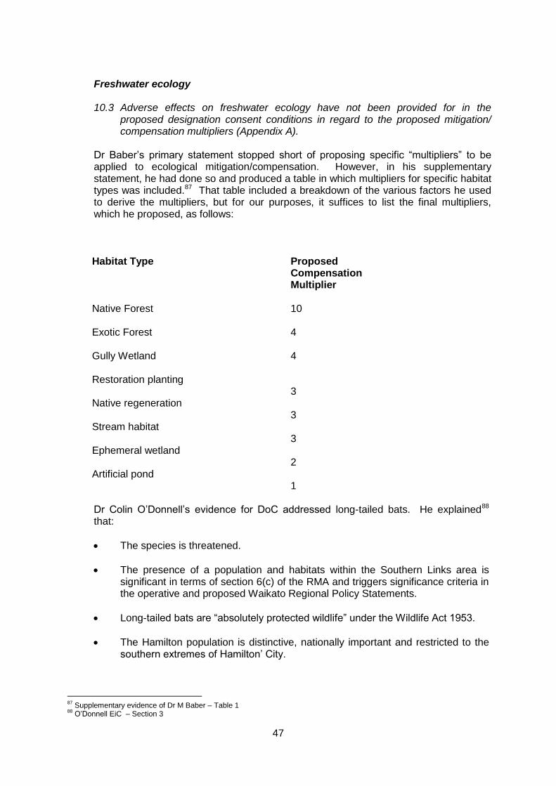
47
Freshwater ecology
10.3 Adverse effects on freshwater ecology have not been provided for in the
proposed designation consent conditions in regard to the proposed mitigation/ compensation multipliers (Appendix A).
Dr Baber’s primary statement stopped short of proposing specific “multipliers” to be applied to ecological mitigation/compensation. However, in his supplementary statement, he had done so and produced a table in which multipliers for specific habitat types was included.87 That table included a breakdown of the various factors he used to derive the multipliers, but for our purposes, it suffices to list the final multipliers, which he proposed, as follows:
Habitat Type
Proposed Compensation Multiplier
Native Forest
10
Exotic Forest
4
Gully Wetland
4
Restoration planting
3
Native regeneration
3
Stream habitat
3
Ephemeral wetland
2
Artificial pond
1
Dr Colin O’Donnell’s evidence for DoC addressed long-tailed bats. He explained88 that:
The species is threatened.
The presence of a population and habitats within the Southern Links area is significant in terms of section 6(c) of the RMA and triggers significance criteria in the operative and proposed Waikato Regional Policy Statements.
Long-tailed bats are “absolutely protected wildlife” under the Wildlife Act 1953.
The Hamilton population is distinctive, nationally important and restricted to the southern extremes of Hamilton’ City.
87
Supplementary evidence of Dr M Baber – Table 1 88
O’Donnell EiC – Section 3
48
There is a lack of background research to identify significant bat sites and hence the effects assessments are uncertain.
The Requiring Authorities’ assessments has underestimated the potential impact on bats.
The adverse effects on bats are likely to be major and largely irreversible, and of a much larger scale than for other sections of the Waikato Expressway.
The effects of Southern Links are cumulative with those for other roading projects.
If bat roost trees are removed will result in as net loss of habitat and the proposal to provide artificial bat roosts has not been successful elsewhere. The proposal to replace feeding habitat by replanting is unlikely to provide viable alternative habitat for more than 50 years.
The only way to resolve potential impacts is to remove the significant uncertainty through identification and protection of bat roosts.
In his supplementary evidence Dr O’Donnell responded to matters raised by the applicant and the s42A Report writers, particularly Mr Kessels. He summarised the situation as follows:89
1. The area affected by this section of the proposed Hamilton Expressway is very
significant and nationally important for long-tailed bats (my EIC section 6). The Southern links Project area appears to traverse the core of the Hamilton long-tailed bat habitat area, with bats occurring through most parts of the Mangakotukutuku gully system- as indicated by Mr Turner's Figure 9 (Annexure 1EIC) and Appendix F Addendum to Ecology Technical Specialist Report, Kessels Ecology (Supplementary s42A Report)
2. Overall, because of the uncertainties noted in my EIC and that of Mr Turner,
and even given strengthening of conditions as I have suggested, there may be important residual adverse effects on the long-tailed bat population and I do not consider that it possible to say with any confidence that proposed actions along the Southern Links routes would achieve "no net loss ... of biodiversity"; as is the aim of conditions proposed by Mr Eccles (his rebuttal Annexure A, Condition 12.2) or that the effects will be "adequately avoided, remedied, or mitigated" (Mr Turner para 17 in rebuttal). In fact, Mr Turner clearly states that the likely effectiveness of the proposed mitigation measures "is not known" (para 72 his rebuttal) and "there is uncertainty in terms of effects and also effectiveness of mitigation" (para 85 his rebuttal).
3. After reading Mr Turner's rebuttal I still contend that:
a. More could be done to reduce uncertainty about the precise impacts of the proposed expressway on long-tailed bats (by better identification of bat habitats and applying the revised conditions and tree felling protocols I discuss in this supplementary evidence).
89
O’Donnell Supp Ev– Summary section
49
b. Still more can be done, and relatively easily, to identify and avoid long-tailed bat habitats once identified (by small adjustments to the road footprint within the designation alignment or route realignments);
c. Although it is sensible to assume that some of the habitat restoration will eventually create new feeding habitats, there is no guarantee that this will happen in relation to the critical roosting habitats.
d. It is unlikely that proposed mitigation will recreate roosting habitat unless done at a significantly greater compensatory scale (>100:1ratio for roost trees) because only a tiny proportion of trees have a chance of developing into bat roosts.
e. Proposed mitigation still does not address where the bats will go in the long lag between tree felling and the development of new habitat.
f. Proposed mitigation does not deal with maternity roosts that may be vacant at the time of proposed felling- these are just as critical to sustaining bat populations.
g. The cumulative effects of additional sections of the Hamilton expressway being developed are not being addressed.
49. The effect of all the uncertainty about impacts and the usefulness of proposed mitigation come down to a critical issue. If breeding roosts are located on the proposed route and felled during construction then all or a high proportion of bats in Hamilton could be affected either directly or indirectly because all or a high proportion of breeding bats may lose critical shelters and breeding sites resulting in reductions in survival and breeding ability. It will not matter if there are still foraging sites or other roosts outside the expressway footprint if this happens.
(c) S42A Report
The reports prepared by the Territorial Authorities and WRC are both relevant and we address each in turn. The WRC s42A Report was written by Mr Brian Richmond. He concluded that that ecological effects (that were within that Council’s jurisdiction) were able to be addressed by conditions. We agree, noting, as Mr Richmond did, that further consents would be required from the WRC before construction works could commence. Mr Gerry Kessels was the ecologist advising the Territorial Authorities’ s42A Report authors. At the time he wrote his initial report (to inform the initial s42A Report), Mr Kessels concluded, as follows:90 My conclusions of the section 92 further information request still largely stands after my review of this notified version of the EAR and AEE pertaining to the project. That is:
“In summary, even though I acknowledge that the vast majority of the proposed NoR traverses a landscape devoid of any significant ecological value, I do not consider that the EAR provides sufficient information or analysis to allow me to understand the scale and intensity of potential ecological effects on those features that are left. It does not support the assessments and recommendations with sufficient scientific evidence by the way of literature review, site specific surveys and associated robust analysis of data to allow for an accurate assessment of ecological effects, nor provide suitably detailed and specific mitigation and monitoring measures.”
90
Section 42A Report – Appendix F prepared by Gerry Kessels
50
The ‘bones’ of an assessment of ecological effects and workable set of consent conditions relating to ecology are contained in the information supplied in the EAR and AEE, but further detailed information and consultation with the key submitters is required before I am in a position to be able to provide further substantive advice concerning the extent and magnitude of the ecological effects of the Project and the efficacy of the proposed consent conditions in the NOR.
By the time the s42A Report writers were due to report to the Reconvened Hearing, Mr Kessels had considerably more information available to him, noting that substantive discussions between him and Mr Turner had not been possible previously due to Mr Turner’s ill-health. Mr Kessels raised a number of matters when he summarised his final evaluation of the proposal based on all the information provided. Of particular importance were the following:
His opinion that the use of compensation multipliers was the crudest and most rudimentary approach to determining mitigation quantum91 but, absent more detailed ecological knowledge, are a commonly used default option.92
The Business Biodiversity Offset Programme (BBOP) draws upon a considerable amount of literature and research to discuss the application of multipliers.93
Despite various limitations, multipliers are entirely appropriate in this case.94
Rather than planting a very large area of land (i.e. using a very large multiplier) and hoping for the best, a varied portfolio of offsets is desirable, and for monitoring to be undertaken.95
In respect of the multipliers he considered appropriate, he recommended the following:96
a. A 3:1 compensation multiplier for a wetland/native forest replanting programme,
equating to 8.25 ha in total, to account for the loss of significant wetland habitat (1.1 ha + 1.4 ha – see paragraph 15 above) and indigenous forest (0.25 ha – see column 1 of Table 1 of Dr Baber’s supplementary evidence), on the provision that this works is applied to both the Transport Agency and HCC sections of the NORs which starts at least several years before construction begins, and that the area replanted is legally protected in perpetuity;
b. A 1:1 replanting programme equating to 12.05 ha (14.8 ha – 2.75 ha) to account for the loss of other gully vegetation, on the provision that this works is applied to both the Transport Agency and HCC sections of the NORs, which starts several years before construction begins, and that the area replanted is legally protected in perpetuity;
c. A 5:1 compensation multiplier for a targeted animal pest control programme to compensate for the removal of 14.8 ha of long-tailed bat habitat, equating to
91
Evidence of Mr G Kessels – para 16 92
Ibid – para 17 93
Ibid – para 18 94
Ibid – para 22 95
Ibid – paras 23 and 24 96
Ibid para 26
51
targeted animal pest control over at least 74 ha of Hamilton gully habitat for a period of 20 years; ….
In overall summary, Mr Kessels concluded:97
35. All of the ecological experts have acknowledged that the effects will be significant
and require a number of substantive measures to minimise these adverse ecological effects. Despite the scale of ecological effects associated with the Project I am largely satisfied that the recommended designation conditions will allow for the design and implementation of a range of reasonably well proven avoidance, remediation and mitigation measures to address any adverse effects relating to aquatic biota, indigenous vegetation and a range of terrestrial indigenous fauna, such as birds and lizards. I acknowledge that resource consents required by the Regional Council will further ensure that effects on aquatic ecology are adequately addressed. I also endorse the approach offered by the Requiring Authorities to commence gully revegetation well in advance of the works occurring, which will allow for notable ‘runs on the board’ before the project starts to cause a biodiversity ‘deficient’ during the construction phase.
36. Concerning long-tailed bats, the Ecological Assessment (Appendix L of the AEE,
page 2), states that: “the measures proposed to avoid, remedy or mitigation effects carry with them significant uncertainty in terms of their necessity, suitability and likely effectiveness. Therefore, the ability of the Project to avoid, remedy and mitigate adverse effects on this species [long-tailed bats] is similarly uncertain, as is the Projects ability to achieve “no net loss” as required by the Proposed National Policy statement on Biodiversity and NZTA’s own Environmental Plan objectives.”
37. These concerns have been reinforced by the evidence of Dr O’Donnell, who is
one of New Zealand’s leading experts on these animals and their habitat requirements. Nonetheless, I provided evidence at the hearing for the East West Link Road (as part of the Hamilton Bypass project), that bats appear to be able to cross roads and are adaptable to human induced changes in the landscape (refer in particular to Annexure 2 of my Evidence in Chief for that project: “Assessment of Ecological Effects on Long-tailed Bats – Survey of Tauwhare Road” dated April 2014).
38. While fully acknowledging the scientific uncertainty around bats, their habitat
requirements, how roads will affect them and the effectiveness of avoidance, remediation and mitigation measures, I am satisfied that the set of conditions recommended pertaining to this species reflects the best possible approach at this point in time. However, they need to be viewed as an integrated package rather than in isolation of each other for their full benefit to be realised.
39. I have experience in applying the pre tree felling protocols and consider they are
effective in avoiding direct mortality of bats and isolating potential occupied roost trees; and I have some evidence for the Tauwhare Road study and subsequent work on Cobham Drive, as well as a review of overseas literature, that long-tailed bats will cross busy roads on a regular basis and that vegetated ‘hop-overs’ and lighting design will reduce the risk of vehicle mortality and fragmentation effects. However, these measures in themselves, while partly avoiding and remedying some of the effects on bats, do not avoid, remedy or mitigate for all of the adverse effects on bats associated with roads.
97
Ibid paras 35 - 41
52
40. Therefore, I do not consider that merely invoking a set of avoidance measures
during construction and then planting vast areas of gully habitat is the sole solution to addressing potential adverse effects on bats and their habitats. The approach of the recommended conditions is to switch part of the gully revegetation focus to targeted animal pest control, thereby offsetting the effects on bats caused by loss of roost trees and fragmentation, as well offset for possible mortality due to tree felling and vehicle strike. The animal pest control will also likely benefit a host of other indigenous fauna groups, such as birds and lizards, as well as aid the natural regeneration of native plants by reducing fruit, seed and foliage browsing.
41. Also critical to the success of the conditions recommended is ensuring that long-
term monitoring and conservation management research is undertaken, which then can be directly applied to developing and refining mitigation measures. Given the time lapse period before construction is likely to commence, this project presents an opportunity to ensure that proper studies into the effects of roads are undertaken and that this research can be applied in terms of understanding what measures are required to avoid, remedy or mitigate these effects and how, when and where best to apply them (such as research of the efficacy of the habitat enhancement techniques shown in Attachment 2).
In answer to our questions, Mr Kessels acknowledged that the BBOP approach had attracted some criticism, as it was not developed under an RMA framework that requires adverse effects to be “avoided, remedied, or mitigated”. He also accepted that there was an inherent degree of subjectivity involved in selecting multipliers and considerable judgement was required. Also, in answer to our questions, he agreed that ecological mitigation need not be undertaken in the district in which any particular effect occurred, but rather the mitigation of the effects of the Southern Links project should be undertaken in the locations that are most ecologically appropriate, irrespective of which district they are located in.
(d) Findings
Overall, we are satisfied that the ecological effects of the proposal can be appropriately managed by the imposition of conditions. First and foremost, we acknowledge the uncertainties surrounding the effects on long-tailed bats, and how such effects might best be managed. In that regard, we have reached the conclusion that the protection of this species requires a multi-agency, whole of region approach. While NZTA and HCC have an important role to play in that regard, they are but a part of a much wider whole. We acknowledge the commitment by NZTA and HCC to participate in such a “whole of region” approach, and the inclusion of an advice note to that effect in the NOR conditions they have proposed. Whilst not enforceable, this is a very public signal of the commitment to participate in that process, and one which we anticipate being followed through. We applaud that.
For the reasons explained by Mr Kessels, we are not convinced that Dr Baber’s use of large multipliers (relative to those proposed by the other ecologists) is appropriate, being mindful that the RMA is not a “no effects statute” and that all effects need to be
53
addressed by way of mitigation, offset or compensation98. We acknowledge Dr O’Donnell’s expertise regarding bats, and his expertise has been helpful in framing certain monitoring conditions. However, it is a wider judgement, framed in RMA terms, that dictates the level to which uncertainties and risk need to be managed. In that regard, the following statement from Dr O’Donnell is telling:
Overall, because of the uncertainties noted in my EIC and that of Mr Turner, and even given strengthening of conditions as I have suggested, there may be important residual adverse effects on the long-tailed bat population and I do not consider that it [is] possible to say with any confidence that proposed actions along the Southern Links routes would achieve "no net loss .....of biodiversity …."99
We do not accept the proposition that the “no net effects” is an RMA bottom line – it is not. In respect of mitigation we prefer the approach of Mr Kessels and Mr Turner. We consider that the overall approach to ecological mitigation should follow the rationale explained by Mr Kessels, but on balance, consider the multipliers recommended by Mr Turner to be sufficient and appropriate. They are aimed at achieving “no net loss of biodiversity”, but, properly in our assessment, do not require that the risks of not achieving this be fully internalised by a project proponent, particularly where these effects involve actions and activities clearly beyond the field of influence of the subject project. We were surprised and impressed with the number of people who, entirely on their own initiative, have been undertaking ecological enhancements on their own properties. Understandably, they are now concerned about the effects of Southern Links on those enhancements and the incentives to continue with them. Some examples are the initiatives being planned by the MSCG and the initiatives undertaken by the Keytes, James, Shaws and Bevans. We think it important the ecological mitigation undertaken for Southern Links appropriately recognises the existence of those enhancements and attempts to integrate with them. We consider that this is an important matter to record in conditions, noting that we have made several changes to conditions in this regard – firstly to ensure consistency between the two Requiring Authorities and secondly to make it more explicit that to achieve the best overall outcome ecological effects should be addressed across the whole Southern Links project, rather than on an NoR by NoR basis.
6.8 Stormwater & Drainage
(a) The Requiring Authorities’ evidence
Mr Christopher Hardy presented evidence for the applicant on stormwater management, drainage design and flooding for the Requiring Authorities. He stated100 that
9 The Project is mainly located in undeveloped rural land so the effect on existing
built stormwater infrastructure is minor. More than 90% of the Project designation is within rural or undeveloped land. The Project will discharge stormwater from the road into natural waterways including the Waitawhiriwhiri Stream, Mangakotukutuku Stream, Mangaonua Stream and the Waikato River. The three
98
Royal Forest and Bird Protection Society of New Zealand Inc v Buller District Council (No 2) [2013] NZHC 1346, [2013] NZRMA 293 - para 52 99
O’Donnell Supp Ev – Summary section – para 2 100
Hardy EiC– paras 9 - 15
54
streams discharge to the Waikato River. The Project also crosses several rural drainage areas administered by Waipa District Council.
10 The effect on the natural environment from stormwater discharges will be
managed through water quality and quantity control prior to discharge. 11 Water quality and quantity effects will be mitigated by designing stormwater
infrastructure to comply with best practice, local and regional council requirements and the needs of the Transport Agency and HCC. The final detail and approach to stormwater treatment will be subject to detailed design and a resource consent process.
12 The relevant design guidelines of HCC, the Transport Agency, KiwiRail and the
Waikato Regional Council (WRC) have been considered in developing the conceptual layout of the drainage system. The design standards have been applied to a degree suitable to determine location and size for designation purposes. Comprehensive design requirements have been set out for use in future design with flexibility to change to meet new requirements at the time of the design.
13 Detailed design at a later stage will enable the Project to comply with all relevant
design guidelines, integrated catchment management plans and best practice at the time. I believe this is appropriate given the expected construction start date in approximately 15 years time.
14 It is not practical to design all aspects of the drainage system in detail at this time. Detailed design at a later date will provide maximum benefit in terms of integration and the use of contemporary solutions. I am confident that the extent of the designation for the purpose of stormwater treatment and control has been adequately defined based on current information.
15 The detailed design stage will seek to identify potential effects and the proposed
solutions to address them. This will be carried out as part of a WRC stormwater discharge consent process during which affected parties will be consulted and the proposed stormwater design will be technically reviewed and approved.
(b) Submissions / Submitter evidence A number of submitters expressed concerns about stormwater management101. While the individual submissions and related evidence focussed on particular geographical areas, a number of common themes emerged, including:
The size and locations of individual stormwater detention ponds.
Whether the land being designated was large enough to adequately manage stormwater flows.
The design criteria for the proposed stormwater infrastructure and a lack of detail as to what is being proposed.
101
Waikato Regional Airport Ltd, Tsai, Tseng & Chao, Todd, Adare Company Limited, Cairns Family Trust, Harcourt, Sharpe, Sharpe Estate, Healy, KiwiRail, Findlay Family Trust and Findlay Family Trust & JA Alderton Trust Joint Venture, Bevan, Dawson, Griffin, Hammond, Lucas, Middle Road and Narrows Road Focus Group, Penn Patterson Partnership, Zha & Yan.
55
Effects of altered drainage patterns on water tables.
Effects on existing drainage patterns and the potential to exacerbate existing drainage/flooding problems.
How drainage from Southern Links will affect drainage associated with land development and vice versa.
The effects of modified drainage on ecological values, particularly those having high values whether natural or enhanced.
The effects of the discharge of contaminants on waterways.
The individual submitters provided us with a large amount of “local knowledge” regarding their own individual situations, which we found to be of considerable assistance. We make two fundamental points regarding these matters. The first is that water related issues will need to be the subject of future resource consent applications to WRC. Those applications are proposed to be made at the time the design of the project is being undertaken – likely to be some considerable time in the future. As such, that is the time at which the efficacy of what was being proposed would be assessed, and consents would only be able to be granted if those effects were considered to be acceptable. Also, if at that time it was found that, for example, insufficient land had been designated to adequately manage stormwater flows, that is a matter that the Requiring Authorities would have to address if it wanted to implement Southern Links.
The second issue relates to how, and the extent to which, these water related matters are addressed now, as part of the current process. That is a matter of conditions, and it suffices to say that we consider the conditions proposed by Mr Richmond relating to the bridge-related resource consents and Mr Eccles in respect of the NoRs to be appropriate and sufficient in this regard. (c) S 42A Report
At the time of writing the s42A Report, the authors concluded that there was limited information in the NoR AEE, and no information in the proposed conditions proffered by the Requiring Authorities, directly related to the management of flooding and drainage effects.102 By the time of the Reconvened Hearing, further technical discussions between the Requiring Authorities and the s42A Report authors had occurred to the point that by the time Ms Hunter addressed us at the Reconvened Hearing,103 she was able to confirm that agreement had been reached between Mr Hardy and Mr Leahy (the contributor to the s42A Report on drainage and stormwater matters) as to the conditions that should be attached to the NORs.
102
Section 42A Report – Section 18.6 103
Second Supplementary Section 42A Report
56
(d) Findings
For all the reasons set out above, we are satisfied that these water-related aspects are able to be dealt with by way of conditions on the individual NORs, to the extent that this is appropriate to do so, given that such matters will be addressed in considerable detail when the resource consent applications needed to authorise water related activities are sought subsequently from WRC.
6.9 Air
(a) The Requiring Authorities’ evidence
Mr Kvatch’s evidence on behalf of the Requiring Authorities stated the following:104
8 I have undertaken an assessment on the air quality effects associated with the Project. The assessment area extended over all areas potentially affected by the Project, as well as the major arterial and local roads that would experience changes in traffic flows as a result of the Project, which could have effects on the local air quality.
9 The results show that the effects of the Project on the local air quality range from
insignificant to minor, depending on the location, and concentrations of the relevant contaminants considered. Predicted concentration of particulates (PM10 and PM2.5), Nitrogen Dioxide (NO2), and Carbon Monoxide (CO) all remain well below the relevant standards and guidelines assessment criteria.
10 My Assessment Report shows that after completion of the Project, the local air quality will remain within the same Waikato Regional Air Quality Category (Waikato Regional Plan, Air module, 6.1.3 Policies, Table 6-2), as if the Project was not built.
11 The construction works for the Project may have potential short term dust
nuisance effects in the areas located close to the construction sites. These effects will be mitigated by best practice methods that will be specified in a Dust Management Plan (DMP), a sub-management plan of the Construction Management Plan (CMP), which will be required by the proposed designation conditions.
(b) Submissions / Submitter evidence
A total of sixteen submissions105 raised specific concerns regarding the adverse effects of dust drift or dust nuisance effects from construction activities. Of particular concern was the potential contamination of drinking water due to several properties sourcing their domestic supply off their roofs. Eleven submissions106 raised concerns about the air quality (vehicle emission) effects of construction and/or operation of the Southern Links network. Specifically, a number of submissions from the Narrows Road area state that the air quality modelling undertaken for the project has not taken into account the effect of living in the apex of two major roads (headed by two interchange systems) plus being sheltered by
104
Kvatch EiC – paras 8 - 11 105
Porritt, Snowball, Vollebregt, Drury, Erkklia, Swann, Martinus, Cairns Family Trust, Findlay Family Trust, Dawson, Griffin, Lucas, Hammond, Middle Road and Narrows Road Focus Group, Penn Paterson Partnership, Qi Zhu and Xianghua Yan 106
Kirker, Drury, Erkklia, Swann, Dawson, Griffin, Lucas, Hammond, Middle Road and Narrows Road Focus Group, Penn Paterson Partnership, Qi Zhu and Xianghua Yan
57
surrounding ridges which limit airflow. Consequently, the maximum possible air quality control is sought through high landscaping or other means.
(c) S 42A Report
Dr Paul Heveldt assessed air quality issues on behalf of the s42A Report authors. His review concluded107 that:
The impacts of vehicle emissions from the operation of the Southern Links roading network have been conclusively shown by the modelling and assessment work carried out by Opus to result in no more than minor adverse air quality effects. Dust emissions during construction can be appropriately managed by the application of best practice dust mitigation methodologies, as proposed by Opus to govern the works. These suggested measures are supported by MWH. The recommendation by Opus for the incorporation of comprehensive air quality management mechanisms and practices within a CMP is endorsed. Such a plan should be certified as being comprehensive and suitable in content. The CMP should set out all the necessary parameters to ensure effective dust control during construction, although the conscientious application of the details of such plans is always the key factor in their effectiveness. This can be ensured by regular inspection checks on construction activities. On the above basis, it is anticipated that the construction of the project can be carried out with confidence that the We concur with these conclusions.
(d) Findings
For all the reasons set out above, we are satisfied that the environment, human health and amenity values will each be satisfactorily protected in relation to air quality.
Based on his assessment the s42A Report authors concluded that the air quality effects associated with the project have been adequately addressed and can be appropriately avoided, remedied or mitigated through the imposition of appropriate conditions.108 effects of the proposal on air quality, both during construction and once it is operational, can be addressed by the inclusion of appropriate conditions. We are satisfied that those conditions proposed by the Requiring Authorities are appropriate in that regard.
107
S42A Report – Appendix I – Section 5 108
S42 A Report – Section 15.6
58
6.10 Contaminated Material
(a) The Requiring Authorities’ evidence
Mr Ken Read presented evidence on behalf of the Requiring Authorities regarding contaminated land. His evidence stated:109
16 The rural nature of much of the area under consideration means that the
majority of potential contaminants arise from the use of agrichemicals (residual pesticides and herbicides) and farm waste disposal (offal pits and farm tips).
17 Some commercially derived contamination is possible at the northern
end of State Highway 3 (SH3), and industrial derived contamination may be present at the junction of the east west link with the existing State Highway 1 intersection of Kahikatea Drive and Greenwood Street.
….. 19 I consider that provided further investigation and assessment of
potentially contaminated properties is made at the detailed design stage, and that it is undertaken in accordance with the relevant legislation and guidance that applies at the time, the potential hazards posed by soil contamination to the environment and human health arising from the Project can be appropriately mitigated and managed.
20 I have reviewed the s42A Report and, subject to minor amendments,
support the inclusion of a Contaminated Soil Management Plan (CSMP). I consider that any contaminated land effects will be adequately avoided, remedied or mitigated through the implementation of the CSMP.
(b) Submissions / Submitter evidence
No submissions were made on this matter.
(c) S 42A Report
Land contamination was addressed on behalf of the s42A Report authors by Dr Heveldt110. Based on his review, the s42A Report authors concluded that the contaminated land effects associated with the project have been adequately addressed and can be appropriately avoided, remedied or mitigated through the imposition of conditions.111
(d) Findings For all the reasons set out above, we are satisfied that the contaminated land effects of the proposal can be addressed by the inclusion of appropriate conditions and that those proposed by the Requiring Authorities are appropriate.
109
Read EiC – paras 16 - 17 & 19 -20 110
S42A Report – Appendix J 111
Ibid – para 16.6
59
6.11 Aviation
Part of the east-west route between the central interchange and the Waikato River (NZTA NoR Waipa DC) traverses around the north end of the proposed extended runway of the Hamilton Airport. The extended runway and appropriate airport operational controls were the subject of a plan change and designations all of which were confirmed in July 2011112. Hamilton Airport is owned and controlled by Waikato Regional Airport Limited (WRAL) which lodged a submission seeking to ensure that the NZTA proposed route in the vicinity of the Airport did not adversely affect the operation of the Airport or compromise the designations and planning controls which supported it. Mr Olliver, planner for WRAL, gave evidence in support of WRAL’s position. The key outcomes sought by WRAL were: a) The highway being positioned on a lower part of the site, well below the Obstacle
Limitation Surfaces.
b) The highway being placed as far away from the end of the runway as practicable,
thereby minimising the risk of an aircraft accident (a very low probability) affecting
the highway.
c) The highway running perpendicular [sic at right angles] to the High Intensity
Approach lights, thereby minimising the risk of headlight glare affecting them.113
By the time of the Substantive Hearing there was complete agreement between WRAL and NZTA on how those outcomes were to be achieved. The only issue was the wording of the appropriate conditions. We have already observed that because the matters before us were to future proof the proposed routes without anticipating construction in the near future, some of the detail of the proposal was not as precise as it could be. For our part we needed assurance that the generality of the conditions (particularly Condition 1 – generally in accordance with) did not remove the obligation on the requiring authority to completely meet the requirement of WRAL in all respects. We received that assurance in the submissions of Ms Janissen in reply for NZTA. She pointed out that:
The generality of Condition 1 is modified by any more specific following conditions;
Proposed Condition15 specifically deals with the Airport issues. In addition Proposed Condition 9 also allows WRAL to be involved in landscaping associated with the project in that locality;
In any event the WRAL designations were confirmed before the designations now sought and for that reason the NZTA designation will require WRAL’s written approval under RMA ss 176(1)(b) or 177(1)(a)114.
We are satisfied that with the conditions proposed, the legitimate concerns of WRAL will be met.
112
Waipa DC Plan Change 69 and Designation DN156 113
Olliver WRAL EiC para3.3 114
Janissen Reply paras. 108 - 116
60
6.12 Archaeology – Archaeology and Historic Heritage
Mr Nick Cable provided evidence on archaeology and Mr Ian Bowman on historic heritage for the requiring authorities. Mr Warren Gumbley reported for the s42A team.
Dr Rachel Darmody gave evidence for Heritage New Zealand Pouhere Taonga.
No other party raised specific matters of an archaeological or heritage nature.
Mr Cable noted that 18 archaeological sites were initially identified within the broader project area, this was reduced to 9 sites115 once the road corridor selection process had been completed, four of which were entirely within the corridor and five partly so. In addition, four areas of pre-European gardening soils were identified. Three pa sites (Whatukoruru, Te Nihinihi and unnamed) were assessed as being of high significance; five of moderate significance (borrow pits and Glenhope Homestead); and one of low significance (farm building). The gardening soils were assessed as being of moderate significance.
Mr Bowman provided detailed evidence relating to Glenhope Homestead and NZTA’s intended relocation to a site within the original 1873 350 acre farm owned by the Hunt and Way families. Mr Bowman116 assessed the historic heritage value as having regional heritage significance for architectural, technological, rarity and historic associative values. He proposed a series of mitigation measures as conditions.
As a result of the expert conferencing undertaken on 22 July 2014, Mr Cable and Mr Gumbley agreed a set of conditions – particularly with respect to the content requirements of the Heritage and Archaeological Site Management Plan, Conservation Plans for significant sites, a Dwelling Conservation Plan for Glenhope Homestead, and an Accidental Discovery Protocol. Mr Bowman indicated his agreement with those conditions.
Dr Rod Clough peer reviewed the reports and evidence of Messrs Cable, Gumbley and Bowman for the Requiring Authorities and concluded that the issues covered and final set of conditions proposed were appropriate.
We understood Dr Darmody also to accept those conditions, while noting that subsequent authorities from Heritage New Zealand would be required (for example for demolition of the Glenhope Homestead outbuildings).
Findings We find that the conditions proposed will ensure that archaeological and heritage matters are addressed appropriately during construction works, and will facilitate the protection of those significant features that remain post-construction.
6.13 Positive Effects
Confirming the NoRs and granting the resource consents (subject to conditions) would have the effect of achieving the objectives of the Southern Links Project as identified at the outset by NZTA. We consider that will provide significant public benefits.
115
Cable, EiC, Annexures B and C 116
Bowman, EiC, para 27
61
7. PLANNING INSTRUMENTS
7.1 Relevant RMA Instruments
Mr Grant Eccles identified117 the following statutory planning documents / instruments as relevant to the NoRs:
National Policy Statement for Freshwater Management 2011
Operative Waikato Regional Policy Statement (including the Vision and Strategy for the Waikato River) 2000;
Proposed Waikato Regional Policy Statement (including the Vision and Strategy for the Waikato River) 2012;
Operative Waipa District Plan 1997;
Proposed Waipa District Plan 2012;
Operative Hamilton City District Plan 2012;
Proposed Hamilton City District Plan 2012; and
Operative Waikato District Plan.
Mr Eccles also identified118 the following additional planning documents for the three restricted discretionary activity bridges (The Narrows Bridge, Gardens Bridge and Mangakotukutuku Bridge) resource consents (with which Mr Brian Richmond concurred):
Operative Waikato Regional Policy Statement (including the Vision and Strategy for the Waikato River) 2000;
Proposed Waikato Regional Policy Statement (including the Vision and Strategy for the Waikato River) 2012; and
Waikato Regional Plan 2012 (reprinted).
7.2 Other Non-RMA Instruments Mr Eccles also accepted the following documents as relevant section 104(1)(c) and 171(1)(d) other matters:
Government Policy Statement on Land Transport Funding 2012;
Government Policy Statement on Land Transport Funding 2012;
National Infrastructure Plan 2011;
Waikato Regional Land Transport Strategy (2011-2041);
Access Hamilton 2010;
Waipa Integrated Transport Strategy 2010;
Waikato Expressway Network Plan 2010
New Zealand Rail Strategy;
117 MacMurray, EiC, paras 143 – 158 and AEE Section 9 118
AEE, Volume 4, Appendix N: Resource Consent Applications, section 9.0
62
Waikato Regional Passenger Transport Plan 2007;
Waikato Regional Walking and Cycling Strategy (2009-2015);
Waipa Integrated Transport Strategy 2010;
Future Proof Growth Strategy 2009;
Hamilton Urban Growth Strategy 2010;
Waipa District Growth Strategy 2009;
Waikato District Growth Strategy 2009 and Related Documents;
Hamilton City Council – Vista 2007; and
New Zealand Energy 2011 and New Zealand Energy Efficiency and Conservation Strategy 2011.
7.3 Assessment A fuller assessment of the applications(s) against the relevant provisions of the above documents was provided in the application documents – particularly:
Volume 1 – Hamilton Southern Links Investigation - Assessment of Environmental Effects and Supporting Information, Section 9.0 Statutory Planning Assessment;
Volume 4, Appendix N: Resource Consent Applications, and
Volume 5: Appendix P – District Plan Objectives.
In addition because the applications for consent are for restricted discretionary
activities, RMA s104C will apply to restrict us to considering only those matters
over which the Waikato Regional Plan (Rule 4.2.8.3) specifies should be
considered, being:
i. The design and location of the bridge including size of the span and the
positioning of piers to avoid, remedy or mitigate any potential adverse effects
of the structure.
ii. The potential effects on bed and bank stability and water quality.
iii. Measures to control the effect of the activity on upstream or downstream
properties.
iv. Effects on any waahi tapu or other taonga from the activity.
v. Effects on the relationship of tangata whenua and their culture and traditions
with the site and any waahi tapu or other taonga affected by the activity.
vi. Effects on the ability of tangata whenua to exercise their kaitiaki role in respect
of any waahi tapu or other taonga affected by the activity.
vii. Measures to ensure the safe passage of fish both upstream and downstream.
viii. Measures to control the effects of the activity on any lawfully established
structure.
ix. Measures to control suspended solids discharges.
x. Measures to avoid, remedy or mitigate adverse effects on the natural character
of the beds of rivers and lakes.
xi. Measures to ensure consistency with criteria as set out in any applicable Water
Management Class in this Plan.
63
xii. Measures to control the effect of the activity on areas of significant indigenous
vegetation and significant habitats of indigenous fauna. In the interest of brevity we do not repeat the detail of that material and, as the relevance or applicability of those documents and their provisions was not contested in any material way by any party, we adopt that assessment – noting that some witnesses contested the interpretation and weight to be afforded particular provisions.
7.4 Peacocke Area One matter that did require our attention related to HCC’s Peacocke Structure Plan (PSP), which is a Proposed District Plan Decisions Version provision (9 July 2014) which sets up a special character zone – one of 6 such zones under the Plan – the intention of which119 is to protect, maintain and enhance the respective “special” characteristics of those areas. Specifically the Peacocke Character zone (PCZ) comprises three discretely identified areas – Terrace, Gully and Hill. This matter had been raised, in particular, by Adare Company Limited (Adare), a submitter with substantial (though not exclusive) landholding within the PCZ, and was concerned about the potential for the relevant NoRs and Garden Bridge consent to compromise the planning intention for that area – which we understood from the evidence of witnesses for Adare to be to create a subdivision in line with certain urban design principles whereby roads and stormwater associated infrastructure respond to the proposed built environment rather than the other way around (as alleged). In particular Adare sought that the NoR and consent processes be made subject to the master-planning exercise required for each of the 16 neighbourhood areas under the plan provisions (otherwise activities are generally non-complying in the absence of a Master Plan). Mr David Serjeant, Adare’s planning witness, noted120 that the detailed cross-section and intersection drawings supplied with the application documentation effectively fixed the form of the designated works, and that this was inappropriate both at this stage but also in terms of the PSP requirements. Ms Le Bas, counsel for HCC, in her opening legal submissions, noted121 that: It is a very clear principle in both law and planning that a designation takes the lead, it is not lead (sic). ... The Commissioners are not required to direct or remind HCC as the relevant Territorial Authority that amendment of the Peacocke Structure Plan and the District Plan will be necessary if HCC’s NoR is confirmed. The Commissioners can rest assured that the Territorial Authority, as promulgator of the Hamilton District Plan, has this matter in hand. Furthermore, in closing submissions, Ms Le Bas noted, among other things, that the drawings submitted were, in any event, subject to final design; an Outline Plan of Works would be required (and for each stage if staged); and that Adare does not own all the land within the PCZ122 meaning that HCC needs to maintain its overall
119
Savage, EiC, Annexure A, section 5.1 - Purpose 120
Serjeant, EiC, para13 121
Le Bas, Opening Submissions, paras 20 - 21 122
At the hearing Adare’s landholdings were identified in 8 of the 16 neighbourhood areas, only 2 of which (Areas 7 and 8) represented “complete” ownership.
64
responsibility for matters relating to the arterial network. Accordingly she rejected Mr Serjeant’s condition amendments. Our attention was also drawn to a PSP provision under section 3.4.3(e) Transport Network, which states quite explicitly: Furthermore uncertainty around the precise form and function of the Southern Links state highway network also means the roading network needs to be responsive to changing circumstances and priorities. The final alignment of the arterial network within Peacocke will be established through the designation process. Therefore the alignment of some of the arterial routes is highly indicative, especially the southern section of the central major arterial route ...
7.5 Findings On the general plans and provisions we accept the evidence of the respective planning witnesses regarding the relevant documents, and adopt those, as there was no material disagreement about them. On the matter of the PSP and PCZ, we note that the provisions themselves anticipate the need for accommodating the outcome of the Southern Links NoR process, which, as Ms Le Bas notes, drives rather than follows the process. We add that we accept the point made by Ms Le Bas regarding the fact that HCC is on notice regarding the potential need to review the planning provisions once the detailed alignment and final design etc are available. Whether that will require substantial amendment is not something on which we can usefully speculate in this decision.
65
8. STATUTORY FRAMEWORK 8.1 Introduction
Before us are no less than eight proposals under three separate sets of RMA processes:
Three Notices of Requirement by NZTA and one Notice of Requirement by HCC
for new designations; One Notice of Requirement by NZTA for an alteration to an existing designation; Three resource consent applications for the three bridges.
Different statutory criteria apply to each set. We deal in this Section of our Hearings Report with each of them separately. We identify criteria for each process as follows: Designations - Sections 8.2 to 8.7 of this Hearings Report; Resource consent applications - Section 8.8 of this Hearings Report. Both sets of criteria are subject to RMA Part 2 (see Section 8.9 of this Hearings
Report).
8.2 Designation Formalities
Pursuant to RMA s166 NZTA (formerly Transit New Zealand) has been given the status of a requiring authority for the purposes of RMA123. The form and content of the NoRs lodged under RMA ss168 and 168A are set out in the prescribed form. There was no challenge either evident in the written submissions or placed before us in evidence about the formal content of any of the NoRs. We accept that the NoRs are appropriate in form and substance.
8.3 Alteration to Designations
One of the NoRs lodged by NZTA is for an alteration to an existing designation. RMA s181 deals specifically with alterations to a designation. RMA s181(2) imports into the alteration procedure the same process as if the designation had been a new one. RMA ss168 to 179 therefore apply with all necessary modifications.
8.4 Designation Criteria
The NZTA NoRs are made under RMA s168 while the HCC NoR is made under RMA s168A. The criteria for the former is set out in RMA s171(1) while the criteria for the latter is set out in RMA s168A(3). However, the considerations are the same. The matters for consideration of each of the requirements are:
When considering a requirement and any submissions received, a territorial authority must, subject to Part 2, consider the effects on the environment of allowing the requirement, having particular regard to-
(a) any relevant provisions of-
123
Gazette Ref 1992/348 & 20/978
66
(i) a national policy statement (ii) …: (iii) a regional policy statement or a proposed regional policy
statement (iv) a plan or proposed plan; and
(b) whether adequate consideration has been given to alternative sites, routes or methods of undertaking the work if-
(i) the requiring authority does not have an interest in the land sufficient for undertaking the work; or
(ii) it is likely that the work will have a significant effect on the environment; and
(c) whether the work and designation are reasonably necessary for achieving the objectives of the requiring authority for which the designation is sought; and
(d) any other matter the territorial authority considers reasonably necessary in order to make a decision on the requirement.
We consider that “having particular regard to..” means that we must turn our mind to each of the matters listed but it is not necessary for all of the criteria to be fulfilled.124 In respect of the designations, the essential matters for consideration are accordingly:
RMA Part 2. We address that in Section 8.9 of this Hearings Report following. Effects on the Environment. We have addressed that in Section 6 of this Hearings
Report. Planning instruments. We have addressed that in Section 7 of this Hearings
Report. Alternative sites or methods. We have addressed this in Section 6.2, and 8.5
following of our Hearings Report. Reasonably necessary. We have addressed this in Section 6.2 and 8.6 following
of our Hearings Report. Any other matter: We have addressed that in Section 7 and 8.7 following of this
Hearings Report.
8.5 Alternative Sites or Methods
RMA s171(1)(b) requires us to have regard to alternatives but only in the event that one of two prerequisites applies. The first of those prerequisites is if the Requiring Authority does not have sufficient land to undertake the work. Neither NZTA nor HCC has sufficient land to undertake all the work covered by the NoRs.
The second prerequisite applies if any adverse effects are likely to be significant. On the face of it, some of the effects may well be described as significant.
In considering the NoRs we must therefore consider alternatives. We have done that in Section 6.2 of this Hearings Report.
Given those considerations, we are satisfied from all the evidence that adequate consideration has been given by the requiring authorities to alternatives in respect of their respective NoRs.
124
Quay Property Management Ltd v Transit NZ (W028/00) at paras.111-112
67
8.6 Reasonably Necessary
In respect of the NoRs, good reason was provided by the requiring authorities in respect of each NoR proposed. We have considered that in Section 6.2 of this Hearings Report. Without traversing the detail of that, it is sufficient to say that we are satisfied that in each case the NoRs are reasonably necessary.
8.7 Designation Options for Designations
In respect of an NOR pursuant to RMA s168 (relevant to the NZTA NoRs), RMA 171(2) provides:
The territorial authority may recommend to the requiring authority that it—
(a) confirm the requirement: (b) modify the requirement: (c) impose conditions: (d) withdraw the requirement.
Furthermore, RMA s168A(4) (relevant to the HCC NoR) provides:
The territorial authority may decide to— (a) confirm the requirement: (b) modify the requirement: (c) impose conditions: (d) withdraw the requirement. Based on our delegations pursuant to RMA s34A described in Section 2.1 of this Hearings Report, we accordingly have the same options in respect of these NoRs.
8.8 Resource Consent Criteria
RMA s104 sets out the matters to be considered when assessing a resource consent. That section requires that, subject to Part 2 (Purpose and Principles), regard must be had to a number of matters of which the following are relevant in this case:
(a) any actual and potential effects on the environment of allowing the activity;
and
(b) any relevant provisions of—
(i) a national environmental standard:
(ii) other regulations:
(iii) a national policy statement:
(iv) a New Zealand coastal policy statement:
(v) a regional policy statement or proposed regional policy statement:
(vi) a plan or proposed plan; and
(c) any other matter the consent authority considers relevant and reasonably
necessary to determine the application.
In addition, as we have already observed in Section 7 of this Hearings Report,
because the applications for consent are for restricted discretionary activities, RMA
s104C will apply to restrict us to considering only those matters over which the
68
Waikato Regional Plan specifies should be considered. We have itemised those in
Section 7 and considered them in Section 6. We have considered effects in Section 6 of this Decision. We have considered the relevant planning instruments in Section 7 of this Decision.
Several other matters were advanced as being matters to which we should have regard. We deal with those matters in Section 7 of this Hearings Report .
8.9 RMA Part 2
All RMA processes before us are subject to RMA Part 2.
8.9.1 The purpose of the RMA as set out in s5 is "to promote the sustainable management of natural and physical resources". Sustainable management is then defined.
8.9.2 RMA s6 sets out matters of national importance which are to be recognised and provided for. The matters of national importance under s6 which are relevant to the consideration of the matters before us are:
(a) the preservation of the natural character of ..., wetlands, ... and their
margins, and the protection of them from inappropriate subdivision, use,
and development:
(b) ...
(c) the protection of areas of significant indigenous vegetation and significant
habitats of indigenous fauna:
(d) the maintenance and enhancement of public access to and along ... lakes,
and rivers:
(e) the relationship of Māori and their culture and traditions with their ancestral
lands, water, sites, waahi tapu, and other taonga:
(f) the protection of historic heritage from inappropriate subdivision, use, and
development:
(g) ...
8.9.3 RMA s7 sets out other matters to which we are to have particular regard. The matters in s7 which may be of relevance to the matters before us include:
(a) kaitiakitanga:
(aa) the ethic of stewardship:
(b) the efficient use and development of natural and physical resources:
(ba) the efficiency of the end use of energy:
(c) the maintenance and enhancement of amenity values:
(d) intrinsic values of ecosystems:
(e) ...
(f) maintenance and enhancement of the quality of the environment:
(g) any finite characteristics of natural and physical resources:
(h) ...
(i) the effects of climate change:
(j) ...
69
8.9.4 Section 8 requires us to take into account the principles of the Treaty of Waitangi.
8.9.5 Leaving aside for the moment the Māori provisions of Part 2 (ss6(e), 7(a) and 8), the AEE, each of the planners for the Requiring Authorities as well as each of the authors of the s42A Reports undertook a detailed analysis of the proposals before us in relation to each of the elements of Part 2, as we have set them out above.
We are satisfied that the proposals achieve the purpose of the RMA and that there is nothing in ss 6 – 8 that undermines that position, provided that appropriate conditions attach to the NoRs and resource consents.
We have discussed in Section 6.7 of this Hearings Report the position relating to matters of ecology. Our conclusions there do not alter the conclusions relating to Part 2.
8.9.6 In respect of the Māori provisions of Part 2, no submissions were received to the proposal before us in relation to Māori issues. However, on the information before us Māori have provided a Position Statement dated 5 August 2013, which is set out in full in the NoRs (Appendix F). As recorded in the Position Statement, Tangata Whenua is Waikato-Tainui represented by Waikato-Tainui Te Kauhanganui Incorporated Society, the mandated iwi authority. The Society has delegated its authority to be represented on the proposals to four of its hapuu, Ngaati Haua, Ngaati Koroki Kahukura, Ngaati Mahanga and Ngaati Wairere, collectively referred to as the Tangata Whenua Working Group (TWWG). TWWG has recorded in the Position Statement that “Tangata Whenua acknowledge that some significant effects on ecological areas and sites of significance are unavoidable (e.g Hamilton Gardens bridge crossing, Mangakotukutuku Gully crossing) in order for the project to be achieved. In those areas Tangata Whenua believe that measures to mitigate the environmental and cultural effects of the project are possible and practicable to implement.” TWWG will be involved in all aspects of the proposal in a consultative capacity. In closing submissions NZTA at paragraph 42 advised that”...condition 9 has since been amended to specifically require that the CLMP and the LMP be prepared in consultation with TWWG.” We note that the appropriate provision is included in conditions for each NoR. On the information provided we consider that the provisions of Part 2 relating to Māori have been satisfied.
70
9. LAPSE and STAGING The related issues of the lapse period for the NoRs and the extent to which the staging of Southern Links project should be subject to conditions were a central issue at the Hearings. We deal with each of them in turn. 9.1 Lapsing
We summarised the Requiring Authorities’ position on the lapse period in Section 6.2 of this Hearings Report. We repeat it here for ease of reference. Put simply, for each NoR a 20 year lapse period has been requested because:
The time needed to investigate, fund and construct the project125
To protect the route from development126
To provide certainty for landowners and to enable landowners to avail themselves of s 185 of the RMA if they satisfy the relevant procedural requirements127
To futureproof a significant transportation network to meet strategic growth needs128.
Ms Janissen advised us that an indicative project schedule had been prepared129 which shows that construction may not have commenced even after 15 years. A significant number of submitters opposed a 20 year lapse period130 (and proposed alternatives of between 5 and 15 years). We do not need to refer to these submissions individually, as the rationale for opposing a 20 year lapse period were all along similar lines. In summary, the submitters opposed the 20 year lapse period for a number of reasons, principal amongst them being so-called “designation blight”. This encapsulates a number of aspects, including:
Uncertainty for property owners;
Business interruption effects;
Restrictions on the use of private land during the lapse period;
Inability to sell property, or to receive a fair price when doing so; and
The lack of any certainty the project will ultimately proceed, given a lack of financial support for the project by either Central Government (in respect of NZTA’s NORs) or HCC.
125
Evidence of Mr B Dowsett – paras 48 - 49 126
Ibid – paras 50 - 52 127
Ibid – paras 53-58 128
Ibid – paras 59 - 62 129
Opening submissions for NZTA – paras 9 -13 130
Jeff Myles, Lynda and Kevin Drury, Tamahere Community Committee, J and C Erkkila Family Trust, John and Heather Healy, Ronald and Carolyn Ingram, Roy and Patricia Teague, Titanium Park Joint Venture, Titoki Sands, Richard and Elizabeth Ward, Martin and Deborah Swann, Eman Property Trust, Rowena Robinson, Cairns Family Trust, Findlay Family Trust, Charles and Marion Fletcher, Jacquilyn and Damian Dawson, Brian Roslyn and Carol Griffin, Leslie Hammond, Graeme and Julie Lucas, Middle and Narrows Road Focus Group, Penn Paterson Partnership, Qi Zha and Xianghua Yan
71
The issue of potential “designation blight” was acknowledged by both Requiring Authorities131. Right from the outset of this Hearings Report (Section 1 - Introduction) we recognised the issues in that regard.
Initially, the s42A Report authors were unable to recommend a particular lapse period, given their belief that further information was necessary to enable them to do so.132 By the time the Section 42A Supplementary Report was prepared, Ms Hunter stated that she had sufficient information to allow her to recommend a lapse period of at least 15 years and suggested the Requiring Authorities provided a simple timeline to demonstrate the tasks to be undertaken and their potential timing in order to justify the 20 year lapse period.
We record that for us, the term of the lapse period was an issue that was “live” throughout the Hearings. The position of the s42A Report writers evolved as further information became available. By the time they prepared the Second Supplementary s42A Report, Ms Hunter was satisfied that a 20 year lapse period was appropriate, provided a comprehensive set of conditions was imposed, noting that this was also recorded in the Planning Joint Witness Statement prepared by Ms Hunter and Mr Eccles. We accept that position and consider that it is appropriate for the route to be protected for the period realistically required to give effect to the designations. Based on the evidence before us, that period is 20 years. That said, we agree with Ms Hunter and Mr Eccles that robust conditions are also required, particularly in relation to consultation and for there to be stakeholder input to the various environmental management plans that will be prepared at the detailed design stage. We return to the matter of conditions later.
We acknowledge that this is not an outcome that will find favour with those submitters who considered that a shorter timeframe was appropriate. However, imposing a shorter term will not necessarily be the end of the matter if the designations are “not given effect to” by the prescribed lapse date, as the Requiring Authorities could still apply under s184 of the RMA for the lapse period to be extended. That extension would be granted if the Territorial Authority was satisfied that “substantial progress or effort has been made towards giving effect to the designation and is continuing to be made.” Such applications are processed on a procedural basis, meaning there are no rights of public participation, and as such a similar situation to that being sought by the Requiring Authorities might still arise.
9.2 Staging
We now deal with staging. The s42A Report authors considered that a condition should be included that obliged the Requiring Authorities to, within five years of confirmation of the designations, prepare a preliminary programme that sets out the likely staging of the project works and anticipated timelines for such works and to update the programme at five yearly intervals. The condition would require that the preliminary programme and five yearly updates be provided to the Territorial Authorities and the Community Liaison Groups that were proposed to be established. Ms Hunter considered that a condition establishing a formal and structured process for the Requiring Authorities to provide reasonably regular updates to the Territorial Authorities and the Community Liaisons Groups on progress towards giving effect to
131
e.g. Evidence of Mr B Dowsett – para 54 and Evidence of Mr T Denton – para 57 132
Section 42A Report – Section 23
72
the designations would assist in addressing the issues of uncertainty associated with a 20 year lapse period. Some of the submitters have indicated their support for the programme staging condition, including the Titanium Park Joint Venture and Future Proof.
Mr Eccles considered that other conditions that require the Requiring Authorities to provide regular updates on project progress were more appropriate and that a specific staging programme condition was not therefore necessary. By the conclusion of the Hearings, Ms Hunter’s thinking had evolved to the point where she “preferred” that a staging condition be included, but that it was not a “drop dead issue” for her. We are not persuaded that a formal staging condition is needed, and agree with Mr Eccles that other conditions, which we address later, are more appropriate.
9.3 Findings
For all the reasons set out above, we are satisfied that it is appropriate to:
Include a 20 year lapse period on all the NORs, but only provided that a comprehensive suite of conditions is imposed that provide opportunities for landowners and stakeholders to be well informed of plans for the implementation of Southern Links and to have input at appropriate points in the detailed design process, and in particular when site-specific management plans are being prepared.
Not include the staging condition proposed by Ms Hunter, but again require the inclusion of appropriate conditions that achieve much the same end result, as generally proposed by the Requiring Authorities.
73
10. CONCLUSIONS
10.1 In Section 6 of this Hearings Report we have considered the effects on the environment of the matters before us and the extent to which proposed conditions may avoid, remedy or mitigate those adverse effects.
In that regard, we are satisfied that the adverse effects of the proposal can be
appropriately managed, by the imposition of a robust set of conditions, as discussed elsewhere.
10.2 In Section 7 of this Hearings Report we have considered the relevant planning
instruments and have concluded that the proposals before us are generally consistent with relevant provisions of the various planning instruments.
10.3 In Section 8 of this Hearings Report we have considered the statutory framework and have concluded that the proposals before us generally meet the statutory criteria.
10.4 Exercising a broad overall judgement, we consider that we should approve each of the
eight matters before us, each subject to a separate set of conditions. We discuss the conditions in detail next.
74
11. CONDITIONS
11.1 Proposed Conditions
It is not unusual in a case of the size and complexity of the matters before us that conditions become an iterative process. That occurred in this case and it became all the more complex as on each occasion we were dealing with not one but multiple sets of conditions. In addition, in respect of the NoRs there remained for a substantial part of the case, differences between the s42A authors and the Requiring Authorities.
In contrast there was little if any comment on the proposed WRC conditions in respect of the three bridges.
In respect of the NoRs: (a) With each of the NoRs lodged by both NZTA and HCC the Requiring Authorities
submitted a set of proposed conditions;
(b) The initial s42A Report in respect of the NoRs proposed a revised set of conditions
(c) In the Evidence in Chief of each of the Requiring Authorities a further updated set of conditions were produced;
(d) The Supplementary s42A Report lodged just prior to the Substantive Hearing offered a fresh set of conditions using the sets proposed by the Requiring Authorities as a base;
(e) In the rebuttal evidence further amendments to each set of conditions were proposed;
(f) During the Substantive Hearing some further alterations were proposed to individual conditions;
(g) In addition, during the Substantive Hearing, we ourselves raised a number of issues relating to conditions;
We have recorded in Section 2.6 of this Hearings Report that we adjourned the Hearings for a period with the primary objective of allowing at least the Requiring Authorities and the s42A authors further time to consider and hopefully agree on appropriate conditions.
We were hugely encouraged at the Reconvened Hearing to find that substantial progress had been made towards that objective. In addition the Requiring Authorities had given further detailed consideration to some the concerns raised by submitters in the course of the Substantive Hearing.
A further set of conditions was tendered by Mr Eccles at the Reconvened Hearing.
The net result is that the proposed conditions now before us are in our view significantly different and far more appropriate than the ones offered with the original NoRs. We are satisfied that the final set of conditions offered by Mr Eccles as part of the Requiring Authorities’ replies are, for the most part, appropriate. Nevertheless there remained by the end of the Reconvened Hearing several outstanding issues in relation to conditions. In Section 6 of this Hearings Report we have considered each of those issues and have arrived at what we consider to be an appropriate set of conditions.

75
11.2 Final Conditions
In our deliberations it has been necessary to make decisions on the remaining outstanding issues relating to conditions. These have been in relation to
Traffic – Section 6.2
Noise – Section 6.3
Ecology – Section 6.7
We consider that the conditions which we now adopt adequately avoid remedy or mitigate the adverse effects identified by all the parties in this case.
76
12. RECOMMENDATIONS AND DECISIONS 12.1 Designations
The following separate Recommendations and Decisions are made by the Commissioners Arcus, Hill, Mitchell and Solomon in respect of each of the designations set out in Volumes 2, 3, 4, 5, and 6 following.
12.2 Resource Consents
Commissioners Mitchell, Hill and Solomon grant the resource consents subject to conditions as set out in Volume 7, 8 and 9 following.
DATED this 24th day of October, 2014
………………………….. C. D. Arcus Joint Hearings Commissioner Chairman
… … … … … … … P.H. Mitchell Hearings Commissioner Chair of Waikato Regional Council Hearings Panel
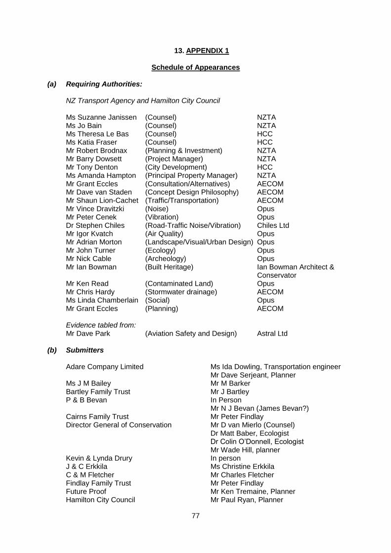
77
13. APPENDIX 1
Schedule of Appearances
(a) Requiring Authorities: NZ Transport Agency and Hamilton City Council
Ms Suzanne Janissen (Counsel) NZTA Ms Jo Bain (Counsel) NZTA Ms Theresa Le Bas (Counsel) HCC Ms Katia Fraser (Counsel) HCC Mr Robert Brodnax (Planning & Investment) NZTA Mr Barry Dowsett (Project Manager) NZTA Mr Tony Denton (City Development) HCC Ms Amanda Hampton (Principal Property Manager) NZTA Mr Grant Eccles (Consultation/Alternatives) AECOM Mr Dave van Staden (Concept Design Philosophy) AECOM Mr Shaun Lion-Cachet (Traffic/Transportation) AECOM Mr Vince Dravitzki (Noise) Opus Mr Peter Cenek (Vibration) Opus Dr Stephen Chiles (Road-Traffic Noise/Vibration) Chiles Ltd Mr Igor Kvatch (Air Quality) Opus Mr Adrian Morton (Landscape/Visual/Urban Design) Opus Mr John Turner (Ecology) Opus Mr Nick Cable (Archeology) Opus Mr Ian Bowman (Built Heritage) Ian Bowman Architect & Conservator Mr Ken Read (Contaminated Land) Opus Mr Chris Hardy (Stormwater drainage) AECOM Ms Linda Chamberlain (Social) Opus Mr Grant Eccles (Planning) AECOM Evidence tabled from: Mr Dave Park (Aviation Safety and Design) Astral Ltd (b) Submitters Adare Company Limited Ms Ida Dowling, Transportation engineer Mr Dave Serjeant, Planner Ms J M Bailey Mr M Barker Bartley Family Trust Mr J Bartley P & B Bevan In Person Mr N J Bevan (James Bevan?) Cairns Family Trust Mr Peter Findlay Director General of Conservation Mr D van Mierlo (Counsel) Dr Matt Baber, Ecologist Dr Colin O’Donnell, Ecologist Mr Wade Hill, planner Kevin & Lynda Drury In person J & C Erkkila Ms Christine Erkkila C & M Fletcher Mr Charles Fletcher Findlay Family Trust Mr Peter Findlay Future Proof Mr Ken Tremaine, Planner Hamilton City Council Mr Paul Ryan, Planner
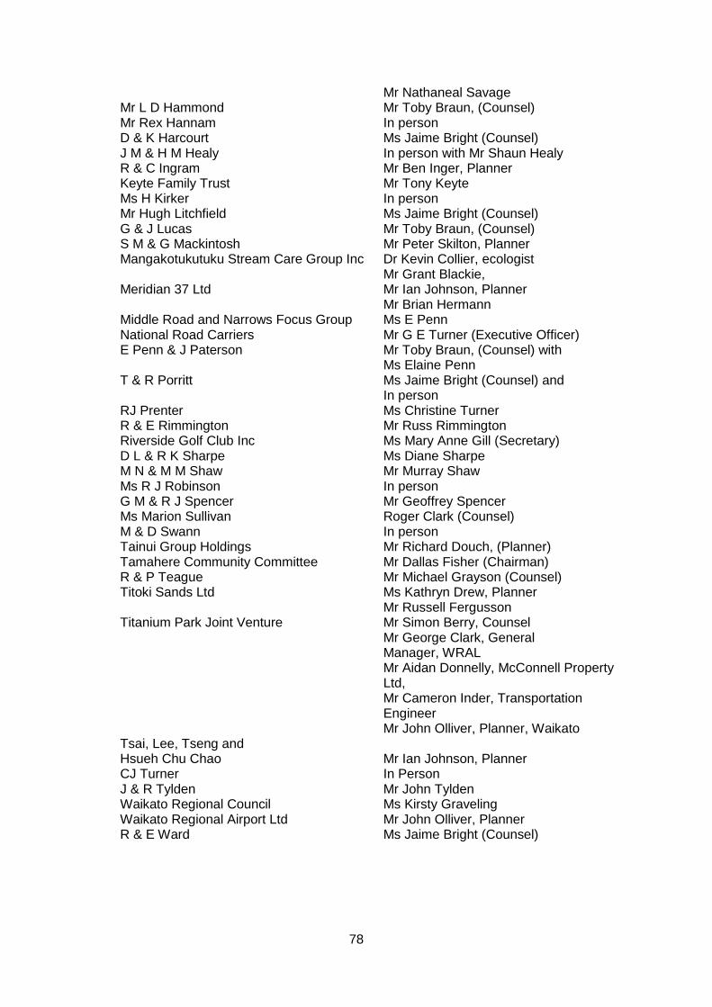
78
Mr Nathaneal Savage Mr L D Hammond Mr Toby Braun, (Counsel) Mr Rex Hannam In person D & K Harcourt Ms Jaime Bright (Counsel) J M & H M Healy In person with Mr Shaun Healy R & C Ingram Mr Ben Inger, Planner Keyte Family Trust Mr Tony Keyte Ms H Kirker In person Mr Hugh Litchfield Ms Jaime Bright (Counsel) G & J Lucas Mr Toby Braun, (Counsel) S M & G Mackintosh Mr Peter Skilton, Planner Mangakotukutuku Stream Care Group Inc Dr Kevin Collier, ecologist Mr Grant Blackie, Meridian 37 Ltd Mr Ian Johnson, Planner Mr Brian Hermann Middle Road and Narrows Focus Group Ms E Penn National Road Carriers Mr G E Turner (Executive Officer) E Penn & J Paterson Mr Toby Braun, (Counsel) with Ms Elaine Penn T & R Porritt Ms Jaime Bright (Counsel) and In person RJ Prenter Ms Christine Turner R & E Rimmington Mr Russ Rimmington Riverside Golf Club Inc Ms Mary Anne Gill (Secretary) D L & R K Sharpe Ms Diane Sharpe M N & M M Shaw Mr Murray Shaw Ms R J Robinson In person G M & R J Spencer Mr Geoffrey Spencer Ms Marion Sullivan Roger Clark (Counsel) M & D Swann In person Tainui Group Holdings Mr Richard Douch, (Planner) Tamahere Community Committee Mr Dallas Fisher (Chairman) R & P Teague Mr Michael Grayson (Counsel) Titoki Sands Ltd Ms Kathryn Drew, Planner Mr Russell Fergusson Titanium Park Joint Venture Mr Simon Berry, Counsel Mr George Clark, General Manager, WRAL Mr Aidan Donnelly, McConnell Property Ltd, Mr Cameron Inder, Transportation Engineer Mr John Olliver, Planner, Waikato Tsai, Lee, Tseng and Hsueh Chu Chao Mr Ian Johnson, Planner CJ Turner In Person J & R Tylden Mr John Tylden Waikato Regional Council Ms Kirsty Graveling Waikato Regional Airport Ltd Mr John Olliver, Planner
R & E Ward Ms Jaime Bright (Counsel)
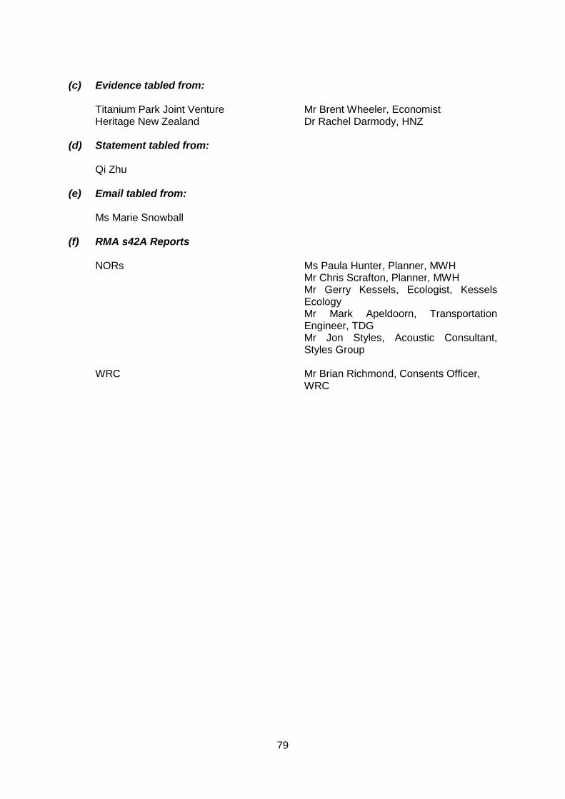
79
(c) Evidence tabled from: Titanium Park Joint Venture Mr Brent Wheeler, Economist Heritage New Zealand Dr Rachel Darmody, HNZ (d) Statement tabled from: Qi Zhu (e) Email tabled from: Ms Marie Snowball
(f) RMA s42A Reports
NORs Ms Paula Hunter, Planner, MWH Mr Chris Scrafton, Planner, MWH Mr Gerry Kessels, Ecologist, Kessels
Ecology Mr Mark Apeldoorn, Transportation
Engineer, TDG Mr Jon Styles, Acoustic Consultant,
Styles Group WRC Mr Brian Richmond, Consents Officer, WRC