artes1 communications in the future statutory commercial maritime communications market · ·...
TRANSCRIPT
ARTES 1
SatCom4Mar Workshop, London, UK08‐July‐2014 1
ARTES 1
1
Satellite Communications in the Future Statutoryand Commercial Maritime Communications Market
ARTES 1
Workshop onFuture Maritime Communications
08‐July‐2014London, UK
08‐July‐2014 SatCom4Mar Workshop, London, UK 2
ARTES 1
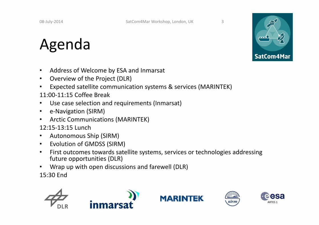
Agenda• Address of Welcome by ESA and Inmarsat• Overview of the Project (DLR)• Expected satellite communication systems & services (MARINTEK)11:00‐11:15 Coffee Break• Use case selection and requirements (Inmarsat) • e‐Navigation (SIRM)• Arctic Communications (MARINTEK)12:15‐13:15 Lunch• Autonomous Ship (SIRM)• Evolution of GMDSS (SIRM)• First outcomes towards satellite systems, services or technologies addressing
future opportunities (DLR)• Wrap up with open discussions and farewell (DLR)15:30 End
08‐July‐2014 SatCom4Mar Workshop, London, UK 3

ARTES 1
Project Partners
08‐July‐2014 SatCom4Mar Workshop, London, UK 4
The SatCom4Mar Project is funded by the ARTES 1 ESA Programme
Coordinator: Deutsches Zentrum für Luft‐ und Raumfahrt, Germany
Inmarsat, UK
Norwegian Marine Technology Research Institute, Norway
Società Italiana Radio Marittima, Italy

ARTES 1
Project Goals The fundamental questions the project SatCom4Mar will address are:
• Which upcoming satellite communication system could contribute to fulfil the requirements of maritime user applications?
• Are there any technological gaps requiring new developments?
• How could upcoming satellite, terrestrial, and legacy systems be integrated to reduce the burden on the navigator (in terms of amount of radio equipment and related procurement and service costs)?
Project duration until 03‐Oct‐2014
SatCom4Mar Workshop, London, UK 508‐July‐2014

ARTES 1
Project Outcomes
• Public workshop (July‐08, 2014) to disseminate already achieved results and to discuss and collect further inputs from the maritime communications community
• Development of road map towards potential new satellite systems and technology. Release and dissemination to relevant bodies and stakeholders by a public final report.
SatCom4Mar Workshop, London, UK 608‐July‐2014
ARTES 1
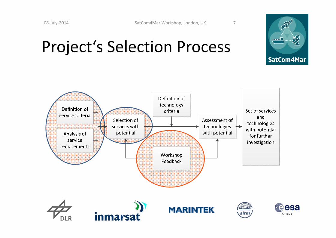
Project‘s Selection Process
SatCom4Mar Workshop, London, UK 708‐July‐2014
ARTES 1
Expected satellite communication systems & services in 2020
Fritz BekkadalMaritime ICT,
Department of Transport Systems, MARINTEK
SatCom4Mar Workshop, Inmarsat, 08.07.2014

Developments and future demands for maritime communications in 2020
• Historically, the maritime industry has been conservative and slow to adopt new technologies
• Shipping companies have always largely relied on proven solutions, but this situation has changed in the course of the past few years
• The maritime industry has been moving from traditional communications systems to higher speed IP data networks
SatCom4Mar Workshop, London, UK 908‐July‐2014

Global maritime SatCom market development predictions
Source: Euroconsult, March 2014
SatCom4Mar Workshop, London, UK 1008‐July‐2014

Global maritime SatCom market status
• In 2013 the global maritime SatCom market grew by 4% in number of terminals and 10% in revenues at the satellite operator level
• Currently the total size of the market is about 348 000 active terminals and more than €560m in revenues at the operator level
• Established MSS services and the fast developing VSAT business contributed to the overall growth of the maritime SatCom market
11SatCom4Mar Workshop, London, UK 1108‐July‐2014

Global maritime market growth predictions
• In 2014 several High Throughput Satellite (HTS) systems will be available 3 times more capacity by the end of 2014 and 6 times more capacity by the end of 2016.
• SatCom capacity revenues will nearly double over the next decade, with a CAGR of 7% over the 10‐year period, to €1.1bn in 2023 (610 000 active terminals)
• The growth is expected to be driven mainly by increasing data consumption across all major maritime segments and the adoption of new generation broadband satellite services.
CAGR: Consolidated Annual Growth Rate
SatCom4Mar Workshop, London, UK 1208‐July‐2014

The maritime market
08‐July‐2014 SatCom4Mar Workshop, London, UK 13
SatCom4Mar Workshop, London, UK 1308‐July‐2014
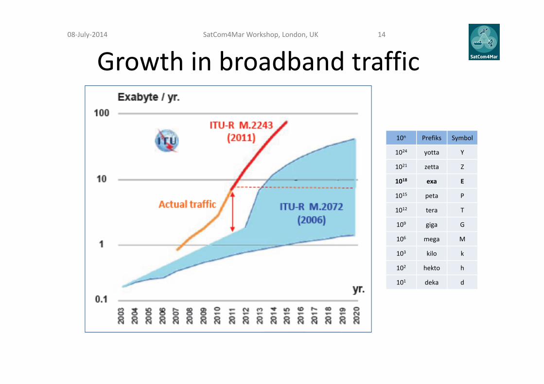
Growth in broadband traffic
10n Prefiks Symbol
1024 yotta Y
1021 zetta Z
1018 exa E
1015 peta P
1012 tera T
109 giga G
106 mega M
103 kilo k
102 hekto h
101 deka d
SatCom4Mar Workshop, London, UK 1408‐July‐2014
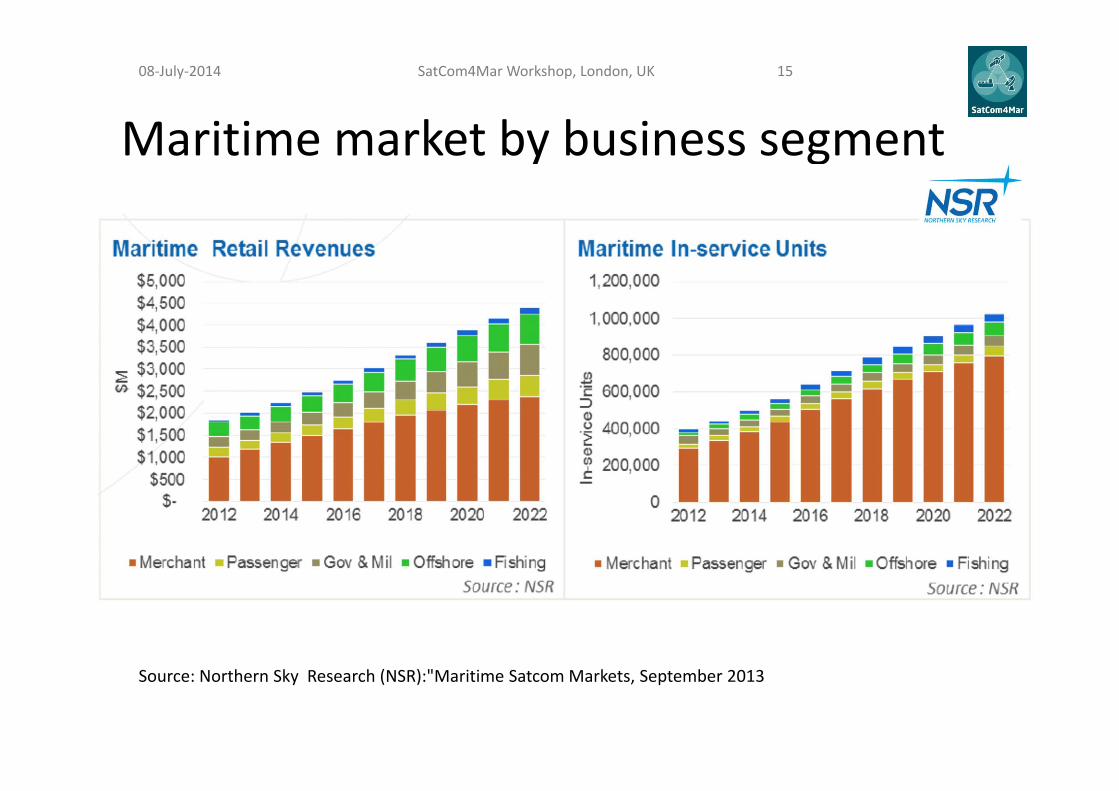
Maritime market by business segment
Source: Northern Sky Research (NSR):"Maritime SatcomMarkets, September 2013
SatCom4Mar Workshop, London, UK 1508‐July‐2014

Market segments' dynamics• Merchant Maritime remains a vital market for maritime
SatCom services – with over 800,000 in‐service units• The Internet‐connected, always‐on movement has
permeated even the family vacation – even on the high‐seas. Combined the Passenger market will account for almost 60 transponders of FSS capacity demand, and over 6 Gbps of HTS capacity
• The Offshore market continues on a growth‐path, adding more than 50,000 in‐service units over the next ten years
• Fishing markets represent the largest addressable market – but still remains a limited opportunity for SatCom
• Government and Military markets face near‐term budget problems, but are expected to recover by 2022
SatCom4Mar Workshop, London, UK 1608‐July‐2014
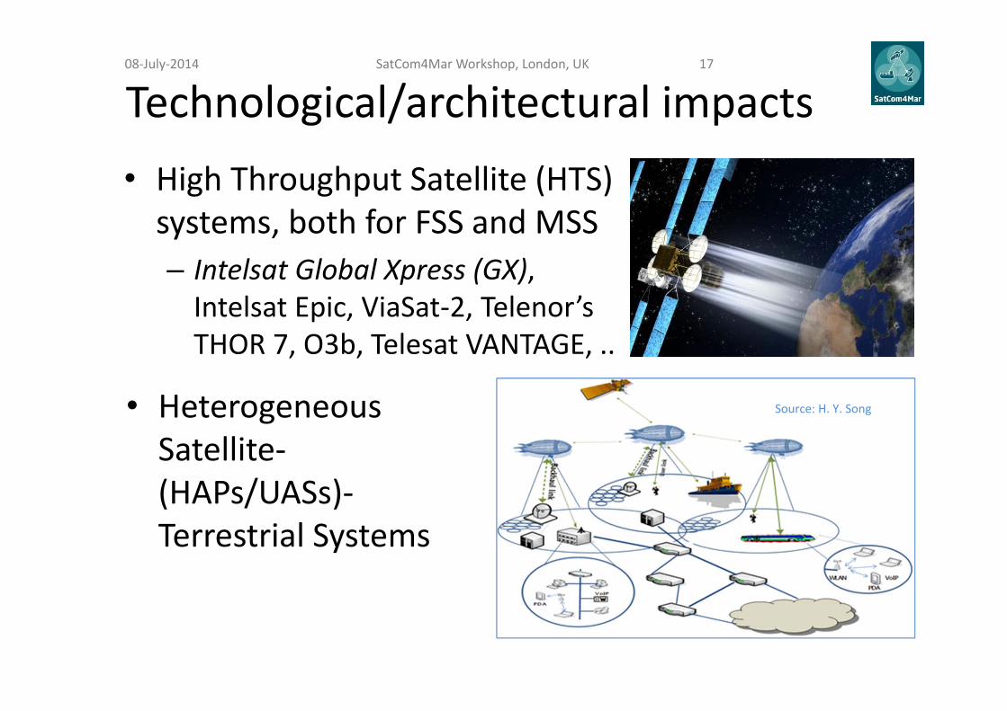
Technological/architectural impacts• High Throughput Satellite (HTS) systems, both for FSS and MSS– Intelsat Global Xpress (GX), Intelsat Epic, ViaSat‐2, Telenor’s THOR 7, O3b, Telesat VANTAGE, ..
Source: H. Y. Song • Heterogeneous Satellite‐(HAPs/UASs)‐Terrestrial Systems
SatCom4Mar Workshop, London, UK 1708‐July‐2014

• Google has allegedly been recruiting ateam of satellite engineers (lead by GregWyler – O3b Networks's founder) todesign a constellation of LEO satellites toprovide global coverage broadband
• The Google‐backed company WorldVu Satellites (L5) has filed for the (legacy Skybridge) Ku‐band frequency and reportedly secured priority ITU filing
• ITU shows L5 filings as promising to start service between late 2019 and mid‐2020• 180 (360?) LEO (800‐950 km altitude?) small (100 kg?) polar orbiting satellites
(inclination: 88.3)• Total capacity: 1‐2 Tbps at full constellation (?)• Small & cheap user terminals; flat panel antennas such as those being developed by
Kymeta (?)
“It could definitely revolutionise the cost of maritime terminals, and the price of capacity could be considerably cheaper” (Tim Farrar, TMF Associates)
SatCom4Mar Workshop, London, UK 1808‐July‐2014

ARTES 1
Use Case Requirements
Yasrine IbnyahyaInmarsat
08‐July‐2014 SatCom4Mar Workshop, London UK
20
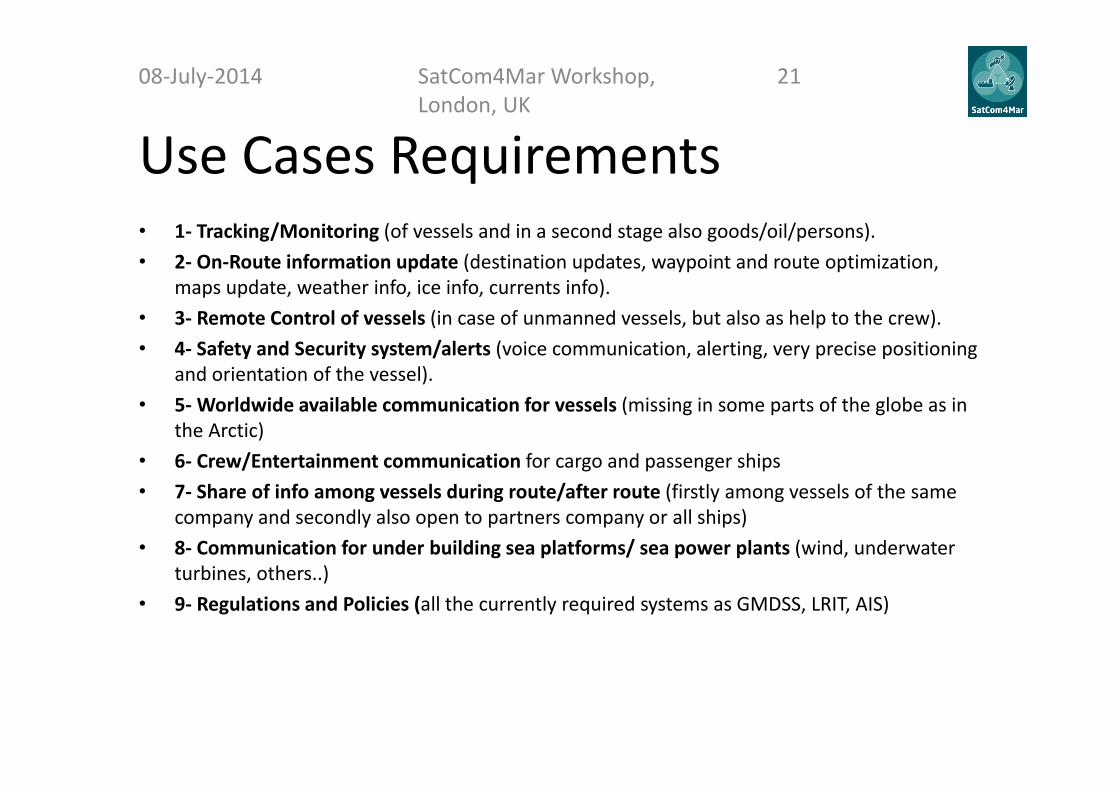
Use Cases Requirements• 1‐ Tracking/Monitoring (of vessels and in a second stage also goods/oil/persons). • 2‐ On‐Route information update (destination updates, waypoint and route optimization,
maps update, weather info, ice info, currents info). • 3‐ Remote Control of vessels (in case of unmanned vessels, but also as help to the crew). • 4‐ Safety and Security system/alerts (voice communication, alerting, very precise positioning
and orientation of the vessel). • 5‐Worldwide available communication for vessels (missing in some parts of the globe as in
the Arctic)• 6‐ Crew/Entertainment communication for cargo and passenger ships• 7‐ Share of info among vessels during route/after route (firstly among vessels of the same
company and secondly also open to partners company or all ships)• 8‐ Communication for under building sea platforms/ sea power plants (wind, underwater
turbines, others..)• 9‐ Regulations and Policies (all the currently required systems as GMDSS, LRIT, AIS)
08‐July‐2014 SatCom4Mar Workshop, London, UK
21
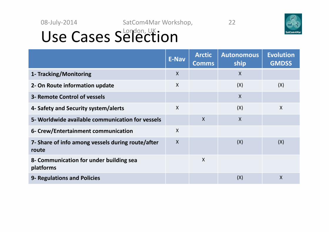
Use Cases SelectionE‐Nav Arctic
CommsAutonomous
shipEvolution GMDSS
1‐ Tracking/Monitoring X X
2‐ On Route information update X (X) (X)
3‐ Remote Control of vessels X
4‐ Safety and Security system/alerts X (X) X
5‐Worldwide available communication for vessels X X
6‐ Crew/Entertainment communication X
7‐ Share of info among vessels during route/after route
X (X) (X)
8‐ Communication for under building sea platforms
X
9‐ Regulations and Policies (X) X
08‐July‐2014 SatCom4Mar Workshop, London, UK
22
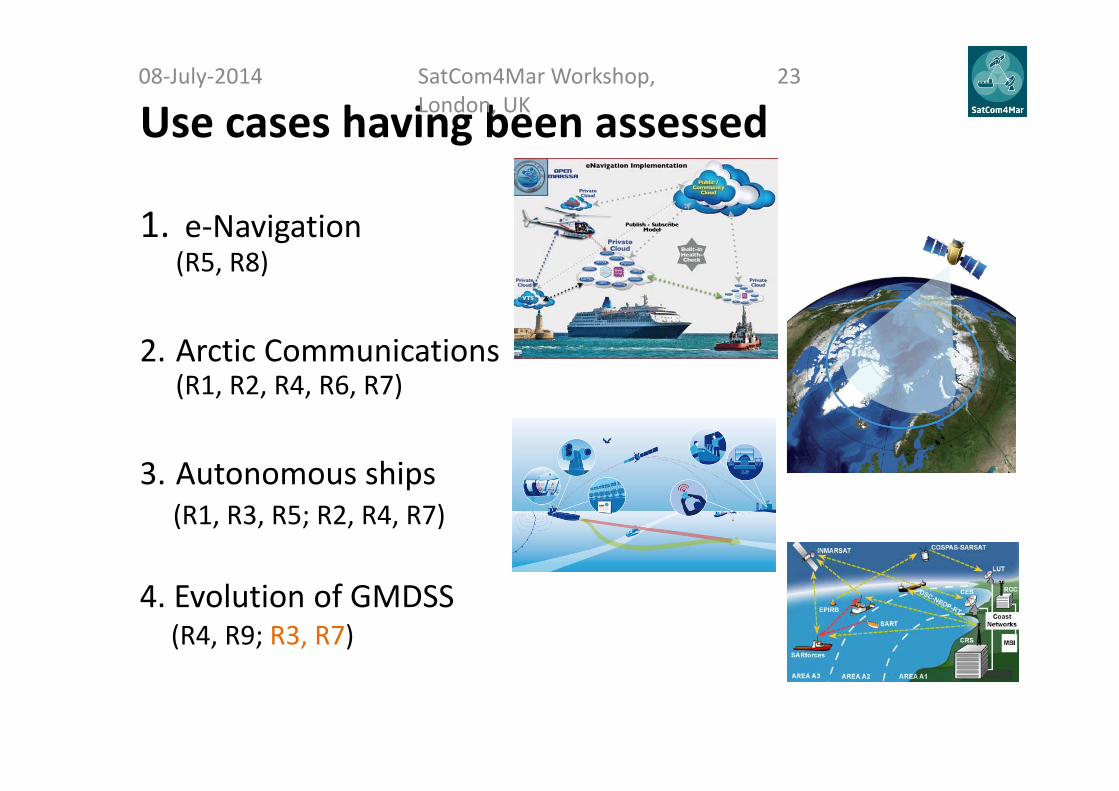
Use cases having been assessed
1. e‐Navigation(R5, R8)
2. Arctic Communications(R1, R2, R4, R6, R7)
3. Autonomous ships(R1, R3, R5; R2, R4, R7)
4. Evolution of GMDSS(R4, R9; R3, R7)
08‐July‐2014 SatCom4Mar Workshop, London, UK
23

ARTES 1
Use Case Scenario:e‐navigation
Claudio AleandriSIRM
Yasrine IbnyahyaInmarsat
08‐July‐2014 SatCom4Mar Workshop, London UK
24
E‐Navigation: Intro08‐July‐2014 SatCom4Mar Workshop,
London, UK25
IMO project that is underway and looking at a future digital concept for the maritimesector.• improved, harmonized and user‐friendly bridge design with improved reliability,
resilience and integrity of bridge equipment and navigation information togetherwith integration and presentation of information in graphical displays such as thatreceived via communication equipment;
• improved reliability and resilience of on‐board Position, Navigation and Timing(PNT) systems;
• improved shore‐based services with means for standardized and automated ship‐to‐shore reporting, improved access to relevant information for Search and Rescue(SAR), and improved communication of VTS (vessel traffic system) information.
At the present time IMO is developing a strategy implementation plan
The plan will be based on, where possible, the existing navigation and communicationequipment and systems.
E‐Navigation: User Requirements08‐July‐2014 SatCom4Mar Workshop,
London, UK26
Existing Navigation Requirements to be maintainedin the future:
• Long Range Identification Tracking (LRIT)• Automatic Identification System (AIS) andSatellite AIS
• GNSS• Vessel Traffic Services (VTS)• Vessel Monitoring Systems (VMS)
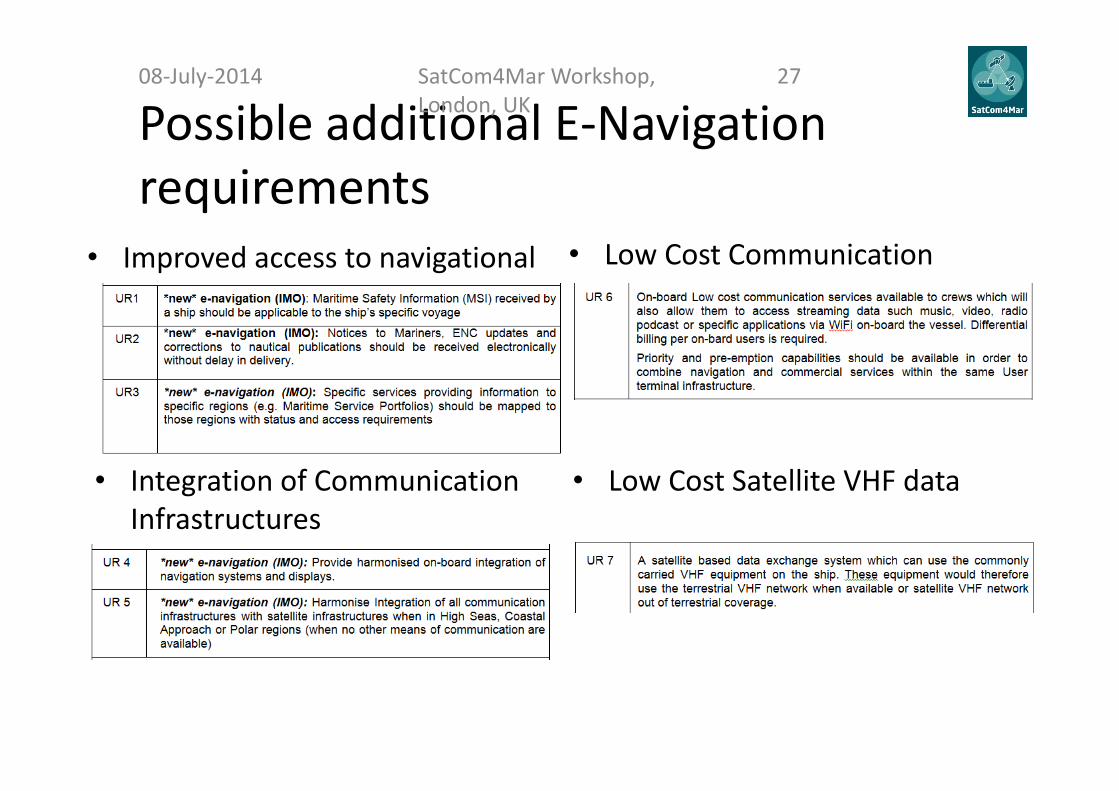
Possible additional E‐Navigation requirements
• Improved access to navigational safety information
08‐July‐2014 SatCom4Mar Workshop, London, UK
27
• Low Cost Satellite VHF data
• Low Cost Communication
• Integration of Communication Infrastructures
E‐Navigation: High level architecture drivers
Starting from requirements the following pointshave been taken into account in defining thearchitecture:• Flexibility• Use of consolidated application technologies• Communication link interoperability
08‐July‐2014 SatCom4Mar Workshop, London, UK
28

E‐Navigation: High level architecture
08‐July‐2014 SatCom4Mar Workshop, London, UK
29
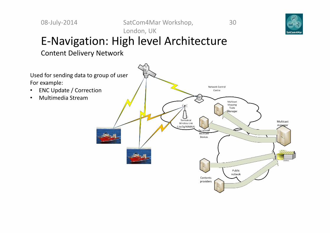
E‐Navigation: High level Architecture Content Delivery Network
08‐July‐2014 SatCom4Mar Workshop, London, UK
30
Used for sending data to group of userFor example:• ENC Update / Correction• Multimedia Stream

E‐Navigation: High level architecture Integrated Application
08‐July‐2014 SatCom4Mar Workshop, London, UK
31
Client Layer
Process Layer
Enterprise Service Bus
AccessManager
Service Layer
ENC TUGS
Services MSI VTS Port Services
Application Front End
Data Storage

E‐Navigation: High level Architecture VDE
08‐July‐2014 SatCom4Mar Workshop, London, UK
32

E‐Navigation: High level Architecture On Board Architecture
08‐July‐2014 SatCom4Mar Workshop, London, UK
33
E‐Navigation: Expected Impact on actual architecture (1/2)
08‐July‐2014 SatCom4Mar Workshop, London, UK
34
The major impact on the existing architecture is expected to be related tointegration of all communication infrastructures with satellite infrastructures.• It seems likely that a combined satellite and terrestrial system may give
best trade‐off between benefits and drawbacks.• A terrestrial infrastructure may provide low cost solutions for the coastal
fleet which may be an important argument for developing nations.• Special systems are required to cover the Polar Regions beyond GEO
satellites coverage. LEO or HEO satellites systems may be mostappropriate.
• Rate of data transfer (capacity of transmission).
E‐Navigation: Expected Impact on actual architecture (2/2)
08‐July‐2014 SatCom4Mar Workshop, London, UK
35
An ideal e‐Navigation communications system would operate automatically, selecting the best communications technology, channel, and characteristics compliant with the ship’s location, and the type of data to be exchanged. This automatic process would be managed in accordance with rules and the needs of the mariner that might include the following:• Need to avoid latency, e.g. when exchanging safety and navigation data with other
vessels or receiving it from electronic systems ashore or at sea;• Ability to delay the transmission or receipt of data, e.g. transfer of non‐urgent
administrative data, or the receipt of chart corrections for the current voyage, asubsequent voyage or for a port to be visited later during the pertinent voyage;
• Value / cost of communications;• Rate of data transfer (capacity of transmission).
Questions?08‐July‐2014 SatCom4Mar Workshop,
London, UK36

ARTES 1
Use Case Scenario:Arctic Communications
Fritz BekkadalMaritime ICT,
Department of Transport Systems, MARINTEK
SatCom4Mar Workshop, Inmarsat, 08.07.2014
Major drivers for Arctic Communication developments
• Oil and Gas (O&G) exploitations• Exploitations of minerals• Fisheries (renewable resources)• New shipping routes• Tourism
SatCom4Mar Workshop, London, UK 3808‐July‐2014

The 22nd and 23rd Norwegian licensing round ‐ closing up on the polar ice rim
SatCom4Mar Workshop, London, UK 3908‐July‐2014

The northernmost findings in the Barents Sea so far Block 7324/8‐1 in the Hoop area
Illustration: Heidi Bredesen
73.5°N / 24.3°E
SatCom4Mar Workshop, London, UK 4008‐July‐2014

Ships, oil and gas ‐ and e‐com servicesSatCom4Mar Workshop, London, UK 4108‐July‐2014

SatCom4Mar: Users' requirements list
• Distress and Safety– An alternative system to HF communications which can be adopted by the IMO and which can provide timely distress and safety communication functions for latitudes above 76oN
• Maritime Safety Information (MSI)– A new MSI service which can be received by ships sailing above 76oN and can additionally provide ice information
• Communications– Communications circuits providing reliable communication capability for ships sailing above 76oN and capable of multi‐Mbps data rates.
42SatCom4Mar Workshop, London, UK 4208‐July‐2014

Arctic wireless e‐com coverage limitations System Characteristics Polar
(> 80°N) Sub‐polar
(70°N ‐ 80°N)
Terrestrial systems
HF (500 kHz) NAVTEX (safety related messages) Unsuitable for digital communications (<0.1 kbps)
HF (500 kHz) NAVDAT (safety related messages)
Currently unavailable; NAVTEX architecture for narrowband data (10‐20 kbps)
HF, MF Safety related messages and voice only
Unsuitable for digital communications
Unsuitable for digital communications
VHF, Digital VHF
Line‐of‐sight voice and narrowband data No base stations Few base stations
GSM, 3G Line‐of‐sight voice and narrowband data No base stations Very few base stations
LTE/4G, WiMAX Line‐of‐sight voice and broadband data No base stations Insignificant deployment
SatCom
systems
GEO (Inmarsat, VSAT)
Medium capacity ‐ low to moderate latency Unavailable Limited availability and quality
LEO (Iridium) Narrowband data
communications – high and variable latency
Potential problems with capability/ quality
Potential problems with capability/quality
HEO Properties comparable with GEO
Currently unavailable, but expected to provide good coverage and properties comparable to GEO systems at lower altitudes (< 60N).
SatCom4Mar Workshop, London, UK 4308‐July‐2014

Future Northern hemisphere SatCom system HEO’s ! (?)• Quasi‐stationary perspective• Apogee height GEO GEO technology can be reused (slightly modified)– Cost savings– Risk reduction
• Best possible high‐latitude coverage per satellite– Fully complements GEO data; no LEO‐like latitudinal
coverage gaps– Little time “wasted” over lower latitudes adequately seen
from GEO• Relatively simple ground segment;
real‐time dissemination can be achieved with a single primary ground station, as for GEO
SatCom4Mar Workshop, London, UK 4408‐July‐2014

Possible SatCom developments in the High North (> 75°N)
Iridium NEXT(2015‐2017)
PCW? (Canadian)
(2020 – (25?))
Arktika?(Russian)
(2020‐ (25?))
Source: Canadian Space Agency ARKTIKA SYSTEM. NPO LAVOCHKIN ILLUSTRATION
SatCom4Mar Workshop, London, UK 4508‐July‐2014
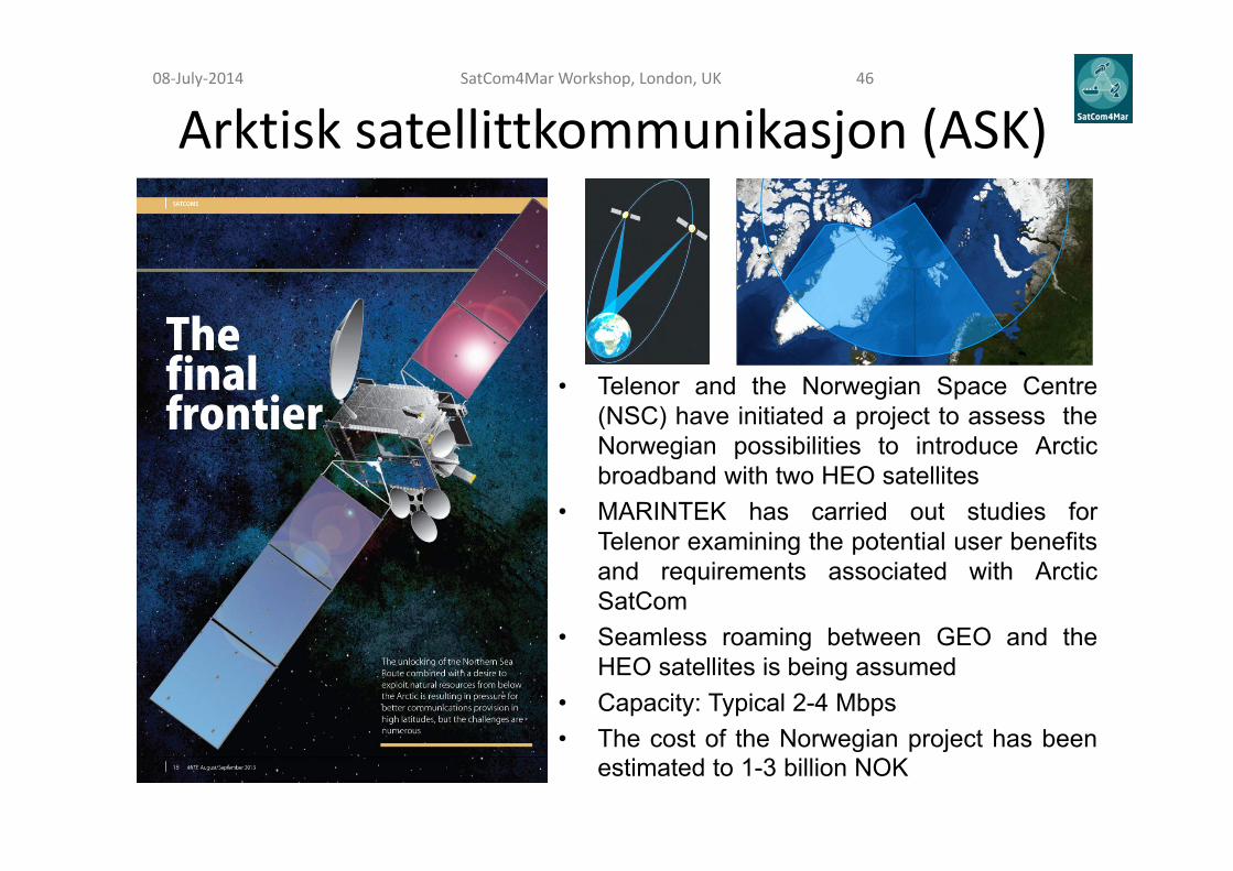
Arktisk satellittkommunikasjon (ASK)
• Telenor and the Norwegian Space Centre(NSC) have initiated a project to assess theNorwegian possibilities to introduce Arcticbroadband with two HEO satellites
• MARINTEK has carried out studies forTelenor examining the potential user benefitsand requirements associated with ArcticSatCom
• Seamless roaming between GEO and theHEO satellites is being assumed
• Capacity: Typical 2-4 Mbps• The cost of the Norwegian project has been
estimated to 1-3 billion NOK
SatCom4Mar Workshop, London, UK 4608‐July‐2014
• No commercial SatCom operator/service provider envisages a market of sufficient size to risk the deployment investments on its own
• Lack of public national and/or international leading initiatives • Hesitating multi‐sectorial user communities
– Most companies prefer to buy services when available, which is typical for the maritime industry like cruise and ferry, fishing, shipping, waterborne transportation, etc.
– The O&G industry might be more willing to commit at an earlier state, depending on when the oil/gas fields further north in the Arctic are deemed accessible for explorations, and on the mobile data capacity needed during the (initial) exploration, appraisal and development phases
Arctic HEO system realisation challenges #1SatCom4Mar Workshop, London, UK 4708‐July‐2014

The five major phases of an oil and gas (O&G) exploration and production (E&P) company's operations
No dedicated e‐com infrastructure is normally applied during this phase. Large amounts of data are stored on board the survey vessels to be processed ashore upon delivery. If a reliable broadband and qualified data link between the vessels and land would be accessible, the potential of saving time and money is significant.
No dedicated e‐com infrastructure is normally applied during this phase either. The dynamic positioning (DP) operations are central in a drilling process. Large amounts of data are stored on board the drilling vessels to be processed ashore upon delivery. The drilling activities are very costly and must be planned with a long perspective. The drilling rigs are hired by the operators.
This phase comprises careful planning of the production phase and its facilities, and hence also decisions regarding the e‐com infrastructure solutions, from the more mobile exploration/appraisal stages to a fixed infrastructure supporting the installations for a long period (i.e. installation of fiber). An assessment scrutinizing the cost/benefit of pertinent communication solutions to meet the operational requirements is consequently needed to specify the infrastructure, the equipment, and to issue an RFP. Subsequent decisions on suppliers and follow‐up on deliveries and installations, including testing, are additional crucial tasks in this phase.
When production starts fixed fiber cablesconnecting the main offshore installation to the shore is normally installed, and both fiber cables and radio links are used to connect surrounding installations to this main hub. Previous studies have revealed current capacity demands around 100 Mbps for typical oil rigs in the North Sea. Operative predictions indicate significantly increased use of remote operations and control in the future, which again brings about higher bandwidth demands.
Decommissioning is a large and complex multi‐discipline project. Each decommissioning project is unique and each platform has its own unique challenges.
Consideration for decommissioning should start in the concept phase of a new asset to ensure no unnecessary cost liability is placed on the operator. Decommissioning in design can increase the net present value of an asset significantly by making informed decisions in the design stage.
SatCom4Mar Workshop, London, UK 4808‐July‐2014
Arctic HEO system realisation challenges #2• Based on experience from the O&G developments
further south there are plausible reasons to assume that fibre communications will be supplied to offshore installations in the north when production is commencing. – Hence crucial e‐com services during the exploration, appraisal
and development phases are bound to rely on wireless solutions – However, during production wireless is deemed to be required
(only) for back‐up purposes and communication with mobile supply units and similar assets
• No evident viable multinational PPP cooperative approach on the horizon
• Attempting the 'INMARSAT model' from the late 1960's?
SatCom4Mar Workshop, London, UK 4908‐July‐2014
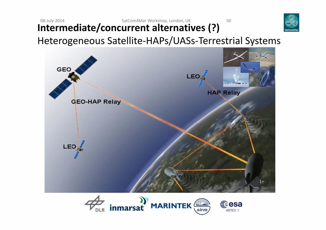
Intermediate/concurrent alternatives (?)Heterogeneous Satellite‐HAPs/UASs‐Terrestrial Systems
SatCom4Mar Workshop, London, UK 5008‐July‐2014

Hybrid Space‐Terrestrial (HST)Concept • GEO
• HEO• (MEO)• LEO
Terrestrial Core
Network
0.5 –20
km
600
–40
000
km
SatCom4Mar Workshop, London, UK 5108‐July‐2014

ARTES 1
Use Case Scenario:Autonomous Ships
Claudio AleandriSIRM
Yasrine IbnyahyaInmarsat
08‐July‐2014 SatCom4Mar Workshop, London UK
53
Autonomous Ship: Introduction08‐July‐2014 SatCom4Mar Workshop,
London, UK54
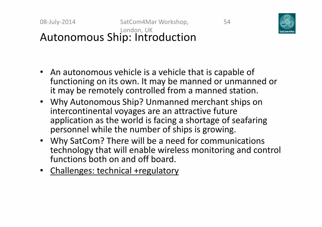
• An autonomous vehicle is a vehicle that is capable of functioning on its own. It may be manned or unmanned or it may be remotely controlled from a manned station.
• Why Autonomous Ship? Unmanned merchant ships on intercontinental voyages are an attractive future application as the world is facing a shortage of seafaring personnel while the number of ships is growing.
• Why SatCom? There will be a need for communications technology that will enable wireless monitoring and control functions both on and off board.
• Challenges: technical +regulatory
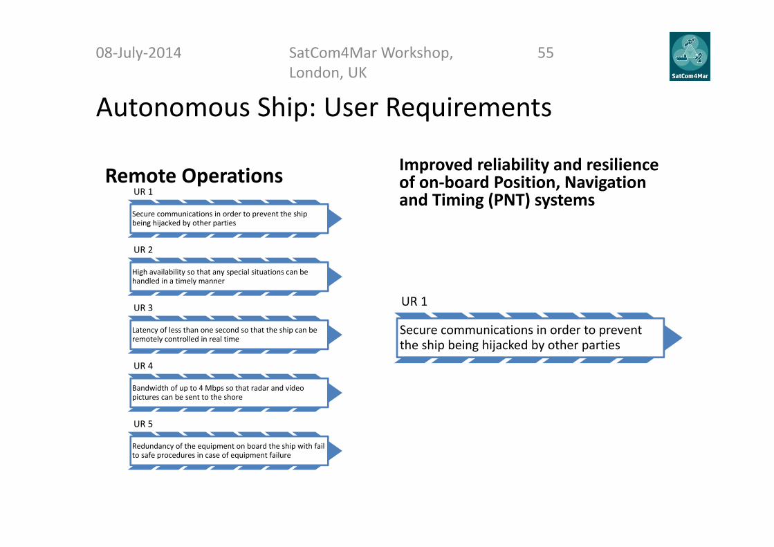
Autonomous Ship: User Requirements
08‐July‐2014 SatCom4Mar Workshop, London, UK
55
Remote Operations Improved reliability and resilience of on‐board Position, Navigation and Timing (PNT) systemsUR 1
Secure communications in order to prevent the ship being hijacked by other parties
UR 2
High availability so that any special situations can be handled in a timely manner
UR 3
Latency of less than one second so that the ship can be remotely controlled in real time
UR 4
Bandwidth of up to 4 Mbps so that radar and video pictures can be sent to the shore
UR 5
Redundancy of the equipment on board the ship with fail to safe procedures in case of equipment failure
UR 1
Secure communications in order to prevent the ship being hijacked by other parties
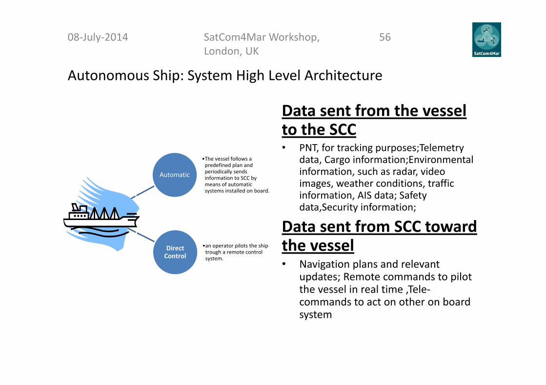
Autonomous Ship: System High Level Architecture
08‐July‐2014 SatCom4Mar Workshop, London, UK
56
Automatic
•The vessel follows a predefined plan and periodically sends information to SCC by means of automatic systems installed on board.
Direct Control
•an operator pilots the ship trough a remote control system.
Data sent from the vessel to the SCC • PNT, for tracking purposes;Telemetry
data, Cargo information;Environmental information, such as radar, video images, weather conditions, traffic information, AIS data; Safety data,Security information;
Data sent from SCC toward the vessel• Navigation plans and relevant
updates; Remote commands to pilot the vessel in real time ,Tele‐commands to act on other on board system

Autonomous Ship: Communication Needs
08‐July‐2014 SatCom4Mar Workshop, London, UK
57
Stream TypeBandwidth
(kbps)Latency
(s)Security Reliability Direction
Rendezvous LOS 2 0.05 High High Ship↔Ship
Remote Control LOS/SatCom 2 1 High Medium Ship↔Shore
Telemetry LOS/SatCom 32 1 Medium Medium Ship→Shore
Radar and Targets LOS/SatCom 75 1 Medium Medium Ship→Shore
HD Video LOS/ SatCom 3000 2.5 Medium Low Ship→Shore

Autonomous Ship: Communication Security Issue
08‐July‐2014 SatCom4Mar Workshop, London, UK
58
Three types of security issues will be considered : Confidentiality: This is the absence of unauthorized disclosure of
information. For personal communication and business communications,confidentiality is of high importance.
Integrity: This is the absence of improper system alteration. Forcommunication systems, this may be malign or accidental insertion offalse data or corruption of data.
Denial of service (DOS): This is the possibility of an attack oncomponents of the communication system that inhibits the use of thesystem to exchange data.
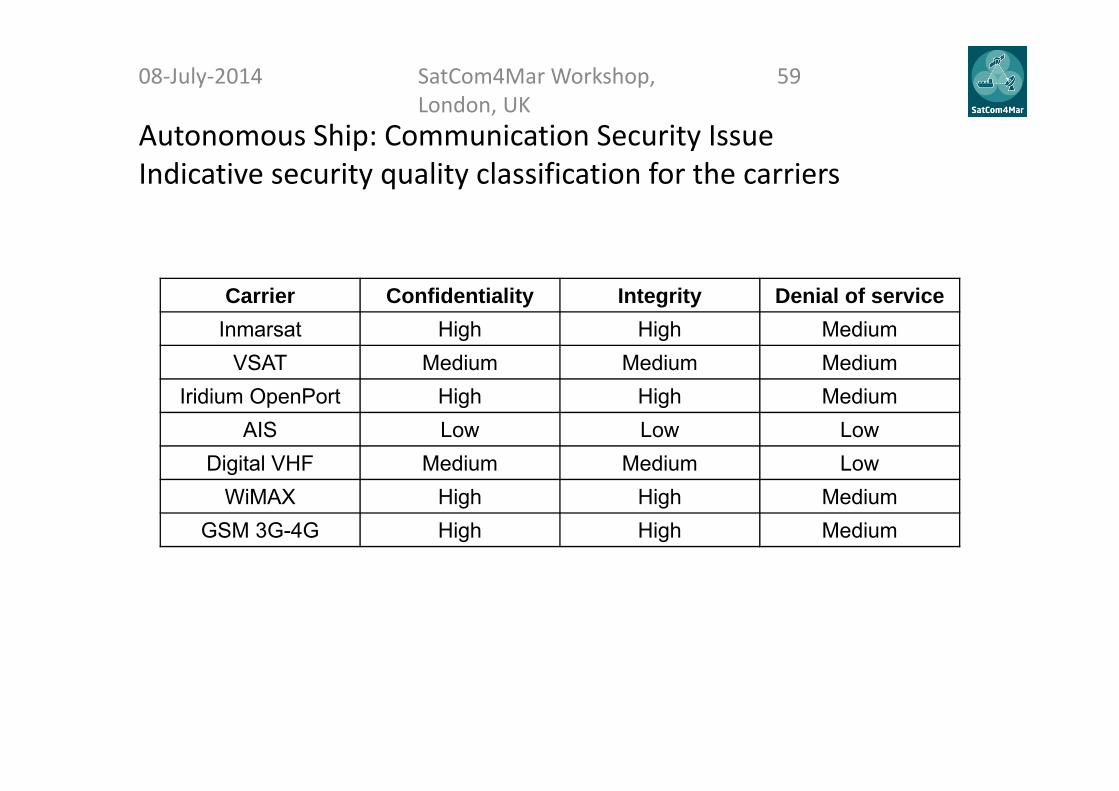
Autonomous Ship: Communication Security IssueIndicative security quality classification for the carriers
08‐July‐2014 SatCom4Mar Workshop, London, UK
59
Carrier Confidentiality Integrity Denial of serviceInmarsat High High Medium
VSAT Medium Medium MediumIridium OpenPort High High Medium
AIS Low Low LowDigital VHF Medium Medium Low
WiMAX High High MediumGSM 3G-4G High High Medium

Autonomous Ship: High Level Network Architecture (1/2)
08‐July‐2014 SatCom4Mar Workshop, London, UK
60

Autonomous Ship and SCC high level network
08‐July‐2014 SatCom4Mar Workshop, London, UK
61
Autonomous Ship: expected impact on existent architectures
08‐July‐2014 SatCom4Mar Workshop, London, UK
62
TodayThe ship is required to be equipped with various communication systems to satisfy relevant international legislation:
Automatic Identification Systems (AIS), VHF Radio with Digital Selective Call (DSC) which includes automatic distress alerting.
NAVTEX is a MF technology for sending warnings to ships in areas close to cost while SafetyNET is an Inmarsat based system with similar functionality for ships in deep sea areas.
The ship will also have to have Emergency Position Indication Radio Beacon (EPIRB) equipment for emergency signalling to other ships, airplanes and the COSPAS/SARSAT system of satellites.
TomorrowIn addition to the mandatory systems described the following communication systems are hence expected to be used for the unmanned ship: One main communication channel based
on a commercial VSAT service operating in C‐, Ku‐ or Ka‐band (4 Mbps)
Backup channel based on L‐band Inmarsat or Iridium OpenPort (in the future: Iridium NEXT) with a capacity of 128 kbps or more.
A dedicated and independent rendezvous communication channel based on, e.g., AIS or digital VHF technology.
Autonomous Ship: advantages and challenges
08‐July‐2014 SatCom4Mar Workshop, London, UK
63
Advantage Challenge• Much of the technology
needed for autonomy is already available.
• Economic sustainability • Social sustainability• Environmental sustainability
• Unmanned shipping requires new technology on board and ashore
• A shore‐side control center (SCC) is also required
• Reliable communication links and a robust communication architecture required
• Unmanned shipping requires the definition of new International Regulations

Questions?08‐July‐2014 SatCom4Mar Workshop,
London, UK64
ARTES 1
Use Case Scenario:Evolution of GMDSS
Yasrine IbnyahyaInmarsat
08‐July‐2014 SatCom4Mar Workshop, London UK
65
Claudio AleandriSIRM
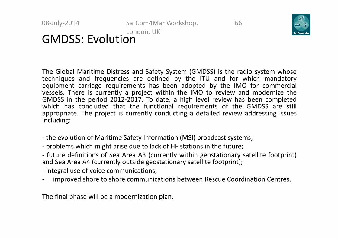
GMDSS: Evolution08‐July‐2014 SatCom4Mar Workshop,
London, UK66
The Global Maritime Distress and Safety System (GMDSS) is the radio system whosetechniques and frequencies are defined by the ITU and for which mandatoryequipment carriage requirements has been adopted by the IMO for commercialvessels. There is currently a project within the IMO to review and modernize theGMDSS in the period 2012‐2017. To date, a high level review has been completedwhich has concluded that the functional requirements of the GMDSS are stillappropriate. The project is currently conducting a detailed review addressing issuesincluding:
‐ the evolution of Maritime Safety Information (MSI) broadcast systems;‐ problems which might arise due to lack of HF stations in the future;‐ future definitions of Sea Area A3 (currently within geostationary satellite footprint)and Sea Area A4 (currently outside geostationary satellite footprint);‐ integral use of voice communications;‐ improved shore to shore communications between Rescue Coordination Centres.
The final phase will be a modernization plan.

GMDSS: User Requirements
08‐July‐2014 SatCom4Mar Workshop, London, UK
67
UR 0.1 Existing Functional requirements of the GMDSS are:• Every ship, while at sea, shall be capable:• of transmitting ship‐to‐shore distress alerts by at least two separate and independent means,
each using a different radio communication service;• of receiving shore‐to‐ship distress alerts;• of transmitting and receiving ship‐to‐ship distress alerts;• of transmitting and receiving search and rescue coordinating communications;• of transmitting and receiving on‐scene communications;• of transmitting and, receiving signals for locating; • of transmitting and receiving maritime safety information;• of transmitting and receiving general radio communications to and from shore‐based radio
systems or networks• of transmitting and receiving bridge‐to‐bridge communications.All these requirements are expected to remain mandatory for passenger ships and cargo ships (>300T). The system is however available to use by any ship in the world. It should be noted that ships may have a need for reception of certain maritime safety information while in port.
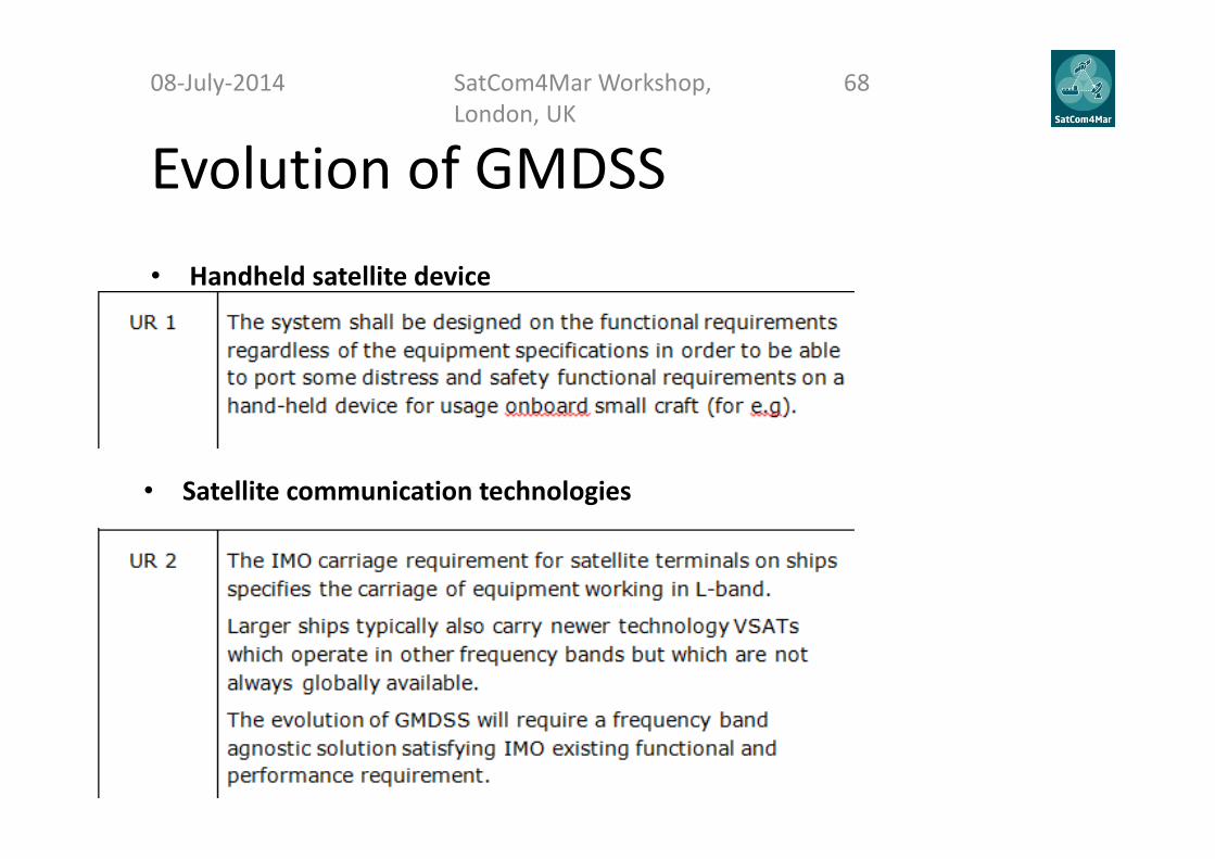
Evolution of GMDSS• Handheld satellite device
08‐July‐2014 SatCom4Mar Workshop, London, UK
68
• Satellite communication technologies

Evolution of GMDSS08‐July‐2014 SatCom4Mar Workshop,
London, UK69
• GMDSS satellite provider diversity
• New EPIRB technology
• Alternative to HF communication
GMDSS: High level architecture drivers
Starting from requirements the following pointshave been taken into account in defining thearchitecture:• Flexibility• Use of consolidated application technologies• Communication link interoperability
08‐July‐2014 SatCom4Mar Workshop, London, UK
70
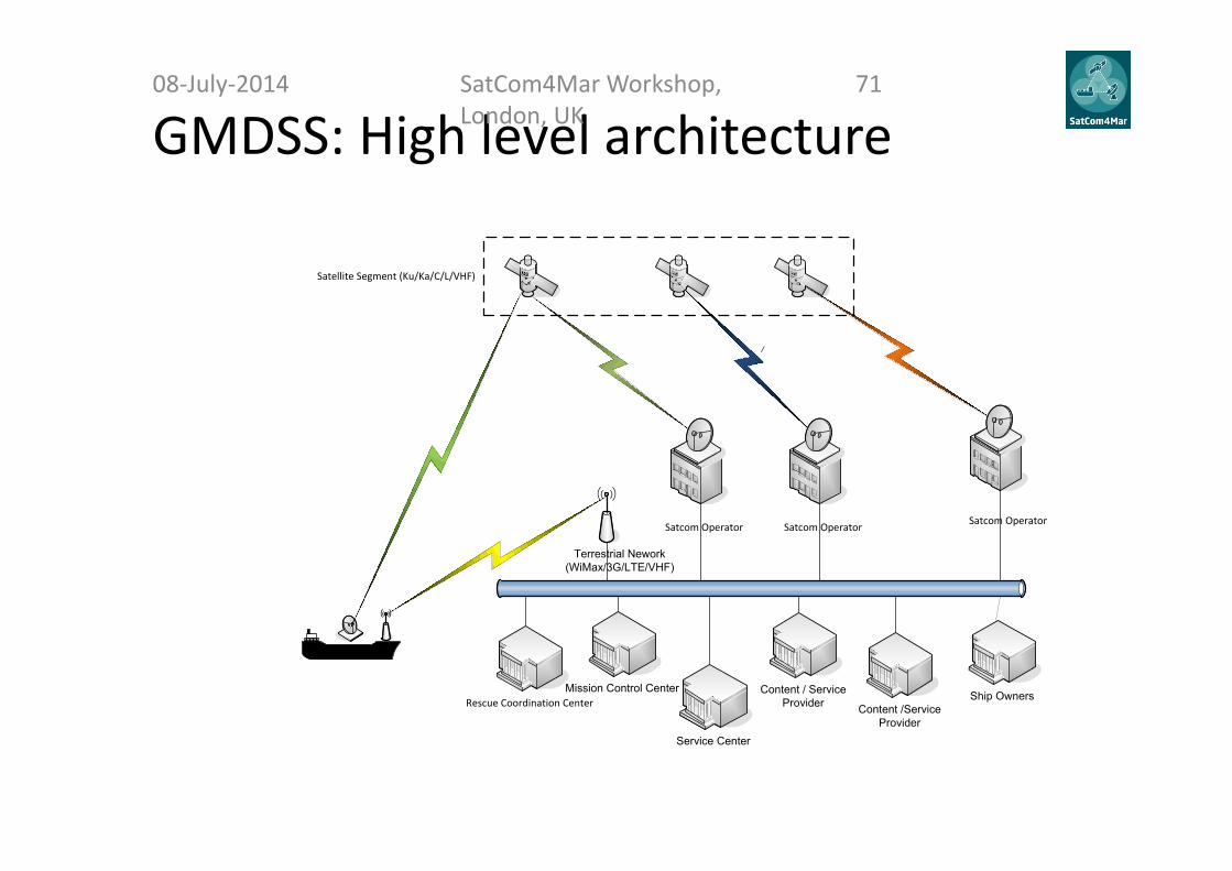
GMDSS: High level architecture08‐July‐2014 SatCom4Mar Workshop,
London, UK71
\
Satellite Segment (Ku/Ka/C/L/VHF)
Satcom Operator
Service Center
Content / Service Provider Content /Service
Provider
Terrestrial Nework(WiMax/3G/LTE/VHF)
Ship OwnersMission Control Center
Satcom Operator Satcom Operator
Rescue Coordination Center

GMDSS: High level architecture Current MSI Service
08‐July‐2014 SatCom4Mar Workshop, London, UK
72
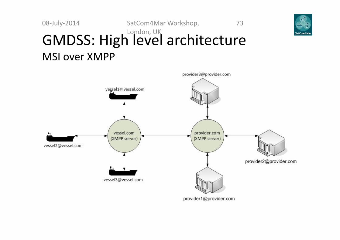
GMDSS: High level architecture MSI over XMPP
08‐July‐2014 SatCom4Mar Workshop, London, UK
73

GMDSS: High level architecture SAR
08‐July‐2014 SatCom4Mar Workshop, London, UK
74
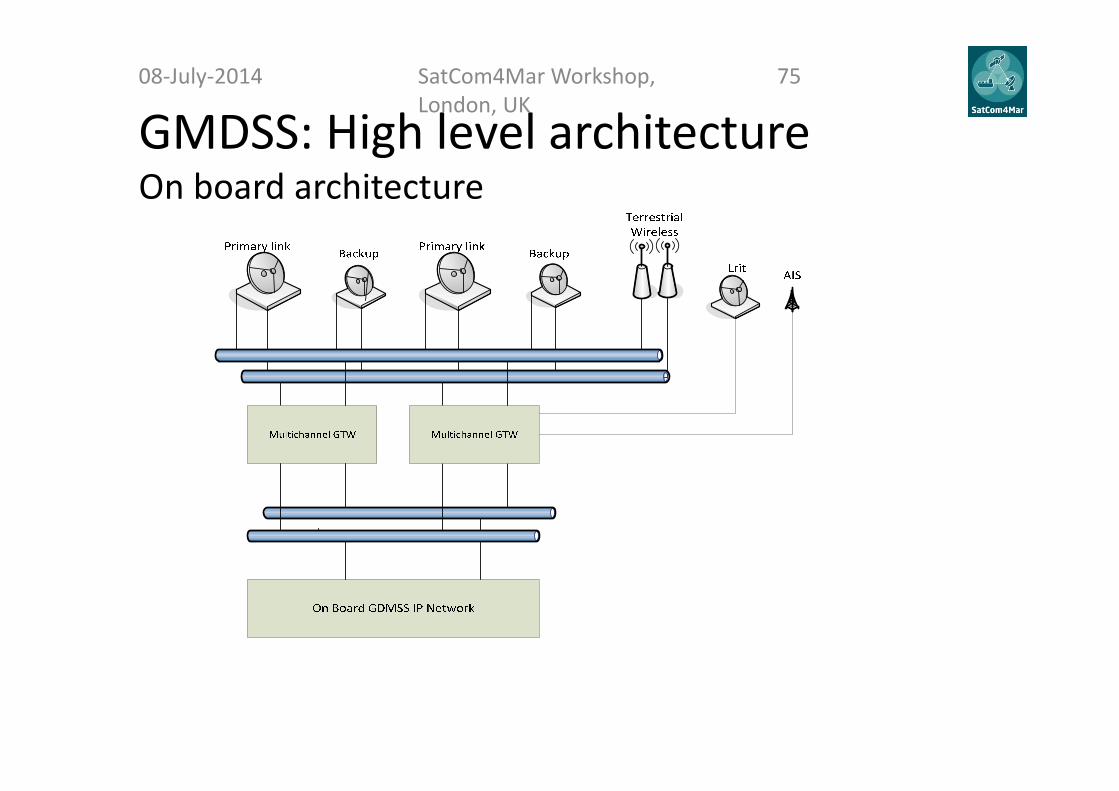
GMDSS: High level architectureOn board architecture
08‐July‐2014 SatCom4Mar Workshop, London, UK
75
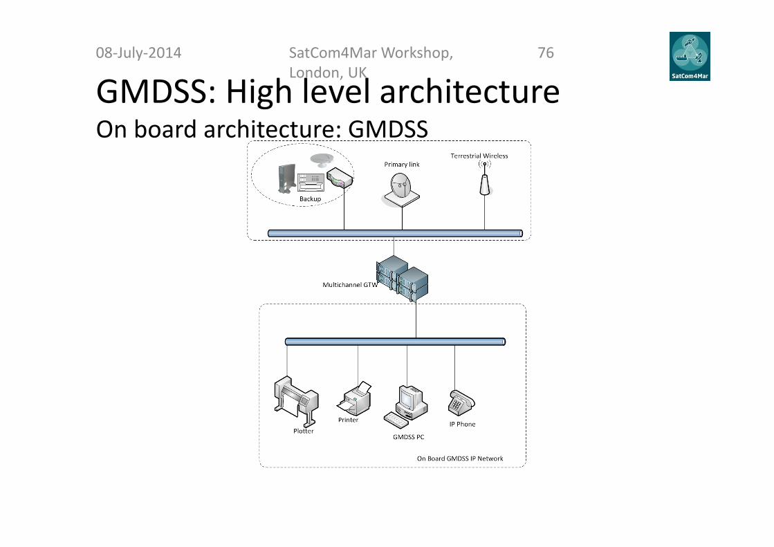
GMDSS: High level architecture On board architecture: GMDSS
08‐July‐2014 SatCom4Mar Workshop, London, UK
76

GMDSS:expected impact on existent architectures
IMO has now opened the GMDSS for the widest possible consideration, leadingpotentially to the greatest changes in maritime safety communications and technologyever since the original GMDSS was developed – changes that will add measurably andsignificantly to safety of life at sea.• Current maritime safety relies upon a broad mix of technologies, both satellite and
terrestrial, and this mix will remain the basis of a future revised GMDSS.• For backup the aging MF/HF technology needs to be renewed (a.o. digitized),
complemented and/or superseded by more modern solutions, if those substitutesprove adequate and compliant with the coming GMDSS requirements.
• The revised GMDSS needs to be based upon a holistic mix of the latesttechnologies, satellite and terrestrial, with modernized MF/HF radio as the back‐upand, in addition to Cospas‐Sarsat EPIRBs, an independent means of alerting.
• The specific impacts pertaining to the Arctic is further outlined in the relevantpresentation.
08‐July‐2014 SatCom4Mar Workshop, London, UK
77

Questions?08‐July‐2014 SatCom4Mar Workshop,
London, UK78

ARTES 1
First outcomes towards satellite systems, services or technologies addressing future opportunities
Federico ClazzerGerman Aerospace Center (DLR)
08‐July‐2014 SatCom4Mar Workshop, London UK
79
Aim and focus
• Define at high level possible architectures and technologies that can provide the requirements for all the use cases
• Focus is on the satellite related technologies as well as on integration between satellite and terrestrial
• Hybrid opportunities are also under investigation (HAPs, or other space‐based relay assets) where applicable
08‐July‐2014 SatCom4Mar Workshop, London, UK
80
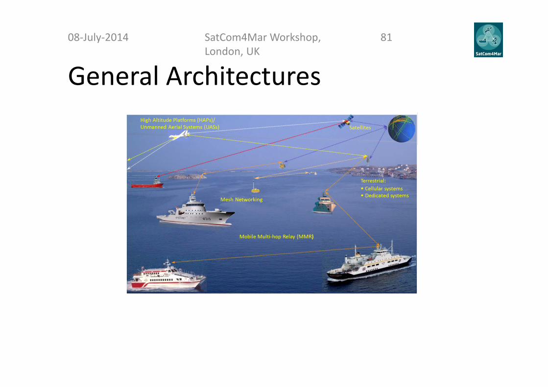
General Architectures08‐July‐2014 SatCom4Mar Workshop,
London, UK81
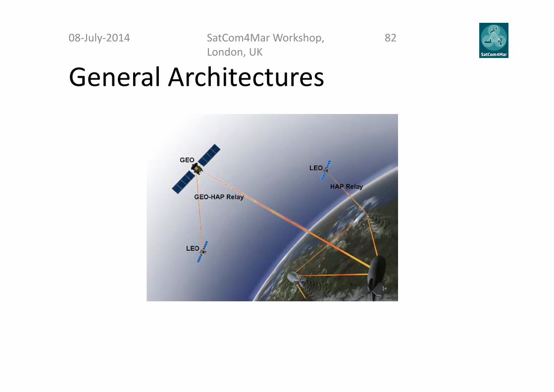
General Architectures08‐July‐2014 SatCom4Mar Workshop,
London, UK82

Example: E‐Navigation08‐July‐2014 SatCom4Mar Workshop,
London, UK83
• The User Requirements show the need of– Bi‐direction communication link (from ship‐to‐shore and from shore‐
to‐ship)– The communication is needed along the entire vessel route– The communication is needed also for new services e.g. VDES,
therefore there is a need to introduce a forward link (from shore‐to‐ship)
– Eventually the communication between ships can be also beneficial (need of multi‐hop heterogeneous networks and mesh networking)

Example: E‐Navigation08‐July‐2014 SatCom4Mar Workshop,
London, UK84
• The system architecture can be divided into:
– Satellite Segment
– Ground Segment
– Ship Segment
Example: E‐Navigation08‐July‐2014 SatCom4Mar Workshop,
London, UK85
• Satellite Segment– GEO, LEO and probably also HEO satellites are needed for providing world coverage ,
particularly where terrestrial is not available– Inter‐satellite links will be required, at least for LEOs– Multi‐hop communication has to be supported, at least for LEOs– Integration with terrestrial communication needs to be supported
• Future scenarios might include– HAPs or other space‐based relay assets that might act as micro‐cells for the terrestrial
system• Can be used for caching in a multi‐hop scenario• Can be used for enhancing the available bandwidth on board• Can be exploited for extending the connectivity among ships providing high data rates
– A large number of small satellites and/or cluster constellations

Example: E‐Navigation08‐July‐2014 SatCom4Mar Workshop,
London, UK86
• Ground Segment
– Multiple gateway scenario shall be supported
– The capability to support huge small satellite constellation can be a futuristic but real necessity
– Integration with terrestrial communication networks in order to allow seamless connections between satellite and terrestrial links
Example: E‐Navigation08‐July‐2014 SatCom4Mar Workshop,
London, UK87
• Ship segment
– Simplified equipment, to reduce:• The duplication of information• The difficulty for the captain and crew to retain useful information• The cost due to training• The response time in case of threats/emergencies
– The ability to utilize duplicated systems (with single visualization) for• Integrity check of the information• Redundancy in case of HW/SW failures• Increased safety on board
– Seamless switching between available links depending on the best performance provided

Conclusions08‐July‐2014 SatCom4Mar Workshop,
London, UK88
• The user requirements show the need of – New satellite configurations with increased flexibility– Integration with terrestrial networks
• The recent technologies needs to be considered and integrated in satellite systems for maritime
• The simplification for human to machine interaction is a driver for ship equipment