arnoldo/ftp/laptop/documents web viewsustaining coastal water resources at the intersection of...
TRANSCRIPT

Sustaining coastal water resources at the intersection of urban planning, biogeochemical sciences and coastal hydrodynamics in the face of sea level rise
Sea level change and sustainability of coastal water resources
Sustaining fresh and salt water resources in coastal zones in the face of accelerating sea level rise
The tipping point analysis of the impacts of sea level rise on the sustainability of coastal water resources
Sustaining coastal water resources in the face of accelerating sea-level rise
TIPSEACOW Tipping points of sea-level rise and coastal water resources
Sea-level change, thresholds, and coastal water sustainability
Sea-level thresholds for water sustainability
Sea-level thresholds for coastal water sustainability
Sea-level change and thresholds for coastal water sustainability
1

I. INTRODUCTIONThis proposal addresses the critical question: To what extent are water resources (both
fresh and salt) in coastal zones sustainable in the face of accelerating sea level rise? From this question, we develop four specific hypotheses (Section III) to be tested using a work plan (Section IV) that consists of collaborative interdisciplinary field observations, experiments, laboratory analyses, and modeling that will contribute to broader impacts (Section V) including development of an interdisciplinary STEM workforce and contributions to site-specific coastal management. Our question, hypotheses, and work plan arise from results of a Track 1 Coastal SEES planning project (Section II) that allowed us to assemble this multidisciplinary team of PIs with excellent working relationships and communication abilities.
Our question stems from uncertainties of how sea-level change impacts coastal water resources at various time and spatial scales Uncertainties arise from multiple linked physicochemical, biological and human processes occurring at coastal zones (Fig. 1). These linked processes require interdisciplinary research to respond and adapt to sea-level rise at optimal times, e.g.1, since response and adaptation may become prohibitively expensive or impossible to accomplish once changing conditions pass certain thresholds (abrupt changes in rates or conditions)2. Our project aims to address several important questions through continued interdisciplinary collaborations initiated with our Coastal SEES Track 1 planning grant. These questions include: What are and how will potential rates of sea-level change impact water resources required by humans and for ecological services? What processes represent thresholds in degradation of water resources? How will crossing thresholds impact natural and built coastal environments? How do thresholds vary with hydrologic characteristics of coastal aquifers?
II. RESULTS FROM PRIOR NSF SUPPORT
A. Martin, Ogram, Peng, Valle-Levinson, OCE-1325227, $441,125, 8/15/2013-7/31/2015 (plus 1-yr no-cost extension), “Coastal SEES (Track 1): Planning for hydrologic and ecological impacts of sea level rise on sustainability of coastal water resources”.
Intellectual merit: This project (hereafter referred to as CS1 for “Coastal SEES Track 1) achieved interdisciplinary field observations, laboratory analyses, and modeling that assessed how sea-level change affects
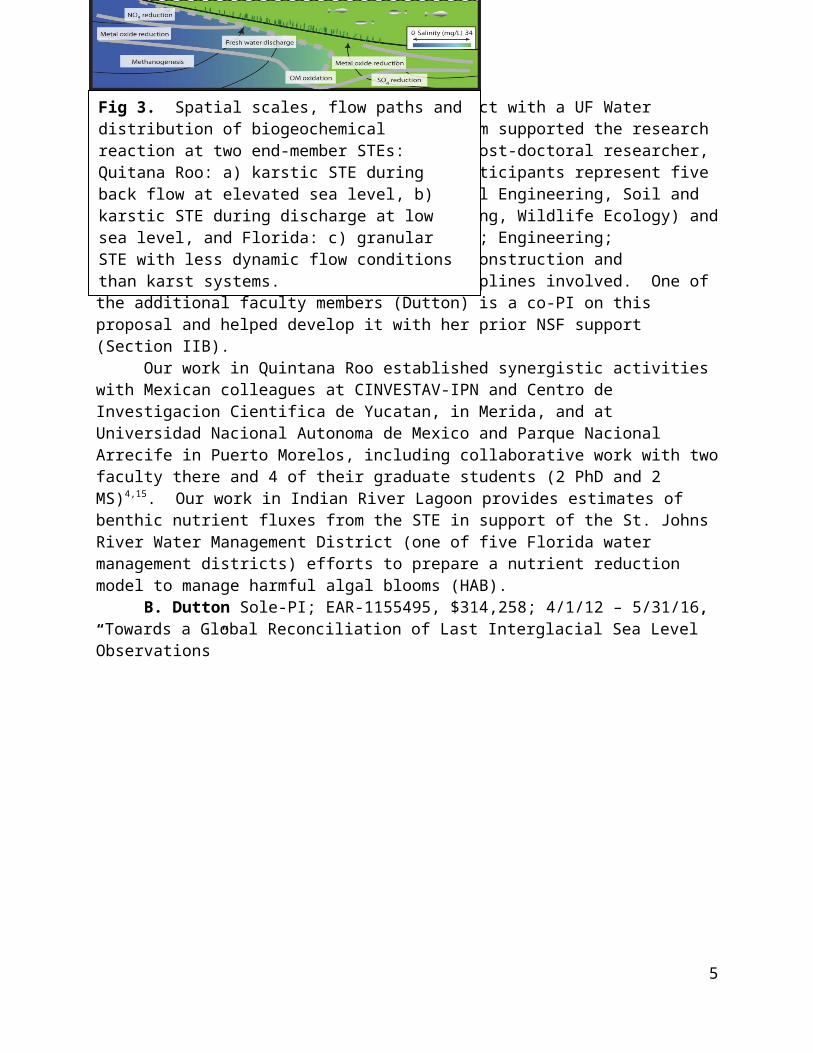
human communities, water resources, coastal hydrodynamics, microbial community structures and functions, and biogeochemical reactions at various time scales (Fig. 2). The project focused on two coastal settings representing end-member subterranean estuaries (STE)3: the east coast of Florida, USA and the east coast of Quintana Roo, Mexico (Yucatan peninsula). Both sites discharge fresh water to coastal lagoons: the Florida STE from a granular, siliciclastic aquifer and the Quitana Roo STE from a carbonate karst aquifer (Fig. 3). These two regions, which have experienced recent rapid population growth, also constitute the field sites for this proposed project (hereafter referred to as CS2 to differentiate it from results derived from CS1).
2
Fig 1. Linkages between disciplines required to understand sea-level rise effects on coastal water resources.

Our results show that hydrogeology and biogeochemical reactions at both sites depend on aquifer characteristics and short-term (tidal to decadal) sea level variations. In the karst region (Quintana Roo), fresh and brackish waters discharge via conduits (water-filled caves), but reversed flow (recharge) occurs when sea level rises above a threshold of 0.08 m above the average during our fortnightly observation periods (Fig. 4)4. During recharge, oxygen-rich lagoon water flows to the aquifer and catalyzes biogeochemical reactions. and dDuring discharge, reaction products, including nutrient-rich waters, flows to the lagoon. Switching from discharge to
recharge is modulated by tides, wind set up and spring-neap tidal cycles4-6. Biogeochemical reactions reflect changes in microbial community structures (Morrison et al., in review; Bae et al., in press) although understanding community functions requires additional samples7. We predict recharge-discharge timing and magnitude will change as water demand, which has risen from 29 to 873 x 106 m3 between 1980 and 2012, increases with population growth (ref?? - Deng and Peng, Chao and Peng in prep??).
In the granular aquifer (Florida), the location of the seepage face (the coastal zone discharging fresh water8) has shifted shoreward by tens of meters as the lagoon flooded following the Last Glacial Maximum LGM9. Data from CS1 extend previous observations to nearly 10 years and show ~5 m (~25%) shoreward migration of the seepage face (Fig. 5). We speculate this shoreward shift reflects acceleration of sea-level rise by about an order of magnitude to rates of ~20 mm/yr over the past 5 years throughout the South Atlantic Bight based on tide gauge data10.
Biogeochemical reactions are similar at the two study sites including enhanced organic matter remineralization, carbon cycling11, altered nitrogen (N) speciation12, sources of phosphorus (P) from organic matter and carbonate minerals4, reduced metal oxides, sulfate reduction and sulfide oxidation9,13,14, with resulting pH changes, mineral dissolution and changing sources and sinks of P 4. These similarities occur regardless of time and spatial scale differences in STE responses to sea-level change (e.g., Fig. 3), suggesting general results about sea level impacts on coastal zones can be obtained from these sites. Publications : To date, x abstracts7,11,12,15 others?), and y papers have been published, submitted or in preparation for the peer-reviewed literature4-6,10Deng and Peng, Chao and Peng in prep. others?).
Broader impacts: CS1 integrated interdisciplinary activity at the University of Florida (UF) centered on coastal water resources and sea level rise. Coupling this project with a UF Water Institute Graduate Fellows (WIGF) Program supported the
3
Fig 2. Times scales of the various processes that impact sustainability of coastal water resources over which we will work.

research of 10 PhD-level graduate students, one post-doctoral researcher, and two additional faculty members. Participants represent five departments (Geological Sciences, Coastal Engineering, Soil and Water Science, Urban and Regional Planning, Wildlife Ecology) and four colleges (Liberal Arts and Sciences; Engineering; Agriculture and Life Sciences; Design, Construction and Planning), reflecting the range of disciplines involved. One of the additional faculty members (Dutton) is a co-PI on this proposal and helped develop it with her prior NSF support (Section IIB).
Our work in Quintana Roo established synergistic activities with Mexican colleagues at CINVESTAV-IPN and Centro de Investigacion Cientifica de Yucatan, in Merida, and at Universidad Nacional Autonoma de Mexico and Parque Nacional Arrecife in Puerto Morelos, including collaborative work with two faculty there and 4 of their graduate students (2 PhD and 2 MS)4,15. Our work in Indian River Lagoon provides estimates of benthic nutrient fluxes from the STE in support of the St. Johns River Water Management District (one of five Florida water management districts) efforts to prepare a nutrient reduction model to manage harmful algal blooms (HAB).
B. Dutton Sole-PI; EAR-1155495, $314,258; 4/1/12 – 5/31/16, “Towards a Global Reconciliation of Last Interglacial Sea Level Observations”
Intellectual Merit: Given the current inability to project dynamic instability of ice sheets under future warming scenarios, the behavior and dynamics of polar ice sheets during past warm periods provide indispensable empirical constraints. This project aims to reconcile observations of the magnitude of peak sea level during the last interglacial period and sea level minima associated with glacials MIS 2 and 6 through fieldwork to survey and collect samples, U-Th dating of corals, and glacial isostatic modeling. Publications: Three papers have appeared in the peer-reviewed literature (refs); another two student-led manuscripts are in prep (refs); at least three
more are anticipated; 14 abstracts (6 posters/8 talks, references) presented by the PI and a PhD graduate student at domestic and international conferences.
Broader Impacts: Three graduate students have been supported by the grant, one undergraduate researcher, a class of students participated in collection of field data in the Bahamas, and a video exhibit and a new exhibit on sea level change are being developed in collaboration with the FL Museum of Natural History. The publications in QSR and Science received significant media attention. The Science paper was picked up by more than 25 media outlets globally including Reuters, The Guardian, and The Washington Post. Research from this grant has been featured twice by NSF (on their home page in Jan-2015 and as the top news story for Science360 in July-2015). This media attention directly led to further engagement in public outreach to communicate the research results, including involvement in an upcoming feature film about climate change, as well as a documentary series on climate change being produced by
4
Fig 4. Two-week time series at Pargos spring, Quitana Roo. Top: Deviation from tidal elevationmean water level and distribution of genes. Middle: Salinity of lagoon and within cave. Bottom: Dissolved oxygen and pH within cave
National Geographic (with an episode focused on sea-level rise in south Florida), contributing to an in-depth piece for the New York Times Magazine, and an in-person consultation with US Senator Bill Nelson (D-FL) regarding sea-level rise in Florida.
III. HYPOTHESES AND SIGNIFICANCE
A. Hypotheses to be testedHypotheses proposed here center on the overarching hypothesis that sustainability of
coastal water resources depends on rates of sea-level change, consumption and degradation of water resources, biogeochemical transformation at the fresh-salt water interface, and physical connections between fresh and salt water. We break down this general hypothesis into specific hypotheses to be tested by our interdisciplinary work plan (Section IV), which includes linked and simultaneous observations, experiments, models, and analyses. Results will be jointly reported in peer-reviewed literature and to cognizant water managers. The specific hypotheses and tests include:
Hypothesis 1: Sea-level rise and coastal population growth will degrade coastal water resources at dissimilar spatial and temporal scales. This hypothesis will be tested through comparing extant observations and projections of coastal development and population growth with evaluations of potential rates of sea-level change based on sediment archives during the last interglacial period ~125,000 years ago (centennial to millennial rates), observations from tide gauge data (decadal rates), and direct observations (seasonal, storm and tidal scales).
Hypothesis 2: Water resources will degrade abruptly when thresholds in population densities, sea level, water table elevations, and alterations of microbial communities are crossed. This hypothesis will be tested through high-resolution observations of changes in sea
level and inland water table at intra-tidal to seasonal time scales; analyses of the impact of changing levels on salt and water exchanges between coastal and aquifer water in two end-member types of STEs; measurements of exchange effects on microbial community structures and functions and associated solute (e.g., C, N and P) concentrations; and compiling, modeling, and comparing data related to inland fresh water consumption relative to changes in water table elevations and population growth.
Hypothesis 3: Exceeding thresholds will alter microbial community structures and functions, nutrient delivery, and salt fluxes, degrade potable water resources, increase cost of human adaptation, and
reduce efficacy of adaption measures. This hypothesis will be tested by compiling water resource usage data and measuring water table and sea level variationsy at seasonal and shorter time scales. These data will be compared with simultaneously measured changes in microbial communities and functions, chemical compositions of water, shifts in hydrodynamic behaviors, and possible contamination from the built environment. These comparisons will be made in the
5
Figure 5. STILL TO BE MODIFIED. Decadal landward movement of salt /fresh water interface at Indian River Lagoon.

framework of past rates of sea-level change based on sediment archives and projections of future sea level and water usage.
Hypothesis 4: Crossing thresholds depends on hydrologic characteristics of the coastal aquifers comprising the STEs. This hypothesis will be tested by comparing data collected from two distinct STEs, both in a rapidly developing setting. One is composed of granular siliciclastic sediments with diffuse flow in a developed setting and the other is composed of variably lithified carbonate rocks and sediments with conduit flow (Fig. 3).
B. Scientific SignificanceEustatic sea level is rising at ~3.2 mm/yr and projections suggest that if the rate
accelerates as expected, sea level will be 0.26 to 1.90 m higher than now by 210016-18. Rising sea level represents a slow-moving problem, punctuated by short-term disasters (e.g., Hurricanes Katrina and Sandy) for the more than 1 billion people who live along coasts19. Particularly vulnerable areas include densely populated regions of Southeast Asia, Egypt, and sub-Saharan countries20 and the US where ~123 million people (39% of the population) live in coastal counties21. Although attention-grabbing events such as storms, storm surge, flooding, and increased erosion (NRC, 2007) are clear threats, less attention focuses on threats to coastal water resources (both fresh and salt) from rising sea level and increased population, which may limit coastal communities sustainability prior to inundation. Threats to freshwater resources include over pumping, waste disposal, and related effects of increasing coastal populations22,23. Threats to salt water resources, which support coastal ecosystems, include changed solute fluxes from reduced submarine groundwater discharge (SGD)24,25 and altered compositions following reactions caused by salt water intrusion4.
Rates of sea-level rise vary through time as shown by sea-level reconstructions that span timescales of 10-105 years e.g.26,27 and direct observations based on tide gauges and satellite altimetry16. Sea level rose 3 meters on ecological time scales based on spectacular successions of reef facies at Xcaret in Quintana Roo from the last interglacial28,29. A similar rapid rise is shown by reef exposure surfaces in the Bahamas and Florida, but these sites suggest the rapid rise was preceded by an ephemeral sea level fall of at least 1 meter, reflecting dynamic instability of polar ice sheets during warm climates30,31. Instabilities also appear fromas meltwater pulses, e.g.32 as sea-level rises of 1 to several meters over 102 to 103 years occurred during retreat of Northern Hemisphere ice sheets over the past 20,000 years. The potential for similar rapid sea-level rise rates in the future is shown by the recent finding that the West Antarctic ice sheet is susceptible for collapse, e.g.33. Understanding potential rates of sea level change is thus critical to develop coping strategies for coastal ecosystems and human communities.
Recent accelerations of sea-level rise are shown by tide gauge and satellite altimetry data, which reveal a change from a global mean rate of ~1.2-1.9 mm/yr between 1901 and 1990 to ~2.8-3.7 mm/yr from 1993-201034. Rates also vary spatially; tide gauge data show ~5 mm/yr rise along the Mid-Atlantic Bight over the past couple of decades35-38. These rates, which are in excess of the global average, reflect wind forcing, deceleration of the Gulf Stream, and changes and/or divergence in the Atlantic Meridional Overturning Circulation (AMOC)39,40,41. Rapid sea level rise also began recently in the South Atlantic Bight, with tide gauges showing rates of ~18 mm/yr since 2011 10,42. These rates may reflect changes to the Atlantic Multi-decadal Oscillation (AMO) and slowing of the Florida current43,44. Temporal and spatial variations in sea-level rise should alter biogeochemical processes in STEs and impact sustainability of coastal water resources, depending on hydrodynamic connections between coastal and aquifer waters. Rates
6
of sea-level change and absolute elevations thus represent important thresholds that when exceeded could permanently degrade coastal water quality.
Subterranean estuaries3 are critical to sustainability of coastal water resources. They receive the first impacts effects from salt water intrusion as sea level rises23,45 and impacts will be modified by changing elevations of the groundwater table46,47 Menning et al, 2015). Subterranean estuaries provide a source of ecologically important solutes including nutrients e.g.48,49-51 and metals e.g.52,53,54 to coastal zones. Nutrient fluxes may decrease with salt water intrusion or may increase as inland vadose zones shrink, limiting waste disposal options. Salt water intrusion should alter microbial community distributions and functions in STEs, thereby altering biogeochemical reaction and nutrient fluxes, e.g.51,55-57. Microbial community functions should be affected as by dissolved oxygen (DO) and dissolved organic carbon (DOC) concentrations, compositions, origins, and lability11,55,56,58-60. Organic carbon remineralization will alter compositions of the greenhouse gases carbon dioxide (CO2) and methane (CH4), nutrients including N and P, and toxins such as sulfide61. These changes will negatively impact coastal economies, for example from diminished fisheries and tourism, as estuarine water quality degrades. Each of these processes may change abruptly, and possibly permanently, as sea level and water use surpass still unknown thresholds.
Human behavior and development can alter natural coastal processes so that a complete understanding of these processes is required to develop predictive models, translate these models to policy, and develop management strategies22. As coastal populations grow and develop coastal lands, water consumption increases even as rising sea level shrinks water availability. Rising sea level and population growth also complicate the ability to treat storm and waste water. Balancing water demand and supply and curbing water demand are critical steps that require an understanding of potential thresholds of sea level and point to the need for studies that cross boundaries between process-based research of the natural sciences with linkages to human-related investigations of the social sciences. Results of these process-based studies will also have to be interpreted based on past, current, and projected rates of sea level change, on whether the rates are accelerating or decelerating, on how rates control hydrodynamic and biogeochemical processes, and on threshold values.
The multiple processes that impact coastal water resources require collaborations between natural and social sciences to develop coping strategies (Fig. 1)22. The challenge is thus to make observations, use proxy information, and develop models to understand the rates of sea level change, its control on coastal hydrodynamics and hydrogeology, its effect on biogeochemical reactions in STEs from exchange and mixing, how it may degrade water quality and quantity for human and ecological use, and how human behaviors impact and respond to these processes (Fig. 1). Resolving this challenge should provide pathways toward sustaining coastal water resources, the primary goal of this proposal. To reach this such goal, our project integrates biogeochemistry, microbiology, hydrology, coastal hydrodynamics, and geology with social sciences including economics and regional planning to evaluate relationships between among human activities, coastal water resources, and changing sea level, and to develop pathways toward sustainable coastal water resources.
IV. WORK PLANCritical variables in the sustainability of coastal water resources include relative elevation
(i.e., hydraulic heads) and rates of change of sea level and inland water table, which control hydraulic gradients. Changes in elevations affect hydrodynamics and hydrogeology of coastal
7

zones and thus water compositions, microbial communities and functions, and sustainability of water resources of coastal human communities. Our work plan examines these variables at the two contrasting sites established with CS1 (Section II), specifically the east coasts of Florida and Quintana Roo (Fig. 3). As described below, we will test our hypotheses through interdisciplinary field observations, laboratory analyses and experiments, and modeling.
A. Hypothesis 1: Impacts of variable rates of sea-level rise and anthropogenic population needs
We must use the geological record to discern the potential rates of sea-level change and impacts to human populations associated with warmer temperatures and continental ice sheet melting because extant tide gauge observations are too short to reflect these changes. Here we focus on fossil coral reefs in Florida and Quintana Roo, and speleothems from Quintana Roo from the last interglacial period, when sea level peaked some 6 to 9 m above present62-64. Our tests of hypothesis 1 include sampling these deposits to estimate potentialpossible variations in sea-level change and theirre potential to affect human responses and sustainability of coastal water resources, as follows.
(1) Estimates of changing sea-level rates. To reconstruct the nature and rates of sea-level change, we will survey the elevations of fossil corals that grew during a past warm period, undertake detailed paleodepth analysis of assemblages of reef biota and diagenetic fabrics, and combine this with radiometric U-series ages to determine the timing and rate of sea-level change. Both field sites provide evidence of rapid sea-level rise, and an influx of sedimentation in the coastal lagoon, ~117,000 yr ago; however, these events are not well-dated so the timing is only loosely constrained. Although not an initial part of CS1, reconnaissance work (fossil reef and speleothems) has been accomplished and local connections have been established in both field sites that allow us to develop the three tasks described below.
TASK #1 (Fossil reef at XCaret): We will revisit the Xcaret site on the Yucatan Peninsula, which preserves two distinct reef terraces. We will collect samples from the lower reef tract, across the transition zone between the two reefs, and into the upper reef by drilling down into the reef. This work will be done in collaboration with local expert Dr. Paul Blanchon at UNAM (see attached letter of collaboration from UNAM). We will use carbonate petrographic techniques to identify cement stratigraphies and exposure history that reflect shifts from marine to fresh water and back to marine salinity, reflecting sea-level oscillations. Previously collected detailed coral assemblage data28 will be used to complement the interpretation of sea level and reef response. For example, a distinct layer of sediment tolerant corals and coralline algae represents reef demise in the transition from lower reef and the upper reef. Our approach of correlating stratigraphies, ages, and taphonomies of the corals will help determine if reef demise was due to a rapid sea-level fall or rise and improve understanding of the reef and coastline response to rapid changes in sea level.
TASK #2 (Rio Secreto Caves near Xcaret): Due to the high uncertainty in ages of the corals previously dated from Xcaret29, we will complement the reef record with age data from stalagmites at nearby caves that have a greater potential to provide robust age constraints for local sea-level changes due to their resistance to chemical alteration, e.g.65. Stalagmites grow? only when caves are above sea level, and thereby provide constraints on timing and magnitude of sea-level changes, e.g.65-67. Therefore, by dating the age of the stalagmites with U-series radiometric dating techniques, we can identify when they stop and start growing, and document the timing of cave submergence and the rate of sea-level rise across elevations in
8

the cave. We will collect stalagmites in portions of the Rio Secreto caves normally not open to the public (see letter of collaboration). These caves sit at optimal elevations to capture the transition into and out of the last interglacial highstand. Recent work at a nearby cave produced an age of ~117 thousand years for inception of stalagmite growth, when sea level fell at the end of this warm period68. Stalagmites will be collected, first as small samples from their top and base (without removing the whole specimen) to guide our strategy for sampling of whole stalagmites, which will provide the highest resolution sea level-age relationships. This sampling approach minimizes impact to cave deposits, which sit in an ecological preserve.
TASK #3 (Fossil reef in FL Keys): Reef deposits in the Florida Keys will be studied to evaluate potential sea level variations in eastern Florida and between study sites (refs). Here we will use the same U series dating methodology as at the fossil reef site at Xcaret (TASK 1, above). Four drill cores into the reef will come from two locations: Windley Key and Lignumvitae Key, where fossil reef material is preserved at the outcrops represent the highest elevations anywhere in the Keys. Both Lignumvitae Key and the Windley Key quarry are Florida State Parks and permits are in place to conduct the sampling required for this project. We will use a portable rotary drill with a diamond drill bit and wireline system that is capable of 30 m penetration and excellent core recovery. The drill has been successfully used in many previous coral reef drilling projects69-71 and can be transported by boat, which is the only access to Lignumvitae Key.
New data generated from these tasks will inform this project of the potential rates of sea-level change. These rates will provide predictive capabilities for when thresholds may be exceeded when coupled with estimates of relationships between sea level elevation, water and microbial compositions, and human responses based on short term observations as described in the following sections
(2) Water stress in the built environment. How variations in rates of sea-level rise may impact coastal communities will be evaluated using an integrated water demand-supply model to assess water stress in differing sea level rise scenarios. The relationships between water demand and available water resources reflects a threshold that may be crossed when demand exceeds supply, which will depend on the rates of sea level rise. To assess the potential of crossing this threshold, we will conduct vulnerability analyses of freshwater resources in the coastal communities based on our estimates of sea-level rise rates and a water balance model.
The water balance will be based on potential recharge and demand and used to assess water stress in coastal communities of our study sites. This balance is determined by precipitation, water usage, transpiration and evaporation, seawater intrusion and other factors, and each community may demonstrate exhibit different water stress levels due tobecause of their locations, population, land cover and local potential rates of sea level rise, e.g.10,29,42. The general equation iswater balance may be written as
R v=∑i
❑
( Pi−U i−T i )+ I +O
where Rv is the total groundwater recharge, i refers to each geographic locations, P is the average seasonal precipitation, U is the total ground water usage, T is the real transpiration and evaporation, I is the groundwater change by seawater intrusion (can be positive o negative), and O is other influencing factors such as surface runoff, interceptions, leakage etc. which are assumed to be unchanged in the short run. Ground water usage (Ui) is the sum of domestic, industrial, commercial and agricultural usage, which is determined by population, meteorological conditions, land use, and per capita usage. These variables will be calculated in geographic units
9

using geographic information systems for both study areas. We expect water resources in these two regions to respond differently to potential sea level rise as a result of differences in infrastructure, water demand, recharge, aquifer characteristics, population growth rate, and potentially from different rates of sea-level change.
We will also perform a vulnerability analysis that will include variations in estimated future sea level rise rates, the movement of the saltwater/freshwater interface, water quality from the water chemistry and microbes analysis (section IV.C), and water demand from consumption of human activities (e.g., water consumptions from different industries). Additional risks arise from flooding vulnerability, which we will estimate based on our sea-level rise estimates, the elevation of the area, the land use types, and property values using geographic information systems. The results of the water vulnerability analysis will predict risk levels of freshwater shortage and degradation of water quality within the two study areas. The results of the vulnerability analysis will be used to estimate the economic costs of sea level rise and to study human responses in the coastal community. The economic costs, including direct and indirect costs, of sea level rise will be estimated based on the Computable General Equilibrium (CGE) model72,73, in which the multiplier costs to the inter-dependent industrials will be estimateddetermined.
B. Hypothesis 2: Abrupt degradation of water resources from crossing thresholdsExpected alteration of coastal water systems from sea-level rise can be evaluated through
observations of fluctuations in sea level at various time scales caused by processes such as tides4-
6, storm set up4,6,74, and ocean-current forcing (Parra et al., 2015b). Our tests of hypothesis 2 include sampling and observing sea-level variations and water compositions at our two sites over short-term (< 1 sec to decadal, Fig. 2) to assess physicochemical responses to the changes, as well as paleo-reconstructions of water quality in the lagoon. Activities for this hypothesis are as follows.
(1) Hydrodynamics. In slowly responding granular aquifers (Indian River Lagoon, Florida), we will make new hydrodynamic observations at our three currently instrumented seepage faces (e.g., Fig. 5) and couple them with hydrographic data to be compiled from infrastructure operated by NOAA and NDBC (tidesandcurrents.noaa.gov; www.ndbc.noaa.gov/ hmd.shtml), including lagoon and off-shore water levels. These records will be supplemented by deployment of Conductivity, Temperature, Depth (CTD) instruments installed in wells onshore and at two depths in piezometers across the seepage face. The piezometers will be surveyed to a common benchmark. Temporal variations in water elevations will be compared with changes in conductivity and temperature to observe how seepage faces respond to changing lagoon elevations through storm e.g.75 and longer events. These results should inform us of what water levels could represent thresholds that change flow conditions.
We will also expand fortnightly observations made over the past two years (Fig. 4) within conduits and at springs in the karstic Quintana Roo STE4,6 to continuous records of at least one year. These instrumental observations will include photosynthetically active radiation (PAR, to assess photosynthetic oxygen production), flow, wind, rain, ocean forcing, and tidal variations. Prior to installing instruments, we will commission a group of certified cave divers to explore and map the cave systems, including the cave that sources Pargos Spring where we have studied the first 12 m of the entrance (Fig. 3a,b). A Vvertical portions of the conduits will be instrumented with a Teledyne Sentinel V, which records current profiles with a 5 acoustic beams (one measures vertical velocities directly) at a resolution of 0.3 m, thereby providing the first
10

flow rate and profile measurements within conduits. All instruments will record data every 10 minutes. The long-term deployments will require collaborations with our Mexican colleagues who have ready access to the field area (see letter of collaboration). Our colleagues will maintain the instruments every 2 months to minimize biofouling effects. To establish thresholds of forcing conditions, the cave divers will obtain profiles of salinity, DO, and pH from the surface as far into the conduit as they can safely reach. Data collection rates will be 5 Hz throughout a syzygy tidal cycle to maximize the potential of observing discharge and backflow, e.g.4. These data will provide information on the threshold for when discharge and recharge shift and how this shift alters water compositions from which we can infer biogeochemical reactions.
(2) Water compositional changes linked to hydrodynamics. Flow variations mix fresh and salt water, thereby impacting organic carbonOC remineralization and the cascade of redox reactions (e.g., denitrification, metal and sulfate reduction, methanogenesis) that control microbial and chemical variations in STEs. Fresh and salt water end members have variable and differing OC organic carbon concentrations and labilities11 further enhancing the hydrodynamic controls on chemical and microbial compositions of the STEs. To observe the relationship between variations in flow and biogeochemical reaction products, various in situ chemical sensors (described below) for DO, pH, nitrate, DOC, and H2S will be coupled with the Sentinel V installed in conduits at Quintana Roo. These sensors will provide high temporal resolution information about changes in redox conditions of the conduits and allow estimates of fluxes of the solutes when coupled with flow rates.
Water samples will also be collected at high spatiotemporal resolution over multiple tidal cycles to evaluate linkages between flow and reaction products through comparisons with data collected simultaneously with moored instruments. Water will be pumped with peristaltic pumps from tubes installed in the explored conduits to a boat where it will be analyzed in the field for ephemeral solutes including Fe(II) and H2S; other samples will be preserved for lab analyses. Chemical compositions to be measured in the laboratory include components affected by organic carbon remineralization such as various N species (NO3, NH4, N2O, N2), P, total Fe and Mn. Major element concentrations (Cl, SO4, Na, K, Mg, Ca) will be used in thermodynamic modeling (PHREEQc) of mineral stabilities to estimate changes in P compositions related to calcite diagenesis76. In addition, U concentrations and 234U/238U isotope ratios will be measured to compare with the U content of fossil corals. Analytical techniques are described in Section IV.C.2.
Moreover, gGroundwater will be sampled from cenotes (inland karst windows) which provide a continuum of fresh to underlying saline groundwater through a halocline77-81. Cenote processes provide a static analogue to biogeochemical processes occurring at the freshwater-saltwater mixing zone in offshore springs. These reactions will be assessed through sampling at high spatiotemporal resolution across the halocline for organic carbon concentrations, lability, nutrients, and microbial populations. These samples will also provide evidence for effects of waste disposal below freshwater lens, a common practice that contributes organic matter, nutrients, organic pollutants, and harmful pathogens to freshwater and coast82. Evidence for contamination includes elevated NH4 concentrations, OC organic carbon characteristics typical of sewage, and pathogenic microbes. Cenotes will also be instrumented with CTDs to observe tidal propagation inland to assess connectivity between the aquifer and ocean, e.g.83,84.
At Indian River Lagoon, one seepage face now has more than a decade of intermittent observations of distribution of fresh and salt water from samples collected from previously installed multi-level piezometers “multi-samplers”85 that show flow rates have slowed and the
11

position of the salt water-fresh water boundary has shifted landward through time9,86. This proposed project will add at least 4 yrs of observations, which would constitute a unique and important time series for a granular STEs characterized by long-term responses to sea level. Continuation of this time series is important considering the recent rapid rise (~18 mm/yr) shown in tide gauges from the South Atlantic Bight10,42. Field and laboratory analyses. from all three seepage faces will include the same suite of solutes as at Quintana Roo,
(3) Paleo reconstructions. In addition, we will combine the age data of the corals (collected for hypothesis 1) with evidence of changes in water quality in the lagoon (assessed by observations of high sediment influx and sediment-tolerant species) as well as changes in water chemistry such as salinity changes (assessed by analyzing the isotope and trace element geochemistry of the corals) associated with past rapid sea-level rise. In this way, we will be able to discern past changes in water chemistry and quality, drawing upon our modern observations of the chemistry gradients between fresh and salt water in this region to inform our interpretation of the geochemical signals preserved in the coral skeleton. Trace element and isotope ratios of certain elements in corals have been extensively used as effective proxies to reconstruct variables such as the temperature, salinity, pH, sediment influx, etc. (REFS).
C. Hypothesis 3: Effects of thresholds on microbes, fluxes, and water resourcesMicrobial communities and chemical compositions of water will change with alteration
of turbulent and diffusional mixing processes at various sea levels thereby impacting resources required by coastal human communities. Our tests of hypothesis 3 include detailed and coupled laboratory analyses of time-series and synoptic water and microbial samples to assess the role sea level has on magnitudes of changes and to apply them to analyses of coastal human community responses to the changes.
(1) Water chemistry and microbes. Linked biogeochemical reactions depend on the lability of organic carbon and available terminal electron acceptors. Lability will be determined through fluorescent techniques including 3D excitation-emission matrices (EEMs) to characterize the dominant colored dissolved organic matter (CDOM) fractions. UV absorbance will also be collected with a Submersible Ultra-violet Nitrate Analyzer (SUNA) connected to the outlet end of the sampling tubes during in situ sampling of water in both Florida and Quintana Roo STEs, and by installing a SUNA at the location of the Sentinel V in conduits in Quintana Roo, e.g.11. The SUNA collects UV absorbance at a rate of 0.5 Hz over wavelengths ranging from 180 to 370 nm at 0.8 nm intervals. These dataThe SUNA signal will be deconvolvuted by the slope method87 to determine concentrations of nitrate, sulfide, colored dissolved organic matter (CDOM) and the character of the organic carbon by the slope method87. The real-time sampling capabilities of the instrument will allow identification of changes in solute concentrations at high temporal resolution (intra-tidal) in Quintana Roo and at small spatial resolution (10s of meters) across the Florida STEs.
Organic carbon analyses will be compared with microbial communities that will be characterized via DNA analysis in the Quintana Roo STE and across the seepage face in the Florida STE. Specific functional genes of interest will include those that control nitrogen cycling (e.g., nifH, nirS/nirK, nrfA, amoA), and genes characteristic of P acquisition (phoX, phoD). In addition, concentrations and distributions of genes encoding aromatic oxygenases (e.g., catechol dioxygenases and monooxygenases) will be determined to test hypotheses related to aromaticity (related to lability) of available carbon from terrestrial and marine sources. In addition to analyses of specific functional genes, the compositions of microbial communities will
12

be characterized via high throughput sequencing of 16S rRNA genes. Detailed information on the structures of microbial communities will provide critical information on potential shifts in community function, how these relate to the changes in organic carbon characteristics, and link back to thresholds in sea-level change.
Similar analyses of microbial communities will be conducted on sediment cores and samples collected from both Quintana Roo and Florida STEs because of the important control of mineral surfaces on the distribution of microbes. These microbial analyses will include analysis of the distribution of the functional genes and characterization of community structures via 16S rRNA gene sequence analysis. In addition to enumeration of the functional genes, enumeration of mRNAs transcribed from those genes (via RT-qPCR) will provide indicators of in situ activities. The cores will be characterized to determine distribution of reactive P pools (Ruttenberg et al., 2009).
Cores will also be collected to perform flow-through experiments to be able to experimentally modulate inputs of salt and various nutrients and observe responses of microbial communities and their controls on solute compositions. The cores will be used to sequentially inject increasingly saline water (fresh to sea water salinity) through the cores. The effluent will be sampled until steady state is reached (Weston et al., 2006) and used to track changes in the concentrations and activities of chemical compositions similar to the natural samples, as well as functional genes, nutrient concentrations and transformations, and organic carbon processing. These experiments will provide controls for the threshold changes related to salt content to be compared with field observations of changes in sea level, and salt, microbial, and nutrient compositions.
(2) Method details for this hypothesis. Water analyses in the field and lab will be accomplished using available instrumentation at the University of Florida as outlined in the facilities form. Precision and accuracy of all analyses will be evaluated based on change balance errors of the major elements, duplicate analyses measured at a rate of ~10% of the samples, and replicate measurements of internal standards.
For isolation of DNA from water samples, the Power Water DNA isolation kit (MoBio, Inc) will be used. In brief, 5 L aliquots of water from selected depths will be passed through 0.22 m Sterivex filters and preserved on ice in the field. Once in the lab, the filters will be kept at 4oC until continued processed. For isolation of DNA and RNA from sediment samples, samples will be frozen on dry ice in the field and transported frozen to the lab. Nucleic acids will be isolated via either the MoBio Power Soil DNA or RNA isolation kit, as appropriate.
Established methods will allow qPCR (enumeration of genes) and RT-qPCR (enumeration of mRNAs) of the functional genes nifH, nirK, nirS, phoX, phoD, xylE. Quality of qPCR will be judged by inspection of the melt curves following PCR and assessing the efficiency of amplification. Functional gene information will be related to geochemical parameters via multivariate approaches. Metagenomic analysis of 16S rRNA genes will be conducted at the University of Florida’s Interdisciplinary Center for Biotechnological Research via sequencing on the Illumina Hi-Seq platform, and sequences analyzed via the Qiime workflow (Kucynski et al., 2012). The Ogram lab has experience with metagenomic analysis using Qiime.
(3) Effects on coastal communities and human responses. Human responses will be studied to determine ways and optimal timing to adapt to sea level rise and increased freshwater stresses. We will first study the optimal land use allocation under the constraint of the freshwater carrying capacity based on potential sea level rise rates to be determined and the water usage rate for different land use types in the existing land use zoning system. We’ll then calculate optimal
13

time to implement the adaptation measures by calculating the changing levels of water supply and demand and the costs and benefits of implementing the adaptation measures in different time periods. The goal is to find the thresholds where water consumptions from human activities will peak and the optimal time for implementing adaptations. A behavior study will also be conducted to estimate residents’ response and possible behavior change when the freshwater carrying capacity and economic impacts of adaptation measures are presented. This study will shed light on the future impacts of human activities on the sustainability of water resources in coastal areas, and what needs to be adjusted to change people’s behaviors. The results will be useful to local community managers setting policy regarding human community responses to loss of coastal resources, particularly water resources of STEs.
D. Hypothesis 4: How hydrodynamic characteristics of STEs affect crossing of thresholdsResponses of coastal water systems and human adaptations to sea-level change,
regardless of the rates and time scales, will depend on hydraulic conductivity of the systems. Systems with high permeability, exemplified by karst systems such as in Quintana Roo, may respond at rates shorter than tidal, but certainly as short as tidal, as shown by alternating discharge and backflow at Pargos Spring (Fig. 4)4,6. These shifts will affect biogeochemical reactions, water compositions, rates of salinization, effects of discharge on coastal ecosystems, sustainability of water resources, and human habitability of coastal zones. In contrast, diffuse systems with low hydraulic conductivity, as exemplified by the Indian River Lagoon STE, will respond more slowly to changes in sea level rise than karst systems9. Although Indian River Lagoon is a microtidal system and thus shows little effect of tidal variations such as in other well-studied STEs88-91, it provides an important opportunity to observe physicochemical effects in an STE to sea-level change at rates longer than tidal. Changes in flow with varying sea level will alter compositions of water and microbial community compositions and functions as salt and fresh water mix, thereby varying biogeochemical reactions of the solid material in the aquifer. Our two study sites will allow us to make observations at two extreme end members in the continuum of flow rates and how these differences in hydrogeology properties will affect characteristics of the STEs as thresholds of sea level and water use are passed. Our tests of hypothesis 4 will thus derive from the comparisons of variations in flow dynamics, biogeochemical reactions, and human responses at the study sites to evaluate the interrelations of these primary variables.
E. Relevance to Sustainability of Coastal Systems This project integrates natural and human processes related to sustainability of coastal
water resources by focusing observations, experiments, and analyses at two distinct end-member STEs. This topic is highly relevant to sustainability of coastal systems, specifically to the Coastal SEES program focus of understanding reciprocal feedbacks between humans and the natural environment, because of the critical need for water resources for human habitation of coastal zones, which may be degraded and abruptly lost as thresholds of usage and sea level are crossed. Through our simultaneous observations, experiments, analyses, and modeling, we expect to develop generalizable theoretical advances in natural sciences to be integrated with key aspects of human processes required to address issues of coastal sustainability.
V. Broader Impacts
14

Broader impacts of this work fall into several categories: human resources, intellectual capacity building, support of site-specific coastal management, and public outreach. In terms of human resources, this project will enhance University of Florida’s growing community of interdisciplinary scholars’ ability to develop a workforce who will be able to address complex issues of sustainability in coastal environments. We will train XX post-doctoral researchers, XX graduate students, and XX undergraduate students by continuing the successes of CS1 in preparing students to identify significant scientific question within their disciplines and relate them to collaborative disciplines. These skills will be developed through proposal preparation (e.g., this one), carried through data collection and analyses, to writing papers for the peer-reviewed literature, in an international science setting. Work proposed here will be incorporated into the PIs’ graduate level classes “Surface and Ground water Interactions”, “Data Analysis”, and “Estuarine Hydrodynamics”. We plan to develop our bi-weekly meetings (see description in Project Management and Integration Plan) into a formal seminar focused on coastal water resource issues open to the UF community.
Our group will strengthen intellectual capacity at UF focused on coastal issues. Many UF faculty are involved in coastal science research and teaching and our group represents a core of this larger community. Another core exists within ecological and biological sciences, and with Martin as co-PI, has submitted an NSF Research Traineeship (NRT) grant (NRT: HERMES: Holistic Environmental Research Model for Educating Scientists). The NRT project, if funded, supports training students in environmental research using coastal systems as a focus, but offers few research opportunities, a gap that would be provided by this proposed project. Should both projects be funded, the two core groups would integrate through on-campus meetings, field activities, and seminars. This integration will be enhanced through management support provided by Dr. Carol Lippincott, a research coordinator at the UF Water Institute, which currently supports our work with the WIGF (see attached Project Management and Integration Plan). The WIGF cohort is currently involved in developing symposia for the upcoming biennial Water Institute symposium (Trends, Cycles and Extreme Events) in February 2016, which has one topical focus on causes and effects of sea level rise.
Finally, this project providethis project provides site-specific outreach in several ways. We intend to continue our collaboration with the Algal Bloom Investigation at the St. Johns River Water Management District to support their efforts to build a predictive model of causes of a recent algal “superbloom” in Indian River Lagoon (see letter of collaboration). This nine month bloom occurred in 2011, and covered about 3 to 4 times more area, contained chlorophyll a concentrations about 6 to 7 times higher than previous blooms, and corresponded with a die-off of 87% of seagrass meadows. Causes of these events are unknown, although they occurred when sea level rise in the South Atlantic Bight increased to ~20 mm/yr10,42,44 suggesting linkages to nutrient inputs and/or variations in exchange with groundwater and the oceans. We will provide magnitudes and sources of benthic nutrients to aid nutrient model development, (completion 2017), and after development will help implement and modify the model.
We plan to develop closer relationships with Mexican colleagues through outreach at two facilities in Quintana Roo, one at Rio Secreto and the other at UNAM (see letters of collaboration). Rio Secreto is a park with a focus on eco-tourism of partially water- and air-filled caves with magnificent speleothems. We have a good working relationship with personnel at the park, who have provided permission to sample the speleothems, water, and install CTDs to monitor water levels. Our group has presented preliminary results of work in Quintana Roo to cave guides who are interested in cave formation processes and sea level variations. We intend
15

to use this project to formalize our relationship by offering symposium to the guides, including information valuable to their tours and other audiences (see letter of collaboration). We also intend to teach short courses at the UNAM facility at Puerto Morelos, a field station providing logistical support (e.g., dock facilities; dive locker and gear; electronic and geochemical laboratories) for our operations in Quintana Roo (see letter of collaboration). These short courses will be pitched at upper level undergraduate/graduate students, focused on questions in this proposal. In addition, we have and will continue to present seminars, aimed at the students and faculty, describing our work and results. To develop a meaningful exchange we will host Mexican colleagues at UF for seminars, project discussions and manuscript development.
VI. Research team and integrationThe assembled research team is exceptionally well suited to addressing the proposed
tasks. We have worked collaboratively on coastal water resource and sea level change problems for two years now, including multiple field trips to Quintana Roo and the east coast of Florida that provided samples and data for analyses in the laboratory and modeling. Initial preliminary results are now appearing in peer-reviewed literature5,8,9,12. These results have also led us to develop this project and our preliminary experiences will allow us to quickly initiate this proposed project. Our team includes a wide range of disciplines, some of which rarely collaborate. Our team has now been fully integrated through our biweekly meetings and field trips in which we educated each participant in important disciplinary questions and innovative methods for addressing those questions. We will continue to develop those interdisciplinary ties as described fully in the attached Project Management and Integration Plan.
16

References
1 Russill, C. & Nyssa, Z. The tipping point trend in climate change communication. Global Environmental Change 19, 336-344 (2009).
2 Kwadijk, J. C. et al. Using adaptation tipping points to prepare for climate change and sea level rise: a case study in the Netherlands. Wiley Interdisciplinary Reviews: Climate Change 1, 729-740 (2010).
3 Moore, W. S. The effect of submarine groundwater discharge on the ocean. Annu. Rev. Mar. Sci. 2, 59-88 (2010).
4 Young, C. et al. Short-term variations in sea level, flow, and biogeochemistry an dimplicaitons of sea level rise on ecosystems. Nature Geosci. (in review).
5 Parra, S. M., Marino-Tapia, I., Enriquez, C. & Valle-Levinson, A. Variations in aturbulent kinetic energy at a point source submarine groundwater discharge in a reef lagoon. Ocean Dynamics Theoretical, OComputational and Observational Oceanography 64, 1601-1614, doi:10.1007/s10236-014-0765-y (2014).
6 Parra, S. M., Valle-Levinson, A., Marino-Tapia, I. & Enriquez, C. Salt intrusion at a submarine spring in a fringing reef lagoon. Journal Geophys. Res: Oceans 120, doi:10.1002/2014JC010459 (2015).
7 Huang, L., Young, C., Pain, A., Martin, J. B. & Ogram, A. in Florida Branch of hte American Society for Microbiology.
8 Glover, R. E. The pattern of fresh-water flow in a coastal aquifer. Journal Geophys. Res. 64, 457-459 (1959).
9 Roy, M., Martin, J. B., Cable, J. E., Smith, C. G. & Cherrier, J. Iron cycling in the seepage face of a subterranean estuary (Indian River Lagoon, Florida). Geochim. Cosmochim. Acta 74, 5560-5573, doi:doi: 10.1016/j.gca.2010.07.007 (2010).
10 Valle-Levinson, A., Dutton, A. & Martin, J. B. Anomalous sea level rise in the southeastern United States from 2011 to 2015. (in review).
11 Pain, A., Martin, J. B., Young, C. & Brown, A. in Geological Society of America Annual meeting. (Geological Society of America).
12 Young, C., Martin, J. B., Pain, A., Huang, L. & Ogram, A. in Geological Society of America, Annual Meeting. (Geological Society of America).
13 Roy, M., Martin, J. B., Smith, C. G. & Cable, J. E. Reactive-transport modeling of iron diagenesis and associated organic carbon remineralization in a Florida (USA) subterranean estuary. Earth Planet. Sci. Letters 304, 191-201 (2011).
14 Roy, M., Rouxel, O., Martin, J. B. & Cable, J. E. Iron isotope fractionation in a sulfide-bearing subterranean estuary and its potential influence on oceanic Fe isotope flux. Chemical Geology (2012).
15 Martin, J. B. et al. in Geological Society of America Meeting.16 Church, J. A. et al. in Climate Change 2013: The Physical Science Basis. Contribution of
Working Group 1 to the Fifth Assessment Report of the INtergovernmental Panel on Climate Change (eds T.F. Stocker et al.) (Cambridge Universtiy PRess, 2013).
17 Rahmstorf, S. et al. Recent climate observations compared to projections. Science 316, 709-709 (2007).
18 Vermeer, M. & Rahmstorf, S. Global sea level linked to global temperature. Proceedings of the National Academy of Sciences 106, 21527-21532 (2009).
17

19 Small, C. & Nicholls, R. J. A Global Analysis of Human Settlement in Coastal Zones. Journal of Coastal Research 19, 584-599, doi:10.2307/4299200 (2003).
20 Neumann, B., Vafeidis, A. T., Zimmermann, J. & Nicholls, R. J. Future Coastal Population Growth and Exposure to Sea-Level Rise and Coastal Flooding - A Global Assessment. PLoS ONE 10, e0118571, doi:10.1371/journal.pone.0118571 (2015).
21 NOAA. (ed US Census Bureau NOAA) (http://stateofthecoast.noaa.gov, 2013).22 Werner, A. D. et al. Seawater intrusion processes, investigation and management: Recent
advances and future challenges. Advances in Water Resources 51, 3-26, doi:http://dx.doi.org/10.1016/j.advwatres.2012.03.004 (2013).
23 Werner, A. D. & Simmons, C. T. Impact of sea-level rise on sea water intrusion in coastal aquifers. Ground Water 47, 197-204 (2009).
24 Burnett, W. C. et al. Assessing methodologies for measuring groundwater discharge to the ocean. EOS 83, 117-123 (2002).
25 Taniguchi, M., Turner, J. V. & Smith, A. J. Evaluationsof groundwater discharge rates from subsurface temperature in Cockburn Sound, Western Australia. Biogeochemistry 66, 111-124 (2003).
26 Lambeck, K., Rouby, H., Purcell, A., Sun, Y. & Sambridge, M. Sea level and global ice volumes from the Last Glacial Maximum to the Holocene. Proceedings of the National Academy of Sciences 111, 15296-15303 (2014).
27 Rohling, E. J. et al. Antarctic temperature and global sea level closely coupled over the past five glacial cycles. Nature Geosci 2, 500-504, doi:http://www.nature.com/ngeo/journal/v2/n7/suppinfo/ngeo557_S1.html (2009).
28 Blanchon, P. Reef demise and back-stepping during the last interglacial, northeast Yucatan. Coral reefs 29, 481-498 (2010).
29 Blanchon, P., Eisenhauer, A., Fietzke, J. & Liebetrau, V. Rapid sea-level rise and reef back-stepping at the close of the last interglacial highstand. Nature 458, 881-884, doi:http://www.nature.com/nature/journal/v458/n7240/suppinfo/nature07933_S1.html (2009).
30 Thompson, W. G., Allen Curran, H., Wilson, M. A. & White, B. Sea-level oscillations during the last interglacial highstand recorded by Bahamas corals. Nature Geosci 4, 684-687, doi:http://www.nature.com/ngeo/journal/v4/n10/abs/ngeo1253.html#supplementary-information (2011).
31 Usdun, H. C. Evidence of Sea-Level Oscillations within the Last Interglacial from the Miami Limestone and Bahamian Oolitic Shoals. (2014).
32 Carlson, A. E. & Clark, P. U. Ice sheet sources of sea level rise and freshwater discharge during the last deglaciation. Reviews of geophysics 50 (2012).
33 Rignot, E., Mouginot, J., Morlighem, M., Seroussi, H. & Scheuchl, B. Widespread, rapid grounding line retreat of Pine Island, Thwaites, Smith, and Kohler glaciers, West Antarctica, from 1992 to 2011. Geophysical Research Letters 41, 3502-3509 (2014).
34 Hay, C. et al. The sea-level fingerprints of ice-sheet collapse during interglacial periods. Quaternary Science Reviews 87, 60-69, doi:http://dx.doi.org/10.1016/j.quascirev.2013.12.022 (2014).
35 Boon, J. D. Evidence of sea level acceleration at US and Canadian tide stations, Atlantic Coast, North America. Journal of Coastal Research 28, 1437-1445 (2012).
18

36 Knight, J. R., Allan, R. J., Folland, C. K., Vellinga, M. & Mann, M. E. A signature of persistent natural thermohaline circulation cycles in observed climate. Geophysical Research Letters 32 (2005).
37 Goddard, P. B., Yin, J., Griffies, S. M. & Zhang, S. An extreme event of sea-level rise along the Northeast coast of North America in 2009–2010. Nature communications 6 (2015).
38 Sallenger Jr, A. H., Doran, K. S. & Howd, P. A. Hotspot of accelerated sea-level rise on the Atlantic coast of North America. Nature Climate Change 2, 884-888 (2012).
39 Ezer, T., Atkinson, L. P., Corlett, W. B. & Blanco, J. L. Gulf Stream's induced sea level rise and variability along the US mid‐Atlantic coast. Journal of Geophysical Research: Oceans 118, 685-697 (2013).
40 Woodworth, P. L., Church, J. A., Aarup, T. & Wilson, W. S. Introduction in understanding sea-level rise and variability. (Wiley-Blackwell, 2010).
41 Thompson, P. R. & Mitchum, G. T. Coherent sea level variability on the North Atlantic western boundary. Journal of Geophysical Research: Oceans 119, 5676-5689, doi:10.1002/2014JC009999 (2014).
42 Park, J. & Sweet, W. Accelerated sea level rise and Florida Current transport. Ocean Science Discussions 12, 551-572 (2015).
43 Frankcombe, L. M. & Dijkstra, H. A. Coherent multidecadal variability in North Atlantic sea level. Geophysical Research Letters 36, n/a-n/a, doi:10.1029/2009GL039455 (2009).
44 Park, J. & Dusek, G. ENSO components of the Atlantic multidecadal oscillation and their relation to North Atlantic interannual coastal sea level anomalies. Ocean Sci. 9, 535-543, doi:10.5194/os-9-535-2013 (2013).
45 Kuan, W. K. et al. Tidal influence on seawater intrusion in unconfined coastal aquifers. Water Resources Research 48, n/a-n/a, doi:10.1029/2011WR010678 (2012).
46 Chang, S. W., Clement, T. P., Simpson, M. J. & Lee, K.-K. Does sea-level rise have an impact on saltwater intrusion? Advances in Water Resources 34, 1283-1291, doi:http://dx.doi.org/10.1016/j.advwatres.2011.06.006 (2011).
47 Vera, I., Mariño-Tapia, I. & Enriquez, C. Effects of drought and subtidal sea-level variability on salt intrusion in a coastal karst aquifer. Marine and Freshwater Research 63, 485-493 (2012).
48 Slomp, C. P. & Cappellen, P. V. Nutrient inputs to the coastal ocean through submarine groundwater discharge: controls and potential impact. Journal of Hydrology 295, 64-86 (2004).
49 Paerl, H. W. Coastal Eutrophication and Harmful Algal Blooms: Importance of Atmospheric Deposition and Groundwater as "New" Nitrogen and Other Nutrient Sources. Limnology and Oceanography 42, 1154-1165 (1997).
50 Johannes, R. E. The Ecological Significance of the Submarine Discharge of Groundwater. Mar. Ecol. Prog. Ser. 3, 365-373 (1980).
51 Kroeger, K. D. & Charette, M. A. Nitrogen biogeochemistry of submarine groundwater discharge. Limnol. Oceanogr. 53, 1025-1039 (2008).
52 Roy, M., Martin, J. B., Cable, J. E. & Smith, C. G. Variations of iron flux and organic carbon remineralization in a subterranean estuary casued by inter-annual variations in recharge. Geochim. Cosmochim. Acta in press (2012).
19

53 Windom, H. L., Moore, W. S., Niencheski, L. F. H. & Jahnke, R. A. Submarine groundwater discharge: A large, previously unrecognized source of dissolved iron to the South Atlantic Ocean. Marine Chemistry 102, 252-266 (2006).
54 Charette, M. A. & Sholkovitz, E. Oxidative precipitation of ground water-derived ferrous iron in the subterranean estuary of a coastal bay. Geophysical Research Letters 29 (2002).
55 Santoro, A. E. & Boehm, A. B. Frequent occurrence of the human-specific Bacteroides fecal marker at an open coast marine beach: relationship to waves, tides and traditional indicators. Environmental Microbiology 9, 2038-2049 (2007).
56 Santoro, A. E., Boehm, A. B. & Francis, C. A. Denitrifier community composition along a nitrate and salinity gradient in a coastal aquifer. Applied and Environmental Microbiology 72, 2102-2109, doi:doi:10.1128/AEM.72.3.2102-2109.2006 (2006).
57 Valiela, I., Bowen, J. L. & Kroeger, K. D. Assessment of models for estimation of land-derived nitrogen loads to shallow estuaries. Applied Geochemistry 17, 935-953 (2002).
58 Boehm, A. B., Paytan, A., Shellenbarger, G. G. & Davis, K. A. Composition and flux of groundwater from a California beach aquifer: Implications for nutrient supply to the surf zone. Continental Shelf Research 26, 269-282 (2006).
59 Paytan, A., Boehm, A. B. & Shellenbarger, G. Bacterial contamination and submarine groundwater discharge - a possible link. Environmental Chemistry 1, 1-2 (2004).
60 Paytan, A. et al. Submarine groundwater discharge: An importnat source of new inorganic notrogen to coral reef ecosystems. Limnol. Oceanogr. 51, 343-348 (2006).
61 Weston, N. B., Vile, M. A., Neubauer, S. C. & Velinsky, D. J. Accelerated microbial organic matter mineralization following salt-water intrusion into tidal freshwater marsh soils. Biogeochemistry 102, 135-151 (2011).
62 Dutton, A. et al. Sea-level rise due to polar ice-sheet mass loss during past warm periods. Science 349, doi:10.1126/science.aaa4019 (2015).
63 Dutton, A. & Lambeck, K. Ice Volume and Sea Level During the Last Interglacial. Science 337, 216-219, doi:10.1126/science.1205749 (2012).
64 Kopp, R. E. et al. The impact of Greenland melt on local sea levels: a partially coupled analysis of dynamic and static equilibrium effects in idealized water-hosing experiments. Climatic Change 103, 619-625 (2010).
65 Dutton, A. in The Encyclopedia of Quaternary Science Vol. 4 (ed S.A. Elias) 460-466 (Elsevier, 2013).
66 Dutton, A. et al. Phasing and amplitude of sea-level and climate change during the penultimate interglacial. Nature Geoscience 2, 355-359 (2009).
67 Van Hengstum, P. J., Richards, D. A., Onac, B. P. & Dorale, J. A. in Handbook of Sea-Level Research (eds I Shennan, A.J. Long, & B. P. Horton) 83-103 (2015).
68 Moseley, G. E., Smart, P. L., Richards, D. A. & Hoffmann, D. L. Speleothem constraints on marine isotope stage (MIS) 5 relative sea levels, Yucatan Peninsula, Mexico. Journal of Quaternary Science 28, 293-300 (2013).
69 Gischler, E. Pleistocene facies of Belize barrier and atoll reefs. Facies 53, 27-41 (2007).70 Gischler, E., Lomando, A. J., Hudson, J. H. & Holmes, C. W. Last interglacial reef
growth beneath Belize barrier and isolated platform reefs. Geology 28, 387-390 (2000).71 Multer, H. G., Gischler, E., Lundberg, J., Simmons, K. R. & Shinn, E. A. Key Largo
limestone revisited: Pleistocene shelf-edge facies, Florida Keys, USA. Facies 46, 229-271 (2002).
20

72 Bosello, F., Roson, R. & Tol, R. S. Economy-wide estimates of the implications of climate change: Human health. Ecological Economics 58, 579-591 (2006).
73 Bosello, F., Roson, R. & Tol, R. S. Economy-wide estimates of the implications of climate change: Sea level rise. Environmental and Resource Economics 37, 549-571 (2007).
74 Smith, C. G., Cable, J. E., Martin, J. B. & Roy, M. Evaluating the source and seasonality of submarine groundwater discharge using a radon-222 pore water transport model. Earth and Planetary Science Letters 273, 312-322 (2008).
75 Smith, C. G., Cable, J. E. & Martin, J. B. Episodic high intensity mixing events in a subterranean estuary: Effects of tropical cyclones. Limnol. Oceanogr. 53, 666-674 (2008).
76 Price, R. M., Savabi, M. R., Jolicoeur, J. L. & Roy, S. Adsorption and desorption of phosphate on limestone in experiments simulating seawater intrusion. Applied Geochemistry 25, 1085-1091 (2010).
77 Stoessell, R. K., Coke, J. G. & Easley, D. H. Localized Thermal Anomalies in Haloclines of Coastal Yucatan Sinkholes. Ground Water 40, 416-424 (2002).
78 Stoessell, R. K., Ward, W. C., Ford, B. H. & Schuffert, J. D. Water chemistry and CaCO3 dissolution in the saline part of an open-flow mixing zone, coastal Yucatan Peninsula, Mexico:. Geological Society of America Bulletin 101, 159-169 (1989).
79 Bottrell, S. H., Carew, J. L. & Mylroie, J. E. in Proceedings of the Sixth Symposium on the Geology of the Bahamas Vol. 6 (ed Brian White) 17-21 (Bahamian Field Station, Ltd., San Salvador Island, Bahamas, 1993).
80 Bottrell, S. H., Smart, P. L., Whitaker, F. F. & Raiswell, R. Geochemistry and isotope systematics of sulphur in the mixing zone of Bahamian blue holes. Applied Geochemistry 6, 97-103 (1990).
81 Beddows, P. A., Smart, P. L., Whitaker, F. F. & Smith, S. L. Decoupled fresh-saline groundwater circulation of a coastal carbonate aquifer: Spatial patterns of temperature and specific electrical conductivity. Journal of Hydrology 346, 18-32 (2007).
82 Leal-Bautista, R. M., Lenczewski, M., Morgan, C., Gahala, A. & McLain, J. E. Assessing Fecal Contamination in Groundwater from the Tulum Region, Quintana Roo, Mexico. Journal of Environmental Protection 4, 1272 (2013).
83 Ferris, J. G. Cyclic fluctuations of water level as a basis for determining aquifer transmissibility. Assem. Gen. Bruxelles, Assoc. Int. Hydrol. Sci., 149-155 (1951).
84 Martin, J. B., Gulley, J. & Spellman, P. Tidal pumping of water between Bahamian blue holes, aquifers, and the ocean. Journal of Hydrology 416-417, 28-38 (2012).
85 Martin, J. B., Hartl, K. M., Corbett, D. R., Swarzenski, P. W. & Cable, J. E. A multilevel pore water sampler for permeable sediments. Journal of Sedimentary Research 73, 128-132 (2003).
86 Martin, J. B., Cable, J. E., Smith, C., Roy, M. & Cherrier, J. Magnitudes of submarine groundwater discharge from marine and terrestrial sources: Indian River Lagoon, Florida. Water Resources Research 43, W05440, doi: 05410.01029/02006WR005266, doi:W05440, doi: 10.1029/2006WR005266 (2007).
87 Helms, J. R. et al. Absorption spectral slopes and slope ratios as indicators of molecular weight, source, and photobleaching of chromophoric dissolved organic matter. Limnology and Oceanography 53, 955 (2008).
21

88 Charette, M. A., Buesseler, K. O. & Andrews, J. E. Utility of radium isotopes for evaluating the input and transport of groundwater-derived nitrogen to a Cape cod Estuary. Limnol. Oceanogr. 46, 465-470 (2001).
89 Bokuniewicz, H. Groundwater seepage into Great South Bay, New York. Estuarine and Coastal Marine Science 10, 437-444 (1980).
90 Bokuniewicz, H., Pollock, M., Blum, J. & Wilson, R. Submarine ground water discharge and salt penetration across the sea floor. Ground Water 42, 983-989 (2004).
91 Michael, H. A., Mulligan, A. E. & Harvey, C. F. Seasonal oscillations in water exchange between aquifers and the coastal ocean. Nature 436, 1145-1148 (2005).
22