archaeological remains at rogie, ross-shire - spanglefishs3.spanglefish.com/s/12654/documents/site...
TRANSCRIPT
The Report Of a Project to Identify, Survey and Record
Archaeological Remains at Rogie, Ross-shire
February 2008 – May 2009
With documentary research carried out by Susan Kruse and her WEA Group
The Report of a Project to Identify, Survey and Record Archaeological remains at Rogie, Ross-shire
carried out by the North of Scotland Archaeological Society,
February 2008 – May 2009
Members of the team
Beth Blackburn, Margaret Bridges, Anne and Dave Coombs, Brian Duff, David and Susan Findlay, Lynn Fraser, Eddie Freeman, George Grant, Janet Hooper,
Hazel Kiero, Linda Lamb, Cait MacCullagh, Allan Mackenzie, Jim and Meryl Marshall, Alastair Morton, Marion Ruscoe, John and Trina Wombell
Acknowledgements
NOSAS would like to acknowledge the involvement of Forestry Commission Scotland and to thank the many local people who showed interest in the project,
particularly to Susan Kruse and her WEA group
This report was compiled and produced by Meryl Marshall with assistance from members of the team
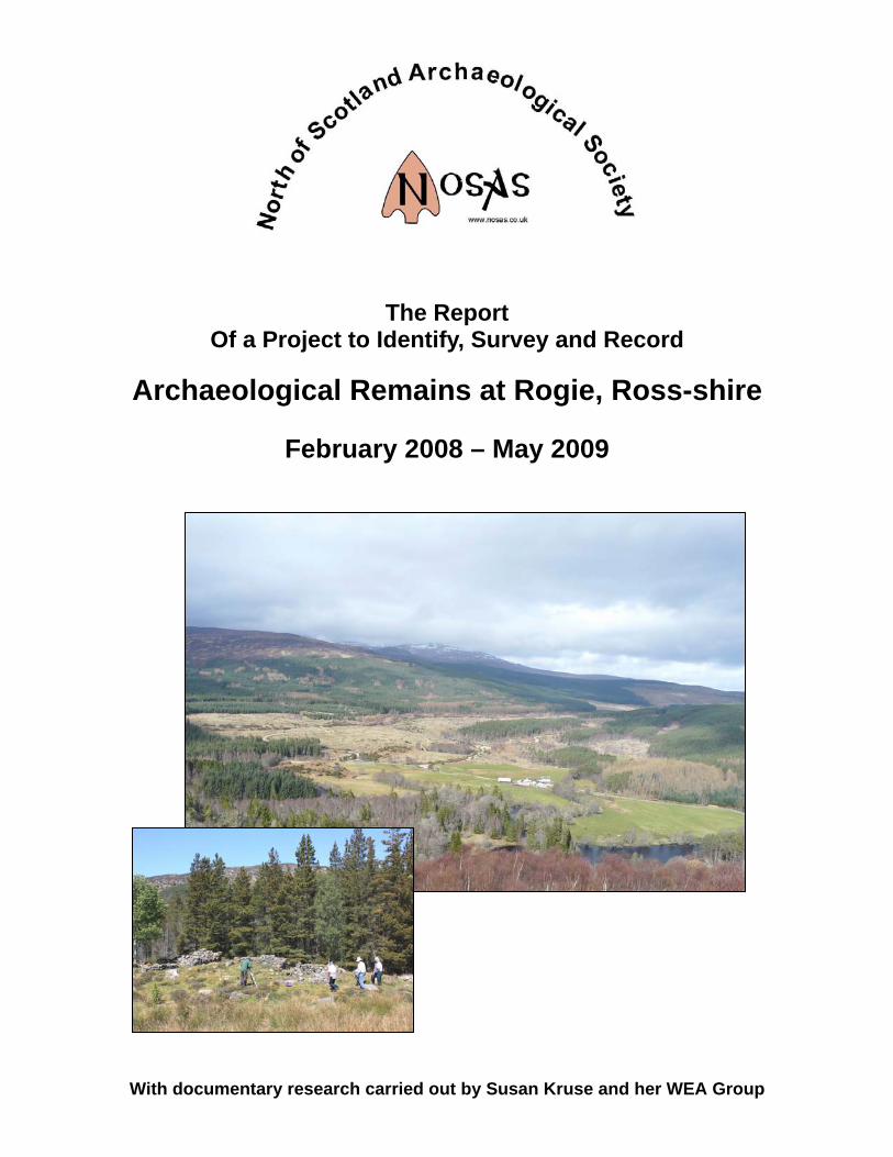
Front page – Rogie Farm and surrounding area from the southwest and (inset) planetabling at the NW settlement of the dispersed township – sites 61 and 62
1
Contents
1. Location of Rogie 2 2. The Rogie Project 2.1 Introduction 3 2.2 Method 3
2.3 Historical background 4 2.4 Results of the fieldwork and interpretation of the sites 7 3. Gazetteer of sites 3.1 The Sites above and to the North of the Railway Line 11 3.2 The Sites below and to the South of the Railway Line 20 3.3 Selected photographs 23 3.4 Photo List 27
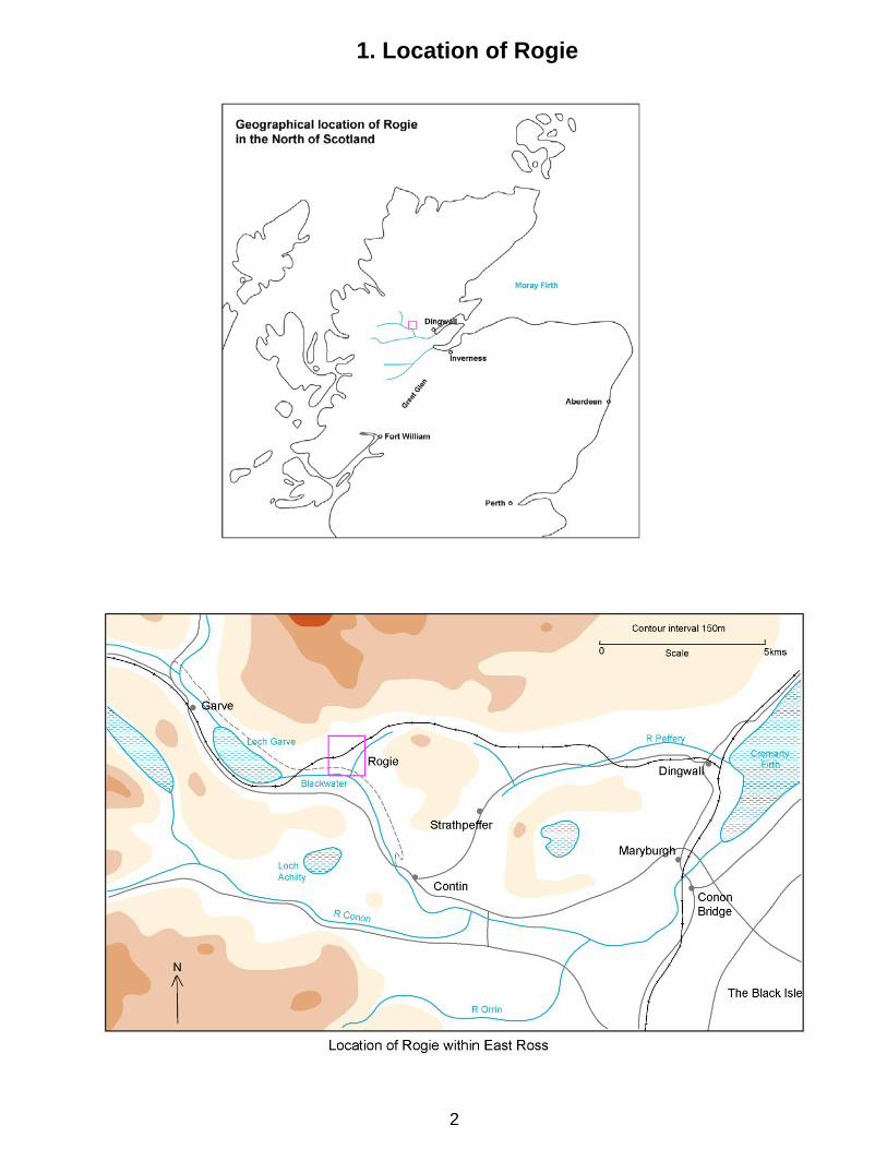
1. Location of Rogie
2
3
2. The Rogie Project
2.1 Introduction In the Summer of 2006 an idea for a project targeting the dispersed township of small scattered farmsteads, 800m to the northwest of Rogie Farm, near Contin, in Ross-shire was discussed. The project would be a joint venture between the North of Scotland Archaeological Society and Forestry Commission Scotland and would have as its main aim the presentation of selected sites to the public and as a focus for a Forestry Commission Scotland family cycle route based on the FC picnic site at Contin Bridge The role of NOSAS was threefold
• To survey and record the archaeological sites of the dispersed township, Nmrs No NH46SW 0003, at NH 439600, in particular making detailed drawings of the two northmost groups of buildings at NH 4378 6012 and NH 4400 6012
• To locate and record other archaeological sites in the surrounding area of approximately 1m2 so that the above sites would be set in context
• Research the historical background of the township and the area of Rogie Farm. In addition, the material would be made available to Forestry Commission Scotland for an interpretive leaflet and NOSAS would “tidy up” selected sites in a sympathetic way so that they were more visible and better presented to the public. The area is situated on the northeast bank of the Blackwater River, 3 kilometres NNW of the village of Contin and approached by a forest road from Contin Bridge. The main trunk road to the West Coast passes along the southwest side of the Blackwater. Rogie Farm and the surrounding land was bought by the Forestry Commission in the 1950s and has been used for forestry ever since. The whole area has been grossly disturbed by forestry, having been ploughed and planted with trees, felled, mounded and replanted. The drainage too has been substantially disturbed by forest roads and tracks - many areas, which would in the past have been well drained, are now marshy. In addition the Dingwall-Kyle of Lochalsh railway line, constructed in 1869, bisects the area from east to west. For various reasons the project did not get underway until January 2008. On the first outing the sites of the dispersed township were used for a training exercise in surveying and recording techniques. The Scotlands Rural Past team came up from Edinburgh and 15 NOSAS members attended a very wet and uncomfortable weekend of training. Thereafter there were several more field days in 2008 and a final day of plane tabling in May 2009. NOSAS member Susan Kruse and her WEA group undertook some very useful research into historical background over the winter of 2008 and Jim Bone provided some helpful aerial photos. We are extremely grateful to both for these contributions. 2.2 Method The Historic Environment Record (HER) held by the Highland Council Archaeology Unit was consulted and the Royal Commission on Ancient and Historic Monuments Canmore website for previously recorded archaeological sites. There was only one site recorded, that of a township, NH46SW 003, of 3 roofed,1 partially roofed and 13 unroofed buildings, 8 enclosures and 2 short lengths of head dyke. This had been recorded in 1996 as part of the First Edition Survey Project which was desk based and as far as we were aware no visits to the site had been made. No other sites had been identified in the area. Several old maps had been consulted, the Roy Military map of c1750, a plan of an intended road from Dingwall to Lochcarron by George Brown, 1790, and the first edition OS map of 1870. Susan Kruse and her group were to add to these maps. Otherwise the historical and documentary research for the sites was carried out by Susan Kruse and her WEA group. We followed the usual format of NOSAS field days; dates were flagged up and interested NOSAS
4
members recruited. Our usual method for recording the sites is to divide into teams of two or three, a more experienced person being matched with a “buddy“. The area was walked over, with likely locations being inspected. Generally the going was difficult because of dense trees, felling and mounding and the heavy bracken cover. Inevitably we did not cover every inch of ground and there may well be sites that have been missed. The objective was to note the exact location of each feature by taking a 10 figure grid reference using a GPS, taking written details and digital photographs of the remains, and drawing measured sketches when it was felt appropriate. Internal measurements of all buildings or enclosures were taken, the rough height of the remaining walls, a description of their composition, other details such as internal partitions, entrances or outshots and associations with other features were noted. A description of the surroundings, together with other information where relevant was also included; if for example we felt that a feature was threatened. The two targeted groups of buildings were to be surveyed and drawn using the planetable method; for each site several planetables were linked together. A plan of the whole area was also to be produced so that the features could be seen in relation to each other. Most of the plans and drawings were to be drawn up using either pen and ink, or OCAD, an orienteering cartographic software programme, the symbols of which have been modified to represent archaeological features. The features were also to be photographed using a digital SLR camera; only selected photographs are reproduced here in the report, the complete set of photographs is available on a DVD. Each feature was given its own identifying two figure number. Copies of the full report are to be deposited with the Forestry Commission, Historic Environment Record (Highland Council), National Monument Record of Scotland, Historic Scotland, Dingwall Museum, Dingwall Library and the North of Scotland Archaeological Society Archives. 2.3 The Historical background of Rogie with grateful thanks to Susan Kruse and her WEA team, the full archive of their research can be seen in the Dingwall Library. This account takes the form of a timeline: Rogie was part of the estates of the Mackenzies of Coul a cadet branch of the Clan Mackenzie In 1610 a charter first mentions the name; 'fishings in the Linn of Coul, called Rogie' (NAS GD1/1149/4) In 1681 a charter of the lands of Coul, Kinnellan and Kinneherd states that the lands were in the possession of Alexander Mackenzie of Coul And in 1715 Sir John Mackenzie estates were forfeited after the 1715 Rebellion for leading the Mackenzies at the Battle of Glenshiel. (see also below 1781 (1715)). Sir John Mackenzie dies without heirs. Estates go to a brother, Sir Colin Mackenzie. (W Anderson, Scottish Nation, 1863) 1725 - The first mention of Rogie on a map by Avery (National Library of Scotland - NLS) 1747-55 - General Roys map shows rig and furrow cultivation in the area. Rogie farm seems to have been called Balnain. Rogie is labelled but may indicate the burn. The Mackenzies of Coul owned Rogie and the land around the settlement or township would have been divided among the tenants and sub-tenants on the ‘run-rig’ principle. ( Roy map on NLS website) 1759 First surviving parish register for a birth at Rogie: Duncan Mackay son of Fraser and Mary Mackay (Fodderty Parish Register of Births) 1768 Rogie is mentioned as part of disputed border between Mackenzie of Coul and Castle Leod Estate (at that time annexed). (’10 Year Peat War’: NAS E746/160) 1780 - Rents for Roagie detailed as £23, 17s, 5d, 6, Money: £22, 9s, 5d, Coverted services: 15s, 5d, Cows foddering: 5s, 2d, 8, [unclear] money: 7s, 9d, 10, Plus 12 ½ hoggs, 17 lambs, 32 hens, 2 leet, 2 feld of peats. 1779 and 1780 A further entry in the Trust Sederunt Book details the cash paid by individual tenants; William Matheson, John Mackenzie, A Fraser & D. Macdonald, Duncan Macka, D. Mackenzie, I. MacGilukson, D. Cameron, I. Macdonald and Sim. Mackenzie. It also lists arrears of two Rogie tenants, Simon Mackenzie and John Fraser (Trust Sederunt book of Alexander Mackenzie of Coul: NAS CS96/1937) 3rd February 1781 - A report on the Petition of Major Alexr. McKenzie shows that in 1715 there were lands at Rogie belonging to the Mackenzies of Coul. After the 1715 rising, they were forfeited, and the report implies that even by 1781 they were still held by the Crown. However, see above the information from the Trust Sederunt Book which clearly shows rents from Rogie in late 1770s.

5
1789 - Ainslie Map shows Rogie and Easterrogie on a road linking Killon (Garve) and Coul (NLS) 1790 - The map of George Brown, has evidence of settlement and extensive rig and furrow at Rogie, and settlements at Upper Rogie (Brown 1790 NAS RHP11593d; also on SCRAN website) The military road at Rogie - In the 18th Century black cattle and pastoral farming formed the mainstay of the Highland economy. There were no metalled roads north of Inverness; drove roads and tracks, for the movement of cattle, were not suitable for wheeled vehicles. The first reference to the need for a road through Strathbran from Contin to Poolewe, with access to Stornoway was in 1757. The Contin-Poolewe Road (52 miles) was started by Major Caulfeild in 1761-1763. It passed along the north side of the Blackwater and Loch Garve through Rogie. Reports suggest that the roads had been built by unskilled labour at high speed and without consideration for the effects of climate and, as a result, the cost of repair and maintenance increased rapidly. By 1780 maintenance of road west of Contin was discontinued and it fell into disrepair. In 1786 John Knox reports that the ‘military roads’ were a waste of money and ‘were little used’. In 1790 George Brown surveyed the line of a new road from Dingwall to Strathcarron along the original line. But in 1802 the Telford Report recommended a route on the south side of the Blackwater and Loch Garve with a bridge at Contin. This eventually came to fruition in 1821. Telford’s first bridge at Contin was carried away in a ‘Great Flood’ in 1811 and a second bridge with a higher arch had to be built. 1791 The Old Statistical Account Ross and Cromarty describes the agricultural basis of the parishes of Fodderty and Contin. Although Rogie was in Fodderty parish, the account from Contin is probably of more relevance, since the Mackenzies of Coul were the main landowners in the parish. 1792 Sir Colin, 5th Baronet, dies. Sir Alexander Mackenzie, 6th baronet, his eldest son inherits. Sir Alexander was a Major General in the Bengal Army. (Scottish Nation .W Anderson, The Scottish Nation, 1863) In 1792 a letter from Kenneth Mackenzie factor to Col Alexander Mackenzie demonstrates the early beginnings of agriculture change within the Coul Estate. It would seem that as part of the tenants’ leases there is hinted that some sort of agricultural improvement. This does not seem to have taken place and the factor is urging Mackenzie to use his power to increase the rate of change. Although not convinced about moving out tenants for sheep the factor is talking about bringing in sheep to help out a farm at Kinellan. Tenants also seem to be owing arrears to the laird.
‘Sheep farmers are quite the rage" commented the Factor… ‘I am not altogether satisfied that it is justified to turn out tenants poor as they are for increase in rent.’ ‘I have just begun to make a move for a small flock of sheep which may answer at Kinnellen in the hope of assisting our poor friends there who have toiled’. (NAS GD1/1149/44 item 6)
1793 A plan of showing the intended road from Lochcarron to Dingwall shows cultivated fields. Rogie farm labelled Rogie, and also a settlement at Upper Rogie. (NAS RHP11597/1) In 1794 rent books record 12 families paying rents at Rogie of £41 12s 10d with very little in arrears (£1, 7s, 0d) (William Mateson, Roderick MacRae, Kenneth Mackenzie, Alex Fraser, John MacDonald, Donald Cameron (sr), Donald Cameron (jr), John Baine, Alex MacRae, Murdo Macdonald, Alex MacDonald, Margaret Fraser). (NAS GD/1149/27) In 1795 Sir George (7th Baronet) took responsibility for the lands of Coul, including Rogie, after the death of Sir Alexander (W Anderson, Scottish Nation, 1863) In 1797 an inventory of Sir Alexander Mackenzie Estate include: 'the arable landes and Riggs of Reogie’ (NAS GD/1/1149/20 item 20) 1806 Stockdale map of 1806 shows settlments at Rogie and Easter Rogie. (NLS and SCRAN) 1809 Sir George Mackenzie is known to have purchased a large number of Cheviots in 1809 to put on his extensive sheep runs. (Inverness Journal 21 April 1809) Dr John Mackenzie (1803-1886) in his memoirs “Pigeon holes of Memory” was very critical of Sir George’s Mackenzies ‘improvements’ and records that he evicted;
'every crofter and they were…over 30 in Rogie alone, all thriving. No arrears, and paying a higher rent than the one sheep farmer pays now'. (C Byam Shaw “ Pigeon holes of Memory” The Life and Times of John Mackenzie)
1813 Sir George Steurt Mackenzie publishes “General View of the Agriculture of the counties of Ross and Cromarty drawn up for the consideration of the Board of Agriculture and Internal Improvement”, a passionate treatise on clearances, and on the feckless crofters.
6
c1820 Thomson map of (published 1832) shows settlement at Rogie, and roads on both sides of the river. (National Library of Scotland) 1837 New Statistical Account Ross and Cromarty for the Parish of Contin describes the agricultural basis of the parishes of Fodderty and Contin. Although Rogie was in Fodderty parish, the account from Contin is probably of more relevance, since the Mackenzies of Coul were the main landowners in the parish. It is quite interesting when compared with Old Statistical Account of 1791, clearly showing the impact of clearing the land for sheep farming. 1841 First Census shows 6 households at Rogie, including the family of Elliots from the Borders as sheep managers. Property called Rhoaggie. The other five families are headed by Donald McDonald (a dry Mason), Alexander Fraser (a labourer), Mary McDonald (a cottar), Rebecca Finlayson (a cottar), and Margt. MacDonald (a cottar). 1848 Sir George Mackenzie 7th Baronett dies. Sir Alexander his son becomes 8th Baronet. 1851 The census shows 6 households. The Elliots have been replaced by William Laidlaw sheep manager from Hawick, and his large family, who lived in Rogie farmhouse. MacDonalds (farm servants and labourers) now have two crofts, and the Fraser croft remains, but the last two are headed now by Agnes MacLennan (pauper) and Elvira Cameron (Pauper). 1856 Sir Alexander Mackenzie, 8th Baronet dies. Succeeded by brother Sir William 9th Baronet 1860s Dingwall and Skye railway cut through the site. Line opened in 1870 (H.A. Vallance, The Highland Railway, pp. 33-4) 1861 Census shows 6 households. Laidlaws (Sheep manager) stayed in the biggest property with 3 rooms. Other 5 properties either have 1 or 2 rooms. Families: McDonald (3 properties: labourers, housekeeper), Fraser (Shepherd), McLennan (housekeeper / pauper). 1868 Sir William Mackenzie dies. Succeeded by brother Sir Robert 10th Baronet 1886-1875 First edition map shows 4 roofed buildings and rough pasture in 2 of the 5 crofts at Rogie north of the railway (OS 1st Edition , NLS) 1871 Census shows 4 households. Rogie farmhouse occupied by the Laidlaws (Sheep Farmer) and his large family. 3 properties called Rogie Cottages. Families living there Frasers (farm servant), Macdonalds (2 properties: farm servant and general servant) 1873 Sir Robert Mackenzie dies. Sir Arthur George Ramsay Mackenzie becomes 11th Baronet 1881 Census shows 3 households. Rogie farmhouse occupied by the Laidlaws. (Sheep Farmers). Rogie Cottages contain families Fraser (widow, agricultural labourer), MacDonald (farm labourer). 1891 Census shows 3 households. Rogie farmhouse is occupied by the Laidlaws. The cottages are occupied by Margaret MacDonald and her unmarried nephew James McQueen (shepherd), and two elderly Fraser sisters. 1901 Census shows 2 households. Adam Laidlaw and brother Walter, sheep farmers, live in Rogie farmhouse. The other Rogie Cottage contains Margaret MacDonald, Mary McRae (sisters) and James MacQueen (shepherd). 1910 The description for Rogie Farmhouse in the Inland Revenue Field Book reads:
‘Farmhouse is built of stone & lime & is slated. Old, but in fair repair, containing kitchen, sitting room, 2 bedrooms with bedroom off and Dairy in back wing of stone & slated – all on ground floor. Upstairs there are 2 bedrooms & a boxroom. Barms attached of stone & lime & slated. Fold of wood & corrugated iron roof, detached. 2 stalled stable of stone & corrugated iron roof with old thatched Byre attached. Shepherds House (thatched) Very old & poor – 2 rooms & closet/’ (Inland Revenue Field Book : Ross & Cromarty Map LXXXVII, property ref: 145)
1929/1930 Last mention of James Macqueen, shepherd in Valuation Rolls 1938/1939 William Macrae, shepherd, first listed as living in a house at Rogie in Valuation Rolls [possibly one of the crofts]. 1942 Donald Grant and family move into Rogie Farm house from Kinellan (Memories Mrs D Macdonald nee Grant; Valuation Rolls) 1943 Shepherd’s house at Rogie occupied by Mr & Mrs James Macqueen was completely destroyed by fire. (Ross-shire Journal, 12th March 1943) 24th March. Death of James Macqueen at Muir of Ord(Ross-shire Journal, 26th March 1943) 1944 Death of William Laidlaw. The final link in a long line of notable pastoral farmers who came North from Hawick over 100 years ago (Ross-shire Journal 24th March 1944) 1947/1948 Last mention of William Macrae at Rogie in Valuation Rolls 1949 Area sold by the Barony of Coul Sir Robert Evelyn Mackenzie 12th Baronet to Mr Donald Grant (Forestry Commission records; Valuation Rolls)
7
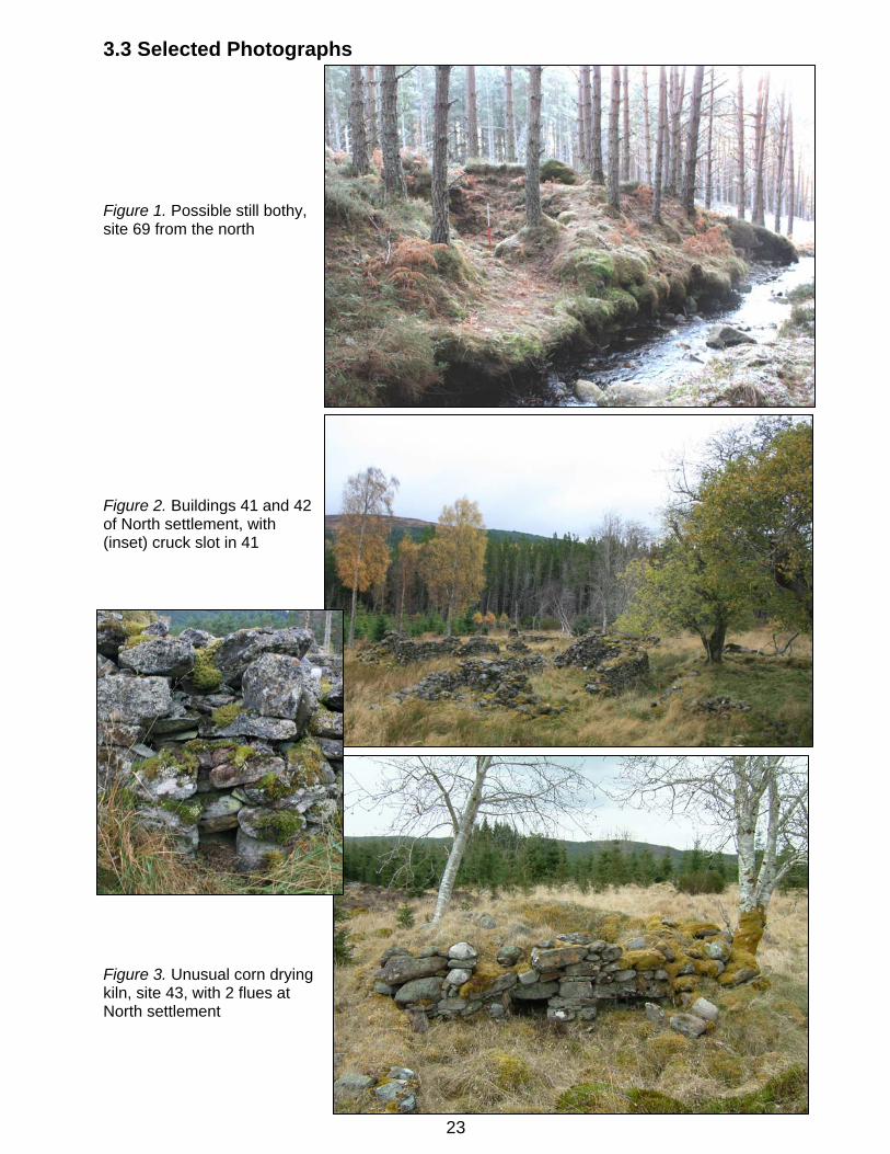
1954 Grant sold land of 4017 acres to the Forestry Commission. Rogie farm had 400 ewes. (Forestry Commission records) 1957 First trees planted by the Forestry Commission, Calculated to take 13 years to completely plant up ( Forestry Commission records) 1988 Forest felled around Rogie scattered township ( Forestry Commission records) 1992 Area replanted with sitka spruce with areas around crofts left unplanted for deer lawns. ( Forestry Commission records) Primary Sources The Old Statistical Account 1791-99 Records from Mrs D Macdonald, nee Grant (in Rogie archive binder, Dingwall Library) Roy Military Survey of Scotland, 1747-1755 Old Parish Records Census Records Secondary Sources C Byam Shaw, Pigeon Holes of Memory. London, Constable (1988) 2.4 Results The majority of the work took place over the winter months between April 2008 and June 2009. Five full field days were organised with numbers of people varying from 3 to 15. In addition, several ad hoc days were undertaken by small groups when the weather was good. 77 individual features were recorded in total. For reporting purposes some features were grouped together as a site and though they are geographically associated, they may not be contemporary with each other. Ten sites have been identified and recorded during the project. Some are single features; others are much more complex with as many as 10 or 12 features. The dispersed township for example has been previously classed as being one township site, but it has 25 individual features. Interestingly we recorded 16 unroofed buildings and 9 enclosures, whereas originally there were 17 buildings (3 roofed, 1 partially roofed and 13 unroofed buildings), 8 enclosures and 2 short lengths of head dyke recorded from the 1st Edition OS map. All the features are detailed in the gazetteer and only selected photographs are included in this report. The complete set of photographs is available on a DVD. The task of exploring the area and locating the archaeological sites was made extremely difficult by the underfoot conditions and all credit goes to the team for their persistence. On the other hand we were considerably helped by being able to drive to within easy reach of many parts of the area by using the comprehensive network of forest roads. Our thanks go to the FC and to Sandy MacArthur and Brian Duff for their co-operation in allowing us to use these roads. As expected, because of their remote location, the buildings and enclosures of the dispersed township were much as depicted on the 1st Edition OS survey and the current 1:25,000 OS map. Their condition too was reasonable. Few had been removed or damaged by forest operations and although they were grossly tumbled there was little sign of stone robbing. What did surprise and excite us though was the group of cup marked stones and the ringed earthwork; evidence of the Neolithic and Bronze Age. The cup marked stones are in a typical position; they have a good outlook and are on a natural routeway. The sheer number of them was very exciting and potentially very important. The ringed earthwork nearby was also in a commanding position, it appeared to be too substantial for a round house, and we speculated that perhaps it was some kind of fortification. Also in this vicinity there is another structure which may have been a fortified building, site 45. It too occupies a dominant position with good panoramic views, but it is a very exposed situation. This building is quite small, just 20m x 14m overall, but the remains of the walls are extremely substantial; 2m thick in places and 1m in height. All these features are located in a small discrete area over two knolls which have recently been replanted with trees. NOSAS hopes that this area can be managed in such a way as to preserve these sites and their setting.
8
Interpretation of the sites at Rogie What have we learnt at Rogie? and does the archaeological evidence support the historical evidence? The project area at Rogie is one of extreme contrasts. The present day farm at Rogie is laid out in neat grass fields, on the haughs of the Blackwater River and the Rogie Burn; their extent today is probably very similar to what it was 200 years ago. Our first observation has to be that when the sheep farm at Rogie came into being there was a massive clearance of people from the old township of Balnain, now Rogie Farm. Beyond and above the farm there is forestry plantations. Dr John Mackenzie in his memoirs “Pigeon Holes of Memory” has it that there were over 30 crofters in Rogie in about 1809. Almost certainly that figure is supported by our archaeological evidence. If we assume that almost every suitable building of reasonable size at the dispersed township of Rogie was a dwelling house, then the figure of 30 is just about possible. But it does occur to us that Rogie 200 years ago might also have included the township of Achadh Mor about 2km to the west, which we have not included in our survey. The word 'croft' conjures up the notion of a more orderly and tidy division of land and this was never the case when there were 30 crofters at Rogie. Much of the ground above the haugh fields of Rogie Farm was uncultivable due to complex topography, rock outcrops, earthfast boulders and general stoniness, and Roy's map of c1750 bears this out. The dispersed township farmsteads is spaced around a large roughly circular walled field, and it is worth speculating that this was an attempt in the period of agricultural improvement to introduce some sort of order to the laying out of crofts in this difficult terrain. The central walled enclosure might have been for the crofter's livestock, to keep them separated from the laird's sheep. A number of the more substantial buildings seen today at Upper Rogie appear to overlay the footings of earlier buildings, perhaps from the period around 1809. The townships may have been obliged to take in kinship families from earlier clearances, resulting in settlement of even the poorest of ground. These early crofters probably turned their hands to a variety of different occupations to make ends meet, such as road building, estate work, droving and illegal whisky production. Many sons would have seen military service. The 1841 census returns sits very comfortably with the number of more upstanding and complex farmstead settlements that we have recorded in detail. The 1841 census records just 6 household heads at Rogie - the sheep farm manager, a dry mason, a labourer and 3 female cottars. To look back before 1750 for evidence of settlement becomes more difficult. Some of the round ended footings we found may represent earlier dwellings, going back several more centuries, but without a campaign of excavation we shall never know. However the enigmatic building on the ridge above the railway line, No 45, see plan on page 17, with its 3 conjoined parts and massive walls is a real problem to explain. Prior to us removing the covering of brash from it, and cutting the broom, one thought expressed was that it was a much older building than any of the others at Rogie, but that it showed signs of reuse probably in the crofting era. One of the team that surveyed this building suggested that what look like entrances today might represent later re-use, and that originally there had been no entrances at ground level, with access being by stairs or a ladder up to raised floor, with cellars below. One possibility for this building is quite romantic. It concerns the struggle for the Scottish Crown against the Anglo-Norman Canmore kings in medieval times. In the 12th and 13th Centuries there were various uprisings led by the MacHeths and the MacWilliams, descendents of the MacAlpine kings of Alba and Macbeth. Moray and Ross was frontier country at this time and at the forefront of the conflict. In 1181 Donald MacWilliam, most likely with help from Ireland, launched a revolt and held on to Ross for 6 years. King William the Lion led an army north to contain the rebellion and in 1187 Donald MacWilliam was killed in a skirmish at Mam Garvia, somewhere west of Dingwall. The natural amphitheatre of Rogie, with an escape route through to the west, would seem to be an ideal hiding place for a gang of insurgents!! The massively walled circular structure No 15, see drawing on page 18, could be the remains of a dun, and that would place it in the Iron Age. No hut circles from the Bronze Age were found in the project area, but several are known on the west side of the Blackwater, opposite Rogie. Beyond that period, the discovery of rock art at Rogie was a real and unexpected bonus for the
9
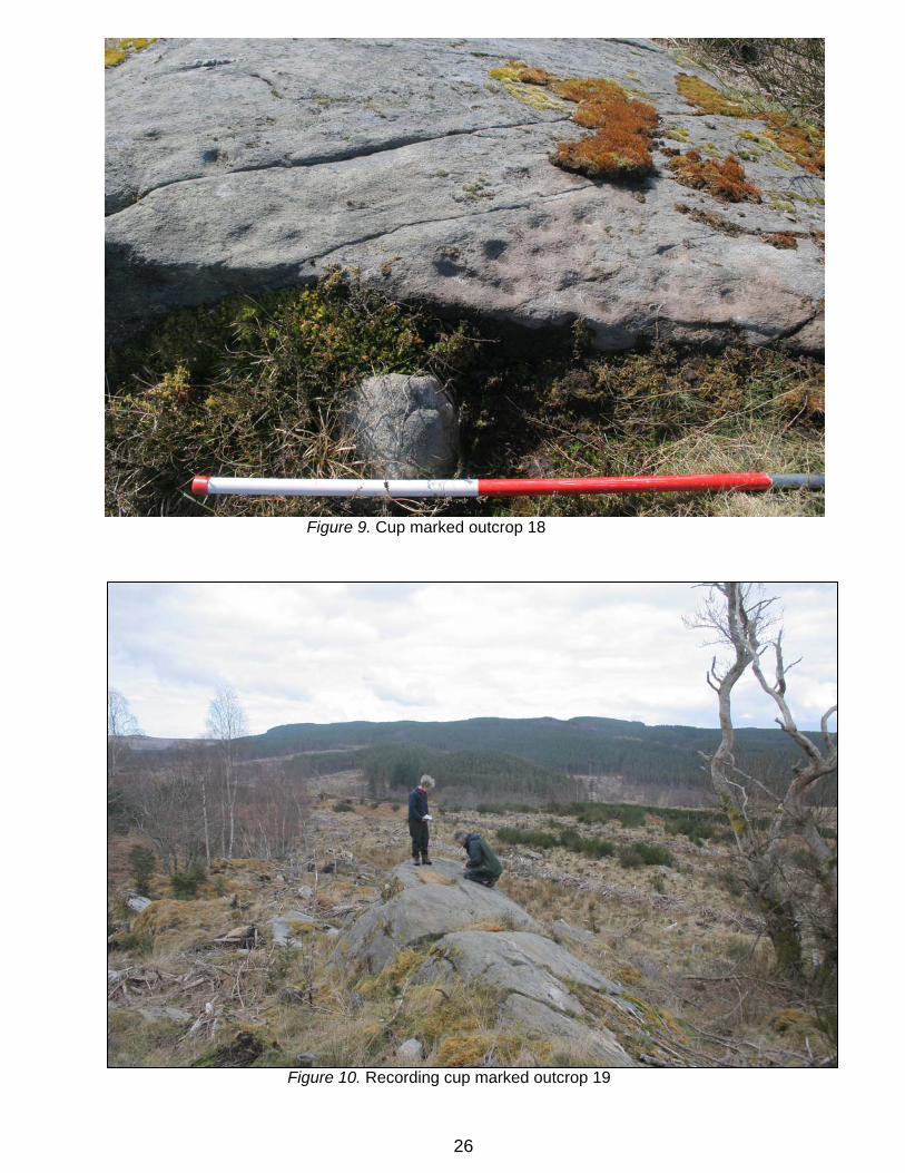
project. The rock art at Rogie is classed as 'rock art in the landscape', in that the cup marks are all either on rock outcrops or on earthfast boulders. It is the largest single group of cup marked stones in Easter Ross so far discovered. This makes the group of considerable interest both locally and regionally. There are 10 cup marked stones in the main group, with 2 outliers, forming as a whole a threshold on the north side of the burn, to the glen of the Rogie Burn, that leads directly thorough to Strath Peffer, about 5km to the east. The Rogie group of cup marked stones is likely to be a territorial statement of some kind, dating to the Neolithic Period, the same period when the many chambered cairns in Easter Ross were built. The cup marked stones here are also significant for the presence nearby of the spectacular Rogie falls, whilst the marked stones directly overlook a slacker stretch of the Blackwater that would always have made an ideal crossing point.

10

11
3. Gazetteer
The sites are generally listed from east to west, taking the upper ones, north of the railway line, first. Individual features have been given a 2 figure project reference number, not in any particular order. For recording purposes the features have been grouped together as a site and though they are geographically associated, they may or may not be contemporary with each other. The site name is generally that of the nearest named place or feature on the 1:25,000 OS map 3.1 The Sites above and to the North of the Railway Line Upper Rogie (features 68 and 69) These sites, 68, a building, and 69, a possible still bothy, are situated within the planted forest to the north of the NW settlement of Upper Rogie. Site 68 is set into a slope below a rock face some 250m to the north of the settlement and site 69 is on the SE bank of a burn some 500m to the north of the settlement 68 Building - NH 43722 60318 This rectangular building is set into a slope below a rock face, it is7m ENE-WSW by 2.2m internally. The front south wall is 1m thick and 1m high and there is a central entrance. There may have been a slight extension to the long wall with one sub-rectangular boulder being 1.4m long. The back wall is set into the slope with only the inner face visible, it is 1-1.4m high and 1m thick. The ENE wall is tumbled although where it is built into the slope the stones appear to be still in situ. The WSW end is only partially tumbled with a recess built into the wall. The recess seems to be carefully built of large sub-rectangular boulders and was initially thought to be a fireplace but there is no indication of a chimney and no sign of burnt stone around the area. The recess is 0.5m wide by 0.6m deep and 0.7m high, 1.2m wide and 1m high externally. The external width is problematic as there is tumble on the outer face. The interior of the building is level with a possible partial division indicated by stones set into the floor and extending from the doorway NW half way across the building. There are faint indications of possible walls on the slope below the building. The building is in a reasonable condition. There is no indication of its date or use. The recess was an unusual feature and its function remains a mystery. 69 Possible still bothy (figure 1) - NH 43636 60489 Immediately to the ESE of the small burn is a hollow in the bank c.2-3m deep, 3.2m N-S and 2.3m wide. The W edge has been enclosed by a low tumbled wall c. 1.75m long and 0.5m wide; the S end is slightly curved. On the NNE edge of the hollow there is a short section of wall face which suggests there may have been a revetted wall, it is difficult to trace further around the bank. To the W this revetted wall has tumbled into a gap between the bank and the surviving enclosing wall. The remains of the structure are very tumbled but it appears to have been a building. Given the position of the building and its poor survival it is possible that it was an illicit still, these were generally in hidden locations and temporary structures. Upper Rogie Dispersed township (Nmrs No NH46SW 003) – centred on NH 439 600 In an area of perhaps half a square kilometre and centred on a rounded hill to the north of the railway line there are the remains of a large enclosure and 5 discrete settlements. Their composition is variable, some have just 1 building and 1 enclosure, others have several buildings with up to 2 enclosures. The central focus is the hill, around which there are the remains of a discontinuous stone and turf wall, several clearance cairns lie within the enclosure particularly in the NW part. The settlements are contiguous with the enclosure wall at varying intervals. The whole area has been grossly disturbed by forestry, having been planted with trees, felled, ploughed and replanted again. In addition the drainage has been substantially disturbed by forest roads and tracks - many areas, which would in the past have been well drained, are now marshy. The surrounding wall and a few associated features are described first followed by each settlement the structures of which have then been grouped together. The township is shown on the 1st edition OS map as 1 partially roofed building, 14 unroofed buildings, 6 enclosures and a head dyke. The individual farmsteads are described from the northeast one and working in an anticlockwise direction, numbered A to F Enclosures (features 54, 49 and 50) 54 Enclosure/Wall - NH 43746 59852 (SW corner/junction) A discontinuous wall surrounds an enclosure some 400m x 200m in size, it is now mostly planted with young trees but in the north part
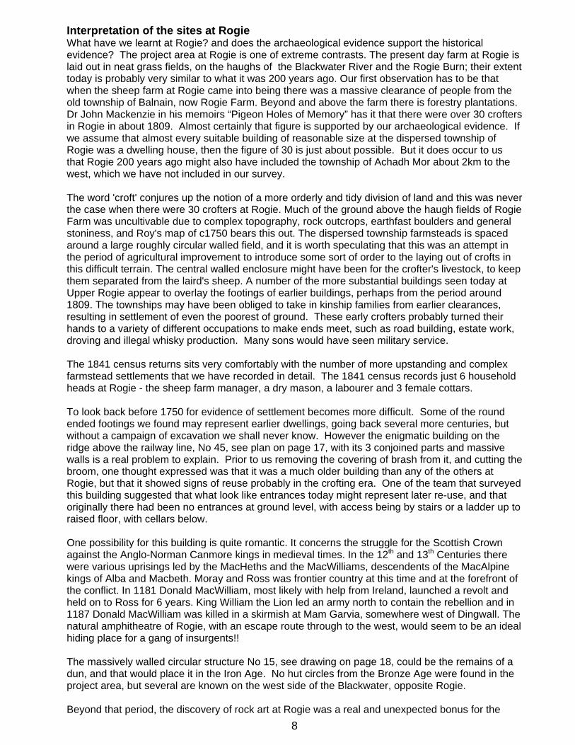
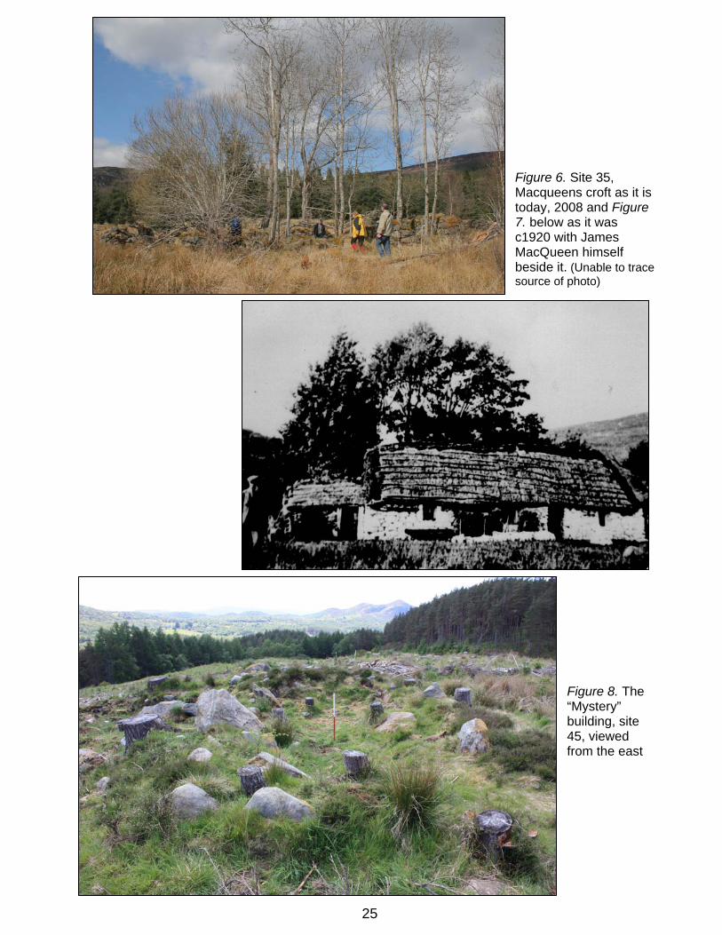
there are some open grassy areas (though ploughed). In the SW and west the wasted dry stone wall is clearly defined and 0.5m in height. To the north it is ploughed out and barely discernable. The east part and south part appears to have been destroyed by the forest roads To the south of the area and just SW of a prominent crossroads there are two features: 49 Clearance cairn - NH 44063 59918 A large cairn piled up against a prominent boulder. 50 Possible enclosure - NH 44046 59910 Two parallel stone and turf banks running parallel and 7m apart may be the remains of an enclosure. They are 0.7m height, have a spread of 2m and length of 12m. The whole area is grossly overgrown with bracken. A. North-East settlement (features 32 - 39) centred on NH 4416 6007 - comprises 4 buildings and 2 enclosures. The drainage of the settlement has been grossly affected by the construction of the road, it is now very marshy. 32 Building - NH 44253 60095 An L-shaped building with an outshot close to and on the west side of a small burn. The main compartment is rectangular and aligned NE-SW. It measures 8 x 3.5m internally and is recessed into a knoll at its SW end where the well made stone face of the gable is 1.5m high. The remaining stone wall footings are 0.5 - 1m high and 0.8m thick. There is an entrance in the centre of the SE wall. The outshot to the SE is 4 x 4m and the walls are very wasted being 0,3m high and with a spread of 1.5m. The structure is grossly overhung with trees 33 Building - NH 44209 60062 On a slight knoll this rectangular structure is aligned NE-SW and measures 6 x 2.5m internally. The remains of the substantial dry stone walls are 0.5 - 1m in height, the gable to the west is 1m high, and have a spread of 1.5m. Planted with trees. There may be an outshot to the SW indicated by truncated walls at the corners and a grassy platform c4.5 x 3m. 34 Enclosure - NH 44196 60045 An irregular shaped enclosure roughly 14 x 11m in the centre of an overgrown marshy area. Substantial stone walls are up to 1m height and have a spread of 2m. The whole is overgrown with reeds and brambles. There is a possible entrance in the west of 2m width. 35 Building (alternative name - MacQueens croft) (figures 6 and 7) - NH 44165 60069 The main building of this settlement. It is the westmost of 2 with an enclosure, 37, to the rear. The building has 2 compartments and an outshot to the SW. It has an internal measurement of 11m x 3.5m, with the main compartment to the west being 6m in length. The tumbled dividing wall is 0.5m high and has a spread of 1m. The walls are of dry stone construction, double faced and 0.7m in thickness. The rear wall is generally 1m in height and turfed up on the outside. The NE gable is 1.5m high and the SW 1.2m. The front wall is tumbled for the main part, 0.5m high and with a spread of 1.5m, although the east part is better preserved and there is an entrance into the NE compartment. The outshot to the SW is more roughly constructed with walls to a height generally of 1m, it measures 3m x 2m and has an entrance in the E corner next to the main building. This building is thought to be MacQueens croft. A photograph taken in the 1920s, has been reproduced in this report, Figure 7, page 25. 36 Building - NH 44169 60078 Immediately to the north of 35 this building on the same NE-SW alignment has 2 compartments and an overall internal measurement of 13m x 3.5m. The west compartment is better preserved and measures 5m x 3.5m. The walls are of dry stone construction,
12
13
double faced and 0.7m in thickness. The SW gable is 2m in height, the rear NW wall 1 - 1.2m high, the SE wall 0.8m high and the dividing wall is 0.5m high. There is an entrance 0.7m wide at the E end of the SE wall. The NE compartment is 7m x 3.5m and much more wasted, although the rear wall is 1m in height and the NE end has an external height of 1m. Otherwise it is generally 0.3m high. A large part of the SE wall is missing (or else it may have been a wide entrance) 37 Enclosure - centred on NH 44157 60079 An irregular enclosure to the rear/northwest of buildings 35 and 36. It is roughly 25m x 15m and is bounded by the remains of a stone wall, 0.5 -0.8m high in the NE part but much more wasted in its SW part. A line of trees are growing along the wall. The internal area is grassy and deeply ploughed but not planted 38 Clearance cairn - NH 44126 60107 39 Cup marked stone - NH 44057 60095 details of this feature are included with the main group of cup marked stones 350m to the SW B. Middle North settlement (features 40 - 44) - centred on NH 4400 6012. Comprises 4 buildings, one corn drying kiln and 1 enclosure. Much of the area is marshy, the drainage having been affected by the construction of forest roads. 40A Enclosure - centred on NH 44004 60103 A rectangular enclosure aligned NNW-SSE is 18m x 13m. It is surrounded by a moss covered wall which is, for the most part, of stone. The general level of the enclosure is raised above that of the surrounding ground which is marshy. The height of the wall is generally 1m on the outside and 0.5m on the inside. A number of trees are growing along the line of the wall. This is most probably a garden. To the south of the enclosure there are two lengths of wall within a plantation of young trees, it is difficult to determine their extent, but they are probably associated with this settlement: B Wall - centred on NH 44068 60084 This winding wall is 23m in length and aligned NW-SE, it is 0.3-0.5m in height, and has a 2m spread. C Wall - centred on NH 44046 60070 and at right angles to 40B this wall has been grossly disturbed by forest ploughing 41 Building (figure 2) - NH 43998 60114 A rectangular building, aligned ENE-WSW, with 2 compartments. The east compartment is better preserved and has internal dimensions of 5.5 x 3m. The dry stone walls are double faced, 0.8m thick and generally 1m in height, although the east gable is 2m high. There is an entrance at the west end of the south wall and a nice pair of cruck slots, opposite one another in the long walls. The west compartment is much more wasted with the walls being 0.3-0.5m height, although at the west end, where it is recessed into the bank, the stone face is 0.8m high. There are two lengths of wall abutting; the one to the north stretches for 7.5m in a NNW direction and is of stone and turf construction, 0.5m high, the one to the south is of turf, it is 7m long and 1m in height. Both of these walls may be all that remains of an enclosure shown on the 1st edition OS map, the rest of it having been destroyed by the construction of the forest road nearby. 42 Building (figure 2) - NH 44001 60120 This is the main building of the settlement, it is aligned E-W and has internal dimensions of 16m x 4m. The internal area is raised above that of the surrounding land and is divided into 2 equally sized compartments by a setting of upright slabs 0.4m in height. The west compartment appears to be the main one, the walls here are generally 0.8-1m height (1-1.5m outside) but the west gable is 1.6m. On the outside this gable is 2m high and has complex buttressing, with a stone plinth 4m x 1.5m x c1.5m height covered by tumble. The east compartment walls are generally 0.5m high (0.8m outside) although the east gable is 1m high (1.3m outside), and here again there appears to have been a form of “buttressing” supporting the gable. Internally there is an obvious drain, 0.4m deep, down the centre of the compartment and an entrance at the west end of the south wall. An outshot to the east, in the form of a level platform, 2.5m x 2.5m, with a stone edge of 0.3m height may be a former building on this site. It is set at a slight angle to the main building and may indicate the line of an earlier building. 42A Building - Immediately to the north of 42, the turf footings of what may be small building are seen. It has the form of an L shaped turf bank, 0.3-0.5m in height with a spread of 1.5m. 43 Kiln and barn (figure 3) - NH 44009 60135 Aligned E-W this structure has an overall measurement of 7m x 3m. The kiln is well preserved and of dry stone construction, it is generally 1.6m high. The bowl has a diameter of 1.8m and it is 0.5-1m deep although there is some tumbled material inside. Unusually there are two flues in the straight west face which is 1.1m in height. The south one appears blocked although it can be probed to a depth of 0.9m, it has an aperture of
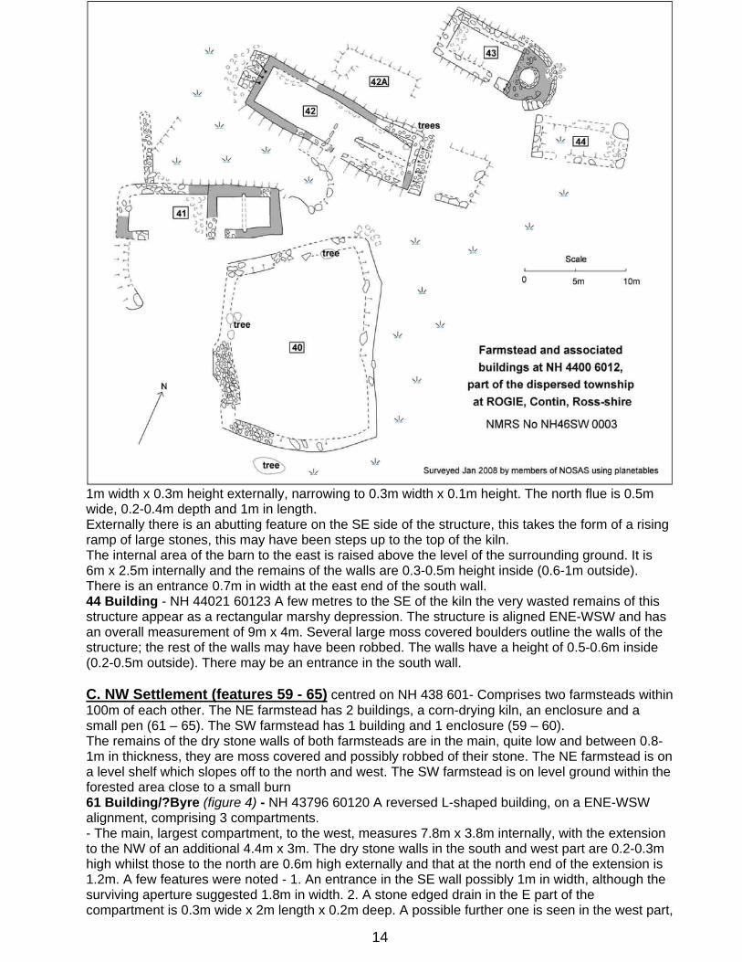
1m width x 0.3m height externally, narrowing to 0.3m width x 0.1m height. The north flue is 0.5m wide, 0.2-0.4m depth and 1m in length. Externally there is an abutting feature on the SE side of the structure, this takes the form of a rising ramp of large stones, this may have been steps up to the top of the kiln. The internal area of the barn to the east is raised above the level of the surrounding ground. It is 6m x 2.5m internally and the remains of the walls are 0.3-0.5m height inside (0.6-1m outside). There is an entrance 0.7m in width at the east end of the south wall. 44 Building - NH 44021 60123 A few metres to the SE of the kiln the very wasted remains of this structure appear as a rectangular marshy depression. The structure is aligned ENE-WSW and has an overall measurement of 9m x 4m. Several large moss covered boulders outline the walls of the structure; the rest of the walls may have been robbed. The walls have a height of 0.5-0.6m inside (0.2-0.5m outside). There may be an entrance in the south wall. C. NW Settlement (features 59 - 65) centred on NH 438 601- Comprises two farmsteads within 100m of each other. The NE farmstead has 2 buildings, a corn-drying kiln, an enclosure and a small pen (61 – 65). The SW farmstead has 1 building and 1 enclosure (59 – 60). The remains of the dry stone walls of both farmsteads are in the main, quite low and between 0.8-1m in thickness, they are moss covered and possibly robbed of their stone. The NE farmstead is on a level shelf which slopes off to the north and west. The SW farmstead is on level ground within the forested area close to a small burn 61 Building/?Byre (figure 4) - NH 43796 60120 A reversed L-shaped building, on a ENE-WSW alignment, comprising 3 compartments. - The main, largest compartment, to the west, measures 7.8m x 3.8m internally, with the extension to the NW of an additional 4.4m x 3m. The dry stone walls in the south and west part are 0.2-0.3m high whilst those to the north are 0.6m high externally and that at the north end of the extension is 1.2m. A few features were noted - 1. An entrance in the SE wall possibly 1m in width, although the surviving aperture suggested 1.8m in width. 2. A stone edged drain in the E part of the compartment is 0.3m wide x 2m length x 0.2m deep. A possible further one is seen in the west part,
14
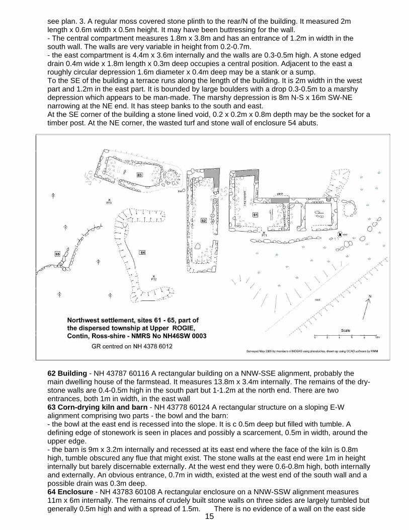
15
It measured 2m
ntrance of 1.2m in width in the
d the east a
is 8m N-S x 16m SW-NE
he socket for a timber post. At the NE corner, the wasted turf and stone wall of enclosure 54 abuts.
the dry-rt but 1-1.2m at the north end. There are two
ngular structure on a sloping E-W
of stonework is seen in places and possibly a scarcement, 0.5m in width, around the
nce, 0.7m in width, existed at the west end of the south wall and a
see plan. 3. A regular moss covered stone plinth to the rear/N of the building. length x 0.6m width x 0.5m height. It may have been buttressing for the wall. - The central compartment measures 1.8m x 3.8m and has an esouth wall. The walls are very variable in height from 0.2-0.7m. - the east compartment is 4.4m x 3.6m internally and the walls are 0.3-0.5m high. A stone edgedrain 0.4m wide x 1.8m length x 0.3m deep occupies a central position. Adjacent to roughly circular depression 1.6m diameter x 0.4m deep may be a stank or a sump. To the SE of the building a terrace runs along the length of the building. It is 2m width in the westpart and 1.2m in the east part. It is bounded by large boulders with a drop 0.3-0.5m to a marshydepression which appears to be man-made. The marshy depressionnarrowing at the NE end. It has steep banks to the south and east. At the SE corner of the building a stone lined void, 0.2 x 0.2m x 0.8m depth may be t
62 Building - NH 43787 60116 A rectangular building on a NNW-SSE alignment, probably the main dwelling house of the farmstead. It measures 13.8m x 3.4m internally. The remains ofstone walls are 0.4-0.5m high in the south paentrances, both 1m in width, in the east wall 63 Corn-drying kiln and barn - NH 43778 60124 A rectaalignment comprising two parts - the bowl and the barn: - the bowl at the east end is recessed into the slope. It is c 0.5m deep but filled with tumble. A defining edgeupper edge. - the barn is 9m x 3.2m internally and recessed at its east end where the face of the kiln is 0.8m high, tumble obscured any flue that might exist. The stone walls at the east end were 1m in height internally but barely discernable externally. At the west end they were 0.6-0.8m high, both internallyand externally. An obvious entrapossible drain was 0.3m deep. 64 Enclosure - NH 43783 60108 A rectangular enclosure on a NNW-SSW alignment measures 11m x 6m internally. The remains of crudely built stone walls on three sides are largely tumbled but generally 0.5m high and with a spread of 1.5m. There is no evidence of a wall on the east side
16
tside of the enclosure and at the north end the wall of enclosure 54 curves
ed N-S and measures 3m x 1m. The walls are of single stone
e a
.7m wide in the SE wall. The building is grass and moss covered and has been planted
hich re 0.3-0.7m high and have a 1-1.5m spread are more substantial in the north and east parts.
but this may have been provided by the west wall of building 62. To the west a possible track ran up the hill along the ouoff in a southerly direction. 65 Pen - NH 43770 60102 Situated in an angle of wall 54 a few metres to the west of the settlement. This small pen is alignthickness and are 0.6-0.7m high. 59 Building (figure 5) - NH 43731 60050 A rectangular structure on a NE-SW alignment measures c7.5m x 2.5m internally. The remains of the dry stone walls are generally 0.5-0.6m high and havspread of 0.8m. There is a considerable amount of tumble in the NE end of the building and an entrance, 0with trees 60 Enclosure - NH 43742 60042 A few metres to the south of 59 this enclosure is in a shelteredposition close to a small burn. It abuts the wall of the main enclosure 54 and is D shaped, on a WSW-ENE alignment and measure 13m x 12m internally. The remains of the dry stone walls wa D. Middle west settlement (features 55 - 58) - centred on NH 4375 5992 This settlement
d tter preserved on the west side where they are 0.5m high. This building is marked on the
of gh and 0.6m thick. There is a possible entrance, 0.8m in
th. The extent of the building is difficult to make out because of forest ploughing and planted
west
he E
tly disrupted by forest operations with deep pits, brashings and newly planted trees verall.
comprises 3, possibly 4 buildings, and an enclosure. 55 Building - NH 43737 59878 This small rectangular building, 40m to the south of the main group,abuts the wall of enclosure 54 and is grossly overgrown with trees, heather and moss. It is roughly square and measures c4m x 4m internally. The walls have been crudely constructed of stone anare beFES. 56 Building - NH 43745 59917 A small rectangular building a few metres to the south of the main building 57. It is aligned WNW-ESE and measures c4m x 3m internally. The dry stone walls arerough construction, generally 0.5m hiwidth, at the east end of the S wall. 57 Building - NH 43742 59919 This the main building is just 1.5m to the north of 56 and on the same alignment. It measures c6.5m x 3.2m internally. The remains of the dry-stone walls are 0.6m in height and 0.7m thick, but the west gable which appears to be largely intact is 1.4m high and the east gable is 0.8m high. There is an entrance, 0.6m width, in the centre of the S wall. 57A Possible building - NH 43756 59921 This may be an outshot to the east of 57. Circa 11 metres to the east of 57 and slightly offset there is evidence of a further building in the form of a well built dry stone “end” wall. It is 0.7m high, with 1m spread and is 4m in length. In between this and 57 there is a slight rectangular depression, c 6m x 3m with a barely discernable low turf wall to the nortrees. 58 Enclosure - NH 43773 59920 A roughly square enclosure to the east of 57 and 56 measures c14m x 14m. It is surrounded by a substantial dry stone wall which in all probability has clearancematerial dumped in it. The wall is generally 0.4-0.5m high and has a spread of 1.5m but thewall is 0.6m high. The enclosure is grassy, has been ploughed but not planted with trees 76 Enclosure - NH 43976 59607 Situated on the south side of a bracken covered knoll to the southof the railway and just 120m to the SW of the level crossing, the very wasted remains of the stone walls of this enclosure are seen. It appears to be roughly rectangular although its extent at the westside is uncertain. It is on an ENE-WSW alignment and c15m x 9m. The walls are obvious on tand S side and are roughly 0.3m high, less obvious to the west and north. The whole area is significano E. SW settlement and quarry (51 - 53 also 47 and 48) Centred on NH 4373 5977 This settlement of one building and one enclosure occupy a broad wooded knoll to the SW of the main enclosure, 54, a further small enclosure and a stretch of wall on a nearby knoll to the east has been
the railway and of more recent origin than
ugh
included. A quarry, possibly associated with the railway, has also been included. 51 Quarry - NH 43742 59806 Probably associated with the settlement which is situated immediately to the SW 52 Building - NH 43733 59777 The rectangular building aligned N-S and measuring 8m x 3m internally. The dry stone walls are double faced, 0.8m thick and generally 0.6m in height. Althothe north gable, which is almost intact, is 1.6m high - it has a large alcove, 0.5m width x 0.6m

17
e is an entrance of 0.7m width in the east wall. The building is very much
s
It is
rth side of the road, but the rest of the wall has been destroyed by forestry
11m x 11m internally and the wasted stone walls which are uite evident are up to 0.4m in height.
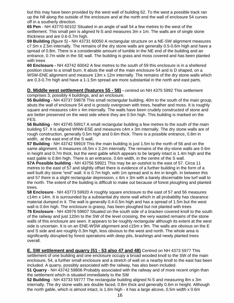
d stones (features 16 - 19, 70 - 74, 77, 28 and 39)
height x 0.6m depth. Therovergrown with bracken. 53 Enclosure - centred on NH 43687 59760 A large rectangular enclosure aligned ENE-WSW iroughly 100m x 50m and occupies a large undulating knoll. The surrounding stone wall is most evident in the west and north where it is generally bracken covered and c0.3-0.5m in height.not evident in the south part although there is a short turf stretch to the south of building 52 47 Wall - NH 43783 59756 (S end) A 28m length of wall crosses a west facing slope on the opposite side of the forest track to the east of building 52. It is 0.4m high, has a spread of 0.6m and is generally very wasted. It may have been part of an enclosure. The wall may continue to the southaround the hill on the notracks and the railway. 48 Enclosure - centred on NH 43800 59736 A few metres to the south of 47 this square enclosure is grossly overgrown with bracken. It is q Sites on Two Knolls close to the Railway Cup marke - Main group centred on NH 4411 5969 The majority of these sites are located on two knolls, one oneach side of the railway, about 500m to the NNW of Rogie Farm. The knolls cover an area roughly 500m x 200m and occupy an elevated position with good prospects to E, W and S. Both knolls are very rough going underfoot, having beeforested in the 1950s, and recently felled, mounded and replanted again. Ten decorated panels are situated on these knolls, two ot
n
her panels, 28 and 39 are 350m to the NE of the
s
0
e
4165 59678 A flat rounded slab
n the SE side of the summit of a prominent knoll
it.
on the top
the top surface of an earthfast boulder, c2m in diameter and 0.75m high. The cup is slightly oval, 7cms in diameter and 3cms deep
main group. All the decorated panels are heavily eroded and some warrantspecialist photography techniques as there may be additional cups and motifs not readily visible to the naked eye. Where a boulder or outcrop has a distinct upper edge or ridge, the cuptend to be arranged along this edge, and the rock may have been chosen for its particular alignment not yet clear to us.All 12 cup marked stones in this group will be recorded in detail along with contextual data as part of the Ross-shire
09-2011. 16 Cup marked stone – NH 44127 59695 A flattish
Rock Art project taking place 2
rounded slab measuring 2m x 1.2m has 10 cups on it. Clearancmaterial is piled up against the east side. 17 Cup marked stone – NH 4measuring 2m x 1.2m on the east end of the summit ridge of a broad knoll has 18 cups on it. 18 Cup marked outcrop (figure 9) – NH 43960 59808 A linear outcrop of rock ohas 22 cups on it. Most of the cups are along the upper edge and are quite worn. 19 Cup marked outcrop (figure 10) – NH 43972 59813 A large flat outcrop of rock on the east end of the knoll has 16 cups on 77 Cup marked stone - NH 44024 59797 8 well defined cups and one possible cups in a triangular shaped group surface of a flat topped earthfast boulder, 1.7m N/S x 1.2m x 0.7m high. The cups are in the NE corner of the boulder 74 Cup marked stone – NH 43896 59811 A single cup on
70 Cup marked stone – NH 43865 59705 A single cup on the sloping face of an earthfast boulder, possibly in situ, but forming part of the revetment around the front of site 45 72 Cup marked stone – NH 44132 59640(approx) A single cup on a small earthfast boulder 71 Cup marked stone – NH 44150 59638 (approx) A single cup on a small earthfast boulder Close and to the NW of the NE settlement of the Upper dispersed township 73 Cup marked stone – NH 44170 59720 (approx) Five small cups, well spread out on an earthfast boulder c2m in diameter and 1.2m high 39 Cup marked stone - NH 44060 60098 On the edge of dense forest to the NW of the NE settlement of the dispersed township of Upper Rogie, a conical earthfast boulder has 1 good cup and 2 poor cups on its upper surface. The boulder is c1.5m in diameter x 1m height 28 Cup marked stone – NH 44321 60015 (approx) To the NE of the main area of CMRs and between the railway and Rogie Burn, an earthfast boulder, c 2m in diameter x 1.2m height, has 5 definite cups with the possibility of a very eroded rosette motif Building, wall and Ringed earthwork (features 45, 46 and 15) - centred on NH 4411 5969 Sites 45, the building, and 46, the short stretch of walling, are located on the same knoll as the majority of the cup marked stones, that to the north of the railway line about 600m to the NNW of Rogie Farm. Site 15, the ringed earthwork, is on the south side of the railway about 400m to the north of Rogie Farm and 200m to the SE of the other knoll. Both knolls occupy an elevated position with good prospects to E, W and S and both are very rough going underfoot, having been forested in the 1950s, and recently felled, mounded and replanted again. 45 Building (figure 8) – NH 43870 59711 The remains of a small but substantial building occupy an exposed but commanding position on the summit ridge of a prominent knoll. The area of the knoll and the structure itself have been grossly disturbed by forest operations with felling, mounding and replanting having recently taken place. The underfoot conditions are extremely rough and hazardous. The building measures 20m x 14m overall. The main axis is NE-SW and there are 2 compartments to this part of the building, but there is also a third compartment on the east side, see drawing. All the walls of the building have been solidly constructed of earth, rubble and large boulders. Their remains are generally 0.5m to 0.8m high and between 1.5m and 2m thick and even 3m in some places. The west compartment measures 5m x 3.5m internally and there is an entrance 1.3m wide in the SE wall. The NE compartment measures 7.5m x 3m internally, again there is an entrance in the centre of the SE wall. There may also be an entrance into the east compartment at the west end of this SE wall, but an opening at the NE corner has probably been made by forest vehicles gaining entry. The SE compartment is aligned at right angles to the other two and is 4.5m x 3.8m internally. It has an entrance in the NE wall. The building sits on a revetted platform 25m x 15m, the SW side
18of which has been built up considerably with large boulders.
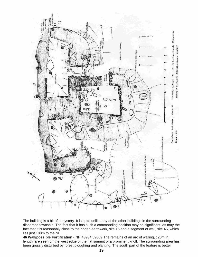
The building is a bit of a mystery. It is quite unlike any of the other buildings in the surrounding dispersed township. The fact that it has such a commanding position may be significant, as may the fact that it is reasonably close to the ringed earthwork, site 15 and a segment of wall, site 46, which lies just 100m to the NE
19
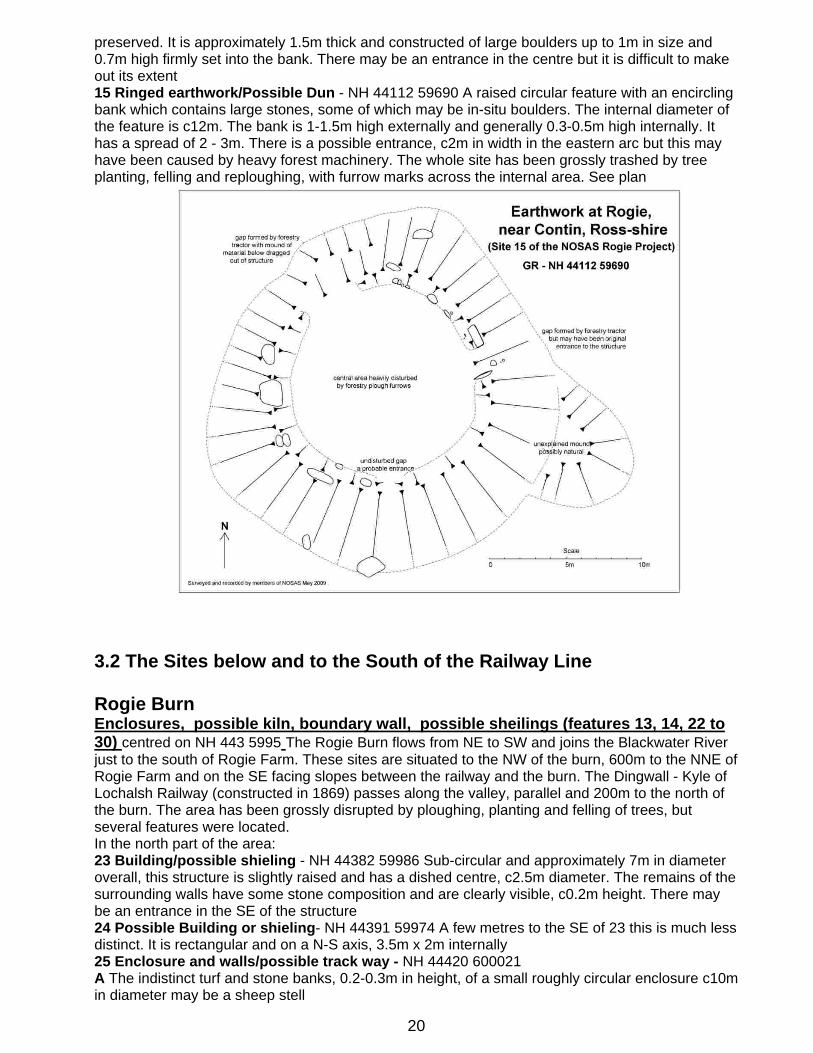
46 Wall/possible Fortification - NH 43934 59809 The remains of an arc of walling, c20m in length, are seen on the west edge of the flat summit of a prominent knoll. The surrounding area has been grossly disturbed by forest ploughing and planting. The south part of the feature is better
preserved. It is approximately 1.5m thick and constructed of large boulders up to 1m in size and 0.7m high firmly set into the bank. There may be an entrance in the centre but it is difficult to make out its extent 15 Ringed earthwork/Possible Dun - NH 44112 59690 A raised circular feature with an encircling bank which contains large stones, some of which may be in-situ boulders. The internal diameter of the feature is c12m. The bank is 1-1.5m high externally and generally 0.3-0.5m high internally. It has a spread of 2 - 3m. There is a possible entrance, c2m in width in the eastern arc but this may have been caused by heavy forest machinery. The whole site has been grossly trashed by tree planting, felling and reploughing, with furrow marks across the internal area. See plan 3.2 The Sites below and to the South of the Railway Line Rogie Burn Enclosures, possible kiln, boundary wall, possible sheilings (features 13, 14, 22 to 30) centred on NH 443 5995 The Rogie Burn flows from NE to SW and joins the Blackwater River just to the south of Rogie Farm. These sites are situated to the NW of the burn, 600m to the NNE of Rogie Farm and on the SE facing slopes between the railway and the burn. The Dingwall - Kyle of Lochalsh Railway (constructed in 1869) passes along the valley, parallel and 200m to the north of the burn. The area has been grossly disrupted by ploughing, planting and felling of trees, but several features were located. In the north part of the area: 23 Building/possible shieling - NH 44382 59986 Sub-circular and approximately 7m in diameter overall, this structure is slightly raised and has a dished centre, c2.5m diameter. The remains of the surrounding walls have some stone composition and are clearly visible, c0.2m height. There may be an entrance in the SE of the structure 24 Possible Building or shieling- NH 44391 59974 A few metres to the SE of 23 this is much less distinct. It is rectangular and on a N-S axis, 3.5m x 2m internally 25 Enclosure and walls/possible track way - NH 44420 600021 A The indistinct turf and stone banks, 0.2-0.3m in height, of a small roughly circular enclosure c10m in diameter may be a sheep stell
20
21
B Just to the NW of 25A are the remains of an indistinct pair of parallel walls roughly 5m apart. One of the walls continues east towards the burn and is clearly seen at NH 44485 60049, it may be a field boundary wall. 26 Possible Boundary wall - NH 44321 60008 (N end) to NH 44375 59954 (S end) A broad linear earth and stone bank meanders down the slope from the railway in the NW towards the SE for a total length of c.75m . The north part, a stretch of c.50m, is 0.5 to 1m in height and has a spread of 3m, but the southern 25m is less distinct and just 1.5m in width. There is a gap, 1.5m in width at NH 44336 59990 This wall may be a consumption dyke 27 Linear clearance - NH 44340 59970 On a NW-SE axis and 5m x 1.5m x 0.5m height 28 Cup marked stone – details of this have been included along with the main group of CMSs which are c350m to the SW In the south part of the area and closer to the main burn; 13 Walls/Possible Enclosure - NH 44294 59715 Within a shallow scoop on the west side of the Rogie Burn the wasted remains of two short sections of stone wall can just be discerned. The area has been felled, ploughed and replanted with trees. 14 Circular enclosure/Sheepfold - NH 44310 59693 In the same rough ground as 13 and just to the south of it, a curving bank of turf and stone makes a semicircular arc, the NE part of an enclosure, 19m in diameter. The remainder of the structure may have been swept away by the small burn which curves round to the SW and appears to follow the line of the circle. 22 Enclosure - NH 44306 59772 On the very edge of the burn and at the foot of a steep knoll this linear enclosure is on a NE-SW axis and measures c.25m x 6m, the leveled terrace has the remnants of a stone wall surrounding. A further wall trails off from the SW end, up the slope and there may be a further linear compartment here, 6m x 1.5m 30 Structure/Possible Kiln - NH 44291 59774 Recessed into the NE side of a prominent knoll (and just a few meters to the NW of site 22) on the west bank of the burn this structure is on a NE-SW axis and measures 4.5m x 2m internally. The recessed and stone faced SW end of the structure is semicircular, 1.5m in diameter. The stone facing has a height of 1m. Easter Rogie Easter Rogie Farmstead, enclosures, pits and improved ground (features 08 - 12, 20 and 21) The site, 500m to the NE of Rogie Farm, is on a SW facing slope to the north of an enclosed field on the east side of the Rogie Burn. The area has recently been felled, ploughed and replanted with trees and a new forest road bisects the site. The site comprises 2 buildings, 3 pits, 3 enclosures and a further possible enclosure. 08 Building - NH 44564 59669 The remains of this building are in very rough ground and under thick bracken and windblown trees, therefore the extent and condition of it were difficult to determine and interpret. It is rectangular with square corners, on a NE-SW axis and internal measurements c8m x 2.5m. The remains of the dry stone walls are to 0.4m height and with a spread of 1m. There may be an entrance in the SE wall and there may be an outshot or an enclosure to the south 09 Pits - centred on NH 44571 59666 Three pits all 1.75m diameter and 0.4m deep, a few metres to the SE of building 08 10 Possible enclosure or building - NH 44531 59703 A 14m length of dry stone wall has returns at both ends. It is on a NE-SW alignment, up to 0.5m height, 1.5m thick and grossly covered with bracken. It may have been truncated by the new road just a few metres to the north. 11 Walls/Enclosure - A large area of improved ground to the NE of the previous features is evident under the ploughing and replanting, there are several clearance cairns. The area was probably surrounded by a dry stone wall evidence of which is seen in a 20m stretch to the south, and to the west adjacent to site 10 12 Building - NH 44482 59728 The remains of the dry stone walling of this structure are clear to be seen on the north side of the forest road. The building is rectangular, aligned WNW-ESE, and measures 7.5m x 3m internally. The walls are double faced 0.5m in height and 0.6m thick. There is an entrance at the E end of the south wall and a roughly constructed sub-square stone platform, 1.2m2 just inside the entrance. An outshot 4m x 4m internally has been crudely constructed on the west end 20 Enclosure - NH 44502 59655 At the base of a SW facing slope and a few metres from the Rogie Burn this gently S facing enclosure is on a ESE-WNW axis and measures c24m x ?12m. The dry stone walls are very wasted but more evident at the west end. The enclosure has
22
birch trees and bracken with windblown trees in its north part. 21 Enclosure - NH 44379 59718 To the west of the previous sites and to the north of the present forest road and bridge this enclosure is barely discernable being covered with brashings. It is rectangular on a NW-SE axis and c.12m x 10m. Defined by the remains of raised stone banks on NW, NE and SE sides Rogie Farm Rogie Township, sheepfold, possible buildings and ford (01 - 07, 31 and 75) (alternative name, Balnain (Roy map)) GR centred on NH 4418 5931 The site, 3kms to the NW of the village of Contin, encompasses the farm and associated structures in the immediate vicinity. The present Rogie Farm is situated on the broad haugh of land to the NE of the Blackwater River, where its tributary, the Rogie Burn, joins it from the NE. There are several enclosed fields which are marshy and prone to flooding, a problem that continues to the present day. The farm is on the NW bank of the Rogie Burn and is probably on the site of the township of Balnain, marked on the Roy map. The farmhouse is occupied and comprises several roofed buildings. Of interest are two “Yankee” sawmills and a platform to the rear/north of the main building. A ford crosses the burn to the south of the farmhouse. The farm is marked on 1st edition and has several roofed buildings, also the sheepfold. The site comprises two distinct groups of features: - 50m to the west of the farm buildings there are the much wasted remains of a kiln, a possible building and two pits, are all that remains of the township. A well constructed ford and silage pit have also been included here: 05 Kiln and barn - NH 44137 59297 This building occupies the west end of a knoll. It is rectangular and comprises two parts. The upper part, the barn, measures 4.5m(NNE-SSW) x 3m, the prominent walls to E and W are 0.4m in height and have a spread of 1m. The lower part to the SSW consists of a steep face with some set stone composition 5m in length and 1.5m in height. 06 Building - NH 44168 59304 The wasted remains of this building are on a WNW-ESE alignment and measure c6.5m x 4.5m overall. There are two compartments, the most obvious to the east is roughly circular, internal diameter 2m and has surrounding turf walls 0.2m high and with 1m spread. The west part is more wasted and appears as two circular depressions, of 1.5m and 2m diameter, although surrounding turf banks can just be discerned. There is a ?entrance at this end. See plan 07 Pits - NH 44178 59313, 1.5m diameter and 0.2m deep, and NH 44183 59310, 2m diameter and 0.2m deep. 31 Pit/possible silage pit - NH 44188 59414 On a S facing slope in a field to the NW of the farm, an oval pit is on a N-S axis and measures 9m x 6m internally. Raised banks define its east and west edges and it has stone clearance and rubbish dumped in it. 75 Ford - NH 44278 59253 A rectangular area of cobbling is seen in the bed of the burn under the southmost concrete bridge to the south of the farmhouse. It is well preserved, measures c10m (NE-SW) x 6m and is made up of rounded stones generally 20-30cms in diameter. It is bounded on its SW/downstream side by a degraded timber kerb and on the SE side it disappears under the retaining bank of large rounded boulders which supports the abutments of the present bridge. - 250m to the NW of the farm buildings there is a sheepfold and the remains of 2 further possible buildings; 02 Sheepfold - NH 44056 59460 Largely intact rectangular enclosure measuring 29m(WNW - ESE) x 23m. Walls of dry stone construction are up to 1.5m height. There are 2 entrances in N wall and 2 short tumbled sections in E and S wall. 01 Earthbank/Track - To the west of the sheepfold and just south of the modern forest road within the field there are two lengths of earth bank, one on either side of the gate into the field. These appear to bound the old track on its south side. At this point the track has taken a more direct line than the modern track today. 03 Possible Building - NH 44029 59443 A rectangular structure on a NE-SW alignment with internal measurement of c5m x 3m. Appears as a platform with a turf wall, 0.2m height and 1-1.5m spread, surrounding on 3 sides (open to SW) and with rounded corners. There is a similar structure, 04, a few metres to NE. 04 Possible Building - NH 44034 59447 Similar to 03 but smaller, this structure is square 2m x 2m internally, Walls of turf have a height of 0.2m and spread of 1-1.5m To the south of these 2 structures there is a curving earth bank which may be associated. It is 10m in length 0.3m in height and has a spread of 1.5m
23
3.3 Selected Photographs Figure 1. Possible still bothy, site 69 from the north Figure 2. Buildings 41 and 42 of North settlement, with (inset) cruck slot in 41
Figure 3. Unusual corn drying kiln, site 43, with 2 flues at North settlement

24
Figure 5. Moss covered footings of Building 59 in the trees
Figure 4. NOSAS team in action, planetabling buildings 61 and 62 at NW settlement
25
Figure 8. The “Mystery” building, site 45, viewed from the east
Figure 6. Site 35, Macqueens croft as it is today, 2008 and Figure 7. below as it was
beside it.sour
c1920 with James MacQueen himself
(Unable to trace ce of photo)
26
Figure 9. Cup marked outcrop 18
Figure 10. Recording cup marked outcrop 19
3.4 Rogie Project – List of Photographs
1. General Views Rogie from the SW/Cnoc Dubh AP – Rogie Farm from east AP – Rogie Farm from the E in the snow AP – Rogie Burn from SE
2. Upper Rogie township North east settlement 32 from W 32 SW wall from E 33 from SW 34 from SW Building 35 35 from SE 35 from SE 35 from SE 35 SW part from SSW 35 NE end from E SW end from SE Building 36 36 from E 36 from SSW 36 from SSW Enclosure 37 37 from NW Middle north settlement 40 from WNW Building 41 41 from SSW 41 from SSW 41 from SW 41 E part from SE 41 N cruck slot 41 S cruck slot Building 42 42 E part from W 42 E part from W 42 W part from E 42 from SE 42 from SW 42 W end from SW 42 E outshot from E 42 E outshot from SE CDK + barn 43 43 from SW 43 from E 43 E end from SW 43 E end from W 43 kiln bowl ent from W 43 N entrance from W 43 S entrance from W 43 bowl from NW Building 44 44 from NW Northwest settlement Building/Byre 61 61 from SE 61 from E 61 from NE
61 from NE with sump 61 W end from SE 61 drain W end from SE 61 drain W end from SE 61 mid part from W 61 E end from SW 61 E end from W 61 drain E end from SW 61 sump from SE 61 plinth from W 61 terrace from SW Building 62 62 & 63 from SE 62 from SE 62 from NW 62 NE corner 62 NE corner CDK and barn 63 63 from NE 63 from NE 63 from NE 63 from SE 63 from SW 63 bowl from NNW 63 bowl from NW 63 drain from SE 63 drain from NW Enclosure 64 64 from NW 64 from SE Pen 65 65 from NE 65 from NNE Farmstead 59 & 60 59 from N 59 from N 59 from NW 60 from S 60 from SE Middle west settlement Building 55 55 from NW 55 from W Building 56 56 from E 56 from E Building 57 57 from SE 57 from SW 57 from SW 57 from WSW Enclosure 58 58 from NE 58 from SE South west settlement Building 52 52 from S 52 from SE 52 N end from S Sites 68 and 69 Possible still bothy 69 69 from E 69 from W 69 from N 69 from NE 69 from NW 69 from SW Building 68 68 from E
27

28
68 from ENE 68 W part from E 68 W part from ENE 3. Rogie Cup Marked Rocks CMR 16 16 x 5 CMR 17 17 x 2 CMR 18 18 x 6 CMR 19 19 x 4 CMR 28 28 x 4 CMR 39 39 x 2 4. Rogie sites 15, 45 and 46 Earthwork 15 15 from NW 15 from NW 15 E part from SE 15 E part from SE 15 W part from SE 15 W part from SE 15 from SE 15 NE part from NW 15 SW part from NW 15 from W Building 45 45 W part pre clearing 45 S part pre clearing 45 W end pre clearing 45 from E 45 from E 45 NE part from E 45 NE part from NE 45 NE part S wall from NW 45 NE part N int wall from E 45 NE part from N int wall from
SE 45 NE part N int wall from S 45 NE part N ext wall from N 45 NW part from W 45 NW part W end from S 45 NW part N wall from E 45 NW part S wall from E 45 NW part S wall from W 45 S part from N 45 S part from E 45 SW terrace from SW 45 SW terrace from NW 45 SW terrace from W Wall 46 46 from NW 46 from S 46 from S 5. Rogie Farm Rogie Farm From S 01 from SE 02, 03 & 04 from SW 03 & 04 from SW 03 from E 03 from S 04 from S 05 from SE
05 from SW 06 from SE 31 from N 31 from NW 75 from NE 75 from NE Farmhouse Platform to rear/N Platform to rear/N Sawmill 1 Sawmill 1 Sawmill 2 Sawmill 2 6. Rogie Burn General view From SW North sites 23 from S 23 from SW 24 from N 24 from NW South sites 14 from SW 22 from N 22 from S 30 from NE 7. East Rogie 08 from S 08 from SW 12 from SE 8. “MacQueens Croft” photograph – date unknown