aquatic ecology studies for the kerosene vale stage 2 ash … · 2016-12-28 · aquatic ecology...
TRANSCRIPT

Report to:
Parsons Brinckerhoff
Aquatic Ecology Studies for the Kerosene Vale Stage 2 Ash Repository Area
Final
October 2007

Aquatic Ecology Studies for the Kerosene Vale Stage 2 Ash Repository Area
October 2007
Report Prepared for:
Parsons Brinckerhoff
GPO Box 5394
Sydney, NSW, 2001
Report Prepared by:
The Ecology Lab Pty Ltd
4 Green Street
Brookvale, NSW, 2100
Phone: (02) 9907 4440
Report Number – 76/0607
Report Status – Final October 2007
© This document and the research reported in it are copyright. Apart from fair dealings for the purposes of private study, research, criticism or review, as permitted under the Copyright Act 1968, no part may be reproduced by any process without written authorisation. Direct all inquiries to the Director, The Ecology Lab Pty Ltd at the above address.

Aquatic Ecology Studies for the Kerosene Vale Stage 2 Ash Repository Area Final, October 2007
The Ecology Lab Pty Ltd – Marine and Freshwater Studies
TABLE OF CONTENTS Summary ................................................................................................................................................i 1.0 Introduction ...................................................................................................................................1
1.1 Background................................................................................................................................1 1.2 Aims .............................................................................................................................................1
2.0 Existing Information.....................................................................................................................2 2.1 Methodology..............................................................................................................................2 2.2 Study Area .................................................................................................................................2 2.3 Water Quality ............................................................................................................................3 2.4 Macrophytes ..............................................................................................................................4 2.5 Macroinvertebrates ...................................................................................................................4 2.6 Fish ..............................................................................................................................................5
3.0 Study Methods ..............................................................................................................................6 3.1 Site Selection ..............................................................................................................................6 3.2 Field Sampling Methods ..........................................................................................................6
3.2.1 Site Description ..................................................................................................................6 3.2.2 Water Quality .....................................................................................................................7 3.2.3 Macrophytes .......................................................................................................................7 3.2.4 Macroinvertebrates ............................................................................................................7 3.2.5 Fish .......................................................................................................................................8
3.3 Laboratory Methods .................................................................................................................9 3.4 Statistical Methods....................................................................................................................9
3.4.1. Water Quality ....................................................................................................................9 3.4.2 Macroinvertebrate AusRivAS Models ...........................................................................9
4.0 Results...........................................................................................................................................11 4.1 Site Description .......................................................................................................................11
4.1.1 Kangaroo Creek (Location 1; Sites 1 and 2). .................................................................11 4.1.2 Sawyers Swamp Creek (Location 2; Sites 3 and 4). .....................................................12 4.1.3 Marrangaroo Creek (Location 3; Sites 5 and 6)............................................................13
4.2 Water Quality ..........................................................................................................................13 4.3 Macrophytes .............................................................................................................................14 4.4 Macroinvertebrates .................................................................................................................14 4.5 Fish ............................................................................................................................................15 4.6 Threatened and protected species, populations and ecological communities and key threatening processes ....................................................................................................................15

Aquatic Ecology Studies for the Kerosene Vale Stage 2 Ash Repository Area Final, October 2007
The Ecology Lab Pty Ltd – Marine and Freshwater Studies
4.6.1 Threatened and Protected Species, Populations and Ecological Communities ......15 4.6.1.1 Australian grayling (Prototroctes maraena) .............................................................15 4.6.1.2 Macquarie perch (Macquaria australasica)...............................................................16
4.6.2 Key Threatening Processes .............................................................................................16 5.0 Discussion ....................................................................................................................................18
5.1 Constraints: Potential Impacts of the KVAR expansion on aquatic habitats...................19 5.1.1 Storage of ash within Stage 2 of KVAR..........................................................................19 5.1.2 Re-alignment of Sawyers Swamp Creek and the construction of stabilisation structures along northern embankment of KVAR. ...............................................................20
6.0 Recommendations.......................................................................................................................22 6.1 Sediment control ......................................................................................................................22 6.2 Restoration ...............................................................................................................................22 6.3 Monitoring ................................................................................................................................23
7.0 Conclusion ....................................................................................................................................24 8.0 Acknowledgements ....................................................................................................................25 9.0 References ....................................................................................................................................26 Tables ...................................................................................................................................................29 Figures .................................................................................................................................................35 Plates ....................................................................................................................................................40 Appendices .........................................................................................................................................53

Aquatic Ecology Studies for the Kerosene Vale Stage 2 Ash Repository Area Final, October 2007
The Ecology Lab Pty Ltd – Marine and Freshwater Studies Page i
SUMMARY Parsons Brinckerhoff, on behalf of Delta Electricity, commissioned The Ecology Lab to undertake ecological studies in relation to the proposed Kerosene Vale Ash Repository Area (KVAR) expansion. Dry conditioned ash that is a by-product of electricity generation at the Wallerawang Power Station (WPS) is currently stored in the KVAR Stage 1. Delta Electricity proposes to expand the ash storage into a second operational area referred to as Stage 2. The proposed expansion would require the re-alignment of a 380 m section of Sawyers Swamp Creek, the construction of stabilisation structures along the northern edge of KVAR and the development of a storm water management strategy. The aims of the study were to provide a baseline description of aquatic habitat and biota in areas that may be affected by the development and to make a comparison with control locations. The Ecology Lab was to identify constraints to the proposed KVAR expansion and make recommendations for possible mitigation measures.
The proposed study area was located 10 km north west of Lithgow and 2.5 km north east of Wallerawang Power Station. The KVAR is an abandoned open cut coal mine that has historically been used for storing mine spoil and ash. Ash storage activities in the area recommenced in 2002 when the current Stage 1 area became operational. Sawyers Swamp Creek is the major watercourse in the study area, flowing into the upper reach of the Coxs River above Lake Wallace, an artificial impoundment above Wallerawang Dam. The Coxs River forms part of the Sydney Water Catchment Area. Other major water bodies in Kerosene Vale include the artificial Sawyers Swamp Creek Ash Dam (SSCAD) and the Lidsdale Cut.
Water quality within this upper section of the Coxs River Catchment is poor, affected by agricultural land practices and industry, such as coal mining and coal-fired power generation. Dry conditioned ash is rich in soluble salts, trace elements and heavy metals. Contamination of receiving waters, lowering of pH and increased turbidity can result from surface run-off and groundwater leachate from ash storage areas. Prior to capping in 1990 there were occasional overflows from the Lidsdale Cut – recharged from groundwater seeping from the KVAR – into Sawyers Swamp Creek. Sawyers Swamp Creek also receives water that has leached through the SSCAD headwall. The waters of Sawyers Swamp Creek have recorded high conductivity and concentrations of some trace elements and heavy metals above the ANZECC threshold for ecosystem protection.
A limited number of surveys in the region of the upper Coxs River have revealed aquatic habitats dominated by the macrophytes, Juncus sp and cumbungi with associated invertebrate fauna including bivalves, gastropods, freshwater shrimp and insect larvae such as caddis flies. Six species of fish have been recorded in or above Lake Wallace. Only two of these are native, the flathead gudgeon and Australian bass, the latter does not occur naturally in this area but has been stocked for recreational fishing. The introduced plague minnow, Gambusia holbrooki, is widespread and both the brown trout and rainbow trout have been stocked for recreational fishing.

Aquatic Ecology Studies for the Kerosene Vale Stage 2 Ash Repository Area Final, October 2007
The Ecology Lab Pty Ltd – Marine and Freshwater Studies Page ii
On June 11th The Ecology Lab established two 100 m long sites in Sawyers Swamp Creek; the upstream site was positioned in the section of channel to be re-aligned. Marrangaroo Creek and Kangaroo Creek were selected as control locations and two 100 m sites were set up within each. Data were collected on water quality and aquatic habitat, including characteristics of channel morphology, substratum composition, riparian vegetation and fish passage. The structure and composition of macrophyte beds were measured, macroinvertebrates assemblages were sampled from edge habitats using AusRivAS protocols and fish were recorded using bait traps, electrofishing and dip-netting. Macroinvertebrate samples were processed in the laboratory and the resulting data analysed using the AusRivAS model. Water quality data were compared with ANZECC guidelines for the protection of aquatic ecosystems.
Sawyers Swamp Creek inhabits a degraded catchment. The channel banks were eroded and riparian cover was variable, containing a mixture of native and introduced species where present. The channel substratum was mostly composed of either shale bedrock or soft clay and silt, the latter of which often supported dense beds of the emergent macrophytes, Juncus sp. and cumbungi. Both control creeks pass through degraded catchments at similar elevations near the Coxs River. The control waterways possessed similar bank and riparian attributes to Sawyers Swamp Creek, however the channel substratum of both creeks was dominated by sand. Kangaroo Creek had similar macrophyte assemblages to Sawyers Swamp Creek and both watercourses were considered to provide minimal fish habitat (Class 3 waterways). Fish passage along Sawyers Swamp Creek was severely obstructed by numerous pipe culverts (and one weir) that appear to create a barrier to upstream passage under nearly all flow conditions. Marrangaroo Creek was larger with greater flows. The in-stream woody debris and deep pool sections of Marrangaroo Creek would provide major fish habitat.
Water tested in Sawyers Swamp Creek exceeded ANZECC guidelines for both conductivity and turbidity. Dissolved oxygen levels were slightly beneath the ANZECC threshold and pH was within the guidelines. Water quality in Sawyers Swamp Creek was generally of lower quality than at the control sites.
Sawyers Swamp Creek had a relatively depauperate aquatic macroinvertebrate fauna with a total of 14 taxa, compared to 31 in Marangaroo Creek and 32 in Kangaroo Creek. AusRivAS analyses revealed that although all sites had fewer taxa than expected Sawyers Swamp Creek showed signs of greater impairment relative to the control locations. The macroinvertebrate assemblage at Sawyers Swamp Creek was dominated by pollution tolerant taxa such as Chironominae, Tanypodinae and Ceratopogonidae. The control locations were often characterised by pollution sensitive taxa such as Leptoceridae and Leptophlebidae at Marrangaroo Creek and Telephlebidae and Gripopterygidae at Kangaroo Creek.
Only 11 fish, representing four species, were caught or observed across all three creeks. Only one species, the native mountain galaxias, was recorded in Sawyers Swamp Creek. No fish were found in Kangaroo Creek. Gambusia, rainbow trout and brown trout were found in Marrangaroo Creek. Sawyers Swamp Creek does not constitute critical habitat for the mountain galaxias, which is abundant throughout the catchment.
No threatened populations, species or communities are believed to inhabit or use areas potentially affected by the KVAR expansion, nor does the area provide critical habitat for any aquatic taxa.

Aquatic Ecology Studies for the Kerosene Vale Stage 2 Ash Repository Area Final, October 2007
The Ecology Lab Pty Ltd – Marine and Freshwater Studies Page iii
The major impact resulting from the proposed KVAR expansion would be the loss of 380 m of existing aquatic habitat and associated assemblages, which constitutes listed key threatening processes with regard to the degradation of riparian vegetation and the removal of large woody debris. Impacts on aquatic ecology may also occur as a result of the mobilisation of sediments into the channel from construction earthworks, downstream effects from changes to the channel morphology and changes to water quality from an increase or change in the ash storage area.
The proposed expansion of the KVAR into Stage 2 would be unlikely to result in long term effects on the aquatic ecology of the area given that surface run-off is managed using standard sediment and erosion control procedures, accepted guidelines are followed for stream rehabilitation and ongoing water quality monitoring is undertaken.
The drainage of KVAR has been engineered to direct surface run-off into return drains for re-use on site. Previous studies at Mt Piper have indicated that run-off and infiltration rates are very low from the ash matrix. Ongoing water monitoring would allow managers to identify any resumption of groundwater seepage to Lidsdale Cut or changes to surface water quality in Sawyers Swamp Creek.
The mobilisation of sediment from earthworks and/or the re-aligned channel can be minimised with the use of standard sediment control procedures, such as the installation of silt curtains, revegetation of riparian and in-stream habitats, and the protection of exposed bank/channel surfaces with biodegradable jute matting.
Careful planning is required in outlining the objectives for channel restoration to ensure the design and implementation will reduce or eliminate any downstream effects from the morphology of the new channel section.
A monitoring programme using control and references sites could be undertaken to determine environmental impacts that may occur from the Stage 2 expansion or measure the progress of channel rehabilitation. This would allow Delta Electricity to demonstrate the success of the project or respond to unforseen problems.

Aquatic Ecology Studies for the Kerosene Vale Stage 2 Ash Repository Area Final, October 2007
The Ecology Lab Pty Ltd – Marine and Freshwater Studies Page 1
1.0 INTRODUCTION
1.1 Background
Parsons Brinckerhoff, on behalf of Delta Electricity, has commissioned The Ecology Lab to undertake ecological studies in relation to the proposed Kerosene Vale Stage 2 Ash Repository Area (KVAR) expansion. Dry conditioned ash is a by-product of electricity generation at the Wallerawang Power Station (WPS) is stored in Kerosene Vale Ash Dam (KVAR). This storage area is divided into two operational areas, referred to as Stage 1 and Stage 2. The Stage 1 operational area, in which ash is currently being placed, is expected to reach full capacity in 2008. Expansion into the Stage 2 operational area would enable WPS to produce electricity for a further 11 years. The proposed extension of the existing storage area into the Stage 2 operational area would require the re-alignment of approximately 380 m of Sawyers Swamp Creek, the construction of stabilization structures along the northern edge of KVAR, and possibly 24 hour trucking operations between WPS and KVAR along an internal haul road and the development of a storm water management strategy.
1.2 Aims
The aims of this study are to:
• Identify the waterways and water bodies that may be affected by the KVAR expansion and the form that potential impacts may take.
• Provide a baseline description of the waterways that may be affected, including: aquatic habitat; barriers to fish movement; physical and chemical attributes of the channel; macrophyte, macroinvertebrate and fish assemblages.
• Identify any threatened species, populations or ecological communities listed under the NSW Fisheries Management Act 1994 and/or Commonwealth Environmental Protection and Biodiversity Conservation Act 1999 that occur or may potentially occur in the identified watercourses.
• Compare the physical, chemical and biotic attributes of potentially affected areas with two appropriate control locations.
• Provide assistance with the design of the re-aligned stream and make recommendations about possible ongoing monitoring.

Aquatic Ecology Studies for the Kerosene Vale Stage 2 Ash Repository Area Final, October 2007
The Ecology Lab Pty Ltd – Marine and Freshwater Studies Page 2
2.0 EXISTING INFORMATION
2.1 Methodology
The library database of The Ecology Lab was searched for relevant material on the aquatic ecology, communities and water quality of the study area.
Threatened populations, species and communities listed on the updated schedules of the NSW Fisheries Management Act 1994 (FM Act) and the Commonwealth Environmental Protection and Biodiversity Conservation Act 1999 (EPBC Act) were investigated to assess their likelihood of occurring within the study area.
The NSW government BioNet database was searched for records of fish and aquatic invertebrates, including threatened and protected species that have been recorded in the study area (Web Reference 1). Other sources used to construct a more complete inventory of macroinvertebrates and fish in the study area include:
• McDowall (1996), Freshwater fishes of South-Eastern Australia.
• Harris and Gehrke (1997), Fish & Rivers in Stress: The NSW Rivers Survey.
• NSW Fisheries (2003), Freshwater fish stocking in NSW. Environmental Impact Assessment.
• Jones et al. (2004), Assessing the effects of trace elements from Wallerawang Power Station on aquatic biota of Lake Wallace.
• The Ecology Lab (2004), Environmental Flows in Coxs River - Environmental Flows from Lyell Reservoir to the Coxs River.
2.2 Study Area
The KVAR is located within the Sawyers Swamp Creek catchment approximately 2.5 km north east of WPS and 10 km north-west of the city of Lithgow (Figure 1). The catchment drains into the upper reaches of the Coxs River, which forms part of the Sydney Water Catchment Area and the Hawkesbury– Nepean River system. The average annual rainfall in the area is 870 mm and temperatures range from -8OC to 38OC (ERM Hyder 2002).
A large proportion of the upper Coxs River catchment surrounding Wallerawang has been modified for agricultural and industrial use, including: grazing, mining and coal-fired power generation. KVAR was originally the site of an open cut coal mine which was abandoned in the 1950s (ERM Hyder 2002). Mine spoil was initially dumped in the site and ash was stored following the construction of the WPS in 1958 (ERM Hyder 2002). The KVAR was modified in various stages from the 1960’s until it was capped with 0.3 - 0.5 m of clay in 1990. During the 1970s the Sawyers Swamp Creek ash dam (SSCAD) was constructed to store wet ash slurry and Sawyers Swamp Creek was re-aligned to its current course (ERM Hyder 2002, Parsons Brinckerhoff 2006a).
The capped area of the KVAR and adjacent areas support highly disturbed vegetation communities and regenerating shrubland, including a pine plantation and some small stands of open Eucalypt forest (ERM Hyder 2002, Parsons Brinckerhoff 2000b). Immediately to the north of the KVAR is the cleared site of an abandoned mine. Further downstream is the low-density residential area of Lidsdale.

Aquatic Ecology Studies for the Kerosene Vale Stage 2 Ash Repository Area Final, October 2007
The Ecology Lab Pty Ltd – Marine and Freshwater Studies Page 3
Sawyers Swamp Creek is the major watercourse flowing through Kerosene Vale. The headwaters of Sawyers Swamp Creek are found to the east in the Newnes State Forest at 1160 m AHD (ERM Hyder 2002). It flows in a westerly direction with slopes of 5 – 20%, past the KVAR at 900 – 920 m AHD and into the Coxs River about 2 km north of WPS (ERM Hyder 2002, Parsons Brinckerhoff 2006b). Dump Creek, a much smaller ephemeral drainage, enters Sawyers Swamp Creek downstream of the Lidsdale Cut. The major water bodies in the area are the SSCAD and the Lidsdale Cut, upstream and downstream of the KVAR respectively. Both of these water bodies are artificial. Much of the original drainage in the KVAR area has been modified. Surface run-off in ash-exposed areas of the KVAR is now channelled to standing ponds or the return water channel in the south-west for re-use on site (ERM Hyder 2002, Parsons Brinckerhoff 2006a).
There are various obstructions to flow and fish passage downstream of Sawyers Swamp Creek in the Coxs River drainage. Nine hundred metres south of WPS and 3 km downstream of the junction with Sawyers Swamp Creek the Coxs River flows into the artificial Lake Wallace formed by Wallerawang Dam. Further downstream, the Coxs River is again artificially impounded at Lake Lyell, the regulated flows released from here then collect in Lake Burragorang above Warragamba Dam. None of these dams have fishways and they represent impassable barriers to most fish species (Gehrke and Harris 1996).
2.3 Water Quality
Historical and current land-use in the upper Coxs River catchment – including agriculture, coal mining and power generation - continue to have a detrimental effect on water quality in the region (Birch et al. 2001). Ash from power generation is enriched with soluble salts and potentially toxic trace elements and heavy metals, all of which can enter waterways via surface run-off and/or leachate from ash storage sites (Lemley 1999, Smith 2003). Studies conducted prior to the use of dry ash storage at KVAR found ash disposal to have been a contributor of trace elements (boron, selenium and fluoride) and heavy metals (copper, aluminium and zinc) into the receiving waters and sediments of the Coxs River and Lake Wallace (Jones et al. 1994, Birch et al. 2001).
Prior to capping in 1991 elevated groundwater levels were occasionally observed in monitoring bores downstream of KVAR suggesting that infiltration and leaching may have occurred (ERM Hyder 2002). The groundwater flow sporadically caused the Lidsdale Cut to overflow into Sawyers Swamp Creek. Following capping of the site groundwater levels dropped and no further overflows from Lidsdale Cut have occurred (ERM Hyder 2002). Groundwater quality indicates relatively consistent levels of trace elements above background levels since capping with values as high as 2.72 mg/L for fluoride and 3.4 mg/L for boron (ERM Hyder 2002).
Surface water quality data collected in Sawyers Swamp Creek by Delta Electricity following capping (1991 – 2000) found variable levels of conductivity (µS/cm), with the median value for this period just above the 350 µS/cm suggested by the ANZECC guidelines for maintaining ecosystem protection (ERM Hyder 2002). Of the trace elements, median boron levels for this period exceeded ANZECC guidelines but median selenium levels were below the ANZECC guidelines. The heavy metals copper, zinc and aluminium all recorded median concentrations of (at least) an order of magnitude greater than the ANZECC guidelines for ecosystem protection (ERM Hyder 2002). In another study, Sawyers Swamp Creek recorded the highest concentrations of cobalt in the Coxs River catchment (113 µg/g) (Birch et al. 2001). This was probably due to run-off or groundwater infiltration from coal mines in the area as the local coal deposits are rich in cobalt.

Aquatic Ecology Studies for the Kerosene Vale Stage 2 Ash Repository Area Final, October 2007
The Ecology Lab Pty Ltd – Marine and Freshwater Studies Page 4
Following the commencement of re-use of the KVAR for ash storage in 2002 surface water quality data collected by Delta Electricity (2002 – 2007) in Sawyers Swamp Creek (downstream of the junction with Dump Creek) recorded a median conductivity of 1099 µS/cm (Nino di Falco, Delta Electricity pers. comm.). Median pH was 6.2 which is below the ANZECC lower limit for ecosystem protection of upland rivers in NSW. Boron concentrations remained above the guideline value, but the median value of 2.4 mg/L was the same as largest value measured from 1991-2000. The median value for selenium was within the ANZECC guidelines. Heavy metals copper and zinc recorded median values that exceeded the ANZECC guidelines, as did cadmium and lead.
2.4 Macrophytes
A previous survey of the KVAR vegetation communities conducted prior to Stage 1 becoming operational identified a small number of aquatic plant species from the Cyperaceae, Juncaceae and Typhaceae families (Appendix 1, source: ERM Hyder 2002). Two of these species were introduced and the others are relatively common, some favouring disturbed areas. Studies in nearby wetlands have identified a number of macrophyte taxa (Appendix 1), with the dominant species Typha domingensis, Eleocharis acuta and Juncus articulatus (The Ecology Lab 1995). Two of these species were among those identified in KVAR by ERM Hyder (2002).
The phytoplankton assemblage of Lake Wallace is variable (Kobayashi 1992, cited in Jones et al. 1994), with dominant genera including Chroococcus, Asterionella, Attheya, Cyclotella, Stephanodiscus, Melosira, and Dinobryon. A later study (Jones et al. 1994) found phytoplankton were characterised by dinoflagellates from the genus Ceratium.
2.5 Macroinvertebrates
There have been few surveys of aquatic macroinvertebrates within the region of the study area. A 1994 study in Lake Wallace (Jones et al. 1994) found cladocerans (predominantly Daphnia carinata) and calanoid copepods dominated the zooplankton. Larger macroinvertebrates recorded included bivalves (e.g. Sphaerium sp.), gastropods (e.g. Physidae), freshwater shrimp (Atyidae) and caddis flies (Trichoptera).
Aquatic macroinvertebrate samples collected from “edge” habitat in the Coxs River (The Ecology Lab 2006, 2007) below Lake Lyell in spring and autumn over 2005 – 2006 recorded between 47 and 52 taxa on each occasion. The assemblages were dominated by Corixidae, Leptophlebiidae, Leptoceridae, Baetidae and Notonectidae in autumn and Caenidae, then Leptophlebiidae, Leptoceridae, Corixidae and Cladorcera in spring (The Ecology Lab 2007). AusRivAS assessments found less diversity than expected in these locations suggesting that the Coxs River is degraded (The Ecology Lab 2004, 2006, 2007).

Aquatic Ecology Studies for the Kerosene Vale Stage 2 Ash Repository Area Final, October 2007
The Ecology Lab Pty Ltd – Marine and Freshwater Studies Page 5
2.6 Fish
The introduced brown trout (Salmo trutta), rainbow trout (Oncorhynchus mykiss), mosquito fish (Gambusia holbrooki), carp (Cyprinus carpio) and the native flathead gudgeon have all been recorded previously in Lake Wallace (Table 1, source: Jones et al. 1994). Gambusia have been found in numerous other wetlands and watercourses in the Wallerawang area (TEL 1995). Brown trout, rainbow trout and the native Australian bass (Macquaria novemaculeata) have been stocked in Lake Wallace and the Coxs River (NSW Fisheries 2003). Given the number of barriers to fish passage downstream of Lake Wallace it would be impossible for the catadromous bass to maintain a sustainable population in the area without continual augmentation by stocking.
These same six species have been recorded in the Coxs River Catchment immediately below the Wallerawang Dam. Other fish identified in this area include the mountain galaxias (Galaxias olidus), longfinned eel (Anguilla reinhardtii), shortfinned eel (Anguilla australis) and the introduced goldfish (Carassius auratus) (Web Reference 1). The distribution of these species extends further downstream into the reaches of the Coxs River catchment below Lake Lyell, where the fish assemblage includes the Macquarie perch (Macquaria australasica), smelt (Retropinna semoni), Cox’s gudgeon (Gobiomorphus coxii), introduced oriental weatherloach (Misgurnus anguillicaudatus) and the fire-tailed gudgeon (Hypseleotris galii). Further downstream towards Lake Burragorang there are (possibly erroneous) records for the mouth almighty (Glossamia aprion) and the empire gudgeon (Hypseleotris compressa). The former are usually found much further north and the latter at lower elevations.
The majority of fish recorded in the Coxs River catchment were introduced species. Fifty four percent of fish recorded by Gehrke and Harris (1999) during a survey of the Hawkesbury-Nepean were G. holbrooki. Another study in the Coxs River below Lake Lyell caught more than 1000 fish representing 6 species, 79% of which were G. holbrooki with only 5% native species (The Ecology Lab 2004).

Aquatic Ecology Studies for the Kerosene Vale Stage 2 Ash Repository Area Final, October 2007
The Ecology Lab Pty Ltd – Marine and Freshwater Studies Page 6
3.0 STUDY METHODS
3.1 Site Selection
Two 100 m long sites were established in areas considered most likely to be affected by the proposed KVAR expansion. The upstream site (Site 3) was located in the section of Sawyers Swamp Creek to be realigned and the second (Site 4) was located further downstream, west of the haul road culvert but upstream of Lidsdale Cut overflow (Figure 2b). Kangaroo Creek and Marrangaroo Creek were selected as control locations; watercourses independent of potential impacts resulting from the KVAR expansion against which any observed changes within Sawyers Swamp Creek following the expansion could be compared. Two 100 m long sites were established at each of the control locations (Figures 2a & 2c). GPS coordinates of all sites are listed in Appendix 2.
The Sawyers Swamp Creek channel around the KVAR was re-aligned in the 1970s and is artificial. The channel substratum was observed to be a mixture of shale bedrock, soft clay and fine silt. The surrounding land-use was relatively unique; characterised by wet and dry ash dams, abandoned mine sites and mine spoil, and disturbed woodland. The Ecology Lab survey was undertaken during a period of relatively high flows following significant rainfall. Given this – and operational time constraint presented by the imminent end of the AusRivAS autumn sampling window – there was some difficulty selecting completely appropriate control sites. Many tributaries of the upper Coxs River are ephemeral and have limited - if any - flows for much of the year. Kangaroo Creek and Marrangaroo Creek were located near Sawyers Swamp Creek and shared a similar orientation, elevation and origin. Both flow through catchments degraded by industry and/or agriculture near their confluence with the Coxs River and both appeared to have sufficient flows to allow sampling throughout the year if required for a future monitoring program. A proportion of the flow in Kangaroo Creek comprised mine-water discharge from the Angus Place colliery, although conductivity and salinity were found to be fairly similar to creeks in moderately disturbed catchments. The channel substratum in the control locations was predominantly sandy in contrast to the clay of Sawyers Swamp Creek.
3.2 Field Sampling Methods
3.2.1 Site Description
At each site, a standardised description of the adjacent land and the condition of riverbanks, channel and bed was recorded using a modified version of the Riparian, Channel and Environmental Inventory (RCE) (See Appendix 3). Habitat descriptors included:
• geomorphological characteristics of the waterways (e.g. gully, intermittent stream, major river; deep pools or gravel beds; waterways interconnecting with other waterways or wetlands upstream or downstream);
• flow regime of the waterways (e.g. intermittent or permanently flowing, flow velocity); • types of land use along the waterway (e.g. industries associated with the river,
recreational uses); • riparian vegetation and instream vegetation (e.g. presence/absence, native or exotic,
condition); • presence of instream or offstream wetlands;

Aquatic Ecology Studies for the Kerosene Vale Stage 2 Ash Repository Area Final, October 2007
The Ecology Lab Pty Ltd – Marine and Freshwater Studies Page 7
• substratum type (e.g. rock, sand, gravel, alluvial substratums); • presence of refuge areas (e.g. wetlands nearby could be interlinked by the waterway
during flow, pools of water above/below the licenced discharge point could be fish habitat);
• presence of spawning areas (e.g. gravel beds, riparian vegetation, snags); and • presence of natural or artificial barriers to fish passage both upstream and downstream
(e.g. weirs, dams, waterfalls, causeways); The waterway at each site was classified for fish habitat according to the NSW Guidelines and Policies for Fish Friendly Roads (Fairfull and Witheridge 2003; Appendix 4).
3.2.2 Water Quality
Water quality was measured at each site using a Yeo-Kal 611 probe. Physical-chemical properties included: electrical conductivity (ms/cm and µs/cm); salinity (ppt); temperature (0C); turbidity (ntu); dissolved oxygen (mg/L and % saturation); pH; and ORP (oxidation reduction potential: mV). During each survey, two replicate measures of each variable were taken from just below the water surface at each site.
3.2.3 Macrophytes
Each 100 m site was divided into 4 x 25 m sub-sections. The percentage cover of macrophytes and other plants were measured within the wetted width of each 25 m sub-section of the channel and the first 0.5 m from the bank. Macrophytes were divided into categories of emergent, floating and submerged. Dominant species of macrophytes were identified. The division of sites into smaller sub-sections was undertaken to provide replicate units within sites to allow for statistical procedures that may be carried out as part of possible future monitoring.
3.2.4 Macroinvertebrates
Macroinvertebrates in the edge habitats at five of the sites were sampled within the ”autumn” period (15th March to 15th June) in accordance with the Rapid Assessment Method (RAM) based on AusRivAS (Turak et al. 2004). Access could not be achieved for site 1 at Kangaroo Creek during the initial field trip and an edge sample was collected later on the 21st June, 6 days outside the AusRivAS autumn window. At each site, the chemical and physical variables required for running the AusRivAS predictive model were also recorded. The length of sites for RAM sampling were determined as a distance of 10 x mode stream width or a minimum of 100 m in length, in accordance with the protocol. Given the relatively narrow creek widths, all sites were 100 m in length. Dip nets with a mesh size of 250µm were used to collect invertebrates from these habitats (Plate 1 Upper). Edge habitat is defined as areas along creek banks with little or no flow, including alcoves and backwaters, with abundant leaf litter, fine sediment deposits, macrophyte beds, overhanging banks and areas with trailing bank vegetation (Turak et al. 2004).
At each site, the edge habitat of slow moving pools was sampled. The dip net was first used to disturb animals by agitating bottom sediments and suspending invertebrates into the water column. The net was then swept through this cloud of material to collect suspended invertebrates and surface dwelling animals. Samples were collected over a total length of 10 m, usually in 1-2 m sections, ensuring that all significant edge sub-habitats within each site were sampled (Turak et al. 2004).

Aquatic Ecology Studies for the Kerosene Vale Stage 2 Ash Repository Area Final, October 2007
The Ecology Lab Pty Ltd – Marine and Freshwater Studies Page 8
Each RAM sample was rinsed in the net with local water to minimise fine particles and placed into a white sorting tray. Animals were removed from the tray using forceps and pipettes. Trained staff removed animals for a minimum period of thirty minutes. Thereafter, removals were performed in ten minute periods to a total of one hour, at which time removals would cease if no new taxa were found in a ten minute period. A full hour was usually required for removing animals. Care was taken to collect cryptic and fast moving animals in addition to conspicuous or slow moving specimens. The animals collected were placed inside a labelled jar containing 70% ethanol and taken to the laboratory. Finally, debris remaining in the tray after processing was returned to the creek in the locality where the sample was originally collected.
A further three samples of macroinvertebrates in edge habitat were taken at each site for future quantitative comparison of macroinvertebrate communities among locations and times (e.g. Beyond BACI design as in Underwood 1992) if required. In this instance an area of edge habitat of approximately 1 m2 was sampled with a dip net for 1 minute. The net contents were preserved in 70% ethanol solution and Rose Bengal dye. These samples were not sorted.
The presence of larger mobile macroinvertebrates was also recorded during electrofishing.
3.2.5 Fish
Electrofishing, bait trapping and dip netting were used in appropriate habitats within each site to sample fish and mobile invertebrates. These techniques are non-destructive, and all but introduced pest species such as the plague minnow (mosquito fish, Gambusia holbrooki), were returned unharmed to the water.
At each site 8 bait traps were deployed. The traps used were rectangular in shape and approximately 350 mm long and 200 mm wide with an entrance tapering to 45 mm, with 3 mm mesh size throughout. Traps were deployed in shallow water habitats that included bare substratum, macrophytes and submerged snags (Plate 1 Lower). Traps were baited with approximately 70 ml of a mixture of chicken pellets and sardines and were left for approximately 3 hours.
Electrofishing is a commonly used, non-destructive technique for sampling fish in freshwater habitats such as creeks, drainage ditches and streams. The technique involves discharging an electric pulse into the water which stuns fish, allowing them to be easily netted, counted, identified and released. Electrofishing was done in riffles, shallow pools and beneath overhanging banks and vegetation. One staff member used the electrofisher, whilst a second handled a dip net and was primarily responsible for capture of stunned fish (Plate 2 Upper). Captured fish were placed into a fish box, filled with stream water, which was handled by a third person on the bank. The third person acted as a safety officer for the other two. Electrofishing was conducted along 4 x 25 m transects (subsections) of each site. The duration of replicate shots within each site varied depending on the amount of suitable habitat for electrofishing.
All fish caught were identified and released as quickly as practicably possible. Any fish that could not be identified in the field was euthanized with clove oil and then preserved in 10% formalin solution and returned to the laboratory.

Aquatic Ecology Studies for the Kerosene Vale Stage 2 Ash Repository Area Final, October 2007
The Ecology Lab Pty Ltd – Marine and Freshwater Studies Page 9
3.3 Laboratory Methods
Animals in the AusRivAS macroinvertebrate samples were removed, identified using a binocular microscope, and counted to a maximum of ten animals as per the AusRivAS protocol. Taxa were identified to family level except for Araneae, Cladocera, Copepoda, Hydracarina, Nematoda, Nemertea, Oligochaeta and Ostracoda. Chironomidae were identified to sub-family level as required by the model. Some families of Anisoptera (dragonfly larvae) were identified to lower taxonomic resolution (species), because they could potentially include threatened aquatic species. Identification of animals was validated by a second experienced scientist performing QA checks on each sample. Any animal whose identity was in doubt was sent to the DECC for identification.
3.4 Statistical Methods
3.4.1. Water Quality
Water quality data were compared with the ANZECC (2000) water quality guidelines for upland rivers, which provide a schedule of trigger values for potential management response in freshwaters of south-eastern Australia.
3.4.2 Macroinvertebrate AusRivAS Models
The AusRivAS protocol uses a model available via Internet to determine the environmental condition of a waterway based on comparisons to a reference condition developed in the model (Web Reference 2). Separate predictive models are available for use with data collected in autumn and spring and there is a combined model that uses data from both seasons. The individual season models have been used for this study. The AusRivAS model generates the following indices.
• OE50Taxa - This is the ratio of the number of macroinvertebrate families with a greater than 50% predicted probability of occurrence that were actually observed (i.e. collected) at a site to the number of macroinvertebrate families expected with a greater than 50 % probability of occurrence. OE50 taxa values range from 0 to 1 and provide a measure of the impairment of macroinvertebrate assemblages at each site, with values close to 0 indicating an impoverished assemblage and values close to 1 indicating that the condition of the assemblage is similar to that of the reference streams.
• Overall Bands are based on OE50Taxa scores which indicate the level of impairment of the assemblage. These bands are graded as follows.
- Band X = Richer invertebrate assemblage than reference condition. - Band A = Equivalent to reference condition. - Band B = Sites below reference condition (i.e. significantly impaired). - Band C = Sites well below reference condition (i.e. severely impaired). - Band D = Impoverished.
The lowest band score obtained for the two habitats within each site was taken as the overall condition (Overall BAND), as recommended by the AusRivAS protocol (Turak et al. 2004).
• OE50Signal index - the ratio of the observed to expected SIGNAL score per site for taxa that have a probability of occurrence of more than 50%.

Aquatic Ecology Studies for the Kerosene Vale Stage 2 Ash Repository Area Final, October 2007
The Ecology Lab Pty Ltd – Marine and Freshwater Studies Page 10
• OE0Signal index - the ratio of the observed to expected averaged SIGNAL grades per site for taxa groups that have a probability of occurrence of more than 0%.
The SIGNAL (Stream Invertebrate Grade Number Average Level) score is a biotic index developed by Chessman (1995 and 2003) as a means of determining environmental quality of sites based on the presence or absence of macroinvertebrate families. Grade numbers were assigned to each macroinvertebrate family or taxa based largely on their responses to chemical changes in the environment. Grade values range from 1 to 10, with a value of 1 indicating a family tolerant to chemical pollution and a value of 10 indicating a sensitive family.

Aquatic Ecology Studies for the Kerosene Vale Stage 2 Ash Repository Area Final, October 2007
The Ecology Lab Pty Ltd – Marine and Freshwater Studies Page 11
4.0 RESULTS Fieldwork was conducted during two trips, from 12th – 15th June and 21st – 22nd June 2007. Both sampling occasions followed periods of high rainfall, and as a result flows in creeks during fieldwork were higher than average. Weather during both sampling periods was overcast with intermittent showers. There was very light snowfall during the first field trip and strong southerly winds during the second.
4.1 Site Description
Table 2 contains RCE (Riparian, Channel and Environmental inventory) scores for each site and Appendix 3 details the categories and descriptors used to calculate RCE scores (after Chessman et al. 1997). Each site was classified according to NSW Fisheries Guidelines (Table 2) and the guidelines for the criteria are contained in Appendix 4.
4.1.1 Kangaroo Creek (Location 1; Sites 1 and 2).
Kangaroo Creek was a control location ~ 3.5 km to the north of Sawyers Swamp Creek (Figure 2a). Water discharged from Angus Place colliery (located on the southern side of the creek) entered settlement ponds before draining into Kangaroo Creek.
Site 1 was located downstream of the mine discharge point (Plate 2 Lower & Plate 3 Upper). Large Eucalyptus trees were present in the riparian vegetation, but there were few shrubs or smaller trees. The area appeared to have been cleared in the past with groundcover dominated by pasture grasses. Livestock appeared to have access, but there were signs that some regeneration had taken place. The channel was relatively narrow in some sections and had strong flows on the days observed. The substratum was predominantly sandy, although in some sections it had been covered by dark silt, deposited recently by mine water discharge (Tony Sebel, Angus Place Colliery, pers. com.). Pasture grasses and blackberry were common along the banks, with some Juncus sp., and cumbungi (Typha domingensis) towards the bottom of the site. Flow was relatively strong and there was no woody debris or detrital cover. The site was considered to provide minimal fish habitat (Class 3 waterway).
Downstream of Site 1 the channel widened considerably supporting a dense assemblage of cumbungi for several hundred metres to Wolgan Road. At the road the creek passed through a sunken culvert into another section populated by a dense stand of cumbungi. Site 2 was located at the end of this cumbungi, approximately 200 m downstream of Wolgan Road (Plate 3 Lower). The surrounding land uses included grazing and the riparian vegetation comprised mainly pasture grasses, with occasional willow trees and blackberry. The channel was narrow along much of its length and became braided in various sections. The substratum was predominantly sandy, but there was evidence of the recent silt discharge from the mine upstream (Plate 4 Upper). Traces of this silt were found downstream to the juncture with the Coxs River. The creek had strong flows on the days observed and the banks were loose and heavily eroded in many places. There was little instream vegetation in the narrow sections of channel with flow other than occasional clumps of Juncus sp. There appeared to be few natural pools or woody debris, and given its degraded nature, Site 4 on Kangaroo Creek is believed to provide minimal fish habitat (Class 3 waterway).

Aquatic Ecology Studies for the Kerosene Vale Stage 2 Ash Repository Area Final, October 2007
The Ecology Lab Pty Ltd – Marine and Freshwater Studies Page 12
4.1.2 Sawyers Swamp Creek (Location 2; Sites 3 and 4).
Sawyers Swamp Creek flowed through Kerosene Vale and adjacent to the proposed Stage 2 area of the KVAR. It has been highly modified following the construction of the SSCAD and the KVAR.
Sawyers Swamp Creek followed the southern boundary of the SSCAD and flows are reported to be intermittent (Nino Di Falco, Delta Electricity Environmental Manager, Pers. Comm.) and persistent only downstream of the section of the channel that flows north along the base of the SSCAD embankment. The creek then flowed west, with the proposed KVAR Stage 2 area to the south and an abandoned mine site to the north (Plate 4 Lower). The channel then passed through the northern section of Lidsdale and entered the Coxs River approximately 2 km north of Lake Wallace. There was little vegetation on much of the adjacent land, although there were sections of sparse open woodland and pine plantation downstream of the KVAR Stage 2 embankment.
Site 3 was located within the section of Sawyers Swamp Creek that is proposed to be re-aligned (Figure 2b, Plate 5 Upper & Plate 5 Lower). The channel was located at the base of the sloping KVAR embankment (Plate 6 Upper). The northern bank of the channel was highly eroded and unstable (Plate 6 Lower). Riparian vegetation was limited, comprising mainly of a few Eucalyptus trees at the southern end and a narrow band of low shrubs (Leptospermum sp. and Acacia sp.) on the immediate channel banks. The upper section of Site 3 had dense macrophytes (e.g. Juncus articulatus) and only a narrow portion of the channel had unrestricted flow. Further downstream there were some small pooling areas after which then the channel widened, becoming shallower with a dense cover of macrophytes (Plate 7 Upper). The channel substratum was comprised mainly of silt and soft clay. Observations were made of possible seepage from a drain set in the northern KVAR embankment wall (Plate 7 Lower). Site 3 was considered to provide minimal fish habitat (Class 3 waterway).
Downstream of Site 3 Sawyers Swamp Creek passed through two culverts, one located underneath the private haul road followed by a 1 m high weir, just downstream of the haul road (Plates 8a - d). Although flow was high in the creek following recent rainfall events the culverts remained a considerable barrier to fish passage upstream. An unknown white flocculant was observed on the macrophytes in some sections.
Site 4 was located downstream of the weir (Figure 2b, Plate 9 Upper). Riparian trees present were predominantly Eucalyptus spp. on the south bank and the exotic pine (Pinus radiata) on the northern bank. The channel banks were steep and the soil often loose. The shrub layer was often dominated by the introduced blackberry. A large proportion of the channel substratum was composed of shale bedrock (Plate 9 Lower) and was relatively straight due to its artificial origins. There were small pooling sections where the substratum comprised soft silts and clays. Site 4 was considered to provide minimal fish habitat (Class 3 waterway).
Further downstream of Site 4, Sawyers Swamp Creek passed through further culverts before it entered the Coxs River.

Aquatic Ecology Studies for the Kerosene Vale Stage 2 Ash Repository Area Final, October 2007
The Ecology Lab Pty Ltd – Marine and Freshwater Studies Page 13
4.1.3 Marrangaroo Creek (Location 3; Sites 5 and 6)
Marrangaroo Creek is located ~ 6 km south of the KVAR and joins the Coxs River downstream of Lake Wallace but upstream of Lake Lyell. Site 5 was located on a section of the Marrangaroo Creek that passed through land owned by the Endless Belt Pty Ltd company (Figure 2c and Plate 10 Upper & Plate 10 Lower). The surrounding land had been cleared for grazing but the riparian vegetation along the site was relatively continuous, with few breaks and varied from 5 m to 30 m in thickness. The upstream section of the northern channel bank was heavily eroded and composed of loose soil, although it was above the wetted width. The channel substratum was predominantly sandy and flow was strong on the days observed. Submerged snags were present and the creek was categorised as providing moderate fish habitat (Class 2 waterway).
Site 6 was located further downstream near the Lithgow Correctional Centre (Figure 2c, Plate 11 Upper & Plate 11 Lower). The adjacent land had been cleared and the mixed native and introduced riparian vegetation was variable in completeness. The channel of Marrangaroo Creek was relatively wide at the sampling point with a modal wetted width of ~ 5 m. The substratum was predominantly sandy with some gravel and cobble. Submerged timber snags and slow flowing pool sections occurred within the site providing major fish habitat (Class 1 waterway).
4.2 Water Quality
The water quality results for samples collected in situ during site inspections by The Ecology Lab were used to determine water quality within the control and impact locations in terms of health of aquatic ecosystems by comparison with the ANZECC (2000) guidelines for upland rivers in south-eastern Australia. These data represent a “snapshot” view of water quality on the day sampled. Table 3 presents a summary of the comparison of physio-chemical properties measured in situ to the relevant ANZECC guidelines for the three creeks. Data used to prepare this summary are presented in Appendix 5.
Both sites in Sawyers Swamp Creek had conductivity values above the ANZECC guidelines for upland rivers, with a mean value of 978 µS/cm (± 117 SD). Although the water from Kangaroo Creek contained discharge from the Angus Place colliery conductivity was within the ANZECC guidelines and the measurements at Marrangaroo Creek were slightly under the lower limit.
Marrangaroo Creek recorded pH values considerably lower than the ANZECC guidelines (ranging from pH = 4.84 – 5.5). Most sites at Sawyers Swamp Creek and Kangaroo Creek recorded pH values within the guidelines, although site 4 at Sawyers Swamp Creek (upstream of the Lidsdale Cut) recorded two values close to the lower limit.
All three creeks recorded dissolved oxygen levels below the ANZECC guidelines lower limits. However most values were only marginally under and the lowest value at any site was <10% beneath the lower limit.
Both control locations, Marrangaroo Creek and Kangaroo Creek recorded turbidity values within the ANZECC guidelines. All replicate turbidity measures at Sawyers Swamp Creek were in excess of the ANZECC guidelines.

Aquatic Ecology Studies for the Kerosene Vale Stage 2 Ash Repository Area Final, October 2007
The Ecology Lab Pty Ltd – Marine and Freshwater Studies Page 14
4.3 Macrophytes
Macrophytes at the two Sawyers Swamp Creek sites inhabited 30% and 71%of the channel wetted width respectively (Table 4). These were all emergent macrophytes, dominated by Juncus articulatus, Isolepis sp. and cumbungi (Typha domingensis). Similarly, the emergent macrophytes Juncus sp. and cumbungi dominated the emergent macrophyte flora of Kangaroo Creek, covering 10 – 16% of the wetted width area. A further 0.5 – 2% was inhabited by submerged macrophytes such as Spiny Mudgrass (Psuedoraphis spinescens). At Marrangaroo Creek macrophytes took up 4.5 - 10% of the channel, three quarters of which were represented by emergent macrophytes such as Juncus sp.
The first 0.5 m of the channel bank was also included in the survey, a considerable amount of which comprised of ferns, ranging from ~ 10% at Marrangaroo to ~ 4 – 6% at Kangaroo Creek and Sawyers Swamp Creek respectively.
4.4 Macroinvertebrates
The samples collected from edge habitat yielded a total of 50 taxa, with 14 in Sawyers Swamp Creek, 31 in Marrangaroo Creek and 32 from Kangaroo Creek (Appendix 6). The number of taxa recorded at individual sites ranged from 10 at Site 4 in Sawyers Swamp Creek to 27 at site 2 in Kangaroo Creek. The samples at Sawyers Swamp Creek were dominated by the true fly families of Chironomidae and Ceratopogonidae, whilst those at Marrangaroo Creek were dominated by Leptoceridae, Leptophlebidae and Chironomidae, and at Kangaroo Creek by Chironomidae, Tipulidae, Gomphidae, Telephlebidae and Leptoceridae. The downstream sites at Marrangaroo Creek and Kangaroo Creek were more diverse than upstream sites.
Sawyers Swamp Creek rated slightly lower than the controls in terms OE50 taxa scores with values ranging from 0.17 to 0.35 in Sawyers Swamp Creek; 0.35 to 0.5 in Marrangaroo Creek; and 0.31 to 0.95 in Kangaroo Creek, indicating that fewer taxa were collected than expected at all sites (Table 5). The observed signal scores (OE50 Signal Score) were also <1, indicating that signal scores were lower than expected at all sites. Sawyers Swamp Creek received 0.71 upstream and 0.65 downstream; Marrangaroo Creek 0.94 upstream and 0.99 downstream; and Kangaroo Creek 0.86 upstream and 0.88 downstream.
These findings were reflected in the AusRivAS band scores at each creek; Sawyers Swamp Creek received two C ratings indicating the taxa assemblage was severely impaired relative to reference conditions. Marrangaroo and Kangaroo Creek were closer to reference conditions, with Marrangaroo Creek a C rating upstream and a B rating downstream; and Kangaroo Creek a C rating upstream and an A rating downstream.
These survey results indicate that all three creeks were impaired but that Sawyers Swamp Creek showed greater signs of severe impairment relative to Marrangaroo and Kangaroo creeks.

Aquatic Ecology Studies for the Kerosene Vale Stage 2 Ash Repository Area Final, October 2007
The Ecology Lab Pty Ltd – Marine and Freshwater Studies Page 15
4.5 Fish
Electrofishing and bait trapping resulted in a total of 11 fish being caught or observed across all three creeks (Appendix 7). No statistical analyses were undertaken due to the small number of fish caught. Mountain galaxias were the only fish recorded in Sawyers Swamp Creek, with 1 in the upstream site (Site 3) and 3 in the downstream site (Site 4)(Plate 12 Upper). Three introduced species of fish were recorded in Marrangaroo Creek; 5 brown trout, 1 rainbow trout and 1 Gambusia (Plate 12 Lower). No fish were recorded in Kangaroo Creek.
4.6 Threatened and protected species, populations and ecological communities and key threatening processes
4.6.1 Threatened and Protected Species, Populations and Ecological Communities
There are two threatened species whose published ranges include the general region of the study area (after McDowall 1996). The FM Act lists the Macquarie perch (Macquaria australasica) as a Vulnerable species. The Macquarie perch and the Australian grayling (Prototroctes maraena) are listed under EPBC Act as Endangered and Vulnerable respectively. None of these species were observed during The Ecology Lab survey in June 2007.
4.6.1.1 Australian grayling (Prototroctes maraena)
The published distribution of the Australian grayling may include the region of the upper Coxs River and grayling have previously been found to an altitude of 1000 m AHD in drainages of the Snowy River (McDowall 1996). However, no survey has recorded the presence of the grayling within the study area or the Coxs River catchment. Grayling prefer watercourses with low turbidity and gravel substrata, and occupy lowland reaches all the way into high elevation reaches (McDowall 1996).
The species has an amphidromous life cycle; newly hatched larvae are phototactic (move towards light) and swim to the surface where they are swept downstream to estuarine / marine waters migrating back to adult freshwater habitats at the age of 6 months. Populations are, therefore, very susceptible to barriers to passage. Adults suffer heavy post-spawning mortality so it is possible, after a few years without juvenile recruitment, that local extinction may occur (Morris et al. 2001). For example, following the construction of the Tallowa Dam on the Shoalhaven River in 1976 no Australian grayling have been recorded in reaches above or below the dam. Three significant dams; the Warragamba Dam; Lyell Dam; and Wallerawang Dam all block the passage of fish migrating upstream to the Coxs River. If the grayling historically inhabited the upper region of the Coxs River prior to the construction of the these dams the species is not considered likely to be currently present in the study area. Accordingly, an assessment of significance for the potential impact of the KVAR expansion or channel realignment on the Australian grayling is not required.

Aquatic Ecology Studies for the Kerosene Vale Stage 2 Ash Repository Area Final, October 2007
The Ecology Lab Pty Ltd – Marine and Freshwater Studies Page 16
4.6.1.2 Macquarie perch (Macquaria australasica)
Macquarie perch usually inhabit the upper reaches of clear, freshwater water courses containing deep, rocky pools with upstream riffle and pool sequences for spawning (Allen et al. 2003, NSW DPI 2005). They migrate upstream to spawn in October/November and their eggs settle and develop in the gravel and cobble found in riffle habitat.
Gehrke et al. (1996) have characterized the Coxs River as significant habitat for a number of fish species including the Macquarie perch. Previous NSW DPI surveys in 1992 and 1994 (Web Reference 1) recorded the presence of the Macquarie perch in the Coxs River catchment, but never upstream of Lake Lyell.
The reasons given for the decline of the Macquarie perch include: barriers to spawning migrations; overfishing; habitat degradation and fragmentation; competition with introduced species such as trout; impacts on invertebrate food fauna; and infection by the epizootic haematopoietic necrosis virus (EHN) (Morris et al. 2001, McDowall 1996).
It is considered unlikely that Macquarie perch use aquatic habitat in the area potentially affected by the expansion of the KVAR. No Macquarie perch have been recorded in surveys conducted in the Coxs River catchment above Wallerawang Dam, including Lake Wallace. The aquatic habitat and water quality in the area have been degraded by industry and land use practises of the last century. Many of the tributaries in the area are ephemeral and even the Coxs River has variable flows a few kilometres upstream of Kerosene Vale where the channel changes to a “chain-of-ponds” form and then loses its distinctness in marshland. The dams that created Lake Wallace, Lake Lyell and Lake Burragorang do not include fishways and have effectively fragmented populations and prevented the upstream spawning migration of adults. Lake Wallace has also been heavily stocked with brown and rainbow trout, species known to compete with the Macquarie perch.
Sawyers Swamp Creek does not contain the habitat required by Macquarie perch. There were no deep holes observed that perch use for cover and foraging. The KVAR area has predominantly clay soils and the channel substratum is a mixture of shale bedrock, soft clay and fine silt, whereas the perch require alternating riffle and pool habitat with sand and cobble for eggs to lodge and develop. In addition there were many culverts along Sawyers Swamp Creek that create a barrier to passage under most flow levels except for fish such as the galaxias, which are known to climb such barriers. At the time of sampling local water quality was poor and turbidity high.
As such, an assessment of significance for the impact of the KVAR expansion or channel realignment on the Macquarie perch is not considered necessary.
4.6.2 Key Threatening Processes
Four Key Threatening Processes relevant to aquatic organisms were identified that may occur as a result of the proposed KVAR expansion. These are listed under FM Act, the NSW Threatened Species Conservation Act 1997 (TSC Act) and the EPBC Act, and include:
1. The degradation of native riparian vegetation along New South Wales water courses;
2. The removal of large woody debris;
3. The installation and operation of instream structures and other mechanisms that alter natural flow regimes of rivers and streams;
4. Predation by the plague minnow (Gambusia holbrooki).

Aquatic Ecology Studies for the Kerosene Vale Stage 2 Ash Repository Area Final, October 2007
The Ecology Lab Pty Ltd – Marine and Freshwater Studies Page 17
Riparian vegetation is important to aquatic macroinvertebrate assemblages and therefore to the fish species that feed upon them. Riparian vegetation is a source of detrital plant matter and large woody debris. Riparian vegetation also acts as a buffer, protecting the watercourse from the effects of land use related impacts in adjacent areas.
Instream woody debris provides a complex physical habitat for fish, including refuge from predation and habitat for prey, as well as forming damming structures that create pools.The NSW DPI Fish Habitat Protection Plan No. 1 General applies to activities such as dredging, reclamation and de-snagging that may affect fish habitat in the form of snags, reed beds and other aquatic plants.
The key threatening process relating to the installation of instream structures will only be relevant if such a structure is included within the re-aligned section, i.e. if the re-aligned channel must pass under an access road. Instream structures such as culverts may alter natural flows and can, therefore, result in the elimination of seasonal cues that trigger spawning and reduce the frequency and intensity of flood flows. Some Australian freshwater fish species have evolved spawning seasons that coincide with the seasonal inundation of wetland areas so that larvae can benefit from the productivity of these habitats. Instream structures can also act as a barrier to fish passage under some or all flow conditions, thereby restricting their ability to migrate upstream or downstream to access spawning or foraging habitat.
Gambusia were not observed in Sawyers Swamp Creek during this survey but are believed fairly abundant in Lake Wallace and surrounding watercourses. Because Gambusia proliferates in disturbed aquatic habitats, any impacts to the riparian vegetation, creek channel or water quality caused by the KVAR expansion or channel realignment could facilitate the introduction or expansion of Gambusia in Sawyers Swamp Creek.
All key threatening processes have affected Sawyers Swamp Creek in the past. Large sections of the channel have been previously re-aligned, riparian vegetation is absent in many areas and large woody debris is scarce. Flow into Sawyers Swamp Creek is regulated by the SSCAD and numerous instream structures, such as culverts, have been positioned along its length.

Aquatic Ecology Studies for the Kerosene Vale Stage 2 Ash Repository Area Final, October 2007
The Ecology Lab Pty Ltd – Marine and Freshwater Studies Page 18
5.0 DISCUSSION The lower reach of Sawyers Swamp Creek comprises a very degraded watercourse. The section of creek that passes through Kerosene Vale is predominantly artificial, having been re-aligned from its original orientation in the 1970s following the construction of the SSCAD and an extension to the original KVAR site. The channel is relatively straight and has steep eroded banks along much of its length. Riparian vegetation is sparse and comprises a mixture of native and exotic trees, shrubs and grasses.
The channel substratum varied from shale bedrock (usually underlying shallow riffle habitat) to sections of soft clay and silt (associated with macrophytes beds and small pools). No sand, gravel or cobble habitat was observed. The creek supported dense stands of macrophytes, often dominated by Juncus articulatus. and cumbungi.
There were numerous barriers to fish passage in the form of pipe culverts and a small weir throughout the creek from the SSCAD to the crossing at Wolgan Road. The surrounding area has been highly disturbed and the land use practices responsible have contributed to the poor water quality in Sawyers Swamp Creek. Conductivity levels and the concentration of various trace elements and heavy metals were more often than not above the ANZECC guidelines recommended for the protection of aquatic ecosystems.
The faunal assemblages observed in Sawyers Swamp Creek were relatively depauperate. A previous study in a lower reach of the Coxs River recorded 14 – 30 macroinvertebrate taxa per site, whereas the sites in Sawyers Swamp Creek recorded 10 and 11 taxa respectively (The Ecology Lab 2006). It is possible that part of the lower than expected diversity could have been affected by the fact sampling took place at the end of the autumn window used by the AusRivAS model. It was particularly cold in the Lithgow region at the time of sampling as winter conditions prevailed. Snow fell during the first field trip and again prior to the second trip with water temperatures as low as 4.3OC recorded. Ice was commonly encountered in the morning in pool habitat with slow moving waters. Similarly, very high rainfall was recorded prior to each sampling period and the resulting higher flows may have flushed many macroinvertebrates downstream, reducing the diversity in the samples. However, whilst both control creeks recorded less taxa than predicted for reference creeks by the AusRivAS model, all control sites had a greater number of taxa present than Sawyers Swamp Creek, with the highly disturbed Site 2 at Kangaroo Creek recording 27 taxa.
AusRivAS assessments of the aquatic macroinvertebrate assemblage suggested the Sawyers Swamp Creek had been severely impaired, more so than the local control sites. Sawyers Swamp Creek was dominated by pollution tolerant taxa such as Chironominae, Tanypodinae (both members of Chironomidae) and Ceratopogonidae. Conversely, the control sites showed higher proportions of pollution sensitive taxa, such as Leptoceridae and Leptophlebidae at Marrangaroo Creek and Telephlebidae and Gripopterygidae at Kangaroo Creek.
This difference in macroinvertebrate assemblages between the control and impact locations suggests that poor water quality may be responsible for the low diversity of faunal assemblages given the high levels of some contaminants present in Sawyers Swamp Creek, although it is impossible to be certain without longer term data for all control locations. Sites at Sawyers Swamp Creek also recorded turbidity levels consistently higher than the control sites and in excess of the ANZECC guidelines. It is possible that a high level of suspended sediment could also affect animals with prominent external gills such as the stonefly (Gripopterygidae) and the mayfly (Leptophlebidae). If so, then there would be a slight confounding effect associated with the difference in substratum composition between

Aquatic Ecology Studies for the Kerosene Vale Stage 2 Ash Repository Area Final, October 2007
The Ecology Lab Pty Ltd – Marine and Freshwater Studies Page 19
control (sandy) and impact (clay) sites, as following rainfall finer clay particles will stay suspended in the water column for longer. This hypothesis is not compelling however, as potentially turbidity-sensitive taxa were present at one control site, but not at the other.
The fish community observed in Sawyers Swamp Creek appeared similarly depauperate, with only one species, the mountain galaxias, recorded during the survey. However, this result was similar to the study of Gehrke et al. (1999) who found that fish assemblages in regulated (i.e. above dams) montane reaches (>700 m) of the Hawkesbury-Nepean were characterized by Gambusia, smelt and the climbing galaxias, except in the extreme upper reaches above Warragamba Dam where only mountain galaxias were recorded.
Seven species of fish have been recorded in Lake Wallace and the upper Coxs River catchment. Of these, the brown trout, the rainbow trout and Gambuisa were recorded during the The Ecology Lab survey in Marrangaroo Creek, which despite flowing into the Coxs River beneath Lake Wallace occupies a similar elevation and degraded catchment to Sawyers Swamp Creek. It was not unexpected that trout were not recorded in Sawyers Swamp Creek as it is not considered to provide particularly good habitat. Flows were lower than in the control locations and the channel substratum is predominantly composed of bedrock or fine clay, providing no areas of spawning habitat preferred by trout (i.e. gravel substratum) (McDowall 1996). Similarly there are barriers to upstream passage of trout created by various suspended pipe culverts (and one weir) along the channel. Conversely, galaxias are renowned for their climbing ability and capacity to overcome barriers to passage such as those posed by culverts. The mountain galaxias have probably benefited from the absence of trout species, as they have been known to disappear from streams following the introduction of trout, which predate upon small fish such as galaxias. However, Sawyers Swamp Creek does not provide critical habitat for the mountain galaxias as this species has a widespread distribution and is often locally abundant within its range (McDowall 1996). The mountain galaxias has been recorded on many occasions elsewhere throughout the Coxs River catchment (Web Reference 1).
5.1 Constraints: Potential Impacts of the KVAR expansion on aquatic habitats
The proposed KVAR expansion involves the extension of ash storage into the Stage 2 operational area, the re-alignment of an approximately 380 m section of Sawyers Swamp Creek and the construction of stabilisation structures along the northern edge of KVAR. There are a number of potential impacts that the proposed KVAR expansion or channel realignment could have on the aquatic ecology of the area.
5.1.1 Storage of ash within Stage 2 of KVAR
A major potential impact resulting from ash storage within KVAR Stage 2 relates to changes in water quality. It is possible that surface water run-off over exposed ash storage areas or leachate from infiltration and groundwater seepage could further degrade the water quality of Sawyers Swamp Creek. Receiving waters affected by inflow of contaminated drainage may undergo changes to physical and chemical attributes, including; conductivity, pH, turbidity and the concentration of trace elements and heavy metals.

Aquatic Ecology Studies for the Kerosene Vale Stage 2 Ash Repository Area Final, October 2007
The Ecology Lab Pty Ltd – Marine and Freshwater Studies Page 20
The drainage system of KVAR has been engineered to channel surface water run-off from exposed or uncapped areas into return drains and pondages, where it would re-used onsite for activities such as dust suppression (ERM Hyder 2002, Parsons Brinckerhoff 2006a). A study conducted on the Mount Piper ash dam found that only 5% of rainfall onto exposed ash areas was transferred into surface run-off and that after two years only 9.2 mm of rainfall had infiltrated into the ash, and only 1 mm into capped areas (Pacific Power 1996 in ERM Hyder 2002). As such, it was considered that there was little chance of contaminated surface waters or leachate reaching Sawyers Swamp Creek (ERM Hyder 2002). However, there is anecdotal evidence that groundwater leached from KVAR prior to capping in 1990 and periodically caused the Lidsdale Cut to overflow into Sawyers Swamp Creek. As a precautionary measure groundwater and surface water monitoring should be maintained.
5.1.2 Re-alignment of Sawyers Swamp Creek and the construction of stabilisation structures along northern embankment of KVAR.
The re-alignment of Sawyers Swamp Creek would entail the loss of 380 m of the existing creek channel and associated aquatic habitat and assemblages. Realignment works would introduce listed key threatening processes regarding the degradation of native riparian vegetation and the removal of large woody debris.
There are a variety of potential impacts in upstream and downstream sections of Sawyers Swamp Creek that may occur as a result of the re-alignment. The physical perturbations involved in constructing a new section of channel can affect a number of physical and chemical processes, which in turn may cause changes in the aquatic ecology of the creek. These physical, chemical and ecological factors may interact with one another, which can make it difficult to predict the spatial and temporal extent, and even direction, of potential impacts.
The proposed re-alignment could alter channel morphology, the shoreline profile and/or riparian vegetation (Gillespie et al. 2002). This may result in changes to the hydrology and flow regimes, shade levels (temperature) and amount of detritus and woody debris, which in turn can impact on water quality, substratum characteristics, macrophyte cover, the availability of foraging and spawning habitat, and therefore, the distribution and abundance of dependent fauna (Gillespie et al. 2002). For example, the straightening of a channel would increase the channel slope and flow velocity, increasing scour and erosive potential of the water and possibly diminishing the duration of high flow events. Increased scour may erode sediment deposits immediately downstream, exposing bedrock, reducing water quality via increased turbidity and possibly resulting in the re-suspension of contaminants. Sediments may be deposited further downstream, smothering existing habitat and macrophytes beds. Changes to substratum composition could have concomitant effects on macrophytes, benthos and ultimately higher trophic organisms such as fish.
The construction of stabilisation structures and the replacement section of channel would involve major earthworks, and therefore, the possibility of mobilising sediments into Sawyers Swamp Creek. Rainfall and/or diverted flows may mobilise loose sediments on the banks and in the substratum of the newly constructed channel. The potential impacts on aquatic ecology include:
• Loss of habitat: (e.g. the reduction of available deep water refuge areas for aquatic biota and smothering of important habitat features such as beds of aquatic macrophytes and gravel spawning grounds due to increased sedimentation).

Aquatic Ecology Studies for the Kerosene Vale Stage 2 Ash Repository Area Final, October 2007
The Ecology Lab Pty Ltd – Marine and Freshwater Studies Page 21
• Decreased growth and increased mortality - suspended clay particles can clog the respiratory gills and/or feed appendages of fish and aquatic macroinvertebrates.
• Reduction of water quality via increased turbidity, nutrient and/or contaminant levels, as follows: o Increased turbidity could result in the reduction of light penetration and
subsequent reduction of primary productivity/aquatic macrophytes, altering existing aquatic habitat.
o Increased nutrient levels may encourage algal growth with potential toxic algal blooms resulting in negative impacts on aquatic fauna.
o Contaminants bound up with sediments could be released during suspension in the water column.
The magnitude and duration of such impacts are difficult to predict and depend on a variety of factors. For example: • If the amount of sediment suspended in the water column is sufficient to have adverse
effects on the biology and ecology of the flora and fauna.
• The type of sediment. The soils in the KVAR appear to be largely clays, which tend to stay suspended in the water column longer, and therefore, travel further downstream increasing the spatial and temporal extent of potential impacts (e.g. possibly beyond Sawyers Swamp Creek and into the aquatic habitat (and recreational fishery) of the Coxs River and Lake Wallace).
• Mobile organisms may have the capacity to seek out more favourable conditions elsewhere and/or recolonise readily after the disturbance.
• The sensitivity of organisms to the particular form of disturbance. At present the aquatic macroinvertebrate assemblage at KVAR is more tolerant to pollution and higher turbidity than those at the control sites.

Aquatic Ecology Studies for the Kerosene Vale Stage 2 Ash Repository Area Final, October 2007
The Ecology Lab Pty Ltd – Marine and Freshwater Studies Page 22
6.0 RECOMMENDATIONS
6.1 Sediment control
The mobilisation of sediment into Sawyers Swamp Creek channel can be minimised through the use of standard sediment and erosion control procedures during construction and river restoration, and through the selection of the most geomorphologically stable route for the re-aligned channel.
Erosion and sediment controls should be installed prior to any construction or earthworks and take high flows into consideration. These may include bunding, silt fences, silt curtains, drains and settlement ponds. Earthworks should ideally be undertaken within 50 m of any watercourse and disturbed areas or spoil should be cleared up or revegetated following the completion of construction.
The most geomorphologically stable route should be selected for the new channel. This would include creating a more natural, meandering channel, which would slow flow and reduce scour potential. Limited reinforcement could be used, if necessary, to reduce erosion if it occurs on toe bends. Loose soil in the sculptured banks and channel should be stabilised as much as possible with appropriate riparian and instream re-vegetation, the introduction of woody debris and the use of jute matting.
6.2 Restoration
Practising of the established principles of rehabilitation on the re-aligned channel section should ensure “compensation” for the loss of approximately 380 m of existing aquatic habitat and minimise possible ongoing impacts the new channel may create.
The restoration program needs to be consistent with State policy and legislation and should identify a clear set of objectives. It may be difficult to restore the creek to its pre-European condition given the lack of knowledge about its characteristics at this time and the other continuing impacts from within the catchment (such as seepage from SSCAD). However, restoration to a pre-realignment state may not be desirable given Sawyers Swamp Creek’s current degraded nature. It may, however, be possible to rehabilitate the waterway to a more idealised and healthier form.
State government agencies have formalised the process of identifying objectives and constraints with respect to rehabilitation of streams by releasing guidelines and requiring the preparation of a Works Plan. Another source of guidelines and objectives includes “A Rehabilitation Manual for Australian Streams” published by the Land and Water Resources Research and Development Corporation (2000).
A starting point for the Sawyers Swamp Creek re-alignment may be to replace the lost aquatic community reflected in Site 3 data - soft clay substratum, low flows and relatively dense but low diversity macrophytes and associated fauna – with potential opportunity to “improve” on the original riparian vegetation, straight-channel form and lack of riffle-pool sequences and instream woody debris.

Aquatic Ecology Studies for the Kerosene Vale Stage 2 Ash Repository Area Final, October 2007
The Ecology Lab Pty Ltd – Marine and Freshwater Studies Page 23
6.3 Monitoring
A monitoring program as part of the KVAR expansion should be implemented to establish whether the project created an environmental impact or not, and to determine whether the proposed restoration of the re-aligned creek was successful in achieving its objectives.
The study should incorporate “best practice” in environmental monitoring, such as the use of a Beyond-BACI sampling design (after Underwood 1992), comparing the Sawyers Swamp Creek with the two control sites from before to after the expansion works. The monitoring program would require at least two sampling periods “before” the works (this study representing the first of these) and at least two sampling periods “after” the completion of the works. In this case another site would need to be established downstream of the re-aligned section so there is replication at the site level (Site 3 was positioned within the channel section that is to be realigned). A monitoring program would also require greater focus on quantitative data provided by macroinvertebrate samples, water quality, macrophytes and perhaps variables representing physical stream processes. Whilst fish could be sampled less frequently for indicative and more descriptive purposes, such sampling may not yield enough data for statistical tests.
There have been advances in the design of experiments to examine restoration of aquatic habitats (Chapman 1999). Some minor changes to the above design, such as the addition of reference sites (sites that embody the restoration objectives), would allow the monitoring program to examine the success of the restoration attempt. If the objectives of the restoration are very modest then the current control sites may suffice. The variables of interest would likely be the same for the proposed impact study above.

Aquatic Ecology Studies for the Kerosene Vale Stage 2 Ash Repository Area Final, October 2007
The Ecology Lab Pty Ltd – Marine and Freshwater Studies Page 24
7.0 CONCLUSION Sawyers Swamp Creek is a relatively degraded water course. It has poor water quality and a relatively depauperate faunal assemblage. The dominant taxa are pollution tolerant and/or ubiquitous and abundant. There are no threatened populations, species or communities present in the area potentially affected by the KVAR expansion, nor does the study area provide critical habitat for any taxa. The proposed development would involve the loss of approximately 380 m of stream habitat and associated flora and fauna. A number of listed Key Threatening Processes are associated with the KVAR expansion and there is a possibility that the proposal may cause further, ongoing impacts on the aquatic ecology of the area. However, the use of standard practices relating to construction and sediment control and the rehabilitation of the newly formed channel should compensate for the initial biodiversity loss and prevent significant ongoing impacts. A monitoring program could demonstrate whether the KVAR expansion had impacted on the aquatic ecology and if the creek restoration had been successful, thereby allowing Delta Electricity to demonstrate the success of their project or adjust their management strategies accordingly.
Aquatic Ecology Studies for the Kerosene Vale Stage 2 Ash Repository Area Final, October 2007
The Ecology Lab Pty Ltd – Marine and Freshwater Studies Page 25
8.0 ACKNOWLEDGEMENTS This report was written by Bob Hunt and Sarah Foy and reviewed by Peggy O’Donnell. Simon Sharp, Dan Aveling and Bob Hunt did the field work and took the photos. Belinda Parkes did the AusRivAS analyses . Rob Whitely, Belinda Parkes, Rad Nair and Sarah Foy identified the macroinvertebrate samples. The following people helped greatly by providing information and/or cooperation with access to sites; Nino Di Falco (Delta Electricity), Tony Sebel (Angus Place Colliery), Endless Belt Pty Ltd and the Lithgow Correctional Centre.

Aquatic Ecology Studies for the Kerosene Vale Stage 2 Ash Repository Area Final, October 2007
The Ecology Lab Pty Ltd – Marine and Freshwater Studies Page 26
9.0 REFERENCES ANZECC (2000). Australian guidelines for water quality monitoring and reporting . National
water quality management strategy, No.7 . Prepared for: Australian & New Zealand Governments. ANZECC//ARMCANZ, Australia.
Allen, G. R., Midgley, S. H. and Allen, M. (2002). Field Guide to the Freshwater Fishes of Australia . Western Australian Museum, Perth WA, 394 pp.
Batley, G. E., Brockbank, C. I., Jones, D. R., Jung, R., Lincoln-Smith, M., Steffe, A., James, R. and Dixon, R. (1991). Investigation Report CET/LHIR018. The impacts of ash dam discharges on the aquatic environment of Lake Macquarie. Prepared for: Electricity Commission of NSW. CSIRO, Centre for Advanced Analytical Chemistry, Sydney, NSW.
Birch, G., Siaka, M. and Owens, C. (2001). The source of anthropogenic heavy metals in fluvial sediments of a rural catchment: Coxs River, Australia. Water Air and Soil Pollution 126, pp. 13-35.
Chapman, M.G. (1999 ). Improving sampling designs for measuring restoration in aquatic habitats. Journal of ecosystem stress and recovery. 3(6): 235-251
Chessman, B. C. (2003). New sensitivity grades for Australian river macroinvertebrates. Marine & Freshwater Research 54, pp. 95-103.
Chessman, B. C. (1995). Rapid assessment of rivers using macroinvertebrates: a procedure based on habitat-specific sampling, family level identification and a biotic index. Australian Journal of Ecology 20, pp. 122-129.
Chessman, B. C., Growns, J. E. and Kotlash, A. R. (1997). Objective derivation of macroinvertebrate family sensitivity grade numbers for the SIGNAL biotic index: Application to the Hunter River system, New South Wales. Marine & Freshwater Research 48, pp. 159-172.
ERM Hyder 2002, Proposed Reinstatement of Dry Ash Placement Kerosene Vale – Review of Environmental Factors.
Fairfull, S. and Witheridge, G. (2003). Why do Fish Need to Cross the Road? Fish Passage requirements for Waterway Crossings. Prepared for: Natural Heritage Trust - Murray Darling Basin Fish Rehab Program. NSW Fisheries, Cronulla NSW.
Gehrke, P. C., Astles, K. L. and Harris, J. H. (1999). Within-catchment effects of flow alteration on fish assemblages in the Hawkesbury-Nepean river system, Australia. Regulated Rivers Research & Management 15, pp. 181-198.
Gehrke, P. C. and Harris, J. H. (1996). Fish and fisheries of the Hawkesbury-Nepean River system final report to the Sydney Water Corporation. NSW Fisheries Research Institute, Cronulla.
Gehrke, P. C. and Harris, J. H. (2000). Large-scale patterns in species richness and composition of temperate riverine fish communities, sourth-eastern Australia.

Aquatic Ecology Studies for the Kerosene Vale Stage 2 Ash Repository Area Final, October 2007
The Ecology Lab Pty Ltd – Marine and Freshwater Studies Page 27
Marine & Freshwater Research 51, pp. 165-82.
Gillespie, G., Carl, L., Mackereth, R., Greig, L., Ming, D., Boivin, M., and Allison, T. (2002). Design standards for improving fish habitat management. Canadian Manuscript Report of Fisheries and Aquatic Sciences 2592. Department of Fisheries and Oceans, Canada.
Harris, J. H. and Gehrke, P. C. (1997). Fish & Rivers in Stress: The NSW Rivers Survey. NSW Fisheries, Cronulla, NSW, 298 pp.
Hose, G., Turak, E. and Waddell, N. (2004). Reproducibility of AusRivAS rapid bioassessments using macroinvertebrates. Journal of the North American Benthological Society 23, pp. 126-139.
Jones, D. R., Riley, K. W., Vaughan, G. T., Lincoln Smith, M. P. and Hawes, P. (1994). Assessing the effects of trace elements from Wallerawang Power Station on aquatic biota of Lakes Wallace & Lyell. Assessing the effects of trace elements from Wallerawang Power Station on aquatic biota of Lakes Wallace & Lyell, Final Report CET/IR 311. Prepared for: Pacific Power. CSIRO Division of Coal and Energy, CSIRO Division of Coal and Energy.
Land and Water Resources Research and Development Corporation (2000). A Rehabilitation Manual for Australian Streams. Available online athttp://www.rivers.gov.au/publicat/rehabmanual.htm
Lemly, A. D. (1993). Metabolic stress during winter increases the toxicity of selenium to fish. Aquatic Toxicology 27, pp. 133-158.
Lemly, A. D. (1999). Selenium impacts on fish: An insidious time bomb. Human and Ecological Risk Assessment 5, pp. 1139-1151.
McDowall, R. (1996). Freshwater Fishes of South-Eastern Australia. Reed Books, Sydney NSW, 1-247 pp.
Morris, S. A., Pollard, D. A., Gehrke, P. and Pogonoski, J. J. (2001). Threatened and Potentially Threatened Freshwater Fishes of Coastal New South Wales and the Murray-Darling Basin. Prepared for: Commonwealth Government's Fisheries Action Program//World Wide Fund for Nature. NSW Fisheries Office Of Consevation, NSW.
NSW Fisheries (2003). Freshwater fish stocking in NSW. Environmental Impact Assessment. Public consultation document. NSW Fisheries, Cronulla Fisheries Centre, NSW.
NSW DPI (2005). PrimeFact 9: Threatened species in NSW, Macquarie perch Macquaria australasica. NSW Department of Primary Industries.
Parsons Brinckerhoff (2006a). Stage 2 Dry Ash Placement – Kerosene Vale Ash Dam Project Application and Preliminary Environmental Assessment. Available online at http://www.planning.nsw.gov.au/asp/pdf/07_0005_preliminary_assessment.pdf
Parsons Brinckerhoff 2006b Preliminary Ecology Assessment for Stage 2 Kerosene Vale Ash Dam, Delta Electricity, NSW.

Aquatic Ecology Studies for the Kerosene Vale Stage 2 Ash Repository Area Final, October 2007
The Ecology Lab Pty Ltd – Marine and Freshwater Studies Page 28
Smith, J.G. (2003). Recovery of the benthic macroinvertebrate community in a small stream after long-term discharges of fly ash. Environmental Management 32(1): 77 – 92.
The Ecology Lab Pty Ltd (August 2004). Environmental Flows from Lyell Reservoir to the Coxs River: Condition of the Aquatic Environment 1995-2003 Second Year Report. Prepared for: Connell Wagner PPI. The Ecology Lab Pty Ltd, Brookvale NSW.
The Ecology Lab Pty Ltd (1994). Investigation of the wetland at Wallerawang. Prepared for: Clayton Utz, for Pioneer Road Services. The Ecology Lab Pty Ltd, The Ecology Lab Pty Ltd.
The Ecology Lab Pty Ltd (1995). Investigation of the wetland at Wallerawang: supplementary report. Prepared for: Clayton Utz, for Pioneer Road Services. The Ecology Lab Pty Ltd, The Ecology Lab Pty Ltd.
The Ecology Lab Pty Ltd (2006). Monitoring of Aquatic Macroinvertebrates in Relation to the Operation of Austen Quarry: Autumn and Spring 2006. Prepared for Adelaide Brighton Limited. The Ecology Lab Pty Ltd, The Ecology Lab Pty Ltd.
The Ecology Lab Pty Ltd (2007). Monitoring of Aquatic Macroinvertebrates in Relation to the Operation of Austen Quarry: Autumn and Spring 2006 – Draft. Prepared for Adelaide Brighton Limited. The Ecology Lab Pty Ltd, The Ecology Lab Pty Ltd.
Underwood, A.J. (1992). Beyond BACI: The detection of environmental impacts on populations in the real, but variable, world. Journal of Experimental Marine Biology and Ecology, 162(2): 145-178.
Web Reference 1. http://www.bionet.nsw.gov.au NSW government combined agency biological search database.
Web Reference 2. http://ausrivas.canberra.edu.au/ AUSRIVAS Australian River Assessment System website.

Aquatic Ecology Studies for the Kerosene Vale Stage 2 Ash Repository Area Final, October 2007
The Ecology Lab Pty Ltd – Marine and Freshwater Studies Page 29
TABLES Table 1: Species of freshwater fish that have been recorded in the region of the study area or
who's published distribution includes the study area. s = sampled, d = published distribution, i = stocked.
Table 2: RCE and fish habitat scores for sites in the study area.
Table 3: Water quality measured in situ in the study area in comparison with ANZECC (2000) guidelines fort the protection of aquatic ecosystems for upland rivers in south–east Australia.
Table 4: Percentage cover of macrophytes within the channel wetted width.
Table 5: AusRivAS scores for observed versus expected macroinvertebrates from edge habitat in June 2007.

Aquatic Ecology Studies for the Kerosene Vale Stage 2 Ash Repository Area
Family Name Species Name Common NameThe Ecology Lab
(2007) Kangaroo Ck
The Ecology Lab (2007)
Sawyers Swamp Ck
The Ecology Lab (2007)
Marrangaroo CkBionet
Harris & Gehrke (1997)1
The Ecology Lab
(2004)2
Jones et al.
(1994)3
NSW Fisheries (2003)3
McDowall (1996)
Anguillidae Anguilla australis Shortfinned eel sc s dAnguillidae Anguilla reinhardtii Longfinned eel sb dCobitidae Misgurnus anguillicaudatus Oriental weatherloach sc dCyprinidae Carassius auratus Goldfish # sc s s dCyprinidae Cyprinus carpio Common carp # sPoeciliidae Gambusia holbrooki Mosquito fish # s sb s s s dSalmonidae Salmo trutta Brown trout# s sa s s s i dSalmonidae Oncorhynchus mykiss Rainbow trout# s sa s s s i dGalaxiidae Galaxias brevipinnis Climbing galaxias sd dGalaxiidae Galaxias olidus Mountain galaxias s sb s dRetropinnidae Retropinna semoni Smelt sc dPrototroctidae Prototroctes maraena Australian grayling** dApogonidae Glossamia aprion Mouth almighty sc
Percidae Perca fluviatilis Redfin perch# sd dPercichthyidae Macquaria australasica Macquarie perch*, *** sc dPercichthyidae Macquaria novemaculeata Australian bass iGobiidae Philypnodon grandiceps Flathead gudgeon sb s s s dGobiidae Hypseleotris compressa Empire gudgeon sc
Gobiidae Hypseleotris galii Firetailed gudgeon sc dGobiidae Gobiomorphus coxii Cox's gudgeon sc d
Source: Field data recorded by The Ecology Lab (13\06\2007 -15\06\2007 and 21\06\2007 - 22\06\2007) and literature review (Web Reference 1, Jones et al . 1994, The Ecology Lab 1994, McDowall 1996, Harris and Gehrke 1997, The Ecology Lab 2004)
Highest point recorded in Coxs River catchment: a = Lake Wallace, b = downstream of Lake Wallace and above Lake Lyell, c = downstream of Lake Lyell, d = Warragamba catchment but not Coxs River catchment
Table 1. Species of freshwater fish recorded in the region of the study area or who's published distribution includes the study area. s = sampled, d = published distribution, i = stocked
* = vulnerable species (NSW FM Act), ** = vulnerable species (EBPC Act), *** = endangered species (EPBC Act), # = alien species, s = sampled, d = published distribution includes study area, i = stocked in the region
Location of survey site: 1 = Coxs River near Lithgow, downstream of Lake Wallace, 2 = Coxs River downstream of Lyell Reservoir, 3 = Lake Wallace
The Ecology Lab Pty Ltd - Marine and Freshwater Studies

Aquatic Ecology Studies for the Kerosene Vale Stage 2 Ash Repository Area
Watercourse Site RCEFish Habitat Classfication
1 32 32 21 33 21 34 27 35 27 26 32 1
Table 2. RCE and fish habitat scores for sites in the study area. See Appendix 3 for derivation of RCE scores and Appendix 4 for derivation of fish habitat classification. Source: Field data recorded by The Ecology Lab (13\06\2007 -15\06\2007 and 21\06\2007 - 22\06\2007)
Kangaroo Creek
Sawyers Swamp Creek
Marrangaroo Creek
The Ecology Lab Pty Ltd - Marine and Freshwater Studies

Aqu
atic
Eco
logy
Stu
dies
for
the
Ker
osen
e V
ale
Stag
e 2
Ash
Rep
osit
ory
Are
a
Wat
erco
urse
Site
Con
duc
tivi
ty (u
s/cm
)
30 -
350
pH
6.50
- 8.
00D
O (%
sat
.)
90 -
110%
Tur
bid
ity
(NT
U)
2
- 25
1
V
2
V
3
4V
5
6
= b
elow
gui
del
ines
,
= a
bove
gui
del
ines
, V =
var
iabl
e (i
nsid
e an
d o
utsi
de
of g
uid
elin
es),
= w
ithi
n gu
idel
ines
Tab
le 3
. W
ater
qua
lity
mea
sure
d in
sit
u in
the
stud
y ar
ea in
com
pari
son
wit
h A
NZ
EC
C (2
000)
gui
del
ines
fort
the
prot
ecti
on
of a
quat
ic e
cosy
stem
s fo
r up
land
riv
ers
in s
outh
–eas
t Aus
tral
ia. S
ourc
e: F
ield
dat
a re
cord
ed b
y T
he E
colo
gy L
ab
(13\
06\
2007
-15\
06\
2007
). S
ee A
ppen
dix
5 fo
r ra
w d
ata.
Mar
rang
aroo
Cre
ek
Saw
yers
Sw
amp
Cre
ek
Kan
garo
o C
reek
The
Eco
logy
Lab
Pty
Ltd
- M
arin
e an
d Fr
eshw
ater
Stu
dies

Aquatic Ecology Studies for the Kerosene Vale Stage 2 Ash Repository Area
Site 1 Site 2 Site 3 Site 4 Site 5 Site 6Floating 0 0 0 0 0 0Submerged 2.25 0.5 0 0 0.5 3.25Emergent 12 16.67 71.25 30 4 7
Total 14.25 17.17 71.25 30 4.5 10.25
Marrangaroo Creek
Table 4. Percentage cover of macrophytes within the channel wetted width. Source: Field data recorded by The Ecology Lab (13\06\2007 -15\06\2007 and 21\06\2007 - 22\06\2007)
Macrophyte Form
Kangaroo Creek Sawyers Swamp Creek
The Ecology Lab Pty Ltd - Marine and Freshwater Studies

Aquatic Ecology Studies for the Kerosene Vale Stage 2 Ash Repository Area
Site 1 Site 2 Site 3 Site 4 Site 5 Site 6
Expected no. taxa 11.01 11.05 11.87 11.12 11.01 11.3O/E no. taxa 0.31 0.94 0.35 0.17 0.35 0.5Band C A C C C B
Expected Signal Score 3.88 4.56 5.29 5.39 5.3 5.4O/E Signal Score 0.86 0.88 0.71 0.65 0.94 0.99
.
Table 5. AusRivAS scores for observed versus expected macroinvertebrates from edge habitat in June 2007. Source: Field data recorded by The Ecology Lab (13\06\2007 -15\06\2007 and 21\06\2007 - 22\06\2007)
IndexSawyers Swamp Creek Marrangaroo CreekKangaroo Creek
Ausrivas band categories are: Band X = macroinvertebrate assemblage at the site is richer (more taxa) than the reference condition; Band A = assemblage is similar to the reference condition; Band B = assemblage is significantly impaired relative to the reference condition; Band C = assemblage is severely impaired relative to the reference condition; Band D = the assemblage is impoverished
The Ecology Lab Pty Ltd - Marine and Freshwater Studies

Aquatic Ecology Studies for the Kerosene Vale Stage 2 Ash Repository Area Final, October 2007
The Ecology Lab Pty Ltd – Marine and Freshwater Studies Page 35
FIGURES Figure 1: Regional map of the study area.
Figure 2a: Kangaroo Creek: Location 1 (Site 1 & Site 2).
Figure 2b: Sawyers Swamp Creek: Location 2 (Site 3 & Site 4).
Figure 2c: Marrangaroo Creek: Location 3 (Site 5 & Site 6).

The Ecology Lab Pty Ltd - Marine and Freshwater Studies
Figure 1: Regional map of the study area.
Aquatic Ecology Studies for the Kerosene Vale Stage 2 Ash Repository Area
Lithgow
WallerawangPower Station
Marrangaroo Creek
KVAR and Sawyers Swamp
Creek
Kangaroo Creek
Sampling site
Watercourse

The Ecology Lab Pty Ltd - Marine and Freshwater Studies
Figure 2a: Kangaroo Creek: Location 1 (Site 1 & Site 2).
Site 2
Site 1
Watercourse
Sampling site
Aquatic Ecology Studies for the Kerosene Vale Stage 2 Ash Repository Area

The Ecology Lab Pty Ltd - Marine and Freshwater Studies
Figure 2b: Sawyers Swamp Creek: Location 2 (Site 3 & Site 4).
Site 4
Site 3
Watercourse
Sampling site
Aquatic Ecology Studies for the Kerosene Vale Stage 2 Ash Repository Area

The Ecology Lab Pty Ltd - Marine and Freshwater Studies
Figure 2c: Marrangaroo Creek: Location 3 (Site 5 & Site 6).
Site 6
Site 5
Watercourse
Sampling site
Aquatic Ecology Studies for the Kerosene Vale Stage 2 Ash Repository Area
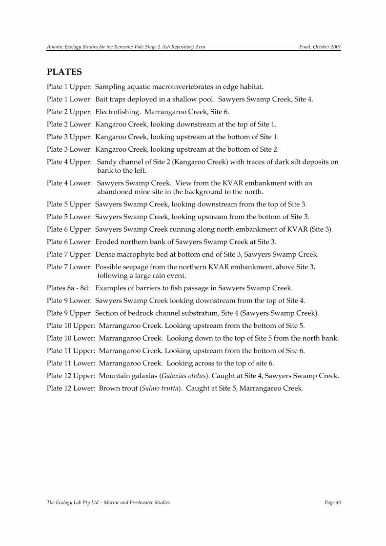
Aquatic Ecology Studies for the Kerosene Vale Stage 2 Ash Repository Area Final, October 2007
The Ecology Lab Pty Ltd – Marine and Freshwater Studies Page 40
PLATES Plate 1 Upper: Sampling aquatic macroinvertebrates in edge habitat.
Plate 1 Lower: Bait traps deployed in a shallow pool. Sawyers Swamp Creek, Site 4.
Plate 2 Upper: Electrofishing. Marrangaroo Creek, Site 6.
Plate 2 Lower: Kangaroo Creek, looking downstream at the top of Site 1.
Plate 3 Upper: Kangaroo Creek, looking upstream at the bottom of Site 1.
Plate 3 Lower: Kangaroo Creek, looking upstream at the bottom of Site 2.
Plate 4 Upper: Sandy channel of Site 2 (Kangaroo Creek) with traces of dark silt deposits on bank to the left.
Plate 4 Lower: Sawyers Swamp Creek. View from the KVAR embankment with an abandoned mine site in the background to the north.
Plate 5 Upper: Sawyers Swamp Creek, looking downstream from the top of Site 3.
Plate 5 Lower: Sawyers Swamp Creek, looking upstream from the bottom of Site 3.
Plate 6 Upper: Sawyers Swamp Creek running along north embankment of KVAR (Site 3).
Plate 6 Lower: Eroded northern bank of Sawyers Swamp Creek at Site 3.
Plate 7 Upper: Dense macrophyte bed at bottom end of Site 3, Sawyers Swamp Creek.
Plate 7 Lower: Possible seepage from the northern KVAR embankment, above Site 3, following a large rain event.
Plates 8a - 8d: Examples of barriers to fish passage in Sawyers Swamp Creek.
Plate 9 Lower: Sawyers Swamp Creek looking downstream from the top of Site 4.
Plate 9 Upper: Section of bedrock channel substratum, Site 4 (Sawyers Swamp Creek).
Plate 10 Upper: Marrangaroo Creek. Looking upstream from the bottom of Site 5.
Plate 10 Lower: Marrangaroo Creek. Looking down to the top of Site 5 from the north bank.
Plate 11 Upper: Marrangaroo Creek. Looking upstream from the bottom of Site 6.
Plate 11 Lower: Marrangaroo Creek. Looking across to the top of site 6.
Plate 12 Upper: Mountain galaxias (Galaxias olidus). Caught at Site 4, Sawyers Swamp Creek.
Plate 12 Lower: Brown trout (Salmo trutta). Caught at Site 5, Marrangaroo Creek.
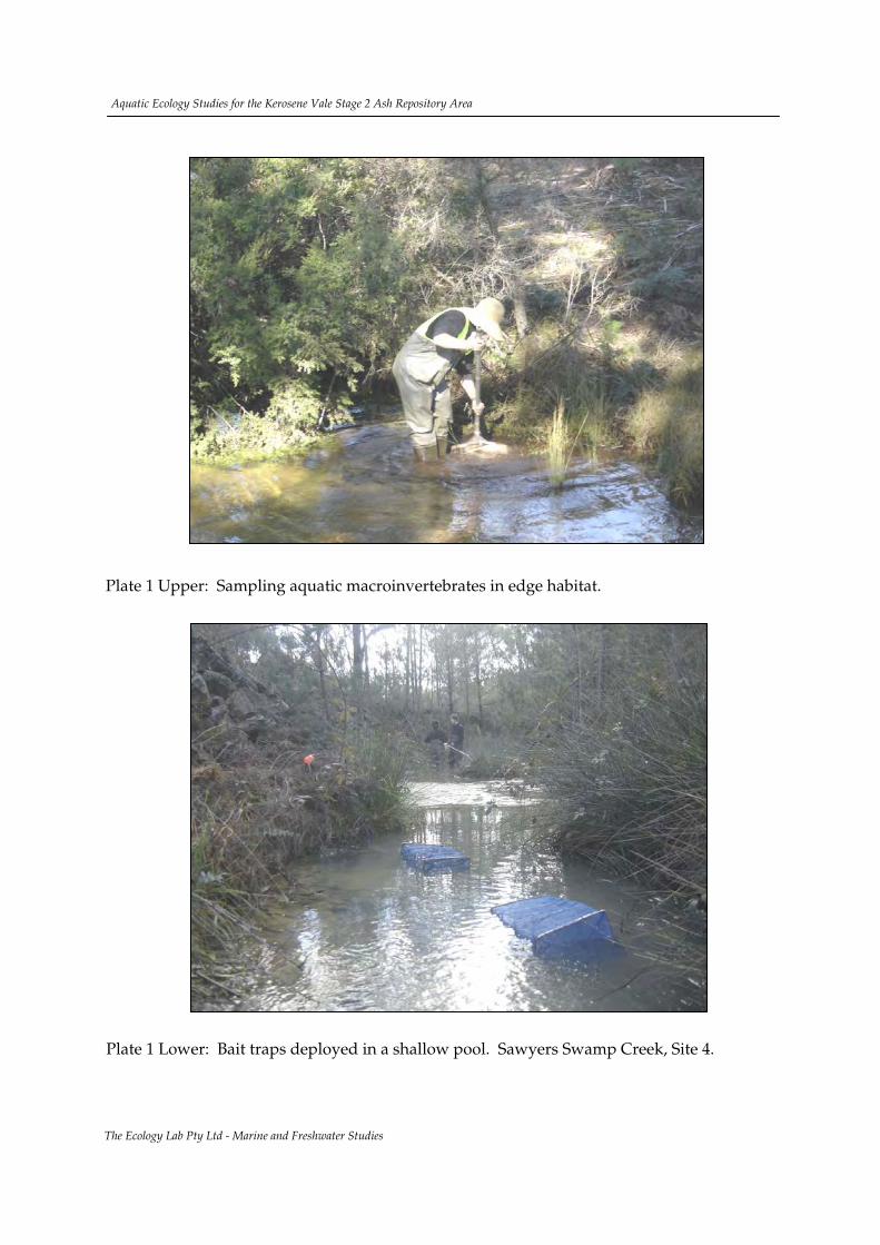
Plate 1 Lower: Bait traps deployed in a shallow pool. Sawyers Swamp Creek, Site 4.
Aquatic Ecology Studies for the Kerosene Vale Stage 2 Ash Repository Area
The Ecology Lab Pty Ltd - Marine and Freshwater Studies
Plate 1 Upper: Sampling aquatic macroinvertebrates in edge habitat.

Plate 2 Lower: Kangaroo Creek, looking downstream at the top of Site 1.
The Ecology Lab Pty Ltd - Marine and Freshwater Studies
Plate 2 Upper: Electrofishing. Marrangaroo Creek, Site 6.
Aquatic Ecology Studies for the Kerosene Vale Stage 2 Ash Repository Area

Plate 3 Lower: Kangaroo Creek, looking upstream at the bottom of Site 2.
The Ecology Lab Pty Ltd - Marine and Freshwater Studies
Plate 3 Upper: Kangaroo Creek, looking upstream at the bottom of Site 1.
Aquatic Ecology Studies for the Kerosene Vale Stage 2 Ash Repository Area

Plate 4 Lower: Sawyers Swamp Creek. View from KVAR embankment.
The Ecology Lab Pty Ltd - Marine and Freshwater Studies
Plate 4 Upper: Sandy channel of Site 2 (Kangaroo Creek) with traces of dark silt deposits on bank to the left.
Aquatic Ecology Studies for the Kerosene Vale Stage 2 Ash Repository Area

Plate 5 Lower: Sawyers Swamp Creek, looking upstream from the bottom of Site 4.
The Ecology Lab Pty Ltd - Marine and Freshwater Studies
Plate 5 Upper: Sawyers Swamp Creek, looking downstream from the top of Site 3.
Aquatic Ecology Studies for the Kerosene Vale Stage 2 Ash Repository Area

Plate 6 Lower: Eroded northern bank of Sawyers Swamp Creek at Site 3.
The Ecology Lab Pty Ltd - Marine and Freshwater Studies
Plate 6 Upper: Sawyers Swamp Creek running along north embankment of KVAR (Site 3).
Aquatic Ecology Studies for the Kerosene Vale Stage 2 Ash Repository Area

Plate 7 Lower: Possible seepage from the northern KVAR embankment, above Site 3, following a large rain event.
The Ecology Lab Pty Ltd - Marine and Freshwater Studies
Plate 7 Upper: Dense macrophyte bed at bottom end of Site 3, Sawyers Swamp Creek.
Aquatic Ecology Studies for the Kerosene Vale Stage 2 Ash Repository Area

Plate 8a – 8d: Examples of barriers to fish passage in Sawyers Swamp Creek. (a)double pipe culvert downstream of Lidsdale Cut Overflow (b) single pipe culvert under haul road, (c) weir downstream of haul road, (d) pipe at south-eastern corner of KVAR at the southern end of the SSCAD wall.
The Ecology Lab Pty Ltd - Marine and Freshwater Studies
(a)
(c) (d)
(b)
Aquatic Ecology Studies for the Kerosene Vale Stage 2 Ash Repository Area

Plate 9 Lower: Section of bedrock channel substrate, Site 4 (Sawyers Swamp Creek).
The Ecology Lab Pty Ltd - Marine and Freshwater Studies
Plate 9 Upper: Sawyers Swamp Creek looking downstream from the top of Site 4.
Aquatic Ecology Studies for the Kerosene Vale Stage 2 Ash Repository Area
Plate 10 Lower: Marrangaroo Creek. Looking upstream from the bottom of Site 5.
The Ecology Lab Pty Ltd - Marine and Freshwater Studies
Plate 10 Upper: Looking down to the top of Site 5 from the north bank.
Aquatic Ecology Studies for the Kerosene Vale Stage 2 Ash Repository Area

Plate 11 Lower: Marrangaroo Creek. Looking across to the top of Site 6.
The Ecology Lab Pty Ltd - Marine and Freshwater Studies
Plate 11 Upper: Marrangaroo Creek. Looking upstream from the bottom of Site 6.
Aquatic Ecology Studies for the Kerosene Vale Stage 2 Ash Repository Area

Plate 12 Lower: Brown trout (Salmo trutta). Caught at Site 5, Marrangaroo Creek.
The Ecology Lab Pty Ltd - Marine and Freshwater Studies
Plate 12 Upper: Mountain galaxias (Galaxias olidus). Caught at Site 4, Sawyers Swamp Creek.
Aquatic Ecology Studies for the Kerosene Vale Stage 2 Ash Repository Area

Aquatic Ecology Studies for the Kerosene Vale Stage 2 Ash Repository Area Final, October 2007
The Ecology Lab Pty Ltd – Marine and Freshwater Studies Page 53
APPENDICES Appendix 1: Macrophyte species recorded in the region of the study area.
Appendix 2: GPS coordinates taken at the study sites in June 2007 (Datum WGS84).
Appendix 3: River descriptors, associated categories and values used in the modified riparian, channel and environmental inventory (RCE) From Chessman et al. (1997).
Appendix 4: Fish habitat classification criteria for watercourses and recommended crossings types (Source: Fairfull and Witheridge, 2003).
Appendix 5: Raw data for water quality measured in situ in the study area. Field data recorded by The Ecology Lab (12\06\2007 - 21\06\2007).
Appendix 6: Presence/absence macroinvertbrate data from AusRivAS samples. Field data recorded by The Ecology Lab (12\06\2007 - 21\06\2007).
Appendix 7: Raw field data for fish and mobile macroinvertebrate sampling. Recorded by The Ecology Lab (21\06\2007 - 22\06\2007).
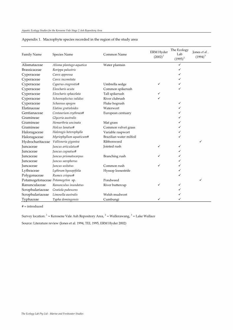
Aquatic Ecology Studies for the Kerosene Vale Stage 2 Ash Repository Area
Family Name Species Name Common NameERM Hyder
(2002)1
The Ecology Lab
(1995)2
Jones et al . (1994)3
Alismataceae Alisma plantago-aquatica Water plantain
Brassicaceae Rorippa palustris
Cyperaceae Carex appressa
Cyperaceae Carex incomitata
Cyperaceae Cyperus eragrostis# Umbrella sedge
Cyperaceae Eleocharis acuta Common spikerush
Cyperaceae Eleocharis sphacelata Tall spikerush
Cyperaceae Schoenoplectus validus River clubrush
Cyperaceae Schoenus apogon Fluke bogrush
Elatinaceae Elatine gratioloides Waterwort
Gentianaceae Centaurium erythraea# European centuary
Gramineae Glyceria australis
Gramineae Hemarthria uncinata Mat grass
Gramineae Holcus lanatus# Common velvet grass
Haloragaceae Haloragis heterophylla Variable raspwort
Haloragaceae Myriophyllum aquaticum# Brazilian water milfoil
Hydrocharitaceae Vallisneria gigantea Ribbonweed
Juncaceae Juncus articulatus# Jointed rush
Juncaceae Juncus cognatus#
Juncaceae Juncus prismatocarpus Branching rush
Juncaceae Juncus sarophorus
Juncaceae Juncus usitatus Common rush
Lythraceae Lythrum hyssopifolia Hyssop loosestrife
Polygonaceae Rumex crispus#
Potamogetonaceae Potamogeton sp. Pondweed
Ranunculaceae Ranunculus inundatus River buttercup
Scrophulariaceae Gratiola pubescens
Scrophulariaceae Limosella australis Welsh mudwort
Typhaceae Typha domingensis Cumbungi
# = introduced
Survey location: 1 = Kerosene Vale Ash Repository Area, 2 = Wallerawang, 3 = Lake Wallace
Source: Literature review (Jones et al. 1994, TEL 1995, ERM Hyder 2002)
Appendix 1. Macrophyte species recorded in the region of the study area
The Ecology Lab Pty Ltd - Marine and Freshwater Studies

Aqu
atic
Eco
logy
Stu
dies
for
the
Ker
osen
e V
ale
Stag
e 2
Ash
Rep
osit
ory
Are
a
App
end
ix 2
. G
PS c
oord
inat
es ta
ken
at th
e st
udy
site
s in
June
200
7 (D
atum
WG
S84)
.
Eas
ting
N
orth
ing
Eas
ting
N
orth
ing
11
Kan
garo
o C
reek
Ups
trea
m02
3044
363
0607
902
3035
363
0612
12
1K
anga
roo
Cre
ekD
owns
trea
m02
2998
263
0621
402
2989
063
0623
03
2Sa
wye
rs S
wam
p C
reek
Ups
trea
m02
2988
663
0221
002
2978
063
0222
24
2Sa
wye
rs S
wam
p C
reek
Dow
nstr
eam
0229
417
6302
340
0229
364
6302
418
53
Mar
rang
aroo
Cre
ekU
pstr
eam
0233
813
6297
303
0233
745
6297
392
63
Mar
rang
aroo
Cre
ekD
owns
trea
m02
3174
362
9709
102
3172
262
9700
8
Top
of s
ite
Bot
tom
of s
ite
Site
Loc
atio
nC
reek
Posi
tion
The
Eco
logy
Lab
Pty
Ltd
- M
arin
e an
d Fr
eshw
ater
Stu
dies

Aquatic Ecology Studies for the Kerosene Vale Stage 2 Ash Repository Area
Descriptor and category Score Descriptor and category Score
1. Land use pattern beyond the immediate riparian zone 8. Riffle / pool sequenceUndisturbed native vegetation 4 Frequent alternation of riffles and pools 4Mixed native vegetation and pasture/exotics 3 Long pools with infrequent short riffles 3Mainly pasture, crops or pine plantation 2 Natural channel without riffle / pool sequence 2Urban 1 Artificial channel; no riffle / pool sequence 1
2. Width of riparian strip of woody vegetation 9. Retention devices in streamMore than 30 m 4 Many large boulders and/or debris dams 4Between 5 and 30 m 3 Rocks / logs present; limited damming effect 3Less than 5 m 2 Rocks / logs present, but unstable, no damming 2No woody vegetation 1 Stream with few or no rocks / logs 1
3. Completeness of riparian strip of woody vegetation 10. Channel sediment accumulationsRiparian strip without breaks in vegetation 4 Little or no accumulation of loose sediments 4Breaks at intervals of more than 50 m 3 Some gravel bars but little sand or silt 3Breaks at intervals of 10 - 50 m 2 Bars of sand and silt common 2Breaks at intervals of less than 10 m 1 Braiding by loose sediment 1
4. Vegetation of riparian zone within 10 m of channel 11. Stream bottomNative tree and shrub species 4 Mainly clean stones with obvious interstices 4Mixed native and exotic trees and shrubs 3 Mainly stones with some cover of algae / silt 3Exotic trees and shrubs 2 Bottom heavily silted but stable 2Exotic grasses / weeds only 1 Bottom mainly loose and mobile sediment 1
5. Stream bank structure 12. Stream detritusBanks fully stabilised by trees, shrubs etc 4 Mainly unsilted wood, bark, leaves 4Banks firm but held mainly by grass and herbs 3 Some wood, leaves etc. with much fine detritus 3Banks loose, partly held by sparse grass etc 2 Mainly fine detritus mixed with sediment 2Banks unstable, mainly loose sand or soil 1 Little or no organic detritus 1
6. Bank undercutting 13. Aquatic vegetationNone, or restricted by tree roots 4 Little or no macrophyte or algal growth 4Only on curves and at constrictions 3 Substantial algal growth; few macrophytes 3Frequent along all parts of stream 2 Substantial macrophyte growth; little algae 2Severe, bank collapses common 1 Substantial macrophyte and algal growth 1
7. Channel formDeep: width / depth ratio less than 7:1 4Medium: width / depth ratio 8:1 to 15:1 3Shallow: width / depth ratio greater than 15:1 2Artificial: concrete or excavated channel 1
Appendix 3. River descriptors, associated categories and values used in the modified riparian, channel and environmental inventory (RCE) From Chessman et al . (1997).
The Ecology Lab Pty Ltd - Marine and Freshwater Studies

Aquatic Ecology Studies for the Kerosene Vale Stage 2 Ash Repository Area
Classification Characteristics of Waterway Type Minimum Recommended Crossing Type
Class 1 – Major Fish Habitat
Major permanently or intermittently flowing waterway (e.g. river or major creek), habitat of a threatened fish species.
Bridge, arch structure or tunnel.
Class 2 – Moderate fish habitat
Named permanent or intermittent stream, creek or waterway with clearly defined bed and banks and with semi-permanent to permanent waters in pools or in connected wetland areas. Marine or freshwater aquatic vegetation is present. Known fish habitat and / or fish observed inhabiting the area.
Bridge, arch structure, culvert or ford.
Class 3 – Minimal fish habitat
Named or unnamed waterway with intermittent flow and potential refuge, breeding or feeding areas for some aquatic fauna (e.g. fish, yabbies). Semi-permanent pools form within the waterway or adjacent wetlands after a rain event. Otherwise, any minor waterway that interconnects with wetlands or recognised aquatic habitats.
Culvert or ford
Class 4 – Unlikely fish habitat
Named or unnamed watercourse with intermittent flow during rain events only, little or no defined drainage channel, little or no free standing water or pools after rain event (e.g. dry gullies or shallow floodplain depression with no permanent wetland aquatic flora present).
Culvert, causeway or ford
Appendix 4. Fish habitat classification criteria for watercourses and recommended crossings types (Source: Fairfull and Witheridge, 2003).
The Ecology Lab Pty Ltd - Marine and Freshwater Studies
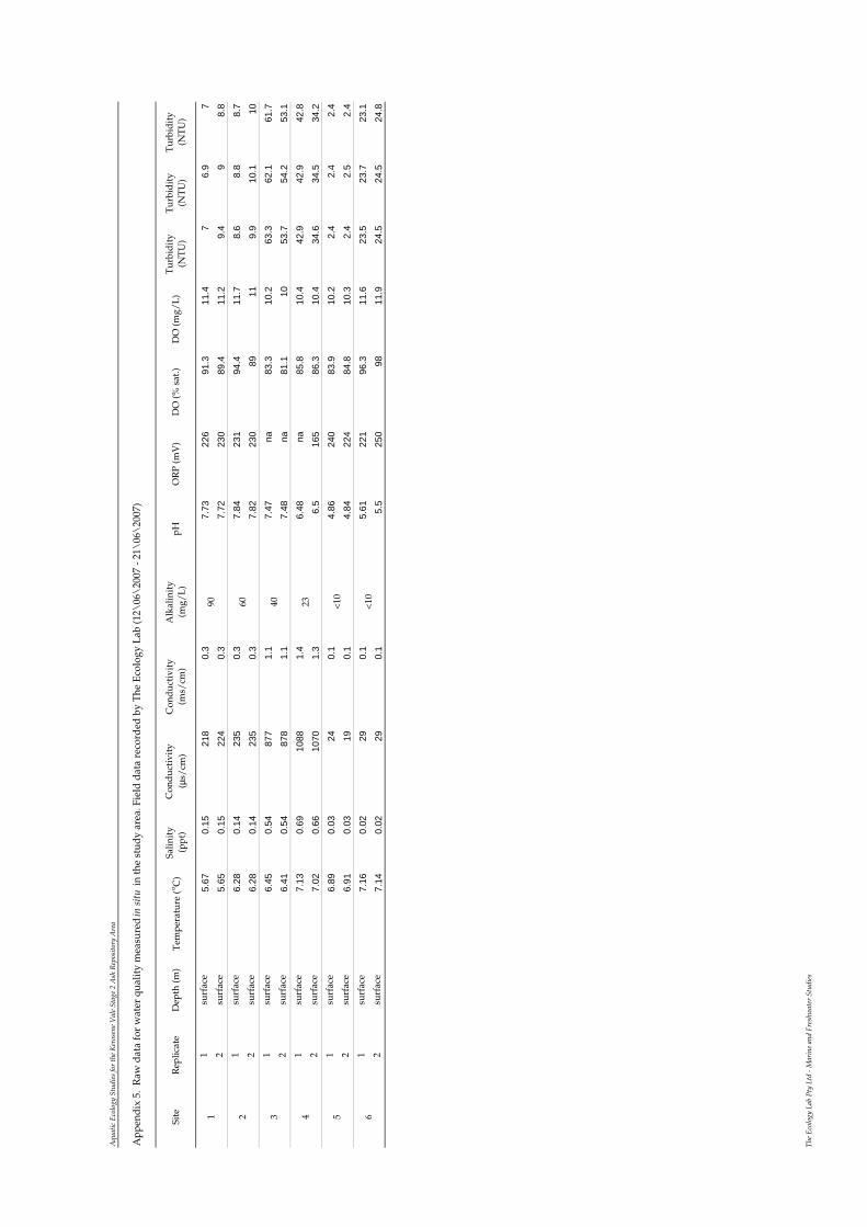
Aqu
atic
Eco
logy
Stu
dies
for
the
Ker
osen
e V
ale
Stag
e 2
Ash
Rep
osit
ory
Are
a
Site
Rep
licat
eD
epth
(m)
Tem
pera
ture
(o C
)Sa
linit
y (p
pt)
Con
duc
tivi
ty
(µs/
cm)
Con
duc
tivi
ty
(ms/
cm)
Alk
alin
ity
(m
g/L
)pH
OR
P (m
V)
DO
(% s
at.)
DO
(mg/
L)
Tur
bid
ity
(NT
U)
Tur
bid
ity
(NT
U)
Tur
bid
ity
(NT
U)
1su
rfac
e5.
670.
1521
80.
37.
7322
691
.311
.47
6.9
72
surf
ace
5.65
0.15
224
0.3
7.72
230
89.4
11.2
9.4
98.
81
surf
ace
6.28
0.14
235
0.3
7.84
231
94.4
11.7
8.6
8.8
8.7
2su
rfac
e6.
280.
1423
50.
37.
8223
089
119.
910
.110
1su
rfac
e6.
450.
5487
71.
17.
47na
83.3
10.2
63.3
62.1
61.7
2su
rfac
e6.
410.
5487
81.
17.
48na
81.1
1053
.754
.253
.11
surf
ace
7.13
0.69
1088
1.4
6.48
na85
.810
.442
.942
.942
.82
surf
ace
7.02
0.66
1070
1.3
6.5
165
86.3
10.4
34.6
34.5
34.2
1su
rfac
e6.
890.
0324
0.1
4.86
240
83.9
10.2
2.4
2.4
2.4
2su
rfac
e6.
910.
0319
0.1
4.84
224
84.8
10.3
2.4
2.5
2.4
1su
rfac
e7.
160.
0229
0.1
5.61
221
96.3
11.6
23.5
23.7
23.1
2su
rfac
e7.
140.
0229
0.1
5.5
250
9811
.924
.524
.524
.8
App
end
ix 5
. R
aw d
ata
for
wat
er q
ualit
y m
easu
red
in s
itu
in th
e st
udy
area
. Fie
ld d
ata
reco
rded
by
The
Eco
logy
Lab
(12\
06\
2007
- 21
\06
\20
07)
51 2 3 4 6
90 60 40 23 <10
<10
The
Eco
logy
Lab
Pty
Ltd
- M
arin
e an
d Fr
eshw
ater
Stu
dies

Aquatic Ecology Studies for the Kerosene Vale Stage 2 Ash Repository Area
Macroinvertebrate Taxa Site 1 Site 2 Site 3 Site 4 Site 5 Site 6
Corbiculidae/ Sphaeriidae Ancylidae Physidae Oligochaeta Copepoda Ostracoda Ceinidae Atyidae Parastacidae Hydracarina Hypogastruridae Caenidae Baetidae Oniscigastridae Leptophlebiidae Megapodagrionidae Diphlebiidae Gomphidae Aeshnidae Telephlebiidae Hemicorduliidae Libellulidae Synthemistidae Gripopterygiidae Hebridae Veliidae Corixidae Notonectidae Corydalidae Osmylidae Noteridae Dytiscidae Gyrinidae Hydrophilidae Scirtidae Elmidae Chironomidae/Chironominae Chironomidae/Tanypodinae Ceratopogonidae Tipulidae Stratiomyidae Dolichopodidae Hydrobiosidae Hydroptilidae Ecnomidae Conoesucidae Odontoceridae Philorheithridae Leptoceridae Pyralidae
Kangaroo Creek Sawyers Swamp Creek Marrangaroo Creek
Appendix 6. Presence/absence macroinvertbrate data from AusRivAS samples. Field data recorded by The Ecology Lab (12\06\2007 - 21\06\2007)
The Ecology Lab Pty Ltd - Marine and Freshwater Studies

Aqu
atic
Eco
logy
Stu
dies
for
the
Ker
osen
e V
ale
Stag
e 2
Ash
Rep
osit
ory
Are
a
App
end
ix 7
. R
aw fi
eld
dat
a fo
r fi
sh a
nd m
obile
mac
roin
vert
ebra
te s
ampl
ing.
Rec
ord
ed b
y T
he E
colo
gy L
ab (2
1\06
\20
07 -
22\
06\
2007
).
Bai
tE
letr
oB
ait
Ele
tro
Bai
tE
letr
oB
ait
Ele
tro
Bai
tE
letr
oB
ait
Ele
tro
Poec
iliid
aeG
ambu
sia
holb
rook
iM
osqu
ito
fish
1
Salm
onid
aeSa
lmo
trut
taB
row
n T
rout
2
3
Salm
onid
aeO
ncor
hync
hus
myk
iss
Rai
nbow
Tro
ut1
Gal
axiid
aeG
alax
ias
olid
usM
ount
ain
Gal
axia
s1
12
Para
stac
idae
Yab
by1
Aty
idae
Fres
hwat
er s
hrim
p1
>10
0
Bai
t = T
otal
cat
ch d
ata
from
8 b
ait t
raps
wit
h a
3hr
soak
tim
e; E
lect
ro =
Tot
al c
atch
dat
a fr
om e
lect
rofi
shin
g fo
r ea
ch s
ite
Fam
ily N
ame
Spec
ies
Nam
eC
omm
on N
ame
Site
1Si
te 6
Site
2Si
te 3
Site
4Si
te 5
The
Eco
logy
Lab
Pty
Ltd
- M
arin
e an
d Fr
eshw
ater
Stu
dies