applied environmental geology (aeg'03) be-228
TRANSCRIPT

FIRST CONFERENCE ONAPPLIED ENVIRONMENTAL GEOLOGY (AEG’03)
IN CENTRAL AND EASTERN EUROPEABSTRACT VOLUME, VIENNA, OCTOBER 7-10th 2003
B
E-22
8


FIRST CONFERENCE ON APPLIED ENVIRONMENTAL GEOLOGY (AEG’03)
IN CENTRAL AND EASTERN EUROPE
Abstract volume, Vienna, October 7-10th 2003
M. Kralik, H. Häusler & C. Kolesar (editors)
Dedicated to Univ.-Prof. Erich SCHROLL
BE-228
Vienna, October 2003

Abstracts presented in this volume reflect the opinion of the authors!
Weitere Informationen zu Publikationen des Umweltbundesamtes finden Sie unter: http:/www.ubavie.gv.at
Impressum Medieninhaber und Herausgeber: Umweltbundesamt GmbH, Spittelauer Lände 5, A-1090 Wien Eigenvervielfältigung
© Umweltbundesamt GmbH, Wien, Oktober 2003 Alle Rechte vorbehalten (all rights reserved) ISBN 3-85457-700-1

Applied Environmental Geology (AEG’03) – sponsors I
Umweltbundesamt/Federal Environment Agency – Austria BE 228 (2003)
SPONSORS
Gesellschaft für Geotechnik GmbH www. geotechnik-gmbh.at MA 31 - Wiener Wasserwerke www.wien.gv.at/ma31
MLP Finanzdienstleistungen AG www.mlp.at OMV Proterra GmbH [email protected] Plantech, Eisenerz 06644420 444 Porr Umwelttechnik GmbH www.put.at Umweltbundesamt GmbH www.umweltbundesamt.at Universität Wien www.univie.ac.at UWITEC Umwelt u. Wissenschaftstechnik www.uwitec.at
II Applied Environmental Geology (AEG’03) – preface
BE 228 (2003) Umweltbundesamt/Federal Environment Agency – Austria
PREFACE This conference on environmental geology aims to act as a platform for communication and knowledge exchange and to create a network between applied geo- and environmental sci-ences of various fields. These fields can be defined as Applied Geoscience in a wider sense and should contribute to a better understanding of the future needs and challenge to envi-ronmental science using geo-science techniques. In addition, the international communication and information between persons working in re-search, administration and in private companies in Central, South Eastern and Eastern Eu-rope should be promoted. To sum it up, however, the major goals of our new conference on Applied Environmental Geology (AEG`03) in Vienna intend to:
Set-up a scientifically based platform for applied environmental geology in Vienna, fo-cusing on environmental problems in Central and Eastern Europe
Rise the awareness of applied environmental problems at different administrative lev-els
Engage application-oriented communication & information of methods and experi-ences in Environmental Geology
Promote activities and research in EC countries and in Central and Eastern Europe in the fields of applied environmental geosciences.
Fortunately the Umweltbundesamt (Austrian Environment Agency) published an abstract volume of the lectures and of those posters which were accepted by the scientific team and the reviewers of more than 100 contributions. Finally it is a pleasure for me to acknowledge the organizers of this conference, Dr. Hermann Häusler, Department of Geological Sciences of our University, and Dr. Martin Kralik, Um-weltbundesamt.
o. Univ.-Prof. Mag. Dipl.-Ing. Dr. Christian Noe Dean of the
Faculty of Natural Sciences and Mathematics, University of Vienna

Applied Environmental Geology (AEG’03) – preface III
Umweltbundesamt/Federal Environment Agency – Austria BE 228 (2003)
PREFACE To demonstrate the diverse application of Earth Sciences for solving environmental problems of modern societies in Central and Eastern Europe, the Institute of Geological Sciences and the Umweltbundesamt (Austrian Environment Agency) in Vienna initiated this conference on Applied Environmental Geology. This conference was preceded by four conferences on geo-scientific aspects on environ-mental protection (“Erdwissenschaftliche Aspekte des Umweltschutzes”) held at the former Arsenal Research Centre in Vienna in the years 1986, 1990, 1994, and 1998. In the new millennium, the European Union continues to progress and stimulate co-operation across country borders. Earth Sciences get in closer contact with other disciplines offering their knowledge and skills to society at the start of the 21st century. The First Conference on Applied Environmental Geology (AEG’03) brings together delegates from more than 20 countries: Albania, Austria, Canada, Croatia, China, Czech Republic, Egypt, Germany, Hungary, Iran, Italy, Japan, Korea, Macedonia, Moldavia, Poland, Romania, Russia, Serbia and Crna Gora, Slovakia, Slovenia, Spain, Switzerland, Ukraine and Thai-land. There will be six main themes at this conference. (1) River Basin Management in context with the European Water Framework Directive (WFD), (2) Karst water protection strategies, (3) remediation of industrial brownfields and military waste sites, (4) geo-risks and impact of mining, (5) anthropogenic contamination and geogenic backgrounds in aerosols, waters, se-diments and soils, (6) Global Change and Paleoclimatology back to geological time-scales. In putting this Conference Programme together, the Local Organising Committee would like to thank all authors, the members of the scientific committee, the Institute of Geological Sci-ences (University of Vienna) as well as all other exhibitors and sponsors for their contribu-tions and support. We hope that the participants find the AEG’03-conference to be a stimulat-ing and rewarding experience and have an enjoyable stay in Vienna.
Georg Rebernig Managing Director Umweltbundesamt
IV Applied Environmental Geology (AEG’03) – content
BE 228 (2003) Umweltbundesamt/Federal Environment Agency – Austria
CONTENT Abdel-Hafez, T. & Schlüchter, C.: Geotechnical problems and the damage
potential to 15th May City, Cairo, Egypt 1 Aboughalma, H. & Stüben, D.: Lateral and vertical distribution of platinium
group elements (PGE) emitted from car catalytic converters along a German highway 3
Adamcova, R. et al.: Hydraulic conductivity of karst soils 6 Alberti, L. & Zanini, A.: Application of the integral pumping test in Milano 9 Alvarez, R. et al.: A new methodological approach for the exploration of the
extended polluted sites 11 Aston, J.: The Rosia Montana Project, Romania. - How a gold mining in-
vestment gives hope to the environment 13 Behr, O. et al.: River bed morphology assessment of the lower Danube in
the common Romanian-Bulgarian river reach (Danube km 845 – km 375) 15
Biondic, B.: Karst groundwater strategy in Croatia 17 Birk, S. et al.: Evaluating spring responses to characterise karst conduit
systems 20 Boev, B. & Lepitkova, S.: Soil contamination in the vicinity of Probistip 22 Borsato, A. et al.: Stable isotope monitoring of Alpine karstic springs in the
Trentino province (NE-Italy) 24 Brauner, M. et al.: RockFor – investigations on shelter efficiency of moun-
tain forests against rockfall 26 Buxbaum, I. & Kralik, M.: Particulate transport and deposition in a prealpine
area 28 Caputo, D. et al.: Degradation of groundwater resources in the Mediterra-
nean basin: climatic changes or human activities? 30 Cara, F. & Dema, S.: Heavy metal as indicators of pollution and their im-
pact in the ecosystem of an industrial zone 32 Chon Hyo-Taek & Lee Jin-Soo: Environmental contamination and risk as-
sessment of arsenic and heavy metals around some abandoned metal mine sites in Korea 34
Clemens, T.: CO2 sequestration in oil and gas fields and CO2 enhanced gas recovery for an example gas reservoir in the Netherlands 36
Čurlik, J.: The influence of soil properties on distribution and leaching of airborne heavy metals in high mountains 38
Dangić, A. & Dangić, J.: Lead as environmental geochemical risk in the central and eastern parts of the Western Balkan (SE Europe) 40
Dangić, A. et al.: Geochemical processes and impacts of some heavy met-als to water quality in the system Danube River-groundwater aquifer: Vinci near Golubac (Serbia and Crna Gora) 42
Applied Environmental Geology (AEG’03) – content V
Umweltbundesamt/Federal Environment Agency – Austria BE 228 (2003)
Dangić, A.: Arsenic in ground-, mineral and thermal waters and rivers in central parts of the Balkan Peninsula (SE Europe): Contents, geochem-istry, and environmental impacts 44
Dangić, A.: Integrative environmental geochemical-geological studies of the Danube River Basin in Serbia and Montenegro (SE Europe) 47
Denner, M.et al.: Analysis of potentially toxic elements in sediments 49 Deutsch, R.: Dams in karstic areas – stand firm or yield? 51 Dragisic, V., Spadijer S. & Milenic D.: Aquifer control techniques in a karst
environment, the southeast Serbia case study 52 Faber, R.: WinGeol: Data preparation for numerical groundwater simula-
tions. How to create an accurate model of the subsurface 54 Filip, J. & Zeman, J.: The effect of geochemical evolution of AMD on min-
eral composition of stream sediments: preliminary study on Hadùvka stream, Western Moravia, Czech Republic 56
Frančišković-Bilinski, S. & Rantitsch, G.: Geochemical and mineralogical dispersion in the Upper Sava river (Slovenia), a preliminary report 58
Frisia, S. et al.: Holocene climate and environmental changes recon-structed from annually laminated speleothems 60
Gaisberger, G. et al.: Heavy metals and their biological availability in soils around the historic mining and metallurgy centre of Oberzeiring/Austria 62
Gavrilita, A. & Gavrilita, D.: Consequences of human impact on landscape in the Republic of Moldavia. Soil processes and land degradation with reference to the last decade 65
Gavrilita, A. & Gavrilita, D.: The contribution of NATO project to the devel-opment and water resources management in the Republic of Moldavia 67
Gavrilita, D. & Gavrilita, A.: Critical state of hydrographical network in the Republic of Moldavia. Analysis and rehabilitation 69
Gerstbach, G. et al.: Interdisciplinary sediment models in “Austro-Pannonia“ 70 Gosar, M. et al.: Environmental impacts of metal mining in Slovenia 73 Grath, J. et al.: Model-based risk assessment of Groundwater Quality at
Groundwater body level in Austria 75 Hannich, D. & Hötzl, H.: Earthquake induced soil liquefication as a high
geo-risk factor 77 Häusler, H. & Leber, D.: Climatic change in the eastern Himalaya as de-
rived from meteorological data and glacier melt processes 79 Häusler, H. et al.: Integration of geological and air-borne geophysical data
for groundwater prospecting in the Bohemian massif of Upper Austria 81 Häusler, H. et al.: Risk analysis of geo-hazards in the Bhutan Himalaya 84 Havas-Szilágyi, E.: Implementation of the Water Framework Directive in
Hungary 86 Helios Rybicka, E. & Rybicki, S.: Impact of coal mining on the environment
in Poland 88 Helios-Rybicka, E. & Adamiec, E.: Sediment assessment in the Oder River
system; Recommendations for the transboundry Rivers Monitoring 90

VI Applied Environmental Geology (AEG’03) – content
BE 228 (2003) Umweltbundesamt/Federal Environment Agency – Austria
Höfer, G.: «Ältere Deckenschotter Mostviertel»: a study of groundwater resource and quality 92
Hofmann, T.: Contaminant transport in the unsaturated zone: behavior of colloidal carriers 94
Hötzl, H. & Neukum, C.: Hazard and risk assessment of karst aquifers 96 Humer, F. et al.: Austrian longterm intergrated monitoring; geochemical cy-
cles in a dolomite karst 98 Inderbitzin, L. et al.: The geochemistry of recent sediments in the Ova Spin-
Reservoir (Engadin, Switzerland) - tracing human impact. 100 Isermann, K. & Isermann, R.: Intentional “natural” attenuation is an unsuit-
able measure to mitigate immissions of the reactive compounds of Car-bon (C), Nitrogen (N), Phosphorus (P) and Sulphur (S) from the total system nutrition 101
Kalembasa, D. et al.: Influence of the duration of floodings on the carbon and nitrogen fraction of soils 103
Kiss, S.: Reuse of brownfields – a case study of the former “Screw Faktory Neunkirchen”, Lower Austria 106
Klug, H. et al.: Comparison of two different integrative approaches for sus-tainable water management practices 108
Knittel, U. et al.: Heavy metal pollution in sediments of the August-2002 floods (Freiberger and Zwickauer Mulde) 111
Kolesar, C. et al.: Application of "Integral Pumping Tests" for integrative groundwater investigation in Linz-Heilham, Austria 113
Kollarits, S. & Kuschnig, G.: Decision-support systems for groundwater pro-tection: Innovative tools for resource management 115
Kopriva, A.: Assessment of iron and manganese migration abilities in mine waters 117
Koscal, M. et al.: Areas of ecological risk in Serbia 119 Kostic, N. et al.: Environmental geochemical changes in Pleistocene loess-
paleosoils in Serbian part of the Pannonian Basin 120 Kraft, C. et al.: Mining in Northern Romania and heavy metal distribution in
sediments of the rivers Szamos and Tisza (Hungary) 122 Kralik, M.: A strategy for protecting karst groundwater in Austria 125 Kralik, M. et al.: Austrian Network of Isotopes in Precipitation (ANIP) as a
tool for assessing good status in groundwater 127 Križáni, I. et al.: The role of microorganisms in hypergenous processes in
dumps and setting-pits at Banská Štianvnica (Slovakia) 130 Križáni, I. et al.: Comparison of the ability of heavy metal leaching from hy-
dro-quartzite and from sediments of setting-pits (Banská Štiavnica, Slo-vakia) 132
Kuchovsky, T., Stejskal, M. & Hrsel, J.: Dealing with the impact of subsur-face contamination on the future land use - example of the Brno city, Czech Republic 134

Applied Environmental Geology (AEG’03) – content VII
Umweltbundesamt/Federal Environment Agency – Austria BE 228 (2003)
Kudjelka, A. et al.: Mobility and bioavailability of heavy metals in Pb-Zn mine tailings of the Grazer Palaeozoic (Styria/Austria) 136
Kupfersberger, H.: Environmental infrastructure measures in the lower Drava River Basin 138
Lehner, E. & Kralik, M.: Inorganic and organic contaminants and mineral-ogy of Viennese dust 140
Liesch, T. & Hötzl, H.: Assessment of ground water risk using neural net-works 142
Linnik, P.: Speciation of heavy metals in the bottom sediments and a sec-ondary pollution of aquatic environment 145
Madritsch, H.: Hydrogeological investigations of springs within large scale landslides using oxygen-18 analyses (Wattental, Tyrol, Austria) 147
Marczinek, S. et al.: Identification and quantification of natural attenuation processes at a site contaminated with chlorinated ethenes 149
Marković, S. B. et al.: Late Pleistocene paleoclimate and paleoenvironment recorded in the loess-paleosol sequence at Irig Brickyard exposure (Vo-jvodina; Serbia) 152
Marofi, S.: River water quality in a semi-arid hydrological basin of Iran 154 Marofi, S.: Groundwater dynamics in a semi arid region 156 Marofi, S.: Transmissivity estimations in the Gara Chay hydrological basin 158 Matic, I. et al.: Conceptual hydrogeological and mathematical model of be-
havior and fate of PCBs in soils of the locality Kragujevac – Serbia and Montenegro 160
Matschullat, J.: Air-borne pollution in Central Europe, a story from the for-mer Black Triangle 161
Moche, W. & Stephan, K.: Levels of PBDE in various environmental matri-ces in Austria 163
Moche, W. & Thanner, G.: Ambient Air Monitoring of PCDD/F and PCB in Austria 166
Monjai, D. et al.: Geohazards related to salt mining in the Khorat-Plateau (NE Thailand) 168
Müllerová, H. & Zeman, J.: Meaning and validity of the sequential extraction procedure (SEA) for evaluation of heavy metals (HMs) mobility 170
Nahold, M., Aichberger, H. & Müller, D.: Advanced site investigation for the selection of cost effective concepts to remediate a former oil refinery 172
Neuhuber et al.: Organic and inorganic removal of CD and pb in sediments and soils: consequences for groundwater protection 175
Norra, S. & Stüben, D.: Urban geochemistry: Alterations of element and stable isotope patterns of soils, dusts and plants 177
Osmani, S.: A view on system analysis of water strategy and management 180 Papesch, W. & Rank, D.: Isotope tracing of hydrological processes in large
river basins: Danube study. 183

VIII Applied Environmental Geology (AEG’03) – content
BE 228 (2003) Umweltbundesamt/Federal Environment Agency – Austria
Patrzałek, A. & Pozzi, M.: Geologic-engineering and chemical properties of topsoil in forming process for biological restoration of coal mine waste-based structures 185
Perišić, M. et al.: Geoecological specifity of the sediments of the iron gate I water reservoir 187
Picer, M. et al.: Investigation of PCB levels in soil samples of an electro-transformer station in Zadar as consequence of oil spills during war ac-tion (Croatia) 190
Pirkl et al.: Geochemical background values of groundwater, rocks and soils in the Northern Calcareous Alps of Upper and Lower Austria 192
Plan L. et al.: Assessment of karst morphological vulnerability parameters 194 Pluta, I. & Halas, S.: Identification of acid mine processes in coal mines of
the upper Silesian coal basin by δ34S and δ 18O in sulphates 196 Prokop, G.: IMAGE-TRAIN: Innovative Management of Groundwater Re-
sources in Europe – Training and RTD co-ordination project 200 Quevauviller, P.: Implementation of the Water Framework Directive in
Europe and its links to geological issues 204 Rank, D. & Papesch, W.: Determination of groundwater flow velocity in the
Southern Vienna Basin from a long-term environmental isotope record 206 Rank, D., Häusler, H. & Papesch, W.: A new runoff model of a complex aq-
uifer system, as developed from isotopic investigations of single precipi-tation events 208
Reinstorf, F. et al.: Concept for improving the area-relation of data from deposition networks in Germany 210
Riedl, F.: Landslide in the Innsbruck Quartzphyllite and related geotechnical and hydrogeological problems in tunneling 212
Rutigliano, P. et al.: Investigation of landslide movements in an area of his-torical and archeological interest 214
Sager, M. et al.: Effect of plant growth and addition of chelators on the speciation in soils obtained from sequential leaching 216
Sager, M.: Characterisation of fertilizers and related substances by multi-element analysis 217
Sappa, G., Tulipano, L. & Di Fiore, C.: Multisystem approach for the identi-fication of recharge areas in karstic aquifers 218
Scharf, S. et al.: Organic Micropollutants and Pharmaceuticals in Sedi-ments and Suspended Matter of the River Danube (Austria) 220
Schubert, G.: Discrimination of groundwaters by hydrochemistry – some examples 223
Schulze, T. et al.: Development of a standard operating procedure "sedi-ments and suspended particularly matter" for the German Environmental Specimen Bank 226
Schuwirth, N. & Hofmann, T.: Evaluation of Leaching and in-situ tests 228 Sinreich, M. & Zwahlen, F.: Specific vulnerability maps as a contribution to
groundwater protection and risk management in karst environments 230

Applied Environmental Geology (AEG’03) – content IX
Umweltbundesamt/Federal Environment Agency – Austria BE 228 (2003)
Sipos, P., Németha, T. & Mohaib, I.: Neutralizing effect of soils to a possi-ble lead pollution as reflected by a study on two natural soil profiles 232
Soto, J., Loredo, L. & Iglesias, J.: Exploration of atmospheric mercury con-tents in relation to mercury-rich waste stockage 235
Spötl, C.: Quaternary dynamics: Paleo-perspective of global change 237 Stichler, W. et al.: The Environmental δ18O - Fingerprint along the Course
of the River Rhine 238 Svetina, M.: Calculation and modelling of critical loads for heavy metals in
terrestrial ecosystem in the Salek Valley, Slovenia 241 Taheri Tizro, A.: Groundwater quality with reference to origin of salinity in
Mahendragarh district, Haryana, India 243 Taheri Tizro, A.: Prospecting of aquifers in hard rock terrain 245 Traxler, K. & Kralik, M.: Ammonium - problem in dragged river Danube se-
diments 247 Trimbacher, C. & Neinavaie, H.: Identification and source apportionment of
airborne particulate matter in an Austrian conurbation area by means of integrated mineralogical and SEM analysis 249
Tuyet, Nguyen T. Anh & Ishihara, Keiichi, N.: The changes in carbon diox-ide emissions in the Vietnamese economy using input-output energy model 252
Veizer, J.: Celestial climate driver: A perspective from four billion years of carbon cycle 254
Volk, G. et al.: Back-calculation of several disastrous avalanche events in February 1999 in Austria using the avalanche model ELBA 256
Weinbruch, S. & Ebert, M.: Source apportionment of atmospheric aerosols based on electron microscopy of individual particles 258
Weinke, G.: et al: Determination of trace elements in waters with dithizone 260 Willig, D.: Empirical insights into the elimination of typical explosives
compounds by the water treatment installation on the blast site Wildflecken (Rhön mountains southeast of Fulda, Germany) 263
Xie, X. et al.: Regional distribution of stream water chemistry as a function of land use and geology in Baden-Württemberg 266
Žibret, G. & Šajn, R.: Emissions of heavy metals to the environment in the town of Celje 268
Zlobina, V. L.: Carbonate karst under urban conditions 270 Zwahlen, F. & Goldscheider, N.: Results of the European COST Action 620
– Vulnerability and Risk Mapping for the Protection of Carbonate (Karst) Aquifers 272

Applied Environmental Geology (AEG’03) – Abdel-Hafez & Schlüchter 1
Umweltbundesamt/Federal Environment Agency – Austria BE 228 (2003)
GEOTECHNICAL PROBLEMS AND THE DAMAGE POTENTIAL TO 15th MAY CITY, CAIRO, EGYPT T. Abdel-Hafez & C. Schlüchter Institute of Geological Sciences, Berne University, Baltzerstrasse 1-3, CH-3012 Berne, Switzerland. [email protected], [email protected] 1. INTRODUCTION The suitability of soils for engineering purposes depends largely upon their ability to remain in place and to support whatever loads may be placed upon them either by a permanent structure or transient loads. Clay minerals are everywhere in the Earth’s upper crust and con-trol the physical properties of the respective units. It is necessary, therefore, that the civil en-gineer responsible for the construction of any form of earthwork should be informed of the quantity of clay minerals that are present and of their properties in order to evaluate their po-tential influence on the engineering project. In clay areas the ability to swell and shrink in re-sponse to fluctuation in water addition and removal is vital to the active generation of the visible structure, in which water and air are penetrated causing problems of structural stability in civil engineering. 15th May City is a new urban area which has been developed over the last 20 years and which is affected by rising groundwater and by cracking of some of its buildings. Soluble salt content of the rock samples have been determined using the Method of RHOADES (1982) and the results show that the amount of soluble salts content is up to 5 wt%-dry. X-Ray Diffraction (XRD) have been carried out to the dried soluble salt extracts and the re-sults show that the halite (NaCl) is the predominant salt in the study area in addition to gyp-sum. Scanning Electron Microscope (SEM) and Energy Dispersive System (EDS) have been carried out to the rock samples collected from the study area. The results show that the rock samples contain Halite, Gypsum and the clay mineral smectite. The swelling and shrinkage potential of smectite clay mineral under the presence of water as well as the volumetric changes due to the dissolution of halite may be one of the causes for the instabilities of cer-tain areas in this City. The presence of water underneath some of the buildings in 15th May City was a geotechnically active environment for clay minerals and halite to react, causing deterioration of the rocks and their physical properties. The main propelling factor, which causes structure instability, is water, derived either from groundwater or seepage of drainage water. Crystalline swelling of smectites in water is caused by hydration of the interlayer cations. The amount of swelling depends mainly on relative humidity and the nature of the interlayer (BROWN, 1984). SPOOR et al. (1982) con-sider that swelling processes related to clay mineralogy are important in destabilizing mole drains. 2. MATERIAS AND METHODS The Method of RHOADS (1982) was used to determine the percentage of the soluble salts content in the rock samples. The dried soluble salts extracts were analysed by XRD to de-termine the mineral composition of the extracts. SEM and EDS were carried out along and perpendicular to the bedding plane of the rock samples to define the morphology and the structure of the samples (Figure 1).

2 Applied Environmental Geology (AEG’03) – Abdel-Hafez & Schlüchter
BE 228 (2003) Umweltbundesamt/Federal Environment Agency – Austria
3. RESULTS AND CONCLUSION Halite and gypsum were the only evaporite minerals positively identified in XRD analyses of the dried soluble salt extracts of 15
th May City and Al-Mokattam study areas. The investiga-tions show that a large amount of halite (sodium chloride) is abundant in Observatory forma-tion where 15th May City is located. The salts dissolve rapidly with excess water causing de-structions. The most cited cause of mechanical weathering is by salt growth from solutions in rock pores and cracks because of substantial pressure that may be exerted by the growing crystals (WINKLER & SINGER, 1972). Fig. 1: (a) SEM photomicrographs along the bedding plane and (b) perpendicular to the bed-ding plane. Of natural salts, sulphates (Na2SO4, MgSO4) exert the highest pressure, and are more ef-fective than sodium carbonates. They are more effective than halite and gypsum in causing breakdown (GOUDIE, 1994). The limestone of Observatory formation is characterized by presence of caves and cracks. Open cracks and joints enable water to seep the rocks. On the way down through the rocks, three possibilities occur; 1- sodium solution concentration will increase, wherever the water evaporates, salt growth will exert crystallization pressure; 2-the soluble salts in the rocks will be dissolved causing structure collapse; 3- swelling and shrinkage of smectite clay minerals might be related to the damage potential of the area. The presence of water beneath some of the building at 15th May City was a good environment for clay minerals and halite to react, causing deterioration of the rocks. The swelling and shrink-age of smectite clay mineral associated with the presence of water as well as the volumetric changes due to the dissolution of halite are responsible for the instability of this City. REFERENCES BROWN, G. (1984): Crystal structures of clay minerals and related phyllosilicates, Phil.
Trans. R. Soc. London. A 311, 221-240. GOUDIE, A. S. (1994): Keynotes Lecture-salt attack on buildings and other structures in arid
lands. In: Fookes, P. G., Parry, R. H. (Eds.), Engineering Characteristics of Arid Soils. Balkema, Rotterdam, 15-28
RHOADES, I. D. (1982): Soluble salts. In: Methods of Soil Analysis. Part 2. Madison. WI: ASA-ASSA, pp. 167-197.
SPOOR, G., LEEDS-HARRISON, P. B. & GODWIN, R. J. (1982): J. Soil Sci. 33, 427-441. WINKLER, E. M. & SINGER, P. C. (1972): Crystallization pressure in stones and concrete.
Geological Society of America Bulletin 83, 3509-3514.
EDS
(a) (b)

Applied Environmental Geology (AEG’03) – Aboughalma & Stüben 3
Umweltbundesamt/Federal Environment Agency – Austria BE 228 (2003)
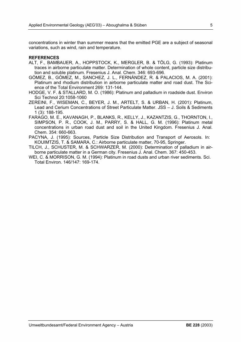
LATERAL AND VERTICAL DISTRIBUTION OF PLATINIUM GROUP ELEMENTS (PGE) EMITTED FROM CAR CATALYTIC CONVERTERS ALONG A GERMAN HIGHWAY H. Aboughalma & D. Stüben Institute of Mineralogy and Geochemistry, Universität Karlsruhe, Germany, [email protected]; Fritz-Haber-Weg 2, D-76131 Karlsruhe, Germany 1. INTRODUCTION The uptake of platinum group elements (PGE) emitted from modern car catalytic converters via the respiratory tract has the potential to cause damage to human health. Respiratory hy-persensitivities have been reported after inhalation of PGE (Pt, Pd, Rh) by street workers. Therefore, detailed sampling and characterisation of emitted PGE in particulate matter are required since their concentration is increasing steadily in airborne particulates. The modern three-way catalysts contain 2-3g of PGE where the ratio Pt/Rh or Pd/Rh is usu-ally 5:1. However, the precious metals Platinum, Palladium and Rhodium are released from catalyst due to thermal heating (500-1000°C) and mechanical abrasion. Furthermore, the amount of PGE emitted depends on several factors such as catalyst type, age and driving velocity. Increased concentration of Platinum Group Elements in airborne particulate matter have been reported in several studies from different countries such as Germany, USA, Sweden, England, Spain (ZEREINI, 2001; HODGE & STALLARD, 1986; WEI & MORRISON, 1994; FARAGO et al. 1996; ALT et al. 1993; TILCH et al., 2000; GÓMEZ et al. 2001). The aim of the present study is to determine the lateral and vertical distribution of PGE emit-ted from car catalytic converters alongside the highway A5 in Germany. 2. MATERIAL AND METHODS Dust samples were collected during summer (May-July) and in winter (November) 2002 after VDI 2119 according to Bergerhoff method. Samples were collected at the following distances from the highway 1m, 2m, 5m, 10m, 15m, and 20m (each 3 glass pots) as well as at the height of 0.1m, 0.5m, 1.0m, 1.5m, 2.0m, 2.5m (height from the ground surface) at a distance of 10m from the highway edge (each 5 glass pots). After sampling, the glass pots were dried at 105°C, weighted and the total dust precipitation was calculated. The quantitative determination of PGE in dust samples was carried out after a microwave digestion using aqua regia (HCl:HNO3, 3:1) and isotope dilution. Following the microwave digestion, Tellurium co-precipitation has been applied for preconcentration of PGE and separation of matrix elements, which interfere with the noble metals during ICP-MS measurement. The concentrations of PGE in dust samples were determined by HR-ICP-MS (Axiom, VG Elemental, UK). 3. RESULTS In general, the concentrations of PGE decrease with increasing distance from the highway. During the summer period of three months (May-July), Platinum shows two maximum peaks of concentration at 2m and 15m distance from the highway whereas Palladium concentration shows two maximum peaks at 5m and 15m. The Rhodium concentration in dust collected during both sampling campaigns follows the general trend like Pt and Pd but shows one maximum peak at 15m (Figure 1) in samples collected in summer. However, during the win-
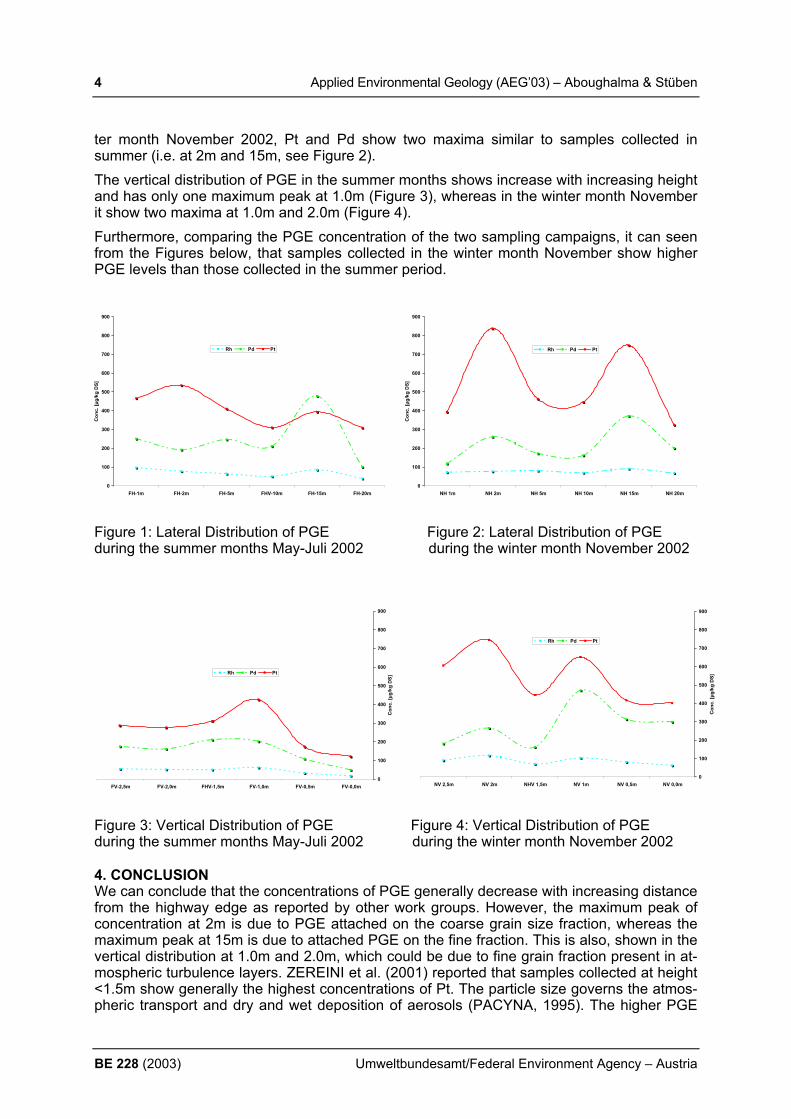
4 Applied Environmental Geology (AEG’03) – Aboughalma & Stüben
BE 228 (2003) Umweltbundesamt/Federal Environment Agency – Austria
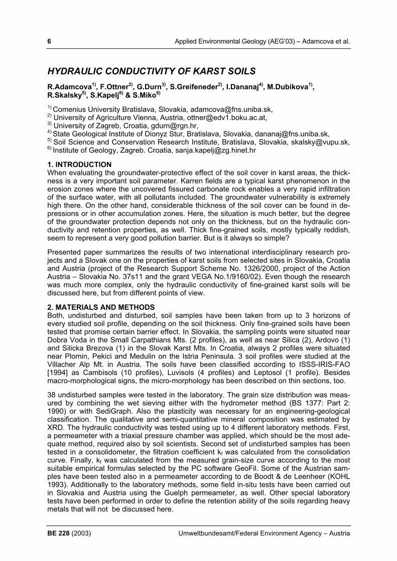
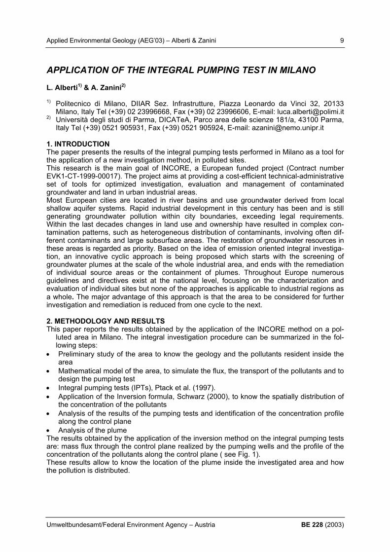
ter month November 2002, Pt and Pd show two maxima similar to samples collected in summer (i.e. at 2m and 15m, see Figure 2). The vertical distribution of PGE in the summer months shows increase with increasing height and has only one maximum peak at 1.0m (Figure 3), whereas in the winter month November it show two maxima at 1.0m and 2.0m (Figure 4). Furthermore, comparing the PGE concentration of the two sampling campaigns, it can seen from the Figures below, that samples collected in the winter month November show higher PGE levels than those collected in the summer period.
Figure 1: Lateral Distribution of PGE Figure 2: Lateral Distribution of PGE during the summer months May-Juli 2002 during the winter month November 2002
Figure 3: Vertical Distribution of PGE Figure 4: Vertical Distribution of PGE during the summer months May-Juli 2002 during the winter month November 2002 4. CONCLUSION We can conclude that the concentrations of PGE generally decrease with increasing distance from the highway edge as reported by other work groups. However, the maximum peak of concentration at 2m is due to PGE attached on the coarse grain size fraction, whereas the maximum peak at 15m is due to attached PGE on the fine fraction. This is also, shown in the vertical distribution at 1.0m and 2.0m, which could be due to fine grain fraction present in at-mospheric turbulence layers. ZEREINI et al. (2001) reported that samples collected at height <1.5m show generally the highest concentrations of Pt. The particle size governs the atmos-pheric transport and dry and wet deposition of aerosols (PACYNA, 1995). The higher PGE
0
100
200
300
400
500
600
700
800
900
FH-1m FH-2m FH-5m FHV-10m FH-15m FH-20m
Con
c. [µ
g/kg
DS]
Rh Pd Pt
0
100
200
300
400
500
600
700
800
900
NH 1m NH 2m NH 5m NH 10m NH 15m NH 20m
Con
c. [µ
g/kg
DS]
Rh Pd Pt
0
100
200
300
400
500
600
700
800
900
NV 0,0m NV 0,5m NV 1m NHV 1,5m NV 2m NV 2,5m
Con
c. [µ
g/kg
DS]
Rh Pd Pt
0
100
200
300
400
500
600
700
800
900
FV-0,0m FV-0,5m FV-1,0m FHV-1,5m FV-2,0m FV-2,5m
Con
c. [µ
g/kg
DS]
Rh Pd Pt
Applied Environmental Geology (AEG’03) – Aboughalma & Stüben 5
Umweltbundesamt/Federal Environment Agency – Austria BE 228 (2003)
concentrations in winter than summer means that the emitted PGE are a subject of seasonal variations, such as wind, rain and temperature. REFERENCES ALT, F., BAMBAUER, A., HOPPSTOCK, K., MERGLER, B. & TÖLG, G. (1993): Platinum
traces in airborne particulate matter. Determination of whole content, particle size distribu-tion and soluble platinum. Fresenius J. Anal. Chem. 346: 693-696.
GÓMEZ, B., GÓMEZ, M., SANCHEZ, J. L., FERNÁNDEZ, R. & PALACIOS, M. A. (2001): Platinum and rhodium distribution in airborne particulate matter and road dust. The Sci-ence of the Total Environment 269: 131-144.
HODGE, V. F. & STALLARD, M. O. (1986): Platinum and palladium in roadside dust. Environ Sci Technol 20:1058-1060
ZEREINI, F., WISEMAN, C., BEYER, J. M., ARTELT, S. & URBAN, H. (2001): Platinum, Lead and Cerium Concentrations of Street Particulate Matter. JSS – J. Soils & Sediments 1 (3): 188-195.
FARAGO, M. E., KAVANAGH, P., BLANKS, R., KELLY, J., KAZANTZIS, G., THORNTON, I., SIMPSON, P. R., COOK, J. M., PARRY, S. & HALL, G. M. (1996): Platinum metal concentrations in urban road dust and soil in the United Kingdom. Fresenius J. Anal. Chem. 354: 660-663.
PACYNA, J. (1995): Sources, Particle Size Distribution and Transport of Aerosols. In: KOUIMTZIS, T. & SAMARA, C.: Airborne particulate matter, 70-95, Springer.
TILCH, J., SCHUSTER, M. & SCHWARZER, M. (2000): Determination of palladium in air-borne particulate matter in a German city. Fresenius J. Anal. Chem. 367: 450-453.
WEI, C. & MORRISON, G. M. (1994): Platinum in road dusts and urban river sediments. Sci. Total Environ. 146/147: 169-174.
6 Applied Environmental Geology (AEG’03) – Adamcova et al.
BE 228 (2003) Umweltbundesamt/Federal Environment Agency – Austria
HYDRAULIC CONDUCTIVITY OF KARST SOILS R.Adamcova1), F.Ottner2), G.Durn3), S.Greifeneder2), I.Dananaj4), M.Dubikova1), R.Skalsky5), S.Kapelj6) & S.Miko6) 1) Comenius University Bratislava, Slovakia, [email protected], 2) University of Agriculture Vienna, Austria, [email protected], 3) University of Zagreb, Croatia, [email protected], 4) State Geological Institute of Dionyz Stur, Bratislava, Slovakia, [email protected], 5) Soil Science and Conservation Research Institute, Bratislava, Slovakia, [email protected], 6) Institute of Geology, Zagreb. Croatia, [email protected] 1. INTRODUCTION When evaluating the groundwater-protective effect of the soil cover in karst areas, the thick-ness is a very important soil parameter. Karren fields are a typical karst phenomenon in the erosion zones where the uncovered fissured carbonate rock enables a very rapid infiltration of the surface water, with all pollutants included. The groundwater vulnerability is extremely high there. On the other hand, considerable thickness of the soil cover can be found in de-pressions or in other accumulation zones. Here, the situation is much better, but the degree of the groundwater protection depends not only on the thickness, but on the hydraulic con-ductivity and retention properties, as well. Thick fine-grained soils, mostly typically reddish, seem to represent a very good pollution barrier. But is it always so simple? Presented paper summarizes the results of two international interdisciplinary research pro-jects and a Slovak one on the properties of karst soils from selected sites in Slovakia, Croatia and Austria (project of the Research Support Scheme No. 1326/2000, project of the Action Austria – Slovakia No. 37s11 and the grant VEGA No.1/9160/02). Even though the research was much more complex, only the hydraulic conductivity of fine-grained karst soils will be discussed here, but from different points of view. 2. MATERIALS AND METHODS Both, undisturbed and disturbed, soil samples have been taken from up to 3 horizons of every studied soil profile, depending on the soil thickness. Only fine-grained soils have been tested that promise certain barrier effect. In Slovakia, the sampling points were situated near Dobra Voda in the Small Carpathians Mts. (2 profiles), as well as near Silica (2), Ardovo (1) and Silicka Brezova (1) in the Slovak Karst Mts. In Croatia, always 2 profiles were situated near Plomin, Pekici and Medulin on the Istria Peninsula. 3 soil profiles were studied at the Villacher Alp Mt. in Austria. The soils have been classified according to ISSS-IRIS-FAO [1994] as Cambisols (10 profiles), Luvisols (4 profiles) and Leptosol (1 profile). Besides macro-morphological signs, the micro-morphology has been described on thin sections, too. 38 undisturbed samples were tested in the laboratory. The grain size distribution was meas-ured by combining the wet sieving either with the hydrometer method (BS 1377: Part 2: 1990) or with SediGraph. Also the plasticity was necessary for an engineering-geological classification. The qualitative and semi-quantitative mineral composition was estimated by XRD. The hydraulic conductivity was tested using up to 4 different laboratory methods. First, a permeameter with a triaxial pressure chamber was applied, which should be the most ade-quate method, required also by soil scientists. Second set of undisturbed samples has been tested in a consolidometer, the filtration coefficient kf was calculated from the consolidation curve. Finally, kf was calculated from the measured grain-size curve according to the most suitable empirical formulas selected by the PC software GeoFil. Some of the Austrian sam-ples have been tested also in a permeameter according to de Boodt & de Leenheer (KOHL 1993). Additionally to the laboratory methods, some field in-situ tests have been carried out in Slovakia and Austria using the Guelph permeameter, as well. Other special laboratory tests have been performed in order to define the retention ability of the soils regarding heavy metals that will not be discussed here.

Applied Environmental Geology (AEG’03) – Adamcova et al. 7
Umweltbundesamt/Federal Environment Agency – Austria BE 228 (2003)
3. RESULTS AND DISCUSSION The hydraulic permeability of the studied soils often changes from one horizon to another one within the same profile, whereby trends observed by one test method are sometimes in opposite to the trends seen by other methods. This is because the hydraulic conductivity re-flects the simultaneous effect of many different factors, internal and external ones. The grain size is only one of them. In general, studied Croatian soils are finer than similar soils in Slo-vakia that are again finer than the Austrian ones. But no real correlation between the grain size and the hydraulic conductivity tested in the triaxial permeameter could be found, just a very weak descending trend with the finer grains could be observed. Surprisingly, the coars-est soil, Leptosol from Silica, yielded the lowest permeability at all: 3,5x10⁻¹¹m.s-1 in the up-per-most horizon. However, this was probably due to the method imperfection (external fac-tor). The necessary chamber pressure might compact the sample. Also 15 cm deeper, where kf reached up to 5,22x10⁻⁷m.s-1, the volume reduction after the test reached 16%! The high-est permeability measured by this method was about 5,8x10⁻⁷m.s-1 in the upper Luvisol sam-ple from Dobra Voda 2, probably due to many roots and cracks and short saturation (see be-low). The mean value of all triaxial tests is 9,47x10⁻⁸, but instead of applying this number in any modelling, the very broad interval between the maximum and minimum should be re-membered! Less extreme and in general lower values have been measured by the con-solidometer method and the estimate from the grain size yielded as good as no differences between the soils (Table 1). The last method proved to be unsuitable for fine-grained soils, because the soils did not fulfil the random conditions of applied formulas. Furthermore, the formulas do not include any porosity-relevant parameter. As expected, in-situ tests showed 100 to 1000-times higher kf than the laboratory tests, reflecting so the presence of macro-pores. Table 1. Hydraulic conductivity of studied soil groups resulting from different test methods Method kf (m.s-1) all soils together Cambisols Luvisols Leptosol triaxial permeameter (30 tests)
mean min max
9,47x10⁻⁸ 3,50x10⁻¹¹ 5,83x10⁻⁷
8,89x10⁻⁸ 1,45x10⁻¹⁰ 3,97x10⁻⁷
7,17x10⁻⁸
1,97x10⁻¹⁰ 5,83x10⁻⁷
2,60x10⁻⁷
3,50x10⁻¹¹ 5,22x10⁻⁷
consolidometer (33 tests)
mean min max
6,53x10⁻⁹
1,40x10⁻⁹ 3,59x10⁻⁸
6,50x10⁻⁹
9,40x10⁻¹⁰ 1,73x10⁻⁸
8,22x10⁻⁹
1,40x10⁻⁹ 3,59x10⁻⁸
1,00x10⁻⁸
7,02x10⁻⁹ 1,30x10⁻⁸
grain size - GeoFil (35 tests)
mean min max
2,38x10⁻⁹
1,01x10⁻⁹ 4,11x10⁻⁹
2,17x10⁻⁹
4,71x10⁻⁹ 1,08x10⁻⁹
2,78x10⁻⁹
1,01x10⁻⁹ 4,11x10⁻⁹
1,56x10⁻⁹
1,21x10⁻⁹ 1,92x10⁻⁹
field test - Guelph (19 tests)
mean min max
3,73x10⁻⁶
<1x10⁻⁸ 2,00x10⁻⁵
1,95x10⁻⁷
2,30x10⁻⁷ 2,00x10⁻⁵
6,23x10⁻⁷
<1x10⁻⁸ 2,96x10⁻⁶
1,30x10⁻⁶
1,10x10⁻⁶ 2,40x10⁻⁶
Sometimes the changing kf could be explained with the mineralogy very well, e.g. in Slovak samples containing smectite (Dobra Voda, Silica). Here, the permeability decreased during 2 weeks in the triaxial chamber considerably as the pores were closed due to smectite swell-ing. Both, degree and duration, of saturation, as well as porosity are very important, whereby these internal factors are in very tight relation in soils containing swelling clay minerals. In other soils, a secondary compaction can lower the effective porosity and thus the hydraulic conductivity. This was observed in the upper-most horizons at the Villacher Alp Mt. due to cattle grazing. But the compacting effect of the geostatic pressure in the deeper horizons was evident in Slovak samples, too. These and further results will be presented in the paper in detail in order to illustrate the difficulties and the complexity of the problem called hydraulic conductivity of soils. It is really not enough to know the grain-size curve!

8 Applied Environmental Geology (AEG’03) – Adamcova et al.
BE 228 (2003) Umweltbundesamt/Federal Environment Agency – Austria
REFERENCES BS 1377: British Standard Methods of tests. Part 2: Soils for civil engineering. 1990, London. ISSS-IRIS-FAO (1994): World Reference Base for Soil Resources. Draft. Wagenigen/Rome. KOHL, B. (1993): Physikalische Charakteristika der Boeden im Mustereinzugsgebiet Loe-
nersbach bei Saalbach. Diploma thesis, Innsbruck
Applied Environmental Geology (AEG’03) – Alberti & Zanini 9
Umweltbundesamt/Federal Environment Agency – Austria BE 228 (2003)
APPLICATION OF THE INTEGRAL PUMPING TEST IN MILANO L. Alberti1) & A. Zanini2) 1) Politecnico di Milano, DIIAR Sez. Infrastrutture, Piazza Leonardo da Vinci 32, 20133
Milano, Italy Tel (+39) 02 23996668, Fax (+39) 02 23996606, E-mail: [email protected] 2) Università degli studi di Parma, DICATeA, Parco area delle scienze 181/a, 43100 Parma,
Italy Tel (+39) 0521 905931, Fax (+39) 0521 905924, E-mail: [email protected] 1. INTRODUCTION The paper presents the results of the integral pumping tests performed in Milano as a tool for the application of a new investigation method, in polluted sites. This research is the main goal of INCORE, a European funded project (Contract number EVK1-CT-1999-00017). The project aims at providing a cost-efficient technical-administrative set of tools for optimized investigation, evaluation and management of contaminated groundwater and land in urban industrial areas. Most European cities are located in river basins and use groundwater derived from local shallow aquifer systems. Rapid industrial development in this century has been and is still generating groundwater pollution within city boundaries, exceeding legal requirements. Within the last decades changes in land use and ownership have resulted in complex con-tamination patterns, such as heterogeneous distribution of contaminants, involving often dif-ferent contaminants and large subsurface areas. The restoration of groundwater resources in these areas is regarded as priority. Based on the idea of emission oriented integral investiga-tion, an innovative cyclic approach is being proposed which starts with the screening of groundwater plumes at the scale of the whole industrial area, and ends with the remediation of individual source areas or the containment of plumes. Throughout Europe numerous guidelines and directives exist at the national level, focusing on the characterization and evaluation of individual sites but none of the approaches is applicable to industrial regions as a whole. The major advantage of this approach is that the area to be considered for further investigation and remediation is reduced from one cycle to the next. 2. METHODOLOGY AND RESULTS This paper reports the results obtained by the application of the INCORE method on a pol-
luted area in Milano. The integral investigation procedure can be summarized in the fol-lowing steps:
• Preliminary study of the area to know the geology and the pollutants resident inside the area
• Mathematical model of the area, to simulate the flux, the transport of the pollutants and to design the pumping test
• Integral pumping tests (IPTs), Ptack et al. (1997). • Application of the Inversion formula, Schwarz (2000), to know the spatially distribution of
the concentration of the pollutants • Analysis of the results of the pumping tests and identification of the concentration profile
along the control plane • Analysis of the plume The results obtained by the application of the inversion method on the integral pumping tests are: mass flux through the control plane realized by the pumping wells and the profile of the concentration of the pollutants along the control plane ( see Fig. 1). These results allow to know the location of the plume inside the investigated area and how the pollution is distributed.

10 Applied Environmental Geology (AEG’03) – Alberti & Zanini
BE 228 (2003) Umweltbundesamt/Federal Environment Agency – Austria
100 m
PCE N
Fig. 1 -Concentration profile of the PCE
REFERENCES ALBERTI, L.; BIANCHI, D.; CECCON, S. (2002): The implementation of a flux model for the
application of groundwater integrated investigation concept. New trends in water and envi-ronmental engineering for safety and life: eco-compatible solutions for aquatic environ-ment. 24-28 June, Capri 2002, Italy.
ALBERTI, L.; BIANCHI, D.; CECCON, S.; GAGLIARDI, M.; MOIANA, E.; ZANINI, A. (2003): Results of the application of the Integral Investigation Method in Milano. In Contamined Soil 2003, Ghent Bel-gium.
INCORE Integrated Concept for Groundwater Remediation (1999). Contract number EVK1-CT-1999-00017.
PTAK, T.; TEUTSCH, G. (2000): Development and application of an integral investigation method for the characterization of groundwater contamination. In: Contaminated Soil 2000, Thomas Telford, London, 198-205.
PTAK, T.; SCHWARZ, R.; TEUTSCH, G. (1997): Pilot study for technical testing of a new in-vestigation approach for the determination of contaminant mass flux and concentration in groundwater at contaminated sites. Report LAG 97_01/0460. University of Tübingen, Germany.
SCHWARZ, R. (2000): Grundwasser Gefhrdungsabschatzung durch Emissions und Immis-sionsmessungen an Deponien und Altlasten. University of Tübingen, Germany.

Applied Environmental Geology (AEG’03) – Álvarez et al. 11
Umweltbundesamt/Federal Environment Agency – Austria BE 228 (2003)
A NEW METHODOLOGICAL APPROACH FOR THE INVESTIGATION OF EXTENDED POLLUTED SITES R. Álvarez, A. Ordóñez & J. Loredo
Dpto. Explotación y Prospección de Minas. Universidad de Oviedo. Independencia 13.
33004 Oviedo. España. [email protected] 1. INTRODUCTION In old industrialised areas, abandoned installations in various stages of gradual decay consti-tute very frequently an important negative environmental legacy for future generations. The investigation of these polluted sites is usually accomplished by application of the classical methodology employed efficiently for years in mining exploration. This methodology consists of different phases where the classical exploration techniques as geophysics, geochemistry, and subsoil surveys by trenches and drills are applied in combination with soil sampling campaigns, in a sequential form. According to this exploration strategy, the data of each ex-ploration step constitute the base for the design of the following one. The economical effi-ciency of this classical approach is currently being under consideration for the case of ex-tended polluted sites included in the category of brownfield. These types of studies, which focus on the characterization and evaluation of pollution in brownfield, usually demand the application of innovative techniques capable to diminish drastically the periods of time nec-essary for the completion of the study and the budget of the project. Therefore, portable ana-lysers are ideal tools for fast, accurate, and economical characterisation and delimitation of extended polluted sites and, in relation to conventional sampling and “off-site” analyses, they provide a great flexibility within the project. Under this consideration, the application of an exploration approach based on the use of portable field analytical techniques capable to ob-tain “in-situ” geochemical data close to real time is currently imposing. 2. MATERIALS AND METHODS There is different portable analytical equipment commercially available for inorganic geo-chemical characterisation. From all of them, the following can be considered: “X-ray fluores-cence”, “Immunoassay tests”, “Anode stripping voltametry”, and “Portable spectrophotome-ter”. Furthermore, there are other technologies still included in the group of emerging and in-novative approaches such as “Laser-induced breakdown spectroscopy”, and “Field portable ion chromatography”. The portable X Ray Fluorescence Analysers (XRF) constitutes a pow-erful and efficient technology, capable to identify priority metallic pollutants in soils and to de-limit the polluted area. The application of this technology at a brownfield site allows obtaining a large number of “in-situ” multielemental analyses within one working day. Then, the lower cost per sample allows a denser, more complete sampling. These methods provide data accurate enough to support technical decisions directly on the site, and this fact causes important reductions in the lifetime of the project and reductions in personal labour and external analyses cost. Although the equipment can measure undis-turbed soil directly, it is possible to improve the quality of the data with a minimal preparation of the samples directly on site. In the delimiting of anthropogenic geochemical anomalies or detection of “hot-spots” at polluted sites and in the control of remediation operations, this screening method has been found technically and economically efficient and its inclusion in the environmental investigation programmes applied to brownfield will be certainly increased on the future.
12 Applied Environmental Geology (AEG’03) – Álvarez et al.
BE 228 (2003) Umweltbundesamt/Federal Environment Agency – Austria
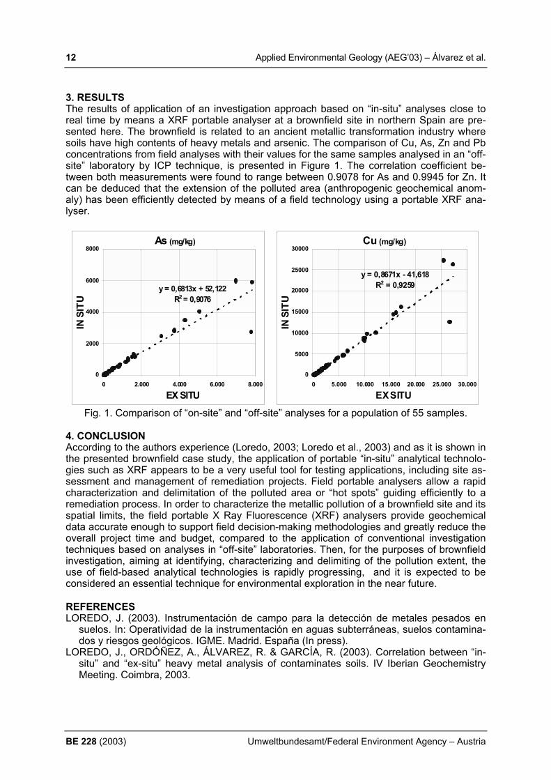
3. RESULTS The results of application of an investigation approach based on “in-situ” analyses close to real time by means a XRF portable analyser at a brownfield site in northern Spain are pre-sented here. The brownfield is related to an ancient metallic transformation industry where soils have high contents of heavy metals and arsenic. The comparison of Cu, As, Zn and Pb concentrations from field analyses with their values for the same samples analysed in an “off-site” laboratory by ICP technique, is presented in Figure 1. The correlation coefficient be-tween both measurements were found to range between 0.9078 for As and 0.9945 for Zn. It can be deduced that the extension of the polluted area (anthropogenic geochemical anom-aly) has been efficiently detected by means of a field technology using a portable XRF ana-lyser.
As (mg/kg)
y = 0,6813x + 52,122R2 = 0,9076
0
2000
4000
6000
8000
0 2.000 4.000 6.000 8.000
EX SITU
IN S
ITU
Cu (mg/kg)
y = 0,8671x - 41,618R2 = 0,9259
0
5000
10000
15000
20000
25000
30000
0 5.000 10.000 15.000 20.000 25.000 30.000
EX SITU
IN S
ITU
Fig. 1. Comparison of “on-site” and “off-site” analyses for a population of 55 samples.
4. CONCLUSION According to the authors experience (Loredo, 2003; Loredo et al., 2003) and as it is shown in the presented brownfield case study, the application of portable “in-situ” analytical technolo-gies such as XRF appears to be a very useful tool for testing applications, including site as-sessment and management of remediation projects. Field portable analysers allow a rapid characterization and delimitation of the polluted area or “hot spots” guiding efficiently to a remediation process. In order to characterize the metallic pollution of a brownfield site and its spatial limits, the field portable X Ray Fluorescence (XRF) analysers provide geochemical data accurate enough to support field decision-making methodologies and greatly reduce the overall project time and budget, compared to the application of conventional investigation techniques based on analyses in “off-site” laboratories. Then, for the purposes of brownfield investigation, aiming at identifying, characterizing and delimiting of the pollution extent, the use of field-based analytical technologies is rapidly progressing, and it is expected to be considered an essential technique for environmental exploration in the near future. REFERENCES LOREDO, J. (2003). Instrumentación de campo para la detección de metales pesados en
suelos. In: Operatividad de la instrumentación en aguas subterráneas, suelos contamina-dos y riesgos geológicos. IGME. Madrid. España (In press).
LOREDO, J., ORDÓÑEZ, A., ÁLVAREZ, R. & GARCÍA, R. (2003). Correlation between “in-situ” and “ex-situ” heavy metal analysis of contaminates soils. IV Iberian Geochemistry Meeting. Coimbra, 2003.
Applied Environmental Geology (AEG’03) – Aston & Avram 13
Umweltbundesamt/Federal Environment Agency – Austria BE 228 (2003)
THE ROSIA MONTANA PROJECT, ROMANIA – HOW A GOLD MINING INVESTMENT GIVES HOPE TO THE ENVIRONMENT J. Aston & H. Avram
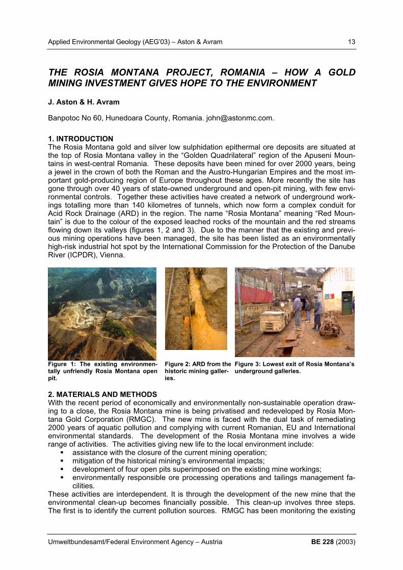
Banpotoc No 60, Hunedoara County, Romania. [email protected]. 1. INTRODUCTION The Rosia Montana gold and silver low sulphidation epithermal ore deposits are situated at the top of Rosia Montana valley in the “Golden Quadrilateral” region of the Apuseni Moun-tains in west-central Romania. These deposits have been mined for over 2000 years, being a jewel in the crown of both the Roman and the Austro-Hungarian Empires and the most im-portant gold-producing region of Europe throughout these ages. More recently the site has gone through over 40 years of state-owned underground and open-pit mining, with few envi-ronmental controls. Together these activities have created a network of underground work-ings totalling more than 140 kilometres of tunnels, which now form a complex conduit for Acid Rock Drainage (ARD) in the region. The name “Rosia Montana” meaning “Red Moun-tain” is due to the colour of the exposed leached rocks of the mountain and the red streams flowing down its valleys (figures 1, 2 and 3). Due to the manner that the existing and previ-ous mining operations have been managed, the site has been listed as an environmentally high-risk industrial hot spot by the International Commission for the Protection of the Danube River (ICPDR), Vienna.
Figure 1: The existing environmen-tally unfriendly Rosia Montana open pit.
Figure 2: ARD from thehistoric mining galler-ies.
Figure 3: Lowest exit of Rosia Montana’s underground galleries.
2. MATERIALS AND METHODS With the recent period of economically and environmentally non-sustainable operation draw-ing to a close, the Rosia Montana mine is being privatised and redeveloped by Rosia Mon-tana Gold Corporation (RMGC). The new mine is faced with the dual task of remediating 2000 years of aquatic pollution and complying with current Romanian, EU and International environmental standards. The development of the Rosia Montana mine involves a wide range of activities. The activities giving new life to the local environment include:
assistance with the closure of the current mining operation; mitigation of the historical mining’s environmental impacts; development of four open pits superimposed on the existing mine workings; environmentally responsible ore processing operations and tailings management fa-
cilities. These activities are interdependent. It is through the development of the new mine that the environmental clean-up becomes financially possible. This clean-up involves three steps. The first is to identify the current pollution sources. RMGC has been monitoring the existing

14 Applied Environmental Geology (AEG’03) – Aston & Avram
BE 228 (2003) Umweltbundesamt/Federal Environment Agency – Austria
environment since 2000. The resulting aquatic monitoring system covers more than 170 km2
upstream, downstream and throughout the existing Rosia Montana Brownfield site. The second step is to identify the pathways through which this pollution enters the downstream environmental system. The third and final step is the isolation and/or removal and treatment of the pollution source. 3. RESULTS The major sources of pollution are identified and classified in line with Romanian and EU leg-islation. Streams in the region are highly contaminated with pH as low as 2.5, and water chemistry pollution existing over 70 times over the Romanian legal limits (figure 4). RMGC will change this situation by collecting the historic acid rock drainage using dams and treating the water to Romanian and EU standards prior to release. Further, by the very fact of devel-oping the new mine, the source of this pollution will be either removed or stabilised.
Fig. 4: Existing dissolved cadmium concentration being discharged from the mine galleries. 4. CONCLUSION The new Rosia Montana Project will develop the existing Brownfield site to create a finan-cially viable modern gold mining project within a sustainable and healthy environment. Through the resources available from the responsible development of the geological richness of this area, incorporating adherence to and compliance with regulations regarding the dis-charge of water and impact on the environment, new life will be infused into the environment and biosphere of Rosia Montana. REFERENCES MINISTERIAL ORDER 10/2002 (replacing Romanian Standard STAS 4706/1988 – Surface
Water Quality); Romanian Official Gazette No. 197, March 27, 2003. ESG INTERNATIONAL et al. (2003), Rosia Montana Project Environmental Impact Assess-
ment.

Applied Environmental Geology (AEG’03) – Behr et al. 15
Umweltbundesamt/Federal Environment Agency – Austria BE 228 (2003)
RIVER BED MORPHOLOGY ASSESSMENT OF THE LOWER DANUBE IN THE COMMON ROMANIAN-BULGARIAN RIVER REACH (DANUBE km 845 – km 375). O. Behr1), C. Bondar2), D. Gutknecht1), S. Modev3) & S. Petkovic4) 1) Institute of Hydraulics, Hydrology and Water Resources, Vienna University of Technology, 2) National Institute of Marine Geology and Geoecology - GeoEcoMar, Bucharest, Romania, 3) University of Architecture, Civil Engineering and Geodesy, Sofia, Bulgaria, 4) Institute for the Development of Water Resources “Jaroslav Cerni”, Belgrade, Yugoslavia
[email protected]/Fax: +43-1-58801-22399 1. INTRODUCTION In den Lower Danube reach numerous problems have arisen over the past two to three dec-ades linked to changes of the river morphology and to erosion along the Danube reach be-tween the Iron Gates reservoirs and the Danube delta. To address this issue of river mor-phology and its consequences for all types of water management activities in this area, a common initiative of all involved countries was launched that led to the definition of a project entitled “Morphological Changes and Abatement of their Negative Effects on a Selected Part of the Danube River”. Implementation of this project was made possible by Phare funding through the EPDRB (Environmental Program for the Danube River Basis). This paper reports on the results of this two-phase project. 2. MATERIAL AND METHODS In the first phase, performed in 1997, an inventory of all available material to assess the river morphology in the approx. 470 km long common Bulgarian-Romanian river reach (km 375 – km 845) was prepared. Analysing various sources of information as bathymetric maps (1908, 1938, 1966 ), cross-section profiles and discharge-stage curves at gauging stations, and suspended sediment data from the time period 1956-1995, a first overall picture of the mor-phological changes during this period could be prepared indicating (i) a general tendency of decreasing water levels over this period, (ii) a general decrease of suspended loads both in the Danube river and its tributaries (Fig. 1), (iii) pronounced changes in the morphological features of the reach, e.g. changes of bank lines due to bank erosion and changes in the number and size of islands along the whole river reach. The observed trends are due to a general decreasing trend of runoff since the 1980s, the construction of Iron Gates I, and a decrease of the tributary sediment contribution (BEHR et al.,2000).
Figure 1: Mean annual suspended sediment load time series [kg/s].
To prepare the preconditions for remedial action planning a second phase project was per-formed between October 1998 and February 2000. It was aimed at the development of a common and integrating monitoring methodology for the Lower Danube and the development of recommendations for global agreements between the involved countries on future monitor-ing, data and information exchange, modelling, and management activities. To test the pro-
16 Applied Environmental Geology (AEG’03) – Behr et al.
BE 228 (2003) Umweltbundesamt/Federal Environment Agency – Austria
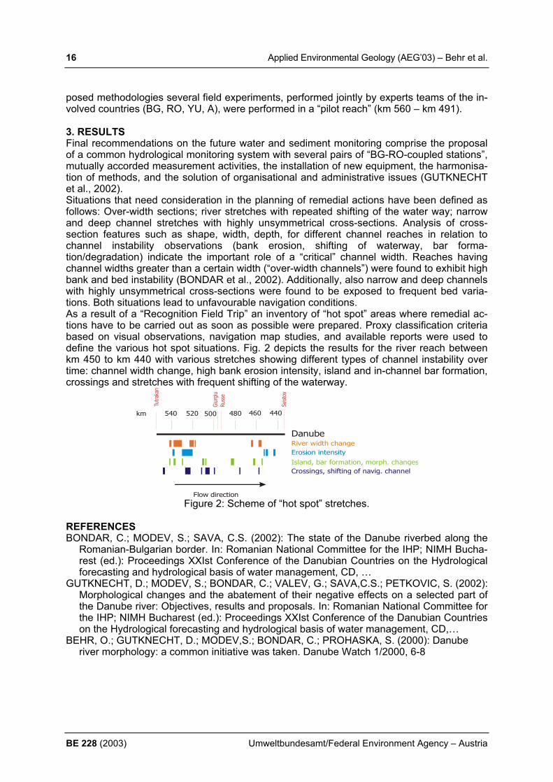
posed methodologies several field experiments, performed jointly by experts teams of the in-volved countries (BG, RO, YU, A), were performed in a “pilot reach” (km 560 – km 491). 3. RESULTS Final recommendations on the future water and sediment monitoring comprise the proposal of a common hydrological monitoring system with several pairs of “BG-RO-coupled stations”, mutually accorded measurement activities, the installation of new equipment, the harmonisa-tion of methods, and the solution of organisational and administrative issues (GUTKNECHT et al., 2002). Situations that need consideration in the planning of remedial actions have been defined as follows: Over-width sections; river stretches with repeated shifting of the water way; narrow and deep channel stretches with highly unsymmetrical cross-sections. Analysis of cross-section features such as shape, width, depth, for different channel reaches in relation to channel instability observations (bank erosion, shifting of waterway, bar forma-tion/degradation) indicate the important role of a “critical” channel width. Reaches having channel widths greater than a certain width (“over-width channels”) were found to exhibit high bank and bed instability (BONDAR et al., 2002). Additionally, also narrow and deep channels with highly unsymmetrical cross-sections were found to be exposed to frequent bed varia-tions. Both situations lead to unfavourable navigation conditions. As a result of a “Recognition Field Trip” an inventory of “hot spot” areas where remedial ac-tions have to be carried out as soon as possible were prepared. Proxy classification criteria based on visual observations, navigation map studies, and available reports were used to define the various hot spot situations. Fig. 2 depicts the results for the river reach between km 450 to km 440 with various stretches showing different types of channel instability over time: channel width change, high bank erosion intensity, island and in-channel bar formation, crossings and stretches with frequent shifting of the waterway.
River width changeErosion intensityIsland, bar formation, morph. changesCrossings, shifting of navig. channel
540 440520 500 480 460
Giur
giu
Russ
e
km
Flow direction
Danube
Figure 2: Scheme of “hot spot” stretches.
REFERENCES BONDAR, C.; MODEV, S.; SAVA, C.S. (2002): The state of the Danube riverbed along the
Romanian-Bulgarian border. In: Romanian National Committee for the IHP; NIMH Bucha-rest (ed.): Proceedings XXIst Conference of the Danubian Countries on the Hydrological forecasting and hydrological basis of water management, CD, …
GUTKNECHT, D.; MODEV, S.; BONDAR, C.; VALEV, G.; SAVA,C.S.; PETKOVIC, S. (2002): Morphological changes and the abatement of their negative effects on a selected part of the Danube river: Objectives, results and proposals. In: Romanian National Committee for the IHP; NIMH Bucharest (ed.): Proceedings XXIst Conference of the Danubian Countries on the Hydrological forecasting and hydrological basis of water management, CD,…
BEHR, O.; GUTKNECHT, D.; MODEV,S.; BONDAR, C.; PROHASKA, S. (2000): Danube river morphology: a common initiative was taken. Danube Watch 1/2000, 6-8

Applied Environmental Geology (AEG’03) – Biondić 17
Umweltbundesamt/Federal Environment Agency – Austria BE 228 (2003)
KARST GROUNDWATER STRATEGY IN CROATIA B. Biondić Faculty of Technical Sciences, Varaždin, University of Zagreb, Hallerova aleja 7, Varaždin, HR-42000, Croatia, [email protected] 1. INTRODUCTION Karst aquifers in Europe get more and more importance, and especially in the Mediterranean Sea area, where in many coastal areas it is the only source of drinking water for the numer-ous population of this natural attractive area. Croatia is part of this Mediterranean zone, whose coastal area is built up by karstified carbonate rocks, and karst aquifers are the only source for water supply of one third of the population in the state and for numerous tourists from Europe, who seasonally visit this area. Different to other coastal Mediterranean areas, in the Croatia karst aquifers (Figure 1) are rich in precipitation – yearly up to 3500 mm, but the irregular seasonal distribution of precipitation and low retention abilities of the karst aqui-fers causes problems during summer dry periods, when the consumption is largest. Quality of water is very good, but for how long will depend on the system of protection, which in the Croatia has been organized already more than thirty years.
Figure 1: Distribution of karst catchments in the Croatia
2. METHODS OF KARSTWATER PROTECTION The geologic structure of Dinarides is very complex and of geosynclinal type, spreading down the coast line from northwest to southeast. Overthrusted structures are very often with the considerable enlargement of thickness of carbonate rocks mostly of Mesozoic age. Kar-stification of carbonate rocks reaches very deep, especially in the coastal area because of about 100 m lower sea level in the beginning of Quaternary. Sea level after the last glacial period has raised up to today’s level, and partly has intruded in coastal parts of coastal karst aquifers, which leads to the present relation of the fresh and salty waters in karst under-ground. Karst catchments are mainly not covered by sediments, but in karst fields with sedi-mentary cover all waters are drained towards active sinkhole zones, which creates very complex hydrogeological conditions and demands aquifer protection in the circumstances of progressive development of the country after the end of the War of Independence. Croatian Government and Water Authority have the positive relation towards the protection of karst aquifers, which comprise of considerable reserves of high quality drinking water and

18 Applied Environmental Geology (AEG’03) – Biondić
BE 228 (2003) Umweltbundesamt/Federal Environment Agency – Austria
have a strategic importance for the future development of country. Protection system of karst aquifers is a part of water management and has been linked for Water Law and accompany-ing Regulation Book. Part of the Regulation Book related to karst aquifers has been made on the basis of own experiences and common activities of European researchers on the EU COST actions 65, 620 and 621. The situation of the protection of karst aquifers is relatively good, and for illustration it can be mentioned that all new objects have to be in the function of improving the area, but problems have been linked for the caught state, what is much more difficult to solve because of the lacking budget. As the entire karst aquifers of the Dinarides are vulnerable to surface influences, the best so-lution would be to protect the complete catchments, but in this case the whole area of the Di-narides would act as a highly protected area. This, however, would practically disable devel-opment and infrastructural connection between the Pannonian region and the Adriatic areas of Croatia. According to the complex geologic structure and different drainage conditions for parts of the karst catchments, the system of karst protection covers two basic elements of karst aquifers, the dynamics of the saturated zone and the functions of unsaturated zone and its covering layers. For the saturated zone of karst aquifers traditional tracing methods of groundwater flow were applied, combining the apparent velocities and time of tracer appearance. In this way we realised the basic criteria of the selective approach to the protection of karst aquifers (Figure 2). This selective approach means different protection levels according to the drain-age values of particular zones within the karst catchments.
Figure 2: Criteria for karst aquifer protection in Croatia
The whole procedure of determining the protection zones and ways of behaviour in these zones has been divided into three phases. At the beginning a general vulnerability map is designed of karst aquifers according to presented criteria which are the basis for the prepara-tion of the official document on the "Decision about the protection of drinking water source". The second phase in detail consists of an investigation of high protected zones – vulnerabil-ity and risk mapping. These activities of the “Regulation book about protection of drinking wa-ter springs” are continued to the final ending of the EU action 620, in which experts from Croatia actively participate. From the action we expect promotion of European criteria har-monized to EU Directives for water resources, which will be than adjusted to the natural con-ditions in karst aquifers of the Dinarides.

Applied Environmental Geology (AEG’03) – Biondić 19
Umweltbundesamt/Federal Environment Agency – Austria BE 228 (2003)
The third phase comprises the forming of a multidisciplinary commission at county level, preparation of the final design of the decision about groundwater protection as based on quoted research projects, on operations plans, and priorities of improving the area. A final decision is expected by the county assemblies by implementing these protection zones and measures in their county physical plans. 3. CONCLUSION Water resources are generally public goods of each country and are used primarily to cover its own needs, and its own development. But due to the high restorability of water resources, especially in coastal karst areas, the high water quality and exceptional position in the Medi-terranean area we think about the future economic use of some part of water resources in the Croatia. REFERENCES RANDIĆ, A., ABRAMOVIĆ, A., BALENOVIĆ, D., BIONDIĆ, B. et al. (1994): Implications of
expected climatic changes for the Cres-Lošinj islands. Climatic change and Mediterra-nean, UNEP book, vol. 2, London, 431-564.
BIONDIC, B., ŠARIN, A. et al. (1995): National report for Croatia. EU COST 65 action final report ¨Hydrogeological Aspects of Groundwater Protection in Karstic Areas¨, Bruxelles, 65-87.
ALMEIDA, C., BIONDIĆ, B. et al. (1995): Pollutants and Pollutant Transport in Karst Areas. EU COST 65 action final report ¨Hydrogeological Aspects of Groundwater Protection in Karstic Areas¨, Bruxelles, 371-380.
BIONDIĆ, B., DUKARIĆ, F. & BIONDIĆ, R. (1997): Impact of the Sea on the Abstraction Structure Perilo in the Bakar Bay, Croatia. IAH book ¨Karst Hydrogeology and Human Ac-tivities: Impacts, Consequences and Implications¨ (ed. Drew, D. i Hoetzl, H.), Hannover, 244-251.
BIONDIĆ, B. & BIONDIĆ, R. (2003): State of seawater intrusion in Croatia. Sc. Book ¨Coastal Aquifers Intrusion Technology: Mediterranean Countries¨ (ed. Lopez-Geta, J. i ostali), Madrid, 225-239.
BIONDIĆ, B., BIONDIĆ, R. & DUKARIĆ, F. (1998): Protection of Karst Aquifers in Dinarides in Croatia. Environmental Geology, 34/4, 309-319.
BIONDIĆ, B. (2000): Karst Groundwater Protection – the case of the Rijeka region, Croatia. Acta Carsologica 29/1. 33-46.
BIONDIĆ, B., PRESTOR, J. et al. (2002): Transboundary aquifers between Slovenia and Croatia – The area between Gulf of Kvarner and Gulf of Trieste. Geologija 45/2, Ljubljana, 311-318.
MILETIĆ, P., BIONDIĆ, B., FRITZ, F. & HEINRICH-MILETIĆ, M. (1989): Novi pristup eviden-ciji i gospodarenju rezervama podzemnih voda R. Hrvatske. Geol. Vjesnik 42, Zagreb, 235-247.

20 Applied Environmental Geology (AEG’03) – Birk et al.
BE 228 (2003) Umweltbundesamt/Federal Environment Agency – Austria
EVALUATING SPRING RESPONSES TO CHARACTERISE KARST CONDUIT SYSTEMS S. Birk1), R. Liedl1) & M. Sauter2) 1) Center for Applied Geoscience, University of Tübingen, Sigwartstr. 10, 72076 Tübingen,
Germany; e-mail: [email protected] / [email protected] 2) Applied Geology, Geoscience Center Göttingen, Goldschmidtstr. 3, 37077 Göttingen,
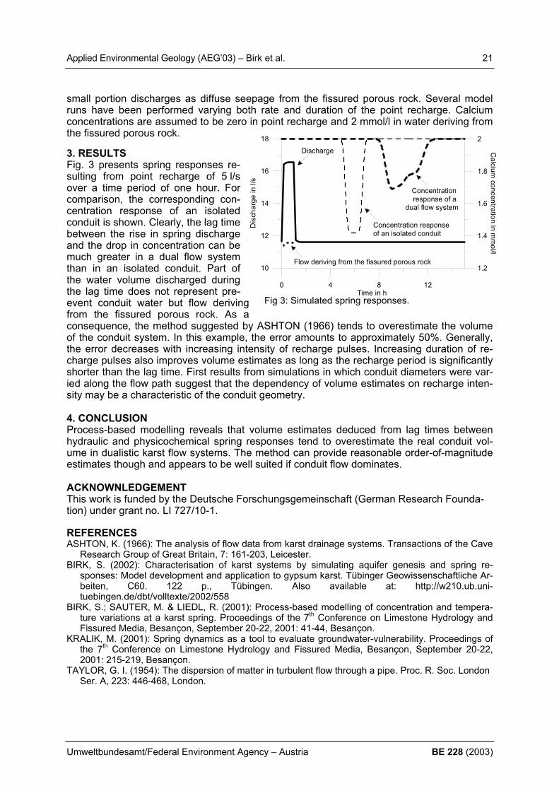
Germany, e-mail: [email protected] 1. INTRODUCTION The vulnerability of karst aquifers is a consequence of the presence of solution conduits that provide highly permeable pathways for the spreading of pollutants. Karst springs that are supplied by conduit systems respond rapidly to recharge events. Measuring the variability of hydraulic or physicochemical parameters at karst springs, thus, has been proposed as a method supporting the vulnerability assessment in karst terrains (KRALIK, 2001). While the mere existence of pronounced spring responses implies that flow is rapidly trans-mitted through a well-developed conduit system, closer analysis may reveal further details on the properties of the conduit system. Due to the almost instantaneous transmission of pres-sure pulses, the spring discharge responds more quickly than physicochemical parameters such as the solute concentration (Fig. 1). The lag time be-tween the rise in spring discharge and the subsequent drop in solute concentration represents the time needed to pass the infiltrated water through the conduit system. Thus, Ashton (1966) suggested that the water volume dis-charged during this lag time provides an estimate for the volume of phreatic karst conduits. In addition to the high-permeability conduit system, a more realistic aquifer model accounts for the less permeable fissured porous rock that provides the majority of aquifer storage. This paper intends to investigate how a phreatic flow component deriving from the fissured porous rock affects spring responses and vol-ume estimates deduced from them. 2. METHOD The dualistic flow system of karst aquifers, comprising rapid, often turbulent flow through conduits and laminar flow similar to Darcy flow within the fissured porous rock is represented by a coupled continuum-pipe flow model that includes a reactive transport module simulating the dissolution of rock and advection of solutes in the pipe network (BIRK ET AL. 2001; BIRK 2002). For the purpose of this study, the model has been upgraded to account for Taylor dis-persion (TAYLOR, 1954) in turbulent flow through pipes. This process-based modelling tool is applied to simulate the response of a karst spring draining a conduit (length: 1200 m; diameter: 0.5 m) embedded in fissured porous limestone (hydraulic conductivity: 10-5 m/s; effective porosity: 0.01). A fixed head (1 m) is prescribed at the left hand side of the model domain (1750 m by 750 m), and uniformly dis-tributed recharge (10-8 m/s, i.e. 316 mm per year) is supplied to the fissured porous rock. Fig. 2 shows the resulting steady-state flow field prior to the injection of point recharge. The conduit focuses the majority of flow to a single point, i.e. the karst spring, whereas only a
Fig 1: Karst spring response to a storm event.
Fig 2: Steady-state flow field (dashed lines:hydraulic heads in m) in the model domain.
Fixe
d H
ead
Boun
dary
Karst SpringConduit
Point Recharge
Discharge
Concentration
Time
Volume discharged during lag time
Applied Environmental Geology (AEG’03) – Birk et al. 21
Umweltbundesamt/Federal Environment Agency – Austria BE 228 (2003)
small portion discharges as diffuse seepage from the fissured porous rock. Several model runs have been performed varying both rate and duration of the point recharge. Calcium concentrations are assumed to be zero in point recharge and 2 mmol/l in water deriving from the fissured porous rock. 3. RESULTS Fig. 3 presents spring responses re-sulting from point recharge of 5 l/s over a time period of one hour. For comparison, the corresponding con-centration response of an isolated conduit is shown. Clearly, the lag time between the rise in spring discharge and the drop in concentration can be much greater in a dual flow system than in an isolated conduit. Part of the water volume discharged during the lag time does not represent pre-event conduit water but flow deriving from the fissured porous rock. As a consequence, the method suggested by ASHTON (1966) tends to overestimate the volume of the conduit system. In this example, the error amounts to approximately 50%. Generally, the error decreases with increasing intensity of recharge pulses. Increasing duration of re-charge pulses also improves volume estimates as long as the recharge period is significantly shorter than the lag time. First results from simulations in which conduit diameters were var-ied along the flow path suggest that the dependency of volume estimates on recharge inten-sity may be a characteristic of the conduit geometry. 4. CONCLUSION Process-based modelling reveals that volume estimates deduced from lag times between hydraulic and physicochemical spring responses tend to overestimate the real conduit vol-ume in dualistic karst flow systems. The method can provide reasonable order-of-magnitude estimates though and appears to be well suited if conduit flow dominates. ACKNOWNLEDGEMENT This work is funded by the Deutsche Forschungsgemeinschaft (German Research Founda-tion) under grant no. LI 727/10-1. REFERENCES ASHTON, K. (1966): The analysis of flow data from karst drainage systems. Transactions of the Cave
Research Group of Great Britain, 7: 161-203, Leicester. BIRK, S. (2002): Characterisation of karst systems by simulating aquifer genesis and spring re-
sponses: Model development and application to gypsum karst. Tübinger Geowissenschaftliche Ar-beiten, C60. 122 p., Tübingen. Also available at: http://w210.ub.uni-tuebingen.de/dbt/volltexte/2002/558
BIRK, S.; SAUTER, M. & LIEDL, R. (2001): Process-based modelling of concentration and tempera-ture variations at a karst spring. Proceedings of the 7th Conference on Limestone Hydrology and Fissured Media, Besançon, September 20-22, 2001: 41-44, Besançon.
KRALIK, M. (2001): Spring dynamics as a tool to evaluate groundwater-vulnerability. Proceedings of the 7th Conference on Limestone Hydrology and Fissured Media, Besançon, September 20-22, 2001: 215-219, Besançon.
TAYLOR, G. I. (1954): The dispersion of matter in turbulent flow through a pipe. Proc. R. Soc. London Ser. A, 223: 446-468, London.
Fig 3: Simulated spring responses.
0 4 8 12Time in h
1.2
1.4
1.6
1.8
2
Calcium
concentration inm
mol/l
10
12
14
16
18
Dis
char
ge in
l/s
Discharge
Flow deriving from the fissured porous rock
Concentration response of an isolated conduit
Concentration response of a
dual flow system
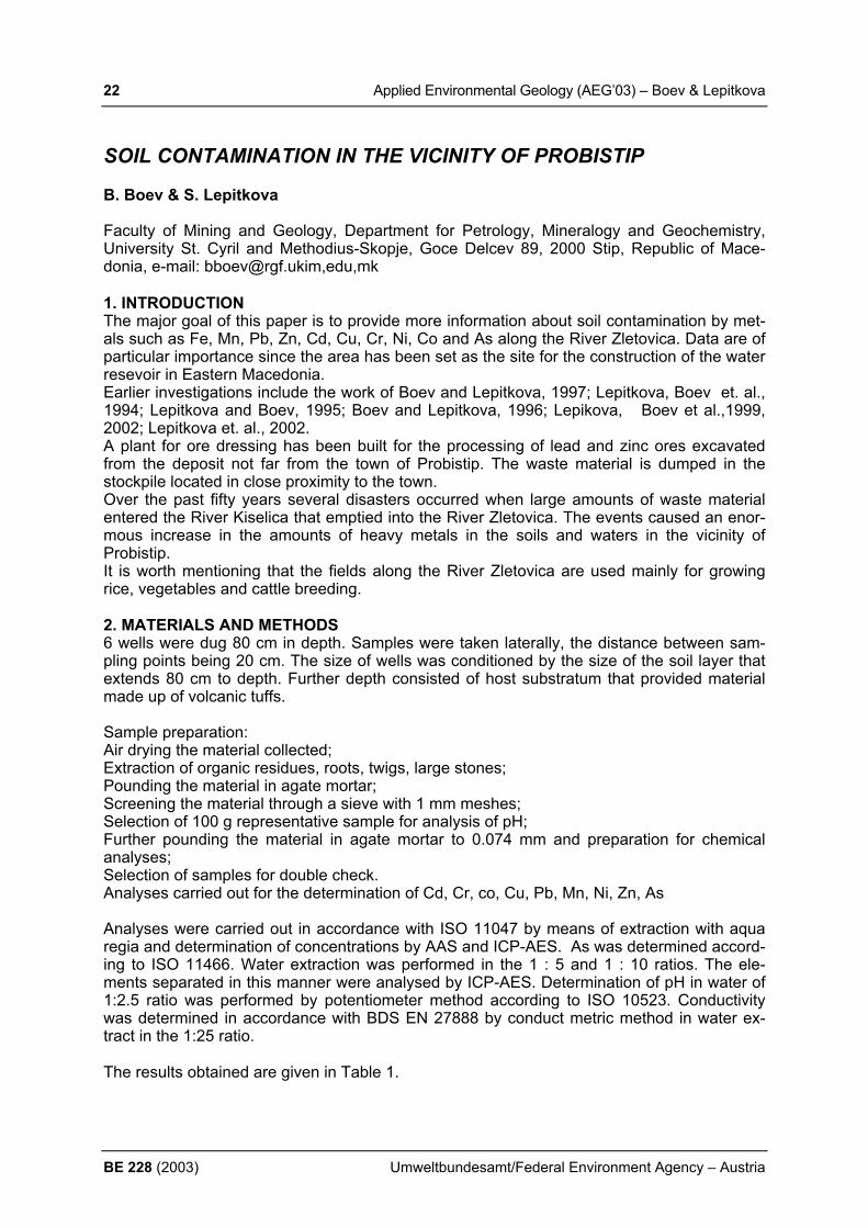
22 Applied Environmental Geology (AEG’03) – Boev & Lepitkova
BE 228 (2003) Umweltbundesamt/Federal Environment Agency – Austria
SOIL CONTAMINATION IN THE VICINITY OF PROBISTIP B. Boev & S. Lepitkova Faculty of Mining and Geology, Department for Petrology, Mineralogy and Geochemistry, University St. Cyril and Methodius-Skopje, Goce Delcev 89, 2000 Stip, Republic of Mace-donia, e-mail: [email protected],edu,mk 1. INTRODUCTION The major goal of this paper is to provide more information about soil contamination by met-als such as Fe, Mn, Pb, Zn, Cd, Cu, Cr, Ni, Co and As along the River Zletovica. Data are of particular importance since the area has been set as the site for the construction of the water resevoir in Eastern Macedonia. Earlier investigations include the work of Boev and Lepitkova, 1997; Lepitkova, Boev et. al., 1994; Lepitkova and Boev, 1995; Boev and Lepitkova, 1996; Lepikova, Boev et al.,1999, 2002; Lepitkova et. al., 2002. A plant for ore dressing has been built for the processing of lead and zinc ores excavated from the deposit not far from the town of Probistip. The waste material is dumped in the stockpile located in close proximity to the town. Over the past fifty years several disasters occurred when large amounts of waste material entered the River Kiselica that emptied into the River Zletovica. The events caused an enor-mous increase in the amounts of heavy metals in the soils and waters in the vicinity of Probistip. It is worth mentioning that the fields along the River Zletovica are used mainly for growing rice, vegetables and cattle breeding. 2. MATERIALS AND METHODS 6 wells were dug 80 cm in depth. Samples were taken laterally, the distance between sam-pling points being 20 cm. The size of wells was conditioned by the size of the soil layer that extends 80 cm to depth. Further depth consisted of host substratum that provided material made up of volcanic tuffs. Sample preparation: Air drying the material collected; Extraction of organic residues, roots, twigs, large stones; Pounding the material in agate mortar; Screening the material through a sieve with 1 mm meshes; Selection of 100 g representative sample for analysis of pH; Further pounding the material in agate mortar to 0.074 mm and preparation for chemical analyses; Selection of samples for double check. Analyses carried out for the determination of Cd, Cr, co, Cu, Pb, Mn, Ni, Zn, As Analyses were carried out in accordance with ISO 11047 by means of extraction with aqua regia and determination of concentrations by AAS and ICP-AES. As was determined accord-ing to ISO 11466. Water extraction was performed in the 1 : 5 and 1 : 10 ratios. The ele-ments separated in this manner were analysed by ICP-AES. Determination of pH in water of 1:2.5 ratio was performed by potentiometer method according to ISO 10523. Conductivity was determined in accordance with BDS EN 27888 by conduct metric method in water ex-tract in the 1:25 ratio. The results obtained are given in Table 1.
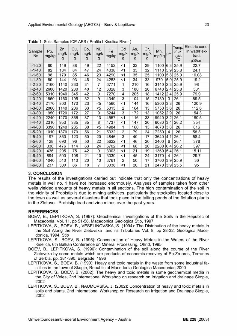
Applied Environmental Geology (AEG’03) – Boev & Lepitkova 23
Umweltbundesamt/Federal Environment Agency – Austria BE 228 (2003)
Table 1: Soils Samples ICP-AES ( Profile I-Kiselica River )
Sample №
Pb, mg/kg
Zn, mg/k
g
Cu, mg/k
g
Co, mg/k
g
Ni, mg/k
g Fe
mg/kgCd
mg/kg
As, mg/k
g
Cr, mg/k
g Mn,
mg/kg рН Temp. of ex-tract OC
Electric cond. in water ex-
tract µS/cm
І-1-20 80 149 88 49 22 4152 <1 32 29 1100 6.3 25.9 22.7І-1-40 82 184 84 47 24 4038 <1 33 32 1110 5.9 25.8 24.1І-1-60 98 170 85 46 23 4290 <1 35 25 1100 5.8 25.9 16.08І-1-80 80 144 93 46 24 4253 <1 34 33 970 5.9 25.9 19.2І-2-20 2160 1140 230 31 7 6771 1 210 16 3140 2.3 25.9 98І-2-40 2600 1420 230 40 12 6328 3 180 20 6740 2.4 25.8 531І-2-60 5310 1940 345 42 9 7270 4 205 18 1412 2.4 25.9 79.9І-3-20 1860 1160 195 32 9 4349 3 104 15 7180 3 26.1 89.5І-3-40 2170 800 170 23 <5 4560 <1 144 16 5300 3.3 26 120.9І-3-60 2060 1140 206 33 <5 5315 2 164 13 5750 3.6 26 112.6І-3-80 1950 1720 172 27 9 5244 3 172 13 1052 2.9 26 154.3І-4-20 2240 1270 366 37 13 4557 <1 116 33 9940 3.2 26.1 180.5І-4-40 2310 953 335 35 8 4737 <1 147 20 6080 3.4 26.2 354І-4-60 3390 1240 235 30 <5 4984 1 160 13 4670 3.8 26 816І-5-20 1010 1370 170 56 21 5332 2 79 24 7250 4 26 58.3І-5-40 197 850 123 50 20 4846 3 40 17 3640 4.1 26.1 58.4І-5-60 128 690 96 50 22 5622 <1 46 20 2400 6 26.1 378І-5-80 336 476 114 63 24 6702 <1 68 20 2280 6.4 26.2 397І-6-20 436 205 75 42 9 3003 <1 21 19 1360 5.4 26.1 15.11І-6-40 894 500 108 21 10 3330 <1 45 24 3170 4 26.1 29.7І-6-60 1040 510 110 20 10 3761 2 50 17 3700 3.9 25.9 36І-6-80 237 300 86 18 7 3338 <1 20 21 2470 3.9 25.5 95
3. CONCLUSION The results of the investigations carried out indicate that only the concentrations of heavy metals in well no. 1 have not increased enormously. Analyses of samples taken from other wells yielded amounts of heavy metals in all sections. The high contamination of the soil in the vicinity of Probistip is due to mining activities, particularly the stockpiles located close to the town as well as several disasters that took place in the tailing ponds of the flotation plants in the Zletovo - Probistip lead and zinc mines over the past years. REFERENCES BOEV, B., LEPITKOVA, S. (1997): Geochemical Investigations of the Soils in the Republic of
Macedonia, Vol, 11, pp 51-56, Macedonica Geologica Stip, 1997 LEPITKOVA, S., BOEV, B., VESELINOVSKA, S. (1994): The Distribution of the heavy metals in
the Soil Along the River Zletovska and its Tributaries Vol. 8, pp 28-32, Geologica Mace-donica, 1994, Stip
LEPITKOVA, S., BOEV, B. (1995): Concentration of Heavy Metals in the Waters of the River Kiselica, 6th Balkan Conference on Mineral Processing, Ohrid, 1995
BOEV, B., LEPITKOVA, S. (1996): Contamination of the soil along the course of the River Zletovska by some metals which are products of economic recovery of Pb-Zn ores, Terranes of Serbia, pp. 381-390, Belgrade, 1996
LEPITKOVA, S., BOEV, B. (1999): Heavy and toxic metals in the waste from some industrial fa-cilities in the town of Skopje, Republic of Macedonia Geologica Macedoniac,2000
LEPITKOVA, S., BOEV, B. (2002): The heavy and toxic metals in some geochemical media in the City of Veles, 2nd International Workshop on research on irrigation and drainage Skopje, 2002
LEPITKOVA, S., BOEV, B., NAUMOVSKA, J. (2002): Concentration of heavy and toxic metals in soils and plants, 2nd International Workshop on Research on Irrigation and Drainage Skopje, 2002

24 Applied Environmental Geology (AEG’03) – Borsato et al.
BE 228 (2003) Umweltbundesamt/Federal Environment Agency – Austria
STABLE ISOTOPE MONITORING OF ALPINE KARSTIC SPRINGS IN THE TRENTINO PROVINCE (NE-ITALY) A. Borsato1), S. Frisia1), A. Longinelli2) & E. Selmo2)
1) Museo Tridentino di Scienze Naturali, via Calepina 14, 38100 Trento, Italy, borsa-
[email protected] 2) Dipartimento di Scienze della Terra, Università di Parma, Parco Area delle Scienze 157/a,
43100 Parma, Italy. 1. INTRODUCTION Stable isotopes are commonly used in hydrology studies to reconstruct the mean altitude of the catchment area. However, the complex topography of the Alpine region, which influences both precipitation amount and trajectories, does not allow to derive a simple δ18O – altitude relationship, as the case studies presented here demonstrate. 2. SETTING, MATERIAL AND METHODS Five Alpine carbonate aquifers in the Trento Province (NE-Italy) were continuously monitored over a 2-year-long program for discharge, electrical conductivity (EC) and temperature; in addiction monthly phisico-chemical, bacteriological and stable isotope (δ18O e δD) analyses were also carried out. We choose two different areas: the Paganella massif a highly karstified limestone aquifer ranging from 200 to 2125 m slm, and the Grosté massif, a high-mountain (1300 to 3163 m slm) fissured and karstic aquifer which developed in dolomite and, subordinately, in lime-stones. The monitored springs are: Trementina (393 m slm; mean discharge 456±66 ls-1) and Prese Val (1085 m slm; mean discharge 35 ±76 ls-1) in the Paganella area; Centonia (1380 m slm; mean discharge 649±621 ls-1), Palù (1510 m, slm; mean discharge: 46±6 ls-1) and Vallesinella (1565 m slm; mean discharge 399±702 ls-1) in the Grostè area (BORSATO, 2001). The spring water analyses were coupled with the isotope analyses of mean monthly meteoric water samples collected at four stations: Andalo (1005 m slm) and Cima Paganella (2125 m slm) in the Paganella area; Campo Carlo Magno (1693 m slm) and Rifugio Graffer (2263 m slm) in the Grosté area (LONGINELLI & SELMO, 2003). 3. RESULTS The seasonal δ18O trend (Fig. 1) illustrates the different behaviour of the different springs: Centonia and Vallesinella springs show very stable winter values from November to March, moderate negative fluctuations (–1.0 ‰) during the snowmelt period (April to June) and slightly positive increases (+1.5 ‰) during Summer and Autumn. The more dynamic Tre-mentina and Prese Val springs show a similar trend, but with higher positive oscillations (up to +3.0 ‰) from July to September, reflecting the rapid turnover and the shorter residence time of the water. Only the Palù spring, which is fed by a mixed porous and fissured aquifer, display exceptionally stable δ18O values of –11.59±0.04 ‰. These results confirm the infor-mation obtained from the continuous monitoring (temperature and EC), the standard devia-tion of the δ18O analyses being directly correlated to the temperature and EC standard devia-tion. The Water Line (WL) calculated from all the spring values is δD = 7.93 δ18O+11.50, which is similar to the Meteoric WL derived from the meteoric stations, and to the MWL calculated for Northern Italy (LONGINELLI & SELMO, 2003). However, if we consider the WL calculated for each spring, we observe that the deuterium excess varies from +10 to +24‰ as we move from the lower to the highest altitude aquifers, and reflect the same deuterium excess shift recorded by meteoric waters.

Applied Environmental Geology (AEG’03) – Borsato et al. 25
Umweltbundesamt/Federal Environment Agency – Austria BE 228 (2003)
-13
-12
-11
-10
-9
-8
-7
nov-
97di
c-97
gen-
98fe
b-98
mar
-98
apr-9
8m
ag-9
8gi
u-98
lug-
98ag
o-98
set-9
8ot
t-98
nov-
98di
c-98
gen-
99fe
b-99
mar
-99
apr-9
9m
ag-9
9gi
u-99
lug-
99ag
o-99
set-9
9ot
t-99
δ18O
‰ (V
-SM
OW
)
Trementina PalùCentonia VallesinellaPrese Val
Fig. 1. Montly δ18O values of the five monitored springs
The seasonal monitoring of some small local springs allow the reconstruction of the δ18O ver-tical gradient for both areas: –0.31‰/100m for Grostè and only –0.08‰/100m for the Pagan-ella area. These gradients are similar to those calculated from the meteoric waters, although spring water values seem to be depleted of about 1.0‰ with respect to the meteoric waters. The very low δ18O vertical gradient for the Paganella area is probably related to the "shadow effect" exerted by the high eastern cliff of the mountain over the whole western slope. Be-cause of this, calculation of the catchment mean elevation from stable isotope data yields large uncertainties. On the contrary, the same calculation for the Grostè area yields precise results, although the large fluctuation between one year and another suggests that only a long term monitoring program can provide reliable results. 4. CONCLUSION The stable isotope monitoring of the karst springs is a useful tool for reconstructing spring dynamics and mean residence time of the water in an aquifer. In the Alpine region, however, the use of δ18O values to calculate the mean altitude of the spring catchments, needs accu-rate long-term monitoring of the meteoric signal, and the reconstruction of local storm tracks. REFERENCES BORSATO, A. (2001): Characterisation of a high-altitude alpine karst aquifer by means of
temperature, conductivity and discharge monitoring (Centonia spring, Brenta Dolomites, N-Italy). In: J.MUDRY & F.ZWAHLEN (ed.): Proceedings of 7th Conference on Limestone Hydrology and Fissured Media 20th – 22nd September 2001 - Besançon (France), 51-54.
LONGINELLI, A., & SELMO E., (2003): Isotopic composition of precipitation in Italy: a first overall map. Journal of Hydrology, 270 (2003): 75-88.

26 Applied Environmental Geology (AEG’03) – Brauner et al.
BE 228 (2003) Umweltbundesamt/Federal Environment Agency – Austria
ROCKFOR – INVESTIGATIONS ON SHELTER EFFICIENCY OF MOUNTAIN FORESTS AGAINST ROCKFALL PROCESSES M. Brauner1), P. Agner2) & J. Hübl1) 1) Institute of Forest and Mountain Risk Engineering, University of Natural Resources and
Applied Life Sciences, A-1190 Wien, Peter Jordan Straße 83; [email protected]; [email protected]
2) GeoExpert Research and Planning GmbH, A-1190 Wien, Döblinger Hauptstraße 42; [email protected]
1. INTRODUCTION In the intensely inhabited Alpine regions hazardous processes, and among them especially rockfalls, are becoming an important issue as they constitute an eminent thread to vulnerable settlement area and infrastructure. It is widely accepted that mountain forests have high ability to mitigate geogene hazards to a great extent. Therefore in most countries forests are declared to shelter forests when objects or the forest itself are endangered by hazardous hillslope processes. For such forests tend-ing measures are rather time consuming and expensive, therefore only minimal tending measures or rather punctual technical mitigation measures are implemented, which may be controversial to nature conservation. 2. METHODS To give decision support on this sensible topic a joint research EU-project ROCKFOR was initiated, investigating three main topics:
Study of rockfall processes on vegetated hillslopes Study on resistance and stability of rockfall shelter forests Adaptation of rockfall simulation techniques for technical mitigation design
3. RESULTS To meet these aims a forest ecosystem assessment tool has been developed, which enables geospatial inventory of ecologic, geologic and morphologic parameters. A national forest growth model has been adapted to shelter forest’s growth characteristics enabling a dynamic assessment in time domain. From monitored stand data it can be shown that age-dependent vertical and horizontal stand structure can influence boulder/tree contact probability and boulder mobilisation probability. Therefore a boulder/tree collision model and a bio-mechanic contact dissipation model has been developed, which estimates the rockfall boulder’s run-out length and energy consump-tion along its trajectory. Further on simulation parameters have been adapted based on past event analysis on monitored rockfalls. They have been cross-checked with 1:1 field tests. 4. CONCLUSIONS Based on the combination of forest stand growth modelling, stand resistance modelling and adapted rockfall simulation, the actual and future influence of forests on rockfall initiation and rockfall run-out can be calculated and the forest’s shelter functionality and tending urgency can be estimated and opposed to technical mitigation alternatives. With these tools decision support on mitigation alternatives on rockfall prone areas can be given. REFERENCES BERGER, F., COROMINAS, J., LOPEZ-CARRERAS, C., BRAUNER, M., KIENHOLZ, H.,
GRASSL, H. (2002): ROCKFOR, Rockfall - Forest Interrelation, Efficiency of the Protec-tive Function of Mountain Forest against Rockfall. Second Annual Report - Year 2001, (CD); financed by the European Commission (Quality of Life and Management of Living Ressources, FP5)

Applied Environmental Geology (AEG’03) – Brauner et al. 27
Umweltbundesamt/Federal Environment Agency – Austria BE 228 (2003)
BERGER, F., COROMINAS, J., LOPEZ-CARRERAS, C., BRAUNER, M., KIENHOLZ, H., GRASSL, H. (2001): ROCKFOR, Rockfall - Forest Interrelation, Efficiency of the Protec-tive Function of Mountain Forest against Rockfall. First Annual Report - Year 2001, (CD); financed by the European Commission (Quality of Life and Management of Living Res-sources, FP5)
BRAUNER, M., FIEGER, S., SCHWARZ, P., HÜBL, H. (2002): ROCKFOR - Investigations on the Interrelationship between Rockfall Processes and Forest Stands. In: IUFRO (Ed.), IUFRO Workshop on Rockfall Control Engineering, 17 - 21 June 2002, Galtuer, Austria, 11, Salzburg.

28 Applied Environmental Geology (AEG’03) – Buxbaum & Kralik
BE 228 (2003) Umweltbundesamt/Federal Environment Agency – Austria
PARTICULATE TRANSPORT AND DEPOSITION IN A REMOTE PREALPINE AREA I.Buxbaum1,2) & M.Kralik1)
1) Umweltbundesamt Austria (Federal Environment Agency Austria) and University of Vi-
enna, Austria, [email protected], 2) NUA – Niederösterreichische Umweltschutzanstalt GmbH, Ma. Enzersdorf, Austria, i-
[email protected] 1. INTRODUCTION Dust and aerosols have been mainly monitored in urban areas. Also speculations about their sources has mostly been on the basis of chemical information only. Very little is known about their mineral and organic phases. In order to interpret the concentration and composition of long range transport of particles in unpolluted areas, the combined information of chemistry and mineralogy is essential. In the Reichraminger Hintergebirge (Northern Calcareous Alps, Upper Austria) the first Aus-trian Integrated Monitoring site ‘Zöbelboden’ on air pollution effects on ecosystems was es-tablished by the Austrian Federal Environment Agency. On Integrated Monitoring the input on long range transboundary air pollutants is monitored and the long term influence on the ecosystem is recorded. The deposition is recorded at an open space on top of a forested dolomite karst plateau in the front range of the Austrian Northern Calcareous Alps (Reichraminger Hintergebirge) 50 km South of Linz at an altitude of about 900m. The annual rainfall ranges from 1500 to 1800 mm. The coldest monthly temperature (900m) is -0.9°C (January), the highest is 15.5°C (August). The very variable snowfall occurs between November and May with an average duration of snow cover of about 4 months. 2. MATERIALS AND METHODS Sampling of the particulate deposition was done weekly over a seven months period (1997) on the Zöbelboden plateau. Airborne dust samples (< 10 µm) have been collected twice on polycarbonate filters in a low volume sampler (Gent). The deposition samples have been centrifuged and screened in two fraction >20 and < 20 µm in order to make them more or less comparable to the PM10 filter samples. Mineralogical composition of the fine fraction (<20 µm) was analysed by x-ray diffraction and SEM. The chemical composition was obtained by analysis with total-reflection x-ray fluores-cence. The content of organic matter was determined by loss of ignition (360° C). 3. RESULTS AND DISCUSSION The average particulate bulk deposition is 24 mg/m2d and does not exceed 100 mg/m2d. The PM10 concentrations are in the range of 8-9 µg/m3 - typical for a clean air area like Zöbel-boden. The dust samples consist of about 60% organic matter. The main mineral phases in the dust are carbonates (calcite and dolomite), gypsum and quartz. Illite-mica, chlorite, kao-linite and feldspar are only present in small quantities. In the airborne dust samples slag glasses which are formed by industrial combustion processes were identified by SEM. The main elements Si, Al, Fe, Mn, Ca and K are not enriched compared to their earth crust con-tents. The contents of S and heavy metals (As, Cd, Cr, Cu, Ni, Pb, Sn, Zn) are relatively en-riched by anthropogenic activities. At a mean rain water pH of 5.0 10-40% of the total heavy metal load deposited are still attached at few milligrams of fine particulates described above. Aluminium and iron are deposited to 80% in particulates.

Applied Environmental Geology (AEG’03) – Buxbaum & Kralik 29
Umweltbundesamt/Federal Environment Agency – Austria BE 228 (2003)
particulate versus dissolved transport
Fig. 1 Particulate (0.45 µm) versus dissolved deposition at the Austrian Integrated Monitor-
ing area (Zöbelboden). 4. CONCLUSIONS • The main mineral phases (carbonate, quartz) are derived from natural sources. • Slag glasses and the growth of gypsum on filters indicate a long range transport of fine
dust particles and pollutants from industrialised or urban areas to the monitoring site. • At least 10-40% of heavy metals are transported into the monitoring area as particulate
matter, for aluminium and iron more than 80%. REFERENCES BUXBAUM, I. (1999): Umweltgeologische Bewertung der Staubdeposition am Integrated
Monitoring Standort „Zöbelboden“ (Reichraming, OÖ). [Environmental evaluation of the dust deposition at the Integrated Monitoring site Zöbelboden]. Unpubl. M.Sc.-thesis, 105 p., Univ. Vienna, Vienna.
MIRTL M. (1996) Kurzbeschreibung des Integrated Monitoring in Österreich 1995/96. – Um-weltbundesamt, Integrated Monitoring Serie: IM - Rep - 001, 18 p., Umweltbundesamt, Vienna.

30 Applied Environmental Geology (AEG’03) – Caputo et al.
BE 228 (2003) Umweltbundesamt/Federal Environment Agency – Austria
DEGRADATION OF GROUNDWATER RESOURCES IN THE MEDITERRANEAN BASIN: CLIMATIC CHANGES OR HUMAN ACTIVITIES? D. R. Caputo1), G. D’Ecclesiis2) & F. Sdao3)
1) University of Ferrara, Dipartimento di Scienze della Terra, Corso Ercole I d'Este, 32,
44100-Ferrara, Italy ([email protected]) 2) TERRAE Studi di Geologia Applicata, Potenza, Italy
3) DiSGG, University of Basilicata, Potenza, Italy
In the Mediterranean basin, the existence of wide carbonate aquifers favour the underground storing of huge amounts of water resources. The social and economic development of the last century caused the increase of productive activities (urban, farming, industrial, etc.), re-quiring always larger quantities of water and wasting in the ground and the underground in-creasing amounts of several kinds of polluting substances As a direct and indirect conse-quence, the quality and quantity of the natural water reservoirs suffered a general degrada-tion. In some case, this irresponsible use of the aquifers has often exceeded their capacity to re-generate themselves, thus causing the progressive lost of the available quantity of the groundwaters with strong consequences for the natural ecosystems. During the last years, the climatic changes occurring at the global scale and particularly within the Mediterranean region, are responsible for the decrease of the main annual precipi-tations and their distribution within the hydrological year. Also, a general increase as a whole of the temperatures further contributed to quantitatively waning the groundwater resources. It is obvious that the combined causes, both climatic and the human, have strongly contrib-uted to the hydrodynamic equilibria of the groundwater resources, with the consequent strong lowering of the piezometric level of the aquifer systems. In this frame, to separately evaluate the impact of the climatic changes and the human activity on the hydrogeological equilibrium and the mechanisms generating the progressive degradation of water resources, geological, hydrological and hydrogeological data of two areas characterised by carbonate aquifer systems have been analysed. The first example is from the Eastern Thessaly plain (Central Greece), while the second case is from the Volturino Mount in the Basilicata region (Southern Italy). In particular, we analysed, firstly, the time series of historical data relative to distributions of the monthly values of the temperature of the air, the precipitations and the discharge for total 17 karstic springs relative to 30 years observations (1973-2003) and, secondly, the geologi-cal and stratigraphyc data. The statistical elaboration of all these data allowed us to deter-mine the principal hydrodynamic parameters of the karstic system and to define the different hydrodynamic behaviour of each system in different alimentation conditions. This behaviour is strongly influenced by i) the local geological contest, ii) the areal extension of the karst sys-tems, iii) the degree of the karstification and the presence of fault zones, iv) the intensity of exploitation (viz. well density) of the water resources downstream of the spring. Moreover, the relationships between the recharge of the spring versus the precipitation al-lowed us to infer the following. Firstly, the decrease amount of precipitations of the last year is reflected in the karsting spring discharge of the Eastern Thessaly basin. In particular, the discharge of Mati Tyrnavou spring presents significant variations from 3000 l/sec, during 1973, to 0 l/sec, in September 1989, rising back to 4000 l/sec during the spring 2003 (period of high precipitations). Secondly, in the case of the Yperia Krini spring, well known from Hellenistic times, since 1989 the source suffered a significant loss in water discharge which was abated from 200 l/sec to only 30 l/sec, during the Summer 1994, and down to 0 l/sec from May 2000 to pre-sent (Fig. 1). In this example, the observed reduction of the rainfall does not justify such a
Applied Environmental Geology (AEG’03) – Caputo et al. 31
Umweltbundesamt/Federal Environment Agency – Austria BE 228 (2003)
large-size decrease of the water discharge which is clearly attributed to the recent drilling of numerous bore-holes for water-supply. In fact, important volumes of water are directly pumped from the aquifer, therefore exceeding the capacity of the reservoir to recover. Thirdly, in the Basilicata karstic spring, since 1983 we observed a drastic decrease of the discharge with minimum values in 1987 (Fig. 2). In general, the flow variations of the spring corresponds to the precipitation variations, but it also clearly depends on the human activi-ties.
Figure 1: Yperia Krini spring: variations of the main annual discharge (l/sec) and annual pre-cipitations (mm) relative to Sotirio climatic station.
Figure 2: Volturino Mount aquifer system: Variations of the main monthly discharge of the springs (l/sec) and the precipitations (mm) relative to period 1983-1991
10
100
1000
1973
1974
1975
1976
1977
1978
1979
1980
1981
1982
1983
1984
1985
1986
1987
1988
1989
1990
1991
1992
1993
1994
1995
P(m
m),
Q(li
t/sec
)
mean annual discharge, Q(lit/sec) annual precipitation, P(mm)

32 Applied Environmental Geology (AEG’03) – Cara & Dema
BE 228 (2003) Umweltbundesamt/Federal Environment Agency – Austria
HEAVY METALS AS INDICATORS OF POLLUTION AND THEIR IMPACT IN THE ECOSYSTEM OF AN INDUSTRIAL ZONE F. Cara1) & S. Dema2) 1) Geological Survey of Albania, Center of Civil Geology, Section of Environmental Geology, Sami
Frasheri No 31, [email protected]; 2) Geological Survey of Albania, Department of Geophysics, Blloku Vasil Shanto,
[email protected] 1. INTRODUCTION The aim of the study is to determine the presence, origin and mobility of the heavy metal in different environs and their impakt and risk on the human chain. 2. MATERIALS AND METHODS Samples were collected from 270 sample point, devided in the different profile lines in the soils around the metalurgical plant of Laci. In addition, samples were taken also in the other elements of ecosystem like in the stream sediments, water stream sediments, industrial dust, pirit ashes, sludges and plants. The objective was the identification of the pollution, the environmental impact of the metalurgical plant in the human chain soil-water-plant-animal-human being.
Figure 1: Geochemical map (classed post) of Cd in dust samples
The soil samples were taken with handsonde type Shiring in the thickness of 35 cm from soil surface, were dried at 60oC for 72 hours and homogenized in an agate mill. Most of the samples are prepared in the tablets form and are analysed with X-Ray Fluorescence. Between samples some of them are selected and measured by AAS and ICP/AES. The
4391000 4391500 4392000 4392500 43930004613000
4613500
4614000
4614500
4615000
Permbajtjet e Cd ne pluhura 0 deri 0.8 0.8 deri 12 12 deri 20 20 deri 23
0 200 m
43 924615
4614
4613
43 93
xx
*
*
**+
+
*
oo
o
o
ox
Fushe Shullazi
Koder Shullazi
Lamasmani
Lekaj
Kombinati Kimiko-Metalurgjik
Laci 1 kmLegjenda
Hire piriti
Skorje bakri
Hire qymyri
x*+o
Stoqe mineralesh bakri
Stoqe minerali fosfatik
Stoqe superfosfati
Azbest
HARTA E KONTURIMIT TE STOQEVE
Figure 2: Geochemical map (Classed post) of Cd in dust sample
21
1
2
2
2
3
1
2
3
Applied Environmental Geology (AEG’03) – Cara & Dema 33
Umweltbundesamt/Federal Environment Agency – Austria BE 228 (2003)
heavy metal levels were presented in the form of coloured contoured maps, using the coordinates of the sampling points. 3. RESULTS AND CONCLUSION
• Based on the results of the geochemical maps is observed the presence of a large group of the heavy metal as Cu, Zn, Ni, Cr, Zs, Cd, Pb etc.
• Measured content of the heavy metal are very high above the international limits of the risk on the ecosystem.
• The source of the heavy metal is antropogenic for most of them and sometimes geogenic, related with the geological background and the types of soils of the studied zone.
• Derived from the interpretation of the factorial analyses, were distinguished two types of the heavy metal pollution sources: one related with the pyrit ashes and the other with the cupper sludges.
• There are observed correlations bettween the content of heavy metal in soil and the plants (Coefficient transfer analyse).
• The pollution with heavy metal has their impact on the quality and the health of the community.
REFERENCES HOLLANDLISTE (1994): Circulaire Interventiewaarden bodemsanering, Staatscourant 95, 24
mei 1994. MATSCHULLAT, J. & MÜLLER, G. (Hrsg.) (1994): Geowissenschaften und Umwelt. Springer
-Verlag. Berlin Heidelberg, 24-79. METZGER, R. (1986): Anwendung von Pb-Isotopensignaturen als Indikatoren für die
Herkunft und Mobilität von Schwermetallen im ehemaligen Pb-Zn-Bergbaugebiet Stolberg/Rheinland. Dissertation an der RWTH Aachen. Aachener Geowissenschaftliche Beiträge, 5-28
TASHKO, A.(1980): Rezultate te perpunimit te te dhenave hidrogjeokimike me ane te analizes faktoriale. Permbledhje studimesh Nr.4, 51-64
TASHKO, A. (2001): Gjeokimia e mjedisit. Leksione per kurset pasuniversitare te specialitetit gjeologji-mjedisi
TOSKA, F. (1994): Ndotja e atmosferes te zones se banuar nga Kombinati kimiko-metalurgjik i Lagit dhe ndikimet e tij mbi shendetin. Disertacion, 5-120.

34 Applied Environmental Geology (AEG’03) – Chon & Lee
BE 228 (2003) Umweltbundesamt/Federal Environment Agency – Austria
ENVIRONMENTAL CONTAMINATION AND RISK ASSESSMENT OF ARSENIC AND HEAVY METALS AROUND SOME ABANDONED METAL MINE SITES IN KOREA Hyo-Taek Chon & Jin-Soo Lee School of Civil, Urban and Geosystem Engineering, College of Engineering, Seoul National University, Seoul 151-742, Korea, [email protected] 1. INTRODUCTION Mining can be an important source of toxic heavy metals in the environment owing to mining activities such as processing, transportation of ores, disposal of tailings and waste waters around mines (ADRIANO, 1986). These activities often produce acid wastes that can cause severe geochemical changes downstream from these facilities (FILIPEK et al., 1987). In a typical metal mine district, massive sulfide ores in inactive mines and mine tailings are weathering and oxidizing at an accelerated rate due to atmospheric exposure. Thus, ele-vated levels of heavy metals discharged from mine waste materials are to be found in nearby streams, agricultural soils and food crops (DAVIES & BALLINGER, 1990; MERRINGTON & ALLOWAY, 1994). In this study, to investigate the contamination levels of heavy metals and assess the risk of adverse health effects on human exposure to heavy metals influenced by past mining activi-ties, environmental geochemical surveys were undertaken around some abandoned metal mine areas (Dongil Au-Ag-Cu-Pb-Zn, Okdong Cu-Pb-Zn, Songcheon Au-Ag, Dongjung Au-Ag-Pb-Zn, Dokok Au-Ag-Cu-Pb-Zn, and Hwacheon Au-Ag-Pb-Zn mines). 2. MATERIALS AND METHODS Sampling of tailings, soils, crop plants and waters in the vicinity of the Dongil, the Okdong, the Songcheon, the Dongjung, the Dokok and the Hwacheon mines was carried out in 2001 and 2002. Soils were sampled from agricultural land around the mine sites. Rice samples were taken from paddy fields. Stream or ground waters used as a drinking water were col-lected around the tailings in these mine areas. After appropriate sample preparation, these samples were analyzed for As, Cd, Cu, Pb and Zn by ICP-AES and ICP-MS. Risk assess-ment of toxic heavy metals has been performed with chemical analytical data for environ-mental media. 3. RESULTS Arsenic and other heavy metals were highly elevated in tailings from the Dongil (8,720 As mg/kg, 5.9 Cd mg/kg, 3,610 Cu mg/kg, 5,850 Pb mg/kg, 630 Zn mg/kg), the Songcheon (24,080 As mg/kg, 8.2 Cd mg/kg, 130 Cu mg/kg, 3,830 Pb mg/kg, 2,410 Zn mg/kg) and the Dongjung (3,620 As mg/kg, 12.2 Cd mg/kg, 144 Cu mg/kg, 5,140 Pb mg/kg, 3,060 Zn mg/kg) mines. Also high concentrations of heavy metals except As were found in tailings from the Okdong (53.6 Cd mg/kg, 910 Cu mg/kg, 1,590 Pb mg/kg, 5,720 Zn mg/kg), the Dokok (98.2 Cd mg/kg, 2,550 Cu mg/kg, 4,200 Pb mg/kg, 18,020 Zn mg/kg) and the Hwacheon (12.4 Cd mg/kg, 580 Pb mg/kg, 1,300 Zn mg/kg) mines. These significant concentrations can impact on soils and waters around the tailing dumps. Elevated levels of As, Cd, Cu, Pb and Zn were also found in agricultural soils from these mine areas. In particular, As concentration in agricultural soils from the Dongil, the Song-cheon and the Dongjung mines was higher more than the permissible level in soils. This level means the threshold of the element concentrations in soils above that crop produced are considered as unsafe for human health. Cadmium was elevated in agricultural soils from the Okdong and the Dongjung mines, Cu from the Dongil and the Songcheon mines, and Pb from the Songcheon, the Dongjung and the Hwacheon mines. Arsenic, Cd and Zn in stream water used for drinking water in the Songcheon mine area were higher than the permissible

Applied Environmental Geology (AEG’03) – Chon & Lee 35
Umweltbundesamt/Federal Environment Agency – Austria BE 228 (2003)
levels (0.05 As mg/L, 0.01 Cd mg/L and 1.0 Zn mg/L) in Korea. In the Dongil mine, As in groundwater used for drinking water exceeded the permissible level (0.01 mg/L) suggested by WHO. Risk assessment is the process of characterizing the adverse health effects of hu-man exposure to environmental hazards. Risk compounds deriving from mine sites either constitute a toxic risk or a carcinogenic risk. Toxic risks are indicated in terms of a hazard quotient (H.Q.). H.Q. is ADD (average daily dose)/RfD (reference dose). A toxic risk exists for H.Q.>1. To calculate the hazard index (H.I.) the ADD from three identified pathways (soil, groundwater and food (rice grain) pathways) compared to the relevant RfD obtained from the US-EPA database IRIS is summed. The hazard index of As in the Dongil, the Okdong, the Songcheon and the Hwacheon mine areas was higher value more than 1.0. In the Okdong and the Songcheon mine areas, H.I. value of Cd exceeded 1.0 (Table 1). The carcinogenic risk for As in stream or ground water used for drinking water from the Songcheon, the Dongil, the Dongjung and the Hwacheon mine areas was 3E-3, 5E-4, 2E-4 and 1E-4, respectively.
Table 1: Hazard indices of As, Cd and Zn for toxic (non-cancer) risk. Mine As Cd Zn
Dongil mine 2.5 0.9 0.4
Okdong mine 1.8 2.2 0.2
Songcheon mine 7.1 4.4 0.2
Dongjung mine 0.4 0.1 0.0
Dokok mine 0.1 0.0 0.0
Hwacheon mine 2.5 0.5 0.3 4. CONCLUSION Elevated levels of As, Cd, Cu, Pb and Zn were found in tailings from the Dongil, the Song-cheon and the Dongjung mines. Heavy metals except arsenic from the Okdong, the Dokok and the Hwacheon mines were also elevated. These significant concentrations can impact on soils and waters around the tailings by surface erosion, rain and wind action and rede-position. From the results of the risk assessment, the hazard index (H.I.) values of As and Cd were the highest in the Songcheon mine area. Therefore, toxic risks for As and Cd exist via expo-sure (ingestion) of contaminated soil, water and rice grain in this mine site. By the result of As analysis for contaminated water consumption, the carcinogenic risks exceed the range (1 by 100,000 to 1,000,000) required for remedial actions in the Songcheon, the Dongil, the Dongjung and the Hwacheon mine sites. Thus, a significant human health risk is present from the consumption of locally ground or stream water in these mine sites. REFERENCES ADRIANO, D.C. (1986): Trace Elements in the Terrestrial Environment. 533p., Springer-
Verlag, New York. FILIPEK, L. H.; NORDSTROM, D. K. & FICKLIN, W. H. (1987): Interaction of acid mine
drainage with waters and sediments of west Squaw creek in the west Shasta mining dis-trict, California. Environ. Sci. Technol., 21: 388-396.
DAVIES, B. D. & BALLINGER, R. C. (1990) : Heavy metals in soils in north Somerset, Eng-land, with special reference to contamination from base metal mining in the Mendips. En-viron. Geochem. Health, 12: 291-300.
MERRINGTON, G. & ALLOWAY, B. J. (1994): The transfer and fate of Cd, Cu, Pb and Zn from two historic metalliferous mine sites in the U.K. Applied Geochem., 9: 677-687.

36 Applied Environmental Geology (AEG’03) – Clemens
BE 228 (2003) Umweltbundesamt/Federal Environment Agency – Austria
CO2 SEQUESTRATION IN OIL AND GAS FIELDS AND CO2 ENHANCED GAS RECOVERY FOR AN EXAMPLE GAS RESERVOIR IN THE NETHERLANDS T. Clemens Rohöl Aufsuchungs AG, Schwarzenbergplatz 16, A-1015 Wien, Austria, [email protected] 1. INTRODUCTION In the wake of the Kyoto protocol, CO2 emissions reduction to control the level of CO2 in the atmosphere has become an important goal. Due to the lack of suitable alternatives for large-scale energy generation in the short- and medium-term, solutions for reducing CO2 emis-sions from burning hydrocarbons are intensively investigated. One possible solution is to sequester CO2 in the subsurface. Hydrocarbon reservoirs (oil, coalbed methane or gas fields) have a cap-rock which was sealing in geological history for geological times and are prime candidates for sequestration of CO2. CO2 injection into oil reservoirs has been extensively investigated and is commercially pursued, in particular in the USA. Current oil production from fields in which CO2 is injected is about 300,000 bbl/day. A small but significant fraction of the CO2 used for Enhanced Oil Recovery (EOR) in the USA is coming from anthropogenic sources. CO2 injection into coalbed methane reservoirs is extensively being studied as well. Numer-ous laboratory experiments have been performed. In the last few years, field tests of this technology were conducted. CO2 enhanced gas recovery (EGR) has not been studies as ex-tensively. The reason might be the already high recovery of gas for conventional depletion of reservoirs. Due to the fact that in some countries huge gas reserves exist and only a limited number of oil fields, sequestration of CO2 into gas fields might be an attractive option and will be described below. 2. METHODS An economically attractive option of CO2 enhanced gas recovery is an integrated power plant with CO2 separation (Zero Emission Power Plants – ZEPP) and injection into a gas reservoir. A couple of scenarios of various ZEPPs with different CO2 injection strategies were evalu-ated by using Shell´s in-house reservoir simulation program MoReS. As an example reser-voir, an existing gas field in the Netherlands was used. Figure 1 shows the example reservoir which was used to evaluate the effect of different CO2 injection schemes on the gas produc-tion rates. 3. RESULTS Conventional gas production is based on reducing the pressure in the reservoir, so-called depletion drive. The geological structure of the reservoir in terms of permeability contrast is not too important for the development of the reservoir, provided that the connectivity of the higher permeable sands is good enough. The idea of CO2 enhanced gas recovery is that CO2 is injected at one side of the reservoir while methane is produced on the other side. For this way of producing gas, the reservoir heterogeneities play a key role in determining the breakthrough time of CO2 in the production well. Figure 2 shows the historical and forecasted gas and CO2 production for the example gas reservoir. In the base case, methane production is continued by depleting the reservoir conventionally without CO2 injection. In the CO2 injection case, additional wells (CO2 injection wells) are drilled and CO2 is injected.

Applied Environmental Geology (AEG’03) – Clemens 37
Umweltbundesamt/Federal Environment Agency – Austria BE 228 (2003)
In the beginning (2003-2009) CO2 is injected at a constant rate. After CO2 breakthrough, however, the generated CO2 from the power plant and additionally the CO2 produced (due to breakthrough at the production wells) has to be injected and hence the CO2 injection rate in-creases. Benefits of CO2 injection are higher gas production rates as can be seen in Figure 2 compared with the base case and slower decline of the gas production rate due to main-tained pressure in the reservoir. This leads to incremental and accelerated gas production, resulting in additional income for CO2 sequestration projects.
Fig. 1: Cross section of the example reservoir.
Fig. 2: Methane production history (until 1999), and forecast for the base case (light green). CO2 injection (starting in 2003) in combination with power plants results in increased gas production (dark green) and slower decline of gas production until CO2 breakthrough in the production well occurs. Initially, CO2 generated by the power plant has to be injected. After CO2 breakthrough in the production well, the additional CO2 has to be injected as well.
Compartment I Compartment II
1
4567
0.0E+00
5.0E+04
1.0E+05
1.5E+05
2.0E+05
2.5E+05
3.0E+05
3.5E+05
1978 1988 1998 2008 2018 2028 2038
gas
prod
uctio
n or
inje
ctio
n in
m3/
day
methane production base case
methane production CO2 case
CO2 injection
CO2 production

38 Applied Environmental Geology (AEG’03) – Čurlík
BE 228 (2003) Umweltbundesamt/Federal Environment Agency – Austria
THE INFLUENCE OF SOIL PROPERTIES ON DISTRIBUTION AND LEACHING OF AIRBORNE HEAVY METALS IN HIGH MOUNTAINS J.Čurlík State geological survey of Slovak Republic, Bratislava, Mlynská dolina 1 1. INTRODUCTION The accumulation of heavy metals in Slovakian forest soils due to long term atmospheric transport is a large scale environmental problem. From systematic geochemical mapping of soils is evident that present day content of some heavy metals (Pb, Cd, Hg, As, Zn, Cu) has been slowly build up especially in high mountainous part of Western Carpathians (ČURLĺK & ŠEFČĺK, 1999). High mountains play a filtering role (sink) for heavy metals. The behaviour of heavy metals, their leaching and mobility is dependent on soil properties (pH, humus and carbonates content) and forms of heavy metals occurrence (input sources). For this study vertical distribution trends and leaching of heavy metals in six soil profiles of mountainous soils was chosen in order to portray the mobility trends of heavy metals which as is believed, have mostly airborne origin. The main soil characteristics are presented in Table1. Tab. 1: Soil characteristics of six forest (high mountainous) soils from Slovakia
For explanation of Table 1: TAP-1- KMd-Spodo- dystric- Cambisol 1915m, gneises and migmatites, TAP-2- KMv-Calcic Cambisol, 1725 m, weathered dolomites, TAP-3-RNk-Ranker, Prašiva, 1735 m weathered granodiorites, TAP-4-RAm– Ortic Rendzina,1380 m limestones, TAP-5- PZo-Histo-humic Podzol, Martinské hole, 1470m, granitic rocks, TAP-6- PZm-Podzol, Babia hora, 1685m, flysch sandstones (element content in mg/kg)
Number Depth Soil Soil Fe ox Al ox As As Cd Cd Cu Cu Hg Hg Pb Pb Zn Zn Vzorky (cm) unit pH (%) (%) tot. DTPA tot. DTPAtot.DTPA tot. DTPA tot. DTPA tot. DTPATAP-1 5--10 KMd 3,81 0,24 0,27 7 < 0.1 < 0.3 < 0.3 9 < 1 0,05 < 0.001 58 < 1 37 1
15--20 4,35 0,43 0,29 2 < 0.1 < 0.3 < 0.3 18 6 0,02 < 0.001 29 < 1 45 2 35--40 4,73 0,53 0,44 5 < 0.1 < 0.3 < 0.3 9 5 0,02 < 0.001 27 2 53 3 50--55 4,91 0,38 0,48 4 < 0.1 < 0.3 < 0.3 10 5 0,02 < 0.001 25 2 55 2
TAP-2 5--15 KMv 4,83 1,07 0,71 25 < 0.1 0,5 < 0.3 28 1 0,09 < 0.001 67 1 149 2 20--30 5,21 1,11 0,87 24 < 0.1 0,3 < 0.3 35 2 0,11 < 0.001 51 2 139 2 60--70 7,30 0,34 0,37 12 < 0.1 0,3 < 0.3 27 9 0,07 < 0.001 22 2 69 4
TAP-3 10--20 RNk 4,45 0,88 0,50 17 < 0.1 < 0.3 < 0.3 15 < 1 0,07 < 0.001 85 < 1 49 < 1 30--40 4,23 0,90 0,58 7 < 0.1 < 0.3 < 0.3 18 3 0,04 < 0.001 40 < 1 64 3
TAP-4 5--10 RAm 6,84 0,39 0,52 31 < 0.1 2,3 1,3 24 4 0,16 < 0.001 89 16 136 20 25--30 7,21 0,21 0,33 20 < 0.1 1,5 1,0 30 9 0,10 < 0.001 42 8 78 10 50--70 8,09 0,08 0,10 9 < 0.1 0,4 < 0.3 15 8 0,05 < 0.001 7 2 29 5
TAP-5 5--10 PZo 3,00 0,22 0,32 25 < 0.1 1,7 < 0.3 20 < 1 0,36 < 0.001 245 < 1 50 2 15--20 4,70 0,09 0,43 6 < 0.1 0,3 < 0.3 18 5 0,04 < 0.001 47 2 29 4 30-40 4,73 0,69 0,79 3 < 0.1 0,3 < 0.3 24 3 0,05 < 0.001 24 < 1 71 2
TAP-6 4--8 PZm 3,30 0,15 0,15 6 < 0.1 0,3 < 0.3 24 < 1 0,22 < 0.001 163 5 53 2 10--20 4,40 0,04 0,13 2 < 0.1 < 0.3 < 0.3 8 4 0,03 < 0.001 27 16 18 4 20-25 3,74 0,41 0,38 7 < 0.1 0,3 < 0.3 27 6 0,04< 0,001 28 < 1 37 4 30--40 4,55 0,88 0,71 6 < 0.1 0,3 < 0.3 21 1 0,05 < 0.001 19 < 1 61 1
Applied Environmental Geology (AEG’03) – Čurlík 39
Umweltbundesamt/Federal Environment Agency – Austria BE 228 (2003)
2. RESULTS AND DISCUSSION The soils under study were analysed for total and extractable heavy metals content, pH ox-alate Fe and Al. Vertical trends of airborne heavy metals distribution (Cd, Pb, Hg, Cu, Zn and As) is demonstrating (Table 1). Beside the total content, extractable forms of heavy met-als (0,05M DTPA) were analysed. From obtained results following conclusions can be drawn:
The role of atmospheric (transboundary ?) input of heavy metals to the soils in high-
lands part of Western Carpathians (Slovakia) is very significant. High mountains play a barrier (sink) for heavy metals transport.
The potential of soil for heavy metals to accumulate is mostly depending on soil prop-
erties. In general topsoils accumulate Pb, Hg and Cd depending on organic matter content (moor) and pH (carbonate status). Pb and Hg are relatively not affected by acidification but Cd is leached from acid (podzolic) soils.
The organic topsoil is the most significant sink for Pb, Hg, and As, but due to organic
complexation some metals are mobilized and likely to precipitate in B horizon or completely leached away.
The relation between soil pH and total content of Cd and Zn is close but potential shift to ex-tractable fraction of Cd, Pb and Zn is higher in neutral soils (Ortic Rendzina, Calcic Cambi-sols). The content of mobile (mobilizable) forms of Cd, Pb, Zn and Cu (in 0,05M DTPA) is higher in neutral soils. This is probably due to deliberation of carbonate bind heavy metals fraction. The rate of both soil acidification and metal leaching depends greatly upon soil and vegetation type. REFERENCES ČURLĺK, J. & ŠEFČĺK, P., 1999: Geochemical atlas of Slovak Republic. Part-V: Soils. SFRI
Bratislava, 100 p.+ 83 maps

40 Applied Environmental Geology (AEG’03) – Dangic & Dangic
BE 228 (2003) Umweltbundesamt/Federal Environment Agency – Austria
LEAD AS ENVIRONMENTAL GEOCHEMICAL RISK IN THE CENTRAL AND EASTERN PARTS OF THE WESTERN BALKAN (SE EUROPE) A. Dangić1) & J. Dangić2) 1) Fac. of Mining & Geology, Univ. of Belgrade, Djušina 7, Belgrade, SCG
[email protected] 2) Faculty of Physical Chemistry, University of Belgrade, Stud. Trg 6, 11000 Belgrade, SCG 1. INTRODUCTION Lead is one of common heavy metals but is very toxic to humans and animals (Chisolm, 1971). In the earth’s crust, it is a relative low abundant trace element, mostly is dispersed in rocks but also forms numerous even large ore deposits. In the central and eastern parts of the Western Balkan (CEWB), which included Serbia and Bosnia and Herzegovina, both lead ore deposits and petrological formations rather rich in lead are widespread. CEWB is an area with a long lead mining history and there are a number of lead sources for environmental contamination, related to old and modern mining activities. CEWB is also a rather highly populated area, with several industrial facilities with lead applications. Thus, lead appears to be in present in several natural and anthropogenic sources and may be a very dangerous contaminant of the diverse parts of the environment – land, water, air and biota. 2. MATERIAL AND METHODS Geological formations and their geochemical features to respect the lead contents and envi-ronmental mobility, as well as lead in soils, river systems (water, bottom sediments, riparian aquifers), and other environmental media. The contents, mobility and possible dangerous environmental geochemical impacts of lead in the relevant water-sediment-soil-rock-ore sys-tems were studied. 3. RESULTS In CEWB, there are some geological formations that are relative rich in lead but lead ore de-posits and mines are most dangerous geological-geochemical sources of environmental lead. Among geological formations, granite and granitoid masses are richest in lead. Lead contents in granitoid rocks in Bosnian Ophiolite Zone are 5-127 mg/kg and in granitoids of the Kopaonik area in Serbia 21-77 mg/kg. However, environmental impact of lead from these sources is generally rather low. In CEWB there are numerous lead ore deposits and occur-rences. Some of them are Triassic in age and of sulfidic or carbonate (cerussite) composi-tion (Bosnia and W. Serbia), but most are Tertiary in age and of sulfidic composition (E. Bos-nia and W, central and SE Serbia). The old and modern sulfide Pb-Zn mines are frequent and common sources of lead envi-ronmental contamination: Borovica (Vareš) and Srebrenica in Bosnia, and V. Majdan, Rud-nik, Kiževak, Crnac, Lece, Trepča, Kižnica, Novo Brdo, Blagodat, etc., in Serbia. Highly min-eralized mine acid sulfate waters are common and may dangerously contaminate surface and ground waters, soils, and biota by lead. However, as they are also very rich in iron (Fe2+), at the surface a quick oxidation of iron and formation of iron oxy-hydroxides or other minerals (jarosite, etc.) very restricted the lead mobility, as in cases of the Crni Guber (Sre-brenica) and Djavolja Varoš (Lece). At Crni Guber, iron-arsenic-sulfate water (famous medi-cal water), flowing out from an old mining tunnel, has pH=3.5, and contains sulfate, iron (Fe2+), As, and lead as much as 532, 125, 5, and 50 µg/kg, respectively. At the spring, it quickly oxidized, ferryhydrite and goethite appear to be formed and lead co-precipitates with them – Pb content in ferryhydrite is as much as 500 mg/kg and more (Dangić & DANGIĆ, 1989); jarosite, sporadically formed in spring deposits, contains 0.5-12 % lead (Pb-jarosite). Among the carbonate lead ore deposits the only one is important due to its size and possible environmental risks – the Olovo deposit in NE Bosnia, in the Krivaja River Basin. It consists of a number of cerussite (with some galena) ore veins localized in karstified limestones and

Applied Environmental Geology (AEG’03) – Dangic & Dangic 41
Umweltbundesamt/Federal Environment Agency – Austria BE 228 (2003)
crossed by a gorge of the Bioštica River. The deposit was prepared for exploitation, but as the watershed of the Krivaja R. was planned for water-supply of the NE Bosnia, the all mining activities have been stopped.
Fig. 1. Stability diagram of the part of the Pb-Fe-CO2–H2O system, at 25 oC, 101.1 Pa (1 bar), activities Fe=10-6, Pb=10-7, partial pressure CO2=10-3.5 (Dangić & DANGIĆ, 2002). Shaded areas - waters of rivers, springs and shallow river bank’s aquifer: Krivaja River, S= spings in the watershed area, R= river and its tributaries; the Danube River, AQ= shallow aquifers in river’s banks, R= river.
To solve the question if it is possible to mine lead ore and use downstream river basin for water-supply, a complex environmental geochemical study (treated the ore deposit, geological formations, rivers, springs, stream sediments, soils and biota) was made. A thermodynamic model of Pb content in mine-, ground- (springs), and river
waters was established (Fig. 1). Due to a specific composition of ore, and convenient geo-logical-geochemical features of the watershed area, the dissolution of cerussite is depressed in the deposit as well as in the river (suspended ore particles); something higher contents of dissolved lead in mine- and groundwater (up to 50 µg/kg) appear to be reduced in rivers by formation of cerusite and lead adsorption on clay particles to bellow 10 µg/kg. The Danube River in Serbia is characterized by a “discrete” pollution of lead - its crosses geological formation rather poor in Pb, but Pb may be involved from upstream course (trans-boundary pollution), by tributaries, and remobilization from bottom sediments and/or bank aquifer. Geochemical system of the Danube river water-bank aquifer-bottom and bank sedi-ments is very comparable with the Krivaja watershed area (carbonate/bicarbonate water, in-creasing of pH downstream) and cerussite formation/dissolution may be one of important regulator of low lead content in river and aquifer water (5-9 µg/kg). However, the upper course of the river and the bank aquifers are more sensitive to lead pollution (Fig. 1). 4. CONCLUSION In CEWB there are several geological-geochemical and anthropogenic sources of environ-mental lead but most dangerous ones are those related to the ore deposits and mining activi-ties. In the case of sulfide lead ore, migration of dissolved lead into the environment appear to be reduced by co-precipitation by Fe-oxyhydroxide and formation of jarosite. In the case of carbonate lead ore, it may be reduced by high stability of cerusite under local geochemical conditions. In the Danube River and its bank aquifers low lead content in water is significantly controlled by formation/dissolution of cerusite. REFERENCES CHISOLM, J. J. (1971): Lead poisoning. Sci. Am., 224: 15-23. DANGIĆ, A. & DANGIĆ, J. (1989): Geochemical processes and genesis of the mineral water Crni
Guber, Yugoslavia. Annal. Géol.Penins. Balkan., 53: 445-458, Belgrade. DANGIĆ, A. & DANGIĆ, J. (2002): Lead in some geochemical systems in Central Balkan Peninsula
and models of its environmental impacts.- 5th International Conf. of Balk. Envir. Assoc. “Trans-boundary pollution”, Belgrade

42 Applied Environmental Geology (AEG’03) – Dangic et al.
BE 228 (2003) Umweltbundesamt/Federal Environment Agency – Austria
GEOCHEMICAL PROCESSES AND IMPACTS OF SOME HEAVY METALS TO WATER QUALITY IN THE SYSTEM DANUBE RIVER-GROUNDWATER AQUIFER: VINCI NEAR GOLUBAC (SCG) A. Dangić1), I. Matić1) & S. Vujasinović1)
1) Faculty of Mining & Geology, University of Belgrade, Djušina 7, 11000 Belgrade, SCG 1. INTRODUCTION Along the Danube River course in Serbia and Montenegro (SCG), there are several large towns and settlements (Novi Sad, Belgrade, Smederevo, B. Palanka, Golubac, etc.) and a number of them use or plan to use Danube riparian aquifers (alluvial, shallow ground waters) for water supply. These ground waters are in a hydraulic connection with the river water and the quantitative and qualitative status of both of them depends significantly on their interaction. Some previous studies (Dangić, 1992; 1994; Dangić & Dangić, 1996; 2001; Dangić et al., 1998; Matić, 2000) indicated that the Danube River and its riparian groundwater may be affected by high contents of heavy metals and that it may be a serious environmental problem. A detail environmental geochemical study on this problem has been conducted at the groundwater exploitation field Vinci at the right bank of the Danube, near the town of Golubac, 95 km at the east (downstream) of Belgrade. 2. MATERIAL AND METHODS The riparian groundwater exploitation field “Vinci” is formed for future water supplying of the town of Golubac and the nearby settlements and was investigated and defined by common hydrogeological works. In addition, in order to investigate geochemical processes in the aqui-fer-river water system and conditions of groundwater pollution/protection, three exploration boreholes were drilled in a cross-section from the Vinci groundwater field to the riverbed and used for sediment/water sampling and monitoring of groundwater regime. Mineralogical (mi-croscopic, XRD) and geochemical studies (heavy metal analyses, etc.) were carried out on complete material and diverse fractions of sediment samples; heavy metal contents were analyzed also in water sample (ES; AAS). 3. RESULTS The Vinci groundwater exploitation field (GWF) is situated in a wide alluvial flat, with altitudes around 72 m asl. The local Danube River water level is about 69 m asl., and the riparian groundwater level is 1.5-2 m bellow the surface. The three hydrogeological-geochemical boreholes are located in the cross-section from the Danube River (P-3), 1.6 km upstream of the GWF, in the GWF (P-1) and in between (P-2). The riparian alluvial sediment complex is build up by (from the surface): (1) 4-5 m silty and clayey materials, (2) 0.5-2 m clays, (3) 4-11 m gravel, (4) clay and clayey silt. Their main features of grain size composition are: formation (1)- predomination of fraction 0.1-0.3 mm (50-90 %), fraction 0.05-1 mm up to 20 %, and clay fraction (<0.002 mm) up to 0.5 %; formation (2)- predomination of 0.002-0.01 mm fraction (up to 60 %), 0.1-0.3 mm fraction up to 40 %, and clay fraction up to 2.5 %. Main mineralogical features of these formations are: presence of quartz, feldspar, illite, and chlorite in all forma-tions, calcite and dolomite in formations (1), (2), and (3), kaolinite in formation (2), montmoril-lonite in formation (4), and gypsum in formation (1). The granulometric composition of these formations, especially of the formation (4), indicate rather high water migration rates and their mineralogical composition indicate a rather small absorption potential in respect to heavy metals. The study of heavy metals included four most dangerous ones: Pb, As, Cd, and Hg. In nearly all sediment formations, in complete material as well as in clay fraction Hg appears in contents bellow 0.5 µg/kg, but in clay fraction of formation (2) is 0.5 ppb. Similarly, Cd con-tents are generally in complete material bellow 2 mg/kg and in clay fraction bellow 5 mg/kg, but one sample of complete material of formation (4) contains something more than 2 mg/kg. On the other hand, contents of lead and arsenic appear to be rather high in complete mate-

Applied Environmental Geology (AEG’03) – Dangic et al. 43
Umweltbundesamt/Federal Environment Agency – Austria BE 228 (2003)
rial and especially in the clay fractions of sediments. The lead content in unfractionated sediment material is 11-14 mg/kg in formations (1), (2), and (3), and more than 25 mg/kg in formation (4). In clay fractions, Pb appears to be enriched up to 60 ppm. Arsenic contents in complete material of sediments are 5-10 mg/kg, but in clay fractions are as high as 15-60 mg/kg. The similar contents of Pb and As appears in the river bottom sediments and its clay fractions (Dangić et al., 1998). In the Danube river water at N. Gradište (upstream of the Vince GWF), lead content is 2-13 (mean 5) µg/kg; contents of As, Cd, and Hg are bellow de-tection limit (<2, <2, and <0.5 µg/kg, respectively). In the riparian aquifer water at the N. Gradište contents of Pb, As, Cd, and Hg are <10, <2, <2, and <0.5 µg/kg, respectively. But, water of the Vinci GWF may at time contains lead as much as 390 µg/kg, and cadmium 2 µg/kg; contents of As and Hg are as low as <2 and <0.5 µg/kg, respectively. This indicates that lead is by some mechanisms introduced into GWF water up to dangerous contents which may discredit GWF for water supply usage. The same effect is potentially possible in respect to arsenic. The geochemical studies indicated several mechanisms of migration-fixation of lead and arsenic in water-rock systems (Bilinski & Schindler, 1982; Hem, 1985; Dangić, 1994; Dangić & Dangić, 1996; 2001; Waslenchuk, 1979). These heavy metals in the system Danube River-sediments-Vinci GWF may be introduced into water in GWF either by migration from the river water, migration from common ground waters, and re-mobilization from alluvial sediments. 4. CONCLUSION In the riparian aquifer at the right bank of the Danube River at the town of Golubac, the Vinci groundwater exploitation field is formed to be used for water supply of the town and sur-rounding settlements. As it appears to be in a strong hydraulic connection with the river, sig-nificant impacts of river water to the Vinci GWF water quantity and quality and vice versa may be expected. The hydrogeological-geochemical studies of possible impacts of four dan-gerous heavy metals – Pb, As, Cd, and Hg in this system, indicated that lead and arsenic may be important risks for water quality in the groundwater exploitation field and that they may be mobilized from the field to impact river water. The results may be used to create a realistic model for the monitoring and protection of water quality in this system. REFERENCES BILINSKI, H.; SCHINDLER, P. (1982): Solubility and equilibrium constants of lead in carbonate solu-
tion. Geochim. Cosmochim. Acta, 46: 921-928, New York. DANGIĆ, A. (1992): The environmental geochemistry and health: impact of ore deposits and ore us-
age. In: DANGIĆ, A. (ed.): Exploration of Mineral Raw Materials and Environmental Protection ‘IGALO-92’. 19-32, SIT RGM, Belgrade.
DANGIĆ, A. (1994): Geochemical systems and processes and water quality. Proceedings of Int. Conf. ‘Water Quality’, Yugoslavia. 353-359, Čačak.
DANGIĆ, A.; DANGIĆ, J. (1996): Geochemical modeling of impact of cerusite mining to lead in a wa-ter system. SEGH 14th European Conference, Book of Abstracts, 30, London.
DANGIĆ, A.; DANGIĆ, J. (2001): Cerussite in the ore-sediment-water system: stability and importance for the lead environmental impact. Mineralogy, Yearbook of Yugoslav Assoc. for Mineralogy, 3: 159-164, Belgrade.
DANGIĆ, A.; DJURIĆ, S.; DANGIĆ, J. & MATIĆ, I. (1998): Mineralogical and some geochemical char-acteristics of bottom and bank sediment of the Danube river in Yugoslavia. XVI Congress of Car-path-Balkan Assoc., Book of Abstracts, 11, Vienna.
HEM, J. D. (1985): Study and Interpretation of the Chemical Characteristics of Natural Water. US Geol. Surv. Water-Supply Paper, 2254, p. 263, Washington.
MATIĆ, I. (2000): Hydrogeology of the Danube River riparian from Belgrade to Golubac from the as-pect of groundwater quality and protection. Ph.D. thesis, University of Belgrade, Faculty of Mining & Geology, p. 225, Belgrade.
WASLENCHUK, D. G. (1979): The geochemical controls on arsenic concentrations in southeastern United State rivers. Solubility and equilibrium constants of lead in carbonate solution. Chemical Geology, 24: 315-325, Amsterdam.

44 Applied Environmental Geology (AEG’03) – Dangic
BE 228 (2003) Umweltbundesamt/Federal Environment Agency – Austria
ARSENIC IN GROUND-, MINERAL AND THERMAL WATERS AND RIVERS IN CENTRAL PARTS OF THE BALKAN PENINSULA (SE EUROPE): CONTENTS, GEOCHEMISTRY, AND ENVIRONMENTAL IMPACTS A. Dangić1)
1) Fac. of Mining & Geology, Univ. of Belgrade, Djušina 7, Belgrade,SCG, adangic@EUnetyu 1. INTRODUCTION Arsenic is a very toxic element to humans and animals. The central parts of the Balkan Peninsula (CBP), in south-east Europe (SCG's parts of the Danube River Basin), are characterized by rather complex geological and geochemical features: diverse magmatic, metamorphic, and sedimentary formations, and two large metallogenic provices – Tertiary, the Pb-Zn Serbo-Macedonian (SM), at west and south, and Cretaceous, the Cu Carpatho-Balkanian (CB), at east. In both SM and CB provinces, there are a number of ore deposits that may contain more or less arsenic and may be very dangerous sources for environmental arsenic. In CBP there are a number of mineral and thermal waters, appearing in diverse geological formations and some of them may be enriched in arsenic. Common ground waters and rivers may be impacted by arsenic from both geological and anthropogenic sources. 2. MATERIAL AND METHODS Geochemical features of geological and metallogenic formations, as well as river-, ground and mineral and thermal waters to respect of arsenic contents, mobility and dispersion were studied. Also, geochemical proceses in relevant water-ore-rock systems representing areas polymetallic sulfide ore deposits, mineral/thermal waters, common ground waters and rivers. 3. RESULTS In the both metallogenic provinces in CBP, numerous sulfide ore deposits, even large ones (Bor, Trepča, etc.), and occurrences appear, which commonly contain somewhat arsenic. Locally, ores/mineralizations may be rather rich in arsenic, due to high contents of arsenic minerals such as arsenopyrite, enargite, etc. Due to high content of pyrite/pyrrhotite in ore, intense supergene alterations are common, resulting in formation of oxidation/cementation zones, mineralized waters, and geochemical dispersion of arsenic (and other elements) into the environment (Dangić, 1996). These processes are strongly supported and expanded by intense mining and ore usage during a very long period – from 4000 years B.C. up to pre-sent. Thus, the arsenic from ore deposits impacts to CBP environment, according the Dangić’s general model (Dangić, 2001) into both levels: (1) in situ, and (2) ore usage. The level (1), with its three stages (pre-mining, mining, and post-mining), produces numerous mineralized acid iron-sulfate shallow ground waters, some of which may contain much arse-nic and may be dangerous to the environment. Thus, in the Pb-Zn mining area of Srebrenica in Bosnia (Dinaric province) there are numerous Pb-Zn sulfide ore veins, with high-temperature and low-temperature ore rich in arsenic (500-1100 ppm). Here, there are nu-merous As-containing mine effluents and springs – one of them is the famous iron-arsenic-sulfate medical water (for anemia and skin diseases) Crni Guber, with as much arsenic as 4,30 mg/L (Table 1). However, studies of geochemical processes in evolution of these waters at spring/surface, i.e. their oxidation (Dangić & Dangić, 1989), found that iron (Fe2+) easily

Applied Environmental Geology (AEG’03) – Dangic 45
Umweltbundesamt/Federal Environment Agency – Austria BE 228 (2003)
Table 1. Arsenic contents in two mineralized waters (in Dinarides and CB). Mineralized waters (content of components in mg/l) Type of ore deposit
Locality pH SO4= Fe2+ As Ore Ore minerals3 Host rocks
CrniGuber (Din)1 3.50 526 123 4.3 Pb-Zn py,apy,g, sph Dacite Lipa (CB)2 2.83 5000 1080 4.2 Cu py,chp,en,sph Andesite 1-Dangić & Dangić (1989). 2-Dragišić et al. (1996). 3-py=pyrite; apy=arsenopyrite; g=galena; sph=sphalerite; chp=chalcopyrite; en=enargite. Table 2. Distribution of mineral and thermal waters in Serbia according their As contents.1
Number of springs (n) and HAsO4= content (mg/L) Geologic
complexes Geotectonic unit(s), number of springs2 n mg/L n mg/L n mg/L
Din, SMM, n=25 9 <0.003 11 0.003-0.010 5 0.030-1.00 Volcanogenic CB, n=5 5 0.010-0.020
Metamorphic Din, SMM, CB, n=61 3 <0.003 48 0.003-0.032 10 0.032-1.00 Carbonate Din, SMM, n=46 2 <0.003 30 0.003-0.030 14 0.03-0.100
PB, n=7 5 0.005-0.020 2 0.60-16.0 Neogene-Qua-ternary basins Din, SMM,CB,n=18 4 <0.003 9 0.003-0.030 5 0.030-0.45
All All, n=162 18 <0.003 108 0.003-0.030 36 0.030-16.0 1-Based on: Protić (1995). 2-Din=Dinarides; CB=Carpatho-Balkanides; SMM=Serbo-Macedonian Mass; PB=Pannonian Basin oxidizes and forms ferrihydrite/goethite and/or jarosite which strongly remove arsenic from water – spring jarosites may contain as much as arsenic as 0.5-3.9 % As2O5. The very simi-lar waters appear also in the Bor mining area, at the Lipa locality, in CB province (Dragišić et al., 1996). In addition, ore tailings (level 2) appear to be sources of arsenic dispersion into ground/surface waters, but it may be effectively suppressed by co-precipitation of As with fer-ric-oxyhydroxides/sulfates. Numerous mineral and thermal waters (MTWs) appearing in CBP very widely in composi-tion/geochemical features. They may be divided according host geological formations into four groups, i.e. to MTWs of: (1) volcanogenic/magmatic complexes, (2) metamorphic com-plexes, (3) carbonate complexes, (4) Neogene-Quaternary basins. For Serbia, there are data on arsenic contents for 162 MTWs (Table 2). As appears in contents from <0,003 mg/L to as much as 16 mg/L. However, there are only 36 MTW with As contents over 0,030 mg/L. The all 46 MTWs of group (3) contain ≤0,100 mg/L As. The groups (1) and (2) are rather similar and contain As up to 1,00 mg/L, but from total 91 MTWs, only 15 have As from 0,030 to 1,00 mg/L. Highest As contents appear in MTWs of the group (4) - in PB up to 16,0 mg/L, in ba-sins south of the Danube River up to 0,45 mg/L. The two PB’s high-As MTWs are brines: one is a lake (0.60 mg/L As), other is 2000m-deep (16.0 mg/L As, 920C). Common shallow ground waters are generally poor in arsenic over CBP, as well as bigger rivers – i.e. typical values for the Danube River water are ≤3 mg/L. In PB, a very important resource of the deep ground waters (as deep as 150-200 m) in the north Banat, which is in-tensively used for public water supply and industry in several towns/settlements, is rather rich in As. It is characterized by high content of organic carbon, than Fe 0,12 mg/L and As 0,012 mg/L; in some local water supply systems As content may be as high as 0,1 mg/L. 4. CONCLUSION In the CBP, there are a number of metallic sulfide ore deposits, which commonly contain ar-senic, and arsenic from them may be dispersed in surface/ground waters, especially in the mining, post-mining, and usage stages. Into mineral and thermal waters, arsenic may be in-volved from either ores, mineralizations or common geological formations. In rivers and common ground waters, arsenic may be involved from these as well as anthropogenic sources. In all these systems, iron oxy-hydroxides significantly regulate As content in water.
46 Applied Environmental Geology (AEG’03) – Dangic
BE 228 (2003) Umweltbundesamt/Federal Environment Agency – Austria
REFERENCES DANGIĆ, A. (1996): Arsenic from geochemical-geological systems in the environment and its
health impacts. SEGH 14th European Conference, Abstracts, 21, London. DANGIĆ, A. (2001): A general geochemical-geological approach to problems of mining im-
pacts to the environment. 3th International Symposium Mining and Environmental Protec-tion, Belgrade-Vrdnik, 2001, Proceedings, 14-20, Belgrade.
DANGIĆ, A., DANGIĆ, J. (1989): Geochemical processes and genesis of mineral water Crni Guber, Srebrenica, Yugoslavia. Ann. Géol. Penins. Balk., 53, 445-458, Belgrade.

Applied Environmental Geology (AEG’03) – Dangic 47
Umweltbundesamt/Federal Environment Agency – Austria BE 228 (2003)
INTEGRATIVE ENVIRONMENTAL GEOCHEMICAL-GEOLOGICAL STUDIES OF THE DANUBE RIVER BASIN IN SERBIA AND MONTENEGRO (SE EUROPE)
A. Dangić1)
1) Fac. of Mining & Geology, Uni. of Belgrade, Djušina 7, Belgrade, SCG [email protected] 1. INTRODUCTION The Danube River (DR), second largest Europe’s river, crosses a number of West-Central-East European countries. Its basin (DRB), covering a very large territory, includes almost all Serbia and Montenegro (SCG). In SCG, DR crosses major geotectonic units - Pannonian Basin (PB), Carpatho-Balkan belt (CB), W Dacian Basin (DcB), and receives large tributaries (Drava, Sava, Tisza, V, Morava). DRB in SCG is characterized by diverse geological-geochemical formations, numerous settlements, agricultural areas, mines, factories, etc., which may be risks to the environment. For complex environmental studies, a multi-disciplinary 3-year project is established (Dangić, 2002). The paper is a part of that project. 2. MATERIAL AND METHODS The integrative environmental/geochemical studies of DRB include all environmental com-plexes according Dangić’s (1996; 2001) complex geological-geochemical model of the envi-ronment: (1) Mineral raw material complex, (2) Water complex, (3) Agriculture complex, (4) Air complex, (5) Radioactivity complex, and (6) Geochemistry and health complex. 3. RESULTS The environmental geochemical-geological features and status of DB in SCG are as follow: I. The Mineral Raw Material Complex (MRMC). It dangerously impacts the environment, especially at south of the Sava River-DR line, where there are numerous ore depos-its/mineralizations and mines with harmful/dangerous components: sulfide Pb-Zn and Cu (Tertiary Serbo-Macedonian Pb-Zn(Sb) and Cretaceous Carpatho-Balkan Cu(Mo) metal-logenic provinces), sulfide Hg, Sb, Ni-silicate, borate, coal, asbestos deposits/mines. MRMC impacts the environment at both impact levels and all stages: (I) The in situ impacts, with (1) Natural (pre-mining), (2) Mining, and (3) Post-mining stages; (II) The usage impacts, with (1) Direct usage, (2) ore dressing, and (3) Metallurgical-chemical processing stages. In several areas, soil, surface and ground waters, air, biota, are polluted at local/regional scales. From sulfide ore deposits several harmful/toxic components (Pb, As, Hg, Ni, Cd, Cu, Mo, Fe, sul-fate, etc.), are mobilized from ore or host rocks and dispersed into the environment. Thus, iron-sulfate acid mine water (pH=2.6) of an abandoned Hg-mine at Belgrade, rich in Hg (4.4 µg/kg) and As (25 mg/kg), mobilized from ore, and Ni (from host ultramafites), contaminates the Sava River; similar waters at Djavolja Varoš (Lece) and Lipa (Bor) contain near 4 mg/kg As. The town of Bor- a large mining, metallurgical and industrial center on/near Cu ore de-posits, is exposure to all superposed impacts (from 1902-1990, 122 million t ore+170 million m3 waste materials produced; acid mine water (pH=5: Fe-sulfate, 61 ppm Cu, 7 mg/kg Zn, etc.) pollutes Timok and Danube rivers (15 and 90 km, downstream). II. The Water Complex - all 3 segments of this complex: (1) surface waters–rivers and lakes, (2) common ground waters, and (3) mineral and thermal waters, аre exposure to diverse natural and anthropogenic impacts, at local/regional scales. Large rivers with riparian aqui-fers, as DR, are very sensitive systems. DR course may be divided into 4 sectors: (1) Hun-garian boundary-Belgrade, (2) Belgrade-Djerdap Lake (DL), (3) DL, and (4) downstream of DL. Along sectors (1) and (2) there are numerous riparian aquifers, in a hydraulic connection with river water. In the bottom/aquifer sediment-river/aquifer water system: pH of river water increase and Eh decrease downstream; Pb content decrease downstream, due to adsorp-tion at clay particles and formation of cerussite (Pb-carbonate); however, Pb and other heavy metals concentrated in sediments appear to be important risk to water quality, especially in riparian aquifer, as they may be re-solved due to relative small geochemical changes in the

48 Applied Environmental Geology (AEG’03) – Dangic
BE 228 (2003) Umweltbundesamt/Federal Environment Agency – Austria
system. Similar or more specific problems occur in common ground water resources (high contents of As and Fe in the Banat area in PB, etc.) and especially in the case of min-eral/thermomineral waters (high As, B, F. Ra, U, etc. contents). III. The Agricultural Complex: In PB, where is an intense agricultural production and there are relative small variations in pedologic/pedogeochemical features of soil, due to intense usages of mineral fertilizers, pesticides, herbicides, and irrigation, the toxic/harmful elements may be introduce into soil-groundwater-river-biota systems and pollute them. In hilly parts of DRB, wider variations in soil features are common, as well as local contaminations with Ni, Pb, etc. Due to a rather high erosion of soil, its transported particles may cause local and/or remote pollution of soil-groundwater-river-biota systems. In the regional scale, general distri-bution of heavy metals reflects composition/geochemical features of geological background, as in the cases of Fe, Ba, Sr, Pb, Li (in PB, Li contents are mostly to 22 mg/kg; in southern part of Serbia, over crystalline complex up to 67 mg/kg. IV. The Air Complex: Fine particles and gaseous components related to the MRM complex appear to impact the atmosphere locally/regionally: mineral dust, fly ash, waste gases from open pit mining and ore processing (Bor, Majdanpek), metallurgy (Bor, Trepča), massive coal burning in electrical power factories (EPF) (Obrenovac, Kostolac, Obilić). There are also pol-lutions from anthropogenic sources (nitrogen fertilizer factories, etc.). In the areas with U-mineralizations, Rn dangerously pollutes soil air, as at the Bukulja Mt. (A=< 30 ->111 Bq). V. The Radioactivity Complex: Some geological-geochemical systems relative enriched in radioactive isotopes/elements K40, U, Th: granotoid rocks in K40, U, and, Th (, altered wall rocks around hydrothermal ores in K, sulfide polymetallic ores in U, karst bauxites in Th, etc., may be risks to the environment (Rudnik, Bor, Poćuta, Grebnik, etc. areas). Small U-deposits/mineralizations in Neogene basins are more dangerous sources for radioactive en-vironmental pollution - there are several large U-dispersion haloes; locally, seasonal geo-chemical variations in the system rock-water may increase dissolved-U in shallow groundwa-ter dangerously (G. Barbeš: 0.2-1.900 µg/kg). New dangerous environmental geochemical risks are large amounts of “depleted”-U dispersed into the environment at more localities by NATO bombardment of Serbia and Montenegro (III-VI, 1999). VI. The Geochemical Status and Health – due to very complex geological-geochemical features of DRB, the environmental-geochemical status of bioessential and harmful/toxic elements is also complex, with several risks to man and animal health. Thus, selenium, which is a bioessential trace element in a small range of contents, but toxic in higher con-tents, is generally depleted in soils and rocks in all DRB (mean soils 203 µg/kg, granitoid rocks 24 µg/kg) which may cause several health problems. Also, there are depletions of io-dine (obligate supplementation to table salt), fluorine (F contents in mineral waters in car-bonate formations 0.25±0.23 µg/kg), etc. However, some of them may locally appear in po-tential toxic contents – Se in clay fraction of some DR’s sediments (up to 2.7 mg/kg), etc. In addition, there are regional/local high contents of toxic elements such as As (in groundwaters in PB >100 µg/kg), Pb in soil-sediment-aquifer-river systems, etc. DRB in SCG is a type area of dangerous endemic kidney disease of unknown origin: the Balkan Endemic Nephropathy (BEN), that might be a ”geochemical disease” (caused by geochemical factors). 4. CONCLUSION The environment of central-lower parts of DB, situated in SCG, is exposure and may be very sensitive to impacts from all environmental-geochemical complexes defined by the Dangić’s (1996) complex model. For its protection, the complex geochemical studies are necessary. REFERENCES DANGIĆ, A. (1996): Geochemistry and the environment: a general complex approach to
environmental studies. 30th Int. Geological Congress, Abstracts, vol. 3, 56, Beijging. DANGIĆ, A. (2001): A general geochemical-geological approach to problems of mining impacts to the
environment. 3th International Symposium Mining and Environmental Protection, Belgrade-Vrdnik, 2001, Proceedings, 14-20, Belgrade.
Applied Environmental Geology (AEG’03) – Denner et al. 49
Umweltbundesamt/Federal Environment Agency – Austria BE 228 (2003)
ANALYSIS OF POTENTIALLY TOXIC ELEMENTS IN SEDIMENTS M. Denner1), F. Gatternig1) & A. Hanus-Illnar1) 1) Umweltbundesamt Austria (Federal Environment Agency Austria), Vienna, Spittelauer Laende 5, [email protected] 1. INTRODUCTION In course of participation in certification of CRMs for minor and trace elements in sediments (estuarine, lake and canal sediment) the total amounts of heavy elements have been ana-lysed. In the present study digestion methods for sediment analysis have been developed. Alternative acid mixtures, varying reaction times, different temperature programmes, 2-step digestion procedures and digestions in one run have been tested. Nitric acid/hydrochloric acid/hydrofluoric acid digestions have been used with and without additional boric acid com-plexation to get knowledge about adsorption effects from heavy metals on HF-insoluble spe-cies (e.g. CaF2). Precautions in sample preparation have been taken in order to avoid con-tamination or loss of volatile elements (i.e. mercury, selenium, arsenic). Measurements of heavy elements were performed using ICP-MS instrumentation. The second aspect of our studies was to quantify main contributors to measurement uncer-tainty for potentially toxic elements, partly being regulated in national or EU directives. Sedi-ments should be able to tell us “true” stories about their interaction with pollutants history. 2. MATERIALS AND METHODS All digestion have been performed with microwave unit “Paar Multiwave” with Teflon high pressure vessels. Acids: nitric acid 65%, subboiled; hydrochloric acid 30%, subboiled; suprapure hydrofluoric acid; recrystallized boric acid; ultra pure water. Instrumentation: ICP-MS ELAN 6000 (calibrated against traceable standards) Certified Samples: - buffalo river sediment (SRM 2704), a freeze dried river sediment from Buffalo River in the
area of the Ohio Street Bridge - estuarine sediment (CRM 277), lyophilised and powdered estuarine sediment (Scheldt),
polluted with the effluents of the chemical and metallurgical industries on the river - lake sediment (CRM 280), lyophilised and powdered lake sediment (Lago Maggiore) typical
for a fine particle anaerobic deep lake sediment, inorganic fraction has a higher content of alumosilicates (clay type particles)
- river sediment (CRM 320), lyophilised and powdered river sediment (Toce and Lago Maggiore), typical for an aerobic situation in rivers with prolonged industrial activity
3. RESULTS Best recovery rates for analysis of As, Cd, Cr, Cu, Hg, Ni, Pb and Zn could be achieved us-ing HNO3/HCL/HF acid mixture: 0,3 g of sediment samples were treated with 5 ml nitric acid and 1 ml hydrochloric acid, mixed (ultrasonic, 5 min.). After addition of 1,5 ml Hydrofluoric acid s.p., and subsequent mixing the vessels were closed and heated in the microwave unit for 80 minutes. Temperature ranged from 190-220°C (blank digestions) and 238-260°C (samples) with a pressure maximum of 75 bar. After a cooling period of 30 minutes boric acid complexation was performed: addition of 9 ml boric acid (6%, 4-times crystallized in water), closed microwave heating for 15 minutes. Digestions were quantitatively transferred into bakers and made up to volume with ultra clean water. Traces of precipitates were filtered and checked for elements of interest using electron microscopy (SiO2 without adsorption of ele-ments of interest). Digestions were analysed using ICP-MS instrumentation. Measurements were obtained against acid adjusted calibration standards, appropriate sample dilutions were prepared for analyses. Recovery rates and uncertainties for selected elements in sediments are given in table 1 and 2.

50 Applied Environmental Geology (AEG’03) – Denner et al.
BE 228 (2003) Umweltbundesamt/Federal Environment Agency – Austria
CRM 277 CRM 280Trace elements in estuarine sediment Trace elements in lake sediment
Element Certified
value [µg/g]
Uncertainty (95%C.I.)
[µg/g]
ICP-MSresults[µg/g]
Uncertainty[µg/g]
Recovery% Element
Certified value [µg/g]
Uncertainty (95%C.I.)
[µg/g]
ICP-MSresults[µg/g]
Uncertainty[µg/g]
Recovery%
As 47,3 1,6 48,3 1,5 102 As 51 2,4 53,0 1,8 104Cd 11,9 0,4 11,4 0,3 96 Cd 1,6 0,1 1,6 0,1 97Cr 192 7 199,9 7,6 104 Cr 114 4 114,1 3,4 100Cu 101,7 1,6 93,2 1,8 92 Cu 70,5 1,5 63,8 2,9 91Hg 1,77 0,06 1,6 0,08 93 Hg 0,67 0,019 0,63 0,1 94Ni 43,4 1,6 42,6 1,7 98 Ni 73,6 2,6 71,4 2,8 97Pb 146 3 142,9 1,9 98 Pb 80,2 2,3 80,1 1,7 100Zn 547 12 525,4 0,4 96 Zn 291 4 283,9 11,5 98 table 1: results for sediments CRM 277 and CRM 280 CRM 320 SRM 2704Trace elements in river sediment buffalo river sediment
ElementCertified
value [µg/g]
Uncertainty (95%C.I.)
[µg/g]
ICP-MSresults[µg/g]
Uncertainty[µg/g]
Recovery% Element
Certified value [µg/g]
Uncertainty (95%C.I.)
[µg/g]
ICP-MSresults[µg/g]
Uncertainty[µg/g]
Recovery%
As 76,7 3,4 82,3 2,5 107 As 23,4 0,15 22,5 1,0 96Cd 0,533 0,026 0,5 0,03 101 Cd 3,45 0,22 3,6 0,2 104Cr 138 7 141,9 5,0 103 Cr 135 5 144 4,2 107Cu 44,1 1 41,7 3,2 94 Cu 98,6 5 90,5 5,3 92Hg 1,03 0,13 1,0 0,03 99 Hg 1,44 0,07 1,4 0,1 96Ni 75,2 1,4 76,9 1,9 102 Ni 44,1 3 43,6 1,7 99Pb 42,3 1,6 43,9 1,2 104 Pb 161 17 159 4,9 99Zn 142 3 139,6 5,3 98 Zn 438 12 423 10,9 97 table 2: results for sediments CRM 320 and SRM 2704
The medium repeatability standard deviations, based upon four independend digestions (four sediments) and determinations with ICP-MS are listed in brackets: As (3,4%), Cd (5%), Cr (3,3%), Cu (5%), Hg (7,1%), Ni (3,6%), Pb (2,3%), Zn (2,8%). For determination of selenium in concentrations below 4 mg/kg ICP-MS data were not suffi-ciently reliable. This was mainly due to interferences on selenium that could not be solved in the low range of interest for sediment project (uncertainty: 45%). According to the EURACHEM guide uncertainty components for the whole process have been derived. Following components were taken into account: handling (weighing, dry mass determination, dilution), digestion, calibration and standard concentration uncertainty, re-agent blanks, possible effect of interference and correction model and possible drift during measurements. Components might show higher standard deviations than others but show less effect on the total uncertainty (digestion, analysis). Main contributors to uncertainty were calibration and digestion, followed by possible contamination effects (blanks). Uncertainty linked to recovery standard deviation was not included because recovery corrected data calculations were not intended.
4. CONCLUSION High pressure microwave-treatments with HNO3/HCl/HF provide reliable results for the partly toxic elements (see table 1, 2). Satisfactory dissolution (100 –107 %) could be achieved for elements (e.g. Cr, partly Pb) being bound in silicate matrix. Independent digestions showed good repeatabilities. Dependent on element and range, variations between 2,8 and 7 % could be reached. Experiments in quantification of measurement uncertainty often lead to overestimation of contributors. Therefore verification with data being based upon independ-ent datasets is recommended.
REFERENCES EURACHEM/CITAC GUIDE (2000): Quantifying Uncertainty in Analytical Measurement QUEVAUVILLER P.; IMBERT J.Ll; OLLE M. (1993) : Evaluation of the Use of Microwave Oven Sys-
tems for the Digestion of Environmental Samples, Mikrochim. Acta 112,147-154, Austria

Applied Environmental Geology (AEG’03) – Deutsch 51
Umweltbundesamt/Federal Environment Agency – Austria BE 228 (2003)
DAMS IN KARSTIC AREAS – STAND FIRM OR YIELD? R. R. Deutsch Ruhrverband, Engineering Geology, Kronprinzenstr. 37, D-45128 Essen, Germany, [email protected] The Number of dams erected in karstic areas is large. But also large is the number of col-lapses. On one side we have to utilize the rare places which are qualified from a morphologi-cal and hydrological point of view, but on the other hand it must be taken into account that geological risks are not clearly to survey. It is a difficult process to decide whether to build a dam at a chosen area inspite of the risks or to leave the place. This decision is complicated by the fact that we can discuss dam failure not only from the point of view related to costs or water supply. Also the question of endangering people and of important enviromental changes due to the fact that a reservoir site has to be given up has to be considered. Though the majority of karst-related scenarios is known from the great karstic regions for in-stance in Yugoslavia, the problem is also known in the industrial district of North-Rhine West-falia in western Germany. In the catchment area of the river Ruhr a system of reservoirs has been established in order to supply about 5 Million people with water. The underground of the reservoirs consists mainly of mudstone and sandstone, but in some places you also find massive limestone with a strong disposition for karstification. At time we have a good view over a period of about hundred years of operating reservoirs in these carbonatic layers and we can report about actions and strategies concerning the treatments of geological problems and their success or back-strokes. In our contribution we describe and judge the special circumstances, investigation methods or strategies and technical measurements for each dam projekt tangent to karstic phenomia. It becomes evident that there is no uniform way to treat the situations: Due to genesis of so-lution appearances, tectonics and other geological circumstances each case has to be stud-ied and judged in a seperate way. Furthermore - because more details of the ground are un-known than known -, the personal experience and power of persuasion of the engineering geologists plays an important role. Summing up we can state that only few planned dams have not been build or were moved to safer a site. In most cases reservoirs were errected in spite of karstic problems. But – sad to say – two of them had to be given up after a certain period of operation. This painful experi-ence states, that there is nearly always a lot of uncertainty combined with karstic under-ground because we cannot judge karstic phenomia and their development under operating conditions in a suffcient way. Though nowadays investigation methods and improvement technics have reached a high level we finally come to the conclusion that by standing firm you still have to live with a high level of uncertainty. Even this can be minimised by extensive sealing, an element of risk re-mains. So you better yield and leave the site – if you can.
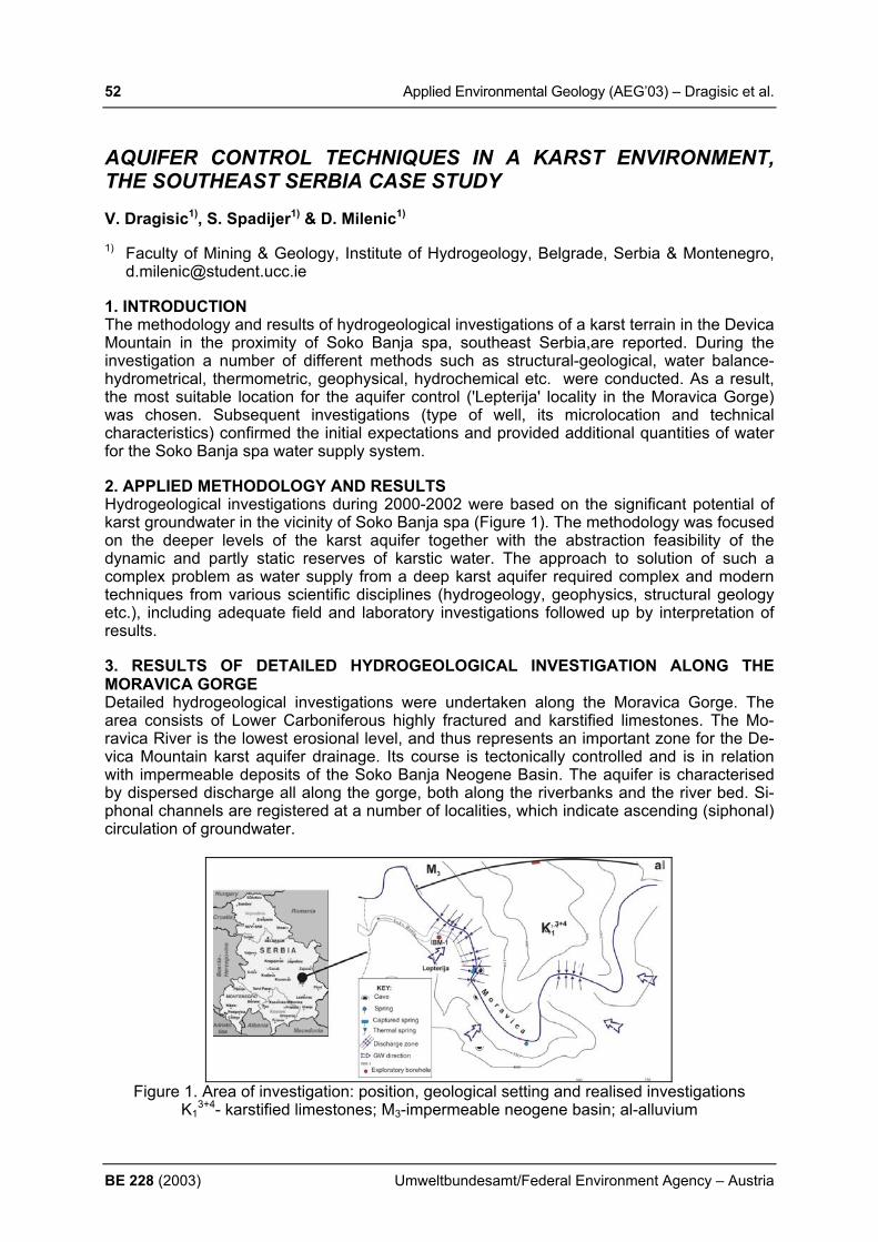
52 Applied Environmental Geology (AEG’03) – Dragisic et al.
BE 228 (2003) Umweltbundesamt/Federal Environment Agency – Austria
AQUIFER CONTROL TECHNIQUES IN A KARST ENVIRONMENT, THE SOUTHEAST SERBIA CASE STUDY V. Dragisic1), S. Spadijer1) & D. Milenic1) 1) Faculty of Mining & Geology, Institute of Hydrogeology, Belgrade, Serbia & Montenegro,
[email protected] 1. INTRODUCTION The methodology and results of hydrogeological investigations of a karst terrain in the Devica Mountain in the proximity of Soko Banja spa, southeast Serbia,are reported. During the investigation a number of different methods such as structural-geological, water balance-hydrometrical, thermometric, geophysical, hydrochemical etc. were conducted. As a result, the most suitable location for the aquifer control ('Lepterija' locality in the Moravica Gorge) was chosen. Subsequent investigations (type of well, its microlocation and technical characteristics) confirmed the initial expectations and provided additional quantities of water for the Soko Banja spa water supply system. 2. APPLIED METHODOLOGY AND RESULTS Hydrogeological investigations during 2000-2002 were based on the significant potential of karst groundwater in the vicinity of Soko Banja spa (Figure 1). The methodology was focused on the deeper levels of the karst aquifer together with the abstraction feasibility of the dynamic and partly static reserves of karstic water. The approach to solution of such a complex problem as water supply from a deep karst aquifer required complex and modern techniques from various scientific disciplines (hydrogeology, geophysics, structural geology etc.), including adequate field and laboratory investigations followed up by interpretation of results. 3. RESULTS OF DETAILED HYDROGEOLOGICAL INVESTIGATION ALONG THE MORAVICA GORGE Detailed hydrogeological investigations were undertaken along the Moravica Gorge. The area consists of Lower Carboniferous highly fractured and karstified limestones. The Mo-ravica River is the lowest erosional level, and thus represents an important zone for the De-vica Mountain karst aquifer drainage. Its course is tectonically controlled and is in relation with impermeable deposits of the Soko Banja Neogene Basin. The aquifer is characterised by dispersed discharge all along the gorge, both along the riverbanks and the river bed. Si-phonal channels are registered at a number of localities, which indicate ascending (siphonal) circulation of groundwater.
Figure 1. Area of investigation: position, geological setting and realised investigations K1
3+4- karstified limestones; M3-impermeable neogene basin; al-alluvium
Applied Environmental Geology (AEG’03) – Dragisic et al. 53
Umweltbundesamt/Federal Environment Agency – Austria BE 228 (2003)
4. RESULTS OF THERMOMETRIC RESEARCH The main aim of the thermometric investigation was to define groundwater discharge zones into the Moravica River and the direction of groundwater movement. On the basis of temperature measurements and correlation with other results, a hydrothermal model of the study area was created. Invetigations were undertaken using a network of 15 points at intervals of 50-100m. Thermometry showed existence of two discharge zones into the river. The first zone is characterised by high temperature groundwater with a deep siphonal circulation and ascending movement towards the surface along a fault zone. The second zone (near a spring exploited for the water supply for a hotel complex) with lower temperatures with respect to surface water, indicates shallower movement of groundwater through the karstic system. 5. RESULTS OF A DETAILED GEOPHYSICAL EXPLORATION Geophysical investigations conductedin the 'Lepterija' locality, used a “mise a la masse" method with a modifications for potential and gradient disposition of electrodes. In the light of the obtained results it was concluded that the greatest underground recharge pathline for the spring 'D. Jovanovic' coincides with the direction of a maximal values of potential and zero values of gradient, respectively. On the basis of the presented results, the microlocation of investigation borehole IBM-1 was defined. 6. RESULTS OF DRILLING AND PUMPING TEST AT THE 'LEPTERIJA' LOCALITY After the IBM-1 borehole was drilled, for the purpose of detailed identification of the lithological profile, hydrogeological properties of the rocks and determination of most productive zones for future screen intervals, geophysical logging was undertaken. Three highly fractured and karstified intervals were located. After the piezometer was cased, it was air-lifted with simultaneous monitoring of the effects on the neighbouring spring 'D. Jovanovic'. During the airlift, around 5-8 l/s of water discharged, with immediate recovery after the test. These results confirmed the proposed methodology, so the exploratory well IEBM-1 was recommended. Microlocation of IEBM-1 was 7m south of IBM-1. The total depth was 80m. After the well was drilled and cased, a number of pumping tests were carried out (June 2001, February 2002, March 2002) with pumping rates from 15 to 30 l/s. In addition to the well, the pumping effects were monitored by the piezometer and on surrounding springs. Graph-analytic interpretation indicated a transmissivity value of 2.97 x 10⁻³ m2/s, and a specific capacity of the well of C=8,02x10⁻⁴ m2/s (at the beginning of well development) and C=1.72x10⁻³ m2/s (at the end of well development) respectively. The optimal capacity of the well is 35 l/s, and exceeds peak requirements of the present water supply scheme. Chemical, bacteriological and radiological analyses indicate that all hydrochemical components are within maximum admissible concentrations. REFERENCES DRAGISIC ET AL. (2002): Hydrogeological investigation of the Soko Banja spa region for the
water supply needs, Project, Belgrade, Serbia and Montenegro, (in Serbian)

54 Applied Environmental Geology (AEG’03) – Faber
BE 228 (2003) Umweltbundesamt/Federal Environment Agency – Austria
WINGEOL: DATA PREPARATION FOR NUMERICAL GROUND-WATER SIMULATIONS. HOW TO CREATE AN ACCURATE MODEL OF THE SUBSURFACE. R. Faber Terramath: Geoscientific Software, Heiligenstädterstrasse 107/30, A-1190 Vienna, Austria; [email protected], 1. INTRODUCTION To create an accurate model of the subsurface of an area, some very different data sets have to be joined together. The two basic types are fault data and data related to the litholo-gies and their hydrological properties. Software, which should help to build groundwater models, is specialized to handle one of these datasets but not both. The integration of the second type is very time consuming or not even possible. A numerical groundwater model neglecting one type will fail in many situations. WinGeol is not programmed to run the nu-merical simulation itself, but to provide useful help to the user to create a reasonable model of the subsurface for simulations based on MODFLOW, MCDONALD et al. (1988). 2. METHODS For integration of fault data, WinGeol requires the following datasets:
• Outcrop measurements (fissure volume) – “point” data • Remote Sensing data (DEM, aerial photos or satellite images) needed to extrapolate
the outcrop “point” data Then WinGeol will calculate / display:
• fissure volume • lineaments • lineament density • lineament density weighted by fissure volume • interpolate a two dimensional grid of the fissure volume
Mapped Lineaments on DEM
Fig. 1 Left: Mapped Lineaments based on DEM data Right: Extrapolated with lineaments mapped from DEM data The Fault Trace module of WinGeol allows to determine the dip angle of lineaments if digital elevation data (DEM) is provided – case study in JANDA et al. (2003). In the near future WinGeol will interpolate a three dimensional grid of the fissure volume to utilize this module. Integration of lithological data

Applied Environmental Geology (AEG’03) – Faber 55
Umweltbundesamt/Federal Environment Agency – Austria BE 228 (2003)
WinGeol will combine permeability layers of faults (see above) and permeability layers based on lithology. This is a standard operation and accurate if your study area consists of well de-fined layers with a homogenous permeability. Especially for areas with clastic sedimentation, where the composition of grain sizes – and therefore the permeability – will vary within a layer, WinGeol provides a numerical transport simulation algorithm (WinGeol / SedTec) to calculate the grain size and type distribution, FABER & WAGREICH (2002) and WAGREICH et al. (2002). Based on this data it is possible to calculate permeability layers. (MODFLOW can handle such data without problems, some third party programs based on MODFLOW will have problems!). If there is knowledge about vertical tectonic movements influencing the sedimentation, simulation of the tectonic is possible, too.
Fig. 2 Data used for numerical transport simulation algorithm (WinGeol / SedTec) To ascertain that the datasets created with WinGeol are useful and agree with your interpre-tation, WinGeol offers capabilities of synoptic visualization in 2D, 3D and profile views. For example you can use geophysical data as well as bore log data for this verification (HÄUSLER et al., 2002). 3. RESULTS WinGeol offers complete new possibilities to integrate geological data into numerical groundwater models. Fault geometry data and results of sediment transport simulations can now be used for groundwater models in a time saving workflow. MODFLOW can be used for the simulation of fractured aquifers – comfortable in- and export functions are in develop-ment. REFERENCES FABER, R., WAGREICH, M. (2002): WINGEOL / SEDTEC - New Software for Modelling
Erosion & Deposition, Molasse – Meeting, Seewalchen, Austria HÄUSLER, H., FABER, R., RAUMAUF, P., WIESMAYR, G. (2002): Hydrogeologie und
Fernerkundung Blatt 34 Perg.- Bund-/Bundesländer-Kooperationsprojekt, Projektendbe-richt, Institut für Geologie, Universität Wien, Wien
JANDA, C., FABER, R., HAGER, C., GRASEMANN, B. (2003): Tracing of Active Faults in the Sutlej Valley (NW-Himalayas, India), EGS - AGU - EUG Joint Assembly, Geophysical Research Abstracts Volume 5, Nice, France
MCDONALD, M.G., and HARBAUGH, A.W., (1988): A modular three - dimensional finite-difference ground-water flow model: U.S. Geological Survey Techniques of Water-Resources Investigations, book 6, chap. A1, 586 p.
WAGREICH, M. FABER, R., & SCHMIDT, H. P. (2002): Stratigraphic Simulation in Neogene Basins of Austria: The influence of synsedimentary tectonics on stratigraphic sequences (unpublished project report).

56 Applied Environmental Geology (AEG’03) – Filip & Zeman
BE 228 (2003) Umweltbundesamt/Federal Environment Agency – Austria
THE EFFECT OF GEOCHEMICAL EVOLUTION OF AMD ON MINERAL COMPOSITION OF STREAM SEDIMENTS: PRELIMINARY STUDY ON HADŮVKA STREAM, WESTERN MORAVIA, CZECH REPUBLIC.
J. Filip1) & J. Zeman2)
Institute of Geological Sciences, Masaryk University, Kotlářská 2, 611 37 Brno, Czech Re-public, 1) [email protected], 2) [email protected]
1. INTRODUCTION Stream waters, polluted by acid mine drainage (AMD), represent the most important ecologi-cal hazard in abandoned mining field with active AMD into streams and rivers (TRTÍKOVÁ et al. 1999). Acid sulphate waters are formed by oxidation and leaching of sulphide-bearing rocks either in abandoned (or productive) mine or within sulphide-containing mine tailings, and typically contain high concentrations of dissolved metals. Metals and other inorganic pol-lutants are attenuated by a series of precipitation, co-precipitation and adsorption reactions (e.g. LANGMUIR 1997) during contact of AMD with atmospheric oxygen, when various in-soluble hydrous ferric oxides (HFO) (e.g. KARATHANASIS & THOMPSON 1995, BIGHAM et al. 1996, CORNELL & SCHWERTMANN 1996), together with oxides and oxyhydroxides of Mn and Al are formed. Sulphates, first of all schwertmanite, as well as other secondary min-erals, are also present in such sediments. Schwertmannite in many cases of AMD prevails over oxide minerals (BIGHAM et al. 1996) and seems to be typical mineral for strongly acid waters containing substantial amount of Fe and SO4 (KIM & CHON 2001). All previously mentioned secondary minerals play a crucial role in redistribution of heavy metals and other pollutants between stream waters and sediments (COSTON et al. 1995).
2. MATERIALS AND METHODS The Hadůvka stream, occurring between Olší and Drahonín villages (about 40 km NW from Brno, Czech Republic), is polluted by AMD of the abandoned uranium mine “Olší”. The Hadůvka stream, where precipitations of secondary phases have taken place to the high ex-tent (ZEMAN 1999), represents very suitable model locality for study of the secondary min-erals–water interaction, particularly with regard to a broad geochemical database that exists about this locality. Stream sediments and waters have been systematically sampled for seven years. The X-ray powder diffraction patterns for stream sediments were collected with computer-controlled X-ray diffractometer Stadi-P (Stoe & Cie Company), arranged in trans-mission mode, with CoKα1 radiation (30 kV, 40 mA, 111 Ge monochromator), position-sensitive detector (4 oΘ effective width). Complete sequential extraction analyses and silicate analyses of stream sediments have been done for better recognition of mineralogical compo-sition of stream sediments. pH, Eh and temperature were measured directly in stream.
3. RESULTS Results from X-ray diffraction have showed that all recently formed minerals are amorphous, nearly amorphous (without regular crystal lattice) or cryptocrystalline and occur in mixture of several phases. Thus this method seems to be unsuitable for characterization of such fresh sediments. Modelling made with the aid of The Geochemist´s Workbench suggested hypo-thetical presence of goethite, pyrolusite, calcite and kaoline. Coupled with sequential and silicate analyses, this hypothetical minerals have been taken as normative for further evalua-tion of bottom sediments. Natural Hadůvka stream sediments are characterized by low con-tent of Fe- and Mn-oxyhydroxides (3 to 4 %) and carbonates (0.X %). Inflow of AMD into the stream causes rapid rising of insoluble HFO (20 to 30 %), carbonates (20 to 30 %) and clay minerals (5 to 10 %) content, but maximum of carbonates is slightly later than that of HFO. Presence of Mn-oxydroxides is also higher in polluted water, but maximum of precipitation take place subsequently after maximum of HFO (few hundreds of meters downstream). Thus water lost about 90 % of total dissolved solids in first hundreds of meters. Long-term monitor-

Applied Environmental Geology (AEG’03) – Filip & Zeman 57
Umweltbundesamt/Federal Environment Agency – Austria BE 228 (2003)
ing reveal seasonal variation of mineralogical composition of bottom sediments, when high-est contents of recently formed mineral phases are in first half of years. Multiyear trend is pointed at lowering of influence of AMD onto bottom sediment composition.
Fig. 1 Temporal variation of normative goethite, pyrolusite, calcite, and kaolinite content in bottom sediment on profile HAD 5 and HAD 4, respectively. Fig. 2 Variation of normative goethite, pyrolusite, calcite, and kaolinite content in bottom sediments along Hadůvka creek and subsequent streams on 21.4.1998.
4. CONCLUSION Fe- and Mn-oxyhydroxides represent, together with carbonates and clay minerals, major mineral phases, which play crucial role in easy-removable uptake of pollutants (U and Ra; ZEMAN 1999). Spatio-temporal precipitation delay of Mn-oxyhydroxides compare to HFO is probably caused by slower oxidation of Mn2+ and is mainly caused by the fact that most of oxygen content in water is consumed by rapid oxidation of Fe2+ to Fe3+ at the beginning of AMD inflow into the Hadůvka stream.
REFERENCES BIGHAM, J. M., SCHWERTMANN, U., TRAINA, S. J., WINLAND, R. L. & WOLF, M. (1996):
Schwertmannite and the chemical modeling of iron in acid sulfate waters. Geochimica et Cosmo-chimica Acta, 60, 12: 2111-2121, Amsterdam.
CORNELL, R. M. & SCHWERTMANN, U. (1996): The Iron Oxides, Structure, Properties, Reactions, Occurrence and Uses. 573 p., VCH Verlagsgesellschaft, Weinheim.
COSTON, J.A., FULLER, CH. C. & DAVIS, J. A. (1995): Pb2+ and Zn2+ adsorption by a natural alumin-ium- and iron-bearing surface coating on an aquifer sand. Geochimica et Cosmochimica Acta, 59, 17: 3535-3547, Amsterdam.
KARATHANASIS, A. D. & THOMPSON, Y. L. (1995): Minaralogy of Iron Precipitates in a Constructed Acid Mine Drainage Wetland. Soil. Sci. Soc. Am. J., 59: 1773-1781, Madison.
KIM, J. Y., CHON, H. T. (2001): Pollution of a water course impacted by acid mine drainage in the Im-gok creek of the Gangreung coal field, Korea. Applied Geochemistry, 16: 1387-1396, Amsterdam.
LANGMUIR, D. (1997): Aqueous Environmental Geochemistry. 431-485, Prentice Hall inc. STUMM, W. & MORGAN, J. J. (1970): Aquatic Chemistry. John Wiley & Sons, New York. TRTÍKOVÁ, S., MEDEJOVÁ, J., KUŠNIEROVÁ, M. & CHOVAN, M. (1999): Precipitation and chemical
composition of iron ochres in the pyrite and stibnite deposit in the Malé Karpaty Mts. Slovak Geol. Mag., 5, 3: 179-186, Bratislava.
ZEMAN, J. (1999): Migration of Iron, Manganese, Uranium and Radium in conditions of mining area Olší-Drahonín. MS, Inaugural thesis PřF MU, Brno. (in Czech)
0%
5%
10%
15%
20%
25%
30%
35%
HAD
3
HAD
5
HAD
9
LOU
1
Albr
ech.
Kado
v
Profile
wt.%
goethite pyrolusite
calcite kaolinite
0%
5%
10%
15%
20%
25%
30%
1997 1998 1999 2000 2000 2001
Year
wt.%
goethite pyrolusite
calcite kaolinite
HAD 5 HAD 4

58 Applied Environmental Geology (AEG’03) – Frančišković-Bilinski & Rantitsch
BE 228 (2003) Umweltbundesamt/Federal Environment Agency – Austria
GEOCHEMICAL AND MINERALOGICAL DISPERSION IN THE UPPER SAVA RIVER (SLOVENIA), A PRELIMINARY REPORT S. Frančišković-Bilinski1) & G. Rantitsch2)
1) Department of Physical Chemistry, “Ruđer Bošković” Institute, POB 180, HR-10002 Za-
greb, Croatia, [email protected]; 2) Institut für Geowissenschaften, Montanuniversität Leoben, Peter Tunner Strasse 5, A-
8700 Leoben, Austria, [email protected] 1. INTRODUCTION Sava River is formed from Sava Dolinka and Sava Bohinjka. It has a large drainage area. It flows throughout Slovenia, Croatia, at the border of Bosnia and Croatia, and at Belgrade (in Serbia) enters the Danube River. ŠTERN & FÖRSTNER (1976) have been the first to de-scribe heavy metals distribution in the sediments of the Sava Basin in Slovenia. Quality of water in Sava River is regularly controlled within National monitoring programs which do not include systematic measurements of sediments. The aim of our work was to study the impact of tributaries on mineralogical and elemental composition of sediments from main stream Sava, starting from mostly clean environments in north-west Slovenia, down below the inflow of Kupa River at Sisak in Croatia, where anthropogenic influence could be expected. 2. SAMPLING AND METHODS In Figure 1 are presented sampling locations (between 46º05’ and 46º30’ N and between 13º45’ and 15º10’ E), which have been studied till now.
Fig. 1: Sampling location along the Upper Sava River
Sediments were taken in contact with running water on several occasions in years 2001 and 2002. The lowest point studied was above the inflow of Savinja River, for which we have found that anthropogenic pollution is significant (FRANČIŠKOVIĆ-BILINSKI et al., 2002). Samples were sieved and dried at 80ºC. All analyses were performed on silt & clay-fraction (<63 µm). Mineralogical composition was determined using XR diffraction (Philips PW 1050). Elemental composition was determined in Actlabs, Canada, by ICP-MS (Ultratrace 2) and by Flow-injection for Hg (1G) programs. A principle component analysis (PCA) was performed on multivariate data, in order to extract the main elemental associations, which control the multivariate signature of data base in the upper drainage area.
Applied Environmental Geology (AEG’03) – Frančišković-Bilinski & Rantitsch 59
Umweltbundesamt/Federal Environment Agency – Austria BE 228 (2003)
3. RESULTS From XRD analysis could be concluded that sediment at the source of Sava Dolinka (No.74) contains dolomite as principle mineral component, while in Sava Bohinjka (No.42) calcite predominates. Sediment of Sava Dolinka (No.70) taken before the confluence of the two riv-ers shows the predominance of quartz. It can be assumed that it comes by several streams flowing from Karavanke, which have not yet been analyzed. Tržaška Bistrica (No.69), which also flows from Karavanke, and Sora (No.65 and 64) have sediments composed predomi-nantly of quartz and mica minerals. Kamniška Bistrica (No.67), which flows from Kamniško-Savinjske Alps has sediments composed predominantly of dolomite. Sediment of Sava River further downstream contain quartz as principle component. From elemental analysis follows that the most abundant elements are Ca, Mg, Fe and Al. They are present in different propor-tions, depending on sample location. Increased concentrations of most trace elements were found in Sava Dolinka (No. 70 – Camp Šobec), probably originating from iron industry in Je-senice. A principle component analysis (PCA) was performed on multivariate data. The main elemental associations can be discussed in details in connection with 3 PCA components. The geochemical data can be interpreted as a weathering of different source rocks during which trace elements are dissipated in the downstream direction. It is also possible to identify pollution sources in the lower region of investigated area. 4. CONCLUSION At this stage of research conclusions are only preliminary. Upper part of Sava drainage basin was selected as a clean environment, slowly changing downstream, where anhtropogenic in-fluence could be observed with highest concentrations of trace elements in sediments of Sava Dolinka in Camp Šobec. It is situated about 10 km downstream from iron industry in Jesenice. Mineralogical composition changes due to tributaries and at the lower part of investigated area is quartz predominating. A principle component analysis (PCA) was per-formed on multivariate data in order to extract the main elemental associations, which control the multivariate signature of database. Further research will be extended on influence of Sav-inja, Krka and Kupa tributaries, where anthropogenic influence is assumed and where Möss-bauer spectroscopy could also be applied. Research was funded by the Ministry of Science and Technology of Croatia, project 0098041, bilateral project Slovenia-Croatia (2000-2002) and JF-169, USA-Croatia. REFERENCES FRANČIŠKOVIĆ-BILINSKI, S.; BILINSKI, H.; TIBLJAŠ, D.; HANŽEL, D. & MERTELJ, A.
(2002): Characterization of sediments from Voglajna and Savinja rivers – preliminary re-sults. Geologija 25/2, 367-372.
ŠTERN, J. & FÖRSTNER, U. (1976): Heavy metals distribution in the sediment of the Sava Basin in Slovenia. Geologija 19, 259-274.

60 Applied Environmental Geology (AEG’03) – Frisia et al.
BE 228 (2003) Umweltbundesamt/Federal Environment Agency – Austria
HOLOCENE CLIMATE AND ENVIRONMENTAL CHANGES RECON-STRUCTED FROM ANNUALLY LAMINATED SPELEOTHEMS S. Frisia1), A. Borsato1), N. Preto2) & C. Spötl3) 1) Museo Tridentino di Scienze Naturali, via Calepina 14, I-38100 Trento, Italy, fri-
[email protected] 2) Dipartimento di Geologia, Paleontologia e Geofisica, Università di Padova, Via Giotto, I-
135137 Padova, Italy, 3) Institut für Geologie und Paleontologie, Universität Innsbruck, Innrain 52, A-6020 Inns-
bruck, Austria. 1. INTRODUCTION Our ability to detect the impact of solar variability over the range of decades to millennia in the climate system relies on reliable and consistent long-term indices of both climate and so-lar parameters. One such potential archive of indices of climate and solar parameters is pro-vided by annual growth laminae of stalagmites. 2. SETTING, MATERIAL AND METHODS Four active stalagmites were collected in two Alpine caves in the Trento Province (46° 04’ 00 N and 11° 10’ 00 E) characterized by different physical settings. Stalagmite BS1 was re-moved from Bus de la Spia, a cave which opens at 625 m asl consisting of a single, down-dipping gallery that ends with an oscillating siphon. Stalagmites ER 76, ER 77 and ER 78 developed in Grotta di Ernesto, another single down-dipping gallery which opens at 1160 m asl and is clogged at its bottom end by sand and collapse blocks. Annual growth laminae thickness was measured under the optical transmission microscope, and the mechanism of annual laminae development was recognized through monitoring and growth experiments in the caves. Sub-annual to annually resolved stable isotope data were obtained for the last 100 years in ER 78 by micromilling and subsequent analyses using a Thermofinnigan mass spectrometer. Correlation analysis was carried out between lamina thickness series and in-strumental series from the ALPCLIM data sources for Northern Italy. 2. RESULTS All four stalagmites shows annual growth laminae for the Holocene, consisting of a winter translucent calcite layer and a summer-fall thin layer of brown calcite. Major and trace ele-ments derived from the dissolution of the karst rock, such as Ca, Mg and Sr are concentrated in the translucent layer. On the contrary, the dark layer is enriched in soil-derived trace ele-ments such as P, Br, Cu, Fe, Y and Zn. Commonly, thicker laminae are characterized by more negative δ13C values, which can be related to enhanced soil activity and CO2 produc-tion, under unlimited water and C3 vegetation conditions. Lamina thickness variability is here considered, therefore, as a proxy for soil activity. Based on our understanding of stalagmite growth mechanisms, we infer that thick laminae (up to 100 µm) topped by a 2 micrometer-thin brown layer correspond to mild winters, when frozen soil conditions lasted for less than 3 months. On the contrary, series of thin laminae mostly consisting of the brown portion en-riched in soil-derived elements and organics indicate cold winters (frozen soil conditions > 3 months) and a short, wet summer/autumn season. Differences in flow regimes and rates do not seem to affect the trend of lamina thickness series, which show similar variability through time in all four specimens. In particular, the growth of one stalagmites (BS 21) is modulated by the fluctuations of an oscillating siphon located at the end of the cave (Bus de la Spia, 450 m asl), that in spring, as a consequence of snow-melt and in late summer, after major storm-related recharge, rapidly rises up to 20 to 30 meters above its mean water level, and drowns the stalagmite site. The supersaturation of the siphon water with respect to calcite is lower than that of the of stalagmite feeding-drip (mean SIcc 0.11 ± 0.11 and 0.51 ± 0.14 respec-tively). The growth lamina structure (proportion of translucent and brown layers, calcite fabric
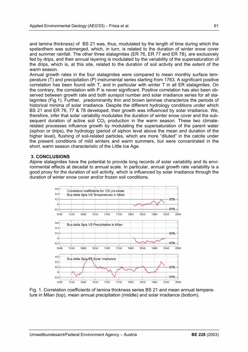
Applied Environmental Geology (AEG’03) – Frisia et al. 61
Umweltbundesamt/Federal Environment Agency – Austria BE 228 (2003)
and lamina thickness) of BS 21 was, thus, modulated by the length of time during which the speleothem was submerged, which, in turn, is related to the duration of winter snow cover and summer rainfall. The other three stalagmites (ER 76, ER 77 and ER 78), are exclusively fed by drips, and their annual layering is modulated by the variability of the supersaturation of the drips, which is, at this site, related to the duration of soil activity and the extent of the warm season. Annual growth rates in the four stalagmites were compared to mean monthly surface tem-perature (T) and precipitation (P) instrumental series starting from 1763. A significant positive correlation has been found with T, and in particular with winter T in all ER stalagmites. On the contrary, the correlation with P is never significant. Positive correlation has also been ob-served between growth rate and both sunspot number and solar irradiance series for all sta-lagmites (Fig.1). Further, predominantly thin and brown laminae characterize the periods of historical minima of solar irradiance. Despite the different hydrology conditions under which BS 21 and ER 76, 77 & 78 developed, their growth was influenced by solar irradiance. We, therefore, infer that solar variability modulates the duration of winter snow cover and the sub-sequent duration of active soil CO2 production in the warm season. These two climate-related processes influence growth by modulating the supersaturation of the parent water (siphon or drips), the hydrology (period of siphon level above the mean and duration of the higher level), flushing of soil-related particles, which are more “diluted” in the calcite under the present conditions of mild winters and warm summers, but were concentrated in the short, warm season characteristic of the Little Ice Age. 3. CONCLUSIONS Alpine stalagmites have the potential to provide long records of solar variability and its envi-ronmental effects at decadal to annual scale. In particular, annual growth rate variability is a good proxy for the duration of soil activity, which is influenced by solar irradiance through the duration of winter snow cover and/or frozen soil conditions. Fig. 1. Correlation coefficients of lamina thickness series BS 21 and mean annual tempera-ture in Milan (top), mean annual precipitation (middle) and solar irradiance (bottom).
62 Applied Environmental Geology (AEG’03) – Gaisberger et al.
BE 228 (2003) Umweltbundesamt/Federal Environment Agency – Austria
HEAVY METALS AND THEIR BIOLOGICAL AVAILABILITY IN SOILS AROUND THE HISTORIC MINING AND METALLURGY CENTRE OF OBERZEIRING/AUSTRIA G. Gaisberger1, F. Ebner1, W. Prochaska1 & M. Sager2
1) Dept. of Geosciences, University of Leoben, Austria, e-mail: [email protected] 2) Austrian Agency for Health and Food Safety and Federal Office for Food Safety Agricul-
tural Research Vienna, e-mail: [email protected] 1. INTRODUCTION The polymetallic mineralization of Oberzeiring (Eastern Alps) is dominated by irregular bod-ies of siderite. Magnetite, hematite (specularite) and barite also occur. The Pb-Zn-Cu-Ag sul-fide mineralization is rich (galena, sphalerite, chalcopyrite, tetrahedrite, tennantite, boulang-erite, pyrite, pyrrhotite); silver minerals include argentite, pyrargyrite and native silver (WEBER et. al.1997). Mining of polymetallic Ag-rich sulfide ores commenced around 900 AD. This phase came to an end when catastrophic flooding killed about 1400 miners under-ground in the year of 1361 or 1365. However, the area remained a metallurgical centre in the 16th century. Iron was produced until 1886 and barite mining was attempted around 1960. Mobilization of heavy metals from mine workings and dumps, smelting sites, metallurgical products (slags, flue dust) and erosion/redeposition of contaminated materials by floodings present environmental hazards for agriculture. Information on heavy metal contents in soils and their biological availability on site is poor. One sample investigated within the “Styrian soil conservation program” gave maximum val-ues of Pb (8769 mg/kg) and As (348 mg/kg). Some isolated soil samples investigated in a study to assess the hazards of ancient mining and metallurgical sites in Austria obtained contents of Pb up to 1016 mg/kg and As up to 87 mg/kg (SCHERMANN & SCHEDL 1994). These are far above Austrian threshold values currently valid for limiting agricultural landuse (Pb 100 mg/kg; As 20 mg/kg). Therefore soils around Oberzeiring were investigated in re-spect to their heavy metal contaminations. The study area (ca. 0,75 km2) is a narrow (300 - 500 m wide) valley surrounded by metamorphic rocks. Alluvium along the creek, fluvial ter-races, and late to post-glacial talus fans comprise the Quaternary association. Mine adits, dumps, slag in heaps and as road material are the relics of the ancient mine and metallurgi-cal activities. 2. METHODS OF INVESTIGATIONS AND RESULTS For primary geochemical screening 110 representative soil samples have been taken from depths of 10 - 25 cm. The fraction < 2 mm was dissolved in HNO3 and analyzed by AAS for Pb, Zn and Cu. Based on these results contaminated areas were mapped and four areas with divergent pedogenic soil formation were investigated in detail along 80 cm deep profiles. These samples (fraction < 2 mm) were dissolved in aqua regia and analyzed by ICP (Al, Sb, As, Ba, Pb, B, Cd, Ca, Cr, Co, Cu, Fe, K, Mg, Mn, Mo, Na, Ni, Li, P, Ag, Ti, V, Bi, W, Zn, Sn). In depth of 0 - 20 cm, pH, Corg, S (LECO), humus and carbonate were determined. The min-erals of the soil were investigated by XRD. Heavy metals are irregulary distributed in the respective profiles and depths. The elements analyzed during the geochemical survey can be enriched in some deeper soil horizons up to a multiple of the geochemical surface survey: Pb 12883 mg/kg, Cu 815 mg/kg, and Zn 2485 mg/kg. Some heavy metals are of low concentration and of little vertical variation (in mg/kg: Cr 5 - 51, Co 4 - 17, Ni 10 - 64 mg/kg, Mo 1- 7, Sn 1 - 4 , W 3 - 13). Ag as the major resource of historic mining is enriched up to 21 mg/kg in technogenically affected horizons. Sb-As-Pb-Cu-Zn varies greatly regarding concentration and depth distribution. Their concentrations are (in mg/kg): Sb 15 - 1828, As 3 - 879, Pb 124 - 12883, Cu 24 - 1105, Zn 139 - 1075. Reflected and transmitted light microscopy, X-ray diffractometry, and microprobe analysis were used
Applied Environmental Geology (AEG’03) – Gaisberger et al. 63
Umweltbundesamt/Federal Environment Agency – Austria BE 228 (2003)
for slag characterization. Slags are of fayalitic composition with a relatively low melting tem-perature (1088 – 1100oC).The slags carry small inclusions of galena, bornite, cuprostibite, native lead and antimony, glass and silicate phases enriched with heavy metals, Pb/Cu sul-fosalts (± Fe) intergrown with galenite (NEINAVAIE & PIRKL 1996). To characterize the biological availability of elements three samples (from A-horizons) were leached sequentially (Fig. 1). In spite of rather high amounts of Pb, As, Sb and Zn found in aqua regia, the mobilities obtained from sequential leaching patterns, were significantly lower than those from samples contaminated from diffuse anthropogenic sources. Pb, the main contaminant, is found mainly in the hydroxylamine- leachable fraction. This points to oxida-tion of the original sulfide ore, and precipitation upon weathered phases in the soil. Although Zn sulfide can more easily be oxidized under atmospheric conditions, Zn was encountered mainly in the sulfide and in the residual fractions. Sb was about equally distributed between oxalate leachable fractions („iron oxides“) and oxidizable fractions („sulfides“). Arsenic re-sides mainly in the iron oxides.
0
10
20
30
40
50
60
1 2 3 4 5 6
0
50
100
150
200
250
1 2 3 4 5 6
0
200
400
600
800
1000
1200
1 2 3 4 5 6
Pbmg/kg
Slag deposit Roman Road Ruin
0
20
40
60
80
100
120
140
1 2 3 4 5 6 7 8
Sbmg/kg
Asmg/kg
Znmg/kg
fractions
Fig.1: Sequential leaching of Pb, Sb, As and Zn from soils of contaminated sites. In order to demonstrate possible hazards from contaminations element transfer to green let-tuce seedlings was investigated. It was harvested 21 days after planting. During this time maximum concentrations develop in the plant tissues (LEE 2002). Most of the elements in-vestigated (Al, As, Ba, Be, Co, Cr, Cu, Fe, Mo, Ni, Pb, V, and Zn) were enriched in roots more than in the corresponding leaves. The leaves clearly were higher in Cd and Mg. About the same concentration levels were found in roots and leaves for Mn, Na, P, and Sr. In dry mass of green plants (Tab. 1), Na>K>P>Cd accumulated over aqua regia concentrations in the respective soils. When the weakly acid mobile fraction is considered, however, there was still enrichment of Zn, Cd, Cr, and Cu with respect to the dry mass of green plants growing on site, whereas As and Ni were at about the same level. Weak –acid mobile Pb concentra-tions in the soils ranged between the concentrations in roots and leaves. With respect to the hydroxylamine mobile fraction, the green plants still enriched Cd, but not Zn. The hydroxyl-amine- mobile As, Ni, and Cr ranged between the correponding concentrations in leaves and roots of the lettuce seedlings.
64 Applied Environmental Geology (AEG’03) – Gaisberger et al.
BE 228 (2003) Umweltbundesamt/Federal Environment Agency – Austria
Table 1. Concentrations found in lettuce leaves and roots grown on contaminated substrates mg/kg Lettuce leaves Lettuce roots
Slag Roman Road Ruin Slag Roman Road RuinAl 85,1 72,4 57,3 5866 3201 881As 0,67 0,33 0,14 21,4 10,4 3,3Ba 21,3 11,2 4,6 209,1 63,6 20,7Be 0,0029 0,0017 0,0020 0,251 0,130 0,031Ca 13951 12059 12198 7576 6367 4562Cd 1,24 1,64 0,62 1,67 1,50 0,44Co 0,067 0,117 0,059 5,11 6,25 1,46Cr 0,57 0,42 0,46 12,4 6,8 1,82Cu 5,89 3,94 3,73 60,7 17,2 12,1Fe 143 133 118 8896 4603 1345K 41150 29388 37600 15142 10549 15469
Mg 5923 4964 4396 5130 3942 2379Mn 56,9 89,6 58,6 242 150 56,1Mo 0,28 0,16 1,04 2,05 1,34 3,8Na 4260 4315 3359 4331 5121 3471Ni 0,85 1,12 0,66 21,9 13,5 7,0P 3039 1982 6037 2256 2062 4358
Pb 6,34 2,25 2,44 527 99,3 62,4Sr 15,2 14,2 13,2 24,5 20,6 15,4V 0,22 0,16 0,08 17,8 10,2 3,8Zn 37,9 26,8 50,8 172 71,0 90,0
3. CONCLUSIONS Soils in the Oberzeiring area reveal two groups of heavy metal associations. (1) As, Sb, Pb, Cu, Zn occur in concentrations far above the average geogene content. They provide the same pattern in their distribution, derive from the primary ore mineralization and are extremly enriched in soils which in deeper parts contain mine waste and slag. Pb is the best tracer element for this group and best suitable for detecting contaminated areas. Some other elements (e.g. Cr, Co, Ni, Mo, Sn, W) are relatively low in concentration and homogeneously distributed. They represent the regional geological input. Beside the geochemical soil content mobile fractions should be considered in order to judge possible environmental hazards. At historical mining sites in Styria with enhanced levels of Pb, Sb, and partially also Zn, Cu and As, the mobility obtained by sequential leaching was rather low. Major portions of the metals may still be present as sulfides. The transfer from the substrate to green lettuce could be matched closer by weak acid mobile fractions or manga-nese oxide fractions, than from total contents. Most of the elements investigated remained in the plant roots. REFERENCES NEINAVAIE, H. & PIRKL, H. (1996) : Bewertung von Schwermineralverteilungen in Böden
und Flusssedimenten mit Hilfe angewandt mineralogischer und geostatistischer Werkzeu-ge. Ber. Geol. B.-Anst. 34: 1 – 67.
SCHERMANN, O. SCHEDL, A. (1994): Erhebung und Bewertung ehemaliger Bergbau- und Hüttenstandorte hinsichtlich Risiko- und Folgenutzungspotentials – Haldenkataster. Un-publ. Report Geol. Survey Austria.
WEBER, L. et al. (1997) : Metallogenetic map of Austria and Explanations. Arch. f. Lagerst. forsch. Geol. B.-A. 19: 1 – 607.
LEE, S.Y. (2002): The effects of chelating agents and metal speciations in phytoremediation, MSc-Thesis, School of Civil, Urban and Geosystem Engineering, Seoul Nat. Univ., South Korea.

Applied Environmental Geology (AEG’03) – Gavrilita & Gavrilita 65
Umweltbundesamt/Federal Environment Agency – Austria BE 228 (2003)
CONSEQUENCES OF HUMAN IMPACT ON LANDSCAPE IN THE REPUBLIC OF MOLDAVIA. SOIL PROCESSES AND LAND DEGRADATION WITH REFERENCE TO THE LAST DECADE. A. Gavrilita & D. Gavrilita National Association “Water Science”, Str. M. Costin 7 office 108, Kishinev, Republic of Mol-davia, [email protected] 1. INTRODUCTION Human impact on landscape in Republic of Moldova has consequential effects on soil struc-ture, involving soil erosion. As a result the process of soil erosion is more accelerated on irri-gated grounds. Limited water resources in Republic of Moldova and complicated landscape determined the necessity of implementing a new progressive method of irrigation- sprinkling method. At the same time the diversity of natural conditions in Republic of Moldova induced the necessity of enforcing various types of sprinkling equipments. However, in the conception of new sprin-kling technologies, the decisions taken by engineers have been oriented especially to in-crease the efficiency of irrigation technology on account of debit raise and the increase of the array of action of water jet. Unfortunately engineers did not pay enough attention to a very important aspect - to preserve soil fertility and productiveness. This aspect was not taken into account, because it was wrongly presumed that as the time went by the soil structure would renew. As a consequence, this presumption brought to the construction of sprinklers with a high in-tensity (up to 1.2 mm/min) and a water consumption of over 100 l/s. In most of the cases, the vast majority of mass production sprinklers produce an artificial torrential rain, which causes the degradation of soil structure, worsening the hydro-physical qualities of irrigable soil and moreover brings to soil erosion. 2. MATERIALS AND METHODS Degradation of irrigable soil during sprinkling becomes more perceptible especially in the irri-gation of gradient fields. In this way, on the field with an inclination of over 0.02 degrees ero-sion emerges frequently and becomes visible as a result of:
• During irrigation of the gradient fields (under the action of artificial rain) they are subdued to erosion because on the slope takes place an ample mutation of parti-cles to the lower side of the slope.
• An irrigable slope itself is a powerful acceleration device of torrential flowing. The erosion of soil during sprinkling could rich to 20t/ha. It is well known the fact that annu-ally soils renew themselves 1-5 t/ha, on the other hand for recovering the eroded stratum of earth it is required from 4-20 years. Therefore it is very important to trace out the fundamental laws of erosion process and on their basis to work out special precautionary measures for preventing erosion in irrigation.
66 Applied Environmental Geology (AEG’03) – Gavrilita & Gavrilita
BE 228 (2003) Umweltbundesamt/Federal Environment Agency – Austria
Tab. 1: Types of soil erosion generated as a result of sprinkling irrigation.
Types of erosion
Consequences
Cause
By drops
Dispersation of soil
particles and their movement to the lower side of the slope. Destruction of the
structural aggregate Settling of the surface
stratum of the soil Diminution of soil ca-
pacity for infiltration
The power of the artificial rain exceeds the admissi-ble limits.
Local
The local mutation of
soil particles to micro depressions Formation of a thick
soil crust
Irrigation
Dripping (on the surface)
Formation of erosion
through dripping of dif-ferent dimensions
The intensity of water dur-ing irrigation exceeds the allowable limits.
Linear (of the network)
Erosion developed by
dripping and drain gut-ter
The damage of the network of irrigation system.
Rainfall (natural precipita-tion)
Erosion developed by
dripping and drain gut-ter
Previous irrigation of the soil with artificial rain.
All the same for all these types of erosion, we propose a set of technical, technological and agro technical measures in order to exclude erosion of irrigable soils.

Applied Environmental Geology (AEG’03) – Gavrilita & Gavrilita 67
Umweltbundesamt/Federal Environment Agency – Austria BE 228 (2003)
THE CONTRIBUTION OF NATO PROJECT TO THE DEVELOPMENT AND WATER RESOURCES MANAGEMENT IN THE REPUBLIC OF MOLDAVIA A. Gavrilita & D. Gavrilita National Association “Water Science”, Str. M. Costin 7 office 108, Kishinev, Republic of Mol-davia, [email protected] 1. INTRODUCTION Despite of its exploratory nature, complex structure, ambitious objectives and consequent di-versity of results, the "PO-RIVERS CP-MOLDOVA” is a consistent project, centered on a sole objective: the development of comprehensive water planning capability with specific ap-plications to the Republic of Moldova. Due to the situation of the country, the first priority was to process the vast amount of disperse data, almost exclusively on paper format. Essential human resources from various related governmental, scientific and public institutes were involved in the project realization and assessment. Moreover than a scientific undertak-ing, the accomplishment of the project aim required academic research and practical proce-dures. It was established as a practical and constructive co-operation between project activists and related institutions, organizations, and societies (main beneficiaries at the end of the project). The project had a great visibility in the media. Two press conferences with the Project Direc-tor and the Executive Director have been taken place, leading to more than half an hour of television prime time, about an hour in radio programs and many references and articles in the national papers. 2. MATERIALS AND METHODS During the project evaluation there were considered two essential phases:
• The 1st - Preparation Phase, which was marked by the preparation of the reports on the existing situation and training of young Moldavian engineers and scientists.
• The 2nd- Execution Phase, when as a first priority was considered the processing of the data selection, storage and proceeding in the database, which was carefully de-signed in collaboration with Portugal specialists; and maps digitizing as a first step for GIS foundation.
Finally, the integration of the continuously updated database with GIS generated a compre-hensive tool for decision support systems (DSS). This is the keystone of the project, and its achievement implies the accomplishment of the project objective that was settled to develop water resources planning and management in Republic of Moldova. An integrated computer provided support for DSS application, developed with the aim to support rivers water quality – QUAL2SE - a water stream simulation model that has been successfully implemented in the PO-Rivers Project and now applied to the main Moldavian original river Reut. In early May 1997, a major restructuring of the Moldavian Administration took place. This change affected the project, as ICAIF (the Moldavian host’s institution) merged into a larger institute, with broader objective and different priorities.

68 Applied Environmental Geology (AEG’03) – Gavrilita & Gavrilita
BE 228 (2003) Umweltbundesamt/Federal Environment Agency – Austria
Following urgent local meetings at Government level with the participation of the Project Di-rector and the Executive Director a Ministerial decision was issued, charging the recently created ANSA – The National Association “Water Science”, under the direction of Professor Andrei Gavrilita, with the responsibility of pursuing this NATO Project. All Moldova’s Water Management System has been renewed and the active role of PO-CP-MOLDOVA in this process was recognized. The main transformation induced by the PO-RIVERS CP- MOLDOVA has been expressed in the Water Resources Management Planning and Methodology, whose planning capability is considerably enhanced by the increased knowledge of the water resources management, the water information system installed, application of the new DSS and the practice acquired dur-ing the project. 3. DISCUSSION The project’s work has been organized in 8 activities:
• Foundation of a Database • Water Resources Strategic Information System • Decision Support Systems- DSS • Urban Water Cycle • Institutional Aspects • Economical Aspects • International Rivers • Technology Transfer
There were many difficulties to overcome during the development of the project: the first and most important was the economic situation of the country, which had reflexes on the ability to maintain the continuous activity of the project collaborators. The entire project was carried out in the context of deep social, political and institutional changes inherent to the creation of the new independent state. As a hole, the activities under the direct supervision of the Project Director developed around the computer center and were carried out by a small team of highly capable and motivated young engineers and scientists.

Applied Environmental Geology (AEG’03) – Gavrilita & Gavrilita 69
Umweltbundesamt/Federal Environment Agency – Austria BE 228 (2003)
CRITICAL STATE OF HYDROGRAPHICAL NETWORK IN THE REPUBLIC OF MOLDAVIA. ANALYSIS AND REHABILITATION. D. Gavrilita & A. Gavrilita National Association “Water Science”, Str. M. Costin 7 office 108, Kishinev, Republic of Mol-davia, [email protected] The prospect of developing the national economy of the country depends on all accounts of insufficiency of water resources, deficiency that constantly is increasing. Global available water resources for a year make 6.3 km3 (for an inhabitant only 0.3 thou-sand m3), for a dry year 4.9 km3 and a very dry year 3.4 km3. Economical evaluation of water resources in certain districts of Republic of Moldova is not very optimistic. Transit seepage of the river Nistru in the outlet section from the territory of Moldova constitutes the average of 10.76 km3. On the territory of Republic of Moldova in the course of a year the average of the seepage, according to water debit, equals to 1.34 km3. In Moldova there are 3621 watercourses, but 90% of them have the length shorter then 10 km and only 8 rivers with a length of over 100 km. The water reservoirs of small rivers are insignificant and in most of the cases rivers dry up during the summer season. Therefore in order to control local seepages, there were built over 3000 drainage basins, dams and lakes. In the last years scientists detected an unexpected intensification of pollution areas in the river Nistru and Prut. Industrial and agricultural companies have been placed in the basin of the river Prut. Unfor-tunately these companies are not properly outfitted; they are not supplied with filtering equip-ment. Consequently on large portions of the river have been testified intensifications of pol-luted areas. Epidemiological – sanitarian conditions of the river Nistru are to a certain extent superior. However and in the case of river Nistru, we can point out the exceeding of permissible con-centration of phenol, phosphorus, pesticides and other impurities. The most important sources of pollution are:
• Draining off waste waters without adequate filtering • Residuals from zoo technical complexes • Superficial washings of fertilizers and toxic chemicals from agricultural fields.
In the districts where such filtering constructions are absent, in most of the cases, there is used a local drainage system which evacuates waste waters in ravines, garbage channels etc. All these have a very harmful influence on fluvial network. In this way the hydrographic network of the country is in great danger, there is a severe need for implementing at large scale new, modern technologies with reasonable water consump-tion; monitoring water supplies and protection of water resources. In this context science plays a very important role in solving the difficulties and problems of water management. As follows we propose a vast program for rehabilitation of hydrographic network by creating protection zones along the riverbanks, their consolidation and by clean-ing out riverbeds.
70 Applied Environmental Geology (AEG’03) – Gerstbach et al.
BE 228 (2003) Umweltbundesamt/Federal Environment Agency – Austria
INTERDISCIPLINARY SEDIMENT MODELLING IN "AUSTRO-PANNONIA" G. Gerstbach 1) , G. Papp2), G. Summer1) & W. Winkler1) 1) Institute of Geodesy & Geophysics, Technical University (TU) Vienna, A-1040 Wien,
Gußhausstraße 27-29 / 128.1; [email protected] 2) Geodetic & Geophysical Research Institute Sopron, MTA GGKI, H-9401 Sopron, POB 5,
[email protected] 1. INTRODUCTION Based on contacts within the Central European Initiative (CEI), several seminars and the PANGEO conference in Salzburg (June 2002), a geoscientific cooperation between the 3 neighbouring countries Austria, Hungary and Slovakia was started in 2003, improving the geoid and the density model of the Vienna Basin and the adjacent Western Pannonia Basin. Up to now this working group consists of geodesists of these three countries, 1-2 geophy-sists, and occasionally geologists. The primary institutions involved in this regional study are:
• Institute of Geodesy & Geophysics, Technical University of Vienna, Austria • Geodetic & Geophysical Research Institute, Sopron, Hungary • Institute of Higher Geodesy, Technical University of Bratislava, Slowakia
In the near future geodesists of the Technical University of Graz and Budapest intend to co-operate, and all geologists and geophysists interested in geoid-modelling, in particular from Hungary and Slovakia, are welcomed. Studies performed in 1997-2002 at the Technical Uni-versity in Vienna and at the Geodetic & Geophysical Research Institute in Sopron revealed, that the Geoid in the border area of Austria, Hungary and Slovakia can be calculated with a higher accuracy of 1-2 cm instead of 5 cm, when the density of the Tertiary and Quaternary sediments, and its basement down to a depth of 5-10 kilometers is well known. As a geoid with cm-accuracy is aimed at by several European institutes since more than one decade, but up to now has only been reached near Vienna, the first goal of the interdisciplinary sediment model cooperation in “Austro-Pannonia” was defined as investigation of the “sediment-density” by Gerstbach and Papp. We intend to set up an interdisciplinary cooperation between diploma and PhD students in the fields of geodesy, geophysics and geology providing digital geological maps, sediment modelling of the Vienna and Pannonian Basin, and modelling the upper mantle in this area respectively using software developed at our institutes and ARC-view as visualization tool. Our poster gives an overview about preliminary results of digital density models (DDM) of sediments in Lower Austria and Western Hungary, and the improvement of the geoid by sediment models. 2. METHODS To improve the geoid of Austro-Pannonia, the sediment density was modelled by the Geo-detic Institute of the Technical University Vienna (GERSTBACH, 1999; GERSTBACH et al., 2003) as well as by the Sopron Research Institute (PAPP et al., 2003). The 3-D digital den-sity model (DDM) of the sediments of the Vienna Basin, down to a depth of 6 kilometers, was performed with the GREMMO*-software (Geologic-geodetic REduction of Multilayer Models) of Technical University of Vienna (GERSTBACH & TENGLER, 1995). The local density variations of the Vienna Basin of +0.1 / -0.6g/cm³ are modelled by vertical cylinders, defined by depth and variable density gradients, which can be used for similar situations in western Pannonia, and for sediment covered volcanoes in Eastern Hungary. A vector field based on 22 astro-points in the Vienna Basin was improved from ±0.6" to final re-siduals of 0.25", corresponding to ~1 mGal, as used for the computation of local sediment
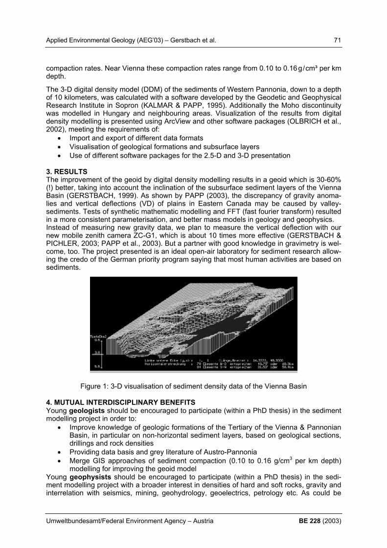
Applied Environmental Geology (AEG’03) – Gerstbach et al. 71
Umweltbundesamt/Federal Environment Agency – Austria BE 228 (2003)
compaction rates. Near Vienna these compaction rates range from 0.10 to 0.16g/cm³ per km depth.
The 3-D digital density model (DDM) of the sediments of Western Pannonia, down to a depth of 10 kilometers, was calculated with a software developed by the Geodetic and Geophysical Research Institute in Sopron (KALMAR & PAPP, 1995). Additionally the Moho discontinuity was modelled in Hungary and neighbouring areas. Visualization of the results from digital density modelling is presented using ArcView and other software packages (OLBRICH et al., 2002), meeting the requirements of:
• Import and export of different data formats • Visualisation of geological formations and subsurface layers • Use of different software packages for the 2.5-D and 3-D presentation
3. RESULTS The improvement of the geoid by digital density modelling results in a geoid which is 30-60% (!) better, taking into account the inclination of the subsurface sediment layers of the Vienna Basin (GERSTBACH, 1999). As shown by PAPP (2003), the discrepancy of gravity anoma-lies and vertical deflections (VD) of plains in Eastern Canada may be caused by valley-sediments. Tests of synthetic mathematic modelling and FFT (fast fourier transform) resulted in a more consistent parameterisation, and better mass models in geology and geophysics. Instead of measuring new gravity data, we plan to measure the vertical deflection with our new mobile zenith camera ZC-G1, which is about 10 times more effective (GERSTBACH & PICHLER, 2003; PAPP et al., 2003). But a partner with good knowledge in gravimetry is wel-come, too. The project presented is an ideal open-air laboratory for sediment research allow-ing the credo of the German priority program saying that most human activities are based on sediments.
Figure 1: 3-D visualisation of sediment density data of the Vienna Basin 4. MUTUAL INTERDISCIPLINARY BENEFITS Young geologists should be encouraged to participate (within a PhD thesis) in the sediment modelling project in order to:
• Improve knowledge of geologic formations of the Tertiary of the Vienna & Pannonian Basin, in particular on non-horizontal sediment layers, based on geological sections, drillings and rock densities
• Providing data basis and grey literature of Austro-Pannonia • Merge GIS approaches of sediment compaction (0.10 to 0.16 g/cm3 per km depth)
modelling for improving the geoid model Young geophysists should be encouraged to participate (within a PhD thesis) in the sedi-ment modelling project with a broader interest in densities of hard and soft rocks, gravity and interrelation with seismics, mining, geohydrology, geoelectrics, petrology etc. As could be
72 Applied Environmental Geology (AEG’03) – Gerstbach et al.
BE 228 (2003) Umweltbundesamt/Federal Environment Agency – Austria
shown in our projects, the vertical density functions can be derived with an accuracy of 0.03 / km, which is even interesting for oil- and gas exploration. Therefore borehole or density logs can be supplemented by data provided by special gravity methods. REFERENCES GERSTBACH, G. (1999): Inversion of Vertical Deflection Data by the Program GREMMO.
Bolletino di Geofisica teorica ed applicata 40, p.461-468, Trieste. GERSTBACH, G. & PICHLER, H. (2003): A small CCD Zenith Camera (ZC-G1) - Developed
for Rapid Geoid Monitoring in Difficult Projects. Conference Paper (7 p.), Proceedings XIII. Conf. Yugoslav Astronomers, Oct. 17-20, 2002, in print, Academy of Science, Beograd.
GERSTBACH, G. & TENGLER (1993): Interaktive geologische Modellierung von Bruchzonen mit Lotabweichungen. Alpengrav. Kolloquium VI, Leoben/Austria 1993, 16 p., Leoben.
GERSTBACH, G. et al. (2003): West Pannonian and Vienna Basin Sediments - a Geoscien-tific Cooperation for Austria, Hungary and Slovakia. EGS spec. Issue TS11, Tectonophys-ics, in print.
IGeS (2002): European (Quasi) Geoid EGG97. IGeS Files Repos... http://www.iges.polimi.it OLBRICH, G., QUICK, M. & SCHWEICKART, J. (2002): Desktop Mapping. Grundlagen und
Praxis in Kartographie und GIS. 3. Auflage, 310 p. + CD, Springer Verlag, Berlin. PAPP, G. & KALMAR, J. (1995): Investigation of Sediment Compaction in the Pannonian
Basin Using 3-D Gravity Modelling. Physics of Earth & Planetary Int. 88/2, p.89-100. PAPP, G. et al. (2003): The Accuracy of the Geoid investigated by the Comparison of Verti-
cal Deflections and Gravity anomaly Data. Research Seminar, TU Wien 14.1.03, Sopron/ Vienna.

Applied Environmental Geology (AEG’03) – Gosar et al. 73
Umweltbundesamt/Federal Environment Agency – Austria BE 228 (2003)
ENVIRONMENTAL IMPACTS OF METAL MINING IN SLOVENIA M. Gosar, R. Šajn & T. Budkovič Geological Survey of Slovenia, Dimiceva 14, SI-1000 Ljubljana, Slovenia, [email protected], [email protected], [email protected]
Slovenia lies in an area in which three large tectonic units meet – Alps, Dinarides and Pan-nonian Basin. The area consists largely of sedimentary rocks. As a consequence of strong tectonic activity many small as well as a few large ore deposits were formed. Some were un-der exploitation from the Roman era up to recent times. Until now, we identified 49 places where underground and open pit mining for non-ferrous metals was in operation; 25 of them had flotation and smelters. The largest of these objects are in Idrija (Hg), Mežica (Pb, Zn), Litija (Pb, Zn, Hg and Ag) and Žirovski vrh (U). The Celje zinc smelter and Kidričevo aluminium plant operated on imported ores. We also identified 33 iron works. They started their production on domestic ore. Three larg-est ones (Jesenice, Ravne na Koroškem, Štore) later expanded their production on imported ores. The most important environmental impacts of metal mining in Slovenia are:
• contaminated waters and sediments from active and abandoned mines and tailings • land subsidence due to subsurface excavation • airborne pollution with heavy metals from/because of smelters • danger of radioactive tailings slide • unstable tailings, contaminated drainage water from tailings • flotation waste • river bed contamination through erosion of old tailings
Data on abandoned mines and tailings can be found in various articles and reports. From these sources we started to develop a database organised in accordance with the EU mining waste directive which is in preparation http://europa.eu.int/comm/environment/waste/mining.htm).
Inventory of metal mines will contain the following elements: • the geo-referenced location of the site • the type of mineral or minerals formerly extracted • the brief history of the site • reserves and perspectivity of the site (if data will be available) • location, and physical and chemical properties of mine tailings
Our strategy is first to examine those mines that operated for a long period of time, or oper-ated for a short period of time with large production. Later we will examine smaller mines that produced environmentally more harmful metals. At the end all the remaining places will be examined. Some locations were examined from geochemical point of view in detail. Important conclu-sions are: In the area of Celje we found very high contents (Ag, As, Cd, Cu, Mo, Pb, S, Sb in Zn), the source of which was the smelting of zinc ore. The distribution of cadmium in the upper level of soils is a good example of a strong anthropogenic impact. The average cadmium content in the area around Celje (1.9 mg/kg) was approximately 3 times above the Slovenian aver-age, in the town centre (7.5 mg/kg) even 15 times above the Slovenian average (ŠAJN, 2001). In the area of Jesenice we investigated the impact of centuries long lasting iron-working ac-tivities in a narrow alpine valley. We identified anthropogenic enrichment (Cd, Cu, Hg, Mn,

74 Applied Environmental Geology (AEG’03) – Gosar et al.
BE 228 (2003) Umweltbundesamt/Federal Environment Agency – Austria
Pb in Zn) in the upper horizon of soils. In the area around Jesenice, the average content of cadmium (2.1 mg/kg) was 4 times above the Slovenian average (ŠAJN et al., 1999). In the Mežica (lead – zinc mine and smelter) valley, 300 years long lasting mining and smelting of lead and zinc ore had a very negative impact on the environment. The area is strongly polluted with Ag, As, Cd, Cu, Hg, Mo, Pb, S, Sb, Sn in Zn. In the investigated area, the average content of cadmium in the upper level of soils (2.6 mg/kg) was more than 5 times above the Slovenian average (ŠAJN, 2002). In Idrija (mercury mine and smelter) and its close surroundings, the influences of natural dispersion of mercury and half-a-millennium mining on the environment have been studied (GOSAR et al., 1997). By soil sampling in an area of 160 km2 around the Idrija mercury mine it was established that mercury concentrations in soil exceed the critical values for soil (10 mg/kg) on 19 km2 (GOSAR & ŠAJN, 2001). Because most roasted ore tailings were dumped into the Idrijca riverbed, the contents of mercury in the sediments of Idrijca and Soča rivers and also in marine sediments at the mouth of the Soča river are increased. In Idrija land sub-sidence occurred above the old mining area. The objective of the presented geochemical investigations was to establish the extension of environmental pollution with heavy metals, and the distinction between natural (geogenic) and anthropogenic-technogenic components of the pollution. High contents of heavy metals, especially cadmium, lead and mercury, can be derived from ore-rich rocks or are the conse-quence of mining (Idrija, Mežica) and smelting (Jesenice, Mežica, Celje), which have lasted for centuries. The future geochemical research will be directed mostly towards the surroundings of smaller abandoned mines, metallurgical plants, and corresponding mine tailings. The objective of the investigations will be geochemical assessment in the vicinity of abandoned mines and mining plants: estimation of geochemical characteristics of the geological environment before any human interference, estimation of the pollutants load, originating in mining and processing of mineral raw materials, in the environment. The research will also try to establish the anthro-pogenic load of heavy metals, such as: Cd, Cu, Hg, Pb and Zn, in surface materials. Special emphasise will be given to the introduction of new principles and methodologies of geochemical research, in regional as well as detailed scale, particularly into comparing pri-mary and recent conditions. The results of the research will contribute to the assessment of potential vulnerability and hazard in the areas in the vicinity of mining and metallurgical plants, as well as metallurgical slag and mine tailings. REFERENCES GOSAR, M., PIRC, S. & BIDOVEC, M. (1997): Mercury in the Idrijca river sediments as a re-
flection of mining and smelting activities of the mercury mine Idrija. Journal of Geochemi-cal Exploration, 58:125-131, Amsterdam
GOSAR, M., ŠAJN, R., (2001): Mercury in soil and attic dust as a reflection of Idrija mining and mineralization (Slovenia). Geologija, 44/1: 137-159.
ŠAJN, R. (2001): Geochemical research of soil and attic dust in Celje area (Slovenia). Ge-ologija, 44/2: 351-362.
ŠAJN, R. (2002): Influence of mining and metallurgy on chemical composition of soil and at-tic dust in Meža valley, Slovenia. Geologija, 45/2: 547-552.
ŠAJN, R., BIDOVEC, M., GOSAR, M., PIRC, S. (1999): Geochemical soil survey at Jesenice area, Slovenia. Geologija, 41:319-338.

Applied Environmental Geology (AEG’03) – Grath et al. 75
Umweltbundesamt/Federal Environment Agency – Austria BE 228 (2003)
MODEL-BASED RISK ASSESSMENT OF GROUNDWATER QUALITY AT GROUNDWATER BODY LEVEL IN AUSTRIA J.Grath1), S.Uhlig2), A.Scheidleder1), C.Schramm1) & K. Weber1) 1) Umweltbundesamt Austria (Federal Environment Agency Austria), [email protected], 2) quo data Germany, [email protected] 1. INTRODUCTION The implementation of the so-called Water Framework Directive (WFD 2000/60/EC) requires according to Annex II an assessment whether a GW-body is at risk of failing to meet the ob-jectives under Article 4. For Austria a standardized procedure was developed for both the ini-tial characterisation and the risk assessment. 2. MODEL-BASED RISK ASSESSMENT For GW-quality the risk assessment will be primarily based on GW-quality data and on na-tional assessment criteria as laid down in the Ordinance on Groundwater Threshold Values (BGBl. 502/91 in the current version). For GW-bodies and groups of GW-bodies for which ei-ther insufficient monitoring data or no monitoring data are available a statistical model was elaborated which allows for the estimation of the average pollutant concentration. The model is based on a weighted multifactorial regression for particular sampling sites. As a first step a procedure for nitrate was developed and tested. For the development of the model data of 110 GW-bodies were used. GW-bodies for which quality data are available cover approximately 95% of the Austrian territory. The model is required for the remaining areas with currently insufficient data. Input parameters for the development of the model were selected from ca. 150 parameters. The parameters investigated cover the following aspects: - properties of the GW-body - type of sampling sites - impact factors (various types of landuse, municipalities, potential point sources of pollu-
tion, ....) - hydrological factors in particular precipitation - properties of overlying strata For the selection of input parameters the following criteria were considered: - significance (factorial effects have to be statistically significant) - relevance (factors should be relevant for the whole area and not only for a small region;
quantitative effects should not be neglectable) - statistical plausibility and stability (factorial effects should be plausible with respect to the
statistical model and reproducible for different time periods) - interpretability (factorial effects should be in accordance with scientific considerations) Finally, for the estimation of the mean nitrate concentration for a GW-body or groups of GW-bodies 10 parameters were chosen (e.g. percentages of the GW-body corresponding to spe-cific landuse factors and long-term mean precipitation). The different spatial and temporal resolution of available data was an additional challenge for the development of the model.
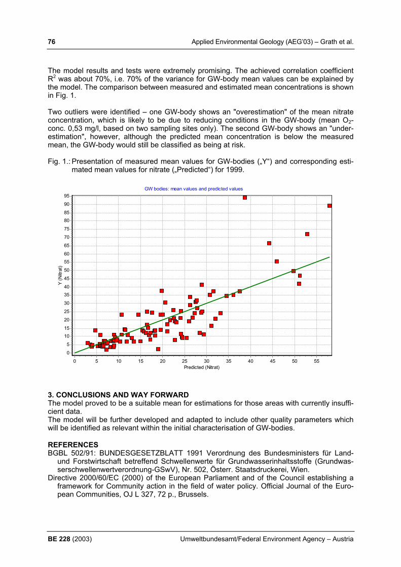
76 Applied Environmental Geology (AEG’03) – Grath et al.
BE 228 (2003) Umweltbundesamt/Federal Environment Agency – Austria
The model results and tests were extremely promising. The achieved correlation coefficient R2 was about 70%, i.e. 70% of the variance for GW-body mean values can be explained by the model. The comparison between measured and estimated mean concentrations is shown in Fig. 1. Two outliers were identified – one GW-body shows an "overestimation" of the mean nitrate concentration, which is likely to be due to reducing conditions in the GW-body (mean O2-conc. 0,53 mg/l, based on two sampling sites only). The second GW-body shows an "under-estimation", however, although the predicted mean concentration is below the measured mean, the GW-body would still be classified as being at risk. Fig. 1.: Presentation of measured mean values for GW-bodies („Y“) and corresponding esti-
mated mean values for nitrate („Predicted“) for 1999.
GW bodies: mean values and predicted values
Predicted (Nitrat)5550454035302520151050
Y (N
itrat
)
95
90
8580
75
70
65
6055
50
45
4035
30
25
20
1510
5
0
3. CONCLUSIONS AND WAY FORWARD The model proved to be a suitable mean for estimations for those areas with currently insuffi-cient data. The model will be further developed and adapted to include other quality parameters which will be identified as relevant within the initial characterisation of GW-bodies. REFERENCES BGBL 502/91: BUNDESGESETZBLATT 1991 Verordnung des Bundesministers für Land-
und Forstwirtschaft betreffend Schwellenwerte für Grundwasserinhaltsstoffe (Grundwas-serschwellenwertverordnung-GSwV), Nr. 502, Österr. Staatsdruckerei, Wien.
Directive 2000/60/EC (2000) of the European Parliament and of the Council establishing a framework for Community action in the field of water policy. Official Journal of the Euro-pean Communities, OJ L 327, 72 p., Brussels.

Applied Environmental Geology (AEG’03) – Hannich & Hötzl 77
Umweltbundesamt/Federal Environment Agency – Austria BE 228 (2003)
EARTHQUAKE INDUCED SOIL LIQUEFICATION AS A HIGH GEO- RISK FACTOR D. Hannich & H. Hötzl University of Karlsruhe, Dept. of Applied Geology, Kaiserstr. 12, D-76128 Karlsruhe, Germa-ny, [email protected]; [email protected] 1. INTRODUCTION More and more importance is accorded in the last years to the geo-risk assessment of soil liquefaction phenomena in regions with a relative high potential of strong earthquakes. The liquefaction is a very complex phenomenon, which can appear in sandy soils under different geotechnical and hydrogeological conditions initiated by strong earthquakes. In this paper will be presented the main geotechnical parameters, which determine the liquefaction poten-tial of sandy layers, the importance of the hydrogeological conditions for occurrence of lique-faction, and the triggering mechanism (pore water pressure excess) of the liquefaction by earthquakes. It will be presented also the most common effects of soil liquefaction like ground cracks, sand volcanoes (“sand boils”), differentiated soil-settlements, landslides and others. The different influencing parameters for liquefaction are studied by the authors in the frame of a German/Romanian cooperative project SFB-461 in correlation with the well-known strong earthquakes occurring in the Vrancea epicentral zone, located at the Carpathian arch in Romania. The study of the liquefaction phenomena, their occurring due to the influencing parameters combined with the triggering conditions during earthquakes, can be done only by a interdisciplinary cooperation, in which geotechnical, geological, hydrogeological and seis-mological knowledge is needed. 2. INFLUENCING FACTORS FOR LIQUEFACTION The liquefaction potential of sandy layers is influenced by main geotechnical parameters, like the grain-size distribution, the grain constitution, the soil compactness / density state, the age of the layer / his geologic history, the consolidation status, the depth of burial and ground slope. Each of these parameters has its specific influence on the liquefaction potential. The grain size distribution has a primordial importance, because mainly in sandy layers with fine to medium grain size distribution occurs the liquefaction status is arrived. But recently also coarser-grained and well-graded soils were considered to be able too to get the liquefaction status (Kramer, 1996). The grain constitution is important for the liquefaction behaviour of sandy layer. Sands with rounded grains will suffer more easy liquefaction as sands with an-gular grains. The soil compactness, represented generally by the relative density, has a great influence on the liquefaction behaviour of a layer. Loose sediments will favour liquefaction. The age of a sandy layer respectively his geologic history plays an important role for the liq-uefaction potential, because younger ones will be less compacted and consolidated and will be easier liquefied (YOUD, 1991). Pleistocene or Holocene sands will be more easily liquefi-able than older ones (KRAMER, 1996). The depth of burial has also importance, because only shallow layers can be liquefied. The optimum depth of burial is considered to be up to 20 m (YOUD, 1991; KRAMER, 1996, and others). All these enounced geotechnical parame-ters are influencing each other and play together an important role for the liquefaction poten-tial of a sandy layer. The hydrogeological conditions of a region play a primordial role for the producing of liq-uefaction phenomena: liquefaction occurs only in saturated soils. So the depth of groundwa-ter (either free or confined) influences the liquefaction susceptibility. The liquefaction suscep-tibility decreases with increasing groundwater depth; the effects of liquefaction are most commonly observed at sites where the groundwater is within a few meters of the ground sur-face. At sites where the groundwater level fluctuates significantly (seasonal or long-time trends), liquefaction hazards may also fluctuate (KRAMER, 1996).

78 Applied Environmental Geology (AEG’03) – Hannich & Hötzl
BE 228 (2003) Umweltbundesamt/Federal Environment Agency – Austria
3. THE MECHANISM OF LIQUEFACTION INITIATION The fact that a soil deposit is susceptible to liquefaction form the geotechnical and hydro-geological point of view, does not mean that liquefaction will necessarily occur during a given earthquake. Its occurrence requires a disturbance that is strong enough to initiate or trigger it. The evaluation of the nature of that disturbance is one of the most critical parts of a lique-faction hazard evaluation. If the triggering earthquake is strong enough, the mechanism of occurrence of liquefaction can be explained by the status when the increasing pore pressure due to seismic cyclic excitation is equalising the static geologic overburden pressure. Starting from this moment, the liquefaction is initiated and the stability and stiffness of the sandy layer is lost and effects of liquefaction will appear. To demonstrate the site response during seismic excitation, i.e. the mechanism of liquefac-tion initiation, recently field-instrumentation was operated in regions with high potential of strong earthquakes, to observe in-situ the correlation between acceleration and pore pres-sure increasing during earthquakes. Such records were firstly done in 1987 at Wildlife Site in California by Youd and Holzer (YOUD et al., 1994). Similar measurements are recently initi-ated by the authors of this paper in Bucharest/Romania, to evaluate in-situ the liquefaction potential of shallow sandy-gravely layers during Vrancea earthquakes. 4. EFFECTS OF LIQUEFACTION AND HAZARD EVALUATION The effects of liquefaction are very various and depend on the local geologic, hydrogeologic conditions of a site and also on the magnitude and epicentral distance of the initiating earth-quake. Among the most common effects of soil liquefaction must be mentioned ground cracks, sand volcanoes (“sand boils”), differentiated soil-settlements, landslides, damaging of sand dames and dikes, and others. Such effects could cause in an urban areas widespread loss of life, damage of buildings, bridges, freeways and lifelines. To prevent such damages and risks for the population of an endangered region, a hazard evaluation respectively a liq-uefaction susceptibility mapping of the region must be carried out (ISHIHARA, 1993). 5. CONCLUSIONS Soil liquefaction is a frequent phenomenon in regions with a high potential of strong earth-quakes and can cause great human and material damages. The high geo-risk factor of this earthquake-induced phenomenon requires well-documented hazard evaluation maps, to en-able corresponding prevention measures for existing and future constructions. The complex-ity of this phenomenon needs an interdisciplinary study by geotechnical, geological, hydro-geological and seismological scientists. REFERENCES ISHIHARA, K. (1993): Liquefaction and flow failure during earthquakes. Geotechnique, 43(3),
p. 351-415 KRAMER, S. L. (1996): Geotechnical Earthquake Engineering. University of Washington,
Prentice-Hall Int. Series YOUD, L., HOLZER, Th. L. (1994): Piezometer performance at Wildlife liquefaction site, Cali-
fornia. Journal of Geotechnical Engineering, Vol. 120, No. 6, p. 975-995 YOUD, T. L. (1991): Mapping of earthquake-induced liquefaction for seismic zonation. Proc.
Fourth Int. Conf. Seismic Zonation I, 111-147.

Applied Environmental Geology (AEG’03) – Häusler & Leber 79
Umweltbundesamt/Federal Environment Agency – Austria BE 228 (2003)
CLIMATIC CHANGE IN THE EASTERN HIMALAYA AS DERIVED FROM METEOROLOGICAL DATA AND GLACIER MELT PRO-CESSES H. Häusler1) & D. Leber2)
1) Department of Geological Sciences, University of Vienna, A-1090 Wien, Althanstraße 14;
[email protected], 2) GeoExpert Research & Planning, Vienna, Austria, [email protected] 1. INTRODUCTION Environmental change in the Eastern Himalaya was investigated in the Tibet-Bhutan section by using remote sensing methods, climatic data and ground check such as local mapping the geomorphology and subsurface geology. Change detection of the High Himalayan environ-ment is based on time series analysis of satellite data, and direct and indirect methods of the assessment of climatic change. 2. METHODS As climatic data in the Tibet Autonomous Region (TAR) is available since the early 50ies of the last century and thus matching the time series analysis of the retreat of glaciers in north-ern Bhutan, the influence of regional warming on the glaciated environment could be as-sessed for the last 50 years (Figure 1). Remote sensing and field investigations in the Bhutan Himalaya revealed however, that the history of glacier lake development (from retreating gla-ciers) differs locally.
13 Pali
14 Rigeze
15 Dangxiong
16 Lhasa
Fig. 1: Trend of mean annual air temperature at four selected meteorological stations in southern Tibet, situated on the Tibetan Plateau north of Bhutan (LEBER et al., 1995). The temperature of 16 of the 17 meteorological stations in Tibet between 1952 and 1992 shows an increase of the annual air temperature of 0.0001°C -0.07°C/year (Figure 1), which is comparable with the continental temperature trends showing an increase between 1860 and 1990 of at maximum 0.8°C/100 years (LEBER & HÄUSLER, 1998). 3. RESULTS As precipitation in Tibet is mainly controlled by the summer monsoon originating from the Gulf of Bengal, which is also the case for the Bhutan Himalaya, a similar regional trend of the air temperature during the last 50 years can be assumed for Bhutan, although meteorological data from this country is available from 15 low land-stations dating back 10 years only. The

80 Applied Environmental Geology (AEG’03) – Häusler & Leber
BE 228 (2003) Umweltbundesamt/Federal Environment Agency – Austria
overall pattern of glacier retreat in northern Bhutan is not comparably similar as it is locally in-fluenced by different distribution of air temperature, wind direction, humidity etc., thus result-ing in different equilibrium line altitudes of the glaciers. Depending on the relief geometry, exposition, and size of the glaciers, glacier retreat differs between neighbouring valleys. Be-cause of a glacier lake outburst in 1956 in Tarina (northern Bhutan) it is obvious, that glacier lakes in Tarina existed in the early 50ies of the last century already, whereas some 30 kilo-meters east of Tarina, in Lunana, glacier retreat was much slower and therefore glacier lake outburst floods (GLOFs) occurred in 1994, some 40 years later than in the west (BRAUNER et al., 2003). The fact, that the local development of big glacier lakes differs more than 50 years, needs a more sophisticated approach of assessing the Himalayan environment, not only by interpret-ing time series analysis of satellite images. For the last 50 years this regional warming very well explains the trend of glacier retreat in general but does not explain the local differences in time and space and therefore cannot be a proper tool for a more sound prediction of local glacier retreat and glacier lake development, as requested by the local governments. 4. CONCLUSIONS To assess the future consequences of regional warming in the Himalaya is a big challenge, because major development zones of the Himalayan countries will suffer from severe geo-hazards caused by increased glacier melt. Up to now no scientific approach is visible to as-sess the velocity of glacier retreat as a basis for the prediction of the increase of geo-hazards such as mass movements and floods in space and time. This is not only a fact for the coun-tries of the Eastern Himalaya (Nepal, Bhutan and China) but for all the other countries of the Karakorum-Hindukush-Himalaya region such as Pakistan, Afghanistan, and India. Coopera-tion partners for joining a future remote sensing project on monitoring and modelling the envi-ronmental change of the Himalayas are warmly welcomed. REFERENCES LEBER, D., HOLAWE, F. & HÄUSLER, H. (1995): Climatic classification of the Xizang/Tibet
Autonomous region (P. R. CHINA) using multivariate geostatistical methods.- GeoJournal, 37 (4), 451-473, 8 fig., 8 tab., London.
LEBER, D. & HÄUSLER, H. (1998): Research on environmental change in Southern Tibet.- Proc. Int. Conf. on Ecohydrology of High Mountain Areas, Kathmandu, 24-28 March 1996, 489-503, 11 fig., 2 tab., Kathmandu/Nepal.
BRAUNER, M., AGNER, P., VOGL, A., LEBER, D., HÄUSLER, H., & DORJI WANGDA (2003): Estimation of glacial outburst floods in Himalayan watersheds by means of quanti-tative modelling.- XXVIII General Assembly, European Geophysical Society, Nice, France, 6-11 April 2003, Abstract, Nice.

Applied Environmental Geology (AEG’03) – Häusler et al. 81
Umweltbundesamt/Federal Environment Agency – Austria BE 228 (2003)
INTEGRATION OF GEOLOGICAL AND AIR-BORNE GEOPHYSICAL DATA FOR GROUNDWATER PROSPECTING IN THE BOHEMIAN MASSIF OF UPPER AUSTRIA H. Häusler1), R. Faber1) & G. Oberlercher2) 1) Department of Geological Sciences, University of Vienna, A-1090 Wien, Althanstraße 14;
[email protected], [email protected] 2) HTL Villach, Tschinnitschlerweg 5, A-9500 Villach; former adress: Geological Survey of
Austria, Rasumofskygasse 23, A-1030 Wien 1. INTRODUCTION The Mühlviertel is the northernmost region of Upper Austria and suffers from water supply as its valleys are situated between 450 and 600 m altitude, and precipitation varies between 700/1250 mm/year in the west and 600/1000 mm/year in the east. The Variscian crystalline basement is deeply eroded and partially covered by Tertiary and Quaternary sediments. The topographic sheet of the Austrian map ÖK 1:50.000, Nr. 34 (Perg), was chosen because aerogeophysical data from a helicopter flight in 1986 was available from a preceding project on raw materials (MATURA, 1988). A previous study on the groundwater potential in the crystalline of the Bohemian Massif was published by STIBITZ (1998). The new project aimed at an estimation of new aquifers as were reported by the geological experts of Upper Austria at depths of 100-150 meters. For the very first time in Austria air-borne geophysical data was calibrated by geological and bore hole data using the newly de-veloped software package WinGeol (geology for windows), a software for synoptic interpreta-tion was used to calibrate aero-geophysical datasets with other data like bore logs, geologi-cal maps and outcrop data (FABER, 2002). Aero-geophysical data from 1986 was reproc-essed by Gernot Oberlercher. Hydrogeological investigations were carried out by Peter Raumauf (RAUMAUF, 2002). We acknowledge the financial support by the Federal Ministry of Education, Science & Culture and the Provincial Government of Upper Austria (grant Bund/Bundesländer-Kooperationsprojekt OA39 Hydrogeologie und Fernerkundung Blatt ÖK34, Perg; see HÄUSLER et al., 2002). 2. METHODS The results of the following methods were integrated in order to evaluate the groundwater re-source potential of the crystalline fault aquifers and the pore aquifers of the Quaternary and Tertiary sediments:
Hydrogeologic mapping of 600 km2 comprising field measurements at 119 wells, 87 springs and 585 hydrochemical laboratory analysis (provided by the “Oberösterreichischer Wasserbus”)
29 isotope analysis (O-18, tritium) of selected wells and springs Lineament analysis of aerial photos, satellite images, air-borne geophysical data, and
of the digital elevation model Structural geologic mapping of 30 outcrops in the crystalline basement for assessing
the major fault directions and measuring the respective joint volume Geological profiles based on bore hole drilling data Calibration of air-borne electromagnetic data by bore hole data 2-D and 3-D digital were combined by using the modules “profile-module”, well-
module”, “lineament-module”, “outcrop-module”, and “fault trace- module”
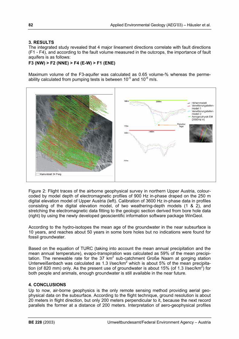
82 Applied Environmental Geology (AEG’03) – Häusler et al.
BE 228 (2003) Umweltbundesamt/Federal Environment Agency – Austria
3. RESULTS The integrated study revealed that 4 major lineament directions correlate with fault directions (F1 - F4), and according to the fault volume measured in the outcrops, the importance of fault aquifers is as follows: F3 (NW) > F2 (NNE) > F4 (E-W) > F1 (ENE) Maximum volume of the F3-aquifer was calculated as 0.65 volume-% whereas the perme-ability calculated from pumping tests is between 10-5 and 10-6 m/s.
Figure 2: Flight traces of the airborne geophysical survey in northern Upper Austria, colour-coded by model depth of electromagnetic profiles of 900 Hz in-phase draped on the 250 m digital elevation model of Upper Austria (left). Calibration of 3600 Hz in-phase data in profiles consisting of the digital elevation model, of two weathering-depth models (1 & 2), and stretching the electromagnetic data fitting to the geologic section derived from bore hole data (right) by using the newly developed geoscientific information software package WinGeol. According to the hydro-isotopes the mean age of the groundwater in the near subsurface is 10 years, and reaches about 50 years in some bore holes but no indications were found for fossil groundwater. Based on the equation of TURC (taking into account the mean annual precipitation and the mean annual temperature), evapo-transpiration was calculated as 59% of the mean precipi-tation. The renewable rate for the 37 km2 sub-catchment Große Naarn at gorging station Unterweißenbach was calculated as 1.3 l/sec/km2 which is about 5% of the mean precipita-tion (of 820 mm) only. As the present use of groundwater is about 15% (of 1.3 l/sec/km2) for both people and animals, enough groundwater is still available in the near future. 4. CONCLUSIONS Up to now, air-borne geophysics is the only remote sensing method providing aerial geo-physical data on the subsurface. According to the flight technique, ground resolution is about 20 meters in flight direction, but only 200 meters perpendicular to it, because the next record parallels the former at a distance of 200 meters. Interpretation of aero-geophysical profiles

Applied Environmental Geology (AEG’03) – Häusler et al. 83
Umweltbundesamt/Federal Environment Agency – Austria BE 228 (2003)
therefore only was carried out for high resolution data in NW direction. Calibration of aero-geophysical models by borehole data is an inevitable prerequisite. As in general no specific bore hole drilling for scientific interpretation is affordable, the quality of local profile interpreta-tion is limited. Future air-borne geophysical projects for groundwater prospecting should be planned where geology basically is simple and matches a geophysical 2-layer model (layer 1: hard rock – layer 2: weathering and sedimentary cover). If possible, high resolution data should be re-corded also perpendicular to the flight direction. To evaluate the model depth of aero-geophysical data, calibration by borehole data is highly recommended. In addition, field geo-physics should be applied for local interpretation of the aero-geophysical dataset. In case that a specific aero-geophysical program fulfilling the above described needs cannot be afforded, similar information on hydrogeology can be achieved by combining structural geological data, a high resolution digital elevation model, and of course, lithology from neighbouring boreholes. WinGeol has proven a powerful software tool for integrating this dif-ferent data sets and different formats. REFERENCES FABER, R. (2002): WinGeol - Softwarepaket zur Erstellung hydrogeologischer Modelle mit-
tels aerogeophysikalischer und strukturgeologischer Daten sowie des digitalen Höhenmo-dells.- Unveröff. Diss. Fak. Naturwissenschaften und Mathematik Univ. Wien, 130 S., 72 Abb., 16 Tab., (Institut für Geologie der Universität Wien), Wien.
HÄUSLER, H., FABER, R., RAUMAUF, P., WIESMAYR, G. & OBERLERCHER, G. (2002): Schlußbericht des Projektes OA39: Hydrogeologie und Fernerkundung Blatt ÖK34, Perg (Oberösterreich).- 94 S., 79 Abb., 4 Tab., Anhang, (Institut für Geologie der Universität Wien), Wien.
MATURA, A. (Hrsg.) (1988): Rohstoffpotential östliches Mühlviertel, Endbericht Projekt OC 6a/86-87.- Ber. Geol. B.-A., 14, 241 S., 42 Abb., 31 Tab., 51 Listen, 70 Beil., (Geol. B.-A.), Wien.
RAUMAUF, P. (2003): Zur Hydrogeologie des Blattes Perg – ÖK34.- Unveröff. Diplomarbeit, Fakultät für Naturwissenschaften und Mathematik der Univ. Wien, 70 S., 35 Abb., 9 Tab. (Institut für Geologische Wissenschaften - Geologie), Wien.
STIBITZ, M. (1998): Investigation of groundwater potential in crystalline of the Bohemian Massif in Austria.- Münchner Geol. Hefte, Reihe B, H. 8, 123-128, 2 fig., 4 tab., München.
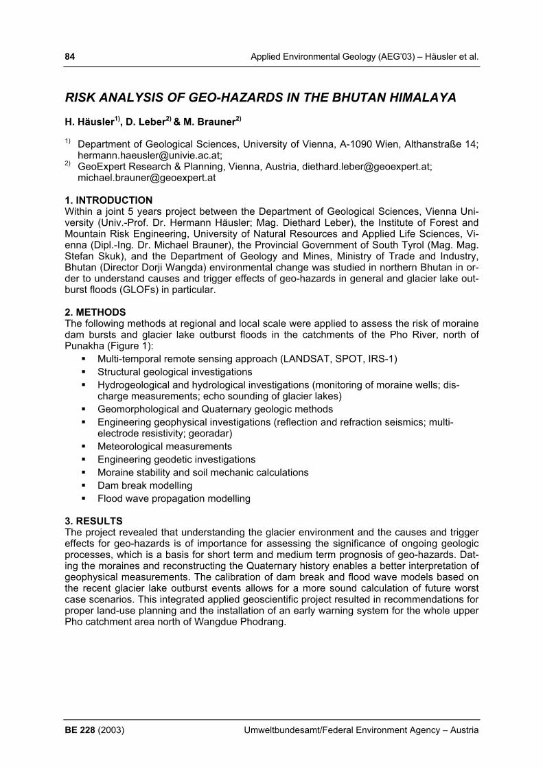
84 Applied Environmental Geology (AEG’03) – Häusler et al.
BE 228 (2003) Umweltbundesamt/Federal Environment Agency – Austria
RISK ANALYSIS OF GEO-HAZARDS IN THE BHUTAN HIMALAYA H. Häusler1), D. Leber2) & M. Brauner2) 1) Department of Geological Sciences, University of Vienna, A-1090 Wien, Althanstraße 14;
[email protected]; 2) GeoExpert Research & Planning, Vienna, Austria, [email protected];
[email protected] 1. INTRODUCTION Within a joint 5 years project between the Department of Geological Sciences, Vienna Uni-versity (Univ.-Prof. Dr. Hermann Häusler; Mag. Diethard Leber), the Institute of Forest and Mountain Risk Engineering, University of Natural Resources and Applied Life Sciences, Vi-enna (Dipl.-Ing. Dr. Michael Brauner), the Provincial Government of South Tyrol (Mag. Mag. Stefan Skuk), and the Department of Geology and Mines, Ministry of Trade and Industry, Bhutan (Director Dorji Wangda) environmental change was studied in northern Bhutan in or-der to understand causes and trigger effects of geo-hazards in general and glacier lake out-burst floods (GLOFs) in particular. 2. METHODS The following methods at regional and local scale were applied to assess the risk of moraine dam bursts and glacier lake outburst floods in the catchments of the Pho River, north of Punakha (Figure 1):
Multi-temporal remote sensing approach (LANDSAT, SPOT, IRS-1) Structural geological investigations Hydrogeological and hydrological investigations (monitoring of moraine wells; dis-
charge measurements; echo sounding of glacier lakes) Geomorphological and Quaternary geologic methods Engineering geophysical investigations (reflection and refraction seismics; multi-
electrode resistivity; georadar) Meteorological measurements Engineering geodetic investigations Moraine stability and soil mechanic calculations Dam break modelling Flood wave propagation modelling
3. RESULTS The project revealed that understanding the glacier environment and the causes and trigger effects for geo-hazards is of importance for assessing the significance of ongoing geologic processes, which is a basis for short term and medium term prognosis of geo-hazards. Dat-ing the moraines and reconstructing the Quaternary history enables a better interpretation of geophysical measurements. The calibration of dam break and flood wave models based on the recent glacier lake outburst events allows for a more sound calculation of future worst case scenarios. This integrated applied geoscientific project resulted in recommendations for proper land-use planning and the installation of an early warning system for the whole upper Pho catchment area north of Wangdue Phodrang.
Applied Environmental Geology (AEG’03) – Häusler et al. 85
Umweltbundesamt/Federal Environment Agency – Austria BE 228 (2003)
Fig. 1: Application of regional methods covering the whole Pho River catchments (region A-C), such as remote sensing, applied geological methods in the glaciated area A, and numeric modelling of flood waves in the respective sections (A-C) to assess the risk of geo-hazards in the Bhutan Himalaya. 4. CONCLUSIONS General risk analysis of geo-hazards in the Himalaya is only reliable on the basis of detailed field work and analysis of the cause and trigger effects of glacier lake outburst floods. Re-mote sensing analysis is a very valuable tool for GIS analysis but not capable to assess sub-surface features such as volume of glacier lakes, melting ice cores or seepages which are basic for local risk assessment of the lake-damming moraines. We acknowledge the Austrian Development Cooperation (Federal Ministry of Foreign Affairs) and the Ministry of Trade and Industry (Royal Government of Bhutan) for funding the applied geoscientific project on glacier lake outburst mitigation in northern Bhutan. REFERENCES BRAUNER, M., LEBER, D., HÄUSLER, H., TOBGAY & DORJI WANGDA (2003): Semiquan-
titative multi-hazard risk assessment concepts for a Himalayan watershed in NW-Bhutan.- XXVIII General Assembly, European Geophysical Society, Nice, France, 6-11 April 2003, Abstract, Nice.
BRAUNER, M., AGNER, P., VOGL, A., LEBER, D., HÄUSLER, H., & DORJI WANGDA (2003): Estimation of glacial outburst floods in Himalayan watersheds by means of quanti-tative modelling.- XXVIII General Assembly, European Geophysical Society, Nice, France, 6-11 April 2003, Abstract, Nice.
PAYER, T., LEBER, D., HÄUSLER, H., BRAUNER, M. & DORJI WANGDA (2003): Snow/ice melt precipitation runoff modelling of glaciers in the Bhutan Himalaya.- XXVIII General As-sembly, European Geophysical Society, Nice, France, 6-11 April 2003, Abstract, Nice.
86 Applied Environmental Geology (AEG’03) – Havas-Szilágyi
BE 228 (2003) Umweltbundesamt/Federal Environment Agency – Austria
IMPLEMENTATION OF THE WATER FRAMEWORK DIRECTIVE IN HUNGARY E. Havas-Szilágyi Ministry of Environment and Water, H-1011 Budapest Fő u. 44-50. Hungary, [email protected] The 2000/60/EC Directive establishing a framework for the Community action in the field of water policy alias Water Framework Directive imposed a great challenge from the date of coming into force in the end of 2000. Since the tasks and deadlines are the same for the present and future member states the accessing countries have been involved in the Common Implementation Strategy almost from the beginning. The objectives of the Water Framework Directive (WFD) should be pursued for river basins and according to the WFD this unit is the Danube River Basin. The Danube River Basin is shared by 13 countries, EU member states, countries in different stages of accession and others increasing the complexity and difficulties even if all the parties of the Danube River Protection Convention (Sofia Convention) agreed in the implementation of the WFD. The tasks to be performed can be summarised as follows: deadline Transposition into the national legislation end of 2003 Identification of competent authorities end of 2003 Characterisation of River Basin Districts end of 2004
(Identification of water bodies, list of protected areas, pressure/impact analyses, economic analyses of water uses etc.) Monitoring programmes end of 2006 River Basin Management Plans end of 2009 Programme of measures (operational) end of 2012 Reaching good status end of 2015
According to the WFD surface water and groundwater bodies shall be identified and characterised and assess the degree to which they are at risk of failing to reach the good status in 2015. Therefore presently these are the fields of the main activity. The designation of the groundwater bodies has been started in 2001. Due to the geological situation of the country – laying practically in the middle of the Carpathian Basin relatively large and thick water bodies have been separated based on the following hierarchical approach (see Fig.1): 1. Karstic and porous aquifers are separated considering geological units. Fissured rocks
are partly designated (recharge areas of springs or locally significant abstractions). 2. In porous aquifers further separation has been done according to downward or upward
flow at regional scale ( connected recharge and discharge areas form “subsurface catchment areas”).The geological units of the porous aquifers are separated into 24 water bodies with downward and 18 water bodies with upward flow.
3. Thermal water resources are important in Hungary. The temperature limit value is 30 oC.
In the porous aquifers thermal water bodies represent a third level in the vertical separation 6 thermal water bodies have been separated.

Applied Environmental Geology (AEG’03) – Havas-Szilágyi 87
Umweltbundesamt/Federal Environment Agency – Austria BE 228 (2003)
4. In karstic aquifers the geological units mean hydraulic boundaries as well. Relating the karstic thermal water bodies the separation is horizontal (there is no significant vertical thermal stratification): 11 cold and 15 thermal water bodies have been separated.
5. In mountainous areas 15 water bodies have been designated representing fissured rocks,
or locally important water abstractions
Fig. 1 Schematic sketch of Hungarian groundwater bodies
In the WFD there are some parts which are irrelevant for us (e.g.: designation of river basin districts, or coastal and transitional waters) therefore meaning no tasks to fulfil. But this is compensated considerably by that Hungary is surrounded by seven neighbouring countries and many discussions and harmonisation on the transboundary water bodies are foreseen. REFERENCES DIRECTIVE 2000/60 EC OF THE EUROPEAN PARLIAMENT AND OF THE COUNCIL
Establishing a framework for Community action in the field of water policy. Official J. Committies, L327/1-72, 22.12.2000, Brüssels
HORIZONTAL GUIDANCE document on the application of the term “water body” in the context of the Water Framework Directive, 2003 Brüssels (under publ.)
REPORT on the designation of groundwater bodies according to the Water Framework Directive, University of Technology and Economics, Budapest, 2003.
Porous aquifer of local importance
Thermal water > 30 oC) In porous aquifers
Thermal karstic aqu.
(> 30 oC)
Porous strata(aquifers)
Cold karstic aquifer
Water in fissured rocks
Border of subsurface catchments
Border of upward and downward
SShhaallllooww aaqquuiiffeerrss

88 Applied Environmental Geology (AEG’03) – Helios Rybicka & Rybicki
BE 228 (2003) Umweltbundesamt/Federal Environment Agency – Austria
IMPACT OF COAL MINING ON THE ENVIRONMENT IN POLAND E. Helios Rybicka & S. Rybicki AGH University of Science and Technology, Al. Mickiewicza 30, 30-059 Krakow, Poland e-mail: [email protected] 1. INTRODUCTION From about 400 million Mg/y of mineral resources recently exploited in Poland, the most im-portant are hard coal and lignite, about 110 Mio. Mg/y and 62,5 Mio. Mg/y respectively; lignite output in Poland gives 5th place in World’s production. Hard coal and lignite recoverable re-sources in Poland are 46 846 Mio. Mg and 14 050 Mio. Mg respectively. Recently hard coal has been mined in 49 mines in three regions: (1) Upper Silesia Coal Basin (USCB), (2) Rybnik Coal District (RCD), and (3) Lublin Coal Basin (LCB). Lignite has been mined in 11 open pits and three regions: (1) Belchatów Brown Coal Basin (BBCB), Konin Brown Coal Basin (KBCB), and (3) Turoszów Brown Coal Basin (TBCB). 2. RESULTS & DISSCUSION In the years 1980-2000 hard coal production has gradually decreased from about 200 Mio. Mg/y in 80’s down to about 100 Mio. Mg/y in 2000. While lignite production reached the high-est amount of 73.4 Mio. Mg/y in 1988, and from this time slowly decreased, down to 62,5 Mio. Mg in year 2000. Coal mining activities impose harmful, usually irreversible impacts on the terrestrial and aquatic environments, from which the most important are: • terrain deformation; • waste generation - changes of landscape; • changes in hydrogeological system; • hydrological and hydrochemical transformations of the surface water flows; • contamination of atmosphere; • contamination of soils. Negative effects of mining activity are especially recognisable at the Upper Silesia Coal Ba-sin, as hard coal has been intensively exploited there for about 160 years. In the 1980s, all of 62 hard coal mines using an area of about 1600 km2, have produced 190 - 200 Mio. Mg per year of hard coal. A substantial amount of a hard coal extracted is burned in several power stations and in the heating-power plants of the Silesia agglomeration, which at the area of 6650 km2 (about 3 % of the total area of Poland) has about 4 million residents (Nowicki, 1993, Helios Rybicka, 1996). Terrain deformation. At present the total area of coal mining land development in Poland is as high as 144 km2. Coal extraction cause generation of huge amount of wastes, e.g. 1 Mg of hard coal generate 0.3 – 0.45 Mg of waste. The changes of landscape resulted with overbur-den dumps from lignite mining, with the total area of about180 km2 and of hard coal mining waste disposals, with total area of about 31 km2. The highest areas of the coal mining de-graded soils are in three Polish provinces, of Wielkopolskie (Poznan), Dolnoslaskie (Lower Silesia) and Slaskie (Upper Silesia), from which only small part has been reclamated. From the total amount (126.2 Mio. Mg) of industrial wastes generated in Poland in 1999, about 32 % resulting from coal processing. At the Silesia province, from about 49 Mio. Mg of gener-ated wastes (above 4000 Mg/km2), more than 34 Mio. Mg make wastes from hard coal processing. Generally, the yearly generation of the hard coal mining wastes decreased but of lignite is on the similar level of about 250 Mio. m3. From the total amount of coal mining wastes accumulated in 2000, about 752 Mio. Mg has arisen from hard coal, and about 6000 Mio. m3 of overburden material from lignite output (Rybicki, 1986). Hydrological and hydrochemical transformations of the surface water flows. The main sources of the surface water contamination are contaminated mining waters and the mining wastes. Mining waters contain high amount of Cl and SO4 ions, up to 50–100 g/dm3. Accord-ing to the results of the national monitoring of the surface flows, the salinity of the Vistula
Applied Environmental Geology (AEG’03) – Helios Rybicka & Rybicki 89
Umweltbundesamt/Federal Environment Agency – Austria BE 228 (2003)
river water, decreased up to the level of III rd class of the water quality standards, at the San river outlet (after about 300 km). In 1998 the operating 62 coal mines at the Upper Silesia Coal Basin, discharged about 720 000 m3 of water per day from 83 discharge points. These waters were rich in Cl and SO4 ions but also in the heavy metals. The best indicators of the river systems contamination are the bottom sediments and/or river suspended matter. The concentration of heavy metals in the bottom sediments of the Vistula river is high and can reach (mg/kg) up to 6000 of Zn, 800 of Pb and 140 of Cd. The content of heavy metals in the upper Odra river is rather high, resulting with the bottom sediments geochemical classes 5 and 4 for Cd and 3 and 4 for Zn. Moreover mining waters contain the radioactive elements i.e. Ra226 and Ra228, which radioactivity ranged from 0.1 to 20 kBq/m3. Generated mining wastes are the considerable sources of both types of contaminants - salin-ity and heavy metals. Total amount of coal mining wastes generated in 1999 was 44,7 Mio. Mg. The most dangerous environmental hazard caused by waste dumps is the pollution of surface and ground waters, and soils, by soluble compounds leached from the wastes. This finding was supported by studies of pore solutions derived from the carboniferous spoils and of waters seeping from the dumps. Aqueous solutions which are highly contaminated with the products of sulphides decomposition occur throughout the full thickness of typical spoil dumps. It was estimated that in the period 1984-2000 ca. 900 Mio. m3 of spoils were dumped at USCB area, which released ca. 40 000 Mg/y of chlorides and 450 000 Mg of sul-phates. Formation of dangerous, acidic waters with pH < 4 appears to be a common effect. Pollution of the soils. At the USCB region the soils in the neighbourhood of the hard coal mines, and especially of the spoils and cleaning wastes. About 54 % of the generated wastes have been dumped on the surface. The wastes are carboniferous claystons, mudstones and gravelstones/conglomerates, all of which contain variable amounts of metals and sulphides. The uncovered waste dumps (e.g. no vegetation) at their nearest surroundings caused a pol-lution of soils, because of dusting, and of leaching processes of above mentioned contami-nants. However, at the heavy industrialised areas like Upper Silesia region, it is almost im-possible to distinguish the sources of soil contamination. Environmental consequences of coal mines closure. Environmental problems have been ap-peared by coal mines closure. In 1994-1998 in the LSCB - 5 mines were closed. Stopping of water drainage and ventilation of mine workings led to reconstruction of groundwater horizon. The gassiness of coal is high and reaches value of 22,8 dm3 CO2/kgdaf (kgdaf – kg dry ash free) and about 30 dm3/ kgdaf for CH4. Systematic rise of water table within the Carboniferous strata expels the coal-bed gases to the surface, like “piston effect” (Kotarba, 2001). The con-tent 2-17 % of CO2, and CH4 over 1 % (max. 49%) were stated at urban area of about 9 km2 (Dzieniewicz, Sechman, 2001). REFERENCES DZIENIEWICZ M. & SECHMAN H. (2001): (unpublished data). HELIOS RYBICKA, E. (1996): Impact of mining and metallurgical industries on the environ-
ment in Poland. Applied Geochemistry, Vol. 11, 3-9. KOTARBA, M., DZIENIEWICZ, M., KORUS, A., SECHMAN, H., GOGOLEWSKA, A.,
GRZYBEK, I., KOMINOWSKI, K. & PLONKA, A. (2001): Gas hazard (methan and carbon dioxide) in the near-surface zone caused by mine closure – examples from urban area in the central part of the Walbrzych Coal District. In: KOTARBA M. (ed.) Transformation of the natural environment and ecodevelopment. GEOSFERA, 185-210, Krakow.
NOWICKI, M. (1993): Environment in Poland, Issues and Solutions. KLUWER, 191. RYBICKI, S. (1986): Structure and physico-mechanical properties of dump soils. Proc. 5th
Inter. IAEG Congress. Buenos Aires, 1019-1027.

90 Applied Environmental Geology (AEG’03) – Helios Rybicka & Adamiec
BE 228 (2003) Umweltbundesamt/Federal Environment Agency – Austria
SEDIMENT ASSESSMENT IN THE ODER RIVER SYSTEM; RECOMMENDATIONS FOR THE TRANSBOUNDRY RIVERS MONI-TORING E. Helios Rybicka & E. Adamiec AGH University of Science and Technology, Al. Mickiewicza 30, Kraków, Poland e-mail: [email protected] 1. INTRODUCTION During the last decade the floods in some of the European River catchment areas, e.g. the Oder River (1997) and the Elbe River (2002), have revealed very wide spectrum of problems with contaminated sediments. During floods, contaminants bound with river solids can un-dergo very wide dispersion in food plains, polders, agricultural areas as well as urban and other residential areas. Very wide investigations of aquatic sediments have shown that for sediment assessment few components should be considered. The most important are the physicochemical properties of sediments and their bioaccumulation capacity. Studies of the Odra river sediments carried out during five sampling periods in the years 1997-2000, showed that the sediment assessment approach should be verified. 2. MATERIAL AND METHODS Very wide and intensive investigations of soluble and particulate pollutants in the Odra river system were carried out within the framework of the International Odra Project. Sediment samples were collected in five sampling periods: November ’97, May and November ’98, June ‘99 and May 2000. From the sediment samples the grain size fraction < 20 µm was separated and subjected to the chemical analysis. The suspended matter samples have been separated from river water on the membrane filters with pores of 0.45 µm diameter, and its concentration was established. The samples were treated according to the analytical procedures used prior (HELIOS RYBICKA, STRZEBOŃSKA, 1999), the metals were ana-lysed by ICP-MS. 3. RESULTS The mean metal concentration in all samples were as follows (mg/kg): 9.4 of Cd, 20.3 of Co, 73 of Cr, 110 of Cu, 2.9 of Hg, 51.6 of Ni, 123 of Pb, 1158 of Zn, 91.1 of As, 2670 of Mn and 4.11 % of Fe. In the samples from May ’98 and May 2000 the highest concentration about 20 mg/kg of Cd and 190 mg/kg of As was found. Quality assessment of the Odra River fine grained fraction (< 20 µm) of the bottom sediments were expressed either in terms of LAWA classification (IRMER, 1997), or according to the Igeo classes (MÜLLER, 1979). Obtained results from both classification methods of river sediment showed that the heavy metals pollution has been decreased, especially with Zn, Pb and Cu; thus an improvement of these metals situation was observed if compared the results from different sampling periods. For all metals studied in the Odra river sediments the sub-stantial reduction with Cd contamination, neither at the period after ’97 flood nor if compare with the earlier results, obtained before ’97, has been observed. The detected levels of metal contamination, mainly with Zn, Pb and Cd, in sediment samples of the Odra river were found to exceed the geochemical background values. Recommendations for the Rivers Monitoring. From the obtained results no big differences of metals contents were observed among the samples for the same river compartment (i.e. sediment, suspended matter or water), from the same locality, taken during the five sampling campaigns, thus both selection of the river compartment and sampling strategy optimisation will be discuss as following: (1) elaboration of the metal “trend” lines for every sampling cam-paign on the basis of each metal distribution in sediment or PSM from five sampling cam-paigns; (2) elaboration of the arithmetical mean of metal values from five sampling cam-

Applied Environmental Geology (AEG’03) – Helios Rybicka & Adamiec 91
Umweltbundesamt/Federal Environment Agency – Austria BE 228 (2003)
paigns; (3) selection of the samples groups based on the results of metal arithmetical means from five sampling periods and (4) calculation of metal arithmetical mean values from se-lected sample sets in the particular groups allowed to proposed only one sampling point for each of the six selected river sections. Selection of the river compartment(s) for Transboundary River Monitoring. Metals contents in the Odra river water were low and allowed to classified it into the 1st class (ADAMIEC, HELIOS RYBICKA, 2002). Generally the metal content in water are lower than the maximum admissible values for drinking water in Poland. In spite of the low metal content, a limited number for water monitoring sites had to be selected, and the samples investigated twice a year. Concerning the Odra river sediment quality, the concentrations of metals, in particular of Cd, Pb, Zn, Cu are high. No substantial differences among sediment sampling sites and sam-pling campaigns were observed. The “trend” line of all five sediment sampling campaigns are similar. Because of the most complicated sampling and analytical procedures of sediments if compare with PSM, we will recommend the last component for river monitoring. Interesting data for PSM were obtained by ADAMIEC and HELIOS RYBICKA (2002). On bases of the metals “trend” lines, the PSM samples were grouped using the results of arith-metical mean values of metals from five sampling periods. Calculation of metal arithmetical mean values from selected PSM sample sets in the particular groups allowed to proposed only one sampling point for each of the six selected Odra river sections. 4. CONCLUSIONS 1. The metal contamination level, mainly Zn, Cu, Pb and Cd, in many solid samples of the Odra river were found to exceed the geochemical background values. The relative highest metal pollution of the Odra river solids was found with Cd and As. The results showed that the dilution, re-suspension, and re–deposition processes at extreme high water events in 1997 have caused additional increase of metal content in both, the PSM and sediments. 2. Metal variability in the Odra river sediments was less significant if compare with PSM, thus the last component will be recommended monitoring, also because: easy sampling proce-dure, more homogeneous material, sample preparation and its chemical digestion is less time consuming and less complicated chemical matrix for ICP –MS. 3. From all elements studied, Cd, Zn and Cu appear to be of particular concern because of the high level, that appear to be bioavailable and their high mobility. However, taking into ac-count applied metal mobility procedure, i.e. buffer capacity of sediments (acidic leaching), and chemical extraction of mobile metals fraction, the last one seems to be more favourable. REFERENCES ADAMIEC, E. & HELIOS RYBICKA, E. (2002): Distribution of Pollutants in the Odra River
System. Part IV. Heavy Metal Distribution in Water of the Upper and Middle Odra River, 1998-2000. J. Env. Stud., 11 (6), 669-673, Poland.
DAMIEC, E. & HELIOS-RYBICKA, E. (2002): Distribution of Pollutants in the Odra River Sys-tem. Part V. Assessment of Total and Mobile Heavy Metals Content in the Suspended Matter and Sediments of the Odra River System and Recommendation for River Chemical Monitoring. J. Env. Stud., 11(6), 675-688, Poland.
HELIOS RYBICKA, E. & STRZEBOŃSKA, M. (1999): Distribution and Chemical Forms of Heavy Metals in the Flood 1997 Sediments of the Upper and Middle River and its Tributar-ies, Poland. Ac. Hydrochim. Hydrobiol., 27, 331-337.
IRMER, U. (1997): Bedeutung Von Hintergrundwerten für Qualitätsanforderung an Oberflä-chenwassern. IKSE – Workshop: Bewertung der Ergebnisse aus der Elbeschadstoffor-schung, 36-40, Geesthacht.
MÜLLER, G. (1979): Schwermetalle in den Sedimenten des Rheins – Veränderungen seit 1971. Umschau 79, 778.
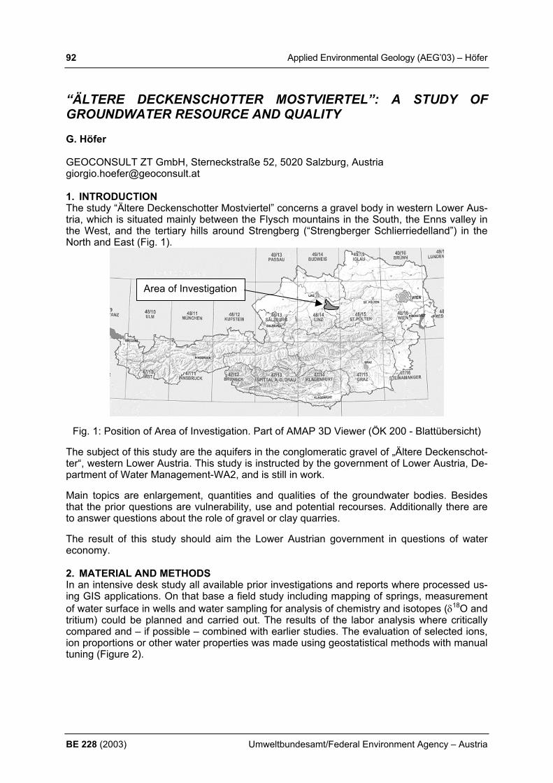
92 Applied Environmental Geology (AEG’03) – Höfer
BE 228 (2003) Umweltbundesamt/Federal Environment Agency – Austria
“ÄLTERE DECKENSCHOTTER MOSTVIERTEL”: A STUDY OF GROUNDWATER RESOURCE AND QUALITY G. Höfer GEOCONSULT ZT GmbH, Sterneckstraße 52, 5020 Salzburg, Austria [email protected] 1. INTRODUCTION The study “Ältere Deckenschotter Mostviertel” concerns a gravel body in western Lower Aus-tria, which is situated mainly between the Flysch mountains in the South, the Enns valley in the West, and the tertiary hills around Strengberg (“Strengberger Schlierriedelland”) in the North and East (Fig. 1).
Fig. 1: Position of Area of Investigation. Part of AMAP 3D Viewer (ÖK 200 - Blattübersicht)
The subject of this study are the aquifers in the conglomeratic gravel of „Ältere Deckenschot-ter“, western Lower Austria. This study is instructed by the government of Lower Austria, De-partment of Water Management-WA2, and is still in work.
Main topics are enlargement, quantities and qualities of the groundwater bodies. Besides that the prior questions are vulnerability, use and potential recourses. Additionally there are to answer questions about the role of gravel or clay quarries.
The result of this study should aim the Lower Austrian government in questions of water economy. 2. MATERIAL AND METHODS In an intensive desk study all available prior investigations and reports where processed us-ing GIS applications. On that base a field study including mapping of springs, measurement of water surface in wells and water sampling for analysis of chemistry and isotopes (δ18O and tritium) could be planned and carried out. The results of the labor analysis where critically compared and – if possible – combined with earlier studies. The evaluation of selected ions, ion proportions or other water properties was made using geostatistical methods with manual tuning (Figure 2).
Area of Investigation

Applied Environmental Geology (AEG’03) – Höfer 93
Umweltbundesamt/Federal Environment Agency – Austria BE 228 (2003)
Fig. 2: Geostatistical evaluation of nitrate content in the central part of area of investiga-
tion. Dark colors show high, bright colors low content.
3. RESULTS The water sources in the central part of the region (“Zentraler Haager Schotterfächer”) are higher than expected. An estimated total recharge of more than 0.2 m³/s rises this groundwa-ter recourse up to a regional interest. The large quantity can easily be explained by a subter-ranean recharge from the southern Flysch mountains. The quality of the groundwater runs two trends – a temporal and a regional one. Temporal trends show a return of pesticide and a consolidation of nitrate content. Regional trends show an important dependence of origin of water. Isolated hills show high to very high con-tents of nitrate. In this areas water recharges only from seepaging precipitation. Areas which are connected to the southern Flysch mountains show a low to moderate nitrate content, which means that fresh spring water rises up the quality (Figure 2). REFERENCES BERGER, E. (1991): Trink- und Nutzwasserversorgung der Stadtgemeinde Haag, geohydro-
logische Gebiets- und Umfeldanalyse, Schlußfolgerungen. – 12 p., ANÖLR, St. Pölten. DECKER, K. & HEINRICH, M. (eds.) (1992): Kompilierte geologische Arbeitskarten Bezirk
Amstetten und Waidhofen an der Ybbs. 1:25.000 (Verkleinerungen 1:50.000). – Geol. B.-A., Fachabt. Rohstoffgeologie, Wien.
FISCHER, H. (1979): Reliefgenerationen im Kristallinmassiv – Donauraum – Alpenvorland und im Westlichen Niederösterreich. – Forsch. dtsch. Landeskunde, 213, 1-232, Trier.

94 Applied Environmental Geology (AEG’03) – Hofmann
BE 228 (2003) Umweltbundesamt/Federal Environment Agency – Austria
CONTAMINANT TRANSPORT IN THE UNSATURATED ZONE: BEHAVIOUR OF COLLOIDAL CARRIERS T. Hofmann Institute for Geoscience, Mainz University, D-55099 Mainz, [email protected] 1. INTRODUCTION Sorption of contaminants at a mobile colloidal phase often remains unconsidered regarding the migration of organic and inorganic contaminants. Due to their high surface to volume ra-tio colloids represent important sorption sites especially for hydrophobic organic contami-nants, heavy metals, and radionuclides. Colloids have different origins. Their size ranges from a few nm up to several µm. They can be differentiated into organic colloids (most of the so called DOC “Dissolved Organic Carbon” is colloidal), inorganic colloids (Al-, Fe- and Mn-Oxides and –Hydroxides) and micro-organisms (“bio-colloids”) (QUYANG et al., 1996). Partly they originate from human sources like industrial dusts and ashes, wash-out, as well as from natural formation. Soot colloids are of major importance concerning the displacement of hydrophobic organic contaminants in urban areas. Atmospherics colloids can reach the soil zone by wet and dry deposition. Depending on hydrochemical and hydraulic conditions significant colloid mobilization and transport can be expected. In contrast to the saturated zone the migration of colloid bound contaminants in the unsaturated zone is less understood. One of the major tasks is to assess the transport of colloids. Colloid removal can be divided into two steps: Collision with the collector (aquifer material) and the attachment to the collec-tor. The first step is dominated by diffusion, interception, and sedimentation of the colloids. In the unsaturated zone in addition the gas phase has to be taken into account. There are suc-cessful approaches in modelling these mechanisms in the saturated zone, but for the unsatu-rated zone model prediction are very insecure. The second step is governed by the interac-tion forces between the colloids or the colloids and the collector. DLVO-theory is able to pre-dict theses interactions adequate for simple hydrochemical settings but fails if natural sys-tems, e.g. the influence of humic substances, a gas phase, steric stabilization, have to be taken into account. Beside the filtration/removal colloid re-mobilization or detachment can play a major role in colloid transport predictions. However, shear forces are commonly not known and difficult to assess. 2. MATERIALS AND METHODS In order to describe and predict colloid transport in natural environments we carried out col-umn experiments with natural sediment, fractionated to different grain sizes in saturated and unsaturated columns. Several transport experiments where carried out with natural and poly-styrene particles. In addition, re-mobilization tests at different flow velocities and hydro-chemical boundary conditions where investigated. Colloid filtration was tested at different ionic strength and colloid surface charge was altered by the variation of the pH. To determine how the soil grain size does influence colloid transport steady state experi-ments with different column filling materials were carried out. The soil grain size varied from the fine sand range to the gravel range. Fluorescent polystyrene colloids (diameter 1 µm, 1.05 g/cm³, Polyscience Inc.) were added as a quasi-dirac injection to the columns. Colloid concentration at the outflow was measured by fluorescent spectroscopy. 3. RESULTS AND CONCLUSIONS For gravel (d10 = 8 mm to 1 mm) colloid breakthrough curves seem to be very similar in ve-locity and shape. Colloid breakthrough in columns with fine grained material is much slower. Comparing the deposition rates a dichotomy in two groups of colloid deposition could be rec-ognized (Figure 1).

Applied Environmental Geology (AEG’03) – Hofmann 95
Umweltbundesamt/Federal Environment Agency – Austria BE 228 (2003)
In the group of gravel materials (d10 = 8mm to 1mm) approximated 50 % colloid deposition can be observed. Compared to this the smaller grain size favours higher deposition rates of about 95 %. Despite the materials cover a wide range of grain sizes, only two deposition re-gimes are developed. Small grain size differences do not seem to be the main influencing factor for colloid deposition. Instead, the water content of the columns and thereby the flow regime plays a major role. In the fine grained columns flow regime is presumably dominated by matrix flow and high water saturation. This also implies that more surfaces are in contact with the seepage flow and can sorb colloids. In coarse grained material macropore flow along distinct flow paths (fingering) can be expected. Flow is faster, as proofed by the ex-periments, and the surface area for colloid attachment is lower, shear forces are higher. Thus, flow pattern (matrix vs. fingering/macropore flow) is dominating colloid transport. Fur-
ther dye tracer experiments carried out at present may visualize these assumed ef-fects. In addition, the gas-water interfacial area as well as the wetting history may play an important role. Experiments where the col-loid size was varied showed that colloid transport in the unsaturated zone behaves differently to the predictions by filtration theory. According to filtration theory a minimum in colloid deposition rate would have been expected for the experiments with 1 µm colloids. Contrary to the expectations, experimental data showed a minimum in colloid deposition displaced
to smaller colloid sizes at 0.2 µm. However, colloid filtration experiments with different ionic strengths showed that the filtration theory can be extended by a sticking probability in order to provide a first estimate of colloid retention in the soil. Further details will be discussed at the AEG03 conference. REFERENCES MCCARTHY J. F. & ZACHARA J. M. (1989): Subsurface transport of contaminants. Environ.
Sci. Technol. 23: 496-502. RYAN, J. N. & ELIMELECH, M. (1996): Colloid mobilization and transport in groundwater.
Colloid Surf. A. 107:1-56. QUYANG et al. (1996): Colloid-enhanced transport of chemicals in subsurface environments:
a review. . Environ. Sci. Technol. 26(2): 189-204.
91
97 99 99
51 49
59
46 4754
44
64
33
54
0
10
20
30
40
50
60
70
80
90
100
Depo
sitio
n [%
]
0.09 0.1 0.17 0.5 1 1 1 2 2.1 4 4 4 8 8Grain size d10 [mm]
Figure 1: Deposition rates of 1µm polystyrene colloids depending on varying grain size of the column filling, irrigation intensity 36 mm/h

96 Applied Environmental Geology (AEG’03) – Hoetzl & Neukum
BE 228 (2003) Umweltbundesamt/Federal Environment Agency – Austria
HAZARD AND RISK ASSESSMENT OF KARST AQUIFERS H. Hoetzl & C. Neukum University of Karlsruhe, 76128 Karlsruhe, Germany, [email protected]; [email protected] 1. INTRODUCTION The protection of our natural karst groundwater resources requires a sustainable groundwa-ter management which should be based on a comprehensive risk analysis. With regard to a possible damage of groundwater the term risk is used for the likelihood of a specific adverse consequence. Following the origin-pathway-target model risk depends on three elements: (1) the hazards and their probability that a hazardous event occurs, (2) the vulnerability of the geological sequence and (3) the consequences for the groundwater. 2. METHOD In a logic system risk assessment is split in two parts: step 1, “risk intensity assessment”, is analysing the potential intensity of the relevant impact reaching the groundwater and there-fore deals with point (1) and (2). Step 2, “risk sensitivity analysis” focuses on the adverse consequences. These depend on the groundwater sensibility, like flow condition, and on the ecological and economical value of the damages. In order to separate clearly the different parts of risk assessment and to quantify their importance a “risk intensity index (RII)”, a “risk sensitivity index (RSI)” and a “total risk index (TRI)” were introduced.
Fig. 1: Risk assessment scheme showing the two main steps of the risk analysis (risk inten-sity and risk sensitivity assessment) leading to quantitative approach (total risk index). An evaluation of previous groundwater studies regarding groundwater protection and groundwater management shows that hitherto investigations and interpretations were mainly restricted on protection capability and capacity or vice versa on vulnerability of the relevant
Applied Environmental Geology (AEG’03) – Hoetzl & Neukum 97
Umweltbundesamt/Federal Environment Agency – Austria BE 228 (2003)
catchment area. This is especially the case in Central Europe, where by legislation all the groundwater is regarded as an important natural resource and therefore requires protection and safety measurements for all resources without considering the economical values of the individual resources. The increasing demand of land for urbanisation, industrialisation and intensified agricultural land use and the resulting competition on available land request a rethinking of our former concepts and a stronger inclusion of economical aspects in groundwater protection. Though COST Action 620 concentrates according the original project proposal on vulnerabil-ity mapping, it has become evident in the course of the Action that especially detailed vulner-ability maps are still more utilizable for experts than for decision makers. However, for practi-cal purposes we need a cost orientated evaluation of the possible groundwater damage, therefore vulnerability estimation has to be supplemented by a full risk assessment including the evaluation of the damage under ecological and economical aspects. In fact the more theoretical approaches and legislative reglement seem to have been bypassed already by very pragmatic and cost-orientated practical decisions. A good example for that is the priori-sation procedure of contaminated groundwater, where remediation is done or given priority to those resources which have higher economical value. 3. CONCLUSION In a first simplified approach valuation of groundwater resources can be done by referring on existing or planned future use of the water like it is also partially handled in Ireland and Eng-land. Future risk assessment needs a more sophisticated approach, where the potential eco-logical and economical damage is put in relation with cost for remediation or alternative water supply or even alternative ecosystems. REFERENCES DALY, D. & MISSTEAR, B. D. (2002): The groundwater protection scheme in Ireland: a risk-
based tool for effective land-use planning. Proceedings of Conference ‘Protecting Groundwater’, Birmingham. Environment Agency (England and Wales), 134-144.
FEDRA, K. (1998): Integrated risk Assessment and management: Overview and state-of-the-art. – In: ALE, B.J.M., JANSEN, M.P.M. & PRUPPERS, M.J.M. (eds.): Risk 97. Proceed-ings of the Intern. Conf. Mapping Environmental Risks and Risk Comparison, Amsterdam, J. of Hazardous Materials, 61, 5-22.
SCHOLLES, F. (1997): Abschätzen, Einschätzen und Bewerten in der UVP. Weiterentwick-lung der Ökologischen Risikoanalyse. Weiterentwicklung der Ökologischen Risikoanalyse. UVP-Spezial, 13, Dortmund.
U.S.EPA Environmental Protection Agency (1993): A review of methods for assessing aqui-fer sensitivity and groundwater vulnerability to pesticide contamination. - 147 p., Washing-ton.
ZWAHLEN, F. (ed.) (2003): Vulnerability and risk mapping for the protection of carbonate (karst) aquifers. Final Report COST Action 620. – European Commission, Directorate-General XII Science, Research and Development; Brussels, Luxemburg (in preparation).

98 Applied Environmental Geology (AEG’03) – Humer et al.
BE 228 (2003) Umweltbundesamt/Federal Environment Agency – Austria
AUSTRIAN LONG TERM INTEGRATED MONITORING; GEOCHEMI-CAL CYCLES IN A DOLOMITE KARST F. Humer1), M. Kralik1), M. Mirtl1) & M. Grabner1) 1) Umweltbundesamt Austria (Federal Environment Agency Austria)
[email protected], [email protected] 1. INTRODUCTION In 1992 the Federal Environment Agency of Austria started a long term Integrated Monitoring in a dolomite karst in the national park Calcareous Alps. Since 1995 hydrological respec-tively hydrochemical parameters have been recorded automatically at a measuring weir. To compare the two parameters precipitation and out flow, both of them have a direct relation to the orographical catchment area. Because of the fact that the investigated area is situated in a deeply karstified dolomite rock mass the detected off flow of the main measuring barrage cannot be treated as equivalent to the real orographical catchment area. For better compa-rability a fictitious proportional part of a larger (and for that reason more representative) hy-drological catchment area was created. 2. MATERIALS AND METHOD To highlight the periodicity of events in a hydrological year an average hydrological year was determined which contains all reliably measured data from 1995 to 2002. In Fig. 1 the input and output data of the catchment area are plotted next to the output detected on the main measuring barrage.
input - output fictitious catchment area - output main measuring barrage
0
25
50
75
100
125
01.01 31.01 02.03 02.04 02.05 02.06 02.07 01.08 01.09 01.10 01.11 01.12 31.12
inpu
t and
out
put (
l/sec
/km
2)
input output fictitious catchment area output measuring barrage
Fig. 1: Average input (precipitation) and output (outflow) from 1995 to 2002. The hatched area in Fig. 1 – calculated as the difference of input and output – give an over-view of the evapotranspiration from May to November. Even during the investigation of the chemical parameters the way of representation shown above was proved to be plausible. This assumption is supported by the results of a number of measuring campaigns where chemism and outflow of several springs and streams have been continuously determined. As a result it turned out that the chemism of the investigated springs is very similar to each other. Only 2 of the 33 dolomite springs are slightly different to a clear dolomite water chem-ism (Fig. 2).
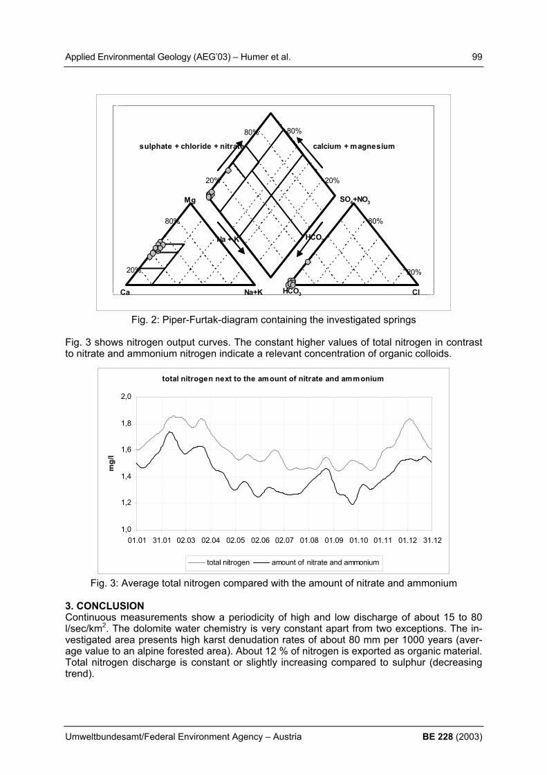
Applied Environmental Geology (AEG’03) – Humer et al. 99
Umweltbundesamt/Federal Environment Agency – Austria BE 228 (2003)
-10,0
190,0
-10,0 240,0
SO4+NO3
sulphate + chloride + nitrate calcium + magnesium
Na + K HCO3
Mg
Ca Na+K HCO3 Cl
20%
80%
20%
80% 80%
20%
80%
20%
Fig. 2: Piper-Furtak-diagram containing the investigated springs
Fig. 3 shows nitrogen output curves. The constant higher values of total nitrogen in contrast to nitrate and ammonium nitrogen indicate a relevant concentration of organic colloids.
total nitrogen next to the amount of nitrate and ammonium
1,0
1,2
1,4
1,6
1,8
2,0
01.01 31.01 02.03 02.04 02.05 02.06 02.07 01.08 01.09 01.10 01.11 01.12 31.12
mg/
l
total nitrogen amount of nitrate and ammonium
Fig. 3: Average total nitrogen compared with the amount of nitrate and ammonium 3. CONCLUSION Continuous measurements show a periodicity of high and low discharge of about 15 to 80 l/sec/km2. The dolomite water chemistry is very constant apart from two exceptions. The in-vestigated area presents high karst denudation rates of about 80 mm per 1000 years (aver-age value to an alpine forested area). About 12 % of nitrogen is exported as organic material. Total nitrogen discharge is constant or slightly increasing compared to sulphur (decreasing trend).

100 Applied Environmental Geology (AEG’03) – Inderbitzin et al.
BE 228 (2003) Umweltbundesamt/Federal Environment Agency – Austria
THE GEOCHEMISTRY OF RECENT SEDIMENTS IN THE OVA SPIN-RESERVOIR (ENGADIN, SWITZERLAND) - TRACING HUMAN IMPACT. L. Inderbitzin1), V. Burki2), C. Haemmig1), S. Strasky1) & C. Schlüchter1) 1) Institute of Geological Sciences, University of Bern, Baltzerstrasse 1, CH-3012 Bern,
Switzerland 2) Institute of Geology, ETH-Zürich, CH-8092 Zürich, Switzerland The Ova Spin-Reservoir is a central installation of the Engadine Hydroelectric Power Scheme. It receives water through a gravity-flow channel from the River Inn (and the Upper Engadine), through pressure tubes from Lake Livigno after power generation, from the natu-ral Fuorn-River and the restricted flow of the Spöl-River. The reservoir is - from a limno-geological point of view - special; because (1) water masses and lake levels vary substan-tially within hours; (2) the same water remains only for a short period of time in the basin (max. 2 days in the average); and (3) an exceptionally high sedimentation rate of several dm/y is observed. Earlier and ongoing analysis of the geochemical composition of the fine grained reservoir sediments, especially the content in heavy metals, points to a major input of the sediment load from the Upper Engadine and its impacted drainage system. Minor local input of heavy metals (Pb, Zn) may be related to medieval silver mining. The Hg-content in the reservoir and neighbouring quaternary sediments displays an interesting pattern which needs further discussion.

Applied Environmental Geology (AEG’03) – Isermann & Isermann 101
Umweltbundesamt/Federal Environment Agency – Austria BE 228 (2003)
INTENTIONAL “NATURAL” ATTENUATION IS AN UNSUITABLE MEASURE TO MITIGATE IMMISSIONS OF THE REACTIVE COMPOUNDS OF CARBON (C), NITROGEN (N), PHOSPHORUS (P) AND SULPHUR (S) FROM THE TOTAL SYSTEM NUTRITION K. Isermann & R. Isermann Bureau of Sustainable Agriculture – BSA, Heinrich-von-Kleist-Strasse 4, D 67374 Hanhofen Tel./Fax: (06344) 29 83 / 93 72 64, e-mail: [email protected]
1. INTRODUCTION Emissions of reactive compounds of C, N, P and S from anthropogenic diffuse and point sources are the causes of the “new types” of environmental problems acidification, eu-trophication, climate change, stratospheric depletion and lack of biodiversity (i.e. forest de-cline). Their impacts are mostly linked synergistic, effected both by the multifunctionality of reactive C, N as well as S and by their exchange between pedosphere, biosphere, hydro-sphere and atmosphere. All these processes influence both the quantities of groundwater as well as surface waters and their loads and levels of reactive compounds of C, N, P and S. Therefore no pure hydrosphere without clean atmosphere and optimal soil organic matter (SOM) both of natural (near) and managed soils. Also no pure surface waters without clean groundwater and vice versa. 2. MATERIALS AND METHODS Important tools to demonstrate (un-)sustainable situations are corresponding complete nu-trient balances of the ecosystems involved, including net immobilisation and net mineralisation of C, N, P and S both in terrestrial and (semi-)subhydric soils (“sediments”) 3. RESULTS AND CONCLUSIONS “Natural” attenuation processes of C, N, P and S are decomposition (i.e. denitrification), conversion (i.e. nitrate ammonification) and dilution as well as exfiltration in the (nearly) natu-ral ecosystems and their environmental spheres like atmosphere, hydrosphere and pe-dosphere with drainage zones, aquifers, lakes, rivers, estuaries, coastal waters (shelves) or the open sea. If “natural” attenuation is abused intentionally as an “end of the pipe strategy” like i.e. by the Nitrate Directive of the EU (1991) high loads with low levels of C, N, P, S (i.e. NO-
3) and new harmful C, N, P and S compounds, emissions and losses like NH4+, NH3,
N2O, NO, (N2), SO42-, CH4, NMVHC (non methane volatile hydrocarbons), (CH3)2S, COS, etc.
are the consequences also with trans-national problems of groundwater and surface water pollution. Net mineralisation both in terrestrial and in (semi-)subhydric soils with a time span of about 40 to 100 years to reach a new equilibrium becomes more and more important as at present when the input of N, P and S to the correspondingly enriched soils decreases, described in the literature as “chemical time bombs (CTB´s)”. The same fate will be with CO2 and C re-spectively when the soils are saturated (“ sequestered”) and (perhaps) the CO2 emissions and immissions will also decline. This is shown not only for agro ecosystems but for the “to-tal system nutrition” with plant and animal nutrition of agriculture, human nutrition as well as the waste and waste water sector and for natural (near) ecosystems like forest ecosys-tems or limnic and marine ecosystems especially in coastal zones of Germany, the EU, USA and Asia or the Danube catchment and its sub areas. Hence, a sink may not be a final sink in long-term perspectives (Brunner 1999) involving in social affairs more than 50 gen-erations of mankind accordingly of about 1000 to 1500 years. This is true especially in pe-dological and geological time spans. Therefore the terms of C, N, P, S retention or “se-questration” are misleading and the correct terms will be C, N, P, S retardation, delay and remobilisation (internal loading or fertilization). Both regarding life stile and management of
102 Applied Environmental Geology (AEG’03) – Isermann & Isermann
BE 228 (2003) Umweltbundesamt/Federal Environment Agency – Austria
land use and energy these balances of C, N, (P) and S in the industrialised countries are exhaustive, increasing their reactive amounts (loads) and concentrations (levels) in the envi-ronment in not tolerable extents. To solve these problems as “mitigations” or “abatements” are banal as well as their causes. These mitigations must be both cause-oriented and sufficiently based on the critical levels and loads of the natural (near)ecosystems as well as on sustainable nutrient balances with optimised SOM shown here exemplary for arable soils of Western Europe. “Optimisa-tion” means not only ecological and economical but simultaneously also social requirements to meet the needs of mankind for biomass production and consumption respectively. So called “unavoidable losses/emissions” esp. of agro ecosystems based only on best avail-able technique (BAT) with correspondingly only self-defined so called “good agricultural prac-tise” are by far not tolerable according to the critical levels and loads of the natural (near) terrestrial, aquatic and atmospheric ecosystems. Tolerable losses/emissions respect tol-erable true natural attenuation rates. There is a need of far-reaching changes of the “total system nutrition” with “biomass production and consumption” to decrease the emissions of reactive compounds especially those of C and N in the industrialised countries like Germany of about 70-90% and to minimise their surpluses simultaneously flanked by mitigation meas-ures of (BAT) (Isermann and Isermann 2003). These cause-oriented and sufficient mitigations are hindered at present by the (in-ter)national policy within the spheres of agriculture, human nutrition, waste and waste water management, environment and energy i.e. both in Germany and in the EU with their unsus-tainable legislation, control and corruption within the total system nutrition with its actors “ag-riculture, feed and food industry, households, waste and waste water management and trade”. The EU WATER FRAMEWORK DIRECTIVE (WFD 2000) demands for the implemen-tation of sufficient indicators and measures till 2012 to reach “good conditions” for groundwa-ter and surface waters till 2015. But neither the WFD (2000) defines those critical nutrient levels and loads for the hydrosphere nor these “good conditions” could be reached till 2015 in spite of sufficient implementations because weak trends will exist due to the above men-tioned retardation of C, N, P, S, water residence times, hydrological pathways as well as flow, weather and changing climate conditions. There may be some hope i.e. with the per-spectives of the German Government and the German EPA for a sustainable development in Germany esp. of the sectors of energy, food production and consumption, mobility, tourism and industry. Such sustainable perspectives are shown i.e. as scenarios of the project da-NUbs (2/2001-1/2005) of the 5th EU Framework Programme (contract EVK1-CT-2000-00051) and should also be compartments i.e. of the priorities 6 (sustainable development-global change and ecosystems) and 7 (policy oriented research- citizen and state) of the 6th EU Framework Programme (2002-2006). REFERENCES BRUNNER, P. (1999): In search of the final sink. Environ. Sci& Pollut. Res. 6 (1), 1 ISERMANN, K. & ISERMANN, R. (2003) : “Unavoidable” in contrast to “tolerable” emissions/
losses of the reactive compounds of Carbon (C) , Nitrogen (N), Phosphorus (P) and Sulphur (S) stemming from the “total system nutrition” and its immissions into the surface waters. 5th ELOISE Conference, Gdanks (Poland) 24-27 March 2003, Book Abstracts 117- 118 - WFD/2000/60/EU: EU WATER FRAMEWORK DIRECTIVE

Applied Environmental Geology (AEG’03) – Kalembasa et al. 103
Umweltbundesamt/Federal Environment Agency – Austria BE 228 (2003)
INFLUENCE OF THE DURATION OF FLOODINGS ON THE CARBON AND NITROGEN FRACTION OF SOILS D. Kalembasa, M. Becher & K. Pakuła Soil Science and Plant Nutrion Department Academy of Podlasie, 14 Prusa Street, 08-110 Siedlce, Poland, e-mail: [email protected] 1. INTRODUCTION The content of plant nutrients elements in soil depends among other from the mineralization – immobilization processes. The big influence on these processes have pH, moisture, tem-perature, biological activitess and oxidaation-reduction processes. The completely filled up of soil pores (anaerobic conditions) for example during flooding caused the production of compounds without oxygen tike (CH4, N2, H2S) which have influence on the growth and de-velopment of plants [KLUDZE & DELAUNE 1995]. The carbon in soil organic matter undergo different chemical changes in relation mainly to their structure. Compounds which are very simple in their structure undergo different metabolism in short time mainly through the miner-alization process. The stability of organic carbon compounds in humic and fulvic acids de-pends upon the oxidation-reduction conditions of soil. In soil environmental with high amount of water usually higher concentration of carbon is stated in fulvic than humic acids [THURMAN 1985]. Water of rivers transports also some amount of carbon. MALCOLM (1985) has stated in such waters about 45% of carbon in fulvic and 5% in humic acids. On the mineralization process of nitrogen in flooded soils big influence have : total concentra-tionn of nitrogen, ratio of C/N, the ratio of lignin to nitrogen, the polyphenol concentration [BECKER et al. 1994]. PALM & SANCHEZ (1991) have reported than on the ratio basis of polyphenols to nitrogen is possible prediction of the liberation of the nitrogen in mineral forms. HUMPHREY & PLUTH (1996) have stated two folds quicker mineralization process of nitrogen organic compounds under the influence of the soil floading. The aim of this ex-periment was the estimation of the influence of the floading of soils in lizymeters during 10 and 25 days on the content of carbon and nitrogen in different fractions of soil organic com-pounds. 2. MATERIALS AND METHODS Two places were chosen in which soil profiles were done and soil samples were taken for further investigation : A) Chodów near Siedlce in the valley of Liwiec river ; B) Siedlce-Sekuła in the valley of Muchawka river. Both rivers belong to the catchment area of river Bug. Soil samples were taken to the depth of 100 cm including each soil profile horizons and transfered to lysimeters (6 cm diameters and 100 cm high) which were filled by gravel on the bottom. Soil in lysimeters were flooded above 5 cm of surface with distilled water for periods of 10 and 25 days. After these periods water was removed from lysimeters using special waveles on the bottom of lysimeters and from each soil profile horizons samples were taken for further investigation which were air-dried and analyzed by following methods: • granulometric composition – areometrically • pH in KCl 1 mol .dm-3 • total organic carbon (Ct) by oxidation-reduction method • total nitrogen (Nt) by Kjeldahl procedure Using acid hydrolyses the following fraction of nitrogen and carbon were separated in fractions : • easily hydrolysable (the contant of nitrogen and carbon) in extracts of 0,25 mol.dm-3 of
H2SO4 ; • difficulty hydrolysable in extracts of 2,5 mol.dm-3 of H2SO4 ;
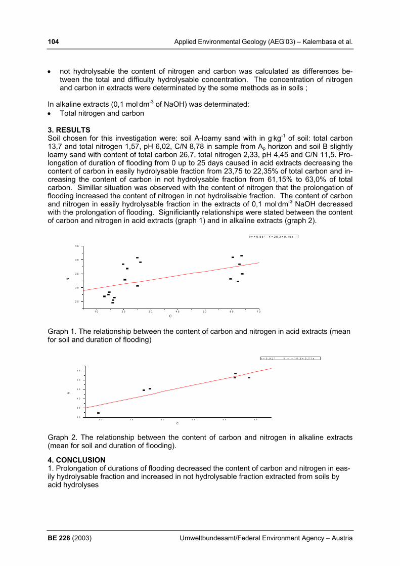
104 Applied Environmental Geology (AEG’03) – Kalembasa et al.
BE 228 (2003) Umweltbundesamt/Federal Environment Agency – Austria
• not hydrolysable the content of nitrogen and carbon was calculated as differences be-tween the total and difficulty hydrolysable concentration. The concentration of nitrogen and carbon in extracts were determinated by the some methods as in soils ;
In alkaline extracts (0,1 mol.dm-3 of NaOH) was determinated: • Total nitrogen and carbon 3. RESULTS Soil chosen for this investigation were: soil A-loamy sand with in g.kg-1 of soil: total carbon 13,7 and total nitrogen 1,57, pH 6,02, C/N 8,78 in sample from Ap horizon and soil B slightly loamy sand with content of total carbon 26,7, total nitrogen 2,33, pH 4,45 and C/N 11,5. Pro-longation of duration of flooding from 0 up to 25 days caused in acid extracts decreasing the content of carbon in easily hydrolysable fraction from 23,75 to 22,35% of total carbon and in-creasing the content of carbon in not hydrolysable fraction from 61,15% to 63,0% of total carbon. Simillar situation was observed with the content of nitrogen that the prolongation of flooding increased the content of nitrogen in not hydrolisable fraction. The content of carbon and nitrogen in easily hydrolysable fraction in the extracts of 0,1 mol.dm-3 NaOH decreased with the prolongation of flooding. Significiantly relationships were stated between the content of carbon and nitrogen in acid extracts (graph 1) and in alkaline extracts (graph 2).
1 0 2 0 3 0 4 0 5 0 6 0 7 0
2 5
3 0
3 5
4 0
4 5
r = + 0 ,5 5 * Y = 2 8 ,2 + 0 ,1 5 x
N
C
Graph 1. The relationship between the content of carbon and nitrogen in acid extracts (mean for soil and duration of flooding)
3 0 3 5 4 0 4 5 5 0 5 53 0
3 5
4 0
4 5
5 0
5 5
r = 0 , 9 2 * Y = + 1 5 , 5 + 0 , 7 1 x
N
C Graph 2. The relationship between the content of carbon and nitrogen in alkaline extracts (mean for soil and duration of flooding). 4. CONCLUSION 1. Prolongation of durations of flooding decreased the content of carbon and nitrogen in eas-ily hydrolysable fraction and increased in not hydrolysable fraction extracted from soils by acid hydrolyses
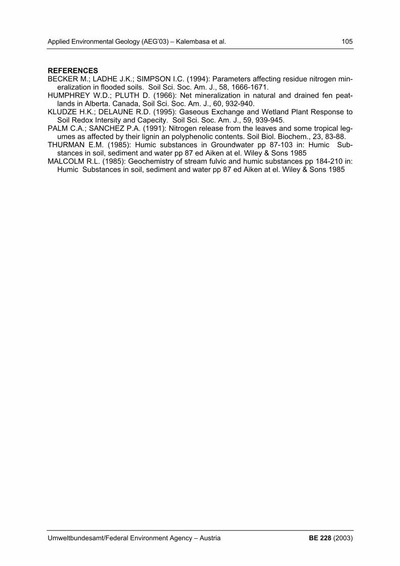
Applied Environmental Geology (AEG’03) – Kalembasa et al. 105
Umweltbundesamt/Federal Environment Agency – Austria BE 228 (2003)
REFERENCES BECKER M.; LADHE J.K.; SIMPSON I.C. (1994): Parameters affecting residue nitrogen min-
eralization in flooded soils. Soil Sci. Soc. Am. J., 58, 1666-1671. HUMPHREY W.D.; PLUTH D. (1966): Net mineralization in natural and drained fen peat-
lands in Alberta. Canada, Soil Sci. Soc. Am. J., 60, 932-940. KLUDZE H.K.; DELAUNE R.D. (1995): Gaseous Exchange and Wetland Plant Response to
Soil Redox Intersity and Capecity. Soil Sci. Soc. Am. J., 59, 939-945. PALM C.A.; SANCHEZ P.A. (1991): Nitrogen release from the leaves and some tropical leg-
umes as affected by their lignin an polyphenolic contents. Soil Biol. Biochem., 23, 83-88. THURMAN E.M. (1985): Humic substances in Groundwater pp 87-103 in: Humic Sub-
stances in soil, sediment and water pp 87 ed Aiken at el. Wiley & Sons 1985 MALCOLM R.L. (1985): Geochemistry of stream fulvic and humic substances pp 184-210 in:
Humic Substances in soil, sediment and water pp 87 ed Aiken at el. Wiley & Sons 1985
106 Applied Environmental Geology (AEG’03) – Kiss
BE 228 (2003) Umweltbundesamt/Federal Environment Agency – Austria
REUSE OF BROWNFIELDS – A CASE STUDY OF THE FORMER „SCREW FACTORY OF NEUNKIRCHEN“, LOWER AUSTRIA S. Kiss PORR Umwelttechnik GmbH, Asbergstraße 47, A-1103 Wien, [email protected] 1 INTRODUCTION Unused land is in dense populated and highly industrialized regions, especially in downtown areas, a very short resource. The knowledge of the ecological, economical and social re-quests for soil as a life basis needs a new strategy for land consumption: less usage of new land and more reuse of remediated land (KLAPPERICH, H., 2001). This leads to a new point of view, that brownfields are no more only a burden; they furthermore could be a new chance. The key for the successful reuse of brownfields is to solve the conflict between nec-essary remediation actions and costs. As an Austrian example how this conflict could be solved the city of Neunkirchen took the opportunity to redevelop the area of the former screw-factory in the heart of Neunkirchen. In the early 1980’s the Brevilier & Urban AG screw factory, the biggest employer in the city of Neunkirchen with a history of more than 150 years, went bankrupt. After attempts to save the company under the new name „Neunkirchner Schraubenwerke“ have failed, in 1991 produc-tion was ultimately wound up. This left a 65,000m² site and industrial buildings with a volume of more than 300,000 m³ in the heart of the city. In 1998 the city of Neunkirchen acquired the area in order to decontaminate and develop it. 2. INVESTIGATIONS AND REMEDIATION PLANNING From 1992 numerous site investigations have been carried out and the site was classified as contaminated site N 34 Neunkirchner Schraubenwerke. In addition, PORR Umwelttechnik and its partners worked out a study of the site in order to examine various decontamination options in respect to the future plans for the area. Exploratory work was undertaken using excavators, percussion boring core sampling and soil air sampling, producing a three-dimensional contamination chart for the whole site. Contamination of the sub-soil was primarily the result of production processes. Typical screw factory contamination of this nature was discovered, including chromium, cadmium, nickel, lead, zinc, mercury, PAHs, hydrocarbons and halogenated hydrocarbons. These contami-nants are the result of galvanic surface treatment processes, the pickling plant, the use of lu-bricating, hardening and cutting oils and the former gas production. These contaminants have been found in the buildings and the sub-soils to a depth of more than 20 m under ground level. The groundwater measurements showed slightly increased values in respect to hydrocarbons and halogenated hydrocarbons. As it was proofed the more severe contamina-tion of the groundwater comes from another contaminated site near the site of the “Neun-kirchner Schraubenwerke”. Detailed plannings and negotiations with the competent authorities lead to a remediation concept with specific target values established for this site. To develop such a list of target values is the key for the reuse of brownfields. If the values are very low the costs for the remediation of the site arise. The result could be, that remediation actions are not financable. On the other hand if the target values are high the effect of the remediation could be neglect-able and for the future investors the risk is very high, that the remaining contamination will cause costs in the future. So this point has a huge potential of conflict between tolerable re-maining contaminations and acceptable costs for the remediation. For each brownfield rede-velopment project the solution of this conflict is crucial for the success of the project.

Applied Environmental Geology (AEG’03) – Kiss 107
Umweltbundesamt/Federal Environment Agency – Austria BE 228 (2003)
3. REMEDIATION ACTIONS Remediation included the following measures:
• Demolition of 300,000m³ enclosed space • Disposal of contaminated demolition material • Recovery of uncontaminated materials on site • Excavation and disposal of about 220,000 tons of contaminated sub-soil
4. DOCUMENTATION AND ARCHIVING OF EVIDENCE
• Groundwater sample preservation and demarcation with respect to contaminated site „N27 Parkplatz Brevillier+Urban“
• Documentation of the success of the remediation measures in 10 x10 m grids • Overall assessment in accordance with the Austrian landfill ordinance • Weighing on site and documentation of all material removed • Project supervision
5. RE-DEVELOPMENT OF THE AREA The city of Neunkirchen developed a masterplan for the reuse of the area. It is planned, that a new hospital should take place on 2/3 of the whole area. The rest of the area should be used for shopping malls, a museum and apartments. The museum will be located in former factory buildings which were not demolished. The remediation works for these protected monuments were done from inside the buildings. 6. CONCLUSION The reuse of a brownfield can be a chance as it shows the example of the remediation of the former “Neunkirchner Schraubenwerke”. The assumption for a successful redevelopment of a brownfield is in the first row to know exactly what the future application of the area will be. If it is not so it is very difficult to define specific target values for the remediation actions in re-spect of the future use of the site. Without knowing future plans, remediation action will be very costintensive because of low target values all over the site. Without public finacial support it is almost impossible to reuse brownfields, because the al-ternative of greenfields is in most cases more attractive because of less risks for the investor. If the circumstances for the redevelopment of a brownfield are specific it could be a big chance for investors in using former brownfield areas. The future for the city of Neunkirchen is very promising, because the specific location of the brownfield area of the “Neunkirchner Schraubenwerke” in the heart of Neunkirchen offers huge opportunities. REFERENCES KLAPPERICH, H. (2001): Recycling vorgenutzter Flächen-innovativer Konzepte.- Terratech
2/2001

108 Applied Environmental Geology (AEG’03) – Klug et al.
BE 228 (2003) Umweltbundesamt/Federal Environment Agency – Austria
COMPARISON OF TWO DIFFERENT INTEGRATIVE APPROACHES FOR SUSTAINABLE WATER MANAGEMENT PRACTICES H. Klug1), P. Zeil1) & F. Gottsmann1) 1) University of Salzburg, Department of Geography and Geoinformatics, Hellbrunner Str.
34, A - 5020 Salzburg, email: [email protected] 1. INTRODUCTION The management of water resources linked with the protection of the environment and risk prevention coming from the agricultural practices are the main issues presented in this pa-per. Particular attention must be paid to integrated strategies for the closing of substance cy-cles in catchment areas with a strong view to nutrient and phosphorus cycles. Dealing with the elaboration and implementation of a regional planning and decision support system (DSS) we introduce two different integrated approaches for future sustainable landscape de-velopment. It is indispensable to stakeholders to provide a comprehensive set of adequate concepts and strategies to introduce clear and realistic ideas and activities to impede and reduce detrimental substance fluxes to surface water (rivers, lakes) and ground water. Participation and stakeholder consultation are the key to improved water resource manage-ment. European water policy has to address the increasing awareness of citizens and other involved parties of their water. At the same time water policy and water management are to address problems in a coherent way. The best model for a single system of water management is management by river basin - the natural geographical and hydrological unit - instead of according to administrative or political boundaries. The implementation of the Directive therefore requires a spatial perception of the catchment and the initiative for dialogue across boundaries – administrative, traditional, and national. There are two main reasons for an extension of public participation. The first is that the deci-sions, on the most appropriate measures to achieve the objectives in the river basin man-agement plan, will require balancing the interests of various groups. The economic analysis requirement is intended to provide a scientific basis for this, and it is essential that the proc-ess is open to the scru-tiny of those who will be affected. The second reason concerns en-forceability. The greater the transparency in the establishment of objectives, the imposition of measures, and the reporting of standards, the greater the care member states will take to implement the legislation in good faith. Additionally, greater transparence increases the power of the citizens to influence the direction of environmental protection, whether through consultation or, if disagreement persists, through complaints procedures and court action. Caring for Europe's waters require more involvement of citizens, interested parties and non-governmental organizations (NGOs). 2. MATERIALS AND METHODS 2.1 FIRST METHOD BASED ON A HIERARCHICAL STRUCTURED FRAMEWORK The concept introduced by Klug (2002) is a hierarchical knowledge base founded on spatial explicit biogeophysical data. The spatial utilization decisions are described in a systematic and transpar-ent way. The decision model provides information about the trajectories of de-velopment which a functionally diverse landscape could take on the grounds of interdiscipli-nary ecologyrelated scientific criteria. The aim is to designate zones for intensive and exten-sive land use, which are balanced with compensatory zones for exploitation, protection or regulation. Spatially derived land-scape visions are shown to be a powerful tool for a more reasoned matching of landscape units to land use. The expert model integrates three main modules and three additional information tools. First, a hierarchical framework determines the priority of functions from extensive to intensive land use, which can be allocated to an area. This model is directly connected to a matrix of rules concerning the superimpositions of functions like utilization, protection and regulation. Eco-

Applied Environmental Geology (AEG’03) – Klug et al. 109
Umweltbundesamt/Federal Environment Agency – Austria BE 228 (2003)
logical buffer stripes and compensation areas between opposing borders of land use types are suggested after deriving the hierarchical framework. The three additional information tools comprises (I) a table of standard values, threshold values and critical values as well as international norms which are interrogated in the main model; (II) a table with the used as-sessment and evaluation procedures, leading to data applied in the hierarchical model; and (III) a matrix of structural indicators (landscape metrics) containing information on biotic and abiotic functions and processes in the landscape. 2.2 SECOND METHOD BASED ON THE 'GENERAL SYSTEMS THEORY' The second methodology is based on human and ecological self organizing systems (KAY et al. 1999). The root of the concept based on the 'General Systems Theory' as well as new approaches in chaos and complexity theories. Accordingly, the relevant human entities (local actors, stakeholders, institutions, cultures, values and visions) as well as ecological entities (biogeophysical factors) are conceptually mapped in a hierarchical relationships. The dy-namic of mutual feedback loops are summarized over diverse space- and time scales. The outcome of this systems assessment is a basis for a scenario exploration process. Visions and goals are defined in human entities and added with ecosystems thresholds in ecological entities. After taken the decisions which organizational entities of the ecosystem are to stimu-late by which means, the requisite human and ecological infrastructure is to identify and pre-sented in the aimed situation status. The methodology is an ongoing adaptive and heuristic process and therefore accompanied by a continuous monitoring-, analysis- and management strategy. It is being able to recursively correct and reformulate analysis and goal formula-tions. The fundament of this management concept is given by diverse approaches for eco-system analysis in literature. The SOHO (Self-Organizing Holarchic Open) methods of the publication from KAY et al. (1999) has been modified and further adapted to the special re-quirements of European regions and extended using GIS and remote sensing methods. 3. RESULTS The first model represents a hard fact method to clearly show the functions and processes, whereas the second model more relies on a soft (system) methodology, accepting uncer-tainty and continually changing systems. Both models are able to provide a good basis for stakeholders discussions. On the one hand based on strong facts and on the other in putting more emphasis on the creation of reconnaissance and sensitization among participants for (natural) systems and their specific behaviors and interactions. Both approaches use GIS as an integral part of Decision Sup-port System (DSS). The inductive derivation of the hierarchi-cal structured framework of the first approach leads to an output map illustrating how a func-tionally 'idealized' state should be shaped by reallocation and buffering. Comparing this model with the current state of the landscape derived from remotely sensed data shows the call for actions to close substance cycles. In the second approach, a recursive soft systems methodology uses GIS and RS techniques more to incorporate biogeophysical understand-ing of nature into scenario exploration. The methodology thus helps to create a common un-derstanding between stakeholders and planners, and facilitates the successful adoption of new planning initiatives for water management. 4. CONCLUSIONS The implementation of both concepts in heterogeneous local and regional landscape-, mas-ter- and development plans is demonstrated in two case studies. Both case studies demon-strate the need to prepare for and initiate modifications in choices and farming practices to adapt to and mitigate the impacts of nutrient cycling while balancing social needs such as tourism development.
110 Applied Environmental Geology (AEG’03) – Klug et al.
BE 228 (2003) Umweltbundesamt/Federal Environment Agency – Austria
REFERENCES DIRECTIVE 2000/60/EC OF THE EUROPEAN PARLIAMENT AND OF THE COUNCIL (23.
Oct. 2000): Establishing a framework for Community action in the field of water policy. Of-ficial J. Eu-ropean Communities, L327/1-72, 22.12.2000, Brussels.
KLUG, H. (2002): Methodisch-konzeptuelle Landschaftsentwicklung über prozess-orientierte, funk-tional-haushaltliche landschaftsökologische Leitbilder. - In: SIR-Mitteilungen und Be-richte, Band 30/2002: 43-52. Salzburg
KAY. J., REGIER, H., BOYLE, M. and FRANCIS, G. (1999): An Ecosystem Approach for Sustain-ability: Addressing the Challenge of Complexity. Futures, 31:721-742.
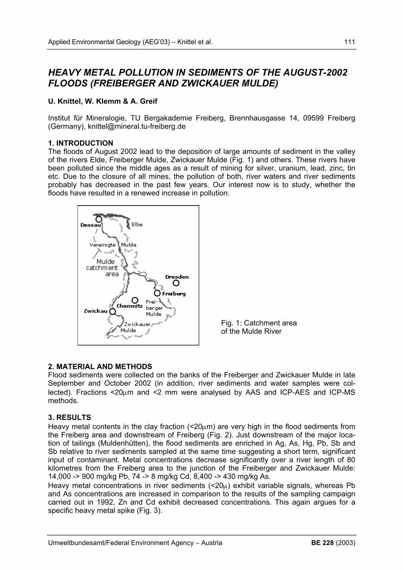
Applied Environmental Geology (AEG’03) – Knittel et al. 111
Umweltbundesamt/Federal Environment Agency – Austria BE 228 (2003)
HEAVY METAL POLLUTION IN SEDIMENTS OF THE AUGUST-2002 FLOODS (FREIBERGER AND ZWICKAUER MULDE) U. Knittel, W. Klemm & A. Greif Institut für Mineralogie, TU Bergakademie Freiberg, Brennhausgasse 14, 09599 Freiberg (Germany), [email protected] 1. INTRODUCTION The floods of August 2002 lead to the deposition of large amounts of sediment in the valley of the rivers Elde, Freiberger Mulde, Zwickauer Mulde (Fig. 1) and others. These rivers have been polluted since the middle ages as a result of mining for silver, uranium, lead, zinc, tin etc. Due to the closure of all mines, the pollution of both, river waters and river sediments probably has decreased in the past few years. Our interest now is to study, whether the floods have resulted in a renewed increase in pollution.
2. MATERIAL AND METHODS Flood sediments were collected on the banks of the Freiberger and Zwickauer Mulde in late September and October 2002 (in addition, river sediments and water samples were col-lected). Fractions <20µm and <2 mm were analysed by AAS and ICP-AES and ICP-MS methods. 3. RESULTS Heavy metal contents in the clay fraction (<20µm) are very high in the flood sediments from the Freiberg area and downstream of Freiberg (Fig. 2). Just downstream of the major loca-tion of tailings (Muldenhütten), the flood sediments are enriched in Ag, As, Hg, Pb, Sb and Sb relative to river sediments sampled at the same time suggesting a short term, significant input of contaminant. Metal concentrations decrease significantly over a river length of 80 kilometres from the Freiberg area to the junction of the Freiberger and Zwickauer Mulde: 14,000 -> 900 mg/kg Pb, 74 -> 8 mg/kg Cd, 8,400 -> 430 mg/kg As. Heavy metal concentrations in river sediments (<20µ) exhibit variable signals, whereas Pb and As concentrations are increased in comparison to the results of the sampling campaign carried out in 1992, Zn and Cd exhibit decreased concentrations. This again argues for a specific heavy metal spike (Fig. 3).
Fig. 1: Catchment area of the Mulde River

112 Applied Environmental Geology (AEG’03) – Knittel et al.
BE 228 (2003) Umweltbundesamt/Federal Environment Agency – Austria
Hence, old waste dumps and tailings deposited along the river banks in the Freiberg area are indicated as sources for the heavy metal load of the flood sediments. Downstream of Freiberg, these contaminants are successively diluted by mixing which less contaminated sediments. 4. CONCLUSIONS Flood events carry metals derived from mining wastes deposited in the Mulde Valley in the Freiberg area downstream. As long as these wastes are accessible to floods, flood events will not result in an overall improvement of the heavy metal load in river sediments by trans-port of polluted sediments downstream and ultimately into the North Sea, because every flood will re-mobilize new metal loads. Detailed mineralogical investigation of the sediments are still required to support these conclusions.
Fig. 2: As, Cd, Pb, and Zn concentration in the <20µm fraction of flood sediments along the Freiberger Mulde.
Fig. 3: As, Cd, Pb, and Zn concentrations in the <20µm fraction of river sediments of 2002 along the Freiberger Mulde relative to values obtained for samples of 1992.
1
10
100
1000
10000
100000
0 20 40 60 80 100 120 140
river lenght [km]
met
al [p
pm]
AsCdPbZn
Freiberg
0,1
1,0
10,0
100,0
0 20 40 60 80 100 120 140
conc
Aut
umn
2002
/con
c au
tum
n 19
92
As
PbZn
Cd
Applied Environmental Geology (AEG’03) – Kolesar et al. 113
Umweltbundesamt/Federal Environment Agency – Austria BE 228 (2003)
APPLICATION OF “INTEGRAL PUMPING TESTS” FOR INTEGRA-TIVE GROUNDWATER INVESTIGATION IN LINZ-HEILHAM C. Kolesar1), S. Bauer2), D. Mueller1), G. Spausta1)
1) Umweltbundesamt Austria (Federal Environment Agency Austria), Spittelauer Lände 5, A-
1090 Vienna, Austria, ++43 1 31304/5915; [email protected]; [email protected]; [email protected]
2) Center for Applied Geoscience, University of Tübingen, Sigwartstraße 10, D-72076 Tübingen, Phone: +49-7071-2973 171; Fax: +49-7071-50 51, [email protected]
1. INTRODUCTION To investigate a CHC contaminated influx to one of the urban water works in Linz (Upper Austria), the integrative technique of “Integral Pumping Tests (IPT´s)” was applied. The ob-jectives were to identify potential plume sources and estimate the mass fluxes. This new ap-proach of integrative groundwater investigation allowed the monitoring of groundwater quality in within an area of approximately 45ha. Therefore long-term constant rate tests combined with concentration time series measurements (i.e. IPT´s) at 10 wells arranged within 3 cross sections were carried out. The investigations were executed as part of the Integral Concept for Groundwater Remediation (INCORE) project carried out under the 5th Framework Pro-gramme of the European Community for Research, Technological Development and Demon-stration activities. 2. MATERIAL AND METHODS Up to the mid 80ies, until a CHC contamination was encountered, the high quality bank-filtered groundwater from the Heilham waterworks was used as an essential part of the mu-nicipal water supply. Since 1997 the two main wells are being used as recovering wells. The waterworks are situated in the northwestern part of a quaternary river basin filled with well permeable sandy gravel and is framed by the banks of the Danube to the south and by the foothills of the Variszic Mountains to the north. The southern part of the catchment zone is a highly urbanized area where 6 sites, mainly dry textile cleaning operations, were sus-pected to cause the contaminations in Well No. 1. With the objectives covering the potential plumes coming from these known sites and identi-fying the main polluters 10 new wells, arranged within 3 control planes (PL 2-4), had to be drilled. For characterization of the groundwater chemistry within each control plane, constant rate tests combined with CHC concentration time series measurements (IPT´s) at each new well were carried out. Additionally the updated groundwater model shows, that all water passing the potential source zones is captured by Well No. 1. of the water works. Hence, be-cause the concentration of CHC is known, a complete mass balance can be calculated as Well No.1 can be understood as control plane No. 1. To achieve diameters of influence up to 70 meters, pumping times of up to 7 days and pump-ing rates of up to 14 l/sec were required. As the capture zones increase during pumping, the distance of influence is a function of time. Hence, for getting a resolution of about 3 meters in radius, about 10 concentration measurements of CHC within a default time schedule at each pumping test had to be made. Furthermore the tests were accompanied by continuous measurement of water level, flow rate, pH-value, temperature, conductivity and oxygen con-tent. To avoid disturbance by the influent groundwater they had to be performed from down-stream to upstream.

114 Applied Environmental Geology (AEG’03) – Kolesar et al.
BE 228 (2003) Umweltbundesamt/Federal Environment Agency – Austria
3. RESULTS The chemical and hydraulic raw data were processed using analytical data conversion as well as a transient inversion algorithm based on a numerical flow and transport model of the field site. The results showed evidence of two distinct main plumes at control plane No. 3,
where concentrations of 60 µg/l TCE were measured and mass fluxes of 5 to 7 g/day were calculated. Furthermore two or three plumes with reduced concentrations of up to 8 µg/l TCE were detected at control plane No. 2. Altogether about 22 g/day of TCE pass the 3 control planes and reach the water works. CONCLUSIONS In the case of Linz-Heilham “Integral Pumping Tests” proved to be a useful tool for multiple plume investigation. Compared to preliminary standard investigations this new approach offers a high level of cer-tainty whereby the higher preliminary in-vestigation costs could be compensated through further investigations. Figure 1: Interpretation of numerical proc-
essed data (INCORE Linz-Hielham)
REFERENCES Holder,Th; Teusch, G.; Ptak, T.; Schwarz, R. (1998). A new approach for source zone char-
acterization: the Neckar Valley study. In: Herbert, M. and K. Kovar (eds.). Groundwater Quality : Remediation and Protection. Proc. GO’98 Conference, Tübingen, Germany, Sep-tember 1998. IAHS Publ.No. 250, pp. 49-55.
Schwarz, R; Ptak, T.; Holder,Th; Teusch, G. (1998). Groundwater risk assessment at con-taminated sites : a new investigation approach. In: Herbert, M. and K. Kovar (eds.). Groundwater Quality : Remediation and Protection. Proc. GO’98 Conference, Tübingen, Germany, September 1998. IAHS Publ.No. 250, pp. 68-71.
Schwarz, R. (1999): Grundwasser-Gefährdungsabschätzung durch Emissions- und Imissi-onsmessungen an Deponien und Altlasten. Dissertation, Lehrstuhl für Angewandte Geo-logie der Universsität Tübingen

Applied Environmental Geology (AEG’03) – Kollarits & Kuschnig 115
Umweltbundesamt/Federal Environment Agency – Austria BE 228 (2003)
DECISION-SUPPORT SYSTEMS FOR GROUNDWATER PROTEC-TION: INNOVATIVE TOOLS FOR RESOURCE MANAGEMENT S. Kollarits 1), G. Kuschnig 2)
1) PRISMA solutions; Klosterg. 18, A-2340 Mödling, [email protected]; 2) Vienna waterworks; Grabnergasse 4-6, A-1060 Vienna, [email protected] 1. INTRODUCTION Governmental authorities are forced by law to take decisions within the framework of Euro-pean, national and regional directives in the fields of spatial planning, ground water and envi-ronmental protection. These tasks can be supported by a decision-support system, which in-tegrates data from various sources and helps to make decision processes more effective and transparent. Basic work for such a decision support system has been done in a transnational and interdisciplinary project (Interreg IIc: KATER: KArst waTER research), including meta-data definition, metadata system, cartographic tools and GIS tools The direct integration of these tools and information in the decision process will be implemented in the next years (project KATER II). This paper will present the achievements of KATER and the first results of the ongoing work, including the definition of decision support environment and the integra-tion of decision support tools in the new GIS software developed. 2. WATER MANAGEMENT ISSUES Water management is a central issue in the 21st century, because water is rapidly becoming a scarce resource. Many of the problems apply in to industrialised countries and developing countries as well:
• Need to address water source protection more systematically • Lack of reliable information • Legislation not enforced • Lack of awareness
The Interreg IIc project KATER was set up to provide solutions to some of the problems named above – especially the information gap and the systematical treatment of water is-sues. In the project period 1999-2001 information systems were developed to allow a com-prehensive and integrative view of water measurements and their environmental conditions. KATER II – which has started in April 2003 – will concentrate on the knowledge base of deci-sion making and on tools for technical support of decision making process. KATER II thus provides an information base and a knowledge-network which is in line with the current de-velopments of the ‘World Water Portal’, which also focuses on water information sharing and cooperation. KATER II and the “World Water Portal” share many common objectives (see also: United Nations: World Water Development Report, 2003). On the European level the base of legislation is the water framework directive. This directive has to be transformed into national legislation by all EU member states by the end of 2003. 3. DECISION PROBLEMS IN WATER MANAGEMENT The basic tasks of water management can be divided into administration, crisis management and planning activities. A detailed analysis of tasks shows that the nature of decision making and the time scale of decisions is clearly different between task categories. Planning needs long-term decisions under conditions of low time-pressure, whereas administration and above all crisis management need immediate decisions. The support of decisions in water management must take into account the differing information needs and tailor the decision support system (including the structuring of data access, the way of data presentation and the system functionality) according to user needs.

116 Applied Environmental Geology (AEG’03) – Kollarits & Kuschnig
BE 228 (2003) Umweltbundesamt/Federal Environment Agency – Austria
Supporting decisions: information needs (KATER I) Regarding the objectives of KATER and KATER II project, the main goal is the development of a decision support system to handle the main tasks of water management: administration, crisis management and planning. But before starting the actual application development process, it was necessary to collect details about the actual workflow of users and their in-formation needs. A detailed analysis of the workflow gives on the one hand the possibility for optimisation of the workflow (avoiding duplicate work, etc.), on the other hand it is the basis for the conception of any support by tools like GIS. In order to satisfy the information needs of user groups the following steps were taken in KATER I: Data collection and integration in GIS database, data documentation via metadata and system development Supporting decisions: decision support systems (KATER II) Basically Decision support systems are computer-based systems, which help decision mak-ers to make „optimal“ decisions in uncertain decision environments. The development of the decision support system is based on the following steps:
• Definition of formal methods for the decision making process including multi-criteria decision-making and techniques of fuzzy evaluation.
• Formalisation of rules and guidelines which describe the complex interactions be-tween land-use and water and environmental protection (knowledge-base).
• The system architecture of the decision support system includes the following basic components, database and data models (DBMS), models for data retrieval, rules and analysis (EXPERT SYSTEM), evaluation methods (EVALUATION), presentation module with cartography and report generator (DISPLAY) and user interface (UI)
• Reference will be made to sources of additional external data relevant in decision-making process (natural disaster info systems, online early warning systems, etc.)
• System development for the defined user groups with attention paid to the following basic principles: use and support of international standards, end-user friendliness presentation and direct use of expert system (rules), use of specifically adapted methods to define evaluation measures, extendable and deployable system devel-opment (COM, XML, web services,…)
4. OUTLOOK The experiences of many transnational and international projects allow to define a list of ba-sic steps how to proceed in the development of a water management system, including
• A common language, to integrate the views on water issues of the diverse actors in the water management process.
• Metadata have been proven to be of highest priority to make the results of any project and data collection process usable.
• A multi-disciplinary approach has to be taken, to integrate the heterogeneous prob-lem views of scientists, authorities, technicians and users.
• Decision support systems have to be simple in use but allow to integrate a wide range of data (of differing quality) and presentation facilities and modelling functions.
REFERENCES KOLLARITS, S. (2001): Karstic waters as strategic ressource. – Wien. In: CORP 2001, 155-
164. STADLER, H. (2000): Contribution to the discussion of vulnerability assessment. Collection
of definitions and short characterisation of EPIK method (Extract from Basic Statments of the COST620 Action), including list of references (paper presented at the 11th workshop of KATER; 11/2000 Ljubljana).
Applied Environmental Geology (AEG’03) – Kopriva 117
Umweltbundesamt/Federal Environment Agency – Austria BE 228 (2003)
ASSESSMENT OF IRON AND MANGANESE MIGRATION ABILITIES IN MINE WATERS A. Kopriva Institute of Geological Sciences, Masaryk University, Kotlářská 2, 611 37 Brno, Czech Re-public, [email protected] 1. INTRODUCTION Restriction of mining in Czech Republic during 80th-90th carried a lot of problems related to environment. Liquidation of working stations, spoil banks and mine tailings has been found to be not so important, main ecological risk went together with concentrated mine water genera-tion, escaping from closed mines. This is a complex process containing a lot of chemical re-actions, but the main cause of concentrated waters generation is pyrite weathering (oxida-tion) in mine areas. Reaction products are beside others H+ ions causing acidification of wa-ters. Another product of pyrite weathering is high concentration of sulfates participating in main manner on mineralization. High concentrations of metals especially iron and manga-nese has found to be third and often the most important problem. That is why high attention is focused on heavy metals mobility. The primary controls on pH content seem to be expo-sure of sulfide minerals to weathering, availability of atmospheric oxygen and ability of non-sulfide minerals to buffer acidity (BETHKE 1996) Main parameters having influence on metal mobility are pH and redox properties of environment. Also very important role play compo-nents able to generate complexes or insoluble phases and thus control their mobility, mainly sulfates and carbonates. 2. MATERIALS AND METHODS Mobility of Fe and Mn was studied in Olsi (flooded uranium mine, Czech-Moravian highland, Czech Republic) using redox-pH diagrams and solubility diagrams construction. The geo-chemical modeling of metals migration was applied both in surface water of Haduvka creek (into which is mine water released) and straight on output of raw mine water from the mine. In the model was calculated with concentrations from the year 1996, when the mine flooding have been finished and started mine water discharging on the surface. Average concentra-tions of Fe, Mn and SO4
2- in mine water and surface water of Haduvka creek in 1996 are shown in table 1.
Tab. 1 Average concentrations of selected species in 1996 [mg/l] pH SO4
2- Fe Mn Haduvka creek 7,4 1156,5 13,5 4,8 raw mine water 7,0 1643,0 30,9 6,5
Diagrams were constructed using geochemical software The Geochemist’s Workbench (BETHKE 1994), Program works with consistent database of termodynamical data, developed in Lawrence Liv-ermore National Laboratory, Berkley, Kalifornia, USA (DELANY & LUNDEEN 1990). 3. RESULTS Results of iron and manganese migration ability in surface water of Hadůvka creek show Fig. 1 and 2. Surface water with high oxygen concentration belong mainly to stable field of Fe(OH)3 in Eh-pH diagram (Fig.1). It means, that iron won’t migrate under this conditions and it will be immobilized into bottom sediment as Fe(OH)3. On the other hand, main part of man-ganese remains mobile as MnSO4
0 complex, only in higher pH values insoluble phases py-rolusite, byxbyite and rhodochrosite will precipitate (Fig. 2) In comparison with iron, manga-nese will be much more mobile in surface water. Figures 3 and 4 show solubility diagrams for iron and manganese in raw mine water with low oxygene content (indicated with slightly re-ducing conditions, pe = 3). In higher pH values and conncentration of iron cca 10-4 mol and

118 Applied Environmental Geology (AEG’03) – Kopriva
BE 228 (2003) Umweltbundesamt/Federal Environment Agency – Austria
more, iron won’t migrate because of Fe(OH)3 precipitation, but in lower pH values, iron will be mobile as FeSO4
0 (Fig. 3). Also manganese will migrate as MnSO40 in wide range of pH and
concentration. The role of carbonates under pH conditions lower than 8 is unimportant. 4. CONCLUSIONS Conclusions resulted from geochemical modeling correspond well with field observation and measurement and can help significantly in prediction of metal migration.
0 2 4 6 8 10 12 14
–.5
0
.5
1
pH
Eh(v
olts
)
Fe(SO4)2-
Fe(OH)3(ppd)Melanterite
Pyrite
Siderite
25°C
Surface water inHaduvka creek
0 2 4 6 8 10 12 14
–.5
0
.5
1
pH
Eh(v
olts
) MnSO4
Alabandite
Bixbyite
Pyrolusite
Rhodochrosite
25°C
Surface water inHaduvka creek
Fig.1 Eh-pH diagram for iron, [Fe2+]=13 mg/l, [SO4
2-]=1200 mg/l, pCO2(g) = 10-3,5. Fig.2 Eh-pH diagram for manganese, [Mn2+] = 5mg/l, [SO4
2-] = 1200mg/l, pCO2(g) = 10-3,5.
0 2 4 6 8 10 12 14–10
–8
–6
–4
–2
0
pH
log
aFe
++
Fe(OH)3
Fe(OH)4-
FeSO4
Fe(OH)3(ppd)
Melanterite
Pyrite
25°C
Mine water
0 2 4 6 8 10 12 14–10
–8
–6
–4
–2
0
pH
log
aM
n++
MnCO3
MnSO4
Alabandite
Bixbyite
Pyrolusite
Rhodochrosite
25°C
Mine water
Fig.3 Solubility diagram for iron, pe=3, [SO4
2-]=1650mg/l, pCO2(g) = 10-3,5. Fig.4 Solubility diagram for manganese pe=3, [SO4
2-]=1650mg/l, pCO2(g) = 10-3,5. REFERENCES BETHKE C. M. (1994): The Geochemist’s Workbench. Geochemical modeling software for
PC Version 2.0. University of Illinois, USA. BETHKE C. M. (1996): Geochemical Reaction Modeling. - Oxford University Press. New
York, USA. DELANY J. M., LUNDEEN S.R. (1990): The LLNL termochemical database. In: Bethke: The
Geochemist’s Workbench. Geochemical modeling software for PC Version 2.0. University of Illinois, USA.

Applied Environmental Geology (AEG’03) – Koscal et al. 119
Umweltbundesamt/Federal Environment Agency – Austria BE 228 (2003)
AREAS OF ECOGEOLOGICAL RISK IN SERBIA M. Koscal, M. Radovic, M. Mijatovic, M. Banjesevic & D. Jelic “Geozavod-Gemini”, Karadjordjeva St. 48, Belgrade, Serbia and Montenegro, E-mail: [email protected] Fundamental geological investigations in Serbia, that resulted in construction of geological map (in scale 1: 100 000) and geomorphologic map of Serbia (in scale 1: 500 000), were solid base for this article. Geological structure of Serbia, as a framework for relief analysis development, is very com-plex. Mass movement analysis in Serbia is conducting on main geotectonic units: Carpatho-Balkanides, Serbian-Macedonian mass, Vardar zone, Dinarides, Panonian basin. Investigated relief types are genetically connected to deluvial, colluvial and proluvial geomor-phologic processes. Geological ground is exposed to recent geomorphologic processes that are constantly acting in order to change the relief and establish new natural balance. Analysis of existing data gave possibility to define the areas with potential risk for natural balance disorder.

120 Applied Environmental Geology (AEG’03) – Kostic et al.
BE 228 (2003) Umweltbundesamt/Federal Environment Agency – Austria
ENVIRONMENTAL GEOCHEMICAL CHANGES IN PLEISTOCENE LOESS-PALEOSOILS IN SERBIAN PART OF THE PANNONIAN BASIN N. Kostic1), A. Dangic2), N. Protic3) 1) Faculty of Agriculture, University of Belgrade, Nemanjina 6, Zemun, SRCG, nzkos-
[email protected] 2) Faculty of Mining & Geology, University of Belgrade, Djusina 7, Belgrade, SRCG 3) Institute for Soil Science, Teodora Drajzera 7, Belgrade, SRCG 1. INTRODUCTION Profiles with multiple paleosols developed in loess at Kapela-Batajnica and Stalac were stud-ied by geochemical and mineralogical methods to determine paleoclimatic changes through the Pleistocene. The study has reveled a long-term trend of a decrease in the Sr/Sr+Ca ra-tios throughout the paleoprofiles, which may imply a general increase of mechanical erosion coupled with a general decline of chemical weathering intensity over the past 800 000 years of Pleistocene and could provide important information about cycles of detailed climatic histo-ries for much of the later Quaternary. Two paleoprofiles, containing nine pedocomplexes each, have recently been exposed in the brick works at Stalac, about 180 km south of Belgrade, a sequence is 35 m thick and at Kapela-Batajnica, near Belgrade, is 40 m thick. The loess paleoprofiles in Serbia were stud-ied by Laskarev (1922), Markovic-Marjanovic (1964), Bronger (1989), PROTIC et al. (1995), Dangic (1995), Kostic & PROTIC (2000). According to Markovic & KUKLA (1999), the earli-est paleosols, in the sequence at Kapela-Batajnica, could be as old as 800 000 yrs. 2. MATERIAL AND METHODS Bulk samples were collected from each horizon or lithological unit at 0.5 m intervals or less for thinner units, giving totals of 56 at Stalac and 61 at Kapela-Batajnica. These were air-dried and gently ground to pass a 2-mm sieve, then split into subsamples. A 10 g subsample of soil was then ground, to less then 150 mesh, in an all-agate planetary ball-mill. Total con-centration of trace elements were determined by spectrochemical emission analysis: EST – 1 equipment, DC-arc in Ar-O2 atmosphere, with Ge and Pd as internal standards. The mineralogical composition of bulk samples was obtained by X-ray diffraction of randomly oriented powders produced by grinding and freeze-drying. Clay fractions were separated by centrifugal sedimentation and analysed mineralogically by X-ray diffraction with SIMENS dif-fractometer using CoKα radiation and a 45-kV tube voltage. 3. RESULTS Kostic and Protic (2002) have determined mineral composition of loess and paleosols in Batajnica, and Stalac paleoprofiles. The mineral composition of loess is basically monoto-nous and comprises of quartz, micas, feldspars, chlorite and dolomite (75 – 80 %) as well as secondary minerals such as: illite, kaolinite, smectites, vermiculite and carbonates. Statistical analysis of the geochemical data has shown bi-modal distribution of Ca and Sr. Low concentrations of the elements are found in loess (C horizons), high concentrations in Bca, and moderate concentrations in B and A horizons. The cyclic nature of sedimentary and pedogenetic processes is variation of the CaCO3 and silt content and clay mineralogy. The Sr/Sr+Ca ratios of the paleosols are always higher than those of loess, which is attributed to changes in paleoclimate, and could be a proxy indicator of chemical weathering intensity. Also, the Sr/Sr+Ca ratio is in a good significant correlation with Illite-open, a form of illite transformation due to initial chemical weathering, as well as with vermiculite at Stalac and smectite at Batajnica. The Sr/Sr+Ca ratio have shown a negative correlation with the Il/Il+Q ratios that are charac-teristic as a proxy indicator of aridisation in Pannonian basin, indicating a steady overall de-creases in weathering rates after formation of the Gunz/Mindel pedocomplex. Statistical

Applied Environmental Geology (AEG’03) – Kostic et al. 121
Umweltbundesamt/Federal Environment Agency – Austria BE 228 (2003)
trend-cycle analysis of the Sr/Sr+Ca ratios through both sequences suggests that after for-mation of the F8 and F9 pedocomplexes, there was a decrease in weathering rates, with a gradual change in climatic conditions from warm humid to temperate dry. 4. CONCLUSIONS The broad similarities in the morphological properties, particle size distributions and carbon-ate contents of most of the equivalent paleosols in the two sequences indicate essentially synchronous climatic changes at Kapela-Batajnica and Stalac. Slight differences between the two sites and in properties of equivalent paleosols can be attributed to small local differ-ences in the composition of the original loess resulting from different provenance of the windblown sediment.
The study has reveled a long-term trend of a decrease in the Sr / Sr + Ca ratios throughout the Batajnica and Stalac paleoprofiles. A general variation in the Sr/Sr+Ca ratios may imply a general increase of mechanical erosion intensity coupled with a general decline of chemical weathering intensity over the past 800 000 years of Pleistocene. Statistical analysis of some geochemical and mineralogical results and ratios calculated at 0.5-m vertical intervals suggests a steady decrease in interglacial weathering rates since the Gunz/Mindel pedocomplexes F8 and F9 and a gradual change from warm humid to temper-ate dry conditions, which also suggests a progressive decrease in precipitation during the later parts of the Quaternary, perhaps with some overall cooling. REFERENCES BRONGER, A., HEINKELE, T. (1989): Paleosol sequences as witnesses of Pleistocene climatic his-
tory. CATENA Supplementband 16, 163–186. DANGIĆ, A. (1995): Geochemical and mineralogical properties of loess at Gornji Zemun. Ann. Geol.
Penins. Balk., vol. 59, 1, 261-285. Belgrade KOSTIC N., PROTIC N. (2000): Pedology and mineralogy of loess profiles at Kapela-Batajnica and
Stalac, Serbia. CATENA 41, 2000, p.217–227. LASKAREV, V. (1922): Sur le loess des environs de Belgrade. Geoloski Anali Balkanskog Poluostra-
va 7 1 , p. 14–21. Belgrade MARKOVIC S. B., KUKLA G. J. (1999): Magnetic susceptibility and grain size record in Stari Slank-
amen section. LOESS FEST 99. p 152-163. Bonn. MARKOVIC-MARJANOVIC, J. (1964): Le loess en Yugoslavie. Proceeds. 6th Int. Congr. Quat., Lodz
4, 551–570. Warszawa PROTIC, N., KOSTIC, N., ANTONOVIC, G. (1995): Pedogenetic processes in some loess paleopro-
files from Serbia. Soil and Plant, vol. 44, 163–175.Belgrade.

122 Applied Environmental Geology (AEG’03) – Kraft et al.
BE 228 (2003) Umweltbundesamt/Federal Environment Agency – Austria
MINING IN NORTHERN ROMANIA AND HEAVY METAL DISTRIBUTION IN SEDIMENTS OF THE RIVERS SZAMOS AND TISZA (HUNGARY) C. Kraft1), D. W. Zachmann1), W. v. Tümpling²) & M. Ovary³) 1) TU Braunschweig, Institute for Environmental Geology, Pockelsstr. 3, 38106 Braun-
schweig; [email protected], [email protected] 2) Centre for Environmental Research Leipzig-Halle Ltd., Department of Inland Water Re-
search Magdeburg 3) ELTE University Budapest, Institute for Chemical Technology and Environmental Chemis-
try 1. INTRODUCTION The mining district of Baia Mare in Northern Romania is well known as the “Golden Triangle”. Especially gold, silver and lead were mined already in Roman times. Since some years gold bearing dumps were recycled by a cyanide leaching process. In this process huge amounts of slurries containing highly toxic cyanides and heavy metals were stored in a tailing pond. In the year 2000 breaches in the dam led to the release of about 100 000 m³ of these toxic wastes and a devasting ecological disaster. Whereas the cyanides disintegrated relatively fast the heavy metals are highly persistent pollutants. Until this event nearly no information about concentrations and distribution of heavy elements in this area were available. 2. MATERIALS AND METHODS Four months after the accident sediments were collected along the rivers Szamos and Tisza starting at the Romanian border (Fig. 1). One year later the same locations were sampled. The samples were taken by a sediment corer (Mondsee type). The samples were stored oxygen free and cool. Total amounts were analysed after wet sieving on a grain size < 20 µm. The samples were digested by a HF-HNO3-HClO4-solution (12:7:2). The analyses were performed by ICP-OES and ICP-MS. Analyses on the element speciation were performed af-ter preparation in an oxygen free atmosphere (glove box, Argon 4.8). The preparation fol-lowed the method after JAKOB et al. (1990). In this method the following (operative) binding forms are specified: 1 – adsorptive, 2 – carbonatic, 3 – easily reducible, 4 – moderately re-ducible, 5 – organic, sulfidic, 6 - residual. 3. RESULTS Local background values of river sediments were obtained from a sediment core taken from a Szamos bayou. Background values and mean concentrations of some heavy elements of Szamos and Tisza are summarized in Tab. 1. Tab. 1: Local background values and mean concentrations in Tisza and Szamos [mg/kg] Element Zn Cd Pb Cr Cu Ni background (shales *) 95 0.3 20 90 45 68 local background 214 2.1 47 92 30 54 Szamos (1 – 4 **) 2690 22 350 150 560 80 Tisza (7 – 10 **) 820 7.7 110 115 170 69
* Turekian & Wedepohl; ** sampling locations (Fig. 1) The increased local background values (Zn, Cd, Pb) indicate the ore minerals occurring in the mining area of Baia Mare. Due to the mining activities the concentrations of these ele-ments (including Cu) are enriched in the Szamos sediments up to a factor of 10 – 20. After the Tisza confluence the admixture of relatively uncontaminated sediments results in the de-

Applied Environmental Geology (AEG’03) – Kraft et al. 123
Umweltbundesamt/Federal Environment Agency – Austria BE 228 (2003)
crease of concentrations by a factor of approximately three. However, the concentrations remain far above the background values. A discrimination between geogenic and anthropogenic proportions of heavy metals in the sediments is possible by element speciation. In general the residual phase of the sequential elution procedure corresponds to the geogenic proportion. Comparing the concentrations of the geogenic proportions to the background concentrations displays nearly identical levels. The bulk of the high concentrations are due to anthropogenic activities. The systematic de-crease of the anthropogenic charge of heavy metals is controlled by the distance to the min-ing area (Fig. 2). In contrary, the geogenic concentrations remain nearly constant. The decrease of the anthropogenic charge goes along with a systematic decrease of the carbonate bonding form of manganese (Fig. 3). This bonding form indicates the reducing character of sediments (BERNER, 1981). Therefore, heavy metals in the sulfidic bonding form (ore minerals) become increasingly available. In comparison to the concentrations of heavy metals immediately after the mining accident in the following year the sediments showed higher values (Fig. 4). This indicates a continuous input of heavy elements to the river sediments. 4. CONCLUSIONS The supply of anthropogenic pollution by the mining industry (Northern Romania) leads to a permanent increasing pollution of the Szamos and Tisza sediments which can be followed on a distance of at least 300 km. The partially very high concentrations of heavy metals occur in easily available bonding forms. Therefore, the release is predominantly controlled by redox changes. REFERENCES BERNER, R. A. (1981): A new geochemical classification of sedimentary environments. J.
Sed. Petrology, 51: 359 – 365. JAKOB, G.; DUNEMANN, L.; ZACHMANN, D. W. & BRASSER, T. (1990): Untersuchungen
zur Bindungsform von Schwermetallen in ausgewählten Abfällen. Abfallwirt.J., 2: 451 – 457.
Fig. 1: Map of the sampling locations
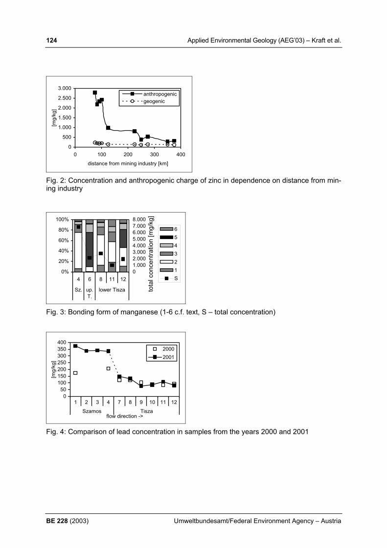
124 Applied Environmental Geology (AEG’03) – Kraft et al.
BE 228 (2003) Umweltbundesamt/Federal Environment Agency – Austria
0
500
1.000
1.500
2.000
2.500
3.000
0 100 200 300 400
distance from mining industry [km]
[mg/
kg]
anthropogenicgeogenic
Fig. 2: Concentration and anthropogenic charge of zinc in dependence on distance from min-ing industry
0%
20%
40%
60%
80%
100%
4 6 8 11 12
Sz. up.T.
lower Tisza
01.0002.0003.0004.0005.0006.0007.0008.000
tota
l con
cent
ratio
n [m
g/kg
]
654321S
Fig. 3: Bonding form of manganese (1-6 c.f. text, S – total concentration)
050
100150200250300350400
1 2 3 4 7 8 9 10 11 12
Szamos Tiszaflow direction ->
[mg/
kg]
20002001
Fig. 4: Comparison of lead concentration in samples from the years 2000 and 2001

Applied Environmental Geology (AEG’03) – Kralik 125
Umweltbundesamt/Federal Environment Agency – Austria BE 228 (2003)
A STRATEGY FOR PROTECTING KARST GROUNDWATER IN AUSTRIA M.Kralik1) 1) Umweltbundesamt Austria (Federal Environment Agency) and University of Vienna, Aus-
tria, [email protected] 1. INTRODUCTION Given the importance of carbonate (karst) groundwater for drinking water supply (50%) and their ecological significance (~22% of the Austrian surface area), strategies for improving their protection are proposed by the Environment Agency. These are based on the results of a questionnaire survey (Part 1), basic facts concerning carbonate (karst) water and recom-mendations for practical and scientific investigations (Part 2). Austria is one of the first coun-tries to develop a protection strategy for carbonate(karst) groundwater. 2. MATERIALS AND METHODS The 1st part is based on the results of a questionnaire survey to which 63 individuals in-volved in karst water supply or research throughout Austria responded. Of the 234 sugges-tions made the most are summarised (KRALIK, 2001). In the 2nd part a summary of the following information on carbonate (karst) groundwater and 12 recommendations for the improvement of groundwater protection in Austria are given. 3. RESULTS AND DISCUSSION The protection of the karst water is, from a legal and technical viewpoint, satisfactorily regu-lated by the ÖVGW (Austrian Association for Gas and Water) guidelines for water protection and prevention areas, the Austrian Water Law and the ÖWAV (Austrian Water and Solid Waste Management Association) guidelines on the use and protection of karst water used for drinking. For the delineation of karst water protection areas the results of dye tracer analysis, accurate hydrogeological mapping and the repeated sampling of springs have proved themselves to be of particular use. The main contaminants are bacteria, mineral oils and gasoline as well as nitrate loading, the main sources of which are mass tourism and agriculture, particularly from high livestock den-sities and arable farming. The majority of the responses consider that mountain ranges important for water supply need special investigations (Dachstein (Upper Austria, Styria), Toten (Upper Austria), Hagen and Tennen (both Salzburg) carbonat(karst)massif). Particular attention, including monitoring, should be paid to existing known minor contamination (Dachstein, the Villach Alps; (Carin-thia)) and all karst areas with relatively high population densities. Where such contamination endangers drinking water supplies the construction of microbiological treatment and drinking water treatment plants is necessary. Long dry periods may damage vegetation and lead to drinking water supply shortages, which should be prevented by creating additional wells in porous aquifers fed by carbonate(karst) water from the mountain ranges. Generally the quantity and quality of carbonate(karst) groundwater in Austria is satisfactory. However, carbonate(karst) groundwater and karst areas in general are under threat from cer-tain point and diffuse sources: • microbiological pollution from sewage (tourism), high livestock and game densities. • widespread, persistent pollution by long-range contaminants, which is concentrated by
high precipitation rates in Alpine regions, accumulation mechanisms and the short-term mobilisation during snowmelt.
• pollution, which results from intensive tourism, forestry or industry.

126 Applied Environmental Geology (AEG’03) – Kralik et al.
BE 228 (2003) Umweltbundesamt/Federal Environment Agency – Austria
These are frequently of hydrocarbon products and chlorinated hydrocarbons, which in these particularly sensitive carbonate(karst) areas (with negligible or eroded soil cover and the quick transfer to springs) cause rapid and severe pollution of groundwater. As the guidelines and laws were generally considered to be sufficient the following practical and scientific initiatives should be undertaken to improve the protection of karst waters and landscapes in Austria. Practical Recommendations 1. Development of criteria and environmental indicators for the good quantitative and good
chemical status of carbonate(karst) groundwaters. These should be in accordance with the European Water Framework Directive and can differ from those in porous media.
2. Publication of a manual to inform and guide engineers and authorities working for small water companies of the dangers and protection methods for carbonate (karst) waters.
3. Development of groundwater vulnerability maps in carbonate(karst) areas, beginning in areas with large groundwater reserves and elevated potential of anthropogenic pollution.
4. Extension and running of the network monitoring isotopes in precipitation in Austria to allow a more precise estimate of the age and altitude of infiltrating groundwater.
5. Extension of the Austrian water quality monitoring programme or other monitoring pro-grammes to include microbiological and total hydrocarbon parameters in order to be able to explain the extent and source of such pollution.
6. Investigation of particular tourist facilities and their evaluation from a karst hydrological perspective in order to exclude significant pollutants from such sources.
7. Provision of public information handouts to explain the threats and the necessity of vigi-lant protection of karst waters to the local population.
Research activities 1. Development of mixed microbiological-chemical fingerprint techniques in order to deter-
mine the origin of microbiological contamination (domestic wastewater, pasture, game). Carbonate(karst) groundwater should be protected at its source (recharge area) instead of being treated before supply.
2. Monitoring and semi-quantitative estimates of long-range contamination of carbon-ate(karst) recharge areas using modern tracer and isotope techniques.
3. European co-operation in the development of one or more groundwater vulnerability as-sessment methods.
4. Further development of remote sensing techniques (aerial and satellite photography) for the rapid production of the aforementioned groundwater vulnerability maps.
5. Evaluation and Interpretation of precipitation-isotope models to improve the scientific ba-sis of dating groundwater and to evaluate the mean altitude of recharge areas. In addi-tion, long-term monitoring of the precipitation models should detect trends in climatic changes in the Alpine areas at an early stage.
In order to achieve these improvements in the protection of carbonate(karst) groundwater there needs to be intensive co-operation between the competent authorities (national and provincial), citizens and academia. REFERENCES KRALIK, M. (2001): Strategie zum Schutz der Karstwassergebiete in Österreich [A stra-
tegy for protecting karst groundwater in Austria]. Bericht, BE-189, 99 p., Umweltbun-desamt, Wien.
Applied Environmental Geology (AEG’03) – Kralik et al. 127
Umweltbundesamt/Federal Environment Agency – Austria BE 228 (2003)
AUSTRIAN NETWORK OF ISOTOPES IN PRECIPITATION (ANIP) AS A TOOL FOR ASSESSING GOOD STATUS IN GROUNDWATER M.Kralik1) , W. Papesch2) & W. Stichler3) 1) Umweltbundesamt Austria (Federal Environment Agency) and University of Vienna, Aus-
tria, [email protected] 2) ARC Seibersdorf research GmbH, A-2444 Seibersdorf; [email protected] 3) [email protected], GSF Institute of Hydrology; Neuherberg, Germany 1. INTRODUCTION The Austrian Network for Isotopes in Precipitation (ANIP) started in 1972. Some stations have already been sampled since the 1960s (IAEA/WMO, 2001). 72 stations are presently sampled all over Austria with some preference given to the Karst areas North and South of the Alpine mountain range. The network is a co-operation between the Austrian Environment Agency (64 stations) and the ARC Seibersdorf Research (Arsenal: 8 stations). In addition 17 large rivers and lakes are sampled once a month to record the outflow response. The aim of the Austrian Network for Isotopes in Precipitation (ANIP) is to provide input data for hydrological and hydrogeological investigations and a data-base for climatological changes and trends in sensitive Alpine areas. This database helps to discern the origin of wet air masses, the mean altitude of the recharge areas and the residence time of water in groundwater bodies (KRALIK et al. 2003). In accordance with the European Water Framework Directive (DIRECTIVE 2000/60/EC) this allows the further characterisation of bodies found to be at risk including the characteristics of superficial deposits and soils. In contrast to some polluted porous aquifers some Alpine
Fig. 1. 72 active sampling stations of the Austrian precipitation network.

128 Applied Environmental Geology (AEG’03) – Kralik et al.
BE 228 (2003) Umweltbundesamt/Federal Environment Agency – Austria
springs show single parameters (e.g. nitrate, chloride) with an increasing trend despite gen-eral low concentrations. This indicates increasing manmade inputs which are in contrast to a good qualitative status. 2. MATERIALS AND METHODS The precipitation is collected on a daily basis in ombrometers (500 cm2) and mixed to monthly samples at stations ranging from 120 to 2250 m in altitude (Fig. 1). So far about 15000 analyses of oxygen-18, deuterium and tritium have been made by the isotope labora-tories of ARC (Arsenal, Vienna) and the Institute of Hydrology (GSF, Munich). All samples not measured immediately were stored in 1L bottles in a specially dedicated cellar (16000 samples) in Vienna and are available for analysis in the future. Besides of the quality assurance of the analysing laboratories, which regularly take part at round robin tests of the IAEA, particular care has been taken for the quality control of the ANIP-Depot of the samples collected in 1 L polyethylene (PE) bottles and some of them stored in dark cellars up to 30 years. Mean temperatures (14° C) and relative humidity (70 %) data were recorded over time periods. 3. RESULTS AND DISCUSSION The amount of precipitation in Austria is highly influenced by the Alpine mountain range (400-3000 mm/y). The amount of annual precipitation increases toward the mountain ranges, in particular at the high altitude regions. However, strong regional differences exist between the windward and the lee side of the Alpine ranges. Wet periods are supposed to represent maritime phases. The Alps as a weather divide sharply distinguish precipitation events caused by different air flow directions. A study about the origin of the precipitating air masses in Austria showed that an Atlantic influence (mois-ture from NW) causes lower stable isotope values (e.g. Patscherkofel and Bregenz) than a Mediterranean one (e.g. Villacher Alpe and Graz) (KAISER et al., 2002). Due to the shorter distance the Mediterranean influence is characterised by lower tritium concentrations. Fig. 2. Altitude effect at the northern front of the Eastern Alps in meteorological stations
and springs (filled symbols) in contrast to a very steep or nearly no altitude effect at the in-ner-alpine mainly Mediterranean influenced stations and springs in southern part of Austria (open symbols).
y = -482.79x - 4436.6R2 = 0.8932
100
600
1100
1600
2100
2600
-15.00 -14.00 -13.00 -12.00 -11.00 -10.00 -9.00 -8.00 -7.00
DELTA OXYGEN - 18
ALT
ITU
DE
(m)
Meteorol. Stations South
Meteorol. Stations North
Hohenpeissenberg, Germ.
Northern Springs
Southern Springs
Linear (Meteorol. Stations
100m ~ 0,21 %o O-18
Applied Environmental Geology (AEG’03) – Kralik et al. 129
Umweltbundesamt/Federal Environment Agency – Austria BE 228 (2003)
In addition to the input measurements at the above mentioned meteorological stations 173 springs North and South of the weather divide were analysed for oxygen-18 and tritium four times a year in 1997/1998 in the framework of the Austrian Water Quality Network (AWQN). The mean O-18 values were plotted against the altitude of the recharge area calculated sta-tistically as the half-height between the altitude of the spring and the potential maximum. It indicates an reasonable gradient of 0.21%o oxygen-18 per 100 m altitude change. al-titude of the recharge area. The correlation between the weighted mean of the O-18 val-ues(1993-1997) and the altitude of the northern meteorological stations are in fairly good agreement with the spring trend in the North (Fig. 2). However, most of the meteorological stations and the springs in the south of Austria show a significant Mediterranean influence. Also the altitude effect is small or not existing probably caused by the shielding effect of the Southern Alpine ranges in Northern Italy and Slovenia. As indicated by a recent study (KAISER ET AL., 2002) all stations and springs are influenced by Atlantic and Mediterranean origin to a variable degree and show therefore local mixtures, which may even vary in time. The dense network of input stations allows to discern the origin of the wet air masses (far transported air pollution), the mean altitude of the recharge area and the mean residence time in the groundwater body. This helps in groundwater bodies at risk to estimates the per-centage of the total groundwater is used by abstraction and how long it will take to observe a trend reversal after the source of contamination is removed. 4. CONCLUSIONS A dense national network of precipitation sampling and some station of river outflow for isotope analysis allow a reasonable estimate of the origin of wet air masses, the altitude of the mean recharge area and the mean transfer time. This is even more important in mountainous areas and region with variable meteorologial regimes. This is a crucial support for quantitative hydrological data. These data are important for the basic hydrological characterisation of groundwater bodies and they are essential for groundwater bodies ar risk. Isotope data help to estimate the percentage of the total groundwater used by abstraction and how long it will take to observe a trend reversal after the source of contamination is re-moved. REFERENCES DIRECTIVE 2000/60/EC (2000) of the European Parliament and of the Council establishing
a framework for Community action in the field of water policy. Official Journal of the Euro-pean Communities, OJ L 327, 72 p., Brussels.
IAEA/WMO (2001). Global Network of Isotopes in Precipitation. The GNIP Database. Acces-sible at: http://isohis.iaea.org.
KAISER, A.; SCHEIFINGER, H.; KRALIK, M.; PAPESCH, W.; RANK, D. & STICHLER, W.; (2002): Links between meteorological conditions and spatial / temporal variations in long – term isotopic records from the Austrian precipitation network. Intern. Conf. “Study of Envi-ronmental Change Using Isotope Techniques”, 23-27 Apr. 2001, C&SPaperSeries 13/P, 67-77, IAEA, Vienna.
KRALIK, M.; PAPESCH, W.; STICHLER, W.; RANK & SCHEIFINGER, H. (2003): Austrian Network of Isotopes in Precipitation (ANIP): Quality assurance and climatological phe-nomenon in one of the oldest and densest networks in the world. Intern. Sympos. On Iso-tope Hydrology and Integrated Water Resources Management, 19-23 May 2003, C&SPaperSeries, IAEA, Vienna.

130 Applied Environmental Geology (AEG’03) – Krizani et al.
BE 228 (2003) Umweltbundesamt/Federal Environment Agency – Austria
THE ROLE OF MICROORGANISMS IN HYPERGENOUS PROCESSES IN DUMPS AND SETTING-PITS AT BANSKÁ ŠTIAVNICA (SLOVAKIA) Ivan Križáni1), Peter Andráš1) & Martin Chovan,2)
1) Geological Institute, Slovak Academy of Sciences, Severná 5, 974 01 Banská Bystrica,
Slovakia, [email protected]; 2) Deparment of Mineralogy and Petrology, Komenský University, Mlynská dolina G, 842 15
Bratislava, Slovakia, [email protected] 1. INTRODUCTION The most legible manifestation of exploitation activities in mining regions are rests of mining dumps, which represent dumping grounds of disintegrated rocks, fine-milled ores and chemi-cal matters used during the dressing activities. Until now were these dumping grounds per-ceived only as a “memorials of the technical work” or as a anthrophic relief-creating ele-ments. The surrounding of Banská Štiavnica is a very good model area. All this region was even during the Ancient times (maybe even during Primeval Age) expressively remarked by mining activity. 2. MATERIALS AND METHODS To confirm that the origination of the percolating waters acidity is the activity of chemical-lithotrophic thionic bacteria there were isolated the following species Thiobacillus ferrooxi-dans, Thiobacillus thiooxidans, Leptospirillum ferrooxidans and Bacillus cereus. The men-tioned bacteria are in dumping grounds metabolically connected with sulphides. The domi-nant part of these sulphides is represented by fine-grained pyrite. It was prowed that in per-colating waters and in the influenced soils are present micro-mushrooms. One of the prod-ucts of the metabolism of micro-organisms are organic acids. It is assumed that these acids have an important role in the process of silicates and Al-silicates decay. The mechanism of biological oxidation under influence of thiobacterias iniciates the hydrolytic process of sul-phide minerals and cause creation of complex compounds of heavy metals. 3. RESULTS These acid percolating waters expressively damage and destroy the all biotop, contaminate the underground waters by Zn, Cu, Cd, Fe, Bi, Mn... The extraordinary negative influence has Al. Its concentration in acid water is very high. The result of biological-chemical environ-mental events is the biological transformation of the original sulphides as well as of the Al-silicates. The main consequence of these pelitisation and illitisation processes. The affecta-tion of H2SO4 and of the products of metabolism of species Bacillus cause releasing of Si, Al, Cr, Au, Ag... to the solution. The study of the gold grains surface show that the products of the bacteria metabolic processes reacted with Au and caused the following Au migration in the form of water-soluble complexes. We recorded the following evolutionary vegetation stages on dumps and soils influenced by heavy metal pollution. On dump areas with fine-grained substrate originate plant groups in mosaic position: Tussilago farfara, Agrostis tenuis and Artemisia vulgaris, Tripleurospermum perforatum, Daucus carota and Tanacetum vulgare. On places where is more humus, we can find next species: Avenella flexuosa, Nardus stricta, and mainly species from the sur-roundings: Arrhenatherum, Tithymalus cyparissias, Veronica chamaedrys, Phleum pratense and Festuca rubra.
Applied Environmental Geology (AEG’03) – Krizani et al. 131
Umweltbundesamt/Federal Environment Agency – Austria BE 228 (2003)
The oldest dumps from 14. to 16. centuries, worked as meadows, are covered by grass, which consists of species sturdy against heavy metals: Acetosella vulgaris, Luzula campes-tris, Arrhenatherum elatius, Avenella flexuosa, Leucanthemum vulgare, Dianthus carthu-sianorum, Pilosella cymosa. The soil in this stage has well developed two or three soil hori-zons. Dumps from 18. and 19. centuries are predominantly planted by trees Pinus nigra, Pinus silvestris and more rarely by Picea abies. On the youngest dumps subsists by auto-sowing Betula pendula, Alnus glutinosa, Salix caprea and some other plants. Analyses of plant tis-sues show high concentrations of heavy metals, e.g. in acid soil (pH = 4) contain Acetosella vulgaris up to 3500 mg Al in kg of dry sample. Little mammals represent due their shortliving and limited, max. of 1-2 ha extent life-area a extraordinary convenient group for monitoring of contamination of environment. It was catched 142 mammals of 5 species: Apodemus flavicollis (54.2%), Microtus arvalis (23.9%), Clethrionomys glareolus (18.3%) and rare Pitimys subterraneus and Clethrionomys suaveolens. There were determined contents of Fe, Mn, Cu, Pb, Zn, Cd, Bi (Ni) in tissues of kidneys, liv-ers and spleens of mostly abundant species. High contents of heavy metals were described in liver dry-tissues of Apodemus flavicollis (mg.kg-1): Fe 3028, Ni 337, Mn 26, Cu 26, Zn 45, Pb 60, Cd 4 ppm and in spleen dry tissues of Microtus arvalis: Fe 952, Ni 2498, Cu 1371, Zn 295, Pb 122, Cd 5 ppm. Between heavy metal contents in plants and internal organs of little mammals from surface levels of dumps was found a trend of important positive correlation but it will be very convenient verify these data on the larger set of samples. 4. CONCLUSIONS The dumps even after several hundred years still represent active micro-biological environ-ment. The products of the biological oxidation are extracted by rain water to the surrounding. The metallic ions contaminate the soil, they influence the vegetation and by mediation of the vegetation they enter to the animal tissues. The best solution how to re-cultivate such a terrains seem to be forested using suitable trees e.g. Pinus nigra. , Pinus silvestris etc. ACKNOWLEDGEMENTS This study has been financially supported by grant No.2-1139 of agency VEGA of Ministery of Education of Slovak Republic and of Slovak Academy of Sciences.

132 Applied Environmental Geology (AEG’03) – Krizani et al.
BE 228 (2003) Umweltbundesamt/Federal Environment Agency – Austria
COMPARISON OF THE ABILITY OF HEAVY METAL LEACHING FROM HYDRO-QUARTZITE AND FROM SEDIMENTS OF SETTING-PITS (BANSKÁ ŠTIAVNICA, SLOVAKIA) I. Križáni1) P. Andráš1) & L. Dluholucká2)
1) Geological Institute, Slovak Academy of Sciences, Severná 5, 974 01 Banská Bystrica, Slovakia, [email protected],
2) Secondary school, 969 01 Banská Štiavnica, Slovakia 1. INTRODUCTION The pit quarry at the south slope of Malý Šobov hill is situated in lens of hydrothermal quartz-ite (HQ). Fine grained waste from flotation plant of Banská Štiavnica Ore Mine State Plant is deposited in setting pit Sedem Žien at the contact of territory of Banská Štiavnica and Ban-ská Belá towns. The reason of the investigation was the desertification of the soil below the dump of the quartzite-quarry at Šobov hill. These two objects were choosed as a characteristic representatives for the study of dump materials of various grain size. Sulphide minerals are present in both types of investigated objects; they differ in the content and in grain size of sulphides. 2. MATERIALS AND METHODS The average sample of HQ (A) was prepared by homogenisation of crushed material from three bore holes for bench blasting in the low level of the quarry and from sediments of set-ting pit (B) after mixing of mentioned three samples from the external part of the dam. Nine portions of grain size <1 mm with volume <25 cm3 from each sample were washed by 250 ml solutions of distilled water (pH 6.5), solution H2SO4 + HNO3 and NaHCO3 in distilled water (pH 4.5) and in rainwater (pH 4.5). Contents of selected heavy metals in leaching were de-termined by atom absorption spectrometry (AA-device: Pye-Unicam Ltd./ Philips, model: PU 9000, flame: air/C2H2). The Thiobacillus ferrooxidans {Lf), Leptospirillum ferrooxidans (Lt), Thiobacillus thiooxidans (Tt) were isolated in Laboratory of Mineral Biotechnologies, Institute of Geotechnics, Slovak Academy of Sciences, Košice. 3. RESULTS Tab. 1 Contents of the most important oxides in wt.% in HQ and in sediments from the set-
ting pit (atom absorption spectrometric analyse) __________________________________________________________________________
SiO2 TiO2 Al203 Fe2O3 FeO MnO MgO CaO Na2O K2O P2O5 __________________________________________________________________________ A 92.32 0.44 0.97 3.26 0.26 0.02 0.04 0.11 0,05 0.08 0.12 B 71.68 0.31 7.72 2.36 2.20 1.03 1.14 2.28 2.22 3.79 0.10 __________________________________________________________________________ Tab. 2 Contents of selected heavy metals (g.t-1) in HQ and in sediments from the setting pit
(atom absorption spectrometric analyse) ____________________________________________
Cu Zn Pb Ag Cd ____________________________________________
A 25 52 64 8.27 0.10 B 478 3632 1138 5.50 18.40
____________________________________________

Applied Environmental Geology (AEG’03) – Krizani et al. 133
Umweltbundesamt/Federal Environment Agency – Austria BE 228 (2003)
Tab. 3 Average contents of heavy metals (mg.l-1) in leachings from samples A and B (atom absorption spectrometric analyse)
______________________________________________________ Fe Mn Cu Zn Pb Ag Cd
______________________________________________________ x A 330 8.10 0.52 5.70 2.30 0.23 0.018 x B 1.10 14.20 0.06 3.40 1.04 0.03 0.045
______________________________________________________ 4. CONCLUSIONS The primary source of Fe, Cu, Zn, Pb, Ag and Cd in HQ in the sediments of the setting pit are sulphide minerals and sulphosalts. Source of the Mn are in both cases carbonates and silicates. The important reason of the intensive leaching of the selected elements from HQ is caused by lower carbonate content in comparison with sediments of the setting pit. The second rea-son is the long time activity of three species of thio-bacteria and of products of their metabo-lism on the high reactive mineral phases of HQ. In the sediments of the setting pit dam was isolated already only Thiobacillus ferrooxidans.
Tab. 4 Overview of thio-bacteria from Šobov and Nová šachta dumps and from setting pit Sedem Žien
__________________________________________________________________________ Locality Samples Sample pH Bacteria Medium number Tf, Lf, Tt __________________________________________________________________________ Šobov quarry and dump drainage water 6 2.0-2.4 + + + Nová Šachta dump drainage water 3 5.6-6.8 + + + Setting pit Sedem Žien leaching from sand 1 5.7 + - - __________________________________________________________________________ Explanations: + present, - not present The waters from the dump area were collected to the retentive basin and than, using 2 km long plastic pipe, deflected to the mining waters to the limestone environment. Experimental neutralisation of acid metallic-sulphate water was realised in the wet land system (Šotník & Šucha 2001). ACKNOWLEDGEMENTS This study has been financially supported by grant No.2-1139 of agency VEGA of Ministery of Education of Slovak Republic and of Slovak Academy of Sciences. REFERENCE ŠOTNÍK. P. & ŠUCHA, V. (2001): Možnosti úpravy kyslého banského výtoku ložiska Banská
Štiavnica – Šobov. Mineralia Slovaca 33: 53-60, Bratislava.
134 Applied Environmental Geology (AEG’03) – Kuchovsky et al.
BE 228 (2003) Umweltbundesamt/Federal Environment Agency – Austria
DEALING WITH THE IMPACT OF SUBSURFACE CONTAMINATION ON THE FUTURE LAND USE - EXAMPLE OF THE BRNO CITY, CZECH REPUBLIC T. Kuchovsky, M. Stejskal & J. Hrsel Institute of Geological Sciences, PrF MU, Kotlarska 2, 611 37 BRNO, Czech Republic [email protected] 1. INTRODUCTION The Brno city with more than 380 000 inhabitants is the second largest town in the Czech Republic. Since the end of the 18-th century and particularly the beginning of the 19-th cen-tury the textile and heavy industry is greatly developing. During the 20-th century the produc-tion technologies were modernized and using of hazardous substances became routine at many sites. This resulted in groundwater and soil contamination. One of the most significant risk of subsurface contamination is related to possible usage of contaminated landsides in fu-ture, which should reflect potential health risk effects. During preparation of the new Territo-rial City Plan the question of the areal extent of contaminated sites in areas planed for differ-ent purposes appeared significant.
2. MATERIALS AND METHODS For the purposes of the work compiling of appropriate methodology was necessary as a first step. The most suitable way of assessment is the standard U.S.EPA methodology for the health-risk assessment applied on areas categorized in the Territorial City Plan of the Brno City. The area categories are originaly classified into groups according to planed architec-tonic usage (e.g. pure living sites, industrial sites, agricultural sites, combined sites). Each area category is coincidently specific by typical time and exposure ways to potential con-taminants. Knowing the typical time and exposure ways to residential or commer-cial/industrial population group the risk-based screening levels were calculated for each of the area categorized in the Territorial City Plan. The limit concentrations were then compared to actual informations about the groundwater and soil contamination. Informations from more than 3000 sampling points consisting of grondwater, soil and soil gas samples were used. Repetitive sampling was used to be done at more than 2000 sampling points. In many cases these information show the contamination trend line. Only the archive informations were used, no new sampling was performed. The basic information of the po-tential and known sources of contamination were respected.
3. RESULTS The result of the project is the map of subsurface contamination in the Brno city. GIS technology was used to bind up the map showing the areal extent of contaminated land-sides to subsurface quality informations. Areal distribution of each selected item is displayed in three layers. The first one shows sources of contamination, the other two layers bring out separate information of groundwater and soil contamination. Color fill and specifying hatch adjustment presents the most important information of particular area. The most importatnt information is the areal extent of zones with critical concentrations of any contaminant reach-ing the calculated risk-based screening level. The color is used for visual identification of the usability of landside for intended purpose of the Brno’s territorial plan. Other importatnt in-formations are listed in database tables. Calculated risk-based screen level, usability and non-usability of the landside for the purposes of the territorial plan, type of contaminant and contaminant concentrations, thickness of the unsaturated zone and references to archive materials are among the most important.
The main advantage of the compiled map is an easy approachable image of areal distribu-tion of subsurface contamination. Such a map is very useful in compiling new territorial city

Applied Environmental Geology (AEG’03) – Kuchovsky et al. 135
Umweltbundesamt/Federal Environment Agency – Austria BE 228 (2003)
plans and may be used by other public organizations dealing with environmental problems in industrial areas.
REFERENCES U.S. EPA (1989): Risk Assessment Guidance for Superfund. Vol. I. U. S. Environmental Pro-
tection Agency, EPA/540/1-89/002, Washington. U.S.EPA (1997): Exposure factor handbook. U.S. Environmental Protection Agency,
EPA/600/P-95/002Fa, Washington. U.S.EPA (2002): Supplemental guidance for developing soils sreening levels for superfund
sites. Environmental Protection Agency, OSWER 9355.4-24, Washington. KUCHOVSKY, T.; STEJSKAL, M.; HRSEL, J. (2003): The map of subsurface contamination
in the Brno City. GIS Ostrava 2003, Conference Papers, VSB TU, Ostrava.
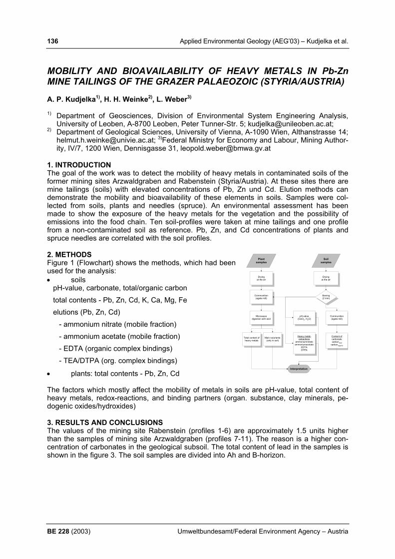
136 Applied Environmental Geology (AEG’03) – Kudjelka et al.
BE 228 (2003) Umweltbundesamt/Federal Environment Agency – Austria
MOBILITY AND BIOAVAILABILITY OF HEAVY METALS IN Pb-Zn MINE TAILINGS OF THE GRAZER PALAEOZOIC (STYRIA/AUSTRIA) A. P. Kudjelka1), H. H. Weinke2), L. Weber3)
1) Department of Geosciences, Division of Environmental System Engineering Analysis,
University of Leoben, A-8700 Leoben, Peter Tunner-Str. 5; [email protected]; 2) Department of Geological Sciences, University of Vienna, A-1090 Wien, Althanstrasse 14;
[email protected]; 3)Federal Ministry for Economy and Labour, Mining Author-ity, IV/7, 1200 Wien, Dennisgasse 31, [email protected]
1. INTRODUCTION The goal of the work was to detect the mobility of heavy metals in contaminated soils of the former mining sites Arzwaldgraben and Rabenstein (Styria/Austria). At these sites there are mine tailings (soils) with elevated concentrations of Pb, Zn und Cd. Elution methods can demonstrate the mobility and bioavailability of these elements in soils. Samples were col-lected from soils, plants and needles (spruce). An environmental assessment has been made to show the exposure of the heavy metals for the vegetation and the possibility of emissions into the food chain. Ten soil-profiles were taken at mine tailings and one profile from a non-contaminated soil as reference. Pb, Zn, and Cd concentrations of plants and spruce needles are correlated with the soil profiles. 2. METHODS Figure 1 (Flowchart) shows the methods, which had been used for the analysis: • soils
pH-value, carbonate, total/organic carbon total contents - Pb, Zn, Cd, K, Ca, Mg, Fe elutions (Pb, Zn, Cd)
- ammonium nitrate (mobile fraction) - ammonium acetate (mobile fraction) - EDTA (organic complex bindings) - TEA/DTPA (org. complex bindings)
• plants: total contents - Pb, Zn, Cd The factors which mostly affect the mobility of metals in soils are pH-value, total content of heavy metals, redox-reactions, and binding partners (organ. substance, clay minerals, pe-dogenic oxides/hydroxides) 3. RESULTS AND CONCLUSIONS The values of the mining site Rabenstein (profiles 1-6) are approximately 1.5 units higher than the samples of mining site Arzwaldgraben (profiles 7-11). The reason is a higher con-centration of carbonates in the geological subsoil. The total content of lead in the samples is shown in the figure 3. The soil samples are divided into Ah and B-horizon.
Dryingat the air
Communition(agate mill)
Microwavedigestion with acid
Total content ofheavy metals
Content ofcarbonatecarbontotal
carbonorganic
Heavy metal-extractions
ammoniumnitrateammoniumacetate
EDTADTPA
pH-value(CaCl2, H2O)
Dryingat the air
Communition(agate mill)
Interpretation
Sieving(2 mm)
Plantsamples
Soilsamples
Main nuturients(only in soil)

Applied Environmental Geology (AEG’03) – Kudjelka et al. 137
Umweltbundesamt/Federal Environment Agency – Austria BE 228 (2003)
0
2000
4000
6000
8000
10000
0 1 2 3 4 5 6 7 8 9 10 11profile
Total content of Pb in soils
AhB
22800 67490ppm
pH-values
3,0
4,0
5,0
6,0
7,0
8,0
0 1 2 3 4 5 6 7 8 9 10 11number of profile
Ah-CaCl2 Ah-H2O B-CaCl2 B-H2O Figures 2 and 3: pH-values and total content of lead in soil-samples
The mobile fraction of Pb, Zn, Cd is about 50 percent of the mobiliseable fraction calculated over all samples. Cadmium shows the expected high mobilisation in soils with mobile frac-tions up to 50 percent and more of the total metal content. The analysis of the macro-nutrients potassium, calcium, magnesium and iron are in the normal range of silvicultural used soils in all samples. The spruces growing on the mine tailings show no deficiency syn-dromes and have a healthy growth.
Natural content insoils and ubiquitouscontaminants
Substantia l changes(contamination,mobilisation)
Concern of interferenceof soil function / subject of protection
Interference of an landuse
PRECAUTION VALUE CONTROL VALUE CRITICAL VALUE
Background array
Precaution Array Critical array
Figure 4: Classification of values of heavy metals in the environment (after PRÜESS 1994) 4. VALUATIONS The measured total contents and mobility of lead, zinc and cadmium in the sample areas are potentional stress for the forming soils. The data indicate a rather strong binding of the heavy metals in the soils more than a high bioavailability. Anyway the plant samples show a partial high intake of especially cadmium but also lead and zinc. The heavy metal accumulator Car-daminopsis halleri shows extremely high values and some spruce needle samples are also highly contaminated. The contents in soils exceed the critical value by Eikmann-Kloke for non-agrarian ecosystems in many soil samples (see also arrow/graph). But the whole sample area is in forest usage, so the entry of heavy metals into the food chain can be ruled out. The analysis of water samples, which had been taken from the Arzwaldbach, shows a very low discharge of heavy metals through the groundwater. REFERENCES PRÜESS, A. (1994): Einstufung mobiler Spurenelemente in Böden, In: Rosenkranz, D., Ein-
sele, G., Harress; H. M., Bodenschutz. Ergänzb. Handbuch, Abschnitt 3600. E., Berlin. LATAL, Ch. (1998): Umweltgeologische Untersuchungen an ausgewählten Bergbaustandor-
ten des Grazer Paläozoikums: (Großstübing, Guggenbach), Graz, Dipl.-Arb. SIEGHARDT, H. (1991): Zur Anatomie und Physiologie von Pflanzen auf anthropogenen
Schwermetallstandorten eines Bergbaugebietes in Österreich, Wien, Habil.-Schrift. WENZEL, W. (1995): Verteilung und Mobilität von Schwermetallen in Böden: Methodik der
Erfassung, Variabilität, Dynamik und ökosystemare Effekte, Habil.-Schrift, Wien. ZEIEN, H. (1995): Chemische Extraktion zur Bestimmung der Bindungsformen von Schwer-
metallen in Böden, Bonner Bodenkundliche Abhandlungen 17, Bonn.
138 Applied Environmental Geology (AEG’03) – Kupfersberger
BE 228 (2003) Umweltbundesamt/Federal Environment Agency – Austria
ENVIRONMENTAL INFRASTRUCTURE MEASURES IN THE LOWER DRAVA RIVER BASIN H. Kupfersberger Institute of Hydrogeology and Geothermics, Joanneum Research Forschungsgesellschaft mbH, Elisabethstr. 16, A-8010 Graz, [email protected] 1. INTRODUCTION For the catchment area of the lower course of the Drava River between Croatia and Hungary waste water and solid waste infrastructure measures shall be developed in order to improve the environmental situation. On the Croatian side municipal water consumption compared to agriculture and industry is the most prominent water using sector in the lower Drava River Basin. Groundwater is the dominant source of water supply. Between one third and two thirds of municipal and indus-trial waste water is collected and treated at least to a basic level. Secondary treatment is mostly not existing REGIONAL ENVIRONMENTAL CENTER FOR CENTRAL AND EASTERN EUROPE (2001). Detrimental effects of non point source pollution from pesticides and fertilizers used in agricultural on groundwater quality have increased substantially in the last decade (INTERNATIONAL BANK FOR RECONSTRUCTION AND DEVELOPMENT, 2003). In the Hungarian area of the lower Drava River Basin most of the people are living in settle-ments with less than 1000 inhabitants with almost no waste water treatment (only 10% with second degree treatment, i.e. biological). However, in compliance with the EU Urban Waste Water Directive 100% of the waste water is collected and mechanically and biologically treated in settlements with more than 2000 population equivalents. The waste water fees cover 100% of the treatment costs including waste water collection and investment costs; but apparently the fees are not collected in every case. Deeper aquifer (i.e. 30-50m below sur-face) layers are used for drinking water supply. The shallow groundwater is influenced by ag-ricultural pollutants and infiltrating non-treated waste water. Industry (e.g. sugar plants, brew-eries) and agriculture are the dominant water consuming sectors. 2. MATERIALS AND METHODS With respect to groundwater protection characterization of the groundwater bodies to assess their use, the risk of future deterioration (including vulnerability mapping) and the potential need for restoration will be important tasks. Detailed investigations include definition and quantification of diffusive (e.g. fertilizers, pesticides) and point sources of pollution (e.g. un-managed landfills) as well as temporal and spatial analysis of hydraulic dominant processes like conditions of recharge, abstraction, discharge and interaction with surface water ecosys-tems (including wetlands). The existing groundwater monitoring net will be evaluated. In particular, the frequency of hy-draulic and chemical measurements shall be such that meaningful time series can be gener-ated to discriminate between the impact of human activities and natural processes. More-over, it has to be guaranteed that the potential exceeding of relevant quality standards is de-tected early on to avoid consecutive damage. For example, after the closure of landfills no subsequent monitoring of groundwater quality is required in Hungary. Furthermore, clean up measures for groundwater bodies need to be considered where concentration of pollutants exceed threshold levels. Since most of the water and waste management data also include spatial characteristics a geographical information system will be set up to provide a common transnational working platform. Thus, existing data sets will get harmonized, a standard for future data sharing defined and at the end a joint warning system for environmental pollution

Applied Environmental Geology (AEG’03) – Kupfersberger 139
Umweltbundesamt/Federal Environment Agency – Austria BE 228 (2003)
can be developed. In contrast to general practice of infrastructure projects it is the particular strategy of this project to integrate technical, economical, social and ecological issues from the very beginning. For this purpose a regional integrated environmental master plan will be developed considering all relevant information corresponding to these diverse aspects. As a necessity, this plan has to be compatible with current national waste and water management plans (KOMMUNALKREDIT AUSTRIA AG, 2003). Solutions will be suggested where differ-ent standards or procedures exist in the two countries. Moreover, cooperation is planned with communities at a local level, since their needs have to be met and they will eventually run the environmental infrastructure measures. As a result of the master plan pilot projects will be designed (i.e. recycling centre as part of a central landfill, decentralized and centralized waste water treatment units, water supply facili-ties) that ensure long-term sustainable, economically and socially viable solutions. EU wide environmental and technological standards as well as modern organisational and financial models (i.e. the establishment of associations of communes, legal restructuring) are at the core of the proposed ventures. Environmental impact assessment of the pilot projects will fol-low. Finally, a new methodological approach for the development and implementation of environ-mental infrastructure in the future EU member states and Central or Eastern European ac-cession countries will be devised. The practical experience made in different pilot projects and the results of the individual integrated approach will be abstracted in order to constitute a standardized approach for integrated environmental infrastructure projects. 3. RESULTS AND CONCLUSIONS Since the project is still in it’s starting phase a preliminary outline of the master plan is ex-pected in the second half of the year after thorough examination of the available data and background reports. The Drava River Basin Project is jointly funded by the EU through the INTERREG IIIB CADSES program, the BMWA, the BMLFUW and the provinces of Styria and Carinthia. REFERENCES KOMMUNALKREDIT AUSTRIA AG (2003): Studie über die Analyse von Rahmenbedingun-
gen im Wasserver-, Abwasserentsorgungs- und Abfallbereich zur ökonomischen und so-zialen Integration von Regionen in Kroatien. 80 p., Oesterreichische Kontrollbank AG, Vienna.
International Bank for Reconstruction and Development / World Bank (2003): Water Re-sources Management in South Eastern Europe Volume II Country Water Notes and Water Facts Sheets. 105 p., Washington.
REGIONAL ENVIRONMENTAL CENTER FOR CENTRAL AND EASTERN EUROPE (2001): Water Pricing in Croatia, Current Policies and Trends, 42 p., Zagreb.
140 Applied Environmental Geology (AEG’03) – Lehner & Kralik
BE 228 (2003) Umweltbundesamt/Federal Environment Agency – Austria
INORGANIC AND ORGANIC CONTAMINANTS AND MINERALOGY OF VIENNESE DUST E. Lehner1,2) & M.Kralik1)
1) Umweltbundesamt Austria (Federal Environment Agency) and University of Vienna, Aus-
tria, [email protected], 2) Institute for Geological Sciences, University of Vienna, Vienna, Austria. 1. INTRODUCTION Particulate Dust Pollution in Vienna Due to improved filtering techniques industry reduced the coarse dust emission considerably in Central Europe, the very fine grained (< 10 µm) and more dangerous dust emission stayed constant or has even increased (BUXBAUM & KRALIK, 2000). Because of their small size as well as their shape, dust particles may be particular harmful to the human respiratory system. High concentrations of some minerals themselves (asbestos, quartz etc.) or the high heavy metal content as well as carcinogenic organic compounds (PAH’s) frequently attached to them have noxious effects. The most important natural and manmade particle sources in urban environments are mate-rials eroded by wind (soils, construction materials etc.), as well as industrial and traffic emis-sions. Speculation about their sources are done on the basis of chemical information only. Very little is known about their mineral and organic phases. In order to interpret the physical properties of particles, their environmental behavior and the health risks they may pose in fu-ture, the combined information of chemistry and mineralogy is essential. 2. MATERIALS AND METHODS The very fine-grained particles have been collected on „low blank“ cellulose nitrate and glassfiber filters in a high volume sampler (Stroehlein) or in a cascade impactor (CMI) at several places in the capital city of Vienna. In order to observe long term changes samples have been taken from the filter of an air condition in intervals of 3-5 month from 1991-1995. These samples have been dry-screened < 20 µm in order to make them more comparable to the PM10 filter samples. Mineralogical composition was analyzed by x-ray diffraction, FTIR and SEM. The trace element and Pb-isotope composition was obtained by dissolving parts of the filters and subsequent analysis with ICP-MS. Glassfibre filters were extracted with supercritical CO2 and the PAH were ana-lyzed with GC-MS (KRALIK, 2000). 3. RESULTS AND DISCUSSION Source apportionment by trace metals, lead isotopes and PAH’s The dust samples consist of calcite, dolomite, quartz, organic matter (+ soot), and gypsum as major phases, whereas illite-mica, chlorite and feldspar are minor phases (<5%). Magnet-ite, goethite, brushite and epsomite were detected as well. Winter sample are more enriched in calcite, dolomite and gypsum compared to samples collected during summer (KRALIK et al., 2000). The considerable enrichment in As, Cd, Pb and Zn, compared with the mean crustal compo-sition, as well as the lead isotope-ratios (207/026) indicate a fair mixture of emissions from heating and gasoline combustion during winter (Fig. 1). The considerable stronger mean en-richment of Sb, Cd and Pb during the summer month is caused by the dominance of auto-mobile emissions and the missing dilution effects by carbonates caused by winter mainte-nance in form of carbonate grit.

Applied Environmental Geology (AEG’03) – Lehner & Kralik 141
Umweltbundesamt/Federal Environment Agency – Austria BE 228 (2003)
The higher concentrations of benzo[a]pyrene in the winter dust samples indicate a higher contribution by fossil fuel burning compared to higher concentrations of coronen in summer, indicative of burning hydrocarbons in car engines.
2,172,142,112,082,052,020,82
0,84
0,86
0,88
0,90 LEAD - ISOTOPESin VIENNESE DUST
208PB / 206PB
207P
B /
206P
B
EXHAUSTE LEAD
BLEIBERG - LEAD
LEAD inPOLISH COAL
1995
Dust
DanubeSediment
1991
Fig. 1 Decreasing influence of gasoline lead changed the lead isotope composition in Vien-nese dust samples considerable during the period of 1991-1995. 4. CONCLUSIONS The most prominent change during 1991-1995 is the considerable decrease in lead content in Viennese dust samples, due to the legal ban on leaded gasoline (1993) during this period causing a continuous shift in lead isotope ratio. This ratio is a mixture between exhaust lead derived from leaded gasoline (mainly Australian lead) and the lead naturally occurring in Vi-enna represented by Danube sediments. REFERENCES BUXBAUM, I. & KRALIK, M. (2000): Are heavy metal particulate transport to remote Alpine
areas a threat to our drinking water resources? Abstr. 5th Intern. Symp. on Environm. Geochemistry, p. 99, 25-28. Apr. Cape Town.
KRALIK, M. (2000): Environmental Geology in Austria. In: NEUBAUER, F. & HÖCK, V. (eds.): Aspects of Geology in Austria. (345 p.). Mitt. Österr. Geol. Ges., 92, 315-337, Wien.
KRALIK, M., LEHNER, E. & HOOGEWERFF, J. (2000): Aerosol and dust emission trends in a metropolitan area: Mineralogy, heavy metals and Pb-isotopes in Viennese dust sam-ples. Abstr. 5th Intern. Symp. on Environm. Geochemistry, p. 96, 25-28. Apr. Cape Town.

142 Applied Environmental Geology (AEG’03) – Liesch & Hötzl
BE 228 (2003) Umweltbundesamt/Federal Environment Agency – Austria
ASSESSMENT OF GROUND WATER RISK USING NEURAL NET-WORKS T. Liesch & H. Hötzl Kaiserstr. 12, D-76128 Karlsruhe, Germany, eMail: [email protected] 1. INTRODUCTION The new European Water Frame Directive calls for action for the detailed assessment of the ground water risk to reduce existing ground water contamination and to avoid future damage. The aim is to work out new strategies for sustainable ground water management. Within the scope of this project a new method of extensive assessment of the ground water risk, basing on neural networks, is developed. This approach considers the sensitivity of the subsurface towards the infiltration of harmful substances (vulnerability) as well as the potential risk resulting from different land use (hazards). For the calibration of the method the actual distribution of hazardous substances in the groundwater in several test areas is used. With this data at each case a neural network is trained and its performance is validated. The trained network can then be used to predict the distribution of the pollutants in areas where it is not known as a measure for the ground water risk. The main advantage over the conven-tional methods is that the correlations made between input parameters and output data are causally determined and not empirical. Furthermore, the method can easily be adjusted to different types of climatic, geological or morphological settings just by training a new network and that, compared to classical numerical modelling, it can be used in different scales and even very large areas with a reasonable cost of computational resources. 2. METHOD To train a neural network, a training area, within a similar setting (i. e. geology, aquifer char-acteristics etc.) as the area that has to be investigated, and with a high density of available data is needed. As input parameters for the neural network all data of factors possibly con-trolling the ground water vulnerability (geology and permeability of the aquifer and the un-saturated zone, ground water height, gradient and flow direction, rainfall, etc.) as well as the land use for potential anthropogenic sources of pollutants (hazards) are collected and stored in a GIS. As the output parameter the distribution of a single pollutant (for specific ground water risk, i. e. the risk for a specific single pollutant) or a sum parameter of several pollut-ants (for overall ground water risk) must be known. All data are then converted into raster data of reasonable cell size, depending on the scale and size of the investigated area and, if needed, punctual data are interpolated as well as new data are derived from existing data (e. g. slope and aspect from a DEM etc.). As neural networks only work with numbers be-tween 0 and 1, the data have to be specially coded, e. g. binary (0 and 1 for “yes” and “no” or “present” and “absent”), in classes (0, 0.5 and 1 for “low”, “middle”, and “high”) or continu-ously (normalized distribution of pollutants or transmissivity of the aquifer). This coding proc-ess has to be carefully considered, for there is sometimes more than one way to code the in-formation and the result can thus be heavily affected. The resulting data are then separated into two data sets, one for the training of the neural network and the other to test its perform-ance. The neural network analysis was carried out in Java Neural Net Simulator (JavaNNS), developed by the university of Tuebingen. So far, a simple three layer feed forward neural network with one hidden layer is used. Several learning functions have been tested, whereat Backpropagation with Momentum Term turned out to give the best results. The number of neurons in the input layer depends on the number of input parameters used. Theoretically all available parameters can be used, but in praxis more then 10 to 12 are not reasonable, be-cause the runtime of the training process increases exponential with the number of input pa-rameters. Therefore a careful preselection has to be made in most cases. The number of neurons in the hidden layer depends on the particular case and has to be tested. In the out-put layer there is always one neuron for the pollutant content as the output parameter. The

Applied Environmental Geology (AEG’03) – Liesch & Hötzl 143
Umweltbundesamt/Federal Environment Agency – Austria BE 228 (2003)
neural net is then trained with the training data iteratively by adjusting the weighted connec-tions of the neurons until a minimum error is reached. This process has to be monitored with a second data set, the validation data, because from a certain point of time, the network is trained on the noise in the training data. This so called “overfitting” has to be avoided, be-cause it causes the loss of the ability of the neural network to generalize, i. e. to predict other than the training data. The performance of the neural network can be checked by comparing the forecast of the trained network (by giving it only the input parameters of the validation data) and the known values of the distribution of the pollutants from the validation data set. The error in percent is then simply computed by subtraction of forecasted value and known value, divided through known value, times 100 and can be shown on a map by re-importing the values into the GIS. 3. RESULTS So far, the method has been developed and tested in two test areas: the Rastatt region south of Karlsruhe/Germany and in a part of the Hegau, southeast of Engen (southwestern Ger-many). In Rastatt, the distribution of chloride has been predicted. As input parameters have been chosen the distance to the river Rhine (main chlorid source by bank filtration), the me-dium ground water height, the medium ground water flow direction, the distance to the river Murg (which brings water poor in chloride from the Blackforest) and the distance to anthro-pogenic chloride hazards. The results of the forecast are shown in Fig. 1. In the Hegau re-gion, which is mostly agriculturally used, nitrate has been chosen as the pollutant to be fore-casted. Input parameters were soil type, geology, ground water height, ground water flow di-rection, protective cover and land use. The result is shown in Fig. 2. The error in the second test area is about twice as high as in the first. This is probably caused by the very poor input data in this test area as well as a time displacement of mapped land use (current data) and nitrate distribution (old data).
Fig. 1: Error in predicting the chloride Fig. 2: Error in predicting the nitrate distribution in the test area at Rastatt/Germany distribution in the test area at (value range from 0.0 % to 67.0 %, average Hegau/Germany (value range from 14.3 %) 0.0 % to 1595 %, average 31.8 % 4. CONCLUSIONS AND FURTHER WORK The investigations show that the new approach is a very efficient method to predict the pres-ence and even the level of pollutants in the ground water. Additionally further works on the neural approach itself should considerably improve the results. So far, only one specific pol-lutant could be predicted. In further works, a method of predicting the overalls pollutant con-tent (by a kind of sum parameter) as a measure for the ground water risk is intended. As de-manded by the Water Frame Directive the new approach could thus be a useful instrument for sustainable ground water management in the future.

144 Applied Environmental Geology (AEG’03) – Liesch & Hötzl
BE 228 (2003) Umweltbundesamt/Federal Environment Agency – Austria
REFERENCES BISHOP, CH. M. (1995): Neural Networks for Pattern Recognition. 482 p., Oxford University
Press, Oxford, New York. VRBA, J.; ZOPOROZEC, A. (eds.) (1994): Guidebook on mapping groundwater vulnerability.
International contributions to hydrogeology, Vol. 16. 131 p., Heise, Hannover. ZELL, A. (1994): Simulation Neuronaler Netze. 624 p., Addison-Wesley, Bonn, Paris.

Applied Environmental Geology (AEG’03) – Linnik 145
Umweltbundesamt/Federal Environment Agency – Austria BE 228 (2003)
SPECIATION OF HEAVY METALS IN THE BOTTOM SEDIMENTS AND A SECONDARY POLLUTION OF AQUATIC ENVIRONMENT P. Linnik Department of Hydrochemistry, Institute of Hydrobiology, National Academy of Sciences, Geroev Stalingrada Ave. 12, Kiev 04210, the Ukraine; [email protected] 1. INTRODUCTION Accumulation of pollutants on the bottom of reservoirs and their remobilization from the bottom sediments are among the important mechanisms of regulation of the content of these substances in the aquatic environment, which influences the bioproductivity parameters of aquatic ecosystems and water quality in them. In this connection many researches repeatedly paid attention to the necessity of more profound studies of bottom sediments of the reservoirs as a potential source of pollution of the aquatic environment by various substances, including the heavy metals (HM). Creation of the cascade of six reservoirs on the Dnieper, one of the largest rivers in Europe, had its adverse consequences, alongside with some positive effect. Regulation and redistri-bution of the river runoff have allowed to decrease considerably the urgency of the problem of water deficiency in Ukraine, and in its southern areas in particular. However, these changes in the hydrological regime of the river were accompanied by the sharp slowing down of its current, reduction of water exchange, a change in the type of circulation of substances in the reservoirs in comparison with the river. 2. MATERIALS AND METHODS The samples of bottom sediments were taken mainly by a modernized Eckman’s dredge with the area of capture of 100 cm2. To obtain silt solutions, the freshly taken samples of the top layer (0–5 cm) of bottom sediments were subjected to centrifugation during 30–40 min at 5 thousand rev/min. The analysis of the HM content in the interstitial solutions was carried out by the chemiluminescent methods [NABIVANETS et al. (1981)] and a method of anodic stripping voltammetry [Linnik & NABIVANETS (1988)]. The concentration of free (hydrated) ions of metals was determined in situ immediately. After that, the silt solutions (25–40 ml) had been frozen in polyethylene bottles for further research: determination of the total con-centration of the metal dissolved forms after photochemical oxidation of organic substances, separation of organic complexes of metals on columns with neutral sephadexes. To investi-gate the fractional distribution of HM in the bottom sediments of the Dnieper water bodies, a five-step sequential extraction procedure was applied [TESSIER et al. (1979)]. The total con-centration of HM in samples of bottom sediments was determined by the method of atomic absorption spectrophotometry (device AAS-1 of Carl Zeiss Jena Company, Germany) after their dissolution in the mixture of concentrated acids HF, HCl and HNO3. 3. RESULTS Maximum quantities of HM studied are characteristic of southern water-bodies located within the industrial zone (the Zaporozh’e and Kakhovka reservoirs as well as Dnieper-Bug estu-ary). The highest concentrations of the metals investigated occurred in the clay silts (Fe, 11600 – 32400; Mn, 1504 – 3450; Cu, 38.9 – 85.5; Zn, 89.8 – 186.5; Cr, 48.6 – 193.0; and Cd, 1.9 – 4.4 mg/kg dry weight). Secondary pollution of the aquatic environment of the Dnieper reservoirs by HM occurs in various seasons. However, a substantial increase of metal concentrations in water is repeatedly observed at the end of summer, and the reservoir drawdown, as a result of somewhat increased water consumption in the specified period, es-sentially promote to that. The concentrations of HM increase by a factor of 1.5 to 3 after the drawdown of the water level. The main reason for the rise in the concentrations of metals is exchange between the bottom sediments and the water column. The rate of HM migration is connected with the forms of occurrence in solid substrates and pore solutions in the bottom sediments, as well as with physico-chemical conditions arising at the sediment/water bound-
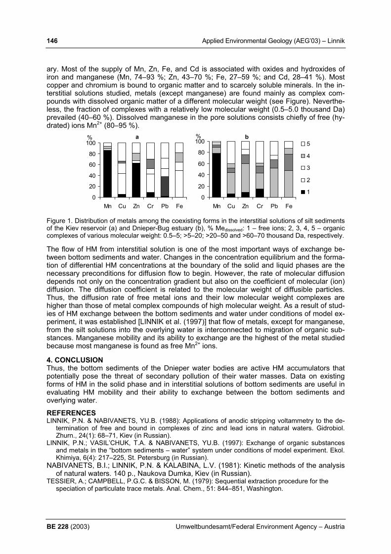
146 Applied Environmental Geology (AEG’03) – Linnik
BE 228 (2003) Umweltbundesamt/Federal Environment Agency – Austria
ary. Most of the supply of Mn, Zn, Fe, and Cd is associated with oxides and hydroxides of iron and manganese (Mn, 74–93 %; Zn, 43–70 %; Fe, 27–59 %; and Cd, 28–41 %). Most copper and chromium is bound to organic matter and to scarcely soluble minerals. In the in-terstitial solutions studied, metals (except manganese) are found mainly as complex com-pounds with dissolved organic matter of a different molecular weight (see Figure). Neverthe-less, the fraction of complexes with a relatively low molecular weight (0.5–5.0 thousand Da) prevailed (40–60 %). Dissolved manganese in the pore solutions consists chiefly of free (hy-drated) ions Mn2+ (80–95 %).
a
0
20
40
60
80
100
Mn Cu Zn Cr Pb Fe
% b
0
20
40
60
80
100
Mn Cu Zn Cr Pb Fe
%5
4
3
2
1
Figure 1. Distribution of metals among the coexisting forms in the interstitial solutions of silt sediments of the Kiev reservoir (a) and Dnieper-Bug estuary (b), % Medissolved: 1 – free ions; 2, 3, 4, 5 – organic complexes of various molecular weight: 0.5–5; >5–20; >20–50 and >60–70 thousand Da, respectively. The flow of HM from interstitial solution is one of the most important ways of exchange be-tween bottom sediments and water. Changes in the concentration equilibrium and the forma-tion of differential HM concentrations at the boundary of the solid and liquid phases are the necessary preconditions for diffusion flow to begin. However, the rate of molecular diffusion depends not only on the concentration gradient but also on the coefficient of molecular (ion) diffusion. The diffusion coefficient is related to the molecular weight of diffusible particles. Thus, the diffusion rate of free metal ions and their low molecular weight complexes are higher than those of metal complex compounds of high molecular weight. As a result of stud-ies of HM exchange between the bottom sediments and water under conditions of model ex-periment, it was established [LINNIK et al. (1997)] that flow of metals, except for manganese, from the silt solutions into the overlying water is interconnected to migration of organic sub-stances. Manganese mobility and its ability to exchange are the highest of the metal studied because most manganese is found as free Mn2+ ions. 4. CONCLUSION Thus, the bottom sediments of the Dnieper water bodies are active HM accumulators that potentially pose the threat of secondary pollution of their water masses. Data on existing forms of HM in the solid phase and in interstitial solutions of bottom sediments are useful in evaluating HM mobility and their ability to exchange between the bottom sediments and overlying water.
REFERENCES LINNIK, P.N. & NABIVANETS, YU.B. (1988): Applications of anodic stripping voltammetry to the de-
termination of free and bound in complexes of zinc and lead ions in natural waters. Gidrobiol. Zhurn., 24(1): 68–71, Kiev (in Russian).
LINNIK, P.N.; VASIL’CHUK, T.A. & NABIVANETS, YU.B. (1997): Exchange of organic substances and metals in the “bottom sediments – water” system under conditions of model experiment. Ekol. Khimiya, 6(4): 217–225, St. Petersburg (in Russian).
NABIVANETS, B.I.; LINNIK, P.N. & KALABINA, L.V. (1981): Kinetic methods of the analysis of natural waters. 140 p., Naukova Dumka, Kiev (in Russian).
TESSIER, A.; CAMPBELL, P.G.C. & BISSON, M. (1979): Sequential extraction procedure for the speciation of particulate trace metals. Anal. Chem., 51: 844–851, Washington.
Applied Environmental Geology (AEG’03) – Madritsch 147
Umweltbundesamt/Federal Environment Agency – Austria BE 228 (2003)
HYDROGEOLOGICAL INVESTIGATIONS OF SPRINGS WITHIN LARGE SCALE LANDSLIDES USING OXYGEN-18 ANALYSES (WATTENTAL, TYROL, AUSTRIA) H. Madritsch Institute of Geology and Palaeontology, University of Innsbruck, Innrain 52, 6020 Innsbruck, Austria, [email protected] 1. INTRODUCTION The aim of this project is to firstly characterise and evaluate springs that emerge from large scale landslides and secondly work out their hydrogeological systems. The study area lies on the western slopes of the “Wattental”, 20km southeast of Innsbruck. Some of the springs, constitute a large part of the water supply for the town of Wattens. Further, the landslides also affect waterpipelines and roads in the region. 2. METHODS The study area was geological and geomorphological mapped in detail (scale 1:10.000) with special emphasis on the structural geology and for signs of relict and active landslides. On one instable slope GPS-geodesy using real time methods has been carried out. Out of over 150 mapped springs 25 were selected to be monitored intensively for a time period of 1 year at monthly intervals. The physical water parameters (electrical conductivity, temperature, dis-charge) have been measured and water samples taken for oxygen-18 analysis. Every 3 months a chemical analysis of the spring waters have been carried out. Analysis of oxygen-18 has also been carried out on monthly mixed samples of 2 precipitation collectors from within the study area. 3. RESULTS The study area lies within the Lower Austroalpine Innsbrucker Quarzphyllite. This metamor-phic unit is mainly made up of quartz-, sericite-, and chlorite-phyllites with inclusions of greenschists, marbles, graphite-schists and garnet-mica-schists. The rocks have undergone intense and polyphase ductile deformation, resulting in a pene-trating NW dipping foliation and several fold generations (KOLENPRAT et al., 1999). At a later stage brittle deformation formed NW-SE and E-W striking faults. The majority of joints and fractures observed now strike N-S at variable dips. The characteristic signs of the mapped landslides are spreading mountain ridges at the top (twin ridges) and scarps and depressions alternating down slope (MOSER, 1994), Fig.1. The movements caused intense fracturing of the rock body. The springs generally occur at the toe of the landslides or in their detachment areas. The electric conductivity of the springs is low (20 – 220 µS/cm) and generally decreases with an increase in outflow altitude. The water types are Ca-Mg-HCO3-SO4 and Ca-Mg-HCO3. The pH values vary between 6.0 –7.8. At present δ 18O values are available from 3 sampling cam-paigns. They show a wide range of –13.7 to –12.2, probably reflecting the temperature and altitude effect (HUMER et al., 1995). 4.CONCLUSIONS The development of the large scale mass movement is mainly due to the schist foliation dip-ping almost parallel to the slope. The brittle deformation and landsliding has formed fractured aquifer systems which in rock types that normally have very poor water conductivity proper-ties (aquicludes). The twin ridges and depressions act as infiltration areas. The δ18O data ob-

148 Applied Environmental Geology (AEG’03) – Madritsch
BE 228 (2003) Umweltbundesamt/Federal Environment Agency – Austria
tained so far shows that some deep lying spring have very low δ 18O values indicating a high mean recharge altitude. Higher lying springs show higher δ 18O values, probably the effect of run-off infiltration. We assume that this reflects a complex multi-level aquifer system in where the shear zones of landslide bodies act as aquicludes (Figure 1).
Fig.1: Schematic profile through the “Sagspitze” landslide showing the hydrogeological
situation With the obtainment of more isotope data in the next few months, we will be able to calculate a regression line, based on the δ18O distribution observed from reference springs and pre-cipitation, to determine the mean recharge altitude for the springs more precisely. Further-more the temporal deviation of the δ18O will allow for making conclusions about the retention characteristics of the source-aquifers (RANK, 1986). ACKNOWLEDGEMENTS The project is part of a master thesis at the Institute of Geology and Palaeontology University of Innsbruck (Advisor: Dr. K. Krainer) and is carried out under the supervision and financial aid of ILF Consulting Engineers (Dr. G. Poscher) and Institute for Hygiene, University of Innsbruck (Dr. I. Jenewein). REFERENCES HUMER, G. et al. (1995): Niederschlags-Isotopenmessnetz Österreich. Monographien,
Bd. 52 – Umweltbundesamt, Wien KOLENPRAT, B. et al. (1999): The tectonometamorphic evolution of Austroalpine Units in
the Brenner area (Tyrol, Austria)- Structural and tectonic implications. Tübinger Geowis-senschaftliche Arbeiten, Series A, Vol. 52, 116-117.
MOSER, M. (1994): Geotechnics of large scale slope movements (“Talzuschübe”) in Alpine Regions. 7th international IAEG congress. 1533-1542, Rotterdam.
RANK, D. (1986): Isotope ratios in the natural water cycle. ÖWW,38, 7/8, S.142, Vienna.

Applied Environmental Geology (AEG’03) – Marczinek et al. 149
Umweltbundesamt/Federal Environment Agency – Austria BE 228 (2003)
IDENTIFICATION AND QUANTIFICATION OF NATURAL ATTENUATION PROCESSES AT A SITE CONTAMINATED WITH CHLORINATED ETHENES S. Marczinek1), K. Kloos2), S. Peiffer3) & W. Schäfer4)
1) Department of Hydrology, University of Bayreuth, Universitätsstrasse 30, 95440 Bayreuth [email protected];
2) Department of Microbiology, University of Bayreuth, Universitäts-strasse 30, 95440 Bayreuth, [email protected];
3) Department of Hydrogeology, University of Aachen3 Templergraben 55, 52056 Aachen, [email protected];
4) Interdisciplinary Center for Scientific Calculations, University of Heidelberg, Im Neuen-heimer Feld 368, 69120 Heidelberg, [email protected]
1. INTRODUCTION For identification of natural attenuation processes at a former landfill situated in northern ba-varia, where aliphatic hydrocarbons and chlorinated ethenes leach out, and the formation of VC indicates microbial degradation of those chlorinated ethenes, hydrogeological, geo-chemical and microbial approaches where applied (MARCZINEK & PEIFFER, in press). Chlo-rinated ethenes were widely used in industry and are either known or suspected carcino-gens. Therefore their occurence in nature is of concern (MCCARTHY et al., 1994). The landfill studied, which was in use from the 40s to the mid 60s and presently is covered with trees and grass, has a size of roughly 400 m². 2. MATERIALS AND METHODS The hydrogeological approach contained the set-up of a regional hydrogeological modell of the target area. Therefore, the geological and hydrogeological settings were worked out through evaluation of geological maps, drillings, hydraulic data like groundwater-table moni-torings and pumping tests and application of hydrogeological tracers, which served for groundwater age determination for identification of groundwater recharge areas. In a geochemical approach the redox-environment of the solid phase and the groundwater were assessed. The redox-environment has great influence on degradation pathways and kinetics of the chlorinated ethenes (BALLAPRAGADA ET AL., 1997; PEIFFER & LASKOV, 2002; VOGEL ET AL., 1987). Apart from using conservative methods like e.g. determination of the redox-potential by using redox-sensors or analysing standard redoxsensitive groundwa-ter and solid phase parameters, like e.g. sulfate, reduced sulfur, nitrate, iron and manganese, also innovative methods like determination of methane and hydrogen-concentrations in groundwater and the employment of In-situ reactors for measuring Fe(III)-reduction-rates were applied. The microbial approach intended to establish methods for characterisation of total microbial populations and groups of halorespiratoric and alkan-oxidising bacterias. Quantification of the identified processes was done by modelling the reactive transport with the programme TBC (SCHÄFER et al., 1998) on basis of a regional groundwater flow modell, which was done with the programme “Modflow”. 3. RESULTS The synthesis of these different approaches in connection with the distribution of the con-taminants led to the identification of distinct zones downstream of the landfill, where reduc-tive dechlorination and cometabolic aerobic degradation of chlorinated ethenes took place. Target aquifer is a confined Triassic Buntsandstein aquifer of 20 – 320 m thickness, which can a least be subdivided into 2 different subaquifers. The water table in the uppermost subaquifer is 2 – 7 m bsl, while in the deeper subaquifer it is found in 15 – 20 m bsl. Mainly

150 Applied Environmental Geology (AEG’03) – Marczinek et al.
BE 228 (2003) Umweltbundesamt/Federal Environment Agency – Austria
the uppermost aquifer is contaminated with chlorinated ethenes and petroleum hydrocar-bons, but small amounts of chlorinated ethenes are also found in the deeper subaquifer. Groundwater movement in the uppermost subaquifer is from SE to NW upstream of the land-fill and changes into an SW-directed flow downstream of it, while in the deeper one the groundwater surface is nearly horizontal with a small gradient towards the south. Directly downstream of the landfill, the redox-environment is strongly reduced, as shown in Figure 1 and sulfate reduction and methanogenesis are taking place. Here a large potential for reductive dechlorination is given, which is also taking place, as it is confirmed by the high degree of metabolism of the chlorinated ethenes shown in Figure 2. With increasing distance to the landfill, the redox-environment becomes more and more oxidised, so that here co-metabolic aerobic degradation especially of the lesser chlorinated ethenes is favored.
landfill
groundwater flowdirection
20 0 20 40m
Fig. 1: Redox-environment in the surroundings of the landfill (Nov. 2002)
Fig. 2: CAH-Distribution in monitoring wells in the surroundings of the landfill (Nov. 2002)

Applied Environmental Geology (AEG’03) – Marczinek et al. 151
Umweltbundesamt/Federal Environment Agency – Austria BE 228 (2003)
4. CONCLUSIONS For assessing natural attenuation at contaminated sites, extensive comprehension of the on-going processes is necessary. Such a comprehension can only be achieved by assembling all information available from the different disciplines concerned with the study of the degra-dation processes or the local settings of the target area. A consideration of the regional settings at this site was necessary because of the compli-cated groundwater-flow structures. In regarding the regional groundwater movement signifi-cant flow structures could be identified which were not only important for the local groundwa-ter flow at the contaminated site but also for risk assessment for the water supply wells situ-ated roughly 4 km south of the landfill. Regarding the chemical and microbial degradation processes in dependence of the groundwater flow insured the simultaneous appreciation of these two types of processes, which are always coupled and superimposed on each other. REFERENCES BALLAPRAGADA, B.S., STENSEL, H.D., PUHAKKA, J.A, FERGUSON, J.F (1997): Effect of hy-
drogen on reductive dechlorination of chlorinated ethenes. Environ. Sci. Technol. 31, 1728-1734.
MARCZINEK, S., PEIFFER S. (in press): Concept and First Results of Studying Natural At-tenuation at a Site in Northern Bavaria Contaminated with Chlorinated Ethenes. In: Schulz, H. D., Hadeler, A.: Geochemical Processes in Soil and Groundwater, Measure-ment - Modelling –Upscaling. Wiley-VCH
MCCARTHY, P. L., SEMPRINI, L. (1994): Ground-Water Treatment for Chlorinated Solvents. In: R.D. Norris et al. (Hrsg): Handbook of Bioremediation. Lewis Publishers, Boca Raton, Fl
PEIFFER S., LASKOV C. (2002): A steady-state approach to model redox potentials in groundwaters contaminated with chlorinated ethenes. In: Schulz H. D., Teutsch G. (Hrsg.): Geochemical Processes - Conceptual Models for Reactive Transport in Soils and Groundwater, Wiley-VCH, 250-262.
SCHÄFER, D., SCHÄFER, W., KINZELBACH, K. (1998): Simulation of reactive processes re-lated to biodegradation in aquifers, Journ. of Cont. Hydrol. 31, 167 -209
VOGEL, T.M., C.S. CRIDDLE UND P.L. MCCARTHY (1987): Transformations of halogenated aliphatic compounds. Environ. Sci. Technol. 21, 722-736

152 Applied Environmental Geology (AEG’03) – Markovic et al.
BE 228 (2003) Umweltbundesamt/Federal Environment Agency – Austria
LATE PLEISTOCENE PALEOCLIMATE AND PALEOENVIRONMENT RECORDED IN THE LOESS-PALEOSOL SEQENCE AT IRIG BRICKYARD EXPOSURE (VOJVODINA; SERBIA) S. B. Marković1), E. A. Oches2), T. Gaudenyi1), M. Jovanović1), W. D. McCoy 3), T. Ste-vens3), P. Sümegi4), S. Savić1), P. Ivanišević5), R. Walther2) & Z. Galović5) 1) Quaternary Research Centre, University of Novi Sad, Trg Dositeja Obradovica 3, 21000
Novi Sad, Serbia and Montenegro; [email protected] 2) Department of Geology, University of South Florida, 4202 E. Fowler Ave. SCA 528,
Tampa FL 33620, USA 3) Department of Geosciences, University of Massachusetts, Amherst, MA, 01003 USA 4) Department of Geology and Paleontology, University of Szeged, Egyetem u. 2-6, H-6722
Szeged, Hungary 5) Poplar Institut, Department of Soil science, Antona Čehova 13, 21000 Novi Sad, Serbia
and Montenegro 1. INTRODUCTION The Irig brickyard loess exposure (45o 05’ N, 19o 52’ E) is situated in the central part of the south slope of Fruška Gora (Vojvodina, Serbia). Initial investigations focus on the four loess layers and three paleosols preserved in the 7 m thick exposure. 2. MATERIALS AND METHODS Investigations of the loess-paleosol sequences of the Irig quarry began in 2001. Samples were collected at 5-cm intervals for sedimentological analysis, and at 25-cm intervals for ma-lacological studies. Grain size fractions (<2, 2-20, 20-200, >200 µm) were measured by siev-ing and pipeting and carbonate content was determined with Scheibler apparature. Magnetic susceptibility variations measured in the field using a portable Bartington susceptibility meter. Measurements levels were at 5-cm intervals and at each level, 10 independent readings were taken and averaged. 10-kg bulk sediment samples for malacological investigations were sieved through 0.7 mm mesh. After fossil gastropod shells were identified, paleoenvi-ronmental classification was done based on study of LOŽEK (1964), but also extended with some local variant defined by KROLOPP & SÜMEGI (1995). Gastropod shells were collected from three levels within L1 (last glacial loess) and the lower part of L2 (penultimate glacial loess) for amino acid racemization analysis in order to independently correlate the stratigra-phy with loess-paleosol units elsewhere in Europe. Details of the sample preparation and analytical methodology are presented in OCHES & MCCOY (2001). 3. RESULTS Amino acid racemization and luminescence geochronology provide correlations between loess-paleosol units at Irig brickyard with glacial cycles (KUKLA, 1975) B and the youngest part of C, respectively, at other European localities. Magnetic susceptibility, grain size and carbonate content records supported a correlation with the δΟ18 variations of SPECMAP paleoclimatic model (MARTINSON et al., 1987) over the last about 140.000 years (figure 1). The relativly poor snail assemblage with dominant species such as Chondrula tridens, Granaria frumentum, Helicopsis striata and Pupilla triplicata suggest arid and relativly warm paleoclimatic conditions. The composition of mollusc fauna suggest that this region, parts of the southern slope of Fruska Gora mountain range, was a refugium for warm-loving and xe-rophilus mollusc taxa, where these elements could survive during the unfavourable climate periods of the Late Pleistocene. It is reflected in the continuous presence of Granaria frumen-tum specimens in the loess samples.
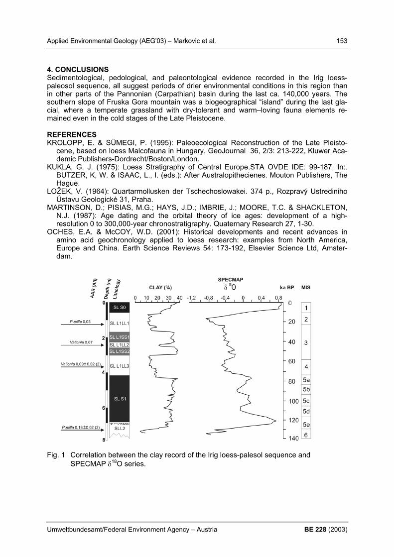
Applied Environmental Geology (AEG’03) – Markovic et al. 153
Umweltbundesamt/Federal Environment Agency – Austria BE 228 (2003)
4. CONCLUSIONS Sedimentological, pedological, and paleontological evidence recorded in the Irig loess-paleosol sequence, all suggest periods of drier environmental conditions in this region than in other parts of the Pannonian (Carpathian) basin during the last ca. 140,000 years. The southern slope of Fruska Gora mountain was a biogeographical “island” during the last gla-cial, where a temperate grassland with dry-tolerant and warm–loving fauna elements re-mained even in the cold stages of the Late Pleistocene. REFERENCES KROLOPP, E. & SÜMEGI, P. (1995): Paleoecological Reconstruction of the Late Pleisto-
cene, based on loess Malcofauna in Hungary. GeoJournal 36, 2/3: 213-222, Kluwer Aca-demic Publishers-Dordrecht/Boston/London.
KUKLA, G. J. (1975): Loess Stratigraphy of Central Europe.STA OVDE IDE: 99-187. In:. BUTZER, K, W. & ISAAC, L., I. (eds.): After Australopithecienes. Mouton Publishers, The Hague.
LOŽEK, V. (1964): Quartarmollusken der Tschechoslowakei. 374 p., Rozpravý Ustrediniho Ústavu Geologické 31, Praha.
MARTINSON, D.; PISIAS, M.G.; HAYS, J.D.; IMBRIE, J.; MOORE, T.C. & SHACKLETON, N.J. (1987): Age dating and the orbital theory of ice ages: development of a high-resolution 0 to 300,000-year chronostratigraphy. Quaternary Research 27, 1-30.
OCHES, E.A. & McCOY, W.D. (2001): Historical developments and recent advances in amino acid geochronology applied to loess research: examples from North America, Europe and China. Earth Science Reviews 54: 173-192, Elsevier Science Ltd, Amster-dam.
Fig. 1 Correlation between the clay record of the Irig loess-palesol sequence and
SPECMAP δ18O series.
154 Applied Environmental Geology (AEG’03) – Marofi
BE 228 (2003) Umweltbundesamt/Federal Environment Agency – Austria
RIVER WATER QUALITY IN A SEMI-ARID HYDROLOGICAL BASIN OF IRAN S. Marofi
Department of Irrigation Eng., Faculty of Agriculture, Bu-Ali Sina University, Azadegan Boulevard, Hamadan, 65174, Iran, [email protected] This study concerns the problem of the rivers water quality of a hydrological basin, located in the two western regions of Iran, of a semi arid climate. The main objective was prediction of surface water quality of the regions, to better feature agricultural management. The temporal and spatial variation of the surface water quality of the area was examined based on the ma-jor chemical elements, which observed on the outlets of 13 sub-basins. The results illustrate that no any significant relations between the chemical element concentrations and the cover areas of the sub-basins can identify. In exception of SAR (Sodium Adsorption Ratio), on av-erage the chemical elements show less than 26% variations between the sampling places. The minimum chemical elements have been observed on the outlet of the AliAbad and Sah-neh, which are the natural basins and have very small agricultural lands. The values of the element concentrations in these two basins are about 50% less than the other basins that are cultivated areas. The temporal analyzes show a negligible seasonal variability (5%) be-tween the considered chemical elements, except for SAR (20%). The higher and the lower concentrations of the chemical elements (in exception of SAR) occur in the fall and spring, respectively. In summer, the SAR value is maximal, and the agricultural activities cause about 37% increase on its normal (average annual) rate in the rivers. 1. INTRODUCTION The impact on water pollution has concerned environmentalists and scientists for decades. JALALI (2002) has described the composition of irrigation waters of 311 wells in Hamadan region. His work indicated that the quality of Hamadan water supply, generally is limited by salinity and sodium hazards. Pervious studies indicate that the bedrock geology and weath-ering of surface rock also are the main influence on water chemistry of stream water (JENKINS et al., 1995). This study presents the water quality of the major rivers of the Ghamasiab basin of Iran. The objective was to determine the anthropogenic impacts on river water quality.The study area covers of 13 sub-basins of the Ghamasiab hydrological basin, located in the Hamadan and Kearmanshah regions. The total area is 20×103 km2 and the sub-basins surface varies from 40 to 7770 km2. Annual precipitation change between 305 and 530 mm. Based on the Kop-pen classification, the climate of Hamadan and Kearmanshah are Bfh and Cfa, respectively. Generally, in all of the area, during the March and April, precipitation is often relatively mini-mal but the rainfall events occur with high intensity. About 85 percent of the area are occu-pied by agricultural lands, which have impacts on quality of the surface waters. The geologi-cal trend of the regions consists of Sanandaj-Serjan and Zagros zones with a faulted bound-ary, which are parallel from northwest to southeast direction. The lithological formations of regions contain metamorphic and igneous rocks such as Malayer metamorphic or Borojared intrusive rocks. The dominant lithologies of Sanandaj-Serjan and Zagros zones are Mesozoic and Tertiary Limestone, respectively. Agricultural activities in these regions consist of de-pression, glacier and terraced cultivation. Pesticides, as well as of fertilizer, in the form of farmyard manure, inorganic nitrogen and phosphate compounds are almost commonly using on crop production.
Applied Environmental Geology (AEG’03) – Marofi 155
Umweltbundesamt/Federal Environment Agency – Austria BE 228 (2003)
2. METHODS Water sampling was undertaken from 1968 to 1996, one time per month by the water Labo-ratory of the West Water Authority. A network of fixed hydromeretic stations (located in outlet of each sub-basin) has used continuously for water sampling and discharge monitoring. Sampling has based on the Depth Integration method, by use of bottles. A temporal classifi-cation has been considered (MAROFI, 2003) to better understanding the seasonal changes of the elements. The obtained data have divided into the four classes: (i) winter, (ii) spring, (iii) summer and (iv) autumn and the statistical analyzes were applied for these four groups of data. 3. RESULTS AND CONCLUSION The major chemical elements of river water quality such as Ca, K, Na, Mg, Cl, HCO3, CO3, SO4 and SAR etc, of 13 sub-basins of the Ghamasiab hydrological basin have examined based on a spatial and seasonal analyse. The results illustrate that any significant relations cannot identify between the chemical element concentrations and the cover areas. The total cations (4.15) and anions (4.14 mequiv/l) concentrations are equal. Ca (2.17) and HCO3 (3.54 mequiv/l) are the dominant cation and anion. Conversely, K (0.04) and CO3 (0.28 me-quiv/l) have the lower concentrations across all the sites. This is consistent with the studies that are done in other relatively similar environments (BHATT & PATHAK, 1992; JENKINS et al., 1995). The importances of the cations and anions concentrations are followed by Ca>Mg>Na>K and HCO3>SO4>Cl>CO3, respectively. The spatial variations of the elements between the sampling stations are: EC (26), TDS (25), SAR (58), total cations and total ani-ons (25) and pH (2%). The minimum elements have been observed on the outlet of the AliA-bad and Sahneh, which are the natural basins and have very small agricultural lands. The observed elements in these two basins are about 50% less than the other areas, which are cultivated. The temporal analyzes show that the higher and the lower concentrations of the chemical elements (in exception of SAR) occur in autumn and spring, respectively. The seasonal variation of the chemical elements is about 5%, in exception of SAR that has a variation of 20%. In summer, the SAR rate of the rivers is maximal and the agricultural activities cause about 37% increasing in its average annual value. REFERENCES BHATT, D. A. & PATHAK, J. K. (1992): Himalayan Environment: Water Quality of the Drain-
age Basins. Shree Almora Book Depot, Almora, India. JALALI, M. (2002): Composition of irrigation waters in west of Iran. 17th WCSS, 14-21 Au-
gust, Thailand. JENKINS, A., SLOAN, W. T. & COSBY, J. (1995): Stream chemistry in the middle hills and
high mountains of the Himalayas, Nepal. J. Hydrol., 166. MAROFI, S. (2003): Stream water quality in the western regions of Iran. USCID, Second In-
ternational Conference on Irrigation and Drainage, Phoenix, Arizona.

156 Applied Environmental Geology (AEG’03) – Marofi
BE 228 (2003) Umweltbundesamt/Federal Environment Agency – Austria
GROUNDWATER DYNAMICS IN A SEMI ARID REGION
S. Marofi Department of Irrigation Eng., Faculty of Agriculture, Bu-Ali Sina University, Azadegan Boulevard, Hamadan, 65174, Iran; [email protected] 1. INTRODUCTION Many researchers have discussed the role of geological properties of aquifer and structural patterns on water table fluctuations. The pervious studies indicate that recharge and dis-charge can be delineated by groundwater mechanisms (LEANEY, 1995). SALAMA et al. (1994) have investigated the recharge and discharge areas using the satellite images. Groundwater potential has more recognized as the main water resources in the western of Iran. Drought and populations growing cause depletion of the groundwater level toward its bedrock. In some places, wells and pumping stations have settled and ground subsidence has occurred because of water table falling. The study area covers the plains of 10 agricultural basins of Hamadan region located in western Iran. The plains surfaces vary from 150 to 800 km2. The altitude ranges between 1550 m (with little topographic relief) and 1850 m (at the flat hills with low superficial relief). The annual water tables movements are considerable (0.12-1.58 m). The yearly precipitation ranges 290 to 371 mm and the climates are cold semi arid and cold arid. More than 70 per-cent of the area is occupied by agricultural lands. It consists of depression and glacier culti-vation that have impact on the water table of plains. The geological trend of the region con-sists of Sanandaj-Serjan and Zagros zones with a faulted boundary, which are parallel from north-west to south-east directions. The lithological formations of the region contain meta-morphic and igneous rocks such as Malayer metamorphic or Borojared intrusive rocks. The dominant lithology of Sanandaj-Serjan and Zagros zones are Mezozoic and Tertiary Lime-stone, respectively. 2. METHODS The specific storage (S) and transmissibility (T) have been estimated by pumping test based on the Jacob and Boulton-Theiss methods in several points of each plain that range between 1 to 7% and 150 to 4500 m2/d, respectively. Groundwater monitoring has done systematically during hydrological cycles from 1990 to 2002, two times per month by the West Water Au-thority. A network of piezometres and wells of 15-80 m depth has been developed at several sites of each plain. The measured data are the depth of water tables in relation to its ground surfaces. The absolute groundwater levels have obtained by comparing the water table depth to absolute ground surface levels. For each plain, based on the Thiessen polygon method, a polygon area has developed for each monitoring point (piezometres or wells) and the observed groundwater levels have changed into the mean global values. The annual and long period characteristic groundwater hydrographs of each plain have developed by using the absolute global stages of water table. 3. RESULTS AND CONCLUSION Groundwater movements of 10 hydrological basins of Hamadan region, situated in western part of Iran have been investigated. The monitored water table levels of the basins have been changed as the absolute elevations. Based on the Thiessen polygon method and the local water table levels data, the characteristic groundwater hydrograph has been developed for each basin, which shows the general yearly dynamic of the groundwaters. In total, the annual value of recharge of the groundwaters is about 0.73% of its discharge rate, therefore the all of water table of the study area were decreased during the observation period (1990-2002). The results illustrate that the groundwater recharges and discharges of the basins are

Applied Environmental Geology (AEG’03) – Marofi 157
Umweltbundesamt/Federal Environment Agency – Austria BE 228 (2003)
not similar and controlled by the geomorphological and geological features. The ranges of recharge and discharge movements of the water tables are 0.95-4.14 and 1.09-5.73 m, re-spectively. By comparing the recharges and discharges rates, it is understate that the annual groundwater balance is negative. In all the basins, the speed of water table fluctuations var-ies by the depth of groundwater and this is relatively more rapid in the upper stages of water tables. The annual and long period groundwater hydrographs of 10 basins have developed and ex-amined based upon the collected data. The each annual hydrograph was divided into two main sections: (i) recharge and (ii) discharge phases. The highest water table stage gener-ally occurs at the beginning of April. For each hydrological cycle, the change of water table is calculated during these characteristic phases. The result shows that the water table levels of the plains of all the basins have declined dur-ing the last decade and year after year they bend down. The change in water table regime is caused by decreasing the rainfall further (ZARE et al., 2001) and increasing the agricultural land development. The results suggest that the groundwater recharge and discharge of the basins are different and controlled by the geomorphological and geological patterns (MAROFI et al., 2002). The rates of the recharge (0.95-4.14 m, occur during 6-7 months) and discharge (1.09-5.73 m, occur during 4-5 months) vary between the basins with about a spa-tial variation of 0.65%. The water table movements also changes by depth of groundwater. In all the plains, it has more rapids in the upper levels, comparing the lower situations. The comparison of recharges and discharges rates show that on average recharges values is about 0.73% of the discharges rates, therefore the annual groundwater balance is negative. The result exhibit that for water table treatment and water balance studies, the groundwater hydrograph separation (recharge and discharge phases) analyzes is more preferable than the yearly hydrograph case. REFERENCES LEANEY, F. W. & HERCZEG, A. L. (1995): Regional recharge to karst aquifer estimated
from chemical and isotopic composition of diffuse and localised recharge, South Australia. J. Hydrol., 164.
MAROFI, S.; VOLTZ, M. & MOUSSA, R. (2002): Role of ditches on water exchanges be-tween two shallow groundwaters in an agricultural catchment, 17th WCSS, Bangkok, Thai-land.
SALAMA, R. B.; TAPLEY, I.; ISHII, T. & HAWKES, G. (1994): Identification of areas of re-charge and discharge using Landsat-TM satellite imagery and aerial photography map-ping techniques. J. Hydrol., 162.
ZARE, H. (2001): Statistical drought investigation in Hamadan region of Iran. First National Conference on “Water Crisis Mitigation Strategies”, Zabol, Iran.

158 Applied Environmental Geology (AEG’03) – Marofi
BE 228 (2003) Umweltbundesamt/Federal Environment Agency – Austria
TRANSMISSIVITY ESTIMATIONS IN THE GARA CHAY HYDROLO-GICAL BASIN S. Marofi Department of Irrigation Eng., Faculty of Agriculture, Bu-Ali Sina University, Azadegan Boulevard, Hamadan, 65174, Iran, [email protected] Based on the pumping test method, the groundwater hydrodynamical properties of the 4 plains of a hydrological basin of Hamadan region, situated in western part of Iran have been estimated. The groundwater transmissivity estimations have followed by stepwise drawdown, constant discharge pumping test and as well as recovery period observations. The result shows that on all of the pumped wells, the higher transmissivities values estimated concern with constant discharge pumping, recovery period and stepwise drawdown, respectively. The study shows that the rate of transmissivity decreases by increase the discharge value. In deeper layers, because of less permeability (comparing the upper layers), water flow to-wards the wells decreases, which can decrease the discharge or aquifer supply outgoing flow of the well. 1. INTRODUCTION It has long been recognized that identification of hydraulic properties of geologic units is an important step for optimum groundwater exploitation. Based on the in situ activities and the modeling approaches, hydrogeologists have been tried to determine the transmissivity and specific capacity as the principal components of aquifer. DIXON & CUSTER (2002) have demonstrated that specific capacity used to estimate hydraulic parameters can be obtained from well bore data. An analysis of the lithology penetrated by the wells indicates that the transmissivity is proba-bly controlled mainly by the stratigraphic position of the layers penetrated by the well (GINGERICH, 1999). FERRIS (1951) developed a method of computing the ratio of trans-missivity to storativity (diffusivity) of an aquifer by comparing the fluctuation of river stage (in-fluence by a flood wave event) to a simple harmonic motion of groundwater stage. HUNTSMAN & MCCREADY (1995) have been applied the time-lag method (FERRIS, 1951) to calculate the diffusivity of a buried valley aquifer based on the one flood wave event. Its results confirm that the use of the time-lag method and passive monitoring has been suc-cessful in this hydrogeologic setting to calculate aquifer characterization parameters. This case field study focuses on the rate of transmissivity that estimated by traditional aquifer pump tests. The study area covers the 4 northern plains of Hamadan, located in western Iran, that is about 2500 km2. It consists of a region of relatively low topography and low rain-fall where the underlying aquifer is heavily utilized for irrigation, industrial and domestic water supplies. The geological trend of the region consists of Sanandaj-Serjan and Central Iran zones with a faulted boundary, which are from northwest to southeast and north direction, respectively. The lithological formations of region contain metamorphic, crystalline and vol-canic rocks. The dominant lithology of are Mesozoic (schist and limestone), Cretaceous (im-permeable sediments and shales) and Cenozoic (igneous rocks, limestone with orbitolina, conglomerate and sandstone) Quaternary (alluvium sediments).
2. METHODS The study area are the upper part plains of Gara Chay basin, in which the Gara Chay River drains the basin toward Ghom salt lake. In exception of some limit areas that are immature karst aquifers, the rather thick alluvial non-consolidated deposits (medium to coarse grained and silt or clay layers with a relatively considerable local variability), of 30-200 m depth with

Applied Environmental Geology (AEG’03) – Marofi 159
Umweltbundesamt/Federal Environment Agency – Austria BE 228 (2003)
different extension water table, constitute the major aquifer of the surface. The aquifers are mainly unconfined with a permanent water table, which has considerable yearly fluctuations, more than 5 m (in some places). The depths of water tables vary between 10 and 45 m. The mean annual precipitation (rainfall and snowfall) is about 290 mm and based on the Koppen climatological classification, the climate is Bfh. More than 80 percent of the site is occupied by agricultural activities. The transmissivity (T) and storativity (S) have been estimated by pumping tests in 7 points of the plains. The global range of the transmissivity and storativity of the plains vary between 127 to 4654 m2/d and 1 to 6.5%, respectively. 3. RESULTS AND CONCLUSION To better understand the groundwater behavior of northern plains of Hamadan, an in situ measurement of the global hydrodynamical properties of the aquifers has been applied, based on the pump test method. The groundwater transmissivity of the plains has estimated in the three situations: (i) stepwise drawdown (variant discharge) pump test, (ii) constant dis-charge pump test and (iii) recovery period observations. The result shows that on all of the pumped wells, the higher transmissivities values estimated are constant discharge pumping (2018), recovery period (588) and stepwise drawdown (416 m2/d), respectively. The result shows that, the ratio between transmissivity estimation in the cases of recovery and the stepwise drawdown pumping (TRec./TStep.), on average is about 1.64. The ratios be-tween the cases of recovery and the constant-rate discharge (TRec./TConst.), the constant-rate discharge and stepwise drawdown pumping (TConst./TStep.) are 0.61 and 4.90, respectively. The result shows that the rate of transmissibility decreases by increase the discharge value. Low permeability of deeper layers is the cause of decreasing the water flow towards the wells, which can decrease aquifer supply flow toward the well and so decrease the discharge of the well. REFERENCES DIXON, S. A. & CUSTER, S. G. (2002): Driller specific capacity as a measure of aquifer
transmissivity and a test of the hydrogeologic units in the Gallatin local water quality dis-trict, Gallatin county, Montana. Denver Annual Meeting.
GINGERICH, S. B. (1999): Estimating transmissivity and storage properties from aquifer tests in the southern Lihue basin, Kauai, Hawaii: U.S. Geological Survey Water-Resources Investigations Report 99-4066, 33 p.
HUNTSMAN, B. E. & MCCREADY, R. W. (1995): Passive Monitoring to Determine Aquifer Diffusivity, International Association of Hydrogeologists Congress June 4-10, Edmonton, Alberta, Canada.
FERRIS, J. G. (1951): Cyclic Fluctuations of Water Levels as a Basis for Determining Aquifer Transmissibility, International Union of Geodesy and Geophysics, Assoc. Sci. Hydrology Assembly, Brussels V.2: 148-155.

160 Applied Environmental Geology (AEG’03) – Matic et al.
BE 228 (2003) Umweltbundesamt/Federal Environment Agency – Austria
CONCEPTUAL HYDROGEOLOGICAL AND MATHEMATICAL MODEL OF BEHAVIOR AND FATE OF PCBs IN SOILS OF THE LOCALITY OF KRAGUJEVAC- SERBIA AND MONTENEGRO
I. Matic1), S. Vujasinovic1), A. Lozajic2) & M. Vojinovic-Miloradov3)
1) Faculty of Mining and Geology, Institute of Hydrogeology, Djusina 7, Belgrade, Serbia and
Montenegro 2) Deconta – Aquatest, Belgrade, Serbia and Montenegro
3) Faculty of Sciences, Department of Chemistry, Novi Sad, Serbia and Montenegro
The research presented in this paper is the part of the COPERNICUS 5th Framework interna-tional scientific and research project APOPSBAL, which deals with the assessment of the se-lected POPs in the atmosphere and water ecosystems from the waste materials generated by warfare in former Yugoslavia. One of the most investigated areas in former Yugoslavia is Kragujevac, which was heavily damaged during the NATO campaign in Yugoslavia in spring 1999. The main environmental effects of the bombardments in Kragujevac were the damaged transformers within ZASTAVA factory – both in the car and military facilities. It was estimated that cca 3000 kg of PCB leaked in connection to the conflict. Two transformers containing large quantities of PCB oil were damaged causing a serious spill of this oil in the paint hall, and its release in some open pits in the hall. Through the implementation of the UNOPS–Clean Up of Environmental Hotspots program, some quantity of the concrete factory founda-tion and soil of 25 cm of depth was collected, and contaminated water from these locations was purified. However, some quantity of PCBs partly leaked directly into the soil and was re-leased into the river Lepenica via sewerage system. The goal of future investigations is determining the contamination level of the wider surround-ings of investigation area in the plane and the cross–section, as well as the area along the banks of the river Lepenica that was flooded after the bombing period. The consequences for environment could be very serious and long–term.
This paper gives the review of geological and hydrogeological characteristics of the investi-gation area and the level of contamination by PCBs after the investigations performed in 2003.
Applied Environmental Geology (AEG’03) – Matschullat 161
Umweltbundesamt/Federal Environment Agency – Austria BE 228 (2003)
AIR-BORNE POLLUTION IN CENTRAL EUROPE, A STORY FROM THE FORMER BLACK TRIANGLE J. Matschullat Interdisciplinary Environmental Research Centre (IÖZ) Technische Universität Bergakademie Freiberg, Brennhausgasse 14, D-09599 Freiberg; e-mail: [email protected] 1. INTRODUCTION The so-called Black Triangle links the south-western part of Poland, the northern part of the Czech Republic and the southernmost part of Saxony in Germany. It was and partly still is home for intense exploitation of natural resources, industrial production, and energy conver-sion. For a long time – and more often than not until today – people think of the area in terms of serious air pollution and resulting damage of natural resources and environment. Visitors today will quickly realize that this dark image does not reflect reality. Instead, a rather pros-perous part of Central Europe with recovering forests, and a growing economy is witness for a profound positive change. This work presents evidence for change that took place over the past 15 years and it points out remaining problems. 2. MATERIALS AND METHODS Air quality monitoring started in the area in the late 19th century already. As of the 1980’s, a more in-depth and widespread network of monitoring stations has been set-up – particularly in the Erzgebirge region. Stations for wet, dry, and total deposition, for aerosol and gas analysis were established and contribute ever since to a dense network for air quality control (MÖLLER & LUX 1992). While data up to the early 1990’s focussed on major pollutants like total dust, SO2, NOx, O3, HF, and major ions in total and wet deposition, the more recent data also yield detailed information on trace element deposition. Standard methods were applied from titrimetry and gravimetry via ion chromatography, different methods of spectrometry to neutron activation analysis and LIDAR. Selected data sets from more than 20 years of con-tinuous research are presented, chosen after rigorous quality control. 3. RESULTS Gases and particulates, and wet deposition are discussed in sequence. The gases include SO2, NOx, O3, and fluorine compounds (ZIMMERMANN ET AL. 2003). SO2-concentrations steadily declined from about 80 to 120 µg m3 until 1990 to 5—10 µg SO2 m3 air today. This reflects the shutdown of outdated power plants in Germany, and later in Czech Republic, and the implementation of state of the art incineration technology in the large coal-fired power plants. Today, SO2 laden air masses, e.g., from the Bohemian basin are a rather rare event even under southerly wind conditions. Consequently, the toxic impact of SO2 has been on a steady decrease and is now below acutely toxic levels (BÄUCKER et al. 2003) The nitrogen oxides, NOx, consisting of NO and NO2, show little change. Their emissions are high in and around cities (traffic related) and much lower in rural and more remote areas. Winter concentrations at forest monitoring stations of Southern Saxony yield averages of 13—17 µg m-3, and in summer of 7—11 µg m-3 (data from 1992 to 2001). Different from the previously discussed gases, O3 steadily increases as of 1990, with particularly high levels in summer. This tendency is related to the steady emission of precursor gases, including NOx in urban environments and by car traffic. Although average values remain below acutely toxic levels for forest trees or other plants, individual events (high radiation with high production rates) deliver short-term highs and cause acute damage to sensitive plant species. A peculiarity of the former Black Triangle certainly was the emission and deposition of fluoride. As an ingredient of the lignites, it was liberated in the incineration process and contributed to acidity and a direct toxic impact onto needle and leaf surfaces in the area. Since F--deposition decreased with SO2, today air and needle concentrations are below phytotoxic levels.
162 Applied Environmental Geology (AEG’03) – Matschullat
BE 228 (2003) Umweltbundesamt/Federal Environment Agency – Austria
Particle deposition is differentiated by sampling methods and grain sizes, and their chemical composition. The total amount of aerosols has decreased in the past 12 years, and many trace constituents now show 10% of their previous concentrations. Thus the regional average values reflect remote and rural conditions – another major improvement and success of air quality control (Matschullat et al. 2000). Precipitation is represented by wet only, throughfall, fog and cloud water deposition, including major and minor chemical compounds (MATSCHULLAT & BOZAU 1996; MATSCHULLAT & KRITZER 1997; MATSCHULLAT et al. 1996). The implementation of modern filter technology in power plants led to a strong decrease of base cation emissions and subsequent deposition as of the mid 1990’s. In parallel with the gases, S-compounds decreased considerably. While NO3-N-concentrations show a slight decline (from 13 kg ha-1 a-1 to 10—11 kg ha-1 a-1 in throughfall deposition); no trend is visible for NH4-N. Consequently, pH-values are on steady increase (now 4.8). Today, fog deposition may locally play a much more important role since ion concentrations in fog water are 100 to 1000 times more concentrated than in rain. And since the Black Triangle is basically defined by orographically elevated areas, fog events are considerably more frequent. In respect to spatial variability, notable differences may occur for all of the described parameters when comparing individual stations. In the Erzgebirge, the Central and Eastern parts are more exposed to relatively high deposition, while the Western Erzgebirge sees more favourable conditions. Similar experiences will be made in other parts of the region. 4. CONCLUSIONS From the data and the long-term experience gained in the area, it becomes obvious that a decent, reliable and transferable interpretation requests long-term monitoring with well equipped measuring stations and the related expertise. The presented continuous data that are, even on a global scale unusually dense clearly show the value and necessity for such kind of observations if sound interpretations are to be delivered. Only then can the experi-ence gained from those valuable data-sets be used for many regions worldwide. REFERENCES BÄUCKER E, KÖHLER R, MATSCHULLAT J, WIENHAUS O, ZIMMERMANN F (2003): Sul-
phate and cation accumulation in mesophyll and endodermis vacuoles of spruce needles – effects on nutrient supply after SO2 fumigation. Trees 17: 1—10
MATSCHULLAT J, BOZAU E (1996): Atmospheric element input in the Eastern Ore moun-tains. Applied Geochemistry 11: 149–154
MATSCHULLAT J, KRITZER P, MAENHAUT, W (1996): Geochemical fluxes in forested acidified catchments. Water, Air and Soil Pollution 85, 1: 859–864
MATSCHULLAT J, KRITZER P (1997): Atmosphärische Deposition in „Reinluftgebieten“, In: Matschullat J, Tobschall HJ, Voigt HJ (eds; 1997) Geochemie und Umwelt. Relevante Prozesse in Atmo-, Pedo- und Hydrosphäre p. 3–24; Springer Verlag Heidelberg, Berlin, New York; 466 p. (in German)
MATSCHULLAT J, ZIMMERMANN F, FIEBIG J, MAENHAUT W (2000): Aerosol and bulk deposition trends in the 1990's, Eastern Erzgebirge, Central Europe. Atmospheric Envi-ronment 34: 3213—3221
MÖLLER P, LUX H (eds.; 1992): Deposition of atmospheric trace elements in the former GDR until 1990. Methods and results. Kommission Reinhaltung der Luft im VDI und DIN, 308 p. (in German)
ZIMMERMANN F, LUX H, MAENHAUT W, MATSCHULLAT J, PLESSOW K, REUTER F, WIENHAUS O (2003): A review of air pollution and atmospheric deposition dynamics in southern Saxony, Germany, Central Europe. Atmos Environ 37, 5: 671—691

Applied Environmental Geology (AEG’03) – Moche & Stephan 163
Umweltbundesamt/Federal Environment Agency – Austria BE 228 (2003)
LEVELS OF PBDE IN VARIOUS ENVIRONMENTAL MATRICES IN AUSTRIA W. Moche1) & K. Stephan1)
1) Umweltbundesamt Austria (Federal Environment Agency Austria), Spittelauer Lände 5 ,
Vienna, Austria; e-mail: [email protected] 1. INTRODUCTION Polybrominated Diphenylethers are widely used as flame retardents in plastics, textiles and coatings. For the year 1999 the estimated worldwide produced amounts of technical PBDE mixtures were 55.000 t for DecaBDE, 3800 t for OcteBDE and 8500 t for PentaBDE. DecaBDE is mainly used in plastics, textiles and coatings, OctaBDE in ABS-applications (e.g. computer casings) and PentaBDE in textiles and PU-foames for furniture. During pro-duction, use and waste treatment emissions into the environment occure, and because of their chemical stability these substances are regarded as persistant in the environment and they bioaccumulate in humans and wildlife (BERGMAN & ÖRN 2001, KNOTH et al. 2002, OLIAEI et al. 2002). Therefore the Environmental Agency Austria started an analytic program to get an overview about the situation of PBDE levels in the Austrian environment. 2. METHODS AND MATERIALS The following matrices were included into the program: - sewage sludge:
One dewatered and one activated sludge were taken from a wastewater treatment plant of a leather producing industry and six sludge samples were taken from wastewater treatment plants of textile industries.
- effluents from wastewater treatment facilities: 24 domestic and industrial wastewater treatment facilities spread throughout Austria were investigated.
- effluents from landfills two landfill leachates and four with these leachates contaminated groundwater samples were analysed
- Danube River sediments and suspended particulates sediment samples were taken from the River Danube along its way through austria. At two sampling sites suspended particulate matter was also collected.
The sample amounts used for analysis were 10 g freezedried solid sample or 0.5 l water sample. The analytic methode, published by KNOTH et al. (2002), includes soxhlet extrac-tion, cleanup by 4 steps of column liquid chromatography and measurement with a GC/HRMS System. The quantification was done by isotope dilution with 7 13C-labeled stan-dards, which were added prior to extraction. The detection limits are in the range between 0.1 and 2 ng/kg and between 0.001 and 0.1 ng/l respectively 3. RESULTS AND DISCUSSION PBDEs could be detcted in nearly all analysed samples, even though in low concentrations.. The Tables 1 to 5 show the results as minimum and maximum, as well as calculated mean and median for the different matrices. The PBDE concentrations in effluent water samples are relatively low, with maximum con-centrations of the most abundant congeners up to 6 ng/l (Table 1). The concentrations of PBDE in the landfill leachates (Table 2) are higher than the concentrations in the effluent samples by one order of magnitude, comparing the most abundant congeners (#47, #99,

164 Applied Environmental Geology (AEG’03) – Moche & Stephan
BE 228 (2003) Umweltbundesamt/Federal Environment Agency – Austria
#100, #183). The contaminated groundwater samples show concentrations similar to the ef-fluents from wastewater treatment facilities. The PBDE concentrations in the sewage sludge samples from the leather industry are in the concentration range of river sediment samples, whereas the sewage sludge samples from the textile industry show high concentrations of PBDEs in a range of several thousand ng/kg (Table 3). The sediment samples from the River Danube show concentrations of PBDE in a range simi-lar to uncontaminated industrial sewage sludge samples, exept at the sampling site down-stream of Vienna the concentrations of the PBDE are much higher (Table 4). The PBDE lev-els in the suspended particulate matter of River Danube are similar to those in the sediment samples. (Table 5). Table 1 Concentrations of PBDE in efflu-
ent water of domestic and in-dustrial wastewater treatment facilities (n=24)
Table 2 Concentrations of PBDE in landfill leachates and groundwater con-taminated by landfill leachates (n=6)
PBDE MIN MAX MED MW PBDE MIN MAX MED MW congener ng/l ng/l ng/l ng/l congener ng/l ng/l ng/l ng/l
# 11 n.d. 0.21 0.0008 0.01 # 11 n.d. 0.55 0.0092 0.066 # 17 / 25 0.0084 0.24 0.02 0.037 # 17 / 25 0.011 4.1 0.041 0.61
# 28 n.d. 0.56 0.067 0.11 # 28 0.036 4 0.18 0.81 # 47 0.8 4.6 1.8 2.2 # 47 0.99 72 3.8 14 # 49 n.d. 0.22 0.056 0.061 # 49 0.035 11 0.14 1.4 # 77 n.d. 0.31 0.0058 0.022 # 77 n.d. 0.046 0.0056 0.013 # 99 0.33 5.4 0.74 1.4 # 99 0.37 83 1.3 15 # 100 0.091 0.87 0.19 0.29 # 100 0.1 15 0.36 2.6 # 116 n.d. 0.14 n.d. 0.0089 # 116 n.d. 0.2 n.d. 0.044 # 138 n.d. 0.68 0.044 0.085 # 138 n.d. 2.6 0.065 0.55 # 140 n.d. 0.59 0.015 0.041 # 140 0.014 1.9 0.048 0.31 # 153 0.086 0.91 0.29 0.33 # 153 0.1 13 0.57 2.8 # 154 n.d. 0.3 0.086 0.12 # 154 0.065 6.6 0.45 1.5 # 155 n.d. 0.13 0.014 0.019 # 155 0.013 0.64 0.032 0.15 # 166 n.d. 0.054 n.d. 0.0069 # 166 n.d. 0.87 n.d. 0.097 # 181 n.d. 0.39 n.d. 0.048 # 181 n.d. 64 n.d. 7.7 # 183 0.29 6 0.98 1.7 # 183 0.5 21 0.98 7

Applied Environmental Geology (AEG’03) – Moche & Stephan 165
Umweltbundesamt/Federal Environment Agency – Austria BE 228 (2003)
Table 3. Concentrations of PBDE in sew-age sludge samples from leather and textile industry (n=8)
PBDE MIN MAX MED MW congener ng/kg ng/kg ng/kg ng/kg
# 11 n.d. 0.94 0.26 0.32
# 17 / 25 1.7 1400 330 450 # 28 10 630 290 300 # 47 350 47000 18000 21000# 49 27 2600 1600 1400 # 77 0.4 21 6.6 7.4 # 99 260 55000 20000 25000# 100 51 9800 3400 4200 # 116 n.d. 24 n.d. 4.6 # 138 9.9 1300 380 490 # 140 8.1 1300 110 290 # 153 56 6000 2200 2600 # 154 24 5100 1400 1900 # 155 7.2 230 63 90 # 166 n.d. 52 n.d. 6.5 # 181 n.d. 60000 1000 9400 # 183 230 16000 1600 3500
Table 4. Concentrations of PBDE in sediments from River Danube (n=13)
Table 5. Concentrations of PBDE in sus-pended particulate mater of River Danube (n=2)
PBDE MIN MAX MED MW PBDE MIN MAX MED MW congener ng/kg ng/kg ng/kg ng/kg congener ng/kg ng/kg ng/kg ng/kg
# 11 n.d. 0.24 n.d. 0.046 # 11 0.1 0.14 0.12 0.12
# 17 / 25 0.98 44 3.6 6.4 # 17 / 25 1.3 1.3 1.3 1.3 # 28 4.4 110 7 15 # 28 5.9 6.2 6.1 6.1 # 47 130 3400 200 450 # 47 120 160 140 140 # 49 6 310 16 40 # 49 6.6 7.4 7 7 # 77 n.d. 2.4 0.26 0.39 # 77 0.26 0.32 0.29 0.29 # 99 80 3900 170 460 # 99 97 110 100 100 # 100 19 790 33 93 # 100 21 25 23 23 # 116 n.d. n.d. n.d. n.d. # 116 n.d. n.d. n.d. n.d. # 138 1.1 91 4.2 11 # 138 3.3 8 5.7 5.7 # 140 n.d. 29 1.9 4.1 # 140 2.1 4.8 3.5 3.5 # 153 11 500 29 64 # 153 14 59 37 37 # 154 1.7 350 14 39 # 154 5.6 15 10 10 # 155 n.d. 17 1.3 2.5 # 155 n.d. 1.1 0.55 0.55 # 166 n.d. n.d. n.d. n.d. # 166 n.d. n.d. n.d. n.d. # 181 n.d. 430 22 72 # 181 60 150 110 110 # 183 32 410 84 110 # 183 45 580 310 310
REFERENCES BERGMAN, A. & ÖRN, U.; (2001) Organohalogen Compounds, 50, 13. KNOTH, W., MANN, W., MEYER, R., NEBHUTH, J.; (2002) Organohalogen Compounds, 58, 213. OLIAEI, F., KING, P., PHILIPS L.; (2002) Organohalogen Compounds, 58, 185.

166 Applied Environmental Geology (AEG’03) – Moche & Thanner
BE 228 (2003) Umweltbundesamt/Federal Environment Agency – Austria
AMBIENT AIR MONITORING OF PCDD/F AND PCB IN AUSTRIA W. Moche1) & G. Thanner1)
1) Umweltbundesamt Austria (Federal Environment Agency), Spittelauer Laende 5, 1090-
Vienna, Austria; e-mail: [email protected] 1. INTRODUCTION In November 1992 the Federal Environment Agency Austria started a one year monitoring programme for ambient air concentrations of dioxins (PCDD/F) at industrial and population centres of Linz, Graz and Vienna. This programme1,2 was the first systematically approach to record the situation of ambient air concentrations of dioxins in Austria. Based on the results of this initial monitoring programme in 1997 a long lasting monitoring programme started with the objective to observe long term trends of PCDD/F and additionally PCB in the air. 2. MATERIALS AND METHODS Sampling & Analysis: Air has been sampled with a two-stage high volume air sampler with a suction speed of app. 14 m³/h and a sampling duration of 72 h resulting in a sampling vol-ume of app. 1000 m³. The detailed description of sampling and analysis can be found in a previously published report1. Sampling sites: The sampling sites of the initial monitoring programme of 1992/93 were located at Graz, Linz and Vienna. The current monitoring programme comprises eight sampling sites of different topographical types, including the three sites of the initial pro-gramme. The following table gives a short description of the sampling sites. Table 1 Sampling Sites for Monitoring of PCDD/F and PCB in ambient air
Sampling Site Topography Surroundings Graz basin suburban settlement, fields Leoben-Donawitz valley suburban settlement, industry Linz plain city centre, industry St. Pölten plain suburban settlement, industry Lustenau plain suburban settlement, fields Zöbelboden mountain top forest Tamsweg basin rural settlement Vienna plain city centre, traffic
Monitoring scheme: The initial monitoring programm consisted of simultaneous ambient air sampling at three locations every two weeks. This programme lasted for one year. For the current monitoring programme the selected sampling sites have been divided into two groups of four. Each group will be sampled simultaneously three times during winter and three times during summer. The programme consists of monitoring cycles which last three years. In the first year the first group of sampling sites is monitored and the second group in the second year. The third year of the cycle is free of sampling. 3. RESULTS AND DISCUSSION The results of the initial monitoring programme, carried out in 1992/93, are shown in Table 2. In Table 3 the results of the first cycle of the current monitoring programme, which started in winter 1997, are summarized. The datasets of 1992/93 compared with those of 1997/99 show a decrease of PCDD/F in the air during winter, whereas the summerlevels are almost equal. Nevertheless for reliable evaluation of time trends the data are too limited. The results of the future monitoring cycles will show a clear picture.
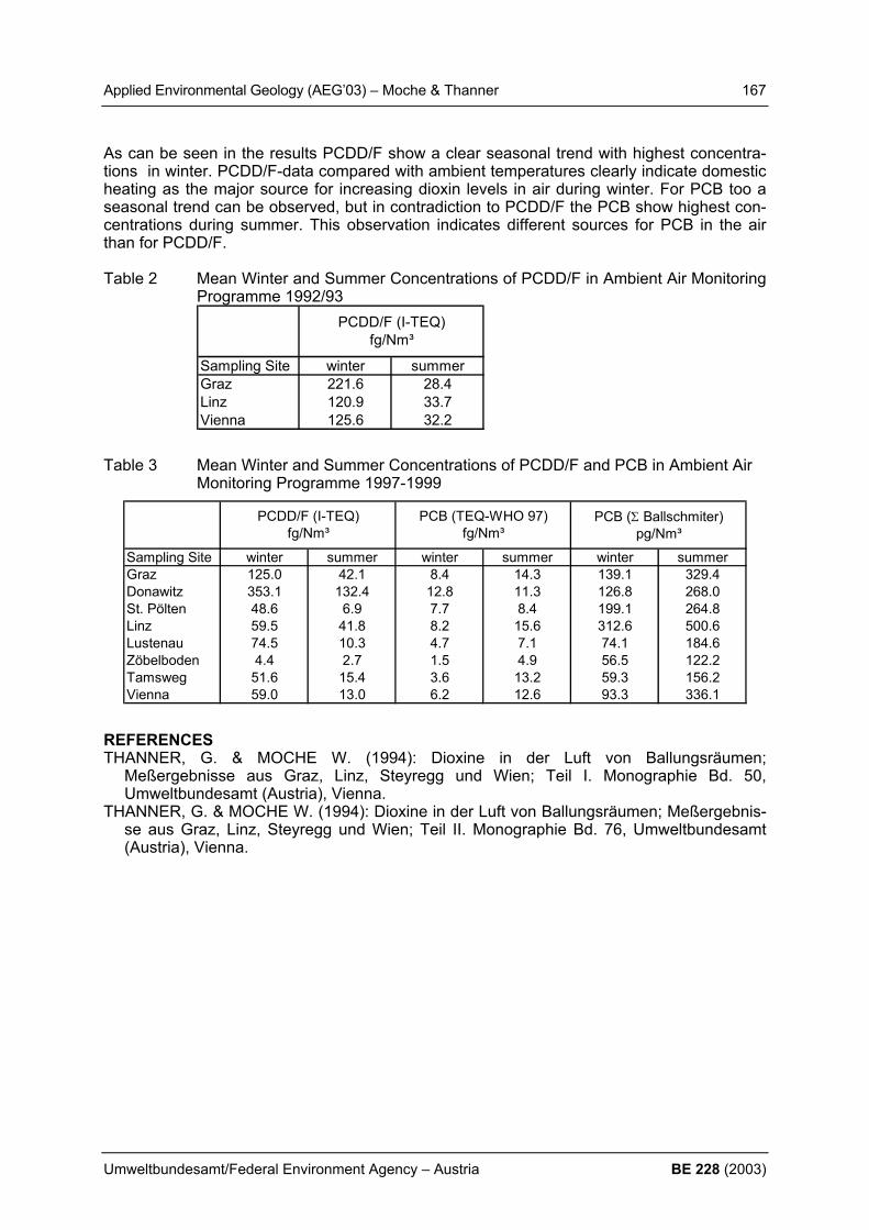
Applied Environmental Geology (AEG’03) – Moche & Thanner 167
Umweltbundesamt/Federal Environment Agency – Austria BE 228 (2003)
As can be seen in the results PCDD/F show a clear seasonal trend with highest concentra-tions in winter. PCDD/F-data compared with ambient temperatures clearly indicate domestic heating as the major source for increasing dioxin levels in air during winter. For PCB too a seasonal trend can be observed, but in contradiction to PCDD/F the PCB show highest con-centrations during summer. This observation indicates different sources for PCB in the air than for PCDD/F. Table 2 Mean Winter and Summer Concentrations of PCDD/F in Ambient Air Monitoring
Programme 1992/93
Sampling Site winter summerGraz 221.6 28.4Linz 120.9 33.7Vienna 125.6 32.2
PCDD/F (I-TEQ)fg/Nm³
Table 3 Mean Winter and Summer Concentrations of PCDD/F and PCB in Ambient Air Monitoring Programme 1997-1999
Sampling Site winter summer winter summer winter summerGraz 125.0 42.1 8.4 14.3 139.1 329.4Donawitz 353.1 132.4 12.8 11.3 126.8 268.0St. Pölten 48.6 6.9 7.7 8.4 199.1 264.8Linz 59.5 41.8 8.2 15.6 312.6 500.6Lustenau 74.5 10.3 4.7 7.1 74.1 184.6Zöbelboden 4.4 2.7 1.5 4.9 56.5 122.2Tamsweg 51.6 15.4 3.6 13.2 59.3 156.2Vienna 59.0 13.0 6.2 12.6 93.3 336.1
PCB (TEQ-WHO 97)fg/Nm³
PCB (Σ Ballschmiter)pg/Nm³
PCDD/F (I-TEQ)fg/Nm³
REFERENCES THANNER, G. & MOCHE W. (1994): Dioxine in der Luft von Ballungsräumen;
Meßergebnisse aus Graz, Linz, Steyregg und Wien; Teil I. Monographie Bd. 50, Umweltbundesamt (Austria), Vienna.
THANNER, G. & MOCHE W. (1994): Dioxine in der Luft von Ballungsräumen; Meßergebnis-se aus Graz, Linz, Steyregg und Wien; Teil II. Monographie Bd. 76, Umweltbundesamt (Austria), Vienna.

168 Applied Environmental Geology (AEG’03) – Monjai et al.
BE 228 (2003) Umweltbundesamt/Federal Environment Agency – Austria
GEO-HAZARDS RELATED TO SALT MINING IN THE KHORAT-PLATEAU (NE THAILAND) D. Monjai 1) , R. Arjwech 2) R. Faber 3) & H. Häusler 3) 1) Geological Survey of Thailand, Khon Kaen, Thailand, [email protected], 2) Institute of Geotechnology, Faculty of Technology, University of Khon Kaen, Thailand 3) Department of Geological Sciences, University of Vienna, A-1090 Wien, Althanstraße 14;
[email protected], [email protected] 1. INTRODUCTION The Khorat plateau is an area of about 170.000 km2 in northeastern Thailand and some part of Lao PDR. The Phu Phan range across the plateau and divides it into the Sakhon Nakon basin on the north and Khorat basin on the south. The Khorat plateau consists of megase-quence of continental red beds of Mesozoic era. This sequence is Khorat Group. It contains 10 formations. the Maha Sarakham Fm. once formation of Khorat group consists of 3 se-quences of evaporites and intercalated with clay bed and the fine grain clastic sedimentary rocks. The evaporite sequences mainly consist of rock salt and the other evaporites such as anhydrite gypsum and potash. In both basins rock salt thickens towards the center of the basin. Shallow salt domes are present in some areas and salt mining is located around these salt domes. Salt production used to consume and raw material of industries. The salt farmers pump a lot of brine water from saturated zone for produce salt so that they have many problems from salt mining such as developing of cavities in the subsurface causing of many subsidence, water pollution: waste water from salt farms is released into natural water resources, leading to infertile farm-land. Recovery is difficult, pollution nearby salt factories, social tensions between farmer and salt producer and high profit producing salt leads to illegal salt production in the rainy sea-son. However the subsidence is main problem because of it is dangerous for people (Fig. 1).
Figure 1: Cross section of the Baan Non Sabang area with cavity formed by the solution of rock salt. The brine is pumped to the surface. Since 1991, the Government of Thailand tries to control the effect from salt mining by limiting the salt mining areas in 5 provinces of northeastern Thailand.

Applied Environmental Geology (AEG’03) – Monjai et al. 169
Umweltbundesamt/Federal Environment Agency – Austria BE 228 (2003)
2. METHODS Recent investigations on the distribution of salt bearing formations in the Khorat Plaeteu were carried out by S. KRIENGSAK (1994), R. FABER (2000) and M. IMAIZUMI et al. (2001). In particular the integrated program performed by the Thailand working group of the Department of Geological Sciences (at that time: Hermann Häusler, René Pitayataratorn and Robert Faber), combing remote sensing methods, geophysical methods and hydro-geochemical methods proofed new results. More recently, geophysical methods such as seismic reflection and resistivity surveys were used for detecting and monitoring the location and size of cavities in subsurface from salt mining. The seismic method shows clearly cavity structure, but the multielectrode resistivity method is faster, cheaper and shows a better resolution of the cavity structures. Basically, the Wenner- and dipole-dipole array was used for subsoil differentiation of formations and cavities. The interpretation of the resistivity in the 2-D pseudo geological cross sections en-ables the identification of abundant cavities in the salt mining areas. Some cavities are under high electric power lines or near the villages. The cavity sizes range between 5-10 meters and 40-50 meters in diameter, situated some tens of meters below the surface. The resistiv-ity monitoring revealed that some cavities grew bigger from year to year (Figure 2).
Figure 2: Cavities from local salt mining cause land subsidence in habituated areas 3. CONCLUSION The subsidence effect from salt mining is dangerous for people in salt mining areas. How-ever, the people need salt mining because they get high profit from salt products. Therefore the information of location and size of cavities around salt mining areas is important for re-minding the people about subsidence hazard areas. REFERENCES FABER, R. (2000) : Hydrogeologie und Fernerkundung Khon Kaen/Thailand.- Unveröff.
Dipl.-Arb., Formal- und Naturwiss. Fak. Univ. Wien, 125 S., 69 Abb., 12 Tab., (Institut für Geologie) Wien.
IMAIZUMI, M., SUKCHAN, S., WICHAIDIT, P., SRISUK, K. & KANEKO, F. (2001): Hydro-logic and geochemical behaviour of saline groundwater in Phra Yun, Northeast Thailand.- JIRCAS Working Report No. 30, 14 p., 12 fig.,
KRIENGSAK, S. (1994): Genetic characteristics of the groundwater regime in the Khon Kaen drainage basin, northeast Thailand.- Unpublished PhD, 383 p., Department of Geology, Edmonton, University of Alberta, Canada.

170 Applied Environmental Geology (AEG’03) – Müllerova & Zeman
BE 228 (2003) Umweltbundesamt/Federal Environment Agency – Austria
MEANING AND VALIDITY OF THE SEQUENTIAL EXTRACTION PROCEDURE (SEA) FOR EVALUATION OF HEAVY METALS (HMS) MOBILITY H. Müllerová1) & J. Zeman2)
Institute of Geological Sciences, Masaryk University, Kotlářská 2, 611 37 Brno, Czech Re-public, 1) [email protected], 2) [email protected] 1. INTRODUCTION A plenty of methods for determination of real species are now available for various elements in aqueous system, methodology for element speciation in solids is less well developed (DAVIDSON et al. 1998). SEAs have been developed in the past 25 years for the de-termination of binding forms of heavy metals in sedi-ment (QUEVAUVILLER et al. 1997). SEA can be used to give an indication of the amounts of metals in vari-ous "reservoirs" which could be mobilized by changes in soil chemistry (notably pH or Eh) (DAVIDSON et al. 1998). Five-step SEA of Tessier et al. (1979) is com-monly used for evaluation of mobility of heavy metals (HMs). This method consists of sequential leaching of the soil samples to separate five fractions of metals: exchangeable, bound to carbonates, bound to Fe-Mn oxides, bound to organic matter and residual. Proce-dure of sequential extraction has a lots of modification according to individual conditions. No matter which procedure is used, all of them are interpreted simi-larly. The sum of the first two HM fractions relative to the total amount removed by all steps of SEA is known as the labile percentages. It is generally ex-pected that the increasing of the labile percentage means the greater potential for migration and bio-accumulation. Based on this, it is expected that after long-term leaching by rainfalls the labile percentage will be washed out of the soil. 2. MATERIALS AND METHODS Cu and Cd sorption and desorption on natural samples was investigated in experimental ar-rangement depictured on Fig. 1. The same amounts of contaminants were introduced into columns by two different ways: 1) by contamination of the stock solution; 2) by direct injection on the sediment surface in column (the point contamination). Methodology of TESSIER et al. (1979) was applied (a) after Cu and Cd sorption, (b) after desorption by distilled water and (c) after long-term closed circulation, respectively. 3. RESULTS Example of relative Cu concentrations of the five distinguished metal fractions bind in sedi-ment is depictured on Fig. 2. There is only slight difference in relative amounts of Cu bind in sediment after contamination, desorption and 7 month circulation. The total HM concentra-tion in column with point contamination decreases from the top to the bottom in column (Fig. 3). On the contrary the concentrations in columns with the contaminated stock solution are almost the same through entire column. The similar results were obtained for different soil and sediment types and also for Cd.
stocksolution
air lift pump
solution outflow
air pump
overflow
air flow
solution
column
Fig.1 Experimental column arrangement.
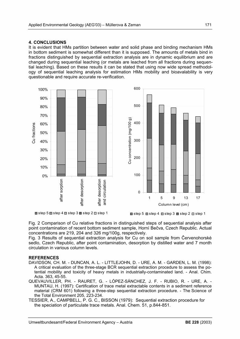
Applied Environmental Geology (AEG’03) – Müllerova & Zeman 171
Umweltbundesamt/Federal Environment Agency – Austria BE 228 (2003)
4. CONCLUSIONS It is evident that HMs partition between water and solid phase and binding mechanism HMs in bottom sediment is somewhat different than it is supposed. The amounts of metals bind in fractions distinguished by sequential extraction analysis are in dynamic equilibrium and are changed during sequential leaching (or metals are leached from all fractions during sequen-tial leaching). Based on these results it can be stated that using now wide spread methodol-ogy of sequential leaching analysis for estimation HMs mobility and bioavalability is very questionable and require accurate re-verification.
Fig. 2 Comparison of Cu relative fractions in distinguished steps of sequential analysis after point contamination of recent bottom sediment sample, Horní Bečva, Czech Republic. Actual concentrations are 219, 204 and 326 mg/100g, respectively. Fig. 3 Results of sequential extraction analysis for Cu on soil sample from Červenohorské sedlo, Czech Republic, after point contamination, desorption by distilled water and 7 month circulation in various column levels. REFERENCES DAVIDSON, CH. M. - DUNCAN, A. L. - LITTLEJOHN, D. - URE, A. M. - GARDEN, L. M. (1998):
A critical evaluation of the three-stage BCR sequential extraction procedure to assess the po-tential mobility and toxicity of heavy metals in industrially-contaminated land. - Anal. Chim. Acta. 363, 45-55.
QUEVAUVILLER, PH. - RAURET, G. - LÓPEZ-SÁNCHEZ, J. F. - RUBIO, R. - URE, A. - MUNTAU, H. (1997): Certification of trace metal extractable contents in a sediment reference material (CRM 601) following a three-step sequential extraction procedure. - The Science of the Total Environment 205, 223-234.
TESSIER, A., CAMPBELL, P. G. C., BISSON (1979): Sequential extraction procedure for the speciation of particulate trace metals. Anal. Chem. 51, p.844-851.
0%
10%
20%
30%
40%
50%
60%
70%
80%
90%
100%
afte
r sor
ptio
n
afte
r des
orpt
ion
afte
r des
orpt
ion
and
circ
ulat
ion
Cu
fract
ions
s tep 5 step 4 step 3 step 2 step 1
0
100
200
300
400
500
600
1 5 9 13 17
Column level (cm)
Cu
conc
entra
tion
(mg/
100
g)
s tep 5 step 4 step 3 step 2 step 1
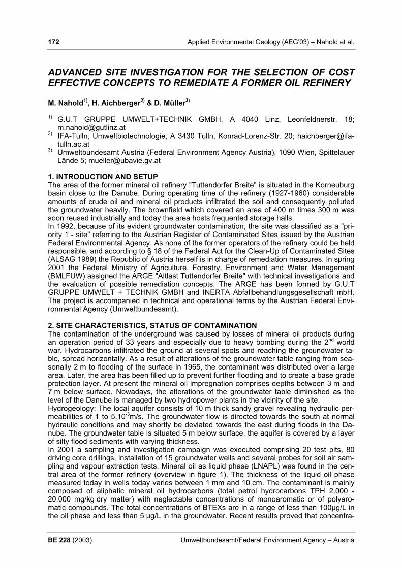
172 Applied Environmental Geology (AEG’03) – Nahold et al.
BE 228 (2003) Umweltbundesamt/Federal Environment Agency – Austria
ADVANCED SITE INVESTIGATION FOR THE SELECTION OF COST EFFECTIVE CONCEPTS TO REMEDIATE A FORMER OIL REFINERY M. Nahold1), H. Aichberger2) & D. Müller3)
1) G.U.T GRUPPE UMWELT+TECHNIK GMBH, A 4040 Linz, Leonfeldnerstr. 18;
[email protected] 2) IFA-Tulln, Umweltbiotechnologie, A 3430 Tulln, Konrad-Lorenz-Str. 20; haichberger@ifa-
tulln.ac.at 3) Umweltbundesamt Austria (Federal Environment Agency Austria), 1090 Wien, Spittelauer
Lände 5; [email protected] 1. INTRODUCTION AND SETUP The area of the former mineral oil refinery "Tuttendorfer Breite" is situated in the Korneuburg basin close to the Danube. During operating time of the refinery (1927-1960) considerable amounts of crude oil and mineral oil products infiltrated the soil and consequently polluted the groundwater heavily. The brownfield which covered an area of 400 m times 300 m was soon reused industrially and today the area hosts frequented storage halls. In 1992, because of its evident groundwater contamination, the site was classified as a "pri-ority 1 - site" referring to the Austrian Register of Contaminated Sites issued by the Austrian Federal Environmental Agency. As none of the former operators of the refinery could be held responsible, and according to § 18 of the Federal Act for the Clean-Up of Contaminated Sites (ALSAG 1989) the Republic of Austria herself is in charge of remediation measures. In spring 2001 the Federal Ministry of Agriculture, Forestry, Environment and Water Management (BMLFUW) assigned the ARGE "Altlast Tuttendorfer Breite" with technical investigations and the evaluation of possible remediation concepts. The ARGE has been formed by G.U.T GRUPPE UMWELT + TECHNIK GMBH and INERTA Abfallbehandlungsgesellschaft mbH. The project is accompanied in technical and operational terms by the Austrian Federal Envi-ronmental Agency (Umweltbundesamt). 2. SITE CHARACTERISTICS, STATUS OF CONTAMINATION The contamination of the underground was caused by losses of mineral oil products during an operation period of 33 years and especially due to heavy bombing during the 2nd world war. Hydrocarbons infiltrated the ground at several spots and reaching the groundwater ta-ble, spread horizontally. As a result of alterations of the groundwater table ranging from sea-sonally 2 m to flooding of the surface in 1965, the contaminant was distributed over a large area. Later, the area has been filled up to prevent further flooding and to create a base grade protection layer. At present the mineral oil impregnation comprises depths between 3 m and 7 m below surface. Nowadays, the alterations of the groundwater table diminished as the level of the Danube is managed by two hydropower plants in the vicinity of the site. Hydrogeology: The local aquifer consists of 10 m thick sandy gravel revealing hydraulic per-meabilities of 1 to 5.10-3m/s. The groundwater flow is directed towards the south at normal hydraulic conditions and may shortly be deviated towards the east during floods in the Da-nube. The groundwater table is situated 5 m below surface, the aquifer is covered by a layer of silty flood sediments with varying thickness. In 2001 a sampling and investigation campaign was executed comprising 20 test pits, 80 driving core drillings, installation of 15 groundwater wells and several probes for soil air sam-pling and vapour extraction tests. Mineral oil as liquid phase (LNAPL) was found in the cen-tral area of the former refinery (overview in figure 1). The thickness of the liquid oil phase measured today in wells today varies between 1 mm and 10 cm. The contaminant is mainly composed of aliphatic mineral oil hydrocarbons (total petrol hydrocarbons TPH 2.000 - 20.000 mg/kg dry matter) with neglectable concentrations of monoaromatic or of polyaro-matic compounds. The total concentrations of BTEXs are in a range of less than 100µg/L in the oil phase and less than 5 µg/L in the groundwater. Recent results proved that concentra-
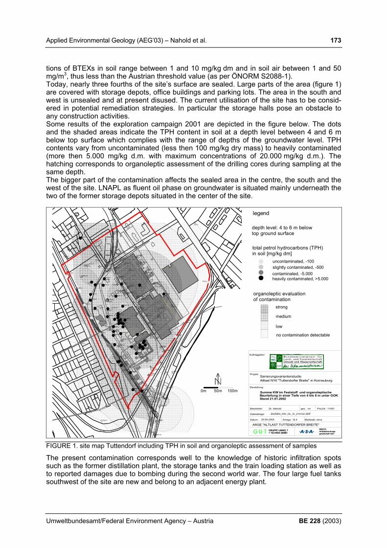
Applied Environmental Geology (AEG’03) – Nahold et al. 173
Umweltbundesamt/Federal Environment Agency – Austria BE 228 (2003)
tions of BTEXs in soil range between 1 and 10 mg/kg dm and in soil air between 1 and 50 mg/m3, thus less than the Austrian threshold value (as per ÖNORM S2088-1). Today, nearly three fourths of the site’s surface are sealed. Large parts of the area (figure 1) are covered with storage depots, office buildings and parking lots. The area in the south and west is unsealed and at present disused. The current utilisation of the site has to be consid-ered in potential remediation strategies. In particular the storage halls pose an obstacle to any construction activities. Some results of the exploration campaign 2001 are depicted in the figure below. The dots and the shaded areas indicate the TPH content in soil at a depth level between 4 and 6 m below top surface which complies with the range of depths of the groundwater level. TPH contents vary from uncontaminated (less then 100 mg/kg dry mass) to heavily contaminated (more then 5.000 mg/kg d.m. with maximum concentrations of 20.000 mg/kg d.m.). The hatching corresponds to organoleptic assessment of the drilling cores during sampling at the same depth. The bigger part of the contamination affects the sealed area in the centre, the south and the west of the site. LNAPL as fluent oil phase on groundwater is situated mainly underneath the two of the former storage depots situated in the center of the site.
uncontaminated, -100slightly contaminated, -500contaminated, -5.000heavily contaminated, >5.000
total petrol hydrocarbons (TPH)in soil [mg/kg dm]
organoleptic evaluationof contamination
strong
medium
low
no contamination detectable0. 00
0. 50
1. 50
2. 50
0m 50m 100m
gesellschaft mbHAbfallbehandlungs-INERTA
+ TECHNIK GMBHGRUPPE UMWELT
Anlage: 19.4
Altlast N16 "Tuttendorfer Breite" in KorneuburgSanierungsvariantenstudie
Maßstab: ohneDatum:
gez.:
Dateiablage:
Dr. Nahold
Projekt:
Proj.Nr.: 11001
20.05.2003
gesellschaft mbHAbfallbehandlungs-INERTA
+ TECHNIK GMBHGRUPPE UMWELT
Bearbeiter:
Darstellung:
Auftraggeber:
ARGE "ALTLAST TUTTENDORFER BREITE"
Summe KW im Feststoff und organoleptische
...BODEN_KW_OL_III_210102.SRF
Beurteilung in einer Tiefe von 4 bis 6 m unter GOKStand 21.01.2002
rmÖ lle it un g Ta n k ha f en
Ö lle it un g Ta n k ha f en
T BRK39
T BRK61
TBR K1
TBRK3
TBRK2
TBRK6
TBR K8
TBRK4
TBRK9
TBRK5
TBRK22
TBRK21
TBRK23
TBR K32
TBRK15
TBRK24
TBRK11
TBRK7
TBRK10
TBRK19
TBR K16
TBRK13
TBRK30
TBRK26
TBR K18
TBR K20
TBRK29
TBRK27TBRK17
TBRK14
TBRK25
TBRK34
TBRK36
TBRK37
TBRK38
TBRK40
TBRK41
TBRK42
TBRK43
TBRK44
TBRK46
TBR K48
TBRK49
TBRK50
TBRK51
TBRK52
TBRK53
TBR K54
TBRK55
TBRK56
TBRK58
TBRK59
TBRK60TBRK62
TBRK63
TBRK64
TBRK65
TBRK66
TBRK67
T BRK68
TBRK69
TBR K70
TBRK71
TBRK72
TBRK74TBRK75
TBR K76
TBRK77
TBRK78
TBR K79
TBRK80
TBRK35
TBRK33
TBRK28
TBRK31
TBR K57
TBRK73
T BRK47
TBRK45
TBRK12
U D1
UD2UD4UD3
UD15U D14
BL4UD13
UD5UD6
UD12 UD7UD11
UD 10 BL2UD8
UD9
BL1
BL3
TB215
TB214
TB204
TB203
TB213
T B201
TB202
TB205
TB206
TB207
TB208
TB209TB210
TB211
TB212
TBS 01
T BS 02
TBS 03T BS 05
TBS 04
TBS 06
TBS 07
TBS 08
TBS 09
T BS 10
TBS 11
TBS 14
TBS 12
TBS 13
TBS 15
TBS 16
TBS 17
TBS 18
TBS 19
TBS 20
depth level: 4 to 6 m below top ground surface
legend
FIGURE 1. site map Tuttendorf including TPH in soil and organoleptic assessment of samples
The present contamination corresponds well to the knowledge of historic infiltration spots such as the former distillation plant, the storage tanks and the train loading station as well as to reported damages due to bombing during the second world war. The four large fuel tanks southwest of the site are new and belong to an adjacent energy plant.

174 Applied Environmental Geology (AEG’03) – Nahold et al.
BE 228 (2003) Umweltbundesamt/Federal Environment Agency – Austria
In the groundwater no relevant concentrations were detected outside this core-area. To the North and in the southern part of the area, the contamination exceeds the border (bold line red in colour version) indicating the site in the Austrian Register of Contaminated Sites.
3. PILOT STUDIES In addition to the above described site investigations a selected number of remediation tech-nologies (A-C) was tested at pilot scale at the unsealed area, in particular: A1 - enhanced in situ mobilisation of hydrophobic organic contaminants with surfactants A2 - application of substrate to enhance microbiological degradation of hydrocarbons B1 - extraction and injection of air to biodegrade contaminants in the vadose zone B2 - groundwater hydraulics and mobilisation of the free oil phase C - injection and distribution of oxygen into the groundwater to improve biodegradation The field tests and laboratory studies were accomplished during summer-autumn 2002 by the ARGE-Vorversuche a joint venture of OMV-Proterra GmbH and IMU-ZT GmbH. The In-stitute for Agrobiotechnology (IFA-Tulln) oversaw lot B1 and conducted respiration experi-ments and operated soil columns for microbiological assessment. 4. SUMMARY AND CONCLUSIONS As a result of the recent investigations the chemical status and regional extent of the con-tamination is now well defined 3-dimensionally. Groundwater hydraulics are understood dur-ing both normal conditions and flood periods. Risk assessment confirmed the threat that the contamination poses to the groundwater and consequently the necessity for remediation; however, these measures may not be required immediately. The following limitations for remediation of the aquifer have been identified and have to be overcome: The composition of the contaminants has altered, mobile compounds were either leached out into the groundwater or volatilised or degraded. Over time strong pollutant soil interactions were developed such as sorption and diffusion into micropores, but also micro-bial degradation occurred. Latter is hampered due to a lack of oxygen and a limit of readily available nutrients. Due to the presence of hydrophobic pollutants in highly contaminated zones hydraulic permeability is decreased by the power of -2. This results in diminished re-mobilization and hinders the distribution of oxygen and nutrients. Besides, in higher perme-able zones and in wells addition of oxygen will cause precipitation of oxides and biomass growth, thus again limiting the radius of influence. Field tests revealed that only the pneumatic application of oxygen to the unsaturated zone is not enough for a relevant degradation of mineral oil. Accompanying lab column experiments proved that only both, sufficient humidity and nutrient addition stimulate biodegradation con-siderably. Despite all these limitations, the activation of microbial degradation was identified to be the only means to reduce the mass of contaminant significantly. Therefore, the recommendation for the remediation strategy involves two major applications: First the extraction of liquid oil phase by hydraulic means and second the stimulation of the autochthonous hydrocarbon de-grading organisms.
ACKNOWLEDGEMENTS This project is financed by the Federal Ministry of Agriculture, Forestry, Environment and Water Management (BMLFUW) in compliance with §18 ALSAG. We gratefully acknowledge the work of the responsible technical executive Hans Bergthaler accompanying the project.
REFERENCES AND ABBREVATIONS ALSAG (1989) Act on the Remediation of Contaminated Sites (Federal Gazette 1989/299) OENORM S2088-1 (1997): Contaminated Sites: Risk Assessment concerning the Pollution of
Groundwater.- Austrian Standards Institute, Vienna. BTEX = monoaromatic hydrocarbons (benzene, toluene, ethylbenzene and xylenes) LNAPL = light non aqueous phase liquid (such as mineral oil hydrocarbons) TPH = total petroleum hydrocarbons

Applied Environmental Geology (AEG’03) – Neuhuber et al. 175
Umweltbundesamt/Federal Environment Agency – Austria BE 228 (2003)
ORGANIC AND INORGANIC REMOVAL OF CD AND PB IN SEDIMENTS AND SOILS: CONSEQUENCES FOR GROUNDWATER PROTECTION S.Neuhuber1,2), A. Metz1) & M.Kralik3) 1) Institute for Geological Sciences, University of Vienna, Austria
2) University of Agriculture Vienna, Austria, 3) Umweltbundesamt Austria (Federal Environment Agency Austria) and University of Vi-
enna, Austria, [email protected], 1. INTRODUCTION Sediments and soils retain heavy metals by adsorption, complexation, ion exchange and precipitation of new mineral phases. Furthermore, they are a source of heavy metal contami-nation by reversing these reactions and by dissolution of metal containing minerals, such as metal sulfides. Pore water composition (sediments) and water saturation (soils) as well as reaction rates affect both removal and release. The quantification of dissolved and solid or-ganic and inorganic ligands for heavy metals is the main key to estimate the retention capac-ity of sediment and soil particles. First, the initial composition of the solid phase which include very reactive early diagenetic and pedogenitic minerals (in effect amorphous and poorly crystalline Fe-, Mn-, and Al- (hydr-)oxides and clay minerals) sorbs metals. These minerals are well known for their high spe-cific surface area and their negative surface charge. In fact, electrostatic interaction (inner- and outer sphere complexes) and van der Waals forces with metal cations remove them from the solution. Second, the organic fraction, in most cases humic and fulvic acids and their reactive, nega-tively charged carboxyl groups as well as amorphous silica with an overall negative charge formed by diatoms add to this processes of removal. Also, bacterial reduction of organic mat-ter releases chelates and contributes to the cycling of Fe and Mn but also other metals in percolating waters. All the components above are enriched and reaction rates are faster in the fine fraction of sediments (<40 µm) and soils (<2 mm), which are therefore of particular interest. Finally, the metals themselves are bound and remobilised mainly as a result of changing chemical conditions, such as pH, redox-potential and ionic strength of the solution. If air dried, most of the metal scavengers are able to adsorb water vapour by their high spe-cific surface area and caused by the dipol structure of the water molecule itself acting like a negatively charged molecule. This study compares water vapour and heavy metal uptake onto soil and sediment samples from mineralogically different areas in Austria (“carbonate” and “crystalline dominated”) to find out if the content of reactive phases can be inferred by determining the water uptake only as suggested for some samples in earlier studies (KRALIK, 1999). The final goal is to evaluate the heavy metal retention capacity of different soil and river sediments protecting groundwater aquifers. 2. MATERIALS AND METHODS To estimate the retention capacity of each sample the mineralogy, the reactive solid phase, and the content of organic carbon including humic acids was determined using standard pro-cedures. Heavy metal (cadmium and lead) uptake during batch experiments was determined by graphite furnace AAS. Sediment samples were exposed to low, common anthropogenic induced concentrations (Cd: 2 and 4 µg/l; Pb: 20 and 40 µg/l) with water from the corresponding sampling site where the water/sediment ratio was 380 mg/l resembling a flood event with a high sediment load.
176 Applied Environmental Geology (AEG’03) – Neuhuber et al.
BE 228 (2003) Umweltbundesamt/Federal Environment Agency – Austria
Reactive surfaces are exposed to the batch solution. The same concentrations were used for soil samples but deionized water simulated irrigation by precipitation. During the batch ex-periment, pH, electric conductivity, redox potential, and temperature were recorded. Water vapour uptake was measured on air dried (90°C) samples, which were again exposed to 70% relative humidity for three days and then dried afterwards to obtain the specific water content. 3. RESULTS AND DISCUSSION Sediments: During the batch experiments 50-85 % of the heavy metals were removed from the added waters. The increase in pH during the batch experiment indicates that the solid phase is in disequilibrium with the solute. In limestone dominated areas, carbonate mineral dissolution is likely to force the pH to higher values during the batch experiment. A small part of the in-crease could also be attributed to the replacement of H+ ions that cover reactive, negatively charged minerals as the metals adsorb. Crystalline samples exhibit a higher amount of organic and inorganic metal scavengers and a generally higher uptake of water vapour. Cadmium and water vapour uptake show a positive correlation. Surprisingly, lead uptake was significantly higher in carbonate dominated areas. Thermody-namic calculations (MinteqA2) proved precipitation of cerrussite (PbCO3) which does not in-fluence the water adsorption. Hence, water vapour uptake does not indicate the retention ca-pacity of carbonate environments, which in fact, is much higher than suggested by the up-take of water vapour. Soils: During the batch experiments 60-90 % of the heavy metals were removed from the added waters. The carbonate areas are reactive environments with high contents of organic carbon, pedogenetic oxides, and dioctaehedral chlorite with high uptake of water vapour. Elution ex-periments in similar conditions as the sediment batch experiments result in relatively high conductivities (up to 350µS/cm) and indicate that sorbed ions are removed from the solid phase. This solid phase should in turn provide binding sites for metal cations during the batch experiment, however an overall negative correlation between reactive solid phase and heavy metal uptake was observed. The preferred pathway of metal sorption is the removal by the dissolved and colloidal (<0.45µm) humic and dissolved fraction of organic carbon which correlates positively with both cadmium and lead uptake. High TOC values result in a larger dissolved and colloidal fraction. Therefore, 10-40 % of the heavy metals are potentially available in mobile form and can be transported and may end up eventually in the groundwa-ter. Coarser grain sizes and therefore increased permeabilities as found in crystalline areas reverse this mechanism by removal of particulate organic carbon and positive correlations between smectite and vermiculite indicate a shift in the dominant mechanism of sorption. 4. CONCLUSION In conclusion, both sediments and soils show a clear positive trend with the content of or-ganic carbon and the uptake of water vapour. However, in soils and sediments with high car-bonate content water vapour do not correlate with this effective mineral phases and are therefore not suitable as evaluating technique. Furthermore, areas with high organic carbon content show high amounts of reactive inorganic phases. However, in soils cadmiun and lead may form complexes with colloidal and dissolved organic fractions which are very mobile and can end up in the ground water. REFERENCES METZ, A.; NEUHUBER, S. & KRALIK, M. (2002): Zusammensetzung von Bodenproben aus
Karbonat- und Kristallingebieten Österreichs in Beziehung zur Blei- und Cadmium – Sorp-tion. Mitt. Österr. Bodenkundl. Ges., 66, 129-136, Wien.

Applied Environmental Geology (AEG’03) – Norra & Stüben 177
Umweltbundesamt/Federal Environment Agency – Austria BE 228 (2003)
URBAN GEOCHEMISTRY: ALTERATIONS OF ELEMENT AND STABLE ISOTOPE PATTERNS OF SOILS, DUSTS AND PLANTS S. Norra & D. Stüben Institute of Mineralogy and Geochemistry, Universität Karlsruhe (TH); [email protected] 1. INTRODUCTION: 45% of the world population is living in urban areas. Industrialized countries show the highest shares of urban population, such as Germany with 87% (BARATTA, 2000). The urban popu-lation is currently enormously increasing in less developed countries (HEINEBERG, 2001). More and more megacities develop, as is observed in countries like China. This development is connected with an increasing importance of urban areas for worldwide element fluxes. Ur-ban areas (and with them their industrial zones) are "melting pots" of element associations with ratios of concentrations not occurring in the nature uninfluenced by human-beings. Such "artificial" element associations occur in produced goods as well as in exhaust, waste and sewage. Consequently, urban areas alter natural element fluxes in manifold ways. However, anthropogenic processes in urban areas do not only change natural element associations, they change the natural abundances of stable isotope ratios as well. Techniques are already developed to investigate intensive local contaminations directly harming organisms. Governmental institutions of most countries established quality standards to control certain limits of environmental pollution. However, less is known about the extent and consequences of creeping environmental pollution and the alteration of natural element patterns in urban soils or vegetation. MAYER (1997) stated "Was den Grenzwert überschreitet, ist unzulässig; aber was den Grenzwert einhält, ist damit noch nicht umweltverträglich"1 Sustainable development needs the comprehensive knowledge about the consequences of urban development on the distribution of chemical elements (STÜBEN & NORRA 2000). The knowledge about element fluxes within urban areas enable to demonstrate potential recyclable resources, creeping accumulations of harmful substances and alterations of the chemical element inventory of the environment. The comprehensive control of chemical element fluxes would help to ensure a healthy and worth living urban environment. This presentation focuses on alterations of element and stable isotope patterns in urban soils, dusts and vegetation. Case studies will be presented demonstrating spatial distributions of trace elements and stable isotopes. These studies concern atmospheric precipitation of dust, street dust, surface soils and herbaceous vegetation of urban green areas. Emissions from diffuse pollution sources (caused by non-point and dispersed pollution sources) accumulate in soils and dusts of urban areas and contaminate the environment. Often, the occurring soil contamination can not be traced back to a single responsible pollution source caused by superimposing pollution from different sources. This is especially the case when the contamination happens via the atmospheric pathway. Soils are sinks for chemical substances deposited from the atmosphere. For that reason, urban soils are gradually enriched with many different chemical substances emitted from different urban pollution sources. Slowly, year by year, soils become more and more enriched with
1 Contaminations exceeding environmental quality standards are inadmissible; but, vice versa, only keeping envi-
ronmental quality standards is not automatically environmentally compatible (translation by the authors)
178 Applied Environmental Geology (AEG’03) – Norra & Stüben
BE 228 (2003) Umweltbundesamt/Federal Environment Agency – Austria
pollutants. Therefore, diffuse contamination of urban soils stretches over large areas and long time periods. On other surfaces as soils, such as roads, atmospheric particulate precipitations form dust depositions with anthropogenically altered element compositions. Vegetation is affected by pollution via atmospheric-leave and soil-root pathways. Thus, vegetation can be used as indicator for bio-availability of trace elements. 2. MATERIALS AND METHODS: Samples of surface soils, dusts and herbaceous vegetation were collected in Mühlburg, Karlsruhe, Pforzheim and Beijing. Soils and herbaceous vegetation was collected according to a sampling grid covering the urban areas. Dust samples were taken as street sediments along roads and as precipitated particulates according to the Bergerhoff method. Trace ele-ments were analysed with energy dispersive x-ray fluorescence and ICP-MS. IR-MS was used to determine ratios of stable isotopes of C and N. Spatial patterns of element distribu-tions in surface soils and herbaceous plants were elaborated and visualized using geostatis-tical methods.
3. RESULTS It is demonstrated that spatial distributions of element patterns in urban areas can be mod-eled using geostatistics. Variogram models were fitted to the spatial variances of element concentrations and stable isotope ratios with regard to different scales (100 m to 2 km grids). Cross validation and cluster analysis are methods allowing to separate locally altered sites (contamination, plant community, etc.) from the general spatial distribution pattern of chemi-cal parameters for the whole town. The spatial patterns of elements and stable isotope ratios of surface soils are determined by land use and underlying geological formations. Some ele-ments such as V and Ni, mainly emitted due to fossil fuel processing, are influenced by both sources, land use and geology. Spatial distributions of concentrations of other elements such as Pb are mainly determined by diffuse urban pollution. In contrast, 13C/12C ratios reflect mainly the original lithology, but are locally altered by anthropogenic activities. The spatial distributions of trace elements in plants depend on the bio-availability of elements and is dis-turbed by extreme high soil concentrations (NORRA et al. 2001a & b, NORRA et al. 2002). Dust precipitations are often contaminated in urban areas and cause a creeping enrichment of soils with harmful elements. This is especially the case for relatively immobile elements such as Pb or Cr. Balances showed that surfaces soils in Karlsruhe can be enriched by 1 mg/kg Pb within 10 to 30 years and by 1mg/kg Cr within 10 to 70 years, respectively. This time period can be extended by several times if the mowing of that sites is taken away (NORRA, 2001). Urban land-use related patterns of element compositions can also be found in atmospheric particulate matter and in street sediments as was shown for examples in Karlsruhe and Bei-jing. Thus, street sediments contain information over and above the traffic pollution. 4. CONCLUSION: Land-use types of urban areas specifically alter the original natural element compositions of the corresponding macrochore. This happens not only through intensive and locally restricted pollution but also through diffuse pollution. The spatial extent of diffuse pollution of soils and vegetation can be modeled using geostatistical methods. These methods provide specific variograms for the spatial distribution of concentrations of different chemical elements. Addi-tionally, they reflect specific patterns of urban land-use and lithological units. Furthermore, geostatistical and multivariate statistical analyses allow to distinguish between diffuse pol-luted and locally polluted sites.

Applied Environmental Geology (AEG’03) – Norra & Stüben 179
Umweltbundesamt/Federal Environment Agency – Austria BE 228 (2003)
Quantification of atmospheric particulate precipitation is important to assess land use related element fluxes in urban areas. Due to these element fluxes, soils of the whole urban area are enriched with anthropogenically emitted elements. From the viewpoint of geochemistry a new kind of association of elements is formed not found in the undisturbed nature. Even ratios of stable isotopes are altered in urban areas with consequences for the isotopic composition of organic matter. Much more pure research is necessary to describe the responsible proc-esses changing the natural element compositions of urban landscapes. Such pure research is necessary to develop further models that describe the formation of specific urban element association on the basis of parameters such as geology, climate, land-use, pollution sources and history. Such models help to forecast pollution conditions in case of certain urban devel-opment scenarios and contribute to a sustainable urban development. REFERENCES BARATTA, M.V. 2000: Der Fischer Weltalmanach. Fischer, Frankfurt am Main. HEINEBERG, H. 2001: Stadtgeographie. Schöningh. Paderborn MEYER, J. 1997: Die zukunftsfähige Stadt. Werner, Düsseldorf. NORRA, S. 2001: Umweltgeochemische Signale urbaner Systeme am Beispiel von Böden,
Pflanzen und Stäuben in Karlsruhe. Karlsruher Geochemische Hefte 18. Schriftenreihe des Institutes für Mineralogie und Geochemie, Univ. Karlsruhe (TH).
NORRA, S.; KRAMAR, U. & STÜBEN, D. 2001a: Kartierung der diffusen, großräumigen Belas-tung urbaner Böden. Altlasten und Boden-News 2/2001, Info-Börse Altlasten und Boden-schutz: 14-17. Landesanstalt für Umweltschutz Baden-Württemberg
NORRA, S.; WEBER, A.; KRAMAR, U. & STÜBEN, D. 2001b: Mapping of trace metals in urban soils – the example of Mühlburg/Karlsruhe. Journal of Soils and Sediments 1(2): 77-93
NORRA, S.; KRAMAR, U. & STÜBEN, D. 2002: Base-maps for the estimation of diffuse soil pollution in urban areas. In: Breh, W.; Gottlieb, J.; Hötzl, H., Kern, F.; Liesch, T.; Niessner, R. (eds.): 2nd European Congress on Fieldscreening: 79-84. Kluwer.
STÜBEN, D. & NORRA; S. 2000: A geochemical view of complex analyses of fluxes of harm-ful substances as a basis for sustainable urban planning. Raumforschung und Raumord-nung 2-3/2000: 103-129.
180 Applied Environmental Geology (AEG’03) – Osmani
BE 228 (2003) Umweltbundesamt/Federal Environment Agency – Austria
A VIEW ON SYSTEM ANALYSIS OF WATER STRATEGY AND MANAGEMENT S. Osmani Faculty of Geology and Mines, Tirana, Albania, [email protected] 1. INTRODUCTION A system analysis of water management is based on the key words that define it. Unfortu-nately, a unique definition and use of the concepts related to water management is missing, as for example recognized in the last International Conferences on water management in Greece (Thesaloniki 1999), Portugal (Lisbon 2001) and Kuwait (see EL-KADY, 2002; OSMAN SI, 2002; VIEIRA, 2002). Of course these not precise definitions and concepts have their implications and consequences to different new strategy, i.e. for transboundary water resources in the Balkans, Arab regions etc. (FONTANE, 2000). On these circumstances, some considerations are given to the essential concepts as strategy, policy, alternatives, pro-ject, infrastructure, structure, which stand on the base of water management. World wide, the water management is becoming more complex, even if it is considered as one of the basic priorities within public policies of the most countries. There are numerous reasons for this, including increasing population and urbanization. As both population and urbanization will continue to rise in the foreseeable future, it is expected that the degree of complexity of water management will continue to increase. DJORDJEVIC (1993) identified three indicators of this complexity: increasing difficult ties in providing the required quantities of water for different purposes, increased problems associ-ated with hydrologic phenomena such as floods and draughts, and increasing danger to hu-mans and the environment from water pollution and destruction of water – related ecosys-tems. Small examples illustrate the mentioned indicators.
• In 2050 the world’s population is expected of 8.9 billion people from whom Africa will have 20%, Asia 59.1%, Europe only 7% and Northern America 4.4%.
• Floods can cause devastating economic and human loss as happened in various part of Europe, America, Asia etc, while droughts may result in diachronic crisis due to in-sufficient water for irrigation, water supply and other uses. These situations are fre-quent in semiarid regions and may cause substantial economic crisis.
Also there are many ecosystem problems related to water quality and quantity (rivers, lakes, underground waters, basins etc. in different scales: local, regional, national etc. The men-tioned factors are potential in the sense of producing eventual crisis and conflicts. A signifi-cant example is from Balkans. So there are different misunderstandings, disputes and con-flicts between their countries (GANOULIS, 1999; see Table 1): Table 1: Examples of transnational problems with water management at the Balkan
Country The cause Bulgaria, Greece, Turkey Evros / Maritza / Meric River Albania, Greece Aoos River Greece, Bulgaria Nestos River Greece, Fyrom Axios / Vardar River Albania, Greece, Fyrom Prespa Lake Albania, Fyrom Scutari, Ohry Lakes etc.

Applied Environmental Geology (AEG’03) – Osmani 181
Umweltbundesamt/Federal Environment Agency – Austria BE 228 (2003)
Shortly said, the mentioned factors: social, economical, and environmental could and should be in the first line of water national policy, else they could and should reproduce interrelated and interacting crisis with many dimensions so,
• A water supply and demand crisis without thinking a next coming and future genera-tions represents a predominantly social dimension.
• Deteriorating water quality and water relations in one integrated ecosystem that can be translated as an ecological dimension.
• Uneconomical exploitation and non rational use of water resources (overexploitation, depletion etc.) that represents an economical crisis.
As it is known the above factors (social, economical and environmental) are the necessary conditions of the water sustainable development. A strategy crisis is based on a lack of co-operation between nations to integrate common water actions and respective institutions. This crisis can be exemplified in a management dimension (better say “mismanagement”). 2. METHODS A system analysis is used to define the mentioned concepts. So water management is con-sidered as rational activity on human beings, water resources etc., which starts from a mis-sion etc. and ends to an optimal output (multi outputs). The management has two compo-nents: strategy and policy i.e. the strategic management and policy management. The strat-egy is referred as a blue print program (the same definition as in Game Theory), which con-tains all the contingency alternatives, while the policy is referred as a strategy applied into practice (HILLARIE & LIBERIAN, 1990). Each strategy has its alternatives, by its turn each alternative has its sub strategy and so on, i.e. whatever are going to be the water strategy, it has its hierarchy composed by sub strate-gies up to the most simple activity (substrategy) applied by a single individual. In this frame, the strategy objectives are necessary and sufficient conditions for its realization. An example from water reservoirs illustrates the mentioned concepts. Some considerations are also given on the following questions: local and global strategy, strategy hierarchy, dependence strategy, integrated strategy etc In addition it is shown each strategy has its infrastructure (input processing and output), and their structures (existing and new one). In different situations several strategies could be joined (integrated) into one giving a global strategy. The global water strategy which is the most large and complex concept on water management, depends on different factors social, economic, environmental, political (in the state view) etc. So different disciplines, methods, instruments etc. are indispensable for its treatment and application into practice. 3. RESULTS A system analysis of water management is not possible without a clear definition of the key concepts in which is based. As it is not an unique semantic line on water management, in the paper the next is considered as a complex and rational activity on human, nature, water etc resources and their relations which starts from an environmental analysis, mission, strategy etc and ends to an optimal output. The water strategy has two elements: strategy and policy. The strategy is considered as a blue print program that contains all the contingency alterna-tives, while the policy is referred as a strategy applied into practice. Whatever is going to be water strategy it determines uniquely its hierarchy i.e. a topological tree. Different concepts as strategy set, game tree etc., are very important for the application of Algebraic Set Theory, Game Theory, Operational Research, and Risk Analysis (Decision-

182 Applied Environmental Geology (AEG’03) – Osmani
BE 228 (2003) Umweltbundesamt/Federal Environment Agency – Austria
Making Analysis in Water Management). Also, different properties as local, global, depend-ence etc are useful in system analysis, programming etc. In order to apply an alternative of a water strategy, it is always necessary a management infrastructure (input, processing and output one). In this framework the strategy, alternatives, mathematical models etc could al-ways be divided into the respective elements (input, processing, output) In the nearest future, this classification will probably make more easier the general study and applications of dif-ferent models of integrated and sophisticated water strategies. 4. CONCLUSIONS
• Water management definition is a common and unique one, based in its strategy and policy. To avoid eventual and existing ambiguity, in the future their correct and accu-rate definition is indispensable.
• The water regional (global) strategy is an optimal one when is referred to the devel-opment of our society, economy limited resources and integrated ecosystem. How-ever, its application is not so easy considering social problems, disparities between regions, political systems, allocation of resources, technologies etc.
• In the nearest future, water global strategy trend seems to be more and more impor-tant and dominant. For this reasons the Game Win-Win etc is a key political issue for each country involved in transboundary, regional waters issues.
• The sustainable development is a relative, dynamic etc concept. Although, it is not quantitatively précised, different appropriate models as dynamic programming etc could be applied at least as investigating tools for a feasibility study or a preliminary analysis of a water integrated (global) strategy.
REFERENCES HILLARIE, F. & LIBERIAN, G. (1990): Introduction to stochastic models in operation re-
search New York 555 GANOULIS, J. (1999): Sharing transboundary water resources: the role of regional partner-
ships in the Balkans. Kluwer Academic Publishers, London EL-KADY, M. & EL-SHIBIN, F. (2002): Water problem map, a way to envision our water fu-
ture. Proceedings of the International Conference on Water Resources Management in arid Regions, Kuwait
FONTANE, D. G. (2000): Monitoring Water Systems: The USA Experience. Kluwer Aca-demic Publishers, London
OSMAN SI (2002): Stochastic Finite Element and Risk Analysis in Water Resources Man-agement. Proceedings of the International Conference on “Water Resources Management in Arid Regions” Kuwait
VIEIRA, V. P. (2002): Challenges of water resources management in Brazilian semi-arid re-gions. Proceedings of the International Conference on “Water Resources Management in Arid Regions Kuwait.

Applied Environmental Geology (AEG’03) – Papesch & Rank 183
Umweltbundesamt/Federal Environment Agency – Austria BE 228 (2003)
ISOTOPE TRACING OF HYDROLOGICAL PROCESSES IN LARGE RIVER BASINS: DANUBE STUDY W. Papesch1) & D. Rank2) 1) ARC Seibersdorf research GmbH, A-2444 Seibersdorf; [email protected] 2) Institut für Geologische Wissenschaften, Universität Wien, A-1090 Wien; die-
[email protected] 1. INTRODUCTION River discharge consists mainly of surface runoff and groundwater seepage and is an impor-tant continent-to-ocean linkage in the global hydrological cycle. Isotope signals in river dis-charge can potentially contribute to better understanding of the continental portion of the hy-drological cycle including information such as water origin, mixing history, water balance, wa-ter residence times, surface-groundwater exchange and renewal rates, and evaporation-transpiration partitioning. Coupled measurement of isotope fluxes and volumetric discharge is also useful for tracing progressive changes in basin hydrology related to climate or land use changes, and can be applied as a diagnostic variable for constraining atmospheric circu-lation models and hydrological models. To be effectively applied, such methods require that systematic enhancement is made in the collection of isotope data of river discharge on a global scale. A CRP (Coordinated Research Project) launched by the IAEA is expected to provide groundwork and a scientific rationale for development of an operational “Global Net-work of Isotopes in Rivers” (GNIR) to enhance understanding of the water cycle of river ba-sins and to assess impacts of environmental and climatic changes on the water cycle. Within this CRP, the long-term isotope records of the Danube and other rivers in Austria (RANK & PAPESCH, 1996, RANK et al., 1998) are completed and re-evaluated with respect to the topic of the CRP.
Fig. 1: 3H and δ18O time series of the Danube at Vienna (catchment area about 102 000 km2, average discharge about 1900 m3.s-1, monthly grab samples, 12 month running mean for δ18O)
10
100
1000
10000
63 65 67 69 71 73 75 77 79 81 83 85 87 89 91 93 95 97 99 01 03-17
-15
-13
-11
H-3 O-18 O-18 mean
Danube, Vienna
δ18O [‰]3H [TU]

184 Applied Environmental Geology (AEG’03) – Papesch & Rank
BE 228 (2003) Umweltbundesamt/Federal Environment Agency – Austria
-15
-14
-13
-12
-11
-10
-9
68 70 72 74 76 78 80 82 84 86 88 90 92 94 96 98 00 02
δ18O [‰]
Inn (Kirchbichl)
Danube (Vienna)
Rhine (Lustenau)
Danube (Ulm)
Drau (Neubrücke)
March (Angern)
2. RESULTS AND CONCLUSIONS The 3H and 18O high resolution time series of the Danube at Vienna is the worldwide longest of a large river (Figure 1). It demonstrates that not only short-term signals but also long-term (interannual) changes of isotope ratios in precipitation are transmitted through the catchment and can be detected in the river water. Thus stable isotopes - 2H, 18O - can be used as inde-pendent tracer to simulate transport processes in river systems. The different isotopic behav-iour of rivers from different parts of the catchment area (Figure 2) reflects differences in the hydrometeorological conditions. The long-term changes in the isotopic records (e.g. increase of δ18O during the eighties) may help to trace hydroclimatic changes in these areas, which otherwise would be difficult to detect. Fig. 2: δ18O records of the Danube, some tributaries and the alpine part of the Rhine (12 month running mean). All the alpine rivers show a similar long-term pattern (R. Inn, R. Drau and Rhine). This isotopic signal dominates also in the Danube at Vienna. The upper Danube (Ulm, data from RANK et al., 1998) and the R. March show a somewhat different isotopic behaviour. REFERENCES RANK, D.; ADLER, A.; ARAGUÁS ARAGUÁS, L.; FROEHLICH, K. & ROZANSKI, K. &
STICHLER, W. (1998): Hydrological parameters and climatic signals derived from long-term tritium and stable isotope time series of the River Danube. – In: Isotope Techniques in the Study of Environmental Change. IAEA-SM-349, 191-205, IAEA, Vienna.
RANK, D. & PAPESCH, W. (1996): Die Isotopenverhältnisse im Donauwasser als Indikato-ren für Klimaschwankungen im Einzugsgebiet. – Limnologische Berichte der 31. Arbeits-tagung der Internationalen Arbeitsgemeinschaft Donauforschung, Wissenschaftliche Re-ferate, 1, 521-526, Göd/Vácrátót.

Applied Environmental Geology (AEG’03) – Patrzałek & Pozzi 185
Umweltbundesamt/Federal Environment Agency – Austria BE 228 (2003)
GEOLOGIC-ENGINEERING AND CHEMICAL PROPERTIES OF TOPSOIL IN FORMING PROCESS FOR BIOLOGICAL RESTORATION OF COAL MINE WASTE-BASED STRUCTURES A. Patrzałek & M. Pozzi Institute of Applied Geology, Silesian University of Technology, 2 Akademicka, 44-100 Gli-wice, Poland; [email protected] 1. INTRODUCTION In the Upper-Silesian Coal Basin in southern Poland large areas of coal mine waste heaps, riverbanks and communication routes’ shoulders build of coal mine waste are biologically re-stored by initiation of soil-forming process. The placing of topsoil in forming process with ap-propriate vegetation is a method to increase the dynamics of this process. The aptitude of topsoil in forming process for regeneration of coal mine waste-based areas is based on knowledge of their physical and chemical properties, primarily the ability to reduce or oppose the erosion process, water conductivity and ability to supply adequate nutrients for flora. 2. MATERIALS AND METHODS The analysis purpose was to determine using laboratory research and observation “in situ”, some physical and chemical properties of composed mixtures of topsoil in forming process before placing them on the banks (in the month of July) and after the period of eight months (in next year’s month of May) when the layer was fully penetrated by root mass. The re-search object was biological restoration of Kłodnica River riverbanks using the mixture of 1) coal mine waste and sewage sediment (volume ratio 3:2), and 2) coal mine waste and com-post (volume ratio 1:1). A 20 cm thick layer of mixture was placed over eroded soil and seeded with selected origins of grass. Examination of the following physical and chemical properties: angle of shearing resistance, apparent cohesion, water conductivity, water reten-tion, electrolytic conductivity, ionic composition, sorptive capacity, pH, was conducted using well-known methods. 3. RESULTS Laboratory research revealed high values of angle of shearing resistance and cohesion of examined mixtures that guarantees high anti-erosion resistance and that was proved in the field experiment. The soil composed of sewage sediment after interlacing with root mass showed higher values of cohesion. These are, along with low water conductivity (Table 1), the required properties of topsoil in forming process placed over spoil-banks. Both mixtures possess no required for plants characteristics. The have low level of plants’ available water and productive water retention and a high level of moisture of wilting point (Table 1). The vegetation on this soil can be exposed to periodical lack of water, especially on areas with south exposition. Chemical properties of the mixtures guarantee the appropri-ate and constant supply of plant nutrients. The mixtures prove high level of organic matter, including high level of nitrogen and ammonium ion and abundance of forms of magnesium, potassium and phosphorus available for plants. The quantity of sorption complex (Table 1) in both newly produced mixtures and after eight month of experiment can be compared to the one characterizing the heavy soil in black earth category. The sorption complex is well satiated with alkali what determines the possibility of retention of nutrients and water in the formed layer of soil. Newly produced mixtures were characterized by high electrolytic conductivity and reaction from acidic to neutral (Table 1). After three months of reclining on the surface of the banks large quantities of salt were washed out and the plants could have been seeded. After eight months the soil had acidic reaction (Table 1).
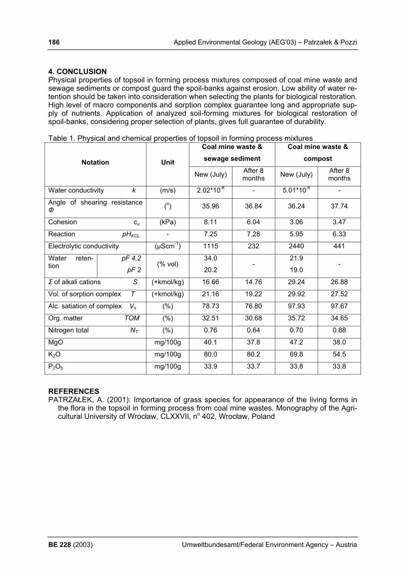
186 Applied Environmental Geology (AEG’03) – Patrzałek & Pozzi
BE 228 (2003) Umweltbundesamt/Federal Environment Agency – Austria
4. CONCLUSION Physical properties of topsoil in forming process mixtures composed of coal mine waste and sewage sediments or compost guard the spoil-banks against erosion. Low ability of water re-tention should be taken into consideration when selecting the plants for biological restoration. High level of macro components and sorption complex guarantee long and appropriate sup-ply of nutrients. Application of analyzed soil-forming mixtures for biological restoration of spoil-banks, considering proper selection of plants, gives full guarantee of durability. Table 1. Physical and chemical properties of topsoil in forming process mixtures
Coal mine waste & sewage sediment
Coal mine waste & compost Notation Unit
New (July) After 8 months New (July) After 8
months
Water conductivity k (m/s) 2.02*10-8 - 5.01*10-6 -
Angle of shearing resistance Ф (o) 35.96 36.84 36.24 37.74
Cohesion cu (kPa) 8.11 6.04 3.06 3.47
Reaction pHKCL - 7.25 7.28 5.95 6.33
Electrolytic conductivity (µScm-1) 1115 232 2440 441
Water reten-tion
pF 4,2
pF 2 (% vol)
34.0
20.2 -
21.9
19.0 -
Σ of alkali cations S (+kmol/kg) 16.66 14.76 29.24 26.88
Vol. of sorption complex T (+kmol/kg) 21.16 19.22 29.92 27.52
Alc. satiation of complex Vs (%) 78.73 76.80 97.93 97.67
Org. matter TOM (%) 32.51 30.68 35.72 34.65
Nitrogen total NT (%) 0.76 0.64 0.70 0.88
MgO mg/100g 40.1 37.8 47.2 38.0
K2O mg/100g 80.0 80.2 69.8 54.5
P2O5 mg/100g 33.9 33.7 33.8 33.8
REFERENCES PATRZAŁEK, A. (2001): Importance of grass species for appearance of the living forms in
the flora in the topsoil in forming process from coal mine wastes. Monography of the Agri-cultural University of Wrocław, CLXXVII, no 402, Wrocław, Poland

Applied Environmental Geology (AEG’03) – Perišić et al. 187
Umweltbundesamt/Federal Environment Agency – Austria BE 228 (2003)
GEOECOLOGICAL SPECIFICITY OF THE SEDIMENTS OF THE IRON GATE I WATER RESERVOIR M. Perišić, V. Tutundžić, S. Knežević Geoinstitut, Rovinjska 12, Belgrade, [email protected] 1. INTRODUCTION The Iron Gate I reservoir degradation and numerous ecological problems with serious long-term consequences for a vast area has been present for several decades. In the past period we published several papers, PERISIC et al. (1996, 1997) about extreme effects of water purification (of the order of 30 million e. p.) and generation of enormous quantity of sediments (of the order of 20 million ton per year) with very high content of harm-ful and dangerous substances in approximately 200 km. long run-of-the-river reservoir of Hy-droelectric Power Plant (HPP) Iron Gate I, confirmed by MULLER et al. (1991). Some con-tradictory data about this part of the flow demand prompt and significant activities for the real assessment of the actual state and creation of protection measures by reduction of sedimen-tation effects and enhancement of water and ecosystem quality of this and downstream part of the Danube flow. 2. MATERIALS AND METHODS By our long-term investigations changes of water quality under backwater effects of the HPP Iron Gate I, in part of the course from 1116 to 943 km. under different water flow conditions we found extremely high water purification, removal of: suspended solids, organic matter, heavy metals and organic micropolutants, but with high degradation of dissolved oxygen re-gime and generation of sediments with high content of pollutants. The HPP Iron Gate reservoir management by Yugoslavian and Romanian authorities started with errors in prediction of sedimentation effects in reservoir basin. With prediction that only particles greater than 60 µm will be deposited it was also claimed that mainly inert matter would settle. But we have proved that in the main reservoir basin 0.5 – 60 µm large particles (Fig. 1) are settling e.g. material with high specific surface and organic matter and heavy metal content. 3. RESULTS Because of the coagulation processes an important part of the organic phase has been set-tling already at the upstream part of the reservoir, together with the coarse particles of the al-lochtonous matter, which creates serious problems and the pollution of ground water. The great plankton production at the upstream part of the reservoir, due to the low degree of pro-tection at the upstream catchments area, effected on the important phenomena of codeposi-tion of allochtonous and organic matter, with serious consequences on the ecosystem under the existing conditions, but with latent abrupt effects of surrounding and longterme degrada-tion downstream area, HUMBORG et. al., 1997.
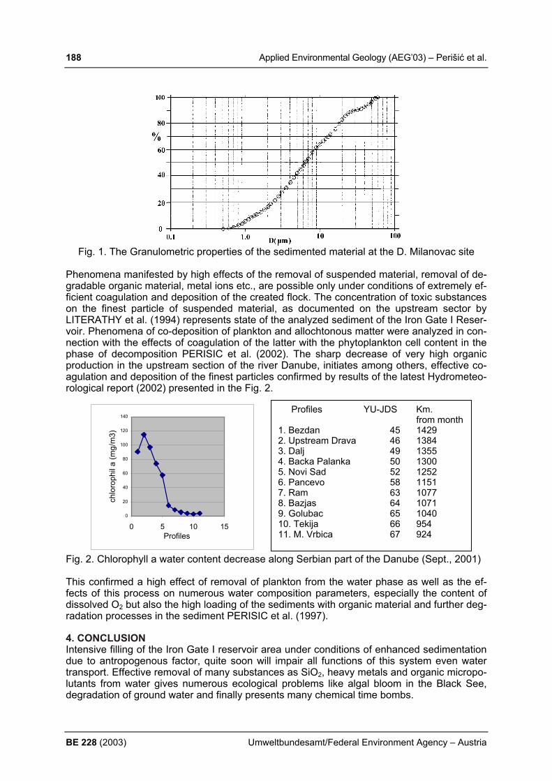
188 Applied Environmental Geology (AEG’03) – Perišić et al.
BE 228 (2003) Umweltbundesamt/Federal Environment Agency – Austria
Fig. 1. The Granulometric properties of the sedimented material at the D. Milanovac site
Phenomena manifested by high effects of the removal of suspended material, removal of de-gradable organic material, metal ions etc., are possible only under conditions of extremely ef-ficient coagulation and deposition of the created flock. The concentration of toxic substances on the finest particle of suspended material, as documented on the upstream sector by LITERATHY et al. (1994) represents state of the analyzed sediment of the Iron Gate I Reser-voir. Phenomena of co-deposition of plankton and allochtonous matter were analyzed in con-nection with the effects of coagulation of the latter with the phytoplankton cell content in the phase of decomposition PERISIC et al. (2002). The sharp decrease of very high organic production in the upstream section of the river Danube, initiates among others, effective co-agulation and deposition of the finest particles confirmed by results of the latest Hydrometeo-rological report (2002) presented in the Fig. 2.
Fig. 2. Chlorophyll a water content decrease along Serbian part of the Danube (Sept., 2001) This confirmed a high effect of removal of plankton from the water phase as well as the ef-fects of this process on numerous water composition parameters, especially the content of dissolved O2 but also the high loading of the sediments with organic material and further deg-radation processes in the sediment PERISIC et al. (1997). 4. CONCLUSION Intensive filling of the Iron Gate I reservoir area under conditions of enhanced sedimentation due to antropogenous factor, quite soon will impair all functions of this system even water transport. Effective removal of many substances as SiO2, heavy metals and organic micropo-lutants from water gives numerous ecological problems like algal bloom in the Black See, degradation of ground water and finally presents many chemical time bombs.
Profiles YU-JDS Km. from month
1. Bezdan 45 1429 2. Upstream Drava 46 1384 3. Dalj 49 1355 4. Backa Palanka 50 1300 5. Novi Sad 52 1252 6. Pancevo 58 1151 7. Ram 63 1077 8. Bazjas 64 1071 9. Golubac 65 1040 10. Tekija 66 954 11. M. Vrbica 67 924
0
20
40
60
80
100
120
140
0 5 10 15Profiles
chlo
roph
il а
(mg/
m3)

Applied Environmental Geology (AEG’03) – Perišić et al. 189
Umweltbundesamt/Federal Environment Agency – Austria BE 228 (2003)
REFERENCES HUMBORG, C.; ITTECOT, V.; COCLASU, A. & BODUNGEN, B., (1997): Effect of Danube
River dam on Black Sea biogeochemistry and ecosystem structure, Nature, Vol 386, pp. 385-388.
LITERATHY, P.; LASZLO, F. & CSANYI, B., (1994): Approaches for sediment associated pollutant monitoring in the river Danube, Wat. Sci. Tech. Vol. 30, No 5, pp 157-165.
MULLER, D.; KIRCHERCH, V. & GODENAU, S.,(1991):Impacts of impoundments at the ma-terial balance of river Danube, Water quality model computation with estimated input data, 24-th IAD Session, Kiev.
PERISIC, M.; MIHAJLOV, A. & TUTUNDZIC, V., (1996): Water quality changes in the Yugo-slav part of the river Danube, Archive Hydrobiology, Supply. Large Rivers 11, No 115, pp. 61-73.
PERSC, M.; MIHAJLOV, A. & KNEZEVIC, S., (1997): Sediment of hydro energetic run-of-the- river reservoir of the Djerdap I hydro energetic power plant-generation and problems in exploration, in Engineering Geology, Wang Sijing and P. Marinos (Eds), VSP, Vol. 23, pp. 41-52.

190 Applied Environmental Geology (AEG’03) – Picer et al.
BE 228 (2003) Umweltbundesamt/Federal Environment Agency – Austria
INVESTIGATION THE PCB LEVELS IN SOIL SAMPLES OF AN ELECTRO-TRANSFORMER STATION IN ZADAR AS CON-SEQUENCE OF OIL SPILLS DURING WAR ACTION (CROATIA) M. Picer1), N. Picer1), T. Kovač1), Z. Cencic Kodba2) & M. Kralik3)
1) Institute " Ruđer Bošković", Bijenička cesta 54, 10000 Zagreb, Croatia, [email protected] 2) Environmental Protection Institute, Prvomajska 1, 2000, Maribor, Slovenia,
zdenka.kodba @zzv-mb.si 3) Umweltbundesamt Austria (Federal Environment Agency Austria) and University of
Vienna, Austria, [email protected] 1. INTRODUCTION During the recent war, the karst area of Croatia has been jeopardized by hazardous waste and deserves particular attention because of its exceptional ecological sensitivity and unfor-tunately unscrupulous destruction of natural resources, infrastructure, homes and enter-prises. There are great fears and concrete evidence those significant quantities of polychlori-nated biphenyls (PCB); various flame-retardants, explosives, and their by-products were re-leased in the environment during warfare. During 1996 waste oil and soil samples near dam-aged transformer stations were collected in Delnice, Zadar, Šibenik, Split, and Dubrovnik area and analyzed on polychlorinated biphenyls. Shown results do not indicate significant contamination of soil with polychlorinated biphenyls in the transformer station (TS) or in oil taken from the oil trench TS "Delnice" and TS “Split”. Concerning the distance from the ca-pacitor battery hit by a rocket fire at transformer installation in Komolac near Dubrovnik, soil showed significant levels of polychlorinated biphenyls. PCB levels indicate significant soil contamination below the capacitor battery hit by a rocket fire in the area of transformer sta-tion TS 220/110/30 kV "Bilice", Šibenik (PICER & PICER, 1998). Results of the analysis of polychlorinated biphenyls in soil from four locations (on some loca-tions, on two depths), indicate significant contamination of the investigated area TS 110/35 kV - Zadar. It was reason for a thorough investigation of this site for levels of PCBs in soil samples around the damaged capacitor (PICER et al., 2003). 2. MATERIALS AND METHODS Thirteen terra rossa type soils from two 1.2 m deep soil pits were collected in February 2003. One just below the asphalt – concrete basement of the destroyed capacitors. The other one just next to it with a natural lawn on top. Both soil profiles are dominated by coarse angular limestone fragments mixed with 5-15% red silty loam. They were originally disturbed by constructing the basement of the capacitors. The air dried soil samples were screened below 2mm and extracted 24 hours with n-hexane by Soxhlet extraction. The analytical method used for the analysis of extracts included filtration through a column of Na2SO4 anh. cleaning on an alumina column and the separation of the PCB’s from organochlorine insecticides on a miniature silica gel column. After concentration down from 0.3 to 1 cm
-3, elutes were analyzed by EC gas
chromatography. During all the analytical procedures, the Mirex standard was used as the internal standard. 3. RESULTS AND DISCUSSION The soil samples (<2 mm) show all low organic carbon content (0.8-1.7%) except the top humus layer of the second pit (5.2%). The PCB content (7 congeners) below the concrete basement is well below the determination level of <0.03 mg/kg. In the second pit the sum of the seven congeners (0.06-0.12 mg/kg) indicate a PCB contamination in down to 1.1 m (Fig. 1). Just in the top soil (4-14 cm) and in the humus layer (< 4cm) the PCB content rises up to 5 and 230 mg/kg. Results of the analysis on PCB in soil from TS "Zadar" indicate significant

Applied Environmental Geology (AEG’03) – Picer et al. 191
Umweltbundesamt/Federal Environment Agency – Austria BE 228 (2003)
contamination of the area with polychlorinated biphenyls. Comparing the given levels of PCB in soil from TS "Zadar" and, by the tolerance criteria accepted in the Netherlands, levels of contamination on some locations far exceed the tolerant levels that do not require remedia-tion.
LEVELS OF PCB IN SOIL SAMPLES FROM THE OUTER RESEARCH HOLE(ANALYSIS PERFORMED BY IPHSI.EP.HSA,MARIBOR)
0,001
0,01
0,1
1
10
100
1000
0 0,2 0,4 0,6 0,8 1 1,2DEPTH OF RESEARCH HOLE (m)
LEVE
L O
F PC
B C
ON
GEN
ERS
(mg/
Kg)
d.
w.
SUM 7 CONG.PCB 28PCB 52
IPHSI.EP.HSA
Fig. 1 Concentration of PCB congeners in a soil pit next to the destroyed capacitor in the Zadar transformator station (sampling February 2003). 4. CONCLUSIONS Most of PCBs (7 congeners) after the transfomator oil spills stayed in the organic rich upper most humus layer (230 mg/kg; <4 cm depth) and to a lesser content in the organic poor terra rossa type top soil (5 mg/kg; 4-14 cm depth). However, PCBs were recorded (0.06-0.12 mg/kg) in the soil down to a depth of 1.1m just above and in fractures of a karstified lime-stone. If and how much of the original PCBs were washed down to the karst groundwater is not known at the present stage. REFERENCES PICER, M. & PICER, N. (1998): War damage and jeopardized water in karst region of Croa-
tia, I. Research of PCBs level on ground of war damaged E.T.S. in karstic region of Croa-tia, Croatian Water Management, 7, No. 73,10-15. (in Croatian).
PICER, M., N. PICER, V. & HODAK KOBASIĆ (2003): PCB levels in soil inside electro trans-former station 110/35 KV in Zadar, Organohalogen compounds, Vol. 62, Environmental levels, Emerging POPs, Site Assessment, Editor: Gary Hunt, TRC Environmental, USA, 472- 475. (23 rd Symposium on Halogenated Environmental Organic Pollutants and POPs - Dioxin , 2003, Boston, MAS. USA, 24.-29. August 2003).

192 Applied Environmental Geology (AEG’03) – Pirkl et al.
BE 228 (2003) Umweltbundesamt/Federal Environment Agency – Austria
GEOCHEMICAL BACKGROUND VALUES OF GROUNDWATER, ROCKS AND SOILS IN THE NORTHERN CALCAREOUS ALPS OF UPPER AND LOWER AUSTRIA H. Pirkl1), M. Heinrich2), S. Pfleiderer2), H. Reitner2), P. Klein2) & K. Decker3)
1) Fa. GEOÖKO, Gentzgasse 17/1/6, 1180 Wien, [email protected] 2) Geologische Bundesanstalt, Rasumofskygasse23, 1030 Wien, mheinrich@.., spfleide-
rer@.., hreitner@.., pklein@.. all at [email protected] 3) Institut für Geologie, Geo-Zentrum der Universität Wien, Althanstraße 14, 1090 Wien,
[email protected] 1. INTRODUCTION The study area is situated in the Northern Calcareous Alps of Upper and Lower Austria be-tween the rivers Enns and Ybbs/Schwarzois. Geological formations predominantly consist of carbonate and siliciclastic rocks of Triassic, Jurassic and Cretaceous age and quarternary moraines and terraces. Land use ranges from agriculture to forestry and, to a lesser extent, industry and tourism. Over the last ten years groundwater samples taken from all main geological formations have been analysed for major and minor ion content as well as for trace element concentrations (Heinrich et al., 1995; Pfleiderer et al., 1999). Complementary rock and soil samples were taken in order to correlate their chemical composition with hydrochemical facies and to follow the flux of chemical substances resulting from atmospherical deposition, soil formation, rock dissolution and groundwater discharge into surficial waters (Pirkl, 1999). The objective of this poster is to present geochemical background values of groundwater, soils and rocks in mostly undisturbed, natural settings in order to characterise environmental processes such as buffering and sorption in soils, mineralization of groundwater travelling through soils and rocks and finally to provide numbers for the assessment of geogenic background vs. anthropogenic contamination of the environment. 2. MATERIALS AND METHODS Figure 1 illustrates the locations of springs (round symbols) measured and sampled on a monthly basis. Field measurements include readings of electrical conductivity, water tem-perature, pH-value, redox potential oxygen content, and discharge. Chemical analyses measure the concentration of Ca, Mg, Na, K, SO4, HCO3, Cl, F, NO3, (major ions) and H2SiO3, Cd, Cr, Cu, Pb, Zn, Al, Fe, Sr, Mn and Li (trace elements). Measurements were car-ried out using ICP atomic emission spectroscopy, ion chromatography, titration and atomic absorption. Rocks samples (triangles in Fig. 1) from all main geological formations were analysed with respect to SiO2, TiO2, Al2O3, Fe2O3, MnO, MgO, CaO, Na2O, K2O, P2O5, CO2, SO3, (major oxides) and Ba, Sr, Co, Cr, Cu, Mo, Mo, Ni, Pb, Sr, V and Zn (trace elements) using ICP atomic emission spectroscopy. Soil samples (pentagons in Fig. 1) were analysed in four ways: (a) extract of water-soluble substances, (b) exchangeable cations after dissolving the sample in lithium chloride, (c) sub-stances mobilised through weak acid after dissolving the sample in hydrochloric acid and (d) total content after dissolving the sample in nitrohydrochloric acid (aqua regia extract). Field observations of soil profiles include vegetation, morphology (slope and aspect), thickness and pH of individual soil horizons.

Applied Environmental Geology (AEG’03) – Pirkl et al. 193
Umweltbundesamt/Federal Environment Agency – Austria BE 228 (2003)
Figure 1: Overview of sampling locations (circles: springs, triangles: rocks, pentagons: soils) 3. RESULTS A homogeneous, well-documented, geo-referenced data set exists now in digital format de-scribing major chemical parameters and trace element concentrations in all main rock and soil formations and springs within the study area. For soil and groundwater, multiple sam-pling allows for time series analysis over long periods. This data set forms the basis of corre-lations between geo-, hydro- and soil chemistry and for further environmental investigations. The poster illustrates (a) results of rock sample analyses specific to geological formations, (b) soil samples for particular morphological, geological and vegetation conditions and (c) time series of groundwater samples of natural springs in various hydrogeological settings. Preliminary interpretation of results indicate high temporal variations in trace element con-centrations of groundwater samples, good correlation between main water chemistry and lithological composition of the respective catchment areas, and moderately high heavy metal contents in sediments with terrigeneous influence. Soil formations on these rocks show risks of acidification. REFERENCES HEINRICH M., BRÜGGEMANN, H, DECKER, K., KLEIN, P., KOCIU, A., KOLLMANN, W.,
LIPIARSKI, P., PAVLIK, W., PIRKL, H. & WIMMER, H.: Wasserhöffigkeit und Wasserqua-lität sowie deren langfristige Sicherung in kalkalpinen Einzugsgebieten am Beispiel eines N-S-Streifens in den niederösterreichischen Kalkalpen zwischen Ybbsitz und Göstling. - Endbericht NA6p, GBA Wien, 1995.
PFLEIDERER S., ARNDT, R., HÜBL, G., RÖMER, A., BRÜGGEMANN, H., DECKER, K., HEINRICH, M., KLEIN, P., KREUSS, P., PIRKL, H., RANK, D., PAPESCH, W. & REITNER, H.: Geohydrologische und hydrogeologische, geochemische und tektonische Grundlagenstudie in den oberösterreichischen Kalkvoralpen nordöstlich der Enns. - End-bericht OA30, GBA Wien, 1999.
PIRKL, H.: Interpretation geochemischer Daten im Rahmen von Wasserhöffigkeits- und Na-turraumpotentialprojekten. – Eisenerz, 1999.
194 Applied Environmental Geology (AEG’03) – Plan et al.
BE 228 (2003) Umweltbundesamt/Federal Environment Agency – Austria
ASSESSMENT OF KARST MORPHOLOGICAL VULNERABILITY PARAMETERS L. Plan, K. Decker & R. Faber Department of Geological Sciences University of Vienna, Althanstrasse 14, A-1090 Vienna, [email protected] 1. INTRODUCTION Karst morphology and infiltration conditions are key parameters for the evaluation of the vul-nerability of karst aquifers (e.g. GOLDSCHEIDER 2000, DOERFLINGER 1999). The influ-ence of closed karst depressions can be summarized as follows:
• Rainwater collected in dolines (sinks) and other closed karst depressions directly infil-trates via ponors into karst conduits.
• Pollutants are carried into the karst aquifer surpassing soil or other protective covers without purification within very short time.
• According to WILLIAMS (1985) the topography of the subsurface water flow in the epikarst zone follows the surface topography.
• For each sink the local catchment area is proportional to the amount of potentially in-filtrated water and therefore statistically proportional to the diameter of the karst con-duit.
• Points with concentrated recharge and their catchment area are locations with high vulnerability, which increases with the area of the drained surface.
2. METHOD In order to map and quantify karst morphological vulnerability parameter sinks are regionally mapped and attributed with their catchment area (“Attributed Sink Method”). The method is automated and integrated in the software package WinGEOL by Robert Faber. In a first step local minima are mapped from a high-resolution digital elevation model (DEM). Then the catchment area of individual sinks is calculated using a flow-accumulation algorithm and each sink is attributed with the size of the orographic catchment area. With the resulting GIS-based map an effective and well-directed ground control is performed to verify the automati-cally derived results and to check for closed depressions of non-karstic origin, e.g. glacial landforms. 3. RESULTS The method is tested on the Hochschwab karst massif in Styria, Austria, which is one of the large karst massifs of the Northern Calcareous Alps mostly formed by Triassic limestone. The overall area of the mountain range, terminated by deeply entrenched valleys, is 620 km² and its summit reaches 2277 m. The plateau between 1400 to 2000 m altitude is part of the catchment of several giant karst springs (up to MQ 5 m³/sec), which provide about 220 000 m³ per day of freshwater for the city of Vienna. The area is very well investigated with respect to lithology, structural geology and hydrology. Karst features such as dolines, poljes, ponors, springs, karren fields etc. have been mapped systematically. Additionally, more than 900 caves are registered (Plan, 2002). The GIS-mapped features show a perfect agreement with the natural karst structures from the field assessment (Fig. 1). Furthermore the method allows distinguishing different types of landscapes according to size and distribution patterns of sinks, runoff-paths and infiltration characteristics. These land-scapes show different vulnerabilities. In the test site four homogeneous karst landscapes are defined. Ranked from low to very high vulnerability, these are:

Applied Environmental Geology (AEG’03) – Plan et al. 195
Umweltbundesamt/Federal Environment Agency – Austria BE 228 (2003)
1 Regions with rare sinks and dominant potential surface runoff to the fore-flood corre-spond to dolomitic karst.
2 Areas with numerous small sinks and no potential surface runoff to the fore-flood. These landscapes correspond to glacially overprinted limestone karst.
3 Intensely karstified areas with few giant dolines with up to several hundred meters di-ameter. The landscapes evolved from glacially non-overprinted Pleistocene nunataks and entirely drain into the karst aquifer.
4 Polje landscapes with very few ponors draining areas up to several square kilometres. The method also quantifies the size of the catchment areas, which entirely drain into the karst aquifer. For the Hochschwab massif, this area makes up 79.5 % of the total catchment.
Fig. 1: Comparison of GIS-mapped sinks and sinks from field assessment. 4. CONCLUSIONS Attributed Sinks provides a fast mapping and assessment of karst depression, which are di-rectly related to the degree of vulnerability of karst groundwater due to the inflation conditions and the amount of infiltrated water. It can be used to quantify karstmorphological vulnerability parameters on the one side and to detect especially vulnerable features to set up protective measures. REFERENCES DOERFLINGER, N. & ZWAHLEN, F. (1998): Praxishilfe: Kartierung der Vulnerabilität in
Karstgebieten (Methode EPIK). 56 p. BUWAL, Bern. GOLDSCHEIDER, N.; KLUTE, M.; STURM, S.; HÖTZL, H. (2000): The PI-method - a GIS
based approach to mapping groundwater vulnerability with special consideration of karst aquifers. - Z. f. angew. Geol., 46: 157-166, Stuttgart.
PLAN, L. (2002): Speläologisch-tektonische Charakterisierung der Karstwasserdynamik im Einzugsgebiet der bedeutendsten Quelle der Ostalpen (Kläfferquelle, Hochschwab). - Speldok 11, 84 p., Verband Österr. Höhlenforscher, Vienna.
WILLIAMS, P. W. (1985): Subcutaneous hydrology and the development of doline and cock-pit karst. - Z. f. Geomorphology, 29: 463-482, Stuttgart, Berlin.

196 Applied Environmental Geology (AEG’03) – Pluta & Halas
BE 228 (2003) Umweltbundesamt/Federal Environment Agency – Austria
IDENTIFICATION OF ACID MINE PROCESSES IN COAL MINES OF THE UPPER SILESIAN COAL BASIN BY δ34S AND δ18O IN SULPHATES I. Pluta1), S. Hałas2),3) 1) Central Mining Institute, pl. Gwarków 1, 40-166 Katowice, 2) Institute of Physics, Maria Curie-Sklodowska University, pl. M. Curie-Sklodowskiej 1, 20-
031 Lublin 3) Institute of Environmental Engineering, Lublin University of Technology, Nadbystrzycka
40b, 20-618 Lublin ABSTRACT We report on applicability of sulphate and oxygen stable isotope analysis for identification of acid mine processes which pollute the mine waters. The study was performed in some hard coal mines in the Upper Silesian Coal Basin in Southern Poland. 1. INTRODUCTION The acid mine processes are a major source of water pollution worldwide. The acid mine drainage (AMD) is considered as one of the most significant environmental challenges (Ah-med 1974). It can be responsible for problems of ground and surface pollution. Particularly the acid mine processes constitute a notable problem at mines, either operational or aban-doned. In this paper we report on a preliminary study of this problem in Polish hard coal mines by investigation of the isotopic compositions of sulphur (δ34S) and oxygen (δ18O) in sulphate ion. 2. GEOLOGY AND HYDROGEOLOGY OF SAMPLING AREA The Upper Silesian Coal Basin (USCB) is located in southern part of Poland. Sixty-six hard coal mines were situated in this region (Fig. 1). The coal has been mined since the second half of the 18th century. The USCB is situated in the Variscan Upper Silesian intermontane depression. The molasse of the Upper Carboniferous strata are 8200 m thick. The coal-bearing Carboniferous rocks occur beneath the permeable Quater-nary and Triassic rocks in the north-eastern part of the USCB and an impervious Tertiary in the southern an western parts. The aquifers in the Carboniferous rocks are in sandstones, claystones and interbedded with mudstone and sandstone complexes. Isotope and chemical data indicate that waters in the Carboniferous rocks originated from the infiltration in different hydrogeological cycles and some are connate waters probably from the Triassic and Tertiary sea. Differences in the origin and geological conditions of the USCB has resulted in a wide salinity and differences in isotope and chemical data. Generally in the majority of mine waters, especially where the permeable Quaternary and Triassic formation cover the Carboniferous rocks, contain sulphate ions, but some of saline mining waters are subjected to reduction conditions and contain the barium ions.

Applied Environmental Geology (AEG’03) – Pluta & Halas 197
Umweltbundesamt/Federal Environment Agency – Austria BE 228 (2003)
Fig. 1. The coal mines of the Upper Silesian Coal Basin (Poland) with acid mine processes (1-base of Carboniferous –bearing deposits, 2- coal mine boundaries, 3-boundary of Poland). 3. ANALYTICAL METHODS The waters samples were filtered and sulphate was precipitated as BaSO4 by BaCl2 solution acidified with HCl. The concentration of sulphates was determined by the gravimetric method. The isotopic compositions δ34S and δ18O were analyzed by mass spectrometry on SO2 and CO2 gases, respectively. SO2 was extracted from BaSO4 by the method developed in UMCS Lublin laboratory, whereas CO2 was prepared by the method described by Mizutani (1971). 4. RESULTS 4.1. SULPHATES IN MINING WATERS The Carboniferous rocks contain sulphates in halite as mineral inclusions and as gypsum, anhydrite, jarosite, melanterite. The sulphides occur as pyrite or marcasite. Under certain conditions these minerals become the source of sulphates for waters remaining in contact with these rocks. The sulphates in mining waters of the USCB may originate: (1) from the marine sulphates minerals of different ages (Tertiary, Triassic), (2) from waste products stored in mining workings, (3) from the oxidation processes of sulphide minerals.
KATOWICE
KWKSilesia
NIWKA - MODRZEJÓW CM
SILESIA CM
POLAND
1 5° 2 3°
5 4°
5 0°
Legend:
(2)(1)
(3)
CZECH

198 Applied Environmental Geology (AEG’03) – Pluta & Halas
BE 228 (2003) Umweltbundesamt/Federal Environment Agency – Austria
Sulphates from the dissolved evaporites are identified generally by δ34S values >+10‰ and δ18O values >+10‰ according to Claypool et al. (1980). All waste products from electric power plants in the Upper Silesia in Poland have recently been stored in mining workings. In the past it was only fly ash which was produced by the burning of coal, but nowadays the products from different flu gas desulphurization processes of clean-coal technologies are stored. Isotopic composition of sulphur and oxygen allow the identification of the origin of sulphates from wastes (Pluta 2001). 4.2. δ34S FROM SULPHIDE MINERALS Samples of iron sulphides FeS2 (pyrite or marcasite) from two coal mines (CM): Marcel and Borynia were selected for the investigation and dissolved into the water with HNO3. Sul-phates of the Jankowice and Krupiński CM were taken from flotation tailings, where the oxi-dation processes of sulphide minerals were performed. Generally the original sulphide min-erals come from the Carboniferous rocks. The results of δ34S and δ18O are given in Table 1. Table 1. δ34S and δ18O of sulphates from oxidized sulphide minerals (pyrite or marcasite) of the Carboniferous rocks in the coal mines of the Upper Silesian Coal Basin (Poland).
Sampling site (name of coal mine)
δ34S CDT ‰
δ18O SMOW ‰
Marcel CM +3.48 n.a. Borynia CM +6.11 n.a. Borynia CM +9.12 n.a. Jankowice CM +4.85 -3.15 Krupiński CM +6.40 -3.55
n.a. = not analyzed 4.3. δ34S AND δ18O FROM SULPHATES OF ACID MINE PROCESSES Acid mine processes resulting from the natural oxidation of sulphide minerals has been de-tected in the Niwka-Modrzejów and Silesia CM. One of the acid mine process is located at the level of 100-130 m in the Niwka-Modrzejów CM. In the order to recognize what is control-ling the chemistry of water, the identification of sulphates was performed. Water has pH=3.8, temperature about 20oC and concentration of sulphates 2660 mg/dm3 (tab. 2). The isotope composition of sulphur and oxygen in sulphates was: δ34S =+6.17‰ and δ18O=+4.04‰. These results indicate that the oxidation of pyrite or marcasite took place. Isotope and chemical data indicate that waters in the Silesia CM originated from the infiltra-tion in the different hydrogeological cycles. All these waters contain barium ions. Sometimes in waters the sulphates were notified. These waters flow through old mine workings. The concentrations of sulphates and isotopic composition of sulphates are presented in the Table 2. The results indicate that the most important mechanism of the generation of sulphates is the oxidation of sulphide minerals (pyrite or markasite) (Pluta et al. 1994). In this case the barium ion is precipitated from natural mine waters. Removal of barium by dissolution of sul-phates related to mining activities is clearly beneficial ecologically.
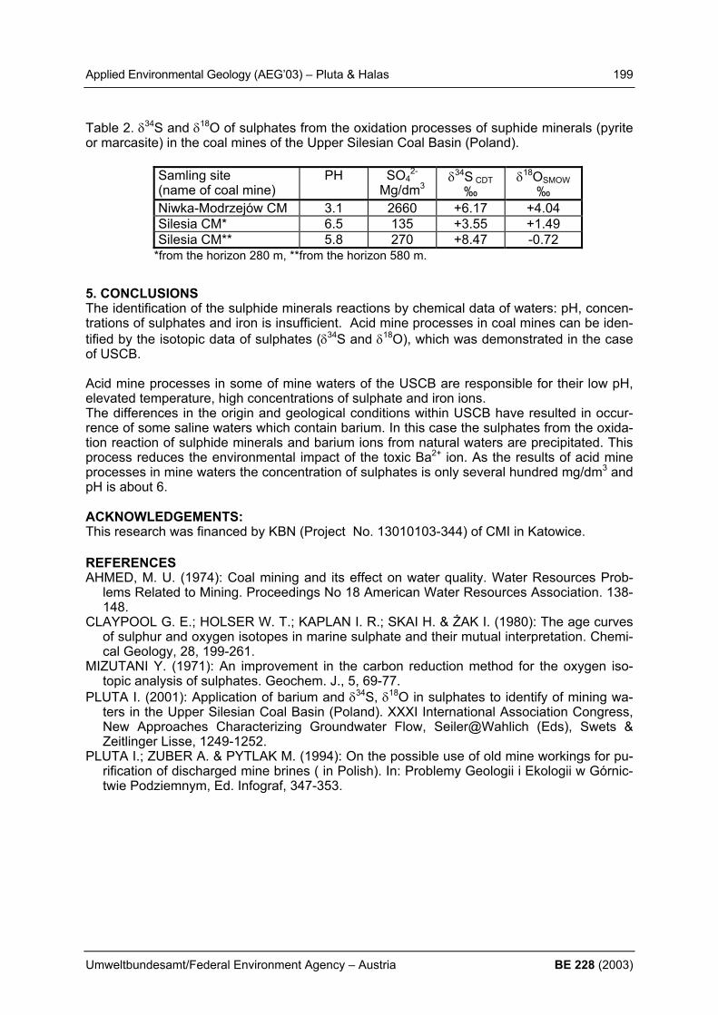
Applied Environmental Geology (AEG’03) – Pluta & Halas 199
Umweltbundesamt/Federal Environment Agency – Austria BE 228 (2003)
Table 2. δ34S and δ18O of sulphates from the oxidation processes of suphide minerals (pyrite or marcasite) in the coal mines of the Upper Silesian Coal Basin (Poland).
Samling site (name of coal mine)
PH SO42-
Mg/dm3 δ34S CDT
‰ δ18OSMOW
‰ Niwka-Modrzejów CM 3.1 2660 +6.17 +4.04 Silesia CM* 6.5 135 +3.55 +1.49 Silesia CM** 5.8 270 +8.47 -0.72
*from the horizon 280 m, **from the horizon 580 m.
5. CONCLUSIONS The identification of the sulphide minerals reactions by chemical data of waters: pH, concen-trations of sulphates and iron is insufficient. Acid mine processes in coal mines can be iden-tified by the isotopic data of sulphates (δ34S and δ18O), which was demonstrated in the case of USCB. Acid mine processes in some of mine waters of the USCB are responsible for their low pH, elevated temperature, high concentrations of sulphate and iron ions. The differences in the origin and geological conditions within USCB have resulted in occur-rence of some saline waters which contain barium. In this case the sulphates from the oxida-tion reaction of sulphide minerals and barium ions from natural waters are precipitated. This process reduces the environmental impact of the toxic Ba2+ ion. As the results of acid mine processes in mine waters the concentration of sulphates is only several hundred mg/dm3 and pH is about 6. ACKNOWLEDGEMENTS: This research was financed by KBN (Project No. 13010103-344) of CMI in Katowice. REFERENCES AHMED, M. U. (1974): Coal mining and its effect on water quality. Water Resources Prob-
lems Related to Mining. Proceedings No 18 American Water Resources Association. 138-148.
CLAYPOOL G. E.; HOLSER W. T.; KAPLAN I. R.; SKAI H. & ŻAK I. (1980): The age curves of sulphur and oxygen isotopes in marine sulphate and their mutual interpretation. Chemi-cal Geology, 28, 199-261.
MIZUTANI Y. (1971): An improvement in the carbon reduction method for the oxygen iso-topic analysis of sulphates. Geochem. J., 5, 69-77.
PLUTA I. (2001): Application of barium and δ34S, δ18O in sulphates to identify of mining wa-ters in the Upper Silesian Coal Basin (Poland). XXXI International Association Congress, New Approaches Characterizing Groundwater Flow, Seiler@Wahlich (Eds), Swets & Zeitlinger Lisse, 1249-1252.
PLUTA I.; ZUBER A. & PYTLAK M. (1994): On the possible use of old mine workings for pu-rification of discharged mine brines ( in Polish). In: Problemy Geologii i Ekologii w Górnic-twie Podziemnym, Ed. Infograf, 347-353.

200 Applied Environmental Geology (AEG’03) – Prokop
BE 228 (2003) Umweltbundesamt/Federal Environment Agency – Austria
IMAGE-TRAIN: INNOVATIVE MANAGEMENT OF GROUNDWATER RESOURCES IN EUROPE – TRAINING AND RTD CO-ORDINATION PROJECT G. Prokop1)
1) Umweltbundesamt Austria (Federal Environment Agency Austria), Spittelauer Lände 5, A-
1090 Vienna, Austria, ++43 1 31304/5915; [email protected]; 1. ABSTRACT The EU-funded project IMAGE-TRAIN (Innovative Management of Groundwater Resources in Europe - Training and RTD Co-ordination Project) has the ambition to improve cooperation and interaction between ongoing research projects in the field of soil and groundwater con-tamination and to communicate new technology achievements to young scientists by means of training courses. IMAGE-TRAIN is a three year project which started in September 2001 and operates at two levels. (1) At the level of senior scientists cluster meetings for research-ers of ongoing research projects are being organised with the objective to establish topic links between RTD projects dealing with contaminated land and groundwater and to promote their practical application. Furthermore, practical case studies with selected experts are be-ing organised to perform short studies on emerging groundwater and soil issues. (2) At the level of junior scientists Advanced Study Courses are being organised with the objective to quickly transfer existing and emerging knowledge to young European academics. Last not least, IMAGE-TRAIN is maintaining a communication platform for young scientists dealing with groundwater and soil science which can be found on the project’s website. 2. PROJECT-STRUCTURE IMAGE-TRAIN is an Accompanying Measure funded by the Fifth Framework Programme (FP5) on research, technological development and demonstration. Main driving forces of this project are improvement of knowledge transfer (training of young scientists, better communication
between established scientists), better integration of EU Accession countries in the research community, establishment of concerted research efforts by combining research projects and estab-
lishing research clusters, and practical implementation of current research activities along practical case studies.
IMAGE-TRAIN has the ambition to improve cooperation and interaction between ongoing re-search projects in the field of soil and groundwater contamination and communicate new technology achievements to young scientists by means of conferences and training courses. IMAGE-TRAIN is a three year project which started in September 2001 and operates at two levels. • Senior level: At this level Cluster Meetings for researchers of ongoing research projects
are being organised with the objective to establish topic links between RTD projects, deal-ing with contaminated land and groundwater and to promote their practical application and by organising practical case studies with selected experts to perform short feasibility stud-ies related to current groundwater or mine water problems.
• Junior level: At this level Advanced Study Courses are being organised with the objective
to quickly transfer existing and emerging knowledge to young European academics.
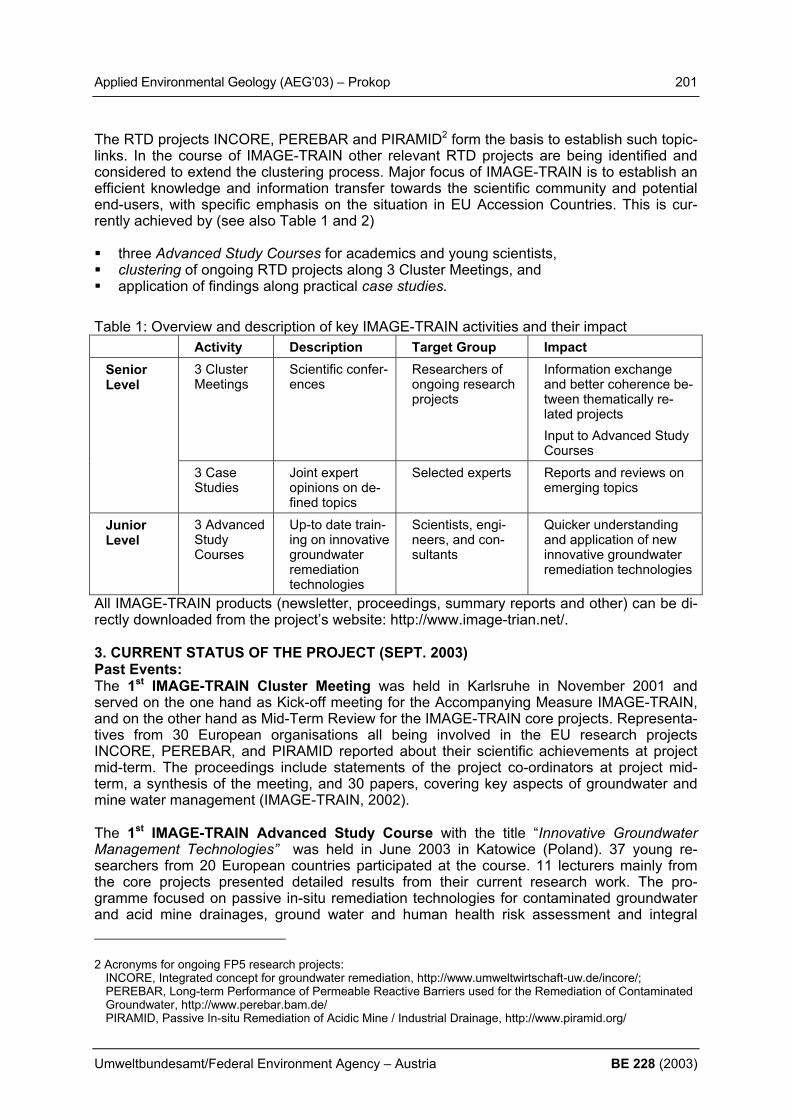
Applied Environmental Geology (AEG’03) – Prokop 201
Umweltbundesamt/Federal Environment Agency – Austria BE 228 (2003)
The RTD projects INCORE, PEREBAR and PIRAMID2 form the basis to establish such topic-links. In the course of IMAGE-TRAIN other relevant RTD projects are being identified and considered to extend the clustering process. Major focus of IMAGE-TRAIN is to establish an efficient knowledge and information transfer towards the scientific community and potential end-users, with specific emphasis on the situation in EU Accession Countries. This is cur-rently achieved by (see also Table 1 and 2) three Advanced Study Courses for academics and young scientists, clustering of ongoing RTD projects along 3 Cluster Meetings, and application of findings along practical case studies.
Table 1: Overview and description of key IMAGE-TRAIN activities and their impact
Activity Description Target Group Impact 3 Cluster Meetings
Scientific confer-ences
Researchers of ongoing research projects
Information exchange and better coherence be-tween thematically re-lated projects Input to Advanced Study Courses
Senior Level
3 Case Studies
Joint expert opinions on de-fined topics
Selected experts Reports and reviews on emerging topics
Junior Level
3 Advanced Study Courses
Up-to date train-ing on innovative groundwater remediation technologies
Scientists, engi-neers, and con-sultants
Quicker understanding and application of new innovative groundwater remediation technologies
All IMAGE-TRAIN products (newsletter, proceedings, summary reports and other) can be di-rectly downloaded from the project’s website: http://www.image-trian.net/. 3. CURRENT STATUS OF THE PROJECT (SEPT. 2003) Past Events: The 1st IMAGE-TRAIN Cluster Meeting was held in Karlsruhe in November 2001 and served on the one hand as Kick-off meeting for the Accompanying Measure IMAGE-TRAIN, and on the other hand as Mid-Term Review for the IMAGE-TRAIN core projects. Representa-tives from 30 European organisations all being involved in the EU research projects INCORE, PEREBAR, and PIRAMID reported about their scientific achievements at project mid-term. The proceedings include statements of the project co-ordinators at project mid-term, a synthesis of the meeting, and 30 papers, covering key aspects of groundwater and mine water management (IMAGE-TRAIN, 2002). The 1st IMAGE-TRAIN Advanced Study Course with the title “Innovative Groundwater Management Technologies” was held in June 2003 in Katowice (Poland). 37 young re-searchers from 20 European countries participated at the course. 11 lecturers mainly from the core projects presented detailed results from their current research work. The pro-gramme focused on passive in-situ remediation technologies for contaminated groundwater and acid mine drainages, ground water and human health risk assessment and integral
2 Acronyms for ongoing FP5 research projects: INCORE, Integrated concept for groundwater remediation, http://www.umweltwirtschaft-uw.de/incore/; PEREBAR, Long-term Performance of Permeable Reactive Barriers used for the Remediation of Contaminated Groundwater, http://www.perebar.bam.de/ PIRAMID, Passive In-situ Remediation of Acidic Mine / Industrial Drainage, http://www.piramid.org/

202 Applied Environmental Geology (AEG’03) – Prokop
BE 228 (2003) Umweltbundesamt/Federal Environment Agency – Austria
groundwater investigation and included an excursion to the Tarnowskie Góry site, a former chemical plant which is considered as national hot spot site in Poland. The course was evaluated by the participants by means of a questionnaire and received excellent results. Contents of the course were published in a review report (IMAGE-TRAIN, 2003a). The 1st IMAGE-TRAIN Case Study was carried out under the lead of Newcastle University. Four experts on saline mine waters in Poland, Spain, and Germany provided their input and expertise concerning saline mine water management. The results of this study are summa-rised in a review paper “Review of Saline Mine Water Management and Methods for Manag-ing them” which is available form the project’s website (Gandy and Younger, 2002). Tab. 2: Timetable of key IMAGE-TRAIN activities (CM=Cluster Meeting, ASC= Advanced
Study Course, CS=Case Study) Date Type Venue Title ; Target Audience Nov. 01
CM Karlsruhe (DE)
IMAGE-TRAIN Kick-off Meeting; Target audience: researchers of projects PEREBAR, INCORE, PIRAMID
June 02
ASC Katwoice (PL)
Innovative Groundwater Management Technologies; Target audi-ence: selected junior scientists and engineers from EU and EU Ac-cession countries
Oct. 02
CS Cracow (PL)
Review of Saline Mine Water Management and Methods for Manag-ing them; Target audience: researchers dealing with mine water problems
Oct. 02
CM Cracow (PL)
Sustainable Management of Contaminated Land and Groundwater in Urban Areas + FP6 Workshop; Target audience: researchers from FP5 research projects
June 03
ASC Pécs (HU)
Groundwater Management in Mining Areas; Target audience: se-lected junior scientists and engineers from EU and EU Accession countries
Nov. 03
CM Orléans (FR)
Are EU FP5 Research Results from the Key Action Water – Pollution Prevention Fit for Use?; Target audience: European researchers and stakeholder groups
Nov. 03
CS Orléans (FR)
Application and Practice Report of EU FP5 Research Results in the Area Key Action Water – Pollution Prevention; Target audience: re-searches dealing with groundwater contamination
May 04
ASC to be de-fined
Title to be determined; Target audience: selected junior scientists and engineers from EU and EU Accession countries
June 04
CS to be de-fined
To be defined; Target audience: researches dealing with groundwa-ter contamination
The 2nd IMAGE-TRAIN Cluster Meeting “Sustainable Management of Contaminated Land and Groundwater in Urban Areas” was held in Cracow from October 2 - 4, 2002. The pur-pose of this meeting was to focus on groundwater pressures in urban areas due to intensive landuse. Furthermore, this event included a specific workshop focussing on the new project tools of the European Commission’s Sixth Framework Programme (FP6) on research, tech-nological development and demonstration. The proceedings of this meeting include 20 sum-mary papers of FP5 research projects dealing with soil and groundwater contamination and a summary of the 1st IMAGE-TRAIN Case Study (IMAGE-TRAIN, 2003a). The 2nd IMAGE-TRAIN Advanced Study Course is dedicated to “Management of Ground-water in Mining Areas” and was held in Pécs-Hungary in June 2003. The venue is close to an abandoned uranium ore mine and processing site which was destination of a one day excur-sion. The course focused on cost-effective remediation of mining effluents and management
Applied Environmental Geology (AEG’03) – Prokop 203
Umweltbundesamt/Federal Environment Agency – Austria BE 228 (2003)
of groundwater in areas affected by contamination from mining activities. Again, the contents of the course will be published in a review report and broadly disseminated. Future Events: The 2nd IMAGE-TRAIN Case Study is currently carried out under the lead of Tuebingen Uni-versity. Key objective is to review deliverables of FP5 research projects dealing with ground-water contamination in view of their practicability for the future groundwater directive. Interim results of this study are presented along CONSOIL 2003 (Bittens and Prokop, 2003) and fi-nal results will be published in a specific review report and will also be available through the project’s website. The 3rd IMAGE-TRAIN Cluster Meeting will be jointly organised with three other projects. The Accompanying Measures SOWA, EUGRIS, IMAGE-TRAIN and JOINT of the EU 5th Frame-work Programme for RTD (FP5) are organising a workshop with the title " The Func-tioning and Management of the Water-Soil-System at River-Basin Scale: Diffuse Pollution and Point Sources" from Nov. 26 to 28, 2003 in Orléans (France). Between 80 and 100 at-tendees from selected FP5 projects, regulators, international and national networks and ser-vice providers are expected to participate. Key objective of the workshop will be (1) the def inition of the current state of research concerning soil and groundwater management, (2) the definition of barriers to technology implementation, and (3) recommendations for further ac-tion. A strategy paper will precede the workshop based on a review FP5 projects and a ques-tionnaire to FP5 researchers concerning future re-search needs. Public access to the results and information is provided through the project’s website (http://www.image-train.net/). Announcements, proceedings from Cluster Meetings, review reports from Advanced Study Courses can be directly downloaded. Finally it should be men-tioned that IMAGE-TRAIN is maintaining a Communication Platform for Young Scientists dealing with groundwater and soil science which can be found on the project’s website. Main objective of this venture is to create a platform which allows Ph.D. students and other young scientists to present their research work and to get readily into contact with others who have similar interests or work at related fields. REFERENCES IMAGE-TRAIN (2003a), “Innovative Groundwater Management Technologies”, Review report of the
1st IMAGE-TRAIN Advanced Study Course in Katowice-Poland from June 24 - 28, Prokop G. et al. (editors), ISSN 0935-4948, published in „Tübinger geowissenschaftliche Arbeiten – Reihe C: Hydro-, Ingenieur- und Umweltgeologie“, Zentrum für Angewandte Geowissenschaften – Eberhard Karls Universität Tübingen, Germany.
IMAGE-TRAIN (2002), “Innovative Management of Groundwater Resources in Europe”, Proceedings of the 1st IMAGE-TRAIN Cluster Meeting in Karlsruhe from November 7 - 9 2001, Prokop, G. (edi-tor), ISBN 3-85457-631-5, published by the Federal Environment Agency – Austria. An on-line ver-sion can be downloaded from http://www.image-train.net.
Gandy C.J., Younger P. (2002), “Review of Saline Mine Water Management and Methods for Manag-ing them” Review paper of the 1st IMAGE-TRAIN case study available at the project’s website: http://www.image-train.net.
IMAGE-TRAIN (2003b), “Sustainable Management of Contaminated Land and Groundwater in Urban Areas”, Proceedings of the 2nd IMAGE-TRAIN Cluster Meeting in Cracow from October 2 - 4 2002, Prokop, G. (editor), published by the Federal Environment Agency – Austria. An on-line ver-sion can be downloaded from http://www.image-train.net.
Bittens M., Prokop G. (2003) “Application and Practice Report of EU FP5 Research Results in the Area Key Action Water – Pollution Prevention: Are Results Fit for Use?” Proceedings of the 8th In-ternational FZK/TNO Conference on Contaminated Soil from May 12 to May 16 2003 in Gent, Bel-gium.

204 Applied Environmental Geology (AEG’03) – Quevauviller
BE 228 (2003) Umweltbundesamt/Federal Environment Agency – Austria
IMPLEMENTATION OF THE WATER FRAMEWORK DIRECTIVE IN EUROPE AND ITS LINKS TO GEOLOGICAL ISSUES Ph. Quevauviller European Commission, DG Environment, [email protected] 1. INTRODUCTION The EU Water Framework Directive (2000/60/EC) was published in the Official Journal of the European Community on 22 December 2000 [1]. This legislation is a result of more than 12 years of consultations among EU Member States and stakeholders (including the scientific community), with an official input given by a Council resolution in 1988 which asked the European Commission to submit proposals to improve ecological quality of Community sur-face waters [2]. It is considered by many policy makers and stakeholders as being probably the most comprehensive policy instrument in the water field that has been developed at an international scale for many years. From the starting point of discussions at the political level, the concept of integrated water management has grown to the design of a policy that consid-ers water as it flows through river basins to the sea. In other words, WFD provisions apply to all waters - inland surface waters, ground waters, transitional (estuarine) and coastal waters. An integrated approach was introduced for water quality and water quantity, and the Direc-tive introduced a framework for water management based on river basin districts. The over-riding objective of the policy is the achievement of “good status” of all waters by the end of 2015. The WFD is one of the most complex introduced by the Commission in that it covers a whole environmental sector – water – in one legislative instrument [3]. Its implementation entails not simply the application of new technical standards, but a requirement to introduce a whole new regime of management, based on river basins, irrespective of existing administrative or, in the case of international rivers, national boundaries. Whilst there are examples of the river basin approach in many countries, the application of the WFD provisions involves Member States, as well as Accession Countries and Associated States, in establishing new organisa-tions within, and even beyond, their territories and this represents a huge challenge to gov-ernments and existing water management authorities. 2. ENVIRONMENTAL OBJECTIVES AND WFD TIME FRAME This new common management system for European water policy is associated to a series of environmental objectives concerning (i) the prevention of further deterioration, the protec-tion and enhancement of the status of aquatic ecosystems and, with regard to their water needs, terrestrial ecosystems and wetlands (Article 1(a)), (ii) the promotion of sustainable water use based on the long-term protection of available water resources (Article 1(b)); (iii) specific pollution control measures (reduction or elimination of discharges and emis-sions/losses of priority hazardous substances) to enhance the protection of the aquatic envi-ronment (Article 1(c)); (iv) the reduction of pollution of groundwater (Article 1(d)); (v) the con-tribution to mitigating effects of floods and droughts (Article 1(e)); and (vi) undertaking meas-ures for achieving ‘good water status’ for all waters within a predetermined timescale (Article 11). These objectives are closely linked to a decision-making process, which is underpinned by a river basin management structure, using river basin districts as natural management units for the protection of water. The Directive follows a strict agenda, starting by the identification of river basins and all of their associated surface and ground water bodies by the Member States, which is to be complemented, before the end of 2004, by their characterisation as re-quired by Article 5 of the WFD and the specifications given in Annex II.

Applied Environmental Geology (AEG’03) – Quevauviller 205
Umweltbundesamt/Federal Environment Agency – Austria BE 228 (2003)
The Directive sets down a number of monitoring obligations, which concern the status of sur-face and ground water bodies as well as protected areas. These are closely linked to the characterisation of the water bodies and involve surveillance monitoring (initial conditions, assessment of long-term changes), operational monitoring (assessment of the measures taken to improve the situation) and investigative monitoring (identification of the causes of e.g. an accidental pollution). In this respect, requirements are set down in Annex V to the Di-rective, considering the monitoring programmes have to be implemented by the end of 2006. Thereafter will come the first river basin management plan (2009) which, on the basis of the characterisation and monitoring data, will enable sets of (protection and/or restoration) measures to be identified. The programme of measures (Article 11) should hence be opera-tional by 2012, i.e. three years before the second river basin management plan (2015). 3. THE WFD AND ITS LINK TO GEOLOGY In the context of the above, links with geological issues appear at various levels. With re-spect to surface waters, the initial characterisation of water bodies implies that they are first divided into various categories – rivers, lakes, transitional waters or coastal waters – and then differentiated according to types (system ‘A’ and ‘B’). The system ‘A’ links water typolo-gies to ecoregions (shown on maps in Annex IX to the Directive) and types which include in-formation on altitude, size and geology (calcareous, siliceous or organic). The system ‘B’ in-cludes system ‘A’ information and optional factors which are more elaborated (e.g. depth, shape, temperature, precipitation, residence time etc.). Important to note is that the charac-terisation work aims to establish type-specific reference conditions for surface water body types, which will be used to represent the values of hydromorphological and physicochemical and of biological quality elements for defining the “high ecological status” as defined in Annex V to the Directive. Type-specific conditions may be either spatially based or based on model-ling, or may be derived using a combination of these methods. Here again, geology is a key feature in that type-specific biological reference conditions based on modelling may be de-rived using predictive models based on historical, palaeological and other available data. With respect to groundwater, links with geology seem obvious since the initial characterisa-tion implies to report on the general character of overlying strata in the cachtment area from which the groundwater receives its recharge. The further characterisation (of bodies found to be at risk) then clearly specifies that information should be gathered on geological character-istics of the groundwater body (including the extent and type of geological units) and its hy-drogeological characteristics as well as the characteristics of superficial deposits and soils. The requirement related to water types is less detailed than for surface water bodies, but Member States may use typologies for groundwater characterisation when establishing natu-ral background levels for these bodies of groundwater. REFERENCES Official Journal of the European Communities, Directive 2000/60/EC of the European Parlia-
ment and of the Council establishing a framework for Community action in the field of wa-ter policy, OJ L 327 (2000) p. 72.
Council resolution, Community Water Policy Ministerial Seminar, Frankfurt, OJ C 209 (1988) p. 3.
P. Chave, The EU Water Framework Directive – An Introduction, IWA Publishing, London, ISBN: 1-900222-12-4, pp.207, 2001.

206 Applied Environmental Geology (AEG’03) – Rank & Papesch
BE 228 (2003) Umweltbundesamt/Federal Environment Agency – Austria
DETERMINATION OF GROUNDWATER FLOW VELOCITY IN THE SOUTHERN VIENNA BASIN FROM LONG-TERM ENVIRONMENTAL ISOTOPE RECORD D. Rank1) & W. Papesch2) 1) Institut für Geologische Wissenschaften, Universität Wien, A-1090 Wien; die-
[email protected] 2) ARC Seibersdorf research GmbH, A-2444 Seibersdorf; [email protected] 1. INTRODUCTION The “Mitterndorfer Senke” in the youngest zone of subsidence in the Southern Vienna Basin contains an important groundwater occurence with regional water-supply facilities. The de-pression filled with Pleistocene gravels and sands is about 40 km long, 2 to 8 km in width and 50 to 150 m deep. Up to 13 m3/s of river water infiltrate into the alluvial cones in the most southern part of the “Mitterndorfer Senke” from the crossing rivers. The contribution of local precipitation to groundwater recharge is very low due to strong evaporation in this area (up to 600 mm/a). The fill in the “Senke” acts very much like a pipeline, transmitting water readily from the main recharge area south-west of Wiener Neustadt to points of surface discharge in the northern part of the basin. For many years a plume of chlorinated hydrocarbons has been moving from the industrial plants in the most southern part of the depression towards the Danube. In this connection the determination of the groundwater flow velocity in the depres-sion became important.
Fig. 1: Southern Vienna Basin: 18O content of precipitation, surface water and shallow groundwater (yearly mean values)

Applied Environmental Geology (AEG’03) – Rank & Papesch 207
Umweltbundesamt/Federal Environment Agency – Austria BE 228 (2003)
2. RESULTS An overview about the 18O content of precipitation, surface water and shallow groundwater in the Southern Vienna Basin is given in Figure 1. A spring (Fischa-Dagnitz) with a discharge of 350 l/s is situated in a distance of some 20 km from the infiltration sections. There exists a long-term environmental isotope record for this spring (values since the early sixties, DAVIS et al. 1968, RIEHL-HERWIRSCH et al. 2000). From these data an estimation of groundwater flow velocity may be gained by comparing the 3H-record of precipitation (input from infiltration section of rivers) with the 3H-record of the Fischa-Dagnitz spring since the contribution of local precipitation to groundwater recharge is negligible. There is a shift of 8 to 10 years between the 3H-maxima in precipitation and in the spring (Figure 2). Taking into account a distance of about 20 km between infiltration sections and spring, this leads to an average groundwater flow velocity of about 1,5 km per year (dis-persion model calculation).
Fig. 2: 3H time series of spring water and precipitation
REFERENCES DAVIS, G. H., PAYNE, B. R., DINCER, T., FLORKOWSKI, T. & GATTINGER, T. (1968):
Seasonal variations in the tritium content of groundwaters of the Vienna Basin, Austria. - In: Isotopes in Hydrology SM-83, 451-473, IAEA, Vienna.
RIEHL-HERWIRSCH, G., GOTTSCHLING, P. & RANK, D. (2000): Schwankungen im ober-flächennahen Grundwasser und Wasserhaushalt im südlichen Wiener Becken. - In: Bar-bara-Gespräche Payerbach 1997, 201-208, Geoschule Payerbach, Wien.
1
10
100
1000
10000
1960 1965 1970 1975 1980 1985 1990 1995
Precipitation: Gloggnitz Fischa-Dagnitz (spring)
3H [TU]

208 Applied Environmental Geology (AEG’03) – Rank et al.
BE 228 (2003) Umweltbundesamt/Federal Environment Agency – Austria
A NEW RUNOFF MODEL OF A COMPLEX AQUIFER SYSTEM, AS DEVELOPED FROM ISOTOPIC INVESTIGATIONS OF SINGLE PRECIPITATION EVENTS D. Rank1), H. Häusler1) & W. Papesch2) 1) Department of Geological Sciences, University of Vienna, A-1090 Wien, Althanstraße 14;
[email protected], [email protected], 2) Austrian Research Center (ARC), Seibersdorf Research GesmbH, A-2444 Seibersdorf,
[email protected] 1. INTRODUCTION & METHODS For general delineation of groundwater protection areas in Eastern Styria, the crystalline basement and its Tertiary cover near Hartberg was investigated. For this purpose isotope analyses of water samples were applied (HÄUSLER, 1995). In addition to a quantitative ap-proach to the course of hydrological events, isotopic investigations also provide insight into the age structure of waters. Such knowledge helps to draw conclusions on the storage proc-esses in hydrological systems and on the composition of the runoff, normally defined as base flow and interflow. Distinguishing the components of runoff is an important basis for the hy-drological assessment of utilizable water reserves in a particular region. A prerequisite for successful isotope investigations of single hydrological events are varia-tions in the isotope ratios of the input – the precipitation. The deviation of isotope ratios for single precipitation events from an average yearly course depends on the origin of the humid air masses, as well as on the respective climatic conditions during the precipitation events. 2. RESULTS & CONCLUSIONS Isotope-hydrological investigations in small catchments in the crystalline Styria border moun-tains (Eastern Alps, Austria) during storm events showed that a two-component runoff model (direct runoff, base flow) cannot sufficiently explain the course of runoff isotope data during the events (RANK & PAPESCH, 1997; RANK et al., 2003; see Figure 1).
Fig. 1: Micro-catchment Höhenhansl near Hartberg (eastern Styria): precipitation and dis-charge on 23-24 June 1993, including baseflow calculated on the basis of a two-component model (base flow and direct runoff), 18O content of precipitation and runoff. At least a “third” runoff component must exist, which cannot be attributed to either the direct runoff of precipitation water, or to the base flow before the storm event. Isotope data indicate
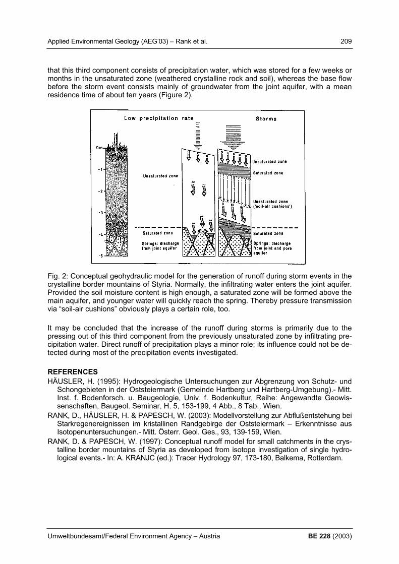
Applied Environmental Geology (AEG’03) – Rank et al. 209
Umweltbundesamt/Federal Environment Agency – Austria BE 228 (2003)
that this third component consists of precipitation water, which was stored for a few weeks or months in the unsaturated zone (weathered crystalline rock and soil), whereas the base flow before the storm event consists mainly of groundwater from the joint aquifer, with a mean residence time of about ten years (Figure 2).
Fig. 2: Conceptual geohydraulic model for the generation of runoff during storm events in the crystalline border mountains of Styria. Normally, the infiltrating water enters the joint aquifer. Provided the soil moisture content is high enough, a saturated zone will be formed above the main aquifer, and younger water will quickly reach the spring. Thereby pressure transmission via “soil-air cushions” obviously plays a certain role, too. It may be concluded that the increase of the runoff during storms is primarily due to the pressing out of this third component from the previously unsaturated zone by infiltrating pre-cipitation water. Direct runoff of precipitation plays a minor role; its influence could not be de-tected during most of the precipitation events investigated. REFERENCES HÄUSLER, H. (1995): Hydrogeologische Untersuchungen zur Abgrenzung von Schutz- und
Schongebieten in der Oststeiermark (Gemeinde Hartberg und Hartberg-Umgebung).- Mitt. Inst. f. Bodenforsch. u. Baugeologie, Univ. f. Bodenkultur, Reihe: Angewandte Geowis-senschaften, Baugeol. Seminar, H. 5, 153-199, 4 Abb., 8 Tab., Wien.
RANK, D., HÄUSLER, H. & PAPESCH, W. (2003): Modellvorstellung zur Abflußentstehung bei Starkregenereignissen im kristallinen Randgebirge der Oststeiermark – Erkenntnisse aus Isotopenuntersuchungen.- Mitt. Österr. Geol. Ges., 93, 139-159, Wien.
RANK, D. & PAPESCH, W. (1997): Conceptual runoff model for small catchments in the crys-talline border mountains of Styria as developed from isotope investigation of single hydro-logical events.- In: A. KRANJC (ed.): Tracer Hydrology 97, 173-180, Balkema, Rotterdam.

210 Applied Environmental Geology (AEG’03) – Reinstorf et al.
BE 228 (2003) Umweltbundesamt/Federal Environment Agency – Austria
CONCEPT FOR IMPROVING THE AREA-RELATION OF DATA FROM DEPOSITION NETWORKS IN GERMANY F. Reinstorf1), M. Binder2), W. Walther3), J. Bittersohl4), J. Hölscher5) & Jost Grimm-Strele6)
1) UFZ-Centre for Environmental Research Leipzig-Halle Ltd., [email protected]
2) RWTH Aachen University, Aachen 3) Dresden University of Technology, Dresden 4) Bavarian State Office for Water Management 5) District Government Braunschweig, Department for Water Management, Lower Saxony 6) State Office for Environmental Protection Baden-Württemberg, Stuttgart 1. INTRODUCTION Concerning protection and sustainable development of soils and waters, there is a growing need of management institu-tions for integrated and area related envi-ronmental information. The measure-ment of atmospheric deposition and sub-stance transport in soils and groundwater is carried out on the basis of sectoral measurement networks. Each network was designed without regard of the oth-ers. Therefore the measurement stations of the various networks are located inde-pendently, as well. Because of that, on behalf of the Länderarbeitsgemeinschaft Wasser (LAWA), methods should be checked, which can be used to link available information at various meas-urement points. The aim of a recent pro-ject was to find a method with maximum accuracy for regionalization of available measurement data from existing routine networks. Special networks from various institutions were supposed to be consid-ered. The project was initiated to exem-plify the procedure for the deposition networks in the Federal States Lower and Upper Saxony in Germany (Fig. 1). 2. MATERIAL Besides taking an inventory and a char-acterization of the available database, geostatistical and deterministic methods as well as atmospheric transport models, e.g. METRAS-MUSCAT, EMEP, EDACS have been evaluated with regard to their accuracy, which can be achieved under the given conditions and their practicability. The suitability of the methods was tested by objective methods. The time series for the validation are from 1995 to 1998. The data base consisted of weekly and monthly deposition data. The number of available measurement stations amounts to 76 in Lower Saxony and 24 in Upper Saxony. It can be seen that the sites are relatively homogeneous distributed over the states (Figure 1)
Fig. 1: Deposition measurement networks in Lower and Upper Saxony.
Lower Saxony
Upper Saxony
Observation Combined observation point Town 5 km radius
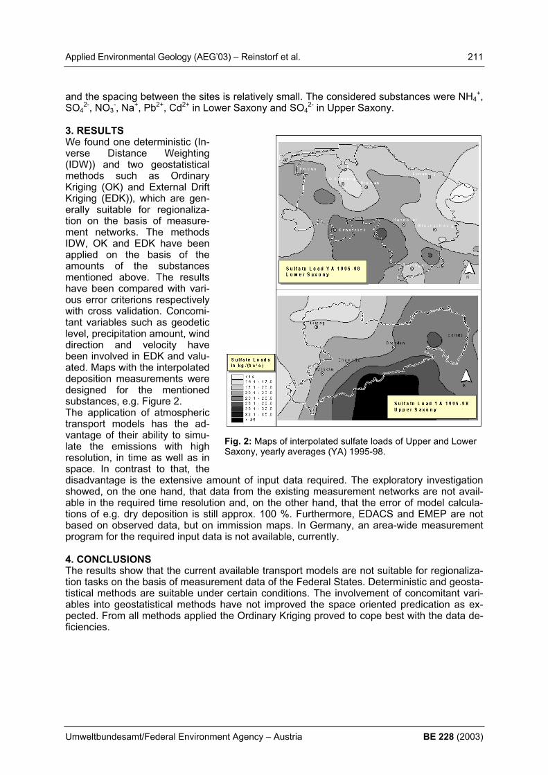
Applied Environmental Geology (AEG’03) – Reinstorf et al. 211
Umweltbundesamt/Federal Environment Agency – Austria BE 228 (2003)
Fig. 2: Maps of interpolated sulfate loads of Upper and Lower Saxony, yearly averages (YA) 1995-98.
and the spacing between the sites is relatively small. The considered substances were NH4+,
SO42-, NO3
-, Na+, Pb2+, Cd2+ in Lower Saxony and SO42- in Upper Saxony.
3. RESULTS We found one deterministic (In-verse Distance Weighting (IDW)) and two geostatistical methods such as Ordinary Kriging (OK) and External Drift Kriging (EDK)), which are gen-erally suitable for regionaliza-tion on the basis of measure-ment networks. The methods IDW, OK and EDK have been applied on the basis of the amounts of the substances mentioned above. The results have been compared with vari-ous error criterions respectively with cross validation. Concomi-tant variables such as geodetic level, precipitation amount, wind direction and velocity have been involved in EDK and valu-ated. Maps with the interpolated deposition measurements were designed for the mentioned substances, e.g. Figure 2. The application of atmospheric transport models has the ad-vantage of their ability to simu-late the emissions with high resolution, in time as well as in space. In contrast to that, the disadvantage is the extensive amount of input data required. The exploratory investigation showed, on the one hand, that data from the existing measurement networks are not avail-able in the required time resolution and, on the other hand, that the error of model calcula-tions of e.g. dry deposition is still approx. 100 %. Furthermore, EDACS and EMEP are not based on observed data, but on immission maps. In Germany, an area-wide measurement program for the required input data is not available, currently. 4. CONCLUSIONS The results show that the current available transport models are not suitable for regionaliza-tion tasks on the basis of measurement data of the Federal States. Deterministic and geosta-tistical methods are suitable under certain conditions. The involvement of concomitant vari-ables into geostatistical methods have not improved the space oriented predication as ex-pected. From all methods applied the Ordinary Kriging proved to cope best with the data de-ficiencies.

212 Applied Environmental Geology (AEG’03) – Riedl
BE 228 (2003) Umweltbundesamt/Federal Environment Agency – Austria
LANDSLIDES IN THE INNSBRUCK QUARTZPHYLLITE AND RELATED GEOTECHNICAL AND HYDROGEOLOGICAL PROBLEMS IN TUNNELLING F. Riedl
Institute of Geology and Palaeontology University of Innsbruck, Bruno Sanders Haus, Innrain
52, 6020 Innsbruck, Austria, [email protected] Summary In the Wattental SE of Innsbruck several landslides occur within the zone of the Innsbruck Quartzphyllite. Investigations are concentrated on one landslide that affects the southern-most part of a tunnel on the western side of the valley. The relation between movements in the tunnel and on the surface is investigated by using GPS-measurements, convergence-measurements, fissurometer-measurements and hydro-geological studies. 1. INTRODUCTION The Wattental is a south-trending, 30 km long side-valley of the Inn-Valley, about 15 km SE of Innsbruck. Rocks exposed in the northern part of Wattental belong to the Lower Austroal-pine tectonic unit termed “Innsbruck Quartzphyllite”. These phyllites are predominated for landslides, particularly where the pore water pressure is high and the gradient is steep. A Landslide also occurs near a NE striking fault zone, which is related to the seismically active Inntal-Störung (fault zone). The purpose of our investigations is: detailed geological mapping at a scale of 1:10.000 hydrological studies (water chemistry, el. conductivity, isotopic composition etc.) over one hydrological year detailed geotechnical mapping of the landslide above the tunnel area geotechnical measurements in the tunnel in order to prevent future failures 2. GEOLOGY The tectonic unit of the “Innsbruck Quartzphyllite” is composed of different sub-members consisting of quartz- and chlorite-phyllites, sericite-phyllites, greenschists containing carbon-ate (near the peak of Largoz), carbonate lenses composed of calcite marbles, porphyroides and meta-graywackes. At Malgrüblerkar tectonically embedded garnet-mica-schists occur. The structure of the investigated area is dominated by a ductile deformation characterized by different fold generations (D1, D2… according to Kolenprat et al. 1999). The brittle deformation is characterized by a NW-striking, a NE-striking and an EW-Striking fault system. The NE-striking fault is interpreted to be a Riedel fault of the sinistral “Inntal Störung (fault)”. The activity of the “Inntal Störung” is assumed to be related to the exhuma-tion of the Tauern window. Rocks of the Innsbruck Quartzphyllite are striking E-W, dipping towards N – NW in the southern part (Malgrüblerkar) and towards S in the northern part (Lar-goz). During the strong deformation along the E-W-striking faults caused the formation of “Kakirit”. One of these two E-W-striking faults is of special interest because the southern portal of the tunnel is situated at this fault. A main point of our investigations is the influence of this fault on the tunnel.
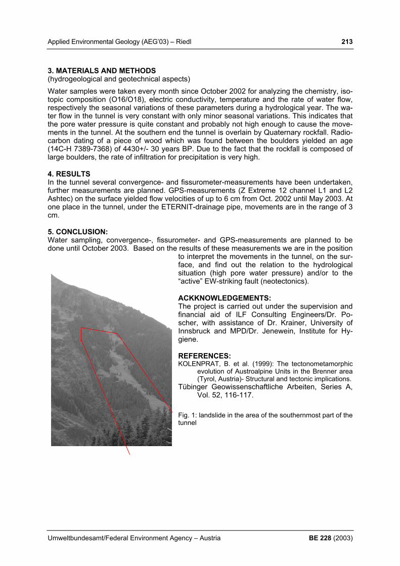
Applied Environmental Geology (AEG’03) – Riedl 213
Umweltbundesamt/Federal Environment Agency – Austria BE 228 (2003)
3. MATERIALS AND METHODS (hydrogeological and geotechnical aspects) Water samples were taken every month since October 2002 for analyzing the chemistry, iso-topic composition (O16/O18), electric conductivity, temperature and the rate of water flow, respectively the seasonal variations of these parameters during a hydrological year. The wa-ter flow in the tunnel is very constant with only minor seasonal variations. This indicates that the pore water pressure is quite constant and probably not high enough to cause the move-ments in the tunnel. At the southern end the tunnel is overlain by Quaternary rockfall. Radio-carbon dating of a piece of wood which was found between the boulders yielded an age (14C-H 7389-7368) of 4430+/- 30 years BP. Due to the fact that the rockfall is composed of large boulders, the rate of infiltration for precipitation is very high. 4. RESULTS In the tunnel several convergence- and fissurometer-measurements have been undertaken, further measurements are planned. GPS-measurements (Z Extreme 12 channel L1 and L2 Ashtec) on the surface yielded flow velocities of up to 6 cm from Oct. 2002 until May 2003. At one place in the tunnel, under the ETERNIT-drainage pipe, movements are in the range of 3 cm. 5. CONCLUSION: Water sampling, convergence-, fissurometer- and GPS-measurements are planned to be done until October 2003. Based on the results of these measurements we are in the position
to interpret the movements in the tunnel, on the sur-face, and find out the relation to the hydrological situation (high pore water pressure) and/or to the “active” EW-striking fault (neotectonics). ACKKNOWLEDGEMENTS: The project is carried out under the supervision and financial aid of ILF Consulting Engineers/Dr. Po-scher, with assistance of Dr. Krainer, University of Innsbruck and MPD/Dr. Jenewein, Institute for Hy-giene. REFERENCES: KOLENPRAT, B. et al. (1999): The tectonometamorphic
evolution of Austroalpine Units in the Brenner area (Tyrol, Austria)- Structural and tectonic implications.
Tübinger Geowissenschaftliche Arbeiten, Series A, Vol. 52, 116-117.
Fig. 1: landslide in the area of the southernmost part of the tunnel

214 Applied Environmental Geology (AEG’03) – Rutigliano et al.
BE 228 (2003) Umweltbundesamt/Federal Environment Agency – Austria
INVESTIGATION OF LANDSLIDE MOVEMENTS IN AN AREA OF HISTORICAL AND ARCHEOLOGICAL INTEREST P. Rutigliano1), F. Sdao2) & R. Frangioso2) 1) Telespazio Spa, Centro di Geodesia Spaziale ”G.Colombo”, 75100 – Matera, Italy 2) DiSGG - Università degli Studi della Basilicata, Campus di Macchia Romana - Potenza 1. INTRODUCTION The Italian Ministry of Education and Research (MIUR) financed a project for the study and the control of geological hazards in some sites belonging o the area of al “Parco Arche-ologico Storico Naturale delle Chiese Rupestri del Materano" near Matera, South Italy. These sites are part of the list of sites protect form the UNESCO. 2. GEOLOGICAL AND GEOMORPHOLOGICAL STUDIES The sites under investigations are localised along the border of some canyons (locally call “gravine”) deep more than 100 meters. The rock basement is represented by carbonate rocks characterized by lithological defects and intense fracturing that cause it's the cause of mass movements of blocks (rock falls, topples and rockslides) that could seriously damage
the fine rupestrian heritages present in the area. The potentially unstable car-bonate blocks have been defined by geological and geomorphologic surveys, with particular attention to the influence of the state of fractures of the blocks. To obtain this information some specific surveys have been carry out and the data have been analyzed following the method of MATHESON (1983, 1989) to obtain information about the principal di-rections of fracture sets and to define an index of relative pericolosity. To obtain precise information about the fractures behavior we analyzed in details some test sites as shown in Figure 1. In par-ticular in the definition of the test site we pay attention to the evidence of danger of disjunction of blocks and to the pres-ence of different systems of joint in the same site. In particular the analysis of the rose diagram at Belvedere delle Chiese Rupestri site shows the pres-ence of two principal direction of frac-tures: NE-SW e NW-SE, but other sys-tems of fractures, less important in terms of number and distribution, are
present. So the picture that comes out show a quite complicate situation, due to a combina-tions of effects, local effects due to the action of site phenomena but also the effects due to more complex tectonic activity of the entire geodynamic of the Murgian Block who these sites belong. The principal causes of instability in the analysed sites could be reported to two prin-cipal mechanisms: wedge failure or toppling of blocks. The responsibility of the first phenom-ena it’s principally due to the joint system oriented (dip direction/dip angle) N303°/63°, while the former is related to the other principal system oriented N259°/79° e 35°/74°. The other place under analysis is Iazzo dell’ Ofra. This site it’s quite far from the “Area delle Chiese Rupestri” but the litological characteristic of the bedrock are really similar to the one de-
Figure1: Map of site measurement for stability analysis and pericolosity map

Applied Environmental Geology (AEG’03) – Rutigliano et al. 215
Umweltbundesamt/Federal Environment Agency – Austria BE 228 (2003)
scribed previously. Once again looking at the rose diagram we obtain information about the presence of two principal trend of joints oriented NW-SE e NE-SW. From the spatial analysis of the distribution of the joints comes out that in this place the principal mechanism of block movements are due to plane wedge failure or topping of blocks, once again related to two different systems of joint orientation, N170°/70° the first, N62°/73° e N249°/76 the former. 3. MONITORING OF MASS MOVEMENTS PHENOMENA On the basis of the results obtained from the geological and geomorphological studies a network for the monitoring of the “Belvedere delle Chiese Rupestri” has been established. The monitoring is going on using an integrated approach: traditional survey systems, applica-tions based on the GPS technique and a deformation measurement system. The measure-ments using the three different techniques are repeated periodically (on monthly basis). Un-fortunately on the site of “Iazzo dell’ Ofra” has not been possible use the same approach.
The area of interest is charac-terized by a very irregular mor-phology and this not allows the use of traditional (optical based) method of survey and five a lot of problem for the use of GPS to. So for this area the only available results come from the ground deformation measurement system. In Fig-ure 2 is shown the distribution of the GPS and deformation stations in the “Belvedere delle Chiese Rupestri” area. From the first results we obtain in-formation about little, (millimet-ric) deformations in act on both the area under investigation. The measurements are still go-ing on and in the next future we could obtain more informa-tion about the mass move-ments.
REFERENCES MATHESON, G. D. (1983):
Rock stability assessment in preliminary site investigation – Graphical Methods. Transport and road research labora-tory report 1039.
MATHESON, G. D. (1989): The collection and the use of field discontinuity data in rock slope design. Q. J. Eng. Geol., 22, 19 - 30.
Calcare di AltamuraCalcarenite di Gravina(Upper Pliocene-LowerPleistocene)
Present-day alluvionaldeposits
Deformation measure-ment site
GPS station site
Rock fall scarp
Rock fall debris
Rock layer attitude
Geological and geomorphological map of the research site “Belvedere delle Chiese Rupestri” Ma-tera –Italy
Legend
Figure2: Map of dislocation of stations for the GPS and ground based measurement

216 Applied Environmental Geology (AEG’03) – Sager et al.
BE 228 (2003) Umweltbundesamt/Federal Environment Agency – Austria
EFFECT OF PLANT GROWTH AND ADDITION OF CHELATORS ON THE SPECIATION IN SOILS OBTAINED FROM SEQUENTIAL LEACHING M. Sager1), H.T. Chon2), S.Y. Lee3)
1) Austrian Agency for Health and Food Safety, Agricultural Research Vienna/Austria 2) Kwangju Institute of Science and Technology, Dept. of Environmental Science and Engi-
neering, Kwangju/ Korea 3) School of Civil, Urban and Geosystem Engineering, College of Engineering,Seoul Na-
tional University, Seoul/Korea
In a pot experiment, lettuce seedlings were grown on a calcareous soil from mine tailings, which was contaminated with Cd, Cu, Pb, Zn and As, and on a nearby farm soil. Compost, citric acid, malic acid, EDTA, NTA were added as complexants to promote phyto-extraction, as well as also NaCl and Na- citrate. The plants were harvested after 5, 10, and after 15 days. Top soil, root soil, base soil and clear soil were submitted to a Tessier-type sequential leaching procedure. Sequential leaching allows to discriminate exchangeables, weak-acid mobiles („carbonates“), hydroxylamine-leachables (Mn-oxides), oxalate leachables (Fe-oxides), H2O2 oxidizables (sulfides+ organics), and residuals. The nitrogen contents of roots and leaves indicated low nitrogen supply, except for the com-post series. P and available K were present at moderate levels. Sequential leaching of the original mine tailing samples revealed that the contaminant metals were already present in significant amounts within weathered phases. In the well aerated, but severely contaminated topsoils, the weak acid mobile fraction of many elements passed a maximum after 10 days of seedling growth (in alphabetical order: Ba; C, Cd, Co, Cu, K, Mg, Mn, Na, S, Sr, Zn). On the other hand, there were remarkable changes with respect to the operationally defined pedogenic oxides (Fe-Mn-Al oxides), more pronounced in root than in top soils. The oxalate leachable fractions were significantly lowered both in topsoil and root soil, which can be attributed to the dissolution of pedogenic oxides by root exudates. Similar effects were also seen within a non-calcareous farm soil of moderate pollution level, which was significantly higher in available K., but at the same low P-level. With respect to main adsorbent phases and nutrient P, root growth promoted the transforma-tion of Fe from the oxalate-leachable to the more readily available hydroxylamine-leachable form, as well as residual Fe and P to the organic/ sulfidic fraction. The addition of complex-ants retarded these effects. Further on, some complexants promoted the transfer of the con-taminants within the green plant from the root to the lettuce leaves. During plant growth, slowly available fractions of e.g. phosphorus, steadily decline, whereas the level of the read-ily available fractions is kept rather constant. The influence of the added substances on the microbial soil life and the action of the
rhizosphere is discussed.
Applied Environmental Geology (AEG’03) – Sager 217
Umweltbundesamt/Federal Environment Agency – Austria BE 228 (2003)
CHARACTERISATION OF FERTILIZERS AND RELATED SUB-STANCES BY MULTI-ELEMENT ANALYSIS M. Sager Austrian Agency for Health and Food Safety, and Federal Office for Food Safety, Agricultural Research Vienna, Spargelfeldstraße 191, A – 1226 Wien, [email protected] 1. SCOPE Utilization of a simultaneously reading Optical Emission ICP enables to obtain data from main and trace elements from less than 4 ml of sample digest, without additional efforts. The number of elements to be reasonably determined is limited due to detection limits, possible volatilization during digestion, possible contamination and blanks, as well incomplete dissolu-tion. The screening program covers the elements (in alphabetical order) Al, As, B, Ba, Be, Ca, Cd, Co, Cr, Cu, Fe, K, Li, Na, Ni, P, Pb, Sr, Tl, V, and Zn. Sn and Sb as well as the lan-thanides are not read because of possibly incomplete dissolution. Sulfur is too high, and se-lenium is too low for the levels usually encountered. Low boron data may be biased by blanks. The main advantages over atomic absorption measurements are the traceability in case of samples have been unintentionously exchanged, and to screen also for elements which are usually not looked at, like unexpected contaminants (As, Be, Tl, V). Sometimes, some additives have been found, which have been forgotten to be mentioned at the label. ICP-data have been compiled since 1997, and assorted due to their contents of nutritional elements NPK and organic carbon. This database should yield the expected concentration range for further samples, in order to judge, whether the composition of an unknown sample is typical for what it is labelled for, or not. This database covers much more parameters than which are needed to judge about the threshold values of the current valid fertilizer act. In some cases, the concentration ranges of the current database can be compared with a set of data obtained 1986-1994, the time before Austria joined the European Union. 2. MATERIAL AND METHODS Mineral fertilizers were dissolved in 2M – HCl, and the residue was dry – ashed in a muffle furnace for 2 hours at 580°. Organic fertilizers were dry ashed, and the ash dissolved in nitric or hydrochloric acid. For calibration, 6 multi- element calibration solutions were used, con-taining a realistic mix of main and trace elements, to simulate the approximate salt contents of the matrix. As, B, Cd, Co, Cr, Fe, Mg, Mn, Na, and Zn were measured at 2 lines simulta-neously. Some lines are interfered at high Fe, and others at high Ca/Mg levels. Final data were selected to be near the calibration points, and at the non- interfered lines. For statistical treatment, data below detection limits have been put to zero. 3. RESULTS Usually, 3 measurements of one sample solution (undiluted, 1+4 and 1+24 diluted) are suffi-cient to cover the normal range of main and trace elements, and to control dilution as well as matrix effects. Spectral interferences may be recognized, if 2 analytical lines yield signifi-cantly different results. The validity of results has been checked by flame-AAS measure-ments from the same sample solution, as well as from digestions independently done. With respect to mean crust contents, B, Cd, and Mo are generally enriched in fertilizers, whereas Ba, Be, Co, Li, Ni, and Pb are found at lower levels. K-only and N-only fertilizers are usually very poor in trace metals („heavy metals“). The concentration range of impurities pre-sent in naturally occurring phosphates was found to be lower than for technical ammonium phosphates, and nitrate-phosphate mixtures. Basic slags contain significantly more Cd, Cr, Mn and V than usual soils. Super and triple phosphates contan more Cd, Cr. Compared with the period 1986-94, Cd and Ni tend to be lower in NPK mineral fertilizers, and Cr tends to be much lower in basic slags. To the contrary, in super- and triple phosphates the median of Cd, Cr, and Zn has risen.
218 Applied Environmental Geology (AEG’03) – Sappa et al.
BE 228 (2003) Umweltbundesamt/Federal Environment Agency – Austria
MULTISYSTEM APPROACH FOR THE IDENTIFICATION OF RECHARGE AREAS IN KARSTIC AQUIFERS
G. Sappa, L. Tulipano & C. Di Fiore
[email protected], Department of Hydraulic, Transportation and Roads - Univer-sity of Rome “La Sapienza”
Groundwater protection is one of the main topics in environmental applied hydrogeology. As a matter of fact groundwatwer in most part of Europe and all over of world is the most impor-tant water resource for supply civil water networks. This paper presents a multisystem ap-proach set up by the authors in the aim of design the main recharge areas of karstic aquifers. As it is known the identification of recharge areas is one of the main goals in land use plan-ning activity. The approach, we propose, is oriented to identify these important areas, which are due to be identified in the aim of protect groundwater. We have named it multisystem ap-proach because it is based as on direct physical criteria, as on chemical ones. In this paper we present the method and one of the most recent successful applications of it. This method is based on the evaluation of the annual average recharge over a feeding basin of a number of springs, and on the interpretation of isotopic composition of many groundwater water sam-ples. On the first, infact, it is applied the hydrogeological inverse budget method (Civita M., 1999), to evaluate the average annual infiltration on the basin, after having splitted the area under study in Square Cells (EFQ) of 250 meters side length in order to calculate for each of them the annual average recharge. The amount of the recharge all over the basin has to be given by adding up the recharge of every cell. The second step regards the effort to define the recharge areas elevation by the application of environmental stable isotopes like D and 18O data of some samples of groundwater com-ing out from springs of the area under study. The elevation effect for these isotopes devia-tion evaluation is taken in account following the results coming from many studies (Bortolami C., 1978) applied in many studies as an effective tool in tracing groundwater recharge, and in our case study we have chosen the equations which estimate the depleting of the D in 0.31 ‰ and of 18O in 2.5 ‰ every 100 m, which are considered typical for the area under study. To apply these equations it should be known the isotopic composition of precipitation, but it is very hard to obtain this datum, as the only isotopic known composition is relative to sampled springs water; whiche are on the whole at the bottom of the basin. On the contrary to identify the recharge area it is necessary to know the isotopic depletion more or less at the top of it. As a matter of fact we have introduced a virtual, statistic point, where it could be considered concetrated the whole infiltration all over the basin. The identification of this point comes from the application, first, of hydrogeological inverse budget method which make us able to set up the distribution of the infiltration all over the basin, splitted in meshes, and to identify the ar-eas where it is a maximum of this infiltration. On the other hand this method let we apply a criterium like the one coming from the solid mechanics, by which it is possible to consider all the weight of a solid in one point, named mass center. By this way the central infiltration point is the one we could consider where the infiltration of the whole basin is concentrated and its elevation is the known data for the application of the depleting equation. This method has been applied to many aquifers in central Italy and in this paper they are dealt with the results of application to the Ceraso, Cesa degli Angeli, Pantano Alta, and Carpinetto springs which present the largest debit coming out from the Simbruini Mountains aquifer. Simbruini Mountains, are part of the latial-abruzzese Apennine. This area is W-SW limited by the valley of the Aniene river, the Liri valley is the border to the East side, the North is marked by Piana del Cavaliere and Piana di Carsoli, the South by Granara valley-Valico S. Antonio Canistro alignment. The geological importance of this unit comes from its being nord-west boarded by the regional “Olevano-Antrodoco” master fault . Its characteristic is that the carbonatic formation arises almost everywhere, except in Vallepietra-Filettino and

Applied Environmental Geology (AEG’03) – Sappa et al. 219
Umweltbundesamt/Federal Environment Agency – Austria BE 228 (2003)
Guarcino-Trisulti where a dolomitic basament arises. The Simbruini Mountains massif is strongly eterogeneous and without any kind of intercalation limestones and dolomitic limestones sequence, made up of six main volume elements in tectonic superimposition with different litho-bio-stratigraphic characteristics. The whole mass is crossed by numerous longitudinal dislocations and by an intense oblique tectonic, as well as five main share surfaces quite inclined, with an approximately longitudinal course with respect to the Apenninic main lines which separate the elements. The Simbruini stratigraphic series is made of a 4000 m carbonate sequence, continuously deposited from the early Triassic to the early Cretaceous. The relative lithofacies have been related to the spatial and temporal evolution of internal carbonatic platform environments. Except for some little changes in the sea level occurred during the late Lias, which caused some localised arisements, in the remaining part of the Jurassic and the later Cretacic, the paleogeographic conditions remained quite constant, with just few variations. The main chemistral properties of these waters come from the fact that they flow in the Simbruini-Ernici - M. Cairo carbonatic unit. They show the complex underground circulation that takes place in these rocks. The carbonatic structure, and sometimes the dolomitc one, are actually important under-ground reservoirs. From these places groundwaterwater flows down to the general drainage axis of the area, that is represented by the Aniene valley. The waterflow is mainly due to a variable secondary permeability by fissures improved by karstic processes, while the primary permeability, due to porosity, is very, very low. We have many hydrogeological studies deal-ing with these springs characterization, but just during the last years we started to analyse the geochemical properties of the waters coming out from these springs. The application of the method mentioned before let us able to design the main recharge ar-eas, as in carbonatic karstic aquifers this practice is sometimes possible to do.
REFERENCES BORTOLAMI G.C., RICCI.B., SUZELLA G.F, ZUPPI G.M. (1978)- Isotope hydrology of the Val Cor-
saglia, maritime Alps, Piedmont, Italy. Isotope Hydrology, IAEA, Vienna. BONI C., BONO P., CAPELLI G.(1988)- Carta idrogeologica del territorio della Regione Lazio. Regio-
ne Lazio, Università degli studi “La Sapienza”, Roma. CIVITA M., DE MAIO M., VIGNA B (1999)- Una metodologia GIS per la valutazione della Ricarica At-
tiva degli Acquiferi. Atti del 3° convegno nazionale sulla protezione delle acque sotterranee per il III millennio. Roma 13-15 ottobre 1999.
FIDELIBUS M.D. (1997)- Il Ruolo della geochimica nella risoluzione di complesse problematiche idro-geologiche. Seminario, CE.RI.S.T.-C.N.R-Bari.
SAPPA G. (1999)- Metodi di tracciamento ambientale. Dipartimento di Idraulica, Trasporti e Strade- Università degli studi di Roma “La Sapienza”, Facoltà di Ingegneria.
TULIPANO L. (2000)- Dispense del corso di Idrogeologia Applicata. Università degli studi di Roma “La Sapienza”, Facoltà di Ingegneria.
VENTRIGLIA U. (1990)- Idrogeologia della provincia di Roma IV Volume Regione Orientale. Ammini-strazione Provinciale di Roma, Assessorato LL.PP. Viabilità e trasporti.
MANFREDINI M. (1986)- Caratteristiche Idrogeologiche della sorgente Ceraso presso Trevi nel Lazio (Frosinone). Acquedotto del Simbrivio.
PATRIZI G.(1976)- Relazione geologica sorgente “Ceraso”. Acquedotto del Simbrivio. PATRIZI G.(1979)- Relazione geologica sorgente “Ceraso”. Acquedotto del Simbrivio. PENTA F. (1956)- Indagini nella zona delle sorgenti del Simbrivio. Istituto di giacimenti minerari e geo-
logia applicata, Università di Roma. IPPOLITO F. (1945)- Relazione geologica sulla sorgente Ceraso. Istituto di Geologia applicata e di Ar-
te mineraria, Università di Napoli. IPPOLITO F. (1955)- Relazione geologica sulle sorgenti Pantano, Carpinetto e Cornetto. Istituto di
Geologia applicata e di Arte mineraria, Università di Napoli. LIPERI L, ERCOLI L (1983)- Studio idrogeologico della sorgente “Cornetto” ubicata nel bacino del
Torrente Simbrivio in prossimità dell’abitato di Vallepietra (Provincia di Roma). Ufficio Geologico-Tecnic o dell’Amministrazione Provinciale di Roma.
ESU F. (1959)- Relazione geologico-tecnica sui lavori eseguiti ed in corso alle sorgenti del Pantano. Consorzio Acquedottistico del Simbrivio.

220 Applied Environmental Geology (AEG’03) – Scharf et al.
BE 228 (2003) Umweltbundesamt/Federal Environment Agency – Austria
ORGANIC MICROPOLLUTANTS AND PHARMACEUTICALS IN SEDIMENTS AND SUSPENDED MATTER OF THE RIVER DANUBE (AUSTRIA)
S. Scharf1), S. Loos1), O. Gans1) & W. Moche1)
1) Umweltbundesamt Austria (Federal Environment Agency), Vienna, Spittelauer Laende 5,
[email protected] 1. INTRODUCTION In connection with ICPDR (International Commission for the Protection of Danube River) and Joint Danube Survey 2001- the Austrian Federal Environment Agency (UBA) and the Insti-tute for Water Quality and Waste Management (IWAG) elaborated a programme for sampling the Austrian stretch of the River Danube from 16.08. to 20.08.2001 between Engelhartszell and Hainburg (KREUZINGER et. al, 2001; LITERATHY et al., 2002). Samples were taken from sediments at 7 points of the River Danube, and at one site in the estuary of the River Schwechat, a major tributary discharging downstream of Vienna. Additionally, two samples of suspended matter were taken in the upper region of the Danube (sampling points see Tab. 1 and 2). The Umweltbundesamt (Federal Environment Agency) analyzed organic micropollut-ants, in particular hydrocarbons, polycyclic aromatic hydrocarbons (PAH), linear alkylben-zenesulfonates (LAS), alkylphenolethoxylates (APEOs), selected endocrine modulators, brominated flame retardants (PBDEs), and specific pharmaceuticals. Several parameters were determined for the first time in Austria, since acculmulations take place and sediments represent the memory regarding the contamination of a water body. Tab. 1: Description of the sampling-points for sediments
Danube km Sampling Point describtion Sampling date JDS Point
2165 Aschach upstream hydropower plant 16.08.2001 JDS 07
2120 Asten upstream hydropower plant 17.08.2001 JDS 08
2095 Wallsee upstream hydropower plant 17.08.2001 JDS 09
2061 Ybbs upstream hydropower plant 17.08.2001 JDS 10
1950 Greifenstein upstream hydropower plant 18.08.2001 JDS 11
1942 Klosterneuburg downstream cable ferry 18.08.2001 JDS 12
1913 River Schwechat estuary 20.08.2001 JDS 13
1895 Wildungsmauer near the water police station 20.08.2001 JDS 14
Tab. 2: Describtion of the sampling-points for suspended matter
Danube km designation Sampling-point Sampling-date JDS point 2202-2165 suspended matter 1 Engelhartszell
to Aschach 16.08.2001 JDS 06-07
2061-2030 suspended matter 2 Ybbs Persenbeug to Melk 17.08.2001 JDS 10
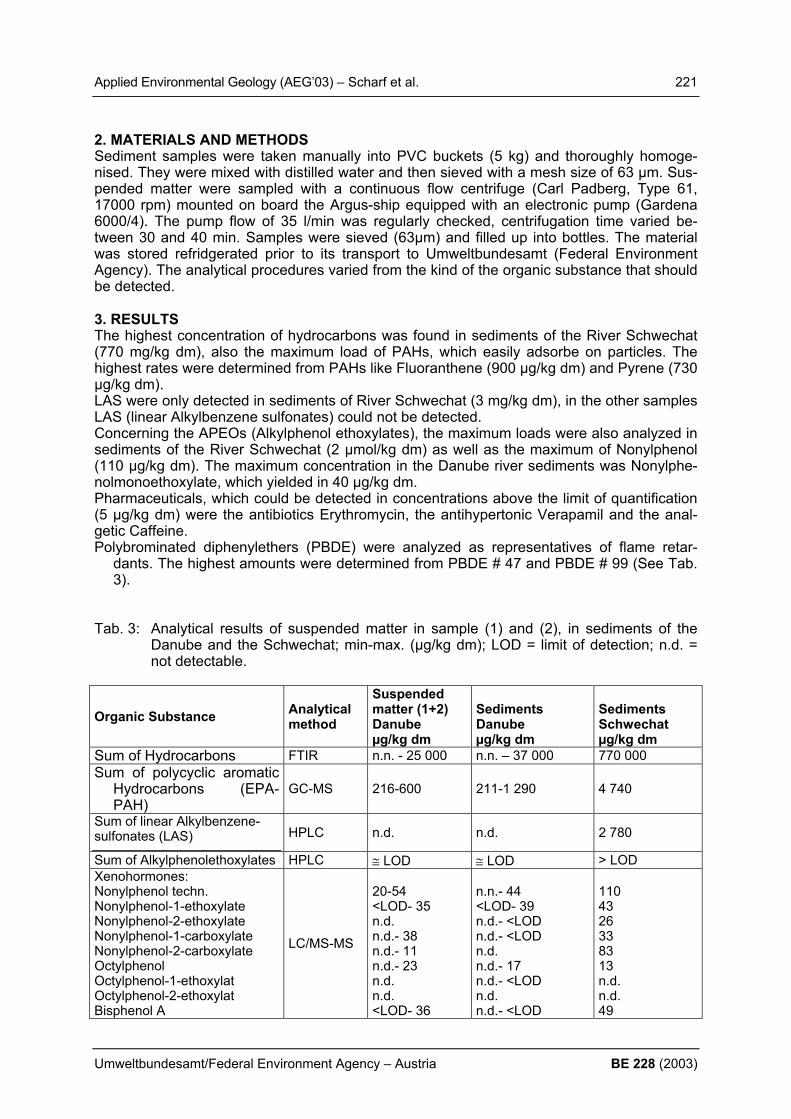
Applied Environmental Geology (AEG’03) – Scharf et al. 221
Umweltbundesamt/Federal Environment Agency – Austria BE 228 (2003)
2. MATERIALS AND METHODS Sediment samples were taken manually into PVC buckets (5 kg) and thoroughly homoge-nised. They were mixed with distilled water and then sieved with a mesh size of 63 µm. Sus-pended matter were sampled with a continuous flow centrifuge (Carl Padberg, Type 61, 17000 rpm) mounted on board the Argus-ship equipped with an electronic pump (Gardena 6000/4). The pump flow of 35 l/min was regularly checked, centrifugation time varied be-tween 30 and 40 min. Samples were sieved (63µm) and filled up into bottles. The material was stored refridgerated prior to its transport to Umweltbundesamt (Federal Environment Agency). The analytical procedures varied from the kind of the organic substance that should be detected. 3. RESULTS The highest concentration of hydrocarbons was found in sediments of the River Schwechat (770 mg/kg dm), also the maximum load of PAHs, which easily adsorbe on particles. The highest rates were determined from PAHs like Fluoranthene (900 µg/kg dm) and Pyrene (730 µg/kg dm). LAS were only detected in sediments of River Schwechat (3 mg/kg dm), in the other samples LAS (linear Alkylbenzene sulfonates) could not be detected. Concerning the APEOs (Alkylphenol ethoxylates), the maximum loads were also analyzed in sediments of the River Schwechat (2 µmol/kg dm) as well as the maximum of Nonylphenol (110 µg/kg dm). The maximum concentration in the Danube river sediments was Nonylphe-nolmonoethoxylate, which yielded in 40 µg/kg dm. Pharmaceuticals, which could be detected in concentrations above the limit of quantification (5 µg/kg dm) were the antibiotics Erythromycin, the antihypertonic Verapamil and the anal-getic Caffeine. Polybrominated diphenylethers (PBDE) were analyzed as representatives of flame retar-
dants. The highest amounts were determined from PBDE # 47 and PBDE # 99 (See Tab. 3).
Tab. 3: Analytical results of suspended matter in sample (1) and (2), in sediments of the
Danube and the Schwechat; min-max. (µg/kg dm); LOD = limit of detection; n.d. = not detectable.
Organic Substance Analytical method
Suspended matter (1+2) Danube µg/kg dm
Sediments Danube µg/kg dm
Sediments Schwechat µg/kg dm
Sum of Hydrocarbons FTIR n.n. - 25 000 n.n. – 37 000 770 000 Sum of polycyclic aromatic
Hydrocarbons (EPA-PAH)
GC-MS 216-600 211-1 290 4 740
Sum of linear Alkylbenzene-sulfonates (LAS) HPLC n.d. n.d. 2 780
Sum of Alkylphenolethoxylates HPLC ≅ LOD ≅ LOD > LOD Xenohormones: Nonylphenol techn. Nonylphenol-1-ethoxylate Nonylphenol-2-ethoxylate Nonylphenol-1-carboxylate Nonylphenol-2-carboxylate Octylphenol Octylphenol-1-ethoxylat Octylphenol-2-ethoxylat Bisphenol A
LC/MS-MS
20-54 <LOD- 35 n.d. n.d.- 38 n.d.- 11 n.d.- 23 n.d. n.d. <LOD- 36
n.n.- 44 <LOD- 39 n.d.- <LOD n.d.- <LOD n.d. n.d.- 17 n.d.- <LOD n.d. n.d.- <LOD
110 43 26 33 83 13 n.d. n.d. 49
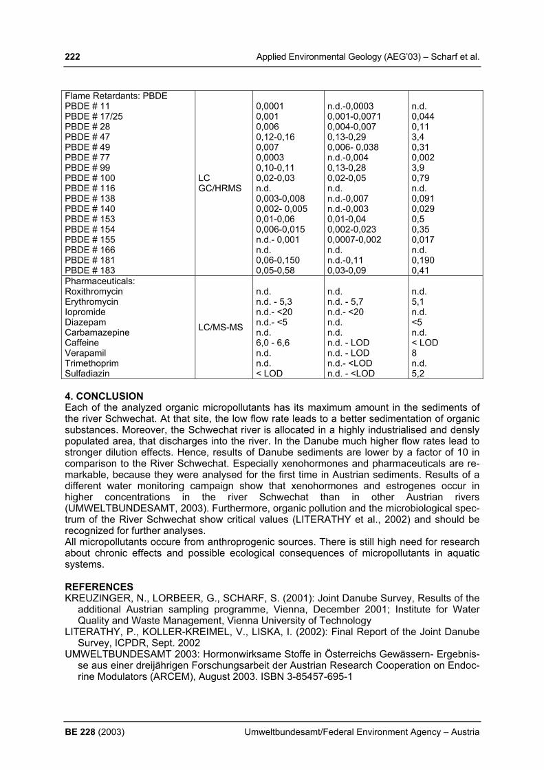
222 Applied Environmental Geology (AEG’03) – Scharf et al.
BE 228 (2003) Umweltbundesamt/Federal Environment Agency – Austria
Flame Retardants: PBDE PBDE # 11 PBDE # 17/25 PBDE # 28 PBDE # 47 PBDE # 49 PBDE # 77 PBDE # 99 PBDE # 100 PBDE # 116 PBDE # 138 PBDE # 140 PBDE # 153 PBDE # 154 PBDE # 155 PBDE # 166 PBDE # 181 PBDE # 183
LC GC/HRMS
0,0001 0,001 0,006 0,12-0,16 0,007 0,0003 0,10-0,11 0,02-0,03 n.d. 0,003-0,008 0,002- 0,005 0,01-0,06 0,006-0,015 n.d.- 0,001 n.d. 0,06-0,150 0,05-0,58
n.d.-0,0003 0,001-0,0071 0,004-0,007 0,13-0,29 0,006- 0,038 n.d.-0,004 0,13-0,28 0,02-0,05 n.d. n.d.-0,007 n.d.-0,003 0,01-0,04 0,002-0,023 0,0007-0,002 n.d. n.d.-0,11 0,03-0,09
n.d. 0,044 0,11 3,4 0,31 0,002 3,9 0,79 n.d. 0,091 0,029 0,5 0,35 0,017 n.d. 0,190 0,41
Pharmaceuticals: Roxithromycin Erythromycin Iopromide Diazepam Carbamazepine Caffeine Verapamil Trimethoprim Sulfadiazin
LC/MS-MS
n.d. n.d. - 5,3 n.d.- <20 n.d.- <5 n.d. 6,0 - 6,6 n.d. n.d. < LOD
n.d. n.d. - 5,7 n.d.- <20 n.d. n.d. n.d. - LOD n.d. - LOD n.d.- <LOD n.d. - <LOD
n.d. 5,1 n.d. <5 n.d. < LOD 8 n.d. 5,2
4. CONCLUSION Each of the analyzed organic micropollutants has its maximum amount in the sediments of the river Schwechat. At that site, the low flow rate leads to a better sedimentation of organic substances. Moreover, the Schwechat river is allocated in a highly industrialised and densly populated area, that discharges into the river. In the Danube much higher flow rates lead to stronger dilution effects. Hence, results of Danube sediments are lower by a factor of 10 in comparison to the River Schwechat. Especially xenohormones and pharmaceuticals are re-markable, because they were analysed for the first time in Austrian sediments. Results of a different water monitoring campaign show that xenohormones and estrogenes occur in higher concentrations in the river Schwechat than in other Austrian rivers (UMWELTBUNDESAMT, 2003). Furthermore, organic pollution and the microbiological spec-trum of the River Schwechat show critical values (LITERATHY et al., 2002) and should be recognized for further analyses. All micropollutants occure from anthroprogenic sources. There is still high need for research about chronic effects and possible ecological consequences of micropollutants in aquatic systems. REFERENCES KREUZINGER, N., LORBEER, G., SCHARF, S. (2001): Joint Danube Survey, Results of the
additional Austrian sampling programme, Vienna, December 2001; Institute for Water Quality and Waste Management, Vienna University of Technology
LITERATHY, P., KOLLER-KREIMEL, V., LISKA, I. (2002): Final Report of the Joint Danube Survey, ICPDR, Sept. 2002
UMWELTBUNDESAMT 2003: Hormonwirksame Stoffe in Österreichs Gewässern- Ergebnis-se aus einer dreijährigen Forschungsarbeit der Austrian Research Cooperation on Endoc-rine Modulators (ARCEM), August 2003. ISBN 3-85457-695-1

Applied Environmental Geology (AEG’03) – Schubert 223
Umweltbundesamt/Federal Environment Agency – Austria BE 228 (2003)
DISCRIMINATION OF GROUNDWATERS BY HYDROCHEMISTRY - SOME EXAMPLES G. Schubert Geological Survey of Austria, Vienna A detailed interpretation of hydrochemical data can provide valuable information on the genesis of groundwater - in addition to the knowledge of the geological structure, the hydrau-lic situation, isotope data etc. However, frequently in hydrogeological projects hydrochemical data are not interpreted accordingly and therefore this information remains unused. The poster brings selected examples which demonstrate the possible hydeogeological conclu-siveness of hydrochemical routine analyses. Special attention is given to a type of diagrams which is not common on the field of hydro-geology, although in certain cases it would be more conclusive than other discrimination dia-grams. These diagrams are XY-diagrams where the X-axes show the total dissolved content in meq/l and the Y-axes the concentrations of the individual dissolved ions in meq/l etc. They are able to discriminate different groundwater types as well as they can show mixing lines and trends of hydrochemical evolution. In another branch of geosciences this type of dia-grams is very common: On the field of magmatic petrology they are used to analyse evolu-tion paths and mixing lines since several decades. On the model of these so called HARKER-diagrams the author used this type of diagrams on the field of hydrogeology. These XY-diagrams can not only be used to compare hydrochemical data of different obser-vation points but also to interpret a hydrochemical measuring series of a single spring or well. The following XY-diagrams (fig. 1 and 2) deliver an example from the Obermarkersdorf Ba-sin, a small Tertiary basin 65 km northwest of Vienna. They show hydrochemical data of a well in Waitzendorf. During the observation this well was characterized by a high variability of the specific electrical conductivity, pH etc. The XY-diagrams show that this was certainly a result of mixing of two different waters. It could not be the result of a solution path because the log pCO2 increased with growing total dissolved content (fig. 2).
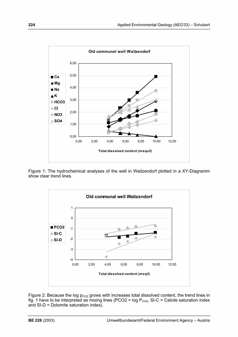
224 Applied Environmental Geology (AEG’03) – Schubert
BE 228 (2003) Umweltbundesamt/Federal Environment Agency – Austria
Old communal well Waitzendorf
0,00
1,00
2,00
3,00
4,00
5,00
6,00
0,00 2,00 4,00 6,00 8,00 10,00 12,00
Total dissolved content (mequ/l)
CaMgNaKHCO3ClNO3SO4
Figure 1: The hydrochemical analyses of the well in Waitzendorf plotted in a XY-Diagramm show clear trend lines.
Old communal well Waitzendorf
-4
-3
-2
-1
0
1
0,00 2,00 4,00 6,00 8,00 10,00 12,00
Total dissolved content (meq/l)
PCO2SI-CSI-D
Figure 2: Because the log pCO2 grows with increases total dissolved content, the trend lines in fig. 1 have to be interpreted as mixing lines (PCO2 = log PCO2, SI-C = Calcite saturation index and SI-D = Dolomite saturation index).

Applied Environmental Geology (AEG’03) – Schubert 225
Umweltbundesamt/Federal Environment Agency – Austria BE 228 (2003)
The poster brings some more examples from hydrogeological studies in Austria: In the Obermarkersdorf Basin also the waters of different groundwater horizons could be distin-guished by hydrochemistry. In the Dachstein region (Northern Calcareous Alps) the waters of two different aquifers could be characterized in the same way. A further example points out the hydrochemical differences between two types of thermal water in the Gastein region (Salzburg). In the last example two sulphate dominated mineral waters in the surrounding of Brixlegg (Tyrol) are discriminated by hydrochemistry. REFERENCES CUDRIGH, S. F. 2002: Die Wasserwegigkeit des Gasteiner Thermalwassersystems unter
Berücksichtigung der Strukturgeologie und im Vergleich zum Thermalsystem Lend. – Dip-lomarbeit, University Salzburg.
PAPESCH, W., RANK, D., SCHUBERT, G. & TESCH, R. 1999: Isotopenhydrologie des O-bermarkersdorfer Beckens. Vorläufige Ergebnisse. – In: ROETZEL, R. (Red.), Arbeitsta-gung Geologische Bundesanstalt 1999. Geologische Karten ÖK 9 Retz und ÖK 22 Holla-brunn. Geogenes Naturraumpotential der Bezirke Horn und Hollabrunn, 179-182, Geolo-gical Survey, Vienna.
SCHUBERT, G. & HEIM, N. 1997: Ausbau Eisenbahnachse Brenner München-Verona. Teil-projekt Zulaufstrecke Nord. Abschnitt Kundl/Radfeld-Baumkirchen. UVE: Schutzgut Was-ser. Weiterführende Unterlagen: Grund- und Bergwasser. Fachbericht W4. Hydrogeologie der Talflanken. Km 21.00-40.20. – unpublished report of the Geological Survey for the BEG Brenner Eisenbahn Gesellschaft, 203 p., Innsbruck.
SCHUBERT, G. 1999: Zu den hydrogeologischen Verhältnissen im Obermarkersdorfer Be-cken. – In: ROETZEL, R. (Red.), Arbeitstagung Geologische Bundesanstalt 1999. Geolo-gische Karten ÖK 9 Retz und ÖK 22 Hollabrunn. Geogenes Naturraumpotential der Bezir-ke Horn und Hollabrunn, 171-178, Geological Survey, Vienna.
SCHUBERT, G. 2000: Water Ressources - Drinking Water. - In: NEUBAUER, F. & HÖCK, V. (Red.), Aspects of Geology in Austria. – Mitt. Geol. Ges., 92, 295-311, Vienna.
SCHUBERT, G. 2001: Zur Diskriminierung von Grundwasserkörpern mithilfe der Hydroche-mie und Isotopenhydrologie (H-3, C-14, O-18 und S-34). – Proceedings PANGEO AUSTRIA I, Salzburg.
SCHUBERT, G. 2002: Hydrogeologie des Dachsteinmassivs. – In: SCHEIDLEDER, A. (Red.), Pilotprojekt "Karstwasser Dachstein". Band 2: Karsthydrologie und Kontaminati-onsrisiko. - Monographien, 108, 111-125, Federal Environment Agency, Vienna and Ar-chiv für Lagerstättenforschung, 21, 111-125, Geological Survey, Vienna.

226 Applied Environmental Geology (AEG’03) – Schulze et al.
BE 228 (2003) Umweltbundesamt/Federal Environment Agency – Austria
DEVELOPMENT OF A STANDARD OPERATING PROCEDURE "SEDIMENTS AND SUSPENDED PARTICULARLY MATTER" FOR THE GERMAN ENVIRONMENTAL SPECIMEN BANK T. Schulze1), M. Ricking1), A. Winkler1; A. Pekdeger1), A. Körner2) & C. Schlüter2) 1) Free University of Berlin, Dep. of Earth Sciences, Environmental Geochemistry & Hydro-
geology, Malteserstr. 74-100, 12249 Berlin (Germany), Email: [email protected] 2) German Federal Environmental Agency (Umweltbundesamt), UBA-FG II 1.4, Bismarck-
platz 1, 14193 Berlin (Germany) 1. INTRODUCTION The German Environmental Specimen Bank (ESB) is an archive of ecological representative environmental samples (e.g. soils, animals, and plants) from different representative terres-trial and aquatic sampling sites in Germany. It is part of environmental observation in Ger-many (UBA 2003). The ESB serves to recognize impending undesirable developments in ecosystems, to identify the nature and extent of any deficiencies and of their consequences (damages), and to supply knowledge for establishing policy priorities and precautionary pol-icy. Obligatory standard operating procedures (SOP) provide a high quality assurance sys-tem for the sampling, handling, storage, and analyses of the specimens. The greatest poten-tial of the ESB is the possibility to achieve retrospective monitoring to detect substances or their metabolites, which were unknown, not detectable, or neglected at the time of their input to the ecosystems (RÜDEL et al. 2003; UBA 2003). The aim of this study is to develop a SOP for the collection of sediments and suspended particularly matter (SPM) at the 13 fluvial and limnic sampling locations of the ESB. Sediments and SPM are important compartments of aquatic ecosystems and have functions as sink, transportation medium, and source of in-organic and organic pollutants in dependence of the hydrological and hydrochemical condi-tions. Hence, they provide records of particularly bound pollutants and their metabolites. 2. MATERIALS AND METHODS The collection of samples for storage in the ESB has to meet generally qualifiers. (1) The sampling should be frozen as soon as possible by liquid nitrogen and must not defrosted by transportation, handling, and storage to preserve any aging and lost of information. (2) The sampling methods should provide sufficient sediment and SPM material for the long-term storage of the specimen. Freeze coring devices (RICKING & SCHULZE 2003) are applied for the sampling of sediment cores to meet the requirements of the ESB. The freeze coring sys-tems are not practicable at all collection sites, because of hydrological and sedimentological reasons. At this sites piston corers are applied. There are different systems used for sam-pling SPM in Germany (LAWA 1998). Mobile passive sedimentation boxes (SB) are com-pared with a centrifuge PADBERG Z61 (Padberg, Lahr, Germany) for applicability. The threshold is to sample at least 2 kg of SPM for storage. 3. RESULTS First results show, that freeze coring devices are applicable at the most fluvial sampling sites of the ESB to collect sediment samples. The sampling site Lower Elbe (Hamburg, Germany) has tidal influence and the sediments are very silty. At that side a Kullenberg piston must be used. The centrifuge has more efficiency in separation fine SPM particles from water com-pared to the SB’s. Nevertheless, it needs much more time to sample the necessary quantity of SPM, because of low capacity of the centrifuge compared to the SB.

Applied Environmental Geology (AEG’03) – Schulze et al. 227
Umweltbundesamt/Federal Environment Agency – Austria BE 228 (2003)
4. CONCLUSIONS The ESB provides long-term stored environmental samples for chemical, biological, and toxi-cological questions, particularly to achieve retrospective monitoring. Due to the limited stor-age capabilities, the sampling of sediment cores will be realised every 5-6 years depending on sedimentation rates. The cores will be stored without any processing to avoid any lost of information. SPM will be collected by means of the SB's in several sampling campaigns per year with collection periods of ~1 month per campaign. The SPM subsamples of any collec-tion site will be united to one time-integrated composite sample per year and location. REFERENCES GERMAN FEDERAL ENVIRONMENTAL AGENCY (UBA) (2003): Environmental Specimen
Bank, http://www.umweltprobenbank.de (accessed May 2003). LÄNDERARBEITSGEMEINSCHAFT WASSER (LAWA) (1998): Fließgewässer der Bundes-
republik Deutschland - Schwebstoffuntersuchungen - Bestandsaufnahme (Stand 1996), Berlin.
RÜDEL, H.; LEPPER, P.; STEINHANSES, J. & SCHRÖTER-KERMANI, C. (2003): Retro-spective monitoring of organotin compounds in marine biota from 1985 to 1999: results from the German Environmental Specimen Bank. Environ. Sci. Technol. 37: 1731-1738, Washington D.C.
RICKING, M. & SCHULZE, T. (2003): Deep-freeze sampling methods for soft sediments; Contaminated Sediments: Characterization, Evaluation, Mitigation/Restoration, and Man-agement Strategy Performance, ASTM STP 1442, J. Locat, R. Galvez-Cloutier, R. C. Chaney, and K. R. Demars, Eds., ASTM International, West Conshohocken, PA.
228 Applied Environmental Geology (AEG’03) – Schuwirth & Hofmann
BE 228 (2003) Umweltbundesamt/Federal Environment Agency – Austria
EVALUATION OF LEACHING AND IN-SITU TESTS Nele Schuwirth & Thilo Hofmann Dipl. Geol. Nele Schuwirth, Dr. habil. Thilo Hofmann, Institute for Geosciences, Mainz Uni-versity, D-55099 Mainz, [email protected] 1. INTRODUCTION In the past a huge number of leaching tests have been developed for different problems and approaches. The difficulty is to decide, which method should be used for which question. Lo-cal authorities in Germany have to provide explicit proceedings how to carry out a risk as-sesment of the soil-groundwater transfer in different cases. But so far there is no detailed di-rective available for different contaminants and different local conditions. An intelligent strategy is needed to establish how different tests relate to another, keeping in mind that for regulatory control and quality control short procedures are needed. For under-standing mechanisms and leaching processes, which are used to define and optimize theses shorter procedures for specific purposes, more fundamental and elaborate tests are required. Currently, selection criteria for leaching tests are developed and an evaluation of significance and correlation of in-situ sampling procedures and leaching tests is worked out. Geochemical behavior of different inorganic contaminants and geochemical conditions in different leaching tests are to be taken into account as well. Material specific leaching parameters are: availability, maximum solubility (for systems in equilibrium), maximum mass transfer rates (for advective controlled systems), the release as a function of pH and liquid-to-solid ratio (L/S), partition coefficient between aqueous and solid phase, redox conditions and acid and base neutralization capacities. Local conditions that must be taken into account are soil characteristics (grain size, permeability, organic matter, acid and base neutralization capacities and redox conditions of the soil), rate of groundwater recharge, seepage water velocity, depths to groundwater table. In-situ sampling techniques are leading straight to the real concentrations in the seepage wa-ter. Disadvantage of these techniques is the small soil volume which is characterized by each sampling point. This implicates problems regarding interpolation. In-situ sampling tech-niques like suction lysimeters and centrifugation provide only informations of selected points available in the scope of time and space. Centrifugation of soil samples is in the strict sense an ex-situ procedure but it leads to comparable results so we add it to the in-situ techniques. 2. MATERIALS AND METHODS Two test sites have been chosen to investigate the life time and emission rate of a contami-nation source. One of these test sites is a former flotation plant from the lead and zinc ore processing. Since the age of the Romans until 1961 non-ferrous metals have been mined there. Field surveys show significant contamination of the soil with lead, zinc, copper, cad-mium, and arsenic. The other test site is an arsenic contaminated former production site of sulphuric acid and aluminium. It is an anthropogenic affected accumulation of ground exca-vation and building rubble. Arsenic, lead, and fluoride can be found here in elevated concen-trations. Different common leaching tests (like the German S4 test (a batch test where soil samples are shaken for 24h with deionized water at a L/S-ratio of 10:1), saturation soil extraction (SSE, air dried soil samples are premoistened and in a second step deionized water is added until the yielding point, in between stored at 5°C and afterwards centrifuged), pH-static tests (a batch test with controlled pH by addition of acid or brine), ammonium nitrate extraction (AmmN, a batch test where soil samples are shaken for 2h with an ammonium nitrate solu-tion at a L/S-ratio of 5:2) and in-situ sampling procedures (like centrifugation and suction lysimeters) are in progress at the two test sites to enable a well founded statement on practi-cability and suitability of these techniques.

Applied Environmental Geology (AEG’03) – Schuwirth & Hofmann 229
Umweltbundesamt/Federal Environment Agency – Austria BE 228 (2003)
3. RESULTS AND CONCLUSIONS First results show that comparing zinc concentrations of the different leachates of the former flotation plant (Fig. 1) different tests lead to different results. Reason for that are the different testing conditions like L/S-ratio and type of solvent. The two major controlling parameters are pH and redox. Since redox conditions on the test site are anoxic, sample preparation for the leaching tests like air drying leads to oxidation of the sulfidic ores and thereby to a decrease in pH and increasing release of heavy metals. The centrifugation provides the lowest concen-trations because the sample material was centrifuged immediately after sampling and had no time to oxidize.
0
1
2
3
4
50 1000 2000 3000 4000
Zinc concentration [mg/L]
Dep
th [m
]
centrifugation S4 AmmN SSE
0
1
2
3
4
50 1000 2000 3000 4000 5000
Zinc concentration normalized on water content [mg/L]
Dep
th [m
]
centrifugation S4 AmmN SSE
0
1
2
3
4
50 5000 10000 15000
Zinc [mg/kg]
Dep
th [m
]
centrifugation S4AmmN SSEAqua Regia RFA
Fig.1: Zinc concentrations in the leachate of different test procedures in mg/L, normalized
on the natural water content, and in mg/kg dry matter; in the last case the results are compared with x-ray fluorescence analysis (XRF) and aqua regia extracts.
The results of the investigation of this test site show that for anoxic field conditions test conditions have to been adjusted to prevent sample oxidation to avoid a considerable overestimation of the heavy metal release. For this reason we are now developing an easy sampling procedure under anoxic conditions that is applicable for risk assessment. REFERENCES: FÖRSTNER, U. (1999): Gefahrenbeurteilung von Böden und Altlasten/Schutz des Grund-
wassers: Kritische Anmerkung zu Konzept und Methode der Gefahrenbeurteilung. In FRANZIUS & BACHMANN (Eds.), Sanierung kontaminierter Standorte und Bodenschutz. Schmidt Verlag, Berlin.
FRENZ (2000): Bundesbodenschutzgesetz (BBodSchG), Kommentar. München: C.H. Beck Verlag.
GROSSMANN et al. (1990): Sorption of trace metals by suction cups of aluminium oxide, ce-ramic and plastics. Z. Pflanzenernähr. Bodenk. 153:359-364.
V.D. SLOOT et al. (1997): Harmonization of Leaching/Extraction tests. Elsevier, Amsterdam.
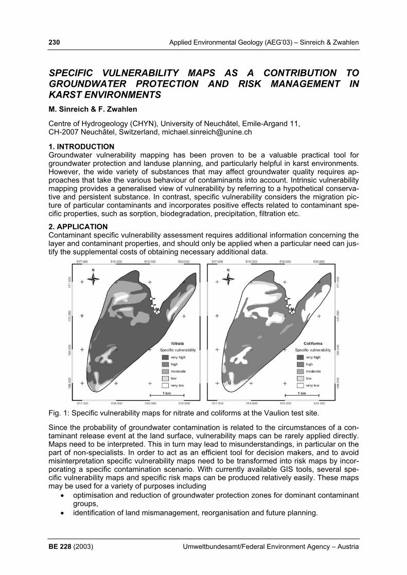
230 Applied Environmental Geology (AEG’03) – Sinreich & Zwahlen
BE 228 (2003) Umweltbundesamt/Federal Environment Agency – Austria
SPECIFIC VULNERABILITY MAPS AS A CONTRIBUTION TO GROUNDWATER PROTECTION AND RISK MANAGEMENT IN KARST ENVIRONMENTS
M. Sinreich & F. Zwahlen Centre of Hydrogeology (CHYN), University of Neuchâtel, Emile-Argand 11, CH-2007 Neuchâtel, Switzerland, [email protected] 1. INTRODUCTION Groundwater vulnerability mapping has been proven to be a valuable practical tool for groundwater protection and landuse planning, and particularly helpful in karst environments. However, the wide variety of substances that may affect groundwater quality requires ap-proaches that take the various behaviour of contaminants into account. Intrinsic vulnerability mapping provides a generalised view of vulnerability by referring to a hypothetical conserva-tive and persistent substance. In contrast, specific vulnerability considers the migration pic-ture of particular contaminants and incorporates positive effects related to contaminant spe-cific properties, such as sorption, biodegradation, precipitation, filtration etc.
2. APPLICATION Contaminant specific vulnerability assessment requires additional information concerning the layer and contaminant properties, and should only be applied when a particular need can jus-tify the supplemental costs of obtaining necessary additional data.
Fig. 1: Specific vulnerability maps for nitrate and coliforms at the Vaulion test site. Since the probability of groundwater contamination is related to the circumstances of a con-taminant release event at the land surface, vulnerability maps can be rarely applied directly. Maps need to be interpreted. This in turn may lead to misunderstandings, in particular on the part of non-specialists. In order to act as an efficient tool for decision makers, and to avoid misinterpretation specific vulnerability maps need to be transformed into risk maps by incor-porating a specific contamination scenario. With currently available GIS tools, several spe-cific vulnerability maps and specific risk maps can be produced relatively easily. These maps may be used for a variety of purposes including
• optimisation and reduction of groundwater protection zones for dominant contaminant groups,
• identification of land mismanagement, reorganisation and future planning.

Applied Environmental Geology (AEG’03) – Sinreich & Zwahlen 231
Umweltbundesamt/Federal Environment Agency – Austria BE 228 (2003)
Land surface zoning may fail if the contamination scenario is not adequately taken into ac-count. Moreover, best management practices may be insufficient without considering the specific hydrogeological aspects of a karst aquifer, as has been shown by CURRENS (2002). 3. MAPPING RESULTS An approach for assessing specific vulnerability has been developed within the framework of the European Cooperation in the Field of Scientific and Technical Research (COST) pro-gram, Action 620, "Vulnerability and risk mapping for the protection of carbonate (karst) aqui-fers". The proposed approach considers the properties both of contaminants and protective layers in order to qualitatively evaluate specific attenuation processes (ZWAHLEN 2003). Fig. 1 presents the mapping results for two typical contaminants impacting a karst groundwa-ter basin in the Swiss Jura Mountains (SINREICH 2003). Such maps may provide the basis for contaminant specific risk assessment. The specific maps display different vulnerability distribution patterns for different contaminants depending on their fate and transport charac-teristics (Fig. 2). This effect may justify the separate vulnerability mapping of specific sub-stances to better counteract the impact of various compounds including pesticides, fertilisers, hydrocarbons, heavy metals and microorganism.
Fig. 2: Vulnerability class statistics for several contaminants at the Vaulion test site. 4. CONCLUSIONS The implementation of contaminant specific vulnerability assessment allows for improved risk management evaluation and permits contamination of groundwater present beneath sensitive land to be reduced. It requires a higher data gathering effort but allows for more efficient landuse. The benefits of this approach must be weighed against social and economic considerations. Specific vulnerability and risk assessment may become more effective by using quantitative methods. Field measurements (tracer testing) and flow/transport modeling are currently being adopted for calibration and validation of this approach. This is anticipated to allow specific contamination scenarios to be simulated. REFERENCES CURRENS, J.C. (2002): Changes in groundwater quality in a conduit-flow-dominated karst
aquifer, following BMP implementation. Environmental Geology, 42, 525-531. SINREICH, M. (2003): Influence of contaminant fate and transport processes on vulnerability
mapping: A Swiss karst test site. Proceedings of the 1st international workshop on Aquifer Vulnerability and Risk, Vol. 1, 296-310, Salamanca/Mexico.
ZWAHLEN, F. (ed.) (2003): Vulnerability and risk mapping for the protection of carbonate (karst) aquifers; Final report (COST Action 620). European Commission, Directorate-General XII Science, Research and Development; Brussels, Luxemburg (in preparation).

232 Applied Environmental Geology (AEG’03) – Sipos et al.
BE 228 (2003) Umweltbundesamt/Federal Environment Agency – Austria
NEUTRALIZING EFFECT OF SOILS TO A POSSIBLE LEAD POLLUTION AS REFLECTED BY A STUDY ON TWO NATURAL SOIL PROFILES P. Sipos1), T. Németh1) & I. Mohai2)
1) Laboratory for Geochemical Research, Hungarian Academy of Sciences, H-1112 Bu-
daörsi út 45., Hungary, e-mail: [email protected] 2) Research Laboratory of Material and Environmental Chemistry, Chemical Research Cen-
ter, Hungarian Academy of Sciences, Budapest, Pusztaszeri út 59-67., H-1525, Hungary 1. INTRODUCTION Considerable amounts of lead have accumulated in soils all over the world due to anthropo-genic activities in the last few decades. This metal is highly toxic for humans and animals, so recognizing and characterizing its behavior in soils is essential. Our purpose was to study the adsorption characteristics of lead in the function of varying composition in two natural forest soil profiles and to recognize the possible neutralizing effect of soils in case of a possible lead contamination. 2. MATERIALS AND METHODS Five and seven samples from each genetic horizons of two forest soil profiles were collected from the Cserhát Mts., NE Hungary. Both profiles were formed on aleurolitic sedimentary rocks, but their mineralogy is completely different. Profile P09 is characterized by high or-ganic matter content (6.74%) in its organic horizon, medium amount (up to 25% in B horizon) of clay minerals (vermiculite and chlorite/vermiculite intergrade species with increasing chlo-rite component downwards) and calcareous subsoil. Profile P13 does not contain carbon-ates, it has low organic matter (up to 1.98%) but high clay mineral content (up to 55%), which is characterized by smectite and illite/smectite phases. Adsorption experiments were carried out on whole soil samples, soil clay fractions, as well as on the organic matter and carbonate free variants of organic and calcareous horizons, re-spectively. The organic matter was removed by 30% hydrogen-peroxide, while the carbonate content by 10% acetic acid. The experiments were performed by mixing 200 mg of sample with 20 ml of nitrate solutions containing various concentrations (20, 50, 80, 100, 120, 200, 500, 1000, 1200 and 2000 mg/l) of lead. Samples were shaken for 48 hours at room tem-perature, then they were centrifuged at 3000 rpm for 15 minutes. The equilibrium concentra-tions of Pb was measured by atomic absorption spectrometer (Perkin-Elmer AAnalyst 300). Initial pH of the solutions was set to 4.5-5 by adding of dilute HNO3 in order to reduce the competition between lead and hydrogen ions (FARRAH & PICKERING, 1979). 3. RESULTS The distribution of maximal lead adsorption on whole soil samples are completely different within the two studied profiles due to their different composition. In case of profile P09 the ex-tent of maximal lead adsorption decreases with depth and decreasing organic matter content (from 50550 to 17510 mg/kg, which are 45 and 15% of total available lead (TAL), respec-tively), while in profile P13 it slightly increases with increasing clay mineral content (from 30420 to 43600 mg/kg, which are 25 and 40% of TAL, respectively). The relation between the soil organic matter content and the lead adsorption is also supported by the fact that the lead adsorption strongly decreases (up to by ~50%) in the organic matter free samples as compared to the organic matter containing ones. There were no measurable lead in the solu-tion after the adsorption experiments in case of horizons characterized by high (15-30%) car-bonate content probably due to the precipitation of lead at alkaline pH. According to GEE et al. (2001) between pH 5 and 8 the CaCO3 acts as an effective buffer against mobilisation of

Applied Environmental Geology (AEG’03) – Sipos et al. 233
Umweltbundesamt/Federal Environment Agency – Austria BE 228 (2003)
of lead, but soils characterized by low carbonate content will remain in the unbuffered zone. At pH above 6, lead is either adsorbed on clay surfaces or precipitates as carbonates. Clay fractions adsorb by 20-30% more lead as compared to the whole soil samples. This in-crease of adsorption is smaller in profile P13, because the whole soil samples also contain high amount of clay minerals. The distribution of maximal lead adsorption on clay fractions shows similar picture in accordance with soil samples. The carbonate removal results an ap-parent, near twofold increase of lead adsorption. This latter fact suggests that small amount (<10%) of carbonate minerals still does not have enough buffering capacity to precipitate the total lead in solution. High extent of the lead adsorption can only begin after neutralizing of this effect. According to the maximal adsorbed lead amounts the vermiculite and smectite dominated phases can adsorb similar quantities of lead (46000-48000 mg/kg, ~40% of TAL), but more than the chlorite dominated ones (32000-43000 mg/kg, 25-35% of TAL). During the adsorption the amount of adsorbed lead increased with increasing calcium con-tent in solution (r = 0.90) in the carbonate containing soil (P09). According to ECHEVERRÍA et al. (1998) if the ratio of desorbed Ca and sorbed Pb is close to 1:1, that indicates the dis-placement of Ca by Pb. In our case at lower adsorbed lead amounts (<0.25 mmol/kg) the ra-tio of desorbed Ca/adsorbed Pb is more than 1 (up to 2), while with increasing lead adsorp-tion this ratio is near to 1. In the carbonate free soil profile (P13) there was no relation be-tween the amount of adsorbed lead and any of base metals got into solution. Following the adsorption studies samples were washed out by distilled water, and the con-centration of desorbed lead was measured. We found that up to 11% of adsorbed lead can be washed out from the organic horizons, which is characterized by the highest amount of organic matter, while in case of mineral horizons containing the largest amount of clay min-erals only 5-7% of adsorbed lead is leachable by distilled water. The results show that soils containing high amount of organic matter adsorb more lead as compared to soils rich in clay minerals, but the strength of adsorption by the organic matter is smaller than that of by the clay mineral. 4. CONCLUSION Different soil horizons have different lead adsorption capacity due to their variable composi-tion. The most significant process is the ion exchange of calcium by lead. The organic matter is of highest lead adsorption capacity, but higher amount of lead can be leached from its sur-face as compared to clay minerals. The clay fractions adsorb more lead as compared to the whole soil samples, because the most important lead adsorbents accumulate in this fraction. Among clay minerals swelling phases (smectite and vermiculite) have higher lead adsorption capacity. The carbonates influence the lead adsorption through their buffering capacity. High calcite content (>15%) in soil results alkaline conditions causing lead precipitation, while in presence of low amount of calcite (<10%) lead adsorption can occur. Supposing a serious lead pollution in a studied profile the high amount of lead adsorbed im-mediately on organic matter will be leached easily due to the regular rainfalls. The lead got into solution migrates in the profile downwards, and it will be adsorbed stronger on clay min-erals or precipitate in alkaline subsoil. Consequently, soils characterized by high amount of organic matter, swelling clay mineral accumulation horizon and calcareous subsoil are able to neutralize a significant lead pollution.

234 Applied Environmental Geology (AEG’03) – Sipos et al.
BE 228 (2003) Umweltbundesamt/Federal Environment Agency – Austria
REFERENCES ECHEVERRÍA, J.C., MORERA, M.T., MAZKARIÁN, C., GARRIDO, J.J. (1998): Competitive
sorption of heavy metal by soils. Isotherms and fractional factorial experiments. Environ-mental Pollution, 101: 275-284.
FARRAH, H., PICKERING, W.F. (1979): pH effects in the adsorption of heavy metal ions by clays. Chemical Geology, 25: 317-326.
GEE, C., RAMSEY, M.H., THORNTON, I. (2001): Buffering from secondary minerals as a migration limiting factor in lead polluted soils at historical smelting sites. Applied Geoche-mistry, 16: 1193-1199.
Applied Environmental Geology (AEG’03) – Soto et al. 235
Umweltbundesamt/Federal Environment Agency – Austria BE 228 (2003)
EXPLORATION OF ATMOSPHERIC MERCURY CONTENTS IN RELATION TO MERCURY-RICH WASTE STOCKAGE J. Soto, J. Loredo & J.G. Iglesias Dpto. Explotación y Prospección de Minas. Universidad de Oviedo. Independencia 13. 33004. Oviedo. España, [email protected] 1. INTRODUCTION Mercury pollution has since long been recognised as a growing problem for both human be-ings and ecosystems, and the interest and concern over mercury in the environment arises from the extremely toxic forms in which this metal can occur (U.S.EPA, 2001, 2002). It is a persistent and bioaccumulative chemical and a potent neurotoxin. Elemental mercury pre-sent in products and waste volatilises readily at ambient and combustion temperatures, lead-ing to air emissions. Mercury is released to the environment form natural sources as mineral deposits and volcanoes, and from a great variety of anthropogenic sources including fossil-fuel combustion, incineration, mining, smelting, etc. Currently, there is a decrease tendency for the anthropogenic emissions of mercury to the atmosphere in Europe (PACYNA et al., 2001), but the contribution from anthropogenic sources it is still a topic of interest, with regulatory as well as scientific implications. Mercury is emitted into the atmosphere in various forms (e.g., elemental, particulate, and mercuric chloride). Elemental mercury is dominant and it is fairly water insoluble. Once emitted into the atmosphere, it can be dispersed over a large area where it can be directly deposited in sensitive ecosystems or remain suspended in the atmosphere, where it is subject to a very complex chemistry. Particulate-phase inorganic mercury can be converted, by naturally oc-curring processes, into the highly toxic and bioaccumulative methyl mercury species in water bodies. 2. MATERIALS AND METHODS An important aspect is the relative significance of point source emissions such as Hg-rich waste storages. Ionic state of mercury at emission is critical to deposition patterns; covalent mercury is water soluble with an atmospheric lifetime of hours to days, whereas elemental mercury has a lifetime of 1-2 years before oxidizing and dissolving. In general, areas sur-rounding Hg-rich waste storages are naturally enriched in this metal, and the magnitude of the Hg release to the atmosphere is governed primarily by the Hg concentration in the waste. Environmental parameters such as temperature, incident sunlight, rainfall, wind direction, etc., influence the magnitude of Hg emissions. In order to assess the environmental significance of Hg emissions from abandoned Hg-rich waste a field exploratory campaign has been made in mining areas of northern Spain. Total mercury concentrations in µg/m3 have been measured in selected sampling points both in industrial and urban areas located in proximity to the waste storages. Measurements have been made with a portable analyser (Mercury Tracker-3000) at a height of 20 cm and 150 cm above soil level. The detection limit of the equipment is 0.1 µg/m3 and the measurement range is 0.1 – 2000 µg/m3. The exposition time for analysis has been programmed to 6 min-utes. Periodically, each fifteen days, field analyses have been made with the portable equip-ment in each one of the selected sampling points, all through a six month period. 3. RESULTS Considering the average of data compiled from the specialised bibliography, representative values of atmospheric mercury concentrations are in the order of 0.005 µg/m3 in non-industrialised areas, between 0.02 and 0.05 µg/m3 in industrialised areas, and higher than 10

236 Applied Environmental Geology (AEG’03) – Soto et al.
BE 228 (2003) Umweltbundesamt/Federal Environment Agency – Austria
µg/m3 in mine waste storage areas (spoil heaps). In the area of study which corresponds to an old mining and metallurgical site, the total mercury concentrations in atmosphere reach up to 45.8 µg/m3 in proximity to a Hg-rich mine waste storage, and 0.89 µg/m3 in an urban areas located 2 km away. The atmospheric mercury concentration varies from season to season, being higher in summer where it reaches to triple the values of winter. In this area the back-ground value is in the order of 0.17 µg/m3, which is higher than the corresponding value in the literature for urban and industrialised areas. CONCLUSIONS According to the preliminary data on atmospheric mercury contents in industrialised and ur-ban areas located in proximity to a point source (Hg-rich waste storage), high mercury con-centrations are detected. The application of simple portable equipment led to delimitate anomalous areas in order to assess the potential risk that high mercury concentrations rep-resent. In the case study corresponding to a historical mine/metallurgical site the local mer-cury background level in atmosphere increases in 30 times the general background level of world bibliographic data. REFERENCES: PACYNA, E.G., PACYNA, J.M. and PIRRONE, N. (2001). European emissions of atmos-
pheric mercury from anthropogenic sources in 1995. Atmospheric Environment, 35, 2987-2996.
U.S.EPA (2001). Workshop on mercury in products, processes, waste and the environment: Eliminating, reducing and managing risks from non-combustion sources. Environmental Protection Agency, EPA/625/R-00/014. Washington.
U.S.EPA (2002). Workshop on the fate, transport, and transformation of mercury in aquatic and terrestrial environments. Environmental Protection Agency, EPA/625/R-02/005. Cin-cinnati.

Applied Environmental Geology (AEG’03) – Spötl 237
Umweltbundesamt/Federal Environment Agency – Austria BE 228 (2003)
QUATERNARY DYNAMICS: PALEO-PERSPECTIVE OF GLOBAL CHANGE C. Spötl Institut für Geologie und Paläontologie, Universität Innsbruck, Innsbruck, Austria [email protected] The identification, quantification and numerical modeling of changes of climate and surface environments during the Earth’s history has resulted in a great appreciation of the dynamics of this planet both in space and time. Geochronology has provided scientists with a wealth of tools to place these processes into a consistent time framework. It is the youngest portion of the Phanerozoic, however, that enables us to examine past global change at the highest possible time resolution (down to subannual). Given the fact that our current „icehouse“ Earth is characterized by climate variability at Milankovitch and significantly shorter time scales we need to very closely look at the Quaternary period to try to work out their timings in order to eventually address the questions about feedbacks, leads and lags and external forcings.
This paper provides an admittedly incomprehensive and subjective perspective of Quater-nary environmental change, a topic that has (a) its deep roots in field-based geology, (b) has grown to a truly global science ever since the onset of deep-sea drilling, (c) has expanded tremendously by the ability to obtain long cores from polar and high-altitude ice, and (d) is now reaching a more mature stage by integrating data from various natural archives and model-based results thereby evolving into a transdisciplinary science whose proponents in-clude not only Earth scientists of various subdisciplines, but also paleobiologists, atmos-pheric physics, climatologists and oceanographers. It is the societal quest for a sound and quantifiable understanding (and eventually prediction) of climate change that provides the stimulus for this paleo-oriented research.
238 Applied Environmental Geology (AEG’03) – Stichler et al.
BE 228 (2003) Umweltbundesamt/Federal Environment Agency – Austria
THE ENVIRONMENTAL δ 18O – FINGERPRINT ALONG THE COURSE OF THE RIVER RHINE W. Stichler1), U. Schotterer2) R. Kozel3) & P. Trimborn1) 1) [email protected], GSF Institute of Hydrology; Neuherberg, Germany 2) Division of Climate and Environmental Physics and Department of Chemistry, University
Bern, Bern, Switzerland 3) Federal Office for Water and Geology, Bern, Switzerland 1. INTRODUCTION Water in rivers may originate from many sources with different isotopic composition depend-ing on precipitation distribution and infiltration characteristics, residence time, or altitude of recharge areas of the contributing ground water components. Thus, the distribution of tritium, deuterium, and oxygen-18 in river waters allows the separation of different water compo-nents as surface run-off of precipitation and groundwater (e.g. Kendall & Coplen, 2001, Weiss & Roether, 1975). As an example we show these effects along the course of the River Rhine by its natural δ18O variability. The total catchment area of the Rhine system covers 159 800 km3, the mean yearly discharge is 2470*106 m3. The observation of the isotopes of the water molecule (2H, 3H, 18O) in this river is part of the Swiss and German isotope networks (e.g. Schürch & al., 2003, Schotterer & al., 2002). 2. METHODS The river Rhine water itself was sampled at the three locations Diepoldsau, Reckingen (Swit-zerland) and Koblenz (Germany) beginning in the middle of the 80ties until present The sam-pling of two main tributaries, the river Aare and the river Mosel started nearly at the same time. The monthly samples from river Rhine at Diepoldsau, Reckingen, and Koblenz as well as the monthly samples from river Mosel and river Aare are discharge proportional, the sam-ples at Baden-Baden and Karlsruhe where taken once a week. 3. RESULTS AND CONCLUSION Figure 1 illustrates the long-term trend of δ18O in the monthly samples. Before entering Lake Constance the seasonality in δ18O, influenced by snowmelt, is clearly visible especially for the period 1998 to 2000. After Lake Constance at Reckingen mixing and discharge from catchments where snow cover plays a minor role, eliminates this seasonality. After the confluent with the river Aare (not shown here) the snowmelt-induced seasonality recovers somewhat (river Rhine at Baden-Baden). Further downstream this influence on the stable isotope content of run-off is again overprinted by local influences, which results in a more irregular behaviour of the δ18O values. At an observation point near Karlsruhe the δ18O - values of weekly samples are compared with the discharge to demonstrate the seasonal variation of different local contributions to the Rhine water (Fig. 2). The rapid depletion of δ18O at the beginning of March 2001 is due to the snow-melt at lower elevations up to the ridges of the Black Forest region. Until June 2001the δ18O – variations are influenced by a mix of snow-melt and local precipitation (together with groundwater), thereafter the second distinct δ18O depletion is caused by snow-melt in the Swiss Alps. At the confluence of the river Main to the river Rhine, we will use the δ18O content of both river to demonstrate the mixing behaviour of both river water bodies. Despite the rather turbulent flow after the confluence, the total mixing is complete only downstream the town of Bingen at a distance of more than 50 km from the confluence. How river water reflects the isotope content of regional precipitation will be shown by the δ18O results measured at Trier and Koblenz and the river Mosel at Koblenz. The seasonal variation of δ18O in precipitation is clearly mirrored in the river water. A certain damping and a shift of about one month delay are obvious. Besides this strong seasonal correlation an

Applied Environmental Geology (AEG’03) – Stichler et al. 239
Umweltbundesamt/Federal Environment Agency – Austria BE 228 (2003)
influence of years with extreme δ18O -values in the summer or winter precipitation can be recognized in the δ18O -values of the river water in the following years. Our example from the Rhine river system demonstrates the use of isotopes as a diagnostic tool for a better understanding of basic processes within river basins. The fact that the isotopes of the water molecule trace pathways of different water sources and changes in the composition of ground water and river run-off opens new possibilities for dynamic changes in water resources if hydrological models are developed through the combined use of hydrodynamic parameters, geochemical tracers and water isotopes. 4. FIGURES
Fig. 1: δ18O time series of river Rhine at different sampling points. At Diepoldsau the river enters Lake Constance, Reckingen is situated after Lake Constance, Baden-Baden is close to the Black Forest, and the sampling station at Koblenz is situated before the confluence with the river Mosel.
Fig. 2: δ18O in weekly samples of river Rhine at Karlsruhe (Germany) together with the discharge curve.

240 Applied Environmental Geology (AEG’03) – Stichler et al.
BE 228 (2003) Umweltbundesamt/Federal Environment Agency – Austria
REFERENCES KENDALL, C. & COPLEN T. B. (2001): Distribution of oxygen-18 and deuterium in river wa-
ters across the United States, Hydrological Processes 15: 1363-1393. SCHOTTERER, U., STICHLER, W., BÜRKI, H., KOZEL, R., NYFELER, P., STOCKER, TH.,
& TRIMBORN, P. (2002): The influence of floods on the water balance of river basins by means of stable isotopes of the water molecule, Proc. Int. Conf. on Flood Estimation, March 6-8 2002, Bern, 229-235.
SCHÜRCH, M., KOZEL, R., SCHOTTERER, U. & TRIPET J.-P. (2003): Swiss federal net-work for the observation of isotopes in the water cycle. Environm. Geol. in press.
WEISS, W. & ROETHER, W. (1975); Der Tritiumabfluss des Rheins 1961-1973, Deutsche Gewässerkundliche Mitteilungen, 19. Jahrgang, Heft 1, 1-5.
ACKNOWLEDGEMENTS The Swiss National Science Foundation and the Federal Office for Water and Geology who operates the Swiss Network for Isotopes in the Hydrological Cycle supported this work. The BfG in Koblenz and to the DWD in Offenbach are acknowledged for technical support.
Applied Environmental Geology (AEG’03) – Svetina 241
Umweltbundesamt/Federal Environment Agency – Austria BE 228 (2003)
CALCULATION AND MODELLING OF CRITICAL LOADS FOR HEAVY METALS IN TERRESTRIAL ECOSYSTEM IN THE SALEK VALLEY, SLOVENIA M. Svetina ERICo Velenje, P.O. Box 22, SI-3320 Velenje, Slovenia, [email protected]
1. INTRODUCTION In Slovenia a modelling application of As, Cd, Co, Cr, Cu, Hg, Mo, Ni, Pb and Zn critical loads in soil were performed. The calculation in the Salek Valley involved 30 research areas in the town Velenje area on a 500 x 500 m grid and in the Sostanj community on a 3 x 3 km grid, where in the period of years 2000 and 2001 the chemical analyses of precipitation and soil were made. The former studies established contamination of topsoil with As and Cd at some territory in the Salek Valley (SVETINA & PIRC, 1997 & 1998). The aim was application of theoretical models for determination the maximum critical levels of heavy metals in terrestrial ecosystem with empirical data. In the past years several studies of heavy metals have been carried out to assess critical loads of long-term acceptable at-mospheric input into terrestrial ecosystem (DE VRIES & BAKKER, 1998). According to defi-nition, a critical load equals the load causing a concentration in soil, that does not exceed the critical limit set for heavy metals. Thus preventing significant harmful effects on specifieid sensitive elements of the environmental – receptors (DE VRIES, 1999). 2. MATERIALS AND METHODS The basis for calculation was an effect-based approach, which limits are based on adverse effects on the ecosystem and the heavy metal concentrations should stay below those limits. As receptor was used a human health trough the ecotoxicological risks with use of ground water for drinking water and/or consume crops that are grown on the soil. The simple model based on dynamic mass balance of heavy metals in soil was used for calculation. It was es-timated that the critical time well illustrates the acute danger of soil pollution and is recom-mended as the draft estimation of actual condition in soil which could be valued with few data (PACES, 1999). The time periods to reach Slovene soil norms under condition of present atmospheric input were estimated by equation (1).
∆t = [ρ . d . (MC – MS)] / fMA (1) MC – critical limit of heavy metal [mg/kg] ρ - density of soil [kg/m3] MS – present content of heavy metal in soil [mg/kg] d – thickness of soil [m] fMA – atmospheric flux of heavy metal [mg/m2/year] t - time [year]
3. RESULTS Two different soil conditions at the actual atmospheric input were used in calculation: un-pleasant and average. The unpleasant condition was simulated for the surface soil to depth of 5 cm and density of 1000 kg/m3, and the advanced to soil depth of 20 cm and density of 1500 kg/m3. The times for both conditions were calculated for As, Cd, Co, Cr, Cu, Hg, Mo, Ni, Pb, Zn, and their median are in Table 1. The comparison between heavy metals indicates high accumulation of As and Hg, and thus their quit fast approach to the critical loads. In second rang of atmospheric input are Cd, Pb and Zn which are accumulated much slowly, followed by Mo, Ni, and Co, and the slowest progress make Cr.

242 Applied Environmental Geology (AEG’03) – Svetina
BE 228 (2003) Umweltbundesamt/Federal Environment Agency – Austria
Table1. Estimated times of critical load for heavy metals in terrestrial ecosystem in the Salek Valley area. * - time to reach the critical load in soil.
Heavy Metal Atmospheric Input [mg/m2/year]
tC* (5 cm) [year]
tC* (10 cm) [year]
As 2.27 730 4500 Cd 0.17 3500 21000 Co 0.26 45000 270000 Cr 0.66 27000 165000 Cu 2.26 6000 37000 Hg 0.32 1500 9300 Mo 0.27 36000 220000 Ni 0.77 12000 74000 Pb 10.4 2400 15000 Zn 15.4 2000 12000
4. CONCLUSIONS Athough the period to achieve the critical loads are except for As above 1000 years; the es-timated periods to reach the permitted Slovene limits in surface soil layer are calculated for As and Hg – 100 years, Cd – 140 years, Pb – 230 years, Zn – 350 years, Cu – 830 years, Mo – 1.700 years, Ni – 1.800 years, Co – 1.900 years, and Cr – 6.000 years. At advantages conditions they are for Cd – 2.000 years, Hg – 4.500 years, As – 9.000 years, Zn – 12.000 years, Pb – 15.000 years, Cu – 35.000 years, Ni – 75.000 years, Cr – 150.000 years, Mo – 220.00 years and Co – 300.000 years. REFERENCES DE VRIES, W. (1999): Approaches and Criteria to Calculate Critical Loads of Heavy Metals
for Soils and Surface Waters. In: GREGOR, H.D.; MOHAUPT-JAHR, B. & HOENERBACH, F. (eds.): Effect-based Approaches for Heavy Metals, Proceedings of Workshop, 12-15 October, Schwerin, Germany, Federal Environmental Agency, Germany.
DE VRIES, W. & BAKKER, D.J. (1998): Manual for Calculating Critical Loads of Heavy Met-als for Terrestrial Ecosystems, Guidelines for Critical Limits, Calculation Methods and Input Data. - DLO Winand Staring Centre, SC Report 166, Wageningen, The Netherlands.
PACES, T. (1999), Critical Time, Critical Load and Target Load to Reach Harmful Concentra-tions of Heavy Metals in Soil Ecosystems: The First Order Kinetic Model. In: GREGOR, H.D.; MOHAUPT-JAHR, B. & HOENERBACH, F. (eds.): Effect-based Approaches for Heavy Metals. Proceedings of Workshop, 12-15 October, Schwerin, Germany, Federal Environmental Agency, Germany.
SVETINA, M., PIRC, S. (1997): Cadmium Enrichment in the Soil of the Salek Valley, Slove-nia. In: Terra Nova, Volume 9, 727, Abstract Supplement No1 of European Union of Geo-sciences 9, 664 p., Cambridge Publications, Strasbourg - France.
SVETINA, M., PIRC, S. (1998): Arsenic Enrichment in the Soil of the Šalek Valley, Slovenia.- In: A Journal of Mineral Sciences Vol. 62 A, Part 3, Abstracts Volume of Goldschmidt Con-ference 1998 in Toluouse, 1485-1486, ISSN 0026-461X, Mineralogical Society, London.
Applied Environmental Geology (AEG’03) – Taheri Tizro 243
Umweltbundesamt/Federal Environment Agency – Austria BE 228 (2003)
GROUNDWATER QUALITY WITH REFERENCE TO ORIGIN OF SALINITY IN MAHENDRAGARH DISTRICT, HARYANA, INDIA
A. Taheri Tizro Dept. of Irrigation Engineering, College of Agriculture, Razi University, Kermanshah, Iran, [email protected]
1. INTRODUCTION The area of investigations covers 1800 km2 and is located near its border with Rajasthan, in India is a simiarid, affected almost perennially by scarcity of water. The rock formations of the Aravalli Mountain belt belong to the Delhi super Group of the Precambrian age. The general strike of the rock is NNE-SSW. The geology of this belt is available from the excellent work of HERON (1917). The availability of groundwater becomes rather erratic due to occurrence of hard rock forma-tion in the large part of the area. Moreover the situation in the area has become quite alarm-ing in recent years due to decline of water levels in the wells (anonymous, 1989). The quality of the groundwater has also deteriorated over the years so that many of the groundwater supplies do not satisfy the regulatory water quality guidelines set by various international agencies. Using standard procedures outlined by MOORE (1968), Freeze and CHERRY (1987) a fence diagram of the area has been prepared which shows that, the general bed-rock slopes down towards the north, east and north east in the area. Hydraulic properties computed from field resistivity data show that these properties vary from low to high (TIZRO & SINGHAL, 1993). Groundwater samples, procured from open and deep wells, were ana-lyzed to establish quality characteristics of groundwater. The occurrence of saline groundwa-ter was witnessed by the high EC values of groundwater. The Iodide / chloride ratios versus iodide plots shows enrichment of Iodide in the saline groundwater, which may be attributed to their longer residence time. Pertinent field data were obtained and examined to explain the quality of groundwater. 2. MATERIALS AND METHODS The groundwater samples, collected during field visits, for both shallow and deep wells, were analyzed with procedure described by Standard Methods (AWWA, 1998). Most of the chemi-cal analyses were carried out in the laboratory except a few parameters like pH, temperature and EC, which were determined on the spot, in the field. The other chemical parameters ana-lyzed included TDS, Na, K, Mg, Ca, Cl, SO4, HCO3 , F, Br and Iodide. 3. RESULTS The result shows a wide variation in different individual parameters as well as its EC and TDS. Though the overall pH (7-8.87) and temperature (24–27 Cº) do not show any significant abnormality. The higher range of TDS indicates the groundwater to be generally saline with few fresh water patches, as manifested by wide range of TDS (400-500 mg/l) and EC (650-5500 micromhos/cm at 25 Cº). The hardness of groundwater ranges from 200-1350 mg/l in shallow and 150-1400 mg/l in deep water, thus it can be designated as hard to very hard. Out of 72 samples from wells, it is found that, fluoride concentration at 14 wells is more than 2.5 mg/l. The presence of fluoride is possible when conditions favor long residence time of F in solution (GACIRI & DAVIEST, 1966). Also, the higher concentration of fluoride in deeper aquifers may be explained due to presence of geological formations rich in fluorine mineral like Apatite etc. In an attempt to study chemical characteristics of the area rationally, the chemical outputs have been plotted in the expanded Durov diagram. Table 1 shows the chemical characteris-tics of these water samples. It is observed that groundwater is of mixed-type but with an indi-cation of processes like ion exchange being active. To ascertain extent of ion exchange,

244 Applied Environmental Geology (AEG’03) – Taheri Tizro
BE 228 (2003) Umweltbundesamt/Federal Environment Agency – Austria
SCHOELLER (1959) index has worked out. The result obtained shows that about 62-72% of the samples exhibit -ve ion exchange. Tab. 1: Chemical characteristics in expanded Durov diagram
No of samples (shallow wells)
No of samples (deep wells)
Falling In field
Explanation of different areas in diagram
1 7 Cl & Ca dominant 1 4 SO4 dominant 7 4 8 Cl dominant (Related to reverse ion exchange
Na-Cl water) 13 14 5 No dominant anion cations (mixing) 14 7 6 SO4 Dominant or Na dominant (probable mixing) 9 5 9 Cl & Na dominant 3 3 HCO3 & Na dominant
According to HOWARD & LIOYD (1978) the aquifer showing high enrichment of iodide are considered to represent long residence within the aquifer system. This approach has been tried and iodide-chloride relationships were studied. It is found that majority of the samples fall above 10 mg/l of I/Cl ratio, which indicates enrichment of iodide with long residence. 4. CONCLUSIONS The groundwater sampling and its analyses were carried out to establish quality characteris-tic. It is found that groundwater is generally marginal to saline in most places. Fluoride con-centration in 21 wells is higher than optimal range. Lithology of geological formations can be a controlling factor in causing high concentration of fluoride in groundwater. The plotting of groundwater quality data on expanded Durov´s diagrams revealed dissolution or a mixing character. It is observed from the iodide-chloride relationship that, the area is enriched with saline water, and can be attributed to longer residence time. REFERENCES AWWA, (1998): Standard methods for examination of water and waste water, USA. FREEZE, R.; ALLAN & JOHN, A. CHERRY, (1987): Groundwater, prentice Hall International
Pub., Inc., London, pp. 524. GACIRI, S. J. & DEVIES, T.C. (1993): The occurrence and Geochemistry of fluoride in some
natural waters of Kenya. Journal of Hydrology pp. 293-304. HERON, A. M. (1917): Geology of the Rajputa, Technical report, 45 (1). HOWARD, K. W. F. & LIOYD, J.W. (1978): Iodide enrichment of groundwaters of chalk aqui-
fer Lincolnshire, England. IAH Conference, Warsaw, pp. 87-98. MOORE, C. A. (1968): Handbook of subsurface Geology, Harpen & Row Publication, New
York, pp. 235. SCHOELLER, H. (1959): Arid Zone Hydrology. Arid Zone Research UNESCO, Paris. TIZRO, T. A. & SINGHAL, D.C. (1993): Geoelectric studies in Narnaul area (Haryana) for es-
timating transmissivity of alluvial aquifers. National Seminar on Hydrology.
Applied Environmental Geology (AEG’03) – Taheri Tizro 245
Umweltbundesamt/Federal Environment Agency – Austria BE 228 (2003)
PROSPECTING OF AQUIFERS IN HARD ROCK TERRAIN A. Taheri Tizro Dept. of Irrigation Engineering, College of Agriculture, Razi University, Kermanshah, Iran; [email protected] 1. INTRODUCTION Hard rocks are included as those geological formations that possess low drillibility and al-most intergranular porosity is practically absent. The hard rock can be characterized by sec-ondary porosity due to presence of joints, fissures, foliation's planes, and solution cavities. In igneous rocks, the significant geohydrological features are primary porosity in the form of in-terstices in vesicular varieties and pillow lava's, lava tubes and occasional tunnels. The po-rosity of volcanic rocks varies widely from an almost negligible for dense varieties to over 80 percent of pumice, tuff and some other vesicular varieties. In crystalline rocks, weathering and fracturing may impart in the secondary porosity of these formations (UNESCO, 1978, 1984). In limestone, solution cavities are the main cause of the secondary porosity and solu-ble property of these rocks give rise to development topographic and hydrologic features that are found rarely in other type of rocks (KARANTH, 1989). Overall, the dynamics of ground-water i.e. occurrences, movement and interaction is well understood in porous media, but however in hard rocks it is still beset with many problems. Major part of western Iran is occupied by hard rocks. These rocks are of crystalline, igneous and calcareous. The hard rocks are neglected as a possible source of groundwater this is mainly due to presence of high potentials groundwater in alluvial formations and probable low permeability and high cost of drilling, but in recent years due to appearances of over draft conditions in alluvial deposits, the hard rock terrain can be looked as a possible source of groundwater. Rapid methods of drilling can facilitate the groundwater investigations and de-velopment work, but systematic geoinvestigation especially by geoelectrical methods can in-crease the rate of success in groundwater development in the area. As the permeability of hard rocks are greatly effected by presence of joints, fissures and solutions cavities there-fore, it becomes necessary to use an effective tool for ascertaining subsurface geological framework and joints, fissures and possible solution cavities in the area. The primary objec-tive of present study is to delineate and locate joints and fractures in unconsolidated forma-tions, which may form potential aquifer zones. The area under investigation is located in the western part of Iran and is demarcated into two parts. The area is covered by Jurassic formation (shist, limestone, vulcanized limestone), Recent to subrecent sediments (clay and alluvium mixed) and Granites. The large masses of granites (batholites has deform the country rocks and has developed a well marked meta-morphic aureole in the area. Detailed study of lithological and geophysical data reveals that depth of alluvial thickness ranges from 20 to 250 m B/L. The depth to water table is 5m in hilly area and reaches up to 40 m in alluvial deposits. 2. MATERIALS AND METHODS Geophysical method is an effective tool for ascertaining subsurface geologic framework of an area (KELLER & FRISCHKNECHT, 1966; GRIFFITH & KING, 1965; ZOHDY et al., 1974). Geoelectrical method can help in delineating the hydrogeological framework of hard rock ter-rain (TIZRO, 2002). To record resistivities of the subsurface formations, current was sent in to the ground through two electrodes and resulting potentials was measured with the help of two other electrodes. Vertical electrical soundings (VES) data was conducted with Schlum-berger configuration at two regions of hard rock formations. The techniques were chosen for its low cost and usefulness in defining the expected targets. For all the vertical electrical sounding that was carried out, the Schlumberger array was used. A total of about 40 VES

246 Applied Environmental Geology (AEG’03) – Taheri Tizro
BE 228 (2003) Umweltbundesamt/Federal Environment Agency – Austria
stations with current electrode separation of up to 600m were established. The maximum electrode separation was sufficient to reach the desired investigation depth. The field appar-ent resistivity data for different values of AB/2 have been processed and sounding data have been interpreted quantitatively and geologically as described by KUNETZ (1966), BHATTACHARYA & PATRA (1968), and ZOHDY (1989). The interpreted quantitative resis-tivity data of VES has been carefully compared with the available lithology and resitivity ranges adopted for different geological formations. 3. RESULTS The resistivity ranges, assigned to the different subsurface formations, are 20 to 100 ohm-m for sand, 5 to 35 oh-m for clay and sand admixtures (depending on fraction of clay), 45 to 300 ohm-m for weathered and semi weathered limestone, 100 to 900 (weathered, fractured and compact Granites). A judicious interpretation of geophysical data in the light of available geological evidence is considered for achieving a realistic perception of the distribution of subsurface geological formations. A repeated effect of tectonic movement and granitisation has deformed the country rocks and developed fractures and joints. Sizable thickness of fractured and semi compact is indicated to be present in hard rock formations and beneath the alluvial burden, which has helped in recommending few successful well sites in these ter-rains. 4. CONCLUSIONS Due to appearances of overdraft conditions in alluvial deposits in western part of Iran, the hard rocks of different formations can be considered as possible source of groundwater po-tentials. The systematic geoinvestigations especially geoelectrical method can help and fa-cilitate the groundwater development in such terrain. REFERENCES BHATTACHARYA, P. K. & PATRA, H. P. (1968): Direct current Geoelectric Sounding. El-
sevier Company, Amsterdam. GRIFFITH & KING, (1965): Applied Geophysics for Engineers and Geologists. Pergamon
press, London, 223 p. KARANTH, K. R. (1998): Hydrogeology. Tata Mc Graw-Hill Publ. Company Limited. 458p. KELLER & FRISCHKNECHT, F. C. (1966): Electrical method in geophysical Prospecting.
Pergamon press. Oxford, 517 p. KUNETZ, G. (1966): Principles of direct current resistivity. TIZRO, T. A. (2002): Hydrogeological Investigations by surface Geoelectrical method. Bulle-
tin of the geological Society of Malaysia. UNESCO (1978): International Hydrogeological Map of Europe. IAH and UNESCO, Paris,
228p. UNESCO (1984): Groundwater in Hard Rock, Studies and reports in Hydrology, Paris, 228 p. ZOHDY, A. A. R. (1974): Application of surface geophysics to groundwater Investigations.
USGS, 116 p. ZOHDY, A. A. R. (1989): A new method for automatic interpretation of Schlumberger and
Wenner sounding curves. Geophysics, 5(2), 245-253.
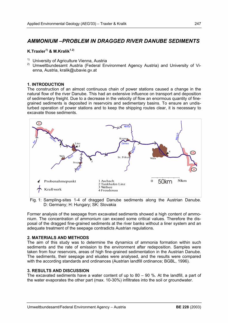
Applied Environmental Geology (AEG’03) – Traxler & Kralik 247
Umweltbundesamt/Federal Environment Agency – Austria BE 228 (2003)
AMMONIUM –PROBLEM IN DRAGGED RIVER DANUBE SEDIMENTS K.Traxler1) & M.Kralik1.2) 1) University of Agriculture Vienna, Austria 2) Umweltbundesamt Austria (Federal Environment Agency Austria) and University of Vi-
enna, Austria, [email protected] 1. INTRODUCTION The construction of an almost continuous chain of power stations caused a change in the natural flow of the river Danube. This had an extensive influence on transport and deposition of sedimentary freight. Due to a decrease in the velocity of flow an enormous quantity of fine-grained sediments is deposited in reservoirs and sedimentary basins. To ensure an undis-turbed operation of power stations and to keep the shipping routes clear, it is necessary to excavate those sediments.
Fig. 1: Sampling-sites 1-4 of dragged Danube sediments along the Austrian Danube. D: Germany; H: Hungary; SK: Slovakia
Former analysis of the seepage from excavated sediments showed a high content of ammo-nium. The concentration of ammonium can exceed some critical values. Therefore the dis-posal of the dragged fine-grained sediments at the river banks without a liner system and an adequate treatment of the seepage contradicts Austrian regulations. 2. MATERIALS AND METHODS The aim of this study was to determine the dynamics of ammonia formation within such sediments and the rate of emission to the environment after redeposition. Samples were taken from four reservoirs, areas of high fine-grained sedimentation in the Austrian Danube. The sediments, their seepage and eluates were analysed, and the results were compared with the according standards and ordinances (Austrian landfill ordinance; BGBL, 1996). 3. RESULTS AND DISCUSSION The excavated sediments have a water content of up to 80 – 90 %. At the landfill, a part of the water evaporates the other part (max. 10-30%) infiltrates into the soil or groundwater.
0 50kmProbenahmepunkt
Kraftwerk
H
D
SK
Wien
Linz
Wels
Steyr
Krems
St. Pölten
Inn Donau
Donau Mar
ch
Traun
Enns
Traise
n
Kamp
1 Aschach2 Tankhafen Linz3 Wallsee4 Freudenau
1 2
3
4

248 Applied Environmental Geology (AEG’03) – Traxler & Kralik
BE 228 (2003) Umweltbundesamt/Federal Environment Agency – Austria
The results of the seepage show an increase in ammonia concentration over the entire pe-riod of the sediments dewatering (up to 20 mg/l ammonium). Nearly all values exceeded the ones given within standards and ordinances (groundwater ordinance: 0,3 mg/l; BGBL 1997; ordinance on surface freshwater emission: 10 mg/l; BGBL, 1996b). The results of the analy-sis of the standard water eluates of the sediments show less ammonium concentrations. However, the calculated ammonium content per kg dry sediment of all four sample sites is higher than the concentration limit of 8 mg/kg (dry weight) for the disposal of soils without a liner system. Comparisons with similar projects have shown, that in several rivers fine-grained sediments contain higher amounts of ammonium. The condition of the sediments allows an estimation of the quantity of the seepage. Finer grained sediments have a higher content of seepage than coarser grained. The grain sup-ported texture in coarsely grained sediments enables rapid movement of pore water. A con-siderable part of the pore water drains immediately during the excavation. 4. CONCLUSIONS In the four studied fine-grained Danube sediments (silt – silty sands) no correlation between ammonium concentration in the sediment seepage and the grain size was found. The am-monium concentrations in the seepage potentially infiltrating the ground varies between 2-25 mg/l and exceed the limit values of the groundwater ordinance (0.3 mg/l). However, the standard water eluates of the sediments show a correlation between grain size and ammonium concentration. In finer grained samples there are higher concentrations than in coarser grained ones. As all four sediment samples (10-40mg NH4/kg) exceed the limit values of 8 mg NH4/kg a deposition of these sediments without an adequate pretreatment is not in accordance to the Austrian landfill ordinance and would need an expensive construc-tion of a liner system. REFERENCES BGBL (Bundesgesetzblatt der Republik Österreich, 1996a), 164. Verordnung: Deponiever-
ordnung, Wien. BGBL (Bundesgesetzblatt der Republik Österreich, 1996b), 186. Verordnung: Allgemeine
Begrenzung von Abwasseremissionen in Fließgewässer und öffentliche Kanalisation (AAEV), Wien.
BGBL (Bundesgesetzblatt der Republik Österreich, 1997), 213. Verordnung: Abände-rung der Grundwasserschwellenverordnung, Wien
TRAXLER, K. (2002): Stickstofftransfer in Porenwässern gebaggerter Donausedimente [Ammonium-Nitrogen-transfer in pore-solutions of dragged Danube-sediments]. Un-publ. M.Sc.-thesis, 90 p., Univ. Vienna.

Applied Environmental Geology (AEG’03) – Trimbacher & Neinavaie 249
Umweltbundesamt/Federal Environment Agency – Austria BE 228 (2003)
IDENTIFICATION AND SOURCE APPORTIONMENT OF AIRBORNE PARTICULATE MATTER IN AN AUSTRIAN CONURBATION AREA BY MEANS OF INTEGRATED MINERALOGICAL AND SEM ANALYSIS C. Trimbacher1) & H. Neinavaie2) 1) Umweltbundesamt Austria (Federal Environment Agenca Austria), Spittelauer Laende 5,
1090 Vienna 2) Geologische Bundesanstalt, Rasumovskygasse, 1020 Vienna 1. INTRODUCTION During a measurement campaign in a conurbation area in winter 2001/2002 samples of suspended particulate matter (PM10 filters) and deposited dust (Bergerhoff method) from six selected sites were analysed (TRIMBACHER & NEINAVAIE 2002). Using integrated mineralogical and scanning electron microscopical techniques the most abundant particle types have been identified. A source apportionment to main contributing sources has been carried out. This methodology has already been introduced in a previous study of the FEA (NEINAVAIE ET AL. 2000). 2. MATERIALS AND METHODS Six sampling sites with different pollution levels have been selected for investigation: one site in an urban residential area, middle to high pollution level; two urban traffic related sites; one urban background site; one site in an urban residential area, middle to high pollu-tion level and one site in an urban residential area, low pollution level. Prior to analysis of the deposited dust, the samples were air-dryed, sieved (< 0.5 mm), washed with 6% H2O2 solution to separate organic materials and divided in a magnetic and non-magnetic fraction. Predominantely, the magnetic fraction contains technogenous parti-cles. Polished thin sections (non-magnetic fraction) and polished cross sections (magnetic fraction) were prepared for mineralogical analysis using reflected and transmitted light mi-croscopy as well as microprobe and EDX for semi-quantitative analysis of selected particu-late pollutants. By means of SEM and EDX structure, size and elemental composition (quali-tatively) of the particles were analysed. The PM10 filter samples were investigated by reflected light microscopy and then accordingly, analysed in the SEM.

250 Applied Environmental Geology (AEG’03) – Trimbacher & Neinavaie
BE 228 (2003) Umweltbundesamt/Federal Environment Agency – Austria
3. RESULTS The most abundant particle types of airborne PM apportioned to main source categories are given in table 1 (biological material not shown).
deposited dust Filter (PM10) source category particle type size range particle type size range tyre wear irregular 30-500 µm soot 0.5-5 µm brake wear irregular 50-150 µm NaCl crystallites 5-10 µm
traffic
chipping of metallic Fe, Cu, Zn
20-250µm
spherical cenospheres 20-250 µm spherical, Al-Si-rich parti-cles
1-5 µm
irregular C-rich particles 20-250 µm spherical cenospheres 5-15 µm spherical plastic particles, partly melted
20-150 µm spherical plastic particles, partly melted
5-25 µm
combustion
irregular Si-rich particles 40-70 µm Ca-ferrite spherical 60 µm magnetite spherical 7-20 µm Zn-spinell spherical 30 µm Si-rich slag 25-80 µm
industry
forging scales -170 µm quartz 5-250 µm quartz 5-15 µm calcite 5-250 µm calcite 5-15 µm mica 5-250 µm mica 5-35 µm
crustal
feldspar 5-250 µm feldspar 5-15 µm Selected SEM-micrographs of typical airborne particulate matter are given in figure 1 (left: two irregular tyre wear particles; middle: NaCl-crystallites and soot particles on filter; right: conospheric, carbonrich particle from domestic combustion).
Additionally, based on the results of the source apportionment, in the deposited dust samples the proportions of the main contributing sources at the six sampling sites were estimated. Most of the identified particles could be attributed to the main source categories “crustal ma-terial” – “road traffic” – “combustion” – “industry” and “biological material”. The results are given in figure 2.

Applied Environmental Geology (AEG’03) – Trimbacher & Neinavaie 251
Umweltbundesamt/Federal Environment Agency – Austria BE 228 (2003)
0%
20%
40%
60%
80%
100%
site1
site2
site3
site4
site5
site6
biologicalindustry combustiontrafficcrustal
figure 2: estimation of source categories contributing to airborne particulate matter in depos-ited dust at six sites in an Austrian conurbation area. Site 1: urban residential area, middle to high pollution level; sites 2, 4: urban traffic related; site 3: urban background; site 5: urban residential area, middle to high pollution level; site 6: urban residential area, low pollution level 4. CONCLUSION Samples of suspended particulate matter (PM10) are more important for the interpretation, as they represent the relevant size fraction that is responsible for exceedances of limit values of ambient air concentrations of particulate matter as fixed in legal regulations. But from the analytical view the relatevely high amount of ultrafine soot particles in this fraction covers other dust particles, being typical for the site and necessary for the site characterisation. A source apportionment becomes highly uncertain. Therefore only a combined investigation of the PM10 fraction and of the coarse fraction (deposited dust) allows a more reliable source apportionment. REFERENCES NEINAVAIE,H., PIRKL, H. & TRIMBACHER, C. (2000): Herkunft und Charakteristik von
Stäuben. UBA-BE-171, Umweltbundesamt Wien. TRIMBACHER, C. & NEINAVAIE, H. (2002): Studie zur Ermittlung der Herkunft von Stäuben
an sechs ausgewählten Messpunkten in Graz.UBA-BE-210, Umweltbundesamt Wien.
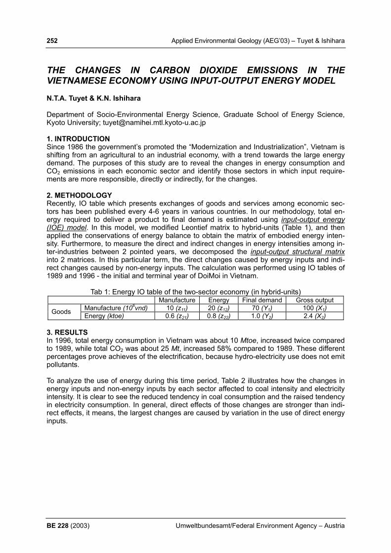
252 Applied Environmental Geology (AEG’03) – Tuyet & Ishihara
BE 228 (2003) Umweltbundesamt/Federal Environment Agency – Austria
THE CHANGES IN CARBON DIOXIDE EMISSIONS IN THE VIETNAMESE ECONOMY USING INPUT-OUTPUT ENERGY MODEL N.T.A. Tuyet & K.N. Ishihara Department of Socio-Environmental Energy Science, Graduate School of Energy Science, Kyoto University; [email protected] 1. INTRODUCTION Since 1986 the government’s promoted the “Modernization and Industrialization”, Vietnam is shifting from an agricultural to an industrial economy, with a trend towards the large energy demand. The purposes of this study are to reveal the changes in energy consumption and CO2 emissions in each economic sector and identify those sectors in which input require-ments are more responsible, directly or indirectly, for the changes. 2. METHODOLOGY Recently, IO table which presents exchanges of goods and services among economic sec-tors has been published every 4-6 years in various countries. In our methodology, total en-ergy required to deliver a product to final demand is estimated using input-output energy (IOE) model. In this model, we modified Leontief matrix to hybrid-units (Table 1), and then applied the conservations of energy balance to obtain the matrix of embodied energy inten-sity. Furthermore, to measure the direct and indirect changes in energy intensities among in-ter-industries between 2 pointed years, we decomposed the input-output structural matrix into 2 matrices. In this particular term, the direct changes caused by energy inputs and indi-rect changes caused by non-energy inputs. The calculation was performed using IO tables of 1989 and 1996 - the initial and terminal year of DoiMoi in Vietnam.
Tab 1: Energy IO table of the two-sector economy (in hybrid-units) Manufacture Energy Final demand Gross output
Manufacture (106vnd) 10 (z11) 20 (z12) 70 (Y1) 100 (X1) Goods Energy (ktoe) 0.6 (z21) 0.8 (z22) 1.0 (Y2) 2.4 (X2) 3. RESULTS In 1996, total energy consumption in Vietnam was about 10 Mtoe, increased twice compared to 1989, while total CO2 was about 25 Mt, increased 58% compared to 1989. These different percentages prove achieves of the electrification, because hydro-electricity use does not emit pollutants. To analyze the use of energy during this time period, Table 2 illustrates how the changes in energy inputs and non-energy inputs by each sector affected to coal intensity and electricity intensity. It is clear to see the reduced tendency in coal consumption and the raised tendency in electricity consumption. In general, direct effects of those changes are stronger than indi-rect effects, it means, the largest changes are caused by variation in the use of direct energy inputs.

Applied Environmental Geology (AEG’03) – Tuyet & Ishihara 253
Umweltbundesamt/Federal Environment Agency – Austria BE 228 (2003)
Tab. 2: Changes in energy intensities (toe/106vnd of output) between 1989 and 1996 The changes caused by changing
in energy requirements of energy inputs
The changes caused by changing in energy requirements of all
(energy and non-energy) inputs
Group of economic sectors
Coal use Electricity use Coal use Electricity use Agriculture, forestry and fishing -0.009 0.001 -0.001 -0.000 Mineral mining -0.014 0.010 0.003 0.002 Food processing -0.197 0.014 -0.022 -0.002 Textiles -0.045 0.016 0.012 0.003 Paper and wood products -0.058 0.013 0.009 0.001 Chemical products -0.144 0.003 -0.011 -0.003 Ceramic, stone and clay products -0.469 0.031 -0.056 -0.001 Iron and steel -0.035 0.000 -0.000 0.000 Non-ferrous metals -0.003 0.004 0.001 0.000 Machinery and other products -0.053 0.008 0.010 0.003 Construction and real estate -0.040 0.003 0.013 0.002 Finance and trade -0.005 0.002 -0.000 0.000 Transportation -0.007 0.001 0.002 0.000 Communications and services -0.029 0.012 0.007 0.002 Households and others -0.012 0.003 -0.001 0.000
Total -1.122 0.121 -0.035 0.007 Our computation indicated that in manufacturing direct CO2 emissions from cement sector kept the largest contribution (occupied 30.41% in 1996). Focused on this sector, we esti-mated for an advanced cement plant with Mt/yr capacity, in which recently Vietnamese gov-ernment is investing. A potential of CO2 reduction is about 13.5% if production equipments would completely be renewed.
Tab. 3: Potential energy saving and CO2 reduction for 1Mt/yr-cement plant (*) Energy consumption (MJ/kg-cement) CO2 emissions (kg-CO2/kg-cement) Old plant 4.47 0.770 New plant 3.69 0.665 Reduction 0.78 0.105 (*) - Capital required for an investment is US$ 150 million. REFERENCES TUYET, Nguyen T. Anh & ISHIHARA, Keiichi N. (2003): Input-output energy model and ce-
ment production in Vietnam. J of Development Engineering, 9: 55-67, Japan. CASLER, S. & AFRASIABI, A. (1993): Input composition and the energy-output ratio. J. of
Structural Change and Economic Dynamics, 4(2): 267-77, USA.
0500
1000150020002500
Direct CO2 emission in 1989Direct CO2 emission in 1996

254 Applied Environmental Geology (AEG’03) – Veizer
BE 228 (2003) Umweltbundesamt/Federal Environment Agency – Austria
CELESTIAL CLIMATE DRIVER: A PERSPECTIVE FROM FOUR BILLION YEARS OF CARBON CYCLE J. Veizer Ottawa-Carleton Geoscience Centre, University of Ottawa & Institut für Geologie, Mineralo-gie und Geophysik, Ruhr Universität, Bochum, Germany 1. INTRODUCTION An understanding of the evolutionary history of our planet, and the impact of human activities on it, is accomplished mainly through the use of geochemical techniques. For example, stud-ies of carbon isotopes in sediments provide a baseline against which to gauge the extent of human impact on the planet’s environment and climate (global warming). These studies show that the carbon cycle, and life, had acquired their basic functions already in the nascent stages of Earth history, some 4 billion years ago. The subsequent evolution of the carbon cycle is mostly a succession of boom and bust episodes, superimposed on this basic design. Model calculations, based on such an oscillating pattern, suggest that atmos-pheric pressures of carbon dioxide (pCO2) during most of the geological past exceeded con-siderably the present day values, including their potential anthropogenic component. These results do not show any clear-cut relationship between carbon isotope signal and ancient climates. On the other hand, the correlation of climate with the oxygen isotope data (a reflec-tion of the past hydrologic cycle) and cosmic ray flux is convincing, suggesting that, as today, water vapour may have been the most important greenhouse gas and that cosmic ray flux may be the principal climate driver on geological time scales. On multimillenial time scales, the bubbles of ancient air trapped in polar ice caps confirm the correlation of warmer climates with elevated carbon dioxide and methane concentrations, but the cause and effect relationship is equivocal. The decline and rise in concentrations of greenhouse gases during the Quaternary ice ages appears to follow temperature changes. On these time scales, as well as on time scales of centuries to decades, climate variations correlate well with the proxies of cosmic ray flux, such as 14C and 10Be. 2. RESULTS AND DISCUSSION For the last century, the global temperature time series correlates 80% with the total solar ir-radiance. All of the above experimental observations point to celestial phenomena as the de-cisive climate driving parameter on most time scales, from geological to human. For the modern carbon cycle, one of the outstanding issues is the fate of about 1/3 of the CO2 from burning of fossil fuels and deforestation. This, the so-called “missing” CO2, is not accounted for by the rising atmospheric CO2 concentrations. Boreal forest ecosystems were proposed to “suck up” this “missing” carbon. It is, however, possible that increased tempera-ture and humidity, rather than higher pCO2, may have been the driving force for photosyn-thetic fixation of carbon within the ecosystem. Our ability to study the past and predict future climates is hampered by the fact that we are dealing with very complex, often “chaotic”, systems. Such systems do not have a single cause and they also possess many self-regulating feedbacks. Although the issues are complex and public education, that could explain this complexity in search of a consensus, is sorely needed, the greenhouse role of CO2, and emission curtail-ment are legitimate concerns.

Applied Environmental Geology (AEG’03) – Veizer 255
Umweltbundesamt/Federal Environment Agency – Austria BE 228 (2003)
Figure 1: The cosmic ray flux (Φ) and tropical temperature anomaly (∆T) variations over the Phanerozoic (SHAVIV & VEIZER, 2003). The upper curves describe the reconstructed trends for cosmic ray flux (CRF). The bottom curves depict the smoothed temperature anomaly (∆T) (“Geological Reconstruction”) based on the δ18O record, the model cosmic ray flux (“fit”), and the residual. The largest residual is at 250 Myr BP, where only a few measurements of δ18O exist due to the dearth of fossils subsequent to the largest extinction event in the Earth history. The top bars represent green-house (white) and icehouse (shaded) episodes as established from sedimentological criteria. REFERENCES FOUKAL P. (2002): Solar activity and climate change over the 20th century. Geophys. Res.
Letters, 29:10.1029/2002GL015474. LEE, D. & VEIZER, J. (2003): Water and carbon cycles in the Mississippi river basin: poten-
tial implications for the northern hemisphere “residual terrestrial sink”. Global Biogeo-chemical Cycles, 17(2): 1037, doi: 10.1029/2002GB001984.
NEMANI, R. R., KEELING, C. D., HASHIMOTO, H., JOLLY, W. M., PIPER, S.C., TUCKER, C. J., MYNENI, R.B. & RUNNING, S.W. (2003): Climate-driven increases in global terres-trial net primary production from 1982 to 1999. Science June 6 2003: 1560-1563.
SHAVIV, N. J. & VEIZER, J. (2003): Celestial driver of Phanerozoic climate? GSA Today, 13/7: 4-10.
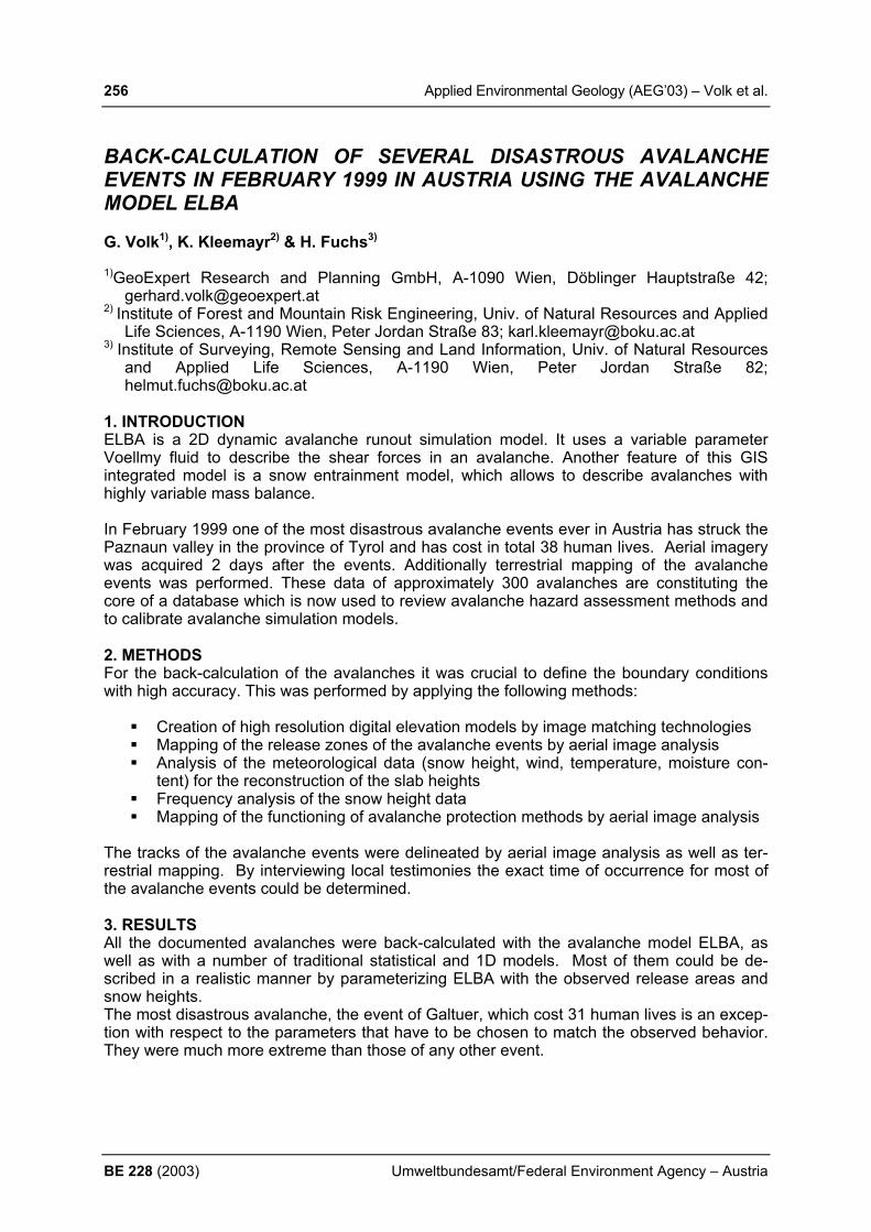
256 Applied Environmental Geology (AEG’03) – Volk et al.
BE 228 (2003) Umweltbundesamt/Federal Environment Agency – Austria
BACK-CALCULATION OF SEVERAL DISASTROUS AVALANCHE EVENTS IN FEBRUARY 1999 IN AUSTRIA USING THE AVALANCHE MODEL ELBA G. Volk1), K. Kleemayr2) & H. Fuchs3) 1)GeoExpert Research and Planning GmbH, A-1090 Wien, Döblinger Hauptstraße 42;
[email protected] 2) Institute of Forest and Mountain Risk Engineering, Univ. of Natural Resources and Applied
Life Sciences, A-1190 Wien, Peter Jordan Straße 83; [email protected] 3) Institute of Surveying, Remote Sensing and Land Information, Univ. of Natural Resources
and Applied Life Sciences, A-1190 Wien, Peter Jordan Straße 82; [email protected]
1. INTRODUCTION ELBA is a 2D dynamic avalanche runout simulation model. It uses a variable parameter Voellmy fluid to describe the shear forces in an avalanche. Another feature of this GIS integrated model is a snow entrainment model, which allows to describe avalanches with highly variable mass balance. In February 1999 one of the most disastrous avalanche events ever in Austria has struck the Paznaun valley in the province of Tyrol and has cost in total 38 human lives. Aerial imagery was acquired 2 days after the events. Additionally terrestrial mapping of the avalanche events was performed. These data of approximately 300 avalanches are constituting the core of a database which is now used to review avalanche hazard assessment methods and to calibrate avalanche simulation models. 2. METHODS For the back-calculation of the avalanches it was crucial to define the boundary conditions with high accuracy. This was performed by applying the following methods:
Creation of high resolution digital elevation models by image matching technologies Mapping of the release zones of the avalanche events by aerial image analysis Analysis of the meteorological data (snow height, wind, temperature, moisture con-
tent) for the reconstruction of the slab heights Frequency analysis of the snow height data Mapping of the functioning of avalanche protection methods by aerial image analysis
The tracks of the avalanche events were delineated by aerial image analysis as well as ter-restrial mapping. By interviewing local testimonies the exact time of occurrence for most of the avalanche events could be determined. 3. RESULTS All the documented avalanches were back-calculated with the avalanche model ELBA, as well as with a number of traditional statistical and 1D models. Most of them could be de-scribed in a realistic manner by parameterizing ELBA with the observed release areas and snow heights. The most disastrous avalanche, the event of Galtuer, which cost 31 human lives is an excep-tion with respect to the parameters that have to be chosen to match the observed behavior. They were much more extreme than those of any other event.
Applied Environmental Geology (AEG’03) – Volk et al. 257
Umweltbundesamt/Federal Environment Agency – Austria BE 228 (2003)
4. CONCLUSIONS 2D avalanche models are a highly valuable tool to determine avalanche hazard zones in complex terrain, since the avalanche path and width is determined automatically. The rheol-ogy of the modified Voellmy fluid implemented in ELBA proved to be capable of explaining the behavior of avalanches in a wide range of sizes. The process of snow entrainment proved to be very important for the comprehension of avalanche dynamics. With the data acquired from the 1999 events ELBA could be calibrated for extreme events.
Fig. 1: Three time-steps of an ELBA simulation; the contours depict different flow heights; the images show the highly variable width and flow height within the avalanche body as well as between the different time steps; flow height and width are strongly influencing the runout length of an avalanche; Nevertheless there remain a number of issues to be dealt with:
The photogrammetric mapping of the 1999 events does not give any information about the dynamic behavior of the avalanches.
The parameters have been calibrated for the conditions of February 1999. It is still unclear which parameters have to be chosen for wetter or dryer snow conditions.
The observations and results of the simulations displayed the importance of a realistic assumption of the size of the release zones in order to get realistic simulation results. In the practical application the definition of release zones is extremely difficult.
REFERENCES VOLK, G. & KLEEMAYR, K. (1999): ELBA - Ein GIS-gekoppeltes Lawinensimulationsmodell,
Anwendungen und Perspektiven. Österreichische Zeitschrift für Vermessung & Geoin-formation, 2+3, 84-92.
VOLK, G. & KLEEMAYR, K. (1999): Lawinensimulationsmodell ELBA. Wildbach- und Lawi-nenverbau, 63, 138, 23-32.
VOLK, G. & KLEEMAYR, K., 2000: Integration von dynamisch variablen Fliessparametern in ein 2D Voellmy Lawinenmodell, Tagungspublikation Symposium Interprävent 2000 – Vil-lach, Band 1, 451-461
258 Applied Environmental Geology (AEG’03) – Weinbruch & Ebert
BE 228 (2003) Umweltbundesamt/Federal Environment Agency – Austria
SOURCE APPORTIONMENT OF ATMOSPHERIC AEROSOLS BASED ON ELECTRON MICROSCOPY OF INDIVIDUAL PARTICLES S. Weinbruch & M. Ebert Institut für Angewandte Geowissenschaften, Fachgebiet Umweltmineralogie, Schnittspahnstr. 9, 64287 Darmstadt, Germany; e-mail: [email protected] 1. INTRODUCTION Enhanced levels of aerosol concentrations have adverse effects on the human health. For example, a strong correlation between mortality and atmospheric concentrations of aerosol particles has been reported in a large number of epidemiological studies (an overview is given by POPE & DOCKERY, 1999). The exact mechanisms are poorly understood, and it is still not clear which particle properties (number, chemical composition, surface area) lead to the observed adverse health effects. A detailed characterization of the exposition is, how-ever, of prime importance for a better understanding of the health effects as well as for all strategies of immission reduction. Source apportionment of atmospheric aerosols is often carried out by receptor modeling (e.g., HOPKE, 1991) using the chemical bulk composition measured at a given site. In con-trast, detailed characterization of individual particles (size, morphology, chemical composition and phase composition) leads to a more complete understanding of the contribution of the different sources to the aerosol composition. 2. ANALYTICAL TECHNIQUES Aerosol particles with aerodynamic diameters between 0.1 and 25 µm (50 % cut-off diame-ter) were collected with a five-stage cascade impactor at different rural and urban-influenced locations in Germany. Samples were studied by high-resolution scanning electron micros-copy (HR-SEM), transmission electron microscopy (TEM) and environmental scanning elec-tron microscopy (ESEM). 3. RESULTS Based on morphology and chemical composition, the particles can be assigned to different groups: biological particles, silicates (including silicon oxides), metal oxides, sea salt, aged sea salt, calcium sulfates, ammonium sulfate, soot, organic particles and sulfate/soot mix-tures. Biological particles can be easily recognized by their morphology and/or by the presence of characteristic elements (e.g., phosphorus, potassium). Independent of the season, biological particles are an important constituent of the fraction of large particles (diameter ≥ 1 µm). In source apportionment studies, which are based on the bulk chemical composition, this impor-tant natural component is mostly overlooked. Silicates and silicon oxides occur at all particle sizes. Based on particle morphology, fly ash particles (melt spheres) can be easily distin-guished from soil particles. At all locations studied, the fraction of small particles (diameter < 1 µm) is dominated by fly ash particles (melt spheres), in contrast to the large silicate and silicon oxide particles which predominantly consist of soil particles. Using the bulk chemical composition, differentiation between fly ash (anthropogenic sources) and soil particles (natu-ral source) is not possible. Metal oxides (mostly iron oxides) primarely occur in the fraction of small particles and are emitted from anthropogenic sources (melt spheres). Sea salt particles and aged sea salt particles (chlorine is partly or completely replaced by sulfur) can be recog-nized by their chemical composition. Both particle groups predominantly occur at particle di-ameters ≥ 0,5 µm. Soot consists of small primary particles (diameters between 10 and 50 nm) which form larger agglomerates with diameters up to a few micrometers. Soot agglom-
Applied Environmental Geology (AEG’03) – Weinbruch & Ebert 259
Umweltbundesamt/Federal Environment Agency – Austria BE 228 (2003)
erates can be easily recognized in HR-SEM and TEM by their characteristic morphology. In polluted air masses, soot may be the dominant particle group in the size fraction ≤ 1 µm. At the smallest size fraction studied (100 – 200 nm), more than 80 % of all particles may be soot agglomerates. As the contribution of the small particles to the aerosol mass is very low, the significance of soot is generally underestimated in source apportionment based on bulk chemistry. Ammonium sulfate and mixtures of ammonium sulfate with soot are two particle groups, which often occur at high abundance (up to 60 %, by number). In the sulfate/soot mixtures, one to several soot agglomerates are enclosed in the ammonium sulfate particle. The number of soot inclusions can be determined only by TEM after the surrounding ammo-nium sulfate is evaporated by the electron beam. The soot inclusions within ammonium sul-fate are of great importance for exposure studies. If deposited in the respiratory tract, ammo-nium sulfate will dissolve and the soot agglomerates will be liberated, leading to a much higher number of insoluble particles. In general, the relative abundance of the different particle groups is highly variable, depend-ing on the air mass back-trajectories. However, at all places investigated air pollution is char-acterized by high abundances of soot particles. 4. CONCLUSIONS Characterization of individual particles by scanning and transmission electron microscopy leads to a more complete picture of the contribution of the different sources to the aerosol composition compared to bulk chemical analysis. Therefore, individual particle analysis must be regarded as an indispensable tool for a realistic exposure assessment as well as for ef-fective strategies for immission reduction. REFERENCES HOPKE, P.K. (1991): Receptor modeling for air quality management. 329 p., Elsevier, Am-
sterdam. POPE, C.A. & DOCKERY, D.W. (1999): Epidemiology of particle effects. In: HOLGATE, S.T.;
SAMET, J.M.; KOREN, H.S. & MAYNARD, R.L. (eds.): Air pollution and health., chapter 31, 673-705, Academic Press, San Diego.

260 Applied Environmental Geology (AEG’03) – Weinke et al.
BE 228 (2003) Umweltbundesamt/Federal Environment Agency – Austria
DETERMINATION OF TRACE ELEMENTS IN WATERS WITH DITHIZONE *) G. H. Weinke1), L Weber2) and H. H. Weinke1) 1) Department of Geological Sciences (Geochemistry), University of Vienna, A-1090 Wien, Althan-
straße 14; 2) Federal Ministry for Economy and Labour, Mining Authority, IV/7, 1200 Wien, Denisgasse 31 *) Dedicated to ord. Univ. Prof. Dr. Wolfgang Kiesl on occasion of his 68th birthday 1. INTRODUCTION In waters zinc is usually present apart from small quantities of lead and copper. Therefore the three elements mentioned are determined preferentially next to each other. The isolated determination of zinc, lead or copper takes place via selective camouflage by addition of small quantities of complex reagents or by choice of the selected pH-value. 2. INVESTIGATIONS The dithizone used as proof reagent for heavy metals (diphenylthiocarbazon, H2Dz) is hardly soluble in water and diluted acids, but soluble in diluted ammonia and organic solvents such as chloroform and carbon tetrachloride as well. For the use in the micro and trace element analysis there is the excellent overview of G. IWANTSCHEFF (1972) as well as a R.S.C. publication (1977). Zinc, lead and copper belong to the elements, which form stable metal di-thizonates MeHDz. Dithizone in the organic solvents is emerald-green and forms red chelate complexes with these heavy metals. In Fig. 1 the absorption spectra of the dithizone as well as the metal complexes of these elements are represented in the spectral region of 300 to 800 nm. The absorption minimum is evident clearly with 520 nm apart from the two absorp-tion maxima of the H2Dz at 450 and 620 nm, while most metal chelate compounds show straight in this range their absorption maximum.
0.000
0.200
0.400
0.600
0.800
1.000
1.200
1.400
1.600
300 400 500 600 700 800
Abs
orpt
ion H2Dz
CuPbZn
Fig. 1: Absorption spectra of the dithizone and the metal chelate compounds. After complete reaction and extraction of the complexes MeHDz the removal from green di-thizone still available in surplus takes place by addition of ammonia. The resulting red colour of the heavy metal complexes is quantitatively measured at 530 nm by a one-colour proce-dure.

Applied Environmental Geology (AEG’03) – Weinke et al. 261
Umweltbundesamt/Federal Environment Agency – Austria BE 228 (2003)
For the determination of the elements zinc, lead and copper five determinations must be ac-complished in each water test. The following conditions are to be kept:
1. the sum of zinc, lead and copper; 2. copper at a pH-value of 2; 3. lead under masking of zinc and copper with cyanide; 4. zinc under masking of lead with thiosulfate; 5. further disturbing chelats forming elements by masking with CN- and S2O3
-2. For the adjustment of the reagents it is substantial that the photometric calibration curves are in the linear range. The absorption of the elements
• zinc • lead • copper
are represented in Figure 2. The measured values show straight lines with 2*10-4 M dithizone solution in CCl4 in the concentration region up to 100 ppb used. For the field work and Figure 1 and Figure 2, a 3.9*10-5 M solution was used to get easier semi-quantitative data in the field.
0.000
0.050
0.100
0.150
0.200
0.250
0.300
0.350
0.400
0.450
0.500
0.0E+00 2.0E-07 4.0E-07
Molarity
Abs
orba
nce
0.000
0.050
0.100
0.150
0.200
0.250
0.300
0.350
0.400
0.450
0.500
0 10 20 30
ppb
Abs
orba
nce
Zinc
Lead
Copper
Zn calc
Pb calc
Cu calc
Fig. 2: Measured photometric calibration lines of Zn, Pb and Cu relate to concentra-tion in molarity. Fig. 3: Measured photometric calibration lines of Zn, Pb and Cu relate to concentra-tion depending on ppb.
3. CONCLUSIONS For the geochemical prospection of waters, which came into contact with sulfide ores, but also water contaminated by environmental influences, the presented method is useful to a detection limit of 1 ppb for zinc and copper as well as of 5 ppb for lead, due to the substan-tially smaller absorption. The extremely small concentrations of heavy metals in standing mine waters are surprising. This is due to the high pH-value. In contrast to this the heavy metals are enriched in the (car-bonaceous) mud. Flowing or dropping water shows clear heavy metal guidance in depend-ence of an ore proximity, why this high-speed proof is recommended not only in environ-mental analytics but also as excellent folder ion method.

262 Applied Environmental Geology (AEG’03) – Weinke et al.
BE 228 (2003) Umweltbundesamt/Federal Environment Agency – Austria
4. ADDENDUM – FIELD WORK For field work the 0,001 % dithizone solution is ideal. Above all, if as upper detection limit 25 to 50 ppb of the trace elements can be specified. As a consequence of the small H2Dz-concentration a semi-quantitative shade of the metal contents can be made directly. 1. Production of a H2Dz-working solution on the day of use by diluting the H2Dz-parent solu-tion in the ratio 1:100 with CCl4. This solution is not to be exposed to the direct sunlight; du-rability maximally one day. 2. The shaking cylinder used for the investigation is rinsed several times with the water which will be examined. 3. Fill 50 ml of the water to be examined into the cylinder. 4. Add 5 drops of buffer solution. 5. Add 5 ml H2Dz-working solution and shake 1 min vigorously. 6. After the separation H2Dz-CCl4/H2O watch the colour of the H2Dz containing phase: a) If the H2Dz gets immediately red or violet: The heavy metal content is > 25 ppb. b) The H2Dz gets blue: Heavy metal content = 25 ppb. 7. The organic phase remains green or greyish green. Add some drops ammonia and shake strongly. H2Dz will be destroyed, only existing red MeHDz remains. A reddish colour indi-cates the presence of metals: c) The H2Dz gets strongly pink = 10 - 20 ppb. d) The colour gets pink = 10 ppb. e) The organic phase gets very weakly pink = 2,5 ppb. f) If the solution becomes colourless, the water is metal-free. REFERENCES IWANTSCHEFF, G. (1972): Das Dithizon und seine Anwendung in der Mikro- und Spuren-
analyse. Verlag Chemie, Weinheim , 330 S. ROYAL CHEMICAL SOCIETY (1977): Dithizone. Analytical Science Monograph No. 5, Lon-
don, 112 S.

Applied Environmental Geology (AEG’03) – Willig 263
Umweltbundesamt/Federal Environment Agency – Austria BE 228 (2003)
EMPIRICAL INSIGHTS INTO THE ELIMINATION OF TYPICAL EXPLOSIVES COMPOUNDS BY THE WATER TREATMENT INSTALLATION ON THE BLAST SITE WILDFLECKEN (RHÖN MOUNTAINS SOUTHEAST OF FULDA, GERMANY) D. Willig AgeoBw, Wehrgeologische Stelle, Postfach 1264 AWG, D-82242 Fürstenfeldbruck, [email protected] 1. INTRODUCTION The blast site on the major training area WILDFLECKEN has been in use since 1937. Within the blast site compounds typical for the use of explosives have been detected inside the ground and in the surface runoff. The contamination of the soil samples ranges from 20 to 450mg/kg (compounds typical of explosives as listed further below, as analysed by Institut Rietzler (GbR, Nürnberg) in the surface zone. In the surface runoff maximum concentrations of 870µg/l have been detected. In order continue operating the explosives training site and to stop the uncontrolled disper-sion of explosive compounds from the soil already contaminated, a new training area includ-ing the cleaning of runoff water has been set up at the site of the old one (see Literature). 2. METHODS From 1937 on the blast site had been used at first by the armed forces of the "Wehrmacht", then by the U.S. army and later on by the German armed forces of the "Bundeswehr". Within a programme for investigating environmental damage of land contaminated by previous use, the major training area WILDFLECKEN and therefore also the blast site were closely exam-ined. The examination has given evidence of the following compounds typical for the use of explosives:
• 2,4,6-trinitrotoluene (TNT) • 4-amino-2,6-dinitrotoluene (4-ADNT) • 2-amino-4,6-dinitrotoluene (2-ADNT) • 2,4-dinitrotoluene (2,4-DNT) • 1,3,5-trinitrobenzene (TNB) • hexogen (RDX) • oktogen HMX • nitropenta (PETN) • nitroglycerine (NG)
The first goal was to continue the use of the blast site for military training with a TNT equiva-lent up to 20 kg without polluting the environment. Second objective was the reduction of contaminants in the running water outside the training site due to the previous use of explo-sives. Therefore the blast site was completely renovated and re-arranged.
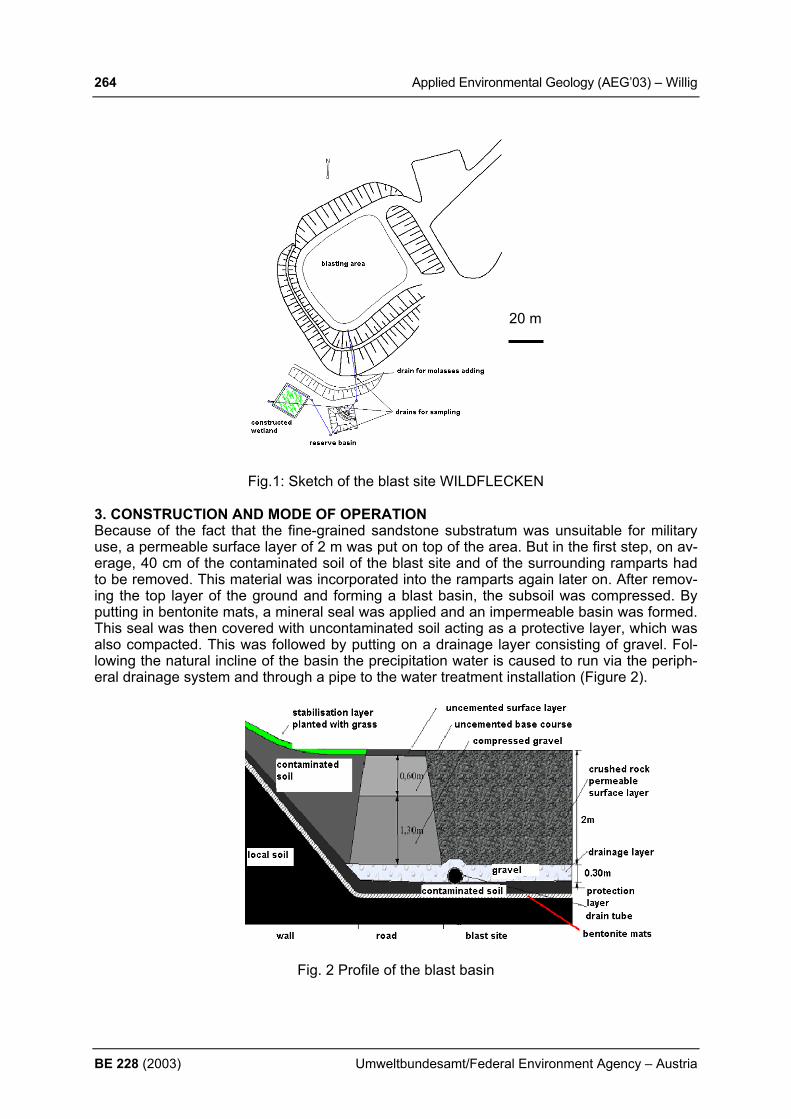
264 Applied Environmental Geology (AEG’03) – Willig
BE 228 (2003) Umweltbundesamt/Federal Environment Agency – Austria
20 m
Fig.1: Sketch of the blast site WILDFLECKEN 3. CONSTRUCTION AND MODE OF OPERATION Because of the fact that the fine-grained sandstone substratum was unsuitable for military use, a permeable surface layer of 2 m was put on top of the area. But in the first step, on av-erage, 40 cm of the contaminated soil of the blast site and of the surrounding ramparts had to be removed. This material was incorporated into the ramparts again later on. After remov-ing the top layer of the ground and forming a blast basin, the subsoil was compressed. By putting in bentonite mats, a mineral seal was applied and an impermeable basin was formed. This seal was then covered with uncontaminated soil acting as a protective layer, which was also compacted. This was followed by putting on a drainage layer consisting of gravel. Fol-lowing the natural incline of the basin the precipitation water is caused to run via the periph-eral drainage system and through a pipe to the water treatment installation (Figure 2).
Fig. 2 Profile of the blast basin

Applied Environmental Geology (AEG’03) – Willig 265
Umweltbundesamt/Federal Environment Agency – Austria BE 228 (2003)
On top the blast site is covered with a surface layer made of crushed coarse gravel. The col-lected percolating water first flows into a storage and sedimentation drain, then into an add-ing drain and finally from a sampling drain into a reserve basin. The reserve basin serves to level out varying amounts of precipitation. At the same time, a first passive cleaning of the water by means of elementary iron takes place ("principle of the reactive wall"). From this basin the collected water flows steadily through a drain pipe into a Constructed Wetland. That is a basin filled with a graded gravel substrate and planted with marsh plants. In the Wetland, through which the water flows in a horizontal direction, the water is to be cleaned almost completely by biological decomposition so that it can be led off through an outflow and another drain for sampling. Since the explosive compounds are decomposed co-metabolically, molasses, depending on the amount of precipitation, must be added as a nu-triment source for micro-organisms inside the adding drain before the water reaches the re-serve basin. All inflows and outflows operate on the basis of the natural declivity, that is with-out the use of pumps. (In sugar refining, molasses is separated from the sugar crystals after each of three boiling or extraction processes that sugar cane goes through. The 3rd and final separation is called blackstrap molasses, and is used mostly as an ingredient in cattle feed). The installation was finished in November 2002. The test phase will last until the thirty-first of July, 2004. During this time the efficiency of the installation will be checked by regular sam-pling and will be optimized in respect of process engineering. The total expenses amount to approximately 250,000 Euro. 4. CONCLUSION It seems to become apparent that the relatively cheap method of cleaning water by means of a Constructed Wetland is an effective way to reduce the pollutants in the percolating water of the blast site. The example of the blast site of WILDFLECKEN shows that blast operations which are necessary from a military point of view can be carried out in an ecologically ac-ceptable way. Therefore the new blast site WILDFLECKEN can function as a pilot project for many premises of the armed forces of the Bundeswehr. REFERENCES BiIOPLANTA & WASAG DECON GmbH. (2002): Genehmigungsplanung- Umgestaltung
des Sprengplatzes auf dem Truppenübungsplatz Wildflecken.- Unveröffentlichter Bericht GERTH, A. et al., (2001): Passive Behandlung sprengstoffkontaminierter Wässer in
Constructed Wetlands und Reaktionswände.- TerraTech., 5, S.: 51-53
266 Applied Environmental Geology (AEG’03) – Xie et al.
BE 228 (2003) Umweltbundesamt/Federal Environment Agency – Austria
REGIONAL DISTRIBUTION OF STREAM WATER CHEMISTRY AS A FUNCTION OF LAND-USE AND GEOLOGY IN BADEN-WÜRTTEM-BERG X. Xie, Z. Berner, S. Norra, D. Stuben Institute for Mineralogy and Geochemistry, Universität Karlsruhe (TH), 76128 Karlsruhe, Germany 1. INTRODUCTION The chemistry of stream waters is influenced by a lot of environmental factors related to litho-sphere, hydrosphere, biosphere, and atmosphere. It has been demonstrated that there is a close relationship between stream water chemistry, land use, and geology (JOHNSON et al., 1997; WAYLAND et al., 2003; HOLLOWAY et al., 1998). The knowledge of the regional distribu-tion of harmful substances in stream waters is of great importance to assess human impact on the environment. Factor analysis combined with geographic information system (GIS) has been widely used to find the specific pollution pattern in stream waters during the last two decades (SMART et al., 1998; WAYLAND et al., 2003; CAMERON, 1996; EVANS et al., 1996). The pre-sent study was carried out to distinguish the land use related pattern of stream water chemistry on a regional scale in Baden-Württemberg (Germany). By means of factor analysis, the data concerning stream water chemistry, geology, and land use were evaluated and the relationships between different environmental parameters were revealed. 2. MATERIALS AND METHODS The study area is located in the south-west of Germany and is covered by a dense network of streams and rivers. The dataset used in this study consists of three categories of data, including 48 chemical, geological, and land use parameters, collected from 88 monitoring stations by the Institute for Environmental Protection of Baden-Württemberg (LFU) between 1985 and 1996. The database on water chemistry contains 21 hydrochemical parameters such as pH, O2, con-ductivity, DOC, SAC, acid capacity, anions (NO3-, PO4
3-, SO42-, Cl-), alkaline and alkaline earth
elements, heavy metals etc.. Geological data include the main geological formations of Baden-Württemberg (crystalline, Buntsandstein + Rotliegendes, Muschelkalk + Lettenkeuper, Gipske-uper, Upper Keuper, Lias + Dogger, Malm, Tertiary, Quaternary alluvial deposits, Quaternary gravels and sands, Quaternary moraines). The area is divided into 16 different land use types as follows: agricultural land, fallow land, dense settlement, scattered settlement, industrial area, wetland, and unsealed area; areas covered for coniferous forest, deciduous forest, mixed forest and scattered stock of trees; areas used for intensive pasture, extensive pasture, orchard and viniculture (NORRA et al., 1999). The factor loadings and factor scores were generated by means of the software package STATISTICA by StatSoft USA. For the extraction of factors, the minimum eigenvalue was set to 1.0 (i.e. only factors were considered which explain more of the variance in the data matrix than an initial variable does) and the factors were rotated using the varimax algorithm (HAIR et al., 1995). The areal distribution of the corresponding factor scores was depicted by using geo-graphic information system (GIS ArcView). 3. RESULTS Based on the factor loadings, the 48 initial variables are condensed and classified into 10 uncor-related factors. These factors can replace the initial variables, whereby a “loss of information” of only 31 % occurs. The factors obtained by the regionalization of stream water chemistry, in de-pendency of the geological underground and distribution of land use types in Baden-Württemberg are summarized in Table 1.
Applied Environmental Geology (AEG’03) – Xie et al. 267
Umweltbundesamt/Federal Environment Agency – Austria BE 228 (2003)
Tab. 1: The ten uncorrelated factors I - X
Factors Hydrochemical parameters
Explained variance (%)
Factor I: main mineralization of the stream water connected to geology Conductivity,Ca, Mg, SO42- 13.46
Factor II: parameter connected to orchards and anthropogenic nutrients PO43-, NO3
-, K+, 9.08
Factor III: heavy metals Cu, Cd, Pb, Zn 9.06 Factor IV: viticulture on Quaternarian terrace deposits NO3
-, O2 7.72 Factor V: pasture in Schwäbische Alb 6.00 Factor VI: organic matter SAC, DOC, pH 5.23 Factor VII: salt water Na+, Cl- 4.82 Factor VIII: geological basement of the Black Forest and Odenwald Si, K+ 4.78 Factor IX: agriculture NO3
- 4.44 Factor X: industry 4.23 4. CONCLUSION Factors explaining the highest share of variance are related to the main mineralization of the waters and parameters representing anthropogenic nutrients. Parallel to successes achieved in controlling of point type sources, pollutants from diffuse sources have become a more important factor which influences the quality of stream waters. Nevertheless, geology is still one of the most important factors controlling the chemistry of stream waters. The basic prerequisites for a successful regionalization based on stream water chemistry, land use, and geology are as fol-lows: (1) reasonably homogenously distributed monitoring sites; (2) qualitatively reliable data; and (3) an appropriate multi-parameter evaluation method, such as factor analysis combined with geographic information system (GIS). REFERENCES CAMERON, E.M. (1996): Hydrogeochemistry of the Fraser River, British Columibia: Sea-
sonal variation in major and minor components. J. Hydrol., 182: 209-225. EVANS, C.D.; DAVIES, T.D.; WIGINGTON, P.J.; TRANTER M.; & KRETSER, W.A. (1996):
Use of factor analysis to investigate processes controlling the chemical composition of four streams in the Adirondack Mountains, New York. J. Hydrol (Amsterdam), 185:297-316.
HOLLOWAY, J.M.; DAHLGREN, R.A.; HANSEN, B.; & GASEY, W.H. (1998): Contribution of bedrock nitrogen to high nitrate concentrations in stream waters.Nature, 395:785-788.
HAIR, J. F.; ANDERSON, R.; TATHAM, R. L. & BLACK, W. C. (1995): Multivariate data analysis, New Jersey (Prentice Hall) .
JOHNSON, L.; RICHARDS. C.; HOST, G. & ARTHUR, J.W. (1997): Landscape Influence on water chemistry in Midwestern stream ecosystems. Freshwater Biology, 37: 193-208.
NORRA, S.; HUCK, K.; SCHMIDT, F.; KRAMMAR, U. & STÜBEN, D. (1999): Untersuchung zur Ableitung von geogenen Hintergrundwerten für die Fließgewässer in Baden-Württemberg. Karlsruhe (Forschungsbericht des Instituts für Petrographie und Geochemie an die Landesanstalt für Umweltschutz Baden-Württemberg (LfU)).
SMART, R.P.; SOULSBY, C.; NEAL, C.; WADE, A.; CRESSER, M.S.; BILLERTT, M.F.; LANGAN, S.J.; EDWARDS, A.C.; JARVIE, H.P.; OWEN, R. (1998): Factors regulating the spatial and temporal distribution of solute concentrations in a major river system in NE Scotland. The Science of the Total Environment, 221: 93-110.
WAYLAND, K.G.; LONG, D.T.; HYNDMAN, D.W.; PIJANOWSKI, B.C.; WOODHAMS, S.M. & HAACK, S.K. (2003): Identifying relationships between baseflow geochemistry and land use with synoptic sampling and R-mode factor analysis. J. Environ. Qual. 32:180-190.

268 Applied Environmental Geology (AEG’03) – Zibret & Sajn
BE 228 (2003) Umweltbundesamt/Federal Environment Agency – Austria
EMISSIONS OF HEAVY METALS TO THE ENVIRONMENT IN THE TOWN OF CELJE G. Žibret, R. Šajn Geološki zavod Slovenije, Dimičeva 14, 1000 Ljubljana, [email protected], [email protected] 1. INTRODUCTION Numerous human activities result in environmental pollution. One of them, which pollutes the environment very heavily, is zinc smelting. In Celje, the zinc smelting plant Cinkarna Celje was being in operation between 1870 and 1970. This is more than 100 years of continuous production. During this period the complete output was approximately 580.000 tons of raw zinc. The production was based on oxidation of sphalerite ore in 11 blast-furnaces without the use of any filters in the chimneys. It has been expected that Celje is polluted with zinc and other geochemical linked elements, like cadmium, lead, arsenic, mercury... 2. MATERIALS AND METHODS The samples were taken in 1 kilometer grid with 15 additional samples taken in the most populated area of Celje. The north-south dimension of the researched area is 8 and the west-east length is 10 kilometers with the Cinkarna Celje in the middle. The research area includes the most densely populated region of Celje basin, uplands in the south and the iron-smelter plant in the east. Considering the nature of pollution in Celje, the best sampling materials are the attic dust and soils. The samples of attic dust were collected from wooden roof-carrying construction in the attics of old houses (at least 50 years) on more than 110 locations. Dust represents the dry air deposit which was accumulated from the time, when the house was built until present. Another sampling material was soil. It was sampled in the proximity of the house, in which dust was collected. A sample was a mixture of 10 or 15 smaller samples, collected in circle grid. Only top 5 centimeters were taken. Chemical analysis was made on the smallest fraction (<0.125 mm) by means of ICP and AAS for mercury. Emissions were calculated on the basis of the concentrations of elements in attic dust, as well as data provided by the Institute of Public Health of Celje, which was measuring the weight of dry and wet air deposits on 19 locations in Celje and its suburbs between the years 1989 and 2000 (URŠIČ, 2000). Unfortunately, any data on the quantity of air deposit during zinc production period were unavailable. Data processing was based on numerical integra-tion with Mathlab application (ŽIBRET, 2002). For separating the anthropogenic and natural emissions of heavy metals in the environment we used the data of natural geochemical background ŠAJN (1999) in the attic dust. 3. RESULTS The results of the research show that Celje is heavily contaminated with zinc and cadmium and medium contaminated with lead, arsenic and mercury (Table 1). For comparison, Table 1 also includes aluminium, the concentrations of which are mainly affected by lithology.

Applied Environmental Geology (AEG’03) – Zibret & Sajn 269
Umweltbundesamt/Federal Environment Agency – Austria BE 228 (2003)
Table 1: non-parametric variables for some elements in the attic dust (-d) and soil (-s) in Celje (all values are in g/t, for emissions in tons): minimum maximum median total anthropogenic natural value value emissions emmissions emissions Al-s 33000 87000 62000 12930 1388 11540 As-d 18000 54000 33000 As-s 4 91 16 16.1 ? ? As-d 6 482 36 Cd-s 0.5 59 2.9 10.46 9.102 1.353 Cd-d 2.3 456 24 Hg-s 0.035 1.395 0.13 0.288 0.039 0.248 Hg-d 0.11 4.59 545 Pb-s 33 1508 117 278.7 180.9 97.75 Pb-d 191 6920 622 Zn-s 87 8573 499 1919 1712 206.8 Zn-d 459 56272 4399 4. CONCLUSION The conclusion of this research is, that Celje is heavily contaminated with heavy metals, es-pecially with cadmium and zinc. This is the consequence of more than 100 years of smelting of sphalerite ore in Cinkarna Celje. The most heavily contaminated area includes the city center and the area between Celje and Štore in the east. The maximum concentrations in this area exceeds the Slovenian averages (ŠAJN, 1999) for more than 100 times. REFERENCES ŠAJN, R. (1999): Geokemične lastnosti urbanih sedimentov na ozemlju Slovenije, 136 p.,
Geološki zavod Slovenije, Ljubljana. URŠIČ, A. (2000): Epidemiološke, higienske in ekološke razmere na Celjskem v letu 1999:
strokovno poročilo, 17 p., ZZV Celje, Celje. ŽIBRET, G. (2002): Masna bilanca težkih kovin na območju Celja, Geologija 45/2: 613 - 618
p., Ljubljana.
270 Applied Environmental Geology (AEG’03) – Zlobina
BE 228 (2003) Umweltbundesamt/Federal Environment Agency – Austria
CARBONATE KARST UNDER URBAN CONDITIONS
V. L. Zlobina Russia, Moscow, 119991 Gubkina 3, Water Problems Institute, [email protected]
1. INTRODUCTION Karst water is closely associated with the environment and therefore changes in environment actively and rapidly affect groundwater. In urban areas groundwater is subjected to many dif-ferent stresses. Changes in hydrogeological conditions strongly affect the environment and karst aquifers. It was usually considerate that karst develops slowly. But today there is evi-dence which contradicts this opinion. New sinkholes may be formed within a few decades or at the beginning of high-rate development of carbonate aquifers, even in areas where sink-holes were not previously observed. High-rate exploitation of karst water leads to generation of hydrodynamic, hydrochemical, thermal, and hydrobiological anomalies in aquifer under development as well as to intensifi-cation of karst-suffosion processes. The combination of these factors leads to the rapid de-velopment of karst in urbanized areas. 2. MATERIALS AND METHODS Many different investigation methods or combinations of methods are used to delineate karst zones. Investigations included: helium survey, hydrodynamic, hydrochemical, thermal, and hydrobiological studies. First step in an investigation, zones which are potentially dangerous for construction due to active karstification processes, or the possibility of karstification in the near future, should be delineated and mapped. A helium survey was performed in order to delineate areas of prob-able active karstification. Mapping of the areal distribution of helium concentration in the Car-boniferous aquifers allowed for the determination of three areas with anomalous values. A helium survey was conducted in Carboniferous aquifers in the Moscow artesian basin during the 1978 -1999 period. A helium survey has been performed over an area of about 1000 km2. Analysis of the piezometric levels in water-supply and observation wells showed that three regime of confined water level fluctuations are present in the Carboniferous aquifer. On the basis of the hydrogeochemical observations, the existence of variations in concentra-tions of some chemical elements in the carboniferous aquifers were established thermody-namic calculations were performed using existing methods. Water samples from water-supply wells were taken. 3. RESULTS The helium study showed that anomalous helium values are indicative of inflows of river and groundwater to confined aquifer. In the area under investigation, by 1987, three mainly con-fined to fault zones and associated palaeovalleys, cutting Jurassic clays were anomalies found. The thermodynamic calculations show a complex change in the index of water saturation on Carboniferous aquifers over time and area. As a result, water becomes undersaturated by calcite and capable of dissolving carbonate rocks. Carbonate undersaturation of the karstic water considerably decrease from 1962 to 1996. The data obtained also confirmed the pre-dominance of water undersaturated with respect to calcium carbonate in the zones where helium anomalies occurred. During recent decades a decrease in ph values from 7-8 to 4.5-5.2 was recorded in the Quaternary aquifers. The spatial study of the karst water dissolving
Applied Environmental Geology (AEG’03) – Zlobina 271
Umweltbundesamt/Federal Environment Agency – Austria BE 228 (2003)
capacity for the area of investigation showed that within the area, nine zones are distin-guished with a calcite saturation index of less than zero. Strontium concentrations in leaching zones are high as 16-25mg/l that is also indicative of the intensification of leaching of carbonate rocks. The largest number of hydrobiont species predominate in areas of recharge, delineated us-ing both helium data, hydrodynamic and hydrochemical data. 4. CONCLUSION Water abstraction is a man-induced factor that has the most pronounced effect on the quality ground water under exploitation. Inflow of river and unconfined ground water into aquifer un-der exploitation the confined water in the formed areas of recharge becomes undersaturated as to calcite that contributes to intensification of the leaching of water-bearing rocks. A helium survey may be the most effective and economical method of investigation. It allows for the establishment of the relationships between aquifers and between surface and groundwater. REFERENCES BREKHOVSKIKH, V. F. & ZLOBINA (1987): Particularities of formation of hydrochemical re-
gime and biocenosis composition of confined ground ware being intensely exploited. Vod-nye Resursy 1, p. 133 -138.
ZLOBINA V. L. (1986): Effect of groundwater exploitation on karst and suffusion develop-ment. Nauka Publ. Moscow (in Russian), 156 p.
ZLOBINA V. L. (1991): The effect of aquifer overexploitation on recharge area formation. XXIII Congress I.A.H.:Aquifer overexploitation Spain. p. 133 – 137.

272 Applied Environmental Geology (AEG’03) – Zwahlen & Goldscheider
BE 228 (2003) Umweltbundesamt/Federal Environment Agency – Austria
RESULTS OF THE EUROPEAN COST ACTION 620 – VULNERA-BILITY AND RISK MAPPING FOR THE PROTECTION OF CARBONATE (KARST) AQUIFERS F. Zwahlen & N. Goldscheider Hydrogeology Centre (CHYN), University of Neuchâtel, 11 rue Emile-Argand, CH-2007 Neuchâtel, Switzerland, Email: [email protected] / [email protected], Phone: 0041-32-718-2689 / -2645 Carbonate terrains, most of which are karstified, comprise one third of the land surface of Europe. Karst aquifers hold important groundwater resources supplying up to 50% of drink-ing water in some European countries. The European COST Action 620 (Cooperation in Sci-ence and Technology), including delegates from 16 countries, worked from 1997 to 2002 to develop a pan-European approach to vulnerability, hazard and risk mapping, which takes into consideration the particular characteristics of carbonate (karst) aquifers, but which can, however, also be used for other aquifer types. The project was given additional impetus by the European Water Framework Directive (2000), which is intended to provide a common framework for water resource policy and management. The approach comprises methods of intrinsic and specific vulnerability mapping, hazard and risk mapping, and validation. The approach can be used for both groundwater resource and source protection. It is based on an origin-pathway-target model. The origin is the point of re-lease of a potential contaminant, mostly the land surface. The target may be the groundwater table (resource protection) or a spring/well (source protection). The pathway comprises all compartments between the origin and the target. If a contamination occurs somewhere inside a catchment, there are three questions that a water user will ask: When will the contamination reach the target (source or resource), at which concentration, and how long will the target be contaminated? Vulnerability mapping thus aims on quantifying those properties of a hydrogeological system, which control the travel time, the concentration decline and the duration of a contamination event. These three aspects can be visualised in a 3D matrix, the so-called vulnerability cube. The intrinsic vulnerability of groundwater to contamination takes into account the hydro-geological properties of the system but is, by definition, independent of the nature of specific contaminants. The COST 620 approach to intrinsic vulnerability mapping uses four factors: O – overlying layers; C – concentration of flow; P – precipitation regime; and K – karst network development. The O factor describes the protectiveness of the layers overlying groundwater (topsoil, subsoil, non karst rock, unsaturated karst rock) dependent on their thickness and hydraulic properties. The C factor takes into account that those layers may be bypassed by surface or subsurface flow that enters the karst aquifer at another point, i.e. via a swallow hole (point recharge). The P factor considers the total annual precipitation and the intensity of precipitation. High intensities will accelerate contaminant transport and thus increase vulnerability. The K factor describes the karstification of the aquifer; there is all kind of transition between only fissured aquifers and extremely developed conduit systems. Different methods were proposed to determine and map intrinsic vulnerability within the framework of the common pan-European approach: the PI method (most commonly used), COP, Time-Input and LEA. A simple 1D transport model (VULK) can be used to calculate the transit time, concentration decline and contamination duration resulting from accidental con-tamination events at different points of the catchment. This model can thus be used to vali-date the results of the other methods. However, it is based on strong simplifications limiting

Applied Environmental Geology (AEG’03) – Zwahlen & Goldscheider 273
Umweltbundesamt/Federal Environment Agency – Austria BE 228 (2003)
its applicability. Present development aims on further improving VULK and coupling it with a GIS so that it can directly be used for vulnerability mapping. Specific vulnerability mapping additionally takes into account the characteristics of the differ-ent contaminants or groups of contaminants and their interaction with the hydrogeological systems. Three main groups of contaminants were identified: organics, inorganics, and parti-cles. The most relevant processes of contaminant attenuation are: adsorption, filtration, bio-degradation, reduction, precipitation, volatilisation, decay, and die off. Specific vulnerability is assessed on the basis of quantifying those layer properties and contaminant properties that control the effectiveness of the abovementioned processes. Hazards are defined as potential sources of groundwater contamination resulting from hu-man activities. There are three types of hazards: point hazards (e.g. septic tanks, farm houses), line hazards (roads, pipelines), and diffuse hazards (agriculture). Hazards are clas-sified on the basis of three criteria: type and toxicity of the contaminant (quality); potential contaminant load (quantity); and likelihood of contamination (accidental or permanent). COST 620 also developed simple hazard data collection software. The risk is generally defined as the probability of an event, multiplied by the resulting poten-tial damage. The risk of groundwater contamination depends the following aspects: the haz-ard, the intrinsic or specific vulnerability of the groundwater resource or source, and, as an optional third aspect, the economic or ecologic value of the groundwater. A risk map can be used as a tool to land-use planning. Action is required in areas, where a dangerous hazard is present on a highly vulnerable surface of a valuable aquifer. COST 620 proposes an ap-proach to risk assessment, risk mapping and risk management. Risk maps are to be created by overlaying vulnerability and hazard maps. COST 620 also proposed different techniques to validating vulnerability maps, including tracer tests, hydrograph and chemograph analyses, and modelling. The different aspects of the proposed methodology were successfully applied in 12 test sites all over Europe, comprising a wide range of geological, hydrogeological and climatic settings. Intrinsic vulnerability mapping was done in all the test sites. In two of those (the Sierra de Líbar in Southern Spain, and the Engen area in Germany), all aspects of the pan-European approach were applied: intrinsic and specific vulnerability mapping, hazard and risk mapping. The main advantages of the proposes approach are: it is based on sound hydrogeological principles; it is applicable for all types of aquifers but takes into account the special nature of karst; it is sufficiently flexible to be applied in different hydrogeological settings and different data availability; it is not a stand-alone method but comprises all elements of groundwater protection – intrinsic and specific vulnerability, source and resource protection, hazard as-sessment and risk mapping and management.