application of remote sensing and rainfall … · near realtime flood inundation mapping in kenya...
TRANSCRIPT
APPLICATION OF REMOTE SENSING AND RAINFALL-RUNOFF-INUNDATION MODEL TO NEAR REALTIME FLOOD INUNDATION MAPPING IN KENYA
Phoebe Pauline Ingado Onjira* Supervisor: Dr. Takahiro Sayama**
MEE13627
ABSTRACT
Flood countermeasures in Kenya are not adequate and insufficient hydro-meteorological data in most basins has made it difficult to characterize flood dynamics. Integrating remote sensing technologies with recent hydrologic modelling can be an appropriate complementary to the limited flood monitoring. This study aims to develop an automated near real-time inundation mapping system using remote sensing techniques and Rainfall-Runoff-Inundation (RRI) model. Flood inundation maps were prepared using MODIS satellite images, RRI Model was set up using 3B42RT satellite rainfall data, and calibrated and validated based on the flood maps prepared from MODIS images. A shell program was then prepared to automate acquisition of rainfall data and preparation of flood inundation maps in near real-time (at an interval of 24 hours). The obtained results show a good match between RRI inundated areas and MODIS inundated areas. This study indicates flood extents derived from remote sensing images can successfully be used in model calibration, and integration of satellite data in hydrologic modelling proves useful in near real-time inundation mapping and provides useful information for the public and concerned authorities.
Keywords: RRI Model, near real time flood mapping, MODIS, Kenya
INTRODUCTION
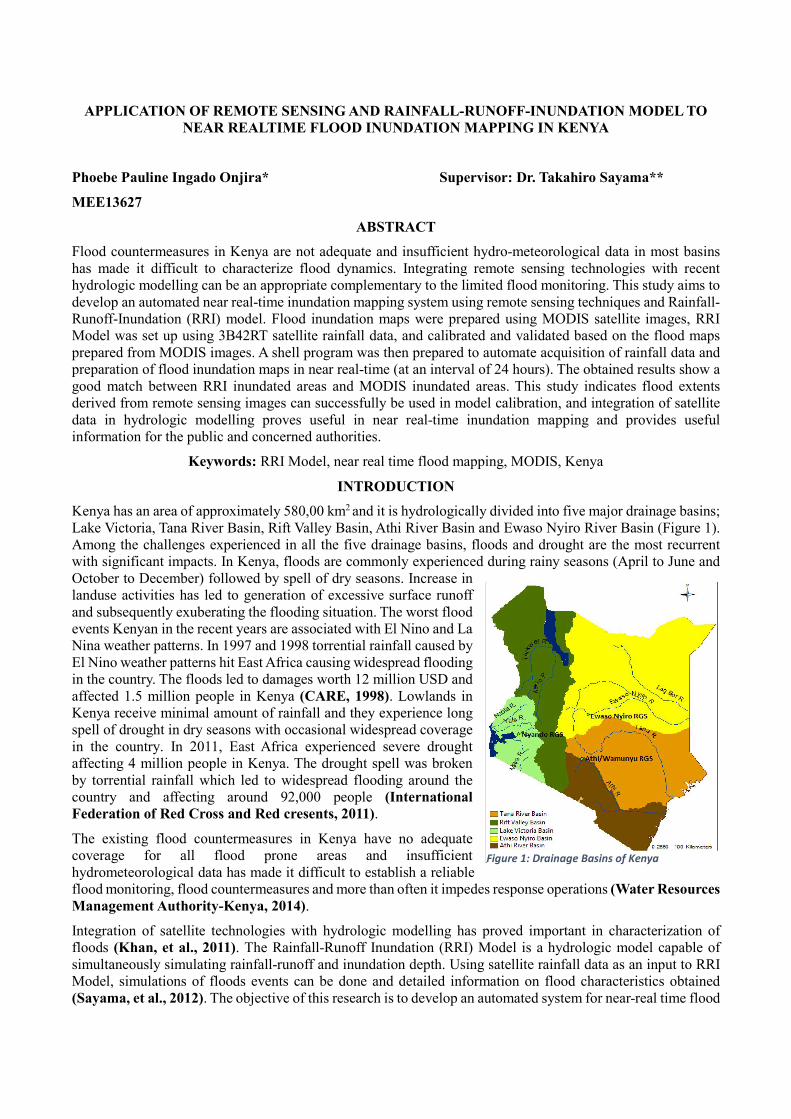
Kenya has an area of approximately 580,00 km2 and it is hydrologically divided into five major drainage basins; Lake Victoria, Tana River Basin, Rift Valley Basin, Athi River Basin and Ewaso Nyiro River Basin (Figure 1). Among the challenges experienced in all the five drainage basins, floods and drought are the most recurrent with significant impacts. In Kenya, floods are commonly experienced during rainy seasons (April to June and October to December) followed by spell of dry seasons. Increase in landuse activities has led to generation of excessive surface runoff and subsequently exuberating the flooding situation. The worst flood events Kenyan in the recent years are associated with El Nino and La Nina weather patterns. In 1997 and 1998 torrential rainfall caused by El Nino weather patterns hit East Africa causing widespread flooding in the country. The floods led to damages worth 12 million USD and affected 1.5 million people in Kenya (CARE, 1998). Lowlands in Kenya receive minimal amount of rainfall and they experience long spell of drought in dry seasons with occasional widespread coverage in the country. In 2011, East Africa experienced severe drought affecting 4 million people in Kenya. The drought spell was broken by torrential rainfall which led to widespread flooding around the country and affecting around 92,000 people (International Federation of Red Cross and Red cresents, 2011).
The existing flood countermeasures in Kenya have no adequate coverage for all flood prone areas and insufficient hydrometeorological data has made it difficult to establish a reliable flood monitoring, flood countermeasures and more than often it impedes response operations (Water Resources Management Authority-Kenya, 2014).
Integration of satellite technologies with hydrologic modelling has proved important in characterization of floods (Khan, et al., 2011). The Rainfall-Runoff Inundation (RRI) Model is a hydrologic model capable of simultaneously simulating rainfall-runoff and inundation depth. Using satellite rainfall data as an input to RRI Model, simulations of floods events can be done and detailed information on flood characteristics obtained (Sayama, et al., 2012). The objective of this research is to develop an automated system for near-real time flood
Figure 1: Drainage Basins of Kenya

inundation mapping for Kenya, using RRI Model and remote sensing data. To achieve this; Moderate Imaging Spectroradiometer (MODIS) images were used to prepare flood inundation maps for past flood events, RRI model was set up using 3B42RT satellite-based rainfall data, calibrated and validated based on flood maps obtained from MODIS images. Based on the validated RRI model, an automated system for flood mapping was to obtain 3B42RT rainfall data, update the RRI input files and execute the RRI model program to produce flood inundation maps on a daily basis.
THEORY AND METHODOLOGY
This study develops a near real time inundation mapping system for Kenya based on satellite data. Flood inundation maps for past flood events were prepared MODIS images. 3B42RT rainfall data was then used to set up RRI Model; calibration and validation of RRI model was done based on MODIS derived flood inundation maps. For near-real time applications shell script was prepared to automate data acquisition and execution of RRI model and production of inundation maps.
Flood Mapping using MODIS images: Terra MOD9A01 data was selected for this study since MODIS sensor detects radiation in the VIS, NIR and SWIR ranges which are appropriate for flood mapping. The following approach was developed in identification of flooded areas in three major steps;
i. Identification of cloud cover using Band 3 of the MODIS images and data over cloud areas are then removed.
ii. Identification of water and non-water pixels based on the following four indices (DVEL, LSWI, NDFI, MLSWI)
iii. Permanent water bodies were determined using a MODIS’ Global Raster Water Mask, downloaded (http://e4ftl01.cr.usgs.gov/MOLT/MOD44W.005/2000.02.24/).
EVILSWIDVEL (1)
62
62
BB
BBLSWI
(2)
71
71
BB
BBNDFI
(3)
2)71(
2)71(
BB
BBMLSWI
(4)
13*5.71*62
12*5.2
BBB
BBEVI
(5)
LSWI is Land Surface Water Index, NDFI is Normalized Difference Flood Index, NDWI is Normalized Difference Water Index, EVI is Enhance Vegetation Index and MLSWI is Modified Land Surface Water Index. B1 is band 1, B2 is band 2, B3 is band 3, B6 is band 6 and B7 is band 7.
RRI model simulations: The RRI model is a 2-D model that simultaneously simulates rainfall-runoff and flood inundation. The model can simulate both surface and sub-surface flows. Surface flow is computed using 1-D and 2-D diffusive wave models. Vertical infiltration is approximated using the Green-Ampt Model while lateral sub-surface flow is considered using discharge-hydraulic gradient. An overflow formula based on the water level and levee height is used to estimate the flow between the river and the catchment (Sayama, et al., 2012). The following steps show the process of RRI model application;
i. 15 seconds Digital Elevation Model (DEM), flow accumulation and flow direction) which were downloaded from http://hydrosheds.cr.usgs.gov/dataavail.php and delineated the data for Kenya and converted to ASCII files in ArcGIS. The data was corrected for errors and then scaled up to increase their resolution to 60 seconds.
ii. Soil distribution map; 30 seconds resolution soil distribution map was obtained from FAO (http://data.fao.org/map?entryId=6fd05da0-853c-11db-b9b2-000d939bc5d8). A mask for soil distribution map for Kenya having 19 different soil classes was prepared using ArcGIS. The map was then resampled to increase its resolution top 60 seconds and reclassified to 12 classes and converted to ASCII format.
iii. Rainfall data; 3B42RT satellite rainfall data from was downloaded from NASA

(ftp://trmmopen.gsfc.nasa.gov/pub/merged/3B42RT/). The rainfall data is in gridded format and a series of shell scripts are used to convert it into format readable by RRI.
iv. Condition files which include river geometry files. River Geometry files were prepared based on the cross section of major rivers in Kenya. Parameterization of the model was done using Manning’s roughness, Green-Ampt Model Parameters (porosity, hydraulic conductivity and suction at the wetting front) and soil depth.
v. Calibration and validation of RRI model was done by adjusting the Manning’s roughness (of the catchment and that of the river bed) and depth of the soil. Infiltration parameters were estimated from Green-Ampt infiltration parameters. The manning’s roughness used was derived from soil texture properties based on FAO soil distribution map.
Near-real time flood mapping application in Kenya: Automation of RRI model for near-real time flood mapping was done using shell script and executed in Cygwin terminal in the following steps;
i. Acquisition of dates for the previous day and updating the dates in the entire program. ii. Delineation of rainfall data to extents that fit Kenya, converting the data into one text file and combining
the files into one text file. iii. Updating the model with initial conditions that have been obtained from the output of the previous
simulation. iv. Executing the RRI model v. Plotting the inundation maps
vi. Converting the inundation maps into KML format vii. Visualizing inundation maps in Google Earth.
DATA
In this study, four different types of data were used; topographical data (DEM, flow accumulation, flow direction and soil distribution map), 3B42RT satellite rainfall data, MODIS images and discharge data. 3B42RT satellite rainfall data for 2011 (October-December), 2012 (April-June) and 2013 (April-June) were obtained from ftp://trmmopen.gsfc.nasa.gov/pub/merged/3B42RT/). The rainfall data is in gridded 3-hourly format and in mm/hr. MODIS Terra (MOD90A1) images for 2011 (October-December), 2012 (April-June) and 2013 (April-June) were downloaded from NASA (http://e4ftl01.cr.usgs.gov/MOLT/MOD09A1.005/). Discharge data from three stations (Figure 1) was obtained from Water Resources Management Authority (WRMA).
RESULTS AND DISCUSSION
Figure 2: LSWI, MLSWI, NDFI and DVEL for October 3, 2011
Identification of water pixels was done using the following threshold values; DVEL >= 0.2, LSWI >= 0.7, MLSWI >= 0.65, NDFI >= 0. NDFI, MLSWI and LSWI exhibit errors in mountaneous areas (marked in Red circles 1,2 and 3). NDFI did not have errors in mountaneous areas and was therefore selected for detection of water pixels in this study.
Calibration of RRI Model; Figure 3 shows a scatterplot obtained by plotting the inundated areas by RRI-simulations against inundated areas by MODIS-derived flood maps; the value of coefficient of determination, R2 is 0.7691 indicating a strong linear correlation between inundated areas detected by MODIS and inundation areas by RRI-simulations. Figure
1 1 1 2 2 2 2 1
3 3 3 3

4 shows the comparative hydrograph for simulated and observed discharge at Ewaso Nyiro RGS (Figure 1), with NSCE = 0.52 indicating that simulated discharge was fitted to observed discharge of 2011 flood event.
Figure 3: scatter graph of inundated area from MODIS images and RRI Model (R2=0.7691)
Figure 4: comparative hydrograph at Ewaso Nyiro RGS during calibration period (NSCE= 0.52, Bias = -39%)
Figure 5 shows MODIS (b) and RRI (c) inundated areas as well as inundated areas detected by both MODIS and RRI (a); areas in red circles numbered 1, 2, 3 and 4 have floods detected by both RRI and MODIS. Around circle 2, MODIS tends to overestimate floods compared to RRI, this may be attributed to underestimations of surface runoff resulting from infiltration or from cloud shadow errors. In Figure 5 (b), it is also observed that area 2 has a lot of clouds (in pink). The hydrograph in Figure 3 represents a station in area 1, it is noted that RRI model tends to overestimate inundations around area 1, though the simulated discharge fits to observed discharge. This error may have been caused by low resolution of topographic data resulting to larger inundated areas and low resolution of MODIS images which cannot detect inundations in smaller extents.
(a) MODIS/RRI
(b) MODIS
(c) RRI
Figure 5: RRI/MODIS (in pink is inundation detected by both MODIS and RRI), MODIS and RRI inundation maps for
calibration period
Validation of RRI model;
Figure 6 shows a large discrepancy in trend; the observed discharge has very high peaks compared to hydrograph of simulated discharged. Simulated discharge is underestimated in comparison to observed discharge; the observed hydrograph recedes to base flow after the last peak but on the contrary the simulated hydrograph continues to peaks again. Underestimation of simulated discharge maybe a result of discharge from springs and the discrepancy in the hydrograph could have been as a result of discharge and withdrawal of water from and
R² = 0.7691
0
2,000
4,000
6,000
8,000
10,000
12,000
14,000
16,000
18,000
20,000
0 5,000 10,000 15,000 20,000
RR
I, a
rea
(km
2 )
MODIS, area (km2)
0
200
400
600
800
1000
1200
1400
01/10/2011 01/11/2011 01/12/2011
Dis
char
ge (
m3
/s)
time (days)
Ewaso Nyiro/Ngare Nyithing (SIMULATED)
Ewaso Nyiro/Ngare Nyithing (OBSERVED)
4
3
2 2 2
1 1 1
3 3
4 4

into an irrigation scheme located upstream of the gauging station. Figure 7 indicate the same flooding trend detected by both RRI and MODIS, the matching areas are identified in red circles and numbered 1, 2, 3 and 4. Nyando RGS falls in areas 3 and it is noted from Figure 7(a) and (b) that the inundation extents by both RRI and MODIS match well despite discrepancies in the observed and simulated discharge hydrographs. Overestimations by MODIS relative to RRI is noted in area 1 and this could be as a result of cloud shadow errors interpreted as water bodies and underestimations of surface runoff resulting from infiltration.
(a) MODIS/RRI
(b)MODIS
(c) RRI
Figure 7: RRI/MODIS (in pink is inundation detected by both MODIS and RRI), MODIS and RRI inundation maps for validation
period
Near-real time flood mapping application in Kenya:
Figure 8: KML inundation maps for 5/8/2014 plotted on Google Earth and
Flooded Eldoret town. Source (Nation Media Group, Kenya)
Figure 9: rainfall distribution map for 5/8/2014
Figure 9 shows the rainfall distribution for 5/08/2014; rainfall up to 120 mm was received in the western and towards the central areas of Kenya. Flooding is subsequently observed on this day in the western parts of the country (Figure 8). Figure 8 also shows a picture of floods in Eldoret town on 5/8/2014 as reported by Nation Media Group (http://mobile.nation.co.ke/counties/Huge-losses-as-floods-cause-havoc-in-Eldoret/-/1950480/2410656/-/format/xhtml/-/8xdch4/-/index.html).
0
50
100
150
200
250
01/04/2013 01/05/2013 01/06/2013
Dis
char
ge (m
3/s
)
time (days)
Nyando (Simulated) Nyando (Observed)
Figure 6: comparative hydrograph for validation period (2013) at Nyando RGS.
3
2
1 1 1
2 2
3 3
4 4 4

CONCLUSION AND RECOMMENDATIONS
The following conclusions can be drawn from this study; i. This study shows that RRI is an adequate model for use in Kenya in flood mapping and capable of
successfully simulating floods in large areas and it has good output for flood characterization. RRI model was successfully set up using 3B42RT data and calibrated and validated using MODIS-derived flood maps. Automation program worked well hence it can be applied for use in Kenya for floods monitoring.
ii. Use of satellite data has proved to be a good solution to Kenyan basins lacking data and offers very good information in flood monitoring.
iii. Studies should be carried out in future using a satellite data availed in real time so as to produce inundation maps in shorter time intervals which will help in monitoring of flash floods.
iv. Fine resolution data and ground data should be used in future studies in order to analyze hydrologic response of different basins in Kenya to establish the potential causes of deviations in hydrographs and improve on model calibration.
v. Future studies should put into account recharge of water bodies in order to accurately quantify discharge vi. Establishment of gauging networks and improvement on manpower and instrumentation for data
collection is necessary to enable acquisition of credible and sufficient data for hydrological studies of Kenyan basins
vii. To make a good statistical analysis of flood coverage using MODIS images, cloud shadow and cloud cover correction method should be employed to ensure no areas that are potentially flooded are removed and no commission errors are made because of cloud shadows.
ACKNOWLEGDEMENT
I would like to express my deepest gratitude to Dr. Takahiro Sayama, Dr. Akira Hasegawa and Dr. Tomoki Ushiyama for their unreserved support and guidance during my studies. I am grateful to and entire JICA and ICHARM staff for the support and help they accorded me during my studies and stay in Japan.
REFERENCES
1. CARE, 1998. Relief Web. [Online] Available at: http://reliefweb.int/report/world/el-ni%C3%B1o-1997-1998-impacts-and-cares-response [Accessed June 2014].
2. International Federation of Red Cross and Red cresents, 2011. ReliefWeb. [Online] Available at: http://reliefweb.int/report/kenya/floods-2011-dref-operation-no-mdrke020 [Accessed 2014].
3. Khan, S. I. et al., 2011. Satellite Remote Sensing and Hydrologic Modeling for Flood Inundation Mapping in Lake Victoria Basin: Implications for Hydrologic Prediction in Ungauged Basins. IEEE Transactions on Geoscience and Remote Sensing, 49(1), pp. 85-95.
4. Sayama, T. et al., 2012. Rainfall-runoff-inundation analysis of the (2010) Pakistan flood in the Kabul River basin. Hydrological Sciences Journal, 57(2).
5. Water Resources Management Authority-Kenya, 2014. Water Resources Management Authority WRMA. [Online] Available at: http://www.wrma.or.ke/index.php/wrma-regional-offices.html [Accessed 2014].