application of gis technology on slope registration … 16 – disaster preparedness and management...
TRANSCRIPT

TS 16 – Disaster Preparedness and Management WOO Chi Pong Application of GIS technology on slope registration for the prevention of landslide Shaping the Change XXIII FIG Congress Munich, Germany, October 8-13, 2006
1/15
Application of GIS Technology on Slope Registration for the Prevention of Landslide
WOO Chi Pong, MHKIS, MRICS, Hong Kong
Key words: slope registration database, landslide hazard, spatial analysis, slope maintenance responsbility
SUMMARY There are about 58,000 registered man-made slopes in the Hong Kong Special Administrative Region (with an area of 1,100 Km2). As most of these slopes are situated in densely populated areas, management tools must be employed to collect information of the slopes in order to monitor their stability. The Civil Engineering and Development Department (CEDD) developed a computerized Slope Information System (SIS) containing data on all of those slopes. The SIS is a geographic information system which integrates different types of slope information linked to geographic and textual databases. It provides valuable information to geotechnical engineers, property owners, management companies and the general public. To support the SIS, the Survey Division of CEDD is commissioned to maintain and update a database of the registered slopes by the Computerized Slope Registration & Location Plan (CSRLP) System. The system was firstly introduced in 1996 and has been recently revamped in 2006. Besides supporting the SIS, CSRLP System also supports the Squatter Control Warning System involving analysis of slope, land status and dwellings which are susceptible to landslide hazard. The author would like to share with the readers the experience of revamping the CSRLP System and the future development.

TS 16 – Disaster Preparedness and Management WOO Chi Pong Application of GIS technology on slope registration for the prevention of landslide Shaping the Change XXIII FIG Congress Munich, Germany, October 8-13, 2006
2/15
Application of GIS technology on slope registration for the prevention of landslide
WOO Chi Pong, Hong Kong
1. INTRODUCTION Hong Kong has a sub-tropical and monsoonal climate with cool dry winters and hot wet summers. Of the annual average rainfall of 2,214mm, about 80% occurs between May and September. On average, two to three hundred landslips occur each year. Most of them are small in scale, but many are large enough to cause injury to people, damage to property and blockage of roads. Hong Kong has steep hilly terrain, intense seasonal rainfall and very dense hillslope development. In particular, many substandard man-made slopes were constructed in the past, largely during the years of rapid development which followed World War II. The Civil Engineering and Development Department (CEDD) of the Government of the Hong Kong Special Administrative Region is responsible for implementing and maintaining high quality public works projects in Hong Kong. One of the duties of CEDD is to oversee Hong Kong’s Slope Safety System, including implementing the Landslip Preventive Measures Programme with an annual budget for slope upgrading works of HK$ 0.9 billion, and to issue public Landslip Warnings in consultation with the Hong Kong Observatory. To achieve this goal, setting up of a comprehensive and up-to-date slope registration database is indispensable. The computerized Slope Information System (SIS), developed by the Slope Safety Division, contains textual and spatial information of man-made slope features ready for on-line analysis of the spatial relation between slopes and surrounding topography. With a view to support the SIS, the Survey Division is commissioned to maintain the computerized Slope Registration and Location Plan (CSRLP) System. It is a digital slope mapping system which contains slope feature boundaries, registration numbers and basic map details. Survey Division also develops Squatter Slope Information System involving analysis of slopes, land status and dwellings which are susceptible to landslide hazard. 2. SYSTEMATIC IDENTIFICATION AND REGISTRATION OF SLOPES IN THE
TERRITORY (SIRST) In 1970s, the former Geotechnical Control Office of Public Works Department started to prepare a Catalogue of Slopes which was in the form of paper record. To prepare for computerization, they started SIRST in July 1994 to collect and retrieve information of identifiable man-made features in Hong Kong. Those registrable features were classified into eight categories :
TS 16 – Disaster Preparedness and Management WOO Chi Pong Application of GIS technology on slope registration for the prevention of landslide Shaping the Change XXIII FIG Congress Munich, Germany, October 8-13, 2006
3/15
F – Fill slope or platform with a surface sloping at >15° and a minimum fill thickness of 1m and without any associated retaining wall(s).
C – Cut slope without any associated retaining wall(s). R – All retaining walls supporting a slope or platform with a surface sloping at <15° (fill or
natural gorund). Where a series of retaining walls of less than registrable height are on an overall slope greater than 45°, their height should be combined to judge if they are registrable.
CR – Cut slope with retaining wall at crest, middle or toe of the slope. FR – Fill slope with associated retaining wall(s) at crest, middle or toe of the slope. DT – Disturbed terrain features which contain repairs to landslides scars or comprise a series
of composite cut and/or fill slopes where the ground surface has been disturbed, the natural slope gradient is greater than 15° and although the individual slopes do not meet the criteria for registration.
NS – Stabilisation measures constructed on natural hillsides to prevent failure, e.g. boulder buttresses, soil nail and raking drains.
ND – Defence measures to contain landslide debris and hence protect buildings and infrastructure at the toe in case of landslide or boulder fall from the natural terrain above, e.g. check-dams, earth bunds and boulder fences.
Aerial photographs and topographic plans were used to identify registrable features, and followed by field verification. The project was completed in September 1998. 3. SLOPE INFORMATION SYSTEM (SIS) Based on the result of Systematic Identification and Registration of Slopes in the Territory, a Slope Information System was thus developed. The SIS contains computerized information including the slope field data, digital slope map from CSRLP, landslip incidents, ground investigation data and other slope-related information such as geology, natural terrain landslides, disused tunnels, location information, horizontal drains, ground anchors, ducting for water-carrying services, etc. With a view to making these information available to the public, CEDD launched the Hong Kong Slope Safety Website (http://hkss.cedd.gov.hk) (Fig. 1) in 1999. Thus, geotechnical engineers, property owners, estate management companies and the general public can search slope-related information easily through this website. Moreover, it has a hyperlink to Lands Department’s Website on Slope Maintenance Responsibility Information System (SMRIS) (http://www.slope.landsd.gov.hk/smris/) (Fig. 2).

TS 16 – Disaster Preparedness and Management WOO Chi Pong Application of GIS technology on slope registration for the prevention of landslide Shaping the Change XXIII FIG Congress Munich, Germany, October 8-13, 2006
4/15
Fig. 1 Hong Kong Slope Safety Website Fig. 2 Slope Maintenance Responsibility
Information System Website 4. COMPUTERIZED SLOPE REGISTRATION AND LOCATION PLAN (CSRLP)
SYSTEM V1.0 Parallel to the development of SIS, the CSRLP System was developed in 1995. Survey Division is responsible for the development of the CSRLP System. It is also the central authority to maintain the graphical slope registration database. CSRLP System provides various types of functions, such as registering new slope, modifying slope boundary and editing textual information. Queries can be performed by the users to retrieve information of the selected slopes. In addition, it can generate reports and produce Master Location Plan and Slope Location Plan either in batch mode or interactive mode. Five groups of functions are designed and developed for the CSRLP System. 4.1 Slope Registration Function This function provides the capability in automatic checking and assigning unique slope numbers to new slope features. 4.2 Plan Production Function This function provides a high quality plan production facilities for the production of Master Location Plan in batch processing environment and Slope Location Plan either in an interactive or batch processing environment using the slope and base map information. Standardized format for Master Location Plan and Slope Location Plan including borders, legends, map scales, symbology and layer are automatically added.

TS 16 – Disaster Preparedness and Management WOO Chi Pong Application of GIS technology on slope registration for the prevention of landslide Shaping the Change XXIII FIG Congress Munich, Germany, October 8-13, 2006
5/15
4.3 Data Retrieval Function This function provides a graphic user interface and enquiry facilities to retrieve and display the graphic and textual information of slope features and base map information. User can retrieve the information by defining different parameters such as extent of area, sheet number, slope number, slope type or job number. Reports on slope query, summary statistics or record listings can be printed. In order to ensure the information in CSRLP System can be transferred to other systems, functions are also provided to enable data transfer operations, including conversion of textual files to user defined ASCII files and production of graphical data in standard graphical exchange formats. 4.4 System Administration Function This function provides the system and database administration facilities for the routine housekeeping and audit trailing tasks. System Administration functions are a restricted set of functions used by the System Administrator. They are primarily written procedures for undertaking day-to-day tasks including setting user privileges, monitoring data security, scheduling backup and recording system usage. 4.5 Network Administration Function This function provides the network administration facilities and an user interface for routine network management. 5. CSRLP SYSTEM V2.0 (FIG. 3, TABLE 1 ) In late 2004, upon the request of Slope Safety Division, Survey Division started to upgrade current system to another platform : Microstation Geographics V8 2004, Oracle Enterprise 9i, and a new database structures – Spatial Data Option (SDO). The main objectives of upgrading are twofold: - to streamline the existing workflow and procedures for various types of slope registration. - to set up a realtime database connection with SIS located at a distant site. Thus, each function in para.4 were being reviewed and the following areas for improvement were identified : - There is no provision to create new slope category other than the 8 categories. - Adding or modifying a slope may inadvertently affect adjacent registered slope boundary. - Choice of designated printer and plotter is not flexible. - Graphic data loss may occur during conversion to other data format. - System administrator cannot trace the progress of an individual job.
TS 16 – Disaster Preparedness and Management WOO Chi Pong Application of GIS technology on slope registration for the prevention of landslide Shaping the Change XXIII FIG Congress Munich, Germany, October 8-13, 2006
6/15
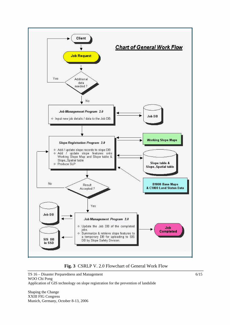
Fig. 3 CSRLP V. 2.0 Flowchart of General Work Flow

TS 16 – Disaster Preparedness and Management WOO Chi Pong Application of GIS technology on slope registration for the prevention of landslide Shaping the Change XXIII FIG Congress Munich, Germany, October 8-13, 2006
7/15
Hardware Server Xeon 3.2 GHz (Dual CPU) 1 GB 100 GB
Workstation PIV 3.0 GHz 512 MB 146 GB HD
Peripherals Calcomp 34480 A0 digitizer HP 4650 dn Colour LaserJet Printer A3 Scanner
Backup 36 GB tape drive UPS 12 minutes Software Microsoft Windows 2000 Server
Microsoft Windows XP for Workstations Oracle Enterprise 9i MicroStation V8 2004 MicroStation Geographics V8 2004 ArcServe Backup r11.1 for Windows ArcServe Backup Agent for Oracle ArcServe Backup Disaster Recovery Option
Link to SIS T1
Table 1 CSRLP V. 2.0 Hardware and Software Configuration 5.1 Enhancement The processing speed and data storage capacity were enhanced by upgrading the system hardware. Moreover, a lot of enhancements were introduced to CSRLP V. 2.0 : 5.1.1 Spatial Data Object Graphical attribute of a slope boundary and associated textual attributes in a database are created as a single entity in ORACLE database. Hence, every slope’s information is an unique record and can be exported to other system efficiently without loss of data. Addition of new slope category is also allowed. 5.1.2 Interface programme ( Fig. 4 ) The interface programme, written in Visual Basic Advanced language, provides an user-friendly platform for user to register/edit slope boundary. Guiding messages are provided for users in each step of workflow as follows :

TS 16 – Disaster Preparedness and Management WOO Chi Pong Application of GIS technology on slope registration for the prevention of landslide Shaping the Change XXIII FIG Congress Munich, Germany, October 8-13, 2006
8/15
- Enter job number and case number - Select type of job - Get original Slope Location Plan - Input / Edit slope boundary - Database linkage - Validate slope attributes - Update spatial database - Print Slope Location Plan
Fig. 4 Step 2 in Slope Registration Programme 2.0
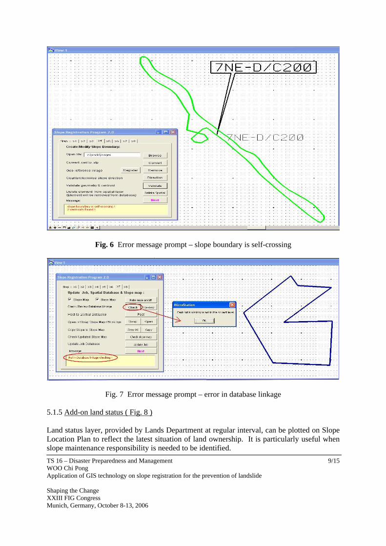
5.1.3 Data quality checking ( Fig. 5 ) Correctness of slope polygon geometry (such as dangling node, non-continuous line) is verified before registration. It maintains consistency and avoids the need for future error debugging.
Fig. 5 Data Quality Checking 5.1.4 Error message prompt ( Fig. 6, 7 ) Amongst various steps, the system provides a lot of checking functions such as database linkage, centroid position, check slope map. It also suggests remedial action if an error is found.
TS 16 – Disaster Preparedness and Management WOO Chi Pong Application of GIS technology on slope registration for the prevention of landslide Shaping the Change XXIII FIG Congress Munich, Germany, October 8-13, 2006
9/15
Fig. 6 Error message prompt – slope boundary is self-crossing
Fig. 7 Error message prompt – error in database linkage 5.1.5 Add-on land status ( Fig. 8 ) Land status layer, provided by Lands Department at regular interval, can be plotted on Slope Location Plan to reflect the latest situation of land ownership. It is particularly useful when slope maintenance responsibility is needed to be identified.

TS 16 – Disaster Preparedness and Management WOO Chi Pong Application of GIS technology on slope registration for the prevention of landslide Shaping the Change XXIII FIG Congress Munich, Germany, October 8-13, 2006
10/15
Fig. 8 Slope Location Plan with land status

TS 16 – Disaster Preparedness and Management WOO Chi Pong Application of GIS technology on slope registration for the prevention of landslide Shaping the Change XXIII FIG Congress Munich, Germany, October 8-13, 2006
11/15
5.1.6 Digital Slope Location Plan Digital Slope Location Plan (in PDF format) is attached to each registered slope. It is convenient for exporting or printing. 5.1.7 Job monitoring Inside the Job Management Programme, system adminstrator can trace the progress of a job easily. 5.1.8 On-line help manual Digital on-line operation manual is available for easy reference. 6. SQUATTER SLOPE INFORMATION SYSTEM (SSIS) It is the Government policy to offer rehousing to those living in squatter structures who are vuluerable to landslide risk. Since the mid-1980’s, some 75,000 people have been rehoused. Some of these squatters were cleared through the Non Development Clearance programme joinitly implemented by CEDD, Housing Department, Buildings Department and Lands Department. As at 2003, about 9,600 people are yet to be rehoused. Geotechnical engineers from CEDD recommend clearance order based on a set of geotechnical considerations. To assist the geotechnical engineers in decision making, the Survey Division develops Squatter Slope Information System in 2002 to integrate Non Development Clearance areas, Target Inspection Areas, cadastral information and slope information for carrying out comprehensive analysis of landslide hazard. Maps can be prepared extracting information from different layers. 6.1 Components By using the GIS technology, Survey Division develops SSIS with the following types of data : 6.1.1 Non Development Clearance Area and Target Area ( Fig. 9 ) Non Development Clearance Area and Target Area, mainly determined by Housing Department, are consolidated by geotechnical engineers of CEDD and forwarded to Survey Division in ArcInfo format.

TS 16 – Disaster Preparedness and Management WOO Chi Pong Application of GIS technology on slope registration for the prevention of landslide Shaping the Change XXIII FIG Congress Munich, Germany, October 8-13, 2006
12/15
Fig. 9 NDC Area and Target Area
6.1.2 Cadastral information The geotechnical engineers of CEDD have identified several categories of cadastral information (ArcInfo format) from Lands Department. Four categories are extracted from the 1:1000 scale Cadastral Information System as follows : - Lot – There are 15 sub-categories. They are land parcels held by the public (either in
freehold or lease hold status) and the government. - Modification of Lot – There are 6 sub-categories. They are variation of the use of land
(such as agricultural to residential use). They are usually temporary in nature. - Licence Area – There are 6 sub-categories. They are unleased government land parcels
issued to the public on payment of prescribed fee. - Vesting Order/Deposit Area - Vesting Orders are formal delegation of legal powers to the
Housing Authority to control and manage public rental housing estates. Usually, a Vesting Order Plan is required to demarcate the boundary of the estate. Pursuant to various Ordinances, Deposit Plans are required to be deposited in the Land Registry. Deposit Areas were shown on these plans for associated government departments. Examples are plans showing boundaries of public pleasure grounds and airport restricted areas.
6.1.3 Basemap information Buildings and temporary structures (in DGN format) are also extracted from the 1:1000 scale digital basemap which is maintained by Lands Department. 6.1.4 Slope boundaries Slope boundaries – extracted from CSRLP System, and related information (such as slope angle, width of retaining wall) - extracted from SIS, are used to form slope buffers ( Fig. 10 )

TS 16 – Disaster Preparedness and Management WOO Chi Pong Application of GIS technology on slope registration for the prevention of landslide Shaping the Change XXIII FIG Congress Munich, Germany, October 8-13, 2006
13/15
Fig.10 Slope buffer and temporary structure/building
Fig. 11 Table showing area of temporary structure being affected by slope buffer
6.2 Analysis By using Arcview V8.3, the Survey Division first checks the data consistency of record, and updates the geospatial and textual information accordingly. Various types of query functions are then executed to deduce the following information : - intersection of building polygons and cadastral information polygons - intersection of temporary structure polygons and cadastral information polygons - intersection of building polygons with slope buffer polygons - intersection of temporary structure polygons with slope buffer polygons ( Figs. 10 &11 ) The consolidated database is then forwarded to geotechnical engineers to aid their decision on formulating Non Development Clearance programme. 7. DISCUSSION As at May 2006, about 58,000 man-made slopes have been registered. The recurrent maintenance works for repairing and upgrading existing slopes will continuously generate demand for slope registration. New development projects will also create new slope features that requiring registration. It is envisaged that the data volume and updating frequency of the CSRLP System will be increased. In addition to the expected expansion of the slope registration database, potential enhancement works are also worthy to be mentioned as follows : 7.1 Information sharing It is the Government’s policy to standardize and align the data structure of geospatial information such that sharing of information can be attained amongst various departments.

TS 16 – Disaster Preparedness and Management WOO Chi Pong Application of GIS technology on slope registration for the prevention of landslide Shaping the Change XXIII FIG Congress Munich, Germany, October 8-13, 2006
14/15
Thus, through the SIS, the slope boundaries can be transferred to another system – Systematic Identification of Maintenance Responsibility of Slopes in the Territory (SIMAR) which is developed by the Lands Department. Inside SIMAR, the maintenance responsibilities of man-made slopes amongst government departments, private lot owners, or both can be revealed. In long-term, geo-referenced database should be shared amongst government departments as well as private stake-holders. Whilst technical issue should not be a major problem, political implication and copyright matters will remain the main issues. 7.2 Efficient data management Under current policy, all departments responsible for site formation works, public developments and slope maintenance/repair/upgrading works are required to provide Survey Division of CEDD with the updated information on slope features formed by them. However, there is no requirement on the standardization of graphic boundary data format. In order to ensure timely, efficient and accurate updating of the CSRLP, and thereafter the SIS, it is highly recommended to standardize the graphic slope boundary data format. 7.3 Slope modification history A slope may undergo several modifications (either in slope type or boundary) since its first registration in CSRLP System. Its entry may be deleted finally due to new development. A relational database capable of keeping associated slope modification history will be an useful management tool to the users. In CSRLP V. 1.0, there is no provision of such function. In CSRLP V. 2.0, function is provided to record the information of last slope modification (Fig. 12 ). In the long run, it is recommended to enhance the relational linkage function such that individual slope’s full modification history can be retrieved easily.
Fig. 12 Reference of last slope modification
TS 16 – Disaster Preparedness and Management WOO Chi Pong Application of GIS technology on slope registration for the prevention of landslide Shaping the Change XXIII FIG Congress Munich, Germany, October 8-13, 2006
15/15
ACKNOWLEDGEMENTS This paper is published with the permission of the Director of Civil Engineering and Development, the Government of the Hong Kong Special Administrative Region. REFERENCES Au Posford Consultants Limited, 1996, Final Report Computerized Slope Registration &
Location Plan System GEO, CEDD, HKSAR Govt, 2004, GEO Circular No.3, Non Development Clearance (Slope
Safety) of Squatters GEO, CEDD, HKSAR Govt, 2004, GEO Circular No.15, Registration and Updating of
Records of Features Mainland West Division, GEO, CEDD, HKSAR Govt, 2004, Information Note 28/2004,
Reducing Landslide Hazards to Squatters Slope Safety Division, GEO, CEDD, HKSAR Govt, 2004, Information Note 25/2004,
Catalogue of Slopes Survey Division, CED, HKSAR Govt, 1999, User Reference Customization Programs
CSRLP Survey Division, CEDD, HKSAR Govt, 2006, User Reference Computerized Slope
Registration & Location Plan System V 2.0 Works Bureau, HKSAR Govt, 1999, Works Bureau Technical Circular No.26/99,
Maintenance of Man-made Slopes and Emergency Repair on Stability of Land Works Bureau, HKSAR Govt, 2000, Works Bureau Technical Circular No. 9/2000,
Registration and Updating of the Catalogue of Slopes CONTACT WOO Chi Pong, Land Surveyor Civil Engineering and Development Department 16/F, One Mongkok Road Commercial Centre 1 Mongkok Road Kowloon Hong Kong CHINA Tel. + 852 2309 5068 Fax + 852 2391 4465 Email: [email protected]