trent hare, usgs, [email protected] ://astropedia.astrogeology.usgs.gov/download/software/gis... · 2d...
TRANSCRIPT


2D Visualize – Hillshade, Color(shade), Slope, Aspect
Analyze – Contour, Profile, Median
LOS, Volume, Zonal Stats, Roughness
3D Visualize – Perspective,
Anaglyph, GeoWall, Animations
February 09, 2010 2

GDAL (Geospatial Data Abstraction Library) – 90+ formats• Handy utility for
• Image conversion utilities• Supports most map projected ISIS2, ISIS3, PDS• GeoTiff, GeoJpeg2000, ENVI, ASCII formats
• Supports reading of WMS layers to help build mosaics• Library utilized in dozens of GIS applications
• Mac binaries: • http://www.kyngchaos.com/files/software/unixport/GDAL_Complete.dmg• Yes - his name is Kyng Chaos. Also install the ECW plug-in to support jpeg2000:
http://www.kyngchaos.com/software/frameworks
• Windows - install FWTools or OSGeo4W
• Linux - users can request binaries from me or build themselves.
February 09, 2010 3

gdalinfo - report information about a file.
gdal_translate - Copy a raster file, with control of output format, type, size, etc.
gdalwarp - Warp (project) an image into a new coordinate system.
gdal_dem – (new) hillshade, color, aspect, slope, rough.
hsv_merge.py – merge colorized and hillshade.
gdal_contour - Contours from DEM.
gdal_rasterize - Rasterize vectors into raster file.
gdal_merge.py - Build a quick image mosaic.
February 09, 2010 4

Examples:>gdal_translate -of ENVI input_geo.cub output.raw
>gdal_translate -of GTiff input_geo.img output.tif
Advancedconvert to ENVI and change the NoData value to -9999>gdal_translate -of ENVI -a_nodata -9999 input_geo.tif output.raw
Show image information including min/max>gdalinfo -mm input_geo.tif use –stats for mean, std dev
Truncate and translate floating values to unsigned 16bit.>gdal_translate -of GTiff -a_nodata 0 -ot UInt16 -scale min max 1
(1+max-min) input.cub output_16bit.tif
More: http://tinyurl.com/GDALtips / http://www.gdal.org/gdal_utilities.html
February 09, 2010 5

1.) Download Tsiolkovskiy (eventually to be posted on LMMP portal)
ftp://pdsimage2.wr.usgs.gov/pub/pigpen/moon/topo/apollo/ (ISIS.zip or GIS.zip)
2.) Convert to 32bit tiff>gdal_translate -of GTiff input_DEM.cub output.tif
3.) Convert to 32bit ENVI raw>gdal_translate -of ENVI input_DEM.cub out.raw
4.) To view – convert to 8bit>gdal_translate -of JPEG –scale input_DEM.cub out.jpg
5.) To view quickly – convert to 8bit browse>gdal_translate -of JPEG –scale –outsize 20% 20% input_DEM.cub out.jpg
February 09, 2010 6

For some reason ENVI export doesn’t add in NULL value. So File -Edit Header in ENVI and add: data ignore val = -3.40282266e+038
February 09, 2010 7
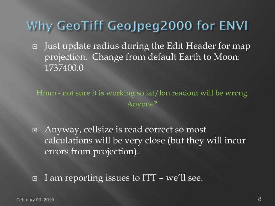
Just update radius during the Edit Header for map projection. Change from default Earth to Moon: 1737400.0
Hmm - not sure it is working so lat/lon readout will be wrong
Anyone?
Anyway, cellsize is read correct so most calculations will be very close (but they will incur errors from projection).
I am reporting issues to ITT – we’ll see.
February 09, 2010 8
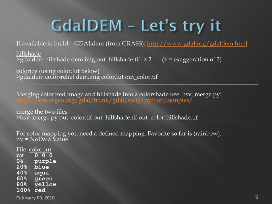
If available in build – GDALdem (from GRASS): http://www.gdal.org/gdaldem.html
hillshade>gdaldem hillshade dem.img out_hillshade.tif -z 2 (z = exaggeration of 2)
colorize (using color.lut below)>gdaldem color-relief dem.img color.lut out_color.tif
Merging colorized image and hillshade into a colorshade use: hsv_merge.py:http://svn.osgeo.org/gdal/trunk/gdal/swig/python/samples/
merge the two files>hsv_merge.py out_color.tif out_hillshade.tif out_color-hillshade.tif
For color mapping you need a defined mapping. Favorite so far is (rainbow). nv = NoData Value
File: color.lutnv 0 0 00% purple20% blue40% aqua60% green80% yellow100% red
February 09, 2010 9

February 09, 2010 10

Support pre-built Lunar GIS Projects for Mappers. ftp://pdsimage2.wr.usgs.gov/pub/pigpen/moon/Global_GIS_Lunar
February 09, 2010 11
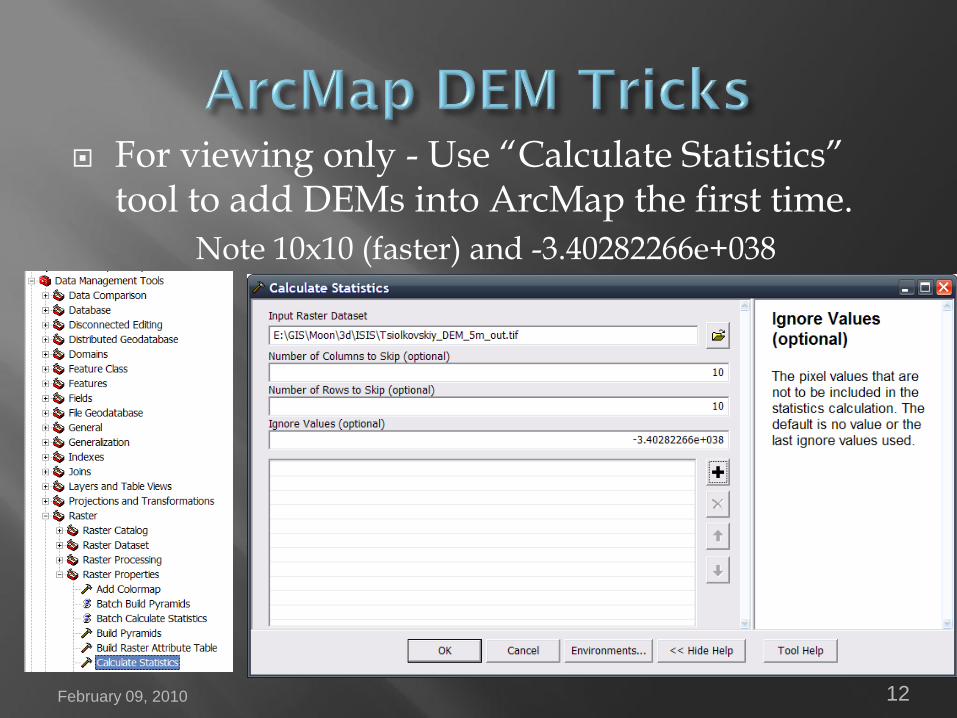
For viewing only - Use “Calculate Statistics” tool to add DEMs into ArcMap the first time.
Note 10x10 (faster) and -3.40282266e+038
February 09, 2010 12

For analysis (appears to be optional now) - Use USGS Image Toolbox – “Convert 32bit NODATA” to add DEMs into ArcMap the first time. Creates new file with NoData defined.
February 09, 2010 13
Download ToolBox from: http://tinyurl.com/ImageToolBox

Under 3D or Spatial Analyst, compute hillshade, set DEM to 50% transparent and std dev 2 stretch.
February 09, 2010 14

Data Frame – Coordinate System
Some GeoTiffs may not know their projection but you can set the projection in the data frame. Define new or set from ortho Jpeg2000.
February 09, 2010 15
Open “Layers” and select Ortho
select modify to check parameters
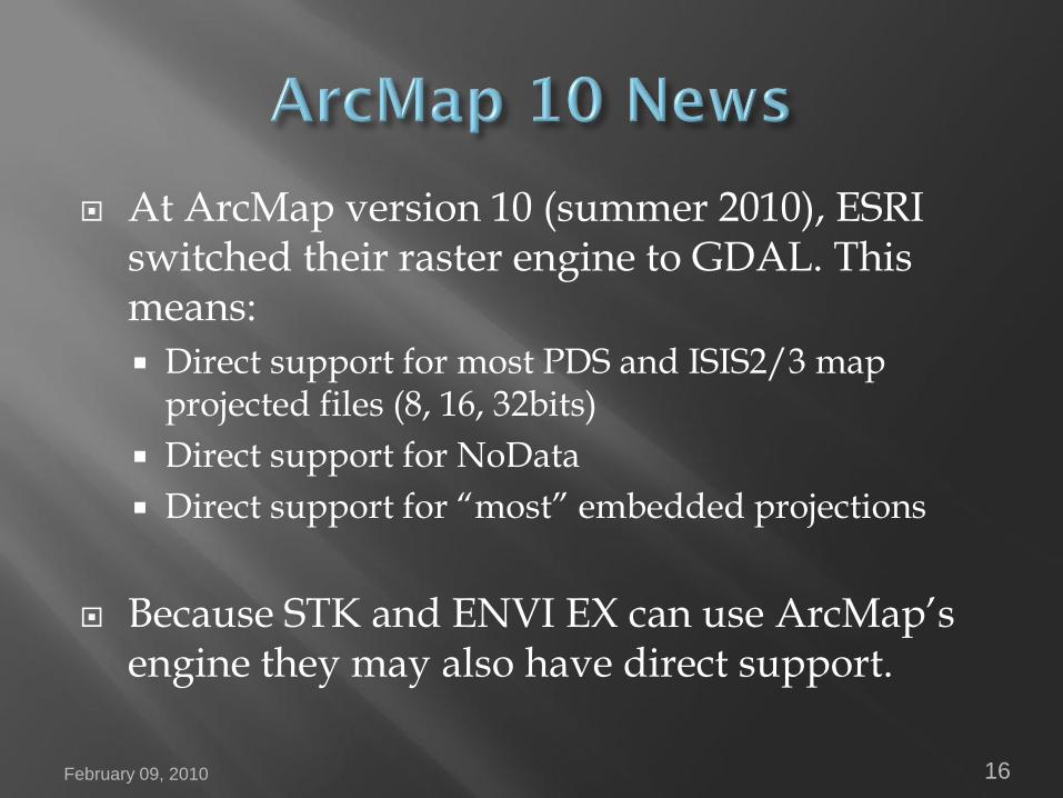
At ArcMap version 10 (summer 2010), ESRI switched their raster engine to GDAL. This means:
Direct support for most PDS and ISIS2/3 map projected files (8, 16, 32bits)
Direct support for NoData
Direct support for “most” embedded projections
Because STK and ENVI EX can use ArcMap’sengine they may also have direct support.
February 09, 2010 16

Under 3D toolbar (set 1. DEM, 2. select “interpolate line”, 3. profile)
February 09, 2010 17
1. 2. 3.
Profiling animations (ArcMap, ISIS, ...)
ftp://pdsimage2.wr.usgs.gov/pub/pigpen
/mars/tutorials/profiling_apps/

1. Start ArcScene (Window’s startbar)
2. add ortho image or hillshade
3. right click properties image, click “Base Heights” tab
4. Check “obtain heights for layer …”, click browse folder and select DEM file.
February 09, 2010 18

Optimize view quality (requires good 3D video card)
1. Under “Base Heights” tab, select “Raster Resolution…” button and bump up number of DEM pixels used.
1000x1000 rows, columns is a good value to start with
2. Under layer’s “Rendering” tab slowly bump up “Quality enhancement for raster images” slider
February 09, 2010 19

View 3D scene in. Set under View – View Settings…
1. Anaglyph mode
2. “Free” (GeoWall) mode (3D Stereo Screen or 2 projectors)
February 09, 2010 20

When creating animations, using very simple toolbar,
1. Set ArcScene window size to 720x480 or smaller
2. Export video to uncompressed AVI
3. Now use free Microsoft Movie, iMovie or Handbrake to convert to DVD or small web format (e.g. mp4 or wmv)
More: http://tinyurl.com/3DAnalyst
February 09, 2010 21

ArcScene is not very good for close viewing (layered wall) but ArcGlobe is. ArcGlobe also support multiple layer transparency also.
To use ArcGlobe:
1. All layers must have correct projection set
2. It is best to have global DEM as an under layer (LOLA)
3. Only a WGS84 radius is supported so be careful when reporting exaggeration.
February 09, 2010 22
More: http://tinyurl.com/3DAnalyst

Globe Alternatives•OSSIM
•Minerva
•ArcMap Explorer
•NASA WorldWind
•ERDAS Titan
•Google Earth – convert images only to superoverlays using gdal2tiles, maptiler, Ames
Stereo Pipeline. GE has no DEM support – must use available topography 23
February 09, 2010 24
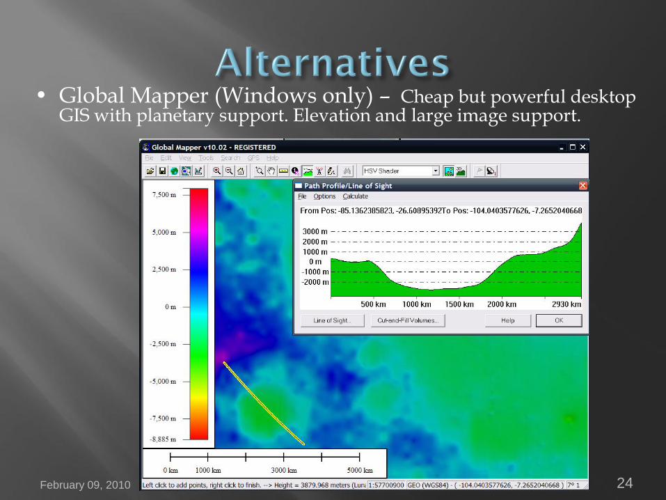
• Global Mapper (Windows only) – Cheap but powerful desktop GIS with planetary support. Elevation and large image support.

February 09, 2010 25
• Saga GIS (Linux, Windows) – Free desktop GIS. Uses GDAL so it can read ISIS, PDS, GeoTiffs, etc. Confusing interface at first but many functions.
February 09, 2010 26
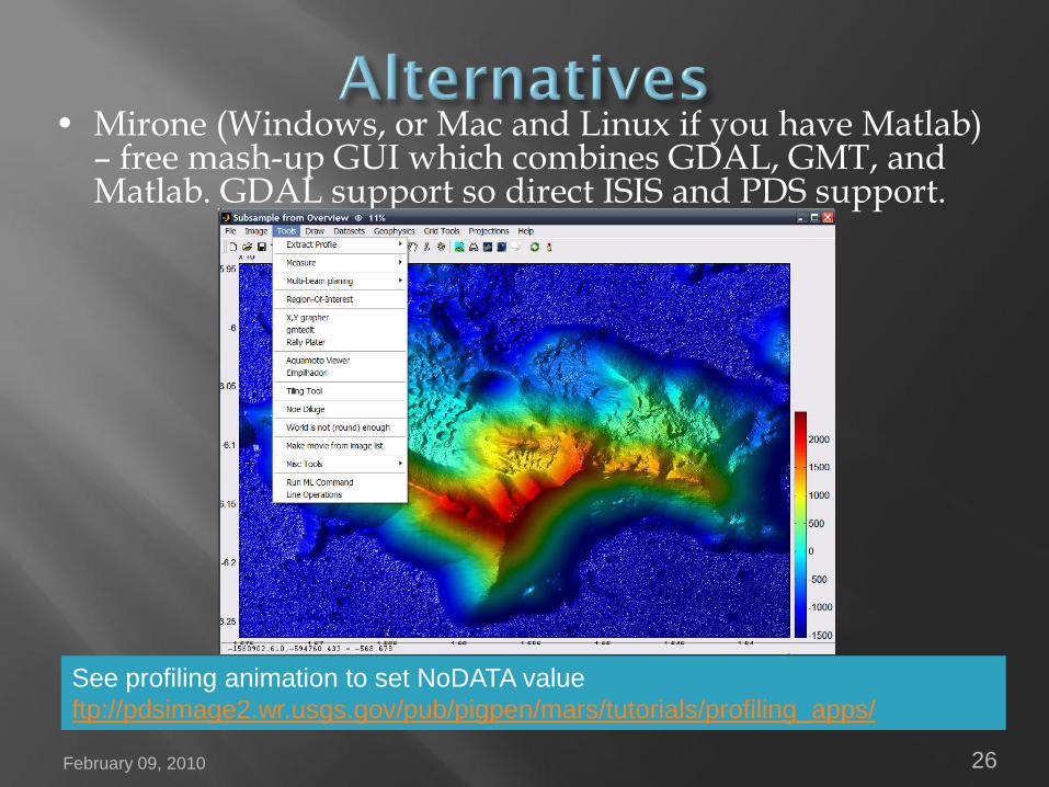
• Mirone (Windows, or Mac and Linux if you have Matlab) – free mash-up GUI which combines GDAL, GMT, and Matlab. GDAL support so direct ISIS and PDS support.
See profiling animation to set NoDATA value
ftp://pdsimage2.wr.usgs.gov/pub/pigpen/mars/tutorials/profiling_apps/

February 09, 2010 27
• Surfer (Windows) – contour, shade, 3D, overlays, vector maps, image processing. Good at creating figures. Convert to Surfer grid using GDAL.
Example conversion:
>gdal_translate -of GSBG -outsize 20% 20% Tsiolkovskiy_DEM_5m.cub out_surfer.grd
February 09, 2010 28
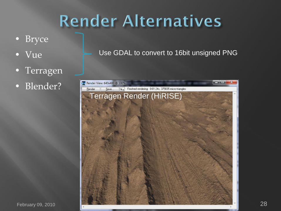
• Bryce
• Vue
• Terragen
• Blender?
Use GDAL to convert to 16bit unsigned PNG
Terragen Render (HiRISE)