appendixb jurisdictional delineation memo - san diego · manual and 2006 arid west supplement....
TRANSCRIPT
APPENDIXB Jurisdictional Delineation Memo
Memorandum
J:\27679000_SD Stormwater\TO-54 SW OM Support\FY 2013\014 Work in Progress\Task 08 - Gen. & LosPen Mitigation\Task 081 - Conceptual Mitigation Plan\PQ Conceptual Plan\Appendices - Same for both sites\Appendix B - JD\JD Memo 04-15-13.docx
Date: April 29, 2013 To: Mark Tucker From: Julie Stout and Sundeep Amin Subject: Jurisdictional Delineations for Proposed Mitigation Sites within
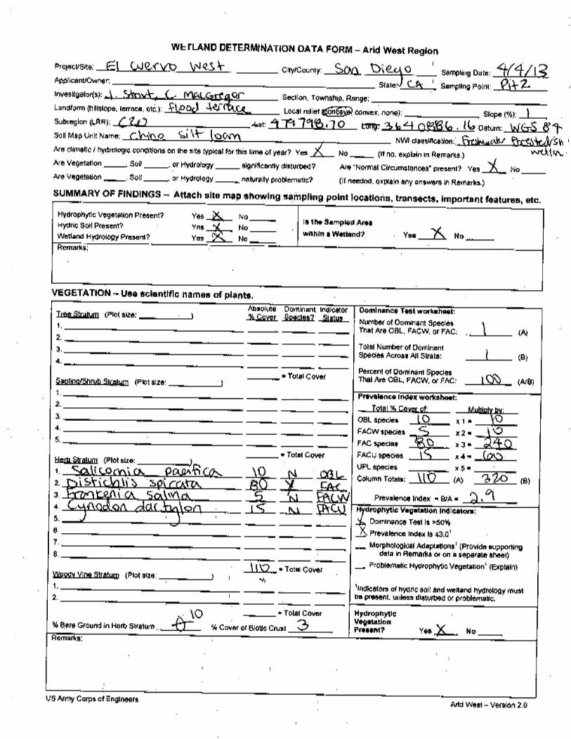
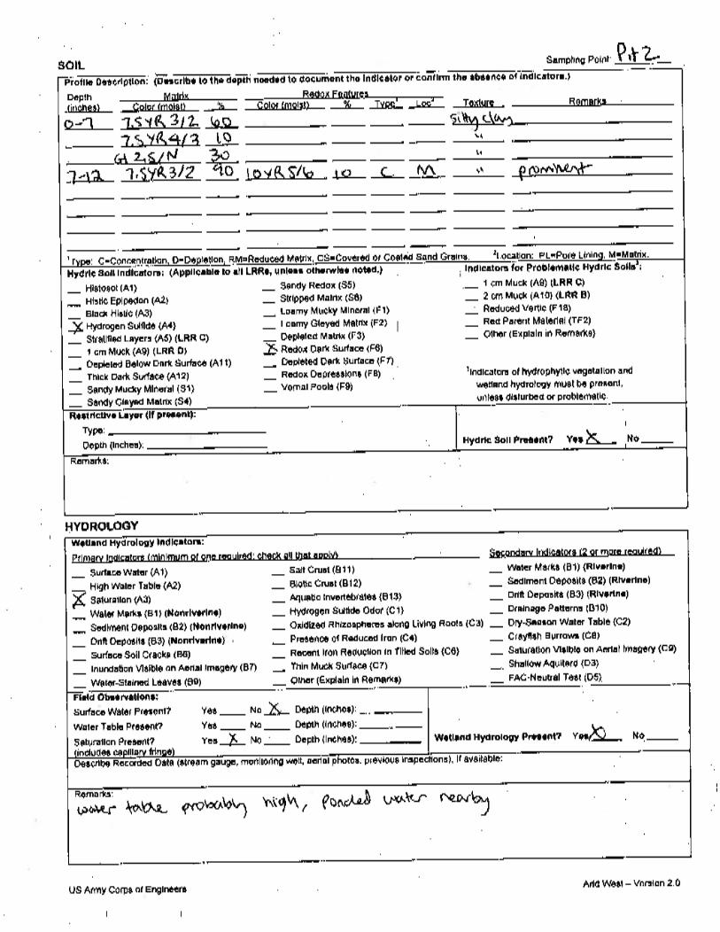
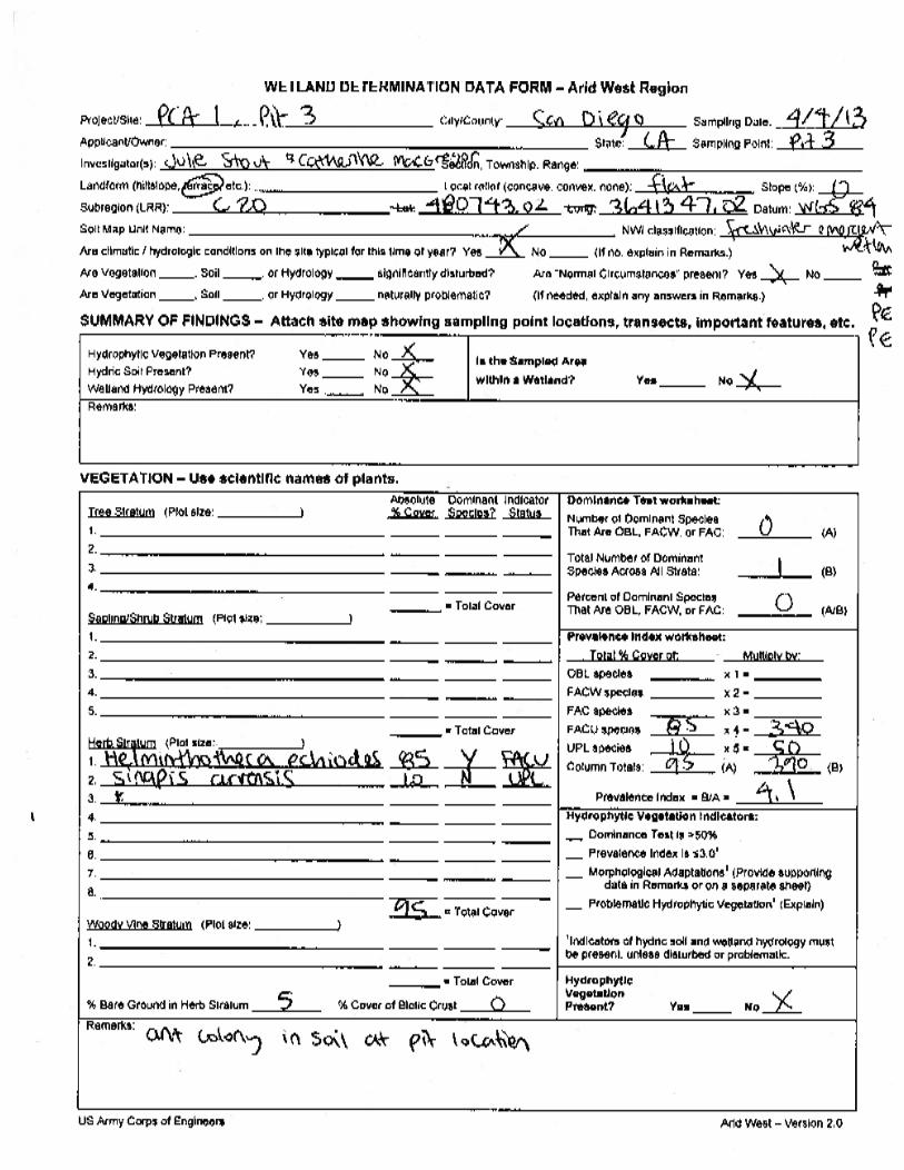
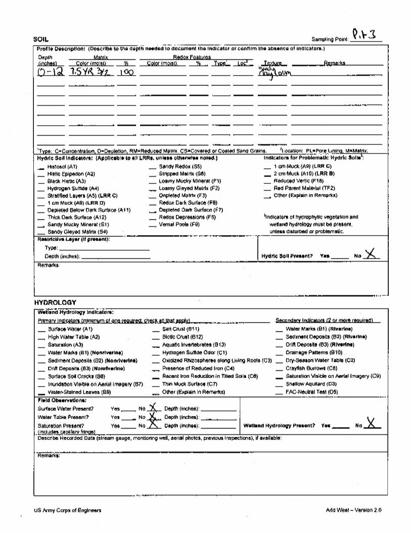
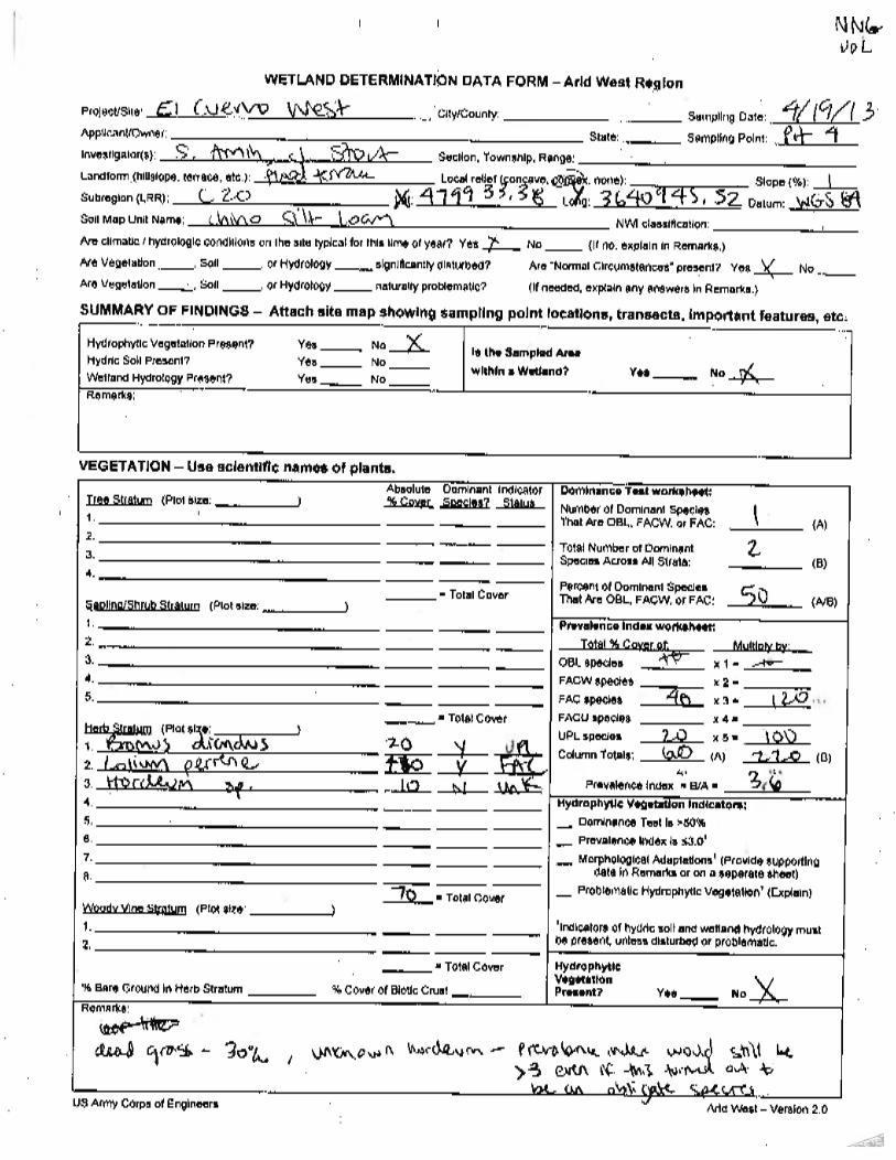
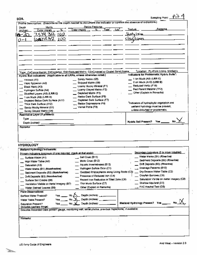
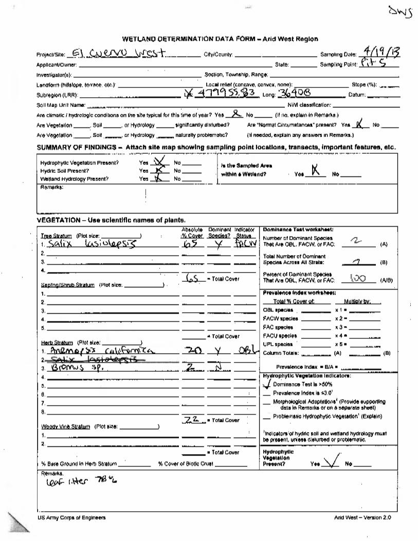
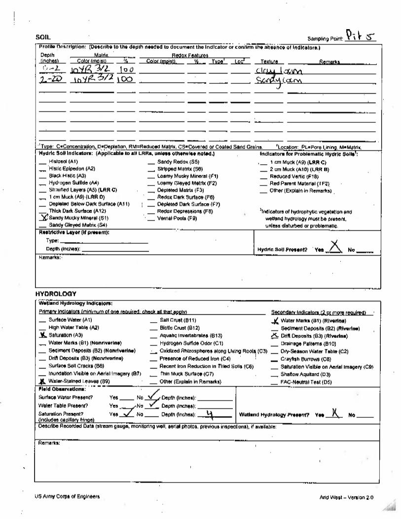
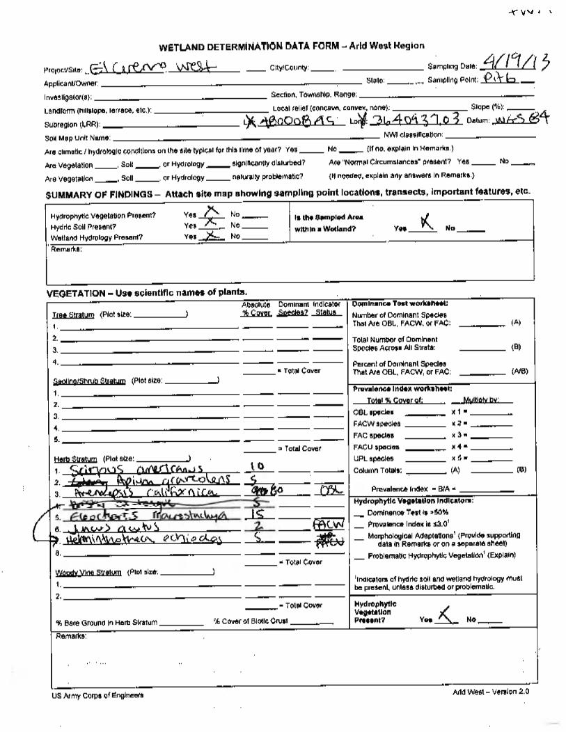
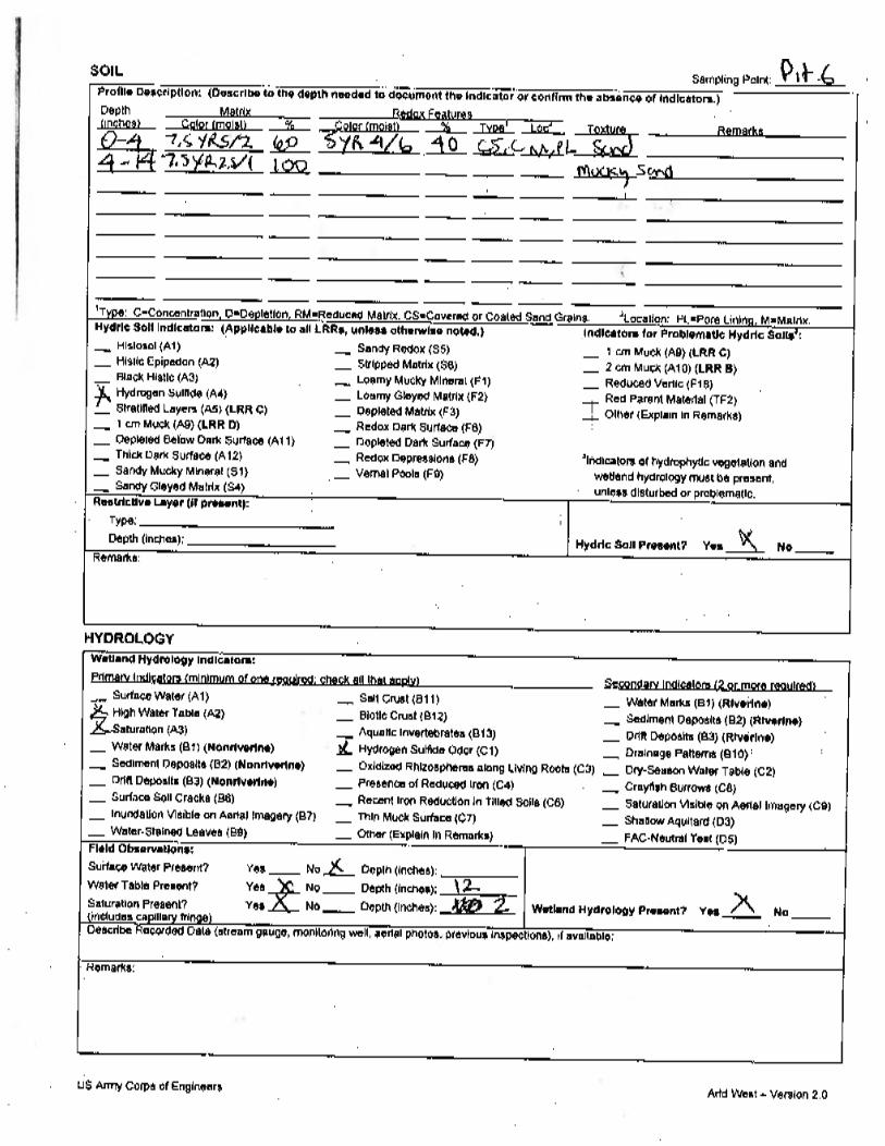
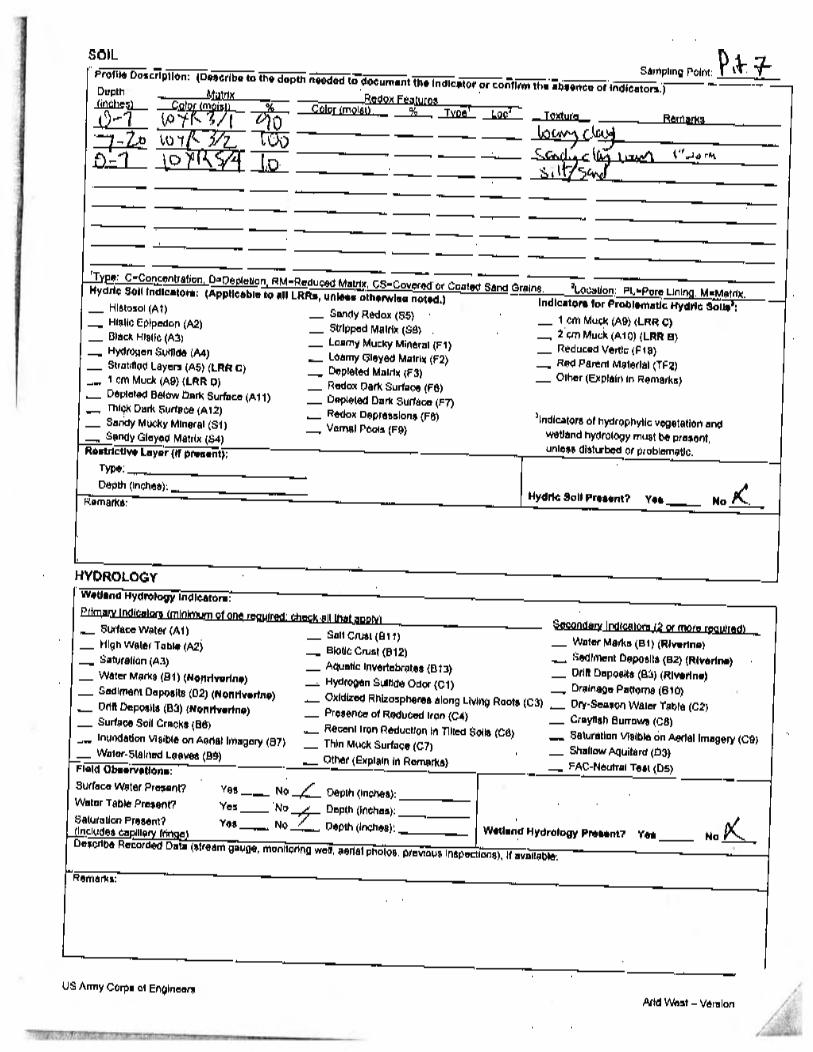
Los Peñasquitos Canyon Preserve The purpose of this memo is to document the methods and results of the delineation and jurisdictional determination conducted at two potential mitigation sites within Los Peñasquitos Canyon Preserve (Figures 1 and 2). The purpose of the delineation was to identify and map the location and extent of the limits of local, state, and federal jurisdictional waters of including wetlands that would fall under the jurisdiction of the U.S. Army Corps of Engineers (Corps), California Department of Fish and Wildlife (CDFW), Regional Water Quality Control Board (RWQCB), California Coastal Commission (CCC), and the City of San Diego. The current Arid West Regional Supplement and Rapanos/Carabell guidance (Rapanos) were applied to the methods and results of this study when relevant. This wetland study also evaluated the extent of waters of the State that may fall under the jurisdiction of the California Department of Fish and Wildlife pursuant to Section 1602 of the Fish and Game Code of California (Streambed Alteration Agreements) or the Porter-Cologne Act regulating waste discharge into waters of the State. This report is for use in the verification process with Local, State and Federal regulators and is intended to be submitted to the regulatory agencies for review and verification. Methods Site visits were conducted by URS biologists Julie Stout and Catherine MacGregor on April 4, 2013 and Julie Stout and Sundeep Amin on April 19, 2013. The initial site visits included vegetation mapping of the mitigation areas plus a 150-foot buffer and compilation of a plant species list. Areas with hydrophytic plant species were examined more closely to determine the wetland boundary. Initial delineation was conducted visually based on vegetation indicators. A three parameter wetland delineation was conducted in accordance with the 1987 Corps Manual and 2006 Arid West Supplement. Wetland waters of the U.S. were sampled using the general methodology detailed in the 1987 U.S. Army Corps of Engineers Wetland Delineation Manual (Corps Manual) for wetlands less than 5 acres in size. Sample points were chosen based on vegetation community mapping and considered visible transitions in vegetation composition and topographical changes. Additional soil pits were created to further document the wetland and upland conditions on site during the subsequent site visit and confirm wetland conditions in the southeastern corner of the site. The definition of the growing season and the basis of determining and recording indicators for hydrophytic vegetation, hydric soils, and wetland hydrology was the 2008 Regional Supplement to the Corps of Engineers Wetland Delineation Manual: Arid West Region (Version 2.0) (Arid West Supplement). Both the Corps Manual and Arid West Supplement were used for the determination and evaluation of any normal circumstances, atypical situations, and problem area wetlands. All Corps and CDFW jurisdictional areas were also assumed to be under the jurisdiction of the RWQCB and the CCC.
Page 2 of 2
J:\27679000_SD Stormwater\TO-54 SW OM Support\FY 2013\014 Work in Progress\Task 08 - Gen. & LosPen Mitigation\Task 081 - Conceptual Mitigation Plan\PQ Conceptual Plan\Appendices - Same for both sites\Appendix B - JD\JD Memo 04-15-13.docx
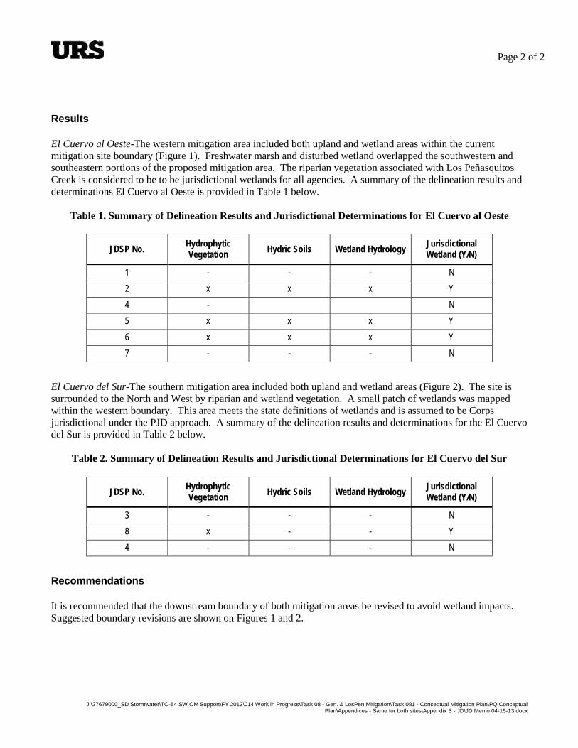
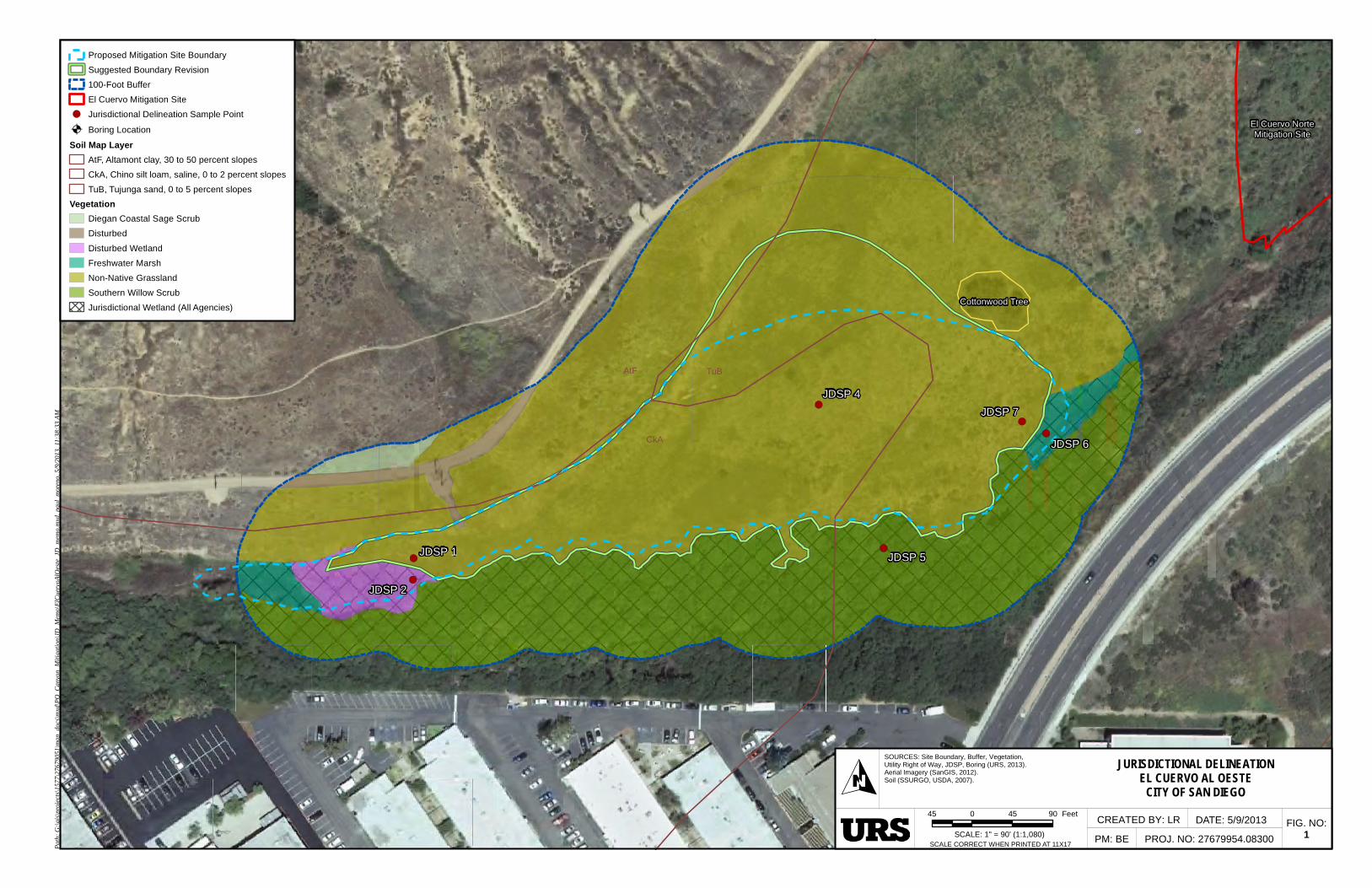
Results El Cuervo al Oeste-The western mitigation area included both upland and wetland areas within the current mitigation site boundary (Figure 1). Freshwater marsh and disturbed wetland overlapped the southwestern and southeastern portions of the proposed mitigation area. The riparian vegetation associated with Los Peñasquitos Creek is considered to be to be jurisdictional wetlands for all agencies. A summary of the delineation results and determinations El Cuervo al Oeste is provided in Table 1 below.
Table 1. Summary of Delineation Results and Jurisdictional Determinations for El Cuervo al Oeste
JDSP No. Hydrophytic Vegetation Hydric Soils Wetland Hydrology Jurisdictional
Wetland (Y/N)
1 - - - N 2 x x x Y 4 - N 5 x x x Y 6 x x x Y 7 - - - N
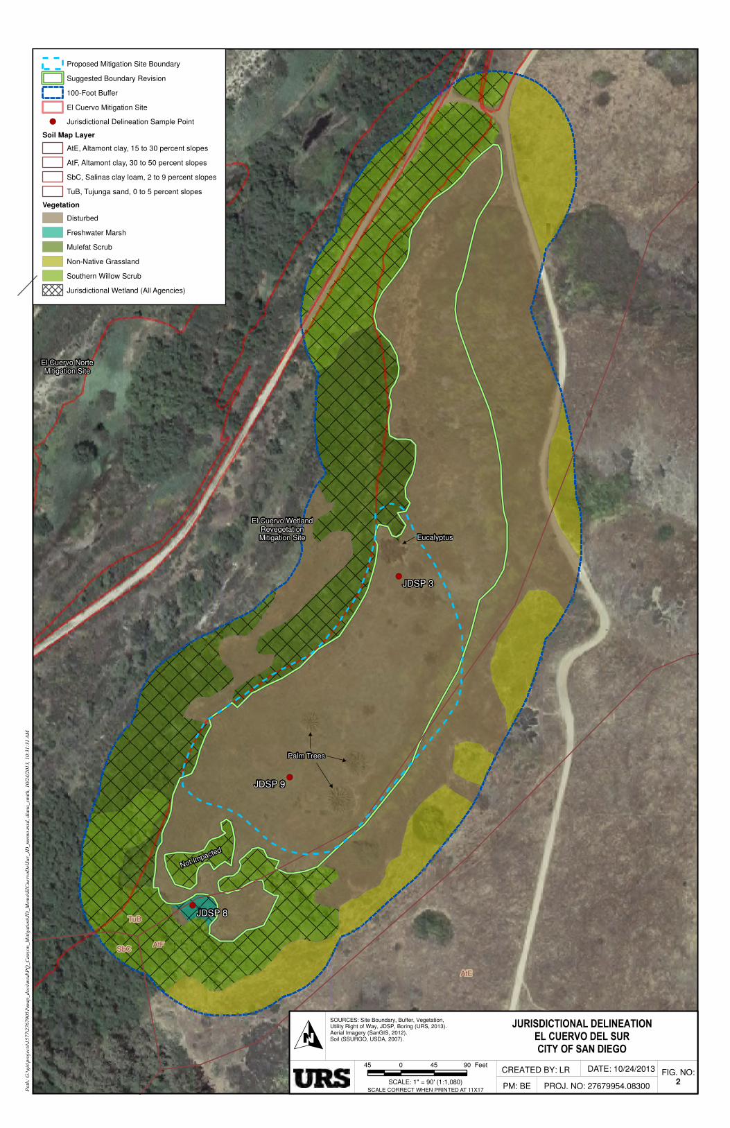
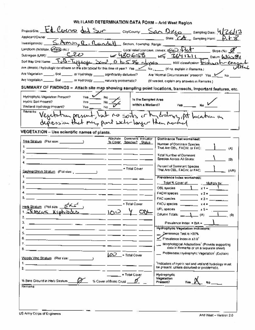
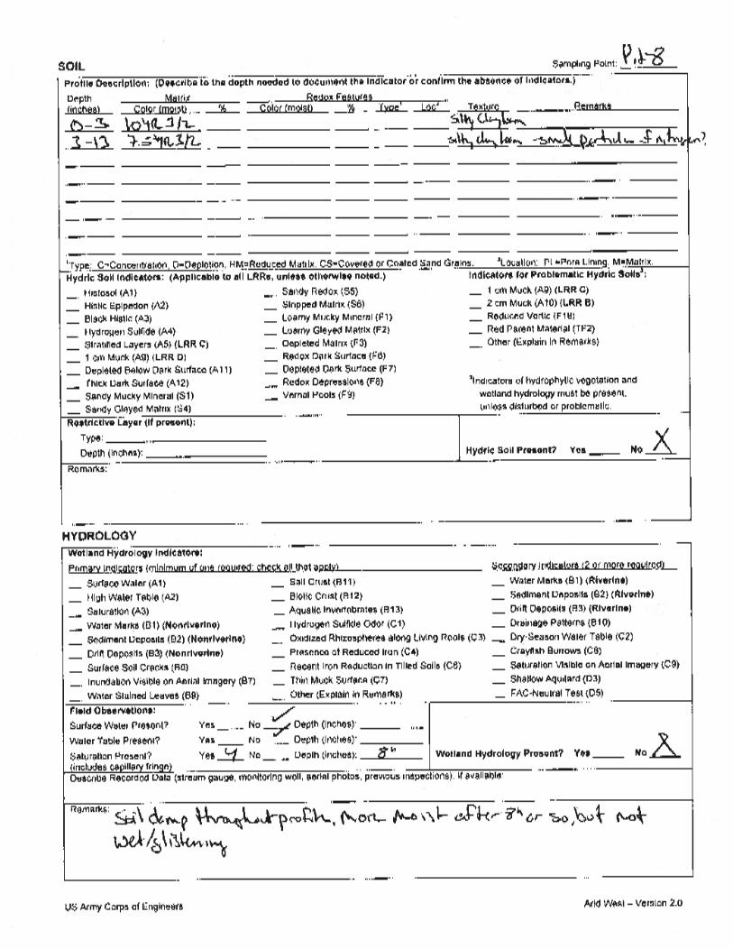
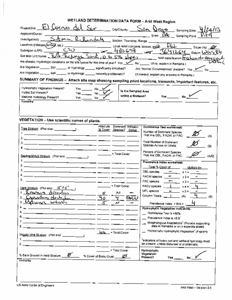
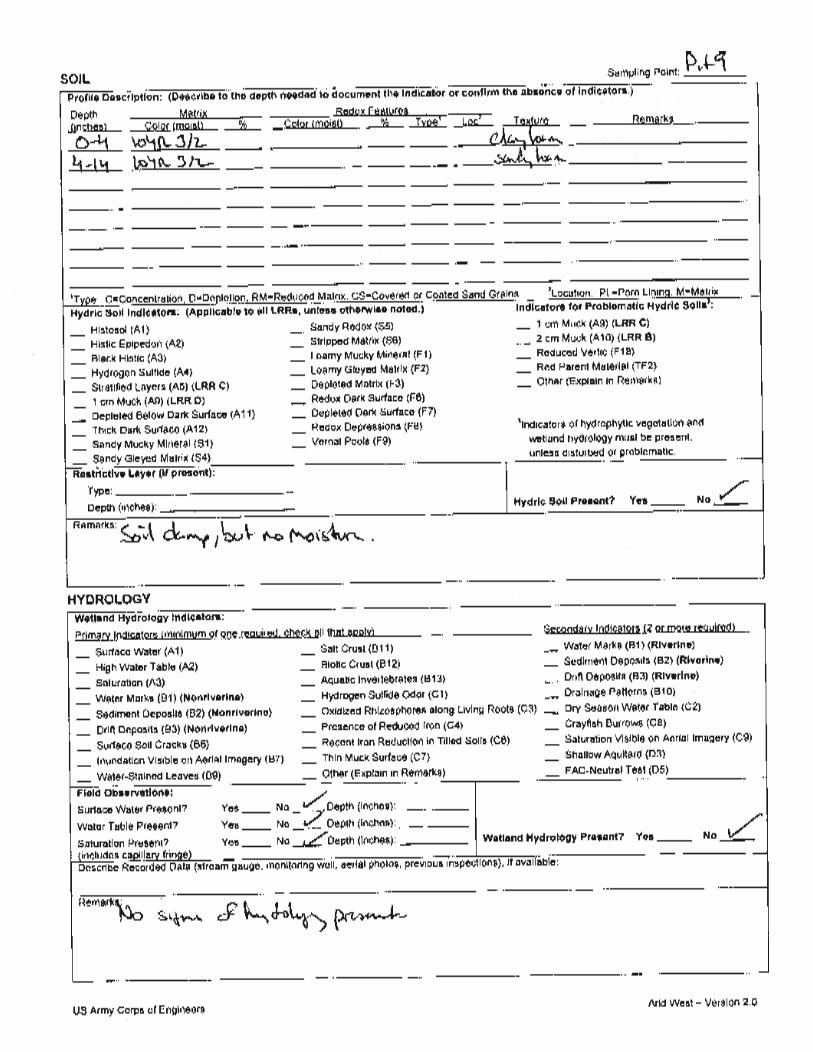
El Cuervo del Sur-The southern mitigation area included both upland and wetland areas (Figure 2). The site is surrounded to the North and West by riparian and wetland vegetation. A small patch of wetlands was mapped within the western boundary. This area meets the state definitions of wetlands and is assumed to be Corps jurisdictional under the PJD approach. A summary of the delineation results and determinations for the El Cuervo del Sur is provided in Table 2 below.
Table 2. Summary of Delineation Results and Jurisdictional Determinations for El Cuervo del Sur
JDSP No. Hydrophytic Vegetation Hydric Soils Wetland Hydrology Jurisdictional
Wetland (Y/N)
3 - - - N 8 x - - Y 4 - - - N
Recommendations It is recommended that the downstream boundary of both mitigation areas be revised to avoid wetland impacts. Suggested boundary revisions are shown on Figures 1 and 2.
!(
!(
!(
!(
!(
!(
AtF TuB
CkA
38El Cuervo NorteMitigation Site
JDSP 7
JDSP 6
JDSP 4
JDSP 5
JDSP 2
JDSP 1
Cottonwood Tree
Path
:G:\g
is\pr
ojec
ts\1
577\
2767
9051
\map
_doc
s\mxd
\PQ
_Can
yon_
Miti
gatio
n\JD
_Mem
o\El
Cue
rvoA
lOes
te_J
D_m
emo.
mxd
,pau
l_m
oren
o,5/
9/20
13,1
1:38
:33
AM
SOURCES: Site Boundary, Buffer, Vegetation, Utility Right of Way, JDSP, Boring (URS, 2013). Aerial Imagery (SanGIS, 2012). Soil (SSURGO, USDA, 2007).
JURISDICTIONAL DELINEATIONEL CUERVO AL OESTE
CITY OF SAN DIEGO
CREATED BY: LR
PM: BE PROJ. NO: 27679954.08300FIG. NO:
1SCALE: 1" = 90' (1:1,080)
45 0 45 90 Feet
OSCALE CORRECT WHEN PRINTED AT 11X17
DATE: 5/9/2013
Proposed Mitigation Site Boundary
Suggested Boundary Revision
100-Foot Buffer
El Cuervo Mitigation Site
!( Jurisdictional Delineation Sample Point
! A Boring Location
Soil Map LayerAtF, Altamont clay, 30 to 50 percent slopes
CkA, Chino silt loam, saline, 0 to 2 percent slopes
TuB, Tujunga sand, 0 to 5 percent slopesVegetation
Diegan Coastal Sage Scrub
Disturbed
Disturbed Wetland
Freshwater Marsh
Non-Native Grassland
Southern Willow Scrub
Jurisdictional Wetland (All Agencies)
!(
!(
!(
El Cuervo NorteMitigation Site
El Cuervo WetlandRevegetationMitigation Site
SbC
TuB
AtF
AtE
Not Impacted
JDSP 3
JDSP 8
JDSP 9
Eucalyptus
Palm Trees
Path
:G
:\gis
\pro
ject
s\1577\2
7679051\m
ap_docs
\mxd\P
Q_C
anyo
n_M
itig
ati
on\J
D_M
emo\E
lCuerv
oD
elSur_
JD_m
emo.m
xd,dia
na_sm
ith,10/2
4/2
013,10:3
1:3
1A
M
SOURCES: Site Boundary, Buffer, Vegetation, Utility Right of Way, JDSP, Boring (URS, 2013). Aerial Imagery (SanGIS, 2012).Soil (SSURGO, USDA, 2007).
JURISDICTIONAL DELINEATION
EL CUERVO DEL SUR
CITY OF SAN DIEGO
CREATED BY: LR
PM: BE PROJ. NO: 27679954.08300
45 0 45 90 Feet
ODATE: 10/24/2013
Proposed Mitigation Site Boundary
Suggested Boundary Revision
100-Foot Buffer
El Cuervo Mitigation Site
!( Jurisdictional Delineation Sample Point
Soil Map Layer
AtE, Altamont clay, 15 to 30 percent slopes
AtF, Altamont clay, 30 to 50 percent slopes
SbC, Salinas clay loam, 2 to 9 percent slopes
TuB, Tujunga sand, 0 to 5 percent slopes
Vegetation
Disturbed
Freshwater Marsh
Mulefat Scrub
Non-Native Grassland
Southern Willow Scrub
Jurisdictional Wetland (All Agencies)
SCALE: 1" = 90' (1:1,080)SCALE CORRECT WHEN PRINTED AT 11X17
FIG. NO:2

APPENDIXC Channel Cross-Section and Hydrology Memo
Date: A
To: S
From: T
Subject: L
MiSCwogd Thi Tswadv THb At TeFCcp Tgptft
April 19, 201
Sundeep Am
Thomas Gra
Los Penasq
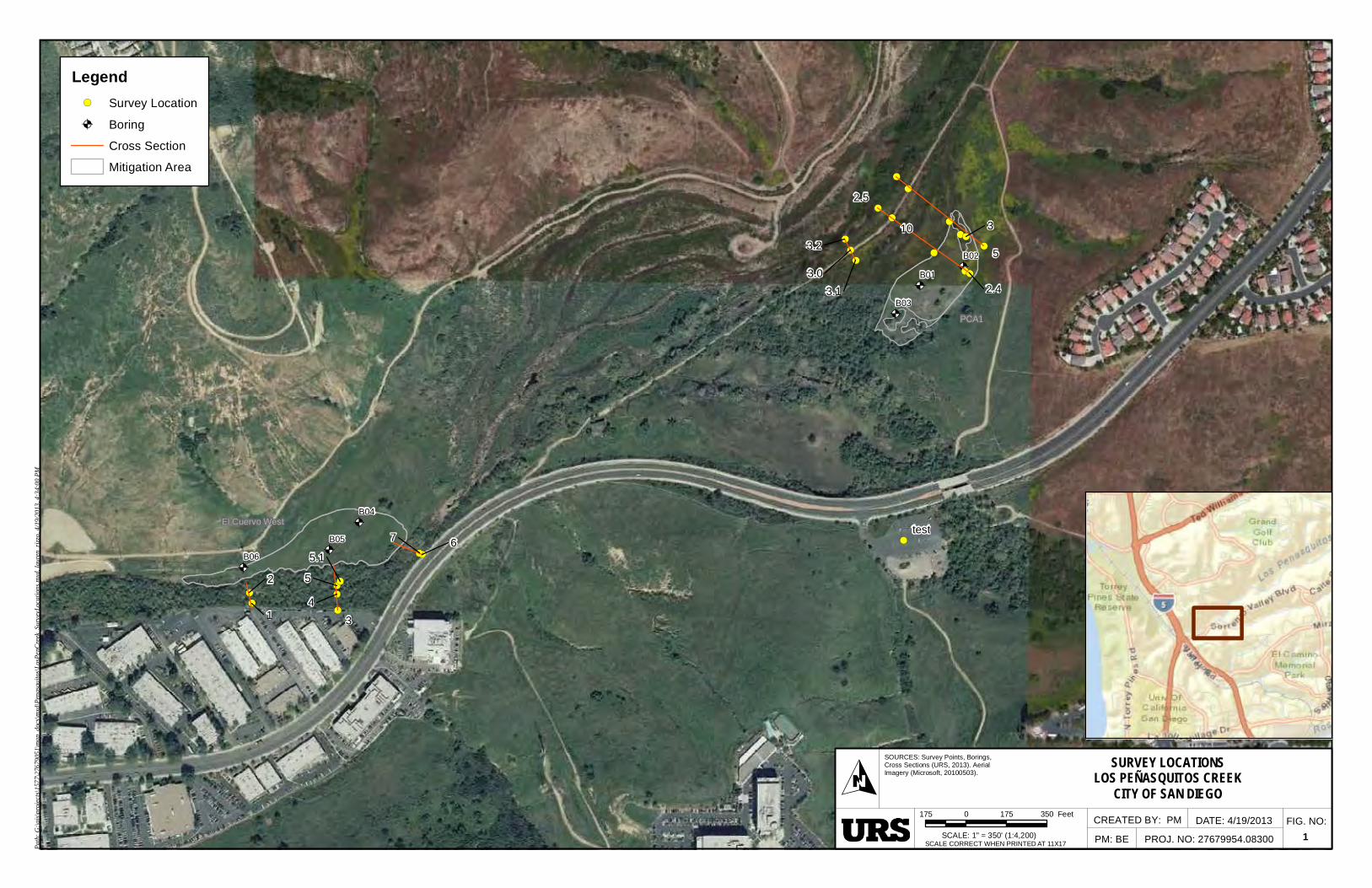
Matt Mooren-house surSur sites. TCuervo al Owas taken objective to getting the depth of wat
The El Cuerheavily vegenstances sm
The El Cuersite area is with tall vegalignments adue to safetvegetated. S
The cross-sHowever, wboring locati
Attached is ataking waypo
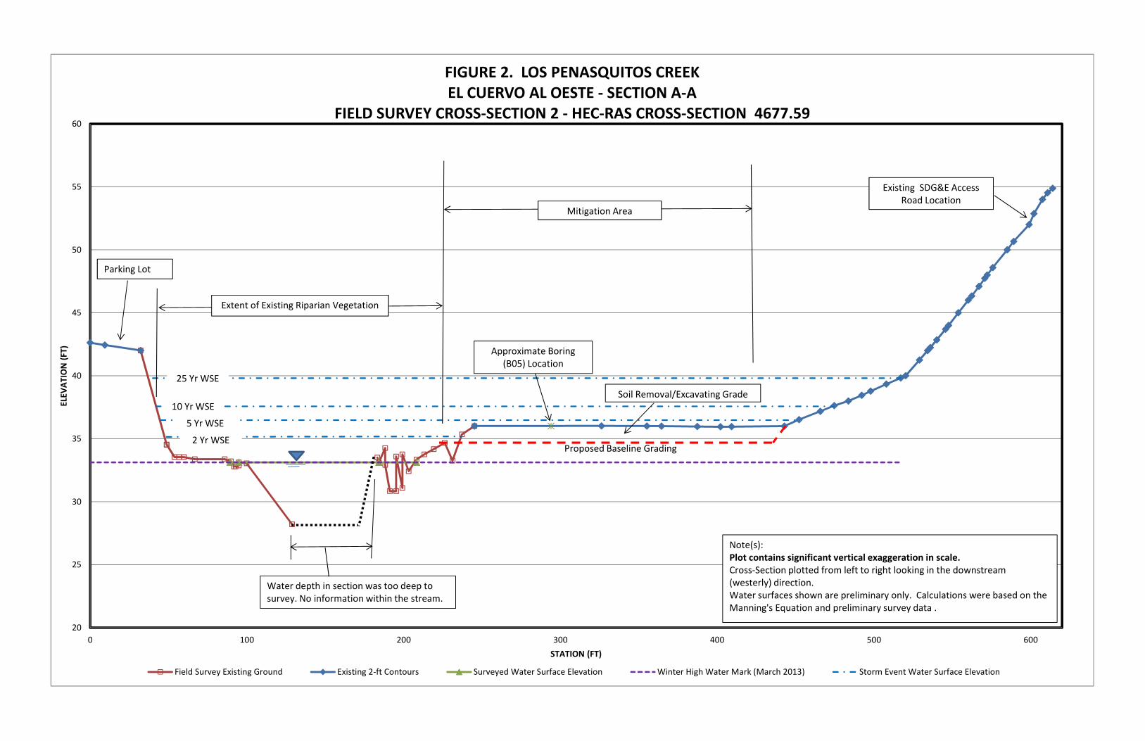
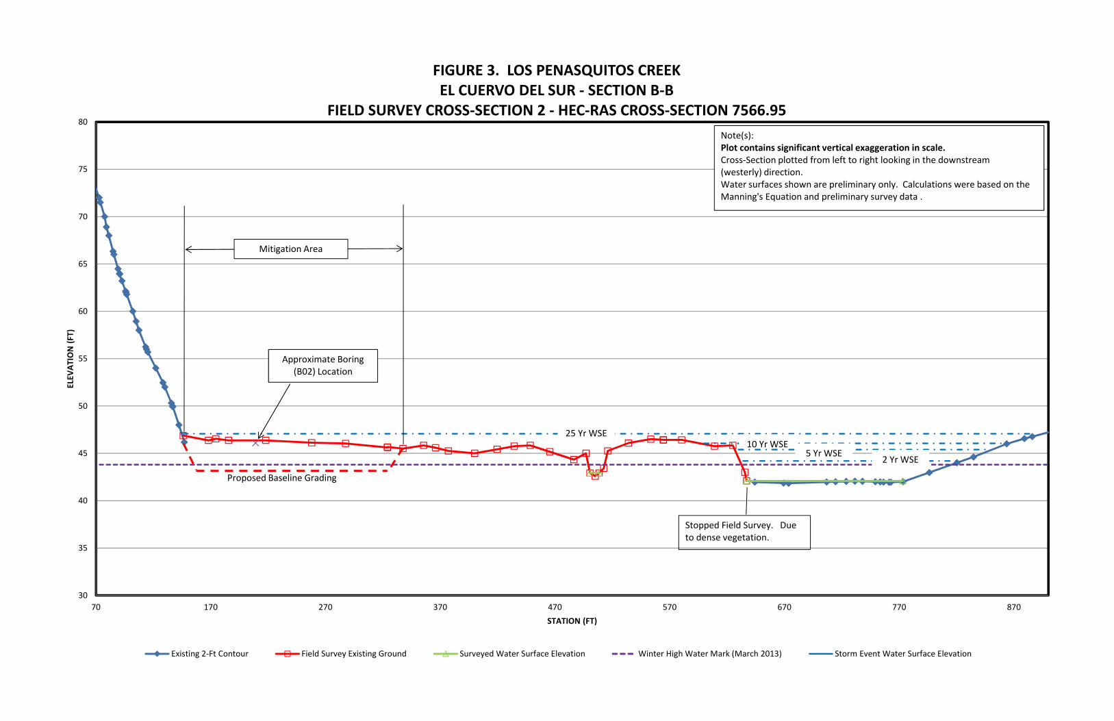
The field suexisting topoFigure 2 anCity topogracanopy of thpoints.
The cross-seground pointpreliminary wthe 2-, 5-, 1for El Cuervothe FEMA F
J:\27679000_S
13
min
ace
uitos Field S
, Jerry Pitt rvey for Los
The survey wOeste site su
on April 18closely aligngeneral topter.
rvo al Oesteetated with tmall pools of
rvo del Sur smainly dry w
getation. Tand the watty. The thirSurvey point
section alige oriented oons, to give
a map illustroints with th
rvey points ography, 2-f
nd Figure 3 aphy is not he trees and
ections genet data for anwater surfac0-, and 25-yo del Oeste lood Insuran
SD Stormwater\TO-54
Survey Progr
and Tom s Penasquitowas taken wurvey was ta8th, 2013. n with the HEography of
e site surveythick brush f standing wa
site survey wwith tall gra
The vegetatiter appearedrd cross-sects were gath
nments weour alignmeus direction
rating our gee GPS unit o
were then tft contour infor El Cuervdetailed eno brush there
erated from n HEC-RAS ce elevationsyear floodplaand El Cuer
nce Study (F
SW OM Support\FY 2
ress Report
Grace speos Creek at ith three cro
aken on AprThe field sEC-RAS crothe land, w
y was conduand trees. ater were ob
was conducass, shrubs aon was tood to be deection, the mhered until ac
re hard to nts with vis
n.
eneral cross-on the field s
transposed ntervals, to gvo del Oesteough to capefore a field
the City topanalysis. T
s and flood ains were dervo del Sur,
FIS) for Los P
M
2013\014 Work in Prog
nt approximthe El Cue
oss-section aril 17th, 2013survey crossoss-section awe also note
ucted withinThe creek
bserved.
cted mainly wand trees. T
o dense to ep. We couost downstrccessibility w
establish ible landma
-section aligsurvey. Ref
onto the crogenerate a e and El Cupture the grosurvey was
ography andThe results fwidths for belineated. Rrespectively
Penasquitos
Memo
gress\Los Penasquito
mately 1.5 dervo al Oestealignments f3 and the Els-sections wand boring loed edge-of-
n the creek ahad running
within the prThe creek acomplete thldn’t travers
ream sectionwas limited.
based on arks, such a
nments thatfer to Figure
oss-sectionsmore define
uervo del Suound points conducted
d the field surom the ana
both project Refer to Figy. The flow s Creek.
orand
s\Los Pen Memo.docx
days condue and El Cufor each site Cuervo del
were taken ocations. O-water locat
area. The ag water and
roject site ararea was vehe survey ase through tn, was very
the overvies houses, t
t were estabe 1.
s generated ed section. ur, respectivs beneath thto suppleme
urveys werealysis determsites. For e
gure 4 and rates were b
dum
x\7-May-13\SDG
ucting an uervo del e. The El l Sur site with the ther than ions and
area was in some
rea. The ry dense
along the the creek y densely
ew map. rees and
lished by
with the Refer to
ely. The he dense ent those
e used as mined the each site, Figure 5 based on
! A
! A
! A
! A
! A
! A
!(
!(!(
!(
!(!(
!(!(
!(
!(
!(!(!(
!(
!(
!(
!(
!(!(
!(
!(!(
!(
PCA1
El Cuervo Westtest
1
2
34
5
67
5.1
3
5
10
2.4
2.5
3.03.1
3.2
B01
B02
B03
B04
B05
B06
Path
:G:\g
is\p
roje
cts\
1577
\276
7905
1\m
ap_d
ocs\
mxd
\Pen
asqu
itos\
LosP
enC
reek
_Sur
veyL
ocat
ions
.mxd
,lau
ren_
rizz
o,4/
19/2
013,
4:34
:00
PM
SOURCES: Survey Points, Borings,Cross Sections (URS, 2013). Aerial Imagery (Microsoft, 20100503).
SURVEY LOCATIONSLOS PEÑASQUITOS CREEK
CITY OF SAN DIEGO
CREATED BY: PM
PM: BE PROJ. NO: 27679954.08300
FIG. NO:1SCALE: 1" = 350' (1:4,200)
175 0 175 350 Feet
OSCALE CORRECT WHEN PRINTED AT 11X17
DATE: 4/19/2013
Legend!( Survey Location
! A Boring
Cross Section
Mitigation Area
20
25
30
35
40
45
50
55
60
0 100 200 300 400 500 600
ELEV
ATION (F
T)
STATION (FT)
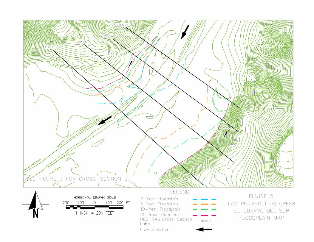
FIGURE 2. LOS PENASQUITOS CREEKEL CUERVO AL OESTE ‐ SECTION A‐A
FIELD SURVEY CROSS‐SECTION 2 ‐ HEC‐RAS CROSS‐SECTION 4677.59
Field Survey Existing Ground Existing 2‐ft Contours Surveyed Water Surface Elevation Winter High Water Mark (March 2013) Storm Event Water Surface Elevation
Water depth in section was too deep to survey. No information within the stream.
Approximate Boring (B05) Location
Parking Lot
Extent of Existing Riparian Vegetation
Existing SDG&E AccessRoad Location
Soil Removal/Excavating Grade
Proposed Baseline Grading
Mitigation Area
Note(s): Plot contains significant vertical exaggeration in scale.Cross‐Section plotted from left to right looking in the downstream (westerly) direction.Water surfaces shown are preliminary only. Calculations were based on the Manning's Equation and preliminary survey data .
25 Yr WSE
10 Yr WSE
5 Yr WSE
2 Yr WSE
30
35
40
45
50
55
60
65
70
75
80
70 170 270 370 470 570 670 770 870
ELEV
ATION (F
T)
STATION (FT)
FIGURE 3. LOS PENASQUITOS CREEKEL CUERVO DEL SUR ‐ SECTION B‐B
FIELD SURVEY CROSS‐SECTION 2 ‐ HEC‐RAS CROSS‐SECTION 7566.95
Existing 2‐Ft Contour Field Survey Existing Ground Surveyed Water Surface Elevation Winter High Water Mark (March 2013) Storm Event Water Surface Elevation
Stopped Field Survey. Due to dense vegetation.
Approximate Boring (B02) Location
Mitigation Area
Note(s): Plot contains significant vertical exaggeration in scale.Cross‐Section plotted from left to right looking in the downstream (westerly) direction.Water surfaces shown are preliminary only. Calculations were based on the Manning's Equation and preliminary survey data .
25 Yr WSE10 Yr WSE
5 Yr WSE2 Yr WSE
Proposed Baseline Grading