appendix p - valley metro
TRANSCRIPT

City of Mesa, AZ: Central Mesa Light Rail Extension p. 1
FY 2011 Assessment of Public Transportation Supportive Land Use and Economic Development Effects Draft Assessment, March 2010
Assessment of Public Transportation Supportive Land Use and Economic Development Effects – FY 2011
City of Mesa, AZ: Central Mesa Light Rail Extension (Small Starts)
Project Location: City of Mesa, AZ Lead Agency: Valley Metro Project Status: Alternatives Analysis
Date of entry into PE: Project Development anticipated June 2010 Date of entry into Final
Design: N/A
A. RATINGS AND CHANGES
RECOMMENDED RATINGS
LAND USE – Medium-Low ECONOMIC DEVELOPMENT – Medium-High • Existing Land Use – Medium-Low • Plans and Policies – Medium-High
• Performance and Impacts – Medium-High
CATEGORY AND FACTOR RATINGS
LAND USE
ECONOMIC DEVELOPMENT
Plans and Policies Performance and Impacts
Existing Land Use
Growth Management
Corridor Policies
Zoning Regs.
Tools to Implement
Performance of Policies
Potential Impact
FY 2011 2 N/A 4 4 3 4 3

City of Mesa, AZ: Central Mesa Light Rail Extension p. 2
FY 2011 Assessment of Public Transportation Supportive Land Use and Economic Development Effects Draft Assessment, March 2010
REASONS FOR CHANGES
This project has not been previously assessed.
SIGNIFICANT NEW INFORMATION SUBMITTED
This project has not been previously assessed.
B1. SUMMARY OF KEY FINDINGS: LAND USE
I. EXISTING LAND USE a. Existing Land Use • In 2005, CBD employment in Phoenix was 80,512 and is projected to increase to 99,905 by
2015/opening year (Medium-Low rating according to FTA guidance). In 2005, station area population density was 5,602 persons per square mile and is projected to increase to 6,234 by 2015/opening year (Medium-Low rating according to FTA guidance).
B2. SUMMARY OF KEY FINDINGS: ECONOMIC DEVELOPMENT
II. TRANSIT-SUPPORTIVE PLANS AND POLICIES a. Growth Management • N/A per Small Starts Guidance b. Transit-Supportive Corridor Policies • The approved Mesa 2026 General Plan, The West Main Street Neighborhood Plan, new land
use categories, and the Town Center Concept Plan encourage station area and corridor development, enhance transit friendly character and improve the pedestrian environment. Additional plans and policies are underway.
c. Supportive Zoning Regulations Near Transit Stations • Significant zoning ordinances exist to increase density and enhance the transit friendly
character. Many of the station areas permit dwelling units per acre which rate from medium to high according to FTA guidance. Bonus intensity zone overlay is an existing tool and form based zoning options (when a specific urban form is sought, a code is designed to guide development) are proposed as a potential future tool.
d. Tools to Implement Land Use Policies • Numerous regulatory and financial incentives are currently applied in practice. In addition,
several more programs are currently in the planning stage. III. PERFORMANCE AND IMPACTS OF POLICIES a. Performance of Land Use Policies • Between 2004 and 2008, recently completed, under construction or well into the design phase
development along the Tempe/Mesa portion of the line has totaled over $1.1 billion. Proposed projects are likewise valued at $1.1 billion.

City of Mesa, AZ: Central Mesa Light Rail Extension p. 3
FY 2011 Assessment of Public Transportation Supportive Land Use and Economic Development Effects Draft Assessment, March 2010
b. Potential Impact of Transit Investment on Regional Land Use • A conservative estimate of 232 acres will be available for development by 2030. At present, no
significant barriers to redevelopment have been identified along the proposed route.
City of Mesa, AZ: Central Mesa Light Rail Extension p. 4
FY 2011 Assessment of Public Transportation Supportive Land Use and Economic Development Effects Draft Assessment, March 2010
C. PROJECT OVERVIEW
PROJECT DESCRIPTION
The Central Mesa LRT Extension Project is an approximately 3.08-mile extension of METRO. It begins at the existing Sycamore/Main Street station and continues east to Mesa. The Sycamore Main Street station is currently the last station in the existing 20-mile light rail corridor and had the highest ridership along the line in 2009. Scottsdale and Phoenix are located northwest of the proposed segment. Tempe and Phoenix are located west of the proposed segment. The project is at grade with four proposed stations. The Mesa/Main Street station will have 322 surface parking spaces while the other stations have no proposed parking. All stations provide connections to local bus routes. This project will not require any additional vehicles to operate. The opening year for the project is 2015 with a capital cost estimate of $198,500,000 (adjusted based on year of expenditure). Service will operate from 5:00 AM to 12:00 AM on weekdays and from 5:00 AM to 3:00 AM on weekends. In 2015, headways will be 10 minutes during the weekday peak, 10 minutes during the weekday off-peak, 20 minutes during weekday evenings and 15 minutes during weekends. Daily ridership for 2015 is projected to be 9,742.
CORRIDOR DESCRIPTION
The purpose of the Central Mesa LRT Extension is to improve mobility and provide additional capacity in the alignment. In addition, the project is intended to connect the Central Mesa alignment with major activity and employment centers located east and west of the project alignment, such as Downtown Phoenix, Downtown Tempe, Sky Harbor International Airport, Arizona State University, proposed Mesa Gateway Area, and the ASU East Polytechnic campus. The project will also enhance multi-model connectivity to the newly constructed Mesa Link BRT (with in-street mixed traffic operations) that currently serves East Mesa including Superstition Spring Mall. Travel demand and traffic congestion, particularly on the major arterials during peak periods, are continuing problems on the alignment. Congestion is expected to worsen in the future and extended beyond the peak period. There are few opportunities to widen the existing surface street system without significant impacts to existing businesses and established/historic neighborhoods. The adopted Regional Transportation Plan (RTP) does not include any roadway capacity improvements on or near the vicinity of Main Street. The report suggests that Arizona is only one of four states to rely on local and regional sales tax revenue as the largest non-federal source of funding and for every dollar invested in public transportation an additional six dollars or more in economic returns is realized. Federal funds are important because the local and regional budget difficulties due to the recession have caused significant decreases in sales tax revenues. The long-range transportation goal of the Regional Transportation Plan is to provide a safe, efficient, economical, attractive, and integrated multi-modal transportation system that offers convenient, accessible, and affordable mobility for all people and for the movement of goods. In support of this goal, additional resources are needed for the design of the Central Mesa LRT Extension, which will ultimately improve mobility and provide additional capacity along the alignment.
City of Mesa, AZ: Central Mesa Light Rail Extension p. 5
FY 2011 Assessment of Public Transportation Supportive Land Use and Economic Development Effects Draft Assessment, March 2010
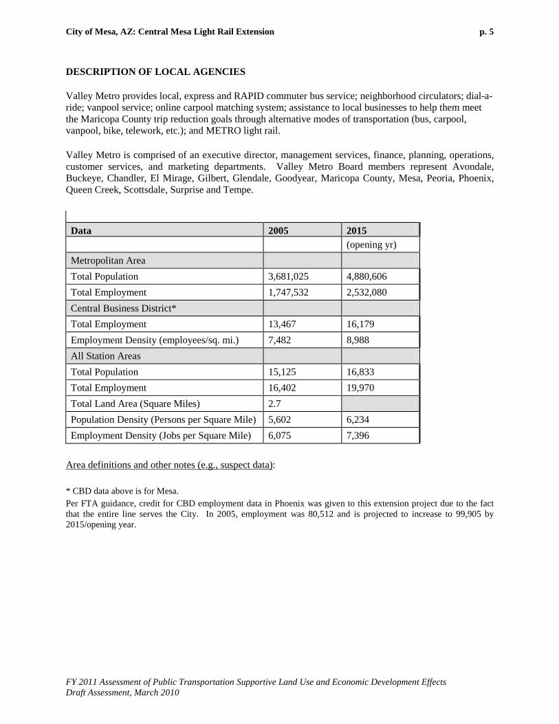
DESCRIPTION OF LOCAL AGENCIES
Valley Metro provides local, express and RAPID commuter bus service; neighborhood circulators; dial-a-ride; vanpool service; online carpool matching system; assistance to local businesses to help them meet the Maricopa County trip reduction goals through alternative modes of transportation (bus, carpool, vanpool, bike, telework, etc.); and METRO light rail.
Valley Metro is comprised of an executive director, management services, finance, planning, operations, customer services, and marketing departments. Valley Metro Board members represent Avondale, Buckeye, Chandler, El Mirage, Gilbert, Glendale, Goodyear, Maricopa County, Mesa, Peoria, Phoenix, Queen Creek, Scottsdale, Surprise and Tempe. Data 2005 2015 (opening yr) Metropolitan Area Total Population 3,681,025 4,880,606 Total Employment 1,747,532 2,532,080 Central Business District* Total Employment 13,467 16,179 Employment Density (employees/sq. mi.) 7,482 8,988 All Station Areas Total Population 15,125 16,833 Total Employment 16,402 19,970 Total Land Area (Square Miles) 2.7 Population Density (Persons per Square Mile) 5,602 6,234 Employment Density (Jobs per Square Mile) 6,075 7,396
Area definitions and other notes (e.g., suspect data): * CBD data above is for Mesa. Per FTA guidance, credit for CBD employment data in Phoenix was given to this extension project due to the fact that the entire line serves the City. In 2005, employment was 80,512 and is projected to increase to 99,905 by 2015/opening year.
City of Mesa, AZ: Central Mesa Light Rail Extension p. 6
FY 2011 Assessment of Public Transportation Supportive Land Use and Economic Development Effects Draft Assessment, March 2010
E1. DETAILED ASSESSMENT OF PUBLIC TRANSPORTATION SUPPORTIVE LAND USE
I. EXISTING LAND USE
a. EXISTING LAND USE Rating: Medium-Low
Existing corridor and station area development
• In 2005, CBD employment in Phoenix was 80,512 and is projected to increase to 99,905 by 2015/opening year (Medium-Low rating according to FTA guidance).
• In 2005, station area population density was 5,602 persons per square mile and is projected to increase to 6,234 by 2015/opening year (Medium-Low rating according to FTA guidance).
• Major generators within the four proposed station areas contribute a total of 25,000 visitors per day including Arizona Museum of Natural History, Arizona Museum for Youth, Arizona Temple, Hohokam Stadium, Mesa Amphitheater, Mesa Arts Center, Mesa Community College, Mesa Court Building, East Valley Institute of Technology, and Northern Arizona University.
Existing corridor and station area develop-ment character
• The Alma School/Main Street station area is comprised of suburban commercial/retail, industrial/commercial, single family and multi-family homes. This station would serve the east end of the East Valley Institute of Technology campus. Vacant and/or underutilized parcels are located within the station area.
• The Country Club/Main Street station area is similar to the Alma School/Main Street station area described above; however, it includes a traditional quaint downtown area with enhanced pedestrian connections through a designated Pedestrian Overlay Area (POA). The POA included enhanced streetscape, wider sidewalks, improved vegetative and structural pedestrian shading, smaller block sizes and increased connectivity. Residential uses constitute 25 percent of the station area.
• The Center/Main Street station area is located in the center of downtown Mesa. Characteristics include a designated POA as well as the large public spaces associated with the Mesa Art Center, government office complex, main public library, and Mesa Convention Center/Amphitheater which are connected through a dedicated off-street pedestrian route. The station will service the daily visitors and government offices.
• The Mesa/Main Street station area is located on the east edge of the downtown area of Mesa. West of the station, characteristics of the area include enhanced pedestrian connections through a designated POA. East of the station, the general character of the area is auto-oriented commercial/retail development along the arterial streets and primarily residential for the remainder of the station area. Forty-four percent of the station area is residential. This station area would also serve the Church of Latter Day Saints and the guest center, as well as a 16 acre park. Vacant and/or underutilized parcels are located within the station area.
• The City of Mesa has committed significant resources to develop its downtown as a true “Main Street” experience and destination. The City has implemented pedestrian and street-space improvements including an
City of Mesa, AZ: Central Mesa Light Rail Extension p. 7
FY 2011 Assessment of Public Transportation Supportive Land Use and Economic Development Effects Draft Assessment, March 2010
E1. DETAILED ASSESSMENT OF PUBLIC TRANSPORTATION SUPPORTIVE LAND USE
extensive public art program, traffic calming and sidewalk improvements, street furniture, bike lanes, street trees and other elements. The City has also worked hard to establish major institutions and attractions within the downtown including the Arizona Museum of Natural History, a youth museum, an outdoor amphitheatre and the Mesa Arts Center, the largest and most comprehensive arts facility in the state. The City remains committed to adding additional cultural and educational facilities to downtown. In addition to these significant public elements, the Downtown Mesa Association counts 490 business establishments, 7,190 employees and 3,000 residents within its one square mile boundary. The cumulative effect of the amenities and the general existing development character within downtown Mesa is to create the potential for the area to become the true anchor of the east valley that provides an alternative to downtown Phoenix and other points west. While being transit supportive and truly urban in character, the presence of the proposed LRT extension would partner with downtown Mesa in its continued emergence as a boutique art and entertainment destination, with a more relaxed feel than downtown Phoenix or the student oriented area of downtown Tempe.
Existing station area pedestrian facilities, including access for persons with disabilities
• Pedestrian overlay areas are present in three of the four station areas. • All City of Mesa overlay projects have ADA compliant facilities (curb
ramps, cross walks, etc.).
Existing corridor and station area parking supply
• According to a 2009 Mesa Downtown Parking study, there are over 5,000 parking spaces available to the public including garages, surface lots and on-street parking. These spaces are part of the Country Club/Main Street, Center/Main Street, and the Mesa/Main Street station areas. The garages, surface lots, on-street and off-street parking are all free including parking at the Government Center and Arts Center. The areas with the greatest parking demand include the blocks around the prime retail shopping area, City government complex, the Mesa Convention Center and the Mesa Arts Center along Center Street. Utilization rates are only documented for off-street parking at 89%.
City of Mesa, AZ: Central Mesa Light Rail Extension p. 8
FY 2011 Assessment of Public Transportation Supportive Land Use and Economic Development Effects Draft Assessment, March 2010
E2. DETAILED ASSESSMENT OF ECONOMIC DEVELOPMENT EFFECTS
II. TRANSIT-SUPPORTIVE PLANS AND POLICIES
a. GROWTH MANAGEMENT Rating: N/A
Concentration of development around established activity centers and regional transit
• N/A
Land conservation and management
• N/A
b. TRANSIT-SUPPORTIVE CORRIDOR POLICIES Rating: Medium-High
Plans and policies to increase corridor and station area development
• Mesa 2025 General Plan (SD-3): The Mesa General Plan was approved by 55 percent of the voters in November 2002 and an update to the General Plan is anticipated to begin in 2010 with a vote in November 2012. Two particular subsets of the Mesa General Plan apply: • Objective ED-2.1: Support the development of key employment centers / corridors throughout the City of Mesa. • Policy ED-2.1b: Through the use of public and private funding mechanisms, provide the infrastructure needed to support mixed-use, high-intensity development within the employment centers/corridors.
• West Main Street Neighborhood Area Plan (SD-4): The Mesa City Council adopted the West Main Street Neighborhood Area Plan for the section of Main Street between University and Broadway, from the Tempe border to Country Club Road, in December 2007. The main purpose of this planning process was to prepare for and encourage redevelopment of property at the existing and proposed light rail stations on this section of Main Street. The vision of this plan is to recreate this section of Main Street into a pedestrian-friendly and transit-friendly area. The plan calls for increased density and intensity within the station areas, while maintaining the established neighborhoods adjacent to these areas. The plan establishes a wide range of policies and projects designed to provide more transportation choices and enhance economic competiveness.
• In November 2008, the Mesa City Council adopted a new land use category – MU/TOD to provide for transit oriented development along the light rail line. In addition, the zoning and land use correlation table in the zoning ordinance was amended to make future transit mixed use zoning districts automatically compatible with the Land Use Plan when applied within 660 feet of an existing or proposed light rail station. This step eliminates the necessity for a property owner to change the general plan prior to obtaining this zoning.
• Through the Central Main Street Neighborhood Area Plan, the City of Mesa is initiating a planning project along the proposed light rail line east
City of Mesa, AZ: Central Mesa Light Rail Extension p. 9
FY 2011 Assessment of Public Transportation Supportive Land Use and Economic Development Effects Draft Assessment, March 2010
E2. DETAILED ASSESSMENT OF ECONOMIC DEVELOPMENT EFFECTS
to Gilbert Road in order to plan for future redevelopment of property, particularly in close proximity to the station areas. This planning process can increase the intensity and density of land uses along this section of Main Street to fully capture the benefit of the light rail line in a way that supports the existing community, coordinates policies, and leverages investment. This planning process will include the preparation of a regulating plan to allow implementation of the form-based code. It is anticipated that this plan will be completed and adopted by early 2011.
Plans and policies to enhance transit-friendly character of corridor and station area development
• The Town Center Concept Plan was approved in 1999 and anticipated the future light rail into the downtown. The plan encourages high density development (40+ du/acre – High rating according to FTA guidance), multi-story mixed-use buildings, and an improved pedestrian environment. The colonnade along Main Street and the Mesa Arts Center are key, implemented elements of the plan that provide major attractions to downtown and enhance the pedestrian nature of the area. The Town Center Concept Plan Status List is extremely detailed and documents more than 10 completed elements, including 3 elements to be completed in 2010.
Plans to improve pedestrian facilities, including facilities for persons with disabilities
• As a result of the 1999 Town Center Concept Plan, another project that has been implemented is improving the pedestrian connection between the Mesa Arts Center and the Mesa Convention Center. A Pedestrian Overlay has been established for the downtown area to allow for pedestrian oriented signage along this section of Main Street.
Parking policies
• The City of Mesa is working on a new plan (i.e. Central Main Plan) for the downtown area in response to the extension of light rail into this area and further out to Gilbert Road. At this early stage of development, there has been input from the Planning Advisory Committee and public that the existing parking fields along Main Street need to be reduced and a more pedestrian friendly environment created. The input received to date indicates there will be significant public support for a plan and associated policies that will encourage a reduction in parking requirements and replacement of existing parking fields with mixed-use development.
c. SUPPORTIVE ZONING NEAR TRANSIT STATIONS Rating: Medium-High
Zoning ordinances that support increased development density in transit station areas
• At the Sycamore/Main Street station area, existing zoning is primarily commercial and multi-residential. There is also some industrial and single-residence zoning. At the Alma School / Main Street station area, existing zoning is primarily commercial. There is also some multi-residence and single-residence zoning. An approved mixed-use development approximately ¼ of a mile to the west of this station is currently under construction. At both station areas, the existing single-residence zoning generally permits densities of approximately 4.7 dwelling units per acre (Low rating according to FTA guidance) and existing multi-residential zoning generally permits densities that range from 12 to 25 dwelling units per acre (Medium to High rating according to FTA guidance), with maximum building heights of three stories. Existing commercial zoning permits maximum building heights of two stories. The existing zoning

City of Mesa, AZ: Central Mesa Light Rail Extension p. 10
FY 2011 Assessment of Public Transportation Supportive Land Use and Economic Development Effects Draft Assessment, March 2010
E2. DETAILED ASSESSMENT OF ECONOMIC DEVELOPMENT EFFECTS
does allow a mix of uses through approval of council use permits in the commercial areas and may allow increased building heights and multi-residential densities through approval of a Bonus Intensity Zone overlay. Proposed mixed use and form-based zoning options will make mixed uses, higher densities, and increased building heights available by right. The proposed new districts will improve the pedestrian character by allowing a greater mix and intensity of uses and by establishing build-to lines that bring development closer to the street and sidewalk.
• At the Country Club/Main Street station area, existing zoning is primarily commercial, multi-residential, and town center. There is also some single-residence zoning. West of Country Club, the existing single-residence zoning generally permits densities of approximately 4.7 dwelling units per acre (Low rating according to FTA guidance) and existing multi-residential zoning generally permits densities that range from 12 to 40 dwelling units per acre (Medium to High rating according to FTA guidance), with maximum building heights of three stories. Existing commercial zoning permits maximum building heights of two stories. East of Country Club, the existing TCB-1 commercial zoning allows a mix of commercial and residential uses by right, with maximum residential densities of 40 dwelling units per acre (High rating according to FTA guidance) and maximum building heights of four stories. The existing TCC zoning also allows a mix of commercial and residential uses with a minimum residential density of 20 dwelling units per acre (Medium-High rating according to FTA guidance) and maximum densities and building heights subject to approval through development review. Proposed mixed use and form-based zoning options will make mixed uses and higher densities available by right and improve the pedestrian character by allowing a greater mix and intensity of uses and by establishing closer build-to lines.
• At the Center/Main Street and Mesa/Main Street station areas, the zoning nearest the stations is Town Center Core which allows a wide range of uses including multi-residence with a minimum density of 20 units per acre (Medium-High rating according to FTA guidance). Other zoning districts near the stations include Town Center Business 1 and Town Center Residence 2. The TCB 1 district is primarily intended for businesses, but also allows multi-residence buildings up to 40 units per acre (High rating according to FTA guidance). The TCR 2 district is primarily a residential district allowing up to 12 dwelling units per acre (Medium rating according to FTA guidance), but also allows nonresidential uses. Proposed mixed use and form-based zoning options will continue to make mixed uses and higher densities available by right. The proposed new districts will improve the pedestrian character by allowing a greater mix and intensity of uses and by establishing closer build-to lines.
Zoning ordinances that enhance transit-oriented character of station area develop-
• The City of Mesa is in the process of updating the entire zoning ordinance. It is anticipated that this new ordinance will be adopted by the City Council in June 2010. General objectives of this effort include implementation of the Mesa General Plan 2025, updating of development

City of Mesa, AZ: Central Mesa Light Rail Extension p. 11
FY 2011 Assessment of Public Transportation Supportive Land Use and Economic Development Effects Draft Assessment, March 2010
E2. DETAILED ASSESSMENT OF ECONOMIC DEVELOPMENT EFFECTS
ment and pedestrian access
standards, and improved diversification of neighborhoods. Some specific items in the new zoning code are:
• Creation of a mixed-use zoning district to be applied along the light rail line to increase density;
• Exploring use of a “graduated density” zone that will encourage assembly of land to achieve higher density development; and
• Modification of design standard and building bulk standards to increase intensity of development, increase the opportunity to continue utilization of existing neighborhoods and communities, and promote affordable housing.
• The City of Mesa has determined that the best way to encourage high-density, mixed-use, transit-oriented development along the light rail line would be through the creation and implementation of a form-based or design-oriented code (When a specific urban form is sought, a code is designed to guide development). The City has issued a RFP to retain a consultant to assist with the development of that zoning option. It is anticipated that this addition to the zoning ordinance will be adopted by September 2010.
• The existing City of Mesa zoning laws include provisions for access for persons with disabilities. A few examples are listed below. Please note that many items in 11-14-3 and 11-15-5 meet and/or exceed ADA standards.
• 11-14-3 Design Guidelines (B) 2: Modes of Transportation - Integrate alternative modes of transportation, including bicycles, pedestrian activity, bus and future light rail stations, with design goals of pedestrian safety, accessibility and comfort while waiting.
• 11-14-3 Design Guidelines (B) 14: Pedestrian Circulation/Waiting- Provide a network of convenient and safe pedestrian paths to connect areas within the project to adjacent properties and public right-of-way. Provide directness, continuity, street crossings, visual interest, shade, site furnishings and safety for pedestrians within and entering the project.
• 11-15-5 Site Layout Standards: Pedestrian connections: Provide safe and adequate pedestrian walkways in office, commercial, and residential developments. These walkways shall be designed to serve internal pedestrian circulation needs, and shall connect to adjoining developments, public sidewalks and bus bays.
Zoning allowances for reduced parking and traffic mitigation
• The City of Mesa is in the final stages of developing a new zoning ordinance. This ordinance is on track for approval by the Mesa City Council in September, 2010. This new code includes the following items:
• Maximum parking spaces. Developments will be capped at providing 125% of the number of spaces required by the zoning ordinance.
• Shared parking. The code provides a mechanism for parking reductions for shared use parking areas.

City of Mesa, AZ: Central Mesa Light Rail Extension p. 12
FY 2011 Assessment of Public Transportation Supportive Land Use and Economic Development Effects Draft Assessment, March 2010
E2. DETAILED ASSESSMENT OF ECONOMIC DEVELOPMENT EFFECTS
• On street parking. In the mixed use and transit mixed use
districts, the code allows for a reduction in off-street parking based on existing on-street parking.
• Transit Reduction. The code provides specific reductions in parking based on proximity to a transit stop. It provides a 10% reduction when within 1/8th mile of a light rail station and a 5% reduction when between 1/8th and ¼ mile of a light rail station.
• Further reductions up to 33% can be approved by the Zoning Administrator for developments within 660 feet of a transit stop.
d. TOOLS TO IMPLEMENT LAND USE POLICIES Rating: Medium
Outreach to govern-ment agencies and the community in support of land use planning
• The City of Mesa is currently engaged in a planning project for the area roughly bounded by Country Club, Gilbert, University and Broadway. (Note, the area west of Country Club was included in a previous planning effort.) This planning area includes the walksheds for the proposed new stations in the downtown area. This planning process is engaging the community through the use of a citizen advisory committee and by involving citizens in community wide meetings. Further, the planning effort is using a website and facebook page to keep citizens involved and up to date on the process. This planning effort also includes the creation of a form-based code to be added to the zoning ordinance. This process is also reaching out to the public for community input on the contents of this code.
Regulatory and finan-cial incentives to pro-mote transit-supportive development
Applied in practice: • The CDBG Loan Fund (SD-6) was established thru the Community
Development Block Grant (CDBG) and focused on creating low-moderate income level jobs in and around downtown Mesa. The maximum loan amount is $50,000. Nearly $250,000 was expended in 2008. Interest rates range from 3% to 5%.
• The Mesa Economic Development Action Team (MEDAT) is comprised of high-level city staff across various departments to assist with customizing city development processes for particular users and to assist these projects thru the regulatory processes.
• The Arizona Revised Statutes states that the Government Property Lease Excise Tax (GPLET) can be levied on a building for which a certificate of occupancy has been issued, and that is available for use for any commercial, residential rental or industrial purpose.
• In redevelopment situations where a project is proposing a re-use or demolition of a building, the City of Mesa has made it possible for the project to take credit for impact fees previously paid at the site. The project would only be responsible for fees due as a result of any over sizing of utilities.
• The primary goal of the Mesa Enterprise Zone Program is to improve the economies of areas in the state with high poverty or unemployment rates.
City of Mesa, AZ: Central Mesa Light Rail Extension p. 13
FY 2011 Assessment of Public Transportation Supportive Land Use and Economic Development Effects Draft Assessment, March 2010
E2. DETAILED ASSESSMENT OF ECONOMIC DEVELOPMENT EFFECTS
Enterprise zones are designated by the Arizona Department of Commerce.
• The Mesa-Maricopa Industrial Development Authority (MCIDA) provides a low interest / tax exempt financing option for economic development projects. The MCIDA is an option to help finance development/redevelopment projects in the TOD corridor.
• HUD Section 108 Loan Fund (SD-10) provides assistance to low and moderate-income individuals by creating jobs, and may also be used to help eliminate conditions of slum or blight, when deemed appropriate.
• The Substantial Conformance Improvement Permit (SD-11) (SCIP) is to encourage improvements and reinvestment into existing developed sites without requiring the demolition of buildings, the loss of required parking spaces and circulation aisles, or the diminution of storm-water retention.
• The Mesa City Council recently adopted a new mechanism for reviewing projects on so-called “by-passed” properties, known as a Development Incentive Permit (DIP). The Council adopted this new process in response to concerns that the recently adopted revisions to the Design Guidelines and Site Development Standards (Chapters 14 and 15 of the Zoning Ordinance) would make smaller properties economically non-viable.
• The City of Mesa is currently reviewing its building code and looking at ways to encourage infill and redevelopment. There have been several examples of “rehab codes” implemented in cities nationwide that have had success in encouraging development.
In planning: • The City of Mesa plans to solicit banking institutions to pool some of the
funds they have identified for the Community Reinvestment Act (CRA) credits and create a loan fund for Downtown Mesa. The loan program will be focused on transit-oriented development & redevelopment along the alignment.
• As a way to help businesses overcome some of the identified obstacles with the older buildings in Downtown Mesa, the City of Mesa is in the process of establishing a grant program, Restaurant Row Programs (Sprinkler grant program, etc, to help businesses offset some of the costs of bringing the buildings up to fire code.
Efforts to engage the development commu-nity in station area planning and transit-supportive development
• The Maricopa Community College Small Business Development Corporation (SBDC) has agreed to provide consulting services specifically for businesses along the alignment. Topics include marketing, business planning, customer service and budgeting.
III. PERFORMANCE AND IMPACTS OF POLICIES
a. PERFORMANCE OF LAND USE POLICIES Rating: Medium-High
Demonstrated cases of developments affected
• The existing METRO LRT system has to date been a success and provides evidence of the presence of transit supportive development. The existing

City of Mesa, AZ: Central Mesa Light Rail Extension p. 14
FY 2011 Assessment of Public Transportation Supportive Land Use and Economic Development Effects Draft Assessment, March 2010
E2. DETAILED ASSESSMENT OF ECONOMIC DEVELOPMENT EFFECTS
by transit-oriented policies
route has exceeded ridership projections by nearly 30% and the Sycamore station, the current terminus from which the proposed extension will begin, achieved the highest ridership levels along the 20 mile line during 2009. The existing line has spurred considerable amounts of development. As of December 2008, approximately $5.4 billion in new development had been completed or was under construction along the LRT route (within ½ mile of a station) and $2 billion in additional development has been proposed. Focusing more closely on the area closest to the proposed extension, development along the Tempe/Mesa portion of the route has totaled over $1.1 billion in development as of December 2008. Proposed projects are likewise valued at $1.1 billion. Of particular interest is of the 13,000 residential units recently completed or under construction, approximately 7,500 are along this portion of the route. The Tempe/Mesa area along the route is proving particularly attractive to higher density, transit supportive residential development. Higher density residential uses are generally occurring within mixed use projects that include retail and other supportive commercial development, further defining a transit supportive environment. The following transit-supportive projects are recently completed in the proposed station areas:
• Broadway 101 Commerce Park: 52-acre master planned Business Park with over 800,000 SF of office, retail, manufacturing and warehouse space. Located at Dobson and Broadway Roads. Project Complete. • EVIT Health Sciences Building (SD-12): 64,000 SF, $12,000,000 Capital Investment. Building will house the practical nursing, surgical technician and Bio Technology classes. The Health Sciences building will provide night classes for adults. Located at Main Street and Longmore. Project complete. • Mekong Plaza: Located at Main Street and Dobson Road. Mekong Plaza is a 100,000 SF climate controlled indoor market place. It is anchored by the 38,000 SF Manila Oriented Market. Mekong Plaza is the southwest’s largest Asian community marketplace. Project complete. • Mesa Arts Center (SD-13): The $94.5 million, 206,500 square-foot complex opened in 2006. As a destination showcase for national and international talent, this center attracts an average of 2,000 people downtown in a typical day.
Station area develop-ment proposals and status
• The following transit-supportive projects are currently underway in the proposed station areas:
• Main Street West Village: 55 town homes and 13 shops/office (1,000 SF each). Town homes will have a “brownstone” type of entry off Main Street. Each shop/office can be sold in combination with the loft or separate. Located at Main Street and Rogers Street. Project on-going. •Mi Pueblo Super Mercado: Mi Pueblo is a small California-based supermarket chain planning to open five stores in Arizona. Mi Pueblo management has identified the corner of Main Street and Dobson

City of Mesa, AZ: Central Mesa Light Rail Extension p. 15
FY 2011 Assessment of Public Transportation Supportive Land Use and Economic Development Effects Draft Assessment, March 2010
E2. DETAILED ASSESSMENT OF ECONOMIC DEVELOPMENT EFFECTS
Road for its first store. Mi Pueblo plans to renovate a former Albertsons. Project underway. •New Court Facility: Located at 1st Avenue and Pomeroy, the new court building is three stories totaling 97,000 SF. The new building will house 10 courtrooms and handle all of the municipal court needs. Total cost of the project was $37.5 million. Project nearing completion.
b. POTENTIAL IMPACT OF TRANSIT INVESTMENT ON REGIONAL LAND USE
Rating: Medium
Adaptability of station area land for development
• The area within one-half mile of the proposed station locations for the Central Mesa LRT Extension contains an adequate supply of land available for development. A combination of vacant, underdeveloped and potentially obsolete sites provides ample opportunity for new development within the area that conforms to the City of Mesa’s vision of a more sustainable urban development pattern that is transit supportive. A conservative estimate of 232 acres is available for development by 2030. At densities planned or under consideration by the City of Mesa, the station areas could accommodate approximately 9,000 housing units and 2 million square feet of commercial development. This level of development is sufficient to absorb 50% of the projected corridor (defined as the area one mile from the proposed line) growth by 2030 within only 13% of the land area. Such a concentration of development is consistent with smart growth and transit supportive development. Several factors can emerge as barriers to development/redevelopment of transit-oriented development within a community. At present, no significant barriers have been identified to redevelopment along the proposed route. The City has in place or is pursuing the policies and regulations required to ensure transit supportive development. The City’s central planning document, the General Plan, which articulates this commitment, was adopted by a public referendum and additional planning efforts have met with support from the public and business community. The City owns over one third of the developable vacant land within the station areas, providing a mechanism to “jump start” development. Ownership patterns on the remaining developable land present no obvious constraints. Finally, no significant environmental issues have been identified and the station areas contain topographically flat sites that should prove easy to develop/redevelop.
Corridor economic environment
• High growth, coupled with the evolution of local development policies and other trends support the prospect for development within the proposed Central Mesa LRT Extension corridor. Between 2004 and 2008, recently completed, under construction or well into the design phase development along the Tempe/Mesa portion of the line has totaled over $1.1 billion. Proposed projects are likewise valued at $1.1 billion.
• The Phoenix region (as represented by the Maricopa Association of Governments (MAG) grew rapidly over the last half of the twentieth century and was one of the fastest growing areas in the country during that time. This growth has continued into the twenty-first century. MAG’s

City of Mesa, AZ: Central Mesa Light Rail Extension p. 16
FY 2011 Assessment of Public Transportation Supportive Land Use and Economic Development Effects Draft Assessment, March 2010
E2. DETAILED ASSESSMENT OF ECONOMIC DEVELOPMENT EFFECTS
2005 regional report compared the region to nine peer regions or comparable Metropolitan Planning Organizations, including San Diego, Portland, Seattle, Sacramento, Denver, San Jose, Austin, Atlanta and Dallas. The peer regions were selected based on a combination of factors such as location, size, land use development patterns, population and employment. Among these regions, the MAG region attained the highest level of growth, both in absolute terms and as a percentage increase, from 2000-2004. The region grew by over 13% during this period. The City of Mesa gained approximately 46,000 residents (nearly 12 percent) during this period, mirroring the growth rate of the overall region. According to projections produced by MAG in 2007, this growth will continue over the next two decades. The City of Mesa’s population is expected to increase from 2004 levels by over 34 percent by 2030. The population within one mile of the proposed extension route is projected to grow by 24 percent. Strong historic and projected population growth is supported by similarly robust numbers for economic growth in the region. From 1990 to 2004, the MAG region outpaced its nine peer cities in Gross Regional Product growth. As with the population trends, business growth is also expected to continue through 2030.
IV. OTHER FACTORS (OPTIONAL)
Other factors not oth-erwise identified
N/A

City of Mesa, AZ: Central Mesa Light Rail Extension p. 17
FY 2011 Assessment of Public Transportation Supportive Land Use and Economic Development Effects Draft Assessment, March 2010
F. SUBMISSION INFORMATION
TIMELINESS OF SUBMISSION
FY Description Rating (Pass/Fail)
2011 This submission was received on time. Pass
QUALITY OF SUBMISSION
FY Description Rating (1 – 5)
2011 The submission was well written and followed the FTA Small Starts template. 5
LIST OF SUBMISSION MATERIALS
FY Materials Submitted 2010 • Land Use and Economic Development Template, October 2009
• Quantitative Land Use Template, October 2009 • Project Description Template, October 2009 • Downtown Mesa Parking Inventory, April 2009 • Town Center Concept Plan, 1999 • Mesa 2025 General Plan, 2002 • West main Street Neighborhood Area Plan, January 2007 • Mixed-Use Transit Oriented Development Category • CDBG Summary • Mesa Economic Development Action Team • Government Property Lease Excise Tax • Mesa Enterprise Zone, July 2007 • HUD Section 108 Loan Fund • Substantial Conformance Improvement Permit • Transit Supportive Development Analysis, September 2009

City of Mesa, AZ: Central Mesa Light Rail Extension p. 18
FY 2011 Assessment of Public Transportation Supportive Land Use and Economic Development Effects Draft Assessment, March 2010
G1. RECOMMENDATIONS FOR IMPROVEMENT: LAND USE
Note: Failure to respond to recommendations may cause ratings to be decreased in future evaluations. The project sponsor should pay particular attention to providing sufficient information and supporting documentation to permit reviewers to fully assess progress on planning activities, development projects, etc. Demonstration of additional progress is especially important as the project prepares to enter final design. Factor Potential Strategies to Improve Land Use Rating Existing Land Use • Include photos to demonstrate existing character
• Include CBD (Mesa) parking spaces per employee • Demonstrate lack of available parking if applicable • CBD (Mesa) parking costs are currently free and should be examined to
promote transit
G2. RECOMMENDATIONS FOR IMPROVEMENT: ECONOMIC DEVELOPMENT
Factor Potential Strategies to Improve Economic Development Rating Growth Management
• N/A
Transit-Supportive Corridor Policies
• Demonstrate adoption of plans and policies • Include CBD (Mesa) commercial FAR • Other commercial FAR • CBD (Mesa) parking spaces per 1,000 sq.ft. • Other spaces per 1,000 sq.ft. • Continue to demonstrate completion of items in Town Center Concept
Plan Zoning Regulations • Demonstrate adoption of ordinances, particularly pertaining to parking Tools to Implement Land Use Plans
• Demonstrate progress of outreach efforts
Performance of Land Use Policies
• Continue to include and update status of development and proposals
Potential Impact of Transit Investment on Regional Land Use
• Continue to update economic environment

QUALITATIVE LAND USE AND ECONOMIC DEVELOPMENT TEMPLATE
October 2009
CENTRAL MESACENTRAL MESALIGHT RAIL EXTENSIONLIGHT RAIL EXTENSION


Central Mesa LRT Extension: Small Starts Template Qualitative Land Use and Economic Development 1. EXISTING LAND USE
2. TRANSIT SUPPORTIVE PLANS AND POLICIES
3. PERFORMANCE AND IMPACTS OF LAND USE POLICIES
SUPPLEMENTAL MATERIALS
Figures
Figure 1 (F-1): Existing Land Use
Figure 2 (F-2): Major Trip Generators
Figure 3 (F-3): Transit Supportive Plans and Policies
Figure 4 (F-4): Central Phoenix / East Valley Development Activity, Tempe & Mesa
Figure 5 (F-5): Central Mesa Development Activity
Figure 6 (F-6): Main Street Transit-Oriented Development
Supporting Documents
Supporting Document 1 (SD-1): Downtown Mesa Parking Inventory
Supporting Document 2 (SD-2): Town Center Concept Plan
Supporting Document 3 (SD-3): Mesa 2025 General Plan
Supporting Document 4 (SD-4): West Main Street Neighborhood Area Plan
Supporting Document 5 (SD-5): Mixed-Use Transit Oriented Development Land Use Category
Supporting Document 6 (SD-6): CDBG Summary
Supporting Document 7 (SD-7): Mesa Economic Development Action Team
Supporting Document 8 (SD-8): Government Property Lease Excise Tax
Supporting Document 9 (SD-9): Mesa Enterprise Zone
Supporting Document 10 (SD-10): HUD Section 108 Loan Fund
Supporting Document 11 (SD-11): Substantial Conformance Improvement Permit
Supporting Document 12 (SD-12): Transit Supportive Development Analysis
Central Mesa LRT Extension: Small Starts Template Qualitative Land Use and Economic Development
2
1. EXISTING LAND USE • What is the general character of land use in the proposed New Starts station areas (e.g., types of
uses, density of development, pedestrian-oriented design features)?
The 3.1-mile Central Mesa LRT Extension extends east from the existing end-of-line station at Sycamore / Main Street. Four new station locations are proposed along Main Street. These include Alma School Road, Country Club Road, Center and Mesa Drive. A land use map is included in F-1.
Sycamore / Main Street: This station is the existing beginning/end-of-line of the existing 20-mile light rail corridor and is the highest boarding station along the rail corridor. The general character of this station area is typical suburban commercial/retail development along the arterial streets, industrial and commercial development between Main Street and Broadway Road, and single/multi-family residence developments north of Main Street. Approximately 30 percent (150 acres) of this station area is devoted to residential land uses, resulting in a density of 8.75 dwelling units per acre. This station also serves the East Valley Institute of Technology (EVIT) and the 2,800 enrolled students. This station area has excellent opportunities for redevelopment via a number of vacant and/or underutilized parcels. The adopted West Main Street Area Plan recommends residential densities in these station areas of no less than 30 dwelling units per acre, commercial intensity of at least 0.60 floor area ratios, and minimum building heights of three stories.
Alma School / Main Street: The general character of this station area is typical suburban commercial/retail development along arterial streets, industrial and commercial development between Main Street and Broadway Road. North of Main Street are single family developments as well as a greater concentration of multiple family developments. Approximately 32 percent (160 acres) of this station area is devoted to residential land uses, resulting in a density of 10.92 dwelling units per acre. This station would also serve the east end of the East Valley Institute of Technology (EVIT) campus and the 2,800 enrolled students. This station area has excellent opportunities for redevelopment via a number of vacant and/or underutilized parcels. The adopted West Main Street Area Plan recommends residential densities in this station area of no less than 30 dwelling units per acre, commercial intensity of at least 0.60 floor area ratios, and minimum building heights of three stories.
Country Club / Main Street: This station is located at the west entrance to the downtown Mesa area. West of Country Club Drive, the characteristics of the area are very similar to the Alma School station area. East of Country Club Drive characteristics of this area include change considerably and transition to more traditional quaint downtown area with enhanced pedestrian connections through a designated Pedestrian Overlay Area (POA) that includes enhanced streetscape, wider sidewalks, improved vegetative and structural pedestrian shading, smaller block sizes and increased connectivity. Approximately 25 percent (125 acres) of this station area is devoted to residential land uses, resulting in a density of 9.85 dwelling units per acre.
Center / Main Street: This station is located in the center of the downtown area of Mesa. Characteristics of this area include existing enhanced pedestrian connections through a designated Pedestrian Overlay Area (POA) that includes enhanced streetscape, wide sidewalks, improved vegetative and structural pedestrian shading, smaller block sizes and increased connectivity. The large public spaces associated with the Mesa Art Center, government office complex, main public library, and Mesa Convention Center/Amphitheater are connected through a dedicated off-street pedestrian route. Approximately 22 percent (110 acres) of this station area is devoted to residential land uses, resulting in a density of 8.26 dwelling units per acre. This station will serve the 3,600 employees that work at the City of Mesa government offices, as well as the nearly 25,000 daily visitors to downtown Mesa.
Mesa / Main Street: This station is located on the east edge of the downtown area of Mesa. West of the Station, characteristics of the area include enhanced pedestrian connections through a designated Pedestrian Overlay Area (POA) that includes enhanced streetscape, wider sidewalks, improved natural and structural pedestrian shading, smaller block sizes and increased connectivity. East of the Station, the general character of the area is auto-oriented commercial/retail development along the arterial streets and primarily residential development for the remainder of the station area. Approximately 44 percent (220 acres) of this station area is devoted to residential uses, resulting in a density of 8.0 dwelling units per acre. This station would also serve the Church of Latter Day Saints and the 1.5 million annual visitors to the guest center and various special events including an Easter Passion Pageant and Christmas light show. Directly across from the LDS Temple is Pioneer Park, a 16 acre City park. This station area has opportunities for redevelopment via a number of vacant and/or underutilized parcels.

Central Mesa LRT Extension: Small Starts Template Qualitative Land Use and Economic Development
3
• What major trip generators are served that are not reflected in the reported quantitative population and employment data (e.g., professional sports stadiums, colleges and universities, hospitals and medical centers)?
There are dozens of trip generators being served in the corridor which contribute a total of 25,000 visitors per day, including the major facilities and events listed below. A map of the major trip generators served is shown in F-2.
Major Trip Generators-Facilities # of Annual Students/Visitors
Other Major Trip Generators-Special Events
Arizona Museum of Natural History 135,000
Arizona Museum for Youth 70,000
Arizona Temple 1.5 million
East Valley Institute of Technology (EVIT) 2,800
Hohokam Stadium 200,000(capacity 13,000)
Mesa Amphitheater 80,000(capacity 4,950)
Mesa Arts Center (MAC) 300,000
Mesa Community College – Downtown Campus Branch
25,000(all branches)
Mesa Convention Center 267,000
Mesa Court Building 230,000
Northern Arizona University – East Valley Campus
1,200
Blissfest Cruisin’ on Main Street Farmers Market MAC Fest Merry Main Street Mesa MLK Day Parade Mesa Veterans Day Parade Old West Days Second Fridays Temple Easter Pageant
• What are typical parking costs and supply (e.g., on-street, off-street lots, structured) in station
areas?
Sycamore / Main Street (existing): This station is the beginning/end of the line of the existing light rail corridor. This station currently has a 700-space park-and-ride facility. Additionally, on-street parallel parking exists along Main Street. The East Valley Institute of Technology has nearly 1,000 spaces on campus just east of the station platform.
Alma School / Main Street: This proposed station area currently only consists of on-street parallel parking. The potential exists for a park-and-ride just south of the station platform at the abandoned Albertson’s.
Country Club / Main Street, Center / Main Street, Mesa / Main Street (Downtown): According to a May 2009 downtown Mesa parking study (SD-1), there are over 5,000 available public spaces – including garages, surface lots, and on-street parking. Over 3,500 of downtown’s garage/lot spaces are for public use, while the rest are privately reserved. The majority of Mesa’s downtown parking is controlled and enforced by the City of Mesa. Currently, the public parking spaces are free of charge primarily to ensure that downtown Mesa retains its competitive advantage over its more suburban-oriented competitors throughout the City of Mesa. At the proposed end-of-the line station at Mesa Drive, a 200-space park-and-ride facility spaces will be constructed as part of the Central Mesa LRT Extension.
The areas with the greatest demand for parking include the blocks around the prime retail shopping area, city government complex, the Mesa Convention Center and the Mesa Arts Center along Center Street. Downtown parking demand is expected to increase in the future as projects identified in the Town Center Concept Plan are implemented. The proposed Central Mesa LRT Extension would serve these facilities directly and could help to alleviate parking constraints by shifting some of the auto trips to transit and opening up more land for economic development.

Central Mesa LRT Extension: Small Starts Template Qualitative Land Use and Economic Development
4
2. TRANSIT SUPPORTIVE PLANS AND POLICIES • What efforts have been undertaken to develop transit-supportive policies for the proposed Small
Starts corridor (e.g., local comprehensive plans, subarea plans, economic development plans, transit station area planning activities)? Who is responsible, and what is the timeframe for completion of these efforts?
Actions Complete:
Town Center Concept Plan (SD-2): This plan was approved in 1999 and anticipated the future extension of light rail into the downtown. This plan encourages high density development (40+ du/acre), multi-story mixed-use buildings, and an improved pedestrian environment. The colonnade along Main Street and the Mesa Arts Center are key elements of that plan that have been implemented that provide major attractions to downtown and enhance the pedestrian nature of the area. Another project that has been implemented is improving the pedestrian connection between the Mesa Arts Center and the Mesa Convention Center. A Pedestrian Overlay has been established for the downtown area to allow for pedestrian oriented signage along this section of Main Street. A map is shown in F-3.
Mesa 2025 General Plan (SD-3): The Mesa General Plan was approved by 55 percent of the voters in November 2002 and an update to the General Plan is anticipated to begin in 2010 with a vote in November 2012. Two particular subsets of the Mesa General Plan apply: • Objective ED-2.1: Support the development of key employment centers / corridors throughout the City
of Mesa. • Policy ED-2.1b: Through the use of public and private funding mechanisms, provide the infrastructure
needed to support mixed-use, high-intensity development within the employment centers/corridors.
West Main Street Neighborhood Area Plan (SD-4): The Mesa City Council adopted the West Main Street Neighborhood Area Plan for that section of Main Street between University and Broadway, from the Tempe border to Country Club Road in December 2007. The main purpose of this planning process was to prepare for and encourage redevelopment of property at the existing and proposed light rail stations on this section of Main Street. The vision of this plan is to recreate this section of Main Street into a pedestrian-friendly and transit-friendly area. The plan calls for increased density and intensity within the station areas, while maintaining the established neighborhoods adjacent to these areas. The plan establishes a wide range of policies and projects designed to provide more transportation choice and enhance economic competiveness. A map is shown in F-3.
Mixed-Use/Transit Oriented Development land use category (SD-5): In November 2008, the Mesa City Council adopted a new land use category – MU/TOD to provide for transit oriented development along the light rail line. In addition, the zoning and land use correlation table in the zoning ordinance was amended to make future transit mixed use zoning districts automatically compatible with the Land Use Plan when applied within 660 feet of an existing or proposed light rail station. This step eliminates the necessity for a property owner to change the general plan prior to obtaining this zoning.
Actions Underway:
Zoning Code update: The City of Mesa is in the process of updating the entire zoning ordinance. It is anticipated that this new ordinance will be adopted by the City Council in June 2010. General objectives of this effort include implementation of the Mesa General Plan 2025, updating of development standards, and improved diversification of neighborhoods. Some specific items in the new zoning code are: • Creation of a mixed-use zoning district to be applied along the light rail line to increase density; • Exploring use of a “graduated density” zone that will encourage assembly of land to achieve higher
density development; and • Modification of design standard and building bulk standards to increase intensity of development,
increase the opportunity to continue utilization of existing neighborhoods and communities, and promote affordable housing.
Addition of form-based zoning option to the Mesa Zoning Ordinance: The City of Mesa has determined that the best way to encourage high-density, mixed-use, transit-oriented development along the light rail line would be through the creation and implementation of a form-based code. The City has issued a RFP to retain a consultant to assist with the development of that zoning option. It is anticipated that this addition to the zoning ordinance will be adopted by September 2010.
Central Main Street Neighborhood Area Plan: The City of Mesa is initiating a planning project along the proposed light rail line east to Gilbert Road in order to plan for future redevelopment of property, particularly in close proximity to the station areas. This planning process can increase the intensity and
Central Mesa LRT Extension: Small Starts Template Qualitative Land Use and Economic Development
5
density of land uses along this section of Main Street to fully capture the benefit of the light rail line in a way that supports the existing community, coordinates policies, and leverages investment. This planning process will include the preparation of a regulating plan to allow implementation of the form-based code. It is anticipated that this plan will be completed and adopted by early 2011. A map is shown in F-3.
• What are the approximate or typical densities, types of uses, and mix of uses allowed under existing and/or proposed zoning in the proposed Small Starts station areas? How do existing and/or proposed zoning regulations support pedestrian-friendly design? What is the timeline for adopting changes to station-area zoning?
Sycamore / Main Street: Existing zoning is primarily commercial and multi-residential. There is also some industrial and single-residence zoning. The existing single-residence zoning generally permits densities of approximately 4.7 dwelling units per acre and existing multi-residential zoning generally permits densities that range from 12 to 25 dwelling units per acre, with maximum building heights of three stories. Existing commercial zoning permits maximum building heights of two stories. The existing zoning does allow a mix of uses through approval of council use permits in the commercial areas and may allow increased building heights and multi-residential densities through approval of a Bonus Intensity Zone overlay. Proposed mixed use and form-based zoning options will make mixed uses, higher densities, and increased building heights available by right. The proposed new districts will improve the pedestrian character by allowing a greater mix and intensity of uses and by establishing build-to lines that bring development closer to the street and sidewalk.
Alma School / Main Street: Existing zoning is primarily commercial. There is also some multi-residence and single-residence zoning. The existing single-residence zoning generally permits densities of approximately 4.7 dwelling units per acre and existing multi-residential zoning generally permits densities that range from 12 to 25 dwelling units per acre, with maximum building heights of three stories. Existing commercial zoning permits maximum building heights of two stories. An approved mixed-use development approximately ¼ of a mile to the west of this station is currently under construction. The existing zoning would allow a mix of uses through approval of council use permits in the commercial areas and may allow increased building heights and multi-residential densities through approval of a Bonus Intensity Zone overlay. Proposed mixed use and form-based zoning options will make mixed uses, higher densities, and increased building heights available by right. The proposed new districts will improve the pedestrian character by allowing a greater mix and intensity of uses and by establishing build-to lines that bring development closer to the street and sidewalk.
Country Club / Main Street: Existing zoning is primarily commercial, multi-residential, and town center. There is also some single-residence zoning. West of Country Club, the existing single-residence zoning generally permits densities of approximately 4.7 dwelling units per acre and existing multi-residential zoning generally permits densities that range from 12 to 40 dwelling units per acre, with maximum building heights of three stories. Existing commercial zoning permits maximum building heights of two stories. East of Country Club, the existing TCB-1 commercial zoning allows a mix of commercial and residential uses by right, with maximum residential densities of 40 dwelling units per acre and maximum building heights of four stories. The existing TCC zoning also allows a mix of commercial and residential uses with a minimum residential density of 20 dwelling units per acre and maximum densities and building heights subject to approval through development review. Proposed mixed use and form-based zoning options will make mixed uses and higher densities available by right and improve the pedestrian character by allowing a greater mix and intensity of uses and by establishing closer build-to lines.
Center / Main Street: The zoning nearest the station is Town Center Core which allows a wide range of uses including multi-residence with a minimum density of 20 units per acre. Other zoning districts near the station include Town Center Business 1 and Town Center Residence 2. The TCB 1 district is primarily intended for businesses, but also allows multi-residence buildings up to 40 units per acre. The TCR 2 district is primarily a residential district allowing up to 12 dwelling units per acre, but also allows non-residential uses. Proposed mixed use and form-based zoning options will continue to make mixed uses and higher densities available by right. The proposed new districts will improve the pedestrian character by allowing a greater mix and intensity of uses and by establishing closer build-to lines.
Mesa / Main Street: The zoning nearest the station is Town Center Core which allows a wide range of uses including multi-residence up to 20 units per acre. Other zoning districts near the station include Town Center Business 1 and Town Center Residence 2. The TCB 1 district is primarily intended for businesses, but also allows multi-residence buildings up to 40 units per acre. The TCR 2 district is primarily a residential district allowing up to 12 dwelling units per acre, but also allows non-residential uses. Further east of the station is primarily zoned commercial along Main Street with multi- and single-

Central Mesa LRT Extension: Small Starts Template Qualitative Land Use and Economic Development
6
residence zoning behind that. Proposed mixed use and form-based zoning options will continue to make mixed uses and higher densities available by right. The proposed new districts will improve the pedestrian character by allowing a greater mix and intensity of uses and by establishing closer build-to lines.
• What financial, regulatory, or other tools and incentives are available to promote transit-supportive development in station areas (e.g., tax breaks, low-interest loans, reduced impact fees, expedited development review, assistance with land assembly, infrastructure finance, joint development programs)? Have these tools and incentives been applied in practice?
Applied in practice:
CDBG Loan Fund (SD-6): A loan fund established thru the Community Development Block Grant (CDBG) focused on creating low-moderate income level jobs in and around downtown Mesa. Maximum loan amount is $50,000. Nearly $250,000 expended in 2008. Interest rates range from 3% to 5%.
Mesa Economic Development Action Team (SD-7): The Mesa Economic Development Action Team (MEDAT) is comprised of high-level city staff across various departments to assist with customizing city development processes for particular users and to assist these projects thru the regulatory processes.
Government Property Lease Excise Tax (SD-8): Arizona Revised Statutes states that the Government Property Lease Excise Tax (GPLET) can be levied on a building for which a certificate of occupancy has been issued, and that is available for use for any commercial, residential rental or industrial purpose.
Impact Fee Credits: In redevelopment situations where a project is proposing a re-use or demolition of a building, the City of Mesa has made it possible for the project to take credit for impact fees previous paid at the site. The project would only be responsible for fees due as a result of any over sizing of utilities.
Mesa Enterprise Zone (SD-9): The primary goal of the enterprise zone program is to improve the economies of areas in the state with high poverty or unemployment rates. Enterprise zones are designated by the Arizona Department of Commerce.
Mesa-Maricopa Industrial Development Authority: The MCIDA provides a low interest / tax exempt financing option for economic development projects. The MCIDA is an option to help financing development/redevelopment projects in the TOD corridor.
HUD Section 108 Loan Fund (SD-10): Projects assisted with this Section 108 loan fund will primarily be to benefit low and moderate-income individuals by creating jobs, and may also be used to help eliminate conditions of slum or blight, when deemed appropriate.
Substantial Conformance Improvement Permit (SD-11): The intent of the SCIP process is to encourage improvements and reinvestment into existing developed sites without requiring the demolition of buildings or the loss of required parking spaces and circulation aisles, nor the diminution of storm-water retention.
Development Incentive Permit (DIP): The Mesa City Council recently adopted a new mechanism for reviewing projects on so-called “by-passed” properties, known as a Development Incentive Permit (DIP). The Council adopted this new process in response to concerns that the recently adopted revisions to the Design Guidelines and Site Development Standards (Chapters 14 and 15 of the Zoning Ordinance) would make smaller properties economically non-viable.
Rehab Building Code: The City of Mesa is currently reviewing its building code and looking at ways to encourage infill and redevelopment. There have been several examples of “rehab codes” implemented in cities nationwide that have had success in encouraging development.
In planning:
Community Reinvestment Act Loan Consortium: The City of Mesa plans to solicit banking institutions to pool some of the funds they have identified for CRA credits and create a loan fund for Downtown Mesa. The loan program will be focused on transit-oriented development & redevelopment along the alignment.
Small Business Development Corporation LRT-focused workshops: The Maricopa Community College Small Business Development Corporation (SBDC) has agreed to provide consulting services specifically for businesses along the alignment. Topics include marketing, business planning, customer service and budgeting.
Restaurant Row Programs (Sprinkler grant program, etc): As a way to help businesses overcome some of the identified obstacles with the older buildings in Downtown Mesa, the City of Mesa is in the process of establishing a grant program to help businesses offset some of the costs of brining the buildings up to fire code.

Central Mesa LRT Extension: Small Starts Template Qualitative Land Use and Economic Development
7
3. PERFORMANCE AND IMPACTS OF LAND USE POLICIES
• What examples exist of recent or proposed transit-supportive development in the Small Starts station areas, or in other areas served by transit in the jurisdiction?
The existing METRO LRT system has to date been a success and provides evidence of the presence of transit supportive development. The existing route has exceeded ridership projections by nearly 30% and the Sycamore station, the current terminus from which the proposed extension will begin, has achieved the highest ridership levels in the system. The existing line has spurred considerable amounts of development. As of December 2008, approximately $5.4 billion in new development has been completed or is under construction along the LRT route (within ½ mile of a station) and $2 billion in additional development has been proposed. Focusing more closely on the area closest to the proposed extension, development along the Tempe/Mesa portion of the route has totaled over $1.1 billion in development as of December 2008 as shown in F-4. Proposed projects are likewise valued at $1.1 billion. Of particular interest is of the 13,000 residential units recently completed or under construction, approximately 7,500 are along this portion of the route. The Tempe/Mesa area along the route is proving particularly attractive to higher density, transit supportive residential development. Higher density residential uses are generally occurring within mixed use projects that include retail and other supportive commercial development, further defining a transit supportive environment. The following transit-supportive projects are recently completed or currently underway in the proposed station areas as shown in F-5.
• Broadway 101 Commerce Park: 52-acre master planned Business Park with over 800,000 SF of office, retail, manufacturing and warehouse space. Located at Dobson and Broadway Roads. Project Complete.
• EVIT Health Sciences Building (SD-12): 64,000 SF, $12,000,000 Capital Investment. Building will house the practical nursing, surgical technician and Bio Technology classes. The Health Sciences building will provide night classes for adults. Located at Main Street and Longmore. Project complete.
• Main Street West Village: 55 town homes and 13 shops/office (1,000 SF each). Town homes will have a “brownstone” type of entry off Main Street. Each shop/office can be sold in combination with the loft or separate. Located at Main Street and Rogers Street. Project on-going.
• Mekong Plaza: Located at Main Street and Dobson Road. Mekong Plaza is a 100,000 SF climate-controlled indoor market place. It is anchored by the 38,000 SF Manila Oriented Market. Mekong Plaza is the southwest’s largest Asian community marketplace. Project complete.
• Mesa Arts Center (SD-13): The $94.5 million, 206,500 square-foot complex opened in 2006. As a destination showcase for national and international talent, this center attracts an average of 2,000 people downtown in a typical day.
• Mi Pueblo Super Mercado: Mi Pueblo is a small California-based supermarket chain planning to open 5 stores in Arizona. Mi Pueblo management has identified the corner of Main Street and Dobson Road for its first store. Mi Pueblo plans to renovate a former Albertsons. Project underway.
• New Court Facility: Located at 1st Avenue and Pomeroy the new court building is three stories totaling 97,000 SF. New building will house 10 courtrooms and handle all of the municipal court needs. Total cost of the project was $37.5 million. Project nearing completion.
This overall trend of development proceeding along the extent of the line east towards Mesa seems primed to continue. The City of Mesa is supporting this trend by developing planning policies and regulations to accommodate mixed use, transit supportive development. Through its General Plan, West Main Street Area sub-plan and business community led planning efforts within the downtown; the City has articulated a commitment to transit supportive development. This policy commitment is being followed up with efforts to revise the zoning ordinance to focus mixed use, denser and pedestrian oriented development near proposed stations. Requirements being examined for station area zoning include revised parking regulations to allow shared parking, minimum residential densities, requirements for a mixture of uses within projects as well as design elements that foster a pedestrian and transit friendly environment.
In addition to these policy and regulation initiatives, the City of Mesa has committed significant resources to develop its downtown as a true “Main Street” experience and destination. The City has implemented pedestrian and street-space improvements including an extensive public art program, traffic calming and sidewalk improvements, street furniture, bike lanes, street trees and other elements. The City has also worked hard to establish major institutions and attractions within the downtown including the Arizona
Central Mesa LRT Extension: Small Starts Template Qualitative Land Use and Economic Development
8
Museum of Natural History, a youth museum, an outdoor amphitheatre and the Mesa Arts Center, the largest and most comprehensive arts facility in the state. The City remains committed to adding additional cultural and educational facilities to downtown.
In addition to these significant public elements, the Downtown Mesa Association counts 490 business establishments, 7,190 employees and 3,000 residents within its one square mile boundary. The cumulative effect of the amenities and the general existing development character within downtown Mesa is to create the potential for the area to become the true anchor of the east valley that provides an alternative to downtown Phoenix and other points west. While being transit supportive and truly urban in character, the presence of the proposed LRT extension would partner with downtown Mesa in its continued emergence as boutique arts and entertainment destination, with a more relaxed feel than downtown Phoenix or the student oriented area of downtown Tempe.
• To what extent do local and regional economic conditions and market trends support development in the corridor?
High growth, coupled with the evolution of local development policies and other trends support the prospect for development within the proposed Central Mesa LRT Extension corridor. For a more comprehensive discussion of the economic development potential in the Central Mesa corridor, please see the attached Central Mesa Transit Supportive Development Analysis (SD-12).
The Phoenix region (as represented by the Maricopa Association of Governments) grew rapidly over the last half of the twentieth century and was one of the fastest growing areas in the country during that time. This growth has continued into the twenty-first century. MAG’s 2005 regional report compared the region to 9 peer regions. Among these regions, the MAG region attained the highest level of growth, both in absolute terms and as a percentage increase, from 2000-2004. The region grew by over 13% during this period. The City of Mesa gained approximately 46,000 residents (nearly 12%) during this period, mirroring the growth rate of the overall region. According to projections produced by MAG in 2007, this growth will continue over the next two decades. The City of Mesa’s population is expected to increase from 2004 levels by over 34% by 2030. The population within one mile of the proposed extension route is projected to grow by 24%. Strong historic and projected population growth is supported by similarly robust numbers for economic growth in the region. From 1990 to 2004 the MAG region outpaced its 9 peer cities in Gross Regional Product growth. As with the population trends, business growth is also expected to continue through 2030.
• To what extent is land in the station areas available for development or redevelopment? What barriers exist to redevelopment (e.g., land assembly, contamination, inadequate infrastructure)?
The area within one-half mile of the proposed station locations for the Central Mesa LRT Extension contains an adequate supply of land available for development. A combination of vacant, underdeveloped and potentially obsolete sites provides ample opportunity for new development within the area that conforms to the City of Mesa’s vision of a more sustainable urban development pattern that is transit supportive. A conceptual TOD build-out scenario is shown in F-6.
A conservative estimate of 232 acres is available for development by 2030. At densities planned or under consideration by the City of Mesa, the station areas could accommodate approximately 9,000 housing units and 2 million square feet of commercial development. This level of development is sufficient to absorb 50% of the projected corridor (defined as the area one mile from the proposed line) growth by 2030 within only 13% of the land area. Such a concentration of development is consistent with smart growth and transit supportive development.
Several factors can emerge as barriers to development/redevelopment of transit-oriented development within a community. At present, no significant barriers have been identified to redevelopment along the proposed route. The City has in place or is pursuing the policies and regulations required to ensure transit supportive development. The City’s central planning document, the General Plan, which articulates this commitment, was adopted by a public referendum and additional planning efforts have met with support from the public and business community. The City owns over one third of the developable vacant land within the station areas, providing a mechanism to “jump start” development. Ownership patterns on the remaining developable land present no obvious constraints. Finally, no significant environmental issues have been identified and the station areas contain topographically flat sites that should prove easy to develop/redevelop (SD-12).
FIGURES

Light RailExtension
1/2 Mile RadiusStations
Existing
Proposed
Current Land UseAgriculture
Commercial
Education
Government
Industrial
Parking
Railroad
Religious
Residential
Utilities
Vacant
Created By: Mesa - GISPrint Date: 8/24/2009Source: City of Mesa
The City of Mesa makes no claims concerning the accuracy of this map nor assumes any
liability resulting from the useof the information herein.
COPYRIGHT 1988, 2009 CITY OF MESA, ARIZONA
0 0.25 0.5
Miles
´
W MAIN ST
S M
ESA
DR
N M
ES
A D
R
W BROADWAY RD
W SOUTHERN AVE
W UNIVERSITY DR
E MAIN ST
E BROWN RD
S A
LMA
SCH
OO
L R
DN
ALM
A S
CH
OO
L R
D
S C
OU
NTR
Y C
LUB
DR
E BROADWAY RD
N C
OU
NTR
Y C
LUB
DR
E UNIVERSITY DR
E SOUTHERN AVE
W BROWN RD
W BROWN RD
Current Land Use StatisitcsLand Use Acres Percentage
Agriculture 23.4 1.3%Commercial 403 23.2%Education 119.3 6.9%Government 177.5 10.2%Industrial 168.6 9.7%Parking 11.1 0.6%Railroad 13.6 0.8%Religious 81 4.7%Residential 667 38.4%Utilities 17 1.0%Vacant 57.7 3.3%Total 1739.2 100.0%
Figure 1 (F-1): Existing Land Use

W Main St E Main St
E Browadway Rd
E Southern Ave
W Browadway Rd
W Southern Ave
W University Dr E University Dr
E Brown Rd
W Brown Rd
S St
aple
y D
r
S M
esa
Dr
S C
ount
ry C
lub
Dr
S A
lma
Scho
ol R
d
S D
obso
n R
d
N S
tapl
ey D
r
N M
esa
Dr
N C
ount
ry C
lub
Dr
N A
lma
Scho
ol R
d
N D
obso
n R
d
PioneerPark
Mesa Amphitheatre
Mesa ConventionCenter & HotelCommunity
Farmer’sMarket
Northern Arizona UniversityE Valley Campus
Mesa PublicLibrary
The ArizonaMuseum for Youth
The ArizonaMuseum of
Natural History
Mesa ArtsCenter
Mesa CityPlaza
MCCDowntown
Campus
East ValleyInstitute of Technology
(EVIT)
Courts
CouncilChambersCity
Offices
FireStation Post
Office
Parks &Recreation
ArizonaTemple
HohokamStadiumExisting LR Alignment
Legend
Proposed LR Alignment
Proposed LR Station
Existing LR Station
1/2 Mile Buffer around Station
Figure 2 (F-2): Major Trip Generators
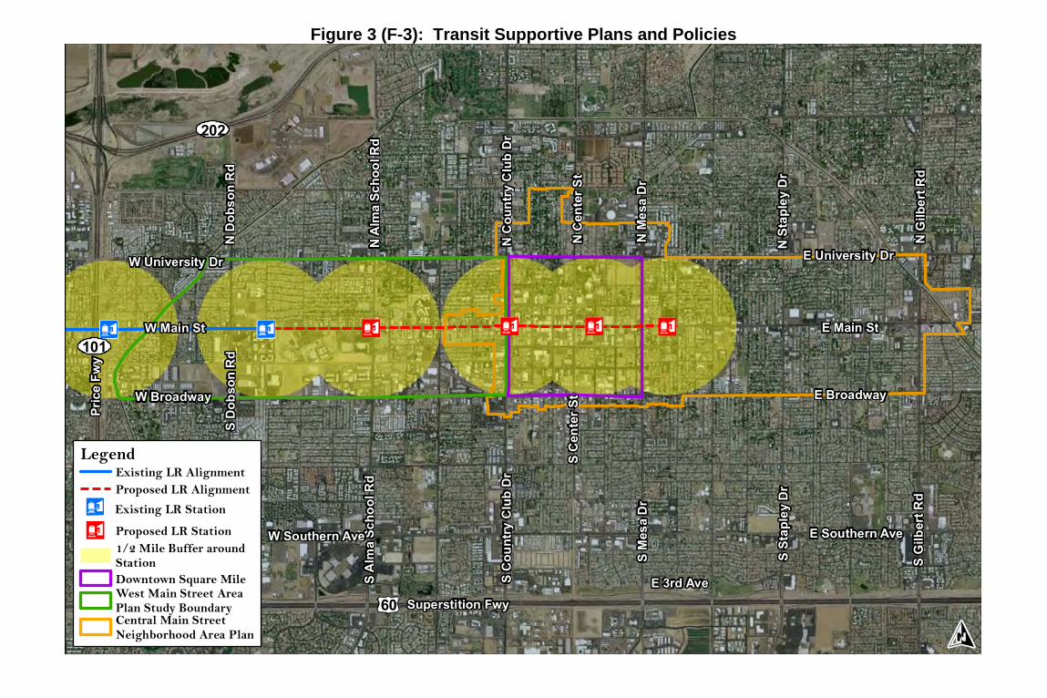
N C
ount
ry C
lub
Dr
W University Dr
W Main St
S A
lma
Scho
ol R
d
E University Dr
E Main St
S St
aple
y D
r
S M
esa
Dr
N M
esa
Dr
E Southern Ave
E 3rd Ave
W Broadway E Broadway
N S
tapl
ey D
r
W Southern Ave
Superstition Fwy
S D
obso
n R
dN
Dob
son
Rd
N A
lma
Scho
ol R
d
S C
ount
ry C
lub
Dr
S C
ente
r St
N C
ente
r St
Pric
e Fw
y
60
101
N G
ilber
t Rd
S G
ilber
t Rd
202
Legend
Proposed LR Station
Existing LR AlignmentProposed LR Alignment
Downtown Square MileWest Main Street AreaPlan Study Boundary
1/2 Mile Buffer aroundStation
Central Main StreetNeighborhood Area Plan
Existing LR Station
Figure 3 (F-3): Transit Supportive Plans and Policies

E University Dr
W Main St
N D
obso
n R
d
Pric
e Fw
y
202 Red Mountain Fwy
E Apache Blvd
E Broadway
E Rio Salado Pkw
S M
cClin
tock
Dr
S M
cClin
tock
Dr
S R
ural
Rd
S M
ill A
ve
TEMPE
MESAArizona State
University
Salt River
101
Commercial/Office
Mixed Use
Public/Institutional
Residential (Multifamily)
Commercial/Office
Mixed Use
Public/Institutional
Residential (Multifamily)
Existing LR AlignmentLegend
Completed Developments/Under Construction Proposed Developments
Existing LR Station1/2 Mile Buffer aroundStation
Figure 4 (F-4): Central Phoenix / East Valley Development Activity, Tempe & Mesa

W Main St
S A
lma
Scho
ol R
d
W Broadway
obso
n R
dN
Dob
son
Rd
N A
lma
Scho
ol R
d
Pric
e Fw
y
E Southern Ave
W University Dr
MESA
101
202
S C
ount
ry C
lub
Dr
N C
ount
ry C
lub
Dr
S M
esa
Dr
N M
esa
Dr
E Main St
E Broadway
E University Dr
Commercial/Office
Mixed Use
Public/Institutional
Residential (Multifamily)
Commercial/Office
Mixed Use
Public/Institutional
Residential (Multifamily)
Existing LR AlignmentLegend
Completed Developments/Under Construction Proposed Developments
Proposed LR AlignmentProposed LR StationExisting LR Station
1/2 Mile Buffer around Station
Figure 5 (F-5): Central Mesa Development Activity

Figure 6 (F-6): Main Street Transit-Oriented Development
SUPPORTING DOCUMENTS

Supporting Document 1 (SD-1): Downtown Mesa Parking Inventory


Supporting Document 2 (SD-2): Town Center Concept Plan

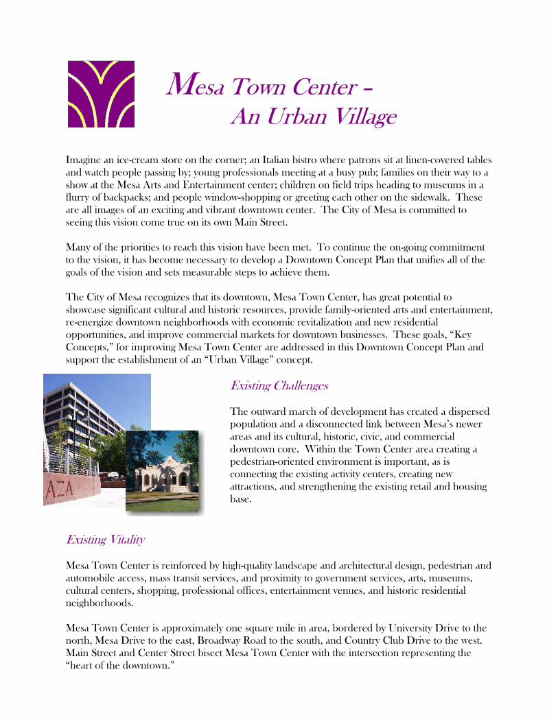
Mesa Town Center – An Urban Village
Imagine an ice-cream store on the corner; an Italian bistro where patrons sit at linen-covered tables and watch people passing by; young professionals meeting at a busy pub; families on their way to a show at the Mesa Arts and Entertainment center; children on field trips heading to museums in a flurry of backpacks; and people window-shopping or greeting each other on the sidewalk. These are all images of an exciting and vibrant downtown center. The City of Mesa is committed to seeing this vision come true on its own Main Street. Many of the priorities to reach this vision have been met. To continue the on-going commitment to the vision, it has become necessary to develop a Downtown Concept Plan that unifies all of the goals of the vision and sets measurable steps to achieve them. The City of Mesa recognizes that its downtown, Mesa Town Center, has great potential to showcase significant cultural and historic resources, provide family-oriented arts and entertainment, re-energize downtown neighborhoods with economic revitalization and new residential opportunities, and improve commercial markets for downtown businesses. These goals, “Key Concepts,” for improving Mesa Town Center are addressed in this Downtown Concept Plan and support the establishment of an “Urban Village” concept.
Existing Challenges The outward march of development has created a dispersed population and a disconnected link between Mesa’s newer areas and its cultural, historic, civic, and commercial downtown core. Within the Town Center area creating a pedestrian-oriented environment is important, as is connecting the existing activity centers, creating new attractions, and strengthening the existing retail and housing base.
Existing Vitality Mesa Town Center is reinforced by high-quality landscape and architectural design, pedestrian and automobile access, mass transit services, and proximity to government services, arts, museums, cultural centers, shopping, professional offices, entertainment venues, and historic residential neighborhoods. Mesa Town Center is approximately one square mile in area, bordered by University Drive to the north, Mesa Drive to the east, Broadway Road to the south, and Country Club Drive to the west. Main Street and Center Street bisect Mesa Town Center with the intersection representing the “heart of the downtown.”
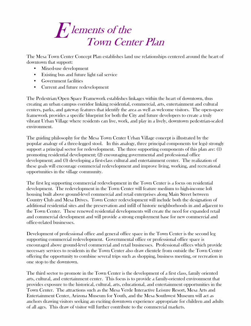
lements of the Town Center Plan The Mesa Town Center Concept Plan establishes land use relationships centered around the heart of downtown that support:
• Mixed-use development • Existing bus and future light rail service • Government facilities • Current and future redevelopment
The Pedestrian/Open Space Framework establishes linkages within the heart of downtown, thus creating an urban campus corridor linking residential, commercial, arts, entertainment and cultural centers, parks, and gateway features that identify the area as well as welcome visitors. The open-space framework provides a specific blueprint for both the City and future developers to create a truly vibrant Urban Village where residents can live, work, and play in a lively, downtown pedestrian-scaled environment. The guiding philosophy for the Mesa Town Center Urban Village concept is illustrated by the popular analogy of a three-legged stool. In this analogy, three principal components (or legs) strongly support a principal sector for redevelopment. The three supporting components of this plan are: (1) promoting residential development; (2) encouraging governmental and professional office development; and (3) developing a first-class cultural and entertainment center. The realization of these goals will encourage commercial redevelopment and improve living, working, and recreational opportunities in the village community. The first leg supporting commercial redevelopment in the Town Center is a focus on residential development. The redevelopment in the Town Center will feature medium to high-income loft housing built above ground-level commercial and retail enterprises along Main Street between Country Club and Mesa Drives. Town Center redevelopment will include both the designation of additional residential sites and the preservation and infill of historic neighborhoods in and adjacent to the Town Center. These renewed residential developments will create the need for expanded retail and commercial development and will provide a strong employment base for new commercial and office-related businesses. Development of professional office and general office space in the Town Center is the second leg supporting commercial redevelopment. Governmental office or professional office space is encouraged above ground-level commercial and retail businesses. Professional offices which provide necessary services to residents in the Town Center also draw clientele from outside the Town Center offering the opportunity to combine several trips such as shopping, business meeting, or recreation in one stop to the downtown. The third sector to promote in the Town Center is the development of a first class, family oriented arts, cultural, and entertainment center. This focus is to provide a family-oriented environment that provides exposure to the historical, cultural, arts, educational, and entertainment opportunities in the Town Center. The attractions such as the Mesa Verde Interactive Leisure Resort, Mesa Arts and Entertainment Center, Arizona Museum for Youth, and the Mesa Southwest Museum will act as anchors drawing visitors seeking an exciting downtown experience appropriate for children and adults of all ages. This draw of visitor will further contribute to the commercial markets.
E


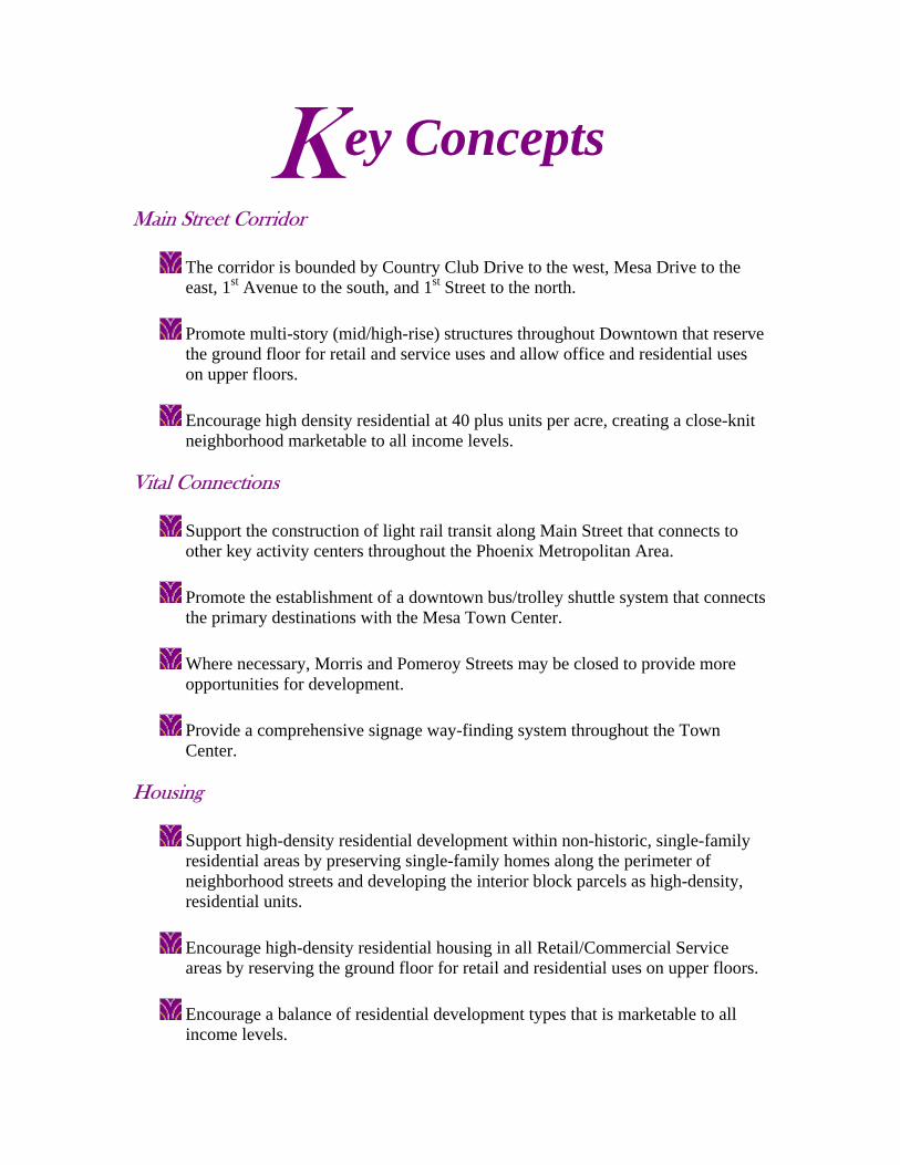
ey Concepts
Main Street Corridor
The corridor is bounded by Country Club Drive to the west, Mesa Drive to the east, 1st Avenue to the south, and 1st Street to the north.
Promote multi-story (mid/high-rise) structures throughout Downtown that reserve the ground floor for retail and service uses and allow office and residential uses on upper floors. Encourage high density residential at 40 plus units per acre, creating a close-knit neighborhood marketable to all income levels.
Vital Connections
Support the construction of light rail transit along Main Street that connects to other key activity centers throughout the Phoenix Metropolitan Area.
Promote the establishment of a downtown bus/trolley shuttle system that connects the primary destinations with the Mesa Town Center. Where necessary, Morris and Pomeroy Streets may be closed to provide more opportunities for development. Provide a comprehensive signage way-finding system throughout the Town Center.
Housing
Support high-density residential development within non-historic, single-family residential areas by preserving single-family homes along the perimeter of neighborhood streets and developing the interior block parcels as high-density, residential units. Encourage high-density residential housing in all Retail/Commercial Service areas by reserving the ground floor for retail and residential uses on upper floors. Encourage a balance of residential development types that is marketable to all income levels.
K

Encourage high-density developments that promote an efficient, creative, and pedestrian-friendly environment.
Pedestrian Access and Environment
Provide pedestrian (Urban Campus) linkages from University Drive to Broadway Road. Construct mid-block pedestrian passes and people-oriented plazas within alleys and between buildings to allow improved pedestrian access from rear parking lots to shopping and other uses along Main Street. This will break up the blocks into smaller, more manageable areas.
Improve pedestrian environment by ensuring landscaped sidewalks on all existing public streets. Provide pedestrian amenities such as benches, trees, lighting, special paving, public art, water features, and bollards within the Urban Campus and along primary pathways.
Provide landscaped median parks along 1st Street and 1st Avenue to Lesueur Street, and Hibbert between 1st and 2nd Streets to preserve the historic character of downtown neighborhoods. Construct an urban landscaped edge along University Drive, Mesa Drive, Broadway Road and Country Club Drive that provides a pedestrian open space pathway that frames the Urban Village.
Gateways
Partner with the developers to construct signature projects at the intersection where the primary and secondary image roads meet to identify Gateways into the Town Center. Partner with developers to construct signature buildings at the corners of Main Street and Country Club Drive and Main Street and Mesa Drive as primary entries to downtown.
Seat of Government Offices
Consolidate appropriate Federal, State, County and local governmental agency offices in a central location within the Town Center.

Maintain considerable workforce in governmental agencies in the Downtown, and strongly discourage relocation of existing governmental personnel to remote locations.
Historic Preservation
Preserve the physical heritage of the historic neighborhoods within the Town Center.
Encourage infill development compatible with surrounding residential uses and architectural character on vacant parcels. Where possible, preserve the historic architectural character through adaptive reuse along Main Street. New construction should be designed to complement the physical, historic character of the surrounding structures.
Arts, Culture, and Entertainment
Construct the Mesa Arts and Entertainment Center as the centerpiece of the “Urban Village.”
Encourage art galleries and artists’ live/work spaces along Main Street and Center Street. Continue to support implementation of the long-range plan for the Arizona Museum for Youth and the Mesa Southwest Museum. Support development of new family-oriented entertainment within the Town Center. Construct an Aquatic Center and Town Park within the Town Center.
Expand and enhance the “Cultural Walk” which is a self-guided interpretive walk around the Downtown’s historic districts.
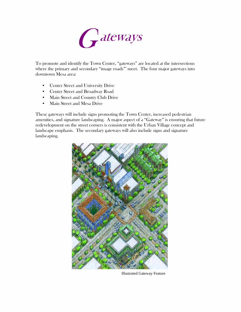
ateways
To promote and identify the Town Center, “gateways” are located at the intersections where the primary and secondary “image roads”’ meet. The four major gateways into downtown Mesa area:
• Center Street and University Drive • Center Street and Broadway Road • Main Street and Country Club Drive • Main Street and Mesa Drive
These gateways will include signs promoting the Town Center, increased pedestrian amenities, and signature landscaping. A major aspect of a “Gateway” is ensuring that future redevelopment on the street corners is consistent with the Urban Village concept and landscape emphasis. The secondary gateways will also include signs and signature landscaping.
G
Illustrated Gateway Feature

Acknowledgements • Mayor
Wayne Brown
• Vice Mayor John Giles
• Councilmembers
Jim Davidson Keno Hawker Bill Jaffa Dennis Kavanaugh Pat Pomeroy
• City Manager
C.K. Luster
• Assistant City Manager Mike Hutchinson
• Community Development Manager
Wayne Balmer, AICP
• Redevelopment Director Greg Marek, AICP
• Public Works Manager
Jack Friedline
• City of Mesa Staff
• Downtown Development Committee
• Historic Preservation
Committee
• Mesa Town Center Corporation
• Mesa Transportation Advisory Board
• Downtown Property and Business Owners
• Housing for Mesa
• Citizens of Mesa • Consultant Team
BRW, Inc. LDR International
December 1999 For additional information please contact the City of Mesa Office of Redevelopment at (480) 644-3959.
Supporting Document 3 (SD-3): Mesa 2025 General Plan

CCiittyy ooff MMeessaa GGeenneerraall PPllaann
City of Mesa Planning Division
55 North Center Street P.O. Box 1466
Mesa, Arizona 85211-1466 (480) 644-2385
www.ci.mesa.az.us/planning
City Council Adoption – June 24, 2002
City Election – November 5, 2002

Acknowledgements
Mayor: Keno Hawker
City Council (Before June 3, 2002): Jim Davidson, Vice Mayor Bill Jaffa Dennis Kavanaugh Pat Pomeroy Claudia Walters Mike Whalen
City Council (After June 3, 2002): Dennis Kavanaugh, Vice Mayor District 3
Claudia Walters – District 1 Mike Whalen – District 2 Kyle Jones – District 4 Rex Griswold – District 5 Janie Thom – District 6
Planning and Zoning Board: Chris Zaharis, Chair Marty Whalen, Vice-Chair Lynda Bailey Dan Brock Mike Cowan Sue Kathe Jerry Petrie Alan Parker (Former Member)
Joint Master Planning Committee: Pat Gilbert, Co-Chair Dr. Albert McHenry
John Giles, Co-Chair Walt McIver Craig Ahlstrom Pat Mendivil Wilford Anderson Robert Napodano Roc Arnett Steve Patience Phil Austin DeWayne Pinkstaff Stan Barnes Tara Plese Nick Carr Bob Power Beth Coons Bill Puffer Louise Daggs Julie Rice Vince DiBella David Robson Ken Driggs Gary Smith Ben Fernandez Lela Steffey Scott Forkenbrock Roman Ullman Rex Griswold Chris Zaharis Diane Lancaster
Mesa 2025 General Plan

Acknowledgements
Mesa 2025 General Plan
Joint Master Planning Committee – Chris Zaharis, Chair Vince Di Bella General Plan Subcommittee: Dr. Albert McHenry Tara Plese
Phil Austin Bill Puffer Dan Brock Marty Whalen Beth Coons
City Manager: Mike Hutchinson
Deputy City Manager: Paul Wenbert
City Attorney: Debbie Spinner
Deputy City Attorney: Joe Padilla
Development Services Manager: Jack Friedline
Planning Director: Frank Mizner,AICP
Planning Division Staff: Wahid Alam, AICP Anne Blech, AICP Dorothy Chimel, AICP Tom Ellsworth
Consultant Team:
Parsons Brinckerhoff: Dan Hartig, PE
Dennis Davis, AICP Cathy Hollow, PE
Economics Research Associates: David Wilcox Amitabh Barthakur
Leon Younger & PROS: Leon Younger

TTaabbllee ooff CCoonntteennttss
1.0 Introduction ........................................................................................................................... 1-1 1.1 The Vision of the Mesa 2025 General Plan ...................................................................... 1-2 1.2 History and Context ............................................................................................................ 1-4
1.2.1 Historical Growth of the City.................................................................................. 1-4 1.2.2 History of Planning in Mesa .................................................................................... 1-5
1.3 City Government ................................................................................................................. 1-5 1.4 Purpose of the General Plan.............................................................................................. 1-6 1.5 Preparation of the General Plan ....................................................................................... 1-8 1.6 Organization and Use of the General Plan ................................................................... 1-11
2.0 Land Use ................................................................................................................................... 2-1
2.1 Background.......................................................................................................................... 2-1 2.1.1 Existing Land Use ..................................................................................................... 2-1 2.1.2 Existing Zoning.......................................................................................................... 2-5 2.1.3 Land Use Plan/Zoning Conformity ........................................................................ 2-6 2.1.4 Land Ownership/Jurisdiction ................................................................................. 2-8
2.2 Goals, Objectives, and Policies ...................................................................................... 2-10 2.3 Plan Components.............................................................................................................. 2-16
2.3.1 Sub-Areas of the City............................................................................................ 2-16 2.3.2 Land Use Category Definitions............................................................................ 2-24 2.3.3 Plan Buildout Analysis............................................................................................ 2-30
3.0 Transportation ...................................................................................................................... 3-1
3.1 Background.......................................................................................................................... 3-1 3.1.1 Roadways................................................................................................................. 3-1 3.1.2 Public Transportation .............................................................................................. 3-2 3.1.3 Bicycle....................................................................................................................... 3-2 3.1.4 Pedestrian................................................................................................................. 3-3
3.2 Goals, Objectives, and Policies ........................................................................................ 3-3 3.2.1 Key Issues .................................................................................................................. 3-3 3.2.2 Goals, Objectives, and Policies Statements ....................................................... 3-4
3.3 Plan Components.............................................................................................................. 3-11 3.3.1 Roadway ................................................................................................................ 3-11 3.3.2 Public Transportation ............................................................................................ 3-13 3.3.3 Bicycle..................................................................................................................... 3-16 3.3.4 Pedestrian and Trails ............................................................................................. 3-17 3.3.5 Other Transportation Guidelines ......................................................................... 3-17
4.0 Economic Development ............................................................................................. 4-1
4.1 Background.......................................................................................................................... 4-1 4.1.1 Population and Households .................................................................................. 4-1 4.1.2 Income...................................................................................................................... 4-2 4.1.3 Age Distribution ....................................................................................................... 4-3
Mesa 2025 General Plan Page i
4.1.4 Educational Attainment......................................................................................... 4-3 4.1.5 Employment ............................................................................................................. 4-4 4.1.6 Jobs per Capita Comparisons .............................................................................. 4-6 4.1.7 Industrial Development .......................................................................................... 4-7 4.1.8 Office Development............................................................................................... 4-8 4.1.9 Retail Trade .............................................................................................................. 4-8
4.2 Goals, Objectives, and Policies ........................................................................................ 4-9 4.3 Plan Components.............................................................................................................. 4-13
5.0 Growth Areas ....................................................................................................................... 5-1
5.1 Background.......................................................................................................................... 5-1 5.1.1 Purpose of Growth Areas Element ....................................................................... 5-1 5.1.2 Catalysts for Change.............................................................................................. 5-1
5.2 Goals, Objectives, and Policies ........................................................................................ 5-2 5.3 Plan Components................................................................................................................ 5-4
5.3.1 Falcon Field .............................................................................................................. 5-4 5.3.2 Town Center/Main Street Corridor ....................................................................... 5-4 5.3.3 Santan Corridor ....................................................................................................... 5-6 5.3.4 Williams Gateway Area.......................................................................................... 5-6
6.0 Revitalization and Redevelopment.................................................................... 6-1
6.1 Background.......................................................................................................................... 6-1 6.1.1 Revitalization in Mesa ............................................................................................. 6-1 6.1.2 Redevelopment and Historic Preservation in Mesa........................................... 6-2 6.1.3 Neighborhood Planning In Mesa.......................................................................... 6-2 6.1.4 Causes of the Need for Revitalization and Redevelopment ........................... 6-3
6.2 Goals, Objectives, and Policies ........................................................................................ 6-4 6.3 Plan Components................................................................................................................ 6-8
6.3.1 Redevelopment Area Powers............................................................................... 6-8 6.3.2 Redevelopment Area Assessment ....................................................................... 6-8 6.3.3 Redevelopment Plan Preparation........................................................................ 6-9 6.3.4 Infill Incentive Districts ............................................................................................. 6-9
7.0 Housing ..................................................................................................................................... 7-1
7.1 Background.......................................................................................................................... 7-1 7.1.1 Housing Principles.................................................................................................... 7-2 7.1.2 Existing Conditions................................................................................................... 7-3
7.2 Goals, Objectives, and Policies ........................................................................................ 7-6
8.0 Public Facilities, Buildings, and Services ....................................................... 8-1 8.1 Background.......................................................................................................................... 8-1
8.1.1 Public/Municipal Buildings and Facilities ............................................................. 8-1 8.1.2 Law Enforcement .................................................................................................... 8-1
Mesa 2025 General Plan Page ii

8.1.3 Fire Protection.......................................................................................................... 8-1 8.1.4 Health Care Facilities.............................................................................................. 8-2 8.1.5 Educational Facilities .............................................................................................. 8-2 8.1.6 Libraries ..................................................................................................................... 8-4 8.1.7 Arts and Cultural Centers....................................................................................... 8-5 8.1.8 Public Utilities............................................................................................................ 8-7
8.2 Goals, Objectives, and Policies ...................................................................................... 8-10 8.2.1 Key Issues ................................................................................................................ 8-10 8.2.2 Goals, Objectives, and Policies Statements ..................................................... 8-10
8.3 Plan Components.............................................................................................................. 8-15 9.0 Parks, Recreation, and Open Space ................................................................ 9-1
9.1 Background.......................................................................................................................... 9-1 9.2 Goals, Objectives and Policies ......................................................................................... 9-3 9.3 Plan Components................................................................................................................ 9-7
10.0 Environmental Planning and Conservation............................................... 10-1
10.1 Background........................................................................................................................ 10-1 10.1.1 Air Quality Management ..................................................................................... 10-1 10.1.2 Water Quality and Conservation........................................................................ 10-2 10.1.3 Energy Conservation ............................................................................................ 10-2 10.1.4 Archaeological Resources .................................................................................. 10-2 10.1.5 Historic Preservation.............................................................................................. 10-3 10.1.6 Natural Habitat Preservation ............................................................................... 10-3 10.1.7 Land Utilization and Protection........................................................................... 10-4
10.2 Goals, Objectives, and Policies ...................................................................................... 10-4
11.0 Water Resources .............................................................................................................. 11-1 11.1 Background........................................................................................................................ 11-1
11.1.1 Current Water Use................................................................................................. 11-1 11.1.2 City Facilities........................................................................................................... 11-3 11.1.3 Current Supplies..................................................................................................... 11-4
11.2 Goals, Objectives, and Policies ...................................................................................... 11-8 11.3 Plan Components............................................................................................................ 11-10
11.3.1 Meeting Demand................................................................................................ 11-12 11.3.2 Drought Planning ................................................................................................ 11-13
12.0 Cost of Development................................................................................................... 12-1
12.1 Background........................................................................................................................ 12-1 12.1.1 General Funding Mechanisms ............................................................................ 12-1 12.1.2 Funding Mechanisms Specific to New Development..................................... 12-1 12.1.3 Cost of Development Issues ................................................................................ 12-2
12.2 Goals, Objectives, and Policies ...................................................................................... 12-7
Mesa 2025 General Plan Page iii
13.0 Safety ........................................................................................................................................ 13-1 13.1 Background........................................................................................................................ 13-1
13.1.1 Environmental Hazards......................................................................................... 13-1 13.1.2 Man Made Hazards .............................................................................................. 13-2 13.1.3 Existing Emergency Preparedness Planning ..................................................... 13-2
13.2 Goals, Objectives, and Policies ...................................................................................... 13-3 14.0 Plan Administration........................................................................................................ 14-1
14.1 Implementation of the General Plan.............................................................................. 14-1 14.1.1 Implementation Tools ........................................................................................... 14-1 14.1.2 Implementation Strategies .................................................................................. 14-5
14.2 Amendments to the General Plan...............................................................................14-8 14.2.1 Major Amendment Definition.............................................................................. 14-8 14.2.2 Major Amendment Administrative Process....................................................... 14-9 14.2.3 Major Amendment Approval Requirements .................................................... 14-9 14.2.4 Minor Amendment.............................................................................................. 14-10
14.3 Updates to the General Plan ......................................................................................... 14-10 15.0 City Council Resolution .............................................................................................. 15-1
Mesa 2025 General Plan Page iv

LLiisstt ooff FFiigguurreess
Figure 1-1 Regional Context.................................................................................................................... 1-9 Figure 1-2 Municipal Planning Area .................................................................................................... 1-10 Figure 2-1 Existing Land Use Acreage by Percentage........................................................................ 2-2 Figure 2-2 Existing Land Use..................................................................................................................... 2-3 Figure 2-3 Generalized Vacant Land .................................................................................................... 2-4 Figure 2-4 Land Ownership...................................................................................................................... 2-9 Figure 2-5 Community Sub-Areas......................................................................................................... 2-17 Figure 2-6 Land Use Plan........................................................................................................................ 2-31 Figure 3-1 Functional Classification ..................................................................................................... 3-14 Figure 4-1 Household Income Profile Comparison – 1989 vs. 1999 ................................................... 4-3 Figure 4-2 Economic Activity Areas ....................................................................................................... 4-5 Figure 5-1 Growth Areas .......................................................................................................................... 5-5 Figure 8-1 Public Facilities ...................................................................................................................... 8-16 Figure 9-1 Park Locations ......................................................................................................................... 9-2 Figure 9-2 Neighborhood Parks - Proposed Target Areas ................................................................ 9-10 Figure 9-3 Community Parks - Proposed Target Areas ..................................................................... 9-11 Figure 9-4 Metro Parks – Proposed Target Areas ............................................................................... 9-12 Figure 9-5 Regional Parks – Proposed Target Areas .......................................................................... 9-13 Figure 11-1 City of Mesa Water Use Characteristics 2000 .................................................................. 11-2 Figure 11-2 City of Mesa Historic Demand On and Off Project......................................................... 11-2 Figure 11-3 Water Resources Plan ....................................................................................................... 11-11 Figure 11-4 City of Mesa Projected Supplies and Demand Off Project ......................................... 11-13
Mesa 2025 General Plan Page v
LLiisstt ooff TTaabblleess
Table 2.1 Description of Zoning Districts .............................................................................................. 2-5 Table 2.2 Correlation Between Land Use and Zoning ....................................................................... 2-7 Table 2.3 Mesa Land Use Plan Buildout Analysis............................................................................... 2-30 Table 3.1 Types of Roadways............................................................................................................... 3-12 Table 3.2 Roadway Characteristics.................................................................................................... 3-12 Table 4.1 Preliminary Projections (2000 to Buildout) ........................................................................... 4-2 Table 4.2 Net Changes in Mesa MPA (2000 to Buildout)................................................................... 4-2 Table 4.3 Maricopa County: Jobs per Capita Comparisons (1995 Estimates) .............................. 4-7 Table 7.1 Current Housing Units Distribution......................................................................................... 7-2 Table 8.1 Hospitals Located within the City of Mesa ......................................................................... 8-2 Table 9.1 City of Mesa Park Standards................................................................................................. 9-8 Table 9.2 City of Mesa Open Space Guidelines................................................................................. 9-9 Table 11.1 2000 City of Mesa Water Supply Use ................................................................................. 11-8
Mesa 2025 General Plan Page vi

11..00 IInnttrroodduuccttiioonn
The City of Mesa General Plan provides a vision and guide to the community’s citizens, businesses, and officials as the community grows and develops in the future. This Introduction describes the vision for the community; summarizes the history and context of planning in Mesa; and provides a description of the purpose, preparation, and use of the General Plan.
Mesa 2025: A Shared Vision
Imagine...
… The natural environment is used to enhance the beauty of the community … Top-notch recreational facilities and parks dotting the community … Exciting cultural destinations to attract residents and visitors … High-quality educational facilities and opportunities available for children and
adults of all ages … Strong economic centers throughout Mesa that provide opportunities to live,
work, and play in the same sub-area of the City … Neighborhoods where residents genuinely care about each other, feel safe, and
celebrate diversity … A people-friendly transportation system of streets, mass transit, non-motorized
vehicles, all interconnecting the business hubs and strong neighborhoods
… A well-run municipal government that provides state-of-the-art access to government services
… Homes and businesses that are well-built, aesthetically pleasing, and well-maintained
Mesa 2025 General Plan Page 1-1
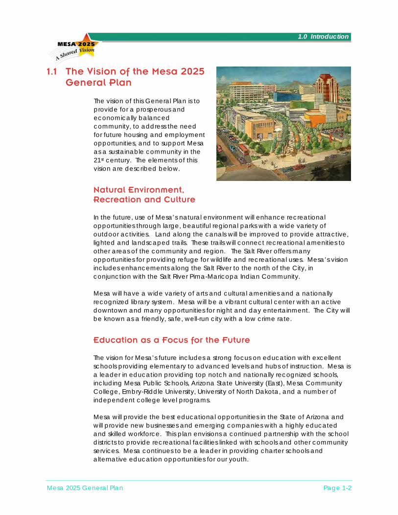
1.0 Introduction
Mesa 2025 General Plan Page 1-2
1.1 The Vision of the Mesa 2025 General Plan
The vision of this General Plan is to provide for a prosperous and economically balanced community, to address the need for future housing and employment opportunities, and to support Mesa as a sustainable community in the 21st century. The elements of this vision are described below.
Natural Environment, Recreation and Culture In the future, use of Mesa’s natural environment will enhance recreational opportunities through large, beautiful regional parks with a wide variety of outdoor activities. Land along the canals will be improved to provide attractive, lighted and landscaped trails. These trails will connect recreational amenities to other areas of the community and region. The Salt River offers many opportunities for providing refuge for wildlife and recreational uses. Mesa’s vision includes enhancements along the Salt River to the north of the City, in conjunction with the Salt River Pima-Maricopa Indian Community. Mesa will have a wide variety of arts and cultural amenities and a nationally recognized library system. Mesa will be a vibrant cultural center with an active downtown and many opportunities for night and day entertainment. The City will be known as a friendly, safe, well-run city with a low crime rate.
Education as a Focus for the Future The vision for Mesa’s future includes a strong focus on education with excellent schools providing elementary to advanced levels and hubs of instruction. Mesa is a leader in education providing top notch and nationally recognized schools, including Mesa Public Schools, Arizona State University (East), Mesa Community College, Embry-Riddle University, University of North Dakota, and a number of independent college level programs. Mesa will provide the best educational opportunities in the State of Arizona and will provide new businesses and emerging companies with a highly educated and skilled workforce. This plan envisions a continued partnership with the school districts to provide recreational facilities linked with schools and other community services. Mesa continues to be a leader in providing charter schools and alternative education opportunities for our youth.

1.0 Introduction
Strong Economic Centers or Hubs Mesa will have sustainable economic centers located at various “hubs” throughout the City. These hubs will emphasize quality, high-paying jobs. The employment sector will offer higher than average wage scales and excellent employment security. There will be a healthy economy that will operate at the cutting edge of technology. One of these economic hubs will be developed in the southeast portion of the planning area in the vicinity of Williams Gateway Airport. This location is considered to be part of the Williams Gateway Sub-Area, but may also be referred to as the Santan Urban Economic Hub. The area is well situated to provide a large international trade center supported by the Williams Gateway Airport. It is envisioned to become a second urban center of the City, with a mixture of residential, commercial, employment, recreational, and public uses. Downtown Mesa is envisioned as a business hub providing governmental services, history and culture for the community. This area will have a high quality employment base. Other economic hubs will be developed in accordance with the characteristics described in the General Plan and the Economic Development Strategy. Each of the economic centers or hubs will allow residents of the City to work and play within fifteen minutes from their homes.
An Involved and Caring Community Mesa will provide an atmosphere that is oriented toward the family and provides a strong sense of place. Citizens will be encouraged to share values, vote, take care of one another and their environment, and celebrate diversity. It is important that all cultural groups are actively involved in planning efforts for the future of our community. This vision recognizes, accepts and promotes diversity in public involvement and educational opportunities for all.
A People-Friendly Transportation System Mesa’s future will boast people-friendly transportation options. The City will strive to resolve problems created by traffic congestion. This vision includes alternatives to automobile transportation providing a wide variety of bus, light rail, bicycle, commuter rail, and air travel opportunities. In conjunction with the people friendly transportation systems in the urbanized core of Mesa, it is envisioned that the downtown area will reveal a renaissance of opportunities. These opportunities will be supported by an ambiance created by a modern light rail system and pedestrian amenities.
Mesa 2025 General Plan Page 1-3

1.0 Introduction
Well Run City and Quality Built Environment Mesa will have one of the best-run municipal governments in the State, providing efficient, modern, and user-friendly services. Environmental issues will be addressed and Mesa will be known as a clean city with virtually no pollution. The City will support clean air efforts, telework, promoting workers to live close to their workplaces, and provide excellent mass transportation choices. Mesa will have a quality built environment, with beautiful natural desert amenities, historic places, and excellent and pleasing architectural character. Commercial and residential developments may be designed in a park-like atmosphere. Innovative urban design supporting the idea of live work and play in one area will be encouraged. Neighborhoods will be well maintained and provide housing in all price ranges and full-spectrum shopping. Mesa will maintain and revitalize its older residential neighborhoods and provide opportunities for quality commercial and mixed-use areas, which may focus on a variety of “small town centers”.
1.2 History and Context
1.2.1 Historical Growth of the City Since its incorporation over 100 years ago, the City of Mesa has experienced tremendous growth. Today it remains primed for further growth in size, population, and employment. The history of Mesa extends back to the Hohokam Indians, the “Departed Ones,” who built the original canal system in the Valley. Mesa’s modern history began in 1877 when a group of Mormon colonists arrived in Lehi and built Fort Utah near the present day intersection of Lehi and Horne Roads. In 1878, a second group of Mormon colonists arrived and established what became modern-day Mesa by registering the square mile bounded by the present day Mesa Drive, Country Club, University, and Broadway Roads. In 1883, the City of Mesa was officially incorporated and had an estimated 200 residents. Almost fifty years later, in 1930, the City’s area had expanded to approximately 2.3 square miles and the population had increased to 3,711. Mesa’s area and population increased rapidly thereafter. By 1960, Mesa’s area was over 15 square miles and the population was nearly 34,000, concentrated near the historic city center. By 1980, however, the City boundaries had expanded significantly, increasing the City’s area to over 66 square miles, and the population had increased to over 152,000. Most recently, in 2000, the City’s area and population had doubled to over 128 square miles and more than 396,000 residents. Similarly, the number of non-agricultural employees in Mesa increased to approximately 249,000 in 2000, up from 151,000 in 1990.
Mesa 2025 General Plan Page 1-4
1.0 Introduction
1.2.2 History of Planning in Mesa
The first general plan for Mesa was adopted by the City Council in December 1971. Officially called the Mesa 1990 General Plan, it served well during a period of rapid growth. The City of Mesa experienced a rapid rate of growth during the decade of the 1970’s. A number of planning studies were completed during this time to supplement the Mesa 1990 General Plan. These studies considered the areas of land use, transportation, storm water, utilities, housing, and airports. As a result of these studies, and in response to the substantial development in Mesa, a new general plan was prepared and adopted in 1982. During the mid-1980’s, Mesa continued to experience significant population and area growth. New local and regional issues arose, including freeway planning, environmental constraints, economic development, downtown redevelopment, neighborhood preservation, and utility system expansion. A major study of local economic development strategies and land use plans related to the newly-approved regional freeway system was conducted. This study resulted in the Mesa Freeway Corridors Study report, completed in 1988, which developed land use plans for a one-to-two-mile-wide corridor along existing and planned freeway alignments. The Mesa Freeway Corridors Study was used as the basis for a 1988 update of the 1982 General Plan. This updated plan focused on policies that reflected the consensus of the City Council and the community. These policies were intended to guide major land use and community development decisions. References were made in the plan to other important studies that identified objectives and policies for the City. After 1988, the City conducted a number of major planning studies to address various aspects of urban development. In 1996, an updated General Plan was prepared. The 1996 General Plan emphasized goals, objectives, and policies. The basic philosophy of the plan was to provide a decision-making framework for the overall planning process.
1.3 City Government The City of Mesa has an elected Mayor and six City Council members that are limited to two consecutive terms. The City operates under a charter form of government, with the Mayor and City Council setting policy. In 1998, a voter initiative changed the election of the council members from an at-large system to a system of six districts. Council members serve a term of four years, with three members elected every two years. The mayor is elected at-large every four years.
Mesa 2025 General Plan Page 1-5
1.0 Introduction
The Mesa City Council actively encourages citizen participation in the decision-making process. This citizen involvement is accomplished through neighborhood meetings, advisory boards and committees, and other means. Based on the citizen input, the Council sets policies for the operation and development of the City. The appointed boards and committees play a major role in this process. The citizen groups that have a particular relationship to the preparation of the General Plan include the Planning and Zoning Board, Transportation Advisory Board, Parks and Recreation Board, and Economic Development Advisory Board. Other groups that play an important role in decisions affecting the community include the Board of Adjustment, Building Board of Appeals, Design Review Board, Downtown Development Committee, Electrical Advisory Board, Historic Preservation Committee, Housing and Human Services Advisory Board, Human Relations Advisory Board, Industrial Development Authority, Judicial Advisory Board, Library Advisory Board, Museum and Cultural Advisory Board, and Plumbing Mechanical and Solar Energy Advisory Board. Supporting the elected and appointed leaders is a City staff of over 3,500 full-time equivalent employees. The City’s leaders and staff strive to improve the quality of life and sustainability of Mesa by developing and enforcing policies related to the City’s growth and development. They also enable community residents and businesses to express their opinions and gain representation via elections, public meetings, and direct contact. The City of Mesa provides a wide range of services to meet the needs of the citizens and businesses located in Mesa, including roadways; gas, water, and electric utilities; police; fire; courts; libraries; solid waste disposal; parks and recreation facilities; arts and cultural programs; and transit. These services significantly improve the quality of life for residents and competitiveness for businesses. Furthermore, they are not generally provided by the private sector, making it incumbent upon the City to ensure their safe and efficient availability. To provide these services, the City of Mesa draws upon a wide array of revenue sources and makes numerous expenditures. While most of this revenue is from local sources, such as sales taxes, utility charges, and user fees, a large proportion also comes from external sources, such as intergovernmental transfers from the State of Arizona. It is critical to the economic well-being of the community that the City’s revenues and expenditures are kept in balance. Through careful planning and budgeting, the City has functioned efficiently since 1941 without a property tax.
1.4 Purpose of the General Plan Arizona state law (ARS 9-461.05.A) requires that each city adopt a comprehensive, long-range general plan to guide the physical development of
Mesa 2025 General Plan Page 1-6

1.0 Introduction
the community. The Mesa City Charter also requires the existence of a general plan. The Mesa General Plan has the following three interrelated functions:
An expression of community goals and priorities • • •
•
•
• • • •
A decision making guide A fulfillment of a legal requirement of state law
While the Mesa General Plan responds to the legal requirements of the Arizona statutes, it is designed to be specific to the issues and needs of Mesa. It contains goals, objectives, and policies to guide the community over a 25-year period. Its focus is on shaping the physical form of the City, yet it also includes policies and statements about other aspects of the community. Misconceptions sometimes exist with regard to the purpose and use of a general plan. Clarifications of several such items include the following.
One misconception is that the general plan cannot be changed over time and that all of the policies and strategies will be implemented exactly as written. However, the plan is a general guideline that may be updated or changed if needed, depending on how growth actually occurs over time. The plan will be evaluated periodically and updated to respond to the changing needs of the community.
Another misconception is that the general plan is the same as the zoning ordinance. In reality, these are two separate documents with different purposes. The general plan is a policy document that guides community growth and development decisions. The zoning ordinance, with its associated zoning maps, implements the General Plan. It is a legal instrument that precisely defines permitted land uses and associated performance standards for individual properties. The important relationship between the two is that zoning amendments must conform to the generalized policies of the plan. A common misconception is that the general plan is only the land use map. While this map is the focal point of many development decisions, the relationship with other concerns is critical to sound decisions. These concerns include transportation, public facilities, the environment, economic development, and other topics. The elements of the general plan provide guidance for decisions that will take into account the interrelationships among these issues.
The following lists summarize what a general plan is and what it is not. Mesa’s General Plan is:
A statement of city policy A guide for decision making A framework for more specific planning A tool for education and communication
Mesa 2025 General Plan Page 1-7
1.0 Introduction
• •
• • • • • •
A means of providing a long-range perspective A way to improve the quality of life
Mesa’s General Plan is not:
A specific plan for a development project A zoning ordinance A rigid static document A capital improvement plan A city budget A master plan or operational plan
1.5 Preparation of the General Plan The general plan is intended to provide a comprehensive guide to the community’s present and future residents and businesses as well as city leaders and staff regarding future growth and development goals. It applies to all land within the planning area and addresses subjects related to the community’s development. The General Plan also specifies the objectives, policies and implementation measures required to achieve the community’s goals. A number of factors signaled the need to update the General Plan since its most recent adoption in 1996. Chief among these was the approval by the State of Arizona of legislation known as Growing Smarter (1998) and Growing Smarter Plus (2000). This legislation requires cities in Arizona to adopt or substantially revise their general plans. It also requires the City Council to approve the General Plan and to submit it to the citizens for a public vote. In addition, the City’s continued strong population growth and the number of development opportunities have made it appropriate to update the General Plan.
The City of Mesa is an important part of the Phoenix Metropolitan Area. The relationship of Mesa to this urban area and the surrounding communities is illustrated on Figure 1-1. This General Plan covers an area somewhat larger than the City’s incorporated limits, as shown on Figure 1-2. This Municipal Planning Area accounts for the fact that the City of Mesa’s sphere of influence extends beyond its boundaries, particularly into areas that currently are primarily under the jurisdiction of Maricopa County. The Mesa Municipal Planning Area is generally bounded by the Salt River on the north, Baseline Road or Germann Road on the south, the Loop 101 Freeway on the west, and Meridian Road on the east. The City’s incorporated area covers 128 square miles. Unincorporated areas collectively comprise approximately 44 square miles, creating a total planning area of nearly 172 square miles.
Mesa 2025 General Plan Page 1-8

GENERAL PLAN
Page 1-9/Projects\16177014 MesaGP/mesa_gp_revised.apr
Regional ContextFigure 1-1
Mesa Municipal Planning Area
County Boundary
PHOENIX
GLENDALE
PEORIA
SCOTTSDALE
TEMPE
QUEEN CREEK
APACHE JUNCTION
SALT RIVER PIMA INDIAN COMMUNITY
MESA
PINAL COUNTY
MARICOPACOUNTY
GILA RIVER INDIAN COMMUNITY
CHANDLER
GILBERT
FOUNTAIN HILLS
PARADISE VALLEY
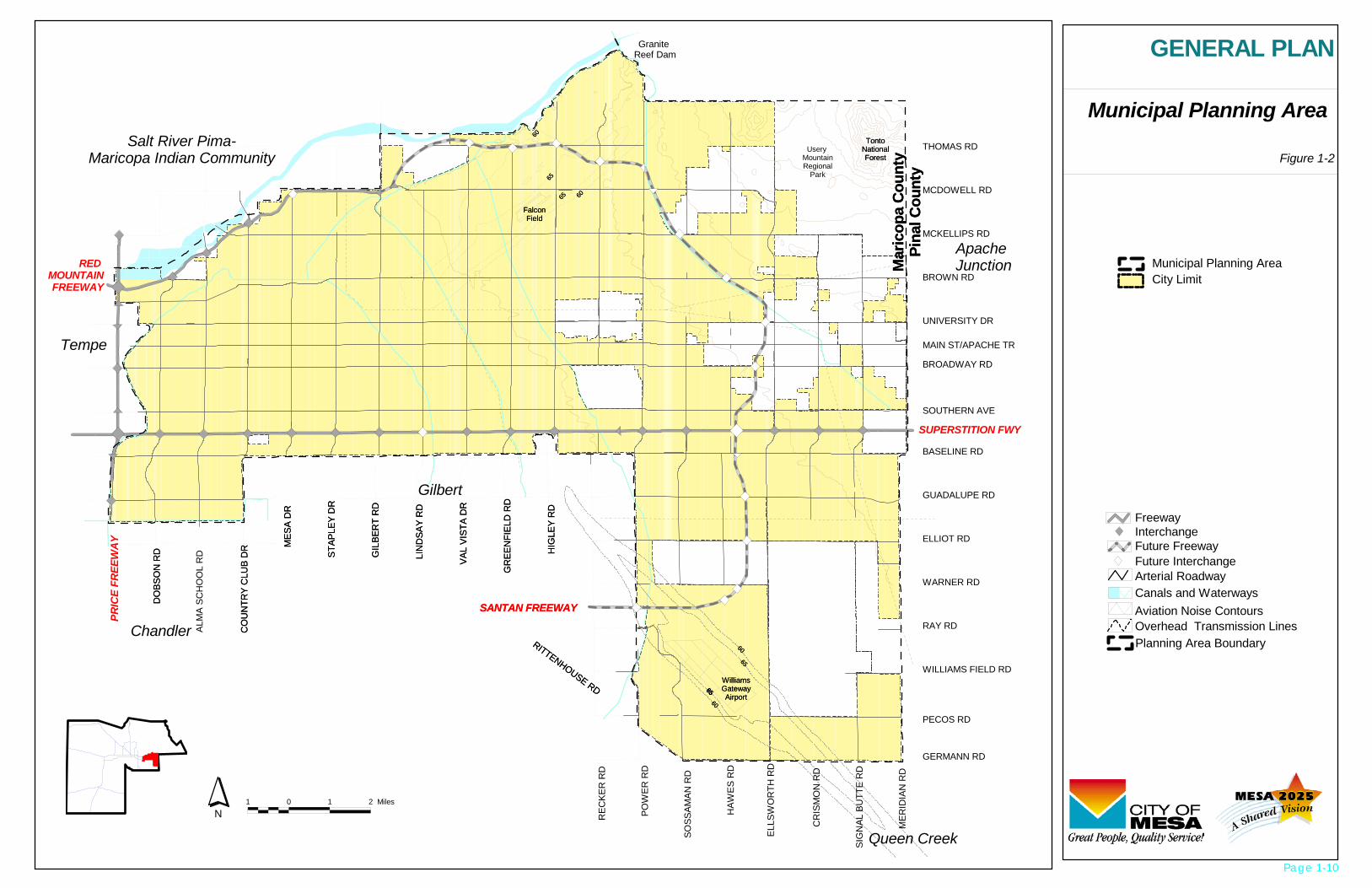
Figure 1-2
Municipal Planning Area
/Projects\16177014 MesaGP/mesa_gp_revised.apr
GENERAL PLAN
City LimitMunicipal Planning Area
1 0 1 2 Miles
N
ApacheJunction
BLM
6565 60
60
Mar
icop
a C
ount
yPi
nal C
ount
y
Salt River Pima-Maricopa Indian Community
Gilbert
Chandler
Tempe
DO
BSO
N R
D
ALM
A SC
HO
OL
RD
CO
UN
TRY
CLU
B D
R MES
A D
R
STAP
LEY
DR
GIL
BER
T R
D
LIN
DSA
Y R
D
RED MOUNTAINFREEWAY
VAL
VIST
A D
R
GR
EEN
FIEL
D R
D
HIG
LEY
RD
REC
KER
RD
POW
ER R
D
SOSS
AMAN
RD
HAW
ES R
D
ELLS
WO
RTH
RD
CR
ISM
ON
RD
SIG
NAL
BU
TTE
RD
MER
IDIA
N R
D
RITTENHOUSE RD
SANTAN FREEWAY
FalconField
TontoNationalForest
60
6565
WilliamsGatewayAirport60
65
65
BLM
6565 60
60
Granite Reef Dam
Mar
icop
a C
ount
yPi
nal C
ount
y
Usery MountainRegional
Park
Queen Creek
DO
BSO
N R
D
CO
UN
TRY
CLU
B D
R MES
A D
R
STAP
LEY
DR
GIL
BER
T R
D
LIN
DSA
Y R
D
VAL
VIST
A D
R
GR
EEN
FIEL
D R
D
HIG
LEY
RD
RITTENHOUSE RD
SANTAN FREEWAY
FalconField
TontoNationalForest
60
6565
WilliamsGatewayAirport60
65
65
SUPERSTITION FWY
PRIC
E FR
EEW
AY
THOMAS RD
MCDOWELL RD
MCKELLIPS RD
BROWN RD
UNIVERSITY DR
BROADWAY RD
BASELINE RD
GUADALUPE RD
ELLIOT RD
WARNER RD
RAY RD
WILLIAMS FIELD RD
GERMANN RD
MAIN ST/APACHE TR
SOUTHERN AVE
PECOS RD
Interchange
Future InterchangeFuture Freeway
Arterial Roadway
Aviation Noise ContoursCanals and Waterways
Overhead Transmission Lines
Freeway
Planning Area Boundary
Page 1-10
1.0 Introduction
In addition to the General Plan, the Mesa 2025 planning process also includes the preparation of the three more specific plans listed below. The General Plan includes elements that pertain to these three subjects. The respective individual master plans will provide additional details.
Transportation Master Plan – Defines objectives, policies, and actions for the transportation system, including streets, transit, bicycles, and pedestrians.
•
•
•
Parks and Recreation Master Plan – Sets objectives and policies for the park system and recreational programs.
Economic Development Strategy– Defines objectives, policies, and strategies for the economic growth, development, and preservation of the community.
The Mayor and City Council appointed a 31-member citizen committee to provide general guidance in the preparation of the four plans. This Joint Master Planning Committee considered broad policy issues, supervised the public involvement process, and made recommendation to the City Council. Subcommittees were created for the General Plan, Transportation Plan, Parks and Recreation Plan, and Economic Development Plan. Each subcommittee addressed its respective plan in a comprehensive manner and forwarded its findings and recommendations to the full committee. An extensive public involvement program was also undertaken to gather the views of the citizens of Mesa. At the center of the program were public open houses held in each of the six City Council districts to present information to the citizens and to gather their opinions during each phase of the planning process. The program also involved public surveys, a stakeholders meeting, newsletters, mailings, a web page, and interviews. Two planning and zoning public hearings and two City Council meetings were scheduled to hear citizen input and consider this plan.
1.6 Organization and Use of the General Plan The remainder of the General Plan is divided into the 12 functional sections or elements listed below. These elements are required by the Growing Smarter (1998) and Growing Smarter Plus (2000) legislation. In some cases, the elements as defined by the statute are combined as indicated.
1. Land Use
2. Transportation (Combines circulation element and bicycle element.)
3. Economic Development
4. Growth Areas
5. Revitalization and Redevelopment
6. Housing
Mesa 2025 General Plan Page 1-11

1.0 Introduction
7. Public Facilities, Buildings, and Services (Combines public buildings element
and public facilities and services element.)
8. Parks, Recreation, and Open Space (Combines open space element and recreation element.)
9. Environmental Planning/Conservation (Combines environmental planning element and conservation element.)
10. Water Resources
11. Cost of Development
12. Safety Each element of the Mesa General Plan is organized into the following sections:
Background • • •
•
•
•
Goals, Objectives, and Policies Plan Components
The Background describes historical and existing conditions and provides the general basis for the other sections of the element. The Goals, Objectives, and Policies are used to guide decisions that affect the future of the City. The following definitions explain these terms in more detail and highlight their increasingly specific nature:
Goal: A goal is a brief statement describing a desired target or end condition at which planning is directed. Goals are generally not measurable or time dependent, and do not describe specific steps necessary for achievement.
Objective: An objective is an intermediate step towards attaining a goal. Objectives should be measurable, time dependent, and achievable.
Policy: A policy is a clear statement guiding decision-making. Policies should be unambiguous, support the relevant goals and objectives, and be based on facts.
The Plan Components describe further details related to the goals, objectives and policies and are intended to facilitate their achievement. These elements of the General Plan provide guidance for future growth and development of the community in both verbal and graphic form. These provisions will be effective only if the plan is properly administered and implemented. Provision must also be made for appropriate amendments. In addition, the General Plan will need to be updated as significant changes occur in the physical, economic, and political environment of the City of Mesa. These updates should reflect the latest demographic data available from the U.S. Census every five to ten years. At a minimum, the General Plan must be updated within ten years to comply with Arizona Revised Statutes.
Mesa 2025 General Plan Page 1-12
1.0 Introduction
Mesa 2025 General Plan Page 1-13
Section 14.0 of the General Plan describes the manner in which the plan will be administered. This section contains the following three items: •
•
•
Plan Implementation – Tools and strategies that will be used to ensure that the goals, objectives, and policies described in the elements will be achieved.
Plan Amendments – Procedures for amending the General Plan as required by state law.
Plan Updates – Description of the need for periodic updates to the General Plan.

Supporting Document 4 (SD-4): West Main Street Neighborhood Area Plan

West Main Street Area Plan
Title
Title
West Main Street Area Plan
January 31, 2007John Wesley, AICPJanuary 31, 2007
John Wesley, AICPPlan Area, Process, and Implementation

West Main Street Area Plan
West Main Planning EffortsWest Main Planning EffortsWest Main Street Area Plan
Transit Oriented Development Ordinance
Other Ordinance Revisions?As Recommended by the Plan
West Main Street Area Plan
Transit Oriented Development Ordinance
Other Ordinance Revisions?As Recommended by the Plan
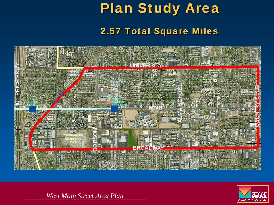
West Main Street Area Plan
Plan Study Area2.57 Total Square Miles
Plan Study Area2.57 Total Square Miles

West Main Street Area Plan
What is the West Main Street Area Plan?What is the West Main Street Area Plan?
An expression of the community will.
A vision for the future.
A collection of strategies to achieve the vision.
A guide for future development in the area.
An identification of physical needs and solutions.
Refinement of the Mesa 2025 General Plan.
Policies to guide city decisions and actions.
An expression of the community will.
A vision for the future.
A collection of strategies to achieve the vision.
A guide for future development in the area.
An identification of physical needs and solutions.
Refinement of the Mesa 2025 General Plan.
Policies to guide city decisions and actions.

West Main Street Area Plan

West Main Street Area Plan
Planning Process Planning Process
City Council Hearing
Community Meeting 1
P&Z Hearing
Process Initiation
Community Meeting 3
Community Meeting 4
Community Meeting 2
Identify Issues
Identify Identify IssuesIssues
Vision & GoalsVision Vision
& Goals& GoalsDraft PlanDraft Draft PlanPlan
Fall 06Fall 06Fall 06 Late Spring 07Late Spring 07Late Spring 07June 06June 06June 06
Summer 07Summer 07Summer 07

West Main Street Area Plan
Community Wide Meeting ResultsCommunity Wide Meeting Results
The Community Wants:· A pedestrian friendly community
· A business and developer friendly community
· The flexibility for diverse architecture and design
· Emphasis on incentives rather than the stick
· Mixed use developments
· A unique area identity
· Quality architecture
The Community Wants:· A pedestrian friendly community
· A business and developer friendly community
· The flexibility for diverse architecture and design
· Emphasis on incentives rather than the stick
· Mixed use developments
· A unique area identity
· Quality architecture

West Main Street Area Plan
Community Wide Meeting ResultsCommunity Wide Meeting Results
The Community Wants:· A higher % of resident home ownership in the area
· A moderate increase in density (up to 5 / 6 stories)
· Preservation of a small town feel
· Activity on Main Street in the day and evening
· A More diverse stock of quality housing options
· Protection of stable single family neighborhoods
· More open space

West Main Street Area Plan
Transit Oriented Development OrdinanceTransit Oriented Development Ordinance

West Main Street Area Plan
Transit Oriented Development Ordinance FunctionTransit Oriented Development Ordinance Function
Establish Locations and BoundariesAround High Capacity Transit Station(s)Walking Distance
Establish Development Standards to Regulate
Permitted UsesBuilding SizeBuilding Location, and etc.Design Standards (landscape, sidewalks, building orientation, etc)

West Main Street Area Plan
Transit Oriented Development Ordinance BenefitsTransit Oriented Development Ordinance Benefits
Optional to Current Standards
Allow Mixed Uses
Reduce Setbacks
Increase Permitted Building Heights
Increase Permitted Density
Streamline Development Approval Processes
Reduce parking requirements
West Main Street Area Plan
Moderator of TOD Expert Panel:
Mike James, AICP
Deputy Transportation Director – Planning & Transit
City of Mesa
Moderator of TOD Expert Panel:
Mike James, AICP
Deputy Transportation Director – Planning & Transit
City of Mesa
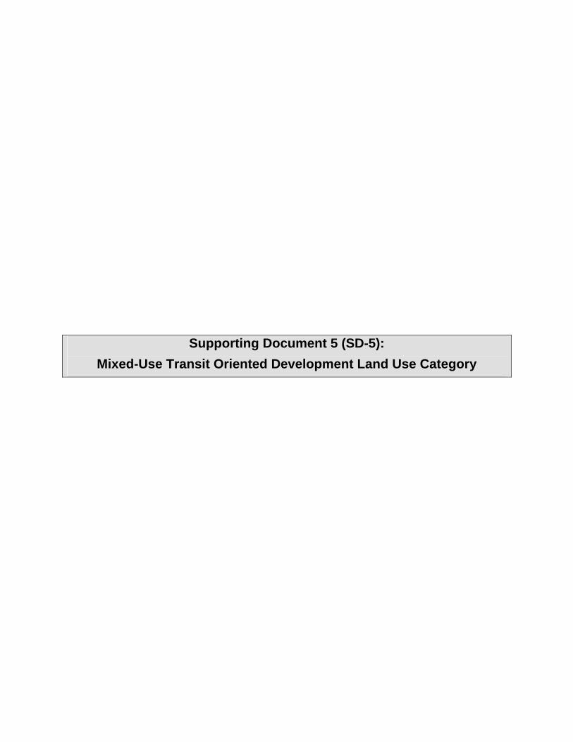
Supporting Document 5 (SD-5): Mixed-Use Transit Oriented Development Land Use Category


Supporting Document 6 (SD-6): CDBG Summary

I:\Properties\CDBG Capital Projects.doc
CDBG Capital Projects – Mesa Arizona Leveraged Funds
Marc Center Day Treatment Center Agency: Marc Center Description of Project: Expansion of an existing building located at 924 North Country Club Drive. This new 32,000 square foot
addition is used as a day treatment center for Marc Center developmentally disabled clients. Funding Sources: $ Amount: % CDBG Mesa CDBG $ 700,000 19% Maricopa County CDBG $ 421,134 Various Contributors $ 2,329,987 Marc Center $ 389,879 Project Total $ 3,850,000 Webster Gymnasium and Recreation Center Agencies: City of Mesa and Mesa Public Schools Description of Project: Construct a new multi-use gymnasium on the Webster Elementary School campus for joint use by the
public and school children. In addition, built 10 new classrooms for the school attached to the gym paid for by the school district.
Funding Sources: $ Amount: % CDBG Mesa CDBG $ 1,018,000 33% Mesa Public Schools $ 2,067,000 Project Total $ 3,085,000 Center for Hope Agency: Community Bridges Description of Project: This new facility serves pregnant or post-partum women with substance abuse problems. The goal is to
help these women and their young children transition from the Center for Hope to an improved life style. Funding Sources: $ Amount: % CDBG Mesa CDBG $ 575,000 19% Other Cities CDBG $ 663,900 AZ Dept. of Housing HOME $ 500,000 HUD Cont. of Care $ 400,000 Federal Home Loan Bank $ 240,000 Private Grants $ 505,000 Private Donations $ 105,000 Additional Fundraising $ 8,325 Project Total $ 2,997,225
Other CDBG Funded Capital Projects:
Non-Profit Projects: Autumn House Domestic Violence Shelter PREHAB group homes and facilities Boys & Girls Club Mesa YMCA Child Crisis Center United Food Bank EVAC Detoxification Center House of Refuge East East Valley Men’s Center PREHAB group homes and facilities Family Resource Center La Mesita Family Shelter City Projects: MARC Center group homes and facilities Jefferson Gym and Recreation Center MARC Center Vocation Training Center Broadway Rec Center Mayfield Juvenile facility Neighborhood improvements in eligible areas citywide: MesaCAN facility -Streetlights, streets, sidewalks, parks Mesa Senior Center ADA compliance
Supporting Document 7 (SD-7): Mesa Economic Development Action Team

A QUARTERLY NEWSLETTER PRODUCED BY THE CITY OF MESA OFFICE OF ECONOMIC DEVELOPMENT
� A RECAP OF BILL JABJINIAK’S FIRST THREE MONTHS AS MESA’S NEW ECONOMIC DEVELOPMENT DIRECTOR . . . . . . . . . . . . 2
� COMMERCIAL METALS COMPANY BRINGS ENERGY EFFICIENT STEEL PROCESS TO MESA . . . . . . 4
� MESA NEDCO HELPS GALA COOPERATIVE EXPAND TO 96 EMPLOYEES . . . . . . . . . . . 3
VOLUME 1 ISSUE 1 2008
Economic VOLUME 1 ISSUE 1 2008
Reporter
Mesa’s Economic Development Action Team brings faster processing to key developments
Patrick Murphy, City of Mesa
The newly-formed Mesa Economic Development Action Team (M�EDAT) is now available to provide streamlined service to key development projects in Mesa. M�EDAT is spearheaded by the Economic Development Department in partnership with the Development Services Department. Senior-level staff representing several additional City departments are also committed to this endeavor.
M�EDAT utilizes the combined strengths of several existing programs to expedite the entire process from beginning to end. For example, pre-submittal conferences and preliminary technical review are automatically incorporated into the process in order to identify major project challenges and expedite permitting services.
In addition, each M�EDAT project is assigned its own dedicated Economic Development Project Manager and a Development Services Project Coordinator to provide coordination through all City processes, from the initial entitlement requirements through issuance of the final Certificate of Occupancy. An initial meeting is arranged to explain available services, fee structures, review processes, access to financing, technical, employment, and training resources in addition to providing prompt response to specific questions.
“We are excited that the implementation of M�EDAT will help in expanding economic development opportunities in Mesa while demonstrating our business friendly approach,” said Economic Development Director Bill Jabjiniak.
Typical key development projects include the expansion of existing businesses or new development projects that demonstrate major benefit to Mesa through the generation of high-quality jobs, major capital investment or the generation of significant sales tax revenue.
The Office of Economic Development is your partner in ensuring your project proceeds in the most effective and efficient manner. For more information on M�EDAT, contact our office at (480) 644-2398.

Supporting Document 8 (SD-8): Government Property Lease Excise Tax

Your Company and City of Mesa: GPLET 101 The Government Property Lease Excise Tax (GPLET) was enacted by the State legislature as an in-lieu of property tax in order to recoup some of the “lost” revenue that could not be assessed due to the Constitutional prohibition of taxing properties owned by certain government entities, such as cities and towns. The GPLET allows a “property tax” to be calculated at a much lower formula than standard property tax assessments on property owned by a governmental entity. This tool is not widely used outside of Redevelopment Areas, where the tax relief is greater by statute, but it is an option citywide. By transferring ownership of all land and buildings to the City, a lower property tax rate is available. In a city maintaining a primary property tax, there is basically no economic incentive for it to collect GPLET instead of property tax.
Major Deal Elements
• A relatively complex Development Agreement would need to be negotiated by the City and YOUR COMPANY and approved by City Council. This Development Agreement is not a “Retail development tax incentive agreement” subject to ARS § 9-500.11.
• Title on land and all buildings would need to be sold to the City for some nominal amount.
• YOUR COMPANY would still hold and pay the mortgage, which would necessitate lender approval of the deal.
• For the number of years specified in the Development Agreement, YOUR COMPANY would pay a lease payment to the City of Mesa as well as all privilege taxes due thereon.
• At the end of the deal the land and buildings would be sold back to YOUR COMPANY for some nominal amount.
• YOUR COMPANY would be responsible to maintain the buildings and property, and implement all agreed upon improvements, including roads and utilities, as appropriate.
• Due to the nature of the agreement, significant insurance and environmental cleanup protections would need to be part of the deal.
• The local School District would need to be in support of the deal and may require some additional elements in the Development Agreement.
K:gplet/gpletsynopsis
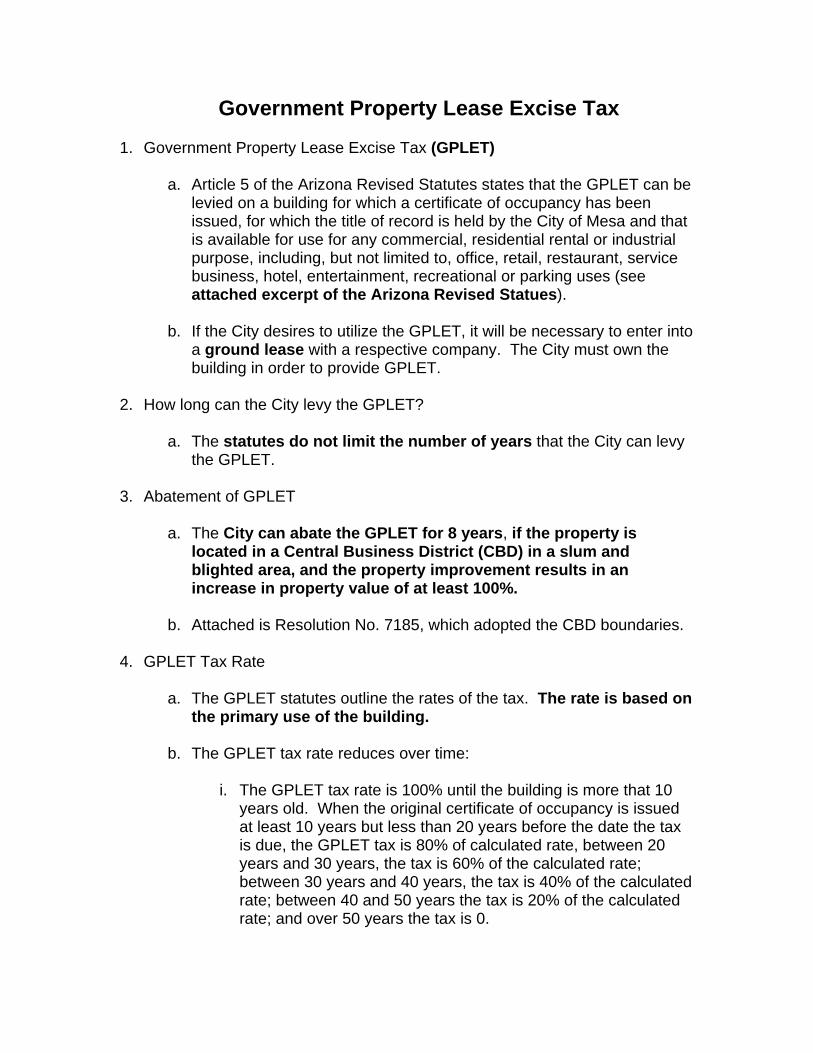
Government Property Lease Excise Tax
1. Government Property Lease Excise Tax (GPLET)
a. Article 5 of the Arizona Revised Statutes states that the GPLET can be levied on a building for which a certificate of occupancy has been issued, for which the title of record is held by the City of Mesa and that is available for use for any commercial, residential rental or industrial purpose, including, but not limited to, office, retail, restaurant, service business, hotel, entertainment, recreational or parking uses (see attached excerpt of the Arizona Revised Statues).
b. If the City desires to utilize the GPLET, it will be necessary to enter into a ground lease with a respective company. The City must own the building in order to provide GPLET.
2. How long can the City levy the GPLET?
a. The statutes do not limit the number of years that the City can levy the GPLET.
3. Abatement of GPLET
a. The City can abate the GPLET for 8 years, if the property is located in a Central Business District (CBD) in a slum and blighted area, and the property improvement results in an increase in property value of at least 100%.
b. Attached is Resolution No. 7185, which adopted the CBD boundaries.
4. GPLET Tax Rate
a. The GPLET statutes outline the rates of the tax. The rate is based on the primary use of the building.
b. The GPLET tax rate reduces over time:
i. The GPLET tax rate is 100% until the building is more that 10 years old. When the original certificate of occupancy is issued at least 10 years but less than 20 years before the date the tax is due, the GPLET tax is 80% of calculated rate, between 20 years and 30 years, the tax is 60% of the calculated rate; between 30 years and 40 years, the tax is 40% of the calculated rate; between 40 and 50 years the tax is 20% of the calculated rate; and over 50 years the tax is 0.

5. Distribution of GPLET revenue
a. The City of Mesa is a recipient of GPLET revenue.
b. Disposition of GPLET revenue is as follows: i. County General Fund 13%
ii. City of Mesa 7% iii. Mesa Community College 7% iv. Mesa Unified School District 73%
6. What are the impacts to the Mesa School District?
a. Over the years that the GPLET is in effect, the Mesa School District
revenue will decrease.
b. However, it can be argued that future revenue will increase as a result of the use of GPLET to entice new development.

Supporting Document 9 (SD-9): Mesa Enterprise Zone
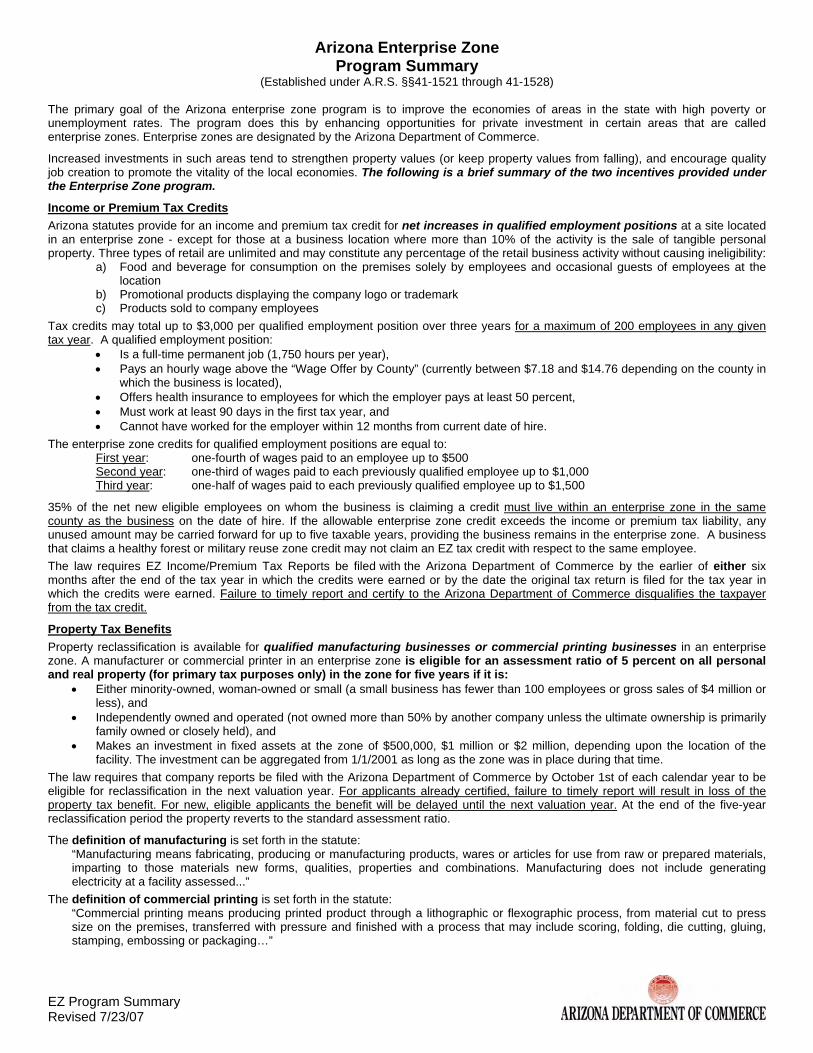
EZ Program Summary Revised 7/23/07
Arizona Enterprise Zone Program Summary
(Established under A.R.S. §§41-1521 through 41-1528)
The primary goal of the Arizona enterprise zone program is to improve the economies of areas in the state with high poverty or unemployment rates. The program does this by enhancing opportunities for private investment in certain areas that are called enterprise zones. Enterprise zones are designated by the Arizona Department of Commerce.
Increased investments in such areas tend to strengthen property values (or keep property values from falling), and encourage quality job creation to promote the vitality of the local economies. The following is a brief summary of the two incentives provided under the Enterprise Zone program.
Income or Premium Tax Credits Arizona statutes provide for an income and premium tax credit for net increases in qualified employment positions at a site located in an enterprise zone - except for those at a business location where more than 10% of the activity is the sale of tangible personal property. Three types of retail are unlimited and may constitute any percentage of the retail business activity without causing ineligibility:
a) Food and beverage for consumption on the premises solely by employees and occasional guests of employees at the location
b) Promotional products displaying the company logo or trademark c) Products sold to company employees
Tax credits may total up to $3,000 per qualified employment position over three years for a maximum of 200 employees in any given tax year. A qualified employment position:
• Is a full-time permanent job (1,750 hours per year), • Pays an hourly wage above the “Wage Offer by County” (currently between $7.18 and $14.76 depending on the county in
which the business is located), • Offers health insurance to employees for which the employer pays at least 50 percent, • Must work at least 90 days in the first tax year, and • Cannot have worked for the employer within 12 months from current date of hire.
The enterprise zone credits for qualified employment positions are equal to: First year: one-fourth of wages paid to an employee up to $500 Second year: one-third of wages paid to each previously qualified employee up to $1,000 Third year: one-half of wages paid to each previously qualified employee up to $1,500
35% of the net new eligible employees on whom the business is claiming a credit must live within an enterprise zone in the same county as the business on the date of hire. If the allowable enterprise zone credit exceeds the income or premium tax liability, any unused amount may be carried forward for up to five taxable years, providing the business remains in the enterprise zone. A business that claims a healthy forest or military reuse zone credit may not claim an EZ tax credit with respect to the same employee. The law requires EZ Income/Premium Tax Reports be filed with the Arizona Department of Commerce by the earlier of either six months after the end of the tax year in which the credits were earned or by the date the original tax return is filed for the tax year in which the credits were earned. Failure to timely report and certify to the Arizona Department of Commerce disqualifies the taxpayer from the tax credit.
Property Tax Benefits Property reclassification is available for qualified manufacturing businesses or commercial printing businesses in an enterprise zone. A manufacturer or commercial printer in an enterprise zone is eligible for an assessment ratio of 5 percent on all personal and real property (for primary tax purposes only) in the zone for five years if it is:
• Either minority-owned, woman-owned or small (a small business has fewer than 100 employees or gross sales of $4 million or less), and
• Independently owned and operated (not owned more than 50% by another company unless the ultimate ownership is primarily family owned or closely held), and
• Makes an investment in fixed assets at the zone of $500,000, $1 million or $2 million, depending upon the location of the facility. The investment can be aggregated from 1/1/2001 as long as the zone was in place during that time.
The law requires that company reports be filed with the Arizona Department of Commerce by October 1st of each calendar year to be eligible for reclassification in the next valuation year. For applicants already certified, failure to timely report will result in loss of the property tax benefit. For new, eligible applicants the benefit will be delayed until the next valuation year. At the end of the five-year reclassification period the property reverts to the standard assessment ratio.
The definition of manufacturing is set forth in the statute: “Manufacturing means fabricating, producing or manufacturing products, wares or articles for use from raw or prepared materials, imparting to those materials new forms, qualities, properties and combinations. Manufacturing does not include generating electricity at a facility assessed...”
The definition of commercial printing is set forth in the statute: “Commercial printing means producing printed product through a lithographic or flexographic process, from material cut to press size on the premises, transferred with pressure and finished with a process that may include scoring, folding, die cutting, gluing, stamping, embossing or packaging…”

Supporting Document 10 (SD-10): HUD Section 108 Loan Fund

FFaacctt SShheeeett FFrroomm tthhee OOffffiiccee ooff EEccoonnoommiicc DDeevveellooppmmeenntt
Topic/Issue: Section 108 Loan Guarantee Program General Statement: In July 2009, the City of Mesa was awarded $16.9 million for a Section 108 Loan
Guarantee from the U.S. Department of Housing and Urban Development (HUD) for an Economic Development Loan Fund. Projects assisted with this Section 108 loan fund will primarily be to benefit low and moderate-income individuals by creating jobs, and may also be used to help eliminate conditions of slum or blight, when deemed appropriate.
Eligible Activities The following activities are eligible for the Section 108 Loan Fund: Real property acquisition, Rehabilitation of publicly owned real property, Relocation, Clearance and demolition, Site preparation, Economic Development, Public facilities improvements, Issuance costs, Capitalized interest, and Reserves.
Interest Rate The interest rate for the Section 108 loan fund will be determined, in part, by the cost of funds on the money from the U.S. Department of Housing and Urban Development (HUD). Permanent financing interest rates are pegged to yields on U.S. Treasury obligations of similar maturity plus additional basis points (1.00% to 3.00%) that are determined on a case-by-case basis. Interim period or “construction period” interest rates are priced by the 3-month London Interbank Offered Rate (LIBOR) as published in the Wall Street Journal plus additional basis points (1.00% to 3.00%) that are determined on a case-by-case basis.
Loan Terms The maximum loan term for the Section 108 loan fund is 20 years. However, certain projects may be able to take advantage of a “balloon” structure which allows for the loan to not fully amortize over the term. In such cases, a balloon payment will be due at the maturity of the term. Loan terms are determined on a case-by-case basis.
Subordination Section 108 loans can be in a subordinate position to conventional financing however several underwriting guidelines detailed in the application must be met.
Collateralization Section 108 loans will typically be secured in the form of a deed of trust collateralized (100%) by the pledge of real property and/or building improvements.
Pre-Payment Penalty Loan in the interim financing stage can be paid off without penalty. Loans in the permanent financing stage have a 10-year pre-payment penalty.
Combined Loan-To-Value (LTV) The maximum combined loan-to-value for a Section 108 loan is 80%.
Reporting Requirements
See attached.
Key Contacts:
William Jabjiniak, Director Office of Economic Development 480.644.3561 (phone) [email protected]

Supporting Document 11 (SD-11): Substantial Conformance Improvement Permit
planning division SCIP Project Guidelines Mesa Zoning Ordinance Section 11-13-2(S), Substantial Conformance Improvement Permit Introduction The Mesa City Council has adopted a new mechanism for reviewing projects that add floor area to existing development or significantly change the land use of a project. The City Council created this new process to address concerns that the adopted revisions to the Design Guidelines and Site Development Standards (Chapters 14 and 15 of the Zoning Ordinance) would create non-conforming site conditions for most non-single residence properties in the City. The Site Development Standards, in particular, substantially increased the dimensions for such items as building setbacks, perimeter landscape areas and building separations. Under Sections 11-1-3 and 11-13-2 of the Mesa Zoning Ordinance, projects that fall under this category may be reviewed for a Substantial Conformance Improvement Permit, or SCIP. SCIP applicants are required to show the end condition of the new project will result in an overall development that “substantially complies” with the revised development standards Purpose and Intent of a SCIP The intent of the SCIP process is to encourage improvements and reinvestment into existing developed sites without requiring the demolition of buildings or the loss of required parking spaces and circulation aisles, nor the diminution of storm-water retention. Satisfying SCIP criteria generally means the proposed improvements reflect the greatest possible degree of compliance for each specific requirement prescribed in the Zoning Ordinance. Limitations Modifications to development requirements authorized by a SCIP are limited to building setbacks, landscaping design, on-site parking, building height, right-of-way dedication, and other site development provisions contained in Chapter 15 of the Zoning Ordinance. A SCIP application CANNOT modify items related to Engineering standards (items such as retention basin size, driveway access), Uniform Fire Code requirements (emergency vehicle access, fire hydrant location, sprinkler requirements), or requirements of the Uniform Building Code (buildings separations, fire ratings, exiting standards).
Definition As defined by the Mesa Zoning Ordinance: Substantial conformance occurs when physical improvements to the existing development site are completed which constitute the greatest degree of compliance with current development provisions, WITHOUT causing or creating any of the following conditions:
1) The demolition or reconstruction of existing buildings or other significant structures (except signs).
2) The cessation of the existing conforming use, or the preclusion of any other lawful, permitted use.
3) The creation of new nonconformities such as a decrease in the number of on-site parking spaces below the required minimum, diminution of the water retention areas to less than the minimum required, constriction in the required vehicular access or fire lanes, or reduction of handicapped accessibility.
Public Hearing Required A SCIP is reviewed and decided at a public hearing by the Zoning Administrator and/or Board of Adjustment (a decision of the Zoning Administrator may be appealed to the Board of Adjustment). Planning Division staff will analyze the request before the hearing date and develop a recommended action. The recommendation may include conditions that could modify the final design if the case is approved. How These Guidelines Will Be Used A list of suggested design guidelines is on the back of this sheet. Planning Division staff will use these guidelines to review and develop their recommendations for SCIP applications. These recommendations are then forwarded to the Zoning Administrator or Board of Adjustment at the public hearing phase of the SCIP process. Copies of any written recommendations will be made available to the applicant and general public prior to the public hearing. Fees SCIP application fees are less in comparison with normal variance fees. If the proposal requires a modification of a City Council approved site plan, the fee for the site plan modification request will include the SCIP fee. See fee schedule.

SCIP – Design Guidelines
The proposed project should comply where possible with the intent of the revised Design Guidelines and Site Development Standards (Chapters 14 and 15 of the Mesa Zoning Ordinance). Existing conditions of surrounding properties are taken into account to provide a context setting for the project, but may not necessarily set a precedent for setback requirements. The Planning Division staff recommendations are based on how well the project works within the following parameters (each given equal weight): 1) Fitting within the context of the existing development; 2) Fitting within the context of surrounding development; 3) Maintenance or development of new buffering mechanisms between
dissimilar uses; and 4) How well the project works to achieve the intent of the revised standards. Creative solutions that achieve these goals are encouraged. Designs that include combined requirements may be considered if the resulting design meets the intent of both standards (example: side yard landscaping requirements and parking lot landscape islands). Remodeled elevations or the design of new buildings should show compliance with all design related standards found in Chapter 14, Design Guidelines. Each case will differ because of the existing site improvements and the nature of the new construction and/or building addition being requested. For this reason, each project will be reviewed on a case-by-case basis. ♦
♦
♦
♦
♦
♦
♦
♦
♦
♦
♦
♦
Foundation Base - Sec.11-15-3(C) New construction should show compliance with intent to separate the building and outdoor seating areas from parking spaces and circulation drives, as well as provide a pleasant pedestrian entry to the building, as well as an attractive landscaped setting.. Existing construction should provide a landscaped pedestrian landing area in front of the primary entry. New Construction should comply with foundation base requirements. Maintenance of Existing Landscaping - Sec. 11-15-3(F) Inventory existing landscaping. Replace dead or unhealthy plants. Bring the plant counts up to the number required at the time the original project was developed. In some cases, supplementing the original plant count will be recommended. Pedestrian Connections - Sec. 11-15-5(A) Provide pedestrian walkways between the street and the building entry, and to adjacent buildings. If applicable, connect walkways from building entries to bus stops.
Parking Lot Landscape Islands - Sec.11-15-3(B) Install parking islands in new parking fields at the specified ratio. Large additions may require the installation of landscape islands within the existing parking field. Perimeter Landscaping Adjacent to Residence District(s) - Sec. 11-15-3(A) All new construction should meet the specified landscape area widths and plant ratios. Existing landscaping will be reviewed for impacts on the number of required parking spaces and storm-water retention basins, and the effectiveness of the screening. Perimeter Screening Standards - Sec. 11-15-4 (Including parking lots and outdoor display area) Provide screening where required, especially for instances regarding outdoor display or outdoor storage. Install landscaping in required areas when the number of parking spaces exceeds 150% of the minimum required by the Zoning Ordinance Parking Lot Layout Standards – Sec. 11-15-5(B) Existing parking fields may be maintained at present size. New development, which requires the addition of 200 or more parking spaces, should comply with the specified standards. Building Separations – Sec. 11-15-2(C) Existing building separations may be maintained. New construction should comply with present requirements. Retention Basin Design – Sec 11-15-3(D) Existing retention basin design may be maintained. Landscaping within and around the retention basin should comply with ordinance standards. New basins will comply with current standards. Open Space Requirements – Secs. 11-5-6(A) & 11-15-3(E) Open space for existing development may be maintained at the current size. Open space for new development should be provided at the ordinance specified standard. Multiple residence projects should consider private open space for individual units as well as common open space. Parking Lot Light Standards – Sec. 11-15-3(F)15 New light poles should meet requirements. Existing light poles may be maintained at existing height. Perimeter Landscaping (All Sides) - Section 11-15-3(A) New construction should meet all of the required setbacks, except in circumstances where maintaining or extending existing circulation lanes would unnecessarily tighten turns, or create unaligned lanes that cross a primary entrance aisle. Small encroachments of parking spaces into landscape areas may be allowed in exchange for increasing the frequency of parking landscape islands. Additional small encroachments into street-side landscape areas MAY be considered for projects that do not over-build a site. Comparisons will be based on building floor areas that are consistent with similar developments on similar sized parcels, and on the development context of the site.
G/Gordon/DIP-SCIP/SCIP Guidelines

Supporting Document 12 (SD-12): Transit Supportive Development Analysis

TRANSIT SUPPORTIVE DEVELOPMENT ANALYSIS
September 2009
CENTRAL MESACENTRAL MESALIGHT RAIL EXTENSIONLIGHT RAIL EXTENSION

Transit Supportive Development Analysis Page 1 09-15-2009 Mesa LRT Extension
I. Evidence of Transit Supportive Development The presence of an environment that fosters transit supportive development (“TSD”) is a key element in the long term growth of transit ridership and system sustainability. In the case of the proposed Mesa extension to the Valley Metro Light Rail Transit (LRT) 20-mile starter system (METRO), current conditions, trends, policies and past area precedents underpin a positive future for substantial TSD at and between the four proposed Mesa Extension stations. The success, from both a ridership and related development viewpoint, of the recently opened LRT system is the first indicator of favorable dynamics for TSD along the proposed extension. The Sycamore station, the only current station within Mesa, is seeing the highest levels of ridership and exceeding initial estimates. Additionally, the policies and actions of the City of Mesa to foster increasingly sustainable and urban mixed use development patterns provide additional backing for TSD.
A. Success of Existing Line – Ridership & Recent Development Patterns The project under review is an extension of the existing Valley Metro LRT system. Consideration of extending the existing system is being driven in part by the success of the existing system in attracting riders and spurring transit-oriented and supportive development. In particular, the southeastern portion of the line has performed well, suggesting an opportunity for future success by extending the system in this direction. While ridership and other similar transit performance measures will be dealt with more specifically in other analyses, it is important to note that the line in general has exceeded ridership estimations. The Sycamore station (the line’s southeastern terminus) in particular has to date had the highest ridership levels. The general success of the system in attracting riders provides some indication of the region’s willingness to adapt to mass transit if the system is reliable and attractive. The success of the Sycamore station in particular shows that a “transit-ready population” exists in this area of the region. In addition to commuters adapting to the presence of transit, the development community has likewise adapted to the presence of light rail. The emergence of new transit supportive development along the line and specifically in the Tempe/Mesa portion of the line shows that the development community is ready and capable of delivering projects that are appropriately scaled and designed. The amount of overall development along the line is impressive. As of December 2008, approximately $5.4 billion in new development has been completed or is under construction along the LRT route (within ½ mile of a station) and an additional $2.0 B in projects have been proposed or are in the planning stages. This development contains over 13,000 residential units and nearly 10 million square feet of new commercial space. This private development has been supported by an additional 500,000 square feet of government and educational space. Along with this large supply of new development, over $2 billion in additional projects

Transit Supportive Development Analysis Page 2 09-15-2009 Mesa LRT Extension
have been proposed. These projects total over 1 million square feet of commercial space, over 8,500 residential units and over 275,000 square feet of government and educational facilities. While the current economic climate has certainly slowed the realization of these projects, they remain poised for development as the economy recovers.
Development along Entire Existing LRT Line
Complete or Under Construction Proposed
Number of Projects 110 70Residential Units 13,059 8,566Commecial SF 9,589,931 1,170,389Hotel Rooms 2,142 1,118Dollars Invested $5.4 Billion $2 BillionTotal Investment $7.4 Billion
Table 1
The Tempe/Mesa portion of the existing Valley Metro LRT begins in the Tempe Town Lake area and ends at the Sycamore Station, which is the line’s current terminus. Development in this area provides a good guide to how future development may proceed along the proposed Mesa extension of the Valley Metro LRT as developments will be drawing from some of the same or similar markets as new station areas open and transit supportive development continues eastward in the valley. Along this portion of the route, the amount of development has also been impressive, with approximately $1.2 billion in development as of December 2008. Proposed projects would nearly double this total.
Development along Tempe/Mesa Portion of Existing LRT Line
Complete or Under Construction Proposed
Number of Projects 30 30Residential Units 7,478 3,757Commecial SF 3,109,710 1,008,167Hotel Rooms 377 833Dollars Invested $1.2 Billion $1.1 BillionTotal Investment $2.3 Billion
Table 2
As Table 2 (above) shows, approximately 7,500 residential units, representing well over one-half of the 13,000+ residential units along the entire line, have been built or are under construction along the Tempe/Mesa portion of the route. This concentration of residential development is indicative of the suitability and demand for denser housing in the area over the past few years. Access to downtown and other Phoenix job markets

Transit Supportive Development Analysis Page 3 09-15-2009 Mesa LRT Extension
makes the area attractive for commuters. The presence of pedestrian scale commercial areas along the route provides further destinations. Arizona State University also serves as an attraction for students, staff and many others. New development is generally mixed use and transit-oriented in nature as the following examples show:
The general trajectory of this development (as seen on the two maps on the following page) has been outward from central Phoenix, along the current LRT route. The continuation of this geographic pattern would indicate that areas along the proposed extension would be prime targets for TSD.
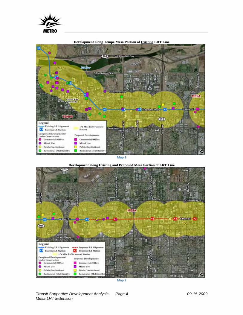
Transit Supportive Development Analysis Page 4 09-15-2009 Mesa LRT Extension
Development along Tempe/Mesa Portion of Existing LRT Line
Development along Existing and Proposed Mesa Portion of LRT Line
Map 2
Map 1
Transit Supportive Development Analysis Page 5 09-15-2009 Mesa LRT Extension
B. Existing Transit Supportive Development Elements in Mesa The above discussion provided evidence of ridership trends and development activity as indicators of the success of the existing Valley Metro LRT line in general and along the southeastern terminus of the line in particular. The line has attracted riders and spurred transit-oriented development. Having established the positive geographic trajectory of development in the vicinity of the proposed extension, it is also important to note what elements are in place along the proposed extension that make project area ready to achieve similar success. The City of Mesa has specifically adopted policies which foster transit supportive development and is continuing to develop additional such policies including working towards revised TSD and form-based zoning. Furthermore, the City has implemented major public investments in its downtown area creating an attractive pedestrian oriented and transit supportive environment.
1. Plans and Policies The City of Mesa, as reflected in its evolving policies, is adopting a transit-supportive model at the core of its future development vision. Growing from a city of 15 square miles and 34,000 people in 1960 to over 133 square miles and 482,000 residents today, the City of Mesa has a proven track record of attracting residents and development. Growth patterns over this time period mirrored the predominating development pattern exhibited throughout the United States during the latter half of the twentieth century. Development concentrated on automobile oriented development including strip retail centers, shopping malls, suburban office development and low density housing. While the city and region grew rapidly under this model, alternative development models began to be sought near the end of the twentieth century. The adoption of Growing Smarter (1998) and Growing Smarter Plus (2000) legislation by the State of Arizona signaled the need for new planning efforts. The City of Mesa responded by developing “Mesa 2025: A Shared Vision” as its General Plan in 2002. Throughout the General Plan’s various elements are objectives and policies that encourage transit-supportive development. Key elements are contained within the land use and transportation elements. The land use element of the plan placed a new emphasis on “innovative and sustainable urban development patterns” and “integrated residential, commercial and office uses” (Objectives LU-1.2 and LU-4.3). This emphasis on sustainability and mixed use development represents a shift towards transit supportive development. This emphasis in the land use element is also supported by the plan’s transportation element. The transportation element calls for “a balanced, multi modal transportation system for the City of Mesa” and “a transportation system that minimizes air, water, and noise pollution while maintaining and enhancing the environment.” (Goal T-1 and Objective T-2.1).

Transit Supportive Development Analysis Page 6 09-15-2009 Mesa LRT Extension
Proposed Station Areas along LRT Extension with City of Mesa Planning Areas Indicated
As the City’s adopted General Plan, “Mesa 2025: A Shared Vision” represents the City’s official policy stance towards future development. The City is in the process of following up on and implementing many of the specific policies contained within the overall document. In December 1999, the City prepared and adopted the Town Center Concept Plan and Action Plan. This plan describes future land uses, densities, transportation facilities, and development design components for future growth in the 1300 acre Town Center Redevelopment Area, which includes most of the areas within ½ mile of the three easternmost proposed LRT stations. The Town Center Redevelopment Area contains a mix of residential, employment, public facility, cultural, and entertainment uses. The area includes the following four historic districts that are on the National Register of Historic Places: Evergreen; West 6th Street; Glenwood Wilbur; and Temple. In addition, the Robson Historic District is locally designated and is eligible for the National Register. These areas and the whole downtown are eminently walk-able; in addition the City has created a Pedestrian Overlay zone in the Downtown Area. Among other goals, Policy RR 1.1 d of the General Plan promotes “mid and high rise mixed residential (i.e. 40 dwelling units/acre) and office uses in the Town Center, reserving ground floor space for retail and other supportive uses in the Pedestrian Overlay Area.” The City of Mesa promotes the location of new business in the downtown
Map 3
Transit Supportive Development Analysis Page 7 09-15-2009 Mesa LRT Extension
area in conjunction with the Mesa Town Center Corporation, the Office of Redevelopment, and the Office of Economic Development. The City has focused additional planning efforts on the western end of Main Street (containing the remaining station areas), adopting a plan for this area in December 2007. The West Main Street Area Plan covers approximately one-half of the area surrounding the proposed Mesa extension to the Valley Metro LRT. The plan emphasizes transit oriented development with the following elements: mixed use, transit supportive densities, pedestrian oriented design, denser development in close proximity to transit stations and well designed inter-modal transfer facilities. As a follow-up to these plans and the overall Mesa 2025 plan, the City is beginning to update its Zoning Ordinance to reflect the new vision. While this effort is still in the public process stages, the focus is firmly on providing an ordinance update that provides means to implement and help ensure realization of the vision contained within Mesa 2025 and subsequent planning efforts such as the West Main Street Area Plan. Regulations under review include requirements for mixed use development, minimum development densities within station areas, provisions for shared parking, urban design recommendations and other elements aimed at ensuring new development or redevelopment occurs within the context of the community’s transit supportive development vision. In addition to these policy and regulation efforts being led by the City of Mesa, other efforts have emerged to help push the city towards a transit supportive development model. The Downtown Mesa Association is a private non-profit organization focused on economic growth within downtown Mesa. The organization includes business and property owners as well as other community stakeholders. In 2009, the organization published their vision for downtown Mesa. A key element of their vision is an emphasis on creating a pedestrian friendly downtown and building upon mass transit, specifically LRT. While the group’s vision does not represent an officially adopted City plan, the visions elements are consistent with the general policies of Mesa 2025 and they do indicate support and “buy-in” from the business community for transit supportive development ideas.
2. Other Factors Supporting Transit Oriented Development In addition to the policy efforts of the Downtown Mesa Association to focus transit supportive development downtown, the City of Mesa has committed a large amount of resources to make downtown Mesa a pedestrian oriented environment and an attractive destination. Streetscape improvements and major public facilities make downtown Mesa a potentially vibrant destination. Pedestrian improvements include improved crosswalks, benches and other street furniture, public art and other pedestrian amenities. Main Street includes bike lanes and traffic calming elements to further enhance the safety and experience of non-motorized travelers. These elements make the area naturally
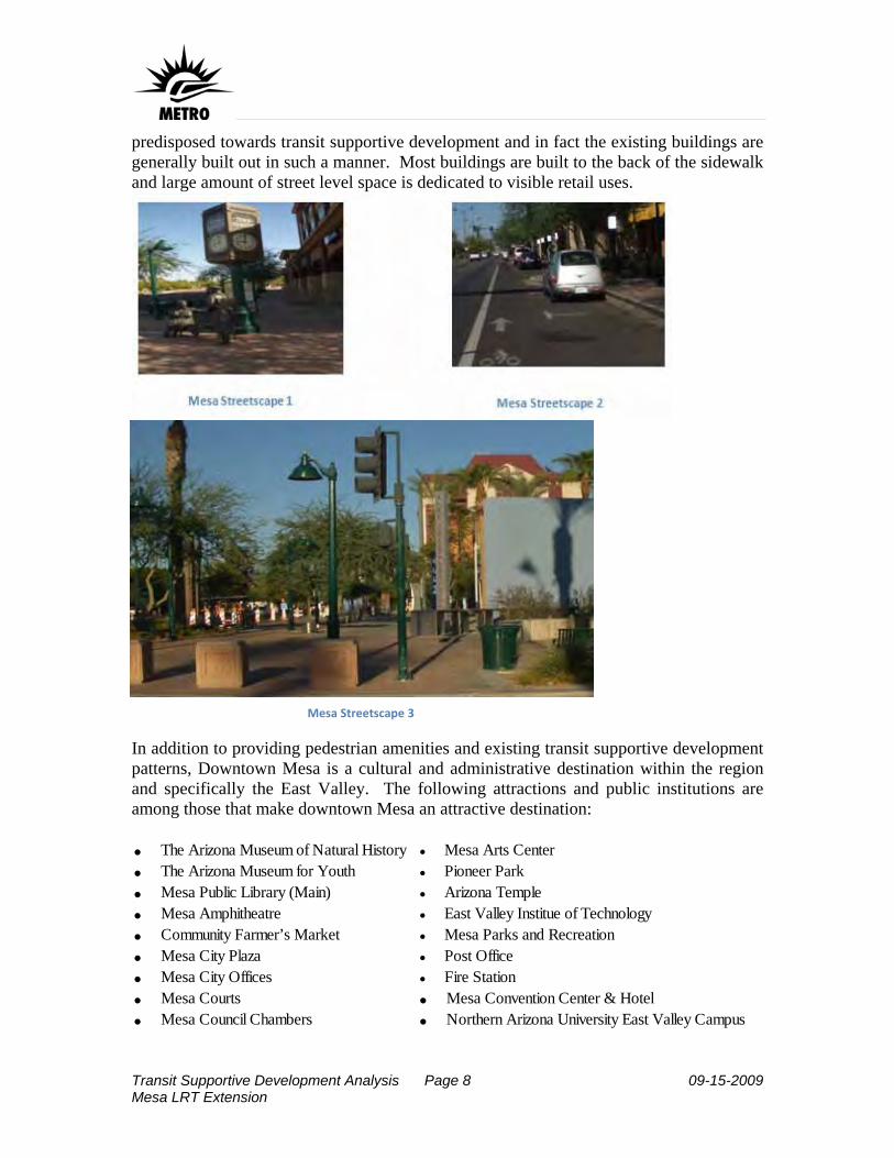
Transit Supportive Development Analysis Page 8 09-15-2009 Mesa LRT Extension
predisposed towards transit supportive development and in fact the existing buildings are generally built out in such a manner. Most buildings are built to the back of the sidewalk and large amount of street level space is dedicated to visible retail uses.
In addition to providing pedestrian amenities and existing transit supportive development patterns, Downtown Mesa is a cultural and administrative destination within the region and specifically the East Valley. The following attractions and public institutions are among those that make downtown Mesa an attractive destination: • The Arizona Museum of Natural History • Mesa Arts Center• The Arizona Museum for Youth • Pioneer Park• Mesa Public Library (Main) • Arizona Temple• Mesa Amphitheatre • East Valley Institue of Technology• Community Farmer’s Market • Mesa Parks and Recreation• Mesa City Plaza • Post Office• Mesa City Offices • Fire Station• Mesa Courts • Mesa Convention Center & Hotel• Mesa Council Chambers • Northern Arizona University East Valley Campus
Mesa Streetscape 3

Transit Supportive Development Analysis Page 9 09-15-2009 Mesa LRT Extension
All of these attractions and developments are within one-half mile of proposed station locations along the proposed Mesa extension of the Valley Metro LRT.
Attractions and Destinations in Mesa along Proposed LRT Extension
As one primary example, the Mesa Arts Center represents a major investment in the downtown. The facility is the largest of its kind in the state of Arizona encompassing 212,755 square feet of space for the performing and visual arts as well as arts education.
Map 4
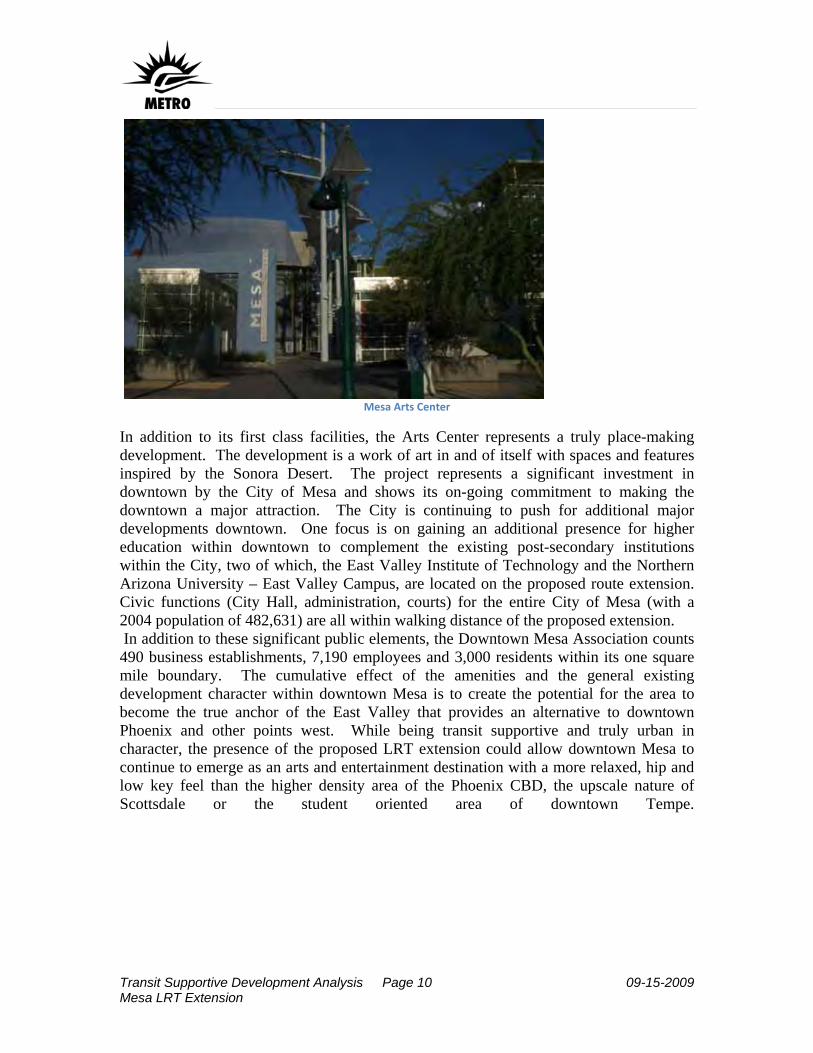
Transit Supportive Development Analysis Page 10 09-15-2009 Mesa LRT Extension
Mesa Arts Center
In addition to its first class facilities, the Arts Center represents a truly place-making development. The development is a work of art in and of itself with spaces and features inspired by the Sonora Desert. The project represents a significant investment in downtown by the City of Mesa and shows its on-going commitment to making the downtown a major attraction. The City is continuing to push for additional major developments downtown. One focus is on gaining an additional presence for higher education within downtown to complement the existing post-secondary institutions within the City, two of which, the East Valley Institute of Technology and the Northern Arizona University – East Valley Campus, are located on the proposed route extension. Civic functions (City Hall, administration, courts) for the entire City of Mesa (with a 2004 population of 482,631) are all within walking distance of the proposed extension. In addition to these significant public elements, the Downtown Mesa Association counts 490 business establishments, 7,190 employees and 3,000 residents within its one square mile boundary. The cumulative effect of the amenities and the general existing development character within downtown Mesa is to create the potential for the area to become the true anchor of the East Valley that provides an alternative to downtown Phoenix and other points west. While being transit supportive and truly urban in character, the presence of the proposed LRT extension could allow downtown Mesa to continue to emerge as an arts and entertainment destination with a more relaxed, hip and low key feel than the higher density area of the Phoenix CBD, the upscale nature of Scottsdale or the student oriented area of downtown Tempe.
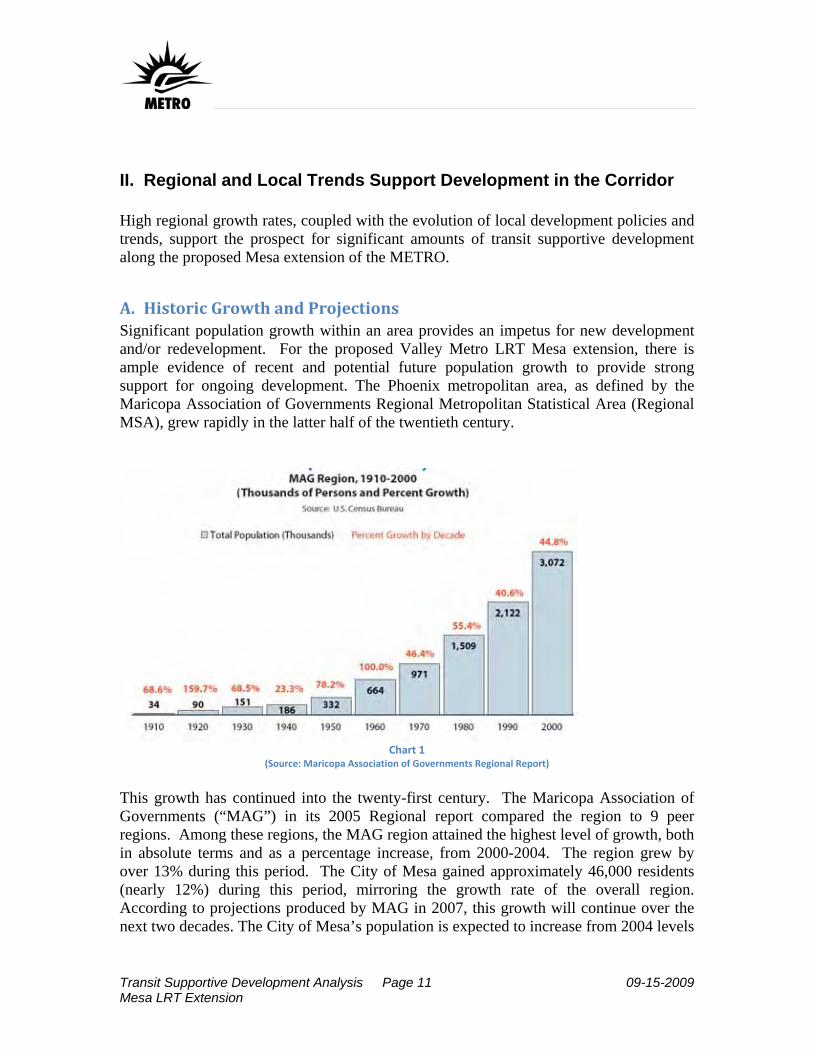
Transit Supportive Development Analysis Page 11 09-15-2009 Mesa LRT Extension
II. Regional and Local Trends Support Development in the Corridor High regional growth rates, coupled with the evolution of local development policies and trends, support the prospect for significant amounts of transit supportive development along the proposed Mesa extension of the METRO.
A. Historic Growth and Projections Significant population growth within an area provides an impetus for new development and/or redevelopment. For the proposed Valley Metro LRT Mesa extension, there is ample evidence of recent and potential future population growth to provide strong support for ongoing development. The Phoenix metropolitan area, as defined by the Maricopa Association of Governments Regional Metropolitan Statistical Area (Regional MSA), grew rapidly in the latter half of the twentieth century.
Chart 1
(Source: Maricopa Association of Governments Regional Report)
This growth has continued into the twenty-first century. The Maricopa Association of Governments (“MAG”) in its 2005 Regional report compared the region to 9 peer regions. Among these regions, the MAG region attained the highest level of growth, both in absolute terms and as a percentage increase, from 2000-2004. The region grew by over 13% during this period. The City of Mesa gained approximately 46,000 residents (nearly 12%) during this period, mirroring the growth rate of the overall region. According to projections produced by MAG in 2007, this growth will continue over the next two decades. The City of Mesa’s population is expected to increase from 2004 levels

Transit Supportive Development Analysis Page 12 09-15-2009 Mesa LRT Extension
by over 34% by 2030. The population within one mile of the proposed extension route is projected to grow by 24%.
City of Mesa and Study Population and Growth
% Increase 2004 2030 2004-2030 Population Central Mesa Study Area 162,243 200,453 23.60% City of Mesa 482,631 648,062 34.30%
Table 3 (Source: Maricopa Association of Governments)
In addition to the general population growth trend, an analysis of the area demographics reveals a substantial portion of the population that may be transit dependent. The Central Mesa Study Area is home to a high concentration of low-income and zero-car households. According to the 2005 MAG Socioeconomic data, about 9.2% of all resident households in the City of Mesa are zero-car households. More than half of such households (54.3%) are within the study area. The number of zero-car households is expected to increase by 26.7% by 2030. Moreover, the percentage increase in number of zero-car households will far outstrip the percentage increase in total households within the city by 2030. In 2004, according to MAG socioeconomic estimates, about 21% of total resident households were in the low income category in the city. About 42% of those households are present in the project study area. The number of such households is expected to increase 27.3% by 2030 within the study area. Also, a high percentage of elderly population resides within the study area. According to the 2000 Census, the study area is home to about 53% of the total population above the age of 65 in Mesa. In most cases, these low-income and zero-car households as well as senior population are dependent upon public transportation to provide access to jobs, health care, and shopping. The strong historic and projected population growth is supported by similarly robust numbers for economic growth in the region. From 1990 to 2004 the MAG region outpaced its 9 peer cities in Gross Regional Product growth.

Transit Supportive Development Analysis Page 13 09-15-2009 Mesa LRT Extension
In
general, over the medium to longer term, historical population and economic growth trends are forecasted to continue in the MAG region generally and the City of Mesa particularly. This projected growth is a positive trend and provides enhanced opportunities for transit supportive development along the proposed Mesa extension of the Valley Metro LRT. The City of Mesa’s commitment to such development, as outlined in the preceding section, further bolsters the prospects for transit supportive development.
Chart 2 (Maricopa Association of Governments Regional Report)

Transit Supportive Development Analysis Page 14 09-15-2009 Mesa LRT Extension
III. Land Available for Development
A. Land Supply and Projected Development Under Existing Plans The area within one-half mile of the proposed station locations for the Mesa extension of the Valley Metro LRT contains a more than adequate supply of land available for development. A combination of vacant, underdeveloped and potentially obsolete sites provides ample opportunity for new development within the ½ mile station area radii that conforms to the City of Mesa’s vision of a more sustainable urban development pattern that is transit supportive.
Vacant Land within 1/2 Mile of Proposed Station Locations
According to information obtained from the Maricopa County parcel database, there are 288 acres of vacant land within one-half mile of the proposed station areas. It is estimated that approximately 50% of this land will be available for development by 2030. The remaining 50% is assumed to remain unavailable until after 2030 due to current use for surface parking for adjacent development, parcel size/adjacencies, ownership and other issues. This leaves 144 acres of vacant land available for development within one-half mile of the proposed stations by 2030.
Map 5

Transit Supportive Development Analysis Page 15 09-15-2009 Mesa LRT Extension
In addition to this vacant land, there are approximately 260 acres of land that are “highly susceptible to redevelopment”, defined as being those parcels that contain low density commercial uses at less than .3 FAR. The development potential of this class of properties is underscored by the fact that approximately 40% have improvements that are over 30 years old and are potentially obsolete. For the purposes of this analysis it is conservatively assumed that 1/3rd of these properties will become available for development by 2030. This adds an additional 88 acres to the 144 vacant acres for a total of 232 acres of land available for development by 2030.
Land Available for Development by 2030 within ½ mile of Proposed Stations
The West Main Street Area Plan calls for development densities of 2.5 floor-area-ratio (FAR) within 1/8th of a mile of station areas, 2.0 FAR from 1/8th to 1/4th of a mile and .25 FAR in the surrounding single family neighborhoods, extending out to 1 mile from the proposed LRT route. The plan assumes an approximate average of 85% residential uses. While an updated small area plan (beyond what is reflected in the General Plan) has yet to be adopted by the City for the downtown area, a conservative view would be to assume that at least similar, if not higher, densities will be sought within the downtown area. Under these assumptions, the land supply within ½ mile of the four stations and most likely to develop or redevelop by 2030 could accommodate nearly 9,000 housing units and 2 million square feet of commercial development. As noted in a preceding section, the overall Mesa extension corridor (defined by the area that is approximately one mile from the proposed route) is forecasted to grow by around 24% by 2030. This level of growth amounts to approximately 38,000 people within this roughly 17 square mile area. Using a blended housing occupancy density of 2.2 residents per unit, the approximately 9,000 housing units that can be accommodated at planned densities within the station areas (approximately 2.2 square miles or 13% of the total area) would total nearly 20,000 people. The accommodation of over 50% of the growth forecasted for the larger corridor area within only 13% of its area would represent an admirable level of smart growth and would result in a truly transit supportive development.
Total (Acres)
Developable by 2030
Potential Residential (Units)
Potential Commercial (SF)
Vacant 288 144 5,600 1,245,000 Susceptible to Redevelopment 260
88
3,400 755,000
Total 548 232 9,000 2,000,000 Table 4
Transit Supportive Development Analysis Page 16 09-15-2009 Mesa LRT Extension
B. Barriers to Redevelopment While numerous factors can emerge as barriers to development/redevelopment of transit-oriented development within a community, at present, no significant barriers have been identified to redevelopment along the proposed extension. All of the property is within the City of Mesa, so jurisdictional control over development is simplified.
1. Policies and Regulations As the discussion above notes, planning and zoning in City of Mesa should present a minimal, if not non-existent, barrier to transit supportive development along the proposed route. The City has already adopted a General Plan and one small area plan that strongly support such development and they are in the process of adopting further polices and in revising zoning regulations to reinforce and implement the policy vision. These efforts are expected to be completed prior to the construction of the proposed extension.
2. Public Support The City’s General Plan was adopted after a public referendum, indicating a majority of residents support the proposed vision. Further evidence of broad support and a lack of significant opposition were evidenced through a robust public involvement process. Public information meetings were held for Scoping, Tier One, Tier Two, and the Locally Preferred Alternative decision. The public was asked to provide input during each of these phases on the location of the alignment and transit technology. In addition, information on the project was presented and comments were received during presentations to the interested groups, boards and commissions of the City of Mesa, and through participation at events. Finally, the efforts of the Downtown Mesa Association indicate a proactive business and property owner community that is actively seeking new transit supportive development. Substantial amounts of developable property exist within the station areas at areas significantly removed from any proximate single family neighborhoods, typically the most likely sources of potential opposition to new development.
3. Land Control, Environmental Issues The City of Mesa owns approximately 68 acres of vacant land within the proposed station areas. This land could serve as an initial catalyst for new development. Additionally, the supply of land discussed in the above section is available in a variety of parcel sizes and ownership scenarios, providing opportunities for large and small scale site consolidation, infill and development. As with any redevelopment area that includes commercial properties, there are likely to be individual sites with some environmental issues. Beyond these typical occurrences, to date, no major environmental issues have been identified

Transit Supportive Development Analysis Page 17 09-15-2009 Mesa LRT Extension
within the stations areas. The station areas are topographically flat and contain no bodies of water, barriers separating them from the station (other than normal street pattern) or other geographical elements that could constrain development.