appendix - minnehaha county, south dakota official website · 107 appendix appendix historic images...
TRANSCRIPT
ENVISION 2035
County History
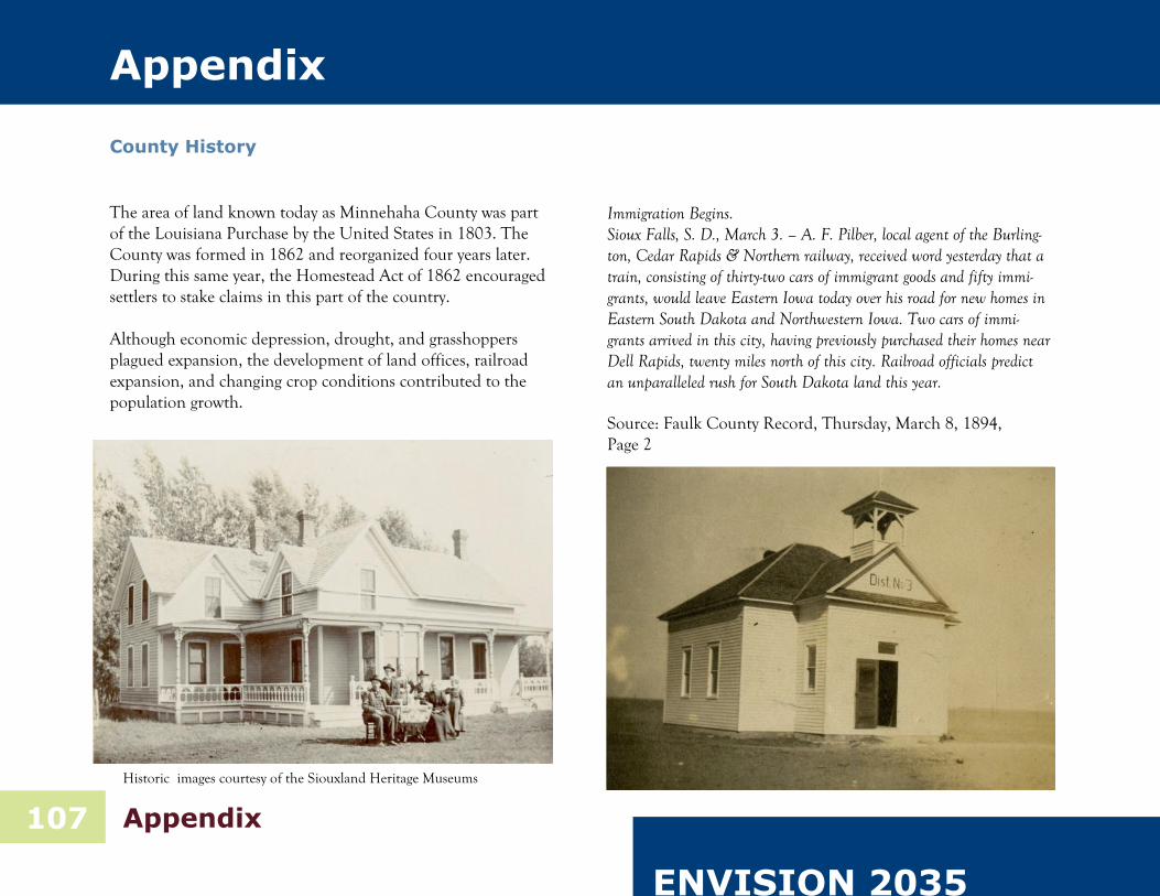
The area of land known today as Minnehaha County was part of the Louisiana Purchase by the United States in 1803. The County was formed in 1862 and reorganized four years later. During this same year, the Homestead Act of 1862 encouraged settlers to stake claims in this part of the country. Although economic depression, drought, and grasshoppers plagued expansion, the development of land offices, railroad expansion, and changing crop conditions contributed to the population growth.
Immigration Begins. Sioux Falls, S. D., March 3. – A. F. Pilber, local agent of the Burling-ton, Cedar Rapids & Northern railway, received word yesterday that a train, consisting of thirty-two cars of immigrant goods and fifty immi-grants, would leave Eastern Iowa today over his road for new homes in Eastern South Dakota and Northwestern Iowa. Two cars of immi-grants arrived in this city, having previously purchased their homes near Dell Rapids, twenty miles north of this city. Railroad officials predict an unparalleled rush for South Dakota land this year. Source: Faulk County Record, Thursday, March 8, 1894, Page 2
107 Appendix
Appendix
Historic images courtesy of the Siouxland Heritage Museums

Moving Forward ~ Planning Ahead
108 Appendix
Natural features within Minnehaha County have attracted peo-ple for both materials and for recreation since the early years of settlement. The area along the Big Sioux River was quarried for quartzite as early as the 1860s. The business of quarrying rock continues today; although modern quarries rely less on manual labor. East Sioux Falls (below) was the center of the mining ac-tivity.
Historic images courtesy of the Siouxland Heritage Museums

ENVISION 2035
Rapid growth in population helped push the U.S. Congress to approve the division of the Dakota Territory, creating the states of North Dakota and South Dakota in 1889. With that division construction began on the first Minnehaha County Courthouse the same year.
The building is constructed of na-tive Sioux Quartz-ite stone, a popular local building mate-rial of the late 19th century. When completed in 1893 the architect, Wal-lace Dow, claimed the structure would be the “largest courthouse be-tween Chicago and Denver.”
109 Appendix
Historic image courtesy of the Siouxland Heritage Museums

Moving Forward ~ Planning Ahead
110 Appendix
The Chicago, St. Paul, Minneapolis & Omaha railroad (formerly part of the Chicago & North-Western Railway Sys-tem) was the first rail line to come into the county. The initial train reached Valley Springs on June 1, 1878, Brandon on July 15 and Sioux falls on August 1. Currently, this line is owned by Eastern & Ellis and is mostly abandoned except for the portion running from Brandon to the western boundary of Sioux Falls. Sioux Falls soon became the hub for rail transportation in the state. Other rail lines include the Chicago, Milwaukee & St. Paul, the Burlington, Cedar Rapids & Northern, the Illinois Central, the Willmar & Sioux Falls, and the South Dakota Central.
Historic images courtesy of the Siouxland Heritage Museums

ENVISION 2035
Planning & Zoning History
The county’s planning efforts began in 1966 with the appoint-ment of a planning commission. Their task was to work with a consultant to prepare a comprehensive plan. This work culmi-nated in 1968 with the completion and adoption of the Min-nehaha County Comprehensive Plan; this plan included zoning and subdivision regulations. The Planning Commission worked several years without staff support until a planning department was formed in 1972. Legal problems were encountered in 1973 when the county refused a request to rezone property. The applicant commenced court action to strike down the comprehensive plan and zoning regu-lations on the basis of improper adoption. The court ruled that the plan had been adopted as an emergency measure, limited by statue to a period of two years, and struck down the plan. In late 1973 the county took action to adopt a permanent plan, including zoning and subdivision regulations. In 1974, the Uni-form Building Code was adopted to regulate building construc-tion in the rural area.
By the mid-1970's significant growth was occurring in the rural area as houses spilled outside of the cities onto agricultural land. While the plan warned of this phenomenon more than half a decade before, the zoning regulations failed to keep pace with development pressure. By 1978, elected officials recog-nized the need for change in order to more effectively manage residential densities in the rural area but the new zoning ordi-nance failed to be sustained by the electorate in a referendum election. In 1980, the zoning regulations were amended to require prop-erty to be rezoned for residential subdivisions. Prospective homeowners were also required to obtain a conditional use be-fore building permits could be issued on isolated nonfarm resi-dential acreages. The Density Zoning Ordinance that was passed in 1988 significantly slowed the development of rural subdivisions by only allowing one residential dwelling on every quarter-quarter section of land or lot of record.
111 Appendix

Moving Forward ~ Planning Ahead
112 Appendix
The zoning ordinance was overhauled and updated in 1990, and these regulations still govern land use in the county with several additions and amendments through the years. The last comprehensive plan was adopted in 1998. A joint jurisdiction boundary, not to exceed three miles beyond corporate munici-pal limits, was drafted a few years later in the early 2000s. Zon-ing regulations for each joint zoning jurisdiction, Dell Rapids and Sioux Falls, were adopted in harmony with the respective comprehensive plans to provide regulatory authority for the mu-nicipalities in land use and zoning matters within three miles of the outer municipal boundaries. The responsibilities of the Planning Department have increased since its inception. Today, the department also manages build-ing inspections, onsite wastewater treatment systems, agricultur-al drainage, code enforcement, solid waste disposal, rural ad-dressing, road vacations, GIS, county-wide recycling and clean-up projects, floodplain management, and the county parks.

ENVISION 2035
113 Appendix
School District Boundaries Map

Moving Forward ~ Planning Ahead
114 Appendix
Zoning Map
ENVISION 2035
115 Appendix
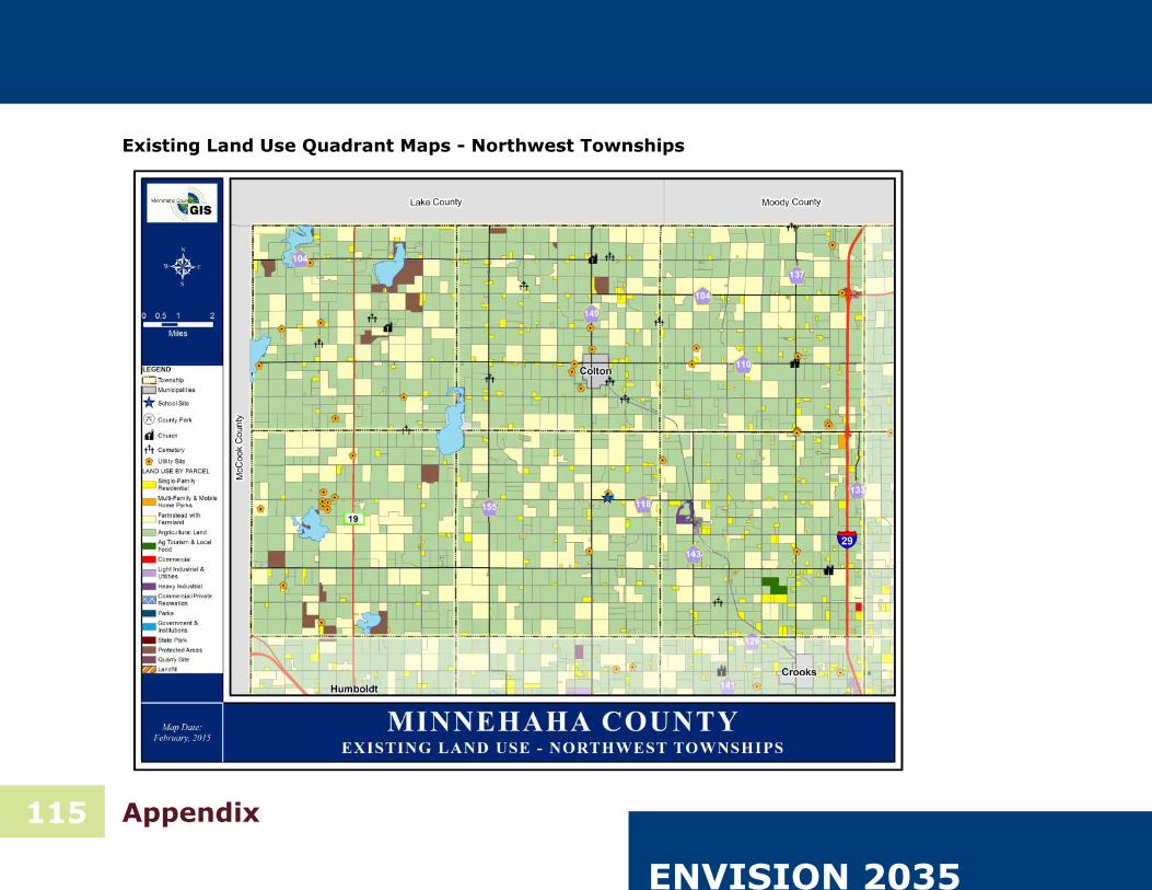
Existing Land Use Quadrant Maps - Northwest Townships

Moving Forward ~ Planning Ahead
116 Appendix
Existing Land Use Quadrant Maps - Northeast Townships

ENVISION 2035
117 Appendix
Existing Land Use Quadrant Maps - Southwest Townships

Moving Forward ~ Planning Ahead
118 Appendix
Existing Land Use Quadrant Maps - Southeast Townships

ENVISION 2035
119 Appendix
Public Comment - Agricultural Survey & Results

Moving Forward ~ Planning Ahead
120 Appendix

ENVISION 2035
121 Appendix
Public Comment - Open Ended Comments from Open Houses

Moving Forward ~ Planning Ahead
122 Appendix

ENVISION 2035
123 Appendix

Moving Forward ~ Planning Ahead
124 Appendix

ENVISION 2035
Public Comment - Parks & Recreation Assessment Survey
125 Appendix
Image Source: SD Game, Fish, & Parks Image Source: SD Game, Fish, & Parks Image Source: SD Tourism

Moving Forward ~ Planning Ahead
126 Appendix
Planning Staff
Scott Anderson, Director
David Heinold, Planner I
Kevin Hoekman, Planner I
Deb Johnson, Planning Tech.
Heidi Jerke, GIS Coordinator
Josh Hellman, GIS Analyst
Dan Kistler, Building Inspector
Contributing Members
Barb Himmel-Roberts
Brian Roegiers
Monte Albertson
Kevin Gallo
Scott Swanson
David Swier
Arden Petersen
Steve VanDerBeek
Sam Trebilcock
Larry Carlson
Lynn Boadwine
Robert Hafstad
Jeff Oyen
Mark Rogen
Karin Renner
Walt Bones
Jeff Eckhoff
Jason Bieber
Nick Fosheim
John Parker
Brian Top
Amber Gibson
Toby Brown
Ryan Streff
Dustin Powers
Pat Herman
The Minnehaha County Planning Department
would like to thank this group of citizens and
community leaders for their time and efforts.
