appendix h: project summary sheets - vdot.virginia.gov ratio: 9.3 benefit/cost calculated using the...
TRANSCRIPT

Appendix H: Project Summary Sheets
US 360/ROUTE 288 INTERCHANGE AREA STUDY
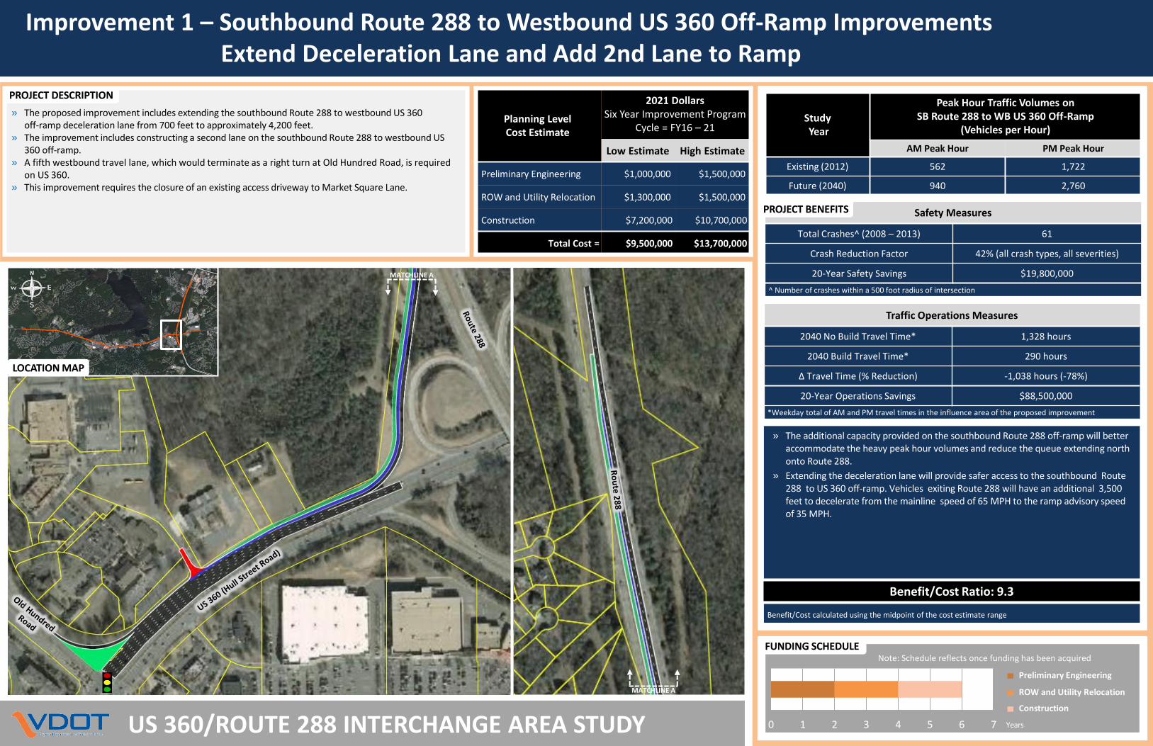
» The proposed improvement includes extending the southbound Route 288 to westbound US 360 off-ramp deceleration lane from 700 feet to approximately 4,200 feet.
» The improvement includes constructing a second lane on the southbound Route 288 to westbound US 360 off-ramp.
» A fifth westbound travel lane, which would terminate as a right turn at Old Hundred Road, is required on US 360.
» This improvement requires the closure of an existing access driveway to Market Square Lane.
PROJECT DESCRIPTION
Planning LevelCost Estimate
2021 DollarsSix Year Improvement Program
Cycle = FY16 – 21
Low Estimate High Estimate
Preliminary Engineering $1,000,000 $1,500,000
ROW and Utility Relocation $1,300,000 $1,500,000
Construction $7,200,000 $10,700,000
Total Cost = $9,500,000 $13,700,000
LOCATION MAP
MATCHLINE A
MATCHLINE A
Preliminary Engineering
ROW and Utility Relocation
Construction
Years0 1 2 3 4 5 6 7
FUNDING SCHEDULENote: Schedule reflects once funding has been acquired
Traffic Operations Measures
2040 No Build Travel Time* 1,328 hours
2040 Build Travel Time* 290 hours
Δ Travel Time (% Reduction) -1,038 hours (-78%)
20-Year Operations Savings $88,500,000
*Weekday total of AM and PM travel times in the influence area of the proposed improvement
Safety Measures
Total Crashes^ (2008 – 2013) 61
Crash Reduction Factor 42% (all crash types, all severities)
20-Year Safety Savings $19,800,000
^ Number of crashes within a 500 foot radius of intersection
» The additional capacity provided on the southbound Route 288 off-ramp will better accommodate the heavy peak hour volumes and reduce the queue extending north onto Route 288.
» Extending the deceleration lane will provide safer access to the southbound Route 288 to US 360 off-ramp. Vehicles exiting Route 288 will have an additional 3,500 feet to decelerate from the mainline speed of 65 MPH to the ramp advisory speed of 35 MPH.
PROJECT BENEFITS
Benefit/Cost Ratio: 9.3
Benefit/Cost calculated using the midpoint of the cost estimate range
StudyYear
Peak Hour Traffic Volumes on SB Route 288 to WB US 360 Off-Ramp
(Vehicles per Hour)
AM Peak Hour PM Peak Hour
Existing (2012) 562 1,722
Future (2040) 940 2,760
Improvement 1 – Southbound Route 288 to Westbound US 360 Off-Ramp ImprovementsExtend Deceleration Lane and Add 2nd Lane to Ramp

Improvement 2 – Route 288 at Commonwealth Center Parkway Interchange andBailey Bridge Connector Improvements
US 360/ROUTE 288 INTERCHANGE AREA STUDY
Traffic Operations Measures
2040 No Build Travel Time* 11,190 hours
2040 Build Travel Time* 6,315 hours
Δ Travel Time (% Reduction) -4,875 hours (-44%)
20-Year Operations Savings $441,500,000
* Weekday total AM and PM travel times in the influence area of the proposed improvements
» Construction of the proposed ramp improvement and Bailey Bridge Connector will provide a parallel route to US 360 and provide direct access to Brad McNeer Parkway.
» This parallel route is projected to reduce traffic volumes on the Northbound Route 288 to Westbound US 360 off ramp by 63%. The existing ramp movement is currently over capacity, this improvement helps to extend the life of this ramp into the future.
» The proposed parallel route is projected to reduce turning movement volumes at intersections projected to operate over capacity under future traffic conditions along US 360 west of Route 288.
» The proposed improvements can serve as an alternate route when incidents occur on
US 360 and Route 288 and will aid during the construction of future projects completed within the US 360 corridor.
» Future connections to the proposed Bailey Bridge Connector could provide additional connectivity to surrounding development.
PROJECT BENEFITS
Benefit/Cost Ratio: 5.6
Benefit/Cost calculated using the midpoint of the cost estimate range
LOCATION MAP
CONCEPTUAL SKETCH
» The proposed improvement includes constructing the following: 1. A directional 1-lane off-ramp from Northbound Route 288 to the Bailey Bridge
Connector.2. A four-lane divided roadway from Route 288 to Brad McNeer Parkway, including a
connector roadway between the Bailey Bridge Connector and Brad McNeer Parkway.3. A 2-lane roadway from Brad McNeer Parkway to Bailey Bridge Road connector road.4. A slip ramp from southbound Route 288 to Commonwealth Centre Parkway5. A 10-foot multi-use path, built to accommodate bicycle and pedestrian traffic, is
proposed in conjunction with proposed Bailey Bridge Connector.» Various improvements, such as traffic signals, roundabouts, and turn lanes would be
required to facilitate turning movements at multiple intersections.
PROJECT DESCRIPTION
Bailey Bridge Connector
MATCHLINE A
MATCHLINE A
Preliminary Engineering
ROW and Utility Relocation
Construction
Years0 1 2 3 4 5 6 7 8
FUNDING SCHEDULE Note: Schedule reflects once funding has been acquired
4
2
5
3
3
3
1
5
Planning LevelCost Estimate
2021 Dollars (1,000,000s)Six Year Improvement Program
Cycle = FY16 – 21
NB RT 288Off-Ramp toBailey Bridge
Connector
Bailey BridgeConnector -
4-Lanes
Bailey BridgeConnector -
2-Lanes
SB RT 288 Off-Ramp to
Commonwealth Center Parkway
TotalEstimate
Low High Low High Low High Low High Low High
Preliminary Engineering $1.8 $2.5 $3.0 $3.5 $0.9 $1.3 $0.2 $0.3 $5.9 $7.6
ROW and Utility Relocation $6.9 $8.9 $11.2 $12.5 $3.4 $4.6 $0.8 $1.2 $22.3 $27.2
Construction $13.0 $17.5 $21.1 $24.6 $6.4 $9.1 $1.6 $2.4 $42.1 $53.6
Total Cost = $21.7 $28.9 $35.3 $40.6 $10.7 $15.0 $2.6 $3.9 $70.3 $88.4
1 2 3 4
Improvement 3 – Displaced Left-Turn (DLT) Intersection at US 360 at Old Hundred Road/Commonwealth Centre Parkway
US 360/ROUTE 288 INTERCHANGE AREA STUDY
Preliminary Engineering
ROW and Utility Relocation
Construction
Years0 1 2 3 4 5 6
FUNDING SCHEDULENote: Schedule reflects once funding has been acquired
Traffic Operations Measures
2040 No Build Travel Time* 2,775 hours
2040 Build Travel Time* 1,005 hours
Δ Travel Time (% Reduction) -1,770 hours (-64%)
20-Year Operations Savings $156,700,000
*Weekday total of AM and PM travel times in the influence area of the proposed improvement
Safety Measures
Total Crashes^ (2008 – 2013) 221
Crash Reduction Factor 19% (all crash types, fatal and injury)
20-Year Safety Savings $9,800,000
^ Number of crashes within a 500 foot radius of intersection
» The DLT configuration will improve one of the most congested and high crash intersections along the US 360 corridor in Chesterfield County by more efficiently moving traffic through the intersection.
» The DLT configuration will improve throughput on US 360 by reducing the number of traffic signal phases. This improvement is projected to operate better than the future no-build scenario and prevent the westbound queue from extending east onto southbound Route 288 under future traffic conditions.
» The DLT configuration provides an alternative to a more expensive grade separation at US 360 and Old Hundred Road/Commonwealth Centre Parkway (Improvement 4) and can be implemented more quickly.
» Impacts to right-of-way, utilities, and existing access driveways will be required to implement the DLT intersection.
PROJECT BENEFITS
Benefit/Cost Ratio: 2.2
Benefit/Cost calculated using the midpoint of the cost estimate range
StudyYear
Total Entering Traffic Volumes(Vehicles per Hour)
AM Peak Hour PM Peak Hour
Existing (2012) 6,410 8,884
Future (2040) 9,860 14,300
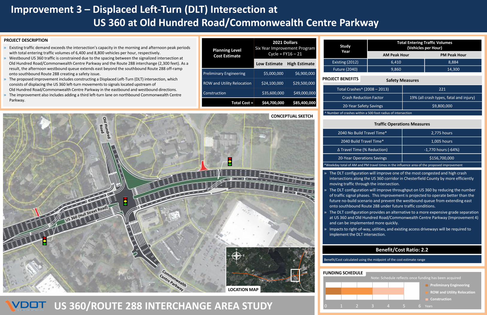
CONCEPTUAL SKETCH
LOCATION MAP
» Existing traffic demand exceeds the intersection’s capacity in the morning and afternoon peak periods with total entering traffic volumes of 6,400 and 8,800 vehicles per hour, respectively.
» Westbound US 360 traffic is constrained due to the spacing between the signalized intersection atOld Hundred Road/Commonwealth Centre Parkway and the Route 288 interchange (2,300 feet). As a result, the afternoon westbound queue extends east beyond the southbound Route 288 off-ramp onto southbound Route 288 creating a safety issue.
» The proposed improvement includes constructing a Displaced Left-Turn (DLT) intersection, which consists of displacing the US 360 left-turn movements to signals located upstream of Old Hundred Road/Commonwealth Centre Parkway in the eastbound and westbound directions.
» The improvement also includes adding a third left-turn lane on northbound Commonwealth Centre Parkway.
PROJECT DESCRIPTION
Planning LevelCost Estimate
2021 DollarsSix Year Improvement Program
Cycle = FY16 – 21
Low Estimate High Estimate
Preliminary Engineering $5,000,000 $6,900,000
ROW and Utility Relocation $24,100,000 $29,500,000
Construction $35,600,000 $49,000,000
Total Cost = $64,700,000 $85,400,000

Improvement 4 – Grade-Separated Diverging Diamond Interchange (DDI) at US 360 at Old Hundred Road/Commonwealth Centre Parkway
US 360/ROUTE 288 INTERCHANGE AREA STUDY
» Existing traffic demand exceeds the intersection’s capacity in the morning and afternoon peak periods with total entering traffic volumes of 6,400 and 8,800 vehicles per hour, respectively.
» Westbound US 360 traffic is constrained due to the spacing between the signalized intersection atOld Hundred Road/Commonwealth Centre Parkway and the Route 288 interchange (2,300 feet). As a result, the afternoon westbound queue extends east beyond the southbound Route 288 off-ramp onto southboundRoute 288 creating a safety issue.
» This project will separate eastbound/westbound through traffic on US 360 from northbound/southbound traffic on Old Hundred Road/Commonwealth Centre Parkway by replacing the current at-grade intersection with a grade-separated Diverging Diamond Interchange (DDI).
» The proposed Continuous Green-T intersection improvement at US 360 and Brad McNeer Parkway(Improvement 5) should be implemented in conjunction with this project to progress westbound US 360 traffic.
» Impacts to right-of-way, utilities, and existing access driveways located within the influence area of the project will be required to implement the grade-separated DDI.
Traffic Operations Measures
2040 No Build Travel Time* 2,775 hours
2040 Build Travel Time* 227 hours
Δ Travel Time (% Reduction) -2,548 hours (-92%)
20-Year Operations Savings $227,700,000
*Weekday total of AM and PM travel times in the influence area of the proposed improvement
Safety Measures
Total Crashes^ (2008 – 2013) 221
Crash Reduction Factor 42% (all crash types, all severities)
20-Year Safety Savings $21,700,000
^ Number of crashes within a 500 foot radius of intersection
» Grade separation of this intersection will address one of the most congested intersections along the US 360 corridor in Chesterfield County. It will more efficientlymove traffic through the intersection while improving safety.
» A grade-separated interchange will improve operations by removing the bottleneck conditions and allow free-flow of US 360, removing approximately two-thirds of the vehicles entering the intersection during the peak periods.
» The DDI configuration improves safety by reducing the number of potential conflict points, from 32 to 18. At each possible conflict point, motorists will merge with only one other direction of travel. This significantly reduces the risk of the most severe types of crashes (i.e., head-on and angle crashes).
PROJECT BENEFITS
Benefit/Cost Ratio: 2.2
Benefit/Cost calculated using the midpoint of the cost estimate range
CONCEPTUAL SKETCH
PROJECT DESCRIPTION
Planning LevelCost Estimate
2021 DollarsSix Year Improvement Program
Cycle = FY16 – 21
Low Estimate High Estimate
Preliminary Engineering $6,000,000 $11,000,000
ROW and Utility Relocation $38,500,000 $47,100,000
Construction $42,800,000 $78,400,000
Total Cost = $87,300,000 $136,500,000
LOCATION MAPPreliminary Engineering
ROW and Utility Relocation
Construction
Years0 1 2 3 4 5 6 7 8
FUNDING SCHEDULENote: Schedule reflects once funding has been acquired
StudyYear
Total Entering Traffic Volumes(Vehicles per Hour)
AM Peak Hour PM Peak Hour
Existing (2012) 6,410 8,884
Future (2040) 9,860 14,300
Improvement 5 – Continuous Green-T (CGT) Intersection at US 360 and Brad McNeer Parkway
US 360/ROUTE 288 INTERCHANGE AREA STUDY
LOCATION MAP
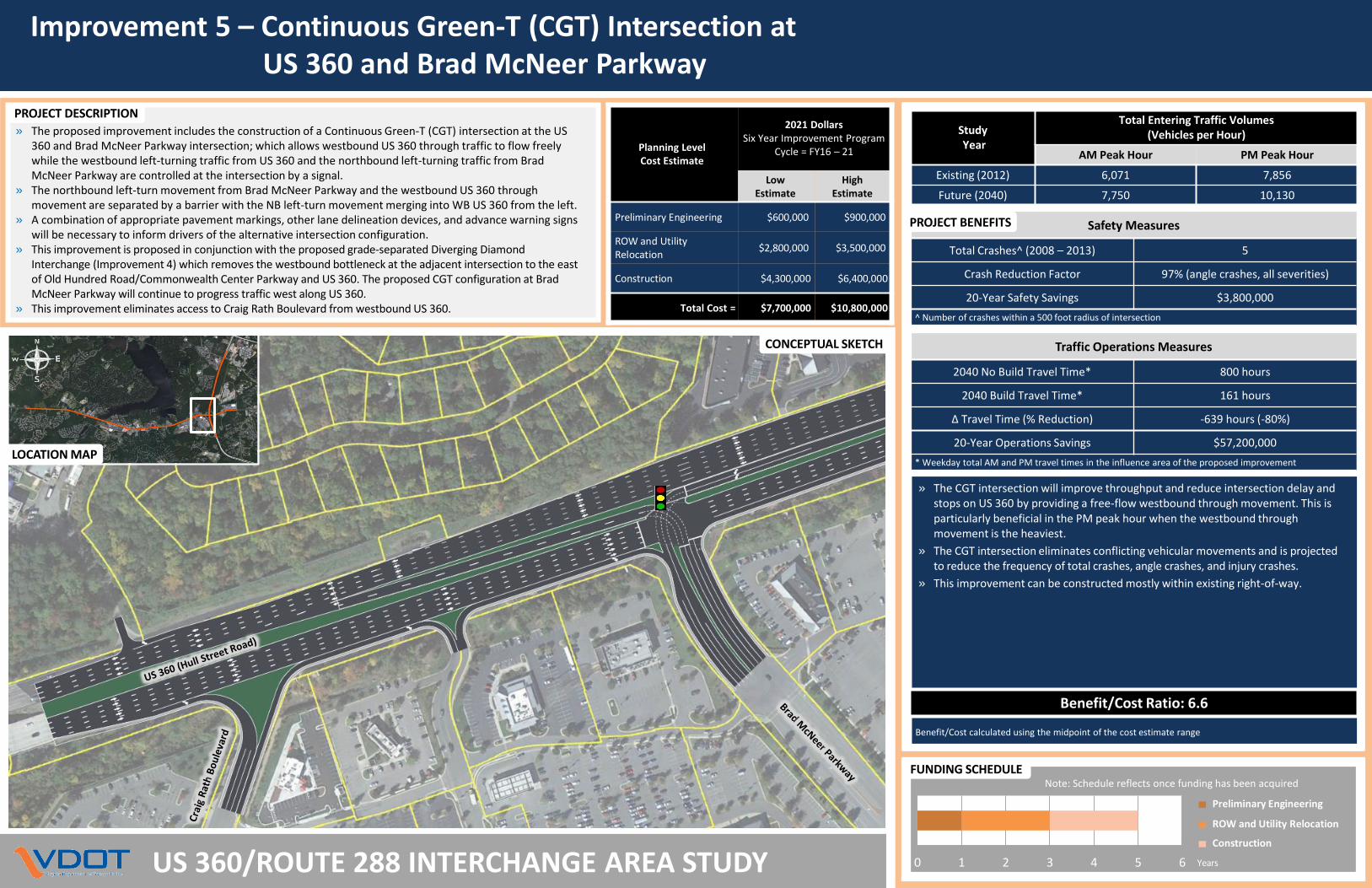
» The proposed improvement includes the construction of a Continuous Green-T (CGT) intersection at the US 360 and Brad McNeer Parkway intersection; which allows westbound US 360 through traffic to flow freely while the westbound left-turning traffic from US 360 and the northbound left-turning traffic from Brad McNeer Parkway are controlled at the intersection by a signal.
» The northbound left-turn movement from Brad McNeer Parkway and the westbound US 360 through movement are separated by a barrier with the NB left-turn movement merging into WB US 360 from the left.
» A combination of appropriate pavement markings, other lane delineation devices, and advance warning signs will be necessary to inform drivers of the alternative intersection configuration.
» This improvement is proposed in conjunction with the proposed grade-separated Diverging Diamond Interchange (Improvement 4) which removes the westbound bottleneck at the adjacent intersection to the east of Old Hundred Road/Commonwealth Center Parkway and US 360. The proposed CGT configuration at Brad McNeer Parkway will continue to progress traffic west along US 360.
» This improvement eliminates access to Craig Rath Boulevard from westbound US 360.
Traffic Operations Measures
2040 No Build Travel Time* 800 hours
2040 Build Travel Time* 161 hours
Δ Travel Time (% Reduction) -639 hours (-80%)
20-Year Operations Savings $57,200,000
* Weekday total AM and PM travel times in the influence area of the proposed improvement
Safety Measures
Total Crashes^ (2008 – 2013) 5
Crash Reduction Factor 97% (angle crashes, all severities)
20-Year Safety Savings $3,800,000
^ Number of crashes within a 500 foot radius of intersection
» The CGT intersection will improve throughput and reduce intersection delay and stops on US 360 by providing a free-flow westbound through movement. This is particularly beneficial in the PM peak hour when the westbound through movement is the heaviest.
» The CGT intersection eliminates conflicting vehicular movements and is projected to reduce the frequency of total crashes, angle crashes, and injury crashes.
» This improvement can be constructed mostly within existing right-of-way.
PROJECT BENEFITS
Benefit/Cost Ratio: 6.6
Benefit/Cost calculated using the midpoint of the cost estimate range
CONCEPTUAL SKETCH
PROJECT DESCRIPTION
Planning LevelCost Estimate
2021 DollarsSix Year Improvement Program
Cycle = FY16 – 21
Low Estimate
HighEstimate
Preliminary Engineering $600,000 $900,000
ROW and UtilityRelocation
$2,800,000 $3,500,000
Construction $4,300,000 $6,400,000
Total Cost = $7,700,000 $10,800,000
StudyYear
Total Entering Traffic Volumes(Vehicles per Hour)
AM Peak Hour PM Peak Hour
Existing (2012) 6,071 7,856
Future (2040) 7,750 10,130
Preliminary Engineering
ROW and Utility Relocation
Construction
Years0 1 2 3 4 5 6
FUNDING SCHEDULENote: Schedule reflects once funding has been acquired
Concept 6 – Route 288 and US 360 Interchange ImprovementsConstruct SB CD Road, EB US 360 to NB Route 288 Directional Ramp, and Widen Route 288
US 360/ROUTE 288 INTERCHANGE AREA STUDY
Traffic Operations Measures
SB Route 288CD Road
EB US 360 toNB Route 288
On-Ramp
Widen Route 288from 4 to 6 Lanes
2040 No Build Travel Time* 1,448 hours 113 hours 2,473 hours
2040 Build Travel Time* 347 hours 45 hours 980 hours
Δ Travel Time(% Reduction)
-1101 hours(-76%)
-68 hours(-60%)
-1493 hours(-60%)
20-Year Operations Savings $95,600,000 $9,200,000 $135,300,000
* Weekday total AM and PM travel times in the influence area of the proposed improvements
Safety Measures
Total Crashes^ (2008 – 2013) 183
Crash Reduction Factor 31% (all crash types, all severities)
20-Year Safety Savings $45,300,000
^ Number of crashes within the influence area of the proposed improvement
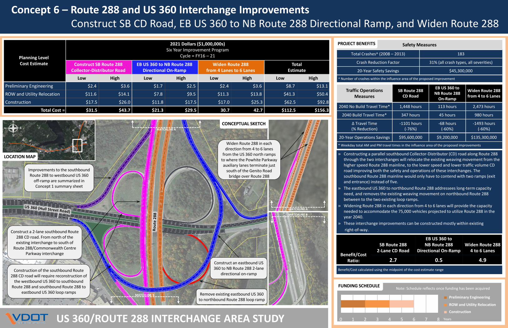
» Constructing a parallel southbound Collector-Distributor (CD) road along Route 288 through the two interchanges will relocate the existing weaving movement from the higher speed Route 288 mainline, to the lower speed and lower traffic volume CD road improving both the safety and operations of these interchanges. The southbound Route 288 mainline would only have to contend with two ramps (exit and entrance) instead of five.
» The eastbound US 360 to northbound Route 288 addressees long-term capacity need, and removes the existing weaving movement on northbound Route 288 between to the two existing loop ramps.
» Widening Route 288 in each direction from 4 to 6 lanes will provide the capacity needed to accommodate the 75,000 vehicles projected to utilize Route 288 in the year 2040.
» These interchange improvements can be constructed mostly within existing
right-of-way.
PROJECT BENEFITS
Benefit/Cost calculated using the midpoint of the cost estimate range
Planning LevelCost Estimate
2021 Dollars ($1,000,000s)Six Year Improvement Program
Cycle = FY16 – 21
Construct SB Route 288 Collector-Distributor Road
EB US 360 to NB Route 288Directional On-Ramp
Widen Route 288from 4 Lanes to 6 Lanes
Total Estimate
Low High Low High Low High Low High
Preliminary Engineering $2.4 $3.6 $1.7 $2.5 $2.4 $3.6 $8.7 $13.1
ROW and Utility Relocation $11.6 $14.1 $7.8 $9.5 $11.3 $13.8 $41.3 $50.4
Construction $17.5 $26.0 $11.8 $17.5 $17.0 $25.3 $62.5 $92.8
Total Cost = $31.5 $43.7 $21.3 $29.5 30.7 42.7 $112.5 $156.3
Preliminary Engineering
ROW and Utility Relocation
Construction
Years0 1 2 3 4 5 6 7 8
FUNDING SCHEDULE
Benefit/Cost Ratio:
SB Route 2882-Lane CD Road
EB US 360 toNB Route 288
Directional On-RampWiden Route 288
4 to 6 Lanes
2.7 0.5 4.9
Improvements to the southbound Route 288 to westbound US 360
off-ramp are summarized in Concept 1 summary sheet
LOCATION MAP
Construction of the southbound Route 288 CD road will require reconstruction of
the westbound US 360 to southbound Route 288 and southbound Route 288 to
eastbound US 360 loop ramps MATCHLINE B
MATCHLINE A
Remove existing eastbound US 360 to northbound Route 288 loop ramp
CONCEPTUAL SKETCH
Construct an eastbound US 360 to NB Route 288 2-lane
directional on-ramp
Construct a 2-lane southbound Route 288 CD road. From north of the existing interchange to south of
Route 288/Commonwealth Centre Parkway interchange
MATCHLINE A
MATCHLINE B
Widen Route 288 in each direction from 4 to 6 lanes
from the US 360 north ramps to where the Powhite Parkway auxiliary lanes terminate just
south of the Genito Road bridge over Route 288
Note: Schedule reflects once funding has been acquired

» The proposed improvements include modifying five existing intersections to a superstreet configuration to accommodate large future side street and US 360 traffic volumes.
» The superstreet configuration requires all side street traffic to turn right. Left-turn and through movements from the side street are required to make U-turns downstream at the signalized median crossovers.
» Expanded paved aprons or loons were assumed at the U-turn crossovers to provide additional space to facilitate larger turning paths of commercial vehicles.
Improvement 7 – Construct Five Superstreet Intersectionsalong US 360 Corridor
US 360/ROUTE 288 INTERCHANGE AREA STUDY
Traffic Operations Measures
2040 No Build Delay* 4,579 hours
2040 Build Delay* 838 hours
Δ Travel Time (% Reduction) -3,741 hours (-82%)
20-Year Operations Savings $333,300,000
* Weekday total AM and PM intersection delay
Safety Measures
Total Crashes^ (2008 – 2013) 101
Crash Reduction Factor 56% (all crash types, all severities)
20-Year Safety Savings $15,300,000
^ Number of crashes within a 500 foot radius of intersection
PROJECT BENEFITS
PROJECT DESCRIPTION
Planning LevelCost Estimate
2021 DollarsSix Year Improvement Program
Cycle = FY16 – 21
per Superstreet Total for 5 Superstreets
Low Estimate High Estimate Low Estimate High Estimate
Preliminary Engineering $600,000 $900,000 $3,100,000 $4,500,000
ROW and Utility Relocation $2,800,000 $3,500,000 $14,200,000 $17,400,000
Construction $4,300,000 $6,400,000 $21,700,000 $31,900,000
Total Cost = $7,700,000 $10,800,000 $39,000,000 $53,800,000
» The proposed superstreet corridor would improve throughput on US 360 west of Brad McNeer Parkway.
» The proposed configuration would improve progression on US 360 by allowing more green time and improve safety by reducing the number of conflict points.
» Economical solution to providing increased capacity and can be implemented with minimal impact to right-of-way and schedule.
LOCATION MAP
1
Superstreet #2: US 360 at N. Spring Run Road/Temie Lee Parkway Superstreet #3: US 360 at Chital Drive
Ch
ital
Superstreet #1: US 360 at Winterpock Road/Lake Harbour Drive
2 3 4 5
Superstreet #4: US 360 at Deer Run Drive/Harbour View Court
US 360 (Hull Street)
Harb
ou
r Vie
w
De
er R
un
Superstreet #5: US 360 at Mockingbird Lane/Harbour Pointe Parkway
US 360 (Hull Street)M
ockin
gbird
US 360 (Hull Street)
Benefit/Cost Ratio: 7.5
Benefit/Cost calculated using the midpoint of the cost estimate range
Preliminary Engineering
ROW and Utility Relocation
Construction
Years0 1 2 3 4 5 6
FUNDING SCHEDULENote: Schedule reflects once funding has been acquired