appendix d – geotechnical condition assessment …
TRANSCRIPT

The City of Winnipeg Appendix D RFP No. 180-2017 Template Version: SrC120161104 - Consulting Services RFP
APPENDIX D – GEOTECHNICAL CONDITION ASSESSMENT SEPTEMBER 1, 2016

c;OI!Il.SU~TJ:IIlCi
i CiXIIIRII·~
3rd Floor 865 Waverley Street Winnipeg, Manitoba R3T 5P4 204.896.1209 fax: 204.896.0754 www.kgsgroup.com
1Kontzamanis Graumann Smith MacMillan Inc.
September 1, 2016
City of Winnipeg Planning, Property and Development Unit 15 - 30 Fort Street Winnipeg, Manitoba ROC 4X5
ATTENTION: Mr. Kendall Thiessen, P.Eng. Riverbank Management Engineer
RE: Saint-Boniface River Trail along Tache Avenue
File No. 14-0107-003
Preliminary Field Investigations, Instrumentation and Monitoring Summary Geotechnical Report of Findings - Final
Dear Mr. Thiessen:
KGS Group is pleased to submit this letter report summarizing the geotechnical findings of the field investigations, instrumentation installation and monitoring completed along the east bank of the Red River between Esplanade Riel and Rue Despins in Winnipeg, Manitoba.
The proposed Saint-Boniface Rivertrail along Tache Avenue would effeCtively serve to provide a permanent connection between both existing and future key riverfront development opportunities. The currently envisioned trail includes features such as a monument, plaza area, and a tree top lookout, all located along the bank of the Red River. Conceptual sketches were prepared by Scatliff+Miller+Murray at the onset of the project and are attached as Appendix A. This preliminary riverbank stability and monitoring assessment is intended to update the stakeholders with respect to current riverbank stability conditions in order to better understand the present site opportunities and risks.
1.0 BACKGROUND INFORMATION
The site spans approximately 500 m along an outside bend on the east bank of the Red River between Esplanade Riel and Rue Despins where Tache Avenue extends along the top of bank and also acts as a City of Winnipeg Primary Dike.
• Records indicate that this section of riverbank has experienced historic riverbank instability and active shoreline erosion. Various riverbank stabilization and erosion protection works have been constructed along select sections over the last 50 years to slow the rate at which useable land was being lost and to protect critical infrastructure such as Tache Avenue. The locations of existing riverbank stability improvement works along with sections of riverbank that are currently unprotected are shown on Figure 01 and are summarized below.

Mr. Thiessen Page 2 KGS 14-0107-003 • Reach 1 – At the downstream extent of the site at Esplanade Riel, a riprap erosion
protection blanket and rockfill columns were constructed in 2001 along 150 m± of riverbank in conjunction with the Esplanade Riel project.
• Reach 2 – Upstream of Esplanade Riel and downstream of Ave De La Cathédrale, approximately 75 m of riverbank is unprotected.
• Reach 3 – Off the end of the Ave De La Cathédrale Right-of-Way, approximately 65 m of riverbank stability improvement works consisting of rockfill columns and a riprap blanket were constructed in 2009 to protect a City of Winnipeg outfall.
• Reach 4 – Along the shoreline at the Taché Dock structure a rockfill riprap blanket and toe berm were constructed along approximately 65 m of riverbank in 1983.
• Reach 5 – Immediately upstream of the Taché Dock riprap blanket and toe berm, approximately 25 m of riverbank is unprotected.
• Reach 6 – An approximately 145 m long retaining wall structure along Taché Avenue was constructed downstream of Rue Despins in the 1970’s. Mid bank offloading and shoreline rockfill riprap erosion protection works were completed at that time. These works were completed following a large slope failure that encroached onto Taché Avenue.
Lower bank rockfill columns were subsequently installed in 1999 along the shoreline parallel to the Taché Avenue retaining wall structure. Based on Waterway Permit No. 120/1999, it is known that fifty-five (55) 3.01 m diameter rockfill columns were installed in two (2) rows and spaced 5 m on center along approximately 145 m of the lower riverbank. City of Winnipeg records also indicate that additional riprap erosion protection (i.e. approx. 330 m3 at 0.3 m± thick) was placed along the shoreline area in 1999 in conjunction with the construction of rockfill columns. It is also understood that maintenance and upgrades to the retaining wall were completed by the City of Winnipeg over the years.
• Reach 7 – Adjacent to Rue Despins, approximately 45 m of riverbank stability improvement works consisting of rockfill columns and a riprap blanket were constructed in 2009 to protect a City of Winnipeg Flood Pumping Station.
This section of riverbank is located within the Floodway and Floodway Fringe Area such that any new development along the bank would be governed by Manitoba Regulation 266/91 and the City of Winnipeg Charter. No development is allowed within the “Floodway Zone”, the area between the Floodway Line and the Red River as shown on the attached City of Winnipeg FPL map provided in Appendix B and as shown on Figure 01. The Flood Protection Level (FPL) varies from EL. 230.34 m to 230.49 m between the downstream and upstream limits of the site, respectively. 2.0 INVESTIGATION PROGRAM KGS Group completed the field investigations component of this assignment in March through April, 2014 prior to the spring freshet. It was key that monitoring data be collected both pre flood and post flood drawdown because that is often when bank stability is at its most critical. The resulting monitoring data is most valuable with respect to the planning of any future works along this section of riverbank.
Mr. Thiessen Page 3 KGS 14-0107-003 As part of the investigation program, KGS Group installed and monitored new instrumentation along Reaches 2, 5 and 6, and monitored previously installed instrumentation at the Cathédrale Outfall (Reach 3) and Despins Flood Pumping Station (Reach 7) sites. No functioning instrumentation is known to exist along Reach 1 or 4. Both new and previously installed instrumentation locations are shown on Figure 01. Each new test hole was advanced to power auger refusal in the underlying till. Soil sampling, classification and instrumentation installation was completed to identify subsurface soils, and to monitor in-situ piezometric elevations and measure potential riverbank movements. All drilling activities and instrumentation installation works were completed under the direct supervision of KGS Group personnel with drilling services provided by Paddock Drilling. In each test hole, one (1) slope inclinometer was installed to monitor potential bank movements and pneumatic piezometers were installed in both the clay and till strata to monitor piezometric pressures in the bank. Diagnostic laboratory testing was performed on select soil samples to determine the relevant engineering properties, including moisture content, Atterberg Limit tests, and grain size analyses. Laboratory testing was completed at an accredited laboratory. Riverbank instrumentation (i.e. new and existing) has been monitored regularly since installation (2014) including pre and post spring and fall drawdown events with the most recent readings collected in June 2016. 3.0 INVESTIGATION RESULTS KGS Group’s interpretation of riverbank geometry and stratigraphy is outlined below and is based on 2011 LiDAR data provided by the City of Winnipeg, and the geotechnical drilling, instrumentation and monitoring program completed by KGS Group. 3.1 RIVERBANK GEOMETRY The current riverbank geometry along this outside bend varies and has been interpreted based on 2011 LiDAR data. Bathymetric survey data was not available at the time this report was prepared and therefore the current river channel geometry below the Regulated Summer River Level (RSRL, EL. 223.7 m) is not known. The locations of individual reaches of bank are shown on Figure 01. Reach 2 - 75 m± unprotected section of bank – The top of bank area along Taché Avenue is relatively flat at approximate EL. 231.0 m±. From the edge of top of bank at the Taché Avenue sidewalk, the riverbank slopes relatively consistently at a 4.4H:1V slope over 35 m to the Regulated Summer River Level (RSRL) at EL. 223.7 m±. Reach 5 - 25 m± unprotected section of bank – The top of bank area along Taché Avenue is relatively flat at EL. 230.5 m±. From the edge of top of bank at the Taché Avenue sidewalk, the riverbank slopes down at approximately a 5.5H:1V slope over 30 m to EL. 225.0 m±. From here, the bank then slopes down at approximately 3H:1V to the RSRL at EL. 223.7 m. Reach 6 - 145 m± section of bank with rockfill columns and riprap blanket – The top of bank area along Taché Avenue is relatively flat at approximate EL. 230.5 m. Along the edge of the Taché Avenue sidewalk there is a vertical retaining wall structure. The base of the wall is at EL. 227.0 m±. It is KGS Group’s understanding that the base elevation of the structure is

Mr. Thiessen Page 4 KGS 14-0107-003 consistent with that of the current mid bank bench that was offloaded in the 1970s. From here, the bank is relatively flat over a distance of 20 m±, and gradually slopes down to EL. 226.0 m± near the Ordinary High Water Mark (OHWM). Below the OHWM the riverbank is unprotected and over steepened with a slope of approximately 2.5H:1V down to EL. 224.0 m±. From there, the lower bank gently slopes at 6H:1V to the RSRL. 3.2 STRATIGRAPHY KGS Group`s 2014 drilling program consisted of a total of five (5) test holes with one (TH14-05) in Reach 2, two (TH14-03 and TH14-04) in Reach 5, and two (TH14-01 and TH14-02) in Reach 6. Based on the geotechnical drilling, sampling and lab testing program the stratigraphy along each reach is interpreted below. KGS Group test hole logs are provided in Appendix C. 3.2.1 Reach 2 – 75 m± Unprotected Section of Bank In general, the stratigraphy is interpreted to consist of clay fill overlying silty clay of lacustrine origin, clay till and silt till. The ground surface at TH14-05 is at approximate EL. 227.85 m±. Clay Fill – Clay fill was encountered at ground surface and extended to a depth of 1.5 m±. The clay fill was brown in colour, damp, of intermediate plasticity, and contained trace fine grained gravel and trace coarse grained sand. The undrained shear strength, determined by a field Torvane, ranged from 50 to 70 kPa with an overall average of 60 kPa. The moisture content of the clay fill was 33% at a depth of 1.2 m±. Lacustrine Silty Clay (CH) – Underlying the clay fill was a 11.0 m± thick deposit of lacustrine silty clay extending to an elevation of EL. 216.9 m±. The silty clay was mottled brown and grey to grey in colour, moist, firm to stiff, of high plasticity, and contained trace silt nodules and trace oxidation. Atterberg Limit testing on a sample from a depth of 4.4 m± measured a Liquid Limit of 87% and a Plasticity Index of 61%. When measured from a sample at the 7.5 m depth, a Liquid Limit of 84% and a Plasticity Index of 61% was measured resulting in a classification of this material as CH. Undrained shear strengths generally decreased with depth and ranged between 12 and 70 kPa. Moisture contents within the clay generally increased with depth and ranged from 46 to 58% with an average of 49%. Clay Till – Clay till was encountered below the lacustrine silty clay and extended to EL. 216.1 m±. The clay till was greyish tan in colour, moist to wet, and contained some fine to coarse grained gravel, trace fine grained gravel and some silt. Silt Till – Silt till was encountered underlying the clay till and extended to power auger refusal at EL. 215.5 m±. The silt till was tan in colour, moist to damp, compact, with fine grained gravel, with medium to coarse grained sand, and trace coarse grained gravel. A Standard Penetration Test (SPT) performed in the silt till recorded uncorrected number of blows (N) of 10 over 0.30 m. 3.2.2 Reach 5 – 25 m± Unprotected Section of Bank In general, the stratigraphy is interpreted to consist of silty clay of lacustrine origin overlying clay till and silt till. At the upper / mid bank area (TH14-03), clayey silt fill was encountered overlying the lacustrine silty clay while in the mid / lower bank area (TH14-04), topsoil and clayey silt were encountered overlying the lacustrine silty clay. Clayey Silt Fill – Clayey silt fill was encountered at the upper / mid bank area from ground surface to a depth of 1.5 m±. The clayey silt fill was brownish tan in colour, moist, stiff, and of

Mr. Thiessen Page 5 KGS 14-0107-003 low to intermediate plasticity. The undrained shear strength of the fill, from the Field Torvane, was 65 kPa. Topsoil – Topsoil was encountered at the mid / lower bank area from ground surface to a depth of 0.6 m±. The topsoil was black, damp, and contained trace fine grained gravel and trace cobbles. Clayey Silt (ML) – An approximately 0.3 m thick layer of clayey silt was encountered in the mid /lower bank area directly below the topsoil and extended to a depth of 0.9 m±. The clayey silt was tan in colour, damp to moist, crumbly, of low plasticity, and contained trace amounts of clay. Lacustrine Silty Clay (CH) – Underlying the clayey silt fill at the upper / mid bank area and the clayey silt deposit at the mid / lower bank area was silty clay of lacustrine origin extending to EL. 215.1 m± to 216.1 m±. The silty clay was brown to grey in colour, moist, firm to stiff in consistency, of high plasticity, and contained trace silt nodules, trace gypsum and trace oxidation. Atterberg Limit testing on a sample from EL. 223.7 m± measured a Liquid Limit of 93% and a Plasticity Index of 67%. When measured from a sample at EL. 217.6 m± , a Liquid Limit of 75% and a Plasticity Index of 55% was measured classifying this material as CH. Undrained shear strengths estimated by the Field Torvane decreased with depth and ranged between 5 and 60 kPa. Moisture content within the clay generally increased with depth and ranged from 34 to 62% with an average of 47%. Clay Till – Clay till was encountered beneath the lacustrine silty clay and extended to EL. 214.6 m± to 215.5 m±. The clay till was greyish tan in colour, moist to wet, soft to very soft, of low to intermediate plasticity and contained varying amounts of silt, sand and gravel. Silt Till – Silt till was encountered below the clay till and extended to power auger refusal at EL. 213.7 m± to 214.0 m±. The silt till was tan in colour, moist, dense to very dense, and contained varying amounts of sand and gravel. A Standard Penetration Test (SPT) performed in the silt till reached refusal with an uncorrected blow counts (N) of greater than 50 over 0.30 m. 3.2.3 Reach 6 – 145 m± Section of Bank with Rockfill Columns and Riprap Blanket In general, the stratigraphy is interpreted to consist of silty clay of alluvial or flood plain origin overlying a thin clayey silt layer, lacustrine silty clay, clay till and silt till. At the upper mid bank area (TH14-02), clay fill and clayey sand with gravel was encountered overlying the alluvial silty clay. Clay Fill – Clay fill was encountered at the upper mid bank area and extended from ground surface to a depth of 1.8 m±. The clay fill was brown and black in colour, damp to moist, stiff, of intermediate plasticity, and contained trace organics and trace fine grained gravel. The undrained shear strength as estimated by one test with the Field Torvane was 85 kPa. Clayey Sand with Gravel (SC) – Clayey sand with gravel was encountered at the upper mid bank area and extended to a depth of 4.7 m± . The clayey sand with gravel was black in colour, moist to wet, and loose. The moisture content was 34% at 4.6 m± depth. Alluvial Silty Clay (CH) – Silty clay of alluvial origin was encountered from ground surface at the lower mid bank area and beneath the clayey sand with gravel in the upper mid bank area. The alluvial silty clay extended to EL. 219.3 m± to 220.9 m±. The alluvial silty clay was brown to grey in colour, damp to moist, firm to stiff, of high plasticity, and contained trace organics and
Mr. Thiessen Page 6 KGS 14-0107-003 trace sand. Atterberg Limit testing on a sample from EL. 220.5 m± (TH14-01) measured a Liquid Limit of 76% and a Plasticity Index of 52%, resulting in a material classification as CH. Undrained shear strengths estimated by the Field Torvane decreased with depth and ranged between 46 and 90 kPa. Moisture contents within the alluvial silty clay generally did not vary with depth and ranged from 32% to 36% with an average of 34%. Silt (ML) / Clayey Silt (CL-CI) – A 0.5 m± thick layer of silt / clayey silt was encountered below the alluvial silty clay and extended to EL. 218.8 m± to 220.4 m±. The silt was tan to grey in colour, moist, firm, and of low to intermediate plasticity. Undrained shear strengths estimated by the Field Torvane range from 45 to 50 kPa. Moisture content within the clayey silt was 34%. Lacustrine Silty Clay (CH) – Underlying the silt / clayey silt layer was a deposit of lacustrine silty clay extending to EL. 216.2 m± to 216.6 m±. The silty clay was brown to grey in colour, moist, firm to stiff, of high plasticity, and contained trace silt nodules. Atterberg Limit testing on a sample from EL. 218.2 m± measured a Liquid Limit of 75% and a Plasticity Index of 55%. Undrained shear strengths estimated by the Field Torvane decreased with depth and ranged between 30 and 50 kPa. Moisture content within the clay generally increased with depth and ranged from 52 to 58% with an average of 55%. Clay Till – Clay till was encountered below the lacustrine silty clay in TH14-02 and extended to EL. 215.7 m±. The clay till was grey in colour, moist to wet, firm, and contained some fine grained gravel and coarse grained sand. Silt Till – Silt till was encountered underlying the lacustrine silty clay in TH14-01 and the clay till in TH14-02 and extended to power auger refusal at EL. 215.1 m± to 215.4 m±. The silt till was grey to tan in colour, moist, compact to very dense, and contained varying amounts of sand and gravel. A Standard Penetration Test performed in the silt till in TH14-01 recorded uncorrected blows (N) of 26 over 0.30 m while uncorrected blow counts (N) of greater than 50 were recorded at Th14-02. 3.3 INSTRUMENTATION MONITORING 3.3.1 Pneumatic Piezometers In total, ten (10) pneumatic piezometers were installed in the clay and till strata to monitor piezometric pressures in the riverbank. Eight (8) piezometers were installed in the clay and two (2) piezometers were installed in the till. During the two year monitoring period, groundwater elevations ranged from EL. 223.45 m to 227.13 m in the clay and from EL. 222.54 m to 226.30 m in the till. Piezometric monitoring results from the 2014 to 2016 monitoring program are summarized on Table 1. Piezometers installed at the Despins Flood Pumping Station site in 2004 were monitored as part of this assignment. Based on monitoring data collected at the site between 2004 and 2016, groundwater elevations ranged between EL. 222.23 m and 225.75 m in the clay and between EL. 222.50 m and 225.86 m in the till. Piezometric monitoring results for the Despins Flood Pumping Station site are summarized on Table 2. Piezometers installed at the Cathédrale Outfall site in 2008 were also monitored as part of this assignment. Based on monitoring data collected at the site between 2008 and 2016, groundwater elevations ranged between EL. 226.35 m and 228.95 m in the clay and between EL. 224.38 m and 225.97 m in the till. Piezometric monitoring results for the Cathédrale Outfall site are summarized on Table 3.

Mr. Thiessen Page 7 KGS 14-0107-003 Based on data collected at all monitoring locations between Esplanade Riel and Rue Despins, there appears to generally exist a slight downward hydraulic gradient through the massive clay strata down to the till. It also appears based on monitoring data that till piezometric pressures respond to changing river levels such that an upward hydraulic gradient can occur at depth near the clay/till interface with rising river levels. 3.3.2 Slope Inclinometers In total, five (5) slope inclinometers were installed and monitored at Reach 2, 5 and 6. Slope inclinometer data was also collected at both the Cathédrale Outfall (Reach 3) and Despins Flood Pumping Station (Reach 7) sites. Slope inclinometers have been monitored regularly since installation including pre and post spring and fall drawdown events with the most recent readings collected in June 2016. Slope inclinometer plots are provided in Appendix D. Reach 2 – 75 m± unprotected section of bank – Based on mid bank monitoring data collected from TH14-05, approximately 62 mm of cumulative shear displacement has occurred at EL. 227 m± since installation in April 2014. A total of 18 mm and 44 mm of shear displacement occurred during years 1 and 2, respectively. This measured bank movement is relatively shallow and occurs along the clay fill / lacustrine clay interface at a depth of 1.5 m± below ground surface. Reach 3 – 65 m± section of bank with rockfill columns and riprap blanket (Cathédrale Outfall Site) – Based on mid bank monitoring data collected from SI-03 approximately 1 mm of cumulative shear displacement occurred at the site during the 2014/15monitoring period, occurring at EL. 218.0 m±. Another approximately 3 mm of cumulative shear displacement occurred at the site during the 2015/2016 monitoring period at the same elevation. This measured bank movement is relatively deep and occurs well above the till interface in the clay at a depth of 6.8 m± below ground surface. Reach 5 – 25 m± unprotected section of bank – Based on mid bank monitoring data collected from TH14-04, approximately 24 mm of cumulative shear displacement has occurred since installation in April 2014 at EL. 227.0 m±. A total of 5 mm and 19 mm of shear displacement occurred during years 1 and 2, respectively. This measured bank movement is relatively shallow and occurs within a relatively thin (0.5 m±) layer of clayey silt at a depth of 0.7 m± below ground surface. Based on upper bank monitoring data collected from TH14-03, no measureable upper bank movement has occurred since installation. Reach 6 – 145 m± section of bank with rockfill columns and riprap blanket – Based on upper mid bank monitoring data collected from TH14-02, approximately 9 mm of cumulative shear displacement has occurred since installation in April 2014 at EL. 221m±. A total of 2 mm and 7 mm of shear displacement occurred during years 1 and 2, respectively. This measured bank movement is relatively deep and occurs within a relatively thin (0.5 m±) layer of clayey silt at a depth of 5.9 m± below ground surface. Based on lower mid bank monitoring data collected from TH14-01, approximately 10 mm of cumulative shear displacement has occurred since installation at EL. 218.5 m±. A total of 3 mm and 7 mm of shear displacement occurred during years 1 and 2 respectively. This measured bank movement is similarly relatively deep and occurs directly beneath a relatively thin 0.5 m± thick layer of silt at a depth of 7.6 m± below ground surface.

Mr. Thiessen Page 8 KGS 14-0107-003 Reach 7 – 45 m± section of bank with rockfill columns and riprap blanket (Despins Flood Pumping Station Site) – Based on both upper and mid bank monitoring data collected from SI-03 and SI09-01, respectively, no measureable shear movement occurred at the site during the two years monitoring period . However, some rotational or overturning types of movements were recorded near the ground surface. 4.0 DISCUSSION Currently, some rockfill riprap shoreline erosion protection exists along a majority of the 500 m± long section of the east riverbank between Esplanade Riel and Rue Despins with only 100 m± of riverbank currently unprotected against erosion (Reach 2 and 5). Recently collected slope inclinometer data serves to confirm that riverbank movement along those unprotected sections of bank is occurring at a higher rate and magnitude in comparison to those protected by either mechanical bank stabilization and / or shoreline erosion protection works. In the 1970’s, a nominal amount of riprap was installed along 145 m± of shoreline (Reach 6) to protect against erosion in conjunction with the construction of the retaining wall along Taché Avenue. At that time, riprap was placed between the summer and winter river levels. City of Winnipeg records indicate that additional riprap consisting of approximately 330 cubic metres at 0.3 m± thickness was placed along the shoreline in 1999. Today, a typical riprap blanket extends between the Ordinary High Water Mark (OHWM) located above the summer river level and extends, on average, 10 m plus below the winter river level into the channel. Given that shoreline erosion is the underlying driving mechanism for bank instability along this section of riverbank, the installation of a continuous rockfill riprap blanket should be considered to slow the rate at which useable land is currently being lost. This would require installing rockfill riprap erosion protection along the 100 m± long section of riverbank that is currently unprotected (Reach 2 and 5) and upgrading the existing 145 m± long rockfill riprap blanket constructed in the 1970’s and topped up in 1999 (Reach 6). Historically, this riverbank has been subject to bank instabilities and failures. In fact in 1970/71 those failures extended back onto Taché Avenue reducing it to a single lane street, i.e. this bank has failed in the past and has failed all the way behind Taché Avenue. Subsequent to the 1970/71 failures, Taché Avenue was rebuilt and every other section except for Reach 2 and Reach 5 of the riverbank from Rue Despins to the Provencher Bridge has since been protected by riprap and / or shear key except for the two sections of bank approximately 100 m± long in total. Any works must be preceded by appropriate erosion control and/or bank stabilization works. The construction of a riverbank development project valued in the order of $1M plus, typically requires that the riverbank be protected to achieve a minimum Factor of Safety (FS) of 1.3 under normal conditions, which here requires a 30% increase to existing bank stability. Other projects completed to those same minimum design criteria include, but are not limited to, Esplanade Riel / Provencher Bridge (FS of 1.5), Waterfront Drive (FS of 1.5), CARRAC docks (FS of 1.5), Alexander Dock reconstruction (FS of 1.5), and the Assiniboine Riverwalk where every structure along the Riverwalk is supported by significant bank stabilization works. For this project, if it is a requirement to build along an unprotected section of bank, the necessary bank stability for critical structures would be achieved by constructing a riprap blanket to control erosion and by constructing rockfill columns to reinforce or strengthen the bank. The estimated construction cost for both riprap erosion protection and mechanical bank stabilization is estimated to be approximately $10k to $12.5k per linear meter of bank protected.

Mr. Thiessen Page 9 KGS 14-0107-003 If this level of bank stabilization funding is not available, there are options: • Move critical structure works onto any other section of this riverbank where the requisite
bank works have already been completed. • Go to a lower level of development such as an at-grade pathway and viewing area; a
project where some bank movement can be tolerated and where ongoing maintenance is anticipated. This scope of project would still require shoreline erosion protection to reduce the risk of catastrophic failure. The estimated construction cost is approximately $1.5k to $2.5k per lineal meter of shoreline protected.
• Obtain alternate funding sources for the bank stabilization works. Taché Avenue also acts as City of Winnipeg Primary Dike and this section of dike does not currently meet City of Winnipeg design stability criteria for a Primary Dike (minimum FS of 1.5) along the full length of the site between Esplanade Riel and Rue Despins. Stabilization of the bank would also ensure that this section of riverbank is closer to the City of Winnipeg design criteria for the Primary Dike.
5.0 CONCLUSIONS Based on our assessment of the preliminary geotechnical findings, the following conclusions are made: • This section of riverbank has experienced historic riverbank instability and active
shoreline erosion. Various riverbank stabilization and erosion protection works have been constructed along some sections over the last 50 years to slow the rate at which useable land was being lost. Recently collected slope inclinometer data serves to confirm that riverbank movement along unprotected sections of the bank is occurring at a higher rate and magnitude than those protected by either mechanical bank stabilization and / or shoreline erosion protection works.
• This section of riverbank is within the Floodway and Floodway Fringe Area such that any new development along the bank would be governed by Manitoba Regulation 266/91 and the City of Winnipeg Charter. No development is allowed within the “Floodway Zone”, the area between the Floodway Line and the Red River. The Flood Protection Level (FPL) varies from EL. 230.34 m to 230.49 m between the downstream and upstream limits of the site, respectively.
• Reach 2 - 75 m± unprotected section of bank – Based on mid bank monitoring data, approximately 62 mm of cumulative shear displacement has occurred at approximate elevation of 227 m since instrument installation in April 2014. A total of 18 mm and 44 mm of shear displacement occurred during years 1 and 2, respectively. These measured bank movements are relatively shallow and occurs along an interface 1.5 m± below ground surface. If left unprotected, ongoing and retrogressive bank movement is likely to occur with time and could impact existing and / or proposed infrastructure along the riverbank.
• Reach 3 - 65 m± section of bank with rockfill columns and riprap blanket (Cathédrale Outfall Site) – Based on mid bank monitoring data collected from SI-03, approximately 1 mm of cumulative shear displacement occurred at El. 218.0 over the 2014/2015 monitoring period. Another approximately 3 mm of cumulative shear displacement occurred at the site during the 2015/2016 monitoring period. These measured bank movements are relatively deep and occur well above the till interface in
Mr. Thiessen Page 10 KGS 14-0107-003
the clay at a depth of 6.8 m± below ground surface. Although the measured movement is nominal during this monitoring period, ongoing bank movement may impact existing and / or proposed infrastructure along the riverbank.
• Reach 5 - 25 m± unprotected section of bank – Based on mid bank monitoring data, approximately 24 mm of cumulative shear displacement has occurred since instrument installation in April 2014. A total of 5 mm and 19 mm of shear displacement occurred during years 1 and 2, respectively. These measured bank movements are relatively shallow and occur within a thin layer of clayey silt 0.7 m± below ground surface. No measureable upper bank movement has occurred since installation based on upper bank monitoring data collected from TH14-03. If left unprotected, ongoing and retrogressive bank movement is likely to occur with time and could impact existing and / or proposed infrastructure along the riverbank.
• Reach 6 - 145 m± section of bank with rockfill columns and riprap blanket – Based on upper mid bank data collected from TH14-02, approximately 9 mm of cumulative shear displacement has occurred over the monitoring period since April 2014. A total of 2 mm and 7 mm of shear displacement occurred during years 1 and 2, respectively. These measured bank movements are relatively deep and occur within a thin layer of clayey silt 5.9 m± below ground surface. Based on lower mid bank data from TH14-01, approximately 10 mm of cumulative shear displacement has occurred since April 2014. A total of 3 mm and 7 mm of shear displacement occurred during years, 1 and 2, respectively. These movements are relatively deep and occurred directly beneath a layer of silt at a depth of 7.6 m± below ground surface. Although the measured movement is nominal during this monitoring period, ongoing bank movement may impact existing and / or proposed infrastructure along the riverbank.
• Reach 7 - 45 m± section of bank with rockfill columns and riprap blanket (Despins Flood Pumping Station Site) – Based on both upper and mid bank monitoring data collected from SI-03 and SI09-01, respectively, no measureable shear movement occurred at the site during the two year monitoring period.
• For this project along unprotected sections of riverbank, the necessary bank stability for critical structures (FS of 1.5) would be achieved by constructing a riprap blanket to control erosion and by constructing rockfill columns to reinforce or strengthen the bank.
6.0 RECOMMENDATIONS Based on our assessment of the preliminary geotechnical findings, the following recommendations are made: • Continue monitoring all existing riverbank instrumentation along the east bank of the
Red River between Esplanade Riel and Rue Despins. Instrumentation should be monitored a minimum of four (4) times per year both pre and post drawdown of the river in the fall and spring, respectively.
• Understanding that shoreline erosion is the underlying driving mechanism for bank instability, the installation of a rockfill riprap blanket which would serve to span between the OHWM and extend on average 10 m plus beyond the winter river level along the entire length of shoreline between Esplanade Riel and Rue Despins should be considered to slow the rate at which useable land is currently being lost. This would require installing rockfill riprap erosion protection along a 100 m± long section of

Mr. Thiessen Page 11 KGS 14-0107-003
currently unprotected bank and upgrading the existing 145m± long rockfill riprap blanket constructed in the 1970's and topped up in 1999.
• For this project where critical structures are proposed along the bank, a Factor of Safety (FS) of 1.5 using parameters representative of conservatively chosen "normal" conditions should be considered as a target for areas where new structural elements are to be constructed along the riverbank. In areas where proposed developments are not considered structural (i.e. at grade paths) or where protecting existing infrastructure that is not exhibiting distress from bank movements, a FS of 1.3 (i.e. a 30% improvement over existing conditions where stability is marginal) would be acceptable. The necessary bank stability could be achieved by constructing a riprap blanket to control erosion and by constructing rockfill columns to reinforce or strengthen the bank.
• A separate assignment to complete a functional level design of suitable riverbank stability improvement alternatives and to provide stakeholders with sufficient detail (e.g. sketches, preliminary costs, etc.) specifically related to design alternatives suitable for this project that would allow stakeholders to select riverbank stability improvement works that best meet the project goals and considerations for moving forward.
7.0 STATEMENT OF LIMITATIONS AND CONDITIONS
7.1 THIRD PARTY USE OF REPORT
This report has been prepared for the City of Winnipeg and any use a third party makes of this report or any reliance on or decisions made based on it, are the responsibility of such third parties. KGS Group accepts no responsibility for damages, if any, suffered by any third party as a result of decisions made or actions undertaken based on this report.
7.2 GEOTECHNICAL INVESTIGATION STATEMENT OF LIMITATIONS
The geotechnical investigation findings and recommendations of this report were prepared in accordance with generally accepted professional engineering principles and practice. The findings and recommendations are based on the results of field and laboratory investigations, combined with an interpolation of soil and groundwater conditions found at and within the depth of the test holes drilled by KGS Group at this site. If conditions encountered during construction appear to be different from those shown by the test holes drilled by KGS Group or if the assumptions stated herein are not in keeping with the design, this office should be notified in order that the recommendations can be reviewed and modified if necessary.
BPA/aa Attachments
Rob Kenyon, Ph.D., P.En Manager Geotechnical Services

City of Winnipeg Saint-Boniface River Trail September2016 Preliminary Field Investigations, Instrumentation and Monitoring – Final KGS 14-0107-003
TABLES

226.12 226.12 226.39 226.39 229.87 229.87 227.72 227.72 227.85 227.85
35734 35726 35739 35723 35725 35722 35735 35736 35727 35738
Top of Pipe Elevation (m):
219.41 215.45 221.82 217.25 220.73 217.68 223.15 218.88 215.66 221.45
Clay Clay Till Clay Clay Clay Clay Clay Clay Till Clay
Date River Level (m)(1)
04-Apr-14 222.45 223.99 224.23 223.87 224.10 225.24 225.02 223.72 223.45 Note (2) Note (2)
08-Apr-14 222.35 222.54 226.04
12-May-14 226.36 226.50 225.82 225.32 225.43 226.25 225.79 225.16 224.66 Note (4) 226.75
26-Jun-14 226.57 Note (3) Note (3) 225.17 225.71 226.18 225.65 225.16 224.66 Note (4) Note (4)
16-Jul-14 226.05 226.64 225.96
01-Aug-14 225.29 225.72 225.54 225.39 225.36 225.96 225.51 224.80 224.37 Note (4) Note (4)
30-Sep-14 223.71 224.71 224.64 225.03 225.08 225.82 225.30 224.94 224.23 Note (4) Note (4)
17-Dec-14 222.79 224.86 224.92 224.95 226.41 225.82 226.21 224.44 224.37 Note (4) Note (4)
21-May-15 226.07 226.51 225.61 224.88 225.15 226.33 225.65 224.94 224.16 226.30 226.04
07-Aug-15 223.72 225.14 224.50 Note (4) 224.94 225.96 225.44 224.80 224.23 225.31 Note (4)
29-Sep-15 223.69 224.35 224.23 224.66 226.25 225.44
06-Nov-15 222.30 224.45 224.87 223.87 224.67 226.75
11-Dec-15 222.34 224.35 224.50 224.52 224.94 226.04 225.16 224.73 223.80 224.31 Note (4)
05-Apr-16 223.67 225.43 225.13 224.95 225.29 227.13 226.14 225.16 224.30 225.59 225.40
01-Jun-16 224.05 225.00 224.78 224.74 225.08 227.13 226.28 225.52 224.09 225.02 226.32
Notes.(1). River level measured at James Ave pumping station(2). Installation had not been completed by this date(3). Casing below water level(4). Erroneous reading
Piezometric Elevation (m)
TH14-01 TH14-02Test Hole:
Ground Elevation (m):
Piezometer No.:
Monitoring Zone:
Tip Elevation (m):
TABLE 1PIEZOMETRIC MONITORING RESULTS
ST. BONIFACE RIVER TRAIL
TH14-05TH14-03 TH14-04
14-0107-003

TABLE 2PIEZOMETRIC MONITORING RESULTS
DESPINS PUMP STATION
StandpipeStandpipe
SP-2Piezometer
Pneumatic PN-3 29636
Pneumatic PN-4 29643
Ground Elev. (m) 226.95 Ground Elev. (m) 226.80 226.80
Stick Up Elev. (m) 227.86 Tip Elev. (m) 217.66 222.23
Strata Till Strata Lacustrine Silty ClayClay Fill / Lacustrine
Silty Clay
DateElevation
(m)Date
Elevation(m)
Elevation(m)
27-Oct-04 223.16 27-Oct-04 - 223.84 223.0831-Jan-05 223.71 31-Jan-05 223.14 223.99 222.2802-Jun-05 224.26 2-Jun-05 223.92 224.90 224.3317-Sep-05 222.50 17-Sep-05 223.99 223.92 223.7804-Apr-06 225.25 4-Apr-06 223.35 224.76 226.0323-Oct-06 223.96 23-Oct-06 223.99 222.65 221.7719-Dec-06 223.70 19-Dec-06 223.35 - 221.7728-Mar-07 224.31 28-Mar-07 223.78 222.23 -16-May-07 224.56 16-May-07 223.99 222.23 224.1804-Oct-07 224.23 4-Oct-07 224.48 222.51 223.7812-Nov-07 224.08 12-Nov-07 223.85 222.30 222.0613-Jun-08 224.54 13-Jun-08 224.27 222.30 224.1905-Nov-08 224.80 5-Nov-08 224.34 222.51 223.3313-Dec-08 225.01 13-Dec-08 224.06 222.37 223.0513-Jun-09 225.37 13-Jun-09 225.75 222.30 -07-Jan-10 224.38 7-Jan-10 224.34 222.37 -21-Mar-10 225.40 21-Mar-10 225.04 222.58 225.2828-Apr-10 225.62 28-Apr-10 224.97 222.37 224.5707-Jun-10 225.48 7-Jun-10 225.46 222.65 225.6830-Mar-11 225.36 30-Mar-11 224.76 222.30 224.1022-Oct-12 223.99 22-Oct-12 223.99 222.37 222.7226-Jun-14 225.86 26-Jun-14 225.61 222.58 226.5701-Aug-14 225.57 1-Aug-14 225.39 222.58 225.2901-Oct-14 225.02 1-Oct-14 224.69 222.30 223.7018-Dec-14 224.71 18-Dec-14 - 222.23 222.7821-May-15 225.68 21-May-15 225.04 222.44 226.0724-Aug-15 224.43 24-Aug-15 224.60 222.33 223.8411-Dec-15 224.55 11-Dec-15 223.50 - 222.3405-Apr-16 225.14 5-Apr-16 224.34 222.37 223.6701-Jun-16 224.95 1-Jun-16 224.27 222.58 224.05
Note:1. River levels are from the James Avenue Pumping Station (provided by the City of Winnipeg).2. "-" indicates instrument could not be read
River
Level (1)
(m)
Q:/Maria/SI/04-0107-12.500/Despins Piezo Table

TABLE 3PIEZOMETRIC MONITORING RESULTS
AVENUE DE LA CATHEDRALE
Ground Elevation (m) 229.00 229.00 229.00
Top of Pipe Elevation (m) 229.64
Piezometer No. STP-01 PN030867 PN030712
Tip Elevation (m) 213.38 218.33 220.16
Monitoring Zone Silt Till Silty Clay Silty Clay
Date River Level (m) (1)
13-Dec-08 223.05 224.72 226.98 226.49
13-Jun-09 - 225.48 227.83 226.98
07-Jan-10 - 224.62 226.84 226.35
31-Mar-10 227.26 225.71 228.95 227.19
28-Apr-10 224.57 225.82 228.18 227.26
07-Jun-10 225.68 225.43 228.53 227.62
30-Mar-11 224.10 225.51 228.39 227.69
22-Oct-11 222.72 224.38 227.54 226.77
20-May-14 226.09 225.97 227.54 Note (2)
26-Jun-14 226.57 225.72 227.83 227.19
01-Aug-14 225.29 225.61 227.90 227.19
01-Oct-14 223.70 225.36 227.90 227.19
17-Dec-14 222.79 225.04 228.88 -
21-May-15 226.07 225.45 227.97 227.19
24-Aug-15 223.84 224.80 227.97 227.19
11-Dec-15 222.34 225.00 227.83 226.91
05-Apr-16 223.67 225.47 228.11 227.19
01-Jun-16 224.05 225.31 228.04 227.62
1. River Level as measured at the James Avenue Pump Station Datum2. PN tip would not fit in readout box 3. "-" indicates instrument could not be read
Piezometric Elevation (m)
Q:\MARIA\SI\08-107-12_De La Cathedrale Outfall

City of Winnipeg Saint-Boniface River Trail September2016 Preliminary Field Investigations, Instrumentation and Monitoring – Final KGS 14-0107-003
FIGURE

APRIL 2015
ST. BONIFACE RIVERTRAIL
CLIENT
REVISIONS / ISSUEDESCRIPTIONYY/MM/DDNO. BY
FIELD INVESTIGATIONSSITE PLAN
FIGURE 01 0
E
<
<
A
<
<
A
<
<
A<
<
A
<
<
A
<
<
A<
<
A<
<
A
<
<
A
<
<
A
=
! A
=
! A
=
! A
=
! A
150 m± section of b
ank
w ith rock fill column
s and
riprap blank e t (2001
)
75 m± unprote c
ted
section of bank
65 m± section of
bank w ith rock fill
columns and ripra
p
blank e t (1999)
65 m± section of bank
w ith riprap blank e t
and be rm (1983)
25 m± unprote cte
dsection of b
ank
145 m± se ction of bank w ith rock fillcolumns (1999) and riprap blank e t (19
70’s)45 m± section
of bank w ith rock fill columns and riprap blank e t (1999)
Cathédrale
Outfall Site
T aché Dock
De spinsFlood PumpingStation Site
REACH 1
REACH 2REACH 3
REACH 4REACH 5
REACH 6 REACH 7
SP2SI-4
SI-3
PN-3,PN-4
ESPLANADE RIEL
PROVENCHER BRIDGE
PROVENCHER BLVD
RUE MASSON
AVE DE LA CATHÉDRALE
T ACHÉ AVE
RUE DESPINS
RED RIVER
T H14-01T H14-02T H14-03
T H14-04
T H14-05
T H08-01T H08-02T H08-03
T H09-01
T H09-02223
231
230
230
229226
224
231
227225
224
226
229
232
227
231
228
231 231
230
231
231
230
229230231
231
227227
228229
230
232231
232
232
230231
232
231
228228
229
231
232
231
233
231
231231
232
225
230
231 232
231
232
232
232
232
231
232
231
231
230
223
225
231
231
232
228
232
231
230
229
230
230
231
230
232
229
230Re taining Wall Structure
6346
00
6346
00
6348
00
6348
00
5527800
5527800
5528000
5528000
5528200
5528200
Taché Ave
Red R
iver
Assiniboine River
Provenche r
Blvd
Main StMarion StSt Marys Rd
Portage Av
PRELIMINARYNOT TO BE USED FOR CONSTRUCTION
20 0 20 40 60 80
Metres
©¯
FileNam
e: P
:\Proje
cts\20
14\1
4-01
07-0
03\D
wg\G
IS\M
XD\R
ev0\
14-0
107-
003_
Fig01_R
ev0.mxd
11"x17
' P
LOT SC
ALE
1:1
LEGEND:=
!
A Test Hole (KGS Group, 2004)
<
<
A Test Hole (KGS Group, 2008)
<
<A Test Hole (KGS Group, 2009)
<
<
A Test Hole (KGS Group, 2014)
Floodway Line
Retaining Wall Structure
1m Index LiDAR Contour
0.25m LiDAR Contour
Property Limits
REV:
Portions of d
ata
presented
are ow
ned
by the P
rovin
ce of Ma
nitoba a
nd a
re p
rodu
ced
under
the
licence a
greement with the P
rovin
ce o
f Ma
nitoba
2015
Queen's
Printer.
SCALE: METRIC 11"x17"1:2,000
0.5
Km
Notes:1. City of Winnipeg Colour Airphotos Captured in spring 2009.2. Property Limit Shown have been Provided by City of Winnipeg.3. LiDAR aquired in 2011 for the City of Winnipeg.4. All units are metric and in metres unless otherwise specified. Transverse Mercator Projection, NAD 1983, Zone 14. Elevations are in metres above sea level (MSL).
BPA15/04/270 ISSUED WITH FINAL REPORT

City of Winnipeg Saint-Boniface River Trail September2016 Preliminary Field Investigations, Instrumentation and Monitoring – Final KGS 14-0107-003
APPENDIX A
ST. BONIFACE RIVERTRAIL – CONCEPTUAL SKETCHES

TACHE PROMENADE: from Esplanade Riel to Rue Despins
Ave Taché
Esplanade Riel
Rue Despins St. Boniface Museum


• Expand the width of the Taché Promenade
• Create a multi-use pathway
• 2.5 km loop promoting healthy and active lifestyles
• Take advantage of spectacular views

Report Adopted and Approved by Council as
“A Guideline for Waterfront Development”

Pages on the St. Boniface & Forks Precinct from the report:
Go to the Waterfront

Taché Promenade Conceptual Master Plan

St. Boniface Museum
Taché Avenue
Plan View of the Tree Top Lookout
Lookout c/w Intrepretive Panels & Grey Nuns “Guiding Light” Sculpture
Bench,
Path Decking, Railing & Lighting

Perspective View: from the Tree Top Lookout toward Esplanade Riel and the Canadian Museum for Human Rights
City of Winnipeg Saint-Boniface River Trail September2016 Preliminary Field Investigations, Instrumentation and Monitoring – Final KGS 14-0107-003
APPENDIX B
CITY OF WINNIPEG FPL MAP
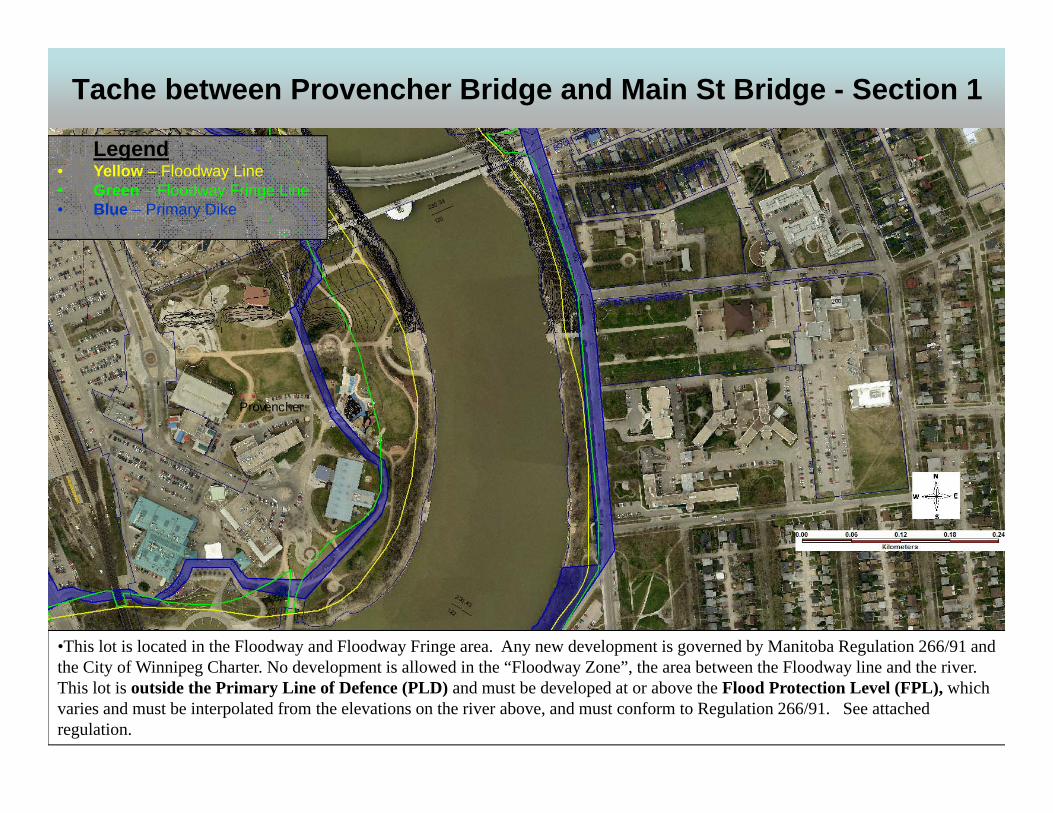
Tache between Provencher Bridge and Main St Bridge - Section 1
•This lot is located in the Floodway and Floodway Fringe area. Any new development is governed by Manitoba Regulation 266/91 andthe City of Winnipeg Charter. No development is allowed in the “Floodway Zone”, the area between the Floodway line and the river. This lot is outside the Primary Line of Defence (PLD) and must be developed at or above the Flood Protection Level (FPL), which varies and must be interpolated from the elevations on the river above, and must conform to Regulation 266/91. See attached regulation.
Legend• Yellow – Floodway Line• Green – Floodway Fringe Line • Blue – Primary Dike
Provencher

City of Winnipeg Saint-Boniface River Trail September2016 Preliminary Field Investigations, Instrumentation and Monitoring – Final KGS 14-0107-003
APPENDIX C
TEST HOLE LOGS

219.3
218.8
216.2
SILTY CLAY (CH) - Brown, damp, stiff, high plasticity, trace rootlets.
- No rootlets below 0.61 m.
- Increased silt content below 1.52 m.
- Blackish grey increasing moisture content, trace coarse grained sand,trace fine grained gravel below below 2.74 m.- No sand or gravel, blocky structure below 3.05 m.
- Grey, firm, not blocky below 3.96 m.
- Blocky below 4.57 m.
- Grain Size Distribution: Gravel (0.0%), Sand (1.7%), Silt (24.5%) &Clay (73.8%) at 5.49 m.
- Stiff below 6.10 m.
SILT (ML) - Tan, moist, firm, low plasticity.
LACUSTRINE SILTY CLAY (CH) - Brown, moist, stiff, high plasticity,trace silt nodules.
- Grey below 7.92 m.
- Firm below 8.38 m.
0.9
6.7
S1
S2
S3
S4
S5
S6
S7
PIE
Z. L
OG
LL
40
20
DE
PT
H (
m)
40
60
(m)
DE
PT
H
DYNAMIC CONE(N) blows/ft
Cu TORVANE (kPa)
40 60
Cu POCKET PEN (kPa)
SPT (N)blows/0.15 m
20(ft)
80
EL
EV
AT
ION
(m
)
%
RE
CO
VE
RY
%N
UM
BE
R
GR
AP
HIC
S
DESCRIPTION AND CLASSIFICATION
60 80SA
MP
LE
TY
PE
PL
20
MC
CITY OF WINNIPEG
PROJECT
LOCATION
TOP OF PVC ELEV.TACHE AVENUE
200 mm ø Hollow Stem Auger, ACKER SS Drill Rig
WATER ELEV.
N
SITE
E
MID BANK5,527,866
ST. BONIFACE RIVER TRAILCLIENT
DATE DRILLED
14-0107-003JOB NO.
DRILLINGMETHOD
UTM (m)
634,731
GROUND ELEV.
3/18/2014
226.12
Split SpoonSAMPLE TYPE
SHEET 1 of 2
5
10
15
20
25
30
Split Barrel
CONTRACTOR
226
225
224
223
222
221
220
219
218
217
INSPECTORC. FRIESEN
Auger Grab
DATE
REFERENCE NO.
B.P.ARPIN
SUMMARY LOG TH14-01HOLE NO.
APPROVED
1
2
3
4
5
6
7
8
9
Paddock Drilling Ltd.
GROUP
7/11/14
GE
OT
EC
HN
ICA
L-S
OIL
LO
G U
:\FM
S\1
4-01
07-0
03\S
T. B
ON
IFA
CE
RIV
ER
TR
AIL
LO
GS
.GP
J

215.4
SILT TILL - Light grey, moist, compact to dense, some medium tocoarse grained sand, trace fine to coarse grained gravel.
AUGER REFUSAL at 10.67 m
Notes:1. Drilled with solid stem auger from 0 to 1.52 m to prevent blockage inhollow stem.2. Installed two RST flow-through P-100 pneumatic piezometers - (PN 035734) at 6.71 m below grade - (PN 035726) at 10.67 m below grade3. Installed slope inclinometer at 10.67 m below grade with a 0.80 mstick up.4. Backfilled with bentonite cement grout from 10.67 m to 0.91 m belowgrade, then bentonite chips from 0.91 m to grade.5. Approximate bentonite-cement slurry mix (ratio by weight) - Water = 3.1 - 3.5 parts - Cement = 1.2 parts - Bentonite grout = 1 part
10.7
0
S8
PIE
Z. L
OG
LL
40
20
DE
PT
H (
m)
40
60
(m)
DE
PT
H
DYNAMIC CONE(N) blows/ft
Cu TORVANE (kPa)
40 60
Cu POCKET PEN (kPa)
SPT (N)blows/0.15 m
20(ft)
80
EL
EV
AT
ION
(m
)
%
RE
CO
VE
RY
%N
UM
BE
R
GR
AP
HIC
S
DESCRIPTION AND CLASSIFICATION
60 80SA
MP
LE
TY
PE
PL
20
MC
Split SpoonSAMPLE TYPE
SHEET 2 of 2
35
40
45
50
55
60
65
70
Split Barrel
CONTRACTOR
216
215
214
213
212
211
210
209
208
207
206
205
INSPECTORC. FRIESEN
Auger Grab
DATE
REFERENCE NO.
B.P.ARPIN
SUMMARY LOG TH14-01HOLE NO.
APPROVED
11
12
13
14
15
16
17
18
19
20
21
Paddock Drilling Ltd.
GROUP
7/11/14
GE
OT
EC
HN
ICA
L-S
OIL
LO
G U
:\FM
S\1
4-01
07-0
03\S
T. B
ON
IFA
CE
RIV
ER
TR
AIL
LO
GS
.GP
J
391412

224.6
221.7
220.9
220.4
216.6
CLAY FILL - Brown and black, damp to moist, intermediate plasticity,stiff, trace organics, trace fine grained gravel
- Trace roots (10 - 15 mm diameter) at 1.22 m.
CLAYEY SAND WITH GRAVEL (SC) - Black, moist to wet, loose,coarse grained sand, fine to coarse grained gravel, slight odour.
- Coarse grained gravel at 3.35 m.
- Grain Size Distribution: Gravel (16.7%), Sand (51.9%), Silt (18.1%) &Clay (13.3%) at 4.42 m.
SILTY CLAY (CH) - Grey and black, moist, firm, high plasticity, traceorganics, slight odour.
CLAYEY SILT (CL-CI) - Tan and grey, moist, low to intermediateplasticity, slight odour.
LACUSTRINE SILTY CLAY (CH) - Brown, moist, high plasticity, firm,trace silt nodules.- Grey below 6.10 m.
- Some to with silt below 8.69 m.
CLAY TILL - Grey, moist to wet, firm, some fine grained gravel and
1.8
4.6
9.1
S1
S2
S3
S4
S5
S6
S7
PIE
Z. L
OG
LL
40
20
DE
PT
H (
m)
40
60
(m)
DE
PT
H
DYNAMIC CONE(N) blows/ft
Cu TORVANE (kPa)
40 60
Cu POCKET PEN (kPa)
SPT (N)blows/0.15 m
20(ft)
80
EL
EV
AT
ION
(m
)
%
RE
CO
VE
RY
%N
UM
BE
R
GR
AP
HIC
S
DESCRIPTION AND CLASSIFICATION
60 80SA
MP
LE
TY
PE
PL
20
MC
CITY OF WINNIPEG
PROJECT
LOCATION
TOP OF PVC ELEV.TACHE AVENUE
200 mm ø Hollow Stem Auger, ACKER SS Drill Rig
WATER ELEV.
N
SITE
E
MID/UPPER BANK5,527,875
ST. BONIFACE RIVER TRAILCLIENT
DATE DRILLED
14-0107-003JOB NO.
DRILLINGMETHOD
UTM (m)
634,742
GROUND ELEV.
3/19/2014
226.39
SAMPLE TYPE
SHEET 1 of 2
5
10
15
20
25
30
Split Spoon
CONTRACTOR
226
225
224
223
222
221
220
219
218
217
INSPECTORS.REPA
Split Barrel
DATE
REFERENCE NO.
B.P.ARPIN
SUMMARY LOG TH14-02HOLE NO.
APPROVED
1
2
3
4
5
6
7
8
9
Paddock Drilling Ltd.
GROUP
7/11/14
GE
OT
EC
HN
ICA
L-S
OIL
LO
G U
:\FM
S\1
4-01
07-0
03\S
T. B
ON
IFA
CE
RIV
ER
TR
AIL
LO
GS
.GP
J

215.7
215.1
coarse grained sand.
SILT TILL - Tan, moist, dense to very dense, some to wih finegrained gravel and coarse grained sand
AUGER REFUSAL at 11.28 m
Notes:1. Installed two RST flow-through P-100 pneumatic piezometers - (PN 035739) at 4.57 m below grade - (PN 035723) at 9.14 m below grade2. Installed slope inclinometer at 11.28 m below grade with a 0.83 mstick up.3. Backfilled with bentonite cement grout from 11.28 m to 1.80 m belowgrade, then bentonite chips from 1.80 m to grade.4. Approximate bentonite-cement slurry mix (ratio by weight) - Water = 3.1 - 3.5 parts - Cement = 1.2 parts - Bentonite grout = 1 part5. No sample was obtained from 0 m to 4.57 m and stratigraphy isprojected from TH14-02A located 0.75 m North East.
11.322
S8
S9
S10
PIE
Z. L
OG
LL
40
20
DE
PT
H (
m)
40
60
(m)
DE
PT
H
DYNAMIC CONE(N) blows/ft
Cu TORVANE (kPa)
40 60
Cu POCKET PEN (kPa)
SPT (N)blows/0.15 m
20(ft)
80
EL
EV
AT
ION
(m
)
%
RE
CO
VE
RY
%N
UM
BE
R
GR
AP
HIC
S
DESCRIPTION AND CLASSIFICATION
60 80SA
MP
LE
TY
PE
PL
20
MC
SAMPLE TYPE
SHEET 2 of 2
35
40
45
50
55
60
65
70
Split Spoon
CONTRACTOR
216
215
214
213
212
211
210
209
208
207
206
205
INSPECTORS.REPA
Split Barrel
DATE
REFERENCE NO.
B.P.ARPIN
SUMMARY LOG TH14-02HOLE NO.
APPROVED
11
12
13
14
15
16
17
18
19
20
21
Paddock Drilling Ltd.
GROUP
7/11/14
GE
OT
EC
HN
ICA
L-S
OIL
LO
G U
:\FM
S\1
4-01
07-0
03\S
T. B
ON
IFA
CE
RIV
ER
TR
AIL
LO
GS
.GP
J
4350
* Refusal with 3 " left in 2nd set

224.6
221.8
CLAY FILL - Brown and black, damp to moist, intermediate plasticity,stiff, trace organics, trace fine grained gravel
- Trace roots (10 - 15 mm diameter) at 1.22 m.
CLAYEY SAND WITH GRAVEL (SC) - Black, moist to wet, loose,coarse grained sand, fine to coarse grained gravel, slight odour.
- Grain Size Distribution: Gravel (16.7%), Sand (51.9%), Silt (18.1%) &Clay (13.3%) at 4.42 m.
END TESTHOLE AT 4.57 M IN SILTY CLAY
Notes:1. Hollow stem auger refusal at 1.22 m in sand and gravel fill.2. Solid stem auger passes 1.22 m depth, end solid stem testhole at4.57 m3. Move testhole location 0.75 m NE, hollow stem refusal at 0.61 m.4. Move testhole location 0.75 m SW from original location. Refer toTH14-02 logs.5. Testhole backfilled with auger cuttings to grade.
4.6
S1
S2
S3
S4
PIE
Z. L
OG
LL
40
20
DE
PT
H (
m)
40
60
(m)
DE
PT
H
DYNAMIC CONE(N) blows/ft
Cu TORVANE (kPa)
40 60
Cu POCKET PEN (kPa)
SPT (N)blows/0.15 m
20(ft)
80
EL
EV
AT
ION
(m
)
%
RE
CO
VE
RY
%N
UM
BE
R
GR
AP
HIC
S
DESCRIPTION AND CLASSIFICATION
60 80SA
MP
LE
TY
PE
PL
20
MC
CITY OF WINNIPEG
PROJECT
LOCATION
TOP OF PVC ELEV.TACHE AVENUE
125 mm ø Solid Stem Auger, ACKER SS Drill Rig
WATER ELEV.
N
SITE
E
MID/UPPER BANK 0.75 M EAST OF TH14-025,527,875
ST. BONIFACE RIVER TRAILCLIENT
DATE DRILLED
14-0107-003JOB NO.
DRILLINGMETHOD
UTM (m)
634,743
GROUND ELEV.
3/18/2014
226.39
SAMPLE TYPE
SHEET 1 of 1
5
10
15
20
25
30
CONTRACTOR
226
225
224
223
222
221
220
219
218
217
INSPECTORS.REPA
Auger Grab
DATE
REFERENCE NO.
B.P.ARPIN
SUMMARY LOG TH14-02AHOLE NO.
APPROVED
1
2
3
4
5
6
7
8
9
Paddock Drilling Ltd.
GROUP
7/11/14
GE
OT
EC
HN
ICA
L-S
OIL
LO
G U
:\FM
S\1
4-01
07-0
03\S
T. B
ON
IFA
CE
RIV
ER
TR
AIL
LO
GS
.GP
J

228.3
CLAYEY SILT FILL - Brownish tan, moist, low to intermediateplasticity, stiff.
LACUSTRINE SILTY CLAY (CH) - Mottled grey and brown, moist,firm, high plasticity, trace gypsum and silt nodules
- Stiff below 2.80 m.
- Gypsum pockets at 3.65 m.
- Gypsum pockets at 4.26 m.
- Trace oxidation below 4.57 m.
- Grey, no gypsum nodules, no oxidation below 7.57 m.
- Firm below 8.69 m.
0.6
9.1
S1
S2
S3
S4
S5
S6
S7
S8
PIE
Z. L
OG
LL
40
20
DE
PT
H (
m)
40
60
(m)
DE
PT
H
DYNAMIC CONE(N) blows/ft
Cu TORVANE (kPa)
40 60
Cu POCKET PEN (kPa)
SPT (N)blows/0.15 m
20(ft)
80
EL
EV
AT
ION
(m
)
%
RE
CO
VE
RY
%N
UM
BE
R
GR
AP
HIC
S
DESCRIPTION AND CLASSIFICATION
60 80SA
MP
LE
TY
PE
PL
20
MC
CITY OF WINNIPEG
PROJECT
LOCATION
TOP OF PVC ELEV.TACHE AVENUE
200 mm ø Hollow Stem Auger, ACKER SS Drill Rig
WATER ELEV.
N
SITE
E
MID/UPPER BANK5,527,959
ST. BONIFACE RIVER TRAILCLIENT
DATE DRILLED
14-0107-003JOB NO.
DRILLINGMETHOD
UTM (m)
634,737
GROUND ELEV.
3/19/2014
229.87
Split SpoonSAMPLE TYPE
SHEET 1 of 2
5
10
15
20
25
30
Split Barrel
CONTRACTOR
229
228
227
226
225
224
223
222
221
220
INSPECTORS.REPA
Auger Grab
DATE
REFERENCE NO.
B.P.ARPIN
SUMMARY LOG TH14-03HOLE NO.
APPROVED
1
2
3
4
5
6
7
8
9
Paddock Drilling Ltd.
GROUP
7/11/14
GE
OT
EC
HN
ICA
L-S
OIL
LO
G U
:\FM
S\1
4-01
07-0
03\S
T. B
ON
IFA
CE
RIV
ER
TR
AIL
LO
GS
.GP
J

215.1
214.6
214.0
- Trace cobble (75 x 40 mm) at 10.67 m.- Trace fine grained gravel below 10.67 m.
- Trace coarse grained silty sand pocket (40 mm) at 11.58 m.
CLAY TILL - Greyish tan, moist to wet, low to intermediate plasticity,soft, with fine grained gravel and coarse grained sand, some silt.
SILT TILL - Tan, moist, dense to very dense, with fine grained graveland medium to coarse grained sand, trace coarse grained gravel.
AUGER REFUSAL at 15.85 m
Notes:1. Drilled with solid stem auger from 0 to 1.52 m to prevent blockage inhollow stem.2. Installed two RST flow-through P-100 pneumatic piezometers - (PN 035725) at 9.14 m below grade - (PN 035722) at 12.19 m below grade3. Installed slope inclinometer at 15.85 m below grade with a 0.76 mstick up.4. Backfilled with bentonite cement grout from 15.85 m to 0.61 m andbentonite chips from 0.61 m to grade.5. Approximate bentonite-cement slurry mix (ratio by weight) - Water = 3.1 - 3.5 parts - Cement = 1.2 parts - Bentonite grout = 1 part
12.2
15.833
S9
S10
S11
S12
S13
S14
PIE
Z. L
OG
LL
40
20
DE
PT
H (
m)
40
60
(m)
DE
PT
H
DYNAMIC CONE(N) blows/ft
Cu TORVANE (kPa)
40 60
Cu POCKET PEN (kPa)
SPT (N)blows/0.15 m
20(ft)
80
EL
EV
AT
ION
(m
)
%
RE
CO
VE
RY
%N
UM
BE
R
GR
AP
HIC
S
DESCRIPTION AND CLASSIFICATION
60 80SA
MP
LE
TY
PE
PL
20
MC
Split SpoonSAMPLE TYPE
SHEET 2 of 2
35
40
45
50
55
60
65
70
Split Barrel
CONTRACTOR
219
218
217
216
215
214
213
212
211
210
209
INSPECTORS.REPA
Auger Grab
DATE
REFERENCE NO.
B.P.ARPIN
SUMMARY LOG TH14-03HOLE NO.
APPROVED
11
12
13
14
15
16
17
18
19
20
21
Paddock Drilling Ltd.
GROUP
7/11/14
GE
OT
EC
HN
ICA
L-S
OIL
LO
G U
:\FM
S\1
4-01
07-0
03\S
T. B
ON
IFA
CE
RIV
ER
TR
AIL
LO
GS
.GP
J
50*Refusal with 4 " left in 1st set

227.1
226.8
TOPSOIL - Black, damp, trace organice clay, trace fine grainedgravel, trace cobbles.
CLAYEY SILT (ML) - Tan, damp to moist, crumbly, low plasticity,trace clay.
LACUSTRINE SILTY CLAY (CH) - Brown, moist, firm, intermediateto high plasticity, trace silt nodules.
- Trace oxidation below 3.05 m.
- Stiff below 4.42 m.- Grey, trace to some silt nodules, no oxidation below 4.57 m.
- Firm below 8.38 m.
- Trace to some silt nodules below 9.14 m.
0.9
4.6
8.8
S1
S2
S3
S4
S5
S6
S7
PIE
Z. L
OG
LL
40
20
DE
PT
H (
m)
40
60
(m)
DE
PT
H
DYNAMIC CONE(N) blows/ft
Cu TORVANE (kPa)
40 60
Cu POCKET PEN (kPa)
SPT (N)blows/0.15 m
20(ft)
80
EL
EV
AT
ION
(m
)
%
RE
CO
VE
RY
%N
UM
BE
R
GR
AP
HIC
S
DESCRIPTION AND CLASSIFICATION
60 80SA
MP
LE
TY
PE
PL
20
MC
CITY OF WINNIPEG
PROJECT
LOCATION
TOP OF PVC ELEV.TACHE AVENUE
125 mm ø Solid Stem Auger, ACKER SS Drill Rig
WATER ELEV.
N
SITE
E
MID BANK5,527,956
ST. BONIFACE RIVER TRAILCLIENT
DATE DRILLED
14-0107-003JOB NO.
DRILLINGMETHOD
UTM (m)
634,727
GROUND ELEV.
3/20/2014
227.72
SAMPLE TYPE
SHEET 1 of 2
5
10
15
20
25
30
Split Spoon
CONTRACTOR
227
226
225
224
223
222
221
220
219
218
INSPECTORS.REPA
Auger Grab
DATE
REFERENCE NO.
B.P.ARPIN
SUMMARY LOG TH14-04HOLE NO.
APPROVED
1
2
3
4
5
6
7
8
9
Paddock Drilling Ltd.
GROUP
7/11/14
GE
OT
EC
HN
ICA
L-S
OIL
LO
G U
:\FM
S\1
4-01
07-0
03\S
T. B
ON
IFA
CE
RIV
ER
TR
AIL
LO
GS
.GP
J

216.1
215.5
213.7
- Soft, some to with silt below 10.36 m.
- Very soft below 10.80 m.
CLAY TILL - Greyish tan, moist, very soft, low to intermediateplasticity, some fine grained gravel, some coarse grained sand, someto with silt.
SILT TILL - Tan, moist, dense to very dense, some to with finegrained gravel, some to with medium to coarse grained sand, tracecoarse grained gravel.
AUGER REFUSAL at 14.02 m
Notes:1. Installed two RST flow-through P-100 pneumatic piezometers - (PN 035735) at 4.57 m below grade - (PN 035736) at 8.84 m below grade2. Installed slope inclinometer at 12.80 m below grade with a 0.75 mstick up.3. Backfilled with bentonite cement grout from 14.02 m to 0.91 m andbentonite chips from 0.91 to grade.4. Approximate bentonite-cement slurry mix (ratio by weight) - Water = 3.1 - 3.5 parts - Cement = 1.2 parts - Bentonite grout = 1 part
12.8
14.0
44
S8
S9
S10
S11
PIE
Z. L
OG
LL
40
20
DE
PT
H (
m)
40
60
(m)
DE
PT
H
DYNAMIC CONE(N) blows/ft
Cu TORVANE (kPa)
40 60
Cu POCKET PEN (kPa)
SPT (N)blows/0.15 m
20(ft)
80
EL
EV
AT
ION
(m
)
%
RE
CO
VE
RY
%N
UM
BE
R
GR
AP
HIC
S
DESCRIPTION AND CLASSIFICATION
60 80SA
MP
LE
TY
PE
PL
20
MC
SAMPLE TYPE
SHEET 2 of 2
35
40
45
50
55
60
65
70
Split Spoon
CONTRACTOR
217
216
215
214
213
212
211
210
209
208
207
206
INSPECTORS.REPA
Auger Grab
DATE
REFERENCE NO.
B.P.ARPIN
SUMMARY LOG TH14-04HOLE NO.
APPROVED
11
12
13
14
15
16
17
18
19
20
21
Paddock Drilling Ltd.
GROUP
7/11/14
GE
OT
EC
HN
ICA
L-S
OIL
LO
G U
:\FM
S\1
4-01
07-0
03\S
T. B
ON
IFA
CE
RIV
ER
TR
AIL
LO
GS
.GP
J
245050
* Refusal with 3 " left in 3rd set

226.3
CLAY FILL - Brown, damp, stiff, crumbly, intermediate plasticity,trace fine grained gravel, trace coarse grained sand.
- Damp to moist below 0.91 m.
LACUSTRINE SILTY CLAY (CH) - Brown mottled with grey, moist,firm, high plasticity, trace silt nodules (1 - 3 mm), trace oxidation.
- Stiff, trace (1 -10 mm) silt nodules below 3.05 m.
- No oxidation below 4.11 m.- Grain Size Distribution: Gravel (0.3%), Sand (1.1%), Silt (27.7%) &Clay (70.9%) at 4.27 m.- Grey mottled with brown from 4.57 m to 5.03 m.
- Grey below 5.03 m.
- Firm below 5.64 m.
- Trace silt nodules (1 - 3 mm) below 6.10 m.
- Grain Size Distribution: Gravel (2.5%), Sand (5.7%), Silt (24.5%) &Clay (67.3%) at 7.32 m.
- Trace coarse grained sub rounded gravel (40 mm x 25 mm) at 9.45m.
6.4
S1
S2
S3
S4
S5
S6
PIE
Z. L
OG
LL
40
20
DE
PT
H (
m)
40
60
(m)
DE
PT
H
DYNAMIC CONE(N) blows/ft
Cu TORVANE (kPa)
40 60
Cu POCKET PEN (kPa)
SPT (N)blows/0.15 m
20(ft)
80
EL
EV
AT
ION
(m
)
%
RE
CO
VE
RY
%N
UM
BE
R
GR
AP
HIC
S
DESCRIPTION AND CLASSIFICATION
60 80SA
MP
LE
TY
PE
PL
20
MC
CITY OF WINNIPEG
PROJECT
LOCATION
TOP OF PVC ELEV.TACHE AVENUE
125 mm ø Solid Stem Auger, ACKER Track Mounted Rig
WATER ELEV.
N
SITE
E
MID BANK5,528,112
ST. BONIFACE RIVER TRAILCLIENT
DATE DRILLED
14-0107-003JOB NO.
DRILLINGMETHOD
UTM (m)
634,694
GROUND ELEV.
4/1/2014
227.85
SAMPLE TYPE
SHEET 1 of 2
5
10
15
20
25
30
Split Spoon
CONTRACTOR
227
226
225
224
223
222
221
220
219
218
INSPECTORS.REPA
Auger Grab
DATE
REFERENCE NO.
B.P.ARPIN
SUMMARY LOG TH14-05HOLE NO.
APPROVED
1
2
3
4
5
6
7
8
9
Paddock Drilling Ltd.
GROUP
7/11/14
GE
OT
EC
HN
ICA
L-S
OIL
LO
G U
:\FM
S\1
4-01
07-0
03\S
T. B
ON
IFA
CE
RIV
ER
TR
AIL
LO
GS
.GP
J

216.9
216.1
215.5
- Silt nodule diameter increases to (5 - 15 mm) below 10.06 m.
- Some silt below 10.67 m.
CLAY TILL - Greyish tan, moist to wet, some fine grained to coarsegrained gravel, trace fine grained gravel, some silt.
SILT TILL - Tan, moist to damp, compact, with fine grained gravel,with medium to coarse grained sand, trace coarse grained gravel.
AUGER REFUSAL at 12.40 m
Notes:1. Installed two RST flow-through P-100 pneumatic piezometers - (PN 035738) at 6.40 m below grade - (PN 035736) at 12.19 m below grade2. Installed slope inclinometer at 12.40 m below grade with a 0.84 mstick up.3. Backfilled with bentonite cement grout from 12.40 m to grade.4. Approximate bentonite-cement slurry mix (ratio by weight) - Water = 3 parts - Cement = 1 part - Bentonite grout = 1.1 parts
12.2
12.4
50
S7
S8
S9
S10
PIE
Z. L
OG
LL
40
20
DE
PT
H (
m)
40
60
(m)
DE
PT
H
DYNAMIC CONE(N) blows/ft
Cu TORVANE (kPa)
40 60
Cu POCKET PEN (kPa)
SPT (N)blows/0.15 m
20(ft)
80
EL
EV
AT
ION
(m
)
%
RE
CO
VE
RY
%N
UM
BE
R
GR
AP
HIC
S
DESCRIPTION AND CLASSIFICATION
60 80SA
MP
LE
TY
PE
PL
20
MC
SAMPLE TYPE
SHEET 2 of 2
35
40
45
50
55
60
65
70
Split Spoon
CONTRACTOR
217
216
215
214
213
212
211
210
209
208
207
INSPECTORS.REPA
Auger Grab
DATE
REFERENCE NO.
B.P.ARPIN
SUMMARY LOG TH14-05HOLE NO.
APPROVED
11
12
13
14
15
16
17
18
19
20
21
Paddock Drilling Ltd.
GROUP
7/11/14
GE
OT
EC
HN
ICA
L-S
OIL
LO
G U
:\FM
S\1
4-01
07-0
03\S
T. B
ON
IFA
CE
RIV
ER
TR
AIL
LO
GS
.GP
J
855

0
10
20
30
40
50
60
70
80
0 20 40 60 80 100
36.1
57.5
47.2
45.1
46.5
47.3
% CLAY
PL
AS
TIC
ITY
IND
EX
(P
I)
DEPTH (m)24
20
26
18
25
23
% SILT
CL-ML
5.5
8.2
3.8
9.9
4.3
7.3
LIQUID LIMIT (LL)
CI
SYMBOLS4
S5
S4
S8
S3
S5
TH14-01
TH14-02
TH14-04
TH14-04
TH14-05
TH14-05
HOLE24.5
27.7
24.5
73.8
70.9
67.3
1.7
1.1
5.7
% SAND
MH
52
55
67
44
62
61
PI76
75
93
62
87
84
LL PL % MC CLASSIFICATION
Notes:ML - Low Plasticity SiltMH - High Plasticity SiltCL-ML - Silty ClayCL - Low Plasticity ClayCI - Intermediate Plasticity ClayCH - High Plasticity ClayLL - Liquid LimitPL - Plastic LimitPI - Plasticity IndexMC - Moisture ContentNP - Non-Plastic
CH
SAMPLE #
ML
CL
CH
CH
CH
CH
CH
CH
GROUP
A-LINE PLOT
CITY OF WINNIPEG
ST. BONIFACE RIVER TRAIL
Page 1 of 1April 2014 Figure 1A-L
INE
PLO
T \\
K-F
ILE
-5\U
-US
ER
\SR
EP
A\F
MS
\14-
0107
-003
\ST
. BO
NIF
AC
E R
IVE
RT
RA
IL L
OG
S.G
PJ

0
10
20
30
40
50
60
70
80
90
100
0.0010.010.1110
3/8" #4
SAND
#50
SAMPLE # % GRAVELSYMBOL HOLE
HYDROMETER ANALYSIS
coarse
1.5"
fine
% SANDS4S1S3S5
0.016.70.32.5
98.331.498.691.8
73.813.370.967.3
3/4" #8 #100 #200
PARTICLE SIZE IN MILLIMETERS
#163"
24.518.127.724.5
1.751.91.15.7
PE
RC
EN
T P
AS
SIN
G
#30
coarse fine
CLASSIFICATIONCc% SILT & CLAY% CLAY% SILT
GRAVEL
mediumCLAYSILT
SIEVE ANALYSIS
DEPTH (m)5.54.44.37.3
GRAIN SIZE ANALYSES
TH14-01TH14-02TH14-05TH14-05
CHSCCHCH
Cu
GROUP
Page 1 of 1
CITY OF WINNIPEG
April 2014 Figure 2
ST. BONIFACE RIVER TRAIL
SIE
VE
AN
ALY
SIS
\\K
-FIL
E-5
\U-U
SE
R\S
RE
PA
\FM
S\1
4-0
107-
003\
ST
. BO
NIF
AC
E R
IVE
RT
RA
IL L
OG
S.G
PJ

City of Winnipeg Saint-Boniface River Trail September2016 Preliminary Field Investigations, Instrumentation and Monitoring – Final KGS 14-0107-003
APPENDIX D
SLOPE INCLINOMETER MONITORING DATA

14-0107-003
St. Boniface River Trail
TH14-01
14-0107-003
St. Boniface River Trail
TH14-01
14-0107-003
St. Boniface River Trail
TH14-01
14-0107-003
St. Boniface River Trail
TH14-01
14-0107-003
St. Boniface River Trail
TH14-01
14-0107-003
St. Boniface River Trail
TH14-01
14-0107-003
St. Boniface River Trail
TH14-01
14-0107-003
St. Boniface River Trail
TH14-01
14-0107-003
St. Boniface River Trail
TH14-01
14-0107-003
St. Boniface River Trail
TH14-01
14-0107-003
St. Boniface River Trail
TH14-01
14-0107-003
St. Boniface River Trail
TH14-01
14-0107-003
St. Boniface River Trail
TH14-01
14-0107-003
St. Boniface River Trail
TH14-01
14-0107-003
St. Boniface River Trail
TH14-01
14-0107-003
St. Boniface River Trail
TH14-01
14-0107-003
St. Boniface River Trail
TH14-01
14-0107-003
St. Boniface River Trail
TH14-01
14-0107-003
St. Boniface River Trail
TH14-01
14-0107-003
St. Boniface River Trail
TH14-01
14-0107-003
St. Boniface River Trail
TH14-01
14-0107-003
St. Boniface River Trail
TH14-01
14-0107-003
St. Boniface River Trail
TH14-01
14-0107-003
St. Boniface River Trail
TH14-01
14-0107-003
St. Boniface River Trail
TH14-01
14-0107-003
St. Boniface River Trail
TH14-01
14-0107-003
St. Boniface River Trail
TH14-01
14-0107-003
St. Boniface River Trail
TH14-01
14-0107-003
St. Boniface River Trail
TH14-01
14-0107-003
St. Boniface River Trail
TH14-01
14-0107-003
St. Boniface River Trail
TH14-01
14-0107-003
St. Boniface River Trail
TH14-01
14-0107-003
St. Boniface River Trail
TH14-01
14-0107-003
St. Boniface River Trail
TH14-01
14-0107-003
St. Boniface River Trail
TH14-01
14-0107-003
St. Boniface River Trail
TH14-01
14-0107-003
St. Boniface River Trail
TH14-01
14-0107-003
St. Boniface River Trail
TH14-01
14-0107-003
St. Boniface River Trail
TH14-01
14-0107-003
St. Boniface River Trail
TH14-01
14-0107-003
St. Boniface River Trail
TH14-01
14-0107-003
St. Boniface River Trail
TH14-01
14-0107-003
St. Boniface River Trail
TH14-01
14-0107-003
St. Boniface River Trail
TH14-01
14-0107-003
St. Boniface River Trail
TH14-01
14-0107-003
St. Boniface River Trail
TH14-01
14-0107-003
St. Boniface River Trail
TH14-01
14-0107-003
St. Boniface River Trail
TH14-01
14-0107-003
St. Boniface River Trail
TH14-01
14-0107-003
St. Boniface River Trail
TH14-01
14-0107-003
St. Boniface River Trail
TH14-01
14-0107-003
St. Boniface River Trail
TH14-01
14-0107-003
St. Boniface River Trail
TH14-01
14-0107-003
St. Boniface River Trail
TH14-01
14-0107-003
St. Boniface River Trail
TH14-01
14-0107-003
St. Boniface River Trail
TH14-01
14-0107-003
St. Boniface River Trail
TH14-01
14-0107-003
St. Boniface River Trail
TH14-01
14-0107-003
St. Boniface River Trail
TH14-01
14-0107-003
St. Boniface River Trail
TH14-01
14-0107-003
St. Boniface River Trail
TH14-01
14-0107-003
St. Boniface River Trail
TH14-01
14-0107-003
St. Boniface River Trail
TH14-01
14-0107-003
St. Boniface River Trail
TH14-01
14-0107-003
St. Boniface River Trail
TH14-01
14-0107-003
St. Boniface River Trail
TH14-01
14-0107-003
St. Boniface River Trail
TH14-01
14-0107-003
St. Boniface River Trail
TH14-01
14-0107-003
St. Boniface River Trail
TH14-01
14-0107-003
St. Boniface River Trail
TH14-01
14-0107-003
St. Boniface River Trail
TH14-01
14-0107-003
St. Boniface River Trail
TH14-01
14-0107-003
St. Boniface River Trail
TH14-01
14-0107-003
St. Boniface River Trail
TH14-01
14-0107-003
St. Boniface River Trail
TH14-01
14-0107-003
St. Boniface River Trail
TH14-01
14-0107-003
St. Boniface River Trail
TH14-01
14-0107-003
St. Boniface River Trail
TH14-01
14-0107-003
St. Boniface River Trail
TH14-01
14-0107-003
St. Boniface River Trail
TH14-01
TH14-01, A-Axis
215
216
217
218
219
220
221
222
223
224
225
226
227
Ele
vatio
n in
met
ers
-15 -5 5 15 25 35
Cumulative Displacement (mm) from 4/4/2014
4/4/20145/13/20147/16/20148/1/20149/30/201412/17/201412/19/20145/21/20158/7/20159/29/201512/11/20154/5/20166/1/2016
TH14-01, B-Axis
215
216
217
218
219
220
221
222
223
224
225
226
227
Ele
vatio
n in
met
ers
-15 -5 5 15 25 35
Cumulative Displacement (mm) from 4/4/2014
4/4/20145/13/20147/16/20148/1/20149/30/201412/17/201412/19/20145/21/20158/7/20159/29/201512/11/20154/5/20166/1/2016

14-0107-003
St. Boniface River Trail
TH14-02
14-0107-003
St. Boniface River Trail
TH14-02
14-0107-003
St. Boniface River Trail
TH14-02
14-0107-003
St. Boniface River Trail
TH14-02
14-0107-003
St. Boniface River Trail
TH14-02
14-0107-003
St. Boniface River Trail
TH14-02
14-0107-003
St. Boniface River Trail
TH14-02
14-0107-003
St. Boniface River Trail
TH14-02
14-0107-003
St. Boniface River Trail
TH14-02
14-0107-003
St. Boniface River Trail
TH14-02
14-0107-003
St. Boniface River Trail
TH14-02
14-0107-003
St. Boniface River Trail
TH14-02
14-0107-003
St. Boniface River Trail
TH14-02
14-0107-003
St. Boniface River Trail
TH14-02
14-0107-003
St. Boniface River Trail
TH14-02
14-0107-003
St. Boniface River Trail
TH14-02
14-0107-003
St. Boniface River Trail
TH14-02
14-0107-003
St. Boniface River Trail
TH14-02
14-0107-003
St. Boniface River Trail
TH14-02
14-0107-003
St. Boniface River Trail
TH14-02
14-0107-003
St. Boniface River Trail
TH14-02
14-0107-003
St. Boniface River Trail
TH14-02
14-0107-003
St. Boniface River Trail
TH14-02
14-0107-003
St. Boniface River Trail
TH14-02
14-0107-003
St. Boniface River Trail
TH14-02
14-0107-003
St. Boniface River Trail
TH14-02
14-0107-003
St. Boniface River Trail
TH14-02
14-0107-003
St. Boniface River Trail
TH14-02
14-0107-003
St. Boniface River Trail
TH14-02
14-0107-003
St. Boniface River Trail
TH14-02
14-0107-003
St. Boniface River Trail
TH14-02
14-0107-003
St. Boniface River Trail
TH14-02
14-0107-003
St. Boniface River Trail
TH14-02
14-0107-003
St. Boniface River Trail
TH14-02
14-0107-003
St. Boniface River Trail
TH14-02
14-0107-003
St. Boniface River Trail
TH14-02
14-0107-003
St. Boniface River Trail
TH14-02
14-0107-003
St. Boniface River Trail
TH14-02
14-0107-003
St. Boniface River Trail
TH14-02
14-0107-003
St. Boniface River Trail
TH14-02
14-0107-003
St. Boniface River Trail
TH14-02
14-0107-003
St. Boniface River Trail
TH14-02
14-0107-003
St. Boniface River Trail
TH14-02
14-0107-003
St. Boniface River Trail
TH14-02
14-0107-003
St. Boniface River Trail
TH14-02
14-0107-003
St. Boniface River Trail
TH14-02
14-0107-003
St. Boniface River Trail
TH14-02
14-0107-003
St. Boniface River Trail
TH14-02
14-0107-003
St. Boniface River Trail
TH14-02
14-0107-003
St. Boniface River Trail
TH14-02
14-0107-003
St. Boniface River Trail
TH14-02
14-0107-003
St. Boniface River Trail
TH14-02
14-0107-003
St. Boniface River Trail
TH14-02
14-0107-003
St. Boniface River Trail
TH14-02
14-0107-003
St. Boniface River Trail
TH14-02
14-0107-003
St. Boniface River Trail
TH14-02
14-0107-003
St. Boniface River Trail
TH14-02
14-0107-003
St. Boniface River Trail
TH14-02
14-0107-003
St. Boniface River Trail
TH14-02
14-0107-003
St. Boniface River Trail
TH14-02
14-0107-003
St. Boniface River Trail
TH14-02
14-0107-003
St. Boniface River Trail
TH14-02
14-0107-003
St. Boniface River Trail
TH14-02
14-0107-003
St. Boniface River Trail
TH14-02
14-0107-003
St. Boniface River Trail
TH14-02
14-0107-003
St. Boniface River Trail
TH14-02
14-0107-003
St. Boniface River Trail
TH14-02
14-0107-003
St. Boniface River Trail
TH14-02
14-0107-003
St. Boniface River Trail
TH14-02
14-0107-003
St. Boniface River Trail
TH14-02
14-0107-003
St. Boniface River Trail
TH14-02
14-0107-003
St. Boniface River Trail
TH14-02
14-0107-003
St. Boniface River Trail
TH14-02
14-0107-003
St. Boniface River Trail
TH14-02
14-0107-003
St. Boniface River Trail
TH14-02
14-0107-003
St. Boniface River Trail
TH14-02
14-0107-003
St. Boniface River Trail
TH14-02
14-0107-003
St. Boniface River Trail
TH14-02
14-0107-003
St. Boniface River Trail
TH14-02
14-0107-003
St. Boniface River Trail
TH14-02
14-0107-003
St. Boniface River Trail
TH14-02
14-0107-003
St. Boniface River Trail
TH14-02
14-0107-003
St. Boniface River Trail
TH14-02
14-0107-003
St. Boniface River Trail
TH14-02
14-0107-003
St. Boniface River Trail
TH14-02
14-0107-003
St. Boniface River Trail
TH14-02
14-0107-003
St. Boniface River Trail
TH14-02
14-0107-003
St. Boniface River Trail
TH14-02
14-0107-003
St. Boniface River Trail
TH14-02
14-0107-003
St. Boniface River Trail
TH14-02
14-0107-003
St. Boniface River Trail
TH14-02
14-0107-003
St. Boniface River Trail
TH14-02
14-0107-003
St. Boniface River Trail
TH14-02
14-0107-003
St. Boniface River Trail
TH14-02
14-0107-003
St. Boniface River Trail
TH14-02
14-0107-003
St. Boniface River Trail
TH14-02
14-0107-003
St. Boniface River Trail
TH14-02
14-0107-003
St. Boniface River Trail
TH14-02
14-0107-003
St. Boniface River Trail
TH14-02
14-0107-003
St. Boniface River Trail
TH14-02
14-0107-003
St. Boniface River Trail
TH14-02
14-0107-003
St. Boniface River Trail
TH14-02
14-0107-003
St. Boniface River Trail
TH14-02
14-0107-003
St. Boniface River Trail
TH14-02
14-0107-003
St. Boniface River Trail
TH14-02
14-0107-003
St. Boniface River Trail
TH14-02
14-0107-003
St. Boniface River Trail
TH14-02
14-0107-003
St. Boniface River Trail
TH14-02
14-0107-003
St. Boniface River Trail
TH14-02
14-0107-003
St. Boniface River Trail
TH14-02
TH14-02, A-Axis
215
216
217
218
219
220
221
222
223
224
225
226
227
Ele
vatio
n in
met
ers
-15 -5 5 15 25 35
Cumulative Displacement (mm) from 4/4/2014
4/4/20145/12/20147/16/20148/1/20149/30/201412/17/201412/19/20145/21/20158/7/20159/29/201512/11/20154/5/20166/1/2016
TH14-02, B-Axis
215
216
217
218
219
220
221
222
223
224
225
226
227
Ele
vatio
n in
met
ers
-15 -5 5 15 25 35
Cumulative Displacement (mm) from 4/4/2014
4/4/20145/12/20147/16/20148/1/20149/30/201412/17/201412/19/20145/21/20158/7/20159/29/201512/11/20154/5/20166/1/2016

14-0107-003
St. Boniface River Trail
TH14-03
14-0107-003
St. Boniface River Trail
TH14-03
14-0107-003
St. Boniface River Trail
TH14-03
14-0107-003
St. Boniface River Trail
TH14-03
14-0107-003
St. Boniface River Trail
TH14-03
14-0107-003
St. Boniface River Trail
TH14-03
14-0107-003
St. Boniface River Trail
TH14-03
14-0107-003
St. Boniface River Trail
TH14-03
14-0107-003
St. Boniface River Trail
TH14-03
14-0107-003
St. Boniface River Trail
TH14-03
14-0107-003
St. Boniface River Trail
TH14-03
14-0107-003
St. Boniface River Trail
TH14-03
14-0107-003
St. Boniface River Trail
TH14-03
14-0107-003
St. Boniface River Trail
TH14-03
14-0107-003
St. Boniface River Trail
TH14-03
14-0107-003
St. Boniface River Trail
TH14-03
14-0107-003
St. Boniface River Trail
TH14-03
14-0107-003
St. Boniface River Trail
TH14-03
14-0107-003
St. Boniface River Trail
TH14-03
14-0107-003
St. Boniface River Trail
TH14-03
14-0107-003
St. Boniface River Trail
TH14-03
14-0107-003
St. Boniface River Trail
TH14-03
14-0107-003
St. Boniface River Trail
TH14-03
14-0107-003
St. Boniface River Trail
TH14-03
14-0107-003
St. Boniface River Trail
TH14-03
14-0107-003
St. Boniface River Trail
TH14-03
14-0107-003
St. Boniface River Trail
TH14-03
14-0107-003
St. Boniface River Trail
TH14-03
14-0107-003
St. Boniface River Trail
TH14-03
14-0107-003
St. Boniface River Trail
TH14-03
14-0107-003
St. Boniface River Trail
TH14-03
14-0107-003
St. Boniface River Trail
TH14-03
14-0107-003
St. Boniface River Trail
TH14-03
14-0107-003
St. Boniface River Trail
TH14-03
14-0107-003
St. Boniface River Trail
TH14-03
14-0107-003
St. Boniface River Trail
TH14-03
14-0107-003
St. Boniface River Trail
TH14-03
14-0107-003
St. Boniface River Trail
TH14-03
14-0107-003
St. Boniface River Trail
TH14-03
14-0107-003
St. Boniface River Trail
TH14-03
14-0107-003
St. Boniface River Trail
TH14-03
14-0107-003
St. Boniface River Trail
TH14-03
14-0107-003
St. Boniface River Trail
TH14-03
14-0107-003
St. Boniface River Trail
TH14-03
14-0107-003
St. Boniface River Trail
TH14-03
14-0107-003
St. Boniface River Trail
TH14-03
14-0107-003
St. Boniface River Trail
TH14-03
14-0107-003
St. Boniface River Trail
TH14-03
14-0107-003
St. Boniface River Trail
TH14-03
14-0107-003
St. Boniface River Trail
TH14-03
14-0107-003
St. Boniface River Trail
TH14-03
14-0107-003
St. Boniface River Trail
TH14-03
14-0107-003
St. Boniface River Trail
TH14-03
14-0107-003
St. Boniface River Trail
TH14-03
14-0107-003
St. Boniface River Trail
TH14-03
14-0107-003
St. Boniface River Trail
TH14-03
14-0107-003
St. Boniface River Trail
TH14-03
14-0107-003
St. Boniface River Trail
TH14-03
14-0107-003
St. Boniface River Trail
TH14-03
14-0107-003
St. Boniface River Trail
TH14-03
14-0107-003
St. Boniface River Trail
TH14-03
14-0107-003
St. Boniface River Trail
TH14-03
14-0107-003
St. Boniface River Trail
TH14-03
14-0107-003
St. Boniface River Trail
TH14-03
14-0107-003
St. Boniface River Trail
TH14-03
14-0107-003
St. Boniface River Trail
TH14-03
14-0107-003
St. Boniface River Trail
TH14-03
14-0107-003
St. Boniface River Trail
TH14-03
14-0107-003
St. Boniface River Trail
TH14-03
14-0107-003
St. Boniface River Trail
TH14-03
14-0107-003
St. Boniface River Trail
TH14-03
14-0107-003
St. Boniface River Trail
TH14-03
14-0107-003
St. Boniface River Trail
TH14-03
14-0107-003
St. Boniface River Trail
TH14-03
14-0107-003
St. Boniface River Trail
TH14-03
14-0107-003
St. Boniface River Trail
TH14-03
14-0107-003
St. Boniface River Trail
TH14-03
14-0107-003
St. Boniface River Trail
TH14-03
14-0107-003
St. Boniface River Trail
TH14-03
14-0107-003
St. Boniface River Trail
TH14-03
14-0107-003
St. Boniface River Trail
TH14-03
14-0107-003
St. Boniface River Trail
TH14-03
14-0107-003
St. Boniface River Trail
TH14-03
14-0107-003
St. Boniface River Trail
TH14-03
14-0107-003
St. Boniface River Trail
TH14-03
14-0107-003
St. Boniface River Trail
TH14-03
14-0107-003
St. Boniface River Trail
TH14-03
14-0107-003
St. Boniface River Trail
TH14-03
14-0107-003
St. Boniface River Trail
TH14-03
14-0107-003
St. Boniface River Trail
TH14-03
14-0107-003
St. Boniface River Trail
TH14-03
14-0107-003
St. Boniface River Trail
TH14-03
14-0107-003
St. Boniface River Trail
TH14-03
14-0107-003
St. Boniface River Trail
TH14-03
14-0107-003
St. Boniface River Trail
TH14-03
14-0107-003
St. Boniface River Trail
TH14-03
14-0107-003
St. Boniface River Trail
TH14-03
TH14-03, A-Axis
214
215
216
217
218
219
220
221
222
223
224
225
226
227
228
229
230
231
Ele
vatio
n in
met
ers
-15 -5 5 15 25 35
Cumulative Displacement (mm) from 4/16/2014
4/16/20145/12/20146/26/20148/1/20149/30/201412/17/20145/21/20158/7/20159/29/201512/11/20154/5/20166/1/2016
TH14-03, B-Axis
214
215
216
217
218
219
220
221
222
223
224
225
226
227
228
229
230
231
Ele
vatio
n in
met
ers
-15 -5 5 15 25 35
Cumulative Displacement (mm) from 4/16/2014
4/16/20145/12/20146/26/20148/1/20149/30/201412/17/20145/21/20158/7/20159/29/201512/11/20154/5/20166/1/2016

14-0107-003
St. Boniface River Trail
TH14-04
14-0107-003
St. Boniface River Trail
TH14-04
14-0107-003
St. Boniface River Trail
TH14-04
14-0107-003
St. Boniface River Trail
TH14-04
14-0107-003
St. Boniface River Trail
TH14-04
14-0107-003
St. Boniface River Trail
TH14-04
14-0107-003
St. Boniface River Trail
TH14-04
14-0107-003
St. Boniface River Trail
TH14-04
14-0107-003
St. Boniface River Trail
TH14-04
14-0107-003
St. Boniface River Trail
TH14-04
14-0107-003
St. Boniface River Trail
TH14-04
14-0107-003
St. Boniface River Trail
TH14-04
14-0107-003
St. Boniface River Trail
TH14-04
14-0107-003
St. Boniface River Trail
TH14-04
14-0107-003
St. Boniface River Trail
TH14-04
14-0107-003
St. Boniface River Trail
TH14-04
14-0107-003
St. Boniface River Trail
TH14-04
14-0107-003
St. Boniface River Trail
TH14-04
14-0107-003
St. Boniface River Trail
TH14-04
14-0107-003
St. Boniface River Trail
TH14-04
14-0107-003
St. Boniface River Trail
TH14-04
14-0107-003
St. Boniface River Trail
TH14-04
14-0107-003
St. Boniface River Trail
TH14-04
14-0107-003
St. Boniface River Trail
TH14-04
14-0107-003
St. Boniface River Trail
TH14-04
14-0107-003
St. Boniface River Trail
TH14-04
14-0107-003
St. Boniface River Trail
TH14-04
14-0107-003
St. Boniface River Trail
TH14-04
14-0107-003
St. Boniface River Trail
TH14-04
14-0107-003
St. Boniface River Trail
TH14-04
14-0107-003
St. Boniface River Trail
TH14-04
14-0107-003
St. Boniface River Trail
TH14-04
14-0107-003
St. Boniface River Trail
TH14-04
14-0107-003
St. Boniface River Trail
TH14-04
14-0107-003
St. Boniface River Trail
TH14-04
14-0107-003
St. Boniface River Trail
TH14-04
14-0107-003
St. Boniface River Trail
TH14-04
14-0107-003
St. Boniface River Trail
TH14-04
14-0107-003
St. Boniface River Trail
TH14-04
14-0107-003
St. Boniface River Trail
TH14-04
14-0107-003
St. Boniface River Trail
TH14-04
14-0107-003
St. Boniface River Trail
TH14-04
14-0107-003
St. Boniface River Trail
TH14-04
14-0107-003
St. Boniface River Trail
TH14-04
14-0107-003
St. Boniface River Trail
TH14-04
14-0107-003
St. Boniface River Trail
TH14-04
14-0107-003
St. Boniface River Trail
TH14-04
14-0107-003
St. Boniface River Trail
TH14-04
14-0107-003
St. Boniface River Trail
TH14-04
14-0107-003
St. Boniface River Trail
TH14-04
14-0107-003
St. Boniface River Trail
TH14-04
14-0107-003
St. Boniface River Trail
TH14-04
14-0107-003
St. Boniface River Trail
TH14-04
14-0107-003
St. Boniface River Trail
TH14-04
14-0107-003
St. Boniface River Trail
TH14-04
14-0107-003
St. Boniface River Trail
TH14-04
14-0107-003
St. Boniface River Trail
TH14-04
14-0107-003
St. Boniface River Trail
TH14-04
14-0107-003
St. Boniface River Trail
TH14-04
14-0107-003
St. Boniface River Trail
TH14-04
14-0107-003
St. Boniface River Trail
TH14-04
14-0107-003
St. Boniface River Trail
TH14-04
14-0107-003
St. Boniface River Trail
TH14-04
14-0107-003
St. Boniface River Trail
TH14-04
14-0107-003
St. Boniface River Trail
TH14-04
14-0107-003
St. Boniface River Trail
TH14-04
14-0107-003
St. Boniface River Trail
TH14-04
14-0107-003
St. Boniface River Trail
TH14-04
14-0107-003
St. Boniface River Trail
TH14-04
14-0107-003
St. Boniface River Trail
TH14-04
14-0107-003
St. Boniface River Trail
TH14-04
14-0107-003
St. Boniface River Trail
TH14-04
14-0107-003
St. Boniface River Trail
TH14-04
14-0107-003
St. Boniface River Trail
TH14-04
14-0107-003
St. Boniface River Trail
TH14-04
14-0107-003
St. Boniface River Trail
TH14-04
14-0107-003
St. Boniface River Trail
TH14-04
14-0107-003
St. Boniface River Trail
TH14-04
14-0107-003
St. Boniface River Trail
TH14-04
14-0107-003
St. Boniface River Trail
TH14-04
14-0107-003
St. Boniface River Trail
TH14-04
14-0107-003
St. Boniface River Trail
TH14-04
14-0107-003
St. Boniface River Trail
TH14-04
14-0107-003
St. Boniface River Trail
TH14-04
14-0107-003
St. Boniface River Trail
TH14-04
14-0107-003
St. Boniface River Trail
TH14-04
14-0107-003
St. Boniface River Trail
TH14-04
14-0107-003
St. Boniface River Trail
TH14-04
14-0107-003
St. Boniface River Trail
TH14-04
14-0107-003
St. Boniface River Trail
TH14-04
14-0107-003
St. Boniface River Trail
TH14-04
14-0107-003
St. Boniface River Trail
TH14-04
14-0107-003
St. Boniface River Trail
TH14-04
14-0107-003
St. Boniface River Trail
TH14-04
14-0107-003
St. Boniface River Trail
TH14-04
14-0107-003
St. Boniface River Trail
TH14-04
14-0107-003
St. Boniface River Trail
TH14-04
14-0107-003
St. Boniface River Trail
TH14-04
14-0107-003
St. Boniface River Trail
TH14-04
14-0107-003
St. Boniface River Trail
TH14-04
14-0107-003
St. Boniface River Trail
TH14-04
14-0107-003
St. Boniface River Trail
TH14-04
14-0107-003
St. Boniface River Trail
TH14-04
14-0107-003
St. Boniface River Trail
TH14-04
14-0107-003
St. Boniface River Trail
TH14-04
14-0107-003
St. Boniface River Trail
TH14-04
14-0107-003
St. Boniface River Trail
TH14-04
14-0107-003
St. Boniface River Trail
TH14-04
14-0107-003
St. Boniface River Trail
TH14-04
14-0107-003
St. Boniface River Trail
TH14-04
14-0107-003
St. Boniface River Trail
TH14-04
14-0107-003
St. Boniface River Trail
TH14-04
14-0107-003
St. Boniface River Trail
TH14-04
14-0107-003
St. Boniface River Trail
TH14-04
14-0107-003
St. Boniface River Trail
TH14-04
14-0107-003
St. Boniface River Trail
TH14-04
TH14-04, A-Axis
215
216
217
218
219
220
221
222
223
224
225
226
227
228
229
Ele
vatio
n in
met
ers
-15 -5 5 15 25 35
Cumulative Displacement (mm) from 4/4/2014
4/4/20145/12/20146/26/20148/1/20149/30/201412/17/20145/21/20158/7/201511/6/201512/11/20154/5/20166/1/2016
TH14-04, B-Axis
215
216
217
218
219
220
221
222
223
224
225
226
227
228
229
Ele
vatio
n in
met
ers
-15 -5 5 15 25 35
Cumulative Displacement (mm) from 4/4/2014
4/4/20145/12/20146/26/20148/1/20149/30/201412/17/20145/21/20158/7/201511/6/201512/11/20154/5/20166/1/2016

14-0107-003
St. Boniface River Trail
TH14-05
14-0107-003
St. Boniface River Trail
TH14-05
14-0107-003
St. Boniface River Trail
TH14-05
14-0107-003
St. Boniface River Trail
TH14-05
14-0107-003
St. Boniface River Trail
TH14-05
14-0107-003
St. Boniface River Trail
TH14-05
14-0107-003
St. Boniface River Trail
TH14-05
14-0107-003
St. Boniface River Trail
TH14-05
14-0107-003
St. Boniface River Trail
TH14-05
14-0107-003
St. Boniface River Trail
TH14-05
14-0107-003
St. Boniface River Trail
TH14-05
14-0107-003
St. Boniface River Trail
TH14-05
14-0107-003
St. Boniface River Trail
TH14-05
14-0107-003
St. Boniface River Trail
TH14-05
14-0107-003
St. Boniface River Trail
TH14-05
14-0107-003
St. Boniface River Trail
TH14-05
14-0107-003
St. Boniface River Trail
TH14-05
14-0107-003
St. Boniface River Trail
TH14-05
14-0107-003
St. Boniface River Trail
TH14-05
14-0107-003
St. Boniface River Trail
TH14-05
14-0107-003
St. Boniface River Trail
TH14-05
14-0107-003
St. Boniface River Trail
TH14-05
14-0107-003
St. Boniface River Trail
TH14-05
14-0107-003
St. Boniface River Trail
TH14-05
14-0107-003
St. Boniface River Trail
TH14-05
14-0107-003
St. Boniface River Trail
TH14-05
14-0107-003
St. Boniface River Trail
TH14-05
14-0107-003
St. Boniface River Trail
TH14-05
14-0107-003
St. Boniface River Trail
TH14-05
14-0107-003
St. Boniface River Trail
TH14-05
14-0107-003
St. Boniface River Trail
TH14-05
14-0107-003
St. Boniface River Trail
TH14-05
14-0107-003
St. Boniface River Trail
TH14-05
14-0107-003
St. Boniface River Trail
TH14-05
14-0107-003
St. Boniface River Trail
TH14-05
14-0107-003
St. Boniface River Trail
TH14-05
14-0107-003
St. Boniface River Trail
TH14-05
14-0107-003
St. Boniface River Trail
TH14-05
14-0107-003
St. Boniface River Trail
TH14-05
14-0107-003
St. Boniface River Trail
TH14-05
14-0107-003
St. Boniface River Trail
TH14-05
14-0107-003
St. Boniface River Trail
TH14-05
14-0107-003
St. Boniface River Trail
TH14-05
14-0107-003
St. Boniface River Trail
TH14-05
14-0107-003
St. Boniface River Trail
TH14-05
14-0107-003
St. Boniface River Trail
TH14-05
14-0107-003
St. Boniface River Trail
TH14-05
14-0107-003
St. Boniface River Trail
TH14-05
14-0107-003
St. Boniface River Trail
TH14-05
14-0107-003
St. Boniface River Trail
TH14-05
14-0107-003
St. Boniface River Trail
TH14-05
14-0107-003
St. Boniface River Trail
TH14-05
14-0107-003
St. Boniface River Trail
TH14-05
14-0107-003
St. Boniface River Trail
TH14-05
14-0107-003
St. Boniface River Trail
TH14-05
14-0107-003
St. Boniface River Trail
TH14-05
14-0107-003
St. Boniface River Trail
TH14-05
14-0107-003
St. Boniface River Trail
TH14-05
14-0107-003
St. Boniface River Trail
TH14-05
14-0107-003
St. Boniface River Trail
TH14-05
14-0107-003
St. Boniface River Trail
TH14-05
14-0107-003
St. Boniface River Trail
TH14-05
14-0107-003
St. Boniface River Trail
TH14-05
14-0107-003
St. Boniface River Trail
TH14-05
14-0107-003
St. Boniface River Trail
TH14-05
14-0107-003
St. Boniface River Trail
TH14-05
14-0107-003
St. Boniface River Trail
TH14-05
14-0107-003
St. Boniface River Trail
TH14-05
14-0107-003
St. Boniface River Trail
TH14-05
14-0107-003
St. Boniface River Trail
TH14-05
14-0107-003
St. Boniface River Trail
TH14-05
14-0107-003
St. Boniface River Trail
TH14-05
14-0107-003
St. Boniface River Trail
TH14-05
14-0107-003
St. Boniface River Trail
TH14-05
14-0107-003
St. Boniface River Trail
TH14-05
14-0107-003
St. Boniface River Trail
TH14-05
14-0107-003
St. Boniface River Trail
TH14-05
14-0107-003
St. Boniface River Trail
TH14-05
14-0107-003
St. Boniface River Trail
TH14-05
14-0107-003
St. Boniface River Trail
TH14-05
14-0107-003
St. Boniface River Trail
TH14-05
14-0107-003
St. Boniface River Trail
TH14-05
14-0107-003
St. Boniface River Trail
TH14-05
14-0107-003
St. Boniface River Trail
TH14-05
14-0107-003
St. Boniface River Trail
TH14-05
14-0107-003
St. Boniface River Trail
TH14-05
14-0107-003
St. Boniface River Trail
TH14-05
14-0107-003
St. Boniface River Trail
TH14-05
14-0107-003
St. Boniface River Trail
TH14-05
14-0107-003
St. Boniface River Trail
TH14-05
14-0107-003
St. Boniface River Trail
TH14-05
14-0107-003
St. Boniface River Trail
TH14-05
14-0107-003
St. Boniface River Trail
TH14-05
14-0107-003
St. Boniface River Trail
TH14-05
14-0107-003
St. Boniface River Trail
TH14-05
14-0107-003
St. Boniface River Trail
TH14-05
14-0107-003
St. Boniface River Trail
TH14-05
14-0107-003
St. Boniface River Trail
TH14-05
14-0107-003
St. Boniface River Trail
TH14-05
14-0107-003
St. Boniface River Trail
TH14-05
14-0107-003
St. Boniface River Trail
TH14-05
14-0107-003
St. Boniface River Trail
TH14-05
14-0107-003
St. Boniface River Trail
TH14-05
14-0107-003
St. Boniface River Trail
TH14-05
14-0107-003
St. Boniface River Trail
TH14-05
14-0107-003
St. Boniface River Trail
TH14-05
14-0107-003
St. Boniface River Trail
TH14-05
14-0107-003
St. Boniface River Trail
TH14-05
14-0107-003
St. Boniface River Trail
TH14-05
14-0107-003
St. Boniface River Trail
TH14-05
14-0107-003
St. Boniface River Trail
TH14-05
14-0107-003
St. Boniface River Trail
TH14-05
14-0107-003
St. Boniface River Trail
TH14-05
14-0107-003
St. Boniface River Trail
TH14-05
14-0107-003
St. Boniface River Trail
TH14-05
14-0107-003
St. Boniface River Trail
TH14-05
14-0107-003
St. Boniface River Trail
TH14-05
14-0107-003
St. Boniface River Trail
TH14-05
14-0107-003
St. Boniface River Trail
TH14-05
14-0107-003
St. Boniface River Trail
TH14-05
14-0107-003
St. Boniface River Trail
TH14-05
14-0107-003
St. Boniface River Trail
TH14-05
14-0107-003
St. Boniface River Trail
TH14-05
14-0107-003
St. Boniface River Trail
TH14-05
14-0107-003
St. Boniface River Trail
TH14-05
14-0107-003
St. Boniface River Trail
TH14-05
14-0107-003
St. Boniface River Trail
TH14-05
14-0107-003
St. Boniface River Trail
TH14-05
14-0107-003
St. Boniface River Trail
TH14-05
14-0107-003
St. Boniface River Trail
TH14-05
14-0107-003
St. Boniface River Trail
TH14-05
14-0107-003
St. Boniface River Trail
TH14-05
14-0107-003
St. Boniface River Trail
TH14-05
14-0107-003
St. Boniface River Trail
TH14-05
14-0107-003
St. Boniface River Trail
TH14-05
14-0107-003
St. Boniface River Trail
TH14-05
14-0107-003
St. Boniface River Trail
TH14-05
14-0107-003
St. Boniface River Trail
TH14-05
14-0107-003
St. Boniface River Trail
TH14-05
14-0107-003
St. Boniface River Trail
TH14-05
14-0107-003
St. Boniface River Trail
TH14-05
14-0107-003
St. Boniface River Trail
TH14-05
14-0107-003
St. Boniface River Trail
TH14-05
14-0107-003
St. Boniface River Trail
TH14-05
14-0107-003
St. Boniface River Trail
TH14-05
14-0107-003
St. Boniface River Trail
TH14-05
14-0107-003
St. Boniface River Trail
TH14-05
14-0107-003
St. Boniface River Trail
TH14-05
14-0107-003
St. Boniface River Trail
TH14-05
14-0107-003
St. Boniface River Trail
TH14-05
14-0107-003
St. Boniface River Trail
TH14-05
14-0107-003
St. Boniface River Trail
TH14-05
14-0107-003
St. Boniface River Trail
TH14-05
14-0107-003
St. Boniface River Trail
TH14-05
14-0107-003
St. Boniface River Trail
TH14-05
14-0107-003
St. Boniface River Trail
TH14-05
14-0107-003
St. Boniface River Trail
TH14-05
14-0107-003
St. Boniface River Trail
TH14-05
14-0107-003
St. Boniface River Trail
TH14-05
TH14-05, A-Axis
215
216
217
218
219
220
221
222
223
224
225
226
227
228
229
Ele
vatio
n in
met
ers
-30 -10 10 30 50 70
Cumulative Displacement (mm) from 4/10/2014
4/10/20145/12/20146/26/20148/1/20149/30/201412/17/20145/21/20158/7/201511/7/201512/11/20154/5/20166/1/2016
TH14-05, B-Axis
215
216
217
218
219
220
221
222
223
224
225
226
227
228
229
Ele
vatio
n in
met
ers
-30 -10 10 30 50 70
Cumulative Displacement (mm) from 4/10/2014
4/10/20145/12/20146/26/20148/1/20149/30/201412/17/20145/21/20158/7/201511/7/201512/11/20154/5/20166/1/2016
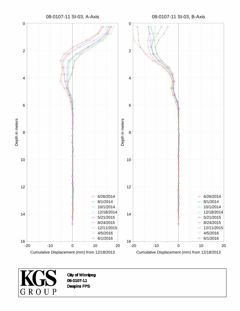
City of Winnipeg
08-0107-11
Despins FPS
City of Winnipeg
08-0107-11
Despins FPS
City of Winnipeg
08-0107-11
Despins FPS
City of Winnipeg
08-0107-11
Despins FPS
City of Winnipeg
08-0107-11
Despins FPS
City of Winnipeg
08-0107-11
Despins FPS
City of Winnipeg
08-0107-11
Despins FPS
City of Winnipeg
08-0107-11
Despins FPS
City of Winnipeg
08-0107-11
Despins FPS
City of Winnipeg
08-0107-11
Despins FPS
City of Winnipeg
08-0107-11
Despins FPS
City of Winnipeg
08-0107-11
Despins FPS
City of Winnipeg
08-0107-11
Despins FPS
City of Winnipeg
08-0107-11
Despins FPS
City of Winnipeg
08-0107-11
Despins FPS
City of Winnipeg
08-0107-11
Despins FPS
City of Winnipeg
08-0107-11
Despins FPS
City of Winnipeg
08-0107-11
Despins FPS
City of Winnipeg
08-0107-11
Despins FPS
City of Winnipeg
08-0107-11
Despins FPS
City of Winnipeg
08-0107-11
Despins FPS
City of Winnipeg
08-0107-11
Despins FPS
City of Winnipeg
08-0107-11
Despins FPS
City of Winnipeg
08-0107-11
Despins FPS
City of Winnipeg
08-0107-11
Despins FPS
City of Winnipeg
08-0107-11
Despins FPS
City of Winnipeg
08-0107-11
Despins FPS
City of Winnipeg
08-0107-11
Despins FPS
City of Winnipeg
08-0107-11
Despins FPS
City of Winnipeg
08-0107-11
Despins FPS
City of Winnipeg
08-0107-11
Despins FPS
City of Winnipeg
08-0107-11
Despins FPS
City of Winnipeg
08-0107-11
Despins FPS
City of Winnipeg
08-0107-11
Despins FPS
City of Winnipeg
08-0107-11
Despins FPS
City of Winnipeg
08-0107-11
Despins FPS
City of Winnipeg
08-0107-11
Despins FPS
City of Winnipeg
08-0107-11
Despins FPS
City of Winnipeg
08-0107-11
Despins FPS
City of Winnipeg
08-0107-11
Despins FPS
City of Winnipeg
08-0107-11
Despins FPS
City of Winnipeg
08-0107-11
Despins FPS
City of Winnipeg
08-0107-11
Despins FPS
City of Winnipeg
08-0107-11
Despins FPS
City of Winnipeg
08-0107-11
Despins FPS
City of Winnipeg
08-0107-11
Despins FPS
City of Winnipeg
08-0107-11
Despins FPS
City of Winnipeg
08-0107-11
Despins FPS
City of Winnipeg
08-0107-11
Despins FPS
City of Winnipeg
08-0107-11
Despins FPS
City of Winnipeg
08-0107-11
Despins FPS
City of Winnipeg
08-0107-11
Despins FPS
City of Winnipeg
08-0107-11
Despins FPS
City of Winnipeg
08-0107-11
Despins FPS
City of Winnipeg
08-0107-11
Despins FPS
City of Winnipeg
08-0107-11
Despins FPS
City of Winnipeg
08-0107-11
Despins FPS
City of Winnipeg
08-0107-11
Despins FPS
City of Winnipeg
08-0107-11
Despins FPS
City of Winnipeg
08-0107-11
Despins FPS
City of Winnipeg
08-0107-11
Despins FPS
City of Winnipeg
08-0107-11
Despins FPS
City of Winnipeg
08-0107-11
Despins FPS
City of Winnipeg
08-0107-11
Despins FPS
City of Winnipeg
08-0107-11
Despins FPS
City of Winnipeg
08-0107-11
Despins FPS
City of Winnipeg
08-0107-11
Despins FPS
City of Winnipeg
08-0107-11
Despins FPS
City of Winnipeg
08-0107-11
Despins FPS
City of Winnipeg
08-0107-11
Despins FPS
City of Winnipeg
08-0107-11
Despins FPS
City of Winnipeg
08-0107-11
Despins FPS
City of Winnipeg
08-0107-11
Despins FPS
City of Winnipeg
08-0107-11
Despins FPS
City of Winnipeg
08-0107-11
Despins FPS
City of Winnipeg
08-0107-11
Despins FPS
City of Winnipeg
08-0107-11
Despins FPS
City of Winnipeg
08-0107-11
Despins FPS
City of Winnipeg
08-0107-11
Despins FPS
City of Winnipeg
08-0107-11
Despins FPS
City of Winnipeg
08-0107-11
Despins FPS
City of Winnipeg
08-0107-11
Despins FPS
City of Winnipeg
08-0107-11
Despins FPS
City of Winnipeg
08-0107-11
Despins FPS
City of Winnipeg
08-0107-11
Despins FPS
City of Winnipeg
08-0107-11
Despins FPS
City of Winnipeg
08-0107-11
Despins FPS
City of Winnipeg
08-0107-11
Despins FPS
City of Winnipeg
08-0107-11
Despins FPS
City of Winnipeg
08-0107-11
Despins FPS
City of Winnipeg
08-0107-11
Despins FPS
City of Winnipeg
08-0107-11
Despins FPS
City of Winnipeg
08-0107-11
Despins FPS
City of Winnipeg
08-0107-11
Despins FPS
City of Winnipeg
08-0107-11
Despins FPS
City of Winnipeg
08-0107-11
Despins FPS
City of Winnipeg
08-0107-11
Despins FPS
City of Winnipeg
08-0107-11
Despins FPS
City of Winnipeg
08-0107-11
Despins FPS
City of Winnipeg
08-0107-11
Despins FPS
City of Winnipeg
08-0107-11
Despins FPS
City of Winnipeg
08-0107-11
Despins FPS
City of Winnipeg
08-0107-11
Despins FPS
City of Winnipeg
08-0107-11
Despins FPS
City of Winnipeg
08-0107-11
Despins FPS
City of Winnipeg
08-0107-11
Despins FPS
City of Winnipeg
08-0107-11
Despins FPS
City of Winnipeg
08-0107-11
Despins FPS
City of Winnipeg
08-0107-11
Despins FPS
City of Winnipeg
08-0107-11
Despins FPS
City of Winnipeg
08-0107-11
Despins FPS
City of Winnipeg
08-0107-11
Despins FPS
City of Winnipeg
08-0107-11
Despins FPS
City of Winnipeg
08-0107-11
Despins FPS
City of Winnipeg
08-0107-11
Despins FPS
City of Winnipeg
08-0107-11
Despins FPS
City of Winnipeg
08-0107-11
Despins FPS
City of Winnipeg
08-0107-11
Despins FPS
City of Winnipeg
08-0107-11
Despins FPS
City of Winnipeg
08-0107-11
Despins FPS
City of Winnipeg
08-0107-11
Despins FPS
City of Winnipeg
08-0107-11
Despins FPS
City of Winnipeg
08-0107-11
Despins FPS
City of Winnipeg
08-0107-11
Despins FPS
City of Winnipeg
08-0107-11
Despins FPS
City of Winnipeg
08-0107-11
Despins FPS
City of Winnipeg
08-0107-11
Despins FPS
City of Winnipeg
08-0107-11
Despins FPS
City of Winnipeg
08-0107-11
Despins FPS
City of Winnipeg
08-0107-11
Despins FPS
City of Winnipeg
08-0107-11
Despins FPS
City of Winnipeg
08-0107-11
Despins FPS
City of Winnipeg
08-0107-11
Despins FPS
City of Winnipeg
08-0107-11
Despins FPS
City of Winnipeg
08-0107-11
Despins FPS
08-0107-11 SI-03, A-Axis0
2
4
6
8
10
12
14
16
Dep
th in
met
ers
-20 -10 0 10 20
Cumulative Displacement (mm) from 12/18/2013
6/26/20148/1/201410/1/201412/18/20145/21/20158/24/201512/11/20154/5/20166/1/2016
08-0107-11 SI-03, B-Axis0
2
4
6
8
10
12
14
16
Dep
th in
met
ers
-20 -10 0 10 20
Cumulative Displacement (mm) from 12/18/2013
6/26/20148/1/201410/1/201412/18/20145/21/20158/24/201512/11/20154/5/20166/1/2016

City of Winnipeg
08-0107-11
Despins FPS
City of Winnipeg
08-0107-11
Despins FPS
City of Winnipeg
08-0107-11
Despins FPS
City of Winnipeg
08-0107-11
Despins FPS
City of Winnipeg
08-0107-11
Despins FPS
City of Winnipeg
08-0107-11
Despins FPS
City of Winnipeg
08-0107-11
Despins FPS
City of Winnipeg
08-0107-11
Despins FPS
City of Winnipeg
08-0107-11
Despins FPS
City of Winnipeg
08-0107-11
Despins FPS
City of Winnipeg
08-0107-11
Despins FPS
City of Winnipeg
08-0107-11
Despins FPS
City of Winnipeg
08-0107-11
Despins FPS
City of Winnipeg
08-0107-11
Despins FPS
City of Winnipeg
08-0107-11
Despins FPS
City of Winnipeg
08-0107-11
Despins FPS
City of Winnipeg
08-0107-11
Despins FPS
City of Winnipeg
08-0107-11
Despins FPS
City of Winnipeg
08-0107-11
Despins FPS
City of Winnipeg
08-0107-11
Despins FPS
City of Winnipeg
08-0107-11
Despins FPS
City of Winnipeg
08-0107-11
Despins FPS
City of Winnipeg
08-0107-11
Despins FPS
City of Winnipeg
08-0107-11
Despins FPS
City of Winnipeg
08-0107-11
Despins FPS
City of Winnipeg
08-0107-11
Despins FPS
City of Winnipeg
08-0107-11
Despins FPS
City of Winnipeg
08-0107-11
Despins FPS
City of Winnipeg
08-0107-11
Despins FPS
City of Winnipeg
08-0107-11
Despins FPS
City of Winnipeg
08-0107-11
Despins FPS
City of Winnipeg
08-0107-11
Despins FPS
City of Winnipeg
08-0107-11
Despins FPS
City of Winnipeg
08-0107-11
Despins FPS
City of Winnipeg
08-0107-11
Despins FPS
City of Winnipeg
08-0107-11
Despins FPS
City of Winnipeg
08-0107-11
Despins FPS
City of Winnipeg
08-0107-11
Despins FPS
City of Winnipeg
08-0107-11
Despins FPS
City of Winnipeg
08-0107-11
Despins FPS
City of Winnipeg
08-0107-11
Despins FPS
City of Winnipeg
08-0107-11
Despins FPS
City of Winnipeg
08-0107-11
Despins FPS
City of Winnipeg
08-0107-11
Despins FPS
City of Winnipeg
08-0107-11
Despins FPS
City of Winnipeg
08-0107-11
Despins FPS
City of Winnipeg
08-0107-11
Despins FPS
City of Winnipeg
08-0107-11
Despins FPS
City of Winnipeg
08-0107-11
Despins FPS
City of Winnipeg
08-0107-11
Despins FPS
City of Winnipeg
08-0107-11
Despins FPS
City of Winnipeg
08-0107-11
Despins FPS
City of Winnipeg
08-0107-11
Despins FPS
City of Winnipeg
08-0107-11
Despins FPS
City of Winnipeg
08-0107-11
Despins FPS
City of Winnipeg
08-0107-11
Despins FPS
City of Winnipeg
08-0107-11
Despins FPS
City of Winnipeg
08-0107-11
Despins FPS
City of Winnipeg
08-0107-11
Despins FPS
City of Winnipeg
08-0107-11
Despins FPS
City of Winnipeg
08-0107-11
Despins FPS
City of Winnipeg
08-0107-11
Despins FPS
City of Winnipeg
08-0107-11
Despins FPS
City of Winnipeg
08-0107-11
Despins FPS
City of Winnipeg
08-0107-11
Despins FPS
City of Winnipeg
08-0107-11
Despins FPS
City of Winnipeg
08-0107-11
Despins FPS
City of Winnipeg
08-0107-11
Despins FPS
City of Winnipeg
08-0107-11
Despins FPS
City of Winnipeg
08-0107-11
Despins FPS
City of Winnipeg
08-0107-11
Despins FPS
City of Winnipeg
08-0107-11
Despins FPS
City of Winnipeg
08-0107-11
Despins FPS
City of Winnipeg
08-0107-11
Despins FPS
City of Winnipeg
08-0107-11
Despins FPS
City of Winnipeg
08-0107-11
Despins FPS
City of Winnipeg
08-0107-11
Despins FPS
City of Winnipeg
08-0107-11
Despins FPS
City of Winnipeg
08-0107-11
Despins FPS
City of Winnipeg
08-0107-11
Despins FPS
City of Winnipeg
08-0107-11
Despins FPS
City of Winnipeg
08-0107-11
Despins FPS
City of Winnipeg
08-0107-11
Despins FPS
City of Winnipeg
08-0107-11
Despins FPS
City of Winnipeg
08-0107-11
Despins FPS
City of Winnipeg
08-0107-11
Despins FPS
City of Winnipeg
08-0107-11
Despins FPS
City of Winnipeg
08-0107-11
Despins FPS
City of Winnipeg
08-0107-11
Despins FPS
City of Winnipeg
08-0107-11
Despins FPS
City of Winnipeg
08-0107-11
Despins FPS
City of Winnipeg
08-0107-11
Despins FPS
City of Winnipeg
08-0107-11
Despins FPS
City of Winnipeg
08-0107-11
Despins FPS
City of Winnipeg
08-0107-11
Despins FPS
City of Winnipeg
08-0107-11
Despins FPS
City of Winnipeg
08-0107-11
Despins FPS
City of Winnipeg
08-0107-11
Despins FPS
City of Winnipeg
08-0107-11
Despins FPS
City of Winnipeg
08-0107-11
Despins FPS
City of Winnipeg
08-0107-11
Despins FPS
City of Winnipeg
08-0107-11
Despins FPS
City of Winnipeg
08-0107-11
Despins FPS
City of Winnipeg
08-0107-11
Despins FPS
City of Winnipeg
08-0107-11
Despins FPS
City of Winnipeg
08-0107-11
Despins FPS
City of Winnipeg
08-0107-11
Despins FPS
City of Winnipeg
08-0107-11
Despins FPS
City of Winnipeg
08-0107-11
Despins FPS
City of Winnipeg
08-0107-11
Despins FPS
City of Winnipeg
08-0107-11
Despins FPS
City of Winnipeg
08-0107-11
Despins FPS
City of Winnipeg
08-0107-11
Despins FPS
City of Winnipeg
08-0107-11
Despins FPS
City of Winnipeg
08-0107-11
Despins FPS
City of Winnipeg
08-0107-11
Despins FPS
City of Winnipeg
08-0107-11
Despins FPS
City of Winnipeg
08-0107-11
Despins FPS
City of Winnipeg
08-0107-11
Despins FPS
08-0107-11 SI09-01, A-Axis0
2
4
6
8
10
12
14
Dep
th in
met
ers
-20 -10 0 10 20
Cumulative Displacement (mm) from 10/22/2012
6/26/20148/1/201410/1/201412/18/20145/21/20158/24/201512/11/20154/5/20166/1/2016
08-0107-11 SI09-01, B-Axis0
2
4
6
8
10
12
14
Dep
th in
met
ers
-20 -10 0 10 20
Cumulative Displacement (mm) from 10/22/2012
6/26/20148/1/201410/1/201412/18/20145/21/20158/24/201512/11/20154/5/20166/1/2016

De La Cathedrale Outfall
SI-03
De La Cathedrale Outfall
SI-03
De La Cathedrale Outfall
SI-03
De La Cathedrale Outfall
SI-03
De La Cathedrale Outfall
SI-03
De La Cathedrale Outfall
SI-03
De La Cathedrale Outfall
SI-03
De La Cathedrale Outfall
SI-03
De La Cathedrale Outfall
SI-03
De La Cathedrale Outfall
SI-03
De La Cathedrale Outfall
SI-03
De La Cathedrale Outfall
SI-03
De La Cathedrale Outfall
SI-03
De La Cathedrale Outfall
SI-03
De La Cathedrale Outfall
SI-03
De La Cathedrale Outfall
SI-03
De La Cathedrale Outfall
SI-03
De La Cathedrale Outfall
SI-03
De La Cathedrale Outfall
SI-03
De La Cathedrale Outfall
SI-03
De La Cathedrale Outfall
SI-03
De La Cathedrale Outfall
SI-03
De La Cathedrale Outfall
SI-03
De La Cathedrale Outfall
SI-03
De La Cathedrale Outfall
SI-03
De La Cathedrale Outfall
SI-03
De La Cathedrale Outfall
SI-03
De La Cathedrale Outfall
SI-03
De La Cathedrale Outfall
SI-03
De La Cathedrale Outfall
SI-03
De La Cathedrale Outfall
SI-03
De La Cathedrale Outfall
SI-03
De La Cathedrale Outfall
SI-03
De La Cathedrale Outfall
SI-03
De La Cathedrale Outfall
SI-03
De La Cathedrale Outfall
SI-03
De La Cathedrale Outfall
SI-03
De La Cathedrale Outfall
SI-03
De La Cathedrale Outfall
SI-03
De La Cathedrale Outfall
SI-03
De La Cathedrale Outfall
SI-03
De La Cathedrale Outfall
SI-03
De La Cathedrale Outfall
SI-03
De La Cathedrale Outfall
SI-03
De La Cathedrale Outfall
SI-03
De La Cathedrale Outfall
SI-03
De La Cathedrale Outfall
SI-03
De La Cathedrale Outfall
SI-03
De La Cathedrale Outfall
SI-03
De La Cathedrale Outfall
SI-03
De La Cathedrale Outfall
SI-03
De La Cathedrale Outfall
SI-03
De La Cathedrale Outfall
SI-03
De La Cathedrale Outfall
SI-03
De La Cathedrale Outfall
SI-03
De La Cathedrale Outfall
SI-03
De La Cathedrale Outfall
SI-03
De La Cathedrale Outfall
SI-03
De La Cathedrale Outfall
SI-03
De La Cathedrale Outfall
SI-03
De La Cathedrale Outfall
SI-03
De La Cathedrale Outfall
SI-03
De La Cathedrale Outfall
SI-03
De La Cathedrale Outfall
SI-03
De La Cathedrale Outfall
SI-03
De La Cathedrale Outfall
SI-03
De La Cathedrale Outfall
SI-03
De La Cathedrale Outfall
SI-03
De La Cathedrale Outfall
SI-03
De La Cathedrale Outfall
SI-03
SI-03, A-Axis0
1
2
3
4
5
6
7
8
9
10
11
12
13
Dep
th in
met
ers
-20 -10 0 10 20
Cumulative Displacement (mm) from 10/22/2012
8/1/201410/1/201412/22/20145/29/20158/24/201512/11/20156/1/2016
SI-03, B-Axis0
1
2
3
4
5
6
7
8
9
10
11
12
13
Dep
th in
met
ers
-20 -10 0 10 20
Cumulative Displacement (mm) from 10/22/2012
8/1/201410/1/201412/22/20145/29/20158/24/201512/11/20156/1/2016