appendix 2: the policies -...
TRANSCRIPT

THE PoliciEs
“Realizing the Garden City”
Realizing The Garden City: The Augusta Sustainable Development Agenda
October 14, 2010
prepared for The City of Augusta, Georgia
byShieldsDESIGN LLC
withCranston Engineering GroupICON Architecture IncThe Woodhurst PartnershipUrban Partners
Appendix 2: Recommendations for a Sustainable Augusta

4-2 Realizing the Garden City: Augusta Sustainable Development Agenda 2010
Recommendations for Sustainable Development, Appendix 2 is a compilation of ‘best practice’ strategies to influence Augusta’s growth and development in a positve way, to ensure a high quality of life for the city’s residents while attracting economic development. The input comes from a wide variety of interested local individuals, regional organizations, and federal programs. The information collected gives the team direction in pursuing an innovative and achievable Sustainable Development Agenda for all of Augusta.
Appendix 2: Recommendations for Sustainable Development

4-3[The Policies Appendix]
3. Recommended Land Development Regulation Changes
3.1 Create an Agriculture and Timber Protection Zoning Category .......4-30
3.2 Limit the use of Flag Lots ....4-31
3.3 Enhance Conservation Subdivision Zoning .......................................4-32
3.4 Encourage Conservation Subdivisions ................................4-33
3.5 Designate Zoning Overlay Districts for Priority Projects to Encourage Quality Development 4-34
3.6 Create “Walkable Subdivision” Neighborhoods ..........................4-36
3.7 Support Low Impact Development Strategies in Building Code Ordinances ........................4-37
3.8 Modify Existing Land Subdivision Regulations .................................4-38
3.9 Require Street Connectivity .4-39
4. Realizing the Garden City through Corridor Revitalization ....
4.1 Economics of the Roadway ..4-44
4.2 Private Sector Role in Roadway Beautification ............................4-47
4.3 Context Sensitive Solutions Classification Approach ..............4-47
4.4 Recommended City Ordinance Changes ......................................4-52
5. Neighborhood Enhancement and Revitalization
5.1 Recommended Comprehensive Plan Changes ..............................4-56
5.2 Community Supported Agriculture ................................4-57
5.3 Improving Neighborhood Character through Tree Planting 4-58
5.4 Support Residential Energy Efficiency Upgrades ....................4-59
5.5 Historic Preservation and Reuse of Existing Buildings as a Green Practice ......................................4-60
Table of Contents
The Policies1. Introduction
Preserve area character and ecological value ............................ 4-6
Enhance neighborhood livability and connectivity .................................. 4-7
Reinforce Urban Augusta as the Region’s Cultural, Economic, and Service Core ................................. 4-9
Improve the Function and Design of the Region’s Corridors ................4-10
Federal Grants Are Available ......4-12
2. Green Infrastructure Integration
2.1 Elements of Green Infrastructure ...................................................4-17
2.2 Integrating Green Infrastructure Analysis into the Development Approval Process ........................4-26

4-4 Realizing the Garden City: Augusta Sustainable Development Agenda 2010

4-5[The Policies Appendix]
1. Introduction
Augusta has many bright spots that show promise for local growth concurrent with the inevitable national economic recovery. A sustainable, growth management framework will reinforce the most desirable qualities of Rural, Suburban, and Urban Augusta, providing a range of unique settings for future development.
These policies will continue to shape a high quality living environment for existing citizens and for future generations, taking advantage of Augusta’s unique natural and man-made resources.
What is Sustainable Development?
According to the Comprehensive Plan, Augusta’s population is projected to grow by approximately 18,000 residents in the next twenty years. This growth should be managed carefully. As introduced in the Final Report, this Agenda’s sustainable development strategy for growth management includes several topic areas:
• Land Development Regulations that support smart growth, preserve valuable resources, and effectively utilize existing and future infrastructure investments.
• High quality design of streets that support adjoining land uses, encourage alternative modes of transit, present an attractive image of the community, and enable increased connectivity between people and businesses.
• Neighborhood Revitalization Programs to support livable communities that encourage social and economic interaction within and between neighborhoods and districts. If they are strong, a city’s neighborhoods are one of its best resources.
These areas are discussed in this document in more detail and key changes to regulatory ordinances are discussed as a way to further support each topic.
When this framework is in place, Augusta will be able to coordinate public and private investment to implement projects that support the community’s overall growth objectives.
Sustainable development protects natural and agricultural areas from encroachment.

4-6 Realizing the Garden City: Augusta Sustainable Development Agenda 2010
Where Can Sustainable Development Policies Make a Difference in Augusta?
Since the mid-nineteenth century, the Savannah River has made Augusta an attractive location for manufacturing and development. In the more recent past, land availability and cost of residential construction have resulted in a proliferation of residential subdivisions in Augusta that has expanded the suburban ring, encroached on natural resources, and created areas of relatively anonymous character that are a cause of local concern about a decreasing attractiveness and quality of life for the region. Listed below are the areas that growth management can provide opportunities for improvement:
In Rural Augusta...
Preserve area character and ecological value
In this area of relatively low density and low land values new residential developments have the potential to detract from the area’s character and put pressure to increase the demand for additional infrastructure and public services. If no action is taken, Rural Augusta will gradually become identical to Suburban Augusta. Areas such as those around Spirit and Little Spirit Creeks, among the least developed of any drainage basin system in Augusta, are highly vulnerable to environmental degradation through development.
Recent development patterns show that forested areas and agricultural uses are among the most common land-type in Augusta to be converted into single-family subdivisions. However, many studies have shown that residential development actually costs communities more money than they stand to gain in taxes (see “Figure 4-5. Median cost per dollar of revenue raised to provide public services to different land uses” on page 4-9). Therefore, it makes economic sense to encourage new development to occur in areas where infrastructure already exists and discourage it in the rural areas. Therefore, strategic land conservation policies may make more economic sense over the long term1.1 Gies, Erica. Conservation: An Investment that Pays. The Trust for Public Land. 2009.
Farmland Reduction in Augusta-Richmond County
1997 - 2002
1997 2002 %
Reduction
Acres of Farmland
15,919 12,439 22%
# of Farms 140 133 5%
* From the Comprehensive Plan, 2009.
Excessive development in Rural Augusta will draw resources away from more developed areas where sewer systems and other public infrastructure are already in place. Such development brings with the obligation to provide costly public services such as sewer, trash collection, policing, and educational facilities and traditional infrastructure such as streets, sewer, and utilities. Often, expansion in rural areas occurs when the infrastructure in closer existing developed areas is nowhere near its full capacity.
The strategic conservation of working lands (both agricultural and timber forests), support the local economy and allow communities to pay less for service delivery than they would with new residential development2. The following graph created by the American Farmland Trust shows how, for every dollar raised in taxes from new residential development, cities are forced to spend that revenue, plus an additional nineteen cents merely for basic Community Service delivery. The graph below shows the results from the Cost of Community Service analysis:
2 American Farmland Trust. Cost of Community Ser-vices Survey, 2007.

4-7[The Policies Appendix]
• Tax credits for conservation to motive the landowner to remain on the land.
• Right to farm policies that prevent nuisance lawsuits that seek to curtail normal farming activities.
• Purchase of development rights between landowner and a land trust.
• Government purchase of local produce for schools, prisions, and government offices.
• Buy local campaigns to share pride and remind consumers of the value of rural land.
• Agricultural and forestry zoning to heavily restrict conflicting development, including residential.
• Rural home clustering to preserve natural land while building the same number of units.
Figure 4-1. Median cost per dollar of revenue raised to provide public services to different land uses
Farms and forests that are preserved in perpetuity further benefit the local economy as money paid for conservation easements often circulates back into the city’s hands through debt reduction, farm investment, timber operation financing, or retirement investment.
Several methods are recommended in this Agenda to support the rural landscape. They are all discussed in detail in the Final Report and in this Appendix, but a quick reference guide is listed here3:
• Use value taxation to allow the land to be assessed at its current use, rather than its highest market value.
3 U.S. Environmental Protection Agency. “Putting Smart Growth to Work in Rural Communities” with the Interna-tional City / County Management Association. 2010.
In Suburban Augusta...
Enhance neighborhood livability and connectivity
According to the Comprehensive Plan, Suburban Augusta, generally including the character areas of West Augusta, Belair, and South and East Augusta, has absorbed most of the City’s growth over the past ten years. This area includes 44% of the entire population of the City. Commercial development in Suburban Augusta has been concentrated in West Augusta and Belair, along I-20. About 47% of all housing units in the region have been constructed in this area over the last decade.
Despite the quantity of development in Suburban Augusta, quality has been haphazard, without a clear strategy of land conservation, public service improvement, or formation of commercial and civic clusters that can be walkable centers for community life.
Augusta’s existing neighborhoods need support. The Comprehensive Plan states that over half (54.8%) of Augusta’s housing units were built between 1940 and 1978. These units have not experienced sustained private sector reinvestment and improvement and are starting to show their wear. A set of policies oriented towards neighborhood infill would help revitalize Suburban Augusta by increasing the
Growth Target. In order to preserve the character of
Rural Augusta, the Agenda includes measures to preserve open lands, insure development quality, prohibit public sewer extensions south of the Spirit Creek basin, and to limit the total amount of residential development in Rural Augusta to a maximum of 5% of annual new housing starts in Augusta/Richmond County.

4-8 Realizing the Garden City: Augusta Sustainable Development Agenda 2010
property tax base and consumer retail spending. A focused infill policy would also encourage further office, restaurant, and recreational projects that capitalize on existing infrastructure and proximate financially viable neighborhoods. These sustainable strategies often yield a one of a kind community, promoting neighborhood strength and identity.
Achieve higher quality for new development. New residential developments in Suburban Augusta should be done at a higher level of quality. Incentives and standards should be provided to insure that new developments will support the priority development project areas identified in this Agenda.
Traditional neighborhood design strategies, providing walkable distances from housing to convenience retailing, schools, recreational opportunities, and adjoining neighborhoods should be promoted as preferred development patterns to self-contained cookie cutter residential sprawl.
Economists and researchers have repeatedly concluded that compact development reduces municipal costs for road maintenance and service delivery, such as water, solid waste, transit, and school busing.
Figure 4-2. Suitable single family development parcels in Suburban Augusta

4-9[The Policies Appendix]
In addition, conservation subdivisions can be cheaper to build than standard residential developments since their method of clustering residences allows for shorter roadways, sidewalks, water mains, utility lines and other infrastructure cost reductions.
Several methods are recommended in this Agenda to support the suburban neighborhoods. They are all discussed in detail in the Final Report and in this Appendix, but a quick reference guide is listed here:
• Fix-it-first approach to infrastructure, prioritizing repair and preventative maintenance before building new.
• Use historic preservation to enhance a “sense of place” for visitors and residents alike.
• Streetscape improvements to make roadways accessible to pedestrians, cyclists, transit riders and drivers alike.
• Target new development where infrastructure already exists.
• Overcome existing codes and ordinances that make it difficult to accomplish infill development.
• Split-rate proprerty taxes that split building value and improvements from land value.
• Focus on school rehabilitation, as they provide historic, sentimental, health and safety benefits to neighboring residents.
“Figure 4-2. Highly suitable potential single family development parcels in Suburban Augusta” on page 4-8 used spatial analysis to find parcels over 10 acres in size, that were not parks, schools, or cemeteries, and not already zoned for industrial or business uses. This query yielded 13,770 acres on 444 parcels in Suburban Augusta. Even the most conservative analysis, setting aside upwards of 15% for infrastructure and 50% of the land for natural resource conservation, shows approximately 4,900 available home sites for development
This far exceeds the land needs for population and job growth over the next 25 years. Therefore, this study recommends that Augusta officially adopt a Preferred Growth Area Map to guide development towards these most easily serviceable and fiscally beneficial locations.
In Urban Augusta...
Reinforce Urban Augusta as the Region’s Cultural, Economic, and Service Core
A major growth management objective is to establish this Urban Area as a unique and special place, as stated in the Westobou Vision Urban Area Master Plan. To this end, the Urban Area must be economically healthy, safe, vibrant and a place where “people want to be and to be seen.” This Agenda must preserve the area’s natural environments, develop its cultural and recreational attributes, and pull from the energy and activity of its citizenry.
Urban Augusta, including the downtown area, consists of 20% of Augusta’s population. Formerly the center of commerce for the region, its now shares its role with massive ‘Big Box’ and strip commercial centers along arterial highways and near to I-20 and I-520 interchanges in particular.
Augusta has done much to preserve the unique character of downtown and is already directing public investment this way. Still, more can be done with policy directed at infill development to increase the density, intensity and use of downtown. Particularly important to the continued viability of downtown is the further development of employment connections,
Growth Target. This Agenda estimates that Suburban
Augusta will continue to be a place of strong growth pressure, absorbing upwards of 50% of new local, single family housing growth in the next decade. This can be achieved, as the graphic to the left shows over 13,000 acres of land that is highly suitable for residential development in Suburban Augusta.

4-10 Realizing the Garden City: Augusta Sustainable Development Agenda 2010
through hospitals, MCG | Georgia Health Sciences University, and their science and technology research support facilities. The expanding health sciences industry can be a major catalyst for downtown. Other initiatives such as streetscape and facade improvements can maintain vibrancy while marketing techniques can promote business and tourism development.
Several methods are recommended in this Agenda to support the downtown. They are all discussed in detail in the Final Report and in this Appendix, but a quick reference guide is listed here:
• Westobou Vision Urban Area Plan, as a broad vision for growth and development.
• Transportation enhancement for walkability and multiple methods of getting around: bikes, driving, public transit, and potentially low-speed electric vehicles.
• Form based codes, to pay attention to details in streetscapes and facades.
• Green street design for stormwater management.
In All of Augusta...
Improve the Function and Design of the Region’s Corridors
The relationship between transportation, land use, and the natural environment is at the heart of any growth management strategy. However; many of Augusta’s suburban corridors are experiencing disinvestment, as indicated by vacant properties and obsolete retail strip malls. In order to revitalize these struggling, strip corridors, local government must pursue two simultaneous and complementary strategies: restructuring the land uses surrounding the roadway and redesigning the public rights-of-way to achieve increased public safety, improved walkability, and higher aesthetic values.
Restructuring Land Uses. The Sustainable Development Agenda recommends high intensity development at strategic intersections along key regional corridors. However, owners of struggling properties between the strategic intersections designated for higher intensity development should be encouraged to convert marginal retail land uses to more productive functions such as medical, light industrial, residential, or public service uses. Higher density housing should be encouraged in areas where no pre-existing viable commercial uses remain, to reflect current market conditions and reconnect to neighborhoods behind the corridor.
Growth Target. This Agenda assumes that Urban Augusta
will continue to grow, and with both the Market Creation Projects and ASDA Priority Development District projects, we expect upwards of 45% of new local, housing growth in the next decade to be located in this area.
Broad Street landscaping (photo: Augusta Convention and Visitor’s Bureau)
Downtown Development Authority’s new street tree planting program (photo: Augusta Convention and Visitor’s Bureau)

4-11[The Policies Appendix]
Figure 4-3. Augusta’s Garden City Corridors
Redesigning the Right-of-Way. Generally, the design of the roadway must be dealt with before the in-between roadway segments can become attractive for residential use. The local government plays a large role in this. Quality urban design and transportation planning, using the latest methods of Context Sensitive Solutions (CSS), can assist in calibrating the size and character of corridors to the land uses they intend to serve as well as beautify them to meet the “Garden City” image to which Augusta aspires.
In Augusta, the Augusta Regional Transportation Study (ARTS) serves as the designated Metropolitan Planning Organization (MPO) for transportation and is in charge of establishing the roadway improvement priorities that can deal with these relationships on Georgia DOT roadway corridors. The Augusta Engineering Department deals with similar relationships on locally funded streets. The ARTS priorities should be highly coordinated with the ASDA growth management priorities in order to achieve the maximum mutual benefit.
“Figure 4-3. Augusta’s Garden City Corridors” on page 4-11shows the various roadways that qualify as corridors in Augusta.

4-12 Realizing the Garden City: Augusta Sustainable Development Agenda 2010
New Federal Grants Are Available for Sustainability
All applications must meet these six “Liveability Principles” in order to obtain grant funds4:
• Provide more transportation choices.
• Promote equitable, affordable housing.
• Enhance economic competitiveness.
• Support existing communities.
• Coordinate and leverage federal policies and investment.
• Enhance the value of communities and neighborhoods.
4 Partnership Agreement by HUD, DOT and EPA Part-nership: Sustainable Communities. June 16, 2009. http://www.epa.gov/smartgrowth/partnership/index.html
EPA’s Smart Growth:
The Environmental Protection Agency’s Smart Growth program helps “communities grow in ways that expand economic opportunity, protects public health and the environment, and enhances the places that people love”. They maintain a set of basic development principles that explain the smart growth approach, including5:
• Mix land uses and foster distinctive, attractive communities with a strong sense of place
• Take advantage of compact building design and create walkable neighborhoods with a range of housing opportunities and choices
• Preserve open space, farmland, natural beauty, and critical environmental areas
• Strengthen and direct development towards existing communities
• Provide a variety of transportation choices
5 US EPA Smart Growth Principles. http://www.epa.gov/smartgrowth/about_sg.htm
The HUD/DOT/EPA partnership agreement states that the inter-office coordination and grant program will:
Enhance integrated planning and investment. The partnership will seek to integrate housing, transportation, water infrastructure, and land use planning and investment.
Provide a vision for sustainable growth. This effort will help communities set a vision for sustainable growth and apply federal transportation, water infrastructure, housing, and other investments in an integrated approach that reduces the nation’s dependence on foreign oil, reduces greenhouse gas emissions, protects America’s air and water, and improves quality of life. Coordinating planning efforts in housing, transportation, air quality, and water, including planning cycles, processes, and geographic coverage, will make more effective use of federal housing and transportation dollars.

4-13[The Policies Appendix]
• Make development decisions predictable, fair, and cost effective
• Encourage community and stakeholder collaboration in development decisions
The EPA has consolidated several new and existing programs into the Healthy Communities Initiative, for which it is asking for access to $32 million in funding in the FY 2011 budget for technical assistance with water issues, green school design, and air quality. Their Brownfield Program is also proposed to expand to include integrated, area-wide planning grants, in addition to their usual funding for environmental remediation.
DOT’s Context Sensitive Design:
The US Department of Transportation focuses on how transportation systems can support a better quality of life, more livable communities, better public health, economic growth and environmental sustainability. Urban strategies include6:
• Promote transportation investments that improve community design and function.
• Provide a wide array of accessible and multi-modal transit options.
• Emphasize pedestrian and bike infrastructure investments.
• Work with local agencies to expand transportation alternatives.
• Encompass public health policies into transportation policy.
6 USDOT Strategic Plan: “Transportation for a New Generation” Summary. June 8, 2010.
The US DOT has the largest amount of currently available funds stemming from the recent stimulus legislation, which includes $1.5 billion in TIGER (Transportation Investment Generating Economic Recovery) grants to help develop livable communities and create jobs. The FY 2011 budget proposes that this be rolled into a $4 billion National Infrastructure Innovation and Finance Fund and that DOT’s existing Livable Communities Program receive $200 million in for a grant program to support local planning processes that integrate transportation, land use, and natural resource conservation.

4-14 Realizing the Garden City: Augusta Sustainable Development Agenda 2010
Using the LEED-ND system, there are five prerequisites to determine applicable development sites8.
• Smart Location (must be within planned water and wastewater service area as well as being either an infill site, on a transit corridor, or in an area with a well developed street-network density)
• Ecological Community Conservation (rare plant and animal species preservation)
• Wetland Conservation
• Agricultural Land Conservation
• Floodplain Avoidance
These features are all identifiable with Augusta’s available spatial data (GIS) and are to be included in future development applications.
8 U.S. Green Building Council. LEED for Neigh-borhood Development. http://www.usgbc.org/DisplayPage.aspx?CMSPageID=148
HUD’s Choice Neighborhoods
The Department of Housing and Urban Development web site describes Choice Neighborhoods as a grant initiative built upon HOPE VI that will:
• Transform distressed neighborhoods and public and assisted projects into viable and sustainable mixed-income neighborhoods
• Link housing improvements with appropriate services, schools, public assets, transportation, and access to jobs.
• Place a strong emphasis on local community planning for access to high-quality educational opportunities, including early childhood education.
The initiative has been allocated up to $65 million for a demonstration in FY 2010 with the possibility of being formally established in FY 2011 at $250 million. Separately, the Department is launching a $150 million Sustainable Communities Initiative for grant purposes and $150 million for Catalytic Investment Competition Grants as part of a new Community Development Block Grant
program designed to support job creation in hard hit neighborhoods7. The competition grants will support vacant property acquisition and green infrastructure development in targeted neighborhoods, transit oriented development, and economic development.
HUD has recently announced that they would start scoring their grant applications by “locational efficiency” and use LEED for Neighborhood Development as a tool to do so. Location efficiency means locating housing nearer to surrounding jobs, neighborhood commercial areas and transportation options. This policy could substantially impact where new affordable and public housing gets built.
7 APA’s Overview of Federal Interagency Partnership for Sustainable Communities Programs in the FY 2011 Budget Proposal.
:

4-15[The Policies Appendix]
Sustainable Fellwood is a 27-acre LEED-ND certified project on Bay Street, in Savannah, GA. It will be a mixed-use development with 220 affordable housing units, 75 senior housing units, and potential retail space. Melaver, Inc.
Features include a community garden, natural daylighting, thermal efficient windows, reflective roofs, and Energy Star appliances throughout.

4-16 Realizing the Garden City: Augusta Sustainable Development Agenda 2010

4-17[The Policies Appendix]
2.1 Elements of Green Infrastructure
Green Infrastructure is a pedestrian accessible interconnected network of natural resources, recreational resources and other open spaces. The form of the GI consists of “Hubs,” larger reserves of land such as parks or natural lands and “Links,” such as linear connections including well-landscaped streets, greenways, trails, and stream buffers, and “Sites,” which are smaller than “Hubs” and may not be connected, but contribute important ecological values, such as protecting wildlife habitat and providing nature-based recreation for people. Green Infrastructure seeks to insure that ecological functions continue to exist after development has happened9.
Many of the following elements are discussed in more depth in Chapter 8 of the Comprehensive Plan.
9 Benedict and McMahon, Green Infrastructure: Link-ing Landscapes and Communities, The Conservation Fund, 2006.
Natural Resources
This Agenda recommends that during the Sketch Plan review phase for new developments, as described in the following Integration of Green Infrastructure into the Development Approval Process section, that the planning staff work with the developer’s site designer to ensure that as many
“Primary Conservation Resources” as possible are preserved and enhanced. For example, at a site scale, this might mean going over details such as the location of impervious surfaces - locating parking lots to minimize disturbance of soil areas most likely to infiltrate and recharge the groundwater.
The following pages review the components of both Natural Resources and Recreational Resources. Included are GIS maps of the resources, as well as recommendations for either their preservation and enhancement.
2. Green Infrastructure Integration
Local governments have two types of tools for encouraging appropriate development and use of Augusta resources; they can fund traditional public works and infrastructure construction projects and they can enact policies that regulate land development, taking advantage of the region’s green infrastructure. This Agenda envisions that Augusta will use a combination of these tools to guide its growth over the next twenty years.

4-18 Realizing the Garden City: Augusta Sustainable Development Agenda 2010
Sustainable Development
Wetlands In Augusta, wetlands and their associated flood plains are located adjacent to the Savannah River, the Augusta Canal, and along most of the creeks. Wetlands are crucial for maintaining functioning ecosystems. Although federal laws and permit programs provide protection of these systems, this Agenda continues to encourage their preservation on a local level by designating them as “primary conservation resources” and recommends requiring them to be maintained as Greenspace for the purposes of the land development approval process. Variances may be applied based on technical review as appropriate.
In addition, the Comprehensive Plan lists three existing mechanisms for wetland protection in Augusta:
• Water Supply Watershed Protection Ordinance
• Soil Erosion and Sediment Control Ordinance
• Tree Ordinance and Illustrated Guide
In addition to these protections, this Agenda recommends prohibiting the removal of trees in wetlands, without the trigger of a building permit application.
StreamsIn recognition of their valuable contribution to the maintenance of functioning ecosystems, this Agenda proposes to further protect streams beyond what is currently required by state ordinance (25 foot development buffer).
This Agenda recommends a Forest Buffer, in conjunction with the recommendations of the Central Savannah River Land Trust, to extend up to 75 feet, but at least 50 feet from the stream center line.
A Forest Buffer requires narrow strips of land (from 25 to 150 feet in width) along both banks of streams and rivers be set-aside from development and left in their undisturbed, natural state as a vegetative barrier. These buffers help protect water quality by slowing and filtering storm water runoff as it flows toward the stream.10
10 Georgia Department of Community Affairs. Toolkit of Best Practices. http://www.dca.state.ga.us/toolkit/ToolDetail.asp?GetTool=67Phinizy Swamp nature trail (photo: Augusta Convention and
Visitors Bureau)

4-19[The Policies Appendix]
Green Infrastructure Integration
This Agenda recommends educating applicable property owners about the Preferential Assessment for Agricultural and Forestry Property (Statewide Ref. Ga Code Ann. 48-5-7.4.1) to give tax relief to qualified owners of farm and forest property who have long-term plans to continue in these uses. The landowners would be eligible to receive a 25% property tax savings and would enter a ten-year protection covenant.
This type of buffer intends to protect the tree roots that maintain soil and the shady tree canopy that promoting desirable aquatic organisms. When implemented, this buffer will create more opportunities for water-based recreational activity along with more neighborhood access opportunities to enjoy the stream banks.
Nearby Fulton County, GA also requires a 75-foot pervious surface stream buffer to protect water quality in south Fulton County. And at the state level, the Metropolitan River Protection Act (MRPA), written to protect the Chattahoochee River, requires a 150-foot pervious surface stream buffer and buffers for tributary streams11.
11 Georgia Model Urban Forest Book. Georgia Forestry Commission. and the USDA Forestry Service. January 2001.
Agricultural Soils The majority of the best agricultural soils in Augusta are found on the ridge tops and hillsides of the Southern Coast Plain. Named Orangeburg-Lucy-Dothan, these are nearly level to gently sloping, well-drained soils that account for most of the farming and woodlands in the south central part of the county. Other good agricultural soils lie in bottom lands along the Savannah River and are called the Riverview-Chewacla-Chastain association.
Preservation of the areas most suited to agriculture and silviculture is crucial to the maintenance of the commercial farming industry in Augusta. This Agenda recommends that these soil conditions be taken into consideration during development approvals as a potential conservation resource.
Forest buffer in action. (Photo: U.S. Natural Resource Conservation Service)
Farm near Blythe, GA

4-20 Realizing the Garden City: Augusta Sustainable Development Agenda 2010
Sustainable Development
Wooded Areas and OrchardsThis Agenda recommends a Zero-Net-Tree-Loss Policy for urban and suburban Augusta as one of the stated goals of the Augusta Tree Ordinance and Illustrated Guide.
This Agenda recommends that woodlands over 1-acre on proposed development property should be evaluated by the Augusta Tree Commission for their:
• Size, configuration, and species composition
• Ecological function (including slope protection, soil stabilization, stream maintenance and animal habitat),
• Recreational potential (pedestrian and equestrian trails, picnicking and other outdoor activities)
• Relationship to woodlands on adjoining properties (both as visual buffer between adjacent developments and potential for maintaining continuous wooded areas)12.
This process would likely occur during the compilation of the Existing Resource Map, described at the end of this section. By working together, the applicant and the Tree Commission should be able to set aside healthy creek side woodlands, significant tree groves, and unique specimen trees to the greatest extent possible.
Regardless, this Agenda recommends that no clearing or earth disturbance be permitted on any site before a site plan or final plat is approved by the city, except for legitimately permitted timbering operations.
12 Growing Greener: Conservation By Design: Model Ordinance Version 2.0, Natural Lands Trust, 2007.
This Agenda recommends educating applicable property owners about the Georgia Forest Land Protection Act of 2008 (O.C.G.A. § 48-5-7.7) to give tax relief to property owners of forested lands over 200 acres who have long-term plans to continue in these uses.
This orchard, visible from Deans Bridge Road, if sold, could be built over by a new owner, destroying an agricultural resource.

4-21[The Policies Appendix]
Green Infrastructure Integration
Surface and Ground Water RechargeAccording to the Comprehensive Plan, Augusta draws most of its groundwater from the Basal Cretaceous aquifer. The Georgia Department of Natural Resources describes this area as having a high susceptibility to pollution. Concerned about the stress placed on the aquifers, the DNR encouraged the city to build a surface water treatment facility and adopt a Groundwater Recharge Area Protection Ordinance in 1998.
Looking at maps in the next column, it is clear that the Augusta region plays an important role in linking large aquifers in South Carolina to ones in western Georgia and Alabama. These aquifers, so small compared to the entire state of Georgia, are playing a large role in the Tri-State (Florida, Georgia, and Alabama) ‘Water Wars’. Augusta should take its stewardship role seriously.
Figure 4-4. Groundwater Recharge Areas in Georgia according to the GA Dept. of Natural Resources
Figure 4-5. Groundwater Recharge Areas in the U.S.
In this light, groundwater recharge areas should be protected to the maximum possible extent from any damage from clearing, grading, filling, or dumping. In more developed areas, this means using Low Impact Development (LID) strategies, in replacement of traditional engineering techniques, to manage storm water.
The LID design approach has received support from the U.S. Environmental Protection Agency (EPA) and is being promoted as a method to help meet goals of the Clean Water Act.
Natural areas like this area near Phinizy Swamp help recharge ground water sources

4-22 Realizing the Garden City: Augusta Sustainable Development Agenda 2010
Sustainable Development
Recreational Resources
Today Augusta has an opportunity to create a legacy of great public spaces connected to communities through a robust open space system. As in the City’s nickname “The Garden City of the South”, as bestowed upon it by Julia Lester Dillon displays, Augusta held an early interest in a well-landscaped public and private realm.
Augusta’s Green Infrastructure is part of its appeal, and its engine for economic growth. Exciting projects and investments into bike trails along the river, greenways along the creeks and trails on the canal have encouraged events such as the Ironman competition and International Mountain Bike Association event. Additional parks will improve the quality of life for every resident by creating a city of vibrant green spaces.
If Augusta strives to maintain a healthy lifestyle, it must plan for places to walk and play. It must leverage its growth to create a connected system of nature preserves, parks, plazas, and streetscapes. It must create regulatory incentives that preserve natural systems. It must act now to harness this energy to create a city of thriving and connected green spaces that serve all its citizens.
Flood PlainsAccording to the Federal Emergency Management Agency Deed Ordinance Restrictions, the 100-year Floodplain is suitable for passive recreation and picnicking. It allows for property in the floodplain to be dedicated and maintained in perpetuity as open space for conservation. Uses on such property may include parks for outdoor recreational activities; wetlands management; nature reserves; cultivation; grazing; and camping (except where adequate warning time is not available to allow evacuation)13.
Therefore, lands within the 100-year floodplain (including the flood way) are considered to be a “primary conservation resource” and this Agenda recommends that they be maintained as Greenspace in any development proposal. Variances may be applied based on technical review as appropriate.
In addition, as Augusta’s Community Greenspace document notes, Rae’s Creek has mostly been protected through Fee Simple Ownership. However, many parcels still remain unprotected.
13 US Department of Homeland Security: FEMA Model Deed Restriction.
Augusta Canal Stream (photo: Augusta Convention and Visitor’s Bureau)

4-23[The Policies Appendix]
Green Infrastructure Integration
In order to enhance the Floodplain through passive recreational use such as community greenspaces or multi-use trails, several acquisition methods are possible:
• Outright donation
• Bargain Sale (landowner is eligible for a tax deduction for the difference between the sale price and the fair market value)
• Land Exchange
• Conservation Easement
• Conservation Lease (Landowners receive regular rent payments and technical assistance for maintaining their property in its natural state)
Public ParksThis Agenda recommends that Augusta-Richmond County create a Comprehensive Open Space Plan for growing and managing Augusta’s green space system. This plan should create a vision and organize a framework for a world-class system that connection people with great public spaces, nature preserves, parks, plazas and streetscapes. The Plan should eventually include:
• Proposed and existing trails to connect to a citywide bike, pedestrian, and low speed vehicle path system.
• Proposed locations for parks based on population location and natural resource availability. All parks should be part of a system optimized for access by a variety of people in different life stages and potential recreational opportunity.
• As the community grows, recreational land should be increased.
This Agenda recommends that the amount of recreational park acreage increase in proportion to population growth, with a goal of 10 acres of parkland for every 1,000 residents. This could be encouraged at the community level by the creation of Special Assessment Districts that raise funds directly from the areas who will
Diamond Lakes park ball fields

4-24 Realizing the Garden City: Augusta Sustainable Development Agenda 2010
Sustainable Development
benefit from the increase. This provides a sense of local ownership and stewardship towards new parks.
Greenway Trails The county’s creeks are a phenomenal resource for the region and should enhance the quality of life for those that live nearby. In partnership with the Central Savannah River Land Trust, Augusta is already working to acquire Butler, Rocky, and Rae’s Creek rights of way for greenbelt construction. All three of these creeks are located in developed areas, backing up to many apartment communities and residences. During the public input session, Greenway Accessibility Improvement was a top priority of meeting attendees.
This Agenda recommends capitalizing on Augusta’s creeks by encouraging sustainable residential and commercial design of adjoining areas with a high level of recreational trail access for bikes, pedestrians, or low speed electric vehicles between schools, neighborhoods, work, and local shopping destinations.
If gap parcels remain difficult to assemble, this Agenda recommends a Purchase of Development Rights (PDR) program14 as a lower cost alternative to buying properties outright, as connectivity is of the utmost importance to the eventual success of the greenbelt system.
14 Carroll County, GA implemented a similar program in 2009 into their development regulations by use of SPLOST funds.
Bike PathsThe Comprehensive Plan of 2009 has a potential bike path map. This Agenda recommends adding greenway trails as future potential bike paths.
Augusta Canal Trail (photo: Augusta Convention and Visitors Bureau)

4-25[The Policies Appendix]
Green Infrastructure Integration
Figure 4-6. ASDA map of potential bike paths

4-26 Realizing the Garden City: Augusta Sustainable Development Agenda 2010
Sustainable Development
2.2 Integrating Green Infrastructure Analysis into the Development Approval Process
As stated in the Final Report, when Green Infrastructure is understood and adopted by local officials, this Agenda proposes that the city evaluate all new development proposals against how they support and enhance Augusta’s Green Infrastructure network. A simple and strategic step for enhancing the quality and accessibility of Augusta’s natural resources is to require a Site Context map, Existing Resources map, and Site Visit during the Sketch Plan review stage (see
“Figure 4-7. Development Approval flow chart for determining Greenway set asides.” on page 4-27 for recommended process).
The Sketch Plan required by the current Subdivision Ordinance dictates that the site designer to ‘draw the proposed layout of streets’ and ‘other features’ in relationship to ‘existing conditions’. This lack of clarity is troublesome on both the developers side (who is unsure what to submit) and the planning commissions side (who is potential unsure of the impacts of what the developer may or may not be proposing).
This Agenda recommends enhancing these Sketch Plan requirements overlaying it onto a Site Context Map that includes the site and an additional 500 feet beyond the site:
• Public roads, trails, sidewalks, utility easements, pipelines and rights-of-way.
• Land protected under city ownership or conservation easements.
• Zoning district boundaries.
• Existing Property lines.
• Names of all property owners and subdivisions.
The Existing Resources Map is a further elaboration of a standard document commonly submitted when conventional developments are being proposed. However, because one of the main goals of the ASDA is to conserve our natural resources, a fairly complete (but not necessarily costly) site inventory is needed. In order to make informed decisions both the municipal reviewer and the developer’s site designer should plot the following natural resource features on a property map superimposed on an aerial photograph extending 1,000 feet from the site boundaries:
• Topography.
• Streams.
• Wetlands and Floodplains.
• Woodlands over 1/2 an acre (from aerial photograph), pasture, and groves of specimen trees. Woodlands over 1 acre to undergo evaluation by the Augusta Tree Commission to determine their preservation potential.

4-27[The Policies Appendix]
Green Infrastructure Integration
• Soil type, including alluvial soils, high water table soils, and agricultural soils.
• Ridge lines and watershed boundaries.
• Any portion of the tract that contains rare or endangered plant or animal species noted by the Georgia Ecological Services Field Offices GIS services.
• View shed analysis from public roads showing significant scenic views.
• Locations and dimensions of existing structures on site.
• Locations of any existing trails that have public use or are proposed on the city’s Open Space plan.
This preliminary design step is recommended to be required for all development applicants. The intent behind this is to allow both the applicant and the planning staff to understand existing natural and cultural resources; both on-site and in nearby neighborhoods. All the required information is available through the city’s GIS system
Both of these maps should be available during a voluntary, but heavily encouraged Site Visit for review by the applicant and planning staff. These maps are perhaps the single most important documents in the early subdivision design process because they provide the information base that should support all major design decisions.
Conservation Subdivision Encouraged
Conservation Subdivision Selected
Pre-Application Meeting
Requ i rements fo r a l l Deve lopmen t
P lans
Context Map & Environmental Resource Map
Optional Site Visit
4-Step Design Process: Set aside
Open Space before determining lots, blocks, and street
layout
Procedure fo r Dete rmin ing Conserva t ion
Poten t ia l
Sketch Plan
Preliminary Plan
Final Plan
Figure 4-7. Development Approval flow chart for determining Greenway set asides.
Recommended Land Development Approval Process:

4-28 Realizing the Garden City: Augusta Sustainable Development Agenda 2010
The goal is to support a variety of housing types with a range of
affordable lifestyle opportunities within the all of Augusta.

4-29[The Policies Appendix]
There are three types of ordinances discusses in this chapter:
• Comprehensive Plan
• Zoning Ordinance
• Land Subdivision Regulations
Comprehensive Plan
The Comprehensive Plan currently lists ‘encouraging quality growth as a development option’ as a Guiding Policy. This Agenda supports that assertion. However, several changes will be required to zoning and subdivision regulations to accomplish the key recommendations.
The first step in facilitating these changes will be the adoption of the ASDA as an amendment to the current Comprehensive Plan, recognizing the substantial process of public review and input associated with this effort. Once the Comprehensive Plan is amended, the various changes recommended can then be enacted in order to modify development regulations so that they are consistent with the Amended Plan.
Zoning Ordinances
Across the country, local governments are searching for ways to create vibrant communities that attract jobs, foster economic development and create attractive places for people to live, work, and play. Zoning affects all of these issues and also provides definitive direction to owners and investors about the type and character of development. Augusta-Richmond County’s zoning codes are essential in creating its building blocks of smart growth15.
Several new zones are recommended: an Agricultural and Timber Protection Zone, a Residential and Office Zone, and an enhanced Conservation Subdivision zone. Plus, three types of overlays: Urban Zoning Overlay and Town Center Zoning Overlay for Priority Projects and a Conservation Development District Overlay for areas of particular environmental sensitivity.
15 Essential Smart Growth Fixes for Urban and Sub-urban Zoning Codes. United States Environmental Protection Agency. Sept, 2009.
Land Subdivision Regulations
This Agenda recommends additions and alterations to the Augusta-Richmond County Subdivision regulations to expand choice for both the consumer and the developer. Augusta is a large, complex city with patterns of land development that range from very urban to very rural. When parcels of land are subdivided, owners subdivide the parcel into streets, lots, and open spaces. This division of land eventually goes on to define the character and ‘feel’ of the development and ultimately the City itself. The street pattern, once established, will be there for a very long time, long after the buildings that front on them are gone. Thus the City’s best one-time influence over this process is through its subdivision regulations.
Different parts of Augusta require tailored land development regulations in order to best promote the integrity and unique character of each character area. Current regulations often result in conventional suburban development patterns being inappropriately applied to both very urban areas and very rural ones. This Agenda recommends revised Flag Lot standards for very rural areas, enhanced Conservation Subdivision guidelines for suburban development, and new Walkable Subdivisions for urban areas.
3. Recommended Land Development Regulation Changes

Sustainable Development
4-30 Realizing the Garden City: Augusta Sustainable Development Agenda 2010
Rural Augusta
3.1 Create an Agriculture and Timber Protection Zoning Category
This Agenda recommends the development of an Agricultural and Timber Protection Zone that keeps working lands affordable and demonstrates that the county sees them as a long-term, economically viable activity instead of merely an interim land use. This zone would replace all undeveloped land currently zoned “A” and prohibit the development of homes on lots less than 8 acres.
Land that is already developed, but is still under an “A” zone, should be rezoned to “R-1”.
This method has been used by other Georgian counties, including:
• Warren County, GA has a 25-acre minimum to protect important agriculture heritage
• Jackson County, GA has an 8-acre minimum to slow encroaching sprawl from the metro Atlanta area
• Carroll County, GA has a 4-acre minimum, known as the “too small to farm, too big to mow” ordinance.
Fort Gordon
BlytheHephzibah
Figure 4-8. Parcels currently zoned “A”, over 6-acres in size

Land Development Regulations
4-31[The Policies Appendix]
3.2 Limit the use of Flag Lots
A “flag lot” is typically a rectangular parcel of land that is accessible only by a very long narrow strip leading from a main road. In Rural Augusta, many developers have subdivided deep lots with modest street frontage in order to eliminate the need to build common roadways. This can cause a variety of problems including:
• Ill-maintained access roads, sometimes shared and often not actually on the same flagpole as residences that are responsible for their maintenance.
• Preclusion of houses closely fronting on public streets in the future, as the current street pattern will be permanent.
• Fewer development controls over this type of subdivision pattern, compromising neighborhood character.
• Decreased property values and neighborhood degradation due to lack of common infrastructure.
• Difficulty in viewing residences from the road potentially creating delays and confusion in emergency service response times.
This Agenda recommends changing flag lot standards to prevent ‘flag lot subdivisions’ where ultimately, the developer skirts responsibility for the creation of common infrastructure such as streets, lighting, and pathways, resulting in awkward, closed-in properties without appropriate streetscaping and front yards.
This Agenda recommends that no more than two ‘flag’ parcels may be located behind any one lot fronting on a public street (see “Figure 4-10. Front Lot with One Flag Lot*” on page 4-31 and “Figure 4-9. Front Lot with Two Flag Lots*” on page 4-31.) and that the back lots share their driveway over a common easement.
Figure 4-9. Front Lot with Two Flag Lots*
Figure 4-10. Front Lot with One Flag Lot*
* Diagrams from the Georgia Tech Urban Design review
Sustainable Development
4-32 Realizing the Garden City: Augusta Sustainable Development Agenda 2010
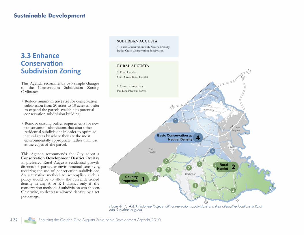
3.3 Enhance Conservation Subdivision Zoning
This Agenda recommends two simple changes to the Conservation Subdivision Zoning Ordinance:
• Reduce minimum tract size for conservation subdivision from 20 acres to 10 acres in order to expand the parcels available to potential conservation subdivision building.
• Remove existing buffer requirements for new conservation subdivisions that abut other residential subdivisions in order to optimize natural areas by where they are the most environmentally appropriate, rather than just at the edges of the parcel.
This Agenda recommends the City adopt a Conservation Development District Overlay in preferred Rural Augusta residential growth districts of particular environmental sensitivity, requiring the use of conservation subdivisions. An alternative method to accomplish such a policy would be to allow the currently zoned density in any A or R-1 district only if the conservation method of subdivision was chosen. Otherwise, to decrease allowed density by a set percentage.
2
1
2
2
2 2
2
22
2 2
4
4
Basic Conservation w/ Neutral Density
11
Country Properties
Rural Hamlet
4
Gordon Hwy
Jimm
y Dyess
Walton Way
Deans Bridge
Rd
Fall Line Fw
y
Rte-88
Peac
h Orc
hard Rd
Sava
nnah
Riv
er P
kwy
Wrightsboro Rd
Old
Way
nesb
oro
Rd
Hephzibah McBean Rd
Win
dsor
Spring Rd
Mik
e Pa
dget
t Hw
y
Washington Rd
Riverwatch Pkwy
I-520
I-20
BlytheHephzibah
Bush FieldFort
Gordon
East AugustaButler Creek
R
ocky C reek
Raes Creek
Spi rit Creek
Little Spirit
Creek
Mc Bean Creek
Figure 4-11. ASDA Prototype Projects with conservation subdivisions and their alternative locations in Rural and Suburban Augusta
SUBURBAN AUGUSTA4. Basic Conservation wtih Neutral Density: Butler Creek Conservation Subdivision
RURAL AUGUSTA
2. Rural Hamlet:
Spirit Creek Rural Hamlet
1. Country Properties:
Fall Line Freeway Farms

Land Development Regulations
4-33[The Policies Appendix]
Suburban Augusta
3.4 Encourage Conservation Subdivisions
Key changes to the Land Subdivision requirements and provisions include:
• Requirement of a context map showing all natural and man-made features surrounding the site.
• Requirement of a site inventory of existing features upon which to base decisions regarding the site’s development
• The required use of process in which Greenspaces are determined first, before houses, streets and lot lines.
• Inclusion of design standards for configuration and location of Greenspace.
• Modify the current Comprehensive Plan Guiding Policy of ‘provide zoning for land suitable for projected new conventional single-family residential development’ to instead encourage conservation subdivision over conventional development methods, as this method needs more public sector support than conventional development.
Also, the future maintenance of newly created Greenspace land is an issue. There are three potential methods to maintain the land left in its natural state:
• Community Associations,
• Private conservation organization, and
• Conservancy lots, which are lots within the neighborhood that are over 10 acres in size, essentially privatizing the Greenspace maintenance in a few select land owners.
This Agenda recommends enhanced Community Associations for all neighborhoods, but particularly for conservation subdivisions, to take care of Greenspace land.
Figure 4-12. Singular entrace, with back yards facing the creek, essentially privatizing that natural amenity
Figure 4-13. Multiple entrances, with front yards facing a street and the creek making it a safe, public way. Smaller lot sizes lead to closer community, with a minimum of 50% of the land is set aside for recreational enjoyment.
Traditional Subdivision
Approach
Conservation Subdivision
Approach

Sustainable Development
4-34 Realizing the Garden City: Augusta Sustainable Development Agenda 2010
Gordon Hwy
Jimm
y Dyess
Walton Way
Wrightsboro Rd
Win
dsor
Spring Rd
Washington RdRiverwatch Pkwy
I-520
I-20
BlytheHephzibah
Bush FieldFort
Gordon
East AugustaButler Creek
R
ocky C reek
Raes Creek
Spi rit Creek
Little Spirit
Creek
Mc Bean Creek
6
7 7
6
3 3
3
3
Urban Village
Town Center
Neighborhood Revitalization
3
Town Center 3
67
Neighborhood Revitalization 7
5
5c
5
Regional Mixed Use 5
Regional Mixed Use
Figure 4-14. Project areas with Prototypical Project Overlay Zones in Urban and Suburban Augusta
3.5 Designate Zoning Overlay Districts for Priority Projects to Encourage Quality Development
It is imperative, in order to produce successful projects at major intersections, that Augusta have a framework in place to encourage a wide variety of mixed uses, walkable centers with plentiful transit options and affordable housing choices. These districts would contain incentives such as increased density or reduced parking, in exchange for desired public amenities such as senior housing, ground-floor retail, public plazas and pedestrian walkways.
At a minimum, these districts would require Low Impact Development standards to manage storm water with an enhanced Green Infrastructure network and support increased density and intensity of use allowances compared to the land uses that surround the Project Area.

Land Development Regulations
4-35[The Policies Appendix]
URBAN AUGUSTAAn Urban Zoning Overlay
The Urban Zoning Overlay (UZO) district is a special type of overlay zoning district that is recommended to better regulate project development in the older, more urban areas of Augusta.
Suggested residential densities in these project areas is 8-16 units per acre.
Other Standards could include:
• Change minimum dimensional standards to maximums in order to create less suburban, more urban, development patterns. These include setbacks, front yard, side yard dimensions.
• Encourage multiple housing types through small lots and limited buffer yards between homes.
• Require minimum residential densities at key areas where the intent is to create walkable village or neighborhood centers.
• Incorporate pedestrian safety improvements, such as convenient on-street parking and minimum facade transparency into design standards.
SUBURBAN AUGUSTAA Town Center Zoning Overlay
The Town Center Zoning Overlay (TCZO) district is a special type of zoning district that is recommended to better regulate project development in suburban areas of Augusta.
While not transit oriented developments, these projects still contain more activity and intensity than their surroundings. This district suggests a traditional neighborhood layout with residential densities of 4-10 units per acre.
Other Standards could include:
• Provide mandatory pedestrian routes within parking lots over 200’ wide in commercial areas. Use 5’ - 8’ sidewalks with a 5’ greenway for better pedestrian and bikeway access.
• Limit parking in front of the building to less than 10% of required spaces, or up to 50% if screened out by use of additional tree plantings and low walls.
• Require open space connectivity, linking trails to new parks and existing, adjacent natural resources, where applicable.
Overlay Districts have design standards in them to ensure quality neighborhood development, such as at the proposed Southgate Urban Village.

Sustainable Development
4-36 Realizing the Garden City: Augusta Sustainable Development Agenda 2010
Urban Augusta
3.6 Create “Walkable Subdivision” Neighborhoods
While Walkable Subdivisions would be a new type of residential subdivision regulation for Augusta, its concept is not new to the region. Existing walkable neighborhoods include popular in-town neighborhoods such as the Summerville and Olde Town communities in Augusta and highly successful TND communities in Columbia County and North Augusta, such as Northridge and Hammonds Ferry. Unfortunately, these neighborhoods are not encouraged development forms and may even be prohibited by many of the conventional residential subdivision codes in place today.
Walkable Subdivision regulations should include the following urban design guidelines:
• Lot frontage requirements and situating guidelines, to encourage a well designed
‘street wall’.
• Allowance for alternative housing layouts, such as cottage subdivisions and subdivisions consisting entirely of attached housing,
• Requirement of alleyway access, to further protect the aesthetic value of the lot face.
• Maximum block lengths of 600 feet, with pedestrian connection easements required every 300 feet. Or block perimeters not to exceed 2000 feet.
• Minimum sidewalk widths of 5 feet and a green zone of 5 feet, to ensure adequate room for pedestrian and movement and greenway planting.
• Requirements for enhanced street design standards, as defined in the next chapter to ensure Complete Streets, which takes pedestrian accessibility into account
• Urban parking requirements, with allowances for on-street parking and specific reduced off-street parking ratios.
Figure 4-15. Disconnected neighborhoods, from each other and the nearby shopping experience.
Figure 4-16. Connected streets and a well-landscaped neighborhood common. Red represent through-way streets that connect abutting neighborhoods, town center developments, and greenway trails along the creek.
Traditional Subdivision Approach
Walkable Subdivision Approach
Wind
sor S
pring
Roa
d
Wind
sor S
pring
Roa
d
Tobacco Road
Tobacco Road

Land Development Regulations
4-37[The Policies Appendix]
3.7 Support Low Impact Development Strategies in Building Code Ordinances
This Agenda recommends that Augusta take a first, pro-active step in reducing the impacts of growth and development on local water resources by supporting the ongoing collaborations between local engineering firms and the Augusta Engineering Department in promoting a city-wide switch to Low Impact Development (LID) standards. Perhaps the best way to support this shift, is to encourage a round-table process as recommended later in this document to convene local engineers, developers, and city officials to come to a consensus on techniques to be promoted and incentivized.
Applicable techniques include:
• Bioretention
• Green Roofs
• Permeable Pavers
• Rain Barrels
• Soil Amendments
• Tree Box Filters
Supporting these techniques would require changes to ordinances in several Augusta regulatory documents, including but not limited to the Water Supply Watershed Protection Ordinance, Flood Hazard Mitigation Plan, and the Street and Roadway Design Manual.
In subdivisions of five acres or greater, applicants are currently required to include 25% publicly accessible open space, as required by zoning district R-1E. This district allows for densities of 10 dwelling units per acre and more. Most Walkable Subdivisions should meet this density level in order to support transit and neighborhood retailing establishments. Therefore, appropriate open spaces include plazas, squares, greens, small parks for passive or active recreational uses and linear open space that incorporates natural elements such as a creek or a significant stand of trees. Well-landscaped streets may be counted towards the open space requirement.
Figure 4-17. Rain gardens, a Low Impact Development solution to parking lot storm water management in Charlotte, NC

Sustainable Development
4-38 Realizing the Garden City: Augusta Sustainable Development Agenda 2010
All Augusta
3.8 Modify Existing Land Subdivision Regulations
In ARTICLE I: General
• This Agenda recommends changing the overall subdivision regulation trigger to apply to any subdivision of four or more parcels, rather than the current 10 or more acres. This change will affect smaller subdivisions in rural areas that may be able to adhere to forthcoming Hamlet design standards.
In ARTICLE II: Procedure for Approval of Subdivision Plats.
• Consistent with the Green Infrastructure recommendations described above, any new subdivision application would be required to submit a Site Context Map and Existing Resources Map during the Sketch Plan review stage for use during the highly encouraged Site Visit.
In ARTICLE III: Requirements for Sketch Plans, Existing Resource Map, Context Map, Development Plans and Final Plats and Provision for Inspection:
• List the new requirements for the Existing Resource and Context maps.
• Consider making Conservation Subdivisions mandatory for any property that includes more than 10 acres of an existing “primary conservation resource” (wetlands and 100-year floodplains) within the site boundary.
In ARTICLE IV General Design Standards
The design standards title has been changed to reflect that two new types of subdivision standards have been proposed:
• Conservation Subdivisions, that reflect an outdoor lifestyle connection.
• Walkable Subdivisions, suggesting an urban lifestyle centered on convenience and community gathering.
In conjunction with a renewed emphasis on Conservation Subdivisions, new Greenspace Design Standards are proposed to fall within Augusta’s Land Subdivision Regulations16:
• Primary Conservation Resources shall all be included in the Greenspace land. With Secondary Conservation Resources being included in Greenspace land to the greatest extent possible.
16 See Growing Greener: Conservation By Design: Model Ordinance Version 2.0, Natural Lands Trust, 2007. for additional details

Land Development Regulations
4-39[The Policies Appendix]
• Greenspace shall be suitable for passive recreational uses, where deemed appropriate, without interfering with adjacent dwelling units, parking, driveways or roads.
• Greenspace shall be interconnected wherever possible and contain a suggested minimum of 3 acres.
• Shall provide for pedestrian paths to be used by the subdivision residents. Public access should be given if they link to other publicly accessible pathways.
• Greenspace shall abut the largest practical number of lots within the subdivision. At least 75% of lots shall directly face the Greenspace.
• Minimize views of new dwellings from exterior roads through heavy landscaping and site design.
3.9 Require Street Connectivity
Streets should be laid out in a manner where connectivity is emphasized. This Agenda recommends that any parcel development over 10 acres in size would be triggered for conformation this connectivity standard. If the parcel abuts two existing right of ways of this length, it is required to establish a connecting route. And where an applicable parcel abuts another applicable parcel (of 10 acres or more), it is required to build a stub-out or hammerhead turn around for future street connections (see
“Figure 4-18. Hammerhead turn around*” on page 4-39.
For dead end streets, they shall be terminated with a hammerhead turn around and be no longer than 300 feet, rather than the 1,000 feet that is allowed now. Around the hammerhead, lots shall be oriented in a way that does not preclude future extension of the road way.
In addition, this Agenda recommends setting up a reserve fund that developers are required to contribute to if they choose not to develop a hammerhead or throughway connection. This fund will be used for future roadway connections. Also, the right-of-way must be dedicated at this time.
General Standards
1. A proposed development shall provide multiple direct connections in its local street system to and between local destinations, such as parks, schools, and shopping, without requiring the use of arterial streets.
2. Each development shall incorporate and continue all collector or local streets stubbed to the boundary of the development plan by previously approved but unbuilt development or existing development.
Figure 4-18. Hammerhead turn around*
* Diagrams from the Georgia Tech Urban Design review day

Sustainable Development
4-40 Realizing the Garden City: Augusta Sustainable Development Agenda 2010
Connectivity Design Standards
The intent of connectivity design standards is to provide for a system of streets that offer multiple routes and connections allowing ease of movement for cars, bikes and pedestrians that include frequent intersections Example ordinance language can be found in a recent Amendment to the Subdivision Ordinance of Spokane County, WA:
a. Block length for local streets shall not exceed 600 feet, unless an exception is granted based on one or more of the following:
• Physical conditions preclude a block length 600 feet or less. Such conditions may include, but are not limited to, topography natural resource areas, critical areas or shorelines.
• Buildings, train tracks or other existing development on adjacent lands physically preclude a block length 600 feet or less.
• An existing street or streets terminating at the boundary of the development site have a block length exceeding 600 feet, or are situated such that the extension of the street(s) into the development site would create a block length exceeding 600 feet.
b. The proposed development shall include street connections to any streets that abut, are adjacent, or terminate at the development site.
c. The proposed development shall include streets that extend to undeveloped or partially developed land that is adjacent to the development site. The streets will be in locations that will enable adjoining properties to connect to the proposed development’s street system.
d. Permanent dead end streets or cul-de-sacs shall only be allowed when street connectivity can not be achieved due to barriers such as topography, natural features or existing development, e.g. train tracks. Cul-de-sacs that are allowed based on the above, shall be limited to 300 feet as measured from the center line of the intersecting street to the radius point of the cul-de-sac.
e. Streets must be public if they are designed to connect to an adjacent site, or will serve lots on an adjacent site.
f. New private streets are allowed only when street connectivity is unachievable, such as property that is isolated by topography or the configuration of existing lots and streets, and shall adhere to the following requirements:.
• Private streets shall be constructed in accordance with the design standards for public streets.
• Pedestrian access shall be provided from the private street to an existing or future street or public pathway if vehicular access cannot be provided.
Figure 4-19. Typical block sizes for three Georgian cities and the famously flexible Commissioner’s Grid Plan of 1812 for New York City show how smaller blocks create more walkable environments.

Land Development Regulations
4-41[The Policies Appendix]
Figure 4-20. Southgate block influence area. Figure 4-21. As determined by outlining nearest collector streets, the Southgate area currently has a 8,400 sq foot “super block” perimeter.
Figure 4-22. Taking just the Southgate parcel, it still has a 5,850sq ft “super block” perimeter size, with an excessive parking ratio of 1 space per approximately 250sq ft of retail .
Figure 4-23. Southgate block with an example of a better, more intensely connected street grid using new street connectivity design standards in an incremental timeframe, as parcels come up for redevelopment.

4-42 Realizing the Garden City: Augusta Sustainable Development Agenda 2010

4-43[The Policies Appendix]
The Priority Projects recommended as part of the Augusta Sustainable Development Agenda are typically located at major intersections throughout the city. These locations are linked together by a road network of mixed-use avenues, boulevards, highways, and parkways that connect key destinations throughout the Augusta region. Realization of the “Garden City” concept will require significant functional and visual improvement of major intersections and then corridor revitalization strategies for the segments in-between.
4. Realizing the Garden City through Corridor Revitalization
The Augusta Sustainable Development Agenda includes an approach to roadway design that considers the roadway function, the context of the adjoining properties and neighborhoods, and the desire to rekindle the “Garden City” concept in the design of Augusta’s roads, for both new construction of streets retrofit of existing routes.
Existing view along the proposed “Augusta Way” boulevard, leaves much room for improvement

Sustainable Development
4-44 Realizing the Garden City: Augusta Sustainable Development Agenda 2010
Strategy One: Viable Commercial Enterprises
Senior Housing and Services
Eldery Care: Independent Living Complex, Assisted Living Facilities, Nursing & Residential Care Facilities
Office and Community Services
Health Services: Outpatient Health Care Centers, Offices of Home Health Care Services, Dental Labs, Medical & Diagnostic Labs, Ophthalmic Goods Manufacturing, Optical Instrument and Lens Manufacturing
Community Services: Day Care Services, Offices of Social & Governmental Services Agencies
Administrative Facilities: Data Processing Centers, Customer Service Centers, Financial Services & Credit Processing Facilities, Accounting & Payroll Services Offices, Testing Labs, Computer Systems Design Offices, Direct Mail Advertising Facilities, Administrative and Finance Back Office Facilities, Electronic, Media Production and Distribution, Video, Sound Recording, Software & Internet, Broadcasting
General Commerce
Construction-Related Businesses: Offices/Shops of Construction Contractors, Building Products Workshops for (Kitchen Cabinets and Countertops, Windows and Doors, Millwork, Ornamental & Architectural Metal Work Fabrication, HVAC Equipment Sales and Fabrication, Blind and Shade Manufacturing, HVAC & Plumbing Supply, Electrical and Lighting Supply, Sign Fabrication, Scenery and Display Fabrication, Custom Furniture Manufacturing, Home Furnishings Wholesaling)
Light Manufacturing & Assembly: Computer and Peripheral Equipment Manufacturing, Custom Machine Shops, Commercial Bakeries, Specialty Food Manufacturing, Printing & Publishing, Medical Products Fabrication, Jewelry and Silverware Manufacturing, Musical Instrument Manufacturing, Burial Casket Manufacturing
Automotive: New Car Sales & Service, Electric Motor Vehicles Assembly, Sales & Service
Distribution and Repair: Professional and Service Equipment Sales, Service & Wholesaling, Photographic, Food Service & Restaurant, Medical, Office Equipment and Supply, Vending Machine Operations Center, Equipment Repair Facilities, Apparel Wholesaling, Commercial Nursery and Florist, Commercial Laundries and Linen Supply
Figure 4-24. Viable business types for Greater South Augusta Trade Area
4.1 Economics of the Roadway
Several major intersections have been identified as favorable locations for clustered retail. These include I-520 interchange at Peach Orchard Rd which is the most attractive location for expanded, diversified retailing in Greater South Augusta. A conservative assessment of retail demand accessible from this location shows nearly $900 million in this Greater South Augusta Trade Area.
Three strategies are recommended in the Final Report, see page 2-129, Figure 2-54
“Restructuring plan for corridors in Suburban Augusta connecting to downtown”. However, Strategy One, Supporting Viable Commercial Enterprises, is detailed further here.

Corridor Revitalization
4-45[The Policies Appendix]
Areas inside the “Greater South Augusta” Trade Area• I-520 Interchange at Peach Orchard
Road, is a site which is the most attractive location for expanded, diversified retailing in Suburban Augusta. This ‘Regional Center’ reaches a customer base of 120,000 to 150,000 from approximately 4 miles away in all directions and up to 10 miles away in the south and southwest. It would support regional scaled big-box and superstore retail with a wide assortment of restaurants. The nearby intersection of I-520 and Deans Bridge Road could be considered an alternative regional location, but as the two serve the same regional market, there is only sufficient demand to support one major regional hub and much of the land immediately at this location is developed otherwise.
• The Deans Bridge and Gordon Highway intersection is centrally located and in position to be a regional and community focused “Business Center” that aims to increase employment opportunities at the center of Augusta’s population. For non-retail commercial spaces and health and human services, this location is likely to pull
2010 Retail Purchase Potential in Greater South Augusta
Total Population 119,100 people
Total Income (in $000) $2,009,622
Grocery Stores $203,910
Drug Stores / Pharmacies $72,712
Restaurants $98,641
Hair Salons $9,980
Other Community-Servicing Retailing $56,197
Department Stores $155,481
Apparel $79,484
Home Furnishings & Home Improvement $114,999
Other Speciality Goods $66,211
Other Retailing $40,849
Total Retail Purchases (in $000) $898,465Urban Partners 8/2010
Figure 4-25. Retail purchase potential in Greater South Augusta Trade Area
Plenty of space available at the Southgate shopping center for additional businesses to infill the parking lot with buildings

Sustainable Development
4-46 Realizing the Garden City: Augusta Sustainable Development Agenda 2010
from a customer base of more than 120,000 persons residing within a 3 to 7 mile radius. For retail services, this location could draw from surrounding neighborhoods located within a more modest 2 to 3 miles and support a grocery store, bank, pharmacy, and several restaurants.
• Tobacco Road and Windsor Spring Road, is an attractive site for a “Town Center” district, building upon a base of about 20,000 nearby households in a 2 to 3 mile radius. This household base would support one or two supermarket anchors totaling 50,000 to 60,000 square feet of spaces as well as another 160,000 square feet of community service retail, restaurants. Another similar intersection would be Wrightsboro Road and Jimmie Dyess Parkway.
Areas outside the “Greater South Augusta” Trade Area:
• Mike Padgett at Brown Road- Rural Augusta needs access to basic convenience goods and services, such as was formerly found at the country store. A hamlet subdivision in this location would serve the area, passing motor traffic and could be an attractive alternative to sprawl around the surrounding rural landscape.
• I-520 Interchange at Sand Bar Ferry Road- As the new and most convenient entry point into Augusta for points north and east, this is an ideal location to develop an attractive commercial area catering to the passing and arriving motorist.
Residential and Office Ordinance
In order to scale retail-zoned land to reflect a more realistic assessment of the current size, strength, and character of the market, excess commercial land in older strips should be rezoned to encourage reinvestment in uses that the market currently supports and while improving the quality of existing retail intersections.
As a part of the new Priority Project Overlay Zones (see “Figure 4-14. Priority Project areas with Priority Project Overlay Zones in Urban and Suburban Augusta” on page 4-36 and surrounding text) suggested for these major intersections, this Agenda recommends a Residential and Office Ordinance that restricts any type of commercial or retail use for up to a mile out from the Project Area boundaries17. Permitted uses include professional, business, medical and residential uses. The ordinance should include guidelines on signage, frontage landscaping, and height.
17 Beyard, Michael D. and Pawlukiewicz, Michael. Ten Principles for Reinventing America’s Suburban Strips. Urban Land Institute. 2001.

Corridor Revitalization
4-47[The Policies Appendix]
4.2 Private Sector Role in Roadway Beautification
The major theme of the Augusta Sustainable Development Agenda, “Realizing the Garden City,” signifies a new beginning of emphasis on living up to the City’s historic brand name. The effort implies a renewed commitment to attractiveness that begins with the public sector. Once the City goes first, the private sector will sense that the City is serious about aesthetic improvements, developers, property owners, and citizens at large will be encouraged in making individual efforts toward achieving an improved street scene. These public and private actions, taken together, will transform the “View from the Road” and help Augusta realize the Garden City.
These landscape areas may have to be largely provided for by private sector donation and non-profit organization grant assistance.
For example, the City of Atlanta, in conjunction with the Junior League of Atlanta and the Atlanta Parks Commissioner founded an organization in 1985 called Trees Atlanta. This organization has been a prime force in addressing Atlanta’s tree loss through tree conservation, replacement and new planting programs. One of its major initiatives is to plant appropriate tree variety along major traffic corridors to increase Atlanta’s urban tree canopy while calming traffic, reducing noise and air pollution and supporting
pedestrian activity. Their successes have encouraged residents to advocate for better tree and landscaping ordinances and have attracted the continued financial support of a range of sources from individuals to large corporations and foundations.
4.3 Context Sensitive Solutions Classification Approach
Functional Classifications
There are several ways that streets are classified. The functional classification is important as it defines the role of the street in moving traffic and how it fulfills that role.. From a functional point of view, the roadway system of Augusta is a network of interstates, highways, commercial arterial routes, and local streets. These arterial routes are classified according to the system of the Georgia Department of Transportation18 into the following functional classes:
• Urban Interstate Principal Arterial
• Urban Freeways and Expressways
• Urban Principal Arterial
• Urban Minor Arterial
The chart on the next page refers to a potential visual prioritization method for Augusta corridors, in relationship to Context Sensitive Solution thoroughfare types.
18 Adapted from Institute of Transportation Engineers (ITE) Context Sensitive Solutions in Designing Major Urban Thoroughfares, www.ite.org, Fact Sheet 4, accessed December 1, 2009.
Context Sensitive Solution (CSS) Organization for Augusta Corridors
Thoroughfare Types
Functional Classification
Principal Arterial
Minor Arterial
Collector
Local
Beautification Overlay Designations: Garden City Gateways Garden City Corridors Garden City Landscape Highlights
Inte
rsta
te
Free
way
Hig
hway
Bou
leva
rd
Ave
nue
Stre
et
Rur
al R
oad
Alle
y
Figure 4-26. Relationship to Context Sensitive Solution Thoroughfare Types

Sustainable Development
4-48 Realizing the Garden City: Augusta Sustainable Development Agenda 2010
Context Zone Distinguishing Characteristics General Character
C-1 Natural Natural landscape Natural features
C-2 Rural Agricultural with scattered development Agricultural activity and natural features
C-3 Suburban Primarily single family residential with walkable development pattern and pedestrian facilities, dominant landscape character
Detached buildings with landscaped yards
C-4 General Urban
Mix of housing types including attached units, with a range of commercial and civic activity at the neighborhood and community scale
Predominantly detached buildings, balance between landscape and buildings, presence of pedestrians
C-5 Urban Center
Attached housing types such as townhouses and apartments mixed with retail, workplace and civic activities at the community or sub-regional scale.
Predominantly attached buildings landscaping within the public right of way substantial pedestrian activity
C-6 Urban Core
Highest-intensity areas in sub-region or region, with high-density residential and workplace uses, entertainment, civic and cultural uses
Attached buildings forming sense of enclosure and continuous street wall landscaping within the public right of way, highest pedestrian and transit activity
District To be designated and described locally, districts are areas that are single-use or multi-use with low-density development pattern. These may be large facilities such as airports, business parks and industrial areas.
Figure 4-27. Context Zone Characteristics
Context Zones
Context zones are used to describe the characteristics of urban sub-areas that have similar discrete ranges of density and intensity of development. The idea of the CSS method is to use these context zones as an important factor to select a roadway type in conjunction with the functional classification to insure that each roadway design is supportive of the area and context it is intended to serve.
Thoroughfare Types
The desirable design characteristics of each thoroughfare type are presented in both in Table 2 and in the illustrative cross sections on the following pages.
The Development Agenda concentrates on thoroughfares that serve existing urban and suburban areas and those that will likely undergo future development within the time horizon of the Agenda. The types of thoroughfares defined by CSS are organized by a classifying system that governs the design criteria of the thoroughfare and along with the surrounding context is used to determine the physical configuration of the traveled way, intersections, and the roadside. The thoroughfare types include the following:

Corridor Revitalization
4-49[The Policies Appendix]
Parkway - a four-lane or larger roadway, with or without curbs, to serve higher traffic volumes of regional traffic at relatively higher speeds.
Highway – a two-lane or larger roadway with ditch sections to accommodate regional and local traffic at higher speeds.
Boulevard – a divided thoroughfare with curbs that serves a mix of regional and local traffic and accommodate the most important transit routes.
Avenue – a curbed road of up to four lanes, with or without a median, that serves a mix of regional and local traffic.
Street – generally a two-lane curbed road that serves predominantly local traffic.
Urb
an T
horo
ughf
are
Typ
e
Num
ber
of T
hrou
gh
Lane
s
Des
ign
Spee
d (m
ph)
Ope
rati
ng S
peed
(mph
)
Inte
rsec
tion
Spa
cing
Tra
nsit
Ser
vice
Em
phas
is
Med
ian
Cur
b P
arki
ng
Dec
eler
atio
n La
ne
Bic
ycle
Fac
iliti
es
Frei
ght M
vmt.
Dri
vew
ay A
cces
s
PARKWAY 2 to 6 55 45-50 ½ mile Express and Local
Wide median Required
No Yes Separate Parallel Route
Regional Through Truck Route
Strin-gent Control
HIGHWAY 2 to 4 55 45-50 1000 to 1,320 feet
Express and Local
Optional No Yes Separate Parallel Route
Regional Truck Route
Con-trolled
BOULEVARD 4 to 6 35-40 30-35 660 to 1,320 feet
Express and Local
Required Optional Optional Bike Lanes
or Parallel Route
Regional Truck Route
Limited
MULTIWAY
BOULEVARD
4 to 6 30-40 (20 in access road-way)
25-35 660 to 1,320 feet (400 to 600 feet for access lanes)
Express and Local
Required Yes on access roadway
Optional Bike Lanes
or Parallel Route
Regional Route/Local deliv-eries only on access roadway
On access Road-way
AVENUE 2 to 4 30-35 25-30 300 to 660 feet
Local Optional Yes No Bike Lanes
or Parallel Route
Local Truck Route
Yes
STREET 2 30 25 300 to 600 feet
Local Optional Yes No “Share the Road”
Local Deliv-eries Only
Yes
LANE 1-2 20 20 N o Minimum
N/A No Yes No “Share the Road”
Local Deliv-eries Only
Yes
Figure 4-28. Urban Thoroughfare Design Characteristics

Sustainable Development
4-50 Realizing the Garden City: Augusta Sustainable Development Agenda 2010
Boulevard
Parkway
HighwayIllustrative Cross Sections
Illustrative cross sections of seven different thoroughfare types, applicable to Augusta, are illustrated to the right. The ASDA recommends that, in each case, the vehicle travelway width be designed to the narrowest standard width for driver and pedestrian safety. Each section assumes that design is consistent with the objectives of DOT’s Context Sensitive Solutions recommendations. Each assumes a well-landscaped corridor, with continuous shade tree plantings along the prescribed sidewalk and multi-purpose paths.

Corridor Revitalization
4-51[The Policies Appendix]
Street - Narrow
Multi-way Boulevard
Avenue
Street - Wide

Sustainable Development
4-52 Realizing the Garden City: Augusta Sustainable Development Agenda 2010
4.4 Recommended City Ordinance Changes
Signage
New Signage Standards should be developed to encourage high quality aesthetic presentation of business to the roadway:
• All new freestanding signs would be required to be monument style, removing sign visibility as a justifiable reason for the removal of trees in commercial areas19.
• Limit height of signs to maximum of 12 feet. Encourage monument signs.
• Require conformance with updated signage guidelines after property use change or sale.
Tree and Landscaping Ordinance Revisions
For ease of administration, this Agenda recommends creating a checklist for procedures to facilitate the tree ordinance compliance process. This checklist would include steps such as a land disturbance permit, rezoning and special use permits, timber harvest permit, minimum planting requirement tables, and information on the tree bond program. This Agenda 19 The city of Canton, GA enacted a simi-lar ordinance in 2002.
recommends that an enhanced Tree Protection Plan be required during the Development Plan submittal phase for both residential and commercial properties. This will be particularly helpful in establishing an ordinance for and the encouraging ordinance compliance in single-family residential subdivisions. This plan shall be prepared by either a Landscape Architect registered in the state of Georgia or the site’s civil engineer and shall show the location of all proposed trees, shrubs, and ground covers plus all existing vegetation to be preserved.
Commercial Area Landscaping Trigger and New Ordinance
This Agenda recommends that the trigger for compliance with these requirements be modified as follows:
• The ordinance now is applied in the case of expansion equal or greater than 20% of building area. This trigger should be reduced to 10%. The part of the ordinance that refers to exemptions for increases in parking areas of less than five new spaces, should be reviewed.
Figure 4-29. Existing light industrial property
Figure 4-30. Existing light industrial property: with new on-site tree planting along the corridor* * Graphics from the Georgia Model Urban Forest handbook from the Georgia Forestry Commission

Corridor Revitalization
4-53[The Policies Appendix]
• The ordinance should also be applied when the ownership of the parcel changes, in order to make landscape updates a part of the real estate transaction cost.
• This ordinance should also be applied when the cost of renovations exceed 25% of the currently assessed building value.
Commercial Energy Efficiency Standards
Augusta should model energy efficiency standards for its private sector by retrofitting all of its existing public structures. This is an opportunity to create local awareness of rainwater capture, green roofs, renewable material use, and native plantings.
• Incorporate energy efficiency and green building practices into commercial and residential building codes. Consider LEED standards.
Figure 4-31. Existing commercial property
Figure 4-32. Existing commercial property: with new on-site tree planting* * Graphics from the Georgia Model Urban Forest handbook from the Georgia Forestry Commission
• Encourage local companies to adopt environmental management standards: energy and water conservation, tree plantings, and using natural weed killers. Then champion early adopters of environmental management standards, as local industry can play a huge role in such an effort. Georgia Tech’s Enterprise Innovation Institute is a potential organizational and program assistance resource for this area.
This Agenda also recommends that Augusta promote ‘dark skies’ to maintain our view of the night sky, reduce glare and light pollution that represents wasted energy with a new Lighting and Glare ordinance section that includes:
• Require lighting to focus on subject property and not spill over onto adjacent property or public-right-of-way.
• Require cut-off fixtures, or low intensity, shielded luminaires and curfew controllers turning the lights off at 10p or at closing (whichever is later).
• Projects should minimize the lighting of architectural or landscaping features.

4-54 Realizing the Garden City: Augusta Sustainable Development Agenda 2010

4-55[The Policies Appendix]
5. Neighborhood Enhancement and Revitalization
Smart Growth is a mechanism for the re-integration of struggling neighborhoods back into a successful community, primarily by encouraging better housing and job opportunities for residents.
Several of the Guiding Policies of the Comprehensive Plan support the redevelopment and infill of older neighborhoods. This Agenda works in tandem with these policies to promote infill housing as a Smart Growth land development practice in Augusta’s Urban and Suburban areas. This sustainable strategy makes use of existing infrastructure by reconnecting neighborhoods that have been severed by ill thought out roadway infrastructure and the resultant economic disconnect.
Augusta has many historic neighborhoods with a strong fabric to build on. This includes replacing obsolete housing and rehabilitating deteriorating structures.
Renovated homes in the Summerville neighborhood
Example of an obsolete structure
Example of structures to be rehabilitated

Sustainable Development
4-56 Realizing the Garden City: Augusta Sustainable Development Agenda 2010
5.1 Recommended Comprehensive Plan Changes
The first step in facilitating the recommendations of this Agenda will be to slightly revise several of the Land Use and Growth Management Guiding Policies of the Comprehensive Plan. Specific elements that should be integrated into these policies include:
• Modify the policy of ‘provide zoning for land suitable for projected new conventional single-family residential development’ to instead encourage infill development over conventional methods as this method needs more public sector policy support.
• Modify the policy of ‘encourage the preservation of residential areas by protecting them from the encroachment of conflicting land uses’ to support lining existing low-density single-family zones with higher-density residential development, especially along the Priority Development Corridor. Apartment buildings and single-family residences can coexist side-by-side in a mutually beneficial manner if appropriate site design techniques and scale are taken into consideration.
• Modify the policy of ‘encourage infill development’ to embrace the increased density of urban neighborhoods, rather that tentatively list potential problems. Increasing the density of neighborhoods through infill areas does more to support their sustained livability than almost any other land development policy.
Existing subdivision without any tree cover for shade and enjoyment
5.2 Community Supported Agriculture
In the coming years, local food production is likely to be both more popular and more necessary. It is educational and it is fun. Augusta has both good soils and available land in each of its urban, suburban and rural sectors. Relative to much of Georgia, it has an abundance of good water. These concerns are causing more and more farms and gardens to be planned, and planted, in traditional neighborhood developments (TND).
“Community Supported Agriculture” occurs when people buy shares of the harvest from a farm in their vicinity. A Serenbe, a TND in Palmetto, GA, people have paid about $750 for a fulls hare of a farm for the April - October season. Residents benefit in very basic ways:
“They’re eating [the produce] and smelling [the plants and soil], and making contact with nature.” says Daron Joffe, who founded ‘Farmer D Organics’ and elevated Serenbe’s farm to certified organic standards20.
The Westobou Vision calls for creation of a commercial organic farm as part of the Sandbar Ferry Road regional recreation area. In Suburban Augusta, a community farm could become an amenity for a conservation subdivision along
20 Langdon, Phillip. Down on the new urban farm. New Urban News Network. Dec 1, 2009. http://newurbannetwork.com/article/down-new-urban-farm

Neighborhood Revitalization
4-57[The Policies Appendix]
Q:How did you become an urban farmer?
A: I started with urban agriculture in Augusta,
Georgia, in 1950 when it didn’t have that terminology. I had no idea then that there was ever such a thing as “urban agriculture.” My grandmother and I grew vegetables such as collard greens, turnips and all the other greens. We grew in our yard. We raised chickens right there in the city. We raised rabbits and made soap for a laundry business. I didn’t always consider myself a farmer. It wasn’t until the 90s that I began to see how it all came together to help communities and the voids that existed in our community. And I served the purpose, even without much compensation, and received comfort that I was helping.
- Mckinley Hightower-Beyah who owns McKinley’s Organic Growing Station in New York, NY
Brian Gandy, farmer of Blue Clay Farms, pictured with the raised garden beds.
Butler Creek. In Rural Augusta, where the best soils lie, commercial farming could be reintroduced on a grander scale. At the proposed Fall Line Farm, both large scale production and demonstration educational programs could preserve this significant agricultural resource.
Community gardens and individual garden plots should be encouraged throughout the city’s existing neighborhoods and subdivisions. Abandoned brick ponds could be come well-stocked fishing holes or even aqua-culture sites. Tree plantations could devour many acres of under-utilized roadway and utility rights of way.
A nearby example, the Hammond’s Ferry, 200-acre TND offers garden plots to its residents. It also features a tiny farm, currently 1.5 acres, including a modest greenhouse and a diminutive barn. The initial idea was that the farm at Hammond’s Ferry, Blue Clay Farm, would provide fresh produce for the local market while educating residents about sustainable agricultural practices. The developers allocated $50,000 a year to establishing the farm and hiring a manager, calculating that it would take five years to break even. However, the owner of the restaurant offered to operate the farm himself, raising ingredients for use in the café, saving the developer’s money and more closely integrating the restaurant and the farm.
The next few years should see extensive national experimentation in how to fit farms and gardens into communities and how to organize their operations and finances. The nation appears to be on the cusp of a more satisfying relationship to food production.
Potential local partners might include the Savannah River Land Trust, Golden Harvest, farmers market organizations, the Exchange Club (which runs the County Fair) local farmers, property owners leasing land, the County Farm Bureau and the state department of agriculture.
Working together there’s a real business opportunity here.

Sustainable Development
4-58 Realizing the Garden City: Augusta Sustainable Development Agenda 2010
Figure 4-33. Existing suburb: without new tree planting
Figure 4-34. Existing suburb: with new private sector tree program planting* * Graphics from the Georgia Model Urban Forest handbook from the Georgia Forestry Commission
5.3 Improving Neighborhood Character through Tree Planting
Tree Program for Existing Neighborhoods
Another method of increasing existing neighborhood property values through natural resources is to plant shade trees along the public utility right-of-ways in existing subdivisions.
This Agenda recommends that Augusta found either a city-wide or targeted neighborhood organization similar to Trees Atlanta21. Beginning in 2001, their successful NeighborWoods program has played a crucial role in the revitalization of many urban neighborhoods. As a combination tree planting, maintenance, education and community building, its staff works with barren neighborhoods to find funding for shade trees, with priority given to areas most frequented by pedestrians and with residents willing to assist in the crucial first two-years of tree maintenance.
21 Trees Atlanta, Inc. http://www.treesatlanta.org/
New Residential Single-Family Subdivision Landscaping
New subdivisions in Augusta-Richmond County are currently exempt from the Tree Ordinance and Illustrated Landscaping Guide and therefore, are allowed to clear-cut at will. They are also not required to plant any street or shade trees to replace the natural resources they may have destroyed.
This is not the norm within the state of Georgia, as the Georgia Urban Forest Council survey reports that of the Georgia counties with tree ordinances, 67% regulate new residential subdivisions with an additional 27% regulating existing single-family residences.
Therefore, this Agenda recommends that Augusta become a state-wide model for new residential subdivisions and include them in its tree ordinance by removing the current exemptions for single-family residential structures on individual lots and new streets within subdivisions.

Neighborhood Revitalization
4-59[The Policies Appendix]
Then, a new section should be added to the ordinance to regulate new single-family construction (not retrofit existing neighborhoods). This section might include:
• Minimum Tree Density. Augusta’s current ordinance requires 1,000 tree quality points per acre. This Agenda recommends adding a requirement for a set number of shade trees per lot. For example: 4 shade trees, at least 8’ tall, with a trunk caliper of 2 inches and 50% of the plantings in the front yard.
Street trees at max 40 feet on center
House shade (min 2 per dwelling)
• Work to prevent clear cutting by altering the tree quality point mathematical formula to prevent the required number of points being met merely through replanting. The intent is to require that some existing tree stands, particularly large groupings, remain.
• Require lines of communication between the developer of a new subdivision and the single-family home builder during lot hand overs, regarding tree protection areas, fencing, and required number of trees per lot.
Large Specimen TreesIn existing neighborhoods, if mature trees are protected, it is by a voluntary Landmark Tree designation where the property owner has voluntarily put the tree in front of the Tree Commission for this designation. In order to increase their protection factor, this Agenda recommends expanding this protection to any mature trees of notable longevity, height, or appearance as determined by the Tree Commission, as follows:
• Define Specimen Trees in the ordinance separately from Landmark Trees, which require a voluntary submittal by the property owner to the Commission.
• Consider that any mature tree, such as those over a 55” caliper, require a permit for their removal and an increased replacement ratio within the Tree Ordinance
The purpose of the new category is to increase the number of trees under protection by the City without relying upon the property owner’s initiative to come forward.
Figure 4-35. New suburb
Figure 4-36. New suburb: with enhanced tree canopy requirements for new development* * Graphics from the Georgia Model Urban Forest handbook from the Georgia Forestry Commission

4-60 Realizing the Garden City: Augusta Sustainable Development Agenda 2010
5.4 Support Residential Energy Efficiency Upgrades
In supporting the redevelopment of its older neighborhoods, Augusta should also support upgrading its housing stock to 21st century energy efficiency standards. This Agenda recommends that Augusta use its building codes to promote green materials, systems and practices for residential energy efficiency.
Like Atlanta’s new Sustainable Home Initiative for a New Economy (SHINE), Augusta should seek to stimulate demand for residential energy-efficient retrofits by providing incentives to single-family homeowners. Augusta could partner with Georgia Power’s Home Performance with ENERGY STAR program and receive additional funds through the U.S. Department of Energy’s Conservation Block Grants. The City of Augusta has already been awarded some funds.
In addition, these grants require that receiving cities utilize local, Georgia-certified contractors to perform the comprehensive assessments and home improvements. This will expand residential construction opportunities and provide contractors with excellent value-added service options, supporting Augusta’s local economy.
5.5 Historic Preservation and Reuse of Existing Buildings as a Green Practice
Historic preservation is a sustainable development practice that conserves resources, recycles materials, and produces an attractive appearance in the process. The construction, operation and demolition of buildings accounts for 48% the United States’ greenhouse gas emissions. However, the energy embedded in an existing building can potentially reduce, by 40%, the total energy use in maintenance and operations for the entire life of a building1.
The National Trust for Historic Preservation has a Sustainability Initiative that encourages the re-use of historic and older buildings as an important investment strategy in existing communities. They note that, “new construction, no matter how green, still uses energy and other natural resources and generates construction waste that clogs landfills”2. Reusing and retrofitting existing buildings can reduce these emissions dramatically.
1 Whole Building Design Guide. A Program of the National Institute of the Building Sciences. Website: http://www.wbdg.org/resources/sustainable_hp.php
2 National Trust for Historic Preservation. Historic Preservation and Sustainability. Website: http://www.preserva-tionnation.org/issues/sustainability/position-statements/sustain-ability.html
In fact, existing buildings are one of Augusta’s greatest renewable resources.
The Green Communities Loan Fund by the Georgia Cities Foundation has financing available for historic buildings that are upgrading to renewable sources of energy.
Enterprise Mill has been succesfully converted into offices and residential lofts (photo: Augusta Convention and Visitor’s Bureau)

4-61[The Policies Appendix]
Team
shieldsDESIGN LLCJohn R. Shields, Principal-In-ChargeA. Rae Smith, Project Urban Designer
Cranston Engineering Group, P.C.Thomas H. Robertson, Transportation, Civil and Regulatory
exclamation101Andrew Young, Graphic Design Consultant
F.M. Costantino IncFrank Costantino, Architectural Rendering
ICON Architecture, Inc.Jonathan S. Lane, Organizational Consultant
The Woodhurst PartnershipBob Woodhurst, ArchitectRobert S. Woodhurst, Associate Architect
Urban PartnersJames E. Hartling, Economic Consultant
with
City of AugustaGeorge Patty, Planning Commission Executive Director Paul DeCamp, Planning Director