appendix 1. river/stream classification for the ntpe · appendix 1. river/stream classification for...
TRANSCRIPT

Appendix 1 – Page 1
Appendix 1. River/Stream Classification for the NTPE A1.1. Aquatic Classification Framework One of the goals of the ecoregional planning process is to develop a strategy to protect ecosystems and habitats on a systematic basis. In many ecoregions, it is difficult to achieve this objective due to the lack of a consistent classification of aquatic ecological systems, which allows us to identify, distinguish and map the types of freshwater habitats and ecological settings within an ecoregion. Prior to beginning work on the NTPE conservation portfolio, a river/stream classification was only available for the UMRB portion of the ecoregion (Weitzell et al. 2003). No aquatic classification was available for the systems in the Missouri and Red River portions the ecoregion, although much had been done to understand the biodiversity and ecology of these watersheds. Our objective was to apply TNC’s aquatic classification framework to the Missouri and Red River systems, identify the river/stream ecological system types that occur in this part of the ecoregion and include them as coarse-filter targets in our conservation plan. The first step in the Nature Conservancy’s river/stream classification approach is to successively divide the surficial hydrologic landscape into Aquatic Subregions, Ecological Drainage Units (EDUs), Aquatic Ecological Systems (AESs; also called systems) and Macrohabitats. Once the boundaries of these areas have been drawn, the macrohabitats and AESs are grouped into macrohabitat types and AES types, respectively, based on similarities in the physical habitat parameters that make up the individual AESs and macrohabitats. These habitat parameters include physical features of aquatic systems that are known to influence the composition and abundance of biota in the region. A1.1.1. Aquatic Subregions At the largest geographic scale are the Aquatic Subregions. These are large drainage regions that generally correspond to the Aquatic Zoogeography of North America, as defined by the United States Forest Service (Maxwell et al. 1995) and the Aquatic Subregions of North America as defined by the World Wildlife Fund (Abell et al., 2000). Boundaries of these units are based on fish zoogeography, physiography, climate and drainage pattern history. The NTPE crosses three subregions: the Missouri Subregion, the Arctic Subregion, and the Southern Plains Subregion (Figure A1.1). A1.1.2. Ecological Drainage Units (EDUs) Ecological Drainage Units are aggregates of hydrologic units (usually 8-digit United States Geological Survey Hydrological Units - HUCs) that share finer-scale physiographic and zoogeographic properties. We defined 11 EDUs for the NTPE ecoregion (Figure A1.2, Table A1.1), using physiographic and zoogeographic data provided in Bailey (1995) and Hocott and Wiley (1986).

Iowa
Minnesota
South Dakota
North Dakota
Nebraska
Manitoba
Upper MississippiRiver Basin
MissouriRiver Basin
Red RiverBasin
Figure A1.1. Aquatic Subregions of the Northern Tallgrass Prairie Ecoregion. The Upper Mississsippi River River basin is the Southern Plains subregion,tThe Missouri River basin is the Missouri subregion, and the Red River basin is the Arctic subregion.
Appendix 1 – Page 3
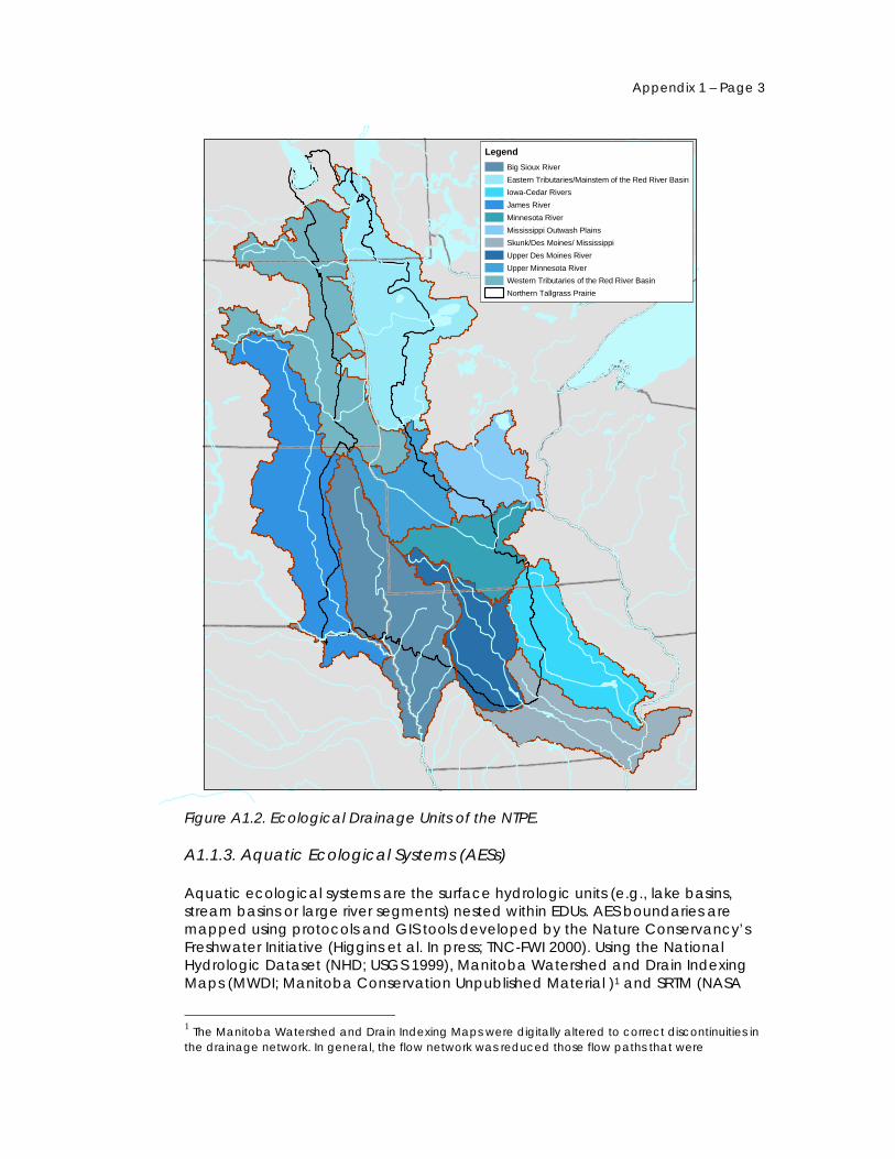
LegendBig Sioux RiverEastern Tributaries/Mainstem of the Red River BasinIowa-Cedar RiversJames RiverMinnesota RiverMississippi Outwash PlainsSkunk/Des Moines/ MississippiUpper Des Moines RiverUpper Minnesota RiverWestern Tributaries of the Red River BasinNorthern Tallgrass Prairie
Figure A1.2. Ecological Drainage Units of the NTPE. A1.1.3. Aquatic Ecological Systems (AESs) Aquatic ecological systems are the surface hydrologic units (e.g., lake basins, stream basins or large river segments) nested within EDUs. AES boundaries are mapped using protocols and GIS tools developed by the Nature Conservancy’s Freshwater Initiative (Higgins et al. In press; TNC-FWI 2000). Using the National Hydrologic Dataset (NHD; USGS 1999), Manitoba Watershed and Drain Indexing Maps (MWDI; Manitoba Conservation Unpublished Material )1 and SRTM (NASA
1 The Manitoba Watershed and Drain Indexing Maps were digitally altered to correct discontinuities in the drainage network. In general, the flow network was reduced those flow paths that were

2002), we drew boundaries around the drainage areas for five size classes of streams and rivers: headwaters (size 1), creeks (size 2), and small (size 3), medium (size 4), and large rivers (size 5). The minimum and maximum drainage areas encompassed by each of these size classes differed slightly depending on the aquatic subregion to which the streams and rivers belonged (Table A1.2). For our conservation planning purposes, we use maps of the full drainage areas for size 1 through 3 systems as our conservation planning units (Figures A1.3 – A1.5). For size 4 and 5 systems, the conservation planning units encompass the river reach and the area 3 km and 5 km, respectively, on either side of the river reach. Each large river system (size 5) is divided into segments representing functional and/or geomorphic breaks in the river continuum (Figure A1.6) A1.1.4. Macrohabitats A macrohabitat is an individual arc segment the NHD and the Manitoba Watershed and Drain Index. The boundaries of each arc segment are usually marked by the confluence of two or more stream/river segments. A1.1.5. AES and Macrohabitat Classification Once the AES and macrohabitat boundaries were established, they were grouped into AES and macrohabitat types according to similarities in persistent, natural attributes that could be mapped at a fairly coarse resolution. Attributes included surface geology, drainage network position, slope, proximity to lakes, and climatic region. Each attribute consisted of several classes that distinguished potentially biologically meaningful thresholds in the environmental gradients of each attribute (Table A1.2). Each macrohabitat arc segment was assigned a combination of macrohabitat attribute classes by overlaying digital environmental spatial data on the NHD in a geographic information system. Groups of macrohabitats that shared a similar series of attribute conditions were considered a macrohabitat type. After all macrohabitats were attributed with the appropriate macrohabitat attribute class, we calculated the total extent of each attribute class in all of the macrohabitats that comprised each AES. We then used hierarchical agglomerative cluster analysis in PCOrd (McCune 1995) to group AESs into AES types based on the relative proportions of macrohabitat attributes found in each system. Therefore, an AES type (also called “system type”) or macrohabitat type is thought to represent a unique ecological setting, with a distinctive combination of macrohabitat attributes and corresponding geophysical processes, disturbance regimes, biological species composition, and potential natural state. Every system type identified for the NTPE is described in Table A1.3.
described as natural streams. Where the flow was interrupted between natural streams, we developed an automated process to connect flow networks using intervening canal/ditch reaches.

Appendix 1 – Page 5
LegendSize 1 System
EDU Boundary
Ecoregion Boundary
Northern Tallgrass Prairie Ecoregion
Figure A1.3. Map of headwater (size 1) AESs in the Missouri and Red River basin EDUs of the NTPE.

LegendSize 2 System
EDU Boundary
Ecoregion Boundary
Northern Tallgrass Prairie Ecoregion
Figure A1.4. Map of creek (size 2) AESs in the Missouri and Red River basin EDUs of the NTPE.

Appendix 1 – Page 7
LegendSize 3 System
EDU Boundary
Ecoregion Boundary
Northern Tallgrass Prairie Ecoregion
Figure A1.5. Map of small river (size 3) AESs in the Missouri and Red River basin EDUs of the NTPE.

LegendSize 4 System
Size 5 System
EDU Boundary
Ecoregion Boundary
Northern Tallgrass Prairie Ecoregion
Figure A1.6. Map of medium and large river (sizes 4 and 5) AESs in the Missouri and Red River basin EDUs of the NTPE.

Table A1.1. Ecological Drainage Units (EDUs) of the NTPE.
Append
ix 2 – Page
EDU TerrestrialEcoregions (EPA Level III)
Geomorp-hology (Bailey et al. 1994)
Geology (Bailey et al. 1994)
Climate (Bailey et al. 1994)
Zoogeo-graphy (Hocutt and Wiley 1986; and Maxwell et al. 1995)
General Description
Upper Minnesota River
Northern Glaciated Plains, Western Corn Belt Plains, North Central Hardwood Forests
Level to rolling till plain dissected by morainal ridges
Till, stratified drift and lacustrine sand and clay covering shale, limestone and sandstone
Annual precipitation averages 20-33”. Mean annual temperature is 40-48° F.
Upper Mississippi Subregion
Level to gently rolling plains formed on glacial till. Bluestem prairie historically covered the uplands, with a narrow corridor of northern floodplain forests along the Minnesota River. Drainages include the upper Minnesota River and its tributaries.
Minnesota River
Northern Glaciated Plains, Western Corn Belt Plains, North Central Hardwood Forests
Level to rolling till plain
Till, stratified drift and lacustrine sand and clay covering shale, limestone, sandstone and some crystalline bedrock
Annual precipitation averages 20-33”. Mean annual temperature is 40-48° F.
Upper Mississippi Subregion
Level to gently rolling plains formed on glacial till. Bluestem prairie historically covered the uplands, with a narrow corridor of northern floodplain forests along the Minnesota River. Drainages include the Minnesota River and its tributaries.
Mississippi Outwash Plains
Western Corn Belt Plains, North Central Hardwood Forests, Northern Lakes and Forests
Level plains and low irregular hills
Approximately 30-500 ft of glacial drift, till, and outwash sands and gravels cover granite, greenstone and metasediments.
Precipitation averages 25-33”. Mean annual temperature is 39-48° F.
Upper Mississippi Subregion
Ecotone between western plains and the forested woodlands of the upper Midwest. The Mississippi headwaters and its tributaries form the primary drainage.
9

A
ppendix 1 – Page 10
EDU Terrestrial Ecoregions (EPA Level III)
Geomorp-hology (Bailey et al. 1994)
Geology (Bailey et al. 1994)
Climate (Bailey et al. 1994)
Zoogeo-graphy (Hocutt and Wiley 1986; and Maxwell et al. 1995)
General Description
Iowa – Cedar Rivers
Western Corn Belt Plains
Level plains and low irregular hills
Approximately 30-500 ft of glacial drift, till, and outwash sands and gravels cover intermittently exposed sandstone, shale, and dolomite.
Precipitation averages 25-33”. Mean annual temperature is 39-48° F.
Upper Mississippi Subregion
Ecotone between western plains and the forested woodlands of the upper Midwest. The Iowa and Cedar Rivers and their tributaries form the primary drainages.
Skunk/Des Moines/Mississippi
Western Corn Belt Plains, Central Irregular Plains, Central Corn Belt Plains, Interior River Valleys and Hills
Moderately dissected, glaciated, flat to rolling plains sloping gently to the Mississippi and Missouri River valleys
Up to 25 ft of loess mantles most of the uplands; till and drift up to 300 ft thick underlie the loess, and shale, limestone and carbonate form the bedrock
Precipitation averages 30-40”. Mean annual temperature is 50-56° F.
Upper Mississippi Subregion
A mosaic of bluestem prairie and oak-hickory forest covered most of the historic landscape of this EDU. Drainages include the Skunk, Des Moines and Mississippi Rivers.
Upper Des Moines River
Western Corn Belt Plains
Level to rolling till plain
Till, stratified drift and lacustrine sand and clay covering shale, limestone and sandstone
Annual precipitation averages 20-33”. Mean annual temperature is 40-48° F.
Upper Mississippi Subregion
Level to gently rolling plains formed on glacial till. Bluestem prairie historically covered the uplands, with a narrow corridor of northern floodplain forests along the Minnesota River. Drainages include the Upper Des Moines River and its tributaries.

A
ppendix 2 – Page
EDU Terrestrial Ecoregions (EPA Level III)
Geomorp-hology (Bailey et al. 1994)
Geology (Bailey et al. 1994)
Climate (Bailey et al. 1994)
Zoogeo-graphy (Hocutt and Wiley 1986; and Maxwell et al. 1995)
General Description
Big Sioux River
Northern Glaciated Plains and Western Corn Belt Plains
Level to rolling till plain
Mostly till, stratified drift and lacustrine sand and clay covering Cretaceous shale, limestone and sandstone, including a few small outcrops of Proterozoic quartzite.
Annual precipitation averages 20-33”. Mean annual temperature is 40-48° F.
Missouri; Missouri Subregion
Level to gently rolling plains formed on glacial till. Bluestem prairie historically covered the uplands, with a narrow corridor of northern floodplain forests along the Minnesota River. Drainages include the Big Sioux River and its tributaries.
James River Western Glaciated Plains, Northeastern Glaciated Plains, North-Central Glaciated Plains
Level to rolling till plain
Glacial till underlain by Cretaceous shale. Areas of ablation potholes, moraines and glacial lake plains.
Cold continental climate with hot, humid summers. Annual precipitation averages 14-24”. Mean annual temperature is 39-43° F.
Missouri; Missouri Subregion
Flat to rolling landscape formed on glacial till, lateral and end moraines. Drainages include the James River Basin and a portion of the mainstem Missouri River (from the Fort Randall Dam to Sioux City, IA). Uplands consist of mixed-grass prairie with semi-permanent and seasonal pothole wetlands.
11

A
ppendix 1 – Page 12
EDU Terrestrial Ecoregions (EPA Level III)
Geomorp-hology (Bailey et al. 1994)
Geology (Bailey et al. 1994)
Climate (Bailey et al. 1994)
Zoogeo-graphy (Hocutt and Wiley 1986; and Maxwell et al. 1995)
General Description
Lower Assiniboine*
Eastern Prairies, Northern Glaciated Plains
Level to undulating till cut by glacial channels. Includes portions of glacial Lake Agassiz deposits and more recent lake sediments.
Glacial till and lacustrine deposits overlie Early Paleozoic carbonates and shale
Cold continental climate with warm summers. Precipitation averages 15-20”. Temperature averages 35-40° F. Evapotrans-piration and precipitation approximately balanced.
Red River/ Hudson; Saskatchewan Subregion
Flat to gently rolling landscape developed on glacial till and lake plains sediments. Drainage includes a few small tributaries to the main stem Assiniboine River, and extends northward to Lake Manitoba.
Eastern Red River Basin
Lake Agassiz Plain, Northern Lakes and forests, North Central Hardwood Forests, Northern Minnesota Wetlands
Level to gently rolling plains bisected by the Red River Valley. Includes the eastern part of the Lake Agassiz plain and beach deposits.
Level lacustrine plains in the west, beach and morainal ridges grade into upland till and peat/muck in the east. Up to 400 feet of glacial sediments overlie Precambrian crystalline bedrock in most areas.
Precipitation averages 18-23”. Mean annual temperature is 36-45° F. Evapotrans-piration and precipitation approximately balanced.
Red River/ Hudson; Saskatchewan Subregion
This EDU spans a broad ecotone: the western half of the EDU intersects with the glacial Lake Agassiz plain, which was historically covered by tallgrass prairie. In the eastern half of the EDU, boreal forests, lakes and swamps occur in the north and hardwood forests occur in the south. Drainages include the eastern tributaries and mainstem of the Red River.

A
ppendix
EDU Terrestrial Ecoregions (EPA Level III)
Geomorp-hology (Bailey et al. 1994)
Geology (Bailey et al. 1994)
Climate (Bailey et al. 1994)
Zoogeo-graphy (Hocutt and Wiley 1986; and Maxwell et al. 1995)
General Description
Western Red River Basin
Lake Agassiz Plain, Northern Glaciated Plains
Level to undulating till cut by glacial channels. Includes the western part of the Lake Agassiz plain and beach deposits.
Glacial till and lacustrine deposits. Outwash and alluvium in the fans and major river valleys. Areas of ablation potholes, moraines and glacial lake plains overlie Cretaceous and Paleozoic sedimentary bedrock.
Cold continental climate with warm summers. Precipitation averages 15-20”. Temperature averages 36-45° F. Evapotrans-piration exceeds precipitation.
Red River/ Hudson; Saskatchewan Subregion
Flat to gently rolling landscape developed on glacial till and lake plains sediments. Drainage includes the western tributaries of the Red River. Historically, transitional tallgrass to mixed-grass prairie occurred in the uplands.
* Assiniboine EDU data from the Atlas of Canada (http://atlas.gc.ca/site/english/index.html
2 – Page 13

A
ppendix 1 – Page 14
Table A1.2. Macrohabitat attributes for Ecological Drainage Units (EDUs) of the NTPE. Attribute Attribute Classes for Missouri River EDUs Attribute Classes for Red River EDUs Data Source(s)
Watershed Size/Shreve Link Magnitude
1- 10-50 km2 headwater 2- 50-150 creek 3- 150-1500 small river 4- 1500-5000 medium river 5- >5000 large river
1- 10-50 km2 headwater 2- 50-150 creek 3- 150-1500 small river 4- 1500-5000 medium river 5- >5000 large river
NHD/MWDI/SRTM* analysis using TNC Tools for Freshwater Classification (TNC-FWI 2000)
Flow Permanence
1- perennial 2- intermittent
1- perennial 2- intermittent
“fcode” field in NHD
Network Position/ Connectivity/ Size Discrepancy
0 – no size discrepancy (next downstream segment is not a larger size-class stream) 1 – size discrepancy (next downstream segment is a larger size-class stream)
1 – little to no size discrepancy(stream order of subject reach differs from order of downstream reach by 0 to 3) 2 – moderate to large size discrepancy (stream order of subject reach differs from order of downstream reach by 4 to 7 )
Link/order number calculated from NHD/MWDI/SRTM* using TNC Tools for Freshwater Classification (TNC-FWI-2000)
Lake Connections
1- no lake connection 2- lake connection
1- no lake connection 2- lake connection
NHD/MWDI/SRTM* analysis with TNC Tools
Gradient 1 - low (<0.0005) 2 - moderate (0.0005-0.0010) 3 - high (>0.0010)
1- low (<0.0003) 2 - moderate (0.0003 - 0.0010) 3 - high (>0.0010)
NHD/MWDI/SRTM* analysis with TNC tools
Surface Geology
1- Coarse Quaternary Substrates (alluvium, outwash, eolian sand, till composed primarily of sand through boulder-sized substrates) 2- Fine Quaternary Substrates (silt, loam, loess/silt, till primarily of silt or loam, or till overlain by loess) 3- Lake Plains 4- Badlands 5- Hard Bedrock (granite) 6- Soft Bedrock (shale, limestone, siltstone) 7- Peat and muck
1- alluvium and lake shore deposits 2- silt and clay lake deposits 3- peat and muck 4- coarse outwash, ice contact and eolian deposits 5- till 6- water
State surficial geology maps

A
ppendix
Attribute Attribute Classes for Missouri River EDUs Attribute Classes for Red River EDUs Data Source(s)
Climate Zone/ Temperature
1- North 2- North-Central 3- South-Central 4- South
1- Northwest 2- Northeast 3- Southwest 4- Southeast
American Horticulture Society/USDA Hardiness zone map; State trout stream coverages
* NHD is the National Hydrologic Dataset (USGS 1999); MWDI is the Manitoba Watershed and Drain Indexing Maps; SRTM is the Shuttle Radar Topography Mission Elevation Dataset (NASA 2002). Table A1.3. Aquatic Ecological System (AES types of the NTPE. Red River / Assiniboine River Basins AES Type Code Size Class AES Description Examples Total NumberAS 1 - 1 (1) Headwater Headwater basins in till and alluvium and beach sediment, with silt/clay lake
deposits, peat, and sandy outwash; generally intermittent flow; variable gradient; infrequently connected to lakes; northeast climate zone; infrequent large size discrepancy to downstream systems. Assiniboine EDU.
7
AS 2 - 38 (2) Creek Creek basins in till, silt/clay lake deposits, and peat; generally perennial flow; moderate to low gradient; generally unconnected to lakes; northeast climate zone; infrequent large size discrepancy to downstream system; Assiniboine EDU.
7
AS 5 - 1 (5) Large River Assiniboine River from Portage la Prairie to the Red River 1 RE 1 - 1 (1) Headwater Headwater basins in till and alluvium and beach sediment, with silt/clay lake
deposits, peat, and sandy outwash; generally intermittent flow; variable gradient; often connected to lakes; northeast climate zone; infrequent large size discrepancy to downstream systems. Red River East EDU.
312
RE 1 - 2 (1) Headwater Headwater basins in till and sandy outwash, with alluvium and beach sediments; generally intermittent flow; variable gradient; often connected to lakes; northwest climate zone; infrequent large size discrepancy to downstream system; Red River East EDU
52
2 – Page 15

A
ppendix 1 – Page 16
AES Type Code Size Class AES Description Examples Total Number RE 1 - 31 (1) Headwater Headwater basins in alluvium, beach sediments, and till, with silt/clay lake
sediments; mostly intermittent flow; moderate gradient; unconnected to lakes; generally in south climate zones; consistent large size discrepancy to downstream system; Red River East EDU
23
RE 1 - 4 (1) Headwater Headwater basins in silt/clay lake deposits, with alluvium, beach sediments, and sandy outwash; mostly intermittent flow; moderate gradient; occasionally connected to lakes; northwest climate zone; occasional large size discrepancy to downstream system; Red River East EDU
76
RE 1 - 49 (1) Headwater Headwater basins in till, alluvium, and beach sediments, with sandy outwash; generally intermittent flow; variable gradient; often connected to lakes; southeast climate zone; no large size discrepancy to downstream system; Red River East EDU
107
RE 1 - 64 (1) Headwater Headwater basins in till, alluvium, and beach sediments, with silt/clay lake sediment and sandy outwash; generally intermittent flow; variable gradient; occasionally connected to lakes; southwest climate zone; no large size discrepancy to downstream systems; Red River East EDU
47
RE 2 - 1 (2) Creek Creek basins in mostly till and alluvial/beach deposits; generally intermittent flow; moderate gradient; generally unconnected to lakes; mostly in the southeast climate zone; no large size discrepancy to downstream system; Red River East EDU
40
RE 2 - 15 (2) Creek Creek basins in till with sand and outwash, with some silt/clay lake deposits; mostly intermittent flow; moderate gradient; generally unconnected to lakes; southwest climate zone; no large size discrepancy to downstream system; Red River East EDU
15
RE 2 - 2 (2) Creek Creek basins in mostly till and silt/clay lake deposits; mostly intermittent flow; moderate gradient; generally unconnected to lakes; northwest climate zone; infrequent large size discrepancy to downstream system; Red River East EDU
35
RE 2 - 22 (2) Creek Creek basins in till and silt/clay lake deposits; mostly intermittent flow; moderate to low gradient; unconnected to lakes; northeast and south climate zones; consistent large size discrepancy to downstream system; Red River East EDU
7
RE 2 - 38 (2) Creek Creek basins in till, silt/clay lake deposits, and peat; generally perennial flow; moderate to low gradient; generally unconnected to lakes; northeast climate zone; infrequent large size discrepancy to downstream system; Red River East EDU
96

A
ppendix
AES Type Code Size Class AES Description Examples Total Number RE 3 - 1 (3) Small River Small river basins in mostly till and silt/clay lake deposits, with beach deposits; mostly
intermittent flow; moderate gradient; generally unconnected to lakes; northeast and northwest climate zones; no large size discrepancy to downstream system; Red River East EDU
11
RE 3 - 25 (3) Small River Small river basins in till and silt/clay lake deposits, with beach deposits; mostly intermittent flow; moderate gradient; generally unconnected to lakes; southwest climate zone; no large size discrepancy to downstream system; Red River East EDU
4
RE 3 - 32 (3) Small River Small river basins in mostly till with outwash and alluvial deposits; generally intermittent flow; moderate to low gradient; occasionally connected to lakes; southeast climate zone; no large size discrepancy to downstream system; Red River East EDU
6
RE 3 - 6 (3) Small River Small river basins in mostly till and silt/clay lake deposits, with beach and peat deposits; generally perennial flow; moderate to low gradient; occasionally connected to lakes; northeast climate zone; infrequent large size discrepancy to downstream systems; Red River East EDU
23
RE 4 - 1 (4) Medium River Medium river basins in mostly till with some silt/clay lake and sand deposits; mostly intermittent flow; medium gradient; generally unconnected to lakes; northwest transitional to northeast climate zone; no large size discrepancy to downstream system; Red River East EDU
2
RE 4 - 2 (4) Medium River Medium river basins in till with some silt/clay lake, peat, and sand deposits; mostly perennial flow; medium gradient; generally unconnected to lakes; northeast climate zone; no large size discrepancy to downstream system; Red River East EDU
4
RE 4 - 3 (4) Medium River Medium river basins in mostly till with some sand deposits; generally intermittent flow; medium gradient; occasionally connected to lakes; southeast climate zone; no large size discrepancy to downstream system; Red River East EDU
4
RE 5 - 2 (5) Large River Red River from the Drayton Dam to the confluence of the Roseau River 1 RE 5 - 3 (5) Large River Red River from the confluence of the Red Lake River to Drayton Dam 1 RE 5 - 4 (5) Large River Red River from the confluence of the Otter Tail and Bois de Sioux to the confluence
with the Sheyenne 1
2 – Page 17

A
ppendix 1 – Page 18
AES Type Code Size Class AES Description Examples Total Number RE 5 - 5 (5) Large River Red River from the confluence of the Sheyenne to the confluence of the Red Lake
River 1
RE 5 - 6 (5) Large River Red Lake River from the confluence of the Clearwater River to the confluence with the Red River
1
RE 5 - 7 (5) Large River Red Lake River from the confluence of the Thief River to the confluence with the Clearwater River
1
RE 5 - 8 (5) Large River Red River from the confluence with the Roseau to the confluence with the Assiniboine
1
RE 5 - 9 (5) Large River Red River from the confluence with the Assiniboine to Lake Winnipeg 1 RW 1 - 1 (1) Headwater Headwater basins in till and alluvium and beach sediment, with silt/clay lake
deposits, peat, and sandy outwash; generally intermittent flow; variable gradient; often connected to lakes; northeast climate zone; infrequent large size discrepancy to downstream systems; Red River West EDU
49
RW 1 - 2 (1) Headwater Headwater basins in till and sandy outwash, with alluvium and beach sediments; generally intermittent flow; variable gradient; often connected to lakes; northwest climate zone; infrequent large size discrepancy to downstream system; Red River West EDU
239
RW 1 - 31 (1) Headwater Headwater basins in alluvium, beach sediments, and till, with silt/clay lake sediments; mostly intermittent flow; moderate gradient; unconnected to lakes; generally in south climate zones; consistent large size discrepancy to downstream system; Red River West EDU
29
RW 1 - 4 (1) Headwater Headwater basins in silt/clay lake deposits, with alluvium, beach sediments, and sandy outwash; mostly intermittent flow; moderate gradient; occasionally connected to lakes; northwest climate zone; occasional large size discrepancy to downstream system; Red River West EDU
83
RW 1 - 49 (1) Headwater Headwater basins in till, alluvium, and beach sediments, with sandy outwash; generally intermittent flow; variable gradient; often connected to lakes; southeast climate zone; no large size discrepancy to downstream system; Red River West EDU
66

A
ppendix
AES Type Code Size Class AES Description Examples Total Number RW 1 - 64 (1) Headwater Headwater basins in till, alluvium, and beach sediments, with silt/clay lake sediment
and sandy outwash; generally intermittent flow; variable gradient; occasionally connected to lakes; southwest climate zone; no large size discrepancy to downstream systems Red River West EDU
203
RW 2 - 1 (2) Creek Creek basins in mostly till and alluvial/beach deposits; generally intermittent flow; moderate gradient; generally unconnected to lakes; mostly in the southeast climate zone; no large size discrepancy to downstream system; Red River West EDU
16
RW 2 - 15 (2) Creek Creek basins in till with sand and outwash, with some silt/clay lake deposits; mostly intermittent flow; moderate gradient; generally unconnected to lakes; southwest climate zone; no large size discrepancy to downstream system; Red River West EDU
69
RW 2 - 2 (2) Creek Creek basins in mostly till and silt/clay lake deposits; mostly intermittent flow; moderate gradient; generally unconnected to lakes; northwest climate zone; infrequent large size discrepancy to downstream system; Red River West EDU
94
RW 2 - 22 (2) Creek Creek basins in till and silt/clay lake deposits; mostly intermittent flow; moderate to low gradient; unconnected to lakes; northeast and south climate zones; consistent large size discrepancy to downstream system; Red River West EDU
5
RW 2 - 38 (2) Creek Creek basins in till, silt/clay lake deposits, and peat; generally perennial flow; moderate to low gradient; generally unconnected to lakes; northeast climate zone; infrequent large size discrepancy to downstream system; Red River West EDU
20
RW 3 - 1 (3) Small River Small river basins in mostly till and silt/clay lake deposits, with beach deposits; mostly intermittent flow; moderate gradient; generally unconnected to lakes; northeast and northwest climate zones; no large size discrepancy to downstream system; Red River West EDU
15
RW 3 - 25 (3) Small River Small river basins in till and silt/clay lake deposits, with beach deposits; mostly intermittent flow; moderate gradient; generally unconnected to lakes; southwest climate zone; no large size discrepancy to downstream system; Red River West EDU
16
RW 3 - 32 (3) Small River Small river basins in mostly till with outwash and alluvial deposits; generally intermittent flow; moderate to low gradient; occasionally connected to lakes; southeast climate zone; no large size discrepancy to downstream system; Red River West EDU
3
2 – Page 19

A
ppendix 1 – Page 20
AES Type Code Size Class AES Description Examples Total Number RW 3 - 6 (3) Small River Small river basins in mostly till and silt/clay lake deposits, with beach and peat
deposits; generally perennial flow; moderate to low gradient; occasionally connected to lakes; northeast climate zone; infrequent large size discrepancy to downstream systems; Red River West EDU
5
RW 4 - 1 (4) Medium River Medium river basins in mostly till with some silt/clay lake and sand deposits; mostly intermittent flow; medium gradient; generally unconnected to lakes; northwest transitional to northeast climate zone; no large size discrepancy to downstream system; Red River West EDU
6
RW 4 - 2 (4) Medium River Medium river basins in till with some silt/clay lake, peat, and sand deposits; mostly perennial flow; medium gradient; generally unconnected to lakes; northeast transitional to northwest climate zone; no large size discrepancy to downstream system; Red River West EDU
2
RW 4 - 3 (4) Medium River Medium river basins in mostly till with some sand deposits; generally intermittent flow; medium gradient; occasionally connected to lakes; southeast climate zone; no large size discrepancy to downstream system; Red River West EDU
1
RW 4 - 5 (4) Medium River Medium river basins in till with minor sand and silt/clay lake deposits; generally perennial flow; medium gradient; generally unconnected to lakes; southwest climate zone; no large size discrepancy to downstream system; Red River West EDU
3
RW 5 - 8 (5) Large River Sheyenne River from Baldhill Creek (Lake Ashtabula) to the upper end of the Sheyenne delta
1
RW 5 - 9 (5) Large River Sheyenne River from the upper end of the Sheyenne delta to the confluence with the Red river
1
Missouri River Basin AES Type Code Size Class AES Description Examples Total Number

A
ppendix
AES Type Code Size Class AES Description Examples Total Number BS 1 - 1 (1) Headwater Headwater systems in fine and coarse quaternary substrates; intermittent flow; low
to high gradient; infrequent connections to lakes and wetlands; no size discrepancy to downstream systems; located in northeast and southwest portions of the Big Sioux EDU.
75
BS 1 - 2 (1) Headwater Headwater systems predominantly in fine and coarse quaternary substrates with minor amounts of hard bedrock, lake plains sediments and peat and muck; intermittent flow; generally high gradient; occasional connections to lakes and wetlands; no size discrepancy to downstream systems; Big Sioux EDU
456
BS 1 - 234 (1) Headwater Headwater systems predominantly in coarse quaternary substrates; predominantly intermittent flow; generally low gradient; occasional connections to lakes and wetlands; no size discrepancy to downstream systems; located in the central portions of the Big Sioux EDU
43
BS 1 - 43 (1) Headwater Headwater systems predominantly in fine quaternary substrates with lesser amounts of coarse quaternary substrates; predominantly intermittent flow; generally high gradient; infrequent connections to lakes and wetlands; no size discrepancy to downstream systems; Big Sioux EDU
372
BS 1 - 5 (1) Headwater Headwater systems in mixture of fine and coarse quaternary substrates; intermittent flow; high gradient; occasional connections to lakes and wetlands; frequent size discrepancy to downstream systems; located in the northern two-thirds of the Big Sioux EDU
105
BS 2 - 1 (2) Creek Creek basins predominantly in fine and coarse quaternary substrates with minor amounts of hard bedrock, lake plains sediments and peat and muck; high gradient, intermittent flow throughout most of basins; occasional connections to lakes and wetlands; infrequent size discrepancy to downstream systems; Big Sioux EDU
138
BS 2 - 11 (2) Creek Creek basins predominantly in fine quaternary substrates with lesser amounts of coarse quaternary substrates; high gradient, intermittent flow throughout most of basins; occasional connections to lakes and wetlands; infrequent size discrepancy to downstream systems; Big Sioux EDU
78
2 – Page 21

A
ppendix 1 – Page 22
AES Type Code Size Class AES Description Examples Total Number BS 2 - 40 (2) Creek Creek basins in coarse quaternary substrates; headwaters and creeks are usually
low gradient with intermittent and perennial flow; occasional connections to lakes and wetlands; infrequent size discrepancy to downstream systems; located in the central part of the Big Sioux EDU
5
BS 3 - 1 (3) Small River Small river basins predominantly in fine and coarse quaternary substrates with minor amounts of hard bedrock, lake plains sediments and peat and muck; high gradient, intermittent flow throughout most of basins; occasional connections to lakes and wetlands; Big Sioux EDU
28
BS 3 - 3 (3) Small River Small river basins in mixture of fine and coarse quaternary substrates; basin streams mostly high gradient with intermittent flow; infrequent connections to lakes and wetlands; located in the southern two-thirds of the Big Sioux EDU.
23
BS 3 - 7 (3) Small River Small river basins predominantly in coarse quaternary substrates with lesser amounts of fine quaternary substrates; basin streams a mixture of low and high gradient with intermittent and perennial flow; infrequent connections to lakes and wetlands; Big Sioux EDU
3
BS 4 - 1 (4) Medium River Medium river basins predominantly in fine and coarse quaternary substrates with minor amounts of hard bedrock, lake plains sediments and peat and muck; high gradient, intermittent flow throughout most of basins; located in the northern two thirds of the Big Sioux EDU.
4
BS 4 - 4 (4) Medium River Medium river basins in fine and coarse quaternary substrates; high gradient, intermittent flow throughout most of basins; located in the southern two thirds of the Big Sioux EDU.
5
BS 5 - 1 (5) Large River Big Sioux River - Sioux Falls to Missouri Confluence 1 BS 5 - 2 (5) Large River Little Sioux River 1 BS 5 - 3 (5) Large River Missouri River from Sioux City, Iowa to the Platte River confluence 1 BS 5 - 4 (5) Large River Big Sioux River – from Egan to Sioux Falls 1 JR 1 - 1 (1) Headwater Headwater stream systems predominantly in fine quaternary substrates, with some
coarse substrates and soft bedrock; intermittent flow; frequently connected to lakes and/or wetlands; central and southern portions of the James River EDU
217

A
ppendix
AES Type Code Size Class AES Description Examples Total Number JR 1 - 12 (1) Headwater Headwater stream systems in soft bedrock and fine and coarse quaternary
substrates; intermittent flow; unconnected to lakes and/or wetlands, but frequently connected to river mainstems; found throughout the James River EDU
73
JR 1 - 17 (1) Headwater Headwater stream systems predominantly in fine and coarse quaternary substrates with some soft bedrock; mostly intermittent flow; unconnected to lakes and/or wetlands; found throughout the James River EDU
92
JR 1 - 2 (1) Headwater Headwater stream systems predominantly in fine quaternary substrates, with some coarse substrates, lake plains sediments and soft bedrock; intermittent flow; frequently connected to lakes and/or wetlands; northern and central portions of the James River EDU
212
JR 1 - 5 (1) Headwater Headwater stream systems predominantly in fine and coarse quaternary substrates with some soft bedrock; intermittent flow; frequently connected to lakes and/or wetlands; central portions of the James River EDU
93
JR 2 - 1 (2) Creek Creek basins predominantly fine quaternary substrates with lesser amounts of coarse quaternary substrates, lake plains sediments and soft bedrock; headwaters and creeks are mostly intermittent; low to high gradient streams throughout systems; James River EDU
74
JR 2 - 10 (2) Creek Creek basins predominantly in coarse and fine quaternary substrates with some lake plains sediments and soft bedrock; headwaters and creeks are mostly intermittent; generally higher gradient streams throughout systems; occasional connections to lakes/wetlands; James River EDU
94
JR 2 - 20 (2) Creek Creek basins predominantly in soft bedrock and coarse quaternary substrates with some fine quaternary substrates and lake plains sediments; headwaters and creeks are mostly intermittent; generally higher gradient streams throughout systems; infrequent connections to lakes/wetlands; James River EDU
15
JR 2 - 46 (2) Creek Creek basins in coarse and fine quaternary substrates with some lake plains sediments and soft bedrock; headwaters and creeks are mostly intermittent; generally high to moderate gradient streams throughout systems; infrequent connections to lakes/wetlands; James River EDU
21
2 – Page 23

A
ppendix 1 – Page 24
AES Type Code Size Class AES Description Examples Total Number JR 3 - 1 (3) Small River Small river basins in coarse and fine quaternary substrates with some lake plains
sediments and soft bedrock; headwaters and creeks are mostly intermittent; generally high to moderate gradient streams throughout systems; occasional connections to lakes/wetlands; James River EDU
22
JR 3 - 13 (3) Small River Small river basins in a mixture of coarse and fine quaternary substrates; headwaters and creeks are mostly intermittent; generally high to moderate gradient streams throughout systems; occasional connections to lakes/wetlands; occasionally large size discrepancy to downstream systems; James River EDU
22
JR 3 - 2 (3) Small River Small river basins in soft bedrock, with lesser amounts of fine and coarse quaternary substrates; headwaters and creeks are mostly intermittent; generally high to moderate gradient streams throughout systems; infrequent connections to lakes/wetlands; James River EDU
5
JR 3 - 44 (3) Small River Small river basins predominantly in coarse quaternary substrates with some fine quaternary substrates; headwaters and creeks are generally intermittent; high to low gradient streams throughout systems; occasional connections to lakes/wetlands; usually no size discrepancy; James River EDU
5
JR 4 - 1 (4) Medium River Medium river basins in fine quaternary substrates, soft bedrock and coarse quaternary substrates; headwaters and tributaries mostly intermittent flow, but mainstems include a mixture of perennial and intermittent channels; mainstem mostly low gradient; James River EDU
2
JR 4 - 2 (4) Medium River Medium river basins in fine and coarse Quaternary substrates; intermittent flow throughout headwaters and tribs, but mainstem systems are mostly perennial; mainstems mostly low gradient, with mostly high gradient headwaters and tribs; frequent interconnections to lakes/ wetlands; James River EDU
3
JR 4 - 3 (4) Medium River 1 JR 5 - 2 (5) Large River Lower James River – from the Beadle/Spink county line in SD to the confluence with
the Missouri River 1
JR 5 - 3 (5) Large River Middle James River – Dakota Lake Plain segment – from Oakes, ND to the Beadle/Spink county line
1
JR 5 - 4 (5) Large River Upper James River from Oakes to Jamestown, ND 1

A
ppendix
AES Type Code Size Class AES Description Examples Total Number JR 5 - 7 (5) Large River Missouri River/Lewis and Clarke Lake – from Niobrara confluence to Gavins Point
Dam 1
JR 5 - 8 (5) Large River Missouri River (1) from Gavins Point Dam to confluence with the Big Sioux River in Sioux City, IA
1
JR 5 - 9 (5) Large River Missouri River (2) from Fort Randal Dam to the confluence with the Niobrara River 1 Upper Mississippi River Basin AES Type Code Size Class AES Description Examples Total Number 12_1B 149 (1-2) Headwater-Creek Perennial creek systems, low gradient with low to
moderate gradient headwaters of mixed intermittency, in fine ground and end moraines, with localized areas of outwash, sand, and alluvium along the main channels.
15
12_1B 3 (1-2) Headwater-Creek Perennial headwater systems, low gradient, with moderate to high gradient tributaries, in fine ground and end moraines, the extreme lower reaches in outwash, sand alluvium, and colluvium.
1
12_1B 62 (1-2) Headwater-Creek Perennial creek systems, low gradient, with moderate to high gradient, intermittent headwaters, in fine ground and end moraines, the lower reaches of many systems in outwash and alluvium.
232
12_2C 10 (3) Small River Perennial small rivers, low to moderate gradient with moderate to high gradient, largely intermittent tributaries, in fine ground and end moraines, the lower main channel in alluvium, outwash, and sand.
20
2 – Page 25

A
ppendix 1 – Page 26
AES Type Code Size Class AES Description Examples Total Number 12_2C 8 (3) Small River Perennial small rivers, low gradient with low to
moderate gradient, largely intermittent tributaries, in fine ground and end moraines, the main channel in outwash.
5
12_3C 5 (4) Medium River Perennial medium rivers, low gradient with moderate to high gradient, largely intermittent tributaries, in coarse ground moraine with areas of dune sand, the main channels in alluvium.
West Fork Cedar River; English River.
2
12_3C 6 (4) Medium River Perennial medium rivers, low to moderate gradient with low to moderate gradient, largely intermittent tributaries, in coarse ground moraine, the upper reaches of the main channels in coarse outwash, the lower reaches in alluvium.
Lower reach of the Shell Rock; Upper middle reach of the Cedar River; Iowa River
3
12_W2472 (5) Large River Perennial large river, low gradient with moderate to high gradient, largely intermittent tributaries, in coarse ground moraine, the main channel in alluvium, with a short stretch of colluvium in the middle reaches.
Iowa River, from the mouth of Otter Creek, Tama County, IA, downstream to the mouth of the Cedar River.
1
12_W2474 (5) Large River Perennial large river, low gradient with few low to moderate gradient, largely intermittent tributaries, in coarse ground moraine with isolated areas of dune sand, the main channel in alluvium.
Middle reaches Cedar River, from just upstream of Janesville, Bremer County, IA, downstream to the mouth of Big Creek, Linn County, IA.
1
13_1B 149 (1-2) Headwater-Creek Perennial creek systems, low gradient with moderate gradient headwaters of mixed intermittency, in fine ground and end moraines, with areas of outwash, sand, and alluvium in lower reaches.
41

A
ppendix
AES Type Code Size Class AES Description Examples Total Number 13_1B 24 (1-2) Headwater-Creek Perennial creek systems, low to moderate gradient,
with moderate to high gradient, intermittent headwaters, in fine ground and end moraines, the lower reaches in colluvium and alluvium.
8
13_1B 3 (1-2) Headwater-Creek Perennial headwater system, low to moderate gradient, with moderate to high gradient headwaters, in fine ground and end moraines, the extreme lower reaches in outwash and colluvium. Occurrences along the Des Moines River, below the mouth of the Boone River
51
13_2C 3 (3) Small River Perennial small rivers, low to moderate gradient with moderate to high gradient, largely intermittent tributaries, in fine ground and end moraines, the lower main channel in outwash.
2
13_2C 36 (3) Small River Perennial small rivers, low gradient, with low to moderate gradient, largely intermittent tributaries, in fine ground and end moraine with isolated areas of lake sand and clay, the main channels in outwash.
5
13_2C 6 (3) Small River Perennial small river, low to moderate gradient, with moderate to high gradient tributaries, in fine ground moraine, the main channel in alluvium.
1
13_3C 1 (4) Medium River Perennial medium river, low to moderate gradient with moderate to high gradient, largely intermittent tributaries, in fine ground and end moraines, the main channel in outwash and alluvium.
Middle reach of the South Raccoon River; Lower reach of the Middle Raccoon River
1
2 – Page 27

A
ppendix 1 – Page 28
AES Type Code Size Class AES Description Examples Total Number 13_3C 15 (4) Medium River Perennial medium rivers, low to moderate gradient,
with low to high (mostly moderate) gradient tributaries of mixed intermittency, in fine ground and end moraines, the main channels in coarse outwash.
Upper Des Moines River; Lower North Raccoon River
2
13_W2888 (5) Large River Perennial large river, low gradient with moderate to high gradient, largely intermittent tributaries, in fine ground and end moraines, with areas of lake sand, the upper main channel in colluvium, the lower in coarse outwash. Des Moines River.
1
14_1B 149 (1-2) Headwater-Creek Perennial creek systems, low gradient, with moderate to high gradient, intermittent headwaters, in fine ground and end moraines, the lower main channels with isolated areas of outwash, alluvium, and sand.
90
14_1B 3 (1-2) Headwater-Creek Perennial headwater system, low to moderate gradient, with moderate to high gradient tributaries, in fine ground and end moraines, the extreme downstream reaches in outwash, alluvium, and sand.
172
14_2C 10 (3) Small River Perennial small rivers, low to moderate gradient, with moderate to high gradient, intermittent tributaries, in fine ground and end moraines, the lower mainstems in outwash and alluvium, with isolated areas of loess.
26
14_3C 6 (4) Medium River Perennial medium rivers, low to moderate gradient with moderate to high gradient, largely intermittent tributaries, in fine ground and end moraines, the main channels in alluvium and outwash, with isolated areas of sand and loess.
Lower reach of the North Skunk River; Lower reaches of the North River, Middle River, White Breast Creek, and Cedar Creek in Iowa
10

A
ppendix
AES Type Code Size Class AES Description Examples Total Number 14_W2758 (5) Large River Perennial large river, low gradient with moderate to
high gradient, intermittent tributaries, in fine ground moraine in the upper reaches, fine end moraine in the lower reaches, the main channel in alluvium.
South Skunk River; Skunk River 1
2_1A 1 (1-2) Headwater-Creek Perennial creeks, low gradient with moderate gradient, intermittent headwaters, in fine, calcareous ground moraine.
1
2_1A 18 (1-2) Headwater-Creek Perennial creek systems, low gradient with moderate gradient, intermittent headwaters, in coarse ground moraine, with local areas of outwash, peat and muck.
7
2_1A 191 (1-2) Headwater-Creek Low density, perennial creek systems, low gradient with low to moderate gradient, intermittent headwaters, in fine, calcareous ground and end moraines, with isolated areas of coarse, calcareous outwash.
2
2_1A 2 (1-2) Headwater-Creek Perennial, low density creek systems, low gradient with low to moderate gradient headwaters, in ground and end moraines of mixed texture and chemistry, with localized areas of calcareous outwash, peat, and muck.
81
2_1A 207 (1-2) Headwater-Creek Perennial low density creek system, low gradient with low to moderate gradient headwaters, in ground and end moraines of varying texture and chemistry, with localized areas of calcareous outwash, peat and muck.
Essentially, the Lake Mille Lacs watershed.
1
2_1A 234 (1-2) Headwater-Creek Perennial creek system, low gradient with low gradient, lake-dominated headwaters, in fine, calcareous end moraine and outwash.
1
2 – Page 29

A
ppendix 1 – Page 30
AES Type Code Size Class AES Description Examples Total Number 2_1A 3 (1-2) Headwater-Creek Perennial, lake-dominated creek systems, low
gradient with low gradient headwaters, in coarse outwash, with isolated areas of ground and end moraines of mixed chemistry .
1
2_1A 4 (1-2) Headwater-Creek Perennial creek systems, low gradient with low to moderate gradient, mostly perennial headwaters, in coarse outwash, fine ground moraine, and isolated peat and muck.
3
2_2A 1 (3) Small River Perennial small river, low gradient, with low to moderate gradient tributaries, in outwash and non-calcareous end moraines, with isolated areas of alluvium, peat and muck.
4
2_2A 2 (3) Small River Perennial small river, low gradient, with few moderate gradient, intermittent tributaries, in coarse outwash and alluvium .
A very small portion of the extreme lower Coon River.
1
2_2A 3 (3) Small River Perennial, low gradient small river, originating in fine ground and end moraines, terminating in coarse outwash. Tributaries largely intermittent, low to moderate gradient, in similar geology.
The upper mainstem Sauk River 1
2_2A 6 (3) Small River Perennial, low gradient small rivers, in fine ground and end moraines, and coarse outwash. Tributaries intermittent, low to moderate gradient, in similar geology.
North and South Forks, Crow River.
2
2_3A 14 (4) Medium River Perennial medium rivers, low gradient with few moderate gradient, mostly intermittent tributaries, the mainstem in coarse outwash, the tributaries in fine ground and end moraines.
North Fork, South Fork, and lower mainstem Crow River (MN)
1

A
ppendix
AES Type Code Size Class AES Description Examples Total Number 2_3A 2 (4) Medium River Perennial medium river, low gradient with low to
moderate gradient tributaries, upper reaches of the mainstem in alluvium, the lower reaches and tributaries in coarse outwash, with areas of fine ground and end moraines.
Lower Rum River (MN). 1
2_3A 9 (4) Medium River Perennial medium river, low gradient with low to moderate gradient tributaries, mainstem in coarse outwash, with areas of ground and end moraine of various texture and chemistry.
Lower Sauk River (MN) 1
3_1A 1 (1-2) Headwater-Creek Perennial creeks, low gradient with moderate to high gradient, intermittent headwaters, in fine, calcareous ground and end moraines.
21
3_1A 191 (1-2) Headwater-Creek Perennial creek systems, low gradient with low to moderate gradient, intermittent headwaters, in fine, calcareous ground and end moraines, with isolated areas of coarse, calcareous outwash.
7
3_1A 2 (1-2) Headwater-Creek Intermittent and perennial creek systems, low gradient with low to moderate gradient headwaters, in fine, calcareous end and ground moraines, with localized areas of lake sands, lake clays, and calcareous outwash.
47
3_1A 234 (1-2) Headwater-Creek Perennial, low-density creek systems, low gradient with low to moderate gradient, intermittent headwaters, in fine, calcareous end moraine, with the lowest reaches in calcareous outwash.
2
2 – Page 31

A
ppendix 1 – Page 32
AES Type Code Size Class AES Description Examples Total Number 3_1A 4 (1-2) Headwater-Creek Perennial creek systems, low gradient with low to
moderate gradient, southern systems with highly intermittent headwaters, in coarse, calcareous ground moraine.
1
3_2A 3 (3) Small River Perennial, low-gradient small rivers, originating in fine ground and end moraines, terminating in coarse outwash. Tributaries intermittent, low to moderate gradient, in fine ground and end moraines.
6
3_2A 6 (3) Small River Perennial, low gradient small rivers, in coarse outwash and alluvium. Tributaries generally intermittent, low to moderate gradient, in fine ground and end moraines, lake silt and clay.
Pomme de Terre River, Chippewa River, Hawk Creek.
3
3_3A 19 (4) Medium River Perennial medium river, low gradient with few low to moderate gradient, intermittent tributaries, in alluvium with isolated areas of lake sands and fine ground moraines.
Upper Minnesota River (from the MN/SD border to the mouth of the Lac Qui Parle River) and lower Lac Qui Parle River, MN.
1
3_3A 9 (4) Medium River Perennial medium river, low gradient with low to moderate gradient, perennial tributaries, mainstem in coarse outwash and alluvium, with tributaries in lake silt and clays.
Lower Chippewa River (MN). 1
4_1A 1 (1-2) Headwater-Creek Perennial creek systems, low gradient with moderate to high gradient, intermittent headwaters, in fine, calcareous ground and end moraines, the larger creek mainstems in coarse outwash and alluvium.
12

A
ppendix
AES Type Code Size Class AES Description Examples Total Number 4_1A 191 (1-2) Headwater-Creek Perennial creek systems, low gradient with low to
moderate gradient, intermittent headwaters, in fine, calcareous ground and end moraines, the southeastern systems with their lower reaches in lake clays.
6
4_1A 2 (1-2) Headwater-Creek Perennial creek systems, low gradient with low to moderate gradient, intermittent headwaters, in fine, calcareous end and ground moraines, with localized areas of lake sand, lake clay, and calcareous outwash.
44
4_1A 234 (1-2) Headwater-Creek Perennial creek systems, low gradient with low to moderate gradient, intermittent headwaters, in fine, calcareous ground and end moraines, the lower reaches in outwash and alluvium.
8
4_2A 15 (3) Small River Perennial small river, low gradient with low to moderate gradient, mostly intermittent tributaries, in lake sands and clays, the main channels in alluvium.
1
4_2A 3 (3) Small River Perennial, low to moderate gradient small rivers, originating in fine ground and end moraines, terminating in alluvium. Tributaries intermittent, low to moderate gradient, in fine ground and end moraines.
2
4_2A 6 (3) Small River Perennial, low to moderate gradient small rivers, originating in fine ground and end moraines, terminating in alluvium or coarse outwash. Tributaries generally intermittent, moderate to high gradient, in similar geology.
Rush River, Sleepy Eye Creek, High Island Creek, Sand Creek
4
2 – Page 33

A
ppendix 1 – Page 34
AES Type Code Size Class AES Description Examples Total Number 4_3A 14 (4) Medium River Perennial medium rivers, low gradient with very few
moderate gradient, intermittent tributaries, the mainstem in alluvium, the tributaries in sands, lake clays, and fine ground moraines.
Lower Blue Earth River (MN). 1
4_3A 9 (4) Medium River Perennial medium river, low gradient with low to moderate gradient tributaries of mixes mixed intermittency, mainstem in coarse outwash and alluvium, with tributaries in lake silt and clays.
Lower Cottonwood River (MN). 1
4_W107 (5) Large River Perennial larger river, low gradient with moderate to high gradient, largely intermittent tributaries, the mainstem in outwash and alluvium, the tributaries in fine ground and end moraines.
Minnesota River (from just below the mouth of the Redwood River, downstream to the mouth of the Blue Earth River.)
1
GR1 (6) Big River Perennial big river, low gradient with few moderate to high gradient tributaries of mixed intermittency, the main channel in alluvium, the tributaries in ground and end moraines of mixed texture and chemistry, with areas of outwash and colluvium.
Pools 1 - 3 3
GR1.1 (6) Big River 1 GR2.1 (6) Big River 1 GR5 (6) Big River Perennial big river, low gradient with moderate to high
gradient tributaries, the main channel in alluvium and outwash, the tributaries in mixed geology, including fine end moraines, lake silts and clays, colluvium, and loess.
Pools 14 - 17 1
GR6 (6) Big River Perennial big river, low gradient with few moderate to high gradient, intermittent tributaries, the main channel in alluvium, the tributaries in fine end moraine.
Pools 18 - 19 2

A
ppendix
AES Type Code Size Class AES Description Examples Total Number GR6.1 (6) Big River 1 GR7 (6) Big River Perennial big river, low gradient with low to high
gradient tributaries, the main channel in alluvium, the tributaries in mixed geology, including fine ground moraines of mixed chemistry, loess, and a few isolated calcareous bedrock outcrops.
Pools 20 - 22 1
GR7.1 (6) Big River 1
2 – Page 35