appeal staff report substantial issue determination
TRANSCRIPT

STATE OF CALIFORNIA—NATURAL RESOURCES AGENCY EDMUND G. BROWN JR., GOVERNOR
CALIFORNIA COASTAL COMMISSION NORTH CENTRAL COAST DISTRICT OFFICE 45 FREMONT STREET, SUITE 2000 SAN FRANCISCO, CA 94105 PHONE: (415) 904-5260 FAX: (415) 904-5400 WEB: WWW.COASTAL.CA.GOV
Th22a Appeal Filed: 5/20/2016 49th Day: Waived Staff: P.Foster - SF Staff Report: 7/28/2016 Hearing Date: 8/11/2016
APPEAL STAFF REPORT
SUBSTANTIAL ISSUE DETERMINATION
Appeal Number: A-2-HMB-16-0058
Applicant: Coastside Fire Protection District Appellant: Citizens for Preserving Rural Half Moon Bay Local Decision: Approved with conditions by the Half Moon Bay City Council
(CDP Application Number PDP-15-046)
Project Location: 1191 Main Street, Half Moon Bay, San Mateo County (APN: 064-370-050) Project Description: Construction of a prefabricated fire training tower approximately
45 feet in height and 4,497 square feet in floor area on an 86,463 square foot lot developed with an existing fire station and fire training yard.
Staff Recommendation: No Substantial Issue
Important Hearing Procedure Note: This is a substantial issue only hearing. Testimony will be taken only on the question of whether the appeal raises a substantial issue. Generally and at the discretion of the Chair, testimony is limited to 3 minutes total per side. Please plan your testimony accordingly. Only the applicant, persons who opposed the application before the local government (or their representatives), and the local government shall be qualified to testify. Others may submit comments in writing. If the Commission determines that the appeal does raise a substantial issue, the de novo phase of the hearing will occur at a future Commission meeting, during which it will take public testimony.

A-2-HMB-16-0058 (Coastside FPD Tower)
2
SUMMARY OF STAFF RECOMMENDATION
The Half Moon Bay City Council approved a coastal development permit (CDP) to allow for the construction of a new four-story prefabricated fire training tower, approximately 45 feet in height and 4,497 square feet in floor area, on a lot previously developed with an existing fire station and fire training yard, just east of Highway 1, on the southwest corner of Main Street and Higgins Canyon Road. The Appellant contends that the City-approved project would visually degrade the City's southern gateway based on lack of conformance with the visual resource policies and standards of the City’s Local Coastal Program (LCP), which require protection of scenic and visual qualities of coastal areas, including the City’s eastern hillsides and ridgelines. After reviewing the local record, Commission staff recommends that the Commission find that the City’s CDP action does not raise a substantial issue with respect to the City-approved project’s conformance with the Half Moon Bay LCP. Although the City’s action raises some questions regarding its consistency with LCP visual policies, staff does not believe that the approved development results in significant visual resource problems. The project would result in a fairly large structure inland of the highway, but its effect on public views is tempered by the presence of the existing fairly large fire station and surrounding development, and the screening provided by existing vegetation along Main Street. Staff believes that the intent of the LCP policies in this regard is adequately respected by the City’s action in this case, and that the development can be found visually compatible with the character of the viewshed at this location. As a result, staff recommends that the Commission determine that the appeal contentions do not raise a substantial issue with respect to the grounds on which the appeal has been filed, and that the Commission decline to take jurisdiction over the CDP for this project. The single motion necessary to implement this recommendation is found on page 4 below.

A-2-HMB-16-0058 (Coastside FPD Tower)
3
TABLE OF CONTENTS
I. MOTION AND RESOLUTION ............................................................................................ 4
II. FINDINGS AND DECLARATIONS .................................................................................... 4
A. PROJECT LOCATION AND DESCRIPTION ................................................................................ 4 B. APPEAL PROCEDURES .......................................................................................................... 5 C. SUMMARY OF APPEAL CONTENTIONS .................................................................................. 6 D. SUBSTANTIAL ISSUE DETERMINATION ................................................................................. 6 E. CONCLUSION ...................................................................................................................... 12
EXHIBITS
Exhibit 1 – Project Location Map Exhibit 2 – Approved Project Design Exhibit 3 – Approved Project Renderings Exhibit 4 – City’s Final Local Action Notice Exhibit 5 – Appeal of Half Moon Bay’s CDP Approval Exhibit 6 – City’s Final Approving Resolution (No. C-2016-34) Exhibit 7 – Still Images from Applicant’s Simulation Video Exhibit 8 – Correspondence

A-2-HMB-16-0058 (Coastside FPD Tower)
4
I. MOTION AND RESOLUTION
Staff recommends that the Commission determine that no substantial issue exists with respect to the grounds on which the appeal was filed. A finding of no substantial issue would mean that the Commission will not hear the application de novo and that the local action will become final and effective. To implement this recommendation, staff recommends a YES vote on the following motion. Passage of this motion will result in a finding of No Substantial Issue and the local action will become final and effective. The motion passes only by affirmative vote of a majority of the Commissioners present.
Motion: I move that the Commission determine that Appeal Number A-2-HMB-16-0058 raises no substantial issue with respect to the grounds on which the appeal has been filed under Section 30603, and I recommend a yes vote.
Resolution: The Commission finds that Appeal Number A-2-HMB-16-0058 does not present a substantial issue with respect to the grounds on which the appeal has been filed under Section 30603 of the Coastal Act regarding consistency with the certified Local Coastal Program and/or the public access and recreation policies of the Coastal Act.
II. FINDINGS AND DECLARATIONS
The Commission finds and declares as follows: A. PROJECT LOCATION AND DESCRIPTION
The proposed project is a new four-story prefabricated fire training tower, which would be approximately 45 feet in height and 4,497 square feet in floor area, on an 86,463 square foot lot previously developed with an existing fire station and fire training yard. The subject property is located at 1191 Main Street in Half Moon Bay, just east of Highway 1, on the southwest corner of Main Street and Higgins Canyon Road (Exhibit 1). As depicted in the project plans (Exhibit 2), the training tower is to be located north of the existing fire station, and set back in the northeast corner of the property in the area of the site currently used as a fire training yard. The tower consists of four enclosed but unconditioned floors, topped by an open training platform. The City-approved structure is 45 feet at its highest point, the top of the stairwell railing, and 40.5 feet to the top of the enclosed portion of the structure. The top floor training platform is designed as a "clear story" with no roof and an open railing instead of a solid parapet. No exterior lighting is included on the building. Small signs are included on doors and walls for field location purposes. The exterior finish will include brick combined with painted metal siding, including muted red brick on the front facade facing Main Street, metal siding painted tan on the sides, and dark brown trim (Exhibit 3). The Applicant indicates that the purpose of the project, including the tower’s design, is to provide a variety of training opportunities for firefighters under realistic and emergent circumstances. The tower includes doors, windows, stairwells, balconies, roof areas, and interior

A-2-HMB-16-0058 (Coastside FPD Tower)
5
spaces that simulate building conditions firefighters encounter in actual emergency situations, including multi-story building rescue scenarios. In addition, the facility provides fire hose connections, burn rooms/areas, a theatrical smoke distribution system, rappelling anchors, moveable interior wall partitions, and operable shutters that facilitate a variety of training activities, as well as a fan to dissipate smoke from burn rooms. The approved construction site is located within the LCP’s Public Service (P-S) zoning district on land designated in the LUP as Public Facilities and Institutions. The LUP designation is intended to provide for educational, governmental and institutional uses not feasibly accommodated in the general commercial area, and supports such uses as schools, public works and utility yards, maintenance buildings, fire stations, and hospitals. Surrounding uses at the site include a non-profit repertory theatre to the north, agricultural land to the east and south, and an undeveloped lot to the west of Main Street fronting Highway 1 (i.e., between Main Street and Highway 1. The site itself is approximately 100 yards inland from Highway 1, and is thereby situated within a scenic corridor, designated by both LUP Policy 7-1 and Implementation Plan (IP) Section 18.37.020(A)(1) as extending for 200 yards on either side of the Highway. In addition, inland hillsides lie eastward of the site, which are identified as both an important visual resource and major attribute of the City’s setting by IP Section 18.01.010(G) and the LCP’s Upland Slopes discussion. Half Moon Bay CDP Approval
On May 3, 2016, the City of Half Moon Bay City Council approved coastal development permit (CDP) PDP-15-046 for the above-described project. The City’s notice of final local action was received in the Coastal Commission’s North Central Coast District office on May 6, 2016 (Exhibit 4). The Coastal Commission’s ten-working day appeal period for this action began on May 9, 2016 and concluded at 5 p.m. on May 20, 2016. One valid appeal, from Citizens for Preserving Rural Half Moon Bay, was timely received (see below and see Exhibit 5).
B. APPEAL PROCEDURES
Coastal Act Section 30603 provides for the appeal to the Coastal Commission of certain CDP decisions in jurisdictions with certified LCPs. The following categories of local CDP decisions are appealable: (a) approval of CDPs for development that is located (1) between the sea and the first public road paralleling the sea or within 300 feet of the inland extent of any beach or of the mean high tide line of the sea where there is no beach, whichever is the greater distance, (2) on tidelands, submerged lands, public trust lands, within 100 feet of any wetland, estuary, or stream, or within 300 feet of the top of the seaward face of any coastal bluff, and (3) in a sensitive coastal resource area if the allegation on appeal is that the development is not in conformity with the implementing actions of the certified LCP; or (b) for counties, approval of CDPs for development that is not designated as the principal permitted use under the LCP. In addition, any local action (approval or denial) on a CDP for a major public works project (including a publicly financed recreational facility and/or a special district development) or an energy facility is appealable to the Commission. The City’s approval is appealable because the approved development constitutes a major public works project. The grounds for appeal under Section 30603 are limited to allegations that the development does not conform to the certified LCP or to the public access policies of the Coastal Act. Section

A-2-HMB-16-0058 (Coastside FPD Tower)
6
30625(b) of the Coastal Act requires the Commission to conduct a de novo CDP hearing on an appealed project unless a majority of the Commission finds that “no substantial issue” is raised by such allegations. Under Section 30604(b), if the Commission conducts a de novo hearing and ultimately approves a CDP for a project, the Commission must find that the approved development is in conformity with the certified LCP. If a CDP is approved for a project that is located between the nearest public road and the sea or the shoreline of any body of water located within the coastal zone, Section 30604(c) also requires an additional specific finding that the development is in conformity with the public access and recreation policies of Chapter 3 of the Coastal Act. This project is not located between the nearest public road and the sea, and thus the additional public access and recreation finding is not needed if the Commission were to approve a project following a de novo hearing.
The only persons qualified to testify before the Commission on the substantial issue question are the Applicant, persons who made their views known before the local government (or their representatives), and the local government. Testimony from other persons regarding substantial issue must be submitted in writing. Any person may testify during the de novo CDP determination stage of an appeal. C. SUMMARY OF APPEAL CONTENTIONS
The Appellant group, Citizens for Preserving Rural Half Moon Bay, contends that the City-approved project would visually degrade scenic views of the City’s eastern hills as seen from Highway 1 based on lack of conformance with LCP visual resource policies and standards, including LCP IP Chapter 18.37 that details standards relating to protection of scenic and visual qualities of the City’s coastal areas. Please see Exhibit 5 for the full appeal document. D. SUBSTANTIAL ISSUE DETERMINATION
The term “substantial issue” is not defined in the Coastal Act or in its implementing regulations. In previous decisions on appeals, the Commission has generally been guided by the following factors in making substantial issue determinations: the degree of factual and legal support for the local government’s decision; the extent and scope of the development as approved or denied by the local government; the significance of the coastal resources affected by the decision; the precedential value of the local government's decision for future interpretations of its LCP; and, whether the appeal raises only local issues as opposed to those of regional or statewide significance. Even when the Commission chooses not to hear an appeal, appellants nevertheless may obtain judicial review of a local government’s CDP decision by filing a petition for a writ of mandate pursuant to the Code of Civil Procedure, Section 1094.5. In this case, and for the reasons discussed further below, the Commission exercises its discretion and determines that the development approved by the City does not raise a substantial issue with regard to the Appellant’s contentions.
Visual Impacts
Applicable Policies
The LUP includes a series of policies designed to protect the City’s scenic qualities, including with respect to the hillsides along the City’s eastern boundary, and require structures to be designed and sited to follow the natural landscape without intruding into the skyline. These

A-2-HMB-16-0058 (Coastside FPD Tower)
7
policies also designate as a scenic corridor areas within at least 200 yards of Highway 1 on either side. Applicable policies include:
LUP Chapter 7 (pg. 90) – Upland Slopes The hillside along the City's eastern boundary is a major attribute of the City's setting. Coordinated County and City measures to protect the scenic quality of these hillsides are necessary… Any new development should be sited and designed to maintain the natural character of the landscape and to avoid substantial cuts and fills. LUP Policy 7-1 The City will establish regulations to protect the scenic corridor of Highway 1, including setbacks for new development, screening of commercial parking, and landscaping in new developments. The City will establish and map scenic corridors for Highway 1 to guide application of the policies of this chapter. Minimum standards shall include all areas within 200 yards of State Highway 1 which are visible from the road. LUP Policy 7-10 New development on upland slopes visible from Highway 1 and Highway 92 as indicated on the Visual Resources Overlay Map, shall not involve grading or building siting which results in a significant modification of the hillscape; where trees must be removed for building purposes, reforestation shall be provided as a part of any new development to maintain the forested appearance of the hillside. Structures shall be subordinate in appearance to the natural landform, shall be designed to follow the natural contours of the landscape, and shall be sited so as not to intrude into the skyline as seen from public viewing places.
The following IP provisions, specifically cited by the Appellant, require that permitted structures remain visually compatible with the character of the surrounding area, while conserving and enhancing important visual resources, including the scenic and visual qualities of coastal areas, by not intruding or projecting above the ridgeline of hillsides at the eastern edge of the City, as seen from Highway 1:
IP Section 18.01.010 – Purpose and Intent More specifically the zoning ordinance is intended to: (G) Conserve and enhance important visual resources within the city, including...views of
the inland hillsides at the eastern edge of the city. IP Section 18.37.010 – Purpose and Intent The specific purpose and intent of these visual resource protection standards are to: (A) Protect the scenic and visual qualities of coastal areas as a resource of public
importance. (E) Allow development only when it is visually compatible with the character of the
surrounding areas. IP Section 18.37.035 – Upland Slopes Standards New development shall meet the following criteria:

A-2-HMB-16-0058 (Coastside FPD Tower)
8
(C) Structures shall be sited so as to not intrude or project above the ridge line skyline as seen from Highways One and 92.
In addition, the following IP visual resource provisions also apply:
IP Section 18.37.020 – Visual Resource Areas The community development director shall prepare and maintain maps of all designated visual resource areas within the city, based upon the visual resources overlay map contained in the city’s local coastal program land use plan. Visual resource areas within the city are defined as follows:
(A) Scenic Corridors. Visual resource areas along the Highway One corridor and scenic
beach access routes, defined as follows: (1) Highway One Corridor. Located on both sides of Highway One, for a distance of two hundred yards in those areas where Highway One is designated as a scenic highway by the state of California and in those areas shown on the visual resources overlay map in the city’s local coastal program land use plan. …
(B) Upland Slopes. Scenic hillsides which are visible from Highway One and Highway 92,
as indicated on the visual resources overlay map. These areas occur include hillside areas above the one hundred sixty foot elevation contour line which are located: 1) East of the proposed Foothill Boulevard, comprising portions of Carter Hill and Dykstra Ranch properties. (2) Southeast of Pilarcitos Creek and east of Arroyo Leon, comprising a portion of land designated as open space reserve in the land use plan. (3) East of the Sea Haven Subdivision, being a portion of the Gravance property designated urban reserve in the land use plan. (4) East of the Nurseryman’s Exchange properties and lower Hester-Miguel lands, comprising all of the upper Hester-Miguel lands designated as open space reserve in the land use plan. …
IP Section 18.37.030 – Scenic Corridor Standards Public views within and from scenic corridors shall be protected and enhanced, according to the following standards: … (A)(3) Within the mapped area of the visual resources overlay map, building height shall not
exceed one story or fifteen feet, unless an increase in height would not obstruct public views to the ocean from the highway or would facilitate clustering of development which would result in greater view protection. The building height may be increased upon approval by the planning commission, if findings are made that greater view protection will result or public views will not be obstructed, but in no case shall building height exceed a height of twenty-eight feet.
(B) Development within the Highway One corridor…In general, structures shall be: (1) Situated and designed to protect any views of the ocean and scenic coastal areas.
Where appropriate and feasible, the site plan shall restore and enhance the scenic quality of visually degraded areas.
(2) Located where least visible from the public view. Development shall not block views of the shoreline from scenic road turnouts, rest stops or vista points.

A-2-HMB-16-0058 (Coastside FPD Tower)
9
(5) Designed to maintain a low height above natural grade, unless a greater height would not obstruct public views.
Analysis
The Appellant contends the City-approved development does not adequately protect public views consistent with the LCP, including specifically that it fails to protect scenic views of the eastern hills because the 45-foot fire training tower will project above the ridgeline as seen from Highway 1. The LUP’s Upland Slopes section (in LUP Chapter 7) recognizes the hillsides along the City’s eastern boundary as a “major attribute of the City’s setting,” and indicates the need for development to be “sited and designed to maintain the natural character of the landscape.” In addition, LUP Policy 7-1 requires the City to establish regulations to protect the scenic corridor of Highway 1, including all areas within 200 yards of the Highway, in order to guide application of the visual resource policies contained in Chapter 7 of the LCP. Finally, LUP Policy 7-10 requires structures to be subordinate in appearance to the natural landform, designed to follow the natural contours of the landscape, and sited so as not to intrude into the skyline as seen from public viewing places.
The IP clearly intends to protect the scenic and visual qualities of coastal areas, allow development only when it is visually compatible with the character of the surrounding areas, and conserve and enhance important visual resources within the City, including views of the inland hillsides at the eastern edge of the city as expressed by IP Sections 18.01.010(G) and 18.37.010(A) and (E), cited above. Specifically regarding development in upland slopes areas, IP Section 18.37.035(C) requires that new development be sited so as to not intrude or project above the ridge line skyline as seen from Highways 1 and 92. With respect to development within scenic corridors, including 200 yards on either side of Highway 1, the IP requires development to remain at or below twenty-eight feet in height (subject to specific findings), protect any views of scenic coastal areas, be located where least visible from the public view, and be designed to maintain a low height above natural grade (see IP Sections 18.37.030(A)(3) and (B)(1), (2) and (5) above).
The City determined that the project is consistent with all applicable policies and development standards of the LCP. With regard to the overall stated purpose and intent of the IP, the City found that the fire tower adequately conserved views of the eastern hillside, as required by Section 18.01.010(G), despite being visible from Highway 1, because it:
is not expected to be visually intrusive or significantly obstruct views of the hillsides due to the structure's relatively small size, its distance from the Highway, the lot's remaining open area, the screening provided by existing street trees on either side of Main Street, and the effective use of materials and color which blends with the background.1
In terms of the stated purpose and intent of the IP’s visual resource protection standards, the City determined the development would protect the scenic and visual qualities of the area and would be visually compatible with the character of the surrounding area, as required by IP Sections 18.37.010(A) and (E). The City states:
1 See Exhibit 6, Resolution No. C-2016-34, Exhibit A.

A-2-HMB-16-0058 (Coastside FPD Tower)
10
…the structure's lot coverage, at approximately 1,875 square feet, is less than 6% of the total area of the site…The visual effect of the additional height is moderated by the building's small size; its greater massing at the ground level; by the building location, which is set back 138 feet from Main Street, 135 feet from the theater, and 130 feet from Fire Station 40.2
In addition, the City explained the tower would blend with the varying architectural styles of buildings in the vicinity of the project site because its industrial look would not contrast abruptly with the existing fire station or the adjacent theater building to the north (housed in a re-purposed industrial building), and the site design “is consistent with the existing pattern along Main Street where buildings are interspersed with open parking areas and street trees block views at regular intervals” (Exhibit 4, pp. 10, 15). Thus, the City made findings based on the fairly broad purpose and intent of the IP.
However, the City did not analyze other more objective visual standards established in the IP and LUP as discussed above, because it found that IP Section 18.37.035 and related provisions of the LUP, such as Policy 7-10, only apply to “upland slopes” areas, which the City asserted do not describe the subject site. Specifically at issue is the requirement that new development be sited so as to not intrude or project above the City’s eastern ridgeline as seen from Highway 1 (see IP Section 18.37.035(C)). IP Section 18.37.020(B) identifies upland slopes as scenic hillsides visible from Highway 1 and 92, “as indicated on the visual resources overlay map”, including “hillside areas above the one hundred sixty foot elevation contour line”. LUP Policy 7-10 is a little broader in terms of ridgeline question, stating that “structures shall be subordinate in appearance to the natural landform, shall be designed to follow the natural contours of the landscape, and shall be sited so as not to intrude into the skyline as seen from public viewing
places” (emphasis added).
Although the City-approved project is not located on an upland slope, that does not mean that the ridgeline protection policies don’t apply. Indeed, the LCP intent is to protect the views of the eastern hillsides, including avoiding development that projects above the ridgeline (see, for example, LUP Policy 7-10 and IP Section 18.01.010(G) cited above). In addition, the LCP makes clear that the area within 200 yards of Highway 1 is a scenic corridor to which specific requirements adhere. The City has taken the position, however, that these requirements only apply if the area is mapped on the visual resources map. Such interpretation is not adequately protective of visual resources, however.
LCP Policy 7-1 states that “The City will establish and map scenic corridors for Highway 1 to guide application of the policies of this chapter. Minimum standards shall include all areas within 200 yards of State Highway 1 which are visible from the road.” The clear intent of such policy is that, at a minimum, any mapping program needs to take into account the area within 200 yards of Highway 1. However, the current visual resource area map does not show the 200 yard area, for some reason. Notwithstanding this omission, it is clear the LCP intent is to protect this area, mapped or not. Indeed, the use of “shall” in the last sentence clearly establishes intent to protect the scenic qualities of this corridor. Furthermore, IP Section 18.37.020(A)(1) defines
2 See Exhibit 6, Resolution No. C-2016-34, Exhibit A.

A-2-HMB-16-0058 (Coastside FPD Tower)
11
the Highway 1 corridor as a visual resource area for a distance of 200 yards on both sides of the Highway.
In its final resolution, the City acknowledges that the subject site is located within 200 yards of Highway 1, therefore requiring the application of LCP Policy 7-10, which states in the second sentence that “[s]tructures shall be subordinate in appearance to the natural landform, shall be designed to follow natural contours of the landscape, and shall be sited so as not to intrude into the skyline as seen from public viewing places.” This is appropriate as the LCP intent is clear in that it means to protect the scenic quality of the hillsides along the City’s eastern boundary, and it would be inappropriate (and not protective of this resource) to try to imply only certain such views are protected, and others not, because of mapping inadequacies.
With respect to the Highway 1 corridor protections, the LCP has a variety of requirements that affect the proposed project, including that development shall remain at or below twenty-eight feet in height, shall not interfere with any views of scenic coastal areas, shall be located where least visible from the public view, and shall be designed to maintain a low height above natural grade (see IP Sections 18.37.030 (A)(3) and (B)(1), (2) and (5)). Ultimately, when read in conjunction, LCP Chapter 7 and the IP consistently describe an overall LCP intent to protect Highway 1 corridor and ridgeline vistas, including the Highway 1 scenic corridor (at least 200 yards out from the edge on either side of Highway 1) and the City’s eastern hills, thus requiring an analysis of the City-approved project’s consistency with all relevant provisions, including all those that refer to visual concerns related to the inland ridgelines and Highway 1 views.
According to a video provided by the Applicant which simulates the visual impact of the City-approved development with a 43-foot crane erected onsite, as viewed from north and southbound lanes of Highway 1, it appears that the 45-foot fire tower will not only be visible from Highway 1, but will also momentarily protrude into the ridgeline view from Highway 1 as travelers look east of the City toward the hillside (Exhibit 7). Therefore, the approved project is inconsistent with the standards set forth in LCP Policy 7-10 and IP Section 18.37.035(C), both of which require structures to be sited so as not to intrude into, or project above the eastern ridgeline as seen from Highway 1. However, in the southbound view from Highway 1 demonstrated in the Applicant’s video, the 43-foot crane remains entirely below the ridgeline, without intruding above it (see Exhibit 7, page 2). It is also important to note the final approved design of the fire tower only has solid walls up to 40.5 feet, with a clear top story and railing up to 45 feet, further ensuring the tower will remain beneath the ridgeline from this perspective.
Further, the existing fire station often appears to be higher than the proposed fire tower relative to the eastern ridgeline as seen from various viewpoints along Highway 1. Utilizing the Applicant’s video demonstration, from a northbound perspective the view of the crane is initially blocked by the on-site fire station itself because the tower is setback in the rear northeast corner of the property, 138 feet from Main Street (see Exhibit 7, page 3). Once past the fire station, the crane breaks the ridgeline looking east from Highway 1, but at this point a northbound passenger would likely only notice the tower in their peripheral vision (see Exhibit 7, page 4). Additionally, Highway 1 does not serve as a common path for coastal hikers, so visual intrusions into the ridgeline from the standpoint of a person walking alongside the highway is not a significant concern in that respect. Consequently, although this development will obstruct some limited existing views to the eastern ridgeline from Highway 1, it does so only in a fleeting

A-2-HMB-16-0058 (Coastside FPD Tower)
12
manner for drivers headed north along the freeway, and will remain subordinate to the ridgeline for southbound drivers.
In essence then, the City-approved project is technically inconsistent with the ridgeline view protection policies and some of the Highway 1 corridor protection policies. However, the inconsistency is not substantial, and the impact to visual resources is fairly minimal in this case, and is compatible with the character of the surrounding development. In terms of Highway 1 views in general, the project would result in a fairly large structure inland of the highway, but its effect on public views is tempered by the presence of the existing fairly large fire station and surrounding development, and the screening provided by existing vegetation along Main Street. As such, again, while technically inconsistent with LCP Highway 1 corridor policies, the intent of the LCP policies in this regard is adequately respected by the City’s action in this case, and the development can be found visually compatible with the character of the viewshed at this location.
E. CONCLUSION
When considering a project that has been appealed to it, the Commission must first determine whether the appeal of the approved development raises a substantial issue of LCP conformity, such that the Commission should assert jurisdiction over a de novo CDP for such development. As described above, the Commission has been guided in its decision of whether the issues raised in a given case are “substantial” by the following five factors: the degree of factual and legal support for the local government’s decision; the extent and scope of the development as approved or denied by the local government; the significance of the coastal resources affected by the decision; the precedential value of the local government’s decision for future interpretations of its LCP; and, whether the appeal raises only local issues as opposed to those of regional or statewide significance. In this case, these five factors, considered together, support a conclusion that this project does not raise a substantial issue of LCP conformance.
First, the City provided sufficient factual and legal support for its decision. As described above, the appeal contentions relate to the project’s consistency with various policies of the City’s certified LUP and Zoning Code. The City’s approval appropriately considers general visual resource requirements and the approved project’s conditions are designed to ensure consistency with these provisions. Although the City did not adequately analyze visual intrusions into the eastern ridgeline or policies that generally apply to the named 200 yards out from Highway 1 scenic corridor, their analysis on the matter was thorough, and the ultimate visual impacts affecting these protected areas will not be substantial. Thus, there is adequate factual and legal support for the City’s decision.
Second, the extent and scope of the approved development is fairly minor. Although a fairly large structure, the approved project fits the scope and size of surrounding development in the vicinity of the project site. The project will remain visually compatible with the adjacent theatre and fire station and adds training capacity to an existing fire station in a Public Service Zoning District.
Third, the significance of the coastal resources affected by the project is less than significant as the impacts to visual resources are low; furthermore, no views of the ocean are impacted. The approved development is designed and conditioned to avoid significant visual impacts, and to limit what impacts there are. In addition, the training tower is sited within the property’s current

A-2-HMB-16-0058 (Coastside FPD Tower)
13
training yard that itself is located inland of both Highway 1 and Main Street in an area that does not affect significant public access, and the project will therefore have no impacts to coastal access or other coastal resources.
Fourth, the approved project does not present an adverse precedent for future interpretations of the LCP, as the visual impacts here are specific to this site. Additionally, the findings above provide guidance regarding visual impact assessment for further development within the corridors of Highway 1 and/or that affects ridgeline views. Finally, the City’s approved project raises only local issues as opposed to those of regional or statewide significance due to the scale of the project and the lack of any significant coastal resource impacts.
Therefore, although the City’s action raises some questions regarding its consistency with LCP visual policies, the Commission finds that the approved development does not result in significant visual resource problems inconsistent with the LCP’s intent in this case. That is not to say that such a conclusion would apply to any development affected by these policies that is proposed where it could impact ridgeline and Highway 1 views, rather that in this case the impacts are not significant. Thus, the Commission here exercises its discretion to find no substantial issue with the City’s action, and the Commission declines to take jurisdiction over the CDP application for this project.

A-2-HMB-16-0058
EXHIBIT 1
Page 1 of 1

A-2-HMB-16-0058
EXHIBIT 2
Page 1 of 5

A-2-HMB-16-0058
EXHIBIT 2
Page 2 of 5

A-2-HMB-16-0058
EXHIBIT 2
Page 3 of 5

A-2-HMB-16-0058
EXHIBIT 2
Page 4 of 5

A-2-HMB-16-0058
EXHIBIT 2
Page 5 of 5

A-2-HMB-16-0058
EXHIBIT 3
Page 1 of 3

A-2-HMB-16-0058
EXHIBIT 3
Page 2 of 3

A-2-HMB-16-0058
EXHIBIT 3
Page 3 of 3

A-2-HMB-16-0058
EXHIBIT 4
Page 1 of 2

A-2-HMB-16-0058
EXHIBIT 4
Page 2 of 2

STATE OF CALIFORNIA -- THE RESOURCES AGENCY EDMUND G. BROWN JR., Governor
CALIFORNIA COASTAL COMMISSION NORTH CENTRAL COAST DISTRICT OFFICE 45 FREMONT STREET, SUITE 2000 SAN FRANCISCO, CA 94105-2219 VOICE (415) 904-5260 FAX (415) 904-5400 TDD (415) 597-5885
APPEAL FROM COASTAL PERMIT DECISION OF LOCAL GOVERNMENT Please Review Attached Appeal Information Sheet Prior To Completing This Form. SECTION I. Appellant(s) Name: Mailing Address: City: Zip Code: Phone:
SECTION II. Decision Being Appealed 1. Name of local/port government:
2. Brief description of development being appealed:
3. Development's location (street address, assessor's parcel no., cross street, etc.):
4. Description of decision being appealed (check one.):
Approval; no special conditions
Approval with special conditions: Denial
Note: For jurisdictions with a total LCP, denial decisions by a local government cannot be
appealed unless the development is a major energy or public works project. Denial decisions by port governments are not appealable.
TO BE COMPLETED BY COMMISSION:
APPEAL NO: DATE FILED: DISTRICT:
A-2-HMB-16-0058
EXHIBIT 5
Page 1 of 7

APPEAL FROM COASTAL PERMIT DECISION OF LOCAL GOVERNMENT (Page 2)
5. Decision being appealed was made by (check one):
Planning Director/Zoning Administrator
City Council/Board of Supervisors
Planning Commission Other
6. Date of local government's decision:
7. Local government’s file number (if any):
SECTION III. Identification of Other Interested Persons
Give the names and addresses of the following parties. (Use additional paper as necessary.)
a. Name and mailing address of permit applicant:
b. Names and mailing addresses as available of those who testified (either verbally or in writing) atthe city/county/port hearing(s). Include other parties which you know to be interested and shouldreceive notice of this appeal.
A-2-HMB-16-0058
EXHIBIT 5
Page 2 of 7

APPEAL FROM COASTAL PERMIT DECISION OF LOCAL GOVERNMENT (Page 3) SECTION IV. Reasons Supporting This Appeal
PLEASE NOTE: • Appeals of local government coastal permit decisions are limited by a variety of factors and requirements of the Coastal
Act. Please review the appeal information sheet for assistance in completing this section. • State briefly your reasons for this appeal. Include a summary description of Local Coastal Program, Land Use Plan,
or Port Master Plan policies and requirements in which you believe the project is inconsistent and the reasons the decision warrants a new hearing. (Use additional paper as necessary.)
• This need not be a complete or exhaustive statement of your reasons of appeal; however, there must be sufficient discussion for staff to determine that the appeal is allowed by law. The appellant, subsequent to filing the appeal, may submit additional information to the staff and/or Commission to support the appeal request.
A-2-HMB-16-0058
EXHIBIT 5
Page 3 of 7

A-2-HMB-16-0058
EXHIBIT 5
Page 4 of 7

Appeal Attachment The proposed project is not consistent with numerous provisions and policies of Half Moon Bay’s certified Local Coastal Program (LCP), as detailed below. It is the clear intent of the City’s LCP to protect scenic views of the eastern hills which are described as “a major attribute of the City’s setting.” The issues raised in this appeal are substantial because the City contends that the LCP provisions and policies cited below do not apply to this project. The issues raised in this appeal extend beyond the current project. If the City’s interpretation of the LCP goes unchallenged, it will set a bad precedent for future projects that have potential to permanently degrade scenic views of the City’s eastern hills as seen from Highway 1. After a local appeal, the City Council approved a 45 foot fire training tower---5 feet lower than the original 50 foot design submitted by the applicant. In requesting the height reduction, the City Council acknowledged the need to protect scenic resources. However, the 45 foot tower would still project above the ridge line skyline as seen from Highway 1, thus violating Zoning Code section 18.37.035(C), which states “Structures shall be sited so as to not intrude or project above the ridge line skyline as seen from Highways 1 and 92.” Figure 1 shows a photo taken from the western shoulder of Highway 1 in January 2016. The photo shows the 50 foot story poles erected by the applicant for the original design tower. From the photo, it is clear that a further height reduction to approximately 35 feet is needed to comply with Zoning Code section 18.37.035(C). An even larger height reduction would be needed if the proposed tower were viewed from the middle of Highway 1 or from the eastern shoulder of Highway 1. Figure 2 shows a rendering of the 45 foot redesigned tower. This rendering was prepared by the applicant (source: Half Moon Bay City staff report dated May 3, 2016). Unlike Figure 1, there are no height reference points (e.g., story poles) to verify the accuracy of the applicant’s rendering. In fact, the rendering presents a misleading depiction of the tower’s true height in relation to the ridge line skyline when seen from this and other parts of Highway 1. The story poles shown in Figure 1 indicate that the 45 foot tower would continue to project above the ridge line skyline by about 10 feet when viewed from the western shoulder of Highway 1. The project is not consistent with the following additional provisions and policies of the City’s certified LCP: Land Use Plan (LUP) Chapter 7 states: “The hillside along the City's eastern boundary is a major attribute of the City's setting. Coordinated County and City measures to protect the scenic quality of these hillsides are necessary.” LUP policy 7-10.states ”Structures shall be subordinate in appearance to the natural landform, shall be designed to follow the natural contours of the landscape, and shall be sited so as not to intrude into the skyline as seen from public viewing places.” Zoning Code Section 18.01.010(G) states “Conserve and enhance important visual resources within the city, including...views of the inland hillsides at the eastern edge of the city.” Zoning Code section 18.37.010(E) states “Allow development only when it is visually compatible with the character of the surrounding areas.” Zoning Code section 18.37.010(A) and Coastal Act section 30251 state “The scenic and visual qualities of coastal areas shall be considered and protected as a resource of public importance.”
A-2-HMB-16-0058
EXHIBIT 5
Page 5 of 7

A-2-HMB-16-0058
EXHIBIT 5
Page 6 of 7

A-2-HMB-16-0058
EXHIBIT 5
Page 7 of 7

RESOLUTION NO. C-2016-34 PDP-15-046
A RESOLUTION OF THE CITY COUNCIL OF THE CITY OF HALF MOON BAY FOR A COASTAL
DEVELOPMENT PERMIT AND ARCHITECTURAL REVIEW FOR CONSTRUCTION OF A
PREFABRICATED FIRE TRAINING TOWER OF APPROXIMATELY 45 FEET IN HEIGHT AND 4,497
SQUARE FEET IN FLOOR AREA, ON A 86,463 SQUARE-FOOT LOT DEVELOPED WITH AN EXISTING FIRE STATION AND FIRE TRAINING YARD LOCATED AT 1191 MAIN STREET IN THE P
S, PUBLIC SERVICE ZONING DISTRICT (APN 064-370-050)
WHEREAS, an application was submitted requesting approval of a Coastal Development Permit and Architectural Review for construction of a prefabricated fire training tower of approximately 45 feet in height and 4,497 square feet in floor area, on an 86,463 square-foot lot developed with an existing fire station and fire training yard in the PS, Public Service Zoning District (APN 064-370-050);
WHEREAS, the procedures for processing the application have been followed as required by law; and
WHEREAS, the City of Half Moon Bay Planning Commission, as the Advisory Body to the City Council, conducted duly noticed public hearings on December 8, 2015 and January 26, 2016, at which time all those in attendance desiring to be heard on the matter were given an opportunity to be heard; and
WHEREAS, following the close of the public hearing on January 26, 2016, the Planning Commission voted to approve the project; and
WHEREAS, an appeal of the Planning Commission approval was filed on February 9, 2016;and
WHEREAS, the City Council conducted a duly-noticed public hearing on March 1, 2016 at which time all those desiring to be heard on the matter were given an opportunity to be heard; and
WHEREAS, the City Council voted unanimously to continue the item to allow the applicant to consider aesthetic modifications; and
WHEREAS, the City Council reopened the duly-noticed hearing on May 3, 2016 to consider the redesign of the project; and
WHEREAS, the City Council considered all written and oral testimony presented for consideration; and
WHEREAS, the Coastside Fire Protection District adopted a Mitigated Negative Declaration, and Mitigation Monitoring and Reporting Program for the project in conformance with the requirements of the California Environmental Quality Act (CEQA); and
WHEREAS, the City Council has reviewed and considered the Final Mitigated Negative Declaration and Initial Study adopted by the Coastside Fire Protection District for the Coastside
1 A-2-HMB-16-0058
EXHIBIT 6
Page 1 of 24

Fire Protection District Fire Training Prop, in conformance with Section 15050(b) of the CEQA Guidelines; and
WHEREAS, the City Council has made the required findings for approval of the project, set forth in Exhibit A to this resolution;
NOW, THEREFORE, BE IT RESOLVED that based upon the Findings in Exhibits A and B, and subject to the Amended Conditions of Approval in Exhibit C, the City Council approves application No. PDP-15-046.
PASSED AND ADOPTED by the City of Half Moon Bay City Council at a duly noticed public hearing held May 3, 2016.
AYES, Councilmembers: Fraser, Kowalczyk, Muller, Penrose, and Ruddock
NOES, Councilmembers:
ABSENT, Councilmembers:
ABSTAIN, Councilmembers:
ATIEST:
2 A-2-HMB-16-0058
EXHIBIT 6
Page 2 of 24

EXHIBIT A RESPONSE TO APPEAL
City Council Resolution C-2016-PDP-15-046
Coastal Development Permit and Architectural Review for construction of a prefabricated fire training tower of approximately 45 feet in height and 4,497 square feet in floor area on a 86A63 square-foot Jot developed with an existing fire station and fire training yard located at 1191 Main Street in the PS, Public Service Zoning District (APN 064-370-050)
GroundsforAppeal1 The project does not conform to visual resource standards protecting views of the eastern hills from Highway one. Specifically, the project violates an objective standard in the LCP/IP §18.37 et seq "Visual Resources Protection Standards" by projecting above the ridgeline into the skyline when viewed from Highway One.
Response The referenced visuat resource standards (Zoning Code Section 18.37.035, Upland slope standards) apply to development in or adjacent to upland slopes. Zoning Code Section
18.37.020 identifies upland slopes as scenic hillsides visible from Highway 1 and 92, which are
hillside areas above the 160-foot elevation contour line. The subject site is not located on or adjacent to an upland slope or to a hillside of any sort; therefore, it is not subject to the upland
slope standards. Consistent with this conclusion, the existing Fire Station 40 was previously found to be in conformance with the Zoning Code despite the fact that it extends above the
ridgeline as viewed from Highway 1. The fact that the Fire Training site is located across the
street from a PUD (and thus could be considered adjacent to a visual resource area}, does not mean that the project is subject to the development standards identified for -other visual
resource areas, such as upland slopes, the Old Downtown, or beach viewshed standards.
GroundsforAppeal2 The proposed tower violates Municipal Code §18.01.010(6), which states "Conserve and enhance important visual resources within the city, including views of Highway 1 of the Pacific Ocean and coastal beaches and bluffs, the visual character of the old downtown area, and views of inland hillsides at the eastern edge of the city."
Response The revised training tower reduces the height of the proposed facility to 45 feet and increases transparency at the top of the structure by replacing the parapet with an open railing, such that the solid, enclosed portion of the structure is 40.5 feet in height, just 5.1 feet above the height of the existing Fire Station 40. The training structure will be visible from Highway 1, but is not expected to be visually intrusive or significantly obstruct views of the hillsides due to the structure's relatively small size, its distance from the Highway, the lot's remaining open area, the screening provided by existing street trees on either
3 A-2-HMB-16-0058
EXHIBIT 6
Page 3 of 24

side of Main Street, and the effective use of materials and color which blends with the background.
GroundsforAppeal3 The project is not consistent with Municipal Code §18.37.010 (E) which states "Allow development only when it is visually compatible with the character of the surrounding areas" or with Municipal Code §14.37.035{6} which states "The proposed developed shall be compatible in terms of height, bulk and design with other structures and environment in the area". The proposed tower would clash sharply with the surrounding buildings that include: the existing fire station, 2} the community theatre~ 3} the houses of Main Street Park, 4} the Ford dealership~ 5} a working farm house, and 6} the nearby historic Johnston House.
Response Buildings of varying architectural styles inform the existing visual character of the vicinity of the project site. Fire Station 40, located on the same parcel as the proposed training facility, is a single-story building 35.4 feet in height with a sloped standing-seam metal roof with large eaves and five fire engine bays with roll-up doors. The Coastal Repertory Theater is an industrial building with a domed roof, and residential development located further north consists of two-story buildings with pitched roofs. Single-story buildings and surface parking are located along Main Street to the northwest. The historic Johnston House is located on the south side of Higgins Canyon Road, approximately one-third mile from the site, and a farmhouse and agricultural operation are located on the north side of Higgins Canyon Road approximately onequarter mile from the site.
The revised training structure reduces the height of the proposed facility to 45 feet and increases transparency at the top of the structure by replacing the parapet with an open railing, such that the solid, enclosed portion of the structure is 40.5 feet in height, just 5.1 feet above the height of the existing Fire Station 40. The proposed structure is considerably smaller, but taller than the adjacent buildings. The structure's lot coverage, at approximately 1,875 square feet, is less than 6% of the total area of the site. The visual effect of the additional height is moderated by the building's small size; its greater massing at the ground level; by the building location, which is set back 138 feet from Main Street, 135 feet from the theater, and 130 feet from Fire Station 40; and by the effective use of materials and color which blends with the background.
The height and design of the proposed training facility is intrinsic to its use. The Fire District has indicated that the facility is intended to simulate building types and occupancies existing in the District's service area- with operable doors, windows, stairwells, balconies, roof areas, fire hose connections, burn rooms, rappelling anchors, moveable interior wall partitions, and operable shutters. As result, the building is somewhat utilitarian and industrial in appearance. This look is not an abrupt contrast with that of the existing fire station with its standing seam metal roof and large fire engine bays, or with the industrial style and chain link fencing of the adjacent theater building. The training facility's small size and location at the back of the site minimizes the visual effect from Main Street. The Conditions of Approval in Exhibit C require that the
4 A-2-HMB-16-0058
EXHIBIT 6
Page 4 of 24

building be maintained in good condition at all times and that it be cleaned as necessary after use to ensure the outer surface is free of burn marks or other blemishes.
Both the existing buildings and the proposed training tower contrast with the Johnston House and the old farmhouse located to the east and southeast if the site. This contrast reflects provisions ofthe City's Land Use Plan, which designates sites fronting on Main Street for urban uses, but designates properties south of Higgins Canyon Road as Open Space Reserve, and establishes a city boundary to the east and south east beyond which rural uses of the County's PAD(CD) Planned Agricultural District apply.
GroundsforAppeal4 Municipal Code §14.37.035(1) states "if the project site is located in an area considered by the committee as having a unified design character or historical character, the design shall be compatible with such character." The nearby Johnston House (which dates to 1855} is listed in the National Register of Historic Places. The proposed tower clashes sharply with the rural historical character of the area.
Response The area surrounding the project site does not have a unified design character or historical character in that the existing buildings located in the vicinity ofthe site (or within one-third mile of the site) vary significantly in age and design.
GroundsforAppeaiS Municipal Code §14.37.030{8} states "Requirements which are more restrictive than the development standards set forth in the city's zoning code may be imposed on a project when the community development director, planning commission, or city council on appeal concludes such requirements are necessary either to promote the internal integrity of the design of the project or to assure compatibility of the proposed project's design with its site and surroundings." The southern end of Main Street has a quiet, rural feel that will be compromised by this tower and associated training activities. Basic community planning principles tell us that this is the wrong place for an industrial tower that will be buzzing with training activity. Environmental review of the project should have considered alternative locations for the tower, and denial would motivate such consideration for any resubmitted project.
Response See response to Grounds for Appeal 3. The California Environmental Quality Act requires an alternatives analysis for projects for which an Environmental Impact Report (EIR) is prepared. An alternatives analysis is not required for projects for which a Negative Declaration is prepared. The Coastside Fire Protection District, as the lead agency, adopted a Mitigated Negative Declaration that indicated, based on mitigation included in the project, that the proposed fire training tower would not result in any significant environmental impact; therefore no alternatives analysis is required as part of the environmental review for the project.
5 A-2-HMB-16-0058
EXHIBIT 6
Page 5 of 24
GroundsforAppeal6 Municipal Code §14.37.040(A} states "In approving any project, the director of community development, planning commission, or city council on appeal shall find that such buildings, structures, planting, paving and other improvements shall be so designed and constructed that they will not be of unsightly or obnoxious appearance .... " The proposed tower will be unsightly at all times and will be obnoxious to the public when buzzing with training activities.
Response See response to Grounds for Appeal 3.
GroundsforAppeal7 Municipal Code §14.37.035{J} and 18.20.070(F) {6) state "The design shall promote harmonious transition in scale and character in areas located between different designated land uses." This is an area where residential housing gives way to agriculture and open space. The proposed 50-foot tower does not promote harmonious transition in scale and character.
Response The proposed fire training facility is located between two existing public service uses, the Coastal Repertory Theater (housed in a re-purposed industrial building) and the existing Fire Station, both of which currently stand out in contrast with the open agricultural fields located to the east and south. This contrast is by design; the parcels fronting on Main Street are planned for urban uses. The immediately adjacent agricultural fields to the east and southeast are located outside the City under County jurisdiction and are zoned PAD (CD), which allows primarily for agricultural uses. The property to the south is located within the City boundaries, but is zoned OS-R Open Space Reserve District, which allows for agriculture, open space, and limited residential use.
The revised design of the fire training structure improves the appearance of the structure, by reducing its height, increasing the transparency of the top of the structure and providing a more nuanced brick and painted metal treatment that blends with the background. Nevertheless, the facility remains somewhat utilitarian in appearance. This look is not an abrupt contrast with that of the existing fire station with its standing seam metal roof and large fire engine bays, or with the industrial style building and chain link fencing of the adjacent theater site. Although the total height of the training structure is 9.6 feet taller than the existing fire station and 18 feet taller than the theater, the overall scale of the building is relatively small. The visual effect of the training tower's height is moderated by the building's small size; its concentration of massing at the ground level; by the building location, which is set back 138 feet from Main Street, 135 feet from the theater, and 130 feet from the fire station; and by the effective use of materials and color that blends with the background. With implementation of the training tower, the existing fire station is likely to continue to be the most visually dominant structure as viewed from Highway 1, due to its prominent corner location, large size, and iconic red roof.
6 A-2-HMB-16-0058
EXHIBIT 6
Page 6 of 24

Grounds for AppealS The City's Downtown Specific Plan §4.311 states: "Enhance the visual appeal of the principal gateways into the downtown area." Even when it does not emit smoke, this industrial tower degrades the visual appeal of the City's southern gateway. Therefore the project does not comply with the City's Downtown Specific Plan.
Response The project site is located at what is generally considered to be the southerly gateway to Downtown Half Moon Bay. Although the subject site is not located within the area of the Downtown Specific Plan, the Plan identifies the intersection of Higgins Canyon Road and Main Street as a gateway intersection. The Specific Plan includes policies promoting gateway signage and beautification and calling for removal of features that detract from the visual appeal of the gateway, such as inoperable vehicles and sign clutter. The gateway policies do not provide guidance for surrounding development. See responses to Grounds for Appeal 3 and 7 in regard to the project's compatibility with this gateway location.
GroundsforAppeal9 The proposed tower violates California Coastal Act §30251, an adopted policy of the City's LCP which states "The scenic visual qualifies of coastal areas shall be considered and protected as a resource of public importance", reinforces by Municipal Code §18.37.010{A). For all the previously stated reasons, approval of the fire tower fails to consider or protect the City's visual resources.
Response As indicated in the response to Grounds for Appeal 1-8, the revised design of the training structure will not negatively impact a visual resource area, will not significantly block views of the hillsides, and is reasonably compatible with adjacent development.
GroundsforAppeallO The project is appealable to the Coastal Commission in that it meets the definition of a "major public works project". The noticing for the project failed to identify the project as appealable to the Coastal Commission.
Response The project meets the definition of a "major public works project" and is appealable to the Coastal Commission. Zoning Code Subsection 18.20.060.A.6 requires that notices for projects located in the Appealable Area of the Coastal Zone state that the project is appealable to the Coastal Commission. The subject project is not located in the Appealable Area of the Coastal Zone; therefore Subsection 18.20.060.A.6 does not apply. Although the project is a major public works project that is appealable to the Coastal Commission, the Zoning Code does not require this to be identified in the public notice.
GroundsforAppealll There are other compliance issues, such as segmentation of the project (the project was segmented into an after-the-fact permit for a parking lot phase, which was modified after
7 A-2-HMB-16-0058
EXHIBIT 6
Page 7 of 24

approval to support the impending tower with utilities and cutouts, and a separate CDP for the building, thereby circumventing the requirement that CEQA analysis address the whole of the project).
Response Pursuant to CEQA, the Coastside Fire Protection District (CFPD) is the lead agency for projects it seeks to implement within the City of Half Moon Bay. CFPD submitted two recent Coastal Development Permit (COP) applications to the City for the subject site. The first application (File No. PDP-066-14), for pavement, lighting, fencing, storm water detention and tree removal, was submitted on September 29, 2014 and was determined to be categorically exempt. The project was approved by the Community Development Director on November 4, 2014 at a noticed public hearing. The subject Coastal Development Permit application (File No. PDP-15-046) for the fire training tower was submitted on June 9, 2015 and was the subject of a Mitigated Negative Declaration prepared and adopted by the CFPD.
The CFPD has indicated that funding constraints influenced the order of these applications and that the COP for pavement and other site improvements had utility for the District, independent of the training tower. Although the fire training tower was included as a strategic goal in the District's 2002 Strategic Plan, funding was not identified until FY 2015/16, after the approval of the pavement and site improvements COP. A May 27,2015 CFPD staff report to the Board of Directors identified achievable financing via a lease purchase financing program through Government Capital Corporation. The COP application for the fire training tower was submitted shortly thereafter.
The pavement and site improvements project (File No. PDP-066-14) did not result in any significant environmental impacts; consequently, addressing that application in the environmental review for the training tower would not have changed the conclusions of the Mitigated Negative Declaration.
8 A-2-HMB-16-0058
EXHIBIT 6
Page 8 of 24

EXHIBIT 8 FINDINGS AND EVIDENCE
City Council Resolution C-2016-PDP-15-046
Coastal Development Permit and Architectural Review for construction of a prefabricated fire training tower of approximately 45 feet in height and 4,497 square feet in floor area, on a 86,463 square-foot lot developed with an existing fire station and fire training yard located at 1191 Main Street in the PS, Public Service Zoning District (APN 064-370-050)
Coastal Development Permit- Findings for Approval
The required Coastal Development Permit for this project may be approved or conditionally approved only after the approving authority has made the following findings per Municipal Code Section 18.20.070:
1. Local Coastal Program - The development as proposed or as modified by conditions, conforms to the Local Coastal Program.
Evidence: The project is consistent with the General Plan/local Coastal Program. The project is located within the Public Facilities and Institutions General Plan designation. This designation is intended to provide for educational, governmental, and institutional uses not normally accommodated in offices located in the general commercial area, such as schools, public works and utility yards, and maintenance buildings and hospitals. The proposed fire training facility is consistent with this designation. The project will not interfere with coastal access and is located on a developed fire station site that is not located in a designated Visual Resource Area or Environmentally Sensitive Habitat Area. The Coastside Fire Protection District filed a Coastal Development Permit application for the project in conformance with LCP Policy 10-1 "City LCP Permitting Requirements," and the project, as revised, is consistent with the Zoning Code and LCP, and is in conformance with LCP Policy 10-2 "City LCP Conformance."
Coastal Act 30240(b) and Policy 3-3 (b): Development in areas adjacent to environmentally sensitive habitat areas shall be sited and designed to prevent impacts which would significantly degrade such areas, and shall be compatible with the continuance of such habitat areas.
Compliance: The project site is not located within or adjacent to an environmentally sensitive habitat area.
Coastal Act 30251: The scenic and visual qualities of coastal areas shall be considered and protected as a resource of public importance. Permitted development shall be sited and designed to protect views to and along the ocean and scenic coastal areas, to minimize the alteration of natural land forms, to be visually compatible with the character of surrounding areas, and where feasible, to restore and enhance visual
9 A-2-HMB-16-0058
EXHIBIT 6
Page 9 of 24

quality of visually degraded areas. New development in highly scenic areas such as those designated in the California Coastline Preservation and Recreation Plan prepared by the Department of Parks and Recreation and by local government shall be subordinate to the character of its setting.
Compliance: The revised training structure design reduces the height of the structure to 45 feet and increases transparency at the top of the structure by replacing the parapet with an open railing, such that the enclosed portion of the structure is 40.5 feet in height. The proposed structure and additional perimeter trees (recently planted) will partially obstruct current views of the hillsides available from Main Street across the vacant portion of the site; however, the revised design lessens the visual effect, the relatively small building will leave portions of the site open to views, and the proposed development is consistent with the existing pattern along Main Street where buildings are interspersed with open parking areas and street trees block views at regular intervals. The proposed facility will have an incremental effect on views from Higgins Canyon Road, across the open agricultural fields east of the project site. This effect is expected to be fairly minor in light of the existing pattern of development along Main Street. The proposed facility will be visible from Highway 1, but is not expected to be visually intrusive or significantly obstruct views of the hillsides due to the building's reduce height, relatively small size, its distance from the Highway, and the screening provided by existing trees on both sides of Main Street.
Overall, the revised fire training structure is visually consistent with the pattern of development in the surrounding area. The project is consistent with the height limit of the Zoning Code. It is not located within a designated Visual Resource Area. The relatively small size of the building and its placement on the site mitigate the visual effect of the facility's height in relation to adjacent buildings. The building design is reasonably compatible with the existing fire station and theater buildings, and the project will not significantly affect views from Main Street, Higgins Canyon Road, or Highway 1.
Policy 7-1: The City will establish regulations to protect the scenic corridor of Highway 1, including setbacks for new development, screening of commercial parking and landscaping associated with new development. The minimum standards shall include all areas within 200 yards of State Highway 1, which are visible from the road.
Compliance: The subject site is located within 200 yards of State Highway 1; however
Highway 1 is not designated a Scenic Highway within the City limits of Half Moon Bay.
The project is not located within a Visual Resource Area as designated on the Visual Resources Overlay Map.
Policy 7-5: All new development, including additions and remodeling, shall be subject to design review.
10 A-2-HMB-16-0058
EXHIBIT 6
Page 10 of 24

Compliance: The proposed project has undergone design review by the City Council and the City Council's findings are included below.
Policy 7-11: New development along primary access routes from Highway 1 to the beach, as designated on the Land Use Map, shall be designed and sited so as to maintain and enhance the scenic quality of such routes, including building setbacks, maintenance of low height of structures, and landscaping which establishes a scenic gateway and corridor.
Compliance: The proposed project is not located along a primary coastal access route from Highway 1 and will not affect coastal access.
Coastal Act 30244: Where development would adversely impact archaeological or paleontological resources as identified by the State Historic Preservation Officer, reasonable mitigation measures shall be required.
Compliance: The prefabricated training facility will be constructed on a paved site previously disturbed by grading, trenching, and other excavation, which did not uncover cultural resources. No structures of historical significance are located on the site.
2. Growth Management System - The development is consistent with the annual population limitation system established in the Land Use Plan and Zoning Ordinance.
Evidence: The proposed project does not include new residential development and would not result in any population increase.
3. Zoning Provisions - The development is consistent with the use limitations and property development standards of the base district as well as the other requirements of the Zoning Ordinance.
Evidence: The proposed fire training facility, a key element of Fire Station 40's ongoing training program, is an allowed use within the P-S, Public Service Zoning District. As conditioned, the training facility is consistent with all of the development regulations of the P-S District. The project site is not located within any of the Visual Resource Areas identified in Zoning Code Section 17.37.020 and is not subject to the visual resource protection standards applicable to those areas. The project is not located within, or proximate to an environmentally sensitive habitat area.
4. Adequate Services - The proposed development will be provided with adequate services and infrastructure in a manner that is consistent with the Local Coastal Program.
Evidence: The proposed project is located on a developed site where all public services and utilities are available. The training facility will facilitate the provision of fire services to the community by enhancing training opportunities for firefighters.
11 A-2-HMB-16-0058
EXHIBIT 6
Page 11 of 24

5. California Coastal Act - Any development to be located between the sea and the first public road parallel to the sea conforms to the public access and public recreation policies of Chapter 3 of the California Coastal Act.
Evidence: The site is located east of Highway 1, and is not located between the sea and the first public road parallel to the sea.
Architectural Site and Design Review - Finding
The required Architectural and/or Site and Design Review for this project may be approved or conditionally approved only after the City Council has made the following findings per Municipal Code Section 14.37.040:
1. That such buildings, structures, planting, paving and other improvements shall be so designed and constructed that they will not be of unsightly or obnoxious appearance to the extent that they will hinder the orderly and harmonious development of the city;
In making the above finding, the City Council has reviewed and considered all of the following criteria as identified in Municipal Code Section 14.37.035:
a. Where more than one building or structure will be constructed, the architectural features and landscaping thereof shall be harmonious. Such features include height, elevations, roofs, material, color and appurtenances.
b. Where more than one sign will be erected or displayed on the site, the signs shall have a common or compatible design and locational positions and shall be harmonious in appearance.
c. The material, textures, colors and details of construction shall be an appropriate expression of its design concept and function, and shall be compatible with the adjacent and neighboring structures and functions. Colors of wall and roofing materials shall blend with the natura/landscape and be non-reflective.
d. The design shall be appropriate to the function of the project and express the project's identity. The planning and siting of the various functions and buildings on the site shall create an internal sense of order and provide a desirable environment for occupants, visitors, and the general community.
e. Roofing materials shall be wood shingles, wood shakes, tile or other materials such as composition as approved by the appropriate design review authority. No mechanical equipment shall be located upon a roof unless it is appropriately screened.
f. The proposed development shall be compatible in terms of height, bulk and design with other structures and environment in the immediate area.
g. The proposed design shall be consistent with the applicable elements of the general plan.
h. If the project site is located in an area considered by the committee as having a unified design character or historical character, the design shall be compatible with such character.
12 A-2-HMB-16-0058
EXHIBIT 6
Page 12 of 24

i. The design shall promote harmonious transition in scale and character in areas located between different designated land uses.
j. The design shall be compatible with known and approved improvements and/or future construction, both on and off the site.
k. Sufficient ancillary functions provided to support the main functions of the project shall be compatible with the project's design concept.
I. Access to the property and circulation systems shall be safe and convenient for equestrians, pedestrians, cyclists and vehicles.
m. The amount and arrangement of open space and landscaping shall be appropriate to the design and the function of the structures.
n. Where feasible, natural features shall be appropriately preserved and integrated with the project.
o. Landscaping shall be in keeping with the character or design of the building, and preferably clustered in natural appearing groups, as opposed to being placed in rows or regularly spaced. The landscape design concept for the site, as shown by the relationship of plant masses, open space, scale, plant forms and foliage textures and colors, shall create a desirable and functional environment and the landscape concept shall depict an appropriate unity with the various buildings on the site. Plant material shall be suitable and adaptable to the site, shall be capable of being properly maintained on the site, and shall be of a variety which would tend to be drought-resistant and to reduce consumption of water in its installation and maintenance.
p. The design shall be energy efficient and incorporate renewable energy design elements including, but not limited to:
1. Exterior energy design elements;
2. Internal lighting service and climatic contra/ systems; and
3. Building siting and landscape elements.
Evidence: The project proposes the construction of a prefabricated fire training facility that is 45 feet tall and 4,497-square-feet on the almost 2-acre Fire Station 40 site located at the northeast corner of the intersection of Main Street and Higgins Canyon Road, with Highway 1. Proposed materials include brick and painted metal siding in a clapboard design. The revised exterior building color blends with colors of natural features located east of the site. No exterior lighting is proposed on the building. Small signs are included on doors and walls for field location purposes. No other new signage is proposed. Improvements were previously approved and constructed on the site (through applications PDP-066-14 and PDP-15-010) that will complement and support the training facility. These include pavement, gated vehicular access from Main Street, tubular steel perimeter fencing, light standards, a bioswale, and 15 additional perimeter trees. A 10,000-gallon, below-grade draughting pit, approved under Coastal Development Permit Exemption PDP-15-010, would retain and recycle water used during routine training.
13 A-2-HMB-16-0058
EXHIBIT 6
Page 13 of 24

The project site is located at what is generally considered to be the southerly gateway to Downtown Half Moon Bay. Although the subject site is not located within the area of the Downtown Specific Plan, the Plan identifies the intersection of Higgins Canyon Road and Main Street as a gateway intersection. The Specific Plan includes policies promoting gateway signage and beautification and calling for removal of features that detract from the visual appeal of the gateway, such as inoperable vehicles and sign clutter. The gateway policies do not provide guidance for surrounding development.
Buildings of varying architectural styles inform the existing visual character of the vicinity of the project site. Fire Station 40, located on the same parcel as the proposed training facility, is a single-story building with a sloped standing-seam metal roof with large eaves and five fire engine bays with roll-up doors. The Coastal Repertory Theater is an industrial building with a domed roof, and residential development located further north consists of two-story buildings with pitched roofs. Single-story buildings and surface parking are located along Main Street to the northeast.
The project includes placement of a 4-story, 4,497 square-foot training facility at the north end of the project site, between the existing Coastal Repertory Theater and Fire Station 40. The proposed building has a footprint and massing that is considerably smaller, but somewhat taller than that of the adjacent buildings. The building's lot coverage, at approximately 1,875 square feet, is less than 6% of the total area of the training lot. The building's upper stories step back from a ground floor of 1,604 square feet to a relatively slender top floor of 550 square feet. The overall height is 45 feet, approximately 9.6 feet taller than the adjacent Fire Station 40 and 18 feet taller than the adjacent theater. The height of the enclosed/solid portions of the structure is 40.5 feet. The visual effect of this additional height is moderated by the building's small size; its greater massing at the ground level; the fact the top 4.5 feet consists of open railing; the building location, which is set back 138 feet from Main Street, 135 feet from the theater, and 130 feet from the fire station; and by the effective use of color that blends with the background.
The height and design of the proposed training facility is intrinsic to its use. The Fire District has indicated that the facility is intended to simulate building types and occupancies existing in the District's service area - with operable doors, windows, stairwells, balconies, roof areas, fire hose connections, burn rooms, rappelling anchors, moveable interior wall partitions, and operable shutters. Even considering the revised design with its brick front fa~ade, the building is somewhat utilitarian in appearance. This look is not an abrupt contrast with that of the existing fire station with its standing seam metal roof and large fire engine bays, or with the industrial style of the adjacent theater building. The training facility's small size and location at the back of the site minimizes the visual effect from Main Street. The Conditions of Approval in Exhibit C require that the building be maintained in good condition at all times and that it be cleaned as necessary after use to ensure the outer surface is free of burn marks or other blemishes.
14 A-2-HMB-16-0058
EXHIBIT 6
Page 14 of 24

The proposed building and additional perimeter trees (planted as part of the prior training yard project) will partially obstruct current views of the hillsides available from Main Street across the vacant portion of the site; however, the relatively small building will leave portions of the site open to views, and the development is consistent with the existing pattern along Main Street where buildings are interspersed with open parking areas and street trees block views at regular intervals. The proposed facility will have an incremental effect on views from Higgins Canyon Road, across the open agricultural fields east of the project site. This effect is expected to be fairly minor in light of the existing pattern of development along Main Street. The proposed facility will be visible from Highway 1, but is not expected to be visually intrusive or significantly obstruct views of the hillsides due to the building's relatively small size, its distance from the Highway, the effective use of color to blend with colors of natural features located east of the site, and the screening provided by existing and proposed street trees on both sides of Main Street.
Overall, the proposed fire training facility is visually consistent with the pattern of development in the surrounding area. It is not located within a designated Visual Resource Area. The relatively small size of the building and its placement on the site mitigate the visual effect of the facility's height in relation to adjacent buildings. The building design is reasonably compatible with the existing fire station and theater buildings, and the project will not significantly affect views from Main Street, Higgins Canyon Road, or Highway 1.
2. That such buildings, structures, planting, paving and other improvements will not impair the desirability or opportunity to attain the optimum use and the value of the land and the improvements, or otherwise impair the desirability of living or working conditions in the same or adjacent areas; and
Evidence: The revised design of the fire training facility is compatible with its surroundings so that it will not impair the desirability of living or working in the area, as discussed under Architectural Finding 1. The Conditions of Approval in Exhibit C require that the building be maintained in good condition at all times, that it be cleaned as necessary after use to ensure the outer surface is free of burn marks or other blemishes, and prohibit training activities on holidays. Furthermore, the project will optimize the use and value of the land for the existing fire station use by providing a state of the art fire training facility that enables fire fighters to train under realistic simulated conditions that reflect the building types and uses within the Coastside Fire District's service area.
Environmental Review- Finding
CEQA- The project will not have a significant effect on the environment.
Evidence: The Coastside Fire Protection District, as the lead agency for the project, adopted a Final Mitigated Negative Declaration (MND) and Mitigation Monitoring and
15 A-2-HMB-16-0058
EXHIBIT 6
Page 15 of 24

Reporting Program (MMP) based on an Initial Study (IS) which identified mitigation to reduce all potentially significant impacts to a less than significant level in conformance with the requirements of the California Environmental Quality Act. This mitigation has been included in the Conditions of Approval for the project (Exhibit B).
16 A-2-HMB-16-0058
EXHIBIT 6
Page 16 of 24

EXHIBITC CONDITIONS OF APPROVAL
City Council Resolution C-2015-PDP-15-046
Planning Commission decision to approve a Coastal Development Permit and Architectural Review for construction of a prefabricated fire training tower of approximately 45 feet in height and 4,497 square feet in floor area with an unenclosed platform of 550 square feet, on a 86,463 square-foot lot developed with an existing fire station and fire training yard located at 1191 Main Street in the PS, Public Service Zoning District (APN 064-370-050)
Authorization: Approval of this permit authorizes a request for a Coastal Development Permit and architectural review to allow installation of a prefabricated fire training facility at the Fire Station 40 site in the P-S, Public Service Zoning District and the Public Facilities and Institutions General Plan designation.
A. The following Conditions shall apply to the subject site:
1. CONFORMANCE WITH APPROVED PLANS. Development of the site shall conform to the
approved plans entitled: Proposed Fire Prop, Coastside County Water District and date
stamped April 13, 2016, except for any revisions required by this permit. The Community
Development Director shall review and may approve any deviation from the approved
plans that is deemed to be minor in nature. Any other change shall require the submittal
of a major modification application and fees and shall be subject to a public hearing as
required by Title 18.
2. CONFORMANCE WITH CONDITIONS OF APPROVAL. The permittee shall construct and
operate this Project in full conformance with these Conditions of Approval. Any revision
of the Conditions of Approval shall require submittal of a major modification subject to a
public hearing as required by Title 18.
3. PLAN REVISIONS. Prior to issuance of a building permit, the permittee shall revise the
project plans in conformance with the following, to the satisfaction of the Community
Development Director:
a) Revise the project plans as necessary to reflect the material and color option
identified in Condition D.8.
4. CONFORMANCE WITH THE MUNICIPAL CODE. No part of this approval shall be construed
to permit a violation of any part of the Half Moon Bay Municipal Code. (Planning)
5. PROJECT OPERATION. Operation of the training facility shall conform to the parameters
proposed by the Coastside Fire Protection District, as follows:
17 A-2-HMB-16-0058
EXHIBIT 6
Page 17 of 24

a) Hours of Operation. Training activities at the fire training structure shall be limited
to between the hours of 8:00 a.m. and 5:00 p.m. daily, with the following
exceptions:
• One night per week training may occur between the hours of 7:00 and 9:00
p.m.; and
• No training shall occur on any State of California or federal holiday.
b) Live Fire. Live fire training shall be limited to 15 days per year.
c) Foam/Hazardous Materials. Neither fire suppression foam nor hazardous materials
shall be used in the training operations.
d) Amplified Sound/Sirens. No amplified sound or sirens shall be used in the training
operations.
e) Maintenance. The permittee shall maintain the fire training structure in good
condition at all times, and shall clean or otherwise repair the structure as necessary
after each use to maintain the exterior surface in a clean and unblemished
condition.
6. MITIGATION MONITORING AND REPORTING. This project shall comply with all of the
requirements of the adopted Mitigation Monitoring and Reporting Program (MMRP)
adopted by the Coastside Fire Protection District on December 2, 2015 to the satisfaction
of the Community Development Director. The permittee shall designate a construction
coordinator to maintain a log documenting compliance with the mitigation measures
specified in the MMRP, including coordination with the Coastal Repertory Theater to
avoid construction during show times. This log shall be available on the site for inspection
by the City. (Planning)
B. The following Conditions shall be fulfilled prior to the issuance of building
permits:
1. SIGNED CONDITIONS OF APPROVAL. The applicant/owner shall submit a signed copy ofthe
conditions of approval to the Planning Department prior to issuance of a grading permit.
(Planning)
2. CONSTRUCTION PLANS. File Number PDP-15-046 and the Conditions of Approval for this
project shall be provided on the cover page of the building permit application plan
submittal. All plans, specifications, engineering calculations, diagrams, reports, and other
data shall be submitted with the appropriate permit application to the City's Building
Division for review and approval. (Planning)
3. LOT GRADING, MATERIALS, EQUIPMENT AND VEHICLE STORAGE. No grading, preparation,
storage, or placement of construction materials, equipment, or vehicles shall take place
18 A-2-HMB-16-0058
EXHIBIT 6
Page 18 of 24
prior to issuance of a grading permit. Any earth movement on or off the site in excess of 50
cubic yards shall require the submittal of a grading plan for review by the City Engineer and
issuance of a grading permit. Grading includes, but is not limited to, any leveling, scrapin&
clearing, or removal of lot surface area. Materials, Equipment, and Vehicles include, but are
not limited to:
a. All masonry, wood, and steel construction materials;
b. All construction-related equipment and storage containers;
c. All construction-related vehicles, including temporary trailers. (Engineering)
4. EROSION AND SEDIMENT CONTROL. An erosion and sediment control plan shall be
submitted that shows effective Best Management Practices (BMP) and erosion and
sediment control measures for the site. Construction plans shall also include the
"construction best management practices" plan sheet. (Engineering)
5. STREET/PUBLIC RIGHT-OF-WAY CUTS FOR UTILITY CONNECTIONS. Street cuts for utility
connections that are less than twenty (20) feet apart shall be repaired with a single patch.
Asphalt repair and overlay shall be in accordance with the City Standard Details. Existing
street improvements, if undermined during construction, shall be replaced to match existing
(Engineering).
6. UNDERGROUND UTILITIES/SERVICES. Electric, telecommunication, and cable and utility
service to the property shall be through underground service connections only. No
overhead utilities are allowed. (Engineering)
7. COMPLIANCE WITH CBC. All structures shall be constructed in compliance with the
standards of the 2013 California Codes of Regulations Title 24, including Building Code,
Residential Code, Administrative Code, Mechanical Code, Plumbing Code, Electrical Code,
Energy Code, Fire Code and Green Building Code to the satisfaction of the Building Official.
(Building)
8. FIRST FLOOR HEIGHT VERIFICATION. Prior to below floor framing or concrete slab steel
reinforcement inspection, a stamped and signed building height verification letter shall be
submitted to the City from a licensed land survey certifying that the first floor height as
constructed is equal to (or less than) the elevation specified for the first floor height in the
approved plans. The building pad shall be at least one-foot above the centerline crown of
the roadway or the top of the curb. (Building)
9. OVERALL PROJECT HEIGHT. Maximum overall height of the project, including any grading,
foundation, pad, and building elevations shall be calculated using the elevation points
indicated on the topographic survey map submitted at the time of application. The
approved height of all projects developed in the City will be measured from existing grade
as indicated on the submitted topographical survey. (Building)
19 A-2-HMB-16-0058
EXHIBIT 6
Page 19 of 24

10. COMPLETION OF UTILITIES. Any public utilities requ1nng relocation as a result of the
construction of the building(s) or improvements under this permit shall be relocated at the
owner's expense. (Building)
11. NOTICE OF DISRUPTION. The permittee shall provide written notice to affected property
and business owners and a copy of such notice to the City Engineer a minimum of two
business days prior to any planned disruption of pedestrian or vehicular traffic, parking, or
public service facilities. (Engineering)
12. CONSTRUCTION MATERIAL STORAGE. Construction material shall not be stored in the
street right-of-way without prior approval from the City Engineer. (Engineering)
13. COASTSIDE COUNTY WATER DISTRICT - REGULATIONS. The project shall comply with all
applicable regulations and requirements of the Coastside County Water District. Water
service shall not be in the same trench as other utilities. (Water District)
14. FIRE CLEARANCE REQUIREMENTS. The permittee shall comply with all applicable fire and
building codes and standards relating to fire and panic safety as identified by the Coastside
Fire Protection District during the building permit process. (Fire)
C. The following conditions shall be implemented prior to and during
construction:
1. NOISE MITIGATION MEASURE 1. Project construction shall conform to all ofthe following:
a) Construction Hours. Construction work shall be limited to the hours of 7:00 a.m. to
6:00p.m. Monday through Friday; 8:00a.m. to 6:00p.m. Saturdays, and 10:00 a.m.
to 6:00 p.m. Sundays and holidays, except as expressly authorized by the City
Engineer in conformance with Section 14.40.020 of the Half Moon Bay Municipal
Code. (Engineering)
b) Exhaust Mufflers. All internal combustion engine-driven equipment shall be
equipped with intake and exhaust mufflers that are in good condition and
appropriate for the equipment.
c) Equipment Location. Stationary noise-generating equipment (e.g. generators and
compressors) shall be located as far as possible from adjacent residential properties.
d) Acoustical Buffers. If stationary noise-generating equipment must be located near
existing residential properties, then such equipment shall have temporary acoustical
enclosures, blanketing, or barriers to reduce the noise emissions.
e) Quiet Technology. The construction shall utilize "quiet" air compressors and other
stationary noise sources where technology exists.
f) Equipment Idling. Non-essential idling of construction equipment shall be limited to
five minutes.
g) Construction Plan. The contractor or construction manager shall prepare a
construction plan identifying the schedule for major noise-generating construction
20 A-2-HMB-16-0058
EXHIBIT 6
Page 20 of 24
activities. The construction plan shall identify a procedure for coordinating with
adjacent residential and other land uses so that construction activities can be
scheduled to minimize noise disturbance.
h) Construction Sign. The construction contractor shall post a sign, clearly visible from
the public sidewalk, with a name and telephone number of the construction
coordinator who is responsible for responding to noise or other construction
complaints. The construction coordinator shall determine the cause of the noise
complaint and implement practical and reasonable measures to correct the
problem.
2. NOISE MITIGATION MEASURE 2. The construction manager shall coordinate with the
Coastside Repertory Theater regarding show times and shall ensure that no construction
activities occur on the project site during a show.
3. CONSTRUCTION TRAILERS. Temporary construction trailers are permitted as accessory uses
in conjunction with the pipeline installation, subject to the following conditions:
a) The construction trailer shall be used as a temporary construction office only.
b) Neither sanitation facilities nor plumbed water is permitted within the trailer.
c) No overnight inhabitance of the construction trailer is permitted.
d) No construction trailers are permitted on site prior to building permit issuance.
e) The construction trailer shall be removed prior to issuance of a certificate of
occupancy. (Planning)
4. AIR QUALITY MITIGATION 1 - BEST MANAGEMENT PRACTICES. The Coastside Fire
Protection District shall monitor construction to ensure that the project implements the
following Bay Area Air Quality Management District dust control measures during all phases
of construction on the project site:
a) Dust Control. Water all active construction areas twice daily or more often if
necessary to control dust. Increased watering frequency shall be required whenever
wind speeds exceed 15 miles-per-hour. Reclaimed water should be used whenever
possible.
c) Trucks. Cover all trucks hauling soil, sand, and other loose materials or require all
trucks to maintain at least two feet of freeboard (i.e. the minimum required space
between the top of the load and the top of the trailer).
d) Site Sweeping. Sweep daily (with water sweepers using reclaimed water if possible)
or as often as needed all paved access roads, parking areas and staging areas at the
construction site to control dust.
21 A-2-HMB-16-0058
EXHIBIT 6
Page 21 of 24

e) Street Sweeping. Sweep public streets daily (with water sweepers using reclaimed
water if possible) in the vicinity of the project site, or as often as needed to keep
streets free of visible soil material.
e) Stockpiles. Enclose, cover, water twice daily, or apply non-toxic soil binders to
exposed stockpiles (dirt, sand, etc.).
f) Speeds. Limit vehicle traffic speeds on unpaved roads to 15 mph.
g) Visible Dust. Suspend construction activities that cause visible dust plumes to
extend beyond the construction site.
h) Maintenance. Properly tune and maintain equipment for low emissions.
j) Construction Sign. Post a publicly visible sign with the telephone number and person
to contact at the Coastside Fire Protection District and the City of Half Moon Bay
regarding dust complaints. These persons shall respond and take corrective action
within 48 hours. The BAAQMD's phone number shall also be visible to ensure
compliance with applicable regulations.
5. HAZARDOUS MATERIALS. Any materials deemed hazardous by the San Mateo County
Department of Health that are uncovered or discovered during the course of work under
this permit shall be disposed in accordance with regulations of the San Mateo County of
Health. (Building)
6. CONSTRUCTION MATERIAL STORAGE. Construction material and equipment shall not be
stored in the street right-of-way without prior approval from the City Engineer.
(Engineering)
7. ENCROACHMENT PERMIT. No construction activity shall occur and no pedestrian and
vehicular traffic control shall be installed within the City right-of-way or affecting the City's
improvements prior to obtaining an encroachment permit from the City. All improvements
constructed within the City right-of-way shall conform to City standards to the satisfaction
of the City Engineer. (Engineering)
D. The following conditions shall be implemented prior to issuance of an
occupancy permit:
8. EXTERIOR COLORS AND MATERIALS. Exterior building materials and colors shall be as
shown on the red brick and painted metal siding option as presented to the City Council on
May 3, 2016, to the satisfaction of the Director of Community Development. (Planning)
22 A-2-HMB-16-0058
EXHIBIT 6
Page 22 of 24
E. Validity and Expiration of Permits
1. EFFECTIVE DATE. This site is not located within the Coastal Commission Appeals
Jurisdiction; however, the project is a major public works project that is appealable to the
Coastal Commission. This permit shall take effect after expiration ofthe Coastal Commission
appeal period. (Planning)
2. ACCURACY OF APPLICATION MATERIALS. The permittee shall be responsible for the
completeness and accuracy of all forms and material submitted for this application. Any
errors or discrepancies found therein may be grounds for the revocation or modification of
this permit and/or any other City approvals. (Planning)
3. PERMIT EXPIRATION. The Coastal Development Permit (COP) shall expire one year from its
date of final approval if development plans for a Building Permit have not been submitted.
Once a Building Permit is issued, the COP shall be deemed in effect. If plans for a Building
Permit are submitted within the 1-year expiration period, and a Building Permit is not
issued, the expiration of the COP shall coincide and run concurrently with the Building
Permit plan submittal/application as long as due diligence is pursued in the opinion of the
Building Official in obtaining the Building Permit.
4. PERMIT EXTENSION. The Community Development Director may, at the Director's
discretion, approve a single one-year extension of this permit based on a written request
and fee submitted to the Director prior to expiration of the permit. Any other extension
shall require approval of a Permit Amendment prior to expiration of the permit. Any
Amendment Application to extend the permit shall be filed a minimum of ninety (90) days
prior to permit expiration to ensure adequate processing time. (Planning)
5. PERMIT RUNS WITH THE LAND. The approval runs with the land and the rights and
obligations thereunder, including the responsibility to comply with conditions of approval,
shall be binding upon successors in interest in the real property unless or until such permits
are expressly abandoned or revoked. (Planning)
6. HOLD HARMLESS. The permittee agrees as a condition of approval of this application to
indemnify, protect, defend with counsel selected by the City, and hold harmless, the City,
and any agency or instrumentality thereof, and its elected and appointed officials, officers,
employees and agents, from and against an and all liabilities, claims, actions, causes of
action, proceedings, suits, damages, judgments, liens, levies, costs and expenses of
whatever nature, including reasonable attorney's fees and disbursements (collectively,
"Claims") arising out of or in any way relating to the approval of this application, any actions
taken by the City related. to this entitlement, any review by the California Coastal
Commission conducted under the California Coastal Act Public Resources Code Section
30000 et seq., or any environmental review conducted under the California Environmental
Quality Act, Public Resources Code Section 210000 et seq., for this entitlement and related
23 A-2-HMB-16-0058
EXHIBIT 6
Page 23 of 24
actions. The indemnification shall include any Claims that may be asserted by any person
or entity, including the permittee, arising out of or in connection with the approval of this
application, whether or not there is concurrent, passive or active negligence on the part of
the City, and any agency or instrumentality thereof, and its elected and appointed officials,
officers, employees and agents. The permittee's duty to defend the City shall not apply in
those instances when the permittee has asserted the Claims, although the permittee shall
still have a duty to indemnify, protect and hold harmless the City. (City Attorney).
OWNER'S/PERMITTEE'S CERTIFICATION:
I have read and understand and hereby accept and agree to implement the foregoing
conditions of approval of the Coastal Development Permit.
APPLICANT:
·~r
(Date)
24 A-2-HMB-16-0058
EXHIBIT 6
Page 24 of 24

A-2-HMB-16-0058
EXHIBIT 7
Page 1 of 4
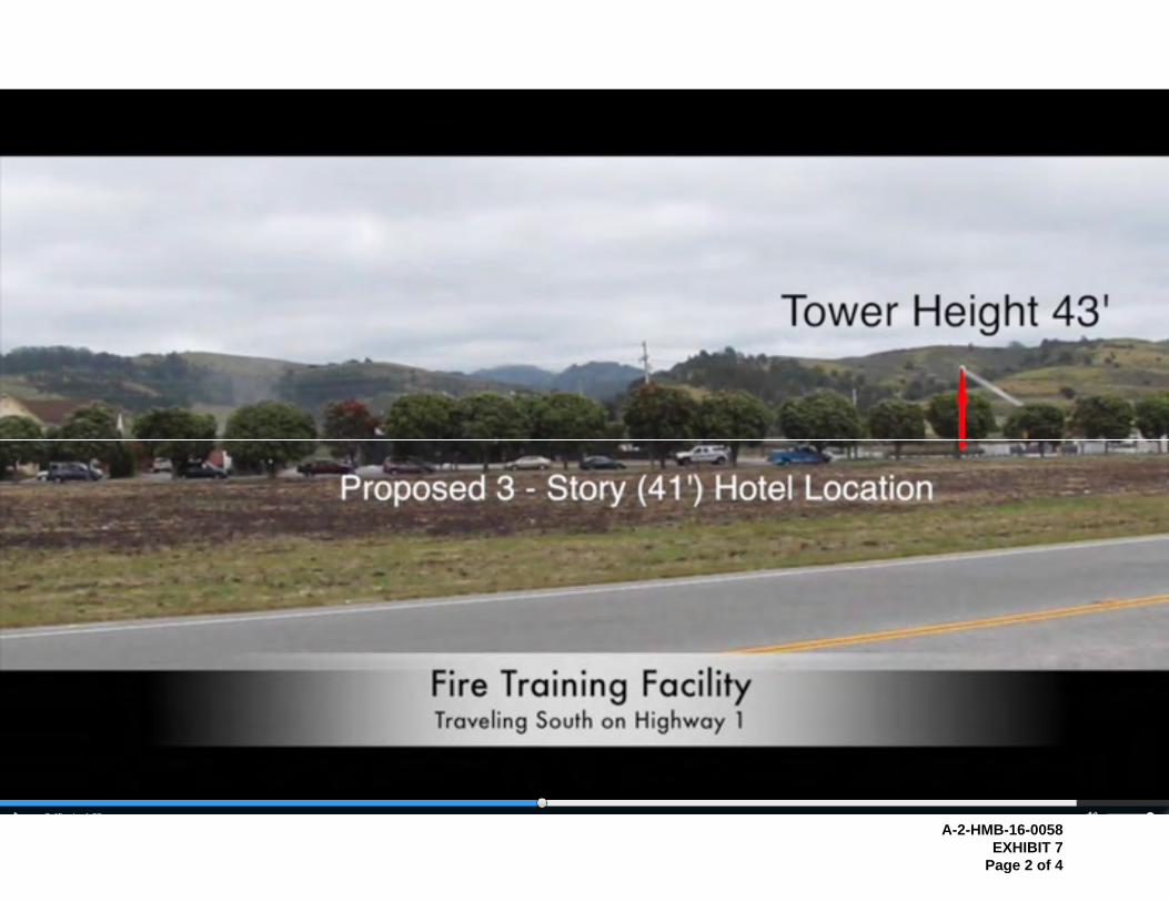
A-2-HMB-16-0058
EXHIBIT 7
Page 2 of 4

A-2-HMB-16-0058
EXHIBIT 7
Page 3 of 4

A-2-HMB-16-0058
EXHIBIT 7
Page 4 of 4
1
COASTSIDE FIRE PROTECTION DISTRICT
1191 MAIN ST. HALF MOON BAY, CA 94019 TELEPHONE (650) 726-5213
FAX (650) 726-0132
June 9, 2016
Stephanie R. Rexing
District Supervisor
North Central Coast District
California Coastal Commission
Re: Coastside Fire Protection District Training Tower Coastal
Commission Appeal No. A-2-HMB-16-0058, Local Government
Application No. PDP-15-046
Dear Ms. Rexing:
The Coastside Fire Protection District submits this letter and the enclosed
materials for your review and consideration prior to making your staff
recommendation to the California Coastal Commission on the above referenced
matter. We respectfully urge you to recommend to the Commission that the
appeal does not raise a Substantial Issue and therefore should not be heard de
novo by the Commission for the reasons set forth below.
On June 3, 2016, the City Council of the City of Half Moon Bay (“City”) -- by
unanimous 5-0 vote -- upheld the January 26, 2016 Planning Commission
approval of the District’s proposed 4,497 sq.ft., graduated width, 45 ft. high fire
training tower (the “Project”) on a 86,463 sq.ft. previously developed, relatively
flat lot located at 1191 Main Street (APN 06081-064370050) east of Highway 1
(“Project Site”). The Project Site is currently developed with an existing fire
station and fire training yard.
Because the Project Site is on the east side of Highway 1 and is not located on
tidelands, submerged lands, public trust lands, sensitive coastal resource area,
or within 100 feet of any wetland, estuary or stream, the Project is appealable to
the Coastal Commission only because it meets the definition of a “major public
works” project pursuant to Coastal Act Section 30603 and defined by Public
A-2-HMB-16-0058
EXHIBIT 8
Page 1 of 17

2
Resources Code Section 13012(a) as “facilities that cost more than one hundred
thousand dollars ($100,000).”
Appellant argues that the Council approval should be set aside by the
Commission because it is inconsistent with following policies of the City of Half
Moon Bay (“City”) Local Coastal Program (“LCP”): (1) Land Use Plan Chapter 7;
(2) Zoning Code Section 18.37.035C; (3) Land Use Plan Policy 7-10; (4) Zoning
Code Sections 18.01.010 G; (5) Zoning Code Sections 18.37.010 A and E; and
(6) Coastal Act Section 3025.
As explained in detail below, and as supported by the evidence in the record and
the additional enclosed and referenced evidence, the Project is consistent with
these LCP policies to the extent they apply to the Project.
1. The Project is Consistent with Land Use Plan Chapter 7 to the Extent it
Applies
Appellant argues that the Project is inconsistent with the following section of the
Land Use Plan (“LUP”) contained in Planning Section 7.1:
As further explained below, Appellant’s argument fails because this section of the
LUP is designed to protect the eastern hillsides themselves and the Project is not
located in the eastern hills.
The Upland Slopes section of the LUP states that measures to protect the scenic
quality of the hillside along the City’s eastern boundary are necessary and then
identifies certain hillsides that the City has jurisdiction over. The policy then
states that any new development – in the identified hillsides listed – should be
sited and designed to maintain the natural character of the landscape and to
avoid substantial cuts and fills.
To implement this policy, the City adopted Zoning Code Section 18.37.035,
which as discussed in detail below, protects the specified hillsides designated as
visual resources on the LCP Visual Resources Overlay Map. The Project is on a
relatively flat, previously developed site just 138 feet east of Main Street; it is not
A-2-HMB-16-0058
EXHIBIT 8
Page 2 of 17

3
located in the eastern hillsides or in any visual resource area depicted on the
Visual Resources Overlay Map, and therefore is not subject to Zoning Code
Section 18.37.035.
Nonetheless, in response to Planning Commission and community concerns, the
District voluntarily revised the Project by reducing the height of the tower from 50
feet (which is permitted by the development standards for the project set forth
Zoning Ordinance Chapter 18.09) to 40 feet with a 5 foot transparent railing. As
evidenced in the attached rendering (Attachment 1) submitted into the record
prior to the City Council decision, and in the enclosed additional photos
(Attachment 2) and video submitted by separate email due to file size, the Project
as revised further complies with the LUP Upland Slopes directive, to the extent it
is applicable, to "maintain[s] the natural character of the landscape".
Additionally, as the Project is a prefabricated structure that will be sited on a pre-
existing concrete slab. As such, it "avoid[s] substantial cuts and fills" in
compliance with the LUP Upland Slopes section, to the extent this section is
applicable to the Project.
2. Zoning Code Section 18.37.035C is Inapplicable to the Project; Even if It
Were Applicable, the Project is Consistent with this Section
Appellant argues the Project is inconsistent with Zoning Code Section
18.37.035C, set forth in full below, because the Project "would still project above
the ridgeline skyline as seen from Highway 1". Appellant's argument fails for the
reasons set forth below.
A-2-HMB-16-0058
EXHIBIT 8
Page 3 of 17

4
a. Section 18.37.035C is not Applicable to the Project
Reading Section 18.37.035C within the context of Chapter 18.37 as a whole, it is
clear that Section 18.37.035C is not applicable to the Project. Chapter 18.37.015
states that "all new development projects within or adjacent to visual resource
areas shall meet the visual resource standards established within this chapter."
Section 18.37.020 then establishes five separately defined visual resource areas:
Beach Viewshed Areas, Scenic Corridors, Upland Slopes, Planned Development
Areas and Old Downtown, and requires that maps of all of these designated
visual resources areas be prepared and maintained, based upon the visual
resources overlay map contained in the City’s local coastal program land use
plan. It then goes on to define each of these distinct visual resource areas.
Zoning Code Section 18.37.020 (B), set forth in full below, defines Upland Slopes
as follows:
The Project Site does not fall within the definition of Upland Slopes. It is not
within a scenic hillside and it is not above the 160 ft. elevation contour line; it is
on a relatively flat, previously developed lot. It is also not indicated on the visual
resources overlay map which is attached as Appendix B to the Initial Study/
Mitigated Negative Declaration prepared for the Project (the "MND"). As such, it
is not located on an Upland Slope. Nor is it adjacent to an Upland Slope.
Therefore, in accordance with Zoning Code Section 18.37.015, the Project is not
subject to Zoning Code Section 18.37.035 which governs development of Upland
Slopes.
As explained by City staff in its response prepared for the City Council appeal
hearing, in Exhibit A to the March 1, 2016 Staff Report to the City Council ("Staff
Report"), “Zoning Code Section 18.37.020B identifies upland slopes as scenic
A-2-HMB-16-0058
EXHIBIT 8
Page 4 of 17

5
hillsides visible from Highway 1 and 92 which include areas above the 160 ft.
elevation contour line. Four specific upland slope areas are identified; the one
closest to the project site is located “southeast of Pilarcitos Creek and east of
Arroyo Leon.” The project site is located over 1,200 feet west of Arroyo Leon
and is flat. The site is not located on or adjacent to an upland slope and is not
subject to the upland slope standards of Zoning Code Section 18.37.035.”
(Exhibit A to Staff Report, p. 4.)
Any conclusion to the contrary would conflict with the plain reading of Chapter
18.37 as a whole. Section 18.37.015 states that "new development projects
within or adjacent to visual resource areas shall meet the visual resource
standards established in this chapter." Section 18.37.020 then identifies five
distinct visual resource areas and the rest of the chapter goes on to specify the
visual resource standards for each identified visual resource. Staff points out
that "[b]ased on the appellant's interpretation, development located in or adjacent
to one [visual] resource area (such as the Old Downtown) would be subject to
visual resource standards developed for another area (like a beach viewshed
area or the Wavecrest PUD). This interpretation is illogical and would have
significant implications far beyond this project." (Exhibit A to Staff Report, p. 3.)
Indeed, if this were the intent of Chapter 18.37, then why would it bother to define
the five different visual resource areas and specify distinctly different visual
resource standards for each of the visual resource areas?
Moreover, as explained in the Initial Study/ Mitigated Negative Declaration
prepared for the Project (the "MND"), the Project Site not only is not within the
Upland Slopes visual resource area, it is not within any of the other four visual
resource areas: “The Visual Resources Overlay Map from the Half Moon Bay
Local Coastal Program is included as Appendix B of this Initial Study. As shown
on the map, the closest identified visual resource to the project site (depicted with
a red star) is “Old Downtown” located 0.6 mile, or eight blocks, from the project
site…Other visual resources identified in Appendix B include ocean views from
Highway 1 and scenic hillsides all of which are north of Old Downtown and
therefore further away from the project site…” (MND, p. 25.) The MND
concluded that the project as originally project (at 50 feet high) would have “a
less than significant impact on all identified visual resources and would conform
to the development standards contained in the [Zoning Code].” (MND, pp. 26-
27.)
b. Even if 18.37.035C Were Applicable to the Project, the Project
Complies
A-2-HMB-16-0058
EXHIBIT 8
Page 5 of 17

6
As demonstrated in the rendering submitted into the record prior to the May 3,
2016 City Council hearing and shown in Attachment 1, even if Section
18.37.035C applied to the Project, the Project complies with this section. As
revised, the Project does not "intrude or project above the ridgeline skyline as
seen from Highways 1 and 92."
Appellant alleges that the rendering "presents a misleading depiction of the
tower's true height in relation to the ridge line skyline when seen from this and
other parts of Highway 1." (Figure 2 to Appeal.) He argues that unlike as in
Figure 1 attached to his appeal, "there are no height reference points (e.g. story
poles) to verify the accuracy of the rendering… The story poles in Figure 1
indicate that the 45 ft. tower would continue to project above the ridge line skyline
by about 10 feet when viewed from the western shoulder of Highway 1." (Id.)
We must first note that the accuracy of Figure 1 is not verified. According to
Appellant, "Figure 1 shows a photo taken from the western shoulder of Highway
1 in January 2016. The photo shows the 50 ft. story poles erected by the
applicant for the original design of the tower." Superimposed on this photo is a
35 ft. mark at the ridgeline and a 50 ft. mark at the top of one of the story poles.
Nowhere in the appeal does it state how the 35 ft. reference point was measured
and determined, who took the photo, and from what location and what height.
In response to Appellant's allegations, on May 25, 2016, the District and the
District's architect sited a 43 ft. fire truck ladder as a reference point in the
approximate location of the proposed Project (as demonstrated in the first
Attachment 2-A and 2-B) and then took two photos (Attachment 2-C and 2-D)
and shot the video I am emailing to you separately due to file size. The photo
shown in Attachment 2-C was taken on southbound Highway 1 at Higgins
Canyon Road. The photo shown in Attachment 2-D was taken approximately
500 feet north of that location along southbound Highway 1. The video, which
will be submitted separately by email due to file size, was taken driving
southbound along Highway 1 and then turning around and driving northbound on
Highway 1. This additional supporting evidence clearly verifies the accuracy of
the rendering shown in Attachment 1, thereby nullifying Appellant's challenge,
and confirming that the Project does not "intrude or project above the ridgeline
skyline as seen from Highways 1 and 92" as required by Section 18.37.035.
Even if the small portion of the upper story of the Project were to pop up above
the ridgeline from certain vantage points along Highway 1, it would still be in
substantial compliance with Section 18.37.035 due to the insignificant width of
the tower (just 23 feet which is less than one-third the total width of the project)
and the minimal visual disruption of the largely transparent railing. As pointed
A-2-HMB-16-0058
EXHIBIT 8
Page 6 of 17

7
out by Councilmember Ruddock at the May 3, 2016 hearing, even if Appellant's
Figure 1 were accurate:
The actual tower that would project above the skyline is only about 23 feet wide. The rest of the building is 28 feet high or less. So most of the building, two-thirds of it, the vast majority, is not going to project over the skyline. So for much of your trip down Highway 1 or up Highway 1, it’s not going to be visible above the skyline. It may at one or two points, but in general I'm thinking not. Therefore, I don't think there is a substantial issue there for the Coastal Commission. I think they are going to look at how much of the building protrudes above the skyline and for how much of the trip up and down Highway 1.
Councilmember Ruddock’s conclusions are supported by the photos in
Attachments 1 and 2 and the referenced video submitted separately.
It is also worth noting that an application to the City has been submitted for a 3-
story, 41 ft. high, 148-room hotel project directly to the west of the Project (and
shown in the video) which if approved, would completely obscure sight of the
proposed Project from Highway 1 and therefore moot altogether the Project's
compliance with Section 18.37.035.
3. Land Use Plan Policy 7-10 is Inapplicable to the Project; Even if it Were
Applicable the Project is Consistent with this Policy
Without any explanation or support, Appellant complains that the Project is not
consistent with Land Use Plan Policy 7-10 set forth in full below:
This policy applies to "new development on upland slopes visible from Highway 1
and 92 as indicated on the Visual Resource Overlay Map." As explained above
in Section 2(a), the site is not located on or adjacent to an upland slope or any
visual resourced indicated on the Visual Resource Overlay Map and therefore,
the Project is not subject to Policy 7-10. As explained above in Section 2(b),
even if this policy were applicable, as evidenced in the rendering enclosed in
Attachment 1, the photos enclosed in Attachment 2, and the video submitted
A-2-HMB-16-0058
EXHIBIT 8
Page 7 of 17

8
separately, the Project complies with this Policy because it is "subordinate in
appearance to the natural landform", is "designed to follow the natural contours
of the landscape" and is "sited so as not to intrude into the skyline as seen from
public viewing places."
4. The Project is Consistent with Zoning Code Section 18.01.010G to
the Extent this Section Applies to the Project
Again, without any explanation or support, Appellant complains that the Project is
not consistent with Zoning Code Section 18.01.010G set forth in full below:
Zoning Code Section 18.10.010 sets forth the intent and purpose of the Zoning
Code as a whole. With respect to subsection G, and as explained in detail in
Section 2 above, the Project does not hinder the Zoning Code’s intent to
"conserve and enhance important visual resources within the city." As stated in
Exhibit A to the Staff Report, "[t]he proposed training tower will be visible from
Highway 1, but is not expected to be visually intrusive or to significantly obstruct
views of the hillsides due to the structure's relatively small size, its distance from
Highway 1, the remaining open area on the parcel, and the screening provided
by existing street trees on either side of Main Street." (Exhibit A to Staff Report,
p. 4.) As such, the Project is consistent with Zoning Code Section 18.10.010G.
A-2-HMB-16-0058
EXHIBIT 8
Page 8 of 17
9
5. The Project is Consistent with Zoning Code Section 18.37.010
Again, without any explanation or support, Appellant complains that the Project is
not consistent with Zoning Code Sections 18.37.010A and E set forth in full
below:
The Project is consistent with Section 18.37.010A as it does not hinder the intent
to "protect scenic and visual qualities of coastal areas as a resource of public
importance." As explained above, the Project Site is not located within or
adjacent to a visual resource area and because it does not substantially protrude
above the eastern hillside ridgeline it does not hinder the scenic and visual
quality of this visual resource area.
The Project is also consistent with Section 18.37.010E because it is "visually
compatible with the character of the surrounding areas." As explained in Exhibit
A to the Staff Report and the MND, the Project is visually compatible with Fire
Station 40, the existing fire station on the Project Site, and the Coastal Repertory
Theatre, an industrial building with a domed roof, and a residential development
located further north consisting of two story buildings with pitched roofs. (Exhibit
A to Staff Report, pp. 4-5, 6-7; MND pp. 27-28.)
6. The Project is Consistent with Coastal Act Section 30251
Again, without any explanation or support, Appellant complains that the Project is
not consistent with Coastal Act Section 30251 set forth in full below:
A-2-HMB-16-0058
EXHIBIT 8
Page 9 of 17

10
As indicated above and as concluded by City staff, the Project is consistent with
this section because "it will not negatively impact a visual resource area, will not
significantly block views of the hillsides, and is reasonably compatible with
adjacent development." (Exhibit A to Staff Report, p. 7.)
In closing, the Coastside Fire Protection District addressed citizen and Council
concerns by reducing the Project height and incorporating a brick building
façade. While the reduced height does compromise the functionality of the
Project to some extent, it will still be able to serve the Project’s purpose of
providing on-site training for the fire fighting staff. The City Council heard and
considered all the testimony and evidence in the record, made all the necessary
findings and conditions regarding this Project, and approved the Project with a
unanimous 5-0 vote. For the foregoing reasons, and as supported by the
evidence in the record and the additional material enclosed and referenced in
this letter, we agree with Councilmember Ruddock that this Project as revised
does not meet the test of Substantial Issue and hope you will reach the same
conclusion.
Many thanks for your consideration.
Respectfully submitted,
Camas J. Steinmetz Deputy District Counsel
Cc: Nancy Cave, District Manager
Robin Mayer, Coastal Commission Legal Counsel
Patrick Foster, Coastal Planner
A-2-HMB-16-0058
EXHIBIT 8
Page 10 of 17

ATTACHMENT 1
A-2-HMB-16-0058
EXHIBIT 8
Page 11 of 17

ATTACHMENT 2A
A-2-HMB-16-0058
EXHIBIT 8
Page 12 of 17

ATTACHMENT 2B
A-2-HMB-16-0058
EXHIBIT 8
Page 13 of 17

ATTACHMENT 2C
A-2-HMB-16-0058
EXHIBIT 8
Page 14 of 17

ATTACHMENT 2D
A-2-HMB-16-0058
EXHIBIT 8
Page 15 of 17

From: Dave Schorr [mailto:[email protected]]
Sent: Thursday, July 21, 2016 12:52 PM To: Foster, Patrick@Coastal
Subject: Half Moon Bay Fire Tower Appeal
Dear Mr. Foster; I am a resident of half Moon Bay. I am writing in support of the appeal filed by Mr. Lansing with respect to the proposed fire training tower. For purposes of your proceedings, we will leave aside prior errors by the Fire District and the City, with regards to effectively (or not) analyzing potential impacts, compliance with CEQA, piecemealing of this project, etc. At issue here is the impact of the proposed development upon visual resources as viewed from within the city of Half Moon Bay, and as viewed from a prominent and delineated view corridor, that of State Highway 1. The intent of the Coastal Act and the LCP as adopted by the City is to preserve and protect the visual resources of this most beautiful area. At issue between the appellant and the project applicant has been an interpretation of portions of the LCP, trying to settle the point of whether or not this parcel is subject to visual resource protections which clearly pertain to upland slope areas, but by intent, would logically also pertain to views of those upland slopes and the associated ridgeline profile as viewed from Highway 1. It is not debated, even by the City, that the proposed fire tower at either 45 or 50 feet of height, would protrude above the ridgeline, as viewed from Highway 1. It would seem that this is a clear violation of the letter and intent of Coastal Act, and in and of itself sufficient grounds to deny the project as currently proposed. The nature and character of the proposed development is not consistent with the scenic and rural nature of the area. I must address the way in which the project applicant has presented this project, with deliberate attempt to minimize all appearances of negative visual impact, both with regards to aesthetics and height/intrusion upon the ridgeline profile. The drawings submitted as renderings of the proposed project greatly minimize the negative aesthetic qualities of prefabricated buildings from the same manufacturer currently installed elsewhere. As opposed to the drawings which present a relatively clean structure, the structure in reality is festooned with exterior, steel, galvanized stairways and landings, giving it a highly industrial, unsightly appearance. But, the major issue here is the height of the building, and the precise extent to which it does protrude above the inland hill ridgeline when viewed from Highway 1.
A-2-HMB-16-0058
EXHIBIT 8
Page 16 of 17

In this regard, the project applicant has significantly and consistently gamed the system. All photographs and renderings provided have been given from the perspective of the viewer on the southbound side of Highway 1, looking towards the hills. Unfortunately, you can't argue with geometry. Take the same viewer, and place them on the northbound side of Highway 1, approximately 100 feet closer to the proposed project site, and intrusion upon the ridgeline is much more pronounced. The story poles erected by the applicant were not in conformity with existing city code and standards, and did not adequately outline the parameters of the structure. As well, they have now been taken down, so no further analysis of visual impact can be done at this point in time. Given the above two points, I most strongly urge the Coastal Commission to defer any judgment upon this matter until direct inspection of the proposed site and its impact on the visual resources can be made by Coastal Commission staff, as evidence submitted by the applicant to date is unreliable and biased. This would require the applicant to reinstall the story poles, with all required flagging, and I would suggest with the additional component of marking 5 foot height increments on the poles as they ascend, for easier comparison with the background ridgeline, as viewed from various vantage points. It is only with these physical components reinstalled, that Commission staff could then make a site visit and make objective and conclusive determination as to the maximum height permissible for this project which would not intrude upon unimpeded view of the inland hill ridgelines. Currently, heading north on Highway 1, the visitor experiences a view of expansive fields, with low-lying structures of the City not disrupting views of the hillsides. There would be a very different experience should this project be allowed to proceed. A very real and significant danger is the precedent that this project, if unmodified, would present. Allowing violation of the ridgeline profile by this project would inevitably be cited as precedent by subsequent developers, leading to incremental but irreversible and irreparable damage to our precious visual resources. Please consider these comments and suggestions in preparing your staff report and making any further determinations. Please do not hesitate to contact me with any questions, or requests for clarification. Sincerely, David Schorr 650-726-2842
A-2-HMB-16-0058
EXHIBIT 8
Page 17 of 17

STATE OF CALIFORNIA—NATURAL RESOURCES AGENCY EDMUND G. BROWN, JR., GOVERNOR
CALIFORNIA COASTAL COMMISSION NORTH CENTRAL COAST DISTRICT OFFICE 45 FREMONT ST, SUITE 2000 SAN FRANCISCO, CA 94105-2219 VOICE (415) 904-5260 FAX (415) 904-5400 TDD (415) 597-5885
Memorandum August 9, 2016 To: Commissioners and Interested Parties FROM: Dan Carl, North Central Coast District Deputy Director North Central Coast District Re: Additional Information for Commission Meeting Thursday, August 11, 2016 Agenda Applicant Description Page Item Th21a Marin Co. LCP Amend. LCP-2-MAR-15-0029-1 Correspondence, Morgan Patton / Ashley Eagle-Gibbs 1-3 Correspondence, Amy Trainer, Scotty Tye & John Sharp 4-5 Email, Robert A. Johnston 6-8 Correspondence, Kathleen Hartzell 9-10 Email, Bridger Mitchell 11-12 Email, Toby Symington 13-14 Email, Cynthia Lloyd 15-16 Email, Lawrence Litvak 17 Correspondence, Conn Rusche 18-19 Email, Sharon Barnett 20 Correspondence, Kenneth Drexler 21 Correspondence, Jessica Reynolds-Taylor 22-23 Correspondence, Carolyn Longstreth 24-25 Email, Victoria Hanson 26-28 Email, Ann W. Baxter 29-31 Email, Daniel Dietrich 32-33 Email, W. Edward Nute 34-35 Email, Mary Barone 36 Email, Corey Barnes 37 Email, Dawn Ward-Doma 38 Note: 113 email comments substantially identical to this email comment were received. This email comment is provided as a representative sample of the 113 email comments. All of the 113 email comments substantially identical to this email comment are available for review at the Coastal Commission’s North Central Coast Office in San Francisco. Correspondence, Bridger Mitchell 39-41 Th22a Coastside Fire Protection District A-2-PAC-16-0058 Correspondence, Kevin J Lansing 42 Th22b Steve Kalpakoff A-2-SMC-16-0066 Correspondence, R. Rexford Upp 43-47

42


