antoaneta-carina popescu - babeș-bolyai...
TRANSCRIPT

Tourism Development in a Rural Periphery.
Case Study: the Sub-Carpathians of Oltenia
Antoaneta-Carina POPESCU1, 2 1 Babeş-Bolyai University, Faculty of Geography, Cluj-Napoca, ROMANIA 2 Université de Pau et des Pays de l’Adour, SET Laboratory, Pau, FRANCE
E-mail: [email protected]
K e y w o r d s: rural space, periphery, tourism development, the Sub-Carpathians of Oltenia
A B S T R A C T
1. INTRODUCTION
The economic view of the spatial organization
of centres and peripheries dominates the theories and
models applied to urban – rural realities. Politics have
followed the same line and divided the world into
central developed places, lagging peripheries and semi-
peripheral places, which are in-between.
We will argue that tourism, the new social,
economic and political trend that emerged during the
19th century and became a widespread phenomenon
during the 20th century, changes to some extent the
already established hierarchy. Rural areas are often
defined and characterised in opposition to the urban
space, especially from the perspective of power relations
established between the centres that control and exploit
the peripheries or from the point of view of push-pull
factors. Urban spaces are considered to be attractive
because they offer diversified employment possibilities,
they host companies’ headquarters, government
institutions, cultural events, have a good educational
system, financial power and they are well connected
with other national and international centres. In
contrast, rural spaces are sparsely populated and
considered to be the supply areas for the urban centres
in terms of work force and raw materials. As a general
rule, urban centres polarize the rural areas situated in
their vicinity. The bigger and more important the urban
Centre for Research on Settlements and Urbanism
Journal of Settlements and Spatial Planning
J o u r n a l h o m e p a g e: http://jssp.reviste.ubbcluj.ro
Rural areas are considered to be in a peripheral position relative to the urban centres. Dichotomies such as centre-periphery or urban-
rural exist because rural areas have always been thought of as less developed, innovative, attractive, densely populated, accessible, etc.
than the urban areas. In this study periphery is analysed in terms of distance from the centre, dependence, distinctiveness and
discourse according to the view of the European Commission. The traditional approach of periphery associated with the distance from
a central place in relation with markets, communication, access to information and services provided and, consequently, the idea of
dependence of the rural space is altered due to tourism. Thus, tourism changes the relationships between centres and peripheries.
Remoteness, naturalness, culture authenticity, vernacular architecture and gastronomy have become the distinctiveness sought by
tourists. In tourism discourse periphery appears as an opportunity to be discovered and used accordingly. The growing demand for
distinctiveness can represent a development opportunity for our study area, the Sub-Carpathians of Oltenia, a peripheral region both
geographically and economically. Based on an empirical research, this paper aims at determining the place of tourism in the
sustainable development strategy of the Su-Carpathians of Oltenia. The evaluation of the tourism potential of the area as well as the
calculation of its human development index allowed us to reach the conclusion that tourism can generate development in our study
area but it should be used as an activity to support the already existing traditional activities.
.

Antoaneta-Carina POPESCU
Journal of Settlements and Spatial Planning, Special Issue, no. 3 (2014) 53-64
54
centre is, the larger its influence radius over the
surrounding space is. Moreover, the expansion of the
urban centres seizes lands which belong to the rural
space, both from an administrative and functional point
of view.
However, the relationships between central
urban places and rural peripheral areas are much more
complex and nuanced. The core-periphery model
generalizes a diversity of space types. Only the rural
space is in fact declined in so many categories which
skip the general model, that it is sometimes improper to
apply such restrictive models to such a diverse reality.
Four basic type situations of the rural areas can be
identified in the scientific literature: (i) rural areas with
poor access and poor physical resources, (ii) rural areas
with a specialized economic base, (iii) rural areas with a
diversified economic base and (iv) rural areas located
near urban agglomerations of significant size [1]. They
correspond to the distant, isolated periphery (i), to the
semi-periphery (ii and iii) and to the integrated
periphery (iv).
Tourism has proved its capacity to animate
and help develop places which may seem unlikely
attractive like the peripheral rural areas. Indeed we
believe that tourism can change polarities, distance,
peripheral areas becoming thus appealing, and highly
frequented central places within the tourism system.
Based on the capacity of tourism to generate
development in peripheral rural areas, this article
explores the possibilities for tourism development of
the Sub-Carpathians of Oltenia, a predominantly rural,
natural region in Romania, situated away from the
major polarizing cities. We shall first explore the
meanings of the word ‘periphery’, the existing types of
peripheral areas, the models that involve peripheral
areas and the dimensions of the periphery in the
scientific literature as well as in official documents.
Secondly we shall concentrate on the analysis of the
periphery in terms of indicators in our area of study and
finally, on the potential of tourism development in the
Sub-Carpathians of Oltenia.
2. THEORY AND METHODOLOGY
2.1. Conceptual framework
This study pays particular attention to the
evolution of the concept of periphery, as well as to the
relationships established between centres and
peripheries, but also between different peripheries. The
economic, political, geographical and lexical meanings
of the word ‘periphery’ intermingle interestingly and
open stimulating research leads. We shall focus on the
design of a multidimensional approach of the periphery
in order to analyze the connections established between
our research topics: periphery and tourism
development.
2.1.1. Definition of periphery
The lexical meaning of periphery is the outer
limit or edge of an area or object; a marginal,
secondary position; of little interest to the majority [2].
The French geographer Roger Brunet (1993)
defines the periphery as an external part of a space, or
a space considered to be under the dominance of a
centre [3, p.379]. This definition shows a distinction
between the geographic meaning of the word, which is
connected with the spatial, geographic reality and the
economic meaning, which leads to the political and
economic division of the world. Nowadays, the
geographic meaning has lost its importance because
even geographers use the term periphery with the
economic meaning, referring to a relation of dominance
and exploitation of the periphery by a centre whose
location site rarely corresponds to a geographic-
mathematic centrality. Rural areas are associated, even
identified with the periphery because they are usually
described as agricultural, remote or isolated, lagging,
dependent upon the city, confronted with migrations
and demographic aging. Thus, this traditional approach
stigmatised rural areas and distorted the image of the
periphery. A peripheral area, then, is one that suffers
from geographical isolation, being distant from core
spheres of activity, with poor access to and from
markets. It also suffers from economic
marginalisation, caused either by a lack of resources,
by a decline in traditional industries or agriculture, or
by a lack of know-how and training in areas such as
marketing and innovation [4, p. 8].
2.1.2. Theoretical models
The theoretical models developed on the
relationship centre-periphery are the core-periphery
model, the dependency theory and the world system
analysis.
The core-periphery model developed by
Friedmann (1966) is a model of uneven development in
the geography of human activity, based on uneven
distribution of power within and between societies [5].
Cores and peripheries can be analysed on a variety of
geographic scales, including uneven regional
development within national economies and uneven
development at a global scale.
The dependency theory developed by Frank
(1967) tries to explain the underdevelopment of
countries, usually situated in the southern hemisphere
as a consequence of their relationships with the
countries of the northern hemisphere [6]. The northern
imperial powers perpetuate forms of economic, political
and cultural dependence in the southern states.
The world system analysis developed by
Wallerstein (1979) focuses on markets and exchange
[7]. The world is seen as an economic system with

Tourism Development in a Rural Periphery. Case Study: the Sub-Carpathians of Oltenia
Journal of Settlements and Spatial Planning, Special Issue, no. 3 (2014) 53-64
55
multiple political centres and multiple cultures. The
core is the developed, industrialized part of the world,
and the periphery is the underdeveloped, typically raw
materials-exporting, the poor part of the world. The
market is the means by which the core exploits and
controls the periphery.
2.1.3. Types of periphery
The models presented suggest the existence of
several types of peripheries according to the scale of
analysis, the model, and the activity taken into
consideration: semi-peripheries, integrated peripheries,
blind-spots, isolates, artificial peripheries, pleasure
peripheries and urban peripheries.
Semi-peripheries represent partly developed
regions or countries. These societies have remained
dependent upon the centre, and to some extent
underdeveloped, especially from the human
development point of view, despite having achieved
significant levels of industrialization and growth [8].
Integrated peripheries are very close to a
centre, being in constant interaction with the centre and
therefore very dynamic. On the other hand, blind spots
represent places neglected by the decision centres and
therefore lagging areas [9]. The isolates are places that
live in autarchy and have no relationships with the
centre [9] whereas the artificial peripheries are created
through political decision and can become more
attractive once the political system is changed [10].
Urban peripheries are situated at the outskirts
of the city and seen as a functional space where the
urban expansion takes place, multiple relationships
being thus established within this spatial-territorial
system.
Pleasure peripheries are designated in
connection to tourism activities [11]. They can refer to
islands, rural areas or even urban peripheries whose
main function is based upon leisure activities.
2.2. Methodology
The methodology applied in this study is both
qualitative and quantitative because qualitative
research gives important insight upon perceptions,
representations and discourse on peripheral areas,
while the quantitative research allows an objective
analysis of the relationships established between the
elements taken into consideration - rural space,
periphery and tourism. On the one hand, the qualitative
analysis allows us to identify the way rural spaces are
perceived, how they are characterised, and the
connections established between rural areas and
peripheral areas. On the other hand, we use the
quantitative research to test if the narratives analysed
with the qualitative method are founded on objective,
relevant statistical data.
2.2.1. Qualitative research
The qualitative method used in this study is
represented by desk research, which implied gathering
and analyzing theoretical information about rural
peripheries. We analyzed both scientific literature
related to the subjects of rural areas and peripheral
places, and official documents from the European
Union such as the reports on The future of Europe’s
rural periphery, on the implementation of the LEADER
programme [1], and at the national level, The National
Strategic Framework for Rural Areas [12], The Rural
Development Strategy 2014-2020 [13].
Desk research highlighted a multidimensional
approach of the concept of periphery: periphery as
distance from the centre, periphery as dependence,
periphery as distinctiveness and periphery as discourse
[1].
The approach of the periphery as distance
from the centre derives from regional studies
(Christaller (1933), Loesch (1954), Isard (1960),
Reynaud (1981)). Christaller and Loesch consider that
regions are organized in hierarchical systems
coordinated by central places, represented by the cities
[14], [15]. Christaller takes into account three principles
in order to determine central places: the market,
transport and the administration. Hence, a central place
is considered to be a place of richness, creation and
consumption. The offer of goods and services the centre
provides determines its area of influence, along with its
administrative power. The connections with other
places, especially its position in the transportation
network determine its place in the urban hierarchy.
Consequently, rural spaces are peripheral places,
dependent on the services, on the market and on the
administrations of the centre.
Many studies, carried out in the ‘60s and ‘70s,
sought to show the extent to which the distance effect
influences spatial mechanism in terms of the
distribution of wealth and spatial interaction. Reynaud
(1981) considered distance from the centre to be
fundamental in the differentiation and spatial
organization. In his opinion the centre is a place of
concentration in terms of population, wealth,
information, innovation, decision making, while the
periphery is basically characterised by its absence of
autonomous decision.
As most of the contributors to the location
theory are economists, the approach of the periphery as
distance is economically oriented. Therefore, theories
such as: Reilly’s law of retail gravitation [17], Loesch’s
general equilibrium model [15], even Christaller’s (a
geographer) central places theory [14] are applied to
homogenous spaces that make abstraction of the
geographic diversity of the space and do not take into
consideration hindering elements such as natural
Antoaneta-Carina POPESCU
Journal of Settlements and Spatial Planning, Special Issue, no. 3 (2014) 53-64
56
barriers (rivers, mountain chains, deserts) that
constitute isolation factors.
The approach of the periphery as dependency
is based on the dependency theory [6]. According to this
theory, northern, imperial powers that are represented
by well developed countries perpetuate forms of
economic, political and cultural dependence in the
southern, less developed countries. Perroux (1964) and
Friedmann (1966) tried to explain the concept of
periphery as the dependency through the framework of
core-periphery model of development [18] [5]. During
the 1970s, the geographers focused on the domination
and dependency relationships between the urban
centres and the rural areas, the latter being considered
‘marginalized’, ‘devitalized’, and even ‘deserted’ by their
inhabitants. Some authors used the core-periphery
model to analyze the relationships between the urban
and the rural areas [19].
The approach of the periphery as local
distinctiveness appeared at the end of the 20th century,
as a response to an increasingly competitive and
globalised world. This new approach is based on the
importance of each place’s specificity, heritage and
resources, introducing thus the spatial dimension into
the economic analysis.
Aydalot (1980) was among the first economists
to take into consideration the spatial dimension in the
economy and focused his research on territorial
economy [20]. In the same line of thought, Gumuchian
and Pecqueur (2007) identify territorial resources -
material resources, human resources, traditions, know-
how and the relationships established between them as
well as the relationships established with the territory
they are found on [21]. Courlet (2007) classifies
resources into generic resources that can be completely
transferred during the production process and specific
resources that are rare exist in only one place and
cannot be transferred [22]. Possessing specific
resources allows a place to have a competitive
advantage on the market and to become attractive.
For peripheral areas, this new paradigm
encouraged the emergence of the local development.
The emphasis on the particular nature of each place
determined that many peripheral rural areas began to
gain image capital due to the quality of their resources,
human capital, location, lower prices of the real estate
and atmosphere of the place, positive distinguishing
factors that attracted entrepreneurs. In the best case
scenario, such peripheral areas were transformed into
business incubation centres or clusters.
Finally, the approach of the periphery as
discourse evolved over time in close relation to the
conceptions, perceptions and representations of the
peripheral places. While until the end of the 20th
century peripheral areas were considered under the
dominance of the centre(s), starting with the ’70s the
narrative on peripheral places and by extrapolation on
rural areas changed. The first to denounce the inequity
between centres and peripheries was the philosopher
Michel Foucault (1971) who considered that the
relationship core-periphery is an inadequate
relationship of power [23]. In his opinion, discourse
reinforces power and the discourses that existed at that
time were mainly top-down, politics being dictated by
the centre and imposed on the periphery. Therefore, his
famous argument to “cut off the head of the king” in the
political analysis and replace it by a decentred
understanding of power is the first step towards the
emergence of bottom-up initiatives and a basic
condition for local development.
In the case of the rural space, there has been a
discursive shift in the way in which the rural economy is
imagined and represented. From being conceived as a
space of production, the rural space is now understood
as a space of consumption. This includes both
consumption activity in the countryside and the
consumption of the countryside – most notably
through tourism but also through residential
investment, the marketing of ‘rural’ crafts and branded
specialty foods [24, p.71]. Thus, the concept of
periphery as local distinctiveness undoubtedly
becomes strategically significant.
2.2.2. Quantitative research
The quantitative research made use of the
Local Human Development Index [25] in order to
determine the degree of peripherality of our study area
in terms of development. The evaluation of the tourism
potential in our area of study was done by applying the
methodology of Ciangă, Dezsi and Rotar (2002) [26].
The Local Human Development Index will be
used to determine the communes from our area of
study that face development problems. It is an
aggregate indicator, advanced by the sociologist
Dumitru Sandu (2013), that measures the total capital
of localities, focusing in particular on four dimensions:
human capital (education facilities at the locality level),
health capital (life expectancy at birth), vital capital
(medium age of adult population of 18 years old and
over), and material capital (average living floor area by
house, distribution of gas for household consumption
by locality inhabitant, privately owned cars to 1000
inhabitants). Built on the principles and the
methodology of the United Nations Human
Development Index, the Local Human Development
Index allows for the identification of lagging regions at
the locality level using statistical data that focus not
only on growth, but also on demography, healthcare
and education. Welfare, as Rawls (2009) or Sen (1999)
pointed out, is not a question of growth, but a question
of development, and growth is not equivalent to
development [28], [29]. Therefore, the index of local
human development measures the total capital of
Tourism Development in a Rural Periphery. Case Study: the Sub-Carpathians of Oltenia
Journal of Settlements and Spatial Planning, Special Issue, no. 3 (2014) 53-64
57
localities, paying particular attention to the situation
the community capital is in. As the author points out, it
is critical to have a good understanding of what
constitutes a lagging region and where the lagging
regions are located, as this will make it easier to
develop tools for the development of these areas [25,
p.100]. In this respect, we shall try to determine the
relationship between the level of development of the
communes from our area of study and tourism
development.
The tourism potential of the region was
evaluated after the methodology proposed by Ciangă,
Dezsi and Rotar (2002), which implies scoring the
elements that have tourism potential [26]. Hence, the
authors have studied in detail each element that can
become tourism attractive. The precision of this
methodology is high, as it works with elements located
at the local scale, allowing a precise radiography of the
status quo [26, p.81]. The authors propose the
quantification of the tourist value of each element. They
take into consideration three main aspects: the
elements that belong to the natural environment, the
human-made elements and the infrastructures. Each
group of elements equally contributes to the tourism
development of a region and therefore it is attributed a
maximum of 50 points. Within each category, the
points are attributed from 0 (for the lack of the
element) to a maximum number of points set by the
authors, according to the importance they give to the
element.
For example, in the category of elements of the
environment, landforms are considered the most
attractive tourism elements being attributed a
maximum of 26 points, distributed according to the
landform type (0-7 points for glacial landforms, 0-3
points for volcanic landforms, 0-7 points for karst
landforms or landforms on conglomerates, 0-3 points
for other types of landforms). The existence of
spectacular landforms such as gorges or steep paths
caused the authors to create a distinct category that can
receive up to 5 points. The landforms developed on salt
receive maximum 1 point. The climate can receive up to
5 points, hydrographical elements up to 11 points
(mineral waters 0-4 points, thermal waters 0-4 points,
lakes 0-4 points, and rivers 0-1 point), and bio-
geographic elements up to 8 points.
Man-made elements which are considered
tourist attractive are represented by architecture sites,
archaeological sites, ethnographical sites, monuments,
museums, etc. These elements are scored according to
the importance established by the Romanian Ministry
of Culture and by the National Territorial Plan.
The authors consider that the infrastructures
also hold tourism potential because they allow the
capitalization of natural and man-made resources.
Therefore, the tourism potential of the infrastructures
takes into consideration the infrastructures directly
related to the tourist activity, but also the general
infrastructures. The infrastructures directly related to
tourism are the accommodation infrastructures, which
can receive a maximum of 40 points according to the
following indicators: size, number of beds, hotel rating;
the healthcare equipments, which receive up to 2 points
and the leisure equipments, which also receive up to 2
points. Access and general infrastructures receive up to
4 points.
The overall tourism potential is calculated as a
sum of the individual scores of the above mentioned
categories. It allows the ranking of the towns and
communes from the study area into four categories of
tourism potential: low tourism potential (2-15 points),
average tourism potential (16-30 points), high tourism
potential (31-50 points), and very high tourism
potential (over 50 points). The calculation of
intermediate scores indicates the strong points and the
weak points of a town or village in terms of tourism
resources and allows a better focused investment and
tourism planning strategy.
3. RESULTS AND DISCUSSION
3.1. Peripheral areas and tourism impact
In general, tourism follows the same pattern of
the core-periphery model. The periphery is still under
the dominance of the centre. The population from the
centre, represented by rich, technological cities goes
into less developed areas, situated more or less close to
the centre, but anyhow accessible by car or by plane,
that are attractive [4] because of their environment and
products’ quality, scenery and services provided.
Many tour operators have seized the urban
people’s desire to experience a less artificial way of life:
the tourists’ wish to be closer to nature, to eat healthy
food and enjoy the calmness of the countryside or even
travel to exotic places, undisturbed by the technological
evolution, in search of authenticity and unaltered
nature. They sell such holidays in the most remote
places on Earth, and they stage authentic customs for
the tourists’ satisfaction, reducing the local population
to no more than an exhibit or a service provider. From
this point of view, tourism can be an example of the
dependency theory as the tourism companies from the
rich, industrialized, tourism generating countries
control the tourism market of the less developed, often
predominantly rural or coastal tourist receiving regions
that have to comply with this dominance.
Nevertheless, tourism is considered an activity
that can produce territorial development, thanks to its
direct and indirect effects on a territory in terms of
employment, infrastructures, investments, specialized
working force, circumstances that lead to local
development. As a result, since 1992 the European
Union has acknowledged that tourism has a role to play

Antoaneta-Carina POPESCU
Journal of Settlements and Spatial Planning, Special Issue, no. 3 (2014) 53-64
58
in reducing regional disparities and, through subsidies,
encouraged regions to engage in development projects
based on tourism activities. Hence, many peripheral
regions, remote rural areas in particular, which were
undergoing decline in agriculture or industry, benefited
from developing tourism activities. Thus tourism
proved its capacity to revitalise remote rural areas as it
is an activity that has the power to recycle devalued
objects [29] giving them new meanings and usage.
Tourism can paradoxically change polarisation
forces between centres and peripheries because beyond
objective characteristics, periphery is also a matter of
perception and discourse. Urban centres can become
repulsive for tourists because of noise, pollution, traffic
jams, and peripheries attractive due to scenery,
environmental quality, remoteness and tranquillity.
Blomgren and Sørensen (1998) have argued
that the qualities perceived by tourists as being
symptomatic of a peripheral situation - qualities which
are attractive to some and repellent to others – and the
actual characteristics of peripheral areas are in a mutual
interdependence: the peripheral destination may
possess symptoms of peripherality, but relies on the
subjective interpretation of these symptoms by the
tourist, while simultaneously the tourist will not
perceive an area as peripheral without certain
symbols of peripherality being present [30, p.334].
Perceptions and discourse thus represent the key to
tourism development in peripheral areas, for, in
general terms, as people in industrialised societies in
the West react to the stresses of city life, and to long-
term global shifts in production and consumption, with
a seemingly insatiable interest in nature and the past
(see Urry, 1990; 1995); and in tourism terms, as tastes
in holiday taking have become more sophisticated and
diverse, the attributes of peripherality, long viewed as
disadvantageous, are now being seen as opportunities
[4, p. 3].
The pleasure periphery phenomenon
identified by Turner and Ash since 1975 is in constant
expansion. The evasion paradises of the urban dwellers
are farther away than they were twenty years ago but
accessibility remains a key issue. Even if in the
beginning the main purpose of the pleasure periphery
was evasion, starting with the 1970, a new tourism
trend appeared: the cultural turn, which became
popular at the end of the 19th century. In a globalized
world, where centres have a tendency to standardize
cultures and replace the natural with the artificial, the
individual instinctively seeks to return to his origins, to
the basic values of life [31]. Such motivations
determine the search for traditional cultures,
unchanged places and authentic experiences, which
determine the choice of peripheral places for leisure
activities [32] [33]. The return of the modern tourist to
rural places represents an opportunity for development
in these places.
In almost any rural area it is possible to find
local products, traditional dishes and handicrafts. These
tasty, traditional and natural products can become
attractions in themselves. Their association with a
particular geographic region proved to be very useful
for attracting tourists, but also for further developing
small businesses in the agrifood sector. The European
Union has even developed schemes of geographical
indications and traditional specialities known as
protected designation of origin, protected geographical
indication and traditional specialities guaranteed that
promote and protect names of quality agriculture
products and foodstuffs [34]. The EU Regulation No
1151/2012 of the European Parliament promotes rural
and agricultural activity, helps small producers sell
their authentic products at premium price and protects
consumers from non-genuine products [35].
Labelling can bring economic benefits as well
as a gain in image since rural areas associated with
organic farming and good-quality products will almost
automatically be considered good quality-life
environments, which might determine certain
enterprises move to a rural area and benefit from the
positive image of the area, or entrepreneurs to start a
business or tourists to buy a holiday house.
As demonstrated, tourism has the power to
generate development. The problem is that tourism
projects are viewed in general as risky [36] because of
seasonality and fashion changes, therefore, tourism
should not be the only activity developed in vulnerable
areas, but combined with complementary activities such
as organic farming, light manufacturing, creative
industries, etc.
Moreover, we must keep in mind that tourism
can easily disturb the environmental balance of the
visited area through overcrowding, pollution, pressure
to modernize, which may lead to identity loss and
trivialization of the traditions [37].
3.2. Area of study
The Sub-Carpathians of Oltenia are situated in
Oltenia Province in South-Western Romania. They are
an intermediary geomorphologic landform between the
Southern Carpathians and the Getic Plateau and due to
this position they are an area of intense exchange
between the mountain and the plain, which favoured
the development of settlements - market towns and
villages.
Well delimited by the river valleys of the Olt
River (in the East) and the Motru River (in the West),
this natural region of about 3000 km2 is also a well
distinguished cultural region. With a density of about
100 inhabit. /km2, it is predominantly a rural region
(about 70%).
Its geographic unity is made obvious by the
landscape. The hills and the depressions longitudinally
Tourism Development in a Rural Periphery. Case Study: the Sub-Carpathians of Oltenia
Journal of Settlements and Spatial Planning, Special Issue, no. 3 (2014) 53-64
59
distributed alternate following a particular pattern: at
the contact with the mountains a first row of
depressions is located at the bottom of the mountains,
followed by a row of hills, separated from the Getic
Plateau by another row of depressions [38].
From a cultural point of view, this region still
remains well rooted in its customs and traditions.
Traditional occupations and crafts such as cattle and
sheep grazing, pottery, weaving and wood carving are
still practiced by the population.
Despite its rich cultural heritage, represented
both by material (architectural monuments) and
immaterial heritage (traditions and handicrafts), this
region has development difficulties. The collapse of the
industrial sector entailed high unemployment rates and
migrations. It bears many of the hallmarks of a
peripheral area, among which industrial reconversion
and population aging are the most important.
It is subject to a triple periphery [31] in
connection to the European political and economic
centres:
- geographical periphery (situated in Eastern
Europe, at an average distance of 1700 km from the
European highly urbanized and economically developed
regions);
- political periphery (because its GDP is under
50% of the EU average, it is considered an
underdeveloped region);
- economic periphery (at the national level, this
region is not situated within the area of influence of the
capital city and its dominantly rural character does not
place it among decision-making players).
In this context, taking into consideration the
cultural and natural resources of the region, tourism
appears as a possible option worth exploring in relation
with territorial development. In this respect we shall
first proceed to the evaluation of the degree of
development of the communes situated in the area
under study, then to the evaluation of their tourism
potential with the purpose of determining the attractive
elements that can trigger development.
3.3. Periphery in terms of indicators
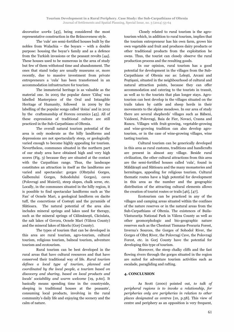
3.3.1. Regional organization and polarization
forces in the Sub-Carpathians of Oltenia
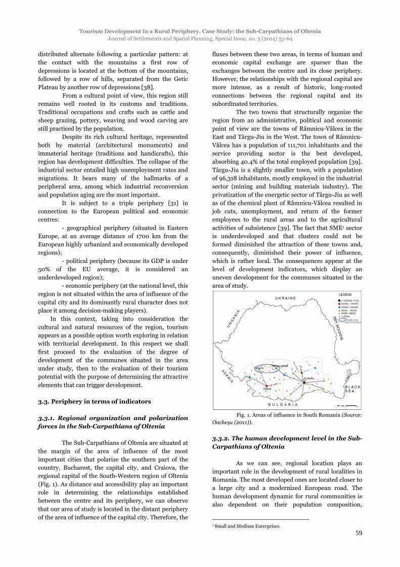
The Sub-Carpathians of Oltenia are situated at
the margin of the area of influence of the most
important cities that polarize the southern part of the
country, Bucharest, the capital city, and Craiova, the
regional capital of the South-Western region of Oltenia
(Fig. 1). As distance and accessibility play an important
role in determining the relationships established
between the centre and its periphery, we can observe
that our area of study is located in the distant periphery
of the area of influence of the capital city. Therefore, the
fluxes between these two areas, in terms of human and
economic capital exchange are sparser than the
exchanges between the centre and its close periphery.
However, the relationships with the regional capital are
more intense, as a result of historic, long-rooted
connections between the regional capital and its
subordinated territories.
The two towns that structurally organize the
region from an administrative, political and economic
point of view are the towns of Râmnicu-Vâlcea in the
East and Târgu-Jiu in the West. The town of Râmnicu-
Vâlcea has a population of 111,701 inhabitants and the
service providing sector is the best developed,
absorbing 40.4% of the total employed population [39].
Târgu-Jiu is a slightly smaller town, with a population
of 96,318 inhabitants, mostly employed in the industrial
sector (mining and building materials industry). The
privatization of the energetic sector of Târgu-Jiu as well
as of the chemical plant of Râmnicu-Vâlcea resulted in
job cuts, unemployment, and return of the former
employees to the rural areas and to the agricultural
activities of subsistence [39]. The fact that SME1 sector
is underdeveloped and that clusters could not be
formed diminished the attraction of these towns and,
consequently, diminished their power of influence,
which is rather local. The consequences appear at the
level of development indicators, which display an
uneven development for the communes situated in the
area of study.
Fig. 1. Areas of influence in South Romania (Source:
Oacheşu (2011)).
3.3.2. The human development level in the Sub-
Carpathians of Oltenia
As we can see, regional location plays an
important role in the development of rural localities in
Romania. The most developed ones are located closer to
a large city and a modernized European road. The
human development dynamic for rural communities is
also dependent on their population composition,
1 Small and Medium Enterprises.
Antoaneta-Carina POPESCU
Journal of Settlements and Spatial Planning, Special Issue, no. 3 (2014) 53-64
60
accessibility to urban growth centres, micro-regional
communication facilities, and general development of
the regions they are part of or close to [25]. Mălăescu
(2009) distinguishes several types of periphery in the
Sub-Carpathians situated between Olt and Jiu rivers,
according to the geographic location and the economic
development of the communities analyzed [41].
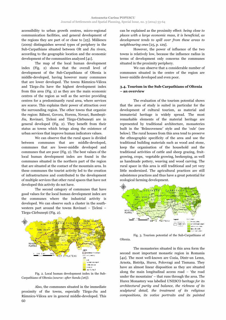
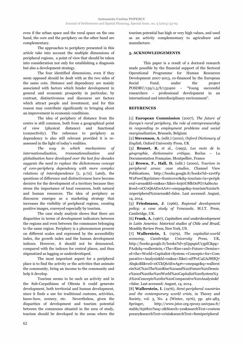
The map of the local human development
index (Fig. 2) shows that the overall level of
development of the Sub-Carpathians of Oltenia is
middle-developed, having however many communes
that are lower developed. The towns Râmnicu-Vâlcea
and Târgu-Jiu have the highest development index
from this area (Fig. 2) as they are the main economic
centres of the region as well as the service providing
centres for a predominantly rural area, where services
are scarce. This explains their power of attraction over
the surrounding region. The other towns that organize
the region: Băbeni, Govora, Horezu, Novaci, Bumbeşti-
Jiu, Rovinari, Ţicleni and Târgu-Cărbuneşti are in
general developed (Fig. 2). They benefit from their
status as towns which brings along the existence of
urban services that improve human indicators values.
We can observe that the rural space is divided
between communes that are middle-developed,
communes that are lower-middle developed and
communes that are poor (Fig. 2). The best values of the
local human development index are found in the
communes situated in the northern part of the region
that are situated at the contact of the mountain area. In
these communes the tourist activity led to the creation
of infrastructures and contributed to the development
of multiple services that other rural spaces that have not
developed this activity do not have.
The second category of communes that have
good values for the local human development index are
the communes where the industrial activity is
developed. We can observe such a cluster in the south-
western part around the towns Rovinari – Ţicleni –
Târgu-Cărbuneşti (Fig. 2).
Fig. 2. Local human development index in the Sub-
Carpathians of Oltenia (source: after Sandu [26]).
Also, the communes situated in the immediate
proximity of the towns, especially Târgu-Jiu and
Râmnicu-Vâlcea are in general middle-developed. This
can be explained as the proximity effect: being close to
places with a large economic mass, it is beneficial, as
development tends to spill over from these areas to
neighbouring ones [25, p. 129].
However, the power of influence of the two
towns is relatively low, because the influence radius in
terms of development only concerns the communes
situated in the proximity periphery.
We can observe that a considerable number of
communes situated in the centre of the region are
lower-middle developed and even poor.
3.4. Tourism in the Sub-Carpathians of Oltenia
– an overview
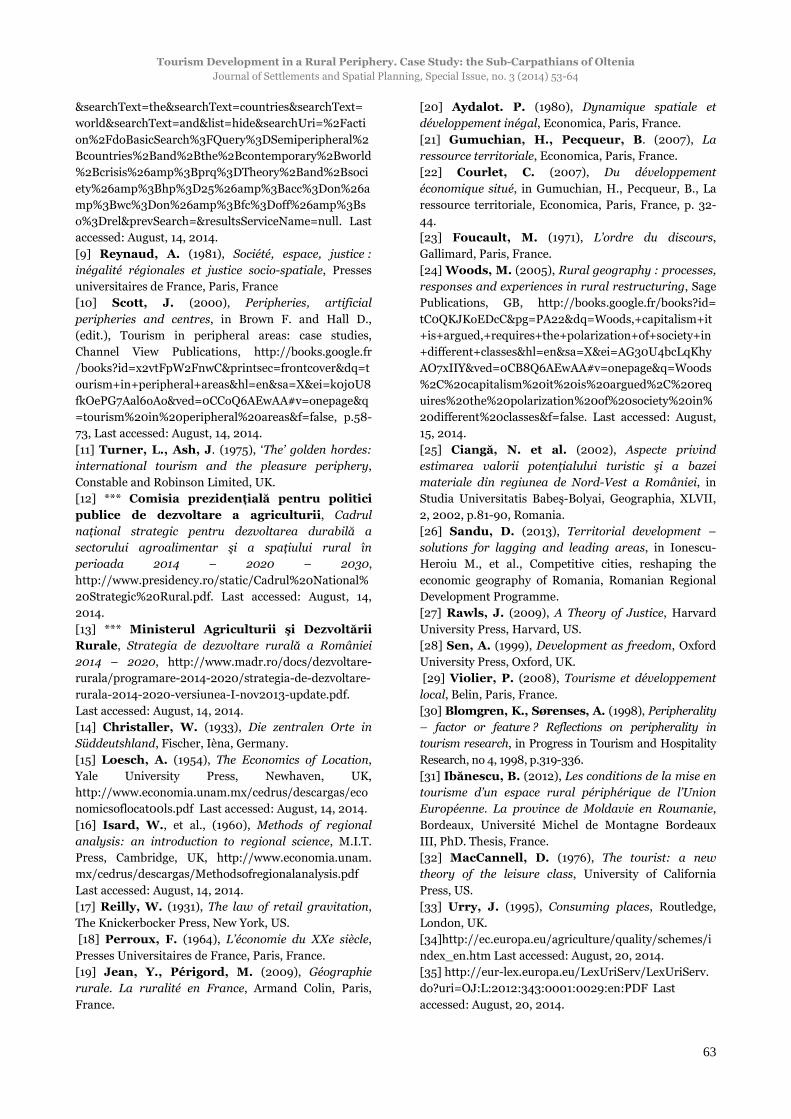
The evaluation of the tourism potential shows
that the area of study is suited in particular for the
development of cultural tourism, as material and
immaterial heritage is widely spread. The most
remarkable elements of the material heritage are
represented by traditional architecture, monasteries
built in the ‘Brâncovenesc’ style and the ‘cule’ (see
below). The rural houses from this area tend to preserve
the ethnographic specificity of the area and use the
traditional building materials such as wood and stone,
keep the organisation of the household and the
traditional activities of cattle and sheep grazing, fruit-
growing, crops, vegetable growing, beekeeping, as well
as handmade pottery, weaving and wood carving. The
rural space in this area is still traditional and yet very
little modernized. The agricultural practices are still
subsistence practices and thus have a great potential for
ecological farming development.
Fig. 3. Tourism potential of the Sub-Carpathians of
Oltenia.
The monasteries situated in this area form the
second most important monastic region in Romania
[42]. The most well-known are Cozia, Dintr-un Lemn,
Arnota, Bistriţa, Hurez, Polovragi and Tismana. They
have an almost linear disposition as they are situated
along the main longitudinal access road – ‘the road
under the mountains’ – that runs through the area. The
Hurez Monastery was labelled UNESCO heritage for its
architectural purity and balance, the richness of its
sculptural detail, the treatment of its religious
compositions, its votive portraits and its painted
Tourism Development in a Rural Periphery. Case Study: the Sub-Carpathians of Oltenia
Journal of Settlements and Spatial Planning, Special Issue, no. 3 (2014) 53-64
61
decorative works [43], being considered the most
representative construction in the Brâncovenesc style.
The ‘cule’ are semi-fortified houses built by the
nobles from Walachia – the boyars – with a double
purpose: housing the boyar’s family and as a defence
from the Turkish invasions or the peasant revolts [44].
These houses used to be numerous in the area of study
but few of them withstood time and abandonment. The
ones that stand today are usually museums or, more
recently, due to massive investment from private
entrepreneurs a ‘cula’ has been transformed in an
accommodation infrastructure for tourism.
The immaterial heritage is as valuable as the
material one. In 2005 the popular dance ‘Căluş’ was
labelled Masterpiece of the Oral and Intangible
Heritage of Humanity, followed in 2009 by the
labelling of the popular songs called ‘doina’ and in 2012
by the craftsmanship of Horezu ceramics [45]. All of
these expressions of traditional culture are still
practiced in the Sub-Carpathians of Oltenia.
The overall natural tourism potential of the
area is only moderate as the hilly landforms and
depressions are not spectacularly steep, or geologically
varied enough to become highly appealing for tourism.
Nevertheless, communes situated in the northern part
of our study area have obtained high and very high
scores (Fig. 3) because they are situated at the contact
with the Carpathian range. Thus, the landscape
constitutes an attraction in itself as the landforms are
varied and spectacular: gorges (Olteţului Gorges,
Galbenului Gorges, Sohodolului Gorges), caves
(Polovragi and Muierii), steep slopes, chalk scree, etc.
Locally, in the communes situated in the hilly region, it
is possible to find spectacular landforms such as ‘the
Fan’ of Ocnele Mari, a geological landform on dacite
tuff, the concretions of Costeşti and the pyramids of
Slătioara. The natural potential of the area also
includes mineral springs and lakes used for therapy,
such as the mineral springs of Călimăneşti, Căciulata,
the salt lakes of Govora, Ocnele Mari (Vâlcea County)
and the mineral lakes of Săcelu (Gorj County).
The types of tourism that can be developed in
this area are rural tourism, agro-tourism, cultural
tourism, religious tourism, balneal tourism, adventure
tourism and ecotourism.
Rural tourism can be best developed in the
rural areas that have cultural resources and that have
conserved their traditional way of life. Rural tourism
defines a local type of tourism, planned and
coordinated by the local people, a tourism based on
discovery and sharing, based on local products and
locals’ sociability and warm welcome [19, p.60]. It
basically means spending time in the countryside,
sleeping in traditional houses at the peasants’,
consuming local products, involving in the rural
community’s daily life and enjoying the scenery and the
calm of nature.
Closely related to rural tourism is the agro-
tourism which, in addition to rural tourism, implies that
the tourism entrepreneur has his own farm, grows his
own vegetable and fruit and produces dairy products or
other traditional products from the exploitation he
owns. Thus, the tourist can closely observe the rural
production process and the resulting goods.
In our opinion, rural tourism has a good
potential for development in the villages from the Sub-
Carpathians of Oltenia suc as: Leleşti, Arcani and
Peştişani, situated in the neighbourhood of cultural and
natural attraction points, because they can offer
accommodation and catering to the tourists in transit,
as well as to the tourists that plan longer stays. Agro-
tourism can best develop in the villages situated on the
trails taken by cattle and sheep herds in their
movements to the alpine meadows. In our area of study
there are several shepherds’ villages such as Băbeni,
Vaideeni, Polovragi, Baia de Fier, Novaci, Crasna and
Runcu. Villages with fruit-growing, vegetable-growing
and wine-growing tradition can also develop agro-
tourism, or in the case of wine-growing villages, wine
tasting tourism.
Cultural tourism can be generically developed
in this area as rural customs, traditions and handicrafts
are present in almost any village. Beside rural
civilization, the other cultural attractions from this area
are the semi-fortified houses called ‘cula’, found in
Măldăraşti and Slătioara and the many monasteries and
hermitages, appealing for religious tourism. Cultural
thematic routes have a high potential for development
in this area as the number and the geographic
distribution of the attracting cultural elements allows
the creation of tourist routes or trails [46], [47].
Ecotourism can be practiced in any of the
villages and camping areas situated within the confines
of the nature reserves or in the natural areas from the
Sub-Carpathians of Oltenia. The existences of Buila-
Vânturariţa National Park in Vâlcea County as well as
other geomorphologic and bio-geographic nature
reserves such as the Chestnut Tismana-Procuria Forest,
Izverna’s Sources, the Gorges of Sohodol River, the
Gorges of Olteţ River, the Polovragi Cave, the Polovragi
Forest, etc. in Gorj County have the potential for
developing this type of tourism.
Moreover, the steep chalky cliffs and the fast
flowing rivers through the gorges situated in the region
are suited for adventure tourism activities such as
escalade, paragliding and rafting.
4. CONCLUSION
As Scott (2000) pointed out, to talk of
peripheral regions is to invoke a relationship, for
peripheries only are peripheries in relation to other
places designated as centres [10, p.58]. This view of
centre and periphery as an opposition is very frequent,
Antoaneta-Carina POPESCU
Journal of Settlements and Spatial Planning, Special Issue, no. 3 (2014) 53-64
62
even if the urban space and the rural space on the one
hand, the core and the periphery on the other hand are
complementary.
The approaches to periphery presented in this
article take into account the multiple dimensions of
peripheral regions, a point of view that should be taken
into consideration not only for establishing a diagnosis
but also a development strategy.
The four identified dimensions, even if they
seem opposed should be dealt with as the two sides of
the same coin. Distance and dependency are mainly
associated with factors which hinder development in
general and economic prosperity in particular, by
contrast, distinctiveness and discourse are factors
which attract people and investment, and for this
reason may contribute significantly to bringing about
an improvement in economic conditions.
The idea of periphery of distance from the
centre is still common, both from a geographical point
of view (physical distance) and functional
(connectivity). The reference to periphery as
dependency is also still relevant provided it is re-
assessed in the light of today’s realities.
The way in which mechanisms of
internationalisation, transnationalisation and
globalisation have developed over the last few decades
suggests the need to replace the dichotomous concept
of core-periphery dependency with more complex
relations of interdependence [1, p.72]. Lately, the
questions of difference and distinctiveness have become
decisive for the development of a territory because they
stress the importance of local resources, both natural
and human resources. The idea of periphery as
discourse emerges as a marketing strategy that
increases the visibility of peripheral regions, creating
positive images, conveyed especially by tourism.
The case study analysis shows that there are
disparities in terms of development indicators between
the regions and even between the communes belonging
to the same region. Periphery is a phenomenon present
on different scales and expressed by the accessibility
index, the growth index and the human development
indexes. However, it should not be denounced,
compared with the indexes for central places, and thus
stigmatized as lagging or underdeveloped.
The most important aspect for a peripheral
place is to find the activity or the activities that animate
the community, bring an income to the community and
help it develop.
Tourism seems to be such an activity and in
the Sub-Carpathians of Oltenia it could generate
development, both territorial and human development,
since it finds a use for traditional customs, activities,
know-how, scenery, etc. Nevertheless, given the
disparities of development and tourism potential
between the communes situated in the area of study,
tourism should be developed in the areas where the
tourism potential has high or very high values, and used
as an activity complementary to agriculture and
manufacture.
5. ACKNOWLEDGEMENTS
This paper is a result of a doctoral research
made possible by the financial support of the Sectoral
Operational Programme for Human Resources
Development 2007-2013, co-financed by the European
Social Fund, under the project
POSDRU/159/1.5/S/132400 - “Young successful
researchers – professional development in an
international and interdisciplinary environment”.
REFERENCES
[1] European Commission (2007), The future of
Europe’s rural periphery, the role of entrepreneurship
in responding to employment problems and social
marginalization, Brussels, Belgium
[2] Stevenson, A. (edit.) (2010), Oxford Dictionary of
English, Oxford University Press, UK
[3] Brunet, R. et al., (1993), Les mots de la
géographie, dictionnaire critique, Reclus – La
Documentation Française, Montpellier, France
[4] Brown, F., Hall, D. (edit.) (2000), Tourism in
peripheral areas: case studies, Channel View
Publications, http://books.google.fr/books?id=x2vtFp
W2FnwC&printsec=frontcover&dq=tourism+in+periph
eral+areas&hl=en&sa=X&ei=k0j0U8fkOePG7Aal6oAo
&ved=0CCoQ6AEwAA#v=onepage&q=tourism%20in%
20peripheral%20areas&f=false. Last accessed: August,
14, 2014.
[5] Friedmann, J. (1966), Regional development
policy: a case study of Venezuela, M.I.T. Press,
Cambridge, UK.
[6] Frank, A. (1967), Capitalism and underdevelopment
in Latin America: historical studies of Chile and Brazil,
Monthly Review Press, New York, US.
[7] Wallerstein, I. (1979), The capitalist-world
economy, Cambridge University Press, UK,
http://books.google.fr/books?id=5GppqmU13pIC&pg=
PA1&dq=wallerstein,+The+Rise+and+Future+Demise+
of+the+World+Capitalist+System:+Concepts+for+Com
parative+Analysis&hl=en&sa=X&ei=nFP0U4GAJ8HQ7
AbqkoBI&ved=0CCkQ6AEwAg#v=onepage&q=wallerst
ein%2C%20The%20Rise%20and%20Future%20Demis
e%20of%20the%20World%20Capitalist%20System%3
A%20Concepts%20for%20Comparative%20Analysis&f
=false. Last accessed: August, 14, 2014.
[8] Wallerstein, I. (1976), Semi-peripheral countries
and the contemporary world crisis, in Theory and
Society, vol. 3, No. 4 (Winter, 1976), pp. 461-483,
Springer, http://www.jstor.org.rproxy.univpau.fr/
stable/656810?seq=2&Search=yes&searchText=contem
porary&searchText=crisis&searchText=Semiperipheral
Tourism Development in a Rural Periphery. Case Study: the Sub-Carpathians of Oltenia
Journal of Settlements and Spatial Planning, Special Issue, no. 3 (2014) 53-64
63
&searchText=the&searchText=countries&searchText=
world&searchText=and&list=hide&searchUri=%2Facti
on%2FdoBasicSearch%3FQuery%3DSemiperipheral%2
Bcountries%2Band%2Bthe%2Bcontemporary%2Bworld
%2Bcrisis%26amp%3Bprq%3DTheory%2Band%2Bsoci
ety%26amp%3Bhp%3D25%26amp%3Bacc%3Don%26a
mp%3Bwc%3Don%26amp%3Bfc%3Doff%26amp%3Bs
o%3Drel&prevSearch=&resultsServiceName=null. Last
accessed: August, 14, 2014.
[9] Reynaud, A. (1981), Société, espace, justice :
inégalité régionales et justice socio-spatiale, Presses
universitaires de France, Paris, France
[10] Scott, J. (2000), Peripheries, artificial
peripheries and centres, in Brown F. and Hall D.,
(edit.), Tourism in peripheral areas: case studies,
Channel View Publications, http://books.google.fr
/books?id=x2vtFpW2FnwC&printsec=frontcover&dq=t
ourism+in+peripheral+areas&hl=en&sa=X&ei=k0j0U8
fkOePG7Aal6oAo&ved=0CCoQ6AEwAA#v=onepage&q
=tourism%20in%20peripheral%20areas&f=false, p.58-
73, Last accessed: August, 14, 2014.
[11] Turner, L., Ash, J. (1975), ‘The’ golden hordes:
international tourism and the pleasure periphery,
Constable and Robinson Limited, UK.
[12] *** Comisia prezidenţială pentru politici
publice de dezvoltare a agriculturii, Cadrul
naţional strategic pentru dezvoltarea durabilă a
sectorului agroalimentar şi a spaţiului rural în
perioada 2014 – 2020 – 2030,
http://www.presidency.ro/static/Cadrul%20National%
20Strategic%20Rural.pdf. Last accessed: August, 14,
2014.
[13] *** Ministerul Agriculturii şi Dezvoltării
Rurale, Strategia de dezvoltare rurală a României
2014 – 2020, http://www.madr.ro/docs/dezvoltare-
rurala/programare-2014-2020/strategia-de-dezvoltare-
rurala-2014-2020-versiunea-I-nov2013-update.pdf.
Last accessed: August, 14, 2014.
[14] Christaller, W. (1933), Die zentralen Orte in
Süddeutshland, Fischer, Ièna, Germany.
[15] Loesch, A. (1954), The Economics of Location,
Yale University Press, Newhaven, UK,
http://www.economia.unam.mx/cedrus/descargas/eco
nomicsoflocat00ls.pdf Last accessed: August, 14, 2014.
[16] Isard, W., et al., (1960), Methods of regional
analysis: an introduction to regional science, M.I.T.
Press, Cambridge, UK, http://www.economia.unam.
mx/cedrus/descargas/Methodsofregionalanalysis.pdf
Last accessed: August, 14, 2014.
[17] Reilly, W. (1931), The law of retail gravitation,
The Knickerbocker Press, New York, US.
[18] Perroux, F. (1964), L’économie du XXe siècle,
Presses Universitaires de France, Paris, France.
[19] Jean, Y., Périgord, M. (2009), Géographie
rurale. La ruralité en France, Armand Colin, Paris,
France.
[20] Aydalot. P. (1980), Dynamique spatiale et
développement inégal, Economica, Paris, France.
[21] Gumuchian, H., Pecqueur, B. (2007), La
ressource territoriale, Economica, Paris, France.
[22] Courlet, C. (2007), Du développement
économique situé, in Gumuchian, H., Pecqueur, B., La
ressource territoriale, Economica, Paris, France, p. 32-
44.
[23] Foucault, M. (1971), L’ordre du discours,
Gallimard, Paris, France.
[24] Woods, M. (2005), Rural geography : processes,
responses and experiences in rural restructuring, Sage
Publications, GB, http://books.google.fr/books?id=
tC0QKJKoEDcC&pg=PA22&dq=Woods,+capitalism+it
+is+argued,+requires+the+polarization+of+society+in
+different+classes&hl=en&sa=X&ei=AG30U4bcLqKhy
AO7xIIY&ved=0CB8Q6AEwAA#v=onepage&q=Woods
%2C%20capitalism%20it%20is%20argued%2C%20req
uires%20the%20polarization%20of%20society%20in%
20different%20classes&f=false. Last accessed: August,
15, 2014.
[25] Ciangă, N. et al. (2002), Aspecte privind
estimarea valorii potenţialului turistic şi a bazei
materiale din regiunea de Nord-Vest a României, in
Studia Universitatis Babeş-Bolyai, Geographia, XLVII,
2, 2002, p.81-90, Romania. [26] Sandu, D. (2013), Territorial development –
solutions for lagging and leading areas, in Ionescu-
Heroiu M., et al., Competitive cities, reshaping the
economic geography of Romania, Romanian Regional
Development Programme.
[27] Rawls, J. (2009), A Theory of Justice, Harvard
University Press, Harvard, US.
[28] Sen, A. (1999), Development as freedom, Oxford
University Press, Oxford, UK.
[29] Violier, P. (2008), Tourisme et développement
local, Belin, Paris, France.
[30] Blomgren, K., Sørenses, A. (1998), Peripherality
– factor or feature ? Reflections on peripherality in
tourism research, in Progress in Tourism and Hospitality
Research, no 4, 1998, p.319-336.
[31] Ibănescu, B. (2012), Les conditions de la mise en
tourisme d’un espace rural périphérique de l’Union
Européenne. La province de Moldavie en Roumanie,
Bordeaux, Université Michel de Montagne Bordeaux
III, PhD. Thesis, France.
[32] MacCannell, D. (1976), The tourist: a new
theory of the leisure class, University of California
Press, US.
[33] Urry, J. (1995), Consuming places, Routledge,
London, UK.
[34]http://ec.europa.eu/agriculture/quality/schemes/i
ndex_en.htm Last accessed: August, 20, 2014.
[35] http://eur-lex.europa.eu/LexUriServ/LexUriServ.
do?uri=OJ:L:2012:343:0001:0029:en:PDF Last
accessed: August, 20, 2014.
Antoaneta-Carina POPESCU
Journal of Settlements and Spatial Planning, Special Issue, no. 3 (2014) 53-64
64
[36] Wanhill, S., Buhalis, D. (1999), Introduction:
Challenges for tourism in peripheral areas, in
International Journal of Tourism Research, no 1, 1999,
p. 295-297, http://www.academia.edu/209882/
Tourism_in_the_European_periphery Last accessed:
August, 20, 2014.
[37] Vlès, V. (2006), La gestion d’un équipement
culturel public à dominante touristique. L’exemple de
l’écomusée de Marquèze, in Allinne, J-P., Carrier, R.,
(dir.), Gérer la culture en région. Les pratiques des
collectivités territoriales en France, l’Harmattan Paris,
France.
[38] Badea L., Buga, D. (coord.) (1992), Geografia
României. Regiunile pericarpatice : Dealurile şi
Câmpia Banatului şi Crişanei, Podişul Mehedinţi,
Subcarpaţii, Piemontul Getic, Podişul Modovei, vol. IV,
Editura Academiei Române, București, Romania
[39] *** Ministerul Dezvoltării Regionale şi
Locuinţei, Regiunea de Dezvoltare Sud-Vest,
http://www.mdrl.ro/_documente/regiuni/4.SW_ro.pd
f Last accessed: August, 10, 2014.
[40] Oacheşu, Ș. (2011), Rolul oraşelor mari în
dezvoltarea regională a României, Facultatea de
Geografie, Universitatea din Bucureşti, PhD. Thesis
Abstract, Romania http://www.unibuc.ro/studies/
index.php?path=Doctorate2012Martie%2FOachesu+St
efan+Vilson++Rolul+oraselor+mari+in+dezvoltarea+r
egionala+a+Romaniei/ Last accessed: August, 10, 2014.
[41] Mălăescu, S. (2009), Subcarpaţii dintre Olt şi
Jiu. Studiu de geografie social cu accent pe perioada de
tranziţie, Presa Universitară Clujeană, Cluj-Napoca,
Romania.
[42] Cocean, P. (2010), Patrimoniul turistic al
României, Presa Universitară Clujeană, Cluj-Napoca,
Romania.
[43] http://whc.unesco.org/en/list/597 Last accessed:
August, 20, 2014.
[44] Dumitrescu, I. (2011), Arhitectura tradiţională
din Vâlcea (secolele XVIII-XX), Offsetcolor, Râmnicu
Vâlcea, Romania .
[45] http://www.unesco.org/culture/ich/index.php?
lg=en&pg=00011#tabs Last accessed: August, 20, 2014.
[46] Mălăescu, S. (2013), The inside story : the
construction of an assessment instrument of cultural
specificity, preservation and suitability for cultural
thematic tourism, Journal of Settlements and Spatial
Planning, no 2/2013, p. 269-279, Romania
http://geografie.ubbcluj.ro/ccau/jssp/arhiva_si2_2013
/10JSSPSI022013.pdf Last accessed: August, 20, 2014.
[47] Popescu, A. (2012), Les routes thématiques:
levier de développement dans les Souscarpates de
l’Olténie ?, RECERC, no 6/2012, France,
http://icress.univ-perp.fr/images/stories/
fichiers_crec/Numero6/mise_en_valeur_patrimoine.p
df Last accessed: August, 20, 2014.