annual - fig - international federation of surveyors two new vice presidents and new ... –...
TRANSCRIPT

REVIEW
AN
NU
AL
International Federation of SurveyorsFédération Internationale des Géomètres
Internationale Vereinigung der Vermessungsingenieure
2008

General Assembly – Stockholm, Sweden in June 2008
The 31st FIG General Assembly was held during the FIG Working Week 2008 at June 15th and 19th in Stockholm. More than fifty member as-sociations participated. The General Assembly elected two new Vice Presidents and new Commission Chairs Elect for the federation. Iain Greenway from United Kingdom and Teo CheeHai from Malaysia are the new Vice Presidents. They are both well known within FIG and their contributions have always been highly appreciated – and the expectations for their term of office 2009 – 2012 are related to this. The term of office of Vice Presidents Paul van der Molen and Ken Allred came to an end at the end of 2008.
The General Assembly elected and appointed Commission Chairs Elect for 2009–2010 are: – Commission 1 Leonie Newnham, Aus-
tralia – Commission 2 Dr. Steven Frank, USA – Commission 3 Prof. Yerach Doytsher,
Israel – Commission 4 Dr. Michael Sutherland,
Canada – Commission 5 Mikael Lilje, Sweden – Commission 6 Dr. Gethin Wyn Roberts,
UK – Commission 7 Daniel Roberge, Canada – Commission 9 Dr. Frances Plimmer, UK.
The Chairs Elect will become automatically Commission Chairs 2011–2014.
Other major decisions of the General Assem-bly include the adoption of the new Statutes and Internal Rules. The assembly endorsed four new other publications:– The FIG Work Plan 2007–2010. This includes
the Council and Commission work plans for 2007–2010;
– Informal Settlements – the Road towards More Sustainable Places. The aim of this report is to explore how surveyors can be better prepared to work with international agencies, national and local governments in the area;
– FIG Guidelines on Capacity Assessment in Land Administration. This Guide, developed in cooperation with FAO, is offered as a tool for improving existing Land Administration Sys-tems through in-county self assessment of the capacity needs, especially in developing and transition countries where the financial resources are limited;
– Costa Rica Declaration on Pro-Poor Coastal Zone Management. The coastal zones are fragile and include a range of rights and interests. FIG supports the right of poor coastal communities to thrive, and retain ongoing access to coastal resources. The FIG Publications are worldwide recog-
nised by professionals, academia, NGOs and organisations as UN-HABITAT, FAO and the Word Bank in developing policies, profession and practise. Amongst the newest FIG Publications there is also ‘The FIG Profile’ which is the latest FIG brochure explaining the benefits of being an FIG member.
The General Assembly adopted two new member associations at its meeting: – Geodetic Engineers of the Philippines, Inc – Chamber of Graduate Surveyors from Bul-
garia.Further nine new affiliate members were
endorsed:– National Oceanic and Atmospheric Adminis-
tration, NOAA, United States Department of Commerce, USA
– Cadastre, Land Registry and Mapping Agency (Kadaster), the Netherlands
– Surveying Department, Dubai Municipality, United Arab Emirates
– National Land Survey of Finland (Maanmit-tauslaitos, MML), Finland
– National Survey and Cadastre (Kort og Ma-trikelstyrelse, KMS), Denmark
– National Land Survey of Sweden (Lantmä-teriet, LM), Sweden
– General Directorate for Surveying, Ministry of Water Resources, Republic of Iraq
– Lao National Geographic Department, Lao PDR
– Siberian State Academy of Geodesy, Russian Federation.The number of affiliate members is now 28. In addition two new corporate members
were endorsed: Derinsu Underwater Engineer-ing Ltd., Turkey; and Al-Mutakamilad Real Estate (Cityplex), Jordan and one academic member admitted to membership: University of Novi Sad from Republic of Serbia.
New chairs elect in a group picture with President Stig Enemark, from left to right: Leonie Newnham (Commission 1), Daniel Roberge (Commission 7), Yerach Doytsher (Commission 3), President Enemark, Mikael Lilje (Commission 5), Gethin W. Roberts (Commission 6) and Steven Frank (Commission 2).
Delegates listening to the FIG Fanfare at the General Assembly.
Outgoing Vice President Paul van der Molen at the General Assembly.

3
Greeting from the Presidentby Prof. Stig Enemark, President of the International Federations of Surveyors
Stig Enemark President of FIG
The theme of the current FIG Council “Building the Capacity” for 2007–2010 has been selected to emphasise the role of surveyors in building the society through their professional expertise and the crucial role that land has in the development. Of course it also highlights the importance to improve professional skills at organisational and personal level. To this work FIG has traditionally contributed by organising conferences and by producing publications.
I have described the visionary part of the FIG agenda “Flying high”. By this I mean global partnerships with the UN agencies such as FAO, UN-HABITAT and the World Bank in support of the global agenda such as achieving the Mil-lennium Development Goals. We have already several good examples on how to proceed in this direction by organising joint events with our main partners. In addition to the global focus our agenda also includes building visions and partnership at the regional level such as the European territory, the Arab world, the Franco-phone Africa and Latin America.
The second pillar on the agenda is “Keeping our feet on the ground”. By this I mean profes-sional and institutional development at regional, national, and local level in support of the regional and local needs of our member associations and the individual surveyors.
This Annual Review covers key achievements on these two areas during the second year of the current work plan.
The big question that I have confronted dur-ing the last year has been: “Is the role of the surveyors changing?” Without any doubt the answer is “Yes”! There is a big swing that could be entitled “From Measurement to Manage-ment”. This does not imply that measurement is no longer a relevant discipline. The change is mainly in response to technology development. Collection of data is now easier, but the assess-ment, interpretation and management of data still require highly skilled professionals. The role is changing into managing the measurements. There is wisdom in the saying that “All good coordination begins with good coordinates”. And the surveyors are the key providers. The change means that surveyors are increasingly contributing to building sustainable societies as experts in managing land.
The other key question is: “What role survey-ors have to play in the global agenda?” The move from measurement to management includes an increased focus on the social science issues such as land tenure, land policies and land management. These are all fields placed in the heart of the global agenda.
The surveyors play a key role in supporting an efficient land market and effective land use management. These functions underpin develop-ment and innovation for social justice, economic growth, and environmental sustainability.
Therefore, no development will take place without having a spatial dimension, and no development will happen without the footprint of surveyors – the land professionals.
In a global perspective surveying and land administration are basically about people, politics, and places. It is about people in terms human rights, engagement and dignity; it is about politics in terms of land policies and good government; and it is about places in terms of shelter, land and natural resources.
In facing the global agenda the role of FIG is threefold: (i) to explain the role of the survey-ing profession and the surveying disciplines in terms of their contribution to the MDGs; (ii) to develop and disseminate knowledge, policies and methods towards achieving and implement-ing the MDGs – a number of FIG publications have already made significant contributions in this regard; and (iii) to work closely with the UN agencies including the World Bank in contribut-
ing to the implementation of the MDGs. Thus it is obvious that a close and very active co-operation with the United Nations on implementing the MDGs belongs to the advanced FIG agenda.
I am proud to say that during the first two years of the four year term of office we have managed to implement major part of the ambi-tious Work Plan that was adopted in Hong Kong in May 2007. We have made good progress especially in relation to implementing the MDGs. FIG is a major partner to UN-HABITAT in support of the Global Land Tool Network; we organised a joint seminar with UN-HABITAT on Slum Upgrad-ing and the Importance of Financial Mechanisms as part of the Working Week in Stockholm; and prepared a conference with the World Bank in Washington that took place in March 2009.
From the FIG point of view it is crucial to make sure that FIG members and individual surveyors benefit from our global activities. This should be enhanced through an increased dialogue with member associations with a focus on explaining the relevance and importance of global activities as a basis for developing the capacity and societal status of surveyors at national and local levels.
Therefore, at the top of the agenda, FIG will continually provide a global forum for discussion and exchange of experiences. This relates to FIG annual conferences, regional conferences, and the work of the ten technical commissions. In the field of capacity building the Council contin-ues to provide institutional support to individual member countries or regions with regard to developing the basic capacity for meeting the challenges of the future in terms of educational programmes, professional organizations, and surveying institutions.
The highlight of the activities in 2008 was the FIG Working Week 2008 in Stockholm. We should not forget the valuable work that the ten commissions are doing by organising their events and through their working groups. These are also described in this Annual Review as well as highlights of visits to regional and national events that have given me a good picture of the vital professional and social life that surveyors are having worldwide. Even in the hard economic times, there are options and opportunities for creative surveyors.
Yours sincerely,
“Surveyors have a key role to play
in contributing to the global agenda
such as the Millennium Development
Goals. Simply, no development will
take place without having a spatial
dimension and no development
will happen without the footprint of
surveyors – the land professionals.”

4
FIG Working Week and XXXI General Assembly in Stockholm, Sweden, 14–19 June 2008
Integrating Generations – the Biggest FIG Working Week in History
The FIG Working Week held in Stockholm, Sweden just before the Midsummer Night was the biggest Working Week ever held. During the event young surveyors were very much in evidence, and mentor sessions brought the generations together. FIG wants to mobilise the next generation of land professionals and continue to develop innovative and transitionary solutions to address global inequality in land and property ownership and tenure.
The Working Week was hosted jointly by the International Federation of Surveyors (FIG) and the Swedish Association of Chartered Surveyors (SLF), which at the same time celebrated its 100th Anniversary. The theme of the Working Week “Integrating Generations” was in line with the overall theme of the current FIG Council: “Building the Capacity”. 950 participants from 90 nations attended the event and the exhibition. In addition to the plenary sessions there were over 70 technical sessions, with almost 350 presentations, and technical tours. The Working Week included the joint FIG/UN-HABITAT seminar on “Improving Slum Conditions through Innova-tive Financing”. The conference venue was the Stockholm City Conference Centre comfortably located within a walking distance to Stockholm’s main attractions.
FIG is a global organisation that aims to build bridges between ages, cultures and continents. Integrating the young generation is a key issue within FIG. This was demonstrated during the opening ceremony by the Swedish Minister for Environment Andreas Carlgren – who opened the conference together with Carl-Olof Ternryd, Honorary President of FIG and President of the FIG Council in 1977, and Cecilia Lindén, Chair of the FIG Working Group for Young Surveyors. The contribution of young surveyors will be most relevant for FIG in solv-ing the issues of our time – where surveying is the backbone of society. In his speech Andreas Carlgren emphasised that in Sweden land and property underpin the economy. However, he said that in developing countries legal empower-ment of the poor is required to support property ownership, and information systems are needed to stop us guessing. He stated that “FIG has such an important key role to play, to combat environmental threat, to combat poverty and slums and to support the development of this globe and its cities.”
In his opening remarks president Stig Ene-mark summarised his opening remarks: “We tied the ribbon between the generation that changed the world from analogue to digital and
Svante Astermo, President of the Swedish Association of Surveyors, SLF and Chair of the organising Committee welcomes FIG to Stockholm.
Opening Ceremony was opened by the music corps of the Royal Guards in the uniforms of the Dragoon’s Battalion.
Prof. Stig Enemark, FIG President making his welcome address.
Dr. Anna K. Tibaijuka, Executive Director of UN-HABITAT was the keynote speaker at the opening ceremony.

5
takes digital media for granted – but work needs to be done in many countries.”
The cultural programme of the opening cer-emony included traditional Swedish folk music and dances performed by the representatives from Skansen, and musical entertainment per-formed by the music corps of the Dragoon’s Battalion of the Royal Guards. They played both melodies from ABBA and a new arrangement of the FIG Fanfare that was also recorded for future use.
At the opening ceremony the keynote ad-dress was given by Dr. Anna K. Tibaijuka, UN Under-Secretary General and Executive Director of UN-HABITAT. In her speech she reminded the audience that the world is becoming more urban: “Cities are not prepared to welcome and receive the new influx. The challenge, therefore, is to try to guide this urbanisation process.”
According to Dr. Tibaijuka only some 10 percent of land parcels in the world are regis-tered; in many areas, the poor’s land rights are based on customary rights that are not legally recognised. She noted that individual freehold titling is not always appropriate for a number of reasons including, the costs of adjudication, high technical standards, expensive registration and transfer fees, and literacy requirements. She observed that the development of new land tools, such as the FIG Land Administration Domain Model, will allow for the registration of customary forms of tenure and overlapping land rights and claims.
The FIG/UN-HABITAT Seminar “Slum Upgrad-ing through Innovative Financing Mechanisms” discussed for two days the challenges and approaches that suit the poor; e.g. intermedi-ate forms of title; gender sensitive title and incremental finance from group to project. Land markets should also work for the poor, using innovative planning instruments. This integrated seminar experience was forwarded to the 4th World Urban Forum in China in November 2008. This seminar attracted new delegates to the FIG Working Week broadening discussions from mere surveyors to multi-discipline dialogue between land professionals and economists.
The three plenary sessions started with a session “Sustainable Urban Development and the Millennium Development Goals”. The keynote addresses were given by Minister Carlgren who talked about the environment and climate and the role of property and land administration institutions in society. The second speaker was Dr. Ashraf Ghani, Chairman of the Institute for State Effectiveness (Afghanistan), who spoke about the legal empowerment in a globalising world. He stated that “the land professional can bring information, knowledge and wisdom into harmony”.
President Enemark made his major contribu-tion to the conference programme in this plenary session focussing on the partnership between FIG and the UN agencies in support of the Mil-lennium Development Goals. He emphasised in his presentation that “the UN agencies have access to national governments and to setting a global agenda, but they will often depend on interest groups and NGOs for implementing this agenda. FIG as an international NGO on the other hand has access to national associations and individual professionals, but at the same time as other NGOs will often depend on the UN agen-cies to determine the global agenda. This is why the global partnership is needed to establish the link that drives development for achieving the global agenda such as the MDGs.”
The second plenary session “Land Admin-istration and Finance Systems“ was organised jointly with the FIG/UN-HABITAT seminar. This session was chaired by Lars Magnusson and Ann Jennervik, focal persons together with Bengt Kjellson in organising this special seminar. The speakers in this sessions included Michael Mutter, from UN-HABITAT Slum Up-grading Facility, speaking about expanding the outreach of housing finance for the urban poor from co-operational point of view and Renu Sud Karnad, Joint Managing Director of the Housing Development Finance Corporation Limited – In-dia telling about concepts of channelling financial flows for adequate and affordable housing. Dan Ericsson, State Secretary of the Ministry of Finance, Sweden explained the Swedish engage-ment in land administration and housing finance. Dr. Malcolm Childress, Sr. Land Administra-tion Specialist from the World Bank brought the World Bank vision to the discussion “Land Finance through Land Governance—Expanding the Discussion of Land Policy during Food Crisis, Climate Change and Rapid Urbanization”. This new view of world population growth was also demonstrated by President Enemark in his closing address.
David Zilkoski from NOAA, USA identified in his presentation at the third plenary session that the new customers for our professional services include key groups such as emergency managers, planners and developers, insurance industry, agricultural industry, environmental en-gineers, coastal managers, tribal governments, and international organisations.
In this plenary session focusing on technical innovations, the other speakers were Frank Udnaes from the Galileo Unit of the European Commission giving an overview on the status of the European EGNOS and Galileo Programmes and Stig Jönsson, Director General of Lantmä-teriet (National Land Survey of Sweden), discuss-ing about building integrated land information
Swedish folk dances and folk music at the opening ceremony.
FIG Honorary Presidents and Members in Stockholm: Jürg Kaufmann, Carl-Olof Ternryd, Stig Enemark, Juha Talvitie, Robert W. Foster and Jerome Ives.
Welcome reception at the Stockholm City Hall.
Entertainment provided by the Choir of technology students at the Gala Dinner.

6
systems and about development of NSDI by using Sweden as an example.
The Working Week in Stockholm introduced peer review papers for the first time in larger scale at an FIG event. Approximately 40 of the presented papers have been peer reviewed. Peer review option was introduced because of the growing requirement for university staff to concentrate their submission of papers on conferences that offer a peer review process. It was considered that the concept worked well in Stockholm and that the option for peer reviewed papers will be offered also at the incoming work-ing weeks and congresses. There seemed to be a common opinion that the overall quality of the presented papers has increased and at the same time number of no-shows has decreased.
In providing solutions to worldwide chal-lenges the surveyors and land professionals can contribute from a broad perspective – this can easily be demonstrated by the focus of attention of FIG’s ten commissions. The history pre-conference workshop collected about 60 participants.
The Working Week was supported by several FIG corporate members both as sponsors and as exhibitors in the exhibition. The gold spon-sors at FIG 2008 were ESRI and Trimble that also sponsored the FIG Foundation Dinner at the Vasa Museum. The local gold sponsors were the National Land Survey (Lantmäteriet) and Swedesurvey. FIG is most grateful for its sponsors and corporate members for their continuous support.
Technical tours included a full-day visit to Gävle to learn from the National Land Survey and Swedesurvey. The other tours included an overview on planning in Stockholm waterfronts and visit to Trimble in Danderyd as well as to the Stockholm City Survey Department and to the Swedish Maritime Administration.
The social functions of the Working Week started with a welcome reception hosted by
the City of Stockholm at the famous Stockholm City Hall, also known as the venue of the Nobel Prize Winner Dinner, an excellent place to start the FIG Working Week.
The FIG Foundation Dinner gathered 300 participants to the Vasa Museum to see the royal flagship that sank on its maiden voyage in 1628 and that was raised from the depths of Stockholm harbour in 1961.
The Nordic speciality “hemma hos” gave a unique opportunity for international participants to go for a home visit and to get to know the Swedish surveyors and their way of living in different locations in Stockholm.
The gala dinner was arranged at the Vintergarden at the Grand Hotel, the hotel in Stockholm over a great dinner and music per-formances by the student choir of technological students.
The farewell reception was hosted by the FIG 2010 organising committee in the foyer of Norra Latin under the well-known Swedish paintings.
In his closing address Stig Enemark spoke about the success of the conference. He re-called a Native American saying, used by Dr. Ashraf Ghani: “We do not inherit the earth from our ancestors, we borrow it from our children”. He also referred to the Commission on Legal Empowerment of the Poor published report: “Making the Law Work for Everyone” with a four pillar approach on empowerment of the poor: access to justice and the rule of law, property rights, labour rights and business rights. Presi-dent Enemark repeated that FIG is strongly com-mitted to the Millennium Development Goals and the UN-HABITAT agenda on the Global Land Tool Network. Global partnerships will establish the link that drives development for achieving the global agenda such as the MDGs. This agenda includes the big challenges of the new millen-nium: climate change, food shortage, energy scarcity, urban growth, environmental degrada-tion and natural disasters. All these issues relate to governance and management of land. Land governance and management is a core area for surveyors – the Land Professionals.
President Enemark concluded that we must mobilise the next generation of Land Profession-als. “We must continue to develop innovative and transitionary solutions to address global inequal-ity in land and property ownership and tenure. We can act as Professional Facilitators – we can ‘Fly High’ and we are providing the underlying data to enable monitoring and support decision making for sustainable development.”
Finally President Enemark thanked our Swed-ish colleagues under the excellent chairmanship of Conference Director Svante Astermo, and the support of the National Land Survey of Swe-den (Lantmäteriet) and Swedesurvey.
Stockholm City Conference Centre was the venue of the conference.
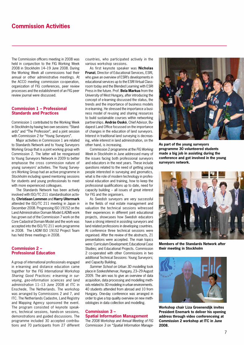
About 30 volunteered students made a big job in assisting during the conference – big thanks to these students coming from different parts of the world.
Gamla Stan – the old city of Stockholm.
7
Commission Activities
The Commission officers meeting in 2008 was held in conjunction to the FIG Working Week 2008 in Stockholm 14–19 June 2008. During the Working Week all commissions had their annual or other administrative meetings. At the ACCO meeting commission co-operation, organization of FIG conferences, peer review processes and the establishment of an FIG peer review journal were discussed.
Commission 1 – Professional Standards and Practices
Commission 1 contributed to the Working Week in Stockholm by having two own sessions: “Stand-ards” and “The Profession”, and a joint session with Commission 2 for “Young Surveyors”.
Major activities in Commission 1 are related to Standards Network and to Young Surveyors Working Group that is a joint working group with Commission 2. The latter will be reorganised to Young Surveyors Network in 2009 to better emphasise the cross commission nature of young surveyors’ activities. The Young Survey-ors Working Group had an active programme in Stockholm including speed mentoring sessions for students and young professionals to meet with more experienced colleagues.
The Standards Network has been actively involved with ISO/TC 211 standardisation activ-ity. Christiaan Lemmen and Harry Uitermark attended the ISO/TC 211 meeting in Japan in December 2008. Progressing ISO 19152 on the Land Administration Domain Model (LADM) work has grown out of the Commission 7 work on the Core Cadastral Domain Model and the work was accepted into the ISO/TC 211 work programme in 2008. The LADM ISO 19152 Project Team has held three meetings in 2008.
Commission 2 – Professional Education
A group of international professionals engaged in e-learning and distance education came together for the FIG International Workshop Sharing Good Practices: e-learning in sur-veying, geo-information sciences and land administration 11–13 June 2008 at ITC in Enschede, The Netherlands. The workshop was arranged by Commissions 2 and 7, and ITC. The Netherlands Cadastre, Land Registry and Mapping Agency sponsored the event. The program consisted of keynote speak-ers, technical sessions, hands-on sessions, demonstrations and guided discussions. The programme included 30 accepted contribu-tions and 70 participants from 27 different
countries, who participated actively in the various workshop sessions.
As first keynote speaker was Nicholas Frunzi, Director of Educational Services, ESRI, who gave an overview of ESRI’s developments in educational services up to the ESRI Virtual Class-room today and the Blended Learning with ESRI Press in the future. Prof. Bela Markus from the University of West Hungary, after introducing the concept of e-learning discussed the status, the trends and the importance of business models in e-learning. He stressed the importance a busi-ness model of re-using and sharing resources to build sustainable courses within networking partnerships. András Osskó, Chief Advisor, Bu-dapest Land Office focussed on the importance of changes in the education of land surveyors. Interest in traditional land surveying is decreas-ing, while interest in land administration, on the other hand, is increasing.
Commission 2 programme at the FIG Working Week in Stockholm in June addressed many of the issues facing both professional surveyors and educators in the next years. These include questions related to the need of getting young people interested in surveying and geomatics, what is the role of modern technology in profes-sional education and training, how to keep the professional qualifications up to date, need for capacity building – all issues of great interest for FIG and the organisers.
As Swedish surveyors are very successful in the fields of real estate management and valuation the technical sessions witnessed their experiences in different joint educational projects, showcases how Swedish educators have a strong interest in assisting surveyors and land related professions in developing countries. At conference three technical sessions were organised. After the review of the abstracts, 21 presentations were accepted. The main topics were: Curriculum Development; Educational Case Studies; and Educational Projects. Commission 2 co-operated with other Commissions in two additional Technical Sessions: Young Surveyors; and Capacity Building.
Summer School on Urban 3D modelling took place in Szekesfehervar, Hungary, 23–29 August 2009. The aim was to give an overview of data acquisition, data processing and modelling meth-ods related to 3D modeling in urban environments. 40 students attended from abroad and 10 from Hungary. One-day conference was arranged in order to give a top quality overview on new meth-odologies in data collection and modelling.
Commission 3 – Spatial Information ManagementThe 2008 Workshop and Annual Meeting of FIG Commission 3 on “Spatial Information Manage-
Workshop chair Liza Groenendijk invites President Enemark to deliver his opening address through video conferenceing at Commission 2 workshop at ITC in June 2008.
As part of the young surveyors programme 30 volunteered students made a big job in assisting during the conference and got involved in the young surveyors network.
Members of the Standards Network after their meeting in Stockholm

8
ment toward Environmental Management of Mega Cities” took place in Valencia, Spain, 18–21 February 2008. This Workshop was supported by ISPRS, EARSeL, INSPIRE, EuroSDR, UN/ECE Committee on Housing and Land Management and the Working Party on Land Administration, and FIG Commission 2. This Commission 3 Work-shop focused on how surveyors can, through SDIs and good land administration, provide reli-able spatial data and the means for monitoring, planning and providing good management of the rapidly increasing urban areas. The workshop was integrated into the TOP-CART 2008. In the third plenary session on “Urban Planning aspects and the impacts of rapid urbanization”; Chryssy Potsiou, was one of the keynote speakers. The commission 3 workshop was attended by 80 international participants from 28 countries.
Commission 3 delegates were welcomed by Prof Pedro Cavero, head of the organizing committee, Jeronimo Miron, UN/ECE WPLA Spanish delegate, President Enemark, and Dr. Potsiou. Invited Commission 3 keynote speakers were President Enemark, Ian Dowman, ISPRS President, Michael Gould who addressed “the INSPIRE initiative and its Implications”, Kevin Mooney who spoke about the “EuroSDR’s re-search activities in urban spatial data collection, management and delivery”, Dr Ana Maria Cruz. Besides the five joint sessions, Commission 3 Workshop had eight more technical sessions with 44 presentations in all.
Chryssy Potsiou attended the UN/ECE organ-ised the workshop on Legal Empowerment of the Poor in Bergen, Norway, 10–11 April 2008. The conference aimed at presenting outcomes of the work of the Commission on Legal Empow-erment of the Poor, and discussing its relevance for the UN ECE region.
Commission 3 had a broad programme at the Working Week in Stockholm including sessions for all Commission working groups.
The main general activity of Commission 3 after the Working Week 2008 in Stockholm has been preparations for the Commission 3 Annual Meeting and Workshop 2009 on “Spatial Infor-mation for Management of Sustainable Urban Areas”, in Mainz, Germany.
Paul Kelly, Chair of WG 3.2 represented Commission 3 at the 9th Congress of Metropolis “Trends in Megacities – Metropolis Congress 2008” in Sydney, Australia, 22–25 October 2008. FIG Commission 3 has set up a Working Group 3.2 to identify relevant spatial tools that will support development and use of spatial data infrastructure (SDI) by city authorities in the world’s largest cit-ies. The working group is currently pursuing two lines of inquiry to identify problems facing mega cities and how SDI can be used to address these problems: Questionnaires and visits to a selected
number of mega cities; Review and assessment of existing publications and other sources. The working group will prepare its final report to be launched at FIG 2010 in Sydney.
Commission 3 contributed to VSMM 2008, 14th International Conference on Virtual Systems and Multimedia dedicated on “Digital Heritage: our HI-tech STORY for future” in Cyprus, 20–26 October 2008.
Commission 3 Chair organised a FIG/UN-HABITAT Expert Group Meeting on Tools for Legal Integration and Provision of Environmental Improvements in Informal Settlements in Europe – A case study for Albania and Greece in Athens, Greece, 27–28 November 2008.
Commission 4 – Hydrography
Commission 4 members participated at two events in 2008: FIG Working Week 2008 in Sweden and Canadian Hydrographic Confer-ence and National Surveyors Conference 2008 in Canada.
Vice Chair of Administration and Communica-tions, David Neale was appointed to the FIG/IHO/ICA International Advisory Board on the Standards of Competence for Hydrographic Surveyors and Nautical Cartographers. Vice Chair, Dr. Michael Sutherland (Working Group 4.3 – Administering Marine Spaces) was nomi-nated chair-elect and approved by the General Assembly at Stockholm. FIG Publication no. 43 – Costa Rica Declaration on Pro-Poor Coastal Zone Management of which Commission 4 was a contributor was published and presented at this year’s Working Week in Stockholm.
At the Working Week in Stockholm the an-nual Commission 4 meeting was held and three technical sessions were hosted by Commission 4: Coastal Zone Management (Joint with Com-missions 7 and 8); Hydrographic Information Management; and Hydrographic Surveying in Practice. Of special interest to Commission 4 was a technical tour hosted by the Swedish Maritime Administration of their new vessel traffic service (VTS).
At the CHC/NSC 2008 in Victoria, Canada the theme of this conference was “Bringing Land and Sea Together”. FIG Commission 4 hosted a Workshop on Administering Marine Spaces. The goals of the workshop were to inform confer-ence participants of international efforts with regard to administering marine spaces and the role of FIG as a source for knowledge and good practice; to solicit feedback from conference participants; and to foster links between the ACLS and FIG in respect to their ongoing efforts to promote an administrative framework (includ-ing the Marine Cadastre) for Canada.
Pedro Cavero, President of the Spanish Association of Surveyors (Colegio Oficial de Ingenieros Técnicos en Topografia) and Chryssy Potsiou, Chair of FIG Commission 3 in Valencia.
Commission 3 delegates at the opening ceremony of Commission Annual Meeting in Valencia
Commission Activities
Commission 4 delegates at their annual meeting in Stockholm.

9
An overview of FIG was provided and Dr. Michael Sutherland chaired the session which focused on providing an understanding of the challenges and issues such as the impact of climate change and development on coastal communities; the role of the surveyor and other land management professionals in respect of the Administration of Marine Spaces. Feedback was received from participants on the role of the surveyor in leading the development, implemen-tation and maintenance of a Marine Cadastre.
In exchange for regular contributions to Hydro International, the publisher continued to provide a free subscription to all Commission 4 delegates.
Commission 5 – Positioning and Measurement
Commission 5 primary focus for 2008 has been to build on the foundations set in the work plan and to facilitate the needs of grass root sur-veyors and our members. As a result we have seen the continued interest and popularity in the development of GNSS positioning applica-tions, associated infrastructure; standards for such measuring devices; and new positioning technologies. Furthermore it is becoming more evident that these GNSS and positioning technologies are become more prevalent and integral components of fundamental infrastruc-ture to support existing and emerging land and spatial information systems.
At FIG related symposia various technical sessions and discussion forums have been held on these topics and have attracted large audiences and quality participation. From the analysis of delegate’s comments and feedback, it appears that Commission will need to convene similar forums but with also an emphasis and involvement of ‘mass market’ positioning tech-nology such as mobile phone communications and indoor positioning systems.
WG 5.1 Standards, Quality Assurance and Calibration chaired by David Martin organised in Stockholm one session on Calibration of Instru-ments and two sessions with WG 5.4. Two of the sessions came under the banner of “Standards, Quality Assurance and Calibration” and concerned GNSS Antenna Calibration and GNSS Standards. The latter session was distinguished by its lively debate over the important subject of standards in surveying and in GNSS in particular. Stand-ards also resurfaced in the sessions dedicated to New Positioning Techniques Forum. Work is progressing on the organisation of a repository of standards information related to GNSS.
WG 5.2 – Reference Frame in Practice chaired by Mikael Lilje, Chair Elect of Commis-
sion 5, was heavily involved in several sessions in Stockholm. Eight sessions were successfully organised. All sessions had quality papers, good attendance and interesting discussions. The work-ing group was also involved in the poster session on “Real Time GNSS CORS”. Most of the presenta-tions on real time networks can be found under the title “Permanent GNSS Networks” on the WG web site under Commission 5. By 2010, the WG hopes to add and update the ‘fact sheet’ archive and will base the additions or changes on the forums and technical papers from 2008/09.
WG 5.3 – Integrated Positioning, Navi-gation and mapping Systems co-chaired by Andrew Hunter and Naser El-Sheimy has been preparing the 6th International Symposium on Mobile Mapping Technology, which will be held in July 2009 in Brazil.
WG 5.4 – Global Navigation Satellite Sys-tems chaired by Volker Schweiger, was active at the Working Week in Stockholm. The sessions about Real Time GNSS CORS networks were successful and were facilitated in partnership with WG 5.2. A poster session and a discussion forum regarding this topic were successfully launched. The work for a “Report on possibilities of cost-effective GNSS techniques for develop-ing countries” is ongoing. It is scheduled to be published in a FIG Report for the FIG Congress in Sydney 2010. WG 5.4 supports German Aerospace Centre (DLR) to acquire kinematic GPS tracks that will be used to evaluate the TanDEM-X digital elevation model. Due to the required global coverage of the GNSS tracks, different tracks shall be acquired on different continents. The work is on going and will be presented at the following FIG events.
Commission Steering Committee consoli-dated relationship with various organisations such as the US National Geodetic Survey, NOAA, IAG and ION in 2008. In Stockholm IAG President Prof. Chris Rizos, and representatives from other partners participated extensively at many technical sessions and meetings.
Commission 6 – Engineering Surveys
Commission 6 activities were continued ac-cording the Working Plan for 2007–2010. The working group structure is stable:
WG6.1 – Deformation Measurement and Analysis, chair Adam Chrzanowski (Canada)
WG6.2 – Engineering Surveys for Industry and Research, chair Thomas Wunderlich (Germany)
WG6.3 – Engineering Survey Data Bases and Facility Management, chair Lothar Gründig (Germany)
Audience at the Commission 5 forum in Stockholm filled in the room to the last seat.
Commission 5 used poster presentations in a successful way at the Commission 5 Forum – Craig Roberts making his presentation.
Matt Higgins ringing the bell at Geo-Siberia 2008 in April where FIG Commissions 5 and 6 made a good input.

10
Commission Activities
WG6.4 – Engineering Surveys for Construc-tion Works and Structural Engineering, chair Gethin Roberts (UK)
WG6.5 – Terrestrial Laser Scanners – joint WG with Commission 5, chair Maria Tsakiri (Greece) and Rudolf Staiger (Germany)
The special and actual topics in focus of Com 6 were covered by six study groups.
During the 2008 Commission 6 contributed to six conferences and seminars.
The 13th International Symposium on De-formation Measurements was held in Lisbon, Portugal, 12–15 May 2008. It was organised by the WG6.1 and SG1, SG2, SG3 and SG6 together with IAG C4, Sub-commission 4.2, Applications of Geodesy in Engineering (4th IAG Symposium on Geodesy for Geotechnical and Structural Engineering). The theme of the sym-posium “Measuring the Changes” reflected the importance, and demand, for fully automated, continuous, and reliable deformation monitoring in the civil engineering, mining, and energy sec-tors. In addition there is a strong trend to incor-porate deformation systems into new structures from the very beginning, driven by concerns for whole-of-life structural health monitoring. Automation, multi-sensor integration, continuous data collection, integrated analysis and physical interpretation, and enhanced accuracy and reli-ability are the key developments in new monitor-ing systems. The symposium had 20 technical sessions with topics ranging from modeling, monitoring of structures, GNSS, geodeforma-tions, radar, and equipment to laser scanning, engineering geodesy and multi-techniques. In addition, there was a special session for fiber optic sensors hosted by the FIG WG 6.4. The annual meeting of SG5 was held in Lisbon during the conference. The symposium was attended by about 160 delegates from 30 countries. Maria Joao Henriques and her colleagues from Laboratorio Nacional de Engenharia Civil (LNEC) and several local organisations organ-ised the symposium.
The 4th International Exhibition and Scientific Congress GEO-SIBERIA 2008 was held in April 2008 in Novosibirsk, Russian Federation. It was organised parallel to the 25 Anniversary of the Siberian State Geodetic Academy. This largest surveying event in Russia was co-sponsored by FIG and by WG6.4.
The 1st International Conference on Machine Control & Guidance prepared by ETH was held in 24–26 June 2008 in Zurich, Switzerland with participation of the WG6.2 and WG6.5 members. During the conference, which was attended by over 130 participants from different backgrounds, following sessions were held: 3D-Construction Applications I (Excavator), II & III; Kinematic Measurement and Sensor Technology
(Local and GNSS Systems); Agriculture Applica-tions; Data Processing an Data Acquisition; and – Control Process and Control Algorithm.
The 4th International Conference on Engineer-ing Surveying – INGEO prepared by the WG6.2 members was held traditionally in Bratislava, Slovakia, 22–23 October 2008. The confer-ence had in focus the new methods and tools to support the effective data collection were developed in the last ten years worldwide. The questions of effective application and usage of new technology, their reliability and operability were discussed during the conference. The conference discussion was focused on present-day questions of laser scanning, usage of laser scanners in industry surrounding, for measure-ment of dynamic deformations, data acquisition and processing.
The traditional seminar about Terrestrial Laser Scanning was held in Fulda, Germany, 6–7 November 2008. This event is organised by jointly by DVW and FIG Commission 5 with participation of Commission 6 members.
Commission 6 contributed to the FIG Working Week in Stockholm by six technical sessions devoted to the engineering survey topics. The commission annual meeting built space for pres-entation of the progress made by the commission WGs and study groups. Technical sessions cov-ered deformation monitoring, analysis and inter-pretation using continuum mechanics, monitoring and analysis of crustal deformations, optimal use of InSAR technology, terrestrial-based RF positioning technologies, methods and equip-ment of terrestrial laser scanning for engineering surveying procedures, analysis of cyclic defor-mations and structural vibrations, monitoring of dynamic loaded structures, application of auto-matic measuring systems for machine guidance, setting-out and measurement of deformations, multidisciplinary expertise and co-operation, which lead to integrated survey methods and systems, co-operation with other professional organisations (IAG, ISM, ISPRS, etc.).
The high number of prepared events under-lines, that the year 2008 was very active and important for Commission 6. The outcomes will transform to results, which are valuable not only for Commission members, but all special-ists dealing with engineering surveying around the world.
Commission 7 – Cadastre and Land Management
Commission 7 Annual Meeting was held in Verona; Italy 11–15 September 2008 including one day open symposium on “Big Works for the Defence of the Territory”. The meeting was organised joint-
Measuring the Changes was the theme of the 13th International Symposium on Deformation Measurements that took place in Lisbon, Portugal organised by the WG6.1 together with IAG C4.
Exhibition at the Measuring the Changes in Lisbon.
4th International Conference on Engineering Surveying – INGEO prepared by the WG6.2 members was held traditionally in Bratislava, Slovakia in October 2008.

11
ly with Consiglio Nazionale Geometri e Geometri Laurenti. The motto of the meeting that included the FIG/FAO International Seminar was “Verona is Passion”. The Annual Meeting has a long history and is in fact the only world wide forum for land administrators and land professionals. President Stig Enemark stated in his keynote presentation that surveyors have an important role in achieving the Millennium Development Goals because land administration is supporting the global agenda.
The annual meeting was attended by 51 delegates from 24 countries with some ac-companying persons and several Italian profes-sionals. High ranking Italian politicians welcomed the participants, emphasizing the importance of land administration. The program followed the tradition of the Commission 7 annual meetings. Three days commission meeting, one day open symposium and one day technical tour. In the three days, there were delivered altogether 50 presentations. The Italian presentations dis-cussed the current situation of land surveying profession, education, practice and the role in the society, problems of measuring market value of Italian real estate, town planning and updating of the cadastre.
Several delegates spoke about the ongoing initiatives of the commission (WGs 1, 2 and 3, Social Tenure Domain Model, Cadastral Template, FLOSS Cadastre, benefits of using new technologies, good practice, case stud-ies, etc.) There were also 13 country reports, with special emphasis on developing countries (Ghana, Kenya and Cambodia).
The one day open symposium on “Environ-ment and Land Administration – Big Works for the Defence of the Territory” as part of the Annual Meeting was very popular program among the Italian professionals. The symposium was organised at the Verona Fiere to provide space for the interested about 400 profes-sionals. President Enemark gave a keynote on environment and land administration in respect of rights, restrictions and responsibilities. The most important presentation was given by Roberto Rosseli who spoke on the ongoing monumental construction Mose Project aiming at protecting Venice and its lagoon against high tides. Following the symposium participants visited the Mose Project in Venice.
At the FIG Working Week in Stockholm more than 80 papers were presented in Commission 7 and joint sessions. Commission contributed to the joint FIG-UN-HABITAT symposium on “Improving Slum Conditions through Innovative Financing” with Tommy Österberg (Sweden) and Christiaan Lemmen as the leaders and supported by other Commission 7 delegates.
Working Group 7.1 – Development of Pro Poor Land Management and Land Ad-
ministration chaired by Christiaan Lemmen has proceeded with its work in developing the Social Tenure Domain Model. In 2008 the Land Admin-istration Domain Model (LADM) was submitted by FIG as a New Working Item Proposal to the ISO. The initiative has been accepted by the ISO Technical Committee is active in standardisation in the field of digital geographic information. The LADM ISO 19152 Project Team had three meetings in 2008 in Copenhagen, Delft and in Tsukuba in Japan in December 2008.
Working Group 7.3 – Application of In-novative Technology in Land Administration chaired by Daniel Steudler supported the start of UN/FAO Project “FLOSS Cadastre” that had an expert group meeting in October 2007. As next step a workshop was organised in Dunedin, New Zealand, May 2008. Discussion at work-shop showed that there would be a tremendous benefit when large national project declare their software developments as open-source. The working group is responsible to keep the Cadastral Template up to-date with contribution by national delegates and representatives.
Commissions 7, 8 and 9 had a key role in organising the FIG/UN-HABITAT seminar on Improving Slum Conditions through Innovative Financing. Michael Mutter from UN-HABITAT and other speakers at the second plenary session in Stockholm.
Commission 7 Annual Meeting 2007 was held in Verona integrated to the FIG/FAO International Seminar: András Osskó (Chair FIG Commission 7, left); Domenico Romanelli (President of the Provincial College of Surveyors of Verona); Fausto Savoldi (CNGGL President); and Stig Enemark (FIG President).
Commission 8 – Spatial Planning and Development
At the General Assembly in Stockholm in June Dr. Diane Dumashie was elected to take up the ‘baton’ for the remainder of the term 2008–2010 from Simon Adcock who had to resign in early 2008. The hand over of the ‘baton’ presented a good opportunity for a mid term review of ‘How we work as a Commission’ with members feeding back from 2009 annual meeting led by the chair. Commission 8, with its involvement in the issues surrounding planning and urbanisation is often exploring planning and problem resolution of the question ‘where people wish to settle’. This means considering not only new development activities but also regenerating the built environment. Crucially the commission needs to translate its activities not only in established areas, but also those that are new and emerging areas. Increasingly our members are highlighting and debating the global issue of environmental resilience in human settlement activities.

12
Commission Activities
an e-forum was run by the GLTN Secretariat in October 2008 to build further consensus on these evaluation criteria. The chair was invited to assist in developing and subsequently taking a role of moderator within the e-forum team .The results were shared at the 4th World Urban Forum in Nanjing, China in November 2008.
Commission 8 has continued to maintain strong relationship with other land professional groups, such as Commonwealth Association of Land Economists (CASLE) and ways to be in-volved in the next African Regional Conference.
Commission 9 – Valuation and the Management of Real Estate
In 2008 Commission 9’s activities concentrated on FIG Working Week in Stockholm and on a joint seminar on Appraisal and Property Protection in Beijing, China on 18–19 October. In addition, the Working Groups of the Commission have been working with their topics through out the year.
In Stockholm the Commission held the com-mission annual meeting and all working groups had their own meetings, WG 9.2 even arranged a special event. In addition there were several presentations on valuation and real estate man-agement in seven sessions.
Working Group 9.2 – Improving Slum Conditions through Innovative Financing, chair Bengt Kjellson and co-chair Ann Jen-nervik, had a key role in organising the joint FIG/UN-HABITAT symposium during the Work-ing Week in Stockholm on “Improving Slum Conditions Through Innovative Financing”. The seminar event was very well attended and very successful. An important part of the event was the inclusion of dialogues as a way to stimulate discussion and exchange of experiences across professional disciplines. In addition to a number of plenary sessions and presentations on the subject matter, a total of eight dialogues were held. This produced valuable outcome which has been documented jointly by FIG and UN-HABITAT (FIG publication no.44), and the outcome of the seminar was presented at the 4th World Urban Forum, in Nanjing, China in November 2008.
The Joint FIG/CIREA/HKIS Seminar on Ap-praisal and Property Protection was organised in Beijing, China P. R., 18–19 October 2008 by the China Institute of Real Estate Appraisers and Agents (CIREA), The Hong Kong Institute of Surveyors (HKIS) and FIG Commission 9 in co-operation with FIG Commission 8. The major goal of this seminar was to intensify the discussion between valuers, surveyors, real estate experts, investors, financiers, urban planners, researchers, teachers and decision makers and develop common ideas for shap-
ing the future. The seminar was very active gathering about 200 participants from nine countries. The President of the China Institute of Real Estate Appraisers and Agents (CIREA) Mr. Song Chunhua, Vice-President Elect Mr. Teo CheeHai, Vice-President of the Hong Kong Institute of Surveyors (HKIS) Mr. Stephen M W Yip and Vice Minister of Ministry of Housing and Urban-Rural Development of P. R. China Mr. Qi Ji gave welcome addresses.
A workshop on FIG recommendations for good practice in compulsory purchase and compensations was organised. After the seminar Commission 9 representatives lead by chair Kauko Viitanen visited CIREA office and discussed with Mr. Chai Qiang about goals of the FIG commission 9 and possibilities to activate the Chinese participation. It was also discussed to make this international seminar a tradition for Commission 9.
Commission 10 – Construction Economics and Management
Commission 10 is working to the broad agenda set out in the paper an “Explanation of the Present and an Agenda for the Future” and in Commission work plan.
Commission attended the FIG Working Week in Stockholm and presented papers in three technical sessions. Richard Hucker chaired another very successful Open Session in which he reported on the work carried out by WG10.3 and lead wide ranging discussion of the several examples of project management practice that he and his colleagues had investigated.
Commission chair Andrew Morley attended the CEEC’s bi-annual General Assembly in Prague in April 2008 and CEEC presented a paper dur-ing the FIG Working Week. This cooperation is working well and promises further involvement in the European context.
Shortly after the Working Week, Andrew Morley was able to attend the ICEC Congress in Toronto with the object of bringing to life the ten year old MoU between ICEC and FIG. This was a positive meeting and work is in progress to identify and develop projects of mutual inter-est to the two memberships. In November the chair attended the biennial ICEC Europe Regional meeting in Rome.
Andrew Morley attended the first meeting of a Commission 10 interest group of African quantity surveyors held during the AAQS trien-nial conference in Accra, Ghana in August. It is hoped that this grouping arrangement will work to overcome some of the logistical issues that have previously limited African participation in Commission work.
The cross cutting theme occurring in our fo-cus is “Man’s relationship with the environment”. This theme has resulted in increasing numbers of technical sessions being developed at our working weeks. Dealing with such questions as: the surveyors role and developing our own capacity, the ability to communicate to the public at large, the importance of land and energy, but also how we may increase the technical know how of planning and development. These suc-cessful sessions could not be achieved without cross commission support, an indication of the holistic remit of today’s land professional.
The areas of interest of Commission 8 remain on: Urbanisation, be it concentrated in informal set-tlements and/ or Mega cities; Disaster reduction, be it coastal or inland, and/ or disasters natural or man made; and Spatial planning, be it on policy and practice in greenfield or brown field sites.
Commission Working Group 8.4 Urban Planning in Coastal Regions progress has been made to initiate a joint Commission output, involving Commissions 4, 5 and 8 respectively with a focus on coastal change, a joint working group effort to work toward an interdisciplinary output of the three disciplines: (i) spatial plan-ning, (ii) geodetic surveying and (iii) marine administration to coastal development. The work aims to lead to a guide for practitioners.
Dr. Dumashie has been with the working agenda by liaising with international agencies, NGOs and member organisations, as well as en-couraging cross-commission involvement. This work will continue with special focus in Africa.
Commission chair and members have ac-tively engaged with the GLTN secretariat, hosted by UN-HABITAT. Following on from Commission 8 members’ involvement in 2007 and then early 2008 on gender responsive evaluation criteria and gender-sensitive tool development process,
Organising Committee of the FIG/CIREA/HKIS Seminar after the successful Commission 9 event in Beijing.
13
Co-operation with United Nations
Co-operation with United Nations
The Global Land Tools Network (GLTN) held a Land Professionals Workshop on Gendering Land Tools, in Bagamoyo, Tanzania from 10–11 March 2008, this workshop was co-hosted by Commission 8 and Dr. Diane Dumashie on behalf of FIG. GLTN remits to develop pro poor land tools that are gender sensitive is one of the core objectives of the network. The workshop discussion was set in the context of the gender mechanism for gendering land tools, and gave careful consideration of how tools can be made responsive to gender and what methodology would enable the gendering of existing land tools. This meeting brought together 12 participants from Sub Saharan Africa, Europe and Asia Pacific to collectively bring their professional knowledge and experience to the network debate and con-tribute to a road map that will identify the way forward. The future steps include setting up the Gender Mechanism Expert Group, which will ne-cessitate identification of stakeholders including professional groups.
UN/ECE organised a Workshop on Legal Empowerment of the Poor in Bergen, Nor-way, 10–11 April 2008. The event was being hosted by the Mapping and Cadastre Authority of Norway (Statens Kartverk), in association with the United Nations Economic Commission for Europe’s (UN ECE) Working Party on Land Administration (WPLA) and was attended by 110 participants from about 36 countries, amongst them Vice President Paul van der Molen and Chryssy Potsiou, Chair of Commission 3. The conference aimed at presenting outcomes of the work of the Commission on Legal Empowerment of the Poor, and discussing its relevance for the UN ECE region.
FAO/UN-HABITAT Expert Group Meeting (EGM) on Guidelines for Addressing Land Issues after Natural Disasters was held at the UN-HABITAT Office in Geneva, 21–23 April 2008. The meet-ing was invited by Paul Munro-Faure, Chief, Land Tenure and Management Unit, FAO; and Clarissa Augustinus, Chief, Land, Tenure and Property Administration, UN-HABITAT. The EGM was organised to contribute to the process of de-veloping Guidelines and a Toolkit for addressing Land Issues after Natural Disasters. The meeting included about 40 invited experts from the UN Agencies, humanitarian organisations, and the land profession. FIG President Stig Enemark represented FIG that is currently considering how best to contribute addressing the land issue after natural disasters. This may include a number of activities ranging from policy development in cooperation with the UN agencies to professional support in actual disaster situations in coopera-tion with other professional organisations.
President Enemark attended the Global Land Tool Network International Advisory Board (IAB) Meeting in New York 7 May 2008 during the 16th Meeting of the UN Commission for Sustainable Development (CSD-16) 5–16 May 2008. The GLTN IAB is established to provide objective advice on issues related to the GLTN policies, operational strategies and projects. IAB consist of representatives of the various 7 segments of GLTN partners, where FIG rep-resents the international professional bodies. The meeting in New York was the second of IAB and chaired by President Enemark due to apologies from the IAB Chairperson, Mrs. Agnes Kalibbala, Uganda. The key issues included an evaluation of the overall GLTN activi-ties during the last year. During the CSD-16 a range of side-events took place. One of these organised by UN-HABITAT, related to Gender and Land and included a presentation from Dr. Diane Dumashie, Chair of Commission 8 entitled “Gendering Land Tools: from Policy to Practice” and showing the results of the UN-HABITAT/FIG workshop held in Bogamoya, Tanzania, March 2008 on Land Tools: Develop-ing Criteria for Gender Sensitivity.
International Seminar on State and Public Land Management was organised by FIG Com-mission 7 and the Consiglio Nazionale Geometri e Geometri Laureati in co-operation with FIG Commission 9 and the Food and Agriculture Organization of the United Nations (FAO) Land Tenure and Management Unit in Verona, Italy 9–10 September 2008. The Seminar preceded the Annual Meeting of FIG Commission 7, organised in close cooperation with CNGGL. Both events attracted land professionals from all over the world.
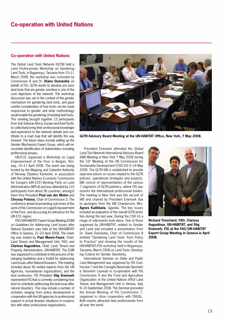
Richard Trenchard, FAO, Clarissa Augustinus, UN-HABITAT, and Stig Enemark, FIG at the FAO/UN-HABITAT Expert Group Meeting in Geneva in April 2008.
GLTN Advisory Board Meeting at the UN-HABITAT Office, New York, 7 May 2008.

14
Co-operation with United Nations
discussed formal and informal ways to come up with action-oriented proposals to create sustainable cities.
FIG was represented by President Enemark, who was one of the keynote speakers in Dia-logue 2 – Promoting Social Equity and Inclusive-ness, which was one of the six core sessions of the WUF. His presentation included the launch of the report from the FIG/UN-HABITAT semi-nar in Stockholm “Improving Slum Conditions through Innovative Financing” and information about FIG contribution to the Global Land Tool Network (GLTN). In the GLTN Roundtable he had a larger presentation on the report and on the FIG role in promoting pro poor land tools. President Enemark attended also the meeting of the International Advisory Board of GLTN that made the work plan for GLTN for the next years, in which FIG will play a key role.
At the Habitat Professionals Forum meeting President Enemark gave the leadership of the HPF to the International Federation of Housing and Planning. New initiatives were introduced to increase the number of active professional groups in the forum.
President Stig Enemark attended the Expert Group Meeting on Voluntary Guidelines on Re-sponsible Governance of Tenure of Land and other Natural Resources at FAO Headquarters, Rome, Italy, 24–25 November 2008. FAO, and partners such as the World Bank, UN-HABITAT, IFAD (International Federation of Agricultural Development), and FIG have been working since 2005 on governance of land administration to raise awareness and produce guidelines. A good example of this is the FAO publica-tion on Good governance in land tenure and administration. As the next step FAO embarks on assisting countries wishing to develop a formal policy response to the problems of weak governance and corruption. This work is intended to result in voluntary guidelines for responsible governance of tenure of land and other natural resources prepared jointly by governments, civil society and international organizations and approved by FAO’s member nations, as well as other interested parties. This EGM included a group of around 80 par-ticipants representing about 60 institutions from all regions in the world. The aim of the meeting was to help FAO to finalise a discussion paper called Towards Voluntary Guidelines on Responsible Governance of Tenure of Land and other Natural Resources. This paper will lay the base for regional and civil society consultations in 2009, which will lead to the preparation of the First Draft Voluntary Guidelines at the end of 2009. One of the consultation seminars will take place at the FIG regional conference in Vietnam.
Dialogue 2 at WUF – Promoting Social Equity and Inclusiveness – Li Guo, Senior Agricultural Economist, World Bank; Stig Enemark, President, International Federation of Surveyors (FIG); Ms. Rita Payne, former Senior Producer BBC’s Asia Today (moderator); Ms. Kyung-wha Kang, Deputy High Commissioner for Human Rights, Office of the High Commissioner for Human Rights; Mr. Anders Knape, President, Swedish Association of Local Authorities (SALAR), Sweden.
Summit of key UN agency people: From left: Paul Munro-Faure (FAO), Mika Törhönen (FAO), Clarissa Augustinus (UN-HABITAT), and David Palmer (FAO) at the FAO EGM in Rome in November 2008.
President Enemark at the WUF conference in Nanjing.
The international seminar aimed to help rais-ing global awareness of problems associated with state/public land and its management, to improve knowledge of good practices in this area, and encourage these to be addressed in new development initiatives. Introductions were made by Stig Enemark on work of FIG in this area and Mika Törhönen on the work of FAO. It was observed that poor governance of public lands disproportionately affects the poor. There is a need for a pro-poor policy on public lands because of dependence of rural poor on such lands. There are different types of state lands – a ‘continuum’ can be constructed State lands deliver public services that individuals cannot provide for themselves. State land management can be improved by technical means and by good governance in land administration. Solving this is in fact is a political and social issue – it is about power relationships. Guidelines in rela-tion to this subject will be published in the near future by FAO.
The Fourth World Urban Forum was organ-ised by UN-HABITAT in Nanjing, China P. R. 3–6 November 2008. The theme of this WUF was “Harmonious Urbanization: the Challenge of Balanced Territorial Development.” The main topics of WUF included how to tackle rapid ur-banisation and its impact on the poor. More than 10,000 participants from non-governmental organisations, community-based groups, urban professionals and academics to governments, local authorities, and national and international associations were at the forum. Through a series of round-table discussions, seminars and dialogues, participants exchanged ideas and

15
Co-operation with Professional and Regional Organisations
Co-operation with professional and regional organisations
Vice President Matt Higgins attended the Munich Satellite Navigation Summit in Germany, 19–21 February 2008. The meeting is really is a “Summit”, in that it deals with the latest develop-ments but does so with a focus on the policy aspects. As such the Summit is a quite unique format. It also has the advantage of attracting senior decision makers, making it an ideal event for high level networking. The sessions were structured as panels where speakers gave short explanations of the status of their topic and then form a panel that is questioned by the session chair. In the Summit program, there were many excellent presentations on latest status and policy developments relating to all the major providers of GNSS, including the EU, USA, Russia, India, Japan and China.
President Stig Enemark attended the XXI ISPRS Congress (The International Society for Photogrammetry and Remote Sensing) and the Annual meeting of the Joint Board for Geospatial Societies (JB-GIS) in Beijing, China P. R., 3–11 July 2008. The theme of the congress was “Silk Road for Information from Imagery” which symbolises the transfer from the last ISPRS congress in Istanbul, to Beijing following the Silk Road used by traders since 200BC thus recognizing the global aspects of the congress by bringing nations and cultures together. The congress was organised by the State Bureau of Surveying and Mapping in China and sponsored by the Chinese Society of Geodesy, Photogram-metry and Cartography (FIG member associa-tion). President Ian Dowman recognised the recent earthquake in Wenchuan that has also demonstrated the immense importance of photogrammetry and remote sensing in disaster risk management. Geospatial information has become a key component of prediction, emer-gency response and recovery. The Congress included three plenary sessions, a range of workshops, poster sessions, and more than 150 technical sessions. President Enemark presented a keynote entitled “Capacity Building for Land Governance in Support of the Global Agenda”. He also chaired and gave an introduc-tory presentation at a special session on Educa-tion and Capacity Building in Geomatics.
The meeting of the Joint Board of Geospatial Information Societies included some fruitful information on current activities and discus-sions on future cooperation and collaboration between the members. A key issue is about development of the Geographic Information Knowledge Network (GIK Network) that is a huge common project led by GSDI to serve the global geographic information community at
large. Another key project is about establish-ing an ad hoc committee on Risk and Disaster Management.
The 39th Conference of the French Chartered Surveyors and 1st Conference of European Sur-veyors, Strasbourg, France, 17–19 September 2008. The conference was organised by Ordre des Geométrès-Experts (OGE) in cooperation with the two European surveyors’ organizations the CLGE (Council of European Geodetic Survey-ors) and GE (Geométrès Europas). The main aim of this European Conference was to raise aware-ness of the surveying profession and increase its exposure among various European institutions and EU consumers generally both in France and across Europe. The opening session included keynote addresses from Pierre Bibollet, OGE President, Alain Gaudet, GE President, Hen-ning Elmstrom, CLGE President, and Francois Mazuyer, Vice President of OGE and general rapporteur of the conference. President Stig Enemark concluded his keynote presentation by “FIG sees the European region as a very strong partner in building and enhancing the global standing of the surveying profession.”
The conference was organised around three main themes: surveyor and advances in technol-ogy: making sustainable development part of the equation; law, the surveyor and property: what areas of expertise for what guarantees; and surveyors and the consumer: matching services to requirements. The conference was attended
Members of the JB-GIS in Beijing: Prof. William Cartwright (Australia), President of ICA; Dr. Dorota A. Grejner-Brzezinska (USA), IAG; Prof. Stig Enemark (DK); Prof. Ian Dowman (UK), President of ISPRS; Mr. Bas Kok (NL), President of GSDI; Mr. Mark Cygan (IMTA); Dr. Orhan Altan (Turkey), Secretary General and Incoming President of ISPRS; Mr. Rodrigo Barriga Vargas (Chile), Observer from PAIGH; Dr. David Fairbairn (UK), Secretary General of ICA.
Pierre Bibollet, President of the French Ordre des Geométrès-Experts and FIG President Stig Enemark at the OGE conference in Strasbourg.
Beijing City Centre with the Forbidden City and Tiananmen Square

16
by more than 1,000 participants with more than 100 from outside France and with a strong representation from Francophone Africa. President Enemark also attended a meeting of the Francophone Group of Surveyors. The conference concluded by adopting a document of recommendations that was signed by the three presidents of OGE, CLGE, and GE. The recommendations are focused on the role and professional status of the European surveyor.
Prof. Pedro Cavero, FIG Ambassador for Latin America, attended the X Interna-tional Congress on Surveying, Cadastre, Geodesy and Geomatics that was held in San José, Costa Rica, 18–20 September 2008. The conference was organised by the Colegio de Ingenieros Topógrafos de Costa Rica CIT/CFIA and co-sponsored by FIG. 360 participants from Costa Rica and several neighbouring countries attended this bi-annual congress. On the 19th September there was the hand over of the Spanish version of the Costa Rica Declaration from FIG to the Colegio by Prof. Cavero. President Juan Manuel Castro Alfaro confirmed to deliver the report to different governmental departments in Costa Rica and further offered it to the foreign delegates of the congress to bring it to their governments. A meeting was organised to discuss about establishing a
Co-operation with Professional and Regional Organisations
Work Plan 2007–2010 – Building the CapacityPromoting and Enhancing the Role of FIG• Professionaldevelopment• Capacitybuildingandinstitutionaldevelopment• Globaldevelopment• Linkingtheglobalagendaandindividualsurvey-
ors
Continuing and Enhancing the Dialogue with the Member Associations• Promotingthebenefitsofbeingamember• Increasingthemembershipbase• Ongoingimplementationoftheinformationand
communication policy• Establishingaforumformappingagencychief
executives• Establishingaforumforcorporatemembers
Promoting FIG as a Global Organisation• EncouragingglobalrepresentationinCounciland
commission officers• Encouragingglobaldistributionofandrepresenta-
tion at FIG conferences• Interacting with regional organisations and re-
specting cultural diversity
Responding to the Millennium Development Goals• DevelopinganFIGpolicyontheMDGsincoopera-
tion with the UN agencies and the World Bank• HighlevelFIG/WBconferencein2008topromote
the FIG global profile in this area
Revising the Conference Structure• Evenyears:MajorconferencesuchastheFIG
Congress or a major Working Week• Oddyears:WorkingWeekandregionalconfer-
ence in partnership with the UN organisations• Council initiatedexpertsymposiaontopical is-
sues e.g. linked to national events
Empowering ACCO and the Commission Activities• ACCOasadynamicforumforstrategicadvice
and professional development• Enhancingtheprofileofthetechnicalprogramme
at the conferences including peer reviewed papers
• EstablishinganonlineFIGjournal• EstablishingTaskForcestodealwithinter-com-
mission activities and policy implementation
Sustaining the FIG Office Administration and Finances• Administration• Finance• Meetings• Events
surveyors’ association for Latin America. This Latin American surveyors associa-tion would link professionals of the whole continent in all fields of common interest whether they are professional, educative or related to free movement of labour, etc. This meeting was attended by surveyors from six countries from the region.
Vice President Matt Higgins attended the Third Meeting of the International Committee on Global Navigation Satellite Systems (ICG) in Pasadena, California, USA, 8–12 December 2008. The ICG has been formed as a result of recom-mendations of the UN Committee on the Peaceful Use of Outer Space (COPUOS), as ratified by the General Assembly of the UN. The United Nations Office for Outer Space Affairs (UN OOSA) acts as the secretariat for the ICG. FIG has a MoU with UN OOSA. A major development for the surveying and geodesy community at ICG-3 was the formation of a Task Force on Geodetic References. The proposed membership of the Task Force means that for the first time ever, there will be a single forum where experts from the user community (including FIG and the Interna-tional Association of Geodesy, IAG) can meet directly with experts from the GNSS providers. A similar Task Force has been established on Time References.
Prof. Pedro Cavero making his welcome address at the opening ceremony of the conference in Costa Rica in September 2008. Other speakers were Ms. Eugenia Flores Vindas, Minister of Science and Technology, Costa Rica, Eng. Jorge Badilla Pérez and Eng. Juan Manuel Castro Alfaro.

17
Visits to members
The FIG Council members and representatives of the Federation have visited following member associations and events during 2008.
President Stig Enemark attended TOP-Cart 2008, the International Congress on Geomatics and Surveying Engineering – IX National Con-gress of Surveying Engineers in Valencia, Spain, 18–21 February 2008 as a key note speaker. The focus of the conference was to emphasise before the public authorities and the society the role of the surveying profession at national and international level. A special focus was given to developing the cadastre in Spain and enhancing the role of the surveying profession within the cadastral area, as is the case in most countries throughout the world. The conference was or-ganized by the Spanish Association of Surveyors in cooperation with the Technical University of Valencia. Plenary session on the cadastre included presentations from Jesús S. Miranda Hita, Director of the Spanish Cadastre; Prof. Ian Williamson, University of Melbourne; and Presi-dent Enemark. The conference was attended by more than 500 delegates with about 450 from Spain. Furthermore 170 students and more than 50 exhibitors made the events a great platform for networking and professional development. The conference included about 20 sessions with about 90 papers presented.
President Enemark attended the International Seminar on Land Management at the Ministry for Municipal and Rural Affairs, Deputy Ministry for Land and Surveying, Riyadh, Kingdom of Saudi Arabia, 5–6 April 2008. The focus of the confer-ence was to contribute to the development of basic land policy principles for the Kingdom of Saudi Arabia. The land information policies and actual databases are already well developed under the Deputy Ministry of Land and Survey-ing; and the perspectives for developing a full land management system including a modern approach to land tenure, land valuation, and land use control are currently debated. The seminar included a range of presentations from invited experts such as Prof. Holger Magel, Honorary President of FIG; Prof. Gottfried Konecny and Prof. Hans Knoop from Germany.
President Enemark attended the international congress and exhibition Map Middle East 2008 in Dubai, United Arab Emirates, 8–10 April 2008. The Congress was organized by GIS Development, a corporate member of FIG, and included a range of plenary sessions on geospa-tial policies, technology, and best practice as well as a number regional sessions on municipal GIS. A major exhibition presented the latest geospatial technology developments with about 50 companies and organisations. President
Enemark gave his keynote presentation “Land Management and Spatial enabled Government” in the plenary session on Geospatial Policies. Plenary sessions also included presentations from Prof. Harlan Onsrud, Executive Director, GSDI; Prof. Mike Jackson, Nottingham Univer-sity, UK; and Dr. Derek Clarke, Department of Land Affairs, South Africa.
President Enemark attended the International Conference Policy meets Land management: Contribution to the Achievement of the Millen-nium Development Goals”, in Munich, Germany, 17–18 April 2008. The Conference was hosted by Prof. Holger Magel. The Conference was fo-cused on the contribution of sound land policies and proper land management to the achieve-ment and implementation of the Millennium Development Goals. A special focus was given to reflecting the on the German contribution in this regard, but also the more global perspec-tive were presented and discussed. President Enemark gave a keynote presentation on “Global partnerships in Land Management”.
Prof. Pedro Cavero, Prof. Ian Williamson, FIG President Stig Enemark, and Director Jesús S. Miranda Hita at TOP-Cart 2008.
Deputy Minister for Land and Surveying Dr. Al Ruwaished, FIG President Prof. Stig Enemark, and Assistant Deputy Minister for Land and Surveying Muhammad Alrajhi who was hosting the meeting in Riyadh.
Visits to Members
Vice President Matt Higgins attended the 4th International Exhibition and Scientific Congress “GEO-Siberia-2008” was organised by the Si-berian State Academy of Geodesy (SSGA) and the International Exhibition Centre Siberian Fair in Novosibirsk; Russian Federation 22–24 April 2008. This year’s event was devoted to the 75th anniversary of SSGA. There were some 3,000 participants overall with approximately 100 com-panies in the exhibition. In the conference there were 18 technical sessions with 450 presenta-tions. The event has excellent participation from within Russia and surrounding countries and is representative of the whole of the Central Asian region. FIG Commissions 5 and 6 co-sponsored the conference.
At the occasion of its 161st anniversary, the General Directorate of Land Registry and Cadastre together with the FIG Turkish member association Chamber of Surveying and Cadastral Engineers organised the 2nd Cadastral Congress in the Turkish capital Ankara 21–24 May 2008. Vice President Paul van der Molen repre-

18
opportunity to experience the spirit of the Croatian surveyors. President Enemark gave the key note address at the meeting entitled “The Land Management Challenge: The Role of the Surveyors in Support of the Global Agenda”. The presentation explained about the need for – next to the geodetic and technical disciplines of surveying – also to include the areas of land tenure, land value, land use, and land develop-ment as key areas of expertise for the surveying profession. The meeting was attended by around 900 delegates that are almost two thirds of all members.
President Enemark and the FIG Director visited Hanoi, Vietnam 8–11 July 2008 for preparations of the 7th FIG Regional Conference that will take place in Hanoi 19–22 October 2009. During the visit the FIG representatives met with the Council of the Vietnam Asso-ciation of Geodesy, Cartography and Remote Sensing, VGCR and several representatives of the Vietnamese administration on surveying, mapping and land administration. During the visit President Enemark visited the Ministry of Natural Resources and Environment where they met with Mr. Nguyen Van Duc, Vice Minister for Natural Resources and Environment, and representatives from departments of survey and mapping; environmental protection; and land administration that is in charge for the big land administration project that is on the way in Vietnam. There are several international projects in Vietnam that are of interest for surveyors. The Vice Minister confirmed the full support of the Vietnamese government to the conference.
President Enemark visited Sydney 1 August 2008 to meet with representatives of the local organising committee for hosting the FIG XXIV Congress in Sydney 11–16 April 2010.
Vice President Paul van der Molen visited the Institution of Surveyors of Tanzania in Dar es Salaam in August 2008 where he met with Prof. Simon Ndyetabula President and Mr. Nassor Duduma, Secretary General of IST. In the discussion IST informed FIG about priority issues of the Tanzanian surveyors. Substantial attention was given to the ethical standards of the profession in Tanzania, where the Institution acts as an advisor to the Government’s National Council of Professional Surveyors. The Council issues and maintains the licenses of the private surveyors. It appears that the Institution aims at keeping high ethical standards, to guarantee trust of the Tanzanian people in the surveying profession. The Institution is active in promoting the profession in the Tanzanian society while at the same time promoting professional advance-ment through seminars and courses.
FIG Director attended INTERGEO 2008 in Bremen, Germany 1– 2 October 2008. The
Prof. Mike Jackson, Prof. Harlan Onsrud, Prof. Stig Enemark, and Dr. Derek Clarke in Dubai at Map Mid East.
Vice President Matt Higgins outside the Siberian State Academy of Geodesy SSGA at Geo-Siberia 2008.
Prof. Damir Medak, President Stig Enemark, and President Petar Nikolic.
Visits to Members
sented FIG at the meeting that was attended by about 500 colleagues. Prof. van der Molen delivered a key-note speech, addressing the view of FIG on land administration world wide, the development and trends, and the role of land valuation for society.
President Enemark visited the Croatian Geodetic Society at the 15th biannual meeting of Croatian surveyors in Rovijn, 22–25 May 2008. The Croatian Geodetic Society is the umbrella organisation for all surveyors and geodesists in Croatia with more than 1,500 members. It has been a member of FIG since 1996. The visit was hosted by the President Petar Nikolic and Prof. Damir Medak and provided a great

19
visit was mainly used for discussions with FIG corporate members to discuss future co-operation and new concept of partnership between FIG and its corporate members. INTERGEO was for three days the focal point of the international geo community where over 15,000 experts from all five continents attended the world’s biggest congress trade fair for geodesy, geoinformation and land man-agement. INTERGEO 2008 was also historical in the sense that President of DVW Hagen Graeff opened the INTERGEO for the last time as he stepped off from the DVW presidency at the end of this year.
The FIG Director attended INTERGEO 2008 as the FIG representative. He attended the Opening Ceremony and some of the confer-ence sessions as well as the exhibition. During the tradeshow he had also several meetings with the major FIG corporate members who as normally attended the tradeshow. INTERGEO offered excellent opportunities not only to get familiar with the latest development in technol-ogy but also to improve co-operation between the corporate members and FIG. Good discus-sions on co-operation were had among others with e.g. Trimble, ESRI and Bentley on general co-operation and participation to the next FIG events in Eilat, Hanoi and Sydney. The FIG Direc-tor met also with representatives of several FIG member associations and members including Australia, Austria, Germany, Ghana, Russia and Ukraine.
President Enemark attended the Annual Con-ference of the Society of Chartered Surveyors, Dublin, Ireland, 17 October, 2008, entitled Ireland´s Future in a Global Economy. The one-day conference included six key presentations addressing the conference themes e.g. from following perspectives banking and property in Ireland and abroad; forecast for Irish construc-tion; and Ireland in a global economy from a developer’s perspective. President Stig Enemark talked about property development and the role of the global surveying profession. The confer-ence was very well attended and provided a useful insight on the role and also opportunities of the surveying profession in Ireland during the current financial crisis.
President Enemark attended the event of the Michael Long Memorial lecture on the evening before the conference and gave a key presen-tation on the Role of the Surveying profession in Contributing to Society. Michael Long was the founder of the Land Surveying (Geomatics) division in the Society of Chartered Surveyors and was strongly committed to the FIG activi-ties. Finally, he gave a lecture to the students at Dublin Institute of Technology that offers a key program in surveying.
President Enemark together with Vice President Matt Higgins and FIG Director vis-ited Sydney 10–14 November to discuss the themes and arrangements of the FIG Congress 2010 that will be held 11–16 April 2010 at the Sydney Convention and Exhibition Centre At the meetings the theme of the conference was confirmed to be “Facing the Challenges – Building the Capacity”. In addition to the opening ceremony there will be four plenary sessions with topics related to big challenges that are facing surveyors and mankind (climate change, disaster risk management and good land governance), to spatially enabled soci-ety and technological futures (as positioning infrastructures and information mobility). The technical programme allows 8–10 parallel technical sessions and workshops that can accommodate up to 600 presentations. As usual, the option for peer review and non peer review papers will be offered.
President Enemark met during his visit rep-resentatives of different Australian associations representing surveyors in New South Wales and in Australia. They expressed great enthusiasm to the congress that is expected to gather more than 2,000 surveyors to Sydney. FIG 2010 will be the only significant conference in the Asia-Pacific region in 2010. The congress will offer a real good reason to visit Australia, if you have
Minister Faruk Nafiz Özak and FIG Vice President Paul van der Molen meeting at the Congress and discussing the Turkish bid for hosting the FIG Congress 2014.
President Stig Enemark, FIG and President Võ Đang Hùng, VGCR signed the agreement on organising the 7th FIG Regional Conference in Hanoi.
Hagen Graeff, DVW President giving his farewell address at Intergeo in Bremen.

20
ian surveyors have lot to offer for international participants in both professional and social aspects.
President Enemark, Vice President Dr. Dalal S. Alnaggar and the FIG Director visited Mo-rocco 16–20 December 2008 in conjunction to the launch of the FIG Working Week 2011. Dur-ing the visit they attended the seminar organised by ONIGT and had meetings with the Council of ONIGT, the organising committee of FIG 2011, representatives of the Moroccan government, parliament and as well as tourism authorities. The delegation also had the opportunity to meet with the Moroccan surveyors both in Rabat and in Marrakech.
FIG Working Week 2011 will be hosted jointly by FIG and the Ordre National des Ingénieurs Géomètres-Topographes, ONIGT. This prepara-tory visit was organised to introduce FIG and the conference to the authorities and partners in Morocco as well as to the members of ONIGT. The visit offered FIG representatives a good opportunity to get familiar with the conference preparations and facilities in Marrakech. Marra-kech is already familiar to FIG members as was the venue for the 2nd FIG Regional Conference in December 2003. All those who participated this regional conference are fully convinced that Morocco and Marrakech will offer an excellent venue for the Working Week both what comes to professional quality, technical facilities and social programme.
The representatives of FIG, ONIGT leaders and Dr. Sarkis Fadous, President of the Arab Union of Surveyors met during the visit with the Mr. Karim Ghellab, Minister of Public Work and Transport who same as Ministry of Tourism and Ministry of Housing, Planning and Urban Development confirmed their full sup-port to the conference. The delegation visited also the Moroccan Parliament where they met with Mr. Mostapha Mansouri, Speaker of the Moroccan House of Representatives. The launching seminar of FIG 2011 was opened by Mr. Aziz Hilali, President of ONIGT. Other presentations were made by Dr. Mohammed Ettarid, Congress Director FIG 2011, Presi-dent Enemark, Dr. Fadous on behalf of AUS and representatives of Moroccan authorities and professional organisations. The meeting was attended by about 100 people.
After the meetings in Rabat President Enemark together with the Director and rep-resentatives from ONIGT visited Marrakech to see the venues of the Working Week and to meet with the surveyors from Marrakech. The meeting on Saturday morning gathered more than 30 interested surveyors to dis-cuss the local contributions to the FIG 2011 programme.
ISA President Jim Curnow and FIG President Stig Enemark sign the Joint venture Agreement for the FIG Congress 2010. Back: Mark Gordon, Paul Harcombe, Matt Higgins and Jonathan Saxon.
Paul van der Molen (left), Simon Ndyetabula (middle), and Nassor Duduma (right).
not done it earlier or if you just want to return for another visit. In addition to the technical and scientific programme there will be an entertain-ing social programme full of Australian friendship and hospitality. The tradeshow is expected to be the bigger than any normal FIG congress and it will attract also attendees outside the congress participants. The Young Ambassadors are planning a special programme for students and young surveyors prior to and during the congress.
President Enemark also visited the Depart-ment of Lands of New South Wales, meeting with Warwick Watkins, Surveyor General, Des Mooney, General Manager LPI and Paul Harcombe, Chief Surveyor LPI and even more importantly the Congress Director of FIG 2010. The visit stated clearly that Sydney and Austral-
Visits to Members
Dr. Sarkis Fadous, President of AUS, Dr. Dalal S. Alnaggar, FIG Vice President, Aziz Hilali, President of ONIGT and Prof. Stig Enemark, FIG President at the ONIGT Headquarters.

21
Permanent Institutions
FIG has two permanent institutions: The International Office of Cadastre and Land Records – OICRF, www.oicrf.org, and The International Institution for the History of Surveying and Measurement – Permanent Institution of FIG (IIHSM), www.fig.net/hsm. The FIG Foundation is in addition an independent body within the Federation.
OICRF maintains a digital library that contains approximately 7,900 publi-cations (1st of January 2009), which include things such as conference documents, magazine articles and reports on land administration. All of the available documents and the most recent publications can be accessed electronically at www.oicrf.org and downloaded in PDF format. In 2008 the digital library got about 70,000 hits. This number is based on the application of new webstat software that counts the hits as produced by users, this does not include hits pro-duced by search engines – which were included in earlier OICRF reporting. OICRF is hosted by the Netherlands Cadastre, Public Registers and Map-ping Agency.
The International Institution for the History of Surveying and Measure-ment prepared a 1½ day symposium in conjunction to the Working Week in Stockholm. This was attended by around 50 colleagues with a large rep-resentation from Africa. Delegates had an opportunity to study and to read all Tycho Brahe contribution, in the Royal Library during the Working Week period. A separate special session was organ-ised for African colleagues to discuss the. link from the Struve Arc to the 30th Meridian via the cross Mediterranean link from Crete to North Africa. The political situation in this area is actu-ally difficult with some of the countries involved not answering any communica-tions but we continue to work on it. The General Assembly approved our efforts to link the two meridians and to foster further research.
Jim Smith has prepared with col-leagues from the UK and South Africa a book on the History of the Tellurometer that should be published very soon. It is hoped that there will be a one-day meeting in Cape Town in 2009 to be-latedly celebrate the 50th anniversary
of when the system was invented and produced.
Jan de Graeve and Jim Smith com-pleted a 1,100 page translation, from French to English, of the final reports of FGW Struve originally published in 1857. The initial work on this was spon-sored by Norway and Sweden.
Members of the IIHSM also partici-pated in the two-yearly meeting of all countries involved in the Struve World Heritage Monument. This was held in the Latvian town of Jacobspils. In addition to technical presentations there were visits to two of the survey stations to take part in inaugural celebrations.
Communication
The main tools for communication of the Federation are the FIG web site www.fig.net and different newsletters (both as soft and hard copies) and printed material and publications and CD-ROMs.
The web site includes e.g. the work plan of the Council and the com-missions; contact details of Council members, member associations, af-filiates, corporate members, academic members, commission officers and commission delegates; forthcoming events; and FIG publications and confer-ence reports.
The FIG annual review – an overview of major activities and achievements and the main medium of external com-munication. This is supported by a monthly e-Newsletter which is sent free of charge to all subscribers. All commis-sions have also their newsletters that are published 1–2 per year and posted on the commission’s web site.
In the FIG publications series the federation publishes formal policy statements and ethical, educational and technical guidelines, these are also available on the FIG home page. Proceedings of FIG conferences and of selected technical seminars sponsored or co-sponsored by FIG’s commissions and member associations are published normally on a CD-ROM and they are also available on the FIG home page. FIG publishes also on the web site a monthly article that is selected from a conference or event and that is of general interest.
Permanent Institutions and Communication
FIG Publications 2008
No 39, 2008FIG REGULATIONS
FIG Work Plan 2007–2010
FIG PUBLICATION NO 39
INTERNATIONAL FEDERATION OF SURVEYORS (FIG)
Figpub39.indd I 12.5.2008 12:15:10
FIG Work Plan 2007–2010This publication includes the work plans of the FIG Council and ten technical com-missions for 2007–2010.
No 40, 2008FIG REGULATIONs
FIG PUbLIcATION NO 40
INTERNATIONAL FEDERATION OF sURVEYORs (FIG)
As proposed adoption of the General Assembly on 15 June 2008
FIG Statutes, Internal Rules and Guidelines
FIG Statutes, Internal Rules and GuidelinesThis publication includes the FIG statutes, internal rules and other regulations.
No 41, 2008
Capacity Assessment in Land Administration
FIG PublIcatIon no 41
FIG GuIDE
Figpub41.indd 1 27.5.2008 12:53:54
Capacity Assessment in Land AdministrationThis Guide, developed in cooperation with FAO, is offered as a tool for improv-ing existing land administration systems through in-country self-assessment of the capacity needs, especially in developing and transition countries where the finan-cial resources often are limited.
No 42, 2008
INTERNATIONAL FEDERATION OF SURVEYORS (FIG)
Informal Settlements:
The Road Towards More Sustainable Places
FIG PUBLICATION NO 42
FIG REPORT
The Road towards More Sustainable Places The aim of this publication is to explore how surveyors can be better prepared to work with international agencies, national and local government in this area. The publication is the result of FIG Working Group 8.3 and sets the road ahead in this area.
No 43, 2008
INTERNATIONAL FEDERATION OF SURVEYORS (FIG)
Costa Rica DeclarationPro-Poor Coastal Zone Management
FIG PUBLICATION NO 43
FIG POLICY STATEMENT
Figpub43.indd I 22.5.2008 12:16:22
Costa Rica Declaration onPro-Poor Coastal Zone ManagementThe coastal areas are fragile and include a range of rights and interests. FIG sup-ports the right of poor coastal communi-ties to thrive, and retain ongoing access to coastal resources. This publication is a result of 6th FIG Regional Conference held in San José, Costa Rica, 2007.
No 44, 2008
Improving Slum Conditions through Innovative Financing
INTERNATIONAL FEDERATION OF SURVEYORS (FIG)
FIG/UN-HABITAT SeminarStockholm, Sweden, 16–17 June 2008
FIG PUbLIcATION NO 44
FIG REPORT
Figpub44.indd 1 8.10.2008 12:23:38
Improving Slum Conditions through Innovative FinancingSummary report of the joint FIG/UN-HABI-TAT seminar that took place in Stockholm, Sweden on 16–17 June 2008.

22
Highlights in 2009
The FIG – WB Conference “Land Governance in Support of the Millennium Development Goals: Responding to New Challenges” took place at the World Bank Headquarters in Washington DC, 9–10 March 2009. The conference was organised by the International Federation of Surveyors and the World Bank. The general aim was to emphasise the important role of Land Governance in implementing the Millennium Development Goals (MDGs) and to show how FIG and the WB work in parallel in this regard. The Conference was attended by about 200 invited international experts representing governments,
UN agencies, development agencies, profes-sionals, academia and private sector.
The conference was divided on six themes: Land governance for the 21st century; Building sustainable, well-governed land administra-tion systems´; Securing social tenure for the poorest; Making land markets work for all; Improving access to land and shelter; and Land governance for rapid urbanization. Together with opening and closing sessions, donators session and country reports in total around 80 papers were presented in 20 sessions.
In the organising committee FIG was repre-sented by President Stig Enemark and Paul van der Molen. Leading from the World Bank was Klaus Deininger, Lead Economist, World Bank Land Thematic Group. The gold sponsors of the event were ESRI, Trimble, Dutch Kadaster and GTZ and silver sponsors Leica Geomatics and ITC. The main outcomes of the conference and a joint FIG/WB declaration will be published in the FIG publication series.
FIG President Stig Enemark, Inga Björk-Klevby (Deputy Executive Director, UN-HABITAT, Mark Crackler, Director, WB ARD, Klaus Deininger, WB and Paul van der Molen, FIG.
FIG/ World Bank Conference “Land Governance in Support of the Millennium Development Goals: Responding to New Challenges” – Washington DC, USA 9–10 March 2009
Panel at the Closing Session: Joan Kagwanja, Economic Affairs Officer, UN-ECA, chair of the closing session (left), Paul van der Molen, the Netherlands, Clarissa Augustinus, UN-HABITAT, Cheryl Morden, IFAD, Jolyne Sanjak, MCC, Helge Onsrud, Norway and Alain Durand-Lasserve, France and Paul Munro-Faure, FAO.
The World Bank Headquarters, Washington, D.C.

23
FIG Working Week 2009 – Surveyors Key Role in Accelerated Development, Eilat, Israel 3–8 May 2009
The joint technical tour for all participants will bring you to Ha Long Bay (Vietnamese: Vinh Ha Long) that
is a UNESCO World Heritage site and a candidate to the New7Wonders of the
world.
President Stig Enemark and Nguyen Van Duc, Vice Minister for Natural Resources and Environment
7th FIG Regional Conference Spatial Data Serving People in Hanoi, Vietnam, 19–22 October 2009
The 7th FIG Regional Conference will take place in Hanoi 19–22 October 2009. The theme of the conference is Spatial Data Serving People – Land Governance and the Environment – Build-ing the Capacity. Each of the three days of the technical conference has a specific theme and keynote presentations: Day 1: Land Administra-tion (Land administration in Vietnam; World Bank projects in the South East Asia region; and Land acquisition in developing economies); Day 2: SDI and the Environment (SDI developments in Vietnam; Climate change and disaster risk management; and Decentralisation and envi-ronmental management); and Day 3: Capacity Building: (Professional standards and ethics; Surveying education in Vietnam and SEA region;
and Promoting public private partnership). Integrated to the FIG Regional Conference the Food and Agriculture Organization of the United Nations (FAO) will be organizing a Regional Con-ference on Voluntary guidelines for responsible governance of tenure of land and other natural resources.
Visit to Ha Long Bay (Vietnamese: Vinh Ha Long) which is a UNESCO World Heritage site and a candidate to the New 7 Wonders of the world will be a unique destination for the joint technical tour on the last day of the conference.
The concept of the regional conference will follow the concept of previous FIG regional conferences that has proved to be successful. The conference will last for four days: three days for technical sessions and one day to a joint technical visit to Ha Long Bay with a cruise in this magnificent nature heritage.
As result of the conference an FIG publica-tion “Hanoi Declaration on Land Acquisition in Developing Economies” will be prepared as an outcome of the conference. The organisers
expect 300–350 participants to attend the conference. The participants are expected to come in equal parts from overseas, re-gion (East and South East Asia) and from Vietnam.
The Vietnam Association of Geodesy, Car-tography and remote Sensing, VGCR is very well prepared for the conference and will do its utmost to make the conference a great experi-ence and success. President Dang Hung Vo, Secretary General Trinh Anh Co, Conference Director Vo Chi My and members of the Board of VGCR and the organising committee are well prepared to welcome the participants to Hanoi.
The FIG Working Week 2009 will be held in Eilat, Israel, 3–8 May 2009. This is the third FIG Working Week and General Assembly under the current Council and at the same time the last before the FIG Congress 2010. This Working Week is hosted jointly by FIG and the Association of Licensed Surveyors in Israel (ALSI).
In the technical programme of the FIG Work-ing Week 2009 there are about 250 papers in almost 60 technical sessions and workshops. The sessions cover all FIG Commissions and include e.g. a Forum for Director Generals of national mapping and cadastre agencies.
Technical tours are offered to the Israel–Egypt and Israel–Jordan boundaries; to the research tunnel at Mount Amram; to the copper mines of Timna; and to the City of Eilat.
Local organising committee of FIG Working Week 2009: Yoav Tal (left), Joseph Kraus, Chair of the Organising Committee and President of ALSI, Joseph Forrai, Haim Srebro, Congress Director, and Moshe Fogel.
Eilat is a great destination for the FIG Working Week and for holidays.

24
The FIG Foundation – Building a Sustainable Future
The FIG Foundation is an independent body under the International Federation of Surveyors.– The Foundation has been established for the purpose of raising funds to finance surveying educa-tion development projects and supporting young sur-veyors in order to build a sustainable future.– The Foundation funds shall not be used to sup-port the normal activities of FIG.
– The Foundation is administered by the FIG Office in Copenha-gen and directed by a Board of five Directors appointed by the FIG Council.
– The Directors of the Foundation will announce every year the scholarships and grants available.The first grants were given in 2002 and there after each year.
Starting from 2009 the FIG Foundation will offer scholarships to attend FIG conferences. These scholarships will be available for authors of peer review papers coming from universities in developing countries.
The FIG Foundation – How can I contribute?Companies, associations, institutions, events, surveyors’ groups and individuals may contribute to the Foundation by:– Donations which will be recognised by a plaque or a certificate
of different categories reflecting the sum of donation as fol-lows:
– platinum plaque EUR 25,000 – gold plaque EUR 10,000 – silver plaque EUR 5,000 – bronze plaque EUR 1,000.– Donations to support specific projects or by offering scholar-
ships. Donors and Benefactors may use the FIG Foundation logo to promote their project donations or scholarships.
– Voluntary donation when registering to FIG events.– Attending social functions such as the FIG Foundation Dinners
held during every FIG Congress and Working Week and other events.
FIG Definition of the Functions of the Surveyor
The definition of the functions of the surveyor as adopted by the FIG General Assembly in 2004:
SummaryA surveyor is a professional person with the academic qualifications and technical expertise to conduct one, or more, of the following activities;– to determine, measure and represent land, three-dimensional ob-
jects, point-fields and trajectories;– to assemble and interpret land and geographically related informa-
tion,– to use that information for the planning and efficient administration
of the land, the sea and any structures thereon; and,– to conduct research into the above practices and to develop
them.
Detailed FunctionsThe surveyor’s professional tasks may involve one or more of the following activities which may occur either on, above or below the surface of the land or the sea and may be carried out in association with other professionals.1. The determination of the size and shape of the earth and the
measurement of all data needed to define the size, position, shape and contour of any part of the earth and monitoring any change therein.
2. The positioning of objects in space and time as well as the position-ing and monitoring of physical features, structures and engineering works on, above or below the surface of the earth.
3. The development, testing and calibration of sensors, instruments and systems for the above-mentioned purposes and for other surveying purposes.
4. The acquisition and use of spatial information from close range, aerial and satellite imagery and the automation of these proc-esses.
5. The determination of the position of the boundaries of public or private land, including national and international boundaries, and the registration of those lands with the appropriate authorities.
6. The design, establishment and administration of geographic information systems (GIS) and the collection, storage, analysis, management, display and dissemination of data.
7. The analysis, interpretation and integration of spatial objects and phenomena in GIS, including the visualisation and communication of such data in maps, models and mobile digital devices.
8. The study of the natural and social environment, the measurement of land and marine resources and the use of such data in the planning of development in urban, rural and regional areas.
9. The planning, development and redevelopment of property, whether urban or rural and whether land or buildings.
10. The assessment of value and the management of property, whether urban or rural and whether land or buildings.
11. The planning, measurement and management of construction works, including the estimation of costs.
In the application of the foregoing activities surveyors take into ac-count the relevant legal, economic, environmental and social aspects affecting each project.
The FIG Foundation

25
FIG Members (December 2008)
Member associations
Algeria Ordre des Géomètres-Experts FonciersArgentina Federación Argentina de AgrimensoresArmenia Association of Private SurveyorsAustralia The Institution of Surveyors, AustraliaAustria Austrian Society for Surveying and
GeoinformationBelarus Land Reform AssociationBelgium Union Belge des Géomètres-Experts
ImmobiliersBenin Syndicat National des Géomètres-
Topographes et Assimilés du BéninBotswana Botswana Surveying and Mapping
AssociationBrazil Brazilian Society of Cartography, Geodesy,
Photogrammetry and Remote SensingFENEA – Federação Nacional dos Engenheiros Agrimensores
Brunei Darussalam Brunei Institution of GeomaticsBulgaria Union of Surveyors and Land Managers in
BulgariaChamber of Graduate Surveyors from Bulgaria
Burkina Faso Association des Geometres et Topographes du Burkina
Cameroon Ordre National des Geometres du CamerounCanada The Canadian Institute of GeomaticsChina P.R. Chinese Society of Geodesy,
Photogrammetry and CartographyChina Institute of Real Estate Appraisers and Agents CIREA
Congo D.R. Federation des Ingenieurs Geometres- Topo graphes
Costa Rica Colegio de Ingenieros Topógrafos de Costa Rica
Croatia Croatian Geodetic SocietyCyprus Association of Rural Surveying Engineers of
CyprusCzech Republic Czech Union of Surveyors and Cartographers
Czech Association of Certified Property Appraisers
Denmark Den danske LandinspektørforeningEgypt Egyptian Committee of Surveying and
Mapping
Estonia Association of Estonian SurveyorsFiji Fiji Institute of SurveyorsFinland The Finnish Association of Surveyors
Maanmittausalan ammattikorkeakoulu- ja opistoteknisten Liitto MAKLI ry
France Ordre des Géomètres-ExpertsAssociation Française de Topographie
Georgia Society of Professionals of Land Information Technologies
Germany DVW – Deutscher Verein für Vermessungs-wesen – Gesellschaft für Geodäsie, Geoinformation und Landmanagement
Ghana Ghana Institution of SurveyorsGreece Technical Chamber of Greece
Hellenic Association of Rural and Surveying Engineers
Hong Kong SAR, China
The Hong Kong Institute of SurveyorsThe Hong Kong Institution of EngineeringSurveyors
Hungary Magyar Földméresi, Térképészeti és Távérzkelési Társaság
Indonesia Ikatan Surveyor IndonesiaIran, Islamic Republic
Iranian Society of Surveyors
Ireland The Society of Chartered SurveyorsThe Irish Institution of Surveyors
Israel Association of Licensed Surveyors in IsraelItaly Consiglio Nazionale Geometri e Geometri
LaureatiJamaica The Land Surveyors Association of JamaicaJapan Japan Federation of SurveyorsKenya Institution of Surveyors of KenyaKorea, Republic of Korea Confederation of SurveyorsKosovo Kosova Surveyors AssociationLatvia Latvian Associations of SurveyorsLebanon Ordre des Géomètres-Topographes du LibanLithuania Lithuanian Association of Surveyors
Lithuanian Association of Property ValuersLuxembourg Ordre Luxembourg des GéomètresMalaysia Association of Authorised Land Surveyors
Malaysia
Member association Affiliate Corporate member Correspondent Academic member
*) Membership to be decided by the General Assembly in May 2009.

26
Malta Malta Institution of SurveyorsMexico Colegio de Ingenieros Topógrafos A.C.Mongolia Mongolian Association of Geodesy and
CartographyMorocco Ordre National des Ingénieurs Géometres-
TopographesNetherlands Geo-informatie NederlandNew Zealand New Zealand Institute of SurveyorsNiger *) Association des Géomètres Experts du NigerNigeria Nigerian Institution of Surveyors
The Nigerian Institute of Quantity SurveyorsNorway Norges Jordskiftekandidatforening (NJKF),
faglig gruppe af Tekna and GeoForumPalestinian Authority Licensed Surveyors Association in PalestinePapua New Guinea Association of Surveyors of Papua New
GuineaPhilippines Geodetic Engineers of the Philippines, Inc.Poland Stowarzyszenie Geodetow PolskichPortugal Ordem dos Engenheiros, Colégio de
Engenharia GeograficaPuerto Rico, USA Colegio de Ingenieros y Agrimensores de
Puerto RicoRomania Union of Romanian Geodesy
Romanian Association of Private SurveyorsRussia Federal Service of Geodesy and Cartography
of Russian FederationSerbia Union of Surveying Engineers of SerbiaSlovak Republic Slovak Union of Surveyors and
CartographersChamber of Surveyors and Cartographers
Slovenia Association of Surveyors of SloveniaSouth Africa South African Council for Professional and
Technical Surveyors Spain Colegio Oficial de Ingenieros Técnicos en
TopografíaSri Lanka Surveyors’ Institute of Sri LankaSweden Association for Chartered Surveying, Prop-
erty Evaluation and Transactions – ASPECTSwitzerland geosuisse – Swiss society of geomatics and
land managementSyria Order of Syrian Engineers and ArchitectsTanzania Institution of Surveyors of TanzaniaTrinidad and Tobago Institute of Surveyors of Trinidad and TobagoTunisia Association Nationale des Ingenieurs
Géomètres-Experts TunisiensTurkey Chamber of Surveying Engineers of TurkeyUkraine Ukrainian Society of Geodesy and
CartographyUnited Kingdom The Royal Institution of Chartered Surveyors
RICSInstitution of Civil Engineering Surveyors
Uruguay Asociacion de Agrimensores del UruguayU.S.A. American Congress on Surveying and
Mapping The Appraisal Institute
Vietnam Association of Geodesy, Cartography and Remote Sensing
Zimbabwe Survey Institute of Zimbabwe
Affiliate Members
Australia and New Zealand
ANZLIC – the Spatial Information Council
Belgium General Administration of the Patrimonial Documentation, Federal Public Service Finance
Brunei Darussalam Survey Department, Ministry of Development
Cambodia Ministry of Land Management, Urban Planning and Construction
Chile Servicio Hidrográfico y Oceanográfico de la Armada de Chile
Colombia Instituto Geográfico Agustin Codazzi
Denmark National Survey and Cadastre Denmark
Finland National Land Survey of Finland
Hungary Institute of Geodesy, Cartography and Remote Sensing (FÖMI)
Iceland The Land Registry of Iceland
Republic of Iraq General Directorate for Surveying, Ministry of Water Resources
Jordan Department of Lands & Survey, Ministry of Finance
Lao PDR National Geographic Department
Macedonia (FYROM)
State Authority for Geodetic Works
Mexico National Institute of Statistics, Geography and Informatics (INEGI)
Mongolia Administration of Land Affairs, Geodesy & Cartography
Namibia Office of the Surveyor General, Ministry of Lands, Resettlement and Rehabilitation
Nepal Survey Department, Government of Nepal
Netherlands Cadastre, Land Registry and Mapping Agency
Norway Statens kartverk, Norwegian Mapping and Cadastre Authority
Romania National Agency for Cadastre and Land Administration
Russian Federation Siberian State Academy of Geodesy
Rwanda Ministry of Lands, Resettlement and Environment
Saudi Arabia, Kingdom of
Ministry of Municipal and Rural Affairs
Sweden Lantmäteriet
Tajikistan Agency for Land Management, Geodesy and Cartography under the Government of Tajikistan
United Arab Emirates
Surveying Department, Dubai
USA United States Department of Commerce, National Oceanic and Atmospheric Administration NOAA
FIG Members (December 2008)
*) Membership to be decided by the General Assembly in May 2009.

27
Academic Members
Australia The University of Melbourne, Department of Geomat-icsRMIT University, Department of Geospatial ScienceUniversity of New South Wales, School of Surveying and Spatial Information SystemsUniversity of Southern Queensland, Department of Surveying and Land InformationUniversity of Technology Sydney, School of Construction Property & Project Management
Austria University of Agricultural Sciences Vienna, Institute of Surveying, Remote Sensing and Land Information
Bahrain Arabian Gulf University, College of Graduate StudiesBelgium ECAM – Haute Ecole Leonard de Vinci, Déparement
ConstructionUniversity of Applied Sciences Kaho Sint-Lieven, Department of Engineering in Construction and Land SurveyingUniversity of Liege, Unit of Geomatics
Botswana University of Botswana, Department of Civil Engineer-ing
Brazil Universidade do Vale do Rio dos Sinos – UNISINOS, Centro de Ciências Exatas e Tecnológicas
Canada University of Calgary, Department of Geomatics EngineeringUniversité Laval, Department of Geomatics SciencesUniversity of New Brunswick, Department of Geodesy and Geomatics Engineering
Chile Universidad de Concepción, Unidad Académica Los Angeles, Departamento Geomensura
China, People’s Republic
School of Public Administration, Renmin University of China, Department of Land & Real Estate Manage-ment
Colombia Universidad Distrital Francisco José de Caldas, Fac-ultad de IngenieríaUniversidad Distrital Francisco José de Caldas, Fac-ultad del Medio Ambiente y Recursos Naturales
Croatia University of Zagreb, Faculty of GeodesyDenmark Aalborg University, Department of Development and
PlanningEgypt National Water Resource Center, Survey Research
InstituteNational Research Institute of Astronomy & Geophys-ics
Ethiopia Institute of Land Administration, Bahir Dar UniversityFinland Helsinki University of Technology, Department of
SurveyingEspoo-Vantaa Institute of Technology (EVITech), Land Surveying
France Ecole Supérieure des Géomètres et Topographes (ESGT)
Germany Anhalt University of Applied Sciences, Faculty of Surveying EngineeringTechnische Universität München
Germany (cont.)
Technische Universität Berlin, Geodäsie und GeoinformationstechnikUniversity of Applied Sciences Oldenburg/ Ostfriesland/Wilhemshaven, Department of Surveying Engineering
Ghana University of Mines and Technology, Department of Geodetic Engineering
Greece National Technical University of Athens, School of Rural and Surveying EngineeringTechnological Educational Institute of Athens, Depart-ment of Topography
Guatemala Universidad de San Carlos de Guatemala, Faculty of Agronomy, Postgraduate Studies
Hong Kong SAR, China
The Hong Kong Polytechnic University, Department of Land Surveying & Geo-Informatics
Hungary The University of West Hungary, College of Surveying and Land Management
Ireland Dublin Institute of Technology, Department of Geomat-ics
Israel Technion – Israel Institute of Technology
Jamaica University of Technology Jamaica, Division of Surveying and Geographic Information Sciences
Kenya University of Nairobi, Department of Surveying
Latvia Riga Technical University, Department of Geomatics
Lithuania Vilnius Gediminas Technical University
Lithuanian University of Agriculture, Water and Land Management Faculty
Malaysia Universiti Teknologi Malaysia, Department of Geomatics Engineering
Mexico Universidad Autónoma de Nuevo León
Nepal Land Management Training Centre, Ministry of Land Reform and Management
Netherlands ITC International Institute for Geo-Information Science and Earth Observation
New Zealand University of Otago, Department of Surveying
Nigeria University of Lagos, Department of Surveying and GeoinformaticsNnandi Azikiwe University, Faculty of Environmental Sciences
Norway Agricultural University of Norway, Department of Land Use and Landscape PlanningNorwegian University of Life Sciences, Department of Mathematical Sciences and Technology
Oceania University of the South Pacific, Land Management & Development Department
Palestinian Authority
Palestine Polytechnic University
Poland Agricultural University of Cracow, Faculty of Environmental Engineering & Land Surveying
Puerto Rico, USA
University of Puerto Rico, Civil Engineering Department
Polytechnic University of Puerto Rico, Department of Land Surveying and Mapping

28
Corporate MembersRomania “Dunarea de Jos” University Galati, Cadastre,
Environment Management and Protection Department“1 Decembrie 1918” University of Alba Iulia, Department of Topography and Cadastre
Russian Federation
Moscow State University of Geodesy and Carto graphy, Economic and Land Manage-mentState University of Land Use Planning
Serbia University of Novi Sad, Faculty of Technical Sciences
Singapore National University of Singapore, School of Design and Environment
Slovenia University of Ljubljana, Faculty of Civil and Geodetic Engineering
South Africa University of Cape Town, Department of Geomatics
Spain Universidad Politécnica de Madrid, Escuela Universitaria de Ingeniería Técnica Topográ-ficaUniversidade de Santiago de Compostela, Department of Agricultural and Forestry EngineeringInstitut de Geomàtica, Integrated Geodesy and Navigation
Sweden Royal Institute of Technology, Real Estate Planning and Land LawDepartment of Real Estate Science at Lund University
Switzerland University of Applied Sciences Northwestern Switzerland
Tanzania Ardhi UniversityTurkey Istanbul Technical University, Department of
Geodesy and PhotogrammetryUnited King-dom
Kingston University, School of SurveyingNewcastle UniversityOxford Brookes University, School of Built EnvironmentSheffield Hallam University, School of Environ-ment and DevelopmentUniversity College London, Department of Geomatic EngineeringThe University of Nottingham, Institute of Engineering Surveying and Space GeodesyUniversity of the West of England, Faculty of the Built Environment
USA Ferris State University, Surveying EngineeringNew Mexico State University, Surveying EngineeringThe Pennsylvania State University, Surveying ProgramTexas A&M University – Corpus Christi, Conrad Blucher Institute for Surveying and Science
West Indies University of the West Indies, Department of Surveying and Land Information
Correspondents
Bahrain, Benin, Bhutan, Gabon, Guyana, India, Lesotho, Mada-gascar, Saint Lucia (WI), Senegal, Zanzíbar (Tanzania), Thailand, Tonga, Tunisia and Tuvalu.
PLATINUM LEVEL
Bentley Systems, www.bentley.com
Environmental Systems Research Institute, Inc. (ESRI), www.esri.comIntergraph Mapping and Geospatial Solutions, www.intergraph.com
Leica Geosystems AG, www.leica.com
Topcon Corporation, www.topcon.co.jp/eng/
Trimble Navigation Ltd, www.trimble.com
GOLD LEVELSOKKIA TOPCON CO., LTD., www.sokkia.co.jp
SILVER LEVELBLOM ASA, www.blomasa.com
COWI A/S, www.cowi.dk
Grontmij nv, www.grontmij.comMagellan Navigation http://pro.magellangps.com
BRONZE LEVELAED-SICAD Aktiengesellschaft, www.aed-sicad.comEimar Arabia Real Estate Development Co. Ltd., www.eimararabia.comGIM International – Reed Business Information – Geo, www.gim-international.com
IGN France International, www.ignfi.fr
Mason Land Surveys Limited, www.mason.co.uk
MENSI S. A., www.mensi.comSchonstedt Instrument Company, www.schonstedt.comSEDIC – Sudan Engineering and Digital Information Center
BASIC LEVELDerinsu Underwater Engineering & Consulting, www.derinsu.comGEO:connexion Ltd, www.geoconnexion.comGEOEXPERT, www.geoexpert.asso.fr
GeoInformatics, www.geoinformatics.comGIS Development Pvt. Ltd., www.gisdevelopment.netHansa Luftbild Sensorik und Photogrammetrie GmbH, www.hansaluftbild.de
Institut Cartogràfic de Catalunya, www.icc.es
International Land Systems (ILS), Inc., www.landsystems.comLKN Earth Research & Consulting, www.lknconsultants.com
P.V. Publications Ltd., www.pvpubs.com
REGIONAL LEVELAssociated Surveyors (Pvt.) Ltd
Cameroon Engineering S.A.Galileo Instruments, Inc., www.earthsurface.comGTZ (German Agency for Technical Cooperation), www.gtz.deOrbits Engineering Firm www.orbitseng.com/Reidin.com, www.reidin.comSEPRET (Société des Etudes de Projets et Réali-sation des Travaux, S.A.R.L.), www.sepret.comOTHER SPONSORSHIP: Den danske Land-inspektørforening (DdL), http://ida.dk/sites/ddl/
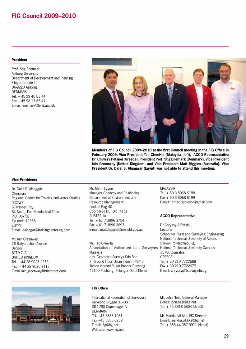
29
FIG Council 2009–2010
Members of FIG Council 2009–2010 at the first Council meeting in the FIG Office in February 2009: Vice President Teo CheeHai (Malaysia, left), ACCO Representative Dr. Chryssy Potsiou (Greece). President Prof. Stig Enemark (Denmark), Vice President Iain Greenway (United Kingdom) and Vice President Matt Higgins (Australia). Vice President Dr. Dalal S. Alnaggar (Egypt) was not able to attend this meeting.
President
Prof. Stig EnemarkAalborg UniversityDepartment of Development and PlanningFibigerstraede 11DK-9220 AalborgDENMARKTel. + 45 99 40 83 44Fax + 45 98 15 65 41E-mail: [email protected]
Mr. Matt HigginsManager Geodesy and PositioningDepartment of Environment and Resource ManagementLocked Bag 40Coorparoo DC Qld 4151 AUSTRALIATel. + 61 7 3896 3754Fax + 61 7 3896 3697E-mail: [email protected]
Mr. Teo CheeHaiAssociation of Authorised Land Surveyors Malaysiac/o Geometra Surveys Sdn Bhd7 (Ground Floor) Jalan Industri PBP 3Taman Industri Pusat Bandar Puchong47100 Puchong, Selangor Darul Ehsan
MALAYSIATel. + 60 3 8068 6188Fax + 60 3 8068 6199E-mail: [email protected]
ACCO Representative
Dr Chryssy A PotsiouLecturerSchool for Rural and Surveying EngineeringNational Technical University of Athens9 Iroon Polytechniou st, National Technical University Campus15780 ZografosGREECE Tel. + 30 210 7722688Fax + 30 210 7722677E-mail: [email protected]
FIG Office
Mr. John Neel, General ManagerE-mail: [email protected]. + 45 3318 5504 (direct)
Mr. Markku Villikka, FIG Director, E-mail: [email protected], Tel. + 358 44 357 0911 (direct)
International Federation of SurveyorsKalvebod Brygge 31–33DK-1780 Copenhagen VDENMARKTel. +45 3886 1081Fax +45 3886 0252E-mail: [email protected] site: www.fig.net
Vice Presidents
Dr. Dalal S. AlnaggarChairmanRegional Center for Training and Water Studies (RCTWS)6 October CitySt. No. 1, Fourth Industrial ZoneP.O. Box 58Zip code 12566EGYPTE-mail: [email protected]
Mr. Iain Greenway26 Ballycrochan AvenueBangorBT19 7LAUNITED KINGDOM Tel. + 44 28 9025 2253Fax + 44 28 9025 2113E-mail [email protected]

30
Commission 1 – Professional PracticeChair: Mr. Yaacoub Saade (Lebanon)Perception of surveying profession; profes-sional practice, legal aspects and organisational structures; standards and certification; code of ethics and applications; under-represented groups in surveying; students and young sur-veyors; information technology management and professional practice; project management, quality and best practice.
Commission 2 – Professional EducationChair: Professor Bela Markus (Hungary)Curriculum development; learning and teach-ing methods and technologies; educational management and marketing; continuing profes-sional development; networking in education and training.
Commission 3 – Spatial Information ManagementChair: Dr. Chryssy Potsiou (Greece)Management of spatial information about land, property and marine data; spatial data infrastructure – data collection, analysis, visualisation, standardisation, dissemination, and support of good governance; knowledge management for SIM; business models, public-private-partnerships, professional practice and administration.
Commission 4 – HydrographyChair: Mr. Andrew Leyzack (Canada)Hydrographic surveying; hydrographic educa-tion, training and CPD; marine environment and coastal zone management; data processing and
management; nautical charting and bathymetric maps – analogue and digital, including electronic navigational charts.
Commission 5 – Positioning and MeasurementChair: Professor Rudolf Staiger (Germany)The science of measurement including instru-mentation, methodology and guidelines; the acquisition of accurate and reliable survey data related to the position, size and shape of natural and artificial features of the earth and its environment and including variation with time.
Commission 6 – Engineering SurveysChair: Professor Alojz Kopacik (Slovakia)Acquisition, processing and management of topometric data; quality control and validation for civil engineering constructions and manu-facturing of large objects; modern concepts for setting-out and machine guidance; deformation monitoring systems; automatic measuring sys-tems, multi-sensor measuring systems; terrestrial laser systems.
Commission 7 – Cadastre and Land ManagementChair: Mr. András Osskó (Hungary)Cadastre, land administration and land manage-ment; development of pro poor land manage-ment and land administration; development of sustainable land administration as infrastruc-ture for sustainable development to underpin economic growth; applications of innovative and advanced technology in cadastre and land
Commission Chairs 2006–2010
administration; promoting the role of surveyors in land administration matters to the public and stakeholders.
Commission 8 – Spatial Planning and DevelopmentChair: Dr. Diane Dumashie (United Kingdom)Regional and local structure planning; urban and rural land use planning and implementation; plan-ning policies and environmental management for sustainable development; re-engineering of mega cities; public-private partnerships; infor-mal settlement issues in spatial development, planning and governance.
Commission 9 – Valuation and the Management of Real EstateChair: Professor Kauko Viitanen ( Finland)Valuation; investment in real estate and invest-ment planning; real estate investment vehicles; real estate, development finance and land use feasibility planning; real estate economics and markets and market analyses; management of property and property systems; management of public sector property.
Commission 10 – Construction Economics and ManagementChair: Mr. Andrew Morley (United Kingdom)Construction economics, including quantity surveying, building surveying, cost engineering and management, estimating and tendering; commercial management including procure-ment, risk management and contracts; project and programme management including planning and scheduling.
Yaacoub Saade (Comm. 1, on the left), Belá Markus (Comm. 2), Chryssy Potsiou (Comm. 3), Andrew Leyzack (Comm. 4), Rudolf Staiger (Comm. 5), Alojz Kopacik (Comm. 6), András Osskó (Comm. 7), Simon Adcock (Comm. 8 – 2006–2007), Kauko Viitanen (Comm. 9) and Andrew Morley (Comm. 10) at the FIG Congress in Munich, October 2006. Diane Dumashie has been appointed to chair Commission 8 after the picture has been taken.

Income and Expenditure Account 2004–2008
INCOMEResult 2008 *)
EuroResult 2007
EuroResult 2006
EuroResult 2005
EuroResult 2004
EuroSubscriptions
Member associations 275,757 251,432 251,432 230,779 218,683
Affiliates 15,385 12,097 8,646 5,981 4,683
Corporate members 108,794 104,312 89,713 81,156 74,799
Academic members 17,463 17,408 16,152 15,086 12,979
Total 417,399 391,342 365,943 333,002 311,144
Other income
Sale of publications 1,643 0 143 50 35
Financial income 13,442 15,458 8,911 8,944 8,038
Projects 70,139 39,961 52,181 83,062 47,733
Various 151 0 14 798 7,622
Total Income 502,774 446,759 427,192 425,856 374,572
EXPENDITURE
Administration, FIG Office and Council 166,133 119,540 111,946 95,740 98,309
Council meetings 32,092 44,425 60,232 31,262 23,270
FIG meetings 43,081 48,758 53,609 43,326 56,639
Member support 49,087 61,062 51,585 55,799 32,469
Commission activities 52,787 64,759 64,306 35,535 43,238
Promotion 66,299 35,421 36,315 30,666 28,483
Projects 65,265 46,750 44,344 50,117 53,107
Total expenditure 474,745 420,714 422,337 342,445 335,515
Surplus of the year 28,029 26,045 4,855 83,411 39,057
*) The accounts for 2008 will be finally adopted by the General Assembly in May 2009.
FIG balances 2002–2008
Development (in € )
0
50,000
100,000
150,000
200,000
250,000
300,000
350,000
450,000
500,000
400,000
2002 2003 2004 2005 2006 2007 2008
Surplus
Assets
Equity
Iain Greenway, Vice President in charge of finances.
FIGAnnualReview2008•ISSN1018-6522ISBN-97887-90907-74-7•PublishedbytheInternationalFederationofSurveyors FIG Office, Kalvebod Brygge 31–33, DK-1780 Copenhagen V, DENMARK, tel. +45 3886 1081, fax +45 3886 0252, email [email protected], www.fig.net
FIG PLATINUM CORPORATE MEMBERS
The XXIV FIG International Congress 2010
www.isaust.org.au
11–16 April 2010Sydney Convention & Exhibition Centre
Sydney, Australia
Facing the Challenges – Building the Capacity