analyzing the relationship between the … · categories at savar, dhaka, bangladesh through space...
TRANSCRIPT

International Journal of Scientific Knowledge (Computing and Information Technology)
Volume 1 Issue 4, Dec 2012 @2012 IJSK & K.J.A. All rights reserved
www.ijsk.org 1493 -ISSN 2305
25
ANALYZING THE RELATIONSHIP BETWEEN THE INTEGRATION
CORE OF DHAKA-ARICHA HIGHWAY AND EXISTING LAND USE
CATEGORIES AT SAVAR, DHAKA, BANGLADESH THROUGH SPACE
SYNTAX ANALYSIS
Saiful Hasan Tariq
Mahbuba Afroz Jinia
Stamford University Bangladesh.
E-Mail: [email protected] [email protected]
Abstract:
With the accumulation of variety of activities in a city, the issue of land use gets significance in terms of efficient use
of the spaces and activity. Along with this issue, another unavoidable issue for proper urban development is
integration or street network. In any area, land use generates whenever movement initiates and the integration is
given. But different type of agglomeration generates different types of movement, for which an area has different
types of land use and zoning. The basic relation of spatial configuration – an output of street network, and land use
generation helps to understand a developing area and guide its land use planning. Dhaka-Aricha Highway is one of
the national highways which connect several districts with Dhaka. This highway ran through several unions in
Savar upazila. Along its way, different types of land use development took place through the course of time. This
study intends to find whether there is any significant relationship between the integration core of existing Dhaka-
Aricha highway and the land use categories in the context of Savar Upazila.
Key wards: Global Integration, Land Use, axial map, Savar upazila

International Journal of Scientific Knowledge (Computing and Information Technology)
Volume 1 Issue 4, Dec 2012 @2012 IJSK & K.J.A. All rights reserved
www.ijsk.org 1493 -ISSN 2305
26
1. Introduction:
Land use plan allocates human activities that should
occur on limited land, and determines the level of
those activities. With the accumulation of variety of
activities in an area, the issue of land use gets
significance in terms of efficient use of the spaces
and activity. Along with this issue, another
unavoidable issue for proper urban development is
integration or street network. In any area, land use
generates whenever movement initiates and the
integration is given. But different type of
agglomeration generates different types of
movement, for which a city has different types of
land use and zoning. The basic relation of spatial
configuration – an output of street network, and land
use generation helps to understand a city and guide
its land use planning.
The study on the integration of existing road network
may define the functionality of the existing land use.
As the higher integration value means better
accessibility, the road network and connectivity may
have significant impact on the land use categories.
This study intends to find whether there is any
relationship between the integration core of existing
Dhaka-Aricha Highway and the land use categories
along its way in the context of Savar Upazila.
2. Objectives of the research
This paper aims to investigate the integration core
of existing Dhaka-Aricha Highway and the changes
in integration value due to the change in land-use
type in order to use the knowledge to make proper
land use for future development. In short the
objectives are as follows.
Review of historical background through
secondary resources.
Understanding the existing land use
categories in Savar upazila.
Finding out the changes in integration value
along Dhaka-Aricha Highway in different
segments
Understanding the relationship between
different integration values and land use.
Placing analytical comments about the
spatial configuration.
3. Methodology of the research:
At first, Literature review has been done to make a
clear conception about the study area and its
historical background based on secondary data.
Secondly, the upazila map and the land use map of
the area (Savar) have been studied to understand the
land-use in different unions in Savar. Thirdly, Dhaka-
Aricha Highway has been segmented on the points
where the union boundaries were crossed by it to
explain the integration and the land use in the easiest
way
Then the axial maps of Savar upazila have been
prepared on the basis of existing road network and
the graph analysis has been made to analyze the
integration values.
The integration [HH] values of existing road network
were analyzed by running axial map graph analysis in
“UCL DEPTHMAP v 10”. Finally the integration
value in different segments of Dhaka-Aricha
Highway along with its land use type in adjacent
areas has been compared to understand the
relationship between the integration value and the
land-use type.
4. City profile:
4.1. Location and Geographic information of
Savar Upazila:
Savar is an Upazila of Dhaka District. It is
located at about 24 km from the center of Dhaka city.
The geographic location of Savar is at 23°51.5′N
90°16′E. According to the 2011 Bangladesh census;
Savar Upazila had a population of 1,387,426 and it
has 66,956 units of household. On the north, Savar is
bounded by Kaliakair and Gazipur Sadar upazilas.
Keraniganj upazila is on the south. Mirpur,
Mohammadpur, Pallabi and Uttara thanas of Dhaka
City are on the east and Dhamrai and Singair upazilas
on the west. The land of the upazila is composed of
alluvium soil of the Pleistocene period. The southern
part of the upazila is composed of the alluvium soil

International Journal of Scientific Knowledge (Computing and Information Technology)
Volume 1 Issue 4, Dec 2012 @2012 IJSK & K.J.A. All rights reserved
www.ijsk.org 1493 -ISSN 2305
27
of the Bangshi and Dhalashwari rivers. Main rivers
are Bangshi, Turag, Buriganga and Karnatali.
4.2. Institutes and other infrastructures in Savar:
Savar is the home of Jahangirnagar University,
one of the renowned Public University of Bangladesh
and only University for full student residence
facilities.
The 9th Division Army Cantonment is located at
northern part of Savar. The Military Firm and Govt
Dairy Firm are just beside Jahangirnagar University.
The only training centre for the public service
commissioned officers in Bangladesh, BPATC
training center (Public Administration Training
Centre) is situated in Savar. Bangladesh Krira
Shiksha Pratisthan (BKSP) is also situated in Jirani
Bazar, Savar. Dhaka Export processing Zone, DEPZ
is also situated in this upazila.
4.3. The unions in savar upazila:
Savar upazila consists of savar paurashava and
11other unions like Shimulia, Dhamsona, Yearpur,
Ashulia, Birulia, Bhakurta, Pathalia, Banagram,
Kaundia, Tetuljhora and Amin Bazar.Dhaka Aricha
highway runs through Savar paurashava, Pathalia,
Banagram, Kaundia, Tetuljhora and Amin Bazar. For
this reason, these unions were taken into account to
analyze land use types along Dhaka-Aricha highway.
Lots of infrastructures have been developed along
this highway in these unions. Jahangir Nagar
University, National Memorial, Savar Cantonment
and Savar dairy farm is most notable landmarks in
Pathalia union at Savar. Military Dairy firm, Radio
station and bank colony established along Dhaka
Aricha Highway in Savar Paurashava. But in the
Banagram, Tetuljhora and Amin Bazar union the
highway did not put much impact on urban
development; rather these unions are still
characterized by agricultural fields and rural
settlements.
Fig: 1. Upazila map, Savar, Dhaka, source: Maps of
Bangladesh blog post

International Journal of Scientific Knowledge (Computing and Information Technology)
Volume 1 Issue 4, Dec 2012 @2012 IJSK & K.J.A. All rights reserved
www.ijsk.org 1493 -ISSN 2305
28
Fig: 2. Land Use map, Savar, Dhaka, [part map] source:
Rajuk
4.4. Existing land use category:
Savar upazila shows distinctive organic growth
pattern of an area. Dhaka-Aricha road, which is one
of the main highways that connects several divisions
in Bangladesh, runs through the urban center of savar
upazila and serves as the main artery of vehicular
transport here. In the integrated detailed area plan
map of Dhaka, the land area of savar area was
categorized among different land use categories
based on field and GPS survey. Here is the short
discussion of the categorized land use of the unions
which were crossed by Dhaka-Aricha Highway:
Pathalia union is occupied by urban residential area
at its northern and south-eastern part. The western
part is characterized by agricultural lands and flood
flow area. At north-east, Savar cantonment and Jatiyo
Smriti Soudho is marked as overlay zone in the land
use map [fig: 2]. Jahangirnagar University and Savar
Dairy Firm occupies a large area at South-east corner
of this union.
Fig: 3. Satellite Image, Pathalia union, Savar,
source: Google earth
Savar Paurashava is characterized by mostly urban
residential zone and Administrative areas. The urban
center of savar is in this area and main urban core is
crossed by Dhaka-Aricha highway. Accept the
northern part, the whole paurashava area is marked as
urban residential zone in the land use map [fig:
2].The northern part is occupied by military dairy
firm. This area has the highest density of urban built
forms in the whole savar upazila. Some residential
cum general industrial use of land are also common
here along Dhaka-Aricha highway.
International Journal of Scientific Knowledge (Computing and Information Technology)
Volume 1 Issue 4, Dec 2012 @2012 IJSK & K.J.A. All rights reserved
www.ijsk.org 1493 -ISSN 2305
29
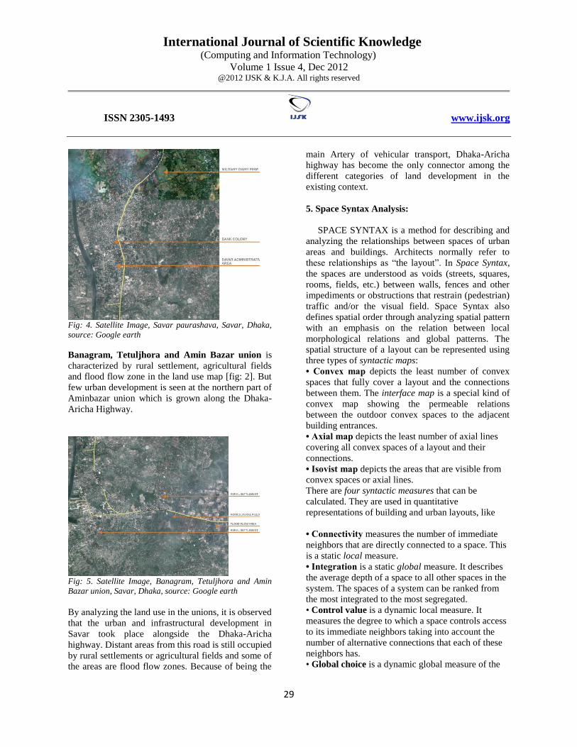
Fig: 4. Satellite Image, Savar paurashava, Savar, Dhaka,
source: Google earth
Banagram, Tetuljhora and Amin Bazar union is
characterized by rural settlement, agricultural fields
and flood flow zone in the land use map [fig: 2]. But
few urban development is seen at the northern part of
Aminbazar union which is grown along the Dhaka-
Aricha Highway.
Fig: 5. Satellite Image, Banagram, Tetuljhora and Amin
Bazar union, Savar, Dhaka, source: Google earth
By analyzing the land use in the unions, it is observed
that the urban and infrastructural development in
Savar took place alongside the Dhaka-Aricha
highway. Distant areas from this road is still occupied
by rural settlements or agricultural fields and some of
the areas are flood flow zones. Because of being the
main Artery of vehicular transport, Dhaka-Aricha
highway has become the only connector among the
different categories of land development in the
existing context.
5. Space Syntax Analysis:
SPACE SYNTAX is a method for describing and
analyzing the relationships between spaces of urban
areas and buildings. Architects normally refer to
these relationships as “the layout”. In Space Syntax,
the spaces are understood as voids (streets, squares,
rooms, fields, etc.) between walls, fences and other
impediments or obstructions that restrain (pedestrian)
traffic and/or the visual field. Space Syntax also
defines spatial order through analyzing spatial pattern
with an emphasis on the relation between local
morphological relations and global patterns. The
spatial structure of a layout can be represented using
three types of syntactic maps:
• Convex map depicts the least number of convex
spaces that fully cover a layout and the connections
between them. The interface map is a special kind of
convex map showing the permeable relations
between the outdoor convex spaces to the adjacent
building entrances.
• Axial map depicts the least number of axial lines
covering all convex spaces of a layout and their
connections.
• Isovist map depicts the areas that are visible from
convex spaces or axial lines.
There are four syntactic measures that can be
calculated. They are used in quantitative
representations of building and urban layouts, like
• Connectivity measures the number of immediate
neighbors that are directly connected to a space. This
is a static local measure.
• Integration is a static global measure. It describes
the average depth of a space to all other spaces in the
system. The spaces of a system can be ranked from
the most integrated to the most segregated.
• Control value is a dynamic local measure. It
measures the degree to which a space controls access
to its immediate neighbors taking into account the
number of alternative connections that each of these
neighbors has.
• Global choice is a dynamic global measure of the

International Journal of Scientific Knowledge (Computing and Information Technology)
Volume 1 Issue 4, Dec 2012 @2012 IJSK & K.J.A. All rights reserved
www.ijsk.org 1493 -ISSN 2305
30
“flow” through a space. A space has a strong choice
value when many of the shortest paths, connecting all
spaces to all spaces of a system, passes through it.
In this research, the axial map is used as syntactic
map and integration has been calculated as
syntactic measure.
5.1. The Axial map of Savar upazila:
As stated before, Savar shows the sign of organic
development and it has a lattice or mesh like road
network. All the arterial, sub-arterial and most of the
collector roads are considered here. Because of the
curvilinear nature of the roads, axial lines could not
be continued very long. Densification of lines in this
map shows an overall concentration of movement
over the area. But to discover the spatial order and
functional organization, these lines are nothing but a
piece of drawing unless placed for syntactic analysis.
5.2. Analysis of the axial map:
The Graph Analysis of the axial map of savar has
been done to evaluate the changes in the integration
value in the Dhaka-Aricha highway in different areas.
The integration value of every axial line in this road
has been taken into account and compared with the
range of 1% integration core to analyze whether these
axial lines are in the range of 1% core or not. As
mentioned in the methodology, the Dhaka-Aricha
highway has been divided into six segments to
compare the integration value and land use.
[Appendix]
Fig: 5.Axial map of Savar, Dhaka, source: Author
Fig: 6.Global integration [HH] map of Savar, Dhaka,
source: Author
5.3. The integration core:
By running the graph analysis, total number of
5310 references was found. The highest integration
[HH] value was found 0.611654 and the lowest
integration [HH] value was 0.145564. To specify the
integration core, 1% of the total reference number is
taken. Therefore, highest 54 nos. integration [HH]
values were taken into account to find out the highest
range of integration value. [For chart see Appendix]

International Journal of Scientific Knowledge (Computing and Information Technology)
Volume 1 Issue 4, Dec 2012 @2012 IJSK & K.J.A. All rights reserved
www.ijsk.org 1493 -ISSN 2305
31
Total number of
integration
(ref. number)
5310
Highest integration
[HH] value
0.611654
Lowest integration
[HH] value
0.145564
1% integration core 0.611654 to 0.551374
Therefore, the range of 1% integration core is found
from 0.611654 to 0.551374
The following analysis shows the integration values
in Dhaka-Aricha highway
Table: 1. Global integration [HH] values of Dhaka-
Aricha highway, source: Author
SEGMENT AXIAL
LINE
[REF.]
INTEGRATION
[HH] VALUE
01 2 0.3745
3 0.3881
4 0.4024
4512 0.4167
5 0.4327
4508 0.4491
6 0.4642
4507 0.4804
7 0.4980
8 0.5165
987 0.5315
02 986 0.5471
9 0.5656
10 0.5670
4552 0.5745
4551 0.5823
4754 0.5905
12 0.5987
42 0.6074
13 0.6116
14 0.5930
15 0.5757
16 0.5580
03 17 0.5358
18 0.5139
19 0.4937
20 0.4736
21 0.4551
22 0.4388
04 23 0.4220
24 0.4058
05 25 0.3901
06 26 0.3755
27 0.3620
28 0.3493
29 0.3374
6. The Relationship between the integration core
and land use:
The integration values in the 1% integration core
range have been picked up from the integration
values in Dhaka-Aricha highway at Savar Upazila.
The values have been compared with the adjacent
land use of Dhaka-Aricha highway in the following
table:
Table: 2. 1% range of integration core and land use
type along Dhaka-Aricha highway, source: Author
Axial
line
[ref.]
Integration
[hh] value
Land use along
dhaka-aricha
highway
9 0.5656 Jahangirnagar
university, savar dairy
firm
10 0.5670 Military Dairy firm
4552 0.5745 BPATC
4551 0.5823 BPATC
4754 0.5905 Radio station
12 0.5987 Urban residential area
42 0.6074 Urban residential area
13 0.6116 Urban residential
area, Administrative
area
14 0.5930 Urban residential area
15 0.5757 Urban residential
area, bank colony
16 0.5580 Urban residential
area, mixed use

International Journal of Scientific Knowledge (Computing and Information Technology)
Volume 1 Issue 4, Dec 2012 @2012 IJSK & K.J.A. All rights reserved
www.ijsk.org 1493 -ISSN 2305
32
7. Observation and Findings:
From the table of the relationship between the
integration core and land use [Table :2], it is found
that majority of the axial lines in the segment of
Dhaka-Aricha highway which ran through the Savar
Paurashava area [segment-2] is in the range of 1%
integration core. The highest integration value is
0.6116 and the lowest is 0.5580 in this segment in the
range of 1% integration core. The central
administrative area and the main urban residential
area have developed around the road segment which
shows the highest integration value of 0.6116. Other
integration values in the 1% integration core range
shows similar characteristics of urban development
along Dhaka-Aricha highway in the Savar upazila.
Fig: 7.Global integration [HH] and land use type, Savar,
Dhaka, source: Author
Fig: 7 show that the urban core of Savar has grown
along that part of Dhaka-Aricha highway which is in
the range of 1% integration core of the total area.
Therefore this study reveals that, the highly
integrated road network triggers the urban
development and the urban core has distinctive
relationship with the highest range of integration
core.
8. Conclusive remarks:
Savar is undergoing rapid urbanization, but still on
the way to reach the peak of its urbanization. Over
the years, scores of industries, shopping centers, and
other infrastructures have sprung up to change the
face of the area. Both built and vacant areas along the
integration core are still attracting new developments
and redevelopments. In such an urban state like
Savar, planning decisions have a lot of scope to
explore a city in a properly thriving way.
As it is seen in this research that Dhaka- Aricha
highway is in the present integration core and it is
attracting mostly residential, institutional and similar
other land uses. Future planning decisions can be
taken accordingly considering the proposed road in
detailed area plan for Greater Dhaka. Syntactic
analysis is a tool which can help the planners to see
the unforeseen about this area.
References:
Hillier, B. “Spatial Sustainability in Cities Organic
Patterns and Sustainable Forms”, Proceedings of the
7th International Space Syntax Symposium, 2009
Farida, N., Nayma. K. “Spatial Logic of
Morphological Transformation A Paradigm of
Planned - Unplanned Areas in Dhaka city”,
Proceedings of the 7th International Space Syntax
Symposium, 2009
Hillier, B. The Common Language of Space,
University College London, 1998
Farida, N., Nuzhat. Z. “Process of Morphological
Transformation and the Emerging Pattern of Built-
Form along Gulshan Avenue in Dhaka”, EAAE /
ARCC International Conference on Architectural
Research, Italy.
P.H. Verburg, A. Veldkampb, L.O. Fresco,
“Simulation of changes in the spatial pattern of land
use in China”, Applied Geography 19 (1999) 211–
233,1998.