an ecological data search for springwell lane
TRANSCRIPT

Greenspace Information for Greater London CIC
the capital's environmental records centre
Greenspace Information for Greater London CIC Registered Office: 10 Queen Street Place, London EC4R 1BEA community interest company limited by guarantee registered in England and Wales number 8345552 Post: C/O London Wildlife Trust, Dean Bradley House, 52 Horseferry Road, London SW1P 2AF
T: 020 7803 4285 Fx: 020 7633 0811 E:[email protected]
An Ecological Data Search for Springwell Lane
On behalf of Applied Ecology Ltd
Report reference 1425
Prepared on 30 Apr 2015 by Maria Longley, Records Officer

Contents
This report may not be passed on to third parties without written permission from GiGL.
1
Contents 1.0 Introduction ................................................................................................................ 2
2.0 Statutory Sites and Local Nature Reserves ................................................................ 3
3.0 Non-Statutory Sites .................................................................................................... 5
3.1 Sites of Importance for Nature Conservation .......................................................... 6
3.2 Important Geological/Geomorphological Sites ...................................................... 13
4.0 Species .................................................................................................................... 15
4.1 Protected Species and Species of Conservation Concern .................................... 16
4.2 Confidential Records ............................................................................................ 29
4.3 LISI Species ......................................................................................................... 31
5.0 Habitats .................................................................................................................... 33
5.1 Survey Data .......................................................................................................... 34
5.2 BAP Condition Assessment & Habitat Suitability .................................................. 38
6.0 Open Spaces............................................................................................................ 40
6.1 Open Space Data ................................................................................................. 41
7.0 Contacts ................................................................................................................... 42
7.1 Borough Contacts ................................................................................................. 42
7.2 Further Contacts ................................................................................................... 43
Annex A - Maps
Statutory Sites Map SINCs Map Survey Parcels Map Open Spaces Map Green Belt Map
Annex B – Supporting Information

Introduction
This report may not be passed on to third parties without written permission from GiGL.
2
1.0 Introduction An ecological data search for Springwell Lane and su rrounding land to a 1 km radius on behalf of Applied Ecology Ltd. The following report was compiled by Greenspace Information for Greater London (GiGL) on behalf of Applied Ecology Ltd, to provide ecological information for the above site for Other. This report may include information on statutory sites, non-statutory sites, species records, habitat or open space information held by GiGL, as requested for the above search area. The boundaries of this search area are defined in the maps in Annex A and lie within the London Borough(s) of Hillingdon. Please note: GiGL do not hold any data relating to the search area within the County of Hertfordshire. It is advisable to contact the following local record centre for any site details and habitat and species records. Hertfordshire Environmental Records Centre www.herc.info.org.uk Important information about this report The data provided within this report is for the internal use of Applied Ecology Ltd (which includes the client where applicable) to inform understanding of the site of interest for 1 year in accordance with the terms and conditions agreed to on request of the search. The report is compiled using data held by GiGL at the time of the request. GiGL takes the accuracy of our data holdings very seriously and the Recorder Advisory Group is set up to help with this important task to ensure what we provide to you is the best data possible for your needs. GiGL is constantly striving to improve the coverage and currency of its data holdings. We would be interested in hearing from you if you are able to submit species or habitat data arising from field surveys.
The data provided must not be distributed or published for an external or public audience, for example within the appendix of a report. Local Planning Authorities may request a copy of the data from GiGL either via their Service Level Agreement (most boroughs are GiGL partners) or as a data search.

Statutory Sites
This report may not be passed on to third parties without written permission from GiGL.
3
2.0 Statutory Sites and Local Nature Reserves
A desk-based search shows that there are no sites w ith European or National statutory designation within the search area and on e LNR. Any citations currently available for the statutory sites within the search area can be seen on the following pages. Statutory site designations:
• Special Area of Conservation (SAC) • Special Protection Area (SPA) • Ramsar sites • Site of Special Scientific Interest (SSSI) • National Nature Reserve (NNR) • Local Nature Reserve (LNR)
For further explanations of the designations please see the “Supporting Information” annex. Please note that statutory citations are legal documents, the content of which is fixed and true at the time of designation. Species referred to in the citations may not be present on site today. Citations may have been written based on data not held by GiGL.

Statutory Sites
This report may not be passed on to third parties without written permission from GiGL.
4
Name Stockers Lake Status Local Nature Reserve (LNR) Area 37.83 hectares Grid reference TQ 047 935 Planning Authority Owner/Manager Scientific interest/Existing use of site Reasons for declaration Please see the Borough Contacts page in this report if you require further details from the relevant Local Authority.

Non-Statutory Sites
This report may not be passed on to third parties without written permission from GiGL.
5
3.0 Non-Statutory Sites A desk-based search shows that there are 6 SINCs an d no RIGS/LIGS within the search area.

Non-Statutory Sites
This report may not be passed on to third parties without written permission from GiGL.
6
3.1 Sites of Importance for Nature Conservation
Introduction
Sites of Importance for Nature Conservation (SINCs) are recognised by the Greater London Authority and London borough councils as important wildlife sites. There are three tiers of sites:
• Sites of Metropolitan Importance • Sites of Borough Importance (borough I and borough II) • Sites of Local Importance
The London Plan identifies the need to protect biodiversity and to provide opportunities for access to nature. The Mayor’s Biodiversity Strategy sets out criteria and procedures for identifying such land for protection in Local Development Frameworks. A London Wildlife Sites Board (LWSB) has been established to provide support and guidance on the selections of SINCs. The boundaries and site grades reflect the most recent consideration of each site, details of which are available from London borough councils. Note that boundaries and grades may change as new information becomes available. For further explanations of the designations please see the “Supporting Information” annex. Areas of Deficiency (AoD) are defined as built-up areas more than one kilometre actual walking distance from an accessible Metropolitan or borough site. AoD areas can be seen on the SINC map. GiGL manage a dataset of spaces designated as public open space categorised according to a site hierarchy documented in The Lon don Plan (Table 7.2) . Information on public open spaces sites are displayed within the open space table. Citations
Citations currently available for SINCs within the search area can be seen on the following pages. Please note that the content of SINC citations is reviewed periodically and that species referred to in the citations may not be present on site today. Citations may have been written based on data not held by GiGL.

Non-Statutory Sites
This report may not be passed on to third parties without written permission from GiGL.
7
Metropolitan
Site Reference: M006
Site Name: London’s Canals
Summary: London’s canals provide a home for many fish and aquatic plants, and are a great way to enjoy the natural world in some of the city’s most built-up areas.
Grid ref: TQ 202 833
Area (ha): 188.52
Borough(s): Brent, Camden, Ealing, Hackney, Hammersmith and Fulham, Hillingdon, Hounslow, Islington, Kensington and Chelsea, Tower Hamlets, Westminster
Habitat(s): Bare ground, Canal, Ruderal, Scattered trees, Scrub, Secondary woodland, Semi-improved neutral grassland, Tall herbs, Vegetated wall/tombstones, Wet woodland/carr
Access: Free public access (all/most of site)
Ownership: Canal & River Trust
Site Description:
London’s canals support a wide range of aquatic flora, amongst which are found a number of locally uncommon species. These include narrow-leaved water plantain (Alisma lanceolatum), rigid hornwort (Ceratopyllum demersum) and shining pondweed (Potomageton lucens), all species of clean, clear waters. Many waterside plants, including several London rarities, also grow on the brickwork and banks of the canal. The canals also support an important invertebrate fauna (including several species of dragon/damselflies), a diverse fish community, and breeding waterfowl. London’s network of canals fulfill an important function in allowing nature into heavily built-up environments. The towpath and associated areas of waste ground, especially in East London, support a number of uncommon species of disturbed ground. The whole of the Grand Union Canal system in London, including the Regent’s and Hertford Union Canals, is included in this single Metropolitan site.
Site first notified: 01/04/1986 Boundary last changed: 30/11/2005
Citation last edited: 01/12/2005 Mayor Agreed: 25/11/2002
Defunct: N
Last Updated: 21/03/2007

Non-Statutory Sites
This report may not be passed on to third parties without written permission from GiGL.
8
Metropolitan
Site Reference: M057
Site Name: Springwell and Stocker’s Lakes
Summary: These flooded gravel pits support many types of water bird, making them popular with birdwatchers.
Grid ref: TQ 042 929
Area (ha): 41.83
Borough(s): Hillingdon
Habitat(s): Pond/lake, Reed bed, Running water, Scrub, Semi-improved neutral grassland
Access: Free public access (all/most of site)
Ownership: Private
Site Description:
A site of great ornithological importance. These flooded former gravel workings support a range of wintering waterfowl, including good numbers of coot, tufted duck, gadwall, shoveler, teal and pochard, with smaller numbers of numerous other species including goosander, goldeneye and occasional smew. The site supports one of London’s few heronries, and other breeding birds include reed bunting, reed warbler and sedge warbler. The Springwell reedbed is also used in winter by roosting corn buntings, a UK Biodiversity Action Plan species. A very popular site with birdwatchers, who are attracted by the high diversity of passage migrants. Both lakes support large and diverse populations of fish. The site supports specially-protected water voles and there are also recent signs of otters in the vicinity. There is free access to both reserves which are managed by the Herts & Middlesex Wildlife Trust.
Site first notified: 19/09/1988 Boundary last changed: 30/11/2005
Citation last edited: 01/12/2005 Mayor Agreed: 25/11/2002
Defunct: N
Last Updated: 01/12/2005

Non-Statutory Sites
This report may not be passed on to third parties without written permission from GiGL.
9
Borough Grade I
Site Reference: HiBI01A
Site Name: Springwell Lane Chalk Pit
Summary: An old chalk pit with habitats from bare chalk cliff to woodland, supporting several rare plants.
Grid ref: TQ 045 930
Area (ha): 7.86
Borough(s): Hillingdon
Habitat(s): Chalk cliffs, Chalk grassland, Scrub, Secondary woodland
Access: No public access
Ownership: Private
Site Description:
One of four chalk pits in the east Colne Valley, Springwell Lane Chalk Pit has a mosaic of habitats from bare rock face through species-rich sward to chalk scrub and early woodland. Several locally scarce, chalk-loving plants are present, including frequent ploughman’s spikenard (Inula conyzae), yellow-wort (Blackstonia perfoliata), eyebright (Euphrasia nemorosa), salad burnet (Sanguisorba minor) and occasional musk mallow (Malva moschata), mouse-ear hawkweed (Pilosella officinarum) and wild strawberry (Fragaria vesca). In a wet area at the bottom of the pit are a few plants of hemp-agrimony (Eupatorium cannabinum) and occasional water figwort (Scrophularia auriculata). The southern part of the pit supports a range of ruderal species. Scrub covers much of the rest of the base of the pit and the lower slopes. Small areas of sycamore (Acer pseudoplatanus) dominated woodland present, generally at the quarry edges.
Site first notified: 01/01/1988 Boundary last changed: 01/01/1988
Citation last edited: 29/12/2005 Mayor Agreed:
Defunct: N
Last Updated: 29/12/2005

Non-Statutory Sites
This report may not be passed on to third parties without written permission from GiGL.
10
Borough Grade I
Site Reference: HiBI01B
Site Name: Springwell Pit Wood
Summary: A fine beech woodland which has developed in an old chalk pit.
Grid ref: TQ 044 923
Area (ha): 1.67
Borough(s): Hillingdon
Habitat(s): Secondary woodland, Semi-improved neutral grassland
Access: No public access
Ownership: Private
Site Description:
This narrow woodland set among grazing pastures was once a chalk pit, one of four old chalk pits in the east Colne Valley. It is dominated by beech (Fagus sylvatica) with holly (Ilex aquifolium) and elder (Sambucus nigra) to the north, whereas the south comprises pedunculate oak (Quercus robur), English elm (Ulmus procera), wild cherry (Prunus avium) and ash (Fraxinus excelsior). Wood forget-me-not (Myosotis sylvatica) is present. Areas of quite flower-rich grassland to the west include thyme-leaved- and germander speedwell (Veronica serpyllifolia and V. chamaedrys).
Site first notified: 01/01/1988 Boundary last changed: 01/01/1988
Citation last edited: 29/12/2005 Mayor Agreed:
Defunct: N
Last Updated: 27/03/2006

Non-Statutory Sites
This report may not be passed on to third parties without written permission from GiGL.
11
Borough Grade II
Site Reference: HiBII14
Site Name: White Heath Farm and Harefield Grove
Summary: A farmland landscape with fields, copses and hedgerows.
Grid ref: TQ 059 917
Area (ha): 52.59
Borough(s): Hillingdon
Habitat(s): Arable, Hedge, Roughland, Running water, Scrub, Secondary woodland, Semi-improved neutral grassland, Unimproved neutral grassland, Wet woodland/carr
Access: Can be viewed from adjacent paths or roads only
Ownership: London Borough of Hillingdon and Private
Site Description:
This is a farmland landscape consisting mainly of pastures, arable fields, copses and hedgerows, and has managed to retain the rural character of the landscape. The nature conservation interest is scattered through the landscape, and some large areas of low wildlife value have been omitted from the site. Much of the site is a mixture of improved and semi-improved, horse-grazed pastures, some of which have been ungrazed for a while. Some fields are dominated by a mix of perennial rye-grass (Lolium perenne) and bents (Agrostis spp.) whereas false oat-grass (Arrenatherum elatius) and cock’s-foot (Dactylis glomerata) are dominant in others. Two arable fields, with maize as their usual crop, are included in the site for their ancient hedges and patches of other habitats. A footpath runs along the eastern edge of White Heath Farm, between species-rich hedgerows with trees that are probably ancient field boundaries. There are at least 10 species of trees and shrubs in the hedges, including beech (Fagus sylvatica), pedunculate oak (Quercus robur), ash (Fraxinus excelsior), English elm (Ulmus procera), field maple (Acer campestre), hazel (Corylus avellana) and hawthorn (Crataegus monogyna) along with field rose (Rosa arvensis), bramble (Rubus fruticosus agg.) and greater stitchwort (Stellaria holostea). A number of small copses punctuate the landscape, including Cooks Wood, Watts Common and a shaw (a narrow belt of woodland) alongside a stream. They are generally dominated by pedunculate oak and ash or beech, depending on the underlying substrate. Other trees and shrubs in these copses include English elm, wild cherry (Prunus avium), rowan (Sorbus aucuparia), hornbeam (Carpinus betulus) and crab apple (Malus sylvestris). Watts Common supports wet woodland, with four species of willow: crack, grey, white and goat willows (Salix fragilis, S. cinerea, S. alba, S. caprea). The ground flora of Watts Common includes the locally scarce lesser spearwort (Ranunculus flammula) and water-pepper (Persicaria hydropiper). The only public access is the footpath along the eastern edge of the White Heath Farm area. There is no public access to the Harefield Grove Estate.
Site first notified: 01/01/1988 Boundary last changed: 08/09/2005
Citation last edited: 27/03/2006 Mayor Agreed:
Defunct: N
Last Updated: 27/03/2006

Non-Statutory Sites
This report may not be passed on to third parties without written permission from GiGL.
12
Borough Grade II
Site Reference: HiBII39
Site Name: Land north of Waterdell Farm
Summary: A large area of roughland linking Springwell Lane Chalk Pit with White Heath Farm on the Hillingdon borough and Hertfordshire county border.
Grid ref: TQ 048 927
Area (ha): 26.8
Borough(s): Hillingdon
Habitat(s): Bare ground, Hedge, Roughland
Access: No public access
Ownership: Private
Site Description:
This large area of roughland links Springwell Lane Chalk Pit with White Heath Farm on the Hillingdon borough and Hertfordshire county border. The site appears to have been used for tipping, and has a varied topography with spoil heaps, some vegetated with a mosaic of scrub, grassland and tall herbs, others almost almost bare soil and rock. Scrub is composed of buddleia (Buddleja davidii), silver birch (Betula pendula), bramble (Rubus fruticosus agg.) and goat, grey and crack willows (Salix caprea, S. cinerea, S. fragilis), with occasional broom (Cytisus scoparius). Tall herbs make up a significant proportion of the habitat and include abundant teasel (Dipsacus fullonum), bristly ox-tongue (Picris echioides) and goat’s-rue (Galega officinalis). There is frequent weld (Reseda luteola), perforate St. John’s-wort (Hypericum perforatum), horse-radish (Armoracia rusticana) and dittander (Lepidium latifolium), a rare plant in London generally associated with damp coastal areas. Amongst these tall herbs are grasses and smaller wild flowers such as false-oat grass (Arrenatherum elatius), red fescue (Festuca rubra), cock’s-foot (Dactylis glomerata), hairy and pendulous sedges (Carex hirta and C. pendula), common toadflax (Linaria vulgaris), red bartsia (Odontites verna) and creeping cinquefoil (Potentilla reptans). A hedgerow of mature peduncluate oak (Quercus robur), ash (Fraxinus excelsior), elder (Sambucus nigra) and hawthorn (Crataegus monogyna) with occasional ivy (Hedera helix) runs along part of the border and might be an ancient boundary marker. The varied structure and topography provides habitats for a wide range of animals. Soil and rock piles offer potential refuge, breeding and hibernation sites for a range of insects, reptiles, amphibians and small mammals. Birds include green woodpecker and the red-listed song thrush. Invertebrates include the notable long-winged conehead (Conocephalus discolor), common blue damselfly (Enallagma cyathigerum) and small copper, gatekeeper and meadow brown butterflies.
Site first notified: 08/09/2005 Boundary last changed: 08/09/2005
Citation last edited: 03/01/2006 Mayor Agreed:
Defunct: N
Last Updated: 10/01/2006

Non-Statutory Sites
This report may not be passed on to third parties without written permission from GiGL.
13
3.2 Important Geological/Geomorphological Sites
Introduction
The designation in planning documents of regionally important geological sites (RIGS) and locally important geological sites (LIGS) is one way of recognising and protecting important geodiversity and landscape features for future generations to enjoy. Geodiversity is defined as:
‘the variety of rocks, fossils, minerals, landforms, soils and natural processes, such as weathering, erosion and sedimentation, that underlie and determine the character of our natural landscape and environment’ (London Plan).
RIGS are currently the most important designated places for geology and geomorphology outside statutorily protected land such as SSSIs. They are equivalent to Sites of Metropolitan Importance for nature conservation. In London, RIG Sites have been selected by South London RIGS, North West London RIGS and GeoEssex (voluntary organisations) but have yet to be formally designated in Greater London. The London boroughs may also designate certain areas as being of local interest for their geodiversity - LIGS. The boundaries and site grades reflect the most recent consideration of each site. Details may change as new information becomes available.
More information can be found in the London Plan Supplementary Planning Guidance London’s Foundations (March 2012) and the London Geodiversity Action Plan, both available from www.londongeopartnership.org.uk. Citations
RIGS/LIGS are designated in four stages: - Potential RIGS/LIGS are those recommended by the London Geodiversity
Partnership and identified in London’s foundations - Recommended RIGS are those recommended by the London Geodiversity
Partnership, identified in London’s foundations and have been through a consultation process with the London boroughs and relevant landowners
- Proposed RIGS/LIGS are those included in draft Borough Development Plan Documents
- Adopted RIGS/LIGS are those identified in adopted Borough Development Plan Documents
Please note that the content of RIGS and LIGS citations is reviewed periodically by the London Geodiversity Partnership.

Non-Statutory Sites
This report may not be passed on to third parties without written permission from GiGL.
14
There are no RIGS or LIGS within the search area.

Species
This report may not be passed on to third parties without written permission from GiGL.
15
4.0 Species
Species from these categories can be seen on the following pages:
• Internationally or nationally protected species * • National or London Biodiversity Action Plan (BAP) priority species • Red Data List species • Species of Conservation Concern in London • London Invasive Species Initiative (LISI) species
Note that GiGL does not currently hold comprehensive species data for all areas. Even where data is held, a lack of records for a species in a defined geographical area does not necessarily mean that the species does not occur there – the area may simply not have been surveyed. Distances and direction to each species record are calculated from the centre-point of a search area. Note that because the resolution of grid references varies between surveys the records with a low grid reference resolution are presented in the Vague Records table. The species, listed by taxon name, were recorded from a broad range of surveys - from public and species specific surveys to formal surveys carried out during the GLA’s rolling survey programme. Records of bat sightings are presented in the report if found in the search area. Records of bat roosts, if present in the search area, will be found in the confidential species table.
* Protected species are those listed on EC Habitats Directive – Annexes II and IV, EC Birds Directive – Annex I, Conservation (Natural Habitats) Regulations 1994 – Schedules 2 & 5, NERC 2006 Section 41, Wildlife and Countryside Act 1981 (as amended) – Schedules 1, 5 & 8, Protection of Badgers Act 1992
If you would like further information regarding rare, notable and protected species please contact a relevant person listed in the Further Contacts section of this report.

Species
This report may not be passed on to third parties without written permission from GiGL.
16
4.1 Protected Species and Species of Conservation C oncern Records in this section come from a variety of planning and conservation designations and are presented here to provide a broad range of information about the search area. GiGL’s Recorder Advisory Group have advised on the inclusion of each category and further information about the designations (legal and notable) can be found in the “Supporting Information” annex. All records in this section were recorded to at least 100 m2 accuracy (a six grid reference figure or higher). The total number of occurrences states the number of recorded instances for a species in the search area e.g. one recorded instance of fly orchid (Ophrys insectifera) could have a count of 10 individual plants. The maximum occurrence column records either that the species was present “P” or gives a numerical value of the highest count of species recorded in the search area where this is known. Table 1 Red Data List designation abbreviations used in the species table. Further information on the designations can be found in the annex. Designation short name Designation full name Designation short name Designation full name RL_DataDeficient IUCN (2001) - Data Deficient RL_LowerRisk IUCN (2001) - Lower risk - near threatened RL_CriticalEndangered IUCN (2001) - Critically endangered RL_Extinct IUCN (2001) - Extinct RL_Endangered IUCN (2001) - Endangered RL_ExtinctWild IUCN (2001) - Extinct in the wild RL_Vulnerable IUCN (2001) - Vulnerable RL_RegionExtinct IUCN (2001) - Regionally Extinct Taxon Name Common Name Designation Total number
of occurrences
No. of breeding
occurrences
Maximum
occurrence
Distance (m) of
nearest record
Bearing of
nearest record
Date of nearest
record
Distance (m) of
most recent
record
Bearing of
most recent
record
Date of most
recent record
Sagittaria sagittifolia Arrowhead Local Spp of Cons Conc 1 1 P 481 SW 04/08/2004 481 SW 04/08/2004
Atriplex littoralis Grass-leaved Orache Local Spp of Cons Conc 1 1 367 SW 1995 367 SW 1995
Clinopodium calamintha Lesser Calamint BAP Priority London
Local Spp of Cons Conc
Nationally Scarce
RedList_GB-VU
4 P 535 NW 1976 729 W 1995
Lathraea squamaria Toothwort Local Spp of Cons Conc 2 P 515 N 1995 544 SW 1996
Carex riparia Greater Pond-sedge Local Spp of Cons Conc 10 P 142 NW 30/07/2004 165 N 02/08/2004
Myriophyllum verticillatum Whorled Water-milfoil Local Spp of Cons Conc
RedList_GB-VU
1 P 94 N 1965 94 N 1965
Cardamine bulbifera Coralroot Local Spp of Cons Conc
Nationally Scarce
3 P 394 N 1988 394 N 1988
Lepidium latifolium Dittander Nationally Scarce 14 P 165 N 02/08/2004 194 N 2006
Allium oleraceum Field Garlic RedList_GB-VU 1 70 639 NW 1996 639 NW 1996
Hyacinthoides non-scripta Bluebell W&CA Sch8
Local Spp of Cons Conc
3 P 394 N 1988 997 N 11/08/2004
Thalictrum flavum Common Meadow-rue Local Spp of Cons Conc 1 P 840 N 1991 840 N 1991
Geranium pratense Meadow Crane's-bill Local Spp of Cons Conc 2 P 305 N 1995 305 N 1995
Gentianella germanica Chiltern Gentian Nationally Scarce
RedList_GB-VU
1 P 230 SW 04/08/1999 230 SW 04/08/1999
Nymphoides peltata Fringed Water-lily Local Spp of Cons Conc
Nationally Scarce
2 P 321 W 1995 506 SW 12/09/1996
Valeriana officinalis Common Valerian Local Spp of Cons Conc 2 4 318 W 1995 318 W 1995
Lithospermum arvense Field Gromwell RedList_GB-EN 1 P 322 SW 1981 322 SW 1981
Erythromma najas Red-eyed Damselfly Local Spp of Cons Conc 2 P 165 N 02/08/2004 481 SW 04/08/2004
Conocephalus fuscus Long-winged Cone-head Local Spp of Cons Conc 1 P 715 N 11/08/2004 715 N 11/08/2004
Hepialus humuli Ghost Moth NERC Act Section 41
BAP Priority National
BAP Priority London
Local Spp of Cons Conc
2 1 766 W 01/07/1905 766 W 2009
Argynnis paphia Silver-washed Fritillary Local Spp of Cons Conc 1 1 353 N 05/07/2010 353 N 05/07/2010

Species
This report may not be passed on to third parties without written permission from GiGL.
17
Taxon Name Common Name Designation Total number
of occurrences
No. of breeding
occurrences
Maximum
occurrence
Distance (m) of
nearest record
Bearing of
nearest record
Date of nearest
record
Distance (m) of
most recent
record
Bearing of
most recent
record
Date of most
recent record
Timandra comae Blood-Vein NERC Act Section 41
BAP Priority National
BAP Priority London
Local Spp of Cons Conc
2 1 766 W 01/07/1905 766 W 2009
Ecliptopera silaceata Small Phoenix NERC Act Section 41
BAP Priority National
BAP Priority London
Local Spp of Cons Conc
2 1 766 W 2009 766 W 2009
Ennomos fuscantaria Dusky Thorn NERC Act Section 41
BAP Priority National
BAP Priority London
Local Spp of Cons Conc
2 1 766 W 01/07/1905 766 W 2009
Diarsia rubi Small Square-spot NERC Act Section 41
BAP Priority National
BAP Priority London
Local Spp of Cons Conc
2 1 766 W 2009 766 W 2009
Melanchra persicariae Dot Moth NERC Act Section 41
BAP Priority National
BAP Priority London
Local Spp of Cons Conc
2 1 766 W 2009 766 W 2009
Mythimna straminea Southern Wainscot Local Spp of Cons Conc 2 1 812 SW 11/08/2001 812 SW 11/08/2001
Allophyes oxyacanthae Green-brindled Crescent NERC Act Section 41
BAP Priority National
BAP Priority London
Local Spp of Cons Conc
2 1 766 W 2009 766 W 2009
Agrochola lychnidis Beaded Chestnut NERC Act Section 41
BAP Priority National
BAP Priority London
Local Spp of Cons Conc
2 1 766 W 2009 766 W 2009
Xanthia icteritia Sallow NERC Act Section 41
BAP Priority National
BAP Priority London
Local Spp of Cons Conc
2 1 766 W 01/07/1905 766 W 2009
Mesoligia literosa Rosy Minor NERC Act Section 41
BAP Priority National
BAP Priority London
Local Spp of Cons Conc
2 1 766 W 2009 766 W 2009
Archanara geminipuncta Twin-spotted Wainscot Local Spp of Cons Conc 4 1 812 SW 11/08/2001 812 SW 2001
Hoplodrina blanda Rustic NERC Act Section 41
BAP Priority National
BAP Priority London
Local Spp of Cons Conc
2 1 766 W 01/07/1905 766 W 2009
Caradrina morpheus Mottled Rustic NERC Act Section 41
BAP Priority National
BAP Priority London
Local Spp of Cons Conc
1 1 766 W 01/07/1905 766 W 01/07/1905
Schrankia costaestrigalis Pinion-streaked Snout Local Spp of Cons Conc 2 1 766 W 2009 766 W 2009
Thumatha senex Round-winged Muslin Local Spp of Cons Conc 2 1 766 W 2009 766 W 2009
Eilema griseola Dingy Footman Local Spp of Cons Conc 2 1 766 W 01/07/1905 766 W 2009
Eilema depressa Buff Footman Local Spp of Cons Conc 2 1 766 W 01/07/1905 766 W 2009

Species
This report may not be passed on to third parties without written permission from GiGL.
18
Taxon Name Common Name Designation Total number
of occurrences
No. of breeding
occurrences
Maximum
occurrence
Distance (m) of
nearest record
Bearing of
nearest record
Date of nearest
record
Distance (m) of
most recent
record
Bearing of
most recent
record
Date of most
recent record
Spilosoma lubricipeda White Ermine NERC Act Section 41
BAP Priority National
BAP Priority London
Local Spp of Cons Conc
2 1 766 W 2009 766 W 2009
Spilosoma luteum Buff Ermine NERC Act Section 41
BAP Priority National
BAP Priority London
Local Spp of Cons Conc
2 1 766 W 2009 766 W 2009
Tyria jacobaeae Cinnabar NERC Act Section 41
BAP Priority National
BAP Priority London
Local Spp of Cons Conc
1 P 165 N 02/08/2004 165 N 02/08/2004
Cygnus olor Mute Swan Local Spp of Cons Conc 275 22 200 94 N 05/11/1998 353 N 20/12/2009
Cygnus columbianus Bewick's Swan Birds Dir Anx 1
W&CA Sch1 Part 1
2 5 353 N 04/01/1985 353 N 19/10/1996
Anser erythropus Lesser White-fronted Goose Birds Dir Anx 1 3 1 353 N 20/03/1986 353 N 30/08/1986
Branta leucopsis Barnacle Goose Birds Dir Anx 1 34 39 353 N 18/09/2000 798 N 15/04/2007
Tadorna ferruginea Ruddy Shelduck Birds Dir Anx 1 2 1 353 N 05/08/2000 353 N 05/08/2000
Tadorna tadorna Shelduck Local Spp of Cons Conc 33 1 14 94 N 20/05/1994 798 N 27/04/2008
Anas penelope Wigeon Local Spp of Cons Conc 290 324 282 NW 31/01/2007 353 N 20/12/2009
Anas strepera Gadwall Local Spp of Cons Conc 264 1 266 282 NW 03/12/1983 353 N 20/12/2009
Anas crecca Teal Local Spp of Cons Conc 149 160 289 SW 01/02/1987 353 N 28/12/2009
Anas acuta Pintail Local Spp of Cons Conc 27 10 353 N 29/01/1987 353 N 08/02/2009
Anas querquedula Garganey W&CA Sch1 Part 1
Local Spp of Cons Conc
3 1 353 N 10/09/1986 353 N 23/08/1996
Anas clypeata Shoveler Local Spp of Cons Conc 253 300 353 N 13/01/2008 353 N 28/12/2009
Aythya nyroca Ferruginous Duck Birds Dir Anx 1 2 1 353 N 19/12/1987 353 N 19/12/1987
Aythya marila Scaup NERC Act Section 41
BAP Priority National
W&CA Sch1 Part 1
Bird-Red
12 2 353 N 16/02/1986 353 N 03/11/2009
Melanitta nigra Common Scoter NERC Act Section 41
BAP Priority National
W&CA Sch1 Part 1
Bird-Red
1 1 353 N 26/06/1994-
29/06/1994
353 N 26/06/1994-
29/06/1994
Bucephala clangula Goldeneye Local Spp of Cons Conc 561 41 282 NW 20/11/2005 353 N 31/12/2009
Mergellus albellus Smew Birds Dir Anx 1 464 18 282 NW 01/01/1996 353 N 31/12/2009
Ardea cinerea Grey Heron Local Spp of Cons Conc 218 16 80 94 N 05/11/1998 353 N 14/06/2009
Ardea purpurea Purple Heron Birds Dir Anx 1
W&CA Sch1 Part 1
1 1 353 N 01/11/2005 353 N 01/11/2005
Botaurus stellaris Bittern Birds Dir Anx 1
NERC Act Section 41
BAP Priority National
W&CA Sch1 Part 1
Bird-Red
BAP Priority London
27 1 353 N 16/03/2006 353 N 24/02/2009
Egretta garzetta Little Egret Birds Dir Anx 1
Local Spp of Cons Conc
115 1 26 353 N 01/01/2007 353 N 29/12/2009
Podiceps auritus Slavonian Grebe Birds Dir Anx 1
W&CA Sch1 Part 1
6 1 353 N 04/03/1985-
05/03/1985
767 SW 07/01/2000
Podiceps nigricollis Black-necked Grebe W&CA Sch1 Part 1
Local Spp of Cons Conc
11 1 282 NW 13/11/2005 353 N 13/12/2005

Species
This report may not be passed on to third parties without written permission from GiGL.
19
Taxon Name Common Name Designation Total number
of occurrences
No. of breeding
occurrences
Maximum
occurrence
Distance (m) of
nearest record
Bearing of
nearest record
Date of nearest
record
Distance (m) of
most recent
record
Bearing of
most recent
record
Date of most
recent record
Milvus migrans Black Kite Birds Dir Anx 1 1 1 353 N 26/06/1994 353 N 26/06/1994
Milvus milvus Red Kite Birds Dir Anx 1
W&CA Sch1 Part 1
14 1 353 N 21/02/2009 353 N 05/12/2009
Circus aeruginosus Marsh Harrier Birds Dir Anx 1
W&CA Sch1 Part 1
3 1 353 N 25/03/2001 353 N 25/03/2001
Circus cyaneus Hen Harrier Birds Dir Anx 1
NERC Act Section 41
W&CA Sch1 Part 1
Bird-Red
4 1 353 N 10/11/1996 798 N 11/11/1996
Pandion haliaetus Osprey Birds Dir Anx 1
W&CA Sch1 Part 1
6 1 353 N 19/08/2009 353 N 10/10/2009
Falco tinnunculus Kestrel Local Spp of Cons Conc 51 4 6 353 N 01/01/1994-
31/12/1994
353 N 30/05/2011
Falco columbarius Merlin Birds Dir Anx 1
W&CA Sch1 Part 1
4 1 353 N 16/05/1986 353 N 06/11/1987
Rallus aquaticus Water Rail Local Spp of Cons Conc 210 15 289 SW 25/01/1986 353 N 24/12/2009
Charadrius dubius Little Ringed Plover W&CA Sch1 Part 1
Local Spp of Cons Conc
35 4 353 N 31/03/1985 798 N 28/03/2009
Charadrius hiaticula Ringed Plover Local Spp of Cons Conc 16 3 353 N 13/04/2007 798 N 05/06/2007
Pluvialis apricaria Golden Plover Birds Dir Anx 1 27 1000 353 N 29/11/1997 353 N 03/02/2009
Vanellus vanellus Lapwing NERC Act Section 41
BAP Priority National
Bird-Red
BAP Priority London
Local Spp of Cons Conc
176 20 1500 353 N 11/05/2007 798 N 19/12/2009
Calidris alpina Dunlin Bird-Red
Local Spp of Cons Conc
24 6 289 SW 20/01/1985 798 N 14/05/2007
Gallinago gallinago Snipe Local Spp of Cons Conc 46 65 289 SW 25/01/1986 798 N 22/03/2009
Scolopax rusticola Woodcock Local Spp of Cons Conc 5 1 353 N 05/01/1997 353 N 05/01/1997
Limosa limosa Black-tailed Godwit W&CA Sch1 Part 1
Bird-Red
3 2 353 N 20/04/1984 798 N 01/08/2001
Limosa lapponica Bar-tailed Godwit Birds Dir Anx 1 7 1 353 N 09/05/2008 353 N 09/05/2008
Numenius phaeopus Whimbrel W&CA Sch1 Part 1
Bird-Red
8 12 353 N 05/08/1982 798 N 26/04/2009
Tringa totanus Redshank Local Spp of Cons Conc 34 8 289 SW 10/01/1985-
16/02/1985
353 N 23/02/2009
Tringa nebularia Greenshank W&CA Sch1 Part 1 13 1 353 N 29/09/1987 798 N 15/09/2001
Tringa ochropus Green Sandpiper W&CA Sch1 Part 1 58 3 289 SW 30/12/1983 798 N 08/05/2007
Tringa glareola Wood Sandpiper Birds Dir Anx 1
W&CA Sch1 Part 1
9 4 798 N 05/05/1995 798 N 31/05/2003
Phalaropus lobatus Red-necked Phalarope Birds Dir Anx 1
BAP Priority National
W&CA Sch1 Part 1
Bird-Red
3 1 353 N 18/09/1995 353 N 18/09/1995
Larus melanocephalus Mediterranean Gull Birds Dir Anx 1
W&CA Sch1 Part 1
5 2 353 N 28/12/2003 353 N 28/12/2003
Larus fuscus Lesser Black-backed Gull Local Spp of Cons Conc 126 300 165 N 02/08/2004 353 N 05/12/2009
Larus argentatus Herring Gull Bird-Red
BAP Priority London
Local Spp of Cons Conc
47 35 353 N 16/12/1987 353 N 08/12/2008
Hydrocoloeus minutus Little Gull Birds Dir Anx 1
W&CA Sch1 Part 1
4 1 353 N 09/11/2005 767 SW 18/11/2006

Species
This report may not be passed on to third parties without written permission from GiGL.
20
Taxon Name Common Name Designation Total number
of occurrences
No. of breeding
occurrences
Maximum
occurrence
Distance (m) of
nearest record
Bearing of
nearest record
Date of nearest
record
Distance (m) of
most recent
record
Bearing of
most recent
record
Date of most
recent record
Sternula albifrons Little Tern Birds Dir Anx 1
W&CA Sch1 Part 1
1 1 353 N 20/06/1994 353 N 20/06/1994
Chlidonias niger Black Tern Birds Dir Anx 1
W&CA Sch1 Part 1
3 2 353 N 05/05/2008 353 N 05/05/2008
Sterna sandvicensis Sandwich Tern Birds Dir Anx 1 1 2 353 N 05/08/1996 353 N 05/08/1996
Sterna hirundo Common Tern Birds Dir Anx 1
Local Spp of Cons Conc
228 21 28 94 N 20/06/1998 353 N 15/07/2009
Sterna paradisaea Arctic Tern Birds Dir Anx 1 4 1 353 N 24/04/1997 353 N 24/04/1997
Columba oenas Stock Dove Local Spp of Cons Conc 30 6 80 94 N 10/05/2001 353 N 05/09/2008
Streptopelia turtur Turtle Dove NERC Act Section 41
BAP Priority National
Bird-Red
BAP Priority London
Local Spp of Cons Conc
1 2 353 N 1982 353 N 1982
Cuculus canorus Cuckoo NERC Act Section 41
BAP Priority National
Bird-Red
BAP Priority London
Local Spp of Cons Conc
70 1 5 94 N 28/04/1996 353 N 14/06/2009
Strix aluco Tawny Owl Local Spp of Cons Conc 11 4 353 N 30/01/1995 353 N 17/03/2007
Apus apus Swift Local Spp of Cons Conc 73 1000 94 N 28/04/1996 353 N 09/08/2009
Alcedo atthis Kingfisher Birds Dir Anx 1
W&CA Sch1 Part 1
Local Spp of Cons Conc
208 6 15 94 N 16/06/1995 293 SW 28/06/2011
Jynx torquilla Wryneck BAP Priority National
W&CA Sch1 Part 1
Bird-Red
14 1 798 N 04/09/1999 798 N 08/09/1999
Dendrocopos minor Lesser Spotted Woodpecker Bird-Red
BAP Priority London
Local Spp of Cons Conc
44 1 4 353 N 28/11/1999 353 N 25/01/2007
Locustella naevia Grasshopper Warbler NERC Act Section 41
BAP Priority National
Bird-Red
BAP Priority London
Local Spp of Cons Conc
7 1 353 N 24/04/2002 353 N 26/04/2002
Phylloscopus trochilus Willow Warbler Local Spp of Cons Conc 64 2 10 205 N 30/03/1999 353 N 18/05/2008
Alauda arvensis Skylark NERC Act Section 41
Bird-Red
BAP Priority London
Local Spp of Cons Conc
14 6 30 205 N 30/03/1999 798 N 10/06/2007
Riparia riparia Sand Martin BAP Priority London
Local Spp of Cons Conc
66 2 500 94 N 16/03/1997 353 N 07/09/2008
Hirundo rustica Swallow Local Spp of Cons Conc 125 2 600 353 N 06/04/2008 798 N 09/08/2009
Delichon urbicum House Martin Local Spp of Cons Conc 102 2 500 94 N 28/04/1996 353 N 31/08/2009
Anthus trivialis Tree Pipit NERC Act Section 41
BAP Priority National
Bird-Red
BAP Priority London
Local Spp of Cons Conc
1 1 205 N 30/09/2000 205 N 30/09/2000
Anthus pratensis Meadow Pipit Local Spp of Cons Conc 27 60 353 N 15/01/1995 798 N 19/12/2009
Species
This report may not be passed on to third parties without written permission from GiGL.
21
Taxon Name Common Name Designation Total number
of occurrences
No. of breeding
occurrences
Maximum
occurrence
Distance (m) of
nearest record
Bearing of
nearest record
Date of nearest
record
Distance (m) of
most recent
record
Bearing of
most recent
record
Date of most
recent record
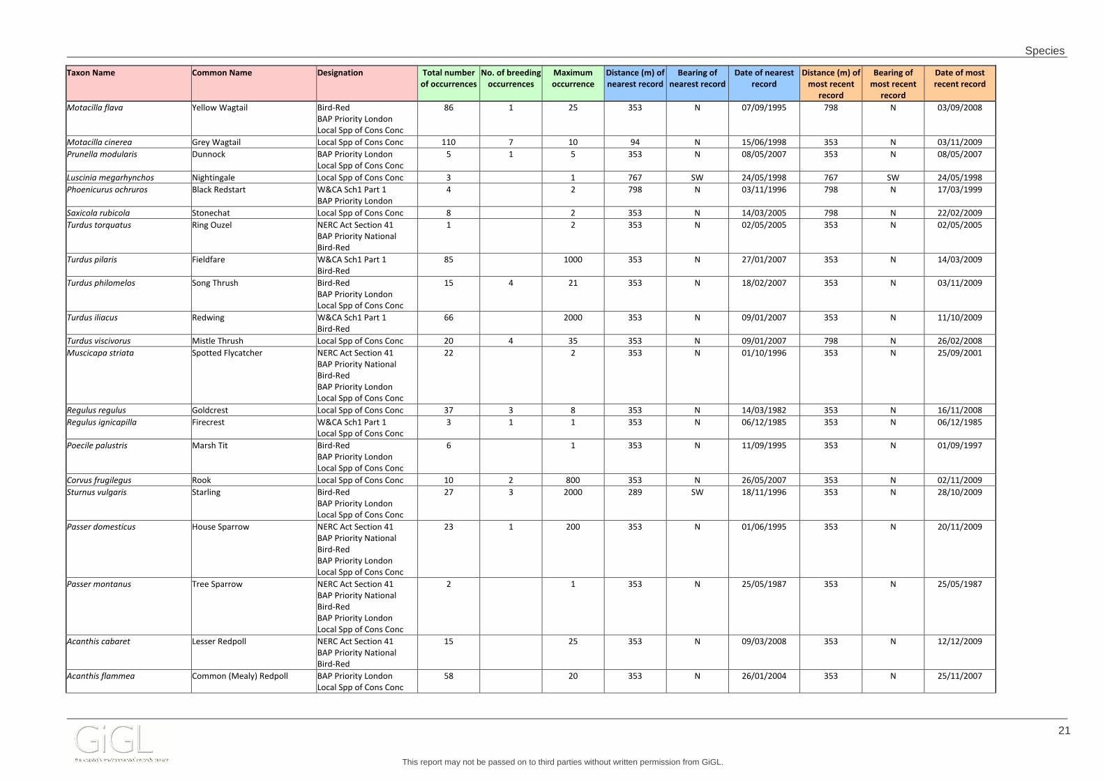
Motacilla flava Yellow Wagtail Bird-Red
BAP Priority London
Local Spp of Cons Conc
86 1 25 353 N 07/09/1995 798 N 03/09/2008
Motacilla cinerea Grey Wagtail Local Spp of Cons Conc 110 7 10 94 N 15/06/1998 353 N 03/11/2009
Prunella modularis Dunnock BAP Priority London
Local Spp of Cons Conc
5 1 5 353 N 08/05/2007 353 N 08/05/2007
Luscinia megarhynchos Nightingale Local Spp of Cons Conc 3 1 767 SW 24/05/1998 767 SW 24/05/1998
Phoenicurus ochruros Black Redstart W&CA Sch1 Part 1
BAP Priority London
4 2 798 N 03/11/1996 798 N 17/03/1999
Saxicola rubicola Stonechat Local Spp of Cons Conc 8 2 353 N 14/03/2005 798 N 22/02/2009
Turdus torquatus Ring Ouzel NERC Act Section 41
BAP Priority National
Bird-Red
1 2 353 N 02/05/2005 353 N 02/05/2005
Turdus pilaris Fieldfare W&CA Sch1 Part 1
Bird-Red
85 1000 353 N 27/01/2007 353 N 14/03/2009
Turdus philomelos Song Thrush Bird-Red
BAP Priority London
Local Spp of Cons Conc
15 4 21 353 N 18/02/2007 353 N 03/11/2009
Turdus iliacus Redwing W&CA Sch1 Part 1
Bird-Red
66 2000 353 N 09/01/2007 353 N 11/10/2009
Turdus viscivorus Mistle Thrush Local Spp of Cons Conc 20 4 35 353 N 09/01/2007 798 N 26/02/2008
Muscicapa striata Spotted Flycatcher NERC Act Section 41
BAP Priority National
Bird-Red
BAP Priority London
Local Spp of Cons Conc
22 2 353 N 01/10/1996 353 N 25/09/2001
Regulus regulus Goldcrest Local Spp of Cons Conc 37 3 8 353 N 14/03/1982 353 N 16/11/2008
Regulus ignicapilla Firecrest W&CA Sch1 Part 1
Local Spp of Cons Conc
3 1 1 353 N 06/12/1985 353 N 06/12/1985
Poecile palustris Marsh Tit Bird-Red
BAP Priority London
Local Spp of Cons Conc
6 1 353 N 11/09/1995 353 N 01/09/1997
Corvus frugilegus Rook Local Spp of Cons Conc 10 2 800 353 N 26/05/2007 353 N 02/11/2009
Sturnus vulgaris Starling Bird-Red
BAP Priority London
Local Spp of Cons Conc
27 3 2000 289 SW 18/11/1996 353 N 28/10/2009
Passer domesticus House Sparrow NERC Act Section 41
BAP Priority National
Bird-Red
BAP Priority London
Local Spp of Cons Conc
23 1 200 353 N 01/06/1995 353 N 20/11/2009
Passer montanus Tree Sparrow NERC Act Section 41
BAP Priority National
Bird-Red
BAP Priority London
Local Spp of Cons Conc
2 1 353 N 25/05/1987 353 N 25/05/1987
Acanthis cabaret Lesser Redpoll NERC Act Section 41
BAP Priority National
Bird-Red
15 25 353 N 09/03/2008 353 N 12/12/2009
Acanthis flammea Common (Mealy) Redpoll BAP Priority London
Local Spp of Cons Conc
58 20 353 N 26/01/2004 353 N 25/11/2007
Species
This report may not be passed on to third parties without written permission from GiGL.
22
Taxon Name Common Name Designation Total number
of occurrences
No. of breeding
occurrences
Maximum
occurrence
Distance (m) of
nearest record
Bearing of
nearest record
Date of nearest
record
Distance (m) of
most recent
record
Bearing of
most recent
record
Date of most
recent record
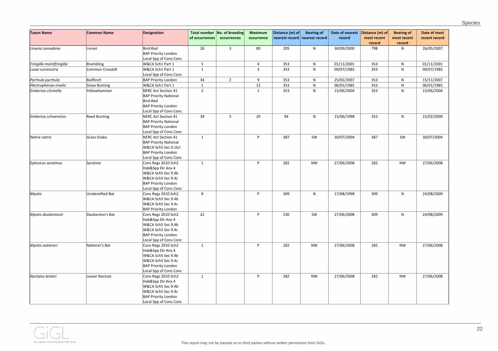
Linaria cannabina Linnet Bird-Red
BAP Priority London
Local Spp of Cons Conc
26 3 80 205 N 30/09/2000 798 N 26/05/2007
Fringilla montifringilla Brambling W&CA Sch1 Part 1 5 4 353 N 01/11/2001 353 N 01/11/2001
Loxia curvirostra Common Crossbill W&CA Sch1 Part 1
Local Spp of Cons Conc
1 3 353 N 09/07/1985 353 N 09/07/1985
Pyrrhula pyrrhula Bullfinch BAP Priority London 34 2 9 353 N 25/01/2007 353 N 15/11/2007
Plectrophenax nivalis Snow Bunting W&CA Sch1 Part 1 1 12 353 N 06/01/1985 353 N 06/01/1985
Emberiza citrinella Yellowhammer NERC Act Section 41
BAP Priority National
Bird-Red
BAP Priority London
Local Spp of Cons Conc
2 1 353 N 15/06/2004 353 N 15/06/2004
Emberiza schoeniclus Reed Bunting NERC Act Section 41
BAP Priority National
BAP Priority London
Local Spp of Cons Conc
39 5 20 94 N 15/06/1998 353 N 22/02/2009
Natrix natrix Grass Snake NERC Act Section 41
BAP Priority National
W&CA Sch5 Sec 9.1k/i
BAP Priority London
Local Spp of Cons Conc
1 P 387 SW 30/07/2004 387 SW 30/07/2004
Eptesicus serotinus Serotine Cons Regs 2010 Sch2
Hab&Spp Dir Anx 4
W&CA Sch5 Sec 9.4b
W&CA Sch5 Sec 9.4c
BAP Priority London
Local Spp of Cons Conc
1 P 282 NW 27/06/2008 282 NW 27/06/2008
Myotis Unidentified Bat Cons Regs 2010 Sch2
W&CA Sch5 Sec 9.4b
W&CA Sch5 Sec 9.4c
BAP Priority London
8 P 309 N 17/08/1998 309 N 24/08/2009
Myotis daubentonii Daubenton's Bat Cons Regs 2010 Sch2
Hab&Spp Dir Anx 4
W&CA Sch5 Sec 9.4b
W&CA Sch5 Sec 9.4c
BAP Priority London
Local Spp of Cons Conc
22 P 230 SW 27/06/2008 309 N 24/08/2009
Myotis nattereri Natterer's Bat Cons Regs 2010 Sch2
Hab&Spp Dir Anx 4
W&CA Sch5 Sec 9.4b
W&CA Sch5 Sec 9.4c
BAP Priority London
Local Spp of Cons Conc
1 P 282 NW 27/06/2008 282 NW 27/06/2008
Nyctalus leisleri Lesser Noctule Cons Regs 2010 Sch2
Hab&Spp Dir Anx 4
W&CA Sch5 Sec 9.4b
W&CA Sch5 Sec 9.4c
BAP Priority London
Local Spp of Cons Conc
1 P 282 NW 27/06/2008 282 NW 27/06/2008

Species
This report may not be passed on to third parties without written permission from GiGL.
23
Taxon Name Common Name Designation Total number
of occurrences
No. of breeding
occurrences
Maximum
occurrence
Distance (m) of
nearest record
Bearing of
nearest record
Date of nearest
record
Distance (m) of
most recent
record
Bearing of
most recent
record
Date of most
recent record
Nyctalus noctula Noctule Bat Cons Regs 2010 Sch2
Hab&Spp Dir Anx 4
NERC Act Section 41
BAP Priority National
W&CA Sch5 Sec 9.4b
W&CA Sch5 Sec 9.4c
BAP Priority London
Local Spp of Cons Conc
1 P 282 NW 27/06/2008 282 NW 27/06/2008
Pipistrellus pipistrellus Pipistrelle Cons Regs 2010 Sch2
Hab&Spp Dir Anx 4
W&CA Sch5 Sec 9.4b
W&CA Sch5 Sec 9.4c
BAP Priority London
Local Spp of Cons Conc
2 P 282 NW 27/06/2008 282 NW 27/06/2008
Pipistrellus pygmaeus Soprano Pipistrelle Cons Regs 2010 Sch2
Hab&Spp Dir Anx 4
NERC Act Section 41
BAP Priority National
W&CA Sch5 Sec 9.4b
W&CA Sch5 Sec 9.4c
BAP Priority London
Local Spp of Cons Conc
3 P 230 SW 27/06/2008 230 SW 27/06/2008
Arvicola amphibius European Water Vole NERC Act Section 41
BAP Priority National
W&CA Sch5 Sec 9.1k/i
W&CA Sch5 Sec 9.1t
WCA5/9.4.a
W&CA Sch5 Sec 9.4b
W&CA Sch5 Sec 9.4c
BAP Priority London
Local Spp of Cons Conc
12 1 105 N 1989 367 SW 1995

Species
This report may not be passed on to third parties without written permission from GiGL.
24
Protected species and Species of Conservation Conce rn – Coarse Resolution Records The species records in this table are represent records of 1km2, 2km2 or 10km2 accuracy. Taxon Name Common Name Designation Total number of
occurrences
Record accuracy Date of oldest
record
Date of most
recent record
Sagittaria sagittifolia Arrowhead Local Spp of Cons Conc 2 1km 1965-1976 1965-1976
Hydrocharis morsus-ranae Frogbit RedList_GB-VU 1 1km 1945 1945
Hydrilla verticillata Hydrilla Nationally Rare
RedList_GB-VU
1 10km 1994 1994
Potamogeton lucens Shining Pondweed Local Spp of Cons Conc 1 1km 20/06/1940 20/06/1940
Potamogeton trichoides Hairlike Pondweed Local Spp of Cons Conc 1 10km 1983 1983
Groenlandia densa Opposite-leaved Pondweed RedList_GB-VU 1 1km 13/06/1940 13/06/1940
Polygonum rurivagum Cornfield Knotgrass Local Spp of Cons Conc 1 1km 1960 1960
Rumex maritimus Golden Dock Local Spp of Cons Conc 1 10km 1994 1994
Rumex palustris Marsh Dock Local Spp of Cons Conc 1 1km 1994 1994
Stellaria palustris Marsh Stitchwort NERC Act Section 41
BAP Priority National
RedList_GB-VU
1 1km 1975 1975
Scleranthus annuus Annual Knawel NERC Act Section 41
BAP Priority National
BAP Priority London
Local Spp of Cons Conc
RedList_GB-EN
5 1km, 10km 1904 1980
Dianthus armeria Deptford Pink NERC Act Section 41
BAP Priority National
W&CA Sch8
Local Spp of Cons Conc
Nationally Scarce
RedList_GB-EN
2 10km 1889 1909
Chenopodium murale Nettle-leaved Goosefoot Local Spp of Cons Conc
RedList_GB-VU
2 10km 1946 1951
Kickxia spuria Round-leaved Fluellen Local Spp of Cons Conc 1 10km 1994 1994
Linaria repens Pale Toadflax Local Spp of Cons Conc 2 2km, 10km 17/06/1987 2001
Galeopsis angustifolia Red Hemp-nettle NERC Act Section 41
BAP Priority National
Local Spp of Cons Conc
Nationally Scarce
RedList_GB-CR
3 10km 1954 1976
Scutellaria minor Lesser Skullcap Local Spp of Cons Conc 1 10km 1956 1956
Nepeta cataria Cat-mint RedList_GB-VU 1 10km 1999 1999
Clinopodium acinos Basil Thyme NERC Act Section 41
BAP Priority National
BAP Priority London
Local Spp of Cons Conc
RedList_GB-VU
1 10km 1981 1981
Clinopodium calamintha Lesser Calamint BAP Priority London
Local Spp of Cons Conc
Nationally Scarce
RedList_GB-VU
5 10km 1903 04/07/1998
Pedicularis sylvatica Lousewort Local Spp of Cons Conc 2 10km 1944 22/05/1983
Pedicularis sylvatica subsp.
sylvatica
Lousewort Local Spp of Cons Conc 2 10km 1983 1983
Rubus britannicus Bramble Nationally Rare 1 10km 11/10/1998 11/10/1998
Rosa obtusifolia Round-leaved Dog-rose Local Spp of Cons Conc 1 10km 1945 1945

Species
This report may not be passed on to third parties without written permission from GiGL.
25
Taxon Name Common Name Designation Total number of
occurrences
Record accuracy Date of oldest
record
Date of most
recent record
Carex appropinquata Fibrous Tussock-sedge Nationally Scarce
RedList_GB-Lr(NT)
1 10km 1936 1936
Carex caryophyllea Spring-sedge Local Spp of Cons Conc 2 10km 1949 1965
Carex paniculata x
appropinquata = C. x rotae
Sedge Nationally Rare
RedList_GB-VU
1 10km 1880 1880
Carex riparia Greater Pond-sedge Local Spp of Cons Conc 4 1km, 10km 1947 20/05/2006
Catabrosa aquatica Whorl-grass Local Spp of Cons Conc 1 10km 1940 1940
Koeleria macrantha Crested Hair-grass Local Spp of Cons Conc 1 10km 04/07/1998 04/07/1998
Aira caryophyllea Silver Hair-grass Local Spp of Cons Conc 1 10km 06/08/1978 06/08/1978
Bromus hordeaceus subsp.
thominei
Sand Soft-brome Nationally Scarce 1 10km 1965-1976 1965-1976
Sedum telephium Orpine Local Spp of Cons Conc 5 1km, 10km 1910 1965-1976
Myriophyllum alterniflorum Alternate Water-milfoil Local Spp of Cons Conc 1 10km 2002 2002
Rorippa islandica Northern Yellow-cress Nationally Scarce 1 10km 1965-1976 1965-1976
Cardamine bulbifera Coralroot Local Spp of Cons Conc
Nationally Scarce
15 1km, 2km, 10km 1913 24/05/2003
Lepidium latifolium Dittander Nationally Scarce 12 1km, 2km, 10km 1937 20/05/2006
Draba muralis Wall Whitlowgrass Nationally Scarce 1 10km 1951 1951
Equisetum arvense x telmateia =
E. x robertsii
Equisetum arvense x telmateia =
E. x robertsii
Nationally Rare
RedList_GB-VU
1 10km 1989 1989
Pinus sylvestris Scots Pine Nationally Scarce 1 1km 1980 1980
Coeloglossum viride Frog Orchid NERC Act Section 41
BAP Priority National
Local Spp of Cons Conc
RedList_GB-VU
1 10km 1906 1906
Cephalanthera damasonium White Helleborine NERC Act Section 41
BAP Priority National
BAP Priority London
Local Spp of Cons Conc
RedList_GB-VU
3 2km, 10km 1944 1980
Epipactis phyllanthes Green-flowered Helleborine BAP Priority London
Local Spp of Cons Conc
Nationally Scarce
1 2km 1959 1959
Epipactis purpurata Violet Helleborine Local Spp of Cons Conc 1 2km 2003 2003
Neottia nidus-avis Bird's-nest Orchid Local Spp of Cons Conc
RedList_GB-Lr(NT)
1 1km 1944 1944
Gymnadenia conopsea Fragrant Orchid Local Spp of Cons Conc 2 1km, 10km 1946 1946
Orchis mascula Early-purple Orchid Local Spp of Cons Conc 1 10km 1945 1945
Orchis militaris Military Orchid W&CA Sch8
Nationally Rare
RedList_GB-VU
1 10km 1900 1900
Orchis morio Green-winged Orchid Local Spp of Cons Conc
RedList_GB-Lr(NT)
1 1km 22/05/1902 22/05/1902
Ophrys insectifera Fly Orchid NERC Act Section 41
BAP Priority National
BAP Priority London
Local Spp of Cons Conc
RedList_GB-VU
10 2km, 10km 23/05/1889 1969
Allium oleraceum Field Garlic RedList_GB-VU 2 2km, 10km 24/06/1998 04/07/1998
Hyacinthoides non-scripta Bluebell W&CA Sch8
Local Spp of Cons Conc
2 1km, 10km 1965-1976 1965-1976
Papaver argemone Prickly Poppy RedList_GB-VU 1 1km 1980 1980

Species
This report may not be passed on to third parties without written permission from GiGL.
26
Taxon Name Common Name Designation Total number of
occurrences
Record accuracy Date of oldest
record
Date of most
recent record
Meconopsis cambrica Welsh Poppy Nationally Scarce 1 2km 1980 1980
Ranunculus hederaceus Ivy-leaved Crowfoot Local Spp of Cons Conc 1 2km 1928 1928
Thalictrum flavum Common Meadow-rue Local Spp of Cons Conc 7 2km, 10km 1902 1992
Medicago polymorpha Toothed Medick Local Spp of Cons Conc
Nationally Scarce
2 10km 1946 1961
Genista anglica Petty Whin Local Spp of Cons Conc
RedList_GB-Lr(NT)
4 10km 1950 24/05/2003
Genista tinctoria subsp. tinctoria Dyer's Greenweed Local Spp of Cons Conc 1 10km 04/07/1998 04/07/1998
Polygala serpyllifolia Heath Milkwort Local Spp of Cons Conc 1 10km 1939 1939
Euphorbia exigua Dwarf Spurge RedList_GB-Lr(NT) 2 2km, 10km 1990 04/07/1998
Salix aurita Eared Willow Local Spp of Cons Conc 2 2km, 10km 1977 2002
Viola canina subsp. canina Heath Dog-Violet Local Spp of Cons Conc
RedList_GB-Lr(NT)
2 10km 1940 1942
Viola tricolor subsp. tricolor Pansy RedList_GB-Lr(NT) 1 10km 10/09/1910 10/09/1910
Geranium pratense Meadow Crane's-bill Local Spp of Cons Conc 2 1km, 10km 1955 1965-1976
Viscum album Mistletoe BAP Priority London
Local Spp of Cons Conc
3 1km, 10km 1928 1978
Gentianella germanica Chiltern Gentian Nationally Scarce
RedList_GB-VU
14 2km, 10km 1883 1977
Jasione montana Sheep's-bit Local Spp of Cons Conc 1 10km 07/09/1912 07/09/1912
Serratula tinctoria Saw-wort Local Spp of Cons Conc 1 10km 1920 1920
Centaurea cyanus Cornflower NERC Act Section 41
BAP Priority National
1 10km 1870 1870
Gnaphalium sylvaticum Heath Cudweed RedList_GB-EN 1 10km 1954 1954
Anthemis cotula Stinking Chamomile RedList_GB-VU 1 10km 1912 1912
Glebionis segetum Corn Marigold RedList_GB-VU 1 10km 07/09/1912 07/09/1912
Valerianella rimosa Broad-fruited Cornsalad NERC Act Section 41
BAP Priority National
Nationally Scarce
RedList_GB-EN
1 10km 1887 1887
Valeriana officinalis Common Valerian Local Spp of Cons Conc 1 10km 1965-1976 1965-1976
Dipsacus pilosus Small Teasel Local Spp of Cons Conc 1 1km 1944 1944
Hydrocotyle vulgaris Marsh Pennywort Local Spp of Cons Conc 1 2km 24/05/2003 24/05/2003
Scandix pecten-veneris Shepherd's-needle NERC Act Section 41
BAP Priority National
Local Spp of Cons Conc
RedList_GB-CR
2 10km 1912 1927
Sium latifolium Greater Water-parsnip NERC Act Section 41
BAP Priority National
Nationally Scarce
RedList_GB-EN
1 10km 1911 1911
Oenanthe fluviatilis River Water-dropwort BAP Priority London
Local Spp of Cons Conc
1 10km 24/05/2003 24/05/2003
Torilis arvensis Spreading Hedge-parsley NERC Act Section 41
BAP Priority National
Nationally Scarce
RedList_GB-EN
3 10km 1903 1986
Hepialus humuli Ghost Moth NERC Act Section 41
BAP Priority National
BAP Priority London
Local Spp of Cons Conc
2 1km, 10km 2008 26/06/2010
Calamotropha paludella Bulrush Veneer Nationally Notable B 1 1km 20/07/2010 20/07/2010

Species
This report may not be passed on to third parties without written permission from GiGL.
27
Taxon Name Common Name Designation Total number of
occurrences
Record accuracy Date of oldest
record
Date of most
recent record
Argynnis paphia Silver-washed Fritillary Local Spp of Cons Conc 1 1km 05/07/2010 05/07/2010
Melanargia galathea subsp.
serena
Marbled White Local Spp of Cons Conc 1 1km 18/07/2008 18/07/2008
Watsonalla cultraria Barred Hook-tip Local Spp of Cons Conc 1 1km 2008 2008
Hemistola chrysoprasaria Small Emerald NERC Act Section 41
BAP Priority National
BAP Priority London
Local Spp of Cons Conc
1 1km 2008 2008
Xanthorhoe biriviata Balsam Carpet BAP Priority London
Local Spp of Cons Conc
1 1km 29/07/2008 29/07/2008
Scotopteryx chenopodiata Shaded Broad-bar NERC Act Section 41
BAP Priority National
BAP Priority London
Local Spp of Cons Conc
3 1km 20/07/2010 03/08/2010
Ennomos quercinaria August Thorn NERC Act Section 41
BAP Priority National
BAP Priority London
Local Spp of Cons Conc
1 1km 03/08/2010 03/08/2010
Ennomos erosaria September Thorn NERC Act Section 41
BAP Priority National
BAP Priority London
Local Spp of Cons Conc
1 1km 20/07/2010 20/07/2010
Lycia hirtaria Brindled Beauty NERC Act Section 41
BAP Priority National
BAP Priority London
Local Spp of Cons Conc
1 1km 2008 2008
Diarsia rubi Small Square-spot NERC Act Section 41
BAP Priority National
BAP Priority London
Local Spp of Cons Conc
3 1km 2008 15/06/2010
Orthosia populeti Lead-coloured Drab Local Spp of Cons Conc 1 1km 2008 2008
Orthosia gracilis Powdered Quaker NERC Act Section 41
BAP Priority National
BAP Priority London
Local Spp of Cons Conc
1 1km 17/04/2010 17/04/2010
Mythimna comma Shoulder-striped Wainscot NERC Act Section 41
BAP Priority National
BAP Priority London
Local Spp of Cons Conc
1 1km 24/06/2010 24/06/2010
Acronicta rumicis Knot Grass NERC Act Section 41
BAP Priority National
BAP Priority London
Local Spp of Cons Conc
3 1km 26/06/2010 31/07/2010
Archanara geminipuncta Twin-spotted Wainscot Local Spp of Cons Conc 1 1km 07/08/2010 07/08/2010
Hoplodrina blanda Rustic NERC Act Section 41
BAP Priority National
BAP Priority London
Local Spp of Cons Conc
3 1km 20/07/2010 03/08/2010
Caradrina morpheus Mottled Rustic NERC Act Section 41
BAP Priority National
BAP Priority London
Local Spp of Cons Conc
10 1km 12/06/2010 17/07/2010
Parascotia fuliginaria Waved Black Local Spp of Cons Conc 4 1km 17/07/2008 17/07/2010

Species
This report may not be passed on to third parties without written permission from GiGL.
28
Taxon Name Common Name Designation Total number of
occurrences
Record accuracy Date of oldest
record
Date of most
recent record
Thumatha senex Round-winged Muslin Local Spp of Cons Conc 2 1km 2008 06/07/2010
Eilema griseola Dingy Footman Local Spp of Cons Conc 8 1km 13/07/2010 13/08/2010
Eilema depressa Buff Footman Local Spp of Cons Conc 3 1km 20/07/2010 31/07/2010
Spilosoma lubricipeda White Ermine NERC Act Section 41
BAP Priority National
BAP Priority London
Local Spp of Cons Conc
10 1km 2008 01/07/2010
Spilosoma luteum Buff Ermine NERC Act Section 41
BAP Priority National
BAP Priority London
Local Spp of Cons Conc
12 1km 2008 03/08/2010
Tyria jacobaeae Cinnabar NERC Act Section 41
BAP Priority National
BAP Priority London
Local Spp of Cons Conc
2 1km 12/06/2010 15/06/2010
Earias clorana Cream-bordered Green Pea Local Spp of Cons Conc 1 1km 07/06/2008 07/06/2008

Species
This report may not be passed on to third parties without written permission from GiGL.
29
4.2 Confidential Records Records included in this section do not include any geographic content as it has been requested (by the data owners/originators) that the location remains confidential. The following information is provided to create a ‘species alert’ record highlighting the presence of a species in the search area. In order to establish the presence of confidential records on the site in question, a second data search request must be submitted with a detailed site boundary. For further explanations of GiGL’s Access to Data Policy and the confidential records please see the “Supporting Information” annex. Taxon Name Common Name Designation Total number of
occurrences
Date of oldest
record
Date of most
recent record
Anas querquedula Garganey W&CA Sch1 Part 1
Local Spp of Cons Conc
7 03/04/1982 08/04/2008
Egretta garzetta Little Egret Birds Dir Anx 1
Local Spp of Cons Conc
27 28/07/2001 15/07/2009
Coturnix coturnix Quail W&CA Sch1 Part 1 1 08/09/2002 08/09/2002
Milvus milvus Red Kite Birds Dir Anx 1
W&CA Sch1 Part 1
7 08/07/1998 20/05/2009
Circus aeruginosus Marsh Harrier Birds Dir Anx 1
W&CA Sch1 Part 1
4 22/04/1995 05/05/2003
Falco subbuteo Hobby W&CA Sch1 Part 1
Local Spp of Cons Conc
118 04/05/1982 28/09/2009
Falco peregrinus Peregrine Birds Dir Anx 1
W&CA Sch1 Part 1
BAP Priority London
Local Spp of Cons Conc
5 03/05/2005 08/05/2009
Charadrius dubius Little Ringed Plover W&CA Sch1 Part 1
Local Spp of Cons Conc
238 02/04/1983 05/04/2009
Gallinago gallinago Snipe Local Spp of Cons Conc 7 02/04/1982 07/04/1995

Species
This report may not be passed on to third parties without written permission from GiGL.
30
Taxon Name Common Name Designation Total number of
occurrences
Date of oldest
record
Date of most
recent record
Streptopelia turtur Turtle Dove NERC Act Section 41
BAP Priority National
Bird-Red
BAP Priority London
Local Spp of Cons Conc
5 10/05/1986 03/06/1998
Cettia cetti Cetti's Warbler W&CA Sch1 Part 1
Local Spp of Cons Conc
47 25/05/1997 08/06/2005
Phoenicurus ochruros Black Redstart W&CA Sch1 Part 1
BAP Priority London
2 11/05/1985 13/04/1998
Panurus biarmicus Bearded Tit W&CA Sch1 Part 1
Local Spp of Cons Conc
2 25/10/1983 30/03/2003
Poecile montana Willow Tit Bird-Red 11 1982 01/01/1987
Coccothraustes coccothraustes Hawfinch NERC Act Section 41
BAP Priority National
Bird-Red
BAP Priority London
Local Spp of Cons Conc
4 20/04/1987 25/04/2000
Emberiza calandra Corn Bunting Bird-Red
BAP Priority London
Local Spp of Cons Conc
12 28/01/1982 26/02/1994
Meles meles Eurasian Badger Protection of Badgers Act
1992
Local Spp of Cons Conc
1 06/08/2004 06/08/2004

Species
This report may not be passed on to third parties without written permission from GiGL.
31
4.3 LISI Species The London Invasive Species Initiative (LISI) encourages better co-ordination and partnership working to prevent, reduce and eliminate the impacts caused by invasive non-native species across the city. The list presents a number of species present in London and causing impacts for which action, monitoring or research is needed. It also lists species not currently in London but of concern due to high risk of negative impact should they arrive, including those for which national alerts are in place through the GB Non-Native Species Secretariat. LISI species are categorised following their likely risk to the environment. For further explanations please see the Supporting Information annex.
LISI Category Explanation
LISI 1 Species not currently present in London but present nearby or of concern because of the high risk of negative impacts should they arrive. Should any species listed in this category appear in London, this should be reported to GIGL or LISI to ensure that action is taken rapidly.
LISI 2 Species of high impact or concern present at specific sites that require attention (control, management, eradication etc). Such species are priority species for action in London and LISI encourages this wherever possible. LISI 3 Species of high impact or concern which are widespread in London and require concerted, coordinated and extensive action to control/eradicate. These species are species currently causing large scale impacts across London and
LISI supports area or catchment wide partnership working to ensure this.
LISI 4 Species which are widespread for which eradication is not feasible but where avoiding spread to other sites may be required. Appropriate biosecurity is required for sites where these species are found. LISI 5 Species for which insufficient data or evidence was available from those present to be able to prioritise.
LISI 6 Species that were not currently considered to pose a threat or have the potential to cause problems in London.
For further advice on dealing with invasive species in London, or to report management work undertaken at a site please contact the LISI Manager at [email protected] or visit http://londonisi.org.uk/ Taxon Name Common Name Designation Total number
of occurrences
Maximum
occurrence
Location of nearest
record
Date of nearest
record
Location of most
recent record
Date of most
recent record
Date range
Lemna minuta Least Duckweed LISI category 4 1 P TQ045935 1990 TQ045935 1990 01/01/1990-31/12/1990
Elodea nuttallii Nuttall's Waterweed LISI category 4 2 P TQ0447193357 02/08/2004 TQ0447193357 02/08/2004 30/07/2004-02/08/2004
Fallopia japonica Japanese Knotweed LISI category 3 7 P TQ0447193357 02/08/2004 TQ0466192606 11/08/2004 30/07/2004-11/08/2004
Impatiens capensis Orange Balsam LISI category 5 12 P TQ0431693317 30/07/2004 TQ0422492759 04/08/2004 01/01/1994-04/08/2004
Impatiens parviflora Small Balsam LISI category 5 1 P TQ043930 30/07/1997 TQ043930 30/07/1997 30/07/1997
Rhododendron ponticum Rhododendron LISI category 2 1 P TQ04799394 10/09/1996 TQ04799394 10/09/1996 10/09/1996
Buddleja davidii Butterfly-bush LISI category 3 6 P TQ044930 29/12/2008 TQ044930 29/12/2008 02/08/2004-29/12/2008
Cotoneaster horizontalis Wall Cotoneaster LISI category 2 1 P TQ044929 1995 TQ044929 1995 01/01/1995-31/12/1995
Myriophyllum aquaticum Parrot's-feather LISI category 3 1 P TQ040935 1995 TQ040935 1995 01/01/1995-31/12/1995
Crocosmia pottsii x aurea = C. x
crocosmiiflora
Montbretia LISI category 2 1 P TQ044929 1995 TQ044929 1995 01/01/1995-31/12/1995
Galega officinalis Goat's-rue LISI category 4 4 P TQ043930 07/07/2001 TQ0453392951 11/08/2004 07/07/2001-11/08/2004
Heracleum mantegazzianum Giant Hogweed LISI category 3 1 P TQ048932 2006 TQ048932 2006 01/01/2006-31/12/2006
Pentaglottis sempervirens Green Alkanet LISI category 6 1 P TQ0449993175 04/08/2004 TQ0449993175 04/08/2004 04/08/2004
Pacifastacus leniusculus Signal Crayfish LISI category 4 1 5 TQ04269295 28/06/2011 TQ04269295 28/06/2011 28/06/2011
Psittacula krameri Ring-necked Parakeet LISI category 4 83 40 TQ046935 06/12/2009 TQ046935 27/12/2009 18/09/1994-27/12/2009

Species
This report may not be passed on to third parties without written permission from GiGL.
32
LISI species – Coarse Resolution Records The species records in this table are represent records of 1km2, 2km2 or 10km2 accuracy. Taxon Name Common Name Designation Total number of
occurrences
Record accuracy Date of oldest
record
Date of most
recent record
Lemna minuta Least Duckweed LISI category 4 2 1km, 10km 31/12/1991 1993
Elodea canadensis Canadian Waterweed LISI category 4 1 1km 1965-1976 1965-1976
Fallopia japonica Japanese Knotweed LISI category 3 2 1km 1965-1976 1965-1976
Impatiens capensis Orange Balsam LISI category 5 3 1km 1965-1976 1993
Impatiens parviflora Small Balsam LISI category 5 2 1km, 10km 1988 24/05/2003
Buddleja davidii Butterfly-bush LISI category 3 3 1km, 10km 31/12/1976 04/07/1998
Brassica napus Rape LISI category 5 1 1km 1965-1976 1965-1976
Azolla filiculoides Water Fern LISI category 2 2 1km 31/12/1976 1999
Crocosmia pottsii x aurea = C. x
crocosmiiflora
Montbretia LISI category 2 1 1km 1965-1976 1965-1976
Hyacinthoides hispanica Spanish Bluebell LISI category 4 2 1km, 2km 31/12/1992 1994
Quercus ilex Evergreen Oak LISI category 2 1 2km 1965-1976 1965-1976
Symphoricarpos albus Snowberry LISI category 2 1 1km 1965-1976 1965-1976

Habitats
This report may not be passed on to third parties without written permission from GiGL.
33
5.0 Habitats
Habitats present within the search area from these sources can be seen on the following pages:
• Survey data • BAP Condition Assessment and Habitat Suitability
The tables can be cross-referenced with the Survey Parcels Map. Note that GiGL does not currently hold habitat data for all areas. Even where data is held, a lack of records in a defined geographical area does not necessarily mean that the habitat does not occur there – the area may simply not have been surveyed.
This section identifies and maps components of the local ecological networks and potential areas identified for habitat restoration or creation.

Habitats
This report may not be passed on to third parties without written permission from GiGL.
34
5.1 Survey Data This table holds the most recent habitat survey information for a given site. It includes data collected via different survey methodologies. The GLA conducted a series of rolling habitat surveys between the mid-1980s and 2009. It used the habitat typologies developed specifically for Greater London – for further details of categories please refer to the Supporting Information section of the Annex. Other habitat classification methodologies recorded in the database are National Vegetation Classification, Phase 1 Habitat Assessment, and Biodiversity Action Plan Broad Habitat classification. Site Name Polygon ID Grid Ref Site Area
(ha)
Survey Date Habitat Type Area (%) Area (ha) Survey Type
Watts Common Area, Horse pastures
to east of footpath
GiGL_HAB_11578 TQ0513792196 12.28 11/08/2004 Improved or re-seeded agricultural
grassland
Neutral grassland (semi-improved)
Native hedge
60
30
10
7.35
3.67
1.23
Lon(P1)
Watts Common Area, Cooks Wood GiGL_HAB_11579 TQ0519192588 1.25 11/08/2004 Native broadleaved woodland 100 1.24 Lon(P1)
Watts Common Area, Fields adjacent
to Hillingdon Borough boundary
GiGL_HAB_11580 TQ0530392669 2.09 11/08/2004 Arable
Native broadleaved woodland
Roughland (intimate mix of 9, 14
and 6)
Scrub
60
25
10
5
1.25
0.52
0.21
0.1
Lon(P1)
Watts Common Area, Linear Shaw GiGL_HAB_11582 TQ0530792546 0.72 12/08/2004 Native broadleaved woodland
Running water (rivers and streams)
90
10
0.65
0.07
Lon(P1)
Watts Common Area, Field to South-
West of Cooks Wood
GiGL_HAB_11587 TQ0523892474 5.29 11/08/2004 Arable 100 5.27 Lon(P1)
Grand Union Canal south of Springwell
lake, Grand Union Canal south of
Springwell Lake and Coppermill Lane
GiGL_HAB_11705 TQ0416191728 2.67 30/10/2004 Standing water (includes canals)
Bare artificial habitat
Scattered trees
50
30
20
1.34
0.8
0.53
Lon(P1)
Springwell Lane Chalk Pit, Horse
pasture
GiGL_HAB_11781 TQ0492492348 2.62 11/08/2004 Improved or re-seeded agricultural
grassland
Native hedge
95
5
2.48
0.13
Lon(P1)
Springwell Lane Chalk Pit, Former land-
fill site (western section)
GiGL_HAB_11782 TQ0466192606 8.73 11/08/2004 Roughland (intimate mix of 9, 14
and 6)
Native hedge
Bare artificial habitat
90
5
5
7.84
0.44
0.44
Lon(P1)

Habitats
This report may not be passed on to third parties without written permission from GiGL.
35
Site Name Polygon ID Grid Ref Site Area
(ha)
Survey Date Habitat Type Area (%) Area (ha) Survey Type
Springwell Lane Chalk Pit, Former land-
fill site (eastern section)
GiGL_HAB_11783 TQ0493692724 18.01 11/08/2004 Roughland (intimate mix of 9, 14
and 6)
100 17.96 Lon(P1)
Springwell Lane Chalk Pit, Car
dismantling yard
GiGL_HAB_11784 TQ0434192825 1.61 11/08/2004 Bare artificial habitat
Scrub
Bare soil and rock
80
10
10
1.29
0.16
0.16
Lon(P1)
Springwell Lane Chalk Pit GiGL_HAB_11785 TQ0453392951 11.53 11/08/2004 Scrub
Ruderal or ephemeral
Bare soil and rock
Basic grassland
Scattered trees
Non- native broadleaved woodland
Bare artificial habitat
20
20
20
15
10
10
5
2.3
2.3
2.3
1.72
1.15
1.15
0.57
Lon(P1)
Springwell Lane Chalk Pit, Airfield GiGL_HAB_11786 TQ0469592878 3.61 11/08/2004 Amenity grassland
tall herbs
70
30
2.52
1.08
Lon(P1)
Springwell Farm Area, Springwell Pit
Wood
GiGL_HAB_11787 TQ0444792352 1.60 06/08/2004 Native broadleaved woodland
Neutral grassland (herb-rich)
90
10
0
0
Lon(P1)
Springwell Farm Area, Horse pastures
around Springwell Pit Wood and
footpath
GiGL_HAB_11788 TQ0435392518 6.12 05/08/2004 Improved or re-seeded agricultural
grassland
Bare soil and rock
tall herbs
90
7
3
5.49
0.43
0.18
Lon(P1)
Springwell Farm Area, Pasture
surrounding wood
GiGL_HAB_11789 TQ0440492223 3.22 06/08/2004 Improved or re-seeded agricultural
grassland
100 3.21 Lon(P1)
Springwell Farm Area, Horse pasture GiGL_HAB_11791 TQ0429392195 1.26 13/08/2004 Improved or re-seeded agricultural
grassland
100 1.26 Lon(P1)
Springwell Lake Area, Springwell Farm
- former watercress beds
GiGL_HAB_11793 TQ0424792532 0.89 13/08/2004 Typha etc. swamp
Native hedge
Fen carr (woodland or scrub over
fen)
80
10
10
0.71
0.09
0.09
Lon(P1)
Springwell Lake Area, Reedbed to
South of lake
GiGL_HAB_11794 TQ0409992441 4.54 04/08/2004 Reedswamp
Scattered trees
Ruderal or ephemeral
80
15
5
3.62
0.68
0.23
Lon(P1)

Habitats
This report may not be passed on to third parties without written permission from GiGL.
36
Site Name Polygon ID Grid Ref Site Area
(ha)
Survey Date Habitat Type Area (%) Area (ha) Survey Type
Springwell Lake Area, Land North of
works
GiGL_HAB_11795 TQ0417792711 1.58 04/08/2004 Neutral grassland (semi-improved)
Bare artificial habitat
Scattered trees
Native hedge
75
15
5
5
1.19
0.24
0.08
0.08
Lon(P1)
Springwell Lake Area, Springwell Lake GiGL_HAB_11796 TQ0410592958 13.56 30/07/2004 Standing water (includes canals)
Scattered trees
tall herbs
Typha etc. swamp
Scrub
Reedswamp
Bare soil and rock
Amenity grassland
63
10
5
5
5
5
5
2
8.52
1.35
0.68
0.68
0.68
0.68
0.68
0.27
Lon(P1)
Springwell Lake Area, Grand Union
Canal East of Springwell Lake
GiGL_HAB_11797 TQ0422492759 2.58 04/08/2004 Standing water (includes canals)
tall herbs
Wet marginal vegetation
Neutral grassland (semi-improved)
Scattered trees
Native hedge
Bare soil and rock
40
15
10
10
10
10
5
1.03
0.39
0.26
0.26
0.26
0.26
0.13
Lon(P1)
Springwell Lake Area, Old watercress
beds
GiGL_HAB_11798 TQ0425493036 1.36 02/08/2004 Ruderal or ephemeral
Bare soil and rock
Wet marginal vegetation
Non-native hedge
Ditches (water filled)
50
20
10
10
10
0.68
0.27
0.14
0.14
0.14
Lon(P1)
Springwell Lake Area, South Harrow
Waltonians Angling Club
GiGL_HAB_11799 TQ0401793311 1.53 26/01/2005 Scrub
Neutral grassland (semi-improved)
Scattered trees
Standing water (includes canals)
Bare soil and rock
40
20
20
10
10
0.61
0.3
0.3
0.15
0.15
Lon(P1)
Springwell Lake Area, Waterside GiGL_HAB_11800 TQ0399593223 1.66 26/01/2005 Standing water (includes canals)
Neutral grassland (semi-improved)
Bare artificial habitat
Scattered trees
55
25
15
5
0.91
0.42
0.25
0.08
Lon(P1)
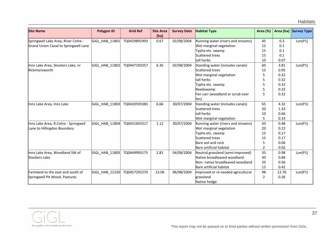
Habitats
This report may not be passed on to third parties without written permission from GiGL.
37
Site Name Polygon ID Grid Ref Site Area
(ha)
Survey Date Habitat Type Area (%) Area (ha) Survey Type
Springwell Lake Area, River Colne -
Grand Union Canal to Springwell Lane
GiGL_HAB_11801 TQ0429892993 0.67 02/08/2004 Running water (rivers and streams)
Wet marginal vegetation
Typha etc. swamp
Scattered trees
tall herbs
45
15
15
15
10
0.3
0.1
0.1
0.1
0.07
Lon(P1)
Inns Lake Area, Stockers Lake, nr
Rickmansworth
GiGL_HAB_11802 TQ0447193357 6.36 02/08/2004 Standing water (includes canals)
Scattered trees
Wet marginal vegetation
tall herbs
Typha etc. swamp
Reedswamp
Fen carr (woodland or scrub over
fen)
60
15
5
5
5
5
5
3.81
0.95
0.32
0.32
0.32
0.32
0.32
Lon(P1)
Inns Lake Area, Inns Lake GiGL_HAB_11803 TQ0420593383 6.66 30/07/2004 Standing water (includes canals)
Scattered trees
tall herbs
Wet marginal vegetation
65
20
10
5
4.32
1.33
0.66
0.33
Lon(P1)
Inns Lake Area, R.Colne - Springwell
Lane to Hillingdon Boundary
GiGL_HAB_11804 TQ0431693317 1.12 30/07/2004 Running water (rivers and streams)
Wet marginal vegetation
Typha etc. swamp
Scattered trees
Bare soil and rock
Bare artificial habitat
43
20
15
15
5
2
0.48
0.22
0.17
0.17
0.06
0.02
Lon(P1)
Inns Lake Area, Woodland SW of
Stockers Lake
GiGL_HAB_11805 TQ0449993175 2.81 04/08/2004 Neutral grassland (semi-improved)
Native broadleaved woodland
Non- native broadleaved woodland
Bare artificial habitat
35
30
20
15
0.98
0.84
0.56
0.42
Lon(P1)
Farmland to the east and south of
Springwell Pit Wood, Pastures
GiGL_HAB_12150 TQ0457292270 13.06 06/08/2004 Improved or re-seeded agricultural
grassland
Native hedge
98
2
12.76
0.26
Lon(P1)

Habitats
This report may not be passed on to third parties without written permission from GiGL.
38
5.2 BAP Condition Assessment & Habitat Suitability The London Biodiversity Partnership (LBP) habitat suitability dataset was created to promote the preservation, restoration and re-creation of priority habitats. This is a modelled dataset which, if used to create one or more of the nine selected BAP priority habitats, should give the best benefit to biodiversity in London. Launched in 2010, this dataset is based on methods developed with the London Biodiversity Partnership’s Habitat Action Plan (HAP) groups. GiGL mapped Biodiversity Action Plan (BAP) habitat distribution using information from GLA habitat surveys, and assessed their condition using species records and other datasets. Further to this work, GiGL created a predictive model of areas suitable for either maintaining existing BAP habitat, expanding areas of BAP habitat or creating new BAP habitats. Again, the methodology was designed in partnership with the HAP groups, and includes factors such as soil type. This dataset was a one-off project and is not updated. Site Name Polygon ID Grid Ref Site Area
(ha)
Created Date Habitat Condition Area (ha) Habitat Suitability Area (ha)
Watts Common Area, Horse pastures to east of footpath GiGL_HAB_11578 TQ0513792196 12.28 2004 Create new/restore relict heath
Create new/restore relict acid grass
12.25
12.25
Watts Common Area, Cooks Wood GiGL_HAB_11579 TQ0519192588 1.25 2004 Wood Unknown condition (management not
known)
1.24 Create new/restore relict heath
Create new/restore relict acid grass
0
0
Watts Common Area, Fields adjacent to Hillingdon Borough
boundary
GiGL_HAB_11580 TQ0530392669 2.09 2004 Wood Unknown condition (management not
known)
0.52 Create new/restore relict heath
Create new/restore relict acid grass
2.08
2.08
Watts Common Area, Linear Shaw GiGL_HAB_11582 TQ0530792546 0.72 2004 Wood Unknown condition (management not
known)
0.65 Create new/restore relict heath
Create new/restore relict acid grass
0.07
0.07
Watts Common Area, Field to South-West of Cooks Wood GiGL_HAB_11587 TQ0523892474 5.29 2004 Create new/restore relict heath
Create new/restore relict acid grass
5.27
5.27
Grand Union Canal south of Springwell lake, Grand Union Canal
south of Springwell Lake and Coppermill Lane
GiGL_HAB_11705 TQ0416191728 2.67 2004 Pond condition Poor 1.33 Create new/restore relict pond
Create new/restore relict reed
2.67
1.34
Springwell Lane Chalk Pit, Horse pasture GiGL_HAB_11781 TQ0492492348 2.62 2004 Create new/restore relict heath
Create new/restore relict acid grass
2.61
2.61
Springwell Lane Chalk Pit, Former land-fill site (western section) GiGL_HAB_11782 TQ0466192606 8.73 2004 Create new/restore relict heath
Create new/restore relict acid grass
8.71
8.71
Springwell Lane Chalk Pit, Former land-fill site (eastern section) GiGL_HAB_11783 TQ0493692724 18.01 2004 Create new/restore relict heath
Create new/restore relict acid grass
17.96
17.96
Springwell Lane Chalk Pit, Car dismantling yard GiGL_HAB_11784 TQ0434192825 1.61 2004 Create new/restore relict heath
Create new/restore relict acid grass
1.61
1.61
Springwell Lane Chalk Pit GiGL_HAB_11785 TQ0453392951 11.53 2004 Species Rich Chalk grass CAT A
Wood Unknown condition (management not
known)
1.72
1.15
Create new/restore relict pond
Create new/restore relict heath
Create new/restore relict floodplain GM
Create new/restore relict acid grass
Expand existing chalk grass
9.77
9.77
9.77
9.77
1.72
Springwell Lane Chalk Pit, Airfield GiGL_HAB_11786 TQ0469592878 3.61 2004 Create new/restore relict heath
Create new/restore relict floodplain GM
Create new/restore relict acid grass
3.6
3.6
3.6
Springwell Farm Area, Springwell Pit Wood GiGL_HAB_11787 TQ0444792352 1.60 2004 Wood Unknown condition (management not
known)
Meadow condition Poor
1.44
0
Create new/restore relict meadow
Create new/restore relict heath
Create new/restore relict floodplain GM
Create new/restore relict acid grass
1.6
1.6
1.6
1.6
Springwell Farm Area, Horse pastures around Springwell Pit
Wood and footpath
GiGL_HAB_11788 TQ0435392518 6.12 2004 Create new/restore relict pond
Create new/restore relict heath
Create new/restore relict floodplain GM
Create new/restore relict acid grass
6.1
6.1
6.1
6.1
Springwell Farm Area, Pasture surrounding wood GiGL_HAB_11789 TQ0440492223 3.22 2004 Create new/restore relict heath
Create new/restore relict floodplain GM
Create new/restore relict acid grass
3.21
3.21
3.21
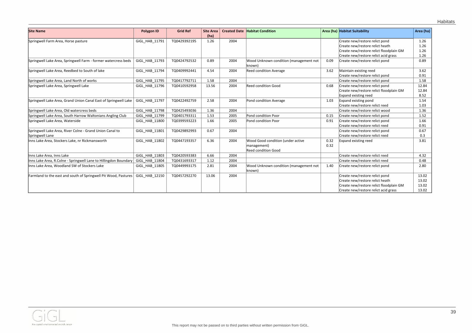
Habitats
This report may not be passed on to third parties without written permission from GiGL.
39
Site Name Polygon ID Grid Ref Site Area
(ha)
Created Date Habitat Condition Area (ha) Habitat Suitability Area (ha)
Springwell Farm Area, Horse pasture GiGL_HAB_11791 TQ0429392195 1.26 2004 Create new/restore relict pond
Create new/restore relict heath
Create new/restore relict floodplain GM
Create new/restore relict acid grass
1.26
1.26
1.26
1.26
Springwell Lake Area, Springwell Farm - former watercress beds GiGL_HAB_11793 TQ0424792532 0.89 2004 Wood Unknown condition (management not
known)
0.09 Create new/restore relict pond 0.89
Springwell Lake Area, Reedbed to South of lake GiGL_HAB_11794 TQ0409992441 4.54 2004 Reed condition Average 3.62 Maintain existing reed
Create new/restore relict pond
3.62
0.91
Springwell Lake Area, Land North of works GiGL_HAB_11795 TQ0417792711 1.58 2004 Create new/restore relict pond 1.58
Springwell Lake Area, Springwell Lake GiGL_HAB_11796 TQ0410592958 13.56 2004 Reed condition Good 0.68 Create new/restore relict pond
Create new/restore relict floodplain GM
Expand existing reed
12.84
12.84
8.52
Springwell Lake Area, Grand Union Canal East of Springwell Lake GiGL_HAB_11797 TQ0422492759 2.58 2004 Pond condition Average 1.03 Expand existing pond
Create new/restore relict reed
1.54
1.03
Springwell Lake Area, Old watercress beds GiGL_HAB_11798 TQ0425493036 1.36 2004 Create new/restore relict wood 1.36
Springwell Lake Area, South Harrow Waltonians Angling Club GiGL_HAB_11799 TQ0401793311 1.53 2005 Pond condition Poor 0.15 Create new/restore relict pond 1.52
Springwell Lake Area, Waterside GiGL_HAB_11800 TQ0399593223 1.66 2005 Pond condition Poor 0.91 Create new/restore relict pond
Create new/restore relict reed
1.66
0.91
Springwell Lake Area, River Colne - Grand Union Canal to
Springwell Lane
GiGL_HAB_11801 TQ0429892993 0.67 2004 Create new/restore relict pond
Create new/restore relict reed
0.67
0.3
Inns Lake Area, Stockers Lake, nr Rickmansworth GiGL_HAB_11802 TQ0447193357 6.36 2004 Wood Good condition (under active
management)
Reed condition Good
0.32
0.32
Expand existing reed 3.81
Inns Lake Area, Inns Lake GiGL_HAB_11803 TQ0420593383 6.66 2004 Create new/restore relict reed 4.32
Inns Lake Area, R.Colne - Springwell Lane to Hillingdon Boundary GiGL_HAB_11804 TQ0431693317 1.12 2004 Create new/restore relict reed 0.48
Inns Lake Area, Woodland SW of Stockers Lake GiGL_HAB_11805 TQ0449993175 2.81 2004 Wood Unknown condition (management not
known)
1.40 Create new/restore relict pond 2.80
Farmland to the east and south of Springwell Pit Wood, Pastures GiGL_HAB_12150 TQ0457292270 13.06 2004 Create new/restore relict pond
Create new/restore relict heath
Create new/restore relict floodplain GM
Create new/restore relict acid grass
13.02
13.02
13.02
13.02

Open Spaces
This report may not be passed on to third parties without written permission from GiGL.
40
6.0 Open Spaces Open space information within the search area can be seen on the following pages. The table can be cross-referenced with the Open Spa ce Map. This open space dataset is a combination of information collected during GLA surveys, information provided to GiGL by the London boroughs and data sourced through other means, e.g. volunteer surveys. Note that GiGL does not currently hold open space data for all areas. Even where data is held, a lack of records in a defined geographical area does not necessarily mean that the open space features do not occur there – the area may simply not have been surveyed.
GiGL uses to following open space definition: undeveloped land which has an amenity value, or has potential for an amenity value. The value could be visual, derive from a site's historical or cultural interest or from the enjoyment of facilities which it provides. It includes both public and private spaces, but excludes private gardens.

Open Spaces
This report may not be passed on to third parties without written permission from GiGL.
41
6.1 Open Space Data The dataset documents the primary and secondary uses of open space (divided according to broad land use categories) along with other information such as public accessibility, facilities, and special designations which apply to the site. For further details of open space typology and designation categories please also refer to the Supporting Information section of the Annex. Site Name Polygon ID Grid Ref Site Area
(ha)
Open Space Typology Public Open Space Awards and
Designations
Public Access Facilities
Land use category Primary use Secondary uses
Colne Valley RP OS_Outside_0010 TQ0547693889 46.97 District Park free
Farmland to the east and south of Springwell
Pit Wood
OS_Hi_0098 TQ0448692126 16.38 Other Urban Fringe agriculture Green Belt (100%) none
Grand Union Canal south of Springwell lake OS_Hi_0128 TQ0416191728 2.67 Green Corridors canal Linear Open Space
SINC (7%)
SINC (85%)
Green Belt (42%)
free
Inns Lake Area OS_Hi_0192 TQ0435793337 16.96 disused quarry/gravel pit;
private woodland; river
disused quarry/gravel pit;
private woodland; river
LNR (44%)
SINC (98%)
Conservation Area
Green Belt (99%)
Restricted Car parking
Dog litter bins/area
Fishing
Information
Seats
Waymarked walking
route
Springwell Farm Area OS_Hi_0331 TQ0435092298 14.07 agriculture; private
woodland
agriculture; private
woodland
SINC (11%)
SINC (12%)
Green Belt (100%)
Restricted
Springwell Lake Area OS_Hi_0332 TQ0413892889 28.38 canal; disused
quarry/gravel pit;
landscaping around
premises; nature reserve;
nursery/horticulture;
canal; disused
quarry/gravel pit;
landscaping around
premises; nature reserve;
nursery/horticulture;
SINC (11%)
SINC (87%)
Conservation Area
Green Belt (95%)
Free Car parking
Cycle paths
Dog litter bins/area
Fishing
Information
Seats
Waymarked walking
route
Springwell Lane Chalk Pit OS_Hi_0333 TQ0474492710 46.12 agriculture; disused
quarry/gravel pit; other
recreational; vacant land
agriculture; disused
quarry/gravel pit; other
recreational; vacant land
SINC (17%)
SINC (58%)
Green Belt (100%)
De facto Car parking
Watts Common Area OS_Hi_0383 TQ0539392022 76.35 Other Urban Fringe agriculture private woodland SINC (27%)
Conservation Area
Green Belt (99%)
Restricted

Contacts
This report may not be passed on to third parties without written permission from GiGL.
42
7.0 Contacts
7.1 Borough Contacts
Further details of sites and species within the search area may be gathered from the following borough contacts: London Borough of Hillingdon Stuart Hunt Green Spaces Team (4W/08) Civic Centre Uxbridge Middlesex UB8 1UW Tel: 01895 250916 Email: [email protected]

Contacts
This report may not be passed on to third parties without written permission from GiGL.
43
7.2 Further Contacts The following contacts work closely with GiGL and are the best source for further advice or interpretation of the data provided by us. They are widely recognised in Greater London as the experts in their fields, and have provided the following information as the preferred method of contact. Areas of expertise SINCs, open space and habitat survey data advice
Organisation GiGL – Greenspace Information for Greater London
Email [email protected]
Website www.gigl.org.uk
Areas of expertise Black redstarts, birds, brown and green roofs
Name Dusty Gedge
Organisation Livingroofs.org
Email [email protected]
Website www.livingroofs.org
Areas of expertise Bats
Organisation London Bat Group
Email [email protected]
Website www.londonbats.org.uk
Areas of expertise Regional biodiversity action plans
Organisation London Biodiversity Partnership
Website www.lbp.org.uk
Areas of expertise Area recorders for birds (Inner London, Kent, Surrey, Buckinghamshire, Middlesex, and Essex)
Organisation London Natural History Soc iety
Website www.lnhs.org.uk

Contacts
This report may not be passed on to third parties without written permission from GiGL.
44
Areas of expertise Plant galls
Name Ken Hill
Organisation London Natural History Society
Email [email protected]
Website www.lnhs.org.uk
Areas of expertise Odonata - Dragonflies and damselflies
Name Neil An derson
Organisation London Natural History Society
Email [email protected]
Website www.lnhs.org.uk
Areas of expertise Invertebrates
Name Colin W Plant
Organisation London Natural History Society
Email [email protected]
Website www.lnhs.org.uk
Areas of expertise Lichens and Fungi
Name Ted Tuddenham
Organisation London Natural History Society
Email [email protected]
Website www.lnhs.org.uk
Areas of expertise Butterflies
Name Leslie Williams
Organisation London Natur al History Society
Email [email protected]
Website www.lnhs.org.uk

Contacts
This report may not be passed on to third parties without written permission from GiGL.
45
Areas of expertise Vascular plants
Name Mark Spencer
Organisation London Natural History Society
Email [email protected]
Website www.lnhs.org.uk
Areas of expertise General conservation advice
Name Conservation Programmes Manager
Organisation London Wildlife Trust
Email [email protected]
Website www.wildlondon.org.uk
Areas of expertise Statutory site advice
Name Conservation Offi cer
Organisation Natural England
Email [email protected]
Website www.naturalengland.org.uk
Areas of expertise London Invasive Species Initiative
Name Joanna Heisse
Organisation Environment Agency
Email [email protected]
Website www.environment-agency.gov.uk
Areas of expertise Geological Designations
Organisation London Geodiversity Partnership
Email [email protected]
Website www.londongeopartnership.org.uk

Annexes
This report may not be passed on to third parties without written permission from GiGL.
46
Annex A - MAPS
Statutory Sites Map
SINCs Map Survey Parcels Map Open Space Map Green Belt Map

Stockers Lake (LNR)
Based on the Ordnance Survey 1: 10 000 map © Crown copyright and database rights 2015 Ordnance Survey Licence No. AL100046223
Statutory Site DesignationsEcological Data Search (1425) for Applied Ecology L td Springwell Lane, 30 April 2015
Local Nature Reserve
National Nature Reserve
Site of Special Scientific Interest
Special Protection Area
Search Area
Special Area of Conservation
Natural England has responsibilities for identifying and protecting National Parks, Areas of OutstandingNatural Beauty, Special Protection Areas, Special Areas of Conservation, Ramsar Sites, National Nature Reserves, Sites of Special Scientific Interest and protected species. Local Authorities designate and manage Local Nature Reserves.
Produced by GreenspaceProduced by GreenspaceProduced by GreenspaceProduced by GreenspaceProduced by GreenspaceProduced by GreenspaceProduced by GreenspaceProduced by GreenspaceProduced by GreenspaceInformation for Greater London CICInformation for Greater London CICInformation for Greater London CICInformation for Greater London CICInformation for Greater London CICInformation for Greater London CICInformation for Greater London CICInformation for Greater London CICInformation for Greater London CIC
www.gigl.org.ukwww.gigl.org.ukwww.gigl.org.ukwww.gigl.org.ukwww.gigl.org.ukwww.gigl.org.ukwww.gigl.org.ukwww.gigl.org.ukwww.gigl.org.uk
Scale 1:10000
Ramsar
503000 504000 505000 506000
503000 504000 505000 506000
1920
0019
3000
1940
00
1920
0019
3000
1940
00

HiBII14
M006
M057
HiBII39
HiBI01A
HiBI01B
Based on the Ordnance Survey 1: 10 000 map © Crown copyright and database rights 2015 Ordnance Survey Licence No. 100032216. GLA
Sites of Importance for Nature ConservationEcological Data Search (1425) for Applied Ecology LtdSpringwell Lane, 30 April 2015
Metropolitan Importance
Borough Importance (Grade 1)
Borough Importance Grade 2
Local Importance
Search Area
Areas of Deficiency
The Sites of Importance for Nature Conservation have been identified since 1986 and the categorisation of sites is related to their protected status in the land-use planning system. The boundaries and site grades reflect the most recent consideration of each site, details of which are available from GiGL. Note that boundaries and grades may change as new information becomes available.
Produced by GreenspaceProduced by GreenspaceProduced by GreenspaceProduced by GreenspaceProduced by GreenspaceProduced by GreenspaceProduced by GreenspaceProduced by GreenspaceProduced by GreenspaceInformation for Greater London CICInformation for Greater London CICInformation for Greater London CICInformation for Greater London CICInformation for Greater London CICInformation for Greater London CICInformation for Greater London CICInformation for Greater London CICInformation for Greater London CIC
www.gigl.org.ukwww.gigl.org.ukwww.gigl.org.ukwww.gigl.org.ukwww.gigl.org.ukwww.gigl.org.ukwww.gigl.org.ukwww.gigl.org.ukwww.gigl.org.uk
Scale 1:10000
503000 504000 505000 506000
503000 504000 505000 506000
1920
0019
3000
1940
00
1920
0019
3000
1940
00

Based on the Ordnance Survey 1: 10 000 map © Crown copyright and database rights 2015 Ordnance Survey Licence No. 100032216. GLA
Habitat Survey ParcelsEcological Data Search (1425) for Applied Ecology LtdSpringwell Lane, 30 April 2015
Survey Parcel
Search Area
GLA habitat survey is broadly similar to English Nature’s Phase I methodology, the differences in habitat classification are largely due to the urban setting for which the London survey specificationis designed. The basic unit of survey isa piece of land termed a "parcel" and parcels are grouped into "sites".
Produced by GreenspaceProduced by GreenspaceProduced by GreenspaceProduced by GreenspaceProduced by GreenspaceProduced by GreenspaceProduced by GreenspaceProduced by GreenspaceProduced by GreenspaceInformation for Greater London CICInformation for Greater London CICInformation for Greater London CICInformation for Greater London CICInformation for Greater London CICInformation for Greater London CICInformation for Greater London CICInformation for Greater London CICInformation for Greater London CIC
www.gigl.org.ukwww.gigl.org.ukwww.gigl.org.ukwww.gigl.org.ukwww.gigl.org.ukwww.gigl.org.ukwww.gigl.org.ukwww.gigl.org.ukwww.gigl.org.uk
Scale 1:10000
503000 504000 505000 506000
503000 504000 505000 506000
1920
0019
3000
1940
00
1920
0019
3000
1940
00
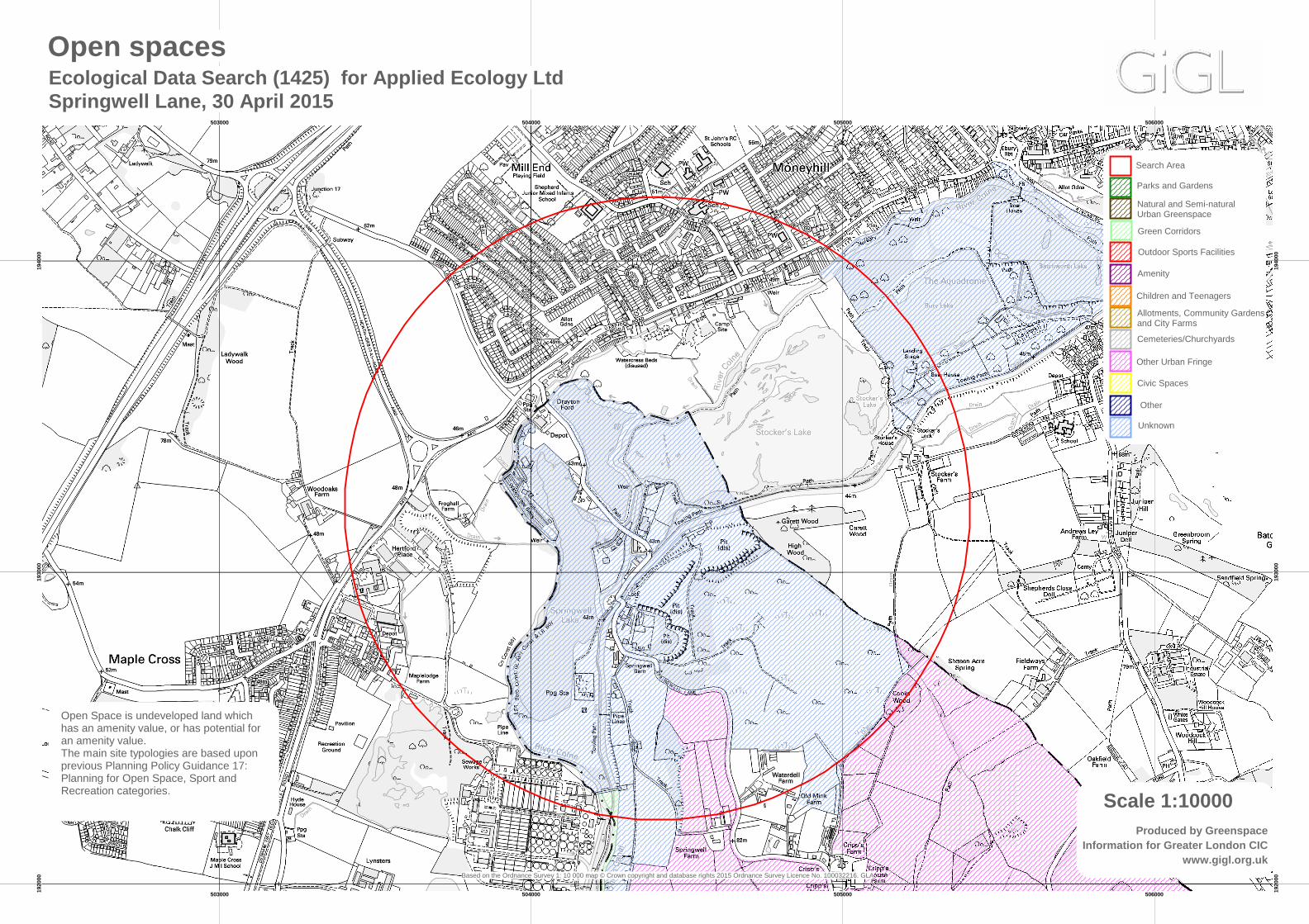
Based on the Ordnance Survey 1: 10 000 map © Crown copyright and database rights 2015 Ordnance Survey Licence No. 100032216. GLA
Open spacesEcological Data Search (1425) for Applied Ecology LtdSpringwell Lane, 30 April 2015
Natural and Semi-natural Urban Greenspace
Children and Teenagers
Allotments, Community Gardensand City Farms
Open Space is undeveloped land which has an amenity value, or has potential for an amenity value.The main site typologies are based upon previous Planning Policy Guidance 17: Planning for Open Space, Sport and Recreation categories.
Produced by GreenspaceProduced by GreenspaceProduced by GreenspaceProduced by GreenspaceProduced by GreenspaceProduced by GreenspaceProduced by GreenspaceProduced by GreenspaceProduced by GreenspaceInformation for Greater London CICInformation for Greater London CICInformation for Greater London CICInformation for Greater London CICInformation for Greater London CICInformation for Greater London CICInformation for Greater London CICInformation for Greater London CICInformation for Greater London CIC
www.gigl.org.ukwww.gigl.org.ukwww.gigl.org.ukwww.gigl.org.ukwww.gigl.org.ukwww.gigl.org.ukwww.gigl.org.ukwww.gigl.org.ukwww.gigl.org.uk
Scale 1:10000
Parks and Gardens
Green Corridors
Outdoor Sports Facilities
Amenity
Cemeteries/Churchyards
Other Urban Fringe
Civic Spaces
Other
Search Area
Unknown
503000 504000 505000 506000
503000 504000 505000 506000
1920
0019
3000
1940
00
1920
0019
3000
1940
00

Based on the Ordnance Survey 1: 10 000 map © Crown copyright and database rights 2015 Ordnance Survey Licence No. 100032216. GLA
Green beltEcological Data Search (1425) for Applied Ecology LtdSpringwell Lane, 30 April 2015
Green belt
Search Area
Green Belt: is land which has been specifically designated as such, either by legislation or through the preparation of development plans, with the aim to protect the open character of the countryside next to urban areas.
Produced by GreenspaceProduced by GreenspaceProduced by GreenspaceProduced by GreenspaceProduced by GreenspaceProduced by GreenspaceProduced by GreenspaceProduced by GreenspaceProduced by GreenspaceInformation for Greater London CICInformation for Greater London CICInformation for Greater London CICInformation for Greater London CICInformation for Greater London CICInformation for Greater London CICInformation for Greater London CICInformation for Greater London CICInformation for Greater London CIC
www.gigl.org.ukwww.gigl.org.ukwww.gigl.org.ukwww.gigl.org.ukwww.gigl.org.ukwww.gigl.org.ukwww.gigl.org.ukwww.gigl.org.ukwww.gigl.org.uk
Scale 1:10000
503000 504000 505000 506000
503000 504000 505000 506000
1920
0019
3000
1940
00
1920
0019
3000
1940
00

Annexes
Greenspace Information for Greater London the capital’s environmental records centre
Annex B - Supporting Information Statutory Site Designations ........................................................................................................................... 2
SINC Designations ............................................................................................................................................ 3
Areas of Deficiency....................................................................................................................................... 4
Geological Designations ................................................................................................................................. 5
Species Protections .......................................................................................................................................... 7
London Biodiversity Action Plan Species .......................................................................................... 10
Confidential Records ...................................................................................................................................... 12
London Invasive Species Initiative overview ......................................................................................... 13
Habitat Classifications.................................................................................................................................... 15
GLA habitat surveys ................................................................................................................................... 15
Other habitat classifications .................................................................................................................... 19
Open Space Designations ........................................................................................................................... 20
Public Open Spaces and Areas of Deficiency in Access to Public Open Space ............... 21
Open Space Categories ................................................................................................................................ 22

Annexes
Greenspace Information for Greater London the capital’s environmental records centre
Statutory Site Designations Local Nature Reserve (LNR) Land owned, leased or managed by Local Authorities and designated under the National Parks and Access to the Countryside Act. A site of some nature conservation value managed for educational objectives — no need for SSSI status. In some cases it is managed by a non-statutory body (e.g. London Wildlife Trust). Local Authorities have the power to pass bylaws controlling (e.g.) access, special protection measures. Site of Special Scientific Interest (SSSI) Area notified under the Wildlife and Countryside Act, 1981, by English Nature, the Countryside Council for Wales or Scottish Heritage as being of special interest for nature conservation. Consultation and some form of agreement with the national statutory conservation agency is mandatory before any listed, potentially damaging development, change in land use, etc. can be carried out. SSSI notification forms the statutory bedrock for site protection, although experience has shown that even SSSIs are not sacrosanct. Biological SSSIs form a national network of wildlife sites in which each site is a distinct discrete link. Sites are selected in such a way that the protection of each site, and hence the network, aims to conserve the minimum area of wildlife habitat necessary to maintain the natural diversity and distribution of Britain’s native flora and fauna and the communities they comprise. Each site, therefore, is of national significance for its nature conservation value. The vast majority of SSSIs, and indeed most areas of semi-natural habitat, cannot be created within human time scales and are therefore considered irreplaceable. Geological SSSIs—more correctly termed Earth Science SSSIs—are the best sites chosen for their research value, the criterion being that they are of national or international importance. Earth Science conservation is concerned with the maintenance of our geological and geomorphological heritage. National Nature Reserve (NNR) Statutory reserve established for the nation under the Wildlife and Countryside Act, 1981. NNRs may be owned by a relevant national body (e.g. English Nature in England) or by established agreement; a few are owned and managed by non-statutory bodies. NNRs cover a selection of the most important sites for nature conservation in the UK. Special Area of Conservation (SAC) and Special Prot ection Area (SPA) SACs and SPAs are areas designated under European law and are the most important sites for wildlife in the UK. SACs are designated under the European Habitats Directive (Council Directive 92/43/EEC) and SPAs under the European Birds Directive (Council Directive 79/409/EEC). Both the Habitats and Birds Directive provide for the creation of a network of protected wildlife areas across the EU, to be known as “Natura 2000”. The designations aim to conserve important or threatened species and habitats and provide them with increased protection and management. Ramsar sites Ramsar sites are wetlands of international importance designated under the Ramsar Convention. The initial emphasis was on selecting sites of importance to waterbirds within the UK, and consequently many Ramsar sites are also Special Protection Areas (SPAs) classified under the Birds Directive. Non-bird features are now increasingly taken into account, both in the selection of new sites and when reviewing existing sites.

Annexes
Greenspace Information for Greater London the capital’s environmental records centre
SINC Designations Sites of Importance for Nature Conservation 1 The different kinds of sites and areas
1.1 There are three kinds of site, which are chosen on the basis of their importance to a particular defined geographic area. This use of search areas is an attempt, not only to protect the best sites in London, but also to provide each part of London with a nearby site, so that people are able to have access to enjoy nature.
Sites of Metropolitan Importance
1.2 Sites of Metropolitan Importance for Nature Conservation are those sites which contain the best examples of London's habitats, sites which contain particularly rare species, rare assemblages of species or important populations of species, or sites which are of particular significance within otherwise heavily built-up areas of London.
1.3 They are of the highest priority for protection. The identification and protection of Metropolitan Sites is necessary, not only to support a significant proportion of London's wildlife, but also to provide opportunities for people to have contact with the natural environment.
1.3.1 The best examples of London's habitats include the main variants of each major habitat type, for example hornbeam woodland, wet heathland, or chalk downland. Habitats typical of urban areas are also included, e.g. various types of abandoned land colonised by nature (‘wasteland’ or ‘unofficial countryside’). Those habitats which are particularly rare in London may have all or most of their examples selected as Metropolitan Sites.
1.3.2 Sites of Metropolitan Importance include not only the best examples of each habitat type, but also areas which are outstanding because of their assemblage of habitats, for example the Crane corridor, which contains the River Crane, reservoirs, pasture, woodland and heathland.
1.3.3 Rare species include those that are nationally scarce or rare (including Red Data Book species) and species which are rare in London.
1.3.4 A small number of sites are selected which are of particular significance within heavily built up areas of London. Although these are of lesser intrinsic quality than those sites selected as the best examples of habitats on a London-wide basis they are outstanding oases and provide the opportunity for enjoyment of nature in extensive built environments. Examples include St James's Park, Nunhead Cemetery, Camley Street Natural Park and Sydenham Hill Woods. In some cases (e.g. inner London parks) this is the primary reason for their selection. For sites of higher intrinsic interest it may only be a contributory factor. Only those sites that provide a significant contribution to the ecology of an area are identified.
1.3.5 A small number of sites are selected which are of particular significance within heavily built up areas of London. Although these are of lesser intrinsic quality than those sites selected as the best examples of habitats on a Londonwide basis they are outstanding oases and provide the opportunity for enjoyment of nature in extensive built environments. Examples include St James’s Park, Nunhead Cemetery, Camley Street Natural Park and Sydenham Hill Woods. In some cases (e.g. inner London parks) this is the primary reason for their selection. For sites of higher intrinsic interest it may
Annexes
Greenspace Information for Greater London the capital’s environmental records centre
only be a contributory factor. Only those sites that provide a significant contribution to the ecology of an area are identified.
1.4 Should one of these sites be lost or damaged, something would be lost which exists in a very few other places in London. Management of these sites should as a first priority seek to maintain and enhance their interest, but use by the public for education and passive recreation should be encouraged unless these are inconsistent with nature conservation.
Sites of Borough Importance
1.5 These are sites which are important on a borough perspective in the same way as the Metropolitan sites are important to the whole of London. Although sites of similar quality may be found elsewhere in London, damage to these sites would mean a significant loss to the borough. As with Metropolitan sites, while protection is important, management of Borough sites should usually allow and encourage their enjoyment by people and their use for education.
1.6 In defining Sites of Borough Importance, the search is not confined rigidly to borough boundaries; these are used for convenience of defining areas substantially smaller than the whole of Greater London, and the needs of neighbouring boroughs should be taken into account. In the same way as for Sites of Metropolitan Importance, parts of some boroughs are more heavily built-up and some borough sites are chosen there as oases providing the opportunity for enjoyment of nature in extensive built environments.
1.7 Planning Policy Statement on Biodiversity and Geological Conservation (2005), in paragraph 5 (i), states that local development frameworks should indicate the location of designate sites for biodiversity and geodiversity, including locally designated sites..
1.8 Since essentially a comparison within a given borough is made when choosing Sites of Borough Importance, there is considerable variation in quality between those for different boroughs; for example, those designated in Barnet will frequently be of higher intrinsic quality than those in Hammersmith and Fulham, a borough comparatively deficient in wildlife habitat. Only those sites that provide a significant contribution to the ecology of an area are identified.
Sites of Local Importance
1.9 A Site of Local Importance is one which is, or may be, of particular value to people nearby (such as residents or schools). These sites may already be used for nature study or be run by management committees mainly composed of local people. Where a Site of Metropolitan or Borough Importance may be so enjoyed it acts as a Local site, but further sites are given this designation in recognition of their role. This local importance means that these sites are also deserving protection in planning.
1.10 Local sites are particularly important in areas otherwise deficient in nearby wildlife sites. To aid the choice of these further local sites, Areas of Deficiency (see below) are identified. Further Local sites are chosen as the best available to alleviate this deficiency; such sites need not lie in the Area of Deficiency, but should be as near to it as possible. Where no such sites are available, opportunities should be taken to provide them by habitat enhancement or creation, by negotiating access and management agreements, or by direct acquisition. Only those sites that provide a significant contribution to the ecology of an area are identified.
Areas of Deficiency
Areas of Deficiency are defined as built-up areas more than one kilometre actual walking distance from an accessible Metropolitan or Borough site. These aid the choice of Sites of Local Importance (see above).

Annexes
Greenspace Information for Greater London the capital’s environmental records centre
Geological Designations Regionally Important Geological/geomorphological Si tes (RIGS) and Locally Important Geological Sites (LIGS) Government guidance uses the term Local Sites for non-statutory geological sites, as distinct from the Sites of Special Scientific Interest [SSSIs] which are protected by government statute.
• In England they are often called Local Geological Sites. • In Scotland they are often called Local Geodiversity Sites. • In Wales they are called Regionally Important Geodiversity Sites.
NOTE: The term Regionally Important Geological/geomorphological Sites (RIGS), which has been in usage now for many years and is still used to describe Local Geological/geodiversity Sites, should be regarded as synonymous to Local Geological Sites. In London, the term RIGS has been retained to cover those sites that are worthy of protection for their geodiversity importance at the London-wide level. RIGS were established in 1990 by the Nature Conservancy Council (NCC) (predecessor of English Nature and Natural England). They have support from Natural England and other national agencies, and are increasingly recognised by local planning authorities. To date RIG Sites have been selected by voluntary groups, Local geoconservation groups (lately known as RIGS groups), which are generally formed by county or by unitary authority area in England. There are more than 50 local groups in the UK, though not all are active. There are 3 active groups in London, South London RIGS, North West London RIGS and GeoEssex, but to date no RIGS have been formally designated in Greater London. RIGS are currently the most important designated places for geology and geomorphology outside statutorily protected land such as SSSIs. The designation of RIGS is one way of recognising and protecting important geodiversity and landscape features for future generations to enjoy. RIGS are equivalent to local Wildlife Sites and other non-statutory wildlife designations. They can be listed in local authorities' development plans and shown on "alert maps". RIGS can be protected through the planning system if a RIGS group recommends sites to the local planning authority. Guidance on RIGS is available on the GeoconservationUK website (www.geoconservationuk.org.uk). They are important as an educational, historical and recreational resource. Sites are selected according to:
- the value for educational purposes in life-long learning - the value for study both by professional and amateur earth scientists - the historical value in terms of important advances in Earth science knowledge, events
or human exploitation - the aesthetic value in the landscape, particularly in relation to promoting public
awareness and appreciation of geodiversity. RIGS can be viewed as equivalent to Sites of Metropolitan Importance for Nature Conservation (SMIs), which include land of strategic importance for nature conservation and biodiversity across London. They are proposed by the Boroughs in Development plan documents and are confirmed if there is no objection from the Mayor to the proposal. These sites should be protected as set out in Policy 3D.16 of the London Plan. The London boroughs may also designate certain areas as being of local conservation (including geological) interest (LIGS). The criteria for inclusion, and the level of protection provided, should reflect the local level of importance in the hierarchy of sites. LIGS are equivalent to Sites of Borough or Local Importance for nature conservation, which are accorded a level of protection commensurate with their borough or local significance. Local site

Annexes
Greenspace Information for Greater London the capital’s environmental records centre
networks provide a comprehensive rather than a representative suite of sites. Defra have published detailed guidance on identification, selection and management of local sites (DEFRA, 2006). LIGS are designated in the Development Plan Documents prepared under the Town and Country Planning system by the London boroughs and are a material consideration when planning applications are being determined. The London Plan Implementation Report London’s foundations (March 2009) describes the geodiversity audit of 36 sites (including the 7 London SSSIs designated for their geodiversity importance). 14 sites were recommended for designation as RIGS and 15 as LIGS. Since publication of London’s foundations, the London Geodiversity Partnership has published the London Geodiversity Action Plan, which includes a programme of inspection and audit of these sites and other potential sites (98 listed in London’s foundations) to manage and conserve London’s geodiversity.

Annexes
Greenspace Information for Greater London the capital’s environmental records centre
Species Protections GiGL has used the conservations designations list created and maintained by the Joint Nature Conservation Committee (JNCC) and used the following designations in the data search report. International and national legislation International Legislation
Birds Directive Annex 1 Birds which are the subject of special conservation measures concerning their habitat in order to ensure their survival and reproduction in their area of distribution. As appropriate, Special Protection Areas to be established to assist conservation measures. Note that the contents of this annex have been updated in April 2003 following the Treaty of Accession.
Habitats Directive Annex 2 - priority species
Species which are endangered, the conservation of which the Community has a particular responsibility in view of the proportion of their natural range which falls within the territory of the Community. They require the designation of special areas of conservation.
Habitats Directive Annex 2 - non-priority species
Animal and plant species of Community interest (i.e. endangered, vulnerable, rare or endemic in the European Community) whose conservation requires the designation of special areas of conservation. Note that the contents of this annex have been updated in April 2003 following the Treaty of Accession.
Habitats Directive Annex 4 Animal and plant species of Community interest (i.e. endangered, vulnerable, rare or endemic in the European Community) in need of strict protection. They are protected from killing, disturbance or the destruction of them or their habitat. Note that the contents of this annex have been updated in April 2003 following the Treaty of Accession.
National Legislation
The Conservation (Natural Habitats, &c.) Regulations 2010 (Schedule 2)
Schedule 2- European protected species of animals.
The Conservation (Natural Habitats, &c.) Regulations 2010 (Schedule 5)
Schedule 5- European protected species of plants.
Natural Environment and Rural Communities Act 2006 - Species of Principal Importance in England
Species “of principal importance for the purpose of conserving biodiversity” covered under section 41 (England) of the NERC Act (2006) and therefore need to be taken into consideration by a public body when performing any of its functions with a view to conserving biodiversity.
Wildlife and Countryside Act 1981 (Schedule 1 Part 1)
Birds which are protected by special penalties at all times.
Wildlife and Countryside Act 1981 (Schedule 5 Section 9.1 (killing/injuring))
Animals which are protected from intentional killing or injuring.
Wildlife and Countryside Act 1981 (Schedule 5 Section 9.1 (taking))
Section 9.1 Animals which are protected from taking.
Wildlife and Countryside Act 1981 (Schedule 5 Section 9.4a)
Section 9.4 Animals which are protected from intentional damage or destruction to any structure or place used for shelter or protection.
Wildlife and Countryside Act 1981 (Schedule 5 Section
Section 9.4 Animals which are protected from intentional disturbance while occupying a structure or place used for

Annexes
Greenspace Information for Greater London the capital’s environmental records centre
9.4b) shelter or protection.
Wildlife and Countryside Act 1981 (Schedule 5)
Cetacean/basking shark that are not allowed to be intentionally or recklessly disturbed.
Wildlife and Countryside Act 1981 (Schedule 8)
Plants which are protected from intentional picking, uprooting or destruction (Section 13 1a); selling, offering for sale, possessing or transporting for the purpose of sale (live or dead, part or derivative) (Section 13 2a); advertising (any of these) for buying or selling (Section 13 2b).
Protection of Badgers Act (1992)
The Protection of Badgers Act 1992 protects badgers from taking, injuring, killing, cruel treatment, selling, possessing, marking and having their setts interfered with, subject to exceptions.
Notable and other species designations Red Data List
Bird Population Status - red Red list species are those that are Globally Threatened according to IUCN criteria; those whose population or range has declined rapidly in recent years; and those that have declined historically and not shown a substantial recent recovery.
IUCN (2001) - Critically endangered
A taxon is Critically Endangered when the best available evidence indicates that it meets any of the criteria A to E for Critically Endangered (see Section V), and it is therefore considered to be facing an extremely high risk of extinction in the wild.
IUCN (2001) - Data Deficient A taxon is Data Deficient when there is inadequate information to make a direct, or indirect, assessment of its risk of extinction based on its distribution and/or population status. A taxon in this category may be well studied, and its biology well known, but appropriate data on abundance and/or distribution are lacking. Data Deficient is therefore not a category of threat. Listing of taxa in this category indicates that more information is required and acknowledges the possibility that future research will show that threatened classification is appropriate. It is important to make positive use of whatever data are available. In many cases great care should be exercised in choosing between DD and a threatened status. If the range of a taxon is suspected to be relatively circumscribed, and a considerable period of time has elapsed since the last record of the taxon, threatened status may well be justified.
IUCN (2001) - Endangered A taxon is Endangered when the best available evidence indicates that it meets any of the criteria A to E for Endangered (see Section V), and it is therefore considered to be facing a very high risk of extinction in the wild.
IUCN (2001) - Extinct A taxon is Extinct when there is no reasonable doubt that the last individual has died. A taxon is presumed Extinct when exhaustive surveys in known and/or expected habitat, at appropriate times (diurnal, seasonal, annual), throughout its historic range have failed to record an individual. Surveys should be over a time frame appropriate to the taxon's life cycle and life form.
IUCN (2001) - Extinct in the wild
A taxon is Extinct in the wild in Great Britain when it is known to survive only in cultivation, in captivity or as a naturalised population (or populations) well outside the past range. A taxon is presumed extinct in the wild when exhaustive surveys in known and/or expected habitat, at appropriate times (diurnal, seasonal, annual) throughout its range have failed to

Annexes
Greenspace Information for Greater London the capital’s environmental records centre
record an individual. Surveys should be over a time frame appropriate to the taxon's life cycle and life form.
IUCN (2001) - Regionally Extinct
Category for a taxon when there is no reasonable doubt that the last individual potentially capable of reproduction within the region has died or has disappeared from the wild in the region, or when, if it is a former visiting taxon, the last individual has died or disappeared in the wild from the region. The setting of any time limit for listing under RE is left to the discretion of the regional Red List authority, but should not normally pre-date 1500 AD.
IUCN (2001) - Lower risk - near threatened
A taxon is Near Threatened when it has been evaluated against the criteria but does not qualify for Critically Endangered, Endangered or Vulnerable now, but is close to qualifying for or is likely to qualify for a threatened category in the near future.
IUCN (2001) - Vulnerable A taxon is Vulnerable when the best available evidence indicates that it meets any of the criteria A to E for Vulnerable (see Section V), and it is therefore considered to be facing a high risk of extinction in the wild.
Other rare/scarce
Nationally rare marine species Species which occur in eight or fewer 10km X 10km grid squares containing sea (or water of marine saline influence) within the three mile territorial limit.
Nationally rare Occurring in 15 or fewer hectads in Great Britain. Excludes rare species qualifying under the main IUCN criteria.
Nationally scarce marine species
Species which occur in nine to 55 10km X 10km grid squares containing sea (or water of marine saline influence) within the three mile territorial limit.
Nationally Notable A Taxa which do not fall within RDB categories but which are none-the-less uncommon in Great Britain and thought to occur in 30 or fewer 10km squares of the National Grid or, for less well-recorded groups, within seven or fewer vice-counties. Superseded by Nationally Scarce, and therefore no longer in use.
Nationally Notable B Taxa which do not fall within RDB categories but which are none-the-less uncommon in Great Britain and thought to occur in between 31 and 100 10km squares of the National Grid or, for less-well recorded groups between eight and twenty vice-counties. Superseded by Nationally Scarce, and therefore no longer in use.
Nationally scarce Occurring in 16-100 hectads in Great Britain.
Nationally Notable Species which are estimated to occur within the range of 16 to 100 10km squares. (subdivision into Notable A and Notable B is not always possible because there may be insufficient information available). Superseded by Nationally Scarce, and therefore no longer in use.
UK BAP
UK Biodiversity Action Plan priority species
The UK List of Priority Species and Habitats contains 1150 species and 65 habitats that have been listed as priorities for conservation action under the UK Biodiversity Action Plan (UK BAP).
Local List
London Species of Conservation Concern
London Biodiversity Partnership listed some 300 species of conservation interest occurring in London.
London BAP Priority species See below.

Annexes
Greenspace Information for Greater London the capital’s environmental records centre
London Biodiversity Action Plan Species Rationale for selecting priority species for action 1. Background
The Greater London Authority Act 1999 requires the elected Mayor to produce a Spatial Development Strategy for London, called the London Plan. The London Plan is the overall strategic plan for London, and it sets out a fully integrated economic, environmental, transport and social framework for the development of the capital to 2031. It forms part of the development plan for Greater London. London boroughs’ local plans need to be in general conformity with the London Plan, and its policies guide decisions on planning applications by councils and the Mayor. From 22 July 2011 this replaces the London Plan (consolidated with alterations since 2004 which was published in February 2008. The London Plan includes an important policy (7.19) Biodiversity and Access to Nature, which links to policies and proposals on approaches to strategic planning in the Mayor’s Biodiversity Strategy1. Policy 7.19 contains the following statement;
The Mayor’s Biodiversity Strategy2 sets out criteria and procedures for identifying land of importance for London’s biodiversity for protection in LDFs and identifying areas of deficiency in access to nature. Protecting the sites at all levels, serves to protect the significant areas of Biodiversity Action Plan (BAP) priority habitat in London and most priority species. However, protection of biodiversity outside designated sites will also be needed. The Mayor and the London Biodiversity Partnership have identified targets in Table 7.3 for the re-creation and restoration of priority habitats, as recommended in PPS 9: Biodiversity and Geological Conservation3.
This policy is employed by the Mayor of London when considering those larger planning applications referred to him for direction under the Town and Country Planning (Mayor of London) Order 2000. Also the London Unitary Development Plans and, increasingly with time, the new Local Development Frameworks of the London Boroughs have to be in general conformity with the London Plan. It is through these local policies that most protection of priority species will occur. The planning protection for priority species should be equivalent to that applying to statutory protected species, although of course development planning can only provide protection from planning-related activities. The London Biodiversity Partnership (LBP) published its original Audit of habitats and species in 2000. This lists all habitats of interest in London, as these relate to the UK BAP. The Audit also lists some 300 species of conservation interest occurring in London. All of these could not practically be considered as priorities for conservation action in the London BAP. Importantly, the LBP has adopted a practical approach to species conservation, whereby action for species should be considered and incorporated within the action proposed for their relevant habitats whenever possible. Species Action Plans have been produced only for prioritised species that are not so conveniently habitat-specific. 1Connecting with London’s nature, The Mayor’s Biodiversity Strategy, GLA July 2002 2 Mayor of London. The Mayor’s Biodiversity Strategy- connecting with Nature. GLA 2005
3 ODPM PPS9. Biodiversity and geological conservation. 2005

Annexes
Greenspace Information for Greater London the capital’s environmental records centre
2. The evaluation process 2.2 Priority Species in London From the list of Species of Conservation Concern in Greater London, our Priority BAP Species have been identified. Criteria for selection of UK BAP Priority Species are as follows;
• Species that are globally threatened; • Species that are rapidly declining in the UK, ie. by more than 50% in the last 25 years.
In accordance with national guidance, London BAP Priority Species must include;
• All UK BAP Priority Species with native or long-established naturalised populations in Greater London.
Further species have been selected using the following criteria;
• Species for which Species Action Plans are currently being implemented in the London BAP;
• Nationally threatened (Red Data listed) species with native or long-established naturalised populations in Greater London;
• UK SCC and declining Nationally Scarce species with significant4 native or long-established naturalised populations within Greater London, (ie. for which a regional responsibility for conservation may be clearly demonstrated).
• Species with native or long-established naturalised populations that are known to have undergone a recent significant decline in Greater London, or for which Greater London holds the majority of the known UK population.
4 for example: the only population within its 10km grid square; a population at the edge of a declining species’ UK range; a constituent of an isolated UK population; an exceptionally strong core area population
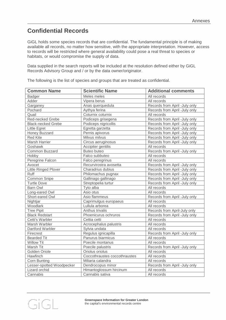
Annexes
Greenspace Information for Greater London the capital’s environmental records centre
Confidential Records
GiGL holds some species records that are confidential. The fundamental principle is of making available all records, no matter how sensitive, with the appropriate interpretation. However, access to records will be restricted where general availability could pose a real threat to species or habitats, or would compromise the supply of data. Data supplied in the search reports will be included at the resolution defined either by GiGL Records Advisory Group and / or by the data owner/originator. The following is the list of species and groups that are treated as confidential.
Common Name Scientific Name Additional comments Badger Meles meles All records Adder Vipera berus All records Garganey Anas querquedula Records from April -July only Pochard Aythya ferina Records from April -July only Quail Coturnix coturnix All records Red-necked Grebe Podiceps grisegena Records from April -July only Black-necked Grebe Podiceps nigricollis Records from April -July only Little Egret Egretta garzetta Records from April -July only Honey Buzzard Pernis apivorus Records from April -July only Red Kite Milvus milvus Records from April -July only Marsh Harrier Circus aeruginosus Records from April -July only Goshawk Accipiter gentilis All records Common Buzzard Buteo buteo Records from April -July only Hobby Falco subbuteo All records Peregrine Falcon Falco peregrinus All records Avocet Recurvirostra avosetta Records from April -July only Little Ringed Plover Charadrius dubius Records from April -July only Ruff Philomachus pugnax Records from April -July only Common Snipe Gallinago gallinago Records from April -July only Turtle Dove Streptopelia turtur Records from April -July only Barn Owl Tyto alba All records Long-eared Owl Asio otus All records Short-eared Owl Asio flammeus Records from April -July only Nightjar Caprimulgus europaeus All records Woodlark Lullula arborea All records Tree Pipit Anthus trivalis Records from April-July only Black Redstart Phoenicurus ochruros Records from April -July only Cetti's Warbler Cettia cetti All records Marsh Warbler Acrocephalus palustris All records Dartford Warbler Sylvia undata All records Firecrest Regulus ignicapilla Records from April -July only Bearded Tit Panurus biarmicus All records Willow Tit Poecile montanus All records Marsh Tit Poecile palustris Records from April -July only Golden Oriole Oriolus oriolus All records Hawfinch Coccothraustes coccothraustes All records Corn Bunting Miliaria calandra All records Lesser-spotted Woodpecker Dendrocopus minor Records from April -July only Lizard orchid Himantoglossum hircinum All records Cannabis Cannabis sativa All records

Annexes
Greenspace Information for Greater London the capital’s environmental records centre
London Invasive Species Initiative overview The London Invasive Species Initiative (LISI) The London Invasive Species Initiative encourages better co-ordination and partnership working to prevent, reduce and eliminate the impacts caused by invasive non-native species across the city. It is a sub-group of the London Biodiversity Partnership and has a wide membership, spanning several sectors and organisations. LISI sub-group Invasive non-native species are widely recognised as a major threat to biodiversity, second only to habitat loss. They can also have serious economic impacts and impacts on social, health and amenity resources. Following on from the creation of the GB Non-Native Species Co-ordinating Mechanism, DEFRA published the ‘Invasive Non-native species framework strategy for GB’ in 2008. Parallel to this, a number of regional initiatives have been set up across the country which helps implement the various policy documents at a regional and sub-regional level. As such, a London Invasive Species Initiative has been formed to work within this context. There are many species present in London, most of the non-native species do not pose a threat to biodiversity and add to the individuality and richness of London’s wildlife and heritage. However, there are some invasive non-native species which are a cause for concern, some of which are already threatening the value of London’s natural environment. Uniquely, the highly urbanised nature of London and the anticipated impacts of climate change are likely to exacerbate the effects of invasive non-native species. Finally, London is an international city and has a higher risk of new non-native species appearing and becoming invasive than some other areas. The presence of a LISI species on or near a site has the following implications:
• The presence of an invasive species may threaten the ecological value of a site and cause additional socio-economic impacts.
• There is a statutory requirement under the Wildlife and Countryside Act 1981 to ensure that non-native species are not introduced or spread in the wild. Species listed in Schedule 9 of the act are known to be established in the wild and care should be taken to ensure that where present, these are not spread through site activities.
• In addition to establishing appropriate biosecurity measures, management may be required to eradicate, control or mitigate the species.
The LISI group was set up as a sub-group of the London Biodiversity Partnership in late 2009 and has since worked on prioritising species for London, providing advice, raising awareness and co-ordinating action on the ground. Group membership is open to all interested organisations with an interest in invasive non-native species, particularly those seeking to work in partnership to tackle the problems caused by them. The Environment Agency currently chairs the group. Joining the LISI group will enable:
• A more efficient and co-ordinated approach to tackling invasive non-native species, including practical action on the ground.
• A more co-ordinated approach will enable organisations to have up to date data on distribution and spread of invasive non-native species as well as work more closely with local groups and organisations to tackle these issues. This will lead to a reduction in resources spent in some locations in the long term.
• Habitat and environmental enhancements.

Annexes
Greenspace Information for Greater London the capital’s environmental records centre
• Partnership work. The group’s objectives The LISI objectives mirror the Convention for Biological Diversity’s “guiding principles of prevention, detection/surveillance and control/eradication of invasive species” and cover the following points:
• Collating and monitoring data on the distribution and spread of invasive species in London. • Developing action plans to address the species of most urgent concern. • Facilitating control and eradication projects for high priority species. • Providing a link between research and practitioners (to help to support the evidence base
for invasive species impacts and/or control measures). • Act as an early warning system for new and emerging invasive species. • Promoting awareness of the risks and impacts associated with invasive species.
LISI species of concern A list of invasive non-native species of concern for London has been drawn up using several sources of information: Schedule 9 of the Wildlife and Countryside Act 1981, The UK Water Framework Directive Technical Advisory Group’s invasive species list and local knowledge. The resulting list presents a number of species either present in London and causing impacts for which action, monitoring or research is needed. The highest priority for London is also the prevention of new species arriving, particularly those for which national alerts are in place through the GB Non-Native Species Secretariat. Each species has been assigned a category for action as follows:
1. Species not currently present in London but present nearby or of concern because of the high risk of negative impacts should they arrive. Should any species listed in this category appear in London, this should be reported to GIGL or LISI to ensure that action is taken rapidly.
2. Species of high impact or concern present at specific sites that require attention (control, management, eradication etc). Such species are priority species for action in London and LISI encourages this wherever possible.
3. Species of high impact or concern which are widespread in London and require concerted, coordinated and extensive action to control/eradicate. These species are species currently causing large scale impacts across London and LISI supports area or catchment wide partnership working to ensure this.
4. Species which are widespread for which eradication is not feasible but where avoiding spread to other sites may be required. Appropriate biosecurity is required for sites where these species are found.
5. Species for which insufficient data or evidence was available from those present to be able to prioritise.
6. Species that were not currently considered to pose a threat or have the potential to cause problems in London.
Further information: For further information relating to LISI please contact – [email protected] For further guidance on invasive non-native species, including management guidance and advice, please see the GB Non-Native Species Secretariat: https://secure.fera.defra.gov.uk/nonnativespecies/home/index.cfm

Annexes
Greenspace Information for Greater London the capital’s environmental records centre
Habitat Classifications The habitat data includes the most recent habitat survey information for a given area. The data includes information collected using different habitat surveying methodologies. GLA habitat surveys The GLA conducted a series of rolling habitat surveys between the mid-1980s and 2009. It used the habitat typologies developed specifically for Greater London. 1 Survey information
1.1 In order to choose sites for protection it is necessary to have good survey information on the habitats and species of all candidate areas.
The London Wildlife Habitat Survey
1.2 Information on wildlife habitats can be collected in a standardised, comprehensive survey. We are fortunate in London in having such a survey, first carried out by the London Wildlife Trust for the Greater London Council in 1984/85, and updated and extended in various surveys since, including re-examination of sites to be described in the handbook series or in relation to proposed developments or management. In a number of London boroughs a systematic survey has been carried out using the London Ecology Unit's specification since 1985. The specification was updated in 2000, when the GLA was established, to collect additional data required for open space planning. The format of the survey is similar to those usually described as ‘Phase I’ or ‘Field by Field’, but is enhanced by the extensive use of standardised written notes. The Authority holds this survey information.
1.3 The initial survey documented areas with semi-natural habitats (more natural than well-
gardened allotments or heavily mown urban playing fields) and was also confined to large areas (above 0.5 ha for inner boroughs and 1 ha for outer boroughs). Much subsequent survey work has documented open spaces regardless of their natural quality and has used a much lower area threshold, to provide a more comprehensive coverage.
1.4 The wildlife habitat survey helps to ensure that candidate sites are not overlooked and
that the same essential minimum of information is available for each. There is usually little other information available on the quality of the wildlife habitats, but any information provided is taken into account.
Information on species
1.5 Information on species, which has been obtained in a consistent and standardised manner as part of the systematic survey of habitats may be used by the Authority in reaching decisions on site quality. Other information on species, relating to individual sites, is frequently available but has rarely been collected in a systematic way so as to allow straightforward comparisons with other sites.
1.6 Information on species is often available from local naturalists, who are able to observe
sites throughout seasons and years to provide an accurate and quite comprehensive listing of these and who may publish accounts of particular species or sites. Valuable though this information is, it often proves difficult to use it to compare candidate sites, as the recording effort put into each site may differ greatly and so may the completeness of the list. The length of the species list and the detection of rare species therefore depends upon the searching effort. For these reasons, such information on

Annexes
Greenspace Information for Greater London the capital’s environmental records centre
species is used only together with knowledge of how the information was obtained and of the way in which the ecology of individual species affects their apparent status.
1.7 The policy of the Authority is to take considerable care in interpreting site-based
species data to ensure that fully professional standards are maintained.
Habitat Types A list of habitats for open space survey in London Code Name Definition
01/02/03
Woodland Stands of trees forming at least 75% cover, including coppice and trees of shrub size, but excluding fen carr (19). Includes stands of willow except Salix cinerea, caprea and viminalis, but excludes hawthorn, hazel (except hazel coppice with standards), elder, juniper and the three willow species listed above, which are always scrub (06) regardless of height. Where the species composition does not fulfil any of 01, 02 or 03 below, code as a mixture. Always record % shrub layer under the qualifiers.
01 Native broadleaved woodland
Woodland (see above) with native broadleaved species (i.e. excluding sycamore and sweet chestnut) comprising at least 75% of the canopy.
02 Non-native broadleaved woodland
Woodland (see above) with non-native broadleaved species (including sycamore and sweet chestnut) comprising 75% of the canopy.
03 Coniferous woodland
Woodland (see above) with coniferous species (including yew) comprising 75% of the canopy.
37 Scattered trees
Trees forming less than 75% canopy cover over another habitat (excluding coppice with standards, which is coded as woodland). Record percentage tree cover here, and the rest of the area under the appropriate habitat.
05 Recently felled woodland
Does not include coppice, which is coded as woodland.
06 Scrub Dominated (at least 75% cover) by shrubs (usually less than 5 metres tall), excluding fen carr (19), heathland (15), young woodland, coppice, hedges (25, 34) and planted shrubberies (38). Includes stands of hawthorn, hazel (except coppice with standards), elder and Salix cinerea, caprea and viminalis regardless of height.
38 Planted shrubbery
Dominated (at least 75% cover) by shrubs, usually non-native species, the majority of which have clearly been planted. Excludes hedges (25, 34).
25 Native hedge Line of shrubs, with or without treeline, one or two mature shrubs wide (wider belts should be coded as scrub or woodland), with native species comprising at least 75% of the shrubs.
34 Non-native hedge
As above but with non-native species comprising at least 75% of the shrubs. If neither 25 nor 34 apply, code as a mixture.
31 Orchard Planted fruit or nut trees forming at least 50% canopy cover.
36 Vegetated Includes ruins, fences and other artificial structures with an appreciable

Annexes
Greenspace Information for Greater London the capital’s environmental records centre
Code Name Definition
walls, tombstones. etc
amount of vegetation (including mosses and lichens) but excluding artificial water margins, which should be coded as wet marginal vegetation (18) if vegetated.
26 Bare soil and rock
Includes active quarries, fresh road workings, spoil or tipping and earth banks of water habitats, where these are minimally vegetated. Excludes arable land (28).
27 Bare artificial habitat
Includes tarmac, concrete, railway ballast, gravel paths, buildings and artificial margins to aquatic habitats, where these are minimally vegetated.
08 Acid grassland
Un- or semi-improved grassland on acidic soils, with less than 25% cover of heather or dwarf gorse. Excludes reedswamp (17). Usually with one or more of Deschampsia flexuosa, Molinia caerulea, Nardus stricta, Juncus squarrosus, Galium saxatile, Potentilla erecta or Rumex acetosella in abundance.
09 Neutral grassland (semi-improved)
Mesotrophic grassland usually with one or more of Arrhenatherum elatius, Deschampsia cespitosa, Alopecurus pratensis, Cynosurus cristatus, Dactylis glomerata, Festuca arundinacea or F.pratensis. Contains more than just Lolium perenne, Trifolium repens, Rumex acetosa, Taraxacum, Bellis perennis and Ranunculus species (see 07 and 11), but lacks the characteristic forbs of 35. Excludes reedswamp (17).
35 Neutral grassland (herb-rich)
Mesotrophic grassland with more forbs typical of old grassland than 09. Likely to contain one or more of Primula veris, Lychnis flos-cuculi, Achillea ptarmica, Silaum silaus, Succisa pratensis, Stachys officinalis, Serratula tinctoria, Ophioglussum, Gensita tinctoria, Sanguisorba officinalis or Caltha palustris, or an abundance of Carex ovalis, Pimpinella saxifraga, Conopodium majus, Cardamine pratensis, Knautia or Filipendula ulmaria.
10 Basic grassland
Un- or semi-improved grassland containing calcicoles. Usually with some of Brachypodium pinnatum, Bromopsis erecta, Heliotrichon pratense, Thymus polytrichus, Sanguisorba minor, Centaurea scabiosa or Origanum vulgare in some abundance.
11 Improved or re-seeded agricultural grassland
Species-poor mesotrophic grassland containing little but Lolium perenne, Trifolium repens, Agrostis species, Bellis perennis, Taraxacum and Ranunculus species. Distinguished from 07 by its agricultural use and hence usually less frequent mowing.
07 Amenity grassland
Usually frequently mown, species-poor mesotrophic grassland characteristic of parks and sports pitches, containing similar species to 11. Scattered trees and shrubberies in parks should be coded separately.
12 Ruderal or ephemeral
Communities composed of pioneer species such as occur in early succession of heavily modified substrates. Typical species include Senecio squalidus, S.vulgaris, Sinapis arvensis, Poa annua, Hirschfeldia incana and species of Polygonum, Persicaria, Melilotus, Atriplex, Chenopodium, Medicago, Vulpia, Picris, Lactuca, Diplotaxis, Conyza and Reseda.
13 Bracken Stands where bracken is dominant. Also used with other habitat codes to indicate scattered bracken.

Annexes
Greenspace Information for Greater London the capital’s environmental records centre
Code Name Definition
14 Tall herbs Stands of tall non-grass herbaceous species, often rhizomatous perennials, such as Fallopia japonica, Conium maculatum, Chamerion angustifolium, Anthriscus sylvestris, Urtica dioica, Epilobium hirsutum, Solidago canadensis and species of Aster and Heracleum. Excludes herbaceous fen vegetation 32).
33 Roughland An intimate mix of semi-improved neutral grassland (09), tall herbs (14) and scrub (06). If these occur in large enough patches they should be coded separately. Usually the next successional stage after 12.
15 Heathland Dwarf-shrub cover greater than 25% of species such as heathers and Ulex minor, with less than 50% cover of Sphagnum. May include a large amount of acid grassland (06) in a close mosaic, but code as a mixture if grassland areas are large.
39 Allotments (active)
Communal allotment gardens which are under cultivation. Code disused plots under other habitats as appropriate.
28 Arable Cropland, horticultural land (excluding allotments), freshly ploughed land and livestock paddocks stocked so heavily as to have little vegetation.
16 Bog Dominated by Sphagnum mosses (greater than 50% cover) with water table at or just below the surface.
17 Reedswamp Stands of Phragmites australis with at least 75% cover of reeds. Includes dry and tidal stands.
40 Typha, etc swamp
Stands of Glyceria maxima, Typha species or Phalaris arundinacea where these species form at least 75% cover.
18 Wet marginal vegetation
Emergent vegetation with a permanently high water table in strips less than five metres wide on the margins of water bodies. Contains species such as Iris pseudacorus, Apium nodiflorum, Acorus calamus and species of Rorippa, Alisma and Juncus. May include Phragmites, Typha and Glyceria maxima, but where these form single-species stands code as 17 or 40 respectively. Usually too small to map but must always be coded if present.
19 Fen carr Woodland or scrub over herbaceous vegetation with the water table above ground for most of the year.
20 Standing water (includes canals)
Lakes, reservoirs, pools, wet gravel pits, ponds, canals, docks and brackish lagoons beyond the limit of swamp or wet marginal vegetation. Always code vegetated margins separately and note trophic status and whether saline or tidal.
21 Ditches (water filled)
Distinguished from 20 and 22 by their (often agricultural) drainage role. Always code vegetated margins separately and note trophic status and whether saline or tidal.
22 Running water
Rivers and streams. Always code vegetated margins separately and note trophic status and whether saline or tidal.
23 Intertidal mud, sand, shingle, etc
Intertidal areas without significant vegetation of higher plants. Try to record the extent at low tide.
24 Saltmarsh Intertidal areas appreciably vegetated with higher plants, excluding reedswamp (17).
Annexes
Greenspace Information for Greater London the capital’s environmental records centre
Code Name Definition
30 Habitat information not available
Areas which cannot be observed due to restricted access, etc.
29 Other To be avoided if possible. Must be specified if used.
32 Species-rich herbaceous fen
Stands of herbaceous vegetation where the water table is above ground for most of the year, with less than 75% dominance of Phragmites, Typha, Glyceria and Phalaris arundinacea. Distinguished by width from 18. So rare in London that it is not on the survey form; write in under “Other” if required.
Other habitat classifications For further information on the recognised habitat classification systems and survey methods that may be represented within the GiGL data, please visit the following links: National Vegetation Classification (NVC) - http://jncc.defra.gov.uk/page-4259 The National Vegetation Classification (NVC) is one of the key common standards developed for the country nature conservation agencies. The original project aimed to produce a comprehensive classification and description of the plant communities of Britain, each systematically named and arranged and with standardised descriptions for each. Phase I and Extended Phase I Habitat Assessment - http://jncc.defra.gov.uk/page-4258 The Phase 1 Habitat Classification and associated field survey technique provide a standardised system to record semi-natural vegetation and other wildlife habitats. Each habitat type/feature is identified by way of a brief description of its defining features. Biodiversity Action Plan Broad Habitat classification - http://jncc.defra.gov.uk/page-4261 This classification was developed as part of the UK Biodiversity Action Plan. The Broad Habitats are the framework through which the Government is committed to meet its obligations for monitoring in the wider countryside.

Annexes
Greenspace Information for Greater London the capital’s environmental records centre
Open Space Designations Open Space : undeveloped land which has an amenity value, or has potential for an amenity value. The value could be visual, derive from a site's historical or cultural interest or from the enjoyment of facilities which it provides. It includes both public and private spaces, but excludes private gardens. English Heritage Registered Parks and Gardens: The English Heritage ‘Register of Historic Parks and Gardens of species historic interest in England’, established 1983, currently identifies over 1,600 sites assessed to be of national importance. The emphasis of the Register is on ‘designed’ landscapes, rather than on planting or botanical importance. The majority of sites are, or started life as, the grounds of private houses, but public parks and cemeteries form important categories. Sites are divided into three grade bands to give added guidance on their significance.
- Grade I sites are of exceptional interest - Grade II* sites are particularly important, or more than special interest - Grade II sites are of special interest, warranting every effort to preserve them.
More information at: www.english-heritage.org.uk Green Flag Awards: The Green Flag Award Scheme recognises and rewards the best green spaces in the country. There are three different awards:
- Green Flag Award: The benchmark national standard for parks and green spaces in the UK>.
- Green Flag Community Award: Recognises high quality spaces in England and Wales managed by voluntary and community groups.
- Green Heritage Sites: Awarded to parks and green spaces with local or national historic importance.
London Square: These are spaces protected by the London Squares Preservation Act (1931); a unique piece of legislation designed to prevent the loss of London’s squares to development. 461 squares are protected under this act. Common: The Commons Registration Act 1965 initiated a formal inventory of commons and green in England and Wales. It defines common land as ‘land subject to rights of common (as defined in this Act) whether those rights are exercisable at all times or only during limited periods’ and ‘waste land of a manor not subject to rights of common’ (Section 22). The Commons Act 2006 provided another chance for common land to be registered. This new law aims to protect these areas, in a sustainable manner delivering benefits for farming, public access and biodiversity. Data is obtained from Defra (2012). This database is believed to contain records for nearly all parcels of registered common land in England, with various associated data including location, area, extent of rights etc. The information for Greater London was assembled in 1985 as part of the biological survey of common land. The data are not kept up-to-date with subsequent new registrations of common land, or amendments to existing registrations. These data must be seen as a snapshot of the registers of common land at the time of the survey. Although deregistration of land registered as common land occurs very infrequently, the entries in this database cannot be guaranteed, and reliance should be placed on an inspection of the relevant register held by the commons registration authority for confirmation. Village Green: is an area which has been allocated by an Act of Parliament for the exercise or recreation of the inhabitants of any locality, or on which the inhabitants of any locality have a customary right to indulge in lawful sports and pastimes.

Annexes
Greenspace Information for Greater London the capital’s environmental records centre
Data are taken from information collected by the Greater London Council in 1965. Metropolitan Open Land: is land designated to strategically project important open spaces within the built environment. It provides a clear break in the urban fabric and contributes to the capital’s green character, often hosting outdoor facilities for Londoners away from their local area and boasting nationally or regionally significant features of landscape of historic, recreational or biodiversity value. Green Belt: is land which has been specifically designated as such, either by legislation or through the preparation of development plans, with the aim to protect the open character of the countryside next to urban areas. Public Open Spaces and Areas of Deficiency in Acces s to Public Open Space Public Open Spaces are categorised according to a site hierarchy documented in The London Plan (Table 7.2).
Public Open Space Category Description Size
guideline Distances from
homes
Regional Parks
Large areas, corridors or networks of open space, the majority of which will be publicly accessible and provide a range of facilities and features offering recreational, ecological, landscape, cultural or green infrastructure benefits. Offer a combination of facilities and features that are unique within London, are readily accessible by public transport and are managed to meet best practice quality standards.
400 hectares 3.2 to 8 km
Metropolitan Parks
Large areas of open space that provide a similar range of benefits to Regional Parks and offer a combination of facilities at a sub-regional level, are readily accessible by public transport and are managed to meet best practice quality standards.
60 hectares 3.2 km
District Parks
Large areas of open space that provide a landscape setting with a variety of natural features providing a wide range of activities, including outdoor sports facilities and playing fields, children’s play for different age groups and informal recreation pursuits.
20 hectares 1.2 km
Local Parks and Open Spaces
Providing for court games, children’s play, sitting out areas and nature conservation areas.
2 hectares 400 m
Small Open Spaces Gardens, sitting out areas, children’s play spaces or other areas of a specialist nature, including nature conservation areas.
Under 2 hectares
Less than 400 m
Pocket Parks
Small areas of open space that provide natural surfaces and shaded areas for informal play and passive recreation that sometimes have seating and play equipment.
Under 0.4 hectares
Less than 400 m
Linear Open Spaces
Open spaces and towpaths alongside the Thames, canals and other waterways; paths, disused railways; nature conservation areas; and other routes that provide opportunities for informal recreation. Often characterised by features or attractive areas which are not fully accessible to the public but contribute to the enjoyment of the space.
Variable Wherever feasible

Annexes
Greenspace Information for Greater London the capital’s environmental records centre
Open Space Categories
The main site typologies are based upon previous Planning Policy Guidance 17: Planning for Open Space, Sport and Recreation categories.
Sub-categories are based on classifications used in the GLA open space surveys.
i. Parks and Gardens
Park refers to traditional public open spaces laid out formally for leisure and recreation. They usually include a mixture of lakes, ponds, lidos, woodland, flower beds, shrubs, ornamental trees, play spaces, formal and informal pitches, bowling greens, tennis courts, golf pitch & put, footpaths, bandstands, toilets, cafes and car parks - but not necessarily all of these. Parts of some parks might be managed as so-called natural areas. Examples of parks include the Royal Parks, municipal parks such as Battersea and Victoria, and wilder places such as Hampstead Heath which, although having distinctly informal qualities, are maintained predominantly for the same purpose, and include the usual swings and roundabouts and playing pitches. Many parks are enclosed by walls or railings, although some parks that began as common land may not be enclosed.
Formal garden refers to spaces with well defined boundaries that display high standards of horticulture with intricate and detailed landscaping. It includes the London squares common to central London, which are typically square areas of grass with some shrub borders, bounded by railings, and surrounded by buildings. Examples include Belgrave Square and Soho Square. ii. Natural and Semi Natural
Common refers to publicly accessible open space that has few if any ‘facilities’. It will typically be mainly open rough grassland (not mown playing field or recreation ground type grass) and/or woodland, and may have a limited provision of facilities. In typology terms, commons are much less formal than parks or parkland. Examples include Wimbledon Common, Wanstead Flats, and parts of Epping Forest.
Country Parks are large areas set aside for informal countryside recreation near or within towns and cities. A list of sites that call themselves Country Parks is available on the Natural England website.
Private woodland refers to woodland which is not accessible for recreational use, nor managed for nature conservation. Record this under “other” until the survey form is revised to accommodate it.
Public woodland refers to woodland which is accessible for recreational use, but not managed for nature conservation.
Nature reserve is a category reserved for an open space that is managed primarily for nature conservation. Do not tick this box just because the site has a nature conservation designation. Many parks, etc. have such designations. An SSSI is likely to have park, common or agriculture as its type. Designated Local Nature Reserves, however, are recorded here. Also do not tick this box where you find small areas set aside for nature within parks, commons and other open spaces. iii. Green Corridors
River should only be used for rivers and streams that do not form part of another land use, such as park, common or nature reserve.
Canal implies an artificial waterway which is navigable. Include docks in this category.

Annexes
Greenspace Information for Greater London the capital’s environmental records centre
Railway cutting and railway embankment are self-explanatory.
Disused railway trackbed is usually obvious, with some traces of its former use. Where disused trackbeds are specifically managed for nature conservation, such as Parkland Walk, record as nature reserve.
Road island/verge is self-explanatory. Record as nature reserve if specifically managed for nature conservation.
Walking / cycling route is a designated footpath / cycleway through informal open space often along former railways or canals but record these examples as Disused railway trackbed or Canal. iv. Outdoor Sports Facilities
Recreation ground is an area of mown grass used primarily for informal, unorganised ball games and similar activities (including dog walking). Not to be confused with playing fields, below.
Playing field is a site comprising playing pitches, usually for football, but also for rugby and hockey and, in the summer, for cricket. Playing pitches may not always be laid out in the summer, so look out for notice boards or changing rooms and pavilions for evidence. Include sites here even if they appear disused. Include school playing fields. Almost always, playing fields consist only of pitches; but they will sometimes have other bits of open land around the edges. Do not include sites that partly contain playing pitches but are more properly categorised as parks or commons. Pitches are often to be found in parks and commons, but the type here is concerned with sites that are exclusively or predominantly reserved for organised team sports.
Golf course : do not include golf courses that are part of parks, commons etc. This type does not include golf driving ranges, pitch & putt or crazy golf.
Other recreational is to be used for sites that are used exclusively or predominantly for other organised sports such as bowls, tennis and golf driving ranges (but not golf courses, see below). v. Amenity
Village green is usually an expanse of grass in the centre of old villages, often used in the summer for cricket.
Hospital includes the grounds of any clinic or health centre.
Educational refers to school or college grounds and field study centres where school education is the primary function. Nature sites which cater for schools and for the general public should be recorded under nature reserves. School playing fields should be recorded under playing fields.
Back garden land is self-explanatory. While most surveys exclude private gardens, backlands are often surveyed for planning casework.
Landscaping around premises includes communal amenity space around housing estates and community centres, and also landscaping around industrial premises.
Reservoir includes covered reservoirs unless these form part of a park. vi. Children and Teenagers
Play space is a site set aside mainly for children. It will contain the usual paraphernalia of swings, slides and roundabouts. Do not record play spaces here if they form part of parks, commons and other open spaces.
Adventure playground is a defined play area for children in a supervised environment. Boundaries and entrances are secure.
Youth area is a defined area for teenagers including skateboard parks, outdoor basketball hoops and other more informal areas such as ‘hanging out’ areas and teenage shelters.

Annexes
Greenspace Information for Greater London the capital’s environmental records centre
vii Allotments, Community Gardens and City Farms
Allotments should be obvious. Include them even if they appear or are disused.
Community garden includes an area that is generally managed and maintained by the local population as a garden and/or for food growing and normally restricted in their access. For examples Pheonix Garden in Holborn.
City farm includes areas that are generally managed and maintained as a small farm by the local population, containing livestock and planting and normally restricted in their access. For example Freightliners Farm in Islington. viii. Cemeteries and Churchyards
Churchyard/cemetery includes burial grounds, graveyards, crematorium grounds and memorial gardens, and gardens or grounds of non-Christian places of worship. Some former or burial grounds that have become full have been converted to informal leisure or recreation spaces; where the gravestones have been removed, these should be recorded as parks. ix. Other Urban Fringe
Equestrian centre includes any land used for intensive horse keeping and riding, but not extensive horse grazing, which should be recorded as agriculture.
Agriculture includes arable and grazing land, including horse grazing, and market gardening (such as vegetables, often grown under cloches, etc.).
Nursery/horticulture does not include commercial retail nurseries (although these might legitimately form a part of a park or common, etc.). Horticulture includes areas of permanent glasshouses. x. Civic Spaces
Civic/market square includes tarmac areas or paved open spaces, which may or may not include planting. However, they do not necessarily have seats and may just be a plaza area, with some planting (usually trees) and public art. Often provide a setting for civic buildings and opportunities for open air markets, demonstrations and civic events. Examples include the area in front of the jubilee line station at Canary Wharf, and the plaza in front of Westminster Cathedral.
Other hard surfaced areas include other areas designed for pedestrians. These typically are used as ‘sitting out’ areas, where workers can enjoy the sun and eat their sandwiches, and as such usually have seats or benches. For example, Emma Cons Gardens opposite the Old Vic Theatre. This category excludes pedestrianised streets, car parks, servicing areas to buildings, and housing amenity space such as communal courtyards. xi. Other
Sewage/water works includes extensive sludge drying areas, filter beds, etc.
Disused quarry/gravel pit may be water-filled, but is not necessarily so.
Vacant land is land with no formal land use. This includes many “urban commons” which are used by people for informal recreation and which may be very valuable for nature conservation. If sites have formalised access and management for nature conservation, record as commons or nature reserves as appropriate.
Land reclamation is land recently decontaminated or reclaimed from disuse, which has not yet been redeveloped.
Others could be anything that does not fit any of the above categories, such as airfields or forestry (not wooded commons or woodland nature reserves)