an assessment of the accuracy of ppp in remote areas in oman · pdf filean assessment of the...
TRANSCRIPT

An Assessment of the Accuracy of Precise Point Positioning in Remote Areas in Oman (7781)
Rashid Al Alawi (Oman) and Audrey Martin (Ireland)
FIG Working Week 2015
From the Wisdom of the Ages to the Challenges of the Modern World
Sofia, Bulgaria, 17-21 May 2015
1/16
An Assessment of the Accuracy of PPP in Remote Areas in Oman
Rashid AL ALAWI, Sultanate of Oman and Audrey MARTIN, Ireland
Keywords: GNSS, PPP, Oman Survey Infrastructure
SUMMARY
Traditionally, high accuracy Global Navigation Satellite Systems (GNSS) positioning has
involved differential techniques. Such techniques significantly reduce or eliminate inherent
biases in the GNSS measurement by referencing simultaneous measurements to one or more
known reference stations. On a national scale, these differential techniques rely heavily on a
costly spatial infrastructure of accurately known points usually occupied by Continually
Operating Reference Stations (CORS). In recent years, the development of Precise Point
Positioning (PPP) techniques have been shown to reduce many of the inherent observation
errors and biases in GNSS solutions which eliminate the need for a ground based reference
station. Such techniques may provide sufficient accuracy when surveying in remote locations
where CORS infrastructure are not suitable.
To assess the suitability of PPP as a viable positioning technique, fifteen known control
points in remote areas of Oman were observed by the National Survey Authority field survey
team in 2014. Each station was observed for two sessions (1- and 2-hours in duration) and
the observed data sent to three PPP online services - Trimble RTX, CSRS and AUSPOS. The
results were compiled and analyzed to evaluate the accuracy of PPP in Oman.
Results indicated a bias in Easting across all sites and although some variability in the results
was found, there was no significant difference in results between the three online service
providers. Differences in the 3D position of both the 1- and 2-hour sessions of 33% of the
samples were found to be approximately 50mm. Thus it has been shown that PPP can
provide a positioning solution and be adopted for medium-accuracy positioning purposes in
remote areas.
An Assessment of the Accuracy of Precise Point Positioning in Remote Areas in Oman (7781)
Rashid Al Alawi (Oman) and Audrey Martin (Ireland)
FIG Working Week 2015
From the Wisdom of the Ages to the Challenges of the Modern World
Sofia, Bulgaria, 17-21 May 2015
2/16
An Assessment of the Accuracy of PPP in Remote Areas in Oman
Rashid AL ALAWI, Sultanate of Oman, Audrey MARTIN, Ireland
1. INTRODUCTION
The National Survey Authority (NSA) of the Sultanate of Oman is currently developing a
new national surveying positioning infrastructure which will establish a CORS network
across the most populated regions of the country. However, as Oman extends over an area of
309,000 km2, with large uninhabited areas of mountains and deserts, it is not feasible or
practical to establish a high density CORS network in these areas. Thus, the use of PPP
solutions delivered from a number of online PPP services as a potential alternative GNSS
positioning solution for the remote areas of Oman was investigated in this study.
1.1 Omans Survey Infrastructure
The development of Oman’s surveying and mapping infrastructure began in 1954 with the
Fahud Geodetic Datum established by Petroleum Development Omans. In 1979, a Doppler
satellite campaign was carried out and 42 control stations in the Fahud Datum network were
occupied, resulting in coordinate values with respect to the WGS72 system. In 1996, the
GPS satellite datum of WGS84 defined by the GRS80 ellipsoid, which is closely aligned with
the International Earth Rotation Service (IERS) Terrestrial Reference Frame (ITRF94), was
adopted.
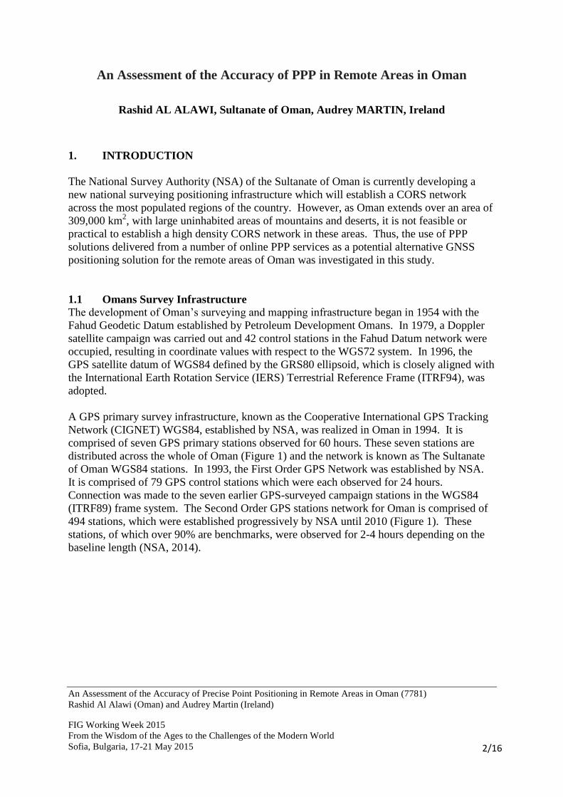
A GPS primary survey infrastructure, known as the Cooperative International GPS Tracking
Network (CIGNET) WGS84, established by NSA, was realized in Oman in 1994. It is
comprised of seven GPS primary stations observed for 60 hours. These seven stations are
distributed across the whole of Oman (Figure 1) and the network is known as The Sultanate
of Oman WGS84 stations. In 1993, the First Order GPS Network was established by NSA.
It is comprised of 79 GPS control stations which were each observed for 24 hours.
Connection was made to the seven earlier GPS-surveyed campaign stations in the WGS84
(ITRF89) frame system. The Second Order GPS stations network for Oman is comprised of
494 stations, which were established progressively by NSA until 2010 (Figure 1). These
stations, of which over 90% are benchmarks, were observed for 2-4 hours depending on the
baseline length (NSA, 2014).
An Assessment of the Accuracy of Precise Point Positioning in Remote Areas in Oman (7781)
Rashid Al Alawi (Oman) and Audrey Martin (Ireland)
FIG Working Week 2015
From the Wisdom of the Ages to the Challenges of the Modern World
Sofia, Bulgaria, 17-21 May 2015
3/16
Figure 1: CIGNET WGS84 Base Network and the First and second order GPS station in Oman
(NSA, 2014)
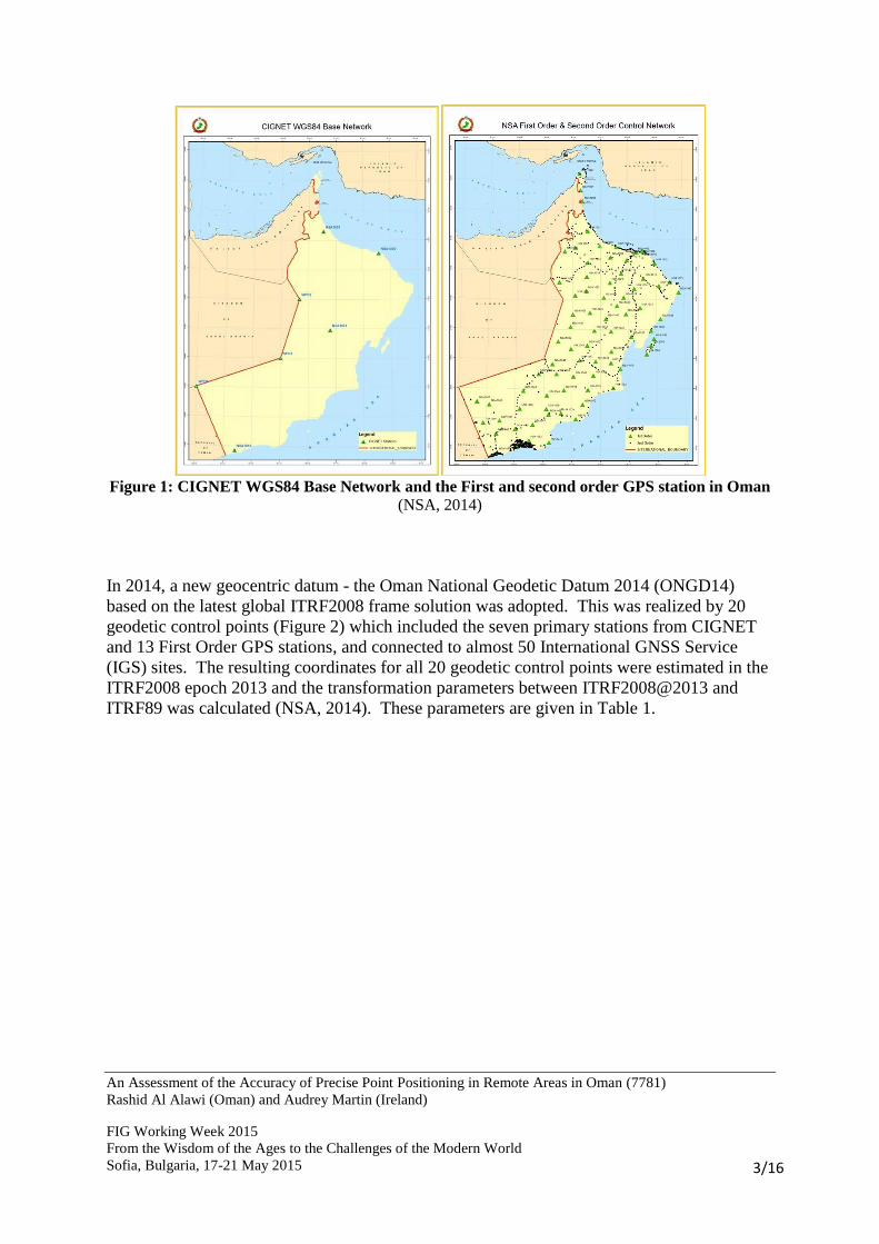
In 2014, a new geocentric datum - the Oman National Geodetic Datum 2014 (ONGD14)
based on the latest global ITRF2008 frame solution was adopted. This was realized by 20
geodetic control points (Figure 2) which included the seven primary stations from CIGNET
and 13 First Order GPS stations, and connected to almost 50 International GNSS Service
(IGS) sites. The resulting coordinates for all 20 geodetic control points were estimated in the
ITRF2008 epoch 2013 and the transformation parameters between ITRF2008@2013 and
ITRF89 was calculated (NSA, 2014). These parameters are given in Table 1.
An Assessment of the Accuracy of Precise Point Positioning in Remote Areas in Oman (7781)
Rashid Al Alawi (Oman) and Audrey Martin (Ireland)
FIG Working Week 2015
From the Wisdom of the Ages to the Challenges of the Modern World
Sofia, Bulgaria, 17-21 May 2015
4/16
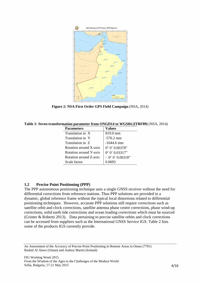
Figure 2: NSA First Order GPS Field Campaign (NSA, 2014)
Table 1: Seven transformation parameter from ONGD14 to WGS84 (ITRF89) (NSA, 2014)
Parameters Values
Translation in X 819.0 mm
Translation in Y -576.2 mm
Translation in Z -1644.6 mm
Rotation around X-axis 0 0’ 0.00378” Rotation around Y-axis 0 0’ 0.03317” Rotation around Z-axis - 0 0’ 0.00318” Scale factor 0.0693
1.2 Precise Point Positioning (PPP)
The PPP autonomous positioning technique uses a single GNSS receiver without the need for
differential corrections from reference stations. Thus PPP solutions are provided in a
dynamic, global reference frame without the typical local distortions related to differential
positioning techniques. However, accurate PPP solutions still require corrections such as
satellite orbit and clock corrections, satellite antenna phase centre corrections, phase wind-up
corrections, solid earth tide corrections and ocean loading corrections which must be sourced
(Grinter & Roberts 2013). Data pertaining to precise satellite orbits and clock corrections
can be accessed from suppliers such as the International GNSS Service IGS. Table 2 lists
some of the products IGS currently provide.
An Assessment of the Accuracy of Precise Point Positioning in Remote Areas in Oman (7781)
Rashid Al Alawi (Oman) and Audrey Martin (Ireland)
FIG Working Week 2015
From the Wisdom of the Ages to the Challenges of the Modern World
Sofia, Bulgaria, 17-21 May 2015
5/16
Table 2: Precise GNSS satellite orbits and clock corrections provided by IGS (IGS, 2013)
Product Parameter Accuracy Latency
Broadcast Orbit 100 cm
Real Time Clock ~ 5 ns
Ultra rapid
(predicted)
Orbit 10 cm Real Time
Clock ~ 5 ns
Ultra Rapid
(estimated)
Orbit < 5 cm 3-9hrs
Clock ~ 2 ns
Rapid
(estimated)
Orbit < 5 cm 17-41 hrs
Clock 0.1 ns
Final
(estimated)
Orbit < 5 cm 12-18 days
Clock < 0.1 ns
Despite several advantages, PPP is also subject to a number of disadvantages, the most
important being the long observation times required. To achieve centimetre-level positioning
accuracy 20 minutes or more are necessary for the integer ambiguity solution to converge
(Rizos et al., 2012). Longer occupation times will generally result in more accurate results
but shorter observation times will restrict the use of PPP for real-time applications.
In recent years, a number of PPP post-processing software systems including BERNESE
GIPSY-Oasis II, RTKLIB and GPSTK have been developed by government agencies,
universities and industries. Some of these are open source programmes which permit some
user interaction with the data used in the solution. In addition, a number of free to use post-
processing services are currently available. These services are available to users to upload
RINEX data to generate coordinate solutions for the static or kinematic GNSS receiver’s
position.
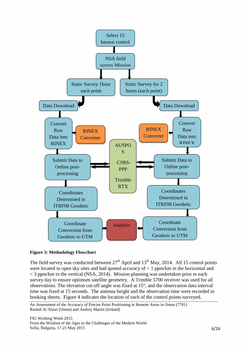
2. METHODOLOGY
To assess if PPP is a suitable an alternative GNSS positioning techniques for remote areas in
Oman 15 known control points from within the national Second Order geodetic network
(Figure 2) were observed by the NSA field survey team. Each station was observed for two
sessions (one- and two-hours) to determine also if a significant increase in accuracy could be
achieved by increasing the observation time. The observed RINEX data was sent to three
PPP service sites (Trimble RTX, CSRS and AUSPOS) for comparative purposes and the
resulting data analyzed to evaluate the accuracy of PPP in Oman. Figure 3 graphically depicts
the methodology adopted.
An Assessment of the Accuracy of Precise Point Positioning in Remote Areas in Oman (7781)
Rashid Al Alawi (Oman) and Audrey Martin (Ireland)
FIG Working Week 2015
From the Wisdom of the Ages to the Challenges of the Modern World
Sofia, Bulgaria, 17-21 May 2015
6/16
Figure 3: Methodology Flowchart
The field survey was conducted between 27th
April and 13th
May, 2014. All 15 control points
were located in open sky sites and had quoted accuracy of < 1 ppm/km in the horizontal and
< 3 ppm/km in the vertical (NSA, 2014). Mission planning was undertaken prior to each
survey day to ensure optimum satellite geometry. A Trimble 5700 receiver was used for all
observations. The elevation cut-off angle was fixed at 15°, and the observation data interval
time was fixed at 15 seconds. The antenna height and the observation time were recorded in
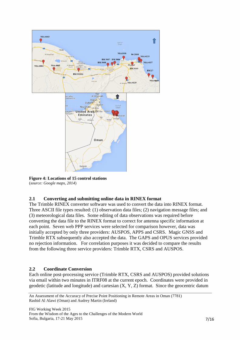
booking sheets. Figure 4 indicates the location of each of the control points surveyed.
Static Survey for 2
hours (each point)
NSA field
survey Mission
Data Download
Select 15
known control
Static Survey 1hour
each point
Data Download
Convert
Raw
Data into
RINEX
RINEX
Converter
Submit Data to
Online post-
processing
services
Analysis
Convert
Raw
Data into
RINEX
Submit Data to
Online post-
processing
services
AUSPO
S
CSRS-
PPP
Trimble
RTX
RINEX
Converter
Coordinates
Determined in
ITRF08 Geodetic
Coordinate
Conversion from
Geodetic to UTM
Coordinate
Conversion from
Geodetic to UTM
Coordinates
Determined in
ITRF08 Geodetic
An Assessment of the Accuracy of Precise Point Positioning in Remote Areas in Oman (7781)
Rashid Al Alawi (Oman) and Audrey Martin (Ireland)
FIG Working Week 2015
From the Wisdom of the Ages to the Challenges of the Modern World
Sofia, Bulgaria, 17-21 May 2015
7/16
Figure 4: Locations of 15 control stations
(source: Google maps, 2014)
2.1 Converting and submitting online data in RINEX format
The Trimble RINEX converter software was used to convert the data into RINEX format.
Three ASCII file types resulted: (1) observation data files; (2) navigation message files; and
(3) meteorological data files. Some editing of data observations was required before
converting the data file to the RINEX format to correct for antenna specific information at
each point. Seven web PPP services were selected for comparison however, data was
initially accepted by only three providers: AUSPOS, APPS and CSRS. Magic GNSS and
Trimble RTX subsequently also accepted the data. The GAPS and OPUS services provided
no rejection information. For correlation purposes it was decided to compare the results
from the following three service providers: Trimble RTX, CSRS and AUSPOS.
2.2 Coordinate Conversion
Each online post-processing service (Trimble RTX, CSRS and AUSPOS) provided solutions
via email within two minutes in ITRF08 at the current epoch. Coordinates were provided in
geodetic (latitude and longitude) and cartesian (X, Y, Z) format. Since the geocentric datum
An Assessment of the Accuracy of Precise Point Positioning in Remote Areas in Oman (7781)
Rashid Al Alawi (Oman) and Audrey Martin (Ireland)
FIG Working Week 2015
From the Wisdom of the Ages to the Challenges of the Modern World
Sofia, Bulgaria, 17-21 May 2015
8/16
of Oman (ONGD 14) is based on the latest global ITRF2008 system at epoch 2013, the
coordinates of the control points occupied in this study and the service results coordinates
were in the same coordinate system. Thus, there was no need to undertake a transformation.
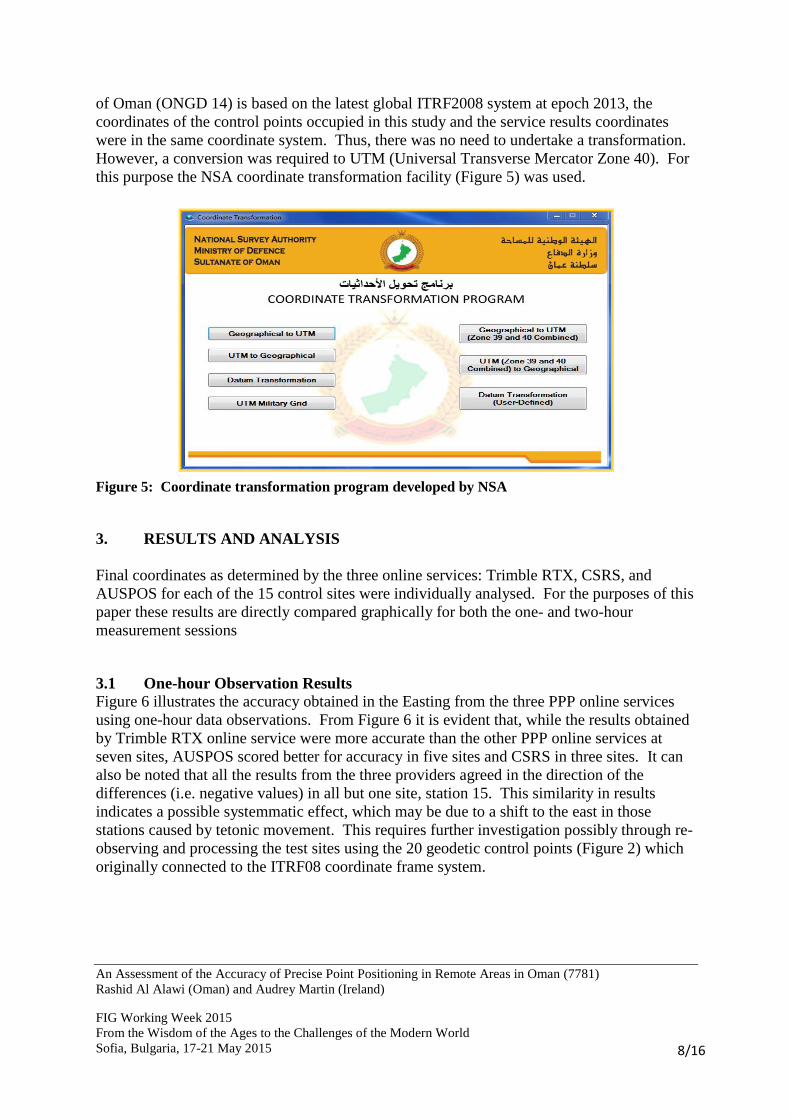
However, a conversion was required to UTM (Universal Transverse Mercator Zone 40). For
this purpose the NSA coordinate transformation facility (Figure 5) was used.
Figure 5: Coordinate transformation program developed by NSA
3. RESULTS AND ANALYSIS
Final coordinates as determined by the three online services: Trimble RTX, CSRS, and
AUSPOS for each of the 15 control sites were individually analysed. For the purposes of this
paper these results are directly compared graphically for both the one- and two-hour
measurement sessions
3.1 One-hour Observation Results Figure 6 illustrates the accuracy obtained in the Easting from the three PPP online services
using one-hour data observations. From Figure 6 it is evident that, while the results obtained
by Trimble RTX online service were more accurate than the other PPP online services at
seven sites, AUSPOS scored better for accuracy in five sites and CSRS in three sites. It can
also be noted that all the results from the three providers agreed in the direction of the
differences (i.e. negative values) in all but one site, station 15. This similarity in results
indicates a possible systemmatic effect, which may be due to a shift to the east in those
stations caused by tetonic movement. This requires further investigation possibly through re-
observing and processing the test sites using the 20 geodetic control points (Figure 2) which
originally connected to the ITRF08 coordinate frame system.

An Assessment of the Accuracy of Precise Point Positioning in Remote Areas in Oman (7781)
Rashid Al Alawi (Oman) and Audrey Martin (Ireland)
FIG Working Week 2015
From the Wisdom of the Ages to the Challenges of the Modern World
Sofia, Bulgaria, 17-21 May 2015
9/16
Figure 6: Easting accuracy obtained using three PPP service (one-hour data observation)
A comparison of the Northing accuracy obtained by the three PPP online services is
illustrated in Figure 7. Here it can be seen that, while the results obtained from the AUSPOS
online service were more accurate than the other two online services at nine sites, the Trimble
RTX results more accurate than the other two providers at five sites, while CSRS proved best
at one site. The differences’ direction and values were similar at all sites.
Figure 7: Northing accuracy obtained via three PPP online services (one-hour data observation)
1 2 3 4 5 6 7 8 9 10 11 12 13 14 15
Δ E Trimble 0,004 -0,267 -0,107 -0,231 -0,172 -0,038 -0,171 -0,147 -0,088 -0,121 -0,193 -0,111 -0,086 -0,089 -0,059
Δ E CSRS -0,049 -0,329 -0,164 -0,264 -0,204 -0,07 -0,131 -0,094 -0,011 -0,038 -0,126 -0,035 -0,094 -0,095 0,023
Δ E AUSPOS -0,093 -0,401 -0,2 -0,269 -0,351 -0,107 -0,102 -0,073 -0,021 -0,04 -0,036 -0,056 -0,008 -0,078 0,261
-0,5
-0,4
-0,3
-0,2
-0,1
0
0,1
0,2
0,3D
iffe
ren
ce i
n (
m)
1 2 3 4 5 6 7 8 9 10 11 12 13 14 15
Δ N Trimble 0,119 0,124 0,276 -0,044 0,189 -0,216 0,137 0,175 0,034 -0,088 -0,051 -0,103 -0,07 -0,047 0,017
Δ N CSRS 0,09 0,093 0,246 -0,032 0,194 -0,211 0,14 0,181 0,05 -0,122 -0,093 -0,141 -0,076 -0,051 0,023
Δ N AUSPOS 0,061 0,069 0,237 -0,047 0,207 -0,198 0,098 0,148 0,052 -0,117 -0,129 -0,09 -0,055 -0,025 0,066
-0,3
-0,2
-0,1
0
0,1
0,2
0,3
0,4
Dif
fere
nce
in
(m
)

An Assessment of the Accuracy of Precise Point Positioning in Remote Areas in Oman (7781)
Rashid Al Alawi (Oman) and Audrey Martin (Ireland)
FIG Working Week 2015
From the Wisdom of the Ages to the Challenges of the Modern World
Sofia, Bulgaria, 17-21 May 2015
10/16
The accuracy in the Height returned from the three PPP online services are graphically
illustrated in Figure 8. Here it can be seen that, while the results obtained by CSRS online
services were more accurate at eight sites, the AUSPOS results were more accurate at five
sites and the Trimble at one site. It should also be noted that the AUSPOS height results
were the least accurate, recording the poorest results at eight stations, and by a factor of more
than two at stations 2, 7 and 8.
Figure 8: The height accuracy obtained via three PPP online services (one-hour data
observation)
On comparing the results of the one-hour observations from three online services it was
found that, while the lowest differences in the Easting (4mm) and in the Northing (14mm)
were achieved using the Trimble RTX service, the lowest difference in Height was achieved
by the CSRS services. The largest difference in the Easting (401mm) and in Height (671mm)
resulted from using the AUSPOS service. Conversely, the Trimble RTX online service
produced the largest difference in the Northing (276mm). The maximum and minimum
differences for each PPP service provider are given in Table 3.
Table 3: The minimum and maximum differences achieved using one-
hour PPP online services
PPP online service Difference (mm)
Easting Northing Height
Trimble RTX Min 4 14 16
Max 267 276 275
CSRS Min 11 23 5
Max 264 246 309
AUSPOS Min 8 25 14
Max 401 237 671
When using the Trimble RTX solution it was found that the differences between known
values and the PPP results in the one-hour observations ranged from 4 to 267, 14 to 276 and
1 2 3 4 5 6 7 8 9 10 11 12 13 14 15
Δ H Trimble -0,112 0,039 -0,053 -0,111 -0,068 -0,06 0,275 -0,019 0,078 0,242 0,172 0,102 -0,027 -0,016 0,186
Δ HCSRS -0,053 0,101 0,016 -0,098 -0,05 -0,014 0,309 -0,008 0,077 0,179 0,103 0,048 -0,025 -0,005 0,122
Δ HAUSPOS 0,029 0,225 0,108 0,126 0,018 -0,032 0,671 0,262 0,131 0,163 0,076 0,065 0,074 0,014 -0,15
-0,2
-0,1
0
0,1
0,2
0,3
0,4
0,5
0,6
0,7
0,8
Dif
feren
ce i
n (
m)
An Assessment of the Accuracy of Precise Point Positioning in Remote Areas in Oman (7781)
Rashid Al Alawi (Oman) and Audrey Martin (Ireland)
FIG Working Week 2015
From the Wisdom of the Ages to the Challenges of the Modern World
Sofia, Bulgaria, 17-21 May 2015
11/16
16 to 275 mm in Easting, Northing and Height, respectively (Table 3). The average
differences were 131, 112 and 104 mm in the Easting, Northing and Height, respectively.
The results of the one-hour observation obtained by CSRS online services for all sites in the
Easting ranged from 11 to 264 mm, from 23 to 246 mm in the Northing and from 5 to 309
mm in the height (Table 3). The differences resulting from one-hour observation using the
AUSPOS online service ranged from 8 to 401mm, 25 to 237 mm and 14 to 671 mm in the
Easting, Northing and Height, respectively (Table 3). Meanwhile, the average difference in
the Easting was 140mm; in the Northing, it was 107mm; and in the Height was 143mm.
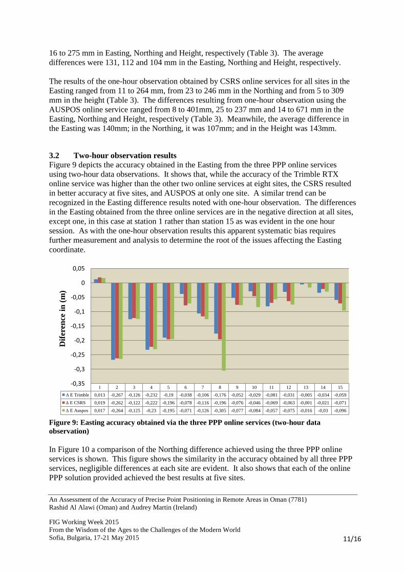
3.2 Two-hour observation results
Figure 9 depicts the accuracy obtained in the Easting from the three PPP online services
using two-hour data observations. It shows that, while the accuracy of the Trimble RTX
online service was higher than the other two online services at eight sites, the CSRS resulted
in better accuracy at five sites, and AUSPOS at only one site. A similar trend can be
recognized in the Easting difference results noted with one-hour observation. The differences
in the Easting obtained from the three online services are in the negative direction at all sites,
except one, in this case at station 1 rather than station 15 as was evident in the one hour
session. As with the one-hour observation results this apparent systematic bias requires
further measurement and analysis to determine the root of the issues affecting the Easting
coordinate.
Figure 9: Easting accuracy obtained via the three PPP online services (two-hour data
observation)
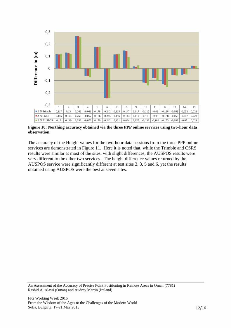
In Figure 10 a comparison of the Northing difference achieved using the three PPP online
services is shown. This figure shows the similarity in the accuracy obtained by all three PPP
services, negligible differences at each site are evident. It also shows that each of the online
PPP solution provided achieved the best results at five sites.
1 2 3 4 5 6 7 8 9 10 11 12 13 14 15
Δ E Trimble 0,013 -0,267 -0,126 -0,232 -0,19 -0,038 -0,106 -0,176 -0,052 -0,029 -0,081 -0,031 -0,005 -0,034 -0,059
Δ E CSRS 0,019 -0,262 -0,122 -0,222 -0,196 -0,078 -0,116 -0,196 -0,076 -0,046 -0,069 -0,063 -0,001 -0,021 -0,071
Δ E Auspos 0,017 -0,264 -0,125 -0,23 -0,195 -0,071 -0,126 -0,305 -0,077 -0,084 -0,057 -0,075 -0,016 -0,03 -0,096
-0,35
-0,3
-0,25
-0,2
-0,15
-0,1
-0,05
0
0,05
Dif
eren
ce i
n (
m)
An Assessment of the Accuracy of Precise Point Positioning in Remote Areas in Oman (7781)
Rashid Al Alawi (Oman) and Audrey Martin (Ireland)
FIG Working Week 2015
From the Wisdom of the Ages to the Challenges of the Modern World
Sofia, Bulgaria, 17-21 May 2015
12/16
Figure 10: Northing accuracy obtained via the three PPP online services using two-hour data
observation.
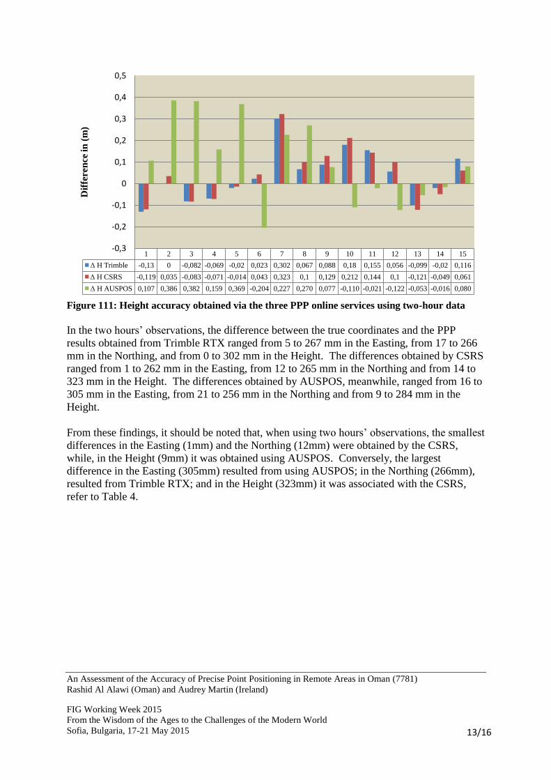
The accuracy of the Height values for the two-hour data sessions from the three PPP online
services are demonstrated in Figure 11. Here it is noted that, while the Trimble and CSRS
results were similar at most of the sites, with slight differences, the AUSPOS results were
very different to the other two services. The height difference values returned by the
AUSPOS service were significantly different at test sites 2, 3, 5 and 6, yet the results
obtained using AUSPOS were the best at seven sites.
1 2 3 4 5 6 7 8 9 10 11 12 13 14 15
Δ N Trimble 0,117 0,13 0,266 -0,061 0,178 -0,242 0,115 0,147 0,017 -0,115 -0,08 -0,128 -0,053 -0,052 0,023
Δ N CSRS 0,115 0,124 0,265 -0,062 0,176 -0,245 0,116 0,143 0,012 -0,119 -0,08 -0,138 -0,056 -0,047 0,022
Δ N AUSPOS 0,12 0,119 0,256 -0,073 0,179 -0,242 0,121 0,094 0,025 -0,139 -0,102 -0,153 -0,058 -0,05 0,021
-0,3
-0,2
-0,1
0
0,1
0,2
0,3D
iffe
ren
ce i
n (
m)
An Assessment of the Accuracy of Precise Point Positioning in Remote Areas in Oman (7781)
Rashid Al Alawi (Oman) and Audrey Martin (Ireland)
FIG Working Week 2015
From the Wisdom of the Ages to the Challenges of the Modern World
Sofia, Bulgaria, 17-21 May 2015
13/16
Figure 111: Height accuracy obtained via the three PPP online services using two-hour data
In the two hours’ observations, the difference between the true coordinates and the PPP
results obtained from Trimble RTX ranged from 5 to 267 mm in the Easting, from 17 to 266
mm in the Northing, and from 0 to 302 mm in the Height. The differences obtained by CSRS
ranged from 1 to 262 mm in the Easting, from 12 to 265 mm in the Northing and from 14 to
323 mm in the Height. The differences obtained by AUSPOS, meanwhile, ranged from 16 to
305 mm in the Easting, from 21 to 256 mm in the Northing and from 9 to 284 mm in the
Height.
From these findings, it should be noted that, when using two hours’ observations, the smallest
differences in the Easting (1mm) and the Northing (12mm) were obtained by the CSRS,
while, in the Height (9mm) it was obtained using AUSPOS. Conversely, the largest
difference in the Easting (305mm) resulted from using AUSPOS; in the Northing (266mm),
resulted from Trimble RTX; and in the Height (323mm) it was associated with the CSRS,
refer to Table 4.
1 2 3 4 5 6 7 8 9 10 11 12 13 14 15
Δ H Trimble -0,13 0 -0,082 -0,069 -0,02 0,023 0,302 0,067 0,088 0,18 0,155 0,056 -0,099 -0,02 0,116
Δ H CSRS -0,119 0,035 -0,083 -0,071 -0,014 0,043 0,323 0,1 0,129 0,212 0,144 0,1 -0,121 -0,049 0,061
Δ H AUSPOS 0,107 0,386 0,382 0,159 0,369 -0,204 0,227 0,270 0,077 -0,110 -0,021 -0,122 -0,053 -0,016 0,080
-0,3
-0,2
-0,1
0
0,1
0,2
0,3
0,4
0,5D
iffe
ren
ce in
(m
)

An Assessment of the Accuracy of Precise Point Positioning in Remote Areas in Oman (7781)
Rashid Al Alawi (Oman) and Audrey Martin (Ireland)
FIG Working Week 2015
From the Wisdom of the Ages to the Challenges of the Modern World
Sofia, Bulgaria, 17-21 May 2015
14/16
Table 4: The minimum and maximum differences achieved using two-hour PPP online services.
PPP online service Difference (mm)
Easting Northing Height
Trimble RTX Min 5 17 0
Max 267 266 302
CSRS Min 1 12 14
Max 262 265 323
AUSPOS Min 16 21 9
Max 305 256 284
From the results obtained it is recognized that a two-hour observation generally provides
slightly better coordinates than one-hour observation. Table 5 illustrates the average
differences obtained in the Easting, Northing and Height in both one- and two-hour
observations.
Table 5: The average differences in mm obtained from one- and two-hour observations
PPP online service Observation Time
Easting Northing Height
Trimble RTX 1-hour 131 112 104
2-hours 96 115 94
CSRS 1-hour 115 116 081
2-hours 104 115 107
AUSPOS 1-hour 140 107 143
2-hours 117 116 66
Overall, variability in the results across the 15 sites between all three PPP services was
recognized. Nevertheless, it should be noted that the differences in the 3D position of 33% of
the samples were approximately 50 mm in 1-hour and 2-hour results across all three services.
This result is somewhat similar to the findings reported by EL-Hattab (2014), who noted that
accuracy to less than one centimetre can be achieved after approximately seven hours’
observation.

An Assessment of the Accuracy of Precise Point Positioning in Remote Areas in Oman (7781)
Rashid Al Alawi (Oman) and Audrey Martin (Ireland)
FIG Working Week 2015
From the Wisdom of the Ages to the Challenges of the Modern World
Sofia, Bulgaria, 17-21 May 2015
15/16
4. CONCLUSION
To determine if the PPP technique represented a suitable alternative to relative GNSS
positioning across remote areas of Oman two sets of PPP GNSS data involving 15 control
points were observed. The 3D positional results obtained from three PPP online services
were compared to the true coordinates of the 15 control points and it was found that 33% of
the differences in 3D positioning across the 15 sites were within an accuracy level of
approximately 50 mm. Thus it can be stated that the PPP method could be used with
confidence for medium-accuracy positioning purposes, such as map production to small and
medium scales.
The results obtained from the 3 PPP service providers indicated a disturbing bias in Easting
coordinate across all but one site from both observation sessions. This indicates a systematic
effect which requires further GNSS observation and analysis with respect to primary and/or
first order control. Overall no significant difference between the 3 PPP online providers –
Trimble RTX, CSRS and AUSPOS was found to exist.
REFERENCES
EL-Hattab, AI 2014, 'Assessment of PPP for establishment of CORS network for municipal
surveying in Middle East', Survey Review, vol. 46, no. 335, pp. 97-103.
Grinter, T & Roberts, C 2013, 'Real Time Precise Point Positioning: Are We There Yet?',
paper presented to International Global Navigation Satellite Systems Society ,IGNSS
Symposium 2013, Outrigger Gold Coast, Qld, Australia,
<http://www.gmat.unsw.edu.au/snap/publications/grinter&roberts2013a.pdf>.
(IGS) International GNSS Service 2013, IGS Products, viewed 18 June 2014,
<http://igs.org/components/prods.html>.
(NSA) National Survey Authority 2014, 'Final Report Oman National Geodetic Datum
(ONGD14)', Ministry Of Defence, Muscat, Oman.
Rizos, C, Janssen, V, Roberts, C & Grinter, T 2012, 'Precise Point Positioning: Is the Era of
Differential GNSS Positioning Drawing to an End?', paper presented to FIG Working Week
2012, Rome, Italy, 6-10 May 2012,
<https://www.fig.net/pub/fig2012/papers/ts09b/TS09B_rizos_janssen_et_al_5909.pdf>.
An Assessment of the Accuracy of Precise Point Positioning in Remote Areas in Oman (7781)
Rashid Al Alawi (Oman) and Audrey Martin (Ireland)
FIG Working Week 2015
From the Wisdom of the Ages to the Challenges of the Modern World
Sofia, Bulgaria, 17-21 May 2015
16/16
BIOGRAPHICAL NOTES
Rashid Al Alawi is the Project officer at the National Survey Authority (NSA) - Sultanate of
Oman. He graduated with an MSc in Geospatial Engineering from the School of Surveying
and Construction Management in the Dublin Institute of Technology in 2014. Rashid has
worked in the (NSA) as a field survey team leader in the period from 1998 until 2010.
Subsequently Rashid was promoted to the training officer in charge until 2013.
Dr. Audrey Martin is the Chair of the MSc in Geospatial Engineering programme, she
lecturers in the Spatial Information Sciences in the Dublin Institute of Technology. Audreys’
area of expertise is Global Navigation Satellite Systems (GNSS) and Geomatics pedagogy.
Audrey held the DIT Teaching and Learning Fellowship in 2011 and was jointly awarded the
2010 Teaching Excellence Award in the College of Engineering and Built Environment.
Audrey supervised the two most recent student winners of the Trimble Dimensions Student
paper competition. She is the Irish representative on FIG Commission 2 and Chairs WG 2.2.
CONTACTS
Rashid Al Alawi MSc. Geospatial Engineering
National Survey Authority
P.O Box 113, P.C 100
Muscat
SULTANATE OF OMAN
Tel. +96824312564
Fax + 96824312443
Email: [email protected] / [email protected]
Web site:www.nsaom.org.om
Dr. Audrey Martin FSCSI FRICS
Programme Chair – MSc Geospatial Engineering.
Spatial Information Sciences Group
College of Engineering & the Built Environment
Dublin Institution of Technology
Bolton Street, Dublin 1,
IRELAND
Tel. +353 1 402 3736
Email: [email protected]