an approach to the origin of boga lake and pukurpara …
TRANSCRIPT

Oriental Geographer Vol. 58, No. 2, 2014 (Published in December 2017)
AN APPROACH TO THE ORIGIN OF BOGA LAKE AND PUKURPARA LAKE IN THE HILL DISTRICTS OF
BANGLADESH
Md. Shahidul Islam* Premanondo Debnath** Jean Marie Garnier***
Abstract: Boga lake and Pukurpara lake are naturally created hilly lakes located on hill tops in the hill districts of Bangladesh. The former is oval in shape and has a maximum water depth of 35 meter and the later is semicircular nut-shaped and has a maximum water depth of 28 meter. They preserve stratified sedimentary sequences, which are suitable for palaeo-environment and palaeo-climatic reconstruction. Using hand-operated piston corer, operating from a floating platform we collected 7 boreholes from Boga lake and 6 boreholes from Pukurpara lake upto 150 cm long. The bathymetry of the lake floors and terrine study shows that both lakes occupy the valleys of the Tertiary hills. Microfossil evidences (diatom) and C14 results suggest the varying rates and direction of monsoon intensity and its cycles of intense torrential rainfalls events during the late Holocene period. It has been argued that there were 13 phases of alternative weak and strong monsoon events during the last 1500 years. The intensified monsoon sequences have had tremendous impact on the terrain morphology and fluvial dynamics in the hilly regions of Bangladesh. The lakes on top of Tertiary hills are not volcanic in origin. Rather intensive monsoon events triggered by mega-scale earthquakes were the driving forces to massive landslide and mass-movement to closure the valley mouths, which initiated the formation of hilly lake basins in the Tertiary landscape and has later been top-up by torrential rain-fed water. Many of such lakes were small in size and have later been filled-up by excessive surface erosion and have turned into wetland ecosystem and marshy plain lands. However, Boga lake and Pukurpara lake, since their origin, till remain their original shape and form, and bear the characteristics of typical hilly lake environment. These two lakes are the examples to reveal how the origin of lakes in the hill districts of Bangladesh are associated with intensified palaeo-monsoon driven heavy rainfall in association with palaeo-seismic activities. C14 dates suggest that Boga lake is much younger (less than 500 yrs BP) than Pukurpara lake (estimated 2000 yrs BP).
Keywords: Boga Lake, Pukurpara Lake, Palaeo-monsoon, Palaeo-earthquake, Palaeo-landslides
* Md. Shahidul Islam, PhD, Professor, Department of Geography and Environment, University of Dhaka, Dhaka 1000, Bangladesh **Premanondo Debnath, Research Associate, Center for Environmental and Geographic Information Services (CEGIS), Dhaka 1212, Bangladesh ***Jean Marie Garnier, PhD, Professor, Centre Européen de Recherche et d’Enseignement des Géosciences de l’Environnement (CEREGE), UMR CNRS 7730, AMU (Aix-Marseille Université). BP 80, 13545 Aix en Provence, France

32 ORIENTAL GEOGRAPHER
INTRODUCTION
A natural lake is localized basin surrounded by land area and is filled-up by water. Natural lakes are generally located in the hilly/mountainous regions or along the course of a mature river (Kuusisto and Hyvarinen, 2000). Lakes are varied in terms of their origin, size, shape, depth and water quality. Some lakes are only a few acres in size whereas other can be thousands of square kilometers. Their depth may vary from a few meters to more than thousand meters. Natural lakes can be formed by various earth system processes. However, some major natural causes are due to tectonic process, glacial activity, volcanic activity and landslides (Allen and Collison, 1986; Garcia-Castellanas, 2006). In the high latitude or tropical high altitude lakes are normally formed due to glacial blockage, and in tropical humid region due to massive landslides. Landslide damlake can be formed due to massive movement of rock, debris and mudflows in an area of narrow valley bordered by steep and rugged hills (Li and Zhu, 2001). Such lakes are commonly found in Hindu Kush Himalayas, where rainfall is high, earthquakes are common and slopes are steep.
Bangladesh is primarily a low laying deltaic country formed by sediments carried by the mighty Ganges-Brahmaputra-Meghna river system. However, the hilly district of Bangladesh is located at the tipping point of four major sub-system of Asian monsoon. The monsoon climate system since its origin in the Neogene period, the region has witnessed significant variations in monsoon system. It is the key mechanism to geomorphological deformation of the hill topography of the country. The unique nature of the Tertiary hills and their evolution history at the margin of Indo-Burmese orogenic belt represent intense seismic activity. The tilting, warping and folding of the strata with anomalous drainage are the common indicators of deformation of the basin architecture. Among a variety of landscape in Tertiary landmass, two naturally created lakes- the Boga lake and Pukurpara lake are of immense beautiful treasures of the country. Despite significant progress has been made on the geological, seismic and hydro-metrological context of the region (Khan, 1991, Rashid, 1991, Banglapedia, 2006) there has been a very little progress to unveil the origin of these two lakes. It is the main aim of this paper is to study the origin of these two natural lakes in the context of regional earth system processes.
AIM AND OBJECTIVES
The main objective of the study is to reconstruct the history of origin of natural lakes, particularly the Boga lake and Pukurpara lake, in the hilly areas of Bangladesh. However, some specific objectives are;

AN APPROACH TO THE ORIGIN OF BOGA LAKE AND PUKURPARA LAKE 33
i) to study the terrain of the Boga lake and Pukurpara lake, and their bottom topography,
ii) to study the sedimentary sequence of these two lakes with the view to reconstruct the characteristics of monsoon during the geological past and
iii) to establish the linkage between palaeo-earthquake and palaeo-monsoon to the origin of the lakes.
STUDY AREA
The study area is located in the hilly districts of Bangladesh where two natural lakes-Boga lake and Pukurpara lake are located (Figure 1). These lakes are not easily accessible due to undulating Tertiary hills topography and very poor communication system, Both the lakes bear the purity of nature, which bear significance of spiritual appeal to the visitors. There is very little human impact on the lake ecology, water is very stagnant and rain is the only source of water. Both the lakes bear the mythological stories on how they have been directing the cultural life settings of the different ethnic groups depending upon the lake environment. The present study is an attempt to understand the earth environmental system relating to the origin of natural lakes of hill regions based on the evidences derived from this two lake sites.
i. Sample Site: Bogalake
Bogakine lake (popularly known as Boga lake) is a natural lake in the hill area of Ruma Upazila, in Bandarban district. It is situated at 21o58'40"N to 21o58'57"N latitude and 92o27'55"E to 92o28'29"E longitude and is about 15 kilometers east of Ruma Upazila. The lake is partially parallelogram or oval in shape. It is bounded on three sides by undulating hills of upto 700m height, with an exception of plain land in the east. Situated on hill tops at an altitude of 372 meter the height of the lake is 165 meter from the nearest basement at Kamlapara. The slope of the hills is very steep in the east than that of other sides. The maximum water depth of the lake is 35 meter (Islam, 2005) and area is 15 acres (Debnath and Islam, 2015). The water of the lake is rain-fed and remains crystal clean. There are two villages, the Marmapara is located in the north of the down of the back slope and Bwam community lives in the south-eastern plain land. The lake is only accessible upto the basement by traditional vehicle (locally known as Chander gari) during the dry season, but during the monsoon only way to walk (7 hours from Ruma-the nearest town).

34 ORIENTAL GEOGRAPHER
Figure 1: Location of the Study area. A. Bangladesh, B. Chittagong Hill Tract Districts, C. Boga lake and D. Pukurpara lake.

AN APPROACH TO THE ORIGIN OF BOGA LAKE AND PUKURPARA LAKE 35
ii. Sample Site: Pukurpara Lake
Raikkhyang lake, popularly known as Pukurpara lake, is located about 20 km (path distance) north-east of Boga lake at 22o01'12'N to 22o01'54'N latitude and 92o32'47"E to 92o33'15'E longitude in Belichhari Upazila of Rangamati District. It is very near to the Myanmar-India-Bangladesh border triangle. The only way to visit the lake is by walking (11 hours from Boga lake) through the undulating steep hills. The lake is located at 360 meter above the mean sea level, maximum water depth is 28 meter and the area is about 98 acres (Debanth and Islam, 2015). Pukurpara lake is semi-circular nut-shaped, has a length of 1.62 kilometer and occupies an area of 6 times bigger than that of Boga lake. The lake is surrounded by hills in all sides, except the southern side, which is the pain-land at lake level. The eastern hills are higher (500 m) than western hills (450m) and the lake topography appears as an elongated valley. The Raikkhyang khals flows along the eastern side of the lake parallel and is connected with the lake in the north with a sharp slope break of the cliff. The Tripura ethnic community live in the south-east and south-west side of the lake. Human intervention in the lake environment till now is negligible, and the water remains stagnant and very clean year round. Various types of fish species are available in the lake water.
METHODOLOGY OF THE STUDY
The study is primarily based on the evidences derived from field survey. The major goal of the field survey was to collect borehole records from lake floor and for that we had to build a floating platform using nine large tubes of a Truck (vehicle).
Photo 1: Shows the floating platform in the middle of Boga lake and preparation for bottom core collection using Piston corer. The platform could hold the entire necessary instrument for coring; grabbing and water sample collection and 5 to 6 person could easily ride on it to conduct their survey activities by using this locally made floating platform.
36 ORIENTAL GEOGRAPHER
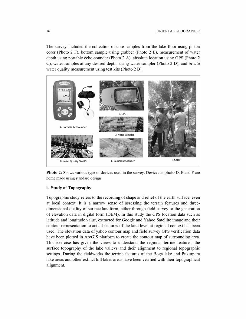
The survey included the collection of core samples from the lake floor using piston corer (Photo 2 F), bottom sample using grabber (Photo 2 E), measurement of water depth using portable echo-sounder (Photo 2 A), absolute location using GPS (Photo 2 C), water samples at any desired depth using water sampler (Photo 2 D), and in-situ water quality measurement using test kits (Photo 2 B).
Photo 2: Shows various type of devices used in the survey. Devices in photo D, E and F are
home made using standard design
i. Study of Topography
Topographic study refers to the recording of shape and relief of the earth surface, even at local context. It is a narrow sense of assessing the terrain features and three-dimensional quality of surface landform, either through field survey or the generation of elevation data in digital form (DEM). In this study the GPS location data such as latitude and longitude value, extracted for Google and Yahoo Satellite image and their contour representation to actual features of the land level at regional context has been used. The elevation data of yahoo contour map and field survey GPS verification data have been plotted in ArcGIS platform to create the contour map of surrounding area. This exercise has given the views to understand the regional terrine features, the surface topography of the lake valleys and their alignment to regional topographic settings. During the fieldworks the terrine features of the Boga lake and Pukurpara lake areas and other extinct hill lakes areas have been verified with their topographical alignment.

AN APPROACH TO THE ORIGIN OF BOGA LAKE AND PUKURPARA LAKE 37
Figure 2: Shows the Contour Map of Boga lake (left) and Pukurpara Lake (right) areas as
derived from DEM analysis.
The contour map of Boga lake area shows that due to very steep (>21.5O) hill slope in the north-eastern and south-western sides of the lake the surface erosion is very high compare to southern portion, where the slope is relatively gentle. There is a deep valley in the north-western edge of the lake and the valley floor remains at the same level as that of the lake floor, which primarily indicates the continuation as a single valley prior to the origin of the lake.
Pukurpara lake, on the other hand, is almost in an alignment of a valley. In the north-east side, the lake terminates to a deep slope to connect the flow of Raikkhyang khal. The floor of the khal also bears nearly the same depth of that of the lake floor, primarily indicating their common alignment as a single valley until their separation. The terrain study shows that north-western and western side of the lake is very steep (>20O) whereas the eastern side is moderate to gentle slope. The southern edge of the lake bears nearly the same level to an extensive plain-land, and is cut by small springs of hill slope origin.
ii. Bathymetric Survey
Bathymetric survey includes the measurements of underwater depth of an ocean or lake floor. Bathymetric survey in a lake illustrates the topographic features of the underwater land type and represent the three-directional view of the lake floor. The purpose of bathymetric survey of Boga and Pukurpara lakes were to unveil the underwater valley alignment and their level of adjustment to surrounding valley topography, as derived from DEM analysis. During fieldwork the bathymetric survey

38 ORIENTAL GEOGRAPHER
was conducted by using a portable echo-sounder, adjusted with the floating platform. During the traverse time across the lake, the digital depth measurement of each traverse was recorded. Moreover, to validate the instrumental records, real depth was also measured using rope-stone along with their GPS values. All those values have later been used in GIS platform to produce three-dimension topography of the lake-floor (Figure 3). The average depth of the Boga lake is 16 m, with maximum depth of 35 meter (Islam, 2005), and that of Pukurpara lake is 12m and 28 m, respectively (Debnath and Islam, 2015). The bottom topography of Boga lake is a typical basin shape, whereas in case of Pukurpara lake it looks like a typical valley. However, in both the lakes, the valleys are sloping down towards north, as are in the same alignment with the surrounding valley topography.
Figure 3: Shows the Bathymetry of Boga lake (left) and Pukurpara lake (right) areas as
derived from field survey.
iii. Lithological Data (Coring)
Signatures of past lake environment and palaeo-lake dynamics remain preserved in litho-stratigraphical sequences. However, the collection of borehole records from lake floor requires specialized coring devices. Due to lack of such instruments, we have

AN APPROACH TO THE ORIGIN OF BOGA LAKE AND PUKURPARA LAKE 39
developed the modified version of each coring equipment using local expertise. All the coring and sampling devices were operated from the floating stations with the aim to record undisturbed in-situ sediment signature from lake floors. Tooley (1981) argued some requirements for coring unconsolidated sedimentary rocks from land surface, which are also applicable for collecting lake sediments. These are i) no disturbance of lithological structure, ii) no change in physical content and iii) no change in chemical composition. Although this is suggestive for civil engineering requirements, but it is also true for retrieving the palaeo-climatic and palaeo-environmental research (Islam, 2001). We have collected 7 boreholes from Boga lake and 6 boreholes from Pukurpara lakes, with the maximum core length of 153 cm (Figure-4). The coring positions in Boga lake were selected in east-west and in Pukurpara lake north-south transactions to registrar all possible micro-sequences and also to avoid sediment reworking as derived from hill slope erosion.

40 ORIENTAL GEOGRAPHER
Figure 4: Shows the litholo-facies of each core at Boga lake (left) and Pukurpara lake (right). The location of each core is shown in Figure 3. The 6 cores from Pukurpara lake were collected by the authors. The last one (F) is the longest core of 150 cm long, which has been carried to laboratory analysis. Each core shows series of embedded very thin lake varve deposits as signals to surrounding environmental pulses, primarily derived from monsoon intensity. Inset is an illustration (zoom) of alternative organic and inorganic layers in core 7 at Boga lake between 10-30cm depth.
Among the 7 cores at Boga lake, the longest one was 114 cm long and shows a total of 18 distinct sediment layers; and at Pukurpara lake the longest core was 150 long showing 33 distinct sedimentary layers. Each layer has a clear and sharp
contact, distinctive thickness, sediment types, textural composition, organic content and geo-chemical properties. In the field the sediment was described according to Troels-Smith (1955) scheme.
iv. Laboratory Data
Three boreholes, one from Boga lake (No-6) and two from Pukurpara lake (No B & F), were carried to the Physical Geography Lab of the Department of Geography and Environment of Dhaka University for laboratory analysis. These include particle size analysis, identification of microfossil as proxy data and determination of organic content. Islam and Debnath (2017) have identified diatom as proxy-records from Boga lake and Pukurpara lake to infer the rates and directions of regional palaeo-monsoon sequences. Diatom is a microscopic algae and it is highly sensitive to environment, temperature, oxygen, water depth and water quality (Battarbee et al., 1984). de Wolf (1982) classified diatom into five salinity groups- polyhalobous, mesohalobous, oligohalobous-halophile, oligohalobous-indifferent and halophobous, which Islam (2001) recognized as synonymous to marine, brackish and freshwater ecology. Boga lake and Pukurpara lake are two freshwater lake and the occurrence of brackish and marine species into the sediment sequences indicates the drifting of those diatom frustules from hill slopes of marine origin. Islam and Debnath (2017) have identified 32 species of diatom of which the influx of Cocconeis Botannica and Nitzschia Balcanica, predominantly marine species, refers to the intensity of heavy torrential rainfall to drift those species into the lake bottom. They have used the marine-fresh (M/F) ratio index as an indicator to determine the nature of palaeo-monsoon events in the past and have suggested sequential monsoon cycles during the late Holocene period.

AN APPROACH TO THE ORIGIN OF BOGA LAKE AND PUKURPARA LAKE 41
vi. Radiocarbon Data
Precise reconstruction of past events, either from naturally origin or of human induced, requires absolute dating of materials, most commonly the organic matters, which represent the chronological changes of the sequences. Among a wide range of chronostratigraphic techniques, the common and widely used type is the Radiocarbon (C14) dating, suitable for dating material age rage upto 30,000 yrs BP very accurately (Cook and Plicht, 2007). The sample selection for dating is a complicated task due to risk of contamination of samples. It is preferable to use in situ organic materials, such as peat, rootlets and plants in their growth position (Islam, 2001). Six samples- three from Boga lake and three from Pukurpara lake- were collected and preserved for C14 dating from core number 6 (Boga lake) and B (Pukurpara lake). Radiocarbon dates from the cores are shown in Table-1.
Table 1: Radiocarbon (C14) Dates from the Cores at Boga lake and Pukurpara lake
Name of Lake Depth of
Sample
C14 age
BP
+/- 2ơ Lab Code
Boga lake
(Core 6)
46-48 cm 130 30 1852-1912AD N/A
74-78 cm 110 30 1872-1932 AD N/A
106-108 cm 245 30 1737-1797 AD N/A
Pukurpara lake
(Core B)
39-41 cm 555 25 1315-1427 AD Poz-58634
61-65 cm 125 30 1677-1940 AD Poz-58640
106-109 cm 955 35 1023-1154 AD Poz-58641
The oldest date from Boga lake is only 245 +/- 30 yrs BP (cal 1737-1797 AD) at a depth of 106-108 cm and that of Pukurpara lake is 955 +/- 35 yrs BP (cal 1023-1154 AD) at a depth of 106-109 cm. In both the lakes, there are evidences of massive sediment reworking as reflected from their upper two dates, at about 150 yrs BP. The assumption of C14 result is based upon the principle of litho-stratigraphy that the older sediment is always overlaid by younger deposits. However, contamination can occur with either older organic materials during sediment accumulation or younger organic materials following deposition (Rasmussen, et al., 2009). In case of Boga lake and Pukurpara lake, such contamination and sediment reworking is possible due to the result of palaeo-seismic events in the past.

42 ORIENTAL GEOGRAPHER
ORIGIN OF HILLY LAKES IN BANGLADESH
Natural lakes are associated with tectonic basins, volcanic activities, landslides, glacial activities, and river and windblown processes. Among those the tectonic lakes are related with crustal deformation primarily due to earthquake. Crater lakes take the shape of volcanic craters and landslide-dam lakes are created by blockage of a valley due to massive debris flows. However, till now the scientific explanation regarding the origin of hill-top lakes in the hilly districts of Bangladesh remained unanswered. There are evidences of large scale palaeo-seismic events (Alam et al., 2012), intensified palaeo-monsoon records (Maher and Hu, 2006) and palaeo-landslides (Higgitt et al., 2014), at regional and local context. In this section, it has been attempted to demonstrate how the origin of Boga lake and Pukurpara Lake are related to local geological events and hydro-metrological processes.
i. Origin of Boga lake
The shape of the lake looks like a crater of a volcano, which might give an immediate impression of its origin by volcanic process. Rahman and Chowdhury (2006) believed that the lake is either the crater of an inactive mud volcano or it was originated due to falling of meteorites. However, there has not been any record of volcanic activities or meteorites fall in the hilly regions of Bangladesh since the geological past, and also has not been found any records of volcanic rocks, ash, or any field evidences in the surrounding areas during the consecutive fieldworks since 2005. The first author made his first-time visit to the lake in 2005, primarily aiming to determine the depth of water, and for the first time measured that the highest water depth of the lake was 35-meter (Islam, 2005). During that survey, a modified corer was used to collect bottom sediment. The corer was 20 kg weight and was designed to hit the lake floor with excessive force to penetrate the floor. Fortunately, instead of hitting the floor or any stone, the corer hit a submerged tree trunk and sample of the trunk shows the existence of submerged trees in the lake floor. Sharif Sarwar, a renowned scuba diver in Bangladesh, recently has identify the existence of such submerged trees in the lake edges and floor, through scuba diving (personal communication). The presence of submerged trees in the lake edges/floors are the evidences of not being of volcanic origin of the Boga lake.
We have tried to explain the origin of the lake in the context of palaeo-extreme events, both hydro-metrological and geological forces. The evidences come from the proxy records of litho-stratigraphy, bio-stratigraphy and chrono-stratigraphy. During the fieldwork, many evidences of palaeo-seismic activities and palaeo-landslides have

AN APPROACH TO THE ORIGIN OF BOGA LAKE AND PUKURPARA LAKE 43
been recorded. Due to massive landslides in 2007, a total of 127 peoples were killed simultaneously at six locations in Chittagong region. The main cause of such massive land-slides was the heavy and intensified torrential rainfall (GoB, 2008). The Barkol earthquake in 2003 also had made many crakes in the hills lopes, which had triggered the hill-soil to massive slides, in associated with heavy monsoon rainfall (Islam, 2004). The process as had been experienced in 2007 at Chittagong, had also been operated in the geological past.
The radiocarbon dates presented in Table-1 shows clear signature of massive sediment reworking and evidences of palaeo-liquefaction at around 1850 AD. The oldest dates is 245 +/- 30 yrs BP (1737 AD) at a depth of 108 cm. Out of seven core, only one could reach to hard rock of the lake floor. It can be assumed that the sediment deposited in the lake floor is about 150 cm, which has been deposited during the last less than 500 years.
The physiography of the lake valley and surrounding landscape shows the existence of a palaeo-valley in south-north alignment, with a westward curve in the north and sharp deep slope in the north. The steep hill slopes bearing the existence of many palaeo-cracks generated by earthquakes tremors, once filled with torrential rains water, led to massive mass movement and creation of a landslide dam to isolate the lake basin. Storm (2010) identified many such lakes in central Asia created by landslide dams and argued that their origin were related with massive earthquake events greater than M7.2.
Figure 5: Shows the mass movements from two sides (white arrow) and the closure of the valley to isolate the lake basin by landslide dam at closing point. The deep valley still exists at same floor level with that of the lake bottom. Intensified monsoon rainfall following-up seismic events was the triggering factor for such landslides at about 500 years before.

44 ORIENTAL GEOGRAPHER
iii. Origin of Pukurpara lake
Pukurpara lake is more isolated than Boga lake and has never been explored scientifically. As part of our research collaboration, Dr. J. M. Garnier (the third author) and Premanondo Debnath (the second author) made the first visit to the lake in 2013. However, during our last visit in 2015, the scientific evidences derived from the field and there after laboratory analysis suggest that the process of origin of Pukurpara lake is the same as that of Boga lake, but of different time period. The palaeo-valley alignment of the lake is more prominent than Boga lake and shows good persistence with the deep valley of the Raikkhyang khal. The physiography of the lake floor is in the same alignment, with an eastward curve in the north and a sharp deep slope to meet the Raikkhyang khal in the east. The steep hill slopes bearing the existence of many palaeo-cracks generated by earthquakes tremors.
Figure 6: Shows the mass movements from two sides (white arrow) and the closure of the valley to isolate the lake basin by landslide dam at closing point. The deep valley still exists at same floor level with that of the lake bottom. Intensified monsoon rainfall following-up seismic events was the triggering factor for such landslides at about 2000 years before present.
The radiocarbon dates presented in Table-1 shows evidences of massive sediment reworking and evidences palaeo-liquefaction at around 1320 AD, much earlier than that of Boga lake (1850 AD). The oldest dates are 955 +/- 35 yrs BP (1023 AD) at a depth of 109 cm. Among the six, none could touch the lake floor. However, based on

AN APPROACH TO THE ORIGIN OF BOGA LAKE AND PUKURPARA LAKE 45
terrain analysis and 3D views of the valley floor is can only be argued that the maximum sediment deposited in the lake floor could be about 200 cm, which has been deposited during the last 2000 years.
FILLING-UP OF SMALL LAKES
Both Boga and Pukurpara are deep water lakes and their floors gradually being filling-up by sediments washed-out from the hill slopes. The sedimentation rate at Boga lake is 2.89-3 mm/yr and that at Pukurpara lake is 0.58-1.09 mm/yr; the former has 3-5 times higher rate than that of the later. This is mostly due to different scales of human intervention in their catchments areas (Debnath and Islam, 2015). However, the current sediment influx from hill slopes by regular torrential rainfall is not enough to filling-up these two lakes and they remain nearly the same size and shape since their origin. That might not be the case for other small lakes in this region. Satellite imageries show the evidences of remnant or traces of many small palaeo-lakes in the hill districts of Bangladesh. Some noticeable lakes, which have been completely or partially silted-up and turned into a marshy lands, swamps or ponds are Bang Pukur, Chingri Pukur, and Rillit Pukur. The process of falling-up is not clear but may be due fluvial origin. Torrential rainfall has always been playing the vital role not only in creating lakes by landslide damming, but also filling-up the small lakes by surface erosion. However, it is not clear whether massive landslides are responsible to filling-up of such palaeo-lakes completely and thus need further investigations.
LAKES IN THE MAKING
Landslide dam lakes can be created due to a broad range of mass movements in mountain morphological settings. Natural dams are formed frequently as a result of rock placement where narrow river valleys are boarded by steep rocky mountain slopes (Tang et al., 2009). A lake is formed behind the dam as result of continuous river flow from steams or torrential rainfall. Only a small amount of drifted material is needed to form a dam in narrow valley and creation of small lakes. Such topographic settings are common in geologically active areas in Chittagong Hill Tracts. This area contains abundant landslide source materials, which can create debris flow for lake formation. Lake formation in the undulating hilly region were not only the events in the past, but would also be the incident in the future. Based on satellite imageries (google images) and their contour representation we tried to make the 3D

46 ORIENTAL GEOGRAPHER
visualization of the regional terrine features to locate potential sites for future lake formation due to landslide dams. Some of those sites have been examined in the field and found that in future due to earthquake induced land deformation and the creation of hill surface creaks followed by heavy torrential rainfall, as had been experience in Chittagong in 2007, might create natural lake in future in the hilly areas of Bangladesh (Figure-7). After 2007 Chittagong landslides events, sites only around the city area came into media, although many evidences of hill side mass displacement in remote hill areas of the region remained unnoticed (personal observation of the first author). Only through fieldwork such potential sites can be located.
Figure 7: Shows the location of two nearby sites for potential lake formation in future due to mass movements from two sides and the closure of the valley to isolate the lake basin by landslide dam at closing point. Above: The location is 22° 2'3.88"N and 92°29'5.84"E, area is 91 acres, and depth is 205 m. Below: Location is 22° 2'23.86"N and 92°28'44.63"E, area is 63 acres and depth is 185 m.
DISCUSSION
Hilly areas of Bangladesh comprises low hill ranges (Dupi Tila and Dihing formation) in the west and high hill ranges (Surma and Tipam formation) in the south-east. The study area coves the high hill ranges characterized by almost north-south parallel

AN APPROACH TO THE ORIGIN OF BOGA LAKE AND PUKURPARA LAKE 47
ridges with their summits reaching 300-1000m. The hills have step slope-generally >40%, underlain by shales, siltstones and sandstones and are subject to landslide erosion (Banglapedia, 2006). The hills are highly dissected due to fluvial actions and are closely linked with torrential rainfall. The average annual rainfall in this region is about 3000 mm and 70-85% of which occurs during the monsoon. However, monsoon intensity had has never been an uniform in trends since the geological past.
Based on lake sediment at Gujarat, India, Prasad et al., (2014) presented multi-proxy records to reveal five phases of palaeo-climate changes in Indian monsoon during the Holocene. They have argued that the present condition of monsoon intensity has been prevailing in the sub-continent since the last 2700 yrs BP. Sharma et al., (2004), on the other hand, demonstrated that the monsoon climate has improved and stabilized during the last 1700 years, although there is a little consensus about the timing, intensity and causes of centennial and decadal scale fluctuations of monsoon precipitation (Fleithmann, et al., 2003). Maher and Hu (2006) established cyclical millennial and multi-millennial rainfall changes in south-east Asian monsoon region. Singh et al., (2015) have depicted the monsoon climatic variability's of about 50 years cycle, although Sinha et al., (2007) have shown much shorter cycles of Indian summer monsoon failures lasting 15 to 30 years period. Islam and Debnath (2017), on the other hand, based on litho-stratigraphic and bio-stratigraphic signatures from lake sediment, have argued for a total of thirteen alternative cycles of week (7) and strong (6) monsoon episodes during the last 1500 yrs BP, with lasting cycles of 80 years intervals. The strong monsoon phases during the last 1000 years are in good agreement with the palaeo-monsoon curve proposed by Kudrass et al., (2001).
It has been noticed that rainwater acts as a triggering point to land slide by reducing the strength of soil bonding and increasing the driving instability under gravitational force. However, it is not adequate to disintegrate and mass-movement of hill slope failures only due to force deriving from rainfall intensity, but also in association with pre-occurring earthquake trimmers of hills slope deformation and creaking. In Bangladesh, the active faults tend to be blind because of high sedimentation rate and thick alluvium mask. The Dauki fault and Tripura-Arakan segments of the mega thrust between Indian and Burmese plates comprised major active structures. The vertical sand dykes in 2m thick alluvium deposits infer the records of palaeo-liquefaction as caused by ground shaking from palaeo-seismic incident from Habigang area (Morino et al., 2011). Alam el al., (2012) have given a comprehensive review of regional palaeo-seismic events with an illustration of evidences of palaeo-tsunamies in the Bay of Bengal. The historical records show that earthquakes in 1710 AD and 1772 AD affected the coast of Bangladesh and Myanmar. Palaeo-seismic records and historical data are in coherent with frequent occurrence of earthquake incident at regional scale covering the Tripura-Arakan geological segments.

48 ORIENTAL GEOGRAPHER
The incidents of landslide damming, closure of valley necks and formation of lake basin, reflects the collectives forces deriving from seismic and hydro-metrological extreme events, as have been observed in other parts of the humid tropical world. Bookhagen et al., (2001) have developed the model to show how the climatic events have played the major role in landslide generation and stabilization of present day lakes in Argentina. Storm (2010) also demonstrated the examples of landslide dammed lake formation in association with earthquake event from central Asian region. Our study also shows that the formation of the Boga lake and Pukurpara lake are in association with the landslide damming and closure of valley neck. This process of land deformation is triggered by the palaeo-earthquake tremors. The process of earthquake induced land deformation, triggered by intensified monsoon rainfall to mass-movement and creation of lake basins in the Chittagong hill tract area are shown in the model below.
Figure 8: Model shows the process for the formation of natural lakes in hilly
areas of Bangladesh.
River Valley Hydromaterological Geological
Seismic Activity Heavy Rainfall
Surface Erosion
Land Slide
Mass Movement Valley Closing
Surface Erosion
Lake Formation Example: Bogalake
Pukurparta Lake
Lake Fill-up
Lake Stoppage Example: Bang Pukur, Chingri
Pukur, Rillit Pukur
Process Process

AN APPROACH TO THE ORIGIN OF BOGA LAKE AND PUKURPARA LAKE 49
CONCLUSIONS
The mysterious origin of the Boga lake and Pukurpara lake, and the mythology of the local tribal people regarding the use of their water and resources, remained unchallenged due to the lacking of scientific investigation on the process of lake dynamics and earth surface system. It was until 2005, when the depth of the Boga lake (Islam, 2015) and until 2013, when the depth of the Pukurpara lake (Debnath and Islam, 2015) were first measured. It is now no more a myth that “lakes have no floor” as originally was the believe of the local tribal people. The present study, based on both field evidences and laboratory analysis, is the first-hand explanation to demonstrate that the lakes are the products of massive landslides due to intensified monsoon rainfall and also triggered by earthquakes. However, yet there remains uncertainty regarding the exact timing of landslides and their scale of linkage with the earthquake incidents. Only repetition of similar works to infer palaeo-seismic events and palaeo-monsoon signature, and their high resolution regional correlation could reduce the massing links of uncertainties of palaeo-events.
Boga lake and Pukurpara lake on top of the hills of Chittagong Hill Tract districts preserve the sedimentary sequences, which remain undisturbed since their deposition. Identification of alternative organic and inorganic layers in the lake sedimentary sequences (Figure-4) and their regional correlation could unveil many of the palaeo-earth surface processes. These processes are hydro-meteorologically sensible and geomorphological active, not only in the stage of lake formation and their silting-up, but also to establish the linkage between man-environment relationship. Although many of the small natural lakes have been silted-up and turned in to hilly marshy lands in recent years, Boga lake and Pukurpara lake since their origin remain as their original shape and size. The sedimentary records available from the lake floor can now be used with confident as natural archive to reconstruct the past natural processes, and also to develop the relationship between the nature process and human activities in the past. The present study is an endeavor to that direction and need further to explore in future.
ACKNOWLEDGEMENT
Thanks are due to Dr. Sirajur Rahman Khan, former DG, Geological Survey of Bangladesh (GSB) for his comments on the manuscript. Mr. Abdus Salam born the suffering during the fieldwork.

50 ORIENTAL GEOGRAPHER
REFERENCES Alam, E., Dominey-Howes, D. and Goff, J. (2012). Tsunamis of the Northeast Indian Ocean
with a Particular Focus on the Bay of Bengal Region— A Synthesis and Review, Earth-Science Reviews, 114, 175–193
Allen, P. A. and Collinson, J. D. (1986). "Lakes." In Sedimentary Environments and Facies, 2nd ed. Oxford, U.K.: Blackwell Scientific Publications.
Banglapedia (2006). Asiatic Society Bangladesh. Battarbee, R. B., Thrush, B. A., Clymo R. S., Le Cren, E. D., Goldsmith P., Mellanby, K.,
Bradshaw, A. D., Chester, P. F., Howells, G. D. and Kerr, A. (1984). Diatom Analysis and the Acidification of Lakes [and Discussion], Phil. Trans. R. Soc. Lond, B, 1984 305, 451-477
Bookhagen, B., Haselton, K. and Trauth, M. H. (2001). Hydrological Modeling of a Pleistocene Landslide Dammed Lake in the Santa Maria Basin, North-West Argentina, Palaeogeography, Palaeoclimatology, Palaeoecolog, 169- 113-127.
Cook, G. T. and Plicht, J. van der (2007). Radiocarbon Dating: Conventional Method, In Scott, E. Elias (ed) The Encyclopedia of Quaternary Science, Elsevier, 2900-2911.
de Wolf, H. (1982). Method of Coding of Ecological Data from Diatoms for Computer Utilization. Meded. Rij. Geol. Dienst, 36, 95-98.
Debnath, P. and Islam, M. S. (2015). Characteristics of Lake Environment in Hilly District of Bangladesh: A Comparative Study between Boga lake and Pukurpara Lake (Bengali). Bhugul-o-Poribesh Journal, 9, 30-52.
Fleithmann, D., Burns, S. J., Mudelsee, M., Neff, U., Kramers, J., Mangini, A. and Matter, A. (2003). Holocene Forcing of the Indian Monsoon Recorded in a Stalagmite from Southern Oman, Science, 300 (13), 1737-39.
Garcia-Castellanos, D. (2006). Long-term Evolution of Tectonic Lakes: Climatic Controls on the Development of Internally Drained Basins, Geological Society of America Special Papers, 398: 283–294.
GoB (2008). Understanding the Causes of Hill and Landslides, and Suggestions to Risk Reduction, Unpub., Technical Committee Final Report
Higgitt, D. L., Zhang, X., Liu, W., Tang, Q., He, X. and Ferrant, S. (2014). Giant Palaeo-landslide Dammed the Yangtze River, Geoscience Letter, 2014, 1-6
Islam, M. S. (2001). Sea-Level Changes in Bangladesh : Last Ten Thousand Years. Asiatic Society of Bangladesh.
Islam, M. S. (2004). Earthquake and Bangladesh: A Geo-environmental Analysis (in Bengali), CUTA Journal, 22, 54-72.
Islam, M. S. (2005). Boga Lake-er Pare (On the Bank of Boga Lake), Suprovat Bangladesh, Udbodhoni Songlcha, 6 March Page 2.
Islam, M. S. and Debnath, P. (2017). Reconstruction of Centennial and Decadal Scale Monsoon Variabilities from Core Sediments of Boga Lake and Pukurpara Lake of Chittagong Hill Tract Region, Bangladesh (manuscript).
Khan, F. H. (1991). Geology of Bangladesh, UPL
Kudrass, H. R., Hofmann, A., Doose, H., Emeis, K. and Erlenkeuser, H. (2001). Modulation and Amplification of Climatic Changes in the Northern Hemisphere by the Indian Summer Monsoon During the Past 80 k.y. Geology 29, 63-66.

AN APPROACH TO THE ORIGIN OF BOGA LAKE AND PUKURPARA LAKE 51
Kuusisto, E. and Hyvarinen, V. (2000). Hydrology of Lakes. In Pertti Heinonen. Hydrological and Limnological Aspects of Lake Monitoring. John Wiley & Sons.
Li, B. and Zhu, L. (2001). Greatest Lake Period and Its Palaeo-environment on the Tibet Plateau, Journal of Geophysical Sciences, 11 (1), 34-42.
Maher, B. A. and Hu, M. (2006). A High-resolution Record of Holocene Rainfall Variations from the Western Chinese Loess Plateau: Antiphase Behaviour of the African/Indian and East Asian Summer Monsoons, The Holocene 16(3), 309-319.
Morino, M., Kamal, A. S. M. M., Muslim, D., Ali, R. M. E., Kamal, M. A., Rahman, M. Z. and Kaneko, F. (2011). Seismic Event of the Dauki Fault in 16th Century Confirmed by Trench Investigation at Gabrakhari Village, Haluaghat, Mymensingh, Bangladesh, Journal of Asian Earth Sciences 42, 492–498
Prasad, V., Farooqui, A., Sharma, A., Phartiyal, B., Chakraborty, S., Bhandari, S., Raj, R. and Singh, A. (2014). Mid–late Holocene Monsoonal Variations from Mainland Gujarat, India: A Multi-proxy Study for Evaluating Climate Culture Relationship, Palaeogeography, Palaeoclimatology, Palaeoecology 397, 38–51.
Rahman S. M. M. and Chowdhury, S. Q. (2006). Bagakaine Lake. In: Banglapedia, Islam S (Ed), pp. 360-361. Asiatic Society of Bangladesh, Dhaka.
Rashid, H. E. (1991). Geography of Bangladesh. Dhaka: University Press Limited.
Rasmusen, K. L., Plitch, J.van der, Doudna, G., Nielsen, F., Hojrup, P., Stenby, E. H. and Pedersen, C. T. (2009). The Effect of Possible Contamination on the Radiocarbon Dating of the Dead Sea Scrolls II: Empirical Methods to Remove Castor Oil and Suggestions for Redating, Radiocarbon, 51(3), 1005-1022.
Sharma, S., Joachimski, M., Sharma, M., Tobschall, H. J., Singh, I. B., Sharma, C., Chauhan, M. S. and Morgenroth, G. (2004). Lateglacial and Holocene Environmental Changes in Ganga Plain, Northern India, Quaternary Science Reviews, 23, 145 – 159.
Singh, D. S., Gupta, A. K., Sangode, S. J., Clemens, S. C., Prakasam, M., Srivastava, P. and Prajapati, S. K. (2015). Multiproxy Records of Monsoon Variability from the Ganga Plain During 400-12 AD, Quaternary International, 371, 157-163
Sinha, A., Cannariato, K. G., Stoot, L. D., Cheng, H., Edward, R. L., Yadava, M. G., Ramesh, R. and Singh, I. B. (2007). A 900-year (600 to 1500 A. D.) Record of the Indian Summer Monsoon Precipitation from the Core Monsoon Zone of India, Geophysical Research Letters, 34, 1-5.
Storm, A. (2010). Landslide Dams in Central Asia Region, Landslides-Journal of the Japanese Landslide Society, 47(6), 1-16
Tang, C., Zhu, J., Li, W. L. and Liang, J. T. (2009). Rainfall-triggered Debris Flows Following the Wenchuan Earthquake, Bulletin of Engineering Geological Environment, 68, 187-194
Tooley, M. J. (1981). Methods of Reconstruction, In I. Simmons and M. J. Tooley (eds) The Environment in British Prehistory, Duckworth, London, 1-48.
Troels-Smith, J. (1955). Characteristics of Unconsolidated Sediments. Geological Survey of Denmark, Series-4, 3(1).