ambler road final eis volume 1: front matter, executive
TRANSCRIPT

U.S. Department of the InteriorBureau of Land Management
Ambler RoadEnvironmental Impact Statement
FINALVolume 1: Chapters 1–3, Appendices A–F March 2020
Prepared by:U.S. Department of the InteriorBureau of Land Management
In Cooperation with:U.S. Army Corps of EngineersU.S. Coast GuardU.S. Environmental Protection AgencyAlatna Village CouncilAllakaket Tribal Council (representing Allakaket Village)Hughes Traditional Council (representing Hughes Village)Noorvik Native CommunityNorthwest Arctic BoroughState of Alaska Department of Natural Resources
Participating Agencies:Federal Highway AdministrationNational Park ServiceU.S. Fish and Wildlife Service
Estimated Total Costs Associated with Developing and Producing this EIS: $4,880,000

Mission
Sustain the health, diversity, and productivity of the public lands for the use and enjoyment of present and
future generations.
Cover Photo: Looking north at the Brooks Range from the Alatna Hills. Photo by Crystal Glassburn (BLM).
DOI-BLM-AK-F030-2016-0008-EIS BLM/AK/PL- 19/013+1610+F030

Ambler Road Final Environmental Impact Statement
Volume 1: Executive Summary, Chapters 1–3, and Appendices A–F
Prepared by: U.S. Department of the Interior Bureau of Land Management
In Cooperation with: U.S. Army Corps of Engineers U.S. Coast Guard U.S. Environmental Protection Agency Alatna Village Council Allakaket Tribal Council (representing Allakaket Village) Hughes Traditional Council (representing Hughes Village) Noorvik Native Community Northwest Arctic Borough State of Alaska Department of Natural Resources Participating Agencies: Federal Highway Administration National Park Service U.S. Fish and Wildlife Service
March 2020
Estimated Agency Total Costs Associated with Developing and
Producing this EIS: $4,880,000

This page is intentionally left blank.

Ambler Road Environmental Impact Statement Responsible agency: United States Department of the Interior (DOI), Bureau of Land Management (BLM)
Document status: ( ) Draft (x) Final
Abstract: The BLM has prepared the Ambler Road Draft Environmental Impact Statement (EIS) in response to an application for an industrial road right-of-way (ROW) in north-central Alaska across federal public lands and other lands. The road would run from the existing Dalton Highway to the Ambler Mining District (District). The area involved lies between the Brooks Range and the Yukon River and between the Dalton Highway (to the east) and the Purcell Mountains (to the west). The Alaska Industrial Development and Export Authority (AIDEA), a public corporation of the State of Alaska, is the applicant.
BLM’s proposed federal action is approval of the requested 50-year ROW. BLM’s purpose is approval of a ROW grant that provides for technically and economically practical and feasible year-round industrial surface transportation access in support of mining exploration and development, and for construction, operation, and maintenance of facilities associated with that access. The need for the BLM action results from a requirement under the Federal Land Policy and Management Act for the BLM to consider such applications. AIDEA’s purpose for this project is to support mineral resource exploration and development in the District. AIDEA indicates that surface transportation would help bring high-value mineral resources into production.
The BLM has evaluated 4 alternatives:
1) The No Action Alternative is a benchmark against which other alternatives are evaluated. 2) Alternative A is the applicant’s proposed alignment. It begins at Milepost (MP) 161 of the Dalton
Highway and runs 211 miles almost directly west, terminating at the Ambler River. It would use approximately 3,500 acres of federal public lands managed by the DOI (Gates of the Arctic National Park and Preserve [GAAR] and BLM-managed lands).
3) Alternative B shares much of its alignment with Alternative A, with the same termini. It runs 228 miles and would use approximately 3,100 acres of federal public lands managed by the DOI. While Alternatives A and B are separate alternatives, they share an alignment except in their approach to and crossing of GAAR.
4) Alternative C begins at MP 59.5 of the Dalton Highway and runs generally northwest 332 miles and terminates at the Ambler River. It would use approximately 19,100 acres of federal public lands managed by the DOI.
Congress, in creating GAAR, authorized a road crossing of the Preserve (Alaska National Interest Land Conservation Act, 1980). Among the larger issues evaluated in the Draft EIS are effects of the road on water resources and wetlands; caribou, fish, and their habitats; subsistence and communities; transportation and access; and special designation lands. The Draft EIS also evaluates the indirect and cumulative effects of a mining scenario deemed reasonable to occur if the road is authorized.
Record of Decision: The BLM may issue a Record of Decision no sooner than 30 days following publication of the U.S. Environmental Protection Agency’s (EPA) notice of filing of this Final EIS

For further information, contact: Tina McMaster-Goering, Project Manager Bureau of Land Management, Central Yukon Field Office Phone: (907) 271-1310 222 University Avenue Fairbanks, Alaska 99709 www.blm.gov/AmblerRoadEIS

Sincerely,
Chad B. PadgettState Director
United States Department of the Interior
BUREAU OF LAND MANAGEMENTAlaska State Office
222 West Seventh Avenue, #13Anchorage, Alaska 995 13-7504
www.blm.gov/alaska
March 2020
Dear Reader:
The Bureau of Land Management (BLM) has completed a Final Environmental ImpactStatement (EIS) for the Ambler Road Project, proposed by the Alaska Industrial Developmentand Export Authority (AIDEA), a state corporation. The proposal is for a new 211-mileindustrial access road from the Dalton Highway to the Ambler Mining District in north-centralAlaska to facilitate mining exploration and potential development.
The Final ElS is an analysis of AIDEA’s application for a right-of-way to cross federal publiclands for a 50-year tenm Based on analysis contained within this EIS, BLM will determine if theproject will be authorized in whole or in part.
The final EIS discloses potential effects associated with the construction, operation,maintenance and reclamation of the road. Analysis of the preferred alternative (Alternative A)and other alternatives was conducted based on public input gathered from the 11-month scopingperiod and a 60-day comment period on the Draft EIS. In September and October of 2019, theBLM held public comment meetings on the Draft EIS in 1$ affected communities as well asAnchorage, Fairbanks, and Washington, DC. Modifications to the Draft EIS were made basedon public comment, cooperating agency coordination, tribal and Alaska Native ClaimsSettlement Act corporation consultation, and the BLM’s internal review. A record of decisionwill be signed no sooner than 30 days after publication of the Notice of Availability of the FinalEIS in the Federal Register.
You may access the final EIS at www.blm.gov/alaska or request a U$B drive from Ms. TinaMcMaster-Goering, project manager, at 907-271-1310.
Thank you for your continued interest in the Ambler Road EIS.
INTERIOR REGION 11 • ALASKA

This page is intentionally left blank.

Ambler Road Final EIS Table of Contents
i
Table of Contents Volume 1 – Executive Summary, Chapters 1–3, and Appendices A–F Volume 2 – Appendices G–K Volume 3 – Appendices L–R Volume 4 – Maps (Maps for Chapters 1–3)
Volume 1 Contents
Executive Summary .............................................................................................................................. ES-1
1. Introduction ....................................................................................................................................... 1-1
1.1. Introduction ............................................................................................................................ 1-1
1.2. Project Background and Overview ......................................................................................... 1-1
1.2.1 Ambler Mining District Location and Land Status .......................................................... 1-1
1.2.2 Project Development Background and History ............................................................... 1-2
1.2.3 Summary of Applicant’s Proposed Action ...................................................................... 1-2
1.3. Applicant’s Purpose and Need for the Project ....................................................................... 1-3
1.4. Purpose and Need for Federal Action .................................................................................... 1-3
1.5. Collaboration and Coordination ............................................................................................. 1-4
1.5.1 Key Agency Participation ................................................................................................ 1-4
1.5.2 Cooperating Agency Engagement ................................................................................... 1-5
1.5.3 Government-to-Government and Other Consultation with Tribes .................................. 1-5
1.5.4 Alaska Native Claims Settlement Act Corporations ........................................................ 1-5
1.5.5 National Historic Preservation Act Section 106 Consultation ......................................... 1-5
1.5.6 Other Coordination .......................................................................................................... 1-6
1.5.7 Summary of Applicable Laws, Regulations, and Permits ............................................... 1-6
1.6. EIS Development Process and Coordination ......................................................................... 1-6
1.6.1 Scoping and Key Issues ................................................................................................... 1-6
1.6.2 Draft EIS Review ............................................................................................................. 1-7
2. Alternatives ........................................................................................................................................ 2-1
2.1. Introduction ............................................................................................................................ 2-1
2.2. Alternatives Development Process ......................................................................................... 2-1
2.3. Alternatives Considered but Eliminated from Detailed Analysis .......................................... 2-1
2.3.1 Modes Eliminated ............................................................................................................ 2-1

Ambler Road Final EIS Table of Contents
ii
2.3.2 Alternatives Eliminated ................................................................................................... 2-3
2.4. Alternatives Retained for Detailed Analysis .......................................................................... 2-4
2.4.1 Screening Results: Alternatives Retained ........................................................................ 2-4
2.4.2 No Action Alternative ...................................................................................................... 2-5
2.4.3 Features Common to All Action Alternatives.................................................................. 2-5
2.4.4 Design Features Proposed by AIDEA ........................................................................... 2-10
2.4.5 Alternative A: AIDEA Proposed Route (GAAR North) to the Dalton Highway .......... 2-16
2.4.6 Alternative B: AIDEA Alternative Route (GAAR South) to the Dalton Highway ....... 2-17
2.4.7 Alternative C: Diagonal Route to the Dalton Highway ................................................. 2-17
2.4.8 Summary of Major Project Components for Each Action Alternative .......................... 2-17
2.5. Summary of Impacts ............................................................................................................ 2-17
2.5.1 Approach to Summarizing Impacts of the Alternatives ................................................. 2-17
2.5.2 Overall Considerations .................................................................................................. 2-19
2.5.3 Geology and Minerals .................................................................................................... 2-19
2.5.4 Sand and Gravel Resources ........................................................................................... 2-20
2.5.5 Hazardous Waste ........................................................................................................... 2-20
2.5.6 Water Resources ............................................................................................................ 2-20
2.5.7 Acoustical Environment ................................................................................................ 2-21
2.5.8 Air Quality and Climate ................................................................................................. 2-21
2.5.9 Vegetation and Wetlands ............................................................................................... 2-22
2.5.10 Fish and Amphibians ..................................................................................................... 2-22
2.5.11 Birds ............................................................................................................................... 2-23
2.5.12 Mammals ....................................................................................................................... 2-23
2.5.13 Land Use/Land Management ......................................................................................... 2-23
2.5.14 Transportation and Access ............................................................................................. 2-24
2.5.15 Recreation and Tourism ................................................................................................. 2-25
2.5.15 Visual Resources ............................................................................................................ 2-25
2.5.17 Socioeconomics and Communities ................................................................................ 2-26
2.5.18 Environmental Justice .................................................................................................... 2-26
2.5.19 Subsistence..................................................................................................................... 2-26
2.5.20 Cultural Resources ......................................................................................................... 2-27

Ambler Road Final EIS Table of Contents
iii
2.5.21 Conclusions .................................................................................................................... 2-27
3. Affected Environment and Environmental Consequences ............................................................ 3-1
3.1. Introduction ............................................................................................................................ 3-1
3.2. Physical Environment ............................................................................................................. 3-4
3.2.1 Geology and Soils ............................................................................................................ 3-4
3.2.2 Sand and Gravel Resources ........................................................................................... 3-14
3.2.3 Hazardous Waste ........................................................................................................... 3-16
3.2.4 Paleontological Resources ............................................................................................. 3-19
3.2.5 Water Resources ............................................................................................................ 3-21
3.2.6 Acoustical Environment (Noise) .................................................................................... 3-35
3.2.7 Air Quality and Climate ................................................................................................. 3-39
3.3. Biological Resources ............................................................................................................ 3-48
3.3.1 Vegetation and Wetlands ............................................................................................... 3-48
3.3.2 Fish and Amphibians ..................................................................................................... 3-65
3.3.3 Birds ............................................................................................................................... 3-81
3.3.4 Mammals ....................................................................................................................... 3-87
3.4. Social Systems .................................................................................................................... 3-105
3.4.1 Land Ownership, Use, Management, and Special Designations ................................. 3-105
3.4.2 Transportation and Access ........................................................................................... 3-112
3.4.3 Recreation and Tourism ............................................................................................... 3-115
3.4.4 Visual Resources .......................................................................................................... 3-120
3.4.5 Socioeconomics and Communities .............................................................................. 3-124
3.4.6 Environmental Justice .................................................................................................. 3-134
3.4.7 Subsistence Uses and Resources .................................................................................. 3-137
3.4.8 Cultural Resources ....................................................................................................... 3-158
3.5. Short-Term Uses versus Long-Term Productivity ............................................................. 3-163
3.6. Irreversible and Irretrievable Commitments of Resources ................................................. 3-164

Ambler Road Final EIS Table of Contents
iv
Appendices Volume 1
A Figures
B Chapter 1 Introduction Tables and Supplemental Information
C Chapter 2 Alternatives Tables and Supplemental Information
D Chapter 3 Physical Environment Tables and Supplemental Information
E Chapter 3 Biological Resources Tables and Supplemental Information
F Chapter 3 Social Systems Tables and Supplemental Information
Volume 2
G Alternatives Development Memorandum
H Indirect and Cumulative Impacts Associated with the Ambler Road
I Collaboration and Consultation
J Section 106 Programmatic Agreement
K Cultural Resources Data Gap Report
Volume 3
L Subsistence Technical Report
M ANILCA Section 810 Final Evaluation
N Potential Mitigation
O References
P Glossary
Q Substantive Comments and BLM Responses
R Analysis of Data Availability per 40 CFR 1502.22
Figures Appendix A (Volume 1) Figure 2-1. Typical roadway section
Figure 2-2. Typical vehicle with containerized concentrate
Figure 2-3. Typical maintenance station layout
Figure 2-4. Typical communication site layout
Figure 3-1. Western Arctic Caribou Herd population estimates from 1970 to 2017

Ambler Road Final EIS Table of Contents
v
Figure 3-2. Population estimates of the Ray Mountains and Hodzana Hills Caribou Herds from 1991 to
2011
Figure 3-3. Bureau of Land Management Resource Management Plan boundaries
Figure 3-4. State of Alaska Department of Natural Resources Area Plan boundaries
Figure 3-5. Northwest Arctic Borough planning boundary
Figure 3-6. Example visual simulation—river crossing
Figure 3-7. Example visual simulation—road on the landscape
Tables Appendix B – Introduction (Volume 1) Table 1. Key permits, approvals, and other requirements by agency
Appendix C – Alternatives (Volume 1) Table 1. Summary of major project components for each action alternative
Table 2. Summary of impacts for each alternative
Appendix D – Physical Environment (Volume 1) Table 1. Geologic units crossed by alternative footprints
Table 2. Acreage and percent of alternative footprint within mapped permafrost areas
Table 3. Asbestos potential of alternative footprint
Table 4. ADEC identified contaminated sites in the study area
Table 5. Spill characteristics by seasons
Table 6. PFYC system description
Table 7. PFYC acreages by alternative
Table 8. Monthly temperature and precipitation levels, Coldfoot Station
Table 9. Monthly temperature and precipitation levels, Bettles Station
Table 10. Monthly temperature levels, Hogatza River Station
Table 11. Monthly temperature and precipitation levels, Selawik Station
Table 12. Monthly temperature levels, Kiana Station
Table 13. Large rivers in the project area
Table 14. USGS gages in the project area and vicinity
Table 15. University of Alaska Fairbanks – Water and Environmental Research Center gages
Table 16. ADNR-listed surface and subsurface water uses

Ambler Road Final EIS Table of Contents
vi
Table 17. Approximated floodplain area impacts by crossing structures
Table 18. Roadway impacts on water quality
Table 19. Construction equipment noise emission reference levels
Table 20. NAAQS and AAAQS
Table 21. EPA’s MOVES emission factors
Table 22. Ambler Road operational phase estimated emissions (tons/year)
Table 23. Dalton Highway operational phase estimated emissions (tons/year)
Table 24. Total operational phase estimated emissions (tons/year)
Table 25. Ambler Road construction phase GHG emissions (metric tons)
Table 26. Annual cumulative GHG emissions from ore transportation, by alternative (CO2e, in metric
tons/year)
Appendix E – Biological Resources (Volume 1) Table 1. Ecoregions and descriptions
Table 2. Vegetation types and descriptions
Table 3. Percentage of vegetation types that occur within the extent of Volume 4, Map 3-8
Table 4. Description of wetland and waterbody types in the study areas
Table 5. Wetland and waterbody types in the study areas
Table 6. ACCS wetland types that occur within the extent of Volume 4, Map 3-9
Table 7. Rare plants in the project area
Table 8. Potentially invasive non-native plant species recorded within the vicinity of the project area
Table 9. Fire management options planned in the project area
Table 10. Alternative A vegetation impact acres and percentages
Table 11. Alternative B vegetation impact acres and percentages
Table 12. Alternative C vegetation impact acres and percentages
Table 13 Alternative A wetland impact acres and percentages
Table 14. Alternative B wetland impact acres and percentages
Table 15. Alternative C wetland impact acres and percentages
Table 16. Fish species documented to occur in drainages intersected by the alternatives
Table 17. Considerations for assessing impacts to fish habitat – anadromous stream crossings and
Essential Fish Habitat in streams
Table 18. Avian species in the project area
Table 19. Mammal species in the project area
Table 20. Loss of caribou habitat (in acres) by herd and range for each alternative

Ambler Road Final EIS Table of Contents
vii
Table 21. Potential impacts to terrestrial mammals
Appendix F – Social Systems (Volume 1) Table 1. Communities by class within 50 miles of a project alternative
Table 2. 17(b) easements within 5 miles of a project alternative
Table 3. RS2477 trails within 5 miles of a project alternative
Table 4. BLM Areas of Critical Environmental Concern and Research Natural Areas in the project
vicinity
Table 5. Acreage of land by owner within the right-of-way by alternative
Table 6. Mileage of each alternative within affected special designation areas
Table 7. Community-based transportation facilities within the transportation study area
Table 8. Potentially affected common river float routes
Table 9. Mileage of each action alternative within BLM’s Visual Resource Management classes
Table 10. Mileage of each alternative within BLM’s Visual Resource Inventory classes
Table 11. Northwest Arctic Borough and Yukon-Koyukuk Census Area annual average resident
employment by industry, 2014–2016
Table 12. Heating oil, gasoline, and electricity prices in study area communities
Table 13. Population and environmental justice metrics in study area communities
Table 14. Summary of potential impacts on EJ population
Table 15. Ambler Road EIS subsistence and Western Arctic Caribou Herd Working Group study
communities
Table 16. All resources harvest and participation data, average across available study years, subsistence
study communities
Table 17. Moose harvest data, average across all available study years
Table 18. Caribou harvest data, average across all available study years, Western Arctic Herd study
communities
Table 19. Number of communities with use areas crossing the project, by alternative and resource
Table 20. Communities most likely to experience subsistence impacts
Table 21. Generalized prehistoric chronology of the study area
Table 22. RS2477 trails in the cultural resources study area
Table 23. Model results, Alternative A
Table 24. Model results, Alternative B
Table 25. Model results, Alternative C

Ambler Road Final EIS Table of Contents
viii
Maps (Volume 4) Map 1-1 Project Vicinity
Map 2-1. Alternatives Considered but Eliminated
Map 2-2. Alternatives Overview
Map 2-3. Alternatives A and B
Map 2-4. Alternative C
Map 3-1. Permafrost
Map 3-2. Asbestos Potential
Map 3-3. Contaminated Sites within 5 miles of an Alternative
Map 3-4. Potential Fossil Yield
Map 3-5. Major Watersheds
Map 3-6. Large Rivers, Lakes, and Hydrologic Gages
Map 3-7. Ecoregions
Map 3-8. Vegetation Types
Map 3-9. Wetlands
Map 3-9B. Nutuvukti Fen Wetlands
Map 3-10. Rare Plants and Ecosystems Recorded
Map 3-11. Invasive Plants and Watershed Vulnerability Ranking
Map 3-12. Elodea Susceptible Rivers
Map 3-13. Historical Fire Starts and Fire Perimeters
Map 3-14. Fire Management Options
Map 3-15. Invasive Plants and Watersheds Affected by Alternative
Map 3-16. Likely Fire Management Options due to the Project
Map 3-17. Known Salmon Spawning and Habitat
Map 3-18. Known Non-Salmon Fish Habitat
Map 3-19. Wood Frog Potential Distribution and Observations
Map 3-20. Ranges of Caribou Herds in Northwestern Alaska
Map 3-21. Caribou Seasonal Ranges
Map 3-22. Caribou Seasonal Ranges and Western Arctic Herd Route Crossings
Map 3-23. Fall and Winter Distribution of Collared Female Western Arctic Herd Caribou
Map 3-24. Administered Lands
Map 3-25. Mining Claims
Map 3-26. Special Land Management Designations

Ambler Road Final EIS Table of Contents
ix
Map 3-27. Existing Transportation
Map 3-28. Regional Transportation
Map 3-29. Recreation
Map 3-30. BLM Visual Resource Classes
Map 3-31. Census Areas
Map 3-32. Subsistence and Caribou Study Communities

Ambler Road Final EIS Acronyms and Abbreviations
x
Acronyms and Abbreviations °F degrees Fahrenheit
AAAQS State of Alaska Ambient Air Quality Standards
AAC Alaska Administrative Code
AADT Annual Average Daily Traffic
ABR ABR Inc. – Environmental Research & Services
ACCS Alaska Center for Conservation Science
ACEC Areas of Critical Environmental Concern
ADEC Alaska Department of Environmental Conservation
ADF&G Alaska Department of Fish and Game
ADHSS Alaska Department of Health and Social Services
ADNR Alaska Department of Natural Resources
ADOLWD Alaska Department of Labor and Workforce Development
AFS Alaska Fire Service
AHRS Alaska Heritage Resources Survey
AICC Alaska Interagency Coordination Center
AIDEA Alaska Industrial Development and Export Authority
ANCSA Alaska Native Claims Settlement Act
ANILCA Alaska National Interest Lands Conservation Act
APE Area of Potential Effect
AQCR Air Quality Control Region
ARD acid rock drainage
ARDF Alaska Resource Data File
AS Alaska Statute
AWC Anadromous Waters Catalog
BLM Bureau of Land Management
BMP best management practice
BP Before Present
CAA Clean Air Act
CEQ Council on Environmental Quality
CFR Code of Federal Regulations

Ambler Road Final EIS Acronyms and Abbreviations
xi
CGP Construction General Permit
CO carbon monoxide
CO2 carbon dioxide
CO2e carbon dioxide equivalent
COPD chronic obstructive pulmonary disease
dBA A-weighted decibels
DENA Denali National Park and Preserve
DGGS Alaska Division of Geological and Geophysical Surveys
District Ambler Mining District
DMTS Delong Mountain Transportation System
DOI U.S. Department of the Interior
DOT&PF Alaska Department of Transportation and Public Facilities
EEA Environmental and Economic Analysis
EFH essential fish habitat
EIS Environmental Impact Statement
EJ Environmental Justice
EPA U.S. Environmental Protection Agency
ESA Endangered Species Act
f/cc fiber per cubic centimeter
FHWA Federal Highway Administration
FMP Fishery Management Plan
FNSB Fairbanks North Star Borough
G2G government-to-government
GAAR Gates of the Arctic National Park and Preserve
GHG greenhouse gas
GIS Geographic Information System
GMU Game Management Unit
GPS Global Positioning System
HAP hazardous air pollutant
HB House Bill
HDR HDR Alaska, Inc.

Ambler Road Final EIS Acronyms and Abbreviations
xii
HHH Hodzana Hills Herd
HUC hydrologic unit code
IMPLAN Impact Analysis for Planning
ISPMP Invasive Species Prevention and Management Plan
LEDPA least environmentally damaging practicable alternative
MAAT Mean Annual Air Temperature
MP Milepost
MSHA Mine Safety and Health Administration
NAAQS National Ambient Air Quality Standards
NAB Northwest Arctic Borough
NEPA National Environmental Policy Act
NHD National Hydrology Dataset
NHPA National Historic Preservation Act
NMFS National Marine Fisheries Service
NNIS Non-native Invasive Species
NO2 nitrogen dioxide
NOx nitrogen oxides
NOA naturally occurring asbestos
NOAA National Oceanic and Atmospheric Administration
NPS National Park Service
NRHP National Register of Historic Places
NWR National Wildlife Refuge
O3 ozone
OHV off-highway vehicle
OSHA Occupational Safety and Health Administration
PA Programmatic Agreement
PAH polycyclic aromatic hydrocarbon
PCE Power Cost Equalization
PEM Palustrine Emergent
PFO Palustrine Forest
PFYC Potential Fossil Yield Classification

Ambler Road Final EIS Acronyms and Abbreviations
xiii
PGE platinum group element
PM10 particulate matter <10 microns
PM2.5 particulate matter <2.5 microns
PML Palustrine Moss/Lichen
ppm parts per million
PSS Palustrine Scrub-shrub
REA Rapid Ecological Assessment
REE rare earth element
RMH Ray Mountains Herd
RMP Resource Management Plan
RNA Research Natural Area
ROD Record of Decision
ROW right-of-way
RS2477 Revised Statute 2477
SF299 Standard Form 299
SO2 sulfur dioxide
SRMA Special Recreation Management Area
State State of Alaska
SWPPP Storm Water Pollution Prevention Plan
TAPS Trans-Alaska Pipeline System
TCE Terrestrial Coarse-filter Conservation Element
TCP Traditional Cultural Property
tpy tons per year
µg/m3 micrograms per cubic meter
USACE U.S. Army Corps of Engineers
USC United States Code
USCG U.S. Coast Guard
USDOT U.S. Department of Transportation
USFS U.S. Forest Service
USFWS U.S. Fish and Wildlife Service
USGS U.S. Geological Survey

Ambler Road Final EIS Acronyms and Abbreviations
xiv
VHF very high frequency
VOC volatile organic compounds
vpd vehicles per day
VRI Visual Resource Inventory
VRM Visual Resources Management
WAH Western Arctic Caribou Herd
WAH WG Western Arctic Caribou Herd Working Group
WSR National Wild and Scenic River System
YKCA Yukon-Koyukuk Census Area

Ambler Road Final EIS Executive Summary
ES-1
Executive Summary What is the BLM proposing to do in this Environmental Impact Statement? In 1980, Congress passed the Alaska National Interest Lands Conservation Act (ANILCA), recognizing the mineral potential in the Ambler Mining District (District) and the need for transportation access. The Bureau of Land Management (BLM) in Alaska has prepared this Environmental Impact Statement (EIS) as required by the National Environmental Policy Act (NEPA) to analyze the Alaska Industrial Development and Export Authority’s (AIDEA) application for a right-of-way (ROW) authorization across federal public land. The ROW approval would allow for an industrial access road from the Dalton Highway to the District in north-central Alaska. The application proposes construction of a road, including multiple material sites, temporary construction camps and long-term maintenance camps, airstrips, a fiber optic communications line, radio communications sites, and guard stations. The requested term of the ROW authorization is 50 years, after which the road would be closed and reclaimed (i.e., camps, communications, bridges, and culverts removed). The proposed BLM federal action is approval of the ROW application.
In ANILCA, Congress approved only access across the National Preserve portion of Gates of the Arctic National Park and Preserve (GAAR), exempting from NEPA the decision of where that route should go. Congress did not make a similar exemption for BLM-managed lands or for other federal permits that would be required. The purpose of this EIS, therefore, is to disclose to the public and federal decision makers impacts of the proposal in accordance with NEPA, before the BLM decides whether to issue a ROW authorization. The BLM has published this Final EIS that addresses substantive comments received on the Draft EIS.
The EIS also serves as the basis for decisions that other federal agencies must make, such as issuance of a permit for fill in wetlands and waters of the United States by the U.S. Army Corps of Engineers (USACE). The USACE, U.S. Coast Guard, and Environmental Protection Agency are federal cooperating agencies for the EIS. The National Park Service (NPS), Federal Highway Administration, and U.S. Fish and Wildlife Service were participating agencies. The Alaska Department of Natural Resources and Northwest Arctic Borough were state and local cooperating agencies. Alatna Village Council, Allakaket Tribal Council (representing Allakaket Village), Hughes Traditional Council (representing Hughes Village), and Noorvik Native Community were cooperating agencies for their special expertise related to traditional knowledge and for input on subsistence and cultural resources.
Ultimately, the BLM, in consultation with cooperating agencies, will make a decision to select one of the alternatives evaluated, including the No Action Alternative. The decision will be documented in a Record of Decision (ROD) that identifies the final decision and the mitigation and stipulations required of AIDEA if the ROW authorization is approved.
What are the purpose and need for the project? AIDEA is pursuing construction of an industrial access road consistent with its mission to increase job opportunities and otherwise encourage Alaska’s economic growth, including development of natural resources. Specifically, AIDEA’s purpose for this project is to support mineral resource exploration and development in the District. The road would provide surface transportation access to the District and allow for expanded exploration, mine development, and mine operations at mineral prospects throughout the District.

Ambler Road Final EIS Executive Summary
ES-2
The purpose of the BLM action is to issue a ROW grant that provides for:
1. technically and economically practical and feasible year-round industrial surface transportation access in support of mining exploration and development; and,
2. construction, operation, and maintenance of facilities associated with that access.
What are the alternatives the Bureau of Land Management is considering? The EIS provides detailed analysis of the following action alternatives and a No Action Alternative:
Alternative A: Alternative A is AIDEA’s proposed route, beginning at Milepost (MP) 161 of the Dalton Highway and extending west along the southern flanks of the Brooks Range to the Ambler River within the District. It crosses GAAR, as allowed in a clause in ANILCA. It would be 211 miles long, with 25 miles crossing BLM-managed land. The trip distance, Fairbanks to the western road terminus, would be 456 miles.
Alternative B: Alternative B is AIDEA’s proposed alternative route to the Dalton Highway based on input from the NPS to minimize the amount of NPS land crossed and to avoid large water bodies. It is a variation on Alternative A, with the same termini. It dips southward near GAAR to cross the National Preserve farther south than Alternative A. It would be 228 miles long, with 25 miles crossing BLM-managed land. The trip distance, Fairbanks to the western road terminus, would be 473 miles.
Alternative C: Alternative C grew out of scoping comments that suggested a route in the Tanana, Hughes, Hogatza, and Kobuk area. The route begins at MP 59.5 of the Dalton Highway, passes through the Ray Mountains, and proceeds generally to the northwest to pass just north of Hughes and just west of Kobuk. It terminates at the Ambler River within the District. It would be 332 miles long, with 274 miles crossing BLM-managed land. The trip distance, Fairbanks to the western road terminus, would be 476 miles.
No Action Alternative. The No Action Alternative evaluates what would occur if the BLM does not grant a road ROW to AIDEA and no road is built. Federal agencies are required to evaluate taking no action as an alternative in an EIS. The No Action Alternative provides a baseline for comparison to the other alternatives, and it is a potential outcome of the EIS.
What is the relationship of the road project to potential mine projects? AIDEA’s proposed project is an industrial road project to a mining district. There is no formal proposal for any specific mine. Therefore, no federal agency is currently considering any authorization for mining activity in the District. The only authorization to be decided at this time is for the road and its supporting infrastructure described in EIS Chapter 2, Alternatives. Actual mine developments would require federal permits and would be evaluated in separate environmental review processes at the time they are formally proposed.
Although there is no formal mine proposal evaluated in the Ambler Road EIS, this EIS addresses reasonably foreseeable mine development as indirect and cumulative impacts. The anticipated development is based on limited available information about the District and on development of other similar mineral deposits. The reasonably foreseeable mining scenario is evaluated in the EIS as part of indirect and cumulative impacts (i.e., impacts induced by construction of the road and added to impacts of the proposed road). See Appendix H, Indirect and Cumulative Impacts Associated with the Ambler Road, for additional information.
The mining scenario assumes the 4 leading prospects in the District—Arctic, Bornite, Sun, and Smucker—all develop with a combination of open pit and underground mining. Other future mining

Ambler Road Final EIS Executive Summary
ES-3
activity in the District is possible but is too speculative to include within the mining scenario for detailed analysis. The mining scenario includes amounts of ore processed; minerals extracted; jobs created; and road, rail, and ship traffic generated. Effects of this activity and other reasonably foreseeable actions are evaluated in Appendix H, and are summarized under each resource in Section 3, Affected Environment and Environmental Consequences, of this EIS.
How is this document organized? The full EIS is available at BLM’s ePlanning website (www.blm.gov/AmblerRoadEIS). The EIS (Volume 1) contains:
• Chapter 1: Introduction, Purpose and Need, Collaboration and Coordination • Chapter 2: Alternatives • Chapter 3: Affected Environment and Environmental Consequences
o 3.1 Introduction o 3.2 Physical Environment: Geology and Soils, Sand and Gravel Resources, Hazardous Waste,
Paleontological Resources, Water Resources, Air Quality and Climate, Acoustical Environment (Noise)
o 3.3 Biological Resources: Vegetation and Wetlands, Fish and Amphibians, Birds, Mammals o 3.4 Social Systems: Land Ownership, Use, Management, and Special Designations;
Transportation and Access; Recreation and Tourism; Visual Resources; Socioeconomics and Communities; Environmental Justice; Subsistence Use and Resources, Cultural Resources
o 3.5 Relationship between Local Short-term Uses and Long-term Productivity o 3.6 Irreversible and Irretrievable Commitments of Resources
The EIS appendices (Volumes 1 through 3) contain further detail:
• Appendix A: Figures • Appendix B: Chapter 1 Introduction Tables and Supplemental Information • Appendix C: Chapter 2 Alternatives Tables and Supplemental Information • Appendix D: Chapter 3 Physical Environment Tables and Supplemental Information • Appendix E: Chapter 3 Biological Resources Tables and Supplemental Information • Appendix F: Chapter 3 Social Systems Tables and Supplemental Information • Appendix G: Alternatives Development Memorandum • Appendix H: Indirect and Cumulative Impacts Associated with the Ambler Road • Appendix I: Collaboration and Consultation • Appendix J: Section 106 Programmatic Agreement • Appendix K: Cultural Resources Data Gap Report • Appendix L: Subsistence Technical Report • Appendix M: ANILCA Section 810 Final Evaluation • Appendix N: Potential Mitigation • Appendix O: References • Appendix P: Glossary • Appendix Q: Substantive Comments and BLM Responses • Appendix R: Analysis of Data Availability per 40 CFR 1502.22
Volume 4 contains maps referenced in the EIS.
What are the major issues evaluated? The BLM undertook a scoping process in 2017–2018. The process was designed so that the BLM could hear from potentially affected communities, tribal entities, and agencies, as well as all levels of

Ambler Road Final EIS Executive Summary
ES-4
government, non-governmental organizations, and the public at large about AIDEA’s proposal. The outcome of the process was identification of issues that the EIS would address (i.e., the “scope” of the EIS). The scoping process and its full results appear in a Scoping Summary Report, published separately and available on the BLM’s project website (www.blm.gov/AmblerRoadEIS).
Key issues from scoping addressed in the EIS are:
• Access. Would public access be allowed on the road, and how would such access affect the region? The EIS states the road would be an industrial access road not open to the public under any alternative. It would have opportunities for commercial delivery to communities near the road under a permit process. See detail in Appendix H, Section 2.2, Indirect Road Access Scenarios.
• Mining impact. Will the EIS address impacts of the mines and not just the road? The EIS addresses consequences of a reasonably foreseeable mining scenario as part of indirect and cumulative impacts. See Appendix H and summaries under each resource in Chapter 3, Affected Environment and Environmental Consequences, of the EIS.
• Geology. Would the road cross geologic hazards, especially permafrost, acid-generating rock, and naturally occurring asbestos (NOA), and, if so, what are the effects? The EIS addresses these topics in Sections 3.2.1, Geology and Soils, 3.2.2, Sand and Gravel Resources, 3.2.3, Hazardous Waste 3.2.5, Water Resources, 3.2.7, Air Quality and Climate, 3.4.5, Socioeconomics and Communities.
• Economics. What are the economic effects, and how do they benefit the regional and state economy? Economics are addressed in Section 3.4.5, Socioeconomics and Communities, of the EIS.
• Socioeconomics. Will road access affect the culture, lifestyle, jobs, and economies of area communities and Alaska Native corporations? The EIS addresses these issues in Sections 3.4.5, Socioeconomics and Communities, and 3.4.7, Subsistence Uses and Resources.
• Recreation and tourism. How would a road affect recreation and tourism? Section 3.4.3 of the EIS addresses Recreation and Tourism. The NPS is preparing a separate Environmental and Economic Analysis (EEA) that addresses GAAR.
• Cultural resources. How would the road affect cultural and historic resources? The BLM is taking a programmatic approach to addressing cultural and historic resources under Section 106 of the National Historic Preservation Act and has developed a draft Section 106 Programmatic Agreement (see Appendix J) in consultation with agencies and tribal entities. Cultural resources are addressed in Section 3.4.8 and Appendices J and K of the EIS.
• Subsistence. How would the project affect caribou, fish, and other subsistence resources? Subsistence uses and resources are addressed in Section 3.4.7 and Appendices L and M of the EIS. The EIS also addresses mammals in Section 3.3.4, fish in Section 3.3.2, and socioeconomics (including public health) in Section 3.4.5.
• Wilderness values. How would the road affect existing wilderness qualities, and wild and scenic river corridors and other areas? The EIS addresses wilderness values on lands outside GAAR in Sections 3.4.3, Recreation and Tourism; 3.4.4, Visual Resources; 3.2.6, Acoustical Environment; and 3.4.1, Land Ownership, Use, Management, and Special Designations. The NPS has prepared a separate EEA that addresses GAAR.
Special Considerations Regarding Gates of the Arctic National Preserve. Potential impacts to GAAR were topics raised during scoping. The road across GAAR is authorized in law. ANILCA Section 201(4)(b) stipulated that the Secretary of the Interior “shall permit” “access for surface transportation purposes across the Western (Kobuk River) unit of the Gates of the Arctic National Preserve….” for access to the District. ANILCA directed that the portion of the road crossing NPS lands be analyzed in an EEA in lieu of an EIS under NEPA. NPS has worked jointly with the U.S. Department of Transportation to develop an EEA, which is intended to identify the most desirable route across NPS lands and inform the development of terms and conditions to be included in the NPS ROW permit. The EEA does not address Alternative C as it would not cross GAAR.

Ambler Road Final EIS Executive Summary
ES-5
What are the primary impacts identified in the Environmental Impact Statement? In general, Alternatives A and B share an alignment across the project area except within and in the near vicinity of GAAR. Alternative B is 17 miles longer than Alternative A. Alternative C follows an almost entirely separate alignment, crossing different terrain, and running approximately 50 percent longer (332 miles) than the other alternatives. While the driving distance to Fairbanks would be similar, the longer road construction length means correspondingly greater acreage of impacts to vegetation, wildlife habitat, and wetlands; greater impacts to streams and wildlife movements; and greater uses of various tracts of (almost exclusively) public or Alaska Native corporation lands. Alternative C also would have greater effects on the Ray Mountain caribou herd and moose, as well as greater involvement with discontinuous permafrost. Alternatives A and B could have greater effects related to sheefish habitat, the Western Arctic caribou herd, and potential use of materials containing NOA. Alternative A would cross the National Preserve for 26 miles. Alternative B would cross the National Preserve for 18 miles. Alternative C would not cross the National Preserve.
Appendix C (Chapter 2 Alternatives Tables and Supplemental Information), Table 2-2, summarizes the key impacts of the project. The introduction to the table is in Section 2.5, Summary of Impacts, of the EIS.
Air and water quality and water flows would be altered along the corridor compared to current, mostly natural conditions. Thousands of culverts would channel flowing water under the road and would affect natural flow patterns, erosion patterns, natural channel migration, ponding, and flooding patterns. Best management practices would be stipulated to minimize impacts. Construction could hasten thawing of permafrost in localized areas and could damage natural topography and alter water flows and vegetation patterns. This is somewhat more likely under Alternative C than under Alternative A or B because Alternative C crosses discontinuous permafrost where the temperature of the permafrost is already closer to the thaw point. All alignments cross areas of NOA and rock that can generate acidic runoff when disturbed, although the Alternative C alignment crosses less area of high NOA potential. Either can be harmful to the environment and human health. Gravel materials containing NOA may be used in the construction of the road embankment where alternative materials are not readily available. AIDEA has committed to following State of Alaska requirements for use of gravels containing NOA in construction projects. No alternative would be expected to generate emissions of air pollutants, including dust, at levels that would approach or exceed national ambient air quality standards. However, all action alternatives would result in emissions due to combustion for movement of vehicles, heating maintenance camps and buildings, and generating power at maintenance camps and for communications facilities.
All action alternatives would result in impacts to vegetation; wetlands; and fish, bird, and mammal habitat. Besides direct fill in wetland and vegetation habitat due to road construction, the areas near the road would be affected by road dust, noise, movement, and light or shading (at culverts and bridges), and potentially spills of pollutants from truck traffic. A road would fragment wildlife habitat. Caribou migration patterns and movements of other wildlife could be affected by the presence of a road and road noise. AIDEA has committed to implementing measures that would require drivers stop and wait when caribou are on or near the road, and to report caribou movements.
Social impacts, including to subsistence and communities, would be of the same type for all action alternatives. However, different communities would be affected depending on the alternative. Kobuk, Shungnak, and Ambler would be affected by all alternatives, with direct road connection to Kobuk anticipated to develop with changes related to less expensive delivery of fuel, groceries, and construction materials likely. Alternatives A and B would be more likely to affect Bettles and Evansville, while Alternative C would affect Hughes (with a future road or year-round trail connection anticipated to

Ambler Road Final EIS Executive Summary
ES-6
develop from Hughes to the proposed Ambler Road). Alatna and Allakaket lie between the Alternative A/B and Alternative C alignments and likely would be affected by any action alternative, but to lesser degrees than closer communities. There are 27 communities with subsistence use areas that overlap the alternatives. Subsistence use would be altered by the presence of a road. Communities could benefit from road construction and maintenance jobs, and ultimately from new mining jobs. Because of its longer length and higher cost, Alternative C would generate more construction and operations and maintenance jobs. The cash income would help individuals and community economies, and could encourage people to move back or stay in the region due to employment opportunities, but also could result in migration to urban areas. The road and mines could cause individual and community impacts related to collection of traditional foods.
Recreation and tourism are closely related to wilderness values in the area. Opportunities for solitude along the corridor would be affected whether backpacking, rafting, fishing or hunting by floatplane or motorboat, or going to traditional fish camps from nearby communities. The area sees limited use by people from outside the study area compared to road-accessible lands, but of the recreation/tourism trips that occur, many begin in GAAR and involve floating out of the Brooks Range to downstream communities or places where aircraft can get in to fly people out. Visitors would pass under Alternative A and B bridges midway through their multi-day trips, often trips that started on a designated wild and scenic river (designations end where the rivers flow out of GAAR). Visual and noise impacts would affect the experience. Two existing fly-in lodges that market their remote locations would be near the Alternative A and B alignments, and the visitor experience could be altered. However, the lodges and communities may have potential for commercial delivery of materials and supplies by road, likely for transfer by snowmobile or boat to their end destination.
What measures are being taken to reduce impacts and resolve issues? AIDEA has committed to avoidance, minimization, and mitigation through design features proposed in their application and through subsequent responses to requests for information from the BLM (see Section 2.4.4). The BLM assumed those commitments would be carried through in their analysis of effects in the EIS, regardless of land ownership. The BLM has taken into consideration comments on the Draft EIS from communities, tribal entities, non-governmental organizations, agencies, and the general public to fully understand and resolve issues to the extent possible. The BLM has considered all comments made in writing or at public hearings on the Draft EIS to avoid, minimize, or mitigate environmental impacts. Responses to substantive comments can be found in Appendix Q, Substantive Comments and BLM Responses. Required mitigation and stipulations will be documented in the ROD. Appendix N, identifies potential mitigation measures. Due to only a portion of each alternative being located on BLM-managed land, BLM’s authority to require and enforce specific measures is limited.
This EIS does not discuss avoidance, minimization, or mitigation for impacts related to the development and operations of potential future mines in detail because specifics of that development are not sufficiently available at this time. However, each mine would be required to undergo its own environmental and permit analysis and state and federal agencies would consider mitigation based on the proposed mine plans prior to authorizing those developments.
What are the major conclusions and findings of the analysis? Preferred Alternative Alternative C. At this stage of analysis, the BLM does not believe Alternative C to be environmentally preferable. It is nearly 60 percent longer than the other action alternatives and would have far greater impacts on the natural environment—habitat, wetlands, and waters. It also would be considerably more
Ambler Road Final EIS Executive Summary
ES-7
costly to construct. Appendix C, Table 2, provides an overview of the analysis and summary of the data leading to this preliminary finding. Additional summary information has been included in Chapter 2, reflecting comments on the Draft EIS. BLM’s final determination, however, will be made in the ROD and will take into account public and agency input on this Draft EIS.
Alternatives A and B. BLM’s preferred alternative is the Alternative A alignment. While Alternatives A and B are separate alternatives, they share an alignment except in their approach and crossing of GAAR. The BLM does not have authority to select the route through GAAR. The decision making process for crossing GAAR is set out in ANILCA, and the decision to allow a road across the National Preserve was made by Congress in ANILCA Section 201(4)(b). ANILCA establishes that the decision regarding the best route across the National Preserve is to be a joint decision of the Secretary of the Interior and the Secretary of Transportation based on the EEA, and that decision is exempt from NEPA.
If the Secretary of the Interior selects Alternative B as the route through GAAR, then Alternative A would no longer be reasonable under NEPA. To be reasonable, the route from the District to the Dalton Highway must be continuous. Therefore, under this scenario, Alternative A would no longer satisfy the purpose and need established in the EIS. The converse is also true. If the Secretary of Interior were to select Alternative A as the best route across GAAR, Alternative B would no longer be continuous and would cease to satisfy the purpose and need.
ANILCA Section 810 The BLM has found in its subsistence evaluation that Alternatives A, B, C, and the cumulative case considered in this Draft EIS may significantly restrict subsistence uses in multiple communities. According to the ANILCA Section 810 evaluation (Appendix M), all action alternatives may significantly restrict subsistence uses for the communities of Alatna, Allakaket, Ambler, Anaktuvuk Pass, Kiana, Kobuk, Selawik, and Shungnak. In addition, Alternatives A and B may significantly restrict subsistence uses for the communities of Bettles, Buckland, Coldfoot, Evansville, Kotzebue, Noatak, Noorvik, and Wiseman. For Alternative C, in addition to those communities listed above for all alternatives, subsistence uses may be significantly restricted for the communities of Hughes, Huslia, Stevens Village, and Tanana. Generally, the restrictions may occur because of a potential decrease in abundance and availability of caribou, fish, and vegetation. For some communities, the road may restrict community access to subsistence resources. All communities may not experience impacts equally to all resources. However, the proposed road project may impact at least 1 resource for each community named above. None of the alternatives would result in a significant restriction to subsistence uses for the other communities examined: Beaver, Galena, Livengood, Manley Hot Springs, Minto, Nenana, and Rampart. The cumulative case examined in Appendix H may further restrict subsistence uses for some communities. See Appendix M, ANILCA Section 810 Final Evaluation, for additional details.
Because there may be a significant restriction on subsistence use, the BLM undertook the notice and hearing procedures required by ANILCA Section 810 (a)(1) and (2) in conjunction with release of the Draft EIS to solicit public comment from the potentially affected communities. The BLM ensured that testimony on impacts to subsistence, acquired from the hearings held in affected communities, was included in the analysis of alternatives in the Final EIS. Additionally, the ANILCA Section 810 Final Evaluation (Appendix M) has been revised to include mitigation measures created, in part, in response to public testimony. The ROD will briefly summarize the evaluation, findings, notice given, hearings held, and final determinations for the selected alternative, including determinations resulting from analysis of cumulative effects of the selected alternative.

Ambler Road Final EIS Executive Summary
ES-8
This page is intentionally left blank.

Ambler Road Final EIS Chapter 1: Introduction
1-1
1. Introduction 1.1. Introduction The Bureau of Land Management (BLM) Central Yukon Field Office has prepared this Environmental Impact Statement (EIS) for federal authorizations in response to a right-of-way (ROW) application from the Alaska Industrial Development and Export Authority (AIDEA). AIDEA proposes to construct, operate, maintain, and remove a 211-mile, all-season, industrial access road to the Ambler Mining District (District)1 in the Brooks Range of Alaska (see Volume 4, Maps, Map 1-1). Under AIDEA’s proposal, approximately 25 miles of the proposed road would cross BLM-managed lands. According to AIDEA, the road would provide access for mineral exploration, mine development, and mining operations in the District. AIDEA is a State of Alaska (State) public corporation whose mission is to increase job opportunities and economic activity in the state. AIDEA has undertaken similar efforts, such as the industrial road that provides access to Red Dog Mine from the northwest coast of Alaska.
On November 24, 2015, and supplemented on June 20, 2016, AIDEA filed a ROW application (known as Standard Form 299 [SF299]) for surface transportation access to currently inaccessible mineral deposits in the District (DOWL 2016a). AIDEA filed the application in accordance with the provisions in the Alaska National Interest Lands Conservation Act (1980) (ANILCA) for providing access to the District (see ANILCA Sections 201(4)(b) and 1101(a)). On April 29, 2019, AIDEA submitted to the BLM an amendment to the SF299, which addresses communications facilities associated with the proposed access road (DOWL 2019a). On October 29, 2019, AIDEA submitted comments on the Draft EIS to the BLM that included clarifications and details on design commitments. On November 13, 2019, AIDEA submitted information about project financing, proposed road maintenance, and proposed reclamation details to the BLM that identified additional design features.
The BLM has authority to grant a ROW across BLM-managed lands and is the lead agency for this EIS. To comply with the National Environmental Policy Act (1969) (NEPA), the BLM has assessed the environmental consequences with support from other federal, state, borough, and tribal entities. The BLM has prepared this EIS in compliance with NEPA, the Council on Environmental Quality regulations for implementing NEPA (40 Code of Federal Regulation [CFR] 1500–1508), BLM NEPA Handbook H-1790-1 (BLM 2008a), and other applicable laws and regulations.
1.2. Project Background and Overview 1.2.1 Ambler Mining District Location and Land Status The District is located within the Northwest Arctic Borough (NAB), in the southern foothills of the Brooks Range of north-central Alaska. There is currently no road or other surface access to this region from the existing transportation network. Volume 4, Map 1-1 shows the location of the District as identified by AIDEA in its SF299 ROW application (DOWL 2016a) and an area of concentrated mining claims sometimes referred to as the “Ambler mineral belt.”
The District has long been recognized as containing a variety of mineral deposits, which have been explored or evaluated for more than a century (DOWL 2016a; Grybeck 1977). The primary identified mineral resources include copper, lead, zinc, silver, and gold (DOWL 2016a). Studies have also identified
1 The term “Mining District” applies traditionally to geographic areas described by miners, and such districts are often governed under bylaws drawn up by miners. The Ambler Mining District, however, is an informal descriptive term applied to the approximate area mapped in this EIS and has no formal or legal standing. In contrast, the many individual mining claims and mining agreements that exist within the mapped area do have legal rights and responsibilities under state and federal law (Pearson 2016; mindat.org 2019).

Ambler Road Final EIS Chapter 1: Introduction
1-2
cobalt and molybdenum as having “real or potential economic value in the mineral deposit” based on currently active prospects (USGS 2018a). There are more than 1,300 active mining claims in the District vicinity (ADNR 2018). A 2015 economic analysis identified 4 major mineral deposits, with Ambler Metals’ (formerly Trilogy Metals, Inc.) Arctic and Bornite deposits the most active (Cardno 2015). More information on mining claims and potential is found in Section 3.2.1, Geology and Minerals; Section 3.4.1, Land Ownership, Use, Management, and Special Designations; and Appendix H, Indirect and Cumulative Impacts Associated with the Ambler Road.
1.2.2 Project Development Background and History
In 1980, Congress passed ANILCA, recognizing the mineral potential in the District and the need for transportation access. The State, through AIDEA, is proposing the access road in accordance with the access provisions of ANILCA and based on studies conducted by the Alaska Department of Transportation and Public Facilities (DOT&PF) and AIDEA. With funding from the Alaska Legislature, DOT&PF began to identify and evaluate alternative overland routes in 2009 and produced a series of reports in 2011 and 2012. DOT&PF transferred the project to AIDEA in 2013. In its application materials, AIDEA identified a proposed route and an alternative route (see Volume 4, Map 1-1). The portion of the road that would cross BLM-managed lands is identical under AIDEA’s proposed and alternative routes.
A portion of AIDEA’s proposed route goes through Gates of the Arctic National Park and Preserve (GAAR), managed by the National Park Service (NPS). In ANILCA Section 201(4)(b), Congress anticipated surface transportation access across GAAR from the District to the Alaska Pipeline Haul Road (Dalton Highway). Per ANILCA, this congressionally approved access through GAAR is not subject to NEPA.2 Instead, ANILCA directs the Secretaries of the U.S. Department of the Interior (DOI) and U.S. Department of Transportation (USDOT) to jointly prepare an Environmental and Economic Analysis (EEA) to determine the route through GAAR and develop terms and conditions for issuance of the NPS ROW permit. However, ANILCA included no such specific provision for access across BLM-managed lands. Also, compliance requirements under other acts (e.g., Clean Water Act) were not exempted. The DOI (through NPS) and USDOT (through the Federal Highway Administration [FHWA]) are preparing the EEA.
1.2.3 Summary of Applicant’s Proposed Action AIDEA has proposed an all-season industrial access road. See more in Chapter 2, Section 2.3.1 Modes Eliminated, at the subheading Public Access Road versus Industrial Access Road. The proposal includes bridges, material sites, maintenance stations, airstrips, and related infrastructure and utilities (see Chapter 2, Alternatives, of this EIS). AIDEA proposed building this road in phases, starting with a seasonal, single-lane, gravel pioneer road (Phase 1). This road would be upgraded in Phase 2 to an all-season, single-lane gravel road and expanded to a 2-lane gravel road in Phase 3. In their application (DOWL 2016a), AIDEA projected the road to have a life of approximately 50 years, based on an estimate of when 2 ANILCA 201(4): “… (b) Congress finds that there is a need for access for surface transportation purposes across the Western (Kobuk River) unit of the Gates of the Arctic National Preserve (from the Ambler Mining District to the Alaska Pipeline Haul Road) and the Secretary shall permit such access in accordance with the provisions of this subsection. (c) Upon the filing of an application pursuant to section 1104 (b), and (c) of this Act for a right-of-way across the Western (Kobuk River) unit of the preserve, including the Kobuk Wild and Scenic River, the Secretary shall give notice in the Federal Register of a thirty-day period for other applicants to apply for access. (d) The Secretary and the Secretary of Transportation shall jointly prepare an environmental and economic analysis solely and for the purpose of determining the most desirable route for the right-of-way and terms and conditions which may be required for the issuance of that right-of-way. This analysis shall be completed within one year and the draft thereof within nine months of the receipt of the application and shall be prepared in lieu of an environmental impact statement which would otherwise be required under section 102(2)(C) of the National Environmental Policy Act. Such analysis shall be deemed to satisfy all requirements of that Act and shall not be subject to judicial review. Such environmental and economic analysis shall be prepared in accordance with the procedural requirements of section 1104(e)…”

Ambler Road Final EIS Chapter 1: Introduction
1-3
mineral exploration and development in the District is anticipated to be completed. AIDEA’s proposal calls for removal of the road and reclamation and restoration of the ROW upon cessation of mining activities in the District. AIDEA intends for the access road to facilitate further mining exploration and development. However, AIDEA has not directly proposed mining-related development in the District. Others would pursue the mining activities, which would require separate permitting decisions and, presumably, NEPA review.
1.3. Applicant’s Purpose and Need for the Project AIDEA is pursuing construction of an industrial access road consistent with its mission to increase job opportunities and otherwise encourage the State’s economic growth, including development of natural resources (AIDEA 2019). Specifically, AIDEA’s purpose for this project is to support mineral resource exploration and development in the District. The road would provide surface transportation access to the District and allow for expanded exploration, mine development, and mine operations at mineral prospects throughout the District. AIDEA indicates that surface transportation access would help bring the high-value mineral resource areas into production (DOWL 2016a).
AIDEA lists multiple public benefits related to the project purpose, including direct employment for road construction and operation, indirect employment related to mining, revenues paid to local and state governments and Alaska Native corporations, and commercial access opportunities for nearby communities associated with proximity to a road (DOWL 2016a).
1.4. Purpose and Need for Federal Action The need for federal action results from the requirement under the Federal Land Policy and Management Act for the BLM to consider AIDEA’s SF299 ROW application for industrial surface transportation access across BLM-managed lands to the District. The proposed BLM federal action is approval of the ROW application submitted by AIDEA.
The purpose of the BLM action is to issue a ROW grant that provides for:
• Technically and economically practical and feasible year-round industrial surface transportation access in support of mining exploration and development; and,
• Construction, operation, and maintenance of facilities associated with that access.
The BLM must decide whether a ROW will be granted and, if so, the terms and conditions that will be imposed.
The U.S. Army Corps of Engineers (USACE) is a cooperating agency for this project and also has its own purpose and needs to consider. Under Section 404(b)(1) Guidelines, the USACE has a basic purpose to determine whether the proposed project is water-dependent. Then, the USACE has an overall purpose that, based on AIDEA’s purpose and need, serves as the basis for identifying practicable alternatives to the Applicant’s proposed project. In its review as a cooperating agency, the USACE indicated that its overall purpose is “to provide year-round surface transportation access for mining exploration and development in the Ambler Mining District.”

Ambler Road Final EIS Chapter 1: Introduction
1-4
1.5. Collaboration and Coordination 1.5.1 Key Agency Participation Lead Federal Agency The BLM is the lead federal agency for this EIS. In addition to NEPA, the BLM is leading the analysis under ANILCA Section 810, National Historic Preservation Act (NHPA) Section 106, and Essential Fish Habitat under the Magnuson-Stevens Fishery Conservation and Management Act. ANILCA Section 810 requires evaluation of the project’s effects on subsistence resources and access to those resources where the project will use federal public land. NHPA Section 106 requires consideration of the project’s effects on historic properties and applies to the entire route, regardless of land status. The Magnuson–Stevens Fishery Conservation and Management Act is the primary law governing marine fisheries management in federal waters, and Essential Fish Habitat is defined under that Act as waters and substrate necessary to fish for spawning, breeding, feeding, or growth to maturity.
Cooperating Agencies Other federal agencies are cooperating agencies because they have their own federal authorization decisions that require compliance with NEPA and/or they have special expertise. These agencies will use this EIS as a basis for their decisions:
• U.S. Army Corps of Engineers. The USACE has jurisdiction over activities that would include the discharge of dredge or fill material into waters of the United States, including wetlands (as regulated under the Clean Water Act Section 404), and work or structures constructed in, on, over, or under navigable waters (as regulated under the Rivers and Harbors Act Section 10).
• U.S. Coast Guard (USCG). The USCG has authority for permitting the construction of bridges over navigable waters under the Rivers and Harbors Act Section 9.
In addition, the U.S. Environmental Protection Agency (EPA) is coordinating as a cooperating agency to maximize use of available resources and special expertise, and minimize duplication in those areas of overlapping responsibilities.
Non-federal cooperating agencies with jurisdiction by law and/or because they have special expertise include:
• Alaska Department of Natural Resources (ADNR). The ADNR Office of Project Management and Permitting is serving as the lead State agency to coordinate input from other State agencies, including the Alaska Department of Environmental Conservation (ADEC); Alaska Department of Fish and Game (ADF&G); Alaska Department of Health and Social Services; and Alaska Office of History and Archaeology, State Historic Preservation Officer. The ADNR would make land management decisions for ROW access across State-managed lands.
• Northwest Arctic Borough. The NAB is providing input on subsistence and cultural resources, and is helping coordinate with tribal members and affected communities. The NAB will also enforce local permitting requirements and advise the BLM on NAB’s authorities.
• Federally Recognized Tribes. Alatna Village Council, Allakaket Tribal Council (representing Allakaket Village), Hughes Traditional Council (representing Hughes Village), and Noorvik Native Community are cooperating agencies for their special expertise related to traditional knowledge and input on subsistence and cultural resources.
Participating Agencies Key participating agencies include the U.S. Fish and Wildlife Service, NPS, and FHWA. The NPS and FHWA are participating in the development of this EIS to coordinate it with the EEA.

Ambler Road Final EIS Chapter 1: Introduction
1-5
1.5.2 Cooperating Agency Engagement The BLM and cooperating agencies met regularly throughout the development of this EIS. Early on, the BLM coordinated with agencies to share data and determine methods for impact analysis and to discuss purpose and need, screening criteria, and alternatives development. Cooperating agencies also met monthly to assist in developing the EIS and provide guidance on work products.
1.5.3 Government-to-Government and Other Consultation with Tribes The BLM conducted a review of potentially affected federally recognized tribes along the proposed road corridors and identified those tribes that could be indirectly affected. Based on this review, on April 20, 2017, the BLM sent letters to 52 federally recognized tribes, presenting the opportunity for government-to-government (G2G) consultation on the project. The BLM undertook ongoing communications and outreach throughout the NEPA process. This involved sending letters to tribes, notifying them of the NEPA and Section 106 processes and offering the opportunity for G2G consultation. Tribes were also invited to become cooperating agencies and participate in EIS development (8 cooperating agency meetings were held). The BLM also created a project email list that included email contacts for tribal representation for the affected area and provided email updates at multiple stages. During scoping, the BLM held an extended scoping period and conducted meetings in 8 villages and 2 teleconferences with the Western Arctic Caribou Herd Working Group to provide opportunities for tribes and rural communities to share comments or concerns. During the comment period, the BLM held 18 hearings/open house meetings in potentially affected villages and 11 G2G consultation meetings. The BLM also held 3 Section 106 consultation meetings and invited tribes to participate to discuss concerns, share information, and review and comment on the draft Programmatic Agreement (PA). Appendix I, Collaboration and Consultation, summarizes G2G consultation during the NEPA process.
1.5.4 Alaska Native Claims Settlement Act Corporations The Alaska Native Claims Settlement Act (1971) (ANCSA) formed Alaska Native regional and village corporations in Alaska. On April 20, 2017, the BLM sent letters to 4 regional corporations and 18 village corporations, initiating consultation for the project. Because Alaska Native corporations are not government entities, they cannot participate in the NEPA process as cooperating or participating agencies, nor are they considered federally recognized tribes. However, Native corporations are afforded status as tribes under NHPA Section 106, and as a matter of policy, the BLM initiates consultation with Alaska Native corporations for actions that have a substantial direct effect on them. These Alaska Native corporations own large areas within the project area and represent shareholders who are members of tribes. The BLM actively engaged Alaska Native corporations during the development of the EIS (see Appendix I, Collaboration and Consultation).
1.5.5 National Historic Preservation Act Section 106 Consultation The BLM initiated Section 106 consultation in 2017 and sent letters to 109 entities across northwest Alaska, including tribes, ANCSA corporations, local governments, and other interested parties inviting them to consult and/or share information or concerns about historic properties, cultural resources, or places of importance that could be impacted by the project. Through this consultation, the BLM developed a PA, which allows for a phased approach to complying with Section 106, pursuant to the implementing regulations found in 36 CFR 800. The BLM developed the PA through consultation with agencies, tribes, and other interested parties and has provided opportunities for the public to share comments or information during the public scoping and comment periods (see Appendix J, Section 106 Programmatic Agreement).

Ambler Road Final EIS Chapter 1: Introduction
1-6
1.5.6 Other Coordination The BLM and AIDEA met regularly throughout the development of this EIS to discuss AIDEA’s ROW grant application and to request additional information or clarification about AIDEA’s proposed project. The BLM also presented to a number of other groups, including the Western Arctic Caribou Herd Working Group, Maniilaq Association, and local governments (see Appendix I, Collaboration and Consultation). The BLM also consulted with (1) the National Oceanic and Atmospheric Administration Fisheries regarding essential fish habitat in accordance with the Magnuson–Stevens Fishery Conservation and Management Act; (2) the NPS regarding Wild and Scenic River impacts and coordination on other impacts and mitigation inside and outside of GAAR; and (3) the U.S. Fish and Wildlife Service regarding compliance with the Endangered Species Act.
1.5.7 Summary of Applicable Laws, Regulations, and Permits Appendix B (Chapter 1 Introduction Tables and Supplemental Information), Table 1, summarizes key anticipated authorizing laws, regulations, and permits for the project. If a Record of Decision is signed by federal agencies approving an action alternative, AIDEA would be required to complete permitting through other agencies and landowners and comply with mitigation commitments identified in each agency’s Record of Decision.
1.6. EIS Development Process and Coordination On February 28, 2017, the Federal Register published BLM’s Notice of Intent to prepare an EIS for the Ambler Road Project, initiating a 90-day scoping comment period. The BLM later extended the comment period through January 31, 2018. The BLM reviewed and processed the comments received and published a scoping summary report on the project website in May 2018 (BLM 2018a). Based on scoping comments, the BLM updated the project purpose and need, developed screening criteria, and evaluated a full range of alternatives through a coordinated process with cooperating agency input to arrive at the reasonable alternatives evaluated in full in this EIS.
BLM’s Ambler Road EIS ePlanning webpage launched January 21, 2016. In October 2017, the BLM added a standalone Ambler Road EIS webpage (www.blm.gov/AmblerRoadEIS) to better enable visitors and search engines to find EIS information and direct people to the ePlanning webpage. These webpages provide background information, project documentation, and project team contact information.
1.6.1 Scoping and Key Issues Scoping is a formal process to help the BLM determine the scope of the analysis needed in the EIS. During scoping, the BLM solicited input on potential issues, impacts, and alternatives to be addressed in the EIS. The BLM held 13 public scoping meetings and an agency scoping meeting in November and December 2017 (Appendix I). The BLM held scoping meetings in Allakaket, Anaktuvuk Pass, Alatna, Fairbanks, Wiseman, Anchorage, Ambler, Kotzebue, Shungnak, Kobuk, Hughes, Huslia, and Evansville/Bettles. The BLM conducted other outreach during scoping, including presentations at various organizations’ meetings. The final Scoping Summary Report (BLM 2018a) on BLM’s project website (www.blm.gov/AmblerRoadEIS) provides further details.
The BLM received oral testimony at most of the public scoping meetings. Additionally, the BLM received a total of 7,225 written scoping communications. These included 6,343 form emails, 862 unique emails (93 of which included attachments), and 20 letters and faxes. The Scoping Summary Report organized these comments into broad issue categories, which included Project/Process, Physical Environment, Biological Environment, Social Environment, and Other Topics such as air quality/dust and impacts related to specific components of the project (e.g., construction camps, gravel pits; BLM 2018a).

Ambler Road Final EIS Chapter 1: Introduction
1-7
The BLM received public comments that expressed concerns about the effects of a new road in a remote rural area. Impacts of highest concern were those related to subsistence resources, particularly caribou and fish, and to the subsistence and rural lifestyle in the area. Related concerns were about impacts to wildlands, designated federal wilderness, wild and scenic rivers, and the broader ecosystem, as well as social impacts within nearby communities. While AIDEA has proposed the road for industrial use by permit, the potential for public access on the road was frequently mentioned, both as a potential benefit to local residents and businesses and as a potential adverse effect by spurring competition for subsistence resources by recreational hunters and fishers and introducing drugs and alcohol to dry communities. Many also expressed concerns about the impacts resulting from mining exploration and development in the District that the industrial access road is intended to promote. Supportive comment letters were also received, expressing support for jobs and the potential for reduced costs of living in the area, and outlining economic benefits from mining development.
1.6.2 Draft EIS Review The Draft EIS was published on August 30, 2019. The BLM provided a 60-day comment period and held meetings/hearings in 18 rural communities, 2 hub communities (Anchorage and Fairbanks), and Washington, DC (as required by ANILCA). The BLM offered numerous opportunities for area residents to weigh in with written comments, including through email, the BLM ePlanning website, comment forms at meetings, and oral testimony at the 21 hearings/meetings. See Appendix I, Collaboration and Consultation, for details on the hearing locations.
Notices for the public meeting dates were sent to the project mailing list; published in the Federal Register; advertised in area newspapers and on social media; published on the BLM project ePlanning website; posted on fliers in potentially affected villages; and aired via public service announcements on area radio stations. Multiple newspapers also ran stories publicizing the meetings. See Appendix I, Collaboration and Consultation, for details on the outreach publicizing the comment opportunities.
In addition to publishing the Draft EIS and the Geographic Information Systems data on the BLM ePlanning website, a printed copy of the Draft EIS was mailed to each affected community to be made available for review by members of the public. The documents were also made available at BLM public reading rooms in Anchorage, Fairbanks, and Washington, DC. Upon request, the BLM printed and mailed copies of the Draft EIS or provided copies on thumb drives.
The BLM received more than 29,000 communications, including unique letters, unique emails, comment forms, oral testimonies, form letters, and submissions to the ePlanning website. The BLM reviewed these communications, prepared responses to those comments identified as substantive, and updated the EIS document based on this input where appropriate. Appendix Q, Substantive Comments and BLM Responses, includes a description of the public comment process, how the BLM considered all comments, and a summary of responses to select substantive comments. All substantive comments and their associated responses are posted on BLM’s ePlanning website for the project (www.blm.gov/AmblerRoadEIS).
The comments submitted to the BLM during the Draft EIS comment period were similar to those received during scoping. Commenters expressed concerns regarding the effects of a new road through a remote, rural area; how the proposed road would impact subsistence resources, particularly caribou and fish, and the subsistence harvest and use and rural lifestyle in the project area. Other concerns include air quality; potential contamination from toxic substances; social and health impacts within nearby communities; public versus private use of the proposed road; the potential for public access on the road, including potential benefits and adverse effects; indirect and cumulative impacts resulting from mining exploration and development in the District that the industrial access road is intended to promote. The BLM also

Ambler Road Final EIS Chapter 1: Introduction
1-8
received supportive comment letters similar to those received during scoping. These focused primarily on economic benefits from mining exploration and development, including the potential for increased jobs, increased State and local revenue, and reduced costs of living in the project area.

Ambler Road Final EIS Chapter 2: Alternatives
2-1
2. Alternatives 2.1. Introduction To identify the alternatives evaluated in detail in this Environmental Impact Statement (EIS), the Bureau of Land Management (BLM) considered a full range of alternatives. These included Alaska Industrial Development and Export Authority’s (AIDEA) proposed alternative and routes investigated by the Alaska Department of Transportation and Public Facilities (DOT&PF) prior to the Federal Register Notice of Intent. The BLM also considered comments received during formal scoping, including multiple comments related to alternatives and factors that fed into the alternative screening process (BLM 2018a). The BLM worked with cooperating agencies to identify the range of alternatives and then evaluate them to determine which were reasonable in light of the stated purpose and need. This chapter summarizes the results of that evaluation (Section 2.2, Alternatives Development Process) and briefly describes why the BLM determined certain alternatives to be not reasonable (Section 2.3, Alternatives Considered but Eliminated from Detailed Analysis) and did not carry them forward for a full evaluation. Section 2.4, Alternatives Retained for Detailed Analysis, details the No Action Alternative, AIDEA’s proposed action (Alternative A), and reasonable alternatives to AIDEA’s proposal (Alternatives B and C). Section 2.4.4 describes certain design features proposed by AIDEA to mitigate adverse environmental impacts.
The BLM documented the alternatives decision-making process in Appendix G, Alternatives Development Memorandum, which relied on relevant documents prepared by AIDEA, DOT&PF, and others to develop and screen alternatives (incorporated here by reference; see Appendix G bibliography). BLM’s ePlanning website (www.blm.gov/AmblerRoadEIS) includes relevant supporting documents. Consult these documents for additional details regarding the alternatives and their evaluation.
2.2. Alternatives Development Process Based on the purpose and need for the project, the BLM identified potential alternatives from a number of sources, including alternatives proposed by AIDEA, routes studied by DOT&PF, and routes and concepts suggested by the public during and after formal scoping. The BLM evaluated alternatives through an iterative process based on scoping comments received, input from cooperating agencies, and a review of available data compiled for this EIS. To determine whether an alternative was reasonable, the BLM employed a 2-phase screening process: (1) an initial screening of transportation modes, including road, standard rail, blimp/dirigible, pipeline, elevated rail, narrow-gauge rail, ice road, and barge, and (2) a screening of routes associated with the reasonable modes. The BLM considered an alternative’s effectiveness at satisfying the purpose and need, technical and economic feasibility, the practicality of the alternative, and whether the alternative substantially duplicated others evaluated. Sections 2.3, Alternatives Considered but Eliminated from Detailed Analysis, and 2.4, Alternatives Retained for Detailed Analysis, describe these alternatives further.
2.3. Alternatives Considered but Eliminated from Detailed Analysis This section describes BLM’s rationale for determining which modes and alternatives are not reasonable.
2.3.1 Modes Eliminated The BLM examined suggested transportation modes. The BLM determined the following modes to be not reasonable, so did not develop specific facility locations.
• Air (Airplanes/Helicopters). This mode would not provide surface access and would not adequately support hauling mining equipment and heavy loads.

Ambler Road Final EIS Chapter 2: Alternatives
2-2
• Air (Blimp/Dirigible). The BLM screened out this mode for the reasons given for air (airplanes/helicopters) and because it involves additional speculation and risk related to relying on technology untested for mining support in an Arctic environment.
• Rail (Elevated Rail). This mode is speculative and relies on technology untested in Arctic environments. It would have very high construction costs, essentially building a rail bridge that would be longer than 200 miles.
• Road (Seasonal Ice Road). This mode would not provide year-round surface access, and the BLM determined it to be unreliable in the face of a changing climate. The BLM determined operations and maintenance to be not reasonable or practical, requiring construction of more than 200 miles of new ice road each winter.
• Water (Barge/Boat). This mode would not provide year-round surface access. Also, the examined rivers would be too shallow for reliable seasonal access and/or would require dredging. The impacts of dredging would also make this mode not practical for environmental reasons.
• Pipeline. The BLM screened out this mode because pipelines alone would not satisfy the project purpose and need of providing surface access for large mining equipment and heavy loads.
Public Access Road versus Industrial Access Road. Scoping comments indicated many questions about public use of the road. The BLM considered this as part of defining the final alternatives to carry forward for analysis in this EIS.
AIDEA filed an application for a right-of-way (ROW) to construct a private industrial access road from the Dalton Highway, crossing federal public lands managed by the BLM and the National Park Service (NPS) to the Ambler Mining District (District). This road would be closed to the public. The BLM is not considering issuance of a ROW for a public road, and a public road is not among the alternatives this EIS analyzes. AIDEA’s SF299 ROW application expressly requests ROW for an “industrial-only road,” for which access “would be controlled and primarily limited to mining-related industrial uses, although some commercial uses may be allowed under a permit process” (DOWL 2016a).
The BLM determined that a public road would be outside the stated purpose and need. In addition, the road would not be safe for general public use given the isolated conditions, narrow road/bridge design, and large industrial truck traffic. Therefore, under Alternative A, B, or C, the road would be for industrial access only, with commercial deliveries along the road possible, but not general public access. AIDEA has clarified that staffed gatehouses would be in place at each end of the road. Appendix H (Indirect and Cumulative Impacts Associated with the Ambler Road), Sections 2.2.1 (General Public Access) and 2.2.2 (Commercial Access Scenario), provide further detail about industrial and commercial uses. The Alaska Department of Natural Resources, in its role as a cooperating agency for the project, has stated that it must separately evaluate questions related to use of the road and restrictions on use and cannot commit at this time regarding restrictions where the road would cross State of Alaska (State) lands.
Comments on the Draft EIS questioned the ability of the BLM and AIDEA to keep the Ambler Road private and based such comments on the opening of the Dalton Highway to the general public after nearly 20 years of its northern end being open to industrial traffic only. The situations differ. The Alaska Supreme Court in 1994 ruled that the ROW grant from the federal government to the State of Alaska was for a “public road,” and that this “public road” intent was echoed in the Declaration of Policy in Alaska law related to the Dalton Highway (AS 19.40), and that the DOT&PF had powers to govern use of the road (close it, or open it to the public). See Turpin v. North Slope Borough, 879 P.2d 1009 (Alaska 1994). The Ambler Road ROW grant is proposed specifically to be for limited access and not open to the public, and it would not be under the control of DOT&PF. Therefore, the Dalton Highway situation is not a precedent for a legal mechanism to open a future Ambler Road to the public. See further explanation in Appendix H, Section 2.2.1.

Ambler Road Final EIS Chapter 2: Alternatives
2-3
Road without Phasing. A concept for building the road without phasing from seasonal pioneer road (Phase 1) to a year-round 1-lane road (Phase 2) to a 2-lane road (Phase 3) had been mentioned in scoping and recurred in comments on the Draft EIS. The potential advantage of building a 2-lane road is avoidance of the temporary disturbances associated with more than a single construction effort. However, AIDEA’s application states that timing of construction of Phases 2 and 3 would be dependent upon the amount of traffic and the need for the additional lane. It is inherent in a phased project like this that the impacts associated with the later phases may never occur. The BLM determined that condensing Phases 1 and 2 would be reasonable as a potential mitigation measure that would apply to any of the 3 action alternatives (i.e., not a separate alternative), but condensing all 3 phases would not.
Condensing Phases 1 and 2: Much of the infrastructure for Phase 2 would already be constructed as part of Phase 1. Most notably, culverts would be placed in Phase 1 at the size and length needed for Phase 2, and bridges would be placed in Phase 1 and would function for all subsequent phases. Additionally, Phase 2 would not involve removing anything placed in Phase 1. While Phase 2 would include a moderate 4-foot expansion of the road width, it would also include construction of a thicker road embankment that would be more effective insulation and would mitigate potential impacts to permafrost as compared to the roadbed associated with Phase 1. A reduction in impacts related to permafrost and related to the consolidation of 2 construction phases into 1 potentially outweighs the impact of the footprint increase associated with Phase 2, even if Phase 2 is not ultimately necessary to support mining operations in the District. Therefore, consolidation of Phases 1 and 2 is identified as a potential mitigation measure in Appendix N.
Condensing Phases 1, 2, and 3: Phase 3 requires longer culverts than the culverts needed for combined Phases 1 and 2. Therefore culverts would be extended, in addition to additional disturbance associated with widening the road footprint. The footprint for Phase 3, a 2-lane road, would be 60 percent wider than the footprint for Phase 2. Mining operations in the District may never reach the level that the Phase 3 road is needed. Even taking into account that requiring the applicant to commence Phase 3 (forgoing Phases 1 and 2) would reduce the number of construction periods from 3 to 1, the potential reduction in impacts from fewer construction periods would not outweigh the increase in adverse impacts associated with the larger footprint of Phase 3, especially considering that Phase 3 is not anticipated to be necessary in the near term. It is also reasonable to assume that road technology and/or construction techniques for permafrost conditions would only improve between now and the time Phase 3 would be needed. For these reasons, it would not be prudent to proceed directly to construction of a 2-lane road.
2.3.2 Alternatives Eliminated The BLM evaluated alternative routes associated with industrial road and overland rail modes—the only modes determined to be reasonable. Roads and rail provide a surface transportation method that is technically feasible and can satisfy the project’s purpose and need. These modes rely on proven technology for supporting mining, including in the Arctic environment of the project area. The design criteria for these modes are well understood. The BLM considered narrow-gauge rail but with the caveat that narrow-gauge rail rolling stock could not freely interchange with the standard-gauge rail on the existing Alaska Railroad.
The BLM considered the following road and rail routes, but determined them to be not reasonable. Volume 4, Maps, Map 2-1, depicts these eliminated alternatives. The bullet points that follow provide a brief summary of why alternatives were determined not reasonable. Appendix G provides additional details.
• Original Brooks East Corridor (Road). The BLM determined that this alternative substantially duplicates Alternative A and is not reasonable due to greater potential community impacts.

Ambler Road Final EIS Chapter 2: Alternatives
2-4
• Rail to Dalton Highway (Along AIDEA’s Proposed Route). The BLM determined that this alternative is not practical due to substantial material handling inefficiencies at both ends. The BLM determined an isolated rail system, not connected to a port or railroad, to be not practical. It was largely duplicative to the AIDEA-proposed road. With a maintenance road alongside the tracks, it would not have the suggested advantage of discouraging unauthorized users, and it would have similar impacts and no construction or operational cost advantage.
• Kanuti Flats Corridor (Road). Of the environmental factors measured during screening, this alternative crossed more anadromous fish streams and affected more riparian acreage compared with other alternatives. It would have similar community concerns as the Original Brooks East Corridor. The BLM found it substantially similar to Alternatives A and B.
• Parks Highway Railroad Corridor (Railroad Connecting to the Alaska Railroad). Because of its length, this alternative would have among the highest costs and environmental impacts. This alternative would also have technical and practicality issues.
• Elliott Highway Corridor (Road). This is the longest road route examined and would require a large bridge over the Yukon River. It is also the most expensive road route examined. This route would be substantially duplicative of Alternative C.
• DMTS Port Corridor (Road or Rail). Capacity limitations at the Delong Mountain Transportation System (DMTS) Port mean that this alternative would require building a new port. Because it would not connect to a usable port, it does not have a rational end point for the project and therefore does not satisfy the project’s purpose and need. The BLM also considered high costs and potential environmental impacts.
• Road to Kiana/Barge (Kobuk River). The BLM eliminated this alternative because the Kobuk River is too shallow; therefore, barging ore and supplies on this route would not be feasible.
• Cape Blossom Corridor (Road or Rail). Because it would not connect to a usable port, it does not have a rational end point for the project and therefore does not satisfy the project’s purpose and need. The BLM also considered high costs and potential environmental impacts.
• Selawik Flats Corridor (Road or Rail). Because it would not connect to a usable port, it does not have a rational end point for the project and therefore does not satisfy the project’s purpose and need. Environmental effects and practicality were also considerations. The BLM also considered alignment variations on the Selawik Flats route suggested during scoping and found them not reasonable for similar reasons.
• Cape Darby Corridor (Road or Rail). Because it would not connect to a usable port, it does not have a rational end point for the project and therefore does not satisfy the project’s purpose and need. The BLM also considered high costs, and environmental and practicality considerations. The BLM considered alignment variations on the Cape Darby route suggested during scoping and found them not reasonable for similar reasons.
2.4. Alternatives Retained for Detailed Analysis 2.4.1 Screening Results: Alternatives Retained Based on screening analysis, the BLM determined that the following alternatives are reasonable and retained them for additional analysis in the EIS. Volume 4, Map 2-2, depicts these retained alternatives.
Alternative A: AIDEA Proposed Route (Gates of the Arctic National Park and Preserve North) to the Dalton Highway. This alternative is the Applicant’s proposed route. The alternative is generally within an acceptable range for all screening criteria. Screening data indicated this alternative would be constructible and less expensive than other alternatives. This alternative would have a logical terminus (rational end point) connecting into the road and rail network to provide year-round access to existing port facilities located to the south.

Ambler Road Final EIS Chapter 2: Alternatives
2-5
Alternative B: AIDEA Proposed Alternative Route (Gates of the Arctic National Park and Preserve South) to the Dalton Highway. This alternative shares much of its length with Alternative A, and screening data indicated it is substantially similar to that route. Despite the similarities, the BLM retained it because it provides a distinct route across Gates of the Arctic National Park and Preserve (GAAR) and is consistent with the alternatives the NPS is evaluating in its Environmental and Economic Analysis. Furthermore, although this alternative is identical to Alternative A in those areas where it crosses BLM-managed lands, it merits treatment as a separate alternative in this EIS because the U.S. Army Corps of Engineers (USACE) is a cooperating agency and the route is not identical across areas falling under USACE’s jurisdiction.
Alternative C: Diagonal Route to the Dalton Highway. The BLM developed this alternative based on scoping comments. The 332-mile route would entail more new construction than the other reasonable alternatives but has a similar driving length from the District to Fairbanks. This alternative would have a logical terminus (rational end point) connecting into the road and rail network to provide year-round access to existing port facilities. Public comments during scoping showed some public support for this alignment and the potential to benefit communities along its route. The BLM carried this alternative forward for detailed analysis after considering all screening criteria, including meeting the project’s purpose and need and environmental factors.
2.4.2 No Action Alternative Under the No Action Alternative, the BLM would not grant a ROW easement, and no road would be constructed or operated to the District. A No Action Alternative is required to be included in a National Environmental Policy Act analysis. The No Action Alternative provides a baseline against which action alternative impacts can be compared.
2.4.3 Features Common to All Action Alternatives This section discusses the design and operational features attributable to the action alternatives. Sections 2.4.5, Alternative A: AIDEA Proposed Route (GAAR North) to the Dalton Highway, through 2.4.7, Alternative C: Diagonal Route to the Dalton Highway, discuss specific routing and important distinctions associated with each action alternative. Volume 4, Map 2-2, illustrates locations of some of the features discussed below.
Proposed Road. The road under all action alternatives ultimately would be a 2-lane, 32-foot-wide, all-season gravel road. Supporting infrastructure would include bridges, culverts, road maintenance stations every 50 to 75 miles, vehicle turnouts, material sites, water source access roads, and airstrips. Appendix A, Figures, Figure 2-1 shows a typical cross section of the proposed road.
Access. Under any of the action alternatives, road access would be controlled and primarily limited to industrial traffic transporting large, heavy equipment; ore; and goods and supplies in support of mine exploration, development, and operations. AIDEA has also requested that commercial access (for deliveries of goods to local communities and residents) and access for emergency response be allowed under a permitted-access process AIDEA would establish. The road would not be open to the general public. Appendix H describes anticipated traffic (Table 2-5), the permit system, and use of the road (Section 2.2).
Vehicles. The primary vehicles to use the road during operation would be trucks hauling mineral exploration and development equipment and ore concentrate, as well as supplies (including fuel). AIDEA is proposing a semi-trailer truck (WB-62 design) with 22,000-pound per standard axle loading and a street-legal maximum width of 8 feet, 6 inches as the design vehicle (i.e., the vehicle to which roadway design specifications are targeted). Other vehicles and equipment anticipated to use the road include

Ambler Road Final EIS Chapter 2: Alternatives
2-6
pickup trucks, road graders and plows, and fuel delivery trucks. All trucks hauling ore concentrates would be covered and sealed to prevent the release of ore concentrate, and trucks hauling 2 trailers of ore concentrate (66 short wet tons) is the assumed typical configuration. Appendix A, Figure 2-2 depicts a typical truck and container system.
Road Traffic Volumes. In its application, AIDEA indicated that total traffic, including fuel and other supplies, would be up to 80 trucks per day (40 round trips) during production (DOWL 2016a). Based on Appendix H, and extrapolated to include other mines, the project annual average daily traffic during peak years could be 168 trips per day, year round, when other mines are in production. Double-trailer ore loads on the Ambler Road would be split and become single-trailer loads for transport on the Dalton Highway and other public roads. Appendix H describes anticipated traffic and use of the road.
Right-of-Way. AIDEA has requested a ROW with a 50-year term. The requested ROW would be 250 feet wide in most areas, although at bridge crossings and steep terrain, the width may need to be up to 400 feet to accommodate cut and fill slopes. ROW would also be needed for road maintenance stations and access roads to these facilities. Most material sites likely would be addressed as material purchase contracts with the land manager, although several would also be used for communications equipment and storage. AIDEA would have legal and financial responsibility for managing road construction and road maintenance and operations within the ROW; however, it is assumed AIDEA would procure road design, construction, maintenance, and operation services through other parties. See Volume 4, Maps 2-3 and 2-4, for the location of proposed maintenance stations and material sites.
Construction Phasing. AIDEA has proposed building the project in 3 phases. Road construction likely would begin in support of mining exploration and would not be dependent on mine permits or approvals. Phase 1 would construct a single-lane, gravel-surfaced pioneer road, typically 16 feet wide (including 2-foot-wide shoulders) on a shallow roadbed. The Phase 1 pioneer road would be constructed over 2 years. A winter construction access trail would be established during the first year, and the pioneer road would be completed in the second year. Construction of the pioneer road would likely require year-round activity. This phase would result in a road that would be used August to April, with restricted access during spring and early summer to minimize roadway damage. Phase 1 would transition directly to Phase 2.
All proposed bridges would be constructed as 1-lane bridges (23 feet wide) in Phase 1 and would remain as 1-lane bridges through all construction and operational phases. The majority of bridge construction activities would take place in winter when rivers were frozen, facilitating temporary river crossings during construction. Culverts placed in Phase 1 would be the length needed for Phase 2.
Phase 2 would reconstruct the pioneer road to be a 1-lane, gravel-surfaced roadway, typically 20 feet wide, over a full-depth embankment (roadbed). Construction of Phase 2 is anticipated to take 2 years to complete. This phase would result in year-round access but would likely be operated in only a single direction at a time, with guided convoys of trucks traveling in 1 direction during certain hours and then in the other direction at other times.
Phase 3 would be constructed once traffic volumes justified upgrading the road, anticipated to be approximately 10 years after construction of Phase 2. Phase 3 would expand the road to 32 feet wide (2 full lanes) by widening the then-existing Phase 2 footprint1 and extending the culverts. The Phase 3 1 Footprints used to calculate impacts in Chapter 3 (Affected Environment and Environmental Consequences) include areas of cuts and fills for the project elements plus a 10-foot buffer around those limits for construction access, clearing, and other temporary effects. A 10-foot buffer is a common buffer applied to road projects in Alaska. It represents an area of sufficient width for construction equipment to operate. The buffer is not typically used along the entire alignment; therefore, it represents a conservative estimate of the potential impacts. The impacts to the construction area are generally considered temporary.
Ambler Road Final EIS Chapter 2: Alternatives
2-7
road would be an all-season gravel road with a design speed (i.e., the speed that roadway geometry would accommodate) of 50 miles per hour. It is anticipated that sections would be posted for lower speeds and actual operating speeds would likely be lower (particularly in Phases 1 and 2). Expansion of the Phase 2 road to Phase 3 is anticipated to take 2 years to complete.
Construction Camps. AIDEA has proposed construction camps to facilitate construction. AIDEA has estimated each camp to be 5 acres, with room for a helipad, equipment and material storage, and employee facilities (e.g., housing, food service). Construction would occur in both directions from these camp areas (which would be spaced approximately every 40 to 45 miles), with equipment staged along the road corridor. See Volume 4, Maps 2-3 and 2-4, for the location of proposed construction camps.
Construction Staging Areas. AIDEA has proposed that material sites would be used to provide temporary staging areas for construction activities, although some separate staging areas would be needed. Staging areas typically would be less than 1 acre and located within the footprint when required outside of material sites. Additional temporary staging and construction areas would likely be required for bridges, but would be within the proposed footprint.
Operations. It is anticipated that AIDEA would procure services of other parties to maintain and operate the road using fees levied on mining companies. Operations would include controlling access, maintaining security around the clock (including staffed gates at each end of the road and regular patrols), and responding to emergencies. Access would be controlled, with no access by the general public, including area residents. Access protocols for the road would be similar to those for the North Slope oil fields at Deadhorse, where the Dalton Highway (existing, maintained public highway) terminates, but permitted industrial users may continue on the industrial road network. AIDEA has proposed that staffed gates would be located at each end of the Ambler Road and at other locations, if needed (Davis 2019). At the east-end guardhouse, there would be space for an office, bathroom, small kitchen, and emergency bunking accommodations. Personnel would be housed at the nearby maintenance station. AIDEA would establish an authorization and training process, and anyone accessing the road (drivers or passengers) would be required to take specialized safety training, have a very high frequency (VHF) radio, and carry personal protective equipment. Only authorized and commercially licensed drivers would be allowed to drive the road. AIDEA has proposed to adopt the wildlife interaction protocols used on its Red Dog Mine road (DMTS) during operation of the proposed Ambler Road, which would include vehicles waiting when caribou are nearby.
All drivers would be required to have 2-way radios and to report their positions regularly, likely hourly. No commercial fueling stations would be established. Permanent road maintenance stations would have fuel for maintenance equipment. The road operator would be required to have personnel trained in first aid and emergency spill response at each maintenance station. All maintenance and security vehicles and staffed facilities would be required to have spill response equipment.
During Phases 1 and 2, when the road is a single lane, most use is anticipated to be in a single direction at a time and may include convoys of trucks moving in a single direction. In Phase 3, when the road is widened to 2 lanes, bridges still would be 1 lane wide. Radio communication would coordinate traffic. Mining companies are anticipated to need areas at each end of the road to stage convoys. At the eastern end, this is assumed to be the maintenance station/material site located in that area, but could include a new area established under mining company permits (i.e., separate from this road authorization). The western end would similarly make use of a maintenance station or material site, or would be addressed through mining company proposals and permitting.
Maintenance. AIDEA proposes that the road for all action alternatives would receive regular maintenance, including grading, sanding, and snow plowing. The maintenance schedule would depend on

Ambler Road Final EIS Chapter 2: Alternatives
2-8
the amount of traffic. As traffic grows, more wear and tear would occur, and maintenance would need to occur more often. AIDEA estimates that 2 inches of gravel would be needed annually to maintain the roadway and that dust control chemicals (palliatives) such as calcium chloride would be applied to reduce dust emissions.
Fuel and Chemicals – Road Construction, Maintenance, and Operations. Small spills or drips at fueling locations would be handled with standard best management practices (BMPs). Spills due to a crash or other accident along the road would be contained as quickly as possible using response equipment maintained on every operations and maintenance vehicle. Fuel would be stored in double-wall tanks meant to serve as secondary containment to reduce spills. Fuel storage facilities would include spill detection equipment. Tanks would be regularly inspected. BMPs would be employed for storage and handling of chemicals for dust control, deicing, cleaning, vehicle maintenance, and other purposes.
Material Sites and Maintenance Facilities. AIDEA has proposed to develop material sites to obtain gravel and riprap for construction and maintenance. Some of the material sites would be expected to be developed into long-term roadway maintenance facilities. These long-term sites would house maintenance workers and include landing strips. Most material sites would require access roads of varying lengths to connect the borrow location to the proposed road. Additionally, side roads would be constructed to provide access to water sources for road construction and maintenance activities. Appendix A, Figure 2-3, illustrates a typical maintenance station facility. See Volume 4, Maps 2-3 and 2-4, for the location of proposed maintenance stations and material sites.
Airstrips. Long-term road maintenance stations would each have an airstrip approximately 150 feet wide and 3,000 feet long. These are spaced approximately every 70 miles. During construction phases, at least weekly flights (1 to 2 per week) are likely to each airstrip to change out construction crews. Likewise, during road operations, it is likely there would be 1 to 2 flights weekly to each airstrip/maintenance station to change road maintenance and security crews. During construction of Phases 2 and 3, when the road would be operating and also under construction, these 2 to 4 flights per week could occur to account for both operation/maintenance and construction crew changes. Most flights likely would be by 9- to 12-passenger aircraft (e.g., Cessna 208 Caravan). During construction, additional flights are likely to occur by helicopter to construction camps and specific sites such as bridges. During road operations, in particular, some crew changes might occur by van rather than by aircraft. These airstrips would be closed and reclaimed at the end the road’s useful life, along with all project components. See Volume 4, Maps 2-3 and 2-4, for the location of proposed airstrips.
Communications. Communications along the road would include a VHF 2-way radio system for security of traffic on the road, a fiber optics line tied to the VHF radio system to enhance the radio system and provide an internet connection to long-term maintenance stations, and a backup satellite system. The fiber optic line would be within a 1.25-inch conduit and would be laid within the road embankment (i.e., there would be no separate trench in native soils); directional drilling would be used to feed the line under larger drainages. Some material sites and the maintenance stations would be sites for communications equipment, including radio towers approximately 100 to 150 feet tall and satellite dishes approximately 10 feet tall. A small heated building at each site would house communications electronics. A generator and 4,000-gallon diesel fuel tank would be located at communications facilities at material sites. At long-term road maintenance stations, the communications system would be tied to the generator and fuel source for the entire site. Communications sites would be located every 30 to 40 miles, and each would be sited within the footprint of a material site or maintenance station. The radio towers and satellite equipment would be installed during Phase 1 and the fiber optics line during Phase 2. Appendix A, Figure 2-4 illustrates proposed communications facilities.

Ambler Road Final EIS Chapter 2: Alternatives
2-9
Funding and Costs. AIDEA is a State of Alaska corporation given separate corporate identity by statute (Alaska Statute [AS] 44.88). AIDEA has its own authority to issue bonds, enter into contracts, and own land rights without involvement or legal obligation of the State of Alaska. AIDEA’s funds are separate from the State of Alaska General Fund. AIDEA indicates that no state General Fund dollars and no federal funds would be used for construction. AIDEA plans to issue revenue bonds as a principal tool to finance the construction of the project. These taxable bonds would be sold through private placements to various potential buyers (e.g., banks, investment funds, high-net worth individuals, and others). In the event that the project is not successful, the investors or bondholders who purchased bonds to finance the project assume the risk of the project's revenues falling short. Additionally, AIDEA plans to pre-fund a reclamation reserve fund with revenue bond proceeds to provide for adequate reclamation when removal and reclamation occurs. AIDEA has separate bonding authority and a separate bond rating from the State of Alaska. Bonds issued by AIDEA do not become a liability of the State and, therefore, would not affect the State's bond rating. The bonds would be repaid by assessing annual fees on the users of the road through a lease agreement. AIDEA has stated at Draft EIS public meetings and indicates on its website that the project would not move ahead with road construction until legal agreements were in hand with the mining companies that would use the road. Funding for maintenance and operations and ongoing mitigation costs would be a pass-through charge to the mining companies using the road. Construction costs for the full build-out of each alternative (Phase 3) are listed in Appendix C (Chapter 2 Alternatives Tables and Supplemental Information), Table 1. Of the construction phases, Phase 1 is expected to cost the most, because it would clear the way for other phases and all bridges would be installed in Phase 1. Phases 2 and 3 would be expansions of the road embankment and would cost less.
Project Lifespan/Closure/Reclamation. The lifespan of the proposed road would be dependent upon the success of exploration and extraction efforts within the District. AIDEA proposes to reclaim the road and anticipates that would occur at the end of the 50-year ROW authorization, or when mineral exploration and development activities in the District conclude (an extension of the authorization would require a new review and decision by the BLM and other permitting agencies). Appendix H contains a hypothetical timeline of road, mine, and reclamation activities. AIDEA proposes to submit a detailed closure and reclamation plan for road project facilities as the time for closure approaches. This would be separate from any mining closure and reclamation plans. The road and airstrips would be closed. AIDEA would be responsible for road reclamation. In general, AIDEA proposes to remove all equipment and buildings (including foundations); remove all culverts and bridges and reestablish natural channels (removing bridge abutments, cutting off driven bridge piles below streambeds); and re-grade the embankments and pads where necessary to approximate natural contours, and avoid erosion and seed bare areas. Airstrip and maintenance station building pads (fill) would be removed and re-contoured to pre-construction grades. Where not used in re-contouring, AIDEA has proposed that material from pads and the road would be disposed of in former material extraction sites. Any material containing naturally occurring asbestos (NOA) used in the embankments would be removed and capped with non-asbestos material. AIDEA anticipates that all reclamation work would occur within the developed footprint of the road project. Removed items would be re-used when possible (e.g. modular buildings), recycled when economically feasible, and otherwise disposed of in existing permitted landfills outside the road corridor. The land would revert to the full control and management of the underlying landowner. Monitoring would occur to ensure reclamation goals, such as erosion control, were met. AIDEA indicates the entire road would be closed and reclaimed in a single effort, with no segments remaining temporarily open, and that insurance for the project would require 100 percent removal to ensure no lingering uninsured liability. However, mining companies may request, from the underlying landowner(s), that some segments of the road within the District stay open and revert to mining company control to allow their continued access from the Dahl Creek airport or mining company airstrips to the mines for required water treatment and monitoring activities, to be conducted potentially in perpetuity. These requests would require separate environmental approval when and if the requests were made.

Ambler Road Final EIS Chapter 2: Alternatives
2-10
2.4.4 Design Features Proposed by AIDEA The following design features have been proposed by AIDEA as a means of minimizing or mitigating for potential impacts. The design features would apply to each action alternative and would be implemented across the entire length of each alternatives, regardless of land ownership.
General Responsibilities and Plan of Development • AIDEA would submit to the BLM, separately or as part of the plan of development (POD), a
financing plan that indicated surety of the funding needed to build and operate the road according to the POD. Indication of AIDEA’s financial ability to fund the project and its removal would be via binding agreements with mining companies, project investors, or other funders, indication of the ability to issue sufficient revenue bonds, and indication of acceptable financial instruments to ensure road closure and reclamation. The financing plan would be submitted for review and approval before final authorization to begin construction of any portion of the Ambler Road.
General Completion of Use (Restoration/Reclamation) • AIDEA would prepare and submit for approval a detailed closure and reclamation plan that would
include (1) a plan for closure and reclamation of 100 percent of the road project, including the road’s full length, and including removal of all related buildings, airstrips, material sites, bridges and their abutments and piers, culverts, and communications equipment; (2) a timing and sequencing plan that shows reclamation as a single effort for the entire road (even if undertaken over 2 or more seasons); (3) a plan to dispose of all demolition scrap and debris outside the road corridor; (4) a plan for disposal of embankment material not needed for restoring natural contours, including safe disposal and capping of any materials that contain NOA and cleanup and disposal of any contaminated soils; (5) an update to the project’s invasive species management plan; (6) an update to the project’s stormwater pollution prevention plan, including detail regarding restoration of stream channels to approximately natural courses with minimal harm to aquatic life; and (7) a post-reclamation monitoring plan (e.g., for erosion, invasive plant species, use of the corridor for access).
• At the project’s outset, before final approval for construction, AIDEA would pre-fund a Reclamation Reserve Fund or similar bonding instrument to the satisfaction of the BLM and other landowners providing ROW grants for the road, to provide for adequate reclamation during the closure and reclamation period.
Operations • AIDEA would ensure personnel with current training in first aid were always present at construction
and maintenance camps.
Physical Environment • Geotechnical field studies and detailed thermal modeling would be completed, and specific measures
to be incorporated in specific areas would be identified during final design after the alignment has received approval from the appropriate federal and state agencies to control permafrost thawing. Design features related to this mitigation would be determined during the design/permitting phase and would be incorporated into ROW authorization and the permit.
• Cut slopes exposing ice-rich permafrost are particularly susceptible to erosion and would be stabilized using a mat of riprap or porous, granular material placed on a geotextile fabric. The porous rock material and geotextile fabric would be used to cover the exposed ice-rich soils and would extend to the toe of the embankment slope, allowing water to flow through the subsurface soils beneath the roadway embankment. Design features related to this mitigation would be determined during the design/permitting phase and would be incorporated into ROW authorization and permit stipulations.
• Embankment thicknesses would be increased where permafrost is likely, and cut sections would be avoided to the greatest extent practical to minimize permafrost exposure. Since permafrost

Ambler Road Final EIS Chapter 2: Alternatives
2-11
degradation typically begins at the toe of the fill slope and spreads under the embankment, fill slopes should be ideally as flat as possible (constructing benched berms alongside the embankment is a common approach). During Phases 1 and 2, fill slopes at culverts would be flattened to provide sufficient burial cover over the culverts to protect the pipes. The flatter fill slopes and more gradual transition from the roadway embankment to existing ground would also help reduce permafrost degradation at the stream crossings. Flattening the fill slopes would be weighed against the increased footprint of the roadway. Design features related to this mitigation would be determined during the design/permitting phase and would be incorporated into ROW authorization and permit stipulations.
• Provisions for reducing permafrost degradation would be included in project design. Potential methods for addressing permafrost concerns include embankment insulation, air convention embankment, thermosyphons, sunsheds, snowsheds, or air ducts. For example, 6 inches of rigid insulation board could be installed under culvert bedding material for increased insulation. Design features related to this mitigation and associated monitoring requirements would be determined during the design/permitting phase and would be incorporated into ROW authorization and permit stipulations.
• Snow would be plowed off the road shoulders and embankment slopes to facilitate dissipation of heat out of the roadway embankment and reduce the likelihood of permafrost degradation. The operations and maintenance BMPs covering snow plowing would be incorporated into the stipulations of the ROW authorization and carried through into AIDEA's contract requirements for any road operator hired by AIDEA.
• Additional soil stability and erosion measures, such as riprap armoring and installation of erosion control matting, would be incorporated in the design where conditions suggest erosion may be an issue. Geotextile fabric would be placed beneath the riprap as appropriate to prevent migration of fines out of the underlying soils into surface water flows. Design features related to this mitigation would be determined during the design/permitting phase and incorporated into permit stipulations.
• AIDEA would avoid the use of materials containing NOA to the greatest extent feasible. For the purposes of this project, AIDEA has identified a threshold of 0.1 percent asbestos by mass as its definition of NOA materials (DOT&PF’s regulations are specified for materials above 0.25 percent NOA; however, AIDEA has committed to a lower threshold). If use of NOA materials cannot be avoided, AIDEA would follow DOT&PF measures as allowed under 17 Alaska Administrative Code 97 and described in their May 14, 2015, regulations regarding the use of materials containing NOA.
• Sufficient oil-spill-cleanup materials (e.g., absorbents, containment devices) would be carried by field crews on all project maintenance and security vehicles.
• Project design features that mitigate impacts to permafrost and hydrology would be incorporated based on geologic and hydrologic studies to freely convey surface water across the road surface and minimize impacts on groundwater flows. Design features related to this mitigation would be refined during the design/permitting phase and would be incorporated into ROW authorization and permit stipulations. See also Section 3.2.1, Geology and Soils, for further information about permafrost soils.
• The planned construction of the road would use fill techniques with minimal cutting of native soils to the maximum extent practical. Cut areas would be examined further during future design phases to evaluate the risk of intercepting groundwater flows. High-risk areas would be mitigated by adjusting the roadway profile to reduce or eliminate the required cut or by incorporating appropriate drainage measures to collect and convey the exposed water. Design features related to this mitigation would be determined during the design/permitting phase and would be incorporated into ROW authorization and permit stipulations.
• Bridges and culverts would be installed at all identified drainage crossings, including rills and ephemeral channels, to maintain hydrologic connectivity, minimize changes to watershed basin areas, and reduce the likelihood of water impoundment degrading permafrost. An adequate number of culverts and/or bridges would be installed to maintain hydrologic continuity and existing drainage

Ambler Road Final EIS Chapter 2: Alternatives
2-12
patterns within wetland complexes, ephemeral channels, and perennial stream channels. AIDEA would evaluate the use of bridges versus culverts on braided streams to reduce impacts to the stream and allow natural stream channel movement. Design features related to this mitigation would be determined during the design/permitting phase and would be incorporated into ROW authorization and permit stipulations.
• The collection of upstream runoff in ditches would be minimized to reduce the effects of diverting surface waters to adjacent drainage ways, maintain existing flow patterns and quantities, and reduce the potential for permafrost degradation. Roadside ditches would only be used in limited cut areas where permafrost presence is unlikely. The elevated (fill) aspect of the road is expected to avoid impacts to shallow groundwater sources; if there are site-specific concerns about damming shallow groundwater or wetting of the embankment, coarse materials would be placed at the lowest levels of the embankment to facilitate groundwater movement across the system (see also Section 3.2.1, Geology and Soils). Design features related to this mitigation would be determined during the design/permitting phase and would be incorporated into ROW authorization and permit stipulations.
• Culverts and bridges would be sized to adequately span (at a minimum) the bankfull width of the natural channel to minimize changes to stream flow velocities during base and flood flows and to maintain natural channel functions, such as sediment/debris transport and wildlife passage. Stream banks would be stabilized at road crossings to minimize the potential for erosion and downstream sedimentation. Design features related to this mitigation would be determined during the design/permitting phase and would be incorporated into ROW authorization and permit stipulations.
• All culverts determined by resource agencies as necessary to maintain hydrologic connectivity during full build-out of the project (Phase 3) would be installed during construction of Phase 1. Length of culverts installed during Phase 1 would be as needed for Phase 2. Design features related to this mitigation would be determined during the design/permitting phase and would be incorporated into ROW authorization and permit stipulations.
• An adaptive management plan for monitoring, maintaining, and repairing culverts over the life of the road would be developed, with Alaska Department of Fish and Game (ADF&G) and USACE input. The plan would include documentation of culvert locations using a Global Positioning System, and regular monitoring during culvert installation and through road operations. The plan would identify corrective measures that would be taken if concerns are identified, and timeframes for those measures to be implemented. Corrective measures may include additional culverts, increasing culvert sizes, adding thaw lines, adding dead-man anchors, or other appropriate measures. The proposed subsistence advisory committee (see design feature under Social Systems) would help in the oversight of the plan and overall road operations and maintenance.
• Design techniques would be employed during design phases to facilitate shallow groundwater flow beneath the road embankment. Installation of multiple culverts in parallel, at a subsurface layer of porous, rocky substrate, and subsurface drains/pipe are potential options. Design features related to this mitigation would be determined during the design/permitting phase and would be incorporated into ROW authorization and permit stipulations.
• Riprap would be placed around the culvert ends at all phases of construction to protect and stabilize the slope of the embankment, reducing erosion of embankment material and minimizing the risk of embankment failure at the crossing during flood events. AIDEA would minimize the use of erosion controls that use plastic and use 100 percent biodegradable materials to the greatest extent practicable. Plastic materials used in sensitive areas would be removed once areas are stabilized. Geo-cells may be considered for stabilization on steep slopes. Design features related to this mitigation would be determined during the design/permitting phase and would be incorporated into ROW authorization and permit stipulations.

Ambler Road Final EIS Chapter 2: Alternatives
2-13
• Design and construction of large bridges would employ measures to minimize effects on water flow and fish migration. Specific design features related to this mitigation would be determined during the design/permitting phase, and would include measures such as: o Use of clean temporary diversion structures (e.g., Super Sack containers). o Working in low-water conditions when the need for diversion and dewatering requirements are
lessened. o Minimizing use of riprap by exploring bioengineering alternatives for bank protection and
stabilization. o Placing pilings to allow for unimpeded river traffic. o Restricting in-water construction during critical migration and spawning movements.
• A stormwater pollution prevention plan would be developed for construction and would identify BMPs to be implemented to reduce the potential for water quality impacts. BMPs also would be incorporated for road operation and maintenance activities to minimize potential impacts on water quality. Measures would include barriers to capture and filter stormwater at construction area boundaries, stabilization of disturbed areas as quickly as feasible, designation of specific areas for fueling, practices for drilling and driving piling and disposing of any drilling mud, and maintaining equipment to reduce the potential for unintentional releases. The operating and maintenance BMPs would be incorporated into the stipulations of the ROW permit and carried through into AIDEA's contract requirements of any road operator hired by AIDEA.
• Trucks hauling concentrate from the Ambler Mining District (District) to the Dalton Highway would be required to use covered, sealed containers to prevent ore concentrate from escaping the haul trucks and minimize the potential for impacts on streams from concentrate transport. The operating requirement would be incorporated into the stipulations of the ROW permit and carried through into AIDEA's permit requirements of any road user.
• A spill prevention and response plan would be developed to guide construction and operation activities. The plan would identify measures to reduce the potential for fuel spills, locations of spill response materials, and training of construction and maintenance staff on spill response. AIDEA would also develop a concentrate recovery plan similar to that developed at the Red Dog Mine to address concentrate spills. Details of the plans would be incorporated into the stipulations of the ROW permit and carried through into AIDEA's contract requirements of any road operator hired by AIDEA.
• All bridges would be designed to adequately convey at a minimum the 100-year peak flood without damage to the roadway embankment or adjacent channel reaches. Scour characteristics of rivers at bridge crossings would be evaluated to minimize long-term risk to bridge abutments and piers. Culverts would be designed to convey at a minimum the 50- or 100-year peak flood depending on site characteristics and perceived risk, as determined on a case-by-case basis. All stream simulation and other moderate to major culverts would be designed to convey the 100-year peak flood, at a minimum. Design features related to this mitigation would be determined during the design/permitting phase and would be incorporated into ROW authorization and permit stipulations.
• During design, culvert widths and bridge spans would be increased as needed, and/or overflow culverts would be installed to improve floodplain connectivity and accommodate stream characteristics to reduce the likelihood of damming or erosion. Overflow culverts, typically set at higher elevations relative to the primary culvert, would be considered at stream crossings where aufeis formation is probable. The overflow culverts would greatly improve the ability to keep water flowing across the roadway and prevent erosion and damming should flow through the primary culvert become impeded or blocked by ice. Overflow culverts also would be considered at stream crossings where there is a high likelihood of large woody debris (e.g., fallen trees) blocking culverts, based on the prevalence of timbered banks and active stream erosion upstream of the crossing. Overflow culverts also would be considered at broad, active floodplains, especially where the main

Ambler Road Final EIS Chapter 2: Alternatives
2-14
stream channel is poorly defined, to better accommodate hydrologic connectivity across the floodplain. Design features related to this mitigation would be determined during the design/permitting phase and would be incorporated into ROW authorization and permit stipulations.
• During construction, AIDEA has proposed requiring contractors to use the following techniques to reduce construction noise: o Place stationary noise sources away from noise-sensitive locations. o Turn idling equipment off. o Drive equipment forward instead of backward, lift instead of drag materials, and avoid scraping
or banging activities. o Use quieter equipment with properly sized and maintained mufflers, engine intake silencers, less
obtrusive backup alarms (e.g., manually adjustable, self-adjusting, or broadband sound alarms instead of traditional “beep-beep-beep” alarms), engine enclosures, or noise blankets.
o Purchase and use new equipment rather than using older equipment. New equipment tends to be quieter than older equipment due to new technology, improvements in mechanical efficiency, improved casing and enclosures, and other innovations.
• Dust palliatives would be applied to the gravel road to reduce the potential for dust. The University of Alaska Fairbanks (UAF) Alaska University Transportation Center has been studying dust palliatives for several years, and this project would incorporate the latest technologies for dust minimization and mitigation based on UAF studies. Details of the plans would be incorporated into the stipulations of the ROW permit and carried through into AIDEA's contract requirements of any road operator hired by AIDEA.
• Construction emissions would be minimized through use of standard BMPs related to dust suppression, equipment maintenance, and other factors.
Biological Resources • Fish surveys would be undertaken to assess whether fish are present in the rivers and streams in the
action area at various freshwater life history stages. The scope of the fish surveys would be coordinated with ADF&G, U.S. Fish and Wildlife Service, and National Marine Fisheries Service once a corridor has been approved. Results from the fish surveys would be shared with ADF&G for nomination and potential inclusion in the Anadromous Waters Catalog.
• Stabilization and restoration of sites disturbed during construction activities would occur in a timely manner within the post-disturbance growing season as work is completed. Disturbed soils would be stabilized and revegetated with native plant materials to reduce visual impacts and the potential for soil erosion and sediment discharge. AIDEA would work with the Alaska Plant Materials Center and the relevant land manager to develop a plan for obtaining native plant seed and/or cuttings to be used for restoration and reclamation needs. Design features related to this mitigation would be determined during the design/permitting phase and would be incorporated into permit stipulations.
• Reclamation of the industrial access road and support facilities would be undertaken at the end of the 50-year term of the ROW authorization. A detailed reclamation plan is subject to land manager approval and would be developed prior to the issuance of the ROW permit. Reclamation measures would include removal of embankments, culverts, and bridges; re-grading the roadway to establish more natural ground contours and drainage patterns; and revegetation of the area through seeding or planting of native vegetation. Appropriate native plant materials would be identified in consultation with the Alaska Plant Materials Center and each landowner. Design features related to this mitigation would be determined during the design/permitting phase and would be incorporated into permit stipulations.
• In areas where the proposed roadway footprint requires the fill of wetlands and does not contain a defined channel, minor culverts (less than 3-foot diameter) would be installed at approximately 150-foot spacing to maintain hydrologic connectivity between bisected wetlands. Culvert spacing and sizing would ultimately be determined during permitting based on additional design information.
Ambler Road Final EIS Chapter 2: Alternatives
2-15
Design features related to this mitigation would be determined during the design/permitting phase and incorporated into permit stipulations.
• Measures to avoid wetland loss would include design efforts to minimize impacts to wetlands and streams such as traversing upland habitats with less than 10 percent longitudinal grades; avoiding sloughs, ponds, and lakes, typically by a minimum of 50 feet; locating river crossings at straight sections; avoiding braided or multiple channels; and crossing rivers at the narrowest point feasible. Other design minimization measures would include shifting the alignment to impact lower-value wetlands and following existing roads or trails where possible.
• If selected, AIDEA would evaluate whether the Alternative A corridor can be shifted any further north to increase the distance from the Nutuvukti Fen. AIDEA would collect additional soils and hydrology information along the road alignment in the fen area and evaluate additional measures to further minimize effects on the fen. AIDEA would evaluate the potential to use porous fill materials in this area to allow more groundwater to flow through the road embankment.
• For waterways to be crossed with culverts and which are deemed to be fish-bearing, the design would comply with ADF&G fish passage standards, which require prescribed velocities and capacities among other design factors, to minimize and/or mitigate impacts to fish habitat from construction activities and operations. Design features of each fish stream crossing structure would be determined through coordination with the ADF&G during the design/permitting phase and incorporated into permit stipulations to ensure structures are designed to maintain fish passage per the Fish Passage Act (AS 16.05.841).
• All perennial rivers and streams are assumed to provide fish habitat, and crossings of them would be designed to provide fish passage. Crossings of well-established ephemeral channels likely to provide fish habitat during seasonal flow periods would also be designed to provide fish passage. Fish passage culverts would be designed and installed using stream simulation principles with embedded culverts filled with substrate to replicate natural channel characteristics and function. Fish passage crossings would be designed to convey the 100-year peak flood (1 percent exceedance probability). See Section 2.5.6 (Water Resources), Water – General, for additional culvert information. The design, construction, and installation of all anadromous water crossings would comply with the methods and recommendations in “Culvert Design Guidelines for Ecological Function, Alaska Fish Passage Program” (USFWS 2020). All fish passage culvert designs would additionally comply with the State of Washington stream simulation culvert width standards, which call for culvert widths of 1.2 times bankfull width plus 2 feet. Design features related to this mitigation would be determined during the design/permitting phase and incorporated into permit stipulations.
• AIDEA would comply with ADF&G permit requirements for all in-water work in salmon streams, including timing restrictions.
• Construction on the pioneer road would comply with possible restrictions during bird nesting periods in accordance with the Migratory Bird Treaty Act.
• AIDEA would incorporate the abatement and wildlife interaction protocols used on the Delong Mountain Transportation System into construction and operation of the Ambler Road. Details of the operating plan would be carried through into AIDEA's permit requirements of any road user.
• AIDEA communications protocol for road users would include coordination and notification to drivers of currently observed animal patterns, including migration patterns, to increase awareness of potential animal and vehicle conflicts. AIDEA would develop communication protocols in conjunction with wildlife managers. The communication protocols would be carried through into AIDEA's permit requirements of any road user.
• AIDEA would adopt a caribou policy that AIDEA and all contractors and road users would make every effort to ensure caribou are not disturbed in their efforts to cross the road. The operating policy would prevent the free-flow of traffic on the Ambler Road whenever caribou are crossing or are in the area. During times of caribou herd seasonal migration, the policy would allow for the closure of the

Ambler Road Final EIS Chapter 2: Alternatives
2-16
road for several consecutive days. During such herd movements, AIDEA would monitor caribou movement and maintain a log of herd movement based on location and numbers of animals. Records would be maintained and shared annually with ADF&G and the Authorized Officer.
Social Systems • AIDEA would operate the Ambler Road as an industrial access road not open to the general public
and would establish a road-use permit system to ensure authorized use only. AIDEA would maintain a staffed gate at the Dalton Highway end of the road to regulate access only to authorized drivers. A similar gate would be established near the western end, near the boundary of the District. The road would not be open to general public use for any purpose or by any means, including vehicles, on foot, or by bicycle, except for crossing the road at designated and safe locations. The BLM’s interpretation of AIDEA’s proposal is that AIDEA would permit only (1) drivers on official mining business to and from the District; (2) road construction and road maintenance personnel on official business; (3) the road’s fiber optics and satellite communications system installation and maintenance personnel on official business; (4) road construction and maintenance camp employees on official business; (5) borough, state, and federal land management agency personnel or Native regional corporation landowners’ land management or permitting personnel on official business for lands adjacent to the road or within the District; (6) regulatory agency personnel on official business associated with compliance, monitoring, inspection, or enforcement for the Ambler Road project or District authorizations; (7) state and federal emergency response officials or crews (police, medical, fire) on official business; and (8) commercial companies/drivers transporting goods or fuel for communities near the road, including for private landowners whose parcels may not be directly adjoining or associated with a named community (outlying Native allotments and similar private properties). None of these classes of road users would be allowed to transport members of the general public as passengers, whether for a fee or not, except those passengers on official business as stated above.
• Bridges would be designed to minimize impacts on river flow and allow continued navigation on the river by watercraft that use each particular river, typically rafts, canoes, kayaks, and small motorized vessels. Where commercial/industrial barges are possible, the bridges would be designed for passage of tugs and barges.
• Kobuk River bridge design would consider aesthetics and incorporate design measures that minimize visual impacts. This includes incorporating brush and willows into riprap areas or using geo-cells for stabilization on steep slopes to reduce riprap and promote vegetation establishment.
• Revegetation of fill slopes with native seed, trees, and/or shrubs on topsoil could be used as a mitigation technique to reduce the contrast between the gravel road and the existing forest. Design features related to this mitigation would be determined during the design/permitting phase and would be incorporated into permit stipulations.
• AIDEA would form a subsistence working group for communication and knowledge sharing. The group would help determine where subsistence users would need to cross the road. The number and extent of these crossings would be negotiated with the group. Ramps would be constructed in select areas to aid such crossings if the subsistence working group determines that such construction is warranted to mitigate impacts to subsistence.
2.4.5 Alternative A: AIDEA Proposed Route (GAAR North) to the Dalton Highway Alternative A is a 211-mile alignment (25 miles traverse BLM-managed land), accessing the District from the east, with its eastern terminus at Milepost (MP) 161 of the Dalton Highway. It runs almost directly west to the District across primarily State-managed, BLM-managed, and GAAR lands. The corridor traverses the south side of the Brooks Range, following a series of stream and river valleys oriented roughly east-west, separating the Schwatka Mountains from a series of smaller mountain ranges and foothills, including the Ninemile Hills, Jack White Range, Alatna Hills, Helpmejack Hills, Akoliakruich

Ambler Road Final EIS Chapter 2: Alternatives
2-17
Hills, Angayucham Mountains, and Cosmos Hills. This route crosses GAAR farther north than Alternative B (see Volume 4, Map 2-3).
2.4.6 Alternative B: AIDEA Alternative Route (GAAR South) to the Dalton Highway
Alternative B is a 228-mile alignment (25 miles traverse BLM-managed land), with its eastern terminus at MP 161 of the Dalton Highway. It follows the same alignment as Alternative A except it loops to the south to pass through GAAR at a location that crosses less National Preserve land and is farther from the Park and Wilderness boundary (see Volume 4, Map 2-3).
2.4.7 Alternative C: Diagonal Route to the Dalton Highway Alternative C is a 332-mile alignment (274 miles traverse BLM-managed land), with its eastern terminus at MP 59.5 of the Dalton Highway. It approaches the District from the southeast, primarily across BLM-managed lands. From the Dalton Highway, the route crosses the Ray River and traverses the Ray Mountains, then roughly heads northwest toward Hughes before passing through the Indian Mountains, and then follows the Koyukuk River south. Just north of Hughes, the route continues northwest, crossing the Hogatza River, traversing the Pah Valley, passing the Selawik National Wildlife Refuge, and proceeding north past Kobuk to join the Alternative A/B alignment near the common terminus at the south bank of the Ambler River (see Volume 4, Map 2-4).
2.4.8 Summary of Major Project Components for Each Action Alternative The action alternatives have similar infrastructure features and would operate similarly. However, each alternative has a different length and traverses different terrain, and therefore each has different numbers of components and features. Appendix C, Table 1 summarizes major project components for each action alternative.
2.5. Summary of Impacts 2.5.1 Approach to Summarizing Impacts of the Alternatives The analysis presented in Chapter 3, Affected Environment and Environmental Consequences, documents the affected environment and the anticipated impacts of Alternatives A, B, and C, and compares those impacts to the No Action Alternative. Appendix C, Table 2 summarizes the impacts for each alternative. This section describes and compares the effects of the alternatives in narrative form, focusing on those key issues identified during public and agency scoping, through public and agency comments on the Draft EIS, and in internal discussions at the BLM and with cooperating agencies.
The subsections below present impacts associated with the summary in Appendix C, Table 2, and provide indication of the anticipated impacts’ likelihood of occurrence, magnitude, duration, and geographic extent based on impacts discussions in Chapter 3. The definitions of the terms used are as follows:
Likelihood: Chapter 3 often addresses the likelihood of impact occurring by indicating the impact “would” occur or “could”/“may” occur. In this summary, likelihood is expressed as follows:
• High: impact would occur or risk of occurrence is high • Medium: impact may or may not occur • Low: impact unlikely to occur
Magnitude: The magnitude of impact is based on context for each resource described in the Affected Environment sections of Chapter 3 and the effect to the resource described in the Environmental Consequences sections of Chapter 3. Where impacts are quantified, magnitude is indicated in part by the

Ambler Road Final EIS Chapter 2: Alternatives
2-18
quantities presented in Appendix C, Table 2 and in multiple tables associated with Chapter 3. (These tables appear in Appendices D [Chapter 3 Physical Environment Tables and Supplemental Information], E [Chapter 3 Biological Resources Tables and Supplemental Information], and F [Chapter 3 Social Systems Tables and Supplemental Information]).
Magnitude is related to the size of adverse or beneficial effect. An adverse effect is one that inflicts harm so as to impair value, usefulness, or normal function. Benefits are the opposite—an effect that improves a condition, adds value and usefulness, or enhances normal function. For the Physical Resources topics, this typically would mean depleting a resource naturally available. If a resource were already impaired, benefits would be repairing to a more natural state. Air quality, water quality, hazardous waste, and acoustic environment issues typically overlap with biological and social issues, and thresholds are related to biological health or human aesthetics. For Biological Resources, damage or improvement typically is based on populations, not just individuals of a species. For Social Systems, damage or improvement is based on effects to people, typically as groups or communities more than individuals, and to cultural practices. Magnitude in the subsections below is expressed as:
• Large: Considering the affected environment described for the resource, the project would damage or improve the resource. For biological and social topics, very large numbers of individuals or whole populations/groups/communities would be affected.
• Medium: Considering the affected environment described for the resource, the project would create measurable changes but not impacts clearly damaging (or clearly beneficial) to the resource. For biological and social topics, individuals or whole populations/groups/communities may be affected, but the effect would fall between Large and Small.
• Small: Considering the affected environment described for the resource, the project would create negligible change, with little or no damage or improvement to the resource. For biological and social topics, a few individuals within a population may be affected but populations/groups/communities would not be affected or would be minimally affected.
Duration: The duration of impact in Chapter 3 is often expressed in terms of temporary impacts of construction (a few years), or long-term impacts of road operation (most of the 50-year term of the proposed ROW grant), or longer, which is effectively permanent. Duration is abbreviated in this summary as follows.
• Permanent: beyond the 50-year term of the road ROW • Long: for most or all of the 50-year term of the road ROW • Moderate: intermediate duration • Short: temporary—during construction or reclamation, or similar limited time, or 1-time effects
Extent: Extent of impacts often is expressed in maps associated with the various resources. More than 30 maps in Volume 4 help to show the extent of impacts, and other maps appear in Appendix H and in the technical reports in other appendices, such as the Subsistence Technical Report (Appendix L). The extent of impact is summarized in the subsections below as follows:
• Expansive: the project area mapped and described in the EIS as well as areas beyond, such as the ranges of caribou migration or subsistence hunting
• Large: covering large parts of the project area • Medium: Limited to 1 or more distinct parts of the project area not necessarily associated with the
road corridor • Small/Narrow: limited to little more than the road ROW/permitted use areas • Minor: site-specific or limited to small portions of the permitted use area

Ambler Road Final EIS Chapter 2: Alternatives
2-19
The closest definition that appeared to apply was used, based on the best professional judgment of the EIS preparers. Note that most impacts discussed are considered adverse impacts, but beneficial impacts are anticipated also. The same terms are meant to apply to beneficial effects as to adverse effects. As this is a summary, reviewers are encouraged to read the body of the EIS and supporting appendices for additional context and detail.
In the following subsections, material provided by the USACE as a cooperating federal agency is included where it best fit the organizational structure of this document. The USACE material is from preliminary considerations regarding a required USACE finding of which alternative may be the least environmentally damaging practicable alternative (LEDPA).
2.5.2 Overall Considerations In general, Alternatives A and B share an alignment across the project area except at GAAR. Alternative B is 17 miles longer than Alternative A. Alternative C follows an almost entirely separate alignment, crossing different terrain and running approximately 50 percent longer (332 miles) than the other alternatives. While the driving distance to Fairbanks would be similar, the longer road construction length means correspondingly greater acreage of impacts to vegetation, wetlands, and wildlife habitat; greater impacts to streams; and greater uses of various tracts of (almost exclusively) public or Native corporation lands. Alternative C also would have greater effects on the Ray Mountains Herd (RMH) of caribou and on moose as well as greater involvement with discontinuous permafrost. Alternatives A and B could have greater effects related to sheefish habitat, the Western Arctic Caribou Herd (WAH), and use of material containing NOA. Alternative A would cross the National Preserve (NPS-managed lands) for 26 miles. Alternative B would cross the National Preserve for 18 miles. Alternative C would not cross the National Preserve. Multiple commenters have noted that, whether park land, multiple-use federal or state land, or Native corporation land, the area as a whole is minimally developed and has value as a large, intact portion of arctic/subarctic wildlife habitat, subsistence-use area, and tourist attraction. This value would be reduced if divided by the presence of a road. In general, the road would be the first road into this area, regardless of alternative, and many impacts would have a larger incremental effect than similar impacts in an area that already had roads. Besides direct fill in wetland and upland vegetation habitats due to road construction, vegetation and animals near the road would be affected by road dust, noise, movement of vehicles, light or shading (at culverts and bridges), and potential spills of pollutants from truck traffic.
2.5.3 Geology and Minerals The following summarizes Section 3.2.1. Construction could hasten thawing of permafrost in localized areas and could damage natural topography and alter water flows and vegetation patterns. This is somewhat more likely under Alternative C than under Alternatives A or B, because Alternative C crosses more discontinuous permafrost where the temperature of the permafrost is already closer to the thaw point. All action alternatives cross areas of NOA and rock that can generate acidic runoff when disturbed, although Alternative C crosses less area of known high NOA potential. Either can be harmful to the environment and human health. AIDEA has committed to avoiding the use of materials with NOA to the greatest extent feasible and to following State guidance for use of gravels containing NOA in construction projects if unavoidable (see Section 2.4.4).
The project area is more subject to NOA than many other areas. The project footprint for Alternative A would have less area with known potential for NOA compared to Alternative B (396 acres versus 733 acres; see Table 2 in Appendix C). Alternative C would have substantially more area in the project footprint with known potential for NOA compared to Alternative A or B but no potential in the high category.
Ambler Road Final EIS Chapter 2: Alternatives
2-20
Under any alternative, a road would induce the development of valuable minerals at the District for delivery to market. Removal of valuable minerals would be a likely, large-magnitude, permanent impact in an area of medium extent.
Regarding asbestos, design commitments and mitigation measures to avoid cuts for road construction, to avoid the use of NOA-containing gravel materials, to require the capping of surfaces with non-NOA-containing materials, and to implement an enforceable dust control plan should minimize NOA-content within the road surface and road dusts. Airborne minerals with NOA would present greater risk of prolonged asbestos exposure to construction workers and vehicle drivers using the road. Overall, NOA would likely be a medium-magnitude, long-term impact over a small/narrow area. Since small asbestos fibers may remain suspended in air for long periods of time and carried long distances by wind or water before settling, for residents of project area communities may experience small-magnitude, long-term NOA impacts over a medium area. Regarding permafrost, construction would exacerbate thawing of permafrost. The effects of the road would be likely, medium-magnitude, permanent impacts in minor areas.
2.5.4 Sand and Gravel Resources The following summarizes Section 3.2.2. Project construction and maintenance would use millions of cubic yards of construction-grade gravel and rock, requiring disturbance at more than 40 sites under any alternative. Additional material would be used annually for road maintenance. Alternative B would marginally have more material sites encompassing a larger area than the other alternatives. However, Alternative C would require substantially more gravel resources because it is a longer alternative. It has a similar number of identified material sites as the other alternatives, meaning each would be larger or deeper. The use of these resources would be a high-likelihood, medium-magnitude, long-term impact over a minor area.
2.5.5 Hazardous Waste The following summarizes Section 3.2.3. Road construction and operations would include fuel handling. As a mining access road, road use would include transport of chemicals used in mining, liquefied natural gas, the mined ore, and other toxic materials. Toxic spills and dust are likely to occur at a small scale under any action alternative. Large spills or releases (e.g., truck rollover) could occur and damage adjacent waterways and habitat. Alternatives A and B would be shorter new gravel roads than Alternative C, and thus, would generate less dust and less runoff from the new road and would have 3 maintenance stations versus 5 (sources of solid and human waste and potential sources of spills and leaks). A portion of the total driving distance to Fairbanks would be on the Dalton Highway (Alternatives A and B would use more than Alternative C), which is an established and maintained road. However, the total driving distance from the District to Fairbanks would be substantially similar for all action alternatives, so based on miles traveled, the risk of spills from traffic would be barely distinguishable. Large releases that could have large impacts to vegetation, fish, birds, mammals, and people would be low-likelihood impacts with generally medium duration, large magnitude, and medium extent. Small releases would be expected to occur despite best practices during fuel transport and handling and would be high-likelihood, short-or medium-duration impacts with small magnitude and typically minor extent. A toxic release of a relatively small amount of substance could lead to a larger impact if it occurred directly into flowing water and before a response could be mounted.
2.5.6 Water Resources The following summarizes Section 3.2.5. Ice road, bridge, and culvert construction; gravel extraction; gravel placement; water withdrawal; and wastewater discharge would affect water bodies. Water quality and water flows would be altered along the corridor compared to current, mostly natural conditions.

Ambler Road Final EIS Chapter 2: Alternatives
2-21
Culverts would provide for primary flows beneath the roadway embankment but would have impacts to the natural hydrology. Dispersed overland flow would be concentrated into distinct flow channels leading to the culverts. Changes in water depth and velocity could result in changes in erosion or sedimentation, ponding, or channel migration. BMPs and other measures would be stipulated to minimize impacts (see Section 2.4.4 and Appendix N), but these would not eliminate impacts. Effects would be similar across alternatives, but Alternative C would cross more streams and fill more than double the floodplain area. Based on stream crossings requiring moderate and larger culverts or bridges, Alternative B would cross the fewest streams (50) and overall would be similar to Alternative A (63) and far fewer than Alternative C (523). Minor culverts, which would be used to cross small streams and for hydraulic connection in wetland areas, would number 2,869 for Alternative A; 3,155 for Alternative B; and 4,076 for Alternative C. See Appendix C, Table 1. Alternative A would cross fewer miles of floodplain (4.6 miles) compared to Alternative B (5.4 miles) and Alternative C (53.6 miles). The impacts to water resources would be high-likelihood, long-term (sometimes permanent) impacts of medium magnitude and small/narrow extent.
2.5.7 Acoustical Environment The following summarizes Section 3.2.6. Road construction and operation would create new sounds from vehicles, aircraft, and generators at maintenance stations and communications sites and from traffic along the length of the road. Except for some aircraft, summer boat traffic on larger rivers, and winter snowmobile traffic in a few areas, the project area has principally natural sounds. Longer alternatives (C) would create new sounds in more new places. Alternatives A and B would cross GAAR and the Kobuk Wild and Scenic River (as allowed in ANILCA 201(4)(b)) and would run near the designated Wilderness boundary, all managed for natural soundscape. Alternative A would impact a larger area within GAAR and would be located closer to the designated Wilderness boundary than Alternative B. Alternative C would avoid these sensitive areas. The indirect effects of induced mining also would create new industrial sound in a mostly natural soundscape. Acoustic changes related to the road project would be high-likelihood, long-duration, medium-magnitude impacts over a small/narrow area, except that aircraft would affect a somewhat larger area. Alternatives A and B impacts would be large magnitude at GAAR because of the sensitivity of management and of the many users in that area. Mining noise would be similar but additional, covering an additional area (see maps) and likely including construction-type sound levels for a longer duration (decades).
2.5.8 Air Quality and Climate The following summarizes Section 3.2.7. Air quality would be altered along the corridor compared to current, mostly natural conditions. No alternative would be expected to generate emissions of air pollutants, including dust, at levels that would approach or exceed national or Alaska ambient air quality standards (see Section 3.2.7), although quantitative modeling was not performed. However, all alternatives would result in emissions due to combustion for operating vehicles (see multiple tables in Appendix D), heating maintenance camps and buildings, and generating power at maintenance camps and for communications facilities. All would generate dust; asbestos and other toxins could occur in dust and be hazardous to those people commonly on the road. Emissions include those known to be harmful to human health in sufficient concentration and to contribute to climate change (see Section 3.2.7). Construction emissions for Alternative C would be nearly 50 percent larger than Alternative A, commensurate with the longer length of construction, and during road operations it would produce more dust overall, because the portion of mining-related traffic on the gravel Ambler Road would be longest. However, for emissions associated with transport of ore from mines to port by truck and rail, Alternative C would result in somewhat less overall tonnage of greenhouse gas (GHG) emissions than Alternatives A or B; although, the differences are not large (see Section 3.2.7). Alternative C also would avoid GAAR, which is managed to maintain natural air quality, while Alternatives A and B would not. See Appendix C, Table 2 and multiple tables in Appendix D. Changes to general air quality are expected to be high-

Ambler Road Final EIS Chapter 2: Alternatives
2-22
likelihood, small-magnitude, long-duration impacts over a small/narrow area. The contribution of GHG emissions from the project to climate changes would be very small on a global scale. GHG emissions would be high-likelihood, small magnitude, long-term contributions to climate change effects of expansive (global) extent. Changes particularly to visible air quality due to dust would be of medium or greater magnitude where visible in and near GAAR because the area is managed for natural air quality and visual aesthetics and the sensitivity of users in this area.
2.5.9 Vegetation and Wetlands The following summarizes Section 3.3.1. All alternatives pass through areas with wetlands, and constructing a road would eliminate both upland and wetland vegetation. Appendix C, Table 2 presents multiple measures of impact of the road project on vegetation and wetlands. In general, the longer the alignment, the bigger the footprint and consequently the greater the loss of or effect on vegetation and wetlands and their functions, including habitat for wildlife, flood attenuation, and permafrost insulation. Alternative C typically would have effects of 50 percent or more than those of Alternative A. The effects of Alternative B would be intermediate but closer to Alternative A. Alternative A would permanently fill 2,079 acres of wetlands, Alternative B would permanently fill 2,416 of wetlands, and Alternative C would permanently fill 3,890 of wetlands. Alternative A would have fewer temporary and indirect effects (fugitive dust impact) to wetlands compared to Alternatives B and C. Alternative A would pass within 0.25 mile up-gradient of a rare wetland, the Nutuvukti Fen, creating a risk of pollutants entering the fen. Alternative B would pass down-gradient, while Alternative C would be located far from the fen. Overall, losses and damage to wetlands and vegetation would be high-likelihood, small- to medium-magnitude impacts of long or permanent duration and covering a small/narrow area along the road corridor. See also Section 2.5.6, Water Resources.
2.5.10 Fish and Amphibians The following summarizes Section 3.3.2. The road would impact fish habitat and alter free fish passage based on likely changes to channels, flows, sedimentation, and other changes to the water resource caused by culverts, bridge piers, alteration of surface and subsurface flow patterns, and other effects. Non-point-source pollutants in runoff and from dust as well as spills or leaks of toxic material could affect fish health and could damage spawning and rearing habitat. There are few known sheefish spawning areas in Alaska, and two are in the project area. Alternatives A and B would cross multiple streams upstream of these spawning areas, with Alternative B closest at 7 miles upstream. Alternative C would cross downstream of these spawning areas. In general, Alternative C would cross approximately 6 times more streams known or assumed to be habitat for anadromous fish, such as salmon, than would Alternatives A or B (270, versus 40 and 43 for Alternatives A and B) and would therefore have more potential for impact. Salmon and sheefish spawning grounds could be affected by a toxic spill (see also Section 2.5.5, Hazardous Waste).
Changes from direct loss of habitat, such as the road or materials sites resulting in fill or excavation in wetlands used as fish rearing habitat, along with effects of road dust and general road runoff on adjacent water quality, would be high likelihood, large magnitude, long-duration impacts of a small/narrow extent.
Changes related to culverts and bridges that would channel sheet flow, impound water, change water velocities and erosion/sedimentation patterns, and possibly change the local relationship of ground water and surface water would affect fish movement and degrade the quality of habitat. These would be high-likelihood, large magnitude, long duration impacts of a minor to small extent.
Particularly with mitigation in place, spills and leaks may be high likelihood and may be of short- to long-duration but would be small magnitude and of minor extent. While the likelihood is low, there is potential that direct activity associated with the road or indirect activity associated with the mines could result in

Ambler Road Final EIS Chapter 2: Alternatives
2-23
toxic releases sufficient to eliminate or damage populations of fish downstream (see Section 3.3.2), with the Kobuk River drainage at greater risk than the Koyukuk drainage, because both the road and mines would occur in the Kobuk drainage. A catastrophic spill or discharge of toxic material directly into fish habitat would be a low-likelihood, large-magnitude impact of potentially long duration and medium extent.
2.5.11 Birds The following summarizes Section 3.3.3. The impacts from the road project on birds would include alteration of terrestrial and aquatic habitat, disturbance and displacement of birds, and injury or mortality. The types of potential effects would be similar for each alternative, with different areas affected. Alternatives A and B would have nearly identical impacts and somewhat more uniform habitat types. Associated with a substantially larger project footprint, Alternative C would affect more habitat than the other alternative. Along Alternative C, these would include areas noted for richness of waterfowl species and more alpine habitat areas than the other alternatives. Overall, changes to bird populations and bird habitat would be high-likelihood, small- or medium-magnitude, long-duration impacts over a small/narrow extent.
2.5.12 Mammals The following summarizes Section 3.3.4. The road project would fragment wildlife habitat. This has been of most concern among public and agency commenters for the WAH, which migrates from the North Slope to the Seward Peninsula across the project area. Appendix C, Table 2 reports acreages of different caribou habitats lost for the WAH and RMH. Only Alternative C would affect the much smaller and non-migratory RMH, as well as the WAH. Alternative A would impact less WAH caribou habitat (4,161 acres) compared to Alternative B (4,775 acres). Alternative C would impact 4,120 acres of WAH habitat. For all alternatives, approximately half of the habitat loss would be from peripheral habitat. Alternative C would use approximate one-third the area of migratory habitat (419 acres) compared to Alternatives A (1,287) and B (1,347). The presence of a road and road noise could affect caribou migration patterns and movements of other animals. Changes in migration could alter where caribou spend their winters and summers; affect energy expenditure of the animals; and, with other herd pressure from other developments and climate change, could affect calving and survival rates (see Section 3.3.4). AIDEA has committed to implementing measures that would require drivers to stop and wait when caribou were on or near the road, and to report caribou movements (Section 2.4.4). Alternative C would affect more area moose habitat than the A/B alignment. The road project also would be expected to result in vehicle-animal collisions, changes to predation patterns, and other disturbance and displacement for most mammals using habitat the road would pass through.
Overall, changes to mammals and their habitat would be high-likelihood, medium-magnitude, long-duration impacts, mostly in an area of small or medium extent but for migrating caribou could affect an expansive area beyond the specific project area. See also Section 3.3.4. Population-level effects to caribou are less likely but could be large-magnitude effects. There are many unknowns about most mammals other than caribou in the project area; uncertainty means impacts could be lower or higher.
2.5.13 Land Use/Land Management The following summarizes Section 3.4.1. The alternatives all principally would cross public lands of the state and federal governments, and also Native corporation lands (Doyon and NANA corporations). Appendix C, Table 2 presents acreages by land owner. Alternatives A and B would affect a much higher proportion of State land than Alternative C, which would affect more than 5 times the acreage of federal land. All alternatives would cross many hundreds of acres of Native corporation lands, with Alternative C using nearly 50 percent more Native corporation lands than Alternatives A or B.

Ambler Road Final EIS Chapter 2: Alternatives
2-24
Congress established the GAAR explicitly allowing for a road to the District. GAAR is a specially designated unit of federal public land managed generally for conservation purposes. GAAR is managed to protect its wild and undeveloped character and to provide continued opportunities for subsistence activities. No alternatives would enter GAAR’s congressionally designated wilderness. Alternatives A and B would cross the National Preserve and the Congressionally designated Kobuk Wild and Scenic River as allowed by Congress in ANILCA, and Alternative A would parallel the wilderness boundary close enough to be seen from higher elevations of the wilderness area. Alternative A would run 27 miles within the Preserve and would be approximately 0.5 to 3 miles south of the wilderness area. Alternative A would be approximately 0.25 mile north of Nutuvukti Lake and would largely avoid Walker Lake, which is located approximately 4 miles to the north of the proposed road. Alternative A would cross the Kobuk Wild and Scenic River. Nutuvukti and Walker lakes are popular fly-in locations in the park, with Walker Lake the primary start location for float trips down the Kobuk River, but visitation is light (See Section 3.4.3, Recreation). Alternative B would run 17 miles in the Preserve, would be 6 miles or more south of the wilderness boundary, and would cross the Kobuk Wild and Scenic River farther downstream. Alternative B would have minimal or no impact to the viewshed or sounds in the Nutuvukti and Walker lakes areas. Alternative C would avoid GAAR entirely and would be more than 30 miles from the wilderness boundary. Under ANILCA 201(4), Congress stipulated (1) the U.S. Department of the Interior “shall permit...access” for surface transportation to the Ambler Mining District across the Preserve and (2) the Preserve “shall be managed…to maintain the wild and undeveloped character of the area, including opportunities for…solitude.” While such a road would be intended under number 1, it would be developed under number 2. Alternative A would have the greatest overall impact to visitor experience in the park and wilderness values largely because of viewshed and noise impacts at Nutuvukti Lake, the wilderness boundary, and to a lesser extent at Walker Lake. The NPS has the primary responsibility for requiring measures that would result in a reduction of impacts to noise and viewsheds in the Preserve. Examples of possible minimization measures are reduced truck speeds and vegetation buffer plantings in select areas.
Overall, the project would separate out certain land-use rights and assign them to AIDEA for the 50-year term of the ROW. This would alter land management under those rights in the narrow ROW. Under any alternative, the overall effects to land ownership would be minimal; underlying ownership would remain and all land rights would revert to the underlying owner at the time of road closure. Changes to management mostly would be high-likelihood, small-magnitude, long-duration impacts over a small/narrow area.
2.5.14 Transportation and Access The following summarizes Section 3.4.2. The alternatives would be 211 (Alternative A), 228 (Alternative B), and 332 (Alternative C) miles long. Under any alternative, the project would create a new transportation facility in an area without existing road access. While this would substantially change the ability to travel by vehicle in the project area, the road would be an industrial mining road and not an addition to the system of public roads. The project also would result in 3 (Alternatives A and B) or 5 (Alternative C) new airstrips. These would be for AIDEA’s use only and would not provide for new general public access via air. The road and airstrips would be closed and removed at the end of the ROW authorization. Appendix C, Table 2 reports the total driving distance to Fairbanks, which is very similar among the alternatives, and total transport distance to a port, assuming the Port of Alaska in Anchorage as the destination. Appendix C, Table 2 also reports anticipated mining-related average daily traffic, which would be identical across the action alternatives. Alternatives A and B would increase traffic by up to 238 trips per day on 161 miles of the Dalton Highway. Alternative C would equally increase traffic, but on 59 miles of the Dalton Highway. Connection of communities to the Ambler Road is predicted to occur at Kobuk under all alternatives and is considered reasonably foreseeable by road, year-round trail, or winter

Ambler Road Final EIS Chapter 2: Alternatives
2-25
trail at Shungnak, Ambler, Bettles, and Evansville under Alternatives A and B, and at Shungnak, Ambler, and Hughes under Alternative C. This would allow any community that decided to connect to transport goods and fuel via commercial transporter at lower costs than air transport. The spur roads may be open to the public, but the Ambler Road would be open only for permitted commercial transporters. Changes to transportation would be high-likelihood, medium-magnitude, long-duration effects over an expansive area,
2.5.15 Recreation and Tourism The following summarizes Section 3.4.3. Recreation and tourism are closely related to wilderness characteristics in the area. Opportunities for solitude would be affected whether backpacking, rafting, fishing, or hunting by floatplane or motorboat, or going to traditional fish camps from nearby communities. Tourism could be affected by a change in the reputation of the area from road-free to having a road, but the overall rate of tourism is not expected to drop as a result of the road. Many recreational trips begin in GAAR and involve floating out of the Brooks Range to downstream communities or places where aircraft can get in to fly people out. Visitors would pass under Alternative A and B bridges midway through their multi-day trips, often trips that started on a designated wild and scenic river (designations end where the rivers flow out of GAAR). Visual and noise impacts would affect the experience. See also Section 2.5.13 (Land Use/Land Management) regarding GAAR management. The Ambler Road itself is not expected to generate new recreation and tourism opportunities or access because it would not be open to the general public or tour operators. Two existing fly-in lodges that market their remote locations would be near the Alternative A and B alignments, and the visitor experience could be affected. However, the lodges and communities may have potential for commercial delivery of materials and supplies by road, likely for transfer by snowmobile or boat to their end destinations. Alternative C would traverse less sensitive recreational areas but over a longer distance and would affect more rivers that see motorized boat transportation for all purposes, including recreational fishing, hunting, and camping. Dalton Highway recreation and tour traffic and facilities (e.g., waysides) would experience a substantial increase in truck traffic during peak years of mining district development, and Alternatives A and B would affect 100 miles more of the Dalton Highway than Alternative C. Overall, changes to recreation and tourism experiences would be high-likelihood, medium-magnitude, long-duration impacts over an area of large extent.
2.5.16 Visual Resources The following summarizes Section 3.4.4. The visual environment would be substantially changed from principally undeveloped forest, tundra, mountains, and rivers to an industrial corridor with contrasting lines, forms, colors, textures, and lights. The road would be readily apparent from the air, higher elevation vantage points, and in foreground views when approached. Much of the area has had a visual inventory by the BLM, and Alternative B would cross the most Class II lands (the most visually valuable in the area), at 107 miles. Alternatives A and C would cross 107 and 76 miles, respectively. This does not include GAAR lands. Overall, the project area is sparsely inhabited and not heavily traveled, so no mass of viewers would be affected, and only GAAR is managed specifically to preserve a natural visual environment (the road also is allowed in GAAR under ANILCA). However, those people who do use the area are likely to be sensitive to visual changes, particular on river floating corridors and within GAAR. Therefore, while Alternative C would affect a larger area, the visual effects may be greater for Alternatives A and B, and particularly for Alternative A, which runs within an area that would be visible from vantage points within Congressionally designated wilderness. Overall, visual changes would be high-likelihood, large magnitude, long-duration impacts over a small to medium extent.

Ambler Road Final EIS Chapter 2: Alternatives
2-26
2.5.17 Socioeconomics and Communities The following summarizes Section 3.4.5. Social impacts, including those to subsistence and communities, would be of the same type for all action alternatives. However, different communities would be affected depending on the alternative. All action alternatives would affect Kobuk, Shungnak, and Ambler, with direct road connection to Kobuk anticipated to develop and changes related to less expensive delivery of fuel, groceries, and construction materials likely. Alternatives A and B would be more likely to affect Bettles and Evansville, while Alternative C would be more likely to affect Hughes (with a future road or year-round trail connection anticipated to develop from Hughes to the proposed Ambler Road). Alatna and Allakaket lie between the Alternative A/B and Alternative C alignment and likely would be affected by any action alternative, but to lesser degrees than closer communities. Communities could benefit from road construction and maintenance jobs, and ultimately from new mining jobs. Because of its longer length and higher cost, Alternative C would generate more construction, operations, and maintenance jobs. Appendix C, Table 2, summarizes jobs, and detail is provided in tables in Appendix E. The cash income from jobs would help individuals and community economies, and could encourage people to move back or stay in the region due to employment opportunities, but also could result in migration to urban areas. For communities connected to the Amber Road infrastructure, public health could be affected in communities closest to the road both by (1) emergency medical access via road and enhanced medical internet access (telemedicine), and (2) easier access to non-traditional foods and other more-easily imported items that negatively affect health. See also Public Health in Section 3.4.5. Statewide and regional economic benefits from jobs and payments to governments and Native corporations would be high-likelihood, large-magnitude, long-duration impacts over an expansive extent. Adverse social changes would be medium-likelihood, variable-magnitude, long- or permanent-duration impacts mostly in the few closest communities (minor extent). See also Section 2.5.19, Subsistence.
2.5.18 Environmental Justice Environmental justice has to do with “disproportionately high and adverse effects” to low-income and minority populations. See Section 3.4.6. Low-income and minority populations make up most of the populations of project-area communities. Impacts to subsistence and public health, including stress, subsistence-food insecurity, and potential exposure to toxins from road and mine operations would disproportionately affect low-income and minority populations, specifically Alaska Native villages in and near the project area that depend on the surrounding area for their subsistence lifestyle. Impacts to employment would occur but would not be expected to disproportionately benefit low-income and minority populations. Where adverse impacts to residents are discussed throughout the EIS, these impact would fall disproportionately on minority and low-income populations. The effects of the alternatives would be similar. All would affect Kobuk, Shungnak, and Ambler as communities nearest the road terminus and mines. In addition, Alternatives A and B would affect Evansville, while Alternative C would affect Hughes. See also Section 2.5.19, Subsistence.
2.5.19 Subsistence The following summarizes Section 3.4.7., Subsistence, an important underpinning of Alaska Native culture, lifestyle, and economy that would be affected by the project. There are 27 communities with subsistence use areas that overlap the alternatives. Subsistence use would be altered by the presence of a road, both because a road would affect wildlife behavior and because it would bisect travel routes used by hunters and affect their access to subsistence use areas. Seven subsistence communities would have 5 or more of their subsistence use areas impacted by the road under Alternatives A and C; 8 communities would be affected at this level under Alternative B. Besides Kobuk, Shungnak, and Ambler, which would be similarly affected under all action alternatives, Alternative A would affect Bettles. Coldfoot, Evansville, and Wiseman; Alternative B would affect Alatna, Bettles, Coldfoot, Evansville, and

Ambler Road Final EIS Chapter 2: Alternatives
2-27
Wiseman; and Alternative C would affect Alatna, Allakaket, Hughes, and Stevens Village. Under all alternatives, other communities also would be affected but with fewer subsistence areas involved. The road and mines could cause individual and community impacts related to collection of traditional foods. See also Section 2.5.17, Socioeconomics and Communities. The alternatives would run close to Native allotments, which may be bases for subsistence activities. Alternative C would run past several allotments near Kobuk and scattered others near Hughes and in the Ray Mountains. Alternative B would pass a block of 3 allotments at Narutuk Lake, and Alternatives A and B would pass 2 allotments at Avaraat Lake and others at greater distance (see Section 3.4.1, Land Use, and Section 3.4.7 Subsistence). Overall, changes to subsistence uses would be high-likelihood, medium-magnitude, long- or permanent-duration impacts over an expansive area for all alternatives. The magnitude of impact to subsistence access can be reasonably estimated and may be small to medium, given commitments to provide for road crossings. The magnitude of impacts to fish, caribou, and other food sources is not as clear because of uncertainties about the populations in the area and whether and how they would react to a road and whether or not substantial spills ever occurred; magnitude of impact to wildlife could be small, medium, or large; see also discussions of fish and mammals (Sections 2.5.10 and 2.5.12).
2.5.20 Cultural Resources The following summarizes Section 3.4.8. As indication of comparative potential effects, many more known cultural sites and historic trails are present within 1 mile of Alternative A than within that distance of the other action alternatives. Alternative A runs near 79 known cultural sites, compared to 53 for Alternative B and 17 for Alternative C. The difference could be because more cultural resource inventory work has been done near the Alternative A/B alignment. Due to the long history of land use in the area, there is a high likelihood that additional historic properties are located along all the alignments. (See Section 3.4.8 for more on these topics). Implementation of a Programmatic Agreement (Appendix J, Section 106 Programmatic Agreement) for a selected alternative would ensure cultural resources were identified and potential effects to resources that were eligible to be listed in the National Register of Historic Places were mitigated. The Programmatic Agreement was developed through consultation with state and federal agencies, tribes, local governments, and other interested parties, and will be executed prior to the EIS Record of Decision. Overall, the expected changes to cultural resources, historic properties, and collective cultural knowledge would be high-likelihood, medium-magnitude, permanent effects over an area of minor extent.
2.5.21 Conclusions The BLM identified the Alternative A alignment as the preferred alternative. The Secretaries of the U.S. Department of the Interior and U.S. Department of Transportation jointly have authority to decide the route through GAAR. Final conclusions regarding issuance of a ROW grant by the BLM and of permits by the USACE and U.S. Coast Guard will appear in the federal agencies’ Record of Decision.

Ambler Road Final EIS Chapter 2: Alternatives
2-28
This page is intentionally left blank.

Ambler Road Final EIS Chapter 3: Affected Environment and Environmental Consequences
3-1
3. Affected Environment and Environmental Consequences
3.1. Introduction
Chapter 3 describes the affected environment (baseline conditions), environmental consequences of the alternatives described in Chapter 2 (Alternatives), and potential mitigation.
Project Area. The project area or “affected environment” is generally defined as the area from the Brooks Range (same latitude as the northern edge of the Ambler Mining District [District]) south to the Yukon River and from the Dalton Highway corridor west to Kobuk Valley National Park (Volume 4, Maps, Map 1-1). The affected area (also sometimes called the “scope of analysis1”) encompasses the area where direct, indirect, and cumulative impacts would be anticipated. The affected area, however, may differ for each resource—from narrow areas limited to the proposed road corridors to more expansive areas defined by the movement of caribou, fish, or subsistence hunters. The sections in this chapter address these individual resource affected areas if they are unique and the maps in Volume 4 depict the geographic extent.
Impacts Defined. Council on Environmental Quality (CEQ) regulations require that Environmental Impact Statements (EISs) address direct, indirect (secondary), and cumulative impacts. This chapter summarizes these impacts. Direct effects are those that occur at the time and place of the proposed project. Indirect effects are those that may occur farther from the project or later in time but are reasonably foreseeable to result from the proposed project. Cumulative effects are those from the project combined with past, present, and reasonably foreseeable future actions, regardless of who undertakes those actions. See Appendix H, Indirect and Cumulative Impacts Associated with the Ambler Road, for additional details on mining and other reasonably foreseeable development impacts.
In accordance with the Alaska National Interest Lands Conservation Act (ANILCA) and its Congressionally recognized need for a road from the Dalton Highway to the District, the Alaska Industrial Development and Export Authority (AIDEA) has proposed a road for access to the District, with the assumption that providing access will lead to mining exploration and development. This EIS is not in response to a mining proposal; therefore, the Bureau of Land Management (BLM) has analyzed the road based on the currently known characteristics of the region and provides analysis of the potential impacts from future mining. Consequently, in this EIS, direct impacts are those that occur at the time and place of road construction and operation (attributable to the road’s footprint and anticipated use of the road). The BLM considers mining exploration and mine development to be reasonably foreseeable if the road were to be built. Therefore, this analysis treats impacts resulting from mining exploration and development expected to occur off the road and later in time as indirect and cumulative effects.
The proposed action (Alternative A) is a 211-mile road that would cross land owned or managed by multiple parties, including the BLM. Under any alternative, the BLM manages only a portion of the corridor, and BLM’s purpose statement (see Chapter 1 [Introduction], Section 1.4, Purpose and Need for Federal Action) is associated with the portions that would occur on BLM-managed lands, with the
1 "Scope of analysis" is defined as the part of the project; its alternatives; and the direct, indirect, and cumulative impacts the USACE will consider in evaluating a permit application. In general, it is the USACE's position that the geographic extent of this review authority and the level of analysis will vary with the amount of federal control and responsibility over a project and the strength of the relationship between those impacts and the regulated portion of the activity (see nctc.fws.gov/courses/csp/csp3112/resources/index.html).

Ambler Road Final EIS Chapter 3: Affected Environment and Environmental Consequences
3-2
remainder of the road considered a connected action. The U.S. Army Corps of Engineers (USACE) jurisdiction extends to waters of the United States along the full length of any alternative. The USACE purpose statement (see Chapter 1, Section 1.4) is associated with these waters wherever they occur along any alternative as land status is immaterial to the scope of USACE’s jurisdiction. For this reason, certain impacts are indirect effects of BLM’s proposed federal action (granting a right-of-way [ROW] across BLM-managed lands) but are direct effects of USACE’s proposed federal action (issuing a permit for fill in waters of the United States). For purposes of this effects analysis, however, the distinction between an indirect and direct effect is ultimately immaterial because the National Environmental Policy Act (NEPA) requires analysis of both types of effects. Therefore, the effects analysis in this chapter generally does not distinguish between the type of action or effect, but addresses all effects for all actions.
Reasonably Foreseeable Actions. AIDEA has provided detail regarding the proposed road, but similar detail does not exist for mining proposals. To evaluate the indirect and cumulative effects of reasonably foreseeable development, the BLM obtained input from a variety of stakeholders, including government and private sector mining professionals, AIDEA, companies that anticipate mining in the District, and the public (through scoping) to develop a reasonably foreseeable development scenario (see Appendix H). This scenario presents a forecast of mining development and activity anticipated to result in road use during the 50-year term of the ROW authorization and other reasonably foreseeable actions, and discloses the anticipated indirect and cumulative effects of that development and activity.
The BLM also considered the impacts of road construction and use of the road for mining access in regards to climate change. Biological and physical resources are anticipated to be affected by climate change under all alternatives, and specific impacts are discussed in the following sections for each resource as appropriate. Additional discussion is included in Appendix H.
Project Phasing. AIDEA has proposed building the road in 3 phases starting with a pioneer road in Phase 1, then constructing a 1-lane gravel road in Phase 2, then expanding to a 2-lane gravel road in Phase 3. The impact analysis focuses on the most impactful phase (i.e., the phase with the greatest potential for significant impacts). For most resource topics, Phase 3 would have the largest footprint and most traffic, and would be anticipated to operate for the largest number of years over the 50-year lease term. This analysis identifies impacts that could be significant in Phases 1 and 2 that are different from those anticipated in Phase 3.
Severity of Impacts. In evaluating impacts of road construction and use of the road for mining access, the BLM considered the duration of activities associated with each as well as the magnitude of the impact. Appendix H describes the development schedule with respect to the road construction (to occur in 3 phases, each having a construction duration of 1 to 2 years) and operations (use of the road for mining access over a 50-year period). The analyses presented in this chapter address impacts for the activities based on the duration of the impact, often referring to temporary impacts associated with construction and long-term or permanent impacts related to the long-term presence of a road in the project area, including effects beyond the life of the ROW grant. The timing and duration of construction activities are estimated in Appendix H, Table 2-9. These analyses quantify the magnitude of the impact to the extent possible, typically in tables in Appendices C (Chapter 2 Alternatives Tables and Supplemental Information), D (Chapter 3 Physical Environment Tables and Supplemental Information), E (Chapter 3 Biological Resources Tables and Supplemental Information), and F (Chapter 3 Social Systems Tables and Supplemental Information), or express it qualitatively relative to the No Action Alternative. The analyses also address the likelihood of any given impact occurring, often as definitive (“would” occur) or potential (“could” or “may” occur). The maps in Volume 4 of this EIS also help to illustrate likelihood of impact by showing the proximity of resources to the alternatives. The location and extent of impacts typically is described, and often is depicted on these maps. A summary of the severity of impacts, expressed as the

Ambler Road Final EIS Chapter 3: Affected Environment and Environmental Consequences
3-3
likelihood, magnitude, duration, and extent of impact, appears in Chapter 2, Section 2.5 (Summary of Impacts), along with a more complete definition of terms.
Data Limitations. Based on a review of the data that are available, summarized, and cited in this document and accompanying appendices, sufficient data exist to allow the BLM to make a reasoned choice among the alternatives and ensure potentially significant impacts are disclosed before such a decision is made. According to Title 40 of the Code of Federal Regulations (CFR) Section 1502.22, when an agency is evaluating reasonably foreseeable significant adverse effects on the human environment in an EIS and there is incomplete or unavailable information, the agency will make clear that such information is lacking. A number of topics are identified within this chapter where information is incomplete or unavailable. The BLM evaluated the data to determine if any missing information would be relevant to reasonably foreseeable significant adverse impacts; whether it would be essential to a reasoned choice among alternatives; and if it was, whether the overall costs of obtaining it would not be exorbitant. Where information was relevant and essential and the costs were not exorbitant, that information was collected (e.g., wetland delineation, updated engineering for Alternative C, economic analysis, etc.). As required by 40 CFR 1502.22, this EIS makes clear to the reader where information is lacking, explains the relevance of the information, and summarizes the existing credible scientific evidence that does exist and is relevant to evaluating reasonably foreseeable significant adverse impacts on the human environment. The BLM has evaluated the impacts in the EIS based upon research methods and theoretical approaches that are accepted in the scientific community. See Appendix R, Analysis of Data Availability per 40 CFR 1502.22, for further information.
Measures to Reduce Impacts. This EIS also discusses potential measures to reduce impacts, and it presents detailed measures in Appendix N (Potential Mitigation) that may be selected to minimize or mitigate impacts. Appendix N presents a list of potential measures the BLM and regulatory agencies with jurisdiction could require as part of their authorizations for the Ambler Road Project. It contains measures that have arisen from law, regulation, and plan policy; AIDEA or other agencies have proposed; or have arisen as the BLM has worked through the analysis in the EIS. The following analyses assume design features committed to by AIDEA in Chapter 2 (Section 2.4.4, Design Features Proposed by AIDEA) will be implemented. The potential mitigation measures included in Appendix N are presented for consideration by BLM and other federal agencies. This list is intended to be applicable to the range of activities AIDEA has proposed; however, not every measure listed would be applicable to every activity/permit. The BLM may authorize portions of the project under separate permits, such as an authorization for the road ROW and separate authorizations for material extraction and sales.
Only a portion of each alternative would be on BLM-managed land, and therefore BLM’s authority to require and enforce specific mitigation measures is limited. No decision will be made until the Record of Decision (ROD), including decisions on which mitigation measures will apply. Each agency may select measures such as these for inclusion in decisions related to their own jurisdictions. Because no specific mining proposal is under consideration, no specific mitigation is proposed for the indirect mining scenario. Such mitigation would be applied for each of those mines as they go through the environmental approval process. Standard mitigations for contemporary mines are generally known and have been assumed to be applied to mines evaluated in Appendix H. For a recent example of typical mitigation required for a mine in Alaska, see the Donlin Gold Mine EIS (USACE 2018).

Ambler Road Final EIS Chapter 3: Affected Environment and Environmental Consequences
3-4
3.2. Physical Environment
3.2.1 Geology and Soils
Affected Environment Overview Geology. The project area spans multiple physiographic provinces (i.e., geographic regions with characteristic geomorphology; Warhaftig 1965). Alternatives A and B follow the southern foothills of the Brooks Range and run through the Arctic Mountains province (DOWL 2011a), which consists of glacier-carved mountains and hills of folded and faulted sedimentary rocks and their metamorphic equivalents. Alluvium and glacial drift fill the valleys and lowlands between ranges. Continuous permafrost underlies this region. The northern end of Alternative C runs through the Arctic Mountains province, as well as the Northern Plateau and Western Alaska provinces. The Northern Plateau province is comprised of rolling hills covered with eolian deposits and V-shaped valleys filled with alluvial deposits. The Western Alaska province is characterized by features varying from rolling hills to lowlands dotted with thaw lakes and cut by meandering streams. Discontinuous permafrost occurs along Alternative C. The main geologic terranes (i.e., fault-bounded regions with distinctive structure and geological history) include the Ruby, Angayucham, and the Koyukuk terranes (Colpern and Nelson 2011). Appendix D, Table 1, presents an overview of project area geologic units.
Soils. Soil types in the project area vary widely, but have common characteristics: they all developed under a cold temperature regime in which biological and chemical transformations are slow and soil horizons or layers are subject to physical dislocations as a result of freeze-thaw processes (BLM 2016a). Project-specific terrain unit mapping present along the western half of Alternatives A and B identified silty-ice-rich deposits and noted the presence of organic deposits, pingos, thaw lakes, and “swampy areas” (DOWL 2011a). Mapped areas near Hughes in Alternative C include terrace gravel, alluvium, possible outwash, lacustrine deposits, muskegs, glacial lake deposits, loess, ice-rich silts, and glacial till. BLM’s Central Yukon Resource Management Plan, Analysis of Management Situation, summarizes soil resources and their current conditions in the Central Yukon area (see BLM 2016a: Section 2.1.2, Soil Resources) and is incorporated here by reference.
Geology and Soils Hazards Geological hazards are natural conditions that could alter the landscape or damage structures and injure humans. Potential geologic hazards present in the project area include fault rupture and related seismic hazards (e.g., ground motion, liquefaction, lateral spreading); sudden slope movement (e.g., landslides, rockslides, rockfall, snow avalanches); slower slope movement (e.g., creep in permafrost, frozen debris lobes, rock glaciers, frost action/solifluction); distress due to permafrost degradation or warming (e.g., thaw settlement, retrogressive thaw slumps, thermokarsts); settlement due to loading of compressible soils (e.g., peat, clay); and impacts from water or ice (e.g., flooding, aufeis). Exposure of subsurface iron sulfide minerals to air and water could result in the creation and leaching of acidic drainage into water bodies, which could cause adverse impacts on aquatic organisms and habitat. Geologic and soil hazards identified in the area include seismicity, permafrost, naturally occurring asbestos (NOA), metal leaching, and acid rock drainage (ARD).
Seismic. Alaska is among the most seismically active regions in the world. The Kobuk fault follows the southern edge of the Brooks Range, south of Alternatives A and B. The Kaltag fault runs east-west, south of Alternative C (Warhaftig 1965). The seismic hazard maps for Alaska show that Western Interior Alaska has less probability of high ground motion than the Southcentral Alaska coastal area and Aleutian chain (Wesson et al. 1999).

Ambler Road Final EIS Chapter 3: Affected Environment and Environmental Consequences
3-5
Permafrost. Permafrost is subsurface soil that has remained at temperatures below 32 degrees Fahrenheit (°F) for at least 2 consecutive years. Where present, permafrost slows drainage, which, combined with low soil temperatures, has resulted in soil with wet, shallow, poorly differentiated profiles and substantial, minimally decomposed organic matter. Detailed permafrost mapping of the project is not available, and regional mapping relied on decades old data (Jorgenson 2008).2 The regional mapping shows that Alternatives A and B traverse primarily mountainous areas of continuous permafrost (greater than 90 percent), with some sections of discontinuous permafrost (50 to 90 percent) along lowlands near the John and Koyukuk river crossings (Jorgenson et al. 2008). Alternative C crosses a continuous permafrost area at its north and south ends, a discontinuous permafrost area in the mountainous area at the south end, and mostly discontinuous permafrost areas through the lowlands and river crossings (Jorgenson et al. 2008). However, the National Park Service (NPS) has identified discontinuous permafrost occurring throughout the project area that crosses Gates of the Arctic National Park and Preserve (GAAR; NPS 2019a), and comments from Trilogy Metals (now Ambler Metals LLC) on this EIS identified that their exploratory work showed discontinuous permafrost throughout the southern Brooks Range near Alternatives A and B.
The Mean Annual Air Temperature (MAAT) indicates that these permafrost soils can be considered warm (greater than 30°F) as compared to cold permafrost soils on the Arctic Slope. These soils are highly susceptible to erosion or other soil movements caused by disturbances to ground-covering vegetation and subsequent thawing of the permafrost. Depending on soil type and ice content, permafrost may be considered thaw-stable, where foundation materials are unchanged in unfrozen condition, or thaw-sensitive (unstable), where the foundation experiences loss of strength and thaw settlement upon thawing. Aerial imagery and limited geotechnical investigations indicate the presence of ice-rich, thaw-sensitive permafrost along parts of each route. Volume 4, Map 3-1, indicates related areas of likely continuous and discontinuous permafrost; continuous permafrost is likely to be more stable.
Asbestos. Asbestos is a term used to describe a class of minerals that form long, thin, very strong fibers. Asbestos fibers do not dissolve in water or evaporate, and are resistant to heat, fire, and chemical or biological degradation. Because of these qualities, asbestos was mined and used in making thousands of products (e.g., insulation, fireproofing materials, brake linings, roofing shingles, etc.). Mining of asbestos for products has ended in the United States; however, many products and older buildings still contain these materials.
Disturbing natural or commercial asbestos-containing materials can release tiny fibers, too small to see, into the air. Workers, and others who breathe asbestos fibers over many years can develop asbestos-related diseases, including asbestosis, lung cancer, and mesothelioma. Some of these diseases can be serious or fatal (ATSDR 2019). People may be exposed to asbestos from swallowing fibers or getting them on their skin; however, the effects are less serious. Most regulations focus on breathing (inhalation) exposures when evaluating health effects of exposure.
NOA is found in mineral deposits in many parts of Alaska, as well as many other states. Previous surveys have found NOA in mineral deposits in rock and soils in the project area. A preliminary evaluation of bedrock potential for NOA in the project area shows all action alternatives traverse areas of medium potential for NOA and cross large swaths of surficial deposits that are unevaluated for NOA potential (Solie and Athey 2015; see Volume 4, Map 3-2). The Alaska Department of Transportation and Public Facilities (DOT&PF) conducted explorations for suitable material sites in 2004 and 2013 for the Ambler Airport improvements project. Most test sites within surficial deposit areas had measurable concentrations of NOA present. Studies have also identified NOA in the Ambler Mineral Belt near the confluence of the
2 The BLM determined that the presence of permafrost would occur among all alternatives. Geotechnical investigations proposed during the design phase would identify their presence, extent, and stability, and the road would be designed and constructed to avoid and minimize impacts using appropriate and standard road design practices.

Ambler Road Final EIS Chapter 3: Affected Environment and Environmental Consequences
3-6
Kobuk and Shungnak rivers (DOWL 2011a). DOT&PF (2009) issued a study on available information regarding NOA in Alaska and established guidance for the usage of materials with NOA. See that report for additional information regarding NOA.
Natural weathering and human activities, including road construction, may disturb asbestos-bearing rock or soil and release mineral fibers into the air. This creates potential for human exposure by inhalation. Asbestos fibers may remain in the lungs for a lifetime without causing health-related issues, but in some cases, asbestos fibers can damage the lungs and cause asbestos-related disease (NewFields 2019). These diseases commonly do not appear for 20 or more years after the start of exposure (NewFields 2019).
Most studies regarding asbestos risk involve occupational settings, where workers are exposed to high levels of asbestos in an indoor setting. It is more difficult to identify risks related to exposure to NOA that is intermittent, uncontrolled, and outdoors. Due to the prevalence of NOA in many locations in the Alaska environment, there is the possibility that some undetermined risk for asbestos exposure is present from background concentrations of airborne NOA.
Due to the toxicity and health dangers posed by asbestos (ATSDR 2019), there are laws and regulations implemented by EPA and other federal agencies to protect the public from asbestos exposure (EPA 2020). These include banning the manufacturing, import, processing, and distribution of some asbestos-containing products and establishing worker protection rules and regulations. The Occupational Safety and Health Administration (OSHA) and Mining Safety and Health Administration (MSHA) have established protections for workers in construction and mining where asbestos is present. The OSHA/MHSA Permissible Exposure Limit is 0.1 fiber per cubic centimeter (f/cc) of air over an 8-hour time-weighted average, with an Excursion Limit of 1.0 asbestos f/cc over a 30-minute period. Depending on their breathing rate, workers could legally be exposed to several hundred thousand to more than a million asbestos fibers in a typical 8-hour shift. Employers must ensure, through monitoring, operating procedures, engineering controls, respiratory protection, and training, that their workers are not exposed above these limits. The EPA established an asbestos airborne clearance level of 0.01 f/cc for worksites within schools.
The State of Alaska enacted a law and guidance with respect to the use of gravel materials containing NOA for construction projects. While the law was designed to release material site owners and state agencies from liability associated with construction projects, AIDEA proposes to follow DOT&PF guidance to demonstrate its commitment to minimizing asbestos impacts. The guidance requires creating comprehensive plans for sampling and analysis, dust control, operations and maintenance, and compliance. Under the State guidance, gravel roads, airstrips, or other exposed surfaces need to be paved or covered by non-NOA-containing materials. Under Alaska Statute (AS) 44.42.430(2), the State defines NOA-containing materials as those “determined to have a content equal to or greater than 0.25 percent naturally occurring asbestos by mass.” Non-NOA-containing materials does not mean that the materials have no asbestos fibers present, nor does it correlate with the OSHA and MSHA limits. Due to the many different factors that affects how much asbestos becomes airborne as part of road dust, the concentration of NOA in materials cannot be correlated with possible airborne exposure related to OSHA, MSHA, or EPA limits. The 0.25 percent level matches the State of California’s allowable concentration for use in unpaved road surfaces, and was developed based on existing sampling and testing protocols.
AIDEA has committed (see Chapter 2, Section 2.4.4) to follow DOT&PF guidance for road construction based on material with NOA at no more than 0.1 percent mass or greater. This is stricter than the State definition of 0.25 (60 percent lower) and is meant to result in lower risk of asbestos exposure.
Metal Leaching and Acid Rock Drainage. Metal leaching and ARD are naturally occurring processes that are caused when minerals containing metals and sulfides come in contact with air and water. The

Ambler Road Final EIS Chapter 3: Affected Environment and Environmental Consequences
3-7
oxidization of iron sulfides in the presence of water, air, and/or bacteria results in acids carried by water drainages, known as ARD. The outflow of acidic water from this process could have an adverse effect on vegetation, soil organisms, water quality, and aquatic life. The acids in ARD can leach metals such as iron, lead, silver, and copper from surrounding rocks. The oxidized metals commonly create yellow, orange, and red colors in the bedrock; aerial imagery identified areas exhibiting this characteristic staining in multiple locations along all action alternatives, indicating the potential for ARD (DOWL 2011a). Volcanogenic massive sulfides deposits have been identified previously in the Ambler Mineral Belt and along the southern Brooks Range (DOWL 2011a). Should VMS deposits be identified during geotechnical investigations, depending on the concentrations of sulfide minerals in the deposits and neutralizing capacity of the surrounding rocks, they may indicate the potential for ARD conditions to develop.
Metals and metalloids such as selenium, zinc, and arsenic can also be leached from reactions in non-acidic conditions, including neutral pH ranges.
Minerals The proposed project provides access to the District, which has been explored for mineral potential since the 1950s and contains a major mineral belt (Grybeck et al. 1996). Nova Copper U.S. Inc. (now Trilogy Metals, Inc. or Ambler Metals LLC3), Valhalla Mining LLC, and Teck Alaska Incorporated have staked more than 160,000 acres of mining claims in the District. The project may provide access to existing claims or mineral occurrences along the selected transportation corridor, including the following:
• Mining claim clusters along the routes include those near the Zane Hills and the Ray Mountains along Alternative C.
• Mining districts, claims, mines, and mineral occurrences and prospects along the project alternatives (see Section 3.4.1, Land Ownership, Use, Management, and Special Designations).
• Rare earth elements (REEs), placer gold, platinum group elements (PGEs), carbonate-hosted copper, sandstone-hosted uranium, and tin-tungsten-molybdenum deposits (see maps in Appendix H).
• Bituminous coal occurrences along Alternatives A and B in the Upper Koyukuk Basin (total estimated resource quantity unknown) and sub-bituminous coal occurrences along Alternative C in the Rampart Field (estimated resources: 50 million short tons; see BLM 2018b).
The following sources provide additional information and are incorporated by reference: (1) the 2015 Ambler Mining Region Economic Impact Analysis (see Chapter 7 in Cardno 2015) provides estimated economic impact on the region, including from potential mineral resources; and (2) the Alaska Resource Data File (ARDF) is a compilation of documented mineral prospects, occurrences, and mines (USGS n.d.). Appendix H provides a summary of mining potential and describes anticipated mining development the BLM predicts is reasonably foreseeable.
Environmental Consequences Road Impacts The road and its associated facilities would transect areas with existing geological hazards as well as unfavorable soil and subsurface conditions, which road construction and use may exacerbate. These include corrosive subsurface minerals; liquefiable soils; and organic-rich, ice-rich, poorly drained, or thaw-sensitive permafrost soils. Geotechnical investigations conducted during the design phase would identify these issues, and the road would be designed and constructed to avoid and minimize their risks
3 In February 2020, Trilogy Metals Inc. and South32 Limited announced the completion of the formation of a 50/50 joint venture company named Ambler Metals LLC (Ambler Metals). Ambler Metals will be working to advance the Upper Kobuk Mineral Projects, including the Arctic and Bornite Projects.

Ambler Road Final EIS Chapter 3: Affected Environment and Environmental Consequences
3-8
using appropriate and standard road design practices. Soil and geological hazards may be addressed by modifying alignments, choosing appropriate cut and fill geometry, implementing slope and/or embankment stabilization measures, using wider and thicker embankments on thaw-sensitive permafrost to reduce thaw settlement, and developing road embankment and bridge designs to resist seismic hazards.
The project provides access to the District. Additionally, the road may provide access to potential mineral areas along the selected route. For most mineral occurrences in remote locations, access is a crucial part of determining feasibility for further development. Appendix H further describes potential impacts associated with mining.
No Action Alternative Impacts Under the No Action Alternative, there would be no change or impact to geology and topography. Ice-rich permafrost soils in the proposed corridors are anticipated to warm and potentially thaw with or without road construction. Climate temperature trends and permafrost temperatures over the past decades show a defined increase. Increasing permafrost temperatures may lead to increased creep rates of soils on slopes and slope failures. Permafrost warming and thawing may lead to development of thaw settlement and thaw ponds. There would be no change to the existing placement of acid-bearing rocks or minerals containing NOA, and therefore no additional changes to the affected environment. Mineral exploration activities would be anticipated to develop more slowly in the District, and large-scale development and extraction projects would be less likely to occur.
Impacts Common to All Action Alternatives
There would be minor, localized changes to the geology and topography for any action alternative. Road construction in fill areas would add load from material and traffic to the current soils and subsurface structure. The timing and duration of construction activities are estimated in Appendix H, Table 2-9. A potential impact includes road embankment settlement due to loading of compressible soils (e.g., peat, clay). Section 3.2.5, Water Resources, discusses changes to drainage and water resources by the placement of the road through the project area.
All action alternatives are exposed to the geological hazards described under Affected Environment, although the route lengths exposed to the different geological hazards vary. Seismicity along each of the action alternative alignments is relatively low.
Permafrost Impacts. All action alternatives are underlain by discontinuous or continuous permafrost. Volume 4, Map 3-1, and Appendix D, Table 2, present areas of permafrost in relation to the alternatives. As permafrost thaws, ice in the permafrost melts and can cause the soil above to sink, resulting in ground subsidence (settlement) and damage to roads, buildings, and other infrastructure (EPA 2017). The ice-rich soils in the proposed corridors would warm and potentially thaw with or without construction within the timeframe of the proposed Ambler Road project lifespan. The timing and duration of construction activities are estimated in Appendix H, Table 2-9. However, with construction, the site-specific area soils are anticipated to experience amplified or accelerated thawing, resulting in increased material demands and maintenance costs from uneven settlement (EPA 2017).
Road construction would change drainage and vegetation patterns, remove the insulating vegetation layer, and change topography by constructing fill or cut sections along the alignment, disturbing the existing natural thermal regime. Potential impacts due to road construction include distress due to permafrost degradation or warming (e.g., thaw settlement, retrogressive thaw slumps, thermokarsts, soil creep). Changed drainage patterns will result in increased sedimentation (erosion and deposition) as permafrost soils thaw. Road performance deficiencies resulting from thermal instability may include shoulder rotation, frost heaving, excess moisture in the road section, pot-holing, ponding, surface and shoulder

Ambler Road Final EIS Chapter 3: Affected Environment and Environmental Consequences
3-9
erosion, heaving, subsidence, and rutting. Additional gravel resources will be required for roadway maintenance and repair.
Changes to the natural thermal regime cannot be avoided; however, impacts would be minimized by using appropriate fill material and embankment designs. The gravel roadway embankment is proposed to be 3 to 8 feet thick to provide additional insulation to underlying soils. However, gravel material absorbs more solar radiation than natural vegetation and could lead to increased permafrost thaw, especially on the south face of east-west roadway alignments. Phased construction may accelerate subsurface soil temperature increases, as Phase 1 pioneer road construction would not include all design measures to insulate the roadway. Drainage changes occurring during Phase 1 (pioneer road) and Phase 2 (1-lane road) could impound water, warming subsurface soils along areas to be encompassed by the Phase 3 (2-lane) footprint. Should permafrost thaw issues occur during Phases 1 or 2, when the road width is narrower, shoulder rotations and embankment cracks could also impact the drivable surface. The timing and duration of construction activities are estimated in Appendix H, Table 2-9.
Dust kicked up by vehicle traffic on a road (called fugitive dust emissions) would settle on snow, foliage, or bare ground, likely affecting an area approximately 328 feet (100 meters) from the roadway edge (Walker and Everett 1987; Auerbach et al. 1997; Myers-Smith et al. 2006; McGanahan et al. 2017). The spread of road dust may result in more rapid melting of snow and additional warming of soils beyond the road footprint. AIDEA proposed potential design features to avoid and minimize permafrost thaw and impacts from permafrost thaw (see Chapter 2, Section 2.4.4). Such measures are likely to be mostly, but not completely, successful where implemented and maintained. Some permafrost may melt regardless and could result in impacts as described above, including impacts to the road that may require repair. Where the road would cross lands managed by others, it is likely similar design measures would be required.
Soil warming and thawing permafrost would make previously frozen, stable soils vulnerable to decomposition that generates greenhouse gasses (GHG) such as carbon dioxide (CO2) and methane. The release of these GHGs from soils across polar regions is anticipated to create a positive feedback that would amplify or accelerate climate warming beyond existing projections (Anthony et al. 2018). The magnitude and timing of these emissions are uncertain (Schuur et al. 2015). See Section 3.2.7 (Air Quality and Climate Change) for additional GHG discussion. Reclamation of the road includes removing the constructed embankment, re-contouring to pre-construction grades, and re-vegetating the footprint. Insulation associated with the road would be removed. Re-seeding and obtaining similar level of vegetation cover (even if initially not the full suite of native vegetation) likely would take many years, possibly decades, and the exposure of dark soils with thin cover may accelerate heat transfer during that time period. Once cover is established, the thermal regime of the area would be anticipated to eventually adjust to be similar to the adjacent terrain.
Asbestos Impacts. NOA has been documented within the project area. AIDEA has indicated that it has identified approximately twice the amount of material needed in order to conservatively allow for avoiding the use of NOA-containing materials for road construction and maintenance. If use of NOA-containing material should be needed for construction, AIDEA has committed to using them in the core of the road embankment and capping them to minimize risk of asbestos in road dust. See further information below and in Chapter 2, Section 2.4.4, and Appendix N.
The potential for encountering NOA exists for all of the proposed action alternatives (see Appendix D, Table 3). Due to unconsolidated surficial deposits left from previous glacial actions the exact details of

Ambler Road Final EIS Chapter 3: Affected Environment and Environmental Consequences
3-10
the amounts and locations of NOA are not known.4 Appendix D, Table 3 helps to define the magnitude of potential impact. Work near areas of suspected NOA, including geotechnical investigations to evaluate asbestos presence, could pose health risks and require measures to mitigate hazards.
While OSHA, MSHA, and EPA have identified exposure limits, there is no identified safe level. Because asbestos is a known carcinogen, and exposure to asbestos fibers through inhalation may lead to the development of pulmonary diseases, comprehensive design stipulations and mitigation measures have been identified to minimize exposure. Road dust may contain low, but measurable, amounts of asbestos. If there were no mitigation or if mitigation were partially or wholly ineffective, fugitive dust emissions could be expected to have greater amounts of asbestos in areas of the roadway constructed with gravel containing NOA. Dust settling on snow, foliage, or bare ground would most affect an area approximately 328 feet (100 meters) from the roadway edge, spreading the asbestos contamination beyond the road footprint. Wind, precipitation, and vegetation disturbances (e.g., humans and animals moving through brush where asbestos fibers have settled) may cause asbestos fibers to become airborne or be washed into water bodies and drinking water sources.
AIDEA has committed to avoid cutting into the existing surface soils and plans to construct the roadway mostly on fill and minimize areas of cut slopes. It has further committed to defining NOA-containing materials as 0.1 percent NOA or greater, which is 60 percent lower than the State of Alaska definition (0.25 percent NOA). AIDEA has committed to avoid using NOA-containing materials, where feasible, for construction and maintenance. Where it cannot avoid the use of such materials, AIDEA has committed to following DOT&PF guidance for use of NOA materials in construction (DOT&PF 2015). No NOA-containing materials would be used for capping road and facility surfaces. Such commitments would apply for each phase of construction and for operations, maintenance, and reclamation. If these design features and BLM stipulations (Chapter 2, Section 2.4.4) and BLM-proposed mitigation measures (Appendix N) are applied along the full length of the alignment and throughout the life of the road (i.e., during operations, maintenance, and rehabilitation), these would lower the potential for asbestos in road dust and acceptably limit the public health risks from asbestos exposure to local communities, road workers, subsistence users, and others passing near the proposed road or crossing it. This should not be confused with elimination of all health risk, because NOA exists in the study area and the use of materials with less than 0.1 percent asbestos does not mean those materials have no asbestos and those materials are not capable of releasing asbestos to the air or presenting a risk to human health.
Road reclamation would include removing all materials placed for the road, airstrips, and facility construction. Such actions may mobilize asbestos fibers into the air, deposit asbestos dust on adjacent vegetation, and wash asbestos into waterways. If materials containing NOA are used, all guidance for testing, handling, dust control, transportation, and construction of such materials should be followed to minimize impacts.
Metal Leaching and Acid Rock Impacts. ARD areas have been identified in the Ambler Mineral Belt, and DOWL (2011a) noted the potential for ARD along Alternatives A and B based on aerial imagery. ARD potential along Alternative C is unknown5. Design features proposed by AIDEA (Chapter 2, Section 4 The details of the amounts and locations of NOA is relevant to protecting against adverse health impacts. However, the information is not essential to making a reasoned choice among alternatives because there is sufficient information on the relative level of risk among alternatives (see Volume 4, Map 3-2). 5 The ARD potential along Alternative C is relevant due to its potential for the kinds of water quality impacts described in this section. The BLM determined the lack of information along Alternative C was not essential to a reasoned choice among alternatives because according to engineering reports at the time of route development, if a bedrock material site is determined to have mineralogy that could lead to ARD, a panel of acid/base tests could be conducted to definitively determine the rock’s ARD potential. If a source were to be determined to have ARD potential, methods could be implemented to prevent ARD, such as covering exposed surfaces, preventing exposure of iron-rich sources, and preventing water run-off across iron-rich materials (e.g., stream diversion); or selecting an alternative site (DOWL 2019b).
Ambler Road Final EIS Chapter 3: Affected Environment and Environmental Consequences
3-11
2.4.4) and stipulations in Appendix N (assuming incorporation in the BLM decision) would result in testing for and minimizing impacts of ARD. Building mostly on fill is proposed and would minimize cuts into ARD-susceptible material. Corrosion testing during geotechnical investigations for the road and material sites would provide information to avoid cuts and use of materials with potential for ARD (see Appendix N). The impacts of the road on adjacent areas of soils and permafrost not directly affected by the road would depend largely on the amount of dust distributed as a result of traffic on the road. In some areas, fugitive dust could include measurable amounts of acid rock or asbestos in areas of the roadway constructed with gravel that contains acid rock or NOA. If acid rock or soils with an acid/base makeup different than surrounding soils were used in the cap surface of the roadbed, the relative acidity of the surrounding soils would change as a result of dust accumulating on those adjacent soils. The drainage of acidic water from the roadway or exposed ARD areas in material sites could impact surface and subsurface water quality and have an adverse effect on vegetation, soil organisms, and aquatic life. It may also influence the likelihood of minerals containing NOA releasing asbestos. If design stipulations to avoid cuts and use of materials with ARD were followed, occurrences of ARD development should be reduced. Methods could be implemented to prevent ARD, such as covering exposed surfaces, preventing exposure of iron-rich sources, and preventing water run-off across iron-rich materials (e.g., stream diversion) to reduce impacts.
It is not known at this time whether the proposed road alternative alignments transect mineralized areas in a manner that would affect or enhance leaching beyond what would be expected under undisturbed circumstances, or the No Action Alternative. Minerals with high toxicity leaching from geologic material in a neutral pH setting does occur and can cause impacts to soil and water quality. Once initiated, leaching and ARD can persist for hundreds of years until the sulfides are completely oxidized or the metals are leached from the rocks (INAP 2014). High levels of metals and/or acids can be harmful or toxic to living organisms. Metals absorbed by plant and animal tissue can be passed along through the food chain. The proposed road is anticipated to be constructed primarily on fill to avoid changing the existing conditions. As such, the concern would be the use of fill material that would leach metals and metalloids under neutral pH conditions. Design features put forth by AIDEA and potential mitigation measures to assess ARD potential would identify the potential for metal leaching under non-acidic conditions. Should high potential exist, the use of the material site or section would be avoided if the mitigation measures were selected.
According to AIDEA, upon road reclamation, embankment materials would be removed and placed into open material sites and covered. This proposed reclamation activity would require the opening and permitting of solid waste landfills within the project footprint. This would require Alaska Department of Environmental Conservation (ADEC) authorization, and would need to be identified as part of any material site reclamation and closure plan. This would not typically be permitted by BLM on BLM-managed lands as it would be a violation of policy based on the existing BLM Mineral Materials Handbook. Should the relative acidity change as a result of these actions, the drainage of acidic waters could also impact surface and subsurface water quality and adversely impact vegetation, soils, and the aquatic environment. Appendix N includes stipulations that would require AIDEA to prepare a detailed reclamation plan and get approval from the BLM prior to any disposal of old roadbed material on BLM-managed land.
Alternatives A and B Impacts Although Alternative B is longer than Alternative A, the overall topography and types of geological hazards to be encountered are similar for both alternatives. Alternatives A and B primarily follow areas of mapped continuous permafrost (Jorgenson et al. 2008). The alternatives follow sections of lowlands and uplands with discontinuous to moderately thick permafrost to thin permafrost in those areas where the alternatives cross the Koyukuk and John rivers, as well as the project terminus near the Ambler River (see

Ambler Road Final EIS Chapter 3: Affected Environment and Environmental Consequences
3-12
Volume 4, Map 3-1, and Appendix D, Table 2). Comments from Trilogy Metals (now Ambler Metals) on this EIS identified that their exploratory work showed discontinuous permafrost throughout the southern Brooks Range near Alternatives A and B. The NPS estimates soil temperatures within the NPS project area are near 30°F. Permafrost temperatures outside the NPS area along Alternatives A and B are likely similar. Maximum potential for thaw settlement along Alternatives A and B ranges from 2 to 98 feet (Jorgenson et al. 2015). Research to characterize the 2050 risk of thaw subsidence for permafrost regions in Alaska based on estimates of ground ice volume, MAAT, soil texture, mean snow depth, vegetation, and presence of organic soil show serious hazards exist to northwest Alaska and Brooks Range infrastructure from warming air temperatures (Hong et al 2014). Such risks of thaw and infrastructure damage would be expected to continue beyond 2050 for the life of the Ambler Road ROW grant (into the 2070s). Geotechnical investigations during design would be anticipated to seek to identify these locations and avoid areas particularly sensitive to high thaw settlement because the maintenance cost would be high.
Portions of the route for Alternative A and B pass through areas of bedrock with known potential for NOA, with some areas having high potential (2 and 3 percent of mapped footprints, respectively). Most areas with medium and high potential are not close to communities (Volume 4, Map 3-2 helps define the likelihood and extent of impact), but the road and road facilities would start concentrating travel corridors along or across it. Road users, including freight transporters and road maintenance personnel, and subsistence users from local communities who travel through and/or use the project area (but not the road itself) for harvesting, may be exposed to fugitive road dusts containing NOA. The unevaluated surficial deposits near Alternatives A and B (91 and 86 percent of mapped footprints, respectively) are likely to have measurable amounts of NOA (see Appendix D, Table 3, which helps define the magnitude of potential impact).
The southern foothills of the Brooks Range have been explored, and mineral occurrences, mineral prospects, and small mines have been developed along much of these corridors. Known occurrences and prospects would likely be reevaluated regarding further development, and new mineral exploration would likely occur if Alternative A or B is selected. Approximately 26 miles of Alternative A and 18 miles of Alternative B pass through NPS-managed GAAR, in which mineral exploration and development is prohibited.
Alternative C Impacts
Portions of the Alternative C alignment cross terrain that has not been glaciated, and the alignment follows broad valley floors that likely contain fine-grained, organic, ice-rich, and frost-susceptible deposits on which it would be difficult to construct and maintain a road embankment. Over half of this alternative is within discontinuous permafrost zones and much of the remainder is in the continuous permafrost zone where the permafrost is characterized as moderately thick to thin (Jorgenson et al. 2008; see Appendix D, Table 2, which helps define the magnitude of potential impact). Thaw settlement potential along Alternative C has not been studied; however, geomorphic features in aerial imagery indicate potential for substantial thaw settlement (DOWL 2019b). Discontinuous permafrost is typically warmer than continuous permafrost, which may lead to increased or earlier warming and thawing of permafrost along this alternative compared to Alternatives A and B. Additionally, discontinuous permafrost may cause considerable differential movement. Like Alternatives A and B, risks of thaw and infrastructure damage would be expected to continue for the life of the Ambler Road ROW grant (into the 2070s).
Approximately 16 percent of the Alternative C alignment traverses areas of bedrock with “Medium” potential for NOA. This occurs in the area where Alternative C traverses the Ray Mountains. This area is distant from communities, but the road itself would be a human high-use zone. Alternative C would

Ambler Road Final EIS Chapter 3: Affected Environment and Environmental Consequences
3-13
traverse steeper slopes than the proposed alignments for Alternatives A and B. Steep sections would be more likely to be constructed using cut sections. It may not be possible to avoid localized areas identified during geotechnical investigations as containing NOA due to topography and lack of alternative routes that could avoid such bedrock formations. Exposed rock walls may contain NOA that could mobilize through wind and precipitation. Following potential mitigation methods (see Appendix N) to control dust and minimize worker exposures would likely be more difficult and therefore more expensive in such areas, limiting its effectiveness. Avoiding such cut areas would be more effective. Surficial deposits comprising over half of the Alternative C footprint may have measurable amounts of NOA.
The ARDF lists fewer known mineral occurrences near Alternative C than near Alternatives A and B. However, several state mining claims exist in the Zane Hills and Ray Mountains. Additionally, the Alaska Division of Geological and Geophysical Surveys (DGGS) has identified high potential for critical minerals including REEs, PGEs, carbonate-hosted copper, sandstone-hosted uranium, and tin-tungsten-molybdenum near this alternative.
Mining, Access, and Other Indirect and Cumulative Impacts The reasonably foreseeable development scenario presented in Appendix H would result in the removal of minerals, including copper and gold, from the District for transport to market. This would be anticipated to occur under all action alternatives, as long as market conditions remained favorable. This is the primary reason sought by AIDEA by implementation of this project and is the presumed reason that Congress made an allowance for a road to the District in ANILCA Section 201(4). Actions from other non-road reasonably foreseeable development, as described in Appendix H, could contribute to the impacts.
Industrial mining and authorized commercial uses of the selected alternative are anticipated to spur the construction of additional access roads and facilities. Such additional development would result in additional localized changes to area geology, topography, and subsurface soils. Disturbances to the soil thermal regime would exacerbate and/or accelerate permafrost thaw in the area. Impacts could be mitigated if spur roads leading to the selected alignment are engineered and the locations at which they connect to the project road are carefully chosen to lessen the potential impact on subsurface soils, existing permafrost, and the project road.
Additional ground-disturbing road construction and mine development may disturb the existing placement of NOA and acid-bearing rock in the area. Use of NOA materials in construction would expose workers both during construction and during operations. Asbestos fibers are a known health risk if disturbed or released into the air. State of Alaska material use guidance and standards address the use of NOA materials on projects, but does not address mining activities such as rock crushing and blasting. The development and operations of the mines would be regulated by multiple laws and authorities, including the Clean Air Act and Safe Drinking Water Act; federal agencies, including OSHA and MSHA, with asbestos regulations; and state agencies, including ADEC and the Alaska Department of Natural Resources (ADNR).
Spur roads and mine development plans would expand the geographic scope of ground disturbance and dust deposition. In addition, actions that cause or exacerbate erosion may release or wash NOA into streams or other water bodies.
Some local communities are anticipated to connect to the fiber optic line that AIDEA has proposed to bury within the proposed roadbed. If these local spur connections use trenching techniques to bury fiber optic lines outside of local connector road embankments, that activity could have adverse localized impacts on soils and permafrost. Recent fiber-optic cable installation adjacent to the Dalton Highway has caused permafrost degradation and the development of thaw ponds (Grove 2018). As permafrost

Ambler Road Final EIS Chapter 3: Affected Environment and Environmental Consequences
3-14
degrades, it becomes more prone to erosion; thawing makes sediments unstable, which leads to increased erosion and sedimentation. Above-ground connections or best installation practices would minimize impacts of community connections.
When the Ambler Road and associated facilities are removed during road reclamation, any spur roads that may develop (e.g., roads to facilitate commercial connections to communities) could be abandoned, or fall into disrepair due to lack of local finances to remove and reclaim. Dust suppression activities would likely be suspended, but use by the local community likely would continue to occur as long as the road was drivable for access to adjacent land. See Section 3.3.1 and 3.3.2 for discussion of impacts to wetlands and fish habitat, respectively.
3.2.2 Sand and Gravel Resources
Affected Environment DOWL (2011a) studied potential borrow sources for Alternatives A and B based on previous DGGS studies (Reger et al. 2003a–g). DOWL (2011a) mapped ice-rich morainal silty gravels along these routes, but stated that less silty, Quaternary alluvial and glacial outwash gravels may be present locally. DOWL (2011a) estimated that material sources consisting of floodplain alluvium, silty alluvium, and bedrock would be available approximately every 5 to 10 miles along Alternatives A and B. A review of aerial imagery, geologic maps, and topographic maps along Alternative C indicates the majority of borrow sources would likely be in bedrock, and material source spacing would vary from approximately 5 to 30 miles. Silty alluvial sources may be present in river floodplains or local glacial outwash deposits.
Environmental Consequences Road Impacts The construction of the road would require large amounts of sand and gravel, embankment material, and aggregate resource, as well as sources of riprap. The current and future characteristics of subsurface soils and final road design dictate the volume and quality of material resources required for road construction. Field studies, site-specific explorations, and laboratory testing would be conducted to evaluate potential material sources and available material quality and quantities.
AIDEA has identified potential material sources along each alternative of sufficient volumes to construct the project and provide additional materials needed for routine maintenance and repairs of areas experiencing thawing and subsidence. Geotechnical investigations supplying data on the specific sizes, grades, and actual quantities have not been conducted. The footprint of each alternative includes anticipated material site development areas; therefore, impact assessments throughout this EIS address impacts associated with material site development, including wetlands and vegetation, fish and wildlife habitat, air quality, and soils. While the volume of overburden at the proposed material sites is unknown, geotechnical engineers estimated that the provided footprint incorporates the stockpiling of removed soils to reach suitable construction material.
It is not currently known if there are sufficient volumes of materials that are clean of NOA. Surficial deposits that have not been evaluated are likely to have come from such bedrock ground down by previous glacial action. It should be anticipated that measurable concentrations of asbestos may be present in unconsolidated surficial deposits near bedrock with high or medium potential for NOA (see Volume 4, Map 3-2, to help understand extent and likelihood of impact). Potential material sites will be investigated and tested to determine if asbestos is present. DOT&PF has guidance for excavation activities and testing procedures for material sites (DOT&PF 2012a).

Ambler Road Final EIS Chapter 3: Affected Environment and Environmental Consequences
3-15
If NOA is determined to be present, and no alternative material sites without asbestos are available, AIDEA has committed to complying with DOT&PF’s Interim Guidance and Standards for Naturally Occurring Asbestos (NOA) Material Use (DOT&PF 2012a), which includes procedures for testing and minimizing dust, and specifies where the materials may be used and not used. For example, roads would need to be either paved or capped with materials free from measureable NOA.
No Action Alternative Impacts There would be no demand on local sand and gravel material sources, or change to the existing placement of NOA or acid-bearing rocks due to this project, and therefore no impacts on these resources under the No Action Alternative.
Impacts Common to All Action Alternatives Potential impacts from road construction and maintenance include the removal of sand, gravel, and bedrock resources for embankment fills and road surfacing from material sites. The development of material sites would affect vegetation cover, topography, drainage patterns, the thermal regime of subsurface soils, wetlands and aquatic resources, wildlife and birds, and air quality (e.g., fugitive dust). The BLM could require mitigation for impacts from material sites be included in specific material site mining plans on BLM-managed lands. Appendix N provides potential mitigation measures and BLM’s standard stipulations for material sites. If these mitigation commitments were applied, they would avoid, minimize, and potentially compensate for unavoidable impacts. Additionally, material site development could expose ARD or NOA materials to the environment, with associated impacts. AIDEA has proposed site-specific geotechnical explorations be performed to evaluate potential material sites (see Chapter 2, Section 2.4.4). Such geotechnical testing would be expected to identify the presence of ARD or NOA to avoid unnecessary cuts and unintentional exposures.
Material containing asbestos, defined by the State of Alaska as more than 0.25 percent, can be used within the road embankment if it is sufficiently capped or paved (DOT&PF 2012a). The applicant has proposed to avoid the use of NOA materials to the greatest extent feasible. If NOA materials are the only feasible option for road construction, AIDEA would follow DOT&PF’s guidance (DOT&PF 2015) and standards for NOA material use (17 AAC 97). Following this guidance would minimize the potential for airborne asbestos in fugitive dust. In its comments on the Draft EIS, AIDEA clarified its own design measure and committed to avoiding the use of any construction and maintenance materials that exceed 0.1 percent NOA, to the greatest extent possible (see Chapter 2, Section 2.4.4), or would follow State design measures to contain NOA materials in the core of the road embankment. The BLM has proposed mitigation measures that would require AIDEA to develop a comprehensive plan to address NOA and demonstrate compliance (see Appendix N, Section 3.2.7). As noted in Section 3.2.1 (Geology and Soils), neither the State definition of NOA materials, which is materials containing more than 0.25 percent NOA, nor AIDEA’s proposed threshold (avoiding materials that contain more than 0.1 percent NOA) is based on levels that have been determined safe to breathe. OSHA standards are based on measurements of the concentration of asbestos fibers in air over time, and OSHA acknowledges that this level does not eliminate health risk (Jeffress 1999).
According to AIDEA, upon reclamation of the road, borrow materials would be removed and placed in open material sites. It is unknown whether such materials would be usable for other construction projects. This proposed reclamation activity would require the opening and permitting of solid waste landfills within the project footprint. This would require ADEC authorization, and would need to be identified as part of any material site reclamation and closure plan. This would not typically be permitted by the BLM on BLM-managed lands as it would be a violation of policy based on the existing BLM Mineral Materials Handbook. Appendix N includes stipulations that would require AIDEA to prepare a detailed reclamation

Ambler Road Final EIS Chapter 3: Affected Environment and Environmental Consequences
3-16
plan and get approval from the BLM prior to any disposal of old roadbed material on BLM-managed land.
Alternatives A, B, and C Impacts Estimated required borrow material for road construction under the action alternatives would be approximately 15 million cubic yards (Alternative A), approximately 16.8 million cubic yards (Alternative B), and approximately 22 million cubic yards (Alternative C; DOWL 2019b). DOWL estimated that material sources would be available approximately every 10 miles along: 93 percent of Alternative A (DOWL 2019b), consisting of floodplain alluvium, silty alluvium, and bedrock (DOWL 2015); 95 percent of Alternative B (DOWL 2019b), consisting of floodplain alluvium, silty alluvium, and bedrock (DOWL 2015); and 84 percent of Alternative C (DOWL 2019b). A review of aerial imagery, geologic maps, and topographic maps along Alternative C indicates the majority of borrow sources would likely be in bedrock, and material source spacing would vary from approximately 5 to 30 miles.
Mining, Access, and Other Indirect and Cumulative Impacts Indirect and cumulative impacts include the change of topography, drainage, and thermal regime due to material site and access road development. These changes may lead to permafrost warming or thawing, which may affect road performance and maintenance and water quality. Locations of material sites and access roads should be chosen and designed based on site-specific geotechnical explorations to mitigate these potential indirect impacts.
Indirect future actions, such as additional ground-disturbing road construction and mine development, may disturb the existing placement of NOA and acid bearing rocks in the area. State of Alaska material use guidance and standards address the use of NOA materials on projects, but does not address mining activities such as rock crushing and blasting. The development and operation of the mines would be under the auspices of multiple agencies and laws, including the Clean Air Act and Safe Drinking Water Act; federal agencies with asbestos regulations, including OSHA and MSHA; and state agencies, including ADEC. See Appendix H for additional details on mining and other reasonably foreseeable development impacts.
3.2.3 Hazardous Waste
Affected Environment Hazardous waste is not a resource that could be affected by the proposed project; rather, it is a potential condition in the environment that could affect natural resources and human health if exposed to air, water, or soil pathways. The physical environment section of this chapter discusses hazardous waste because it is often found buried or has spilled and seeped into the soil or groundwater. The project area has had limited human or industrial activities that could have resulted in solid or hazardous wastes being introduced into the environment. Localized spills and contaminated sites are present near existing communities and along the Dalton Highway and Trans-Alaska Pipeline System (TAPS), which form the eastern boundary of the project area. ADEC’s contaminated sites database indicates there are no contaminated sites within 5 miles of Alternatives A and B; however, 17 contaminated sites are located within 5 miles of Alternative C, with the closest active site located approximately 1.5 miles away (see Appendix D, Table 4, and Volume 4, Map 3-3).
Environmental Consequences Road Impacts Construction and operation of the roadway would involve use of chemicals, production of solid waste, and transport of chemicals, explosives, and solid waste in an area with limited human or industrial

Ambler Road Final EIS Chapter 3: Affected Environment and Environmental Consequences
3-17
activity, which could result in solid or hazardous wastes being introduced into the environment. The road project would be anticipated to include the transportation, storage, and use of diesel and other fuel products; oils and lubricants for road construction and maintenance of equipment; and dust palliatives. Transportation on the road would include the movement of fuels (including liquefied natural gas for mine power production), chemicals, explosives, and supplies to support the development and operation of the mines, as well as the movement of wastes and ore concentrates. All of these actions involve substances that could be toxic to organisms, including humans. State and federal laws govern transport and handling of such materials, and Appendix N includes potential mitigation measures that may be applied to this project.
While gravel road dust consists mainly of relatively inert mineral particles, these particles are typically laden with trace chemical contaminants originating from vehicle exhaust emissions and the wear and tear of vehicle components, such as brakes (copper, nickel) and tires (zinc, cadmium), and chemicals used in the maintenance of roads, including deicing and dust abatement treatments, as well as herbicides applied for control of invasive weeds (EPA 2014). Road dust of industrial roads may also become contaminated by the materials hauled on the roadway (EPA 2009).
Impacts from spills vary, based on the material type, size, and season. Substance behavior—if released into the environment—is influenced by environmental factors (current weather or season), the environment onto which the spill occurs, and the physical and chemical properties of the spilled material. Appendix D, Table 5, describes potential spill behavior during the 4 seasons, as described in the Alpine Satellite Development Plan EIS (BLM 2004a). The table helps to define the potential magnitude and extent of spills. A spill prevention, control, and countermeasures plan would be developed to guide construction and operation activities. The plan would identify measures to reduce the potential for fuel spills, locations of spill response materials, and training of construction and maintenance staff on spill response.
No Action Alternative Impacts Under the No Action Alternative, there would be no generation of solid waste, wastewater, or spills of oils or other hazardous substances in the project area attributable to the project.
Impacts Common to All Action Alternatives All action alternatives would generate solid waste consisting of food wastes, sewage sludge, and other nonhazardous burnable and non-burnable wastes from road construction, operations, and maintenance. Solid wastes would be separated and stored in approved containers until they were incinerated or transported to an approved landfill. Burning waste would temporarily affect air quality. Construction and maintenance activities are anticipated to include the use of dust palliatives (also known as dust suppressants) to reduce particulate concentrations in the air. These may introduce chemical contamination into the surrounding environment and waterbodies. The accumulation of low levels of persistent contaminants over long periods of time can impact ecosystems that have only experienced minimal industrial pollutants. AIDEA proposes the use of dust palliatives and the latest technologies for dust minimization (see Chapter 2, Section 2.4.4). A potential BLM mitigation measure under consideration by the BLM would ensure that dust control palliatives be selected to minimize toxicity to fish. Potential BLM mitigation measures include additional methods to minimize such impacts (see Appendix N).
Spills are not a planned activity and are unpredictable in cause, location, size, time, duration, and material type. However, they are likely to happen, given the expectation of regular use of the road over a 50-year period by vehicles, all of which are likely to require fuel and lubricants. A large percentage of vehicles on the industrial road would transport bulk shipments of fuel or chemicals. The majority of construction spills tend to be relatively small amounts of refined products, such as gasoline, diesel, and lubricating and

Ambler Road Final EIS Chapter 3: Affected Environment and Environmental Consequences
3-18
hydraulic fluids resulting from vehicle and construction equipment fueling and maintenance. Most small spills would likely occur on the road prism (road surface and road embankment). A tanker truck accident or a fuel storage tank failure is the most likely source of large spills.
Chemicals used in mining processes would be transported along the ROW. The applicant provided a list of commonly used chemicals anticipated to be shipped via the road, including copper sulfate, hydrochloric acid, lime, methyl isobutyl carbinol, sodium cyanide, sodium diisobutyldithiophosphinate, sodium isopropyl xanthate, sulfuric acid, zinc sulfate, and adipic acid (DOWL 2016a). The actual chemicals transported could change depending on final mining operation plans and permit stipulations. These chemicals are toxic and would be transported dry or in sealed containers to minimize risk of exposure to humans and the aquatic environment should a vehicle collision or rollover occur. Permits and authorizations for the mines would address transportation, storage and usage, and emergency response procedures for hazardous materials used in mining activities.
Mining activities to extract minerals would also result in ore concentrates that may contain toxic dusts, including lead and zinc. The applicant has committed to requiring mineral concentrates be loaded into specialized (sealed) intermodal bulk shipping containers for transport to port. With this containerized system, metal releases from the transport of ore concentrate would not be expected to be commonplace. Diesel fuel, gasoline, lubricants, liquefied natural gas, listed chemicals, and ore concentrates could be toxic to plants, animals, and people, sometimes at low concentrations in air, water, or soil. Uncontained larger spills that left the gravel road embankment could kill or damage plants, fish, wildlife, and human road users and pollute water, soil, and air.
All action alternatives have similar total transportation lengths to and from Fairbanks. All action alternative embankments would be surrounded by approximately 60 percent wetlands and waterbodies within 328 feet (100 meters; see Section 3.3.1, Vegetation and Wetlands). Contaminant releases near wet areas and beyond the gravel embankments would have short migration pathways to aquatic habitat. Once contaminants reach unfrozen waterbodies, clean up and removal would be difficult.
Because the area is remote and little infrastructure exists, the existing capacity for response to spills is limited. While the statewide capacity for oil spill response is well established, there is minimal capacity to handle a spill of liquefied natural gas or chemicals such as sodium cyanide. AIDEA’s design features include development of a spill prevention and response plan to comply with regulations regarding spill prevention, containment, preparedness, and response (Chapter 2, Section 2.4.4). Appendix N, Section 3.2.3 (Hazardous Waste), outlines potential mitigation measures for hazardous waste, solid waste, and fuel handling and transport. If such commitments are applied, the potential risk of spills may be reduced, and adverse impacts from resulting spills may be minimized but are not expected to be eliminated.
Alternatives A and B Impacts Construction of Alternative A or B would be shorter than C, resulting in less vehicle equipment and vehicle maintenance associated with the construction activities. This may result in less incidences of construction related leaks and spills. The shorter distance to the Dalton Highway with Alternatives A and B, however, results in longer driving distances on the Dalton Highway and increased risk of fuel truck spill on the highway relative to Alternative C. The controlled access of the proposed road may reduce the likelihood of spills.
Alternative C Impacts Where Alternative C traverses the Ray Mountains, the alignment is anticipated to have more steep sections than Alternatives A and B, which could result in more difficult driving conditions and more risk of contaminant releases as a result of vehicle accidents. The Alternative C alignment also crosses more

Ambler Road Final EIS Chapter 3: Affected Environment and Environmental Consequences
3-19
streams and follows several streams, resulting in a greater percentage of the alignment in or within 1,000 feet of estimated floodplains (see Section 3.2.5, Water Resources), which could increase risks of contaminant dispersion and difficult cleanups.
Mining, Access, and Other Indirect and Cumulative Impacts Reasonably foreseeable development actions would increase the potential of spills in the project area. Development and operations of large-scale mining operations in the District would likely include the transportation of liquefied natural gas by tanker truck. Spills and potential risk of spills as a result of the development and operation activities of mines as identified in Appendix H are more predictable and more serious than those discussed above as part of the proposed road project. Toxic chemicals would be stored on site as part of any developed mine and used as part of their ore extraction and concentration process. Any contaminants released to the environment through any activity made possible by the road, including but not limited to large-scale mining, would be addressed in coordination with the ADEC and EPA. The action taken to remediate environmental impacts of the release would be site specific, protective of human health and the environment, and consistent with all environmental laws and regulations. The ADNR Office of Project Management and Permitting typically coordinates large mine permitting. ADNR Division of Mining, Land and Water, Dam Safety and Construction Unit, would review dam design and operation for state certification, and ADEC would issue permits to authorize the disposal of tailings, waste rock and wastewater, and ensure compliance with applicable water quality standards. Regardless, tailings dam failures occur and could have major adverse effects to water quality, fish and wildlife habitat, fish and wildlife mortality, and human mortality. It is not possible to state with specificity spill impacts from mining because no specific mining proposal has been made. However, the risk of spills and impacts from spills are anticipated to be similar to those experienced at the Red Dog Mine (EPA 2009) and discussed in the spill risk assessment in the Donlin Gold EIS (USACE 2018)6. The EIS evaluated spill risks and associated impacts from spills of diesel fuels, liquefied natural gas, and chemicals used in ore processing, and mine tailings stored behind a tailings dam. These are representative of the types of spills and impacts that can occur in mining operations. Section 311 of the Clean Water Act establishes requirements related to discharges or spills of oil or hazardous substances. Under 40 CFR 112, the EPA would require any mining facilities that handle substantial quantities of oil to prepare a Spill Prevention, Control, and Countermeasures plan. See Appendix H for additional details on mining and other reasonably foreseeable development.
3.2.4 Paleontological Resources
Affected Environment Paleontological resources include fossilized and non-fossilized remains of ancient life. According to the BLM (2016a), little work has been done to inventory paleontological materials on BLM-managed lands in the Central Yukon planning area. However, a wide range of vertebrate, invertebrate, and plant fossils are known across the area. The nature of the paleontological resources in the Central Yukon planning area spans the Paleozoic Era (approximately 540 to 250 million years ago) to the Cenozoic Era (approximately 65 million years ago to present). All types of vertebrate and invertebrate animals and plant specimens are reported, with the large mammal vertebrate remains concentrating in the Pleistocene epoch (approximately 1.8 million to 10 thousand years ago). Vertebrate fossils within the planning area typically fall within the Pleistocene or Cretaceous (approximately 144 to 65 million years ago) age classes, with the earlier Cretaceous being much rarer.
6 In this EIS, the analysis relies on studies associated with current or proposed mines in Alaska. It should be noted, however, that Donlin is a gold mine and Red Dog is a lead/zinc mine; these mines’ products are different than those that would be primarily produced by mines in the District (i.e., copper, cobalt).

Ambler Road Final EIS Chapter 3: Affected Environment and Environmental Consequences
3-20
The BLM is required to use the Potential Fossil Yield Classification (PFYC) system, which is a tool for assessing potential occurrences of paleontological resources in mapped geologic units. The PFYC system provides baseline information for assessing paleontological resources and provides a consistent approach to determine if an action may affect paleontological resources on public lands. The system is created from available geologic maps and assigns a class value to each geologic unit. PFYC values range from Class 1 (very low) to Class 5 (very high) and indicate the probability for the mapped unit to contain significant paleontological resources and the degree of management concern for the resource. Geologic units without enough information to assign a PFYC value are assigned Class U (Unknown Potential). PFYC values for geologic units in Alaska were first assigned in 2010 (Armstrong 2010), and an updated geospatial PFYC model for Alaska is currently being developed. Based on preliminary results, PFYC values for the mapped geologic units in the project area range from Class 1 (very low) to Class 2 (low). No Class 3, 4, or 5 values are identified. Class U values are present, but are primarily assigned to bodies of water. There are no previously-recorded paleontological locales in the project area.
Environmental Consequences Road Impacts No Action Alternative Impacts Current changes to paleontological resources, such as increased exposure due to changes in permafrost, riverbank erosion, and weathering, would continue to occur. There would be no potential direct impacts on paleontological resources as a result of the project under the No Action Alternative.
Impacts Common to All Action Alternatives Direct impacts on paleontological resources could occur during material site development and gravel mining due to construction. Indirect impacts on paleontological resources may occur in areas cut for roadway or airstrip construction, or during material site excavation. Since the paleontological resources in the project area have not been extensively studied, infrastructure construction may support additional scientific research and identification of paleontological resources (e.g., during geotechnical testing, road cuts, or further cultural resource investigations). While all paleontological resources are protected from removal, damage, or destruction on federal lands (16 United States Code [USC] 470aaa – 470aaa-11) and the proposed road will not be open to public access, improving access to areas with paleontological resources may result in unauthorized fossil removal, looting, and damage. Removal of ground cover could expose fossil-bearing units that would then expose the unit to weathering influences, which may damage the resource and its context. These impacts would occur during each phase of construction and during road closure and reclamation. The timing and duration of construction activities are estimated in Appendix H, Table 2-9.
Appendix D, Table 7, summarizes anticipated acreage of impacts on PFYC units and helps define the likelihood and magnitude of impact. Volume 4, Map 3-4, illustrates the locations and extent of potential impact. No Class 3 (moderate), 4 (high), or 5 (very high) acreages would be impacted, although some areas are unevaluated. Impacts on Class W (water) would be mitigated by bridge structures.
Alternative A Impacts The Alternative A footprint crosses geologic units identified as Class 1 (very low) and 2 (low) for paleontological resources. See Appendix D, Tables 6 and 7, and Volume 4, Map 3-4, for more detailed descriptions.
Alternative B Impacts The Alternative B footprint crosses geologic units identified as Class 1 (very low) and 2 (low) for paleontological resources. The Alternative B footprint disturbs approximately 600 more acres than

Ambler Road Final EIS Chapter 3: Affected Environment and Environmental Consequences
3-21
Alternative A due to its longer length. See Appendix D, Tables 6 and 7, and Volume 4, Map 3-4, for more detailed descriptions and project classifications.
Alternative C Impacts The Alternative C footprint crosses geologic units identified as Class 1 (very low) and 2 (low) for paleontological resources. Alternative C footprint impacts the most acreage of all alternatives due to its longer length. Approximately 400 acres (5 percent) of the Alternative C footprint has unknown potential, and would be identified for medium to high management concern until field surveys or additional research is performed. See Appendix D, Tables 6 and 7, and Volume 4, Map 3-4, for more detailed descriptions.
Mining, Access, and Other Indirect and Cumulative Impacts Ground-disturbing activities from past and present activities (see Appendix H) may have affected paleontological resources in the project area in areas of mineral exploration or community infrastructure construction for airports or local roads. Reasonably foreseeable future actions (see Appendix H) that could affect paleontological resources include mine and road development in the project area. All paleontological resources are protected from removal, damage, or destruction on federal lands, unless permitted, under the Paleontological Resources Preservation Act (16 USC 470aaa – 470aaa-11). Activities with the potential to adversely affect paleontological resources are typically required to have professional inventories filed with the BLM before specific development projects begin (BLM 2018a). These include requirements to minimize or eliminate adverse impacts on paleontological resources. Mine and road development on state-owned lands would be required to coordinate with the state land manager, as stipulated under the Alaska Historic Preservation Act (AS 41.35), which specifically covers fossils. The effects of climate change could influence the rate or degree of permafrost melting, resulting in exposure or damage to paleontological resources, contributing to potential cumulative impacts. The No Action Alternative would have no potential cumulative impacts on paleontological resources.
3.2.5 Water Resources
Affected Environment Overview The water resources of the region are influenced primarily by climate and topography. Moderately warm summers and cold winters prevail, with mean daily temperatures below freezing from the beginning of October through the end of April and snowfall occurring from September to May. Average annual precipitation is 17 inches, but varies slightly throughout the area due to microclimate conditions such as elevation and topography (BLM 2016a). The project area has limited coverage from meteorological or hydrological recording stations. Some climate records are available from the National Centers for Environmental Information for Bettles and Coldfoot, Hogatza River, and Kiana and Selawik on the east, south, and west sides of the project area, respectively. Appendix D, Tables 8 through 12, show data for these stations. Appendix D, Tables 8, 9, and 11, show mean monthly precipitation values for Coldfoot, Bettles, and Selawik.
Surface Waterbodies The topography of the project area defines the drainage basins, major rivers, and general direction of flow. The area is generally comprised of the Yukon River watershed and its tributaries, which enters near the southern boundary of the project area where it crosses the Dalton Highway and flows southwest to the Bering Sea (see Volume 4, Map 3-5). Large rivers joining the Yukon include the Ray, Big Salt, Tozitna, Melozitna, and Koyukuk rivers. The Brooks Range, to the north, is the headwaters for many of the rivers flowing south and then west. The Koyukuk basin rises in the Chandalar Shelf east of the Dalton Highway

Ambler Road Final EIS Chapter 3: Affected Environment and Environmental Consequences
3-22
and parallels the highway south, and then west, to join the Yukon River south of the project area and empty into the Bering Sea. Large rivers joining the Koyukuk include the Wild, John, Alatna (includes the Malamute Fork of the Alatna), Indian, Hughes Creek, and Hogatza rivers. The Kobuk basin rises in the Brooks Range and flows south and then west to the Chukchi Sea. Large rivers joining the Kobuk include the Reed, Mauneluk, Kogoluktuk, Shungnak, and Ambler rivers and Beaver Creek. Volume 4, Map 3-6, depicts these major rivers and lakes, and Appendix D, Table 13, lists the large rivers, headwater origins, receiving waters, drainage areas, and alternatives that cross them.
In addition to the large rivers noted above, hundreds of named and unnamed smaller rivers and streams intersect the proposed alternatives, requiring 2,921 to 4,585 additional bridge and culvert crossings as identified in Appendix D, Table 17. These smaller rivers and streams provide water conveyance, fish habitat, floodplain storage, and watercourse/wetland connectivity.
According to BLM’s Central Yukon Resource Management Plan, Analysis of Management Situation (BLM 2016a), streams typically have low dissolved solids, dissolved oxygen near saturation, and neutral to moderately basic pH. Water temperatures during summer are typically less than 57°F. Appendix D, Table 14, provides the location, period of record, and type of data collected from the U.S. Geological Survey (USGS) gages. Appendix D, Table 15, provides similar data from the University of Alaska Fairbanks–Water and Environment Research Center stations. Volume 4, Map 3-6, shows the distribution of the river monitoring stations within the project area.
Several large lakes exist along the northern routes (Alternatives A and B) near the southern boundary of GAAR, including Walker Lake, Nutuvukti Lake, Lake Selby, and Narvak Lake (within the preserve), and Iniakuk Lake, Norutak Lake, Lake Minakokosa, Avaraart Lake, and Kollioksak Lake (outside the preserve). Large lakes along the Alternative C route include Klalbiamunket Lake (near Hughes) and Lake Tokhaklanten, but no information on their water quantity, quality, or bathymetry is available. The many small lakes within the project area are located primarily along the lower gradient sections of the rivers or wetland areas. Lakes are prevalent along the Kobuk River, Kogoluktuk River, Mauneluk River, Pah River Flats, and Kanuti National Wildlife Refuge (NWR), including the Kilolitna, Kanuti, Alatna, John, Wild, and Koyukuk rivers. No information on water quantity, quality, or bathymetry for these lakes was available7.
Limited surface waters within 5 miles of the alternatives have been reserved for mining and drinking water. See Appendix D, Table 16, for ADNR-listed surface and subsurface water uses.
The USACE has authority over navigable waters in Alaska that are regulated under Section 10 of the Rivers and Harbors Act. According to the USACE in its capacity as a cooperating agency for this EIS, as of October 19, 1995, the USACE Alaska District had identified 4 rivers meeting the definition of navigability that could be affected by the project: the John River from its confluence with the Koyukuk for 105 miles upstream, the Kobuk River from the Chukchi Sea upstream for 200 miles, the Koyukuk River from its confluence with the Yukon River upstream for 544 miles, and the Yukon River for its entire length of 1,432 miles in Alaska. None of these river segments within the project area is subject to tidal influence.
The Seventeenth U.S. Coast Guard District also makes navigability determinations to determine its jurisdiction on specific waterways or portions of waterways in Alaska. These determinations are subject to change or modification pursuant to 33 CFR 2.45. Under Section II, Internal Waters Determined to be
7 Because of the distance of the alignments from these waters, the BLM determined that the lack of data was not relevant to understanding reasonably foreseeable significant adverse impacts and that this data was not essential to making a reasoned choice among alternatives.

Ambler Road Final EIS Chapter 3: Affected Environment and Environmental Consequences
3-23
Navigable Waters of the United States, the list represents waterways for which the U.S. Coast Guard (USCG) has made a navigability determination. Omission of a waterway from this list does not mean the waterway is not navigable, just that no determination has been requested. This list includes the entire length of the Dietrich River (a tributary to the Middle Fork of the Koyukuk River), the Kobuk River from its mouth to the Village of Kobuk, and the entire length of the Yukon River in Alaska. Boats are known to use many rivers and streams in the project area. Section 3.4.2, Transportation and Access, and Section 3.4.3, Recreation and Tourism, discuss some of these uses.
Flooding and Hydrology Records of discharge and stage as well as precipitation in the project area are limited. Flooding can be the result of snowmelt in years with high snowfall and accumulation of snow water equivalent in the catchment in late spring, ice jams during breakup (frequent in the area), or excessive rainfall during summer. Generally, maximum discharge occurs during spring breakup, which usually happens during the latter part of May south of the Brooks Range (BLM 2016a). Gage records for Jim River near Bettles indicate that peak flows occurred during the typical spring breakup period and fall rainstorms. Studies estimated the Koyukuk River at Hughes reached a discharge of 330,000 cubic feet per second during a flood event resulting from 2 high-precipitation events approximately 1 week apart in August 1994 (Kane et al. 2015). This event resulted in floods in Allakaket, Alatna, and Hughes that Kane et al. (2015) estimated to be 100-year runoff events. Many river basins within the project area likely have similar hydrology. Flows in the larger rivers are usually at a minimum in March and maximum in June, July, or August, and winter flows are generally about 20 percent of peak summer flows (BLM 2016a). The south-flowing rivers originating in the Brooks Range likely experience flooding from snowmelt and ice jamming more than from large rainfall events. These rivers would be expected to experience overbank flows during breakup each year, especially at locations where ice jams impede conveyance. The wide river valleys with lower slopes, such as the Lower Koyukuk, Kanuti, and Lower Kobuk, drain a considerably larger area and may experience more summer flooding than snowmelt or ice jam flooding.
Subsurface Water (Groundwater) Like most areas underlain by permafrost, groundwater is mainly contained within the thaw bulbs of rivers and lakes. Mountainous and steep river reaches tend to have braided channel systems with potential for water transport within the bed or gravel substrate. These systems are more likely to develop aufeis when local geologic features or springs result in water pushing to the surface during extreme cold periods or during increasing subsurface discharge. Increased aufeis development could occur when the ground is disturbed, especially in instances where groundwater or intra-streambed water flow is restricted. Studies have reported no significant aufeis accumulations (lasting into summer); the lack of late spring/summer imagery precludes identification of likely areas where formation is possible8. Thaw bulbs could become extensive in lowland river valleys characterized by meandering channels. Groundwater sources may be considerable, especially in areas where the mean average ground temperature is near 32°F (see Volume 4, Map 3-1). It has been noted that snow and ice fields on the south side of the Brooks Range feed important springs that emerge on the north side of the Brooks Range within the Arctic NWR (Yoshikawa et al. 2007; Kane et al. 2013).
The ADNR Division of Mining, Land, and Water maintains a list of water rights and temporary use authorizations for subsurface and surface sources. Within approximately 5 miles of the project alternatives, there are 7 subsurface water use permits, certificates, and pending actions, including the City of Hughes, City of Kobuk, and several private uses. Surface water rights exist for the City of Shungnak and a private entity (see Appendix D, Table 16). The public and private drinking water supplies provided 8 The BLM determined there is sufficient information to make a reasoned choice among alternatives. Obtaining additional detailed imagery for a project area of this size would be exorbitant.

Ambler Road Final EIS Chapter 3: Affected Environment and Environmental Consequences
3-24
by drilled wells are at least 1.6 miles from the nearest alignment alternative and should be unaffected by potential roadway spills. The City of Kobuk well, however, is likely influenced by the water quality of the Kobuk River. While located 1.6 miles upstream of Alternative C, it is also downstream of Alternatives A and B and could be impacted by spills on those alternatives. The public drinking water supply for the City of Shungnak is a surface water supply from the Kobuk River and would be more affected by spills near the Kobuk River. This supply is 5.2 miles (approximately 10 river miles) downstream from Alternative C. This analysis has not identified specific areas of snow collection for water supply/sources for villages.
Water Quality Limited water quality information is available, other than measurements made at the water monitoring stations described in Appendix D, Tables 8, 9, and 11. However, the majority of streams and lakes within the project area are undisturbed and have little to no human-caused impacts on water quantity, water quality, riparian function, or stream stability. Except for elevated sediment levels in summer due to glacial melting, water quality is generally good to excellent (BLM 2016a). For these reasons, the BLM determined the lack of data was not relevant to understanding reasonably foreseeable significant adverse impacts and this data was not essential to making a reasoned choice among alternatives. Due to climatic conditions, surface water and soils are frozen in winter, limiting pollution inputs into streams. Where surface-disturbing activities are or have been occurring, streams experience elevated turbidity during spring snowmelt and rainfall events. The ADEC Division of Water maintains a list of impaired waters; none of the waters within the project area appear on that list.
Environmental Consequences Road Impacts Water resources evaluated in this section include rivers, streams, lakes, and groundwater both in terms of quantity and quality. The analysis of impacts is based on available data for the water resources within the study area and the proposed Ambler Road conceptual design plans. This section also describes measures that could be implemented to avoid or reduce potential impacts on water resources.
Components and actions of the alternatives that have the potential to affect water resources during construction and operations include gravel mining; placement of gravel fill for infrastructure (e.g., road, access roads, pads, airstrips), placement of ice roads and ice pads during initial roadway construction (Phase 1 Pioneer Road), installation of culverts and bridges, extraction of water supply from local lakes or rivers (for construction of ice roads and ice pads, construction of roadway embankment, potable water use, and dust suppression), and wastewater discharge. The timing and duration of construction activities are estimated in Appendix H, Table 2-9.
Potential impacts on water quantity and quality would include the following: blockage or convergence of natural drainage (overland flow); changes in stage and velocity of water flow; changes in channel/bank erosion and deposition (scour/sedimentation); increased turbidity during construction and operations; increased potential for overbank flooding; increased potential of aufeis formation; changes in groundwater flow; changes in the soil thermal regime and permafrost; hydrocarbon, mineral concentrate, or other spills; acidification of surface water from exposure to ARD at road cuts; NOA released from gravel extraction or runoff from roadway gravels; fugitive releases of metals from haul trucks; and the demand for water supply.
Impacts were evaluated qualitatively and include an evaluation of potential temporary and long-term impacts on water resources for the construction and operation of the Ambler Road. Many of the impacts on water resources quantity and quality resulting from construction of any action alternative would be similar to impacts anticipated during the operations phase of that alternative and during road closure and

Ambler Road Final EIS Chapter 3: Affected Environment and Environmental Consequences
3-25
reclamation. Chapter 2, Section 2.4.4, describes design features proposed by AIDEA to minimize or mitigate these potential impacts. The proposed project design uses minor culverts at small rills, ephemeral channels, and concentrated drainage pathways to minimize changes to existing drainage patterns and hydrology; however, impacts to natural hydrology would remain. Dispersed overland flow would be concentrated into distinct flow channels leading to the culverts. Changes in water depth and velocity could still result in changes in erosion or sedimentation, ponding, or channel migration. Additional culverts would be included during the detailed design process if needed to adequately capture and convey existing drainage pathways. AIDEA’s commitments in Chapter 2, Section 2.4.4, state that culverts would be sized to match or exceed existing bank full widths to maintain existing flow depths and velocities at typical flows and would be sized to have adequate hydraulic capacity to convey flood flows. Riprap or other erosion control methods would be used to reduce potential for erosion or sedimentation during flood flows. Drainage design would be reviewed by appropriate regulatory agencies (USACE, ADNR, Alaska Department of Fish and Game [ADF&G]) during permitting for the project. Appendix N, Section 3.2.5 (Water Resources) provides potential BLM mitigation measures intended to further minimize impacts on water resources, and other stipulations and best management practices (BMPs).
No Action Alternative Impacts The road would not be built and there would not be impacts on the water resources associated with AIDEA’s proposal under the No Action Alternative. Water resources would be affected by changing climate and permafrost conditions (see Sections 3.2.1, Geology and Soils, and Section 3.2.7, Air Quality and Climate) and other reasonably foreseeable future actions, as described in Appendix H.
Impacts Common to All Action Alternatives The impacts are described as a result of specific components or actions taken in the construction and operation of the proposed road. Most actions span both construction and operations and also have multiple impacts on water resources. Appendix E, Tables 13 through 15, quantifies wetland impacts, and Appendix E, Table 17, summarizes impacts to fish stream habitat. These tables help to define the likelihood and magnitude of impact to water resources. In the paragraphs that follow, construction impacts are generally of 2 years per construction phase, while some changes to area hydrology could be long-term or permanent. Impacts associated with traffic would be long-term operational impacts.
The requirements of the ADEC Construction General Permit (CGP) describe control measures that must be used to manage storm water runoff during construction activities. These measures minimize erosion and reduce or eliminate the discharge of pollutants, such as sediment carried in storm water runoff from construction sites. If these measures were not implemented properly, polluted storm water runoff could adversely impact fish, animals, plants, and humans. The permit ensures protection of water quality and human health. The Storm Water Pollution Prevention Plan (SWPPP) is part of the CGP and describes control measures and BMPs that will be used during construction and operation to minimize erosion; protect water bodies; control dust; and address dewatering, soil stabilization, treatment chemicals, fueling areas, spill notification, and inspections. The CGP and SWPPP would control activities associated with gravel extraction, placement of fill, and construction of bridges and culverts as well as maintenance operations.
Gravel for construction of the roadway embankment, airstrips, access roads, and pads, plus for annual maintenance operations, would be extracted from identified material sites along each alternative route (see Volume 4, Maps 2-3 and 2-4, for locations of proposed material sources for the action alternatives and general extent of impact; compare with Volume 4, Maps 3-5 and 3-6, for water resources context). Proposed material sites are located in a variety of terrains, including ridge, upland, and floodplain areas (see Appendix C, Table 2). AIDEA specified in its comments on the Draft EIS that it would model floodplains to allow material site boundaries to be modified to avoid impacts to active floodplains and

Ambler Road Final EIS Chapter 3: Affected Environment and Environmental Consequences
3-26
reduce the likelihood of gravel extraction to impact aquatic habitat. AIDEA anticipates material sites identified near streams and rivers would be developed in upland terraces or abandoned floodplains above the elevation of the active floodplain. A proposed BLM mitigation measure (see Appendix N, Section 3.2.2) would prohibit mining within the beds of active streams, active floodplains, lakeshores, or outlets of lakes of non-navigable waterways (State of Alaska owns the submerged lands of navigable waters, and would make gravel extraction permitting decisions if requests for gravel occurred in these areas). If these identification efforts and measures were not implemented properly, removal of gravel from areas near streams, including floodplains, could result in changes to groundwater level and flow patterns, which is particularly important in fish spawning and rearing stream habitat. In addition, gravel material sites in the active floodplain would also have the potential to be flooded during snowmelt or high-flow events, risking breaching of the material site into the stream corridor and resulting in increased sediment flow into the stream. If active floodplains of meandering streams are not avoided for material sites, the stream’s migration over time may also breach the gravel mine site. This could result in increased sediment introduction into the watercourse, changes in streambed characteristics, and degradation of fish habitat. Most potential material sites are underlain by permafrost and development of the site, and removal of surface vegetation, may result in local permafrost thaw or thermokarsting, especially if the mine site is filled with snowmelt/floodwater. Gravel mining would create some localized dust that could be carried to water bodies and downstream. As noted above, material sites would be required to meet permitting requirements, including a SWPPP, to reduce impacts from dust and other potential contaminants on nearby water quality. Following reclamation, gravel mines may function like a natural lake, but would remain a risk to the natural stream habitat if breached due to bank failure or channel meandering.
The construction of the gravel road and its associated infrastructure would compact underlying soil, potentially impact thaw depths, and reduce natural infiltration into areas below the gravel footprint, all of which could alter the shallow groundwater movement in the active layer. Groundwater flow beneath roadway embankments may increase the thaw of permafrost (Darrow et al. 2013); therefore, AIDEA proposes engineering design measures for flow beneath/through embankments (see Chapter 2, Section 2.4.4 for design features). The gravel roadway embankment is proposed to be 3 to 8 feet thick, which provides additional insulation to underlying soils with the potential to reduce the active layer thickness. The gravel material, however, absorbs more solar radiation than the natural vegetation and could lead to increased permafrost thaw, especially on the south face of east-west roadway alignments. Placement of gravel fill could also cause changes in the patterns of natural surface drainage, leading to creation of new pathways or changes to existing drainage patterns. AIDEA’s design features to minimize permafrost impacts are presented in Chapter 2, Section 2.4.4.
Locally, reduced groundwater flow and interrupted surface drainage could result in areas of pooling on the uphill side of the embankment and drying of soils on the downslope side. Pooling would result in greater thermal absorption in summer, accelerating permafrost thaw and potential thermokarsting. Aufeis forms at locations where groundwater or stream flow is forced to the surface and freezes, such as upslope ditches and culverts when the active layer at the roadway freezes quicker than the upslope soils, pushing groundwater to the surface. Chapter 2, Section 2.4.4, describes AIDEA’s design features to minimize interruptions to shallow groundwater flow beneath the roadway embankment and measures to reduce pooling on the upslope side of the embankment. Drying may reduce the vegetative cover, allowing increased solar absorption and permafrost thaw. The changes in surface and groundwater flow may result in increases or decreases in local stream flow and potential changes in timing of lake and wetland recharge. Soils on road embankments are more susceptible to erosion during snowmelt and rainfall runoff than vegetated areas, leading to increased turbidity of receiving waters.

Ambler Road Final EIS Chapter 3: Affected Environment and Environmental Consequences
3-27
During embankment construction, the disturbance of natural soils and dust from gravel placement would be increased, and dust would be deposited on snow and ice during the winter or on vegetation and open water during the summer. The sediments and dust could be introduced into waterbodies when melting occurs, causing an increase in turbidity. Construction impacts on water quality would be limited to entrainment of fine-grained fill material in runoff during snowmelt and rainfall events in summer, following construction. Changes in the configuration of the roadway embankment (Phase 1 to Phase 2 to Phase 3) would also increase construction type impacts of gravel placement. The initial construction would be expected to last about 2 years and likely would be continuous with Phase 2 (Phases 1 and 2 total would be 4 years). The construction of Phase 3 would take another 2 years approximately 10 to 12 years later. These estimates are based on the timing and duration of construction activities estimated in Appendix H, Table 2-9.
AIDEA has proposed design features meant to retain cross drainage, so that the gravel road embankment would not unduly affect drainage patterns (see Chapter 2, Section 2.4.4). Long-term effects of the gravel infrastructure over the life of the road could include potential changes to the existing hydrologic regime, although this is expected to be largely mitigated with properly placed culverts and bridges at defined waterway crossings and regularly placed cross-drainage culverts, as outlined in Chapter 2, Section 2.4.4. If these measures were not implemented properly, the gravel infrastructure would result in an increase in sedimentation and turbidity in nearby waterways because of erosion of the embankment materials. Water quality could be affected by the long-term accumulation of road dust during operations. While dust deposited directly into water sources may cause minor impacts, the dust that builds up over time on tundra or floodplain vegetation may cause a larger impact on water quality. During a rain event, accumulated dust could be washed into nearby waterbodies over a short period and increase turbidity, total suspended solids, and other pollutant concentrations depending on the makeup of the source material (see discussions of NOA in local minerals in Sections 3.2.1, Geology and Soils; 3.2.2, Sand and Gravel; and 3.4.5, Socioeconomics and Communities; see also NewFields 2019). Metals can come from natural gravel materials, material transported on the road, and vehicles (e.g., exhaust and brake wear); metals can also become entrained in dust and stormwater runoff (see Sections 3.3.1, Vegetation and Wetlands, and 3.3.2, Fish and Amphibians, for a discussion of impacts on these resources from metals). Dissolved oxygen concentrations could be affected by increased turbidity. These increases in turbidity are similar to those that occur during high-flow events when sediments that have been deposited on bars and shorelines over time during low-flow conditions are suddenly mobilized and transported downstream. The gravel infrastructure may accelerate the thawing of permafrost, exposing previously frozen materials to subsurface flows, which may react with constituents of minerals in the soil that had once been sequestered in ice (Barker et al. 2014; Jones 2016). This may mobilize minerals and metals and introduce chemical changes in the soils, groundwater, and surface waters.
Changes in road grade, vegetation clearing, plowed snow banks, guard rails, and bridge abutments change wind patterns, which in turn change snow accumulation and drifting patterns (NCHRP 2019: Section 3.10). Gravel fill from the roadway embankment would also change snow accumulation patterns, which, in turn, could change drainage patterns once the snow melts and increase inundation (flooding) or drying of affected areas. Snow drifting could also result in insulation of the surface soils, reducing the freezing of surface soils (active layer) and potentially increasing the depth of permafrost thaw. While plowing of snow from the roadway shoulders and embankment slopes as a mitigation measure to facilitate dissipation of heat out of the embankment may reduce the likelihood of permafrost degradation, it may result in changes in snow accumulation at the base of the embankment (Regehr et al. 2013). This could result in increased insulation of the embankment as well as the possibility of road dust, deicing agents, contaminated road sands and other road surface materials reaching further into the surrounding environment during snowmelt runoff. Increased inundation from melting snow accumulations could

Ambler Road Final EIS Chapter 3: Affected Environment and Environmental Consequences
3-28
increase areas of pooling and thermokarst action, creating settlement, impounded areas of water, and increased permafrost thaw.
AIDEA proposes to complete bridge construction and much of the Phase 1 road during winter. As such, ice roads and pads are anticipated to be a necessary winter construction technique. Ice pads may be constructed to support gravel mine extraction activities, for staging equipment and supplies during construction, and for work platforms for bridge construction. River crossings and wetland area ice covers in some areas would likely be thickened to provide bearing capacity for heavy construction vehicles during initial pioneer road construction. Ice roads and pads could locally change snow accumulation patterns and may damage underlying vegetation. Ice roads in Alaska typically require approximately 1 million gallons of water for each mile of a 25-foot-wide ice road; however, individual road segments are not anticipated to be even 1 mile long. Approximately 250,000 gallons would be required per acre of ice pad. As discussed below, water necessary for construction of ice roads and pads would be withdrawn from lakes or large rivers near the construction activities as allowed by State of Alaska temporary water use authorizations and fish habitat permits.
During spring breakup, ice road segments across floodplains and ice pads could temporarily block sheet flow within drainages, altering the natural distribution of surface waters. Until ice roads melt, shallow groundwater and sheet flow may build up on the upslope side, potentially increasing permafrost thaw. To ensure adequate drainage at stream crossings, ice roads would be removed, slotted, or scored prior to spring breakup to avoid increased erosion of streambanks upstream and downstream of the crossing. Meltwater from ice roads and pads during spring breakup could have a temporary localized effect on specific conductance, alkalinity, and pH in the surrounding waterbodies. Spills or material releases (e.g., lubricants, oils, fluids) on ice roads or pads would be required to be removed prior to melt out as per appropriate BMPs.
The proposed project alternatives would require a large number of bridges and culverts as defined in Appendix D, Table 17 (see DOWL 2016a: Appendix 5C, Maps 6 through 14, for diagrams showing typical culverts and bridges). The table helps to define the likelihood and magnitude of impact. All of the action alternatives have a similar number of stream crossings and estimated hydraulic cross-connection culverts, ranging from 13.85/ mi (Alternative C) to 14.05/mile (Alternative B). Bridges have the potential to impact flow velocities and depths, especially during high-flow events, freeze-up and breakup ice runs, and ice jams. Bridges for this project are defined as small (less than 50-foot span), medium (50- to 140-foot span), and large (multiple spans of up to 140 feet with sets of piers within the river channel). AIDEA has proposed that bridges would be designed to pass a 100-year flood event with limited impact to the floodplain, minimal increase in water levels upstream of the bridge, and nominal changes in water velocity through the bridge opening (DOWL 2016a). Abutments are proposed to be designed outside of the full channel width and would be protected from erosion by riprap or other appropriate scour protection. Large bridges would include piers within the river channel, which have a local impact on water velocity and bed scour around the piers during flood events. The piers should be located to minimize impacts on fish and boat passage while maintaining sufficient protection from scour in the event of channel shifting. Construction of piers in the river channels may impact water quality by disturbing substrate and temporarily increasing suspended solids. Construction of the bridges is proposed to be primarily during winter to minimize disruption of the riverbed during low flow conditions.
Consideration of boat passage is a USCG requirement for bridges on rivers the USCG has determined are navigable waters, and they would need to be designed to maintain a bottom chord clearance sufficient for boat passage. Boat size is likely to vary considerably depending on the water body, from canoes and rafts to loaded barges. The USCG would undertake navigability determinations for streams where no previous determination has been undertaken. For purposes of this EIS, all streams currently used for boating (e.g.,

Ambler Road Final EIS Chapter 3: Affected Environment and Environmental Consequences
3-29
rafting/pack-rafting, canoeing, motor-boating, river barging) are considered navigable, and therefore are assumed to fall under the requirements of USCG Section 9 Bridge Permit(s) to not impede navigation of such vessels. AIDEA has proposed that the bridges would be designed to allow continued navigation. See Chapter 2, Section 2.4.4.
There is the potential for AIDEA to use a variety of methods to install steel or concrete bridge piers or abutment pilings into the earth. Some techniques use drilling fluids (drilling muds) to provide cooling to the drilling bit, provide stability to uncased borings, and facilitate moving cuttings to the surface. If used, there is the potential for this material, composed primarily of a combination of water, bentonite, and barite, to be discharged to the river (even in winter). If discharged, this material would increase turbidity and potentially deposit on the streambed in areas of low velocity, and could release toxins in the drilling mud or in the native material, affecting fish habitat. As noted in Chapter 2, Section 2.4.4, construction of bridge piers and abutments would be completed under an ADEC-regulated SWPPP and under ADF&G Title 16 Fish Habitat permit and USACE permit (as applicable) to minimize impacts on water quality and to aquatic species. Chapter 2, Section 2.4.4, and Appendix N also describe commitments related to in-water construction and the potential use and disposal of drilling muds.
Culverts would be installed at defined drainages to maintain drainage patterns and connectivity of wetlands and other surface waterbodies and minimize floodplain impacts. Culverts for this project are defined as major (11 to 20 feet in diameter), moderate (4 to 10 feet in diameter) and minor (3 feet in diameter) (see DOWL 2016a: Appendix 5C, Maps 6 through 14, for diagrams showing typical culverts and bridges). Major and moderate culverts would be embedded using stream simulation and natural channel design practices providing a span meeting or exceeding the bankfull width of the natural channel where necessary for fish passage. AIDEA intends to provide fish passage at all perennial and well-established ephemeral stream crossings during Phase 1 construction. Flow constrictions and increased stream velocity may occur at the inlet and outlet of a culvert on a defined channel, which could lead to increased depths upstream of the culvert and potential streambed scour and bank erosion at the culvert outlet, with sediment deposition a short distance downstream of the culvert outlet.
Culvert design is proposed to include insulation and bedding material beneath the culvert to facilitate groundwater flow at the crossings and to minimize aufeis formation. Stream banks impacted during construction will be reconstructed and stabilized using bioengineering and/or riprap scour protection to reduce the likelihood of bank erosion during flood events. Riprap protection would also be provided at the inlet and outlet to prevent erosion of the embankment.
Cross-drainage culverts are proposed to be placed in gravel roadways to maintain natural surface drainage patterns. While defined drainage and connectivity culvert placement has been determined by aerial photography and the National Hydrography Database, additional cross-drainage culverts (size, placement, and need for fish passage) would need to be determined based on hydraulic design criteria and in consultation with regulatory agencies. Final design placement of culverts would need to be field-verified and reviewed with the ADF&G for concurrence during permitting. The estimated spacing of cross-drainage culverts is every 1,000 feet; however, some culverts could be spaced closer than 1,000 feet to mitigate the impacts of sheet flow interruption and thermokarst action. AIDEA has proposed a design feature that cross-culverts in wetland areas without defined water channels be spaced approximately 150 feet apart (see Chapter 2, Section 2.4.4). Culverts would be installed during Phase 1 construction at the Phase 2 length required, with additional embankment cover to protect the culverts prior to the construction of the Phase 2 roadway embankment. Additional cross-drainage culverts could be placed after the first spring breakup as site-specific needs are further assessed with regulatory agencies, in combination with field observations of impacts on natural drainage patterns. During Phase 3 construction, the culverts would be extended as needed to accommodate the increased embankment width, which

Ambler Road Final EIS Chapter 3: Affected Environment and Environmental Consequences
3-30
would result in local impacts on water quality by disturbing substrate and temporarily increasing suspended solids. Construction of the culverts in Phase 1 and increasing their length in Phase 3 would result in disruptions to the streambed and banks, and may impact water quality by temporarily increasing suspended solids. The initial construction to install culverts would be expected to last about 2 years, and the construction of Phase 3 would take another 2 years approximately 10 to 12 years later, based on the timing and duration of construction activities estimated in Appendix H, Table 2-9.
Water access points would be located along the routes at rivers and lakes to provide water for construction activities, maintenance (dust control), and potable water supply for maintenance or fueling stations. While the specific locations of water access points have been proposed within GAAR, they have not all been identified outside of GAAR. Some water access points also identify the footprint for access roads leading from the Ambler Road to the water location. Water for construction and maintenance of any ice roads (stream and river crossings) and pads, and domestic use at the construction camps during construction activities would be withdrawn from lakes or large rivers near the construction activities. State of Alaska temporary water use authorizations and fish habitat permits would be required. The permit requirements limit the amount of water that can be withdrawn from these sources. Withdrawals of unfrozen water from lakes during winter would be anticipated to be subject to stipulations and BMPs similar to those for North Slope activities described by the BLM (2013a). If sensitive fish are present in these lakes, water withdrawal is limited to 15 percent of the estimated water volume below 7 feet. In lakes with only non-sensitive fish present, water withdrawal is limited to 30 percent of the estimated water volume below 5 feet. In lakes without fish, water withdrawal is limited to 35 percent of the total lake volume (BLM 2013a).
Water withdrawal at individual permitted lakes is not expected to impact the hydrology other than causing minor fluctuations in water levels during winter. The impacts would decrease as natural lake recharge occurred during spring breakup. Many lakes and wetland areas have surface and subsurface connections with adjacent lakes, whereby water withdrawals from a lake might lower the level of an adjacent lake. This effect would likely be short-lived due to the annual recharge processes from snowmelt during breakup and the high level of interconnectivity of the lakes. Temporary water quality effects from water withdrawals from ice-covered lakes during winter include decreasing dissolved oxygen concentrations, alkalinity, and pH until spring breakup and snowmelt. Water withdrawals may also occur from the larger rivers within the project area but may be limited to ice-free periods as winter flows are very low and access points may be difficult to maintain. Access roads to these water access points would be designed to avoid impacts on the floodplain (e.g., flow blockage, erosion of access pad), as water levels would have a greater variation from base flow to flood stage. See Chapter 2, Section 2.4.4 for design features and Appendix N for potential BLM mitigation measures to avoid and minimize impacts.
Construction camps and maintenance stations would generate wastewater from typical domestic operations associated with food preparation and lodging of personnel. The construction camps would have a greater number of people at the camps but would be short duration (1 to 2 years for each construction phase). The maintenance stations would house fewer personnel, but may have a greater incidence of collected materials associated with vehicle maintenance and repair. Impacts of wastewater discharge would depend on the method of disposal. A potential mitigation measure in Appendix N would require the road operator to submit plans for waste management for review and approval by appropriate regulatory agencies; the BLM anticipates these plans would be similar to those at maintenance stations along the Dalton Highway. Wastewater would likely be treated in a small package plant and discharged to a drainfield. Solid waste would likely be incinerated and hazardous wastes would likely be trucked off site for proper disposal. Typical wastewater would be discharged through an engineered system that would meet ADEC requirements. Such a system typically would impact shallow groundwater in terms of increased release of warmer water and potential pollutants, including fecal coliform bacteria. Thermal

Ambler Road Final EIS Chapter 3: Affected Environment and Environmental Consequences
3-31
impacts of these systems could also increase thaw of the permafrost, which could result in additional changes to the groundwater flow and potentially damage the system itself through thermokarsting of lagoons or failure of mounded septic systems. As the construction camps would be temporary, the efficiency of the treatment system must be considered in the design. If wastewater effluent is to be discharged to streams, appropriate ADEC permits would be required, which would also address impacts on the stream.
Spills, including fuels, chemicals, and ore concentrates are discussed in Section 3.2.3, Hazardous Waste. Their effects on water quality streams, lakes, and groundwater will be dependent on the type of spill, quantity of material spilled, time of year (frozen ground and surface waters), and the discharge in the receiving water body.
Human health hazards from drinking water containing asbestos are considered to be orders of magnitude less hazardous than the potential hazards due to airborne asbestos. The World Health Organization (2003) concluded, “although asbestos is a known human carcinogen by the inhalation route, available epidemiological studies do not support the hypothesis that an increased cancer risk is associated with the ingestion of asbestos in drinking-water.” The EPA Drinking Water Standards set 7 million asbestos fibers per liter as the Maximum Contaminant Level for public drinking water. Runoff and fugitive dust washed off vegetation in areas where NOA is used in road construction would increase the concentration of asbestos in water resources.
Alternative A Impacts Alternative A would have the shortest length and footprint area of main and access road embankments. Alternatives A and B have the same number of construction camps, maintenance stations, and airstrips. Alternative A would have the least number of vehicle turnouts and material sites. With the least footprint area of gravel infrastructure (see Appendix C, Tables 1 and 2), Alternative A would be expected to have the least overall impacts associated with blocking surface and groundwater flow, redirecting surface drainage pathways, and increasing permafrost thaw as well as the least amount of increased turbidity associated with gravel placement during embankment construction or road dust washed into streams and rivers.
Also, as the shortest alignment, Alternative A would have the fewest number of minor culverts (2,869). It would have 15 moderate and 19 major culverts, which would be greater than Alternative B. The number of cross-drainage culverts required, in addition to these stream channel culverts, would also be expected to be the fewest of all the alignments. The total number of culverts would be the least of all the route alignments, and therefore would be expected to have the least impacts associated with flow constrictions, increased stream velocity at the culvert inlet and outlet, increased depths upstream of the culvert, potential streambed scour and bank erosion at the culvert outlet, and sediment deposition downstream of the culvert outlet.
In the absence of specific floodplain data for each waterbody, floodplain area impacts were estimated using the proposed number, size and length of crossing structures. Floodplain impact width was calculated as 3 times the proposed culvert/bridge length, and floodplain impact length extended 5 times the culvert diameter/bridge length upstream and downstream of the crossing structure. The area of floodplain that would be impacted by the roadway embankment, drainage culverts (excluding additional cross drainage culverts), and impacts upstream and downstream of the culverts was estimated to be approximately 84.5 acres, which is the smallest of the alternatives (see Appendix D, Table 17, which helps define the likelihood and magnitude of impacts). There would be 3 small bridges, 15 medium bridges, and 11 large bridges on Alternative A. Analysis indicates that 2,025 acres of floodplain would be affected for bridges in Alternative A (see Appendix D, Table 17).

Ambler Road Final EIS Chapter 3: Affected Environment and Environmental Consequences
3-32
The impacts of the roadway on water quality were estimated by determining the miles of roadway embankment in a floodplain or within 1,000 feet of a floodplain. For this estimate, the available floodplain vegetation mapping (primarily for larger rivers) was compared to the various alternative alignments. Floodplain mapping for smaller streams does not exist. For Alternative A, 4.61 miles of the roadway alignment would be located in a floodplain (primarily where it crosses rivers and streams), and a total of 16 miles are within 1,000 feet of a floodplain (includes the miles in the floodplain; see Appendix D, Table 18). The table helps to define the likelihood and magnitude of impact. These impacts to water quality of the floodplain areas should be considered in conjunction with impacts to wetlands and vegetation, which also affect water quality. Those impacts are discussed in Section 3.3.1, Vegetation and Wetlands, and Appendix E, Tables 13 through 15, and include the direct footprint impacts and dust impacts to different classifications of wetlands along the alternatives, helping to illustrate the magnitude of impact to these water resources.
Alternative A has 3 more medium bridges than Alternative B. Two large bridges pass over different reaches of the Reed and Kobuk rivers for Alternatives A and B, but all other large bridges are the same for these 2 alternatives. The crossing over the Kobuk River (Wild and Scenic River designation) on Alternative A occurs within GAAR. The Kobuk river bridge, with piers in the water and abutments in the floodplain, would affect the free-flowing nature of the river—a quality the WSR designation was designed to protect. Designing the crossing of the Kobuk river as a full span bridge without piers in the water channel is a mitigation measure that would eliminate or reduce impacts to channel migration and the free-flowing sinuosity of the river, as well as reducing impacts to fish habitat (Section 3.3.2), navigability (see Section 3.4.3, Recreation and Tourism), and subsistence resources (Section 3.4.7) beyond the park boundaries. The NPS Draft Environmental and Economic Analysis (EEA; NPS 2019a) evaluated the impacts of a multi-span bridge, because a full-span bridge was deemed not economically feasible in the conceptual design phase. The NPS has proposed mitigation to minimizing the impact of the bridge design and construction in its Draft EEA (NPS 2019a). See Appendix N for details. The crossings of the Kobuk and Reed rivers on Alternative A are higher up in the basin, and therefore would experience lower discharges and would be further upstream from sheefish spawning habitat on the Kobuk River, farther downstream.
The alignment passes close (0.25 mile) to Lake Nutuvukti within GAAR and could impact water quality from roadway runoff. While the alignment may be within the sight distance of Walker Lake, it is approximately 3 miles away and not within impact distance for water quality.
Alternative B Impacts Alternative B would be 17 miles longer than Alternative A, and would follow the same alignment except for a short portion that travels in the near vicinity of and through GAAR. Since it is longer, it would have a greater number of access road embankment miles, vehicle turnouts, and material sites. Alternative B would have the same number of construction camps, maintenance stations, and airstrips as Alternative A. Alternative B would have a somewhat larger total infrastructure footprint (see Appendix C, Tables 1 and 2, which help to define the likelihood and magnitude of impact), and therefore would be expected to have greater impacts associated with blocking surface and groundwater flow, redirecting surface drainage pathways, increasing permafrost thaw, and a greater amount of increased turbidity associated with gravel placement during construction or road dust washed into streams and rivers compared to Alternative A (see Appendix D, Table 18, which helps to define the likelihood and magnitude of impact).
Alternative B would have a greater number of minor culverts (3,155) than Alternative A but would have only 12 moderate and 12 major culverts, which is less than Alternative A. The number of cross-drainage culverts required, in addition to these stream channel culverts, would be expected to be greater than Alternative A since Alternative B is longer overall. Because the total number of culverts would be greater,

Ambler Road Final EIS Chapter 3: Affected Environment and Environmental Consequences
3-33
Alternative B would be expected to have the greater impacts associated with flow constrictions, increased stream velocity at the culvert inlet and outlet, increased depths upstream of the culvert, potential streambed scour and bank erosion at the culvert outlet, and sediment deposition a short distance downstream of the culvert outlet.
The area of floodplain impacted by the roadway embankment, drainage culverts (excluding additional cross drainage culverts), and impacts upstream and downstream of the culverts is approximately 88.5 acres, which is greater than under Alternative A. The floodplain impact estimate of the bridges (3 small, 12 medium, and 11 large) indicates that 2,021 acres of floodplain would be affected by the bridges in Alternative B, which is slightly less than, but similar to, Alternative A.
The impacts of the roadway on water quality were estimated by determining the miles of roadway in a floodplain or within 1,000 feet of a floodplain where data exist. Floodplain mapping for smaller streams does not exist. For Alternative B, 5.43 miles of the roadway alignment would be located in a floodplain (primarily where it crosses rivers and streams), and a total of 17 miles are within 1,000 feet of a floodplain (includes the miles in the floodplain).
As stated above, the number of bridges is the same for Alternatives A and B except for the section where Alternative B loops to the south to minimize the length of roadway within GAAR. There are 3 fewer medium bridges on Alternative B than on Alternative A. The Alternative B crossing over the Kobuk River (Wild and Scenic River Designation) is longer than the crossing on Alternative A and occurs along a straight, faster moving section. The Kobuk river bridge, with piers in the water and floodplain, would affect the free-flowing nature of the river—a quality the WSR designation was designed to protect. Designing the crossing of the Kobuk river as a full span bridge without piers in the water channel is a mitigation measure that would eliminate or reduce impacts to channel migration and the free-flowing sinuosity of the river, as well as reducing impacts to fish habitat (Section 3.3.2), navigability (see Section 3.4.3, Recreation and Tourism), and subsistence resources (Section 3.4.7) beyond the park boundaries. The NPS (2019) evaluated the impacts of a multi-span bridge, because a full-span bridge was deemed not economically feasible in the conceptual design phase. The NPS has proposed mitigation to minimizing the impact of the bridge design and construction in its Draft EEA (NPS 2019a). See Appendix N for details. The crossings of the Kobuk and Reed rivers on Alternative B are lower in the basin than those on Alternative A, and therefore would experience higher discharges and would be closer to sheefish spawning habitat on the Kobuk River farther downstream.
Alternative B would pass within 0.5 mile and upslope of Norutak Lake just outside of GAAR boundary and could be within impact distance for water quality from roadway runoff.
Alternative C Impacts Alternative C would be longer than Alternatives A and B at 332 miles and would follow an alignment that would traverse along river valleys for a large part of its length. Since it would be the longest of the action alternatives, it would have the greatest number of access road embankment miles, vehicle turnouts, material sites, construction camps, maintenance stations (5), and airstrips (5) compared to Alternative A or B. As such, Alternative C would have a larger total gravel infrastructure footprint (see Appendix C, Tables 1 and 2) and would be expected to have the greatest impact associated with blocking surface and groundwater flow, redirecting surface drainage pathways, and increasing permafrost thaw as well as the greatest amount of increased turbidity associated with gravel placement during construction or road dust washed into streams and rivers of all of the alternatives (see Appendix D, Table 18, which helps to define the likelihood and magnitude of impact).

Ambler Road Final EIS Chapter 3: Affected Environment and Environmental Consequences
3-34
Alternative C would have the greatest number of minor culverts (4,076), moderate culverts (131), and major culverts (141)—substantially more than either Alternative A or B. The number of cross-drainage culverts required in addition to these stream channel culverts would also be greater than Alternative A or B due to the length. The total number of culverts would be greater than Alternative A or B, and therefore would be expected to have the greatest impacts associated with flow constrictions, increased stream velocity at the culvert inlet and outlet, increased depths upstream of the culvert, potential streambed scour and bank erosion at the culvert outlet, and sediment deposition a short distance downstream of the culvert outlet of any of the action alternatives.
The area of floodplain that would be impacted by the roadway embankment, drainage culverts (excluding additional cross-drainage culverts), and impacts upstream and downstream of the culverts is approximately 181 acres, which would be greater than Alternative A or B. There are 79 small bridges, 158 medium bridges, and 14 large bridges. This number of bridges is much higher than Alternatives A and B. Floodplain analysis indicates that 4,092 acres of floodplain would be affected by the bridges in Alternative C—considerably more than Alternative A or B (see Appendix D, Table 17, which helps to define the likelihood and magnitude of impact).
The impacts of the roadway on water quality were estimated by determining the miles of roadway in or within 1,000 feet of a floodplain. For this estimate, the available floodplain vegetation mapping (primarily larger rivers) was compared to the various alternative alignments. Floodplain mapping for smaller streams does not exist. For Alternative C, 54 miles of the roadway alignment would be located in a floodplain (primarily where it crosses rivers and streams) and a total of just over 96 miles are estimated to be within 1,000 feet of a floodplain (includes the miles in the floodplain)—much more than Alternative A or B. This is a result of the proposed Alternative C alignment traversing parallel to many of the stream drainage corridors rather than crossing them.
The crossing of the Kobuk River on Alternative C is approximately 1,400 feet wide and is lower in the basin than Alternatives A and B, and therefore would experience higher discharges and would be closer to sheefish spawning habitat on the Kobuk River.
Mining, Access, and Other Indirect and Cumulative Impacts The greatest cumulative impacts would arise from potential mine development. Mine development would include impacts from new mine access road construction in terms of changed surface and groundwater flow patterns, establishment of large infrastructure pads, and removal of vegetation and overburden soils. Hard rock mining often involves moving massive amounts of rock (open pit), which disrupts the natural surface and groundwater interaction and requires removal of water from the mine to be stored for reuse in temporary storage ponds. Large excavations would likely intercept the groundwater table, resulting in increased aufeis formation. Placer mining operations could result in extensive changes to channel alignment, bed and bank configuration, stream habitat, and floodplain geometry and function in addition to water quality, turbidity, and aufeis formation. Water supply and usage for the mining of rock, processing of ore, and maintenance of facilities, combined with potable water requirements, would be expected to have an impact on water quantity of rivers and lakes. Groundwater levels and permafrost within mined areas would be permanently disrupted. Impacts on water resources quality may include increased dust from mining operations, potential spills and containment of ore concentrates, chemicals used in processing ore, fuels, and process water, in addition to wastewater from operations of facilities and camps, and may require treatment of mine water in perpetuity (Hughes et al. 2016; Limpinsel et al. 2017; Woody et al. 2010). Indirect impacts from mine development would also be local to the mine development sites, but could be greater in terms of water quantity (water use), extent of impacts due to changes in drainage patterns, and potential water quality impacts from mine operations.

Ambler Road Final EIS Chapter 3: Affected Environment and Environmental Consequences
3-35
AIDEA has proposed that communities would be allowed to use the road for commercial deliveries. Therefore, other indirect impacts include the potential development of new access roads to tie into the Ambler Road for delivery of commercial goods and fuel supplies. These roads would have the same types of impacts as the development of the Ambler Road in terms of water resources.
Impacts to permafrost and natural drainage patterns will continue to occur over the life of the project and mine operation. In areas of ice-rich permafrost, climate change would result in permafrost thaw and subsidence, potentially resulting in roadway embankment damage or changes in culvert inverts or alignments, which would cause additional changes to hydrology. Cumulatively, Alternative C has the most water resources impacts due to its length and would experience the earliest permafrost effects to the stability of the roadway.
3.2.6 Acoustical Environment (Noise)
Affected Environment Natural sounds (e.g., wildlife, wind, water) and human-made sounds (e.g., vehicles, aircraft, boats) comprise the acoustical environment (or soundscape). Several factors influence sound, including distance from the sound’s source, terrain, vegetation or ground cover, and atmospheric conditions (e.g., wind, weather). Sounds are considered noise when they have the potential to affect the natural acoustical environment, noise-sensitive receptors (i.e., wildlife and people who experience increased sensitivity or exposure to noise during activities), and values. Noise, measured in decibels, is based on perception (i.e., whether it disrupts normal activity or diminishes quality of life), and is affected by pitch, frequency, intensity, and duration. A-weighted decibels (dBA) closely correlate to the frequency response of normal human hearing (see DOWL 2016a regarding noise metrics).
The study area is remote, with a soundscape primarily characterized by natural sounds (e.g., wildlife, birds, flowing water, wind, etc.). Human-made noise in the study area is intermittent, transitory, and generally concentrated at rivers. A South Walker Lake study site in the project area, for example, “had a time-averaged natural ambient sound pressure level…of 20.9 dBA” (Betchkal 2019). Human-made noise sources include off-highway vehicles (OHVs), snowmobiles, and motorized boats used for subsistence hunting and travel; fixed-wing aircraft and helicopter overflights; aircraft/helicopter and boat activity for recreation and research; and firearms associated with hunting.
The BLM conducted a Geographic Information System (GIS) examination of the affected environment consisting of a buffered area 2.5 miles from proposed infrastructure. This buffer was based on the impact distance identified for the Red Dog Mine noise analysis (EPA 2009). Noise-sensitive receptors in the area include the community of Kobuk, approximately 1 mile from Alternative C; GAAR where Alternatives A and B transect its southern portion; people crossing or accessing the area for subsistence purposes and recreation; and wildlife. The NPS contracted the development of a noise model to analyze noise impacts within GAAR. At BLM’s request, the NPS expanded the model calculations over the full length of Alternatives A, B, and C. See Appendix D, Attachment A, for the road model description and results (Betchkal 2019).
Part of the proposed project area overlaps GAAR. The NPS has policies/authorities to preserve soundscapes and reduce noise in NPS-managed parks (NPS 2000, 2006a, 2006b). ANILCA both established GAAR and made an allowance for a road from the Dalton Highway to the District across the Preserve portion of GAAR. NPS (2019a) provides further information regarding the soundscape in GAAR.

Ambler Road Final EIS Chapter 3: Affected Environment and Environmental Consequences
3-36
Environmental Consequences Road Impacts Noise associated with construction and operation of the proposed project has the potential to impact people and wildlife in or near the study area by altering the acoustic environment/soundscape. Project sources of noise include construction activities such as blasting, pile driving, operating construction equipment and vehicles, diesel generator operations at construction camps, maintenance stations, material sites and radio communication towers, aircraft take-offs, landings and overflights, and vehicle operations along the roadway. The timing and duration of construction activities are estimated in Appendix H, Table 2-9. See Sections 3.3.2, Fish and Amphibians; 3.3.3, Birds; and 3.3.4, Mammals; 3.4.3, Recreation and Tourism; and 3.4.7, Subsistence Uses and Resources for additional information.
No Action Alternative Impacts The No Action Alternative would not construct the proposed road, and therefore would not result in project-related noise effects for humans (residents, subsistence users, visitors) and wildlife (birds, mammals, fish) inhabiting or traversing the study area. Small-scale mining and exploration activities would likely continue, but noise impacts from these activities would be localized, intermittent, short term, and temporary. Most of the soundscape would be expected to generally remain unchanged from current conditions.
Impacts Common to All Action Alternatives All action alternatives would introduce a new, 2-lane, all-season gravel road and supporting infrastructure (e.g., bridges, culverts, road maintenance stations, communication sites with towers, vehicle turnouts, material sites, access roads, airstrips) as well as associated air and ground traffic across a remote and mostly natural setting, altering its existing soundscape.
Noise from construction would dominate the acoustical environment near the activity for its duration (see Appendix D, Table 19, for noise levels for typical construction equipment and operations; the table helps to define the magnitude of impact compared to mostly natural sounds). Construction noise impacts would increase for each phase of the project based on the enlarging footprint and longer period/seasons of activities. The greatest impact during construction may come from impulsive noise (e.g., gravel mine and road cut blasting, bridge pile driving), which results in high-intensity, short-duration bursts. Noise from crushers can be at times constant and prolonged, punctuated by impulsive bursts as rock is dumped into them. Loading trucks with rocks or gravel is also a source of sudden noises. Birds and wildlife may perceive it as a threat, resulting in startle responses and avoidance. Phases 1 and 2 would likely be built as a continuous 4-year effort, with mining traffic beginning at the transition from Phase 1 to Phase 2. Sounds generated as part of the construction process would extend throughout this time, and construction camps would be nodes of activity until removed at the end of Phase 2. Phase 1 would likely create the most construction sound, because that phase would include most of the blasting and pile driving needed and the most helicopter flights. Phase 1 is expected to last 2 years, with activity occurring year round. The timing and duration of construction activities are estimated in Appendix H, Table 2-9.
Construction and operation would result in increased noise from aircraft (fixed wing and helicopter), which would be used to transport cargo and/or personnel. Noise impacts from aircraft activity would vary based on the type of aircraft (smaller aircraft are likely to be used), phase (landings, and particularly take-offs at full power are generally louder than level flight), location (e.g., at specific locations such as airstrips; along in-transit flight paths; dispersed locations for exploration, research, recreation), altitude (lower is louder), frequency (1 to 4 per week per airstrip, depending on project phase), and timing in relation to locations and activities of receptors. Aircraft noise currently is the most frequent non-natural sound in much of the study area, and it would increase as a result of the proposed project. High

Ambler Road Final EIS Chapter 3: Affected Environment and Environmental Consequences
3-37
overflights, likely most frequently from Fairbanks, located to the southeast of project airstrips, would be less disturbing than approaches and departures at project airstrips. Flights may include relatively short flights along the road between project airstrips. Because the flights would be shorter, they may not be as high and, therefore, would generate more noise in the road corridor. Helicopter flights would be much more likely during construction of Phase 1 and would include multiple low-altitude flights and take-off and landing operations along the road corridor. Load slinging operations are likely and generally include more prolonged hovering near ground level to hook and unhook loads, extending noisy periods. Sounds in the air even slightly above ground elevation would be expected to propagate farther than similar sounds on the ground, magnifying the effects of air traffic.
Construction and operation would introduce noise from ground transportation vehicles (e.g., gravel, semi-trailer, and fuel delivery trucks; lighter-duty vehicles; bulldozers; graders; compactors) into the study area. Truck traffic would increase over the 3 phases, and would be greatest once mine production peaks (maximum project annual average daily traffic [AADT] of 168 trips per day; see Appendix H). The NPS noise model assumes evenly distributed traffic throughout the year and day, averaging 6 heavy trucks per hour. The greatest contributors to road noise are vehicle braking and engine noise, and tires on the road surface. Traffic density and speed also affect road noise, with lower speed and density allowing for longer noise-free intervals. See Appendix D, Attachment A, for an estimate of decibel levels and maps showing the location of predicted noise increases (Betchkal 2019). The information helps to define the location, extent, likelihood, and magnitude of impact. Maintenance equipment likely would result in differing sound levels, depending on the maintenance task at hand. For example, plows and graders would include the sounds of the blade on the ground and often additional engine noise associated with the load the plow was pushing. Maintenance activity in a specific location using multiple vehicles would create a temporary node of activity with greater sound levels. It would be likely that maintenance sounds would occur virtually every day of the year at several locations along the road. Whether related to through traffic or maintenance, distance to where a person or animal’s ability to hear traffic or construction noise would vary depending on terrain as well as temperature, wind direction, and existing natural conditions.
Overall impacts of construction and operation noise would be of medium to high intensity, local to regional extent, and construction impacts would be temporary. All project sounds would attenuate to low intensity as distance from the source increased. Construction and operation noise would potentially cause local changes in wildlife movement and distribution patterns, but would be unlikely to affect wildlife populations. See more on wildlife effects from noise in Sections 3.3.3, Birds, and 3.3.4, Mammals. Construction and operation noise would potentially reduce the sense of isolation and solitude that village residents and visitors in and near the study area currently value.
Design features presented in Chapter 2, Section 2.4.4, includes measures that would reduce noise during construction and operation, such as keeping vehicles and mufflers in good operating condition. Noise barriers are not considered practical over such long distances. Requirements such as good mufflers and limiting use of air brakes would reduce traffic sounds but would not completely stop the sound propagation from the road.
Alternatives A and B Impacts Alternatives A and B would have similar impacts. Traffic noise impacts are identified at an average width of 3.7 miles across the lengths of both alternatives (centered on the roadway), after which natural conditions would limit a person or animal’s ability to hear truck noise at distance (See Appendix D, Attachment A, which helps to define the location/extent, likelihood, and magnitude of impact). Alternative A would be located within 3.7 miles (often less than 1 mile) of the shared Park and designated Wilderness boundary for approximately 25 miles, while Alternative B would be located farther south. It would not be anticipated that the nearest communities to these alternatives (Bettles/Evansville and Kobuk,

Ambler Road Final EIS Chapter 3: Affected Environment and Environmental Consequences
3-38
at 8 and 9 miles distance, respectively) would be affected by traffic noise under typical conditions, although residents traveling on the land or waterways or staying at outlying camps may be affected by noise from the road. Rivers are often transportation corridors and sites for camps and are likely to be the most frequently used areas.
Alternatives A and B each would have 3 airstrips, and therefore would generate air traffic and landing and takeoff noise at 3 nodes associated with maintenance camps. These alternatives would have approximately 5 construction camps in addition to the maintenance camps, which would be nodes of sound-producing activity, including activity of construction equipment and helicopters.
Alternatives A and B would cross GAAR, as allowed under ANILCA 201(4)(b), resulting in impacts on visitors. See also Section 3.4.3, Recreation and Tourism, regarding visitor use patterns and numbers. When compared to other NPS units in Alaska and the Lower 48, GAAR is relatively free of noise (e.g., Walker Lake North has the lowest observed noise event rate of any site in the national park system to date; Betchkal 2015). Walker and Nutuvukti lakes, near Alternatives A and B, are primary access points for the southern portion of GAAR, so visitors likely would experience noise impacts from construction and operation of the alternatives. Alternatives A and B would cross multiple rivers used for float trips, including the Kobuk Wild and Scenic River. Alternative B crosses the Kobuk and Reed rivers within GAAR, where lands are managed for natural quiet, while Alternative A crosses the Kobuk within GAAR and the Reed River outside the Preserve boundary. Visitors floating these rivers would experience noise impacts from the road. For river floaters, the road typically would be audible for a short time as watercraft approached and then floated beyond the road. Compared to areas in national parks near roads, relatively few people use the area, so few would hear the road. However, the area is specifically managed not only to maintain a natural acoustic environment but for use by few people (few encounters between people), so the low numbers and natural acoustic environment are part of the same management intent. Other rivers with float use are discussed in Section 3.4.3, Recreation and Tourism. NPS (2019a) provides further information regarding potential noise impacts in GAAR from the project.
Alternative C Impacts Alternative C overall would generate new noise over a longer distance compared to Alternatives A and B due to the longer road and additional material and support facilities required to construct and maintain it. Alternative C proposes more and longer bridges than Alternatives A and B, which would likely require more pile driving activities. Impulsive, high intensity noise sources are often considered more intrusive to normal human and wildlife activities. Alternative C may also require longer sections of construction using rock cuts and blasting than Alternatives A and B, due to steep sections along the Ray Mountains. Alternative C will affect more previously undisturbed land than Alternatives A and B, and the impacts would spread wider due to terrain differences, averaging 5.1 miles across (centered on roadway) before natural conditions would limit the ability to hear truck noise at a distance (see Appendix D, Attachment A, which helps to define the location/extent, likelihood, and magnitude of impact). The communities of Kobuk and Hughes, located 2 and 3 miles from the roadway, respectively, would be anticipated to perceive traffic noise from Alternative C. Vehicle trips (ground and air) and vehicle miles travelled are projected to be slightly higher for Alternative C than for Alternatives A and B (due to greater maintenance requirements), which would be expected to result in a greater overall amount of vehicle-related noise. However, given the longer road length, noise-free intervals between trucks may be longer, allowing longer periods without noise, which could be beneficial to wildlife movement (Betchkal 2019).
Alternative C would have 5 airstrips and, therefore, would generate air traffic and landing and takeoff noise at 5 nodes associated with maintenance camps. These alternatives would have approximately 8 construction camps in addition to the maintenance camps, which would be nodes of sound-producing activity, including activity of construction equipment and helicopters.

Ambler Road Final EIS Chapter 3: Affected Environment and Environmental Consequences
3-39
Alternative C would avoid crossing GAAR, resulting in no impact to the character of those lands. Alternative C would follow and cross many other rivers, including the Kobuk and Koyukuk rivers, resulting in noise impacts on area residents using them as travelways and visitors using them for recreation. In addition, Alternative C has greater potential for noise impacts on residents in Kobuk and Hughes, who may experience noise impacts associated with construction and operation on the portions of the roads nearest these communities. Compared to urban areas or even developed park areas with many people, relatively few people would be affected by the road noise; however, some of them are likely to be more sensitive to such noise because it would contrast with the otherwise quiet surroundings.
Mining, Access, and Other Indirect and Cumulative Impacts Cumulative effects from noise are unique because noise above ambient levels occurs only when a noise-generating action is occurring, and the distance between a noise source and the receiver influences noise intensity. Louder noises tend to dominate noise levels; therefore, the cumulative effect of other noise sources may be masked by the loudest noise source. All action alternatives would elevate noise above ambient levels in the study area. When this increase in sound level is assessed cumulatively with effects of past and present activities and reasonably foreseeable developments from activities associated with mining, road traffic, community access traffic, and Dalton Highway improvements (see Appendix H), there would be an incremental increase in noise levels, especially where noise sources are closer to communities, subsistence use and recreation areas, or other noise-sensitive locations. Intermittent noises (e.g., blasting at material sites, road cuts, and mine sites) may occur concurrently with other projects, or may increase the overall frequency of disturbances to noise sensitive areas and receptors.
3.2.7 Air Quality and Climate
Affected Environment Air Quality Regulatory Environment Ambient air quality in a given location may be characterized by comparing the concentration of various pollutants in the ambient air with the standards set by federal and state agencies. Under the authority of the Clean Air Act (CAA), the EPA has established nationwide air quality standards, known as the National Ambient Air Quality Standards (NAAQS) for 6 air pollutants. The standards set maximum allowable atmospheric concentration of these 6 criteria pollutants and were established to protect the public health within an adequate margin of safety. The ADEC has also adopted and established State of Alaska ambient air quality standards (AAAQS). Pollutants for which standards have been set include carbon monoxide (CO), nitrogen dioxide (NO2), particulate matter less than 10 or 2.5 microns in aerodynamic diameter (PM10 and PM2.5), ozone (O3), sulfur dioxide (SO2), and lead.
Two additional pollutants of concern, nitrogen oxides (NOx) and volatile organic compounds (VOCs) are also regulated because they contribute to the formation of ozone in the atmosphere; however, no NAAQS or AAAQS have been established for these pollutants (note, however, the criteria pollutant NO2 is a major constituent of NOx). EPA has also established emissions and equipment standards for 187 listed hazardous air pollutants (HAPs) for several industrial categories. Additionally, greenhouse gases (GHGs) became regulated pollutants on January 2, 2011, because of their contribution to global climate change effects. Many air quality permitting and regulation activities under the CAA are delegated to ADEC, which has also established permitting and registration requirements as well as emission standards for equipment and standards for air pollutant sources.

Ambler Road Final EIS Chapter 3: Affected Environment and Environmental Consequences
3-40
Existing Conditions Emissions from natural sources such as wildfires and human-induced air pollutant emissions from industrial processes and mobile emissions affect air quality. The proposed project is in a remote area of the Northern Alaska Intrastate Air Quality Control Region (AQCR) where there are few major pollutant emission sources. The emissions produced are generally localized in residential populated areas and would be expected to be below applicable EPA-approved NAAQS (EPA 2016a) and AAAQS, see Appendix D, Table 20. There are currently no air pollutant monitoring sites located within the analysis area for this project. Air monitoring sites nearest the area are located in Fairbanks and Denali National Park and Preserve (DENA). Real-time data are available through EPA website AirNow (www.airnow.gov) and the Alaska air quality network (dec.alaska.gov/Applications/Air/airtoolsweb/Aq). Fairbanks is a highly populated area and the air quality is not representative of the project. DENA is therefore used to characterize the affected environment. The DENA site is operated by the NPS for purposes of establishing background concentrations and trends in potential impacts to visibility in this remote area. Although this station is not used to demonstrate compliance with NAAQS (and AAAQS), data show that typical background concentrations for PM10, PM2.5, and ozone are well below NAAQS (and AAAQS) thresholds. For the previous 3 years (2017 through 2019) average concentrations of PM10 were 1.8 micrograms per cubic meter (µg/m3) compared to the standard of 150 µg/m3. For PM2.5, the 3-year average annual concentrations was 1.0 µg/m3 compared to the standard of 12 µg/m3 while the 3-year average of the 98th percentile of the 24-hour concentration was 2.8 µg/m3 compared to the standard of 35 µg/m3. For ozone, the 3-year average of the fourth highest daily 8-hour maximum was 0.052 parts per million (ppm) compared to the standard of 0.070 ppm while average background ozone concentrations were approximately 0.033 ppm.
Air quality in specific geographic region is designated as attainment (meets air quality standards), non-attainment (air quality does not meet standards for one or more pollutants), or unclassifiable (insufficient data exists to determine compliance) by EPA in accordance with 40 CFR 81.302. The AQCR that the proposed project is located in is primarily designated as unclassifiable due to the remoteness of the region and lack of representative air monitoring data over the large geographic area designated mainly as attainment or unclassifiable for criteria pollutants that EPA has established NAAQS for under 40 CFR 81.302. The project is roughly 200 miles north of the closest federally EPA designated Class I protected area located with Denali National Park of the DENA. The closest population center is the Fairbanks North Star Borough (FNSB), which EPA designated in 40 CFR 81.302 as non-attainment for particulate matter less than 2.5 microns in diameter (PM2.5) for the 24-hour NAAQS (and AAAQS) due to its susceptibility to temperature inversions and local emissions sources such as woodstoves, industrial and residential combustion of fossil fuels, and motor vehicles with its air pollution managed ADEC manages air quality in this area under a State Implementation Plan. The area is also classified as a maintenance area for carbon monoxide (CO) where, notably, industry changes have helped reduce the CO emissions from non-attainment. The combination of temperature inversions and emissions such as mobile combustion, industrial emissions, and wood-stove burning contribute heavily to pollution in Fairbanks and on main highways.
In remote areas like the project area, fugitive dust is a main source of particulate pollution (particulate matter less than 10 microns [PM10] and PM2.5) in the atmosphere. Particulate is often a result of wind erosion, natural and human-made (anthropogenic) fires, combustion by-products, and vehicle travel on unpaved roads. The particulate matter could contain minerals such as asbestos and others due to the geology of the area. During summer in the project area, particulates from forest fires are common. Fugitive dust generated on roads in summer is a major issue.
GAAR has participated in the Interagency Monitoring of Protected Visual Environments Network, monitoring regional haze and pollutant concentrations in precipitation (wet deposition) in Bettles. That

Ambler Road Final EIS Chapter 3: Affected Environment and Environmental Consequences
3-41
station has been relocated to Toolik Lake and no longer collects data on the south side of the Brooks Range. Regional haze data collected from 2008 to 2015 can be found at vista.cira.colostate.edu/improve. The wet deposition data National Trends Network Station AK06 measures sulfate, nitrate, ammonium, chloride, calcium, magnesium, potassium, sodium, and mercury. Data from 2008 to present can be found at the National Atmospheric Deposition website (nadp.slh.wisc.edu/NTN/ntnData.aspx).
Climate The project area is located within Interior Alaska, where the climate is characterized as subarctic and semiarid. The area has microclimates that experience low annual precipitation of approximately 17 inches and a range of temperatures as high as 100°F and as low as -70°F (BLM 2016a). Lowland basins and broad valleys between the Brooks and Alaska-Aleutian ranges largely influence the climate. Area winds are dominated by wind flows from the east that reach 15 to 25 miles per hour. High winds in the lowland areas with open riverbeds often re-entrain particulates (ADEC 2016). These climate factors could contribute to haze and poor visibility, but also to atmospheric clearing.
BLM’s Analysis of Management Situation (BLM 2016a) has a concise summary of climate change in Interior Alaska, which is summarized in this paragraph and the following paragraph. Sources of existing GHGs in the project area are primarily a result of wildfires and located primarily in and near small communities, from on- and off-road vehicle fuel combustion, heating of buildings, and electric power generation. All of these factors contribute to overall GHGs in the atmosphere.
The global mean surface temperature has increased since the last half of the nineteenth century, and observations and computer model predictions indicate that increases in temperature are likely to be greater at higher latitudes like those of the project area. Climate modeling predicts an increase in the length of the summer season, with fall freezes occurring later and spring thaws occurring earlier. Impacts of climate change visible in Alaska include coastal and river erosion, increased storm effects, retreat of sea ice, and permafrost thaw (U.S. Global Change Research Program 2018). Other anticipated effects include changes in wildfire patterns and in species abundance and diversity. Warmer temperatures and a longer growing season are expected to increase evapotranspiration enough to outweigh a regional increase in precipitation. Seasonal changes in climate could have profound impacts on the condition and health of wildlife habitat. Such changes could lead to increased fire risk and contribute to the likelihood of wetlands, streams, and lakes drying out (Rupp and Springsteen 2009). See Section 3.3.1 (Vegetation and Wetlands) for discussion of wildfire and wildfire management changes and impacts associated with climate change. Thawing permafrost, including thawing that may drain areas of peat, may release stored methane and other GHGs (Schuur et. al. 2015; Strack et. al. 2019), which are anticipated to accelerate climate change and accelerate permafrost degradation. Thawing permafrost also may release to the broader environment mercury that has been locked up in frozen soil for thousands of years, a potential risk to wildlife and human health (see also Public Health discussion in Appendix H).
Environmental Consequences Road Impacts No Action Alternative Impacts Under the No Action Alternative, the proposed project would not be developed, and associated impacts on air quality would not occur.
Impacts Common to All Action Alternatives Air Quality The proposed project would have the potential to impact air quality as a result of increased air pollutant emissions from road and facility construction, road and facility maintenance and operations, mobile

Ambler Road Final EIS Chapter 3: Affected Environment and Environmental Consequences
3-42
source emissions, and fixed equipment such as generators and heating systems. The pollutants of concern that have the potential to be emitted include particulate matter from fugitive dust emission sources; criteria pollutants and hazardous air pollutants from fossil fuel combustion; and asbestos from disturbance of NOA materials. In addition, GHGs associated with fossil fuel combustion would be emitted.
Fugitive dust emissions sources would include particulates associated with road construction and maintenance activities such as scraping, grading, crushing and loading/unloading of construction materials as well as dust entrainment from processes such as vehicle traffic on the road and wind erosion to disturbed surface areas. Mobile sources of emissions would include vehicles such as cars, trucks, airplanes, helicopters, and construction equipment. Stationary sources of emissions would include generators, heaters or other equipment used for heat and energy production at construction camps, maintenance sites, airstrips, and communications sites. Air pollutant emissions would occur during construction and after the road was completed and was traveled by vehicles and equipment.
Impacts to air quality were assessed by evaluating the type, duration, and potential magnitude of air pollutants that could be emitted by project related activities under each alternative. Estimated emissions were calculated for those activities where reasonably foreseeable data was available. Appendix D, Table 24, shows the activities that have the potential to generate emissions under construction conditions and under road operation conditions. The table helps to define the likelihood and magnitude of impact. In addition, the table show the types of pollutants potentially emitted from each activity and where data was available, the potential magnitude of those emissions.
NOA potential impacts are discussed in more detail in Sections 3.2.1, Geology and Soils; 3.2.2, Sand and Gravel; and 3.4.5, Socioeconomics and Communities (see also NewFields 2019).
During active construction of any of the proposed road alternatives, the proposed project has the potential to increase criteria pollutants and HAPs in the short term, and these emissions are subject to non-road engines and portable generator regulations such as 40 CFR 9, 69, 80, 86, 89, et al. (see Control of Emissions of Air Pollution From Nonroad Diesel Engines and Fuel, EPA Final Rule 2004). There is no specific construction and operations plan, therefore it is not possible at this time to quantify the criteria air pollutants for construction, or maintenance and operations activities. It is anticipated that the main concern would be the generation of particulate matter. Fugitive emissions made up of heavy particulates are often localized and would settle out near the proposed road. The development of an enforceable, comprehensive dust control plan is proposed as a mitigation measure. This plan would be reviewed by multiple agencies and must be approved by the authorized officer prior to any surface disturbing activities (see Appendix N). The dust control plan, with appropriate methods and usage of palliatives, would mitigate much of the construction air quality impacts associated with fugitive dust. In addition, air quality permitting requirements for the proposed construction camps would ensure compliance with regulations and would help to ensure that construction emissions would not exceed the NAAQS or AAAQS.
Air pollutant emissions from the operational phase (post-construction), would include particulate matter emissions (fugitive dust) from wind erosion and vehicle traffic as well as criteria pollutant and HAP emissions from fossil fuel combustion in vehicles, maintenance equipment and equipment used to produce heat and power. Air pollutant emissions from mobile sources and equipment would be subject to vehicle and generator regulations such as 40 CFR Parts 80, 85, and 86 as well as emissions standards and air permitting requirements of ADEC included under 18 AAC 50. The mitigation measures for air quality included in Appendix N, including the requirement for a Dust Control plan and air monitoring would be effective at ensuring that emissions do not cause an exceedance of ambient air quality standards.
In the mining development scenario described in Appendix H, there would be peak traffic of about 170 one-way heavy (double trailer) truck trips per day (approximately 60,000 trips per year hauling ore

Ambler Road Final EIS Chapter 3: Affected Environment and Environmental Consequences
3-43
and traveling across an area where there is currently no traffic). Appendix D, Tables 22 through 24, calculated annual air emissions from this traffic, including CO, NOx, SO2, VOCs, and PM10/ PM2.5. This emissions based approach was performed to identify anticipated emissions loading and compare alternatives. It does not seek to estimate health-based ambient air quality concentrations, which would require air dispersion modeling, but does help to define the likelihood and magnitude of impact.
The estimated emissions of criteria pollutants are similar for each alternative, with the exception of particulate matter. Alternative C is estimated to have the greatest particulate matter emissions as a result of fugitive dust over a greater length of unpaved roadway, with or without dust control. Alternative C is estimated at about 20,000 tons per year (tpy) in comparison to Alternatives A and B at approximately 13,100 and 13,900 tpy, respectively.
Impacts on air quality as a result of the proposed project traffic would be of the same type under all 3 action alternatives. Once the project road opens for use, all action alternatives would represent a similar length of vehicle-miles-travelled between the District and Fairbanks; however, Alternative C would have greater impacts due to the longer distance of double-trailer vehicles on unpaved road through undeveloped areas. Air quality impacts would also result from stationary sources such as heating plants and generators at maintenance stations, temporary construction camps, and communication tower sites.
Dust generated from project traffic is anticipated to be the primary air quality concern during road operations. Appendix D, Tables 22 through 24, summarize estimates of particulate matter generated by the operation of the road, with and without dust control. Dust from the road and its gravel-surfaced facilities (maintenance stations, airstrips, access roads) can also be entrained from wind erosion. AIDEA proposes in its application that the road and facility surfaces would be treated with a dust suppressant that would greatly decrease any potential dust entrainment. As discussed above, an enforceable, comprehensive dust control plan to address dust control would be a mitigation requirement prior to BLM permitting of the ROW (see Appendix N). Air quality monitoring for PM10 and PM2.5 at construction camps and nearby communities, which would be part of the dust control plan, would identify issues and provide necessary data to address and mitigate. If the dust control plan is not implemented appropriately, localized air quality impacts may occur.
Dust deposition impacts are more likely to occur on other environmental resources rather than air quality. Discussions of dust deposition impacts can be found in Sections 3.2.5, Water Resources; 3.3.1, Vegetation and Wetlands; 3.3.2, Fish and Amphibians; 3.3.3, Birds; and 3.3.4, Mammals.
All action alternatives are likely to encounter or use materials with NOA during construction. Specific mitigation measures that identify controls, use, and capping to minimize exposure to NOA are discussed in Appendix N. To the extent that dust containing NOA may be generated by road use, levels of fugitive dust with NOA on vegetation, such as berries, are likely to remain fairly constant over time, due to the washing effect of rain. The dust will not accumulate on the vegetation. Dust on vegetation could become airborne during dry conditions, when people, animals, or wind disturbed the vegetation. Levels of personal exposure to asbestos are difficult to estimate due to variables such as moisture levels, asbestos content of the dust, and differences in activities that might disturb the dust. However, where NOA materials are used, the exposure level would be more than the potential exposures under the No Action Alternative. The EPA examined the potential for worker or personal exposures to asbestos from NOA by activity in their exposure and human health risk assessment for the Clear Creek Management Area in California (EPA 2008, 2016b). In summary, this study found that recreational activities that create the most soil disturbance and dust, such as vehicle driving and riding, releases the most asbestos into the breathing zone. Vehicle usage during construction and transportation along the road would create similar releases should materials containing NOA be encountered or used during construction.

Ambler Road Final EIS Chapter 3: Affected Environment and Environmental Consequences
3-44
The use of sand or gravel materials that have been tested, and are shown to have concentrations of asbestos at levels less than 0.25 percent asbestos by mass (definition of NOA in Alaska law) or less than 0.1 percent asbestos (AIDEA-proposed threshold) does not mean that those materials have no asbestos and does not mean that those materials are not capable of releasing asbestos to the air or presenting a risk to human health. For the same weight of dust created, having a higher percentage of asbestos would create a higher potential exposure.
Appendix N presents potential mitigation measures, and Chapter 2, Section 2.4.4, presents design features proposed by AIDEA, to reduce the risk of creating airborne asbestos dust, including how the road is constructed and treatments to reduce dust during operations. With the expectation that the AIDEA design features would be implemented, application of mitigation measures in Appendix N should effectively reduce air quality impacts.
High winds would contribute to the potential of fugitive dust to contribute to regional haze concerns. Monitoring data collected in cooperation with ADEC at Red Dog Mine evaluated total suspended particulate that makes up most of fugitive dust. Total suspended particulate contains all heavy particulates and also smaller criteria pollutant particulates of size 10 microns or less. The Red Dog Mine study (Teck Cominco AK, Inc. 2007) showed that fugitive dust emissions were highly affected by seasonal factors, and measurements were higher when temperatures dropped to near and below freezing and precipitation was low (November to April). Snow on the road may decrease dust generation from vehicle usage of the road. However, since the conventional dust control application methods depend on watering and are typically not used during freezing conditions, the potential for air quality impacts from road construction and operation to contribute to regional haze could be anticipated to be greater during freezing temperatures.
The project is located in the same region as GAAR. Its air quality monitor was discontinued in 2016; however, its data can be used for baseline assessments. Air quality monitors proposed as part of dust control plan mitigation (Appendix N) could be used as a gauge, should any increased impacts be detected once the road was in use. While regional haze is not anticipated to be affected, the data may identify where additional control measures would be required.
Climate GHG emissions would result from vehicle and equipment combustion during construction, and from road use once construction was complete. GHG emissions for the construction of each alternative was estimated and is presented in Appendix D, Table 25. GHG emissions from industrial transportation on the proposed alternatives, as well as GHG emissions from continued road travel to Fairbanks and rail transport to the Port of Alaska are estimated and presented in Appendix D, Table 26. These tables help to define the likelihood and magnitude of impact. GHG emissions from transportation along the proposed road would be comparable to emissions from other industrial access roads in Alaska and other ROW authorizations from the BLM. While this project itself would not generate sufficient GHG emissions to affect global climate, incrementally with other projects, it would contribute to the accumulation of relatively small emissions worldwide that have together resulted in effects to the global climate. The emissions estimates address fuel usage anticipated for construction activities, and do not include potential project contributions to accelerating local permafrost thaw which would result in generating GHGs such as methane and CO2.
Appendix D, Table 26, summarizes GHG emissions in the form of tons of carbon dioxide equivalent (CO2e) per year for the transportation associated with moving the ore to the Port of Alaska. The difference would be in the spatial area that could be affected by new fugitive dust emissions along the alternative routes and the lengths of construction of those routes and infrastructure associated with the

Ambler Road Final EIS Chapter 3: Affected Environment and Environmental Consequences
3-45
length, such as the number of maintenance stations. GHG emissions would result from stationary sources such as heating plants and generators at maintenance stations, temporary construction camps, and communication tower sites. Aircraft using project airstrips primarily to transport maintenance and operations crews also would generate emissions from burning aviation fuels.
Alternative A Impacts The road segment under Alternative A would be the shortest distance (211 miles) and would result in less surface disturbance and earthwork, causing less fugitive dust during construction and operations of the proposed Ambler Road. The GHG emissions estimate for the construction of Alternative A is approximately 99,000 metric tons of CO2e, which is equivalent to the annual energy use of 11,439 homes (using the EPA Greenhouse Gas Equivalencies Calculator, www.epa.gov/energy/greenhouse-gas-equivalencies-calculator9). This estimate does not include project contributions to accelerating the localized thawing of area permafrost, which would result in generating GHGs such as methane and CO2. As the shortest alternative, Alternative A would have the smallest footprint and may be assumed to contribute the least additional GHG emissions from permafrost thawing.
Alternative A would require less dust suppressant for treatment and would not create as much potential fugitive emissions, due to less exposed surface area. Appendix D, Table 22, summarizes the annual emissions from vehicle usage of the roadway, including particulates (both with dust control and without) for Alternative A. As the shortest alternative, Alternative A emissions are the least compared to the Alternative B and C segments of the Ambler Road; however, when examined in combination with emissions associated with the remaining road distance to Fairbanks, most criteria air pollutants are similar in magnitude (see Appendix D, Tables 23, 24, and 26). These tables help to define the likelihood and magnitude of impact.
Alternative A would have 3 airstrips and maintenance stations that would be additional sources of emissions from aircraft, generators, and heating systems. The nearest communities to Alternative A are Bettles and Evansville, which are 8 miles away from the road (and much greater distances to probable locations of airstrips and maintenance stations). It is anticipated that impacts or exceedances to air quality thresholds would be minimized by distance to sources, the short duration the construction seasons, and operator-committed measures to address dust control, although no quantitative modeling has been performed. Appendix F, Table 1, documents the distances of communities to the alternatives. The short-term construction and the operation of the Alternative A road would have localized air quality impacts without frequent application of dust suppressants, but would not be expected to exceed applicable air quality standards. Local exceedances of air quality standards could occur without frequent reapplication of suppressant.
Alternative B Impacts Air quality impacts under Alternative B would be expected to be similar to Alternative A, with the exception of generally greater fugitive dust and engine emissions due to the longer route (additional 17 miles), which would increase construction time and road miles traveled during use. The GHG emissions estimate for the construction of Alternative B is approximately 111,000 metric tons of CO2e, which is equivalent to the annual energy use of 12,812 homes (using the EPA Greenhouse Gas Equivalencies Calculator, www.epa.gov/energy/greenhouse-gas-equivalencies-calculator). This estimate does not include project contributions to accelerating the localized thawing of area permafrost, which would result
9 This calculator can also be used to provide comparisons to vehicle miles travelled, gallons of gasoline, percent of a coal-fired power plant annual emissions, or even number of cellphone batteries charged, as may best be comprehended by various users

Ambler Road Final EIS Chapter 3: Affected Environment and Environmental Consequences
3-46
in generating GHGs such as methane and CO2. Alternative B would have a larger footprint than A, and may be assumed to contribute to larger GHG emissions from permafrost thawing.
Alternative B air emissions quantities are greater than Alternative A and less than Alternative C based on the Ambler Road only; however, when examined in combination with emissions associated with the remaining road distance to Fairbanks, emissions of most criteria air pollutants are similar in magnitude.
There would be similar additional fugitive dust, engine emissions, and need for dust suppressants along the Dalton Highway as Alternative A. Appendix D, Tables 22 through 24 summarize the annual emissions, including particulates (both with dust suppression and without) for Alternative B, and help to define the likelihood and magnitude of impact. Alternative B would have 3 airstrips and maintenance stations that would be sources of emissions from aircraft, generators, and heating systems. The nearest communities to Alternative B are Bettles and Evansville, which are 8 miles away and would experience little to no air quality effects, although no quantitative air quality modeling has been performed. Appendix F, Table 1, documents the distances of communities to the alternatives and helps to define the likelihood of impact. The short-term construction and the operation of the Alternative B route would have localized air quality impacts without frequent application of dust suppressants, but would not be expected to exceed applicable air quality standards.
Alternative C Impacts The impacts of Alternative C on air quality would be similar to impacts under other alternatives. Air quality impacts would affect a larger area over a longer period of time due to more surface disturbance and likely a longer construction period. As the longest route with the biggest footprint and the most maintenance and communications facilities and airstrips, it would generate the greatest amount of fugitive dust and engine emissions attributable to construction, operations, and maintenance between the District and the Dalton Highway. The GHG emissions estimate for the construction of Alternative C is approximately 154,000 metric tons of CO2e, which is equivalent to the annual energy use of 17,816 homes (using the EPA Greenhouse Gas Equivalencies Calculator, www.epa.gov/energy/greenhouse-gas-equivalencies-calculator). This estimate does not include project contributions to accelerating the localized thawing of area permafrost, which would result in generating GHGs such as methane and CO2. Alternative C has the largest footprint, and may be assumed to contribute to larger GHG emissions from permafrost thawing.
Alternative C emissions quantities are greater than Alternatives A and B segments of the Ambler Road; however, when examined in combination with emissions associated with the remaining road distance to Fairbanks, most criteria air pollutants are similar in magnitude. Alternative C would generate less dust and engine emissions, and would have less need for dust suppressants for the road segment along the Dalton Highway and to Fairbanks, compared to Alternatives A and B. Appendix D, Tables 22 through 24, summarize the annual emissions, including particulates (both with dust suppression and without) for Alternative C and help to define the likelihood and magnitude of impacts. The overall travel distance is similar; therefore, the total dust, emissions, and dust suppressant usage would be similar among all alternatives.
Alternative C would have 5 airstrips and maintenance stations that would be sources of emissions from aircraft, generators, and heating systems. The nearest communities to Alternative C are Kobuk (2 miles), Hughes (3 miles), and Shungnak (5 miles). Because of the distances and generally windy environment, ambient air quality impacts would be expected to be negligible, although no quantitative modeling was performed. Dust plumes may be visible particularly from Kobuk. Appendix F, Table 1, documents the distances of communities to the alternatives. Alternative C would have localized air quality impacts
Ambler Road Final EIS Chapter 3: Affected Environment and Environmental Consequences
3-47
without frequent application of dust suppressants, but would not be expected to exceed applicable air quality standards.
Mining, Access, and Other Indirect and Cumulative Impacts The proposed project is located in a remote area that is designated mainly as attainment or unclassifiable for criteria pollutants for which EPA has established NAAQS under 40 CFR 81.302. The area does not contain many sources of emissions other than dust from surface wind erosion, emissions from wildfires, emissions from on- and off-road vehicle travel, and emissions from community sources such as generators, heating equipment, and vehicles. Remote activities such as on- and off-road travel result in air quality impacts that are comparatively less than fugitive emissions from fires in the area. The cumulative impacts in the area as a result of wildfire may be partially mitigated from activities such as wildfire management practices (e.g., fire suppression, prescribed fire, mechanical or chemical treatments to fuels, prevention of human-caused fires). Cumulatively, potential impacts on air quality would result from the proposed project, recreational use, mineral exploration and development activities, construction of other roads, and transport along roadways. These activities combined are unlikely to exceed applicable air quality standards. Increased vehicle traffic through Fairbanks would contribute emissions, potentially increasing PM2.5 concentrations and furthering the non-attainment status of the area for that pollutant.
The air quality impacts associated with reasonably foreseeable mining activities would be analyzed on a case-by-case basis as part of each site’s own permitting process and would be subject to appropriate measures to reduce impacts unique to each proposal. The project area would be considered to be in an attainment area, and for major sources of emissions that a mine could trigger, EPA could require a prevention of significant deterioration permit. The ADEC has regulatory authority for air permits under a delegation from the EPA. The EPA has stated its concerns in comments on the Draft EIS that the foreseeable mining activity could cause substantial impacts to regional air quality and air quality related values such as visibility and plant/wildlife welfare. An evaluation of project impacts on ambient air quality standards would be required, including analysis of soils, vegetation, and visibility impacts. Permitting and analysis of mines would be expected to help reduce the potential to exceed air quality standards, as emission control technology review would be required.
The Donlin Gold Mine is a recent conventional example of a mine reviewed for air quality impacts (USACE 2018). The potential for increased emissions from mining due to vehicular traffic, fugitive, and stationary emission sources was analyzed. Main components of the operation infrastructure evaluated included mining and milling facilities, waste rock dumps, haul roads, tailings facility, generators, boiler, and a waste incinerator. The construction and closure impacts on applicable air quality standards were predicted through air dispersion modeling methods not to exceed NAAQS. Operational impacts were estimated to be above thresholds requiring more stringent permits, such as a Title V Operating Permit (required under the Clean Air Act for “major” sources of air pollutants), and to trigger GHG reporting; however, the impacts were anticipated to be below regulatory standards. Impacts from mines in the District will be site-specific and permitted specifically to proposed operations and potential emissions to avoid exceeding air quality standards.
Air quality impacts are anticipated from North Slope oil and gas development, the expansion of Red Dog Mine for its operating life through closure, Dalton Highway construction, and climate change as a result of increased fuel combustion. Impacts from each of these actions may be substantive in their localized areas, but they are far enough away from the proposed road and indirect mine development that they are not anticipated to be additive within the project area.
Any of the action alternatives, in combination with past, present, and reasonably foreseeable activities, is expected to increase air emissions, including GHGs, in the region and State. The only discernable

Ambler Road Final EIS Chapter 3: Affected Environment and Environmental Consequences
3-48
cumulative differences among the alternatives would be attributable to the direct impacts, primarily associated with the length and operational features of any given alternative (see Chapter 2, Section 2.5, for a summary of severity of impacts). While the air quality impacts of any action alternative would be highly localized and often short term, and would not be predicted to be above applicable air quality standards, cumulatively the project would contribute GHGs to the atmosphere. While this project itself likely would not substantially affect air quality in the project area, with other emissions and other projects nationally and globally, it would contribute incrementally to far-reaching effects, including ecological and socioeconomic effects of climate change in the project area (as discussed in other sections of this EIS). Mining project and road project effects of the types discussed in the EIS that can hasten permafrost thaw, coupled with the effects of a generally warming climate on permafrost, could cumulatively release methane and further contribute to climate change. Current CH4 emissions from melting permafrost are estimated at approximately 1 percent of global methane budget, but are anticipated to grow to be the second largest anthropogenic source of GHGs by midcentury (Walter Anthony et al. 2018; NASA 2018; Schaefer et al. 2014).
3.3. Biological Resources
This section addresses vegetation and wetlands, fish and amphibians, birds, and mammals. Together with humans, insects, fungi, and microscopic life forms, these make up the biodiversity of species on earth and the biodiversity of a specific region. Scientists are concerned about a recent increase in the rate of species extinction and the loss of biodiversity globally. Pollution, climate change, and human population growth are threats to biodiversity (National Geographic Society 2019). The following subsections and the corresponding subsections in Appendix H, taken together, address the biodiversity of the north-central Alaska study area and risks to species and populations. A “population” is the group of individuals of the same species living in the same geographic area and generally dependent upon one another (e.g., breeding) to persist as a population over time. Most development projects that remove vegetation, turn soil, create unusual emissions, or create barriers to movement in a mostly natural environment will affect individual animals and plants and may affect species populations in that area. Effects to a population may be effects to the size or density of a population or the birth/death/regeneration rates within a population. The sections that follow address the Ambler Road project’s potential effects on populations and species diversity.
3.3.1 Vegetation and Wetlands
Affected Environment Vegetation The proposed alternatives traverse the lowlands, hills, and mountains within Alaska’s Interior and Northern subregions west of the Dalton Highway, between the Brooks Range Mountains to the north and the Yukon River to the south. Alternatives A and B are primarily located within the Kobuk Ridges and Valleys (Kobuk) ecoregion, with minor portions of the routes passing through the Brooks Range and Ray Mountains ecoregions. Alternative C is primarily located within the Kobuk and Ray Mountains ecoregions (see Volume 4, Map 3-7; Nowacki et al. 2001). Appendix E, Table 1, provides a description of ecoregions.
Vegetative communities in this vast and largely roadless planning area are currently predominantly undisturbed. Areas of disturbance include remote villages, small roads, and trails associated with nearby communities, some of which cross the alternative footprints and Dalton Highway. See Section 3.4, Social Systems, for more details. Forest and woodlands are common at lower elevations, with black spruce in wetland bogs; white spruce and balsam poplar along rivers; white spruce, paper birch, and trembling

Ambler Road Final EIS Chapter 3: Affected Environment and Environmental Consequences
3-49
aspen on well-drained uplands; and shrub communities at higher elevations dominate the Kobuk ecoregion (Nowacki et al. 2001; Fulkerson et al. 2016; BLM 2016a). Black spruce woodlands; white spruce, birch, and aspen on south-facing slopes; white spruce, balsam poplar, alder, and willows on floodplains; and shrub birch and Dryas-lichen tundra at higher elevations comprise the Ray Mountains ecoregion (Fulkerson et al. 2016). Tussocks, shrubs, mixed forest, and alpine tundra on the southern side of the range dominate the Brooks Range ecoregion (Fulkerson et al. 2016).
Mapping and tabular data used in this analysis are based on the Central Yukon Rapid Ecoregional Assessment (REA) GIS output. The Central Yukon REA dataset classifies vegetation into 15 vegetation classes, including 7 regionally important community types, referred to as Terrestrial Coarse-filter Conservation Elements (TCEs), based on similar biological and physical characteristics (Boucher et al. 2016). All TCE vegetation types occur in the project area. The most prevalent vegetation types traversed by the alternatives, and the project area as a whole, are upland low-tall shrub and upland mesic spruce forest. Riparian forest and shrub and Alpine and Arctic tussock tundra are the least abundant of the TCE vegetation types. Of all vegetation communities near the project area, Emergent Herbaceous Wetlands, Grassland-Herbaceous, and moss-dominated communities are the scarcest. The Central Yukon REA Final Report (Boucher et al. 2016) and Appendix E, Table 2, describe the vegetation types. Volume 4, Map 3-8, shows the vegetation types in the project area. Appendix E, Table 3, provides percentages of vegetation types shown within the extent of Volume 4, Map 3-7 to provide context of the vegetation communities in the project area.
Wetlands The USACE has jurisdiction over waters of the United States (of which wetlands are a subset) under Section 404 of the Clean Water Act or Section 10 of the Rivers and Harbors Act of 1899. The wetlands analysis used Alaska Center for Conservation Science (ACCS) mapping to provide broad context (see Volume 4, Map 3-9). Appendix E, Table 6, provides percentages of aggregated wetland types shown within the extent of Volume 4, Map 3-9, to provide context of the wetland types in the project area.
Wetlands are common in the region (Hall et al. 1994) and along the areas traversed by the alternatives (DOWL 2014a, 2016 b). Black spruce and sedge-shrub-peatlands occur throughout the region in lowlands, such as flat to gently sloping valley bottoms and abandoned floodplains (Boucher et al. 2016). ACCS mapping also indicates forested-shrub wetlands are common in lowlands in the project area, particularly along streams and rivers. Permafrost occurs throughout much of the Kobuk ecoregion and discontinuously in the Ray Mountains (Fulkerson et al. 2016). Permafrost could cause poor soil drainage, leading to the presence of wetlands. See Section 3.2.1, Geology and Soils, for details.
Based on available wetland mapping, Palustrine Scrub-shrub (PSS) and Palustrine Forest (PFO) are the most abundant wetland types along the alternatives. Palustrine Emergent (PEM) and Palustrine Moss/Lichen (PML) wetlands also occur along the alternatives and in the project area, but are less common. Palustrine wetlands generally include nontidal freshwater wetlands dominated by trees, shrubs, or persistent emergent vegetation (e.g., grasses, sedges), but can also include waterbodies less than 6.6 feet (2 meters) deep (Cowardin et al. 1979). Refer to Section 3.2.5, Water Resources, for details about waterbodies (e.g., ponds, lakes, streams, rivers) in the project area. Cowardin et al. (1979) and Appendix E, Tables 4 and 5, describe the wetland and waterbody types in the study areas.
Nutuvukti Fen, a pristine patterned fen, is located approximately 0.25 mile downgradient of the footprint of Alternative A. This fen has been reported to provide many important functions in GAAR such as regulating flood flows; removing sediment, nutrient, and toxicant; and providing habitat for birds, mammals, and fish (ABR 2017). As noted by NPS (2019a), there are few patterned fens in all Interior Alaska, of which Nutuvukti Fen is one of the largest. According to NPS (2019a), upstream

Ambler Road Final EIS Chapter 3: Affected Environment and Environmental Consequences
3-50
impoundments, should they occur, could disrupt recharge of this fen. Nutuvukti Fen is located within GAAR and is subject to NPS management.
Wetland functions are the physical, chemical, and biological processes or attributes that contribute to the self-maintenance of a wetland ecosystem (ASTM 1999). DOWL (2014a) provided a wetland functional assessment for a portion of Alternatives A and B. ABR, Inc. – Environmental Research & Services (ABR 2017), completed a functional assessment for the portions of Alternatives A and B that traverse GAAR. Functional assessments, to date, have not included Alternative C or the eastern 50 miles of Alternatives A and B. These functional assessments report that, where evaluated, wetlands in the study areas provide functions such as fish and wildlife habitat, , sediment removal, nutrient and toxicant removal, flood flow regulation, erosion control and shoreline stabilization, groundwater discharge and recharge, organic matter production and export, rare and native plant diversity, and maintenance of soil thermal regime of wetlands underlain by permafrost. These functional assessments also found wetlands within their respective study areas to provide subsistence (ABR 2017) as well as education, scientific, and heritage services (DOWL 2014a) to varying degrees.
Ecosystem services are commonly defined as the benefits to people that are provided by ecosystems and contribute to human welfare, both directly and indirectly, as well as globally and locally (Costanza et al. 1997). Ecosystem services are derived from the functions provided by wetlands and can include water supply and purification; food production, such as fish; increased productivity of downstream fisheries; reduced impacts from floods; climate regulation through carbon sequestration; mitigation of climate change impacts; cultural benefits, including aesthetic, spiritual, and education opportunities; and recreation and tourism benefits (Woodward and Wui 2001; Millennium Ecosystem Assessment 2005; Kusler 2006). These services also provide economic benefit to society, which could be substantial (Woodward and Wui 2001; Costanza et al 1997). Based on the functional assessments provided by ABR (2017) and DOWL (2014a), many of the ecological services listed above are provided near Alternatives A and B. The capacity to provide these ecosystem services will vary for each wetland, and not all wetlands will provide all of the services listed above at all times.
Although a functional assessment or evaluation of wetland services has not been provided for Alternative C, given the pristine condition of wetlands that occur along all the action alternatives, it is likely that many of the same functions and associated services would be provided by wetlands near Alternative C, although the amount and performance of these functions and associated services would vary. However, because the alternatives traverse relatively pristine terrain, the impacted functions would be greater, the more wetlands that are affected. For these reasons, not having detailed functional assessments is not critical to a reasoned choice among alternatives.
Rare Plants and Ecosystems The U.S. Fish and Wildlife Service (USFWS 2019; Swem 2020) reports no federal Endangered Species Act (ESA) listed plant species in the project area. The ACCS maintains a rare plant list for Alaska; however, no statewide protections pertain to species on the list (see Volume 4, Map 3-10). Appendix E, Table 7, provides a list of potentially rare plants in the project area. The ACCS (2019a) reports Yukon aster within the footprint of Alternative A; the state lists it as S3 (moderate risk of extirpation), it has a global rank of G3 (moderate risk of extinction), and it is a BLM Sensitive Species (BLM 2019; Nawrocki et al. 2013). Available mapping shows additional rare species in the project area, but none located within 0.25 mile (1,320 feet) of affected areas. However, rare plant surveys near the alternatives are limited and have not been performed along the routes of the alternatives. Given the level of survey information that is available, it is not considered likely that there are broad and unavoidable areas of extremely rare plants. It is likely occurrences could be avoided by minor redesign if deemed necessary. Therefore, the BLM determined that additional detailed rare plant surveys during the EIS process would not be essential to a

Ambler Road Final EIS Chapter 3: Affected Environment and Environmental Consequences
3-51
reasoned choice among alternatives. Surveys along the alternatives would be necessary to confirm the presence or absence of rare plants in these areas and these could be done during design and permitting to avoid or mitigate for potential effects. A mitigation measure requiring such surveys appears in Appendix N.
Rare ecosystem records indicate several occurrences of geothermal springs and their associated plant species, ranked globally and in Alaska as a vulnerable ecosystem (Boucher et al. 2016), near Alternative C. The closest spring is at least 0.5 mile from any affected area (Volume 4, Map 3-10; BLM 2013b; also see Boucher et al. 2016 for details on plant species of concern associated with geothermal springs within the region).
In addition, Nutuvukti Fen, a pristine patterned fen, is located approximately 0.25 mile downgradient of the footprint of Alternative A. See the Wetlands subsection above.
Non-native Invasive Plants Non-native species of plants and animals can be harmful if introduced in an environment where they can flourish and out-compete native species. However, because non-native invasive animals have not been detected in the study area, and infestations are unlikely, only non-native invasive plants are discussed in this EIS. Non-native invasive species (NNIS) are those that succeed in a new environment and may compete with and/or interfere with the growth of native species. A new species may have few natural limits on its reproduction and growth in a new environment (e.g., it is not eaten), and it may be able to successfully dominate other species that are part of a previously-balanced ecological web. Biodiversity can be threatened (Carlson et al. 2008, 2016; BLM 2016a). In the wild, changes in plant cover can affect wildlife, including aquatic life, and change fire regimes, water flow and erosion profiles, and aesthetics (Carlson et al. 2008, 2016). NNIS also can affect farming and human developments, but those effects are of little issue in the project area (Carlson et al. 2008). Reversing an invasion of NNIS can be difficult and costly, or impossible, despite large efforts.
NNIS of plants occur in high concentrations in the project area immediately adjacent to the Dalton Highway (Carlson et al. 2016). Low to moderate concentrations occur in and around communities, including stretches of river utilized by communities, in southern portions of GAAR, and in the Ray Mountains. Previous studies documented bird vetch, rated as highly invasive, within the affected area of Alternative C, adjacent to the Dalton Highway (AKEPIC 2019; BLM 2013c; Carlson et al. 2008). Previous studies do not document other NNIS in areas affected by the other alternatives; however, studies document white sweetclover, narrowleaf hawksbeard, meadow foxtail, foxtail barley, pineapple weed, and bird vetch near the alternatives, primarily along the Dalton Highway. These species range from very weakly invasive to extremely invasive (Carlson et al. 2008). The eastern 20 miles (approximate) of the Alternatives A, B, and C alignments are within or adjacent to watersheds10 having NNIS likely to cause management concerns and at least 10 non-native species present (BLM 2013d; Carlson et al. 2016). The alternatives also traverse several watersheds with moderate to high infestation vulnerability (BLM 2013e; Carlson et al. 2016). Appendix E, Table 8, lists NNIS recorded near the project area. Volume 4, Map 3-11, provides invasive species occurrence locations and current infestation vulnerability ratings. Current infestation vulnerability ratings were derived from modeled data, which are presented in Carlson et al. (2016).
Carlson et al. (2016) recognize waterweed (Elodea spp.) as a serious threat to the ecology of freshwater systems; however, it is not known to occur in the waters crossed by the alternatives. However, targeted surveys for Elodea infestations, to date, are not known to have occurred in the waterways that would be 10 “Watersheds” are land areas associated with drainage patterns and topographic divides but do not necessarily mean the NNIS are found in or along waterways.

Ambler Road Final EIS Chapter 3: Affected Environment and Environmental Consequences
3-52
crossed by the alternatives. Surveys to monitor for new invasions of Elodea or to assess the extent of known infestations has shown to be challenging due to the difficulties of reaching most lakes and rivers in remote Alaska (Carey et al. 2016). Currently, the closest known infestations of Elodea have been recorded in Chena Slough, Chena River, and Chena Lakes in urban areas of Fairbanks (Carey et al. 2016; Fairbanks Soil and Water Conservation District 2019), south of the Dalton Highway. Elodea has also been recently documented in Totchaket Slough southwest of Fairbanks along the Tanana River (Morton et. al. 2019; Fairbanks Elodea Steering Committee 2017). However, some rivers in the study areas, including the Koyukuk, Indian, Melozitna, and Tozitna rivers (Volume 4, Map 3-12; BLM 2013f), are susceptible to Elodea infestation. Current Elodea infestations in Alaska are suspected to have been spread via downstream fragment drift, floatplane, and boats (Carey et al. 2016; Moses 2016).
Wildfire Ecology and Management Wildfires are part of the natural ecology of the project area and are the main driver of vegetation succession. Fire frequency, size, and severity vary based on vegetation, climatic conditions, and topography (BLM 2016a). Wildfires are common in the Kobuk ridges and valleys during warm, dry summers with frequent lightning (ADF&G 2006). The Ray Mountains also experience relatively warm, although moist, conditions with occasional wildfires (BLM 2016a). Wildfires are less common in the Brooks Range (Fresco et al. 2016). Lightning causes the majority of wildfires in these ecoregions, with the most frequent and largest occurring in forested vegetation (BLM 2016a).
The project area generally reflects a natural fire regime (BLM 2016a). BLM’s historical fire geospatial data from 1959 to 2018 show frequent fire starts in and around the proposed alternatives and fire sizes ranging from less than 50 acres to hundreds of thousands of acres (BLM 2019; Volume 4, Map 3-13). Note that there are more small starts and fewer large fire size polygons near roads and rivers because these are areas designated for increased fire suppression. See Fresco et al. (2016) for information on fire return intervals (predicted frequency) for the study area ecoregions.
The BLM Alaska Fire Service (AFS; BLM 2016a) provides wildfire protection for the area. Jurisdictional agencies including federal, state, private, municipal, and Alaska Native corporation lands along with the BLM AFS update wildfire management options annually, and the Alaska Interagency Coordination Center (AICC) maintains an electronic map atlas. Federal and state agencies, in cooperation with Alaska Native entities, employ 4 wildfire management options: Critical, Full, Modified, and Limited (AICC 2019). The project area is primarily located in Limited and Modified management, although Full and Critical options surround nearby communities within the project area (BLM 2016a; Volume 4, Map 3-14). Appendix E, Table 9, describes the fire management options. Currently, fire suppression and surveillance efforts in the project area are highly dependent on aircraft based out of Fairbanks and Galena. During times of high activity in the Kobuk and Noatak valleys, Dahl Creek has been set up as a remote fueling site and staging area. See BLM (2016a) and the Alaska Interagency Wildland Fire Management Plan (AICC 2019) for more details on wildfire management.
Environmental Consequences In general, Volume 4, Maps 3-8 and 3-9, provide context for the location, extent, and likelihood of impacts to wetlands and vegetation from the proposed road project.
Road Impacts No Action Alternative Impacts Under the No Action Alternative, development of the project would not happen; therefore, no impacts on vegetation, wetlands, rare plants, ecosystems, wildfire ecology, and wildfire management from road development would be expected. However, further spread and establishment of NNIS along the Dalton

Ambler Road Final EIS Chapter 3: Affected Environment and Environmental Consequences
3-53
Highway and near locations of human development use would likely continue. Additionally, these resources would be impacted by changing climate conditions (see Sections 3.2.1, Geology and Soils, and 3.2.7, Air Quality and Climate, and Appendix H).
Impacts Common to All Action Alternatives Vegetation Impacts Construction and operation activities that would impact vegetation include placement of gravel fill, excavation of surface layers during construction and gravel mining, clearing of vegetation, and fugitive dust fallout from construction and operation activities. Road closure and reclamation impacts to vegetation are expected to be similar to those related to construction. The primary effects to vegetation from these activities would be reduction of vegetation types that occur in project footprints, and alteration of vegetation communities beyond project footprints, which would result from changes to soil, surface and ground water flow, thawing of permafrost, degradation of vegetation, increased erosion and sedimentation, and introduction of NNIS. Reduction of vegetation types within the project footprint would also result in impact and alteration to fish and wildlife habitat (see Sections 3.3.2, Fish and Amphibians, 3.3.3, Birds, and 3.3.4, Mammals). Although these types of impacts would be common to each action alternative, the vegetation types, habitat quality, and acreages impacted would vary based on the location of each alignment. Phases 1 and 2 of the project would have less impact to vegetation because there would be less acreage fill on and alteration to vegetation and they would occur for a shorter duration. Therefore, much of the analysis in this section focuses on Phase 3, which represents the greatest potential for vegetation to be affected because of its larger footprint, higher traffic volumes, and longer duration. Construction impacts would occur during the time each phase is being built. Appendix E, Tables 10 through 15, show the calculated acreages of impact to vegetation and wetlands within the construction daylight limits, the 10-foot construction buffer, and a dust impacts buffer for Alternatives A, B, and C, helping to illustrate the magnitude of impact of loss and damage to vegetation and the relatively narrow extent of such impacts.
Permanent impacts to native vegetation would occur from construction of the main road, landing strips, material and rip-rap sources, and construction access roads, due to vegetation clearing and the placement of gravel fill. Loss of vegetation would result in a number of effects to the surrounding environment, including alteration of adjacent vegetation community composition and loss or alteration of fish and wildlife habitat associated with that vegetation. As road closure and reclamation occur, native vegetation communities would reestablish over time, although this may take decades. Initially, herbaceous communities would reestablish from revegetation efforts, and native trees and shrubs may eventually reestablish naturally.
Alteration of native vegetation would occur from construction, operation, and road closure/reclamation activities that result in changes to soils, altered hydrology, thawing of permafrost, fugitive dust, and other factors. Alterations to vegetation were assessed within 328 feet (100 meters) of roads and ancillary sites, where the majority of impacts from fugitive dust and other construction and operation activities are expected to occur. Research has shown that the greatest amount of impacts to vegetation from dust occurs within 328 feet (100 meters) from the edge of roads (Walker and Everett 1987; Auerbach et al. 1997; Myers-Smith et al. 2006; McGanahan et al. 2017). However, studies by Myers-Smith et al. (2006) and McGanahan et al. (2017) confirmed fugitive dust deposition up to 328 to 656 feet (100 to 200 meters) from the road. A study of fugitive dust at Red Dog Mine (Teck Cominco AK, Inc. 2007) found higher fugitive dust emissions when temperatures were at or below freezing and precipitation was low. Impacts are expected to be greatest closest to the road, particularly within the 10-foot temporary construction zone where vegetation would be subjected to compaction, clearing, and heavy equipment use.

Ambler Road Final EIS Chapter 3: Affected Environment and Environmental Consequences
3-54
Native vegetation removed within the 10-foot temporary construction zone would result in long-term alteration of vegetation community composition. Removal of native vegetation in this area, particularly in boreal forest, could take decades to recover, or longer (Sullender 2017). Loss of boreal forest could result in the establishment of perennial grass, such as blue-joint, which could occupy a site for many decades (Werner 1996). Although vegetation communities cleared within the 10-foot construction zone reestablish over time, it is unlikely they would recover to their unaltered condition.
Activities within the 10-foot construction zone would impact soil and hydrology, and affect adjacent vegetation. Equipment use could cause rutting, mixing, and soil compaction. These effects could increase soil bulk density (Trombulak and Frissell 2000), hinder root establishment, and reduce water and air infiltration (Passioura 2002; Nawaz et al. 2012), which could reduce plant establishment and growth. Removal of surface layers could cause increased erosion of soils from water or wind, and increased sedimentation. During construction, equipment could physically damage permafrost, or remove the insulating active layer, which could result in changes in thermal regime, causing permafrost thaw (thermokarst) and potentially affecting surface water drainage patterns. In addition, melting of underlying permafrost due to disturbance of insulating vegetation layers could continue long after the initial disturbance ends and could be difficult to reverse (NRC 2003).
As a result of changes caused by permafrost thaw, increased wetness or flooding of adjacent vegetation could occur in some areas; inundation of vegetation not adapted to wet conditions could cause mortality of vegetation and shifts in vegetation communities (Jorgenson et al. 2001). In other areas, permafrost thaw could cause increased drainage, resulting in a shift to vegetation communities better adapted to drier conditions. Alternatives A and B would generally run perpendicular to the slope of surrounding terrain, which could result in impounding surface water and vegetation flooding changing the thermal regime of underlying permafrost. Alternative C also runs perpendicular to slope gradients and through valleys and would also have the potential to impound surface water in those areas, with similar impacts. Additionally, and for all alternatives, thaw of permafrost could cause gradual movement of wet soils down slope (solifluction) and large scale slope failure, which could result in alteration of vegetation communities. See Section 3.2.1, Geology and Soils.
Fugitive dust emissions would result from both construction activities and traffic during operation. In addition, maintenance activities such as rock crushing will periodically create dust emissions at material sites. Fugitive dust deposition would occur throughout the life of the project and would be a long-term impact. Fugitive dust could cause reduced photosynthetic capabilities, increased soil pH, shifting of soil nutrients, decreased biomass, and reduced species richness, and could reduce or eradicate moss and lichen (Auerbach et al.1997; Walker and Everett 1987), all of which could change vegetation community composition. Fugitive dust has been shown to eliminate vegetation within 16 feet (5 meters) of heavily traveled roads (NRC 2003) and eliminate sphagnum moss within 66 feet (20 meters; Auerbach et al. 1997; Walker and Everett 1987). Additionally, fugitive dust deposition along roadsides could also cause early snowmelt along road corridors, which could result in early green-up (Walker and Everett 1987), resulting in changes to vegetation composition. Early snowmelt and reduction or elimination of insulating vegetation and moss layers combined with other road-related effects, such as adjacent ponds absorbing more heat, could result in warming the soil, deepening thaw and creating thermokarst adjacent to roads (NRC 2003). In addition, wind, water, vehicle traffic, and vehicle speed could influence the amount and extent of fugitive dust deposition. More heavily traveled roads have been shown to cause heavier road dust and have higher amounts of dust fallout at greater distances from roads compared to less trafficked roads (NRC 2003). Both vehicle speeds and traffic amounts are expected to be less on access roads and more at ancillary sites. As such, fugitive dust impacts are expected to be greatest along the heavily-trafficked main road and to a lesser extent along access roads and ancillary sites.

Ambler Road Final EIS Chapter 3: Affected Environment and Environmental Consequences
3-55
For this project, trucks containing heavy metal ore are proposed to be containerized, which is expected to limit ore dust escapement from trucks. An estimated 168 trucks a day (at peak production) would haul mining materials, including concentrates containing copper, zinc, lead, silver, and gold, along the road (see Appendix H), which could result in escapement of ore dust during transportation. Studies show that even with a change from tarps to hydraulically sealed lids and truck rinsing procedures, ore concentrates have been transported up to 2.5 miles (4 kilometers) from the Red Dog Mine haul road and low levels much farther (Hasselbach et al. 2005; Neitlich et al. 2017). Concentrations of fugitive dust deposition composed of lead have been found to be greatest approximately 33 feet (10 meters) from the road (Hasselbach et al. 2005), but could occur within 328 feet (100 meters) from the road (Ford and Hasselbach 2001). However, heavy metal dust has also been shown to impact vegetation well beyond 328 feet (100 meters), although impacts decrease logarithmically with distance (Neitlich et al. 2017). Heavy metal dust can persist in the soil for many decades (Neitlich et al. 2017), resulting in impacts to the surrounding vegetation and habitat. The effects from ore dust to vegetation include lichen mortality, decreased lichen species richness and cover, decreased moss cover, and degradation of moss species (Neitlich et al. 2017), which could result in degradation and changes to vegetation community composition. Appendix N has potential mitigation measures that would require AIDEA to submit and follow approved dust-limiting plans.
Mosses, lichen, and vegetation can accumulate metals in their tissue (Wegrzyn et al. 2016; Brumbaugh et al. 2011; Ford and Hasselbach 2001). Studies of metal accumulation in moss at Red Dog Mine revealed that Hylocomium splendens near the haul road were highly enriched in metals such as lead, zinc, and cadmium, with elevated levels of these metals found as far as 5,250 feet (1,600 meters) from the road (Ford and Hasselbach 2001). Lead and zinc have been shown to accumulate in high levels in lichen (Wegrzyn et al. 2016). Vegetation sampled at Red Dog Mine approximately 60 to 80 feet (18 to 24 meters) from the haul road, including birch, cranberry, willow, and cotton grass, were found to accumulate zinc, barium, cadmium, and lead, with lead levels found to be the highest of these (Brumbaugh et al. 2011). Brumbaugh et al. (2011) reported that of these metals, cadmium and zinc were found to have high bioaccessibility, greater than that of lead. Some wetland plants, such as cattails (Typha spp.), also have the capacity for heavy metal uptake (Hozhina et al. 2001) and are utilized for their ability to filter pollutants (Singh et al. 2017). Elevated levels of metals in plants could have impacts to overall vegetation health as well as present risks to wildlife, fish, and subsistence users as they enter the food chain. See Sections 3.3.2 (Fish and Amphibians), 3.3.4 (Mammals), and 3.4.7 (Subsistence Uses and Resources) for additional details. Again, design features and mitigation measures are proposed in Chapter 2, Section 2.4.4, and Appendix N to limit fugitive dust and loss of ore dust from trucks using the road. It is likely that permits for mining activity would address this issue as well.
Degradation of water quality due to construction and operations could also result in impacts to vegetation and wetlands. Impacts to vegetation would likely be greatest within floodplains and riparian zones. Similarly, effects to vegetation may also affect related resources such as water quality and hydrology. See Section 3.2.5, Water Resources.
Other factors that could affect vegetation near the road include the introduction of toxicants and the spread of invasive species. Introduction of toxicants from dust suppressants containing chloride and petroleum products associated with vehicle use and road run-off has the ability to impact vegetation. Due to its longer length, Alternative C would have a greater amount dust suppressant needed and a greater degree of associated vegetation impacts. Alternative A has the least road surface of the alternatives and, therefore, would likely have the least amount of associated impacts to vegetation from dust suppressants. In addition, construction and operation activities that cause any disturbance to vegetation and soil surface layers would increase the vulnerability of these affected areas to the establishment of NNIS, which, once

Ambler Road Final EIS Chapter 3: Affected Environment and Environmental Consequences
3-56
introduced, have the potential to expand beyond initial disturbance footprints. See the NNIS discussion below.
Impacts to vegetation can be partially mitigated through stabilization and revegetation of soils within construction zones and along the fill slope of roads, dust suppression, and use of BMPs during construction and operations. As a design feature, AIDEA has proposed to work with the Alaska Plant Material Center and the relevant land manager to develop a plan for obtaining native plant seed and/or cuttings to be used for restoration and reclamation needs (see Chapter 2, Section 2.4.4). Appendix N provides additional details of potential measures to reduce impacts. If Appendix N measures are applied in addition to AIDEA’s design features, revegetation of soils can be successful. However, such measures would not reduce the permanent loss to vegetation or the loss in plant diversity. Changes to vegetation due to altered hydrology, compacted soils, and the introduction of toxicants from dust deposition and dust suppressants would remain. Potential measures to prevent the introduction and spread of NNIS include regular monitoring and eradication measures, and are likely to slow the procession of NNIS but not prevent it.
Wetland Impacts Construction, operation, and road closure/reclamation activities that would impact wetlands include those mentioned above in the Vegetation subsection. Additional impacts on wetlands would also include water withdrawal from aquatic resources. The primary effects to wetlands from these activities would be fill of wetland types and functions performed by those wetlands, and alteration of wetland types and wetland functions beyond project footprints and, though connected waters, sometimes well outside the immediate road corridor. Although these types of impacts would be common to each action alternative, the wetland types and acreages impacted would vary based on the location of each alternative. In addition, Phase 1 and 2 of the project are expected to have less impact to wetlands because there would be less acreage of fill and alteration. As such, much of the analysis in this section focuses on Phase 3, which represents the greatest potential for wetlands to be affected because of its larger footprint, higher traffic volumes, and long duration. Construction impacts would occur during the time each phase is being built. Road closure and reclamation impacts to wetlands are expected to be similar to those related to construction.
Wetland impacts due to fill would occur within the same areas as described above in the Vegetation subsection and would be considered permanent. Wetlands filled in the project area would also result in a permanent reduction of associated biological, hydrological, and biogeochemical functions within the fill footprint.
Alteration of wetlands would occur from construction, operation, and road closure/reclamation activities that result in alteration of soil characteristics, hydrologic alteration, changes to vegetation community composition, degradation of permafrost, fugitive dust deposition, introduction of NNIS, and other factors that would affect wetland types and their associated functions. Alteration of wetlands may include conversion from a wetland type to another (changes in vegetation community or hydrologic regime), conversion of wetlands to uplands, and decreased performance of wetland functions. Wetlands would also be impacted within the 10-foot temporary construction zone and by fugitive dust from roads and ancillary sites, as described in the Vegetation subsection above.
Impacts to wetlands within in the 10-foot construction zone from clearing and equipment use would be similar to those described in the Vegetation subsection above. Wetlands and their associated functions could be reestablished over time to some degree (Zedler 2000). Removal of wetland vegetation in this zone, particularly in Forested wetland types, would result in long-term alteration of wetland types due to long recovery times required to reestablish vegetation communities. It is unlikely that wetlands would recover to their unaltered, pre-project conditions after construction.

Ambler Road Final EIS Chapter 3: Affected Environment and Environmental Consequences
3-57
As described in the Vegetation subsection above, construction activities within the 10-foot temporary construction zone would disturb natural soil structure and hydrology. Additionally, removal of insulating vegetation, poor roadside drainage, and pooling of surface water along the road could increase permafrost thaw (Walker and Everett 1987) and lead to erosion. Thawing permafrost could increase permeability of previously frozen soils and change the hydrology, affecting viability of wetlands across the project area near the road by increasing or decreasing wetland surface area depending upon site-specific conditions (Hinzman et al. 2005 as cited in Rowland et al. 2010). Once disturbed, permafrost-supported wetlands are unable to be rehabilitated to their original condition (BLM 2016a). See Section 3.2.1, Geology and Soils, for more information on permafrost changes. Roads would limit surface water flow and could impound water in some locations. Culverts would be installed at drainages to mitigate restrictions to surface water flow. However, paths of drainages can be difficult to predict, so it is possible that some drainages could be missed or that culvert installation and/or maintenance would be inadequate. Water could be impounded on the upstream side of the road (ABR 2017) and result in conversion of wetlands to waters or increase the moisture regime of wetlands. Conversely, interruptions to natural drainage patterns could convert wetland vegetation communities to drier types on the downgradient side of the road, which could increase shrub wetlands (USACE 2012). AIDEA has proposed design features to ensure cross drainage in wet areas that do not have defined channels, such as culvert placement at approximately 150-foot intervals (see Chapter 2, Section 2.4.4). During road closure and reclamation, AIDEA has proposed to remove culverts, bridges, and road embankments, reconnect stream channels, and regrade the footprint to maintain natural contours and drainage patterns, which may reestablish connectivity between wetlands and other aquatic resources that may have become restricted or fragmented from culverts or fill materials.
Fugitive dust impacts to wetlands would be the same as those described in the Vegetation subsection above. Sphagnum moss biomass could be reduced or eliminated along roads due to an increase in soil pH, whereas graminoid species biomass has been found to increase (Auerbach et al. 1997). In addition, road operations and maintenance could cause sedimentation and increased nutrient input to wetlands adjacent to the road, which could add pollutants and further impact wetland soils, hydrology, and vegetation.
AIDEA has proposed water withdrawal from freshwater sources during construction and throughout operations, primarily for dust control. If water withdrawal precludes complete recharge of surface waters, the decreased water levels of ponds and lakes could result in exposure of bare substrate and reduction of shoreline wetlands.
Other factors that could affect wetlands adjacent to the road include those described in the Vegetation subsection above, as well as introduction of toxicants and NNIS.
Excavation and filling of wetlands and waters within the project footprint would result in the impact to the biological, hydrological, and biogeochemical functions performed by those wetlands at that location, and potentially alter the ability of adjacent wetlands to perform wetland functions. Wetland functions that are expected to be altered or lost within the project footprint and altered within 328 feet (100 meters) of the road and ancillary sites as a result of construction and operation of the action alternatives include: wildlife or fish habitat, organic matter production and export, rare and native plant diversity, flood flow regulation, erosion control and shoreline stabilization, groundwater discharge and recharge, and water quality improvement functions. Associated wetland ecosystem services, such as providing habitat and nutrients for fish that are harvested, would also be lost or altered. Wetland acreage calculations in Appendix E, Tables 6 and 13 through 15, provide information on differences among the alternatives, the extent to which the study area would be affected, and help to illustrate the magnitude of impact. These types of impacts to connected wetlands beyond 328 feet (100 meters) would likely occur with diminishing effect over distance. See also the wetlands discussion in Appendix H.

Ambler Road Final EIS Chapter 3: Affected Environment and Environmental Consequences
3-58
Impacts to wetlands could be reduced through appropriate bridge and culvert design, as proposed by AIDEA (see Chapter 2, Section 2.4.4), as well as other minimization and avoidance design measures. Appendix N provides details of potential BLM mitigation measures. The USACE is responsible for determining compensatory mitigation as part of the USACE’s Clean Water Act permit decision. If compensatory mitigation is required for the proposed project, this information will be included in the ROD as a USACE decision. No final determination has yet been made, so no information regarding compensatory mitigation is included in this EIS.
Rare Plants and Ecosystems Impacts The primary impacts to rare plants would be from construction, operation, and road closure/reclamation activities that result in excavation or the placement of fill, trampling from equipment and personnel, fugitive dust deposition, changes to soil characteristics, changes to hydrology, and changes to surrounding vegetation. Additional impacts to rare plants include reduction of overall population size and reduction or alteration of habitat. The distribution of rare plants is not well known, but if such plants overlapped with road construction, most impacts to rare plants due to project construction would be permanent loss. Disturbance to individuals or populations of rare plants could continue through the life of the project from operations and maintenance activities. Much of the analysis in this section focuses on Phase 3, which represents the greatest potential for impact or disturbance to rare plants, due to it having a larger footprint, higher traffic volumes, and longer duration than Phases 1 and 2. Construction impacts would occur during the time each phase is being built.
Yukon Aster was recorded at one location within the footprint of Alternative A (ACCS 2019a), which, if present at the time of construction, would result in a permanent impact to that individual or local population. Several additional records of this species are located within the project area but outside the area anticipated to be directly affected (more than 0.25 mile away). As such, it is unlikely that this species would be eliminated from the project area, although the risk is acknowledged. In addition, this species is known to occur in Alaska and Canada, and is therefore not considered to be at risk of state or global extinction. Comprehensive surveys have not been conducted along any of the routes of the action alternatives; therefore, the magnitude and context of potential loss or alteration of rare plant species specific to each action alternative are not precisely known11. As such, rare plants are not discussed separately by alternative.
Thirteen geothermal springs, considered rare ecosystems (Stout and Al-Niemi 2002), are located within the project area and may contain regionally uncommon mixes of plant species. The closest hot spring would be approximately 0.5 mile from Alternative C, near Hughes (Volume 4, Map 3-10, helps to illustrate the locations of resources and therefore the likelihood and extent of impact). Although increased human access would be unlikely from the road to these rare ecosystems, such access could occur in association with greater human use of the area. Increased access could disturb and degrade these ecosystems over the long term. Public access to the area via the proposed road would not be allowed and is not expected; however, it is possible that once more people know the area, they may visit the area (e.g., via airplane, OHV, or snowmobile) and access public lands to visit these geothermal springs. AIDEA proposes to monitor road activity and staff gates around the clock to minimize access via the road (see Chapter 2, Section 2.4.4). In addition, the closest geothermal springs could be contaminated by fugitive dust if BMPs were not followed for minimization of fugitive dust such as dust that could escape from trucks carrying ore.
11Scoping comments did not identify impacts to rare plants as a significant issue. Based on the rare plants known to inhabit the study area, and the habitat information that is available based on vegetation and other mapping, the BLM determined there is sufficient information to make a reasoned choice among alternatives. Comprehensive surveys on routes totaling more than 540 miles would be exorbitant.

Ambler Road Final EIS Chapter 3: Affected Environment and Environmental Consequences
3-59
Appendix N provides potential measures to minimize impacts to rare plants. Potential measures to minimize impacts to rare plants include pre-construction surveys and appropriate response measures.
Non-native Invasive Plant Species Impacts The spread and establishment of NNIS along all the action alternatives is considered likely. Impacts to the surrounding area from the introduction and spread of NNIS, including alteration to vegetation and wetland communities, would be long-term. Much of the analysis in this section focuses on Phase 3, which represents the greatest potential for introduction of NNIS over time due to it having higher traffic volumes and longer duration than Phases 1 and 2. Construction impacts would occur during the time each phase is being built. Road closure and reclamation impacts are expected to be similar to those related to construction.
If commitments by AIDEA in Chapter 2, Section 2.4.4, and potential mitigation measures in Appendix N were consistently applied along the proposed alignment, NNIS infestations may remain localized and small enough to be eradicated during seasonal monitoring and removal efforts. The introduction and spread of NNIS is anticipated to be minimized. The introduction and establishment of NNIS due to construction, operations, and road closure/reclamation could infest locations along the road and ancillary sites from the use of vehicles, airplanes, construction equipment, snow plowing equipment, and fill materials, and from foot traffic via clothing and shoes (BLM 2016a). Additionally, as road closure and reclamation occurs, the resulting exposed/reseeded soils would be more vulnerable to NNIS spread, if populations had become established during construction and operation activities. Because the action alternatives connect to the Dalton Highway, which has large densities of NNIS, it is likely that, without adequate mitigation, over time the alternatives would result in similarly high densities of NNIS along them (see also Volume 4, Map 3-11). Volume 4, Map 3-15, depicts those watersheds intersected by the action alternatives that would have a high vulnerability to invasive species infestations due to the proximity of the alternatives to known high density infestations of NNIS on the Dalton Highway. The map helps to illustrate the extent of potential impacts. Although not derived from modeled data, as is presented in Volume 4, Map 3-11, this map illustrates the increase in vulnerability of these watersheds and areas downstream to NNIS infestations from their existing vulnerability status (shown in Volume 4, Map 3-11). NNIS infestations, if not prevented or eradicated when established, could result in alteration to native vegetation, including wetland vegetation, and plant community composition, by increasing competition and reducing species diversity. NNIS establishment could also result in degradation of wildlife and fish habitat, degradation or reduction of subsistence food, and degradation of visual resources.
The spread of Elodea could result in alteration of freshwater ecology, alteration of hydrology, and degradation of recreational resources, and could have potentially strong effects on high-value aquatic resources (i.e., salmon and fish-bearing waterways; Carlson et al. 2016). Elodea has the potential to degrade fish habitat and displace native flora and fauna; make boat travel difficult; reduce recreation opportunities; and alter freshwater habitats by decreasing water flow and increasing sedimentation. Elodea is known to establish via small fragments and can easily attach to equipment, vehicles, boats, and float planes, and therefore has the potential to spread readily (Carlson et al. 2016; Morton 2016; Fairbanks Elodea Steering Committee 2017). Once introduced, it spreads easily because broken plant segments form new plants and it can survive when frozen in ice, thereby allowing it to spread long distances downstream (ADNR 2019). As such, there is a potential that contaminated construction equipment during in-water work, such as bridge and culvert installation, could spread Elodea into waterways or other aquatic habitat (State of California 2008). The ADNR, Alaska Division of Agriculture, recommends removing all visible mud, plants, and fish/animals from equipment to help stop the spread (ADNR 2019). Additionally, GAAR visitors and personnel could pose a risk of spread via gear and equipment brought into the park (i.e., boats, floatplanes, fishing gear, etc.). The impacts from the spread of Elodea to these affected

Ambler Road Final EIS Chapter 3: Affected Environment and Environmental Consequences
3-60
resources would be considered long-term. Appendix N (Section 3.3.1) provides details of potential measures to minimize the impact of NNIS, including Elodea.
Impacts from the spread of NNIS could be minimized through baseline and periodic surveys as well as implementation of an Invasive Species Prevention and Management Plan (ISPMP) that would include vehicle cleaning and ongoing monitoring and eradication efforts (see Appendix N).
Wildfire Ecology and Management Impacts Impacts to wildfire ecology and management within the project area would occur from construction, operation and maintenance, and road closure/reclamation of the roads and ancillary sites. Development of the action alternatives through a largely undeveloped and wildfire-driven environment would have long-term impacts to the natural wildfire ecology and to wildfire management. Much of the analysis in this section focuses on Phase 3, which represents the greatest potential for alteration of the natural fire regime and wildfire management, due to it having a larger footprint, higher traffic volumes, and longer duration than Phases 1 and 2. Construction impacts would occur during the time each phase is being built. Road closure and reclamation impacts are expected to be similar to those related to construction.
Wildfires drive a cycle of vegetation succession on the land. Post-burn, late successional vegetation communities, such as spruce forest, will transition to early pioneering herbaceous vegetation communities, which will later be succeeded by mid-successional scrub-shrub communities, and then late successional vegetation. These cyclical patterns of vegetation succession create a mosaic of different aged vegetation communities in ecosystems maintained by wildfire (BLM 2016a).
The road would create a large, linear, fire break (typically 100 feet as proposed by AIDEA [DOWL 2019a]) across the land, which could prevent the natural spread of some wildfires, particularly wildfires that are small or burning under wet, damp, or low wind conditions; it would have less of an impact on wildfires burning under hot, dry, and windy conditions. A linear feature would remain on the landscape after road closure and reclamation for a number of years or even decades as native vegetation communities become reestablished. Construction and operation activities could also result in an increase in wildfire frequency due to human-caused ignition of wildfires. An increase in human-caused wildfires, combined with an increase in suppression, could result in more frequent small wildfires occurring near the action alternatives. Additionally, an increase in suppression near infrastructure combined with smaller fires from the road’s fuel break effect could result in a delay of fire return intervals and a buildup of fuels near the project, which could result in more intense and severe wildfires during hot, dry conditions in these areas.
These impacts to this cycle could result in preventing natural patterns of vegetation change at the regional level and in turn affect fish and wildlife habitat. Increased wildfire suppression near infrastructure could ultimately lead to more large and severe wildfires in the project area due to increased fuel loading (Danahy 2013; Steel et al. 2015). Further, burning of organic soils during these larger more severe wildfires could accelerate permafrost degradation, whenever all or nearly all the organic layer is burned (Yoshikawa et al. 2002), which could ultimately result in an increase in thermokarst, large-scale slope failures, and long-term changes to the ecology of the area. The construction and operation of roads and ancillary sites could result in long-term changes to the natural fire regime12 of the project area, from
12 The natural fire regime of an area has been defined by Heinselman (1978, as cited in Viereck and Schandelmeier 1980) as the total pattern of fires characteristic of a natural region or ecosystem. The pattern is comprised of the following factors: ignition, intensity, size, return intervals, and the general ecological effects on the ecosystem. BLM Alaska Technical Report 9, A Regional Approach to Fire History in Alaska, divided Alaska into 55 physiographic sections and tabulated lightning caused fires for the period of record. Table 3 showed the areas with a high occurrence of lightning-caused fires that have cycles of 29 to 400 years. The Ambler Road is in the Ambler-Chandalar Ridge and Lowland area, with a cycle of 142 years. While this study was based on the period 1957 to 1979, a reanalysis would not likely significantly change the results.

Ambler Road Final EIS Chapter 3: Affected Environment and Environmental Consequences
3-61
increased human-caused fires, prevention of natural fire spread, and increased fire suppression efforts (DOI 2017).
The construction and operations of roads and ancillary sites through a largely undeveloped environment could result in both short- and long-term changes to wildfire management. Current suppression and monitoring efforts in the project area are supported by aircraft and at times, remote staging locations. Although commercial access may not be permitted on the action alternatives, government access to the road would be anticipated for fire suppression and management activities, such as mobilizing personnel and equipment, which would improve access to suppress wildfires. The road could further improve fire suppression by providing a break in fuels, which could obstruct wildfires.
Fire management options are evaluated on an annual basis and would be altered under any of the action alternatives based on needs for protection of human life and property. Currently, the majority of the project area is located within “Limited” and “Modified” fire management option areas, which would likely change to “Full” management with “Modified” extending around it at temporary construction camps and long-term maintenance stations to protect human life and structures, and “Full” management around AIDEA’s proposed communication towers that will be on the road long-term (see Volume 4, Map 3-14, and Appendix E, Table 9, for further information on fire management options). According to the BLM (2016a), if sufficient fuels management13 is lacking, areas that are in a Critical, Full, or Modified fire management option areas would shift away from a natural regime as a result of fire suppression efforts (BLM 2016a). In addition, federal agencies generally extinguish wildfires that are not natural starts on their respective federal lands, due to policy and land management plan objectives, which could contribute to changing the natural fire regime of the area. Suppression efforts on non-federal lands would be determined by the agency with jurisdiction.
Forestry and timber impacts from the project clearing would be addressed using responsible land management measures pertaining to the use and sale of timber on BLM-managed lands. Wildfire impacts would be reduced by employing preventative measures described in Firewise Alaska and by such measures as promptly notifying land managers if a wildfire occurs on or near lands subject to the ROW grant. Appendix N provides additional details regarding this potential mitigation. These measures are designed to establish appropriate protocols for forestry, timber and wildfire issues for the construction and operation of the road. They would not completely mitigate the impacts but would be effective in reducing the impacts caused by the construction and establishment of a road and associated facilities.
Alternative A Impacts Vegetation Impacts The greatest amount of impacts on vegetation types from Alternative A would be to Upland Low and Tall Shrub communities, followed by Upland Mesic Spruce Forest communities, which are also the most common vegetation types in the project area. The least amount of impacts would be to herbaceous types, including Grassland/Herbaceous, Emergent Herbaceous, and Sedge/Herbaceous communities, as well as Alpine and Arctic Tussock tundra, which are also the least common vegetation types in the project area (see Appendix E, Tables 10 through 12, for distinguishing data comparing all vegetation types for Alternatives A, B, and C. The tables help to illustrate the magnitude of impact).
Alternative A has the smallest development footprint of all action alternatives, resulting in the least overall amount of impacts to vegetation. Alternative A would have the least amount of impacts across all
13 Fuels management is the development and implementation of prescribed fire, mechanical, or chemical treatments to fuels in a given area(s) and is designed to meet desired future conditions in areas where wildland fire is being suppressed (BLM 2016a).

Ambler Road Final EIS Chapter 3: Affected Environment and Environmental Consequences
3-62
vegetation types, with the exception of Upland Low and Tall Shrub (see Appendix E, Tables 13 through 15, for comparison information on all wetland types).
While Appendix E, Tables 10 through 12, report impacts to Barren Land, Developed, and Open Water, impacts to these vegetation types were not considered for comparison of impacts among the action alternatives for vegetation.
Wetlands Impacts The greatest amount of impacts on wetlands from Alternative A would be to Scrub-Shrub wetlands, followed by Forested wetlands, which are also the most common wetland types in the project area. The amount of impacts to Scrub-Shrub wetlands, the most common wetland type, would be roughly twice as great as the amount of impacts to Forested wetlands. Palustrine Emergent types are scarce in the area and are therefore considered high-value; they would be the type least affected by Alternative A, in comparison to the other alternatives. Alternative A is the only alternative that could result in impacts to the Nutuvukti Fen, a rare patterned fen, located approximately 0.25 mile downgradient of the development footprint within GAAR (Volume 4, Map 3-9B, illustrates location and potential extent of impact).
Rare Plants and Ecosystems Impacts Two geothermal springs are located in the Brooks Range approximately 15 miles north of Alternative A. Based on the distance of these geothermal springs from this alternative, potential impacts are anticipated to be minimal.
Non-native Invasive Species Impacts Alternative A is the shortest in linear miles of all action alternatives and therefore may present less impact from NNIS introduction and establishment than the other action alternatives. Alternative A crosses two rivers on the eastern portion of the routes that are considered susceptible to Elodea infestations. Potential for Elodea infestation along these rivers would greatly increase from the construction and operation of Alternative A; however, this alternative crosses fewer susceptible rivers than Alternative C.
Wildfire Ecology and Management Impacts Many factors could influence wildfire ecology, including vegetation type, moisture content, weather, etc. However, overall length of road that would be developed and the number of structures that would be constructed requiring fire suppression (e.g., maintenance station, communication towers) were used for comparison of impacts among the action alternatives. The length of road that would be developed under Alternative A would be slightly less than Alternative B. The number of structures under Alternative A that would require fire suppression as well as the level of human-caused wildfire occurrence, suppression efforts, and changes to fire management actions are expected to be similar to Alternative B.
Alternative B Impacts Vegetation Impacts The greatest amount of impacts on vegetation from Alternative B would be to the most common vegetation types in the project area, including Upland Low and Tall Shrub communities, followed by Upland Mesic Spruce Forest communities. The least amount of impacts would be to the least common vegetation types, including herbaceous types and Alpine and Arctic Tussock tundra, as well as Riparian forest and shrub (see Appendix E, Tables 10 through 12, which help to define the magnitude of impact).
The development footprint of Alternative B would be slightly larger than Alternative A, and would result in a greater overall amount of impacts to vegetation. However, the overall distribution of impacts to vegetation community types would be similar between the 2 alternatives, with the exception that Alternative B would impact greater amounts of Upland Mesic Spruce Forest. The amount of impacts

Ambler Road Final EIS Chapter 3: Affected Environment and Environmental Consequences
3-63
across all vegetation types from Alternative B would be far less compared to Alternative C, with the exception of greater impacts to Upland Low and Tall Shrub (see Appendix E, Tables 10 through 12).
Wetlands Impacts The greatest amount of impacts on wetlands from Alternative B would be to Scrub-Shrub wetlands, followed by Forested wetlands (see Appendix E, Tables 13 through 15), which are also the most common wetland types in the project area. As described under Alternative A, Alternative B would result in a similar amount of impacts to Palustrine Emergent wetlands, which are considered high-value, as mentioned above in Alternative A Impacts. Impacts on Nutuvukti Fen from Alternative B are not anticipated, because the fen is located upgradient from Alternative B (Volume 4, Map 3-9B).
Alternative B would result in slightly greater impacts to wetlands and waterbodies than Alternative A, but less impacts than Alternative C (see Appendix E, Tables 13 through 15). Overall, Alternative B would have more impacts to Forested wetland types than Alternative A, which accounts for most of the differences between these alternatives. The amount of impacts to Palustrine Emergent types (high-value) would be similar to Alternative A, which would be less than half that of Alternative C. Similar to Alternative A, approximately 9 acres within the 328-foot (100 meter) buffer are unmapped; therefore, the extent of impacts to these unmapped areas is unknown.
Rare Plants and Ecosystems Impacts See Alternative A.
Non-native Invasive Species Impacts Alternative B is longer in linear miles than Alternative A but shorter than Alternative C; therefore, the area that would be subject to potential for NNIS introduction and establishment would be greater than Alternative A, but less than Alternative C. Potential for Elodea infestation along rivers crossed by Alternative B would be similar to that of Alternative A, but would be less than Alternative C.
Wildfire Ecology and Management Impacts Impacts specific to Alternative B regarding wildfire ecology and management are discussed above under Alternative A, as these routes are anticipated to have similar effects, which would be less than that of Alternative C.
Alternative C Impacts Vegetation Impacts Alternative C has the largest development footprint of all action alternatives, resulting in the greatest overall amount of impacts on vegetation compared to Alternatives A and B. Similar to Alternatives A and B, the greatest amount of impact on vegetation from Alternative C would be to the most common vegetation types in the project area, including Upland Mesic Spruce Forest communities, followed by Upland Low and Tall Shrub communities (see Appendix E, Tables 10 through 12, which help to illustrate the magnitude of impact). Alternative C would affect substantially more Riparian Forest and Shrub acreage compared to the other action alternatives and therefore would affect more river and stream habitat. Alternative C would also have the highest amount of impacts on other, less common vegetation types in the area, including Alpine and Arctic tussock tundra, and herbaceous communities including Emergent Herbaceous Wetlands, Grassland/Herbaceous, and Sedge/Herbaceous types.
Wetlands Impacts Alternative C would result in greater wetland fill and alteration impacts on wetlands than the other action alternatives. The greatest amount of impacts to wetlands from Alternative C would be to Scrub-Shrub wetlands (see Appendix E, Tables 13 through 15), which is also the most common wetland type in the

Ambler Road Final EIS Chapter 3: Affected Environment and Environmental Consequences
3-64
project area. Alternative C crosses more streams than any other alternative and therefore impacts more riparian wetlands than Alternatives A and B. In addition, Alternative C would impact greater amounts of high-value Palustrine Emergent wetland types than Alternatives A and B combined. Impacts on Nutuvukti Fen from Alternative C, are not be anticipated, because the fen is located upgradient of Alternative C (Volume 4, Map 3-9B).
Rare Plants and Ecosystems Impacts The closest geothermal spring to any alternative is located approximately 0.5 mile from the footprint of Alternative C (Volume 4, Map 3-10, helps to indicate the extent and likelihood of impact). Due to the proximity of the geothermal spring, Alternative C would pose greater risk of potential impacts on geothermal springs and their plant communities from unauthorized access compared to the other action alternatives. Most other geothermal springs are located more than 10 miles from the alignment. Based on the distance of these other geothermal springs from Alternative C, potential impacts are anticipated to be minimal.
Non-native Invasive Species Impacts Alternative C is longer in linear miles than any other action alternative; therefore, the area that could have the greatest impact from NNIS from introduction and establishment. In addition, Alternative C would cross, or travel parallel to, more streams and rivers (several of which have been identified as susceptible to Elodea infestation) than other action alternatives. As such, Alternative C is considered to have the greatest risk of any of the action alternatives for Elodea infestation.
Wildfire Ecology and Management Impacts Alternative C is longer in linear miles than Alternative A or B, with the greatest number of structures that would be constructed requiring fire suppression; therefore, Alternative C is expected to result in the greatest amount of impacts to wildfire ecology and management compared to the other action alternatives. See Alternative A, above.
Mining, Access, and Other Indirect and Cumulative Impacts The indirect and cumulative effects from development of mines and associated road access, AIDEA’s proposed action, as well as other reasonably foreseeable developments would increase the magnitude of direct impacts discussed above (see Appendix H for more details). Ecosystem changes would occur from the combined development of these actions. These actions would result in wetlands and vegetation being lost as a result. Fugitive dust, changes to soil characteristics, changes to hydrology, thawing of permafrost, and increases in NNIS to the area would result in changes to wetlands and vegetation. Associated wetland functions and ecosystem services would also be altered or lost as a result of these projects. The development and operation of mines and AIDEA’s proposed action could result in contamination to surrounding environment due to fugitive dust from trucks hauling ore or spills from trucking accidents, leading to further loss or alternation of vegetation and wetlands. Ongoing ecological changes due to climate trends could further intensify and accelerate any human-caused changes to the project area resulting from AIDEA’s proposed action (EPA 2017). The loss or alteration of rare or high-value wetland types combined with climate-change-induced effects on wetlands could degrade and reduce their occurrence in the area. These projects would also result in loss and alteration (change in the plant communities or degradation of their functions) of tundra types, which are uncommon in the project area, and which could be further threatened from climate-change-induced affects. Although mitigation is likely, the cumulative effect of these projects could increase the introduction and spread of NNIS. Further, climate change has also been shown to create favorable conditions for the establishment of NNIS due to climate change induced stress in ecosystems creating pathways of invasion (Masters and Norgrove 2010). Climate change is also expected to increase frequency, size, and severity of wildfires (EPA 2017), which

Ambler Road Final EIS Chapter 3: Affected Environment and Environmental Consequences
3-65
would further intensify changes to the landscape, vegetation, and wetlands. Some of these impacts to wetlands and vegetation may not be reversed and would be permanent.
AIDEA’s proposed action, in combination with other reasonably foreseeable actions, would likely have substantial cumulative and long-term impacts to vegetation, wetlands, and associated wetland functions and ecosystem services. Cumulative impacts would be greatest from Alternative C, which would result in greater impacts to wetlands and vegetation than the other action alternatives. In addition, Alternative C is the longest of the alternatives, which would potentially allow NNIS to spread a greater distance. However, Alternative C would traverse a variety of ecoregions, and its impacts would not be concentrated in the southern foothills vegetation communities.
The indirect and cumulative effects from development of mines, indirect road access, and AIDEA’s proposed action, as well as other reasonably foreseeable developments, would increase the magnitude of all previously discussed impacts above. The greater length of Alternative C could result in greater fuel loading and over time result in more frequent small wildfires, or more severe large wildfires as compared to Alternatives A and B. More severe wildfires could also impact riverine wetlands and aquatic habitats.
3.3.2 Fish and Amphibians
Affected Environment The study area for fish includes large and small rivers, tributary streams, lakes, and other aquatic habitats within drainage basins14 intersected by the project alternatives (Volume 4, Map 3-17). Within the Kobuk-Selawik River basin, these include major rivers such as the Kobuk, Reed, Mauneluk, Kogoluktuk, and Shungnak rivers and Beaver Creek. These rivers in the western portion of the study area generally flow west and drain into Kotzebue Sound in Northwest Alaska. Major rivers in the eastern portion of the study area include the Koyukuk, Wild, John, Malamute Fork of the Alatna, Alatna, Indian, and Hogatza rivers and Hughes Creek in the Koyukuk River basin, and the Melozitna and Tozitna rivers in the Yukon River Basin. These rivers generally flow south-southwest and contribute to the lower Yukon River Basin. The Ray and Big Salt rivers15 drain into the middle Yukon Basin. Fish populations in these streams generally are managed across all land ownerships by the ADF&G, and BLM relied on ADF&G studies as important sources of information. Habitat in the project area supports fish species integral to the subsistence practices of villages throughout the region (Brown et al. 2012; Anderson 2007; Anderson et al. 2004a; Braem et al. 2015; see Section 3.4.7, Subsistence Uses and Resources, for details). Section 3.2.5, Water Resources, describes water quality and habitat characteristics for streams and lakes in the study area.
Fish Through ADF&G and others, researchers have documented more than 20 fish species in the study area (Appendix E, Table 16). Pacific salmon, sheefish, broad and humpback whitefish, Arctic grayling, northern pike, and burbot are major targets of a subsistence, sport, or commercial fishery in the study area or have essential fish habitat (EFH) designated in the study area and are therefore a focus of this section. Based on its cultural importance within the study area, the Alaska blackfish is also discussed. See Appendix L as well as Sections 3.4.7, Subsistence Uses and Resources, and 3.4.2, Transportation and Access, for additional information. No fish species listed as threatened or endangered under the ESA occur in the study area and there is no designated critical habitat identified in the study area (Swem 2020).
14 Alternatives A, B, and C traverse the Koyukuk and Kobuk-Selawik river basins (based on USGS hydrologic unit code’s 6th level [HUC6]). Alterative C also traverses streams in the Beaver Creek-Yukon and Melozitna-Yukon river basins (HUC6). The Kobuk-Selawik rivers basin contributes to the Northwest Alaska basin (HUC8); the rest contribute to the Yukon Basin (HUC8). 15 The Ray and Salt river drainages are in the Beaver Creek-Yukon River basin (HUC6).

Ambler Road Final EIS Chapter 3: Affected Environment and Environmental Consequences
3-66
The ADF&G Anadromous Waters Catalog (AWC) identifies 4 Pacific salmon species in the affected environment. Chinook and chum salmon are widely distributed; ADF&G studies confirm that at least 1 of these 2 species use all major rivers or streams in the study area as well as other tributary streams (Johnson and Blossom 2019a, 2019b). While chum salmon in Clear Creek, a tributary of the Hogatza River in the study area, is on BLM’s ‘Watchlist Animals’ list, there are currently no fish species recognized as sensitive by the BLM16 whose range extends into the study area (Esse and Kretsinger 2009; Kretsinger et al. 1994; BLM 2019). The ADF&G considers Chinook salmon in the Yukon River system as a stock of yield concern17. Chinook and chum salmon returns to the Yukon and other rivers in northwest Alaska have declined since the late 1990s, resulting in seasonal restrictions and fishery closures (McKenna 2015). Henshaw Creek stands out as an especially important producer of chum salmon in the Koyukuk River drainage. Henshaw Creek, the Tozitna River, and the South Fork Koyukuk River provide major spawning areas for Chinook salmon in the middle Yukon River basin (Brown et al. 2017). The South Fork Koyukuk River also provides habitat for a considerable number of chum salmon in addition to Chinook salmon (BLM 2016a; Larson et al. 2017). Previous surveys suggest that the Hogatza River can support tens of thousands of chum salmon, although the stream is not currently monitored (Kretsinger et al. 1994). Salmon production within a stream and throughout a drainage can shift over time; 1 stream may produce relatively few salmon 1 year and years later contribute far more to the overall population (Brown et al. 2017; Larson et al. 2017 [ADF&G study]; JCT 2019 [ADF&G study]; McKenna 2015). This is evidenced by long-term annual escapement estimates of summer chum salmon for the Anvik River and Henshaw Creek (McKenna 2015; JCT 2019 [ADF&G study])18. Summer chum salmon returns to the Anvik River have dropped substantially since about 2002, even though numbers of summer chum migrating into the Yukon River has remained strong (Larson et al. 2017). Quantitative information regarding the strength and run size of salmon stocks are not available for most streams throughout Alaska, including those in the study area (JCT 2019; O’Brien 2006; Larson et al. 2017; Munro 2018).
Coho and sockeye distribution appears more limited in the Koyukuk River basin by comparison, and unlike chum and Chinook salmon, ADF&G studies do not document them in the western portion of the study area (Johnson and Blossom 2019a). Coho salmon use extends into the Malamute Fork Alatna River upstream to Mettenpherg Creek, and in the South Fork Koyukuk River upstream to the Jim River (Johnson and Blossom 2019b). Sockeye salmon use the Koyukuk River upstream to Henshaw Creek (Johnson and Blossom 2019b). Volume 4, Map 3-17, identifies known salmon distribution throughout the study area based on the best available data (Johnson and Blossom 2019a, 2019b; Brown et al. 2017; Larson et al. 2017).
Subsistence harvest of adult salmon occurs in July and August when salmon return to study area streams to spawn (Anderson et al. 2004a; Braem et al. 2015). Restrictions on Chinook salmon harvest, due to a substantial decline in their population, have resulted in increased subsistence and commercial harvest of chum salmon in the Yukon River basin (Larson et al. 2017). Pacific salmon spawn in summer or fall, and eggs incubate through winter and hatch the following spring. Embryo survival depends on water temperature and sufficient water depth throughout incubation. Volume 4, Map 3-17, identifies known Chinook and chum salmon spawning areas; however, spawning likely occurs in other suitable habitats not yet identified (Brown et al. 2017; Larson et al. 2017). Studies documented juvenile Chinook, coho, and, 16 The 2019 BLM Sensitive Animals List for fish includes the Alaskan brook lamprey, Gulkana River steelhead, and Kigluaik Mountain Arctic char; Clear Creek chum salmon are on the BLM “Watchlist Animals” list (BLM 2019). 17 A stock of Yield Concern is defined as "a concern arising from a chronic inability, despite the use of specific management measures, to maintain specific yields, or harvestable surpluses, above a stock's escapement needs (5 AAC 39.222(f)(42)). 18 Escapement estimates for summer chum salmon in the Anvik River, based on Sonar counts from 1979 through 2018 have fluctuated between 193,098 fish (in 2009) and 1,479,582 fish (in 1981) (JCT 2019). Escapement estimates for summer chum in Henshaw Creek, based on weir counts from 2000 through 2017, have fluctuated between 21,400 fish (in 2003) and 360,687 fish (in 2017) (McKenna 2015; JCT 2019).

Ambler Road Final EIS Chapter 3: Affected Environment and Environmental Consequences
3-67
to a lesser extent, chum salmon19, as well as Dolly Varden, in several small tributary streams throughout the study area (ABR 2015; ADF&G 2019a; Lemke et al. 2013; Scannell 2015). In addition to small headwater streams and major rivers, salmon and other key fish use off-channel habitats, such as wetlands, sloughs, and off-channel ponds (Quinn 2005; Wuttig et al. 2015). Under natural conditions, many important off-channel habitats and some headwater streams may only be available seasonally, during high rainfall or flood events (Quinn 2005; Wuttig et al. 2015).
Habitat in the study area supports several other anadromous and resident fish populations. While several lakes in the study area are capable of supporting fish year-round (Brown et al. 2012), many anadromous and resident fish migrate seasonally between mainstem, tributary, and connected off-channel habitats20 to access preferred feeding, rearing, spawning, or overwintering areas (Brown 2009; Savereide and Huang 2016; Wuttig et al. 2015). The mainstem channels of major streams generally provide overwintering habitat for mixed stocks of several species and serve as a corridor between seasonal habitats (Wuttig et al. 2015). Maintaining seasonal habitat connectivity is important for many fish species in the study area (Wuttig et al. 2015; Brown et al 2012). Though the mapped fish distribution presented here (Volume 4, Maps 3-17 and 3-18) represents the best available data, fish more than likely use other habitats in the study area, including streams, rivers, lakes, and off-channel areas, that may be of equal or potentially more import as those shown (Wuttig et al. 2015; Brown et al. 2012; Larson et al. 2017). Additionally, some habitats that may not currently be important for key fish species may become more important in the future as species and habitats adjust to changing climatic conditions and other factors (Clark et al. 2010). Therefore, all connected aquatic habitats in the study area were considered important to fish in the EIS analysis. Further field study would be necessary to identify all streams and another aquatic habitats in the study area and determine potential fish use. AIDEA has identified streams in the study areas using a combination of desktop analyses and field surveys. Densely vegetated habitats precluded identification of some small drainages (less than 12 feet wide) in some areas (DOWL 2014a, 2016b).
Sheefish, broad whitefish, and humpback whitefish21 comprise the majority of the non-salmon subsistence harvest for Koyukuk River communities22 (Anderson et al. 2004a; Brown et al. 2012; see Section 3.4.7, Subsistence Uses and Resources). Sheefish, the largest member of the whitefish family, are an important subsistence harvest resource in this region, and scientists consider them a unique fish species in North America (Alt 1994; Braem et al. 2015). Sheefish require specialized spawning habitat limited by water temperature, substrate composition, and specific water quality characteristics influenced by geologic features (Savereide and Huang 2016) (see Volume 4, Map 3-18). They tend to exhibit a high degree of fidelity, not only to spawning reaches but to specific areas within them (Savereide and Huang 201623). Sheefish and whitefish broadcast spawn over mixed-sized gravels in swift flowing water in fall (Gerken 2009), eggs develop over winter, and larvae emerge in spring, with young dispersing downstream typically during spring floods. Spawning areas are used selectively, and large populations may target an area of ideal spawning grounds within a very short river reach (Underwood et al. 1998; Tanner 2008; Gerken 2009). Immature whitefish typically rear in a wide range of habitats for several years before migrating upstream to spawn (Brown 2009).
19 Chinook, coho, and sockeye salmon young typically rear and overwinter in freshwater systems prior to out-migrating to saltwater, while chum salmon often out-migrate soon after emergence. 20 ABR (2014) describes physical habitat conditions for 11 streams along the northern portion of the study area and discusses potential habitat functions (e.g., spawning, rearing) at each site. 21 Anadromous forms of sheefish, and broad and humpback whitefish occur in the study area (Brown 2009; Savereide and Huang 2016; Wuttig et al. 2015). 22 Area residents harvest whitefish from rivers and lakes throughout the year (Anderson et al. 2004a; Brown 2009). 23 See Savereide and Huang (2016) for more information on sheefish in the Kobuk River drainage.

Ambler Road Final EIS Chapter 3: Affected Environment and Environmental Consequences
3-68
The upper Kobuk River supports “the largest spawning population of sheefish in northwestern Alaska” (Scanlon 2009:7; Taube and Wuttig 1998). The Kobuk is well known for its world-class sheefish trophy fishing. The Alatna River is the most important spawning area for sheefish and other whitefish species in the upper Koyukuk River drainage (Brown 2009). Volume 4, Map 3-18,24 shows known sheefish and other whitefish spawning locations; whitefish likely spawn in other suitable areas not yet documented (Brown et al. 2012; Wuttig et al. 2015). Maintaining spawning habitat is critical to the survival of the Kobuk and Yukon rivers sheefish and whitefish populations because a large fraction of a spawning population may spawn in a small, distinct geographic area. Habitats suitable for supporting rearing, feeding, and overwintering, also essential to whitefish populations, are more widely distributed across a population’s range (Brown 2009; Brown et al. 2012).
Arctic grayling is a widely distributed resident species and a target of subsistence harvest. During or after spring breakup, grayling move to tributaries to spawn. Since grayling spawn in spring soon after ice-out and young-of-the-year hatch the same summer, they can spawn in streams that may freeze in winter. Based on field observations and documented life histories, most small first-order streams in the Koyukuk drainage likely provide spawning, rearing, and/or summer feeding habitat for discrete populations of Arctic grayling (Wuttig et al. 2015). Burbot spawn under the ice over clean gravels in late winter, in water as shallow as 1 foot deep (Mecklenburg et al. 2002; Morrow 1980). Burbot spawn in several major streams in the upper Koyukuk River drainage (Wuttig et al. 2015). The upper Wild River and the North Fork Koyukuk River downstream of Florence Creek are probable spawning areas (Wuttig et al. 2015). Northern pike are also an important target of subsistence harvests in this region (Anderson et al. 2004a; see Section 3.4.7, Subsistence Uses and Resources). Northern pike overwinter in relatively deep lakes and rivers, and after ice-out move into shallow, vegetated waters to spawn (Morrow 1980). The Alaska blackfish, found only in Alaska and Siberia, is unique in that it can breathe atmospheric oxygen, survive in poorly oxygenated waters unsuitable for other species, and tolerate extreme cold (Armstrong 1994; Sisinyak 2006). Lemke et al. (2013), ABR (2014), Wuttig et al. (2015), and Kane et al. (2015) provide more detailed habitat and/or fish presence information for many streams and lakes in the study area.
The BLM has identified the Tozitna and Indian rivers as having valuable chum and Chinook spawning habitat (Knapman 1989; Kretsinger and Will 1995). More than 42,000 acres in the Clear and Caribou creek watersheds (tributaries to the Hogatza River) provide some of the most productive chum salmon production habitat within the Koyukuk River drainage (BLM 2016a; Kretsinger et al. 1994). Areas along the Hogatza River also contain high-value salmon habitat within Clear, Caribou, and High creeks. Additionally, the BLM (2016a) has identified high-value chum spawning habitat in the Klikhtentotzna River (tributary to upper Hogatza River) and portions of the South Fork Koyukuk River provides habitat for a large number of Chinook and chum salmon.
Essential Fish Habitat The Magnuson-Stevens Fishery Conservation and Management Reauthorization Act directs federal agencies to consult with the National Oceanic and Atmospheric Administration (NOAA) when any of their activities may have an adverse25 effect on EFH. EFH refers to “waters and substrate necessary to fish for spawning, breeding, feeding, or growth to maturity” for fish managed under a federal Fishery Management Plan, with Pacific salmon being the only managed fish in the study area (NPFMC 2012). The National Marine Fisheries Service defines freshwater EFH for Pacific salmon as “Freshwater areas used by egg, larvae, and returning adult salmon.” The AWC identifies freshwater habitats important for Pacific salmon and NOAA considers such habitats EFH for managed species identified. Chinook, chum,
24 Brown et al. (2012) describe whitefish biology based on several Yukon River basin studies. 25 An adverse effect means “any impact which reduces quality and/or quantity of EFH.”

Ambler Road Final EIS Chapter 3: Affected Environment and Environmental Consequences
3-69
coho, and sockeye salmon have EFH designated in several streams throughout the study area (Volume 4, Map 3-17).
Aquatic Invertebrates Aquatic invertebrates (small animals such as insects, crustaceans, mollusks, and worms that live in water) are critical components of freshwater ecosystems, serving as vital links in the food chain. They are a main food resource for most key fish species in the region. Juvenile Chinook, coho, and sockeye salmon, for example, feed on aquatic invertebrates in freshwater systems prior to out-migrating to the sea (Quinn 2005). Fish growth is often limited by food availability in streams (Quinn 2005). The availability of food resources in stream systems can also influence the timing, as well as the numbers, of successfully out-migrating smolts and ultimately play a role in the strength of the return (Quinn 2005; Clark et al. 2010). Aquatic invertebrates also perform important nutrient cycling functions by helping decompose materials in the water, and are indicators of overall stream health. Although data specific to the study area are limited, Scannell (2015) assessed aquatic productivity in the Wild, John, Malamute Fork John, and Koyukuk rivers and examined stomach contents of captured fish. High water conditions during the spring sampling event may have influenced the overall low observation of density and diversity at the 4 sample sites. Scannell (2015) found chironomids (non-biting midges), mites, black flies, caddis flies, mayflies, stoneflies, copepods, and shrews in Arctic grayling stomachs; snails and beetles in humpback whitefish stomachs; and partially digested insect larvae in lake chubs stomachs.
Amphibians The wood frog is the only amphibian species in the project area and the only amphibian species north of the Arctic Circle. It is common throughout northern latitudes of North America and is uniquely capable of surviving extreme cold during winter dormancy. Wood frogs occur in a wide variety of riparian habitats throughout Alaska and feed opportunistically on a variety of small invertebrates. Breeding pools are generally small and devoid of predatory fish. Wood frogs over-winter on land up to several hundred meters from breeding lakes (ANHP 2019). Surveys in GAAR identified individual wood frogs near Walker and Nutuvukti lakes, which are near Alternative A (Pyare and Gotthardt 2007). Studies have modeled suitable wood frog habitat throughout the state (ACCS 2019b; Volume 4, Map 3-19).
Habitat reduction and fragmentation due to commercial and residential development have caused population decline throughout much of the wood frog’s range (Reeves and Green 2006). Studies found a high incidence (as many as 19 percent of individuals sampled in some ponds) of abnormalities (e.g., missing, shrunken, or misshapen limbs) among wood frogs in Alaska (Reeves and Green 2006). Studies have linked the chytrid fungus (a fungal pathogen) to amphibian declines worldwide, and linked to rapid declines in boreal toads within Southeast Alaska (NPS 2015; Morton 2012; Nelson 2019). ABR (2015) also notes it as a concern in Interior Alaska; however, Reeves (2008) notes occurrence and distribution of the fungus are not known.
Proximity to roads positively correlates with risk of skeletal abnormalities from multiple potential causes in Alaska wood frogs sampled at national wildlife refuges from the Arctic to the Yukon-Kuskokwim Delta, Interior, and Kenai Peninsula. Scientists said this could be due to chemical contamination of gravel and frog habitat, or by the roads facilitating introduction of predators, parasites, or pathogens (Reeves et al. 2008).

Ambler Road Final EIS Chapter 3: Affected Environment and Environmental Consequences
3-70
Environmental Consequences Road Impacts No Action Alternative Impacts The road would not be built and there would not be impacts to fish or fish habitat associated with AIDEA’s proposal under the No Action Alternative. Fish and aquatic resources would be affected by changing climate and permafrost conditions (see Sections 3.2.1, Geology and Soils, and 3.2.7, Air Quality and Climate) and other reasonably foreseeable future actions, as described in Appendix H.
Impacts Common to All Action Alternatives In an effort to reduce the severity of impacts to fish and aquatic life, AIDEA has committed to using stream simulation design principles per USFS guidelines (2008) for all culverts placed in streams that support resident or anadromous fish. Stream simulation culverts are often wider than traditional fish passage culverts, allowing the simulated channel in the culvert to accommodate a range of flood flows and sediment transport scenarios without compromising fish and aquatic organism movement and without having detrimental effects to habitat upstream or downstream (USFS 2008). Channels within stream simulation culverts can effectively simulate many natural stream processes when properly designed (Barnard et al. 2013; USFS 2008). While floodplain function is not replicated and channel structure does not form on its own within the culvert26, large rocks or other stabilizing structures can be added during construction to mimic more natural conditions (USFS 2008; Barnard et al. 2013). AIDEA has committed to several other mitigation measures, as identified in Chapter 2, Section 2.4.4, that would minimize, but not eliminate, impacts to fish and amphibians. Impacts to fish and amphibians would occur during construction phases, operations and maintenance, and road closure and reclamation activities.
Properly designed, installed, and maintained conveyance structures would localize changes to physical habitat. This analysis assumes habitat within a distance of up to about 5 times the width of culverts and bridges may be most affected27. Habitat function within affected areas may permanently change from existing conditions. For instance, the amount and/or quality of spawning and rearing habitat in affected areas may be reduced due to scour and/or deposition. A recent study of fish assemblages and habitat characteristics at industrial road crossings sites in boreal forest habitat found that culverts often resulted in increased fine sediment, dissimilarities between fish species composition and density downstream as compared to upstream, and elevated water temperatures, whereas such differences were less pronounced for bridge crossings (Maitland et al. 2016). Since AIDEA has committed to installing fish passage culverts using stream simulation design per USFS guidelines (2008) in all fish-bearing streams crossed by the road, potential impacts would be minimized. Appendix E, Table 17, provides multiple measures regarding stream, wetlands, floodplains, and proposed construction that help to define the likelihood and magnitude of impact. The timing and duration of construction activities are estimated in Appendix H, Table 2-9. Section 3.2.5, Water Resources, discusses water quality and hydrology in more detail.
Specific road-related activities that would affect fish and amphibians include installing and maintaining bridges and culverts at stream crossings; mining gravel during construction and operations; withdrawing water from aquatic habitats to compact gravel, suppress dust, and supply drinking water for construction and maintenance crews; discharging wastewater to surface water bodies; and placing gravel fill to construct and maintain the roadway embankment and other infrastructure during all 3 project phases. The primary effects to fish and amphibians would result from degrading habitat quality at and downstream of 26 Features that cannot be recreated within the culvert include flood-plain functions, channel structure, natural light, cohesive soils, channel bends, and habitat created from natural debris jams or channel-spanning wood (USFS 2008). 27 Observations suggest habitat within a distance of 5 times the width of the properly sized, installed, and maintained conveyance structures would be most affected; floodplain width assumed to be 3 times the diameter of a culvert width plus a roadway embankment at a 4:1 slope for Phase 3 width both upstream and downstream was used to estimate impacts to floodplains.

Ambler Road Final EIS Chapter 3: Affected Environment and Environmental Consequences
3-71
conveyance structures and gravel mine sources near rivers, potentially impeding seasonal habitat connectivity, modifying hydrologic conditions along the entire length of the road embankment, and introducing the potential for accidental spills of petroleum products, mineral concentrates, and other contaminants into aquatic habitats. Of particular concern is the potential for the road to accelerate the predicted rate of climate-driven permafrost degradation, which would further degrade downstream water quality, potentially inhibit fish movement, and may alter species distribution and abundance and influence fish populations (O’Donnell et al. 2017; Moquin and Wrona 2015; Evengard et al. 2011). While AIDEA commits to employing a number of design measures outlined in Chapter 2, Section 2.4.4, the implementation of such measures would reduce, but not eliminate, potential impacts to fish and amphibians. A summary of each project element and related effects, in consideration of the proposed design measures, is provided below.
The action alternatives propose to construct bridges across known Chinook and chum salmon spawning habitat28 in the Yukon River basin and install culverts in more than 1,000 mapped streams29, of which many are either known or assumed by AIDEA to provide habitat for anadromous and/or resident fish. Volume 4, Map 3-17, identifies known Chinook and chum salmon spawning areas and helps to define the extent of potential impact; however, because not all spawning areas are documented, spawning likely occurs in other suitable habitats (Larson et al. 2017). Bridges and culverts would potentially reduce the amount of anadromous and resident fish habitat and alter habitat function. Properly sized and maintained bridges would have the least effect on fish habitat quality and function. Although culverts can be designed to ensure passage of various life stages of fish, they will still alter the characteristics of small stream segments by routing flow underneath the roadway embankment. Replacing natural habitat with culverts and confining flow through culverts and bridges will create localized adverse impacts to fish habitat, which could include reduced habitat complexity and increased sedimentation and scour potential. In some instances, culverts can impact the transport and storage of sediment and wood, which can adversely affect the instream habitat characteristics both upstream and downstream of the structures throughout the life of the road (Limpinsel et al. 2017; Maitland et al. 2016; Daigle 2010; Trombulak and Frissell 2000; NRC 2005; DOWL 2016a, Moore et al. 1999). Sedimentation, especially when increased over naturally occurring background levels,30 affects habitat quality and function (DFO 2000; Jensen et al. 2009). Increased fine sediments could smother incubating eggs, decrease fry emergence, reduce the amount of suitable habitat for juvenile fish, and decrease benthic community production (Limpinsel et al. 2017). Elevated turbidity from suspended solids diminishes habitat quality, and may decrease primary production, the availability of food resources; elevate water temperatures, and affect feeding behavior; large plumes could damage gills and impair organ function (Limpinsel et al. 2017). In some cases, such conditions can be severe and if persistent, affect enough habitat and/or individuals to influence the size and/or strength of fish stocks or populations (Limpinsel et al. 2017; DFO 2000; Jensen et al. 2009). AIDEA’s design features and the potential BLM mitigation measures would minimize impacts.
28 Fish species habitat use data are not available for many streams crossed by the action alternatives; it is likely that salmon spawn in other streams crossed by action alternatives. Studies documented juvenile Chinook, coho, and, to a lesser extent, chum salmon in several study area streams (ABR 2015; ADF&G 2019a; Lemke et al. 2013; Scannell 2015) The BLM has evaluated the available fish and fish habitat information and has determined that the sufficient information exists for making a clear distinction among alternatives and a reasoned decision. 29 Based on spatial review of alternatives’ crossings of streams in the National Hydrography Dataset, AWC and streams mapped by DOWL and assumed by AIDEA to provide fish habitat (DOWL 2019). Wetland and stream mapping produced by DOWL (2014a) was based on aerial photograph interpretation, site photographs, Light Detection and Ranging two-foot contours, and 1:24,000 scale hydrologic stream data. DOWL (2014a) cautions that densely vegetated habitats precluded identification of small drainages (less than 12 feet wide) in some areas. Additional field data collection would be necessary to document all streams. 30 Sedimentation and deposition rates naturally fluctuate in rivers in response to flow and weather (e.g., precipitation, snowmelt).
Ambler Road Final EIS Chapter 3: Affected Environment and Environmental Consequences
3-72
AIDEA has committed to ensuring fish passage. Maintaining access to seasonal habitats during natural migration periods is critical to sustaining fish populations. Past studies have shown that inadequately designed, installed, or maintained culverts often lead to velocity barriers for upstream migrating fish and even properly designed culverts may lead to locally increased stream velocities at inlets and outlets (Limpinsel et al. 2017; Hotchkiss and Frei 2007; NOAA n.d.; Burford Jr. 2005). As a result of the road intercepting and rerouting the natural overland and stream flow paths of more than 1,000 mapped streams3132, velocity may increase in some streams and decrease in others. Such velocity changes in individual streams would be anticipated to be relatively minor and not be likely to alter fish species composition or distribution. AIDEA has committed to proper design and installation of stream simulation culverts to help maintain effective fish passage, habitat integrity, and drainage similar to natural conditions after construction that, along with regular maintenance, would be critical to maintaining fish populations (DOWL 2016a; see also Chapter 2, Section 2.4.4). Well-designed fish passage culverts, as AIDEA has committed to providing, would reduce but not eliminate maintenance issues. Throughout operations, routine inspection and maintenance of culverts and bridges would be necessary to ensure fish passage and minimize habitat degradation. Culverts would need to be cleared each year prior to spring breakup to avoid impeding fish movement, particularly for Arctic grayling and other species that migrate under the ice to reach spawning or other seasonal habitats. A potential BLM mitigation measure would require AIDEA to develop a long-term monitoring plan that would include regular culvert inspection and maintenance to reduce the likelihood and severity of potential impacts to aquatic life (Appendix N). Installation, regular inspections, and maintenance of properly installed crossing structures would reduce impacts to fish habitat.
AIDEA assumes that all perennial rivers and streams provide fish habitat and would therefore require fish passage (SF299). AIDEA also assumes that some well-defined ephemeral streams provide fish habitat (SF299). AIDEA has committed to providing fish passage at all crossings of perennial and well-established ephemeral channels that support fish using stream simulation design principles (Appendix E, Table 17). ADF&G may require additional surveys be conducted at stream crossings, particularly where fish data are lacking, to inform culvert design during permitting.33 AIDEA has committed to using culverts that would be designed and maintained to allow fish passage during natural migration periods (DOWL 2016a; see also Chapter 2, Section 2.4.4). Therefore, impacts from conveyance structures may be fairly localized within a given stream but widespread across the region since the road would traverse hundreds of small and large streams that may support fish. Design features proposed by AIDEA as described in Chapter 2, Section 2.4.4, and other potential measures that the BLM could require (Appendix N), such as regular culvert inspections and maintenance, would minimize potential effects to fish species abundance and distribution.
Activities in streams and along banks would temporarily impact habitat quality, and increased sedimentation and turbidity may be especially pronounced during and shortly after Phase 1 and Phase 3 construction and during road closure and reclamation activities. During Phase 1 construction, piles will be driven or drilled below ordinary high water of several anadromous streams in winter to support bridge piers and abutments.34 Impact hammers generate underwater sound pressure levels that may displace,
31 Based on spatial review of alternatives’ crossings of streams in the National Hydrography Dataset, AWC and streams mapped by DOWL and assumed by AIDEA to support fish (DOWL 2019b). Wetland and stream mapping produced by DOWL (2014a) was based on aerial photograph interpretation, site photographs, Light Detection and Ranging 2-foot contours, and 1:24,000 scale hydrologic stream data. Additional field data collection would be necessary to document all streams. 32 DOWL (2014a) cautions that densely vegetated habitats precluded the identification of small drainages (less than 12 feet wide). 33 The Fishway Act (AS 16.05.841) requires authorization from ADF&G for activities within or across a stream used by fish if such an activity may impede the efficient passage of resident or anadromous fish, which could include ephemeral streams. 34 Abutments for small bridges, in addition to multi-span bridge piers, may be located below ordinary high water (DOWL 2016a).

Ambler Road Final EIS Chapter 3: Affected Environment and Environmental Consequences
3-73
harm, or kill fish and/or incubating eggs exposed to harmful levels (Limpinsel et al. 2017; Stadler 2003; Hawkins 2005). Fish response is difficult to predict, and the extent of injury or harm to fish is difficult to quantify.35 While some fish may die, impact hammer use would not affect enough individual fish to cause effects to fish populations. AIDEA’s design measures (Chapter 2, Section 2.4.4) would minimize the potential for increased sedimentation and turbidity to affect fish habitat during construction and maintenance activities. During permitting, ADF&G will establish in-water work timing windows to reduce construction-related impacts to fish for each construction phase and during road closure and reclamation activities.36
The placement of road embankments would change overland flow, change surface and groundwater flow patterns, and in some cases disconnect streams from low-lying, off-channel habitats (e.g., seasonally flooded wetlands, ponds) that would otherwise be seasonally accessible to aquatic species (Daigle 2010; Trombulak and Frissell 2000; Creamer 2019; Forman and Alexander 1998). Reducing habitat connectivity to seasonal habitats would reduce habitat availability for fish, including rearing Pacific salmon, and may increase pressure in available habitats. Such changes to the flow regime could reduce low flow stability in summer, fall, and winter, increase frequency and magnitude of peak flows in the season of thaw, and potentially alter stream thermal regimes (McDonough et al. 2014). While habitat that maintains a surface water connection to streams for longer duration may have a higher potential to support a broader composition of species, seasonal use of off-channel habitats and ephemeral streams is important for many species. While AIDEA would be required to maintain fish passage in streams crossed by the road, the road embankment would eliminate connectivity to some habitats as a result of altering hydrology across the project area, and may increase competition in those still accessible to fish. Appendix E, Table 17, estimates acres of wetlands and waters37 that would be eliminated38 and helps to illustrate the magnitude of impact. Several of AIDEA’s design features (Chapter 2, Section 2.4.4) would lessen, but not eliminate, impacts to fish and aquatic life.
During road closure and reclamation, AIDEA would remove culverts, bridges, and road embankments and re-contour the road embankment to a pre-construction grades (Chapter 2, Section 2.4; Davis 2019a). AIDEA’s proposed reclamation intends to maintain natural drainage patterns and preclude surface water from ponding along the reclaimed corridor (Davis 2019a). Removing culverts and bridges would disturb the streambed and may temporarily increase sedimentation, but would ultimately re-establish connectivity to aquatic habitats, including to off-channel habitats such as wetlands, where access may have been hampered by culverts. Chapter 2, Section 2.4.4 identifies design measures that will minimize potential impacts to fish and aquatic life.
Roads alter the physical, chemical, and biological structure and integrity of aquatic habitat, could contribute persistent sediment loads, and increase rates of natural disturbances such as landslides (DFO 2000). The potential is especially important to consider given the proposed road’s spatial location and extent. As permafrost continues to thaw, the potential for large thaw slumps and other physical manifestations of soil instability increases, which may cause sediment releases into spawning and other important fish habitats (Vonk et al. 2015; Cho 2018). Climate models have predicted that warming ground temperatures will continue to decrease the amount of permafrost throughout the region. Constructing and maintaining a road hundreds of miles long across a largely undeveloped area underlain 35 The effects of noise on individual fish depends on many factors, such as species and size; vertical location of fish and proximity to sound source; water current and depth; substrate composition and texture; peak noise level; noise frequency and rise time; and the presence or absence of predators since injured fish are more susceptible to predation (Limpinsel et al. 2017). Fish response ranges from avoidance to acute and sometimes fatal effects (damage to auditory receptors and rupture of the swim bladder to chronic effects (behavioral changes and long-term stress; Hastings and Popper 2005). 36 Installing conveyance structures would require temporary stream diversions. 37 Data necessary to quantify acreage of impacts to fish habitat are not available; therefore, all waters are assumed to support fish. 38 The impact to vegetation and wetlands near the roadway would also contribute to habitat degradation and increased erosion.
Ambler Road Final EIS Chapter 3: Affected Environment and Environmental Consequences
3-74
by relatively warm permafrost has the potential to accelerate the predicted rate of permafrost thaw, especially given the shallow roadway design proposed for Phase 1 (Cheek 2008). Increased fine sediments have the potential to smother incubating eggs, decrease fish survival rates, and, over time, could reduce the strength of fish stocks or even populations (Limpinsel et al. 2017; Jensen et al. 2009). Even properly designed roads in permafrost-free areas could become major sources of increased sedimentation if not properly maintained (Limpinsel et al. 2017). Under a potential BLM mitigation measure, AIDEA would develop a long-term monitoring plan to ensure proper road maintenance, including culvert inspection, to reduce the likelihood of potential impacts to aquatic life (Appendix N).
The road will introduce the potential for polycyclic aromatic hydrocarbons (PAHs), trace metals,39 and other toxins to habitats that support sheefish, broad and humpback whitefish, salmon, and other fish harvested for subsistence use, by way of roadway runoff, accidental spills, and dust (Trombulak and Frissell 2000; Trumbull and Bae 2000; VTPI 2015; Nixon and Saphores 2007). Petroleum products are highly toxic to aquatic life, persist in sediments for many years, and are harmful to fish in very small concentrations in water or food (Limpinsel et al. 2017; Incardona et al. 2004; Reynaud and Deschaux 2006; Brown et al. 2012). Exposure to PAHs could result in injury and mortality for salmon and other species, and even dissolved PAHs are highly toxic to fish embryos at low concentrations40 (Carls and Meador 2009; Incardona et al. 2015). Metals are highly soluble in water and fish are extremely vulnerable to metal toxicants in water since their gills are continuously exposed (Price 2014). High metal concentrations disrupt organ function and even low concentrations could lead to mortality41 (Hughes et al. 2016; Mallat 1985; Wood 2001). Copper is a neurotoxin to fish and exposure to even very low levels impairs olfactory function and alters the behavior of salmon and other species (Limpinsel et al. 2017; Hughes et al. 2016). Increased metals could impact aquatic invertebrate health through uptake from sediments and riparian vegetation, then bioaccumulate up the food chain after consumption by fish and amphibians (Fisher 1995; Limpinsel et al. 2017). Toxic metals that bioaccumulate in fish tissue can lead to fish mortality, increased susceptibility to disease, reduced growth rates, and pose health risks to human consumers (Hughes et al. 2016).
Dust from the road would increase fine sediment input and impact habitat quality (Appendix E, Table 17). Calcium chloride, which may be used to control dust, easily leaches out of the soil during precipitation events and is toxic to fish (Barnes and Conner 2014) and wood frog larvae (Harless 2012). Calcium chloride inhibits growth of young salmonids; reduced growth rates at critical life stages have the potential to negatively affect recruitment and population dynamics (Hintz and Relyea 2017). The project proposes to employ mitigation measures to reduce the magnitude of potential impacts. The BLM could, for instance not allow the use of calcium chloride and will consider the effectiveness of dust suppression relative to the impacts associated with the dust and the impacts of the calcium chloride use. However, even with the use of hydraulically sealed lids and truck rinsing procedures, ore concentrates are transported up to 2.5 miles (4 kilometers) from the Red Dog mine haul road and low levels much farther (Hasselbach et al. 2005; Neitlich et al. 2017). Once in waterways, toxins may spread even farther. Surface runoff from the road could enter waterways and adversely affect water quality. Even low levels bioaccumulate in fish tissue and could impair fish behavior. Mines would also use the road to transport fuel and toxic processing chemicals42 that, if spilled, would threaten aquatic life and be especially toxic when combined (Price 2014). Design measures (Chapter 2, Section 2.4.4) would minimize, but not eliminate, potential impacts to fish and aquatic life.
39 Refined petroleum (e.g., diesel, kerosene) have high levels of metals (i.e., lead, copper) (Akpoveta and Osakwe 2014). 40 Embryo exposure to very low-level crude oil concentrations cause lasting cardiac defects in salmon (Incardona et al. 2015). 41 Copper is a neurotoxin to fish; exposure to low levels impairs olfactory function and alters behavior (Hughes et al. 2016). 42 Copper sulfate, hydrochloric acid, lime, methyl isobutyl carbinol, sodium cyanide, sodium diisobutyldithiophosphinate, sodium isopropyl xanthate, sulfuric acid, zinc sulfate, and adipic acid are commonly used in mines (DOWL 2016a).

Ambler Road Final EIS Chapter 3: Affected Environment and Environmental Consequences
3-75
Spills have the potential to substantially degrade habitat quality and affect the long-term health of individual fish and fish populations. While the extent of potential impacts of a spill would depend on the material spilled, characteristics of the receiving habitat, and the speed and success of spill response, spills onto the roadway would occur. Habitat located near road crossing sites, which includes spawning, rearing, feeding, wintering, and migratory habitat, would be most susceptible to contamination from potential spills (see Volume 4, Maps 3-17 and 3-18, which help illustrate locations and extent of habitat and therefore likelihood of impact). In the event of a vehicle rollover, lid-locking mechanisms on closed container vehicles could be damaged and potentially toxic ore concentrate (and ore concentrates that may contain toxic dust) released into the atmosphere, onto land, and into waterways (see also Section 3.4.2, Transportation and Access). Such a spill, particularly if near a stream, could substantially alter water chemistry, cause fish mortality, substantially degrade habitat quality and function, and disrupt behavior (e.g., migration patterns). Even very small amounts of copper and other trace metals are known to adversely affect salmon and other fish species (Hughes et al. 2016). Spills of such materials into fish habitat has the potential to affect fish populations in the Kobuk River and Yukon River basins.
Streams and other aquatic habitats would be at risk of potential spills through final road closure and reclamation. Truck rollovers with spills, construction equipment and snowplow accidents, and other spill types happen every year on Alaska’s roads in small but consistent numbers, according the ADEC spills database (ADEC 2019a). With nearly 50 years of industrial truck traffic planned on the Ambler Road and with transport of fuel, chemicals, and ore concentrate year round and often in the dark, it appears likely spills would occur despite precautions. The risk of catastrophic spill (e.g., relatively large amounts of highly toxic material escaping directly into important fish waters before spill response could be initiated) is much less likely. Spills often contaminate soils, snow, and the road surface and require substantial clean-up. Less often, spills contaminate water and fish. The risk of a catastrophic spill is low but not impossible, and consequences could be high if such a spill occurred.
Changes to natural water chemistry parameters may reduce egg survival and affect fish populations (Limpinsel et al. 2017). Sheefish have very specific spawning habitat requirements, influenced in part by geologic features (Gerken 2009). Exposing materials with considerably different geologic composition may influence the water chemistry signature downstream. Even small changes in water quality could have substantial consequences to fish populations. Runoff from the road, even if not contaminated by spills, may alter downstream water chemistry (EPA 2019). NOA and acid-generating rocks occur throughout the study area. While a Yukon River study documented asbestos fibers in tissue of multiple fish species, it is unclear if and to what extent asbestos may be harmful to fish and aquatic life (West and Metsker 1983). There is also the potential that NOA released into rivers could lead to higher concentrations of some trace metals in fish tissues (Schreier et al. 1987), but analysis of effects to fish from asbestos are limited. Embankment and fill material that may contain NOA would be exposed to the aquatic environment during road closure and reclamation, but would be moved and disposed of in approved disposal sites in accordance with State and federal authorizations. Exposure and leaching of acid rock into waterways would substantially degrade habitat quality, alter water chemistry, and affect the health of fish and invertebrate populations. Whitefish, including sheefish, and salmon may be most vulnerable to decreases in pH compared to existing levels. AIDEA indicates that cuts in acid rock areas would be avoided, but total avoidance may be difficult to achieve.
The elimination and fragmentation of wood frog habitat would likely not cause effects to frog populations due to the low density and wide distribution of the population. Frogs likely would be killed during road operations by vehicles, during vegetation removal, and by soil compaction. Unknown but possible are

Ambler Road Final EIS Chapter 3: Affected Environment and Environmental Consequences
3-76
frog deaths from potential chemical contamination, through increased predation,43 and by introduced parasites or pathogens.44 The chytrid fungus has had a strong effect on amphibian populations in other locations, and an infected wood frog was found in Alaska (Reeves and Green 2006; NPS 2015; Morton 2012; Nelson 2019), which indicates the fungus has made it to Alaska. While transfer of the fungus via roads apparently is not occurring across Alaska, it is possible the fungus could be transferred via roads to wood frog habitat in the project area. As a separate issue, proximity to roads is correlated with higher rates of wood frog physical malformations (Reeves et al. 2008), and increased chloride concentrations can reduce amphibian abundance and distribution (Sadowski 2002). The road may act as a vector for the introduction and movement of diseases that could infect wood frog populations beyond the ROW and invasive plant species that could degrade habitat quality (see Section 3.3.1, Vegetation and Wetlands).
Removing gravel from a stream channel changes the structure of its natural habitat for aquatic species, sediment transport dynamics and flow processes; degrades quality and habitat function upstream and downstream of mined areas; and alters fish and invertebrate communities (Brown et al. 1998; NMFS 2005). AIDEA has identified potential gravel mine sites on ridges, hillsides, and low-lying areas of floodplains and in some cases directly adjacent to active stream channels. Removing streambed gravel from relic channels in the active floodplain degrades habitat quality by reducing habitat complexity and altering hyporheic zone45 dynamics,46 which may affect survival rates of incubating eggs (Kondolf et al. 2002; NMFS 2005). Adverse impacts to fish may be fairly localized during the activity, although the full magnitude of effects is difficult to quantify given the lack of specific gravel extraction methods and plans.47 AIDEA would be required to operate each gravel mine site under an approved stormwater pollution prevention plan (SWPPP) and incorporate measures to minimize potential impacts from erosion and sedimentation (Chapter 2, Section 2.4.4).
Since stream channels naturally meander within their floodplains over time, it is plausible that the stream may eventually occupy the mined area, further perpetuating habitat degradation and reducing the availability of suitable spawning habitat.48 Studies have shown that attempts to mitigate or restore streams impacted by gravel mining can be expensive and may be ineffective because impacts often extend kilometers upstream and downstream of mined sites (Brown et al. 1998; Kondolf et al. 2002). Existing management plans for the Indian River and Hogatza River Areas of Critical Environmental Concern (ACECs) indicate that material sites should not be located within the active floodplain of any stream within the existing ACECs (Kretsinger and Will 1995; Kretsinger et al. 1994). If the project were to commit to total avoidance of gravel mining in active floodplains regardless of land ownership and jurisdiction, impacts to fish habitat from gravel mining would be greatly reduced. Locating material sites outside of active floodplains could help to mitigate the project’s cumulative impacts to fish and aquatic life. Gravel mining near sheefish and other whitefish spawning areas could have especially negative consequences to fish populations, since these fish have specific spawning requirements and large numbers of fish spawn in relatively small, distinct areas. Blasting to support road construction and gravel mining throughout operations creates sound pressure levels that may harm exposed fish. Limits on the power of explosives would reduce impacts (Kolden and Aimone-Martin 2013; Timothy 2013).
AIDEA may close some material sites prior to reclaiming the road depending on whether the material site is needed for road maintenance or if all usable material was excavated to construct the road (Davis 2019a). AIDEA would stabilize material sites to prevent erosion and sedimentation into nearby water 43 The road may result in a localized increase in wood frog predation, as predators are attracted to human infrastructure and roads. 44 Chemicals and pathogens in gravel or other material has contaminated habitat and cause limb malformations in Alaska. 45 The hyporheic zone is where surface and groundwater interact beneath and adjacent to streams; it is critical for salmon spawning and egg incubation and regulates biological activity that affects stream health; see Hancock 2002 for more information. 46 Dewatering mine pits adjacent to streams alters water quality, flow dynamics and may reduce downstream habitat availability. 47 Increasing fine sediment input in spawning gravels decreases survival of salmonid eggs (Quinn 2005; Jensen et al. 2009). 48 Small, unconfined streams may be more vulnerable to gravel mining than highly structured large rivers (Brown et al. 1998).

Ambler Road Final EIS Chapter 3: Affected Environment and Environmental Consequences
3-77
bodies or vegetation (Davis 2019a). Upon final road closure and reclamation, AIDEA intends to reclaim material sites by returning gravel from the road embankment to material sites (this may not be allowed on BLM-managed lands). This could transfer road-associated toxins into material sites and have unidentified impacts to local wetland and aquatic habitats. In any case, AIDEA would need to acquire permits to dispose of the material in authorized locations and would need to comply with the state and federal permit stipulations regarding the disposal.
AIDEA will need to obtain authorizations from ADNR and ADF&G for each water source49 prior to construction and is expected to follow typical stipulations to protect individual fish, such as providing a screen at the water intake. Permit stipulations set forth by ADNR and ADF&G also typically limit the quantity of water that can be removed from each source to minimize impacts to aquatic life and ensure suitable habitat is maintained throughout the year. Nonetheless, water withdrawals may kill or injure some small individual fish and invertebrates, but water withdrawal would not be anticipated to affect fish populations if typical permit stipulations were followed and enforced.50 While water needs would vary for each phase, the types of impacts to fish would be similar though potentially more widespread during times when more water is required. While it is challenging to predict the level to which the road may affect fish and aquatic invertebrate species, it is likely that water withdrawals, warmer water temperatures, increased sedimentation, and changes in flow could contribute to changes in aquatic invertebrate abundance and distribution. Declines in food resources that are available for salmon and other fish species, which are already food-limited in Arctic ecosystems, may limit growth rates and reduce fish survival (Reist et al. 2006). Chapter 2, Section 2.4.4, identifies AIDEA’s design features that would reduce, but not eliminate, potential impacts. Appendix N identifies additional measures that the BLM could require of AIDEA on BLM-managed lands to minimize impacts to fish and aquatic life.
Alternative A Impacts The road route proposed under Alternative A would cross the Kobuk River and more than 20 of its tributary streams that flow directly into the Kobuk River sheefish spawning grounds. Distances from the crossings to the known spawning grounds vary but are in the 12 to 15 mile range. The Kobuk supports “the largest population of spawning sheefish in northwestern Alaska” (Scanlon 2009:7; Taube and Wuttig 1998). The road could introduce contaminants, including but not limited to PAHs, chemicals associated with mining, and toxic ore, into waters known to support sheefish, broad and humpback whitefish, Chinook, chum, and coho salmon, and several other species that are extremely important for subsistence harvest throughout the region. While Volume 4, Map 3-17, identifies known Chinook and chum salmon spawning areas, spawning likely occurs in other suitable habitats. Volume 4, Map 3-18, shows documented sheefish and other whitefish spawning locations. A spill into these waterways has the potential to affect sheefish as well as multiple stocks of salmon. The maps help to illustrate the extent and likelihood of potential impacts. Alternative A would also cross several fish streams that ultimately contribute flow to the Alatna River upstream of documented sheefish and whitefish spawning grounds and in the vicinity of known salmon spawning areas.
Appendix E, Table 17, which identifies a number of metrics considered in assessing impacts to fish, can be used to make general comparisons of potential impacts between the action alternatives regarding the likelihood and magnitude of potential impacts. The Alternative A road route would cross the fewest number of streams and would be considerably shorter in length than Alternative C. Alternative A would cross streams much farther upstream in the drainage basins than Alternative C and would not cross streams directly within existing ACECs. Because of its location near and upstream of sheefish habitat, 49 While the water access points have been proposed within GAAR, they have not all been identified outside of GAAR. 50 Fish can become entrained (pulled into intake pipe) or impinged (suctioned against screen) during water withdrawals. Intake screens and velocity limits typically required by permit stipulations help to prevent most fish from entering the pump (McLean 1998).

Ambler Road Final EIS Chapter 3: Affected Environment and Environmental Consequences
3-78
Alternative A has a greater potential to directly affect Kobuk River and Alatna River sheefish spawning habitat than Alternative C. Alternative B would include a similar number of crossings as Alternative A but would cross the Reed River within approximately 7 miles of Kobuk River sheefish spawning habitat, closer than the other action alternatives. Alternative C would cross the Kobuk River downstream of sheefish spawning habitat. Since stream and fish data are not available for all action alternatives at the same resolution, exact comparisons of fish stream crossings among alternatives are not possible. However, the BLM reviewed the information that is available and determined that the difference in resolution among alternatives is not essential to making a reasoned choice among the alternatives, because enough is known to determine comparative impacts. The overall costs and time of obtaining the same level of fish data for all alternatives would be exorbitant. To disclose impacts, the BLM relied on published data and input from subject matter experts and cooperating agencies in interpreting available data.
Alternative A proposes gravel mine sites in floodplains at several locations, including directly adjacent to known salmon and whitefish streams. Nearly half of the material sites proposed under Alternative A would be located in a floodplain and/or within 500 feet (152 meters) of fish streams (Appendix E, Table 17, helps illustrate the likelihood of impacts to fish habitat related to floodplains). Material sites in the floodplains could degrade anadromous habitat quality in the John, Malamute Fork Alatna, Alatna, Kobuk, Reed, Mauneluk, Kogoluktuk, and Ambler rivers and Beaver Creek, in addition to several smaller streams that may support fish (see Volume 4, Maps 2-3, 3-5, 3-6, 3-17, 3-18 for extent of potential impacts). Gravel mine operations would be subject to SWPPPs and other measures which would reduce, but not completely eliminate, potential impacts to streams and aquatic life from erosion and sedimentation.
Alternative A would have the smallest footprint, eliminate the fewest acres of waters and wetlands (Appendix E, Table 13), and require the fewest stream crossings (Appendix E, Table 17) compared to the other action alternatives. Conveyance structures proposed by Alternative A are estimated to affect a similar amount of fish habitat as Alternative B but much less than Alternative C (Appendix E, Table 17). Based on these estimates, impacts to wood frogs, aquatic invertebrates, and fish would likely be less for Alternative A than for the other action alternatives.
Alternative B Impacts Similar to Alternative A, Alternative B would cross several fish streams that flow directly into the Kobuk River and Alatna River sheefish spawning grounds, which are shown in Volume 4, Map 3-18, and in the vicinity of known salmon spawning areas (Volume 4, Map 3-17). While Alternative B would include a similar number of crossings as Alternative A, several would be located closer to important sheefish and known whitefish spawning areas. Alternative B would cross the Reed River within about 7 miles of Kobuk River sheefish spawning habitat. Alternative B would also cross several tributary streams of Jack Beaver Creek, which is located just upstream of important whitefish and sheefish spawning habitat in the Alatna River. The location of crossings relative to sheefish spawning could put this limited spawning habitat at risk of degradation and contamination from potential spills. Like Alternative A, Alternative B would not cross streams within existing ACECs. Alternative B proposes a similar number of gravel mine sites in floodplains and/or low lying areas within 500 feet (152 meters) of fish streams as Alternative A, including directly adjacent to known salmon and whitefish streams, as shown in Appendix E, Table 17. Material sites in these areas would impact fish habitat quality in the John, Malamute Fork Alatna, Alatna, Kobuk, Hogatza, Mauneluk, Kogoluktuk, and Ambler rivers and Beaver Creek, in addition to several streams that support fish. While effects to fish, aquatic invertebrate, and wood frogs would be similar, slightly more habitat would be impacted under Alternative B than Alternative A (Appendix E, Table 14).

Ambler Road Final EIS Chapter 3: Affected Environment and Environmental Consequences
3-79
Alternative C Impacts The Alternative C route would be much longer than the other action alternatives. Alternative C would cross several more fish streams than Alternative A or B and, due to challenging topography, would be routed along floodplains more often and for longer distances than the other action alternatives. Alternative C would route over 80 miles of industrial road within 1,000 feet of major floodplains and/or streams (identified by the National Hydrology Dataset [NHD]), which may put these waters at a higher risk from potential spills and increased sedimentation. For comparison, about 16 miles and 20 miles of the Alternative A and Alternative B industrial road alignments, respectively, would be routed within 1,000 feet of major floodplains and/or NHD streams.
Alternative C would cross the Kobuk River downstream of known sheefish spawning habitat. While the road would still introduce the potential for spills into sheefish, whitefish, and salmon habitat, it would be less likely to directly affect sheefish spawning habitat in the Kobuk River. Alternative C is routed through habitat on the Koyukuk River that was previously identified as a sheefish spawning area; however, recent surveys suggest this habitat may not be used by sheefish for spawning (Brown and Burr 2012).
Alternative C is the only alternative that would cross streams within existing ACECs. The BLM has developed Habitat Management Plans for the ACEC's in the Indian, Tozitna, and Hogatza drainages. These plans have management guidelines that provide specific identification and protection of the fisheries habitat within the ACEC. Alternative C would cross and run parallel to the Tozitna and Indian rivers within existing ACECs and along the Hogatza River upstream from the existing ACEC. Alternative C would construct more bridges than the other action alternatives, which would damage fish habitat less than culvert crossings. However, the Alternative C route would require installing over 4,000 minor culverts and many more moderate and major culverts, substantially more than the number of culverts proposed by the other alternatives. Since the resolution of available stream and fish data varies across alternatives and crossing locations have not been fully identified for Alternative C, more detailed comparisons among alternatives are not possible. The BLM has evaluated the available fish and fish habitat information and has determined that sufficient information exists for making a clear distinction among alternatives and a reasoned decision.
Alternative C also proposes gravel mine sites directly adjacent to known salmon and whitefish streams. Fewer material sites would be located in floodplains and/or within 500 feet (152 meters) of fish streams for Alternative C compared to the other action alternatives (Appendix E, Table 17). Material sites in the floodplains would degrade the quality of anadromous fish habitat in the Ray, Tozitna, Indian, Kobuk, Hogatza, and Ambler rivers, as well as several streams that support fish. Because Alternative C would result in the largest footprint and affect the most acres of waterbodies and wetlands, impacts to fish, aquatic invertebrates, and wood frogs from impacts to habitat would be greater than under the other action alternatives (Appendix E, Tables 15 and 17, help to illustrate the likelihood and magnitude of impacts).
Essential Fish Habitat Impacts All action alternatives would reduce the amount and impact the quality of EFH. All action alternatives would construct bridges across documented EFH streams. Several known EFH streams could be adversely affected as a result of gravel mining, depending upon the proximity of the mining activity to the stream and floodplain. Effects to salmon and EFH from installing, operating, and maintaining bridges and culverts and the road, removing gravel from the floodplain of EFH streams, and withdrawing water throughout the life of the project would be similar to those described for all action alternatives. Proposed activities may influence surface and groundwater flow (hyporheic zone) dynamics, which could ultimately influence salmon production rates. Construction and operation of any action alternative would affect EFH and could impact individual Pacific salmon in localized areas, as described above. See also the discussion under Indirect and Cumulative Impacts, below.

Ambler Road Final EIS Chapter 3: Affected Environment and Environmental Consequences
3-80
Appendix E, Table 17, estimates the number of EFH streams crossed by each alternative and the amount (magnitude) of habitat that may be most affected and providing context for the likelihood of impact. It is likely that more streams and wetlands support Pacific salmon than have been identified to date, and would therefore be considered EFH. AIDEA would be required to conduct additional surveys during permitting to supplement existing data.
Alternative C would cross more documented EFH streams and impact more documented EFH than the other action alternatives. Alternative A would have 1 less EFH stream crossing than Alternative B. Note, however, that fish sampling has not been conducted for most streams in the project area. While comparing the number of EFH stream crossings is useful, a detailed and quantitative comparison of potential impacts to salmon and EFH between alternatives would require additional data collection.
EFH Determination Statement51:
1. Construction and operation of the Ambler Road has the potential to adversely affect EFH if adequate fish passage facilities are not constructed to provide and support anadromous salmon in their fresh water phases.
2. However, given the proper implementation of both short and long term mitigation measures, it is BLM’s determination that the project will not adversely affect EFH for anadromous salmon populations.
Mining, Access, and other Indirect and Cumulative Impacts The mines and other reasonably foreseeable development in the project area would be expected to be permitted through state or federal processes, and it is assumed that projects mostly would be well-managed and that reasonable mitigation would be in place to address potential impacts to fish and EFH. The indirect and cumulative impacts from development of mines within the District and secondary access roads, other development or activities, and climate change would be additive to the impacts to fish and amphibians described above (see Appendix H for more details). Construction of the road is anticipated to lead to the development of large-scale hard rock mines near habitat that is essential for Chinook, chum, and coho salmon; sheefish; broad and humpback whitefish; Arctic grayling; and several other species that are integral to the subsistence practices throughout this region. Mining and its associated activities have the potential, if not properly managed, to substantially impact habitat structure, quality, and function and affect fish species at the population level. Hard rock mining could disrupt natural surface and groundwater interactions and processes, reduce the amount of EFH, likely impact water quantity and quality, affect biodiversity and fish production, and may require treatment of toxic mine water in perpetuity (Hughes et al. 2016; Limpinsel et al. 2017; Woody et al. 2010). Adverse impacts to water quality were found to be common at mine sites and most often caused by failed mitigation (Kuipers et al. 2006; Maest et al. 2005; Woody et al. 2010). As described in the reasonably foreseeable development scenario (Appendix H), 4 hypothetical mine projects would be located on tributary streams that drain into the Kobuk River. One of the hypothetical mines would drain into the Kobuk River above the known sheefish spawning area while the remaining three would drain into the Kobuk downstream of the known spawning area. This is the only known sheefish spawning area in the Kobuk River drainage. Two of the State’s 11 sheefish spawning locations occur in the potentially-affected study area (i.e., Kobuk and Alatna Rivers are important for sheefish spawning). The Alatna River is the most important spawning area for sheefish and other whitefish species in the upper Koyukuk River drainage (Brown 2009). Mining-related impacts could affect sheefish in northwestern Alaska if water quality, water chemistry, and/or spawning habitat did not remain suitable to support this species. The road and reasonably foreseeable future
51 Based on consultation with the National Marine Fisheries Service in accordance with Section 305(b) of the Magnuson-Stevens Fishery Conservation and Management Act.

Ambler Road Final EIS Chapter 3: Affected Environment and Environmental Consequences
3-81
development could also negatively affect the Alatna River whitefish spawning grounds, as well as several streams identified as EFH for Pacific salmon, as described above in this section.
The road could accelerate the predicted rate of permafrost melting, which would further reduce downstream water quality, potentially inhibit fish movement, and may alter species distribution and abundance. Climate-driven changes are predicted to be substantial within the life of the road and would influence the timing of life history events (e.g., spawning, emergence), the ability of habitat to support some species, and ultimately change species distribution and affect the productivity of individual stocks and species populations (Clark et al. 2010; Mauger et. al. 2016). Fish response to climate change will vary by species and type of habitat affected, among other factors (see Appendix H) (Reist et al. 2006). Continued warming and permafrost thaw will likely promote or accelerate the mobilization of bioavailable methylmercury into aquatic habitats and the food chain52 (Schuster et al. 2011). Increased traffic and fugitive dust along the Dalton Highway may contribute to further habitat degradation and increased turbidity levels in fish streams crossed by the highway inside and outside of the project area. While Pacific salmon are resilient, under current conditions many stocks of Pacific salmon appear stressed by a number of factors (Larson et al. 2017). Chinook and chum salmon returns to the Yukon River basin and other systems in northwest Alaska have declined since the late 1990s (McKenna 2015) and resulting restrictions have increased harvest of chum salmon (McKenna 2015; Larson et al. 2017). Scientists suspect that heat stress from the warmer than normal water temperatures and low water is what caused thousands of adult chum salmon in the Koyukuk River to die prior to spawning in 2019 (Westley et al. 2019; Quinn-Davidson 2019). While Pacific salmon species are resilient, many stocks in Alaska, including within the project area, appear stressed by a number of factors. It is difficult to assess at what point individual impacts may cumulatively stress fish, including Pacific salmon, to the point of effects to local and regional populations or cumulatively affect species’ resilience.
Cumulatively, the road and reasonably foreseeable future development have the potential to have very substantial, long-term impacts to fish and aquatic life in the project area, which could lead to substantial impacts on subsistence use practices in the region. Climate change would further intensify and likely accelerate human-caused changes to habitat throughout the project area resulting from the project and reasonably foreseeable future actions. Proper construction and management would minimize, but not eliminate, the potential for the road and reasonably foreseeable future development to adversely affect fish populations in this region.
3.3.3 Birds
Affected Environment Approximately 141 avian species may occur in the project area (Appendix E, Table 18). There is little information on avian species distribution or abundance in the project area, and researchers have completed few avian monitoring studies in this region53. The ACCS Wildlife Data Portal interactive range maps (ACCS 2019b), supplemented with species lists and survey reports from GAAR (DeGroot and McMillan 2012) and Kanuti NWR (Craig and Dillard 2012, 2013; Harwood 2014; Platte and Stehn 2011) and with nearby breeding bird survey routes (e.g., Caribou Mountain, Kanuti Canyon, Manly Hot Springs, Moose Creek; see Pardieck et al. 2018), inform bird species occurrence in the study area. These studies are incorporated by reference.
52 Methylmercury, which is known to be the most poisonous among the mercury compounds is created when inorganic mercury circulating in the general environment is dissolved into freshwater and seawater (Hong et al. 2012). 53 Impacts to birds were not identified as a significant issue based on scoping comments. Based on the species known to inhabit the study area, and the habitat information that is available inferred from vegetation and other mapping, The BLM determined there is sufficient information to make a reasoned choice among alternatives. Obtaining detailed data on species distribution and abundance for 141 species in a project area of this size would be exorbitant.
Ambler Road Final EIS Chapter 3: Affected Environment and Environmental Consequences
3-82
The alternatives cross a variety of land cover types, including a wide diversity of avian habitats. Avian species assemblages across Alternatives A, B, and C vary, depending on habitat type. The majority of Alternatives A and B is located in spruce woodlands and scrub. The majority of Alternative C traverses spruce, birch, and aspen forests (see Section 3.3.1, Vegetation and Wetlands). Passerines (perching/song birds) are the most common species group in terrestrial habitats, although species composition varies depending on land cover type and elevation. Waterfowl, gulls, terns, and shorebirds are generally attracted to lakes, rivers, and other wetlands; however, some species prefer alpine meadows and tundra. The majority of avian species are migratory and present only in summer or during migration. Approximately 20 year-round resident species occupy the project area, including owls, ravens, ptarmigan, grouse, chickadees, and dippers (Appendix E, Table 18; ADF&G 2019b). Approximately 130 species nest within the project area, including these resident species. Currently, human influence (e.g., air traffic, boats, snowmachines, etc.), except near small villages, does not generally disturb avian habitat in the project area.
Approximately 34 species of waterbirds (e.g., waterfowl, loons, grebes, cranes) may occur in the project area (Appendix E, Table 18). Most waterbirds are associated with lakes, streams, and wetlands, which are common throughout the project area (Appendix E, Table 5). The most common waterbirds recorded during aerial surveys in Kanuti NWR include northern pintail, scaup (greater or lesser), and American wigeon (Platte and Stehn 2011). The Central Yukon REA (Trammel et al. 2016) identified areas of waterfowl species richness along Alternative C near the Hogatza and Pah rivers. Red-throated loons, which are on the current BLM list of sensitive species (BLM 2019), are rare in the project area. They breed in tundra wetlands and small boreal ponds, but prefer coastal areas (Barr et al. 2000).
Approximately 17 species of shorebirds and 5 species of larids may occur in the project area. Suitable habitat is relatively rare for gulls and terns, and many of these species are fairly uncommon. Shorebirds are common in wetlands and in suitable habitat along rivers, streams, ponds, and lakes. Some species, such as American golden-plovers, wandering tattlers, and surfbirds, breed in alpine tundra and mountainous areas. Wandering tattlers and surfbirds are both rare, and their population trends are unknown because they are difficult to study (Handel and Sauer 2017). Alternative C crosses mountainous and alpine habitat, while Alternatives A and B skirt the edges of these habitats.
Approximately 18 raptor species may occur in the project area, including eagles, hawks, falcons, and owls. Ritchie (2013) conducted raptor nest surveys within 2 miles of the Alternative A and B centerlines and identified golden eagle, peregrine falcon, osprey, and bald eagle nests. The foothills along and north of Alternatives A and B contain cliff-nesting habitat for peregrine falcons and golden eagles. Peregrine falcons and rough-legged hawks may also nest in relatively small, riverine banks along the major rivers crossed by project alternatives. Major river drainages and some lakes provide riparian forest stands suitable for bald eagles and osprey, the primary tree-nesting species in the project area. Surveys focused on cliff habitat and large, riparian tree stands (Ritchie 2013). Several other raptor species nest in different habitat types, and surveys likely did not detect them. Aerial surveys in the Kanuti NWR identified bald eagle, osprey, great horned owl, and northern goshawk nests (Craig and Dillard 2012, 2013).
Approximately 67 species of landbirds (e.g., songbirds, woodpeckers, kingfishers, grouse, ptarmigan) may occur in the study area. Passerines comprise 56 of these species and encompass the majority of birds in the study area. In 2005, researchers conducted landbird monitoring in southern GAAR. The most common species observed were fox sparrow, Bohemian waxwing, white-crowned sparrow, dark-eyed junco, ruby-crowned kinglet, and redpolls (Tibbitts et al. 2005). This is consistent with other landbird surveys elsewhere in Interior Alaska (ABR 2014; Harwood 2014). Common ravens are the largest passerine, filling a niche similar to raptors, and are ubiquitous across most of Alaska. Ritchie (2013) identified 6 common raven nests located within 2 miles of Alternatives A and B.

Ambler Road Final EIS Chapter 3: Affected Environment and Environmental Consequences
3-83
Three species of landbirds that may occur in the study area are currently on the BLM sensitive species list: olive-sided flycatcher, gray-headed chickadee, and rusty blackbird (BLM 2019). Olive-sided flycatchers breed along forest edges, such as burns, marshes, open water, and open woodlands. They sing from the tops of tall, prominent trees and forage among snags and over meadows (Altman and Sallabanks 2012). Gray-headed chickadees are 1 of 3 resident chickadee species found in the coniferous forests of the project area. Rusty blackbirds are associated with wetlands, such as bogs, muskeg swamps, and beaver ponds (Avery 2013).
Special Status Species Of the 141 bird species that may occur in the project area (Appendix E, Table 18), 5 are currently recognized by the BLM as sensitive, 7 are BLM watch list species (BLM 2019), 10 are USFWS birds of conservation concern (Bird Conservation Region 2, 3, or 4; USFWS 2008), and 43 are recognized as “At-Risk” by the ADF&G (2015). Appendix E, Table 18, denotes species listed as vulnerable or near-threatened on the International Union for Conservation of Nature (IUCN 2019) Red List of Threatened Species and Audubon Alaska Red or Yellow List species (Warnock 2017a, 2017b). The BLM has confirmed with the USFWS (Swem 2020) that no ESA-listed threatened, endangered, or candidate bird species and no designated critical habitat currently occurs in or near the study area. The Bald and Golden Eagle Protection Act protects bald and golden eagles, and the Migratory Bird Treaty Act protects almost all birds, in the project area. The status of species is subject to change; for example, the BLM revises its list of sensitive and watch list species every 3 years.
Environmental Consequences Road Impacts No Action Alternative Impacts Under the No Action Alternative, the BLM and/or other federal permitting agencies would not issue permits for the Ambler Road, and therefore road construction and use would not occur. There would be no potential direct or indirect impacts on birds associated with AIDEA’s proposal under the No Action Alternative. Birds would be affected by changing climate and permafrost conditions, and other reasonably foreseeable future actions as described in Appendix H.
Impacts Common to All Action Alternatives The impacts on birds from a road could include terrestrial and aquatic habitat reduction and alteration, disturbance and displacement, and injury or mortality. However, due to limited baseline data on bird distribution or abundance in the project area, it is not possible to quantify potential impacts to birds at the species or population level. Avian abundance across North America has declined 29 percent since 1970 (Rosenburg et al. 2019), but it is unclear how that compares to changes in abundance in Interior Alaska. The types of potential effects would be similar under each action alternative, but the avian resources affected may vary based on the location of each action alternative.
Bird habitat, including potential breeding, nesting, foraging, staging, and stopover habitat, would be lost where vegetation removal and gravel fill placement occur. Rare, habitat-limited, and specialist bird species, such as some special status species and birds with high fidelity to nest sites, could be disproportionately affected by habitat loss. The removal or alteration of uncommon habitat types would have a proportionately greater impact on the species that use them; however, the impact would be localized. Bridge construction is likely to alter some bluffs and cliffs to install abutments, although it is not known whether any specific nesting sites would be affected.
Most habitat loss would occur during Phase 1 construction, with habitat loss expanding during construction of Phases 2 and 3. Traffic operating on the road starting in Phase 1 would create movement,

Ambler Road Final EIS Chapter 3: Affected Environment and Environmental Consequences
3-84
noise, and dust that would degrade adjacent habitat. The habitat adjacent to the existing road that would be affected during Phases 2 and 3 would likely be of lower quality than habitat that is undisturbed, as would be lost during Phase 1 construction. It is likely that most, if not all, species now occurring in the area of the proposed alignments would continue to occur in the area. Individuals would be displaced, and some may not be able to successfully compete to find suitable replacement habitat (e.g., for nesting or foraging) or would end up in inferior habitat (e.g., more subject to flooding or predation). Reclamation would be conducted with the intention of restoring the disturbance footprint to near current conditions, but the timing of reclamation would vary across the route based on numerous factors, including topography, hydrology, and vegetation types used in reclamation. The timing and duration of construction activities are estimated in Appendix H, Table 2-9.
Edge effects describe the alteration of habitat beyond the footprint of the road due to gravel spray, fugitive dust, snow accumulation, noise pollution, light pollution, alteration of hydrologic flow regimes, and various other factors. Related, road construction may result in both creation (impoundment of water) and destruction of small ponds, and road maintenance is likely to affect some waterbodies as sources for water withdrawal for dust abatement and other activities. These activities could adversely affect habitat for waterfowl and shorebirds. Edge effects would occur during all construction phases, during road operation, and during road closure and reclamation. As described in Section 3.3.1, Vegetation and Wetlands, fugitive dust could be deposited within 328 feet (100 meters) of the gravel road (Walker and Everett 1987) or beyond (Myers-Smith 2006; McGanahan et al. 2017). Fugitive dust deposition could also increase thermokarst and soil pH, and reduce the photosynthetic capabilities of plants in areas adjacent to roads (Auerbach et al.1997). Edge effects could reduce the availability of food sources, the productivity of vegetation, and the quality of potential nesting habitat, particularly for waterfowl and shorebirds. Noise and light pollution may extend large distances from the gravel footprint, depending on vegetation type, topography, ambient sound levels, and various other factors (Bayne et al. 2008; see Section 3.2.6, Acoustical Environment, and Appendix D, Attachment A, for more information on noise). Noise pollution could result in an increase in energy expenditure due to higher stress levels and an increase in startle and flight responses. Behavioral changes could result in reduced foraging rates and decreased mating success. Noise could also inhibit predator detection and intraspecific communication (Barber et al. 2010; Brown et al. 2012) while light pollution can alter singing, nesting, and mating patterns (Da Silva et al. 2015).
Birds may be disturbed or displaced during construction due to human activity, vehicle and aircraft traffic, pile installation, noise/light pollution, and other industrial construction activities described in Chapter 2, Alternatives. Construction would occur year-round, but the vast majority of birds are only present from late spring to early fall. The greatest potential impact on birds would occur during breeding and nesting seasons, which generally occur from May through September, although some raptors, geese, and swans may nest earlier. Overwintering and resident species, such as ptarmigan, grouse, ravens, and other species may be disturbed during winter construction. The distance to which disturbance creates behavioral changes in birds varies by species, life stage, the source of the disturbance, and each individual’s tolerance or habituation to disturbances (Bayne et al. 2008). Birds flushed from their nest sites leave those nests vulnerable to predation.
Disturbance and displacement would occur during each of the 3 construction phases and during road closure and reclamation, but would likely be greatest during Phase 1 construction when clearing and ground disturbing activities would occur in previously undisturbed habitat. Even if much of the construction were completed in winter, birds returning in spring would find habitat gone and would be displaced. Some birds may use the area adjacent to the new road during the spring, only to be disturbed later in the summer when construction activity would resume or operations would occur. Disturbance and displacement of birds would continue through the life of the road and during closure and reclamation due

Ambler Road Final EIS Chapter 3: Affected Environment and Environmental Consequences
3-85
to vehicle traffic, road maintenance activities, and other operation or closure activities. Once constructed, the Phase 1 pioneer road would not be used in spring/early summer (May through July), and therefore behavioral impacts on birds would be less than during the other phases, which include year-round operation. Potential mitigation measures (Appendix N, Section 3.3.4, Birds) that discourage intentional harassment of birds would only slightly lessen the overall behavioral disturbance impacts that largely result from the use of construction equipment and vehicle use.
During construction, birds could be incidentally injured or killed during the initial removal of vegetation. Vegetation removal for construction would result in habitat loss and create “open areas that may fragment populations of forest-dwelling species,” and mowing practices could “directly kill eggs, fledglings and adults attending nests” (Kociolek et al. 2015), which could reduce productivity and abundance at the local population level for some species. However, these impacts may be slightly offset because BLM special status species policy (BLM 2008b) and Alaska statewide land health standards (BLM 2004b) afford protections to special status species, including mitigation measures for activity that may result in population declines. Under a potential BLM mitigation measure (see Appendix N), AIDEA would ensure that vegetation clearing on BLM-managed land was scheduled outside of the breeding season, that any vegetation clearing during the breeding season of special status species include pre-disturbance nest surveys, and that construction include appropriate avoidance measures to prevent impacts to special status species. Another potential BLM mitigation measure is protective of bank swallows by ensuring that no vertical or near-vertical faces that may encourage bank swallow nesting are left on any slope, including material stockpiles, on BLM-managed lands (Appendix N, Section 3.3.4, Birds). A design feature proposed by AIDEA (Chapter 2, Section 2.4.4) and a potential mitigation measure (Appendix N) are intended to protect migratory birds generally but would not be effective in avoiding injury, mortality, or loss of occupied nests (bank swallow nests and others), because such effects would be incidental to road construction. For most avian species in Interior Alaska, breeding occurs between May 1 and July 15. Canada geese and swans generally nest between April 20 and July 15, and raptors nest much earlier than other species. The majority of surface disturbance is expected to occur during Phase 1 construction. During construction of subsequent phases, vegetation removal would be limited to that along the edge of the road. Generally, this vegetation is of lesser quality and less likely to contain nesting birds.
Birds may collide with vehicles, aircraft, and construction equipment. Rate of collisions with vehicles range from 2.7 to almost 100 birds per mile of road, depending on traffic volume, adjacent habitat types, and other factors (Erickson et al. 2005). Due to an expected reduction in nesting density and avian activity in proximity to the road over time, the majority of collisions with construction equipment would occur during Phase 1 construction.
During road operation, birds may collide with vehicles, bridges, communication towers, and other structures (Erickson et al. 2005; Loss et al. 2015). According to Trans Alaska Pipeline owner, collisions with vehicles was the greatest source of bird mortality, primarily for ptarmigan and passerines, associated with the TAPS, particularly along the Dalton Highway where birds were attracted to roadside areas of early green-up caused by dust shadows (BLM 2004a). The potential for collisions with vehicles is directly related to traffic volume and travel speed (Loss et al. 2014, 2015), which are both expected to increase over time and would be greatest during Phase 3. Birds, especially waterfowl, use rivers and streams as movement corridors. Therefore, the potential for collisions at bridges could be greater than at other points along the road. Birds may also collide with communication towers and other structures. The presence of guy wires on towers and characteristics of warning lights affect the potential for collisions with these structures (Erickson et al. 2005; Loss et al. 2015). The presence of carrion would attract some bird species and result in mortality while they were scavenging on the road (Kociolek et al. 2015). Some bird species may be attracted to facilities associated with the road, such as towers, buildings, or bridges while others

Ambler Road Final EIS Chapter 3: Affected Environment and Environmental Consequences
3-86
(e.g., corvids, gulls, some raptors) may be attracted to exposed trash. However, potential mitigation measures (Appendix N, Section 3.3.4, Birds) intended to control trash may minimize this potential issue.
Predators and scavengers of birds and bird nests include foxes, bears, ermine, raptors, gulls, jaegers, and ravens. Ground-nesting birds, such as most shorebirds and waterbirds, are at particular risk for nest depredation. Linear features and anthropogenic disturbance are known to attract and facilitate dispersal of predators. Lattice-style communication towers provide nesting and perching structures for avian predators, which may increase predation risk. The presence of a road may result in a minor, but widespread, increase in bird mortality due to predation that would continue beyond active reclamation.
Alternative A Impacts Avian habitat lost or altered due to Alternative A would consist primarily of upland tundra shrublands and mesic spruce forests. Alternative A would affect relatively little alpine habitat (see Appendix E, Table 10, provide a sense of the magnitude of impact to habitat types). Avian habitat associations lack the refinement, and vegetation mapping lacks the detail necessary to accurately predict impacts at the species level. Overall, Alternative A would result in less habitat reduction and alteration than the other action alternatives.
Alternative B Impacts Under Alternative B, lost or altered avian habitat would generally be the same as under Alternative A (see Appendix E, Table 11, which provides a sense of the magnitude of impact). Slightly more habitat would be lost or altered under Alternative B than Alternative A. Due to the poor granularity of available habitat mapping and lack of refined species habitat associations, it is not possible to pinpoint differences between Alternatives A and B in regard to potential impacts on birds. However, given the size of the study area and available habitat, the lack of detailed information is not relevant to identifying reasonably foreseeable significant adverse impacts.
Alternative C Impacts Avian habitat affected by Alternative C would primarily consist of upland shrublands and mesic spruce forests. Alternative C crosses more alpine habitat and riparian forests/shrublands than the other action alternatives (see Appendix E, Table 12, which provides a sense of the magnitude of impact). This alternative crosses through an area identified in the Central Yukon REA (Trammell et al. 2016) as having high waterfowl species richness. In addition, Alternative C is substantially longer and would result in more avian habitat reduction than the other alternatives. Due to its length, Alternative C would require longer construction periods, more air traffic, and more construction and operation support facilities. Based on this, it is anticipated that Alternative C would result in greater impacts to birds than the other action alternatives.
Mining, Access, and other Indirect and Cumulative Impacts The indirect and cumulative impacts on birds from development of the District and secondary access roads, and other development and activities in the analysis area (see Appendix H) would be additive to and synergistic with the action alternatives. Habitat loss and alteration due to the reasonably foreseeable development of the District could more than equal that from the road and exponentially increase fragmentation of avian habitat. Disturbance and displacement from mining activity would be in addition to disturbance due to road construction and use. Warming Arctic conditions combined with other cumulative actions may increase wildfires, change the abundance and distribution of forage and nesting habitat, or increase the prevalence and intensity of weather events (Hinzman et al. 2005). The accumulation of impacts on birds would be similar regardless of the action alternative selected.

Ambler Road Final EIS Chapter 3: Affected Environment and Environmental Consequences
3-87
3.3.4 Mammals
Affected Environment As many as 38 mammal species may occur in the project area (Appendix E, Table 19). The ADF&G, NPS, and BLM regularly monitor large terrestrial mammals such as caribou and moose (Dau 2015; Jandt 1998; Joly and Cameron 2017). Species occurrence and distribution information for other mammals is based on Cook and MacDonald (2006) and MacDonald and Cook (2009), as well as interactive range maps from the ACCS Wildlife Data Portal (ACCS 2019b) and the NPS Species Checklist (NPS 2019b), and are incorporated by reference. Mammalian species presence varies across the project area, depending on habitat type and prey distribution. Most of the alternatives are in low and tall shrub habitats or mesic spruce forests of the Kobuk Valley and Ray Mountains ecoregions (see Section 3.3.1, Vegetation and Wetlands).
Caribou The project alternatives occur within the ranges of 2 caribou herds: the Western Arctic Herd (WAH) and the Ray Mountains Herd (RMH; only Alternative C). Increased vehicle traffic on the Dalton Highway (under Alternatives A and B) may also affect the Hodzana Hills Herd (HHH). ADF&G studies indicate other nearby herds include the Teshekpuk, Central Arctic, and Porcupine herds north and northeast of the project area (Dau 2015) and the Wolf Mountain Herd south of Alternative C (Volume 4, Map 3-20). Because Porcupine and Wolf Mountain herds do not occur in the project area, they are not anticipated to be affected and are not discussed further. Individuals from the Central Arctic and Teshekpuk herds may enter the project area during migration or while overwintering. Low densities of collared Teshekpuk Herd caribou have overwintered on the Seward Peninsula, near Kobuk, and near Noatak (Parrett 2019). This use is rare, so these herds are not discussed further.
According to ADF&G studies, the majority of caribou in the project area are members of the WAH, which ranges over approximately 157,000 square miles (363,000 square kilometers) of northwestern Alaska (Dau 2015; Volume 4, Map 3-20). Human development in the WAH range is currently limited to approximately 40 rural villages and the Red Dog lead and zinc mine, which includes a 70-mile private road and port site (WAH WG 2011).
The RMH and HHH are small, non-migratory caribou herds that inhabit the area north of the Yukon River village of Tanana, within the Ray Mountains and Hodzana Hills, respectively (Volume 4, Map 3-20; Pamperin 2015). No notable human development exists within the RMH range. The Dalton Highway is the primary, notable human footprint within the HHH range (Horne et al. 2014). Due to the isolation of the RMH and HHH ranges, as well as low harvest numbers, little is known about the seasonal distribution and life history of these 2 herds. Compared to the WAH, much less information regarding seasonal distribution, abundance, habitat use, diet, and other life history factors is available for the RMH and HHH. This is because these herds have been a lower priority for research by ADF&G and other agencies due to their small size, isolation, and absence of substantial hunting pressure. The lack of available, specific data means the impact evaluations pertaining to these two herds require a greater dependence on what is known about the WAH and other better studied caribou herds. Because less is known about the RMH and HHH than the WAH, less detail is possible. The BLM considered this lack of data and determined there was sufficient information based on general knowledge of caribou and based on what is known specific to the RMH and HHH to make a reasoned choice among alternatives and to disclose relevant impacts.
Major mortality events have occurred during winter throughout the range of the WAH. Winter rain events cause ice and strong winter storms that create wind and deep snow, limiting access to critical winter forage and contributing to episodic population declines (Joly et al. 2010; Joly and Klein 2011). Cows

Ambler Road Final EIS Chapter 3: Affected Environment and Environmental Consequences
3-88
exhibit poor physiological conditioning, lower calf birth weights, reduced calf survival, slower growth of surviving calves, poor body condition of calves, reduced pregnancy rates, and delayed birthing during springs that follow winters with deep snow (Adams et al. 2006; Joly and Klein 2011). Unusually strong winter storms near Cape Thompson during 1994–1995 and 1999–2000 brought cold temperatures, strong winds, ice, and deep snow cover. ADF&G research links those conditions to poor body condition in caribou, suggesting that starvation contributed to large die-offs during those years (Dau 2005). As caribou densities hit their peak, competition for food resources could also contribute to localized mortality events in winter range areas, as have occurred in other Arctic caribou populations (Ferguson and Messier 2000; Jandt et al. 2003; Joly et al. 2007).
Caribou are a preferred prey for wolves and can comprise up to 60 percent of the wolf diet, and wolves cause up to 7 percent of the WAH mortality each year (Ballard et al. 1997). Wolves preferentially prey on caribou in Central Alaska, even when moose and sheep are abundant (Dale et al. 1994). Caribou and other ungulates comprise a larger proportion of the grizzly bear diet in Interior Alaska, as compared to coastal bears that consume a diet of mostly salmon (Mowat and Heard 2006). Other carnivores that may prey on caribou include wolverines, coyotes, and golden eagles, but they generally target the very young, very old, or debilitated in a herd (Joly and Klein 2011).
Caribou are an important subsistence and cultural resource for Alaska Natives living within the 42 communities located throughout the WAH range (Appendix F, Table 15). Harvest of WAH caribou occurs primarily through local subsistence or non-local sport hunting in game management units (GMUs) 21D, 22A–E, 23, 24, and 26A. Total harvest of subsistence and sport-hunted WAH caribou in 2014 was approximately 6 percent of the population. ADF&G indicates this includes a small number of Teshekpuk herd caribou since they and WAH can co-occur during their fall migration (Dau 2015). Local subsistence hunters generally travel by boat on rivers in summer or snow machine in winter, while non-local sport hunters primarily travel by aircraft. Sport hunting of the WAH has occurred for many years, but appears to have increased rapidly since 2000 then stabilized or declined due to regulatory changes and national economic downturn (Fullman et al. 2017). Conflict between local and non-local hunters has arisen due to perceived negative effects of aircraft on caribou behavior and local hunter success. Studies (e.g., Fullman et al. 2017) have not shown that WAH caribou alter their fall migration due to non-local hunting activity, although fine-scale or short-term responses may be altering availability of caribou to local hunters. See Section 3.4.7, Subsistence Uses and Resources, for further information about subsistence hunting of caribou.
Lichens are the primary forage for WAH caribou in late fall and throughout winter, comprising over 70 percent of their diet (Joly and Cameron 2018a). Lichen are a major source of carbohydrates and help caribou survive winter until emergent forage appears in spring (Joly et al. 2012). Studies suggest that caribou with access to lichens have better body condition, may experience less competition for food, and have a better chance of surviving winter (Joly and Cameron 2015; Joly et al. 2015). The RMH and HHH, like other non-migratory, low-density caribou herds, persist with limited lichen consumption (Joly and Cameron 2018a; Thomas and Edmonds 1983; Adamczewski et al. 1988). The RMH appears to select deciduous dwarf shrublands for foraging (Horne et al. 2014).
Fires and overgrazing could result in long-lasting impacts on WAH caribou survival and fitness. Lichens are particularly prone to the effects of fire due to their structure, moisture content, and position atop the tundra canopy. Fires and overgrazing result in a shift from lichen to a cover of fast-growing grasses and herbs that could persist for decades (Jandt et al. 2003, 2008; Joly et al. 2009). Wilson et al. (2014) found that recent fires have removed large portions of high-quality habitat in the eastern half of Alternatives A and B, and large portions of Alternative C intersect past burn areas (Boggs et al. 2012). In northwestern Alaska, dwarf and tall shrub cover has increased substantially over the last quarter century (Joly et al.

Ambler Road Final EIS Chapter 3: Affected Environment and Environmental Consequences
3-89
2009). Low abundance of quality winter forage could cause caribou to migrate farther in search of suitable habitat, which increases energy expenditure and exposes them to increased predation risk (Joly et al. 2010; Dau 2015).
Herd Size and Trends. Caribou herd populations experience cyclical growth and decline (Appendix A, Figures, Figure 3-1). ADF&G studies indicate the WAH experienced a steep decline from 1970 to 1976, when the population dropped from 240,000 to 70,000, and then began a steady increase for several decades (Dau 2015). The ADF&G has conducted aerial photo censuses of the WAH since 1986 and has tracked collared individuals since 1979. The population peaked at more than 490,000 caribou in 2003 (Dau 2015), raising concerns about potential overgrazing (Joly 2011). The WAH then experienced another decline. Reasons for the decline are uncertain, but could be due to declines in lichen cover in their winter range or severe winter weather events. In 2007, studies estimated the population at 377,000 individuals, and it continued to decline at approximately 4 to 6 percent per year, until 2011, when it reached 325,000 animals (Joly 2011). Between 2011 and 2013, the population dropped to 235,000, which is an average annual decline of 15 percent. According to ADF&G studies, this steep decline was due to very high mortality in winter 2011–2012 and low recruitment during 2012 and 2013 (Dau 2015). The population continued to decline through 2016, when surveys estimated it at 201,000. However, the most recent photo census in 2017 estimated the WAH at 259,000 caribou (Volume 4, Map 3-21). The ADF&G did not complete a photo census in 2018 because caribou never suitably aggregated on their summer range, and poor weather prevented surveys during fall migration. Due to recent severe winter conditions, the adult female mortality rate may be among the worst since 1985, leading ADF&G biologists to acknowledge the possibility of a population decline during 2018 (Romanoff 2018).
In 1983, the ADF&G surveyed the RMH for the first time and counted 400 caribou. Between 1994 and 2012, the long-term population size was between 656 and 1,564 animals (Horne et al. 2014). Unlike the larger herds in Alaska, the RMH and HHH populations remain relatively consistent and do not experience cyclic fluctuations. A July 2018 survey, the most recent conducted, counted 812 caribou (Longson 2019). Radio telemetry data from 2005 to 2009 estimated the HHH at 1,000 to 1,500 animals (Horne et al. 2014; Pamperin 2015). The RMH and HHH appear to be stable and comparable in size (Appendix A, Figure 3-2). Hunter and subsistence harvest is low for both herds due to limited access and a short season (Pamperin 2015). Predation appears to be the primary factor limiting herd growth, although body size appears to have declined over time (Pamperin 2015).
Traditional Knowledge. Local residents of communities within and near the project area contribute invaluable observational information on long-term caribou distribution trends. Particularly valuable are observations and accounts of caribou from before regular scientific monitoring began in the 1970s. Comments from the public and cooperating agencies (i.e., Northwest Arctic Borough) during scoping and from the public during the Draft EIS comment period illuminated the wealth of knowledge available from local residents and are summarized here. Most comments consistently described a decline in caribou abundance over the last 50 years. Residents of Bettles/Evansville, Hughes, Tanana, Alatna, and Allakaket describe a steep decline in local availability of caribou immediately following construction of the Dalton Highway and TAPS in the mid-1970s; referencing a belief that the introduction of the Dalton Highway resulted in a diversion from their previous migration route. Residents of Huslia recounted high caribou abundance in that area 30 years ago, but very few today. Today, hunters must travel 60 miles from Huslia to find caribou to harvest. Changes in migration pathways have also been observed over the decades, particularly in the vicinity of Ambler and Bornite. At least one local resident reports a drastic change in caribou abundance near Bornite since mineral exploration began in the District.
Life History and Seasonal Distribution. Caribou occupy different types of habitat throughout their range, depending on season. They use their ability to efficiently travel long distances to access areas with

Ambler Road Final EIS Chapter 3: Affected Environment and Environmental Consequences
3-90
abundant forage plants, minimize predation, and escape insect harassment. Caribou make some of the longest terrestrial migrations on the planet (Joly et al. 2018), and the WAH is the most wide-ranging caribou herd in Alaska. According to ADF&G studies, the WAH has exhibited the same general movement patterns for the last 50 years (Dau 2015) and generally show high fidelity to their calving grounds. However, their specific migratory routes and overwintering areas show greater annual and even decadal variation (Volume 4, Map 3-23). Their total distribution extends from the Chukchi Sea coast east to the Colville River, and from the Beaufort Sea coast south to the Seward Peninsula and Nulato Hills. This range encompasses most of the project area, which the WAH generally uses during migration and as winter range (Volume 4, Map 3-21; Dau 2015). ADF&G indicated during Draft EIS comments that the WAH used the project area more extensively during the 1980s than the past 15 to 20 years; however, as mentioned above, shifts in range use can occur on decadal time scales.
According to ADF&G studies, spring migration appears to coincide with average daily ambient temperatures above freezing (Dau 2015). Pregnant cows from the WAH begin their spring migration in early May, while bulls and non-maternal cows begin in mid-May (Dau 2015). Joly and Cameron (2017) found that the average date collared cows crossed the Kobuk River, which is approximately the same latitude as Alternatives A and B, is between late April and late May. The relatively large spread of dates may be due to the different timing of pregnant and non-maternal cows. The mapped migratory range (ADF&G 2017) generally overlaps with the western half of Alternatives A and B and the western one-third of Alternative C. The mapped peripheral range, which receives consistent but lower density use, generally covers the eastern half of Alternatives A and B, and the middle one-quarter of Alternative C (Mileposts [MP] 154 to 245; Volume 4, Map 3-21).
Pregnant cows head directly to the Utukok Hills, near the headwaters of the Colville River, to give birth in dense aggregations (Volume 4, Map 3-20). Bulls and non-pregnant cows migrate to the Wulik Peaks and Lisburne Hills (Dau 2015; Joly and Cameron 2017; Romanoff 2018). Moist dwarf-shrub and moist low-shrub vegetation typically dominate calving grounds (Kelleyhouse 2001); however, caribou seem to prefer foraging on flower buds of tussock cottongrass (Eriophorum vaginatum; Kuropat 1984), which seems to be important to lactating cows (Eastland et al. 1989; Kelleyhouse 2001). After calves are born in early June, cows and calves travel to mix with the rest of the herd in the Lisburne Hills.
During summer, the WAH uses the western North Slope and central to western Brooks Range (Dau 2015; Joly and Cameron 2017). Mosquitoes and parasitic oestrid flies (warble fly and nose-bot fly) harass caribou during the early and middle summer months (Person et al. 2007; Dau 2015). In response to insect harassment, caribou form large aggregations and move rapidly towards the coast or other insect-free habitat such as river bars, dunes, drained-lake basins, and late snow-covered ridge tops (Murphy and Lawhead 2000). Habitat selection becomes secondary to escaping insect harassment, and caribou typically feed less often and use areas with lower-quality forage (Person et al. 2007). Caribou infested with oestrid fly larvae could suffer poor body condition and lower pregnancy rates (Hughes et al. 2009; Cuyler et al. 2010). Summer and insect relief season forage is predominantly sedge-grass meadow, dwarf shrub, and willows (Kuropat 1984). In late summer, as insect harassment subsides, the herd becomes more dispersed across the North Slope and Brooks Range, with some individuals traveling as far east as the Dalton Highway (Dau 2015; Joly and Cameron 2017; Joly et al. 2018).
According to ADF&G studies, the WAH begins a widely dispersed fall migration during August, moving south and southwest toward their winter habitat through November (Dau 2015). On average, the WAH crosses the Kobuk River from early to mid-October (Joly and Cameron 2017). The project area is located within the eastern, approximately one-quarter section of known WAH caribou fall migration routes. Roughly 13 to 68 percent of the herd may pass through the project area during fall migration, between September and January, depending on the year (Joly et al. 2016; Joly and Cameron 2017). ADF&G

Ambler Road Final EIS Chapter 3: Affected Environment and Environmental Consequences
3-91
studies indicate that the rut occurs within the dispersed herd during fall migration, though there is no specific location of the rut (Dau 2015).
Most WAH caribou winter on the Seward Peninsula or in the upper Kobuk and Koyukuk river drainages (Volume 4, Map 3-21; Dau 2015). Studies have observed collared caribou during winter in the Buckland Valley, Selawik, and Nulato Hills (Jandt et al. 2003; Joly et al. 2006; Joly 2019). A small portion of the WAH occasionally winters on the North Slope near Point Lay, Atqasuk, or Umiat. Overwintering locations of WAH caribou has and likely will shift considerably; ADF&G (Dau 2001) noted a shift in primary winter range from the Nulato Hills to the central Seward Peninsula during the mid-1990s likely due to overgrazing. In recent years, studies have observed a larger portion of the WAH wintering in the central and western parts of the Seward Peninsula (Romanoff 2018). The mapped WAH winter range (ADF&G 2017) overlaps with approximately 50 miles of Alternatives A (MPs 155 to 199) and B (MPs 172 to 216) on the western portion of those routes. The mapped winter range overlaps with approximately 77 miles of Alternative C (MPs 244 to 321; Volume 4, Map 3-21). Wilson et al. (2014) found that 24 of 80 (30 percent) collared WAH caribou spent at least a portion of 1 winter (of 4 studied) within 15 miles of Alternatives A and B.
On their winter range, cows from the WAH prefer northwest- and southwest-facing slopes, and avoid flat terrain (Wilson et al. 2014; Joly 2011). Independent of lichen abundance, caribou preferred scrub, shrub, and sedge habitats over deciduous and mixed forests (Joly 2011). During winter, habitat selected by WAH caribou has up to 3 times the lichen abundance of unused habitat, and they select areas with fewer tall shrubs (Joly et al. 2007, 2010).
Unlike the WAH, the RMH and HHH do not undertake major migration and range within much smaller areas (Hollis 2007; Horne et al. 2014). Researchers once thought the 2 herds were a single herd, but telemetry data indicated little to no overlap between the herds, and studies identified the HHH as a distinct herd in 2007 (Hollis 2007). Separation of the RMH and HHH appears to be based on habitat selection and the presence of dwarf shrub forage, moderate slope, and lack of wetlands; the presence of a road did not seem to be a driver (Horne et al. 2014). While the availability of lichen as winter forage is important to the WAH, non-migratory herds such as the RMH and HHH may not depend as heavily on lichen abundance to support energetically expensive migrations (Joly and Cameron 2018), although studies on RMH and HHH diet have not been conducted.
The RMH range is roughly bounded on the south by the Yukon River, on the east by the Dalton Highway, and includes the entirety of the Ray Mountains. The northern extent of the range is located in the Kanuti Flats. RMH calving distribution is not well delineated. Studies have found that some caribou from the RMH calve on the southern slopes of the Ray Mountains in the upper Tozitna drainage, while other studies have suggested they calve on the northern slopes near Kilo Hot Springs (Jandt 1998). During summer, studies found the RMH caribou in the alpine zones of the Ray Mountains, such as Spooky Valley and Mount Henry Eakins. RMH caribou winter on the northern slopes of the Ray Mountains near the headwaters of the Kanuti-Kilolitna River (Jandt 1998; Hollis 2007; Pamperin 2015). Groups of 200 to 400 RMH caribou are typical during winter (Jandt 1998).
Caribou from the HHH are typically concentrated near the headwaters of the Hodzana, Dall, and Kanuti rivers on the east side of the Dalton Highway (Hollis 2007). Occasionally, studies found HHH caribou west of the Dalton Highway. The Dalton Highway intersects the southeast portion of their range during all seasons (Horne et al. 2014; Pamperin 2015).
Ambler Road Final EIS Chapter 3: Affected Environment and Environmental Consequences
3-92
Other Large Herbivores Information on moose abundance and distribution in the project area is highly limited. Moose abundance and density in the project area are low. However, densities are comparable to those in other areas surveyed throughout northwestern Alaska and are likely regulated by wolves and bears (Lawler and Dau 2006; Reimer et al. 2016). According to NPS and ADF&G studies, population estimates do not appear to be meeting management objectives, natural mortality is high, and harvest is currently restricted (Joly et al. 2017; Stout 2018). Moose density within GAAR in 2015 was approximately 0.16 moose per square mile (0.06 moose per square kilometer), which suggests there has been little change in abundance from 2004 to 2015 (Sorum et al. 2015). This is consistent with density estimates in the upper Kobuk River drainage (Saito 2014). Population estimates between 2000 and 2013 in GMU 23 (which overlaps the western half of the project area) indicate moose densities ranged between 0.03 and 0.59 adult moose per square mile (Saito 2014). In GMU 24 (which overlaps the eastern portion of Alternatives A and B and the central portion of Alternative C), densities were approximately 0.48 moose per square mile (Longson 2019). The observed moose densities are low, particularly in the western and northern portions of the project area (Joly et al. 2016).
Moose in the project area select habitat with high canopy cover or 11- to 30-year-old burn areas (Maier et al. 2005). During winter, they select lower elevation areas close to rivers, except females with calves, which select more forested areas (Joly et al. 2016). Moose prefer tall shrub and riparian habitats in early successional stage areas with new or young vegetation (Joly et al. 2012). In the project area, winter concentration areas are present along major river drainages where riparian habitat is abundant (ADF&G 1973). Moose are also an important subsistence resource for residents within the communities of the Koyukuk and Yukon river drainages (Lawler and Dau 2006). It should be noted that impacts to moose were not identified as a significant issue based on scoping comments. Based on habitat information inferred from vegetation and other mapping, and consultation with cooperating agencies, the BLM determined there is sufficient information available to make a reasoned choice among alternatives.
Muskox and Dall sheep are present in northwestern Alaska, but it is unlikely either species would occur in the project area. The nearest herd of muskox is located in the Cape Thompson area. Aerial surveys sighted a small population of muskox within the last decade in GAAR, likely comprised of individuals that have dispersed because of range expansion of other herds (Lawler 2003). Individual or small groups of muskox have been reported infrequently near Ambler and Kobuk, but these are considered rare sightings (Parrett 2019). Dall sheep occur within the steep mountain slopes, alpine ridges, and meadows of the Brooks Range (Reimer et al. 2016). Individuals occasionally seek shelter in lowland forests, particularly during heavy snow events, but are unlikely to occur in the project area.
Large Carnivores In this analysis, large carnivores include bears, foxes, wolves, and wolverines. Small carnivores (e.g., ermine, river otter) are discussed below under Small Mammals. Black bears and wolves are the most common large carnivores in the project area. Most species in this group are opportunistic mesocarnivores that inhabit large home ranges and a variety of habitats. For example, studies found that wolves in Alaska occupy ranges in excess of 1,100 square miles (3,000 square kilometers; Ballard et al. 1998). All the large carnivore species prey on or scavenge caribou and moose, but only wolves and grizzly (brown) bears regularly prey on adult ungulates. Caribou are preferred prey when in high abundance within their territories; however, wolves target moose during winter when caribou are absent (Ballard et al. 1997). In addition to moose and caribou, wolves also prey on voles, lemmings, ground squirrels, and snowshoe hares (Stephenson 1979). Grizzly bear density in the western Arctic is positively correlated with caribou density (Reynolds and Garner 1987), but abundance and distribution in the project area are largely

Ambler Road Final EIS Chapter 3: Affected Environment and Environmental Consequences
3-93
unknown, particularly along Alternative C (Young 2015)54. Grizzly bear activity along Alternatives A and B peaks in August and September, when they are positively associated with salmon streams (Joly et al. 2016). Grizzly bears den at middle to high-altitude ranges of the Brooks Range (Joly et al. 2016) and Ray Mountains (Jandt 1998, Eagan 1995). Black bears are an important subsistence species, and furbearers (e.g., wolf, wolverine) are targets of trapping for local communities for income and subsistence purposes. The population trends of large carnivores in or near the project area are largely unknown due to low density, large ranges, cryptic nature, and high mobility of the various species.
Small Mammals Small mammals, including shrews, lemmings, voles, ground squirrels, and weasels, are important prey for predatory birds and carnivorous mammals in northwestern Alaska. Many small mammal species have cyclical population fluctuations reflected, with a short temporal lag, in the population fluctuations of their predators. For example, fox and lynx populations in northern Alaska are highly volatile and are closely associated with snowshoe hare abundance (Ruggiero et al. 1999; Yom-Tov et al. 2007). Furbearers, particularly lynx, marten, beaver, and fox, are harvested by trappers throughout the project area, but harvest numbers are relatively low throughout the region. Arctic ground squirrels hibernate during winter, while lemmings, voles, weasels, and shrews are active year-round. Most of these species are widely distributed and relatively common in a variety of habitats.
Little brown bat is the most widely distributed bat in Alaska; however, its presence within the project area is unknown. Little brown bats have been observed throughout interior Alaska, and observations from Bettles and Fort Wainwright are closest to the project area (Shively and Barboza 2017; Shively 2016; Savory et al. 2017). Maternity roosts have been identified at anthropogenic (i.e., buildings) and natural (i.e., trees) sites in Interior Alaska (Shively 2016; Shively and Barboza 2017). Tree roosts are generally located in deciduous and mixed open forests near rivers and ponds (Shively 2016; Shively and Barboza 2017).
Cook and MacDonald (2006) and MacDonald and Cook (2009) describe the habitat preferences of small mammals. The population trends of small mammals in or near the project area are unknown due to a lack of research. However, given the size of the study area and overall habitat availability, the BLM determined the missing information is not relevant to reasonably foreseeable significant adverse impacts.
Special Status Species The BLM has confirmed with the USFWS (Swem 2020) that the ESA does not currently list any terrestrial mammals known or suspected to occur within the project area and there is no designated critical habitat located in the project area. The BLM designated the arctic ground squirrel and little brown bat, each of which occurs in the project area, as watch list species (BLM 2019), and the State lists 16 mammal species as Species of Greatest Conservation Need (ADF&G 2015; Appendix E, Table 19). Neither designation is associated with additional protections or stipulations.
Environmental Consequences Road Impacts No Action Alternative Impacts Under the No Action Alternative, the BLM and/or other federal permitting agencies would not issue permits for the Ambler Road, and therefore road construction and use would not occur. There would be 54 Impacts to bears were not identified as a significant issue based on scoping comments. Based on habitat information inferred from vegetation and other mapping and consultation with cooperating agencies, The BLM determined there is sufficient information available to disclose impacts commensurate with the anticipated impacts and to make a reasoned choice among alternatives.

Ambler Road Final EIS Chapter 3: Affected Environment and Environmental Consequences
3-94
no road impacts associated with AIDEA’s proposal on mammals under the No Action Alternative. Mammals would be affected by changing climate and permafrost conditions, and other reasonably foreseeable future actions, as described in Appendix H.
Impacts Common to All Action Alternatives Potential impacts to mammals from construction and operation of the action alternatives could include habitat loss, alteration, and fragmentation; behavioral disturbance and displacement; and injury or mortality. The nature of the impacts is similar for each action alternative, but the magnitude of the impacts would vary based on differences in location and design of the action alternatives (see discussion below and in Chapter 2, Section 2.4.4). See Appendix E, Table 21, for a summary of potential impacts to terrestrial mammals, including effect type, extent, and duration. The timing and duration of construction activities are estimated in Appendix H, Table 2-9.
Caribou Impacts Construction of the action alternatives would result in the loss of caribou habitat in areas of vegetation removal and placement of gravel fill. Direct loss (i.e., not including indirect impacts or edge effects) of caribou habitat by herd, range type, and action alternative is shown in Appendix E, Table 20, which helps define the likelihood and magnitude of impact. Indirect impacts are discussed below, but they are not quantified because they are dependent on numerous variables, such as vegetation type, environmental conditions, and numerous aspects of the perturbations. The reduction of lichen-dominated vegetation types would result in disproportionately greater impacts on WAH than the reduction of other vegetation types, because of the importance of lichen as a food source. Available land cover mapping is insufficient55 to describe the distribution of lichen-dominant vegetation types throughout the project area (see Section 3.3.1, Vegetation and Wetlands), so it is not possible to quantify potential impacts to this important component of caribou habitat. As shown in the table, each of the action alternatives would permanently remove habitat acreage in the winter, migratory, and peripheral ranges of the WAH caribou. During winter, forage can be limited and travel can be difficult due to snow cover. Loss of winter range would be more detrimental to the WAH than loss of migratory or peripheral range. Although habitat loss would occur under each action alternative, Alternative C would result in the greatest area of WAH winter range loss, while Alternatives A and B would result in greater total loss of WAH habitat, as discussed further below and in Appendix E, Table 20. Habitat lost from any of the action alternatives would represent no more than 0.005 percent of the 92.2-million-acre WAH total range.
The ADF&G maintains radio collar and satellite telemetry data for the WAH in cooperation with the BLM, NPS, North Slope Borough, and ConocoPhillips Alaska, Inc. The data provide multiple locations for each caribou. A GIS kernel density estimation technique was used to approximate seasonal range use for the collared cohort as a representative sample of the entire WAH. Migration percentages were calculated from the 95 percent utilization distribution of dynamic Brownian Bridge movement models for each individual. The fall migration (September 18 to November 7) routes and winter (November 8 to May 5) range use of female WAH caribou collared between July 1, 2002, and June 30, 2017, are depicted in Volume 4, Map 3-23. To show the shift in range use and migratory routes over the last 15 to 20 years, the data are represented in 5year increments in Volume 4, Map 3-23. Winter range use is displayed as high-, medium-, and low-density (50, 75, and 95 percent of collared individuals, respectively) utilization contours in Volume 4, Map 3-23. Using these data results in concentrated ranges because the data are based on a smaller number of individuals and fewer years. As such, the winter range use and fall migration areas shown in Volume 4, Map 3-23, should be interpreted as supplemental to rather than superseding the ADF&G range maps. Together, all the caribou maps help to illustrate the extent of
55 The BLM determined that the cost of obtaining this data would be exorbitant but has summarized the credible scientific evidence that is available.

Ambler Road Final EIS Chapter 3: Affected Environment and Environmental Consequences
3-95
caribou movements in relation to the road alternatives and help to define the extent and likelihood of potential impact. Habitat loss within the high-density winter range for each 5 year period and under each action alternative is provided in Appendix E, Table 20, helping to define the magnitude of impact. As shown on Volume 4, Map 3-23, which illustrates the extent of potential impacts, fall migration has become more concentrated southwest of Kobuk as a result of shifting winter range use. Each of the action alternatives overlaps with fall migration routes near Kobuk. Winter distribution has shifted south and west since 2002. None of the action alternatives would directly affect high-density winter range used by the WAH between 2012 and 2017. However, because WAH range use is dynamic, seasonal herd concentrations may overlap with the action alternatives in any given year. The impacts of the Ambler Road on WAH described below have the potential to occur at any point along the action alternatives that the caribou may occur, as range use may shift in the future for anthropogenic or natural reasons.
Impacts from physical and chemical alteration of caribou habitat from gravel spray, fugitive dust, thermokarst, drifted snow, or contamination of vegetation and soils are highest within 328 feet (100 meters) of the gravel footprint (Walker and Everett 1987). However, decline in percent cover of lichens has been detected up to 3,280 feet (1,000 meters) from gravel roads used for mining (Chen at al. 2017). Depending on the value of the habitat within 3,280 feet of the gravel footprint, which varies continuously across the landscape, habitat alteration could result in a range of impacts, from negligible functional effects on caribou to effects that could be equivalent to complete habitat loss.
The presence of a road could result in an increase in human-started fires, but would also change fire management priorities and resource allocation (see Section 3.3.1, Vegetation and Wetlands). Therefore, in proximity of the road, fires may be smaller and of shorter duration. Loss of caribou browse due to fires may be less common in the project area as a result of the road for several decades but then a buildup of fuels after decades of fire suppression may cause a larger loss of caribou browse in parts of the project area.
Each action alternative would fragment the WAH caribou range. The effects of this fragmentation, although small relative to the total range of the WAH, could be pronounced because the range is currently largely unaltered from a natural state. Fragmentation may result in reduced dispersion of individuals across the winter range and subsequent crowding in smaller habitat fragments (Dyer et al. 2002). A Fish and Wildlife protection plan would include several measures to minimize the effects of habitat fragmentation on mammals (Appendix N, Section 3.3.5, Mammals).
Construction and use of the road would cause behavioral disturbance to and displacement of caribou due to human activity, including noise and light pollution (Murphy and Lawhead 2000; Shideler et al. 1986). Traffic levels on the proposed road would be relatively low—fewer vehicles than in many studies about roads. Disturbance and displacement would occur during all phases of construction and during road closure and reclamation. Behavioral disturbance could result in an increase in energy expenditure due to higher stress levels and an increase in startle and flight responses. Behavioral changes could result in reduced foraging rates and decreased mating success. Noise could also inhibit predator detection and intraspecific communication (Barber et al. 2010; Brown et al. 2012).
Caribou are most susceptible to disturbance during calving and post-calving (summer), when behavioral changes and displacement have been detected up to 2.5 miles (4 kilometers) from industrial activity on the North Slope (Cronin et al. 1994; Cameron et al. 1992). Recently, Johnson et al. (2019) found that caribou on the North Slope reduced their use of habitat within 3.1 miles (5 kilometers) of development during calving and up to 1.2 miles (2 kilometers) during post-calving. Outside of calving and post-calving, displacement from suitable habitat is common up to 0.6 mile (1 kilometer) from disturbance (Cronin et al. 1994; Johnson and Lawhead 1989; Johnson et al. 2019), even with relatively low activity levels. Other studies have identified larger displacement zones: up to 6 miles (9.6 kilometers) from

Ambler Road Final EIS Chapter 3: Affected Environment and Environmental Consequences
3-96
various forms of disturbance (Edmonds 1987; Duchesne et al. 2000; Nellemann et al. 2003; Cameron et al. 2005; Schaefer and Mahoney 2007; Vors et al. 2007; Leblond et al. 2011; Plante et al. 2018). Displacement distance is related to disturbance intensity and other factors. Leblond et al. (2013) found that caribou avoidance of a highway occurred up to 3.1 miles (5 kilometers) during and after modifications to increase vehicle traffic; however, the maximum traffic rates for this project would be several times lower than those in the study. The strongest reactions to human activity, as measured in displacement distance, occur in response to humans on foot (Curatolo and Murphy 1986; Lawhead et al. 1993; Cronin et al. 1994). Evidence of habituation to development and human activity is weak or absent (Johnson et al. 2019). Disturbance during winter could result in reduced movement rates, constricted home range size, and less range fidelity (Faille et al. 2010). Displacement from winter range could affect access to forage and subsequently reduce fitness at a time of year when forage may already be limited due to snow conditions (Joly et al. 2010; Joly 2011). If implemented, construction timing windows recommended by the BLM (Appendix N, Section 3.3.5, Mammals) could reduce, but would not eliminate, impacts to caribou during sensitive periods.
During construction and road closure/reclamation, the most disturbing stimuli to caribou would be construction equipment and air traffic. Caribou are more prone to displacement from areas with consistently high levels of disturbance, such as material sites, camps, and airstrips. Low-level aircraft may cause flight responses or temporary changes in caribou behavior (Maier et al. 1998; Reimers and Colman 2006). Subsistence hunters in northern Alaska have expressed concerns about aircraft influences on caribou (Georgette and Loon 1988; Halas 2015). During road operation, the most common disturbing stimuli would be vehicle traffic. Moderate to high traffic volumes (more than 15 vehicles per hour) have been shown to delay or deflect large groups of caribou, however individual movement may be altered at lower volumes and slower rates of traffic (Cameron et al. 1979; Curatolo and Murphy 1986; Lawhead and Murphy 1988; Cronin et al. 1994). There is also the potential that larger vehicles operating on the proposed road may increase avoidance to a greater extent than estimated in previous studies that focused on smaller vehicles associated with public or oil field roads. During Phase 1 operation, the pioneer road would see low traffic volumes and slow travel speeds. During Phase 2 operation, the use of pilot cars and convoys would limit displacement impacts on caribou. During Phase 3 operation (a 2-lane road), traffic volume is difficult to predict without actual mine proposals and is dependent on mine development. This EIS predicts a range of potential traffic volumes, from 104 to 168 trucks per day during Phase 3 operation (Appendix H), or 5 to 7 trucks per hour on average, which is lower than traffic volumes in the studies. Disturbance and displacement of caribou would be greatest during construction of Phase 1 and during operation of Phase 3.
Caribou that encounter the road may be impeded, causing delays in crossing the road, deflection of movements, or potentially prevention of crossing the road entirely by some individuals. Steep road embankments may prevent caribou from crossing, thereby furthering the effect of the impedance. During winter, steep snow banks may prevent caribou movement and reduce road crossings (Roby 1978) except on BLM-managed lands where this potential impact may be partially mitigated. Potential mitigation measures (Appendix N, Section 3.3.5, Mammals) and design features proposed by AIDEA (Chapter 2, Section 2.4.4), such as requiring vehicles to wait for caribou to cross and allowing for closure of the road during migration periods, should reduce, but not eliminate, these impacts. Examples from across the globe suggest that disruptions in ungulate migration often cause rapid population collapse (Bolger et al. 2008). However, in Alaska, the Central Arctic Herd has maintained connectivity between winter and summer ranges despite being intersected by the Dalton Highway (Nicholson et al. 2016), the Fortymile Herd has maintained movement and migration patterns despite being intersected by multiple highways and roads (Boertje et al. 2012), and the Nelchina herd has generally maintained the minimum population objective set by ADF&G, despite crossing multiple highways annually (ADF&G 2016). In Alberta, roads are a

Ambler Road Final EIS Chapter 3: Affected Environment and Environmental Consequences
3-97
semi-permeable barrier to woodland caribou, with the greatest barrier effect evident during late winter (Dyer et al. 2002).
As described above, local residents indicate that the historical caribou distribution in the project area shifted following the construction of TAPS and the Dalton Highway. Prior to construction of the pipeline and road, caribou migrated through the eastern portions of the project area, near Bettles, Alatna, and Allakaket. Following construction, residents say that the caribou stopped coming through this area (WAH WG 2015, 2016). These observations could be due to the TAPS and the Dalton Highway, but may not necessarily have been of WAH caribou. Seasonal distributions of the HHH, Central Arctic Herd, or Porcupine Herd may also have been influenced by pipeline or road development. Alternatively, the observed changes could be explained by stochastic shifts in range use as a result of natural perturbations.
In a study of the 55-mile DeLong Mountain Transportation System (DMTS) road that services the Red Dog Mine, 8 of 28 GPS-collared caribou (29 percent) altered their movements near the road during fall migration and took approximately 10 times as long to cross the road. However, crossings by most collared caribou (71 percent) did not appear to be delayed, and connectivity to seasonal ranges was maintained (Wilson et al. 2016). According to a study by a retired ADF&G biologist (Dau 2013) direction changes, increased travel time, and increased travel distance occurred in WAH caribou that encountered the DMTS road during fall migration. The locations where GPS-collared WAH caribou crossed the action alternatives have been mapped since 2009. The number of collared caribou that crossed the action alternatives ranged from 12 to 20 percent (Joly 2019). However, many caribou crossed the same alternative multiple times in a single season. Results of the analysis are described separately for each action alternative below.
According to ADF&G studies, although delays and deflections of individuals may occur, and changes to localized movement patterns may result, the migratory patterns of the WAH as a whole would likely remain intact. Although caribou generally do not use specific migratory or seasonal movement paths every year, in most years, the majority of WAH caribou migrate west of the proposed action alternatives (Dau 2015). Impacts to winter movements of WAH caribou would be localized and limited as movement rates are lowest during mid to late winter (Joly 2011). The majority of WAH caribou winter on and near the Seward Peninsula, southwest of the action alternatives (Volume 4, Map 3-22). However, it appears that winter abundance is shifting towards the Brooks Range and other areas north of the project area (Parrett 2019). The potential impacts on WAH caribou are described separately for each action alternative below. The potential impacts on RMH caribou are described under Alternative C, below, and potential impacts on HHH caribou are discussed under Alternatives A and B, below.
As described in Chapter 2, Section 2.4.4 and Appendix N, Section 3.3.5 (Mammals), design features and potential mitigation measures include several measures intended to reduce disturbance to caribou and facilitate movement across the road. Some of these measures will be similar to those currently used on the DMTS road. Although these measures should be effective in reducing some of the behavioral disturbance and displacement impacts described above, available literature from the DMTS road (Wilson et al. 2016) suggests that the measures are not entirely effective, and therefore behavioral disturbance, and displacement should be anticipated.
Injury and mortality of caribou may occur as a result of the road and airstrips. Collisions on the DMTS road are rare: 11 caribou fatalities were reported between January 2004 and November 2017 (Teck 2018). Caribou density along the DMTS is likely much higher than within the project area, except possibly the westernmost 40 to 50 miles of each action alternative. However, the DMTS road is located in open tundra; higher collision rates could be expected in forested or mountainous sections of the action alternatives, such as within the Ray Mountains or foothills of the Brooks Range, where sight lines are reduced. Although preventive measures would be taken to reduce collisions (Chapter 2, Section 2.4.3,

Ambler Road Final EIS Chapter 3: Affected Environment and Environmental Consequences
3-98
Features Common to All Alternatives), caribou may be struck by aircraft and trucks and other vehicles (Aviation Safety Network 2020). The potential for vehicle collisions would be greatest during operation, particularly during Phase 3 when traffic volumes and travel speeds are the highest. Caribou may be attracted to the road as a movement corridor, to escape insect harassment, or during spring when the roadsides are the first to green up (Murphy and Lawhead 2000). The potential for collisions is highest in areas with limited sight lines.
Changes in hunter use may occur as a result of the road. Use of the road by hunters would not be allowed, and measures such as staffed gates and corridor communications would be in place to prevent access (see Chapter 2, Section 2.4.4). Nonetheless trespass use by sport or subsistence hunters, should it occur, could increase harvest close to the road. Alternatively, harvest may be reduced near the road because legal sport hunters may avoid the road to have a more natural experience or sport and subsistence hunters may avoid the road so as not to trespass while pursuing game (see Section 3.4.7, Subsistence Uses and Resources).
Predators, such as wolves and bears, may use the road corridor to more efficiently gain access to caribou (Dickie et al. 2017; DeMars and Boutin 2017; McKenzie et al. 2012; Wittington et al. 2011). Some caribou subsequently may actively avoid the road to avoid predators (DeMars and Boutin 2017), however, as described below, all action alternatives would intercept migratory movements, to varying degrees. James and Stuart-Smith (2000) found that while caribou were near a road their risk of predation increased. Recent declines in caribou populations in northern Canada have been linked to increased predation in proximity to linear features (i.e., roads, seismic lines, and trails; McLoughlin et al. 2003; Hervieux et al. 2013; Hebblewhite 2017). Wolf predation on caribou is a common concern raised by local residents. Although the road would be removed during closure and reclamation, a linear feature would remain, and predation may remain elevated for decades following closure.
Although unlikely, the road may prevent caribou from escaping wildland fires, resulting in fatalities. Roadside forage or waterbodies may become contaminated from chemicals associated with road construction and maintenance or deposition of mining byproducts released from trucks hauling ore (Neitlich et al. 2017; Hasselbach et al. 2005); this could affect animal health and is a concern for hunters consuming the meat. See also Sections 3.3.1, Vegetation and Wetlands; 3.3.2, Fish and Amphibians; and 3.4.7, Subsistence Uses and Resources, where bioaccumulation of pollutants and contamination of subsistence foods are discussed.
Other Large Herbivore Impacts Construction of the action alternatives would result in the loss, alteration, and fragmentation of moose habitat. However, habitat disturbance can be beneficial to moose as it increases early successional browse availability. Moose abundance and density in the project area are low, particularly in the western half of the project area. Population estimates do not appear to be meeting management objectives, natural mortality is high, and harvest is currently restricted (Joly et al. 2017; Stout 2018). The locations of important calving and overwintering areas are not well known at this time, but local residents suggest important wintering grounds exist in the Alatna Portage area. For these reasons, impacts to important habitat areas are possible, may reduce productivity, and may result in localized population declines. Changes in population or demography would likely require changes in management strategies that may reduce harvest quotas or lead to implementation of predator control measures. Potential mitigation measures include a Fish and Wildlife protection plan and several measures to minimize habitat fragmentation for mammals (Appendix N, Sections 3.3.2, Wildlife – General, and 3.3.5, Mammals).
Loss or alteration of muskox and Dall sheep habitat would not occur because both species rarely occur in the portions of the project area proposed for road development and for this reason the habitat there is not of high value to these species.

Ambler Road Final EIS Chapter 3: Affected Environment and Environmental Consequences
3-99
Disturbance and displacement of moose would likely occur, but the displacement distance and duration would be small. The full extent and nature of disturbance and displacement of moose cannot be predicted with certainty but would likely be greatest during all construction phases and during road closure and reclamation, but would also occur during operation. Although moose tend to avoid roads, landscape features and browse availability are greater determinants of moose distribution in forested terrain (Bartzke et al. 2015). Moose also tend to habituate relatively quickly to anthropogenic disturbances (Harris et al. 2014) and may choose to use the road when deep snow impedes movement. Increased traffic volumes on the DENA road during the late 1990s did not appear to change abundance, distribution, or behavior of moose in the road corridor (Burson et al. 2000). In Norway, habitat alteration caused only minor changes in moose behavior but did result in greater separation of seasonal ranges (Andersen 1991). Steep road embankments may prevent moose from crossing the road. Potential BLM restrictions on activity during moose calving (Appendix N, Section 3.3.5, Mammals) would be ineffective at reducing potential disturbance to moose during this sensitive period because the amount of BLM-managed land intersecting Alternatives A and B is small and the locations where moose calving occurs is unknown or difficult to predict56.
Although human activity may be noticeable to Dall sheep or muskox that are relatively close to the road, it is unlikely they would elicit behavioral reactions.
Injury and mortality of moose may occur as a result of the road, primarily due to trucks striking moose. Due to the low density of moose in the project area, collisions would likely be rare, but given the small population, even the loss of a few individuals could be detrimental. As discussed for caribou, above, the potential for vehicle collisions would be greatest during Phase 3 of operation when traffic volumes and travel speeds are the highest. Snowpack depth and proximity to winter range are positively correlated with collisions along railroads (the greater the snow depth, the higher the potential for collisions; Modafferi 1991). Moose may be attracted to the road as a movement corridor or during spring when the roadsides are the first to green up. Mowing and trimming of vegetation adjacent to the roads may increase new green browse for moose and attract them to the roadside. Moose often travel along riparian corridors and may cross the road close to or on bridges where it is not possible for trucks to avoid collisions.
Moose hunters often float rivers such as the Koyukuk, John, or the Malamute Fork Alatna. The presence of an industrial access-only road may deter recreational use and lower moose harvest rates in these areas. In addition, changes in the abundance or distribution of large carnivores may change moose predation rates. Predation, particularly high levels of calf predation, appears to be the limiting factor for this moose population (Joly et al. 2017; Longson 2019); therefore, a reduction in predators could increase the moose population. However, hypothetical changes in distribution may also increase predation in or near the project area.
Muskox and Dall sheep are unlikely to occur on or near the road, and therefore are unlikely to suffer injury or mortality as a result of the action alternatives.
Large Carnivore Impacts Construction of the action alternatives would result in the loss, alteration, and fragmentation of habitat for large carnivores. Wolves, grizzly bears, black bears, and foxes are opportunistic predators with large ranges. For this reason, they are generally resilient to habitat loss unless it affects their prey. Changes to caribou or moose distribution and abundance could have cascading effects on bears and wolves. Wolf prey density in the project area is considered low (Johnson et al. 2017) and the availability of food
56 The BLM determined there is sufficient information to make a reasoned choice among alternatives. The time and cost of obtaining additional detailed field information regarding moose calving areas would be exorbitant and would not be expected to add meaningfully to the overall assessment of alternatives.

Ambler Road Final EIS Chapter 3: Affected Environment and Environmental Consequences
3-100
resources for bears is limited (Hilderbrand et al. 2019); therefore changes in abundance may reduce fitness and productivity. For example, local residents report that grizzly bears are common on the Malamute Fork of the Alatna River and a road here may result in avoidance of an important food source. Fragmentation of large ranges may alter distribution and predation patterns. Among potential mitigation measures is a Fish and Wildlife protection plan and several measures to minimize habitat fragmentation for mammals (Appendix N, Sections 3.3.2, Wildlife – General, and 3.3. 5, Mammals); these may help to minimize impacts on BLM-managed lands.
Large carnivores may increase movement rates and movement duration due to road disturbance. Disturbance would occur during construction, operation, and during road closure and reclamation. Gardner et al. (2014) found that female bears with cubs that regularly moved between habitat patches early in the spring and those that were active during early morning, incurred higher cub mortality. Denning bears may be disturbed by nearby road construction, which may in extreme cases cause den abandonment, but would most likely only result in temporary spikes in heart rate and respiratory rate (Reynolds et al. 1983). A potential BLM mitigation measure may slightly reduce disturbance to denning bears because, under the measure, AIDEA would obtain locations of known bear dens and implement plans to avoid known bear dens (see Appendix N, Section 3.3.5, Mammals).
Roads can reduce wolverine habitat quality, elicit changes in movement patterns, and limit dispersal, especially among female wolverines (Scrafford et al. 2018, Magoun et al. 2019, Sawaya et al. 2019; May et al. 2006). Scrafford et al. (2018) found that wolverine in northern Alberta avoided roads and roads reduced habitat quality, regardless of traffic rate. In addition, the pace of wolverine movement near roads increased with traffic volume (Scrafford et al. 2018). Studies have found that female wolverine are less likely to cross roads. This aversion to dispersal by females has led to genetic isolation and demographic fragmentation (Sawaya et al. 2019). Caribou are an important component of wolverine diet, both as prey and through scavenging carcasses. In northern Alaska, wolverines have been known to pursue caribou for long-distances (Magoun et al. 2018). Fragmentation of habitat by roads may interrupt predation events. Potential changes in caribou distribution and abundance, as discussed above, may also have cascading effects on wolverine. However, wolverines also tend to select alpine habitat which would be less affected by all of the action alternatives.
Injuries or fatalities of large carnivores due to vehicle collisions are possible, but would be rare. Bears and foxes may be attracted to human activity areas by real or perceived availability of food sources, such as trash. Use of disturbed areas by bears increases mortality rates (Berland et al. 2008). Bears and foxes may be killed in defense of life and property if they threaten people or become a nuisance. Measures to properly secure wildlife attractants and to discourage feeding of wildlife by AIDEA employees (Appendix N, Section 3.3.5, Mammals) would be effective in reducing human-wildlife conflict, if implemented. Changes in distribution of hunting and trapping, or interference with long-established traplines, due to the road may increase or decrease harvest levels for some large carnivores.
Small Mammal Impacts Construction of the action alternatives would result in loss, alteration, and fragmentation of habitat for small mammals. At the individual level, habitat loss and alteration may cause abandonment of habitat. Small mammals often occupy relatively small or restricted home ranges. Loss or fragmentation of this habitat could have severe consequences at the individual level. Some small mammals may be unable to disperse to available adjacent habitats. Changes in distribution may cause increased competition for resources or increased risk of predation. Although it is unlikely these impacts would accumulate to cause changes at the population level, currently available information on habitat value for most small mammal species is unavailable. Therefore, potential impacts cannot be quantified.

Ambler Road Final EIS Chapter 3: Affected Environment and Environmental Consequences
3-101
Small mammals may be locally displaced from suitable habitat. They may move in to lower quality habitat where competition for resources or risk of predation increases. In general, it is assumed that small mammal habitat is abundant and widespread across the project area, and alternate habitats are available for most small mammals. However, due to the fine-scale of small mammal habitat associations and a lack of detailed habitat mapping, impacts to small mammals from disturbance and displacement is difficult to predict.
Construction, operation, and road closure/reclamation activities would result in mortality of small mammals. Removal and compaction of top soils would crush burrowing mammals. Contamination of soils or waterbodies, even in small amounts, may cause injury of small mammals. Removal of little brown bat tree roosts may result in mortality, particularly if this occurs during pup birth and rearing (June through early August). Changes in the current distribution of trapping due to the road may increase or decrease predation of some small mammals in the project area. Use of the road would result in mortality of small mammals when they attempt to cross the road. The presence of linear infrastructure may attract foxes, ravens, or birds of prey, which would increase predation rates on small mammals. While the construction and operation of the road would remove individuals from the population, the road would not affect small mammals at the species population scale. However, increased carrion would attract predators and result in mortality of these species while they scavenge on the road.
Alternative A Impacts Caribou Impacts Alternative A would result in the smallest gravel footprint and least amount of caribou habitat loss and alteration of the action alternatives. Impacts to WAH caribou range would be similar to Alternative B, but Alternative A would affect more winter range used by collared caribou (Joly 2019; Appendix E, Table 20, helps to illustrate the likelihood and magnitude of impact).
Between 2009 and 2019, there were 168 crossings of the proposed Alternative A by 28 collared WAH caribou (anywhere along the length of the alignment). This includes 62 crossings by 19 caribou during fall migration (September 1 to November 30) and 97 crossings by 13 caribou during winter (December 1 to March 31). During the 10-year study, approximately 14 percent of collared caribou crossed Alternative A. All crossings occurred west of MP 33 with a high density of crossing locations located near MPs 103 to 110 (Alatna Portage area) and 190 (Ambler Lowlands; Joly 2019; Joly and Cameron 2018b). Where Alternatives A and B diverge, near GAAR, Alternative A was crossed a total of 64 times by 10 caribou, as compared to 24 crossings by 8 caribou across Alternative B (Joly 2019; Joly and Cameron 2018b). Compared to Alternative B, there were more crossings overall under Alternative A, however, the total number of individuals was small and not substantially different. In addition, pre-construction data is a poor indicator of caribou behavior following construction. Therefore, it is not clear whether Alternative A would have substantially different effects overall on disturbance and displacement of caribou than Alternative B.
Increased traffic on the Dalton Highway could disturb or displace HHH caribou under Alternatives A and B, but these impacts would not occur under Alternative C. Average daily traffic levels between the Yukon River and Gobblers Knob ranged from 180 to 250 vehicles between 2012 and 2017, with an average of 217 daily vehicles (DOT&PF 2017). Approximately two-thirds of these are commercial trucks as opposed to private vehicles (HDR 2018). Although few HHH caribou occur near the Dalton Highway, increases in traffic volume of 160 to 238 trucks during Phase 3 operation (Appendix H) or an increase of 74 to 110 percent over current levels, may adversely affect this herd. HHH caribou may avoid using habitat west of the Dalton Highway, which could lead to avoidance of high-quality habitat and increased competition for resources in a restricted, lower-quality range. The potential for vehicle collisions with caribou would increase proportionally to traffic volume. Travel speeds would likely be higher than those on the Ambler

Ambler Road Final EIS Chapter 3: Affected Environment and Environmental Consequences
3-102
Road, which would also increase the risk of collisions. The effects of increased traffic on the Dalton Highway may be amplified due to the relatively small population size and small range of the HHH.
Other Large Herbivore Impacts Alternative A would result in the least amount of habitat lost or altered out of the action alternatives. In a study of 37 collared moose in and near the project area conducted between 2008 and 2013, 6 moose (16 percent of those collared) crossed the proposed Alternative A route a total of 156 times (Joly et al. 2016) Moose density is very low along the western half of Alternative A, including where Alternatives A and B diverge. Therefore, there is little to no difference in potential effects on moose between Alternatives A and B.
Large Carnivore Impacts Alternative A would result in the smallest area of habitat loss and alteration of the 3 alternatives. In a study of 41 collared grizzly bears between 2014 and 2015, 17 bears crossed Alternative A a total of 209 times. Crossing rates were similar between Alternatives A and B, and most crossings were close to salmon streams. Grizzly bear dens have been identified in the southern Brooks Range above Alternatives A and B (Joly et al. 2016). Both Alternatives A and B avoid alpine habitat and therefore would not directly affect grizzly bear dens, but disturbance from road construction and use may affect denning bears in this area.
Small Mammal Impacts Impacts on small mammals would be similar between Alternatives A and B, except that under Alternative A, slightly less habitat loss and alteration would occur than under Alternative B.
Alternative B Impacts Caribou Impacts Alternative B would result in 15 percent more habitat loss and alteration than Alternative A, but much less than Alternative C. Alternative B would affect slightly more ADF&G-mapped migratory and peripheral range than Alternative A, and less than half as much habitat used by collared caribou in the winter (Appendix E, Table 20, helps to illustrate the likelihood and magnitude of impact). Despite these differences, the functional effect of Alternatives A and B on caribou would likely be the same.
Alternative B follows the same alignment as Alternative A for 73 percent of its route, and therefore would have similar impacts on caribou. Between 2009 and 2019, there were 127 crossings of proposed Alternative B by 27 collared WAH caribou. This includes 65 crossings by 21 caribou during fall migration (September 1 to November 30) and 54 crossings by 10 caribou during winter (December 1 to March 31). During the 10-year study, approximately 12 percent of collared caribou crossed Alternative B. All crossings occurred west of MP 33 with the highest density of crossings near milepost 208 (Ambler Lowlands). Where Alternatives A and B diverge, near GAAR, Alternative A was crossed a total of 64 times by 10 caribou, as compared to 24 crossings by 8 caribou across Alternative B (Joly 2019; Joly and Cameron 2018b). Although there were more crossings overall under Alternative A, the total number of individuals was small and not substantially different. In addition, pre-construction data is a poor indicator of caribou behavior following construction. Therefore, it is not clear whether Alternative B would have substantially different effects overall on disturbance and displacement of caribou than Alternative A.
Potential impacts to the HHH due to increased traffic volumes on the Dalton Highway may occur, and would be identical to those described above for Alternative A, but Alternative C would avoid these impacts.

Ambler Road Final EIS Chapter 3: Affected Environment and Environmental Consequences
3-103
Other Large Herbivore Impacts Moose densities are low across the project area. Therefore, potential impacts to moose from Alternative B would be similar to Alternative A, except slightly more habitat loss would occur under Alternative B.
Large Carnivore Impacts In a study of 41 collared grizzly bears between 2014 and 2015, 16 bears crossed Alternative B a total of 192 times. Impacts to other large carnivores would be similar between Alternatives A and B, except slightly more habitat loss would occur under Alternative B.
Small Mammal Impacts Impacts to small mammals would be similar between Alternatives A and B, except that under Alternative B, slightly more habitat loss and alteration would occur than under Alternative A.
Alternative C Impacts Caribou Impacts Of the action alternatives, Alternative C would result in the largest gravel footprint and most caribou habitat loss and alteration. While Alternative C would affect the least amount of WAH caribou range, it is the only action alternative that would affect RMH caribou range (Appendix E, Table 20, helps to illustrate the likelihood and magnitude of impacts).
Collared WAH caribou crossed the Alternative C alignment more often than Alternatives A and B. Between 2009 and 2019, there were 168 crossings of Alternative C by 41 collared WAH caribou. This includes 70 crossings by 32 caribou during fall migration (September 1 to November 30) and 43 crossings by 12 caribou during winter (December 1 to March 31). During the 10-year study, approximately 20 percent of collared caribou crossed Alternative C. All crossings occurred west of MP 167 and the highest density of crossings was between MPs 300 and 307, just south of the Kobuk River (Joly 2019).
Unlike Alternatives A and B, Alternative C would intersect the range of the RMH and result in the loss of known summer and year-round range (Appendix E, Table 20). The RMH is a small, non-migratory herd that occupies a relatively small and isolated range centered on the Ray Mountains. Little is confidently known regarding the seasonal distribution, migratory routes, diet, or other important life history and habitat use of this herd. Impacts from habitat loss and alteration, disturbance and displacement, and injury and mortality as described above could be more pronounced and of higher consequence to this herd than the WAH. Furthermore, the RMH population growth is limited by predation (Pamperin 2015). Impacts from Alternative C that affect the population could be detrimental to the long-term viability of the herd.
Habitat loss would affect about 0.08 percent of the approximately 2.5-million-acre RMH range, including 0.23 percent of available summer range (Appendix E, Table 20). There currently is no noteworthy anthropogenic disturbance located in the range of the RMH. Fragmentation of an already restricted range could constrict movement, increase crowding, and increase competition for limited forage (Vors et al. 2007).
Alternative C follows the upper Tozitna River drainage, which could be important winter, calving, or summer habitat, as caribou were found there in each of those seasons during monitoring in the late 1980s and early 1990s (Hollis 2007; Pamperin 2015). Jandt (1998) identified the south slopes of the upper Tozitna River drainage as a core calving area. Alternative C would remove approximately 984 acres of alpine habitat in the Ray Mountains (Appendix E, Table 12, helps to illustrate the magnitude of impact), which Jandt (1998) found to be heavily used during summer. Although this herd is non-migratory, it does undertake relatively short movements based on seasonal forage availability. Alternative C may impede access to important habitats. Implementation of potential seasonal restrictions on construction activities,

Ambler Road Final EIS Chapter 3: Affected Environment and Environmental Consequences
3-104
specifically during calving (Appendix N, Section 3.3.5, Mammals), would be important to reduce impacts to RMH caribou.
Other Large Herbivore Impacts Alternative C would result in more habitat loss and alteration than the other action alternatives. Alternative C would cross more streams and would parallel rivers for large portions of the route. Moose densities are moderate to high in this region, and moose may be locally abundant (BLM 2016a). Therefore, impacts to moose may be greater than for Alternatives A and B. However, the extent of the impacts and relative magnitude cannot be predicted because little is currently known about moose distribution, abundance, or habitat use near Alternative C.
Large Carnivore Impacts Alternative C would result in more loss and alteration of habitat for large carnivores than the other action alternatives. Grizzly bear denning sites have been observed in the mountains surrounding the upper Tozitna River drainage (Jandt 1998). The Ray Mountains represent a somewhat isolated patch of medium quality grizzly bear denning habitat in Interior Alaska (Eagan 1995 as cited in BLM 2016a). Loss and alteration of habitat as well as disturbance from Alternative C could reduce or redistribute denning in this area. Construction and use of a road through alpine habitat may affect wolverines more under Alternative C than the other action alternatives.
Small Mammal Impacts Alternative C would result in the largest amount of habitat loss and alteration of the action alternatives. Therefore, impacts to small mammals would be similar in nature to those described above, but would be greater than the other action alternatives.
Mining, Access, and other Indirect and Cumulative Impacts The indirect and cumulative impacts from development of mines within the District and secondary access roads, and other development or activities elsewhere in the WAH range would be additive to the impacts to caribou described above and synergistic with the action alternatives. Environmental analysis and permitting for impacts of future development would be expected at the time of that development. Habitat loss and alteration due to the reasonably foreseeable development of the District could equal or exceed that from the road itself (Appendix H, Table 2-10) and exponentially increase fragmentation of migratory and winter range. Similar impacts on caribou as described above could occur from additional roads. However, the resulting road networks could increase the magnitude of impacts on caribou, and mining activities could result in a greater intensity of disturbance and displacement. These activities would occur in addition to habitat loss and human activities in WAH summer range or elsewhere on their migratory range. Finally, climate change, would act synergistically along with other cumulative actions, and may increase wildfires, alter predator-prey dynamics, change browse availability and distribution, or increase the prevalence of extreme winter weather events (Hinzman et al. 2005).
Besides the pervasive effects of climate change, project impacts to RMH caribou would only be affected under Alternative C. Four clusters of State mining claims are noted in the Ray Mountains (see Volume 4, Map 3-25). Under Alternative C, the development of these mining claims would be more likely to occur because of easier access. Development of mines in the Ray Mountains would result in indirect and cumulative impacts on RMH caribou. Due to the small population and restricted range of the RMH, development on this scale could affect the long-term viability of the herd.
Reasonably foreseeable actions not associated with AIDEA’s proposal would affect caribou and caribou habitat. The impacts of climate change on caribou, described above, would occur equally under the action alternatives and No Action Alternative.
Ambler Road Final EIS Chapter 3: Affected Environment and Environmental Consequences
3-105
The indirect and cumulative impacts from development of the District and secondary access roads, and other development or activities to other large herbivores throughout the analysis area would be additive to and synergistic with the action alternatives (Appendix H). Habitat loss and alteration due to the reasonably foreseeable development of the District could equal or exceed that from the road itself (Appendix H, Table 2-10) and exponentially increase fragmentation of ungulate habitat. Similar impacts on moose as described above would occur from additional roads. However, the resulting road networks would increase the magnitude of impacts on moose, and mining activities would result in a greater intensity of disturbance and displacement. The mines would encroach on Dall sheep alpine habitat and approach the periphery of muskox range. Climate change would act synergistically with other cumulative actions and may increase wildfires, change browse availability and distribution, or increase the prevalence of harsh winter weather events (Hinzman et al. 2005). Climate change would be additive to the development of mines by reducing suitable habitat for Dall sheep. Reintroduction of Dall sheep to the Ray Mountains has been discussed (BLM 2016a). Alternative C would directly impact Dall sheep if they were present, or the presence of a road and its impacts on sheep may preclude reintroduction.
The indirect and cumulative impacts from development of the District and secondary access roads, and other development or activities to large carnivores throughout the analysis area would add to those from the action alternatives (Appendix H). Habitat loss and alteration due to the reasonably foreseeable development of the District could equal or exceed that from the road itself (Appendix H, Table 2-10) and exponentially increase fragmentation of carnivore habitat. Similar impacts on large carnivores as described above would occur from additional roads. However, the resulting road networks would increase the magnitude of impacts on carnivores and mining activities would result in a greater intensity of disturbance and displacement. The mines would encroach on wolverine alpine habitat and potential grizzly bear denning habitat. Climate change would act synergistically with other cumulative actions and may increase wildfires, change prey abundance and distribution, or increase the prevalence of harsh winter weather events (Hinzman et al. 2005).
The indirect and cumulative impacts from development of the District and secondary access roads, and other development or activities to small mammals throughout the analysis area would add to those from the action alternatives (Appendix H). Habitat loss and alteration due to the reasonably foreseeable development of the District could equal or exceed that from the road itself (Appendix H, Table 2-10) and exponentially increase fragmentation of small mammal habitat. Impacts on small mammals similar to those described above would occur from additional roads. However, the resulting road networks would increase the magnitude of impacts on small mammals and mining activities would result in a greater intensity of disturbance and displacement. The mines would encroach on the alpine habitat of arctic ground squirrel, hoary marmot, and pika, which would be additive with climate change and impacts to alpine habitat under Alternative C. Climate change would act synergistically with other cumulative actions and may increase wildfires, change predator abundance and distribution, or increase the prevalence of harsh winter weather events (Hinzman et al. 2005).
3.4. Social Systems
3.4.1 Land Ownership, Use, Management, and Special Designations
Affected Environment Land Ownership, Use, and Management The study area consists of federal, state, Native, and other private lands. Volume 4, Map 3-24, shows land ownership, and Appendix A, Figures 3-3, 3-4, and 3-5, show land use and management boundaries in the study area. The following provides context:
Ambler Road Final EIS Chapter 3: Affected Environment and Environmental Consequences
3-106
• Alternative A crosses state-owned/managed lands (59 percent); federal lands under jurisdiction of the BLM (12 percent) and NPS (12 percent); lands owned by 2 Alaska Native corporations (15 percent); and “other” (2 percent), which includes rivers/water, local government lands, and private lands;
• Alternative B crosses state-owned/managed lands (64 percent); federal lands under jurisdiction of the BLM (11 percent) and NPS (8 percent); lands owned by 2 Alaska Native corporations (13 percent); and “other” (4 percent), which includes rivers/water, local government lands, and private lands; and
• Alternative C crosses state-owned/managed lands (2 percent); federal lands under jurisdiction of the BLM (82 percent); lands owned by 2 Alaska Native Corporations (15 percent); and “other” (1 percent), which includes river/water and private lands.
The Ambler Mining District Access Environmental Overview Memorandum (DOWL 2011b) generally describes the affected environment for land ownership, use, and management. Since its inclusion in the Overview Memorandum; however, the ADNR has updated the Northwest Area Plan for State Lands (ADNR 2008), which covers a portion of the study area. This section summarizes the land ownership, use, and management of the study area, including any updates since the Overview Memorandum (DOWL 2011b).
Federal Lands. Land ownership in the study area is mostly federal, under the jurisdiction of the BLM, NPS, or USFWS depending on the land designation. These agencies manage some federal land in the study area as either National Park and Preserve or Wildlife Refuge. Congress provided for road access across the Western (Kobuk River) Unit of GAAR in the ANILCA Section 201(4)(b). Under ANILCA 201(4), Congress stipulated (1) the DOI “shall permit...access” for surface transportation to the District across the Preserve and (2) the Preserve “shall be managed…to maintain the wild and undeveloped character of the area, including opportunities for…solitude.” See also explanation in Chapter 1, Section 1.2.2, Project Development Background and History. The BLM has resource management plans (RMPs) that provide a framework for management of lands under its jurisdiction (incorporated as follows by reference). The Kobuk-Seward Peninsula Resource Management Plan, Draft EIS (BLM 2006), applies to the western portion of the study area (see Appendix A, Figure 3-3). This plan presents the goals and objectives, land use allocations, and management actions covering public lands in the Kobuk-Seward Peninsula Planning Area. The Resource Management Plan and Record of Decision for the Central Yukon Planning Area (BLM 1986) covers most of the study area, and the Utility Corridor Resource Management Plan/Environmental Impact Statement Record of Decision (BLM 1991a) covers the TAPS corridor at the eastern edge of the study area (see Appendix A, Figure 3-3). The Central Yukon and Utility Corridor RMP boundaries include 24 remote villages, 15 of which have tribal entities, and the lands of 3 Alaska Native Claims Settlement Act (ANCSA) Regional Corporations (Doyon Limited, Arctic Slope Regional Corporation, Inc., and NANA, Inc.). The BLM currently is developing an RMP that encompasses the Central Yukon and Utility Corridor RMP boundaries.
When the BLM conveys land to a Native corporation under ANCSA, it may reserve rights known as 17(b) easements to the United States (BLM 2016b). The BLM established most 17(b) easements to provide for access to public lands and major waterways. There are multiple 17(b) easements within 5 miles of a proposed project alternative (see Volume 4, Map 3-27, and Appendix F, Table 2).
State Lands. The state manages most of its lands for multiple uses. Area land use plans govern management of state lands (incorporated as follows by reference). These plans provide management intent, land-use designations, and management guidelines that apply to state lands in the planning area. The Northwest Area Plan (ADNR 2008) covers the western portion of the study area (see Appendix A, Figure 3-4). In general, the plan indicates the state should keep its land in this area in public ownership and opens the area to mineral entry and development, and mineral, coal, or oil and gas leasing; however, land uses need to be consistent with the specific management intent of each unit (see ADNR 2008 for

Ambler Road Final EIS Chapter 3: Affected Environment and Environmental Consequences
3-107
details). The Yukon Tanana Area Plan (ADNR 2014) covers the eastern portion of the study area, which is in the plan’s Lower Tanana region (see Appendix A, Figure 3-4). In general, “the overall management intent for this region is to dispose of some land for agricultural and settlement, retain land with forestry values and (it is recommended) incorporate some of these into the Tanana Valley State Forest, and retain state land associated with mineral, habitat, and public recreation and to manage state land consistent with these values” (ADNR 2014:3-20). As shown on Volume 4, Map 3-24, the State has selected lands from the federal government, and these selections still are pending. The state has also top-filed on Utility Corridor lands not currently eligible for selection, including lands associated Alternatives A and B. See also Appendix H, Section 2.3.2, Past and Present Actions.
Native Lands. The study area includes lands owned by NANA Regional Corporation, Inc. and Doyon Limited, regional corporations established under ANCSA. Within each of the regions are village corporations, some of which own the surface estate around their respective villages (e.g., Evansville) and some of which have merged their assets with the NANA regional corporation (e.g., Kobuk, Ambler, Shungnak). In general, the regional and village corporations provide social and economic opportunities to their shareholders. Another land ownership consideration is lands granted under the Native Allotment Act of 1906, providing for the grant of up to 160 acres to individual Alaska Natives. The Secretary of the Interior grants Native allotments, typically as restricted-title properties. As shown in Volume 4, Map 3-24, the Native corporations have selected lands from the federal government, and these selections still are pending.
Other Lands. The western portion of the study area is located within the Northwest Arctic Borough (NAB; see Appendix A, Figure 3-5), a first class borough under AS 29. The NAB provides planning, platting, and land use regulations for borough areas (including within cities). Portions of Alternatives A and B are within the NAB Subsistence Conservation District and NAB Habitat Conservation District for the Kobuk River Sheefish and Whitefish Spawning Area. According to the NAB Code and NAB comments on the Draft EIS, these districts can accommodate roads, airports/airstrips, mineral exploration, development, and minor resource extraction, but the project applicant will need to apply for rezoning or a conditional use permit. For more information on NAB zoning requirements, see Chapter 9.12 of the NAB Code.
Most of the study area is outside an organized borough. There are several second-class cities and unincorporated communities within 50 miles of the proposed project alignments (see Appendix F, Table 1).
Subsurface Rights/Mining Claims. Under Alaska law, surface and subsurface property ownership are separate rights. The State of Alaska typically owns the subsurface rights to state- and privately owned property (excluding Native owned), while the BLM manages the subsurface rights on federal public lands. There are many mining claims in the project area, primarily clustered in the District (see Volume 4, Map 3-25). Mining claims grant the claimholder exclusive rights to locatable minerals, but not sand and gravel resources, in their claim area. Mining claims do not allow the claimholder to restrict access to public lands. Mineral rights often take priority over other rights, except on those areas considered “withdrawn” from mineral entry such as national parks, national monuments, and Wild and Scenic Rivers. Regional and village corporations own surface estate lands, but ANCSA conveyed subsurface rights to regional corporations.
Revised Statute 2477. Section 8 of the Mining Law of 1866 addresses Revised Statute 2477 (RS2477), which grants a public ROW across unreserved federal land for transportation purposes. To qualify as a RS2477 route, it must have been constructed or used when the land was unreserved federal land. The State of Alaska has identified more than 600 possible RS2477 routes, including several in the study area (see Volume 4, Maps 3-25 and 3-27); see also Section 3.4.8, Cultural Resources). ADNR records indicate

Ambler Road Final EIS Chapter 3: Affected Environment and Environmental Consequences
3-108
there are several trails asserted as RS2477 ROW with 5 miles of the proposed project alignments (see Appendix F, Table 3).
Special Land Management Designations including Parks, Refuges, Protected Areas, Wilderness, and Wild and Scenic Rivers Volume 4, Map 3-26, shows the special designation lands described below.
Wilderness and Wilderness Study Area. Congress designated GAAR, except the National Preserve portion, as Wilderness (ANILCA established wilderness in the park portion and allowed for a road in the Preserve). Congress also designated the northern portion of the Selawik NWR as Wilderness, which abuts Wilderness in the southern portion of Kobuk Valley National Park, located approximately 8 miles west of Ambler. The BLM assessed its lands in much of the project area and determined most have “wilderness characteristics.” However, the BLM does not manage these lands for these characteristics, so this analysis of Special Designations does not consider them further. See Section 3.4.3, Recreation and Tourism, regarding wilderness recreation experiences. No designated Wilderness Study Areas occur in the project area.
Areas of Critical Environmental Concern and Research Natural Areas. Through the existing RMP process, the BLM designated 11 ACECs and Research Natural Areas (RNAs) in the project area, as listed in Appendix F, Table 4, and shown on Volume 4, Map 3-26 (see Resource Management Plan and Record of Decision for the Central Yukon Planning Area [BLM 1986] and Utility Corridor Resource Management Plan/Environmental Impact Statement Record of Decision [BLM 1991a]). As currently defined, ACECs (43 CFR 1610.7-2) protect areas where there is a historic, cultural, or scenic value; fish or wildlife resource; or another natural system or where there is a natural hazard present that has substantial significance and value or cause for concern and requires special management (BLM 2015). In BLM’s existing project-area plans, the BLM considers RNAs together with ACECs. RNAs (43 CFR 8223) provide management and protection of lands with natural characteristics (e.g., plants, animals, geology, soil, water) that are unusual or of scientific or other special interest. The federal government intends RNAs to be used for research and education.
Special Recreation Management Areas. The Dalton Highway “inner corridor” from the Yukon River to areas north of the Brooks Range is a Special Recreation Management Area (SRMA) governed by a recreation plan (BLM 1991b). See also Section 3.4.3, Recreation and Tourism.
National Park System Units. GAAR occurs across the northern part of the project area and includes designated Wilderness. Kobuk Valley National Park is at the western edge of the project area and includes designated Wilderness; however, this analysis does not address it further because of lack of anticipated effects from the proposed project.
National Wildlife Refuge System Units. The Kanuti, Koyukuk, and Selawik NWRs occur in the project vicinity. This analysis does not describe these NWRs further because of lack of anticipated effects from the proposed project. The Selawik National Wild River, located within Selawik NWR, is an exception and is addressed in the next paragraph.
Wild and Scenic Rivers. Congress has designated those portions of the Alatna (main stem), Kobuk, John, Tinyaguk, and North Fork Koyukuk rivers that are within GAAR as parts of the National Wild and Scenic River System (WSR). These designated WSRs are located in the project area, and Alternatives A and B would cross the Kobuk WSR. See also Section 3.4.3, Recreation and Tourism, which addresses river users who continue on these rivers beyond the WSR designations. The Selawik National Wild River is part of Selawik NWR, located on the western side of the project area. The headwaters, including lakes

Ambler Road Final EIS Chapter 3: Affected Environment and Environmental Consequences
3-109
that provide for fly-in access, are closest to the proposed alternatives. The Selawik National Wild River is 1 of 2 spawning areas for sheefish in northwest Alaska. Low divides connect the upper river to the Koyukuk watershed, and humans have used them for hundreds of years as a transportation route (USFWS n.d.). Hot springs occur in this area. Residents of nearby communities typically access them by snowmobile and have bath houses/cabins there.
Environmental Consequences Road Impacts No Action Alternative Impacts The No Action Alternative would not result in any impacts to land use, management, or ownership, including special designation lands. Small-scale mining and exploration activities would likely continue.
Impacts Common to All Action Alternatives All action alternatives would cross land of multiple owners. The BLM has authority only over BLM-managed lands. Management relative to the proposed road, including permit stipulations and mitigation measures required to minimize environmental impacts, would be the responsibility of each landowning entity. In general, Volume 4, Maps 3-24, 3-25, and 3-26, illustrate land ownership and land management areas that would be affected by the action alternatives. These maps help to illustrate the locations and extent of such impacts.
Land management agencies would have an oversight responsibility for operations within the ROW, and this would entail additional work and costs for these agencies, including the BLM. Costs would be associated with issuing the ROW, monitoring operations, and ensuring compliance with terms and conditions over the life of the project. Fees paid to the land management agencies would be expected to cover most of these costs.
While the location and quantity of the impacts would vary under each action alternative, the type of impact would be similar, except with respect to GAAR and the Kobuk WSR, which Alternative C would not affect. No change in the broad pattern of underlying land ownership is anticipated as a result of the project because the ROW is proposed to be an easement. Appendix F, Table 5, shows the amount of land by owner that would be within the project ROW57 and helps define the magnitude of impact. Alternative C affects more acres of land then the other action alternatives, especially BLM-managed land. The project would convert land within the ROW from its existing use (e.g., largely undisturbed, natural habitat, low-intensity recreation, subsistence) to a transportation use during Phase 1. The land generally would be unavailable for other uses, including public access, except at designated crossings, during the project’s lifespan. After road closure and reclamation, land use would be largely restored to its current use.
While state and federal management plans for the area do not specifically call for a road in the District, the plans allow for such activity in most areas (see more at Alternative A and B discussion below), and ANILCA allowed for a road at the GAAR Preserve. All action alternatives would require a Title 9 permit from the NAB. The permit may require stipulations to address potential land use conflicts.
The road would not have public access, which would limit the potential for future development along the road. The road may make it easier to transport construction material; AIDEA indicated in its application that “some commercial uses may be allowed under a permit process” (DOWL 2016a; see Appendix H, Section 2.2.2, Commercial Access Scenario, for details about commercial access). Communities may find
57 Note: the ROW is generally 250 feet wide, centered on the road centerline, except where the toe-of-slope is outside that limit. In those locations, the ROW boundary was considered for this analysis to be 10-feet beyond the toe-of-slope limit to provide space for construction and maintenance access.

Ambler Road Final EIS Chapter 3: Affected Environment and Environmental Consequences
3-110
it feasible to build new community facilities, housing, or other infrastructure, expanding the community’s footprint and changing land use locally.
Appendix F, Table 4, identifies the special designation lands and amount of land each alternative would affect, helping to illustrate the magnitude of effect to the designation and the likelihood of effect to the protected features. Roads and traffic generally are not desirable in special designation areas. They are not normally allowed in designated Wilderness and may be subject to extra stipulations in other areas. All alternatives would leave the Dalton Highway within the SRMA, although at different locations.
AIDEA would make provisions for suitable permanent crossings of the ROW for the public where the ROW crosses existing roads, foot trails, winter trails, RS2477 trails, easements (including ANCSA 17b public easements), or other ROWs or known routes identified through AIDEA coordination with subsistence communities in the region and land managers. Under a potential BLM mitigation measure, AIDEA would prepare a Public Access Plan (see Appendix N).
Alternatives A and B Impacts Alternatives A and B cross GAAR, through the Western (Kobuk River) Unit of the National Preserve. The NPS EEA is addressing impacts to GAAR. Typically, a road through these lands likely would not be considered a compatible land use, but Congress provided for a road to the District across the National Preserve in ANILCA 201(4)(b) (see also Chapter 1, Section 1.2.2, Project Development Background and History).
These alternatives cross BLM-managed lands for 21 miles at and west of the Dalton Highway. Otherwise, these alternatives cross considerably more state land than Alternative C. Appendix F, Table 5, illustrates the magnitude of effect to various landowners. Road construction is consistent with State and BLM management plans in the area of these alignments. Alternatives A and B are more likely to impact Bettles and Evansville, while Alternative C would not. The Alternative B alignment would impact slightly more land than Alternative A. Alternatives A and B would cross through a corner of the GAAR park and Wilderness boundary described in ANILCA (near the Koyukuk River at approximately road mile 25, and approximately 10 miles northeast of Evansville; see Volume 4, Map 3-29) but would do so on a Doyon Native Corporation inholding within the boundary, so there would be no effect on NPS-managed land.
Alternative A would cross the GAAR Preserve and the Kobuk WSR near the designated Wilderness boundary. Lands on both sides of the boundary presently are managed for wilderness characteristics, high scenic values, and backcountry recreation. The difference is that Congress designated the northern area in law as Wilderness, while the southern Preserve portion is managed as wilderness per NPS policy according to its management plan. Alternative B would cross the Preserve lands at least 7 miles south of the Wilderness boundary and away from potential views of people within the designated Wilderness and near Walker Lake, the common starting point for Kobuk River trips. Alternative A would cross the National Preserve for 26 miles, roughly paralleling the Wilderness boundary within approximately 1 mile for 16 miles, and it would cross the Kobuk WSR. Alternative B would cross the National Preserve for 18 miles at a distance of 8 miles or more from the Wilderness boundary, which would create less impact on management of the congressionally designated wilderness than Alternative A. Both would cross the Kobuk WSR. Alternative A would be within approximately 0.25 mile of the WSR for approximately 2 miles, while Alternative B would be within approximately 0.25 mile of the WSR for approximately 0.7 mile. The impacts to wilderness characteristics within both the Preserve and WSR cannot be eliminated or even meaningfully reduced by changes in road and bridge appearance or operations. However, the alternatives would not enter federal Wilderness lands and would not jeopardize the status of designated Wilderness.

Ambler Road Final EIS Chapter 3: Affected Environment and Environmental Consequences
3-111
ANILCA Section 201 allows for a crossing of the Preserve and the Kobuk WSR. Both alternatives would alter the character of the WSR corridor, primarily by creating a road bridge over a river designated for its “wild river” characteristics, including free-flowing waters that are generally inaccessible except by trail, while the character would change in the vicinity of the bridge.
The preliminary design for Alternatives A and B shows the project affecting a small amount of Native allotment land (see Appendix F, Table 5) at two parcels located near MP 131 and MP 180, where a water source access road and a material site overlap the allotments. In final design, it would be possible to adjust the design slightly in these locations to completely avoid overlap with the allotments. However, the allotments respectively would be directly adjacent to the water access road and the material site. Adjacency could be considered a benefit (such as the ability to take deliveries of goods via the road) or an adverse effect (such as noise, dust, and disturbance) or both, depending on the individual owner’s point of view. Several other Native allotments occur relatively close to the proposed Ambler Road (see Appendix H, Section 2.2.2, Commercial Access Scenario, for detail) and could see similar effects, diminishing with distance from the road.
The shared alignment would cross the SRMA near Dalton Highway MP 161 and just south of Chapman Lake, which is listed in BLM public materials as a recreation site for wildlife viewing. See also Section 3.4.3, Recreation and Tourism.
Alternative C Impacts Alternative C crosses considerably more BLM-managed land than Alternative A and B and would not cross NPS-managed lands, including the Kobuk WSR. Generally, road construction is consistent (not inconsistent) with State and BLM management plans in the area of this alignment. Alternative C would be likely to impact Hughes, while Alternatives A and B would not. The Alternative C alignment would cross the Tozitna River and Indian River existing ACECs (see Appendix F, Table 4, which defined magnitude of effect to ACECs). Placing a road across these existing ACECs, established to protect fish spawning and rearing habitat, increases the level of concern regarding impacts to water flows, quantity, and siltation. However, nothing in the Resource Management Plan and Record of Decision for the Central Yukon Planning Area (BLM 1986) or ACEC plans prohibits road construction, and mitigation measures are likely to reasonably protect fish habitat. BLM’s habitat plan for the Indian River ACEC (Kretsinger and Will 1995) provides management guidelines. The Tozitna River ACEC plan (Knapman 1989) does not provide formal management guidelines. See also Section 3.3.2, Fish and Amphibians.
The preliminary design for Alternative C shows the proposed road ROW overlapping Native allotment land and other private land (see Appendix F, Table 5). The largest Native allotment use is nearly 9 acres on an allotment near Kobuk. This is a location where the Ambler Road would use (and likely reconstruct) an existing road to the Kobuk River. The road under this alternative would not likely overlap with the Native allotment parcel, and in final design, it likely would be possible to reduce or eliminate overlap with this Native allotment. Similarly, at an allotment north of Hughes where the ROW overlaps the parcel, it is likely in final design that use of a parcel would be eliminated. In these cases, the road would be adjacent to the parcels. At another allotment immediately southwest of Kobuk Airport, a parcel is overlapped for access to a river bar for gravel extraction and likely would be temporary. Proximity to the Ambler Road could be considered a benefit (such as taking deliveries of goods via the road) or an adverse effect (such as noise, dust, and disturbance) or both, depending on the individual owner’s point of view. Several other Native allotments occur relatively close to the road (see Appendix H, Section 2.2.2, Commercial Access Scenario, for detail) and could see similar effects, diminishing with distance from the road.

Ambler Road Final EIS Chapter 3: Affected Environment and Environmental Consequences
3-112
At a long, narrow private parcel on the eastern edge of the Ray Mountains, in a confined valley, Alternative C would run the length of the parcel, and the ROW would overlap a large portion of it. The road potentially would overlap with the western end of an airstrip, possibly partially grown over, and an undetermined development, and it would cross some visible trails. During final design, additional work could be done in consultation with the landowner to determine the best route, avoid existing development wherever possible, and provide for crossings of the Ambler Road for access to all parts of the property. It is likely the ROW could be narrowed in this area.
Mining, Access, and other Indirect and Cumulative Impacts Any of the action alternatives, combined with the mining projects and other developments, would indirectly and cumulatively impact land use and, in some cases, land ownership. The large patterns of land ownership would remain unchanged. General land use intent expressed in area management plans would be satisfied, but the conversion to industrial uses of the road corridor and District would alter existing land uses in the process. The possible development of parallel transportation routes for users that do not have access to the proposed road is generally inconsistent with the management plans. While the alternatives would use differing proportions of land from different owners and different special designation areas, there is no major distinction among the action alternatives regarding overall land ownership or land use, beyond those differences discussed above as direct impacts.
The affected special designation lands would differ, and Alternatives A and B would cross GAAR and Kobuk WSR lands—managed for wilderness values, high scenic values, and backcountry recreation—while Alternative C would not. The Alternative C alignment would cross or is located relatively close to several existing ACECs and RNAs, as shown on Volume 4, Map 3-26. The Spooky Valley RNA and Hogatza River ACEC have greater likelihood of indirect effects than others, because these are areas that have mining claims that would be relatively easy to extend a road into if Alternative C were in place. RNAs are withdrawn from all forms of appropriation and would need to be modified to allow any other entity the land rights necessary to build a road.
3.4.2 Transportation and Access
Affected Environment The study area for direct effects is limited to where proposed routes cross the existing transportation facilities; however, indirect effects may extend beyond the vicinity of a project alternative because community residents may travel long distances for subsistence purposes (see Appendix L regarding where residents travel for subsistence purposes). The study area for indirect effects extends from the District to its connection to a Southcentral Alaska port (anticipated to be the Port of Alaska) to account for material hauling effects. Volume 4, Map 3-27, shows existing transportation facilities near the project alternatives. Volume 4, Map 3-28, shows the regional transportation system that could be affected. Appendix F, Table 7, summarizes community-based transportation facilities.
Study area communities have limited road networks. Local roads are unpaved, with the longest road segments typically being those that access airports and landfills. Most residents do not use standard vehicles for local transportation needs. Instead, they depend on snowmobiles and other OHVs, together with boats for river travel. As a result of the limited roads, air travel is a primary mode of transportation between communities in the study area. Most communities have DOT&PF-owned airports with scheduled air service, which varies in frequency. In addition, the study area has several backcountry landing strips, which travelers use on an as-needed basis. These landing strips mostly support recreation, hunting, and mining activity.

Ambler Road Final EIS Chapter 3: Affected Environment and Environmental Consequences
3-113
Inter-community roads in the region are limited. The Dalton Highway is the eastern boundary of the project area and connects Alaska’s North Slope to Fairbanks. It is a low-volume public highway with gravel and paved portions. AADT ranges from 300 to 400 vehicles per day, depending on the segment. For the Dalton Highway over 4 years (2013 to 2016), DOT&PF recorded 24 crashes (average 6 per year), 2 of them fatal crashes, and 6 of them serious-injury crashes (DOT&PF 2019). Several communities have year-round or seasonal access to the Dalton Highway, which connects to the Elliott Highway and the state road system. Tanana Road/Tofty Road connects Tanana, Manley Hot Springs, and Minto to the Dalton Highway. For 1 or 2 months per year, a winter road connects Bettles and Evansville to the Dalton Highway, which connects to Fairbanks. However, winter road construction depends on specific conditions, such as sufficiently cold temperatures, adequate snow cover, thick river ice, and low wind (Spindler 2016). Residents also use winter only inter-community trails such as the Shungnak-Kobuk trail, which NAB maintains (NAB 2010).
During summer and fall, residents use boats on rivers and lakes and OHVs over land in the study area. See also Section 3.2.5, Water Resources, for discussion of navigable waters. In winter and spring, residents travel via snowmobile as snow conditions allow. Residents primarily use snowmobiles, OHVs, and boats for subsistence, local travel, and recreation purposes. During summer, commercial barge service on the Kobuk River brings fuel and freight from Kotzebue to Ambler, Shungnak, and Kobuk. Hughes does not have consistent barge service due to shallow river waters (Hughes Traditional Council 2013).
Environmental Consequences Road Impacts No Action Alternative Impacts The No Action Alternative would not result in any impacts to the existing transportation system. Continuation of small-scale mining development and ore exportation would likely generate similar air traffic and Dalton Highway traffic levels as today. Improved access to currently stranded mineral resources would not occur.
Impacts Common to All Action Alternatives Under all action alternatives, the proposed project would result in the development of an access road to currently stranded mineral resources and would include associated support facilities including: airstrips, maintenance stations with fueling for maintenance equipment and communications towers, and other facilities to support the construction, operation, and maintenance of the road, although the number of each component would vary by alternative. Alternative C has more facilities (except material sites) than the other two alternatives. See Appendix C, Table 1, for a summary of project components by alternative.
Transportation currently occurs in the area for subsistence, recreation, and inter-village travel. Road construction would increase vehicle and aviation traffic in the region and rail traffic between Fairbanks and south coast ports. Construction and reclamation would involve using heavy equipment and vehicles to transport personnel, fuel, and supplies during construction activities. The timing and duration of construction activities are estimated in Appendix H, Table 2-9.
Development of the road and mines would lead to increased traffic on the existing surface transportation network, especially on the Dalton Highway; see Appendix H, Table 2-6, for traffic projections during all 3 phases of proposed road development. All action alternatives are expected to have the same traffic volume. Phase 1 and 2 would have less impact because they have lower traffic volumes. The highest traffic volumes occur in Phase 3, so much of the analysis in this section focuses on Phase 3. Traffic would be a mix of ore concentrate trucks and other vehicles, such as those supporting road maintenance or

Ambler Road Final EIS Chapter 3: Affected Environment and Environmental Consequences
3-114
supply/fuel delivery. Fuel and other hazardous materials transported on the road would create a potential for hazardous material spills (see Section 3.2.3, Hazardous Waste, for more information). Additional traffic may occur on the road to support emergency response efforts. See Section 3.3.1, Vegetation and Wetlands, for information about the potential for wildfires in the area. Upon closure of the Ambler Road, traffic on the Dalton Highway related to the District would be limited to trips associated with monitoring activity, reducing overall traffic on the segment south of the intersection.
The BLM is not considering issuance of ROW for a public road. While the proposed road is primarily for industrial access, AIDEA has proposed communities be allowed to use the road for certain uses, such as commercial delivery of fuel and goods. Public use would be allowed at designated crossings, which may restrict or cause out-of-direction travel for local travelers compared to current conditions. General public access would be restricted by means of a staffed, gated facility at each end of the proposed road. Preventing unauthorized traffic and implementing access control could minimize vehicle conflicts and crashes. AIDEA would develop a communications plan and safety protocols to reduce vehicle crashes. AIDEA has also proposed creating a subsistence working group, which would be charged with identifying crossing locations that could include winter trails or designated RS2477 routes (or potentially other locations) used for subsistence travel. AIDEA has proposed several design features to reduce trespass on the road, including installing a staffed gate near the Dalton Highway intersection. Chapter 2, Section 2.4.4 summarizes these measures, which are expected to be highly effective at the road entry point; however, some trespass may occur, particularly by those intersecting the road in the backcountry. After reclamation, AIDEA’s security monitoring of the corridor would end and segments of the road corridor may be inviting to those on snowmobiles and possibly to users of OHVs in summer as a linear corridor. However, the removal of much of the road embankment and of all bridges and culverts would be expected to constrain use to relatively short segments, because of limiting topography and water, and mostly to winter use. Segments could become parts of permanent trails based on repeated use.
All action alternatives involve bridge and culvert construction for river crossings. These structures may limit a river’s ability to be used for water-borne transportation. However, U.S. Coast Guard permits for navigable waterways would be required, and land managers are likely to require designs to allow navigation, whether by canoe and raft or tug and barge, depending on the location. While the types of impacts are similar among alternatives, Alternative C would cross the Kobuk and Koyukuk rivers in areas that could be used by barges or other large boats while Alternatives A and B would cross rivers used primarily by small craft. Phase 1 would have a greater impact as the initial culverts would be installed during this phase. Design features include adequate clearance on bridges where barge service and boat use occur to reduce impacts in accordance with bridge permitting that would be effective in maintaining access (see Chapter 2, Section 2.4.4). The road closure and reclamation process would result in removal of bridge abutments and the cutting of bridge piers below the streambed, ultimately restoring full free-flow and removing any navigation obstacle.
The proposed airstrips are not intended for public use and are unlikely to have a major impact on aviation activity in the area. AIDEA estimates an additional 1 to 2 flights per week to each maintenance station (Davis 2019b). Alternative C would be associated with more flights because it has more maintenance stations. Construction of the road would result in a temporary increase in regional air traffic during construction to support crew changes and transportation of supplies. Construction related air traffic would likely originate in Fairbanks or Anchorage. After road and airstrip closure and removal, aviation activities would consist of an occasional overflight for monitoring activities. See Appendix H for air traffic estimates.

Ambler Road Final EIS Chapter 3: Affected Environment and Environmental Consequences
3-115
Alternatives A and B Impacts The impacts under Alternatives A and B would be similar to those impacts common to all action alternatives. The intersection of Alternatives A and B with the Dalton Highway would occur at MP 161.
Alternative C Impacts Alternative C would connect to the Dalton Highway at MP 59.5. Alternative C would have more potential for fuel spills, traffic crashes, and similar impacts because it is the longest of the action alternatives and traverses mountainous terrain. Traffic would spend more time on Alternative C than on the other alignments. However, if the routes are evaluated as the distance between the District and Fairbanks, Alternative C would be similar to other alternatives—17 miles longer than Alternative A and 3 miles longer than Alternative B. Alternative C would cross the Koyukuk and Kobuk rivers. The Kobuk River crossing is a concern as it could affect barge service to Kobuk, so adequate bridge clearance would need to be provided to avoid impacts to that service.
Mining, Access, and other Indirect and Cumulative Impacts Mine development would change transportation use in the region, increasing road, rail, aviation, and port activity due to the need to transport ore concentrate to market and people and supplies to and from the mines (See Appendix H, Section 2.1.5, Reasonably Foreseeable Action Scenario). Traffic on the Dalton Highway (and other roads) between the Ambler Road turn off and the Fairbanks rail yard would increase. This traffic increase would occur for 161 miles of the Dalton Highway under Alternatives A and B and 59.5 miles under Alternative C, plus portions of the Elliott and Steese highways en route to Fairbanks (identical for all alternatives), and would likely result in more crashes and maintenance needs. The existing transportation systems are anticipated to be able to accommodate this additional demand without causing traffic congestion.
The proposed project may result in spur roads being built to local villages. Development of these spur roads would depend on the community’s proximity to the proposed road and ability to find construction funding.
The proposed project is also likely to worsen the shortage of drivers with Commercial Driver’s Licenses. This may result in other industries being unable to hire drivers or the need to hire drivers from outside Alaska (Friedman 2018). Due to the employment opportunity, it is likely that more people will pursue obtaining a Commercial Driver’s License, which would reduce the shortage. See Section 3.4.5, Socioeconomics and Communities, for more regarding employment and training.
3.4.3 Recreation and Tourism
Affected Environment Recreation and tourism in the project area includes road-based activity along the Dalton Highway, fly-in/backcountry trips along the southern Brooks Range and in the Ray Mountains, and fishing and hunting along the broad lowland river corridors. Volume 4, Map 3-29, illustrates common float trips, lodge areas, and Dalton Highway recreation features.
The BLM manages land covered by the Utility Corridor RMP (BLM 1991a) primarily as a transportation and utility corridor for TAPS and the Dalton Highway. However, many people drive the highway for recreation, and the BLM also manages for this use. The Recreation Area Management Plan: Dalton Highway (BLM 1991b) designates the “inner corridor” as an SRMA (see Volume 4, Map 3-26), where recreation is a top management concern. Primary activities in the inner corridor are sightseeing, overnight lodging and camping at developed sites, interpretive services, and fishing. Developed recreation facilities such as campgrounds and visitor contact stations occur at designated development nodes. The BLM

Ambler Road Final EIS Chapter 3: Affected Environment and Environmental Consequences
3-116
manages the “outer corridor” for primitive/traditional recreation opportunities, where primary activities are hunting, fishing, backpacking, and snowmobiling. The BLM prohibits recreational OHVs or snowmobiles within 5 miles of the highway ROW, in deference to state law. West of the corridor, recreation occurs, but the Resource Management Plan and Record of Decision for the Central Yukon Planning Area (BLM 1986) does not emphasize its management. Similarly, the state and NWRs have land management plans that allow, but do not strongly emphasize, management for recreation (see Section 3.4.1, Land Ownership, Use, Management, and Special Designations).
Recreation and tourism traffic is an important component of Dalton Highway traffic. The BLM operates 2 seasonal visitor contact stations on the Dalton Highway. The Yukon River Crossing station has recorded an average of 7,481 visitors per summer season (2004 to 2018; Egger 2019). The Arctic Interagency Visitor Center at Coldfoot has averaged 8,467 visitors per summer season (2004 to 2018; Egger 2019). Winter activity has been growing, particularly tours for aurora viewing. AADT near the Yukon River approaches 300 vehicles per day (HDR 2018), which is low by 2-lane highway standards. Monthly AADT in summer is 400 to 450 vehicles per day. Truck traffic accounts for approximately two-thirds of the total, with the percentage of trucks increasing with latitude as recreation and tourism traffic turns back and trucks continue to Deadhorse. Using this two-thirds estimate, approximately 150 vehicles per day in summer are standard vehicles, including local resident traffic, oil industry traffic in light vehicles, tour vans, and independent recreational visitors. Traffic counts group recreational motorhomes with trucks. For some independent drivers, contending with trucks on a narrow, and often gravel, road adds challenges to the drive and could detract from the recreational experience.
In 2019, the BLM permitted 13 tour businesses to use facilities in the highway corridor. These typically are van tours from Fairbanks to the Arctic Circle and other destinations. The tour companies annually report numbers of clients at various stops. BLM records show strongly increasing numbers overall from 2010 to 2017. The Arctic Circle Wayside, which represents setting foot in the Arctic for tourists, is the most popular site, with 13,544 visitors in 2017, based on reports from the tour companies.
A backcountry area not accessible by road and without permanent recreational trails is located west of the Dalton Highway corridor. GAAR, other parks and wildlife refuges, the Brooks Range, and the area of mostly undeveloped lands south of the mountains make up a mostly intact natural landscape that is the primary attraction for people seeking backpacking, river floating, and fishing experiences. See also Project Area under Section 3.1 (Introduction) regarding consideration of the full landscape. Visitation numbers in the backcountry mostly are not monitored by the land managing agencies. The NPS as a participating agency for this EIS indicated that GAAR as a whole gets 400 to 1,000 individual visitors per year, almost all of them in the snow-free season and most of them travelling by river. The NPS EEA indicates that Walker Lake, near the project alternatives, received average known visitation of 85 in 2013–2017, that permits are not required for park entry, so the numbers are likely undercounted, and that the length of time each visitor spends is among the highest in the national parks system (8 to 10 days; NPS 2019a). The level of use outside the GAAR boundary to the south is expected to be of similar or greater magnitude, as float trips that start in the park continue south outside the park and because rivers and communities provide additional means of access by powerboat, snowmobile, and aircraft for local residents and visitors.
Whether guided or independent, virtually all visitors use tourist services—small-aircraft bush pilots, guides (e.g., backpacking, rafting, fishing, hunting, photography, birding, and dog mushing guides), outfitters/rentals, and/or lodgings. Visits occur mostly in summer, but also on snow (with fewer visitors), including dog sled tours, aurora borealis viewing, flightseeing, and lodging. Tourism in the area is based on the natural environment—scenic mountains and river valleys in natural condition, and wildlife and fish for which such areas are habitat. Wilderness characteristics are an important driver of Alaska visitation

Ambler Road Final EIS Chapter 3: Affected Environment and Environmental Consequences
3-117
(Colt and Fay 2017). As indicated in Section 3.4.5, Socioeconomics and Communities, wildlife viewing and hunting contribute economically to the state.
A typical trip uses scheduled flights to Bettles and charter aircraft on “tundra tires,” floats, or sometimes skis to land on gravel bars, lakes, or flat rivers. Recreationists backpack and/or paddle for multi-day trips on their own or with guides. Such trips are in keeping with “solitude” and “primitive and unconfined recreation” values, highlighted in GAAR management (note that ANILCA also allowed for a road through the District in the GAAR Preserve). The undeveloped state- and BLM-managed land south of GAAR also provides for these values, and many float trips traverse these lands; however, the state and BLM do not manage land outside the park to retain wilderness values. Nonetheless, as evidenced by comments on the Draft EIS, the area is perceived by many as wild or “wilderness.” Appendix F, Table 8, summarizes common river floating routes. Recreationists can also take floating/fishing trips from the Dalton Highway, where it crosses rivers that flow west through Kanuti NWR. Many other streams in the project area may also be used for floating or powerboat access. See also Sections 3.2.5, Water Resources, and 3.4.2, Transportation and Access, for other discussion of navigable waters. Commenters on the Draft EIS from Tanana indicated dog mushing tours, other ecotourism, and recreational uses of the Ray Mountains and its hot springs occurs from the Tanana area and that tourism includes photography, hunting and fishing, backpacking, and river floating. Among the fly-in options are trips to remote lodges such as Iniakuk Lake Wilderness Lodge and Peace of Selby Wilderness Lodge at Narvak Lake. Each lodge has several outlying cabins on private lands in the Alatna and upper Kobuk drainages, some within GAAR. The lodges offer high-end, customized trips with airplane support for sightseeing, hiking, boating, fishing, hunting, aurora viewing, and dog mushing. The lodges’ websites market the wilderness and park surroundings (Peace of Selby Wilderness Lodge 2019; Iniakuk Lake Wilderness Lodge 2019).
Environmental Consequences Road Impacts No Action Alternative Impacts The No Action Alternative would not change existing recreation and tourism activity or trends.
Impacts Common to All Action Alternatives In general, Volume 4, Map 3-29, illustrates the locations of recreational features and routes and proximity to the alternatives and driving routes anticipated. The map helps define the extent and likelihood of potential impacts to recreation.
Creating a road for 200 to 300 miles across an otherwise mostly undeveloped area would be perceived by many recreationists and tourists as an impact to the nature-based tourism resource and businesses in the region. A road in the backcountry would be a visual and audible interruption in the road corridor through the natural environment. Publicity about the road could cause some potential visitors to go elsewhere, with an economic impact to pilots, guides, and lodge operators who depend on those visitors. It is likely a new normal would be established once the road was in place, and new visitors with different expectations would replace those displaced, but the experience currently available in parts of the study area, and the reputation of the region as a whole would be changed.
Impacts would occur along the road corridor where people enjoying a remote, natural experience in the backcountry would see the proposed road or hear its traffic or other associated sounds. This is most likely to occur in river corridors popular for boating when boaters approach a bridge or fish, hike, hunt, or camp near a bridge. It is likely the road and any associated facilities located near these rivers would effectively create a zone people would not use for these activities. For people intending a recreational trip away from the routines of home, whether home is in a city or a village in the project area, the road would be an

Ambler Road Final EIS Chapter 3: Affected Environment and Environmental Consequences
3-118
engineered structure in a natural environment, and traffic, dust, and new aircraft overflights would intrude visually and audibly on the experience. For people who have been in the backcountry for multiple days, potentially with several more days ahead of them, crossing a road in the middle of the trip would be a disruption and a considerable change in the recreation and tourism environment. These impacts would occur both for fly-in paddlers floating out of GAAR and for residents and visitors using motorized boats and travelling the rivers. Bridge piers are expected to be designed to minimize hazards to navigation. See design features proposed by AIDEA in Chapter 2, Section 2.4.4, and potential BLM mitigation measures in Appendix N. See also discussion of navigable waters in Section 3.2.5, Water Resources. Physical passage would likely not be a substantial issue, but the structures and road traffic would materially change the experience. Most people in powerboats likely would be less sensitive to the presence of the road, particularly to the sounds of the road, but would be affected by seeing the road. These types of impacts also would affect guides and lodge owners, potentially reducing demand for their trips. Mobile guides may be prompted to shift to other areas, which could crowd those other areas or result in greater competition for guiding permits. For lodges located near a road alternative, the road could require changing the business model.
Although recreational use of the road would not be allowed (see Chapter 2), some people are anticipated to try to hike or hitch a ride out to the Dalton Highway from a bridge crossing. Recreational hunters or anglers, including local residents and visitors, similarly may try to use (i.e., trespass on) portions of the road to access fish and game.
Similar to effects on river users, impacts could occur for anybody traveling cross country and coming across the road. Cross-country travel would be relatively rare in summer and more likely during winter. Lodge owners; lodge guests; and other landowners visiting their lands, cabins, or fish camps located near the road likely would feel a change in their customary environment. Also, because shooting from or across a road is against State of Alaska law, the road would create a narrow corridor off-limits to taking game. In all cases, it is likely that people would continue to use the rivers, public and private lands, and lodges for recreation and tourism, hunting and fishing, with shifts by independent travelers to other, more remote streams (e.g., rivers in the Arctic NWR) and areas likely; however, there is not sufficient data to know whether this would be discernable from normal variations in use.
After road closure and reclamation, the land would revert to management under then-current land-use plans of the underlying land owners. The natural landscape could be largely restored, without road activity, noise, and dust. Visual evidence of the road would be expected to remain for decades and potentially permanently in many locations (see Section 3.3.4, Mammals), but if other development had not occurred near the corridor by that time, nature-based recreation and tourism could return. Lodges and guides could reorient somewhat more to clients interested in wilderness characteristics. River users would no longer see bridges or hear traffic during their float trips. Restrictions on cross-country travel would be lifted, and portions of the corridor may attract use particularly by snowmobile but possibly also by summer vehicles, although removal of the road embankment, bridges, and culverts would likely preclude long-distance use of the corridor. With a 50-year term for the ROW grant, it is unknown how land-use planning or nearby developments might change this scenario.
Alternatives A and B Impacts Alternatives A and B would cross 5 of the 6 common float trips listed in Appendix F, Table 8 (the Selawik River excepted), and several others such as the Reed River. This table, along with Volume 4, Map 3-29, help to illustrate the likelihood, magnitude, and extent of impacts. Of the 5 common float routes crossed, 1 (the Kobuk) is crossed where it is designated a WSR. The other 4 are designated WSR where they occur within GAAR but are not designated WSR where these alternatives would cross. However, virtually all parties that float the WSRs float several days beyond GAAR to a community or

Ambler Road Final EIS Chapter 3: Affected Environment and Environmental Consequences
3-119
backcountry area suitable for pickup by small plane. The scenery changes as the rivers leave the mountains and become flatter, wider, and more winding, but the remote characteristics remain. Crossings by road would affect the sense of solitude and remoteness currently experienced.
Alternatives A and B would terminate at a material site adjacent to the Ambler River. Alternative A would cross the designated Kobuk WSR 3.8 river miles south of Walker Lake (2.7 straight-line miles), while Alternative B would cross the Kobuk WSR 26 river miles southwest of Walker Lake (14.6 straight miles) and would include an airstrip and maintenance station near the river. Under Alternative A, the road and dust plumes from traffic on the road would be visible and traffic likely would be heard under some conditions near Walker Lake, a primary access point for visitors to this part of GAAR. The maintenance station in the Preserve under Alternative B would be a node of activity adjacent to the WSR that would generate new aircraft take-off and landing operations and substantial starting and stopping of truck traffic. This visible and audible activity would impact the recreation experience. The alternatives would be identical near Iniakuk and Narvak lakes, where lodges are located.
Approximately 1 mile of the shared Alternative A and B alignment, roughly centered on MP 1, would be approximately 0.75 mile upstream of and at a similar elevation as the existing access road for Chapman Lake. Chapman Lake is located west of the Dalton Highway, which is listed in BLM recreation documents as a wildlife viewing site for highway travelers. In addition, a material site and Ambler Road maintenance station are proposed near Ambler Road MP 0.6 and overlapping the road to Chapman Lake. The material site would be easily visible from a lake overlook at a distance of 0.5 mile. The AIDEA gatehouse also is likely to be in this area. Traffic on the new road is likely to be audible from the lake, and dust likely would be visible. Vehicles on the Ambler Road may be visible from some vantage points depending on tree cover, which is variable but sparse in this area. The gatehouse would be expected to have continual traffic sounds audible and overhead lights and buildings visible from the lake area, decreasing the attractiveness of the location for wildlife viewing. The material site could temporarily or permanently eliminate public road access to the lake overlook.
Impacts to recreation near Chapman Lake largely would cease upon road closure and reclamation, but the reclaimed road corridor could attract vehicle use for a short distance. The corridor would cross a medium sized drainage approximately 4 miles from the Dalton Highway and several small drainages in between. With all culverts removed, these would be impediments to vehicle use, but some recreational access could occur, most of it likely in winter.
Alternative C Impacts Alternative C would avoid any recreational impact associated with GAAR. It would terminate adjacent to the Ambler River. It would cross the Kobuk River downstream of Kobuk, where most river floaters end their trips, so would avoid most impacts to recreationists floating out of GAAR. Alternative C would not cross the other common river float trips (Appendix F, Table 8) and would therefore avoid those impacts. Alternative C would cross the Kobuk River (outside its WSR designation) and cross and parallel the Hogatza and Koyukuk rivers, all used by boaters for sport fishing, hunting, and access to fish camps and other private property used in part for recreation. Impacts as described for all action alternatives would occur and likely would affect more river users overall, although some would be passing under the road solely for transportation rather than recreation. The road could conflict with recreational uses of the Ray Mountains, particularly those accessing the mountains from the Yukon River/Tanana River. The valleys are narrow, and some areas may not have space for safe winter travel between slopes with avalanche potential, the river, and the road. Noise, vehicle lights, and the presence of the road would alter the experience. Recreational use at any time of year is thought to be relatively low. Overall, Alternative C impacts on recreational experiences would occur in less sensitive areas than those impacted by Alternatives A and B.

Ambler Road Final EIS Chapter 3: Affected Environment and Environmental Consequences
3-120
Upon road closure and reclamation the road corridor near the Dalton Highway could attract vehicle use on the reclaimed road for a short distance. The corridor would cross the Ray River and associated wetlands within approximately 5 miles from the Dalton Highway. With all culverts and bridges removed, waterways would be impediments to vehicle use, but some recreational access could still occur, most of it likely in winter. In winter, the corridor could provide desirable recreational access through timbered areas beyond the Ray River to the eastern Ray Mountains
Mining, Access, and other Indirect and Cumulative Impacts Mine development, like road development, would alter current backcountry recreational use patterns. Much of the District would be relatively unattractive for recreation. A busy, lit, and noisy ore-trailer assembly area near the Dalton Highway could conflict with recreational use of the Chapman Lake under Alternatives A and B, depending on its ultimate location. Increased traffic on the Dalton Highway would likely diminish the existing recreational experience, and existing facilities such as roadside privy toilets likely would be inadequate. The traffic impacts would occur for 161 miles of the Dalton Highway under Alternatives A and B and 59.5 miles under Alternative C. Cumulative impacts of the road project would occur principally because the road would induce development of the mines. The road and the mines together would substantially alter the recreation environment along the southern Brooks Range, with greater effects under Alternatives A and B than under Alternative C.
3.4.4 Visual Resources
Affected Environment The proposed road corridors are mostly undeveloped lands with a natural appearance and a visual variety of planar, rounded, and blocky topographic forms; vegetation textures; water; and colors. All public lands have scenic value, but areas with the most variety and harmonious composition have the greatest value (BLM 2018c). In some locations, there is evidence of human activity (e.g., cabins, communities). The most prominent feature of the built environment is the TAPS, which includes swaths cut through the forest for the Dalton Highway and the pipeline, and the highway and reflective pipe themselves.
Key viewing locations typically are points or corridors where people are likely to be, particularly in areas where there is an expectation for a pleasant or natural view, including:
• River corridors and lakes used for recreational float trips, particularly the Alatna, John, North Fork/Middle Fork Koyukuk, and Kobuk rivers and Walker and Nutuvukti lakes;
• Dalton Highway Scenic Byway, particularly pullouts and overlooks along the highway; • Communities, where people are present most often; and • Lodges, cabins, and seasonal hunting/fishing camps, where the same people may visit repeatedly.
The BLM manages visual resources under a Visual Resources Management (VRM) system. The BLM manages the Dalton Highway “inner corridor” per Class IV VRM objectives, where a high level of change in landscape character is allowed and results of management activities may dominate the view (BLM 1989, 1991a, 1991b). The BLM manages lands associated with the “outer corridor” as Class III, where management activities may attract attention but should not dominate the view (BLM 1989, 1991a). The BLM addresses lands farther west in the existing Central Yukon management area as follows: “Areas of outstanding scenic value in the Ray Mountains would be managed where possible to retain existing character of the landscape. Other areas would be managed to lessen impacts from other activities” (BLM 1986).
In the project area, the BLM (2018c) has prepared a Visual Resource Inventory (VRI) for lands in the Central Yukon management area. The BLM categorizes lands into 4 VRI classes, which are separate from

Ambler Road Final EIS Chapter 3: Affected Environment and Environmental Consequences
3-121
VRM classes. VRI classes represent the relative value of the visual resource: Classes I and II are most valued, Class III is of moderate value, and Class IV is the least valued. The VRI process involves a scenic quality evaluation (visual appeal); a sensitivity level analysis based on the number of people expected to be in an area, their purposes, and the nearby land management; and a delineation of distance zones from a travel corridor or viewpoint. The final VRI class (I–IV) summarizes these elements in a single classification. Volume 4, Map 3-30, shows BLM VRI classes for the study area. See the VRI (BLM 2018c), incorporated here by reference, for detail.
The NPS completed a VRI for GAAR related to the proposed project (Meyer and Sullivan 2016). Visual values of NWR lands are similar to the NPS- and BLM-managed lands, but this analysis does not address them because no alternative would cross NWR lands. The State of Alaska does not specifically manage its lands for scenic values.
Environmental Consequences Road Impacts No Action Alternative Impacts The No Action Alternative largely would retain current trends in which visual changes are small and incremental, mostly in the vicinity of other current development. Within the District, mineral exploration may continue at low levels and could result in some development in new areas, including buildings, airstrips, cat tracks, and potentially roads, and these would change the local visual environment with contrasting lines, forms, colors, and textures.
Impacts Common to All Action Alternatives All action alternatives would affect the visual environment. Appendix F, Tables 9 and 10, illustrate how much of each alternative would lie within VRI and VRM areas shown in Volume 4, Map 3-30. The tables and map together help to illustrate the likelihood, magnitude, and extent of impacts. Impacts occur when a harmonious composition of visual elements and visual variety is disrupted. The proposed project would introduce a linear engineered element with a contrasting light-colored gravel surface into a primarily natural environment of darker colored trees and tundra. The visual texture of the road would appear harder and smoother than most surrounding land cover. Consequently, the road would be immediately visible when trees or terrain were not blocking it, and from higher vantage points. The line of the road, as well as motion, dust plumes, reflection, and lights from traffic on the road, would draw the eye of people scanning the landscape. As a curving line following the contours of the land, the road would not necessarily be visually unpleasant, but it would be distinct, and different from everything around it. Major project bridges would be large engineered structures that would coincide in many cases with river travel corridors where people concentrate, but in most cases river travelers would quickly pass the structures. Boaters likely would not see other parts of the road, although material sites or water access points are near some bridges and may be visible.
Other project elements, such as the dozens of material sites, several permanent maintenance camps with 3,000-foot runways, and multiple communications sites with buildings and communications towers, also would place contrasting forms, lines, textures, and colors into the mostly natural setting. Communications towers likely would be gray galvanized metal structures 100 to 150 feet tall, much taller than any local trees. Buildings are likely to be boxy, metal-sided structures built for utility over aesthetics, creating contrasting forms. Potential mitigation measures outlined in Appendix N (Section 3.4.4, Visual Resources) include color specifications for siding and roofing to reduce the contrast of structures, but it is likely the surfaces would remain reflective and therefore highly visible over distance when the view angle and sun angle converged. For users of the road, who would be looking out on the landscape and expecting

Ambler Road Final EIS Chapter 3: Affected Environment and Environmental Consequences
3-122
a road to be part of the view, the driving experience overall is likely to be perceived as highly scenic and pleasing.
NPS completed a viewshed analysis for the portions of Alternatives A and B that would cross GAAR (Meyer and Sullivan 2016; see in particular Summary of Findings and Conclusions), basing some of the work on a visual analysis NPS performed in conjunction with AIDEA (DOWL 2014b), both incorporated here by reference. The AIDEA effort included figures with simulation of the road appearance from 10 key observation points within GAAR. These simulations may be considered reasonable representations of the type of visual change that would occur under any alternative, including at locations outside GAAR, at similar distances and vantage points. Appendix A, Figures 3-6 and 3-7, provides example simulations. Areas near the Dalton Highway are classified VRI Class II, indicating they are inventoried as having high visual values, and these lands are the backdrop for the Scenic Byway designation. However, the BLM manages these lands to allow for visual changes because the corridor is an industrial utility corridor for TAPS (VRM Classes III and IV). Appendix F, Table 9 shows how much of each alternative would be within the VRM classes. The new road, its security gate, a material site, and maintenance station buildings and equipment would be in these areas and would dominate the view for people near them. This would be expected and allowed under VRM Class IV. For VRM Class III, “dominating the view” generally is not allowed. Most viewers in these areas would not be near the new road, however. They would be drivers on the Dalton Highway, and the Ambler Road intersection is likely to pass in a moment and not dominate the view.
It is somewhat a contradiction that visual assessment often focuses on the number of people affected while at the same time, lands may be managed precisely for low numbers of people. In general, the number of people living in, visiting, or otherwise passing through the study area is considered low in comparison to urban areas or the entrance areas of the most-visited national parks in the State and nation such as Denali, Yosemite, and Yellowstone. However, many visitors and residents in the area west of the Dalton Highway have an expectation of seeing few other people and few human developments. The visual effects may be of less importance when considered in light of the relatively small number of people affected, but may be of greater importance considering the expectation of those in the area for natural views and the importance of GAAR for management as a natural setting.
The impacts of the road would be of long duration, likely permanent despite closure and reclamation measures, and would include strong contrasts when seen from relatively close range or higher vantage points. Reclamation activities would create their own temporary visual impacts, when the road corridor, camps, and airstrip locations would look like construction zones, with highly contrasting exposed earth, mud, construction debris, and active equipment. Once final contours and revegetation were established, the appearance would have less contrast in color and texture but would be likely to retain different vegetation types and, therefore, different color and texture than the natural surroundings for decades.
Alternative A Impacts Alternative A, like Alternative B, would traverse the southern foothills of the Brooks Range, an area generally of high visual variety (BLM VRI Class II). ANILCA provided for passage via road through GAAR. Alternative A would cross the National Preserve for 26 miles, roughly paralleling the Wilderness boundary within approximately 1 mile for 16 miles, and it would cross the Kobuk WSR. Management of GAAR lands is the most sensitive to visual changes of any in the project area, particularly the designated Wilderness and WSR. While Alternative A would not pass through Wilderness, it would run close to it and would be visible from some higher vantage points within the designated Wilderness. It would not likely be visible from the surface of Walker Lake, a common access point, but would be readily apparent to people flying in to Walker Lake. The alignment would be within approximately 0.25-mile of the WSR for approximately 2 miles. People floating the Kobuk WSR, other rivers downstream of their “wild and

Ambler Road Final EIS Chapter 3: Affected Environment and Environmental Consequences
3-123
scenic” designations, and other scenic but undesignated rivers such as the Reed River would encounter visually contrasting bridges (see Section 3.4.3, Recreation and Tourism, and Appendix A, Figure 3-6). The area of Alternative A around MP 1 would be in an area visually connected with Chapman Lake, where there may be viewers valuing the mostly natural setting for whom the new facilities would dominate the view (see Section 3.4.3, Recreation and Tourism).
Alternative B Impacts Alternative B, like Alternative A, would traverse the southern foothills of the Brooks Range, an area generally of high visual variety (VRI Class II). Alternative B would cross the National Preserve for 18 miles at a distance of 8 miles or more from the Wilderness boundary, effectively out of sight, which would create less impact than Alternative A but would cross the WSR and affect its scenic characteristics. Alternative B would be within approximately 0.25-mile of the WSR for approximately 0.7 mile. While ANILCA provided for passage through GAAR, management of these lands is more sensitive to visual changes than most other lands in the project area. People floating the Kobuk WSR, and other rivers downstream of their “wild and scenic” designations, and other scenic but undesignated rivers such as the Reed River in the Preserve, would encounter visually contrasting bridges (see Section 3.4.3, Recreation and Tourism, and Appendix A, Figure 3-6). The area around MP 1 of Alternative B would be in an area visually connected with Chapman Lake (see Section 3.4.3, Recreation and Tourism), where there may be viewers valuing the mostly natural setting for whom the new facilities would dominate the view.
Alternative C Impacts Alternative C would traverse mountains, rolling hills, and broad river flats, not unlike that shown in Appendix A, Figure 3-7.The visual variety of these areas is particularly high in the Ray Mountains (VRI Class II), but certain flat areas (e.g., 50 miles of road north and east of Hogatza) provide less visual interest (Classes III and IV). Land management along this alignment is not highly sensitive to visual changes. The road would pass approximately 1.3 miles west of Kobuk. Dust plumes likely would be visible west of town. Traffic, including reflections and headlights coming off the hills to the north, would increase and would occur 24 hours per day. The Kobuk River bridge and road would be readily visible by anybody traveling downriver by boat or snowmobile, a common route. At Hughes, the road and Koyukuk River bridge would be similarly visible by anybody traveling upriver or to the northwest (e.g., up Hughes Creek). Overall, Alternative C visual impacts are larger in area due to its longer length, but of less severity due to lower sensitivity of users and less land management sensitivity.
Mining, Access, and other Indirect and Cumulative Impacts Past actions have resulted in the visual environment described in the Affected Environment, with gradual incursion over more than 100 years of visible cut trails and expanded communities. Construction of TAPS and the Dalton Highway resulted in major visual changes in the 1970s. In 1980, creation of conservation system units protected and to a certain extent promoted the natural visual environment and, at the GAAR Preserve, allowed for a road to the District. The impacts of the proposed road would continue a trend of lines across the project area.
The mining scenario described in Appendix H would result in 4 new mines with associated roads and airstrips in the mountains north of Kobuk and south of GAAR. Several open pits mines that each could be 0.75 mile across and with tailings areas up to 1.5 miles long and 0.75 mile wide, along with traffic dust, lights, and buildings to house several hundred to more than 1,000 workers would change the visual environment of the area, introducing the engineered, stair-stepped mining pits and unnatural and contrasting forms (buildings, embankments), lines (roads, vertical mill towers, communications towers), and colors. This area is used primarily by local residents and some river floaters (e.g., Ambler River) and is seen by people traveling by aircraft for transportation or tourism. The numbers of travelers who would

Ambler Road Final EIS Chapter 3: Affected Environment and Environmental Consequences
3-124
see the mine-related development is not high, but many of those who would see them likely would be sensitive to the changes.
The visual impacts of the proposed road would be important by themselves, regardless of alternative. Combined with past impacts (particularly the Dalton Highway/TAPS corridor) and the reasonably foreseeable mining development, impacts in the project area would be greater. The impacts would be similar among the alternatives except that Alternative A would affect more sensitive GAAR and WSR lands along the proposed road. Alternatives B and C, and particularly C, would affect less sensitive areas. However, Alternative C, because of its length, would affect a larger area overall.
3.4.5 Socioeconomics and Communities
Affected Environment The socioeconomics study area focuses primarily on the Yukon-Koyukuk Census Area (YKCA) and the NAB. Particular emphasis is placed on describing socioeconomic conditions in the communities within 50 miles of the proposed road that are not connected to the statewide road system year-round. The proposed project could potentially result in changes to resident and commodity transportation patterns and costs in these communities. The YKCA communities within approximately 50 miles include Bettles, Evansville, Allakaket, Alatna, Huslia, Hughes, Tanana, and Rampart, while the NAB communities within approximately 50 miles include Kobuk, Shungnak, and Ambler. Residents in the Nome and Kusilvak Census Areas and North Slope Borough could also experience effects to subsistence resulting from impacts to caribou (see Section 3.4.7, Subsistence Uses and Resources). Volume 4, Map 3-31, depicts these geographic areas and the locations of the potentially affected communities. Appendix F, Table 13, lists the communities that could be affected and provides population and demographic data.
Economic Conditions This analysis focuses on NAB and YKCA economies because that is where the primary socioeconomic impacts are anticipated. Many of the communities in these locales have “mixed” economies in which households rely on cash income and the harvest of subsistence resources. Cash-paying jobs tend to be temporary or seasonal in rural Alaska, so cash incomes tend to be small and insecure (ADF&G n.d.). Transfer payments, including the Permanent Fund Dividend, unemployment benefits, retirement benefits, and Medicaid payments, account for a much larger share of household income (Goldsmith 2010). Due to the low availability of jobs, together with the high cost of food in local grocery stores, subsistence is essential to many of these residents’ diets. Rural households use cash to purchase fuel oil, electricity, and family goods, such as clothing. They also use cash to purchase equipment used in subsistence hunting, fishing, and gathering, such as guns and ammunition, fishing nets, boats, OHVs and snowmobiles (including gas and oil), and rain gear. This use of cash to invest in subsistence food production is an essential component of many household economies (Wolfe and Walker 1987; ADF&G n.d.).
Employment. Appendix F, Table 11, presents a snapshot of the resident workforce of the NAB and YKCA by industry over the 2014–2016 period, based on data provided by the Alaska Department of Labor and Workforce Development (ADOLWD 2019). Resident employment in the NAB totaled 3,004 jobs in 2016 (Appendix F, Table 11). Private industries employed approximately 60 percent of the total resident workforce, and the public sector employed 40 percent. The largest private sector employers included Maniilaq Association, a non-profit corporation that provides health and social services, and Teck Alaska, the operator of the Red Dog Mine. Mineral exploration activities in the District also created some mining-related jobs (DOWL 2016a). The largest public sector employer of residents was local government, which included tribal government employment.

Ambler Road Final EIS Chapter 3: Affected Environment and Environmental Consequences
3-125
Employment in the YKCA totaled 2,567 jobs in 2016 (Appendix F, Table 11). State and local governments provided approximately 60 percent of the jobs. The Tanana Chiefs Conference, a non-profit corporation that provides social and health services to Alaska Natives, was the largest private employer. Work associated with the TAPS accounted for many of the highest paying private-sector jobs. The TAPS passes through the center of the census area, with 3 pump stations between Livengood and Coldfoot (Shanks 2013).
Recreation and tourism is a smaller employer of local residents, but the scenery, rivers, parklands, and opportunity to see and recreate in the arctic are a draw of the study area. Animals in Alaska have economic value for viewing and hunting or fishing. For example, a 2014 ADF&G study indicated that statewide Alaskans and visitors spent $3.4 billon directly on wildlife viewing and hunting trips in 2011, resulting in a total of $4.1 billion in economic activity in the state in that year (ECONorthwest et al. 2014). Visitors also support Dalton Highway tours, flightseeing, backcountry guiding, and fishing and hunting trips out of Fairbanks and study area communities such as Bettles.
Unemployment is generally high in the study area, with typical unemployment rates in the double digits. Unemployment data likely underestimate the number of people who would like to work, particularly in more remote communities, because the unemployment rate includes only people who are actively seeking work. Several of the study area communities are off the road system, making commuting to a job in another town or city impractical. Consequently, some people may cease to actively search for work (Robinson 2009).
Appendix F, Table 13, shows the unemployment rates in the NAB and YKCA, which are substantially higher than the state rate, while median household incomes are lower.
Cost of Living. Air travel is the most commonly used-form of transportation for access to communities in the project area. Reliance on air travel is costly for the communities, which are not connected to the statewide road system, and this is reflected in the high prices for goods and services. A recent study of grocery costs in 16 Alaska communities conducted by the University of Alaska Fairbanks’ Cooperative Extension Service reports that the highest costs are in areas where most food is flown in. For example, in Kotzebue, groceries are more than double the cost for the same items in Fairbanks and Anchorage (Fried 2018). The provision of public infrastructure and services in rural Alaska is expensive. For example, the cost to construct public buildings in rural Alaska is approximately twice as much per square foot as in Anchorage (Foster and Goldsmith 2008). The higher construction cost is due to higher freight costs (barge and air), limited supply of specialty labor (mechanical, electrical), permafrost and other challenging foundation conditions, weather delays, remote logistics, and high fuel costs.
Cost of Energy. Heating fuel is a major expenditure in the study area communities, as shown in Appendix F, Table 12. In 2018, the price per gallon for number 1 fuel oil was higher in all communities than in Fairbanks, where it was $3.05. The cost was relatively lower in Bettles and Evansville because they are able to contract large semi-truck tankers to haul in a year’s supply of fuel when the winter road is accessible (Spindler 2016). Other study area communities pay among the highest prices in the state, which is a particular economic burden on local households given the relatively high unemployment and poverty rates among YKCA and NAB residents (Shanks 2009, 2013).
Study area communities use diesel fuel to generate all electricity produced and consumed in each community. The cost of generating electricity in rural areas is considerably higher than in urban areas of the state, as stand-alone diesel generators not tied into the regional grid generate the electricity. Delivery of fuel for power generation, heating, and transportation is seasonal and limited by sea or river ice, water levels, or ice road availability. This means that communities must store large volumes of fuel oil in bulk fuel storage tank farms to meet their annual energy needs. Fuel storage requires a substantial capital

Ambler Road Final EIS Chapter 3: Affected Environment and Environmental Consequences
3-126
infrastructure investment (Wilson et al. 2008). Additionally, the lack of economies of scale leads to costly electricity per unit produced (Fay et al. 2012). The state subsidizes rural electric utilities customers through the Power Cost Equalization (PCE) program, which lowers residential electricity rates in participating communities. Appendix F, Table 12, shows the PCE subsidy rates for 2017.
Community Services Health Care. Health clinics offering primary care are located in all study area communities. However, the staff, equipment, and other resources of many of these clinics are limited, meaning that trauma and serious illness cases must be sent to an outside hospital, usually by airplane or helicopter. Helicopter medevacs can cost $100,000 or more, and fixed-wing aircraft medevacs exceed $22,000 (Schoenfeld 2013; Alaska Federal Health Care Partnership 2016).
Law Enforcement. Law enforcement in the study area is primarily the responsibility of Alaska State Troopers, provided by a central headquarters with area posts in Fairbanks, Coldfoot, and Kotzebue. The logistical issues created by distance between posts and communities, together with erratic weather conditions and limited weather stations, create challenges for troopers largely dependent on aircraft to conduct their work. Some communities, including Allakaket and Alatna, have no local law enforcement officer; therefore, there is little ability for officers to provide a prompt response in the event of an emergency.
Solid Waste Disposal. ADEC must approve solid waste plans for any construction; typically, combustible solid waste is incinerated. Non-combustible solid waste must be disposed of in approved facilities using appropriate procedures. In most of the study area, solid waste is disposed of in local landfills operated by local governments. The exception is Bettles, which uses the landfill at Evansville. All landfills in the study area are categorized as Class III (i.e., a municipal landfill that accepts less than 5 tons of solid waste per day and is not connected by road to a larger landfill or is 50 miles by road from a larger landfill; 18 AAC 60.300(c)(3)). Landfills at Evansville, Huslia, Rampart, Ambler, Kobuk, and Shungnak backhaul some household hazardous materials and recyclables by barge, small boat, airplane, or truck to a larger community for final disposal (ADEC 2019b). However, the feasibility of most backhaul programs varies annually, seasonally, and daily depending on transportation costs, local government revenue, river depths, and staff experience (Zender Environmental Health and Research Group 2015). Landfills at Alatna, Allakaket, and Hughes currently have no backhaul capability (ADEC 2019b). The Bornite Mine Camp, located 12 miles north of Kobuk, has a permitted landfill. The BLM does not permit the burial of garbage within the lands it manages in the project area.
Public Health A health impact assessment has been completed (NewFields 2019) that describes current human health conditions for communities within 50 miles of the proposed road and project alternatives. Potentially affected communities are located in the Interior Public Health Region (YKCA) and Northern Public Health Region (NAB). The overall illness and mortality indicators for the area are generally consistent with the overall trends observed for all Alaska Natives. Illness is dominated by communicable diseases, dental disease, injury, and poisoning. Musculoskeletal diseases are a leading cause of outpatient visits. Cancer incidence rates have increased substantially over the last 50 years and are associated with underlying rates of smoking, alcohol usage, and obesity.
The 3 leading causes of mortality for all Alaska Natives are cancer, heart disease, and unintentional injury. The Northern Public Health Region has higher cardiovascular and unintentional injury mortality rates than the Interior Public Health Region. Chronic obstructive pulmonary disease (COPD) mortality rates have increased considerably and are consistent with high smoking rates. Alaska Native males had substantially higher mortality rates for cancer, heart disease, unintentional injury, suicide, COPD, and
Ambler Road Final EIS Chapter 3: Affected Environment and Environmental Consequences
3-127
alcohol abuse than Alaska Native females. Alaska Native females had substantially higher rates of mortality due to cerebrovascular disease and chronic liver disease than Alaska Native males. Alaska Native infant mortality rates have decreased substantially since the 1980s. Life expectancy for Alaska Natives has been increasing since the 1980s and is now 70.7 years.
NOA is present in multiple geographic areas within the Interior Public Health Region.
Environmental Consequences Road Impacts No Action Alternative Impacts The No Action Alternative would not result in any changes to socioeconomic conditions in the study area communities. The No Action Alternative would likely maintain the current baseline health trends in regional mortality and morbidity.
Impacts Common to All Action Alternatives Employment and Income. The number of jobs that would be directly and indirectly supported by road construction and operation under each alternative was estimated for this section using IMPLAN, an input-output model. Estimates of the percentages of jobs that would be filled by residents of the NAB/YKCA region were obtained from the University of Alaska (UA 2019). Percentages notes in this subsections are applied for estimated job counts under each alternative below. The timing and duration of construction activities are estimated in Appendix H, Table 2-9.
While employment and income opportunities would vary under each action alternative and would be different during road construction or operations, all action alternatives would provide some increased job opportunities for residents. However, jobs may be temporary. A majority of the study area communities have high levels of unemployment and low-income with high costs of living. AIDEA has stated that the proposed access road could alleviate some high costs through potential commercial access for affected communities (see Appendix H, Section 2.2.2, Commercial Access Scenario).
Under all action alternatives, most of the direct, on-site construction jobs would be in the heavy civil construction trade, including heavy equipment operators, site engineers, construction managers, and construction laborers. State-level data from the ADOLWD indicates that approximately 81 percent of construction laborers in Alaska are state residents (Kreiger et al. 2019). While firms based in Anchorage would likely receive most of the Alaska-based construction contracts, it is expected that workers employed by these firms would come from all regions of the state. As a state agency, AIDEA cannot offer a hiring preference to residents of the NAB/YKCA. However, a large number of working-age adults residing in the region are currently qualified to fill project construction jobs. In 2016, for example, 153 NAB residents and 152 YKCA residents worked as construction laborers (ADOLWD 2019). Also, many residents are available for immediate employment, as there were approximately 737 unemployment insurance claimants in the NAB and 614 in the YKCA in 2016 (ADOLWD 2019). Many of these unemployed individuals likely have the requisite skills for construction jobs or could be trained for construction jobs at project worksites. An estimated 20 percent of construction jobs would go to residents of this region (UA 2019). The specific numbers associated with each alternative, ranging from 110 to 210 annual jobs, are presented below by alternative.
Construction of the proposed road would initiate subsequent rounds of income creation, spending, and re-spending. Third-party contractors, vendors, and manufacturers receiving payment for goods or services required by the project would, in turn, be able to pay others who support their businesses. Also, people directly and indirectly employed to construct or maintain the road would generate jobs and income as they

Ambler Road Final EIS Chapter 3: Affected Environment and Environmental Consequences
3-128
purchase consumer goods and services to meet household needs (also termed “multiplier effects”). Impact Analysis for Planning (IMPLAN), an input-output model, was used to estimate the multiplier effects of the project’s construction and operation on the statewide economy. These multiplier effects take into account both the sector-based interactions that exist in the economy and the leakages in the form of purchases of goods and services from outside Alaska. It is estimated that approximately 10 percent of the total jobs created during road construction, including jobs created as a result of multiplier effects, would be filled by NAB/YKCA residents (UA 2019). The specific numbers associated with each alternative, ranging from 117 to 225 annual jobs, are presented below by alternative.
Annual operations and maintenance expenditures would provide ongoing employment once construction was completed. An estimated 20 percent of the jobs directly supported by operation of the proposed road would be filled by NAB/YKCA residents (UA 2019). Overall, it is estimated that approximately 11 percent of the total number of jobs created annually during road operation, including jobs created as a result of multiplier effects, would be filled by NAB/YKCA residents (UA 2019). The specific numbers associated with each alternative, ranging from 10 to 15 annual jobs, are presented below by alternative.
Road construction could also potentially generate economic benefits for ANCSA corporations, such as Doyon Limited and NANA Corporation. For example, portions of the road alignments cross 10 to 12 miles of land that Doyon Limited owns, including ownership of the surface and subsurface (Alternatives A and B) or subsurface only (Alternative C). Furthermore, there are proposed project material sites located on land for which Doyon Limited owns the subsurface estate. Elsewhere, Doyon Limited manages 40 sand, gravel, and rock sources in 34 villages within the Doyon region to generate revenue (Doyon Limited 2019). Road construction would require approximately 23.6 million cubic yards of material for a total estimated cost of $160.2 million, which includes labor and the material expense. Of this total amount, under a 2015 approximation of the current Alternative A, approximately $28.6 million was expected to go to Alaska Native entities (Cardno 2015).
Public comments on the Draft EIS indicated concern from multiple communities about the communities and regional residents absorbing adverse impacts without seeing substantial benefits, and concern about benefits accruing only to some communities and not to all those that may be adversely impacted. See also Appendix H, Section 3.5.5, Socioeconomics and Communities.
Road reclamation would be a large construction-type project similar to initial road construction. Similar numbers of jobs likely would be created. However, once reclamation was complete, all employment related to the Ambler Road would end. Construction and maintenance workers in the region and from elsewhere would be no longer have jobs or income from this source.
State and Local Government Revenues. According to economic studies done for the project (UAA 2019; Cardno 2015), no local government revenues are expected to be generated during road construction, operation, or reclamation. Once mining projects are operational, local governments may receive additional revenue from Payment in Lieu of Taxes (paid to the NAB) and the Village Improvement Fund, as indicated in Appendix H, Tables 3-7 and 3-8. AIDEA indicates it pays an annual dividend to the State General Fund and would continue to pay a dividend from Ambler Road revenue for the life of the project (Davis 2019a). The State of Alaska also may receive royalty payments from excavation of embankment materials and aggregate on state lands during road construction. There is insufficient information to estimate the dividend or potential material sales payments. Any payments specifically associated with the Ambler Road would cease once the road was closed.
Community Services. During construction, it is anticipated that project construction workers for the proposed road would be housed in work camps, so no increase in demand for community services and other public infrastructure is anticipated in study area communities. During road operations, people

Ambler Road Final EIS Chapter 3: Affected Environment and Environmental Consequences
3-129
employed during the operation and maintenance of the proposed road would likely commute (likely by air) from their homes and live in accommodations at the maintenance stations; therefore, they are not projected to create additional demand for public infrastructure and services in study area communities.
Rural Lifestyle. Public and non-governmental organization comments on the Draft EIS, including those from local communities, included concerns for the effects of the project on the quality of life in rural communities. Commenters expressed concern that road access into these remote areas would introduce more human activity and development that would detract from the rural lifestyle and forever change the culture and traditional practices of the Alaska Native communities. There is also concern that competition for subsistence resources would increase and subsistence resource availability would be reduced (see Section 3.4.7, Subsistence Uses and Resources), which would also affect the rural lifestyle. The potential benefits of job creation and access to goods through commercial delivery could also have a negative effect on the lifestyle of the community by building reliance on the cash economy rather than subsistence. These influences would be removed when the road was closed and reclaimed, but it is unclear whether cultural shifts that had occurred would shift back.
Public Health. Impacts to human health are somewhat similar across all action alternatives, with differences based primarily on each community’s location and distance from the road (see NewFields 2019 for further information). Potential effects are related to socioeconomic improvements in household income and employment during active road construction and operation. Increased economic benefits may decrease the number of food-insecure households but would also change the use of traditional foods. Increases in accidental releases (e.g., fuels, hazardous materials) could affect terrestrial and aquatic resources, which would affect access to traditional foods. Potential subsistence impacts to access, quantity, and quality (real or perceived) related to road construction and operation (e.g., NOA and other dusts, noise, physical barriers, habitat fragmentation, competition for resources) could occur with resulting effects on local diets as discussed in Section 3.4.7, Subsistence Uses and Resources. Changes in diet are associated with long-term increases in non-communicable disease rates such as diabetes (NewFields 2019). Road construction and operations could increase distribution and consequent human exposure to NOA materials, which could have resultant health effects, particularly with prolonged exposure (see introductory asbestos discussion in Section 3.2.1, Geology and Soils). Asbestos air quality risks would be greater for workers building and using the road than for community members, who would not normally be close to the road. Volume 4, Map 3-2, helps to illustrate the extent of areas with NOA, although NOA gravel material could be used for construction in areas different than its source. It is anticipated that design features (commitments) from AIDEA listed in Chapter 2, Section 2.4.4, coupled with proposed mitigation measures in Appendix N would acceptably limit the public health risks from asbestos exposure to local communities, road workers, and subsistence users and others crossing or passing near the road.
Increased interaction between community members and industrial road traffic could result in serious accidents and injuries. Potential measures that could decrease impacts, including participatory monitoring and health education and promotion, are further discussed in the Health Impact Assessment (NewFields 2019, Chapter 5, Table 64), and some are included in Appendix N. The direct influences of a road on public health would be removed at the end of the project life, when the road was closed. However, to the extent the changes had become ingrained in new patterns of eating and in community culture, public health influences could persist long after the road was gone. The loss of road-related jobs and loss of access for commercial delivery of fuel and goods could combine to weaken local economies of communities, particularly those nearest to the road (named below), and change health outcomes again. However, the influences of road closure may be difficult to discern from other influences, depending on what other local, regional, national, and global changes occur during the 50-year life of the Ambler Road.

Ambler Road Final EIS Chapter 3: Affected Environment and Environmental Consequences
3-130
Alternative A Impacts An estimated total of 2,730 jobs would be directly supported by the construction of the proposed road over the entire construction phase. If Phase 1 and 2 construction lasts 4 years, the average direct construction employment is projected to be 680 jobs annually. Assuming 81 percent of the construction laborers are state residents, Alaskans would hold 550 of the direct jobs per year. An estimated 110 of these direct jobs would be filled by NAB/YKCA residents, assuming 20 percent of the construction jobs would be filled by residents of this region.
Construction-related spending for materials and services would support an additional estimated 180 jobs throughout Alaska annually, while construction employee spending would support an additional 310 jobs annually. Overall, it is estimated that 1,170 jobs would be supported annually during project construction, of which approximately 117 would be filled by NAB/YKCA residents, assuming 10 percent of the total jobs created during road construction would be filled by residents of this region.
An estimated 50 jobs would be directly supported by operation of the proposed road. Of these direct jobs, 10 would be filled by NAB/YKCA residents, assuming 20 percent would be filled by residents of this region. Operations-related spending for materials and services would support an additional 20 jobs throughout Alaska annually, while operations employee spending would support an additional 20 jobs annually. Overall, an estimated 90 jobs would occur annually during road operations, of which approximately 10 would be filled by NAB/YKCA residents, assuming 11 percent of the total jobs created during road operations would be filled by residents of this region.
Potential health impacts from Alternative A are essentially the same as those discussed above for all alternatives. Alternative A and B alignments are quite similar; therefore, the health consequences are nearly identical. Kobuk, and possibly Shungnak and Ambler, would see similar potential for these health-related effects because they would be similarly situated geographically from the road under any alternative. Bettles and Evansville would be more likely to experience health-related impacts under Alternatives A and B as compared to Alternative C due to their proximity to the road alignment under those alternatives.
Alternative B Impacts An estimated total of 2,930 jobs would be directly supported by the construction of the proposed road over the entire construction phase. If Phase 1 and 2 construction lasts 4 years, the average direct construction employment is projected to be 730 jobs annually. Assuming 81 percent of the construction laborers are state residents, Alaskans would hold 590 of the direct jobs per year. Approximately 120 of these direct jobs would be filled by NAB/YKCA residents, assuming 20 percent of the construction jobs would be filled by residents of this region.
Construction-related spending for materials and services would support an additional estimated 190 jobs throughout Alaska annually, while construction employee spending would support an additional 330 jobs annually. Overall, it is estimated that 1,250 jobs would be supported annually during project construction, of which approximately 125 would be filled by NAB/YKCA residents, assuming 10 percent of the total jobs created during road construction would be filled by residents of this region.
An estimated 60 jobs would be directly supported by operation of the proposed road. Of these direct jobs, 12 would be filled by NAB/YKCA residents, assuming 20 percent would be filled by residents of this region. Operations-related spending for materials and services would support an additional 20 jobs throughout Alaska annually, while operations employee spending would support an additional 30 jobs annually. Overall, an estimated 110 jobs would occur annually during road operations, of which

Ambler Road Final EIS Chapter 3: Affected Environment and Environmental Consequences
3-131
approximately 12 would be filled by NAB/YKCA residents, assuming 11 percent of the total jobs created during road operations would be filled by residents of this region.
Potential health impacts from Alternative B are essentially the same as those discussed above for all alternatives. Alternative A and B alignments are similar; therefore, the health consequences are nearly identical. Kobuk, and possibly Shungnak and Ambler, would have similar potential for health-related effects because they would be similarly situated geographically from the road under the action alternatives. Bettles and Evansville would be more likely to experience health-related impacts under Alternatives A and B as compared to Alternative C due to their proximity to the road alignment under those alternatives.
Alternative C Impacts Because it is much longer, Alternative C would provide more road construction and operations jobs than Alternatives A or B. An estimated total of 5,240 jobs would be directly supported by the construction of the proposed road over the entire construction phase. If Phase 1 and 2 construction lasts 4 years, the average direct construction employment is projected to be 1,310 jobs annually. Assuming 81 percent of the construction laborers are state residents, Alaskans would hold 1,060 of the direct jobs per year. Approximately 210 of these direct jobs would be filled by NAB/YKCA residents, assuming 20 percent of the construction jobs would be filled by residents of this region.
Construction-related spending for materials and services would support an additional estimated 350 jobs throughout Alaska annually, while construction employee spending would support an additional 590 jobs annually. Overall, it is estimated that 2,250 jobs would be supported annually during project construction, of which approximately 225 would be filled by NAB/YKCA residents, assuming 10 percent of the total jobs created during road construction would be filled by residents of this region.
An estimated 80 jobs would be directly supported by operation of the proposed road. Of these direct jobs, 16 would be filled by NAB/YKCA residents, assuming 20 percent would be filled by residents of this region. Operations-related spending for materials and services would support an additional 20 jobs throughout Alaska annually, while operations employee spending would support an additional 40 jobs annually. Overall, an estimated 140 jobs would occur annually during road operations, of which approximately 15 would be filled by NAB/YKCA residents, assuming 11 percent of the total jobs created during road operations would be filled by residents of this region.
Impacts from Alternative C are identical to Alternatives A and B with the following exceptions: (1) exposure to NOA materials is likely to be less of an issue because Alternative C traverses areas identified as having less “high to known asbestos potential” (see Volume 4, Map 3-2), and (2) the community of Kobuk, and possibly Shungnak and Ambler, would see similar potentials for these health-related effects because they would be similarly situated geographically from the road under any alternative. Hughes would have closer proximity to the road and would be more likely to experience the impacts described above, while Bettles and Evansville likely would not.
Mining, Access, and other Indirect and Cumulative Impacts Past and present actions that have affected NAB/YKCA communities, including those communities closest to the proposed road, include mining development (e.g., Red Dog Mine), infrastructure projects, scientific research, recreation and tourism, sport hunting and fishing, and state and federal hunting and harvesting regulations.
The socioeconomic baseline of the study area is characterized by communities having high levels of unemployment, low incomes, and high costs of living. Construction of the access road and further

Ambler Road Final EIS Chapter 3: Affected Environment and Environmental Consequences
3-132
development of the mines in the District would result in increased employment opportunities and income for some of the residents in this region. While the future closure of Red Dog Mine may result in some job loss for area communities, other oil and gas projects in northern Alaska provide potential employment opportunities.
While the access road is in operation, communities could benefit from secondary uses beyond providing industrial access to the District. AIDEA’s application indicates that a secondary benefit of the proposed road would come from commercial access for communities closest to the road, creating opportunities for less expensive transportation of goods to and from some NAB/YKCA communities. See Appendix H, Section 2.2.2 (Commercial Access Scenario), for assumptions and details about commercial access for local communities. AIDEA’s inclusion of a fiber optic communications line for internet and telephone service along the access road (see Appendix H, Section 2.2.3, Fiber Optics Communications and Related Issues) would likely result in communities desiring connection to the fiber optic line. These opportunities could result in beneficial socioeconomic effects to these communities.
Increased access to communities may increase the potential for bringing drugs, alcohol, and other prohibited substances into the communities. See also Appendix H and the project’s Health Impact Assessment (NewFields 2019; available on the BLM’s ePlannning project website). Social or cultural impacts could occur without additional government or community plans to increase police or safety officer presence (see Appendix L, Section 6.4, Road Impacts, for discussion). AIDEA has proposed design features such as a staffed gate at the Dalton Highway end of the road, which is intended to prevent public access along the road (see Chapter 2, Section 2.4.4). This would help to curb the potential for bringing these items into these communities. In addition, AIDEA’s proposed closure and reclamation of the road at the end of the ROW term could have great impact on communities that have become dependent on commercial access and fiber optic service. Cumulative actions could also further disrupt subsistence resources and users in the communities that rely on subsistence to support their lifestyle and economy. See also the direct impacts discussion above in this section and Section 3.4.7, Subsistence Uses and Resources.
The construction and operation of the proposed road, together with the mining development that the road would support, would provide opportunities for workforce training and development and employment for Alaska residents, including residents of NAB/YKCA communities in the project area. In addition, mining development would generate revenues for the State of Alaska through royalties, income taxes, and other taxes and fees. The NAB and NANA would also experience substantial increases in revenue as a result of mining development. This revenue could be used to support education, health facilities, and other public infrastructure and services in communities in the region.
The combined effects of project employment opportunities, enhanced ability of the NAB and NANA to support public infrastructure and services in the region, and reductions in the cost of living due to changes in the logistics of transporting fuel, freight and people are expected to have an overall beneficial impact on the economic well-being of individuals and families in NAB/YKCA communities. However, should employment opportunities in mining projects lead to depopulation of some NAB/YKCA communities due to migration to urban centers, the effect on the range and level of local public services and facilities could be negative. Increased economic activity could enhance the ability for communities to support local infrastructure investments, such as water and sewer improvements, with related health benefits.
Potential commercial access could improve goods and service distribution, resulting in a mixture of impacts. For example, access to cheaper building materials could make constructing or maintaining water, sewer, or other health-related infrastructure less expensive. Improved commercial access could lower distribution costs for clinic supplies. However, it would also facilitate increases in substance abuse due to easier importation of alcohol and tobacco products. Improvements in road and air infrastructure (i.e., new

Ambler Road Final EIS Chapter 3: Affected Environment and Environmental Consequences
3-133
landing strips associated with road construction and maintenance) would facilitate redundancy for emergency evacuation for health related emergencies or during disasters for communities (See Appendix H, Section 2.2). There would be potential health improvements due to access to fiber optic cable infrastructure because faster and more stable internet/telecommunications would facilitate telemedicine. If communities had been able to take advantage of these benefits, at road closure they would lose them. However, it is not known how communications and medical technology will change in the intervening years.
Increased economic benefits of job access at potential mines may decrease the number of food-insecure households. For example, improved incomes may allow for purchase of better snowmobiles and hunting/fishing supplies, which would facilitate subsistence activities. Potential indirect and cumulative impacts to access, quantity, and quality (real or perceived) of subsistence foods could occur, related to: (1) increased competition for resources (induced access), (2) impacts to fish and game populations or locations, (3) concern about pollutants from mining affecting water and target harvest species, and (4) difficulties with scheduling time off work for subsistence activities. Impacts to subsistence harvesting could have cascading effects on long-term non-communicable disease rates (e.g., making diabetes rates worse by a general substitution of store-bought food for traditional subsistence foods). See Section 3.4.7 (Subsistence Uses and Resources) for information on which communities are likely to experience subsistence impacts.
A fly-in-fly-out workforce at the mines could have mixed effects on community cohesion (e.g., employed adults may relocate to urban areas but send remittances back to the villages) with health related effects from psychological stress. Increases in communicable diseases related to in-migration and increased incomes are a concern and often associated with the “boom and bust” cycle. See also Appendix H and the Health Impact Assessment (NewFields 2019) completed for the project. Increases in vaccine preventable diseases are possible in association with large construction work camps. Kobuk, and possibly Shungnak and Ambler, would see the most potential for indirect and cumulative health effects from the proposed road and mining in the District because of their proximity to the mines and likely access of mine workers to and from the mines via the Dahl Creek airstrip.
Overall, the mines would be expected to provide a beneficial economic impact to the State and regional economies and to the economies of those local communities where residents were employed at the mines. The economic benefit would be mostly in the form of direct jobs and jobs induced by the spending of those with the jobs. Tables in Appendix H, Section 3.5.5 (Socioeconomics and Communities), show numbers of anticipated jobs, the value of those jobs, and other economic benefits, including payments to the State, borough, and Native corporations, from the mining operations. Incorporated in the statewide income and employment figures are benefits to the trucking, rail, commuter air, and port industries in Fairbanks, Anchorage, and other communities. Revenue from mining-related activity at ports and airports would help pay for the maintenance of facilities that benefit other companies and the general public.
Public comments on the Draft EIS, including those from project area communities, expressed concern over how the project would further change the way of life for people living in rural communities. Many commenters cited the cultural practices of their ancestors, subsistence activities that sustain them, and traditions that get passed from generation to generation. They then described how these qualities of life have changed since the late 60s/early 70s when oil and gas development on the North Slope began and the Dalton Highway and TAPS were built. They describe their history of living on the land, how they feel connected to it, and how they rely on its resources, and how the introduction of roads, mines, and pipelines has brought more people to the area, more encroachment on the land, and more competition for resources. The BLM recognizes that, as opportunities for access and development increase in remote regions of Alaska, the lifestyle and culture of Alaska Native communities in those regions also change.

Ambler Road Final EIS Chapter 3: Affected Environment and Environmental Consequences
3-134
The isolated communities will continue to experience encroachment in areas that they have relied on for cultural and traditional practices. Appendix H describes the cumulative effects of increased human presence and use of the land in remote areas on environmental and cultural resources. The BLM acknowledges that the effects of the project on rural communities contribute to a cumulative effect of a changing rural lifestyle experienced primarily in Alaska Native communities.
3.4.6 Environmental Justice
Affected Environment Executive Order 12898 states “each Federal agency shall make achieving environmental justice part of its mission by identifying and addressing, as appropriate, disproportionately high and adverse human health or environmental effects of its programs, policies, and activities on minority populations and low-income populations,” including Alaska Native tribes. See Appendix F, Section 1.6, Environmental Justice, for details about this Executive Order and how Environmental Justice (EJ) communities were identified. Appendix F, Table 13, identifies minority and low-income populations among study area communities; nearly all communities listed are EJ communities based on minority and/or low-income metrics, and almost all are associated with a Tribe. The communities that did not meet the criteria were Fairbanks, Wiseman, and Bettles. Communities in the study area with proportionally larger Alaska Native populations often have the highest poverty rates. Statewide, the average percentage of Alaska Natives living in poverty during the 2013 to 2017 period was higher than any other racial or ethnic group and more than 3 times that of whites (U.S. Census Bureau 2019). Generally, unemployment within the study area communities is high, with typical unemployment rates in the double digits.
Environmental Consequences An impact related to EJ is considered to occur if an alternative would disproportionately adversely affect EJ communities through its effects in any of the impact categories in this chapter. These may include impacts to water and air quality, vegetation and animals (especially those used for subsistence), or impacts to subsistence, local socioeconomics, and cultural resources. For the physical and biological environment topics, the impact may be related to EJ if it affects communities of people rather than the just the resource itself.
CEQ guidance in a presidential memo transmitting Executive Order 12898 indicates the federal agency is expected to provide opportunities for community input into the NEPA process. Because of the known likelihood of effects to EJ communities, the BLM has ensured outreach to the communities in the area during scoping and review of the Draft EIS. See a brief summary in Chapter 1, Section 1.5, Collaboration and Coordination. Efforts included public scoping meetings and Draft EIS public hearings in more than 20 communities, including offers to secure translation services between English and Alaska Native languages, and meetings with tribal and non-tribal community leaders. The BLM provided each community with a hard-copy of the Draft EIS.
Appendix F, Table 14, summarizes the project’s potential impacts by resource category to provide context for the EJ analysis and helps to illustrate the likelihood and magnitude of impact. For each action alternative, most of the resource impacts would be experienced by communities in closest proximity to the road. Impacts to subsistence use and resources and socioeconomics (public health) would be among the most important high and adverse effects, based on public comment received from the communities and the analysis elsewhere in this EIS. Specific resource sections in this chapter and associated technical reports contain more information about the likelihood, magnitude, duration, and extent of impacts. The timing and duration of construction activities are estimated in Appendix H, Table 2-9. Given the impact summary shown in Appendix F, Table 14, the BLM has determined that the project under any action alternative could have disproportionately high and adverse impacts to residents of EJ communities.

Ambler Road Final EIS Chapter 3: Affected Environment and Environmental Consequences
3-135
Road Impacts No Action Alternative Impacts The No Action Alternative would not result in any impacts to areas of potential environmental justice concern listed in Appendix F, Table 14, and therefore would have no disproportionately high and adverse effects on minority and low-income populations. The economic conditions at the local, regional, and state level would be expected to continue along current trends (e.g., high levels of unemployment, low incomes, high costs of living); no beneficial or adverse economic impacts from the road would occur.
Impacts Common to All Action Alternatives EJ effects to EJ communities are primarily related to the proximity of each action alternative to the community. The impacts to minority and low-income populations would be similar for all action alternatives and would be similar for each project phase.
All action alternatives would affect Kobuk by direct road connection, and Shungnak and Ambler because they are relatively close to Kobuk and the project. The resource impacts of most concern regarding effects to the EJ communities were subsistence and socioeconomics (including public health). Impacts to other resources are discussed in their respective sections and in Appendix F, Table 14, which helps to define likelihood and magnitude of impact. Some disproportionately high and adverse effects on minority and low-income populations could occur and would include potential reductions in subsistence resource abundance and availability and increased exposure to public health risks, as further described below.
At the end of the Ambler Road’s 50-year ROW term, the road would be closed and reclaimed. Effects of the road would be removed from the area, including road maintenance jobs, traffic effects on wildlife, and the road’s restrictions on land use. The road corridor restrictions on public use would be lifted, and residents from nearby communities would no longer be constrained in their movements by the presence of the road. Subsistence use patterns theoretically could be restored. However, it is unclear whether some impacts would persist and continue to fall disproportionately on EJ communities. For example, some public health effects such as diet changes could become ingrained in the local culture, or if wildlife or fish populations or movement patterns had been altered by the road, it is not clear that they would revert to 2020 conditions upon closure and removal of the road.
Subsistence Resources. Effects to subsistence resources (see Section 3.4.7, Subsistence Uses and Resources) are of high importance to the study area communities listed in Appendix F, Tables 13 and 14. More specifically, the subset of communities listed in Appendix F, Table 20, in the Subsistence section, is considered the group of communities where EJ is an issue for this project (minus Bettles and Wiseman, which are not EJ communities). The analysis of subsistence effects considered subsistence use areas, harvester access, and resource availability. Areas where an alternative would bisect a community’s subsistence use area or intersect a portion of the subsistence use area would experience the greatest subsistence impact (see discussion below by alternative). Other potential impacts to subsistence resources and uses include noise, traffic, human activity, infrastructure (including physical barriers), and changes in employment. Due to their economic, cultural and social dependence on subsistence resources, these EJ communities would be most vulnerable to the potential reductions in subsistence resource abundance and availability resulting from the project.
Socioeconomics and Communities (Public Health). Potential adverse public health impacts (see Section 3.4.5, Socioeconomics and Communities) may be concentrated in the minority and low-income communities closest to the road alternatives. A number of these effects, such as a possible increase in the number of food-insecure households and increases in psychosocial stress at either a household or individual level, may be related to decreased access to subsistence resources. Stresses on communities have been among issues expressed to the BLM in government to government and other local meetings in

Ambler Road Final EIS Chapter 3: Affected Environment and Environmental Consequences
3-136
the project area. Other potential adverse public health effects that may disproportionately affect minority and low-income populations due to their proximity to the proposed road include increased exposure to NOA materials.
The construction and operation of the proposed road are expected to provide employment for residents of NAB/YKCA communities (see Section 3.4.5, Socioeconomics and Communities), most of which have predominately minority populations and large low-income populations. However, the minority and low-income populations in these communities are not expected to receive project-related employment benefits in greater proportion or degree than other populations in the region or the general state population.
Alternatives A and B Alternatives A and B cross mapped subsistence use areas for 12 subsistence study communities: Alatna, Allakaket, Ambler, Anaktuvuk Pass, Bettles, Coldfoot, Evansville, Hughes, Kobuk, Selawik, Shungnak, and Wiseman. These alternatives are most likely to have the greatest effect on the EJ communities of Evansville, Kobuk, and Shungnak because their subsistence use areas are bisected by the alternatives (Appendix F, Table 20). Bettles is the only community with similar proximity and effects to these alternatives that is not an EJ community, so effects to communities near these alternatives would disproportionately fall on low income and minority populations. As a distinction between alternatives, Alternatives A and B would be likely to affect subsistence use and resources in Evansville and Coldfoot, while Alternative C would not.
Under Alternatives A and B, the EJ communities with the greatest potential for impacts to human health are Ambler, Kobuk, Evansville, and Shungnak due to their proximity to the road. As a distinction between alternatives, Alternatives A and B would be likely to affect public health in Evansville while Alternative C would not.
Alternative C Alternative C crosses use mapped subsistence use areas for 12 subsistence study communities: Alatna, Allakaket, Ambler, Anaktuvuk Pass, Hughes, Huslia, Kiana, Kobuk, Selawik, Shungnak, Stevens Village, and Tanana. Alternative C is mostly likely to have the greatest impact on the EJ communities of Hughes, Kobuk, and Shungnak, because their subsistence use areas are bisected by the alternatives (Appendix F, Table 20). All these communities are EJ communities; there are no non-EJ communities with similar proximity or effects. Therefore, all effects to communities near Alternative C would disproportionately fall on low income and minority populations. As a distinction between alternatives, Alternative C would be likely to affect Hughes, Stevens Village, and Tanana while Alternatives A and B would not.
Alternative C would have the same types of impacts to public health as Alternatives A and B. The EJ communities with the greatest potential for human health impacts are Ambler, Hughes, Kobuk, and Shugnak. As a distinction between alternatives, Alternatives A and B would be likely to affect public health in Hughes while Alternative C would not.
Mining, Access, and other Indirect and Cumulative Impacts Past and present actions that have affected the areas of potential EJ concern listed in Appendix F, Tables 13 and 14, include mining development (e.g., Red Dog Mine), infrastructure projects, scientific research, recreation and tourism, sport hunting and fishing, and state and federal hunting and harvesting regulations.
The construction and operation of the proposed road, together with the mining development that the road would support, is expected to result in a reduction in subsistence resource abundance and availability (see Section 3.4.7, Subsistence Uses and Resources, and Appendix H, Section 3.5.7, Subsistence Uses and

Ambler Road Final EIS Chapter 3: Affected Environment and Environmental Consequences
3-137
Resources). This reduction would have a disproportionately high and adverse impact on minority and low-income populations because of their economic, cultural, and social dependence on subsistence resources. Changes in subsistence resource abundance resulting from climate change could contribute to changes in resource availability caused by road construction and mining development, further reducing their availability to minority and low-income populations.
In addition, some potential adverse public health impacts of road construction and mining development may be concentrated in areas of potential environmental justice concern (see Section 3.4.5, Socioeconomics and Communities). A number of these effects, such as a possible increase in the number of food-insecure households and increases in psychosocial stress at either a household or individual level, may be related to decreased access to subsistence resources. Other potential adverse public health effects that may disproportionately affect minority and low-income populations due to their proximity to the proposed road and mining development include increased exposure to NOA materials.
These impacts to minority and low-income populations would be partially offset by increased employment opportunities, expanded public services, and reductions in the cost of living due to changes in the logistics of delivering fuel and freight in some communities. Road and mine construction and operation would provide opportunities for workforce training and development and employment for NAB/YKCA communities, most of which have high minority and low-income populations. Proposed mines located on land owned by NANA (e.g., Bornite Mine) may be developed under an operating agreement specifying that NANA shareholders receive direct and meaningful benefits from development at the mine. In addition, the revenue the NAB and NANA would receive from mining development could be used to support public infrastructure and services in the region. Construction of the proposed road could also reduce the costs of transporting goods to some NAB/YKCA communities and provide increased access to emergency and health care services.
3.4.7 Subsistence Uses and Resources
Affected Environment Subsistence is a central aspect of rural Alaska life and culture and is the cornerstone of the traditional relationship of Alaska Native people with their environment and was recognized as such by Congress in ANILCA Title VIII. Residents of the study communities rely on subsistence harvests of plant and animal resources both for nutrition and for their cultural, economic, and social well-being. Activities associated with subsistence—processing, sharing, redistribution networks, cooperative and individual hunting, fishing, gathering, and ceremonial activities—strengthen community and family social ties, reinforce community and individual cultural identity, and provide a link between contemporary Alaska Natives and their ancestors. Traditional knowledge, based on a long-standing relationship with the environment, guide these activities. More than just food, subsistence includes economic, social, cultural/traditional, and nutritional elements. In Alaska, a dual management system by the State of Alaska and federal government regulates subsistence hunting and fishing. Subsistence activities on all lands in Alaska, including private lands, are subject to state or federal subsistence regulations, with the state managing subsistence harvest of fish and wildlife on state and privately-owned land. ANILCA Section 802(2) allows the federal government to prioritize subsistence taking of fish and game on federal lands over other taking of fish and game when it is necessary to restrict taking in order to assure the continued viability of the fish or wildlife populations.
Subsistence is part of a rural economic system called a “mixed, subsistence-market” economy, wherein families invest money into small-scale, efficient technologies to harvest wild foods (Wolfe 2000). The combination of subsistence and commercial-wage activities provides the economic basis for the way of life so highly valued in rural communities (Wolfe and Walker 1987). Data show that subsistence in rural

Ambler Road Final EIS Chapter 3: Affected Environment and Environmental Consequences
3-138
Alaska has remained stable over time, with the exception of some regional variation, regardless of income levels (Magdanz et al. 2016). Thus, while the mixed cash economy is an important feature of subsistence in Alaska, economic growth or decline is not necessarily associated with corresponding increases or decreases in subsistence harvests.
All 53 study communities, including primary subsistence study communities and caribou subsistence study communities, are listed in Appendix F, Table 15. Primary subsistence study communities for this EIS are those located within 50 miles of the project alternatives, or with subsistence use areas documented within 30 miles of the project alternatives. There are 27 primary subsistence study communities (see Appendix F, Table 15, and Volume 4, Map 3-32). In addition, the project is within the range of the WAH, a highly migratory and important subsistence resource to communities in western and northwestern Alaska. While the action alternatives may affect the RMH and HHH, subsistence harvest of these herds is highly limited due to limited access (Pamperin 2015). The EIS analyzes a separate subset of the 42 member communities of the Western Arctic Caribou Herd Working Group (WAH WG; Volume 4, Map 3-32). These caribou subsistence study communities are referred to as the WAH study communities and include overlap with 16 of the primary subsistence study communities listed in Appendix F, Table 15. Inclusion of the WAH study communities captures potential indirect or cumulative impacts to communities who use caribou that migrate through the project area and are harvested elsewhere. Despite various environmental, historic, social, and economic forces of change, subsistence remains a central part of life and culture in all of the study communities. The Subsistence Technical Report (Appendix L) provides more detailed resource- and community-specific subsistence use data.
Subsistence Use Areas Appendix L, Maps 2 through 27, depict subsistence use areas for all resources for individual subsistence study communities and are largely the result of efforts undertaken by the Alaska Department of Fish and Game. These maps illustrate the location and extent of potential impacts relative to the proposed alternatives. Sixteen of the 27 study communities have use areas overlapping with 1 or more of the project alternatives (see Appendix F, Table 15). The remaining 11 study communities have subsistence use areas within 30 miles of 1 or more of the project alternatives or are within 50 miles of a project alternative. Subsistence use areas are documented for varying time periods, including lifetime, 10-year, or 1-year time periods. Lifetime use areas are useful for capturing long-term trends in subsistence use patterns and the extent of traditional land use areas. Shorter time periods are useful for capturing “current” subsistence use patterns and revealing recent trends in subsistence use. It is important to include all time periods when establishing a baseline of subsistence uses, as residents may return to previously used traditional areas in the event of environmental or regulatory changes, or changes in resource distribution or migration. Current subsistence use areas are useful for analyzing the likely direct impacts of a project. Even if a community shows a change in traditional uses over time (e.g., constricted use areas), traditional land use areas are still important to cultural identity, and protection of traditional land use areas ensures the ability of communities to adapt to future changes.
Communities closest to the project alternatives (i.e., within 30 miles) include those surrounding the Koyukuk River (Alatna, Allakaket, Bettles, Coldfoot, Evansville, Hughes, Wiseman), Kobuk River (Ambler, Shungnak, Kobuk), and Yukon River (Rampart, Stevens Village, Tanana). Additional study communities in the Kotzebue Sound and Kobuk River regions (Kiana, Noorvik, Buckland, Selawik, Noatak, Kotzebue) harvest resources to the west and downstream from the project alternatives. Communities in the Koyukuk, Tanana, and Yukon River regions (Huslia, Galena, Beaver, Nenana, Minto, Manley Hot Springs) harvest resources to the south and east of the project alternatives. Anaktuvuk Pass (on the North Slope but included in the Koyukuk River region study communities) harvests resources to the north of the project alternatives. Subsistence use area maps show overlap between communities, which is reflective both of shared harvesting areas and kinship and social ties between communities.

Ambler Road Final EIS Chapter 3: Affected Environment and Environmental Consequences
3-139
Residents often travel by river and overland to other communities within their regions to engage in subsistence activities, visit with family and friends, and attend feasts and festivals.
According to ADF&G subsistence data, subsistence use areas for the Kobuk River region study communities (Ambler, Kobuk, Shungnak, Kiana, Noorvik) are focused around the Kobuk River, including the Upper Kobuk River, and extend south toward the Koyukuk River drainage and north into the Brooks Range and as far as the North Slope of Alaska (Appendix L, Maps 2 through 6). Residents’ subsistence uses also extend downriver and into the marine waters of Kotzebue Sound and the Chukchi Sea. More recently documented subsistence use areas (Watson 2018; Satterthwaite-Phillips et al. 2016) indicate a smaller extent of overland travel. In particular, recent studies show less extensive travel to the north of the study communities into the Brooks Range and onto the North Slope. Watson (2018) suggests that some of the shifts in use areas may reflect changes in WAH migratory routes; changes in traditional hunting methods to avoid diverting caribou during their fall migration (i.e., hunting them farther south); decreased need for extensive overland travel (e.g., less reliance on furbearer trapping); and increased reliance on fish resources (i.e., greater focus on riverine use areas). Except for Noorvik, subsistence use areas for Kobuk River region study communities overlap with the western portion of the project alternatives.
According to ADF&G, subsistence use areas for the Kotzebue Sound region study communities (Kotzebue, Buckland, Selawik, Noatak) are focused around Kotzebue Sound; the Chukchi Sea coast; and lands and rivers surrounding Kotzebue Sound, including the Brooks Range and the Noatak, Kobuk, Selawik, and Buckland rivers (Appendix L, Maps 7 through 10). More recently documented subsistence use areas for these study communities (Satterthwaite-Phillips et al. 2016) indicate a smaller extent of overland travel. Subsistence use areas for Kotzebue Sound region study communities do not overlap with the project alternatives but occur downriver from the alternatives or approach the project alternatives in overland areas from the west and north.
According to ADF&G, subsistence use areas for the Koyukuk River region study communities for this project (Alatna, Allakaket, Anaktuvuk Pass, Bettles, Coldfoot, Evansville, Hughes, Huslia, Wiseman), are focused around the upper and lower Koyukuk River drainages and various tributaries of the Koyukuk River, Iniakuk Lake, the upper Kobuk River, and overland areas surrounding the Koyukuk River and into the Brooks Range (Appendix L, Maps 11 through 19). Use areas for the northernmost Koyukuk River region study community of Anaktuvuk Pass extend onto the North Slope of Alaska and as far north as Nuiqsut, while use areas for the southernmost community of Huslia extend west to Kotzebue Sound and south to the Yukon River. More recently documented subsistence use areas for the study communities indicate various changes to contemporary subsistence use areas compared to historic use areas, including certain changes brought about by establishment of GAAR (Watson 2018; SRB&A 2016a). As noted above, even if certain traditional land use areas are not depicted on contemporary subsistence use area maps, communities maintain cultural ties to traditional use areas, and the protection of these areas is key to maintaining cultural identity and the ability to adapt to future changes. Koyukuk River region use areas for all communities overlap with various portions of the project alternatives.
According to ADF&G, subsistence use areas for the Tanana River region study communities (Tanana, Manley Hot Springs, Minto, Nenana) are focused around the Tanana River, Yukon River, Nenana River, and Minto Flats (Appendix L, Maps 20 through 23). For road-connected communities (e.g., Manley Hot Springs, Minto, Nenana) use areas also occur along the Parks, Elliott, Steese, and/or Dalton highways. In the case of Nenana, documented use areas occur as far west as the Koyukuk River. Tanana use areas overlap with the southern portion of the project area.
According to ADF&G, subsistence use areas for the Yukon River region study communities (Stevens Village, Rampart, Galena, Beaver) are focused around the Yukon River system, extending from the

Ambler Road Final EIS Chapter 3: Affected Environment and Environmental Consequences
3-140
Chalkyitsik area to the mouth of the Koyukuk River, in addition to along the Koyukuk River toward Alternative C near Hughes (Appendix L, Maps 24 through 27). A majority of use areas for the Yukon River region study communities are located to the east and south of the proposed project alternatives.
Timing of Subsistence Activities Data on the timing of subsistence activities are available for all 27 subsistence study communities. The seasonal round of subsistence activities is similar with some variation by community and region. Across all regions, spring was traditionally centered around muskrat and waterfowl hunting at spring camps and preparation for the busy salmon harvesting season (YRDFA 2008). While residents no longer use spring muskrat camps regularly, some hunting of muskrats and beaver continues to occur, and waterfowl hunting remains an important spring activity (Braem et al. 2015). When available, residents may hunt WAH during their spring migration north. Spring carnivals are important regional events, particularly for Kobuk and Koyukuk river communities, which center on the harvest and sharing of subsistence foods (Watson 2018). In summer, residents set nets for salmon, sometimes while staying at traditional fish camps, with vegetation harvesting and large land mammal hunting also occurring during this time. Harvesting of sheefish during their summer runs is a key summer activity for Kobuk River communities. Large land mammal hunting begins in summer but peaks during fall, when residents hunt for caribou, moose, bear, and Dall sheep. Residents also hunt waterfowl in fall as they migrate south (Betts 1997). In fall, non-salmon fish (e.g., grayling, whitefish) replace salmon as the primary fish resource, with target species varying by community and region (Betts 1997; YRDFA 2008; Marcotte and Haynes 1985). Fall is also an important time for berry picking. Hunting and fishing (through the ice) continues at somewhat lower levels into winter. Residents may harvest moose for potlatches during winter, and some individuals also trap and hunt for beaver and other furbearers (e.g., wolf, wolverine, lynx, marten, fox) in winter. When caribou migrate into the region during winter, hunters from the Kobuk and Koyukuk river regions may travel by snowmobile—sometimes great distances—to harvest them (Watson 2018). Residents also harvest ptarmigan during winter when available.
Harvest Data Appendix F, Table 16, provides average harvest and participation data for all resources for the 27 subsistence study communities, Appendix F, Table 17, provides average moose harvest and participation data for the 27 subsistence study communities, and Appendix F, Table 18, provides average caribou use and harvest data for the 42 caribou study communities. Use of subsistence resources among the study communities is high. On average, between 96 and 100 percent of households in the study communities report using subsistence resources on an annual basis, and between 75 and 100 percent of households report participating in subsistence activities (i.e., attempting to harvest one or more subsistence resources). On average, subsistence study communities harvest 576 pounds of subsistence resources (in terms of edible pounds) per capita annually. The highest average harvest is in Tanana (2,157 pounds), followed by Huslia (1,082 pounds), Fort Yukon (999 pounds), and Hughes (926 pounds). Regarding percentage of overall harvest, large land mammals and salmon are the top resource harvested in 12 study communities. Non-salmon fish is the top harvested resource in 2 study communities (Selawik and Noorvik). In general, large land mammals, salmon, and non-salmon fish comprise the top 3 resource categories harvested by most of the study communities, although marine mammals, migratory birds, vegetation, and upland game birds also appear among the top resources for some study communities.
Moose is a key large land mammal resource among many of the study communities and therefore species-specific data are provided in Appendix F, Table 17. On average, between 25 and 100 percent of the subsistence study communities report using moose (64 percent of households across all communities). Nearly half of households report attempting to harvest moose. Moose harvests account for up to 51.5 percent of subsistence harvests in the study communities and provide between 7 and 198 pounds per

Ambler Road Final EIS Chapter 3: Affected Environment and Environmental Consequences
3-141
capita, on average. Communities harvesting the most moose per capita (over 100 pounds annually) include Rampart, Tanana, Galena, Alatna, Hughes, Wiseman, and Huslia. Data on use and harvests of caribou are provided in the following section.
Harvest amounts are dependent on the availability and abundance of subsistence resources within a community’s subsistence land use area and are not necessarily reflective of a community’s dependence on or preference for a given resource. In prehistoric times, when the Athabascans and Iñupiat of the area lived semi-nomadic lifestyles, the response to a decline in resource availability may have been to move to a more suitable location. With today’s communities established in permanent locations, relocating to a more productive area, at least on a permanent or semi-permanent basis, is not an option for most individuals. Currently, communities have adapted to the availability of resources within their subsistence use areas, and when one resource declines, residents may increase their harvest of a different resource in response. An example of this is the declining harvests of caribou within the Upper Koyukuk Region and corresponding increase in moose harvests starting in the late twentieth century. This shift in harvests was in response to changes in the distribution of caribou away from traditional land use areas, and the gradual appearance of moose within those areas. Other recent trends within the region observed by local residents and wildlife biologists include declining chum salmon and Chinook salmon runs; changes in the distribution of the WAH and reduced availability for certain communities; and recent declines in the availability of moose in the Upper Koyukuk region, with increased availability in the Kobuk River region (Watson 2018; Braem et al. 2015).
Subsistence Uses of the Western Arctic Herd Appendix F, Table 18, provides caribou use and harvest averages across all available study years for the 42 caribou study communities listed in Appendix F, Table 15, and depicted on Volume 4, Map 3-32. The tables and maps provide context and extent of potential impacts associated with the road alternatives. The 42 caribou study communities are members of the WAH WG and are subsistence users of the WAH. Caribou is a key subsistence resource for many of the WAH WG study communities. With few exceptions, use of caribou among the 42 study communities is high, with more than 50 percent of households in 30 of the 42 study communities using caribou. The contribution of caribou toward the total subsistence harvest is highest in the communities of Anaktuvuk Pass, White Pass, Ambler, Shungnak, Deering, Koyuk, Noatak, and Buckland. Caribou contributes an average of at least one-third of the total harvest in those communities. Sharing of caribou is common, based on who is successful in a hunt and who is in need at any given time, and is part of the culture. Caribou sharing ranges widely, with between 2 and 71 percent of WAH WG households giving caribou, and between 3 and 84 percent receiving caribou (the same households give at some times and receive at other times). On average, caribou contribute approximately 25 percent toward the total harvest for the study communities. Nearly half of households (48 percent) participate in caribou hunting, and residents harvest an average of 101 pounds of caribou annually (Appendix F, Table 18).
While some communities’ subsistence data indicate a trend of declining harvests, a reduction in harvests amounts does not necessarily equate to a reduction in resource dependence. Harvest declines could be a result of changes which are out of a community’s control, such as the availability of caribou within communities’ traditional harvesting areas; ability to access caribou herds due to increasing gas prices; and changes in the timing of the fall caribou migration (Watson 2018). Many communities that are located within the current “peripheral” range of the WAH were established in their present-day locations because of their proximity to key subsistence resources, including caribou. The centralization of previously semi-nomadic peoples reduced their ability to adapt to the changing distribution and migration patterns of the WAH and other caribou herds. Without the means (e.g., transportation, funds) to access caribou herds, communities rely on sharing networks for their dependence on caribou and may shift their resource focus to other resources which are more available, such as moose. This does not mean that caribou is no longer

Ambler Road Final EIS Chapter 3: Affected Environment and Environmental Consequences
3-142
culturally important to these communities, and if migration or distribution of the herds change in the future such that they are available, communities would likely resume previous levels of harvesting. Strong sharing networks between communities and regions ensure that residents of all study communities continue to receive and consume caribou, and the resource remains culturally important to these study communities regardless of current harvest levels. Sharing activities strengthen and affirm kinship and social ties and are integral to maintaining the cultural identity of subsistence users.
Environmental Consequences Road Impacts The following sections describe the potential impacts of the proposed road to subsistence uses and resources. Further discussion of potential impacts resulting from the project is provided in the Subsistence Technical Report (Appendix L) and the ANILCA Section 810 Final Evaluation (Appendix M). A summary of community use areas crossing each alternative is provided in Appendix F, Table 19, and a list of communities and the type of impact appears in Table 20. These tables help to define the likelihood and magnitude of impacts and give a sense of extent as well. Resource-specific data are provided in Appendix L. Based on these data, the project crosses subsistence use areas for 16 of the 27 subsistence study communities (Alatna, Allakaket, Ambler, Anaktuvuk Pass, Bettles, Coldfoot, Evansville, Hughes, Huslia, Kiana, Kobuk, Selawik, Shungnak, Stevens Village, Tanana, Wiseman). Subsistence use areas are most commonly crossed for small land mammals (15 communities), caribou and moose (12 communities each), and non-salmon fish and vegetation (10 communities each). Most of these resources (moose, caribou, vegetation, non-salmon fish) are of high importance to a majority of the potentially affected communities. In the case of small land mammals, these resources are generally of low to moderate resource importance to the study communities (see Appendix L). While trapping and hunting of furbearers and small land mammals occur among a smaller subset of community harvesters and provide a minimal amount in terms of subsistence foods, these activities are an important component of the local economy and culture, and furbearer harvesters often expend considerable time, money, and effort in their pursuits. The study communities with the highest numbers of resource uses crossed by the proposed project alternatives are Hughes, Kobuk, Shungnak, Allakaket, Ambler, Bettles, and Evansville (8 or more resources out of 14 resource categories).
No Action Alternative Impacts Under the No Action Alternative, the BLM and/or other federal permitting agencies would not issue permits for the Ambler Road; therefore, road construction and use would not occur. While some small-scale mining exploration and development would likely continue to occur, levels of exploration of development would be much lower under the No Action Alternative. Most study communities would remain unconnected to the road system, and the road and associated large-scale mine development would not occur. Existing sources of impacts on subsistence for the study communities, including the Red Dog Mine, Dalton highway traffic, air traffic, sport and non-local hunting competition, harvest and hunting regulations, and climate change, would continue to occur. Communities’ traditional harvesting areas would remain largely untouched by industrial development thus minimizing impacts to cultural identity.
Impacts Common to All Action Alternatives All action alternatives could impact subsistence resource abundance and availability as well as user access in the project study area. These impacts are discussed below. See also Appendices L and M for additional discussion of project impacts to subsistence. In general, Appendix L, Maps 2 through 27, illustrate subsistence use areas for project area communities in relation to the road alternatives. These help to define the extent and likelihood of impact from any one alternative.

Ambler Road Final EIS Chapter 3: Affected Environment and Environmental Consequences
3-143
Resource Abundance Construction activities that could affect resource abundance through removal or disturbance of spawning, foraging, and nesting habitat include blasting/mining, operation of construction equipment, excavation, placement of gravel, construction noise, human presence, water withdrawal, installation of bridges and culverts, and air and ground traffic. Construction activities may also cause direct mortality to individual animals (e.g., caribou, fish, moose, waterfowl) through vehicle and aircraft collisions, pile driving, and blasting. The same types of effects would likely occur during reclamation of the road, camps, and airstrips, although at lower levels because the work at that time would occur principally on developed areas rather than on natural habitat. The timing and duration of construction activities are estimated in Appendix H, Table 2-9.
Operation activities that could affect resource abundance include the presence of roads and bridges (e.g., habitat fragmentation), the presence of other infrastructure (e.g., communications towers, culverts), fuel or other contaminant spills, dust deposition, road and air traffic, and human activity. The presence of the road in addition to related culverts, bridges, and gravel infrastructure would locally alter and impact fish habitat upstream and downstream from the road, which could affect fish abundance for subsistence users in certain waterways crossed by the road. It is not possible to predict the location and magnitude of such changes, although key sheefish spawning areas in the Kobuk River drainage and whitefish spawning areas in the Alatna River could be particularly vulnerable (Section 3.3.2, Fish and Amphibians).
Habitat fragmentation resulting from sustained disturbances to caribou and other mammal and bird resources along the proposed road could result in decreased abundance of these resources over time. In the case of caribou, other Alaska herds such as the Central Arctic Herd have maintained habitat connectivity and general migration patterns despite being intersected by highways and roads. While the project represents a small proportion of the total WAH and RMH ranges, fragmentation of the ranges resulting from a road may be more pronounced because the WAH and RMH ranges have had less exposure to development infrastructure and activities than other herds such as the Teshekpuk and Central Arctic herds (see Section 3.3.4, Mammals). The likelihood of longer term impacts on resource abundance vary by resource and are discussed below under the individual alternatives, Indirect and Cumulative Impacts, and individual biological resources subsections in Section 3.3, Biological Resources. Appendix L includes additional information on longer term impacts.
As with construction, some direct mortalities will occur as a result of collisions with vehicles, aircraft, or infrastructure during operations. Individual mortalities of terrestrial mammals and birds would be most common under Phase 3 when traffic levels are highest. Collisions with caribou are most likely to occur within the western portion of the road corridors where caribou density is higher.
Ingestion of contaminated water or vegetation as a result of spills could also cause illness in individual animals. Mines would use the road to transport fuel and other chemicals and toxic materials. Key sheefish, whitefish, and salmon spawning streams would be crossed by the proposed road corridors and therefore vulnerable to spills and other contamination include the Kobuk River, Alatna River, Henshaw Creek, South Fork Koyukuk River, and Hogatza River. Larger hazardous materials spills into waterways would have larger effects on fish habitat and abundance, particularly if spills occur in sheefish, whitefish, or salmon spawning streams, and could cause individual fish mortality, affect migration patterns, and affect fish populations. A large-scale spill could result in reduced harvests of aquatic resources in addition to marine resources, including marine mammals, farther downstream from the proposed road and mines, as a result of local harvesters concerns about contamination. In addition to spills, leaching of acid rock into waterways could affect aquatic habitat quality for sheefish, whitefish, Chinook and chum salmon, and other aquatic resources. Small changes in water quality could have substantial impacts on fish populations (see Section 3.3.2, Fish and Amphibians regarding the low likelihood of large spills; see

Ambler Road Final EIS Chapter 3: Affected Environment and Environmental Consequences
3-144
Section 3.2.3, Hazardous Waste, regarding spills in general). Fugitive dust along the road would also result in loss or alteration of vegetation and wetlands along road corridors, which could affect feeding habitat for terrestrial mammals and birds and potentially cause individual mortalities. For additional discussion of potential impacts to resource abundance resulting from operation, see Appendix L and Section 3.3, Biological Resources. See Section 3.2.3, Hazardous Waste, for a discussion of spills.
The process of reclamation would be a large scale construction-type process that would freshly disturb stream channels, create intermittent noise in a different pattern than standard road operations, and risk erosion and spills, any of which could temporarily affect resource abundance. However, once complete, the road corridor would be free of industrial activity, streams would be expected to find a new equilibrium, and over time the corridor would revegetate and become increasingly available as habitat. This would be largely dependent on what other actions may have affected the nearby habitat in the intervening years. The road’s physical presence would act as a movement corridor for wildlife, including predators, during and well after reclamation.
Resource Availability Many of the subsistence study communities have high unemployment rates, incomes below the poverty line, and high food insecurity (Guettabi et al. 2016). Despite these factors, community populations are stable. Subsistence activities and harvests are a key component in maintaining residents’ ability to remain in their communities (Guettabi et al. 2016). Because of the importance of subsistence to maintaining the stability of the mixed economy and resilience of the study communities, these communities are also particularly vulnerable to impacts on subsistence harvests and subsistence resource availability. As noted above, while the once semi-nomadic Athabascans and Iñupiat of the region once responded to resource declines by moving to more productive locations, today’s residents live in permanent communities, and relocation is not an option for most individuals. Thus, residents adjust to resource declines by increasing their harvests of other resources. However, in cases where the availability of multiple resources declines—in the case of a large-scale industrial or environmental disaster, for example—residents may be further stressed to adapt to the changes while also maintaining current cultural practices. Furthermore, many of the subsistence study communities do not currently have road access and most Alaska Native populations have specific cultural, social, and spiritual identities and needs that are inextricably linked to subsistence, which adds to vulnerability associated with change introduced through an industrial road. These communities are the most vulnerable to potential impacts to subsistence resource availability resulting from the project. While certain local changes to resource movement or distribution may seem minimal from a biological perspective (i.e., not affecting overall population levels, body condition, herd ranges, etc.), local changes can have much larger impacts on resource availability to local hunters. It is important to a harvester’s success that resources are available within traditional hunting areas at the expected time during the seasonal round, and that the resources are accessible via available forms of transportation. Small changes affecting animals can result in decreased hunting success due to a variety of factors.
Construction activities that may affect resource availability for subsistence users include excavation, blasting, mining, ROW clearing, gravel placement, operation of construction equipment, general construction noise, human activity, vehicle and air traffic, sedimentation, and fuel or other contaminant spills. Many of these activities also would occur during road reclamation. Infrastructure such as the pioneer road; large, steep cuts and fills; temporary snow and material piles; material sites; culverts; and bridge piles may also pose physical obstructions for terrestrial mammals and fish. Impacts of infrastructure on resource availability are further discussed in Appendix L and below, under Operation. See also Chapter 2, Section 2.4.4, and Appendix N for design features and potential mitigation measures. The 16 communities that have use areas overlapped by project alternatives would experience direct impacts to resource availability. Larger impacts to resource behavior, migration, or distribution could
Ambler Road Final EIS Chapter 3: Affected Environment and Environmental Consequences
3-145
result in indirect impacts to resource availability for all 27 subsistence study communities, and in the case of caribou, the 42 caribou study communities. Impacts to individual study communities are discussed in more detail in Appendix L and presented in Subsistence tables in Appendix F.
In the short term, blasting and ROW clearing may displace or divert subsistence resources such as large and small land mammals and waterfowl due to the noise associated with such activities. These activities would also impact vegetation and surrounding habitat for subsistence resources such as caribou, moose, and waterfowl, and would remove berry, wild plant, and wood harvesting areas for study communities along the road corridor. Noise from construction equipment, gravel placement, blasting, mining, vehicle traffic, aircraft and helicopters, and human activity would likely displace or divert subsistence resources such as caribou, moose, bear, small land mammals, and waterfowl. Traffic itself causes a physical barrier for migratory animals, particularly caribou, and could also displace or divert resources when herds are separated (Vistnes and Nellemann 2007).
Potential effects of construction activities on resource availability also include contamination resulting from fuel and other chemical spills, dust deposition, sedimentation due to erosion along river and stream banks, and increased emissions. Construction activity may lead to concerns by local residents about contamination of subsistence resources, particularly plants and berries, which are of high importance to nearly all potentially affected communities and which could be directly affected by fugitive dust along the road corridors. This concern would be especially elevated in areas where NOA is exposed during construction or contained in the gravel fills used for the project. Fuel spills and erosion may also result in contamination of waterways, affecting fish and other animals who ingest contaminated water. Contamination or perceived contamination can have indirect effects on subsistence, as subsistence users may reduce their consumption of a resource if they fear contamination; therefore, resources perceived as unhealthy or contaminated are considered unavailable to local residents. This response has been systematically documented in household harvest surveys and hunter interviews on the North Slope of Alaska, with between 22 and 54 percent of respondents indicating that they had avoided eating certain subsistence foods in the previous year because of concerns about contamination. The communities with the highest rates of avoidance are also those closest to major oil and gas developments on the North Slope (SRB&A 2017, 2018).
This analysis assumes no road users authorized by AIDEA (e.g., construction workers, vehicle operators) would be allowed to hunt or fish from project facilities, the potential for impacts to resource availability resulting from hunting or fishing by construction workers is a key concern that has been raised by the study communities. Potential mitigation measures presented in Appendix N (Sections 3.4.7, Subsistence Uses and Resources, and 3.4.3, Recreation and Tourism) include a measure to disallow hunting and fishing by employees; the BLM would have the authority to enforce such restrictions on BLM-managed lands only, however. AIDEA could adopt this measure as an overall design feature of its own, and it would then apply throughout the length of the project. Public access to the area by the general public and project workers for hunting or fishing via the proposed road would not be allowed. It is possible that once the area is known to more people (e.g., workers on their own time, via airplane, OHV, or snowmobile, but not via the road), they may visit the area and access public lands to engage in harvesting activities, which could increase the number of hunters in the area over time and reduce resource availability for local residents. Chapter 2, Section 2.4.4 includes design features proposed by AIDEA to monitor road activity and staff gates around the clock to minimize such use.
See Appendix L for more detailed discussions of potential impacts to the availability of caribou, moose, fish, and vegetation to the study communities.
Disturbance, displacement, or contamination of subsistence resources during operations could result in those resources being unavailable at the time and place that local harvesters are accustomed to finding

Ambler Road Final EIS Chapter 3: Affected Environment and Environmental Consequences
3-146
them. In general, impacts would be similar to the construction impacts (discussed above) pertaining to traffic, dust deposition, human activity, contamination, and infrastructure. However, the impacts would occur over a longer period and would occur with either greater or lesser frequency or intensity depending on the impact source. Under Phase 3, the final road would be larger and access roads and maintenance stations would be in place; therefore, infrastructure-related impacts on resource availability during operations would be more likely than during construction. Overall, decreased availability of resources resulting from project operations may result in residents having to travel farther to access subsistence resources, with greater risks to safety and greater expenditures of time, effort, and money.
Sources of noise from maintenance and operation of the road would include vehicle traffic, small fixed-wing aircraft, helicopters, maintenance equipment and activities (e.g., backup horns, rock crushing, grading, sanding, plowing, gravel placement), and human activity. The frequency of truck traffic would increase over the 3 project phases, and would be higher once mine exploration and development began, with 104 to 168 trips per day during peak mine production (see Appendix H, Table 2-6). Increased traffic along the Dalton Highway may also displace caribou from the HHH, affecting resource availability to users of that herd, although documented use of the herd by local residents is limited. Air traffic levels would be slightly lower under operation. While overall ground traffic would be higher during mine production, human activity would be lower once construction is complete. During road operations, the final 2-lane road combined with an increase in traffic would likely increase the potential for deflection or delay of caribou movements, particularly during the fall migration south (see above under Construction), a peak hunting time for the study communities. In other rural communities where roads have been built, access to private roads has in some way offset some of the impacts to resource availability; however, AIDEA’s proposal would prohibit local public access along the road and this lack of access to local hunters would introduce subsistence impacts with no offsetting subsistence benefit.
The proposed road routes cross through community caribou hunting areas for 12 communities: Hughes, Kobuk, Shungnak, Allakaket, Ambler, Bettles, Evansville, Alatna, Huslia, Anaktuvuk Pass, Selawik, and Tanana (see Appendix L, Table 45). For seven of these communities, caribou are a resource of high importance, while for the remaining five communities, caribou are of moderate or low importance based on selected measures. While caribou are harvested in lesser quantities than in the past for some of the study communities, changes to subsistence uses of caribou are often a result of changes in caribou migration or distribution, which are out of a community’s control. In many cases, communities were originally situated in areas known to be productive for caribou harvests, only to witness shifts in the distribution of the caribou herds which made them difficult to access. In more recent years, construction of TAPS and the Dalton Highway was reported by local residents to shift the distribution of caribou, and residents within the eastern portion of the proposed road corridors, such as Bettles, Alatna, and Allakaket, experienced a decline in harvests. Today, some residents from the northern and eastern portions of the project area travel to the southwest of the community toward Buckland into the WAH wintering grounds to harvest caribou. Without the means (e.g., transportation, funds) to access caribou herds, communities rely on sharing networks for their dependence on caribou and may shift their resource focus to other resources which are more available, such as moose. This does not mean that caribou is no longer culturally important to these communities, and if migration or distribution of the herds change in the future such that they are available, communities would likely resume previous levels of harvesting. In addition to the communities who have documented use of the proposed corridors, additional subsistence study communities and caribou study communities may experience impacts to caribou availability if the road causes larger impacts on caribou movement. Future changes in the distribution or migration of the caribou resulting from the road and other factors may result in changes to boundaries for the winter, migratory, and peripheral ranges of the herd, thus affecting the availability of the herd to communities in different ways.

Ambler Road Final EIS Chapter 3: Affected Environment and Environmental Consequences
3-147
Stream and riverbeds may experience increased sedimentation or alteration over time due to the presence of culverts and bridge piers. AIDEA has proposed to install crossings to protect natural flow patterns and minimize negative effects, and the BLM has proposed mitigation measure for fish that would require culvert inspection (Appendix N). However, if culverts and bridges are not properly maintained or if erosion control measures are not taken, fish migrations could be disrupted or blocked, which could reduce fish availability for subsistence users (see Section 3.3.2, Fish and Amphibians). The risk of contamination from dust deposition and fuel would continue through the life of the project, and depending on the magnitude of spills could have far-reaching impacts on upstream and downstream subsistence users. Gravel mining and associated blasting would continue throughout operations for roadway maintenance; therefore, some individual loss or displacement of fish would continue during operations. The introduction of invasive plants along road corridors could impact resource habitat and/or productivity and impact the availability of certain resources, including wild edible plants and berries, to subsistence users (Section 3.3.1, Vegetation and Wetlands). Invasive aquatic plants could also alter aquatic and wetland habitat and reduce the availability of fish and other resources in certain areas. Unlike other construction impacts that are expected to be more short-term, the introduction of invasive species could become a long-term impact if their spread is uncontrolled, potentially reducing plant and berry availability for subsistence users along the road corridors. However, Appendix N includes mitigation measures to help control and minimize the spread of NNIS.
Most of the restrictions to availability would cease once the road was fully reclaimed and closed. The noise and activity of the reclamation process itself, including the removal of bridges and culverts that would increase water turbidity, may displace animals and fish that are subsistence resources and make them unavailable. After closure was complete, and as stream channels settled into equilibrium and the corridor gradually revegetated, the corridor likely would become habitat for plants and animals. It is not clear that this would necessarily reestablish previous (year 2020) resource availability patterns, but a source of disturbance would be gone.
User Access Sixteen of the 27 subsistence study communities have subsistence use areas crossing 1 or more of the proposed road corridor alternatives (see Appendix F, Table 19, which provides a sense of the likelihood and magnitude of potential impacts, and see Appendix L for further detail). These communities would be the most likely to experience direct impacts to user access resulting from the proposed road. Of these communities, 5 (Bettles, Evansville, Hughes, Kobuk, Shungnak) have use areas that are bisected by the road, meaning that access to a large portion of their hunting, fishing, and gathering areas would require crossing the road (depending on the chosen alternative). Alatna, Allakaket, and Ambler use areas are also crossed but to a lesser degree (i.e., the road intersects a portion rather than through the center of their use areas) than the above 5 communities. The subsistence activities that most commonly occur near the proposed corridors include hunting and trapping of small land mammals and furbearers, hunting of moose and caribou, vegetation harvesting, non-salmon fish harvesting, and migratory bird hunting. Other resource harvesting activities that could be affected include other large land mammal (Dall sheep and bear) hunting, upland game bird hunting, salmon fishing, and to a lesser extent, egg harvesting.
Impacts to harvester access would occur near the road corridor, where harvesters could be faced with physical obstructions to access or be forced to avoid construction work areas. Construction infrastructure (e.g., the pioneer road, construction laydown materials, and heavy equipment) could present physical barriers to subsistence users. For example, hunters may not be able to cross over a high road on their snowmobiles, particularly if they are pulling a heavy load. In addition, individuals traveling overland may have to divert around material sites and other areas that are unsafe for travel. AIDEA has proposed working with subsistence users to provide crossing ramps to provide access to their subsistence resources (see Chapter 2, Section 2.4.4). Appendix N indicates that these ramps would be installed during Phase 1

Ambler Road Final EIS Chapter 3: Affected Environment and Environmental Consequences
3-148
construction. Hunters may not be permitted to cross construction-phase roads until crossing areas are established and hunters may not be permitted to cross during active construction activity, which would obstruct travel altogether for a short time. The timing and duration of construction activities are estimated in Appendix H, Table 2-9. It is anticipated that bridges would be designed with adequate clearance. However, it is possible that bridges may affect boat travel along certain smaller waterways or in unusually high or low water conditions; the likelihood of this impact depends on individual bridge height and design.
The degree of impacts from construction would depend on whether the timing of construction activities conflicts with subsistence use areas and activities for a community. Because construction would occur year-round, it is likely that there would be direct conflicts with construction activities for certain subsistence uses. Chapter 2, Section 2.4.4, and Appendix N contain measures to minimize impacts of construction. According to data collected for several communities whose use areas are bisected by the project alternatives (Hughes, Bettles, Evansville), in addition to several communities whose use areas overlap with portions of the project (Alatna, Allakaket, Wiseman/Coldfoot), residents of the region primarily use boats and snowmobiles to access hunting and gathering areas, although road-connected communities (Wiseman/Coldfoot) also commonly use road vehicles to access harvesting areas (see Appendix L; SRB&A 2016; Watson 2018). Subsistence activities occur year-round, peaking in fall (August and September) and again in mid-winter and early spring (February through April) for most study communities with available data. Overland trails, routes, and/or traplines would be bisected by the project. In these cases, residents may abandon or alter traplines to avoid regular crossing of the project corridor. However, Chapter 2, Section 2.4.4, and Appendix N include measures to minimize such impacts. The project corridors cross areas used for both riverine and overland travel (see Appendix L), and construction activities would occur year-round; therefore, residents may experience impacts from construction during all subsistence seasons and for all subsistence activities that are overlapped by the project.
In addition to physical barriers to subsistence users during construction, residents may also experience reduced access due to security restrictions around construction work areas or general avoidance of development areas. As stated in the Subsistence Technical Report (Appendix L), regardless of regulatory and physical barriers in the project area, subsistence users may choose not to access nearby subsistence use areas any longer because construction-related sites, smells, lights, noises, and activities could disturb resources, reduce the potential for a successful harvest, and impact the harvester’s experience. Residents may avoid hunting near the road due to concerns about shooting near infrastructure and human activity, lack of knowledge regarding security protocols, contamination concerns, and general discomfort with conducting traditional subsistence activities near non-local workers and industrial activity. In addition, shooting from or across a road is contrary to Alaska law. For additional discussion of potential avoidance related to the project, see Appendix L.
As noted above, 16 of the 27 subsistence study communities have subsistence use areas crossing 1 or more of the proposed road corridor alternatives, and the road and other project related infrastructure would represent a direct reduction of traditional subsistence hunting and harvesting areas for these communities. During road operation, residents would continue to experience physical barriers to access resulting from infrastructure such as roads, although the presence of crossing ramps would help reduce those impacts. Whether crossing ramps would reduce access impacts for local hunters would depend on the location, design, and frequency of the ramps. Because subsistence users do not always use or follow established trails when pursuing resources overland, instead traveling in various directions based on environmental factors (e.g., weather, snow, ice conditions) and traditional knowledge of resource distribution and behavior, the presence of crossing ramps would not completely mitigate impacts to user access. Subsistence users may have to travel additional distances when pursuing resources to locate

Ambler Road Final EIS Chapter 3: Affected Environment and Environmental Consequences
3-149
approved crossing areas, or they may take safety risks by crossing in areas not approved for crossing. In addition, despite the presence of crossing ramps, some individuals may still have difficulty using crossing ramps, especially when hauling sleds. Subsistence users in the North Slope community of Nuiqsut have reported difficulty under certain conditions when using crossing ramps on industrial roads near their community (SRB&A 2018).
While road access for local subsistence users would not be permitted, it is possible that residents from nearby study communities in addition to non-local hunters from other regions would use the cleared ROW alongside the road as a travel corridor for overland (snowmobile or OHV) travel, particularly if resources such as moose concentrate in these corridors. AIDEA indicates that ROW travel would be prohibited, security would patrol the roads to prevent violations, and drivers would be in radio contact and would be required to report activities in the vicinity of the road. Road operators would be required to have an access plan, including access controls (see Chapter 2, Section 2.4.4, and Appendix N). Enforcement measures would reduce, but are not anticipated to stop, trespass use of the ROW. Restrictions on use of the ROW, particularly by local residents when certain areas of the road would be crossable, may be difficult to enforce. Increased non-local access would be less likely but may affect subsistence uses for residents of the subsistence study communities by increasing human activity and competition in the area. Competition from non-local hunters, facilitated by guiding and air charter services, is an existing source of impacts to subsistence users within the region. Sport hunting of the WAH has increased substantially since 2000, and conflicts between locals and sport hunters related to aircraft disturbances are commonly reported (Fullman et al. 2017; see Section 3.3.4, Mammals). Residents have reported other actions from non-local hunters which are inconsistent with traditional Athabascan and Iñupiaq values, such as hunting for sport, wasting meat, hunting in key migration corridors, or targeting the “lead caribou” in a herd, thus deflecting them from their usual routes (Braem et al. 2015). A potential for increased access to the region and competition by outside hunters resulting from a road corridor and associated ROWs is a primary concern that has been voiced by a number of subsistence study communities (Watson 2014; BLM 2018a). While the proposed road and airstrips would be closed to unauthorized public access, the magnitude of impacts related to competition will depend on the ability to control access along the proposed road alternatives and ROWs. See Chapter 2, Section 2.4.4, and Appendix N for several related measures meant to control access. For additional discussion of potential use of the ROW by local and non-local hunters, see Appendix L.
During operations, harvester avoidance of the project area may be reduced from construction levels due to decreased noise and human activity disturbances, although avoidance responses would likely continue throughout the life of the project for certain individuals. The area of infrastructure-related avoidance by local residents would be larger during operations due to the greater infrastructure footprint. In addition, avoidance may extend to a larger area than the footprint if residents perceive that resources are less available in surrounding areas. Because the road corridor bisects subsistence use areas for 8 communities (Bettles, Evansville, Hughes, Kobuk, Shungnak, and to a lesser extent Alatna, Allakaket, and Ambler), residents from these communities may not have the option to avoid the road altogether to continue accessing traditional subsistence use areas. Therefore, total avoidance of the affected area may be more likely for residents from communities whose use areas are on the periphery of the project area (e.g., Anaktuvuk Pass, Huslia, Kiana, Selawik, Stevens Village, Tanana).
Regardless of alternative, AIDEA has proposed a design feature that would create a Subsistence Advisory Committee, which would participate in identifying road crossing locations used for subsistence and other local travel, in addition to providing input into road operations to minimize the potential for adverse effects on subsistence access. Similar committees have been established in other communities affected by road and other development; while useful for identifying and lessening impacts, the existence of these committees does not guarantee that suggested mitigation will be implemented or that impacts will be

Ambler Road Final EIS Chapter 3: Affected Environment and Environmental Consequences
3-150
eliminated. AIDEA has also proposed allowing some commercial access to communities, which could result in increased access to and decreased costs of goods, such as food, fuel, and equipment. Decreased fuel costs could have a subsistence benefit by allowing residents to travel farther, more frequently, or at reduced cost in pursuit of subsistence resources. For additional details about AIDEA’s design features and potential mitigation, see Chapter 2, Section 2.4.4, and Appendix N, Sections 3.4.2 (Transportation and Access) and 3.4.7 (Subsistence Uses and Resources). Potential mitigation measures also include timing project activities to avoid subsistence activities and, generally, not impeding subsistence. The potential measures are anticipated to be effective in minimizing impacts, but would not completely mitigate them.
Road reclamation after 50 years of operation would be a large-scale construction-type project that would result in noise and activity along the road corridor. Depending on timing of road work, removal of crossing ramps, and opening of the area to free-er travel, hunting access could be further restricted during a season or two. Overall, restrictions caused by the Ambler Road on movement of local community members across the landscape for subsistence purposes would be removed once the road was fully closed and the industrial activity had ceased. The abandoned road corridor would revert to management under then-current land management plans, and it is likely that subsistence communities would have full use of it. Some people may use the corridor as a way to access hunting, fishing, or gathering areas, but most of the road embankment and the bridges and culverts would be removed, so the new topography or open water crossings may restrict usefulness of the corridor to relatively short segments. AIDEA sponsorship of a subsistence working group would cease.
Sociocultural Impacts Impacts to resource abundance, resource availability, and user access would likely affect the costs and time associated with conducting subsistence activities and could have sociocultural impacts on residents in the project area. Decreased abundance or availability of resources may result in residents spending more time and effort in the pursuit of those resources, with greater risks to hunter safety. Some residents may reduce the time spent harvesting subsistence resources if the resources are unavailable in traditional harvesting areas and residents do not have the money to expend on traveling farther. Although not anticipated, if road security were ineffective, these impacts could be further compounded by increased unauthorized access by non-local harvesters who have greater means to access resources and who have harvesting practices that are in direct conflict with traditional Athabascan and Iñupiaq values. Impacts related to resource availability, such as decreased community subsistence harvests, would likely have greater impacts to vulnerable low income, unconnected, and low-harvest households (Kofinas et al. 2016). Decreased harvests among the study communities could also have more wide-ranging effects due to the potential impacts on sharing networks within the region in addition to networks which extend to other regions (Kofinas et al. 2016; Braem et al. 2015). Sharing is a key value across the study region that is central to subsistence and that strengthens social and kinship ties across communities and regions.
Changes in traditional land use areas over time could also affect cultural identity for the Athabascans and Iñupiat of the region, as a community’s identity is inextricably linked to ancestral lands. In the case of the Iñupiat of the Koyukuk River valley, their identity continues to be strongly associated with traditional uses of areas north of the Kobuk River and into the Brooks Range, despite recent shifts in contemporary subsistence patterns resulting from changes in resource availability, land management, and access. Further changes to the availability of caribou and other resources and a shifting away from the traditional/ancestral use areas could affect residents’ senses of identity. The proposed road corridor bisects an area that has been a political boundary between the Iñupiat and Athabascans for thousands of years; impacts to resource availability and changes in subsistence use patterns could affect these traditional boundaries and associated cultural identity of area residents (Watson 2018). If the road reduces the availability of key subsistence resources such as caribou, moose, or sheefish, communities may also experience negative social effects (e.g., increased drug and alcohol use, increased depression) resulting

Ambler Road Final EIS Chapter 3: Affected Environment and Environmental Consequences
3-151
from poor harvests of those resources in a given year, increased food insecurity, and perceived degradation of culturally or spiritually important places and resources.
Economic opportunity associated with increased revenue/dividends, job opportunities, and income, can have positive effects on rural communities and on subsistence use patterns by encouraging residents to remain in their home communities and invest their income into subsistence technologies and pursuits. Increased income and job opportunities can also have negative impacts on subsistence use patterns by changing the socioeconomic status of certain community members, reducing the time available to engage in subsistence activities, facilitating a shift toward store-bought goods, and altering social roles within a community. Local jobs directly associated with road construction and operation will be limited in number, will be temporary, and will require skills and qualifications which most local residents do not have (Section 3.4.5, Socioeconomics and Communities). Job opportunities would be greatly reduced after construction, with the road employing between 9 and 15 local residents, depending on the alternative.
All alternatives would cross ANCSA Native corporation land (see Appendix F, Table 5), some of it Doyon Limited land and some NANA land (regional corporations) and some of it land associated with smaller Native corporations. It is likely the corporations would sell gravel from their lands for road construction and maintenance, and may collectively receive tens of millions of dollars (Cardno 2015). Shareholders likely would receive dividends from the regional corporations bolstered by those payments. These funds may help individuals adapt to subsistence impacts by providing funds toward subsistence equipment and supplies, but the funds would not go solely to shareholders in communities experiencing project impacts to subsistence; the funds would go all shareholders. See further discussion of related sociocultural effects in Appendix H, Section 3.5.7 (Subsistence Uses and Resources).
Over time, decreased abundance and availability of resources, in combination with decreased access to or avoidance of traditional harvesting areas and changes in social roles and socioeconomic status, may reduce overall participation rates in subsistence or harvest amounts. When subsistence users’ opportunities to engage in subsistence activities are limited, then their opportunities to transmit knowledge about those activities, which are learned through participation, are also limited. If residents stop using portions of the project area for subsistence purposes, either due to avoidance of development activities or reduced availability of subsistence resources, the opportunity to transmit traditional knowledge to younger generations about those traditional use areas would be diminished. While communities would likely maintain a cultural connection to these areas and acknowledge these areas as part of their traditional land use area, the loss of direct use of the land could lead to reduced knowledge among the younger generation of place names, stories, and traditional ecological knowledge associated with those areas. There would also be fewer opportunities for residents to participate in the distribution and consumption of subsistence resources, ultimately affecting the social cohesion of the community. Any changes to residents’ ability to participate in subsistence activities, to harvest subsistence resources in traditional places at the appropriate times, and to consume subsistence foods could have long-term or permanent effects on the spiritual, cultural, and physical well-being of the study communities by diminishing social ties that are strengthened through harvesting, processing, and distributing subsistence resources, and by weakening overall community well-being.
Alternative A Impacts Alternative A crosses subsistence use areas for 12 subsistence study communities: Alatna, Allakaket, Ambler, Anaktuvuk Pass, Bettles, Coldfoot, Evansville, Hughes, Kobuk, Selawik, Shungnak, and Wiseman. Therefore, these communities would likely experience direct impacts of Alternative A on their subsistence uses in terms of direct reduction of subsistence use areas, impacts on user access, and direct impacts to resource availability (i.e., localized disruptions to resource behavior or distribution resulting from project activities and infrastructure). Impacts to resource abundance or larger impacts to resource

Ambler Road Final EIS Chapter 3: Affected Environment and Environmental Consequences
3-152
availability resulting from changes to migration routes or habitat use could extend to other subsistence study communities or, in the case of caribou, to the 42 WAH WG study communities.
Communities with the highest number of resource uses crossed (5 or more resources) include Bettles, Evansville, Shungnak, Ambler, Coldfoot, Kobuk, and Wiseman. Alternative A bisects community uses (i.e., community residents would need to cross or detour around the road to access a large portion of their subsistence use area) for Bettles, Evansville, Kobuk, and Shungnak; therefore, these communities would be most heavily impacted by Alternative A in terms of access. Bettles, Evansville, and Kobuk would be closest to the road corridor; therefore, they would be more likely to experience benefits of the road regarding lowered costs of subsistence supplies/equipment and other goods if the communities can develop a way to create an access route from their community to the nearby corridor (note: Kobuk is the only community that would have direct access). Appendix H describes communities’ anticipated access of the route for commercial deliveries.
Key subsistence harvesting areas that Alternative A would cross include the Ambler River, Kobuk River, Mauneluk River, Beaver Creek, Reed River, Alatna River, Upper Koyukuk River, Iniakuk River and Lake area, John River, Wild River, and South and North Fork Koyukuk rivers. Each of these locations are traditional harvesting areas for multiple communities, particularly among the Kobuk River Region and Koyukuk River Region communities and for multiple resources (see Appendix L, Sections 5.1 and 5.3).
Resources for which availability or access could be directly affected under Alternative A include caribou (9 communities), moose (9 communities), small land mammals (8 communities), migratory birds (6 communities), Dall sheep (6 communities), and vegetation (6 communities) (see Appendix F, Table 19, and Appendix L). Of these resources, moose, caribou, and vegetation are resources of high importance to a majority of the potentially affected study communities. For a smaller number of communities, harvests of salmon, non-salmon fish, bear, and eggs could be directly affected. For a discussion of the nature of potential impacts to individual resources, see above under Impacts Common to All Action Alternatives, Resource Abundance and Resource Availability.
Alternative A crosses through key migratory range for the WAH and could therefore affect the availability of WAH to the south (in fall) and north (in spring/summer) of the road. The road runs perpendicular to the primary direction of movement during migration, increasing the likelihood of caribou being diverted and delayed during migration. Caribou would cross the Alternative A corridor during fall and winter (Section 3.3.4, Mammals). Alternative A is to the north of a majority of the study communities whose caribou hunting activities peak in fall (see Appendix L). Deflections of caribou to the north of these communities during fall could substantially impact resource availability to subsistence harvesters. The likelihood of deflections of caribou to the north of these communities during fall could substantially impact resource availability to subsistence harvesters. The likelihood of large deflections would vary annually based on environmental and development-related (e.g., traffic and noise levels) factors. The importance of maintaining the north-south migration is evident in traditional hunting methods that place hunting camps to the south of rivers and allow the first of the caribou herd to pass by before hunting them (WAH WG 2017). Direct impacts to caribou availability along the road corridor resulting from smaller-scale disruptions may occur for the communities of Bettles, Evansville, Shungnak, Ambler, Kobuk, Alatna, Allakaket, Anaktuvuk Pass, and Selawik. For Anaktuvuk Pass, the road corridor is on the periphery of their caribou hunting areas. Larger-scale disruptions may extend to other harvesters of the WAH. Alternative A does not occur within the range of the RMH. Traffic increases on the Dalton Highway may affect the HHH and subsistence activities near the Dalton Highway.
Under Alternative A, fish availability could be directly affected for 4 study communities: Bettles, Evansville, Shungnak (for salmon), and Ambler. Non-salmon fish are a resource of high importance to these communities, and salmon are a resource of moderate (Bettles) to high importance (Ambler,

Ambler Road Final EIS Chapter 3: Affected Environment and Environmental Consequences
3-153
Evansville, Shungnak) (see Appendix L). In particular, sheefish spawning grounds, which are particularly sensitive to changes in environmental conditions, occur along the Alatna and Kobuk rivers, which are crossed by the Alternative A corridor. Any impacts from construction or operation of the road corridor that change water quality downstream could affect sheefish spawning grounds, which could impact communities downstream from the corridor on the Koyukuk and Kobuk river drainages (Alatna, Allakaket, Hughes, Huslia, Ambler, Kobuk, Shungnak, Kiana, Noorvik). For most of these communities downstream from the Alternative A corridor, non-salmon fish are a resource of high importance (see Appendix L). These communities could experience indirect impacts if larger changes to fish health or availability occur. Alternative A has a greater potential to directly affect sheefish spawning grounds compared to Alternative C. In addition to sheefish spawning grounds, Alternative A also crosses streams in the Upper Koyukuk drainage (Alatna River, Henshaw Creek, North Fork Koyukuk River, Wild River, John River), which support spawning for Chinook, chum salmon, and whitefish. Impacts to these spawning grounds could also have larger impacts to communities that harvest salmon downstream from the road corridor.
Alternative B Impacts Alternative B is similar to Alternative A regarding the communities that could be directly affected and the nature of the potential impacts. Alternative B crosses use areas for 12 subsistence study communities: Alatna, Allakaket, Ambler, Anaktuvuk Pass, Bettles, Coldfoot, Evansville, Hughes, Kobuk, Selawik, Shungnak, and Wiseman (see Appendix F, Table 19, and Appendix L). Therefore, these communities would likely experience direct impacts from Alternative B on their subsistence uses regarding direct reduction of subsistence use areas, impacts on user access, and direct impacts to resource availability (i.e., localized disruptions to resource behavior or distribution resulting from project activities and infrastructure). Alternative B would cross through similar key subsistence harvesting areas as Alternative A, with the addition of the Hogatza River area and Norutak Lake, which are used by multiple Kobuk and Koyukuk River Region communities (see Appendix L, Sections 5.1 and 5.3). The primary difference between Alternatives A and B regarding direct community impacts is that the route would not overlap with migratory bird hunting areas for Ambler but would overlap with vegetation harvest areas for that community. Alternative B would cross within approximately 7 miles of sheefish spawning habitat on the Reed River, introducing higher potential for degradation and contamination of that habitat from spills (Section 3.3.2, Fish and Amphibians). For caribou, the effects would the same as under Alternative A (Section 3.3.4, Mammals). Impacts to resource abundance or larger impacts to resource availability resulting from changes to migration routes or habitat use could extend to other subsistence study communities or, in the case of caribou, to the 42 WAH WG study communities. However, the overall migratory routes of the WAH are expected to remain intact. For a discussion of the nature of potential impacts to individual resources, see above under Impacts Common to All Action Alternatives, Resource Abundance and Resource Availability.
Alternative C Impacts Alternative C crosses use areas for 12 subsistence study communities: Alatna, Allakaket, Ambler, Anaktuvuk Pass, Hughes, Huslia, Kiana, Kobuk, Selawik, Shungnak, Stevens Village, and Tanana. These communities would likely experience direct impacts from Alternative C on their subsistence uses regarding direct reduction of subsistence use areas, impacts on user access, and direct impacts to resource availability (i.e., localized disruptions to resource behavior or distribution resulting from project activities and infrastructure). Impacts to resource abundance or larger impacts to resource availability resulting from changes to migration routes or habitat use could extend to other subsistence study communities or, in the case of caribou, to the 42 WAH WG study communities. However, large migratory changes are less likely under Alternative C than Alternatives A and B because Alternative C does not intersect as much of the WAH’s migratory range.

Ambler Road Final EIS Chapter 3: Affected Environment and Environmental Consequences
3-154
Communities with the highest number of resource uses crossed (5 or more resources) include Allakaket, Hughes, Kobuk, Shungnak, Ambler, Stevens Village, and Alatna. Alternative C bisects community uses (i.e., community residents would need to cross or detour around the road in order to access a large portion of their subsistence use area) for Hughes, Kobuk, and Shungnak; therefore, in terms of access these communities would be most heavily impacted by Alternative C. These communities would also be most likely to experience benefits of the road related to lowered costs of subsistence supplies/equipment and other goods if these communities can develop a way to create an access route from their community to the nearby corridor. The community of Kobuk would be located directly along the Alternative C route and Hughes is within 4 miles of the route. Appendix H describes communities’ anticipated access of the route for commercial deliveries.
Key subsistence harvesting areas Alternative C would cross include the Lower Kobuk River, Pah River Flats, Hogatza River, Hughes Creek, Indian River, Melotzina River, Ray Mountains, and Ray River. Each of these locations is a traditional harvesting area for multiple communities, particularly among the Koyukuk, Tanana, and Yukon River Region communities (see Appendix L, Sections 5.3, 5.4, and 5.5).
Resources for which availability or access could be directly affected under Alternative C include small land mammals (11 communities), caribou (10 communities), non-salmon fish (8 communities), moose (8 communities), bear (7 communities), vegetation (6 communities), migratory birds (6 communities), and salmon (5 communities) (see Appendix F, Table 19, and Appendix L). For a smaller portion of communities, harvests of Dall sheep and upland game birds could be affected. For a majority of the study communities, caribou, moose, non-salmon fish, salmon, and vegetation are resources of high importance (see Appendix L). Alternative C would have greater noise impacts compared to Alternatives A and B as it would affect more previously undisturbed land than Alternatives A and B, and noise would spread wider under Alternative C due to terrain differences. Therefore, impacts on resource availability and user avoidance related to noise may occur over a greater area under Alternative C (Section 3.2.6, Acoustical Environment). For a discussion of the nature of potential impacts to individual resources, see above under Impacts Common to All Action Alternatives, Resource Abundance and Resource Availability.
Alternative C does not cross through the primary migratory range for the WAH and does not intersect the primary north-south movement of the herd. Therefore, the alternative would be less likely to affect WAH migration routes and behavior and less likely to have direct and indirect effects on resource availability for the caribou study communities. However, Alternative C does occur within the wintering grounds for the WAH and affects an overall greater amount of WAH habitat; therefore, direct impacts to caribou availability along the road corridor may occur for the communities of Allakaket, Hughes, Kobuk, Shungnak, Ambler, Alatna, Huslia, Anaktuvuk Pass, Selawik, and Tanana, all of which have caribou hunting areas overlapped by the alternative. For Anaktuvuk Pass, the road corridor is on the periphery of their caribou hunting areas. Alternative C bisects the overall and summer ranges of the RMH. Due to the small population size and herd range, impacts to the RMH could be amplified; however, the RMH is difficult to access and hunted by the subsistence study communities only occasionally so direct impacts to local hunters would be possible but unlikely. Alternative C would not affect the HHH.
Compared to Alternatives A and B, Alternative C crosses areas of higher value moose habitat and therefore could have greater impacts to moose availability in nearby communities. Impacts would be relatively localized along the road system, and therefore would affect communities who have the highest reliance on moose and moose hunting areas closest to the road corridor (e.g., Hughes, Huslia, Alatna, Allakaket). Alternative C could directly affect fish availability for a greater number of communities than Alternatives A and B (8 communities versus 4). Alternative C crosses the Kobuk River directly downstream from sheefish spawning habitat. Therefore, any changes to waterways that obstruct access to spawning grounds or affect water quality could have larger indirect impacts to communities who harvest

Ambler Road Final EIS Chapter 3: Affected Environment and Environmental Consequences
3-155
sheefish upstream and downstream from the road corridor (Alatna, Allakaket, Bettles, Evansville, Hughes, Kobuk, Shungnak, Ambler, Huslia, Kiana). However, Alternative C would be less likely to have direct impacts on sheefish spawning grounds. In addition, while Alternative C would cross more fish streams than Alternatives A and B, it would construct more bridges and fewer minor culverts, which are more likely to obstruct fish passage. Alternative C would more frequently be routed along floodplains and near streams, which may put waters at higher risk for spills and sedimentation (see Section 3.3.2, Fish and Amphibians). In addition to sheefish spawning grounds, Alternative C also crosses streams that support spawning for Chinook and chum salmon. Impacts to salmon spawning grounds could also have larger impacts to communities that harvest salmon downstream from the road corridor along the Yukon and Koyukuk rivers. Finally, because of the longer overall length of Alternative C, this Alternative would likely result in a greater number of job opportunities for local residents compared to Alternatives A and B, although relative job opportunities for local versus non-local residents would remain relatively limited.
Mining, Access, and other Indirect and Cumulative Impacts Throughout history, subsistence users have adapted to various economic, social, and environmental changes that have affected subsistence use patterns of the study communities. Major historic events which have affected subsistence in the region include pre-contact trade and contact between Iñupiat and Athabascans; initial European contact which introduced western trade goods; the fur trade in the early nineteenth century, which introduced a market economy and the use of firearms; the late nineteenth and early twentieth century gold rush, which resulted in territorial shifts, establishment of new communities, intermarriage, and a subsequent starvation period compounded by a caribou decline; introduction of new technologies such as outboard motors; and missionaries and school requirements, which resulted in the centralization of communities and abandonment of semi-nomadic subsistence patterns (Watson 2018).
More recent actions which have affected subsistence uses and resources within the study region include mining development (including the Red Dog Mine), infrastructure projects, scientific research, recreation and tourism, sport hunting and fishing, hunting and harvesting regulations, establishment of wildlife refuges and national parks, and environmental changes resulting from climate change. Construction of the TAPS and Dalton Highway have affected subsistence access and resource availability for communities in the eastern portion of the project area, with many residents believing that the highway and pipeline have resulted in changes to caribou migration across the region. The Red Dog Mine, including the DMTS and port site, has introduced contamination concerns for local residents, particularly Kivalina residents who are situated downstream from the mine, and have affected resource distribution and migration for resources such as caribou and marine mammals possibly resulting in decreased harvests of these resources over time (EPA 2009). Increased sport hunting and fishing in the region and associated air traffic have resulted in increased competition for local subsistence users in addition to disturbance and displacement of subsistence resources such as caribou. The establishment of GAAR in the 1980s also affected access to and use of traditional harvesting areas for residents of nearby communities within the northeastern portion of the project area (Watson 2018). Current subsistence use patterns, as described in this section and Appendix L, are the result of the adaptation of communities to all of the above forces of change. Any future actions, regardless of how minor they seem at the time, will also contribute to changes in subsistence patterns.
The cumulative impacts to subsistence resulting from the proposed road and other reasonably foreseeable developments such as mining could result in reduced harvesting opportunities for local residents and alterations in subsistence harvesting patterns (see Appendices H, L, and M). A recent study comparing road-connected to non-road-connected communities showed that road-connected communities have substantially lower subsistence harvests than non-road-connected communities (Guettabi et al. 2016). The correlation between public roads and subsistence harvests has been documented in other studies, with Magdanz et al. (2016) finding that a community’s location on a public road was expected to reduce

Ambler Road Final EIS Chapter 3: Affected Environment and Environmental Consequences
3-156
subsistence harvests by approximately one-third but was not consistently correlated with an increase or decrease in income. Both studies looked at communities located on publicly-accessible roads, and therefore the studies are not directly comparable to this project because the currently proposed road is an industrial access-only road, and the BLM does not believe it is reasonably foreseeable that the road will become public. AIDEA has proposed allowing some commercial access to communities, which could result in increased access to and decreased costs of goods, such as food and equipment. While the project may not reduce subsistence harvests to levels seen along other road-connected communities in the state, the combination of reduced resource availability, decreased user access, increased income (for some communities), and increased access to commercial goods (for some communities), would likely alter subsistence harvesting patterns across the region and affect overall subsistence harvests for certain communities. Section 3.3.2, Fish and Amphibians, notes that 1 of the proposed mine projects described in Appendix H is located on a tributary of the Kobuk River that flows to the Kobuk’s only known sheefish spawning grounds and 3 other mines are located on tributaries that enter downstream of this spawning area. Contamination of these tributaries could have population level impacts on sheefish, a key subsistence resource in the study region. Further development of the District and associated roads would contribute to additional habitat fragmentation for resources such as caribou and moose; impacts on caribou migratory patterns would increase with the density of infrastructure development.
Decreased harvests among the study communities could have wide-ranging effects due to the potential impacts on sharing networks within the region in addition to networks that extend to other regions (Kofinas et al. 2016). Sharing is central to subsistence and is a key value across the study region. Decreased harvests could disrupt existing sharing networks to other communities and regions if residents are unable to share as widely or frequently as they are accustomed. A study in the Upper Kobuk Region documented sharing networks which extended to the major urban centers of Alaska, the North Slope, Northwest, Southeast, Southwest, and Interior Alaska, during a single study year Braem et al. 2015). Because of the large number of communities who harvest from the WAH and the extensive sharing networks maintained by these communities, a decline in herd size or a substantial change in the migration or distribution of the herd could have wide-reaching impacts on sharing networks which extend well outside of the study region to other regions of Alaska.
Those individuals who obtain long-term employment associated with the road or associated mining developments may experience reduced time to engage in subsistence activities, although they may continue to invest monetarily in and support subsistence activities for others in the community. Those with mining jobs may move away from their communities, as some have done in association with the Red Dog Mine, to larger urban centers. The benefits of increased employment and income will likely only occur for certain households and certain communities and could cause social tensions associated with increased inequality. As noted in BurnSilver and Magdanz (2019), household responses to social, economic, and environmental change are not homogenous, and benefits of economic growth are generally not distributed equally. Certain households are more vulnerable to changes in community economic status and disruptions in subsistence harvesting, social ties, and sharing. Household sensitivity and adaptive capacity are good indicators of how households will respond to sudden change. Factors determining household sensitivity include low-harvest, low-income households, or households, which are “unbalanced” or “spread thin” (e.g., medium-harvest, low income; or low harvest, high income). Certain communities have greater adaptive capacity, overall, than others, but all communities show significant variation among individual households. Thus, increased economic benefits to a region will not be distributed equally to all households and the most vulnerable households will likely experience the greatest consequences of subsistence disruptions through weakened social networks and the inability to adapt to changes in resource availability. Similarly, certain communities may be more vulnerable to the impacts of the road on subsistence due to a lack of economic benefits associated with the road; smaller

Ambler Road Final EIS Chapter 3: Affected Environment and Environmental Consequences
3-157
resource bases (and therefore a decreased ability to diversify in the face of sudden changes in resource availability); and proximity to impact sources.
In rural Alaska, certain households or individuals play a particularly important role in harvesting and distributing subsistence foods to households and individuals who are unable to hunt or harvest for themselves. Research from the ADF&G has found that as a general rule, 30 percent of households, referred to as “super-harvester households,” generally harvest 70 percent of the total community harvest (Wolfe 20004). Harvests may be even more concentrated for specific resources such as caribou (SRB&A 2016; Kofinas et al. 2016). An increase in employment associated with the road and mine developments may result in some households or individuals shifting away from their roles as super-harvesters as they have less time to engage in subsistence activities as they once did.
Subsistence roles within a community regularly change and evolve due to household circumstances (e.g., age and number of household members, employment levels, income, health), and communities generally adapt to these changes, with new harvesters filling or returning to previous subsistence roles as their circumstances allow and as the need presents itself. In addition, the roles of super-harvester households and high-earning households are not mutually exclusive. Kofinas et al. (2016) found that many super-harvester households are high income households, and the vast majority of high harvesting households have at least one employed household member. Other research has shown an inverse relationship between income and harvesting levels, with high income associated with lower harvests (Guettabi et al. 2016). On a community scale, Magdanz et al. (2016) found a 2.5 percent decrease in in household mean harvests for each 10 percent increase in household income. In a single study community controlling for household size, the harvest-income association disappeared. Thus, recent research suggests that at a community and household level, increased income is not associated with increased harvest.
It is likely that responses to increased income will vary by households; some households will invest their increased income into subsistence pursuits (including providing gas and supplies to active harvesters from other households), while others may gradually participate less in the subsistence economy. A sudden increase in employment levels in a community may cause at least a temporary disruption in social ties and roles within the subsistence study communities, which could cause a decline in the distribution of subsistence foods for a period of time.
A number of studies have documented the resilience of subsistence communities in the face of sudden or dramatic changes, noting that communities and households often respond to scarcity of one resource (caribou) by increasing their harvests of another, or by increasing income sources when subsistence foods are less available Martin 2015). Resilience allows communities and households to adjust to changes while maintaining access to key cultural resources and activities. However, the ability of households to be resilient in the face of change does not negate the existence of impacts, nor does it imply that households can simply adapt to all forces of change. In addition, as discussed above, communities and households are not homogenous in their capacity to adapt to sudden change (BurnSilver and Magdanz 2019). Larger disruptions to subsistence ties, particularly in combination with decreased availability of key subsistence resources, could affect social, cultural, and economic well-being, particularly to the more vulnerable low income, unconnected, and low-harvest households who rely on strong sharing networks for their food security (Kofinas et al. 2016). Over time, if communities in the region become road-connected, experience an increase in the availability of goods, income, and employment opportunities; and also experience decreased harvesting opportunities, this could result in an overall decrease in subsistence harvests among the study communities (Magdanz et al. 2016).
Indirect and cumulative impacts of Alternatives A and B related to resource abundance and availability would likely be greater than those under Alternative C, as they would be more likely to affect resource availability of migrating caribou to the subsistence study communities, particularly during fall, and are

Ambler Road Final EIS Chapter 3: Affected Environment and Environmental Consequences
3-158
more likely to adversely affect sheefish and whitefish, key subsistence species among the study communities. However, impacts related to user access and on resource availability along the road corridors would be similar across all alternatives and would affect a similar number of study communities.
When subsistence users’ opportunities to engage in subsistence activities are limited, their opportunities to transmit knowledge about those activities, which are learned through participation, are also limited. If residents stop using portions of the project area for subsistence purposes, either due to avoidance of development activities or reduced availability of subsistence resources, the opportunity to transmit traditional knowledge to younger generations about those traditional use areas would be diminished. While communities would likely maintain a cultural connection to these areas and acknowledge them as part of their traditional land use area, the reduction in direct use of the land could lead to reduced knowledge among the younger generation regarding place names, stories, and traditional ecological knowledge associated with those areas. There would also be fewer opportunities for residents to participate in the distribution and consumption of subsistence resources, ultimately affecting the social cohesion of affected communities. Any changes to residents’ ability to participate in subsistence activities, harvest subsistence resources in traditional places at the appropriate times, and consume subsistence foods could have long-term or permanent effects on the spiritual, cultural, and physical well-being of the study communities by diminishing social ties that are strengthened through harvesting, processing, and distributing subsistence resources, and by weakening overall community well-being.
For a more detailed discussion of mining, access, and other indirect and cumulative impacts, see Appendix L, Section 6.6.
3.4.8 Cultural Resources
Affected Environment Cultural resources is a broad term and includes archaeological, historical, and architectural resources; structures; travel corridors; and places of religious, spiritual, or cultural significance to tribes, including Traditional Cultural Properties (TCPs), Sacred Sites, traditional use areas, cultural landscapes, and geographic features. The study area for cultural resources extends for 5 miles on either side of each action alternative and related infrastructure components. This buffer is assumed to capture all traditional land-use patterns that may have occurred in the region, throughout history. The study area crosses a large portion of Interior Alaska, which Alaska Natives have used for thousands of years.
The data for the cultural resource analysis are compiled from the National Register of Historic Places (NRHP), the Alaska Heritage Resources Survey (AHRS) database (ADNR 2019), the ADNR Division of Mining, Land and Water RS2477 trails database (ADNR n.d.), and recent cultural resources investigations and ethnographic studies within the study area (e.g., Blanchard et al. 2014a, 2014b, 2015; Watson 2018), the Cultural Data Gap Report (Appendix K) that was developed for the proposed project, and an archaeological sensitivity model prepared on behalf of this project (Sweeney and Simmons 2019).
Ethnographic Overview All action alternatives cross the traditional homeland of many Alaska Native groups, including Koyukon and Tanana Athabascans along the southern and eastern portions of the project area, and Iñupiat peoples along the western and northern portions of the study area. The Koyukon traditionally occupied a vast area from the middle Kobuk River, throughout the Koyukuk drainage, to the Yukon River, while the Tanana lived in the Tanana River drainage (Andrews 1977; Simeone 1985). In general, both groups followed a seasonal subsistence pattern where several families would camp at the junction of major rivers and streams during summer to fish and collect game and plant resources, and then relocate to upland lakes

Ambler Road Final EIS Chapter 3: Affected Environment and Environmental Consequences
3-159
during fall to hunt caribou. In early winter, families would build semi-subterranean moss houses, and live in them for part of the winter. Towards the end of winter when food stores were depleted, family groups would disperse to hunt caribou, harvest small game, and sometimes travel long distances to trade with their Iñupiat partners (Brown 2007).
Historically, individual Iñupiat nations occupied the Kotzebue region (the Qikiqtaġruŋmiut nation), the Kobuk River Valley (the Akuniġmiut, Kuuvaum Kaŋiaġmiut, Kuuŋmiut nations), and the Central Brooks Range (the Tulugagmiut and Nuataaġmiut nations) (Brown 1988; Burch 1998). Iñupiat settlement and subsistence patterns varied somewhat from Athabascan groups. Generally, winter was spent in a sod house in a village of several families, and summers were spent moving between short-term camps in pursuit of seasonal resources. Both villages and short-term camps were located in areas with reliable subsistence resources and fresh water. Villages often had a community men’s house called a qargi and a hallmark of Iñupiat culture were pottery or soapstone oil lamps were used to provide heat and light inside houses (Burch 1998; Oswalt 1967).
Caribou was a key subsistence resource and was harvested throughout the year for both Athabascan and Iñupiat groups. Migratory waterfowl, fish, fur-bearing animals, small game, and plants were all harvested for both food and for material resources. Some Iñupiat groups also harvested marine resources (subsistence resources are also discussed in Section 3.4.7, Subsistence Uses and Resources). Variations in subsistence and settlement patterns depended on the seasonal availability and abundance of different resources and the timing of gathering for trading fairs and other events.
There are a number of traditional place-names in the study area, indicating long-term prehistoric and historic land use and complex patterns of trade and migration were present in the region for millennia. Just as they are currently, rivers were heavily used for transportation, and the Kobuk River was a major travel and trade route between the Kotzebue Sound and the Koyukuk River and the central Brooks Range region. Similarly, the Koyukuk River, which flows into the Yukon, and the Alatna River were used as major transportation routes for goods and people into Interior Alaska. Appendix K summarizes additional ethnographic information.
Archaeological and Historic Overview The archaeology of Interior and Northern Alaska spans nearly 14,000 years of human history. The term “archaeological tradition” is used to describe a recurring assemblage of artifacts that are found together and date to a specific period of time, which archaeologists use to understand and interpret past human behavior and lifeways. Archaeological traditions that are present, or may be present, in the study area include the Paleoindian tradition (13,700 to 9,600 years before present [BP]); American Paleoarctic tradition (11,300 to 7,800 BP); Northern Archaic tradition (7,000 to 3,000 BP); Arctic Small Tool tradition (5,000 to 1,200 BP); Norton Tradition (2,500 to 1,800 BP), which is considered ancestral to the culture and heritage of modern Iñupiat people; and the Athabascan tradition (1,200 BP to approximately 1880 AD), which is considered ancestral to the culture and heritage of modern Koyukon and Tanana people. Appendix F, Table 21, and Appendix K describe these traditions in more detail.
From approximately 1880 on, there was a heavy Euro-American presence in Interior and Northwest Alaska. Between 1850 and 1910, commercial whaling in the Kotzebue Sound and Bering Straits region had a major impact to traditional Iñupiat lifeways, and their economy became increasingly cash-based. Marine resources and caribou herd numbers significantly decreased during this time, likely due to the increased resource pressures from the commercial whaling crews. In the 1880s, the caribou crash became so dire that a famine occurred in Northwest Alaska and the Central Brooks Range, and hundreds of Iñupiat people died or permanently relocated to the coast where marine resources were more readily available (Burch 2012). Beginning the 1880s, miners began prospecting along the Kobuk and Koyukuk

Ambler Road Final EIS Chapter 3: Affected Environment and Environmental Consequences
3-160
rivers and in response, several trading posts were established to supply the miners. The influx of non-Natives into Interior Alaska brought epidemics like measles and influenza, which depopulated whole villages along the Yukon River and its tributaries and had major and lasting impact to Alaska Native communities. Sickness was also compounded by the caribou crash during this time, and many of the individuals that survived were faced with starvation (Brown 2007). Other Euro-American presence also included traders, missionaries, and teachers, many of whom contributed to the establishment of permanent settlements and villages and helped to establish many social and economic systems that are significant to the history of Alaska. Appendix K provides additional information on the history and prehistory of the study area.
Previous Cultural Resources Investigations Archaeological and ethnographic research has been conducted since the nineteenth century in Interior and Northwestern Alaska as a result of early exploration, academic research, and compliance-based work carried out by public and private entities. However, the only archaeological surveys for the project occurred in 2013 and 2014 by Northern Land Use Research, Alaska, on behalf of AIDEA, and included both a reconnaissance survey (Blanchard et al. 2014b) and pedestrian survey (Blanchard et al. 2015) for the route alignments at that time. Very little cultural resources fieldwork has occurred along the Alternative C corridor, with approximately 6 miles of the 2013 reconnaissance survey coinciding with the Alternative C alignment west and north of its intersection with Alternatives A and B. If an alternative is permitted, AIDEA will be required to inventory archaeological, historic, and ethnographic resources within the Area of Potential Effects (APE) for the entire route, according to the stipulations in the Section 106 Programmatic Agreement (Appendix J).
In an effort to identify potential areas where archaeological resources are likely to be in the direct and indirect APEs and increase the potential to locate these resources in a large study area, Northern Land Use Research, Alaska, prepared a prehistoric archaeological resources sensitivity model specific to the project (Sweeney and Simmons 2019). The model results divided the study area into high, medium, and low potential zones for cultural resources (see Appendix F, Tables 23 through 25). Although the lack of previous cultural resources surveys in the region limits the accuracy of the model, the model suggests that 80 to 90 percent of the modelled study area is either high or medium probability for prehistoric archaeological resources, indicating that there is a high likelihood that archaeological resources will be located along any of the routes.
Known Resources A total of 516 previously recorded AHRS sites are located within the study area, as of March 2019 (ADNR 2019). The majority of previously recorded sites are prehistoric, although a portion are historic. Site types include cairns, roads and trails, caribou fences, activity areas, hunting stations, cabins, traps, mining camps, historic shelters, and historic debris and artifact scatters (ADNR 2019).
In addition to AHRS sites, this analysis identified 17 RS2477 trails in the study areas. RS2477 derives from Section 8 of the Mining Law of 1866 and provides for ROW for the construction of highways over public lands. Pack trails, sled dog trails, and wagon roads are all examples of RS2477 roads and trails (ADNR 2013). In general, many RS2477 trails meet the age requirements necessary to be considered historic sites and therefore consideration as historic properties under the NRHP. Appendix F, Table 22, provides information regarding RS2477 trails in the study area.
There are hundreds of traditional place names across the study area. Place names are often associated with places that are culturally significant. Research has included documentation of Koyukon place names in the communities of Huslia, Hughes, and Koyukuk (McCloskey et al. 2014); documentation of place names in the communities of Alatna, Allakaket, and Hughes (YRDFA 2008); and documentation of place

Ambler Road Final EIS Chapter 3: Affected Environment and Environmental Consequences
3-161
names in Koyukon communities (Jones 1986). GAAR, in association with anthropologist Eileen Devinney, developed the Iñupiaq Place Names project in the 1990s, which compiled Iñupiaq place names from several projects in the region into a single source. The NAB has been recently involved in the Iñuuniałiqput Iḷiḷugu Nunaŋŋuanun (Documenting Our Way of Life Through Maps) compilation of Iñupiaq place names in the region.
Few ethnographic resources have been documented in the study area. Reasons for this include the general overall lack of research in the region and the relatively new addition and focus on resources such as TCPs, Sacred Sites, and cultural landscapes in the cultural resource regulatory review. However, based on the long history of land use in the region, ethnographic resources likely exist within the study area and could include sites, landscapes, structures, objects, or natural resources such as plants, fish and wildlife, minerals, or water bodies that have legendary, religious, subsistence, or other significance to the community or group that shares those values.
Environmental Consequences This section addresses the impacts of the construction, operations and maintenance, and reclamation of the proposed road to cultural resources. Federal agencies encourage environmental review coordination under NEPA and the National Historic Preservation Act (NHPA) (CEQ and ACHP 2013) and coordination of review under these laws is codified in the NEPA’s implementing regulations at 40 CFR 1500–1508 (40 CFR 1502.25[a]). While the NHPA deals with a subset of cultural resources known as historic properties58, NEPA takes a broader approach and addresses both cultural resources and historic properties. . For a cultural resource to be determined eligible for listing on the NRHP, it must typically be a minimum of 50 years in age and meet the eligibility requirements for historic properties described in the implementing regulations of the NHPA (36 CFR 60).
For the purposes of the NHPA, historic properties are considered within an APE, which is the geographic area within which a proposed project may result in direct or indirect adverse effects to historic properties. The APE for this project consists of a 1-mile buffer on each side of the project corridor and around all project components (See Appendix J, Attachment A). The corridor consists of a 250-foot wide, and, in some cases (e.g., water crossings, steep terrain), 400-foot-wide footprint. The 1-mile APE will encompass reasonably foreseeable direct, indirect, or cumulative adverse effects from the project. While some effects may be present beyond the APE in certain areas (e.g., the road may be visible for more than 1 mile away when viewed from higher ground), it is unlikely that the eligibility or significance of any historic properties would be changed; therefore, the effect would not be considered adverse.
Adverse effects to historic properties are being addressed through the Section 106 process by means of the Programmatic Agreement, which applies to all project activities, regardless of land ownership, and to all phases of the project. See Appendix J for a copy of the agreement. This analysis has identified AHRS sites and RS2477 trails within the APE; however, only 3 have been evaluated for NRHP eligibility (see Appendix J, Attachment C). Due to a lack of evaluation and comprehensive cultural resources and ethnographic investigations in the project area, non-evaluated resources within the APE will be evaluated for NRHP eligibility through compliance with the Section 106 Programmatic Agreement (Appendix J). The Programmatic Agreement (Appendix J) addresses the process for identifying additional historic properties and resolving potential adverse effects through avoidance, minimization, or mitigation.
The following discussion of environmental impacts is not limited to historic properties and includes potential impacts to cultural resources, regardless of their NRHP eligibility.
58 Historic properties are defined as “any prehistoric or historic district, site, building, structure, or object included in, or eligible for inclusion in, the NRHP (36 CFR 800.16(l)(1).

Ambler Road Final EIS Chapter 3: Affected Environment and Environmental Consequences
3-162
Road Impacts No Action Alternative Impacts The No Action Alternative would not result in impacts to cultural resources.
Impacts Common to All Action Alternatives The proposed road could result in direct and indirect impacts to cultural resources during each phase of construction and during road closure and reclamation. Direct impacts to cultural resources include physical destruction or damage of a property, removal of a property from a historic location, change in the character of use or physical features that contribute to historic significance, deterioration through neglect, or introduction of visual, atmospheric, or audible elements that diminish the integrity of a property’s significant historic features (36 CFR 800.5(a)(2)). Direct impacts include all physical impacts to resources, regardless of their specific type (i.e., whether they are visual, physical, auditory, etc.). Indirect impacts to cultural resources are more varied and could include those caused by the project that are later in time or farther removed in distance but are still reasonably foreseeable. While the road would be closed to general public access, indirect impacts could include increased access to areas with cultural resources, resulting in possible damage, looting, or loss of privacy. Even if unauthorized access via of the road did not occur, more people from outside the area would learn about the area and may seek to visit by means other than the road. Indirect impacts could also include changes to the physical environment that structurally affect the resource, such as through permafrost thawing and vibration from construction. Some indirect impacts may be short term (i.e., limited to the construction or operation phases), but others may be longer term (e.g., loss of resource or changes to patterns of use, such as for ethnographic resources).
AHRS sites and RS2477 trails are located within the APEs for all action alternatives. Therefore, direct and indirect impacts to cultural resources, including previously undiscovered or unreported cultural resources, are likely under all action alternatives. As shown in Appendix F, Tables 23 through 25, the archaeological resources probability model (Sweeney and Simmons 2019) indicates nominal differences in the estimated percentages of high, medium, and low probability areas among the alternatives for the occurrence of prehistoric or proto-historic resources but substantial differences in acreages. The tables help to illustrate the likelihood and magnitude of impact. This model is limited by the number of (or lack of, in some instances) previous archaeological investigations that have been conducted in the area. However, the Programmatic Agreement (Appendix J) addresses the process for identifying historic properties and resolving potential effects to these properties. While the stipulations included in the PA are intended to mitigate adverse effects to historic properties, they would also mitigate effects to cultural resources as they are defined in NEPA through avoidance measures. This includes requiring cultural resource surveys to occur prior to ground disturbing activities and requiring all construction personnel to undergo cultural awareness training.
Alternative A Impacts Based on the information available, Alternative A could affect the greatest number of documented cultural resources. However, the higher number of documented cultural resources along this route is likely due to more archaeological investigations conducted along this route within GAAR. There are 79 previously recorded AHRS sites within the Alternative A APE and 19 RS2477 trails. The majority of the AHRS sites consist of prehistoric chipped stone scatters, although 2 sites are transportation features, including the Dalton Highway and a section of the abandoned Hickel Highway. The location of cultural resources in the direct and indirect APEs indicates the possibility for direct and indirect impacts. The likelihood for encountering previously undocumented cultural resources and historic properties within the APE is high. Archaeological probability modeling suggests that the Alternative A APE contains extensive

Ambler Road Final EIS Chapter 3: Affected Environment and Environmental Consequences
3-163
high and medium probability zones for cultural resources (Appendix F, Table 23 provides a sense of the likelihood and magnitude of impact).
Alternative B Impacts There are 53 previously recorded AHRS sites within the Alternative B APE and the same RS2477 trails as Alternative A. The extent and duration of direct impacts to AHRS sites in the Alternative B APE would be similar to those described for Alternative A, although fewer resources have been identified to date. The probability is high that previously undocumented cultural resources and historic properties exist within the Alternative B APE. Archaeological probability modeling suggests that the Alternative B direct and indirect APEs contain extensive high and medium probability zones for cultural resources (Appendix F, Table 24 provides a sense of the likelihood and magnitude of impact).
Alternative C Impacts There are 17 previously recorded AHRS sites within the Alternative C APE and 17 RS2477. These sites include 2 historic transportation routes, a historic prospecting camp, a portion of the Dalton Highway, and a prehistoric artifact scatter. Potential direct and indirect impacts to these resources would be the same as those described for Alternatives A and B, although fewer resources have been identified to date. While Alternative C would affect the least amount of documented resources, this is likely due to the relative absence of previous archaeological investigations along the route. Archaeological probability modeling suggests that the Alternative C APE contains extensive high and medium probability zones for cultural resources (Appendix F, Table 25, provides a sense of the likelihood and magnitude of impact). Therefore, the probability is high that previously undocumented cultural resources and historic properties exist within the Alternative C APE.
Mining, Access, and other Indirect and Cumulative Impacts The anticipated mining scenario would result in the development of several large mining projects in the District. These projects would include actions such as infrastructure development and the excavation of open pit mines over large areas. The projects would carry a high potential for additional direct and indirect impacts to cultural resources, although the specific locations and timeframes for individual projects are unknown. Few cultural resources investigations in the District have previously occurred. Additional mining impacts could result from development of mining projects outside the District along all action alternatives. Development of the mines would require additional evaluation and consultation to comply with the NHPA prior to their approval.
Improvements to the Dalton Highway may be needed due to increased industrial traffic resulting from future mining development and arctic oil development, which could cumulatively result in a greater quantity of Dalton Highway improvements (e.g., widening or realignment), increasing the probability for direct and indirect impacts to cultural resources and to the NRHP-eligible Dalton Highway itself.
As a result of climate change, environmental changes such as permafrost melt could result in relocation or modification of facilities and infrastructure associated with the access road and mining projects. Such actions could result in direct and indirect impacts to cultural resources.
3.5. Short-Term Uses versus Long-Term Productivity
This section discusses the relationship of local, short-term impacts and uses of resources that would occur if the Ambler Road were authorized, and the maintenance and enhancement of long-term productivity of the project area’s environmental resources. Short-term uses of the environment generally are understood to be the impacts of the project, compared to long-term productivity of various resources.
Ambler Road Final EIS Chapter 3: Affected Environment and Environmental Consequences
3-164
In this section, short-term refers to the total duration of the activities described in Chapter 2, Alternatives, and includes the mining development and community access activities described in Appendix H. Generally, this period is anticipated to be 50 years, which is the duration of AIDEA’s requested ROW authorization. Each of the action alternatives would involve varying degrees of the short-term uses of resources through the conversion of natural areas to road ROW. Productivity of the land as a natural and recreational resource would be affected as part of a transportation facility for the life of the proposed project. Short-term impacts are described in Sections 3.2, Physical Environment, through 3.4, Social Systems.
Long-term productivity refers to an indefinite period after mining in the District is complete and the road has been removed and reclaimed. Over the long term, decades after the cessation of mining and reclamation of the road, environmental conditions and productivity are generally expected to recover. In the Arctic, recovery can take longer than in other environments, and recovery does not mean the productivity would return to original conditions. At the mine sites and certain damaged areas where water courses may have been altered or permafrost accidently melted, recovery is less likely. Other reasonably foreseeable actions, such as rising temperatures, could continue to influence change in the productivity of the project area in both the short and long term.
3.6. Irreversible and Irretrievable Commitments of Resources
Irreversible and irretrievable commitments of resources refers to impact to or use of resources that cannot be reversed or recovered. Such commitments refer primarily to nonrenewable resources. There would be irreversible and irretrievable commitments of resources associated with any of the action alternatives, including:
• Use of gravel resources for construction of the road, maintenance camp pads, and airstrips. Gravel resources are considered to be in limited supply along much of the Dalton Highway. Along the proposed route, this also is likely to be the case, especially for gravels not containing NOA.
• Ground disturbance and permanent change to permafrost, and associated topography and vegetation changes, that would be expected to occur with gravel extraction and road cuts.
• Use of fuel for energy during road construction, operation, and reclamation. • Use of concrete and steel resources for bridges, culverts, and buildings. These resources are not
known to be scarce but likely would be transported long distances to reach the project site. Steel is anticipated to be recycled to the extent it is still useable after 50 years.
• Change of land use to transportation purposes, with partial recovery of land uses at closure and reclamation. o Reduction or change of vegetation and wetlands, which also serve as wildlife habitat, where
gravel is removed or placed. o Reduction or abandonment of wildlife habitat. o Reduction or change of subsistence use areas.
• Loss of a large tract of undeveloped and unfragmented land having wilderness characteristics. This would occur during the life of the project, with partial but not complete recovery thereafter because the linear visual change on the ground after road closure and reclamation would persist.
• Commitment of financial resources for road construction.
In general, the longer the alternative, the greater the commitment of resources to establish and maintain the road. Therefore, Alternatives A and B would have similar commitments of resources, and Alternative C would have greater commitments. These changes and impacts are discussed in 3.2, Physical Environment, through 3.4, Social Systems, and some quantities appear in Appendix C, Tables 1 and 2, which summarize impacts of the alternatives.

Ambler Road Final EIS Chapter 3: Affected Environment and Environmental Consequences
3-165
As indirect (induced) impacts of road construction, the mining scenario described in Appendix H also would result in irreversible and irretrievable commitments of resources, including use of marketable mineral resources such as copper and gold. Other irreversible and irretrievable mine impacts would be similar to those bulleted above for the road, would be in addition to those for the road.

Ambler Road Final EIS Chapter 3: Affected Environment and Environmental Consequences
3-166
This page intentionally left blank.

Appendix A:
Figures (Figures for Chapters 1–3)

This page is intentionally left blank.

Ambler Road Final EIS Appendix A: Figures
A-i
Table of Contents 1. Introduction ..................................................................................................................................... A-1
2. Alternatives ...................................................................................................................................... A-1
3. Affected Environment and Environmental Consequences ........................................................ A-3
3.1. Introduction ................................................................................................................................ A-3
3.2. Physical Environment ................................................................................................................ A-3
3.3. Biological Environment .............................................................................................................. A-3
3.3.1 Vegetation and Wetlands .................................................................................................. A-3
3.3.2 Fish and Amphibians ......................................................................................................... A-3
3.3.3 Birds .................................................................................................................................. A-3
3.3.4 Mammals ........................................................................................................................... A-4
3.4. Social Environment ................................................................................................................... A-5
3.4.1 Land Ownership, Use, Management, and Special Designations ...................................... A-5
3.4.2 Transportation and Access ............................................................................................... A-6
3.4.3 Recreation and Tourism .................................................................................................... A-6
3.4.4 Visual Resources .............................................................................................................. A-7
3.4.5 Socioeconomics and Communities ................................................................................... A-9
3.4.6 Environmental Justice ....................................................................................................... A-9
3.4.7 Subsistence Uses and Resources .................................................................................... A-9
3.4.8 Public Health (from HIA contractor) .................................................................................. A-9
3.4.9 Cultural Resources ............................................................................................................ A-9
4. References ....................................................................................................................................... A-9
Figures Figure 2-1. Typical roadway section ......................................................................................................... A-1 Figure 2-2. Typical vehicle with containerized concentrate ...................................................................... A-1 Figure 2-3. Typical maintenance station layout ........................................................................................ A-2 Figure 2-4. Typical communication site layout .......................................................................................... A-3 Figure 3-1. Western Arctic Caribou Herd population estimates from 1970 to 2017 ................................. A-4 Figure 3-2. Ray Mountains and Hodzana Hills Caribou Herds population estimates from 1991
to 2011 .............................................................................................................................................. A-4 Figure 3-3. Bureau of Land Management Resource Management Plan boundaries ............................... A-5 Figure 3-4. State of Alaska Department of Natural Resources Area Plan boundaries ............................. A-5 Figure 3-5. Northwest Arctic Borough planning boundary ........................................................................ A-6 Figure 3-6. Example visual simulation—river crossing ............................................................................. A-7

Figure 3-7. Example visual simulation—road on the landscape ............................................................... A-8

Ambler Road Final EIS Appendix A: Figures
A-1
1. Introduction Chapter 1, Introduction, includes no figures.
2. Alternatives Figure 2-1 shows a typical cross section of the proposed road.
Figure 2-1. Typical roadway section Source: Adapted from DOWL 2016: Appendix 5C Typical Section
Figure 2-2 depicts a typical truck and container system.
Figure 2-2. Typical vehicle with containerized concentrate Source: Trilogy Metals 2018

Ambler Road Final EIS Appendix A: Figures
A-2
Figure 2-3 illustrates typical maintenance station facilities.
Figure 2-3. Typical maintenance station layout Source: DOWL 2019

Ambler Road Final EIS Appendix A: Figures
A-3
Figure 2-4 illustrates proposed communications facilities.
Figure 2-4. Typical communication site layout Source: DOWL 2019
3. Affected Environment and Environmental Consequences
3.1. Introduction
Section 3.1, Introduction, includes no figures.
3.2. Physical Environment
Section 3.2, Physical Environment, includes no figures. See Appendix D, Attachment A, for figures regarding noise.
3.3. Biological Environment
3.3.1 Vegetation and Wetlands
Section 3.3.1, Vegetation and Wetlands, includes no figures.
3.3.2 Fish and Amphibians
Section 3.3.2, Fish and Amphibians, includes no figures.
3.3.3 Birds
Section 3.3.3, Birds, includes no figures.

Ambler Road Final EIS Appendix A: Figures
A-4
3.3.4 Mammals
Figure 3-1 shows the estimated population of the Western Arctic Caribou Herd based on surveys conducted between 1970 and 2017.
Figure 3-1. Western Arctic Caribou Herd population estimates from 1970 to 2017 Source: Dau 2015
Figure 3-2 shows the estimated population of the Ray Mountains and Hodzana Hills caribou herds based on surveys conducted between 1991 and 2011.
Figure 3-2. Ray Mountains and Hodzana Hills Caribou Herds population estimates from 1991 to 2011 Source: Pamperin 2015 Note: RMH = Ray Mountains herd; HHH = Hodzana Hills herd
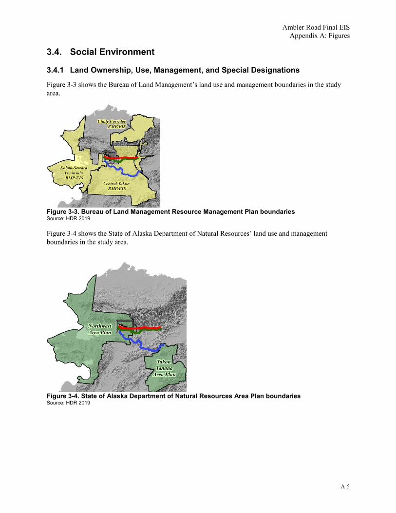
Ambler Road Final EIS Appendix A: Figures
A-5
3.4. Social Environment
3.4.1 Land Ownership, Use, Management, and Special Designations
Figure 3-3 shows the Bureau of Land Management’s land use and management boundaries in the study area.
Figure 3-3. Bureau of Land Management Resource Management Plan boundaries Source: HDR 2019
Figure 3-4 shows the State of Alaska Department of Natural Resources’ land use and management boundaries in the study area.
Figure 3-4. State of Alaska Department of Natural Resources Area Plan boundaries Source: HDR 2019

Ambler Road Final EIS Appendix A: Figures
A-6
Figure 3-5 shows the Northwest Arctic Borough’s land use and management boundaries in the study area.
Figure 3-5. Northwest Arctic Borough planning boundary Source: HDR 2019
3.4.2 Transportation and Access
Section 3.4.2, Transportation and Access, includes no figures.
3.4.3 Recreation and Tourism
Section 3.4.3, Recreation and Tourism, includes no figures.

Ambler Road Final EIS Appendix A: Figures
A-7
3.4.4 Visual Resources
Figure 3-6 shows a view from a key observation point (KOP) upriver of the Alternative B alignment on the Kobuk River. It illustrates a river-level view. Shown are (1) existing conditions and (2) a simulation of the view of the proposed Kobuk River bridge, with concrete bridge girders visible running horizontally and multiple vertical concrete piers in the river. This is representative in general of what large, multi-span bridges might look like at any major river crossing on any alternative but is specific to Alternative B and the Kobuk Wild and Scenic River.
Figure 3-6. Example visual simulation—river crossing Source: DOWL 2014

Ambler Road Final EIS Appendix A: Figures
A-8
Figure 3-7 shows a view from a KOP west of Walker Lake. It illustrates a view from a promontory. Shown are (1) existing conditions and (2) a simulation of the view of Alternative A winding across a relatively level landscape with moderate mountains in the background and hill slopes dropping away in the foreground. This is representative in general of what the proposed Ambler Road might look like in a combination of flat and mountainous terrain on any alternative but is specific to Alternative A near Walker Lake.
Figure 3-7. Example visual simulation—road on the landscape Source: DOWL 2014

Ambler Road Final EIS Appendix A: Figures and Maps
A-9
3.4.5 Socioeconomics and Communities
Section 3.4.5, Socioeconomics and Communities, includes no figures.
3.4.6 Environmental Justice
Section 3.4.6, Environmental Justice, includes no figures.
3.4.7 Subsistence Uses and Resources
Section 3.4.7, Subsistence Uses and Resources, includes no figures.
3.4.8 Public Health
Section 3.4.8, Public Health, includes no figures.
3.4.9 Cultural Resources
Section 3.4.9, Cultural Resources, includes no figures.
4. References Dau, J. 2015. Units 21D, 22B, 22C, 22E, 23, 24 AND 26A. Chapter 14, p. 14-1 through 14-89 In:
Caribou management report of survey and inventory activities 1 July 2012 – 30 June 2014 (P. Harper and L.A. McCarthy, eds.). Alaska Department of Fish and Game Species Management Report ADF&G/DWC/SM-2015-4. Juneau, Alaska.
DOWL. 2014. Preliminary Visual Impact Analysis, Ambler Mining District Industrial Access Road. November 2014. Prepared for AIDEA by DOWL. Anchorage, Alaska. Available at: ftp.ambleraccess.org/Reports/Project_Field_Studies/2014/01_Appdx_3C-Visual_Analysis_Report.pdf
DOWL. 2016. Ambler Mining District Industrial Access Road SF299 Revised Permit Application. Appendix 5C Typical Section (June 29, 2016). Available at: eplanning.blm.gov/epl-front-office/eplanning/planAndProjectSite.do?methodName=dispatchToPatternPage¤tPageId=111130
DOWL. 2019. Ambler Mining District Industrial Access Project SF299 Application Communications Amendment. April 2019. Prepared for AIDEA by DOWL. Anchorage, Alaska.
Pamperin, N.J. 2015. Units 20F, 21B, 21C, 21D, 24A, 24B, and 25D caribou. Chapter 13, pages 13-1 through 13-15 In: Caribou management report of survey and inventory activities 1 July 2012–30 June 2014 (P. Harper and L. A. McCarthy, editors). Alaska Department of Fish and Game, Species Management Report ADF&G/DWC/SMR-2015-4. Juneau, Alaska.
Trilogy Metals Inc. 2018. High Grade, High Quality, Solid Partners: Copper-Zinc-Lead-Gold-Silver and now… Cobalt. 2018 Precious Metals Summit Colorado, presentation dated September 21, 2018. Available at: trilogymetals.com/assets/docs/presentations/Trilogy-Metals---Corporate-Presentation----Precious-Met.pdf

Ambler Road Final EIS Appendix A: Figures
A-10
This page is intentionally left blank.

Appendix B:
Chapter 1 Introduction Tables and Supplemental Information

This page is intentionally left blank.

Ambler Road Final EIS Appendix B: Chapter 1 Introduction Tables and Supplemental Information
B-i
Table of Contents 1. Introduction ..................................................................................................................................... B-1
1.1. Introduction ................................................................................................................................ B-1
1.2. Project Background and Overview ............................................................................................ B-1
1.3. Applicant’s Purpose and Need for the Project .......................................................................... B-1
1.4. Purpose and Need for Federal Action ....................................................................................... B-1
1.5. Collaboration and Coordination................................................................................................. B-1
1.6. EIS Development Process and Coordination ............................................................................ B-3
2. References ....................................................................................................................................... B-3
Tables Table 1. Key permits, approvals, and other requirements by agency....................................................... B-1

Ambler Road Final EIS Appendix B: Chapter 1 Introduction Tables and Supplemental Information
B-ii
This page is intentionally left blank.

Ambler Road Final EIS Appendix B: Chapter 1 Introduction Tables and Supplemental Information
B-1
1. Introduction
1.1. Introduction
This section includes no tables or supplemental information.
1.2. Project Background and Overview
This section includes no tables or supplemental information.
1.3. Applicant’s Purpose and Need for the Project
This section includes no tables or supplemental information.
1.4. Purpose and Need for Federal Action
This section includes no tables or supplemental information.
1.5. Collaboration and Coordination
Table 1 summarizes key anticipated authorizing laws, regulations, and permits for the project.
Table 1. Key permits, approvals, and other requirements by agency Responsible agency Jurisdiction/legal authority Key permit, approval, or other requirement
DOI BLM and federal cooperating agencies
NEPA Disclose and review environmental impacts of proposed federal actions
DOI BLM/federal cooperating agencies
NHPA NHPA consultation, Section 106 determinations/PA includes consideration of effects of federal undertakings on historic properties
DOI BLM FLPMA Decision whether to grant ROW permit and authorization to regulate the use, occupancy, and development of public lands and to take action to prevent unnecessary or undue degradation of public lands
DOI BLM ANILCA Section 201 and Title XI
Authorization for Transportation and Utility Systems and Facilities on Federal Lands and ANILCA-defined conservation system units
DOI BLM ANILCA Section 810 Section 810 evaluation and findings include analysis of impacts to subsistence resources and access to those resources
DOI BLM ANCSA Coordination with ANCSA landowners (DOI Policy on Consultation with Alaska Native Claims Settlement Act Corporations [2011])
DOI NPS ANILCA Section 201(4)(b) Grant ROW permit across GAAR if BLM selects a route that goes through GAAR
USACE CWA Section 404 Department of the Army Permit for discharge of dredged or fill material into waters of the United States, including wetlands

Ambler Road Final EIS Appendix B: Chapter 1 Introduction Tables and Supplemental Information
B-2
Responsible agency Jurisdiction/legal authority Key permit, approval, or other requirement
USACE Rivers and Harbors Act Section 10
Department of the Army Permit for construction in any navigable water; the excavation or discharge of material into such water; or the accomplishment of any other work affecting the course, location, condition, or capacity of such waters
USCG Rivers and Harbors Act Section 9
Section 9 permit for development of a bridge or causeway in or over any navigable river or navigable water of the United States
DOI USFWS Bald and Golden Eagle Protection Act
Permits to take, haze, relocate, or destroy eagles or their nests
DOI USFWS MBTA Consultation/permits for actions that could take migratory birds or the parts, nests, or eggs of such birds
DOI USFWS Fish and Wildlife Coordination Act
Consultation on impacts on fish and wildlife resources
NMFS MSA EFH Assessment: consultation on the effects to EFH
ADEC CWA Section 401 Section 401 Water Quality Certification issued to accompany the USACE Section 404 permit
ADEC CWA Section 402 APDES permit for point-source discharge of wastewater or storm water into waters of the United States
ADEC Title I and/or Title V Operating Permits 18 AAC 50
Construction, Minor Permit, or Operating permits for air pollution sources at material sites and or construction/maintenance camps
ADF&G AS Title 16 Title 16 Fish Habitat Permit required for proposed activity conducted below mean high water of anadromous fish streams
ADNR AS 38.35.850 Road ROW permit for state land
ADNR AS 38.05.550-565 Material sales (e.g., gravel) permit for state land
ADNR AS 38.05.850 Land use permits for any construction camps, staging areas, and airstrips that may be outside the construction ROW on state land
ADNR AS 46.15 and 11 AAC 93 Temporary water use/water rights
SHPO AS 41.35 (AHPA); NHPA Section 106
AHPA and NHPA Section 106 review of activities that may affect cultural resources/historic properties
NAB NAB Home Rule Charter Title 9
Borough permitting
DOI BLM/federal cooperating agencies
EO 11988 Floodplain Management: avoid short- and long-term adverse impacts to wetlands whenever a practicable alternative exists
DOI BLM/federal cooperating agencies
EO 11990 Protection of Wetlands: minimize the destruction, loss, or degradation of wetlands, and preserve and enhance the natural and beneficial values of wetlands
DOI BLM/federal cooperating agencies
EO 12898 Environmental Justice: identify/address disproportionately high and adverse effects of the project on minority and low-income populations
DOI BLM/federal cooperating agencies
EO 13045 Protection of Children from Environmental Health and Safety Risks: identify/assess environmental health and safety risks that may disproportionately affect children

Ambler Road Final EIS Appendix B: Introduction: Tables and Supplemental Information
B-3
Responsible agency Jurisdiction/legal authority Key permit, approval, or other requirement
DOI BLM/federal cooperating agencies
EO 13112 Invasive Species: prevent the introduction of invasive species; control invasive species already introduced; and minimize the economic, ecological, and human health impacts of invasive species
DOI BLM/federal cooperating agencies
EO 13175 Consultation and Coordination with Indian Tribal Government: consult with tribal governments when considering polices that would impact tribal communities
DOT&PF 17 AAC 10 Driveway/Approach Road permit for connecting to existing DOT&PF road
DOT&PF 17 AAC 20 Lane Closure Permit for Dalton Highway lane closures (if needed during construction)
Notes: AAC = Alaska Administrative Code; ADEC = Alaska Department of Environmental Conservation; ADF&G = Alaska Department of Fish and Game; ADNR = Alaska Department of Natural Resources; AHPA = Alaska Historic Preservation Act; ANCSA = Alaska Native Claims Settlement Act; ANILCA = Alaska National Interest Lands Conservation Act; APDES = Alaska Pollutant Discharge Elimination System; AS = Alaska Statute; BLM = Bureau of Land Management; CWA = Clean Water Act; DOI = Department of the Interior; DOT&PF = Alaska Department of Transportation and Public Facilities; EFH = Essential Fish Habitat; EO = Executive Order; FLPMA = Federal Land Policy and Management Act; GAAR = Gates of the Arctic National Park and Preserve; MBTA = Migratory Bird Treaty Act; MSA = Magnuson-Stevens Fishery Conservation and Management Act; NAB = Northwest Arctic Borough; NEPA = National Environmental Policy Act; NHPA = National Historic Preservation Act; NMFS = National Marine Fisheries Service; NPS = National Park Service; PA = Programmatic Agreement; ROW = right-of-way; SHPO = State Historic Preservation Officer; USACE = U.S. Army Corps of Engineers; USCG = U.S. Coast Guard; USFWS = U.S. Fish and Wildlife Service EIS Development Process and Coordination
1.6. EIS Development Process and Coordination
This section includes no tables or supplemental information.
2. References
None cited.

Ambler Road Final EIS Appendix B: Chapter 1 Introduction Tables and Supplemental Information
B-4
This page is intentionally left blank.

I
Appendix C:
Chapter 2 Alternatives Tables and Supplemental Information

Ambler Road Final EIS Appendix C: Chapter 2 Alternatives Tables and Supplemental Information
C-ii
This page is intentionally left blank.

Ambler Road Final EIS Appendix C: Chapter 2 Alternatives Tables and Supplemental Information
C-i
Table of Contents 1. Alternatives ...................................................................................................................................... C-ii
1.1. Introduction ................................................................................................................................ C-1
1.2. Alternatives Development Process ........................................................................................... C-1
1.3. Alternatives Considered but Eliminated from Detailed Analysis ............................................... C-1
1.4. Alternatives Retained for Detailed Analysis .............................................................................. C-1
1.5. Summary of Impacts ................................................................................................................. C-5
2. References ..................................................................................................................................... C-11
Tables Table 1. Summary of major project components for each action alternative ............................................ C-3 Table 2. Summary of impacts for each alternative ................................................................................... C-5

Ambler Road Final EIS Appendix C: Chapter 2 Alternatives Tables and Supplemental Information
C-ii
This page is intentionally left blank.

Ambler Road Final EIS Appendix C: Chapter 2 Alternatives Tables and Supplemental Information
C-1
1. Alternatives
1.1. Introduction
No tables or supplemental information.
1.2. Alternatives Development Process
No tables or supplemental information.
1.3. Alternatives Considered but Eliminated from Detailed Analysis
No tables or supplemental information.
1.4. Alternatives Retained for Detailed Analysis
Table 1 provides a summary of key project components by alternative to supplement the text in Section 2.4.3 of the EIS, Features Common to All Action Alternatives. This table shows how the common features differ in number or extent across the alternatives.

Ambler Road Final EIS Appendix C: Chapter 2 Alternatives Tables and Supplemental Information
C-2
This page is intentionally left blank.

Ambler Road Final EIS Appendix C: Chapter 2 Alternatives Tables and Supplemental Information
C-3
Table 1. Summary of major project components for each action alternative Component Alternative A Alternative B Alternative C Terminus (Project Start) MP 161 Dalton Highway MP 161 Dalton Highway MP 59.5 Dalton Highway
Terminus (Project End) Ambler River/Ambler Mining District
Ambler River/Ambler Mining District
Ambler River/Ambler Mining District
Length of industrial access road (miles) 211 228 332
Total footprint of industrial access road (acres) 2,318 2,551 5,262
Total footprint of support access roads (acres) 137 214 239
Number of maintenance stations (12 acres each) 3 stations (36 acres) 3 stations (36 acres) 5 stations (60 acres)
Number of material sites 41 46 44
Total footprint of material sites (acres) 1,863 2,155 2,408
Number of airstrips (150 feet by 3,000 feet) 3 3 5
Total footprint of airstrips (acres) 153 153 255
Number of vehicle turnouts (1 every 10 to 11 miles) 20 22 32
Number of communications towers: At maintenance stations + At materials sites = Total number
3 + 9 = 12 3 + 10 = 13 5 + 14 = 19
Total footprint of project (acres) 4,524 5,138 8,210
Total footprint of project on NPS-managed lands (acres) 332 343 0
Gravel needed for construction (cubic yards) 15 million 16.8 million 22 million
Gravel needed for maintenance (cubic yards, annually) 220,000 238,000 347,000
Number of minor culverts (to 3 feet wide) 2,869 3,155 4,076
Number of moderate culverts (4 to 10 feet wide) 15 12 131
Number of major culverts (10 to 20 feet wide) 19 12 141
Number of small bridges (less than 50 feet long) 3 3 79
Number of medium bridges (50 to 140 feet long) 15 12 158
Number of large bridges (greater than 140 feet long) 11 11 14

Ambler Road Final EIS Appendix C: Chapter 2 Alternatives Tables and Supplemental Information
C-4
Component Alternative A Alternative B Alternative C Costsa of construction (based on 2-lane road):
1. Road2. Landing strips (number of strips)3. Maintenance stations (number of stations)4. Communications (VHF radio, fiber optic, and satellite)5. Construction – Total6. Closure and reclamationb
7. Construction plus reclamation – Total
1. $447 million2. $2.5 million (3)3. $26.4 million (4)4. $43.4 million5. $519.3 million6. $60.0 million7. $579.3 million
1. $481 million2. $2.5 million (3)3. $26.4 million (4)4. $46.9 million5. $556.8 million6. $64.8 million7. $621.6 million
1. $880 million2. $4.2 million (5)3. $39.7 million (6)4. $68.3 million5. $992.2 million6. $94.4 million7. $1.09 billion
Costs* of annual maintenance: 1. Road2. Maintenance stations (landing strips not separated)3. Communications4. Total
1. $6.6 million/year2. $2 million/year (4)3. $586,000/year4. $9.2 million/year
1. $7.2 million/year2. $2 million/year (4)3. $633,000/year4. $9.8 million/year
1. $10.4 million/year2. $3 million/year (6)3. $917,000/year4. $14.3 million/year
Source: DOWL 2016, 2019a, 2019b; Analysis by the Bureau of Land Management (BLM) Note: MP = Milepost a Costs are Alaska Industrial Development and Export Authority (AIDEA) estimates prepared by engineering consultant DOWL and provided to the BLM in April 2019 in a “Summary Report Addendum” and in an “SF299 Application: Communications Amendment.” For the Environmental Impact Statement, AIDEA/DOWL used somewhat different methods to estimate costs than they had used earlier for AIDEA’s proposed routes (Alternatives A and B only); this was an effort to present cost estimates for all 3 alternatives on the same basis and at the same level of detail. Therefore, costs presented here may differ from those presented in AIDEA’s other materials regarding its proposal. Also, AIDEA’s cost estimate as presented to the BLM amortized maintenance camps and airstrips as maintenance costs over multiple years and presented them as maintenance costs rather than construction costs. The BLM has included them as part of overall construction costs. AIDEA presented some communications costs for all alternatives and some for its proposed routes only (Alternatives A and B). Where necessary, the BLM extrapolated unit costs to calculate the communications costs for all alternatives on the same basis. b Closure and reclamation costs were provided by AIDEA for Alternative A as an “Intermediate (Class 4) cost estimate in accordance with the Standard Reclamation Cost Estimate procedure” used by the Alaska Department of Natural Resources. AIDEA provided the information to the BLM on November 13, 2019, by letter. The cost provided was $58.9 million, “assuming an accuracy of -10 percent to +25 percent,” or $53 million to $74 million. The BLM rounded the cost estimate to $60 million, calculated a per-mile cost for Alternative A, and applied the per-mile cost to Alternatives B and C.

Ambler Road Final EIS Appendix C: Chapter 2 Alternatives Tables and Supplemental Information
C-5
1.5. Summary of Impacts
Table 2 summarizes the impacts by resource category and resources affected for each alternative. Unless otherwise noted, impacts given are for the entire road project, including the road, airstrips, maintenance camps, material sites, and material/water access roads. For additional information, see Chapter 3 (Affected Environment and Environmental Consequences), appendices, and technical reports for each resource category.
Table 2. Summary of impacts for each alternative Resource category Resource affected No Action Alternative Alternative A Alternative B Alternative C
Geology and Minerals
Permafrost, NOA, ARD. Thawing of some permafrost likely based on current trends.
Road construction likely to exacerbate thawing of permafrost and resultant ground settlement in the road corridor. All alternatives cross areas of NOA, and asbestos dust is a health hazard. Disturbing soils has potential to generate ARD where sulfide minerals are exposed.
Similar to Alternative A. Similar to Alternative A, with somewhat less known NOA.
Geology and Minerals
Indirect effects. Unlikely to result in removal of minerals from the District to market.
Would lead to removal of minerals from the District to market. Same as Alternative A. Same as Alternative A.
Soils and Permafrost
Area underlain by continuous permafrost.
N/A 4,177 acres (92% of route)
4,691 acres (91% of route)
3,945 acres (48% of route)
Soils and Permafrost
Area underlain by discontinuous permafrost.
N/A 347 acres (8% of route)
447 acres (9% of route)
4,254 acres (52% of route)
Soils and Permafrost
Area (acres) of project footprint with known potential for NOA.
N/A Known High: 88 acres Known Medium: 106 acres Known 0 to Low: 202 acres Unknown (unevaluated surface deposits): 4,120 acres Other (water): 8 acres
Known High: 168 acres Known Medium: 198 acres Known 0 to Low: 367 acres Unknown: 4,395 acres Other (water): 9 acres
Known High: 0 acres Known Medium: 1,279 acres Known 0 to Low: 2,267 acres Unknown: 4,645 acres Other (water): 20 acres
Sand and Gravel Number of material sites and projected total acreage.
N/A Road construction and maintenance would use a large volume of material with 41 potential material sites identified (estimated to total 1,863 acres).
Similar to Alternative A but 46 potential material sites (estimated to total 2,155 acres).
Similar to Alternative A but 44 potential material sites (estimated to total 2,408 acres).
Hazardous Waste Risk of toxic releases to the environment.
N/A Toxic spills and dust are likely to occur at a small scale under any action alternative. Large spills or releases from a truck rollover could occur and damage adjacent waterways and habitat.
Similar to Alternative A. Similar to Alternative A. Alternative C is approximately 50% longer than Alternative A, so would have greater direct risk of spill from truck rollover on the new road, but overall driving distance to Fairbanks would be similar, so overall risk would be similar.
Paleontological Resources
Area of project footprint by PFYC (Classes 1–5; water and unknown areas not given).
N/A Class 1–2 (very low/low): 4,518 acres Class 3–5 (moderate–very high): 0 acres
Class 1–2 (very low/low): 5,131 acres Class 3–5 (moderate–very high): 0 acres
Class 1–2 (very low/low): 7,785 acres Class 3–5 (moderate–very high): 0 acres
Paleontological Resources
Effects on fossil and non-fossil evidence of ancient life.
Weathering and erosion of resources would occur naturally.
Construction could affect fossil and non-fossil evidence of ancient life.
Same as Alternative A. Same as Alternative A.
Water Resources Effects to water resources. N/A Ice road, bridge, and culvert construction; gravel extraction; gravel placement; water withdrawal; and wastewater discharge would likely alter surface and subsurface flow patterns and water quality. The impacts of each alternative would be similar, with extent of impact governed largely buy the length of the alternative.
Similar to Alternative A, but slightly longer alignment means slightly greater impact.
Similar to Alternative A, but much longer alignment means correspondingly greater impact.

Ambler Road Final EIS Appendix C: Chapter 2 Alternatives Tables and Supplemental Information
C-6
Resource category Resource affected No Action Alternative Alternative A Alternative B Alternative C
Water Resources Miles of alignment in floodplain (including bridge and culvert crossings).
N/A 4.6 miles 5.4 miles 53.6 miles
Water Resources Miles of alignment located within 1,000 feet of floodplain.
N/A 16.1 miles (8%) 17.3 miles (8%) 96.3 miles (29%)
Water Resources Area of assumed floodplain impact by bridges and culverts (includes multiple assumptions).
N/A 2,110 acres 2,110 acres 4,526 acres
Acoustical Environment
Direct effects to soundscape. N/A Road construction and operation would create new sounds from vehicles, aircraft, and generators at maintenance stations and communications sites. Longer alternatives would create new sounds in more new places. Alternative A would cross GAAR and the Kobuk Wild and Scenic River and would run near the designated Wilderness boundary, all managed for natural soundscape.
Similar to Alternative A. Alternative B would cross GAAR and the Kobuk Wild and Scenic River, both managed for natural soundscape. However, road noise generally would not extend to Wilderness.
Similar to Alternative A. However, Alternative C would not cross GAAR. It would pass near Kobuk and Hughes and could create noise impacts in and near these communities.
Acoustical Environment
Indirect and cumulative effects. N/A Mining in the District would be the same under all action alternatives and would create substantial industrial noise from continual blasting and earth moving with oversize vehicles, in addition to road and air traffic noise. Ambler Road noise combined with mine-related noise would create cumulative impacts over substantial parts of the District.
Same as Alternative A. Same as Alternative A.
Air Quality and Climate
Emissions and effects on air quality. N/A Pollutants, including dust, would be emitted from construction and operation of the road under all action alternatives. The areas affected would differ by the location and length of each alignment. Effects mostly would be small and localized to the road corridor. No criteria pollutants would be expected to exceed thresholds established for human health. Alternative A would pass through GAAR, a sensitive air quality area.
Similar to Alternative A. Similar to Alternative A, but Alternative C would not pass through any sensitive air quality area. As a much longer alternative, it would create new emissions in a larger area, but overall GHG emissions would be lower than Alternatives A and B.
Air Quality and Climate
NA For District traffic, District to Fairbanks: Carbon monoxide: 13.7 tons/year Nitrous oxide: 39.3 tons/year Sulfur dioxide: 0.5 ton/year Dust (with dust control): 6,430 tons/year Construction GHG (CO2e): 99,136 tons Operations GHG (CO2e): 54,230 tons/year
For District traffic, District to Fairbanks: Carbon monoxide: 13.7 tons/year Nitrous oxide: 39.3 tons/year Sulfur dioxide: 0.5 ton/year Dust (with dust control): 6,430 tons/year Construction GHG (CO2e): 99,136 tons Operations GHG (CO2e): 54,230 tons/year
For District traffic, District to Fairbanks: Carbon monoxide: 13.7 tons/year Nitrous oxide: 39.3 tons/year Sulfur dioxide: 0.5 ton/year Dust (with dust control): 6,430 tons/year Construction GHG (CO2e): 99,136 tons Operations GHG (CO2e): 54,230 tons/year
Vegetation and Wetlands
Vegetation impact, 10-foot construction zone.
N/A 610 acres 676 acres 913 acres
Vegetation and Wetlands
Vegetation impact/cut-fill in project footprint.
N/A 4,517 acres 5,130 acres 8,111 acres
Vegetation and Wetlands
Vegetation impact, primary dust zone. N/A 17,728 acres 19,656 acres 25,865 acres
Vegetation and Wetlands
Wetland impact, 10-foot construction zone.
N/A 343 acres 396 acres 572 acres
Vegetation and Wetlands
Wetland impact/cut-fill in project footprint.
N/A 2,079 acres 2,416 acres 3,890 acres

Resource category Resource affected No Action Alternative Alternative A Alternative B Alternative C
Vegetation and Wetlands
Wetland impact, primary dust zone. N/A 10,837 acres 12,270 acres 16,289 acres
Vegetation and Wetlands
Percent of route going through wetlands.
N/A 57% 60% 63%
Vegetation and Wetlands
Rare/higher value wetlands (Palustrine Emergent & Nutuvukti Fen)
N/A 116.3 acres built in Palustrine Emergent. 0.25 mile up-gradient of Nutuvukti Fen.
118.6 acres built in Palustrine Emergent. 249.8 acres built in Palustrine Emergent.
Fish and Amphibians
Number of crossings of known and/or assumed anadromous fish streams.
N/A 40 43 270
Fish and Amphibians
Number of gravel mines within floodplain or in low-lying areas within 500 feet of fish streams/total number of gravel mines proposed.
N/A 21/41 22/46 16/44
Birds Birds and bird habitat. N/A The impacts from a road on birds would include cut and fill in and alteration of terrestrial and aquatic habitat, disturbance and displacement of birds, and injury or mortality. The types of potential effects would be similar for each alternative, with different areas affected. Alternative A and B would have nearly identical impacts.
Same as Alternative A. Similar to Alternative A, but Alternative C would be the longest alignment and would affect more habitat. It would affect an area noted for richness of waterfowl species and would cross more alpine habitat areas.
Mammals Caribou habitat affected – WAH. N/A Migratory: 1,287 acres Winter: 1,128 acres Peripheral: 1,745 acres Total: 4,161 acres
Migratory: 1,347 acres Winter: 1,128 acres Peripheral: 2,300 acres Total: 4,775 acres
Migratory: 419 acres Winter: 1,615 acres Peripheral: 2,086 acres Total: 4,120 acres
Mammals Caribou habitat affected – RMH. N/A 0 acres 0 acres 1,964 acres
Land Land ownership of proposed ROW (generally 250 feet wide; where footprint is outside this area, the ROW is considered to be 10 feet beyond the footprint).
N/A Federal: 3,498 acres State: 8,635 acres Borough: 261 acres Alaska Native Corporation: 2,439 acres Native Allotment: 0.05 acres Private: 0 acres Undetermined: 42 acres Total: 14,874 acres
Federal: 3,083 acres State: 10,148 acres Borough: 593 acres Alaska Native Corporation: 2,437 acres Native Allotment: 0.44 acres Private: 0 acres Undetermined: 45 acres Total: 16,306 acres
Federal: 19,090 acres State: 426 acres Borough: 0 acres Alaska Native Corporation: 3,390 acres Native Allotment: 12 acres Private: 152 acres Undetermined: 73 acres Total: 23,143 acres
Land Miles of proposed ROW within special designation areas.
N/A 29 miles (GAAR, Special Recreation Management Area, Kobuk Wild and Scenic River)
21 miles (GAAR, Special Recreation Management Area, Kobuk Wild and Scenic River)
105 miles (Tozitna River and Indian River Areas of Critical; Environmental Concern, Special Recreation Management Area)
Transportation and Access
Total transport distance, Ambler Mining District to port at Anchorage
-portion assumed by truck-portion assumed by rail
N/A 808 miles 452 miles 356 miles
825 miles 469 miles 356 miles
828 miles 472 miles 356 miles

Ambler Road Final EIS Appendix C: Chapter 2 Alternatives Tables and Supplemental Information
C-8
Resource category Resource affected No Action Alternative Alternative A Alternative B Alternative C
Transportation and Access
Direct effect: AADT on the Ambler Road over the 50-year term of the ROW permit (based on assumed mining scenario in Appendix H, Indirect and Cumulative Impacts Associated with the Ambler Road).
N/A Phase 1: 7–57 trips per day Phase 2: 58–118 trips per day Phase 3 (early): 104–168 trips per day Phase 3 (late): 83, tapering to 3, trips per day
Phase 1: 7–57 trips per day Phase 2: 58–118 trips per day Phase 3 (early): 104–168 trips per day Phase 3 (late): 83, tapering to 3, trips per day
Phase 1: 7–57 trips per day Phase 2: 58–118 trips per day Phase 3 (early): 104–168 trips per day Phase 3 (late): 83, tapering to 3, trips per day
Transportation and Access
Indirect effect: AADT increase on Dalton Highway (current AADT is 300 (projected traffic level is the same for all action alternatives).
N/A Dalton Highway miles affected: 161 Phase 1: 7–57 trips per day Phase 2: 58–179 trips per day Phase 3 (early): 160–238 trips per day Phase 3 (late): 123, tapering to 3, trips per day
Dalton Highway miles affected: 161 Phase 1: 7–57 trips per day Phase 2: 58–179 trips per day Phase 3 (early): 160–238 trips per day Phase 3 (late): 123, tapering to 3, trips per day
Dalton Highway miles affected: 59.5 Phase 1: 7–57 trips per day Phase 2: 58–179 trips per day Phase 3 (early): 160–238 trips per day Phase 3 (late): 123, tapering to 3, trips per day
Transportation and Access
Indirect effect: new rail and port traffic associated with 4 likely mines (same for all action alternatives).
N/A Arctic: 4.3 trains per week; 10 ships per year Bornite: 2.2 trains per week; 5 ships per year Sun: 1.5 trains per week; 3 ships per year Smucker: 1.5 trains per week; 3 ships per year
Arctic: 4.3 trains per week; 10 ships per year Bornite: 2.2 trains per week; 5 ships per year Sun: 1.5 trains per week; 3 ships per year Smucker: 1.5 trains per week; 3 ships per year
Arctic: 4.3 trains per week; 10 ships per year Bornite: 2.2 trains per week; 5 ships per year Sun: 1.5 trains per week; 3 ships per year Smucker: 1.5 trains per week; 3 ships per year
Transportation and Access
Communities most likely to arrange commercial deliveries directly or by connecting boat or snowmobile.
N/A Direct: Kobuk Via connecting boat or snowmobile: Shungnak, Ambler, Bettles-Evansville
Direct: Kobuk Via connecting boat or snowmobile: Shungnak, Ambler, Bettles-Evansville
Direct: Kobuk Via new road: Hughes Via connecting boat or snowmobile: Shungnak, Ambler
Recreation and Tourism
Example: common Brooks Range float trips crossed by alignment (with relationship to Wild and Scenic River segment).
N/A Alatna River (downstream of Wild and Scenic River portion) John River (downstream of Wild and Scenic River portion) Kobuk River (at Wild and Scenic River portion) North Fork Koyukuk (downstream of Wild and Scenic River portion) The alternative crosses multiple other streams and rivers used for float trips but that originate outside GAAR and have no “wild and scenic” segment.
Alatna River (downstream of Wild and Scenic River portion) John River (downstream of Wild and Scenic River portion) Kobuk River (at Wild and Scenic River portion) North Fork Koyukuk (downstream of Wild and Scenic River portion) The alternative crosses multiple other streams and rivers used for float trips but that originate outside GAAR and have no “wild and scenic” segment.
Kobuk (downstream of Wild and Scenic River segment) The alternative crosses multiple other streams and rivers used for float trips and boating but that originate outside GAAR and have no “wild and scenic” segment, including the Koyukuk and Hogatza.
Visual Resources Miles of road alignment within BLM VRI classifications (broad indicator of visual value without management implications).
N/A BLM VRI Class I: 0 miles BLM VRI Class II: 107.3 miles BLM VRI Class III: 0 miles BLM VRI Class IV: 21.5 miles Unclassified (GAAR): 26.1 miles Unclassified (Other): 56.4 miles
BLM VRI Class I: 0 miles BLM VRI Class II: 119.3 miles BLM VRI Class III: 0 miles BLM VRI Class IV: 25.7 miles Unclassified (GAAR): 17.8 miles Unclassified (Other): 65.5 miles
BLM VRI Class I: 0 miles BLM VRI Class II: 75.5 miles BLM VRI Class III: 64.4 miles BLM VRI Class IV: 168.7 miles Unclassified (GAAR): 0 miles Unclassified (Other): 23.9 miles
Visual Resources Miles of road alignment within BLM VRM classifications (indicator of consistency with management plan near Dalton Highway).
N/A BLM VRM Class I/II: 0 miles BLM VRM Class III: 16.9 miles BLM VRM Class IV: 1.9 miles
BLM VRM Class I/II: 0 miles BLM VRM Class III: 16.9 miles BLM VRM Class IV: 1.9 miles
BLM VRM Class I/II: 0 miles BLM VRM Class III: 7.9 miles BLM VRM Class IV: 4.4 miles
Socioeconomics and Communities
Direct road construction jobs (assuming each alternative would be built in 4 years).
N/A Road construction total jobs per year: 680 Portion of total jobs to Alaskans: 550 Portion of total jobs to area residents: 110 Road operations jobs: 50 Portion of operations jobs to area residents: 10
Road construction total jobs per year: 730 Portion of total jobs to Alaskans: 590 Portion of total jobs to area residents: 120 Road operations jobs: 60 Portion of operations jobs to area residents: 12
Road construction total jobs per year: 1,310 Portion of total jobs to Alaskans: 1,060 Portion of total jobs to area residents: 210 Road operations jobs: 80 Portion of operations jobs to area residents: 16

Resource category Resource affected No Action Alternative Alternative A Alternative B Alternative C
Socioeconomics and Communities
Public Health N/A Increased employment and income could reduce food-insecurity but could alter diets away from healthier traditional diets to less healthy ‘store-bought’ diets, which can contribute to obesity and diabetes. The road could lead to increased exposure to asbestos, particularly for those who regularly travel/hunt & gather/work on or near the road and breathe dust. Road access/commercial deliveries and influx of road and mine workers would create easier access to abusable substances and could increase communicable disease if residents and workers mingle. If communities connected to the project fiber optic line, the connection could improve access to telemedicine until the road closed. See also Health Impact Assessment at project ePlanning web site. Communities most affected: Kobuk, Shungnak, Ambler, Bettles, Evansville.
Same as Alternative A. Communities most affected: Kobuk, Shungnak, Ambler, Bettles, Evansville.
Same as Alternative A, except potentially lower potential for asbestos to be released in road dust. Communities most affected: Kobuk, Shungnak, Ambler, Hughes.
Socioeconomics and Communities
Indirect effects of mines in the District.
N/A The mines would create new jobs and pay fees and taxes to the State of Alaska, Northwest Arctic Borough, and Native corporations. This would occur equally under all action alternatives. See also Transportation and Access for individual communities that could have cheaper commercial delivery of goods. This impact would occur during road operations, but the jobs could lead to decreased population in some small communities due to urban migration.
Same as Alternative A. Same as Alternative A.
Environmental Justice
Disproportionate effects to minority and low-income populations.
N/A Impacts to subsistence and public health, including stress, subsistence-food insecurity, and potential exposure to asbestos, would disproportionately affect low-income and minority populations, specifically Alaska Native villages that live in and near the project area and depend on the surrounding area for their subsistence lifeway. Impacts to employment would occur but would not be expected to disproportionately affect low-income and minority populations. The effects would be more likely for Bettles-Evansville under Alternative A and less likely for Hughes.
Same as Alternative A. Same as Alternative A, but the effects would be more likely for Hughes under Alternative C and less likely for Bettles-Evansville.
Subsistence Number of communities with subsistence use areas that would be crossed by the project, affecting subsistence travel patterns and subsistence species movements.
N/A Moose: 9 Caribou: 9 Dall sheep: 6 Bear: 5 Small land mammals: 8 Migratory birds: 6 Upland game birds: 4 Eggs: 2 Salmon: 3 Other fish: 3 Vegetation: 6
Moose: 9 Caribou: 9 Dall sheep: 6 Bear: 5 Small land mammals: 9 Migratory birds: 5 Upland game birds: 4 Eggs: 2 Salmon: 3 Other fish: 3 Vegetation: 7
Moose: 8 Caribou: 10 Dall sheep: 3 Bear: 7 Small land mammals: 15 Migratory birds: 6 Upland game birds: 3 Eggs: 0 Salmon: 5 Other fish: 8 Vegetation: 6
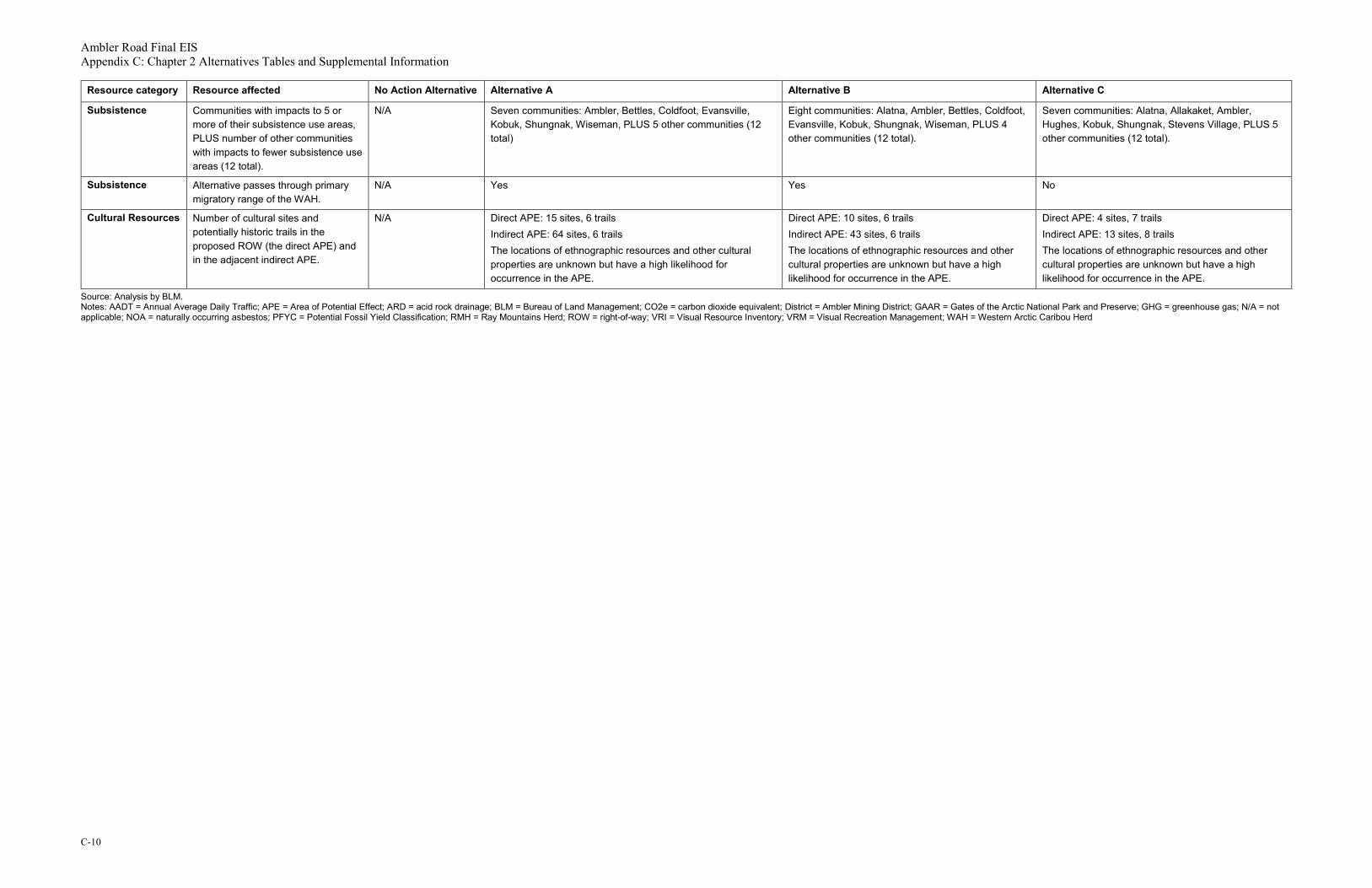
Ambler Road Final EIS Appendix C: Chapter 2 Alternatives Tables and Supplemental Information
C-10
Resource category Resource affected No Action Alternative Alternative A Alternative B Alternative C
Subsistence Communities with impacts to 5 or more of their subsistence use areas, PLUS number of other communities with impacts to fewer subsistence use areas (12 total).
N/A Seven communities: Ambler, Bettles, Coldfoot, Evansville, Kobuk, Shungnak, Wiseman, PLUS 5 other communities (12 total)
Eight communities: Alatna, Ambler, Bettles, Coldfoot, Evansville, Kobuk, Shungnak, Wiseman, PLUS 4 other communities (12 total).
Seven communities: Alatna, Allakaket, Ambler, Hughes, Kobuk, Shungnak, Stevens Village, PLUS 5 other communities (12 total).
Subsistence Alternative passes through primary migratory range of the WAH.
N/A Yes Yes No
Cultural Resources Number of cultural sites and potentially historic trails in the proposed ROW (the direct APE) and in the adjacent indirect APE.
N/A Direct APE: 15 sites, 6 trails Indirect APE: 64 sites, 6 trails The locations of ethnographic resources and other cultural properties are unknown but have a high likelihood for occurrence in the APE.
Direct APE: 10 sites, 6 trails Indirect APE: 43 sites, 6 trails The locations of ethnographic resources and other cultural properties are unknown but have a high likelihood for occurrence in the APE.
Direct APE: 4 sites, 7 trails Indirect APE: 13 sites, 8 trails The locations of ethnographic resources and other cultural properties are unknown but have a high likelihood for occurrence in the APE.
Source: Analysis by BLM. Notes: AADT = Annual Average Daily Traffic; APE = Area of Potential Effect; ARD = acid rock drainage; BLM = Bureau of Land Management; CO2e = carbon dioxide equivalent; District = Ambler Mining District; GAAR = Gates of the Arctic National Park and Preserve; GHG = greenhouse gas; N/A = not applicable; NOA = naturally occurring asbestos; PFYC = Potential Fossil Yield Classification; RMH = Ray Mountains Herd; ROW = right-of-way; VRI = Visual Resource Inventory; VRM = Visual Recreation Management; WAH = Western Arctic Caribou Herd

Ambler Road Final EIS Appendix C: Chapter 2 Alternatives Tables and Supplemental Information
C-11
2. ReferencesDOWL. 2016. Ambler Mining District Industrial Access Road SF299 Revised Permit Application.
Prepared for the Alaska Industrial Development and Export Authority. Available at: eplanning.blm.gov/epl-front-office/eplanning/planAndProjectSite.do?methodName=dispatchToPatternPage¤tPageId=111130
DOWL. 2019a. Ambler Mining District Industrial Access Project SF299 Application Communications Amendment. April 2019. Prepared for AIDEA by DOWL. Anchorage, Alaska.
DOWL. 2019b. Ambler Mining District Industrial Access Project: Summary Report Addendum. Prepared for AIDEA by DOWL. Anchorage, Alaska.

Ambler Road Final EIS Appendix C: Chapter 2 Alternatives Tables and Supplemental Information
C-12
This page is intentionally left blank.

Appendix D:
Chapter 3 Physical Environment Tables and Supplemental Information

This page is intentionally left blank.

Ambler Road Final EIS Appendix D: Chapter 3 Physical Environment Tables and Supplemental Information
D-i
Table of Contents 1. Affected Environment and Environmental Consequences – Physical Environment............... D-1
1.1. Geology and Soils ..................................................................................................................... D-1
1.2. Sand and Gravel Resources ..................................................................................................... D-2
1.3. Hazardous Waste ...................................................................................................................... D-3
1.4. Paleontological Resources ........................................................................................................ D-5
1.5. Water Resources ...................................................................................................................... D-7
1.6. Acoustical Environment (Noise) .............................................................................................. D-14
1.7. Air Quality and Climate ........................................................................................................... D-15
1.7.1 Greenhouse Gas Emissions ........................................................................................... D-21
2. References ..................................................................................................................................... D-23
Tables Table 1. Geologic units crossed by alternative footprints ......................................................................... D-1 Table 2. Acreage and percent of alternative footprint within mapped permafrost areas .......................... D-2 Table 3. Asbestos potential of alternative footprint ................................................................................... D-2 Table 4. ADEC identified contaminated sites in the study area ................................................................ D-3 Table 5. Spill characteristics by seasons .................................................................................................. D-4 Table 6. PFYC system description ............................................................................................................ D-5 Table 7. PFYC acreages by alternative .................................................................................................... D-7 Table 8. Monthly temperature and precipitation levels, Coldfoot Station ................................................. D-7 Table 9. Monthly temperature and precipitation levels, Bettles Station .................................................... D-8 Table 10. Monthly temperature levels, Hogatza River Station .................................................................. D-9 Table 11. Monthly temperature and precipitation levels, Selawik Station ................................................ D-9 Table 12. Monthly temperature levels, Kiana Station ............................................................................. D-10 Table 13. Large rivers in the project area ............................................................................................... D-10 Table 14. USGS gages in the project area and vicinity .......................................................................... D-11 Table 15. University of Alaska Fairbanks − Water and Environmental Research Center gages ........... D-12 Table 16. ADNR-listed surface and subsurface water uses ................................................................... D-12 Table 17. Approximated floodplain area impacts by crossing structures ............................................... D-13 Table 18. Roadway impacts on water quality ......................................................................................... D-14 Table 19. Construction equipment noise emission reference levels....................................................... D-15 Table 20. NAAQS and AAAQS ............................................................................................................... D-15 Table 21. EPA’s MOVES emission factors ............................................................................................. D-17 Table 22. Ambler Road operational phase estimated emissions (tons/year) ......................................... D-19 Table 23. Dalton Highway operational phase estimated emissions (tons/year) ..................................... D-20 Table 24. Total operational phase estimated emissions (tons/year) ...................................................... D-20 Table 25. Ambler Road construction phase GHG emissions (metric tons) ............................................ D-22

Ambler Road Final EIS Appendix D: Chapter 3 Physical Environment Tables and Supplemental Information
D-ii
Table 26. Annual cumulative GHG emissions from ore transportation, by alternative (CO2e, in metric tons/year) ........................................................................................................................................ D-23
Attachment Attachment A: Predictive Noise Modeling of the Ambler Road

Ambler Road Final EIS Appendix D: Chapter 3 Physical Environment Tables and Supplemental Information
D-1
1. Affected Environment and Environmental Consequences – Physical Environment
1.1. Geology and Soils
Table 1 identifies the geologic units crossed by the alternative footprints in the project area. The largest unit is unconsolidated surficial deposits, which predominantly consists of alluvial and glacial deposits.
Table 1. Geologic units crossed by alternative footprints State unit Alternative A (acres) Alternative B (acres) Alternative C (acres)
Andesitic volcanic rocks 0 0 162
Calcareous graywacke and conglomerate
9 125 1,096
Dikes and subvolcanic rocks 0 0 13
Igneous rocks 130 210 1,214
Intermediate granitic rocks 0 0 19
Mafic igneous-clast conglomerate, sandstone, and mudstone
111 111 0
Marble, northern Alaska 7 10 68
Melange facies 7 92 0
Metagraywacke and phyllite 34 31 9
Pelitic and quartzitic schist of the Ruby terrane
0 0 256
Pyroclastic rocks 0 0 216
Quartz-mica schist of the Brooks Range
104 104 73
Quartz-pebble conglomerate, west-central Alaska
32 77 60
Unconsolidated surficial deposits, undivided
4,084 4,370 4,455
Volcanic graywacke and conglomerate
0 0 143
Water 6 7 19
Total acres 4,524 5,138 8,210 Source: USGS n.d. Note: The total acreage of Alternative C includes a 406-acre area undefined by a state unit or water body.

Ambler Road Final EIS Appendix D: Chapter 3 Physical Environment Tables and Supplemental Information
D-2
Table 2 identifies the footprint acreage and percentage within mapped permafrost areas.
Table 2. Acreage and percent of alternative footprint within mapped permafrost areas Permafrost Alternative
A (acres) Alternative
A (%) Alternative B (acres)
Alternative B (%)
Alternative C (acres)
Alternative C (%)
Mountainous Area underlain by continuous permafrost
3,510 78 3,738 73 283 3
Mountainous Area underlain by discontinuous permafrost
0 0 0 0 3,031 37
Lowland and Upland Area underlain by moderately thick to thin permafrost
667 15 953 19 3,662 45
Lowland and Upland Area underlain by discontinuous permafrost
347 8 447 9 1,234 15
Total 4,524 100 5,138 100 8,210 100 Source: Geo-references map and attribute data derived from Ferrians 1965 Notes: Totals may exceed 100 percent due to rounding. The lowland and upland area underlain by moderately thick to thin permafrost is considered continuous permafrost for summation purposes.
Table 3 identifies the acreage and percentage of each alternative footprint on the mapped asbestos potential in the project area.
Table 3. Asbestos potential of alternative footprint Naturally occurring asbestos potential
Alternative A (acres [% total])
Alternative B (acres [% total])
Alternative C (acres [% total])
High 88 (2) 168 (3) 0 (0)
Medium 106 (2) 198 (4) 1,279 (16)
Zero to low 202 (4) 367 (7) 2,267 (28)
Unknown (unevaluated surficial deposits)
4,120 (91) 4,395 (86) 4,645 (57)
Other/Water 8 (<1) 9 (<1) 20 (<1)
Total 4,524 (100) 5,138 (100) 8,210 (100) Source: Solie and Athey 2015
1.2. Sand and Gravel Resources
No tables or supplemental information.

Ambler Road Final EIS Appendix D: Chapter 3 Physical Environment Tables and Supplemental Information
D-3
1.3. Hazardous Waste
Table 4 lists Alaska Department of Environmental Conservation (ADEC) identified contaminated sites located within 5 miles of Alternative C. There are no sites located within 5 miles of Alternatives A and B. Volume 4, Map 3-3 depicts this information.
Table 4. ADEC identified contaminated sites in the study area ADEC Hazard ID
Site name Status Distance from Alternative C
(miles)
23352 BLM Fire Service Dahl Creek Cleanup Complete 0.9
25387 Alyeska Five Mile Airstrip Cleanup Complete 1.3
3100 DOT&PF SREB - Kobuk Active 1.5
4615 Kobuk Abandoned Tank Farm Active 1.5
26573 DOT&PF 7 Mile Maintenance Station Class V Injection Well
Active 1.9
24594 DOT&PF 7 Mile Maintenance Station Cleanup Complete − Institutional Controls
2.0
873 DOT&PF 7 Mile Camp Cleanup Complete − Institutional Controls
2.0
1078 Central Alaska Gold Company Cleanup Complete 3.2
1601 Hughes Power Plant Pipeline Active 3.2
2645 Hughes School and Community Tank Farm Active 3.4
26270 Alyeska PS 06 Former Fire Training Area Active 4.3
4611 Alyeska PS 06 Former Mainline Turbine Sump Cleanup Complete 4.4
2965 Alyeska PS 06 Leach Field/Fuel Island Active 4.4
2529 Alyeska PS 06 Therminol Spill Site Cleanup Complete − Institutional Controls
4.4
3115 Alyeska PS 06 Jet Shed Cleanup Complete − Institutional Controls
4.4
1437 Alyeska PS 06 JP4 Fueling Facility Cleanup Complete 4.4
1731 Alyeska PS 06 Former Turbine Fuel Loading Cleanup Complete − Institutional Controls
4.4
Source: ADEC 2019 Notes: DOT&PF = Alaska Department of Transportation and Public Facilities; ADEC = Alaska Department of Environmental Conservation; BLM = Bureau of Land Management; ID = Identification; PS = Pump Station; SREB = snow removal equipment building

Ambler Road Final EIS Appendix D: Chapter 3 Physical Environment Tables and Supplemental Information
D-4
Table 5 describes characteristics of spill conditions and descriptions by season.
Table 5. Spill characteristics by seasons Season Conditions Description
Summer (ice-free)
Most rivers and creeks are ice-free or flowing; ponds and lakes are open water; tundra is snow-free; and biological use of tundra and water bodies is high.
Currents, winds, and passive spreading forces would disperse spills that reach the water bodies. Spills to the tundra would directly affect the vegetation, although dispersal of the spilled material is likely to be impeded by the vegetation. Spills to wet tundra may float on the water or be dispersed over a larger area than would spills to dry tundra or to snow-covered tundra. Spills under pressure that spray into the air may be distributed downwind over substantial areas and affect the tundra vegetation and water bodies.
Fall (freeze-up)
Waterbodies are beginning to ice over, but the ice cover might vary, depending on temperature, wind, currents, and river flow velocities. Snow begins to cover the tundra, and most of the migratory birds are leaving the North Slope.
Spilled material could be dispersed when it reaches flowing water but slowed or stopped when it reaches snow or surface ice. The spilled material could be contained by the snow or ice but dispersed if the ice breaks up and moves before it refreezes. The spilled material also could flow into ice cracks to the underlying water, where it could collect.
Winter (ice cover)
Waterbodies are covered by mostly unbroken ice, and snow covers the tundra.
Dispersal of material spilled to the tundra generally would be slowed although not necessarily stopped by the snow cover. Depending on the depth of snow cover as well as temperature and volume of spilled material, it may reach the underlying dormant vegetation or tundra ponds and lakes. Similarly, spills to rivers and creeks generally would be restricted in distribution by the snow and ice covering the waterbody, compared to seasons when there is no snow or ice cover. Spills under the ice to creeks, rivers, and tundra ponds and lakes might disperse slowly, as the currents are generally slow to nonexistent in winter.
Spring (breakup)
Thawing begins in the higher foothills of the Brooks Range and river flows increase substantially and quickly, often to flood stages. This is a short period of the year. These increased flows cause river ice cover to break up and flow downriver. River floodwaters usually flow over sea ice, which hastens the breakup of the sea ice. Snow cover begins to melt off the tundra and many migratory species, especially birds, return to the tundra.
Spills to waterbodies during breakup are likely to be widely dispersed and difficult to contain or clean up. Spills to the tundra might be widely dispersed if the flooding overtops the river and creek banks and entrains the spilled material.
Source: Coastal Plain Draft EIS (BLM 2019), based on Alpine Satellite Development Plan EIS (BLM 2004)

Ambler Road Final EIS Appendix D: Chapter 3 Physical Environment Tables and Supplemental Information
D-5
1.4. Paleontological Resources
The Potential Fossil Yield Classification (PFYC) system allows BLM employees to make initial assessments of paleontological resources to analyze potential effects of a proposed action under the National Environmental Policy Act. The PFYC system can also highlight areas for paleontological research efforts or predict illegal collecting. The system provides a consistent approach to determine in a potential action may affect paleontological resources.
Occurrences of paleontological resources are known to be correlated with mapped geologic units. The PFYC is created from available geologic maps and assigns a class value to each geological unit, representing the potential abundance and significance of paleontological resources that occur in that geologic unit. PFYC assignments should be considered as only a first approximation of the potential presence of paleontological resources, subject to change, based on ground verification.
Table 6 descriptions for the class assignments below are guidelines. The assignments were developed by BLM for geologic units within the Central Yukon Planning Area boundary, using criteria outlined in BLM Instruction Memorandum 2016-124 and are summarized in the following table.
Table 6. PFYC system description Class PYFC system description
Class 1 – Very Low These are geologic units that are not likely to contain recognizable paleontological resources. Management concerns for paleontological resources in Class 1 units are usually negligible or not applicable. Paleontological mitigation is unlikely to be necessary, except in very rare or isolated circumstances that result in the unanticipated presence of paleontological resources, such as unmapped geology contained in a mapped geologic unit. The probability of affecting significant paleontological resources is very low, and further assessment of paleontological resources is usually unnecessary. An assignment of Class 1 normally does not trigger a further analysis, unless paleontological resources are known or found to exist; however, standard stipulations should be put in place before any land use action is authorized, in order to accommodate an unanticipated discovery.
Class 2 – Low This is assigned to geologic units that are not likely to contain paleontological resources. Except where paleontological resources are known or found to exist, management concerns for paleontological resources are generally low and further assessment is usually unnecessary, except in occasional or isolated circumstances. Paleontological mitigation is necessary only where paleontological resources are known or found to exist. The probability of affecting significant paleontological resources is low. Localities containing important paleontological resources may exist, but they are occasional and should be managed on a case-by-case basis. An assignment of Class 2 may not trigger further analysis unless paleontological resources are known or found to exist; however, standard stipulations should be put in place before any land use action is authorized to accommodate unanticipated discoveries.

Ambler Road Final EIS Appendix D: Chapter 3 Physical Environment Tables and Supplemental Information
D-6
Class PYFC system description
Class 3 – Moderate This is assigned to sedimentary geologic units where fossil content varies in significance, abundance, and predictable occurrence. Except where paleontological resources are known or found to exist, management concerns for paleontological resources are generally low and further assessment is usually unnecessary, except in occasional or isolated circumstances. Paleontological mitigation is necessary only where paleontological resources are known or found to exist. The probability of affecting significant paleontological resources is low. Localities containing important paleontological resources may exist, but they are occasional and should be managed on a case-by-case basis. An assignment of Class 2 may not trigger further analysis unless paleontological resources are known or found to exist; however, standard stipulations should be put in place before any land use action is authorized to accommodate unanticipated discoveries.
Class 4 – High This is assigned to geologic units that are known to contain a high occurrence of paleontological resources. Management concerns for paleontological resources in Class 4 are moderate to high, depending on the proposed action. Paleontological mitigation strategies will depend on the nature of the proposed activity, but field assessment by a qualified paleontologist is normally needed to assess local conditions. The probability for affecting significant paleontological resources is moderate to high and depends on the proposed action. Mitigation planners must consider the nature of the proposed disturbance, such as removal or penetration of protective surface alluvium or soils, potential for future accelerated erosion, or increased ease of access that could result in looting. Detailed field assessment is normally required and on-site monitoring or spot-checking may be necessary during land-disturbing activities. In some cases, avoiding known paleontological resources may be necessary.
Class 5 – Very High This is assigned to sedimentary geologic units where fossil content varies in significance, abundance, and predictable occurrence. Management concerns for paleontological resources are moderate because the existence of significant paleontological resources is known to be low. Common invertebrate or plant fossils may be found in the area, and opportunities may exist for casual collecting. Paleontological mitigation strategies will be proposed, based on the nature of the proposed activity. This classification includes units of moderate or infrequent occurrence of paleontological resources. Management considerations cover a broad range of options that may include record searches, pre-disturbance surveys, monitoring, mitigation, or avoidance. Surface-disturbing activities may require assessment by a qualified paleontologist to determine whether significant paleontological resources occur in the area of a proposed action and whether the action could affect the paleontological resources.

Ambler Road Final EIS Appendix D: Chapter 3 Physical Environment Tables and Supplemental Information
D-7
Class PYFC system description
Class U – Unknown Potential
These are such geologic units that cannot receive an informed PFYC assignment. Until a provisional assignment is made, geologic units that have an unknown potential have medium to high management concerns. Lacking other information, field surveys are normally necessary, especially before a ground-disturbing activity is authorized. An assignment of Class U may indicate the unit or area is poorly studied, and field surveys are needed to verify the presence or absence of paleontological resources. Literature searches or consultation with professional colleagues may allow an unknown unit to be provisionally assigned to another PFYC, but the geological unit should be formally assigned to a class after adequate survey and research is performed to make an informed determination.
Class W – Water This class is assigned to any surface area that is mapped as water. Most bodies of water do not normally contain paleontological resources; however, shorelines should be carefully considered for uncovered or transported paleontological resources.
Source: BLM 2016 Note: PFYC = Potential Fossil Yield Classification
Table 7 summarizes the PFYC acreages for the project construction footprints of each action alternative.
Table 7. PFYC acreages by alternative PFYC Alternative A (acres) Alternative B (acres) Alternative C (acres)
Class 1 – Very Low 306 514 2,023
Class 2 – Low 4,212 4,617 5,762
Class 3 – Moderate 0 0 0
Class 4 – High 0 0 0
Class 5 – Very High 0 0 0
Class W – Water 6 7 19
Class U – Unknown Potential 0 0 406
Total 4,524 5,138 8,210 Source: USGS Scientific Investigations Map 3340, Geological Map of Alaska, GIS Data accessed online at https://mrdata.usgs.gov/sim3340/, PFYC rankings for the Central Yukon Management Planning area assigned by BLM Regional Paleontologist, March 2019. Per BLM IM 2016-124, Class U (unknown potential) has moderate-high management concerns until evaluation is performed (BLM 2016). Note: PFYC = Potential Fossil Yield Classification
1.5. Water Resources
Table 8 summarizes temperature and precipitation levels at Coldfoot Station, including mean highs and lows, and number of years or values available for both.
Table 8. Monthly temperature and precipitation levels, Coldfoot Station Month Mean
monthly temp. (°F)
Mean monthly high (°F)
Mean monthly low (°F)
Total precip.
(in.)
Number of years/ values (mean)
Number of years/ values (high)
Number of years/ values (low)
Number of years/ values
(precip.)
January -6.2 1.4 -14.4 0.91 18 19 18 23
February 1.0 10.3 -8.3 1.00 21 21 21 22

Ambler Road Final EIS Appendix D: Chapter 3 Physical Environment Tables and Supplemental Information
D-8
Month Mean monthly
temp. (°F)
Mean monthly high (°F)
Mean monthly low (°F)
Total precip.
(in.)
Number of years/ values (mean)
Number of years/ values (high)
Number of years/ values (low)
Number of years/ values
(precip.)
March 7.6 22.0 -6.8 0.57 20 20 20 23
April 27.0 39.2 14.8 0.67 21 21 21 23
May 45.1 56.3 34.0 0.98 20 21 20 23
June 57.4 69.6 45.5 1.52 21 22 21 23
July 58.3 69.2 47.6 2.92 19 20 19 23
August 51.7 62.0 40.6 3.25 19 19 21 23
September 40.1 48.7 31.6 2.38 21 21 22 23
October 22.6 29.6 15.6 1.28 21 21 21 23
November 1.6 8.6 -5.4 0.85 21 21 21 24
December -2.0 5.4 -9.4 1.07 19 19 19 23
Source: NCEI n.d. Note: °F = degrees Fahrenheit; in. = inches; precip. = precipitation; temp. = temperature
Table 9 summarizes temperature and precipitation levels at Bettles Station, including mean highs and lows, and number of years or values available for both. The meteorological record at Bettles is extensive, and National Centers for Environmental Information (NCEI) has produced long-term average daily values of maximum, minimum, and mean daily temperatures as well as mean daily precipitation and snowfall, presented as year to date values.
Table 9. Monthly temperature and precipitation levels, Bettles Station Month Mean
monthly temp. (°F)
Mean monthly high (°F)
Mean monthly low (°F)
Total precip. (in.)
Number of years/values (mean temp.)
Number of years/values
(precip.)
January -15.9 -8.0 -23.8 1.0 16 36
February -6.7 3.4 -16.7 1.2 15 35
March -1.1 13.5 -15.8 0.8 15 35
April 22.6 36.0 9.2 0.8 15 35
May 41.9 54.6 29.2 1.0 15 35
June 53.9 66.9 40.9 1.3 15 35
July 54.9 66.8 43.0 2.1 15 35
August 48.8 60.0 37.7 2.7 15 35
September 36.5 45.6 27.3 2.1 14 35
October 19.0 25.9 12.0 1.4 17 35
November -5.1 2.2 -12.5 1.0 17 36
December -10.3 -2.8 -17.8 1.2 17 36
Source: NCEI n.d. Note: °F = degrees Fahrenheit; in. = inches; precip. = precipitation; temp. = temperature

Ambler Road Final EIS Appendix D: Chapter 3 Physical Environment Tables and Supplemental Information
D-9
Table 10 summarizes temperature levels at Hogatza River Station, including mean highs and lows, and number of years or values available for both.
Table 10. Monthly temperature levels, Hogatza River Station Month Mean
monthly temp. (°F)
Mean monthly high
(°F)
Mean monthly low
(°F)
Number of years/values (mean temp.)
Number of years/values (high temp.)
Number of years/values (low temp.)
January -5.7 0.7 -12.1 7 7 7
February 5.9 14.4 -2.7 9 9 9
March 11.4 25.4 -2.6 13 13 13
April 30.6 44.0 17.2 13 13 13
May 46.5 59.6 33.4 15 15 15
June 58.5 72.0 45.2 28 28 28
July 60.2 72.1 48.3 31 31 31
August 54.0 65.0 42.9 28 28 28
September 42.9 52.5 33.4 27 27 27
October 24.8 31.9 17.6 26 26 26
November 6.7 13.4 0.0 19 20 19
December 1.0 7.0 -5.1 10 10 10
Source: NCEI n.d. Note: °F = degrees Fahrenheit; temp. = temperature
Table 11 summarizes temperature and precipitation levels at Selawik Station, including mean highs and lows, and number of years or values available for both.
Table 11. Monthly temperature and precipitation levels, Selawik Station Month Mean
monthly temp. (°F)
Mean monthly high (°F)
Mean monthly low
(°F)
Total precip. (in.)
Number of years/values
(temp.)
Number of years/values
(precip.)
January -5.7 2.0 -13.3 0.33 2 2
February -0.2 7.3 -7.6 0.27 2 3
March -0.4 8.5 -9.3 0.36 2 3
April 23.8 32.5 15.2 0.25 3 3
May 42.0 51.7 32.3 1.01 3 3
June 55.4 65.1 45.7 0.91 3 3
July 60.8 68.9 52.7 1.78 3 3
August 53.2 61.0 45.6 2.81 3 3
September 42.5 50.5 34.5 1.44 4 4
October 30.2 36.3 24.1 1.39 4 4
November 12.5 18.7 6.3 0.43 3 3
December 8.1 15.1 1.2 0.76 2 2
Source: NCEI n.d. Note: precip. = precipitation; temp. = temperature; in. = inches; °F = degrees Fahrenheit

Ambler Road Final EIS Appendix D: Chapter 3 Physical Environment Tables and Supplemental Information
D-10
Table 12 summarizes temperature levels at Kiana Station, including mean highs and lows, and number of years or values available for both.
Table 12. Monthly temperature levels, Kiana Station Month Mean monthly
temp. (°F) Mean monthly
high (°F) Mean monthly
low (°F) Number of years/values
January -2.0 4.6 -8.6 12
February 1.8 9.6 -6.0 16
March 5.2 15.3 -4.8 17
April 23.3 33.2 13.4 20
May 41.3 51.2 31.3 21
June 54.7 65.2 44.1 25
July 58.0 67.4 48.7 28
August 52.4 61.4 43.5 28
September 41.7 50.0 33.5 27
October 24.8 30.8 18.8 25
November 5.4 11.3 -0.6 18
December 0.2 6.6 -6.2 13
Source: NCEI n.d. Note: °F = degrees Fahrenheit; temp. = temperature
Table 13 lists the large rivers in the project area, including their headwater origin and receiving waters, drainage areas, and alternatives crossings.
Table 13. Large rivers in the project area Large river Headwater origin Receiving water Route alternatives
crossing
Koyukuk River Chandalar Shelf/Brooks Range
Yukon River A, B, C
Wild River Brooks Range Koyukuk River A, B
John River Brooks Range Koyukuk River A, B
Malamute Fork Alatna River Brooks Range Alatna River A, B
Alatna River Brooks Range Koyukuk River A, B
Indian River Indian Mountains Koyukuk River C
Hughes Creek Hogatza Hills Koyukuk River C
Hogatza River Helpmejack Hills Koyukuk River B, C
Yukon River Coastal Range, Northern British Columbia
Bering Sea None
Ray River Ray Mountains Yukon River C
Big Salt River Ray Mountains Yukon River C
Tozitna Ray Mountains Yukon River C
Melozitna Slokhenjikh Hills Yukon River C

Ambler Road Final EIS Appendix D: Chapter 3 Physical Environment Tables and Supplemental Information
D-11
Large river Headwater origin Receiving water Route alternatives crossing
Kobuk River Brooks Range Chukchi Sea A, B, C
Reed River Brooks Range Kobuk River A, B
Beaver Creek Brooks Range Kobuk River A, B
Mauneluk RIver Brooks Range Kobuk River A, B
Kogoluktuk River Brooks Range Kobuk River A, B
Shungnak River Brooks Range Kobuk River A, B, C
Ambler River Brooks Range Kobuk River None
Source: USGS n.d.
Hydrologic data within the project area are limited, with only 3 currently operating USGS gages: 15564879 Slate Creek at Coldfoot, 15743850 Dahl Creek near Kobuk, and 15453500 Yukon River near Stevens Village (at the Dalton Highway crossing). Additional information is available for discontinued USGS gages for 15564885 Jim River near Bettles, 15564900 Koyukuk River at Hughes, and 15564875 Middle Fork of the Koyukuk River near Wiseman. All stations include water quality information. The U.S. Fish and Wildlife Service (USFWS) is currently monitoring 8 gage stations within the Kanuti National Wildlife Refuge (NWR), including the Koyukuk River near Bettles just downstream from its confluence with the John River. Table 14 summarizes drainage data from the U.S. Geological Survey (USGS) gages in the project area and vicinity, by station. Map 3-5 in Volume 4 depicts the locations of the gages.
Table 14. USGS gages in the project area and vicinity USGS ID Station name and
nearby town Coordinates
(NAV27)a Drainage
area (sq. mi.)
Period of record
Type of data
15453500 Yukon River near Stevens Village (Dalton Highway Crossing)
65°52'32" N 149°43'04" W
194,000 October 1991–current
Discharge, field measurements, water-quality measurements
15564875 Middle Fork of the Koyukuk River near Wiseman
67°26'18" N 150°04'30" W
1,170 January 1970–September 1987
Discharge, field measurements, water-quality measurements
15564879 Slate Creek at Coldfoot 67°15'16" N 150°10'38" W (NAD83)
73.1 May 1995–current
Discharge, temperature, field measurements, water-quality measurements
15564885 Jim River near Bettles 66°47'10" N 150°52'23" W
458 August 1970–September 1977
Discharge, field measurements, water-quality measurements
15564900 Koyukuk River at Hughes
66°02'51"N 154°15'30" W
17,990 January 1960–September 1982
Discharge, field measurements, water-quality measurements
15743850 Dahl Creek near Kobuk 66°56'46" N 156°54'32" W
10.9 September 1994–current
Discharge, field measurements
Source: USGS 2019 Notes: N = North; W = West; sq. mi. = square mile; USGS = U.S. Geological Survey a NAV27 is used unless otherwise noted.

Ambler Road Final EIS Appendix D: Chapter 3 Physical Environment Tables and Supplemental Information
D-12
Kane et al. (2015) monitored gages and water quality at 5 river stations: the Koyukuk River near Bettles (in cooperation with the USFWS), the South Fork of Bedrock Creek (tributary to the Alatna), Alatna River, Kobuk River, and Reed River. The last 4 stations were close to the Alternative A alignment. Table 15 summarizes location information for the University of Alaska Fairbanks (UAF) Water and Environmental Research Center gages, by station. Volume 4, Map 3-5, depicts the locations of these gages.
Table 15. University of Alaska Fairbanks − Water and Environmental Research Center gages Station Basin Location Period of record Data typesa
Alatna River Alatna 67.022°N 153.302°W
July 2012 to September 2014 (H) and August 2015 (M)
Hydrologic and meteorological
Bettles Koyukuk 66.9064°N 151.6772°W
September 2012 to September 2014 (H) and August 2015 (M)
Hydrologic and meteorological
Reed River Kobuk 66.9973°N 151.6772°W
July 2012 to September 2014 (H) and August 2015 (M)
Hydrologic and meteorological
S. Fork Bedrock Creek
Alatna 67.0924°N 152.7292°W
July 2012 to September 2014 (H) and August 2015 (M)
Hydrologic and meteorological
Upper Iniakuk Alatna 67.1354°N 153.1354°W
July 2012 to Aug 2015 Meteorological
Upper Kogoluktuk Kobuk 67.3071°N 156.2446°W
July 2012 to August 2015 Meteorological
Upper Reed Kobuk 67.1853°N 154.9361°W
July 2012 to August 2015 Meteorological
Wild Koyukuk 67.4152°N 151.6837°W
July 2012 to August 2015 Meteorological
Source: Kane et al. 2015 Notes: H = Hydrological; M= Meteorological; N = North; W = West Meteorological data include air temperature, relative humidity, wind speed, wind direction, snow depth, soil moisture, soil temperature, barometric pressure, net radiation, and rainfall. Four stations were close to the proposed Alternative A and B alignments, and 4 sites were farther north and upslope in the river basins to provide information on variations with altitude. a Hydrologic data include water level, turbidity, suspended sediment, and water velocity.
Table 16 identifies Alaska Department of Natural Resources (ADNR)-listed permits, certificates, and pending actions for surface and subsurface water uses within approximately 5 miles of project alternatives. Note, the ADNR is the authority for private (non-public) well logs and water rights, and the ADEC is the authority for regulated public water system sources (e.g., wells, intakes, springs, rain catchments, and infiltration galleries).
Table 16. ADNR-listed surface and subsurface water uses Water type
ADNR file type and number
Name Distance from alternative in miles
Description
Subsurface ADL 400049 Helmericks 4.6 (Alternative A) Drilled well, 500 GPD

Ambler Road Final EIS Appendix D: Chapter 3 Physical Environment Tables and Supplemental Information
D-13
Water type
ADNR file type and number
Name Distance from alternative in miles
Description
Subsurface LAS 21006 City of Kobuk 1.6 (Alternative C) Public water supply for homes, water treatment plant, washateria, and school
Subsurface LAS 3454 Bamford 1.8 (Alternative C) Water withdrawn from drilled well and unnamed tributary to Hogatza River
Subsurface ADL 67134 City of Hughes 3.3 (Alternative C) Drilled well, 4,000 GPD
Subsurface ADL 53264 Yukon Koyukuk School District
3.3 (Alternative C) Drilled well for grade school, 5,000 GPD
Subsurface LAS 6660 Alyeska Pipeline Services
0.5 (Alternative C) Drilled well for Pump Station 6, 10,000 GPD
Subsurface LAS 3037 Sukakpak Inc. 3.0 (Alternative C) Drilled well at gas station, 8,000 GPD
Surface ADL 75781 Stewart, deceased
4.8 (Alternative A), 4.8 (Alternative B), 2.9 (Alternative C)
Water for gold mining sourced from Dahl, Harry, and Wye creeks
Surface TWUA P2018-128
City of Shungnak 5.2 (Alternative C) Withdrawal from Kobuk River for public water supply, 16,000 GPD
Source: ADNR 2019 Notes: ADL = Alaska Division of Lands; ADNR = Alaska Department of Natural Resources; GPD = gallons per day; LAS = Land Administration System; TWUA = Temporary Water Use Authorization
Table 17 estimates floodplain area impacted by the installation of crossing structures. In the absence of specific 100-year floodplain data for each waterbody, floodplain area impacts were estimated using the proposed number, size, and length of crossing structures. The average culvert length is assumed to be 96 feet, which is the proposed typical Phase III road width (32 feet lane road surface width, constructed with 8 feet of fill and 4:1 slopes). Minor culverts are assumed to be 3 feet in diameter, moderate culverts are 10 feet in diameter, and major culverts are 20 feet in diameter. Small bridges are assumed to be 50 feet long, medium bridges are assumed an average of 120 feet long, and large bridge lengths are calculated based on estimated individual bridge lengths. Floodplain impact width is 3 times the culvert diameter/bridge length, and floodplain impact length extends 5 times the culvert diameter/bridge length upstream and downstream of the crossing structure.
Table 17. Approximated floodplain area impacts by crossing structures Structure type Alternative A Alternative B Alternative C
Number of minor culverts (≤ 3 feet)
2,869 3,155 4,076
Number of moderate culverts (≤ 10 feet)
15 12 131
Number of major culverts (≤ 20 feet)
19 12 141
Number of small bridges (≤ 50 feet)
3 3 79

Ambler Road Final EIS Appendix D: Chapter 3 Physical Environment Tables and Supplemental Information
D-14
Structure type Alternative A Alternative B Alternative C
Number of medium bridges (≤ 140 feet)
15 12 158
Number of large bridges (≥ 140 feet)
11 11 14
Approximated floodplain area impacted by culverts (acres)
84 88 181
Approximated floodplain area impacted by bridges (acres)
2,025 2,021 4,345
Total approximated floodplain impacts (acres)
2,110 2,110 4,526
Source: AIDEA Note: This analysis has been performed to estimate relative impacts. Hydrology investigations during design would inform the specific number, placement and size of each crossing structure to be constructed.
Table 18 summarizes water quality impacts estimated based on the miles of roadway embankment either in the floodplain or within 1,000 feet of the floodplain. This analysis seeks to include impacts associated with linear infrastructure construction alongside water bodies. Embankment erosion and spills would have a higher likelihood to enter rivers and streams within 1,000 feet of floodplain. In the absence of specific 100-year floodplain data, the impacts were estimated by the intersection of the floodplain vegetation mapping layer with the alignment footprint.
Table 18. Roadway impacts on water quality Measurement Alternative A Alternative B Alternative C
Miles of alignment in the floodplain (including crossings)
4.6 5.4 53.6
Miles of alignment located within 1,000 feet of floodplain
16.1 17.3 96.3
Total Miles of alternative 211 228 332
Percent alternative impacting or within 1,000 feet of floodplain
8% 8% 29%
Notes: Floodplain impacts are estimated by the floodplain vegetation mapping layer intersected by the alignment alternatives. Miles of alignment within 1,000 feet of floodplain includes the miles that are in the floodplain.
1.6. Acoustical Environment (Noise)
Table 19 summarizes noise levels generated by individual pieces of typical construction equipment and construction operations. These include stationary noise equipment such as generators and pumps that produce constant levels of noise, and jackhammers and pile drivers that produce impulsive, high-intensity, short-duration noise levels. Mobile equipment such as trucks and earth moving equipment can have different power cycles and is expected to move locations over time. Noise levels are reported at 50 feet, and attenuate over distance. See Attachment A, Predictive Noise Modeling of the Ambler Road, for further information.

Ambler Road Final EIS Appendix D: Chapter 3 Physical Environment Tables and Supplemental Information
D-15
Table 19. Construction equipment noise emission reference levels Equipment description Impact device? Lmax at 50 feet (dBA)
Auger drill rig, rock drill No 85
Blasting Yes 94
Compactor (ground) No 80
Dozer, excavator, grader, scraper, other (greater than 5 HP) No 85
Drill rig, dump, or flatbed trucks No 84
Front end loader No 80
Generator No 82
Impact pile driver Yes 95
Jackhammer Yes 85
Pickup truck No 55
Pneumatic tools No 85
Pumps No 77
Vibratory pile driver No 95
Warning horn No 85
Source: FHWA 2006: Table 9.1 Note: Lmax = maximum noise level; dBA = A-weighted decibels; HP = horsepower
1.7. Air Quality and Climate
The National Ambient Air Quality Standards (NAAQS) are federal standards for pollutants considered harmful to human health and the environment, and are regulated by the Environmental Protection Agency (EPA) under the Clean Air Act (42 U.S. Code 7401 et seq.). NAAQS are applied for outdoor air throughout the country. Primary standards are designed to protect human health, with an adequate margin of safety, including sensitive populations such as children, the elderly, and individuals suffering from respiratory diseases. Secondary standards are designed to protect public welfare, damage to property, transportation hazards, economic values, and personal comfort and well-being from any known or anticipated adverse effects of a pollutant. A district meeting a given standard is known as an “attainment area” for that standard, and otherwise a “non-attainment area.” The Ambler Road EIS project area is considered an attainment area.
ADEC Division of Air Quality (DAQ) assesses compliance with the NAAQS and Alaska Ambient Air Quality Standards (AAAQS) and works to ensure that the State of Alaska meets health-based air quality standards to protect public health and the environment. Table 20 summarizes both the NAAQS and AAAQS.
Table 20. NAAQS and AAAQS Pollutant Averaging period NAAQS (40 CFR 50) AAAQS (18 AAC 50)
NO2 1 houra 100 ppb (188 µg/m3)
188 µg/m3
NO2 Annualb 53 ppb (100 µg/m3)
100 µg/m3
PM10 24 hourc 150 µg/m3 150 µg/m3
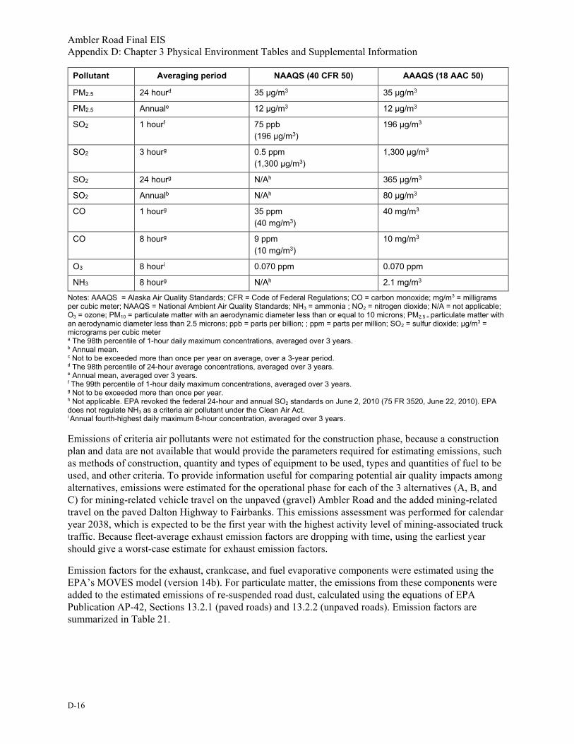
Ambler Road Final EIS Appendix D: Chapter 3 Physical Environment Tables and Supplemental Information
D-16
Pollutant Averaging period NAAQS (40 CFR 50) AAAQS (18 AAC 50)
PM2.5 24 hourd 35 µg/m3 35 µg/m3
PM2.5 Annuale 12 µg/m3 12 µg/m3
SO2 1 hourf 75 ppb (196 µg/m3)
196 µg/m3
SO2 3 hourg 0.5 ppm (1,300 µg/m3)
1,300 µg/m3
SO2 24 hourg N/Ah 365 µg/m3
SO2 Annualb N/Ah 80 µg/m3
CO 1 hourg 35 ppm (40 mg/m3)
40 mg/m3
CO 8 hourg 9 ppm (10 mg/m3)
10 mg/m3
O3 8 houri 0.070 ppm 0.070 ppm
NH3 8 hourg N/Ah 2.1 mg/m3
Notes: AAAQS = Alaska Air Quality Standards; CFR = Code of Federal Regulations; CO = carbon monoxide; mg/m3 = milligrams per cubic meter; NAAQS = National Ambient Air Quality Standards; NH3 = ammonia ; NO2 = nitrogen dioxide; N/A = not applicable; O3 = ozone; PM10 = particulate matter with an aerodynamic diameter less than or equal to 10 microns; PM2.5 = particulate matter with an aerodynamic diameter less than 2.5 microns; ppb = parts per billion; ; ppm = parts per million; SO2 = sulfur dioxide; µg/m3 = micrograms per cubic meter a The 98th percentile of 1-hour daily maximum concentrations, averaged over 3 years. b Annual mean. c Not to be exceeded more than once per year on average, over a 3-year period. d The 98th percentile of 24-hour average concentrations, averaged over 3 years. e Annual mean, averaged over 3 years. f The 99th percentile of 1-hour daily maximum concentrations, averaged over 3 years. g Not to be exceeded more than once per year. h Not applicable. EPA revoked the federal 24-hour and annual SO2 standards on June 2, 2010 (75 FR 3520, June 22, 2010). EPA does not regulate NH3 as a criteria air pollutant under the Clean Air Act. i Annual fourth-highest daily maximum 8-hour concentration, averaged over 3 years.
Emissions of criteria air pollutants were not estimated for the construction phase, because a construction plan and data are not available that would provide the parameters required for estimating emissions, such as methods of construction, quantity and types of equipment to be used, types and quantities of fuel to be used, and other criteria. To provide information useful for comparing potential air quality impacts among alternatives, emissions were estimated for the operational phase for each of the 3 alternatives (A, B, and C) for mining-related vehicle travel on the unpaved (gravel) Ambler Road and the added mining-related travel on the paved Dalton Highway to Fairbanks. This emissions assessment was performed for calendar year 2038, which is expected to be the first year with the highest activity level of mining-associated truck traffic. Because fleet-average exhaust emission factors are dropping with time, using the earliest year should give a worst-case estimate for exhaust emission factors.
Emission factors for the exhaust, crankcase, and fuel evaporative components were estimated using the EPA’s MOVES model (version 14b). For particulate matter, the emissions from these components were added to the estimated emissions of re-suspended road dust, calculated using the equations of EPA Publication AP-42, Sections 13.2.1 (paved roads) and 13.2.2 (unpaved roads). Emission factors are summarized in Table 21.

Ambler Road Final EIS Appendix D: Chapter 3 Physical Environment Tables and Supplemental Information
D-17
Table 21. EPA’s MOVES emission factors Vehicle type
Vehicle type ID
Fuel type Pollutant Pollutant ID
Emission factor
(grams/ vehicle-
mile) (Jan)
Emission factor
(grams/ vehicle-
mile) (July)
Average
Light-duty Truck
31 50%/50% Gasoline/Diesel Mix
CO 2 6.60E-01 6.83E-01 6.72E-01
Light-duty Truck
31 50%/50% Gasoline/Diesel Mix
NOX 3 3.87E-02 3.55E-02 3.71E-02
Light-duty Truck
31 50%/50% Gasoline/Diesel Mix
SO2 31 1.57E-03 1.57E-03 1.57E-03
Light-duty Truck
31 50%/50% Gasoline/Diesel Mix
VOC 87 2.07E-02 2.18E-02 2.13E-02
Light-duty Truck
31 50%/50% Gasoline/Diesel Mix
PM10 –Exhaust
100 2.65E-03 2.94E-03 2.80E-03
Light-duty Truck
31 50%/50% Gasoline/Diesel Mix
PM10 – Brake wear
106 1.14E-02 1.14E-02 1.14E-02
Light-duty Truck
31 50%/50% Gasoline/Diesel Mix
PM10 – Tire wear
107 8.32E-03 8.32E-03 8.32E-03
Light-duty Truck
31 50%/50% Gasoline/Diesel Mix
PM2.5 – Exhaust
110 2.35E-03 2.61E-03 2.48E-03
Light-duty Truck
31 50%/50% Gasoline/Diesel Mix
PM2.5 – Brake wear
116 1.42E-03 1.42E-03 1.42E-03
Light-duty Truck
31 50%/50% Gasoline/Diesel Mix
PM2.5 – Tire wear
117 1.25E-03 1.25E-03 1.25E-03
Light-duty Truck
31 50%/50% Gasoline/Diesel Mix
CO2e 98 2.34E+02 2.34E+02 2.34E+02
Combination Long-haul Truck
62 Diesel CO 2 3.11E-01 3.11E-01 3.11E-01
Combination Long-haul Truck
62 Diesel NOX 3 1.26E+00 1.17E+00 1.21E+00

Ambler Road Final EIS Appendix D: Chapter 3 Physical Environment Tables and Supplemental Information
D-18
Vehicle type
Vehicle type ID
Fuel type Pollutant Pollutant ID
Emission factor
(grams/ vehicle-
mile) (Jan)
Emission factor
(grams/ vehicle-
mile) (July)
Average
Combination Long-haul Truck
62 Diesel SO2 31 1.20E-02 1.20E-02 1.20E-02
Combination Long-haul Truck
62 Diesel VOC 87 8.08E-02 8.08E-02 8.08E-02
Combination Long-haul Truck
62 Diesel PM10 – Exhaust
100 2.62E-02 2.62E-02 2.62E-02
Combination Long-haul Truck
62 Diesel PM10 – Brake wear
106 6.47E-02 6.47E-02 6.47E-02
Combination Long-haul Truck
62 Diesel PM10 – Tire wear
107 2.98E-02 2.98E-02 2.98E-02
Combination Long-haul Truck
62 Diesel PM2.5 – Exhaust
110 2.41E-02 2.41E-02 2.41E-02
Combination Long-haul Truck
62 Diesel PM2.5 – Brake wear
116 8.09E-03 8.09E-03 8.09E-03
Combination Long-haul Truck
62 Diesel PM2.5 – Tire wear
117 4.48E-03 4.48E-03 4.48E-03
Combination Long-haul Truck
62 Diesel CO2e 98 1.45E+03 1.45E+03 1.45E+03
Notes: CO = carbon monoxide; CO2e = carbon dioxide equivalent; NOx = oxides of nitrogen; PM10 = particulate matter with an aerodynamic diameter less than or equal to 10 microns; PM2.5 = particulate matter with an aerodynamic diameter less than 2.5 microns; SO2 = sulfur dioxide; VOC = volatile organic compound
The AP-42 inputs for unpaved roads in MOVES required the following assumptions and variables. For surface material silt content an amount of 4.8 percent (AP-42, Table 13.2.2-1 – Sand and Gravel Processing). The annual precipitation was taken from Equation 1a from Chapter 13.2.2 of AP-42 and precipitation adjustment factor applied (Equation 1a emission factor times [365 minus 90 days] divided by 365). The dust suppression control efficiency applied to the estimation was 50 percent, an accepted level of control efficiency by BLM. The particle size multipliers used in for unpaved roads estimations are 0.15 pound per vehicle mile traveled (lb/VMT) for PM2.5 and 1.5 lb/VMT for PM10 as compared to 4.9 lb/VMT for total PM (AP-42, Chapter 13.2.2, Table 13.2.2-2).
The AP-42 inputs for paved roads in MOVES include the following assumptions and variables. For surface silt loading: 0.6 gram per meter squared (g/m2) (Table 13.2.1-2, baseline x 3). This is a conservative winter-based silt loading from ADT category 500-5,000. For vehicles, an average weight of
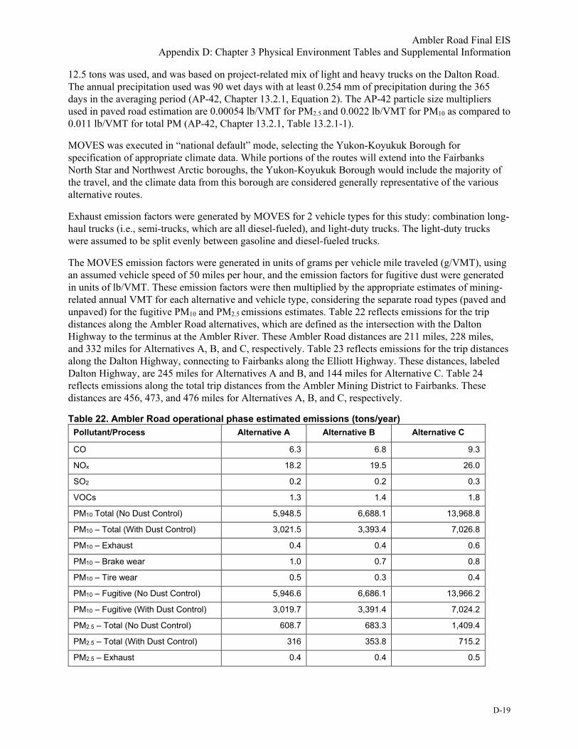
Ambler Road Final EIS Appendix D: Chapter 3 Physical Environment Tables and Supplemental Information
D-19
12.5 tons was used, and was based on project-related mix of light and heavy trucks on the Dalton Road. The annual precipitation used was 90 wet days with at least 0.254 mm of precipitation during the 365 days in the averaging period (AP-42, Chapter 13.2.1, Equation 2). The AP-42 particle size multipliers used in paved road estimation are 0.00054 lb/VMT for PM2.5 and 0.0022 lb/VMT for PM10 as compared to 0.011 lb/VMT for total PM (AP-42, Chapter 13.2.1, Table 13.2.1-1).
MOVES was executed in “national default” mode, selecting the Yukon-Koyukuk Borough for specification of appropriate climate data. While portions of the routes will extend into the Fairbanks North Star and Northwest Arctic boroughs, the Yukon-Koyukuk Borough would include the majority of the travel, and the climate data from this borough are considered generally representative of the various alternative routes.
Exhaust emission factors were generated by MOVES for 2 vehicle types for this study: combination long-haul trucks (i.e., semi-trucks, which are all diesel-fueled), and light-duty trucks. The light-duty trucks were assumed to be split evenly between gasoline and diesel-fueled trucks.
The MOVES emission factors were generated in units of grams per vehicle mile traveled (g/VMT), using an assumed vehicle speed of 50 miles per hour, and the emission factors for fugitive dust were generated in units of lb/VMT. These emission factors were then multiplied by the appropriate estimates of mining-related annual VMT for each alternative and vehicle type, considering the separate road types (paved and unpaved) for the fugitive PM10 and PM2.5 emissions estimates. Table 22 reflects emissions for the trip distances along the Ambler Road alternatives, which are defined as the intersection with the Dalton Highway to the terminus at the Ambler River. These Ambler Road distances are 211 miles, 228 miles, and 332 miles for Alternatives A, B, and C, respectively. Table 23 reflects emissions for the trip distances along the Dalton Highway, connecting to Fairbanks along the Elliott Highway. These distances, labeled Dalton Highway, are 245 miles for Alternatives A and B, and 144 miles for Alternative C. Table 24 reflects emissions along the total trip distances from the Ambler Mining District to Fairbanks. These distances are 456, 473, and 476 miles for Alternatives A, B, and C, respectively.
Table 22. Ambler Road operational phase estimated emissions (tons/year) Pollutant/Process Alternative A Alternative B Alternative C
CO 6.3 6.8 9.3
NOx 18.2 19.5 26.0
SO2 0.2 0.2 0.3
VOCs 1.3 1.4 1.8
PM10 Total (No Dust Control) 5,948.5 6,688.1 13,968.8
PM10 – Total (With Dust Control) 3,021.5 3,393.4 7,026.8
PM10 – Exhaust 0.4 0.4 0.6
PM10 – Brake wear 1.0 0.7 0.8
PM10 – Tire wear 0.5 0.3 0.4
PM10 – Fugitive (No Dust Control) 5,946.6 6,686.1 13,966.2
PM10 – Fugitive (With Dust Control) 3,019.7 3,391.4 7,024.2
PM2.5 – Total (No Dust Control) 608.7 683.3 1,409.4
PM2.5 – Total (With Dust Control) 316 353.8 715.2
PM2.5 – Exhaust 0.4 0.4 0.5

Ambler Road Final EIS Appendix D: Chapter 3 Physical Environment Tables and Supplemental Information
D-20
Pollutant/Process Alternative A Alternative B Alternative C
PM2.5 – Brake wear 0.1 0.1 0.2
PM2.5 – Tire wear 0.1 0.1 0.1
PM2.5 – Fugitive (No Dust Control) 608.2 683.7 1,408.6
PM2.5 – Fugitive (With Dust Control) 315.5 353.2 714.4
Notes: CO = carbon monoxide; NOx = oxides of nitrogen; PM10 = particulate matter with an aerodynamic diameter less than or equal to 10 microns; PM2.5 = particulate matter with an aerodynamic diameter less than 2.5 microns; SO2 = sulfur dioxide; VOCs = volatile organic compounds
Table 23. Dalton Highway operational phase estimated emissions (tons/year) Pollutant/Process Alternative A Alternative B Alternative C
CO 7.4 7.4 4.0
NOx 21.1 21.1 11.3
SO2 0.2 0.2 0.1
VOCs 1.5 1.5 0.8
PM10 Total (No Dust Control) 7,186.8 7,186.8 6,058.8
PM10 – Total (With Dust Control) 3,645.4 3,646.4 3,047.8
PM10 – Exhaust 0.5 0.5 0.2
PM10 – Brake wear 1.2 1.2 0.6
PM10 – Tire wear 0.5 0.5 0.3
PM10 – Fugitive (No Dust Control) 3,644.2 3,644.2 3,046.6
PM10 – Fugitive (With Dust Control) 457.8 457.8 336.7
PM2.5 – Total (No Dust Control) 734.2 734.2 611.3
PM2.5 – Total (With Dust Control) 366.9 380.2 310.2
PM2.5 – Exhaust 0.4 0.4 0.2
PM2.5 – Brake wear 0.1 0.1 0.1
PM2.5 – Tire wear 0.1 0.1 0.0
PM2.5 – Fugitive (No Dust Control) 733.6 733.6 610.9
PM2.5 – Fugitive (With Dust Control) 379.5 379.5 309.8
Notes: CO = carbon monoxide; PM10 = particulate matter with an aerodynamic diameter less than or equal to 10 microns; PM2.5 = particulate matter with an aerodynamic diameter less than 2.5 microns; SO2 = sulfur dioxide; VOC = volatile organic compounds
Table 24. Total operational phase estimated emissions (tons/year) Pollutant/Process Alternative A Alternative B Alternative C
CO 13.7 14.1 13.3
NOx 39.3 40.5 37.2
SO2 0.4 0.4 0.4
VOCs 2.7 2.8 2.6
PM10 Total (No Dust Control) 13,135.3 13,874.9 20,027.6
PM10 – Total (With Dust Control) 6,530 7,039.7 10,074.6

Ambler Road Final EIS Appendix D: Chapter 3 Physical Environment Tables and Supplemental Information
D-21
Pollutant/Process Alternative A Alternative B Alternative C
PM10 – Exhaust 0.9 0.9 0.8
PM10 – Brake wear 2.1 2.2 2.0
PM10 – Tire wear 1.0 1.0 1.0
PM10 – Fugitive (No Dust Control) 13,131.3 13,870.8 20,023.8
PM10 – Fugitive (With Dust Control) 6,526 7,035.6 10,070.8
PM2.5 – Total (No Dust Control) 1,342.9 1,417.5 2,020.7
PM2.5 – Total (With Dust Control) 681.7 732.7 1,024.2
PM2.5 – Exhaust 0.8 0.8 0.7
PM2.5 – Brake wear 0.3 0.3 0.3
PM2.5 – Tire wear 0.2 0.2 0.1
PM2.5 – Fugitive (No Dust Control) 1,341.7 1,416.2 2,109.5
PM2.5 – Fugitive (With Dust Control) 681.7 732.7 1,024.2
Notes: CO = carbon monoxide; PM10 = particulate matter with an aerodynamic diameter less than or equal to 10 microns; PM2.5 = particulate matter with an aerodynamic diameter less than 2.5 microns; SO2 = sulfur dioxide; VOCs = volatile organic compounds
1.7.1 Greenhouse Gas Emissions
Greenhouse gases (GHGs) are gaseous compounds in the atmosphere that can absorb infrared radiation and are effective at trapping and holding energy from the sun and heat in the atmosphere. GHGs are emitted by both natural and anthropogenic sources. The most common GHGs in the atmosphere are water vapor, carbon dioxide (CO2) and methane (CH4). Scientists have developed global warming potentials (GWP) for GHGs to provide a way to compare global warming impacts of these different gases. Each GHG has a GWP that accounts for the intensity of its heat trapping effect and its longevity in the atmosphere. According to the Intergovernmental Panel on Climate Change (IPCC), GWPs typically have an uncertainty of ±35 percent. GWPs have been developed for several GHGs over different time horizons including 20-year, 100-year, and 500-year. The choice of emission metric and time horizon depends on type of application and policy context; hence, no single metric is optimal for all policy goals. The 100-year GWP was adopted by the United Nations Framework Convention on Climate Change (UNFCCC) and its Kyoto Protocol and is now used widely as the default metric. In addition, the EPA uses the 100-year time horizon in its Inventory of U.S. Greenhouse Gas Emissions and Sinks: 1990–2017 (April 2019), GHG Reporting Rule requirements under 40 Code of Federal Regulations Part 98, Subpart A, and uses the GWPs and time horizon consistent with the IPCC Fifth Assessment Report in its science communications.
The GWP expresses how much energy 1 ton of a GHG emitted will absorb over a specific time period in comparison to 1 ton of CO2 emitted. CO2 is used as the comparison point, and it is given a GWP of 1. The other GHGs range in how they contribute to warming the earth’s atmosphere and have a higher GWP compared to CO2 over a time period. The GWP for CH4 is 25 and for N2O is 298. Emissions calculated using these GWPs are expressed as carbon dioxide equivalents (CO2e).
GHG emissions were calculated for the construction phase under each alternative because emission factor data were available for estimating emissions of GHGs based on estimated material quantities, typical off-road construction equipment, and fuel used to move materials. The Federal Highway Administration fuel use factors in highway and bridge construction were used to identify additional fuel needs for vegetation clearing of forested and shrub areas, and the installation of bridges and culvert pipe structures. Further estimates were made to identify additional emissions associated with transportation of workers to/from

Ambler Road Final EIS Appendix D: Chapter 3 Physical Environment Tables and Supplemental Information
D-22
the construction area, and electrical generation at construction camps. Estimated GHG emissions under each alternative do not include the transportation of materials to the construction area, or other fuel uses associated with the construction and operation of the construction camps, maintenance sites, communication sites, or airstrips. The estimates do not include the removal of the road at the end of the project life, but the removal effort may be reasonably assumed to be similar in scope as the construction emissions. The GHGs most likely to be emitted from the proposed project would be a result of fossil fuel combustion in vehicles, construction equipment and heat and power generation and include CO2, CH4, and nitrous oxide (N2O). GHGs emitted as a result of the project contributions to accelerating local thawing of permafrost have not been included in these calculations. Current climate models include gradual thawing of permafrost, however abrupt thawing rates may increase GHG emission by up to 190 percent (Walter Anthony et al. 2018). Overall, current CH4 emissions from melting permafrost are estimated at about 1 percent of global methane budget, but are anticipated to grow to be the second largest anthropogenic source of GHGs by mid-century (Walter Anthony et al. 2018; NASA 2018; Schaefer et al. 2014).The GHG emissions were calculated as CO2e using EPA emission factors and the appropriate GWP. The resultant CO2e emissions for the project are shown in Table 25 for comparison with GHG emissions on a local, state-wide, country-wide, or global level. Using the EPA GHG equivalency calculator (www.epa.gov/energy/greenhouse-gas-equivalencies-calculator) the Alternative A, CO2e emissions are equivalent to an annual energy use of 11,439 homes, Alternative B to 12,812 homes, and Alternative C to 17,816 homes.
Table 25. Ambler Road construction phase GHG emissions (metric tons) Emissions Alternative A Alternative B Alternative C
Material estimates (cubic yards)
15 million 16.8 million 22 million
Off-road fuel (gallons)a 5.82 million 6.52 million 9.07 million
Total CO2e (tons)b 99,136 111,020 154,395 Sources: GreenDOT Calculator (GHG Calculator for State Departments of Transportation, version 1.5 beta), Fuel Usage Factors in Highway and Bridge Construction (National Academies of Science 2013). Notes: CO2e = carbon dioxide equivalent a Operating plans for the construction of the project have either not been provided, or have not been developed. Off-road fuel estimates are diesel fuel volumes estimated for operation of typical construction equipment used in new road construction, addressing the movement of material fill, culvert installations, and bridge construction. b Total CO2e includes CO2 equivalent calculations for the production and movement of construction soils, off-road construction vehicle usage, on-road transportation associated with the movement of workers to support construction, and electricity generation estimates for construction camps. This does not include emissions the operation of maintenance stations, emissions associated with annual maintenance activities through the anticipated life of the road, the construction and operation of any mines, or the emissions associated with the vehicle usage on the road (see Table 22 through Table 26).
Table 26 summarizes annual GHG emissions for the operational phase including transportation of mining ore from the Ambler Mining District to the Port of Alaska. These estimated emissions are based on traffic estimates developed as part of the mine development and production schedule scenario outlined in Appendix H. It uses the CO2e calculated for the road transportation along each alternative to Fairbanks as well as the estimated rail emissions for the railroad cars needed to take the ore from Fairbanks to the Port of Alaska in Anchorage. Road transportation CO2e emission estimates were calculated in the same way as criteria pollutants using the EPA’s MOVES model (version 14b) and was based on miles on each segment of road for 2 vehicle types of combination long-haul trucks and light-duty trucks. The resultant CO2e emission factors shown in Table 21 were then multiplied by the appropriate estimates of project-related annual VMT for each alternative and vehicle type. Rail assumptions included 2 weekly trains of 75 cars carrying loads of ore, returning with empty cars. Fuel efficiency factors were developed using Surface Transportation Board (STB) Annual 2018 Report for UP freight diesel fuel use.

Ambler Road Final EIS Appendix D: Chapter 3 Physical Environment Tables and Supplemental Information
D-23
Table 26. Annual cumulative GHG emissions from ore transportation, by alternative (CO2e in metric tons/year)
Emission Type Alternative A Alternative B Alternative C
Roadway Emissions 47,668 49,273 45,410
Ambler Road Segment 22,146 23,751 31,673
Dalton Highway to Fairbanks 25,522 25,522 13,738
Rail Emissions 6,562 6,562 6,562
Total Annual Emissions 54,230 55,835 51,972
Note: CO2e is an expression of the total GHG emissions expressed as the equivalent of CO2
For perspective, in 2015, State of Alaska GHG emissions were estimated to be 39.54 million metric tons (MMT) per year (ADEC 2018), and national GHG emissions were 6,624 MMT per year (EPA 2019). Total surface transportation (on-road and rail) estimates were 2.88 MMT/year in Alaska in 2015. This project would add less than 2 percent to the Alaska surface transportation emissions inventory.
2. References ADEC (Alaska Department of Environmental Conservation), Division of Air Quality. 2018. Alaska
Greenhouse Gas Emissions Inventory 1990-2015. January 2018.
ADEC. 2019. Contaminated sites, Alaska Department of Conservation. Available at: dec.alaska.gov/spar/csp.aspx
ADNR (Alaska Department of Natural Resources). 2019. Alaska Mapper: Water Estate Map (public). Available at dnr.alaska.gov/mapper/ Accessed March 27, 2019.
BLM (Bureau of Land Management). 2016. Potential Fossil Yield Classification (PFYC) System for Paleontological Resources on Public Lands. IM 2016-124. July 8, 2016. Available at: www.blm.gov/sites/blm.gov/files/uploads/IM2016-124_att1.pdf Accessed May 15, 2019.
Cardno. 2015. Ambler Mining Region Economic Impact Analysis. Prepared for AIDEA. January 16, 2015. Available at: www.aidea.org/Portals/0/PDF%20Files/CARDNOAmblerEconomicImpactAnalysis.pdf
EPA (Environmental Protection Agency). 2019. National-Level U.S. Greenhouse gas Inventory 1990-2017. EPA 430-F-19-001, April 2019. Available at: www.epa.gov/sites/production/files/2019-04/documents/2019_fast_facts_508_0.pdf
Ferrians, O.J. 1965. Permafrost map of Alaska - U.S. Geological Survey Miscellaneous Geologic Investigations Map I-445. Scale 1 to 2,500,000.
FHWA (Federal Highway Administration). 2006. Construction Noise Handbook. FHWA-HEP-06-015. Available at: www.fhwa.dot.gov/environment/noise/construction_noise/handbook/
Kane, D.L., E.K. Youcha, S.L. Stuefer, H. Toniolo, J.W. Homan, W.E. Schnabel, R.E. Gieck, E. Lamb, T. Tschetter, and G. Myerchin-Tape. 2015. Environmental Studies of Ambler Transportation Corridor, Alaska. Final Report. University of Alaska Fairbanks, Water and Environmental Research Center, INE/WERC 15.14. Fairbanks, Alaska.

Ambler Road Final EIS Appendix D: Chapter 3 Physical Environment Tables and Supplemental Information
D-24
NASA (National Aeronautics and Space Administration). 2018. Unexpected future boost of methane possible from Arctic permafrost. NASA Global Climate website, NASA Jet Propulsion Laboratory, 2018. Available at: climate.nasa.gov/news/2785/unexpected-future-boost-of-methane-possible-from-arctic-permafrost/
National Academies of Sciences, Engineering, and Medicine. 2013. Fuel Usage Factors in Highway and Bridge Construction. Exhibit S-1. The National Academies Press. Washington, D.C. Available at: doi.org/10.17226/22629
NCEI (National Centers for Environmental Information) NOAA (National Oceanic and Atmospheric Administration. No date. Climate Data Online. Climate records for Bettles, Coldfoot, Hogatza River, Kiana, and Selawik. Available at: www.ncdc.noaa.gov/cdo-web/datasets
North of 360 Mining News. 2018. Alaska Geologists Enter Valhalla Minerals. September 2018. Available at: www.miningnewsnorth.com/story/2018/09/01/news/alaska-geologists-enter-valhalla-metals/5330.html
Schaefer, K. H. Lantuit, V.E. Romanovsky, E.A.G. Schuur, and R. Witt. 2014. The impact of the permafrost carbon feedback on global climate. Environmental Research Letters 9(2014) 085003:1–9. Available at: iopscience.iop.org/article/10.1088/1748-9326/9/8/085003/pdf
Solie, D.N., and J.E. Athey. 2015. Preliminary evaluation of bedrock potential for naturally occurring asbestos in Alaska: Alaska Division of Geological & Geophysical Surveys Miscellaneous Publication 157, 15 p., 21 sheets, scale 1:500,000. Available at: doi.org/10.14509/29447
Trilogy Metals, Inc. 2017. Reserves and Resources. Available at: trilogymetals.com/ Accessed November 9, 2017.
USGS (U.S. Geological Survey). No date. Topographic and route alignment layers of Ambler Viewer.
USGS. No date. USGS Scientific Investigations Map 3340, Geological Map of Alaska. GIS data accessed at: mrdata.usgs.gov/sim3340/
USGS. 2019. National Water Information System: Web Interface. Data for sites 15564879 (Slate Creek at Coldfoot), 15743850 (Dahl Creek near Kobuk), 15453500 (Yukon Springs near Stevens Village), 15565885 (Jim River near Bettles), 15564900 (Koyukuk River at Hughes), and 15564875 (MT Koyukuk River near Wiseman). Available at: waterdata.usgs.gov/nwis/inventory
Walter Anthony, K., T.S. von Deimling, I. Nitze, S. Frolking, A. Emond, R. Daanen, P. Anthony, P. Lindgren, B. Jones, and G. Grosse. 2018. 21st-century modeled permafrost carbon emissions accelerated by abrupt thaw beneath lakes. Nature Communications 2018; 9:3262. Available at: www.ncbi.nlm.nih.gov/pmc/articles/PMC6093858/

Ambler Road Final EIS Appendix D: Chapter 3 Physical Environment Tables and Supplemental Information
Attachment A:
Predictive Noise Modeling of the Ambler Road

Ambler Road Final EIS Appendix D: Chapter 3 Physical Environment Tables and Supplemental Information
This page is intentionally left blank.

Chapter 3 Physical Environment Tables and Supplemental Information Attachment A: Predictive Noise Modeling of the Ambler Road
1
Predictive Noise Modeling of the Ambler Road Presenting acoustic models of potential noise from vehicle traffic alternatives on the
Ambler Road using Cadna-A noise prediction software
Prepared for: BLM Alaska
222 W. 7th Ave Anchorage, AK 99513
…
Completed by: U.S. National Park Service
May 29, 2019
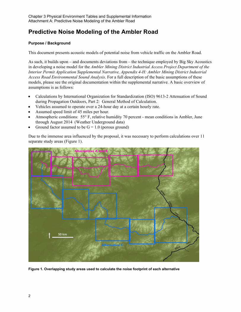
Chapter 3 Physical Environment Tables and Supplemental Information Attachment A: Predictive Noise Modeling of the Ambler Road
2
Predictive Noise Modeling of the Ambler Road Purpose / Background
This document presents acoustic models of potential noise from vehicle traffic on the Ambler Road.
As such, it builds upon – and documents deviations from – the technique employed by Big Sky Acoustics in developing a noise model for the Ambler Mining District Industrial Access Project Department of the Interior Permit Application Supplemental Narrative, Appendix 4-H: Ambler Mining District Industrial Access Road Environmental Sound Analysis. For a full description of the basic assumptions of these models, please see the original documentation within the supplemental narrative. A basic overview of assumptions is as follows:
• Calculations by International Organization for Standardization (ISO) 9613-2 Attenuation of Sound during Propagation Outdoors, Part 2: General Method of Calculation.
• Vehicles assumed to operate over a 24-hour day at a certain hourly rate. • Assumed speed limit of 45 miles per hour. • Atmospheric conditions: 55° F, relative humidity 70 percent - mean conditions in Ambler, June
through August 2014 (Weather Underground data) • Ground factor assumed to be G = 1.0 (porous ground)
Due to the immense area influenced by the proposal, it was necessary to perform calculations over 11 separate study areas (Figure 1).
Figure 1. Overlapping study areas used to calculate the noise footprint of each alternative

Chapter 3 Physical Environment Tables and Supplemental Information Attachment A: Predictive Noise Modeling of the Ambler Road
3
Under the current development scenario that includes a single mine, the estimated volume of vehicles on the road is 6 heavy truck trips per hour1.
Preparing Vehicle Line Sources
An initial challenge of the project was to develop line source information for traffic conditions using methodology of the Department of Transportation Traffic Noise Model. This approach was adopted for consistency with the original models included in the right of way application.
Curves showing broadband A-weighted sound pressure levels for heavy trucks as a function of vehicle speed are published in the FHWA Traffic Noise Model Technical Manual, Appendix A (FHWA 1998, figures 8, 10, 12). We used the heavy truck curve for at a speed of 45 miles per hour to model impacts of the proposed Ambler Road. Therefore if additional small vehicles are expected to use the road, these models will underestimate the impact of road development. If any vehicles travel faster than 45 miles per hour, these models will also underestimate impacts.
The 1/3rd octave band emission spectra for each vehicle type are published in the TNM Technical Manual, Appendix A (FHWA 1998, figures 17, 21, 26). These spectra are referenced to unity (0 dB,) so a numeric offset must be added such that the broadband level of the spectrum matches the broadband level of the vehicle travelling at a given speed. For heavy trucks travelling at 45 mph, the offset is 72.3 dB. Adjusted 1/3rd octave band levels are then summed to 1/1 octave band levels for the 63, 125, 250, 500, 1000, 2000, 4000, and 8000 Hz bands. These provided the input for our modeling software, CadnaA (DataKustik).
Description of Results
Running each CadnaA scenario results in a 100x100 meter grid of 1-hour equivalent sound pressure levels (LAeq, 1hr). Data from each study area were merged into complete road sections for each Alternative. Minor artifacts arising from the study area boundaries are visible in the results, but they do not affect estimates of impact to a meaningful degree.
All models presented below are clipped to an LAeq, 1hr of 16 dB. This level represents the 10th percentile sound pressure level (LA90) in the area during the summer months (Betchkal 2019) or median natural conditions (LA50) during the Alaskan winter months (Betchkal 2013, NPS 2013). In other words, the natural conditions that would limit a person or animal’s ability to hear truck noise at distance. For alternatives that affect Gates of the Arctic National Park and Preserve, such an analysis threshold is consistent with NPS management policy §8.2.3 (NPS 2006), which states that the natural ambient sound level is the baseline against which impacts of proposed actions should be evaluated.
1 Vehicle count determined through consultation with John McPherson, HDR, Inc. on 05/14/19.

Chapter 3 Physical Environment Tables and Supplemental Information Attachment A: Predictive Noise Modeling of the Ambler Road
4
Figure 2. Modeled LAeq, 1hr for Alternative A given 6 truck trips per hour at 45 mph. Data are clipped to an ambient LA90 of 16 dB.
Figure 3. Modeled LAeq, 1hr for Alternative B given 6 truck trips per hour at 45 mph. Data are clipped to an ambient LA90 of 16 dB.

Chapter 3 Physical Environment Tables and Supplemental Information Attachment A: Predictive Noise Modeling of the Ambler Road
5
Figure 4. Modeled LAeq, 1hr for Alternative C given 6 truck trips per hour at 45 mph. Data are clipped to an ambient LA90 of 16 dB.
Table 1 presents several numeric metrics of impact for each alternative. The first is the absolute area of land affected. The second is the area of land affected per unit road length, which attempts to illustrate how terrain differences between routes geographically restrict the impacts of noise.
Table 1. Predicted land area impacted by noise for each alternative and traffic scenario
Alternative A B C Area affected (mi2) 788 mi2 841 mi2 1,681 mi2
Area affected per unit road length (mi2/mi) 3.7 mi2/mi 3.7 mi2/mi 5.1 mi2/mi
Under any scenario a large area of land will be affected by noise. However, Alternative C will affect more previously undisturbed land in Alaska than Alternatives A and B. By comparison, the difference in impact between Alternatives A and B is relatively small.
The context of noise influences how appropriate it is in a certain place (Bijsterveld 2008, pg. 240). Alternative A represents a noise incursion into Gates of the Arctic National Park, and is predicted to impact federally-designated wilderness and a national natural landmark. Noise from Alternative C is predicted to be audible in several rural Alaskan communities.
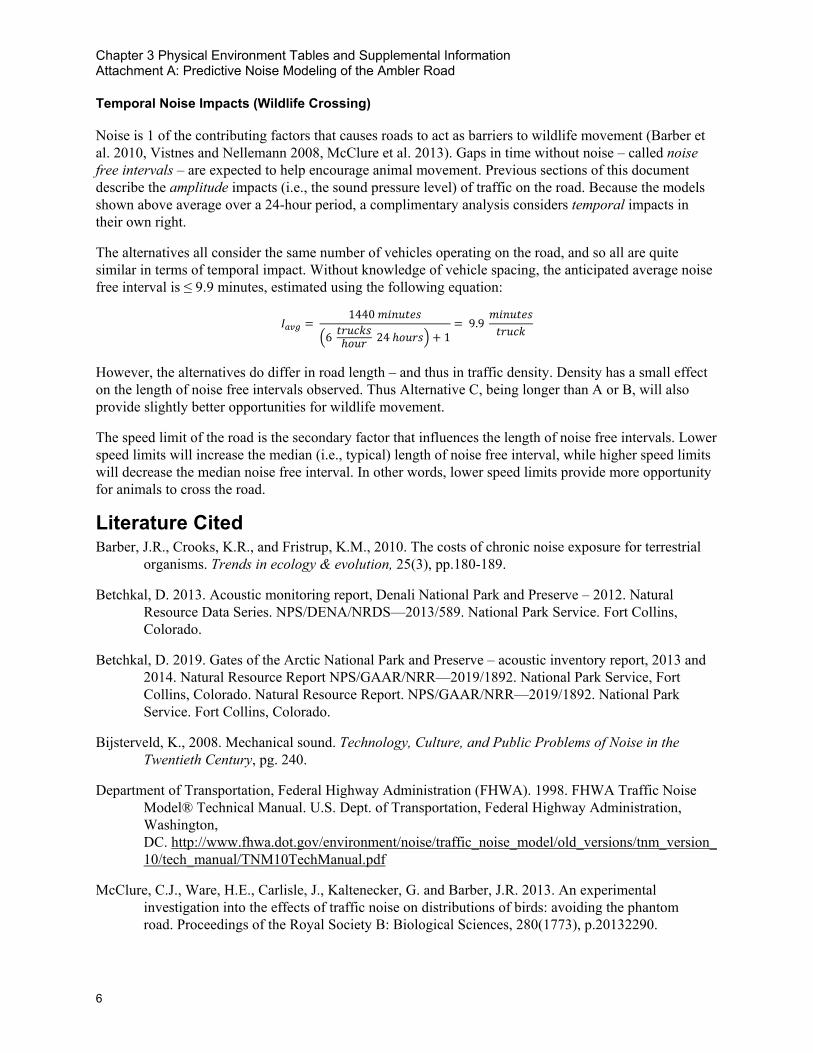
Chapter 3 Physical Environment Tables and Supplemental Information Attachment A: Predictive Noise Modeling of the Ambler Road
6
Temporal Noise Impacts (Wildlife Crossing)
Noise is 1 of the contributing factors that causes roads to act as barriers to wildlife movement (Barber et al. 2010, Vistnes and Nellemann 2008, McClure et al. 2013). Gaps in time without noise – called noise free intervals – are expected to help encourage animal movement. Previous sections of this document describe the amplitude impacts (i.e., the sound pressure level) of traffic on the road. Because the models shown above average over a 24-hour period, a complimentary analysis considers temporal impacts in their own right.
The alternatives all consider the same number of vehicles operating on the road, and so all are quite similar in terms of temporal impact. Without knowledge of vehicle spacing, the anticipated average noise free interval is ≤ 9.9 minutes, estimated using the following equation:
𝐼𝐼𝑎𝑎𝑎𝑎𝑎𝑎 = 1440 𝑚𝑚𝑚𝑚𝑚𝑚𝑚𝑚𝑚𝑚𝑚𝑚𝑚𝑚
�6 𝑚𝑚𝑡𝑡𝑚𝑚𝑡𝑡𝑡𝑡𝑚𝑚ℎ𝑜𝑜𝑚𝑚𝑡𝑡 24 ℎ𝑜𝑜𝑚𝑚𝑡𝑡𝑚𝑚� + 1= 9.9
𝑚𝑚𝑚𝑚𝑚𝑚𝑚𝑚𝑚𝑚𝑚𝑚𝑚𝑚𝑚𝑚𝑡𝑡𝑚𝑚𝑡𝑡𝑡𝑡
However, the alternatives do differ in road length – and thus in traffic density. Density has a small effect on the length of noise free intervals observed. Thus Alternative C, being longer than A or B, will also provide slightly better opportunities for wildlife movement.
The speed limit of the road is the secondary factor that influences the length of noise free intervals. Lower speed limits will increase the median (i.e., typical) length of noise free interval, while higher speed limits will decrease the median noise free interval. In other words, lower speed limits provide more opportunity for animals to cross the road.
Literature Cited Barber, J.R., Crooks, K.R., and Fristrup, K.M., 2010. The costs of chronic noise exposure for terrestrial
organisms. Trends in ecology & evolution, 25(3), pp.180-189.
Betchkal, D. 2013. Acoustic monitoring report, Denali National Park and Preserve – 2012. Natural Resource Data Series. NPS/DENA/NRDS—2013/589. National Park Service. Fort Collins, Colorado.
Betchkal, D. 2019. Gates of the Arctic National Park and Preserve – acoustic inventory report, 2013 and 2014. Natural Resource Report NPS/GAAR/NRR—2019/1892. National Park Service, Fort Collins, Colorado. Natural Resource Report. NPS/GAAR/NRR—2019/1892. National Park Service. Fort Collins, Colorado.
Bijsterveld, K., 2008. Mechanical sound. Technology, Culture, and Public Problems of Noise in the Twentieth Century, pg. 240.
Department of Transportation, Federal Highway Administration (FHWA). 1998. FHWA Traffic Noise Model® Technical Manual. U.S. Dept. of Transportation, Federal Highway Administration, Washington, DC. http://www.fhwa.dot.gov/environment/noise/traffic_noise_model/old_versions/tnm_version_10/tech_manual/TNM10TechManual.pdf
McClure, C.J., Ware, H.E., Carlisle, J., Kaltenecker, G. and Barber, J.R. 2013. An experimental investigation into the effects of traffic noise on distributions of birds: avoiding the phantom road. Proceedings of the Royal Society B: Biological Sciences, 280(1773), p.20132290.

Chapter 3 Physical Environment Tables and Supplemental Information Attachment A: Predictive Noise Modeling of the Ambler Road
7
National Park Service (NPS). 2006. Management Policies 2006. U.S. Department of the Interior, National Park Service, Washington, DC.
National Park Service (NPS). 2013. Winter Road Plowing in Denali National Park EA, Appendix D: Soundscape Information. pp. 78-79. Denali Park, Alaska.
Penland, C., 1988. The distribution of random segment lengths. Geophysical Research Letters 15(12), pp.1405-1408.
State of Alaska. 2015b. Ambler Mining District Industrial Access Project - Department of the Interior Permit Application Supplemental Narrative, Appendix 4-H: Ambler Mining District Industrial Access Road Environmental Sound Analysis. State of Alaska, Alaska Industrial Development and Export Authority, Anchorage, AK.
Vistnes, I. and Nellemann, C. 2008. The matter of spatial and temporal scales: a review of reindeer and caribou response to human activity. Polar Biology 31(4), pp.399-407.

Chapter 3 Physical Environment Tables and Supplemental Information Attachment A: Predictive Noise Modeling of the Ambler Road
8
This page left blank

Appendix E:
Chapter 3 Biological Resources Tables and Supplemental Information

This page is intentionally left blank.

Ambler Road Final EIS Appendix E: Chapter 3 Biological Resources Tables and Supplemental Information
E-i
Table of Contents 1. Affected Environment and Environmental Consequences – Biological Resources................ E-1
1.1. Vegetation and Wetlands .......................................................................................................... E-1
1.1.1 Affected Environment ......................................................................................................... E-1
1.1.2 Environmental Consequences ......................................................................................... E-11
1.2. Fish and Amphibians ............................................................................................................... E-15
1.3. Birds......................................................................................................................................... E-17
1.4. Mammals ................................................................................................................................. E-23
1.4.1 Affected Environment ....................................................................................................... E-23
1.4.2 Environmental Consequences ......................................................................................... E-24
2. References ..................................................................................................................................... E-25
Tables Table 1. Ecoregions and descriptions ....................................................................................................... E-1
Table 2. Vegetation types and descriptions .............................................................................................. E-2
Table 3. Percentage of vegetation types that occur within the extent of Volume 4, Map 3-8 ................... E-3
Table 4. Description of wetland and waterbody types in the study areas ................................................. E-4
Table 5. Wetland and waterbody types in the study areas ....................................................................... E-4
Table 6. ACCS wetland types that occur within the extent of Volume 4, Map 3-9 ................................... E-6
Table 7. Rare plants in the project area .................................................................................................... E-7
Table 8. Invasive non-native plant species recorded within the vicinity of the project area ..................... E-8
Table 9. Fire management options planned in the project area ............................................................. E-10
Table 10. Alternative A vegetation impact acres and percentages ........................................................ E-11
Table 11. Alternative B vegetation impact acres and percentages ........................................................ E-12
Table 12. Alternative C vegetation impact acres and percentages ........................................................ E-12
Table 13. Alternative A wetland impact acres and percentages ............................................................. E-13
Table 14. Alternative B wetland impact acres and percentages ............................................................. E-14
Table 15. Alternative C wetland impact acres and percentages ............................................................. E-14
Table 16. Fish species documented to occur in drainages intersected by the alternatives ................... E-15
Table 17. Considerations for assessing impacts to fish habitat – anadromous stream crossings and Essential Fish Habitat in streams ........................................................................................... E-16
Table 18. Avian species in the project area ............................................................................................ E-17

Ambler Road Final EIS Appendix E: Chapter 3 Biological Resources Tables and Supplemental Information
E-ii
Table 19. Mammal species in the project area ....................................................................................... E-23
Table 20. Loss of caribou habitat (in acres) by herd and range type for each action alternative ............................................................................................................................... E-24
Table 21. Potential impacts to terrestrial mammals ................................................................................ E-25

Ambler Road Final EIS Appendix E: Chapter 3 Biological Resources Tables and Supplemental Information
E-1
1. Affected Environment and Environmental Consequences – Biological Resources
1.1. Vegetation and Wetlands
1.1.1 Affected Environment
Vegetation Table 1 describes affected ecoregions in the project area (see also Volume 4, Maps, Map 3-7).
Table 1. Ecoregions and descriptions Ecoregion Description
Brooks Range This east-west range is the northernmost extension of the Rocky Mountains and includes the Brooks Range, British Mountains, and Richardson Mountains. Many of the mountains are comprised of steep, angular summits flanked by rubble and scree. On the western and eastern ends of the range, the topography becomes less rugged. Rivers and streams cut narrow ravines into the terrain. During the Pleistocene, glaciers covered the higher portions of the range. Only a few small cirque glaciers remain. A dry, polar climate dominates the land. Winters are long and cold, and summers are short and cool. Air temperatures decrease rapidly with increased elevation. Permafrost is mostly continuous south of the ridge crest. Dominant vegetation classes on the south side of the range are sedge tussocks and shrubs in valleys and lower slopes, sparse conifer-birch forests in large valleys, and alpine tundra and barrens at higher elevations. The ecoregion provides habitat for Dall sheep, caribou, marmots, gray wolves, and brown bears. Groundwater fed springs and streams provide habitat for Arctic grayling and Dolly Varden.
Kobuk Ridges and Valleys The Kobuk ridges and valleys ecoregion is comprised of a series of paralleling ridges and valleys that radiate south from the Brooks Range, created partially by high-angle reverse faults and interceding troughs. In the past, ice sheets descending from the north covered the area. Alluvial and glacial sediments cover the broad valleys, while rubble covers the intervening ridges. The climate is dry continental with long, cold winters and short, cool summers. During winter, cold air drains from the Brooks Range into the valleys. Permafrost is thin to moderately thick throughout much of the area. Forests and woodlands dominate much of the area. Trees become increasingly sparse in the west. Tall and short shrub communities of birch, willow, and alder occupy ridges.
Ray Mountains The Ray Mountains are comprised of compact, east-west oriented ranges. Rubble covers the metamorphic bedrock, and soils are shallow and rocky. During the Pleistocene, the Ray Mountains remained largely unglaciated. The climate is continental with dry, cold winters and somewhat moist, warm summers. Permafrost is discontinuous and ranges from thin to moderately thick. Dominant vegetation classes are black spruce woodlands; white spruce, birch, and aspen on south-facing slopes; white spruce, balsam poplar, alder, and willows on floodplains; and shrub birch and Dryas-lichen tundra at higher elevations. Clear headwater streams are important habitat for Arctic grayling. Moose, brown bears, gray wolves, red fox, lynx, and marten are common.
Source: Boucher et al. 2016 in Trammell et al. 2016 Note: Only affected ecoregions are described.

Ambler Road Final EIS Appendix E: Chapter 3 Biological Resources Tables and Supplemental Information
E-2
Table 2 describes the vegetation types that occur in the project area (see also Volume 4, Map 3-8).
Table 2. Vegetation types and descriptions Vegetation type Description
Alpine and Arctic Tussock Tundra Generally composed of tussock-forming sedges, often in combination with dwarf and low shrubs. Tussock cottongrass (Eriophorum vaginatum) is often the dominant sedge species. Shrubs tend to provide at least 25% cover and include ericaceous, willow (Salix spp.), and birch (Betula spp.) species. Herbaceous cover and diversity are low and often includes bluejoint grass (Calamagrostis spp.).
Alpine Dwarf Shrub Tundra Widespread above the tree line on ridges, summits, side slopes, late-lying snow beds, and high elevation valleys. Plant species and vegetation community diversity is high. Vegetation is usually composed of dwarf evergreen or deciduous shrubs and may also include grasses, sedges, and lichen.
Upland Low and Tall Shrub Dominates the landscape above the tree line, but below alpine dwarf shrubs on sites with deep active layers and well-drained soils, such as riparian zones and side slopes. The low shrub tundra type generally occurs above the tree line, dominated by birch and low willow species. Tall shrub thickets are often composed of alder (Alnus spp.) and willow species and occur on side slopes, drainages, and avalanche terrain.
Upland Mesic Spruce Forest Often occurs near elevational tree line. Generally characterized by woodland and open forest canopies with a well-developed dwarf and low shrub understory. White spruce is often the dominant conifer. The shrub layer is typically composed of bog blueberry (Vaccinium uliginosum), Labrador tea (Rhododendron spp.), tealeaf willow (Salix pulchra), and birch species. Feathermoss groundcover is common.
Upland Mesic Spruce Hardwood Forest
Generally occurs on well-drained slopes on eastern, southern, or western aspects. Forest composition comprises all post-fire seral stages, including conifer, deciduous, or mixed forest. Dominant species include white spruce, Alaska birch (Betula neoalaskaana), and trembling aspen (Populus tremuloides). A variety of shrub species, such as green alder (Alnus viridis), resin birch (Betula glandulosa), and Labrador tea species, commonly occur. The herbaceous cover and species diversity is low.
Riparian Forest and Shrub Occurs where fluvial processes are the major disturbance and includes a mix of successional stages linked to flooding frequency. Balsam poplar (Populus balsamifera) is the dominant deciduous tree and white spruce (Picea glauca) may be co-dominant or dominant. Alder or willow species usually dominate the shrub canopy. The herbaceous layer composition is diverse and varies by substrate type and successional stage.
Lowland Woody Wetland Occurs on gently sloping to flat lowland terrain. Generally composed of coniferous wetlands and associated sedge-shrub bogs and fens that form mosaics of forested and non-forested wetland habitats. Dominant vegetation may include black spruce (Picea mariana), sedges (Carex spp.), cottongrass, and ericaceous and birch species.
Source: Boucher et al. 2016 in Trammell et al. 2016 Note: Descriptions do not include unvegetated barren landcover or open water.

Ambler Road Final EIS Appendix E: Chapter 3 Biological Resources Tables and Supplemental Information
E-3
Table 3 lists the percentages of each vegetation type within Study Areas A, B, and C.
Table 3. Percentage of vegetation types that occur within the extent of Volume 4, Map 3-8 Vegetation type Percent of assessment area (%)
Alpine Arctic Tussock Tundra 5.7
Alpine Dwarf Shrub Tundra 14.5
Upland Low and Tall Shrub 29
Upland Mesic Spruce Forest 22
Upland Mesic Spruce Hardwood Forest 7
Riparian Forest and Shrub 5.3
Lowland Woody Wetland 4.5
Emergent Herbaceous Wetlands 0.3
Grassland/Herbaceous 0.4
Sedge/Herbaceous 0.9
Moss <0.1
Barren Land 1.9
Developed <0.1
Perennial Ice/Snow <0.1
Open Water 1.3
Unmapped 7.1a
Total assessment area 100.0 Source: Boucher et al. 2016 in Trammell et al. 2016 a Unmapped area occurs well outside of the area that would be affected by the project.
Wetlands Waters of the U.S. (WOTUS) are defined as “surface waters, including streams, streambeds, rivers, lakes, reservoirs, arroyos, washes, and other ephemeral watercourses and wetlands” (33 Code of Federal Regulations [CFR] 328.3(a)). Wetlands are defined as “those areas that are inundated or saturated by surface or groundwater at a frequency and duration sufficient to support, and that under normal circumstances do support, a prevalence of vegetation typically adapted for life in saturated soil conditions” (33 CFR 328.3(b)). Wetlands are a subset of WOTUS and must possess the following: (1) a vegetation community dominated by plant species, typically adapted for life in saturated soils; (2) inundation or saturation of the soil during the growing season; and (3) soils that are saturated, flooded, or ponded long enough during the growing season to develop anaerobic conditions (USACE 1987, 2007). Table 4 and Table 5 describe the wetland and waterbody types found in the study areas (see also Volume 4, Map 3-9). Table 6 lists the Alaska Center for Conservation Science (ACCS) wetland types that occur within the extent of Volume 4, Map 3-9, and their extent.

Ambler Road Final EIS Appendix E: Chapter 3 Biological Resources Tables and Supplemental Information
E-4
Table 4. Description of wetland and waterbody types in the study areas Wetland and waterbody types Description
Palustrine Forested (PFO; Freshwater Forested/Shrub Wetland)
Vegetated wetlands characterized by woody plants that are 20 feet tall or taller and exceeding 25% cover. Functions may include nutrient and toxicant removal, general habitat suitability, and native plant species richness.
Palustrine Scrub-shrub (PSS; Freshwater/Shrub Wetland)
Vegetated wetlands dominated by woody vegetation less than 20 feet tall. Species include true shrubs, young trees (saplings), and trees or shrubs that are small or stunted because of environmental conditions. Functions may include flood flow alteration, nutrient and toxicant removal, and general habitat suitability.
Palustrine Emergent (PEM; Freshwater Emergent Wetland)
Vegetated wetlands characterized by erect, rooted, herbaceous hydrophytes, excluding mosses and lichens. This vegetation is present for most of the growing season in most years. Perennial plants usually dominate these wetlands. Functions may include flood flow alteration, nutrient and toxicant removal, erosion control, shoreline stabilization, and general habitat suitability.
Palustrine Moss-Lichen (PML; Freshwater Bryophyte)
Vegetated wetlands that include areas where mosses or lichens cover substrates other than rock and where emergent, shrubs, or trees make up less than 30% of the areal cover.
Palustrine Waterbody (Freshwater Pond)
Generally characterized as waterbodies (ponds) less than 20 acres in size, lacking active wave-formed or bedrock shoreline features no deeper than 6.6 feet, and salinity less than 0.5 ppt. Functions may include sediment removal, nutrient and toxicant removal, erosion control, shoreline stabilization, and general habitat suitability.
Lacustrine Waterbody (lake or deep pond)
Generally characterized as wetlands and deepwater habitats (lake or deep pond) with the following characteristics: situated in a topographic depression or a dammed river channel; lacking trees, shrubs, persistent emergents, emergent mosses, or lichens with 30% or greater areal coverage; total area of at least 20 acres; and salinity less than 0.5 ppt.
Riverine Generally includes all wetlands and deepwater habitats that are contained within a channel, with the following exceptions: wetlands dominated by trees, shrubs, persistent emergents, emergent mosses, or lichens; and habitats with water containing ocean-derived salts of 0.5 ppt or greater.
Estuarine and Marine Deepwater Does not occur within project area. Sources: ACCS 2019a; Cowardin et al. 1979; DOWL 2014 Note: ppt = parts per thousand
Table 5. Wetland and waterbody types in the study areas Wetland and waterbody types
Aggregated wetland type
Description
PFO1 PFO Forested wetlands dominated by broad-leaved evergreen tree species
PFO1/4 PFO Forested wetlands dominated by broad-leaved evergreen tree species and co-dominated by needle-leaved evergreen tree species
PFO1/SS1 PFO Forested wetlands dominated by broad-leaved evergreen tree species with broad-leaved deciduous scrub-shrub understory

Ambler Road Final EIS Appendix E: Chapter 3 Biological Resources Tables and Supplemental Information
E-5
Wetland and waterbody types
Aggregated wetland type
Description
PFO4 PFO Forested wetlands dominated by needle-leaved evergreen tree species
PFO4/1 PFO Forested wetlands dominated by needle-leaved evergreen tree species and co-dominated by broad-leaved evergreen tree species
PFO4/SS1 PFO Forested wetlands dominated by needle-leaved evergreen tree species with broad-leaved deciduous scrub-shrub understory
PFO4/SS4 PFO Forested wetlands dominated by needle-leaved evergreen tree species with a needle-leaved evergreen scrub-shrub understory
PML PML Wetlands dominated by moss and lichen with less than 30% cover of other vegetation
PSS1 PSS Scrub-shrub wetlands dominated by broad-leaved deciduous species
PSS1/3 PSS Scrub-shrub wetlands dominated by broad-leaved deciduous species and co-dominated by broad-leaved evergreen species
PSS1/4 PSS Scrub-shrub wetlands dominated by broad-leaved deciduous species and co-dominated by needle-leaved evergreen scrub-shrub species
PSS3 PSS Scrub-shrub wetlands dominated by broad-leaved evergreen species
PSS4 PSS Scrub-shrub wetlands dominated by needle-leaved evergreen scrub-shrub species
PSS4/1 PSS Scrub-shrub wetlands dominated by needle-leaved evergreen scrub-shrub species and co-dominated by broad-leaved deciduous species
PSS1/EM1 PSS Scrub-shrub wetlands dominated by broad-leaved deciduous scrub/shrub species with persistent emergent plant species as groundcover
PSS4/EM1 PSS Scrub-shrub wetlands dominated by needle-leaved evergreen scrub-shrub with persistent emergent plant species as groundcover
PSS1/FO4 PSS Scrub-shrub wetlands dominated by broad-leaved deciduous species and co-dominated by needle-leaved evergreen tree species
PEM1 PEM Emergent wetlands dominated by persistent non-woody species, such as sedges, that remain standing at least until the beginning of the next growing season
PEM1/SS1 PEM Emergent wetlands dominated by persistent non-woody species, such as sedges, that remain standing at least until the beginning of the next growing season and are co-dominated by broad-leaved scrub-shrub species
PUB Palustrine waterbody (pond)
Palustrine waterbody with unconsolidated bottom
L1UB Lacustrine waterbody (lake)
Lacustrine limnetic unconsolidated bottom characterized by deep-water habitats with over 6.6 feet of water and surface area larger than 20 acres
L2UB Lacustrine waterbody (lake)
Lacustrine littoral unconsolidated bottom characterized by shallow (less than 6.6 feet), nearshore portion of deep-water habitats with a surface area larger than 20 acres
R2 Riverine Lower perennial river or stream

Ambler Road Final EIS Appendix E: Chapter 3 Biological Resources Tables and Supplemental Information
E-6
Wetland and waterbody types
Aggregated wetland type
Description
R3 Riverine Upper perennial river or stream Sources: Cowardin et al. 1979; DOWL 2014, 2019; USFWS 1995 Notes: EM = Emergent; FO = Forested; L = Lacustrine; PAB = Palustrine Aquatic Bed; PEM = Palustrine Emergent; PFO = Palustrine Forested; PML = Palustrine Moss-Lichen; PSS = Palustrine Scrub-shrub; PUB = Palustrine Unconsolidated Bottom; R = Riverine; SS = Scrub-shrub; UB = Unconsolidated Bottom
Table 6. ACCS wetland types that occur within the extent of Volume 4, Map 3-9 ACCS wetland type Percent of assessment area
(%)a
Freshwater Bryophyte Wetland 0.1
Freshwater Emergent Wetland 1.7
Freshwater Forested/Shrub Wetland 10.1
Total freshwater wetlands 11.9
Freshwater Pond 0.3
Lake 0.8
Riverine 0.9
Estuarine and Marine Deepwater <0.1
Total waterbodies 2.0
Total wetland and waterbodies 13.8
Upland 86.2
Total assessment area 100.0 Source: ACCS 2019a Notes: ACCS = Alaska Center for Conservation Science a Percent rounded to nearest 0.10.
The analysis used coarse-scale Alaska Center for Conservation Science (ACCS) wetland mapping (ACCS 2019a) to provide broad context (see Volume 4, Map 3-9) and finer-scale (1 inch equals 1,000 feet or less) wetland mapping, and to assess specific wetland types. DOWL (2014) prepared field-verified mapping, for Alternatives A and B, apart from the eastern 50 miles of the two alignments. Field-verified mapping was not available for Alternative C. DOWL (2019) also prepared coarser-scale (1 inch equals 1,000 feet) desktop mapping, which was used where field-verified mapping was unavailable. This analysis mapped wetland types using the National Wetlands Inventory (NWI) classification system (Cowardin et al. 1979). For a description of field efforts and mapping methods, see DOWL (2014). Also see DOWL (2012, 2014, 2016) and ABR (2017) for reports on wetlands associated with the project.
Wetland delineation mapping conducted by DOWL in 2014 was completed using ArcMap GIS; a geo-referenced aerial photograph from 2012 was used as a base to digitally map wetlands, vegetation community boundaries, and riverine habitats and to then calculate habitat size. Final mapping was based on aerial photograph interpretation, site photographs, Light Detection and Ranging (LiDAR) 2-foot contours, and 1:24,000 scale hydrologic stream data. Field data was used to ground truth aerial photograph interpretations of preliminarily mapped communities. Polygons were coded as wetland or upland and provided Cowardin and Alaska Vegetation Classifications.
Wetland delineation mapping conducted by DOWL in 2019 was completed using publicly available aerial imagery services to delineate habitat types based on landscape position, water sources, vegetation structure, and topography. Creation of habitat boundary polygons used a scale of 1 inch = 1,000 feet.

Ambler Road Final EIS Appendix E: Chapter 3 Biological Resources Tables and Supplemental Information
E-7
Minimum mapped polygon size was approximately of 0.25 acre. Other resources used for aerial interpretation of wetlands included National Wetland Inventory maps and United States Geological Survey (USGS) National Hydrography Dataset. The best available imagery from multiple publicly available sources, including ESRI World Imagery, Bing, and Alaska Department of Natural Resources, were used for delineation purposes. Polygons were coded as wetland or upland and provided Cowardin and Alaska Vegetation Classifications.
Table 7 lists the rare plants in the project area (see also Volume 4, Map 3-10).
Table 7. Rare plants in the project area Common name Scientific name State rank Global rank BLMa
Alaska moonwort Botrychium alaskense S3 G4 Watch List
Baikal sedge Carex sabulosa ssp. leiophylla S1 G5 N/A
Bristleleaf sedge Carex eburnea S3 G5 N/A
Drummond’s rockcress Boechera stricta SU G5 N/A
False melic Schizachne purpurascens S2 G5 N/A
Field locoweed Oxytropis tananensis S3/S4Q GNR N/A
Fowl mannagrass Glyceria striata S3 G5 N/A
Fragile rockbrake Cryptogramma stelleri S3/S4 G5 N/A
Glacier buttercup Ranunculus camissonis S3 GNR Watch List
Hudson bay sedge Carex heleonastes S3 G4 N/A
Knotted rush Juncus nodosus S1/S2 G5 N/A
Kokrine’s locoweed Oxytropis kokrinensis S3 G3 Sensitive
Lapland Sedge Carex lapponica S3/S4 G4/G5Q N/A
Longstem sandwort Arenaria longipedunculata S3/S4 G3/G4Q Watch List
MacKenzie Valley mannagrass Glyceria pulchella S3/S4 G5
N/A
Northern bugleweed Lycopus uniflorus S3S4 G5 N/A
Northern fescue Festuca viviparoidea and Festuca viviparoidea ssp. viviparoidea
SU G4/G5 N/A
Northern sedge Carex deflexa var. deflexa S2/S3 G5 Watch List
Richardson’s phlox Phlox richardsonii SU G4 N/A
Rock stitchwort Minuartia dawsonensis S3S4 G5 N/A
Selkirk’s violet Viola selkirkii S3/S4 G5? N/A
Siberian oatgrass Trisetum sibiricum ssp. litorale S3 G5/T4Q N/A
Siberian polypody Polypodium sibiricum S3 G5? N/A
Small-leaf bittercress Cardamine blaisdellii S3/S4 G3/G4 Watch List
Thinleaf cottonsedge Eriophorum viridicarinatum S2/S3 G5 N/A
Umbrella starwort Stellaria umbellata S3/S4 G5 N/A
Western quillwort Isoetes occidentalis S3/S4 G4/G5 N/A
Yellow avens Geum aleppicum ssp. strictum S3 G5/T5 N/A
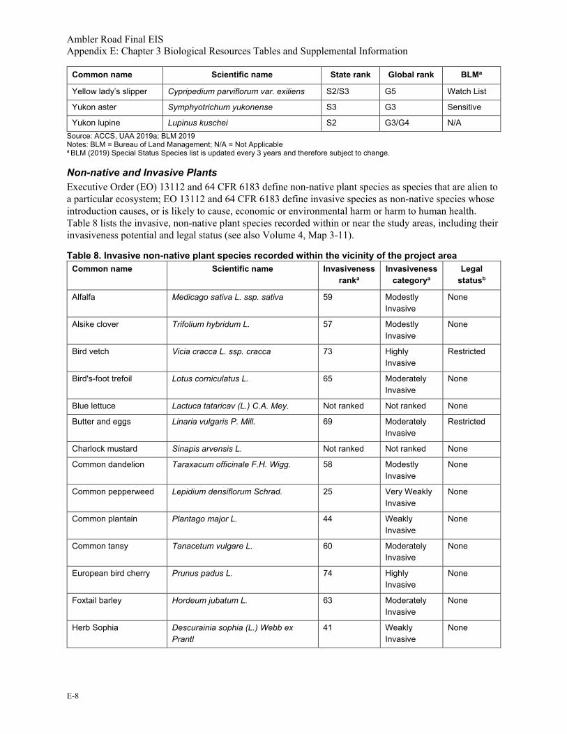
Ambler Road Final EIS Appendix E: Chapter 3 Biological Resources Tables and Supplemental Information
E-8
Common name Scientific name State rank Global rank BLMa
Yellow lady’s slipper Cypripedium parviflorum var. exiliens S2/S3 G5 Watch List
Yukon aster Symphyotrichum yukonense S3 G3 Sensitive
Yukon lupine Lupinus kuschei S2 G3/G4 N/A Source: ACCS, UAA 2019a; BLM 2019 Notes: BLM = Bureau of Land Management; N/A = Not Applicable a BLM (2019) Special Status Species list is updated every 3 years and therefore subject to change.
Non-native and Invasive Plants Executive Order (EO) 13112 and 64 CFR 6183 define non-native plant species as species that are alien to a particular ecosystem; EO 13112 and 64 CFR 6183 define invasive species as non-native species whose introduction causes, or is likely to cause, economic or environmental harm or harm to human health. Table 8 lists the invasive, non-native plant species recorded within or near the study areas, including their invasiveness potential and legal status (see also Volume 4, Map 3-11).
Table 8. Invasive non-native plant species recorded within the vicinity of the project area Common name Scientific name Invasiveness
ranka Invasiveness
categorya Legal
statusb
Alfalfa Medicago sativa L. ssp. sativa 59 Modestly Invasive
None
Alsike clover Trifolium hybridum L. 57 Modestly Invasive
None
Bird vetch Vicia cracca L. ssp. cracca 73 Highly Invasive
Restricted
Bird's-foot trefoil Lotus corniculatus L. 65 Moderately Invasive
None
Blue lettuce Lactuca tataricav (L.) C.A. Mey. Not ranked Not ranked None
Butter and eggs Linaria vulgaris P. Mill. 69 Moderately Invasive
Restricted
Charlock mustard Sinapis arvensis L. Not ranked Not ranked None
Common dandelion Taraxacum officinale F.H. Wigg. 58 Modestly Invasive
None
Common pepperweed Lepidium densiflorum Schrad. 25 Very Weakly Invasive
None
Common plantain Plantago major L. 44 Weakly Invasive
None
Common tansy Tanacetum vulgare L. 60 Moderately Invasive
None
European bird cherry Prunus padus L. 74 Highly Invasive
None
Foxtail barley Hordeum jubatum L. 63 Moderately Invasive
None
Herb Sophia Descurainia sophia (L.) Webb ex Prantl
41 Weakly Invasive
None

Ambler Road Final EIS Appendix E: Chapter 3 Biological Resources Tables and Supplemental Information
E-9
Common name Scientific name Invasiveness ranka
Invasiveness categorya
Legal statusb
Icelandic poppy Papaver croceum Ledeb. 39 Very Weakly Invasive
None
Italian tyegrass Lolium multiflorum Lam. 41 Weakly Invasive
None
Lambsquarters Chenopodium album L. 37 Very Weakly Invasive
None
Lupine clover TrifoliumtlupinasterwL. Not ranked Not ranked None
Meadow foxtail Alopecurus pratensis L. 52 Modestly Invasive
None
Narrowleaf hawksbeard Crepis tectorum L. 56 Modestly Invasive
None
Narrowleaf hawkweed Hieracium umbellatum L. 51 Modestly Invasive
None
Orange hawkweed Hieracium aurantiacum L. 79 Highly Invasive
Prohibited
Oxeye daisy Leucanthemum vulgare Lam. 61 Moderately Invasive
None
Pineappleweed Matricaria discoidea DC. 32 Very Weakly Invasive
None
Prostrate knotweed Polygonum aviculare L. 45 Weakly Invasive
None
Quackgrass Elymus repens (L.) Gould 59 Modestly Invasive
Prohibited
Red sandspurry Spergularia rubra (L.) J.& K. Presl. 34 Very Weakly Invasive
None
Shepherd's purse Capsella bursa-pastoris (L.) Medik. 40 Weakly Invasive
None
Siberian peashrub Caragana arborescens Lam. 74 Highly Invasive
None
Smooth brome Bromus inermis Leyss. 62 Moderately Invasive
None
Spreading bluegrass or Kentucky bluegrass
Poa pratensis L. ssp. irrigata (Lindm.) H. Lindb. or Poa pratensis L. ssp. pratensis
52 Modestly Invasive
None
White sweetclover Melilotus albus Medik. 81 Extremely Invasive
None
Sources: ADNR 2019; ANHP 2019; Carlson et al. 2008; Trammell et al. 2016 a Invasiveness category is based on invasiveness rank scores, which were developed based on total scores from 21 assessment questions used by Carlson et al. (2008). Scores >80 = “Extremely Invasive;” 70–79 = “Highly Invasive;” 60–69 = “Moderately Invasive;” 50–59 = “Modestly Invasive;” 40–49 = Weakly Invasive;” < 40 = “Very Weakly Invasive” b Restricted species are generally considered nuisances or economically detrimental, but can be controlled more easily.

Ambler Road Final EIS Appendix E: Chapter 3 Biological Resources Tables and Supplemental Information
E-10
Wildfire Ecology and Management Table 9 describes the fire management options that are currently planned in the project area (see also Volume 4, Map 3-14).
Table 9. Fire management options planned in the project area Fire management option
Description
Critical Lands in wildland urban interface and other densely populated areas where there is an immediate threat to human life, primary residences, inhabited property, community-dependent infrastructure, and structural resources designated as National Historic Landmarks should be considered for this designation. This classification is applicable to an entire village or town as well as a single inhabited structure. Excluding fire from Critical Management Option areas may necessitate vegetation (fuels) management projects to reduce and mitigate the risks of damage from a wildfire.
Full This option provides for protection of moderately populated areas, cultural and paleontological sites, developed recreational facilities, physical developments, administrative sites and cabins, structures, high-value natural resources, and other high-value areas. Structures on or eligible for inclusion on the National Register of Historic Places and non-structural sites on the National Register are placed within this category. Either broad areas or specific sites qualify to be designated as Full. The long-range effects on fire-dependent ecosystems are a land management consideration when designating Full at the landscape scale. The attempt to exclude fire may necessitate implementing vegetation (fuels) management programs.
Modified This option provides a management level between Full and Limited. It allows for a response to wildfire that tailors the initial action to the time of year that the fire starts. It provides for an initial response designed to protect identified sites early in the season when the probability is high that they will eventually be affected; but later in the year allows fire-related land-use and resource objectives to be accomplished in a cost-effective manner while still providing appropriate levels of site protection. The option is based on the assumption that in a normal fire year early season ignitions are more likely to spread to the point that they threaten values than late season ignitions. Prior to a pre-identified “conversion date” the initial response to a fire is similar to the Full Management Option, recognizing that lands placed in this category will usually be suited to indirect attack. After the conversion date, when it is less likely that the fire will spread and threaten values, the initial response is similar to the Limited Management Option in order to balance acres burned with suppression costs, and to accomplish land and resource management objectives when conditions are favorable. Sites that warrant higher levels of protection may occur within the Modified area.
Limited This option is designed for broad, landscape-scale areas where the low density and wide distribution of values to be protected best allows for fire to function in its ecological role. Wildland fire can be managed to protect, maintain, and enhance natural and cultural resources and, as nearly as possible, enable fire to function in its ecological role and maintain the natural fire regime. In these areas, fire is routinely able to function in its natural roles as an essential ecological process. Limited may also be assigned to areas where the cost of suppression may exceed the value of the resources to be protected, where the environmental impacts of fire suppression activities may have more negative impacts on the resources than the effects of the fire, and where safety considerations preclude the commitment of firefighters to an area (e.g. military impact zones). Wildland fires occurring within this designation will be allowed to burn within predetermined areas while continuing protection of human life and site-specific values. Periodic surveillance will be conducted to evaluate the need for action to protect human life or site-specific values.

Ambler Road Final EIS Appendix E: Chapter 3 Biological Resources Tables and Supplemental Information
E-11
Fire management option
Description
Unplanned No management option is planned. Sources: AICC 2019
1.1.2 Environmental Consequences
Vegetation Impacts to vegetation were analyzed using the cut and fill footprint and a 10-foot temporary construction zone surrounding the cut and fill footprint. Impacts outside of the construction zones were assessed using a 328-foot buffer off the edge of the road, based on impacts from fugitive dust.
Impacts were calculated by overlaying the construction daylight limits and associated 10-foot and 328-foot buffers onto the Central Yukon REA vegetation mapping in GIS to quantify acres of each vegetation type that will be impacted. Table 10, Table 11, and Table 12 provide acreages of impacts to vegetation types within the construction footprint, the 10-foot temporary construction zone, and a 328-foot buffer surrounding the footprint. For all action alternatives, the project would be constructed in three phases. The Phase 3 construction footprint was used as the basis for this analysis, as it encompasses both Phase 1 and Phase 2 construction footprints.
Table 10. Alternative A vegetation impact acres and percentages Vegetation types Area (acres)
construction zone/ temporary: 10 feet
Area (%)
Area (acres) direct
footprint
Area (%)
Area (acres) dust: 328
feeta
Area (%)
Upland low and tall shrub 258.5 42.3 1,897.6 41.9 7,466.5 41.7
Upland mesic spruce forest 213.8 35.0 1,336.8 29.5 6,308.5 35.3
Upland mesic spruce-hardwood forest
38.5 6.3 218.2 4.8 1,106.0 6.2
Lowland woody wetland 24.0 3.9 215.8 4.8 683.9 3.8
Grassland/Herbaceous 20.9 3.4 230.6 5.1 592.9 3.3
Alpine and Arctic tussock tundra
18.1 3.0 130.8 2.9 495.0 2.8
Alpine dwarf shrub tundra 15.7 2.6 235.0 5.2 488.1 2.7
Riparian forest and shrub 13.4 2.2 115.5 2.6 382.9 2.1
Sedge/Herbaceous 6.6 1.1 136.6 3.0 200.4 1.1
Open water 2.0 0.3 6.7 0.1 162.9 0.9
Emergent herbaceous wetlands
0.0 0.0 0.2 0.0 4.1 0.0
Barren land 0 0.0 0 0.0 0 0.0
Developed 0.0 0.0 0 0.0 4.7 0.0
Grand total 611.5 100.0 4,523.9 100.0 17,895.8 100.0 a The 328-foot fugitive dust buffer includes the 10-foot construction zone.

Ambler Road Final EIS Appendix E: Chapter 3 Biological Resources Tables and Supplemental Information
E-12
Table 11. Alternative B vegetation impact acres and percentages Vegetation types Area (acres)
construction zone/ temporary: 10 feet
Area (%)
Area (acres) direct
footprint
Area (%)
Area (acres) dust: 328
feeta
Area (%)
Upland low and tall shrub 275.2 40.6 2,127.4 41.4 7,867.9 39.7
Upland mesic spruce forest 266.3 39.3 1,622.8 31.6 7,899.4 39.8
Upland mesic spruce-hardwood forest
36.3 5.4 254.8 5.0 1,035.8 5.2
Lowland woody wetland 24.4 3.6 228.3 4.4 683.0 3.4
Alpine and Arctic tussock tundra
18.1 2.7 146.3 2.8 503.1 2.5
Grassland/Herbaceous 18.1 2.7 225.8 4.4 529.1 2.7
Riparian forest and shrub 16.0 2.4 150.6 2.9 470.8 2.4
Alpine dwarf shrub tundra 15.8 2.3 248.3 4.8 490.4 2.5
Sedge/Herbaceous 5.8 0.8 125.9 2.5 173.7 0.9
Open water 2.0 0.3 6.8 0.1 166.4 0.8
Barren land 0.2 0.0 0.9 0.0 6.6 0.0
Emergent herbaceous wetlands
0 0.0 0 0.0 3.1 0.0
Developed 0.0 0.0 0 0.0 4.7 0.0
Grand total 678.3 100.0 5,137.9 100.0 19,834.2 100.0 a The 328-foot fugitive dust buffer includes the 10-foot construction zone.
Table 12. Alternative C vegetation impact acres and percentages Vegetation types Area (acres)
construction zone/ temporary: 10 feet
Area (%)
Area (acres) direct
footprint
Area (%)
Area (acres) dust: 328
feeta
Area (%)
Upland mesic spruce forest 259.7 28.0 2,111.4 25.7 7,551.5 28.9 Upland low and tall shrub 222.2 24.0 1,914.6 23.3 6,311.6 24.2
Riparian forest and shrub 119.2 12.9 1,178.2 14.4 3,247.8 12.4
Lowland woody wetland 110.5 11.9 729.7 8.9 3,138.0 12.0
Alpine and Arctic tussock tundra
74.4 8.0 578.9 7.1 2,045.2 7.8
Upland mesic spruce-hardwood forest
56.1 6.1 809.1 9.9 1,517.7 5.8
Sedge/Herbaceous 28.5 3.1 234.7 2.9 840.9 3.2
Alpine dwarf shrub tundra 27.2 2.9 405.5 4.9 829.7 3.2
Developed 11.6 1.3 79.0 1.0 94.3 0.4
Grassland/Herbaceous 10.3 1.1 115.2 1.4 243.0 0.9
Emergent herbaceous wetlands
4.7 0.5 34.0 0.4 139.4 0.5

Ambler Road Final EIS Appendix E: Chapter 3 Biological Resources Tables and Supplemental Information
E-13
Vegetation types Area (acres) construction zone/ temporary: 10 feet
Area (%)
Area (acres) direct
footprint
Area (%)
Area (acres) dust: 328
feeta
Area (%)
Open water 2.5 0.3 11.9 0.1 128.9 0.5
Barren land 0.1 0.0 7.6 0.1 3.2 0.0
Unmapped 0.1 >0.1 0.3 >0.1 1.2 >0.1
Grand total 927.3 100.0 8,210.2 100.0 26,092.3 100.0 a The 328-foot fugitive dust buffer includes the 10-foot construction zone.
Wetlands Impacts to wetlands were calculated in the same manner as identified above in the vegetation section using the wetland mapping provided for the project (DOWL 2014 and 2019). Mapped wetland types were aggregated to the Cowardin Class levels to better facilitate comparison of impacts among the alternatives. Wetland types were aggregated first by System then by dominant Class, as shown in Table 5. Waterbodies in the Lacustrine and Palustrine Systems were aggregated as Lake or Pond, respectively.
It should be noted that approximately 9 acres within the 328-foot buffer of Alternatives A and B are unmapped. However, this unmapped area occurs on the easternmost extent of these action alternatives and is largely composed of the Dalton Highway.
Table 13, Table 14, and Table 15 provide acreages of impacts to wetland types within the construction footprint, the 10-foot temporary construction zone, and a 328-foot buffer surrounding the footprint.
Table 13. Alternative A wetland impact acres and percentages Aggregated wetland type Area (acres)
construction zone/ temporary: 10 feet
Area (%)
Area (acres) direct
footprinta
Area (%)
Area (acres) dust: 328
feetb
Area (%)
PEM total 14.8 2.4 116.3 2.6 477.2 2.7
PFO total 111.3 18.2 601.4 13.3 3,370.7 18.8
PSS total 212.4 34.7 1,341.0 29.6 6,677.4 37.3
Total freshwater wetlands 338.5 55.4 2,058.6 45.5 10,525.2 58.8
Pond total 0.1 >0.1 1.5 >0.1 56.9 0.3
Lake total 0 N/A 0 N/A 0 N/A
Riverine total 4.7 0.8 19.1 0.4 254.9 1.4
Total waterbodies 4.8 0.8 20.6 0.5 311.8 1.7
Total wetland and waterbodies
343.3 56.1 2,079.2 46.0 10,837.1 60.5
Upland total 268.2 43.9 2,444.7 54.0 7,058.8 39.4
Grand total 611.5 100.0 4,523.9 100.0 17,895.8 100.0 Notes: PEM = Palustrine Emergent; PFO = Palustrine Forest; PSS = Palustrine Scrub-shrub; N/A = Not applicable a The direct footprint impacts are not meant to represent a complete loss for riverine wetlands; rather, direct footprint acreages of riverine wetlands represent alterations to these wetland types where bridges and culverts would be constructed. b The 328-foot fugitive dust buffer includes the 10-foot construction zone.

Ambler Road Final EIS Appendix E: Chapter 3 Biological Resources Tables and Supplemental Information
E-14
Table 14. Alternative B wetland impact acres and percentages Aggregated wetland type Area (acres)
construction zone/ temporary: 10 feet
Area (%)
Area (acres) direct
footprinta
Area (%)
Area (acres) dust: 328
feetb
Area (%)
PEM total 15.0 2.2 118.6 2.3 485.6 2.4
PFO total 152.2 22.4 858.1 16.7 4,464.8 22.5
PSS total 223.5 33.0 1,414.5 27.5 6,974.8 35.2
Total freshwater wetlands 390.7 57.6 2,391.3 46.5 11,925.2 60.1 Pond total 0.2 >0.1 1.5 >0.1 59.9 0.3
Lake total 0 N/A 0 N/A 3.7 >0.1
Riverine total 5.4 0.8 23.0 0.4 281.1 1.4
Total waterbodies 5.6 0.8 24.6 0.5 344.8 1.7 Total wetland and
waterbodies 396.3 58.4 2,415.8 47.0 12,269.9 61.9
Upland total 282.0 41.6 2,722.0 53.0 7,564.2 38.1
Grand total 678.3 100.0 5,137.9 100.0 19,834.2 100.0 Notes: PEM = Palustrine Emergent; PFO = Palustrine Forest; PSS = Palustrine Scrub-shrub; N/A = Not applicable a The direct footprint impacts are not meant to represent a complete loss for riverine wetlands; rather, direct footprint acreages of riverine wetlands represent alterations to these wetland types where bridges and culverts would be constructed. b The 328-foot fugitive dust buffer includes the 10-foot construction zone.
Table 15. Alternative C wetland impact acres and percentages Aggregated wetland type Area (acres)
construction zone / temporary: 10 feet
Area (%)
Area (acres) direct
footprinta
Area (%)
Area (acres) dust: 328
feetb
Area (%)
PEM total 35.0 3.8 249.8 3.1 1,000.2 3.8
PFO total 97.1 10.5 677.2 8.2 2,731.2 10.5
PML total 4.8 0.5 30.3 0.4 136.2 0.5
PSS total 425.0 45.7 2,865.4 34.8 12,037.4 46.1
Total freshwater wetlands 562.0 60.5 3,822.6 46.5 15,905.0 61.0 Pond total 1.3 0.1 9.1 0.1 59.0 0.2
Lake total >0.1 >0.1 0 N/A 5.5 0.0
Riverine total 8.3 0.9 58.3 0.7 320.2 1.2
Total waterbodies 9.6 1.0 67.4 0.8 384.8 1.5 Total wetland and
waterbodies 571.6 61.5 3,890.0 47.3 16,289.7 62.4
Upland total 355.7 38.5 4,320.2 52.7 9,802.6 37.6
Grand total 927.3 100.0 8,210.2 100.0 26,092.3 100.0 Notes: PEM = Palustrine Emergent; PFO = Palustrine Forest; PML = Palustrine Moss-Lichen; PSS = Palustrine Scrub-shrub; N/A = Not applicable a The direct footprint impacts are not meant to represent a complete loss for riverine wetlands; rather, direct footprint acreages of riverine wetlands represent alterations to these wetland types where bridges and culverts would be constructed. b The 328-foot fugitive dust buffer includes the 10-foot construction zone.

Ambler Road Final EIS Appendix E: Chapter 3 Biological Resources Tables and Supplemental Information
E-15
1.2. Fish and Amphibians
Table 16 identifies species documented in the study area and highlights species key to this analysis. The analysis identifies a fish species as key if it is a major target of subsistence, sport, or commercial fisheries, has specialized habitat (e.g., spawning areas) in the study area that is limited elsewhere, or has essential fish habitat (EFH) designated in the study area. Table 17 provides considerations for assessing impacts to fish habitat, including anadromous stream crossings and EFH in streams. See also Volume 4, Map 3-17 and Map 3-18.
Table 16. Fish species documented to occur in drainages intersected by the alternatives Common name(s) Traditional name(s) Scientific name Life history Considerations specific to the study area Species of Greatest Conservation Need
throughout Alaskaa
Arctic graylingb Suluqpaugaqd, tleghelbaayee Thymallus arcticus Resident Subsistence target, sport Cultural Importance
Round whitefish Quptik, Savaigutnikd, hulten’e Prosopium cylindraceum Resident Prey species; subsistence (bycatch) Cultural Importance
Sheefish (Inconnu)b Siid, ledlaagha e Stenodus leucichthys Mostly Anadromous in study area Subsistence target, sport, commercial Stewardship Species
Humpback whitefishb Qaalgiq, Ikkuiyiqd, holehgee Coregonus pidschian Anadromous or Resident Subsistence target Cultural Importance
Broad whitefishb Quasriluk, Siiguliaqd, taasezee Coregonus nasus Anadromous or Resident Subsistence target Cultural Importance
Least cisco Qalusraaq, Iqalusaaqd, tsaabaayee Coregonus sardinella Anadromous or Resident Sport, prey species, subsistence Cultural Importance
Burbot, mudshark, lushb Tittaaliq, Tiktaaliqd Ts’oneyee Lota lota Resident Subsistence Cultural and Ecological Importance
Dolly Varden Qalukpik, Agalukpiqd, seł yee lookk’e Salvelinus malma Anadromous or Resident Subsistence, sport Cultural Importance; Stewardship Species
Chinook salmonb, c Iqalsugruk, Tagayukpukd Oncorhynchus tshawytscha Anadromous Subsistence target, EFH Cultural and Economic Importance; Stewardship
Chum salmonb, c Qalugruaq, Aqalugruaqd Oncorhynchus keta Anadromous Subsistence target, EFH, commercial Cultural and Economic Importance
Coho salmonb Not applicable Oncorhynchus kisutch Anadromous Subsistence target, EFH Cultural and Economic Importance; Stewardship
Sockeye salmonb Not applicable Oncorhynchus nerka Anadromous EFH Cultural and Economic Importance; Stewardship
Northern pikeb Siulik, Siilikd, K’oolkkoyee Esox lucius Resident Subsistence target, sport Cultural and Economic Importance
Arctic lamprey, eel Dots’e tl’ egheze, Dots’ e tl’ oole Lampetra camtschatica Anadromous Prey species (subsistence outside of study area) Cultural Importance
Arctic char Igalukpiq, Qalukpikd Salvelinus alpinus Resident Subsistence, sport Cultural Importance
Lake trout Kanaak, Akmagukd, qalukpik, tl’uhlaaghee Salvelinus namaycush Resident Subsistence, sport Cultural Importance
Alaska blackfishb Iłuuqiñiq, Iłuiqiñiqd Oonyeeyhe Dallia pectoralis Resident Subsistence; culturally significant Cultural Importance
Lake chub Lake herring, tokkodoozee Couesius plumbeus Resident Prey species Ecological Importance
Longnose sucker Kaviqsuaq, Milugiaqd toonts’odee Catostomus catostomus Resident Prey species Not applicable
Slimy sculpin Netsoo tlee’e Cottus cognatus Resident Prey species Not applicable
Ninespine stickleback Kakilniukd Pungitius pungitius Resident Prey species Ecological Importance Sources: ABR 2014a; ADF&G 2015, 2019; Anderson et al. 2004; Esse and Kretsinger 2009; Johnson and Blossom 2018a, 2018b; Jones 2006; Kretsinger et al. 1994; Lemke et al. 2013; McKenna 2015; Scannell 2015; Wuttig et al. 2015 Notes: EFH = Essential Fish Habitat a ADF&G (2015) identifies 58 fish species as species of greatest conservation need (SGCN) in Alaska; none is listed as “at-risk’ (species whose population is small, declining, or under significant threat). SGCN, based on multiple criteria, include species that are culturally, ecologically, or economically important; species with a high percentage of their North American or global population in Alaska (stewardship species); and species that function as indicators of environmental change (sentinel species). b Species shown in bold (strong text) and followed with a superscript of “b” are major targets of a subsistence, sport, or commercial fishery in the study area; have specialized habitat (e.g., spawning area) in the study area that is limited elsewhere; or have EFH designated in the study area and are considered key to this analysis. The Alaska blackfish is a focus species for this analysis because of its cultural significance within the study area (S. Whiting, personal communication 2019). c Chinook and chum salmon returns to the Yukon and other rivers in northwest Alaska have declined since the late 1990s (McKenna 2015). Chum salmon in Clear Creek, a tributary of the Hogatza River, is on the BLM’s “Watchlist Animals” list of the “BLM Alaska Special Status Species List” but are not currently recognized as a sensitive species (BLM 2019; Esse and Kretsinger 2009; Kretsinger et al. 1994). d Iñupiaq names based on Jones 2006. e Koyukon names based on Anderson et al. 2004.

Ambler Road Final EIS Appendix E: Chapter 3 Biological Resources Tables and Supplemental Information
E-16
Table 17. Considerations for assessing impacts to fish habitat – anadromous stream crossings and Essential Fish Habitat in streams Number of stream crossings and proximity of road and gravel sites to fish streams Alternative A Alternative B Alternative C
Number of Essential Fish Habitata crossings 13 14 21
Number of known anadromous streamsb crossings 17 18 26
Number of crossings of assumed anadromousc streams 23 25 244
Total number of known and/or assumed anadromousd fish stream crossings 40 43 270
Number of bridge crossings 29 26 251
Number of moderate and major culverts proposedd 34 24 272
Number of minor culverts proposedf 2,869 3,155 4,076
Acreage of fish habitat affected by bridgesg, which may result in loss of spawning habitat 2,025 2,021 4,092
Acreage of fish habitat affected by culvertsh, which may result in loss of spawning habitat 84.5 88.5 181
Linear miles of fish stream habitat affected by properly maintained bridgesg 13.4 10.5 57.4
Linear miles of fish stream habitat affected by properly maintained fish passage culvertsh 70.1 76.4 110
Total length of road in miles, excluding access roads 211 228 332
Miles of road located within major floodplainsi, excluding access roads 4.6 5.4 53.6
Miles of road located within 1,000 feet of major floodplaini, excluding access roads 16.1 17.3 96.3
Miles of road located within 1,000 feet of National Hydrography Dataset streams, excluding access roads 16.0 20.2 83.3
Total number of gravel mines proposed 41 46 44
Number of gravel mines within floodplaini or in low-lying areas within 500 feet of fish streamsj 21 22 16
Number of gravel mines located within 300 feet of Essential Fish Habitat a streams 3 4 6
Number of gravel mines within 300 feet of known and/or assumed anadromousd streams 8 11 18 a Based on crossings of salmon streams identified in the Anadromous Waters Catalog (Johnson and Blossom 2018a, 2018b) and streams recently nominated for inclusion into the AWC, by ADF&G staff (Geifer et al. 2019). b Based on crossings of streams identified in the Anadromous Waters Catalog (Johnson and Blossom 2018a, 2018b) and streams recently nominated for inclusion into the AWC, by ADF&G staff (Geifer et al. 2019). c Based on streams assumed by AIDEA and DOWL to support anadromous fish (received GIS data 2019). d Includes data from the AWC and those streams that AIDEA and DOWL assume to be anadromous. e Moderate culverts would be 4 to 10 feet in diameter and major culverts would be 10 to 20 feet wide. AIDEA made an estimate at the application stage of the number of major, moderate, and minor culverts that would be needed for the project. AIDEA has committed to using stream simulation principles to design culverts at all fish-bearing streams in order to provide fish passage and minimize potential adverse impacts to fish and aquatic life. At the construction stage AIDEA will be required to use culverts sized appropriately for the drainage and to meet fish passage requirements where necessary, even if their application stage estimate was different. f Minor culverts would be 3 feet or less in diameter. AIDEA estimated the number of minor culvert crossings but did not provide crossing locations or stream data at the same resolution for all alternatives, so it is difficult to estimate the number of minor culverts intended to convey perennial stream flow and pass fish, as opposed to those intended to facilitate cross drainage or maintain wetland connectivity in areas that do not support fish. AIDEA made an estimate at the application stage of the number of major, moderate, and minor culverts that would be needed for the project (as shown in this table). At the construction stage, AIDEA will be required to use culverts sized appropriately for the drainage and to meet fish passage requirements where necessary, even if their application stage estimate was different. In some cases ‘minor’ culverts may not be large enough to adequately pass fish, particularly using stream simulation principles, and therefore, some culverts in fish-bearing habitat may be resized through coordination with ADF&G prior to construction, during permitting. g The bridge length was assumed to be an average of 50 feet for small bridges, 120 feet for medium bridges, and the actual length for the large bridges. Assuming that the stream/floodplain would be impacted by the bridge crossings up to five times the bridge length both upstream and downstream allowed an estimate of the area of floodplain impacts due to the bridges. h The culvert width was assumed to be an average of 3 feet for minor culverts, 10 feet for moderate culverts, and 20 feet for major culverts. Assuming that the stream/floodplain would be impacted by the culvert crossings up to five times the culvert width plus a roadway embankment at a 4:1 slope for Phase 3 width both upstream and downstream allowed an estimate of the area of floodplain impacts due to culverts. i Based on vegetative floodplain mapping for the Central Yukon Region (BLM 2016). j Based on review of aerial imagery, LIDAR, contour data, available stream and fish data from multiple sources and proposed material site locations in geographic information systems (GIS) software. DOWL (2014) cautions that densely vegetated habitat precluded identification of some drainages (less than 12 feet wide) in some areas.

Ambler Road Final EIS Appendix E: Chapter 3 Biological Resources Tables and Supplemental Information
E-17
1.3. Birds
Table 18 identifies the avian species that occur in the project area, including their common and scientific names, relative abundance, and special status designations.
Table 18. Avian species in the project area Species group Common name Scientific namea Species relative abundance
in the project area Species
occurrence BCCb BLMc ADF&Gd AUDe IUCNf AOU No. Reference
Waterfowl Greater white-fronted goose Anser albifrons U B N/A N/A N/A N/A N/A 14 Alaska Center for Conservation Science Web Mapper
Waterfowl Snow goose Anser caerulescens R M N/A N/A N/A N/A N/A 15 Alaska Center for Conservation Science Web Mapper
Waterfowl Brant Branta bernicula R M N/A N/A N/A N/A N/A 19 Kanuti NWR
Waterfowl Cackling goose Branta hutchinsii U B N/A N/A N/A N/A N/A 21 Alaska Center for Conservation Science Web Mapper
Waterfowl Canada goose Branta canadensis C B N/A N/A N/A N/A N/A 22 Alaska Center for Conservation Science Web Mapper
Waterfowl Trumpeter swan Cygnus buccinator C B N/A W N/A N/A N/A 25 Alaska Center for Conservation Science Web Mapper
Waterfowl Tundra swan Cygnus columbianus U M N/A N/A N/A N/A N/A 26 Alaska Center for Conservation Science Web Mapper
Waterfowl Mallard Anas platyrhynchos C B N/A N/A N/A N/A N/A 37 Alaska Center for Conservation Science Web Mapper
Waterfowl Northern pintail Anas acuta C B N/A N/A N/A N/A N/A 46 Alaska Center for Conservation Science Web Mapper
Waterfowl Gadwall Mareca strepera U M N/A N/A N/A N/A N/A 46.5 Alaska Center for Conservation Science Web Mapper
Waterfowl American wigeon Mareca americana C B N/A N/A N/A N/A N/A 47 Alaska Center for Conservation Science Web Mapper
Waterfowl Northern shoveler Spatula clypeata C B N/A N/A N/A N/A N/A 48 Alaska Center for Conservation Science Web Mapper
Waterfowl Green-winged teal Anas crecca C B N/A N/A N/A N/A N/A 49 Alaska Center for Conservation Science Web Mapper
Waterfowl Canvasback Aythya valisineria R B N/A N/A N/A N/A N/A 50 Alaska Center for Conservation Science Web Mapper
Waterfowl Redhead Aythya americana R B N/A N/A N/A N/A N/A 51 Alaska Center for Conservation Science Web Mapper
Waterfowl Ring-necked duck Aythya collaris U B N/A N/A N/A N/A N/A 53 Alaska Center for Conservation Science Web Mapper
Waterfowl Greater scaup Aythya marila C B N/A N/A N/A RL N/A 55 Alaska Center for Conservation Science Web Mapper
Waterfowl Lesser scaup Aythya affinis C B N/A N/A N/A N/A N/A 56 Alaska Center for Conservation Science Web Mapper
Waterfowl Harlequin duck Histrionicus histrionicus R B N/A N/A N/A N/A N/A 61 Alaska Center for Conservation Science Web Mapper
Waterfowl Surf scoter Melanitta perspicillata C B N/A N/A N/A N/A N/A 63 Alaska Center for Conservation Science Web Mapper
Waterfowl White-winged scoter Melanitta fusca C B N/A N/A N/A N/A N/A 64 Alaska Center for Conservation Science Web Mapper
Waterfowl Black scoter Melanitta americana U B N/A N/A AR RL NT 65 Alaska Center for Conservation Science Web Mapper
Waterfowl Long-tailed duck Clangula hyemalis C B N/A N/A N/A N/A VU 66 Alaska Center for Conservation Science Web Mapper
Waterfowl Bufflehead Bucephala albeola U B N/A N/A N/A N/A N/A 67 Alaska Center for Conservation Science Web Mapper
Waterfowl Common goldeneye Bucephala clangula U B N/A N/A N/A N/A N/A 68 Alaska Center for Conservation Science Web Mapper
Waterfowl Common merganser Mergus merganser R B N/A N/A N/A N/A N/A 72 Kanuti NWR
Waterfowl Red-breasted merganser Mergus serrator C B N/A N/A N/A N/A N/A 73 Alaska Center for Conservation Science Web Mapper
Loons and Grebes Red-throated loon Gavia stellata R B N/A S AR N/A N/A 134 Alaska Center for Conservation Science Web Mapper
Loons and Grebes Pacific loon Gavia pacifica U B N/A N/A N/A N/A N/A 135 Alaska Center for Conservation Science Web Mapper
Loons and Grebes Common loon Gavia immer C B N/A N/A N/A N/A N/A 136 Alaska Center for Conservation Science Web Mapper
Loons and Grebes Horned grebe Podiceps auritus C B C N/A N/A N/A VU 1986 Alaska Center for Conservation Science Web Mapper
Loons and Grebes Red-necked grebe Podiceps grisegena U B N/A N/A N/A RL N/A 1987 Alaska Center for Conservation Science Web Mapper

Ambler Road Final EIS Appendix E: Chapter 3 Biological Resources Tables and Supplemental Information
E-18
Species group Common name Scientific namea Species relative abundance in the project area
Species occurrence
BCCb BLMc ADF&Gd AUDe IUCNf AOU No. Reference
Grouse and Ptarmigan Ruffed grouse Bonasa umbellus U RE N/A N/A N/A N/A N/A 98 Alaska Center for Conservation Science Web Mapper
Grouse and Ptarmigan Spruce grouse Falcipennis canadensis C RE N/A N/A N/A N/A N/A 101 Alaska Center for Conservation Science Web Mapper
Grouse and Ptarmigan Willow ptarmigan Lagopus lagopus C RE N/A N/A N/A N/A N/A 102 DeGroot and McMillan
Grouse and Ptarmigan Rock ptarmigan Lagopus muta C R N/A N/A N/A N/A N/A 103 Alaska Center for Conservation Science Web Mapper
Grouse and Ptarmigan Sharp-tailed grouse Tympanuchus phasianellus U R N/A N/A N/A N/A N/A 107 Alaska Center for Conservation Science Web Mapper
Cranes Sandhill crane Antigone canadensis R B N/A N/A N/A N/A N/A 365 Alaska Center for Conservation Science Web Mapper
Kingfishers Belted kingfisher Megaceryle alcyon U B N/A N/A AR N/A N/A 912 Alaska Center for Conservation Science Web Mapper
Woodpeckers Downy woodpecker Dryobates pubescens C RE N/A N/A N/A N/A N/A 963 Alaska Center for Conservation Science Web Mapper
Woodpeckers Hairy woodpecker Dryobates villosus C RE N/A N/A N/A YL N/A 964 Alaska Center for Conservation Science Web Mapper
Woodpeckers American three-toed woodpecker Picoides dorsalis R RE N/A N/A N/A N/A N/A 969 Alaska Center for Conservation Science Web Mapper
Woodpeckers Black-backed woodpecker Picoides arcticus R RE N/A N/A N/A N/A N/A 970 Alaska Center for Conservation Science Web Mapper
Woodpeckers Northern flicker Colaptes auratus C B N/A N/A AR N/A N/A 979 Alaska Center for Conservation Science Web Mapper
Raptors Bald eagle Haliaeetus leucocephalus C B N/A N/A N/A N/A N/A 270 ABR Raptor Report
Raptors Northern harrier Circus cyaneus C B N/A N/A AR N/A N/A 274 ABR Raptor Report
Raptors Sharp-shinned hawk Accipiter striatus U B N/A N/A N/A N/A N/A 278 ABR Raptor Report
Raptors Northern goshawk Accipiter gentilis C R N/A N/A N/A N/A N/A 282 ABR Raptor Report
Raptors Red-tailed hawk Buteo jamaicensis C B N/A N/A N/A N/A N/A 305 ABR Raptor Report
Raptors Rough-legged hawk Buteo lagopus U B N/A N/A N/A N/A N/A 307 ABR Raptor Report
Raptors Osprey Pandion haliaetus C B N/A N/A N/A N/A N/A 308 ABR Raptor Report
Raptors Golden eagle Aquila chrysaetos C B N/A N/A N/A N/A N/A 310 ABR Raptor Report
Raptors American kestrel Falco sparverius U B N/A N/A AR N/A N/A 323 ABR Raptor Report
Raptors Merlin Falco columbarius U B N/A N/A N/A N/A N/A 325 ABR Raptor Report
Raptors Gyrfalcon Falco rusticolus R RE N/A W AR N/A N/A 330 ABR Raptor Report
Raptors Peregrine falcon Falco peregrinus C B C N/A N/A N/A N/A 331 ABR Raptor Report
Raptors Great horned owl Bubo virginianus U R N/A N/A N/A N/A N/A 681 ABR Raptor Report
Raptors Snowy owl Bubo scandiacus R M N/A N/A N/A N/A N/A 682 Kanuti NWR
Raptors Northern hawk owl Surnia ulula U RE N/A N/A AR N/A N/A 683 ABR Raptor Report
Raptors Great gray owl Strix nebulosa U RE N/A N/A AR N/A N/A 698 ABR Raptor Report
Raptors Short-eared owl Asio flammeus U B N/A N/A N/A N/A N/A 701 ABR Raptor Report
Raptors Boreal owl Aegolius funereus U B N/A N/A AR N/A N/A 704 ABR Raptor Report
Shorebirds American golden-plover Pluvialis dominica U B N/A N/A AR RL N/A 373 Alaska Center for Conservation Science Web Mapper
Shorebirds Semipalmated plover Charadrius semipalmatus U M N/A N/A N/A N/A N/A 381 Alaska Center for Conservation Science Web Mapper
Shorebirds Spotted sandpiper Actitis macularius U B N/A N/A AR N/A N/A 397 Alaska Center for Conservation Science Web Mapper
Shorebirds Solitary sandpiper Tringa solitaria U B C N/A AR YL N/A 399 Alaska Center for Conservation Science Web Mapper
Shorebirds Wandering tattler Tringa incana U B N/A N/A N/A YL N/A 401 Alaska Center for Conservation Science Web Mapper
Shorebirds Surfbird Aphriza virgata U B N/A N/A AR YL N/A 402 Alaska Center for Conservation Science Web Mapper

Ambler Road Final EIS Appendix E: Chapter 3 Biological Resources Tables and Supplemental Information
E-19
Species group Common name Scientific namea Species relative abundance in the project area
Species occurrence
BCCb BLMc ADF&Gd AUDe IUCNf AOU No. Reference
Shorebirds Lesser yellowlegs Tringa flavipes C B C N/A AR RL N/A 406 Alaska Center for Conservation Science Web Mapper
Shorebirds Upland sandpiper Bartramia longicauda R B C N/A AR N/A N/A 410 Alaska Center for Conservation Science Web Mapper
Shorebirds Whimbrel Numenius phaeopus U B C S AR YL N/A 413 Alaska Center for Conservation Science Web Mapper
Shorebirds Hudsonian godwit Limosa haemastica U B C N/A AR N/A N/A 420 Alaska Center for Conservation Science Web Mapper
Shorebirds Semipalmated sandpiper Calidris pusilla U B N/A N/A AR N/A NT 429 Alaska Center for Conservation Science Web Mapper
Shorebirds Least sandpiper Calidris minutilla C B N/A N/A N/A N/A N/A 435 Alaska Center for Conservation Science Web Mapper
Shorebirds Baird's sandpiper Calidris bairdii U B N/A N/A N/A N/A N/A 437 Alaska Center for Conservation Science Web Mapper
Shorebirds Pectoral sandpiper Calidris melanotos U M N/A N/A N/A N/A N/A 438 Kanuti NWR
Shorebirds Long-billed dowitcher Limnodromus scolopaceus U M N/A N/A N/A N/A N/A 450 Alaska Center for Conservation Science Web Mapper
Shorebirds Wilson's snipe Gallinago delicata U B N/A N/A N/A N/A N/A 452 Alaska Center for Conservation Science Web Mapper
Shorebirds Red-necked phalarope Phalaropus lobatus U B N/A N/A N/A N/A N/A 458 Alaska Center for Conservation Science Web Mapper
Larids Bonaparte's gull Chroicocephalus philadelphia
R B N/A N/A N/A N/A N/A 463 Alaska Center for Conservation Science Web Mapper
Larids Mew gull Larus canus C B N/A N/A N/A N/A N/A 464 Alaska Center for Conservation Science Web Mapper
Larids Herring gull Larus argentatus C B N/A N/A AR N/A N/A 467 Alaska Center for Conservation Science Web Mapper
Larids Glaucous gull Larus hyperboreus R M N/A N/A N/A N/A N/A 476 Kanuti NWR
Larids Arctic tern Sterna paradisaea C B CC N/A AR N/A N/A 502 Alaska Center for Conservation Science Web Mapper
Larids Long-tailed jaeger Stercorarius longicaudus R B N/A N/A N/A N/A N/A 512 Kanuti NWR
Passerines Olive-sided flycatcher Contopus cooperi U B CC S AR RL N/A 1127 DeGroot and McMillan
Passerines Western wood-pewee Contopus sordidulus R B N/A N/A AR RL N/A 1131 Alaska Center for Conservation Science Web Mapper
Passerines Yellow-bellied flycatcher Empidonax flaviventris R V N/A N/A N/A N/A N/A 1138 Kanuti NWR
Passerines Alder flycatcher Empidonax alnorum C B N/A N/A N/A N/A N/A 1140 Alaska Center for Conservation Science Web Mapper
Passerines Hammond's flycatcher Empidonax hammondii U B N/A N/A N/A N/A N/A 1144 Alaska Center for Conservation Science Web Mapper
Passerines Say's phoebe Sayornis saya U B N/A N/A N/A N/A N/A 1155 Alaska Center for Conservation Science Web Mapper
Passerines Northern shrike Lanius excubitor U B N/A N/A N/A N/A N/A 1156 Alaska Center for Conservation Science Web Mapper
Passerines Black-billed magpie Pica hudsonia C B N/A N/A N/A N/A N/A 1293 Alaska Center for Conservation Science Web Mapper
Passerines Common raven Corvus corax C B N/A N/A N/A N/A N/A 1307 DeGroot and McMillan
Passerines Horned lark Eremophila alpestris U B N/A N/A AR N/A N/A 1310 Alaska Center for Conservation Science Web Mapper
Passerines Tree swallow Tachycineta bicolor U B N/A N/A AR N/A N/A 1318 Alaska Center for Conservation Science Web Mapper
Passerines Violet-green swallow Tachycineta thalassina U B N/A N/A N/A RL N/A 1321 Alaska Center for Conservation Science Web Mapper
Passerines Bank swallow Riparia riparia U B N/A W AR RL N/A 1328 DeGroot and McMillan
Passerines Cliff swallow Petrochelidon pyrrhonota U B N/A N/A N/A N/A N/A 1329 DeGroot and McMillan
Passerines Black-capped chickadee Poecile atricapillus U R N/A N/A N/A N/A N/A 1334 Alaska Center for Conservation Science Web Mapper
Passerines Boreal chickadee Poecile hudsonicus C RE N/A N/A AR N/A N/A 1338 DeGroot and McMillan
Passerines Gray-headed chickadee Poecile cinctus U RE N/A S N/A RL N/A 1339 DeGroot and McMillan
Passerines American dipper Cinclus mexicanus U RE N/A N/A N/A N/A N/A 1399 Alaska Center for Conservation Science Web Mapper

Ambler Road Final EIS Appendix E: Chapter 3 Biological Resources Tables and Supplemental Information
E-20
Species group Common name Scientific namea Species relative abundance in the project area
Species occurrence
BCCb BLMc ADF&Gd AUDe IUCNf AOU No. Reference
Passerines Ruby-crowned kinglet Regulus calendula C B N/A N/A N/A N/A N/A 1403 Alaska Center for Conservation Science Web Mapper
Passerines Arctic warbler Phylloscopus borealis U B N/A N/A N/A N/A N/A 1412 DeGroot and McMillan
Passerines Bluethroat Cyanecula svecica U B N/A N/A N/A N/A N/A 1425 Alaska Center for Conservation Science Web Mapper
Passerines Northern wheatear Oenanthe oenanthe U B N/A N/A N/A N/A N/A 1426 Alaska Center for Conservation Science Web Mapper
Passerines Mountain bluebird Sialia currucoides U B N/A N/A N/A N/A N/A 1430 Alaska Center for Conservation Science Web Mapper
Passerines Townsend's solitaire Myadestes townsendii R B N/A N/A N/A N/A N/A 1431 Kanuti NWR
Passerines Gray-cheeked thrush Catharus minimus C B N/A N/A N/A N/A N/A 1451 DeGroot and McMillan
Passerines Swainson's thrush Catharus ustulatus U B N/A N/A AR N/A N/A 1453 Alaska Center for Conservation Science Web Mapper
Passerines Hermit thrush Catharus guttatus U B N/A N/A N/A N/A N/A 1454 Alaska Center for Conservation Science Web Mapper
Passerines American robin Turdus migratorius C B N/A N/A N/A N/A N/A 1472 DeGroot and McMillan
Passerines Varied thrush Ixoreus naevius C B N/A N/A AR N/A N/A 1478 Alaska Center for Conservation Science Web Mapper
Passerines Eastern yellow wagtail Motacilla tschutschensis R V N/A N/A N/A N/A N/A 1513 Kanuti NWR
Passerines American pipit Anthus rubescens U B N/A N/A AR N/A N/A 1521 Alaska Center for Conservation Science Web Mapper
Passerines Bohemian waxwing Bombycilla garrulus C B N/A N/A N/A N/A N/A 1524 Alaska Center for Conservation Science Web Mapper
Passerines Orange-crowned warbler Oreothlypis celata C B N/A N/A AR RL N/A 1536 DeGroot and McMillan
Passerines Yellow warbler Setophaga petechia C B N/A N/A AR YL N/A 1545 Alaska Center for Conservation Science Web Mapper
Passerines Yellow-rumped warbler Setophaga coronata C B N/A N/A N/A N/A N/A 1550 Alaska Center for Conservation Science Web Mapper
Passerines Townsend's warbler Setophaga townsendi U B N/A W N/A N/A N/A 1554 Alaska Center for Conservation Science Web Mapper
Passerines Blackpoll warbler Setophaga striata U B N/A W AR RL N/A 1569 Alaska Center for Conservation Science Web Mapper
Passerines Northern waterthrush Parkesia noveboracensis C B N/A N/A N/A N/A N/A 1581 Alaska Center for Conservation Science Web Mapper
Passerines Wilson's warbler Cardellina pusilla C B N/A N/A AR N/A N/A 1601 Alaska Center for Conservation Science Web Mapper
Passerines American tree sparrow Spizelloides arborea C B N/A N/A AR N/A N/A 1704 DeGroot and McMillan
Passerines Savannah sparrow Passerculus sandwichensis U B N/A N/A AR N/A N/A 1715 DeGroot and McMillan
Passerines Fox sparrow Passerella iliaca C B N/A N/A AR N/A N/A 1721 DeGroot and McMillan
Passerines Lincoln's sparrow Melospiza lincolnii C B N/A N/A N/A N/A N/A 1723 Alaska Center for Conservation Science Web Mapper
Passerines White-crowned sparrow Zonotrichia leucophrys C B N/A N/A AR N/A N/A 1728 Degroot-McMillan
Passerines Golden-crowned sparrow Zonotrichia atricapilla U B N/A N/A N/A N/A N/A 1729 Alaska Center for Conservation Science Web Mapper
Passerines Dark-eyed Junco Junco hyemalis C B N/A N/A N/A N/A N/A 1730 Alaska Center for Conservation Science Web Mapper
Passerines Lapland longspur Calcarius lapponicus U B N/A N/A N/A N/A N/A 1733 Alaska Center for Conservation Science Web Mapper
Passerines Snow bunting Plectrophenax nivalis U B N/A N/A AR N/A N/A 1744 Alaska Center for Conservation Science Web Mapper
Passerines Red-winged blackbird Agelaius phoeniceus U B N/A N/A N/A N/A N/A 1772 Alaska Center for Conservation Science Web Mapper
Passerines Rusty blackbird Euphagus carolinus U B CC S AR N/A VU 1784 DeGroot and McMillan
Passerines Gray-crowned rosy-finch Leucosticte tephrocotis C B N/A N/A N/A N/A N/A 1846 Alaska Center for Conservation Science Web Mapper
Passerines Pine grosbeak Pinicola enucleator C B N/A N/A N/A N/A N/A 1849 Alaska Center for Conservation Science Web Mapper
Passerines White-winged crossbill Loxia leucoptera C RE N/A N/A N/A N/A N/A 1856 Alaska Center for Conservation Science Web Mapper
Passerines Common redpoll Acanthis flammea C B N/A N/A AR N/A N/A 1857 DeGroot and McMillan

Ambler Road Final EIS Appendix E: Chapter 3 Biological Resources Tables and Supplemental Information
E-21
Species group Common name Scientific namea Species relative abundance in the project area
Species occurrence
BCCb BLMc ADF&Gd AUDe IUCNf AOU No. Reference
Passerines Hoary redpoll Acanthis hornemanni U RE N/A N/A N/A N/A N/A 1858 DeGroot and McMillan
Passerines Gray jay Perisoreus canadensis C B N/A N/A N/A N/A N/A 1978 Alaska Center for Conservation Science Web Mapper Sources: ABR 2014b; ACCS, UAA 2019b; ADF&G 2015; Banks et al. 2000, 2002, 2003; BLM 2019; DeGroot and McMillan 2012; IUCN 2019; USFWS 2008; Warnock 2017a, 2017b Notes: ADF&G = Alaska Department of Fish and Game; AOU No. = American Ornithological Society Checklist Number; AUD = Audubon Alaska; B = Breeding; BCC = Birds of Conservation Concern; BLM = Bureau of Land Management; C = Common; IUCN = International Union for Conservation of Nature; M = Migration; N/A = Not applicable; NT = Near Threatened; NWR = National Wildlife Refuge; R = Rare; RE = Resident; RL = Red List of Declining Bird Populations; S = Sensitive; U = Uncommon; V = Vagrant; VU = Vulnerable; W = WatchList; YL = Yellow List of Vulnerable Species a Scientific names from List of the 2,031 Bird Species (with Scientific and English Names) Known from the American Ornithological Society Checklist Area (AOS n.d.). The list incorporates changes made in the 42nd, 43rd, and 44th supplements to the checklist, as published in The Auk 117: 847−858 (2000); 119:897-906 (2002); 120:923-932 (2003) (Banks et al. 2000, 2002, 2003). b CC = U.S. Fish and Wildlife Service Birds of Conservation Concern, Regions 2, 3, or 4 (USFWS 2008) c BLM Sensitive Species List (BLM 2019) d At -Risk" Species; Source: ADF&G Wildlife Action Plan (ADF&G 2015) e,Audubon Alaska, Alaska WatchList (Warnock 2017a, 2017b) f IUCN Red List (IUCN 2019)

Ambler Road Final EIS Appendix E: Chapter 3 Biological Resources Tables and Supplemental Information
E-22
This page intentionally left blank.

Ambler Road Final EIS Appendix E: Chapter 3 Biological Resources Tables and Supplemental Information
E-23
1.4. Mammals
1.4.1 Affected Environment
Table 19 lists mammal species in the project area, including common and scientific names, abundance, and special status designations.
Table 19. Mammal species in the project area Type Common name Scientific name Abundance BLM ADF&G
Large Herbivores Caribou Rangifer tarandus Common N/A N/A
Large Herbivores Moose Alces alces Common N/A N/A
Large Herbivores Dall sheep Ovis dalli dalli Rare N/A N/A
Large Herbivores Muskoxen Ovibos moschatus Rare N/A N/A
Large Carnivores Black bear Ursus americanus Common N/A N/A
Large Carnivores Coyote Canis latrans Rare N/A N/A
Large Carnivores Gray wolf Canis lupus Common N/A N/A
Large Carnivores Grizzly (brown) bear Ursus arctos Uncommon N/A N/A
Large Carnivores Lynx Lynx canadensis Uncommon N/A N/A
Large Carnivores Red fox Vulpes vulpes Common N/A N/A
Large Carnivores Wolverine Gulo gulo Uncommon N/A N/A
Small Mammals Alaska marmot Marmota broweri Common N/A N/A
Small Mammals Alaska tiny shrew Sorex yukonicus Rare N/A N/A
Small Mammals American beaver Castor canadensis Common N/A N/A
Small Mammals American marten Martes americana Uncommon N/A N/A
Small Mammals American pigmy shrew Sorex hoyi Uncommon N/A N/A
Small Mammals Arctic ground squirrel Spermophilus parryii Common WL N/A
Small Mammals Cinereus shrew Sorex cinereus Common N/A N/A
Small Mammals Collared pika Ochotona collaris Uncommon N/A N/A
Small Mammals Dusky (montane) shrew Sorex monticolus Common N/A N/A
Small Mammals Ermine Mustela erminea Common N/A N/A
Small Mammals Least weasel Mustela nivalis Common N/A N/A
Small Mammals Little brown bat (myotis) Myotis lucifugus Rare WL N/A
Small Mammals Meadow vole Microtus pennsylvanicus Common N/A SGCN
Small Mammals Mink Mustela vison Common N/A N/A
Small Mammals Muskrat Ondatra zibethicus Common N/A N/A
Small Mammals Neararctic brown lemming Lemmus trimucronatus Common N/A SGCN
Small Mammals Neararctic collared lemming
Discrostonyx groelandicus
Uncommon N/A N/A
Small Mammals North American river otter Lontra canadensis Common N/A N/A
Small Mammals Northern bog lemming Synaptomys borealis Common N/A SGCN

Ambler Road Final EIS Appendix E: Chapter 3 Biological Resources Tables and Supplemental Information
E-24
Type Common name Scientific name Abundance BLM ADF&G
Small Mammals Northern flying squirrel Glaucomys sabrinus Rare N/A SGCN
Small Mammals Northern red-backed vole Myodes rutilus Common N/A SGCN
Small Mammals Porcupine Erethizon dorsatum Common N/A N/A
Small Mammals Red squirrel Tamiasciurus hudsonicus Uncommon N/A SGCN
Small Mammals Root vole (tundra vole) Microtus oeconomus Common N/A SGCN
Small Mammals Singing vole Microtus miurus Common N/A SGCN
Small Mammals Snowshoe hare Lepus americanus Common N/A SGCN
Small Mammals Tundra shrew Sorex tundrensis Common N/A SGCN
Small Mammals Yellow-cheeked (taiga) vole
Microtus xanthognathus Common N/A SGCN
Source: ADF&G 2015; BLM 2019; NPS 2019; UAA 2019 Notes: ADF&G = Alaska Department of Fish and Game; BLM = Bureau of Land Management; N/A = Not applicable; SGCN = State of Alaska Species of Greatest Conservation Need; WL = BLM Watch List Species
1.4.2 Environmental Consequences
Table 20 includes habitat loss within the 95 percent contours for both fall and winter for each alternative.
Table 20. Loss of caribou habitat (in acres) by herd and range type for each action alternative Herd/Range Alternative A Alternative B Alternative C
WAH migratorya 1,287 1,347 419
WAH wintera 1,128 1,128 1,615
WAH peripherala 1,745 2,300 2,086
WAH totala, b 4,161 4,775 4,120
WAH winter high-density (2002–2007)c
2,882 3,491 1,230
WAH winter high-density (2007–2012)c
2,370 2,979 1,015
WAH winter high-density (2012–2017)c
0 0 0
RMH summera 0 0 1,329
RMH totala, b 0 0 1,964 Notes: WAH = Western Arctic Caribou Herd; RMH = Ray Mountains Herd. a ADF&G 2017; see Volume 4, Map 3-21 b Total is entire known range, including seasonal ranges. c ADF&G 2019; see Volume 4, Map 3-23; winter: November 8 – May 5.
Table 21 provides a summary of potential impacts to terrestrial mammals from the road.

Ambler Road Final EIS Appendix E: Chapter 3 Biological Resources Tables and Supplemental Information
E-25
Table 21. Potential impacts to terrestrial mammals Project component
Effect type Potential effect Extent Duration
Construction Habitat loss and alteration
Habitat loss from vegetation removal and gravel fill placement
Site-specific Long-term
Construction and operation
Habitat loss and alteration
Habitat alteration due to gravel spray, fugitive dust, thermokarst, drifted snow, and contamination of soils or water
Local Long-term
Construction and operation
Habitat loss and alteration
Early snowmelt due to deposition of fugitive dust
Local Long-term
Construction and operation
Disturbance and displacement
Displacement of terrestrial mammals away from construction activity, air traffic, and truck traffic
Project area-wide
Long-term
Construction and operation
Disturbance and displacement
Avoidance of high-quality habitat and critical range due to displacement
Project area-wide
Long-term
Construction and operation
Disturbance and displacement
Attraction to human infrastructure when scavenging for food, as a movement corridor, or as escape from insect harassment
Local Long-term
Construction and operation
Disturbance and displacement
Disturbance and altered behavior due to noise pollution, light pollution, and human activities associated with construction and operation
Local Long-term
Construction and operation
Disturbance and displacement
Alteration of movement patterns including delays and deflections to the road and human activity
Project area-wide
Long-term
Construction and operation
Injury and mortality
Injury or mortality of terrestrial mammals due to vehicle or aircraft strikes
Site-specific Long-term
Construction and operation
Injury and mortality
Contamination of roadside forage due to dust or other contaminants
Local Long-term
2. References ABR (ABR, Inc. – Environmental Research & Services, Inc.). 2014a. Stream Habitat Surveys of
Proposed Bridge Crossings on the Brooks East Corridor. Prepared for DOWL HKM by ABR, Inc. – Environmental Research & Services. October 2014.
ABR. 2014b. Landbird and Shorebird Migration, Breeding, and Habitat Use. Study Plan Section 10.16. Initial Study Plan. Susitna-Watana Hydroelectric Project (FERC No. 14241). Prepared for Alaska Energy Authority by ABR, Inc. – Environmental Research & Services. February 2014. Anchorage, Alaska. Available at: www.arlis.org/docs/vol1/Susitna2/ISRd/SuWa207sec10-16.pdf
ABR. 2017. Assessment of Potential Changes in Wetland and Riverine Functions for the Proposed Ambler Mining District Industrial Access Project in Gates of the Arctic National Park, Alaska. Prepared for AIDEA. January, 2017. Anchorage, Alaska.
ACCS (Alaska Center for Conservation Science), UAA (University of Alaska Anchorage). 2019a. ACCS Rare Plant Data. Obtained February 2019.

Ambler Road Final EIS Appendix E: Chapter 3 Biological Resources Tables and Supplemental Information
E-26
ACCS, UAA. 2019b. Wildlife Data Portal (Beta). Available at: aknhp.uaa.alaska.edu/apps/wildlife/ Accessed February 25, 2019.
ADF&G (Alaska Department of Fish and Game). 2015. Alaska Wildlife Action Plan. Juneau, Alaska.
ADF&G. 2019. Alaska Freshwater Fish Inventory database. ADF&G, Division of Sport Fish. Available at: adfg.maps.arcgis.com/apps/webappviewer/index.html Accessed March 5, 2019.
ADNR (Alaska Department of Natural Resources), Division of Agriculture. 2019. Invasive Plants and Agricultural Pest Management, Prohibited & Noxious Weeds. Available at: plants.alaska.gov/invasives/noxious-weeds.htm
AICC (Alaska Interagency Coordination Center). 2019. Alaska Interagency Wildland Fire Management Plan 2016. March 2019 Review. Available at: fire.ak.blm.gov/content/aicc/Alaska%20Statewide%20Master%20Agreement/4.%20Alaska%20Interagency%20WIldland%20Fire%20Managment%20Plan%20(AIWFMP)/2018%20AIWFMP.pdf Accessed April 24, 2019.
Anderson, D.B., C.L. Brown, R.J. Walker, and K. Elkin. 2004. Traditional Ecological Knowledge and Contemporary Subsistence Harvest of Non-salmon Fish in the Koyukuk River Drainage, Alaska. ADF&G, Division of Subsistence. Technical Paper No. 282.
ANHP (Alaska Natural Heritage Program). 2019. Conservation Status Report: Lithobates sylvaticus. Available at: aknhp.uaa.alaska.edu/apps/wildlife/ Accessed February 26, 2019.
AOS (American Ornithological Society). No date. Checklist of North and Middle American Birds. Available at: checklist.aou.org/taxa/
Banks, R.C., C. Cicero, J.L. Dunn, A.W. Kratter, H. Ouellet, P.C. Rasmussen, J.V. Remsen Jr., J.D. Rising, and D.F. Stotz. 2000. Forty-second supplement to the American Ornithologists’ Union Check-list of North American Birds. The Auk 117(3):847–858.
Banks, R.C., C. Cicero, J.L. Dunn, A.W. Kratter, P.C. Rasmussen, J.V. Remsen Jr., J.D. Rising, and D.F. Stotz. 2002. Forty-third supplement to the American Ornithologists’ Union Check-list of North American Birds. The Auk 119 (3):897–906.
Banks, R.C., C. Cicero, J.L. Dunn, A.W. Kratter, P.C. Rasmussen, J.V. Remsen Jr., J.D. Rising, and D.F. Stotz. 2003. Forty-fourth supplement to the American Ornithologists’ Union Check-list of North American Birds. The Auk 120(3):923–931.
BLM (Bureau of Land Management). 2019. BLM-Alaska Special Status Plant and Animal Species List – 2019. Available at: www.blm.gov/programs/fish-and-wildlife/threatened-and-endangered/state-te-data/alaska Accessed February 14, 2019.
Boucher, T.V., J.R. Fulkerson, B. Bernard, L. Flagstad, T. Nawrocki, M. Carlson, N. Fresco. 2016. Section G. Terrestrial Coarse-filter Conservation Elements. In Central Yukon Rapid Ecoregional Assessment (Trammel, E.J, T. Boucher, M.L. Carlson, N. Fresco, J.R. Fulkerson, M.L. McTeague, J. Reimer, and J. Schmidt, eds.). Prepared for the U.S. Department of the Interior, Bureau of Land Management. Anchorage, Alaska.

Ambler Road Final EIS Appendix E: Chapter 3 Biological Resources Tables and Supplemental Information
E-27
Cowardin, L.M., V. Carter, F.C. Golet, and E.T. LaRoe. 1979. Classification of Wetlands and Deepwater Habitats of the United States. U.S. Fish and Wildlife Service, Office of Biological Services. Washington, D.C.
DeGroot, K.A., and J. McMillan. 2012. Landbird Monitoring in the Arctic Network: Gates of the Arctic National Park and Preserve and Noatak National Preserve (2010 Report). Natural Resource Data Series NPS/ARCN/NRDS–2012/315. U.S. Department of the Interior, National Park Service, Natural Resource Stewardship and Science. Fort Collins, Colorado.
DOWL. 2012. Wetland Mapping for Preliminary Corridors, Ambler Mining District Access. Prepared for DOT&PF. April 2012. Fairbanks, Alaska.
DOWL. 2014. Preliminary Wetland Delineation and Functions and Values Assessment for the Ambler Mining District Industrial Access Road. Prepared for the AIDEA, May 2014. Anchorage, Alaska.
DOWL. 2016. Desktop Wetland Delineation Ambler Mining District Industrial Access Project. Prepared for AIDEA, June 2016.
DOWL. 2019. Desktop Wetland Delineation Mapping. May 2019. Prepared for AIDEA. Anchorage, Alaska.
Esse, D.A., and C.F. Kretsinger. 2009. Abundance and run timing of adult salmon in Clear Creek, Hogatza River, Alaska, 2000–2005. Program Report DIFR BLM/AK/F0300-65/FY09/1120/07. U.S. Department of the Interior, Bureau of Land Management, Central Yukon Field Office. Fairbanks, Alaska.
IUCN (International Union for Conservation of Nature). 2019. The IUCN Red List of Threatened Species. Version 2019-1. Available at: www.iucnredlist.org. Accessed March 22, 2019.
Johnson, J., and B. Blossom. 2018a. Catalog of waters important for spawning, rearing, or migration of anadromous fishes - Interior Region, Effective June 1, 2018. ADF&G, Special Publication No. 18-03. Anchorage, Alaska.
Johnson, J., and B. Blossom. 2018b. Catalog of waters important for spawning, rearing, or migration of anadromous fishes – Arctic Region, Effective June 1, 2018. ADF&G, Special Publication No. 18-02. Anchorage, Alaska.
Jones, A. 2006. Iqaluich Nignaqtuat, Fish that we eat. U.S. Fish and Wildlife Service Office of Subsistence Management Fisheries Resource Monitoring Program, Final Report No. FIS02-023, Anchorage, Alaska.
Kretsinger, C.F., S.M. Will, D.R. Hunt, and M.I. Mahran. 1994. Hogatza River ACEC Aquatic Habitat Management Plan. BLM-Alaska ACEC HMP BLM/AK/ST-94/014/+6700+070. May 1994.
Lemke, J., J.M. Gottschalk, D. Dissing, R.M. Burgess, and J.C. Seigle. 2013. Anadromous Fish Surveys within the Brooks East Corridor Survey Area, Alaska. Prepared by ABR, Inc. – Environmental Research & Services, June 2013.
McKenna, B. 2015. Abundance and Run Timing of Adult Salmon in Henshaw Creek, Kanuti National Wildlife Refuge, Alaska, 2014. Tanana Chiefs Conference, Fisheries Program, FRMP 14-209.
NPS (National Park Service). 2019. NPSpecies - The National Park Service biodiversity database. IRMA Portal version. Available at: irma.nps.gov/npspecies. Accessed March 22, 2019.

Ambler Road Final EIS Appendix E: Chapter 3 Biological Resources Tables and Supplemental Information
E-28
Scannell, H.L. 2015. Fisheries and Aquatic Inventory of the Koyukuk, John, and Wild Rivers, 2014.
Trammell, E.J., T. Boucher, M.L. Carlson, N. Fresco, J.R. Fulkerson, M.L. McTeague, J. Reimer, and J. Schmidt, eds. 2016. Central Yukon Rapid Ecoregional Assessment. Prepared for the U.S. Department of the Interior, Bureau of Land Management. Anchorage, Alaska.
USACE (U.S. Army Corp of Engineers). 1987. Wetlands Delineation Manual. Vicksburg, Mississippi.
USACE. 2007. Regional Supplement to the Corps of Engineers Wetland Delineation Manual: Alaska Region (Version 2.0) (Wakeley, J.S., R.W. Lichvar, and C.V. Noble, eds.). ERDC/EL TR-07-24. USACE, Research and Development Center. Vicksburg, Mississippi.
USFWS (U.S. Fish and Wildlife Service). 1995. Photointerpretation Conventions for the National Wetlands Inventory. National Wetland Inventory Center. January 1995.
USFWS. 2008. Birds of Conservation Concern 2008. U.S. Department of Interior, Fish and Wildlife Service, Division of Migratory Bird Management. Arlington, Virginia. Available at: www.fws.gov/migratorybirds/
Warnock, N. 2017a. Alaska WatchList: 2017 Red List of Declining Bird Populations.
Warnock, N. 2017b. The Alaska WatchList 2017 (yellow list – vulnerable species). Audubon Alaska. Anchorage, Alaska.
Wuttig, K.G., M.L. Albert, A.E. Behr, and J.W. Savereide. 2015. Fishery Investigations along the Proposed Ambler Road Corridor, 2014. Fishery Data Series No. 15-37. ADF&G. November 2015.

Appendix F:
Chapter 3 Social Systems Tables and Supplemental Information

This page is intentionally left blank.

Ambler Road Final EIS Appendix F: Chapter 3 Social Systems Tables and Supplemental Information
F-i
Table of Contents 1. Affected Environment and Environmental Consequences – Social Systems ........................... F-1
1.1. Land Ownership, Use, Management, and Special Designations ............................................... F-1
1.1.1 Affected Environment .......................................................................................................... F-1
1.1.2 Environmental Consequences ............................................................................................ F-9
1.2. Transportation and Access ....................................................................................................... F-10
1.2.1 Affected Environment ........................................................................................................ F-10
1.2.2 Environmental Consequences .......................................................................................... F-11
1.3. Recreation and Tourism ........................................................................................................... F-11
1.3.1 Affected Environment ........................................................................................................ F-11
1.3.2 Environmental Consequences .......................................................................................... F-12
1.4. Visual Resources ...................................................................................................................... F-12
1.4.1 Affected Environment ........................................................................................................ F-12
1.4.2 Environmental Consequences .......................................................................................... F-12
1.5. Socioeconomics and Communities .......................................................................................... F-13
1.5.1 Affected Environment ........................................................................................................ F-13
1.5.2 Environmental Consequences .......................................................................................... F-14
1.6. Environmental Justice .............................................................................................................. F-14
1.6.1 Affected Environment ........................................................................................................ F-14
1.6.2 Environmental Consequences .......................................................................................... F-19
1.7. Subsistence Uses and Resources ........................................................................................... F-21
1.7.1 Affected Environment ........................................................................................................ F-21
1.7.2 Environmental Consequences .......................................................................................... F-29
1.8. Cultural Resources ................................................................................................................... F-33
1.8.1 Affected Environment ........................................................................................................ F-33
1.8.2 Environmental Consequences .......................................................................................... F-34
2. References ...................................................................................................................................... F-35
Tables Table 1. Communities by class within 50 miles of a project alternative ..................................................... F-1 Table 2. 17(b) easements within 5 miles of a project alternative ............................................................... F-1 Table 3. RS2477 trails within 5 miles of a project alternative .................................................................... F-8

Ambler Road Final EIS Appendix F: Chapter 3 Social Systems Tables and Supplemental Information
F-ii
Table 4. BLM Areas of Critical Environmental Concern and Research Natural Areas in the F-project vicinity ................................................................................................................................................ F-9
Table 5. Acreage of land by owner within the right-of-way by alternative ................................................. F-9 Table 6. Mileage of each alternative within affected special designation areas ...................................... F-10 Table 7. Community-based transportation facilities within the transportation study area ....................... F-10 Table 8. Potentially affected common river float routesa.......................................................................... F-11 Table 9. Mileage of each action alternative within BLM’s Visual Resource Management classes ......... F-12 Table 10. Mileage of each alternative within BLM’s Visual Resource Inventory classes ........................ F-12 Table 11. Northwest Arctic Borough and Yukon-Koyukuk Census Area annual average resident
employment by industry, 2014–2016a.............................................................................................. F-13 Table 12. Heating oil, gasoline, and electricity prices in study area communities ................................... F-14 Table 13. Population and environmental justice metrics in study area communities .............................. F-17 Table 14. Summary of potential impacts on EJ population ...................................................................... F-19 Table 15. Ambler Road EIS subsistence and Western Arctic Caribou Herd Working Group study
communities ..................................................................................................................................... F-21 Table 16. All resources harvest and participation data, average across available study years, subsistence
study communities ........................................................................................................................... F-23 Table 17. Moose harvest data, average across all available study years ............................................... F-26 Table 18. Caribou harvest data, average across all available study years, Western Arctic Herd study
communities ..................................................................................................................................... F-27 Table 19. Number of communities with use areas crossing the project, by alternative and resource..... F-29 Table 20. Communities most likely to experience subsistence impacts .................................................. F-30 Table 21. Generalized prehistoric chronology of the study area ............................................................. F-33 Table 22. RS2477 trails in the cultural resources study area .................................................................. F-34 Table 23. Model results, Alternative A ..................................................................................................... F-34 Table 24. Model results, Alternative B ..................................................................................................... F-35 Table 25. Model results, Alternative C ..................................................................................................... F-35

Ambler Road Final EIS Appendix F: Chapter 3 Social Systems Tables and Supplemental Information
F-1
1. Affected Environment and Environmental Consequences – Social Systems
1.1. Land Ownership, Use, Management, and Special Designations
1.1.1 Affected Environment
Table 1 lists the communities by class within 50 miles of a project alternative, as well as their Alaska Department of Commerce, Community, and Economic Development (ADCCED) classifications. Volume 4, Maps, Map 3-31 depicts the locations of these communities.
Table 1. Communities by class within 50 miles of a project alternative Community name Class Distance from
Alternative A (miles)
Distance from Alternative B
(miles)
Distance from Alternative C
(miles)
Alatna Unincorporated 35 35 37
Evansville Unincorporated 8 8 78
Coldfoot Unincorporated 13 13 92
Manley Hot Springs Unincorporated 139 139 41
Tanana First Class City 128 126 28
Rampart Unincorporated 105 105 18
Bettles Second Class City 8 8 77
Allakaket Second Class City 34 34 39
Ambler Second Class City 22 22 22
Shungnak Second Class City 15 15 5
Kobuk Second Class City 9 9 2
Huslia Second Class City 92 92 47
Hughes Second Class City 68 55 3
Wiseman Unincorporated 24 24 102 Source: ADCCED 2019
Table 2 summarizes 17(b) easements within 5 miles of proposed project alternatives.
Table 2. 17(b) easements within 5 miles of a project alternative Easement Identification Number
Conveyance Land owner Easement type
Use restrictions
Easement status
Alternative intersected
9 L 50900613 Doyon, Limited Proposed trail up to 25 feet
No restrictions
Reserved N/A
19a C5 50950471 K'oyitl'ots'ina, Limited, Successor in Interest to Hadohdleekaga, Incorporated
Proposed trail up to 25 feet
No restrictions
Reserved N/A

Ambler Road Final EIS Appendix F: Chapter 3 Social Systems Tables and Supplemental Information
F-2
Easement Identification Number
Conveyance Land owner Easement type
Use restrictions
Easement status
Alternative intersected
4 C5 5020120013 Doyon Proposed trail up to 50 feet
No restrictions
Reserved N/A
17, C5, D3, D9, L
5020120013 Doyon, Limited Existing trail up to 25 feet
No restrictions
Reserved N/A
30 C5 50950467 K'oyitl'ots'ina, Limited, Successor in Interest to Hadohdleekaga, Incorporated
Existing trail up to 25 feet
Other Reserved N/A
1 C5, D1 5020110039 NANA Corporation, Successor in Interest to Kuuvagmiut Incorporated (also known as Koovukmeut Incorporated in official state and federal documentation)
Existing trail up to 25 feet
Winter only Reserved Alternative A, Alternative B, Alternative C
78 D9 N/A N/A N/A N/A Nominated N/A
6 C5 5020110115 NANA Corporation, Successor in Interest to Kuuvagmiut Incorporated (also known as Koovukmeut Incorporated in official state and federal documentation)
Existing trail up to 50 feet
Other Reserved N/A
2 D1 5020000260 NANA Regional Corporation, Inc.
Existing trail up to 50 feet
No restrictions
Reserved N/A
7 L 5020110039 NANA Corporation, Successor in Interest to Kuuvagmiut Incorporated (also known as Koovukmeut Incorporated in official state and federal documentation)
Existing trail up to 50 feet
Other Reserved Alternative C
15 L 5020110113 NANA Regional Corporation, Inc.
Proposed trail up to 25 feet
No restrictions
Reserved N/A
9 C3, D9, L 5020110039 NANA Corporation, Successor in Interest to Kuuvagmiut Incorporated (also known as Koovukmeut Incorporated in official state and federal documentation)
Road up to 60 feet or greater for existing road
No restrictions
Reserved Alternative C

Ambler Road Final EIS Appendix F: Chapter 3 Social Systems Tables and Supplemental Information
F-3
Easement Identification Number
Conveyance Land owner Easement type
Use restrictions
Easement status
Alternative intersected
10b C3, D9, L 5020110039 NANA Corporation, Successor in Interest to Kuuvagmiut Incorporated (also known as Koovukmeut Incorporated in official state and federal documentation)
Road up to 60 feet or greater for existing road
No restrictions
Reserved N/A
10a C3, D9, L 5020110039 NANA Corporation, Successor in Interest to Kuuvagmiut Incorporated (also known as Koovukmeut Incorporated in official state and federal documentation)
Road up to 60 feet or greater for existing road
No restrictions
Reserved N/A
10 C3, D9, L 5020110039 NANA Corporation, Successor in Interest to Kuuvagmiut Incorporated (also known as Koovukmeut Incorporated in official state and federal documentation)
Road up to 60 feet or greater for existing road
No restrictions
Reserved N/A
11 C5 5020110039 NANA Corporation, Successor in Interest to Kuuvagmiut Incorporated (also known as Koovukmeut Incorporated in official state and federal documentation)
Existing trail up to 25 feet
Winter only Reserved N/A
1 C5, D1 5020110039 NANA Corporation, Successor in Interest to Kuuvagmiut Incorporated (also known as Koovukmeut Incorporated in official state and federal documentation)
Proposed trail up to 25 feet
Winter only Reserved N/A
16 L 5020090323 NANA Corporation, Successor in Interest to Kuuvagmiut Incorporated (also known as Koovukmeut Incorporated in official state and federal documentation)
Proposed trail up to 25 feet
No restrictions
Reserved N/A

Ambler Road Final EIS Appendix F: Chapter 3 Social Systems Tables and Supplemental Information
F-4
Easement Identification Number
Conveyance Land owner Easement type
Use restrictions
Easement status
Alternative intersected
16 L 5020090323 NANA Corporation, Successor in Interest to Kuuvagmiut Incorporated (also known as Koovukmeut Incorporated in official state and federal documentation)
Proposed trail up to 25 feet
No restrictions
Reserved N/A
50 C5 N/A N/A N/A N/A Nominated N/A
9 L 50950689 Doyon, Limited Proposed trail up to 25 feet
No restrictions
Reserved N/A
23 C5 5020050403 Doyon, Limited Proposed trail up to 25 feet
No restrictions
Reserved N/A
38 E 50950471 K'oyitl'ots'ina, Limited, Successor in Interest to Hadohdleekaga, Incorporated
Proposed trail up to 25 feet
No restrictions
Reserved N/A
30 C5 50950469 K'oyitl'ots'ina, Limited, Successor in Interest to Hadohdleekaga, Incorporated
Existing trail up to 25 feet
Other Reserved N/A
30 C5 50950469 K'oyitl'ots'ina, Limited, Successor in Interest to Hadohdleekaga, Incorporated
Existing trail up to 25 feet
Other Reserved N/A
52 C5 N/A N/A N/A N/A Nominated N/A
34 C5 50900615 Doyon, Limited Proposed trail up to 50 feet
No restrictions
Reserved N/A
1 C3, C5, D9, L
50900615 Doyon, Limited Existing trail up to 50 feet
Other Reserved Alternative A, Alternative B
1 C3, C5, D9, L
5020140025 Evansville, Inc. Existing trail up to 50 feet
Other Reserved N/A
1 C3, C5, D9, L
5020120199 Evansville, Inc. Existing trail up to 50 feet
Other Reserved N/A
6 C5 5020110039 NANA Corporation, Successor in Interest to Kuuvagmiut Incorporated (also known as Koovukmeut Incorporated in official state and federal documentation)
Existing trail up to 50 feet
Other Reserved N/A

Ambler Road Final EIS Appendix F: Chapter 3 Social Systems Tables and Supplemental Information
F-5
Easement Identification Number
Conveyance Land owner Easement type
Use restrictions
Easement status
Alternative intersected
6 C5 5020000260 NANA Regional Corporation, Inc.
Existing trail up to 50 feet
Other Reserved N/A
8 L 5020110113 NANA Regional Corporation, Inc.
Road up to 60 feet or greater for existing road
No restrictions
Reserved N/A
7 L 5020110039 NANA Corporation, Successor in Interest to Kuuvagmiut Incorporated (also known as Koovukmeut Incorporated in official state and federal documentation)
Existing trail up to 50 feet
Other Reserved N/A
7 L 5020090323 NANA Corporation, Successor in Interest to Kuuvagmiut Incorporated (also known as Koovukmeut Incorporated in official state and federal documentation)
Existing Trail up to 50 feet
Other Reserved Alternative A
7 L 5020000260 NANA Regional Corporation, Inc.
Existing trail up to 50 feet
Other Reserved Alternative C
15 L 5020090323 NANA Corporation, Successor in Interest to Kuuvagmiut Incorporated (also known as Koovukmeut Incorporated in official state and federal documentation)
Proposed trail up to 25 feet
No restrictions
Reserved N/A
15 L 5020110113 NANA Corporation, Successor in Interest to Kuuvagmiut Incorporated (also known as Koovukmeut Incorporated in official state and federal documentation)
Proposed trail up to 25 feet
No restrictions
Reserved N/A
15 L N/A N/A Proposed trail up to 25 feet
N/A Nominated N/A

Ambler Road Final EIS Appendix F: Chapter 3 Social Systems Tables and Supplemental Information
F-6
Easement Identification Number
Conveyance Land owner Easement type
Use restrictions
Easement status
Alternative intersected
15 L 5020110115 NANA Corporation, Successor in Interest to Kuuvagmiut Incorporated (also known as Koovukmeut Incorporated in official state and federal documentation)
Proposed trail up to 25 feet
No restrictions
Reserved N/A
9 C3, D9, L 5020000260 NANA Regional Corporation, Inc.
Road up to 60 feet or greater for existing road
No restrictions
Reserved Alternative C
9 C3, D9, L 5020000260 NANA Regional Corporation, Inc.
Road up to 60 feet or greater for existing road
No restrictions
Reserved Alternative C
9 C3, D9, L 5020000260 NANA Regional Corporation, Inc.
Road up to 60 feet or greater for existing road
No restrictions
Reserved Alternative C
2 D1 5020110039 NANA Corporation, Successor in Interest to Kuuvagmiut Incorporated (also known as Koovukmeut Incorporated in official state and federal documentation)
Existing trail up to 50 feet
No restrictions
Reserved N/A
2 D1 5020000260 NANA Regional Corporation, Inc.
Proposed trail up to 50 feet
No restrictions
Reserved N/A
2 D1 5020000260 NANA Regional Corporation, Inc.
Existing trail up to 50 feet
No restrictions
Reserved N/A
1 C5, D1 5020110041 NANA Regional Corporation, Inc.
Existing trail up to 25 feet
Winter only Reserved N/A
1 C5, D1 5020110041 NANA Regional Corporation, Inc.
Existing trail up to 25 feet
Winter only Reserved N/A
1 C5, D1 5020110041 NANA Regional Corporation, Inc.
Existing trail up to 25 feet
Winter only Reserved N/A

Ambler Road Final EIS Appendix F: Chapter 3 Social Systems Tables and Supplemental Information
F-7
Easement Identification Number
Conveyance Land owner Easement type
Use restrictions
Easement status
Alternative intersected
1 C5, D1 5020110039 NANA Corporation, Successor in Interest to Kuuvagmiut Incorporated (also known as Koovukmeut Incorporated in official state and federal documentation)
Proposed trail up to 25 feet
Winter only Reserved N/A
1 C5, D1 5020110039 NANA Corporation, Successor in Interest to Kuuvagmiut Incorporated (also known as Koovukmeut Incorporated in official state and federal documentation)
Proposed trail up to 25 feet
Winter only Reserved N/A
10a C3, D9, L 5020110039 NANA Corporation, Successor in Interest to Kuuvagmiut Incorporated (also known as Koovukmeut Incorporated in official state and federal documentation)
Road up to 60 feet or greater for existing road
No restrictions
Reserved N/A
10a C3, D9, L 5020110039 NANA Corporation, Successor in Interest to Kuuvagmiut Incorporated (also known as Koovukmeut Incorporated in official state and federal documentation)
Road up to 60 feet or greater for existing road
No restrictions
Reserved N/A
10 C3, D9, L 5020110039 NANA Corporation, Successor in Interest to Kuuvagmiut Incorporated (also known as Koovukmeut Incorporated in official state and federal documentation)
Road up to 60 feet or greater for existing road
No restrictions
Reserved N/A
4 C5, D1, L 5020110041 NANA Corporation, Successor in Interest to Isingnakmeut Incorporated
Existing trail up to 25 feet
No restrictions
Reserved N/A
4 C5, D1, L 5020110041 NANA Corporation, Successor in Interest to Isingnakmeut Incorporated
Proposed trail up to 25 feet
No restrictions
Reserved N/A

Ambler Road Final EIS Appendix F: Chapter 3 Social Systems Tables and Supplemental Information
F-8
Easement Identification Number
Conveyance Land owner Easement type
Use restrictions
Easement status
Alternative intersected
11 C5 5020110039 NANA Corporation, Successor in Interest to Kuuvagmiut Incorporated (also known as Koovukmeut Incorporated in official state and federal documentation)
Proposed trail up to 25 feet
Winter only Reserved N/A
16 L N/A N/A Proposed trail up to 25 feet
N/A Nominated N/A
15 L 5020090323 NANA Corporation, Successor in Interest to Kuuvagmiut Incorporated (also known as Koovukmeut Incorporated in official state and federal documentation)
Proposed trail up to 25 feet
No restrictions
Reserved N/A
15a C5 N/A N/A Proposed trail up to 25 feet
N/A Nominated Alternative A, Alternative B
4 C5, D1, L 5020110109 NANA Regional Corporation, Inc.
Existing trail up to 25 feet
No restrictions
Reserved N/A
Note: N/A = Not Applicable
Table 3 summarizes RS2477 trails within 5 miles of proposed project alternatives.
Table 3. RS2477 trails within 5 miles of a project alternative ADNR Casefile number
Name Qualifies as RS2477 right-of-way
Alternative intersected
RST 18 Bettles-Wild Lake River Trail Yes Alternative A, Alternative B
RST 38 Tramway Bar Yes Alternative A, Alternative B
RST 105 Alatna-Shungnak Yes Alternative C
RST 209 Bettles-Coldfoot Yes Alternative A, Alternative B
RST 289 Tanana-Allakaket Yes Alternative C
RST 308 Hughes-Mile 70 Yes Alternative C
RST 412 Slate Creek Yes Alternative A, Alternative B
RST 450 Hickel Highway Yes Alternative A, Alternative B
RST 1611 Bergman-Castle Mountain Yes Alternative A, Alternative B

Ambler Road Final EIS Appendix F: Chapter 3 Social Systems Tables and Supplemental Information
F-9
ADNR Casefile number
Name Qualifies as RS2477 right-of-way
Alternative intersected
RST 1718 Kobuk-Dahl Creek Trail Yes N/A
RST 1719 Wesley Creek Trail Yes Alternative C
RST 1720 Dahl Creek-Wesley Creek Trail Yes Alternative C
RST 1741 California Creek Trail Yes N/A
RST 1742 Kobuk River-California Creek Mine Yes N/A
RST 1744 Kobuk River-Junction Yes Alternative C
RST 1745 Kobuk-Dahl Creek Landing Field Yes N/A
RST 1913 Pah River Portage Yes Alternative C Source: ADNR 2019 Note: ADNR = Alaska Department of Natural Resources; RS = Revised Statute; RST = Revised Statute Trail; N/A = Not Applicable.
Table 4 shows the Bureau of Land Management (BLM) Areas of Critical Environmental Concern (ACEC) and Research Natural Areas (RNA) near the project, including their size and reason for ACEC/RNA designation. Volume 4, Map 3-26 depicts the locations of areas.
Table 4. BLM Areas of Critical Environmental Concern and Research Natural Areas in the project vicinity
Plan ACEC or RNA name Size (acres) Reason for designation
CY Hogatza River Tributaries ACEC 5,200 Crucial salmon spawning habitat
CY Indian River ACEC 158,000 Crucial salmon spawning habitat
CY Ishtalitna Creek Hot Springs RNA 1,000 Low-gradient hot springs system
UC Kanuti Hot Springs ACEC 40 Hot springs system
CY Lake Todatonten Pingos RNA 660 Geologic features: open system pingos
CY McQuesten Creek RNA 3,900 Low-gradient hot springs system; geologic features: stone stripes and surface slumps
CY South Todatonten Summit RNA 660 Geologic features: open system pingos
CY Spooky Valley RNA 10,100 Geologic, physiographic, vegetation, and scenic
CY Tozitna River ACEC 843,000 Crucial salmon spawning habitat
CY Tozitna Subunit North ACEC 129,000 Crucial caribou calving habitat
CY Tozitna Subunit South ACEC 62,600 Crucial caribou calving habitat Sources: BLM 1991, 2012 Notes: ACEC = Areas of Critical Environmental Concern; CY = Central Yukon; RNA = Research Natural Area; UC = Utility Corridor
1.1.2 Environmental Consequences
Table 5 shows the amount of land by owner that would be within the project right-of-way for each of the three alternatives.
Table 5. Acreage of land by owner within the right-of-way by alternative Land Owner Alternative A
(acres) Alternative B
(acres) Alternative C
(acres)
Department of the Interior 3,498 3,082 19,089
State government 8,635 10,147 426
Local government 261 592 0
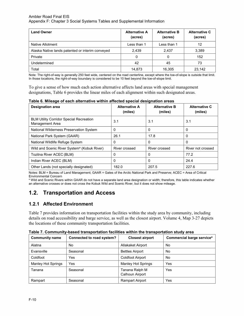
Ambler Road Final EIS Appendix F: Chapter 3 Social Systems Tables and Supplemental Information
F-10
Land Owner Alternative A (acres)
Alternative B (acres)
Alternative C (acres)
Native Allotment Less than 1 Less than 1 12
Alaska Native lands patented or interim conveyed 2,439 2,437 3,389
Private 0 0 152
Undetermined 42 45 73
Total 14,873 16,305 23,142 Note: The right-of-way is generally 250 feet wide, centered on the road centerline, except where the toe-of-slope is outside that limit. In those locations, the right-of-way boundary is considered to be 10 feet beyond the toe-of-slope limit.
To give a sense of how much each action alternative affects land areas with special management designations, Table 6 provides the linear miles of each alignment within such designated areas.
Table 6. Mileage of each alternative within affected special designation areas Designation area Alternative A
(miles) Alternative B
(miles) Alternative C
(miles)
BLM Utility Corridor Special Recreation Management Area 3.1 3.1 3.1
National Wilderness Preservation System 0 0 0
National Park System (GAAR) 26.1 17.8 0
National Wildlife Refuge System 0 0 0
Wild and Scenic River Systema (Kobuk River) River crossed River crossed River not crossed
Tozitna River ACEC (BLM) 0 0 77.2
Indian River ACEC (BLM) 0 0 24.4
Other Lands (not specially designated) 182.0 207.5 227.6 Notes: BLM = Bureau of Land Management; GAAR = Gates of the Arctic National Park and Preserve; ACEC = Area of Critical Environmental Concern a Wild and Scenic Rivers within GAAR do not have a separate land area designation or width; therefore, this table indicates whether an alternative crosses or does not cross the Kobuk Wild and Scenic River, but it does not show mileage.
1.2. Transportation and Access
1.2.1 Affected Environment
Table 7 provides information on transportation facilities within the study area by community, including details on road accessibility and barge service, as well as the closest airport. Volume 4, Map 3-27 depicts the locations of these community transportation facilities.
Table 7. Community-based transportation facilities within the transportation study area Community name Connected to road system? Closest airport Commercial barge servicea
Alatna No Allakaket Airport No
Evansville Seasonal Bettles Airport No
Coldfoot Yes Coldfoot Airport No
Manley Hot Springs Yes Manley Hot Springs Yes
Tanana Seasonal Tanana Ralph M Calhoun Airport
Yes
Rampart Seasonal Rampart Airport Yes

Ambler Road Final EIS Appendix F: Chapter 3 Social Systems Tables and Supplemental Information
F-11
Community name Connected to road system? Closest airport Commercial barge servicea
Bettles Seasonal Bettles Airport No
Allakaket No Allakaket Airport No
Ambler No Ambler Airport Not consistent service
Shungnak No Shungnak Airport Not consistent service
Kobuk No Kobuk Airport Not consistent service
Huslia No Huslia Airport Yes
Hughes No Hughes Airport Not consistent service
Wiseman Yes Wiseman Airportb No Source: ADCCED 2019 a Under typical conditions b Not consistently maintained
1.2.2 Environmental Consequences
No additional tables or supplemental information.
1.3. Recreation and Tourism
1.3.1 Affected Environment
Table 8 presents the rivers commonly used for float trips that could be affected by the project. It also includes the common float lengths, typical craft used, put-in and take-out locations, and details on the lands crossed. Volume 4, Map 3-26 depicts the locations of these river float routes. Those listed in Table 8 are examples of rivers made prominent because segments of them start within GAAR or they otherwise have segments that have been designated as parts of the national Wild and Scenic Rivers System. Most named streams can be floated, particularly with the advent of lightweight, single-person packrafts that can be combined with hiking. Float trips have been reported in public comments on the Draft Environmental Impact Statement (EIS) and online as occurring on Beaver Creek, Iniakuk River, Kogoluktuk River, Koyukuk River, Malamute Fork of the John River, Malamute Fork of the Alatna River, Mauneluk River, Reed River, Shungnak River, Wild River, and others. Note that put-in and take-out locations are limited to what is accessible by small aircraft (e.g., Super Cub landing on small gravel bars).
Table 8. Potentially affected common river float routesa River name (common float length)
Typical craftb Typical put-in locationc
Typical take-out location Lands crossed
Alatna River (135 miles)
Inflatable kayak, raft
Circle Lake Allakaket (Koyuk confluence), Malamute Fork (gravel bar), Helpmejack Creek
GAAR (WSR), state, BLM, Native corporation
Ambler River (75 miles)
Canoe, kayak Gravel bars near headwaters
Ambler Village GAAR, state, BLM, Native corporation
John River (100 miles)
Canoe, kayak, raft
Hunt Fork Lake Bettles/Koyukuk confluence GAAR (WSR), state, Native corporation
Kobuk River (115 miles)
Kayak, raft Walker Lake Kobuk GAAR (WSR), state, Native corporation, BLM
North Fork Koyukuk River (90 miles)
Kayak, raft Kuchona Creek, Redstar Creek
Bettles GAAR (WSR), Native corporation, state

Ambler Road Final EIS Appendix F: Chapter 3 Social Systems Tables and Supplemental Information
F-12
River name (common float length)
Typical craftb Typical put-in locationc
Typical take-out location Lands crossed
Selawik River (160 miles)
Canoe, kayak Lake near headwaters
Selawik River (floatplane) below Tagagawik River
Selawik NWR (WSR)
Sources: Alaska.org (No date); U.S. Fish and Wildlife Service (No date); American Packrafting Association (No date) Notes: BLM = Bureau of Land Management; GAAR = Gates of the Arctic National Park and Preserve; NWR = National Wildlife Refuge; State = State of Alaska; WSR = Wild and Scenic River a Many other streams may be floated, particularly by single-person packraft in conjunction with hiking, and some of them could be affected by the project. b This table shows craft for typical recreational float trips. Larger craft, including barges, are able to use portions of these rivers. This table is not meant to address navigability determinations. c Typical access to put-in location is by small plane from Bettles or Coldfoot or direct from Fairbanks.
1.3.2 Environmental Consequences
See Table 8. Impacts to the recreational user would be similar to those discussed in the EIS for any stream or river crossed by an alternative.
1.4. Visual Resources
1.4.1 Affected Environment
No tables or supplemental information.
1.4.2 Environmental Consequences
Table 9 presents the mileage of each action alternative within BLM Visual Recreation Management (VRM) classifications. BLM has only designated VRM classifications near the Dalton Highway corridor.
Table 9. Mileage of each action alternative within BLM’s Visual Resource Management classes BLM VRM class Alternative A
(miles)a Alternative B
(miles)a Alternative C
(miles)a
Class I/II 0 0 0
Class III 16.9 16.9 7.9
Class IV 1.9 1.9 4.4 Source: BLM data accessed 2019; analysis by HDR Notes: BLM = Bureau of Land Management; VRM = Visual Recreation Management a Mileages are short compared to the overall lengths of the alternatives because BLM VRM classes exist only near the Dalton Highway. Mileage given is on the centerline of each alternative and does not include proposed access roads to material sites, maintenance camps, or other associated facilities.
Table 10 presents the mileage of each action alternative with BLM Visual Resource Inventory (VRI) classifications. These occur more broadly, including some areas not managed by the BLM, but are a tool for inventorying the importance of the visual environment on BLM lands and do not indicate management intent.
Table 10. Mileage of each alternative within BLM’s Visual Resource Inventory classes BLM VRI class Alternative A
(miles) Alternative B
(miles) Alternative C
(miles)
Class I 0 0 0
Class II 107.3 119.3 75.5

Ambler Road Final EIS Appendix F: Chapter 3 Social Systems Tables and Supplemental Information
F-13
BLM VRI class Alternative A (miles)
Alternative B (miles)
Alternative C (miles)
Class III 0 0 64.4
Class IV 21.5 25.7 168.7
Unclassified (GAARa) 26.1 17.8 0
Unclassified (othera) 56.4 65.6 23.9 Source: BLM data accessed 2019, analysis by HDR. Notes: BLM= Bureau of Land Management; VRI = Visual Resources Inventory; GAAR = Gates of the Arctic National Park and Preserve a BLM has classified broad areas of similar topography and vegetation regardless of land ownership but has not classified the entire project area. Gates of the Arctic National Park and Preserve is assumed to be the equivalent of Class I or II based primarily on management intent. Based on surrounding classifications (See Volume 4, Map 3-30), the other unclassified portions would likely be a combination of classes II, III, and IV, with more Class II near the Brooks Range and more Class IV farther south. Mileage given is on the centerline of each alternative and does not include proposed access roads to material sites, maintenance camps, or other facilities that may occur.
1.5. Socioeconomics and Communities
1.5.1 Affected Environment
Table 11 presents a snapshot of the resident workforce of the Northwest Arctic Borough (NAB) and Yukon-Koyukuk Census Area (YKCA) by industry over the 2014–2016 period, based on data provided by the Alaska Department of Labor and Workforce Development (ADOLWD 2019). Government jobs constitute the largest public sector for employment in the NAB and YKCA. Volume 4, Map 3-31 depicts the boundaries of these analysis areas.
Table 11. Northwest Arctic Borough and Yukon-Koyukuk Census Area annual average resident employment by industry, 2014–2016a
Industry NAB 2014
NAB 2015
NAB 2016
YKCA 2014
YKCA 2015
YKCA 2016
Natural resources and mining
129 176 178 99 95 81
Construction 121 116 111 149 160 146
Manufacturing 17 22 21 27 15 7
Goods producing 267 314 310 275 270 234
Trade, transportation, and utilities
350 327 318 259 252 257
Information 60 52 48 35 36 34
Financial activities 99 95 72 8 7 7
Professional and business services
406 422 367 113 102 105
Educational and health services
474 523 549 261 254 241
Leisure and hospitality 71 87 87 143 142 127
Service providing 1,460 1,506 1,441 819 793 771
State government 89 88 70 80 76 78
Local government 1,187 1,144 1,183 1,554 1,496 1,484
Government 1,276 1,232 1,253 1,634 1,572 1,562
Other 25 29 24 121 125 120

Ambler Road Final EIS Appendix F: Chapter 3 Social Systems Tables and Supplemental Information
F-14
Industry NAB 2014
NAB 2015
NAB 2016
YKCA 2014
YKCA 2015
YKCA 2016
Unknown 0 0 1 2 0 0
Total 3,003 3,052 3,004 2,728 2,635 2,567 Source: ADOLWD 2019 Notes: NAB = Northwest Arctic Borough; YKCA = Yukon-Kuskokwim Census Area a Data are by place of residence. All employed residents age 16 and over who live in the borough/census area are counted whether or not they work in the borough/census area. The ADOLWD database captures data for workers in private sector, state, and local government covered by unemployment insurance within Alaska. Federal workers, military, and the self-employed are not included.
Table 12 presents the costs of heating oil and gasoline pear gallon within select study area communities in 2017 and 2018. Table 12 also includes electricity rates in 2017, with and without the State of Alaska’s Power Cost Equalization (PCE) program. Volume 4, Map 3-31 depicts the locations of these communities.
Table 12. Heating oil, gasoline, and electricity prices in study area communities Community 2018 residential
rate for No. 1 fuel oil (per gal.)
2018 price for gasoline (per gal.)
2017 residential rate without PCE
(per kWh)
2017 residential rate with PCE
(per kWh)
Alatna $6.25 $7.00 $0.75 $0.32
Allakaket $6.25 N/A $0.75 $0.32
Bettles $4.00 N/A $0.69 $0.32
Evansville $3.91 N/A $0.69 $0.32
Hughes $9.00 $8.42 $0.71 $0.19
Huslia $5.70 $6.58 $0.52 $0.22
Rampart $5.00 N/A $0.82 $0.35
Ambler N/A N/A $0.54 $0.22
Kobuk $9.44 N/A $0.55 $0.22
Shungnak $8.33 N/A $0.55 $0.22 Source: Alaska Energy Data Gateway 2019; ADCCED 2019 Notes: gal. = gallon; kWh = kilowatt hour; N/A = Not available; No. = Number; PCE = Power Cost Equalization
1.5.2 Environmental Consequences
No additional tables or supplemental information.
1.6. Environmental Justice
1.6.1 Affected Environment
President William J. Clinton issued Executive Order (EO) 12898, Federal Actions to Address Environmental Justice in Minority Populations and Low-Income Populations, in 1994. Its purpose is to focus federal attention on the environmental and human health effects of federal actions on minority and low-income populations with the goal of achieving environmental protection for all communities. The EO directs federal agencies to identify and address the disproportionately high and adverse human health or environmental effects of their actions on minority and low-income populations to the greatest extent practicable and permitted by law.
When determining whether effects are disproportionately high and adverse, EO 12898 directs agencies to consider the following:

Ambler Road Final EIS Appendix F: Chapter 3 Social Systems Tables and Supplemental Information
F-15
1. Whether there is, or will be, an effect on the natural or physical environment that significantly (as employed by the National Environmental Policy Act [NEPA]) and adversely affects a minority or low-income population or Indian tribe. Such effects may include ecological, cultural, human health, economic, or social impacts on minority or low-income communities or Indian tribes when those impacts are interrelated to impacts on the natural or physical environment;
2. Whether environmental effects are significant (as employed by NEPA) and are, or may be, having an adverse impact on minority or low-income populations or Indian tribes that appreciably exceeds, or is likely to appreciably exceed, those on the general population or other appropriate comparison group; and
3. Whether the environmental effects occur, or would occur, in a minority or low-income population or Indian tribe affected by cumulative or multiple adverse exposures from environmental hazards.
This analysis identified minority and low-income populations in study area communities using the 2017 American Community Survey 5-year data provided by the U.S. Census Bureau (2019). The analysis based minority status determinations on identifying individuals who are non-white, or who are white but have Hispanic ethnicity. The analysis based low-income status determinations on identifying individuals living in poverty in the previous 12 months.
This analysis identified a study area community as an area of potential environmental justice concern if (1) the minority population exceeds 50 percent or (2) the minority or low-income population is meaningfully greater than the minority or low-income population percentage in a reference population. For the purposes of this analysis, the reference population is the population of Alaska. The decision threshold when there is a “meaningfully greater” percentage of minority or low-income individuals than in the reference population is based on the following equation:
(minority or low-income population in study area community/total population in study area community)
divided by
(minority or low-income population in reference area/total population in reference area).
If the equation results in a number greater than 1, there is a greater proportion of minority or low-income individuals residing in the study area community than in the reference population.
Table 13 presents population, minority, and low-income characteristics of study area communities and other geographic extents such as relevant boroughs and Alaska as a whole. The communities that did not meet the environmental justice criteria include Fairbanks, Wiseman, and Bettles. Volume 4, Map 3-31 depicts the locations of these census areas and communities.
See Table 13 and Table 14.

Ambler Road Final EIS Appendix F: Chapter 3 Social Systems Tables and Supplemental Information
F-16
This page intentionally left blank.

Ambler Road Final EIS Appendix F: Chapter 3 Social Systems Tables and Supplemental Information
F-17
Table 13. Population and environmental justice metrics in study area communities Geographic location
Associated with Alaska Native tribe
Total population
Minority population
metric: White (%)a
Minority population
metric: Black or African
American (%)b
Minority population
metric: American Indian or Alaska
Native (%)b
Minority population
metric: Asian (%)b
Minority population
metric: Pacific
Islander (%)b
Minority population
metric: Other (%)b
Minority population
metric: Hispanic or Latino (%)c
Minority population
metric: minority
(%)d
Minority population
metric: EJ
community?
Low-Income population
metric: unemployment
rate (%)
Low-Income population
metric: median
household income ($)
Low-Income population
metric: individuals
below poverty level
(%)
Low-Income population
metric: EJ
community?
State of Alaska N/A 738,565 61.5 4.9 19.6 8.1 1.9 1.9 6.8 38.5 N/A 7.7 76,114 10.2 N/A
Fairbanks North Star Borough N/A 100,031 83.8 6.7 11.5 4.8 0.9 1.2 7.7 28.9 N/A 8.0 76,250 7.7 N/A
Fairbankse No 31,853 57.5 12.7 13.7 6.6 1.6 2.0 11.9 42.5 No 9.4 60,658 11.9 No
Nome Census Area N/A 9,869 23.1 1.4 80.6 2.1 0.5 0.1 2.4 85.1 N/A 16.6 53,821 24.9 N/A
Brevig Mission Yes 421 0.7 1.4 99.3 0.0 0.0 0.0 0.0 99.3 Yes 30.8 33,750 59.3 Yes
Elim Yes 296 1.7 0.0 98.3 0.0 0.0 0.0 0.7 98.3 Yes 25.5 39,375 25.5 Yes
Golovin (Cheenik) Yes 123 4.9 0.0 94.3 0.0 0.0 0.8 0.8 95.1 Yes 11.5 50,000 19.5 Yes
Koyuk Yes 248 2.0 0.0 97.6 1.2 0.0 0.0 0.0 98.0 Yes 36.0 36,429 41.1 Yes
Nome Yes 3,793 27.3 3.3 64.1 2.2 1.1 0.3 5.8 72.7 Yes 9.6 81,389 11.8 Yes
St. Michael Yes 441 1.1 0.2 98.9 0.0 0.5 0.0 0.0 98.9 Yes 21.3 42,813 23.3 Yes
Shaktoolik Yes 282 1.1 0.0 98.9 1.1 0.0 0.0 0.0 98.9 Yes 20.5 56,875 16.0 Yes
Shishmaref Yes 522 6.5 0.6 92.7 0.2 0.0 0.0 0.0 93.5 Yes 18.8 34,583 37.3 Yes
Stebbins Yes 500 2.2 0.0 97.8 0.0 1.2 0.0 0.0 97.8 Yes 23.9 37,679 33.9 Yes
Teller Yes 184 0.0 0.0 100.0 0.0 0.0 0.0 0.0 100.0 Yes 15.0 33,750 37.5 Yes
Unalakleet Yes 685 11.7 0.7 75.2 14.0 0.0 0.0 0.1 88.3 Yes 12.0 61,250 13.5 Yes
Wales Yes 159 0.6 0.0 99.4 0.0 0.0 0.0 0.0 99.4 Yes 12.0 31,250 41.4 Yes
White Mountain Yes 173 9.2 0.0 90.8 0.0 0.0 0.0 0.0 90.8 Yes 21.2 38,125 30.6 Yes
North Slope Borough N/A 9,757 36.4 2.1 57.6 6.5 3.1 1.6 4.1 68.7 N/A 9.5 77,266 10.2 N/A
Anaktuvuk Pass Yes 290 11.7 1.0 87.2 0.0 0.0 0.0 1.7 88.3 Yes 50.4 56,667 33.6 Yes
Atqasuk Yes 172 1.7 0.0 98.3 0.0 0.0 0.0 0.0 98.3 Yes 11.6 61,250 19.2 Yes
Utqiaġvik Yes 4,383 13.0 2.9 68.6 12.8 6.5 1.6 4.6 87.0 Yes 14.2 82,964 11.2 Yes
Nuiqsut Yes 395 7.8 0.0 90.9 0.0 1.5 0.0 0.0 92.2 Yes 23.1 82,813 9.3 No
Point Hope Yes 629 3.8 2.2 94.1 1.4 0.0 2.9 6.0 96.2 Yes 32.3 60,417 20.0 Yes
Point Lay Yes 273 4.4 0.0 92.7 0.0 1.5 0.0 4.8 95.6 Yes 22.4 58,750 20.2 Yes
Wainwright Yes 513 6.2 0.2 93.8 0.0 0.0 0.0 2.3 93.8 Yes 15.9 71,250 13.5 Yes
Northwest Arctic Borough N/A 7,715 15.1 1.0 85.0 1.8 0.5 1.0 2.5 88.9 N/A 20.1 61,533 25.3 N/A
Ambler Yes 299 3.3 0.0 96.3 0.0 1.0 0.0 0.0 96.7 Yes 22.2 44,500 27.8 Yes
Buckland Yes 627 1.8 0.0 97.4 0.2 0.0 0.6 0.6 98.2 Yes 42.2 41,932 22.5 Yes
Deering Yes 152 1.3 0.0 92.1 6.6 0.0 0.0 0.0 98.7 Yes 14.3 44,375 13.2 Yes
Kiana Yes 284 3.5 0.0 95.4 1.1 1.4 0.0 0.0 96.5 Yes 31.0 42,813 37.5 Yes
Kivalina Yes 678 5.2 0.6 94.2 0.0 0.0 0.0 0.6 94.8 Yes 20.3 48,750 31.1 Yes

Ambler Road Final EIS Appendix F: Chapter 3 Social Systems Tables and Supplemental Information
F-18
Geographic location
Associated with Alaska Native tribe
Total population
Minority population
metric: White (%)a
Minority population
metric: Black or African
American (%)b
Minority population
metric: American Indian or Alaska
Native (%)b
Minority population
metric: Asian (%)b
Minority population
metric: Pacific
Islander (%)b
Minority population
metric: Other (%)b
Minority population
metric: Hispanic or Latino (%)c
Minority population
metric: minority
(%)d
Minority population
metric: EJ
community?
Low-Income population
metric: unemployment
rate (%)
Low-Income population
metric: median
household income ($)
Low-Income population
metric: individuals
below poverty level
(%)
Low-Income population
metric: EJ
community?
Kobuk Yes 152 5.3 0.0 94.7 0.0 0.0 0.0 9.2 94.7 Yes 26.7 52,500 39.5 Yes
Kotzebue Yes 3,276 20.4 1.7 73.2 2.7 0.9 1.9 4.9 79.6 Yes 11.9 88,047 16.2 Yes
Noatak Yes 424 0.9 0.7 98.6 0.0 0.0 0.0 0.0 99.1 Yes 29.5 50,000 28.8 Yes
Noorvik Yes 579 4.8 0.0 95.2 0.0 0.0 0.0 0.0 95.2 Yes 29.5 48,750 32.2 Yes
Selawik Yes 813 1.4 0.0 98.6 0.0 0.0 0.0 0.0 98.6 Yes 36.1 35,625 46.6 Yes
Shungnak Yes 280 13.2 0.7 80.0 6.8 0.0 0.0 0.0 86.8 Yes 26.4 39,688 31.9 Yes
Kusilvak Census Area N/A 8,129 7.6 1.2 94.6 0.6 0.2 0.0 1.6 96.2 N/A 28.8 36,468 39.1 N/A
Kotlik Yes 726 1.9 1.2 97.8 0.0 0.0 0.0 0.0 98.1 Yes 17.0 41,667 44.2 Yes
Yukon-Koyukuk Census Area N/A 5,453 27.9 0.5 76.3 0.7 0.1 0.2 2.1 78.7 N/A 19.7 37,819 25.5 N/A
Alatnaf Yes 37 0 0 100.0 0 0 0 0 0 Yes 15.4 NA NA NA
Allakaket Yes 186 10.2 0.0 82.8 2.2 0.0 0.0 4.8 89.8 Yes 35.8 27,250 28.8 Yes
Bettlese, g No 74 68.9 0.0 31.1 0.0 0.0 0.0 0.0 31.1 No NA 68,125f 0.0 No
Coldfoot No 84 97.6 0.0 1.2 1.2 0.0 0.0 1.2 2.4 No NA N/A 29.8 Yes
Evansville Yes 9 11.1 0.0 88.9 0.0 0.0 0.0 0.0 88.9 Yes NA 33,750 NA NA
Galena Yes 473 32.1 0.2 63.6 1.7 0.0 0.0 2.5 67.9 Yes 11.0 74,375 10.4 Yes
Hughes Yes 77 0.0 0.0 89.6 10.4 0.0 0.0 0.0 100.0 Yes 10.5 34,375 28.6 Yes
Huslia Yes 397 8.1 0.0 91.9 0.0 0.0 0.0 1.8 91.9 Yes 22.6 40,000 24.2 Yes
Kaltag Yes 165 8.5 0.0 91.5 0.0 0.0 0.0 0.0 91.5 Yes 35.4 27,500 18.8 Yes
Koyukuk Yes 54 0.0 0.0 100.0 0.0 0.0 0.0 0.0 100.0 Yes 19.2 15,417 42.6 Yes
Manley Hot Springs Yes 77 66.2 0.0 22.1 0.0 0.0 0.0 11.7 33.8 No 11.4 55,833 15.6 Yes
Nulato Yes 276 2.9 1.4 97.1 0.0 0.0 0.0 0.0 97.1 Yes 30.2 38,333 31.4 Yes
Rampart Yes 36 0.0 0.0 100.0 0.0 0.0 0.0 30.6 100.0 Yes NA 50,625 N/A NA
Tanana Yes 243 10.7 0.4 87.7 0.0 0.0 0.0 1.2 89.3 Yes 6.5 47,778 8.4 No
Wisemane No 9 100.0 0.0 0.0 0.0 0.0 0.0 0.0 0.0 No 0.0 NA 0.0 No Source: U.S. Census Bureau 2019; National Conference of State Legislatures 2018 Notes: N/A = Not applicable; EJ = Environmental Justice; NA = Not available a Alone, non-Hispanic, or Latino. b Alone or in combination with one or more other races. c Hispanic or Latino, can be of any race. d 100 percent minus “White, non-Hispanic, or Latino.” e Did not meet the Environmental Justice criteria. f All data for Alatna are from ADCCED 2019. g Median household income data for Bettles are from ADCCED 2019.

Ambler Road Final EIS Appendix F: Chapter 3 Social Systems Tables and Supplemental Information
F-19
1.6.2 Environmental Consequences
See Table 14.
Table 14. Summary of potential impacts on Environmental Justice population Resource Effects in Relation to EJ Communities DH&A effects?
Geology and Soils (3.2.1) Impacts generally occur to natural systems and not directly to people. Any NOA that resulted in asbestos in road dust would most likely affect road users/workers, who are not expected to be disproportionate from the local EJ communities. The indirect effect of removing valuable minerals for human uses would not disproportionately affect local EJ communities.
No
Sand and Gravel Resources (3.2.2)
Road construction and maintenance would use a large volume of material, but such material would not likely have been used by local villages because of distance. This would not cause an adverse effect to local EJ communities.
No
Hazardous Waste (3.2.3) Toxic spills and dust are likely to occur at a small scale under any action alternative. Large spills or releases from a truck rollover could occur and damage adjacent waterways and habitat. Large releases are not likely, but if such a release did occur, it could result in high and adverse effects to downstream EJ communities.
Possible
Paleontological Resources (3.2.4)
Very low potential for impacts. No
Water Resources (3.2.5) Impacts related to ice road, bridge, and culvert construction; gravel extraction; gravel placement; water withdrawal; and wastewater discharge would likely alter surface and subsurface flow patterns and water quality near the road. No high adverse effect to EJ communities is expected. If a large spill occurred in flowing water, it could result in high and adverse effects to downstream EJ communities.
Possible
Acoustical Environment (Noise) (3.2.6)
Impacts of new noise in a mostly natural environment from road construction, road operations, and mining, including sounds of aircraft, vehicles, and generators at maintenance stations and communications sites would be encountered by a mix of local residents of EJ communities. The impact would be high and adverse near project facilities but not in villages. Because local subsistence hunters are more likely to range widely across the landscape and would be more likely to encounter the road, the effect in the backcountry may be disproportionately felt by residents of the EJ communities.
Possible
Air Quality and Climate (3.2.7)
Air quality would not be substantially affected except sometimes in the immediate road corridor, and then, primarily from dust. Any asbestos or other toxins in road dust would most likely affect road users/workers, and would not be expected to disproportionately affect the local EJ communities.
No
Vegetation and Wetlands (3.3.1)
Impacts to wetlands due to gravel fill, clearing of vegetation, and fugitive dust fallout would primarily affect natural systems in areas near project facilities and not people. No high and adverse effects to EJ communities is expected.
No
Fish and Amphibians (3.3.2)
There is potential for degradation of habitat quality, modification of hydrologic conditions along road, potential for spills of contaminants into aquatic habitats, and potential for the acceleration of climate-driven permafrost degradation leading to worsening of downstream fish habitat. These would be effects principally to natural systems but could affect subsistence. See Subsistence below.
No
Birds (3.3.3) Impacts for terrestrial and aquatic habitat reduction and alteration, disturbance and displacement, and injury or mortality would be effects principally to natural systems. See Subsistence below. No
Mammals (3.3.4) Potential impacts from habitat loss and fragmentation, behavioral disturbance and displacement, and injury or mortality would be effects to natural systems, but could affect subsistence. See Subsistence below. No
Land Ownership, Use, Management and Special Designations (3.4.1)
No changes to underlying land ownership. Land management changes would result in a road and mines. The change in land management would disproportionately affect local EJ communities, who use the land most. Effects of mines on NANA Corporation land would be high and likely would be mixed adverse and beneficial for NANA shareholders, who include the EJ communities in the western portion of the project area.
Partially
Transportation and Access (3.4.2)
Primarily minor impacts to existing transportation infrastructure. Substantial new access to Ambler Mining District. The road would impede free overland travel (e.g., by snowmobile), disproportionately affecting EJ communities, but access points for crossing the road would be provided in the most used areas, so the adverse impact is not expected to be “high.”
No
Recreation and Tourism (3.4.3)
Impacts to existing recreation and tourism experience would affect both local people traveling or going to hunting or fishing camps for pleasure and people from outside the area for flightseeing, backpacking, river floating, fishing, hunting, and lodge stays. The impacts would be high and adverse for people experiencing them but likely would not fall disproportionately on EJ communities.
Likely not.
Visual Resources (3.4.4) Impacts to the visual environment due to creation of a linear engineered element in a primarily natural environment would affect both local people and recreationists/tourists from outside the region. The impacts would be high and adverse for those approaching the road or seeing it from high vantage points or the air, but these impacts likely would not fall disproportionately on EJ communities.
No
Socioeconomics and Communities (3.4.5)
Potential for increased employment and income opportunities. Beneficial effects to local, regional, and State of Alaska economy. Potential to reduce cost of living. The beneficial impacts of employment would not disproportionately fall to EJ communities. Beneficial impacts of lower cost fuel and goods would accrue to Kobuk residents and likely to 2-3 other communities, and these benefits would disproportionately fall to EJ communities in these villages. There is potential for high and adverse impacts due to changes in subsistence (see below), easier importation of drugs and alcohol, and mixing with a typically young, single male road and mine worker crews, but limits on crew travel to local communities from their work sites is expected to limit the impact. If high and adverse impacts did occur, they would fall disproportionately to EJ communities in the villages closest to the alternatives.
Possible
Subsistence Uses and Resources (3.4.7)
There is potential for impacts to subsistence use areas, access to resources, and availability of resources. See Table 20 below for details. The road itself would impede access to subsistence resources (see Transportation, above) and, by fragmenting habitat, and has potential to change caribou migration, and thus, availability (see Mammals, above). Spills or chronic production of toxic materials or dust in water could affect important salmon and sheefish habitat (see Fish above). The effect would be adverse but not necessarily “high and adverse.” However, the combination of effects from the road, combined with the mine and other stressors on wildlife, would be more likely to result in high and adverse effects over time. Any effects would disproportionately fall to EJ communities, particularly those nearest to the road.
Likely
Cultural Resources (3.4.8) There is potential for impacts to known cultural resources and to potentially historic trails. There is high likelihood of that there are ethnographic resources and cultural properties in the proposed road corridors that have not yet been identified and that impacts would occur to them. Impacts would affect the legacy of these sites for all Americans but likely would be felt most strongly among local tribes composed largely of EJ populations.
Likely
Notes: DH&A = Disproportionately High and Adverse; EJ = Environmental Justice; NOA = naturally occurring asbestos

Ambler Road Final EIS Appendix F: Chapter 3 Social Systems Tables and Supplemental Information
F-20
This page intentionally left blank.

Ambler Road Final EIS Appendix F: Chapter 3 Social Systems Tables and Supplemental Information
F-21
1.7. Subsistence Uses and Resources
1.7.1 Affected Environment
Table 15 lists the primary subsistence communities for the analysis.
Table 15. Ambler Road EIS subsistence and Western Arctic Caribou Herd Working Group study communities Study community number
Study community Study community type
Community within 50 miles
Community use areas overlap the project
Community use areas within 30 miles
Member of WAH WG
1 Alatna SUB Yes Yes Yes No
2 Beaver SUB No No Yes No
3 Coldfoot SUB Yes Yes Yes No
4 Evansville SUB Yes Yes Yes No
5 Livengood SUB Yes No No No
6 Manley Hot Springs SUB Yes No Yes No
7 Minto SUB Yes No Yes No
8 Nenana SUB No No Yes No
9 Rampart SUB Yes Yes Yes No
10 Stevens Village SUB Yes Yes Yes No
11 Tanana SUB Yes Yes Yes No
12 Allakaket SUB/WAH Yes Yes Yes Yes
13 Ambler SUB/WAH Yes Yes Yes Yes
14 Anaktuvuk Pass SUB/WAH No Yes Yes Yes
15 Bettles SUB/WAH Yes Yes Yes Yes
16 Buckland SUB/WAH No No Yes Yes
17 Galena SUB/WAH No Yes Yes Yes
18 Hughes SUB/WAH Yes Yes Yes Yes
19 Huslia SUB/WAH Yes Yes Yes Yes
20 Kiana SUB/WAH No Yes Yes Yes
21 Kobuk SUB/WAH Yes Yes Yes Yes
22 Kotzebue SUB/WAH No No Yes Yes

Ambler Road Final EIS Appendix F: Chapter 3 Social Systems Tables and Supplemental Information
F-22
Study community number
Study community Study community type
Community within 50 miles
Community use areas overlap the project
Community use areas within 30 miles
Member of WAH WG
23 Noatak SUB/WAH No No Yes Yes
24 Noorvik SUB/WAH No No Yes Yes
25 Selawik SUB/WAH No Yes Yes Yes
26 Shungnak SUB/WAH Yes Yes Yes Yes
27 Wiseman SUB/WAH Yes Yes Yes Yes
28 Atqasuk WAH No No No Yes
29 Brevig Mission WAH No No No Yes
30 Deering WAH No No No Yes
31 Elim WAH No No No Yes
32 Fairbanks WAH No No No Yes
33 Golovin WAH No No No Yes
34 Kaltag WAH No No No Yes
35 Kivalina WAH No No No Yes
36 Kotlik WAH No No No Yes
37 Koyuk WAH No No No Yes
38 Koyukuk WAH No No No Yes
39 Nome WAH No No No Yes
40 Nuiqsut WAH No No No Yes
41 Nulato WAH No No No Yes
42 Point Hope WAH No No No Yes
43 Point Lay WAH No No No Yes
44 Shaktoolik WAH No No No Yes
45 Shishmaref WAH No No No Yes
46 St. Michael WAH No No No Yes
47 Stebbins WAH No No No Yes
48 Teller WAH No No No Yes
49 Unalakleet WAH No No No Yes
50 Utqiaġvik WAH No No No Yes

Ambler Road Final EIS Appendix F: Chapter 3 Social Systems Tables and Supplemental Information
F-23
Study community number
Study community Study community type
Community within 50 miles
Community use areas overlap the project
Community use areas within 30 miles
Member of WAH WG
51 Wainwright WAH No No No Yes
52 Wales WAH No No No Yes
53 White Mountain WAH No No No Yes Notes: SUB=Subsistence Study Community; WAH=Western Arctic Caribou Herd Working Group Study Community; WAH WG = Western Arctic Caribou Herd Working Group
Table 16 provides average harvest and participation data for all resources for the subsistence study communities. Note that Livengood and Nenana are not included in this table as there are no harvest data and no comprehensive study years for data, respectively.
Table 16. All resources harvest and participation data, average across available study years, subsistence study communities Study community % of
HH using
% of HH trying to harvest
% of HH
harvesting
% of HH
giving
% of HH
receiving
Estimated pounds
harvested
Average HH
pounds
Per capita
pounds
Top 3 resource categories (by % of
total harvest)
Alatna 100 100 100 100 100 97,760 2,274 633 Salmon (48.5) LLM (28.8) NSF (16.4)
Allakaket 100 95 90 86 100 114,651 2,349 689 Salmon (53.4) NSF (22.9) LLM (18.7)
Ambler 98 96 96 87 92 170,468 2,243 603 LLM (59.9) NSF (28.9) Salmon (5.9)
Anaktuvuk Pass 98 77 75 76 95 69,825 1,122 316 LLM (89.6) NSF (7.9) Vegetation (1.9)
Beaver 100 98 96 78 95 43,301 1,277 545 Salmon (49.8) LLM (30.7) NSF (7.3)
Bettles 100 88 88 88 100 11,010 446 186 LLM (67.2) Salmon (15.2) NSF (10.1)
Buckland 99 90 90 89 82 226,074 2,569 554 LLM (44.1) Marine Mammals (22.1) NSF (17.3)

Ambler Road Final EIS Appendix F: Chapter 3 Social Systems Tables and Supplemental Information
F-24
Study community % of HH
using
% of HH trying to harvest
% of HH
harvesting
% of HH
giving
% of HH
receiving
Estimated pounds
harvested
Average HH
pounds
Per capita
pounds
Top 3 resource categories (by % of
total harvest)
Coldfoot 100 100 100 50 100 381 76 38 LLM (85.3) Vegetation (14.7)
Evansville 100 100 100 77 100 10,748 401 155 LLM (57.9 Salmon (18.1) NSF (11.6
Galena 96 85 87 65 86 325,368 1,628 520 Salmon (58.0) LLM (27.6) NSF (10.1)
Hughes 96 85 77 62 96 87,069 3,697 926 Salmon (60.8) LLM (24.6) NSF (10.7)
Huslia N/A N/A 100 N/A N/A 208,165 3,652 1082 Salmon (51.2) LLM (35.0) NSF (8.4)
Kiana 99 92 92 N/A N/A 133,211 1,402 347 LLM (37.7) NSF (28.7) Salmon (24.4)
Kobuk 100 100 100 90 100 50,743 1,410 309 LLM (36.1) Salmon (29.8) NSF (27.2)
Kotzebue 99 88 87 79 96 1,278,772 1,601 398 LLM (31.5) Marine Mammals (23.0) NSF (22.9)
Manley Hot Springs 100 98 98 71 93 52,438 904 426 Salmon (82.0) NSF (7.4) LLM (5.0)
Minto 98 97 95 74 93 115,196 2,312 620 Salmon (55.3) LLM (23.6) NSF (13.1)
Nenana 98 86 78 54 87 64,965 267 111 Salmon (41.0) LLM (33.3) NSF (12.0)
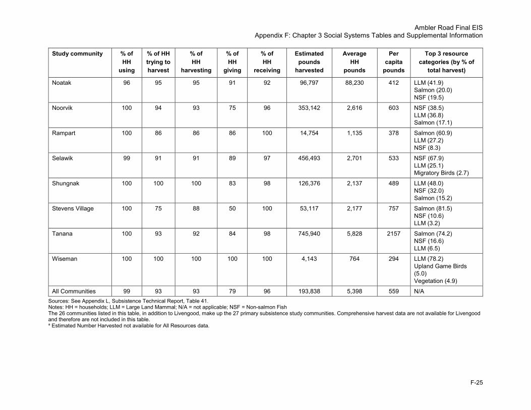
Ambler Road Final EIS Appendix F: Chapter 3 Social Systems Tables and Supplemental Information
F-25
Study community % of HH
using
% of HH trying to harvest
% of HH
harvesting
% of HH
giving
% of HH
receiving
Estimated pounds
harvested
Average HH
pounds
Per capita
pounds
Top 3 resource categories (by % of
total harvest)
Noatak 96 95 95 91 92 96,797 88,230 412 LLM (41.9) Salmon (20.0) NSF (19.5)
Noorvik 100 94 93 75 96 353,142 2,616 603 NSF (38.5) LLM (36.8) Salmon (17.1)
Rampart 100 86 86 86 100 14,754 1,135 378 Salmon (60.9) LLM (27.2) NSF (8.3)
Selawik 99 91 91 89 97 456,493 2,701 533 NSF (67.9) LLM (25.1) Migratory Birds (2.7)
Shungnak 100 100 100 83 98 126,376 2,137 489 LLM (48.0) NSF (32.0) Salmon (15.2)
Stevens Village 100 75 88 50 100 53,117 2,177 757 Salmon (81.5) NSF (10.6) LLM (3.2)
Tanana 100 93 92 84 98 745,940 5,828 2157 Salmon (74.2) NSF (16.6) LLM (6.5)
Wiseman 100 100 100 100 100 4,143 764 294 LLM (78.2) Upland Game Birds (5.0) Vegetation (4.9)
All Communities 99 93 93 79 96 193,838 5,398 559 N/A Sources: See Appendix L, Subsistence Technical Report, Table 41. Notes: HH = households; LLM = Large Land Mammal; N/A = not applicable; NSF = Non-salmon Fish The 26 communities listed in this table, in addition to Livengood, make up the 27 primary subsistence study communities. Comprehensive harvest data are not available for Livengood and therefore are not included in this table. a Estimated Number Harvested not available for All Resources data.

Ambler Road Final EIS Appendix F: Chapter 3 Social Systems Tables and Supplemental Information
F-26
Table 17 provides average moose harvest and participation data for the for the 27 subsistence study communities.
Table 17. Moose harvest data, average across all available study years Community % HHs
use % HHs
trying to harvest
% of HHs harvesting
% of HHs giving
% of HHs receiving
Estimated harvest total
number
Estimated harvest total lbs
Estimated harvest
average HH lbs
Estimated harvest
per capita lbs
% of total
harvest
Alatna 98 75 50 41 74 15 7,905 355 117 16.0
Allakaket 97 73 52 45 65 34 17,676 332 98 12.9
Ambler 36 21 13 14 26 10 5,231 74 20 4.5
Anaktuvuk Pass 29 10 6 9 24 4 2,230 25 7 3.2
Beaver 33 27 12 12 28 10 5,927 277 90 25.1
Bettles 88 35 24 40 62 8 3,792 193 72 51.5
Buckland 23 17 9 13 14 13 6,873 73 15 4.0
Coldfoot 25 NA NA NA 25 NA NA NA NA NA
Evansville 78 33 20 39 68 7 3,201 133 55 51.4
Galena 90 64 48 34 55 106 60,907 316 108 25.6
Hughes 96 62 57 35 69 26 13,083 538 140 17.6
Huslia 99 66 58 36 52 79 44,744 608 198 28.8
Kiana 29 16 13 9 14 13 7,054 72 19 6.5
Kobuk 48 45 16 16 43 6 2,958 95 21 3.8
Kotzebue 47 23 12 16 38 105 56,591 70 18 5.4
Manley Hot Springs 59 50 11 25 49 8 4,498 123 55 4.9
Minto 90 70 39 34 74 32 18,732 309 96 22.5
Nenana 49 69 22 8 29 62 40,213 223 83 NA
Noatak 39 28 24 21 32 377 3,973 386 8 2.3
Noorvik 57 28 20 18 43 35 18,902 129 28 3.7
Rampart 86 57 57 43 86 4 4,011 309 103 27.2
Selawik 65 36 25 36 53 50 26,775 164 35 4.7
Shungnak 57 27 19 16 41 12 6,302 113 25 3.1
Stevens Village 60 56 25 14 44 31 1,630 82 24 1.5
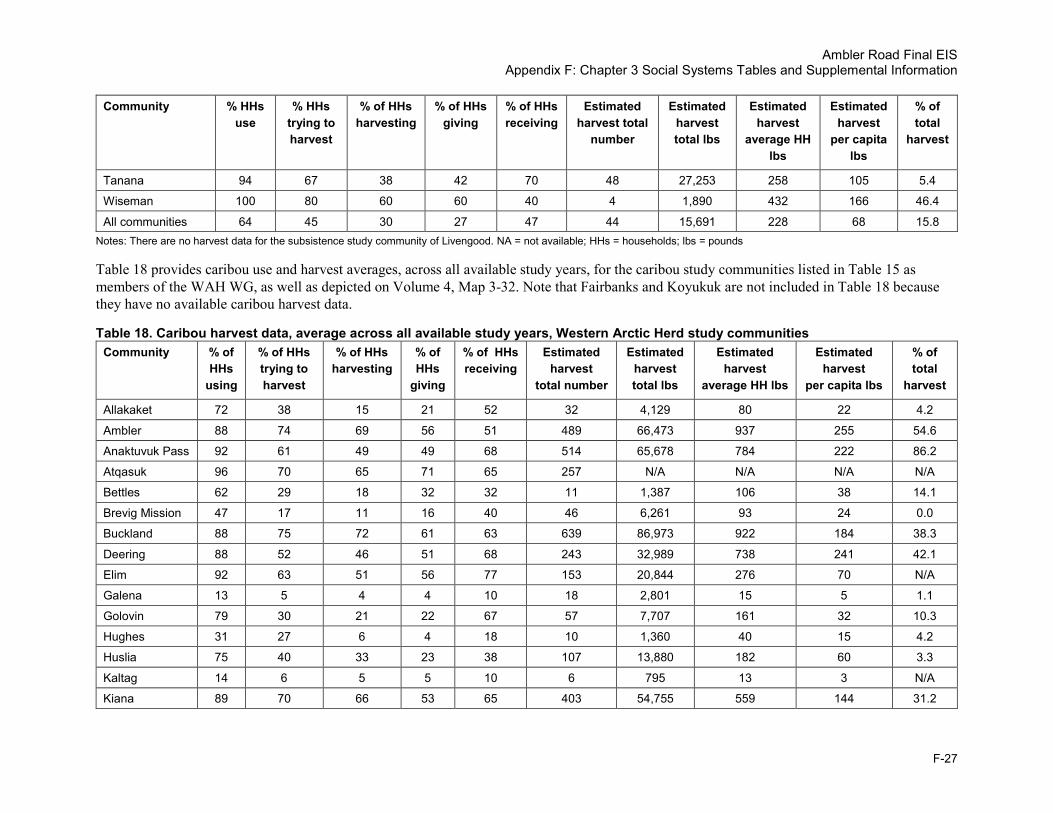
Ambler Road Final EIS Appendix F: Chapter 3 Social Systems Tables and Supplemental Information
F-27
Community % HHs use
% HHs trying to harvest
% of HHs harvesting
% of HHs giving
% of HHs receiving
Estimated harvest total
number
Estimated harvest total lbs
Estimated harvest
average HH lbs
Estimated harvest
per capita lbs
% of total
harvest
Tanana 94 67 38 42 70 48 27,253 258 105 5.4
Wiseman 100 80 60 60 40 4 1,890 432 166 46.4
All communities 64 45 30 27 47 44 15,691 228 68 15.8 Notes: There are no harvest data for the subsistence study community of Livengood. NA = not available; HHs = households; lbs = pounds
Table 18 provides caribou use and harvest averages, across all available study years, for the caribou study communities listed in Table 15 as members of the WAH WG, as well as depicted on Volume 4, Map 3-32. Note that Fairbanks and Koyukuk are not included in Table 18 because they have no available caribou harvest data.
Table 18. Caribou harvest data, average across all available study years, Western Arctic Herd study communities Community % of
HHs using
% of HHs trying to harvest
% of HHs harvesting
% of HHs
giving
% of HHs receiving
Estimated harvest
total number
Estimated harvest total lbs
Estimated harvest
average HH lbs
Estimated harvest
per capita lbs
% of total
harvest
Allakaket 72 38 15 21 52 32 4,129 80 22 4.2
Ambler 88 74 69 56 51 489 66,473 937 255 54.6
Anaktuvuk Pass 92 61 49 49 68 514 65,678 784 222 86.2
Atqasuk 96 70 65 71 65 257 N/A N/A N/A N/A
Bettles 62 29 18 32 32 11 1,387 106 38 14.1
Brevig Mission 47 17 11 16 40 46 6,261 93 24 0.0
Buckland 88 75 72 61 63 639 86,973 922 184 38.3
Deering 88 52 46 51 68 243 32,989 738 241 42.1
Elim 92 63 51 56 77 153 20,844 276 70 N/A
Galena 13 5 4 4 10 18 2,801 15 5 1.1
Golovin 79 30 21 22 67 57 7,707 161 32 10.3
Hughes 31 27 6 4 18 10 1,360 40 15 4.2
Huslia 75 40 33 23 38 107 13,880 182 60 3.3
Kaltag 14 6 5 5 10 6 795 13 3 N/A
Kiana 89 70 66 53 65 403 54,755 559 144 31.2
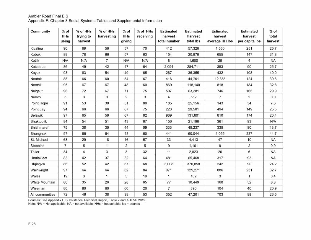
Ambler Road Final EIS Appendix F: Chapter 3 Social Systems Tables and Supplemental Information
F-28
Community % of HHs
using
% of HHs trying to harvest
% of HHs harvesting
% of HHs
giving
% of HHs receiving
Estimated harvest
total number
Estimated harvest total lbs
Estimated harvest
average HH lbs
Estimated harvest
per capita lbs
% of total
harvest
Kivalina 90 69 56 57 70 412 57,326 1,550 251 25.7
Kobuk 89 78 66 57 63 154 20,976 655 147 31.8
Kotlik N/A N/A 7 N/A N/A 8 1,600 29 4 NA
Kotzebue 86 49 42 47 64 2,094 284,711 353 90 25.7
Koyuk 93 63 54 49 65 267 36,355 432 108 40.0
Noatak 88 66 60 54 67 416 44,761 12,355 124 39.6
Noorvik 95 67 67 48 60 869 118,140 818 184 32.8
Nuiqsut 96 72 67 71 75 507 63,281 746 165 29.9
Nulato 5 3 3 2 3 4 552 7 2 0.0
Point Hope 91 53 30 51 80 185 25,156 143 34 7.6
Point Lay 94 66 66 67 75 223 29,501 494 149 25.5
Selawik 97 65 59 67 82 969 131,801 810 174 20.4
Shaktoolik 84 54 51 43 67 156 21,196 361 93 N/A
Shishmaref 75 38 35 44 59 333 45,237 335 80 13.7
Shungnak 97 66 64 48 60 441 60,044 1,055 237 44.7
St. Michael 68 29 18 16 57 33 4,413 47 10 NA
Stebbins 7 5 1 2 5 9 1,161 9 2 0.9
Teller 34 4 3 3 32 11 2,823 20 6 NA
Unalakleet 83 42 37 32 64 481 65,468 317 93 NA
Utqiaġvik 86 52 42 67 68 3,008 370,858 242 90 24.2
Wainwright 97 64 64 62 84 971 125,271 886 231 32.7
Wales 19 3 1 5 19 1 162 3 1 0.4
White Mountain 80 35 26 28 65 77 10,449 160 52 8.8
Wiseman 80 80 60 60 20 7 890 104 40 20.9
All communities 72 46 38 39 53 352 47,201 703 98 26.5 Sources: See Appendix L, Subsistence Technical Report, Table 2 and ADF&G 2019. Note: N/A = Not applicable; NA = not available; HHs = households; lbs = pounds

Ambler Road Final EIS Appendix F: Chapter 3 Social Systems Tables and Supplemental Information
F-29
1.7.2 Environmental Consequences
Table 19 provides the number of subsistence study communities with subsistence use areas that are crossed by an alternative by resource type. Table 20 includes communities most likely to have subsistence impacts under each alternative.
Table 19. Number of communities with use areas crossing the project, by alternative and resource
Resource
Number of communities crossing
Alternative A
Number of communities crossing
Alternative B
Number of communities crossing
Alternative C
Number of communities crossing
any alternative
Alternative(s) affecting greatest
number of communities
Moose 9 9 8 12 A, B
Caribou 9 9 10 12 C
Dall sheep 6 6 3 6 A, B
Bear 5 5 7 7 C
Other large land mammals
0 0 0 0 N/A
Small land mammals 8 9 11 15 C
Marine mammals 0 0 0 0 N/A
Migratory birds 6 5 6 9 A, C
Upland game birds 4 4 3 7 A, B
Eggs 2 2 0 2 A, B
Salmon 3 3 5 6 C
Non-salmon fish 3 3 8 10 C
Marine invertebrates 0 0 0 0 N/A
Vegetation 6 7 6 10 B
Total number of communities crossed
12 12 12 16 N/A
Source: Appendix L, Maps 2 through 27 Note: N/A = not applicable

Ambler Road Final EIS Appendix F: Chapter 3 Social Systems Tables and Supplemental Information
F-30
Table 20. Communities most likely to experience subsistence impacts
Community No Action Alternative Alternative A Alternative B Alternative C
Alatna N/A Intersects a portion of subsistence use area
Intersects a portion of subsistence use area
Intersects a portion of subsistence use area
Allakaket N/A Intersects a portion of subsistence use area
Intersects a portion of subsistence use area
Intersects a portion of subsistence use area
Ambler N/A Intersects a portion of subsistence use area
Intersects a portion of subsistence use area
Intersects a portion of subsistence use area
Anaktuvuk Pass
N/A On periphery of subsistence use areas On periphery of subsistence use areas On periphery of subsistence use areas
Bettles N/A Bisects subsistence use areas Bisects subsistence use areas N/A
Buckland N/A Could cause downstream impact to fish
Could cause downstream impact to fish Could cause downstream impact to fish
Coldfoot N/A Intersects a portion of subsistence use area
Intersects a portion of subsistence use area
N/A
Evansville N/A Bisects subsistence use areas Bisects subsistence use areas N/A
Hughes N/A On periphery of subsistence use areas On periphery of subsistence use areas Bisects subsistence use areas
Huslia N/A Could cause downstream impact to fish
Could cause downstream impact to fish Intersects a portion of subsistence use area; could cause downstream impact to fish
Kiana N/A Could cause downstream impact to fish
Could cause downstream impact to fish Could cause downstream impact to fish
Kobuk N/A Bisects subsistence use areas Bisects subsistence use areas Bisects subsistence use areas
Kotzebue N/A Could cause downstream impact to fish
Could cause downstream impact to fish Could cause downstream impact to fish
Noatak N/A Could cause downstream impact to fish
Could cause downstream impact to fish Could cause downstream impact to fish
Noorvik N/A Could cause downstream impact to fish
Could cause downstream impact to fish Could cause downstream impact to fish
Selawik N/A On periphery of subsistence use areas On periphery of subsistence use areas On periphery of subsistence use areas
Shungnak N/A Bisects subsistence use areas Bisects subsistence use areas Bisects subsistence use areas
Stevens Village
N/A N/A N/A On periphery of subsistence use areas

Ambler Road Final EIS Appendix F: Chapter 3 Social Systems Tables and Supplemental Information
F-31
Community No Action Alternative Alternative A Alternative B Alternative C
Tanana N/A N/A N/A On periphery of subsistence use areas
Wiseman N/A Intersects a portion of subsistence use area
Intersects a portion of subsistence use area
N/A
Notes: N/A = not applicable. Bisecting subsistence use areas is considered to indicate likely greatest impact. An alternative “intersecting a portion,” on the “periphery,” and possibly causing “downstream impact” generally indicate successively lower impact.

Ambler Road Final EIS Appendix F: Chapter 3 Social Systems Tables and Supplemental Information
F-32
This page is intentionally left blank.

Ambler Road Final EIS Appendix F: Chapter 3 Social Systems Tables and Supplemental Information
F-33
1.8. Cultural Resources
1.8.1 Affected Environment
Table 21 provides the generalized prehistoric chronology of the study area, including details on the type of cultural complex and representative sites and their characteristics.
Table 21. Generalized prehistoric chronology of the study area Cultural complex
Chronology Characteristics and representative sites
Paleo-Indian Period
11,700–8,000 BP
Lanceolate projectile points, distinctive gravers, end scrapers, blades, and debitage Mesa and Sluiceway complexes; Utukok River sites, Putu, Mesa
American Paleoarctic Tradition
10,000–7,000 BP
Core and blade technology characterized by wedge-shaped microblade cores, microblades, blades, burins, and ellipsoidal bifaces Onion Portage, Gallagher Flint Station, Lisburn Site
Northern Archaic Tradition
6,500–3,500 BP Side-notched projectile points, some presence of microblades Kurupa Lake, Tuktu Lake, Onion Portage
Denbigh Flint Complex
4,250–2,600 BP Well-made, tiny bifacial tools and projectile points; microblades, burins, and insets Iyatayet Site, Cape Denbigh, Onion Portage
Choris 2,800–2,200 BP Large, finely made projectile points, ground slate tools, pottery, burin spalls, and adze blades. Large oval-shaped structures; elliptical houses and associated material culture that includes lanceolate projectile points, adze blades (for insertion into antler shafts), and flaked burins Cape Krusenstern, Choris Peninsula, Onion Portage
Norton 2,500–1,800 years ago
Greater dependence on marine resources, including fish; abundance of net sinkers; coarser material types compared to earlier periods; check-stamped pottery, deep square houses Iyatayet site
Ipiutak 1,950–1,100 BP Elaborate burial goods carved of ivory, use of iron, Denbigh-like inset styles, uniface knives, Norton style discoid scrapers, bifaces and burins, lack of pottery, and ground slate artifacts Point Hope, Anaktuvuk Pass
Northern Maritime Tradition
1,600 BP–European Contact
Increased exploitation of marine mammals, stamped pottery, ground slate tools, flaked stone insets, ivory artifacts Cape Krusenstern, Birnirk
Arctic Woodland
800–200 BP Caribou-oriented, interior, Eskimo culture, square house pits with entrance tunnels Kobuk River sites, Kotzebue coastal area
Athabascan Tradition
200–120 BP Variations in semi-subterranean house structures or winter houses (ookevik) and variations in lithic technology; subsurface house pits and cache pits; European trade goods at later sites Lake 324 complex at Batza Tena, Onion Portage
Source: BLM 2012; Giddings and Anderson 1988; Blanchard 2014 Notes: BP = Before Present

Ambler Road Final EIS Appendix F: Chapter 3 Social Systems Tables and Supplemental Information
F-34
Table 22 lists the Revised Statute 2477 (RS2477) trails found in the cultural resources study area, as well as corridors within the direct and indirect effects areas. Volume 4, Maps 3-26 and 3-29 depict the locations of the RS2477 rotes.
Table 22. RS2477 trails in the cultural resources study area RST number RST name Corridors within direct
impacts area Corridors within indirect
impacts area
RST 105 Alatna-Shungnak Alternative C Alternative A, Alternative C
RST 1611 Bergman-Cathedral Mountain Alternative A, Alternative B Alternative A, Alternative B
RST 1718 Kobuk-Dahl Creek Trail No direct impacts No indirect impacts
RST 1719 Wesley Creek Trail Alternative A, Alternative C Alternative A, Alternative C
RST 1720 Dahl Creek-Wesley Creek Trail Alternative A, Alternative C Alternative A, Alternative C
RST 1741 California Creek Trail No direct impacts No indirect impacts
RST 1742 Kobuk River-California Creek Mine No direct impacts No indirect impacts
RST 1744 Kobuk River-Junction Alternative A, Alternative C Alternative A, Alternative C
RST 1745 Kobuk-Dahl Creek Landing Field No direct impacts No indirect impacts
RST 18 Bettles-Wild Lake River Trail Alternative A, Alternative B Alternative A, Alternative B
RST 1913 Pah River Portage Alternative A, Alternative C Alternative A, Alternative C
RST 209 Bettles-Coldfoot Alternative A, Alternative B Alternative A, Alternative B
RST 289 Tanana-Allakaket Alternative A, Alternative C Alternative A, Alternative C
RST 308 Hughes-Mile 70 Alternative A, Alternative C Alternative A, Alternative C
RST 38 Tramway Bar Alternative A, Alternative B Alternative A, Alternative B
RST 412 Slate Creek Alternative A, Alternative B Alternative A, Alternative B
RST 450 Hickel Highway Alternative A, Alternative B Alternative A, Alternative B Source: ADNR (No date). Notes: RST = Revised Statute Trail
1.8.2 Environmental Consequences
Table 23 through Table 25 summarize the results of cultural resources sensitivity modelling for each alternative. For purposes of the model, “study area” was defined as a 20-mile buffer centered on the 3 alternative routes (Sweeney and Simmons 2019).
Table 23 summarizes the results of cultural resources sensitivity modelling for Alternative A. There are a total of 2,695,857.8 model study acres for Alternative A.
Table 23. Model results, Alternative A Model value Model value acreage for study
area (acres) Percentage (%)
High 978,408.3 36.3
Medium 1,306,638.2 48.5
Low 410,811.3 15.2
Total 2,695,857.8 100.0 Source: Adapted from Sweeney and Simmons 2019
Table 24 summarizes the model results for Alternative B. There are a total of 2,870,235.7 total study acres for Alternative B.

Ambler Road Final EIS Appendix F: Chapter 3 Social Systems Tables and Supplemental Information
F-35
Table 24. Model results, Alternative B Model value Model value acreage for study
area (acres) Percentage (%)
High 1,114,208.0 38.8
Medium 1,361,150.5 47.4
Low 394,877.1 13.8
Total 2,870,235.7 100.0 Source: Adapted from Sweeney and Simmons 2019
Table 25 summarizes the model results for Alternative C. There are a total of 4,971,935.4 total study acres for Alternative C.
Table 25. Model results, Alternative C Model value Model value acreage for study
area (acres) Percentage (%)
High 2,022,278.0 40.7
Medium 1,895,499.5 38.1
Low 962,693.0 19.4
No Value 91,464.9 1.8
Total 4,971,935.4 100.00 Source: Adapted from Sweeney and Simmons 2019
2. References ADCCED (Alaska Department of Commerce, Community and Economic Development), Division of
Community and Regional Affairs. 2019. Community Database Online. Available at dcra-cdo-dcced.opendata.arcgis.com/. Accessed February 23, 2019.
ADF&G (Alaska Department of Fish & Game). 2019. Community Subsistence Information System: Csis. Harvest by Community. Available at: www.adfg.alaska.gov/sb/CSIS/index.cfm?ADFG=harvInfo.harvestCommSelComm Accessed May 2018.
ADNR (Alaska Department of Natural Resources), Division of Mining, Land, and Water. No date. RS2477 Project. Available at: www.dnr.state.ak.us/mlw/trails/rs2477/index.cfm
ADNR, Office of History and Archaeology. No date. Alaska Heritage Resources Survey Online Database. Available at: dnr.alaska.gov/parks/oha/ahrs/ahrs.htm
ADOLWD (Alaska Department of Labor and Workforce Development). 2019. Northwest Arctic Borough and Yukon-Koyukon Census Area Annual Average Resident Employment by Industry, 2014–2016.
Alaska Energy Data Gateway. 2019. Community Metric Explorer. Available at: akenergygateway.alaska.edu/. Accessed February 18, 2019.
Alaska.org. No date. Alaska Float Trips. www.alaska.org/float-trips. Accessed March 2019.

Ambler Road Final EIS Appendix F: Chapter 3 Social Systems Tables and Supplemental Information
F-36
American Packrafting Association. No date. Forums. Available at: packrafting.org. Accessed March, 2019.
Blanchard, M.R., R.O. Stern, J. Rogers, D. Guilfoyle, P.M. Bowers, R. Gordaoff, H. Brown, G. Neufeld, and M. Phillips. 2014. Cultural Resources Overview and Data Gap Analysis, Ambler Mining District Industrial Access Road Project (AMDIAR). Prepared by Northern Land Use Research Alaska, LLC for DOWL HKM. Anchorage, Alaska.
BLM (Bureau of Land Management). 1991. Utility Corridor Resource Management Plan/Environmental Impact Statement Record of Decision. Available at: eplanning.blm.gov/epl-front-office/projects/lup/35315/43921/47272/UtilityRMP_ROD_web.pdf
BLM. 2012. National Petroleum Reserve-Alaska Final Integrated Activity Plan /Environmental Impact Statement. U.S. Department of the Interior, Bureau of Land Management. Anchorage, Alaska.
Giddings, J.L., and D. Anderson. 1986. Beach Ridge Archaeology of Cape Krusenstern: Eskimo and Pre-Eskimo Settlements Around Kotzebue Sound, Alaska. Publications in Archeology No. 20. U.S. Department of the Interior, National Park Service. Washington, D.C.
National Conference of State Legislatures. 2018. Federal and State Recognized Tribes. Available at: www.ncsl.org/research/state-tribal-institute/list-of-federal-and-state-recognized-tribes.aspx. Accessed February 28, 2019.
Sweeney, M.A., and L.J. Simmons. 2019. Cultural Resources Sensitivity Model for the Ambler Mining District Industrial Access Project. Prepared for DOWL and Alaska Industrial Development and Export Authority. May 2019.
U.S. Census Bureau. 2019. American FactFinder: American Community Survey. Available at: factfinder2.census.gov/faces/nav/jsf/pages/index.xhtml. Accessed February 23, 2019.
USFWS (U.S. Fish and Wildlife Service). No date. Plan Your Visit. Selawik National Wildlife Refuge – Alaska. Available at: www.fws.gov/refuge/Selawik/visit/plan_your_visit.html. Accessed March 2019.