amazon riverboat exploration 2012 field report
TRANSCRIPT
Amazon Riverboat Exploration
2012 FIELD REPORT
Background Information
Lead PI: Richard Bodmer
Report completed by: Richard Bodmer
Period Covered by this report: 2012
Date report completed: 2013-02-16 21:32:57
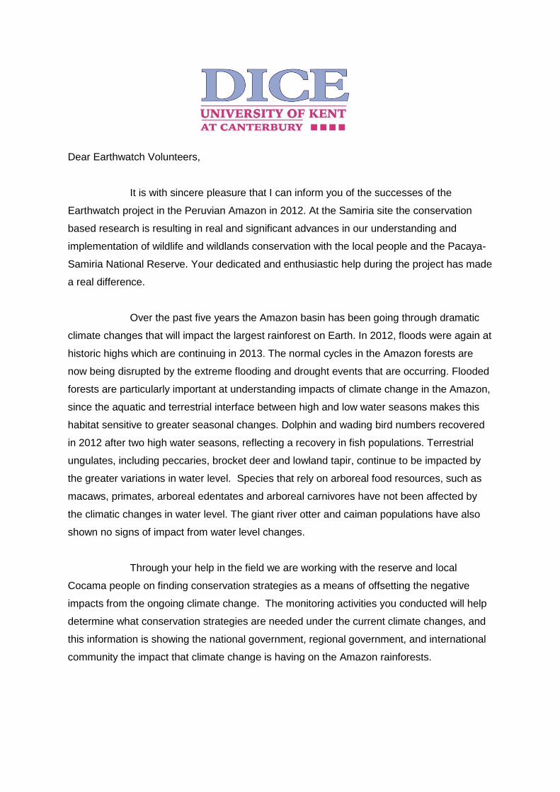
Dear Earthwatch Volunteers,
It is with sincere pleasure that I can inform you of the successes of the
Earthwatch project in the Peruvian Amazon in 2012. At the Samiria site the conservation
based research is resulting in real and significant advances in our understanding and
implementation of wildlife and wildlands conservation with the local people and the Pacaya-
Samiria National Reserve. Your dedicated and enthusiastic help during the project has made
a real difference.
Over the past five years the Amazon basin has been going through dramatic
climate changes that will impact the largest rainforest on Earth. In 2012, floods were again at
historic highs which are continuing in 2013. The normal cycles in the Amazon forests are
now being disrupted by the extreme flooding and drought events that are occurring. Flooded
forests are particularly important at understanding impacts of climate change in the Amazon,
since the aquatic and terrestrial interface between high and low water seasons makes this
habitat sensitive to greater seasonal changes. Dolphin and wading bird numbers recovered
in 2012 after two high water seasons, reflecting a recovery in fish populations. Terrestrial
ungulates, including peccaries, brocket deer and lowland tapir, continue to be impacted by
the greater variations in water level. Species that rely on arboreal food resources, such as
macaws, primates, arboreal edentates and arboreal carnivores have not been affected by
the climatic changes in water level. The giant river otter and caiman populations have also
shown no signs of impact from water level changes.
Through your help in the field we are working with the reserve and local
Cocama people on finding conservation strategies as a means of offsetting the negative
impacts from the ongoing climate change. The monitoring activities you conducted will help
determine what conservation strategies are needed under the current climate changes, and
this information is showing the national government, regional government, and international
community the impact that climate change is having on the Amazon rainforests.

From the staff of the Ayapua and Clavero, the students, fellow members of the
Club of Remate de Malas, and myself, we send our warmest Amazonian regards, and again
thank you so much for your kind assistance with the Amazon Riverboat project.
Yours faithfully,
Richard E. Bodmer,
PhD, DSc Reader in Conservation Ecology
Durrell Institute of Conservation and Ecology
University of Kent Canterbury, UK
SECTION ONE: Scientific research achievements
Top highlight from the past season
The Amazon basin is going through dramatic climate changes that will impact the largest
rainforest on Earth. The normal cycles in the Amazon forests are now being disrupted by the
extreme flooding and drought events that are occurring. In 2012, following two years of high
water levels, both the dolphin and wading bird numbers recovered, reflecting a recovery in
fish populations. Terrestrial ungulates, including peccaries, brocket deer and lowland tapir,
are also being impacted by the greater variations in water level. Species that rely on
arboreal food resources, such as fruits, leaves, insects or other prey have not been affected
by the climatic changes in water level. Wildlife groups such as macaws, primates, arboreal
edentates and carnivores inhabit the forest above the physical impacts of flooding. The giant
river otter and caiman populations have also shown no signs of impact from water level
changes.
Reporting against research objectives
The major findings over the past year have demonstrated the impact of climate
change on wildlife species in flooded forests of the Peruvian Amazon and the need for
conservation actions. Results have continued to show the importance of incorporating local
people in reserve management through community based sustainable resource use of the
principal livelihood products of fish and bush meat. However, results have shown how
climate change is impacting sustainability of subsistence resource uses. This highlights the
importance of involving local communities in incentive based conservation as a mechanism
for ecosystem management and how this can help mitigate impacts of climate change on
local people through improving livelihoods.
During the late 1990´s and first ten years of the 21st century studies on climate
change in the Amazon focused on dieback of the rainforest and its conversion to savanna
habitat (Cook & Vizy 2008, Fearnside 2004). Climate models predicted that with warmer
temperatures the Amazon would experience decreased rainfall resulting in greater fire risk
and in turn savannas of the cerrado overtaking the Amazon (Malhi 2008). Deforestation
along the southern rim would accelerate these changes (Killeen & Solorzano 2008).
Intensive droughts of 2005 and 2010 supported these predictions (Zeng et al. 2008, Asner &
Alencar 2010). Concern about Amazon dieback is multiple, since it impacts biodiversity,
livelihoods and shrinks size of the Amazon carbon sink (Betts et al. 2008). Indeed, the
Amazon basin is the largest terrestrial carbon sink on Earth (Cowling & Shin 2008).
More recently better climate models show a more complex scenario of climate
change in the Amazon. Models using the IPCC-AR4 predict the western Amazon basin will
actually become wetter with greater flooding during the high water season, and extreme
conditions becoming more frequent (Cook et al. 2012, Langerwisch et al. 2012). These
models also predict that extreme drought during the low water season will occur, but with a
lower probability than intensive flooding (Cook et al. 2012). In contrast, these models predict
that the southern Amazon will become drier, but to a lesser extent then was predicted by
previous models (Cook et al. 2012).
The empirical evidence from western Amazonia, where the Earthwatch project is
working, concurs with more recent models. Each year the Amazon River goes through
seasonal changes between the flooding period from December to June and the low water
period between July to November (Junk et al. 1989). However, these normal seasonal
changes are now becoming more intense. In 2009, the Amazon River was at a record high,
flooding huge areas of Amazonian forests. In 2010 the water levels of the Amazon River
were at record lows resulting in extreme dry conditions and drought. More recently in 2011,
high water exceeded those of 2009. In 2012 the water level flooded with greater intensity
than in previous years and became a new record high. The low water season was also
relative intensive, but did not exceed previous records (Figure 1). In January 2013 the water
level is at a new record high for the month, with flooding occurring earlier than in previous
years. The consecutive intensive recent flooding and the occasional intensive drought
concur with the IPCC-AR4 models (Cook et al. 2012, Langerwisch et al. 2012). However,
these models predicted that intensive events would only occur during the end of the 21st
century, when in fact they are already occurring in the second decade.

Research on wildlife populations is being conducted in the Samiria River basin to
understand how the ever increasing climatic changes are impacting the ecology, behavior
and populations of aquatic and terrestrial species. The team is also working with the local
Cocama Indian communities and the reserve authority to see how the climate changes are
affecting fishing, bush meat hunting and conservation strategies.
The Amazonian forests of Loreto, Peru are situated in the western Amazon basin and
harbor some of the greatest mammalian, avian, floral and fish diversity on Earth (Keddy et
al. 2009). However, these vast expanses of intact forest will only remain if conservation
programs are successfully implemented. Wildlife conservation in Loreto must incorporate
landscape features (in terms of major habitat types of both flooded and upland forests),
biology of landscape species and socio-economics of rural people (Bodmer et al. 1997).
Research on wildlife populations is being conducted on river dolphins, primates, fish,
caimans, macaws, deer, peccaries, tapirs, jaguars, giant river otters, wading birds and other
species to understand how ever increasing climatic changes are impacting their ecology,
behavior and populations. The research team is also working with the local Indian
communities to see how the changes are affecting their fishing and bush meat hunting that
they depend on for their daily livelihood.
Wildlife of the Samiria River lives in an ecosystem that is driven by large seasonal
fluctuations occurring between high and low water seasons. The ecology of aquatic and
terrestrial wildlife revolves around these seasonal changes in water level (Aquino et al.
2001).
Ecological conditions of long periods of flooding, up to six months, are very harsh on
much of the floral and faunal community (Junk & Piedade 1997). Many plant species cannot
withstand long periods of inundation and diversity of plants in the heavily flooded areas is
lower than lightly and non-flooded levees (De Simone et al. 2002). Likewise, terrestrial
wildlife (deer, peccaries, rodents and tapir) must seek out floodplain islands or levees during
high water seasons, which have increased competition and predation pressures (Bodmer
1990, Junk & Da Silva 1997). Even arboreal wildlife is impacted by flooding, since many fruit
trees are quite seasonal in flooded forests, resulting in seasons with low food production
(Ayres 1986).
Aquatic wildlife is equally affected by large seasonal inundations. During the flooded
periods fish enter water laden forests and feed on the abundance of vegetative and animal
production, especially abundant fruits, invertebrates and other living organisms trapped in
the annual floods (Junk et al. 1997). Indeed, many tree species fruit during this season and
rely on the fish as their primary means of seed dispersal (Goulding 1980). During the flooded
period many fish populations reproduce within the inundated forests (Ortega &
Hidalgo2008). Other aquatic wildlife have a more difficult time during floods, such as
dolphins, giant river otter and other fish predators, since their prey is more sparsely
distributed throughout the large expanses of flooded forests. When waters recede during dry
months, fish populations become condensed in the reduced lakes, rivers and channels with
ever increasing competition and predation. During this period many fish populations migrate
out of smaller rivers and into larger rivers (Granado-Lorencio et al. 2007). Dolphins, wading
birds and other fish predators have an abundance of prey during the low water season and
even follow fish migrations down rivers and channels.
People who live in flooded forests also have adapted to seasonal changes in both
use of natural resources and their agriculture (Goulding et al. 1996). During high water
seasons fishing is more difficult, since fish are dispersed throughout inundated forests.
However, during this period hunting becomes easier with the large bush meat species, such
as deer, peccaries and tapir being trapped on levees (Bodmer et al. 1998). In contrast,
during low water seasons bush meat species become difficult to hunt as they range
throughout the entire forests, and the fish become easy prey being trapped in reduced water
bodies of lakes, channels and rivers (Tejerina-Garro et al. 1998)). Local indigenous people
of floodplain forests alter their hunting and fishing accordingly, with a greater emphasis on
hunting during high water seasons and a greater focus on fishing during low water seasons
(Bodmer et al. 1998).
The normal cycles in the Amazon forests are now being disrupted by extreme
flooding and drought events of recent years. Flooded forests are particularly important at
understanding impacts of climate change in the Amazon, since the aquatic and terrestrial
interface between high and low water seasons makes this habitat sensitive to greater
seasonal variations (Hamilton et al. 2002). Water level change is a robust measure of
climate fluctuation, since variations are on a weekly, or even monthly basis as the waters
raise and recede. This is unlike temperature and rainfall, which can have dramatic daily
fluctuations resulting in large standard deviations (Wittmann et al. 2004).
The Earthwatch project is using a set of key wildlife species to evaluate conservation
strategies and impact of climate change on species and local people of the Samiria River
basin in the Pacaya-Samiria National Reserve. These species groups include the following:
1) River dolphins were used as indicator species of the aquatic systems. 2) Macaws were
used as indicators of the arboreal forest fruit production. 3) Primate populations were
monitored to evaluate arboreal mammals. 4) Ungulates and rodents are important bush
meat species and were used to examine how climate change is impacting sustainability of
hunting. 5) Carnivores, marsupials and edentates were used to monitor non-bush meat
mammals. 6) Giant river otters and manatees were monitored to evaluate the recovery of
vulnerable species. 7) Game bird populations were monitored to evaluate large bodied
forest birds. 8) Caiman populations were monitored to evaluate the recovery of black
caiman populations. 9) The abundance and age structure of fish were monitored to
determine the status of fish populations and local fisheries. 10) The livelihoods of local
Cocama people were evaluated under the current climate change conditions.
The Pacaya-Samiria National Reserve extends over an area of 2,080,000 ha in the
Department of Loreto, Peru. The study areas of the Samiria River basin included 1) the
complex hyrdoscape of the mouth with its lakes, channels and river. This area was also
classified as the commonly hunted zone and is where the local Cocama villages are
situated. 2) The mid section of the Samiria River basin is located in the region of PV2
Tachcocha and Huisto lake and stream and was classified as the occasionally hunted zone.
3) The upper section of the basin between PV3 Hungurari and PV4 Pithecia, which was
classified as the infrequently hunted zone (Figure Map).
Methods
Terrestrial mammals and game birds Line censuses along transect trails were used
to conduct terrestrial mammal and game bird censuses. Census trails between 2-5 km in
length were surveyed repeatedly. Information registered on a census includes: day, site,
species, number of individuals, and perpendicular distance from the individual to the transect
line, habitat, time, distance travelled and weather conditions.
The method assumes that all the animals that are on the center of the line transect
(0 m perpendicular distance) will be observed. The technique is based on the notion that
observers do not see all the animals that are off the center of the line, and that the
probability of sighting an animal depends on the distance of the animal from the line.
Animals closer to the line have a higher probability of being seen than animals further from
the line. The perpendicular distance of all solitary animals sighted, or the first animal sighted
in a social species were recorded (Buckland et al. 1993). The DISTANCE estimation
calculates the animals that you did not see, and includes these animals in the density
estimate.
The method relies on measuring the perpendicular distance of animals before they
move as a consequence of seeing the observer. That means observers must try and see the
animal before they sight the observer. It also means observers must measure the
perpendicular distance of the first sighting. If animals move because of the observer than the
estimate will be biased. With the DISTANCE program trails do not have to be straight, but
the perpendicular distances must be measured at the correct angle of the center line. The
perpendicular distance will be measured directly from the point of first sighting (Buckland et
al. 1993).

The method assumes that animals are independently dispersed throughout the
habitat. Since individual animals within a social group are not independent, but move
dependent upon one another, animal groups in social species must be considered as the
sampling unit. Thus, DISTANCE will calculate the density of animal groups (Buckland et al.
1993).
The equipment used for line transects included: a map of the area, a compass, data
sheets, pens and binoculars. Trails were not placed with any pre-determined knowledge of
the distribution of the animals. Censuses were done using small groups of three or four
observers. Transects were walked slowly and quietly (500-1,000 m/hr) between 7am and
3pm.
Census information was analysed using DISTANCE software (Thomas et al. 2002).
This program is regularly used in calculating individual or group densities (Buckland et al.
1993) and can estimate densities if the distribution of sightings within a transect line forms a
clear probability function. When the number of sightings is deemed insufficient to determine
a probability function, the method known as ‘fixed width’ was used to estimate the densities.
Camera Traps Digital camera traps with heat/motion sensors were used to photograph
ungulates, rodents, cats, armadillos and other terrestrial species. Twenty paired StealthCam
passive infrared camera trap stations were set over an area of c. 50 km2 and distributed
across habitat types. Detection histories were constructed for each species using capture
rates. Trails were used to place camera traps throughout each sampling area. Cameras
were checked once a week for batteries and to download pictures (Pittet 2012).
Censuses of caimans:
To assess the population and ecology of caiman species in the ecosystem it is
necessary to gain an understanding of their population size. Aquatic transects were used
traveling upstream or downstream on the main river and in nearby channels or lakes. A GPS
was used to determine the distance surveyed each night. All caimans seen were identified to
the species level as best as possible and size of the caiman and location were noted. These
data, along with data collected from captured caimans, were used to analyze the caiman
population size. Caiman surveys and captures were conducted from a small boat fitted with
a 15-horsepower engine. Caimans were located by their eye reflections using a 12-volt
spotlight and approached to a distance where the engine was silenced and the boat paddled
closer. Noosing was used to capture caimans. The noose was made of a long pole about 2
m in length with a loop of rope that can be pulled tight over the caiman’s neck. The caimans
were secured with rope tied around the jaw behind the nostrils and around the neck. Total
body length was measured from the tip of the snout to the tip of the tail, while head length
was measured from the tip of the snout to the posterior edge of the orbital (the vent). The
sex was also determined. Weight of the caiman was recorded in kilograms. A measuring
tape and weighing scales was used (Swan 2012).
The population abundance of each species was calculated using the formula N/L,
where N= the number of individuals and L= the distance travelled in kilometers. The results
indicate the number of individuals per kilometer.
Censuses of macaws
Point counts were used to monitor macaws. Between eight and nine points was
established in each sampling unit separated by 500m. A GPS was used to measure the
distance between points. Fifteen minutes was spent at each point. Censuses were carried
out twice a day in the morning (5:30-9:00h) and afternoon (16:00-18:30). The censuses
usually lasted longer in the morning than in the afternoon. Within the 15-min counts, all
macaw species either perched or flying were noted. The distances of the birds from the
observer were estimated where possible. A motorized boat was used to travel to each point.
Abundance data were calculated in each sampling zone. This was done by adding the total
number of sightings and dividing this number by the number of points. Thus, abundance is
expressed as the number of individuals per point.
Censuses of dolphins
Dolphin censuses were carried out at both sites. Five kilometers was travelled daily
from 9:30 to 13:00 h along the center of the river using a boat. Information collected
included: species, group size, group composition, behavior (travelling, fishing, playing), time,
and any additional observations.
Data were analyzed using fixed width:
Where: D=N/2WL D= Density N= Number of individuals W= 0.5 River width L=
Distance travelled 2= Number of margins sampled
Aquatic surveys were used to census dolphins. A GPS (Global Positioning System)
was used to determine the length of each aquatic census. Dolphin transects usually take
three to four hours to complete depending on the speed at which the river is flowing.
A motorized boat was used to carry out the census. Any dolphins seen coming to the
surface for air, swimming with their heads above water, sunbathing or swimming just below
the surface of the water (i.e. no deeper than 5 cm) were recorded. Care was taken not to
double count any dolphin sightings. Behavioral information on the dolphin activity was also
recorded along with the size class of each dolphin sighting. For each transect the weather
conditions and the start and finish times were recorded. Censuses of fish During the
censuses green gill nets of 3.5’’ were used in lakes and channels with weak currents and
white gill nets in the river.
Fishing points were located on shores or banks where there is aquatic vegetation or
shrubs, although meanders are the preferred areas. Individuals were identified, measured
and weighed. Catch per unit effort was calculated by the number of individuals per species
caught and the effort spent fishing at each zone. Habitats were also compared (lake,
channel, river) and diversity indices were used. Productivity of fish was shown in terms of
catch per unit effort, using the ‘biomass captured per effort’ method. The CPUE method is a
robust indicator over time for the level of abundance, density and pressure fishing in a given
zone (Hinton & Maunder 2004). The length-frequency analysis helps to predict biological
impacts of fisheries. A harvest focused on juveniles, for example, causes greater impact
than a harvest of adult fish not in their breeding period.
Giant River Otter Censuses
Were conducted for two months intervals. Sample counts were used to compare
relative abundance between censuses rather than absolute counts which would have
required identification of all individuals. Censuses were conducted by boat, scanning with
binoculars and listening for otter calls. We recorded group sizes and locations using a
handheld Global Position System (GPS), which we also used to calculate the length of each
transect. Double counting was avoided by keeping a constant boat speed and where
possible by identifying groups by the unique throat markings of individuals. The total length
of each transect was recorded, along with the width and type of the body of water (Recharte
& Bodmer 2009).
Sample sizes
Large sample sizes are needed to have confidence in the results and the study has
had increasing sample sizes over the years, with 2010, 2011 and 2012 having the greatest
number of surveys conducted. Rounded average annual sample sizes for these years were
Terrestrial transects 1000 km, Dolphin surveys 1800 km, Caiman surveys 800 km, Macaw
points 1200 points, Hours fishing 400 hours, and Wading bird surveys 500 km. In addition
there were 1,935 camera trap days yielding 6,047 useful photographs.
Results
River dolphins : Pink river (Inia geoffrensis) and grey river dolphins (Sotalia
fluviatilis) were used as indicator species for the aquatic hydroscape. These species are
appropriate as indicator species because 1) they are top predators of the hydroscape, 2)
they are not intentionally killed by people due to strong taboos, 3) they can move in and out
of river systems over short periods of time, and 4) they are easy to count and observe. The
dolphin’s ability to move widely means that changes in dolphin populations within a river
system will be caused more by dolphins leaving an area or immigrating into an area rather
than a result of mortality or reproduction. Thus, if a hydroscape is going through negative
changes, such as pollution or overfishing, dolphin numbers will decrease rapidly. Likewise, if
a river system becomes healthier than surrounding hydroscopes dolphin numbers would
increase from dolphins moving into the area.
Results from this research show some important consequences of the extreme
variations in water levels that have been occurring over the past several years on the dolphin
populations. Extreme variations in water levels are having a clear impact on the dolphins
with drought resulting in lower numbers and floods resulting in healthier numbers. However,
these changes are not immediate with changes in dolphin numbers lasting for several years
after an extreme water level event. This impact began during the initial record high waters of
2009 and has continued through the drought of 2010 and high waters of 2011and 2012.
The populations of pink river dolphins between 2006-2012 was consistently greater than the
grey river dolphin (Z(U)=3.0707, P=0.0021). Overall, pink river dolphins had an average
density of 2.07±1.08 ind/km2 and grey river dolphins 1.05±0.98 ind/km2. Both the pink and
grey river dolphins use the length of the Samiria River differently throughout the year, with
the dolphins moving up and down the river depending on the season. Therefore, the analysis
of population changes over the years only used data from the August – September period,
which corresponds to the annual low water season. During the low water season dolphins
use river habitats to a much greater extent, whereas in the high water season dolphins are

using lakes and channels more than river habitats. The greater use of river habitats by
dolphins during the low water season also makes multi-year comparisons more robust by
focusing on dry season data.
Using results from 2006-2012, pink river dolphins decreased in density in the Samiria
River between 2007 and 2011, and began to increase in 2012 (Figure 2a). The population of
pink river dolphins has always been greatest at the mouth of the Samiria River, compared to
mid and upper sections. However, at the mouth of the Samiria River pink river dolphins
decreased from the drought of 2010 and have only recently increased in 2012 following two
years of heavy flooding. In 2011 pink river dolphins at the mouth were at a low of 2.36±0.75
ind/km, compared to 3.76±1.00 ind/km in 2012 and the peak in 2009 of 7.31 ±2.15 ind/km.
The drought in 2010 had a significant impact on dolphin populations . The extreme
low water conditions of 2010 resulted in lower dolphin numbers throughout the Samiria
River. Overall, the pink river dolphin numbers decreased by 47% and the grey river dolphin
by 49% in September and October 2010. The dolphins left their habitats in the Samiria River
to find refuge in the larger channels of the Amazon. The drought ended in late October 2010
and in January and February 2011 both pink and grey dolphins continued to be consistently
lower (between 60-70% fewer sightings) than the same months in 2010. By March 2011 both
species began to return to the Samiria river, but results from 2011 show that the pink river
dolphin did not recover fully from the drought, and populations continued to decrease despite
higher water levels in 2011. It was only in 2012 that the pink river dolphin increased in
numbers.
The negative impact of a drought appears to have lasted two years, and positive
growth following consecutive high floods also appears to have a two year lag time. This
same trend was seen in the mid section of the Samiria River. The pink river dolphin has
decreased in population since the greater variations in water level began. In 2011, the pink
river dolphin was at a low of 1.02±0.93 ind/km following the drought of 2010 and has only
began to increase again in 2012 with 2.62±1.41 ind/km, compared to the average of 2.55
ind/km and the peak during 2007 of 3.79±1.23 in/km. Similar to the mouth, the drought had a
two year negative impact and positive growth from consecutive flooding occurred after two
years. Pink river dolphins in the upper section of the Samiria River have not shown
decreases in populations. In 2012 the pink river dolphins in the upper section of the Samiria
River were 2.35±0.82 ind/km with an annual average of 2.99 ind/km.
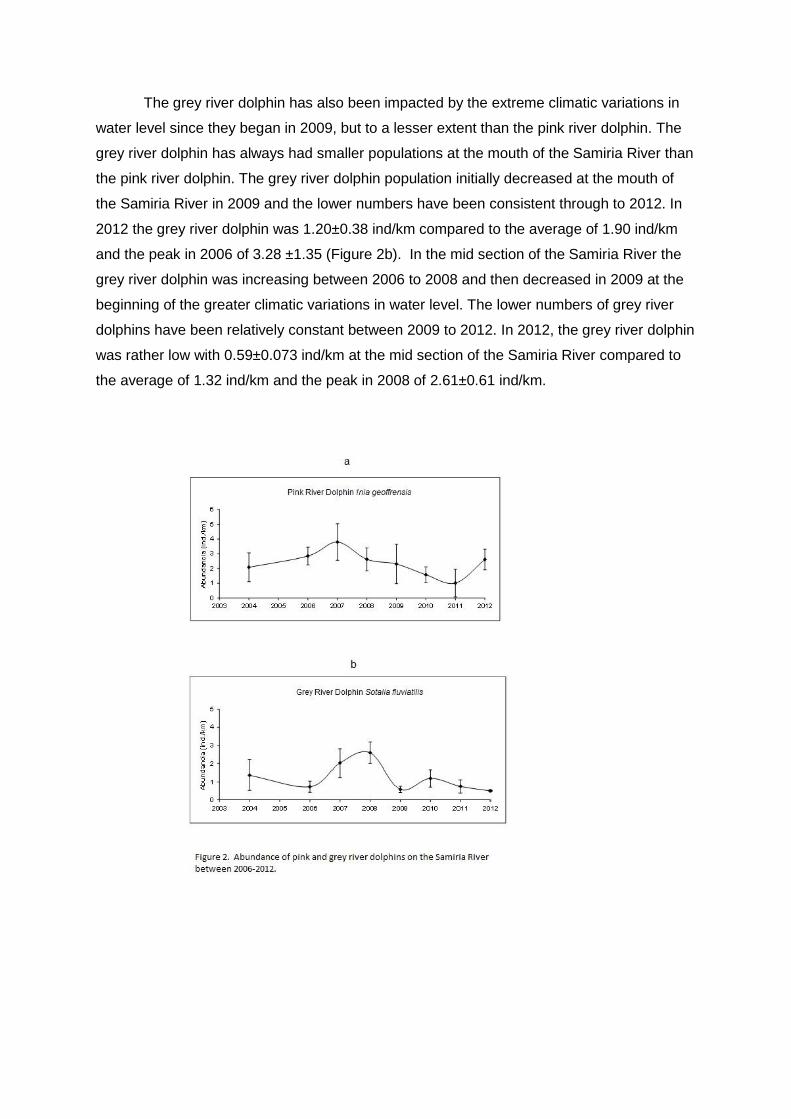
The grey river dolphin has also been impacted by the extreme climatic variations in
water level since they began in 2009, but to a lesser extent than the pink river dolphin. The
grey river dolphin has always had smaller populations at the mouth of the Samiria River than
the pink river dolphin. The grey river dolphin population initially decreased at the mouth of
the Samiria River in 2009 and the lower numbers have been consistent through to 2012. In
2012 the grey river dolphin was 1.20±0.38 ind/km compared to the average of 1.90 ind/km
and the peak in 2006 of 3.28 ±1.35 (Figure 2b). In the mid section of the Samiria River the
grey river dolphin was increasing between 2006 to 2008 and then decreased in 2009 at the
beginning of the greater climatic variations in water level. The lower numbers of grey river
dolphins have been relatively constant between 2009 to 2012. In 2012, the grey river dolphin
was rather low with 0.59±0.073 ind/km at the mid section of the Samiria River compared to
the average of 1.32 ind/km and the peak in 2008 of 2.61±0.61 ind/km.

The grey river dolphin has had relatively stable numbers in the upper section of the
Samiria River between 2006 to 2010, but decreased in numbers in 2011. In 2012, the grey
river dolphin remained low and was at 1.39±0.52 ind/km in the upper section of the Samiria
River compared to the annual average of 2.44 ind/km and the peak in 2010 of 3.29 ±2.33
ind/km. Demographics of pink river dolphins have changed since greater variations in water
level have been observed in the Samiria River. In 2008, prior to the water level changes pink
river dolphins had an average composition along the river of 93.5% adults and 6.5%
juveniles and young. In 2011, after three years of greater variations in water level and
decreasing pink river dolphin populations the demography consisted of 85.9% adults and
14.1% juveniles and young. In 2012 it appears that the pink river dolphin is reproducing even
greater with 66.25% adults and 33.75% juveniles and young. The increase in juveniles and
young indicates a pink river dolphin population starting to recover from perturbations, which
is commonly observed in mammalian systems. The larger and more stable population prior
to the water level variations shows an adult dominated population with less reproduction. As
the adult population decreased between 2009 and 2011 the reproduction of individuals has
increased and the demographics show a greater percentage of juvenile and young
individuals, which is now reflected in increasing populations.
Demographics of grey river dolphins have also changed since greater variations in
water level have been observed in the Samiria River. The demographic changes in grey river
dolphins have been less intensive than the pink river dolphins, which mirrors the population
declines that have been greater in the pink than the grey river dolphins. In 2008, prior to the
water level changes the grey river dolphin had an average composition along the river of
91.4% adults and 8.6% juveniles and young. In 2011, the demography consisted of 85.8%
adults and 14.2% juveniles and young, and in 2012 there were 77.9% adults and 22.1%
juveniles and young. Similar to the pink river dolphin, the increase in juveniles and young
grey river dolphin indicates a population starting to recover from perturbations. The
reproduction of grey river dolphins has increased as the populations have been declining
from greater water level variations that have impacted the dolphins between 2009 to 2012.
Changes in dolphins numbers is directly related to the fish populations. This relationship has
to do with several variables. During intensive floods fish populations have greater
reproduction due to better and longer access to flooded forests. However, during intensive
floods fish are less dense due the increase in water volume, making fishing by dolphins
more difficult. This would explain the initial decrease in dolphin numbers during the onset of
more flooded years after 2009. Droughts have immediate impacts on fish numbers and
result in rapid decreases. This explains the impact of droughts on the dolphin numbers in
2010 which lasted until 2011. With two consecutive years of high floods the fish population
has increased with a corresponding increase of dolphins in 2012, especially pink river
dolphins. Results show that pink river dolphin populations are correlated to the abundance of
red piranha and that grey river dolphin populations are correlated to the abundance of white
piranha. Both red and white piranha species were negatively impacted by the drought in
2010 (see section on fish results).
Macaws
Macaw populations were used as indicator species of the terrestrial forest landscape.
These species are appropriate as indicator species because 1) they are frugivores that rely
on forest fruits, 2) they are not killed by people, 3) they can move in and out of the forest
areas over short periods of time, and 4) they are easy to count and observe. The macaws
in the Samiria River include the chestnut-fronted macaw (Ara severus), blue & yellow macaw
(Ara ararauna), red-bellied macaw (Orthopsitaca manilata) and scarlet and red & green
macaws (Ara macao/chloroptera).
Overall the abundance of macaws in the Samiria River during 2012, as in previous
years, differs between species (H=9.4615, gl=3, P=0.0237). The most common species was
the red-bellied macaw (Orthopsitaca manilata) 16.65±2.79 ind/point, followed by the blue &
yellow macaw (Ara ararauna) 2.74±0.65 ind/point and chestnut-fronted macaw (Ara severus)
1.26±0.40 ind/point. The scarlet and red & green macaws (Ara macao/chloroptera) are least
common and together only had an abundance of 0.16±0.05 ind/point.
Along the length of the Samiria River macaw numbers in total were relatively
constant and ranged between 8-12 ind/point. However, the composition of the macaws
varied considerably between the mouth, mid section and upper reaches of the Samiria River.
At the mouth of the river the numbers were dominated by the red-bellied macaw, with low
numbers of blue& yellow and chestnut-fronted macaws. There were no sightings of the
scarlet and red & green macaws at the mouth. In the mid section of the river the numbers
were again dominated by the red-bellied macaw, but the blue & yellow macaw had greater
numbers, and the chestnut-fronted lower numbers. In the upper reaches of the river the
three common macaws, red-bellied, blue & yellow and chestnut-fronted all had similar
numbers. The scarlet and red & green macaws were present in the mid and upper sections,
but with very low numbers.
In general the macaws have been increasing in the Samiria River basin over the
period of greater variations in water level and do not appear to have been impacted

negatively by the greater climatic variations. In contrast, the macaw populations are actually
doing better over the past few years. The macaws are not directly impacted by water level
variations due to their arboreal habits. Therefore, health of the forest appears to have been
maintained since the greater climatic variations took effect in 2009. The population variations
over the years in the different sections of the basin (mouth, mid section and upper reaches),
for the most part conform to overall annual variations (Figure 3). The chestnut-fronted
macaw has increased since 2009 in the Samiria River basin (H=19.97, gl=8, P=0.010). This
species has gone through cyclical population booms and bursts in the basin.
Between 2006-2007 there were high population numbers of the chestnut-fronted macaw.
Then between 2008-2009 the population was low. In 2010 the chestnut-fronted macaw
began to increase and in 2011 it was at its highest population level recorded thus far in the
Samiria basin, and with a similar population in 2012. The red-bellied macaw population is
also cyclical in the Samiria River basin. This species had relatively low number until 2009,
when its population increased significantly. In 2010, 2011 and 2012 the population of red-
bellied macaw has been declining (H=15.64, gl=8, P=0.047). It appears that the chestnut-
fronted and red-bellied macaws are in direct competition, both over the years and at specific
sites. Total numbers of the two species are relatively constant, however, at times one
species or the other will dominate either annually throughout the basin or specifically at a
given site. The blue & yellow macaw has been relatively constant in numbers in the Samiria
basin since 2003 with some annual fluctuations (F8,18=3.55, P=0.0122). The greater
variations in water level have not obviously impacted the blue & yellow macaw numbers,
though its population did peak in 2009 and again increased in 2011 with a slight decline in
2012. The sample sizes of the scarlet and red & green macaw are small and the variations
do not show any significant trends along the Samiria River basin (H=6.17, gl=8, P=0.6282).
Wading birds
Wading birds were used as indicators of the fish production in the Samiria River basin. Fish
reproduce in the flooded forests of the Samiria basin during the high water season. Young
fish then migrate out of the Samiria during low waters of the dry season. Each year flocks of
Neotropical cormorants (Phalacrocorax brasilianus) and great egrets ( Ardea alba) migrate
to and congregate at the mouth of the Samiria River to feed on fish swimming out of the
basin between the months of August to November. In addition, non-migratory wading birds
are also seen in greater abundances, including wattled jacana (Jacana jacana), cocoi heron
(Ardea cocoa) and snowy egret (Egretta thula). Wading birds along the Samiria River were
classified into five assemblages according to their annual use of the river and changes in
abundances.
Group 1: These are the species that show marked seasonal migrations during the dry
season.
Group 2 & 3: These are the species that show variations in their abundances over the year,
but not in relation to the dry season.
Group 4 & 5: These are the resident species that show little annual fluctuations in their
abundances along the Samiria.
The species composition of wading birds differed along the Samiria River. Overall the
wading bird abundance was greatest at the mouth of the river, with a considerably lower
abundance at the mid section and even lower numbers in the upper reaches of the river. At
the mouth Phalacrocorax brasilianus dominated, followed by Ardea alba and Jacana jacana.
In the mid section the most abundant wading bird was Ardea alba, followed by
Phalacrocorax brasilianus and Ardea cocoa.
In the upper reaches Ardea alba was agin the dominant species followed by Ardea cocoa
and then Phalacrocorax brasilianus. There was a strong correlation between abundance of
wading birds and fish populations in the Samiria River basin. Overall abundance of all
species of wading birds are correlated to abundance of fish populations. Abundance of
Ardea alba and Phalacrocorax brasilianus correlated with overall fish abundance. Therefore,
wading bird species are a good measure of overall fish production. Greater variations in
water level have impacted wading bird populations. Abundances of the two dominant
species, Phalacrocorax brasilianus and Ardea alba, at the mouth of the Samiria River were
relatively constant between 2006 to 2010, and even had a slight increasing trend over the
years.
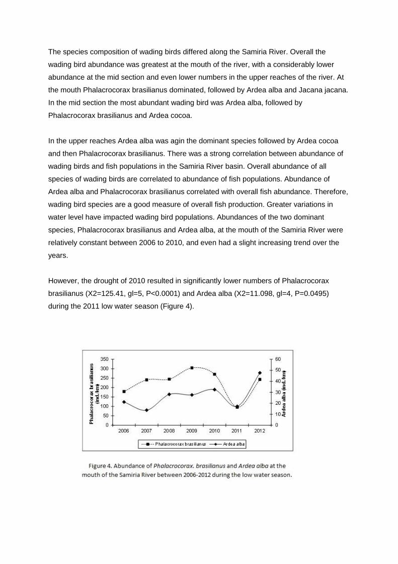
However, the drought of 2010 resulted in significantly lower numbers of Phalacrocorax
brasilianus (X2=125.41, gl=5, P<0.0001) and Ardea alba (X2=11.098, gl=4, P=0.0495)
during the 2011 low water season (Figure 4).
The drought resulted in high fish mortality and decreased wading bird numbers concur with a
decrease fish production during 2011. This also correlates with the impact of water level
variations on fish populations and decrease in dolphin numbers (see fish and dolphin
sections). In 2012 there was a significant recovery of wading bird populations with numbers
approaching the peak years of 2009-2010.
Primates
Primates and other mammals were surveyed in the Samiria River to evaluate the success of
wildlife management by the reserve and the participation of community based involvement.
The Samiria was divided into three zones according to wildlife use plans, including 1) a zone
used commonly for subsistence hunting of the local Cocama indigenous people, 2) a zone
occasionally used for subsistence hunting, and 3) a zone infrequently used for subsistence
hunting.
Results of the censuses conducted betwenn 2006-2012 showed that overall densities and
biomass of mammals differed between the three zones, with the occasionally hunted zone
having the highest density of mammals, followed by the infrequently hunted zone, and lastly
the commonly hunted zone (X2= 91.264, gl= 2, P< 0.0001).
Primates dominated the density and biomass of mammals in all three zones (X2= 397.89,
gl= 2, P= 0.0001) with the infrequently hunted zone have the greatest density, followed by
the occasionally hunted zone and the lowest density of primates being in the commonly
hunted zone.
Saimiri bolviensis, Cebus apella, Alouatta seniculus, and Saguinus fuscicollis, had the
greatest density in the infrequently hunted zone. Saimiri boliviensis dominated the
occasionally hunted zone followed by Saguinus fuscicollis, Cebus apella, and Alouatta
seniculus. Saimiri bolviensis was also the dominant species in the commonly hunted zone
followed by Saguinus fuscicollis, Cebus apella, Alouatta seniculus, and Pithecia monachus.
Populations of primates along the Samiria River have not shown any obvious impacts from
the greater variations in water level that began in 2009 and continued through 2012
(F5,12=0.843, P= 0.5455).
Primate populations increased after 2000 from overhunting in the 1990´s and by 2006
primate densities were relatively stable. Unlike ground dwelling mammals and dolphins, the
arboreal primates inhabit the environment above the physical influences of the changing
water level. Many primate species rely on fruits as their major food, and similar to macaws,
primates have maintained stable populations that reflect a constant fruit production in the
forests.
Densities of woolly monkeys (Lagothrix poeppigii) have remained relatively constant
between 2004 and 2012 (G=4.6517, gl=7, P= 0.7024)(Figure 5a).
Over all years, woolly monkey density differed between the zones and was greatest in the
infrequently hunted zone, followed by the occasionally hunted zone and least in the
commonly hunted zone (Kruskal-Wallis= 13.67, gl=2, P= 0.0011). The multi-year fluctuations
between 2006 and 2012 show the infrequently and occasionally hunted zones to have
similar densities of woolly monkeys. The commonly hunted zone had a greater increase in
woolly monkey density between 2006 and 2011. The howler monkey (Alouatta seniculus)
densities have shown fluctuations in the Samiria River, with a declining population between
2006 to 2008 and then an increasing and stable population between 2008 to 2012
(X2=37.69, gl=8, P<0.0001)(Figure 5b).
Over all years, the density of howler monkey differed between the hunting zones and was
greatest in the infrequently hunted zone, followed by the occasionally hunted zone and least
in the commonly hunted zone (F2,15=4.40, P=0.0307). The greatest increase in howler
monkey density since 2006 was in the commonly hunted zone. The brown capuchin monkey
(Cebus apella) densities have been relatively constant in the Samiria River basin between
2004 and 2012 (X2=7.63, gl=7, P= 0.3657)(Figure 5c).
Over all years, the density of brown capuchin was similar between all three zones, with a
slightly lower density in the commonly hunted zone (F2,15= 2.2108, P=0.1428). The greatest
increase in brown capuchin density has been in the infrequently hunted zone. The monk saki
monkey (Pithecia monachus) densities have been relatively constant in the Samiria River
basin between 2004 and 2012 (G=5.5926, gl=7, P=0.6001)(Figure 5d) with a drip in density
in 2008 and a steadily increasing population through to 2012. Whilst the sample variation
shows no significant difference in density of monk saki monkey between the hunting zones,
the species does show a greater density in the commonly hunted zone (H=2.6584,
P=0.2647).
Monk saki monkeys were hunted in the past, but wildlife management in the Samiria River
basin has resulted in this species having the greatest density in the zone with heaviest
subsistence hunting.
The squirrel monkey (Saimiri boliviensis) densities have had increases and dips between
2004 and 2012 (X2=50.892, gl=7, P<0.0001)(Figure 5e) with the 2012 density being
relatively average for the species over the years. Over all years, the density of squirrel
monkey was similar between all three hunting zones (F2,20= 1.5144, P=0.2432). There was
a dip in 2011 in the density of squirrel monkey, but numbers increased again in 2012. The
saddled back tamarin (Saguinus fuscicollis) densities have been relatively constant in the
Samiria River basin between 2004 and 2012 (X2=11.272, gl=8, P= 0.1867)(Figure 5f).
Over all years, the density of saddled back tamarin was very similar between the hunting
zones, with a slightly lower density in the commonly hunted zone (F2,20= 0.0274,
P=0.9737). The commonly hunted zone has also seen the greatest increase in the density of
saddled back tamarins between 2009 through to 2012, and is now at a peak population. The
white capuchin monkey (Cebus albifrons) is a rarer species in the Samiria River basin and
densities have been relatively constant between 2004 and 2012 (G= 6.0307, gl=8, P=
0.6438)(Figure 5g).

Over all years, the density of white capuchin monkey was similar between all three hunting
zones (F2,20=0.3683, P=0.7012), but has considerable variation due to the small sample
sizes. Several lotka-volterra competitive interactions were observed with the primates.
The woolly monkey and howler monkey appear to be competing in the Samiria River. In
areas with high woolly monkey density there is low howler monkey density, and vice versa.
In general howler monkeys had a greater density than woolly monkeys, however the
densities of both species have been relatively stable over the years since 2004, indicating
that the competitive interactions appear stable. In contrast, the squirrel monkey and brown
capuchin monkey often form interspecific associations. Thus, the densities of squirrel
monkeys and brown capuchin monkeys had a positive correlation with greater density of
squirrel monkey also having greater density of brown capuchin.
Ungulates
Unlike primates, ungulates have been impacted by greater climatic variations in water level
between 2009 to 2012. Ungulates in the Samiria River basin include the white-lipped and
collared peccary (Tayassu pecari and Tayassu tajacu), red brocket deer (Mazama
americana) and lowland tapir (Tapirus terrestris).
Overall density of ungulates estimated from line transects has decreased significantly since
water level variations began (b=-0.9505, t=-3.8605, P=0.0119). Peak density of 3.93 ind/km2
occurred in 2009 after years of relatively stable water levels and then decreased in 2010 to
1.03 ind/km2 and again in 2011 to 0.65 ind/km2. In 2012 there were too few ungulates
sighted on transects to estimate density. Camera traps showed similar results to line
transects. 1,935 camera trap days were used to calculate camera capture rates in the
Samiria River basin in 2009 and 2011. Capture rate is per animal at a camera station and
multiple photos during a visitation are only counted as one event. Peccary herds are
registered as events, not as individuals.
In 2009 capture rates of ungulates was 142.69 captures per 1,000 trap days compared to
77.18 captures in 2011, resulting in a 46% decrease. All ungulate species showed
decreases. Ecological conditions of long periods of flooding in varzea forests of the Samiria
River, up to 6 months, can be very harsh on the ungulate community. Ground dwelling
mammals must seek out levees during the high water season, which result in increased
competition and predation pressures. These normal seasonal conditions have been more
intense during the exceptionally high waters of 2009 to 2012, and are continuing in the early
months of 2013. Initially, higher ungulate densities were recorded during 2009, as the stable
populations were forced onto ever decreasing levees. In 2010, the initial impact of high
waters of 2009 was observed, with decreasing ungulate densities. Record high waters of
2011 and 2012 surmounted those of 2009 and resulted in an even greater decrease of
ungulates. Results from camera traps show that the greater extremes in high water are
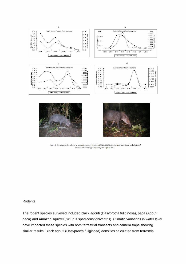
resulting in greater percentages of emaciated ungulates.
Camera traps set in 2009 did not record any emaciated individuals of ungulates. In drastic
contrast, Camera traps set in 2011 recorded significant percentages of emaciated
individuals, including lowland tapir: 3% (4 pictures out of 127 pictures), collared peccary:
12% (5 pictures out of 41 pictures), and white-lipped peccary: 10% (7 pictures out of 71
pictures)(Figure 6). The emaciation is due to the smaller levee size resulting in less food
availability and greater intra and inter specific competition. White-lipped peccary (Tayassu
pecari) have been impacted dramatically by intensive floods of recent years. The species
had a peak in its population in the Samiria River basin in 2009 with 3.64 ind/km2 which
declined dramatically in 2010 to 0.88 ind/km2 and still further in 2011 to 0.59 ind/km2 (G=
26.25, gl=5, P=0.0001)(Figure 6a). No white lipped peccary were sighted on line transects in
2012. They still occur in the Samiria River basin, but at greatly reduced numbers. White-
lipped peccary had a greater density in the infrequently and occasional hunted zones and a
significantly lower density in the frequently hunted zone. All three zones have shown
decreases in white-lipped peccary density.
Results from camera traps concur with line transects, and capture rates in 2011 were 9.86
herds per 1000 trapdays, 56% lower than in 2009. Collared peccay (Tayassu tajacu) have
been impacted equally as intensively as white-lipped peccary by intensive floods occurring in
western Amazonia. Collared peccary had a peak in population in the Samiria River basin in
2008 with 0.23 ind/km2, which declined dramatically in 2010 to 0.05 ind/km2 and still further
in 2011 and 2012 where no individuals were sighted on the line transects (b=-2.6493, t=-
2.6189, P=0.0471)(Figure 6b).
Collared peccary still occur in the Samiria River basin, but at much lower numbers than in
the past. Camera traps concur with line transect results, and capture rates in 2011 were
29.02 herds per 1000 trap days, 51% lower than in 2009. Over the years, collared peccary
had a greater density in the infrequently hunted zone than the occasional and frequently
hunted zones. The infrequently hunted zone has larger and higher levees that would help
explain the species preference for this area. All three zones have shown decreases in
collared peccary density.
Collared peccary generally do not have large populations in flooded forests compared to
non-flooded forests and varzea could be considered as a marginal habitat for the species.
Increasing level of flooding since 2009 has caused this species to become very rare in the
flooded forests of the Samiria River basin.

Of all of the ungulate species, red brocket deer (Mazama americana) were faring slightly
better until the historically high floods of 2012, which caused their population to fall. Density
of red brocket deer was relatively constant in the Samiria River basin between 2004 to 2010,
but in 2011 red brocket deer density dropped to 0.04 ind/km2 and in 2012 no red brocket
deer were sighted on the transects (b=-14.82, t=-3.2686, P=0.0170)(Figure 6c). Camera trap
results agree with the transects. In 2009 there were 36.36 captures per 1000 trap days and
by 2011 the capture rate fell to 19.15, or a 42% decrease. Over the years, density of red
brocket deer was similar in the infrequently hunted zone and occasionally hunted zone and
none were recorded in the commonly hunted zone. The commonly hunted zone has always
had very low populations of red brocket deer.
Lowland tapir (Tapirus terrestris) are also showing impacts from climate change. Camera
traps capture tapirs with better accuracy than sightings on line transects. In 2009 camera
trap capture rates for tapir were 22.73 captures per 1000 camera days and in 2011 capture
rates fell slightly to 19.15 captures resulting in a 16% decrease, which was much less than
other ungulate species. In 2012 some cameras were set, but much fewer than in 2009 and
2011. However, this low sample did capture 6 tapir events resulting in a capture rate of
14.56, which was 24% lower than 2011.
Terrestrial transects have shown decreases in tapir numbers. In 2010 transect results
showed an increase in tapir sightings, which in 2011 dropped to a very low number and in
2012 no tapirs were sighted on transects (Figure 6d). Over the years, tapir have been
sighted most frequently in the occasionally hunted zone, followed by the infrequently hunted
zone, and sighted least in the commonly hunted zone. The commonly hunted zone has
always had very low populations of lowland tapir.
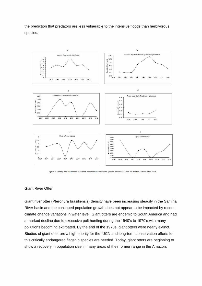
Rodents
The rodent species surveyed included black agouti (Dasyprocta fuliginosa), paca (Agouti
paca) and Amazon squirrel (Sciurus spadiceus/igniventris). Climatic variations in water level
have impacted these species with both terrestrial transects and camera traps showing
similar results. Black agouti (Dasyprocta fuliginosa) densities calculated from terrestrial
transects have been relatively constant in the Samiria River basin between 2006 and 2012
(G= 0.8392, gl=7, P= 0.997)(Figure 7a).
Density of black agouti peaked in 2009 with 0.93 ind/km2 and has decreased slightly with a
density in 2012 of 0.39 ind/km2. Camera trap results concurred with transects and had a
capture rate in 2009 of 445.45 captures per 1000 trap days compared to a capture rate in
2011 of 239.11 captures or a 46% decrease. Black agouti occurs in all three hunting zones
with a greater density in the infrequently hunted zone, followed by the occasionally hunted
zone and least in the commonly hunted zone. The small body size of the black agouti
(around 5 kg) allows individuals to survive on small forest levees during intensive flooding,
which is not possible for the larger ungulate species. This has presumably helped black
agouti survive during recent intensive floods.
Paca (Aguoti paca) are terrestrial nocturnal species and were only observed on camera
traps. Results of capture rates showed a decrease in their population following recent flood
events. In 2009 paca had a capture rate of 113.64 captures per 1000 camera days, which
fell to 45.59 captures in 2011 resulting in a 60% decrease in their abundance. Amazon
squirrel (Sciurus spadiceus/igniventris) densities have shown an overall stable population in
the Samiria River basin between 2004 and 2012 (G=4.8109, gl=7, P= 0.683)(Figure 7b) with
a peak in 2009 of 11.27 ind/km2 a decreasing tendency between 2010 and 2012 with 2012
densities at 4.33 ind/km2.
Camera trap results showed a similar trend with a capture rate in 2009 of 72.72 captures per
1000 trap days and 52.80 captures in 2011 resulting in a 27% decrease in their abundance.
The population of Amazon squirrel was similar between all three hunting zones
(F2,17=1.4175, P= 0.2675). The Amazon squirrel has not shown significant changes in
density as a result of the recent climate changes. The habits of the squirrels are
predominantly arboreal and similar to the primates are not directly impacted by the physical
flooding and indicating healthy fruit production.
Edentates
The edentate species surveyed included the tamandua (Tamandua tetradactyla), three toed
sloth (Bradypus variegatus), giant anteater (Myrmecophaga trydactila), giant armadillo
(Priodontes maximus) and smaller armadillo species (Dasypus novemcinctus and Dasypus
septemcinctus). The arboreal species (tamandua and three toed sloth) have not shown
impacts in the populations over the recent climate change variations. Both species are
arboreal and are not directly impacted by the extreme physical flooding events of recent
years, and similar to the other arboreal wildlife species these populations of edentates have
been stable. However, terrestrial species have shown impacts and their populations have
decreased as a consequence of the extensive flooding of recent years.
Tamandua (Tamandua tetradactyla) densities have been relatively constant in the Samiria
River basin between 2004 and 2012 with a low point in 2009 and 2010, flowed by higher
densities in 2011 and 2012 (G=1.5145, gl=5, 0.9114)(Figure 7c). Density of tamandua in
2012 was 0.17 ind/km2. Tamdandua were rarely captured on camera traps and sample
sizes were too small for analysis. Density of tamandua was relatively similar in all three
zones (F2,17=0.6125, P= 0.2275). The tamandua are both arboreal and terrestrial and they
feed on ants and termites, which indicates that ant and termite populations have not
presumably been impacted during the recent climate changes.
Three toed sloth (Bradypus variegatus) densities have been consistently constant in the
Samiria River basin between 2008 and 2012 (G= 0.8321, gl=6, P= 0.9912)(Figure 7d). In
2012 the density was 0.21 ind/km2. The density of three toed sloth has been relatively
similar between all three zones (H=0.0241, gl=2, P= 0.988). The sloths are folivores and
their arboreal habitats have not been directly impacted by the recent high water levels. Giant
anteaters (Myrmecophaga trydactila) was only sighted occasionally on terrestrial transects.
However, giant anteaters were recorded on camera traps, which showed impacts by the
intensive floods. Capture rates in 2009 were 22.72 captures per 1000 trap days and in 2011
were 8.70 captures with a decrease in abundance of 62%. Giant anteaters are large
terrestrial animals and similar to ungulates they have declined as a result of recent
inundations. Dasypus spp. are nocturnal species and were only recorded on camera traps.
These armadillo species were lumped in the analysis, since many of the photos did not
permit precise species identification. Nov armadillo species were impacted by intensive
floods and populations declined as a result of the climatic events. Capture rates in 2009
were 127.27 captures per 1000 trap days and in 2011 the rates were 31.34 captures,
resulting in a decrease in abundance by 75%. Flooded forests are not preferred habitat of
armadillos, since the borrowing habits and proximity of ground water often result in borrows
becoming inundated. Indeed, a study of borrow placement by the project showed that
armadillos in the Samiria River basin often prefer elevated mounds made by leaf cutter ants,
which are usually found on higher ground. In contrast, in non-flooded altura forests there is
no relationship between armadillos and leaf cutter ants.

Giant armadillos (Priodontes maximus) are large terrestrial species predominantly active at
night. They are only very rarely seen on terrestrial transects, but have on occasion been
recorded on camera traps. There were no records on the 2009 cameras and only 9 events
on the 2011 cameras yielding a capture rate of 5.22 captures per 1000 camera trap days.
The small sample size does not allow for an analysis of their population trends, however, the
prediction is a declining giant anteater population in line with other large terrestrial mammals
and smaller armadillos.
Carnivores and Marsupials
The carnivores and marsupials analyzed from terrestrial transect and camera trap results
included common opossum (Didelphis marsupialis), coati (Nasua nasua), tyra (Eira barbara),
ocelot (Leopardus pardalis), jaguar (Panthera onca) and puma (Puma concolor). Other
species sighted with sample sizes too small for population analysis included crab eating
raccoon (Procyon cancrivorous), jaguarundi (Felis yaguaroundi), margay (Felis wiedii) and
other opossums (Common Grey Four-eyed Opossum Philander opossum, and the Brown
Four-eyed Opossum Metachirus nudicaudatus).
The scansorial species did not show any clear impact from the recent climate change events
since they are both ground dwelling and arboreal. The arboreal habits allow these species to
overcome the physical impacts of recent extreme floods and included the coati, tyra and
common opossum. The common opossums (Didelphis marsupialis) are nocturnal species
that were recorded frequently on camera traps, but not during terrestrial transects conducted
during daylight hours. The 2009 camera trapping sessions recorded a capture rate of
common opossum at 131.81 captures per 1000 trap days compared to 169.47 captures in
2011, with similar abundances and no indications of declines caused by floods. The common
opossums live both on the ground and in trees of the lower understory of the forests and can
survive above water during times of intensive flooding, which explains its stable population.
Coati (Nasua nasua) densities have varied with dips and peaks in the Samiria River basin
between 2004 and 2011 (G= 10.5981, gl=7, P= 0.1571)(Figure 7e) and in 2011 and 2012
were around the long term average density, at 1.29 and 2.17 ind/km2. Coati were rarely
captured on camera traps and sample sizes were too small for analysis. Over the years the
coati populations have been similar between all three hunting zones (H=1.3581, gl= 2, P=
0.5071). Coati use both terrestrial and arboreal habitats and feed predominately on larger
insects that move up the trees during floods and in turn allow the coati to overcome the
intensive flooding events and maintain healthy populations.
Tyra (Eira barbara) densities have varied in the Samiria River basin between 2004 and 2012
but have been consistently increasing since a low point in 2009 (G=1.4836, gl=6,
P=0.9606)(Figure 7f) and density in 2012 were at 0.28 ind/km2. Densities of tyra were
similar between all three hunting zones (H=5.526, gl= 2, P= 0.631). Results from the camera
traps agree with line transects. In 2009 no tyra were captured on the cameras, in 2011
camera traps had a capture rate of 6.96 tyra per 1000 camera trap days, and in 2012 the few
camera placed had a capture rate of 4.85, similar to 2011. Tyra often feed in the lower and
middle story of the forest, which allows individuals to overcome periods of extensive flooding
and maintain a healthy population during intensive floods.
Jaguar (Panthera onca), puma (Puma concolor), and ocelot (Leopardus pardalis) were
recorded on camera traps. The responses of terrestrial predators to the intensive flooding
should be different than terrestrial herbivores (ungulates and rodents), since predators can
find a higher density of prey trapped on floodplain levees during inundations, which would
actually make it easier for them to find prey.
In contrast, herbivores have much greater competition of food and lower body conditions as
animals are pushed ever tighter on the smaller and smaller levees as waters rise. Thus,
herbivores would suffer mortality both from increased predation and greater competition of
food, whilst predators would have an easier time capturing prey.
Ocelots (Leopardus pardalis) were recorded in considerable numbers on camera traps. In
accordance with the predictions, ocelot abundance has not been impacted by the recent
intensive floods. In 2009 ocelot abundance was relatively low with a capture rate of 9.09
ocelots per 1000 camera trap days. In 2011 the capture rate increased to 54.55 captures
and on the small sample of traps placed in 2012 capture rate remained strong at 41.26.
Ocelots can be individually identified by their pelt markings,which makes it possible to use
capture-recapture methods to estimate density. There were an estimated 12 individual
ocelots captured on the camera traps distributed over an area approximately 20km2, which
yielded a density of 0.6 ind/km2. Sample sizes of jaguar and puma from camera traps were
not consistent enough to examine abundance relationships between years. The sample size
for 2011 was large enough to have an indication of the general health of the species. In
2011 the capture rates of jaguar on camera traps was 12.18 captures per 1000 camera trap
days, and for puma it was 13.34 captures. These capture rates indicate sizeable
abundances of both species and would suggest that in 2011 both jaguar and puma had not
been impacted by the climate changes of greater water level variations. This concurs with
the prediction that predators are less vulnerable to the intensive floods than herbivorous
species.
Giant River Otter
Giant river otter (Pteronura brasiliensis) density have been increasing steadily in the Samiria
River basin and the continued population growth does not appear to be impacted by recent
climate change variations in water level. Giant otters are endemic to South America and had
a marked decline due to excessive pelt hunting during the 1940’s to 1970’s with many
pollutions becoming extirpated. By the end of the 1970s, giant otters were nearly extinct.
Studies of giant otter are a high priority for the IUCN and long-term conservation efforts for
this critically endangered flagship species are needed. Today, giant otters are beginning to
show a recovery in population size in many areas of their former range in the Amazon,
including the Samiria River basin. Sightings of giant river otter have increased substantially
in the Samiria River basin over the years.
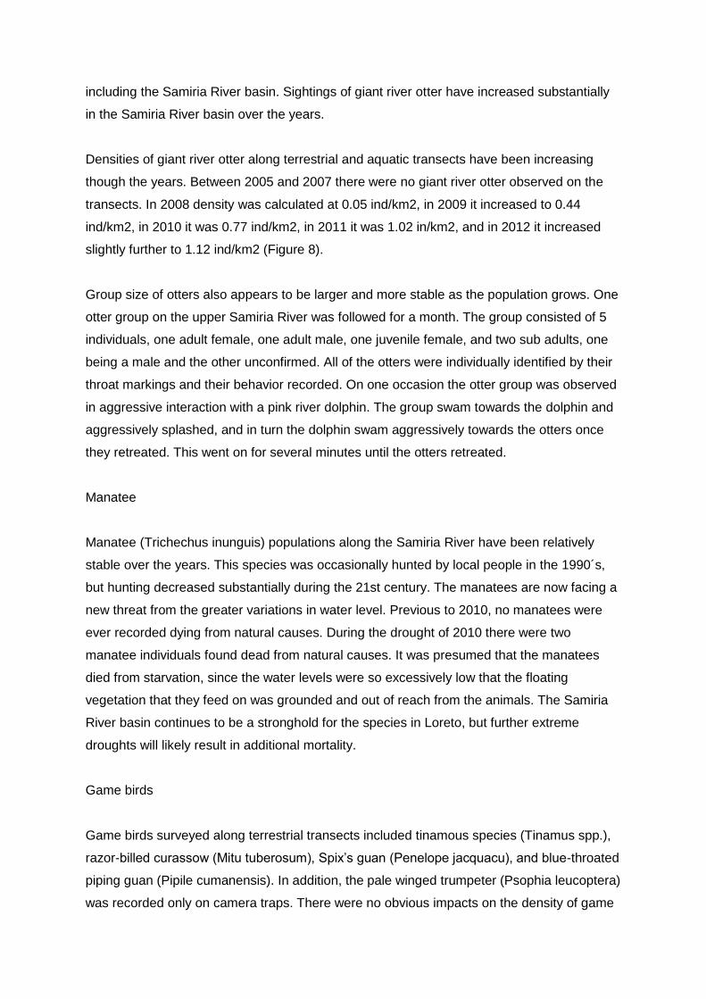
Densities of giant river otter along terrestrial and aquatic transects have been increasing
though the years. Between 2005 and 2007 there were no giant river otter observed on the
transects. In 2008 density was calculated at 0.05 ind/km2, in 2009 it increased to 0.44
ind/km2, in 2010 it was 0.77 ind/km2, in 2011 it was 1.02 in/km2, and in 2012 it increased
slightly further to 1.12 ind/km2 (Figure 8).
Group size of otters also appears to be larger and more stable as the population grows. One
otter group on the upper Samiria River was followed for a month. The group consisted of 5
individuals, one adult female, one adult male, one juvenile female, and two sub adults, one
being a male and the other unconfirmed. All of the otters were individually identified by their
throat markings and their behavior recorded. On one occasion the otter group was observed
in aggressive interaction with a pink river dolphin. The group swam towards the dolphin and
aggressively splashed, and in turn the dolphin swam aggressively towards the otters once
they retreated. This went on for several minutes until the otters retreated.
Manatee
Manatee (Trichechus inunguis) populations along the Samiria River have been relatively
stable over the years. This species was occasionally hunted by local people in the 1990´s,
but hunting decreased substantially during the 21st century. The manatees are now facing a
new threat from the greater variations in water level. Previous to 2010, no manatees were
ever recorded dying from natural causes. During the drought of 2010 there were two
manatee individuals found dead from natural causes. It was presumed that the manatees
died from starvation, since the water levels were so excessively low that the floating
vegetation that they feed on was grounded and out of reach from the animals. The Samiria
River basin continues to be a stronghold for the species in Loreto, but further extreme
droughts will likely result in additional mortality.
Game birds
Game birds surveyed along terrestrial transects included tinamous species (Tinamus spp.),
razor-billed curassow (Mitu tuberosum), Spix’s guan (Penelope jacquacu), and blue-throated
piping guan (Pipile cumanensis). In addition, the pale winged trumpeter (Psophia leucoptera)
was recorded only on camera traps. There were no obvious impacts on the density of game

birds from greater variations in water level. Similar to macaws, primates and other arboreal
wildlife, game birds are able to overcome the physical flooding. Overall numbers of game
birds was relatively similar between the hunting zones with a trend towards greater numbers
in the infrequently hunted zone, followed by the occasionally hunted zone and least in the
commonly hunted zone (F2,17=2.3146, P=0.1278). The density of game birds in 2012 was
around the long term average for all three hunting zones. Density of tinamous in the Samiria
River has gone through dips and peaks between 2004 to 2012 with no significant long term
trends (G=4.3755, gl=6, P= 0.626)(Figure 9a) and an average density at 4.39 ind/km2.
Densities in 2011 and 2012 were towards the lower end, at 2.40 and 2.01 ind/km2,
respectively.
Camera trap results had a capture rate of tinamous in 2009 at 104.54 captures per 1000 trap
days and in 2011 with 178.75 captures. Both the transects and camera traps show a healthy
and stable population of tinamous and no indication of the species impacted by climate
change variations in water level, whilst the transects have fallen slightly, the camera
encounters have increased. The tinamous density was similar in all three hunting zones
(F2,15= 0.8311, P=0.542). The razor-billed curassow was observed both on line transects
and on camera traps. Densities have been relatively constant between 2004 to 2012
(G=1.3613, gl=6, P=0.9682)(Figure 9b).
Density of razor-billed curassow was 0.20 ind/km2 in 2012. Camera traps recorded an
encounter rate in 2009 of 22.72 events per 1000 camera trap days and in 2011 there were
8.70 events. The results do not show any signs of razor-billed curassow being impacted by
climate change events, whilst camera trap encounters fell somewhat, transect densities have
increased slightly. The infrequently hunted zone had the greatest density of razor-billed
curassow, followed by the occasionally hunted zone. There were no sightings of this species
in the commonly hunted zone. The Spix’s guan has gone through some peaks and dips in
numbers on transects between 2004-2012, but overall has had a relatively stable population
(G= 3.3917, gl=6, P= 0.7583)(Figure 9c) with 2012 density at 1.02 ind/km2 being at a peak.
This indicates that the species has not been impacted by the climatic fluctuations in water
level.
Spix´s guan were not recorded on camera traps. The density of Spix’s guan was relatively
similar between the hunting zones with a trend towards higher density in the infrequently
hunted zone, followed by the occasionally hunted zone, and least in the commonly hunted
zone (H=1.6494, gl=2, P=0.4383). Blue-throated piping guan had a relatively stable
population between 2006 to 2012 (G=2.0177, gl=7, P=0.9589)(Figure 9d). The 2012 density
was slightly lower than the mean at 0.24 ind/km2, but still at healthy numbers.
Results indicated that blue-throated piping guan has not been impacted by recent water level
variations. Blue-throated piping guans were not recorded on camera traps. The infrequently
hunted zone had the greatest density, followed by the occasionally hunted zone. There were
no sightings of this species in the commonly hunted zone.
Pale winged trumpeters were recorded on camera traps and only rarely observed on
terrestrial transects. In 2009 camera traps recorded an encounter rate of pale winged
trumpeter at 13.63 events per 1000 camera trap days, which was similar to the 2011
encounter rate of 19.15 events. These results suggest that pale winged trumpeter were not
impacted by the recent fluctuations in water level.
Fish
Fish populations in the Samiria River have been impacted by the greater variations in water
level. This impact was evident in 2011, following the drought of 2010. The abundance of fish
remained stable, but the size of abundant species decreased indicating a demographic
change in the populations. It appears that changes in fish population impacted dolphin and
wading bird populations. Fish numbers and demographics do better in high water years
when fish can enter flooded forests for longer periods and exploit the abundance of food.
Many fish species reproduce in the flooded forest habitats and high water years usually
result in greater reproductive rates. Fish abundance was calculated using CPUE (catch per
unit effort) and showed differences along the Samiria River basin. The greatest abundance
of fish was in the mid section of the Samiria, followed by the lower section and lastly the
upper section (F2,14=4.1786, P=0.037). The fish populations along the Samiria River basin
showed an increase in numbers after 2007, at which point the populations abundance has
remained relatively stable through to 2012 (G= 0.6568, gl=6, P= 0.9954). Whilst overall
CPUE has remained stable, abundances of different species vary between years (Figure
10).
Differences were seen in the fish composition between the low water and high water
seasons along the Samiria River basin. In the mid section Liposarcus pardalis dominated the
CPUE in both seasons. However, in the low water season Hoplerythrinus unitaeniatus was
the next most abundant species followed by Pygocentrus nattereri.
During the high water season in the mid section of the river Pygocentrus nattereri was the
second most abundant species, followed by Serrasalmus rhombeus.
In the upper reaches of the Samiria River the most abundant species during the low water
season were Hoplerythrinus unitaeniatus, Liposarcus pardalis and Pygocentrus nattereri,
respectively. In contrast during the high water season the most abundant species were
Liposarcus pardalis, Chaetobranchus flavesens, and Mylossoma duriventrus, respectively.
Abundances between the two seasons showed that dominant fish species differed, reflecting
a change in the community structure of the fish populations. Demography used size
structure to evaluate the general health of the populations and analyses were done on
Astronotus ocellatus, Liposarcus pardalis, Prochilodus nigricans, Pygocentrus nattereri and
Serrasalmus rhombeus. All of the species, except Prochilodus nigricans showed a significant
decrease in size classes in 2011, reflecting degradation in the health of the populations
following the drought of 2010.
Populations show a recovery in 2012 following the record high waters of 2011.
Astronotus ocellatus “acarahuazu”
The demography of Astronotus ocellatus has been impacted by the variations in water level.
During the years 2007, 2008, the size of the largest catch of Astronotus ocellatus ranged
was 17 - 19 cm in length. In 2010 the size of the largest catch increased to 19-21 cm. In
2011, the size of the largest catch declined dramatically to 11-13 cm (Kolmogorov-Smirnov
(K-S), P>0.05) and in 2012 after intensive flooding the age structure shows signs of recovery
with the largest catch being 13-15 cm (Figure 11a).
Liposarcus pardalis “carachama”
The demography of Liposarcus pardalis has shown some signs of impact from the greater
variations in water level. The largest size catch of Liposarcus pardalis over the years 2007-
2010 has been in the range of 22-25 cm in length. In 2011 the largest size catch dropped to
19-22 cm, which was also the size in 2008 (K-S, P<0.01). After the high waters of 2011 and
2012 age of the largest catch has shown signs of recovery with an increase in the 22-25 cm
catch (Figure 11b).
Prochilodus nigricans “boquichico”
The demography of Prochilodus nigricans has not shown any impacts from the water level
variations. The largest size catch in the years 2007, 2008 and 2010 was 18-21 cm in length,
while the largest size catch in 2009 and 2011 was 21-24 cm, and in 2012 it was 15-17 cm
(K-S, P<0.05)(Figure 11c).
Pygocentrus nattereri “piraña roja”
The demography of Pygocentrus nattereri has been impacted by the variations in water
level. The largest size catch of Pygocentrus nattereri over the years 2007-2010 has been in
the range of 14-16 cm cm in length. In 2011 the largest size catch dropped to 12-14 cm and
had increases in the smaller 8-12 cm catches. In 2012 Pygocentrus nattereri shows signs of
recovery with increases in the 14-16 cm catches and decreases in the 8-12 cm catches (K-
S, P<0.05)(Figure 11d).
Serrasalmus rhombeus “piraña blanca”
The demography of Serrasalmus rhmbeus has been impacted by the variations in water
level. En el The largest size catch of Serrasalmus rhombeus over the years 2007-2010 has
been in the range of 13-15 cm in length. In 2011 the largest size catch dropped to 9-11 cm,
and had increase catches in the smaller sizes of 7-9 cm. In 2012, Serrasalmus rhmbeus has
shown signs of recovery with the largest catch size being 13-14 cm (K-S, P<0.05)(Figure
11e).
Caimans
Three species of caimans occur in the Pacaya-Samiria National Reserve, black caiman
(Caiman niger), spectacled caiman (Caiman crocodylus) and smooth fronted caiman
(Paleosuchus trigonatus). Black caiman were intensively overhunted during the 1950’s –
1970’s and have been recovering in the Samiria River over the past decades. The caimans
have not shown any lasting impacts from recent climate change events. However, during the
drought of 2010 there were short term impacts on the spectacled caiman population. The
spectacled caiman appeared to be impacted by the extreme low water levels, whereas the
black caiman appeared to be less affected.
The spectacled caiman had an overall lower abundance in the Samiria River during the
drought than their six year average with the upper section having 56% fewer, the mid section

having 27% fewer, and the lower section having 40% fewer. It appears that the drop was
due to spectacled caimans moving to more isolated habitats, because after the drought the
caiman populations returned to the more stable numbers. The black caiman abundances
were similar and did not show general declines, with the upriver section having very similar
numbers to previous years, the mid section having slightly fewer and the lower section
having greater numbers than previous years.
The abundance of caiman varies along the Samiria River.
The spectacled caiman (Caiman crocodilus) was the most abundant species along the
Samiria River and had greater numbers in the upper Samiria 1.06±1.02 ind./km, followed by
the mid section 0.67±0.43 ind./km and lowest at the mouth 0.082±0.051 ind./km (H=4.82,
gl=2, P=0.09). Black caiman (Melanosuchus niger) was the second most abundant species
and had greater numbers in the mid section 0.42±0.18 ind./km, followed by the upper
reaches 0.28±0.19 ind./km and least abundant at the mouth 0.42±0.18 ind./km (H=4.95,
gl=2, P=0.084). The smooth fronted caiman (Paleosuchus trigonatus) was the rarest species
along the Samiria River with similar abundances between all three sections of the river
ranging between 0.02±0.02 ind./km - 0.04±0.04 ind./km (H=1.004, gl=2, P=0.61). The
population of black caiman showed a trend towards increasing numbers after the extensive
overexploitation of the 1950´s to 1970´s (H=28.42, gl=9, P=0.0014). More recently, between
2006-2012 the black caiman has had a more stable abundance (b=1.5086, t=0.3016,
P=0.7070)(Figure 12a). The spectacled caiman population decreased significantly when
black caiman began to recover (b=-3.346, t=-5.3279, P=0.0007), but have been relatively
stable since 2006 (b=-1.2199, t=-0.2331, P=0.8223)(Figure 12b). The smooth fronted
caiman has had a relatively stable population over the years along the Samiria River. The
habitat use of the caiman also differed in the Samiria according to the species. The common
caiman had the greatest abundance in the river habitat, followed by the lake habitat and was
least abundant in the channels. The black caiman showed a similar pattern and had the
greatest abundance in the river habitat and similar abundances in lakes and channels. The
smooth fronted caiman was only found in the river habitat. There was a relationship between
the black caiman, common caiman and the white piranha (Serrasalmus rhombeus).
The greater the densities of white piranha the more abuandant the caiman species,
indicating the correlation between food resources and caiman numbers. A reverse trend was
found with the smooth fronted caiman.
Cocama Indigenous People
The greater variations in water level caused by recent climate change events is beginning to
have an impact on the sustainability of resource use by the local Cocama Indians who use
the Samiria River as their traditional area. The Cocama live in the flooded forests and have
adapted to the seasonal fluctuations in the use of natural resources. During high water
fishing is more difficult, since the fish are dispersed throughout the inundated forests.
However, during this period hunting usually becomes easier with the large bushmeat
species, such as deer, peccaries and tapir being trapped on the levees.
However, the recent climate change events have resulted in a decline in bush meat species,
resulting in both fewer animals to hunt and hunting becoming less sustainable. The Cocama
now have to rely more on fishing during the high water season, when fish are more difficult
to catch. The size of commonly used fish decreased after the drought, which means that
people had to capture greater numbers to maintain the same protein intake. This requires
greater effort and less sustainable fisheries, since more fish need to be captured. More
recently, the fish population has recovered resulting in a more sustainable fishery.
The sustainability of bush meat hunting by the Cocama in the Samiria River basin was
evaluated using stock’recuitment analysis. The stock-recruitment model is based on density-
dependent population models that use maximum sustained yield estimates (MSY) and
carrying capacity (K). Most species of tropical wildlife that are hunted are K-selected species
and should therefore have density-dependent recruitment. In turn, sustainable harvests of
tropical wildlife populations will depend on relationships between rate of recruitment and
population size. The stock-recruitment model predicts the riskiness of harvests for different
populations sizes. A species population in a hunted area can be compared to a predicted K
and MSY. This is accomplished by comparing the density of the hunted population (N) to an
estimated K as N/K.
Harvesting species at the MSY is a risky management strategy and should be avoided.
Similarly, harvesting species with small base populations (to the left of MSY) is a risky
management strategy and should be avoided. Harvesting species with large base
populations (to the right of MSY), on the other hand, is a safe management strategy that can
be used for long-term sustainable use of a species. In the Samiria River basin densities of
mammals in nonhunted areas were used to estimate K. MSY was set at 60% of K for
peccaries, deer, and large rodents and 80% of K for lowland tapir and primates.
The sustainability of bush meat hunting has decreased significantly since the climatic
changes in water level variation began in 2009. The hunting pressure has not increased, but
declined since 2000. The changes in the sustainability appear to be due to the impact that
climate change is having on bush meat species.
In 2000, the only species that was hunted with a risk in sustainability was the lowland tapir.
Collared peccary, white-lipped peccary, red brocket deer and black agouti were all hunted
safely. The conservation actions that were implemented through community based wildlife
management have resulted in a healthier tapir population, and by 2009-2010 the tapir was
hunted safely in terms of sustainable use. However, other bush meat species have declined
since the climatic variations began.
The first species to be impacted was the collared peccary and in 2009-2010 the hunting of
collared peccary became risky. The other bush meat species were hunted safely in 2009-
2010. By 2011 the impact of climatic change on the sustainability of hunting became evident,
with collared peccary, white-lipped peccary, red brocket deer and black agouti all becoming
risky in terms of hunting sustainability.
The only species that remained as safe was the lowland tapir, because of a reduction in
hunting pressure by the Cocama as a result of conservation and sustainable use actions.
Conclusions Conservation activities produce the best results when professionals,
institutions, local communities and reserve authorities work together.
The monitoring activities conducted by the Earthwatch expeditions helped to collect
information on a variety of wildlife populations, which is helping determine whether the
current climate change variations in water level are impacting the wildlife and people of the
Samiria River basin (Bodmer et al. 2012). Water level is a reliable measure of climate
change for several reasons. Water level has a gradual increase and decrease in the upper
Amazon and is a steady measurement, unlike temperature or rainfall which can vary greatly
even on a daily basis. Water level in the upper Amazon is similar over very large areas and
in not site specific, in contrast to rainfall which can vary significantly even at sites in close
proximity. Water level is also very easy to measure and records have been taken in the
Amazon for over 100 years, so long term trends are available.
Lastly, water level has both direct and indirect impacts on wildlife and the flooded forests are
where this impact is the greatest and can be measured easiest (Bodmer et al. 2011). The
variation in water level is impacting the dolphins. The drought of 2010 caused many dolphins

to leave the Samiria River. In addition, the annual sighting of dead pink river dolphins floating
down the Samiria is usually 1 or 2 individuals. However, during the drought there were 6
dead pink dolphins seen along the Samiria and the number of sightings of dead individuals is
only a proportion of the actual mortality. Sightings of dead grey dolphins are much rarer.
Mortality in manatees was also seen in 2011 for the first time presumably due to a lack of
access to their major food resource, the floating vegetation, which was high and dry and out
of their reach. Major food resources for the dolphins are piranha fish and there are good
correlations between the abundance of piranha and dolphins, both pink and grey. Results
showed that piranhas are one of the fish species that have been impacted by recent climate
changes in water level. The age structure of the two most abundant species decreased
during the drought indicating deterioration in the demography of the species.
In turn, it is likely that the decrease in fish size was impacting the food resources of the
dolphins, reflected in the declining dolphin abundances. In 2012, following two years of high
water levels, both the dolphin and fish show signs of recovery. The greater proportion of
young dolphins in the Samiria may be a population response to the declining populations.
Density dependent mechanisms would predict a younger demography after a perturbation in
the population. The younger dolphin population may also lead to a recover in dolphin
numbers and a growing population in the coming years, if conditions of climate change
stabilize. Wading bird populations also showed an impact from the drought. The great egret
and Neotropical cormorant seasonally migrate in large numbers to the mouth of the Samiria
River as the fish fry move out of the flooded forests. It is common to sight over 7,000
Neotropical cormorants and 2,000 great egrets during a single transect at the mouth during
the low water season. In 2011, there were significantly fewer wading birds at the mouth, and
many cormorants and egrets were seen searching for fish on the Maranon River and the mid
section of the Samiria River. It appears that the number of fish fry were lower and the birds
had to look for food in other areas than the usual dry season feeding waters. Similar to the
dolphins, it appears to be the impact on the fish populations that caused the decline in
observed numbers of wading birds after the drought.
Similar to the dolphins, wading bird numbers recovered in 2012 after two high water
seasons, reflecting a recovery in fish populations. Fish populations were impacted the
greatest by the drought during the low water season of 2010 and consequences were seen
during 2011. Fish mortality during the drought was substantial both because of the lack of
deep water and the anoxic conditions. Water depth was only a foot or so deep in many
lakes, channels and the river, which also caused greater competition, predation and
movement out of the Samiria River into the larger Maranon and Amazon Rivers. The
production of fish during the 2011 high water season was likely reduced substantially
because of the adult mortality from the drought.
Indeed, in 2012 after two consecutive high water years fish populations show recovery in
demography and numbers. Fish populations usually rebound quite rapidly from poor
conditions, which appears to be the case in 2012.
Terrestrial ungulates, including peccaries, brocket deer and lowland tapir, are also being
impacted by the greater variations in water level. These ground dwelling species are
impacted by the high water levels that reduce the availability of dry ground during the high
water season. There are multiplier effects that are causing the ungulates to decline under
these conditions. With less dry land during extreme floods the food availability decreases,
since food resources are directly proportional to the amount of dry land. Thus, the carry
capacity also declines and both inter and intra specific competition increases. The camera
traps set during the high water season in 2011 clearly showed the consequences of this
reduced food availability and increased competition, with many peccaries, deer and tapir
showing signs of emaciation.
Ungulates populations also become more vulnerable to predation when they are restricted to
floodplain levees during high water. Predators such as jaguars and pumas seek out the
levees and prey on the ungulates. It would be expected that the predators would actually do
better during these extreme floods seen in recent years, and camera trap results confirmed
this prediction. Species that rely on arboreal food resources, such as fruits, leaves, insects
or other prey have not been affected by the climatic changes in water level.
Wildlife groups such as macaws, primates, arboreal edentates and carnivores inhabit the
forest above the physical impacts of flooding. It also appears that the forest fruit production
has not been effected by the water level variations, and some groups that depend on the
fruits have increased, while others have remained stable. Likewise, the insects and other
arboreal prey resources are still in abundance, since they move vertically up the trees during
floods. This was reflected by a stable population of arboreal edentates and carnivores. The
giant river otter and caiman populations have also shown no signs of impact from water level
changes. Giant river otter are still in a growth phase from the massive overexploitation that
occurred between the 1950´s and 1970´s.
Their populations are still well below the carrying capacity and it is likely that the decrease in
their preferred fish was not drastic enough to impact the steady growth of their population.
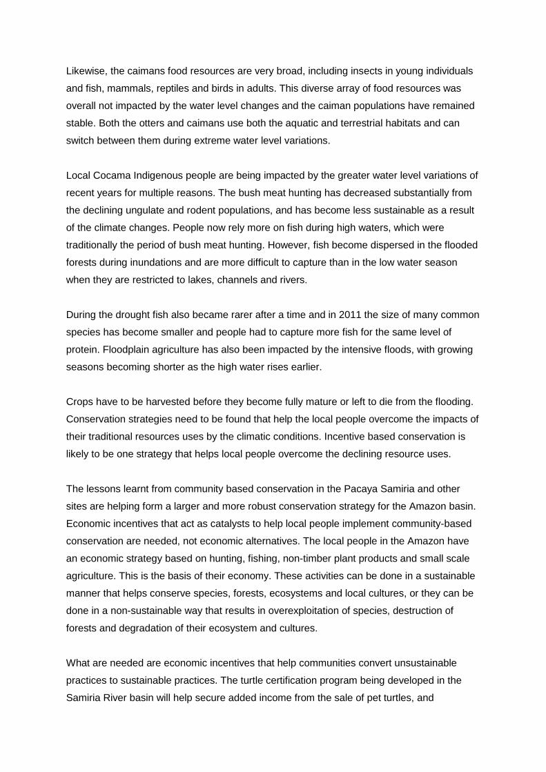
Likewise, the caimans food resources are very broad, including insects in young individuals
and fish, mammals, reptiles and birds in adults. This diverse array of food resources was
overall not impacted by the water level changes and the caiman populations have remained
stable. Both the otters and caimans use both the aquatic and terrestrial habitats and can
switch between them during extreme water level variations.
Local Cocama Indigenous people are being impacted by the greater water level variations of
recent years for multiple reasons. The bush meat hunting has decreased substantially from
the declining ungulate and rodent populations, and has become less sustainable as a result
of the climate changes. People now rely more on fish during high waters, which were
traditionally the period of bush meat hunting. However, fish become dispersed in the flooded
forests during inundations and are more difficult to capture than in the low water season
when they are restricted to lakes, channels and rivers.
During the drought fish also became rarer after a time and in 2011 the size of many common
species has become smaller and people had to capture more fish for the same level of
protein. Floodplain agriculture has also been impacted by the intensive floods, with growing
seasons becoming shorter as the high water rises earlier.
Crops have to be harvested before they become fully mature or left to die from the flooding.
Conservation strategies need to be found that help the local people overcome the impacts of
their traditional resources uses by the climatic conditions. Incentive based conservation is
likely to be one strategy that helps local people overcome the declining resource uses.
The lessons learnt from community based conservation in the Pacaya Samiria and other
sites are helping form a larger and more robust conservation strategy for the Amazon basin.
Economic incentives that act as catalysts to help local people implement community-based
conservation are needed, not economic alternatives. The local people in the Amazon have
an economic strategy based on hunting, fishing, non-timber plant products and small scale
agriculture. This is the basis of their economy. These activities can be done in a sustainable
manner that helps conserve species, forests, ecosystems and local cultures, or they can be
done in a non-sustainable way that results in overexploitation of species, destruction of
forests and degradation of their ecosystem and cultures.
What are needed are economic incentives that help communities convert unsustainable
practices to sustainable practices. The turtle certification program being developed in the
Samiria River basin will help secure added income from the sale of pet turtles, and
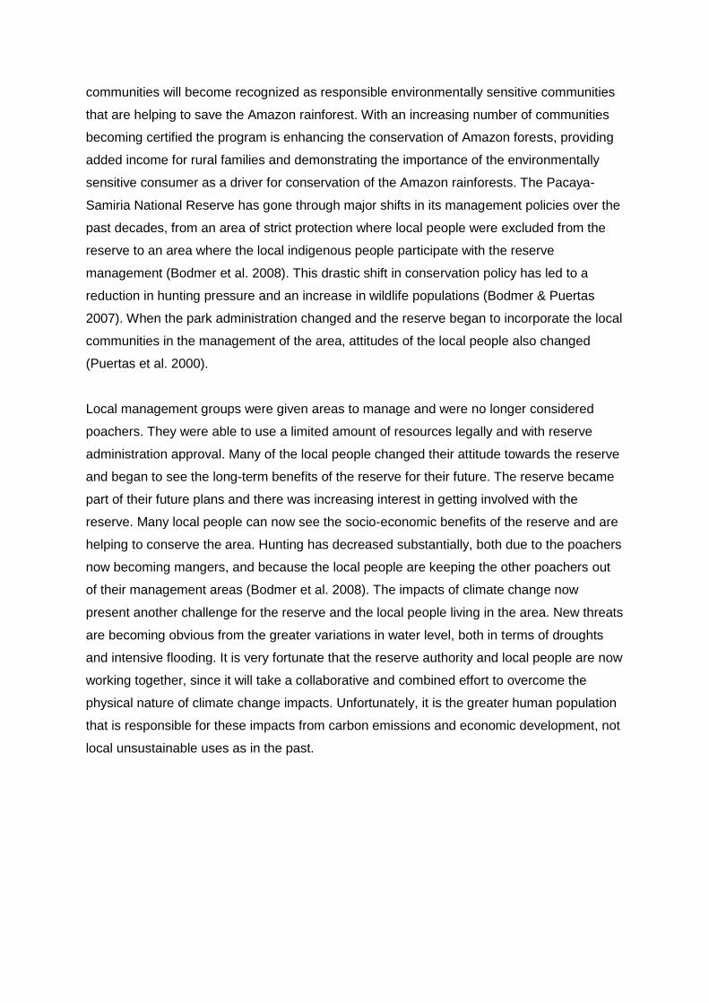
communities will become recognized as responsible environmentally sensitive communities
that are helping to save the Amazon rainforest. With an increasing number of communities
becoming certified the program is enhancing the conservation of Amazon forests, providing
added income for rural families and demonstrating the importance of the environmentally
sensitive consumer as a driver for conservation of the Amazon rainforests. The Pacaya-
Samiria National Reserve has gone through major shifts in its management policies over the
past decades, from an area of strict protection where local people were excluded from the
reserve to an area where the local indigenous people participate with the reserve
management (Bodmer et al. 2008). This drastic shift in conservation policy has led to a
reduction in hunting pressure and an increase in wildlife populations (Bodmer & Puertas
2007). When the park administration changed and the reserve began to incorporate the local
communities in the management of the area, attitudes of the local people also changed
(Puertas et al. 2000).
Local management groups were given areas to manage and were no longer considered
poachers. They were able to use a limited amount of resources legally and with reserve
administration approval. Many of the local people changed their attitude towards the reserve
and began to see the long-term benefits of the reserve for their future. The reserve became
part of their future plans and there was increasing interest in getting involved with the
reserve. Many local people can now see the socio-economic benefits of the reserve and are
helping to conserve the area. Hunting has decreased substantially, both due to the poachers
now becoming mangers, and because the local people are keeping the other poachers out
of their management areas (Bodmer et al. 2008). The impacts of climate change now
present another challenge for the reserve and the local people living in the area. New threats
are becoming obvious from the greater variations in water level, both in terms of droughts
and intensive flooding. It is very fortunate that the reserve authority and local people are now
working together, since it will take a collaborative and combined effort to overcome the
physical nature of climate change impacts. Unfortunately, it is the greater human population
that is responsible for these impacts from carbon emissions and economic development, not
local unsustainable uses as in the past.
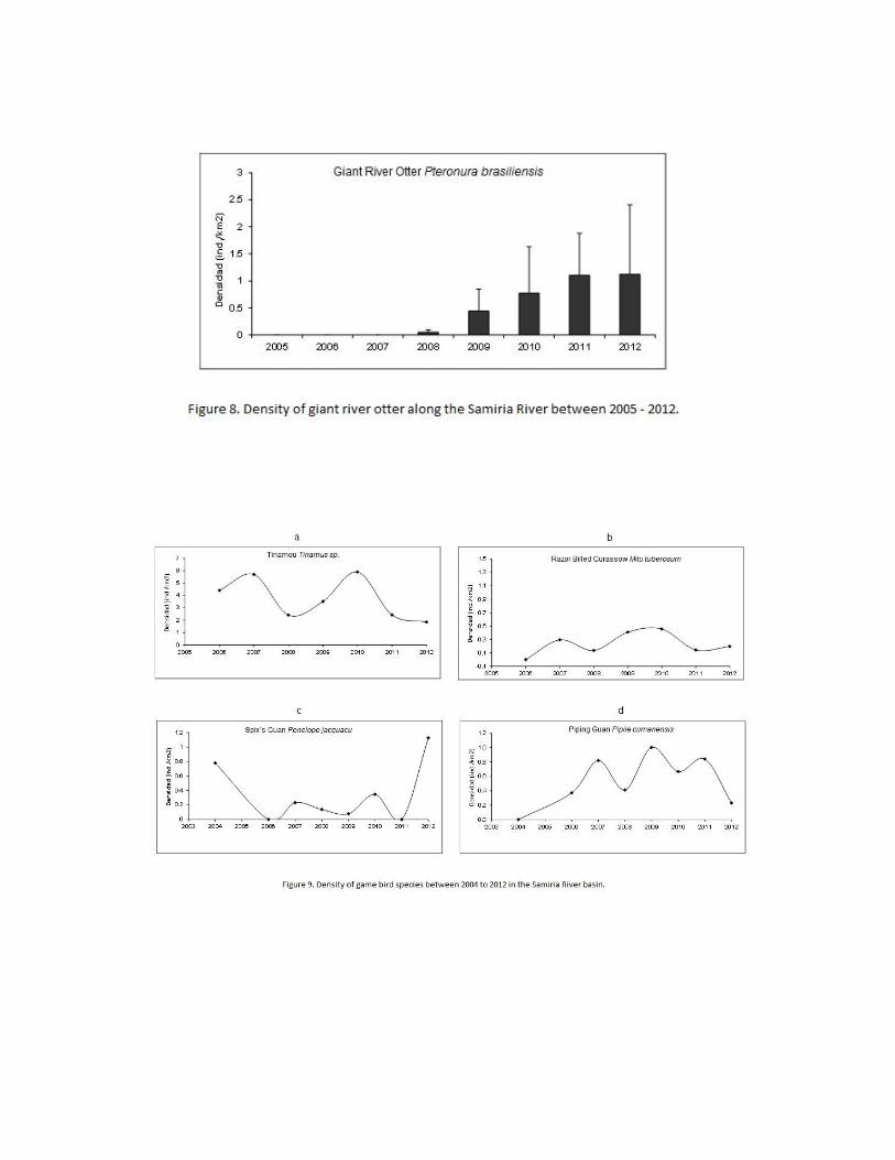
0.00
0.50
1.00
1.50
2.00
2.50
3.00
3.50
4.00
4.50
5.00
2006 2007 2008 2009 2010 2011 2012
CP
UE
(In
d/h
ora
s/re
d)
Pygocentrus nattereri
0.00
1.00
2.00
3.00
4.00
5.00
6.00
2006 2007 2008 2009 2010 2011 2012
CP
UE
(In
d/h
ora
s/re
d)
Liposarcus pardalis
0.00
0.10
0.20
0.30
0.40
0.50
0.60
0.70
0.80
0.90
2006 2007 2008 2009 2010 2011 2012
CP
UE
(In
d/h
ora
s/re
d)
Serrasalmus rhombeus
0.00
0.10
0.20
0.30
0.40
0.50
0.60
0.70
0.80
0.90
2006 2007 2008 2009 2010 2011 2012
CP
UE
(In
d/h
ora
s/re
d)
Prochilodus nigricans
0.00
0.50
1.00
1.50
2.00
2.50
3.00
2006 2007 2008 2009 2010 2011 2012
CP
UE
(In
d/h
ora
s/re
d)
Astronotus ocellatus
Figure 10. CPUE of common fish species in the Samria River between 2006 – 2012.
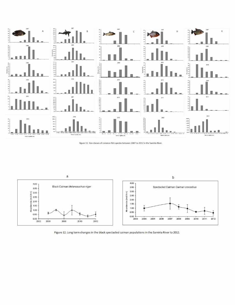
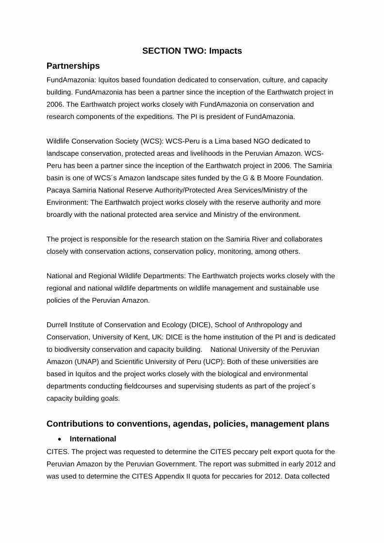
SECTION TWO: Impacts
Partnerships
FundAmazonia: Iquitos based foundation dedicated to conservation, culture, and capacity
building. FundAmazonia has been a partner since the inception of the Earthwatch project in
2006. The Earthwatch project works closely with FundAmazonia on conservation and
research components of the expeditions. The PI is president of FundAmazonia.
Wildlife Conservation Society (WCS): WCS-Peru is a Lima based NGO dedicated to
landscape conservation, protected areas and livelihoods in the Peruvian Amazon. WCS-
Peru has been a partner since the inception of the Earthwatch project in 2006. The Samiria
basin is one of WCS´s Amazon landscape sites funded by the G & B Moore Foundation.
Pacaya Samiria National Reserve Authority/Protected Area Services/Ministry of the
Environment: The Earthwatch project works closely with the reserve authority and more
broardly with the national protected area service and Ministry of the environment.
The project is responsible for the research station on the Samiria River and collaborates
closely with conservation actions, conservation policy, monitoring, among others.
National and Regional Wildlife Departments: The Earthwatch projects works closely with the
regional and national wildlife departments on wildlife management and sustainable use
policies of the Peruvian Amazon.
Durrell Institute of Conservation and Ecology (DICE), School of Anthropology and
Conservation, University of Kent, UK: DICE is the home institution of the PI and is dedicated
to biodiversity conservation and capacity building. National University of the Peruvian
Amazon (UNAP) and Scientific University of Peru (UCP): Both of these universities are
based in Iquitos and the project works closely with the biological and environmental
departments conducting fieldcourses and supervising students as part of the project´s
capacity building goals.
Contributions to conventions, agendas, policies, management plans
International
CITES. The project was requested to determine the CITES peccary pelt export quota for the
Peruvian Amazon by the Peruvian Government. The report was submitted in early 2012 and
was used to determine the CITES Appendix II quota for peccaries for 2012. Data collected
from the Earthwatch project were used in the analysis. (The document is included in the
Appendix of this report).
CITES: Peccary pelt certification and turtle certification have been incorporated as part of the
CITES-Peru agenda, and peccary certification is being used by CITES as a model for other
wildlife programs. BioCAN: Wildlife management in Andean Community Pact countries.
The project is involved with the BioCAN initiative to develop wildlife conservation policy
across the Andean Community.
National or regional
The project produced a detailed report on the impact of climate change on wildlife in the
Samiria River basin for the Ministry of the Environment, completed in June 2012. The report
is being used to evaluate the impact of climate change in protected areas in Peru. (The
document is included in the Appendix of this report).
Local
The project has been working closely with the Pacaya-Samiria National Reserve Authority
on implementing management actions and community-based involvement in the reserve
according to the Reserve Management Plan. During every expedition meetings are held with
the Reserve Authority and local community representatives at the headquarters in the
Samiria River. Involvement in Management Plan Activities in 2011 included support for
community projects, support for the turtle headstarting program, support for vigilance
activities, support for workshops, among others.
Developing Environmental Leaders
Capacity building Capacity building of local professionals, communities, park guards,
students and government officials by the project is key to the long term goals. Monitoring
information collected by the Earthwatch project is used in fieldcourses, workshops,
conferences and meetings. Fieldcourses and workshops held on the Samiria River allow on-
the-ground information transfer and training. The Earthwatch project is the only institution
that provides field based courses in the Pacaya Samiria National Reserve to students,
professionals, NGOs and government officials. Latin American Wildlife Conservation At
an international level the PI and his team are involved with the Latin American Wildlife
conferences (CIMFAUNA) and helping create a Latin American Wildlife Society
(COMFAUNA) with a Latin American Wildlife journal (REMFAUNA)(www.comfauna.org)
funded by the Gordon and Betty Moore Foundation. The CIMFAUNA conferences are
approaching their 22 year with 11th conference to be held in 2014. The conferences have
historically been an important mechanism in promoting the success of community base
wildlife management in Latin America, among many other aspects of wildlife conservation,
such as endangered species conservation, landscape approaches, wildlife health, among
others. The society COMFAUNA will build on the achievements of the conferences by
forming a community of professional, indigenous people, students and governmental and
non-governmental institutions to help guarantee the long term influence that wildlife
conservation has on policy, programs, and the future generations of wildlife specialists and
indigenous people. The results of monitoring conducted by the Earthwatch project will be
used by the Latin American Wildlife Society to influence wildlife conservation throughout the
continent of Central and South America, via the journal (REMFAUNA) and the conferences
CIMFAUNA.
Actions or activities that enhance natural and/or social capital
The project is involved with the turtle head starting program. This program involves the
collection of turtle eggs from natural nests that are then relocated to artificial beaches at
guard posts and management group huts. Once the eggs hatch the young turtles are kept in
tanks for one to two weeks and fed natural food. The turtles are then released back to the
river. This program gives a better chance of survival for the turtles by 1) protecting nests
during incubation and 2) protecting turtles during their first weeks in the water. Earthwatch
volunteers during the July to October expeditions help with egg translocation and turtle
releases when opportunity arises. Because these activities depend on the park
administration program we do not include them as a confirmed activity of the expedition.
Conservation of Taxa
For information on the baseline population, population trends, impacts by the project and
conservation status please consult the Research Report section of this document, which
provides details on all species listed below. pink river dolphin (Inia geoffrensis): rare grey
river dolphin (Sotalia fluviatilis) chestnut-fronted macaw (Ara severus) blue & yellow macaw
(Ara ararauna) red-bellied macaw (Orthopsitaca manilata) scarlet macaw (Ara macao)
red & green macaws (Ara chloroptera) Neotropical cormorants (Phalacrocorax brasilianus)
great egrets ( Ardea alba) wattled jacana (Jacana jacana) cocoi heron (Ardea cocoa)
snowy egret (Egretta thula) woolly monkeys (Lagothrix poeppigii): rare howler monkey
(Alouatta seniculus) brown capuchin monkey (Cebus apella) monk saki monkey (Pithecia
monachus) squirrel monkey (Saimiri boliviensis) saddled back tamarin (Saguinus
fuscicollis) white capuchin monkey (Cebus albifrons) white-lipped peccary (Tayassu pecari)
collared peccary (Tayassu tajacu) red brocket deer (Mazama americana) lowland tapir
(Tapirus terrestris) black agouti (Dasyprocta fuliginosa) Amazon squirrel (Sciurus
spadiceus/igniventris) tamandua (Tamandua tetradactyla) three toed sloth (Bradypus
variegatus) coati (Nasua nasua) tyra (Eira barbara) Jaguar (Panthera onca): vulnerable
puma (Puma concolor) ocelot (Leopardus pardalis) jaguarundi (Felis yaguaroundi) margay
(Felis wiedii) giant river otter (Pteronura brasiliensis): endangered manatee (Trichechus
inunguis); vulnerable tinamous species (Tinamus spp.) razor-billed curassow (Mitu
tuberosum) Spix’s guan (Penelope jacquacu) blue-throated pipin guan (Pipile cumanensis)
black caiman (Caiman niger): vulnerable spectacled caiman (Caiman crocodylus) smooth
fronted caiman (Paleosuchus trigonatus)
Conservation of Habitats
Flooded varzea forests are being conserved through wildlife conservation programs of the
Pacaya Samiria National Reserve. One of the guidelines for managing wildlife is the
maintenance and improvement of wildlife habitat in its natural state. This guideline ensures
that local people conserve natural habitats, and is an important conservation strategy for
conserving Amazon forests. The project is working with the regional and national
government of Peru and the Andean Community (CAN) to include the wildlife habitat
guideline in national and multi-national (CAN) wildlife laws, thus helping to conserve
Amazonian forests more broadly.
Ecosystem Services
The project is helping to conserve the largest fisheries reproduction area in the Peruvian
Amazonia, the 20,000 km2 Pacaya Samiria National Reserve. During high water periods
90% of the reserve floods, literally becoming an inland sea. During floods fish enter the
water laden forests and feed on the abundance of vegetative and animal production,
especially the abundance of fruits, invertebrates and other living organisms trapped in the
annual. The abundance of food improves the condition of fish and in turn allows for high
reproductive rates with many fish populations reproducing within the inundated forests. The
fisheries of the Peruvian Amazon depend on the flooded forests of the Pacaya Samiria
National Reserve. If the reserve was deforested the entire fisheries in the Peruvian Amazon
of Loreto would collapse. In addition, many other species such as dolphins, caimans, wading
birds, otters, among others rely on the fish production of the flooded forests to maintain
healthy populations. The project is helping to conserve this massive flooded forest and its
ecosystem service of maintaining healthy fish populations.
The flooded forests have high productivity and are an important terrestrial carbon
sink. The project is helping to conserve the intact forests and maintain the avoided
deforestation carbon sink services. In addition, the project is helping to conserve Amazon
forests more broadly by including habitat conservation as a wildlife management guideline
with the Peruvian national wildlife law and the Andean Community wildlife agreement. This in
turn will help conserve intact Amazonian forests as terrestrial carbon sinks.
Conservation of Cultural Heritage
The Project has restored the last remaining historic boats of the Peruvian Amazon. Currently
the project has restored three ships and three launches, including the rubber ships Ayapua
built in Hamburg, Germany in 1906 and the Rio Amazonas built on the Clyde, Scotland in
1899; and the navel ship Clavero built in Paris, France in 1876, which is the oldest boat still
navigating the Amazon River. The project is the only institution that has historic boats in the
Amazon, apart from the Peruvian Navy that has one restored ship. In 2004 the project
embarked on a program to restore the last remaining historic ships and launches of the
Peruvian Amazon before they were lost, in order to preserve this important cultural history of
the Peru. The ships have been restored to their original Victorian splendor with many navel
antiques and other artifacts incorporated. The Rio Amazonas is still undergoing restoration.
The project has restored a national protected monument in the city of Iquitos, the Casa
Morey, a rubber baron´s mansion dating from 1910. The rubber boom between 1890 and
1914 was an extremely important economic, social and cultural period for the Amazon where
wealth was created through the collection of natural rubber that was used during the
industrial period. Luis Morey, one of the wealthiest rubber barons, built the Casa Morey
using material from Europe, including Spanish tiles, iron pillars from Scotland and other fine
materials. After years of neglect and misuse the Casa Morey was deteriorated when the
project acquired the building and restored it to its original splendor incorporating many
original features and details of the period. The project will be building a small museum on
the Indigenous Cultures of the Amazon in 2013-2014. This museum will be dedicated to the
Indian cultures of the Amazon basin and will have around 300 artifacts displayed on the
different indigenous groups, including material used in ceremonies, hunting and fishing, and
daily life. Iquitos currently does not have a proper museum and this project would enhance
the cultural attributes of the city (see Appedix 3 for project description).
Impacting Local Livelihoods
The project is working on sustainable use and incentive based conservation through peccary
and turtle certification as a means of improving livelihoods of rural indigenous communities.
The peccary and turtle certification programs are a mechanism to increase the economic
value of resources through sustainable use and conservation. Local communities and
management groups who conserve areas for wildlife and habitats, and use natural resources
sustainable can obtain certification as “good managers of wildlife and forests.” This
certification then allows communities and management groups to sell certain products,
including peccary pelts and pet turtles, as certified products and attain added economic
value. Thus, these communities can improve their livelihoods by becoming good managers
and implementing conservation and sustainable use actions. Annual verification of continued
good practices means that the communities and management groups have to continue their
efforts in order not to lose their certification. This program links biodiversity and habitat
conservation with community based efforts that improve livelihoods and help conserve
Amazonian forests. The project also hires a monthly average of 20 local people for staff as
field assistants, boat crew and other opportunities.
Local community activities
The project has always taken the approach that research and conservation activities should
use an interdisciplinary approach to find a balance between the needs of the indigenous
people and the conservation of the animals and plants. This project is helping to conserve
wildlife, not only for saving the biodiversity of the Amazon, but also as a means of helping
the poor indigenous people who rely on these resources for their food and shelter. The
project is working together with the local people, because they are the true guardians of the
forest, and information provided by this research can help the indigenous people make
appropriate decisions on how best to save the Amazon forests. Local people are taking
actions in places like the Pacaya-Samiria Reserve which is an examples of how things are
changing; it is an example of how conservation can work in collaboration with local people,
governments and NGO’s.
Dissemination of research results
Scientific peer-reviewed publications
Bodmer, R.E., P.E. Puertas, M.S. Antúnez, T.G. Fang, and G. Gil (2012). Monitoreo de
Fauna Silvestre e Implicancias de Impacto de Fluctuaciones Climaticas en la Reserve
Nacional Pacaya Samiria, Loreo – Peru. WCS, pp. 171.
Swan, N. and R. Bodmer (In Press). Interspecific population dynamics of caimans in the
Peruvian Amazon. Latin American Wildlife Journal – RemFauna.
Bodmer, R., Fang, T. Puertas, P. and M. Antunez (In Press). Population responses of
aquatic and terrestrial wildlife to climatic fluctuations in water level in the Peruvian Amazon.
Latin American Wildlife Journal – RemFauna.
Handrahan, E. and R. Bodmer (In Press). Historic Boats of the Peruvian Amazon. Wust
Publications.
Grey literature and other dissemination
Printed
1) Pittet , M. (2012). Towards an effective monitoring methodology for key mammal species
in the Pacaya Samiria National Reserve, Peru. MSc Thesis, DICE, University of Kent, UK.
2) Swan, N. (2012). The status and conservation of the black and spectacled caiman within
a national reserve in the Peruvian Amazon. MSc Thesis, DICE, University of Kent, UK.
3) Nakamura, M. (2012). Feasibility of a certification system for trade in freshwater turtles
from the Peruvian Amazon. MSc Thesis, DICE, University of Kent, UK
4) Bodmer, R.E. y T.G. Fang (2011). Evaluación de Pecaríes en la Amazonia Peruana de
Loreto para las Cuotas Máximas Sostenibles 2013. Report submitted to Dirrecion General
Foretal y Fauna, Ministerio de Agricultura, Peru, pp. 127.
5) Bodmer, R., Walkey, M., Puertas, P. and M. Antunez (2012). Conservation research,
monitoring and management of fish populations in the Samiria River of the Pacaya-Samiria
National Reserve. Report to WCS-Peru, pp.28.
6) Bodmer, R., Puertas, P. and M. Antunez (2012). Conservation Status of Caiman
Populations in the Samiria River of the Pacaya-Samiria National Reserve. Report to WCS-
Peru, pp 18.
7) Bodmer, R., Puertas, P. and M. Antunez (2012). Monitoreo de guacamayos como
indicadores de hábitats terrestres de la cuenca del Samiria, Reserva Nacional Pacaya-
Samiria. Report to WCS- Peru, pp 30.
8) Bodmer, R.E., P.E. Puertas, M.S. Antúnez, T.G. Fang, and G. Gil (2012). Monitoreo de
especies indicadoras para evaluar el impacto del cambio climático en la cuenca del Samiria,
Reserva Nacional Pacaya-Samiria. Report to Ministry of the Environment, Peru, pp 160.
9) Plus 15 BSc thesis projects.
Meetings
1) R. Bodmer gave one plenary talk, two session talks and organized one workshop at the
10th Amazon and Latin American Wildlife Conference, May 2012, Salta Argentina

2) R. Bodmer gave a plenary talk at the South American CITES workshop on livelihoods,
Lima July 2012, Lima, Peru.
3) R. Bodmer gave a plenary talk at the BioCAN (Andean Community) meeting on
developing wildlife laws for CAN, August 2012, Lima, Peru.
4) R. Bodmer helped organize and gave a plenary talk at the workshop on Climate change
impacts in the Peruvian Amazon, September 2012, Iquitos, Peru.
TV Documentaries
1) The March 2012 Earthwatch expedition was part of a National Peruvian TV documentary
on the Peruvian Amazon, entitled “Amazonia, Ruta Maravilla”
2) The project was involved with the BBC 2 Documentary “The Dark”.
SECTION THREE: Anything else
Project funding
USAID/WCS/SPDA - ICAA 2: Theproject has a sub grant within this larger initiatve that funds
community based conservation work in the Samiria River Basin. The sub grant is for three
years. Annual fundeing of the sub grant is $60,000.
The Gordon & Betty Moore Foundation: The project receives funds to help create a Latin
American Wildlife Society and help support the Latin American Wildlife Conferences. Annual
support to the project in Peru ia $35,000.
Other fundings sources are being sought and will be report on upon successful application.
Is there anything else you would like to tell us?
Acknowledgements
We would like to thank the following biologists for their hard work on the project in 2012:
Pablo Puertas Melendez, Andy Bicerra Canayo, Tula Fang Monge, William Bodmer,
Kimberlyn Chota Pinedo, Fatima Sanchez Mosqueda, and Gabriel Mori Isapillo. We would
like to thank the following Earthwatch volunteers for their valuable time and focused
dedication on the project in 2012: Sian Pety, Charles Whitfield, Katherine Petty, Alec
Connah, Robert Petty, Dorothy Zales, William Zales, Maria Chatzinakis, Sarah Nunneley,
Charles Johnson, Donna Popp, Arleda Watson, Diane Coiner, Janice Leal, Ian Mackenie,
Jack Burtt, Sally Summers, Darren Butcher, Linda Huentinck, John Huentick, Allyn
Schneider, Ruth Fitzpatrick, Graham Massey, Allison Massey, June Buckenham, Judith
Gillete, Bruce Halls, Elizabeth Morris Hughes, Gary Wehrman, Philip Vitiello, Janet Vitiello,
Allison Lee, Richard Jon Barlow, Mat Ali Mmohd Ezam, Katherine Grose, Paul Joy, Anne
Luke, Edward Talbot, Chris Franklin, Jane Mcmurtie, Sarah Blodett, Patricia Mcmillen,
Samuel Bader, Michael Staszkiw, Antoine Tardif, Ashley Lutrick, Samantha Sylvara,
Kathleen Schmidt, Victoria Mitchell, Elissa Scuder, Flor Duran, Clyde Hettrick, Stacey
Hagreen, Greg Robbins, Elena Pina, Ariana Marangakis, Brandon Honijo, Jeanette Coral
Barreiro, Ana Krik, Violet Young, Vincent Young, Matthew Bronen, Mariel Bronen, Julie
Hudson, Kirtana Vallabhaneni, Stacey Clarke, Lilia Vanessa Diaz Calampa, Margarita Urcia
Saboya, Xiao Cong Liu, Fakiang Shen, Yun Wang, Ruigang Wang, Hong Wu, Mengran Yu,
Jie Zhen, Ganbo Huang, Lian Zhong Chen, Yudong Shi, Denys Mc Bride, Noel Knight,

Susan Sherwood, Neil Sherwood, Malcolm Turner, Alison Thornhill, Pamela Ann Lister
Reay, John Brabant Reay, Paul Williams, Pamela Deneve, Douglas Deneve, Anne Malcolm,
Margaret Wilgis, Mildred Lerhmann, Elaine Ende, Ruth Grifiin, Lily Tamura, and Karen
Gallegos. We would like to thank the following crew for their hard working efforts on the
project in 2012: Bernabe Guerrero Melendez, Odilio Ricopa Alves, Wilfredo Silva Murayari,
Rolando Cabrera Isuiza, Ruth Soria Saavedra, Dante Huaman Valencia, Arnaldo Del Aguila
Gonzales, Segundo Silva Murayari, Gimia Macahuachi Cerepera, Pasrot Tuanama Piña,
Rocio Cruz Palla, Mercedez Cruz Palla, Hugo Rodriguez Vargas, Angela Manihuari Bustos, ,
and Marta Lucy. We would like to thank the dedicated Cocama field assistants for their
great help with the Project in 2012: Alfredo Ihuaraqui Yaicurima, Ormeñio Mendoza
Ahuanari, Tedy Yuyarima Aquituari, Euclides Ahuanari Silvano, Roberto Pinedo, and Juan
Huanaquiri Huayllahua. Apologies if we have accidentally missed any names.
We would like to thank the Earthwatch staff Caroline Dunn and Sarah Ryan for their
continual assistance and dedication to the project.
We would like to thank Earthwatch Institute, FundAmazonia, DICE, WCS-Peru, the Pacaya
Samiria National Reserve Authority, the Ministry of the Environment, the Direcion General
Forestal y Fauna, UNAP, UCP, the regional Government of Loreto, the Gordon & Betty
Moore Foundation, USAID, and the Ministry of Culture for their financial and institutional
support of the project.
Appendices below
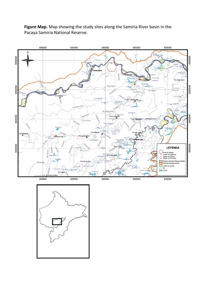
Figure Map. Map showing the study sites along the Samiria River basin in the Pacaya Samiria National Reserve.