alamance county planning board · alamance county planning board agenda ... w. todd lambert ......
TRANSCRIPT

ALAMANCE COUNTY PLANNING BOARD
AGENDA
Meeting Notes: 1. Those wishing to make public comments should sign-in prior to the meeting. 2. In order to be fair and ensure that all citizens wishing to speak may be heard, the Chair
may place time limits on public comments. 3. Any further discussion by the public on a given agenda item is subject to the discretion of
the Chair of the Planning Board
Planning Manager Jason S. Martin
Chairman W. Todd Lambert
Commissioner’s Meeting Room
124 W. Elm Street Graham, NC 27253
March 13, 2014 7:00 PM
I. CALL MEETING TO ORDER
II. APPROVAL OF PLANNING BOARD MINUTES 1. February 2014
III. PUBLIC COMMENTS
IV. OLD BUSINESS
1. Planning Board Vacancy/Review of Applicants 2. Staff Update-Quarterly Development Reports
V. NEW BUSINESS
1. Proposed Watershed Protection Ordinance Amendment 2. Adoption of 2014 Alamance County Community Profile 3. Destination 2020 Review Presentation 4. Presentation of Open Space/Rural Preservation Subdivisions
VI. ANNOUNCEMENTS
VII. ADJOURNMENT

Minutes of the Alamance County Planning Board
February 20, 2014 7:00 p.m., Board of County Commissioners Room
Board Members Present: Rodney Cheek Jimmy Ray Cobb, Jr. (Vice Chair) Rob Countiss Monte Holland Don Jennings Todd Lambert (Chair) Robert Osborne Edgar Pritchett Randall Smith
Board Members Absent: Bryan Foushee Albert Freeman David Smith Staff Present: Jason Martin, Planning Manager Aspen Price, Planner Public Present: Ravi Balan Don Nielsen
Call to Order Mr. Jason Martin, Planning Manager, called the meeting to order at approximately 7:00 pm.
Election of Officers Election of Chair: Mr. Martin opened the floor to nominations for Chair; Mr. Cobb nominated Mr. Lambert. Mr. Martin asked if they were any other nominations, there were none. Mr. Martin asked for a motion; a motion was made by Mr. Cobb to appoint Mr. Lambert as Chair, seconded by Mr. Holland, and approved unanimously. Election of Vice Chair: Chair Lambert opened the floor to nominations for Vice Chair; Mr. Cobb nominated Mr. Osborne. Mr. Lambert asked if they were any other nominations, there were none. Mr. Lambert asked for a motion; a motion was made by Mr. Cobb to appoint Mr. Osborne as Vice-Chair, seconded by Mr. Jennings, and approved unanimously.
Approval of 2014 Meeting Schedule Mr. Martin presented a proposed meeting schedule for 2014. Mr. Countiss noted that the heading of the meeting dates read “2010 Meeting Schedule” and should read “2014 Meeting Schedule.” Motion: Mr. Countiss made a motion to adopt the 2014 meeting schedule with suggested changes; it was seconded by Mr. Osborne. Vote: Unanimously approved.
Approval of Minutes Mr. Lambert asked if there were any changes to the minutes. None were suggested. Motion: Mr. Jennings made a motion to approve the June 13, 2013 minutes and the November 14, 2013 minutes; it was seconded by Mr. Holland. Vote: Unanimously approved.

Public Comments
Mr. Lambert asked if there were any public comments. Hearing none, he moved to the next agenda item.
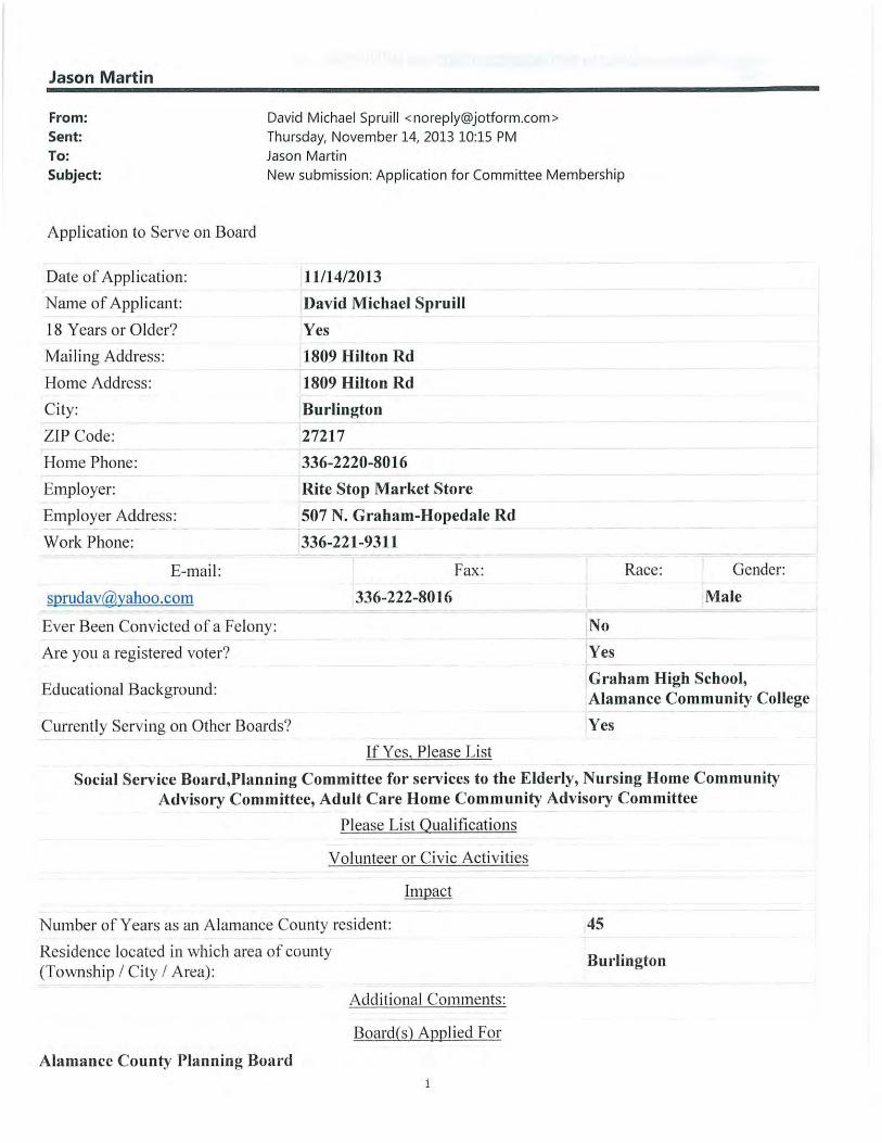
New Business Review of Planning Board Applications: Mr. Martin stated that there is one vacancy on the board, as Mr. Richardson has submitted a written resignation due to his relocation out of the state. Mr. Martin stated that tonight the board has two applications to consider, one from Mr. Balan from Melville Township, and one from Mr. Spruill from Burlington Township, both of which are eligible townships for appointment. Mr. Balan introduced himself and described his interest in serving on the Planning Board. Mr. Martin stated that the new member would be an Alternate member and would finish out Mr. Richardson’s unexpired term. Mr. Lambert asked if the other applicant, who was not present, was aware of the meeting tonight. Mr. Martin confirmed that he spoke with Mr. Spruill this week, and that he had made both applicants aware of the change in meeting schedule due to the inclement weather. Mr. Countiss asked Mr. Balan why specifically the Planning Board was his choice of community involvement. Mr. Balan stated that he found out about the vacancy on the Planning Board through his involvement as an Ambassador with the Chamber of Commerce. He said that when he did more research on the Planning Board, it piqued his curiosity even more, as he is all about delving deep into where you live and having an appreciation for it. Mr. Lambert stated that they need to make a recommendation for one of these applicants, and asked Mr. Martin for clarification that they have the option of not making a recommendation as well. Mr. Martin confirmed this was the case but asked the board, if they chose not to make a recommendation tonight, to give him a directive, as they do have an opening. Mr. Cobb asked if there had been any effort to advertise the opening. Ms. Price responded that it was posted on the Planning Department website, and that she had also created a blog post about it in the News & Updates section of the website. Mr. Martin stated that an advertisement had not been run in the newspaper; however the Department had received applications. Mr. Osborne asked about distribution of representation throughout the county. Mr. Martin stated that the townships that are not currently represented on the board are Albright, Coble, Faucette, and Haw River. Mr. Osborne said it was probably harder to gauge the second piece of his question, which is looking at the cross-section of urban versus rural on the board. Mr. Martin stated that it was almost an even split. Mr. Martin reminded the board that the way the ordinance was written, no more than two members can be from any given township, and no more than one can be a voting member. Mr. Lambert stated that he personally would like to see more members from townships not currently represented, but that he was not sure how staff could get interest from particular areas. Mr. Lambert added that he would be in favor of waiting a month and putting a notice on the website on the home page for the county. Mr. Martin recommended in that case that the board table any action, because they do have applicants. Mr. Osborne thanked Mr. Balan for coming and addressing the board, and stated that he would like to see the opportunity to have the feeling that the vacancy has been understood by the community and that they have an opportunity to see multiple candidates. He added that he did not feel like they were under the gun to pick any one person immediately, and would like to look at multiple candidates. Ms. Price noted that these applications came in in November, and that notices had been posted on the Planning Department webpage since then and they have not seen any additional

applications. Mr. Osborne acknowledged that after hearing that this is out there, the degree to which an additional three weeks will develop any additional interest sounds unlikely. Motion: Mr. Osborne made a motion to table the decision until the next meeting with direction to staff to post the vacancy notice on the front page of the County website with details on where the Board currently does not have representation; it was seconded by Mr. Cheek. Vote: Unanimously approved. Discussion of Planning Board Goals for 2014: Mr. Martin noted that the previous year was a quiet year for the Planning Board and asked the board if there were any specific ordinances or issues they want staff to look at. Mr. Lambert stated that he felt it would be helpful for staff to give a summary on progress on the Destination 2020 Plan, as they were more than halfway through it. Along those lines, he suggested a quarterly or biannual county snapshot with building permits, growth in certain areas, school population and other information. Mr. Lambert added that he was interested in seeing conservation subdivisions brought up again. Mr. Martin offered to provide a presentation to the board on these issues. Mr. Osborne stated that he remembered that these were additional permissive revisions, not restrictions. Mr. Lambert confirmed that was the case. Mr. Martin added that they were seven years into the Land Development Plan, and it was related to Destination 2020, so it may be worthwhile to do a review of that as well. Mr. Cheek asked if they had the technology to know if there are liquid storage facilities with drain pipes underneath them that are straight piped into the rivers or creeks or streams. He clarified that the coal ash issue in the news made him aware of this issue. Mr. Martin responded that unless there was something through Environmental Health, probably not. Mr. Lambert asked if it would be through NC DENR through their direct discharge permitting. Mr. Martin offered to look into it. Mr. Jennings asked if there was anything they needed to be aware of in regards to the preliminary floodplain maps. Mr. Martin stated not at this time, that at the earliest they were looking at new maps and ordinances in December of this year.
Announcements There were no announcements.
Adjournment With no other business to be discussed the Planning Board was adjourned at approximately 7:55 p.m. Respectfully Submitted, Jason S. Martin Planning Manager

Alamance County Planning Board ACTION AGENDA ITEM
MEETING DATE: 3/13/2014 TO: Todd Lambert, Chair FROM: Jason Martin, Planning Manager PUBLIC HEARING: YES NO
ISSUE/ACTION REQUESTED: Review of Planning Board Appications
BACKGROUND/PURPOSE OF REQUEST: The Alamance County Planning Board currently has one (1) vacancy created by the resignation of Eric Richardson who has relocated out of the state.
STAFF RECOMMENDATION: APPROVAL DENIAL NO RECOMMENDATION
ATTACHMENTS:
1) Application- Ravi Balan (Melville Township) 2) Application- David Michael Spruill (Burlington Township) 3) Application- Roslyn McNeill (Haw River Township)
PLANNING BOARD ACTION
APPROVED: DENIED: DEFFERED: UNTIL ______________________ CONDITIONS/NOTES:


APPLICATION FORM FOR COMMITTEE MEMBERSHIP
Applicant Information Date of Application
Applicant Name
Mailing Address
Home Address
Home Phone Number
Employer and Address
Work Phone Number E-Mail Address FAX Number Race Sex
Number of Years as Alamance County Resident
Residence Located in Which Section of Alamance County (Township/City/Area of County)
Additional Comments
Boards Applied For
March 5, 2014
Roslyn McNeill1101 Birkdale Drive, Mebane, NC 27302Same336-260-1512NC Dept of State Treasurer, Raleigh, NC919-508-5945
[email protected] African American Female16 years
Haw River Township
Previously served on the town of Mebane Planning Board
Planning Board

Alamance County Planning Board ACTION AGENDA ITEM
MEETING DATE: 3/13/2014 TO: Todd Lambert, Chair FROM: Jason Martin, Planning Manager PUBLIC HEARING: YES NO
ISSUE/ACTION REQUESTED: Watershed Protection Ordinance Amendment
BACKGROUND/PURPOSE OF REQUEST: The Alamance County Planning Department has discovered a conflict between the Watershed Protection Ordinance and Subdivision Ordinance with regards to exempt subdivisions. Currently lots that are subdivided for the purpose of settling an estate are exempt from County subdivision regulations; however the Watershed Ordinance specifies a minimum lot size for watershed areas. Because of this, it is possible that a plat could be approved as an exempt subdivision and create a violation under the Watershed Ordinance. Staff is therefore proposing to amend the Watershed Ordinance so that it is in harmony with the Subdivision Ordinance by creating a new exemption under Section 102 of the Ordinance.
STAFF RECOMMENDATION: APPROVAL DENIAL NO RECOMMENDATION
ATTACHMENTS:
1) Proposed Amendment 2) 3)
PLANNING BOARD ACTION
APPROVED: DENIED: DEFFERED: UNTIL ______________________ CONDITIONS/NOTES:

3
WATERSHED PROTECTION ORDINANCE WHEREAS, it is the intention of the Alamance County Board of Commissioners, upon recommendation by the Alamance County Planning Board, to protect the watershed areas of Alamance County. Primarily these watershed areas include the water supply lakes for the cities of Burlington, Graham, Mebane and for the Orange Water and Sewer Authority. This Ordinance is promulgated in order to provide for a safe and potable water supply for present and future generations of Alamance County citizens; and WHEREAS, the County of Alamance has the authority to regulate the uses of properties in water supply watersheds located in its territorial jurisdiction by virtue of N.C.G.S. 153A-340(ff) and Article 21 of Chapter 143 of the General Statutes of North Carolina. NOW, THEREFORE, THE BOARD OF COUNTY COMMISSIONERS FOR THE COUNTY OF ALAMANCE DOTH ORDAIN: ARTICLE 100: AUTHORITY Section 101. Jurisdiction. The provisions of this Ordinance shall apply within the areas designated as a Public Water Supply Watershed by the N.C. Environmental Management Commission (EMC) and shall be defined and established on the maps entitled, "Watershed Protection Map of Alamance County, North Carolina" ("the Watershed Map"), which is adopted simultaneously herewith. The Watershed Maps and all explanatory matter contained thereon accompanies and is hereby made a part of this Ordinance. This Ordinance shall be permanently kept on file in the office of the Clerk to the Board of County Commissioners. Section 102. Exceptions to Applicability. A. Nothing contained herein shall repeal, modify, or amend any Federal or State law or
regulation, or any Ordinance or regulation pertaining thereto except any Ordinance which this Ordinance specifically replaces.
B. It is not intended that this Ordinance interfere with any easement, covenants or other
agreements between parties. However, if the provisions of this Ordinance impose greater restrictions or higher standards for the use of a building or land, then the provisions of this Ordinance shall control.
C. Existing development, as defined in this Ordinance, is regulated under the provisions
as stated in Section 211. D. A nonconforming lot of record shall not be subject to the development restrictions of

4
this Ordinance if it is developed for single-family residential purposes, except as specified in Section 203. Any lot or parcel created as part of any other type of subdivision that is exempt from a local subdivision ordinance shall be subject to the land use requirements (including impervious surface requirements) of these rules, except that such a lot or parcel must meet the minimum buffer requirements to the maximum extent practicable.
E. The division of property among heirs for the sole purpose of settling an active estate
shall be exempt from the minimum lot size requirements of this ordinance. Section 103. Reenactment of Existing Watershed Ordinance. This Ordinance in part carries forward by re-enactment, some of the Alamance County Watershed Protection Ordinance adopted by the Board of Commissioners on May 4, 1987, as amended 11-19-90, 9-20-93, 12-18-95 and 1-21-97, and it is not the intention to repeal but rather to re-enact and continue in force such existing provisions so that all rights and liabilities that have accrued thereunder are preserved and may be enforced. All provisions of the Watershed Protection Ordinance which are not re-enacted herein are hereby repealed. All suits at law or in equity and/or all prosecutions resulting from the violation of any Ordinance provisions heretofore in effect, which are now pending in any court of this state or of the United States, shall not be abated or abandoned by reason of the adoption of this Ordinance, but shall be prosecuted to their full finality the same as if this Ordinance had not been adopted; and any and all violations of the existing Watershed Protection Ordinance, prosecutions for which have not yet been instituted, may be hereafter filed and prosecuted; and nothing in this Ordinance shall be so construed as to abandon, abate or dismiss any litigation or prosecution now pending and/or which may heretofore have been instituted or prosecuted. Section 104. Criminal Penalties. Any person violating any provisions of this Ordinance shall be guilty of a misdemeanor and, upon conviction, shall be punished in accordance with NCGS 14-4. The maximum fine for each offense shall not exceed $500.00. Each day that the violation continues shall constitute a separate offense. Section 105. Remedies. A. If any subdivision, development and/or land use is found to be in violation of this
Ordinance, the County Manager may initiate an action in the name of Alamance County, in addition to all other remedies available either at law or in equity, institute an action or proceedings to restrain or correct the violation; an action to prevent occupancy of the building, structure, or land; or an action to prevent any illegal act, conduct, business, or use in or about the premises. No activity, situation, structure or land use shall be allowed within the watershed area which poses a threat to water quality and the public health, safety and welfare. Such conditions may arise from inadequate on-site sewage systems which utilize

Alamance County Planning Board ACTION AGENDA ITEM
MEETING DATE: 3/13/2014 TO: Todd Lambert, Chair FROM: Jason Martin, Planning Manager PUBLIC HEARING: YES NO
ISSUE/ACTION REQUESTED: Adoption of the 2014 Alamance County Community Profile
BACKGROUND/PURPOSE OF REQUEST: The Alamance County Planning Department has developed a Community Profile Report for the Board’s consideration. The profile was created through the compilation and analysis of demographic and socio-economic data for Alamance County. It is Staff’s intent to revise and update this profile every 2-3 years; as new data becomes available. The profile focuses on county demographics, population, land-use and area/density, housing, employment, and education.
STAFF RECOMMENDATION: APPROVAL DENIAL NO RECOMMENDATION
ATTACHMENTS:
1) Proposed 2014 Community Profile 2) 3)
PLANNING BOARD ACTION
APPROVED: DENIED: DEFFERED: UNTIL ______________________ CONDITIONS/NOTES:

Alamance County
Community Profile Alamance County Planning Department March 2014

2014 Community Profile | 1
Population
Unincorporated Areas Municipalities
Alamance County 2012 Population: 151,170 In 2012, Alamance County’s total estimated popu-
lation was 151,170. The majority of the population,
98,752 is within the county’s ten municipalities.
Thirty-five percent, or 52,418 people, live in the
county’s unincorporated areas.
White and non Hispanic or Latino residents make
up the largest percentage of the population, with
the unincorporated areas being less diverse than
municipalities.
Percent of Population by Ethnicity
County
Total Municipalities
Unincorporated
Areas
11.0% 12.3% 8.7% Hispanic or
89.0% 87.7% 91.3% Not Hispanic
or Latino
All data from American Community Survey 5-year datasets. Date shown is from the end of the range, e.g.”2012” is from 2008-2012 dataset.
Percent of Population by Race
County Total
White: 69.9% Black: 18.0% Other: 4.3%
Age % 2012 Trend 2009-2012
0-14 years 19.4%
15-24 years 14.5%
25-44 years 25.0%
45-59 years 21.1%
60-74 years 12.9%
75 years and over 7.1%
Median Age: 38.5
21 years and over: 71.4%
62 years and over: 17.8%
Almost half (46.1%) of the population is between 25
and 59 years old. The young to middle-aged popu-
lation has declined over the past four years, with
the exception of the 15-24 year old age bracket,
which likely represents the continued growth of
Elon University. The Baby Boomer population (48-
66) has seen a steady increase over the past four
years.
Population Age Trends

2014 Community Profile | 2
Land Area & Density
Alamance County has a total land area of approximately 435 square miles, of which 10.8 square miles is water.
Three lakes—Lake Cammack, Lake Mackintosh, and Graham-Mebane Lake—serve as water reservoirs for
county residents. To protect these water resources, six watersheds encompassing approximately 108 square
miles limit the scale and type of development in these areas. The Haw River is the largest river, but there are
also numerous creeks, streams, and ponds throughout the county.
The municipalities cover an area of 52 square miles and their extraterritorial jurisdictions, where the munici-
palities’ zoning authority extends to, cover another 48 square miles. Approximately 334 square miles are locat-
ed within the county’s planning jurisdiction.1
Population Density
The population density in Alamance County as a
whole is 355 persons per square mile. Faucette
Township is the least dense at 87 persons per
square mile, and Burlington Township is the most
dense at 1,587 persons per square mile.
Land Use
A large portion of land in unincorporated Alamance
County is used for agricultural purposes. Over 2,100
parcels in the unincorporated areas of the county
are classified as farms, equaling approximately 155
square miles. Another 61 square miles are classified
as vacant.2
1 Land area calculations from GIS and the 2012 U.S. Gazetteer. 2 Land use classifications from the Alamance County Tax Department
2014 Community Profile | 3
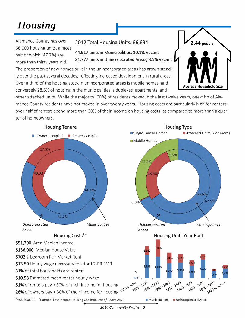
Housing
Alamance County has over
66,000 housing units, almost
half of which (47.7%) are
more than thirty years old.
The proportion of new homes built in the unincorporated areas has grown steadi-
ly over the past several decades, reflecting increased development in rural areas.
Over a third of the housing stock in unincorporated areas is mobile homes, and
conversely 28.5% of housing in the municipalities is duplexes, apartments, and
other attached units. While the majority (60%) of residents moved in the last twelve years, one-fifth of Ala-
mance County residents have not moved in over twenty years. Housing costs are particularly high for renters;
over half of renters spend more than 30% of their income on housing costs, as compared to more than a quar-
ter of homeowners.
Average Household Size
2.44 people
Housing Units Year Built
Housing Tenure Housing Type
2012 Total Housing Units: 66,694
44,917 units in Municipalities; 10.1% Vacant
21,777 units in Unincorporated Areas; 8.5% Vacant
Housing Costs1,2
$51,700 Area Median Income
$136,000 Median House Value
$702 2-bedroom Fair Market Rent
$13.50 Hourly wage necessary to afford 2-BR FMR
31% of total households are renters
$10.58 Estimated mean renter hourly wage
51% of renters pay > 30% of their income for housing
26% of owners pay > 30% of their income for housing 1ACS 2008-12. 2National Low Income Housing Coalition Out of Reach 2013
2014 Community Profile | 4
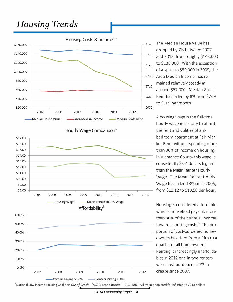
Housing Trends
The Median House Value has
dropped by 7% between 2007
and 2012, from roughly $148,000
to $138,000. With the exception
of a spike to $59,000 in 2009, the
Area Median Income has re-
mained relatively steady at
around $57,000. Median Gross
Rent has fallen by 8% from $769
to $709 per month.
A housing wage is the full-time
hourly wage necessary to afford
the rent and utilities of a 2-
bedroom apartment at Fair Mar-
ket Rent, without spending more
than 30% of income on housing.
In Alamance County this wage is
consistently $3-4 dollars higher
than the Mean Renter Hourly
Wage. The Mean Renter Hourly
Wage has fallen 13% since 2005,
from $12.12 to $10.58 per hour.
Housing is considered affordable
when a household pays no more
than 30% of their annual income
towards housing costs.3 The pro-
portion of cost-burdened home-
owners has risen from a fifth to a
quarter of all homeowners.
Renting is increasingly unafforda-
ble; in 2012 one in two renters
were cost-burdened, a 7% in-
crease since 2007.
Housing Costs & Income1,2
Hourly Wage Comparison1
1National Low Income Housing Coalition Out of Reach 2ACS 3-Year datasets 3U.S. HUD *All values adjusted for inflation to 2013 dollars
Affordability2
2014 Community Profile | 5
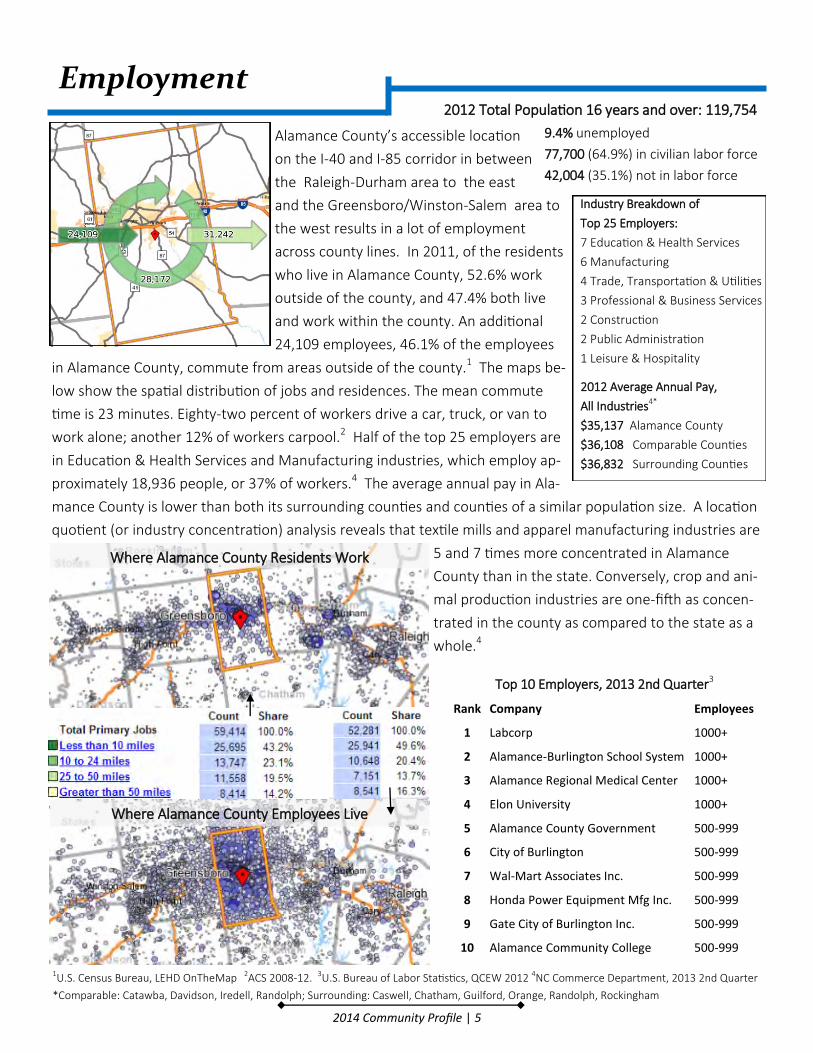
Employment
Alamance County’s accessible location
on the I-40 and I-85 corridor in between
the Raleigh-Durham area to the east
and the Greensboro/Winston-Salem area to
the west results in a lot of employment
across county lines. In 2011, of the residents
who live in Alamance County, 52.6% work
outside of the county, and 47.4% both live
and work within the county. An additional
24,109 employees, 46.1% of the employees
in Alamance County, commute from areas outside of the county.1 The maps be-
low show the spatial distribution of jobs and residences. The mean commute
time is 23 minutes. Eighty-two percent of workers drive a car, truck, or van to
work alone; another 12% of workers carpool.2 Half of the top 25 employers are
in Education & Health Services and Manufacturing industries, which employ ap-
proximately 18,936 people, or 37% of workers.4 The average annual pay in Ala-
mance County is lower than both its surrounding counties and counties of a similar population size. A location
quotient (or industry concentration) analysis reveals that textile mills and apparel manufacturing industries are
5 and 7 times more concentrated in Alamance
County than in the state. Conversely, crop and ani-
mal production industries are one-fifth as concen-
trated in the county as compared to the state as a
whole.4
Top 10 Employers, 2013 2nd Quarter3
Rank Company Employees
1 Labcorp 1000+
2 Alamance-Burlington School System 1000+
3 Alamance Regional Medical Center 1000+
4 Elon University 1000+
5 Alamance County Government 500-999
6 City of Burlington 500-999
7 Wal-Mart Associates Inc. 500-999
8 Honda Power Equipment Mfg Inc. 500-999
9 Gate City of Burlington Inc. 500-999
10 Alamance Community College 500-999
1U.S. Census Bureau, LEHD OnTheMap 2ACS 2008-12. 3U.S. Bureau of Labor Statistics, QCEW 2012 4NC Commerce Department, 2013 2nd Quarter
*Comparable: Catawba, Davidson, Iredell, Randolph; Surrounding: Caswell, Chatham, Guilford, Orange, Randolph, Rockingham
2012 Total Population 16 years and over: 119,754
9.4% unemployed
77,700 (64.9%) in civilian labor force
42,004 (35.1%) not in labor force
Where Alamance County Residents Work
Where Alamance County Employees Live
Industry Breakdown of
Top 25 Employers:
7 Education & Health Services
6 Manufacturing
4 Trade, Transportation & Utilities
3 Professional & Business Services
2 Construction
2 Public Administration
1 Leisure & Hospitality
2012 Average Annual Pay,
All Industries4*
$35,137 Alamance County
$36,108 Comparable Counties
$36,832 Surrounding Counties

2014 Community Profile | 6
In 2002, Manufacturing made up 28.09% of employ-
ment in Alamance County; by 2012 that share dropped
to 17.51%. Two sectors, Health Care and Accomoda-
tion, saw more than 4% growth over the 10-year peri-
od. A pay comparison over the same time period re-
veals that pay has remained steady for most industry
supersectors, but has decreased for Education & Health
Services and Professional & Business Services. While
real pay in comparable and surrounding counties has
remained steady, it has fallen by almost $2,000 in Ala-
mance County. A 10-year snapshot of employment
trends show that the current unemployment rate is
lower than in 2003. However, over the past year, the
number of employed remains steady while the number
of unemployed has significantly dropped; suggesting
that many have stopped looking for work and have
dropped out of the labor force.
Top Industry SuperSectors Avg. Annual Pay, 2002*
Avg. Annual Pay, 2012*
Education & Health Services 42,477 35,327
Manufacturing 40,588 40,774
Trade, Transportation & Utilities 32,659 44,156
Professional & Business Services 42,936 28,556
Construction 37,144 40,036
Public Administration (Local Gov’t) 36,393 37,489
Leisure & Hospitality 14,874 14,193
All Industries, Alamance County 37,430 35,652
All, Comparable Counties 36,421 36,637
All, Surrounding Counties 37,586 37,372
Employment Trends
1U.S. Bureau of Labor Statistics 2by NAICS 2-digit code *All values adjusted
Unemployment January-December 20131
Unemployment 2003-20131
Top 10 High-Employment Industry Sectors, 2002-2012
2002 % Rank % 2012
Manufacturing 28.09 1 17.51 Manufacturing
Retail trade 13.37 2 16.68 Health care and social assistance
Health care and social assistance
11.33 3 16.40 Retail trade
Accommodation and food services
8.35 4 12.47 Accommodation and food services
Administrative and waste services
7.23 5 7.28 Administrative and
waste services
Construction 5.91 6 4.63 Construction
Management of companies and
enterprises 5.21 7 4.31 Wholesale trade
Wholesale trade 4.02 8 4.26 Management of companies and
enterprises
Finance and insurance
3.46 9 3.25 Educational
services
Other services, except public
administration 2.94 10 2.65
Finance and insurance

2014 Community Profile | 7
Education
Alamance County has seen a
marked increase over time in
higher education attainment.
However, while Alamance
County’s educational attain-
ment is higher than counties of comparable population
size, it lags behind that of surrounding counties, the
state, and the nation as a whole. Almost half of the
population aged 25 years and older did not finish high
school or has only a high school degree. Lower educa-
tional attainment corresponds with higher unemploy-
ment rates and lower earnings.
The Alamance-Burlington School System (ABSS) has 26
elementary schools, 7 secondary schools, and 1 com-
bined school, with approximately 22,260 students in
attendance. Almost 71% of students graduate high school, of
which 45% intend to go on to a four year institution.
Three charter schools
provide an alternative to
the public school system
and have a total enroll-
ment of 1,039 students.1
There are two higher education institutions in the county as
well. Alamance Community College, which offers a range of
programs for degree-seeking students and continuing educa-
tion, has 4,677 full-time equivalent students.2 Elon University,
a private four-year university, has 5,225 undergraduates and
691 graduate students enrolled.3
ABSS High School Graduate Intentions
12007-08, NC Public Schools 2ACC Factbook 2011-12 3 Elon.edu 2011-12 4 ACS 2008-12.
Alamance County’s Educational Attainment Over Time
2010 Educational Attainment Comparison
Educational Attainment Alamance County, 20124
Unemployment Rate
Median Earnings
Less than high school 10.3% $17,931
High school graduate only 7.8% $26,386
Some college or Associate’s degree 6.1% $31,884
Bachelor’s degree or higher 3.4% $44,819
Graduate or professional degree No Data $57,346
ABSS Figures and Rankings1 Figure
Statewide Ranking
Students Enrolled 22,260 16
Per Pupil Spending $7,658 109
Per Pupil County Appropriations & Supplemental Taxes
$1,390 51

Alamance County Planning Board ACTION AGENDA ITEM
MEETING DATE: 3/13/2014 TO: Todd Lambert, Chair FROM: Jason Martin, Planning Manager PUBLIC HEARING: YES NO
ISSUE/ACTION REQUESTED: Presentation of Open Space/Rural Preservation Subdivisions
BACKGROUND/PURPOSE OF REQUEST: As directed by the Planning Board, Staff has prepared information regarding Open Space & Conservation Subdivisions. At my request, our Planner, Aspen Price, conducted research regarding from various sources and has prepared a memo summarizing this type of development I have included this memo for the Board’s information as well. Also enclosed is a rendering of a hypothetical traditional subdivision versus a subdivision utilizing such guidelines; including hypothetical costs for infrastructure, etc. Finally, I have included a draft of potential amendments to the Subdivision Ordinance should the Board wish to pursue the idea further.
STAFF RECOMMENDATION: APPROVAL DENIAL NO RECOMMENDATION
ATTACHMENTS:
1) Memorandum (Aspen Price to Jason Martin) 2) Drawings & Costs Analysis 3) Draft Amendments
PLANNING BOARD ACTION
APPROVED: DENIED: DEFFERED: UNTIL ______________________ CONDITIONS/NOTES:

To: Jason Martin, Planning Manager
From: Aspen Price, Planner
Date: March 3, 2014
Subject: Conservation Subdivisions
Standard Subdivision Conservation Subdivision Image: Columbia Land Conservancy
What is a Conservation Subdivision?
A conservation subdivision is an alternative to a standard subdivision in that it allows developers to
group lots into compact clusters and leaves a significant portion of the site, typically 50-70%, as
preserved open space. Conservation subdivisions have the same density and number of homes as a
standard subdivision, but the location and spacing of those homes is changed.
How can Conservation Subdivisions benefit Alamance County?
Conservation subdivisions are efficient development, as they require less infrastructure and
have lower maintenance costs over time as compared to a standard subdivision. On average, a
conservation subdivision lot costs $7,400 less to build than a standard subdivision lot.1 Because
the number and value of homes is the same as in a standard subdivision, the overall tax revenue
does not change, but long-term maintenance costs are lower.
Conservation subdivisions have been shown to reduce impervious surface by 31% and have a
38% reduction in stormwater runoff over standard subdivisions,2 thus meeting the Jordan Lake
rules and in some cases potentially acting as nutrient offsets for other developments. In
addition, shared septic, drinking water, and stormwater systems further protect water quality.3
Conservation subdivisions are compatible with Alamance County’s rural heritage, as they can
include space for agricultural uses and preserve the natural vistas and rural feel that are a strong
part of Alamance County’s heritage. These types of subdivisions protect natural resources
without limiting growth. In addition, the option to develop homes on part of a parcel provides a
low-impact alternative for landowners who cannot afford to maintain their land as it is, but
want to continue to use their property to some degree.

Conservation subdivisions preserve property values. Studies have shown that lots in
conservation subdivisions sell in about half the time as lots in standard subdivisions, and home
values tend to appreciate faster over time, because of the knowledge that surrounding land will
not be developed and the aesthetic of the neighborhood will not change.4
Conservation subdivisions provide recreation opportunities for residents, thus both improving
their health and quality of life as well as reducing the demand for taxpayer-funded green space.5
When several conservation subdivisions are developed within proximity of one another, the
resulting contiguous greenspace presents an opportunity for linear recreation areas, such as
greenways and hiking trails, and protects important habitat and wildlife corridors.
Who manages the open space?
The open space is permanently preserved through deed restrictions, conservation easements, or
restrictive covenants, and is typically managed either by a homeowner’s association or a land
conservancy. In some cases it remains in ownership of the original landowner, who operates a farm or
other use on the property. In a few cases the open space is dedicated to a local government as a public
park. Many jurisdictions allow this land to be used for low-intensity uses, including buffering,
agriculture, selective timber harvesting, passive recreation, storm water detention, and community
wells and drainfields.
How are wells and septic systems managed when the lots are close together?
If lots are an acre or larger each, they typically have their own well and septic. If less than an acre, one
option is for each house to have an individual septic system, but to locate the leaching fields in the open
space. Some conservation subdivisions have a community septic system that serves all houses with
leaching fields in the open space. Likewise, two or three houses can share a well, or a community well
can serve the entire subdivision.
How are density bonuses offered?
Some jurisdictions provide incentives for choosing a conservation design over a standard subdivision,
such as density bonuses or expedited review processes. Density bonuses are generally minimal, at most
allowing developers to “round up” when calculating the allowable number of homes, thus yielding one
or two additional homes. The reduced cost of construction associated with conservation subdivisions is
considered to be enough of an incentive, and conservation subdivisions are not intended to be higher-
density uses. A few ordinances offer additional units if the greenspace is dedicated as a public park or if
affordable housing is provided, but generally ordinances stress that conservation subdivisions should
not significantly differ in the number of units as compared to a standard subdivision.
Limitations of Conservation Subdivisions
If the open space is being used for agriculture, the agricultural portion needs to be well
managed with regards to noise, dust, chemicals, and odor to remain compatible with the
residential area.6
Conservation subdivisions are most effective when their open space connects with adjacent
open space and can be used for greenways, wildlife corridors, and other contiguous benefits,
but the likelihood of several developing adjacent to each other is slim.

Because Alamance County does not have traditional zoning, it is difficult to target conservation
subdivisions for specific parts of the county where certain economic, ecological, or historic
features would benefit from a conservation subdivision design.
Conservation subdivisions tend to sell for a premium of $13,000 - $18,000 per acre over
standard subdivisions, which can exclude moderate-income buyers.7
There are perceived barriers to conservation subdivisions which inhibit them from actually being
constructed. In a study completed by the N.C. Cooperative Extension, 51 North Carolina
counties allow conservation subdivisions, but only 26 counties have a completed conservation
subdivision.8 In some jurisdictions, the additional time and money necessary to obtain
regulatory permissions, such as waivers and variances, acts as a barrier for some developers.9
Permitting conservation subdivisions by right, creating clear calculation methods for open space
and density, and providing minimal incentives can help encourage the creation of conservation
subdivisions.
Conservation subdivisions are advantageous for developers because they cost less to build, lots sell
more quickly, and they retain strong property values over time. They provide recreation opportunities
for residents and preserve important habitat and wildlife areas. These alternative subdivisions are
compatible with the county’s rural heritage and address stream buffer and storm water runoff issues in
low-cost and effective ways. Conservation subdivisions are an alternative type of development that can
preserve the unique characteristics of Alamance County without limiting growth or curbing tax revenue.
This wide range of benefits makes a strong case for amending the Alamance County Subdivision
Ordinance to include the option of building conservation subdivisions.
Helpful Resources for Additional Information
NC Cooperative Extension Conservation Subdivision Handbook (Includes a model ordinance):
http://www.ces.ncsu.edu/forestry/pdf/ag/ag742.pdf
Atlanta Regional Commission’s Conservation Subdivision Ordinances (Includes a model ordinance):
http://www.scdhec.gov/environment/baq/docs/ModelOrdinances/OtherExamples/GeorgiaConservatio
nSubdivisionToolkit.pdf
Southwestern Illinois Resource Conservation & Development, Inc. Conservation Subdivision Design
Handbook:
http://conservationtools.org/libraries/1/library_items/349-Conservation-Subdivision-Design-Handbook
1 Mohamed, Rayman. (2006). The Economics of Conservation Subdivisions: Price Premiums, Improvement Costs,
and Absorption Rates. Urban Affairs Review 41(3). http://www.landchoices.org/conservationsubs/consubs_pdfs/consubs_economics1.pdf 2N.C. Cooperative Extension. (2009). Conservation Subdivision Handbook: A guide for North Carolina communities
in the use of conservation design for land use planning. http://www.ces.ncsu.edu/forestry/pdf/ag/ag742.pdf 3 N.C. Cooperative Extension
4 Mohamed

5 Atlanta Regional Commission. (2001). Conservation Subdivision Ordinances.
http://www.scdhec.gov/environment/baq/docs/ModelOrdinances/OtherExamples/GeorgiaConservationSubdivisionToolkit.pdf 6 Southwestern Illinois Resource Conservation & Development, Inc. (2006). Conservation Subdivision Design
Handbook. http://conservationtools.org/libraries/1/library_items/349-Conservation-Subdivision-Design-Handbook 7 Mohamed
8 N.C. Cooperative Extension
9 Southwestern Illinois Resource Conservation & Development, Inc.


Scenario #1 (Traditional Subdivision w/no Open Space)
Total Tract Area (acres) 43.76 Total Open Space (acres) 0 % Open Space 0%
Proposed Roads (Linear ft.) 4455
# Lots 47 Cost (per linear ft.) $130
Lot Price $25,000
Total Cost for Infrastructure $579,150
Sales Revenue $1,175,000
Total Adjusted Profit (Revenue-Cost) $595,850
Scenario #2 (Subdivision w/ Open Space)
Total Tract Area 43.76 Total Open Space 21.76 % Open Space 50%
Proposed Roads (Linear ft.) 1954
# Lots 32 Cost (per linear ft.) $130
Lot Price $25,000
Total Cost for Infrastructure $254,020
Sales Revenue $800,000
Total Adjusted Profit (Revenue-Cost) $545,980

DDRRAAFFTT FFeebbrruuaarryy 22001144
Rural Preservation Subdivisions
General The option to construct a Rural Preservation Subdivision shall only apply to subdivisions that meet the criteria for a major subdivision.
Purposes
The purpose of the voluntary Rural Preservation Subdivision option is to preserve agricultural rural community character that might be lost through conventional development approaches, without limiting growth or curbing tax revenue. To accomplish this goal, greater flexibility and creativity in the design of such developments is encouraged.
Open Space Standards
Maximum Number of Lots The total number of lots allowed in a Rural Preservation Subdivision is equal to the number of lots allowed under traditional subdivision requirements. If the acreage calculation yields a fraction of an allowable lot greater than or equal to 0.5, the developer may include one additional lot in the Rural Preservation Subdivision.
Minimum Lot Size Requirements Subdivisions developed under these guidelines shall require a minimum of lot size of 20,000 square feet
Minimum Building Setback Requirements Minimum building setbacks for subdivisions developed under these guidelines shall be as follows:
Front: 25’ (from the right-of-way) Side: 10’ Side Street: 15’ (from the right-of-way) Rear: 20’
Open Space Requirements All Rural Preservation Subdivisions shall maintain, at a minimum, 50% of the project area as open space in the subdivision design; Rural Preservation Subdivision50% of the total land area as open space, of which half must be buildable area. Open space shall include lands that meet the criteria for target conservation areas and shall be contiguous.
Target Conservation Area Criteria Target conservation areas may include, but are not limited to, the following features:
1. Floodplains and Hydric Soils. Floodplains (100-year and 500-year) and hydric soils identified as part of: (1) a Flood Insurance Study prepared by the Federal Emergency Management Agency (FEMA); or (2) the County Soil Survey prepared by the USDA Natural Resources Conservation Service.

DDRRAAFFTT FFeebbrruuaarryy 22001144
2. Riparian Buffers
3. Viewsheds
4. Forest Cover
Permitted Uses of Open Space Permitted uses of open space may include the following:
1. Conservation. Conservation of natural resources, archeological resources or historical resources.
2. Agriculture. Agriculture, horticulture, or silviculture, provided that all applicable best management practices are used to minimize environmental impacts.
3. Passive Recreation.
4. Stormwater Management. All Best Management Practices (BMP) for stormwater control.
5. Utility Easements. Easements for drainage, access, and underground utility lines.
6. Community Wells and Sewage Systems.
Prohibited Uses of Open Space Construction of roads, parking lots and other impervious surfaces.
Water supply and sewage disposal facilities Water supply and sewage disposal facilities to serve Rural Preservation Subdivisions may be provided through the use of various alternatives, including:
• Individual wells and septic tanks located either on each lot or in off-lot locations within undivided open space areas designated for such uses on the Final Plat, and protected through recorded easements; or
• A community water supply and/or sewage disposal system designed, constructed, and maintained inconformity with all applicable state, federal, and local rules and regulations; or
• Connection to a water supply and/or sewage disposal system operated by a municipality, association, or water or sewer authority. System extensions are permitted only in accordance with applicable water and sewer, and land use policies and shall be sized only to serve the Open Space Development for which the system is extended; or
• A combination of the above alternatives.
Ownership and Management of Open Space The applicant must identify the current and future owner(s) of the open space who is responsible for maintaining such the open space area and any associated facilities. If a homeowners’ association is the owner, membership in the association shall be mandatory and automatic for all homeowners within the subdivision and their successors and the association shall have lien authority to ensure the collection of dues from all members. The responsibility for maintaining the open space and any facilities located thereon shall be borne by the owner.
Legal Instrument for Permanent Protection

DDRRAAFFTT FFeebbrruuaarryy 22001144
Open space proposed for an Rural Preservation Subdivision shall be protected in perpetuity by a binding legal document that is recorded with the deed. The document shall be one of the following three (3) options:
1. Permanent Conservation Easement. A permanent conservation easement in favor of either:
a. A land trust or similar conservation-oriented non-profit organization with legal authority to accept such easements. The organization shall be bona fide and in perpetual existence and the conveyance instruments shall contain an appropriate provision for retransfer in the event the organization becomes unable to carry out its functions; or
2. Permanent Restrictive Covenant. A permanent restrictive covenant for conservation purposes. In cases where a permanent restrictive covenant is used, the restrictive covenant shall be recorded in conjunction with the plat(s) and shall be a separate document from other restrictive covenants prepared for the development.
3. An equivalent legal tool that provides permanent protection, if approved by the County Attorney.
Procedures for Application and Approval
Pre-Development Conference Required Those desiring to create a Rural Preservation Subdivision are required to schedule a pre-development conference with staff from the Planning Department and Environmental Health. This conference will be used to obtain a general understanding of the proposed subdivision through the review of a sketch plan and to allow staff to adequately address and convey to the developer the requirements of this Ordinance.
Application and Approval Process After the pre-development conference requirement has been met, Rural Preservation Subdivision applicants must follow the procedures for application and approval as required for a traditional major subdivision listed in Article V.