advisory visit to the river gryffe strathclyde, 26
TRANSCRIPT

1
ADVISORY VISIT TO THE RIVER GRYFFE STRATHCLYDE, 26 FEBRUARY 2007
Frontispiece: River Gryffe (above ford near Houston)
By Dr Andy Walker, Ellwyn, Moulin, Pitlochry PH16 5ER (Tel: 01796 472743; E-mail: [email protected])
On behalf of Windrush AEC Ltd, The Cottage, Fordwells, Witney, Oxon OX29 9PP

2
1.0 BACKGROUND and OBJECTIVES Abercorn Angling Club in Renfrew, Strathclyde, requested an advisory visit to their waters, primarily the River Gryffe (less commonly now, River Gryfe), to help promote best practice in protecting and managing wild trout and other freshwater fish stocks. The Club currently has about 165 - 200 members and is limited to 250. In addition to brown trout, the River Gryffe and neighbouring lower tributaries of the River Clyde, supports angling fisheries for sea trout, salmon and grayling. The Gryffe rises in the hills to the south of Greenock at an elevation of about 400 m. and flows south-east through two Gryfe Reservoirs built to provide compensation water after the construction of Loch Thom. Below Strathgryfe, the river passes Kilmacolm and through Bridge of Weir, before reaching in turn the Black Cart and the White Cart to the west of Renfrew and then the Clyde estuary. The mainstay of the club’s fishing is on the Gryffe and the White Cart. The White Cart rises in the hills to the south of Glasgow and is also fed by several smaller tributaries and reservoirs. Although the headwaters are in open country, most of the course of the White Cart runs through Greater Glasgow. In spite of the high level of conurbation, the Clyde system is enjoying a major resurgence of stocks of salmon and sea trout in its lower half. Major physical barriers prevent access of migratory fish into the upper reaches of the main stem Clyde. The River Gryffe used to be heavily polluted by local industries, including tanneries, but is now much cleaner. Water quality in the lower Clyde has also improved dramatically, but the upper estuary is still prone to pollution, especially in dry summers, due to its poor flushing mechanism. SEPA’s River Classification (see http://www.sepa.org.uk/rqc/) for 2005, the latest available data (2006 due imminently), lists the Gryffe throughout as A1 for water quality and biological status. Unsurprisingly, the White Cart registered a lower status in its middle and lower reaches, although it still supports salmonid fish through Paisley and Renfrew (and see for White Cart headwaters the WTT Advisory Visit report for Walton AC, 2006). For more detailed comments on water quality of the Gryffe and White Cart, contact the Environmental Quality Manager, SEPA South West Region, 5 Redwood Cres., Peel Park, East Kilbride, G74 5PP (direct dial 01355 574251; e-mail: [email protected]). The Clyde River Foundation (CRF) has quantitative juvenile fish population data for many monitored electro-fishing sites on the River Gryffe as shown in Figure 1 (Contact Dr W. Yeomans: e-mail [email protected]). For practical purposes, the sites are restricted to wadeable sections and, although ideal for monitoring juvenile trout and salmon, they cannot fully represent the abundance of larger fish, including grayling that are present mainly in deeper water.

3
KILMACOLM
BRIDGE OF WEIR
Locher Water
Black Cart
White Cart
Green Water
Gotter Water
PowBurn
Carruth Burn
Mill Burn
Dargavel BurnGryfeWater
Barochan Burn
Lin Burn
Burnbank WaterBlacketty Water
Gryfe Fishery Survey in 2004 – spatial survey
“Monitoring Sites” 2003-2006 – temporal monitoring
ROF Bishopton Survey 2005 – contract work
Invertebrate Sampling 2006 – student project
Fig 1: Map of the River Gryffe showing Clyde Rivers Trust Study Sites 2.0. THE ADVISORY VISIT The Wild Trout Trust advisory visit was undertaken on 26 February during a spell of mild weather when river levels and water clarity were moderate. Sandy Marshall and Neil Sinclair were in attendance on behalf Abercorn AC. Neil is also President of Strathgryfe AA and a member of Bridge of Weir AC, and thus has wide experience of the river. Therefore the opportunity was taken to view the river from top to bottom. Following the visit, George Inglis, Secretary of the Bridge of Weir Angling Club, provided additional valuable information, as did Dr Willie Yeomans of the CRF. The visit itself was not intended to be a biological survey, but a rapid overview that might suggest ways forward. The Wild Trout Trust aims to encourage and assist riparian owners, fishing clubs and community volunteer groups, to instigate habitat restoration projects for the benefit of self-sustaining wild trout populations. As well as helping the fish and, by inference, angling, the recommendations from an advisory visit promote local biodiversity in and around rivers and stillwaters. The inspection of the river began in Strathgryfe below the lower Gryfe Reservoir. The reservoirs were built in the catchment of the Gryffe above Greenock to serve the lower Clyde towns. To ‘compensate’ industry on the Gryffe, water was provided from the lower reservoir, an historical arrangement which appears to have fallen into disuse (pers.comm. George Inglis).
4
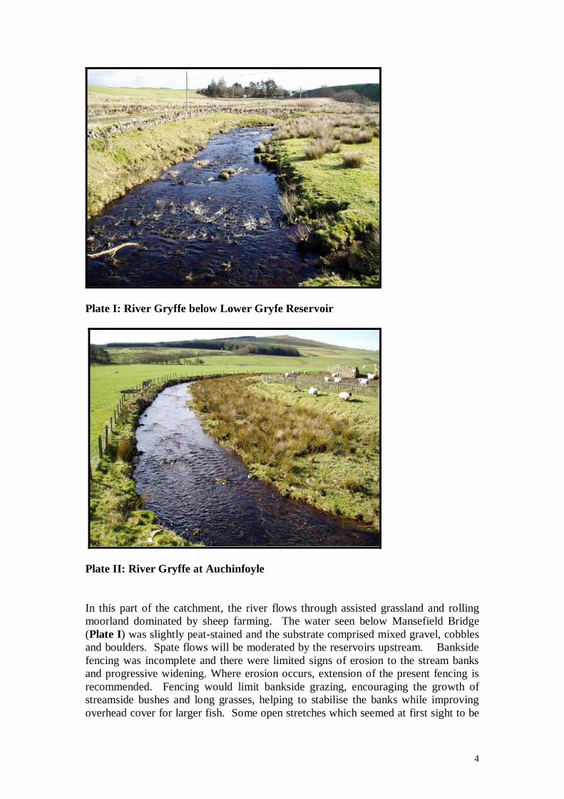
Plate I: River Gryffe below Lower Gryfe Reservoir
Plate II: River Gryffe at Auchinfoyle In this part of the catchment, the river flows through assisted grassland and rolling moorland dominated by sheep farming. The water seen below Mansefield Bridge (Plate I) was slightly peat-stained and the substrate comprised mixed gravel, cobbles and boulders. Spate flows will be moderated by the reservoirs upstream. Bankside fencing was incomplete and there were limited signs of erosion to the stream banks and progressive widening. Where erosion occurs, extension of the present fencing is recommended. Fencing would limit bankside grazing, encouraging the growth of streamside bushes and long grasses, helping to stabilise the banks while improving overhead cover for larger fish. Some open stretches which seemed at first sight to be

5
adequately fenced remain accessible to sheep. Farmers used to find grant-aid for fencing and other wild habitat improvements through the Rural Stewardship Scheme, but this is sadly underfunded at present. Other sites further downstream had retained some riparian trees, especially alders, and their roots were providing good potential hiding cover for trout.
Plate III: Some excellent salmonid habitat downstream of Netherwood Bridge The upper reaches are inaccessible to migratory fish because of waterfalls situated at Gryfeside Farm and support only a modest amount of fishing now. Despite the clean gravel and cobble nature of the river bed and general good habitat conditions, juvenile densities may not be optimised because of the lack of large migrant parents and the small size of the adult resident fish (fish density data for some stretches of this upper area are held by the CRF). Therefore, the parts of the river above the falls may not be contributing many fish to the lower sections of the Gryffe. Moreover, studies have shown that wild trout populations occurring above impassable falls tend to provide few if any recruits for downstream populations. Above-falls trout are strongly selected for genetic characteristics that favour residence over downstream migration, as those individuals that do migrate, whether by accident or otherwise, cannot return to their natal stretches to spawn. However, the upper river population may not be genetically pristine. The reservoirs situated further upstream are stocked with hatchery-reared trout by angling syndicates and over the years some brown trout may have dropped over the dams and into the river where they may have spawned.

6
Plate IV: Lower Strathgryfe downstream from impassable falls After maintaining a brisk pace for some distance due to the steeper gradient, the river grows in size and levels off a little as it reaches Kilmacolm, and longer, tree-lined pools are formed. Here and further downstream, redundant mill weirs have been removed or lowered to ease fish passage. The remnant parts of weirs now provide some extra depth and cover for larger fish, including resting salmon, without acting as significant barriers to their migration.
Plate V: Weir pool between Kilmacolm and Bridge of Weir below Quarrier’s Road Bridge (Craigends Bridge)

7
Water quality, river channel and bankside habitat conditions continued to be excellent as we progressed downstream through Bridge of Weir and beyond, with a densely wooded gorge and bedrock pools and then gravel stretches, with a mixture of tree-lined and open banks. The river channel was more mobile and there was significant bankside erosion in this area (Milton Bridge – Quarrier’s Road Bridge). Bridge of Weir AC has carried out a number of bankside improvements above the town in an attempt to curb such erosion and create better pools. At this stage, we jumped several miles downstream without viewing the river. We picked it up again at Bridge of Weir and walked from there to Crosslee. Long pools in this area such as the Coal Bog Pool can hold many salmon and appeared to provide very good conditions for grayling and trout. Olives were hatching at the river surface by mid-afternoon and occasional fish rose to take them. Neil Sinclair commented that the main hatches on the river these days were Large Dark Olive, Blue-winged Olive and smaller Baetids, but the river used to have Iron Blues and other species more sensitive to water quality and these may be scarcer. The CRF has invertebrate studies in progress and will be able to examine these points in more detail. Unfortunately, litter was becoming more prevalent, spoiling the attractive appearance of the river corridor. While some of this unwanted debris may come from anglers, much seems to be the result of fly-tipping from nearby paths and roadways. It is a widespread social problem, especially in poorer urbanised areas, but farming and other private dumping areas have not helped. Of course, some of the rubbish may have accumulated over many years during which steep river banks have been viewed as a convenient means of disposal. It was evident from various signposted paths that walking access along the river is being improved and maintained for the wider community. Perhaps the angling associations could link with other interested groups and try to organise from time to time a sponsored and heavily-publicised clean-up.
Plate VI: River Gryffe downstream from the road bridge at Bridge of Weir

8
Plate VII: Below Barrs Dam near the top of Abercorn AC water (left bank) below Bridge of Weir
Plate VIII: Tail of Coal Bog Pool

9
Plate IX: Open water with gravel beds Still further down we came upon a part of the river below Crosslee Bridge which has been heavily modified for flood defence by the erection of high walls, in a manner completely unsympathetic to the natural channel. Much of this artificial section near a housing estate has had to be fenced off, presumably because of the steep drop into the river.
Plate X: Flood defence walls beside housing developments, 200 metres below Crosslee Bridge Nearer Houston, areas of the river bank had been colonised by Japanese Knotweed. This aggressively colonising plant may need specialist attention to prevent further encroachment and loss of native plant species.

10
Plates XI: Knotweed colonising river banks near Houston The river then returned to open grassy fields, winding through a flood plain before reaching the tidal area near Linwood. Some sections were lined by trees and bushes and appeared sound. However, an area of severe bank erosion seen below the confluence with the Locher Burn is close to encroaching upon a local road. The Abercorn Club does not currently have the fishing in this part. The Locher Burn also has a history of intermittent pollution incidents. According to anecdotal reports, there have been major fish-kills there on two occasions during the last 10 or 12 years. Other tributaries gained in the lower reaches are the Houston and Dargarvel Burns. The latter burn which runs into the head of the tidal water is a remarkable example of recovery from long-term pollution from a former Royal Ordnance Factory, Bishopton. The decline of local industry has helped ease the pollution burden carried by the River Gryffe, but substantial growth in housing developments has to be matched by improvements in sewage disposal and efficient treatment for good water quality to be maintained. There remain concerns over occasional problems with local sewage pumping stations and resultant overflows into the river, into a tidal area with known poor flushing potential in low flow conditions.

11
Plate XII: Severe bank erosion in lower River Gryffe below confluence with Locher Water
Plate XIII: Lower River Gryffe, about 800 metres above Fulwood Bridge, by Linwood

12
Plate XIV: Dargarvel Burn (formerly heavily polluted from the Royal Ordance Factory, Bishopton) COMMENTS Angling for trout and grayling in the River Gryffe underwent a steady decline during the 1990s from a position of strong stocks. However, there are now some encouraging signs of an improvement in each species and good runs of salmon. I am grateful here to George Inglis, Secretary of Bridge of Weir Angling Club, who has results from River Gryffe competitions and private catches and writes “The annual catch in the six competitions was of the order of 300, almost all of them trout. Post decline it is in the region of 20 to 60. In this latter period stocking was performed in some years and these introductions obviously boosted catches. From years when no stocking was performed, and also years when marked fish were introduced, it is deduced that the post decline catches were of the order of 20 trout caught annually. To labour the point the catches have dropped from 300 to 20 or thereabouts”. Referring to grayling he continues “These catches fell from about an average of 20 fish caught on the day to figures of next to nothing. Likewise ...... from both BOWAC and Abercorn waters …grayling were prolific. The catches fell from an average of 9 or 10 or so daily to very very few.” George Inglis has been in close touch with SEPA and goes on to record “Most of these (pollution) problems have been addressed and water quality on the river has been good since the spring of 2003. We have other supporting information on some of the burns that indicates that over quite a period there had been agricultural misuse.” There have been problems with both diffuse and point source pollution, prompting close attention from SEPA. Where these problems were believed to be due to farming, Area Environmental Officers have visited local farmers to stress the need for best

13
practice to maintain necessary good water and biological quality within the tributaries and the main river (pers.comm. Maureen Cooke, SEPA). Anglers on the River Gryffe need to be vigilant in reporting pollution immediately to Club officials and to SEPA. Water samples should be taken above and below suspected sources, backed up by digital images, dates and times. The clubs should standardise with SEPA their reporting procedures for reporting any pollution, including fly-tipping. A general tidying of litter and accumulated rubbish would greatly aid the aesthetic appearance of the river and its banks, although this is a huge and ongoing task for individual clubs and needs a wider strategic approach together with the communities involved. One of the many long-term advantages that should come from the Clyde River Foundation’s excellent programme of “Clyde in the Classroom” and other measures embarked upon with the schools and the general public is a developing public awareness of the need for active conservation of the freshwater environment. Densely wooded sections of the banks of the Gryffe would benefit from some coppicing and bush pruning, in order to open up more of the channel to the light. However, most of the river is in open ground or dappled shade and is not densely tunnelled. With regard to bankside or in-river work, from 1 April 2006, it is a legal requirement to consult SEPA and possibly obtain a licence, under the terms of the Water Environment (Controlled Activities) (Scotland) Regulations 2005. To obtain further information the club should obtain SEPA’s “Levels of Authorisation for Controlled Activities” and “Consultation on the Water Environment Charging Scheme 2006,” available by direct application, or through the SEPA website: (www.sepa.org.uk/consultation/index.htm). Now, any importation of boulders, or placement of croys and efforts to repair numerous areas of bank erosion, probably would need to be licensed. No detailed proposals were discussed during the advisory visit. On the other hand, overhanging vegetation, large woody debris and tree roots are vital shelter for trout and should be retained in the river as far as possible. Timber jams in the river need to be assessed to see whether they are a flood risk, or a barrier to fish movement, or just a problem for salmon fishing which can be put up with, before full-scale removal is enacted. Of course, the extent of individual blockages will change with gales and spates, requiring constant review. For further advice on retention and even better deployment of large woody debris, consult the excellent article by Vaughan Lewis, ‘Two limbs good, four limbs better’, published in the latest edition of the WTT magazine Salmo Trutta, Vol. 10, which has just come out. The magazine contains several other articles giving very sound advice for tackling habitat improvements. Of course, the manual of the WTT, ‘The Wild Trout Survival Guide’, which will be supplied with the final AV report, shows the full background picture and illustrates lots of these practical techniques in action. Any substantial measures intended to improve the physical nature of the river and its holding capacity for salmon, or brown trout and grayling should be outlined in a Management Plan, supported by photographs and drawings, which would be available to show to SEPA, planners and any other relevant authorities, or to affected local farmers or riparian owners. Increasingly, Management Plans are drawn up by Fisheries Boards, Trusts and Foundations so that they can seek funding, prioritise and schedule works on river catchments. Angling Clubs can play a full part in these schemes, but will find it hard to operate on their own, although there is considerable

14
merit in the three Gryffe clubs having a more unitary approach in relation to better management of the catchment. Some comments should also be made about put and take stocking to support brown trout catches in the river, as this was a topic raised during the advisory visit. Stocking has gone on for some time, to mitigate problems with intermittent pollution and high potential for angling pressure. The two lower Clubs take in significant sums of money from angling tickets and so must show that these sums are carefully and democratically spent. Strathgryfe AA does no stocking nowadays. On the middle Gryffe, Bridge of Weir AC augments with good quality trout of similar size to the wild trout. Abercorn AC has been stocking regularly with large, takeable-sized trout (1-2lbs). All of these fish are obtained from commercial fish farms and are non-native to the river. Stocking at any size is likely to result in greater competition with the wild fish for food and space. The extent depends to a large extent on the densities that are already in residence. Put and take stocking tends to attract anglers who have an unreal expectation about sustainable fishing pressure and often little concept of traditional angling values and behaviour. Pressure grows to stock even more heavily and even to announce where and when the fish are released. All stockies need time to adjust their feeding and hiding behaviour as they are naïve in the wild and bigger ones tend to gather together in deeper pools where they are soon found, targeted and caught. Tight bag limits and better policing are required to spread the catches more evenly. As well as changing angler attitudes, all stocking from hatcheries/fish farms from outwith the catchment area carries a risk of introduction of new parasites and diseases. There are also major concerns on genetic grounds about stocking fish farm trout. Research studies have shown that interbreeding between hatchery-reared and native trout (and salmon) reduces overall population fitness and may lead to fewer wild fish. Fortunately, not many of the stockies seem to survive long enough to breed. The Wild Trout Trust is not against stocking to support angling fisheries in principle, as it has its place. The Trust strongly believes, however, that habitat improvements and other management practices are the first priority to help wild stocks maintain themselves. The Gryffe flows through a catchment with relatively rich and productive underlying geology and has neutral to alkaline water chemistry. It is recovering from long-term pollution and now has a substantial run of salmon and some sea trout. In the recent past, the river was well-capable of supporting good stocks of brown trout and grayling, although there has been a decline of these species in recent years. Conceivably, the increasing stocks of juvenile and adult migratory fish may prevent larger trout being able to regain the levels of population that they achieved in the past. However, there have also been a number of incidents of pollution which are likely to be implicated in the decline of the grayling that occur in the main river. In addition to other sources of pollution, including from agriculture, possibly including sheep dipping effects, storm water overflows and faulty pumping schemes have allowed raw sewage to flow into the river from time to time. Hopefully, SEPA will continue to maintain improvements to water quality with their now greater powers conferred by the European Water Framework Directive and new Scottish legislation. The hydrological regime of the river catchment is another important issue. Moderate water flows are needed throughout the year, but especially in the warmer months, to

15
maintain dilution of pollutants and maintain oxygen levels. However, there is a growing concern among the Gryffe anglers about faster rising and falling of the river seen in spates nowadays. The intensity of the peak flows often leads to flooding and bank erosion. Significantly milder, wetter winters and locally severe deluges are affecting the country as a whole and are forecast to become the norm under global warming. Historically, water from the upper Gryffe catchment was captured in reservoirs and ‘compensation’ water released to meet the operating needs of industry. Now, Scottish Water abstracts from the reservoirs to meet the wider community needs. A recent unpublished report by the Carnie Consultancy states that the compensation flow in summer is 0.12 m3s-1 and only 0.059 m3s-1 in winter. Clearly, the abstraction limits need to be controlled so that the river receives at least the minimum amount of flow suitable to maintain good ecological status at all times. SEPA now should have the powers necessary to ensure this. As elsewhere in Scotland, the upper Gryffe catchment also has a considerable amount of drainage of wetlands, mainly for farming and some for forestry operations, but also now for large-scale housing developments. The land drainage required for upland management and for these ever-growing communities increases the risk of flooding and river bank and bed erosion further downstream. High river flows in winter may wash away some of the redds of salmon and trout, although trout may be less affected. Trout tend to spawn in smaller streams which will overflow in peak spate events and are less eroded, although they can be scoured too if the flows are sharp enough. Spring is likely to be the most critical time for grayling. Spate pulses that occur in late March/mid April may wash away their ova and emerging fry. River managers and water engineers seem gradually to be warming to the idea of restoring wetlands in order to delay the rapid drainage of river catchments. However, there are limits to what can be achieved if housing developments continue to be approved in flood plain areas and more sections are retained between high concrete walls for flood defence, as seen near Houston. As stated earlier in this report, for practical information on specific habitat improvement techniques, consult the new and highly acclaimed Wild Trout Trust publication “The Wild Trout Survival Guide – Habitat and Fishery Management Guidelines” (supplied). For other details and examples, consult the Wild Trout Trust website (http://www.wildtrout.org/). Previous advisory visit reports by the various WTT consultants in various parts of Britain can be reviewed and relevant parts downloaded. Abercorn club members should be aware that some of the legal requirements and most of the agencies that need to be consulted for river management schemes are different in Scotland from England and Wales. Dr Yeomans will be able to advise the Club about the situation in the Clyde catchment. Disclaimer: This report is produced for guidance only and should not be used as a substitute for full professional advice. Accordingly, no liability or responsibility for any loss or damage can be accepted by Windrush AEC Ltd as a result of any person, company or other organisation acting, or refraining from acting, upon comments made in this report.

16