advances in environmental biology - aensiweb.net 2014/328-343.pdf · metropolitan area due to...
TRANSCRIPT

Advances in Environmental Biology, 8(12) July 2014, Pages: 328-343
AENSI Journals
Advances in Environmental Biology ISSN-1995-0756 EISSN-1998-1066
Journal home page: http://www.aensiweb.com/AEB/
Corresponding Author: Nila Pashmakian, M.A., Department urban planning, Islamic Azad University of Hamedan,
Hamedan.
E-mail: [email protected]
Optimizatized Planning and location of under-subsurface parking on the southern side of the central area of Hamadan using AHP and GIS 1Nila Pashmakian and 2Mohammad Saeed Izadi
1M.A., Department urban planning, Islamic Azad University of Hamedan, Hamedan, Iran . The design derived from MSc thesis entitled
“planning for subsurface levels to provide parking ". 2PhD, Department Urban Design. Faculty member and associate professor at the University of Hamedan, Hamedan, Iran.
A R T I C L E I N F O A B S T R A C T
Article history:
Received 2 April 2014
Received in revised form 13 May 2014
Accepted 28 June 2014
Available online 23 July 2014
Keywords:
subsurface levels, parking, south side of the metropolitan area of Hamedan,
techniques of fuzzy analytic hierarchy process (Fuzzy)
Urban centers, as the heart beating and the center of social and economic life, as a most
problematic part of any city and difficult to manage and organize with high sensitivity
and requires special attention to the problem. This Followed by urban transformations in recent times and the emergence of new needs, subsurface spaces suggested as one of
the important issues in town planning. How to use subsurface urban spaces around the
world is different in terms of features and conditions. In this regard, the Hamedan metropolitan area due to traffic issues such as congestion and poor overcrowding of
Pedestrians and driver, lack of parking and the loss of neighborhoods historical identity
surrounding downtown, as the case investigated. In the present study, the research method based on objective and practical type and base on analytical descriptive and
experimental-survey methods. Thus, field study and questionnaire methods were used in reviewing literature and research topic and presenting an analytical model of library
research and to gather information regarding the nature of research. And for evaluating
and prioritizing the effective indices for the development of subsurface parking, several predictor variable(such as environmental, economical factors, etc.) in the study area and
parking locating options are ranked according to the specified criteria, and hierarchy
fuzzy technique and geographic information system(GIS)was used. According to the results of the criteria, the criteria for "environmental", "traffic", "economical",
"Functional", "anatomical", "crowd", respectively are the most effective measures in
order to locate Subsurface parking in studies area. The results of the sub criteria determines the" distance from traveling absorption centers", "distance from river", "soil
type", "ground slope", "distance from parking space", " distance from the main
thoroughfares", respectively, with weights0.594, 0.383, 0.333, 0.284, 0.249, 0.157, have the largest share in the subsurface parking. Finally, the results show that the fourth
place in Takhti Street with a rate of 0.280 is the most appropriate place. The second
place located in Shariati Street with0.229 weight has the lowest rate among the four sites.
© 2014 AENSI Publisher All rights reserved.
To Cite This Article: Nila Pashmakian, Mohammad Saeed Izadi, The Study of Effect of Integration Marketing Strategies and Product Supply
Lines of the Company's Overall Strategy (Case studyIran Insurance companyof Kermanshah City), Adv. Environ. Biol., 8(12), 328-343, 2014
INTRODUCTION
Historical context is the precious heritage of the cities that are part of the identity of urban life throughout
history and have played a significant role with regard to the incapacities for attracting tourists are also important
economically. The areas generally are core areas of the city and basis for development of cities, facing a number
of problems in the process of city developing that result from lack of physical fitness they need for growing new
cities. Should benefit this earth such a way that allows reconstruction process and natural mechanism of land
and reclamation should always applied in each design and plan, Evaluate the solutions, suggesting that the third
dimension of cities, along with level that has considered from the beginning of human life, give us high
potential in this area for relieve the massive problems First thought that third dimension with tall building and
going to the height would be remedial, but after a while it was exposed to ineffective with multiple physical and
social difficulties and research showed that this third dimension, whereas a large part of it is transferred to the
surface, have a more efficient and will be very useful for reducing complex urban problems. Optimal use of

329 Nila Pashmakian and Mohammad Saeed Izadi et al, 2014
Advances in Environmental Biology, 8(12) July 2014, Pages: 328-343
groundwater levels to reduce the spread of urban surface so that some city functions such as parking and
shopping transferred in part to the lower level can be effective. Population growth and the consequently rapid
growth of cities and their horizontal expansion, increased demand for people living in urban centers, the spread
of cars, new transportation system, higher density development in urban areas etc, all of which features of cities
development and it’s Expansion pattern in the past decades, cause environmental, traffic, and functional and
physical problems and spaces are overcrowded and without identity, especially in city centers and historic sites
are not able to meet the quantitative and qualitative needs of users. On the other hand, in the central area of the
city of Hamedan, public transportation is not responsive to the needs of citizen and thus require the use of
private vehicles in the city, increasing lack of parking for vehicles and stationary traffic, which causes major
problems in transportation and misanthropy and fading urban life in some historic neighborhoods in cities.
Statement of Problem:
Hamedan having a radial pattern centered Imam Square and its six main street in central texture, has a
considerable focus, the focus because of economic focus in the downtown core (markets, shops and banks) and
focus on some services, including medical services in this area. With increasing population and limited ways in
which development is mainly intended to the southeast, Having a historical context with urban values especially
in its center, in fact was the initial point of city creation, has been confirmed continuing process and unplanned
development and appropriate planning. Unfortunately, in recent decades, with the loss of valuable surface space
for critical applications, reduction of the minimum per capita of recreational and urban green spaces, land
shortage and as a result, land high prices, especially in the downtown area and other reasons, and loss of historic
neighborhoods surrounding the central square of Hamedan and become places to park the car with the sharp
drop in the quality, vitality and its dynamics approved necessary to achieve the urban subsurface environments.
So the main question in the discussion will be indicators and criteria that used to locate subsurface parking
obtained from the literature study and the sustainability indicators extracted from Agenda 21; have what weight
and importance in improving the environmental study area?
This study aims to determine the location of subsurface parking selection in reducing the loss of historic
neighborhoods identification surrounding central area of Hamedan and appropriate response to the problem of
citizen space and spatial needs.
Literature view:
The use of underground space for the first time started as the caves, bunkers and stored food for early
humans [16,23]. In the early 1900s, the bustle of the city caused the French architect Eugene Henard to think to
take the streets underground for traffic. Edward Etojohnin 1937established"Design and Technology levels
Association”, with the aim of making better use of space. This idea highly rejected by many other authors like
write whom believe a modern solution for the congestion problem [10]. In2003, John Bastie did research on
subsurface area and reminded underground space as a four dimension that used more and more despite of
technical difficulties and costs. In addition, for full use of the basement, he believed lowest cost and risk that is
certainly requires best know ledge and awareness. Important use of the underground space, related to
pedestrians and vehicles. In addition, due to the uniformity of heat a good condition provides for the grocery
store. There are also subway stations or regional high-speed rail network (RER) and extensive car parking in the
basement, the nuclear threat in most advanced countries, such as Sweden and Switzer land in creased and
enhanced underground Spaces for bunker. In a study conducted by Hen Admiral and Martin Knights 2008,
Challenge for use of underground space is for the raise of its cost and this defined as" when the urban area is
running out, land prices increased” In addition, utilization of underground space used as the final Bergeron.
However, creating such a space need the high technology that comes with increases costs (Knights&Admiraal
2010). According to the categories that Gideon Golany [20] has provided, underground space has five
categories: Earth-Sheltered Habitat: kind of house in United States located on the land surface and protected
with a layer of soil. Semi Belowground: kind of basement that part of it in underground and some part on the
ground. Subsurface House: With a pattern of central courtyard, have a little depth to the roof and ground surface
is about0.5m. Below Ground: The depth of the space about three feet from the roof to the ground. Geo-Space:
Japanese used for areas that are quite deep, and have diverse commercial and shipping applications. To achieve
the objective of studies in this area, use of underground space affect various factors that divided in to six
sections:
1. The technical and environmental characteristics (for example, soil and rock quality, groundwater) [17];
2. Geological features;
3. Features of the urban environment organization [25]
4. The administrative and legal issues, (for example. land ownership, land use regulations, environmental
protection, construction permits [12];
5. Economic factors: cost of land, difference between construction cost of surface and groundwater, Life
Cycle Cost [13];

330 Nila Pashmakian and Mohammad Saeed Izadi et al, 2014
Advances in Environmental Biology, 8(12) July 2014, Pages: 328-343
6. Aspects of psychological;
Maire [24], there are four main sources of groundwater for the exploitation of basement, management of
these resources is essential. Parriaux [26], And planning urban underground should be according to the four
main sources of "space", "water", "energy" and "materials" that like human organ assessed as a delicate balance.
A comprehensive approach as "multiple use planning" that promotes not only the geological and environmental
impacts, but also economic efficiency and social accept ability of underground development is also considered.
Lord Norman Foster, In a study conducted in the Netherland son spatial planning, housing and environment,
underground structures proposed as a transport, manufacturing, urban structures, warehouses and archives
applications. Direct and indirect benefits of using underground space for various groups, including consumers,
business owners and employees, organizational and political bodies [29]. Part of his studies show subsurface
parking capacity in Tokyo and Nagoya, that could concluded in the future for two main reasons, Lack of surface
space on metropolitan cities to provide urban services and Uses and increases aesthetics dimensions [14] With
studies conducted in urban areas of England for tunnel construction, show that tunnel construction is cheaper
than land ownership, especially where the ground is rocky and tunnel construction experienced. Benefits of
increased use of underground space in a more economical use of infrastructure, better mobility of traffic, reduce
environmental impact (level of noise, odor issues, threats, risks, etc.), leading to cities revival land improve
quality of urban life . [15] So the studies done for importance of these spaces. Habibi investigate the link
between sustainability and the use of spaces in the subsurface, criteria and sustainability indicators related to
subsurface areas of the Agenda 21, has been extracted in the six dimensions of economic, social, cultural,
environmental, administrative, physical and transport, mining and compared with employed principles in the
subsurface projects in Mashhad.
InFigure2, Optimization by applying the urban underground space for urban economic growth and demand
is shown in "analytical iterative process model".
Chart 1: The iterative process of analysis, Resources: [27]
Research method:
In the present research experimental – survey method used in order to gather information and communicate
between variables. In addition, to explain the literature and research records, library research applied. This study
presents 4-level analysis of the effective factors contributing to the subsurface parking location, In the first level
main object of research is evaluate and prioritize the effective indices in locating subsurface parking. In the
second and third level, criteria and sub criteria is located. Also in the fourth level, located four regions of study
area, Due to lack of information or lack of differences in the criteria range, only the number of criteria and sub
criteria used. To determine the criteria and sub-criteria in model, library and studies used. Then designed
questionnaire distributed among 20 experts in this field. On the other hand, to analyze data, prioritize the
criteria, sub criteria, and compare the optimal location of the study area, the four fuzzy AHP technique used .
The suitability of a particular location for service, industrial, commercial activities, largely depends on factors
that evaluated during the selection and location services [32]. Principle of applying the most effective, efficient
and adaptable index based on demographic, economic, structural, traffic and parking characteristics in any area
can play an important role in the parking optimal Locating. Therefore, the most important and effective
measures identified and extracted, and presented in seven categories of following diagram:

331 Nila Pashmakian and Mohammad Saeed Izadi et al, 2014
Advances in Environmental Biology, 8(12) July 2014, Pages: 328-343
Fig. 1: the model of Evaluation effective factors to the subsurface parking locating, Source: authors
In this method with the decomposition of decision to its Criteria, the decision making method made
hierarchical and Relative importance or priority of qualitative decision criteria determined using paired
comparisons Experimental evaluation of model parameters affecting the subsurface parking, the author’s source,
and then pair wise comparisons matrix components imported in the Expert choice spreadsheet software. Then
the weights for spatial analysis in GIS software layers made of the criteria applied and with weighted overlay
method, suitable place characterized as a subsurface parking and determined by choosing the preferred option.
Statistical population:
The scope of this research study is located on the southern side of the metropolitan area of Hamedan. In
activity area 10% for working and activity system, equal to 54,003 square meters and 33% for residential system
with the total area of 173,249 square meters. In addition, 6% of the utilities system, with an area of 29,193
square meters and 51% allocated to the communication system. The total parking area about 8632 square
meters, which is 1.5% of the total surface area available in study area.
Fig. 2: South side of the metropolitan area of Hamedan
Data from the study:
In this section, the collected data and information, observations and surveys from surveys organized in five
categories (dimensions of physical, social - cultural, environmental, economical and traffic) as an overview and
comprehensive indicator of the impact features in the subsurface parking Locating.
332 Nila Pashmakian and Mohammad Saeed Izadi et al, 2014
Advances in Environmental Biology, 8(12) July 2014, Pages: 328-343
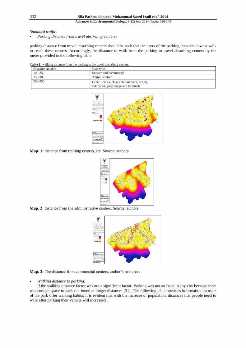
Standard traffic:
Parking distance from travel absorbing centers:
parking distance from travel absorbing centers should be such that the users of the parking, have the lowest walk
to reach these centers. Accordingly, the distance to walk from the parking to travel absorbing centers by the
meter provided in the following table.
Table 1: walking distance from the parking to the travel absorbing centers,
User type Distance suitable Service and commercial 100-350 Administrative 250-300
Other items such as entertainment, health, Education, pilgrimage and terminals
200-350
Map. 1: distance from training centers, etc. Source: authors
Map. 2: distance from the administrative centers. Source: authors
Map. 3: The distance from commercial centers, author’s resources
Walking distance to parking:
If the walking distance factor was not a significant factor. Parking was not an issue in any city because there
was enough space to park can found at longer distances [31]. The following table provides information on users
of the park offer walking habits; it is evident that with the increase of population, distances that people need to
walk after parking their vehicle will increased .

333 Nila Pashmakian and Mohammad Saeed Izadi et al, 2014
Advances in Environmental Biology, 8(12) July 2014, Pages: 328-343
Map. 4: distance from marginal and non-marginal parking
Distance from the road (near the main artery):
path ways leading to the parking plays an important role in determining their parking place. Crowded,
narrow streets where cars due to traffic and congestion problems not well suited to locate parking. Parking
should designed so that emptying a maximum of 50% of their capacity in the emergency. Therefore, the wide
Passages have a higher capacity in parking location. In the ATEC Consultants estimates, we see that 60% of all
urban travel destinations happened in Hamedan central ring composed of nine districts. The main streets within
the context of these district does not have local and destination areas traffic, However, it is a Passing traffic and
have shortcut for the ride of some who want to reach the central square.
Social- Demographic criteria:
living population:
The more lower population density in the city and evenly distributed across the city. The rate of population
Benefit from resources and allocating resources will increase. In contrast, high population density means
increasing demands of any goods and services. In low-density space, have a more spaces to build parking or car
parks on the passages Margin. However, in the high-density car users increased and cause traffic, and many
problems in urban streets [6]. Accordingly, in the scope of the study (using official statistics), about 10,271
people have been living. In addition, based on the area of about 52 hectares of area, population density was of
197.51 people for per hectare. According to the survey, more than 70% of residents own their own home, 20%
of the rental and others are institutional residents or free residents. 56 %of residents have no plans to change
their location and on the contrary, 44%are willing to change their place of residence. This phenomenon means a
moderate level of resident’s interest to living in this part of town.
Map. 5: population density, author’s resources
Floating population: in the study area due to the important factor, town market of Hamadan, Cultural -
religious centers and Central Square, city of Hamedan have floating population and the population will have
different characteristics and social significance. Within the historic market of Hamadan city, attending are
mainly middle and lower classes of rural and urban areas. Major centers of Cultural–religious attracted
particular groups such as Clerics, tourists and young people. In addition, the Commercial edges of Boali Street
open to population that going to this area for shopping.
the identity and history:
In study area, any new construction must considered many monuments. In Figure 3 a valuable historical
monuments and the privacy of each is marked:
334 Nila Pashmakian and Mohammad Saeed Izadi et al, 2014
Advances in Environmental Biology, 8(12) July 2014, Pages: 328-343
Fig. 3: The location of historic sites and its Privacy. Source: municipality of the hamedan province
Physical criteria:
Physical organization:
In this area, except for new construction with high levels, most buildings are two floors and less. Total floor
of 2-storey building approximately forms 193,603 square meters or 37% of the entire existing infrastructure in
this area. Due to Old texture, the maximum number of pieces devoted to fine Components. In some places,
height does not match the texture and therefore combination is for old and new texture that new building
overlooking surrounding building, and cause loss of privacy. In Evaluate the quality of buildings, total floor area
of destroyed buildings approximately 6 hectares that is about 15% of the total floor area is devoted to the study
area. Due to the disturb wind and use of desired wind in north south and due to organic texture, fills texture seen
more than an empty tissue.
Ownership:
respectively state ownership, after private property ownership have highest potential, and finally the
dedicated Property have the least potential for ownership and change to parking usage.
Environmental measures:
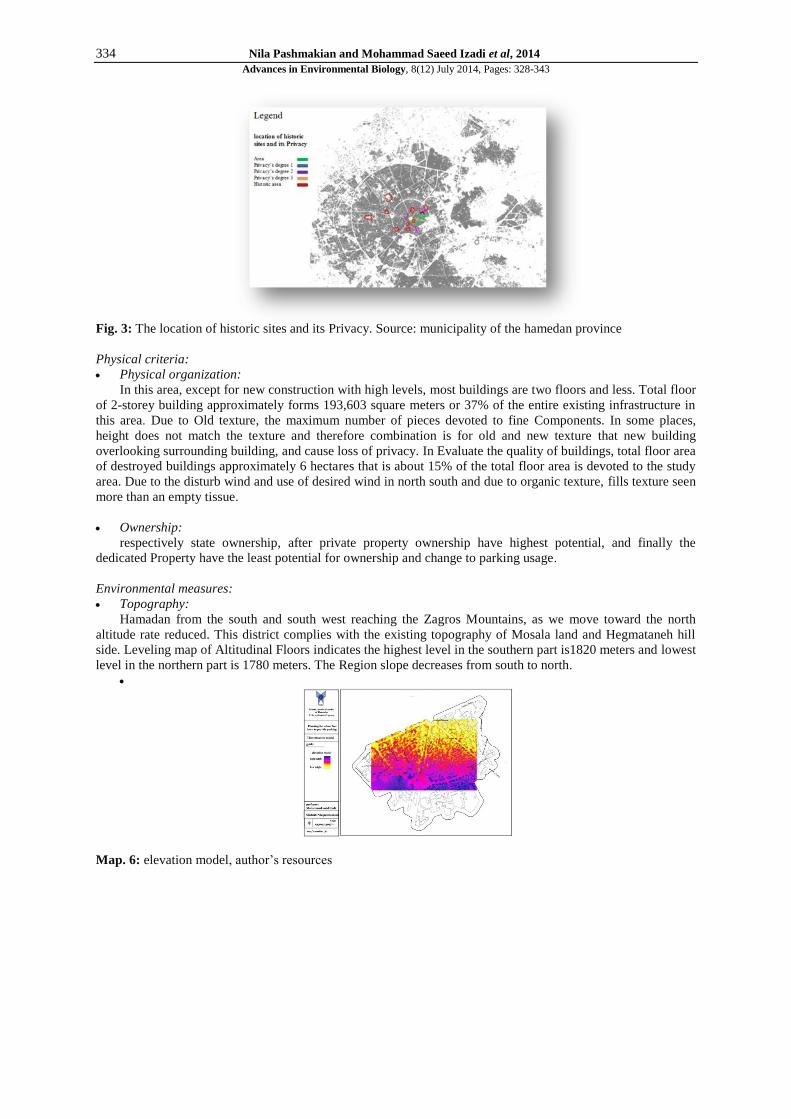
Topography:
Hamadan from the south and south west reaching the Zagros Mountains, as we move toward the north
altitude rate reduced. This district complies with the existing topography of Mosala land and Hegmataneh hill
side. Leveling map of Altitudinal Floors indicates the highest level in the southern part is1820 meters and lowest
level in the northern part is 1780 meters. The Region slope decreases from south to north.
Map. 6: elevation model, author’s resources
335 Nila Pashmakian and Mohammad Saeed Izadi et al, 2014
Advances in Environmental Biology, 8(12) July 2014, Pages: 328-343
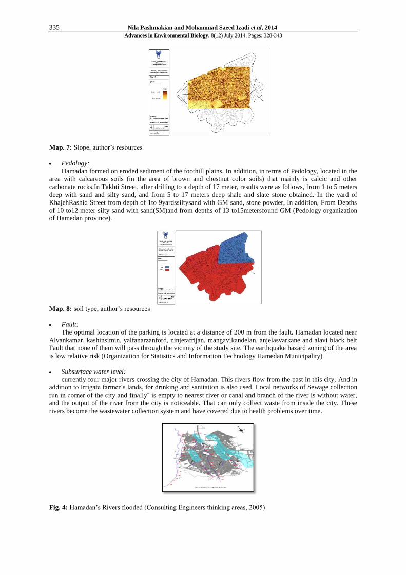
Map. 7: Slope, author’s resources
Pedology:
Hamadan formed on eroded sediment of the foothill plains, In addition, in terms of Pedology, located in the
area with calcareous soils (in the area of brown and chestnut color soils) that mainly is calcic and other
carbonate rocks.In Takhti Street, after drilling to a depth of 17 meter, results were as follows, from 1 to 5 meters
deep with sand and silty sand, and from 5 to 17 meters deep shale and slate stone obtained. In the yard of
KhajehRashid Street from depth of 1to 9yardssiltysand with GM sand, stone powder, In addition, From Depths
of 10 to12 meter silty sand with sand(SM)and from depths of 13 to15metersfound GM (Pedology organization
of Hamedan province).
Map. 8: soil type, author’s resources
Fault:
The optimal location of the parking is located at a distance of 200 m from the fault. Hamadan located near
Alvankamar, kashinsimin, yalfanarzanford, ninjetafrijan, mangavikandelan, anjelasvarkane and alavi black belt
Fault that none of them will pass through the vicinity of the study site. The earthquake hazard zoning of the area
is low relative risk (Organization for Statistics and Information Technology Hamedan Municipality)
Subsurface water level:
currently four major rivers crossing the city of Hamadan. This rivers flow from the past in this city, And in
addition to Irrigate farmer’s lands, for drinking and sanitation is also used. Local networks of Sewage collection
run in corner of the city and finally˝ is empty to nearest river or canal and branch of the river is without water,
and the output of the river from the city is noticeable. That can only collect waste from inside the city. These
rivers become the wastewater collection system and have covered due to health problems over time.
Fig. 4: Hamadan’s Rivers flooded (Consulting Engineers thinking areas, 2005)

336 Nila Pashmakian and Mohammad Saeed Izadi et al, 2014
Advances in Environmental Biology, 8(12) July 2014, Pages: 328-343
Map. 9: distance from the Moradbaig river
Economic criteria:
Land price:
The economic cost of construction in this part cause the growing trend of Building Density. This situation
has an effect on the height tissue of area. However, according to high Antiquity of Tissue, limitations for height
buildings have considered, that would led to adverse effects on renovation of old texture in this area. Residential
real estate prices in main axes ending to square (takhti and boali axes), between16 to 17 million toman and
(shariati axe) more than18 million tomans. Real estate prices in shariati, boali, and takhti Zonesa price from 1
million to 2 milion toman. Lowest Price in akbatan zone is babataher with less than 1 million toman.
Map. 10: Commercial real estate prices, Zone
Map. 11: Housing prices in the area
Map. 12: Commercial real estate prices in axis, Source: The authors

337 Nila Pashmakian and Mohammad Saeed Izadi et al, 2014
Advances in Environmental Biology, 8(12) July 2014, Pages: 328-343
Table 3: Underground space applications, Resources: (Knights&Admiraal, 2008)
Use of transportation (with the emphasis on
infrastructure)
Tunnels for transport (people and goods)
Mass transport of cables and network equipment
Productive use
natural findings, agricultural and urban parks
Exploration of natural resources
Surface layers: sand, gravel, clay
Deep layers :oil and gas
Water tanks and water extraction
Application of urban structures Results and strategy on the matter and buildings
Car parking, ground stations, cinemas, offices, shopping centers
Use of Storage and Reservoir
Tank waste products, dangerous goods
Decontamination of soil
Energy Storage, Thermal Energy Storage
Archive Application Cultural Heritage and Archaeology
Geography and earth sciences
Reasons to use subsurface levels for providing parking:
As the world population is increasing the country needs higher standards of living for their people. World to
bear against the growing need, should provide more food, energy and mineral resources. This compounded by
three major trends: Conversion of arable land to urban uses, 2) urbanism growing of world population, 3) and
the growing concern for environmental protection and improvement, especially due to global warming and its
impact on population growth [13]. So the ground level, faced with many issues in cities, such as environmental
problems, dense population increases, rapid urbanization and migration and the lack of adequate space and land.
Trying to get rid of the limitation we encountered with this option makes it possible to exploit the third
dimension of space. At first glance, this dimension imagined upward that In this case problems like pollution
and obstruction of the visual corridors and things like this. In order to modulate the adverse effects, the idea of
using the third dimension in terms of downward movement of subsurface spaces proposed In addition, attempt
to overcome technical and Quality problems to operate and improve its quality and its utility has started and in
its kind provided the benefits for stakeholders and users [28]. The major reasons for embracing the underground
spaces, especially in the current era can be knew as a physical, environmental, social, safety and economic
factors:
Table 4: Reasons for using subsurface spaces.
Physical factors
The use of underground space due to lack of space or because creating the surface facilities at the site is not acceptable in society .
Placing facilities under low levels is an acting techniques to help make The lighter burden of high
density land uses
Especially in urban centers with population and urbanization growth and development, (Carmody & Sterling, 1993:6).
To hide the unattractive technical facilities in sensitive locations or industrial installations for
protecting landscape
Environmental factors
Prevent loss of agricultural land degradation due to horizontal expansion of cities and roads (ibid.) .
Protection from the very cold or very hot weather because of average and uniform ground level temperatures (Golany, 1996).
Typically, underground structures, according to the above-ground structure, are more resistant to catastrophic events such as earthquakes, hurricanes, tornadoes, foreign fires (ISWA,2013)
The use of topography and Natural factors of land (Carmody& Sterling, 1993:267).
Social factors To provide facilities for the growing population lives in cities
Protective
views
The safest place to store nuclear waste and other hazardous substances or undesirable substances
in underground installations (Sterling & Godard, 2005).
Protect stored objects or products such as food and…in terms of average and constant
underground temperature.
Protect the transmission of noise in the air (same) .
Passive defense (emergency shelter in times of war, explosions and possible continuation of the activities and services of the Department of Infrastructure and meet their vital needs in ongoing crisis caused
by the war).
Economic view
Low cost of land, will make it easier to start the project.
Thermal insulation exists in subsurface structure that cause the ventilation system installed more
easily and at lower costs. Part of the costs of reducing vibration, constant temperature and clean room space is also less than surface structures.
Physical Insulation of subsurface structures, prevents external environment impact such as building components and reduces maintenance costs that compared with surface structure is considerable.
Subsurface Structures have more life time than minimal surface structures
Due to the position and orientation of harmful agents, normally are more prone to damage and destruction
Introduction Indicators and research criteria based on sustainability indicators

338 Nila Pashmakian and Mohammad Saeed Izadi et al, 2014
Advances in Environmental Biology, 8(12) July 2014, Pages: 328-343
Table 5: Factors influencing the evaluation of subsurface levels to provide parking, Source: the authors
Effective Factors used in the evaluation of subsurface levels in the central area Indicators
Service level / radius access / walking distance / distance from the street / fast and safe passage out of
the range of tissue... / Traffic and Transport
Identify Stable regions and areas in the risk / change management and investment outlook / consider
activities Financial dimensions / increase public awareness and participation, and use of local power / creating cooperation networks between different sectors /Codification effective laws and regulations /
applying New procedures for optimal use of economic tools... /
Managerial
Trying for economic growth / decline in the cost of municipal services / using incentive policy /
increase economic efficiency / Attracting non-governmental investment Economical
Ground slope/ soil type and distance from the fault / underground water level / reduce noise and air
pollution / Environmental
Density of building / property / mixing physical and multipurpose use of space / redevelop existing land / sustainable management of urban land and optimal use of land
Physical
Population density / Equitable distribution of resources/ focus on collective spaces / focus on culture
and identity / non-separation and social isolation / considering human needs... / Social-cultural
Research Results:
For Combine with each other as an information layers, the weight of each criterion and sub criterion must
be commensurate with the importance and specified using a weighting method. Because the criteria that used for
Locating, usually do not have the same significance In this study, the compare paired weighting method used.
Method of pair wise comparison Because of its strong theoretical basis, high accuracy, having a value is one of
the most reliable and most widely used approach. Comparisons in this method conducted based on theoretical
analysis and described rather qualitatively. In this way to avoid personal errors in decisions using opinions of
experts and consists of three stages to create a hierarchy of criteria and sub criteria, comparison of the pair wise
and calculation Weights, and Estimates the relative in compatibility of decision.
Chart. 2: Calculation of criteria and sub-criteria in the subsurface parking, Source: The authors
Criteria Weight according to the principles of surface parking appears in the below diagram. Environment
criteria has been more important than other criteria The most important consideration is the environmental
standards than other criteria.

339 Nila Pashmakian and Mohammad Saeed Izadi et al, 2014
Advances in Environmental Biology, 8(12) July 2014, Pages: 328-343
Fig. 3: prioritization criteria, author's resource
The following four alternatives selected in khajeh Rashid Street, area of Bani Sadr, Madani Boulevard,
Shariati place. Then with analysis and comparison of four alternative spatial applying Fuzzy AHP based on
Analytic Hierarchy Process (AHP) to help with the GIS (GIS) using IDRISI and ARC GIS, ARC VIEW
software. Fourth Alternative location located in Takhti Avenue has the highest priority for parking layout.
Map. 13: Locating alternative location, author’sresources
As apparent from the following drawings, place located on Shariati Street and Madani Boulevard have
highest priority to locate Subsurface parking in terms of environmental criteria and related parameters (distance
from the river Moradbaig, and the soil type and slope). In addition, the location of Takhti and MadaniBoulevard
Avenue and Khaje Rashid respectively have highest priority to locate Subsurface parking in terms of social
criteria and related parameters (population, distribution of urban facilities, preservation of neighborhoods and
security)
Map. 14: suitable location of parking, social criteria

340 Nila Pashmakian and Mohammad Saeed Izadi et al, 2014
Advances in Environmental Biology, 8(12) July 2014, Pages: 328-343
Map. 15: parking suitable locating, Environmental criteria, source: the authors
As apparent from the following drawings, place located in Khajeh Rashid and Takhti Avenue have highest
priority to locate subsurface parking in terms of performance measures (absorption of travel) .Place located in
Khajeh Rashid and Takhti Avenue have the highest priority to suitable location of Subsurface parking in terms
of the traffic criteria and related parameters (distance from the parking, away from the main roads, the distance
of the travel absorbing centers, traveling sensitivity) .
Map. 16: suitable location of parking, criteria of travel absorbing centers, Source: The authors
Map. 17: suitable location of parking, traffic criteria, author’sresources
Chart. 4: options percentage in priority of suitable location of parking plan, Source: The authors
341 Nila Pashmakian and Mohammad Saeed Izadi et al, 2014
Advances in Environmental Biology, 8(12) July 2014, Pages: 328-343
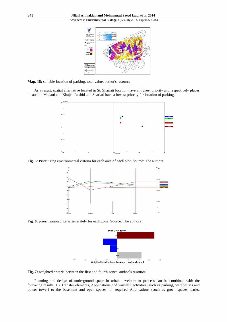
Map. 18: suitable location of parking, total value, author's resource
As a result, spatial alternative located in St. Shariati location have a highest priority and respectively places
located in Madani and Khajeh Rashid and Shariati have a lowest priority for location of parking.
Fig. 5: Prioritizing environmental criteria for each area of each plot, Source: The authors
Fig. 6: prioritization criteria separately for each zone, Source: The authors
Fig. 7: weighted criteria between the first and fourth zones, author’s resource
Planning and design of underground space in urban development process can be combined with the
following results. 1 - Transfer elements, Applications and wasteful activities (such as parking, warehouses and
power tower) to the basement and open spaces for required Applications (such as green spaces, parks,

342 Nila Pashmakian and Mohammad Saeed Izadi et al, 2014
Advances in Environmental Biology, 8(12) July 2014, Pages: 328-343
recreational applications). 2 - Balance the congested area with underground development and solve
environmental problems. 3 - Underground spaces have high stability in times of crisis or disaster such as an
earthquake. 4 - Underground Spaces enhances buildings flexibility and urban spaces and increase users choice
in different climatic, economic and social conditions. 5 - Underground Spaces have a stable temperature and
minimum temperature in winter and summer and have a good ability in climate for human comfort and human
life needs. Taking this approach for the southern side of the metropolitan area of Hamedan, while adopting a
holistic approach to historical and natural characteristics, socio-cultural environment can help to improve
quality. Identification and analysis of this area shows that high Pedestrians and driver disorders and loss of
identity surrounding central tissue and lack of space are the top issues. It is noteworthy that these spaces should
use holistic approach and consider all aspects, and dimensional attitudes can lead to inefficiency and the lack of
success of these spaces.
The objective of this research, to use the hierarchical fuzzy technique in south side of the metropolitan area
of Hamadan, for achieving assess and prioritize the criteria and effective sub-criteria in subsurface location of
parking, in the study area and ranking options for location of parking according to the specified criteria’s . In
this study, each of the criteria and sub criteria classified and ranked with fuzzy AHP technique. Therefore, the
proposed analytical model is composed of 7 criteria and 17 sub-criteria. According to the results, from studied
criteria, the criteria for "environment", "traffic", "economy", "Functions", "anatomical", "crowd", respectively
have the most effective measures in order to locate Subsurface parking in studies area. The results of the sub-
criteria determines the "distance from travel absorption centers", " distance from river", "soil type", " Ground
slope", "parking space", "distance from the main thoroughfares", respectively, with weights 0.594, 0.383, 0.333,
0.284, 0.249, 0.157, have the largest share in the subsurface parking. Finally, results from any one of the four
study area and the weight of each alternative location show that fourth place located in Takhti streets with 0.280
is the most appropriate location. The second place located in Shariati with 0.229 weights is the lowest among
the four locations.
Vehicle parking spaces suggestions:
1)locate Subsurface parking space will be made in keeping with the surrounding neighborhood centers and
given adequate ventilation and access to adjacent residential land uses. Smoke or noise has caused it not to
disturb the comfort of residential neighborhoods surrounding tissue.
2)Remove and delete the parking lots running in the area of first ring (such as Kababiyan and Aghajanibeig
parking lots),and the opportunity to transfer to the surface so that the user in contravention of neighborhoods
view, cultural and natural characteristics, valuable features of the environment, and the subsurface space
designed according to the spirit of this historic area have a high importance 3) entrance passageway width and
slope way to parking is not less than 5 meters and average parking less than 3/50meters. Entrance dips width
shall be the width of the internal route.
4) The land with over 25 meters of a pedestrian entrance two vehicles allowed. In addition, the slope of
the ramp at least 15% of the property without violating the Pavement.
5) In subsurface Parking location soil mechanical conditions should considered.
6) Maneuvering space provided when space between the column into two units for deployment vehicle 4.5
m or axle-to-axle 4.8 m and main manor is a 5meter.
REFERENCES
[1] Bastie, Jean and Desert, Bernar, 2003. "City", translating Dr. Ali Ashrafi, Arts University Press, second
edition.
[2] Pakzad, Jahanshah, 2007. “ideas process in Urbanism ", Volume II, published by New Towns.
[3] -organization for Statistics and Information Technology ¬ Hamedan province, (2013).
[4] Pedology organization of Hamedan province( ,(2013).
[5] Shahi, Jalil, 2000. "Traffic Engineering", Fifth Edition, Tehran Publishing Center, Tehran.
[6] Ebadi, Mosa, 2007. “parking lots location by using OWA", MSc thesis, Faculty of Geosciences,
ShahidBeheshti University
[7] Gharib, Fereydon, 2012. "Communication Networks in Urban Design", First Edition, Eighth print.
[8] Motkan, A., A. Shakiba, H. Pourali, A. Ebadi, 2009. " Definite and fuzzy decision to locate parking lots"
Environmental Sciences, 6 ( 3.)
[9] Statistical Center of Iran (1996 and 2006), "Population and Housing Census Results", country’s
Management and Planning organization.
[10] Fajr Consulting Engineers and development projects in Tehran areas of subsurface, 2009.
[11] Consulting Engineers in cooperation with Rahvar research consulting engineers, Hamedan( (2005)
[12] BARKER, M., 1991. "Legal and administrative issues in underground space use: a preliminary survey of
ITA member nations", Tunnelling and Underground Space Technology, 6(2): 191-209.

343 Nila Pashmakian and Mohammad Saeed Izadi et al, 2014
Advances in Environmental Biology, 8(12) July 2014, Pages: 328-343
[13] Carmody, J., R. Sterling, 1993." Underground Space Design: A Guide to Subsurface Utilization and Design
for People in Underground Spaces", Van No strand Reinhold, New York.
[14] Chow, f.C., T. Paul, T. vähäaho i. b. Sellberg, L.J.L. lemos, 2002. "Hidden aspects of urban planning:
utilization of underground space". Conference on Soil Structure Interaction in Urban Civil Engineering,
Zürich.
[15] Durmisevic, S., 1999. "The future of the underground space", Cities, 16(4): 233-245, Elsevier.
[16] Dunkel, F., 1985. "Underground and earth sheltered food storage: historical, geographic and economic
considerations".
[17] Duffaut, P. & C. Mégnin, 1995. "Underground Paris [Paris souterrain]".Géochronique, pp: 18-27.
[18] Edelenbos, J., R. Monnikhof, J. Haasnoot, F. Van Der Hoeven, E. Horvat, R. Van Der Krogt, 1998.
"Strategic study on the utilization of underground space in the Netherlands". Tunneling and Underground
Space Technology, 13: 159-165.
[19] Godard, J.P., R.L. Sterling, 1995. "General considerations in assessing the advantages of using
Underground space".Tunneling and Underground Space Technology.
[20] Golany, S.G., and T. Ojima, 1996. "Geo-Space Urban Design. New York:" John Wiley& Sons, USA.
[21] ISWA, 2013. World congress is one of the world’s most important congresses in the field of waste
management, Vienna.
[22] -Knights, Martin. Admiraal, Han, 2008. “The use of underground space in urban development”.
[23] Labs, K., 1976. "The architectural underground". Underground Space 1.
[24] Maire, P., p. Blunier, A. Parriaux, L. Tacher, 2006. " Underground Planning And Optimisation Of The
Underground Ressources’combination Looking For Sustainable Development In Urban Areas".
[25] Monnikhof, R., J. Edelenbos, R. vanderKrogt, 1998. "How to determine necessity for using underground
space: an integral assessment method for strategic decision-making". Tunneling and Underground Space
Technology, 13(2).
[26] Parriaux, A., L. Tacher, V. Kaufmann, P. Blunier, 2006. "Underground resources and sustainable
development in urban areas": AEG, pp: 3-8.
[27] Qing Li, H., A. Parriaux, P.h. Thalmann, 2012." The Way To Plan A Sustainable “Deep City”: The
Strategic Framework And Economic Model, 13th Acuus conference “Underground Space Development –
Opportunities and Challenges” Singapore.
[28] -Sterling, R.L., and J.P. Godard, 2005. "Geoengineering Considerations in the Optimum Use of
Underground Space".ITA-Technical Report. ITA-AITES:
[29] Tareau, J.P., 1995. "Underground Car Parks", ITA Working Group No. 13, "Direct and indirect
Advantages of Underground Structures".
[30] UTUDJIAN E., 1952. "Architecture and underground urbanism" [Architecture et urbanism souterrains].
[Laffont], (in French).
[31] Weant, R.A., 1978." Parking Garage Planning and Operation". ENO Foundation for Transportation INC,
Jersey07632, pp: 166-192.Nigeria.
[32] Yang, Jiaqin, Lee, Huei, 1997. "An AHP decision model for facility location selection", Publisher: MCB UP
Ltd, Facilities, 15: 9/4.