actuarial document selector system and access to … to the adbs ¾the most appropriate way to...
TRANSCRIPT

Actuarial Document Actuarial Document Selector System and Selector System and
Access to the FCIAccess to the FCI--33 Rate 33 Rate MapsMaps

Access to the ADBSAccess to the ADBSThe most appropriate way to access the FCIThe most appropriate way to access the FCI--33 Actuarial 33 Actuarial Maps is through the Actuarial Document Browser. The Maps is through the Actuarial Document Browser. The links for the Browser are below and are available directly links for the Browser are below and are available directly off the RMA Web Site (off the RMA Web Site (http://http://www.rma.usda.govwww.rma.usda.gov))
Actuarial Document BrowserActuarial Document Browserhttp://http://www.rma.usda.gov/tools/adb.htmlwww.rma.usda.gov/tools/adb.html
then, select the following link from the Actuarial then, select the following link from the Actuarial Document Browser page.Document Browser page.
FormForm--based (user friendly) Actuarial Documentsbased (user friendly) Actuarial Documentshttp://www3.rma.usda.gov/apps/docbrowser/docbrowserA.cfmhttp://www3.rma.usda.gov/apps/docbrowser/docbrowserA.cfm

FCIFCI--33 Maps33 Mapsthe maps are also in a PDF list on the RMA the maps are also in a PDF list on the RMA Website (http://Website (http://www.rma.usda.govwww.rma.usda.gov). ). there are also there are also ShapefilesShapefiles for ESRI based GIS for ESRI based GIS systemssystemsto determine the crop type the FCIto determine the crop type the FCI--33 map 33 map pertains to, you need to access the Map Rule pertains to, you need to access the Map Rule Page through the Actuarial Documents BrowserPage through the Actuarial Documents Browseras you will see in the "walkas you will see in the "walk--through" of the through" of the Actuarial Documents Browser in the attached Actuarial Documents Browser in the attached PDF the correct map will be linked to PDF the correct map will be linked to automaticallyautomatically

Actuarial Document Actuarial Document Browser WalkBrowser Walk--throughthrough

Actuarial Document Selector System
Select STATES for access to the FCI-33 Rate Maps by state, county & crop.
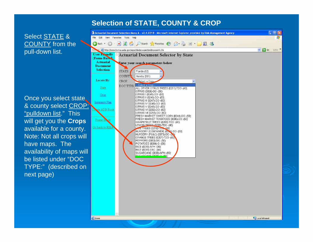
Selection of STATE, COUNTY & CROP
Once you select state & county select CROP: “pulldown list.” This will get you the Cropsavailable for a county. Note: Not all crops will have maps. The availability of maps will be listed under “DOC TYPE:” (described on next page)
Select STATE & COUNTY from the pull-down list.
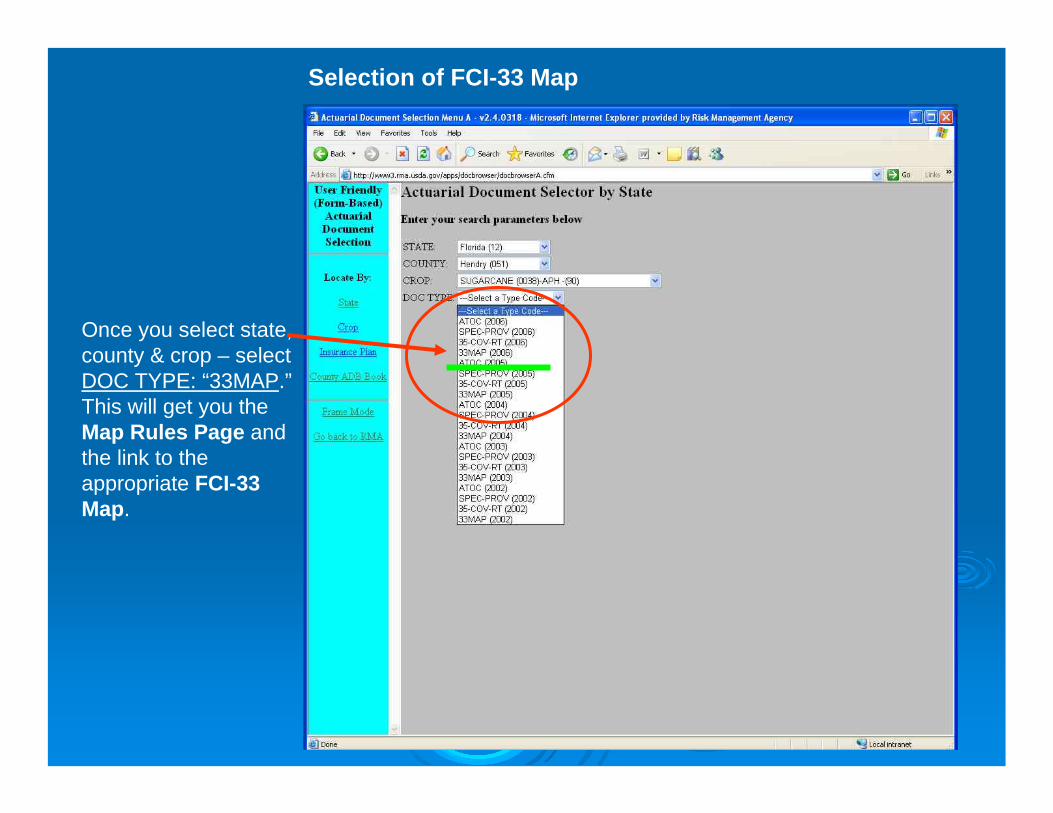
Selection of FCI-33 Map
Once you select state, county & crop – select DOC TYPE: “33MAP.”This will get you the Map Rules Page and the link to the appropriate FCI-33 Map.

Map Rules Page AND Link to Appropriate Map
The map legend/key is described here on the “Map Rules Page.” The map Rules Page identifies all the crops, types, and practices in the county for which the map applies. There will be a separate “Map Rules Page”for each map.
The link for the map for the selected county, crop & practice is here.

Map Rules Page Generated for FCI-33 Map
When you click on the FCI-33 Actuarial Map link the map will spawn off into a new Adobe Acrobat PDF window. The appropriate map for that county, crop & practice will be displayed.

Map Rules Page Generated for FCI-33 Map
The map legend/key is described here on the “Map Rules Page.” There will be a separate “Map Rules Page” for every map in the county. Each map may apply to multiple crops, types, and practices within the county.

General Standards Applicable to General Standards Applicable to the FCIthe FCI--33 Actuarial Maps33 Actuarial Maps
As maps are redrawn, they will all be designated as FCIAs maps are redrawn, they will all be designated as FCI--33, 33, Actuarial Maps. There may be separate maps (RMA layers) for TActuarial Maps. There may be separate maps (RMA layers) for T--Yields and High Risk areas, but there will no longer be a separaYields and High Risk areas, but there will no longer be a separate te actuarial document titled actuarial document titled ““TT--Yield Locator DocumentYield Locator Document””..
CrossCross--Hatched designation will always mean Unrated Land Hatched designation will always mean Unrated Land (URA).(URA). There are no areas designated with a cross hatch that have There are no areas designated with a cross hatch that have a rate assigned. Inversely, all areas designated as crossa rate assigned. Inversely, all areas designated as cross--hatched hatched on the actuarial map must be unrated land.on the actuarial map must be unrated land.
Maps for TMaps for T--Yield purposes only will have numeric designationsYield purposes only will have numeric designations. . TT--yield = NUMERIC designatoryield = NUMERIC designator
Maps that are for High Risk areas only will have alpha designatiMaps that are for High Risk areas only will have alpha designationsons. . High Risk = ALPHA (A, B, C) designatorHigh Risk = ALPHA (A, B, C) designator

General Standards Applicable to General Standards Applicable to the FCIthe FCI--33 Actuarial Maps33 Actuarial Maps
a map (RMA layer) may be used for both High Risk areas and Ta map (RMA layer) may be used for both High Risk areas and T--Yield Yield areas, but only when the areas are identical. When a High Risk areas, but only when the areas are identical. When a High Risk area and a area and a TT--Yield area are the same, alpha designators will be usedYield area are the same, alpha designators will be used. . High Risk & THigh Risk & T--yield = ALPHA designatoryield = ALPHA designator
maps that are for crops using Rating Areas (Rate Class crops witmaps that are for crops using Rating Areas (Rate Class crops with plan h plan codes 40, 41, 43, 46, 50, 51, 55, 70, 84, and 86) will have numecodes 40, 41, 43, 46, 50, 51, 55, 70, 84, and 86) will have numeric ric designationsdesignations. . If the map contains high risk areas, the high risk area portion If the map contains high risk areas, the high risk area portion of the map will be designated with alpha charactersof the map will be designated with alpha characters. . Both Rating Area & Both Rating Area & High Risk = NUMERIC (Rating Area) & ALPHA (High Risk)High Risk = NUMERIC (Rating Area) & ALPHA (High Risk)
when digitizing High Risk map areas, separate when digitizing High Risk map areas, separate polygon(spolygon(s) encompassing ) encompassing the remainder of the county that is not designated as High Risk the remainder of the county that is not designated as High Risk must be must be digitized. (There will be an RMA line around the County Boundarydigitized. (There will be an RMA line around the County Boundary))
most of these issues will be explained on the Map Rules Page formost of these issues will be explained on the Map Rules Page for the the particular County/Crop.particular County/Crop.