activities of nict space weather and ionospheric …//aoswa.nict.go.jp/associates.html aoswa mailing...
TRANSCRIPT

Activities of NICT space weather and ionospheric research
Takuya [email protected]
Senior ResearcherSpace Weather and Environment Informatics Laboratory
Applied Electromagnetic Research InstituteNational Institute of Information and Communications Technology (NICT)
4-2-1 Nukui-kita, Koganei 184-8795 JAPAN

• The “ONLY National Institute” of Information and Communications technology in Japan
• Staff: permanent researchers: 300, temporal researchers: 400, administrative: 200 (approximately).
• Yearly budget: about 30 billion JPY
• Headquarter: Koganei, Tokyo
• Main Blanches: Keihanna, Kobe, Kashima, Okinawa
• Observatories: Wakkanai, Hiraiso, Yamagawa, Okinawa
About NICT

• Target– Forecasting technology of radio
propagation in the ionosphere– Forecasting technology of
electromagnetic environments on geostationary orbit
Communication troubles
Satellite troubles
NICT space weather activities
• Moreover…– Grasp and mitigation of electromagnetic disaster from NATURAL
source– Especially, suggests appropriate and precise information about
rare and severe events (once in 1000 years) such as ultra-huge frares to decision makers.
– Contribute to Safe and secure use of radio wave

< Time range of forecast >
[X-ray, EUV, light, radio wave]• Approximately 8 min. (light speed)
[ solar energetic particles ]• tens minutes to several hours
[Interplanetary shocks]• approximately 1 hour (from ACE)• two or three days (from the sun)• twenty-seven day (solar rotation)
[solar cycle]• approximately 11 years
Space weather: cause and effect

Ionospheric effects on radio applications

Ionosonde-domestic-SEALION-Antarctica
GPS-TEC DB
Obs.
Open data
Construct of model/simulation code
Experimental: Neural Net for EPB
Numerical:GAIA model
Prior service
4D assimilation
Numerical forecasts
Provide data for contributing to global model(International Reference Ionosphere)
development(automatic scaling/ passive radars)
Provide input data
verification
Meteorological data
Connection of magnetospheric model
Nowcasts and forecasts of ionosphere
Nowcasts and forecasts of ionosphere
Forecast of Ionospheric condition and disturbances
Ne
Tn
Rainfall

Two-dimensional TEC observation using a dense GPS receiver network
TEC perturbations detrended with 10-min window after the 2011 Tohoku EQ. Star mark represents the epicenter. [Tsugawa et al., EPS, 2011]
• A dense GPS receiver network makes it possible to observe two-dimensional TEC variations.
GEONET consisting of more than 1,200 GPS stations

Absolute TEC ROTI (~10km scale irregularity)
Loss-of-Lock (~100m scale irregularity)
12:20 UT(21:20 JST)
12:40 UT(21:40 JST)
13:00 UT(22:00 JST)
GPS loss of lock caused by plasma bubble

Realtime GPS-TEC observation in Japan
• NICT started realtime (now 10-30 min delay) two-dimensional TEC observation using realtime GEONET data in the collaboration with ENRI, Kyoto-U., and Nagoya-U.
• The database of TEC maps from 1997 are available on the website.
http://seg-web.nict.go.jp/GPS

Global GNSS receiver networks
� As of 2012, we are collecting all the available GNSS receiver data (more than 6,000 receivers) which belong to GEONET, UNAVCO, SOPAC, IGS, CORS, EPN, etc (more than 20 providers).
� We have developed regional/global high-resolution maps of absolute TEC, detrended TEC, ROTI, loss-of-lock on GPS signals.

Present
Southeast Asian GNSS NetworksAvailable for Ionospheric Researches
Near Future Image
• Dense and wide-coverage GPS receiver network can reveal their spatial structures, propagation directions, and temporal evolutions.
• The GPS-TEC maps greatly contribute to the ionospheric researches and the nowcast/forecast of space weather.
• However, it is difficult to collect or share the GNSS data in some countries due to government or institute data policy.
EIA?
TID?
EIA?
TID?
Plasma Bubble?
EAI
TID
EAI
TID
Plasma Bubble

GPS Observation Data((((RINEX format))))
Header Part
1 epoch
year, month, day, hour, min, sec, flag, # of PRNs, PRNs
Filename: ssssdddh.yyossss: marker nameddd: day of the yearh: file sequence numberyy: 2-digit year

General GNSS-TEC data (ex. IONEX)
Multiple GPS Receivers
RINEX Observation Data
Absolute VTEC Map Data
Input
Output
RINEX Navigation
Data
Satellite Biases
Satellite/receiver biases, absolute slant TEC estimation
Slant-to-vertical TEC conversion
Receiver Biases
• Vertical absolute TEC (VTEC) map data and instrumental biases ofsatellite and receiver are simultaneously derived from the data of multiple GPS receivers and satellite orbit.
• Temporal and spatial resolution of VTEC Map data are too low to observe small-scale ionospheric disturbances such as plasma bubble and ionospheric waves.
An example of IGS TEC map with spatial resolution of 5° in longitude, 2.5° in latitude and temporal resolution of 2 hours (Hernández-Pajares, 2009).Share

IONEX format (v1.0)
Header Part
VTEC values for longitude bins at a latitude bin
epoch start
Filename: cccedddh.yyIccc: Analysis Center designatore: extension or region codeddd: day of the yearh: file sequence numberyy: 2-digit yearI: file type

Proposed GNSS-TEC data for data sharing
Single GPS Receiver
RINEX Observation Data
Input Output
Slant TEC with Biases
Slant-to-vertical TEC conversion
Multiple receiver data processing
Slant TEC derivation
Combined satellite and receiver biases estimation
Combined Biases
Biases subtraction
IGS Orbit Data
Absolute Slant TEC
High-pass filterSlant-to-vertical TEC
conversionMultiple receiver
data processing
VTEC perturbation Map Data
IGS Orbit Data
Absolute VTEC Map Data
• Slant TEC data including satellite and receiver biases are derived from GPS data of one receiver.
• VTEC maps can be derived using the slant TEC data from multi GPS receivers.
• The VTEC data can have high temporal and spatial resolution.
• The Slant TEC data would be suitable for data sharing in the Southeast Asia.
Share
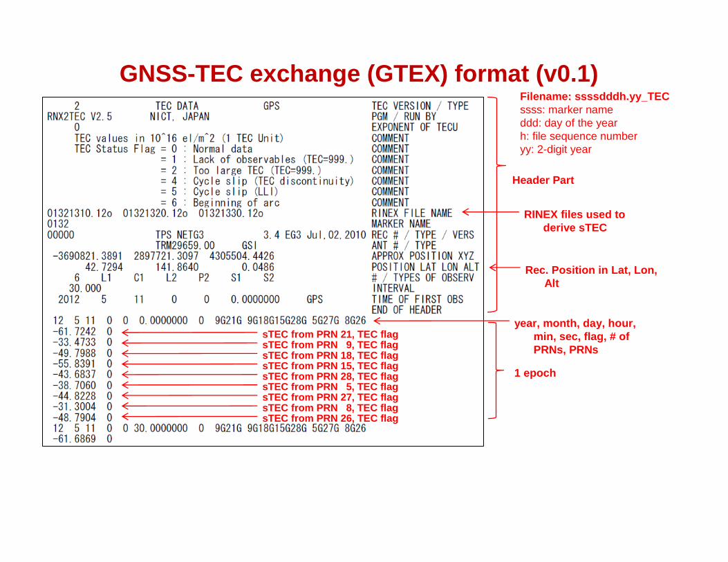
GNSS-TEC exchange (GTEX) format (v0.1)
Header Part
1 epoch
year, month, day, hour, min, sec, flag, # of PRNs, PRNs
Filename: ssssdddh.yy_TECssss: marker nameddd: day of the yearh: file sequence numberyy: 2-digit year
sTEC from PRN 21, TEC flagsTEC from PRN 9, TEC flagsTEC from PRN 18, TEC flagsTEC from PRN 15, TEC flagsTEC from PRN 28, TEC flagsTEC from PRN 5, TEC flagsTEC from PRN 27, TEC flagsTEC from PRN 8, TEC flagsTEC from PRN 26, TEC flag
RINEX files used to derive sTEC
Rec. Position in Lat, Lon, Alt

GNSS-TEC exchange (GTEX) format (v0.2)
Header Part
1 epoch
year, month, day, hour, min, sec, flag, # of PRNs, PRNs
Filename: ssssdddh.yy_TECssss: marker nameddd: day of the yearh: file sequence numberyy: 2-digit year
sTEC from PRN 21, TEC flagsTEC from PRN 9, TEC flagsTEC from PRN 18, TEC flagsTEC from PRN 15, TEC flagsTEC from PRN 28, TEC flagsTEC from PRN 5, TEC flagsTEC from PRN 27, TEC flagsTEC from PRN 8, TEC flagsTEC from PRN 26, TEC flag
• This version is presented in the ISTF/2.
RINEX files used to derive sTEC
Rec. Position in Lat, Lon, AltTypes of obs. in RINEX
Interval according to RINEX

GNSS-TEC data sharing based on GTEX• NICT have developed the database of
“GTEX” data for more than 6,000 GNSS receivers in the world. These data are available via the NICT science cloud, OneSpaceNet (OSN).
• Since the 1st AOSWA workshop held in Chiang Mai, Thailand in February 2012, we are now developing the GTEX data of Thailand, Indonesia, South Korea, and China collaborated with KMITL, LAPAN, KMA, and CMA, respectively.
• We can provide software products to convert RINEX data to GTEX data (Fortran 77) , and to make high-resolution TEC grid data (Fortran 77) and map images (IDL).
• NICT recently released a Windows software “RNX2GTEX” which are available via the NICT website.
Detrended TEC over Thailand. [Courtesy of K. Watthanasangmechai (KMITL)]
Detrended TEC over Indonesia by SUGAR network.
http://seg-web.nict.go.jp/e-sw/download/index_e.html

• Objective: make a regional linkage of information of space weather for operations and researches
• GTEX data sharing is one of important items.
Asia-Oceania Space Weather Alliance: AOSWA
The 1st AOSWA workshop at Chiang Mai, Thailand during 22-24 February 2012. - 10 countries, 30 organizations, 76 participants- 41 oral presentations, 21 poster presentations, 1 tutorial lecture- an excursion- business meeting
http://aoswa.nict.go.jp
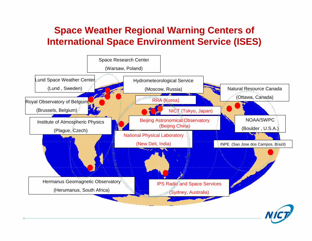
IPS Radio and Space Services
(Sydney, Australia)
NOAA/SWPC
(Boulder , U.S.A.)
Natural Resource Canada
(Ottawa, Canada)
NICT (Tokyo, Japan)
Beijing Astronomical Observatory (Beijing China)
National Physical Laboratory
(New Deli, India)
Hydrometeorological Service
(Moscow, Russia)
Space Research Center
(Warsaw, Poland)
Institute of Atmospheric Physics
(Plague, Czech)
Royal Observatory of Belgium
(Brussels, Belgium)
Lund Space Weather Center
(Lund , Sweden)
Space Weather Regional Warning Centers ofInternational Space Environment Service (ISES)
Hermanus Geomagnetic Observatory
(Herumanus, South Africa)
INPE (Sao Jose dos Campos, Brazil)
RRA (Korea)

Space Weather Workshop @USA
Space Weather Week @Europe
AOSWA @Asia-Oceania region

AOSWA meetings
22

Associates (so far)http://aoswa.nict.go.jp/associates.html
AOSWA mailing list <[email protected]>
Join Us!Join Us!

Summary• Activities of NICT space weather and ionospheric researches were briefly
introduced.
• High-resolution two-dimensional TEC observations with dense GNSS receiver networks have been used for monitoring and researching severe ionospheric disturbances which can degrade GNSS navigations and cause loss-of-lock on GNSS signals.
• The dense GNSS receiver networks in the Asia-Oceania region would be a powerful tool for the nowcast/forecast of ionospheric disturbances such as plasma bubbles.
• We have developed GNSS-TEC data sharing system based on “GTEX”format under AOSWA (and hopefully under ICAO/ISTF). The GTEX database are available via NICT science cloud “OneSpaceNet”
AcknowledgementGNSS receiver data are provided by GSI, UNAVCO, IGS, SOPAC, CORS, WCDA, CHAIN, PANGA, KASI, KMA, EPN, BKGE, OLG, IGNE, DUT, ASI, ITACyL, ESEAS, SWEPOS, SATREF, BIGF, TrigNet, Geoscience Australia, IPS, RBMC, SUGAR, DPT, LAPAN, and KMITL.