achieving the vision - madison, wisconsin · achieving the vision ... bradley hutter, gary ... don...
TRANSCRIPT
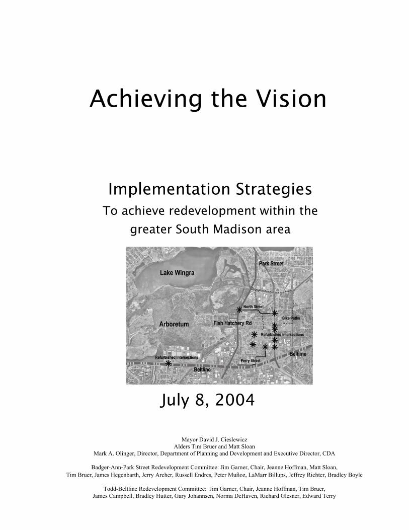
Achieving the Vision
Implementation Strategies To achieve redevelopment within the
greater South Madison area
July 8, 2004
Mayor David J. Cieslewicz Alders Tim Bruer and Matt Sloan
Mark A. Olinger, Director, Department of Planning and Development and Executive Director, CDA
Badger-Ann-Park Street Redevelopment Committee: Jim Garner, Chair, Jeanne Hoffman, Matt Sloan, Tim Bruer, James Hegenbarth, Jerry Archer, Russell Endres, Peter Muñoz, LaMarr Billups, Jeffrey Richter, Bradley Boyle
Todd-Beltline Redevelopment Committee: Jim Garner, Chair, Jeanne Hoffman, Tim Bruer,
James Campbell, Bradley Hutter, Gary Johannsen, Norma DeHaven, Richard Glesner, Edward Terry

F:\PLCOMMON\Cnare\Southside for Olinger\nov 22\StrategiesText20040708.doc 11/23/04 2:11 PM
2
With the staff support of Hickory R. Hurie, Percy Brown, Rebecca Cnare, David Dryer, Bill Fruhling, Joe Gromacki, Warren Kenney, Don Marx, Dan McCormick, Brad Murphy, P. Katherine Naherny, Larry Nelson, Archie Nicolette, Nancy Prusaitis, and Jule Stroick

Introduction
In the autumn of 1999, the Madison Common Council recognized the opportunities emerging in the South Madison area by adopting a CDBG Commission recommendation that the City designate the South Madison area as its next neighborhood planning area. Earlier in 1998, the City had also budgeted some planning funds for the South Metropolitan Planning Council, a community-based group of residents and businesses. In 2000, the Planning Council undertook a visioning process using the planning funds to identify the unrecognized potential for the entire length of Park Street. This visioning effort produced a document called Park Street: Possibilities to Reality that articulated several unifying themes to be used to guide the growth and development of the street and the neighborhoods adjacent to Park Street:
Park Street is a gateway street with distinct sub-districts, which should be developed to add more character to the street;
Greater attention should be focused on the
pedestrian and vehicular crossings of Park Street in order to better link adjacent neighborhoods together; (See Figure 1)
Park Street's private and public
appearance is aging and more attention should be paid to its street lighting, median landscaping, parking lot maintenance and building facade treatments. (See Figure 2)
Key parcels along the street could be
developed in ways that enhance the other businesses and lend more vitality to the area;
Fig.1
Fig.2
Key

4
These four insights continue to inform and shape many of the additional planning efforts in the area. Soon after the release of the Vision document, the Common Council appointed an Ad Hoc Park Street staff team to examine ways in which the City could refine its previously approved capital budget projects along Park Street to better incorporate the recommendations from the Vision document. The Planning Unit and a steering committee of residents and business representatives worked to develop a more detailed neighborhood plan for the area that builds on the heritage of the Vision document. The Steering Committee met over the course of next 36 months to develop its recommendations, which are summarized in Appendix 3. In the spring of 2002, long simmering disputes over town of Madison boundaries and Fitchburg and City of Madison annexation issues yielded a series of more fruitful discussions among the three entities. The two Mayors and the Town Chair sanctioned staff discussion about a boundary agreement. The Agreement enabled the Town of Madison to choose to exist as a separate governmental body for another twenty years, in exchange for the establishment of a more rational permanent boundary between Fitchburg and the City of Madison. Several areas were annexed to the City of Madison, and the agreement provided for two additional attachments of Town of Madison areas to the City of Madison prior to the end of the twenty years if these areas were part of a redevelopment plan. In the fall of 2003, the new Mayor of Madison, David J. Cieslewicz, and the two Alders of the south side, Tim Bruer (District 14) and Matt Sloan (District 13), sponsored a capital budget project for the area that provided $2.5 million for activities that address the redevelopment goals for the area. The Common Council confirmed mayoral appointments to two redevelopment committees, one for the Badger-Ann-Park St area, and a second for the Todd-Beltline area. The BAP Redevelopment Committee first met on April 12, 2004; the Todd-Beltline Redevelopment Committee on April 15, 2005. The two redevelopment committees reviewed an initial draft of this document developed by a team of City staff, to help set City priorities on the use of those funds to address the remaining key components from in the various planning efforts. The two redevelopment committee co-sponsored an Open House held at the Harambee Center on June 22, 2004 to present their preliminary recommendations to area residents and businesses, and to obtain their feedback on the proposed

5
projects. Over 100 people participated and offered their comments. The two committees considered those comments, reviewed the project costs estimates, and present their recommendations to the Common Council in the form of this report. SYNOPSIS: The two redevelopment committees agreed with the mayor and the two alders on an initial targeting of the $2.5 million from the capital budget that would allocate $1.2 million to the Todd-Beltline area and $1.3 million to the Badger-Ann-Park area. The Todd Beltline Redevelopment Committee recommends that the City use the $1.2 million in this way:
Use City funds for streetscape, pedestrian, transit, and bicycle enhancements to leverage State of Wisconsin Department of Transportation reconstruction of the Beltline Highway and the exit/entrance ramps for Todd Drive. The Committee believes that City commitment of these funds will encourage earlier State work on these critical intersections, and will stimulate private sector redevelopment in the area.
The BAP Redevelopment Committee recommends that the City use the $1.3 million in these projects:
$225,000 for City purchase of several out-lots to the Villager Mall that currently serve as parking for the Villager; $450,000 for City purchase and demolition of a
deteriorating building. City acquisition will facilitate Parks Division construction of a spray park that will serve as a innovative recreational facility and green space for the area west of Park Street. $200,000 toward a non-profit group’s acquisition
and redevelopment of rental property into owner-occupied residences, as one way to encourage more stable households in the Badger-Magnolia area. $325,000 toward streetscape enhancements along
Park Street between Beld Street and the Beltline. These would lead to safer pedestrian, bicycle and
6
vehicular crossings for Park Street, and development of public art that would reinforce the identity of this area of Park Street as a gateway to the City and the University. $100,000 toward planning, site planning and
market studies for the Villager.

7
Developing the Vision(s) Residents of South Madison have participated in several formal planning processes since 1999: An opportunities study under the sponsorship of the
South Metropolitan Planning Council that produced Park Street: Possibilities to Reality.
Design Guidelines for businesses to use in improving
their buildings and parking lots; A concentration neighborhood plan that will recommend
the redevelopment of several key areas, greater linkage between the east and west sides of Park Street, and efforts to build the character along the length of the street.
A plan to improve Penn Park as a key recreation area on
the east side of Park Street; A BUILD I study of market potential for redevelopment
focused on the area of Wingra Creek and Park Street; A blight study for the Department of Planning and
Development that identified several areas that would qualify for redevelopment under the State of Wisconsin statutes.
Two redevelopment plans are being pursued by the
Madison Community Development Authority that identify major physical improvement projects for Madison to undertake in the Park-Ann-Badger and the Todd-Beltline areas.
Two redevelopment committees review of the Park-
Ann-Badger area and the Beltline-Todd Drive area investment options and use of City of Madison capital funds to stimulate improvement in these areas.

8
Development Goals Each of these efforts has sponsored community meetings and other forms of public participation to help area stakeholders (residents, businesses, institutions, etc.) identify their vision for the area, and goals for the future to help obtain that vision. This series of planning efforts has consistently identified several broad goals, which will continue to shape planning, and development decisions concerning these neighborhoods:
South Madison Character: Promote a distinctive identity and character for the area, with improved public and private landscaping, and civic space for the library and health center; Business Infrastructure: Improve the environment,
infrastructure, and resources to help existing businesses grow, attract new businesses, and help create employment opportunities for area residents; Housing Options: Expand the range of housing options
within the area, including more opportunities for homeownership, and the upgrade of existing housing stock. Linkages: Develop safer intersections, streets, bike
paths, that promote the linkages between the east and west sides of Park Street, and improve interior circulation within the Fish Hatchery Road, Beltline, Coliseum, and Todd Drive areas.
Indicators of Success of These Efforts: If these plans and recommendations are fully implemented, the South Madison area would be characterized by these changes:
Thriving small businesses, which would increase their sales, and create more employment opportunities for South Madison residents Increased sales among Park Street and Todd area
businesses Upgraded and higher value housing Higher rates of homeownership New civic spaces for a library and the heath and human
services center Distinctive lighting, plantings, and signage in public
right of ways and business front lots Safer pedestrian and bicycle crossing for Park Street and
for Todd Drive Great resident awareness of the South Madison area and
its resources

9
Strategic Steps by Geographical Area to Achieve the Major Goals from These Plans The various plans have articulated four major components related to the major goals within these plans: civic character, business development, housing, and improved linkages. This statement suggests the priority strategies, steps, organizational leadership, budget and timeline needed to accomplish these higher priority goals in six focus areas of South Madison: This document will focus on the following areas for targeted redevelopment (see Figure 3):
Area A The Villager Mall Area B Park, Badger and Buick Area C Park, North Street, and Fish Hatchery Area D Park, Ann and Perry Area E Badger, Magnolia and Cypress Area F Todd Drive and the West Beltline
Sub areas included in Long Range Development Plans; while not directly addressed in this redevelopment plan, are important to the vitality of overall South Madison planning efforts. These would include the following (See Figure 3):
Area G Labor Temple Site Area H Gilson Road Site Area J Sunstrom Development
Fig.3

10
Area A: The Villager Mall Opportunity The Villager Mall and two gas stations dominate the rather dated nondescript landscape of this area. The Villager Mall is a former retail shopping mall that is presently in transition from a mixture of retail and back office functions for a major insurance company, into a major community educational and service delivery center with some associated retail activities. Current uses include several small ethnically-oriented businesses, a check-cashing service, the South Madison branch of the Public Library, the Harambee Health & Human Services, a County Human Services center, a University-sponsored Partnerships Office that include the University, Madison Area Technical College classes, Edgewood College, and various non-profit organizations such as Madison Urban Ministry and Wisconsin Women's Business Corporation. The Mall itself consists of several joined buildings, and is losing its functionality as retail space, but is building office space, civic use, and neighborhood civic center (See Figure 4). There are those who believe that redevelopment will only proceed with a change in the ownership and an infusion of new capital for redevelopment. Many residents and some businesses have identified the Mall and its vast minimally landscaped parking area as a blighting influence on the area. Almost 75% of the rental revenue derives from public or publicly supported institutions. Two of the major leases - for the Library and Harambee – expire in October 2005. The area itself contains approximately ten (10) acres at the Southern gateway of Park Street. Strategy In order to achieve redevelopment of this area, the City should facilitate the transfer of ownership to an entity that over time will redevelop this area into a mix of retail, commercial, and civic uses, while enhancing the physical environment so that it contributes to better image and land use.
Fig.4

11
Organizational Vehicle and Funding The City sees three alternatives for the redevelopment of this area: 1) the City could authorize the Community Development Authority (CDA) to acquire and redevelop the property or 2) the City could facilitate a public-private partnership between a consortium of users; or 3) the City could foster a partnership between the CDA and a private investor. Organizational alternatives: Issue
CDA real estate subsidiary.
Consortium of users. Private investor as lead or partner with CDA subsidiary.
Precedence. Patterned after Madison CDA effort with Monona Shores.
Patterned after Monona Terrace partnership.
Patterned after Colonial Court redevelopment effort.
Lead in time for development of organization.
Could replicate or expand the role of the current MRC.
May need most lead time to establish such a group.
Would need to conduct search or request for proposals.
Major City role. Backstop for CDA. Backstop for consortium of users.
Land assembly.
Amount of City support. Staff support to CDA. Financing. Operating support for major tenants.
Staff support to consortium. Financing. Operating support for major tenants.
Staff support to CDA for assembly. Financing. Operating support for major tenants.
Amount of City control over outcome.
Influence would be exerted through CDA oversight of the subsidiary.
Influence would be shared among Consortium partnerships.
Influence would be exercised via contract with private developer.
Resources Resources needed to accomplish this redevelopment would involve at least three major phases of activity: an acquisition phase, a stabilization phase, and a redevelopment phase. Acquisition of the Villager is estimated to cost around $9.0 (nine million dollars), with redevelopment in phases costing significantly more, depending upon the particular concept for redevelopment. Since public entities currently cover the majority of the rental revenue to the Villager, their continued participation as major tenants is critical to the success of the redevelopment plan. The interest and commitment of a private corporation to anchor a major portion of the Mall for retail use might also facilitate its redevelopment. While a variety of redevelopment plans might exist, a significant opportunity exists to create a true civic space that will enhance other community development activities in South Madison.
The advantages and disadvantages of each of these approaches is briefly summarized in the table below:

12
Timeline The Department of Planning and Development is presently assessing the potential of using New Market Tax Credits to help purchase the Villager and control its development. If these appear both probable and feasible as a financing source, the CDA should enter into a contract with consultants to develop the financing plan, and the operational entity. Two decision points are critical to implementation of this scenario: the cooperation of the current owner in the transfer of the property, and the City/CDA internal decision path as it relates to the availability of the tax credits. Development Concepts: While the ultimate redevelopment concepts for the Mall have yet to be developed, several elements are evident, and need to be addressed to facilitate redevelopment to both the Villager Mall and elsewhere. (See Figure 5) Improved infrastructure: Improve the intersections at Park Street
and Badger Rd., Hughes Place, Ridgewood Ave and Buick Street. Improvements should work to address both functional and aesthetic concerns.
Reorganize the Villager Mall site through the introduction of a new street network, including on-street parking, within the interior the current mall site.
Create a major focal point for South Madison by using the redevelopment to promote an urban square that provides an opportunity for the entire South Madison community to celebrate its special events.
Development Potential: Landmark office building on the corner
of Hughes Place and Park Street ‘Main Street’ type retail developments
around a new public street and urban square
New community-focused building to house Harambee, public library and some market-rate office space
Fig.5

13
Area B: Park, Badger, and Buick Opportunity Private business interests hold the titles or options to much of the real estate to the commercial area on the east side of Park Street south of the Villager apartments to Badger Road. This business group intends to acquire the remaining parcels and construct a mixed-use commercial/retail development that will hold a variety of businesses. Strategy With the adoption of a redevelopment plan for this area, the City could facilitate private development in the area, including plans for upgrading the Hughes Place and Badger Road intersections. The goal of this upgrade would be to improve pedestrian safety, improve circulation into and out of the redeveloped area, and provide for an enhanced gateway treatment into the neighborhood. Organizational Vehicle The Department of Public Works and the Community and Economic Development Unit will plan for the upgrade of the intersections and assuring their upgrade to link both sides of Park Street. These improvements should be coordinated with the recommendations of the Park Street design guidelines and other infrastructure improvement efforts that will planned along the northern sections of Park Street. Resources The creation of a TIF District and possible State transportation funds may help cover the costs of public improvements.
Fig.6

14
Timeline The City should complete plans for these intersections by Fall 2005 so that the City is ready to move ahead with bids coordinated with the business redevelopment. Development Concepts: As with Area A, new developments center around the concept of street and neighborhood-oriented business and retail opportunities at the gateway intersection of Park Street and the West Beltline Highway. Improved infrastructure: Improvements to intersections of
Park Street and Badger Road, Hughes Place, Ridgewood Avenue and Buick Street.
Open space improvements at Penn Park.
Development Potential: Landmark office building on the
corner of Park Street and Badger Road that would anchor this location, and complement other redevelopment opportunities at the Villager Mall site. ‘Main Street’ type retail developments centered around improved Hughes Place intersection that would carry theme of Villager Mall redevelopment across Park Street. This could provide significant opportunities for enhancing the synergies between the Villager Mall and this area, strengthening Hughes Place as a strong link from the neighborhoods west of Park Street to the new development east of Park Street.
Fig.7

15
Area C: Park, North and Fish Hatchery Opportunity The area bounded by Park Street, North Avenue, the railroad tracks, and Fish Hatchery Road, is an underutilized area with poor access, no through connection between Fish Hatchery and Park Street, and varied business uses. Current valuations reflect the lack of access. Strategy The City should review the potential for a through street that links Park Street with Fish Hatchery in the vicinity of Carver Street or the south end of Bowman Field. The construction of a street might be sufficient to stimulate additional business development in this area and increase opportunities for business expansion and resident employment. Organizational Vehicle The City Department of Public Works should take the lead in exploring the potential for a through street in this area, aided by the Real Estate section of the City's Community and Economic Development unit. Resources and Timeline: If needed, the City should make available a portion of the 2005 Capital Budget fund for planning for the street and the acquisition of easements or land for the street, with construction planned for spring 2006.
Fig.8

16
Indicator of Success: The City should monitor the progress of this project using the following benchmarks: Construction of the road sign by December 2006 Expansion of the tax base in this area Creation of jobs held by area residents
Development Concepts: New developments are focused on the creation of a new through street at North Avenue. Improved infrastructure: New connection between
Fish hatchery Road and Park Street will be created in an existing right-of-way just south of Bowman Field.
Open space park improvements and a new bicycle path will be created to connect Wingra Creek to the south.
Development Potential: Improved infrastructure for existing and new light
industrial and commercial areas north of North Avenue New housing opportunities adjacent to the proposed
North Avenue connection.
Fig.9

17
Area D: Ann and Perry Opportunity Ann Street acts as a dysfunctional frontage road to the Beltline Highway and approximately a half-dozen businesses located along Ann Street. While access from the west end of Ann Street from Fish Hatchery is serviceable, access to the east end of Ann Street is through a non-standard town road called Perry Street. Commercial development along Perry and Ann reflect the difficulty of access and visibility, and several properties are either for sale or are underutilized. By reworking the access and circulation, it is possible to create better flow and create better sites for redevelopment. Strategy The City should begin work on a more detailed plan for this area, including discussions with private developers interested in redevelopment of portions of parcels facing Ann Street. Organizational Vehicle The Real Estate Section, Planning Unit, and Office of Business Assistance should take the lead in exploring the potential for better access in this area, and the creation of larger redevelopment sites along Ann Street. Public Works staff will take the lead in engineering and traffic concerns. The CDA may play an initial role in land assembly of several of the critical properties now under-utilized, or for sale, if the need arises.
Fig.10
18
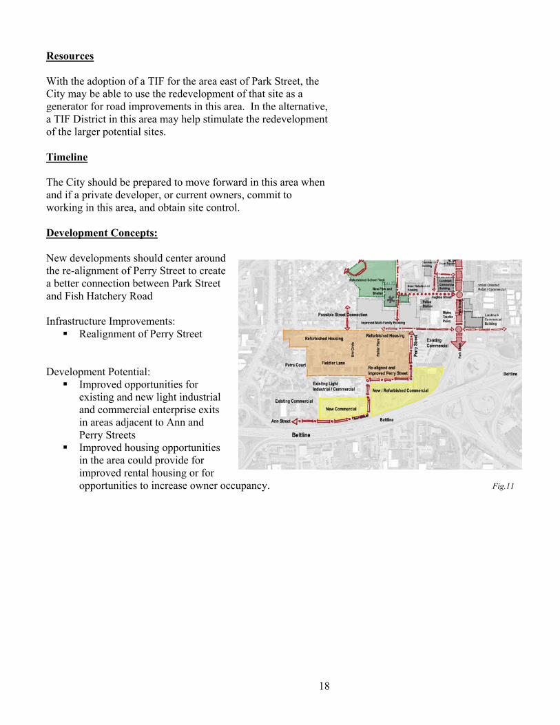
Resources With the adoption of a TIF for the area east of Park Street, the City may be able to use the redevelopment of that site as a generator for road improvements in this area. In the alternative, a TIF District in this area may help stimulate the redevelopment of the larger potential sites. Timeline The City should be prepared to move forward in this area when and if a private developer, or current owners, commit to working in this area, and obtain site control. Development Concepts: New developments should center around the re-alignment of Perry Street to create a better connection between Park Street and Fish Hatchery Road Infrastructure Improvements: Realignment of Perry Street
Development Potential: Improved opportunities for
existing and new light industrial and commercial enterprise exits in areas adjacent to Ann and Perry Streets
Improved housing opportunities in the area could provide for improved rental housing or for opportunities to increase owner occupancy. Fig.11
19
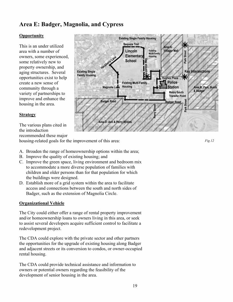
Area E: Badger, Magnolia, and Cypress Opportunity This is an under utilized area with a number of owners, some experienced, some relatively new to property ownership, and aging structures. Several opportunities exist to help create a new sense of community through a variety of partnerships to improve and enhance the housing in the area. Strategy The various plans cited in the introduction recommended these major housing-related goals for the improvement of this area: A. Broaden the range of homeownership options within the area; B. Improve the quality of existing housing; and C. Improve the green space, living environment and bedroom mix
to accommodate a more diverse population of families with children and older persons than for that population for which the buildings were designed.
D. Establish more of a grid system within the area to facilitate access and connections between the south and north sides of Badger, such as the extension of Magnolia Circle.
Organizational Vehicle The City could either offer a range of rental property improvement and/or homeownership loans to owners living in this area, or seek to assist several developers acquire sufficient control to facilitate a redevelopment project. The CDA could explore with the private sector and other partners the opportunities for the upgrade of existing housing along Badger and adjacent streets or its conversion to condos, or owner-occupied rental housing. The CDA could provide technical assistance and information to owners or potential owners regarding the feasibility of the development of senior housing in the area.
Fig.12

20
Resources The City could tap the following resources to help meet the objectives for this redevelopment area: Sub-objective: Resource Upgrade existing
properties. Recruit new owners to upgrade, redevelop property.
Re-shape environment to improve recreational space and circulation.
BI systematic building inspection.
Routine inspections would improve existing code compliance.
CED Rehab Loan program.
Owner-occupied properties of 1-4 units might qualify for rehab loans.
CED Home-buy program. This program provides a modest amount of down payment and closing cost assistance.
Project Home NOAH program.
NOAH program provides purchase assistance and mentoring to new buyers of rental properties.
CDBG/HOME assistance to non-profits.
Groups like Centro Hispano, Progressive Housing Alliance, or Future Madison Housing may be interested in acquiring some rental properties and renovating/ converting them to lease to owner status.
WHEDA tax credit and loan programs.
Groups like Centro Hispano, Progressive Housing Alliance, or Future Madison or private owners may qualify for some WHEDA assistance to acquire and upgrade property.
Parks Explore more intensive recreational development of the Lincoln School playground for access by neighborhood residents. Parks has conducted planning studies for a spray park combining Lincoln School playground and a single property at the corner of Magnolia and Cypress.
Traffic Engineering and Engineering
Explore the linkage or some internal streets within the area to provide more of a grid-like circulation.

21
Timeline While improvement of this area is important to the overall strategy for this area, several more pressing decisions outlined in this Implementation Strategy document suggest that this area be the focus of efforts after the redevelopment initiatives are started with the Villager and the Buick-Park-Badger. The City could assist groups that express interest in proceeding with acquisition and redevelopment in this area even before the Villager and Badger-Park initiatives if there were sufficient funds in existing programs. Park improvements and other initiatives in and around Lincoln Elementary School are scheduled for implementation during Fall 2004, if the Common Council approves Parks acquisition of the site for the spray park as recommended by the Badger-Ann-Park Redevelopment Committee. Development Concepts: New developments center around a new park at the intersection of Hughes Place and Cypress Way Infrastructure Improvements: Refurbishment of
intersections and pedestrian crossings on Cypress Way.
Possible new street connection between Magnolia and Badger Roads in alignment with Magnolia Circle
Open space improvement by the introduction of a new cooperative park between the Park System and Lincoln Elementary School.
Development Potential: New and refurbished housing along Magnolia and
Badger Roads.
Fig.13

22
Area F: Todd-Beltline Area Opportunity This area is declining in value with aging buildings and fragmented commercial ownership. Strategy Organizational Vehicle The CDA should create a redevelopment district within this area, and work with existing private property owners and developers who may be interested in the area to facilitate their improvement of the area. Resources The Todd-Beltline Redevelopment Committee has recommended City use of $1.2 million in capital budget funds for streetscape, pedestrian, transit, and bicycle enhancements to leverage State of Wisconsin Department of Transportation reconstruction of the Beltline Highway and the exit/entrance ramps for Todd Drive. The Committee believes that City commitment of these funds will encourage earlier State work on these critical intersections, and will stimulate private sector redevelopment in the area. In addition, the CDA should recommend the creation of a Tax Incremental Finance District that could tap the construction of new commercial and retail office buildings currently under discussion in the Todd area for additional redevelopment projects that would enhance the area, including the redevelopment of some of the existing housing into workforce housing for employees of the companies that are, or will locate along the Beltline. This increment could further assist road improvements, critical site acquisition along the Beltline near Todd Drive, and a condo conversion program along McDivitt. Timeline The City should complete the attachment process under the boundary agreement worked through with the Town of Madison and the City of Fitchburg. Once completed, the City should
Fig.14

23
complete a memorandum of understanding with the State regarding the planned reconstruction and intersection improvements. The City should then work cooperatively with the State to complete the public participation process for the specific designs, and facilitate State completion of the project in a timely manner to encourage private redevelopment in the area. The CDA should adopt a tax increment district plan by January 2005 so that it might capture the current value of the property slated for office development as part of the base for the area, prior to new construction in the area.

24
Development Potential: There are three sub districts for potential development in the Todd Drive / Beltline District. Sub-Area A Sub-Area A consists of a mixture of commercial properties at the intersection of Todd Drive and the West Beltline, residential properties further to the south and southwest, and a large site for a proposed office building in the southwest corner. Project Implementation: To support the development of office and commercial space in the area, the following will be accomplished:
• The aging and marginal commercial properties adjacent to the West Beltline Highway will be removed and a new commercial development constructed;
• Housing on the west side of Ashford Lane will be rehabilitated and modified;
• The properties on the west side of Todd Drive that are residential will be either rehabilitated, or options explored to convert into owner-occupied housing; The City should include funds within the 205 capital budget to help facilitate these conversations.
• The remaining properties on the east side of Ashford Lane and the north side of Nottingham Way may be enhanced by City rehabilitation loans as appropriate;
• The Mortenson Investment Group (MIG) will continue to design, market, and develop a large vacant property in the southwest corner of this area with a multi-story office building. The first phase of the development may include a 140,000 gross square foot, six-story building. A second phase building has been identified but plans have neither been finalized by the owner nor approved by the City.

25
Sub-Area B Sub Area B consists of all commercial property on the south side of the West Beltline and the East side of Todd Drive. Project Implementation: Some of the property in this sub area is underutilized. The redevelopment plan for this area includes acquisition and removal of some of the existing commercial properties so the site can be redeveloped for more productive and economic use. A redeveloper at this point has not been identified, although an adjacent landowner, Baxter Investments has expressed interest and has engaged the same set of consultants that have been hired by the Mortenson Investment Group to develop concepts plans for the west side of Todd Drive. Sub-Area C Sub-Area C is a small area located on the north side of the West Beltline on both sides of Todd Drive extending approximately 500 feet north of the Highway frontage road. Project Implementation: This area presently consists of some vacant buildings and underutilized property. It offers great potential for commercial redevelopment. This site contains two key quadrants of this intersection, both of which are underutilized. Redevelopment could increase density, activity, and value to the community and could add key aesthetic improvement to this intersection.

26
Conclusion The implementation of these major objectives and 18 activities will depend in part upon the emergence of favorable opportunities for action, the separate approval or commitment of public and private resources, and the strengthening of neighborhood and private sector support for particular activities. The City of Madison, working with the CDA, community and business partners, will undertake these activities outlined above over a ten-year period, contingent upon the availability of resources. Specific resource commitments for particular activities will be reviewed by the Common Council as part of the City budgeting process in light of these South Madison implementation strategies and emerging opportunities within the Park Street/ Beltline corridor.

27
Appendix: The Department of Planning and Development Planning Unit has created two maps that illustrate the full potential of the Southside Redevelopment Plan. (These are described but not included in this report, but are available from Archie Nicholette of the Planning Unit.) Map #1 demonstrates infrastructure improvement opportunities that will allow the south side of Madison to become fully integrated into the to city fabric. Improvements on Perry and North Streets, as well as
connections to the East around the proposed Sundstrom residential development, will eliminate the isolation of several key Southside neighborhoods.
New and improved bicycle and pedestrian path s will
connect parks, waterways, and urban open spaces. Pedestrian crossings at major intersections will be
improved to promote safety for neighborhood residents and visitors.
Illustrates future infrastructure development outside of
this specific redevelopment plan, yet impacts the success of Madison’s Southside
Map #2 fully explains potential build-out and redevelopment potential: New and refurbished housing opportunities
Landmark office developments that signify gateway
entrances into Madison Neighborhood business and retail opportunities
Development connections between and among
neighborhoods Illustrates development potential just to the north and
east of the redevelopment area at Gilson Street, properties adjacent to the Labor Temple, and a new residential development to the east.