accounts and measures for managing identified wildlife
TRANSCRIPT

Identified Wildlife Management Strategy
Accounts and Measures forManaging Identified Wildlife
Northern Interior Forest Region
Version 2004
Ministry of Water, Land and Air Protection


Identified Wildlife Management Strategy
Accounts and Measures forManaging Identified Wildlife
Northern Interior Forest Region
Version 2004
Ministry of Water, Land and Air Protection

National Library of Canada Cataloguing in Publication DataBritish Columbia. Identified Wildlife Management Strategy.
Accounts and measures for managing identified wildlife :Northern Interior Forest Region. – Version 2004 —
Previously issued 1998 by Ministry of Forests undertitle: Managing identified wildlife : procedures andmeasures.
Also available on the Internet.ISBN 0-7726-5132-9
1. Northern Interior Forest Region (B.C.) 2. Wildlifeconservation – British Columbia. 3. Wildlife management –British Columbia. 4. Biological diversity conservation –British Columbia. 5. Forest management – Environmentalaspects – British Columbia. I. British Columbia. Ministryof Water, Land and Air Protection. II. Title.
QH77.C32 B74 2004 333.95’16’097118 C2004-960015-X
© 2004 Province of British Columbia
Cover photo: Jared Hobbs

iii Accounts and Measures for Managing Identified Wildlife – Introduction V. 2004 iii
Northern Interior Forest Region
Preface
The Identified Wildlife Management Strategy is aninitiative of the Ministry of Water, Land and AirProtection, in partnership with the Ministry ofForests and carried out in consultation with otherresource ministries, stakeholders and the public.Statutory authority is provided for the Ministry ofWater, Land and Air Protection to carry out thisstrategy under provisions of the Forest Practices Codeof British Columbia Act and regulations, and underthe new Forest and Range Practices Act and regula-tions, to be implemented in 2004.
Two companion documents address the managementof Identified Wildlife, and together, comprise theIdentified Wildlife Management Strategy (IWMS).The first document, Procedures for ManagingIdentified Wildlife, describes the procedures forestablishing, modifying and rescinding a wildlifehabitat area (WHA), and for implementing strategicand landscape level planning recommendations. Thisdocument provides direction to governmentplanners, foresters and wildlife managers.
The second document, Accounts and Measures forManaging Identified Wildlife, summarizes the status,life history, distribution and habitats of IdentifiedWildlife, and outlines specific guidelines formanagement of their habitats. For ease of use, theAccounts and Measures report is available as threeseparate documents, one for each of the Coast,Northern Interior, and Southern Interior regions.Only species occurring within that region areincluded along with all introductory and appendixmaterials. As a result, note that some species willoccur in more than one report (e.g., Grizzly Bearoccurs in all three reports).
These documents are a resource for governmentplanners, foresters and wildlife managers, and forthose persons interested in the life histories ofIdentified Wildlife. They provide the necessaryinformation, procedures, practices and guidelines tohelp achieve effective management and conservationof Identified Wildlife under the Forest and RangePractices Act.
Acknowledgements
A project of this magnitude was made possible onlythrough the long-standing executive support ofRalph Archibald, Gordon Macatee, Bruce Morgan,Larry Pedersen, Derek Thompson, Gary Townsend,Jim Walker, and Nancy Wilkin. Rod Davis and BrianNyberg were also strong supporters, and providedprudent facilitation and direction.
The cooperation and advice of two importantcommittees made this project go smoothly. TheIWMS Technical Government Working Group andTechnical Advisory Committee were integral in thedevelopment of the accounts, and contributed muchtime and effort to reviewing this document.
The IWMS Technical Government Working Group,an interagency committee, provided overall projectdirection as well as strategic and technical review ofaccounts. Representatives included Wayne Erickson
(Ministry of Forests [MOF]); Doug Fraser (MOF);Stewart Guy (Ministry of Water, Land and AirProtection [MWLAP]); Gordon Haas (formerMinistry of Fisheries); Andrew Harcombe (Ministryof Sustainable Resource Management [MSRM]);Eric Lofroth (MWLAP); Brian Nyberg (MOF);Kathy Paige (MWLAP); Susanne Rautio (MWLAP);Richard Thompson (MWLAP); and Liz Williams(MSRM). Of special note is Stewart Guy whodemonstrated exceptional communication andproject leadership that enabled this project to moveforward. Likewise special thanks are due WayneErickson for diligently working to ensure theaccuracy of all the accounts and for project direc-tion; and Susanne Rautio for her leadership andproject management in the early development of thisdocument.

iv Accounts and Measures for Managing Identified Wildlife – Introduction V. 2004
Northern Interior Forest Region
Heppner, Jim Herbers, Anne Hetherington, JaredHobbs, Robin Hoffos, Tracey Hooper, Jeff Hoyt,Doug Janz, Bruce Johnson, Pierre Johnstone, DougJury, Thomas Kaye, Trevor Kinley, Jan Kirkby,Norbert Kondla, Pam Krannitz, John Krebs, KarlLarsen, Ted Lea, Carla Lenihan, Dave Low, MarleneMachmer, Nancy Mahony, Todd Manning, MalcolmMartin, Anre MacIntosh, Dean McGeough, TerryMcIntosh, Will MacKenzie, Andy MacKinnon,Gordon Mackinnon, Scott McNay, Katherine Maxcy,Del Meidinger, Rhonda Millikin, Dave Nagorsen,Gary Norris, Penny Ohanjanian, Kristiina Ovaska,Allan Peatt, Mark Phinney, Jim Pojar, JuanitaPtolemy, James Quayle, Leah Ramsay, Sal Rasheed,John Richardson, Hans Roemer, Beth Rogers,Jordan Rosenfeld, Don Russell, Helen Schwantje,Geoff Scudder, Dale Seip, Jon Shepard, Michael G.Shepard, Chris Siddle, Andrea Sissons, Rick Smith,Al Soobotin, Julie Steciw, Andy Stewart, Jeff Stone,Thomas P. Sullivan, John Surgenor, RichardThompson, Astrid Van Woodenberg, RossVennesland, Louise Waterhouse, Debbie Webb,Bryan Webster, Rich Weir, Troy Wellicome, BillWestover, Liz Williams, Al Wilson, Doug Wilson,Guy Woods, Karen Yearsley, John Youds, Jim Young,and Fred Zwickel.
Maps were prepared by Dennis Demarchi, DianaDemarchi, Annika Livingston with input fromauthors and species experts including CarmenCadrin, Wayne Campbell, Ray Coupé, Craig Delong,Wayne Erickson, Don Gayton, Crispin S. Guppy,Jan Kirkby, Ted Lea, Pontus Lindgren, DaveNagorsen, Jenifer Penny, Jim Pojar, Mike Sarell,and Rick Tucker.
Thanks also to Chris Smith at TM NewMedia for allher hard work and patience. I’m sure it seemed likethe changes were endless.
This document represents the efforts of many peopleand I would like to thank everyone for theircontribution and support.
Every effort was made to maintain the integrity ofthe accounts while still working within the IWMSpolicy framework.
Kathy PaigeEditor and Compiler
The IWMS Technical Advisory Committee, com-prised of stakeholder representatives, reviewed allaccounts many times over and in much detail (seeAppendix 1 for agency representation). Represen-tatives included David Borth (BC Cattlemen’sAssociation); Colin Campbell (BC EnvironmentalNetwork); Elaine Golds (BC Endangered SpeciesCoalition/Federation of BC Naturalists); CarolHartwig (BC Wildlife Federation); Bill Hadden(Federation of BC Woodlot Associations);Dr. Gilbert Proulx (Council of Forest Industries[COFI]); Paula Rodriguez de la Vega (BC Environ-mental Network); Geoff Scudder (University ofBritish Columbia); Kari Stuart-Smith (COFI); KenSumanik (BC Mining Association); and Wayne Wall(Coast Forest & Lumber Association). Specialmention is due Colin Campbell, Elaine Golds, BillHadden, Carol Hartwig, Dr. Gilbert Proulx, PaulaRodriguez de la Vega, and Wayne Wall for theirdedication and thoughtful input throughout theproduction of this document.
Many other professionals were involved in thedevelopment and review of the accounts included inthis document. Many experts wrote or reviewedaccounts including staff from the MSRM Conser-vation Data Centre, MWLAP Biodiversity Branch,consultants, and many other organizations. Alloriginal authors have been acknowledged in theaccounts. Some of the key technical and operationalreviewers were Janice Anderson, Ted Antifeau,Harold Armleder, Mike Badry, Suzanne Beauchesne,Robb Bennett, Doug Bertram, Andy Bezgrove,Christine Bishop, Ian Blackburn, Louise Blight, ClaitBraun, Andrew Breault, Mark Brigham, Kim Brunt,Doug Burles, Rob Butler, Carmen Cadrin, RichardCannings, Robert A. Cannings, Syd Cannings, AdolfCeska, Trudy Chatwin, Dave Christie, Myke Chutter,Alvin Cober, John Cooper, Brenda Costanzo, RayCoupé, Vanessa Craig, Laura Darling, John Deal,Don Demarchi, George Douglas, Ted Down, DonDoyle, Frank Doyle, Dave Dunbar, Linda Dupuis,Orville Dyer, Wayne Erickson, Tom Ethier, MattFairbarns, Tracey Fleming, Dave Fraser, Doug Fraser,Laura Friis, Grant Furness, Judy Godfrey, WilliamGolding, Steve Gordon, Crispin S. Guppy, Les Gyug,Cindy Haddow, Anne Harfenist, Ian Hatter, Don

v Accounts and Measures for Managing Identified Wildlife – Introduction V. 2004 v
Northern Interior Forest Region
Contents
Preface ...................................................................................................................... iiiAcknowledgements ................................................................................................. iiiIntroduction.............................................................................................................. 1Selection of Identified Wildlife ................................................................................ 2Account Development and Review ........................................................................ 3Account Template .................................................................................................... 4Identified Wildlife by Forest Region ....................................................................... 9Fish ........................................................................................................................... 13
TroutBull Trout ........................................................................................................ 13
Amphibians .............................................................................................................. 29Frogs and toads
Coastal Tailed Frog ........................................................................................ 29Birds ......................................................................................................................... 39
Birds of preyShort-eared Owl ............................................................................................ 39
SeabirdsMarbled Murrelet .......................................................................................... 47
SongbirdsBay-breasted Warbler ................................................................................... 62Black-throated Green Warbler ...................................................................... 70Cape May Warbler......................................................................................... 80Connecticut Warbler ..................................................................................... 90Nelson’s Sharp-tailed Sparrow .................................................................... 100
Upland game birds“Columbian” Sharp-tailed Grouse .............................................................. 106
Waders and shorebirdsAmerican White Pelican................................................................................ 115Great Blue Heron .......................................................................................... 126Long-billed Curlew ....................................................................................... 138Sandhill Crane ............................................................................................... 146
Mammals ................................................................................................................. 157Carnivores
Fisher ............................................................................................................. 157Grizzly Bear ................................................................................................... 175Wolverine ...................................................................................................... 195
UngulatesBighorn Sheep .............................................................................................. 205Caribou .......................................................................................................... 224

vi Accounts and Measures for Managing Identified Wildlife – Introduction V. 2004
Northern Interior Forest Region
Plant Communities .................................................................................................. 253Forested
Hybrid White Spruce/Ostrich Fern ............................................................... 253Western Redcedar/Devil’s-Club/Ostrich Fern .............................................. 258
Acronyms ................................................................................................................. 263Glossary ................................................................................................................... 264
Appendices1. Technical Advisory Committee ......................................................................... 2692. Summary of Volume 1 element changes ......................................................... 2703. Ministry of Forests administrative boundaries ............................................... 2714. Ecoprovince and ecosection codes (Version 1.7) ............................................ 2725. Biogeoclimatic ecological classification unit codes ....................................... 2746. Broad ecosystem units of British Columbia .................................................... 2757. Structural stages and codes .............................................................................. 2968. Wildlife tree classification for coniferous trees .............................................. 2989. Coarse woody debris classification ................................................................. 299
10. Scientific names of commonly referred to tree and wildlife species ............ 30011. NatureServe status ........................................................................................... 30112. Determining wildlife tree dbh recommendations for cavity-nesters ............ 30213. Northern Interior region Identified Wildlife forest district tables .................. 305

1 Accounts and Measures for Managing Identified Wildlife – Introduction V. 2004 1
Northern Interior Forest Region
Introduction
Identified Wildlife are species at risk and regionallyimportant wildlife that the Minister of Water, Landand Air Protection designates as requiring specialmanagement attention under the Forest and RangePractices legislation. Under this legislation, thedefinition of species at risk includes endangered,threatened or vulnerable species of vertebrates,invertebrates, plants and plant communities.Regionally important wildlife include species thatare considered important to a region of BritishColumbia, rely on habitats that are not otherwiseprotected under FRPA, and are vulnerable to forestand range impacts.
The Identified Wildlife Management Strategy(IWMS) provides direction, policy, procedures andguidelines for managing Identified Wildlife. Thegoals of the Identified Wildlife Management Strategyare to minimize the effects of forest and rangepractices on Identified Wildlife, and to maintaintheir critical habitats throughout their currentranges and, where appropriate, their historic ranges.In some cases, this will entail restoration ofpreviously occupied habitats, particularly for thosespecies most at risk.
The Identified Wildlife Management Strategy appliesto Crown forest and range land or private land thatis subject to a tree farm or woodlot licence. Itaddresses forest and range practices regulated underBritish Columbia’s forest legislation. It does notaddress activities such as recreation, hunting, orpoaching. Under the Wildlife Act, native terrestrialvertebrates designated as “wildlife” are protectedfrom killing, capture, and harassment except bypermit or regulation. The strategy also does notaddress agriculture or urban development. TheIWMS is not intended to be a comprehensiverecovery strategy; instead it is intended to be onetool that can be used to manage or recover specieshabitats. A role of the Ministry of Water, Land andAir Protection is to direct or assist in thedevelopment of conservation strategies and recoveryplans for species at risk. These plans and strategies
can address all requirements for a species’ conser-vation including research and inventory needs,habitat conservation, and regulatory measures.
Identified Wildlife are managed through theestablishment of wildlife habitat areas (WHAs),objectives for wildlife habitat areas, and implemen-tation of general wildlife measures (GWMs), orthrough other management practices specified instrategic or landscape level plans. Wildlife habitatareas are mapped areas that have been approved bythe Minister of Water, Land and Air Protection asrequiring special management. The purpose ofWHAs is to conserve those habitats considered mostlimiting to a given species. For example, feedinglakes for American White Pelican are consideredlimiting because they must occur near the breedingsite, contain the appropriate prey species, and berelatively free of human disturbance. Breeding sitesfor Ancient Murrelet are considered limiting becausethis species returns to the same area each year,breeds in undisturbed old forest habitat, andrequires freedom from most mammalian predators.
General wildlife measures describe the managementpractices that must be implemented within anapproved WHA or other spatially defined area. AGWM may limit activities partially (e.g., seasonally)or entirely. General wildlife measures prescribe alevel of management appropriate to the conservationstatus of Identified Wildlife. Management objectivesare consistent with the goals and commitments ofthe Canadian Biodiversity Strategy and provincialgoals for the management of wildlife (i.e., asoutlined in the Provincial Wildlife Strategy).
For the most part, Identified Wildlife provisions donot address the issues of habitat supply, habitatconnectivity, and population viability and otherissues such as access management. Such issuesshould be taken into account during strategic orlandscape level planning. Species requiringconsideration within strategic level plans aretypically wide-ranging species that are sensitive tolandscape level changes such as, but not limited to,Badger, Bull Trout, Caribou, Fisher, Grizzly Bear,Marbled Murrelet, Queen Charlotte Goshawk,Spotted Owl, and Wolverine.

2 Accounts and Measures for Managing Identified Wildlife – Introduction V. 2004
Northern Interior Forest Region
The IWMS is a significant step toward responsiblestewardship of Identified Wildlife. The managementpractices included in IWMS are designed to reducethe impacts of forest and range management onIdentified Wildlife within targeted social andeconomic constraints, to balance both socio-economic considerations and conservation ofspecies at risk in British Columbia’s managed forestand rangelands. Identified Wildlife ManagementStrategy provisions in themselves may be insufficientto conserve viable populations of these speciesthroughout their natural ranges in British Columbia.Other strategies and planning, such as RecoveryPlans, may be required. The IWMS is intended to bethe single-species complement to the broader,coarse-filter provisions of the province’s forest andrange practices legislation, and strategic land useplans.
Selection ofIdentified Wildlife
Forest practices legislation authorizes the Minister ofWater, Land and Air Protection to establish cate-gories of species at risk and regionally importantwildlife, for purposes of establishing wildlife habitatareas, objectives and general wildlife measures thatmake up the IWMS.
Identified Wildlife are a sub-set of species and plantcommunities selected from provincially red-(Endangered or Threatened) or blue-listed (SpecialConcern, Vulnerable) vertebrates and invertebrates;red-listed plants or plant communities; andregionally important wildlife. The ConservationData Centre (MSRM) is responsible for determiningthe status of elements in British Columbia. TheConservation Data Centre (January 2003) lists over1500 animals, plants, and plant communities thatare considered to be at risk in British Columbia.
Volume 1 of the Identified Wildlife ManagementStrategy included 40 Identified Wildlife. These40 elements represented a portion of the elements atrisk and affected by forest and range practices. Theoriginal list reflected the efforts of the IWMSinteragency Technical Government Working Groupto represent a diversity of species and habitats, andincluded elements from all forest regions. WhenVolume 1 was released in 1999, a commitment wasmade to evaluate and rank all species at risk forinclusion within IWMS. In the fall of 1999, astakeholder Technical Advisory Committee (seeAppendix 1) was established to participate andadvise in the development of a systematic anddefensible method to determine and rank candidatesfor designation as Identified Wildlife, thus ensuringthat the elements most in need and most likely tobenefit from inclusion in IWMS were identified. Themethod for setting priorities was completed in May2000. For a detailed description of the method andresults, see Setting Priorities for the Identified WildlifeManagement Strategy.
By September 2001, over 800 species at risk that wereeligible1 to be designated as Identified Wildlife hadbeen evaluated for inclusion within IWMS,including all elements in Volume 1 (see Appendix 2for changes from Volume 1). Of a possible 889eligible candidates, 246 were considered candidatesfor further consideration. These were divided intothree priority categories: high priority (n = 52),intermediate priority (n = 115), and low priority(n = 79). Priority was determined by consideringboth the relative conservation risk (i.e., risk ofextinction) and relative risk from forest and rangemanagement. Conservation risk was determined byconsidering both the global and provincial status foreach element (see Table 1). Conservation risk wasthe primary factor involved in determining IWMSpriority. Relative risk from forest and rangemanagement was determined using a coarse riskassessment. The risk assessment considered the main
1 See definition of “species at risk” and “wildlife.”

3 Accounts and Measures for Managing Identified Wildlife – Introduction V. 2004 3
Northern Interior Forest Region
threats causing an element to be at risk as well as theability of existing habitat protection mechanisms(i.e., parks, FRPA provisions) to address the habitatrequirements of each element. In addition the abilityto apply Identified Wildlife provisions was alsoconsidered (i.e., whether known sites occur onprivate land where the Forest Practices Code did notapply, or where FRPA will not apply). In this wayonly those elements negatively affected by forest orrange management that occur on Crown land andwhose requirements are not adequately addressed byother provisions were selected for designation asIdentified Wildlife.
Table 1. Relative conservation risk matrix(1 = highest risk, 15 = lowest risk)
GlobalProvincial rank
rank S1 S2 S3 S4 S5
G1 1
G2 2 3
G3 4 5 6
G4 7 9 11 13
G5 8 10 12 14 15
The 2004 list of Identified Wildlife replaces theVolume 1 list. Some elements included in Volume 1were considered of lower priority, and thus are notincluded in IWMS at this time (see Appendix 2).These elements may be reconsidered for inclusionlater. In addition, while the Minister of Water, Landand Air Protection has legal authority to includeregionally important wildlife, this category has notbeen evaluated at this time and thus is not includedin this version. Regionally important wildlife areyellow-listed and were considered of lower priority.In some cases, it may be possible to address themanagement of specific, localized habitat featuresfor regionally important wildlife using the revised“wildlife habitat feature” mechanism within FRPA.Others will be addressed within IWMS once the listof regionally important wildlife has been updatedand approved by the Minister of Water, Land andAir Protection.
Identified Wildlife may be added or rescinded by theMinister of Water, Land and Air Protection. De-designation may occur when the status of a speciesor community changes. Likewise, the IWMS prioritylists will be updated regularly (see Procedures forManaging Identified Wildlife).
Account Developmentand Review
Accounts summarize the status, life history, distri-bution, habitat requirements and managementstandards for Identified Wildlife. Accounts wereprepared according to IWMS priority (see Selectionof Identified Wildlife). The priorities for accountdevelopment were elements ranked as having a highpriority for inclusion in IWMS. Candidatesconsidered of intermediate priority were alsoconsidered, particularly those that are listednationally by the Committee on the Status ofEndangered Wildlife in Canada (COSEWIC) andthose that were originally included within IWMSVolume 1.
Additional accounts will be developed on anongoing basis according to IWMS priority ornational listing (COSEWIC). At this time it isanticipated that updates will be made availableannually following updates to national andprovincial status listings. Provisions may be madefor emergency situations, see Procedures forManaging Identified Wildlife.
Each account was peer reviewed by a technicalreviewer, operational reviewer, and IWMS reviewer.In addition, the IWMS Technical GovernmentWorking Group, IWMS stakeholder TechnicalAdvisory Committee, and regional WHA commit-tees reviewed accounts. In many cases other profes-sionals and specialists, especially those involved insetting species management or recovery direction(i.e., Recovery Teams), also reviewed accounts.

4 Accounts and Measures for Managing Identified Wildlife – Introduction V. 2004
Northern Interior Forest Region
Account Template
ENGLISH NAME2
Scientific name
Original author3
Species or PlantCommunity Information
Taxonomy
Describes current taxonomic classification. Notincluded in plant community accounts.
Description
Describes distinguishing features used foridentification.
Distribution
Global
Describes global range.
British Columbia
Describes distribution in British Columbia.
Forest regions and districts
Describes distribution according to the Ministry ofForests administrative units (Appendix 3).
Ecoprovince and ecosections
Describes distribution using the ecoregionclassification system (Appendix 4), which divides theprovince into hierarchically and ecologically definedunits. Units are defined by climate, physiography,vegetation, and wildlife potential.
Biogeoclimatic units
Describes distribution using the biogeoclimaticecosystem classification system (Appendix 5).Biogeoclimatic units are defined based on geogra-phically related ecosystems that are distributedwithin a vegetationally inferred climatic space.
Broad ecosystem units
Describes distribution using the broad ecosysteminventory classification system (Appendix 6). Abroad ecosystem unit is a permanent area of thelandscape, meaningful to animal use, that supports adistinct kind of dominant vegetative cover, ordistinct non-vegetated cover (such as lakes or rockoutcrops). Each vegetated unit is defined asincluding potential (climax) vegetation and anyassociated successional stages (for forests andgrasslands). Broad ecosystem classes have beencreated based on the integration of vegetation,terrain, topography, and soil characteristics. They areamalgamations of different groups of site seriesunits, as well as site associations. Each BEU mayinclude many distinct climax plant associations.Broad ecosystem units may not be intuitivelyobvious as many associated habitats may occur in asingle unit (i.e., trembling aspen in the InteriorDouglas-fir Forest unit).
Elevation
Elevation in metres.
2 English and scientific names largely follow 2003 ResourceInformation Standards Committee (RISC) standards exceptfor those subspecies without standardized English names.Non-standard English names are noted in quotation marks(e.g., “Queen Charlotte” Goshawk) in the account titles.
3 Accounts were modified from the original drafts as part ofthe peer review process; IWMS legal, policy, and technicalreviews; or recommendations from the IWMS TechnicalAdvisory Committee and regional reviews.

5 Accounts and Measures for Managing Identified Wildlife – Introduction V. 2004 5
Northern Interior Forest Region
Life History or Plant CommunityCharacteristics
For vertebrates and invertebrates, information onthe diet and foraging behaviour, reproduction, sitefidelity, home range, and movements is provided.For plants, information on reproduction anddispersal is provided. For plant communities, thestructural stage, natural disturbance regime, andfragility of the community are described.
Habitat
Structural stage
Lists structural stages used (Appendix 7) for forestedhabitats and usually only coniferous species.Structural stage depends on the age class of theecosystem and vegetation species. For plantcommunity accounts, the structural stage at climaxcondition is listed.
Important habitats and habitat features
Describes important habitats (e.g., nesting habitat)or habitat features such as wildlife trees (seeAppendix 8), coarse woody debris (see Appendix 9),or canopy structure. Not included in plantcommunity accounts. If not specifically described,age follows the definitions of the BiodiversityGuidebook (1995 – see http://www.for.gov.bc.ca/tasb/legsregs/fpc/fpcguide/biodiv/biotoc.htm). SeeAppendix 10 for scientific names of commonlyreferred to tree species.
Conservation andManagement
Status
Describes status in British Columbia (Red, Blue, orYellow), as determined by the Conservation DataCentre (MSRM). Provincial status is determined andreviewed biannually using the internationallyaccepted methods of the NatureServe. For moreinformation, see http://wlapwww.gov.bc.ca/wld/documents/ranking.pdf. In summary, elements areranked from 1 to 5 where 1 is critically imperilled
and 5 is secure. Generally, red-listed elements areranked 1 or 2, blue-listed elements are ranked 3, andyellow-listed elements are ranked 4 or 5.
Status in Canada, as determined by the Committeeon the Status of Endangered Wildlife in Canada(COSEWIC) is also provided. COSEWIC lists speciesas Extinct, Extirpated, Endangered, Threatened, SpecialConcern, Not at Risk, or Data Deficient. For the mostup-to-date lists, see http://www.cosewic.gc.ca.
NatureServe ranks are also provided for BritishColumbia (BC) and neighbouring jurisdictionsincluding Alaska (AK), Yukon (YK), NorthwestTerritories (NWT), Alberta (AB), Washington (WA),Idaho (ID), and Montana (MT). National (N) andGlobal (G) ranks, which reflect an elements’ status inCanada or throughout its global range, are alsoprovided when known. This information canindicate the relative importance of conservationwithin British Columbia and may be used to setregional or provincial management priorities. SeeAppendix 11 for a description of rankingmethodology and codes.
Trends
Population trends
Indicates any noted trends as well as information onabundance, number of known occurrences, and anynoted increases, declines, or losses of previouslyoccupied sites.
Habitat trends
Provides general indication of trend (i.e., unknown,likely increasing, likely decreasing, or stable).
Threats
Population threats
Describes threats to populations, such as lowreproductive rate, limited dispersal ability, anddisease.
Habitat threats
Describes the type of threats to a species’ habitat orto a plant community, with particular emphasis onthreats from forest or range management practices.

6 Accounts and Measures for Managing Identified Wildlife – Introduction V. 2004
Northern Interior Forest Region
Legal Protection and HabitatConservation
Summarizes existing legislation, policy, or guidelinesthat directly protect or manage elements or theirhabitats with emphasis on FRPA provisions andprotected areas.
Identified Wildlife Provisions
Identified wildlife provisions include (1) sustainableresource management and planning recommenda-tions, (2) wildlife habitat areas, and/or (3) generalwildlife measures. There is a new provision underFRPA that enables government to set objectives forwildlife habitat areas. This provision is consistentwith the shift towards more results based forestpractices and enables forest tenure holders toprepare results and strategies for Forest StewardshipPlans that are consistent with objectives for wildlifehabitat areas. Objectives for wildlife habitat areashave not been included in the accounts. Proceduresfor using this new provision are currently underdevelopment.
Sustainable resource management andplanning recommendations
Recommendations for strategic or landscape levelplanning. Where appropriate and consistent withcurrent land use plans and future planningprocesses, these recommendations may be adaptedas resource management zone objectives, landscapeunit objectives, or land use objectives under asustainable resource management plan. Whererecommendations are not established as legalobjectives, they may provide guidance to operationalplans such as forest stewardship plans.
Under the 1995 Forest Practices Code (FPC), mostIdentified Wildlife were managed through theestablishment of wildlife habitat areas and did notrequire specific land use objectives to be established.Three species (Bull Trout, Fisher, and Grizzly Bear)were designated “Higher Level Plan” (HLP) species,and could be managed through the establishment ofresource management zone objectives (a type ofHLP under the FPC). Under the new forest
legislation (FRPA), it is anticipated that, wherenecessary, strategic or landscape level land useobjectives will be established under the Land Act.Nonetheless, there may be benefits from planningfor the requirements of elements at the strategic andlandscape level in that it may be possible toeffectively plan for a greater number of species andaccommodate connectivity requirements whilereducing the incremental impacts to resourceindustries.
Strategic and landscape level objectives should beconsidered for species that have large home ranges,occur at low densities, have widely and sparselydistributed limiting habitats, or are sensitive tolandscape level disturbances. The requirements ofsuch species must be addressed over large areas, suchas regions or watersheds, to effectively manage theirpopulations. There are at least nine species withinIWMS for which strategic level objectives should beconsidered: Badger, Bull Trout, Caribou, Fisher,Grizzly Bear, Marbled Murrelet, Queen CharlotteGoshawk, Spotted Owl, and Wolverine.
The requirements of Identified Wildlife may also beconsidered within landscape level plans. Generally,the biodiversity goal of landscape level planning is tomaintain representative elements (i.e., ecosystemsand stand level structural features) across thelandscape to increase the probability of maintainingplant communities, species, populations, andcommunity processes over time. However, someelements, particularly those at risk, or those asso-ciated with rarer or unique habitats, may not beadequately addressed; thus, it is important toconsider more specific requirements or locations ofthese elements. The FRPA priorities for landscapelevel planning are old forest and wildlife treeretention. For many Identified Wildlife, recommen-dations have been made within accounts for oldforest or wildlife tree retention to best meet theirneeds and to assist planning to meet multiple goals(i.e., IWMS, landscape or stand level biodiversity),where possible, and where these goals arecompatible. These recommendations are providedfor use during landscape level planning and may bedeveloped as legal objectives.

7 Accounts and Measures for Managing Identified Wildlife – Introduction V. 2004 7
Northern Interior Forest Region
However, in some cases, using landscape levelprovisions (i.e., old forest) to manage for a singlespecies may compromise the ability to represent thefull array of biodiversity elements within the land-scape; thus, the implications to other biodiversityelements should always be considered.
Wildlife habitat area
Wildlife habitat areas (WHAs) are areas of limitinghabitat that have been mapped and approved by theMinister of Water, Land and Air Protection. Wildlifehabitat areas are designed to minimize disturbanceor habitat alteration to a species’ limiting habitat orto a rare plant community. In most cases, a WHAcontains both a core area that is protected fromhabitat alteration and a management zone to mini-mize disturbance during critical times or to corearea habitats.
Goal
Refers to the overall purpose and management ofthe WHA.
Feature4
Describes an appropriate feature that is required forestablishment of a WHA (e.g., active nest area,specific number of breeding pairs or density, mater-nity colony, or hibernacula). Typically these will bebased on limiting habitats, significant concentra-tions, or those habitats not addressed by coarse filterprovisions (i.e., riparian management and landscapeunit planning) that are currently occupied. In somecases, WHAs may be recommended for potentially orhistorically suitable sites for recovery or recruitment.Generally, these will be recommended or endorsed byestablished recovery teams to meet the requirementsof the federal Species at Risk Act.
Size
The size of the WHA is estimated; however, these arerough estimates and are subject to site-specificconsiderations. Further study may determinewhether these estimates are adequate to conserve thespecies or plant community.
Design
Describes the configuration of a WHA includingrecommendations for inclusion of a core area and amanagement zone as well as other importantconsiderations for designing a WHA. The generaldesign of WHAs is based on important life historycharacteristics such as home range size. Typically theWHA will be designed to address key managementconcerns, whether those are related to habitat ordisturbance. Thus, in some cases the design of theWHA will be based on habitat factors and in othercases it may simply be based on distance from animportant habitat feature (i.e., a nest) to minimizedisturbance at that feature.
General wildlife measures
General wildlife measures (GWMs) direct forest andrange practices within a WHA, specified ecosystemunit, or other spatially defined area, and have beenapproved by the Minister of Water, Land and AirProtection.
Goals
List of the overall objectives and desired resultsfor management within a WHA or otherwisedefined area.
Measures
General wildlife measures can address forest andrange practices carried out under the ForestPractices Code (during transition) or under FRPA.The practices include road construction, roadmaintenance, livestock grazing, hay cutting, pesticideuse, and timber harvesting. Practices have beengrouped under the following headings: access,harvesting and silviculture, pesticides, range, andrecreation. A GWM may limit activities partially orentirely. A GWM may apply to the core area ormanagement zone of a WHA. When neither arespecified, the GWM applies to the entire WHA. Allgeneral wildlife measures may be modified case bycase by the Minister of Water, Land and AirProtection or designate. For more information, seeProcedures for Managing Identified Wildlife.
4 Not to be confused with “wildlife habitat feature.”

8 Accounts and Measures for Managing Identified Wildlife – Introduction V. 2004
Northern Interior Forest Region
Additional ManagementConsiderations
Recommendations for managing an area adjacent toa WHA or for managing activities that are notregulated under the FRPA.
Information Needs
Suggested list of three main research or inventorypriorities.
Cross References
List of other Identified Wildlife whose requirementsand distribution may overlap with the species orplant community under consideration.
References Cited
Personal Communications

9 Accounts and Measures for Managing Identified Wildlife – Introduction V. 2004 9
Northern Interior Forest Region
Identified Wildlife by Forest Region
See Appendix 13 for lists of Identified Wildlife by Northern Interior forest districts.
Southern Northern
English name Scientific name Coast Interior Interior
Plant Communities
Alkali Saltgrass herbaceous vegetation Distichlis spicata var. stricta x herbaceous vegetation
Antelope Brush/Bluebunch Wheatgrass Purshia tridentata/ x Pseudoroegneria spicata
Antelope Brush/ Purshia tridentata/ x Needle-and-Thread Grass Hesperostipa comataDouglas-fir/Alaska Oniongrass Pseudotsuga menziesii/ x
Melica subulataDouglas-fir/Common Juniper/Cladonia Pseudotsuga menziesii/ x
Juniperus communis/CladoniaDouglas-fir/Dull Oregon-grape Pseudotsuga menziesii/ x
Mahonia nervosaDouglas-fir/Snowberry/Balsamroot Pseudotsuga menziesi/ x
Symphoricarpos albus/ Balsamorhiza sagittata
Hybrid White Spruce/Ostrich Fern Picea engelmannii x glauca/ x x Matteuccia struthiopteris
Ponderosa Pine/Bluebunch Wheatgrass Pinus ponderosa/ x – Silky Lupine Pseudoroegneria spicata
– Lupinus sericeusVasey’s Big Sage/Pinegrass Artemisia tridentata ssp. vaseyana/ x
Calamagrostis rubescensWater Birch – Red-Osier Dogwood Betula occidentalis – Cornus stolonifera x
Western Hemlock – Douglas-fir Tsuga heterophylla x x /Electrified Cat’s-Tail Moss – Pseudotsuga menziesii/
Rhytidiadelphus triquetrusWestern Redcedar/Devil’s-club/ Thuja plicata/Oplopanax horridus/ x Ostrich Fern Matteuccia struthiopterisWestern Redcedar – Douglas-fir/ Thuja plicata – Pseudotsuga menziesii/ x x Devil’s-club Oplopanax horridusWestern Redcedar – Douglas-fir/ Thuja plicata – Pseudotsuga x x Vine Maple menziesii/Acer circinatum
Plants
Scouler’s Corydalis Corydalis scouleri x
Tall Bugbane Cimicifuga elata x
Invertebrates
Gillett’s Checkerspot Euphydryas gillettii x
Johnson’s Hairstreak Loranthomitoura johnsoni x
Quatsino Cave Amphipod Stygobromus quatsinensis x
Sonora Skipper Polites sonora x x
Sooty Hairstreak Satyrium fuliginosum x

10 Accounts and Measures for Managing Identified Wildlife – Introduction V. 2004
Northern Interior Forest Region
Southern Northern
English name Scientific name Coast Interior Interior
Vertebrates
Fish
Bull Trout Salvelinus confluentus x x x
Vananda Creek Limnetic and Gasterosteus spp. 16 and 17 x Benthic Sticklebacks
“Westslope” Cutthroat Trout Oncorhynchus clarki lewisi x introduced
Amphibians
Coastal Giant Salamander Dicamptodon tenebrosus x
Coastal Tailed Frog Ascaphus truei x x x
Coeur d’Alene Salamander Plethodon idahoensis x
Great Basin Spadefoot Spea intermontana x
Northern Leopard Frog Rana pipiens introduced x
Red-legged Frog Rana aurora x
Rocky Mountain Tailed Frog Ascaphus montanus x
Tiger Salamander Ambystoma tigrinum x
Reptiles
“Great Basin” Gopher Snake Pituophis catenifer deserticola x
Racer Coluber constrictor mormon x x
Western Rattlesnake Crotalus oreganus x
Birds
American White Pelican Pelecanus erythrorhynchos x x x
Ancient Murrelet Synthliboramphus antiquus x
Bay-breasted Warbler Dendroica castanea x
Black-throated Green Warbler Dendroica virens x
Burrowing Owl Athene cunicularia x
Cape May Warbler Dendroica tigrina x
Cassin’s Auklet Ptychoramphus aleuticus aleuticus x
“Columbian” Sharp-tailed Grouse Tympanuchus phasianellus x x columbianus
Connecticut Warbler Oporornis agilis x
Flammulated Owl Otus flammeolus idahoensis x
Grasshopper Sparrow Ammodramus savannarum x perpallidus
Great Blue Heron Ardea herodias fannini, x x x Ardea herodias herodias
“Interior” Western Screech-Owl Otus kennicottii macfarlanei x
Lewis’s Woodpecker Melanerpes lewis historical x
Long-billed Curlew Numenius americanus x x
Marbled Murrelet Brachyramphus marmoratus x x
Nelson’s Sharp-tailed Sparrow Ammodramus nelsoni x
Prairie Falcon Falco mexicanus x
“Queen Charlotte” Goshawk Accipiter gentilis laingi x
“Queen Charlotte” Hairy Woodpecker Picoides villosus picoideus x
“Queen Charlotte” Northern Aegolius acadicus brooksi x Saw-whet Owl

11 Accounts and Measures for Managing Identified Wildlife – Introduction V. 2004 11
Northern Interior Forest Region
Southern Northern
English name Scientific name Coast Interior Interior
Sage Thrasher Oreoscoptes montanus x
“Sagebrush” Brewer’s Sparrow Spizella breweri breweri x
Sandhill Crane Grus canadensis x x x
Short-eared Owl Asio flammeus x x x
Spotted Owl Strix occidentalis x x
“Vancouver Island” Northern Pygmy-Owl Glaucidium gnoma swarthi x
“Vancouver Island” Lagopus leucurus saxatilis x White-tailed Ptarmigan
White-headed Woodpecker Picoides albolarvatus x
Williamson’s Sapsucker Sphyrapicus thyroideus nataliae, x Sphyrapicus thyroideus thyroideus
Yellow-breasted Chat Icteria virens x x
Mammals
Badger Taxidea taxus jeffersonii extreme xeast only
Bighorn Sheep Ovis canadensis x x
Caribou (mountain, boreal and Rangifer tarandus caribou x x x northern ecotypes)
Fisher Martes pennanti x x x
Fringed Myotis Myotis thysanodes x
Grizzly Bear Ursus arctos x x x
Keen’s Long-eared Myotis Myotis keenii x
Pacific Water Shrew Sorex bendirii x
Spotted Bat Euderma maculatum x
“Vancouver Island” Common Sorex palustris brooksi x Water Shrew
Vancouver Island Marmot Marmota vancouverensis x
Wolverine Gulo gulo luscus, x x x Gulo gulo vancouverensis


13 Accounts and Measures for Managing Identified Wildlife – Accounts V. 2004 13
Northern Interior Forest Region
Fish
BULL TROUT
Salvelinus confluentus
Original1 prepared by Jay Hammond
Species Information
Taxonomy
As a member of the genus Salvelinus, Bull Trout(family Salmonidae) are not a true trout, but rathera char. Bull Trout have a complicated taxonomichistory, in part due to Bull Trout and Dolly Varden(Salvelinus malma) being considered for a time asthe same species, until Cavender (1978) identified anumber of morphological characteristics of the skulland distribution patterns that suggested the twospecies were actually distinct. Haas and McPhail(1991) also concluded that Bull Trout and DollyVarden are separate species, based on principalcomponent analyses of meristic and morphometricdata. In addition, genetic studies of the genusSalvelinus, using ribosomal DNA (Phillips et al.1992; Phillips et al. 1994) and mitochondrial DNA(Grewe et al. 1990), supported the findings of themorphological studies. In fact, in each of thesegenetic studies, Bull Trout and Dolly Varden werenot as closely related to each other as they were toother char species. This separation between the twospecies has been recognized by the AmericanFisheries Society since 1980 (Robins et al. 1980).
The taxonomic history is also complicated byrecords of hybridization between Bull Trout andDolly Varden, where these species occur in sympatry(McPhail and Taylor 1995; Baxter et al. 1997).However, Hagen (2000) undertook a detailed studyin the Thutade watershed, where Bull Trout andDolly Varden ranges overlap, and concluded thatecological factors and niche selection weresupporting reproductive isolation between the twospecies and that the hybrids were generally not as fitas either parent species in this environment. Tayloret al. (2001) noted that, despite the gene flow
brought about by hybridization, Bull Trout andDolly Varden are clearly distinct gene pools. Themaintenance of this distinction, in sympatry and inthe face of gene flow, was considered conclusive inmeeting the test of biological species.
There are no recognized subspecies of Bull Trout.However, Taylor et al. (1999) identified twoevolutionarily distinct units—coastal and interior—based on range-wide mitochondrial DNA studies. InBritish Columbia, the coastal unit is concentrated inthe lower Fraser (downstream of Hell’s Gate) andother south coast rivers such as the Squamish. Thisgroup likely invaded British Columbia from theChehalis refuge and may extend farther north up thecoast; however, sample coverage was poor in thatarea. The interior unit, occupying the remainder ofthe species’ range in British Columbia, likely invadedBritish Columbia from the Columbia refuge.
Taylor et al. (1999) also noted that genetic diversityin Bull Trout was principally found between (ratherthan within) populations and stressed theimportance of maintaining as many populations aspossible to conserve the species. Costello et al.(2003) used microsatellite DNA to examine geneticstructure at the basin level. Their results supportedthe earlier work and demonstrated high levels ofpopulation subdivision within basins. Importantly,above-barrier populations were found to containlocally rare alleles, suggesting the possibility ofdistinct founding events. These results suggest thatrecolonization of extirpated populations fromneighbouring watersheds may not be sufficient tomaintain the species diversity.
1 Volume 1 account prepared by J. Ptolemy.

14 Accounts and Measures for Managing Identified Wildlife – Accounts V. 2004
Northern Interior Forest Region

15 Accounts and Measures for Managing Identified Wildlife – Accounts V. 2004 15
Northern Interior Forest Region
Description
Bull Trout have a large head and jaws in relation totheir long, slender body (Post and Johnston 2002).Cavender (1978) reported that Bull Trout have alarger, broader, and flatter head, and a more ventrallyflattened body, than Dolly Varden. Bull Troutcolouration ranges from green to greyish-blue, withlake-resident fish often displaying silvery sides(Nelson and Paetz 1992; Berry 1994). The dorsumand flanks are spotted with pale yellowish-orangespots. The absence of black spots on the dorsal findistinguishes Bull Trout from other species of charand trout that are native to western Canada (Berry1994). The pelvic and anal fins of mature male BullTrout develop a tri-colour sequence beginning withwhite leading edges progressing to a black bandfading to grey and ending with a bright orangetrailing edge. Mature female Bull Trout exhibit asimilar pelvic and anal fin colouration, though thecolour contrast is not as pronounced as that of malefish (McPhail and Murray 1979).
Bull Trout are large fish relative to other char andtrout species (Ford et al. 1995). Stream-residentpopulations often reach maturity and maximumlength at 20–33 cm (Robinson and McCart 1974;Craig and Bruce 1982; Pollard and Down 2001). Themaximum size of mature Bull Trout has beenreported to vary from 20 to 40 cm in some habitats(Bjornn 1961; McPhail and Murray 1979). However,Pollard and Down (2001) also reported that themean size of mature Bull Trout in a selection of largelakes, reservoirs, and rivers in British Columbiaranged from 60 to 66 cm for females and from 65 to73 cm for males. The minimum size for spawnerstypically exceeded 50 cm. The largest recorded BullTrout captured, from Pend Oreille Lake, Idaho, was100 cm long and weighed 15 kg (Goetz 1989).
Sexual dimorphism exists in Bull Trout and male fishare often larger than females (McPhail and Murray1979; Carl et al. 1989). Spawning males oftendevelop a pronounced hook, or kype, on the lowerjaw (McPhail and Baxter 1996).
Distribution
Global
Bull trout are endemic to western Canada and theU.S. Pacific Northwest (Federal Register 1998).Historically they were found in most of the largeriver systems from about 41° N (i.e., McCloud Riverdrainage in northern California and the JarbridgeRiver in Nevada) to about 60° N (i.e., headwaters ofthe Yukon River) (Federal Register 1998). Althoughmostly located west of the Continental Divide, BullTrout are also found in certain headwater systems ofthe Saskatchewan and McKenzie river systems ofAlberta and British Columbia (Federal Register1998). In British Columbia and Washington, BullTrout have been primarily considered to be aninterior species, found mostly east of the Coast(Cascade) Mountains (McPhail and Baxter 1996).However, as the ability of fisheries biologists todiscriminate between Bull Trout and Dolly Vardenhas improved, coastal populations have beenrecognized (e.g., Olympic Peninsula; lower Fraserand Squamish rivers), with some individuals evenmaking forays into salt water (T. Down, pers.comm.). Through the years, the distribution of BullTrout has diminished throughout its range; most ofthis reduction has occurred at its southern fringe.
British Columbia
In British Columbia, Bull Trout are found inpractically every major mainland drainage, includingthose major coastal drainages which penetrate theCoast Mountains into the interior of the province(e.g., Fraser, Homathko, Klenaklini, Bella Coola,Dean, Skeena and Nass rivers). In addition, somecoastal populations of Bull Trout have beenrecognized (e.g., Squamish River).
Drainages/locations where they do not occur includeVancouver Island and the Queen Charlotte Islands;the lowermost reaches of some of the majordrainages penetrating the Coast Mountains; thePetitot and Hay river systems in the north-east; mostof the headwaters of the Yukon River system, exceptfor Swan Lake in the Teslin drainage; and the Alseksystem on the north coast (McPhail and Carveth1993; McPhail and Baxter 1996).

16 Accounts and Measures for Managing Identified Wildlife – Accounts V. 2004
Northern Interior Forest Region
Note that, at the current time, Dolly Varden ratherthan Bull Trout are identified as the species presentin the majority of the coastal drainages that do notpenetrate into the interior of the province.
Forest regions and districts
Coast: Chilliwack, North Island (mainland portion),Squamish
Northern Interior: Fort Nelson (absent in Petitotand Hay River drainages), Fort St. James, Kalum,Mackenzie, Nadina, Peace, Prince George, SkeenaStikine (absent in Alsek drainage and all upperYukon drainage except for Swan Lake in Teslinsystem), Vanderhoof
Southern Interior: Arrow Boundary (absent inKettle River), Cascades, Central Cariboo,Chilcotin, Columbia, Headwaters, Kamloops,Kootenay Lake, Okanagan Shuswap (absent inSimilkameen and Okanagan rivers), Quesnel,Rocky Mountain
Ecoprovinces and ecosections
BOP: CLH*, HAP, KIP, PEL
CEI: BUB, BUR, CAB, CAP, CCR, CHP, FRB,NAU, NEU, QUL, WCR, WCU
COM: CBR*, CPR*, CRU, EPR, KIM, MEM*, NAB,NAM*, NBR*, NWC, SBR*, SPR*
GED: FRL
NBM: CAR, EMR, HYH, KEM, LIP, MUF, NOM,SBP, SIU, STP, TEP*, THH*, TUR*, WMR
SBI: BAU, ESM, HAF, MAP, MCP, MIR, NEL,NHR, NSM, PAT, PEF, SHR, SOM, SSM
SIM: BBT, BOV, CAM, CCM, COC, CPK, EKT,ELV, EPM, FLV, FRR, MCR, NKM, NPK,QUH, SCM, SFH*, SHH, SPK, SPM, UCV,UFT
SOI: GUU, HOR*, LPR, NIB, NOH*, NTU, PAR,SCR, SHB, STU*, THB, TRU
TAP: ETP*, FNL*, MAU*, MUP* = presence in portion of ecosection only
Broad ecosystem units
FS, IN, LL, LS, OW, RE, SP
Elevation
The occurrence of Bull Trout is strongly associatedwith elevational (Rieman and McIntyre 1995) andthermal (Pratt 1984) gradients in streams, and with
thermal gradients in individual habitats (Bonneauand Scarnnechia 1996). There are anecdotalobservations that Bull Trout do not occur, or aremuch less frequently observed, above certainthreshold temperatures (e.g., Fraley and Shepard1989; Rieman and McIntyre 1993; Parkinson andHaas 1996). In Washington State, on the west side ofthe Cascades, 94% of known spawning occurredabove 210 m elevation. On the east side of theCascades, 94% of known spawning occurred above610 m elevation (Washington State Internet site).Note that these elevation data are mostly from theUnited States where higher temperatures have oftenlimited Bull Trout distribution to headwater areas. Ina study on B.C. populations, Parkinson and Haas(1996) considered temperature to be moreimportant in determining Bull Trout distributionthan other physical factors.
Life History
Diet and foraging behaviour
In general, Bull trout fry tend to stay near thesubstrate to avoid being swept downstream (Fordet al. 1995). Juvenile Bull Trout predominantly feedon aquatic insects and amphipods from benthic,pelagic, and littoral zones (Connor et al. 1997). Boag(1987) reported that juveniles in western Albertapreferentially feed on plecopterans, trichopterans,ephemeropterans, and coleopterans. Juveniles in theFlathead Basin in Montana feed on dipterans andephemeropterans (Shepard et al. 1984).
The three life history strategies of Bull Trout largelyinfluence diet and foraging behaviour. Steam-resident Bull Trout are often smaller than migratoryfish. Of the migratory strategies, adfluvial (spawn intributary streams and reside in lakes or reservoirs)populations tend to experience greater growth thanfluvial (spawn in tributaries, but live in mainstemrivers) fish (Berry 1994; Ratcliff et al. 1996). Thegrowth rate of Bull Trout rapidly increases inpopulations that enter rivers and lakes with plentifulfish prey (McPhail and Murray 1979). Adfluvial fishare predominantly piscivorous (Berry 1994; Connoret al. 1997; Mushens and Post 2000), which plays a

17 Accounts and Measures for Managing Identified Wildlife – Accounts V. 2004 17
Northern Interior Forest Region
large role in the more rapid growth rate of adfluvialfish over fluvial or resident populations.
Reproduction
Bull trout often reach sexual maturity at 5–7 years ofage, but the range is 3–8 years (McPhail and Murray1979; Fraley and Shepard 1989; Rieman andMcIntyre 1996). The body size of mature Bull Troutvaries according to their life history strategy (Postand Johnston 2002). Fecundity of females isproportional to body size; small, resident femalesmay produce 500 eggs, while the much largermigratory fish will produce 2000–5000 eggs(McPhail and Murray 1979; Berry 1994).
Bull trout spawn between mid-August and lateOctober (McPhail and Murray 1979; Rieman andMcIntyre 1996). Pollard and Down (2001) notedthat spawning windows for northern Bull Troutpopulations were generally earlier than for southernpopulations and may be affected by annual climaticconditions. Distance covered during spawningmigrations and timing of migration varies anddepends upon life history strategy (Post andJohnston 2002). Resident populations tend tomigrate short distances to spawning grounds, whilemigratory populations may travel up to or over250 km (McLeod and Clayton 1997; Burrows et al.2001). McPhail and Murray (1979) and Weaver andWhite (1985) reported that 9°C appears to be thetemperature threshold below which Bull Trout begintheir spawning activities.
Females select redd sites and excavate the nest.Courtship and spawning are carried out at the reddand a complete round of spawning requires severaldays to complete (McPhail and Baxter 1996).
Site fidelity
Approximately 50% of radio-tagged Bull Trout in astudy by Carson (2001) exhibited signs of spawningmigration and post-spawning homing behaviour.The results of Carson’s study suggest that Bull Troutin the McLeod system in west-central Alberta occupya small home range and exhibit strong fidelity totheir range. Swanberg (1997) also reported strongpost-spawning homing behaviour suggesting some
degree of site fidelity. Burrows et al. (2001) reportedmixed fidelity to summer and fall habitat for feedingand spawning in the Halfway River system in north-eastern British Columbia; some radio-tagged BullTrout had returned to locations where they had beenpreviously located, but other fish remained instreams where they had not been previouslyobserved.
The homing ability of Bull Trout appears to bevariable and is perhaps an adaptive trait that issubject to natural selection (McPhail and Baxter1996). McPhail and Baxter (1996) speculate that thedegree of homing may be related to stream size andstability. Baxter (1995) reported that differentfemales will select previously used redd locations indifferent years suggesting some degree of spawningsite fidelity.
Home range
Bull Trout home range is highly variable dependingupon life history strategy. The home range forresident populations is much smaller than that ofmigratory fluvial or adfluvial populations, whichcan have very large home ranges, usually becauseresident populations are restricted to stream reacheslocated above barriers to migration. Burrows et al.(2001) reported annual movement of up to 275 kmin the Halfway River system. Carson (2001) reportedsmall, discrete home ranges for Bull Trout tracked inthe McLeod River system in Alberta.
Movements and dispersal
Bull Trout populations may move long or shortdistances to and from feeding, spawning, andoverwintering sites depending upon their life historystrategy. Timing of the spawning migration dependson a number of variables that include water tem-perature, habitat, genetic stock, and possibly daylight(photoperiod regulates endocrine control of thesetypes of behaviour in other salmonids) (Ford et al.1995). Mature fish from fluvial populations makespawning migrations from large to smaller rivers inmid- to late summer when the water temperaturesare relatively high and water levels are typicallydeclining (Oliver 1979; Fraley and Shepard 1989;Hagen and Baxter 1992). Many of the juvenile fish

18 Accounts and Measures for Managing Identified Wildlife – Accounts V. 2004
Northern Interior Forest Region
from fluvial populations migrate from their natalareas during their third summer, but some do notemigrate until their fourth summer (Oliver 1979;Pratt 1992; Sexauer 1994). Juvenile migrations beginin spring and continue through summer months(Oliver 1979).
Fluvial forms in the Peace River system make longdistance migrations to and from spawning locations(Pattenden 1992; McPhail and Baxter 1996; Burrowset al. 2001), as do populations in the Columbia Riversystem (O’Brien 1996). Adfluvial populations exhibitsimilar migratory patterns as the fluvial form wheremature Bull Trout migrate from lakes to spawningstreams (McPhail and Murray 1979; Fraley andShepard 1989). Juvenile fish (fry, 1+, 2+, and 3+)emigrate from natal streams to lakes or reservoirsthrough summer months (McPhail and Murray1979).
Habitat
Structural stage
Forest health and the maintenance of riparian forestsare very important in maintaining the integrity offish habitat. In addition, the forest structural stagesurrounding streams may also play an importantrole. Generally, mature structural stages (5–7)produce more large woody debris than younger seralstages (Robison and Beschta 1990); more sedimenttrapping and storage (Bragg et al. 2000); morenutrient cycling (Bilby and Likens 1980); and morefish habitat structure (Bragg et al. 2000).
Important habitats and habitat features
Bull Trout are cold water specialists which Riemanand McIntyre (1993) identified as having morespecific habitat requirements than other salmonids.These authors reviewed five habitat features thatconsistently influence Bull Trout distribution andabundance: channel and hydraulic stability;substrate; cover; temperature; and the presence ofmigration corridors. The influence and temporalimportance of each of these features can be modifieddepending on the life history strategy (fluvial,adfluvial, or resident) and life history stage.
Spawning
Bull Trout spawn in flowing water (references citedin McPhail and Baxter 1996) and show a preferencefor gravel and cobble sections in smaller, lower orderrivers and streams. Bull Trout tend to be very selec-tive when choosing spawning locations. Spawningsites are characterized by low gradients (~1.0–1.5%);clean gravel <20 mm; water velocities of 0.03–0.80m/s; and cover in the form of undercut banks, debrisjams, pools, and overhanging vegetation (referencescited in McPhail and Baxter 1996).
Water temperature plays an important role in BullTrout spawning success. A threshold temperature of9°C has been suggested as the temperature belowwhich spawning is initiated (McPhail and Murray1979; Weaver and White 1985), at least for moresouthern stream systems. More recent data ontemperature/spawning timing in northern B.C.systems suggest that temperature thresholds arelower or that temperature is not as important a cuebecause mean stream temperatures at spawninglocations rarely exceed 9° at any time of the year(T. Zimmerman, pers. comm.).
The stability of the temperature environment innatal streams is likely a much more critical feature ofhigh quality spawning locations. There may also be alower temperature threshold below which spawningis suspended. Allan (1987) reported that Bull Troutin Line Creek in the east Kootenay region of BritishColumbia stopped spawning when water temper-atures dropped below 5°C. Egg incubation requirestemperatures <8°C and an optimal range of 2–4°C(Berry 1994; Fairless et al. 1994).
Groundwater interaction with surface water likelycreates thermal stability at spawning sites that canact to minimize winter hazards for incubating eggs(Baxter and McPhail 1999). During the winter,stream temperatures in parts of British Columbiaare at or very near 0°C; therefore, anchor iceformation is a constant threat to incubating eggs. Astable winter environment would be a spawning sitethat (1) could be predicted to be anchor ice free formost winters, or (2) demonstrates a stable thermalsignature above 0°C year over year (T. Zimmerman,pers. comm.).

19 Accounts and Measures for Managing Identified Wildlife – Accounts V. 2004 19
Northern Interior Forest Region
Rearing and foraging
In general, all Bull Trout (regardless of the life stageor life history strategy) are cold water specialists. BullTrout are seldom found in systems where watertemperature is above 15°C for prolonged periods(references cited in McPhail and Baxter 1996). Adultsare primarily piscivorous and depend on an adequateforage base to support growth and reproduction. BullTrout appear to be primarily ambush predators andare highly dependent on cover, usually in the form ofdeep pools, woody debris jams and undercut banks(T. Down, pers. comm.).
Bull Trout fry are often associated with shallowwater, low-velocity side channels, and abundantinstream cover in the form of cobble and boulders(Environmental Management Associates 1993;Baxter 1994, 1995). Bull Trout fry focus their feedingon aquatic insects near or on the bottom of thestream (Nakano et al. 1992).
Most juveniles rear in streams and appear to preferpools over riffles, runs, or pocket water (Fraley andShepard 1989; Nakano et al. 1992). Adequateinstream cover is an important component ofjuvenile habitat. Juveniles in Line Creek in the eastKootenay region of southeastern British Columbiawere associated with large woody debris (LWD),undercut banks, and coarse substrate (Allan 1987).Juveniles are benthic and drift foragers (Nakano etal. 1992) that feed on aquatic insects until the fishreach about 11 cm, at which time they usually switchto preying on other fish (Pratt 1992).
Overwintering
Juvenile overwintering in streams is more closelyassociated with cover than during summer months(Sexauer 1994). Overhead cover, deep, low-velocitywater, and the absence of anchor ice are importantoverwintering habitat features for juveniles(Thurow 1997).
Stream-resident populations of Bull Trout, parti-cularly those in northern latitudes, require suitableice-free overwintering sites and this is a criticalcomponent in maintaining viable populations(McPhail and Baxter 1996). In the fall, fish will movefrom small tributaries into larger streams or rivers(Craig and Bruce 1982; Stewart et al. 1982). In theSukunka River in northeastern British Columbia,Bull Trout overwinter in deep pools (Stuart andChislett 1979). As for juveniles, adult overwinteringhabitat requirements are low velocity water withsufficient depth to provide ice-free refuges andoverhead and instream cover (Rhude and Rhem1995). Adults often undergo extensive downstreammigrations to overwintering habitat (e.g., Burrowset al. 2001).
Conservation andManagement
Status
The Bull Trout is on the provincial Blue List inBritish Columbia. Its status in Canada has not beendetermined (COSEWIC 2002).
Summary of ABI status in BC and adjacent jurisdictions (NatureServe Explorer 2002)
BC AB ID AK MT OR WA YK Canada Global
S3 S3 S3 S? S3 S3 S3 S? N3 G3

20 Accounts and Measures for Managing Identified Wildlife – Accounts V. 2004
Northern Interior Forest Region
Trends
Population trends
Generally, Bull Trout populations are considered tobe declining in abundance throughout their nativerange in Canada and the United States (referencescited in Post and Johnston 2002). For the most part,this range reduction is comprised of localizedextinctions, although in at least one system (theMcCloud in California) they no longer exist(McPhail and Baxter 1996). In Alberta, Bull Troutpopulations have been in decline since the beginningof the 1900s.
In British Columbia, the general trend for Bull Troutpopulations is stable to diminishing (Pollard andDown 2001) – stable if adequate protectionmeasures are implemented and enforced, butdiminishing if forest practices and road developmentactivities (including petroleum development roadsin northeastern British Columbia) continue todegrade and exclude suitable Bull Trout habitat.Population trends for Bull Trout in British Columbiaare shown in Figure 1 (note that there are minorinconsistencies between the Bull Trout distributionsshown in Figure 1 and the Bull Trout distributionsnoted earlier in this account).
Figure 1. Status of Bull Trout in BritishColumbia by watershed group.Conservation risk means that thepopulation is known to be in decline(B.C. MWLAP 2002).
Habitat trends
Given the broad distribution of Bull Trout in BritishColumbia, no studies have attempted to quantifytrends in Bull Trout habitat across the provinciallandscape. In this situation, it is appropriate to useindicators of general habitat condition; one suchindicator is road density in watershed groups (B.C.MWLAP 2002), with road density being a surrogatemeasure of the amount of development in a givenwatershed. Cross and Everest (1997) examined thelink between changes in habitat attributes for BullTrout in “managed” watersheds (roaded and subjectto logging and/or mining activity) and unroaded/unlogged watersheds. They noted, among otherfindings, a reduction in pool depth and volume inmanaged watersheds, which were considered to bekey impacts to Bull Trout habitat. In BritishColumbia, road length increased by 45% between1988 and 1999 (B.C. MWLAP 2002). This findingsuggests a general decline in the quality of Bull Trouthabitat in British Columbia.
Threats
Population threats
In British Columbia, a primary threat to Bull Troutis the fragmentation of populations through thedisruption of migration patterns. Except forpopulations upstream of migration barriers,subpopulations that occur in the same watershedmost likely exchange genetic material and are able torecolonize streams following catastrophic events.Studies on these clusters of subpopulations or“metapopulations” indicate that the likelihood ofpersistence decreases as local populations becomeisolated from each other through the creation ofbarriers to migration. Obstructions to Bull Troutmovement can be fairly obvious (e.g., perchedculvert outlets or water velocity through a culvert) ormore subtle, such as sections of degraded habitat(e.g., stream channel instability, increasing watertemperatures, sedimentation of substrate, or lack ofcover). Once fragmented, the components of ametapopulation are much more prone to extirpationfrom both stochastic and deterministic risks.

21 Accounts and Measures for Managing Identified Wildlife – Accounts V. 2004 21
Northern Interior Forest Region
A second primary threat to Bull Trout is theirsensitivity to angling pressure. The significantincrease in the number of roads, and other lineardevelopments such as seismic trails, pipelines, andpower line corridors, in previously unroaded water-sheds, especially in northeastern British Columbia, isa major concern for Bull Trout populations becauseit allows anglers and poachers unprecedented accessto streams that were previously protected by theirremoteness. Poaching and non-compliance withconservative regulations for Bull Trout is a seriousproblem in previously more remote regions of theprovince.
Other threats to Bull Trout populations includedisease and competition with other species.
Habitat threats
Of all the salmonid species, Bull Trout have the mostspecific habitat requirements (Rieman and McIntyre1993) and are very sensitive to habitat degradation.Their specialization as a cold water species makesthem highly susceptible to activities such as ripariantimber harvesting. Loss of stream shading can leadto elevated water temperatures (both daily mean andpeak temperatures), which can be problematic for aspecies that is seldom found in streams or lakeswhere temperatures rise above 15°C. Increasingwater temperatures can lead to population frag-mentation and increase the risk of invasion by otherspecies that may displace Bull Trout and lead tofurther decreases in their abundance (Parkinson andHaas 1996).
Bull Trout require clean, well-oxygenated water; as aresult, the distribution and abundance of all BullTrout are strongly influenced by channel andhydrologic stability. The eggs and young of this fall-spawning species are vulnerable to winter and earlyspring conditions such as low flows, which canstrand eggs and embryos or lead to freezing withinthe substrate. These life stages are also susceptible toflooding and scouring. Success of embryo survival,fry emergence, and overwinter survival of juveniles isrelated to low sedimentation levels, becauseincreased sediment leads to losses in pool depth andfrequency; reductions in interstitial spaces; channel
braiding; and potential instabilities in the supply andtemperature of groundwater inputs (Rieman andMcIntyre 1993).
Forest harvesting, petroleum and mining develop-ment, and associated access; livestock grazing; andurban development are all anthropogenic threats tothe integrity of Bull Trout habitat. The effects ofthese threats can be separated into three generalcategories: (1) elimination of habitat or restrictionof fish access; (2) sedimentation and erosion; and(3) alteration or loss of required habitatcharacteristics.
Elimination or restriction
Pre-Forest Practices Code forest harvesting andforestry road development, and petroleum explo-ration and development access construction, havecontributed to the decline in Bull Trout populationsaround the province by disrupting migrationcorridors. Perched culverts, debris, channelization,increased water temperatures, and increased watervelocities are all capable of influencing access toimportant habitats utilized by adfluvial, fluvial, andresident Bull Trout populations. Construction ofdams and reservoirs in the Peace River andColumbia River watersheds eliminated significantamounts of stream habitat through inundation andalso created barriers that, in some cases, have alteredhistorical migration patterns. The resultant isolationand restriction of populations related to these accessbarriers may reduce the gene flow within andbetween populations and negatively affect the long-term success of distinct Bull Trout populationsthroughout the province.
Sedimentation and erosion
Significant changes in unit area peak flows, unit areastorm volumes, and response time to storm eventsare known to be associated with increased develop-ment within a watershed (e.g., forest harvest;grazing; petroleum resource, mining, and urbandevelopment). As the area of a clearcut increases, acorresponding increase in storm volume occurs.Road development leads to earlier, higher peak flowsand can also alter groundwater flows. In addition to

22 Accounts and Measures for Managing Identified Wildlife – Accounts V. 2004
Northern Interior Forest Region
influencing peak flows, roads may act as sedimentsources.
An increase in sediments and erosion (above naturalbackground levels) are undesirable as they candegrade spawning and rearing habitat, and causedirect injury to fish, by:
• infilling gravel spawning substrate;
• infilling pool and riffle habitat;
• impairing feeding ability, through increasedturbidity;
• reducing food availability for juvenile fish andlowering stream productivity, throughsmothering of aquatic insects; and
• clogging and abrading of fish gills.
Alteration of habitat characteristics
The presence of riparian vegetation is a criticalfactor in the maintenance of many importanthabitat features required by Bull Trout and other fishspecies. However, riparian vegetation is frequentlyremoved as a result of development activities withina watershed, and this loss has significant negativeimpacts on fish habitat. Riparian vegetation:
• Provides a source of short- and long-term LWDrecruitment, which is a key component in thecreation of optimal salmonid habitat such aspools and cover (Chilibeck et al. 1992);
• Maintains lower water temperatures by shadingthe channel—a critical habitat factor for BullTrout (Scruton et al. 1998; Maloney et al. 1999);
• Increases bank stability and maintains integrityof channel morphology (Robison and Beschta1990; Chilibeck et al. 1992; Bragg et al. 2000);
• Provides a substrate for many terrestrial insects,which are in turn an important aquatic foodsource, and provides organic matter (in the formof leaf litter) that supports the aquatic food chain(Chilibeck et al. 1992; Wipfli 1997); and
• Acts as a buffer zone to intercept runoff and filterfor sediment and pollutants (Chilibeck et al.1992).
As for other fish and aquatic organisms, climatechange and associated global warming are predictedto reduce Bull Trout habitat by leading to increasedwater temperatures and leaving even more areas
unsuitable for all life stages of this cold water spe-cialist (Kelehar and Rahel 1992; Mullan et al. 1992).
Legal Protection and HabitatConservation
Bull Trout in British Columbia are protected underthe provincial Wildlife Act, the provincial FishProtection Act, and the federal Fisheries Act. TheWildlife Act enables provincial authorities to licenseanglers and angling guides, and to supply scientificfish collection permits, and the Fish Protection Actprovides the legislative authority for water managersto consider impacts on fish and fish habitats beforeapproving new water licences or amendments toexisting licences, or issuing approvals for works inand about streams. However, the Fish Protection Actcannot be used to supercede activities authorizedunder the provincial Forest Act, or where the ForestPractices Code or its successor, the Forest and RangePractices Act, applies (see Section 7(7), FishProtection Act).
The federal Fisheries Act delegates authority to theProvince to establish and enforce fishing regulationsunder the British Columbia Sport Fishing Regula-tions. These Regulations incorporate a variety ofmeasures to protect fish stocks, including stream andlake closures, catch and release fisheries, size andcatch limits, and gear restrictions.
In addition, Section 35(1) of the federal Fisheries Actprohibits activities that may result “in the harmfulalteration, disruption, or destruction of fish habitat.”Similarly, Section 36(3) of the Act prohibits thedeposition of a “deleterious substance of any type”into waters frequented by fish.
Also of note is the fish habitat policy of the federalDepartment of Fisheries and Oceans, which includesa goal of “… no net loss of the productive capacityof fish habitat”, which is designed to maintain themaximum natural fisheries capacity of streams(Chilibeck et al. 1992).
The provincial system of parks and protected areas,and the federal system of parks, provide some levelof protection for certain populations, or portions ofpopulations, of Bull Trout. However, given the wide

23 Accounts and Measures for Managing Identified Wildlife – Accounts V. 2004 23
Northern Interior Forest Region
distribution of this species, most of its habitat inBritish Columbia does not lie within the boundariesof a protected area.
Provisions enabled under the Forest Practices Code(FPC) or its successor, the Forest and Range PracticesAct (FRPA), that may help maintain habitat for thisspecies include: ungulate winter range areas; oldgrowth management areas; riparian managementareas; community watersheds; coarse woody debrisretention, visual quality objectives; and the wildlifehabitat feature designation. All of these, exceptcommunity watersheds, have the ability to protectrelatively small portions of streamside vegetation(i.e., a few hundred hectares) along a stream;community watersheds have the potential to protectan entire population of a stream resident form.
However, for Bull Trout, these provision are con-sidered to be coarse filters only and thus inadequateto conserve Bull Trout, as this species is more sensi-tive to habitat disturbances than most other fishspecies. For example, one potential problem withthese provisions is that the current RiparianManagement Area (RMA) guidelines do not requireretention of a reserve zone on S4 streams (small, fish-bearing; <1.5 m wide), only a 30 m managementzone (MOF and MOELP 1995). Given Bull Trout’spreference for cool water systems and their use ofsmaller headwater systems, these guidelines may beinconsistent with the goal of protecting Bull Troutcritical habitat.
Provisions exist within FRPA to allow watersheds tobe designated as having significant fisheries values,and streams to be designated as being temperaturesensitive. The former designation could lead torequirements to consider cumulative hydrologicimpacts, while the latter could have implicationswith regard to riparian retention on S4 and S5streams. However, notwithstanding that significantfisheries watersheds are as yet undefined, bothprovisions will require a proactive designation byMWLAP before the provisions would be available toprotect and conserve Bull Trout habitat.
The data necessary for such value judgments by theMinistry is not widely available. Furthermore, theimpact to the overall temperature regime of
individual watersheds, and thus on any downstreamfisheries values, as a result of logging smallheadwater tributaries to their stream banks ispoorly understood.
Identified Wildlife Provisions
Sustainable resource management andplanning recommendations
Due to the wide distribution of Bull Trout in theprovince, the varying migratory patterns of thespecies, and the species’ use of a variety of sparselydistributed habitats, wildlife habitat areas (WHAs)cannot address all aspects of the Bull Trout’s lifehistory requirements. In addition, as this species isespecially sensitive to habitat degradation, itsrequirements must be addressed at the landscapelevel, in order to effectively manage for themaintenance of populations.
In sub-basins where Bull Trout are present, andwhere forest development is planned for the next5-year period, any of the following are recommendedas supplementary triggers for the watershedassessment procedure (WAP):
• more than 10% of the watershed has been loggedin the 20 years prior to the start of the proposeddevelopment plan, or will be logged in the25 years prior to the end of the proposeddevelopment plan;
• a “significant” number of mass-wasting eventsare known to have occurred in the watershed(i.e., more than one event/km2 and more thantwo events reaching the mainstem);
• the presence in the watershed of either highstream channel density (i.e., more than 1 km ofchannel/km2), high road density (i.e., more than150 m of road length/km2), or a siginificantnumber of stream crossings (i.e., more than0.6/km2 in the interior or more than 1.4 km2 onthe coast); or
• evidence of significant stream channel stabilityproblems.
The objective of the WAP is to avoid cumulativehydrologic impacts that may affect channel stabilityor structure. If the WAP determines that the water-shed is sensitive to disturbance (a rating of Mediumor High in the Hazard Category), Bull Trout

24 Accounts and Measures for Managing Identified Wildlife – Accounts V. 2004
Northern Interior Forest Region
populations are at risk. In such sensitive watersheds,the following conservation measures, based on themetapopulation concept, should be demonstrated bystrategic and operational planning processes, andreflected in the temporal and spatial layout ofcutblocks, road layout and design, and hydrologicgreen-up and recovery standards:
• Minimization of upstream and upslope distur-bances to prevent siltation, temperature, andhydrologic impacts (including disruptions ofgroundwater flows) in areas influencing criticalreaches of Bull Trout habitat;
• Minimization of road networks, total roadlength, and number of stream crossings, andavoidance of linear road developments adjacentto stream channels, where practical from anengineering perspective;
• Maintenance of riparian habitats in a properlyfunctioning condition, to ensure LWD recruit-ment is based on life expectancy and decayperiods of naturally occurring adjacent treespecies;
• Minimization of obstructions to movements, andisolation of populations (e.g., ensure streamcrossings will pass migrating Bull Trout at allflows and life history stages, etc.);
• Minimize road construction within 0.5 km ofknown Bull Trout congregations; and
• Maintain riparian reserves on S4 streams with orsuspected to have Bull Trout, or S5 and S6streams that are tributary to streams with BullTrout, where local managers deem necessary toprotect natural stream processes and limiterosion and sedimentation.
General wildlife measures
Apply general wildlife measure to “identified fisheriessensitive watersheds,” as defined by MWLAP, whereBull Trout were part of the rationale for the desig-nation or at and above S4 streams with Bull Troutcongregations. A congregation is defined as asignificant portion of a run. A significant portionwill generally be >20% of the adult population of arun, depending on professional judgement. Truecongregations will be intuitively obvious at criticaltimes of the year. They should be based on a groundsurvey or aerial redd count that identifies a signifi-cant portion of the run accumulating at a specific
location/habitat that will be reasonably stable overseveral years.
Goals
1. Prevent or minimize access to Bull Troutcongregations.
2. Prevent or minimize detrimental alterations toBull Trout habitat, including sedimentation.
3. Maintain important habitat features includingcover, substrate quality, pool depth and volume,groundwater flow, water quality, temperature,channel structure, and hydrologic characteristicsof the site.
4. Ensure large woody debris recruitment based onlife expectancy and decay periods of naturallyoccurring adjacent tree species.
5. Maintain migration corridors and preventisolation of Bull Trout population.
6. Maintain or rehabilitate to a properly functioningcondition.
Measures
Access
• Do not construct roads and excavated or bladedtrails. Where there is no alternative to road ortrail development, close to public during stagingand spawning times and rehabilitate as soon aspossible. Ensure that roads do not impact streamchannel integrity, water quality, groundwaterflow, substrate composition, cover, and naturaltemperature regimes.
• Avoid stream crossings at Bull Troutconcentrations. Stream crossings should be builtto the highest standards to minimize the risk ofsediment input or impacts to the channel.
Harvesting and silviculture
• Plan harvest to meet goals of maintaining streamchannel integrity, water quality, groundwaterflow, and substrate composition; and tominimizing disturbance.
Range
• Do not place livestock attractants within 500 mof known congregations.
Recreation
• Do not develop recreational trails, facilities, orstructures within 500 m of known congregations.

25 Accounts and Measures for Managing Identified Wildlife – Accounts V. 2004 25
Northern Interior Forest Region
Additional ManagementConsiderations
Place roads as far as practicable from critical BullTrout habitat.
Avoid development of recreational trails, facilities, orstructures immediately adjacent to WHAs.
Information Needs
1. Biology, ecology, and limiting factors of theanadromous form of Bull Trout in BritishColumbia (e.g., factors limiting juvenilerecruitment, juvenile migratory patterns andhabitat use, dispersal mechanisms, and rates).
2. Knowledge of distribution and stock status isinadequate in most areas of the province.
3. Effects of sustained forest harvesting on thequality and quantity of groundwater supplies inBull Trout watersheds.
Cross References
Grizzly Bear, “Westslope” Cutthroat Trout
References Cited
Allan, J.H. 1987. Fisheries investigations in Line Creek –1987. Prepared for Line Creek Resources Ltd.,Sparwood, B.C. 67 p.
Baxter, J.S. 1994. Juvenile bull trout (Salvelinusconfluentus) assessment and inventory in theChowade River: preliminary surveys (1994). Reportprepared for B.C. Min. Environ., Lands and Parks,Fisheries Br., Fort St. John, B.C. 8 p.
______. 1995. Chowade River bull trout studies 1995:habitat and population assessment. Report preparedfor B.C. Min. Environ., Lands and Parks, Fish. Br.,Fort St. John, B.C. 108 p.
Baxter, J.S. and J.D. McPhail. 1999. The influence ofredd site selection, groundwater upwelling, andover-winter incubation temperature on survival ofbull trout (Salvelinus confluentus) from egg toalevin. Can. J. Ecology 77:1233–1239.
Baxter, J.S., E.B. Taylor, R.H. Devlin, J. Hagen, and J.D.McPhail. 1997. Evidence of natural hybridiz-ationbetween dolly varden (Salvelinus malma) and bulltrout (Salvelinus confluentus) in a northcentralBritish Columbia watershed. Can. J. Fish. AquaticSci. 54:421-429.
Berry, D.K. 1994. Alberta’s bull trout management andrecovery plan. Alta. Environ. Prot., Fish and Wildl.Serv., Fish. Manage. Div., Edmonton, Alta. 22 p.
Bilby, R. and G. Likens 1980. Importance of organicdebris dams in the structure and function of streamecosystems. Ecology 61:1107–1113.
Bjornn, T.C. 1961. Harvest, age structure and growth ofgame fish populations from Priest and upper Priestlakes. Trans. Am. Fish. Soc. 90:27–31.
Boag, T.D. 1987. Food habits of bull char, Salvelinusconfluentus, and rainbow trout, Salmo gairdneri,coexisting in a foothills stream in northern Alberta.Can. Field-Nat. 101:56–62.
Bonneau, J.L. and D.L. Scarnecchia. 1996. Distributionof juvenile bull trout in a thermal gradient of aplunge pool in Granite Creek, Idaho. Trans. Am.Fish. Soc. 125:628–630.
Bragg, D., J. Kershner, and D. Roberts. 2000. Modelinglarge woody debris recruitment for small streams ofCentral Rocky Mountains. U.S. Dep. Agric. For.Serv., Rocky Mtn. Res. Stn. Gen. Tech. Rep. 55.
B.C. Ministry of Water, Land and Air Protection (B.C.MWLAP). 2002. State of the EnvironmentReporting. Available from:http://wlapwww.gov.bc.ca/soerpt/4fish/trout.htm(Bull Trout).
Burrows J., T. Euchner, and N. Baccante. 2001. Bulltrout movement patterns: Halfway River and PeaceRiver progress. In Bull Trout II Conf. Proc. M.K.Brewin, A.J. Paul, and M. Monita (editors). TroutUnlimited Canada, Calgary, Alta., pp. 153–157.
Carl, L.M., M. Kraft, and L. Rhude. 1989. Growth andtaxonomy of bull charr, Salvelinus confluentus, inPinto Lake, Alberta. Environ. Biol. Fish. 26:239–246.
Carson, R.J. 2001. Bull trout spawning movements andhoming behaviour back to pre-spawning locationsin the McLeod River, Alberta. In Bull Trout II Conf.Proc. M.K. Brewin and M. Monita (editors). TroutUnlimited Canada, Calgary, Alta., pp. 137–140.
Cavender, T.M. 1978. Taxonomy and distribution of thebull trout, Salvelinus confluentus, from the AmericanNorthwest. Calif. Fish and Game 64:139–174.
Chilibeck, B., G. Chislett, and G. Norris. 1992. LandDevelopment Guidelines for the Protection ofAquatic Habitat. Dept. Fish. Oceans Can. and B.C.Min. Environ., Lands and Parks, Victoria, B.C. 128 p.
Committee on the Status of Endangered Wildlife inCanada (COSEWIC). 2002. Canadian species at risk.Available from: http://www.speciesatrisk.gc.ca
26 Accounts and Measures for Managing Identified Wildlife – Accounts V. 2004
Northern Interior Forest Region
Connor, E., D. Reiser, K. Binkley, D. Paige, and K. Lynch.1997. Abundance and distribution of anunexploited bull trout population in the CedarRiver watershed, Washington, USA. In Friends of theBull Trout Conf. Proc. W.C. Mackay, M.K. Brewin,and M. Monita (editors). Bull Trout Task Force(Alberta), Trout Unlimited Canada, Calgary, Alta.,pp. 403–412.
Costello, A.B., T.E. Down, T.S.M. Pollard, C.J. Pacas, andE.B. Taylor. 2003. The influence of history andcontemporary stream hydrology on the evolution ofgenetic diversity within species: an examination ofmicrosatellite DNA variation in bull trout,Salvelinue confluentus (Pisces: Salmonidae). Evol.57(2):328–344.
Cross, D. and L. Everest. 1997. Fish habitat attributes ofreference and managed watersheds, with specialreference to the location of Bull Trout (Salvelinusconfluentus) spawning sites in the upper SpokaneRiver ecosystem, northern Idaho. In Friends of theBull Trout Conf. Proc. W.C. Mackay, M.K. Brewin,and M. Monita (editors). Bull Trout Task Force(Alberta), Trout Unlimited Canada, Calgary, Alta.,pp. 381-385.
Craig, P.C. and K.A. Bruce.. 1982. Fish resources in theupper Liard River drainage. In Fish resources andproposed hydroelectric development in the upperLiard drainage. A.D. Sekerak (editor). Reportsubmitted to British Columbia Hydro and PowerAuthority. 184 p.
Environmental Management Associates. 1993. Bulltrout juvenile and spawning habitat preferencecriteria, Smith-Dorrien Creek, Alberta. Report toAlta. Environ. Prot., Fish and Wildl. Div.,Edmonton, Alta. 26 p. Unpubl.
Fairless, D.M., S.J. Herman, and P.J. Rhem. 1994.Characteristics of bull trout (Salvelinus confluentus)spawning sites in five tributaries of the UpperClearwater River, Alberta. Alta. Environ. Prot., Fishand Wildl. Serv., Rocky Mountain House, Alta. 49 p.
Federal Register. 1998. Rules and regulations.Endangered and threatened wildlife and plants:Determination of threatened status for the KlamathRiver and Columbia River distinct populationsegments of bull trout. Vol. 63, No. 111/June 10,1998.
Ford, B.S., P.S. Higgins, A.F. Lewis, K.L. Cooper, T.A.Watson, C.M. Gee, G.L. Ennis, and R.L. Sweeting.1995. Literature reviews of the life history, habitatrequirements and mitigation/ compensationstrategies for selected fish species in the Peace, Liardand Columbia River drainages of British Columbia.
Report prepared for the Dep. of Fish. and Oceansand B.C. Ministry of Environment, Lands and Parks,Victoria, B.C. 23 p.
Fraley, J.J. and B.B. Shepard. 1989. Life history, ecologyand population status of migratory bull trout(Salvelinus confluentus) in the Flathead Lake andriver system, Montana. Northwest Sci. 63:133–143.
Goetz, F. 1989. Biology of the bull trout, a literaturereview. U.S. Dep. Agric. For. Serv., WillametteNational Forest, Eugene, Oreg. 53 p.
Grewe, P.M., N. Billington, and P.D.N. Hebert. 1990.Phylogenetic relationships among members ofSalvelinue inferred from mitochondrial DNAdivergence. Can. J. Fish. Aquat. Sci. 47:984–991.
Haas, G.R. and J.D. McPhail. 1991. Systematics anddistributions of Dolly Varden (Salvelinus malma)and bull trout (Salvelinus confluentus) in NorthAmerica. Can. J. Fish. Aquat. Sci. 48:2191–2211.
Hagen, J. 2000. Reproductive isolation between DollyVarden (Salvelinus malma) and bull trout (S.confluentus) in sympatry: the role of ecologicalfactors. MSc thesis. Univ. B.C., Vancouver, B.C.
Hagen, J. and J.S. Baxter. 1992. Bull trout populations ofthe North Thompson River Basin, British Columbia:initial assessment of a biological wilderness. Reportto B.C. Min. Environ., Lands and Parks, Fish. Br.,Kamloops, B.C. 37 p.
Kelehar, C. and F. Rahel. 1992. Potential effect ofclimatic warming on salmonid distributions inWyoming. West. Div. Am. Fish. Soc. Ann. Meet., July13–16, 1992, Fort Collins, Colo.
Maloney, S.B., A.R. Tiedemann, D.A. Higgins, T.M.Quigley, and D.B. Marx. 1999. Influence of streamcharacteristics and grazing intensity on streamtemperatures in eastern Oregon. General TechnicalReport PNW-GTR-459. USDA USFS PacificNorthwest Research Station, Portland, Oregon. 19p.
McLeod, C.L. and T.B. Clayton. 1997. Use of radiotelemetry to monitor movements and obtain criticalhabitat data for a fluvial bull trout population in theAthabasca River, Alberta. In Friends of the BullTrout Conf. Proc. W.C. Mackay, M.K. Brewin, andM. Monita (editors). Bull Trout Task Force(Alberta), Trout Unlimited Canada, Calgary, Alta.,pp. 413–420.
McPhail, J.D. and J.S. Baxter. 1996. A review of bulltrout (Salvelinus confluentus) life-history and habitatuse in relation to compensation and improvementopportunities. B.C. Min. Environ., Lands and Parks,Fish. Br., Victoria, B.C. Fish. Manage. Rep. No. 104.

27 Accounts and Measures for Managing Identified Wildlife – Accounts V. 2004 27
Northern Interior Forest Region
McPhail, J.D. and R. Carveth. 1993. Field key to thefreshwater fishes of British Columbia. Draft for 1993Field Testing. Resour. Inv. Comm., Aquat. Inv. TaskForce, Victoria, B.C.
McPhail, J.D. and C.B. Murray. 1979. The early life-history and ecology of Dolly Varden (Salvelinusmalma) in the upper Arrow Lakes. Submitted to BCHydro and Power Authority and Kootenay RegionFish and Wildlife. 113 p.
McPhail, J.D. and E.B. Taylor. 1995. Skagit Char Project(Project 94-1). Final report to Skagit EnvironmentalEndowment Commission. 39 p.
Mullan, J., K. Williams, G. Rhodus, T. Hilliman, and J.McIntyre. 1992. Production and habitat ofsalmonids in mid-Columbia River tributarystreams. U.S. Dept. Interior U.S. Fish Wildl. Serv.,Monogr. 1. 60 p.
Mushens, C. and J.R. Post. 2000. Population dynamicsof the Lower Kananaskis Lake bull trout: 1999progress report. Prepared for Alberta Conserv.Assoc. and TransAlta Utilities. Univ. Calgary,Calgary, Alta. 65 p. + appendices.
Nakano, S., K.D. Fausch, T. Furukawa-Tanaka, K.Maekawa, and H. Kawanabe 1992. Resourceutilization by bull char and cutthroat trout in amountain stream in Montana, USA. Jap. J. Ichthyol.39:211–217.
NatureServe Explorer. 2002. An online encyclopedia oflife [Web application]. Version 1.6. Arlington, Va.Available from: http://www.natureserve.org/explorer
Nelson, J.S. and M.J. Paetz 1992. The fishes of Alberta.2nd ed. Univ. Alberta Press and Univ. Calgary Press,Edmonton, Alta. 437 p.
O’Brien, D.S. 1996. Findings of the 1995 Duncan bulltrout radio telemetry project. Report submitted toColumbia Basin Fish and Wildlife CompensationProgram, Nelson, B.C. 82 p.
Oliver, G.G. 1979. A final report on the present fisheriesuse of the Wigwam River with an emphasis on themigration, life-history and spawning behaviour ofDolly Varden char, Salvelinus malma (Walbaum).Fish and Wildl. Br., Kootenay Region, Cranbrook,B.C. 82 p.
Parkinson, E. and G. Haas. 1996. The role ofmacrohabitat variables and temperature in definingthe range of Bull Trout. B.C. Min. Environ., Landsand Parks. Fish. Proj. Rep. No. 51. 13 p.
Pattenden, R. 1992. Peace River Site C hydroelectricdevelopment pre-construction fisheries studies.Data summary report 1991. Prepared for BC HydroEnvironmental Resources Div. by RL&LEnvironmental Services Ltd., Edmonton, Alta. 23 p.
Phillips, R.B., S.A. Manley, and T.J. Daniels. 1994.Systematics of the salmonid genus Salvelinusinferred from ribosomal DNA sequences. Can. J.Fish. Aquat. Sci. 51:198–204.
Phillips, R.B., K.A. Pleyte, and M.R. Brown. 1992.Salmonid phylogeny inferred from ribosomal DNArestriction maps. Can. J. Fish. Aquat. Sci. 49:2345–2353.
Pollard, S.M. and T. Down. 2001. Bull Trout in BritishColumbia - A provincial perspective on status,management and protection. In Bull Trout II Conf.Proc. M.K. Brewin, A.J. Paul, and M. Monita(editors). Trout Unlimited Canada, Calgary, Alta.,pp. 207-214.
Post, J.R. and F.D. Johnston. 2002. Status of the BullTrout (Salvelinus confluentus) in Alberta. AlbertaWildl. Status Rep. No. 39. 40 p.
Pratt, K.L. 1984. Pend Oreille trout and char life historystudy. Idaho Dep. Fish and Game, Boise, Idaho.
______. 1992. A review of bull trout life history. InProc. Gearhart Mountain bull trout workshop. P.J.Howell and D.V. Buchanan (editors). Oreg. Chapterof the Am. Fish. Soc., Corvallis, Oreg., pp. 5–9.
Ratcliff, D.E., S.L. Thiesfeld, W.G. Weber, A.M. Stuart,M.D. Riehle, and D.V. Buchanan. 1996. Distribution,life history, abundance, harvest, habitat, andlimiting factors of bull trout in the Metolius Riverand Lake Billy Chinook, Oregon, 1983-1994. Oreg.Dep. Fish and Wildl., Fish Div., Info. Rep. No. 96–97.44 p.
Rhude, L.A. and P.J. Rhem. 1995. Bull trout populationstatus, spawning and seasonal movement in theUpper Clearwater drainage, Alberta 1992 and 1993.Alberta Environ. Prot., Natural Resour. Serv., Fishand Wildl., Rocky Mountain House, Alta. 166 p.
Rieman, B.E. and J.D. McIntyre. 1993. Demographicand habitat requirements for the conservation ofbull trout, Salvelinus confluentus. U.S. Dep. Agric.For. Serv., Intermtn. Res. Stn., Gen. Tech. Rep. INT-302, Ogden, Utah.
______. 1995. Occurrence of Bull Trout in naturallyfragmented habitat patches of varied size. Trans.Am. Fish. Soc. 124:285–296.
______. 1996. Spatial and temporal variability in bulltrout. N. Am. J. Fish. Manage. 16:132–141.

28 Accounts and Measures for Managing Identified Wildlife – Accounts V. 2004
Northern Interior Forest Region
Robins, C.R., R.M. Bailey, C.E. Bond, J.R. Brooker, E.H.Lachner, R.N. Lea, and W.B. Scott. 1980. A list ofcommon and scientific names of fishes from theUnited States and Canada. Am. Fish. Soc. Spec. Publ.12, Bethesda, Md.
Robinson, D.J. and P.J. McCart. 1974. Fisheriesinvestigations along the route of Inland Natural GasCo. Ltd. East Kootenay Link Pipeline, Oasis to Yahk,B.C. In Environmental Assessment Report of the 12-inch East Kootenay Link Pipeline. Section B – Salmoto Yahk, British Columbia. William Brothers CanadaLtd., Calgary, Alta.
Robison, E.G. and R.L. Beschta. 1990. Identifying treesin riparian areas that can provide coarse woodydebris to streams. Forest Science 36(3):790-801.
Sexauer, H.S. 1994. Life history aspects of bull trout,Salvelinus confluentus, in the eastern Cascades,Washington. M.Sc. thesis. Central Wash. Univ.,Ellensburg, Wash.
Scruton, D., K. Clarke, and L. Cole. 1998. Watertemperature dynamics in small forested headwaterstreams of Newfoundland, Canada: Quantificationof thermal brook trout habitat to address initialeffects of forest harvesting. In Proc. Forest-FishConf.: land management practices affecting aquaticecosystems, May 1–4, 1996. M. Brewin and D.Monita (editors). Can. For. Serv., Edmonton, Alta.,NOR-X-356, pp. 325–336.
Shepard, B., K. Pratt, and J. Graham. 1984. Life historiesof westslope cutthroat trout and bull trout in theupper Flathead River Basin, Montana. MontanaDep. Fish, Wildl. and Parks. Kalispell, Mont.85 p. + 3 appendices.
Stewart, R.J., R.E. McLenehan, J.D. Morgan, and W.R.Olmsted. 1982. Ecological studies of arctic grayling,Thymallus arcticus, Dolly Varden, Salvelinus malma,and mountain whitefish, Prosopium williamsoni, inthe Liard River drainage, B.C. Report to WestcoastTransmission Company and Foothills Pipe LinesLtd. by EVS Consulting, North Vancouver, B.C.
Stuart, K.M. and G.R. Chislett. 1979. Aspects of the lifehistory of arctic grayling in the Sukunka drainage.B.C. Fish and Wildl. Br., Prince George, B.C. 111 p.
Swanberg, T.R. 1997. Movements of and habitat use byfluvial bull trout in the Blackfoot River, Montana.Trans. Am. Fish. Soc. 126:735–746.
Taylor, E.B., S. Pollard, and D. Louie. 1999.Mitochondrial DNA variation in bull trout(Salvelinus confluentus) from northwestern NorthAmerica: implications for zoogeography andconservation. Molecular Ecology 8:1155–1170.
Taylor, E.B., Z. Redenback, A.B. Costello, S.M. Pollard,and C.J. Pacas. 2001. Nested analysis of geneticdiversity in northwestern North American char,Dolly Varden (Salvelinus malma) and bull trout(Salvelinus confluentus). Can. J. Fish. Aquatic Sci.58(2):406–420.
Thurow, R.F. 1997. Habitat utilization and dielbehaviour of juvenile bull trout (Salvelinusconfluentus) at the onset of winter. Ecol. FreshwaterFish. 6:1–7.
Washington State Department of Ecology. Protection ofspawning and early tributary rearing of char. Lastupdated July 2003. Available athttp://www.ecy.wa.gov/programs/wq/swqs/bull_trout/early_trib-identification.html
Weaver, T.M. and R.G. White. 1985. Coal Creek fisheriesmonitoring study, No. III. Final report. MontanaCoop. Fish. Res. Unit, Boseman, Mont.
Wipfli, M.S. 1997. Terrestrial invertebrates as salmonidprey and nitrogen source in streams: Contrastingold-growth and young-growth riparian forests insouth-eastern Alaska, USA. Can. J. Fish. Aquat. Sci.54:1259–1269.
Personal Communications
Down, T. 2003. Min. Water, Land and Air Protection,Victoria, B.C.
Zimmerman, T. 2003. Min. Water, Land and AirProtection, Prince George, B.C.

29 Accounts and Measures for Managing Identified Wildlife – Accounts V. 2004 29
Northern Interior Forest Region
Amphibians
COASTAL TAILED FROG
Ascaphus truei
Original1 prepared by Agi Mallory
Species Information
Taxonomy
Phylogenetic studies have determined that tailedfrogs belong in their own monotypic family,Ascaphidae (Green et al. 1989; Jamieson et al. 1993).Recent phylogeographic analysis has determined thatcoastal and inland assemblages of the tailed frog aresufficiently divergent as to warrant designation astwo distinct species: Ascaphus truei (coastal) andAscaphus montanus (Rocky Mountain) (Ritland et al.2000; Nielson et al. 2001). The divergence of coastaland inland populations is likely attributable toisolation in refugia in response to the rise of theCascade Mountains during the late Miocene to earlyPliocene (Nielson et al. 2001).
The Coastal Tailed Frog and Rocky Mountain TailedFrog are the only members of the family Ascaphidaeand are considered the most primitive frogs in theworld, representing the basal lineage of the anurans(Nielson et al. 2001).
Description
Tailed frogs have unique morphological adaptationsto life in fast-flowing mountain streams. They arethe only frog species in North America that breed incold mountain streams. Adults and juveniles aresmall (2.2–5.1 cm) with a large head, a vertical pupil,and broad and flattened outer hind toes. They lacktympana (ear membranes) and the ability to vocal-ize, presumably adaptations to the constant sound ofrushing water. The species is commonly known asthe tailed frog because males have a short, conical“tail” with which to inseminate females. Adults havea grainy skin that can vary in colour from tan, tochocolate brown, to olive green (Metter 1964;
L.A. Dupuis, pers. comm.); fine black specklinggenerally occurs on paler individuals. There is oftena distinct copper bar or triangle between the eyesand snout, with green undertones (Metter 1964).
Tadpoles are roughly 11 mm in length uponhatching, and can reach up to 65 mm long prior tometamorphosis (Brown 1990). They possess a wideflattened oral disc modified into a suction mouth forclinging to rocks in swift currents and grazingperiphyton (Metter 1964, 1967; Nussbaum et al.1983), a ventrally flattened body, and a laterallycompressed tail bordered by a low dorsal fin. Theyare black or light brownish-grey, often with fineblack speckling; lighter flecks may or may not bepresent (L.A. Dupuis, pers. comm.). The tadpolesusually possess a white dot (ocellus) on the tip of thetail and often have a distinct copper-coloured bar ortriangle between the eyes and snout. Hatchlings lackpigmentation, and are most easily characterized bythe large, conspicuous yolk sac in the abdomen.
Distribution
Global
The Coastal Tailed Frog occurs from northwesternCalifornia to Portland Canal and Nass River, northof Prince Rupert, British Columbia throughout thetemperate Coast Mountains (Corkran and Thoms1996; Dupuis and Bunnell 1997).
British Columbia
In British Columbia, the Coastal Tailed Frog isrestricted to cool permanent mountain streamswithin the windward and leeward drainages of theCoast Mountains. The distribution extends from the
1 Volume 1 account prepared by L. Dupuis.

30 Accounts and Measures for Managing Identified Wildlife – Accounts V. 2004
Northern Interior Forest Region
31 Accounts and Measures for Managing Identified Wildlife – Accounts V. 2004 31
Northern Interior Forest Region
Lower Mainland in the Fraser Basin to PortlandCanal and the Nass River on the north coast (Dupuisand Bunnell 1997; Dupuis et al. 2000). Occurrencesbecome scattered and tadpole densities decreasenorth of latitude 54° N. The most westerly occur-rences are from islands on the mid- and northerncoast of British Columbia, and from Namu andBoswell Inlet in the Hecate Lowlands (Dupuis et al.2000). The most easterly occurrences are from theCayoosh Ranges between Pemberton and Lillooet,Cathedral Provincial Park, south of Princeton, andPenticton (Dupuis et al. 2000; Gyug 2000). In theeastern portion of its range, cold creek temperatureslimit distribution (Dupuis and Friele 2003).
Forest regions and districts
Coast: Campbell River (mainland), Chilliwack,North Coast, North Island (mainland),Squamish, Sunshine Coast
Northern Interior: Kalum, Skeena Stikine
Southern Interior: Cascades, Okanagan Shuswap(Penticton)
Ecoprovinces and ecosections
COM: CPR, EPR, HEL, KIM, KIR, NAM, NPR,NWC, OUF, SBR, SPR
GED: FRL, GEL
SOI: HOR, LPR, OKR, PAR, SCR, STU
Biogeoclimatic units
AT: p
CWH: dm, ds1, ds2, ms1, ms2, vh1, vh2, vm, vm1,vm2, wm, ws1, ws2, xm1
ESSF: dc2, mw, wv, xc
ICH: mc2
IDF: dk2, ww, xh1
MH: mm1, mm2
MS: dm2
Broad ecosystem units
CB, CR, FS, RR, RS, SM, SR, YBCH, CW, FR, HS, MF – on south-facing slopes onlyAV, RR, WR, (SS in IDFdk2, IDFww)SF (into MSdm2 in OKR, STU)
Elevation
From sea level to 2140 m
Life HistoryDiet and foraging behaviour
Adults and juveniles forage primarily at night alongthe creek on a variety of items, including spiders andother terrestrial arthropods such as ticks, mites,collembolans (snow fleas), and various insects aswell as snails (Metter 1964). Unlike most frogs andtoads, tailed frogs do not have their tongue attachedat the front of their mouth and therefore lack theability to flip it out to catch prey (Green andCampbell 1984).
Tailed frog tadpoles are primary consumers that feedlargely on diatoms that they scrape from submergedrocks (Metter 1964; Bury and Corn 1988). Othercomponents of their diet include conifer pollen andsmall quantities of filamentous algae. In somestreams, tailed frog tadpoles may function as thedominant herbivore (Lamberti et al. 1992).
Reproduction
Tailed frogs are the longest lived anuran species (15–20 years), and have the longest larval period andlongest time to sexual maturity of all North Americanfrogs (Brown 1975, 1989). They reach sexual maturityat 8 or 9 years of age (Daugherty and Sheldon 1982).Courtship takes place in the water in early fall(September–October). Tailed frogs are among thefew frog species worldwide with internal fertilization(Green and Campbell 1984). The sperm stays viablein the female’s oviducts until egg laying in June orearly July. Each female produces a double strand of44–85 colourless, pea-sized eggs that she attaches tothe underside of a large rock or bolder in the streamin late summer (Metter 1964; Nussbaum et al. 1983).Although eggs are difficult to find, previous studieshave shown that eggs are generally found close toheadwaters (Brown 1975; Adams 1993).
The embryos emerge approximately 6 weeks afterthe eggs are deposited. They feed on a yolk sac whichsustains them through the winter in the natal pooluntil their suctorial mouth is fully developed, afterwhich they become more mobile (Metter 1964;Brown 1975). The tadpole stage lasts between 2 to4 years prior to metamorphosis (Metter 1964;Brown 1990). However, 1-year larval cycles have

32 Accounts and Measures for Managing Identified Wildlife – Accounts V. 2004
Northern Interior Forest Region
been observed for the Coastal Tailed Frog innorthern California (Wallace and Diller 1998).Variation in the age at metamorphosis appears toreflect differences in climatic conditions throughoutthe species range (Bury and Adams 1999).
Home range
Home range is not known. A study on age-specificmovement patterns of Rocky Mountain Tailed Frogsfound that adults remain closely associated withtheir natal stream throughout their lives, often notmoving more than 20 m per year and between years(Daugherty and Sheldon 1982). In the Coast Range,adults have been reported several hundred metresfrom a stream’s edge during wet weather (Bury andCorn 1988; Dupuis et al. 1995; Gomez and Anthony1996; Wahbe et al. 2000). Climatic conditions likelyfavourable for tailed frogs (e.g., high humidity,extended periods of rain) along the coast may enableadults to occupy larger home ranges or move longerdistances.
Movements and dispersal
Data on movement and dispersal of Coastal TailedFrogs for all life history stages are limited. Tadpolesare relatively sedentary but movements of up to65 m have been recorded in old-growth streams inthe Squamish area (Wahbe 1996). Given that eggsare generally deposited in the headwaters near thesource of the stream (Brown 1975; Adams 1993),larval movement is thought to be primarily down-stream (Wahbe et al. 2000). Tadpoles can be eithernocturnal or diurnal, and may alter their behaviourto avoid detection by predators such as the CoastGiant Salamander (Feminella and Hawkins 1994).
Adults generally remain close to stream banks, andmay move upstream either for refuge during thesummer months or to lay eggs. A recent study in theChilliwack Valley found Coastal Tailed Frogs inmature forests primarily within 5 m of the stream-side, with a maximum distance of 45 m (Matsuda2001). This study showed that, in clearcut sites, ahigher proportion of frogs were caught at distances>45 m away, suggesting that frogs move beyondriparian zones in disturbed habitats when climaticconditions are favourable. A recent study in the
Merritt area found only adult males or immaturefemales on streams without larvae duringSeptember, which indicates that adult females areless likely to disperse during the breeding season(Gyug 2000).
Some evidence shows that newly metamorphosedtailed frogs represent the life history stage thatmigrates farthest away from the stream. Preliminaryresults from movement studies in the Squamish areafound newly metamorphosed tailed frogs 100 mfrom the nearest stream during the fall (Wahbe et al.2000). Bury and Corn (1987, 1988) also capturednumerous recently metamorphosed tailed frogs inpitfall traps set in forested stands, in the fall.
Habitat
Structural stage6: mature forest (100–140 years)7: old forest (>140 years)
Important habitats and habitat features
The presence of intrusive or metamorphic bedrockformations, moderate annual rainfall with a rela-tively high proportion of it occurring during thesummer, and watersheds with low or moderateprevious levels of harvest appear to be large-scaleregional features in predicting the presence ofAscaphus (Wilkins and Peterson 2000).
Terrestrial
Little work has been done on post-metamorphic andadult habitat associations. Coastal Tailed Frogs aremore prone to desiccation than most anuran speciesdue to their dependence on vascularized skin forrespiration (Claussen 1973b).
Forested riparian areas can benefit tailed frog larvaeby moderating stream and ambient temperatures.Forested buffers also help to maintain bank stabilityand channel characteristics (Kelsey 1995; Dupuisand Friele 1996; Dupuis and Steventon 1999).
Aquatic
The Coastal Tailed Frog inhabits mountain streamswith step-pool morphologies, and overall gradientsthat are not too low or excessively steep (Dupuis

33 Accounts and Measures for Managing Identified Wildlife – Accounts V. 2004 33
Northern Interior Forest Region
et al. 2000). Larvae typically occur in creeks drainingbasins <50 km2 but abundance is greatest in basins<10 km2 (Dupuis and Friele 2003). Step-pools ofcool, permanent streams adjacent to old forest withsignificant understorey are most suitable for thisspecies. The species will also inhabit pool-rifflehabitats characteristic of Coast Giant Salamanderand fish-bearing streams.
Due to a long larval development period, tadpolesrequire stable perennial streams. Stable mountainstreams are characterized by regularly spaced poolsand interlocked cobble/boulder (or wood) steps thatwithstand moderate floods and sediment pulses(Chin 1998). Creeks composed of coarse substrates(boulders and large cobbles) and granodioritebedrock that breaks down into coarse rock maymaintain a higher density of tadpoles (Dupuis andFriele 1996; Diller and Wallace 1999). Coarsesubstrates allow for interstitial spaces that can serveas egg-laying and over-wintering sites, and cover inthe event of flooding or small bedload movements.This is critical as tailed frogs have been shown to benegatively associated with the amount of finesediments in streams (Bull and Carter 1996; Welshand Ollivier 1998; Dupuis and Steventon 1999).
Tadpoles prefer smooth-surfaced substrates with aminimum diameter of 55 mm (Altig and Brodie1972). Clear water is critical to allow for lightpenetration which stimulates algal growth, and alsoto minimize sedimentation which fills the interstitialspaces and results in scouring of periphyton fromrocks. Tadpoles prefer rocks in turbulent water, andrequire interstitial spaces between rocks for bothforage and cover (Altig and Brodie 1972). Juvenilesand adults forage along the stream channel and inthe riparian area and require riparian vegetation,boulders, and coarse woody debris for cover.
The creeks must remain cool throughout thesummer as the species has a narrow temperaturetolerance. However, at the northern limit of theirrange cold temperatures (<6°C) are consideredlimiting. The eggs require temperatures of 5–18°C tosurvive (Brown 1975). Stream temperatures and
food resources during the growing season areprobably the most important environmentalvariables influencing tadpole growth (Brown 1990).
Conservation andManagement
Status
The Coastal Tailed Frog is on the provincial Blue Listin British Columbia. It is designated as a species ofSpecial Concern in Canada (COSEWIC 2002).
Summary of ABI status in BC and adjacentjurisdictions (NatureServe Explorer 2002)
BC CA OR WA Canada Global
S3S4 S2S3 S3 S4 N3N4 G4
Trends
Population trends
The Coastal Tailed Frog is moderately widespreadand locally common. Populations are remarkablydiscrete within streams. There is no estimatedpopulation size for the Coastal Tailed Frog in BritishColumbia. A recent study showed that Coastal TailedFrogs occurred in 40–60% of creeks surveyed on thecoast of British Columbia, but only 10% near thenorthern limit of the range (Dupuis et al. 2000).
Habitat trends
Headwater streams have historically been viewed asless important than salmonid streams, and havereceived little or no protection in British Columbia.Suitable habitat for the Coastal Tailed Frog isdeclining in British Columbia, particularly in areasthat have been clearcut at higher elevations.According to Environment Canada’s status report,about 75% of the tailed frog’s habitat in BritishColumbia has been at least partially developed(Environment Canada 2001).

34 Accounts and Measures for Managing Identified Wildlife – Accounts V. 2004
Northern Interior Forest Region
Threats
Population threats
Factors that contribute to the vulnerability ofCoastal Tailed Frog populations include its special-ized habitat requirements, long larval period,potentially limited dispersal capabilities, lowreproductive rates, and low tolerance of warmtemperatures. Tadpoles are vulnerable to localextirpations or population declines from massivebedload (boulders, logs, and debris) movements inthe creeks. Survival to the adult stage appears to beparticularly low in second-growth forests, which arepredominant in its range.
Habitat threats
Coastal Tailed Frogs are habitat specialists and occuronly in suitable mountain streams. Due to thesespecialized habitat requirements, the Coastal TailedFrog is vulnerable to habitat loss and alterationassociated with logging. Logging impacts includestream exposure (e.g., Holtby 1988), increasedsedimentation (e.g., Beschta 1978; Reid and Dunne1984), bank erosion (e.g., Beschta 1978), and wind-fall, as well as reduced summer flow rates andincreased peak discharges (Jones and Grant 1996).Sedimentation fills the spaces between rocks,reducing the availability of refuge sites used toescape floods, bedload movements, predation, andwarm temperatures. Large-scale habitat disturbance,loss, and fragmentation through road building andtimber harvesting are also likely to be detrimental tothe species.
Livestock grazing may impact stream habitats wherelivestock grazing occurs.
Legal Protection and HabitatConservation
The Coastal Tailed Frog is protected, in that itcannot be killed, collected or held in captivitywithout special permits, under the provincialWildlife Act. If salmonid habitat exists downstream,some level of protection may be provided throughthe Fisheries Act.
Some populations occur in provincial parks andecological reserves, such as Cypress Provincial Park,Pinecone Burke Provincial Park, CathedralProvincial Park, Mount Elphinstone, GaribaldiProvincial Park, and the Kitlope HeritageConservancy.
The results based code may provide protectionthrough the establishment of old growth manage-ment areas (OGMAs), provided these overlap withknown sites or suitable habitat. In addition, riparianmanagement guidelines provide a measure ofprotection for riparian habitats, particularly forstreams with game fish. However, since most popu-lations of the Coastal Tailed Frog are found in smallstreams without fish, they are not protected by FRPAriparian management recommendations. Theserecommendations do not recommend retention of ariparian reserve zone on small streams where “game”fish are not present. However, they do recommendthat forest practices in management zones adjacentto streams classified as S4–S6 (small fish or non fishbearing) be planned and implemented to meetriparian objectives. These objectives can includeretaining sufficient vegetation to provide shade,reduce microclimatic changes, maintain bankstability and, where specified, may include objectivesfor wildlife, fish habitat, channel stability, anddownstream water quality.
Finally, some additional protection of Coastal TailedFrog habitat may come through the creation ofspecial resource management zones (SRMZs) andprotected areas for other species, such as theSpotted Owl, and Grizzly Bear.
Identified Wildlife Provisions
Sustainable resource management andplanning recommendations
In landscapes or portions of landscapes documentedto contain tailed frog populations, consider thefollowing recommendations:
Establish OGMAs to protect known tailed frogoccurrences and suitable riparian habitats (see“Important habitats and habitat features”).

35 Accounts and Measures for Managing Identified Wildlife – Accounts V. 2004 35
Northern Interior Forest Region
Maximize connectivity of riparian habitats.Wherever possible, increase retention on streamsclassified as S5 or S6.
Maintain water quality and flow characteristics(i.e., timing and quantity).
Minimize use of chemical applications(e.g., dust-palliative polymer stabilizers and soilbinders that can be sprayed within ditch lines).
Avoid cross-stream yarding on suitable streams.
Wildlife habitat area
Goal
Maintain important streams and suitable breedingareas.
Feature
Establish WHAs on important streams and breedingareas. These streams/stream reaches are generallycharacterized by (1) presence of tadpoles, (2) year-round flow (perennial streams or gullies), (3) inter-mediate gradient (to allow formation of step-poolmorphology), (4) coarse substrates, (5) stablechannel beds, and (6) forest cover.
Size
Approximately 20 ha but will depend on site-specificfactors including the number and length of streamreach included. Larger WHAs may be appropriate inwatersheds with unstable terrain (class IV or V), orwhen WHAs are established to capture strategicmetapopulations.
Design
A WHA should include at least two streams orstream reaches (e.g., S5 or S6) with evidence ofpresence of tailed frogs. The boundaries of a WHAshould be designed to maintain stream conditions(substrate, temperature, macro-invertebrate, andalgae communities). The WHA should include a30 m core area and 20 m management zone onboth sides or larger in areas of unstable terrain or tocapture strategic metapopulations. Where slopesexceed 60%, the WHA should extend to the top ofthe inner gorge.
Where several streams with these characteristicsoccur, priority should be given to sites adjacent to
mature or old forest, sites with the greatest potentialto establish and maintain mature forest connectivity,sites closest to the headwaters, or sites with highdensity of tadpoles. In general, WHAs should beestablished in watersheds with low or moderate levelsof historical harvest and on several streams/streamreaches in a drainage to ensure that at least one willmaintain a viable subpopulation (Sutherland 2000).
General wildlife measures
Goals
1. Maintain clean and stable cobble/boulder gravelsubstrates, natural step-pool channelmorphology, stream temperatures withintolerance limits.
2. Maintain microclimatic, hydrological, andsedimentation regimes to (1) limit the frequencyof occurrence of extreme discharge events,(2) limit the mortality rate of tailed frogs duringfloods, and (3) meet foraging and dispersalrequirements of the adults and metamorphs.
3. Maintain riparian forest.
4. Maintain important structural elements(e.g., coarse woody debris).
5. Maintain water quality and naturally dispersedwater flows.
6. Minimize risk of windthrow.
Measures
Access
• Minimize roads or stream crossings within thecore area. When roads are determined to benecessary, minimize length and construct narrowroads to minimize site disturbance and reducegroundwater interception in the cutslope; usesediment-control measures in cut-and-fill slopes(e.g., grass-seeding, armouring ditch lines, andculvert outfalls); deactivate roads but minimizedigging and disturbance to adjacent roadsidehabitat; minimize site disturbance duringharvesting, especially in terrain polygons withhigh sediment transfer potential to natal streams;and fall and yard away from, or bridging, allother stream channels (ephemeral or perennial)within the WHA, to reduce channel disturbanceand slash loading.

36 Accounts and Measures for Managing Identified Wildlife – Accounts V. 2004
Northern Interior Forest Region
• Where stream crossings are required, ensure thetype of crossing structure and any associatedroads are designed and installed in a way thatminimizes impacts to tailed frog instream andriparian habitats. Use temporary clear spanbridges where practicable.
Harvesting and silviculture
• Do not harvest in the core area. Use partialharvesting systems in the management zone thatmaintain 70% basal area with the appropriatestructure necessary to achieve the goals of theGWM.
• Where management zones exceed 20 m, developa management plan that is consistent with thegoals of the GWM.
• No salvage should be carried out.
• Avoid cross-stream yarding.
• Do not use chemical applications (e.g., dust-palliative polymer stabilizers and soil binders thatcan be sprayed within ditch lines).
Pesticides
• Do not use pesticides.
Range
• Where livestock grazing occurs, follow recom-mended target conditions for range use in streamriparian areas. Fencing may be required by thestatutory decision maker to ahcieve goals.
Additional ManagementConsiderations
Wherever possible and practicable, augmentmanagement zone using wildlife tree retention areas.
Manage stream reaches adjacent to WHA accordingto riparian management recommendations.
Prevent fish introductions and rechannelization ofareas supporting tailed frog populations.
Maintain slash-free headwater creeks and forestedriparian buffers, especially within fragmented areas.
Information Needs
1. Age-specific movement and dispersal patternsand home range.
2. Demographic responses of Coastal Tailed Frogsto habitat change (e.g., age-class distribution,reproductive success, movement, and dispersal).
3. Opportunity to use variable retention and partialharvesting without degrading habitat suitability.
Cross References
Coastal Giant Salamander, Marbled Murrelet, PacificWater Shrew
References Cited
Adams, M.J. 1993. Summer nests of the tailed frog(Ascaphus truei) from the Oregon Coast range.Northwest. Nat. 74: 15–18.
Altig, R. and E.D. Brodie, Jr. 1972. Laboratory behaviorof Ascaphus truei tadpoles. J. Herpetol. 6(1):21–24.
Beschta, M. 1978. Long-term patterns of sedimentproduction following road construction andlogging in the Oregon Coast Range. Water Resour.Res. 14(6):1011–1016.
Brown, H.A. 1975. Temperature and development ofthe tailed frog, Ascaphus truei. Comp. Biochem.Physiol. 50A:397–405.
_____. 1989. Developmental anatomy of the tailed frog(Ascaphus truei): a primitive frog with large eggsand slow development. J. Zool. 55:343–348.
_____. 1990. Morphological variation and age-classdetermination in overwintering tadpoles of thetailed frog, Ascaphus truei. J. Zool. Lond. 220:171–184.
Bull, E.L. and B.E. Carter. 1996. Tailed frogs:distribution, ecology, and association with timberharvest in northeastern Oregon. U.S. Dep. Agric.For. Serv., Res. Pap. (497):1–12.
Bury, R.B. and M.J. Adams. 1999. Variation in age atmetamorphosis across a latitudinal gradient for thetailed frog, Ascaphus truei. Herpetologica55(2):283–291.
Bury, R.B. and P.S. Corn. 1987. Evaluation of pitfalltrapping in northwestern forests: trap arrays withdrift fences. J. Wildl. Manage. 51:112–119.
_____. 1988. Responses of aquatic and streamsideamphibians to timber harvest: a review. In Stream-side management: riparian wildlife and forestryinteractions. K.J. Raedeke (editor). Univ. Wash.,Coll. For. Resour., Seattle, Wash., pp. 165–181.
Chin, A. 1998. On the stability of step-pool mountainstreams. J. Geol. 106:59–69.
37 Accounts and Measures for Managing Identified Wildlife – Accounts V. 2004 37
Northern Interior Forest Region
Claussen, D.L. 1973a. The thermal relations of thetailed frog, Ascaphus truei, and the Pacific treefrog,Hyla regilla. Comp. Biochem. Physiol. 44A:137–153.
_____. 1973b. The water relations of the tailed frog,Ascaphus truei, and the Pacific treefrog, Hyla regilla.Comp. Biochem. Physiol. 44A:155–171.
Committee on the Status of Endangered Wildlife inCanada (COSEWIC). 2002. Canadian Species atRisk. www.speciesatrisk.gc.ca
Corkran, C.C. and C.R. Thoms. 1996. Amphibians ofOregon, Washington and British Columbia. LonePine Publishing, Edmonton, Alta.
Daugherty, C.H. and A.L. Sheldon. 1982. Age-specificmovement patterns of the frog Ascaphus truei.Herpetologica 38(4):468–474.
Diller, L.V. and R.L. Wallace. 1999. Distribution andhabitat of Ascaphus truei in streams on managed,young growth forests in north coastal California. J.Herpetol. 33:71–79.
Dupuis, L.A. and F.L. Bunnell. 1997. Status anddistribution of the Tailed Frog in British Columbia.Report for Forest Renewal BC. Univ. B.C., Cent.Appl. Conserv. Biol., Vancouver, B.C.
Dupuis, L.A., F.L. Bunnell, and P.A. Friele. 2000.Determinants of the tailed frog’s range in BritishColumbia. Northwest Sci. 74:109–115.
Dupuis, L.A. and P.A. Friele. 1996. Riparianmanagement and the tailed frog. Interim reportprepared for B.C. Min. For., Prince Rupert For. Reg.,Smithers, B.C. 18 p.
Dupuis, L.A. and P.A. Friele. 2003. Watershed-levelprotection and management measures for themaintenance of Ascaphus truei populations in theSkeena Region. Rep. prepared for B.C. Min. Water,Land and Air Protection, Smithers, B.C.
Dupuis, L.A., J.N.M. Smith, and F. Bunnell. 1995.Relation of terrestrial-breeding amphibianabundance to tree-stand age. Conserv. Biol. 9:645–653.
Dupuis, L.A. and D. Steventon. 1999. Riparianmanagement and the tailed frog in northern coastalforests. For. Ecol. Manage. 124:35–43.
Environment Canada. 2001. Species at risk. Tailed frog:Pacific coast population. Available from: http://www.speciesatrisk.gc.ca/Species/.
Feminella, J.W. and C.P. Hawkins. 1994. Tailed frogtadpoles differentially alter their feeding behavior inresponse to non-visual cues from four predators. J.N. Am. Benthol. Soc. 13(2):310–320.
Gomez, D.M. and R.G. Anthony. 1996. Amphibian andreptile abundance in riparian and upslope areas offive forest types in western Oregon. Northwest Sci.70:109–119.
Green, D.M. and R.W. Campbell. 1984. Theamphibians of British Columbia. Royal B.C. Mus.,Victoria, B.C. Handb. No. 45.
Green, D.M., T.F. Sharbel, R.A. Hitchmough, and C.H.Daugherty. 1989. Genetic variation in the genusLeiopelma and relationships to other primitivefrogs. J. Zool. Syst. Evol. Res. 27(1989):65–79.
Gyug, L.W. 2000. Tailed frog inventory, year 2000,Merritt Forest District. Report prepared for B.C.Min. Environ., Lands and Parks, Southern InteriorReg., Kamloops, B.C. 33 p.
Holtby, L.B. 1988. Effects of logging on streamtemperatures in Carnation Creek, BritishColumbia, and associated impacts on coho salmon(Oncorhynchus kisutch). Can. J. Fish. Aqua. Sci.45:502–515.
Jamieson, B., M. Lee, and K. Long. 1993. Ultrastructureof the spermatozoon of the internally fertilizingfrog Ascaphus truei (Ascaphidae: Anura: Amphibia)with phylogenetic considerations. Herpetologica49(1):52–65.
Jones, J.A. and G.E. Grant. 1996. Peak flow responses toclearcutting and roads in small and large basins,western Cascades Oregon. Water Resour. Res.32(4):959–974.
Kelsey, K.A. 1995. Responses of headwater streamamphibians to forest practices in WesternWashington. Ph.D. thesis. Univ. Wash., Seattle,Wash. Unpubl.
Lamberti, G.A., S.V. Gregory, C.P. Hawkins, R.C.Wildman, L.R. Ashkenas, and D.M. Denicola. 1992.Plant-herbivore interactions in streams near MountSt. Helens. Freshwater Biol. 27:237–247.
Matsuda, B.M. 2001. The effects of clearcut timberharvest on the movement patterns of tailed frogs(Ascaphus truei) in southwestern British Columbia.M.Sc. thesis. Univ. B.C., Vancouver, B.C.
Metter, D.E. 1964. A morphological and ecologicalcomparison of two populations of the tailed frogAscaphus truei Stejneger. Copeia 1964:181–195.
Metter, D.E. 1967. Variation in the ribbed frog Ascaphustruei Stejneger. Copeia 1967:634–649.
NatureServe Explorer. 2002. An online encyclopaediaof life. Version 1.6. NatureServe. Arlington, VA.Available at http://www.natureserve.org/explorer/

38 Accounts and Measures for Managing Identified Wildlife – Accounts V. 2004
Northern Interior Forest Region
Nielson, M., K. Lohman, and J. Sullivan. 2001.Phylogeography of the Tailed Frog (Ascaphus truei):implications for the biogeography of the PacificNorthwest. Evolution 55(1):147–160.
Nussbaum, R.A., E.D. Brodie, Jr., and R.M. Storm.1983. Amphibians and reptiles of the PacificNorthwest. Univ. Idaho Press, Moscow, Idaho.332 p.
Reid, L.M. and T. Dunne. 1984. Sediment productionfrom forest road surfaces. Water Resour. Res.20:1753–1761.
Ritland, K., L.A. Dupuis, F.L. Bunnell, W.L.Y. Hung,and J.E. Carlson. 2000. Phylogeography of the tailedfrog (Ascaphus truei) in British Columbia. Can. J.Zool. 78:1749–1758.
Sutherland, G.D. 2000. Risk assessment forconservation under ecological uncertainty: a casestudy with a stream-dwelling amphibian inmanaged forests. Ph.D. thesis. Univ. B.C.,Vancouver, B.C. 154 p.
Wahbe, T.R. 1996. Tailed frogs (Ascaphus trueiStejneger) in natural and managed coastaltemperate rainforests of southwestern BritishColumbia, Canada. M.Sc. thesis. Univ. B.C.,Vancouver, B.C. 49 p.
Wahbe, T.R., F.L. Bunnell, and R.B. Bury. 2000.Defining wildlife habitat areas for tailed frogs. InProc. Conf. on the biology and management ofspecies and habitats at risk. L.M. Darling (editor).Kamloops, B.C., Feb. 15–19, 1999. B.C. Min.Environ., Lands and Parks, Victoria, B.C., and Univ.Coll. Cariboo, Kamloops, B.C., pp. 489–496.
Wallace, R.L. and L.V. Diller. 1998. Length of the larvalcycle of Ascaphus truei in coastal streams of theRedwood Region, Northern California. J. Herpetol.32(3):404–409.
Welsh, H.H., Jr. and L.M. Ollivier. 1998. Streamamphibians as indicators of ecosystem stress: a casestudy from California’s redwoods. Ecol. Appl.8(4):1118–1132.
Wilkins, R.N. and N.P. Peterson. 2000. Factors relatedto amphibian occurrence and abundance inheadwater streams draining second-growthDouglas-fir forests in southwestern Washington.Forest Ecology and Manage. 139:79–91.
Personal Communications
Dupuis, L.A. 2002. Consultant, Squamish, B.C.

39 Accounts and Measures for Managing Identified Wildlife – Accounts V. 2004 39
Northern Interior Forest Region
Birds
SHORT-EARED OWL
Asio flammeus flammeus
Original prepared by John M. Cooperand Suzanne M. Beauchesne
Species Information
Taxonomy
One subspecies, Asio flammeus flammeus, isrecognized over most of this species’ range includingBritish Columbia (AOU 1957; Cannings 1998). Eightor nine other subspecies occur in disjunctpopulations in South America and on islandselsewhere in the world (Holt and Leasure 1993).
Description
The Short-eared Owl is a medium-sized owl withsmall ear tufts. At a distance it appears to be a palebuff colour, with black “wrist” patches on the wing.Its flight is moth-like, with erratic wing beats,typically carrying it low over the ground. Whenperched, it sits slantwise, rather than vertical, as domost other owls of its size.
Distribution
Global
Short-eared Owls breed across subarctic and tem-perate North America and Eurasia as well as on thegrasslands of South America and some islandsincluding Hawaii, the Galapagos, the FalklandIslands, Cuba, Puerto Rico, Borneo, and thePhilippines. Some populations are resident; however,the northernmost populations are migratory. InNorth America, birds winter from extreme southernCanada, south to central Mexico. Eurasian birdswinter in the Mediterranean region of Europe,Northern Africa, and southern Asia to Malaysia(Holt and Leasure 1993).
British Columbia
Short-eared Owls breed locally on the southmainland coast, through the Fraser River delta eastto Fort Langley, in the south and central Interiornorth through the Thompson and Chilcotin-Cariboo basins to Prince George, and in the PeaceLowland. It is an uncommon migrant throughoutthe province. The Fraser River delta is the mainwintering area in the province although a few birdswinter on southeastern Vancouver Island and in thesouthern Interior (Campbell et al. 1990).
Forest regions and districts
Coast: Campbell River, Chilliwack, North Island,South Island
Northern Interior: Fort Nelson, Peace (Mackenzieprobable), Prince George, Skeena Stikine
Southern Interior: 100 Mile House, ArrowBoundary, Central Cariboo, Chilcotin, Columbia(possible), Kamloops, Kootenay Lake, OkanaganShuswap, Quesnel, Rocky Mountain
Ecoprovinces and ecosections
BOP: KIP, PEL
CEI: CAB, CCR, CHP, FRB, QUL
COM: NIM, WIM
GED: FRL, GEL, LIM, NAL
NBM: TAB
SBI: NEL
SIM: EKT, SCM, SFH, SPM
SOI: GUU, NIB, NOB, NOH, OKR, SHB, SOB,SOH, STU, THB, TRU
TAP: FNL, MUF, MUP

40 Accounts and Measures for Managing Identified Wildlife – Accounts V. 2004
Northern Interior Forest Region

41 Accounts and Measures for Managing Identified Wildlife – Accounts V. 2004 41
Northern Interior Forest Region
Biogeoclimatic units
BG: xh1, xh2, xh3, xw, xw1, xw2
BWBS: dk1, mw1
CDF: mm
CWH: dm, vm1, xm1, xm2
ICH: mw2, xw
IDF: dk1, dk1a, dk3, dk4, dm, mw1, mw2, un, xh1,xh1a, xh2, xh2a, xm, xw
PP: dh1, dh2, xh1, xh1a, xh2
SBS: mh, mk1
SWB: dk
Broad ecosystem units
AB, BS, CF, DF, DP, ES, GO, ME, MS, OV, PP, RR,SM, SS, UR, WG, WL, WP, WR, YB
Elevation
Near sea level to 975 m, occurrence up to 2165 m(Campbell et al. 1990)
Life History
Diet and foraging behaviour
Short-eared Owls are prey specialists, concentratingon small rodents (primarily microtines), whichundergo regular population cycles (Wiebe 1991;Sullivan 1992; Holt and Leasure 1993). Whenmicrotine populations crash in one area, Short-earedOwl populations must move to find a new preysupply. Other small mammals, insects, and birds aretaken in lesser quantities.
Short-eared Owls usually hunt in a low flight pathover grasslands, marshes, fallow fields, and otheropen areas. They also hover or hunt from a perch(Wiebe 1987; Holt and Leasure 1993).
Reproduction
Monogamous pair bonds are formed in the latewinter and likely last only for a single season (Holtand Leasure 1993). Nesting may begin as early as lateMarch, although late April to early May is morecommon in British Columbia (Campbell et al. 1990).In British Columbia, clutch size ranges up to 13 eggs,but six or seven eggs are most common (Campbell etal. 1990). Clutch sizes are larger in times of greater
prey abundance (Johnsgard 1988). The female aloneincubates the eggs for 24–28 days. Incubation beginsbefore the clutch is completed, resulting inasynchronous hatching of young. The male bringsfood to the incubating and brooding female.Nestlings leave the nest after about 12–16 days butare unable to fly for another 10–12 days (Holt andLeasure 1993).
Short-eared Owls begin breeding at one year of age.One brood is probably raised annually. Someresearchers believe that a second brood may beraised during years of extremely abundant prey,although conclusive evidence is lacking. Restartsafter nest failure have been documented (Johnsgard1988; Holt and Leasure 1993).
Nests are placed in open areas such as fallow fields,dry marshes, or grasslands with sufficient groundcover to conceal nests. This species is unusual amongowls in that it builds its own nest, rather than usingthe nest of another bird species (Johnsgard 1988).Nests are built on the ground, in a scrape lined withvegetation and feathers (Campbell et al. 1990; Holt1992; Semenchuk 1992; Holt and Leasure 1993).Nests are usually on dry, raised ground, although wetareas may also be used (Holt and Leasure 1993).
Site fidelity
Nest sites are infrequently reused in subsequentyears; however, it is uncertain whether this is by thesame or different individuals (Bent 1938). In general,nest site fidelity is not strong, presumably becausethis species is nomadic. Roosts may be used yearafter year.
Home range
Although Short-eared Owls are territorial during thebreeding season, they have been documented nestingclose to one another in good habitat where prey isabundant (Johnsgard 1988). Densities of breedingpairs have been as high as 1 pair/5.5 ha (Holt andLeasure 1993). In Manitoba, mean size of fiveterritories was 73.9 ha (Clark 1975). Territory sizemay decrease with increasing prey densities(Clark 1975).

42 Accounts and Measures for Managing Identified Wildlife – Accounts V. 2004
Northern Interior Forest Region
In winter, this species is non-territorial, congregatingwhere there is suitable habitat and a good preysupply. In British Columbia, roosts with up to 110birds have been documented in the Fraser Riverdelta (Campbell et al. 1990).
Dispersal and migration
In British Columbia, the Short-eared Owl isprimarily a migratory species, with most individualsbreeding in the Interior then moving southward inthe fall. Populations in the northern breeding rangeof British Columbia begin fall migration in lateOctober (Campbell et al. 1990). Some individuals,particularly in the Fraser River delta, are resident(Campbell et al. 1990; Sullivan 1992). It is possiblethat this species only migrates in search of food, andthat more owls do not migrate in years when prey isabundant (Cadman 1994).
Habitat
Structural stage
Breeding
2–3 or old-growth field
Wintering
2–3a and old-growth field (multi-year crop rotation)
Important habitats and habitat features
Foraging
The Short-eared Owl requires ample, accessible preynear the nest site. Open areas with patchy vegetationprovide suitable forage for small mammal preyspecies and opportunities for the owls to accesstheir prey.
Nesting
Extensive open areas such as grasslands, savannahs,rangeland, or marshes with an abundant prey base,suitable nest sites, and adequate roosting sites areimportant breeding habitats (Cannings et al. 1987;Campbell et al. 1990). In British Columbia, most ofthe nests reported in Campbell et al. (1990) werefound in shrubby, grassy fields adjacent to agri-cultural areas (e.g., pastures, fallow fields, and
cultivated fields). Other sites, in order of frequency,included airport fields, marshes, open rangeland,sagebrush plains, and hayfields. In the PeaceLowlands (B.C.), uncultivated edges aroundwetlands are also used (M. Phinney, pers. comm.).Elsewhere, Short-eared Owls have been documentedusing newly cleared forests (Johnsgard 1988;Semenchuk 1992; Holt and Leasure 1993). Nests areusually situated on a raised, dry site within low,concealing vegetation (Holt and Leasure 1993).
Wintering
It is likely that the availability of suitable winterhabitat with a sufficient prey base and adequateroost sites is the limiting factor for winteringpopulations in British Columbia (Butler andCampbell 1987; Campbell et al. 1990). Open areassuch as marine foreshores, estuaries, marshes,grasslands, fallow fields, hay fields, pastures, airports,and golf courses are used by this owl (Cannings et al.1987; Johnsgard 1988, Semenchuk 1992; Holt andLeasure 1993). In the Fraser River delta, Short-earedOwls have been reported to favour “old-field” habitatcharacterized by variable grass heights and shrubpatches (Campbell et al. 1990; Searing and Cooper1992; Sullivan 1992).
Prey abundance and accessibility are critical factorsfor wintering Short-eared Owls, both of which seemto be strongly linked with old-field habitat. In theFraser River Valley, Townsend’s Vole (Microtustownsendii) is the most abundant microtine andtheir highest densities are in old-field habitat. Smallmammals also tend to be more accessible to owls inold-field habitat rather than in the uniformvegetation of cultivated fields (Cadman 1994).
Roosting
Winter roost sites must be close to hunting areas,provide protection from the weather and conceal-ment from predators and mobbing birds, and berelatively free from human disturbance. This owltypically roosts on the ground within tall grass orshrubs, or in hedgerows (Holt and Leasure 1993).On Sea Island (British Columbia), roosts often occurin patches of Scotch broom (Cytisus scoparius). They

43 Accounts and Measures for Managing Identified Wildlife – Accounts V. 2004 43
Northern Interior Forest Region
will also roost in trees when snow depths exceed5 cm (Johnsgard 1988).
Migration
Habitat requirements are probably similar tobreeding season, although smaller open habitats maybe used (Holt and Leasure 1993).
Conservation andManagement
Status
The Short-eared Owl is on the provincial Blue List inBritish Columbia. It is considered a species of SpecialConcern in Canada (COSEWIC 2002). (See Summaryof ABI status in BC and adjacent jurisdictions atbottom of page.)
Trends
Population trends
Population size and trends are difficult to assessbecause this owl is cyclic and nomadic, an unknownportion of the population nests in remote, unsur-veyed regions, and even within easily accessible,known owl habitat, there has been a lack of consis-tent standardized census effort (Holt and Leasure1993, Cadman 1994). Although these owls areoccasionally active during the day, they are easilyoverlooked when roosting because they roost inheavy cover on the ground, and are usually wellcamouflaged. Estimating population size is furthercomplicated by migration patterns becausewintering, migrating and resident bird populationsoverlap (Cannings et al. 1987). During the breedingseason, females are reluctant to flush off nests,making nests difficult to locate and breeding statusdifficult to determine (Holt and Leasure 1993).
At this time there is insufficient data to assess theoverall population trend in British Columbia.However, Munro and Cowan (1947) suggested anapparent province-wide decline over the previous15–20 years. In the Fraser River delta, evidencesuggests that the local population has been in declinefor the last few decades (Campbell et al. 1990). Inaddition, Christmas Bird Count data from the LowerMainland show a steady reduction in peak numberof Short-eared Owls from 1984 to 1990 (Campbell etal. 1990). In the 1960s, several hundred Short-earedOwls were banded on Sea Island (Campbell et al.1990), but it is unlikely that the reduced amount ofhabitat on Sea Island today could support suchnumbers now.
Habitat trends
This species relies on winter habitat that has beensignificantly reduced and is further threatened (Tate1986; Fraser et al. 1999). Habitat at lower elevationsis undoubtedly less abundant than in the past. In theSouthern Interior Mountains Ecoprovince, most lowelevation grassland has been converted to agricul-tural lands and marshes have been drained. In theCentral Interior Ecoprovince, and likely elsewhere(e.g., East Kootenay Trench ecosection), potentialbreeding and foraging habitat is being lost as grass-lands are reduced by forest encroachment due to firesuppression (Hooper and Pitt 1995).
On the coast, estuarine marshes have been elimi-nated by industrial development and fallow fieldshave been converted to housing, industry or moreintensive agricultural practices.
Threats
Population threats
As a ground nesting species, hazards to nests andnestlings include fire, flooding of marsh or coastal
Summary of ABI status in BC and adjacent jurisdictions (NatureServe Explorer 2002)
BC AK CA ID MT OR WA Canada Global
S3B, S2N S3N, S5B S3 S5 S4 S4? S4B, S4N N4N, N5B G5

44 Accounts and Measures for Managing Identified Wildlife – Accounts V. 2004
Northern Interior Forest Region
habitat, farm machinery, and predators (Campbellet al. 1990; Cadman 1994). Mortality in adults hasalso been attributed to shooting; collisions with cars,aircraft, and other machinery; and entanglementwith barbed wire and hip chain (Holt and Leasure1993; Cadman 1994).
Elsewhere in North America, Short-eared Owls havebeen extirpated from areas that still contain appar-ently suitable habitat. Holt and Leasure (1993)speculate that mammalian predation of eggs andnestlings could be the cause. An increase inpopulations of feral cats and dogs or coyotes, incombination with urbanization, likely seriouslyimpacts this species reproductive success. Thesefactors may be influencing local breeding popu-lations near Boundary Bay and on Sea Island as bothareas are popular with dog owners, and coyotes arenow established at both locations.
Habitat threats
In British Columbia, the primary threat to thisspecies is loss or degradation of old-field winterhabitat (Butler and Campbell 1987; Campbell et al.1990). The Fraser River delta supports the largestwinter population of Short-eared Owls in theprovince. However, this area has been, and continuesto be, modified through urbanization and increas-ingly intensive agricultural practices (Campbell et al.1990). Habitat loss leads directly to a reduction infood availability causing an increase in intra- andinterspecific competition (e.g., with NorthernHarriers). Ongoing loss and fragmentation ofhabitat make new prey supplies harder to find(Cadman 1994).
Although the Short-eared Owl’s breeding range inBritish Columbia is more widespread than its winterrange, loss of nesting habitat can have an impact onlocal populations. Nesting habitat is especiallysubject to pressure from urbanization and modernagricultural practices in the Fraser and Okanaganvalleys (Campbell et al. 1990). In more remote areas,nesting habitat may be degraded from overgrazingby livestock, or nests may be destroyed by mowing ofmeadows for hay.
Legal Protection and HabitatConservation
The Short-eared Owl, its nests, and its eggs areprotected from direct persecution in BritishColumbia under the provincial Wildlife Act.
Breeding habitat in British Columbia is associatedwith agricultural areas in the lower Fraser RiverValley, Okanagan Valley, Thompson, and Peacelowlands. Undoubtedly, these owls also breed locallyin more remote areas as well. Although a small areaof wintering and breeding habitat in the lower FraserRiver Valley is protected in the Alaksen NationalWildlife Area, Boundary Bay Reserves, andCentennial Park (all in Delta), most of the winteringhabitat in the lower Fraser River Valley, OkanaganValley and Thompson is on private land. Deltafarmers (Delta Farmland and Wildlife Trust) have anold-field management program that they operate inco-operation with the Canadian Wildlife Service;this program may help provide suitable habitat forthis species on private agricultural land. Conser-vation of habitat on Crown land may be partiallyaddressed by range use guidelines.
Identified Wildlife Provisions
Wildlife habitat area
Goal
Maintain important habitat features (i.e., tall grass)at traditional winter, roosting, or nesting locations.
Feature
Although Short-eared Owls tend to be nomadic,they may traditionally use areas for breeding,roosting, or wintering. Establish WHAs attraditional communal (>8 owls) roosting sites,traditional nest, or winter areas.
Size
WHAs for traditional (used for several years) roostsites will generally be 5 ha and WHAs for traditionalnest sites or wintering sites will generally be 10 habut will depend on site-specific factors.

45 Accounts and Measures for Managing Identified Wildlife – Accounts V. 2004 45
Northern Interior Forest Region
Design
The WHA is not intended to encompass the entirearea used by the owls but rather is intended tomaintain key areas used for nesting, roosting, orforaging. Where appropriate, centre WHA on theknown nest or roost sites.
General wildlife measure
Goals
1. Minimize human and livestock disturbance toactive winter roosts and nest sites.
2. Maintain important structural features. Forexample, maintain a range of mid-height to tallgrasses with some low shrub cover for nesting.
Measures
Access
• Do not construct roads.
Pesticides
• Do not use pesticides.
Range
• Plan livestock grazing to maintain the desiredstructure of plant community (i.e., tall grass),desired stubble height and browse utilization.Establish a key area to monitor structure, height,and utilization. If damage from livestock is foundto be degrading the vegetative structure, fencingmay be required. Consult MWLAP for fencingarrangements.
• Maintain grass structure (i.e., 50 cm ordepending on the site’s potential).
• Delay burning or mowing until after the breedingseason (1 August).
Additional ManagementConsiderations
Where possible, control forest encroachment intonatural grassland habitat with controlled prescribedburning or other methods. Use prescribed burningin forest clearings where Short-eared Owls arenesting. Burning should occur outside of thebreeding season.
In agricultural areas:
• Increase percentage of fields left fallow withinwinter range.
• Leave patches of shrubs and hedgerows betweenfields.
• Minimize disturbance by people and dogs duringcritical times (i.e., April through May; Decemberthrough February).
• Enhance habitat for voles and other microtines,wherever possible.
• Consider fencing high use areas or knownnesting areas to protect from managementactivities such as haying.
Old-field habitat is usually on private land. Due tothe importance of old-field winter habitat for thisspecies, landowners should be encouraged to retainor rotate fields in such a way as to maintain as muchof this habitat as possible. Fields known to be usedby Short-eared Owls should be managed tominimize negative impacts of disturbance byhumans, vehicular traffic, and domestic animals.
Grassland, marshes, rangeland, and estuaries suitablefor Short-eared Owl winter or nesting habitat shouldhave appropriate vegetation characteristics retainedand should be protected from undue disturbance byhuman activities.
In grassland areas, meadows should not be burnedor mowed until >1 August to protect eggs andunfledged young.
Maintain a mosaic of grassland and old field habitatin suitable condition to ensure a continued supply ofnesting and wintering habitat.
Information Needs
1. Status of breeding and wintering localities.
2. Impacts of human recreational use of nestingareas on reproductive success.
3. Suitability of clearcuts for foraging and nestinghabitat.
Cross References
Sandhill Crane

46 Accounts and Measures for Managing Identified Wildlife – Accounts V. 2004
Northern Interior Forest Region
References Cited
American Ornithologists’ Union (AOU). 1957. Check-list of North American birds. 5th ed. Baltimore, Md.691 p.
Bent, A.C. 1938. Life histories of North American birdsof prey. Part 2. U.S. Natl. Mus. Bull.170:1–482.
Butler, R.W. and R.W. Campbell. 1987. The birds of theFraser River delta: populations, ecology andinternational significance. Can. Wildl. Serv., Delta,B.C. Occas. Pap. No. 65. 73 p.
Cadman, M.D. 1994. Status report on the Short-earedOwl, Asio flammeus, in Canada. Committee on theStatus of Endangered Wildlife in Canada, Ottawa,Ont. 53 p.
Campbell, R.W., N.K. Dawe, I. McTaggart-Cowan, J.M.Cooper, G.W. Kaiser, and M.C.E. McNall. 1990. Thebirds of British Columbia. Vol. II: Nonpasserines.Diurnal birds of prey through woodpeckers. RoyalB.C. Mus., Victoria, B.C., and Can. Wildl. Serv.,Delta, B.C. 636 p.
Cannings, R.A., R.J. Cannings, and S.G. Cannings.1987. Birds of the Okanagan Valley, BritishColumbia. Royal B.C. Mus., Victoria, B.C. 420 p.
Cannings, R.J. 1998. The birds of British Columbia–ataxonomic catalogue. B.C. Min. Environ., Landsand Parks, Wildl. Br., Victoria, B.C. Wildl. Bull. No.B-86. 252 p.
Clark, R.J. 1975. A field study of the Short-eared Owl,Asio flammeus (Pontoppidan), in North America.Wildl. Monogr. 47:1–67
Committee on the Status of Endangered Wildlife inCanada (COSEWIC). 2002. Canadian Species atRisk. www.speciesatrisk.gc.ca
Fraser, D.F., W.L. Harper, S.G. Cannings, and J.M.Cooper. 1999. Rare birds of British Columbia. B.C.Min. Environ., Lands and Parks, Wildl. Br. andResour. Inventory Br., Victoria, B.C. 244 p.
Holt, D.W. 1992. Notes on Short-eared Owl (Asioflammeus) nest sites, reproduction and territorysizes in coastal Massachusetts. Can. Field-Nat.106:352–356.
Holt, D.W. and S.M. Leasure. 1993. Short-eared Owl(Asio flammeus). In The birds of North America,No. 62. A. Poole and F. Gill (editors). Acad. Natl.Sci., Philadelphia, Penn., and Am. Ornith. Union,Washington, D.C. 22 p.
Hooper, T.D. and M.D. Pitt. 1995. Problem analysis forChilcotin-Cariboo grassland biodiversity. B.C. Min.Environ., Lands and Parks, Wildl. Br., Victoria, B.C.Wildl. Bull. B-82.
Johnsgard, P.J. 1988. North American Owls: Biologyand natural history. Smithsonian Inst. Press,Washington, D.C.
Munro, J.A. and I. McTaggart-Cowan. 1947. A review ofthe bird fauna of British Columbia. B.C. Prov. Mus.Spec. Publ. 2, Victoria, B.C. 285 p.
NatureServe Explorer. 2002. An online encyclopaediaof life. Version 1.6. NatureServe. Arlington, VA.Available at http://www.natureserve.org/explorer/
Searing, G.F. and J.M. Cooper. 1992. Raptor/heronmanagement plan for airport reserve lands on SeaIsland, Richmond, British Columbia. Report byLGL Limited, Sidney, B.C. Unpubl.
Semenchuck, G.P. 1992. The atlas of breeding birds ofAlberta. Fed. Alberta Naturalists, Edmonton, Alta.391 p.
Sullivan, T.M. 1992. Population, distribution andhabitat requirements of birds of prey. InAbundance, distribution and conservation of birdsin the vicinity of Boundary Bay, British Columbia.R.W. Butler (editor). Can. Wildl. Serv., Delta, B.C.Tech. Rep., 86–108.
Tate, J. 1986. The Blue List for 1986. Am. Birds 40:227–226.
Wiebe, K.L. 1987. Behaviour, habitat, populationtrends, and management of Short-eared Owls insouthwestern British Columbia. Report for SimonFraser Univ., Burnaby, B.C. Unpubl.
_____. 1991. Food habits of short-eared owls insouthwestern British Columbia. J. Raptor Res.25(4):143–145.
Personal Communications
Phinney, M. 2000. Louisiana-Pacific Canada Ltd.,Dawson Creek, B.C.

47 Accounts and Measures for Managing Identified Wildlife – Accounts V. 2004 47
Northern Interior Forest Region
MARBLED MURRELET
Brachyramphus marmoratus
Original1 prepared by Alan Burger
Species Information
Taxonomy
The Marbled Murrelet, Brachyramphus marmoratus,is a member of the auk family (Alcidae). No sub-species are recognized in North America (AOU1997). Some intraspecific morphological andmolecular variation has been found among popu-lations of Marbled Murrelets (reviewed in Burger2002). The small population in the western AleutianIslands, Alaska, shows some genetic differences fromthe rest of the North American population, butsamples from British Columbia, southeastern Alaska,Washington, and Oregon showed no consistentgenetic differences or evidence of subspecies.
Description
Small seabird (length 24–25 cm; mass 190–270 g;Nelson 1997). There is no sexual size or colourdimorphism. Adults in breeding plumage have amarbled grey-brown plumage that provides goodcamouflage at nest sites. The non-breeding (basic)and juvenile plumages are black and white, typical ofmost seabirds.
Marbled Murrelets forage by diving, using its wingsfor underwater propulsion (Gaston and Jones 1998).Adaptations for this mode of foraging includeincreased flight muscles and reduced wing area,resulting in high wing-loading. The consequencesare that Marbled Murrelets need to fly fast (generallymore than 70 km/h), are not very maneuvrable inflight, and have difficulty landing and taking off.This in turn affects their choice of nest site andvulnerability to terrestrial predators (details below).
Distribution
Global
The Marbled Murrelet occurs from the AleutianIslands, Alaska, along the southern coast of Alaskasouth to central California.
British Columbia
Murrelets are likely to be found anywhere along thecoast of British Columbia within 30 km of thePacific coast. A few birds venture farther inland, upto 80 km from the coast. At sea, they tend to remainwithin sheltered waters or within 500 m of exposedopen coasts.
Forest regions and districts
Coast: Campbell River, Chilliwack, North Coast,North Island, Queen Charlotte Islands, SouthIsland, Squamish, Sunshine Coast
Northern Interior: Kalum, Skeena Stikine
Ecoprovinces and ecosections
Terrestrial:
COM: CBR, EPR, HEL, KIR, MEM, NAB, NAR,NBR, NIM, NPR, NWC, NWL, OUF, QCL,SBR, SKP, SPR, WQC, WIM
GED: FRL, GEL, LIM, NAL, SGI, SOG
Marine:
COM: DIE, HES, QCS, QCT, VIS
GED: JDF
Biogeoclimatic units
CDF, CWH, MH
Broad ecosystem units
Terrestrial:
CD, CG, CH, CP, CS, CW, DA, FR, HB, HL, HS, MF,RR, SR, YM
1 Volume 1 account prepared by A. Derocher and others.

48 Accounts and Measures for Managing Identified Wildlife – Accounts V. 2004
Northern Interior Forest Region

49 Accounts and Measures for Managing Identified Wildlife – Accounts V. 2004 49
Northern Interior Forest Region
Aquatic:
ES, IM, LL, LS
Elevation
0–~1500 m (but see “Habitat” below for preferredelevations)
Life History
Diet and foraging behaviour
Murrelets eat small schooling fish (predominantlyPacific Sand Lance Ammodytes hexapterus, andimmature Pacific Herring Clupea harengus), andlarge pelagic crustaceans (euphausiids, mysids,amphipods) (Burger 2002). In many areas thedistribution, abundance, and movements ofmurrelets at sea seem closely linked to those ofsand lance, especially during the murrelet’sbreeding season.
The Marbled Murrelet forages by diving, using itswings for underwater propulsion. Adaptations forthis mode of foraging include increased flightmuscles and reduced wing area (Gaston and Jones1998). Most murrelets forage in relatively shallowwater (<30 m deep), either in sheltered sea or within500 m of exposed shores. They tend to avoid thecentres of deep fjords and channels. Adults eat arange of prey types, but select a larger fish(e.g., mature sand lance) to carry back to thenestling. Proximity to good foraging sites is likely toinfluence selection of inland nest sites. Most nestswere within 50 km of foraging sites, althoughbreeding murrelets are known to commute 100 kmor more to feed at prey concentrations (Whitworthet al. 2000; Hull et al. 2001; Burger 2002).
Reproduction
Reproduction and demography are reviewed inRalph et al. (editors, 1995), Nelson (1997), andBurger (2002). Breeding probably begins at age2–5 years, and the generation time was estimated tobe about 10 years. Estimates of the proportion ofmature adults in the population range from 55 to95%, and are more likely near the upper part of thisrange. In common with most seabirds, murreletshave low reproductive recruitment (fecundity),
balanced by high adult survival. Fecundity (numberof female fledglings raised per female of breedingage) ranged from 0.17 to 0.22 from studies ofnesting success and radio-telemetry, and was 0.13based on adjusted counts of juveniles and adults atsea. Mark-recapture studies in Desolation Soundindicate local annual adult survival of 0.83–0.92(Cam et al., in press).
The breeding season is prolonged (late-Aprilthrough early September) and some failed breedersmay lay a replacement egg (McFarlane Tranquilla2001; Lougheed et al. 2002b). Most nests are onplatforms (limbs or deformities >15 cm diameter) inold conifers (details below), but a few are on mossycliff-ledges and one has been found in a deciduoustree (Burger 2002). The nest is a simple depression inthe moss or duff. The clutch is a single egg. Bothsexes incubate the egg and feed the chick. Theincubation period is ~30 days and chicks fledgewhen 30–40 days old. Adults exchange incubationshifts and deliver most meals to the chick in darktwilight before dawn. Some meals are also deliveredat dusk and a few in daylight hours. Chicks fledge byflying to the sea and are not attended by parents afterfledging.
Site fidelity
Site fidelity is not well known, but evidence suggeststhat suitable stands will be repeatedly used fornesting (Manley 1999; Burger 2002; Simon FraserUniv., unpubl. data). Nests and nest trees aregenerally not re-used in subsequent seasons, but afew radio-tagged birds returned to nest in differenttrees within the same stand. A few trees have beenfound with more than one nest from differentseasons. One banded bird that bred in DesolationSound, British Columbia, wintered in the San JuanIslands, Washington, but was re-captured inDesolation Sound in the following breeding season(Beauchamp et al. 1999). Watersheds generallysupport similar numbers of murrelets from year toyear, but there might be some interannual move-ment by murrelets among adjacent watersheds(Burger 2001, 2002).
50 Accounts and Measures for Managing Identified Wildlife – Accounts V. 2004
Northern Interior Forest Region
Home range
Most nests in British Columbia were within30–50 km of marine capture sites (for radio-telemetry studies) and foraging aggregations(reviewed by Burger 2002). In some situations, suchas nest sites inland of long, deep fjords, murreletscommute large distances (occasionally >100 km) tofeed at prey concentrations. Murrelets show diurnaland seasonal movements among foraging sites, butoften aggregate predictably at favoured sites. Unlikemost other seabirds, murrelets are not colonial; nestsites appear to be scattered across suitable foresthabitat. Some individuals breeding on VancouverIsland foraged in both Clayoquot Sound and theStrait of Georgia within the same season (SimonFraser Univ., unpubl. data).
Movement and dispersal
Marbled Murrelets are somewhat migratory, and inmany parts of British Columbia both adults andnewly fledged juveniles tend to move away frombreeding grounds at the end of the breeding season,from late July through September (Burger 2002;Lougheed et al. 2002a). A portion of the populationoften remains near the breeding grounds throughwinter. Beauchamp et al. (1999) provided the onlyproof of migration, between Desolation Sound andthe San Juan Islands, Washington (see previoussection). Other marked murrelets from DesolationSound, however, seemed to remain there afterbreeding (Beauchamp et al. 1999). Migrationbetween the breeding areas on the outer west coastof Vancouver Island to more sheltered winteringareas in the Strait of Georgia and Puget Sound seemsto occur (Burger 2002).
Habitat
Structural stage7: old forest (>250 yr – age class 9, but 8 is
acceptable if older forest is not present and theage class 8 provides platform limbs and othernest attributes; see Tables 1 and 3 below).
Important habitats and habitat features
Nesting
In the Conservation Assessment of Marbled Murreletsin British Columbia: A Review of the Biology,Populations, Habitat Associations, and Conservation,suitable nesting habitat is defined as the habitat inwhich Marbled Murrelets nesting in BritishColumbia are likely to nest successfully. In general,suitable habitat is old seral stage coniferous forest,providing large trees with suitable platforms (limbsor deformities >15 cm diameter), and a variablecanopy structure allowing access to the platforms.More detailed descriptions of the tree and standattributes are given below. Some Marbled Murreletnests in British Columbia have been found in habitatthat differs somewhat from the defined suitablehabitat (e.g., cliffs, a deciduous tree, isolated veteransin stunted stands), but inclusion of all the possiblehabitat types likely to be used by murrelets becomesunworkable. This account focuses on forest habitatmost likely to be occupied by nesting murrelets.
Over 200 nests have been found in British Columbia,with the vast majority in old conifers (Nelson 1997;Burger 2002; Simon Fraser Univ., unpubl. data).About 3% of nests found in Desolation Sound wereon mossy cliff-ledges (Bradley and Cooke 2001), andsimilar sites have been found near Clayoquot Sound.One Desolation Sound nest was in a large red alder(Alnus rubra) (Bradley and Cooke 2001). Most B.C.nests were found in yellow-cedar (Chamaecyparisnootkatensis), western hemlock (Tsuga heterophylla),Sitka spruce (Picea sitchensis), Douglas-fir(Pseudotsuga menziesii), and western redcedar (Thujaplicata), with fewer in mountain hemlock (Tsugamertensiana) and amabilis fir (Abies amabilis)(Burger 2002). It is unlikely that murrelets selectparticular tree species, but certain species are morelikely to provide large horizontal platforms suitablefor nesting, and this varies regionally and withelevation.
Microhabitat requirements for Marbled Murreletnest sites are summarized in Table 1. The first fourconditions are commonly found in dominant oldforest trees which explains the overwhelming

51 Accounts and Measures for Managing Identified Wildlife – Accounts V. 2004 51
Northern Interior Forest Region
majority of nests in such trees. Most nest trees inBritish Columbia were >200 years old (Burger 2002).In Oregon, a few nests have been found in youngerwestern hemlock trees deformed by mistletoe(Nelson 1997), but no nests have been found in suchsites in British Columbia.
Two studies in British Columbia compared forestpatches containing nests with adjacent randomlyselected patches. Manley (1999) found that nestpatches had significantly more large trees (>60 cmdiameter) and more trees with platforms (limbs withdiameter >15 cm including epiphytes) than randompatches. Waterhouse et al. (2002) found that forestpolygons with murrelet nests were significantlyolder, and had taller trees, larger mean basal area,and greater vertical complexity than adjacentrandomly selected treed polygons. Numerous otherstudies involving audiovisual surveys, vegetationanalysis, tree climbing, and radio-telemetry haveconfirmed the association of nesting murrelets witha combination of large old trees, availability of largemoss-covered limbs providing nest platforms, andvariable canopy structure with gaps providing accessto the platform limbs (Burger 2002).
In British Columbia, murrelet nests have been foundfrom sea level to about 1500 m in elevation (Nelson1997; Burger 2002). Among 138 nests found bytelemetry in British Columbia, 84% were foundbelow 1000 m, and there was a rapid drop-off innests with increasing elevation above 1000 m(Burger 2002; Simon Fraser Univ., unpubl. data).Where low elevation forests with suitable nestinghabitat were still plentiful, 64% of nests were below600 m, and 93% were below 900 m (n = 55 telemetrynests). In Desolation Sound nesting successincreased with increasing elevation, which wasprobably due to reduced densities of predators athigher elevations (Bradley 2002). There are nocomparative studies of nest success versus elevationfrom elsewhere. In contrast, audiovisual surveysshowed declining evidence of stand occupancy bymurrelets with increasing elevation, and stand leveland micro-habitat features important for nesting(e.g., large trees, presence of potential platformlimbs, and epiphyte cover on branches) usuallydeclined with increasing elevation (Burger 2002). Ingeneral, preferred nesting habitat in BritishColumbia is likely to be found at 0–900 m elevation
Table 1. Key microhabitat characteristics for Marbled Murrelets nest site in British Columbia (formore details see Hamer and Nelson 1995; Nelson 1997; Burger 2002)
Murrelet requirements Key habitat attributes
Sufficient height to allow stall-landings and Nest trees are typically >40 m tall (range 15–80 m),jump-off departures and nest heights are typically >30 m (range 11–54 m);
nest trees are often larger than the stand average.
Openings in the canopy for unobstructed Small gaps in the canopy are typically found next toflight access nest trees, and vertical complexity of the canopy is
higher in stands with nests than in other nearbystands.
Sufficient platform diameter to provide a nest site Nests are typically on large branches or branches withand landing pad deformities, usually with added moss cover; nest
limbs range from 15 to 74 cm in diameter; neststypically located within 1 m of the vertical tree trunk.
Soft substrate to provide a nest cup Moss and other epiphytes provide thick pads at mostnest sites, but duff and leaf litter are used in drierareas.
Overhead cover to provide shelter and reduce Most nests are overhung by branches.detection by predators

52 Accounts and Measures for Managing Identified Wildlife – Accounts V. 2004
Northern Interior Forest Region
(perhaps 0–600 m in watersheds with more intactold stands), with less suitable conditions at 900–1500m, and areas above 1500 m are unlikely to be used.In all cases elevation should not be the sole criterionfor establishing suitability, and evidence of nesting,occupancy, and/or suitable habitat (e.g., potentialnest platforms) is needed for establishing habitatsuitability.
Marbled Murrelets readily nest on steep slopes, andmany nests found with telemetry were on steepslopes (30–70o) (Burger 2002; Simon Fraser Univ.,unpubl. data). In Desolation Sound, nest success waspositively correlated with slope (Bradley 2002).Slopes appear to enhance access to nest sites in treecanopies and perhaps reduce predation risk.
Steep slopes are not essential for nesting if forestcanopies are non-uniform with small gaps, astypically found in old forest stands. Several studiesshowed negative or neutral effects of slope on ratesof occupied detections and measures of nest habitatquality (Burger 2002). Slope should be treated as aneutral variable in habitat management; suitablehabitat is selected regardless of slope. Aspect doesnot appear to have a strong effect on the placementor success of nests, although south-facing slopes indrier areas appear to have fewer mossy platformsthan other aspects (Burger 2002).
Foraging
Marbled Murrelets forage at sea. Important habitatsinclude shallow nearshore and sheltered waters,especially those known to support foraging aggre-gations, concentrations of prey schools, or marinehabitats likely to support prey (e.g., the sand andgravel subtidal substrates in which sand lance burythemselves). It is important to maintain inlandbreeding habitat associated with known concen-trations of murrelets at sea (MMRT 2003).
Wintering
Marbled Murrelets winter at sea. Important habitatsare as described for foraging, but are generally moresheltered than those used in summer.
Conservation andManagement
Status
The Marbled Murrelet is on the Red List in BritishColumbia. It is designated as Threatened in Canada(COSEWIC 2002).
Summary of ABI status in BC and adjacentjurisdictions (NatureServe Explorer 2002)
AK BC CA OR WA Canada Global
S2S3 S2B, S1 S2 S3 N2 G3G4S4N
Trends
Population trends
The population in 2002 was estimated to be 54 700–77 700 birds of all ages (median 66 000 birds, or56 000 adults if 85% are mature adults) based onextrapolations from radar and at-sea counts (Burger2002). Large parts of the range have no counts andthere is considerable uncertainty around thesepopulation estimates. There are few long-term datato assess population trends, but most data andanecdotal accounts indicate declining populations insome parts of British Columbia, especially in easternVancouver Island and the southern mainland(Burger 2002). At-sea surveys in Clayoquot andBarkley sounds on the west of Vancouver Islandindicate declines of 20–40% between 1979 and1982and the mid-1990s, but these trends are complicatedby negative responses by murrelets to unusuallywarm oceans in the 1990s and by the variability inat-sea census data (Burger 2002).
Habitat trends
Accurate assessments of the amount of nestinghabitat lost to industrial logging are not yet available,because of the difficulties in defining suitable habitatand mapping such habitat across coastal BritishColumbia. Preliminary mapping by the B.C.Ministry of Forests and by Demarchi and Button

53 Accounts and Measures for Managing Identified Wildlife – Accounts V. 2004 53
Northern Interior Forest Region
(2001a, 2001b; see Burger 2002) suggests that theamount of potential (capable) murrelet habitat lostby 2000, since the onset of industrial logging, was inthe order of 35–49%. Large declines in capablehabitat were evident in the following former forestdistricts: Port Alberni, Campbell River, Duncan, PortMcNeill, and Sunshine Coast (Demarchi and Button2001a, 2001b). The reduction of habitat within theGeorgia Depression (southeast Vancouver Island andthe southern mainland) is of particular concern(Kaiser et al. 1994; MMRT 2003).
Threats
Population threats
Demographic models indicate that murrelet popu-lations are most sensitive to adult survival, followedby survival of immatures and then fecundity(Beissinger and Nur 1997; Cam et al., in press). Themost likely direct threats to adults are from oil spillsand entanglement in fishing gear (Burger 2002).Predation of adults (at sea and inland) and disturb-ance at foraging areas due to boat traffic and aqua-culture have also been identified as threats, but theireffects are not known (Burger 2002).
Habitat threats
Reduced recruitment due to loss of nesting habitat iswidely accepted as the major threat throughout thespecies’ range (Ralph et al. 1995; Nelson 1997; Hull1999). Radar studies in five regions of British Co-lumbia show significant correlations betweennumbers of murrelets and existing areas of appar-ently suitable nesting habitat (Burger 2002). Inaddition, a radar study in Clayoquot Sound showedreduced populations in watersheds subjected tointensive logging and concluded that murrelets didnot pack into remaining old forest patches in higherdensities (Burger 2001). For these reasons, breedingpopulations of murrelets are expected to decline asareas of suitable nesting habitat decrease. The effectson murrelets of habitat fragmentation and creationof forest edges by clearcut logging are less clear.
Populations of murrelets seem more dependent onthe area and quality of available nesting habitat thanon the size and shape of habitat patches and edge-
effects. Risk modelling suggested that edge effectswere clearly secondary (but not trivial) to amountand quality of nesting habitat in determiningpopulation persistence in British Columbia(Steventon et al., in press). The effects of smallpatches, forest edges, and fragmentation of habitaton nesting Marbled Murrelets are still unclear, andfield data are somewhat contradictory (Burger2002). Reduced nest success within 50 m of forestedges, attributed to increased predation risk, wasreported in one range-wide review (Manley andNelson 1999). In contrast, nests in Desolation Soundlocated by telemetry showed no difference in successbetween edge and interior sites, perhaps becausenests proximal to edges predominated at higheraltitudes where predation was less prevalent (Bradley2002). Some common nest predators, such asSteller’s Jay (Cyanocitta stelleri), favour forest edgesbordering clearcuts and roads (Masselink 2001), buta comprehensive study on the Olympic Peninsula,Washington, showed that many potential predatorsof murrelet nests were not edge-loving species andthat other factors affected predation risk, notablyproximity to human activities (attracting corvids)and successional stage of vegetation bordering oldforest edges (Raphael et al. 2002). Loss of habitatthrough windthrow along forest edges and roads,and changes to canopy microclimates near forestedges are also likely (Burger 2002). Alteredmicroclimates might affect nesting murrelets directlythrough thermal stress, or indirectly throughremoval or inhibition of epiphyte mats used as nestsubstrates, but there are no field data to test thesehypotheses. Edge effects are most likely to occur at“hard” edges, defined as old forest (>250 yr)bordered by clearcuts or young regenerating forest<40 years old, and any negative effects are likely tobe greatest within 50 m of such edges (Burger 2002).
The effects of roads on murrelets and their nestinghabitat have not been fully investigated. Roadspotentially create both benefits (enhanced access tocanopy platforms) and risks (attracting predatorssuch as ravens and jays, increasing windthrow, andaltering canopy microclimates).

54 Accounts and Measures for Managing Identified Wildlife – Accounts V. 2004
Northern Interior Forest Region
Five radar studies in British Columbia and one onthe Olympic Peninsula, Washington, showed signi-ficant positive correlations between numbers ofmurrelets and areas of large-tree old seral habitat perwatershed (Burger 2002). These data indicate thatwatershed populations of Marbled Murrelets aredirectly proportional to the areas of nesting habitatavailable. Densities (murrelets per area of habitat)were significantly higher on the west coast ofVancouver Island (0.082 ± 0.034 SD birds per ha)than on the B.C. mainland coast (0.028 ± 0.019 birdsper ha) when the habitat classified as good wasconsidered in each study (Burger 2002). The under-lying cause of this regional difference is not known.
Risk modelling of B.C. populations indicated thatthe certainty of population outcome was affected bymanagement choices of how much and what type ofold forest to maintain (Steventon et al., in press).The modelling also indicated that rate of decline ofnesting habitat had little influence on long-termpopulation outcome, but the eventual nestingcapacity (area and quality of habitat) when it didstabilize was important.
Legal Protection and HabitatConservation
Marbled Murrelets and their nests and eggs areprotected from direct persecution under theCanadian Migratory Birds Convention Act, 1994, andthe provincial Wildlife Act (Section 34). As a federallylisted species the Marbled Murrelet will come underthe jurisdiction of the Species at Risk Act (SARA).
Several protected areas are important for theconservation of the Marbled Murrelet includingCarmanah-Walbran Provincial Park, Pacific RimNational Park, Strathcona Provincial Park and othercoastal protected areas in Clayoquot Sound, GwaiiHaanas National Park Reserve, and several of thelarger protected areas on the central mainland coast.Smaller areas of habitat in the water-supply catch-ments for the cities of Vancouver and Victoria arealso important, because surrounding habitat areashave been greatly depleted.
Marbled Murrelets were listed as Threatened by theCommittee on Status of Endangered Wildlife inCanada (COSEWIC) in 1990. The Marbled MurreletRecovery Team published the first Recovery Plan(Kaiser et al. 1994), which focused on data gaps andresearch priorities. Following a second review (Hull1999), the Threatened status was confirmed in 2000,primarily on the basis of low reproductive rate andcontinued evidence of declining nesting habitat(D. Fraser, pers. comm.). A revised recovery strategyand action plan are being drafted by the recoveryteam, based upon the 2001–2002 ConservationAssessment (Hooper 2001; Burger 2002; Steventon etal., in press). The main conservation andmanagement points have already been identified(MMRT 2003).
Identified Wildlife Provisions
Sustainable resource management andplanning recommendations
Over the last two years, the provincial ministries andthe national Marbled Murrelet Recovery Team(MMRT) have collaborated on a conservationassessment of the Marble Murrelet. Part A2 of theassessment has recently been published, Part B3 hasbeen released by the MMRT, and Part C4 is in press.These documents incorporate the latest science onthis species and represent the consensus of themulti-stakeholder MMRT, which has members fromgovernment, industry, academia, and ENGOs. Theconservation assessment documents will be used bythe MMRT in preparing a Recovery Strategy for the
2 Burger, A.E. 2002. Conservation assessment of MarbledMurrelets in British Columbia: a review of the biology,populations, habitat associations and conservation. CWS,Pacific and Yukon Region, British Columbia. Tech. Rep. Ser.No. 387.
3 Canadian Marbled Murrelet Recovery Team. 2003. MarbledMurrelet Conservation Assessment 2003, Part B: MarbledMurrelet Recovery Team Advisory Document onConservation and Management. Canadian Marbled MurreletRecovery Team Working Document No. 1.
4 Steventon, D. et al. In press. Analysis of Long-term Risks toRegional Marbled Murrelet (Brachyramphus marmoratus)Populations Under Alternative Forest Management Policieson Coastal British Columbia.
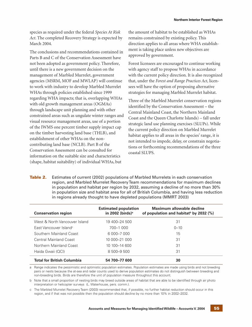
55 Accounts and Measures for Managing Identified Wildlife – Accounts V. 2004 55
Northern Interior Forest Region
species as required under the federal Species At RiskAct. The completed Recovery Strategy is expected byMarch 2004.
The conclusions and recommendations contained inParts B and C of the Conservation Assessment havenot been adopted as government policy. Therefore,until there is a new government decision on themanagement of Marbled Murrelet, governmentagencies (MSRM, MOF and MWLAP) will continueto work with industry to develop Marbled MurreletWHAs through policies established since 1999regarding WHA impacts; that is, overlapping WHAswith old growth management areas (OGMAs)through landscape unit planning and with otherconstrained areas such as ungulate winter ranges andvisual resource management areas, use of a portionof the IWMS one percent timber supply impact capon the timber harvesting land base (THLB), andestablishment of other WHAs on the non-contributing land base (NCLB). Part B of theConservation Assessment can be consulted forinformation on the suitable size and characteristics(shape, habitat suitability) of individual WHAs, but
the amount of habitat to be established as WHAsremains constrained by existing policy. Thisdirection applies to all areas where WHA establish-ment is taking place unless new objectives areapproved by government.
Forest licensees are encouraged to continue workingwith agency staff to propose WHAs in accordancewith the current policy direction. It is also recognizedthat, under the Forest and Range Practices Act, licen-sees will have the option of proposing alternativestrategies for managing Marbled Murrelet habitat.
Three of the Marbled Murrelet conservation regionsidentified by the Conservation Assessment – theCentral Mainland Coast, the Northern MainlandCoast and the Queen Charlotte Islands) – fall understrategic land use planning exercises (SLUPs). Whilethe current policy direction on Marbled Murrelethabitat applies to all areas in the species’ range, it isnot intended to impede, delay, or constrain negotia-tions or forthcoming recommendations of the threecoastal SLUPS.
Table 2. Estimates of current (2002) populations of Marbled Murrelets in each conservationregion, and Marbled Murrelet Recovery Team recommendations for maximum declinesin population and habitat per region by 2032, assuming a decline of no more than 30%in population size and habitat area for all of British Columbia, and having less reductionin regions already thought to have depleted populations (MMRT 2003)
Estimated population Maximum allowable decline
Conservation region in 2002 (birds)a of population and habitatb by 2032 (%)
West & North Vancouver Island 19 400–24 500 31
East Vancouver Islandc 700–1 000 0–10
Southern Mainland Coast 6 000–7 000 15
Central Mainland Coast 10 000–21 000 31
Northern Mainland Coast 10 100–14 600 31
Haida Gwaii (QCI) 8 500–9 500 31
Total for British Columbia 54 700–77 600 30
a Range indicates the pessimistic and optimistic population estimates. Population estimates are made using birds and not breedingpairs or nests because the at-sea and radar counts used to derive population estimates do not distinguish between breeding andnon-breeding birds. Birds are therefore the unit of population measure throughout this account.
b Note that a small proportion of nesting birds may breed outside areas of habitat that are able to be identified through air photointerpretation or helicopter surveys (L. Waterhouse, pers. comm.).
c The Marbled Murrelet Recovery Team (2003) recommended that, if possible, no further habitat reduction should occur in thisregion, and if that was not possible then the population should decline by no more than 10% in 2002–2032.

56 Accounts and Measures for Managing Identified Wildlife – Accounts V. 2004
Northern Interior Forest Region
Wildlife habitat area
Because of the unique nature of Marbled Murreletmanagement direction in British Columbia(i.e., historical reliance primarily on OGMAs forestablishing WHAs to protect nesting habitat), thefollowing paragraph is provided as context forMarbled Murrelet WHA development.
To the degree possible within government policydirection limiting impacts on timber supply, areas ofsuitable Marbled Murrelet habitat (Table 3) shouldbe maintained and protected, in combination withother constrained areas, to achieve the habitatobjectives of Table 2 and the spatial distributionrecommended for each conservation region by theMarbled Murrelet Recovery Team (MMRT 2003).When calculating total areas of maintained habitatin each conservation region or landscape unit, applythe same habitat selection criteria to protected andto non-protected areas.
Goal
Maintain suitable Marbled Murrelet nesting habitat(Table 3).
Features
Establish WHAs in suitable Marbled Murreletnesting habitat, as defined in Table 3 and the textbelow. Each habitat feature should not be used inisolation but in combination with others to ensureselection of suitable habitat. Ideally WHAs should beestablished in habitats identified as “Most Likely” tocontain suitable features. Habitat rated as“Moderately Likely” may be considered for WHAsbut will require confirmation as suitable habitatusing approved methods of ground or helicoptersurveys. Areas rated as “Least Likely” should only beconsidered if there is evidence of nesting (nests,eggshells, or occupied detections), or strong evidencethat the particular site provides the necessarymicrohabitat attributes (Table 1), such as platformlimbs (>15 cm diameter including epiphytes) andvariable canopy structure, and is within commutingdistance of likely foraging areas at sea.
The CWH and CDF biogeoclimatic zones arepreferred over MH (Burger 2002). Fine-scale
biogeoclimatic attributes are best applied throughselection of site index productivity classes (Greenand Klinka 1994). Stands classified as age class 8(140–250 yr) might provide suitable habitat but thisneeds to be confirmed through ground truthing;stands of age class 7 or less (<140 yr) are unlikely toprovide suitable habitat, unless there are suitable oldseral veteran trees or other trees with suitableplatforms present. Most nests have been found inheight class 5 or larger (>37 m tall), but smaller treescan provide suitable habitat especially in higherelevations and latitudes. Height classes on forestcover maps generally reflect average conditions in apolygon and might not be accurate for all parts of apolygon. Some multi-layered polygons with lowheight class ratings (e.g., class 2 with a veteran layer)might provide suitable trees, but these need to beconfirmed by field assessments before accepting suchpolygons as suitable habitat.
Canopy vertical complexity is an important habitatattribute and is generally a better predictor ofsuitable habitat than crown closure. Aerial photo-graphs can be used to assess and rank verticalcomplexity. Slope should be regarded as a neutralfeature at the landscape scale, but topographicvariability provided by slopes, small rock outcrops,avalanche chutes, gullies, riparian zones, and smallridges are hypothesized to improve forest value asnest habitat by breaking up the continuity of theforest canopy and improving access to the canopyfor murrelets.
Aspect, moisture regimes, and exposure to wind andsea-spray need to be considered if there is evidencethat these affect the availability of nesting platformsby inhibiting moss development on tree limbs.
Size
Within managed forests, maintain a balanced rangeof patch sizes. Patch size composition will varydepending on the existing habitat options. Until theeffects of patch size are better understood, theRecovery Team recommends maintaining a mix oflarge (>200 ha), medium (50–200 ha), and small(<50 ha) patches within managed forests.

57 Accounts and Measures for Managing Identified Wildlife – Accounts V. 2004 57
Northern Interior Forest Region
Design
Where possible, follow the steps in Table 4 forselecting nesting habitat for WHAs.
As much as possible, minimize edge effects in WHAsby avoiding elongated or amoeboid shapes with large“hard” edges (defined above), and by establishingWHA boundaries along natural forest edges or withbuffers of older second growth. Maintain windfirmboundaries to WHAs (Stathers et al. 1994) butminimize edge-feathering and topping that mightremove potential nesting habitat. WHAs borderedentirely by natural edges (e.g., between avalanchechutes or rivers) need not be restricted by shape orsize.
Wherever possible buffer the effects of roads,clearcuts, human communities, logging camps, andrecreation sites, by leaving borders of maturingforest (>40 yr) around the old seral nesting habitat.
If there has to be a trade-off between maintainingsuitable nesting habitat for WHAs or maintainingmaturing buffer zones around WHAs, select thenesting habitat. An exception might be made if thereis strong evidence that the buffer zone will matureinto old forest with more favourable attributes asnesting habitat than other existing old forest avail-able for WHAs in the same landscape unit cluster.
Forests within 0.5 km of shores that are exposed toopen ocean or have high densities of shorelinepredators (e.g., corvids) are generally considered lesssuitable habitat (Burger 2002), but they should beincluded within a WHA to buffer against wind andsea spray.
Table 3. Features of Marbled Murrelet nesting habitat to consider during selection and design ofWHAs and other maintained habitat patches. The features are grouped by the likelihoodthat polygons with these features will contain a large proportion of suitable nestinghabitat. Additional features are described in the text. Features should not be used inisolation but in combination with other features.
Moderately
Feature Most likely likely Least likely
Distance from saltwater (km): all regions 0.5–30 0–0.5 & 30–50 >50
Elevation (m):
Central & Northern Mainland Coast 0–600 600–900 >900
Haida Gwaii (QCI) 0–500 500–800 >800
All other regions 0–900 900–1500 >1500
Stand age class: all regions 9 (>250 yr) 8 (140–250 yr) <8 (<140 yr)
Site index productivity classes: all regions a Class I & II Class III Class IV(site index 20+) (site index 15–19) (site index <15)
Tree height class: all regionsb 4–7 (>28.5 m) 3 (19.5–28.4 m) <3 (<19.5 m)
Canopy closure class: all regions Classes 4, 5, & 6 Classes 3 & 7 Classes 2 & 8
Vertical canopy complexity: all regionsc MU, NU, & VNU U VU
a Productivity classes as defined in Green and Klinka (1994, p. 197); approximate 50-year site index values also given – application ofthese indices might vary with different tree species and across regions.
b Nests have been found in polygons ranked height class 1 or 2 but the nests were in larger trees than the polygon average.
c Vertical complexity ranked from least to highest (see Waterhouse et al. 2002). VU = very uniform (<11% height difference leadingtrees and average canopy, no evidence of canopy gaps or recent disturbance). U = uniform (11–20% height difference, few canopygaps visible, little or no evidence of disturbance. MU = moderately uniform (21–30% height difference, some canopy gaps visible,evidence of past disturbance, stocking may be patchy or irregular. NU = non-uniform (31–40% height difference, canopy gaps oftenvisible due to past disturbance, stocking typically patchy or irregular). VNU = very non-uniform (>40% difference, very irregularcanopy, stocking very patchy or irregular).

58 Accounts and Measures for Managing Identified Wildlife – Accounts V. 2004
Northern Interior Forest Region
General wildlife measures
Goals
1. Maintain important habitat features such asadequate large trees providing suitable nestplatforms and vertical canopy complexity.
2. Minimize activities and habitat modificationsthat might attract predators (e.g., recreationalsites may attract nest predators, such as crows,ravens, jays, or squirrels).
3. Minimize “hard edges” (defined in “Habitatthreats” section) that might attract edgepredators, allow windthrow, or adversely affectcanopy microclimates.
4. Minimize disturbance to nesting birds during thebreeding season (late-April through earlySeptember).
Measures
Access
• Do not construct or widen roads unless there isno other practicable option.
Harvesting and silviculture
• Do not harvest except for salvage.
Pesticides
• Do not use pesticides.
Recreation
• Do not develop recreational structures, trails, orfacilities.
Table 4. Recommended steps in selecting WHAs and other maintained nesting habitat forMarbled Murrelets
Goals for each step Tools and procedures
1. Identify habitat polygons to be considered for Apply regionally specific habitat algorithms andWHAs and other maintained nesting habitat recognized habitat indicators (see Tables 1 and 3, and
associated text) to forest cover maps, or similarrecognized GIS databases. See also strategic planningsection above.
2. Assess and rank the polygons based on evi- Air photo interpretation (Donaldson, in press), focusingdence of suitable canopy structure and stand on vertical complexity, tree height, stand age, andfeatures. other regionally relevant parameters in Tables 1 and 3.
3. Confirm that the ranked polygons are suitable One or more of the following:(a) evidence of nestinghabitat (nests, eggshells); (b) evidence of stand occupancy
using audio-visual surveys (RIC 2001); (c) evidence ofsuitable microhabitat features (Table 1) using groundtransects or plots (RIC 2001); (d) evidence of suitablemicrohabitat features (Table 1) from low-level helicoptersurveys (Burger et al., in press).
4. Select among the polygons classified as Maintained habitat can be a combination of polygonssuitable habitat sufficient to meet the area require- classified as Most Likely or Moderately Likely that isments for the specific landscape unit, landscape confirmed to have nesting, occupancy or suitableunit cluster, or other management unit under habitat. Polygons ranked Least Likely should only beconsideration. included if there is recent evidence of murrelet nests
or occupancy by murrelets likely to be breeding, orstrong evidence of suitable canopy attributes withincommuting distance of marine feeding sites.

59 Accounts and Measures for Managing Identified Wildlife – Accounts V. 2004 59
Northern Interior Forest Region
Additional ManagementConsiderations
Partial retention harvesting should not be under-taken in WHAs until its effects on murrelets areknown.
Information Needs
1. Criteria and methods for identifying andmapping suitable nesting habitat need to berefined. Standard protocols for using aerialphotographs and low-level helicopter recon-naissance to identify suitable habitat need tobe confirmed.
2. The distribution and area of suitable habitatacross coastal British Columbia need to beaccurately mapped.
3. Better information is needed on the size,distribution, and habitat use of regional popu-lations to refine habitat requirements in eachconservation region.
4. The effects of forest edges and patch size on nest-site selection and breeding success need to bemeasured in a wide range of habitats.
5. The effects of partial retention harvesting androads on nesting Marbled Murrelets need to beinvestigated.
Refer to the Marbled Murrelet Recovery Team forupdates on research priorities.
Cross References
Great Blue Heron, Grizzly Bear, Keen’s Long-earedMyotis, “Queen Charlotte” Goshawk, “QueenCharlotte” Northern Saw-whet Owl
References Cited
American Ornithologists’ Union (AOU). 1997. Forty-first supplement to the American Ornithologists’Union check-list of North American birds. Auk114:542–552.
Beauchamp, W.D., F. Cooke, C. Lougheed, L.W.Lougheed, C.J. Ralph, and S. Courtney. 1999.Seasonal movements of Marbled Murrelets:evidence from banded birds. Condor 101:671–674.
Beissinger, S.R. and N. Nur. 1997. Appendix B:Population trends of the Marbled Murreletprojected from demographic analysis. In Recoveryplan for the threatened Marbled Murrelet(Brachyramphus marmoratus) in Washington,Oregon and California. U.S. Fish Wildl. Serv.,Portland, Oreg., pp. B1–B35.
Bradley, R.W. 2002. Breeding ecology of radio-markedMarbled Murrelets in Desolation Sound, BritishColumbia. M.Sc. thesis. Simon Fraser Univ.,Burnaby, B.C.
Bradley, R.W. and F. Cooke. 2001. Cliff and deciduoustree nests of Marbled Murrelets in southwesternBritish Columbia. Northwest. Nat. 82:52–57.
Burger, A.E. 2001. Using radar to estimate populationsand assess habitat associations of MarbledMurrelets. J. Wildl. Manage. 65:696–715.
_____. 2002. Conservation assessment of MarbledMurrelets in British Columbia: review of thebiology, populations, habitat associations, andconservation. Can. Wildl. Serv., Delta, B.C. Tech.Rep. Ser. No. 387.
Burger, A.E., B.R. Smart, L.K. Blight, and J. Hobbs. Inpress. Standard methods for identifying andranking nesting habitat of Marbled Murrelets inBritish Columbia. PART B: low-level aerialreconnaissance methods. B.C. Min. Water, Land andAir Prot., Victoria, BC. Unpubl.
Cam, E., L.W. Lougheed, R.W. Bradley, and F. Cooke. Inpress. Demographic assessment of a MarbledMurrelet population from capture-mark-recapturedata. Conserv. Biol.
Canadian Marbled Murrelet Recovery Team. 2003.Marbled Murrelet Conservation Assessment 2003,Part B: Marbled Murrelet Recovery Team AdvisoryDocument on Conservation and Management.Canadian Marbled Murrelet Recovery TeamWorking Document No. 1.
Committee on the Status of Endangered Wildlife inCanada (COSEWIC). 2002. Canadian species atrisk. Available from: http://www.speciesatrisk.gc.ca
Demarchi, D.A. and A.A. Button. 2001a. MarbledMurrelet nesting habitat capability in BritishColumbia: Map 2 – weighted average capability.B.C. Min. Environ., Lands and Parks, Resour. Inv.Br., Victoria, B.C. Map @ 1:300,000.
_____. 2001b. Marbled Murrelet nesting habitatsuitability in British Columbia: Map 3 – weightedaverage suitability. B.C. Min. Environ., Lands andParks, Resour. Inv. Br., Victoria, B.C. Map @1:300,000.

60 Accounts and Measures for Managing Identified Wildlife – Accounts V. 2004
Northern Interior Forest Region
Donaldson, A. In press. Standard methods foridentifying and ranking nesting habitat of MarbledMurrelets in BC. Part A: air photo interpretation.Report to B.C. Min. Water, Land and Air Prot.,Victoria, B.C. Unpubl.
Gaston, A.J. and I.L. Jones. 1998. The auks Alcidae.Oxford Univ. Press, Oxford, U.K.
Green, R.N. and K. Klinka. 1994. A field guide to siteidentification and interpretation for the VancouverForest Region. B.C. Min. For., Res. Br., Victoria, B.C.Land Manage. Handb. No. 28.
Hamer, T.E. and S.K. Nelson. 1995. Characteristics ofMarbled Murrelet nest trees and nesting stands. InEcology and conservation of the Marbled Murrelet.C.J. Ralph, G.L. Hunt, Jr., M.G. Raphael, and J.F.Piatt (editors). U.S. Dep. Agric. For. Serv., Pac. SWRes. Stn., Albany, Calif., Gen. Tech. Rep. PSW-GTR-152, pp. 69–82.
Hooper, T.D. 2001. Research and inventory of MarbledMurrelets (Brachyramphus marmoratus) in BritishColumbia: 1991-1999. Report to Can. Wildl. Serv.,Pac. and Yukon Reg., Delta, B.C. Unpubl.
Hull, C.L. 1999. COSEWIC status report update onMarbled Murrelet Brachyramphus marmoratus(Gmelin). Report to Committee on the Status ofEndangered Wildlife in Canada (COSEWIC).Simon Fraser Univ., Cent. Wildl. Ecol., Burnaby,B.C.
Hull, C.L., G.W. Kaiser, C. Lougheed, L. Lougheed, S.Boyd, and F. Cooke. 2001. Intra-specific variation incommuting distance of Marbled Murrelets(Brachyramphus marmoratus): ecological andenergetic consequences of nesting further inland.Auk 118:1036–1046.
Kaiser, G.W., H.J. Barclay, A.E. Burger, D. Kangasniemi,D.J. Lindsay, W.T. Munro, W.R. Pollard, R. Redhead,J. Rice, and D. Seip. 1994. National Recovery Planfor the Marbled Murrelet. Recovery of NationallyEndangered Wildlife Committee, Can. Wildl. Serv.,Ottawa, Ont. Rep. No. 8.
Lougheed, C., L.W. Lougheed, F. Cooke, and S. Boyd.2002a. Local survival of adult and juvenile MarbledMurrelets and their importance for estimatingreproductive success. Condor 104:309–318.
Lougheed, C., B.A. Vanderkist, L.W. Lougheed, and F.Cooke. 2002b. Techniques for investigatingbreeding chronology in Marbled Murrelets,Desolation Sound, British Columbia. Condor104:319–330.
McFarlane Tranquilla, L.A. 2001. Using multiplemethods to describe breeding, stress response, anddisturbance of Marbled Murrelets (Brachyramphusmarmoratus). M.Sc. thesis. Simon Fraser Univ.,Burnaby, B.C.
Manley, I.A. 1999. Behaviour and habitat selection ofMarbled Murrelets nesting on the Sunshine Coast.M.Sc. thesis. Simon Fraser Univ., Burnaby, B.C.
Manley, I.A. and S.K. Nelson. 1999. Habitatcharacteristics associated with nest success andpredation at Marbled Murrelet tree nests(Abstract). Pac. Seabirds 26:40.
Marbled Murrelet Recovery Team (MMRT). 2003.Marbled Murrelet Conservation Assessment 2003,Part B – Marbled Murrelet Recovery Team advisorydocument on conservation and management.Available from the Can. Wildl. Serv., Delta, B.C.
Masselink, M.N.M. 2001. Responses by Steller’s Jay toforest fragmentation on southwest VancouverIsland and potential impacts on Marbled Murrelets.M.Sc. thesis. Univ. Victoria, Victoria, B.C.
NatureServe Explorer. 2002. An online encyclopedia oflife [Web application]. Version 1.6. Arlington, Va.Available from: http://www.natureserve.org/explorer
Nelson, S.K. 1997. Marbled Murrelet Brachyramphusmarmoratus. In The birds of North America, No.276. A. Poole and F. Gill (editors). Acad. Nat. Sci.,Philadelphia, Penn., and Am. Ornithol. Union,Washington, D.C.
Ralph, C.J., G.L. Hunt Jr., M.G. Raphael, and J.F. Piatt(editors). 1995. Ecology and conservation of theMarbled Murrelet in North America. U.S. Dep.Agric. For. Serv., Pac. SW Res. Stn., Albany, Calif.,Gen. Tech. Rep. PSW-GTR-152.
Raphael, M.G., D. Evans Mack, J.M. Marzluff, and J.M.Luginbuhl. 2002. Effects of forest fragmentation onpopulations of the Marbled Murrelet. Stud. AvianBiol. 25:221–235.
_____. 2001. Inventory methods for Marbled Murreletsin marine and terrestrial habitats, Version 2.0.Standards for components of British Columbia’sbiodiversity, No. 10. B.C. Min. Environ., Lands andParks, Victoria, B.C. Available from: http://srmwww.gov.bc.ca/risc/pubs/tebiodiv/index.htm
Stathers, R.J., T.P. Rollerson, and S.J. Mitchell. 1994.Windthrow handbook for British Columbia forests.B.C. Min. For., Res. Br., Victoria, B.C. Work. Pap.9401.

61 Accounts and Measures for Managing Identified Wildlife – Accounts V. 2004 61
Northern Interior Forest Region
Steventon, J.D., G.L. Sutherland, and P.E. Arcese. Inpress. Analysis of long-term risks to regionalmarbled murrelet (Brachyramphus marmoratus)populations under alternative forest managementpolicies in coastal British Columbia. B.C. Min. For.,Res. Program and For. Practices Br., Victoria, B.C.
Waterhouse, F.L., R. Bradley, J. Markila, F. Cooke, andL. Lougheed. 2002. Use of airphotos to identify,describe and manage forest structure of MarbledMurrelet nesting habitat at a coastal BritishColumbia site. B.C. Min. For., Vancouver For. Reg.,Res. Sect., Nanaimo, B.C. Tech. Rep. TR-016.
Whitworth, D.L., S.K. Nelson, S.H. Newman, G.B. vanVliet, and W.P. Smith. 2000. Foraging distances ofradio-marked Marbled Murrelets from inland areasin southeast Alaska. Condor 102:452–456.
Personal Communications
Fraser, D. 2003. Min. Water, Land and Air Protection,Victoria, B.C.

62 Accounts and Measures for Managing Identified Wildlife – Accounts V. 2004
Northern Interior Forest Region
BAY-BREASTED WARBLER
Dendroica castanea
Original prepared by John M. Cooper andSuzanne M. Beauchesne
Species Information
Taxonomy
The Bay-breasted Warbler is a neotropical migrantsongbird. It is one of 12 species of warbler in thegenus Dendroica that breed in British Columbia(Campbell et al. 2001). No subspecies are recognized(AOU 1957; Cannings 1998). It seems to be closelyrelated to the Blackpoll Warbler (Dendroica striata),with which it overlaps in range, as there have beenthree records of hybridization (Williams 1996).
Description
A small songbird about 14 cm in length. In breedingplumage, the male has a black face; chestnut crown,throat, and sides; cream-coloured patch on the sidesof the neck; a cream-coloured belly; and two boldwhite wing stripes contrasting with the otherwisedark olive, streaked upperparts. The female is similarin pattern but is significantly duller in colour. In thefall, adult males, females, and young of year haveolive green upperparts with two white wing bars anddull yellowish underparts.
Distribution
Global
The Bay-breasted Warbler breeds from the south-eastern Yukon, southwestern Mackenzie and north-eastern British Columbia, across Canada throughoutthe boreal forest to southwestern Newfoundland,and south into the United States from northernMinnesota east to Maine. This species wintersmainly in the Panama as well as south into northernColombia and western Venezuela (AOU 1983;Campbell et al. 2001).
British Columbia
In British Columbia, Bay-breasted Warblers havebeen reported primarily in the Taiga Plains andBoreal Plains ecoprovinces, from near KwokullieLake and along the Liard River, at Mile 513 of theAlaska Highway, south through Moberly and OneIsland lakes (Cooper et al. 1997). Extralimitalrecords include Tetana Lake, Yoho National Park,and Indianpoint Lake (Godfrey 1986), and west endof Williston Lake (Price 1993).
Forest regions and districts
Northern Interior: Fort Nelson, Peace
Ecoprovinces and ecosections
TAP: ETP, FNL
BOP: HAP, KIP, PEL
NBM: HYH, LIP
Biogeoclimatic units
BWBS: mw1, mw2
Broad ecosystem units
BA, PR
Elevation
230–760 m (Bennett and Enns 1996;Campbell et al. 2001)
Life History
Very little is known about the ecology of the Bay-breasted Warbler in British Columbia, thereforemost of the following information is inferred fromstudies in other areas.

63 Accounts and Measures for Managing Identified Wildlife – Accounts V. 2004 63
Northern Interior Forest Region

64 Accounts and Measures for Managing Identified Wildlife – Accounts V. 2004
Northern Interior Forest Region
Diet and foraging behaviour
During the breeding season, the Bay-breastedWarbler is a specialized forager, spending most of itstime in the shady, interior branches of the middleand upper coniferous canopy (Bent 1953;MacArthur 1958). Morse (1978) also noted Bay-breasted Warblers in deciduous habitats, foraging atmedium to medium-low heights. Its diet is mainlyinsectivorous, composed of a variety of adult andlarval insects, spiders, and spider and insect eggs(Bent 1953; MacArthur 1958; Sealy 1979; Morse1980). Lepidopteran larvae (e.g., spruce budworms)are the primary food source during the breedingseason (Morse 1978). The diet switches to mainlyfruit during the winter in the tropics when insectsare scarce (Rappole 1995; Williams 1996).
Reproduction
The Bay-breasted Warbler is probably seasonallymonogamous although mate-switching is possible(Sealy 1979; Williams 1996). Upon arriving on thebreeding grounds, males select nesting territories,defending them from conspecific males. The femalebuilds the nest with some assistance from the male(Baicich and Harrison 1997). Clutch size rangesfrom three to seven eggs and is strongly influencedby food supply with larger clutches (six or seveneggs) typical during periods of high food abundance(Bent 1953; Morse 1978; 1989; Peck and James1987). In northeastern British Columbia, egg layingprobably begins in mid-June (Campbell et al. 2001).Eggs are incubated by the female for 12–13 days,nestlings fledge after 10–12 days, and both parentscontinue to feed young for several days, post-fledging (Bent 1953; Baicich and Harrison 1997). Asingle brood is likely raised annually in BritishColumbia, as is usual for neotropical migrants(Morse 1989).
Site fidelity
Bay-breasted Warblers respond to budworm out-breaks and may become super-abundant duringinfestations and then decline or disappear entirelyfrom area within a few years after the outbreak(Morse 1980). Thus, site fidelity is likely low, lastingroughly as long as the outbreak period.
Home range/territory size
There are no data for nesting territory size orbreeding density in British Columbia, but thiswarbler is one of the least abundant warblers inBritish Columbia (Cooper et al. 1997). Elsewhere,most density data are for periods of budwormoutbreak, including one study in Ontario, wheredensities of up to 230 pairs/km2 were recorded(Williams 1996).
Dispersal and movements
Spring migrants enter northeastern British Columbiathrough Alberta and begin arriving in mid- to lateMay, with the majority probably arriving in late Mayand early June (Pinel et al. 1993).
After nesting is completed, adults probably begin tomigrate south in mid- to late July, followed byjuveniles through August (Salt 1973; Pinel et al.1993).
Habitat
Structural stage1
6: mature forest (80–140 yr)7: old growth (>140 yr)
Important habitats and habitat features
Nesting
In northeastern British Columbia, Bay-breastedWarblers are found almost exclusively in maturewhite spruce forest, either in pure stands or mixedwith clumps of aspens (Populus tremuloides), birch(Betula papyrifera), and balsam poplar (Populusbalsamifera) (McTaggart-Cowan 1939, Erskine andDavidson 1976; Siddle 1992; Enns and Siddle 1992).This species also uses riparian coniferous ormixedwood corridors with multi-layered canopy andfrequent openings (Campbell et al. 2001).
Some common characteristics of nesting habitatinclude a high proportion of old spruce (wildlife treeclasses 3–5) with dead lower branches, a relativelyclosed upper canopy, a sparse but patchy sub-canopy,and an understorey dominated by highbush-cranberry (Viburnum edule), paper birch (Betula
1 Suitability increases with age.

65 Accounts and Measures for Managing Identified Wildlife – Accounts V. 2004 65
Northern Interior Forest Region
occidentalis), dogwood (Cornus nuttallii), or Sitkaalder (Alnus viridis ssp. fruticosa) (Cooper et al. 1997;Campbell et al. 2001).
Bay-breasted Warblers usually nest in coniferoustrees; preferring spruce or fir, although they alsooccasionally nest in deciduous trees or shrubs (Bent1953; Sealy 1979; Peck and James 1987). Nests arebulky cups of grass, small twigs, and caterpillar webslined with fine rootlets and hair (Baicich andHarrison 1997). Nests are usually placed on ahorizontal branch, near the trunk or along a mainbranch, and may be 2–18 m above ground, although4.6–7.6 m is most common (Bent 1953; Peck andJames 1987; Baicich and Harrison 1997). Only onenest has been documented for British Columbia, andits location on a spruce branch, 8 m above theground, is consistent with nest microhabitat foundelsewhere (Campbell et al. 2001).
An abundant prey base is an essential nesting habitatfeature. Breeding distribution and abundance isstrongly tied to presence of eastern spruce budworm(Choristoneura fumiferana) (MacArthur 1958; Morse1978, 1989; Welsh 1987).
Foraging
Birds probably forage mainly within the nestinghabitat, therefore feeding and nesting habitatrequirements are the same.
Conservation andManagement
Status
The Bay-breasted Warbler is on the provincial RedList in British Columbia. Its status in Canada has notbeen determined (COSEWIC 2002).
Summary of ABI status in BC and adjacentjurisdictions (NatureServe Explorer 2002)
BC AB AK NWT Canada Global
S2B, S2S3B SR S? N5B G5S2N
Trends
Population trends
Throughout this species range, local populationtrends are closely correlated with outbreaks of theeastern spruce budworm and, therefore fluctuatedramatically (Bennett and Enns1996; Williams 1996;Cooper et al. 1997). In eastern North America,several studies have shown stable long-term trends,but significant recent short-term declines (Hill andHagan 1991; Hagan and Johnston 1992). AcrossCanada, Breeding Bird Survey data suggestpopulations are declining (Erskine et al. 1992).
Overall Bay-breasted Warbler populations may bedeclining slightly (Williams 1996). Although thereare no population trend data for British Columbia,considering the widespread population declines ofmany neotropical migrants (Morton and Greenberg1989; Terborgh 1989; Finch 1991), the limitednumber of records for Bay-breasted Warblers inBritish Columbia, and the fact that this species relieson a habitat in decline, it is probable that popu-lations are stable or declining (Cooper et al. 1997;Fraser et al. 1999), rather than increasing.
Habitat trends
Pure stands of large spruce, the preferred habitat ofBay-breasted Warbler, are relatively rare in thenortheast and are being harvested at rates that theB.C. Ministry of Forests has described as non-sustainable (MOF 1992).
Threats
Population threats
Bay-breasted Warblers are rarely parasitized byBrown-headed Cowbird (Williams 1996); however,the impact of nest parasitism can be severe onneotropical migrants, especially in fragmentedforests (Brittingham and Temple 1983; Askins et al.1990; Finch and Stangel [editors] 1993). The lack ofparasitism on this species is undoubtedly because ittypically breeds in boreal forests away from cowbirdconcentrations. Brown-headed Cowbird parasitismwill undoubtedly increase with habitatfragmentation.

66 Accounts and Measures for Managing Identified Wildlife – Accounts V. 2004
Northern Interior Forest Region
Fragmentation of habitat increases edge habitatfavoured by predatory species such as jays, crows,magpies, and some small mammals. Because theprobability of predation on forest songbird nestsincreases with increasing forest fragmentation, it isprobable that Bay-breasted Warblers will faceincreasing predation intensity as forests are cleared(Wilcove 1985; Yahner and Scott 1988; Askins et al.1990; Cooper et al. 1997).
Rappole (1995) lists Bay-breasted Warbler amongstthe neotropical migrants with a high probability ofdeclining in the next decade, with winter being themost vulnerable period due to habitat loss within arelatively restricted winter range.
Migrating warblers suffer mortality from naturalenvironmental factors such as inclement weather andfrom human-related factors such as collision with lighttowers (Williams 1996). It is expected that predationof nestlings by small mammals and birds, particularlycorvid species, impacts reproductive success (Morse1989; Williams 1996; Cooper et al. 1997).
Habitat threats
The primary threat to the Bay-breasted Warbler inBritish Columbia is the harvesting of mature andold-growth white spruce stands within its restrictedrange in the Boreal Plains and Taiga Plains eco-provinces. Loss or deterioration of forest habitat hasbeen widely blamed for declines in breeding popula-tions of many forest warbler species (Titterington etal. 1979; Askins and Philbrick 1987; Terborgh 1989;Saunders et al. 1991; Hagan and Johnston 1992;Maurer and Heywood 1993). There is no evidence tosuggest that the Bay-breasted Warblers will responddifferently (Cooper et al. 1997).
Bay-breasted Warblers have been observed in BritishColumbia in stands that have been logged selectivelyfor very large spruce with substantial, but unquanti-fied, amounts of moderate-sized spruce remaining;this finding suggests that a certain amount ofselective logging may be compatible with thiswarbler (Enns and Siddle 1992).
Stands favoured by Bay-breasted Warblers are oftentargeted for salvage or sanitation logging and, onceharvested, require considerable time (>100 years)
before they regenerate to a stage suitable for thisspecies. Fire is also more likely to occur in selectivelylogged upland areas with optimal Bay-breastedWarbler habitat due to high fuel accumulation andsite-related factors such as slope and aspect(Parminter 1983; Cooper et al. 1997).
Habitat is also lost or fragmented by other activitiessuch as clearing for agriculture, road building,transmission lines, and oil and gas exploration(Cooper et al. 1997). In addition, the use ofpesticides to control budworm outbreaks maythreaten the quality of habitat (Williams 1996;Cooper et al. 1997).
Legal Protection and HabitatConservation
The Bay-breasted Warbler, its nests, and its eggs areprotected from direct persecution in Canada by theMigratory Birds Convention Act. In British Columbia,the same are protected under the provincialWildlife Act.
Several Class A parks, such as Taylor Landing(2.4 ha) and Kiskatinaw River (154 ha), are withinthe known range and habitat type of Bay-breastedWarbler, although none include significant amountsof old-growth white spruce forest. One ecologicalreserve, Fort Nelson River, may have small amountsof suitable habitat for Bay-breasted Warbler and theAndy Bailey Recreation Area (196 ha) contains someblack and white spruce riparian forest.
Most other nesting habitat is on Crown land;therefore, habitat conservation may be partiallyaddressed by the old forest retention targets (oldgrowth management areas), riparian reserves, andwildlife tree retention areas as required under theresults based code.
Since Cape May and Bay-breasted Warblers usesimilar habitats, reserves for one species will likely beuseful for the other.
Identified Wildlife Provisions
Habitat management for this species is bestconducted at the landscape level. Becausepopulations are very local, are dispersed in a large

67 Accounts and Measures for Managing Identified Wildlife – Accounts V. 2004 67
Northern Interior Forest Region
geographic area, and respond so directly to preyavailability, old growth management areas, riparianmanagement areas, and protected areas scatteredthroughout the BWBS may be the best approach tomanaging habitat for this species.
Sustainable resource management andplanning recommendations
Maintain suitable nesting habitat by maintainingold spruce forest.
Incorporate old spruce into (1) old growthmanagement areas (OGMAs); (2) areasconstrained for other management objectives(e.g., visual quality, recreation, ungulate winterrange, terrain concerns); or (3) stand levelreserves such as wildlife tree retention areas andriparian management areas.
Areas selected should include spruce forests withevidence of declining health for their potentialfor future spruce budworm outbreaks. Othercharacteristics of good habitat are stands of old-growth black or white spruce >140 years, arelatively closed upper canopy, open patches inmid-canopy, and an understorey dominated byhighbush-cranberry, paper birch, dogwood, orSitka alder.
Specific wildlife tree and old forest retentionobjectives for this species should be considered inthe BWBSmw1 and BWBSmw2 in Fort Nelson,and Peace forest districts. Blocks should beassessed to identify potentially suitable WTRareas. The attributes listed in Table 1 should beused to design suitable WTR areas for thisspecies.
Table 1. Preferred WTR area characteristicsfor the Bay-breasted Warbler
Attributes Characteristics
Size (ha) ≥5 ha
Location BWBSmw1, BWBSmw2
Features trees with dead lower branches;understorey dominated byhighbush-cranberry, paper birch,dogwood, or Sitka alder
Tree species white spruce
Age/structure ≥80 years; structural stages 6–7
Wildlife tree class 3–5
Restrict salvage or harvest and avoid insecticideuse.
Maintain WTR area over the long term.
Wildlife habitat area
Goal
Although this species is likely best managed at thelandscape level, it may be appropriate to establishWHAs where strategic level planning objectivescannot address critical areas for the species.
Feature
Establish WHAs only within highly suitable nestinghabitat (i.e., in mature or old spruce forest) whereconcentrations (>3 pairs/10 ha) of Bay-breastedWarblers regularly occur.
Size
Typically between 10 and 30 ha but will depend onsite-specific factors.
Design
WHAs should include old spruce forest on flattopography with a relatively closed upper canopy,open patches in mid-canopy and an understoreydominated by highbush-cranberry, paper birch,dogwood, or Sitka alder. Minimize edge habitatwherever possible.
General wildlife measure
Goals
1. Ensure WHA is windfirm.
2. Maximize interior forest conditions.
3. Minimize disturbance during the nesting season(1 June to 31 July).
Measures
Access
• Do not construct roads, trails, or other accessroutes.
Harvesting and silviculture
• Do not harvest.
Pesticides
• Do not use pesticides.

68 Accounts and Measures for Managing Identified Wildlife – Accounts V. 2004
Northern Interior Forest Region
Additional ManagementConsiderations
Forestry practices that promote microhabitatdiversity by providing uneven-aged forests maybenefit this species.
Avoid prime Bay-breasted Warbler habitat whenplanning seismic explorations, transmission lines,and other access routes.
Information Needs
1. Distribution.
2. Habitat use preferences.
3. Population estimates and trends.
Cross References
Cape May Warbler
References Cited
American Ornithologists’ Union (AOU). 1957. Check-list of North American birds. 5th ed. Baltimore, Md.691 p.
_____. 1983. Check-list of North American birds.Lawrence, Kans. 877 p.
Askins, R.A., J.F. Lynch, and R. Greenberg. 1990.Population declines in migratory birds in easternNorth America. Curr. Ornith. 7:1–57.
Askins, R.A. and M.J. Philbrick. 1987. Effect of changesin regional forest abundance on the decline andrecovery of a forest bird community. Wilson Bull.99:7–21.
Baicich, P.J. and C.J. Harrison. 1997. A guide to thenests, eggs, and nestlings of North American birds.2nd ed. Academic Press, London, U.K. 347 p.
Bennett, S. and K. Enns. 1996. A bird inventory of theBoreal White and Black Spruce biogeoclimatic zonenear the “Big Bend” of the Liard River. B.C. Min.Environ., Lands and Parks, Fort St. John, B.C.
Bent, A.C. 1953. Life histories of North American woodwarblers. Smithsonian Inst. Press, Washington, D.C.Bull. 203. 734 p.
B.C. Ministry of Forests (MOF). 1992. Fort NelsonTimber Supply Area timber supply analysis report.Prince George, B.C. 77 p.
Brittingham, M.C. and S.A. Temple. 1983. Havecowbirds caused forest songbirds to decline?Bioscience 33:31–35.
Campbell, R.W., N.K. Dawe, I. McTaggart-Cowan, J.M.Cooper, G.W. Kaiser, A.C. Stewart, and M.C.E.McNall. 2001. The birds of British Columbia. Vol.IV: Passerines. Wood Warblers through Old WorldSparrows. Royal B.C. Mus., Victoria, B.C., and Can.Wildl. Serv., Delta, B.C.
Cannings, R.J. 1998. The birds of British Columbia: ataxonomic catalogue. B.C. Min. Environ., Landsand Parks, Wildl. Br., Victoria, B.C. WB-86.
Committee on the Status of Endangered Wildlife inCanada (COSEWIC). 2002. Canadian Species atRisk. www.speciesatrisk.gc.ca
Cooper, J.M., K.A. Enns, and M.G. Shepard. 1997.Status of the Bay-breasted Warbler in BritishColumbia. B.C. Min. Environ., Lands and Parks,Victoria, B.C. WR-79.
Enns, K.A. and C. Siddle. 1992. The distribution,abundance and habitat requirements of selectedpasserine birds of the Taiga and Boreal Plains.Report prepared for B.C. Min. Environ., Lands andParks, Victoria, B.C. Unpubl. 68 p.
Erskine, A.J., B.T. Collins, E. Hayakawa, and C. Downes.1992. The cooperative breeding bird survey inCanada, 1989–1991. 14 p.
Erskine, A.J. and G.S. Davidson. 1976. Birds in the FortNelson lowlands of northeastern British Columbia.Syesis 9:1–11.
Finch, D.M. 1991. Population, ecology, habitatrequirements, and conservation of neotropicalmigratory birds. U.S. Dep. Agric. For. Serv., FortCollins, Colo. Gen. Tech. Rep. RM-205. 26 p.
Finch, D.M. and P.W. Stangel (editors). 1993. Statusand management of neotropical migratory birds.U.S. Dep. Agric. For. Serv., Fort Collins, Colo. Gen.Tech. Rep. RM-229.
Fraser, D.F., W.L. Harper, S.G. Cannings, and J.M.Cooper. 1999. Rare birds of British Columbia. B.C.Min. Environ., Lands and Parks, Wildl. Br. andResour. Inventory Br., Victoria, B.C. 244 p.
Godfrey, W.E. 1986. The birds of Canada. Revised ed.Natl. Mus. Can., Ottawa, Ont. 595 p.
Hagan, J.M. III and D.W. Johnston. 1992. Ecology andconservation of neotropical migrant landbirds.Smithsonian Inst. Press, Washington, D.C. 609 p.
Hill, N.P. and J.M. Hagan III. 1991. Population trendsof some northeastern North American landbirds: ahalf-century of data. Wilson Bull. 103:165–182.
MacArthur, R.H. 1958. Population ecology of somewarblers of northeastern coniferous forests. Ecology39:599–619.

69 Accounts and Measures for Managing Identified Wildlife – Accounts V. 2004 69
Northern Interior Forest Region
Maurer, B.A. and S.G. Heywood. 1993. Geographicrange fragmentation and abundance of neotropicalmigratory birds. Conserv. Biol. 7:501–509.
McTaggart-Cowan, I. 1939. The vertebrate fauna of thePeace River district of British Columbia. B.C. Prov.Mus., Victoria, B.C. Occas. Pap. No. 1. 102 p.
Morse, D.H. 1978. Populations of Bay-breasted andCape May Warblers during an outbreak of thespruce budworm. Wilson Bull. 90:404–413.
_____. 1980. Foraging and coexistence of spruce-woodwarblers. Living Bird 18:7–25.
_____. 1989. American warblers. Harvard Univ. Press,Cambridge, Mass. 406 p.
Morton, E.S. and R. Greenberg. 1989. The outlook formigratory songbirds: “future shock” for birders.Am. Birds 43:178–183.
NatureServe Explorer. 2002. An online encyclopaediaof life. Version 1.6. NatureServe. Arlington, VA.Available at http://www.natureserve.org/explorer/
Parminter, J. 1983. Fire-ecological relationships for thebiogeoclimatic zones and subzones of the FortNelson Timber Supply Area. Northern Fire Ecol.Project. B.C. Min. For., Victoria, B.C. 53 p.
Peck, G.K. and R.D. James. 1987. Breeding birds ofOntario: nidology and distribution. Royal Ont.Mus., Toronto, Ont. 321 p.
Pinel, H.W., W.W. Smith, and C.R. Wershler. 1993.Alberta birds, 1971–1980. Prov. Mus. Alberta Nat.Hist, Edmonton, Alta. Occas. Pap. No. 20. 238 p.
Price, M. 1993. The Donna Creek area, BritishColumbia: an east-west transition zone. Birders J.5:251–255.
Rappole, J.H. 1995. The ecology of migrant birds: aneotropical perspective. Smithsonian Inst. Press,Washington, D.C.
Salt, W.R. 1973. Alberta vireos and wood warblers.Prov. Mus. Arch. Alberta, Edmonton, Alta. Publ. 3.141 p.
Saunders, D.A., R.J. Hobbs, and C.R. Margules. 1991.Biological consequences of ecosystemfragmentation: a review. Conserv. Biol. 5:18–32.
Sealy, S.G. 1979. Extralimital nesting of Bay-breastedWarblers: response to forest tent caterpillars? Auk96:600–603.
Siddle, C. 1992. The declining populations of warblersin northeastern British Columbia. In Communityaction for endangered species: a public symposiumon B.C.’s threatened and endangered species andtheir habitat. S. Rautio (editor). Vancouver, B.C.,Sept. 28–29, 1991. Fed. B.C. Naturalists andNorthwest Wildl. Preserv. Soc., Vancouver, B.C., pp.143–151.
Terborgh, J.W. 1989. Where have all the birds gone.Princeton Univ. Press, Princeton, N.J. 207 p.
Titterington, R.W., H.S. Crawford, and B.N. Burgason.1979. Songbird responses to commercialclearcutting in Maine spruce-fir forests. J. Wildl.Manage. 43:602–609.
Welsh, D.A. 1987. Birds as indicators of forest standconditions in boreal forests of eastern Canada.ICBP Tech. Publ. 6:259–267.
Wilcove, D.S. 1985. Nest predation in forest tracts andthe decline of migratory songbirds. J. Ecol.66:1211–1214.
Williams, J.M. 1996. Bay-breasted Warbler (Dendroicacastanea). In The birds of North America, No. 206.A. Poole and F. Gill (editors). Acad. Natl. Sci.,Philadelphia, Penn., and Am. Ornith. Union,Washington, D.C.
Yahner, R.H. and D.P. Scott. 1988. Effects of forestfragmentation on depredation of artificial nests. J.Wildl. Manage. 52:158–161.

70 Accounts and Measures for Managing Identified Wildlife – Accounts V. 2004
Northern Interior Forest Region
BLACK-THROATED GREEN WARBLER
Dendroica virens
Original prepared by John M. Cooper and Suzanne M. Beauchesne
Species Information
Taxonomy
The Black-throated Green Warbler is part of asuperspecies complex with closely related Dendroicawarblers (Hermit, Golden-cheeked, and Townsend’s)(AOU 1983). Hybridization between Black-throatedGreen and Townsend’s Warblers (Dendroicatownsendi) has been reported from the RockyMountains of British Columbia where the breedingranges of these two species overlap (Rohwer 1994).Two subspecies of Black-throated Green Warblersare recognized, of which only the nominate race,D. virens virens, occurs in British Columbia (Morse1993; Cannings 1998). The other race, D. virenswaynei occurs in the southeastern United States(Morse 1993).
Description
A small songbird about 13 cm in length. In breedingplumage, the male has a black throat and sides ofbreast, yellow face with olive green ear coverts,unstreaked olive green crown and upper parts, twowhite wing bars, and a white belly. The female hassimilar markings but is duller, the chin is yellow, andthere is less black on the lower throat and sides ofbreast. Juveniles are significantly duller still with verylittle or no black on the chin and throat, which is,instead, white or pale yellow (Pyle 1997).
Distribution
Global
The Black-throated Green Warbler breeds fromnortheastern British Columbia, across borealCanada east to Newfoundland and Labrador andsouth in the United States, from Minnesota in the
west across to Alabama and Georgia. This specieswinters primarily in Mexico and Central America,south to Panama although some birds may be foundin the United States along the Gulf of Mexico, in theCaribbean, and in northern South America (AOU1983; Morse 1993).
British Columbia
Black-throated Green Warblers were not known tooccur in British Columbia during the first half of thiscentury (Munro and and McTaggart-Cowan 1947;Godfrey 1986). The first documented record for theprovince was in 1965 (Salt 1966). Morse (1993)speculates that it has undergone a recent rangeexpansion into northeastern British Columbia whereit reaches the northwestern extreme of its range.
The Black-throated Green Warbler occurs mainly inthe Boreal Plains Ecoprovince, with most recordscoming from the Peace Lowland (Campbell et al.2001). Enns and Siddle (1992) reported this specieswest to Moberly Lake, north to Blueberry Creek andsouth to near the headwaters of the KiskatinawRiver. Recent records from the Tuchodi River extendits known range significantly northward, into theTaiga Plains Ecoprovince. It has recently been foundto occur rarely in the Fort Nelson Forest District ofthe Taiga Plains (Bennett et al. 2000). There is oneknown record in the Sub-Boreal InteriorEcoprovince (Cooper et al. 1997).
Forest regions and districts
Northern Interior: Fort Nelson, Peace
Ecoprovinces and ecosections
BOP: CLH, HAP, KIP, PEL
TAP: MUP
SBI: HAF

71 Accounts and Measures for Managing Identified Wildlife – Accounts V. 2004 71
Northern Interior Forest Region
72 Accounts and Measures for Managing Identified Wildlife – Accounts V. 2004
Northern Interior Forest Region
Biogeoclimatic units
BWBS: mw1, mw2
Broad ecosystem units
BA, PR
Elevation
Breeding – 650–1100 m in the northeastMigration – sea level to 1800 m (Campbell et al.2001).
Life History
Very little is known about the ecology of the Black-throated Green Warbler in British Columbia,therefore much of the following information isinferred from studies in other areas.
Diet and foraging behaviour
The Black-throated Green Warbler is primarilyinsectivorous. Lepidopteran caterpillars contributethe greatest volume to its diet, but a wide range ofprey is taken including beetles, bugs, gnats, ants,spiders, mites, and plant lice (Bent 1953; Morse1976; Robinson and Holmes 1982; Morse 1993).Gleaning small branches and foliage of conifers isthe main foraging technique although this speciesalso hovers to glean the underside of foliage andterminal tips of branches and hawks insects in flight(MacArthur 1958; Morse 1968). In BritishColumbia, as elsewhere, most foraging is donewithin the mid- to upper canopy (Sabo and Holmes1983; Morse 1993). In migration, berries are addedto the diet (Morse 1993).
Reproduction
Upon arriving on the breeding grounds, male Black-throated Green Warblers select breeding territories,defending them from conspecific males, then pairwith a mate after females arrive. Both sexes contri-bute to nest building (Morse 1993). Clutches usuallycontain four eggs, however three to five egg clutcheshave been recorded (Bent 1953; MacArthur 1958;Peck and James 1987; Baicich and Harrison 1997).Egg-laying probably occurs mainly in mid- to lateJune in northeastern British Columbia (Campbell
et al. 2001). Eggs are incubated by the female alonefor about 12 days (Baicich and Harrison 1997).Nestlings fledge after 9–11 days (Bent 1953; Morse1993; Baicich and Harrison 1997). Both parentscontinue to feed young for several days, post-fledging, often separating at this point, each takingpart of the brood (Morse 1993; Baicich and Harrison1997). Siddle (1981) reported a fledgling being fedby an adult at Kiskatinaw Park on 30 June. A singlebrood is likely raised by each pair annually in BritishColumbia, as is usual for neotropical migrants(Morse 1989).
Site fidelity
Unlike Bay-breasted (Dendroica castanea) and CapeMay Warblers (Dendroica tigrina), the Black-throated Green Warbler is known to have a highdegree of site fidelity to breeding and wintering sites(Morse 1971, 1993).
Home range
Breeding territories are small (0.3–0.55 ha); andterritory size is inversely related to density and foodsupply (Morse 1976, 1977). Densities of populationsbreeding in the eastern United States ranged from0.6 to 2.2 pairs/ha (Morse 1976, 1989, 1993; Holmes1986). Densities may actually decline during periodsof budworm outbreaks, probably because of compe-tition with the larger Bay-breasted and Cape MayWarblers, which increase in density during outbreaks(Kendeigh 1947; Morse 1993). In west-centralAlberta, densities of territorial males were 4.2–5.6/100 ha in 60- to 80-year-old aspen-dominated forest(Westworth and Telfer 1993). In British Columbia,one 19 ha island in the Peace River contained threeterritorial males (Penner 1976).
Movements and dispersal (migration)
In British Columbia, male Black-throated GreenWarblers reach the breeding grounds a few daysearlier than females, consistent with a generalpattern for many bird species (Francis and Cooke1986; Morse 1993). This species enters northeasternBritish Columbia through northern Alberta,beginning in mid- to late May, with most probablyarriving in late May and early June. After nesting is

73 Accounts and Measures for Managing Identified Wildlife – Accounts V. 2004 73
Northern Interior Forest Region
completed, adults probably begin to migrate southin the second half of July, followed by juveniles inAugust (Cooper et al. 1997). The species has beenrecorded in northeastern British Columbia between9 May and early September (Penner 1976; Campbellet al. 2001).
During migration this warbler uses a variety ofhabitats (Keast and Morton 1980) including, inBritish Columbia, willow/alder edge habitat (Ennsand Siddle 1992).
Habitat
Structural stage6: mature forest (80–140 yr)7: old forest (>140 yr)
Important habitats and habitat features
Nesting
Throughout its range, Black-throated Green Warblernesting habitat varies from pure coniferous throughto pure deciduous forests, although almost all siteshave at least some conifer component (Collins 1983;Peck and James 1987; Morse 1989). This speciesprefers old forests but has also been recordedbreeding in middle and late seral stage forests(Morse 1976).
In northeastern British Columbia, Black-throatedGreen Warbler nesting habitat includes matureriparian white spruce (Picea glauca) or mixedwood(spruce [Picea spp.], trembling aspen [Populustremuloides], balsam poplar [Populus balsamiferabalsamifera) forests, similar to that documented inAlberta (Penner 1976; Enns and Siddle 1992; Siddle1992; Lance and Phinney 1994). Stands tended tobe mesic, with rose (Rosa spp.), baneberry (Actaearubra), highbush cranberry (Viburnum edule),bunchberry (Cornus canadensis), fireweed(Epilobium angustifolium), kinnikinnick(Arctostaphylos uva-ursi), mosses, peavine (Lathyrusspp.), and American vetch (Vicia americana) in theunderstorey (Cooper et al. 1997). Siddle (1981,1992) stressed the importance of riparian forest
along the south bank of the Peace River and alongsmaller streams. Pure deciduous forests are rarelyused in this province; however, even a small clumpof mature spruce within an otherwise pure aspenstand attracts Black-throated Green Warblers(Cooper et al. 1997).
No Black-throated Green Warblers nests have beenfound in British Columbia (Campbell et al. 2001).Elsewhere, nest site microhabitat is not highlyspecialized; however, mature rather than juveniletrees are preferred and nests are usually found inconiferous trees, although deciduous trees are alsoused (Baicich and Harrison 1997). Nests are usually2–8 m above ground but have been recorded as highas 20 m (Bent 1953; Peck and James 1987). Nests aresometimes built in the lower canopy or understorey.Nests are compact cups of grass, moss, and twigs,lined with hair and feathers, and are placed againstthe trunk on a supporting branch or further out on abranch fork.
Foraging
Birds probably forage mainly within the nestinghabitat; therefore, feeding and nesting habitatrequirements are the same.
Conservation andManagement
Status
The Black-throated Green Warbler is on theprovincial Blue List in British Columbia. Its status inCanada has not been determined (COSEWIC 2002).
Summary of ABI status in BC and adjacentjurisdictions (NatureServe Explorer 2002)
BC AB WA Canada Global
S3B, S3S4B S? N5B G5S2N

74 Accounts and Measures for Managing Identified Wildlife – Accounts V. 2004
Northern Interior Forest Region
Trends
Population trends
There are no population trend data for BritishColumbia, although some authors believe allnortheastern warblers are currently in decline(Siddle 1992). This warbler appears to haveexpanded its range westward into northeasternBritish Columbia in the last few decades, suggestingthat populations overall may have increased duringthat time (Morse 1993; Cooper et al. 1997). In astudy of warbler habitat associations in northeasternBritish Columbia, where various habitat types weresampled from Pine Pass north to the Yukon border,Black-throated Green Warblers accounted for 15.1%of 332 songbird sightings (Enns and Siddle 1992). InBritish Columbia, Black-throated Green Warblersmay be locally common in good habitat (Cooperet al. 1997).
In eastern and central North America, variousanalyses revealed no, or very slight, changes inpopulation indicating an overall stable trend for thisspecies (Morse 1976; Holmes and Sherry 1988; Hilland Hagan 1991, Hagan and Johnston 1992; Morse1993). In southern Ontario, long-term trends werestable (1961–1988), but there was a significantdecline (-8.2% annually) between 1979 and 1988(Hagan and Johnston 1992).
Generally, neotropical migrants are thought to besuffering widespread population declines (Mortonand Greenberg 1989; Terborgh 1989; Finch 1991).Morse (1993) and Rappole (1995) both forecast apopulation decline for this species due to loss ofwintering habitat.
Habitat trends
Late seral mixedwood stands, the preferred habitatof the Black-throated Green Warbler, are beingharvested in the Peace Lowland, reducing theamount of habitat available to this species.
Threats
Population threats
Nest parasitism by Brown-head Cowbirds canseverely impact neotropical migrant songbirdpopulations (Brittingham and Temple 1983; Askinset al. 1990; Finch and Stangel 1993). In BritishColumbia, there is a single record of a Brown-headed Cowbird fledgling being fed by a Black-throated Green Warbler (Siddle 1992). Elsewhere,parasitism has frequently been reported with rates ofup to 34% documented (Friedmann 1963; Peck andJames 1987; Morse 1993). Parasitism is more preva-lent along edge habitat (Morse 1993), which suggeststhat the rate of parasitism will increase in BritishColumbia with increasing fragmentation of north-eastern forests (Cooper et al. 1997).
Forest fragmentation increases edge habitat favouredby predatory species such as jays, crows, andmagpies. Because the probability of predation onforest songbird nests increases with increasing forestfragmentation (Wilcove 1985; Yahner and Scott1988; Askins et al. 1990), Black-throated GreenWarblers will likely face greater predation intensityas forests are cleared.
In other regions, large-scale spraying of insecticidesin coniferous forest habitat, to control insectoutbreaks, could reduce the insect prey base, andcause indirect mortality in this species (Morse 1993).Populations elsewhere are known to have declinedafter application of fenitrothion (Pearce et al. 1979).
This species also has a restricted range in BritishColumbia (Cooper et al. 1997; Fraser et al. 1999).
Migration is probably the period of highestmortality for both adults and juveniles. Migratingwarblers suffer mortality from natural environ-mental factors such as inclement weather and fromhuman-related factors such as collision with lighttowers (Morse 1993).

75 Accounts and Measures for Managing Identified Wildlife – Accounts V. 2004 75
Northern Interior Forest Region
Late snowstorms are known to cause severemortality of migrants and breeders, and Julyrainstorms kill many fledglings, both events thatmay depress local breeding populations for severalyears (Morse 1976). Populations in Wisconsin andMichigan declined precipitously during years ofdrought (Hagan and Johnston 1992), suggesting aresponse to presumed lower food supplies duringdry springs. Populations are not known to increasein response to spruce budworm outbreaks; in fact,they may decline, probably due to competition withother warbler species that increase in numberdramatically (Morse 1993).
Habitat threats
The primary threat to Black-throated Green Warblerpopulations in British Columbia is the harvesting oflate seral mixedwood stands within its restrictedrange in the Peace Lowland. Loss or deterioration offorest habitat has been widely blamed for declines inbreeding populations of many warbler species(Titterington et al. 1979; Burgess and Sharpe 1981;Askins and Philbrick 1987; Terborgh 1989; Saunderset al. 1991; Hagan and Johnston 1992; Maurer andHeywood 1993). There is no evidence to suggest thatBlack-throated Green Warblers will responddifferently (Cooper et al. 1997).
In northeastern British Columbia, clearcutting ofmature to old-growth white spruce and mixedwoodforests removes suitable nesting habitat for thisspecies. Selective logging also severely reduceshabitat quality if forests are thinned by 40–75%(Webb et al. 1977; Freedman et al. 1981). Strip cutsof 20–30 m are also known to negatively impacthabitat in the short to medium term (Freedmanet al. 1981).
Local extirpations of this warbler have been docu-mented in severely fragmented forests (Askins andPhilbrick 1987; Hagan and Johnston 1992) andforests where mature conifers have been removed(Salt 1973). Other studies have documented thisspecies nesting in middle seral stage, second-growthforests in eastern North America where this warbleris known as a pioneering species, rapidly occupyingnew habitats as they become suitable (Morse 1993).
However, these traits have not yet been observed inBritish Columbia where virtually all reports are frommature and older forests. Additional research isneeded to determine the use of younger-aged forestsbefore the impact of timber harvesting in BritishColumbia on use can be adequately addressed(Cooper et al. 1997).
The trend in northeastern British Columbia towardintensive silviculture for short rotations of mixed-wood (Peterson et al. 1989) prevents regeneration ofgood quality Black-throated Green Warbler nestinghabitat after it has been lost to harvesting. Tech-niques that alter the shrub component, debrisstructure, and the eventual plant species distributionin mixedwood stands may also reduce habitatsuitability of habitat (Cooper et al. 1997).
Habitat is also lost or fragmented by other activitiessuch as clearing for agriculture, road building,transmission lines, and oil and gas exploration(Askins 1994). In the Dawson Creek Timber SupplyArea, many of the pure stands of large aspen andcottonwood occur on private land adjacent toagricultural fields. Harvesting is currently takingplace on private land with an unknown area beingconverted to agricultural fields. This area is unlikelyto revert to a mixedwood forest in the future(Cooper et al. 1997). In addition, potential hydro-electric projects on the Peace River (e.g., Sites C andE) would flood substantial amounts of good Black-throated Green Warbler habitat (Penner 1976).
Grazing may reduce the quality of habitat for thiswarbler through damage to the understorey andbecause Brown-headed Cowbirds are attracted tolivestock. In the northeast, livestock grazing is moreprevalent in mixed aspen stands, which have higherforage production, than in pure coniferous stands(Pitt 1984).
Within its wintering range, deforestation for timberproduction, agricultural clearing, and urban devel-opment continue to reduce the quantity of habitatavailable (Rappole 1995). The Black-throated GreenWarbler may be less affected than many otherneotropical migrants by deforestation of tropicalregions because this species has a relatively largewintering range, uses a broad range of winter

76 Accounts and Measures for Managing Identified Wildlife – Accounts V. 2004
Northern Interior Forest Region
habitats, and is a generalist in foraging (Hagan andJohnston 1992). However, there is cause for concernfor any species with a concentration of migrantsfrom a huge breeding distribution funnelled intoa relatively small winter range (Keast andMorton 1980).
Legal Protection and HabitatConservation
The Black-throated Green Warbler, its nests, and itseggs are protected from direct persecution in Canadaby the Migratory Birds Convention Act. In BritishColumbia, the same are protected under theprovincial Wildlife Act.
In British Columbia, Beatton Park (312 ha), MoberlyLake Park (98 ha), Kiskatinaw River Park (154 ha),Peace Boudreau Protected Area, and Peace RiverCorridor (2014 ha), all relatively small provincialparks, are the only existing reserves where Black-throated Green Warblers have consistently beenrecorded (Siddle 1992). Other Class A parks, such asTaylor Landing (2.4 ha), are within the known rangeand habitat type of this species, although recordsmay be lacking. Prophet River Wayside Park(113 ha), Andy Bailey Park (196 ha), Sikanni OldGrowth Park (1439 ha), and Butler Ridge Park(6024 ha) may protect suitable habitat.
Most other nesting habitat is on Crown land;therefore, habitat conservation may be partiallyaddressed by old forest retention targets (old growthmanagement areas), riparian reserves, and wildlifetree retention areas or other wildlife habitat areasrequired under the results based code.
Identified Wildlife Provisions
Sustainable resource management andplanning recommendations
Maintain suitable nesting habitat.
Incorporate suitable nesting habitat into (1) oldgrowth management areas; (2) areas constrainedfor other management objectives (e.g., visualquality, recreation, ungulate winter range, terrainconcerns); or (3) stand level reserves such aswildlife tree retention (WTR) areas and riparianmanagement areas.
In general, the shape and size of forest reservesshould be designed to minimize edge habitat andisolation of populations. In addition, habitatcorridors that connect patches of forest areproving to be an important factor in retainingbird community diversity in isolated patches(MacClintock et al. 1977). Creating suchcorridors of forest habitat suitable for Black-throated Green Warblers between maturemixedwoods may reduce the impact of timberharvesting on this species (Cooper et al. 1997).
Consider greater WTR area retention levels inmature and old spruce or mixedwood forestwhere this species is known to occur. Blocksshould be assessed to identify potentially suitableWTR areas. Table 1 provides attributes thatshould be used to design suitable WTR areas forthis species.
Restrict salvage or harvest and avoid insecticideuse.
Maintain WTR areas over the long term.
Table 1. Preferred WTR area characteristicsfor the Black-throated Green Warbler
Attributes Characteristics
Size (ha) ≥2–10 ha
Location BWBSmw1, BWBSmw2
Features patches of mature spruce withindeciduous-leading.
Tree species white spruce or mixedwood(spruce, trembling aspen, balsampoplar)
Age/structure ≥80 years; structural stages 6–7
Wildlife habitat area
Goal
Maintain suitable nesting habitats. Consider size andshape of the WHA to minimize edge habitat.
Feature
Establish WHAs within highly suitable nestinghabitat (mature or old mixedwoods) whereconcentrations (>3 pairs) of Black-throated GreenWarblers regularly occur.

77 Accounts and Measures for Managing Identified Wildlife – Accounts V. 2004 77
Northern Interior Forest Region
Size
Typically between 10 and 30 ha but will depend onsite-specific factors.
Design
Consider locating adjacent to other reserves such asriparian management areas wherever possible. Ifstands are deciduous leading types, they mustinclude clumps of mature spruces. Minimize edgehabitats wherever possible and minimize/avoidagricultural areas (M. Phinney, pers. comm.)
General wildlife measure
Goals
1. Ensure windfirmness.
2. Maximize interior forest conditions.
3. Maximize mature riparian forest reserves.
4. Minimize disturbance during the nesting season(15 May–31 July).
Measures
Access
• Do not construct roads, trails, or other accessroutes.
Harvesting and silviculture
• Do not harvest.
Pesticides
• Do not use pesticides.
Range
• Plan livestock grazing (i.e., timing and browseutilization) to minimize negative impacts to thisspecies. The “desired plant community,”including seral stage mix, species composition,and structural characteristics (i.e., understoreyvegetation) should be maintained.
• Grazing after the nesting season (after 31 July) isprefereable.
• Do not place livestock attractants within WHA.
Additional ManagementConsiderations
Avoid prime Black-throated Green Warbler habitatwhen planning seismic explorations, oil and gasdevelopment, transmission lines, and otheraccess routes.
Information Needs
1. Inventory to identify local concentrations of thisspecies and monitor known populations to keepcurrent on the effects of silviculture practices.
2. Habitat mapping in core areas.
3. Population estimates and trends.
Cross References
Bay-breasted Warbler, Cape May Warbler
References Cited
American Ornithologists’ Union (AOU). 1983. Check-list of North American birds. Lawrence, Kans.877 p.
Askins, R.A. 1994. Open corridors in a heavily forestedlandscape: impact on shrubland and forest-interiorbirds. Wildl. Soc. Bull. 22:339–347.
Askins, R.A., J.F. Lynch, and R. Greenberg. 1990.Population declines in migratory birds in easternNorth America. Curr. Ornith. 7:1–57.
Askins, R.A. and M.J. Philbrick. 1987. Effect of changesin regional forest abundance on the decline andrecovery of a forest bird community. Wilson Bull.99:7–21.
Baicich, P.J. and C.J. Harrison. 1997. A guide to thenests, eggs, and nestlings of North American birds.2nd ed. Academic Press, London, U.K. 347 p.
Bennett, S., P. Sherrington, P. Johnstone, and B.Harrison. 2000. Habitat use and distribution ofneotropical migrant songbirds in northeasternBritish Columbia. In Proc. Conf. on the biology andmanagement of species and habitats at risk. L.M.Darling (editor). Kamloops, B.C., Feb. 15–19, 1999.B.C. Min. Environ., Lands and Parks, Victoria, B.C.,and Univ. Coll. Cariboo, Kamloops, B.C., pp. 79–88.
Bent, A.C. 1953. Life histories of North American woodwarblers. Smithsonian Inst. Press, Washington, D.C.Bull. 203. 734 p.
Brittingham, M.C. and S.A. Temple. 1983. Havecowbirds caused forest songbirds to decline?Bioscience 33:31–35.

78 Accounts and Measures for Managing Identified Wildlife – Accounts V. 2004
Northern Interior Forest Region
Burgess, R.L. and D.M. Sharpe. 1981. Forest islanddynamics in man-dominated landscapes. Springer-Verlag, New York, N.Y.
Campbell, R.W., N.K. Dawe, I. McTaggart-Cowan, J.M.Cooper, G.W. Kaiser, A.C. Stewart, and M.C.E.McNall. 2001. The birds of British Columbia. Vol.IV: Passerines. Wood Warblers through Old WorldSparrows. Royal B.C. Mus., Victoria, B.C., and Can.Wildl. Serv., Delta, B.C.
Cannings, R.J. 1998. The birds of British Columbia: ataxonomic catalogue. B.C. Min. Environ., Landsand Parks, Wildl. Br. and Resourc. Inventory Br.,Victoria, B.C. WB-86. 252 p.
Chytyk, P., J.M. Cooper, and S. Bennett. 2001. 2000Northern Goshawk inventory of the Burnt Riverand lower Sukunka landscape units. Reportprepared by Manning, Cooper and Associates forCanfor, Chetwynd Division, Chetwynd, B.C.Unpubl.
Collins, S.L. 1983. Geographic variation in habitatstructure of the Black-throated Green Warbler(Dendroica virens). Auk 100:382–389.
Committee on the Status of Endangered Wildlife inCanada (COSEWIC). 2002. Canadian Species atRisk. www.speciesatrisk.gc.ca
Cooper, J.M., K.A. Enns, and M.G. Shepard. 1997.Status of the Black-throated Green Warbler inBritish Columbia. B.C. Min. Environ., Lands andParks, Wildl. Br., Victoria, B.C. WR-80.
Enns, K.A. and C. Siddle. 1992. The distribution,abundance and habitat requirements of selectedpasserine birds of the Taiga and Boreal Plains.Report prepared for B.C. Min. Environ., Lands andParks, Victoria, B.C. Unpubl. 68 p.
Finch, D.M. 1991. Population, ecology, habitatrequirements, and conservation of neotropicalmigratory birds. U.S. Dep. Agric. For. Serv., FortCollins, Colo. Gen. Tech. Rep., RM-205. 26 p.
Finch, D.M. and P.W. Stangel. 1993. Status andmanagement of neotropical migratory birds. U.S.Dep. Agric. For. Serv., Fort Collins, Colo. Gen. Tech.Rep. RM-229. 422 p.
Francis, C.M. and F. Cooke. 1986. Differential timing ofspring migration in wood warblers (Parulinae). Auk103:548–556.
Fraser, D.F., W.L. Harper, S.G. Cannings, and J.M.Cooper. 1999. Rare birds of British Columbia. B.C.Min. Environ., Lands and Parks, Wildl. Br. andResour. Inventory Br., Victoria, B.C. 244 p.
Freedman, B., C. Beauchamp, I.A. McLaren, and S.I.Tingley. 1981. Forestry management practices andpopulations of breeding birds in Nova Scotia. Can.Field-Nat. 95:307–311.
Friedmann, H. 1963. Host relations of the parasiticcowbirds. U.S. Natl. Mus. Bull. 233, Washington,D.C. 276 p.
Godfrey, W.E. 1986. The birds of Canada. Natl. Mus.Can., Ottawa, Ont. 595 p.
Hagan, J.M. III and D.W. Johnston. 1992. Ecology andconservation of neotropical migrant landbirds.Smithsonian Inst. Press, Washington, D.C. 609 p.
Hill, N.P. and J.M. Hagan III. 1991. Population trendsof some northeastern North American landbirds: ahalf-century of data. Wilson Bull. 103:165–182.
Holmes, R.T. 1986. Foraging patterns of forest birds:male-female differences. Wilson Bull. 98:196–213.
Holmes, R.T. and T.W. Sherry. 1988. Assessingpopulation trends of New Hampshire forest birds:local vs. regional patterns. Auk 105:756–768.
Keast, A. and E.S. Morton. 1980. Migrant birds in theneotropics: ecology, behavior, distribution andconservation. Smithsonian Inst. Press, Washington,D.C.
Kendeigh, S.C. 1947. Bird population studies in theconiferous forest biome during a spruce budwormoutbreak. Biol. Bull. 1:1–100.
Lance, A.N. and M. Phinney. 1994. Bird diversity andabundance following aspen clearcutting in theboreal white and black spruce biogeoclimatic zone.Report for 1993, Unpubl. FRDA Rep. prepared forB.C. Min. For., Victoria, B.C. 40 p.
MacArthur, R.H. 1958. Population ecology of somewarblers of northeastern coniferous forests. Ecology39:599–619.
MacClintock, L., R.F. Whitcomb, and B.L. Whitcomb.1977. Evidence for the value of corridors andminimization of isolation in preservation of bioticbiodiversity. Am. Birds 31:6–13.
Maurer, B.A. and S.G. Heywood. 1993. Geographicrange fragmentation and abundance of neotropicalmigratory birds. Conserv. Biol. 7:501–509.
Morse, D.H. 1968. A quantitative study of foraging ofmale and female spruce woods warblers. Ecology49:779–784.
_____. 1971. The foraging of warblers isolated on smallislands. Ecology 52:216–228.
_____. 1976. Variables affecting the density andterritory site of breeding spruce-woods warblers.Ecology 57:290–301.

79 Accounts and Measures for Managing Identified Wildlife – Accounts V. 2004 79
Northern Interior Forest Region
_____. 1977. The occupation of small islands bypasserine birds. Condor 79:399–412.
_____. 1989. American warblers. Harvard Univ. Press,Cambridge, Mass. 406 p.
_____. 1993. Black-throated Green Warbler. No. 55. InA. Poole and F. Gill (editors). The birds of NorthAmerica. Acad. Natl. Sci., Philadelphia, Penn., andAm. Ornith. Union, Washington, D.C. 19 p.
Morton, E.S. and R. Greenberg. 1989. The outlook formigratory songbirds: “future shock” for birders.Am. Birds 43:178–183.
Munro, J.A. and I. McTaggart-Cowan. 1947. A review ofthe bird fauna of British Columbia. B.C. Prov. Mus.,Victoria, B.C. Spec. Publ. 2. 285 p.
NatureServe Explorer. 2002. An online encyclopaediaof life. Version 1.6. NatureServe. Arlington, VA.Available at http://www.natureserve.org/explorer/
Pearce, P.A., D.E. Peakall, and A.J. Erskine. 1979. Impacton forest birds of the 1976 spruce budworm sprayoperation in New Brunswick. Can. Wildl. Serv.Prog. Note 97. 3 p.
Peck, G.K. and R.D. James. 1987. Breeding birds ofOntario: nidiology and distribution. Royal Ont.Mus., Toronto, Ont. 321 p.
Penner, D.F. 1976. Peace River Sites C and Eenvironmental impact studies: wildlife resources.Report prepared by Thurber Consultants Ltd. forBC Hydro, Vancouver, B.C. Unpubl. 307 p.
Peterson, E.B., A. Kabzems, R.D. Kabzems, and N.M.Peterson. 1989. Boreal mixedwood forestmanagement challenges: a synopsis of opinionsfrom 1988 interviews. For. Can., North. For. Res.Cent., Edmonton, Alta. ENFOR Project P-353. 39 p.
Pitt, M.D. 1984. Range condition and trend assessmentin British Columbia. B.C. Min. For., Res. Program,Victoria, B.C. Internal rep. Res. Rep. RR84004-HQ.117 p.
Pyle, P. 1997. An identification Guide to NorthAmerican Birds: Part 1. Slate Creek Press, Bolinas,Calif. 732 p.
Rappole, J.H. 1995. The ecology of migrant birds: aneotropical perspective. Smithsonian Inst. Press,Washington, D.C.
Robinson, S.K. and R.T. Holmes. 1982. Foragingbehaviour of forest birds: the relationships amongsearch tactics, diet, and habitat structure. Ecology63:1918–1931.
Rohwer, S. 1994. Two new hybrid Dendroica warblersand new methodology for inferring parentalspecies. Auk 111:441–449.
Sabo, S.R. and R.T. Holmes. 1983. Foraging niches andthe structure of forest bird communities incontrasting montane habitats. Condor 85:121–138.
Salt, W.R. 1966. Some unusual bird records from thePeace River district. Can. Field-Nat. 80:114–115.
_____. 1973. Alberta vireos and wood warblers. Prov.Mus. Arch. Alberta, Edmonton, Alta. Publ. No. 3.141 p.
Saunders, D.A., R.J. Hobbs, and C.R. Margules. 1991.Biological consequences of ecosystemfragmentation: a review. Conserv. Biol. 5:18–32.
Siddle, C. 1981. Two recent breeding records. B.C.Natur. (Winter):12.
_____. 1992. The declining populations of warblers innortheastern British Columbia. In Communityaction for endangered species: a public symposiumon B.C.’s threatened and endangered species andtheir habitat. S. Rautio (editor). Vancouver, B.C.,Sept. 28–29, 1991. Fed. B.C. Naturalists andNorthwest Wildl. Preserv. Soc., Vancouver, B.C., pp.143–151.
Terborgh, J.W. 1989. Where have all the birds gone?Princeton Univ. Press, Princeton, N.J. 207 p.
Titterington, R.W., H.S. Crawford, and B.N. Burgason.1979. Songbird responses to commercialclearcutting in Maine spruce-fir forests. J. Wildl.Manage. 43:602–609.
Webb, W.L., D.F. Behrend, and B. Saisorn. 1977. Effectsof logging on songbird populations in a northernhardwood forest. Wildl. Monogr.55:1–35.
Westworth, D.A. and E.S. Telfer. 1993. Summer andwinter bird populations associated with five age-classes of aspen forest in Alberta. Can. J. For. Res.23:1830–1836.
Wilcove, D.S. 1985. Nest predation in forest tracts andthe decline of migratory songbirds. J. Ecol.66:1211–1214.
Yahner, R.H. and D.P. Scott. 1988. Effects of forestfragmentation on depredation of artificial nests. J.Wildl. Manage. 52:158–161.
Personal Communications
Phinney, M. 2002. Louisiana-Pacific Canada Ltd.,Dawson Creek, B.C.

80 Accounts and Measures for Managing Identified Wildlife – Accounts V. 2004
Northern Interior Forest Region
CAPE MAY WARBLER
Dendroica tigrina
Original prepared by John M. Cooper andSuzanne M. Beauchesne
Species Information
Taxonomy
The Cape May Warbler is one of 12 species ofwarbler in the genus Dendroica that breed in BritishColumbia (Campbell et al. 2001). It may be mostclosely related to the Blackpoll (Dendroica striata)and Bay-breasted Warblers (Dendroica castanea),based on morphology, behaviour, and ecology(Baltz and Latta 1998). No subspecies of Cape MayWarbler are recognized (AOU 1957; Cannings 1998).
Description
The Cape May Warbler is a small (~13 cm in length)songbird. In the breeding season, the male has achestnut ear patch bordered by a distinct yellowhindneck and throat, an indistinct black eye stripe,and an olive crown and nape, heavily streaked withblack. The upperparts are predominantly olive withsome black streaking, white wing patch, and a yellowrump. The underparts are yellow with bold blackstreaking on the breast. The breeding female issimilar but significantly duller in colour, the wingpatch is replaced by a narrow white wing bar, and thechestnut ear patch is lacking. Immature birds areduller still (Pyle 1997).
Distribution
Global
The Cape May Warbler breeds from the south-western Northwest Territories and northeasternBritish Columbia, across Canada east to Nova Scotia,and in the northern United States from the Great
Lakes east to Maine (Godfrey 1986). Local andregional breeding distributions and populations areinfluenced by outbreaks of eastern spruce budworm(Choristoneura fumiferana) (Kendeigh 1947;MacArthur 1958; Morse 1978). It winters primarilyin the West Indies, although a few have also beenfound in Central America and northern SouthAmerica (AOU 1983; Baltz and Latta 1998).
British Columbia
The Cape May Warbler occurs almost exclusively inthe Taiga Plains and Boreal Plains ecoprovinces.Most records are from a small area near DawsonCreek, Pouce Coupe, and Tupper, in the BorealPlains with another cluster of reports coming fromthe Fort Nelson Lowland in the Taiga Plains (Siddleet al. 1991; Enns and Siddle 1992). There is evidenceof breeding in both areas (Siddle et al. 1991).
Forest regions and districts
Northern Interior: Fort Nelson, Peace
Ecoprovinces and ecosections
TAP: FNL, MUP
BOP: KIP, HAP, PEL
Biogeoclimatic units
BWBS: mw1, mw2
Broad ecosystem units
BA, PR
Elevation
Breeding: 420–660 m (Bennett and Enns 1996,Campbell et al. 2001)
Migration: 230–760 m (Campbell et al. 2001)

81 Accounts and Measures for Managing Identified Wildlife – Accounts V. 2004 81
Northern Interior Forest Region

82 Accounts and Measures for Managing Identified Wildlife – Accounts V. 2004
Northern Interior Forest Region
Life History
Very little is known about the ecology of the CapeMay Warbler in British Columbia, and many detailsare lacking from elsewhere in its range. Most of thefollowing information is inferred from studies inother areas.
Diet and foraging behaviour
During the breeding season, the Cape May Warbleris a spruce budworm specialist (Crawford andJennings 1989; Baltz and Latta 1998). It feeds mainlyby gleaning prey from tree foliage, primarily alongbranches, but also hawks, hovers, or fly-catches(Morse 1978; Baltz and Latta 1998). In BritishColumbia, as reported elsewhere, most foraging isdone within the upper canopy (MacArthur 1958;Enns and Siddle 1992). This warbler also oppor-tunistically takes advantage of a variety of smalladult and larval insects, spiders, eggs, of spiders andinsects, as well as berries, and seeds (Bent 1953;Morse 1978; Sealy 1989). Nectar, pollen, and tree sapare important food sources during spring migration(Bent 1953; Sealy 1989). In the winter, the Cape MayWarbler may feed mainly on nectar, althoughinvertebrates are also taken, if available (Terborgh1989; Baltz and Latta 1998).
Reproduction
There is no information on pair formation. Thefemale alone builds the nest (Baltz and Latta 1998).Nests are bulky cups of grass, small twigs, and mosslined with hair, feathers, and fur (Baicich andHarrison 1997). Clutch size ranges from four to nineeggs and is strongly influenced by food supply, withlarger clutches typical during periods of high foodabundance (Bent 1953, Morse 1978, 1989). Innortheastern British Columbia, egg laying probablybegins in mid- to late June (Cooper et al. 1997).Incubation, by the female alone, is for an unknownperiod, although 11–13 days is likely, based on theincubation period of other members of this genus.The nestling period is also unknown, but is probablybetween 9 and 12 days, also based on other con-generic warblers. Nestlings are likely present fromlate June through mid-July in northeastern BritishColumbia (Campbell et al. 2001). Both parents feed
nestlings (Baltz and Latta 1998). A pair probablyraises a single brood each year in British Columbia, awidespread pattern in warblers (Morse 1989; Baltzand Latta 1998). There are no data for Cape MayWarblers on hatching success, survival of nestlings,or fledging success; however, through increasedclutch sizes, Cape May Warblers are undoubtedlyable to produce more young in years and regionswith high food supplies (Baltz and Latta 1998).
Site fidelity
Cape May Warblers are known to respond dramatic-ally, in breeding distribution and population size, tochanges in abundance of spruce budworms(Kendeigh 1947; MacArthur 1958; Morse 1978;Saunders et al. 1985; Welsh 1987; Morse 1989), acorrelation that has been noted in British Columbia(Bennett and Enns 1996; Cooper et al. 1997). Theymay become super-abundant during infestationsand then decline or disappear entirely from an areawithin a few years after the outbreak (Baltz and Latta1998). Thus, site fidelity is likely low.
Home range/territory size
There are no data on territory size for BritishColumbia; however, an average territory size of0.4 ha/pair has been recorded in Ontario (Kendeigh1947). Local densities in northeastern BritishColumbia have ranged from about 0.1 to 0.5 pairs/ha(Bennett et al. 2000). In Ontario, densities fluctuateddramatically, from 370 pairs/km2 in the early 1980sto almost none in 1986, in response to a sprucebudworm infestation and subsequent decline(Baltz and Latta 1998).
Dispersal and movements
The Cape May Warbler is a neotropical migrantsongbird and one of the first warblers to arrive inCanada in spring and last to leave in late summer(Francis and Cooke 1986). During spring migration,males arrive slightly earlier than females, a generalpattern in many neotropical migrants (Francis andCooke 1986). Spring migrants begin arriving innortheastern British Columbia in mid-May withmost probably arriving in late May and early June(Siddle et al. 1991; Campbell et al. 2001).

83 Accounts and Measures for Managing Identified Wildlife – Accounts V. 2004 83
Northern Interior Forest Region
After nesting is completed, adults probably begin tomigrate south in mid- to late July followed byjuveniles in August although the fall movement isdifficult to discern because of small populations(Campbell et al. 2001). Cape May Warblers occurregularly in northeast British Columbia between19 May and 21 August; however, there is a late recordof 22 October at Prince George (Campbell et al.2001).
Habitat
Structural stage1
6: mature forest (80–140 years)7: old forest (>140 years)
Important habitats and habitat features
Nesting
Throughout its range, the Cape May Warbler reliesmainly on mature to old, coniferous-dominatedforests for nesting habitat (B.C.: Bennett et al. 2000,Bennett and Enns 1996; Alberta: Semenchuk 1992;Ontario: Welsh 1987; general: Baltz and Latta 1998).In northeastern British Columbia, Cape MayWarblers are found almost exclusively in maturewhite spruce (Picea glauca) forest, either pure standsor mixed with balsam poplar (Populus balsamifera),aspens (Populus tremuloides), birch (Betulapapyrifera), willow (Salix spp.), alder (Alnus rubra),and lodgepole pine (Pinus contorta) (McTaggart-Cowan 1939; Siddle et al. 1991; Enns and Siddle1992). Very few data are vailable on the use ofdifferent successional stages by Cape May Warblers,although one study in Maine found no use of earlyor mid-seral stages (Titterington et al. 1979). Theeffects of forest fragmentation or selective loggingare not well known. However, Enns and Siddle(1992) found this warbler in selectively logged standsin the northeast and use of spruce in overgrownpastures in Maine has been documented (Palmer1949), suggesting some tolerance for thinning offorests.
Only one nest has been found in British Columbia(Campbell et al. 2001). Elsewhere, Cape May
Warblers nest in coniferous (mainly spruce) trees,10–20 m above ground. Nests are placed on ahorizontal branch, often near the trunk, on the shortbranches at the top (Bent 1953; Baicich andHarrison 1997).
Some common characteristics of Cape May Warblerhabitat in British Columbia include tall stands ofwhite spruce that are fairly dense but have frequentopenings. Relatively tall conifers, extending above themain canopy, are used by males as singing perchesand are, apparently, important nesting habitatcomponents (Baltz and Latta 1998). Sites are usuallyon flat ground with an open, mossy (Dicranum spp.,Pleurozium spp., Rhytidiopsus spp.) ground cover andunderstorey plants include highbush cranberry(Viburnum edule), horsetail (Equisetum spp.),bunchberry (Cornus canadensis), palmate coltsfoot(Petasites frigidus var. palmatus), twinflower (Linneaborealis), and willow (Cooper et al. 1997).
An abundant prey base is an also essential breedingseason resource feature. Breeding distribution andabundance are strongly tied to presence of sprucebudworm (MacArthur 1958; Morse 1978; Welsh1987; Morse 1989).
Foraging
Birds probably forage mainly within the nestinghabitat; therefore, feeding and nesting habitatrequirements are the same.
Conservation andManagement
Status
The Cape May Warbler is on the provincial Red Listin British Columbia. Its status in Canada has notbeen determined (COSEWIC 2002).
Summary of ABI status in BC and adjacentjurisdictions (NatureServe Explorer 2002)
BC AB NWT Canada Global
S2B, S2B S? N5B G5S2N1 Suitability increases with age.

84 Accounts and Measures for Managing Identified Wildlife – Accounts V. 2004
Northern Interior Forest Region
Trends
Population trends
There are no data on population trends for CapeMay Warblers in British Columbia, although someauthors believe all northeastern warblers are indecline (Siddle et al. 1991; Siddle 1992). The CapeMay Warbler was first documented in BritishColumbia in 1938 when a single bird was collectedduring fieldwork in the Peace Lowland (McTaggart-Cowan 1939). It was not recorded again until 1971and has only been infrequently documented since.For example, only one bird was recorded from theFort Nelson Lowland during two summers fieldworkin the mid-1970s (Erskine and Davidson 1976) andone bird was found during 1 month of fieldwork in1982 near Kwokullie Lake (Cooper et al. 1997). Morerecently, the Cape May Warbler was considered oneof the least abundant warblers in northeasternBritish Columbia (Enns and Siddle 1992; Siddle1992). Lance and Phinney (1994) found no indi-viduals during their study south of Dawson Creek inmixedwood forest, results that reinforce the relation-ship between Cape May Warblers and mature whitespruce stands. In the late 1990s, however, Cape MayWarblers were relatively more common at severalsites in the northeast (Bennett et al. 2000). The CapeMay Warbler is very sparsely and locally distributedin northern Alberta according to recent atlassurveys (Semenchuk 1992); few data indicate thatits long-term population status is different inBritish Columbia.
In eastern North America, Breeding Bird Surveysreveal no significant long-term population trends forCape May Warbler (1966–1988, Robbins et al. 1989,Hagan and Johnston 1992), or Canada(Environment Canada 2001). A constant-effort mist-netting program in Massachusetts found asignificant long-term (1970–1988) decline inmigrating populations, as did an analysis of 53 years(1937–1989) of field notes from easternMassachusetts (Hill and Hagan 1991; Hagan andJohnston 1992). Local declines in some Caribbeanwintering areas have also been documented (Haganand Johnston 1992).
Based on the widespread population declinesexperienced by many neotropical migrants (Mortonand Greenberg 1989; Terborgh 1989, Finch 1991),and because of the limited number of records ofCape May Warblers from British Columbia, a speciesthat relies on a habitat in decline, it is probable thatpopulations are stable or decreasing, and improbablethat populations are increasing(Cooper et al. 1997).
Habitat trends
Mature to old-growth, spruce-dominated forests, thepreferred habitat of Cape May Warbler, are relativelyrare in the northeast. Because of the high commer-cial value of large spruce, it is inevitable that mostaccessible stands will be harvested (MOF 1994), andthat most high quality Cape May Warbler habitat inBritish Columbia will eventually be lost.
Cape May Warblers have been observed in selectivelylogged stands; however, these areas had access roadssuggesting that they may be further thinned orcleared in the future (Enns and Siddle 1992). Theextent to which mature forest may be thinned andstill provide suitable habitat for Cape May Warblershas yet to be determined (Cooper et al. 1997).
Threats
Population threats
Nest parasitism by Brown-headed Cowbirds(Molothrus ater) can severely impact neotropicalmigrant songbird populations (Brittingham andTemple 1983; Askins et al. 1990; Finch and Stangel1993). In British Columbia, there is a single record ofa recently fledged Brown-headed Cowbird being fedby an adult Cape May Warbler (Siddle 1992).Elsewhere, parasitism of Cape May Warblers hasonly infrequently been reported (Friedmann 1963;Baltz and Latta 1998). However, although it isunlikely that cowbird parasitism is a major factor inBritish Columbia at present, the lack of parasitismon this species is undoubtedly related to the fact thatit typically breeds in boreal forests away fromcowbird concentrations and the lack of nest obser-vations. Therefore, it is likely that the rate of para-

85 Accounts and Measures for Managing Identified Wildlife – Accounts V. 2004 85
Northern Interior Forest Region
sitism will increase with increasing fragmentation ofnortheastern forests (Cooper et al. 1997).
Forest fragmentation also increases edge habitatfavoured by predatory species such as jays, crows,and magpies. Although there is only limited data forpredation on Cape May Warblers, all forest song-birds face greater predation intensity as forests arecleared (Wilcove 1985; Yahner and Scott 1988;Askins et al. 1990).
Migration is typically the period of highest mortalityfor both adult and juvenile warblers. Cape MayWarblers are particularly vulnerable to stormsbecause their migratory path includes a considerabledistance over water. Collision with light towers alsokills hundreds of migrating Cape May Warblersannually in the eastern United States (Baltz and Latta1998). Historical aerial spraying practices for sprucebudworm were fatal for large numbers of warblers onthe breeding ground (Pearce et al. 1979). Band returndata also suggest that many are killed by domesticcats, and shot on the winter ground (Baltz and Latta1998).
Habitat threats
The primary threat to the Cape May Warbler inBritish Columbia is the harvesting of mature to old-growth white spruce dominated stands within itsrestricted range in the Boreal Plains and Taiga Plainsecoprovinces. Loss or deterioration of forest habitathas been widely blamed for declines in breedingpopulations of many forest warbler species(Titterington et al. 1979; Burgess and Sharpe[editors] 1981; Askins and Philbrick 1987; Terborgh1989; Hagan and Johnston 1992; Maurer andHeywood 1993). There is no evidence to suggestthat the Cape May Warbler will respond differently(Cooper et al. 1997).
Habitat is also lost or fragmented by other activitiessuch as clearing for agriculture, road building,transmission lines, and oil and gas exploration(Cooper et al. 1997).
Once harvested, it is estimated that clearcuts willrequire >100 years to regenerate to a stage suitablefor Cape May Warblers (Cooper et al. 1997). In the
northeast, the general forest management trendtoward intensive silviculture for shorter rotations(Peterson et al. 1989) precludes regeneration of thehighest quality nesting habitat (old growth>140 years) after a block has been harvested. Insome tree farm licences (e.g., TFL 48 in DawsonCreek Forest District), the percentage of old-growthconiferous forests may be increasing as fire suppres-sion reduces large-scale fire disturbances andyounger stands continue to age faster than old-growth stands are logged or burned (A. de Vries,pers. comm.).
Large-scale spraying of insecticides, to controlbudworm outbreaks in coniferous forest habitat,inevitably reduces insect prey base (Freedman et al.1981; Cooper et al. 1997; Baltz and Latta 1998).
The Cape May Warbler may be somewhat lessaffected than many other neotropical migrants bydeforestation of tropical regions because this speciesuses a broad range of winter habitats where it is aforaging generalist (Baltz and Latta 1998). However,there is cause for concern for any species with aconcentration of migrants from a huge breedingdistribution funnelled into a relatively small winterrange (Keast and Morton 1980). Therefore, Cape MayWarbler populations are considered highly vulnerableto tropical deforestation in the main wintering rangein the Bahamas and Greater Antilles (Terborgh 1989;Hagan and Johnston 1992; Rappole 1995). This maybe important because it is usually populations at theedge of a species range, as in British Columbia, thatare the first to decline when overall numbers decline(Wilcove and Terborgh 1984).
Legal Protection and HabitatConservation
The Cape May Warbler, its nests, and its eggs areprotected from direct persecution in Canada by theMigratory Birds Convention Act. In British Columbia,the same are protected under the provincialWildlife Act.
Several Class A parks, ecological reserves, recreationareas, and proposed protected areas are within therange of the Cape May Warbler, although none

86 Accounts and Measures for Managing Identified Wildlife – Accounts V. 2004
Northern Interior Forest Region
include significant amounts of old-growth whitespruce forest. Most nesting habitat is on Crown land;therefore, habitat conservation may be partiallyaddressed by the old forest retention targets (oldgrowth management areas), riparian reserves, andwildlife tree retention (WTR) areas in the resultsbased code.
Since Cape May and Bay-breasted Warblers usesimilar habitats, areas (i.e., WHAs, OGMAs, WTRareas) established for one species will likely be usefulfor the other.
Identified Wildlife Provisions
Habitat management for this species is best con-ducted at the landscape level. Because populationsare very local, are dispersed in a large geographicarea, and respond so directly to prey availability, oldgrowth management areas, riparian managementareas, and protected areas scattered throughout theBWBS may be the best approach to managinghabitat for this species.
Sustainable resource management andplanning recommendations
Maintain suitable nesting habitat. Considergreater old forest retention in forests withabundant large-stem spruce trees and recordedconcentrations of Cape May Warblers.
Incorporate old spruce into (1) old growthmanagement areas (OGMAs); (2) areasconstrained for other management objectives(e.g., visual quality, recreation, ungulate winterrange, terrain concerns); or (3) stand levelreserves such as wildlife tree retention areas andriparian management areas. Areas selectedshould include spruce forests with evidence ofdeclining health for potential future sprucebudworm outbreaks. Other characteristics ofgood habitat are stands of old-growth black orwhite spruce >140 years, flat topography, andopen moss-dominated understoreys.
Plan rotation age to ensure sufficient mature andold forest is maintained.
Consider wildlife tree and old forest retentionobjectives for this species in the BWBSmw1 andBWBSmw2 in Fort Nelson and Peace forest
districts. Blocks should be assessed to identifypotentially suitable WTR areas. The followingattributes should be used to design suitable WTRareas or OGMAs for this species (Table 1).
Restrict salvage or harvest and avoid insecticideuse.
Maintain WTR area over the long term.
Table 1. Preferred WTR area characteristicsfor the Cape May Warbler
Attributes Characteristics
Size (ha) ≥5 ha; larger are preferred
Location BWBSmw1, BWBSmw2; flattopography
Features open moss-dominated understoreys
Tree species white spruce; coniferous speciespreferred
Age/structure >140 years; structural stage >6
Wildlife habitat area
Goal
Although this species is likely best managed at thelandscape level, where landscape level planningobjectives cannot address critical areas for thesespecies, then it may be appropriate to establishWHAs.
Feature
Establish WHAs only within highly suitable nestinghabitat (i.e., in mature or old spruce forest) whereconcentrations (>3 pairs/10 ha) of Cape MayWarblers regularly occur.
Size
Typically between 10 and 30 ha but will depend onsite-specific factors.
Design
WHAs should include old spruce forest on flattopography with open moss-dominated under-storeys. Minimize edge habitat wherever possible.

87 Accounts and Measures for Managing Identified Wildlife – Accounts V. 2004 87
Northern Interior Forest Region
General wildlife measure
Goals
1. Ensure WHA is windfirm.
2. Maximize interior forest conditions.
3. Minimize disturbance during the nesting season(1 June to 15 July).
Measures
Access
• Do not construct roads, trails, or other accessroutes.
Harvesting and silviculture
• Do not harvest.
Pesticides
• Do not use pesticides.
Additional ManagementConsiderations
Avoid prime Cape May Warbler habitat whenplanning seismic explorations, transmission lines,and other access routes.
Information Needs
1. Distribution.
2. Habitat use preferences.
3. Population estimates and trends.
Cross References
Bay-breasted Warbler, Black-throated Green Warbler
References Cited
American Ornithologists’ Union (AOU). 1957. Check-list of North American birds. 5th ed. Baltimore, Md.691 p.
_____. 1983. Check-list of North American birds.Lawrence, Kans. 877 p.
Askins, R.A., J.F. Lynch, and R. Greenberg. 1990.Population declines in migratory birds in easternNorth America. Curr. Ornith. 7:1–57.
Askins, R.A. and M.J. Philbrick. 1987. Effect of changesin regional forest abundance on the decline andrecovery of a forest bird community. Wilson Bull.99:7–21.
Baicich, P.J. and C.J. Harrison. 1997. A guide to thenests, eggs, and nestlings of North American birds.2nd ed. Academic Press, London, U.K. 347 p.
Baltz, M.E. and S.C. Latta. 1998. Cape May Warbler(Dendroica tigrina). In The birds of North America,No. 332. A. Poole and F. Gill (editors). The Birds ofNorth America, Inc., Philadelphia, Penn.
Bennett, S. and K. Enns. 1996. A bird inventory of theBoreal White and Black Spruce biogeoclimatic zonenear the “Big-Bend” of the Laird River. B.C. Min.Environ., Lands and Parks, Fort St. John, B.C.
Bennett, S., P. Sherrington, P. Johnstone, and B.Harrison. 2000. Habitat use and distribution ofneotropical migrant songbirds in northeasternBritish Columbia. In Proc. Conf. on the biology andmanagement of species and habitats at risk. L.M.Darling (editor). Kamloops, B.C., Feb. 15–19, 1999.B.C. Min. Environ., Lands and Parks, Victoria, B.C.,and Univ. Coll. Cariboo, Kamloops, B.C., pp. 79–88.
Bent, A.C. 1953. Life histories of North American woodwarblers. U.S. Natl. Mus. Bull. 203. 734 p.
B.C. Ministry of Forests (MOF). 1994. Dawson CreekTimber Supply Area timber supply analysis. B.C.Min. For., Victoria, B.C. 67 p.
Brittingham, M.C. and S.A. Temple. 1983. Havecowbirds caused forest songbirds to decline?Bioscience 33:31–35.
Burgess, R.L. and D.M. Sharpe (editors). 1981. Forestisland dynamics in man-dominated landscapes.Springer-Verlag, New York, N.Y.
Campbell, R.W., N.K. Dawe, I. McTaggart-Cowan, J.M.Cooper, G.W. Kaiser, A.C. Stewart, and M.C.E.McNall. 2001. The birds of British Columbia. Vol.IV: Passerines. Wood Warblers through Old WorldSparrows. Royal B.C. Mus., Victoria, B.C., and Can.Wildl. Serv., Delta, B.C.
Cannings, R.J. 1998. The birds of British Columbia: ataxonomic catalogue. B.C. Min. Environ., Landsand Parks, Wildl. Br. and Resour. Inventory Br.,Victoria, B.C. Wildl. Bull. No. B-86. 252 p.
Committee on the Status of Endangered Wildlife inCanada (COSEWIC). 2002. Canadian Species atRisk. www.speciesatrisk.gc.ca
Cooper, J.M., K.A. Enns, and M.G. Shepard. 1997.Status of the Cape May Warbler in BritishColumbia. B.C. Min. Environ., Lands and Parks,Wildl. Br., Victoria, B.C. WR-82.
Crawford, H.S. and D.T. Jenning. 1989. Predation bybirds on spruce budworm (Choristoneurafumiferana): functional numerical and totalresponses. Ecology 70:152–163.

88 Accounts and Measures for Managing Identified Wildlife – Accounts V. 2004
Northern Interior Forest Region
Enns, K.A. and C. Siddle. 1992. The distribution,abundance and habitat requirements of selectedpasserine birds of the Taiga and Boreal Plains.Report prepared for B.C. Min. Environ., Lands andParks, Victoria, B.C. Unpubl. 68 p.
Environment Canada. 2001. Breeding Bird Surveyelectronic file (CWS-scf.ec.gc.ca/nwc/bbs.htm).
Erskine, A.J. and G.S. Davidson. 1976. Birds in the FortNelson lowlands of northeastern British Columbia.Syesis 9:1–11.
Finch, D.M. 1991. Population, ecology, habitatrequirements, and conservation of neotropicalmigratory birds. U.S. Dep. Agric. For. Serv., FortCollins, Colo. Gen. Tech. Rep., RM-205. 26 p.
Finch, D.M. and P.W. Stangel. 1993. Status andmanagement of neotropical migratory birds. U.S.Dep. Agric. For. Serv., Fort Collins, Colo. Gen. Tech.Rep. RM-229.
Francis, C.M. and F. Cooke. 1986. Differential timing ofspring migration in wood warblers (Parulinae). Auk103:548–556.
Freedman, B., C. Beauchamp, I.A. McLaren, and S.I.Tingley. 1981. Forest management practices andpopulations of breeding birds in Nova Scotia. Can.Field-Nat. 95:307–311.
Friedmann, H. 1963. Host relations of the parasiticcowbirds. U.S. Natl. Mus. Bull. No. 233. 276 p.
Godfrey, W.E. 1986. The birds of Canada. Natl. Mus.Can., Ottawa. Ont. 595 p.
Hagan, J.M. III and D.W. Johnston. 1992. Ecology andconservation of neotropical migrant landbirds.Smithsonian Inst. Press, Washington, D.C. 609 p.
Hill, N.P. and J.M. Hagan III. 1991. Population trendsof some northeastern North American landbirds: ahalf-century of data. Wilson Bull. 103:165–182.
Keast, A. and E.S. Morton. 1980. Migrant birds in theneotropics: ecology, behavior, distribution andconservation. Smithsonian Inst. Press, Washington,D.C.
Kendeigh, S.C. 1947. Bird population studies in theconiferous forest biome during a spruce budwormoutbreak. Biol. Bull. 1:1–100.
Lance, A.N. and M. Phinney. 1994. Bird diversity andabundance following aspen clearcutting in theboreal white and black spruce biogeoclimatic zone.FRDA report prepared for B.C. Min. For., Victoria,B.C. Unpubl. 40 p.
MacArthur, R.H. 1958. Population ecology of somewarblers of northeastern coniferous forests. Ecology39:599–619.
Maurer, B.A. and S.G. Heywood. 1993. Geographicrange fragmentation and abundance of neotropicalmigratory birds. Conserv. Biol. 7:501–509.
McTaggart-Cowan, I. 1939. The vertebrate fauna of thePeace River district of British Columbia. B.C. Prov.Mus., Victoria, B.C. Occas. Pap. No. 1. 102 p.
Morse, D.H. 1978. Populations of Bay-breasted andCape May Warblers during an outbreak of thespruce budworm. Wilson Bull. 90:404–413.
_____. 1989. American warblers. Harvard Univ. Press,Cambridge, Mass. 406 p.
Morton, E.S. and R. Greenberg. 1989. The outlook formigratory songbirds: “future shock” for birders.Am. Birds 43:178–183.
NatureServe Explorer. 2002. An online encyclopaediaof life. Version 1.6. NatureServe. Arlington, VA.Available at http://www.natureserve.org/explorer/
Palmer, R.S. 1949. Maine birds. Bull. Mus. Comp. Zool.No. 102. 65 p.
Pearce, P.A., D.E. Peakall, and A.J. Erskine. 1979. Impacton forest birds of the 1976 spruce budworm sprayoperation in New Brunswick. Can. Wildl. Serv.Progr. Note 97. 3 p.
Peterson, E.B., A. Kabzems, R.D. Kabzems, and N.M.Peterson. 1989. Boreal mixedwood forestmanagement challenges: a synopsis of opinionsfrom 1988 interviews. For. Can., North. For. Res.Cent., Edmonton, Alta. ENFOR Project P-353. 39 p.
Pyle, P. 1997. An identification guide to NorthAmerican Birds: Part 1. Slate Creek Press, Bolinas,Calif. 732 p.
Rappole, J.H. 1995. The ecology of migrant birds: aneotropical perspective. Smithsonian Inst. Press,Washington, D.C.
Robbins, C.S., J.R. Sauer, R. Greenberg, and S. Droege.1989. Population declines in North American birdsthat migrate to the neotropics. Proc. Natl. Acad. Sci.USA 86:7658–7662.
Saunders, C.J., R.W. Stark, E.J. Mullins, and J. Murphy.1985. Recent advances in spruce budworm research.Proc. CANUSA spruce budworms research symp.,Bangor, Me., Sept. 16–20, 1984. Can. For. Serv., U.S.Dept. Agric., For. Serv., Bangor, Me. 527 p.
Sealy, S.G. 1989. Defense of nectar resources bymigrating Cape May Warblers. J. Field Ornith.60:89–93.
Semenchuk, G.P. 1992. The atlas of breeding birds ofAlberta. Fed. Alberta Naturalists, Edmonton, Alta.

89 Accounts and Measures for Managing Identified Wildlife – Accounts V. 2004 89
Northern Interior Forest Region
Siddle, C. 1992. The declining populations of warblersin northeastern British Columbia. In Communityaction for endangered species: a public symposiumon B.C.’s threatened and endangered species andtheir habitat. S. Rautio (editor). Vancouver, B.C.,Sept. 28–29, 1991. Fed. B.C. Naturalists andNorthwest Wildl. Preserv. Soc., Vancouver, B.C., pp.143–151.
Siddle, C., D.F. Fraser, and L.R. Ramsay. 1991.Preliminary species management plan for CapeMay Warbler in British Columbia. Report preparedfor B.C. Min. Environ., Wildl. Br., Victoria, B.C.Unpubl. 6 p.
Terborgh, J.W. 1989. Where have all the birds gone?Princeton Univ. Press, Princeton, N.J. 207 p.
Titterington, R.W., H.S. Crawford, and B.N. Burgason.1979. Songbird responses to commercialclearcutting in Maine spruce-fir forests. J. Wildl.Manage. 43:602–609.
Welsh, D.A. 1987. Birds as indicators of forest standconditions in boreal forests of eastern Canada.ICBP Tech. Publ. 6:259–267.
Wilcove, D.S. 1985. Nest predation in forest tracts andthe decline of migratory songbirds. J. Ecol.66:1211–1214.
Wilcove, D.S. and J.W. Terborgh. 1984. Patterns ofpopulation decline in birds. Am. Birds 38:10–13.
Yahner, R.H. and D.P. Scott. 1988. Effects of forestfragmentation on depredation of artificial nests. J.Wildl. Manage. 52:158–161.
Personal Communications
de Vries, A. 2000. Canfor, Prince George, B.C.

90 Accounts and Measures for Managing Identified Wildlife – Accounts V. 2004
Northern Interior Forest Region
CONNECTICUT WARBLER
Oporornis agilis
Original prepared by John M. Cooperand Suzanne M. Beauchesne
Species Information
Taxonomy
The Connecticut Warbler is a neotropical migrantsongbird and one of three species of warbler in thegenus Oporornis that breeds in British Columbia(Campbell et al. 2001). No subspecies ofConnecticut Warbler are recognized (Pitocchelliet al. 1997; Cannings 1998).
Description
A small (13–15 cm) songbird, adapted for life on ornear the forest floor, which is reflected in relativelylong legs on a stout body. In breeding plumage, themale has a grey hood extending to the lower throat; acomplete whitish eye ring; olive to olive brown,unstreaked upper parts; and yellowish under parts.Females are similar but duller, and immatures areduller still, with a brownish hood. The primarydistinguishing feature, separating ConnecticutWarbler from Mourning and McGillivray’s warblers,is the complete whitish eye ring, which is present inboth sexes, all age classes, and at all times of year(Pyle 1997). Males are distinguished from Mourningand McGillivray’s warblers by lack of black on upperbreast.
Distribution
Global
The Connecticut Warbler breeds in a narrow bandacross Canada from southwestern NorthwestTerritories (Machtans 2000) east to western Quebecand, in the United States, in northern Minnesota,Wisconsin, and Michigan (Godfrey 1986). Most ofthe breeding range is in Canada. This species winterrange is poorly known; however, it has wintered inthe Amazon River basin (Colombia to Brazil)(AOU 1983; Pitocchelli et al. 1997).
British Columbia
The Connecticut Warbler reaches the northwesternextreme of its breeding range in northeastern BritishColumbia where it occurs mainly in the PeaceLowland and Kiskatinaw Plateau ecosections of theBoreal Plains Ecoprovince (Campbell et al. 2001).Small numbers have been reported from the FortNelson Lowland near Fort Nelson (Erskine andDavidson 1976; Campbell et al. 2001).
Forest regions and districts
Northern Interior: Fort Nelson, Peace
Ecoprovinces and ecosections
TAP: FNL
BOP: CLH, HAP, KIP, PEL
Biogeoclimatic units
BWBS: mw1, mw2
Broad ecosystem units
BA, PR
Elevation
400–1100 m (Campbell et al. 2001)
Life History
Very little is known about the specifics of the ecologyof the Connecticut Warbler in British Columbia andmany details are lacking from elsewhere in its range.Much of the following information is inferred fromobservations from eastern North America, exceptwhere noted.
Diet and foraging behaviour
The Connecticut Warbler is primarily an insect-ivorous bird that eats a variety of small insects,spiders, snails, eggs of spiders and insects, berries,and seeds (Bent 1953). It feeds mainly by gleaningprey from the ground, along fallen logs, and from

91 Accounts and Measures for Managing Identified Wildlife – Accounts V. 2004 91
Northern Interior Forest Region

92 Accounts and Measures for Managing Identified Wildlife – Accounts V. 2004
Northern Interior Forest Region
foliage of low shrubs and herbs (Bent 1953; Griscomand Sprunt 1957; Curson et al. 1994). In BritishColumbia, most foraging is done within the shrublayer or along the ground (Enns and Siddle 1992).
Reproduction
Upon arriving on the breeding grounds, males selectnesting territories and defend them from otherconspecific males. Pairs form soon after and arepresumably monogamous (Ehrlich et al. 1988;Pitocchelli et al. 1997). Information is lacking onnest construction (Pitocchelli et al. 1997). Nests arecompact, deep cups of fine grass and rootlets linedwith finer grass and hair (Baicich and Harrison1997). Clutches contain three to five eggs (Bent1953; Baicich and Harrison 1997). Egg-laying likelyoccurs mainly in mid- to late June in northeasternBritish Columbia (Campbell et al. 2001). The femalealone incubates the eggs for an estimated 12–13 days(Bent 1953; Baicich and Harrison 1997). Thenestling period is unknown, but is probably similarto the Kentucky Warbler, whose nestlings leave thenest after 8–10 days (Bent 1953; Baicich andHarrison 1997). Both parents feed the nestlings,landing with food 10–15 m from the nest andwalking through the underbrush the remainingdistance. Fledglings probably cannot fly for the firstweek and are cared for by both parents for at least2 weeks (Bent 1953; Pitocchelli et al. 1997). A singlebrood is probably raised each year in BritishColumbia, a widespread pattern in warblers (Morse1989). There are no data for Connecticut Warblerson hatching success, survival of nestlings, or fledgingsuccess anywhere in its range (Pitocchelli et al. 1997).The first nest found in British Columbia (spring2002) contained five eggs on June 19, five well-feathered chicks on July 8 which left the nest byJuly 10.
Site fidelity
No data but likely return to same areas. There are nodata to suggest that populations expand and contractin response to changes in prey availability (Cooperet al. 1997).
Home range/territory size
Data on breeding territory size is limited, howeverone study in Minnesota found territory sizes torange from 0.24 to 0.48 ha (Niemi and Hanowski1984). In west-central Alberta, density of territorialmales in 30-year-old aspen forest was 4.4/100 ha(Westworth and Telfer 1993). Lance and Phinney(1994) reported 4 pairs in one 32 ha study plot innortheastern British Columbia.
Dispersal and movements
Connecticut Warblers winter further south thanmost other North American warblers and so have alonger distance to travel during migration. Theyarrive in Canada later and leave earlier than mostother warblers except for Mourning and Canadawarblers (Cowan 1939; Salt 1973; Francis and Cooke1986). Males probably arrive slightly earlier thanfemales, a general pattern in many bird species.Spring migrants enter the province throughnorthern Alberta, beginning in the last few days ofMay, with most probably arriving in early June(Campbell et al. 2001).
After nesting is completed, adults probably begin tomigrate south in mid- to late July and juvenilesprobably follow in mid-August (Cooper et al. 1997).
Habitat
Structural stage5: young forest6: mature forest7: old forest
Important habitats and habitat features
Nesting
Connecticut Warbler populations in differentgeographic regions may occupy somewhat differentforest types, but all habitat descriptions from thewestern limit of its range (Saskatchewan, Alberta,and British Columbia) include deciduous, mainlyaspen, forest (Johns 1993). In British Columbia,Connecticut Warblers generally breed in deciduous,often in pure trembling aspen (Populus tremuloides)stands, although aspen and spruce (Picea spp.), and

93 Accounts and Measures for Managing Identified Wildlife – Accounts V. 2004 93
Northern Interior Forest Region
balsam poplar (Populus balsamifera) and whitespruce (Picea glauca) forests are also used.
There is some disagreement as to the preferred forestage in British Columbia. Although recent clearcutsare not used, breeding territories have beendocumented in forests from pole stage to old forest(>80 years old) (Westworth and Associates Ltd.1984; Enns and Siddle 1992; Westworth and Telfer1993; Lance and Phinney 1994). Pole age forests areprobably the minimum growth stage suitable for thiswarbler as it has not been found in recent clearcutslash, sapling, or early pole seral stands (Lance andPhinney 1993, 1994; Westworth and Telfer 1993). Itis not known whether pole stage forests are suitableor are possibly population sinks. Since this speciesnests on the ground or near the ground, structuremay not be as important as development ofappropriate herbaceous and understorey layers.
The herbaceous and shrub layers are probably themost important habitat features as this warblerforages almost exclusively on, or very near, theground. Only one nest has been found in BritishColumbia (Campbell et al. 2001; M. Phinney, pers.comm.), however, the presence of singing malessuggests breeding occurs at various localities. Theone nest in British Columbia was found in a patch ofpole-stage aspen trees within a larger multi-agedaspen mosaic. The nest was on the ground, situatedunder a dead stick and concealed from above bydead grasses and lush greenery (grasses, rose,peavine, columbine) (M. Phinney, pers. comm.)Some common characteristics of reportedConnecticut Warbler nesting habitat in BritishColumbia include variable-aged forest with plenty offree mid-canopy level space, noticeable gaps in coverbetween the dense, shrubby understorey and theeven, high canopy.
Nest site microhabitat seems to be relatively constantthroughout its range (Baicich and Harrison 1997).The ground cover at nest sites can be characterized asrichly vegetated and an overstorey of late pole orolder stage forest is required. Nests are placed on theground among herbs and grass or at the base of asapling, in mossy hummocks, or a few inches off theground in the base of a shrub (often wild rose), and
are usually well concealed by overhanging vegetation(Bent 1953; Baicich and Harrison 1997). Innortheastern British Columbia, most breedingterritories seem to be on “warm” (south- or west-facing slopes) sites (M. Phinney, pers. comm.).
Associated species include tall bluebell, whitegeranium, baneberry, rose, northern bedstraw, red-osier dogwood, willow, bluegrass, wildrye, timothy,paintbrush, junegrass, bunchberry, soopolallie,fireweed, American vetch and purple peavine, spruceare often interspersed sporadically throughout thestand (McTaggart-Cowan 1939; Penner 1976; Siddle1992; Enns and Siddle 1992; Lance and Phinney1993, 1994).
Habitat patch size seems critical as ConnecticutWarblers do not seem to occupy aspen groves <4 hain size (Johns 1993). In northeastern BritishColumbia, suitable habitat <5 ha may be used if it iswithin a larger forested area (Phinney, pers. comm.).
Low intensity spring ground fires may be importantin maintaining suitable habitat (i.e., promotes herblayer and reduces shrub layer).
Foraging
Birds probably forage mainly within the nestinghabitat, therefore feeding and nesting habitatrequirements are the same.
Conservation andManagement
Status
The Connecticut Warbler is on the provincial RedList in British Columbia. Its status in Canada has notbeen determined (COSEWIC 2002).
Summary of ABI status in BC and adjacentjurisdictions (NatureServe Explorer 2002)
BC AB Canada Global
S2B, S4B N5B G4S2N

94 Accounts and Measures for Managing Identified Wildlife – Accounts V. 2004
Northern Interior Forest Region
Trends
Population trends
There are no data on population trends forConnecticut Warbler in British Columbia. Recentstudies in northeastern British Columbia haveshown conflicting results. Some authors reportedConnecticut Warblers to be one of the least commonwarbler species in the northeast (Siddle 1992; Ennsand Siddle 1992), while others suggest it may bemore widespread and numerous (but still of localoccurrence) than currently documented (Lance andPhinney 1993, 1994; Phinney 1998; Bennett et al.2000). Data from the Fort Nelson Lowland are few,but Connecticut Warblers may occur there morefrequently than is currently known as well (Cooperet al. 1997). Flack (1976) also suspects that,throughout its range, the Connecticut Warbler ismore locally common and widely distributed thangenerally thought.
However, some authors believe all northeasternwarblers are in decline (Siddle 1992). Rappole(1995) lists Connecticut Warbler amongst theneotropical migrants with a high probability ofpopulation decline in the next decade due to loss ofwinter habitat. This may be important because low-density breeding populations, particularly those atthe edge of a species range, as in British Columbia,are usually the first to decline when overall numbersdecline (Wilcove and Terborgh 1984). A compre-hensive analysis of Breeding Bird Surveys fromeastern North America revealed no significantpopulation trends for the Connecticut Warblerbetween 1966 to 1988 (Hagan and Johnston 1992).
Considering the widespread population declines ofneotropical migrants (Morton and Greenberg 1989;Terborgh 1989; Finch 1991), the overall lack ofrecords for Connecticut Warblers in BritishColumbia, and the fact that this species relies onhabitat in decline, it is probable that populations arestable or decreasing, and improbable thatpopulations are increasing (Cooper et al. 1997).
Habitat trends
Trends in nesting habitat quantity for ConnecticutWarblers are directly linked with harvesting of aspenstands (Cooper et al. 1997). An estimated 1800–4000 ha of aspen mixedwood forest is beingharvested annually in the northeast (MOF 1994).Forests on flat, rolling topography, which maycontain some of the best habitat, are being harvestedat the greatest rate because of easy access (Cooperet al. 1997).
Threats
Population threats
The impact of nest parasitism by Brown-headCowbirds is thought to be severe on neotropicalmigrant songbirds, especially in fragmented forests(Brittingham and Temple 1983; Askins et al. 1990;Hagan and Johnston 1992; Finch and Stangel 1993).Connecticut Warblers are known to be parasitized bycowbirds; however, the extent of parasitism has notbeen documented because of lack of nesting records(Pitocchelli et al. 1997). However, it is likely that therate of parasitism will increase with increasingfragmentation of northeastern forests.
Forest fragmentation also increases edge habitatfavoured by predatory species such as jays, crows,and magpies. Although there are no data forpredation on Connecticut Warblers, all forestsongbirds face greater predation intensity as forestsare cleared (Wilcove 1985; Yahner and Scott 1988;Askins et al. 1990).
Migration is typically the period of highest mortalityfor both adult and juvenile warblers with hazardsincluding natural environmental factors such asinclement weather and human-related factors suchas collision with light towers (Pitocchelli et al. 1997).
Habitat threats
The primary threat to the Connecticut Warbler inBritish Columbia is the harvesting of aspen stands innortheastern British Columbia. Loss or deteriorationof forest habitat has been widely blamed for declinesin breeding populations of many warbler species(Burgess and Sharpe 1981; Askins and Philbrick

95 Accounts and Measures for Managing Identified Wildlife – Accounts V. 2004 95
Northern Interior Forest Region
1987; Terborgh 1989; Saunders et al. 1991; Haganand Johnston 1992; Maurer and Heywood 1993).Research within northeastern British Columbiasuggests that this warbler will be eliminated in theshort term from clearcut blocks of aspen forest andwill not recolonize these areas unless it is allowed toregenerate to the late pole stage (>10 cm dbh and>35–40 years; Cooper et al. 1997).
Timber harvest and shortening of harvest rotationcycles (Peterson et al. 1989) is rapidly reducing theamount of mature aspen and mixedwood forestwithin this species range. As a result, the age-classdistribution of deciduous forests in the northeast isexpected to change dramatically. In the DawsonCreek Timber Supply Area (TSA), it is projected thatage-class distribution will be primarily <50 years ofage in 50 years. In the early 1990s, there were approx-imately 112 000 ha of deciduous forest >80 years ofage. However in 100 years, less than 12 000 ha ofdeciduous forest is forecast to be >80 years of age.Only aspen stands that are difficult to access, oftendue to a steep slope location, or reserved for otherreasons, are not targeted for harvest (MOF 1994). Itis not known if these areas are suitable forConnecticut Warblers.
Fragmentation effects are very important for thisspecies as well. In Saskatchewan, there was a signi-ficant negative trend of occurrence with increasingisolation of suitable habitat (Johns 1993). Therefore,as habitat becomes increasingly fragmented,Connecticut Warblers are less able to use isolatedsuitable patches of habitat.
Silvicultural techniques that alter the shrubcomponent, debris structure, and the eventual plantspecies distribution in mixedwood stands may alsoreduce the suitability of habitat for ConnecticutWarblers (Cooper et al. 1997). Application ofherbicides to eliminate deciduous forest andunderstoreys would reduce habitat availability(Cooper et al. 1997). Large-scale spraying of insect-icides in deciduous forest habitat would inevitablyreduce their insect prey base and therefore thequality of habitat available (Freedman et al. 1981).
Fire suppression may also be detrimental toConnecticut Warbler nesting habitat. Occasional firemay play a role in creating the habitat features,specifically the herbaceous and shrub developmentrequired by this species. However, regular prescribedburning to create ungulate winter range eliminatesforest and potential Connecticut Warbler habitat (M.Phinney, pers. comm.).
In the Dawson Creek TSA, many of the pure standsof large aspen occur on private land adjacent toagricultural fields. Harvesting is currently takingplace on private land, with an unknown area beingconverted to agricultural fields. This area is unlikelyto revert to a mixedwood forest in the future(Cooper et al. 1997).
Grazing by domestic animals affects the herbaceousand shrub vegetation layers, which are importanthabitat features for this species. The precise impactsof grazing are not known but heavy grazing is likelyvery negative and light grazing may be compatible.Heavy grazing is bound to be detrimental to habitatquality (M. Phinney, pers. comm.).
Habitat is also lost or fragmented by other activitiessuch as clearing for road building, transmissionlines, and oil and gas exploration. For example,breeding territories in Minnesota were found to befarther from power lines than control plots withsimilar characteristics, suggesting that power linerights-of-way created unfavourable edge habitat(Niemi and Hanowski 1984).
Loss of winter habitat is expected to reduce thecontinental population, which may then bereflected in British Columbia’s breeding population(Rappole 1995).
Legal Protection and HabitatConservation
The Connecticut Warbler, its nests, and its eggs areprotected from direct persecution in Canada by theMigratory Birds Convention Act. In British Columbia,the same are protected under the provincialWildlife Act.

96 Accounts and Measures for Managing Identified Wildlife – Accounts V. 2004
Northern Interior Forest Region
Like most warblers, this species is widely scatteredon the breeding grounds. In British Columbia, smallnumbers are likely protected in various reserves andparks but data are generally lacking. Siddle (1992)lists Gundy, north of Tupper, and Cecil Lake as areasof consistent occurrence, but densities of birds andstatus of lands are uncertain. Class A parks such asTaylor Landing (2.4 ha), Kiskatinaw River (154 ha),and Beatton (312 ha) are within the known rangeand habitat type of this species, although recordsmay be lacking. Belcourt River, Peace BoudreauProtected Area, and other proposed protected areasalso have suitable habitat (Cooper et al. 1997).
Most other nesting habitat is on Crown land;therefore, habitat conservation may be partiallyaddressed by the old forest retention targets (oldgrowth management areas) riparian reserves andwildlife tree retention area recommendations asrequired under the results based code.
In addition, forest structure and speciescomposition, especially the herbaceous andunderstorey layers, may be addressed by guidelinesin the Range Management Guidebook. However,typical range management practices for livestock inthe Dawson Creek area seem to preclude use ofgrazed areas by Connecticut Warblers (M. Phinney,pers. comm.). Grazing typically removes or damagesthe structural integrity of herbaceous and shrublayers. Light grazing may not be detrimental, butgrazing in the northeast tends to be heavy where itoccurs (M. Phinney, pers. comm.).
Identified Wildlife Provisions
The habitat for Connecticut Warblers is uniqueamong northeastern songbirds at risk; therefore,habitat must be specifically managed for this species.
Sustainable resource management andplanning recommendations
Maintain suitable nesting habitat (deciduousleading stands). Consider greater mature or oldretention in areas where this species is known tooccur.
Incorporate stands of pure trembling aspen andmixedwood forest within the Boreal PlainsEcoprovince into (1) old growth managementareas; (2) areas constrained for other manage-ment objectives (e.g., visual quality, recreation,ungulate winter range, terrain concerns); or(3) stand level reserves such as wildlife treeretention areas and riparian management areas.
Wildlife tree retention areas (WTR areas) and oldgrowth management areas (OGMAs) may besuitable alternatives to wildlife habitat areas ifcentred on habitat used by Connecticut Warblersand at least 5–10 ha. Consider wildlife tree andold forest retention objectives for this species inthe BWBSmw1, BWBSmw2 in Fort Nelson, andPeace forest districts. Blocks should be assessed toidentify potentially suitable WTR areas. Thefollowing attributes (Table 1) should be used todesign suitable WTR areas or OGMAs for thisspecies.
Table 1. Preferred WTR area characteristicsfor the Connecticut Warbler
Attributes Characteristics
Size (ha) ≥5 ha
Location BWBSmw1, BWBSmw2; flat togently sloping sites with southerly towesterly aspects
Features herbaceous and shrub layers
Tree species aspen; deciduous species
Age/structure ≥40 years; structural stages 5–7
Maximize interior forest conditions of reserves,restrict salvage or harvest, maintain over the longterm, and avoid insecticide use.
Maintain corridors of forest habitat suitable forConnecticut Warbler where possible to reducethe impact of harvesting on this species (Cooperet al. 1997). Habitat corridors that connectpatches of forest are proving to be an importantfactor in retaining bird community diversity inisolated patches (MacClintock et al. 1977),especially for ground-dwelling migratory birdssuch as Connecticut Warbler.

97 Accounts and Measures for Managing Identified Wildlife – Accounts V. 2004 97
Northern Interior Forest Region
Wildlife habitat area
Goal
Maintain suitable nesting habitats. Consider size andshape of the WHA to minimize edge habitat.
Feature
Establish WHAs only within highly suitable nestinghabitat (i.e., deciduous-leading forests) whereconcentrations (>3 pairs/10 ha) of ConnecticutWarblers occur.
Size
Typically between 20 and 40 ha but will depend onsite-specific factors.
Design
WHAs should include aspen or mixedwood standswith lush understoreys of herbs, within a largerundisturbed tract of forest. Consider locating inmesic or riparian sites and close to other protectedforest areas or constrained areas (e.g., riparianreserve zones, sites with sensitive slopes, or soils).Minimize edge habitat wherever possible.
General wildlife measure
Goals
1. Ensure WHA is windfirm.
2. Maintain the herbaceous community.
3. Minimize disturbance during the nesting season(1 June to 31 July).
4. Minimize disturbance to nests.
Measures
Access
• Do not construct roads, trails, or other accessroutes.
Harvesting and silviculture
• Do not harvest.
Pesticides
• Do not use pesticides.
Range
• Plan livestock grazing (i.e., timing and browseutilization) to minimize negative impacts to thisspecies. The “desired plant community,”including seral stage mix, species composition(i.e., aspen and deciduous species), and structuralcharacteristics (i.e., understorey vegetation)should be maintained.
• Grazing after the nesting season (after 31 July) ispreferable.
• Limit grazing of herb/forb species by livestock tono more than 50% utilization.
• Do not place livestock attractants within WHA.
Additional ManagementConsiderations
Avoid prime Connecticut Warbler habitat whenplanning seismic explorations, transmission lines,and other access routes.
Information Needs
1. Distribution, population size, and trends.
2. Habitat suitability, especially the minimumsuitable “desired plant community,” forest ageclass, and minimum patch size.
3. Effects of timber harvest, silviculture practices,and range management practices on populationsand habitat.
Cross References
Black-throated Green Warbler, Bay-breastedWarbler, Cape May Warbler
References Cited
American Ornithologists’ Union (AOU). 1983. Check-list of North American birds. Lawrence, Kans.877 p.
Askins, R.A., J.F. Lynch, and R. Greenberg. 1990.Population declines in migratory birds in easternNorth America. Curr. Ornith. 7:1–57.
Askins, R.A. and M.J. Philbrick. 1987. Effect of changesin regional forest abundance on the decline andrecovery of a forest bird community. Wilson Bull.99:7–21.

98 Accounts and Measures for Managing Identified Wildlife – Accounts V. 2004
Northern Interior Forest Region
Baicich, P.J. and C.J. Harrison. 1997. A guide to thenests, eggs, and nestlings of North American birds,second edition. Academic Press, London, U.K.347 p.
Bennett, S., P. Sherrington, P. Johnstone, and B.Harrison. 2000. Habitat use and distribution ofneotropical migrant songbirds in northeasternBritish Columbia. In Proc. Conf. on the biology andmanagement of species and habitats at risk. L.M.Darling (editor). Kamloops, B.C., Feb. 15–19, 1999.B.C. Min. Environ., Lands and Parks, Victoria, B.C.,and Univ. Coll. Cariboo, Kamloops, B.C., pp. 79–88.
Bent, A.C. 1953. Life histories of North American woodwarblers. Smithsonian Inst., Washington, D.C. Bull.203. 734 p.
B.C. Ministry of Forests (MOF). 1994. Dawson CreekTimber Supply Area timber supply analysis.Victoria, B.C. 67 p.
Brittingham, M.C. and S.A. Temple. 1983. Havecowbirds caused forest songbirds to decline?Bioscience 33:31–35.
Burgess, R.L. and D.M. Sharpe (editors). 1981. Forestisland dynamics in man-dominated landscapes.Springer-Verlag, New York, .N.Y.
Campbell, R.W., N.K. Dawe, I. McTaggart-Cowan, J.M.Cooper, G.W. Kaiser, A.C. Stewart, and M.C.E.McNall. 2001. The birds of British Columbia. Vol.IV: Passerines. Wood Warblers through Old WorldSparrows. Royal B.C. Mus., Victoria, B.C., and Can.Wildl. Serv., Delta, B.C.
Cannings, R.J. 1998. The birds of British Columbia: ataxonomic catalogue. B.C. Min. Environ., Landsand Parks, Wildl. Br., Victoria, B.C. WB-86.
Committee on the Status of Endangered Wildlife inCanada (COSEWIC). 2002. Canadian Species atRisk. www.speciesatrisk.gc.ca
Cooper, J.M., K.A. Enns, and M.G. Shepard. 1997.Status of the Connecticut Warbler in BritishColumbia. B.C. Min. Environ., Lands and Parks,Wildl. Br., Victoria, B.C. WR-83.
Curson, J., D. Quinn, and D. Beadle. 1994. Warblers ofthe Americas: an identification guide. HoughtonMifflin, New York, N.Y. 252 p.
Ehrlich, P.R., D.S. Dobkin, and D. Wheye. 1988. Thebirder’s handbook. Simon and Schuster Inc., NewYork, N.Y. 785 p.
Enns, K.A. and C. Siddle. 1992. The distribution,abundance and habitat requirements of selectedpasserine birds of the Taiga and Boreal Plains.Report prepared for B.C. Min. Environ., Lands andParks, Victoria, B.C. Unpubl. 68 p.
Erskine, A.J. and G.S. Davidson. 1976. Birds in the FortNelson lowlands of northeastern British Columbia.Syesis 9:1–11.
Finch, D.M. 1991. Population, ecology, habitatrequirements, and conservation of neotropicalmigratory birds. U.S. Dep. Agric. For. Serv., FortCollins, Colo. Gen. Tech. Rep. RM–205.
Finch, D.M. and P.W. Stangel. 1993. Status andmanagement of neotropical migratory birds. U.S.Dep. Agric. For. Serv., Fort Collins, Colo. Gen. Tech.Rep. RM–229.
Flack, J.A.D. 1976. Bird populations of aspen forests inwestern North America. Ornith. Monogr. 19.
Francis, C.M. and F. Cooke. 1986. Differential timing ofspring migration in wood warblers (Parulinae). Auk103:548–556.
Freedman, B., C. Beauchamp, I.A. McLaren, and S.I.Tingley. 1981. Forestry management practices andpopulations of breeding birds in Nova Scotia. Can.Field-Nat. 95:307–311.
Godfrey, W.E. 1986. The birds of Canada. Revised ed.Natl. Mus. Can., Ottawa, Ont. 595 p.
Griscom, L. and A. Sprunt, Jr. 1957. The warblers ofAmerica. Devin-Adair Co., New York, N.Y. 356 p.
Hagan, J.M. III and D.W. Johnston. 1992. Ecology andconservation of neotropical migrant landbirds.Smithsonian Inst. Press, Washington, D.C. 609 p.
Johns, B.W. 1993. The influence of grove size on birdspecies richness in aspen parklands. Wilson Bull.105:256–264.
Lance, A.N. and M. Phinney. 1993. Bird diversity andabundance following aspen clearcutting in theBoreal White and Black Spruce biogeoclimaticzone. FRDA report prepared for B.C. Min. For.,Victoria, B.C. Unpubl. 40 p.
_____. 1994. Bird diversity and abundance followingaspen clearcutting in the Boreal White and BlackSpruce biogeoclimatic zone. FRDA Report preparedfor B.C. Min. For., Victoria, B.C. Unpubl. 40 p.
MacClintock, L., R.F. Whitcomb, and B.L. Whitcomb.1977. Evidence for the value of corridors andminimization of isolation in preservation of bioticbiodiversity. Am. Birds 31:6–13.
Machtans, C.S. 2000. Extra-limital observations ofBroad-winged Hawk, Buteo platypterus,Connecticut Warbler, Oporornis agilis, and otherbird oberservations from the Liard Valley, North-west Territories. Can. Field-Nat. 114:671–679.
Maurer, B.A. and S.G. Heywood. 1993. Geographicrange fragmentation and abundance of neotropicalmigratory birds. Conserv. Biol. 7:501–509.

99 Accounts and Measures for Managing Identified Wildlife – Accounts V. 2004 99
Northern Interior Forest Region
McTaggart-Cowan, I. 1939. The vertebrate fauna of thePeace River district of British Columbia. B.C. Prov.Mus., Victoria, B.C. Occas. Pap. No. 1. 102 p.
Morse, D.H. 1989. American warblers. Harvard Univ.Press, Cambridge, Mass. 406 p.
Morton, E.S. and R. Greenberg. 1989. The outlook formigratory songbirds: “future shock” for birders.Am. Birds 43:178–183.
NatureServe Explorer. 2002. An online encyclopaediaof life. Version 1.6. NatureServe. Arlington, VA.Available at http://www.natureserve.org/explorer/
Niemi, G.J. and J.M. Hanowski. 1984. Effects oftransmission line on bird populations in the redlake peatland, northern Minnesota. Auk 101:487–498.
Penner, D.F. 1976. Peace River Sites C and Eenvironmental impact studies: wildlife resources.Report prepared by Thurber Consultants Ltd. forB.C. Hydro, Vancouver, B.C. Unpubl. 307 p.
Peterson, E.B., A. Kabzems, R.D. Kabzems, and N.M.Peterson. 1989. Boreal mixedwood forest manage-ment challenges: a synopsis of opinions from 1988interviews. For. Can., North. For. Res. Centre,Edmonton, Alta. ENFOR Proj. P-353. 39 p.
Phinney, M. 1998. Spring and summer birds of DawsonCreek 1991–1995. Wild Bird Trust of B.C., NorthVancouver, B.C. Wildl. Rep. No. 4. 60 p.
Pitocchelli, J., J. Bouchie, and D. Jones. 1997.Connecticut Warbler (Oporornis agilis). In Thebirds of North America, No. 320. A. Poole and F.Gill (editors). Acad. Natl. Sci., Philadelphia, Penn.,and Am. Ornith. Union, Washington, D.C. 16 p.
Pyle, P. 1997. An identification guide to NorthAmerican birds: Part 1. Slate Creek Press, Bolinas,Calif. 732 p.
Rappole, J.H. 1995. The ecology of migrant birds: aneotropical perspective. Smithsonian Inst. Press,Washington, D.C.
Salt, W.R. 1973. Alberta vireos and wood warblers.Prov. Mus. Arch. Alberta, Edmonton, Alta. Publ. 3.141 p.
Saunders, D.A., R.J. Hobbs, and C.R. Margules. 1991.Biological consequences of ecosystemfragmentation: a review. Conserv. Biol. 5:18–32.
Siddle, C. 1992. The declining populations of warblersin northeastern British Columbia. In Communityaction for endangered species: a public symposiumon B.C.’s threatened and endangered species andtheir habitat. S. Rautio (editor). Vancouver, B.C.,Sept. 28–29, 1991. Fed. B.C. Naturalists andNorthwest Wildl. Preserv. Soc., Vancouver, B.C., pp.143–151.
Terborgh, J.W. 1989. Where have all the birds gone?Princeton Univ. Press, Princeton, N.J. 207 p.
Westworth, D.A. and Associates Ltd. 1984. Impact onwildlife of short-rotation management of borealaspen stands. Can. Wildl. Serv., Edmonton, Alta.ENFOR Project P-203. 148 p.
Westworth, D.A. and E.S. Telfer. 1993. Summer andwinter bird populations associated with five age-classes of aspen forest in Alberta. Can. J. For. Res.23:1830–1836.
Wilcove, D.S. 1985. Nest predation in forest tracts andthe decline of migratory songbirds. J. Ecol.66:1211–1214.
Wilcove, D.S. and J.W. Terborgh. 1984. Patterns ofpopulation decline in birds. Am. Birds 38:10–13.
Yahner, R.H. and D.P. Scott. 1988. Effects of forestfragmentation on depredation of artificial nests. J.Wildl. Manage. 52:158–161.
Personal Communications
Phinney, M. 2000. Louisiana-Pacific Canada Ltd.,Dawson Creek, B.C.

100 Accounts and Measures for Managing Identified Wildlife – Accounts V. 2004
Northern Interior Forest Region
NELSON’S SHARP-TAILED SPARROW
Ammodramus nelsoni
Original prepared by John M. Cooperand Suzanne M. Beauchesne
Species Information
Taxonomy
Nelson’s Sharp-tailed Sparrow and Saltmarsh Sharp-tailed Sparrow (Ammodramus caudacutus) wereconsidered conspecific, as Sharp-tailed Sparrow,until 1995 (AOU 1995) when Sharp-tailed Sparrowwas separated into two species based on morpho-logical and behavioural differences (Greenlaw 1993;Rising and Avise 1993; Greenlaw and Rising 1994;Rising 1996). There are three recognized subspeciesof Nelson’s Sharp-tailed Sparrow. Of the threesubspecies, only A. nelsoni nelsoni occurs in BritishColumbia (AOU 1957; Cannings 1998).
Two other subspecies breed in eastern NorthAmerica: A. nelsoni alterus in saltmarshes along thecoast of James Bay and Hudson Bay, and A. nelsonisubvirgatus along the coast of the St. Lawrence Riverestuary, Gaspe Peninsula, New Brunswick, PrinceEdward Island, Nova Scotia, and Maine south to theDelmarva Peninsula.
Description
This sparrow has a buffy orange face (broad eyebrowand malar stripe) with grey ear coverts. The crownconsists of a grey stripe bordered by dark brownlateral stripes. The upper parts are olive brown withdistinct greyish or white streaking on the back andgrey on the sides of the neck. The breast is ochrewith darker streaks on the sides. The abdomen iswhite. The tail is brown and tapered. Sexes aresimilar. Juveniles are similar but facial markings areless distinct and the ear covert is brown, not grey.
Distribution
Global
Ammodramus nelsoni nelsoni, found in north-easternBritish Columbia, ranges from southern District ofMackenzie through northern Alberta, centralSaskatchewan, and southwestern Manitoba to SouthDakota, Minnesota, and rarely Wisconsin. All threesubspecies of Nelson’s Sharp-tailed Sparrowprimarily winter along the southern Atlantic andGulf of Mexico coasts although small numbers areregularly found in appropriate habitat on theCalifornia coast (Greenlaw and Rising 1994).
British Columbia
Nelson’s Sharp-tailed Sparrow is an uncommonsummer visitor to the Peace Lowlands of BritishColumbia. Known from only 13 sites, of which fiveare likely only frequented on unusually wet years, ithas one of the most restricted distributions of anypasserine occurring in British Columbia. There areonly two confirmed nesting records for BritishColumbia. There is one record of a fall vagrant nearVancouver (Campbell et al. 2001).
Forest regions and districts
Northern Interior: Peace
Ecoprovinces and ecosections
BOP: PEL, KIP
Biogeoclimatic units
BWBS: mw1
Broad ecosystem units
LL, LS, WL
Elevation
690–800 m (Campbell et al. 2001).

101 Accounts and Measures for Managing Identified Wildlife – Accounts V. 2004 101
Northern Interior Forest Region

102 Accounts and Measures for Managing Identified Wildlife – Accounts V. 2004
Northern Interior Forest Region
Life History
Very little is known about the specifics of Nelson’sSharp-tailed Sparrow biology within BritishColumbia, therefore most of the following infor-mation is inferred from studies outside the province.
Diet and foraging behaviour
During the breeding season, adults feed primarily oninsects, spiders, amphipods, molluscs, and otherinvertebrates. This diet may be supplemented withseeds (Greenlaw and Rising 1994).
Reproduction
No pair bonds are formed. A dominant male maybreed with more than one female. It is generallybelieved that the female alone builds the nest,incubates the eggs, and apparently provides allparental care although males have been observedbringing food to the nest (Greenlaw and Rising 1994;M. Phinney, pers. comm.). Clutches contain four orfive eggs; eggs are incubated for about 11 days;nestlings fledge after about 10 days and fledglingsremain dependent on the female for another 2–3 weeks (Semenchuk 1992; Baicich and Harrison1997). One brood is probably produced annually;however, restarts after nest failure have beendocumented (Greenlaw and Rising 1994). In BritishColumbia, based on two nest records, the calculatedoccurrence of nests with eggs or young is between27 June and 17 July (Campbell et al. 2001). Adultsand young probably leave nesting grounds and beginmigration shortly after young are independent(Greenlaw and Rising 1994; Campbell et al. 2001).
Site fidelity
This species is believed to regularly use seven of theknown sites in British Columbia.
Home range
Males are non-territorial, and establish large, over-lapping home ranges. Females establish smallerhome ranges than males, which may overlap withother females. In good habitat, active nests may belocated within metres of one another (Greenlaw andRising 1994).
Migration and dispersal
Nelson’s Sharp-tailed Sparrow is a migratorysongbird. Birds apparently move directly to thebreeding grounds upon arrival in the province inspring. Although movements in British Columbiaare poorly documented, the earliest spring record is8 June and the latest fall record is 12 September.
Habitat
Structural stage2: herb
Important habitats and habitat features
Nesting
Grassy areas within wetlands, usually near-dead orliving willows (Salix spp.) are used. Wetlands withpersistent grasses and patches of willows or otheremergent vegetation are important nesting habitat(Greenlaw and Rising 1994). In British Columbia,this sparrow has been found in marshes at the edgeof woodland lakes, between creeks and wetmeadows, and on willow covered islets on lakes. Inwet years it may also use smaller wetlands. Only twonests have been found in British Columbia. Bothwere in clumps of tall, dry grass, one directly overwater and the other near a water channel (Campbellet al. 2001). Known breeding sites in BritishColumbia are larger (>5 ha) W1 class hydrophyticwetlands, but smaller (1–5 ha) wetlands are alsolikely used, especially in wet years.
It is likely that the availability of suitable wetlands isthe most significant limiting factor influencingNelson’s Sharp-tailed Sparrow distribution andabundance.
Foraging
Birds probably feed exclusively within the nestinghabitat, therefore feeding and nesting habitatrequirements are the same.
Wintering
This species winters in coastal saltmarsh habitat(Greenlaw and Rising 1994).

103 Accounts and Measures for Managing Identified Wildlife – Accounts V. 2004 103
Northern Interior Forest Region
Migration
Habitat requirements unknown. The use of transi-tional habitats during migration in British Columbiahas not been documented (Campbell et al. 2001).
Conservation andManagement
Status
The Nelson’s Sharp-tailed Sparrow is on theprovincial Red List in British Columbia. It isconsidered Not at Risk in Canada (COSEWIC 2002).
Summary of ABI status in BC and adjacentjurisdictions (NatureServe Explorer 2002)
BC AB MT NWT WA Canada Global
S2B, S3B S1B, S? S? N5B G5S2N S2N
Trends
Population trends
No population trend data are available for BritishColumbia. To date only 13 sites are known. Thissparrow’s extremely secretive habits make popu-lations difficult to assess and there are no data forbreeding population density for this species(Greenlaw and Rising 1994). In general, populationdata are also sparse throughout the species range;however, prairie birds apparently occur in local,scattered groups that may consist of only a smallnumber of birds (Semenchuk 1992; Siddle 1992;C. Siddle field notes).
Habitat trends
At least one historic site in British Columbia hasbeen drained making it unsuitable for this specieswhile, outside of the province, the Nelson’s Sharp-tailed Sparrow has also been extirpated from parts ofits range due to habitat loss (Greenlaw and Rising1994; Campbell et al. 2001).
Threats
Population threats
This species has an extremely small, localizedpopulation in British Columbia which may increaseits risk of extirpation. There have been only twobreeding records in British Columbia. Based onavailable information, there are estimated to befewer than 50 birds known from only 13 sites inBritish Columbia.
Habitat threats
The primary threat to this species habitat in BritishColumbia is the loss of wetland nesting habitat.Wetlands are vulnerable to change from any activitythat impacts water level, water quality, or the sur-rounding vegetation. Significant changes in waterlevels can result from intensive forestry activity.Trampling of marsh vegetation by livestock, or use ofmachinery along wetland edges could also negativelyimpact habitat quality by crushing grasses andshrubs. Agriculture practices can also affect bothwater level and quality through draining, infilling, orpesticide or herbicide spraying. Flooding wetlandhabitats to enhance habitat for other species can bedetrimental to Nelson’s Sharp-tailed Sparrows, atleast in the short term. Nesting habitat can also bedisturbed by domestic animals or human activitiessuch as recreation.
Elsewhere, the species as a whole is vulnerablebecause it overwinters in localized, concentratedgroups in threatened coastal saltmarsh habitat(Greenlaw and Rising 1994).
Legal Protection and HabitatConservation
The Nelson’s Sharp-tailed Sparrow, its nests, and itseggs are protected from direct persecution in Canadaby the Migratory Birds Convention Act. In BritishColumbia, the same are protected under theprovincial Wildlife Act.
Nesting sites are currently conserved in BoundaryLake Ecological Reserve and Nature Trust land(McQueen’s Slough). Ducks Unlimited also

104 Accounts and Measures for Managing Identified Wildlife – Accounts V. 2004
Northern Interior Forest Region
maintains some wetland habitats. On Crown landconservation of habitat may be partially addressedby the wetlands and lakes management recom-mendations and the range use guidelines for riparianareas. For small wetlands (class W3), the riparianguidelines may not be sufficient to protect nestinghabitat.
Identified Wildlife Provisions
Wildlife habitat area
Goal
Maintain suitable nesting habitat.
Feature
Establish WHAs at known breeding sites or siteswith high suitability nesting habitat.
Size
At least 1 ha but will depend on site-specific factorssuch as size of the wetland and extent of riparianvegetation.
Design
For wetlands <5 ha, the WHA should include thewetland and surrounding emergent and riparianareas. For wetlands >5 ha, the WHA should include5 ha around the nesting area and includesurrounding riparian vegetation.
General wildlife measure
Goals
1. Minimize trampling of marsh vegetation bylivestock.
2. Minimize damage to vegetation structure.
3. Maintain important structural components(i.e., willow species, emergent vegetation).
4. Maintain hydrological conditions and waterquality.
5. Maintain WHA in a properly functioningcondition.
Measures
Access
• Do not construct roads or trails.
Harvesting and silviculture
• Do not harvest.
Pesticides
• Do not use pesticides.
Range
• Control livestock grazing (i.e., timingdistribution and level of use). Fencing may berequired by the statutory decision maker.
• Maintain shrub community (willow). Limitbrowse utilization by livestock to no more than10%.
• Do not place livestock attractants within WHA.
Recreation
• Do not establish recreation sites or trails.
Additional ManagementConsiderations
Within the breeding range of this species (PeaceLowland and Kiskatinaw Plateau ecosections),timber harvest adjacent to W1 wetlands should bewithin the retention levels suggested for this regionin the results based code, but higher retention levelsshould be considered in RMAs adjacent to knownbreeding wetlands or WHAs established for thisspecies.
Seismic explorations which cross wetlands suitablefor, or known to be used by, Nelson’s Sharp-tailedSparrow, should be planned in such a way thatdamage to vegetation structure is minimized, andduring times that will not disturb the species.
Protect wetlands from drainage.
Maintain hydrological wetland characteristics(i.e., avoid building roads or culverts that couldimpact water flow into wetland).
Minimize negative impacts on water quality, waterlevels, or structure of emergent vegetation.

105 Accounts and Measures for Managing Identified Wildlife – Accounts V. 2004 105
Northern Interior Forest Region
Maintain at least a 10 m reserve zone around smallwetlands (<5 ha) with persistent grasses and patchesof willows.
Information Needs
1. Inventory of wetlands >1 ha near known nestingwetlands.
Cross References
Sandhill Crane, Short-eared Owl
References Cited
American Ornithologists’ Union (AOU). 1957. Check-list of North American birds. 5th ed. Baltimore, Md.691 p.
_____. 1995. Fortieth supplement to the AmericanOrnithologists’ Union Check-list of NorthAmerican birds. Auk 112:819–830.
Baicich, P.J. and C.J.O. Harrison. 1997. A guide to thenests, eggs, and nestlings of North American birds.2nd ed. Academic Press, San Diego, Calif. 347 p.
Campbell, R.W., N.K. Dawe, I. McTaggart-Cowan, J.M.Cooper, G.W. Kaiser, A.C. Stewart, and M.C.E.McNall. 2001. The birds of British Columbia. Vol.IV: Passerines. Wood Warblers through Old WorldSparrows. Royal B.C. Mus., Victoria, B.C., and Can.Wildl. Serv., Delta, B.C.
Cannings, R.J. 1998. The birds of British Columbia: ataxonomic catalogue. B.C. Min. Environ., Landsand Parks, Wildl. Br., Victoria B.C. WB-86.
Committee on the Status of Endangered Wildlife inCanada (COSEWIC). 2002. Canadian Species atRisk. www.speciesatrisk.gc.ca
Greenlaw, J. 1993. Behavioral and morphologicaldiversification in Sharp-tailed Sparrows(Ammodramus caudacutus) of the Atlantic Coast.Auk 110:286–303.
Greenlaw, J. and J.D. Rising. 1994. Sharp-tailedSparrow. In The birds of North American, No. 112.A. Poole and F. Gill (editors). Acad. Natl. Sci.,Philadelphia, Penn., and Am. Ornith. Union,Washington, D.C.
NatureServe Explorer. 2002. An online encyclopaediaof life. Version 1.6. NatureServe. Arlington, VA.Available at http://www.natureserve.org/explorer/
Rising, J.D. 1996. A guide to identification and naturalhistory of the Sparrows of the United States andCanada. Academic Press, San Diego, Calif.
Rising, J.D. and J.C. Avise. 1993. Application ofgenealogical-concordance principles to thetaxonomy and evolutionary history of the Sharp-tailed Sparrow (Ammodramus caudacutus). Auk110:844–856.
Semenchuk, G.P. 1992. The atlas of breeding birds ofAlberta. Fed. Alberta Nat., Edmonton, Alta. 391 p.
Siddle, C. 1992. The summer season: British Columbia/Yukon region. Am. Birds 46:1167–1170.
Personal Communications
Phinney, M. 2000. Louisiana-Pacific Canada Ltd.,Dawson Creek, B.C.
106 Accounts and Measures for Managing Identified Wildlife – Accounts V. 2004
Northern Interior Forest Region
“COLUMBIAN” SHARP-TAILED GROUSE
Tympanuchus phasianellus columbianus
Original prepared by R.W. Ritcey and Doug Jury
Species Information
Taxonomy
The Columbian Sharp-tailed Grouse is one of sixsubspecies of Sharp-tailed Grouse, a species foundonly in North America. Three subspecies occur inBritish Columbia: Tympanuchus phasianelluscolumbianus, T. phasianellus caurus, andT. phasianellus jamesi.
Description
Medium-sized grouse (length 41–48 cm; weight596–1031 g); both sexes have similar plumage;overall cryptically coloured; white breast with severalV-shaped brown markings; head, neck, and back areheavily barred dark brown, black, and buff; wedge-shaped tail; two middle tail feathers extend pastother tail features. During display, males can beidentified by pink air sacs on either side of neck andby linearly marked central rectrices (Tirhi 1995,Connelly et al. 1998).
Distribution
Global
Sharp-tailed Grouse range from north-centralAlaska and the Yukon east to central-westernQuebec, south through the western North Americaninterior to eastern Oregon, northern Utah, Colorado,Minnesota, and northern Michigan. The ColumbianSharp-tailed Grouse occurs in parts of theintermountain or Great Basin region of westernNorth America from southcentral British Columbia
south to Colorado. In Idaho, Montana, Utah, andWyoming, it inhabits <10% of its historic range; inColorado and Washington from 10 to 50% of itsoriginal range; in British Columbia the estimate isfrom approximately 80% (Tirhi 1995).
British Columbia
In British Columbia, the Columbian subspecies isfound from near Vanderhoof south to Merritt, eastto the Cariboo Mountains, and west to the CoastRanges.
Forest region and districts
Northern Interior: Vanderhoof
Southern Interior: 100 Mile House, ArrowBoundary, Cascades, Central Cariboo, Chilcotin,Kamloops, Okanagan Shuswap, Quesnel, RockyMountain
Ecoprovinces and ecosections
CEI: BUB, CAB, CCR, CHP, FRB, NAU, QUL
SBI: BAU, NEL
SIM: EKT, UCV
SOI: GUU, NIB, NOB, NOH, NTU, OKR, PAR,SHB, SOB, SOH, STU, THB, TRU
Biogeoclimatic units
BG: xh1, xh2, xh3, xw, xw1, xw2
IDF: dk1, dk2, dk3, dk4, dm1, dm2, mw1, mw2,mw2a, un, xh1, xh1a, xh2, xh2a, xh2b, xm,xw, xw2
PP: dh1, dh2, xh1, xh1a, xh2, xh2a
SBS: dk, dw2, dw3, mh
SBPS: xc

107 Accounts and Measures for Managing Identified Wildlife – Accounts V. 2004 107
Northern Interior Forest Region

108 Accounts and Measures for Managing Identified Wildlife – Accounts V. 2004
Northern Interior Forest Region
Broad ecosystem units
Season
Breeding Nesting Summer Fall Winter
Structural Structural Structural Structural Structural
Unit stage Unit stage Unit stage Unit stage Unit stage
BS all AC 2,3 AC 2,3 AC all BS all
DF 2,3 BS all BS all BS all CF all
DL 2,3 CF all CF all CF all CR all
LP 2,3 DL 2,3 DL 2,3 CR all DL 2,3,4
PP 2,3 DP 2,3 DP 2,3 DL 2,3,4 DP all
PP 2–7 PP 2,3 LP 2,3,4 FE all
PP ME all
MR all
PP all
SC all
SH all
SS all
SW all
Elevation (breeding)
275–1190 m
Life History
Diet and foraging behaviour
Sharp-tailed Grouse feed on a variety of plants andinsects depending upon the season. The generalpattern of food intake appears to be similar betweenSharp-tailed Grouse occupying grasslands orclearcuts. In spring, Sharp-tailed Grouse eat forbs,grasses, and insects. Insects are more important inthe summer and fall when they are more available.Chicks also feed primarily on insects and otherinvertebrates.
In early fall, Sharp-tailed Grouse of southern BritishColumbia eat mainly greens of several leafy plantspecies with grass leaves making up a lesser part ofthe diet. As fall progresses, berries become moreimportant although green leaves are available andeaten until freeze up. Insects, chiefly grasshoppers,are a minor food item in fall. Sharp-tailed Grousebegin to eat leaves and twigs of deciduous trees withthe approach of winter.
In winter, they feed primarily on buds and catkins ofdeciduous trees and shrubs. Of lesser importance arefruits and berries. Although Sharp-tailed Grouse areoften found in open grassland habitats during winter,grass seeds appear to be a minor component of thediet during that season. Cultivated grains can supplyquality winter food but little is grown in the range ofColumbian Sharp-tailed Grouse in British Columbia.
For grassland populations, the most importantforage species are snowberry (Symphoricarpus alba),rose (Rosa species), and dandelion (Taraxacumofficinale). Important browse species include waterbirch (Betula occidentalis), trembling aspen (Populustremuloides), saskatoon (Amelanchier alnifolia), andchoke cherry (Prunus virginiana). Seeds from anysource appear to be unimportant in the fall diet ofgrassland Sharp-tailed Grouse in British Columbia.
For populations utilizing clearcuts, the most impor-tant shrub species are kinnikinnick (Arctostaphyllosuva-ursi), common juniper (Juniper communis), andprickly rose (Rosa acicularis). The most commonlyeaten browse species is scrub birch (Betulaglandulosa) and to a lesser extent, water birchand aspen.

109 Accounts and Measures for Managing Identified Wildlife – Accounts V. 2004 109
Northern Interior Forest Region
Reproduction
Breeding males congregate at specific areas to displayand attract females. Nearly all breeding occurs atthese sites, known as leks. When a choice is available,females select males positioned near the centre of thelek. Calls from the leks may be heard for a distanceof up to 1.5 km (Ritcey 1995).
Females lay a first clutch at 11 months of age andproduce annually with a mean clutch size of 12.8.A high percentage of eggs are fertile and nearly allfemales nest. Re-nesting is common if the nest isdestroyed leading to a second or sometimes thirdnesting attempt. There is one brood per year.Because of their high reproductive rate and variabi-lity in survival of young, sharp-tailed grouse popu-lations show pronounced year-to-year fluctuationsin fall numbers.
Site fidelity
Leks are traditional and may be used for many yearsif habitat remains unchanged and disturbance byhumans is not too great. Males may tolerate mostdisturbances but females avoid disturbed leks(Baydack and Hein 1987).
Home range
Despite the ability for long flight, they may haverelatively limited home ranges where year-roundrequirements are met within a small area. Forexample, in Montana males had a home range of1.7 km2 while females were 3.6 km2 (Cope 1992); inIdaho during the summer both sexes used a 1.87 km2
range (Marks and Marks 1987) and in BritishColumbia year round home ranges were 4.9 km2
(Van Rossum 1992). Nests have been located within100 m of lek and >3 km from lek sites but most arewithin 1.6 km of lek (Marks and Marks 1987; Meints1991; Giesen and Connelly 1993).
Dispersal and movements
Sharp-tailed Grouse are considered non-migratoryalthough they are well adapted to undertake longflights to obtain seasonal foods within their homerange. Banded Sharp-tailed Grouse in South Dakota
travelled up to 148 km; juveniles travelled fartherthan adults and females travelled farther than males(Robel et al. 1972).
Habitat
Structural stageSee Broad ecosystem units table above.
Important habitats and habitat features
Breeding
Openness is an important requirement of a dancingground (lek) because it enable the detection ofpredators and in attracting grouse to the lek byseeing and/or hearing displaying males. Leks areoften located on ridge tops or elevated ground butnot necessarily the highest ground available. Seclu-sion is an important attribute of successful leks.
Nesting
Adequate cover to conceal nests is crucial. Extensiveareas of nesting habitat are necessary to prevent nestpredators concentrating their searches. Residual grasscover with a minimum height of 25 cm is recom-mended for nesting habitat for grassland populations(Meints et al. 1992). Jury (pers. comm.) found fourof five nests of radio-marked Sharp-tailed Grouse inclumps of residual bluebunch wheatgrass(Pseudoroegneria spicata) while a fifth was in a densestand of Kentucky blue grass (Poa pratensis). Roughfescue (Festuca campestris) is also often dominant atmany sites in British Columbia (D. Fraser, pers.comm.) There is conflicting information oncharacteristics of nesting habitat for “Columbian”Sharp-tailed Grouse in the U.S. Cope (1992) foundnests located in native grass cover and only one nestfound within 50 m of shrub cover while Tihri (1995)cited several studies in other states where shrub coverwas the preferred nesting habitat.
Summer (brood)
Areas with an abundance of ground dwelling insectsare vital for chicks. A high percentage of groundcover was a characteristic of brood rearing areas inMontana (Cope 1992). Tihri (1995) cited studies
110 Accounts and Measures for Managing Identified Wildlife – Accounts V. 2004
Northern Interior Forest Region
that found shrub habitats to be preferred for raisingbroods in some areas while grass/forb habitats wereused elsewhere. Few data are available on preferredbrood habitats in British Columbia.
Fall
Berries are important both for grassland andclearcut populations. Disturbed areas such asroadsides and landings with abundant greens such asclovers, dandelion, and yarrow are heavily used.Lodgepole pine stands with developed or developingcanopies have heavier crops of kinnikinnick thannew clearcuts, especially in dry situations. Also in thefirst snowfalls of winter, locating berries and movingabout in the understorey of those stands is facilitatedby snow interception of the canopy.
Winter
Riparian areas rich in deciduous shrub and treespecies provide berries, palatable catkins, and twigsfor important winter feeding habitat. Shrub fens andshrub carrs with low growing scrub birch providewintering habitats for clearcut populations (Ritcey1990). Snow roosting by Sharp-tailed Grouse is acommon strategy to conserve energy in winter(Evans and Moen 1975). Leupin and Murphy(2000a) found Sharp-tailed Grouse to roost inupland rose patches in the absence of snow. Snowroosting areas were all found near deciduous/riparian and shrub cover. Gratson (1988) foundroosting in Wisconsin to be in open sedge-meadowsand shrub-marshes where there is little alternateprey to attract predators.
Conservation andManagement
Status
The Columbian Sharp-tailed Grouse is on theprovincial Blue List in British Columbia. Its status inCanada has not been determined (COSEWIC 2002).
Summary of ABI status in BC and adjacentjurisdictions (NatureServe Explorer 2002)
BC ID MT OR Canada Global
S2S3 S3 S1 S1 N2N3 G4T3
Trends
Population trends
Concern over Sharp-tailed Grouse populations wasnoted as early as 1905. By the mid-20th century,populations had declined to extinction throughmuch of the Columbian subspecies range in thesouthern part of the province (Munro andMcTaggart-Cowan 1947). In 2001, it was estimatedthat there were approximately 10 000 breeding birdsin British Columbia based on extrapolations of malecounts at dancing grounds and allowance for annualvariability and error. The largest populations occurin the central Interior where the population isestimated to be between 4000 and 8200. In thesouthern Interior, the population is estimated to bebetween 600 and 1200.
A review of lek counts in the climax grasslands of theThompson Okanagan Plateau (WLAP Region 3)from 1986 through 1999 documented a decline inpopulation and number of leks (Leupin and Murphy2000b). Populations declined by close to 50% from1990 numbers when populations were at their mostrecent peak. Of 23 known leks (1986–1988) period,only 43% remained active in 1998. However, it isuncertain whether recently discovered leks in thegrasslands are replacements for those abandoned inthe past decade.
Lek counts in seral grasslands of Cariboo Basin andChilcotin Plateau (WLAP Regions 3 and 5) from1993 through 2000 showed a decline of similarproportions. Counts at seven leks fell from anaverage of 18 birds/lek in 1993 to 10 birds/lek in2000 (i.e., 44% decline in numbers). This declinewas not unexpected as forest regrowth has invadedopen sites even during this relatively short time.However, of eight leks known in 1993 and revisitedin 2000, all remained active. New leks are beingfound each year in clearcuts indicating at least some

111 Accounts and Measures for Managing Identified Wildlife – Accounts V. 2004 111
Northern Interior Forest Region
compensation for the downward trend in numbersobserved on leks of the older clearcuts. Overall thelimited evidence suggests a decline in numbers ofbirds in clearcuts since 1993 but it is unlikely that thedecline is as severe as that recorded in the climaxgrasslands.
Habitat trends
Urban and agricultural development and forestencroachment into climax grasslands continue toreduce or degrade the amount of available habitatfor the grassland populations. In the northern partof the Columbian Sharp-tailed Grouse range,clearcut logging has increased habitat, althoughplanting and mechanical site preparation techniquesmay reduce the overall benefit.
ThreatsPopulation threats
Disturbance at leks may cause females to avoid themrendering the leks reproductively inactive (Baydackand Hein 1987). Illegal hunting may threatenisolated populations whose numbers are alreadydepressed by habitat alteration and fragmentation.Predation may keep populations depressed wherepredator populations are high or birds are predis-posed to predation due to poor habitat conditions.
Habitat threats
The main threats include subdivision of ranchlands,heavy livestock grazing, water management, and firesuppression. Some silvicultural and agriculturalpractices may also act to depress populations.
Subdividing ranches into hobby farms is a growingtrend that has already displaced Sharp-tailed Grousefrom some of their best grassland habitats.Subdivision means more disturbance by highernumbers of humans and pets. It also brings with itgrazing that tends to be heavier than on well-managed rangelands.
Livestock grazing occurs over most of the range ofthe Columbian Sharp-tailed Grouse. The impact oflivestock is most apparent in the grassland habitatswhere rotational grazing systems often leave little
residual grass for nesting Sharp-tailed Grouse on falland early spring grazed ranges or pastures. Long-term grazing has reduced shrub and tree compo-nents of riparian habitats and continues to do so.Those components are vital to the survival of Sharp-tailed Grouse in grassland habitats.
Water storage and diversion may damage riparianvegetation. Damage from fluctuating water levels ismost evident at impoundments but storage anddiversion of water results in less water downstreamfor maintaining riparian vegetation. Drainage ofwetlands can severely reduce the size of areassupporting scrub birch, water birch, and willow.
Several common silvicultural practices have thepotential to reduce populations over the long term:
1. Planting xeric, treeless sites can reduce opennessand contributes little to fibre production fromthe forest.
2. Deep trenching to improve seedling survival mayimpede movement of chicks, making it difficultfor them to forage and increasing theirvulnerability to predation in the first few daysafter leaving the nest.
3. Plantations are often thinned and weeded afterestablishment removing deciduous species suchas willow, aspen, and birch that are winter foodsources.
4. Use of insecticides reduces the amount of insectsavailable to chicks during critical early stages ofdevelopment.
Legal Protection and HabitatConservation
The Columbian Sharp-tailed Grouse, its nests, andits eggs are protected from direct persecution by theprovincial Wildlife Act.
This subspecies is hunted over part of its range inBritish Columbia (Parts of MWLAP Region 5 andmanagement unit 3-31) but season closures are ineffect in all grassland habitats of these regions.
Approximately 7000 ha of suitable habitat are withinwildlife management areas (WMAs) includingJunction, Chilanko Marsh, Dewdrop-Rosseau Creek,and Tranquille WMAs.

112 Accounts and Measures for Managing Identified Wildlife – Accounts V. 2004
Northern Interior Forest Region
A number of protected areas include habitat forColumbian Sharp-tailed Grouse totalling about32 000 ha. However, some of those overlap WMAs sothe total area of habitat protected is probably lessthan 35 000 ha. Except for their importance asecological benchmarks, ecological reserves contri-bute little to the protection of Columbian Sharp-tailed Grouse.
Range use plans under the results based code mayaddress the needs of this species provided manage-ment objectives and measures as follows are incor-porated into the plans.
Identified Wildlife Provisions
Wildlife habitat area
Goal
Maintain known lek sites in native grassland habi-tats. The priority for establishing WHAs should be ingrassland habitats where populations are most atrisk. At this time it is not considered necessary toestablish WHAs for populations occurring inclearcuts.
Feature
Establish WHAs at known lek sites in nativegrasslands.
Size
Typically 700 ha but will vary depending on site-specific factors.
Design
Ideally, the WHA should be at least a 1.5 km radiusaround the lek but the shape will vary according tosite-specific considerations, including nearness ofwintering, nesting, and rearing habitats. Whenpresent, riparian areas should be included as well asother important habitat features (i.e., deciduouscopses, shrub patches and tall grass areas).
General wildlife measure
Goals
1. Minimize disturbance during critical times.
2. Maintain winter food supply.
3. Maintain secure nesting and rearing habitat.
4. Minimize forest encroachment.
Measures
Access
• Permanently deactivate or rehabilitate roads afteruse. Close roads that pass within 100 m of anactive lek during April and May. ConsultMWLAP for site-specific times.
• Prohibit access to leks between 1 April and31 May when females attend the leks forbreeding.
Pesticides
• Do not use pesticides.
Range
• Maintain residual grass cover to a minimumheight of >25–30 cm in 50% of grass stands.Graze to an average of no greater than 30% use.
• Do not graze during the nesting or early rearingseason (i.e., 1 April to 31 May).
• Maintain deciduous shrub and tree componentsin riparian areas. A maximum removal fromlivestock grazing of 10% of annual growth ofwoody vegetation <2 m is recommended.
• Do not hay or mow until after August 15.Maintain residual grass cover to a minimum of20 cm. Retain shrub cover in meadowssurrounding the harvested area.
• Do not place livestock attractants within WHA.
• Do not construct fences or place livestock oilerswithin 400 m of lek. Fences may be constructedwithin 400 m if not within line of sight of lek.
• Do not herd large numbers of livestock throughthe WHA between 15 April to 30 June.

113 Accounts and Measures for Managing Identified Wildlife – Accounts V. 2004 113
Northern Interior Forest Region
Additional ManagementConsiderations
Water licence applications that would flood, drain,or divert water from known wintering areas forColumbian Sharp-tailed Grouse should not bepermitted. Draining of sedge meadow complexesshould be prevented.
Protect water supply to water birch and scrub birchstands where Sharp-tailed Grouse winter. Discouragechannelling of creeks.
For populations occurring in clearcuts or sedgemeadow complexes, consider the followingrecommendations:
• Maintain natural openings and continued supplyof early seral habitat. Consult MWLAP whenharvesting near known sites.
• Avoid deep trenching (>20 cm) and othermechanical site preparation that result in deepdepressions and loss of deciduous species. Wherenecessary, patch scarification methods arepreferred over disc trenching.
• Retain aspen, birch, and willow when thinningand weeding.
• Maintain deciduous species in riparian areasadjacent to known populations.
• Do not use insecticides in clearcuts used bynesting or rearing Sharp-tailed Grouse.
• Control forest encroachment. Prescribed burningmay be used to stimulate shrub production andto prevent forest encroachment.
• Maintain aspen, birch, willow, and deciduousspecies.
• Minimize haying of scrub birch/sedge meadowcomplexes.
Information Needs
1. Research on cutblock/sedge meadow complexpopulations including DNA analysis.
2. Use of prescribed fire in maintaining suitablehabitat.
3. Adaptive management to determine whichgrazing regimes are most appropriate formanaging grassland populations of theColumbian Sharp-tailed Grouse.
Cross References
Burrowing Owl, Long-billed Curlew, “Sagebrush”Brewer’s Sparrow
References Cited
Baydack, R.K. and D.A. Hein. 1987. Tolerance of sharp-tailed grouse to lek disturbance. Wildl. Soc. Bull.15:535–539.
Committee on the Status of Endangered Wildlife inCanada (COSEWIC). 2002. Canadian Species atRisk. www.speciesatrisk.gc.ca
Connelly, J.W., M.W. Gratson, and K.P. Reese. 1998.Sharp-tailed Grouse. In The birds of North AmericaNo. 354. A. Poole and F. Gill (editors). The Birds ofNorth America, Inc., Philadelphia, Penn.
Cope, M.G. 1992. Northwest Montana Libby/HungryHorse Dams wildlife mitigation, Columbian Sharp-tailed Grouse. Final Rep.
Evans, K.E. and A.N. Moen. 1975. Thermal exchangebetween sharp-tailed grouse (Pedioecetesphasianellus) and their environment. Condor77:160–168.
Giesen, K.M. and J.W. Connelly. 1993. Guidelines formanagement of Columbian Sharp-tailed Grousehabitats. Wildl. Soc. Bull. 21:325–333.
Gratson, M.W. 1988. Spatial patterns, movements, andcover selection by Sharp-tailed Grouse. In Adaptivestrategies and population ecology of northerngrouse. A.T. Bergerud and M.W. Gratson (editors).Univ. Minn. Press, Minneapolis, Minn., pp. 158–192.
Leupin, E. and M. Murphy. 2000a. 1998–2000 Sharp-tailed Grouse lek inventory project. Unpubl. rep.prepared for Min. Environ., Lands and Parks,Kamloops, B.C.
_____. 2000b. Population trend of the Sharp-tailedGrouse in the Thompson Nicola Region. Unpubl.rep. prepared for Min. Environ., Lands and Parks,Kamloops, B.C.
Marks, J.S. and V.S. Marks. 1987. Habitat selection byColumbian Sharp-tailed Grouse in west-centralIdaho. U.S. Dep. Inter., Bur. Land Manage., Boise,Idaho. 115 p.
Meints, D.R. 1991. Seasonal movements, habitat useand productivity of Columbian sharp-tailed grousein southeastern Idaho. M.Sc. thesis, Univ. Idaho,Moscow, Idaho. 74 p.

114 Accounts and Measures for Managing Identified Wildlife – Accounts V. 2004
Northern Interior Forest Region
Meints, D.R., J.W. Connelly, K.P. Reese, A.R. Sands, andT.P. Hemker. 1992. Habitat suitability indexprocedure for Columbian Sharp-tailed Grouse.Univ. Idaho, Coll. For., Wildl. Range Sci. Bull.No. 55.
Munro, J.A. and I. McTaggart-Cowan. 1947. A reviewof the bird fauna of B.C. B.C. Prov. Mus., Victoria,B.C. Spec. Publ. 2. 258 p.
NatureServe Explorer. 2002. An online encyclopaediaof life. Version 1.6. NatureServe. Arlington, VA.Available at http://www.natureserve.org/explorer/
Ritcey, R.W. 1990. Report of a survey of winteringSharp-tailed Grouse in forested habitats nearWilliams Lake, B.C. Feb./Mar. 90. Report to Oreg.Nature Conservancy. Unpubl. 10 p.
_____. 1995. Status of the sharp-tailed grouse inBritish Columbia (columbianus subspecies). B.C.Min. Environ., Lands and Parks, Wildl. Br., Victoria,B.C.
Robel, R.J., F.R. Henderson, and W. Jackson. 1972.Some Sharp-tailed Grouse statistics from SouthDakota. J. Wildl. Manage. 36(1)87:98.
Tirhi, M.J. 1995. Washington state management planfor sharp-tailed grouse. Wash. Dep. Fish Wildl.,Wildl. Manage. Program, Olympia, Wash. 99 p.
Van Rossum, G. 1992. Habitat of the ColumbianSharp-tailed Grouse (Tympanuchus phasianelluscolumbianus) in the southern interior of BritishColumbia. Report to B.C. Min. Environ., Kamloops,B.C. 20 p.
Personal Communications
Fraser, D. 2002. Range Branch, Min. Forests,Victoria, B.C.
Jury, D. 2000. Min. Water, Land and Air Protection,Kamloops, B.C.

115 Accounts and Measures for Managing Identified Wildlife – Accounts V. 2004 115
Northern Interior Forest Region
AMERICAN WHITE PELICAN
Pelecanus erythrorhynchos
Original1 prepared by William L. Harper
Species Information
Taxonomy
The American White Pelican (Pelecanuserythrorhynchos) is one of two species from thefamily Pelecanidae that occurs in British Columbia;the other is the Brown Pelican (P. occidentalis). Nosubspecies of the American White Pelican arerecognized (Evans and Knopf 1993; Cannings 1998).
Description
A very large white bird (150–188 cm in length;wingspan of 240–300 cm), with black wingtips and along, orange-pink pouched bill (Godfrey 1986). Thebill has a conspicuous gular pouch that is used tohold captured fish and sieve them from water.During the breeding season, an upright horny plategrows on the top portion of the culmen. Feet andlegs are a bright orange; bare skin found around theeyes is orange and eyelids are red. Adult males andfemales are similar in appearance; females arenoticeably smaller. Immatures are similar to adults;however, feathers are typically more greyish and billand feet duller.
Distribution
Global
American White Pelicans only occur in NorthAmerica (Evans and Knopf 1993). They breed fromcentral British Columbia, extreme southwesternNorthwest Territories, central Saskatchewan,southern Manitoba, and western Ontario, southlocally to California, Nevada, Utah, Wyoming, SouthDakota, and southeastern Texas (Godfrey 1986;
Evans and Knopf 1993). Their winter range includesCalifornia, Arizona, and the Gulf States souththrough Mexico to Guatemala (Cannings 1998).
British Columbia
Pelicans nest at only one location in BritishColumbia—Stum Lake, 70 km northwest ofWilliams Lake. Birds from the Stum Lake colonyforage in lakes, rivers, and streams over a broad areaof the Fraser Plateau, approximately 30 000 km2
(Harper and Steciw 2000). Little is known about thesize or behaviour of non-breeding pelican popula-tions that occur in British Columbia; however, it isthought that many of them forage within the samearea as breeding birds. A substantial population ofunknown breeding status forage at Nulki andTachick lakes, 15 km southwest of Vanderhoof. In theKootenays, pelicans regularly occur within theCreston Valley Wildlife Management Area south ofKootenay Lake (Gowans and Ohanjanian 2000).Pelicans do not typically winter in British Columbia,although individuals occasionally stay during wintermonths (Campbell et al. 1990).
Forest region and districts
Coast: Chilliwack, South Island, Sunshine Coast
Northern Interior: Fort St. James (substantialpopulation of unknown breeding status),Vanderhoof
Southern Interior: 100 Mile House, ArrowBoundary (non-breeding and migratory),Central Cariboo, Chilcotin (breeding andforaging), Kamloops, Okanagan Shuswap,Quesnel
1 Volume 1 account prepared by R. Dawson.

116 Accounts and Measures for Managing Identified Wildlife – Accounts V. 2004
Northern Interior Forest Region

117 Accounts and Measures for Managing Identified Wildlife – Accounts V. 2004 117
Northern Interior Forest Region
Ecoprovinces and ecosections
CEI: BUB, CAB, CHP, FRB, NAU, QUL, WCU
GED: FRL, GEL, NAL, SGI (migratory), SOG
SBI: BAU
SIM: SFH
SOI: NOB, SOB, STU, THB
Biogeoclimatic units
BG, IDF, SBPS, SBS – all subzones (breeding)
ICH (non-breeding and migratory), PP
CDF (migratory), CWH
Broad ecosystem units
FE, GB, LL, LS, ME, OW
Elevation
Sea level to 1220 m (Campbell et al. 1990)
Life History
Diet and foraging behaviour
American White Pelicans are mainly piscivorous(fish-eating), foraging both singly and in co-opera-tive groups (Johnsgard 1993). Group foragingincludes flocks of pelicans driving schools of fishtoward shallow water by dipping their bills into thewater while slowly swimming forward (Anderson1991). Pelicans appear to be able to shift feedingstrategies to optimize foraging efforts in lakes andstreams depending on the availability of preyresources (McMahon and Evans 1992).
Analysis of regurgitates from nestlings showed thatminnows (Cyprinidae – Cyprinus, Gila, Pimephales,Richardsonius, Rhinichthys, Ptychocheilus) andsuckers (Catostomidae – Catostomus) dominate thenestling diet at many pelican colonies (reviewed inHarper 1999). Other prey species found includestickleback (Gasterosteidae – Pungitius, Culaea),sunfish (Centrarchidae – Archoplites, Pomoxis),bullhead (Ictaluridae – Ameiurus), perch (Percidae –Perca, Stizostedion, Etheostoma, Micropterus), salmonand trout (Salmonidae – Oncorhynchus), salaman-ders (Caudata – Ambystoma, Necturus), and crayfish(Orconectes, Astacus). Bones from seven fishestimated to be 30–40 cm long were discovered atthe Stum Lake breeding colony. These were
determined to be from six suckers (Catastomus spp.)and one northern squawfish (Ptychocheilusoregonensis) (Dunbar 1984).
Pelicans are surface feeders, typically foraging inshallow water near shore, but they are also known toforage in the upper metre of the water column overdeeper open waters (Findholt and Anderson 1995).Measurements of bill and neck lengths suggestforaging is restricted to the upper 1.25 m of thewater column (Anderson 1991). Fish are typicallycaught with a rapid dip of the bill, with the gular sacheld open in the form of a scoop.
Nocturnal foraging is common during the breedingseason, but apparently not in winter (Evans andKnopf 1993). In the daytime, prey is probablylocated visually. At night, bill contact combined withan increased rate of bill dipping is thought to helplocate prey. Besides possible advantages in capturingprey at night, nocturnal foraging allows pelicans totravel during the day to take advantage of risingthermals to save energy while soaring (O’Malley andEvans 1984). Recent studies have confirmed theimportance of nocturnal foraging to pelicans inBritish Columbia (Harper and VanSpall 2001).
Reproduction
American White Pelicans are colonial breeders, withnesting generally synchronized across an entirecolony (Baicich and Harrison 1997). Pelican coloniesare often mixed with nesting Double-crestedCormorants (Phalacrocorax auritus), as is the case atStum Lake with approximately 13 nesting cormorantpairs (Fraser et al. 1999).
Pelican courtship begins shortly after birds arrive atthe nesting island. In British Columbia, nest buildingis typically initiated within 3–4 days after pelicansarrive at the nesting colony (Campbell et al. 1990).Both adults build the nest over 3–5 days (Baicich andHarrison 1997). Most nests are made from moundsof dirt, sticks, reeds, and debris, althoughoccasionally shallow depressions in sand are used(Campbell et al. 1990).
In British Columbia, clutches are laid between earlyMay and late July, peaking during the second andthird weeks of May (Dunbar 1984). Clutch size

118 Accounts and Measures for Managing Identified Wildlife – Accounts V. 2004
Northern Interior Forest Region
ranges from one to four eggs, with an average clutchsize of 1.95 in years with no disturbance, and 1.69 inyears with disturbance (Dunbar 1984). Althoughtwo eggs may be laid, only 1% of nests are likely tofledge two young, because the second-hatched chickis killed either directly by the elder sibling orindirectly through starvation (Evans 1996).
Incubation period is 29–36 days and is done by bothsexes (Baicich and Harrison 1997). Adults broodyoung for 15–18 days and are fed mostly a liquefieddiet of regurgitated fish matter. Most young inBritish Columbia are hatched by late June and arefledged by late July to early August (Campbell et al.1990). Mobile young pelicans form overnight creches(close aggregations of juveniles) beginning at about17 days of age, after which both parents begin leavingthe nest at the same time to forage (Evans 1984).Creching is thought to provide both thermo-regulatory (i.e., reduce resting metabolic rate by atleast 16% at 10oC) and antipredator advantages toyoung juveniles (Evans 1984). Young typically fledgeat 7–10 weeks of age (Baicich and Harrison 1997).
Site fidelity
American White Pelicans exhibit a very strongfidelity to breeding sites, returning to the samenesting islands annually (Evans and Knopf 1993).Human or natural disturbance at nesting coloniesduring the previous year typically does not deterbirds from returning the following year. Onlycatastrophic disturbance (e.g., island flooding,desecration, or destruction) will cause pelicans toabandon a nesting area. However, under suchcircumstances, pelicans generally establish a newnesting colony close to the original site. It is believedthat pelicans breed every year at Stum Lake,although the location of the colony was notidentified until 1939 (Munro 1945).
Home range
American White Pelicans have large home ranges.Pelicans are highly mobile (up to 50 km/hr) andefficient flyers allowing them to shift foraging sites totake advantage of temporarily abundant foodsupplies (Evans and Knopf 1993). Pelicans routinely
fly 50–100 km from their nesting islands to feed atoutlying foraging lakes (Johnson and Sloan 1978;Evans and Knopf 1993; Derby and Lovvorn 1997).
In British Columbia, aerial surveys have documentedpelican foraging lakes as far as 165 km (AbuntletLake) from the nesting colony (Wood 1990).Pelicans from Stum Lake forage at 40 different lakesover an area of 30 000 km2 on the Fraser Plateau(Wood 1990; Harper and Steciw 2000; Harper andVanSpall 2001). A significant population of adultpelicans also occur approximately 200 km north ofthe nesting colony at Nulki, Tachick, and Stuartlakes, but the breeding status of these birds isunknown at this time (Harper and VanSpall 2001).Large numbers of non-breeding pelicans are alsopresent throughout the summer in the CrestonValley Wildlife Management Area south of KootenayLake (Gowans and Ohanjanian 2000).
Movements and dispersal
American White Pelicans are highly migratory. Mostpelicans arrive on the Fraser Plateau in mid-April;earliest arrival 10 March (Campbell et al. 1990).Pelicans leave for their wintering grounds inCalifornia and Mexico from September to mid-October (Dunbar 1984; Campbell et al. 1990). It isthought that Stum Lake pelicans migrate west of theRocky Mountains towards the southwestern UnitedStates (Campbell et al. 1990). Pelicans banded atStum Lake have been recovered in Washington,Oregon, Idaho, Utah, California, and Mexico(J. Young, pers. comm.).
Habitat
Structural stage1a: sparse (nesting and loafing)2a: forb-dominated herb (nesting and loafing)2b: graminoid-dominated herb (nesting and loafing)2c: aquatic herb (loafing)
Important habitats and habitat features
In general, American White Pelicans requireundisturbed islands for nesting and isolated lakeswith adequate prey fish species for foraging.

119 Accounts and Measures for Managing Identified Wildlife – Accounts V. 2004 119
Northern Interior Forest Region
Nesting
Nests are built on islands in lakes with little naturalor human disturbance (Evans and Knopf 1993).Nesting islands are typically flat, with littlevegetation or large ground debris present due tophysical disturbance by pelicans and high soil acidityfrom guano. Prey fish populations are notnecessarily present at nesting lakes, but stable waterlevels are important to maintain productive nestinghabitats. Rising water levels can result in flooding ofnest sites, and falling water levels can reduce theeffectiveness of the water barrier that is used assecurity from terrestrial predators.
The only breeding colony in British Columbia islocated at Stum Lake on the Fraser Plateau, a shallow(mean depth of 2.5 m), slightly alkaline (pH = 8.6),900 ha lake at 1220 m elevation (Campbell et al.1990). Nesting occurs at variable levels on fourdifferent islands at Stum Lake (Dunbar 1984;Campbell et al. 1990; Harper and Steciw 2000).Three of the four islands are non-forested and verysparsely vegetated, but one contains well-spacedspruce and birch trees. These nesting islands arelocated 80–600 m from shore, are low in profile (upto 6.7 m in height), and range in size from 90 to1000 m2. Nests are generally closely spaced andsituated on flat areas, often adjacent to dead trees,logs, and rocks (Dunbar 1984). Most nests are madefrom mounds of dirt, sticks, reeds, and debris,although occasionally shallow depressions in sandare used (Campbell et al. 1990). The nests are looselylined with feathers, twigs, fish bones, or small stones.
Foraging
American White Pelicans forage in slow-movingstreams and rivers, lakes, permanent or semi-permanent marshes, reservoirs, and, to a limitedextent during migration, coastal bays, estuaries, andnear-shore marine sites (Johnsgard 1993). Pelicansare opportunistic in their food habits, and prey
species vary greatly depending on location and timeof year. Foraging waters range from nutrient-rich tonutrient-poor, muddy to clear, with various shore-lines of mud, sand, gravel, and rock (Evans andKnopf 1993). There is less site tenacity than forbreeding habitats; however, birds return to the sameforaging lakes when prey species are present.
In British Columbia, pelicans forage in shallowsalong the shorelines of lakes, at creek mouths, inshallow open water in the middle of lakes, and instreams (Dunbar 1984; Harper and VanSpall 2001).Stream foraging, which was only observed in thespring, is thought to be associated with the spawningactivities of coarse fish such as longnose suckers(Catostomus catostomus). Inlets and outlet streamsare a significant component of pelican foraginghabitat, not only because their deltas are often usedas loafing habitat, but also because these streamsprovide foraging opportunities, particularly whenfish are spawning.
In British Columbia, the average elevation of19 main foraging lakes is 1004 m above sea level(Harper and Steciw 2000). Puntzi Lake is the largestof these foraging lakes with a surface area of 1706 ha.The other foraging lakes are much smaller, and arerelatively similar in size, averaging 321 ha in surfacearea, 4 m in depth, and 15 million m3 in volume(Harper and Steciw 2000). Most of these lakes arefairly alkaline in nature with 8 of 11 having pHreadings from 8.5 to 9.2.
Loafing areas are important as stopovers for flightsfrom foraging lakes to the nesting colony wherepelicans rest, preen, and wait for favourable flightconditions. In British Columbia, the most com-monly used loafing sites are sandbars and mud flatislands at the deltas of major inlets and floatingvegetation along the marshy edges of shallow lakes(Harper and Steciw 2000). Deadfall, partly sub-merged logs, and shorelines are also used for loafing(Wood 1990).

120 Accounts and Measures for Managing Identified Wildlife – Accounts V. 2004
Northern Interior Forest Region
Conservation andManagement
Status
The American White Pelican is on the provincial RedList in British Columbia. It is designated as Not atRisk in Canada (down-listed from Threatened in1987 (COSEWIC 2002).
Summary of ABI status in BC and adjacentjurisdictions (NatureServe Explorer 2002)
BC AB NWT WA ID MT Canada Global
S1B, S2B S? S1B, S1B, S2B, N4B G3SZN SZN SZN SZN
Trends
Population trends
The global population of American White Pelicans isestimated at approximately 52 000 breeding pairs(Johnsgard 1993). There are 50 breeding colonies inwestern Canada and 18 in the United States, many ofwhich are threatened by loss of habitat and waterlevel problems (Evans and Knopf 1993). In BritishColumbia, the one nesting colony at Stum Lake hasbeen censused numerous times beginning in 1953.Counts of nests have ranged from a low of 85 nestsin 1968 to a high of 423 nests in 1993 (Dunbar 1984;J. Steciw, pers. comm.). Nest counts at Stum Lakeaveraged 285 nests between 1997 and 2001 (J. Steciw,pers. comm.). Although population fluctuations arecommon, the American White Pelican breedingpopulation in British Columbia is considered stable.Non-breeding birds in the Creston Valley WildlifeManagement Area in the Kootenays have increasedfrom a few birds in the 1980s to maximum count of83 in 1999 (Gowans and Ohanjanian 2000). Birds ofunknown breeding status at Nulki and Tachick lakeshave increased from a few birds in the early 1990s toa maximum count of 77 in 2000 (Harper andVanSpall 2001).
Habitat trends
Habitats in and around the breeding colony areprotected within White Pelican Provincial Park.Trends in foraging habitat quality are linked to ratesof development and access to foraging lakes. Mostforaging lakes are being impacted at various levels byincreasing human use, including road development;lakeshore development for recreational use; boating;changes in lake water levels associated withirrigation use; and changes in fish stocks associatedwith introduction of game fish.
Threats
Population threats
The negative impacts of disturbance at breedingcolonies are severe and well known (Dunbar 1984;Evans and Knopf 1993). Human disturbance cancause predation of eggs and chicks, nest abandon-ment, cooling or overheating and dehydration ofeggs and chicks, accidental crushing of eggs byadults, trampling, and undue stress and regurgita-tion of foods (Hall 1926; Bunnell et al. 1981;Bowman et al. 1994). The timing of these distur-bances is critical. Disturbance by coyotes (Canislatrans) or humans early in the nesting period cancause sudden and complete desertion of the nestingcolony (Bunnell et al. 1981; Evans and Knopf 1993).Low flying aircraft over the Stum Lake breedingcolony are known to have caused high levels ofdisturbance and offspring mortality (Bunnell et al.1981; Dunbar 1984). Although causes are unknown,complete abandonment of the Stum Lake colony hasbeen documented three times in the past 41 years: in1960 (Dunbar 1984), 1986 (Campbell et al. 1990),and 2001 (J. Anderson, pers. comm.).
The level of tolerance at foraging sites to humandisturbance is less well known. Human activities thatare known to cause disturbance to pelicans atforaging areas include recreational boating; angling;water skiing; backcountry use and lakeshore acti-vities, such as hiking and camping; vehicle traffic;and forest harvesting (Hooper and Cooper 1997;Harper and Steciw 2000). Wood (1990) foundforaging pelicans responded to disturbance

121 Accounts and Measures for Managing Identified Wildlife – Accounts V. 2004 121
Northern Interior Forest Region
(human presence, motorboats, aircraft) by flying toanother area of the lake or leaving the lake entirely.Pelican responses to different levels of humandisturbance can vary greatly (Evans and Knopf1993). In British Columbia, experimental approachesby researchers elicited various reactions by pelicans,with some birds flying away when approached within300 m, while others only swam away whenapproached to 50 m (Harper and VanSpall 2001).The greatest potential impact of human disturbanceaway from the breeding colony may be at loafing androosting sites.
Habitat threats
The primary threat to American White Pelicans inBritish Columbia is the potential destruction andalteration of their nesting habitat (Hooper andCooper 1997; Harper and Steciw 2000). Althoughthe breeding colony is protected in the Class A WhitePelican Provincial Park, stabilizing water levels atStum Lake is still important to maintain theproductivity of the nesting islands. If water levels aretoo high, then nesting islands are inundated and thenests are flooded. If water levels are too low, thennesting islands become connected to the mainlandand lose their ability to act as a barrier tomammalian predators.
Alteration of foraging habitats is major potentialthreat to American White Pelicans (Hooper andCooper 1997; Harper and Steciw 2000). Legal andillegal alterations of stream courses and damming ofstreams affect foraging lake water levels and fishabundance. Streams and lakes are often dammed forirrigation or drained to create more agricultural land(Hooper and Cooper 1997). For example, theChilcotin River inlet to Chilcotin Lake was illegallydiverted in 1975 (Harper and Steciw 2000). In thelate 1980s, a number of dams constructed in theRosita–Tautri Lakes chain altered lake levels andpotentially served as barriers to the migration andspawning of Longnose Suckers, a principal preyspecies for pelicans. As with nesting islands, waterlevels can affect pelican loafing and roosting habitat.Abnormally high water levels can flood mudflatislands and low water levels cause loafing habitats tobecome connected to the mainland and lose their
ability to provide protection from potentialpredators (Hooper and Cooper 1997; Harper andSteciw 2000).
American White Pelicans in British Columbia couldalso be affected indirectly by negative impacts to fishprey species in foraging lakes (Hooper and Cooper1997; Harper and Steciw 2000). Pollution frommotorboats, chemical runoff from agricultural lands,and rural sewage could potentially inhibit reproduc-tion or cause mortality fish prey species (Hooper andCooper 1997). The introduction of game fish inforaging lakes could also potentially reduce fish preyspecies due to competition for food resources and/ordirect predation (Evans and Knopf 1993).
Legal Protection and HabitatConservation
The American White Pelican, its nests, and eggs areprotected from direct persecution in BritishColumbia by the provincial Wildlife Act. It is alsodesignated Endangered under the provincialWildlife Act.
Stum Lake and the breeding colony have beenprotected within White Pelican Provincial Park, aClass A park of 2763 ha, since 1971 (Bunnell et al.1981; Fraser et al. 1999). To protect nesting pelicans,the park is closed to the boating, angling, landing offloatplanes, and the discharge of firearms from1 March to 31 August (Dunbar 1984). TransportCanada regulations restrict aircraft over Stum Laketo altitudes above 610 m (Bunnell et al. 1981).
Nazko Lakes Provincial Park (15 548 ha) andKluskoil Lake Provincial Park (12 419 ha) are bothClass A wilderness parks that encompass foraginghabitat of American White Pelicans. Established in1995, these parks effectively protect some foraginghabitat values. However, unlike White PelicanProvincial Park, they are not managed exclusively forpelicans, so there is the potential that park statuscould lead to increased human use and higher levelsof disturbance for foraging pelicans.
The Cariboo-Chilcotin Land-Use Plan (CCLUP)(Province of British Columbia 1995) generallyaddresses the issue of public access to pelican

122 Accounts and Measures for Managing Identified Wildlife – Accounts V. 2004
Northern Interior Forest Region
foraging habitats with the direction that, “whererequired, roads will be planned to limit impacts onenvironmental values and road closure and deacti-vation and rehabilitation requirements for existingand future roads will be specified.” This planidentifies important foraging lakes and also directsresource managers to “provide buffers of at least200 m and limit human disturbance aroundimportant pelican feeding lakes” (Province ofBritish Columbia 1995).
Under the results based code, conservation ofriparian forest edges at foraging lakes and streamsmay be partially addressed through application ofriparian and lakeshore guidelines.
Identified Wildlife Provisions
Sustainable resource management andplanning recommendations
The quality of pelican foraging habitats can begreatly affected by the level of public access, throughnegative impacts caused by human disturbance andintroduction of pollutants. Establishing WHAs,riparian reserves, and lakeshore management zonesaround these habitats may not be entirely adequatefor addressing these concerns. Access managementmust be given particular attention in forest develop-ment plans to ensure that the construction anddeactivation of roads near pelican habitats isconducted in accordance with strategic planningobjectives.
Access objectives should be identified for eachpelican foraging lake, beginning with provisionsin the Cariboo-Chilcotin Land-Use Plan(Province of British Columbia 1995) and otherapplicable strategic or landscape-level plans.Objectives under the Recreational OpportunitySpectrum (ROS) as laid out in the Ministry ofForests’ Recreation Inventory can serve todescribe these access management objectives(MOF and MELP 1996a).
As much as possible, important foraging lakesshould be classified as wilderness lakes (having aprimitive ROS objective and allowing no roadswithin 8 km). Other pelican foraging lakesshould be classified as quality lakes (having asemi-primitive non-motorized ROS objective
and allowing no roads within 1 km) (MOF andMELP 1996a, 1996b). Access management mustthen be planned to meet those objectives,addressing proximity of roads and road quality,road deactivation, trails to lakes, boating restric-tions, aircraft restrictions, and recreation sites.
Wildlife habitat area
Goal
Protect foraging, loafing, and roosting habitat fromhuman disturbance and habitat loss or alteration.
Feature
Establish WHAs on foraging, loafing and roostingsites on and adjacent to lakes, stream reaches, andother aquatic habitats used by American WhitePelicans during the breeding season. WHAs shouldnot normally be established on aquatic habitats usedonly during spring and fall migration unless thereare compelling conservation reasons, such as theregular and predictable use of critical staging areas.
Size
Typically, 1 km around the entire aquatic area oflakes and stream reaches used for foraging, loafing,or roosting by pelicans.
Design
The WHA should include a core area and amanagement zone. The core area should be thereserve area designated by the CCLUP, riparian orlakeshore management guidelines under the Forestand Range Practices Act.
The WHA should include the lake or stream reachused for foraging, and all aquatic and riparian areasused for loafing and roosting. Maximize the size ofthe WHA adjacent to known foraging areas, andloafing and roost sites to maintain the quality andisolation of these habitats.

123 Accounts and Measures for Managing Identified Wildlife – Accounts V. 2004 123
Northern Interior Forest Region
General wildlife measures
Goals
1. Maintain the isolation of foraging lakes andstream reaches, and loafing and roosting sites.
2. Minimize disturbance during the breedingseason (1 April to 15 September).
3. Maintain integrity of habitats of prey species.
Measures
Access
• Do not develop any new permanent roads(e.g., forest service or main haul). Ensuretemporary roads (e.g., road sections off mainroads) are made impassable to vehicles from1 April to 31 August.
Harvesting and silviculture
• Do not harvest in the core area.
• Within the management zone, do not harvest,including salvage, during breeding season(1 April–15 September).
• Maintain riparian reserves on all lakes andwetlands within WHA using the largest reserveareas as described in the Riparian ManagementArea Guidebook. Maintain riparian reserves on allstreams within the WHA according to stream sizeas described within the Riparian ManagementArea Guidebook.
• Do not use motorized manual or heavyequipment for site preparation or othersilvicultural work from 1 April to 31 August.
• Minimize vehicle use during silvicultural andother work from 1 April to 31 August.
Pesticides
• Do not use pesticides.
Recreation
• Do not develop recreation sites.
Additional ManagementConsiderations
Disturbance of pelicans at their feeding sites canhave negative consequences for breeding success.Foraging lakes that do not have permanent roadaccess should be maintained that way by routing anynew permanent roads well away from foraging
habitats used by pelicans. Floatplanes should notland or fly low over pelican foraging lakes.Operations that involve a lot of human activity(e.g., logging camps, landings) should be located asfar away from WHAs as possible. Activities that alterthe natural condition of feeding lakes or encouragerecreational use (e.g., stocking with recreational fish,use that causes fluctuations in water levels during thebreeding season, alienation of Crown land along theperimeter of feeding lakes) should be discouraged.
Draft guidelines, available for commercial recreationtenures in British Columbia, provide conservationobjectives for the American White Pelican (seeMELP 2000).
Information Needs
1. Specific locations of important stream and riverreaches that are used at night by foragingpelicans.
2. Specific locations of loafing and roosting sites forsome foraging lakes.
3. Impacts of various levels of disturbance atforaging, loafing, and roosting areas.
Cross References
Sandhill Crane
References Cited
Anderson, J.G.T. 1991. Foraging behavior of theAmerican White Pelican (Pelecanuserythrorhynchos) in western Nevada. ColonialWaterbirds 14:166–172.
Baicich, P.J. and C.J. Harrison. 1997. A guide to thenests, eggs, and nestlings of North American birds.2nd ed. Academic Press, London, U.K. 347 p.
Bowman, T.D., S.P. Thompson, D.A. Janik, and L.J.Dubuc. 1994. Nightlighting minimizes investigatordisturbance in bird colonies. Colonial Waterbirds17:78–82.
B.C. Ministry of Environment, Lands and Parks(MELP). 2000. Expanded Kootenay guidelines forwildlife and commercial recreation. Wildl. Br.,Victoria, B.C. Available from: http://wlapwww.gov.bc.ca/wld/comrec/crecintro.html

124 Accounts and Measures for Managing Identified Wildlife – Accounts V. 2004
Northern Interior Forest Region
B.C. Mininisty of Forests and B.C. Ministry ofEnvironment, Lands and Parks (MOF and MELP).1996a. Lake classification and lakeshoremanagement guidebook: Kamloops Forest Region.Victoria, B.C. results based code of BritishColumbia guidebook.
_____. 1996b. Lake classification and lakeshoremanagement guidebook: Prince George ForestRegion. Victoria, B.C. results based code of BritishColumbia guidebook.
Bunnell, F.L., D. Dunbar, L. Koza, and G. Ryder. 1981.Effects of disturbance on the productivity andnumbers of White Pelicans in British Columbia –observations and models. Colonial Waterbirds 4:2–11.
Campbell, R.W., N.K. Dawe, I. McTaggart-Cowan, J.M.Cooper, G.W. Kaiser, and M.C.E. McNall. 1990. Thebirds of British Columbia. Vol. 1. Nonpasserines:Loons through waterfowl. Royal B.C. Mus.,Victoria, B.C., and Can. Wildl. Serv., Delta, B.C. 535p.
Cannings, R.J. 1998. The birds of British Columbia – ataxonomic catalogue. B.C. Min. Environ., Landsand Parks, Victoria, B.C. Wildl. Bull. B-86. 252 p.
Committee on the Status of Endangered Wildlife inCanada (COSEWIC). 2002. Canadian Species atRisk. www.speciesatrisk.gc.ca
Derby, C.E. and J.R. Lovvorn. 1997. Predation on fishby cormorants and pelicans in a cold-water river: afield and modeling study. Can. J. Fish. Aqua. Sci.54:1480–1493.
Dunbar, D.L. 1984. The breeding ecology andmanagement of White Pelicans at Stum Lake,British Columbia. B.C. Min. Environ., Victoria, B.C.Fish Wildl. Rep. R-6. 85 p.
Evans, R.M. 1984. Some causal and functionalcorrelates of creching in young White Pelicans. Can.J. Zool. 62:814–819.
_____. 1996. Hatching asynchrony and survival ofinsurance offspring in an obligate brood reducingspecies, the American White Pelican. Behav. Ecol.Sociobiol. 39:203–209.
Evans, R.M. and F.L. Knopf. 1993. American WhitePelican (Pelecanus erythrorhynchos). In The birds ofNorth America, No. 57. A. Poole and F. Gill(editors). Acad. Nat. Sci., Philadelphia, Penn., andAm. Ornithol. Union, Washington, D.C. 24 p.
Findholt, S.L. and S.H. Anderson. 1995. Diet and preyuse patterns of the American White Pelican(Pelecanus erythrorhynchos) nesting at PathfinderReservoir, Wyoming. Colonial Waterbirds 18:58–68.
Fraser, D.F., W.L. Harper, S.G. Cannings, and J.M.Cooper. 1999. Rare birds of British Columbia. B.C.Min. Environ., Lands and Parks, Wildl. Br. andResour. Inventory Br., Victoria, B.C. 244 p.
Godfrey, W.E. 1986. The birds of Canada. 2nd ed. Natl.Mus. Can., Ottawa, Ont. 595 p.
Gowans, B. and P. Ohanjanian. 2000. The AmericanWhite Pelican (Pelecanus erythrorhynchos) in theCreston Valley Wildlife Management Area: theirabundance, distribution and habitat use. HabitatConserv. Trust Fund report for B.C. Min. Environ.,Lands and Parks, Nelson, B.C.
Hall, E.R. 1926. Notes on water birds nesting atPyramid Lake, Nevada. Condor 28:87–91.
Harper, W.L. 1999. Foraging ecology of the AmericanWhite Pelican and other freshwater pelicans: areview of the literature. Habitat Conserv. TrustFund report for B.C. Min. Environ., Lands andParks, Williams Lake, B.C. 34 p.
Harper, W.L. and J. Steciw. 2000. American WhitePelican foraging lakes in British Columbia: analysisof surveys and preliminary managementrecommendations. Habitat Conserv. Trust Fundreport for B.C. Min. Environ., Lands and Parks,Williams Lake, B.C. 102 p.
Harper, W.L. and K. VanSpall. 2001. Foraging ecologyof the American White Pelican in British Columbia:year two progress report. Habitat Conserv. TrustFund report for B.C. Min. Environ., Lands andParks, Williams Lake, B.C. 34 p.
Hooper, T.D. and J.M. Cooper. 1997. Managing forhigh priority “identified wildlife” species in theCariboo Region – a problem analysis. Report forB.C. Min. Environ., Lands and Parks, WilliamsLake, B.C. 213 p.
Johnsgard, P.A. 1993. Cormorants, darters, and pelicansof the world. Smithsonian Institution Press,Washington, D.C. 445 p.
Johnson, R.F. and N.F. Sloan. 1978. White Pelicanproduction and survival of young at Chase LakeNational Wildlife Refuge, North Dakota. WilsonBull. 90:346–352.
McMahon, B.F. and R.M. Evans. 1992. Nocturnalforaging in the American White Pelican. Condor94:101–109.
Munro, J.A. 1945. Birds of the Cariboo parklands. Can.J. Res. D23:17–103.
NatureServe Explorer. 2002. An online encyclopaediaof life. Version 1.6. NatureServe. Arlington, VA.Available at http://www.natureserve.org/explorer/

125 Accounts and Measures for Managing Identified Wildlife – Accounts V. 2004 125
Northern Interior Forest Region
O’Malley, J.B.E. and R.M. Evans. 1984. Activity ofAmerican White Pelicans, Pelecanuserythrorhynchos, at a traditional foraging area inManitoba. Can. Field-Nat. 98:451–457.
Province of British Columbia. 1995. The Cariboo-Chilcotin Land-Use Plan: 90-day implementationprocess. Final report. B.C. Min. For., Land UseCoordination Office, and B.C. Min. Environ., Landsand Parks, Victoria, B.C. 207 p.
Wood, M.D. 1990. Summer foraging distribution andhabitat use of White Pelicans on the Fraser Plateau,B.C.—1989 and 1990. Report for B.C. Min.Environ., Fish Wildl. Br., Williams Lake, B.C.Unpubl. 155 p.
Personal Communications
Anderson, J. 2002. Min. Water, Land and AirProtection, Williams Lake, B.C.
Steciw, J. 2001. Min. Water, Land and Air Protection,Williams Lake, B.C.
Young, J. 2001. Min. Water, Land and Air Protection,Williams Lake, B.C.

126 Accounts and Measures for Managing Identified Wildlife – Accounts V. 2004
Northern Interior Forest Region
GREAT BLUE HERON
Ardea herodias
Original1 prepared by Ross G. Vennesland
Species Information
Taxonomy
Three subspecies of the Great Blue Heron arerecognized in North America, two of which occur inBritish Columbia: A. herodias herodias, which occursacross most of North America, and A. herodiasfannini, which occurs only on the Pacific coast fromWashington to Alaska (Payne 1979; Hancock andKushlan 1984; Cannings 1998). The separation ofthese subspecies is based on differences in plumage,morphology, and migratory behaviour (Hancockand Elliott 1978; Payne 1979).
Description
The Great Blue Heron is the largest wading bird inNorth America, and measures about 60 cm in height,97–137 cm in length, and 2.1–2.5 kg in mass (Butler1992). The wings are long and rounded, the bill islong, and the tail is short (Butler 1992). Great BlueHerons fly with deep, slow wingbeats and with theirnecks folded in an S-shape. Plumage is mostly ablue-grey colour and adults have a white crown.
Distribution
Global
Great Blue Herons breed in three distinct regions ofNorth America. Ardea herodias occidentalis breeds inFlorida, A. herodias fannini breeds on the Pacificcoast from Washington to Alaska, and A. herodiasherodias breeds from southern Canada south toCentral America and the Galapagos (Butler 1992).Populations of A. herodias fannini are non-migratory(Butler 1992). Winter ranges for A. herodias herodias
include the Pacific coast of North America, thecontinental United States, Central America, andnorthern South America to Colombia, Venezuela,and the Galapagos (Butler 1992).
British Columbia
In British Columbia, A. herodias fannini occurs year-round on the Pacific Coast and occasionally inlandto the Bulkley Valley (Campbell et al. 1990; Gebauerand Moul 2001), and A. herodias herodias occurs insouthern interior regions of the province primarilyduring breeding and migratory periods (Campbell etal. 1990; Cannings 1998). The highest concentrationsof breeding herons occur in the Georgia Depressionecoprovince due to the presence of several largecolonies (Campbell et al. 1990; Gebauer and Moul2001).
Forest regions and districts
The A. herodias fannini subspecies occurs in theCoast Forest Region and the A. herodias herodiassubspecies occurs in the Southern and NorthernInterior forest regions.
Coast: Campbell River*,2 Chilliwack*, North Coast*,North Island, Queen Charlotte Islands*, SouthIsland*, Squamish*, Sunshine Coast*
Northern Interior: Kalum, Nadina, Peace, PrinceGeorge, Skeena Stikine, Vanderhoof
Southern Interior: 100 Mile House*, ArrowBoundary*, Cascades*, Central Cariboo*,Chilcotin, Columbia*, Headwaters*, Kamloops*,Kootenay Lake*, Okanagan Shuswap*, Quesnel*,Rocky Mountain*
1 Draft Vol. 1 account prepared by Ken Summers.2 * = known to breed.

127 Accounts and Measures for Managing Identified Wildlife – Accounts V. 2004 127
Northern Interior Forest Region

128 Accounts and Measures for Managing Identified Wildlife – Accounts V. 2004
Northern Interior Forest Region
Ecoprovinces and ecosections
BOP: PEL, HAP
CEI: BUB, CAB*, CAP*, CHP, FRB, NAU, NEU
COM: CPR, CRU, EPR*, HEL*, KIM, KIR, MEM,NAM, NCF, NIM, NPR, NWC*, NWL, OUF,QCL*, QCT, SBR, SKP*, SPR*, WIM*, WQC*
GED: FRL*, GEL*, LIM*, NAL*, SGI*, SOG*
SBI: BAU, BUB, NEL, NSM, SSM
SIM: BBT, CAM, CCM*, EKT*, EPM, MCR, NPK,SCM*, SFH*, SHH*, SPK*, SPM*, UCV*,UFT
SOI: GUU*, LPR, NIB*, NOB*, NOH*, NTU*,OKR, PAR, SCR, SHB*, SOB*, SOH, STU*,THB, TRU*
Biogeoclimatic units
BG: xh1, xw1
CDF: mm
CWH: dm, ms1, ms2, vh1, vh2, vm1, vm2, wh1, xm
ICH: dw, mk1, mk2, mk3, mw2, mw3, xw
IDF: dk3, dm2, mw1, mw2, un, xh1, xh2
MS: dk
PP: dh2, xh1, xh2
SBS: dk or dh, dw1
Broad ecosystem units
CB, CF, CR, ES, IM, PR, RR, SP, SR, WL, (UR in GEDecoprovince)
Elevation
In British Columbia, most herons occur near sealevel on the coast or in the lowlands and valleybottoms of the Interior, though nesting andoccurrences have been documented to 1100 m(Campbell et al. 1990).
Life history
Diet and foraging behaviour
Great Blue Herons are prey generalists, althoughthey primarily forage for fish. They stalk prey bywalking or standing in shallow water along theshoreline of oceans, marshes, lakes, and rivers and infields or other vegetated areas (Butler 1992). Inupland areas they stalk mostly small mammals such
as rodents (Butler 1992). This upland foragingbehaviour is more common in winter and forjuveniles learning to hunt (Butler 1991). Other preytypes include amphibians, reptiles, invertebrates, andbirds (Butler 1992). Prey is located by sight and iscaught by a rapid thrust of the neck and head (Butler1992). Herons generally swallow their prey whole(Butler 1992). See Gebauer and Moul (2001) for amore exhaustive review of diet and foragingbehaviour.
Reproduction
Great Blue Herons nest throughout the southernInterior and coastal areas of the province, butbreeding is concentrated in the Strait of Georgiawhere several colonies of >100 breeding pairs occur(Eissinger 1996; Butler 1997). It has been estimatedthat about 84% of the A. herodias fannini populationand about 65% of all Great Blue Herons in theprovince breed in this area (Butler 1997; Gebauerand Moul 2001). Large colonies are associated withextensive estuarine mudflats and eelgrass bedsaround the Fraser River delta (Butler 1993; Eissinger1996). Colony size has been associated with availableforaging area for the Great Blue Heron (Gibbs 1991;Butler 1992; Gibbs and Kinkel 1997).
Breeding is initiated between February and April forA. herodias fannini and in late March for A. herodiasherodias (Butler 1992; Gebauer and Moul 2001).Males arrive at the colony site and establish terri-tories, followed about 1 week later by the females(Butler 1991). Courtship and nest repair and/orbuilding take from several days to about a month(Butler 1991). Monogamous pairs are established forthe season (Simpson 1984), and an average of foureggs is laid at about 2-day intervals (Vermeer 1969;Pratt 1970). Clutch size ranges from one to eight,with three to five being typical (Ehrlich et al. 1988;Campbell et al. 1990). Incubation begins soon afterthe first egg is laid, resulting in asynchronoushatching (Butler 1992). Hatching occurs after about27 days of incubation (Butler 1992). Young arereared on the nest for about 60 days, fed mostly fishcaught near the colony site (Krebs 1974; Simpson1984). One breeding cycle requires about 100 days,and herons reproduce for about 200 days around the

129 Accounts and Measures for Managing Identified Wildlife – Accounts V. 2004 129
Northern Interior Forest Region
Strait of Georgia. Thus, herons can potentially breedmore than once if their first attempt fails. Breedingduration for the Interior is not known. Heronbreeding sites can be relocated rapidly because nestscan be built in 3 days (Butler 1997) and eggs can belaid within about 1 week (Butler 1997).
Great Blue Herons first breed after their secondwinter (Pratt 1973). Estimates of mortality fromband recovery data (outside of British Columbia)range from 69% for first year juveniles, 36.3% forsecond year juveniles, and 21.9%/yr thereafter(Henney 1972, cited by Butler 1992).
Site fidelity
Colonies are dynamic, especially in areas of highdisturbance (Butler 1992; Vennesland 2000). Somecolonies are used for many years (e.g., Shoal Island,Point Roberts, and Stanley Park, all about 28 years),but most colonies, especially those under 50 nests,are relocated more frequently (Gebauer and Moul2001). Across British Columbia, it is not clear howfrequently the same individuals return to the samenest site. However, at one colony on the SunshineCoast, Simpson et al. (1987) found that 40% of thebreeding herons in 1978 did not return in 1979, andmost breeding herons were on different nests andwith different mates in 1979. Once a colony has beenabandoned for more than 1 year, recolonizationoccurs infrequently (Gebauer and Moul 2001).
Home range
In British Columbia, breeding colonies range in sizefrom two to about 400 nests with some pairs nestingsolitarily (Gebauer and Moul 2001). In south-coastalBritish Columbia in 1999, Vennesland (2000)reported a mean colony size of 62 nests (SD = 94,n = 31), a median of 26 nests, and that the “typical”heron nested in a colony of 199 nests. Large coloniesin deciduous trees or small and dispersed coloniescan encompass several hectares (R.G. Vennesland,pers. obs.; M. Chutter, pers. comm.). In southernBritish Columbia, Machmer and Steeger (2002)reported a mean colony size of 19 nests (SE = 6,n = 7) and a range of 1–77 nests. During thebreeding season, adult herons range within about30 km of their colonies, although most stay within
10 km (Butler 1991, 1997). During winter, someadults maintain small foraging territories (Butler1991), but little is known of how frequently alternatesites are used.
Movements and dispersal
Little is known of the initial dispersal of Great BlueHerons from their natal site, but band recoveriessuggest that most fledglings disperse from their natalareas (Henney 1972, cited by Butler 1992). Juvenilesare believed to disperse widely, often northwardsduring the summer after fledging. Long distancedispersal of juveniles has been reported. Campbellet al. (1972, cited by Campbell et al. 1990) reportedjuvenile dispersal from Vancouver to the FraserLowlands, Washington State, Oregon State, andKamloops. On the coast of British Columbia, A.herodias fannini is primarily non-migratory, withmost birds wintering close to breeding areas (Butler1997; Gebauer and Moul 2001). In contrast,A. herodias herodias, in the interior of the province,is primarily migratory, although the extent ofsouthward movement is unknown. Groups ofA. herodias herodias are known to overwinter alongice-free watercourses of southern British Columbia(Machmer 2002), but some birds migrate as farsouth as Mexico and South America (Campbell et al.1990; Butler 1992).
Habitat
Structural stage (breeding)5: young forest6: mature forest7: old forest
Important habitats and habitat features
Foraging
Great Blue Herons require abundant and accessibleprey within 10 km of a breeding location (Butler1995). Important foraging habitats include aquaticareas such as tidal mudflats, riverbanks, lakeshores,and wetlands (Butler 1992). Shallow water fishspecies are the most important prey group forherons during breeding and non-breeding seasons(Butler 1992). During winter on the coast, when

130 Accounts and Measures for Managing Identified Wildlife – Accounts V. 2004
Northern Interior Forest Region
aquatic prey are less abundant due to a reducedduration of daytime low tides, fallow agriculturalfields become important foraging areas for adult andjuvenile herons (Butler 1992; Gebauer and Moul2001). Inland fields are considered an importantforaging habitat for both adults and juveniles in thelower Fraser Valley and on southern VancouverIsland (Gebauer and Moul 2001). The number ofherons that use non-aquatic foraging habitats is notknown, but large numbers of herons reside in south-coastal areas—an estimated 3326 herons (Gebauerand Moul 2001)—so it is likely that these areas arean important foraging habitat for a significantportion of the heron populations in this area. Theimportance of non-aquatic foraging habitat forherons in the Interior and on other areas of the coastis not known.
Nesting
Colonies occur in relatively contiguous forest,fragmented forest, and solitary trees (Butler 1997).Nests are generally located close together, althoughhighly dispersed colonies have been reported(Vennesland, pers. obs.; M. Chutter, pers. comm.).The most common tree species used for breeding onthe coast are red alder (Alnus rubra), black cotton-wood (Populus balsamifera), bigleaf maple (Acermacrophyllum), lodgepole pine (Pinus contorta),Sitka spruce (Picea sitchensis) and Douglas-fir(Pseudotsuga menziesii) (Gebauer and Moul 2001).In the southeastern interior, black cottonwoodcomprises 54% of nest trees with coniferous species—Douglas-fir, western white pine (Pinus monticola),hybrid white spruce (Picea glauca × engelmannii),ponderosa pine (Pinus ponderosa), western redcedar(Thuja plicata) and western hemlock (Tsugaheterophylla)—accounting for the remaining 46%
(Machmer and Steeger 2002). Nest in coniferoustrees are more difficult to detect, even during aerialsurveys. See Gebauer and Moul (2001) for a moreexhaustive review of tree species utilized.
The size of Great Blue Heron populations has beencorrelated with the area of foraging habitat availablelocally (Butler 1993; Gibbs and Kinkel 1997). It istherefore important, especially in highly urbanizedareas such as Vancouver and Kelowna, that sufficientnesting habitat is maintained near important feedingareas (Butler 1997). In addition, since heronsfrequently relocate colonies, it is also important thatalternate forested sites be available. The very largecolonies (~200–400 breeding pairs) that occuraround the lower Fraser Valley rely on large parcelsof primarily deciduous (mostly red alder) forest.Eagle activity is likely increasing at these sites,making the availability of this type of forestimportant for reducing the potential impact offoraging eagles by giving herons alternate nestinglocations if eagle activity becomes too high attraditional sites (Vennesland 2000).
Conservation andManagement
Status
Both subspecies of the Great Blue Heron are on theprovincial Blue List in British Columbia. In Canada,the fannini subspecies is considered a species ofSpecial Concern (COSEWIC 2002). The status of theherodias subspecies has not been assessed.
Summary of ABI status in BC and adjacent jurisdictions (NatureServe Explorer 2002)
Subspecies BC AB AK ID MT OR WA Canada Global
A. h. fannini S3B, S5N – S4 – – – ? N? G5T4
A. h. herodias S3B, S5N S3B, S1N – S5B, S5N S4B, SZN S4 S4S5 N5B, NZN G5T5

131 Accounts and Measures for Managing Identified Wildlife – Accounts V. 2004 131
Northern Interior Forest Region
Trends
Population trends
Population size has been difficult to estimate for thisspecies because colonies are not stable entities andare difficult to track in a standardized fashion(Butler 1997; Vennesland 2000; Gebauer and Moul2001). The fannini subspecies in British Columbia iscurrently estimated at 3626 breeding adults, with anestimated 3326 adults breeding in the Strait ofGeorgia and 300 breeding elsewhere on the coast(Butler 1997; Gebauer and Moul 2001). The size ofthe herodias subspecies in British Columbia is notknown, but probably ranges between 300 and 700individuals (Gebauer and Moul 2001).
Population trends are also difficult to estimate. Fewdata are available on the coast prior to the past30 years; however, over this period the populationhas been reported to be generally stable or declining.Gebauer and Moul (2001) reported that the GreatBlue Heron population on the coast had apparentlynot changed significantly since Butler (1997) esti-mated the heron population from data collectedfrom 1987 to 1992, although some measures showeddeclines (Gebauer and Moul 2001). An annualdecline rate of 5.7% was reported from BreedingBird Survey (BBS) data from 1966 to 1994 (Downesand Collins 1996), but Christmas Bird Counts(CBC) showed populations to be generally stable(Gebauer and Moul 2001). An exception is theSunshine Coast area, where CBC data indicate adecline from 1991 to 1997. In addition, the numberof herons observed breeding on the Sunshine Coastdropped from 97 in 1978 (Forbes et al. 1985b) to 11in 1999 (Vennesland 2000). Campbell et al. (2001)concluded that coastal Great Blue Herons were themost at risk out of 28 species of birds in BritishColumbia that showed significant declines based onBBS data. It is generally believed that the size of theGreat Blue Heron population in the Interior hasincreased over the past century, but little informa-tion is available on the magnitude of this increase(Gebauer and Moul 2001). Seventeen active breedingsites with 259 active heron nests were detectedduring a 2002 breeding inventory of the ColumbiaBasin in British Columbia (Machmer and Steeger
2002). This compares to 10 active sites with 266active nests in a 1982 survey of a smaller portion ofthe basin (Forbes et al. 1985a); differences in surveymethods and survey area size limit conclusionsregarding population trends.
Habitat trends
Suitable nesting habitat has undoubtedly declined inBritish Columbia over the past century due toincreases in the size of human populations andindustry, especially in south-coastal areas around theFraser River delta and Vancouver Island (Moore1990; Butler 1997; Campbell et al. 2001). Theavailability of suitable forested lands in BritishColumbia continues to decrease (Butler 1997;Gebauer and Moul 2001). Habitat destruction insouth coastal British Columbia has resulted in theabandonment of at least three colonies (Gebauer1995; Vennesland 2000). Similarly, the constructionof dams, flooding or reservoirs, and the developmentof forest and riparian lands is associated with someheron colony abandonment in the Interior(Machmer and Steeger 2002).
Suitable foraging habitat is also likely declining inBritish Columbia, and this decline is considered tobe as or more important than that of breedinghabitat (Gebauer and Moul 2001). The size of GreatBlue Heron populations is correlated with the area offoraging habitat available locally, and consequentlythe largest concentrations of herons occur aroundthe Fraser River delta where extensive mudflats andeelgrass beds provide abundant foraging locations(Butler 1993; Eissinger 1996; Gibbs and Kinkel1997). Local declines in foraging habitat have likelybeen greatest in south-coastal British Columbiabecause most of the province’s human population islocated in this area (Butler 1997; Gebauer and Moul2001).
Threats
Population threats
Direct threats to Great Blue Heron populations inBritish Columbia include disturbance and mortalityfrom predators and humans, food supply limita-tions, contamination, and weather.

132 Accounts and Measures for Managing Identified Wildlife – Accounts V. 2004
Northern Interior Forest Region
Vennesland (2000) reported that Bald Eagle(Haliaeetos leucocephalus) depredation and humandisturbance were the most important direct threatsto heron populations because of reductions inbreeding productivity. During the 1998 and 1999breeding seasons, eagles were likely involved in 13 of14 colony abandonments observed, and eagledepredation of eggs and nestlings had a significantnegative impact on the breeding productivity ofcolonies in south coastal British Columbia(Vennesland 2000). Over the same period, humandisturbance was likely involved in one colonyabandonment (Vennesland 2000). Other authorshave also commented on the potential problemsassociated with eagles and humans (e.g., Parnell et al.1988; Norman et al. 1989; Butler et al. 1995; Butlerand Vennesland 2000; Gebauer and Moul 2001).Human disturbance has been implicated in manyhistorical colony abandonments in British Columbia(Kelsall and Simpson 1979; Forbes et al. 1985a).Additionally, both these sources of disturbance areincreasing in British Columbia (Vermeer et al. 1989;Blood and Anweiller 1994), and their impact onbreeding herons is also probably increasing(Vennesland 2000). The killing of adult herons whofeed on farmed fish stocks is currently prohibiteddue to the large influence that the removal ofbreeding adults can have on local heron populations(Butler and Baudin 2000; R.W. Butler, pers. comm.),although the regional manager of EnvironmentalStewardship, in consultation with the CanadianWildlife Service, can issue a permit to kill herons atfish farms. Eagles also attack and kill adult herons(Forbes 1987; Sprague et al. 2002). In addition,although herons commonly nest in urban areas(Butler 1997; Vennesland 2000), disturbance fromhumans can cause herons to temporarily abandontheir breeding attempts, allowing predators to takeeggs (Moul 1990). High levels of human activity nearbreeding colonies have also been linked withincreased disturbance from eagles (Vennesland2000). There have been no reports of direct negativeeffects on breeding or non-breeding herons fromcattle or other agricultural animals. Grazing couldpotentially alter heron foraging success if changes invegetative cover made it more difficult to catch prey,but no data are available that address this question.
Food supply problems can also threaten Great BlueHeron populations. Pratt (1972) and Blus andHenney (1981) reported significant overwintermortality of herons on the Pacific coast of theUnited States due to starvation. In addition, Butler(1995) found that starvation due to a lack offoraging skill was the most important factoraffecting juvenile survival during the first winterafter fledging. Food supply problems can also affectheron breeding productivity if adult herons cannotobtain enough food to adequately feed their young(Gebauer and Moul 2001). However, food limita-tions are currently viewed as a less important threatthan disturbance from predators and humans(Butler 1997; Vennesland 2000).
Contamination from human industrial activitieslikely caused the abandonment of one colony nearVancouver Island in the late 1980s (Elliott et al.1989), but this threat is declining in BritishColumbia and is currently not seen as a widespreadproblem (Elliott et al. 2003).
Adverse weather can also impact heron populations.Forbes et al. (1985b) suggested that low rainfall and/or extensive sunshine could increase breedingproductivity, implying that high rainfall and limitedsunshine might reduce productivity. This effectcould be due to hypothermia in nestlings, or reducedprey delivery from attending adults (Gebauer andMoul 2001). Tree or nest blowdown has also beenimplicated in the death of nestlings (Burkholder andSmith 1991).
Habitat threats
Threats to Great Blue Heron habitat in BritishColumbia include the loss of breeding and foragingareas to urban development, forestry, hydroelectricpower development, and natural processes. Urbandevelopment and forestry are the main causes ofhabitat loss. Heron populations in British Columbiaare concentrated around the Georgia Depressionecoprovince and in valley bottoms of the Interior,and these two habitats are also the primary centresof human activity in the province (Moore 1990;Butler 1997; Campbell et al. 2001). Forestry canimpact heron habitat through the removal of active

133 Accounts and Measures for Managing Identified Wildlife – Accounts V. 2004 133
Northern Interior Forest Region
or potential nest trees (Bjorkland 1975; Werschkulet al. 1976; Gebauer and Moul 2001). Habitat is alsothreatened by weather-related problems such as treeor nest blowdown (see previous section). Forestfragmentation may increase access to, or visibility of,breeding colonies for predators, such as Bald Eagles,thereby reducing the amount of suitable breedinghabitat available to herons (Vennesland 2000).
Legal Protection and HabitatConservation
The Great Blue Heron, its nests and eggs areprotected year-round from direct persecution by theprovincial Wildlife Act, as well as the Migratory BirdsConvention Act. Scare/kill permits were provided upto 1998 to control herons feeding on fish stocks,but these have since been revoked (Butler andBaudin 2000).
Many sites are currently protected within regional ormunicipal parks, wildlife management areas, or haveother protected status directly related to the occu-pancy of breeding herons (Gebauer and Moul 2001).This includes colonies at Vaseux Lake and WilmerWildlife Area in the Kootenay region, as well as thefour largest colonies in the lower Fraser Valley (67%of all active nests in the area, n = 1070) and twocolonies on Vancouver Island and the Gulf Islands(39% of all active nests in the area, n =459) (Gebauerand Moul 2001). In total, 59% of all active nests inthe Georgia Depression are currently protected (n =1529 active nests). The continuing efforts of the WildBird Trust are now directed at mid-sized colonies tosecure covenants on private and commercial lands(Butler and Baudin 2000; Gebauer and Moul 2001).The Delta Farmland Trust has recently establishedgrassland set-asides to protect heron foraging habitat,and several projects have been undertaken to restoreoriginal habitat in areas that have been altered bycauseways and dikes (Gebauer and Moul 2001).
Under the results based code, some critical foragingand nesting habitats could be addressed throughestablishment of old growth management areas,riparian management areas and wildlife tree reten-tion areas. In addition, the “wildlife habitat feature”designation may also protect known nest sites.
Although buffers are not currently enabled underthis designation, licensees should voluntarilymaintain a buffer to minimize disturbance andmaintain the integrity of nesting habitat. However,many breeding colonies are located on private land,and the protection of heron nesting locations onCrown land should be considered a priority becausemost herons nest on private land where lessregulatory control is available.
For colonies on private land, best managementpractices guidelines have been created by theBritish Columbia Ministry of Water, Land and AirProtection, Region 1 (Vancouver Island). Thesevoluntary guidelines outline how developers canhelp to protect breeding herons in existingdeveloped areas (K. Morrison, pers. comm.). Inaddition, herons on private land can be pro-tected through zoning at the municipal level(M. Henigman, pers. comm.).
Identified Wildlife Provisions
Wildlife habitat area
Goals
Protect heron nesting sites and adjacent foragingareas from human disturbance and habitat loss oralteration.
Feature
Establish WHAs at nesting areas and nesting colo-nies. Important foraging sites (i.e., concentrations ofherons feeding on a regular basis) may be recom-mended for WHA establishment by the Canada/U.S.Heron Working Group.
Size
Typically 80 ha but will ultimately depend on site-specific factors. Size should depend on the numberof individuals using locations for breeding and/orforaging (Butler 1997; Gebauer and Moul 2001) anddensity of use. Other important factors to be con-sidered include location, topography, proximity offoraging sites (for colonies), relative isolation, anddegree of habituation to disturbance.

134 Accounts and Measures for Managing Identified Wildlife – Accounts V. 2004
Northern Interior Forest Region
Design
The design of the WHA should consider the colonysize, location, proximity of foraging sites, relativeisolation, and degree of habituation to disturbance.The core area should be approximately 12 ha andinclude known nest sites, potential nesting areas and,where appropriate, foraging areas and flight paths.Ideally, the boundary of the core area should beapproximately 200 m radius from the edge of thecolony or important habitat feature(s). A 300 mmanagement zone should also be included tominimize disturbance to all components of theWHA (nest site, foraging sites).
In areas where human disturbance is a concern,incorporate boundaries that may act as barriers tohumans wherever possible. Carlson and McLean(1996) showed that barriers that completelyexcluded humans were more effective thanmanagement zones that allowed some intrusion, andbreeding productivity was higher at sites withstronger barriers (e.g., ditches and fences).
For existing developed sites in areas of high humanuse, a minimum naturally vegetated strip around allbreeding colonies of at least 50 m is recommendedby the best management practices guidelinesproduced by the Ministry of Water, Land and AirProtection in Region 1 (K. Morrison, pers. comm.).
General wildlife measures
Goals
1. Minimize disturbance during the breedingseason (15 February to 31 August) and between1 November and 31 March for colonies thatoccupy areas year round.
2. Maintain important structural elements fornesting and foraging (i.e., suitable nest trees,non-fragmented forest around nest trees, wetlandcharacteristics for foraging if applicable, roosttrees, and ground barriers to exclude mammalianpredators).
Measures
Access
• Do not develop roads or trails within the corearea. Road and trail construction or blasting inthe management zone should not occur between15 February and 31 August.
• Limit access on existing roads and trails between15 February and 31 August. Types and levels ofuse must not exceed levels that customarily occurduring the breeding period.
Harvesting and silviculture
• Do not harvest within the core area.
• Do not harvest within the management zonebetween 15 February and 31 August.
• No silvicultural activities, except restoration orenhancement activities, should occur within thecore area. In the management zone, nomechanized activities that exceed noise ordisturbance levels (including distance fromcolony) previously experienced during thisperiod should occur between 15 February and31 August.
• Within a management zone that has few treesother than the nest trees, restocking and/orsilvicultural techniques can be applied to enhancerapid development and protection of the stand.
Pesticides
• Do not use pesticides.
Range
• Maintain WHA in a properly functioningcondition.
• Control level of livestock use and plan grazing toensure that the structural integrity of stands ofemergent vegetation are maintained. Fencingcould be required by the statutory decision makerto meet goals described above.
Recreation
• Do not develop recreation trails, structures, orfacilities.

135 Accounts and Measures for Managing Identified Wildlife – Accounts V. 2004 135
Northern Interior Forest Region
Additional ManagementConsiderations
Avoid disturbance within 500 m of colonies andadjacent foraging habitats between 15 February and31 August and between 1 November and 31 Marchfor year-round colonies. Some colonies may havebecome habituated to some levels of disturbance, inwhich case it may not be necessary to refrain fromactivities. In general, motorized, loud, or continuousactivities are more disturbing than non-motorizedactivities. When incorporating barriers to minimizeaccess or disturbance, it is better to use barriers thatcompletely exclude humans than those that allowsome intrusion (Carlson and McLean 1996).
Where permanent activities or habitat modificationsare planned, vegetative screening should be plantedor maintained between the activity and the colony asclose to the activity area as possible. Where possible,the trees/shrubs planted should be a mixture ofdeciduous and coniferous, and half should be of thesame species currently used for nesting.
Consider constructing a fence or other barrierbetween the activity and vegetative screening.
Protect heron foraging resources, especially thosewithin 4 km of colonies and in key wintering areas,from development, degradation, and pollution,particularly aquaculture operations and discharge oftoxic effluents. Coastal heron concentrations occuron estuaries and other low gradient intertidalhabitats and on adjacent farmlands during thewinter. Interior birds feed in marshes and alongshallow shorelines of lakes and rivers; during winterthey need areas of open (unfrozen) water.
Maintain perch trees adjacent to major summer andwinter foraging areas.
Prevent further loss of important coastal andinterior riparian mature/old-growth forest nestinghabitat to urban/suburban and forest development.
Information Needs
1. Monitoring of key breeding locations is ongoingon the coast and should be continued at theexisting, or a more intensive level.
2. Heron surveys on foraging grounds.
3. Current and future impact of Bald Eagledisturbance at coastal and interior heroncolonies. Eagle populations are increasing, but itis not known how long they will continue to doso, whether human activities are enhancing theirpopulations, or how this activity may change thelocation or distribution of breeding herons.
Cross References
Marbled Murrelet, “Queen Charlotte” Goshawk,Spotted Owl, “Vancouver Island” Northern Pygmy-Owl
References Cited
Bjorkland, R.G. 1975. On the death of a midwesternheronry. Wilson Bull. 87:284–287.
Blood, D.A. and G.G. Anweiller. 1994. Status of theBald Eagle in British Columbia. B.C. Min. Environ.,Lands and Parks, Wildl. Br., Victoria, B.C. Wildl.Work. Rep. WR-62.
Blus, L.J. and C.J. Henney. 1981. Suspected Great BlueHeron decline after a severe winter in the ColumbiaBasin. Murrelet 62:16–18.
Burkholder, G. and D.G. Smith. 1991. Nest trees andproductivity of Great Blue Herons (Ardea herodias)at Knox Lake, north-central Ohio. ColonialWaterbirds 14:61–62.
Butler, R.W. 1991. Habitat selection and time ofbreeding in the Great Blue Heron (Ardea herodias).Ph.D. dissertation. Univ. B.C., Vancouver, B.C.
_____. 1992. Great Blue Heron. In The birds of NorthAmerica No. 25. A. Poole, P. Stettenheim, and F. Gill(editors). Philadelphia: Acad. Nat. Sci., Philadelphi,Penn., and Am. Ornith. Union, Washington, D.C.
_____. 1993. Time of breeding in relation to foodavailability of female Great Blue Herons (Ardeaherodias). Auk 110:693–701.
_____. 1995. The patient predator: population andforaging ecology of the Great Blue Heron (Ardeaherodias) in British Columbia. Can. Wildl. Serv.,Ottawa, Ont. Occas. Pap. 83.
_____. 1997. The Great Blue Heron. UBC Press,Vancouver, B.C.

136 Accounts and Measures for Managing Identified Wildlife – Accounts V. 2004
Northern Interior Forest Region
Butler, R.W. and P. Baudin. 2000. Status and conser-vation stewardship of the Pacific Great Blue Heronin Canada. In Proc. Conf. on the biology andmanagement of species and habitats at risk. L.M.Darling (editor). Kamloops, B.C., Feb. 15–19, 1999.B.C. Min. Environ., Lands and Parks, Victoria, B.C.,and Univ. Coll. Cariboo, Kamloops, B.C., pp. 247–250.
Butler, R.W. and R.G. Vennesland. 2000. Commentary:integrating climate change and predation risk withwading bird conservation research in NorthAmerica. Waterbirds 23:535–540.
Butler, R.W., P.E. Whitehead, A.M. Breault, and I.E.Moul. 1995. Colony effects of fledging success ofGreat Blue Herons (Ardea herodias) in BritishColumbia. Colonial Waterbirds 18:159–165.
Campbell, R.W., N.K. Dawe, I. McTaggart-Cowan, J.M.Cooper, G.W. Kaiser, and M.C.E. McNall. 1990. Thebirds of British Columbia. Vol. 1. Nonpasserines:Loons through waterfowl. Royal B.C. Mus.,Victoria, B.C., and Can. Wildl. Serv., Delta, B.C. 535p.
Campbell, R.W., N.K. Dawe, I. McTaggart-Cowan, J.M.Cooper, G.W. Kaiser, A.C. Stewart, and M.C.E.McNall. 2001. The birds of British Columbia. Vol.IV: Passerines. Wood Warblers through Old WorldSparrows. Royal B.C. Mus., Victoria, B.C., and Can.Wildl. Serv., Delta, B.C.
Cannings, R.J. 1998. The birds of British Columbia: ataxonomic catalogue. B.C. Min. Environ., Landsand Parks, Wildl. Br., Victoria, B.C. Wildl. Bull. B-86. 252 p.
Committee on the Status of Endangered Wildlife inCanada (COSEWIC). 2002. Canadian Species atRisk. www.speciesatrisk.gc.ca
Downes, C. and B. Collins. 1996. The Canadianbreeding bird survey, 1966–1994. Can. Wildl. Serv.,Ottawa, Ont. Program Notes 105.
Ehrlich, P.R., D.S. Dobkin, and D. Wheye. 1988. Thebirder’s handbook: a guide to the natural history ofNorth American birds. Simon and Shuster, NewYork, N.Y. 785 p.
Eissinger, A. 1996. Great Blue Herons of the Salish Sea:a model plan for the conservation and stewardshipof coastal herons colonies. Report prepared forTrillium Corporation, ARCO Products, and Wash.Dep. Fish Wildl., Olympia, Wash.
Elliott, J.E., R.W. Butler, R.J. Norstrom, and P.E.Whitehead. 1989. Environmental contaminants andreproductive success of Great Blue Herons, Ardeaherodias, in British Columbia, 1986–87. Environ.Poll. 59:91–114.
Elliott, J.E., M.L. Harris, L.K. Wilson, P.E. Whitehead,and R.J. Norstrom. 2003. Reproductive successand chlorinated hydrocarbon contamination ofresident Great Blue Herons (Ardea herodias) fromcoastal British Columbia, Canada, 1977–2000.Environ. Pollution 121:207–227.
Forbes, L.S. 1987. Predation on adult Great BlueHerons: Is it important? Colonial Waterbirds10:120–122.
Forbes, L.S., K. Simpson, J.P. Kelsall, and D.R. Flook.1985a. Great Blue Heron colonies in BritishColumbia. Can. Wildl. Serv., Delta, B.C. Unpubl.rep.
_____. 1985b. Reproductive success of Great BlueHerons in British Columbia. Can. J. Zool.63:1110–1113.
Gebauer, M.B. 1995. Status and productivity ofGreat Blue Heron (Ardea herodias) colonies in thelower Fraser River Valley in 1992, 1993 and 1994.B.C. Min. Environ., Lands and Parks, Surrey, B.C.105 p.
Gebauer, M.B. and I.E. Moul. 2001. Status of theGreat Blue Heron in British Columbia. B.C. Min.Environ., Lands and Parks, Wildl. Br., Victoria,B.C. Wildl. Work. Rep. 102.
Gibbs, J.P. 1991. Spatial relationships betweennesting colonies and foraging areas of Great BlueHerons. Auk 108:764–770.
Gibbs, J.P. and L.K. Kinkel. 1997. Determinants ofthe size and location of Great Blue Heroncolonies. Colonial Waterbirds 20:1–7.
Hancock, J. and H. Elliott. 1978. The herons of theworld. London Editions, London, U.K.
Hancock, J. and J. Kushlan. 1984. The heronshandbook. Harper and Row, New York, N.Y.
Henney, C.J. 1972. An analysis of the populationdynamics of selected avian species with specialreference to changes during the modern pesticideera. U.S. Fish and Wildl. Serv., Wahsington, D.C.Wildl. Res. Rep. I.
Kelsall, J.P. and K. Simpson. 1979. A three-year studyof the Great Blue Heron in southwestern BritishColumbia. Proc. Colonial Waterbird Group3:69–74.
Krebs, J.R. 1974. Colonial nesting and social feedingas strategies for exploiting food resources in theGreat Blue Heron (Ardea herodias). Behaviour51:99–131.

137 Accounts and Measures for Managing Identified Wildlife – Accounts V. 2004 137
Northern Interior Forest Region
Machmer, M.M. 2002. Evaluation of fall and winteruse of Waldie Island by Great Blue Herons in B.C.Hydro and Power Authority, Burnaby, B.C.
Machmer, M.M. and C. Steeger. 2002 (draft).Breeding inventory and habitat assessment ofGreat Blue Herons in the Columbia River Basin.Columbia Basin Fish and Wildl. Compens. Prog.Nelson, B.C.
Moore, K. 1990. Urbanization in the Lower FraserValley, 1980–1987. Can. Wildl. Serv., Delta, B.C.Tech. Rep. 120.
Moul, I.E. 1990. Environmental contaminants andbreeding failure at a Great Blue Heron colony onVancouver Island. M.Sc. thesis. Univ. B.C.,Vancouver, B.C.
NatureServe Explorer. 2002. An online encyclopaediaof life. Version 1.6. NatureServe. Arlington, VA.Available at http://www.natureserve.org/explorer/
Norman, D.M., A.M. Breault, and I.E. Moul. 1989.Bald Eagle incursions and predation at GreatBlue Heron Colonies. Colonial Waterbirds12:215–217.
Parker, J. 1980. Great Blue Herons (Ardea herodias)in north-western Montana: nesting habitat useand the effects of human disturbance. M.Sc.thesis. Univ. Montana.
Parnell, J.F., D.G. Ainley, H. Blokpoel, B. Cain, T.W.Custer, J.L. Dusi, S. Kress, J.A. Kushlan, W.E.Southern, L.E. Stenzel, and B.C. Thompson. 1988.Colonial waterbird management in NorthAmerica. Colonial Waterbirds 11:129–345.
Payne, R.B. 1979. Ardeidae. In Checklist of birds ofthe world. E.M. a. G.W.C. (editors). Mus. Comp.Zool., Cambridge, Mass., pp. 193–244.
Pratt, H.M. 1970. Breeding biology of Great BlueHerons and Common Egrets in CentralCalifornia. Condor 72:407–416.
_____. 1972. Nesting success of common egrets andGreat Blue Herons in the San Francisco BayRegion. Condor 74:447–453.
_____. 1973. Breeding attempts by juvenile GreatBlue Herons. Auk 90:897–899.
Quinn, T. and R. Milner. 1999. The Great BlueHeron: management recommendations forWashington’s priority species. Vol. IV: Birds.Wash. State Dep. Fish Wildl. Available from http://www.wa.gov/wdfw/hab/phsrecs.htm.
Simpson, K. 1984. Factors affecting reproduction inGreat Blue Herons (Ardea herodius). M.Sc. thesis,Univ. B.C., Vancouver, B.C. Unpubl.
Simpson, K. and J.P. Kelsall. 1978. Capture andbanding of adult Great Blue Herons at PenderHarbour, British Columbia. Proc. ColonialWaterbird Group 1978:71–78.
Simpson, K., J.N.M. Smith, and J.P. Kelsall. 1987.Correlates and consequences of coloniality inGreat Blue Herons. Can. J. Zool. 65:572–577.
Vennesland, R.G. 2000. The effects of disturbancefrom humans and predators on the breedingdecisions and productivity of the Great BlueHeron in south-coastal British Columbia. M.Sc.thesis. Simon Fraser Univ., Burnaby, B.C.
Vermeer, K. 1969. Great Blue Heron Colonies inAlberta. Can. Field-Nat. 83:237–242.
Vermeer, K., K.H. Morgan, R.W. Butler and G.E.J.Smith. 1989. Population, nesting habitat andfood of Bald Eagles in the Gulf Islands. In Thestatus and ecology of marine and shoreline birdsin the Strait of Georgia, British Columbia. K.Vermeer and R.W. Butler (editors). Can. Wildl.Serv., Ottawa, Ont. Spec. Publ., pp. 123–131.
Vos, K.K., R.A. Ryder, and W.D. Graul. 1985.Response of breeding Great Blue Herons tohuman disturbance in North-central Colorado.Colonial Waterbirds 8:13–22.
Werschkul, D.F., E. McMahon, and M. Leitschuh.1976. Some effects of human activities on theGreat Blue Heron in Oregon. Wilson Bull.88:660–662.
Personal Communications
Butler, R.W. 2001. Canadian Wildlife Service, Delta,B.C.
Chutter, M. 2002. Min. Water, Land and Air Protection,Victoria, B.C.
Henigman, M. 2002. Min. Water, Land and AirProtection, Nanaimo, B.C.
Morrison, K. 2002. Min. Water, Land and AirProtection, Nanaimo, B.C.
138 Accounts and Measures for Managing Identified Wildlife – Accounts V. 2004
Northern Interior Forest Region
LONG-BILLED CURLEW
Numenius americanus
Original1 prepared by I.A. (Penny) Ohanjanian
Species Information
Taxonomy
The Long-billed Curlew (Numenius americanus) isthe largest member of the sandpiper family,Scolopacidae, to breed in British Columbia. Twosubspecies are recognized by some researchers, thelesser Long-billed Curlew (N. americanus parvus)which nests in Canada and the northern UnitedStates, and the greater Long-billed Curlew(N. americanus americanus) which occurs farthersouth (Allen 1980; Cannings 1998). Genetic workhas not yet been carried out to determine if thisdistinction is valid.
Description
The Long-billed Curlew is a large, long-leggedshorebird found primarily in grassland habitatsduring the breeding season. It has mottled, lightbrown plumage, a buff-coloured breast, and cinna-mon underwing linings. The bill is long and curvesdownwards, reaching a length of up to 195 mm infemales and 140 mm in males (Jenni et al. 1982).
Distribution
Global
In the United States, Long-billed Curlews breed westof the Mississippi River in Washington, Oregon,northeastern California, Idaho, Nevada, centralUtah, northern New Mexico, northern Texas,northwestern Oklahoma, Wyoming, Montana,Colorado, North Dakota, South Dakota, Nebraska,and western Kansas (Sauer et al. 2000). Since theearly 1900s they have been extirpated from much oftheir historic range (Allen 1980; De Smet 1992). Themajor wintering areas for Long-billed Curlews arethe coastal lowlands of California, the inlandgrasslands of the Central Valley, west Texas, eastern
New Mexico, and along the Gulf coast in Texas andLouisiana (Sauer et al. 2000). De Smet (1992) hasalso reported this species wintering in the coastallagoons of southern Mexico and south to Venezuela.
During the last century in Canada, curlew numbershave declined and the breeding range has shrunk.Formerly a breeder in southern Manitoba, the speciesis now listed as extirpated (De Smet 1992; Sauer et al.2000). Long-billed Curlews remain in Saskatchewan(Smith 1996, cited by Hill 1998) but no longer occupysome of their historic range in the southeasternportions of the province (De Smet 1992). In Alberta,Long-billed Curlews breed in the southern half of theprovince, with the highest densities in the grasslandssouth of Red Deer (Hill 1998).
British Columbia
Non-breeding birds are widely distributed throughthe south-central Interior, north to the NechakoLowland. This shorebird appears sporadically on thesouth coast during spring and autumn migration,where it is restricted to estuaries, mudflats, airports,or other open grassy areas.
The Long-billed Curlew breeds in the southernInterior. Breeding areas are fairly disjunct andinclude areas from (1) Lillooet north to Quesnel(Chubb Lake), (2) the Chilcotin west to Alexis Creek,(3) the south Okanagan and lower Similkameenvalleys, (4) the North Okanagan, (5) the Thompson-Nicola, and (6) the East Kootenay Trench (Cannings1999). Small populations breed in agriculturalcropland near McBride and in the Creston Valley(Van Damme 1996, cited by Cannings 1999).Records outside the periphery of its breeding rangesuggest that it may breed over a slightly larger rangethan currently documented. Breeding does not occuron the coast.
1 Volume 1 account prepared by M. Sarell.

139 Accounts and Measures for Managing Identified Wildlife – Accounts V. 2004 139
Northern Interior Forest Region

140 Accounts and Measures for Managing Identified Wildlife – Accounts V. 2004
Northern Interior Forest Region
Forest region and districts
Coast:2 Campbell River, Chilliwack
Northern Interior: Fort St. James (possible),Prince George, Vanderhoof
Southern Interior: 100 Mile House, ArrowBoundary, Cascades, Central Cariboo, Chilcotin,Headwaters, Kamloops, Kootenay Lake,Okanagan Shuswap, Quesnel, Rocky Mountain
Ecoprovinces and ecosections
CEI: CAB, CHP, FRB, QUL
COM: WIM
GED:2 FRL, NAL
SBI: NEL
SIM: EKT, ELV, SCM, UCV, UFT
SOI: GUU, NIB, NOB, NOH, NTU, OKR, PAR,SHB, SOB, SOH, STU, THB
Biogeoclimatic units
BG: xh1, xh2, xh3, xw, xw1, xw2
CDF: mm
CWH: dm, vh1, vh2, vm1, xm1
ICH: xw
IDF: dk1, dk2, dk3, dk4, dm2, mw1, mw2, mw2a,xh1, xh1a, xh2, xh2a, xm, xw
PP: dh1, dh2, xh1, xh2, xh2a
SBS: dh, dw3, mk1
Broad ecosystem units
AB, BS, CF (in FRL only), DF, ES, ME, SS
Elevation
280–1220 m (Campbell et al. 1990; Fraser et al. 1999)
Life History
Diet and foraging behaviour
On the breeding grounds, adult Long-billed Curlewshave been observed eating ground beetles (Allen1980), and grasshoppers (Redmond and Jenni 1985)as well as earthworms in nearby irrigated hayfields(Ohanjanian 1985). Grasshoppers and beetles are thepredominant prey of chicks, and caterpillars andspiders are also eaten (Redmond and Jenni 1985). Inwintering habitats, the Long-billed Curlew feeds on
mud crabs, fiddler crabs, ghost shrimps, andoccasionally small fishes (De Graaf et al. 1991).
Reproduction
Long-billed Curlews first breed at 2–3 years(females) and 3–4 years (males) (Redmond andJenni 1986). They nest in dry, open grasslands withlow profile vegetation. Nests are shallow scrapes onthe ground, from 130 to 275 mm in diameter andapproximately 20 to 65 mm deep (Allen 1980). Nestcups may be lined with leaves, twigs, sheep or rabbitpellets, small stones, and grass (Allen 1980; Jenniet al. 1982). Four eggs are usually laid over 1 week(Jenni et al. 1982; Redmond 1984; Campbell et al.1990). Clutches are initiated from mid-April untilthe first half of May, with most occurring in thethird week of April (Redmond 1984; Cannings et al.1987). More northerly birds may initiate clutchesslightly later than those in the south, but it isunlikely that eggs are laid in any location after mid-May. Both adults share incubation (which takesabout 28 days) (Allen 1980) and depend on theircryptic plumage to camouflage their presence. Whenincubating birds are flushed, they may take up to1 hour to return to the nest (Allen 1980).
Chicks hatch synchronously, and adults and broodsremain within 100–300 m of the nest site for the firstfew days (Jenni et al. 1982), after which time theybecome highly mobile. Some chicks become capableof flight at 35–40 days (Jenni et al. 1982), althoughFitzner (1978) reports 40–45 days to fledging.Females usually depart from the breeding groundsprior to their chicks being fledged, leaving males totend broods after the first few weeks (Redmond1984; De Smet 1992). The young of birds thatinitiate clutches in the third week of April aregenerally fledged by the end of June. This datemay extend into mid-July for later breeders.
Site fidelity
Both male and female Long-billed Curlews showstrong site fidelity, returning each year to previousnesting territories (Redmond 1984). There isevidence that male curlews tend to return to theirplace of birth to set up a territory and attract a matewhen they reach sexual maturity. Long-billed2 Non-breeding.

141 Accounts and Measures for Managing Identified Wildlife – Accounts V. 2004 141
Northern Interior Forest Region
Curlews are monogamous and have long-term pair-bonds (Redmond 1984).
Home range
Nesting territory is highly variable in size. In theChilcotin, nesting curlew densities ranged from a lowof 0.73 pairs/100 ha of suitable habitat to 3.4 pairs/100 ha (Ohanjanian 1987). Hooper and Pitt (1996)found breeding densities ranged from 0.7 pair/100 hato 2.1 pair/100 ha between 1987 and 1992. In the EastKootenay, densities at Skookumchuck ranged from1 pair/20 ha (1985) to 1 pair/30 ha (Ohanjanian1992). In southwestern Idaho estimates ranged from1.74 males/100 ha suitable habitat to a maximum of8.4 males/100 ha (Jenni et al. 1982). In southeasternWashington, breeding densities ranged from 1 pair/172.6 ha to 1 pair/66 ha in the densest area (Allen1980). Broods require more space than nestingadults, and home ranges of up to 1000 ha arerecorded in the literature (Jenni et al. 1982). Jenniet al. (1982) suggest that a curlew brood requires aminimum of 250 ha.
Movements and dispersal
Migrants appear from late March through early Aprilduring most years. Females may depart from thenesting areas as early as the latter half of June(Redmond 1984) with some males following soonafter. Juveniles of the year remain the longest on thebreeding grounds, forming feeding flocks andthen departing at the end of July (Allen 1980;Redmond 1984).
HabitatStructural stage2: herb
Important habitats and habitat features
Nesting and brood rearing
Long-billed Curlews breed in areas with maximumvisibility, largely because of co-operative anti-predator mobbing behaviours. They therefore needlarge contiguous openings of grassland and preferareas that are gently sloping (Hooper and Pitt 1996).During pre-laying and incubation, areas with lowvegetation (<10 cm tall preferred) and a maximum
vertical coverage value of 40% at the height of acurlew’s eyes (30 cm) are used preferentially (Allen1980; Jenni et al. 1982; Ohanjanian 1992). Duringbrood-rearing, higher vegetation (up to 30 cm) maybe used, and irregular spacing of taller grass clumpscomplement chicks’ cryptic colouration and providehiding and shading opportunities for them (Allen1980; Jenni et al. 1982). Mean width of openingsused for nesting at Skookumchuck was 547 m (range250–900) at the narrowest point (Ohanjanian 1992).A buffer of 300–500 m between nesting territoriesand non-suitable habitat or human activities hasbeen observed by Bicak et al. (1982) and Jenni et al.(1982).
Use of new crested wheatgrass seedings has beendocumented in British Columbia, where a highproportion of native plant species were still presentand the vegetative profile was low (Ohanjanian1985). Such seedings will not continue to supportthe species if left ungrazed; in Idaho, they wereavoided because their vertical coverage values weretoo high (Jenni et al. 1982).
Migration
This shorebird appears sporadically on the southcoast during spring and autumn migration, where itis restricted to estuaries, mudflats, airports, or otheropen grassy areas (Campbell et al. 1990).
Foraging
Insects are obtained primarily on the grasslands.Curlews may be seen soon after their arrival inspring, however, earthworms provide immediate,high quality protein in irrigated hayfields(Ohanjanian 1985).
Conservation andManagement
Status
The Long-billed Curlew is on the provincial Blue Listin British Columbia. It is designated as a species ofSpecial Concern in Canada (COSEWIC 2002).

142 Accounts and Measures for Managing Identified Wildlife – Accounts V. 2004
Northern Interior Forest Region
Summary of ABI status in BC and adjacent jurisdictions(NatureServe Explorer 2002)
BC AB ID MT OR WA Canada Global
S3B, S3B S3B, S4B, S3S4 S2B, N4B G5SZN SZN SZN S2N
Trends
Population trends
The population of Long-billed Curlews in the NorthOkanagan Valley declined considerably between1982 and 1995 (Cannings et al. 1987; Cannings1999). The south Okanagan birds appear to fluc-tuate, and may have done so historically as well(Cannings 1999). The East Kootenay population hasincreased since the 1970s (Ohanjanian 1992), andnew reports of birds at Creston (Van Damme 1996,cited by Cannings1999) suggest that they may beexpanding their range in this region. There is nohard data on current population trends elsewhere inBritish Columbia. The overall population appears tobe stable, with some areas increasing and otherdecreasing (Cannings 1999).
Habitat trends
Habitat continues to be lost due to forest encroach-ment, subdivisions, and conversion of rangelands toagricultural use.
Threats
Population threats
In British Columbia, the Long-billed Curlew has arestricted breeding distribution and small populationsize. Cannings (1999) estimated a minimum popu-lation of about 250 breeding pairs. The Long-billedCurlew is a ground-nesting species and thereforeexperiences high rates of predation on eggs andyoung. Predators of nests or chicks include coyotes,weasels, badgers, magpies, ravens, dogs, and snakes(Allen 1980; Redmond 1984). If nests are predated,adults do not usually re-nest (Cannings 1999).
Habitat threats
Major threats to Long-billed Curlew habitat areurbanization, forest encroachment due to firesuppression, noxious weeds, and conversion ofnative rangelands to agricultural crops such asginseng and hay (Ohanjanian 1992; Cannings 1999).Hay fields are generally too dense for small chicks tomove about in. There are reports of Long-billedCurlews nesting in grain fields (Cannings 1999);their productivity in these habitats, however, has notbeen ascertained. Cheatgrass (Bromus tectorum), anintroduced invasive grass, is tolerated and may evenbe preferred by Long-billed Curlews but otherinvasive species, particularly knapweed, are thoughtto be avoided by curlews.
All-terrain vehicles (ATVs) may pose a serious threatin localized areas. Range quality may becomedegraded as ATV tracks destroy vegetation andfacilitate topsoil erosion. ATVs may also cause directmortality to Long-billed Curlews in several ways:eggs may become overheated leading to heat stressand embryo death while adults are flushed off nests,predators such as ravens may be attracted to chicksby adult alarm calls while they mob humanintruders, and nests or chicks may be run over.
Although Long-billed Curlews tolerate and may evenbenefit from livestock grazing, they may be impacted(e.g., trampling) or disturbed by heavy livestockduring critical times during the breeding season.
Pesticides, particularly organochlorines, may alsoimpact curlew breeding success.

143 Accounts and Measures for Managing Identified Wildlife – Accounts V. 2004 143
Northern Interior Forest Region
Legal Protection and HabitatConservation
The Long-billed Curlew, its nests, and its eggs areprotected under the federal Migratory BirdsConvention Act and the provincial Wildlife Act.
For the most part, very little of known curlewnesting habitat is protected. Cannings (1999)estimates that <10% of curlews nest within landsprotected for conservation. In the south Okanaganand Similkameen, only 6% of curlew habitat isconsidered to be within lands designated forconservation purposes and 47% is within privateland (MELP 1998). In the Cariboo/Chilcotin, someprotection is available for a few pairs of Long-billedCurlews at the Junction Provincial Park (410 ha)(Ohanjanian 1987; T. Hooper, pers. comm.). Thereare also a few pairs in the south Okanagan WildlifeManagement Area and at White Lake, which is underlong-term lease to Nature Trust (Cannings 1999). Inthe East Kootenay, one or two pairs nest onproperties owned by the province at Bummer’s Flatsand on Wolf Creek Road. Churn Creek and Lac duBois may also contain nesting curlews.
Under the results based code, range use plans thatconsider the requirements of this species may besufficient to meet the needs of the species. Howeverfor a species to be specifically addressed within theseplans they must be designated as Identified Wildlife.In some cases, current grazing practices may beadequate to maintain habitats for this species andtherefore it may not be necessary to establish aWHA. This assessment must be made case by case.
Identified Wildlife Provisions
Wildlife habitat area
Goals
Maintain suitable nesting and brood rearing habitatfor multiple pairs.
Feature
Establish WHAs over breeding areas occupied bymultiple pairs. Breeding areas include nesting,incubation, and brood rearing habitats.
Size
Typically between 250 and 500 ha but will ultimatelydepend on the number of pairs and area of suitablehabitat. Larger contiguous openings will supportmore curlews (denser numbers) than smaller areas(Bicak et al. 1982).
Design
The WHA should include flat to moderately rollingterrain and short grass cover (ideally ≤10 cm tallduring the pre-laying period and up to 25 cm duringbrood-rearing) (Jenni et al. 1982). Ideally the WHAshould include as large an area of grassland aspossible but should include ~250 ha of broodrearing habitat with scattered clumps of grasses 20–30 cm in height (this may include the nestingterritory). The WHA should be at least 250 m wideat its narrowest point but should include a 500 mbuffer of similar open habitat (Jenni et al. 1982) toprotect against disturbance. The buffer should bemanaged similar to the core so does not need to bedistinguished but should be considered whendesigning WHA boundaries.
General wildlife measures
Goals
1. Provide low profile vegetation (<10 cm) fornesting in April.
2. Provide vegetation that is approximately 25 cm inheight for brood rearing in May.
3. Minimize disturbance from humans or livestockduring critical times throughout the breedingseason (1 April to 15 July).
4. Maintain native bunchgrass in brood-rearingareas.
5. Minimize forest encroachment.
Measures
Access
• Do not construct roads unless there is no otherpracticable option.
• Limit road use during critical times during thebreeding season (1 April to 15 July) whenconsidered necessary by statutory decision maker.Contact MWLAP staff for site-specific times.

144 Accounts and Measures for Managing Identified Wildlife – Accounts V. 2004
Northern Interior Forest Region
Pesticides
• Do not use pesticides.
Range
• Control timing and distribution of livestockgrazing to avoid disturbances during thebreeding season. Consult MWLAP for site-specific times.
• Plan livestock grazing to maintain grass cover innesting areas that is on average <10 cm in heightwhen curlews return in spring.
• Avoid concentrating livestock during thebreeding season (1 April to 15 July) particularlyduring the incubation period. Place salt andwater troughs in treed areas wherever possible toprevent livestock concentrations in the openwhere nests may occur. When it is necessary tomove livestock through a WHA during theincubation period (generally 15 April to 31 May)and there is no other practicable option, useforest or shrub areas or areas immediatelyadjacent to trees (<20 m) rather than in themiddle of openings. Consult MWLAP for specifictimes.
• Do not use fire in nesting areas during egg-layingor brood-rearing times.
Recreation
• Do not establish recreational trails.
Additional ManagementConsiderations
Prevent or restrict motorized recreation vehiclessuch as ATVs and dirt bikes within WHAparticularly between 15 March to 15 July.
Where appropriate, and the habitat capability ishigh, revegetate crested wheatgrass seedings to nativegrass species.
Control forest encroachment using logging incombination with burning or other suitablemethods.
Information Needs
1. Population size and trend.
2. Determine if Long-billed Curlews breed inChurn Creek Protected Area.
3. Research on brood rearing and rearing habitatrequirements is needed.
Cross References
Grasshopper Sparrow, Sage Thrasher
References Cited
Allen, J.N. 1980. The ecology and behaviour of thelong-billed curlew in southeastern Washington.Wildl. Monogr. 73. 67 p.
Bicak, T.K., R.L. Redmond, and D.A. Jenni. 1982.Effects of grazing on long-billed curlew breedingbehaviour and ecology in southwestern Idaho. InProc. Symp. on wildlife livestock relationships. J.M.Peek and P.D. Dalke (editors). Univ. Idaho, For.,Wildl. Range Exp. Stn., Moscow, Idaho, pp. 74–85.
B.C. Ministry of Environment, Lands and Parks(MELP). 1998. Habitat atlas for wildlife at risk:South Okanagan and Lower Similkameen.Penticton, B.C.
Campbell, R.W., N.K. Dawe, I. McTaggart-Cowan, J.M.Cooper, G.W. Kaiser, and M.C.E. McNall. 1990. Thebirds of British Columbia. Vol. II: Nonpasserines.Diurnal birds of prey through woodpeckers. RoyalB.C. Mus., Victoria, B.C., and Can. Wildl. Serv.,Delta, B.C. 636 p.
Cannings, R.A., R.J. Cannings, and S.G. Cannings.1987. Birds of the Okanagan Valley, BritishColumbia. Royal B.C. Mus., Victoria, B.C. 420 p.
Cannings, R.J. 1998. The birds of British Columbia: ataxonomic catalogue. B.C. Min. Environ., Landsand Parks, Victoria, B.C. Wildl. Bull. B-86.
_____. 1999. Status of the Long-billed Curlew inBritish Columbia. B.C. Min. Environ., Lands andParks, Wildl. Br., Victoria, B.C. Wildl. Work. Rep.WR-96.
Committee on the Status of Endangered Wildlife inCanada (COSEWIC). 2002. Canadian Species atRisk. www.speciesatrisk.gc.ca

145 Accounts and Measures for Managing Identified Wildlife – Accounts V. 2004 145
Northern Interior Forest Region
DeGraaf, R.M., V.E. Scott, R.H. Hamre, L. Ernst, andS.H. Anderson. 1991. Forest and rangeland birds ofthe United States natural history and habitat use.U.S. Dep. Aric. For. Serv., Agric. Handb. 688.Northern Prairie Wildl. Res. Cent. Home Pagehttp://www.npwrc usgs.gov/resource/1998/forest/forest.htm (Version 03NOV98).
De Smet, K.D. 1992. Status report on the long-billedcurlew (Numenius americanus) in Canada. Dep.Nat. Resour., Winnipeg, Man.
Fitzner, J.N. 1978. The ecology and behavior of theLong-billed Curlew (Numenius americanus) insoutheastern Washington. Ph.D. thesis. WashingtonState Univ., Pullman, Wash.
Fraser, D.F., W.L. Harper, S.G. Cannings, and J.M.Cooper. 1999. Rare birds of British Columbia. B.C.Min. Environ., Lands and Parks, Wildl. Br., andResour. Inventory Br., Victoria, B.C.
Hill, D.P. 1998. Status of the Long-billed Curlew(Numenius americanus) in Alberta. Alberta Environ.Prot., Fish. Wildl. Manage. Div., and AlbertaConserv. Assoc., Edmonton, Alta. Wildl. Status Rep.6. 20 p.
Hooper, T.D. and M.D. Pitt. 1996. Breeding birdcommunities and habitat associations in thegrasslands of the Chilcotin region, BritishColumbia. Environ. Can., Can. For. Serv., and B.C.Min. For., Victoria, B.C. FRDA Rep. No. 243.
Jenni, D.A., R.L. Redmond, and T.K. Bicak. 1982.Behavioral ecology and habitat relationships ofLong-billed Curlews in western Idaho. Report toBur. Land Manage., Boise, Idaho. 234 p
Ohanjanian, I.A. 1985. The Long-billed Curlew(Numenius americanus) on Skookumchuck Prairie– status report and enhancement plan. B.C. Min.Environ., Wildl. Br., Cranbrook, B.C.
______. 1987. Status report and managementrecommendations for the Long-billed Curlew(Numenius americanus) on the Junction. Report forB.C. Min. Environ., Wildl. Br., Cariboo/ChilcotinReg. BC. 25 p.
______. 1992. Numbers, distribution and habitatdynamics of Long-billed Curlews in the EastKootenay. B.C. Min. Environ., Wildl. Br.,Cranbrook, B.C. 41 p
NatureServe Explorer. 2002. An online encyclopaediaof life. Version 1.6. NatureServe. Arlington, VA.Available at http://www.natureserve.org/explorer/
Redmond, R.L. 1984. The behavioral ecology of Long-billed Curlews (Numenius americanus) breeding inwestern Idaho. Ph.D. thesis. Univ. Mont., Missoula,Mont. 140 p.
Redmond, R.L. and D.A. Jenni. 1985. Note on the dietof Long-billed Curlew chicks in western Idaho.Great Basin Nat. 45:85–86.
______. 1986. Population ecology of the Long-billedCurlew (Numenius americanus) in western Idaho.Auk 103:755–767.
Sauer, J.R., J.E. Hines, I. Thomas, J. Fallon, and G.Gough. 2000. The North American breeding birdsurvey, results and analysis 1966–1999. Version98.1. Patuxent Wildl. Res. Cent., Laurel, Md. Mostrecent update: 22 August 2000.
Smith, A.R. 1996. Atlas of Saskatchewan birds.Saskatchewan Natural History Society, Regina, SK.Spec. Publ. No. 22. 456 pp.
Van Damme, L.M. 1996. Creston Valley: Checklist ofbirds. Nelson Nat., Nelson, B.C.
Personal Communications
Hooper, T.C. 2001. Consultant, Victoria, B.C.

146 Accounts and Measures for Managing Identified Wildlife – Accounts V. 2004
Northern Interior Forest Region
SANDHILL CRANE
Grus canadensis
Original1 prepared by Martin Gebauer
Species Information
Taxonomy
Of the 15 crane species in the world (Sibley 1996),two breed within North America: Sandhill Crane(Grus canadensis) and Whooping Crane (Grusamericana) (NGS 1999). Early literature recognizedthree subspecies of Sandhill Crane (AOU 1957),however, more recent literature recognizes sixsubspecies: Lesser (G. canadensis canadensis),Canadian (G. canadensis rowani), Greater(G. canadensis tabida), Florida (G. canadensispratensis), Cuban (G. canadensis nesiotes), andMississippi (G. canadensis pulla) (Walkinshaw 1973,Tacha et al. 1992) of which the first three subspeciesoccur in British Columbia (Cannings 1998).
The Lesser Sandhill Crane is a common migrantthrough British Columbia, as is the Greater SandhillCrane and possibly the Canadian Sandhill Cranebreed. The Greater Sandhill Crane is thought to bethe subspecies breeding in the Lower Mainland, theQueen Charlotte Islands, Vancouver Island, theHecate Lowlands, and interior areas of the province(Campbell et al. 1990). Some authors have ques-tioned the splitting of Greater and CanadianSandhill Cranes into separate subspecies since acontinuum in morphology and random pairingamong the supposed subspecies has beendemonstrated (Tacha et al. 1992).
Description
These large grey birds are perhaps most oftenconfused with the morphologically similar, buttaxonomically different, Great Blue Heron(Ardea herodias). Sandhill Cranes can be distin-guished by their large size, overall grey colouration(often stained with rusty colouration), with dull redskin on the crown and lores, whitish chin, cheek and
upper throat, and black primaries. Young are morebrownish and without a bare forehead patch(Godfrey 1986; NGS 1999).
Distribution
Global
The Sandhill Crane is restricted to North Americabreeding primarily from the northwestern UnitedStates (e.g., northwestern California, Nevada, andOregon) and the Great Lakes area north to Alaska,and the Northwest Territories including Baffin andVictoria Islands. Resident populations breed in theMississippi River delta, Florida and southernGeorgia, and Cuba (Tacha et al. 1992). SandhillCranes winter from central California, southeasternArizona east to central Texas, in scattered areas of theGulf Coast and southern Florida, and south to thestates of Sinaloa, Jalisco, Chihuahua, Durango, andVeracruz in Mexico (Tacha et al. 1992; Howell andWebb 1995; Drewien et al. 1996).
British Columbia
The Sandhill Crane has a widespread breedingdistribution in British Columbia, although thebreeding distributions of the three separate sub-species is not well understood. Known breedingareas include much of the central Interior, the QueenCharlotte Islands, the central mainland coast, MaraMeadows near Enderby, East Kootenay, northeasternBritish Columbia near Fort Nelson, and at PittMeadows and Burns Bog in the Lower Mainland(Gebauer 1995; Cooper 1996). The Greater SandhillCrane is thought to breed throughout most of theInterior, whereas the Canadian Sandhill Crane isthought to breed on the coast (Cooper 1996) butmay also breed in the central Interior and northeast(Littlefield and Thompson 1979). Lesser Sandhill
1 Volume 1 account prepared by J. Cooper.

147 Accounts and Measures for Managing Identified Wildlife – Accounts V. 2004 147
Northern Interior Forest Region

148 Accounts and Measures for Managing Identified Wildlife – Accounts V. 2004
Northern Interior Forest Region
Cranes occur in the province in large numbersprimarily during migration, but may also breed inthe northeast (Cooper 1996). Stopover points formigrating Sandhill Cranes include White Lake in thesouth Okanagan, Lac Le Jeune in the Kamloops area,Becher’s Prairie near Williams Lake, the KispioxValley north of Smithers, Nig Creek northwest ofFort St. John and Liard Hot Springs in north-centralBritish Columbia (Campbell et al. 1990).
Forest region and districts
Coast: Campbell River, Chilliwack, North Coast,North Island, Queen Charlotte Islands, SouthIsland, Squamish
Northern Interior: Fort Nelson, Kalum, Mackenzie,Nadina, Peace, Prince George, Skeena Stikine,Vanderhoof
Southern Interior: 100 Mile House, ArrowBoundary, Cascades, Central Cariboo, Chilcotin,Headwaters, Kootenay Lake, Okanagan Shuswap,Quesnel, Rocky Mountain
Ecoprovinces and ecosections
BOP: CLH, HAP, KIP, PEL
CEI: BUB, CAB, CAP, CHP, FRB, NAU, NEU,QUL, WCR, WCU
COM: CPR, CRU, FRL, HEL, KIM, KIR, NAB,NAM, NIM, NPR, NWL, OUF, QCL, SKP,WIM, WQC
GED: FRL, LIM, NAL
NBM: LIP, TEB, TEP
SBI: BAU, ESM, MAP, MCP, NEL, NHR, PAT,SHR
SIM: BBT, CAM, EKT, QUH, SCM, SFH, SHH,SPM, UCV, UFT
SOI: GUU, NIB, NOB, NTU, OKR, SHB, SOB,STU, TRU, (THB – eastern end only)
TAP: ETP, FNL, MAU, MUP, PEP, TLP
Biogeoclimatic units
BG: all
BWBS: dk1, dk2, mw1, mw2
CDF: mm
CWH: all
ICH: all
IDF: dk1, dk1a, dk1b, dk2, dk3, dk4, mw1, mw2,mw2a
MS: all
PP: all
SBPS: dc, mc, mk, xc
SBS: dk, dw1, dw2, dw3, mc, mc1, mc2, mc3, mh,mk1, mk2, mw
Broad ecosystem units
BB, BG, BS, CB, CF, ES, ME, OW, RE, SS, TF, WL
Elevation
Breeding: sea level to 1220 m
Non-breeding: sea level to 1510 m(Campbell et al. 1990)
Life History
Diet and foraging behaviour
Sandhill Cranes are opportunistic foragers, feedingon both animal (primarily invertebrates) and plantfoods (Walkinshaw 1973; Mullins and Bizeau 1978;Ballard and Thompson 2000). In Nebraska, cranesfeeding in cornfields ate >99% corn whereas thosefeeding in native grasslands and alfalfa fieldsconsumed 79–99% invertebrates (Reinecke andKrapu 1986). Invertebrates consumed by cranes inNebraska included earthworms, beetles, crickets,grasshoppers, cutworms, and snails. In Idaho, plantsmade up 73% of the total food consumption ofsummering cranes, and insects and earthwormsmade up the remaining 27% (Mullins and Bizeau1978). Large flocks of staging cranes feeding onagricultural grain crops has lead to crop depredationin some areas (Tacha et al. 1985; McIvor andConover 1994a, 1994b). Other foods taken bySandhill Cranes include crayfish, voles, mice, frogs,toads, snakes, nestling birds, bird eggs, berries, andcarrion (Cooper 1996).
Reproduction
Dates for 20 clutches in British Columbia rangedfrom 2 May to 25 June with 50% recorded between9 and 24 May. Clutch size ranged from one to threeeggs with 84% having two eggs (Campbell et al.1990). Dates from two nests in British Columbia

149 Accounts and Measures for Managing Identified Wildlife – Accounts V. 2004 149
Northern Interior Forest Region
suggest an incubation period of 33–34 days(Campbell et al. 1990), more than the 28–32 daysreported by Ehrlich et al. (1988). Dates for 47 broodsin British Columbia ranged from 15 May to1 September with 57% recorded between 15 Juneand 15 July. Sizes of 46 broods ranged from one totwo young with 72% of the broods having oneyoung (Campbell et al. 1990). Fledgling periodranges from 65 to 70 days (Ehrlich et al. 1988;Campbell et al. 1990). Replacement clutches may belaid if the first clutch is lost within an interval ofabout 20 days (Nesbitt 1988).
Site fidelity
Drewien et al. (1999) found that radiomarkedSandhill Cranes of the Rocky Mountain populationexhibited strong site fidelity to summer and wintergrounds during successive years, and that juvenilesapparently learned traditional use patterns fromparents. Tacha et al. (1984) found that individuals(particularly established pairs) consistently returnedto the same wintering grounds. However, prelimi-nary data in central British Columbia suggest thatsite fidelity of breeding pairs between years is notstrong (Cooper 1996).
Home range
Sandhill Crane territories at Grays Lake, Idaho, withthe densest known nesting concentrations, averaged17 ha (Drewien 1973). At Malheur National WildlifeReserve (NWR), territories averaged approximately25 ha (Littlefield and Ryder 1968). Walkinshaw(1973) found average territory sizes ranging from53 to 85 ha in Michigan. Territory sizes of cranesnesting in British Columbia have not beendetermined.
Movements and dispersal
Three migration routes are known in BritishColumbia, each of which is used in spring andautumn: coastal, central Interior, and northeasternInterior. Cranes migrating along the coastal route
enter British Columbia over Juan de Fuca Strait andare occasionally seen in the Barkley Sound andJohnstone Strait regions. The main passage ofmigrants occurs in early April, whereas the autumnmovement peaks in October (Campbell et al. 1990).Birds using the coastal route (~3500) are suspectedof nesting in the coastal islands of British Columbiaand southeast Alaska (Campbell et al. 1990). In thecentral Interior, the migration route follows theOkanagan Valley to Peachland, then over ChapperonLake and the Kamloops area, through the centralChilcotin-Cariboo, over the Fraser Plateau followingthe Bulkley and Kispiox valleys, past Meziadin Lakeand into southeastern Alaska. Between 22 000 and 25000 birds are thought to use this route (Campbell etal. 1990). The main spring movement is at the end ofApril, with the main passage in the fall from lateSeptember to early October. Known stopover pointsinclude White Lake in the south Okanagan, Lac LeJeune, Becher’s Prairie west of Williams Lake, andthe Kispiox Valley north of Hazelton (Campbell et al.1990). In northeastern British Columbia, between150 000 and 200 000 birds move through the PeaceRiver area on their way to Alaskan and Siberianbreeding grounds (Kessel 1984; Tacha et al. 1984),generally passing over Nig Creek and Cecil Lake(Campbell et al. 1990). Spring migration occursfrom late April to early May, whereas fall migrationis generally during the second and third weeks ofSeptember (Campbell et al. 1990).
After hatching, young leave the nest and forage withtheir parents around the perimeter of the natalwetland, primarily in sedge meadows. Once younghave fledged, localized congregations occur in pre-migration staging areas (Gebauer 1995). In the fall atBurns Bog, cranes moved from roosting areas withinthe Bog to agricultural fields for foraging each day,moving distances of 2–4 km (Gebauer 1995). Lewis(1975) found the average distance of flightmovements between feeding and roosting areas torange from 2 to 16 km.

150 Accounts and Measures for Managing Identified Wildlife – Accounts V. 2004
Northern Interior Forest Region
Habitat
Structural stage Roosting Nesting Escape Screen
1: non-vegetated or x xsparsely vegetated
2: herb x x
3a: low shrub x x
3b: tall shrub x x x x
4: pole/sapling x x
5: young forest x x
6: mature forest x x
7: old forest x x
Important habitats and habitat features
Nesting
Typical breeding habitats include isolated bogs,marshes, swamps and meadows, and other secludedshallow freshwater wetlands generally >1 ha in sizesurrounded by forest cover. Emergent vegetationsuch as sedges (Carex spp.), Cattail (Typha latifolia),bulrush (Scirpus spp.), Hardhack (Spiraea douglasii),willows (Salix spp.), and Labrador Tea (Ledumgroenlandicum) are important for nesting and broodrearing (Robinson and Robinson 1976, Runyan1978, Littlefield 1995a). Nesting wetlands are usuallysecluded, free from disturbance, and surrounded byforest. In coastal areas, brackish estuaries are usedfor rearing broods. Johnsgard (1983) andWalkinshaw (1949) identified sphagnum bogs asimportant nesting habitats for Greater SandhillCranes. Most sightings of cranes in Burns Bog werefrom wet and dry heathland (i.e., sphagnum)vegetation communities (Gebauer 1995).
Forested buffers around nesting marshes are likelycritical for relatively small (1–10 ha) wetlands.Forests are used for escape cover by young andprovide a buffer against disturbance. Although theSandhill Crane has occasionally been reported asnesting in revegetating clearcuts (Campbell et al.1990), clearcuts are generally not suitable habitatalternatives to wetlands.
Nests consist of large heaps of surrounding domi-nant vegetation, usually built in emergent vegetationor on raised hummocks over water (Melvin et al.
1990; Campbell et al. 1990). Robinson and Robinson(1976) found the average depth of water at five nestsin the Pitt River Valley to be 4.3 cm in May and13 cm in June. In Michigan, cranes selected nest sitesin or near seasonally flooded emergent wetlands andavoided forested uplands (Baker et al. 1995). Nestsmay adjust (i.e., float) to slight increases in waterlevel (Tacha et al. 1992).
Foraging
One of the most important habitat characteristicsfor Sandhill Cranes is an unobstructed view ofsurrounding areas and isolation from disturbance(Lovvorn and Kirkpatrick 1981). Typical foraginghabitat includes shallow wetlands, marshes, swamps,fens, bogs, ponds, meadows, estuarine marshes,intertidal areas, and dry upland areas such asgrasslands and agricultural fields. In the Interior,flooded meadows and agricultural fields providegood roosting habitat.
Roosting/staging
Observations of numerous roosting sites by Lewis(1975) and Lovvorn and Kirkpatrick (1981)indicated that roosts were characterized by levelterrain, shallow water bordered by a shoreline eitherdevoid of vegetation or sparsely vegetated, and anisolated location that reduces potential for distur-bance by humans. These features are typical ofroosting habitats in Burns Bog (Gebauer 1995) andat White Lake, Okanagan (Cannings et al. 1987).However, Folk and Tacha (1990) noted that open

151 Accounts and Measures for Managing Identified Wildlife – Accounts V. 2004 151
Northern Interior Forest Region
terrain at roost sites was not necessarily a criticalelement, but that presence of shallow water wascritical.
Conservation andManagement
Status
Most breeding populations of Sandhill Crane are onthe provincial Blue List in British Columbia;however, the Georgia Depression population is onthe provincial Red List. The Greater Sandhill Crane(G. canadensis tabida) is considered Not at Risk inCanada (COSEWIC 2002). Other subspecies havenot been assessed. (See Summary of ABI status in BCand adjacent jurisdictions at bottom of page.)
Trends
Population trends
Breeding Bird Survey results for the period 1966 to1999 indicate significant increases in Sandhill Cranepopulations in the United States (4.9%/yr) and inCanada (14.4%/yr) (Sauer et al. 2000). A review andsynthesis of existing information supports thesetrends (Johnsgard 1983; Safina 1993). Drewien andBizeau (1974) observed that the formerly abundantcrane populations in the northern Rocky MountainStates were reduced to an estimated 188–250 pairs by1944, but since that time, have increasedsubstantially. A low 6.7% recruitment annual rateat Malheur NWR (caused primarily by coyotedepredation) was probably responsible for a declinein breeding pairs from 236 in 1975 to 168 in 1989(Littlefield 1995b). In California, a 52% increase in
breeding pairs of Greater Sandhill Crane hasoccurred between 1971 and 1988, whereas breedingpairs in Oregon remained stable (Littlefield et al.1994). Lovvorn and Kirkpatrick (1981) reported arapid increase in the eastern population of theGreater Sandhill Crane during the 1970s.
In British Columbia, population trend data arelacking, but most populations are likely stable(Fraser et al. 1999). The highest breeding densitiesappear to be in the Chilcotin region where recentaerial surveys found 18 nest sites in 4 days (Cooper1996). Breeding waterbird surveys by CanadianWildlife Service in the central Interior of BritishColumbia since 1987 suggest that crane populationsin this area may be increasing (A. Breault, pers.comm.). Increased winter population levels in theCentral Valley also suggest that populations ofGreater Sandhill Cranes may be increasing in BritishColumbia (A. Breault, pers. comm.). The FraserLowland populations have declined significantly andare endangered (Gebauer 1995, 1999; Cooper 1996).South Okanagan populations have been extirpated(Cannings et al. 1987). An analysis of Breeding BirdSurveys in British Columbia for the period 1966 to1999 did not reveal a significant trend in SandhillCrane breeding populations (Sauer et al. 2000),however, sample sizes are likely too small to obtainsignificant results.
The Central Valley population of Greater SandhillCrane (i.e., from British Columbia to California) isestimated to number between 6000 to 6800 birds(Pacific Flyway Council 1997). This populationestimate is based on surveys of wintering GreaterSandhill Cranes in Oregon and northern California.Approximately half of the wintering population(i.e., between 2600 to 3400 cranes) may be breeding
Summary of ABI status in BC and adjacent jurisdictions (NatureServe Explorer 2002)
Population BC AK AB ID MT NWT OR WA YK Canada Global
Georgia S1 – – N? G5T1QDepression
All others S3S4B, SZN S5B S4B S5B,SZN S2N, S5B S? S3B S1B,S3N S? N5B G5

152 Accounts and Measures for Managing Identified Wildlife – Accounts V. 2004
Northern Interior Forest Region
in British Columbia. A target population of7500 Greater Sandhill Cranes has been set by thePacific Flyway Management Plan (Pacific FlywayCouncil 1997).
Habitat trends
In most areas of the province, there have been fewchanges in habitat suitability or availability. Loggingactivities adjacent to breeding wetlands are likely themost important land use practice reducing habitatsuitability in the province. In urbanized areas, suchas the Burns Bog and Pitt Polder areas of the LowerMainland, rapid urbanization and intensive agri-cultural regimes have reduce availability of isolated,relatively undisturbed habitats suitable for breeding.
ThreatsPopulation threats
At Malheur NWR in Oregon, 58 of 110 nests in oneyear were lost to depredation (Littlefield and Ryder1968). At Malheur NWR in 1973 and 1974, coyoteswere implicated as significant predators of eggs andchicks when only two young each year were knownto fledge from 236 pairs of breeders (Littlefield1975). Eight years of predator control at MalheurNWR resulted in a rebound in the number ofbreeding cranes by 1993 (Littlefield 1995a). In moreheavily populated areas of the Lower Mainland, roadmortality and nest depredation by coyotes may befactors. Dykes and roads have increased accessibilityfor predators such as coyotes at Burns Bog and PittPolder (Gebauer 1995) and cattle trails haveimproved access at Malheur NWR (Littlefield andPaulin 1990).
Collisions with power lines has been described as amajor mortality factor for cranes in Colorado(Brown and Drewien 1995) and North Dakota(Faanes 1987), however, this is likely not a mortalityfactor in British Columbia. Lead poisoning has beenreported as a mortality factor (Windingstad 1988;Franson and Hereford 1994), but again, this is likelynot an important mortality factor in BritishColumbia, especially since the use of lead shot isgradually being phased out. Windingstad (1988)found that avian cholera, avian botulism, and
ingestion of mycotoxins (in waste peanuts) were theleading causes of non-hunting mortality in cranes.Hailstorms, lightning, and avian tuberculosis alsokilled cranes. Pesticides have generally not beenimplicated in eggshell thinning, reduced reproduct-ive success, or mortality (Tacha et al. 1992).
Cold and wet spring conditions may also impactbreeding success of Sandhill Cranes, as nests aresusceptible to rising water levels (Littlefield et al.1994). The Pacific Flyway Management Plan (PacificFlyway Council 1997) identified poor recruitment asone of the major problems confronting the CentralValley population of Greater Sandhill Cranes.
Habitat threats
In the Georgia Depression, populations havedeclined as spreading urbanization and intensiveagriculture have encroached on wetlands. In otherareas of the province, land use practices such aslogging up to the edge of wetlands, draining ofwetlands for agriculture, and trampling of emergentvegetation by livestock have resulted in loss ofhabitats (Cooper 1996). Preliminary investigationsby Cooper (1996) suggest that wetlands with recentnearby clearcutting in the Chilcotin region are notused for nesting by cranes.
Littlefield and Paulin (1990) found that nestingsuccess of cranes was lower on wetlands grazed bylivestock than on ungrazed wetlands. A factorpossibly causing this difference included the pre-sence of livestock trails that improved access formammalian predators.
Most suitable habitats (e.g., bogs and swamps) in theprovince are of low value for timber and agriculturalpurposes and are in remote areas with sparse humanpopulations. Habitats in these areas are not currentlythreatened.
Legal Protection and HabitatConservation
The Sandhill Crane, its nests, and its eggs are pro-tected in Canada and the United States under thefederal Migratory Birds Convention Act and theprovincial Wildlife Act. Sandhill Cranes are hunted in

153 Accounts and Measures for Managing Identified Wildlife – Accounts V. 2004 153
Northern Interior Forest Region
other jurisdictions but are closed to hunting inBritish Columbia.
Several nesting areas are protected in WildlifeManagement Areas (e.g., Pitt Polder, Bummers Flatsin the East Kootenay) or in provincial parks(e.g., Naikoon Provincial Park, Queen CharlotteIslands) (Fraser et al. 1997). Some pairs likely nest inother parks such as Stum Lake and TweedsmuirProvincial Park. A number of new provincial parkshave been announced in the south Okanaganthrough the Okanagan-Shuswap Land and ResourceManagement Plan process. The White LakeGrasslands Park (3627 ha) protects a knownmigratory stopover point for Sandhill Cranes.
Under the results based code, the riparianmanagement recommendations may provideadequate protection for some wetlands particularlylarger wetlands and wetland complexes.
Identified Wildlife Provisions
Wildlife habitat area
Goals
Maintain wetlands and riparian habitats that providebreeding habitat for one or more pairs of breedingcranes that are not already protected or adequatelymanaged through the riparian managementrecommendations. Protect traditional roost sitesused in spring.
Feature
Priority for WHA establishment is for the Red-listedGeorgia Depression population. Establish WHAs atwetlands not addressed under the RiparianManagement Areas Guidebook and where breeding isknown to occur.
Size
The size of the WHA will vary depending on the sizeand isolation of the wetland but will generally be20 ha (excluding wetland area). For primarymigratory stopover points (e.g., Nig Creek, KispioxValley), a WHA should be up to 20 ha depending onparticular habitat conditions of the site.
Design
The key habitat requirements for cranes includewater, nesting cover and feeding meadows(Littlefield and Ryder 1968). The WHA shouldinclude a core area and management zone. The corearea should include the entire stand of emergentvegetation around the wetland plus 50 m. Themanagement zone may be between 200–350 mdepending on site-specific factors such as potentialdisturbances, existing tree density within manage-ment zone and characteristics of adjacent upland.Design management zone to maintain seclusion ofwetland and minimize disturbance. Staging orroosting sites are generally in open areas withstanding water and open fields.
General wildlife measure
Goals
1. Maintain the structural integrity of emergentvegetation in and around nesting areas to providecover and nesting habitat.
2. Maintain vegetated screen around breedingwetlands.
3. Minimize disturbance and access during thebreeding season (1 April to 21 September).
4. Minimize human access to important stagingareas during the migratory period (April andSept./Oct.).
5. Restore historical water regimes to wetland areasthat have been drained.
Measures
Access
• Do not develop any permanent roads within corearea. Avoid road construction during thebreeding season unless there is no otherpracticable option.
• Limit or reduce access during the breedingperiod and/or migration period by deactivatingor gating roads.
Harvesting and silviculture
• Do not harvest during the breeding season(15 April to 15 August). Consult MWLAP forsite-specific times.
• Retain at least 40% of the dominant andcodominant trees within core area.

154 Accounts and Measures for Managing Identified Wildlife – Accounts V. 2004
Northern Interior Forest Region
• Retain as much of the understorey trees, shrubs,and herbaceous vegetation as is practicable.
Pesticides
• Do not use pesticides.
Range
• Plan grazing to ensure that the structuralintegrity of stands of emergent vegetation ismaintained and nests are protected fromtrampling. Fencing may be required in someinstances.
• Do not hay wet meadows until after 25 August toprevent mortality of young.
• Do not place livestock attractants within corearea.
Recreation
• Do not establish recreational facilities or trails.
Additional ManagementConsiderations
Where water control structures are in place, do notdraw down water during the breeding season;encourage landowners to keep meadows wetthrough July.
Do not remove beaver (Castor canadensis) damswhere dams flood areas being used by breedingcranes.
Avoid unnecessary draining of wetlands, andchanges in livestock grazing regimes.
Avoid harvesting within 800 m of breeding wetlandsduring the breeding season. Limit access within400 m during the breeding season and restrictrecreational activities in and around habitats usedfor staging and breeding during periods of use bycranes.
Where possible, ensure suitable croplands (i.e., grain)are near habitats used by migratory and stagingcranes.
Maintain intact shallow freshwater wetlands, andretain riparian forests adjacent to these wetlands.
Ditching and creation of compartments andimpoundments in conjunction with some wetland
management practices are detrimental to cranepopulations. Cooper (1996) recommends that:(1) structural integrity of wetlands is maintained;(2) water use permits are controlled; (3) buffer zonesare established around nesting marshes; (4) buildingof dykes, roads, and other structures that increaseflooding risk be avoided; and (5) incentives areprovided to farmers and other land users to dis-courage draining, dyking, or filling of nestingmeadows.
Information Needs
1. Investigate the tolerance of Sandhill Cranes tologging adjacent to their wetland breedinghabitats. Determination of an effective forestedbuffer strip is an important research question asis the effectiveness of current guidelines toprotect riparian areas (e.g., Riparian ManagementArea Guidelines).
2. Concentrated inventory of potentially corebreeding areas in the Chilcotin-Cariboo, QueenCharlotte Islands (e.g., Naikoon Provincial Park),northern Vancouver Island, and northeasternBritish Columbia using standardized methodsare required to estimate breeding population size.
3. Determining the breeding range of the threesubspecies in British Columbia would be ofparticular management interest for the PacificFlyway Management Plan.
Cross References
Nelson’s Sharp-tailed Sparrow, Pacific Water Shrew
References Cited
American Ornithologists’ Union (AOU). 1957.Checklist of North American birds. 5th ed.Baltimore, Md.
Baker, B.W., B.S. Cade, W.L. Mangus, and J.L.McMillen. 1995. Spatial analysis of Sandhill Cranenesting habitat. J. Wildl. Manage. 59(4):752–758.
Ballard, B.M. and J.E. Thompson. 2000. Winter diets ofSandhill Cranes from central and coastal Texas.Wilson Bull. 112(2):263–268.
Brown, W.M. and R.C. Drewien. 1995. Evaluation oftwo power line markers to reduce crane andwaterfowl collision mortality. Wildl. Soc. Bull.23(2):217–227.

155 Accounts and Measures for Managing Identified Wildlife – Accounts V. 2004 155
Northern Interior Forest Region
Campbell, R.W., N.K. Dawe, I. McTaggart-Cowan, J.M.Cooper, G.W. Kaiser, and M.C.E. McNall. 1990. Thebirds of British Columbia. Vol. II: Nonpasserines.Diurnal birds of prey through woodpeckers. RoyalB.C. Mus., Victoria, B.C., and Can. Wildl. Serv.,Delta, B.C. 636 p.
Cannings, R.A., R.J. Cannings, and S.G. Cannings.1987. Birds of the Okanagan Valley, BritishColumbia. Royal B.C. Mus., Victoria, B.C.
Cannings, R.J. 1998. The birds of British Columbia: ataxonomic catalogue. B.C. Min. Environ., Landsand Parks, Wildl. Br. and Resour. Inventory Br.,Victoria, B.C. Wildl. Bull. B-86. 243 p.
Committee on the Status of Endangered Wildlife inCanada (COSEWIC). 2002. Canadian Species atRisk. www.speciesatrisk.gc.ca
Cooper, J.M. 1996. Status of the Sandhill Crane inBritish Columbia. B.C. Min. Environ., Lands andParks, Wildl. Br., Victoria, B.C. Wildl. Bull. B-83.
Drewien, R.C. 1973. Ecology of Rocky MountainGreater Sandhill Cranes. Ph.D. thesis. Univ. Idaho,Moscow, Idaho. 152 p.
Drewien, R.C. and E.G. Bizeau. 1974. Status anddistribution of Greater Sandhill Cranes in theRocky Mountains. J. Wildl. Manage. 38(4):720–742.
Drewien, R.C., W.M. Brown, and D.S. Benning. 1996.Distribution and abundance of Sandhill Cranes inMexico. J. Wildl. Manage. 60(2):270–285.
Drewien, R.C., W.M. Brown, J.D. Varley and D.C.Lockman. 1999. Seasonal movements of SandhillCranes radiomarked in Yellowstone National Parkand Jackson Hole, Wyoming. J. Wildl. Manage.63(1):126–136.
Ehrlich, P.R., D.S. Dobkin, and D. Wheye. 1988. Thebirder’s handbook: a field guide to the naturalhistory of North American birds. Simon & SchusterInc., Toronto, Ont.
Faanes, C.A. 1987. Bird behaviour and mortality inrelation to power lines in prairie habitats. U.S.Wildl. Serv., Washington, D.C. Fish Wildl. Tech.Rep. No. 7. 24 p.
Folk, M.J. and T.C. Tacha. 1990. Sandhill Crane roostsite characteristics in the North Platte River Valley.J. Wildl. Manage. 54:480–486.
Franson, J.C. and S.G. Hereford. 1994. Lead poisoningin a Mississippi Sandhill Crane. Wilson Bull.106(4):766–768.
Fraser, D.F., W.L. Harper, S.G. Cannings, and J.M.Cooper. 1999. Rare birds of British Columbia. B.C.Min. Environ., Lands and Parks, Wildl. Br. andResour. Inventory Br., Victoria, B.C. 244 p.
Gebauer, M.B. 1995. Status, reproductive success andhabitat requirements of Greater Sandhill Cranes(Grus canadensis tabida) in the Lower Fraser RiverDelta in 1993 and 1994. Report prepared for B.C.Min. Environ., Lands and Parks, Surrey, B.C.Unpubl.
_____. 1999. Burns Bog Greater Sandhill Crane (Gruscanadensis tabida) study. Report prepared for DeltaFraser Properties Partnership and theEnvironmental Assessment Office in support of theBurns Bog Ecosystem Review. Unpubl.
Godfrey, W.E. 1986. The birds of Canada. Natl. Mus.Nat. Sci., Ottawa, Ont. 595 p.
Howell, S.N.G. and S. Webb. 1995. A guide to the birdsof Mexico and northern Central America. OxfordUniv. Press, New York, N.Y.
Johnsgard, P.A. 1983. Cranes of the World. IndianaUniv. Press, Bloomington, Ind.
Kessel, B. 1984. Migration of Sandhill Cranes, Gruscanadensis, in east-central Alaska with routesthrough Alaska and western Canada. Can. Field-Nat. 98(3):279–292.
Lewis, J.C. 1975. Roost habitat and roosting behaviorof Sandhill Cranes in the Southern Central Flyway.In Proc. Int. Crane Workshop 1:93–104.
Littlefield, C.D. 1975. Productivity of Greater SandhillCranes on Malheur National Wildlife Refuge,Oregon. In Proc. 1975 Int. Crane Workshop1:86–92.
_____. 1995a. Sandhill Crane nesting habitat, eggpredators, and predator history on MalheurNational Wildlife Refuge, Oregon. Northw. Nat.76(3):137–143.
_____. 1995b. Demographics of a declining flock ofGreater Sandhill Cranes in Oregon. Wilson Bull.107(4):667–674.
_____. 1999. Greater Sandhill Crane productivity onprivately owned wetlands in Eastern Oregon. West.Birds 30(4):206–210.
Littlefield, C.D. and D.G. Paullin. 1990. Effects of landmanagement on nesting success of Sandhill Cranesin Oregon. Wildl. Soc. Bull. 18:63–65.
Littlefield, C.D. and R.A. Ryder. 1968. Breeding biologyof the Greater Sandhill Crane on Malheur NationalWildlife Refuge, Oregon. Trans. N. Am. Wildl. Nat.Resour. Conf. 33:444–454.
Littlefield, C.D., M.A. Stern and R.W. Schlorff. 1994.Summer distribution, status, and trends of GreaterSandhill Crane populations in Oregon andCalifornia. Northwest. Nat. 75:1–10.

156 Accounts and Measures for Managing Identified Wildlife – Accounts V. 2004
Northern Interior Forest Region
Littlefield, C.D. and S.P. Thompson. 1979. Distributionand status of the Central Valley population ofGreater Sandhill Cranes. In Proc. 1978 CraneWorkshop. J.C. Lewis (editor). Colorado StateUniv., Fort Collins, Colo., pp. 113–120.
Lovvorn, J.R. and C.M. Kirkpatrick. 1981. Roostingbehaviour and habitat of migrant Greater SandhillCranes. J. Wildl. Manage. 45(4):842–857.
McIvor, D.E. and M.R. Conover. 1994a. Habitatpreference and diurnal use among Greater SandhillCranes. Great Basin Nat. 54(4):329–334.
_____. 1994b. Impact of Greater Sandhill Cranesforaging on corn and barley crops. Agric.Ecosystems Environ. 49:233–237.
Melvin, S.M., W.J.D. Stephen, and S.A. Temple. 1990.Population estimates, nesting biology, and habitatpreferences of Interlake, Manitoba, Sandhill Cranes,Grus canadensis. Can. Field-Nat. 104(3):354–361.
Mullins, W.H. and E.G. Bizeau. 1978. Summer foods ofSandhill Cranes in Idaho. Auk 95:175–178.
National Geographic Society (NGS). 1999. Field guideto birds of North America. Washington, D.C.
NatureServe Explorer. 2002. An online encyclopaediaof life. Version 1.6. NatureServe. Arlington, VA.Available at http://www.natureserve.org/explorer/
Nesbitt, S.A. 1988. Nesting, renesting and manipulatingnesting of Florida Sandhill Cranes. J. Wildl.Manage. 52:758–763.
Pacific Flyway Council. 1997. Pacific FlywayManagement Plan for the Central Valley populationof Greater Sandhill Cranes. Pacific Flyway Comm.(c/o Pacific Flyway Representative, Portland, Oreg.,97232-4181). Unpubl. rep. 44 p. + appendices.
Reneike, K.J. and G.L. Krapu. 1986. Feeding ecology ofSandhill Cranes during spring migration inNebraska. J. Wildl. Manage. 50(1):71–79.
Robinson, W.F. and R.D. Robinson. 1976. SandhillCrane records for the Pitt Polder (1976). Unpubl.rep.
Runyan, C.S. 1978. Pitt Wildlife Management Areawildlife inventory report. Unpubl. rep.
Safina, C. 1993. Population trends, habitat utilization,and outlook for the future of the Sandhill Crane inNorth America: a review and synthesis. BirdPopulations 1(0):1–27.
Sauer, J.R., J.E. Hines, I. Thomas, J. Fallon, and G.Gough. 2000. The North American breeding birdsurvey, results and analysis, 1966–1999. Version98.1, U.S. Geol. Surv., Patuxent Wildl. Res. Cent.,Laurel, Md.
Sibley, C.G. 1996. Birds of the world, version 2.0. InBirder’s diary, version 2.5, Thayer Birding Software.
Tacha, T.C., C. Jorgenson, and P.S. Taylor. 1985.Harvest, migration, and condition of SandhillCranes in Saskatchewan. J. Wildl. Manage.49(2):476–480.
Tacha, T.C., S.A. Nesbitt, and P.A. Vohs. 1992. SandhillCrane. In The birds of North America 31. A. Poole,P. Stettenheim, and F. Gill (editors). Acad. Nat. Sci.,Philadelphia, Penn., and Am. Ornith. Union,Washington, D.C.
Tacha, T.C., P.A. Vohs, and G.C. Iverson. 1984.Migration routes of Sandhill Cranes from mid-continental North America. J. Wildl. Manage.48(3):1028–1033.
Walkinshaw, L.H. 1949. The Sandhill Cranes. Bloom-field Hills, Mich. Cranbrook Inst. Sci. Bull. 29.
_____. 1973. The Sandhill Crane (Grus canadensis). In.Cranes of the world. Winchester Press, New York,N.Y., pp. 78–143.
Windingstad, R.M. 1988. Nonhunting mortality inSandhill Cranes. J. Wildl. Manage. 52:260–263.
Wood, P.B., S.A. Nesbitt, and A. Steffer. 1993. BaldEagles prey on Sandhill Cranes in Florida. J. RaptorRes. 27(3):164–165.
Personal Communications
Breault, A. 2001. Canadian Wildlife Service, Delta, B.C.

157 Accounts and Measures for Managing Identified Wildlife – Accounts V. 2004 157
Northern Interior Forest Region
Mammals
FISHER
Martes pennanti
Original prepared by Mike Badry1
Species Information
Taxonomy
Fishers (Martes pennanti) belong to the familyMustelidae (weasels). Fishers are considered to be asingle undifferentiated species throughout theirrange (Powell 1993). Fishers are closely related to theother six members of the genus Martes: EurasianMartens (M. martes), American Martens(M. americana), Yellow-throated Martens(M. flavigula), Japanese Martens (M. melampus),Sables (M. zibellina), and Stone Martens (M. foina).Fishers are sympatric throughout much of theirrange with American martens (Hagmeier 1956;Krohn et al. 1995), which are the only other Martesspecies found in North America.
Description
Fishers have long, thin bodies that are characteristicof most mustelids. Fishers have dense, long,luxurious, chocolate-brown coloured fur, withconsiderable grizzling patterns around the shouldersand back. Their tails are furred and make up aboutone-third of their total body length. Fishers havepointed faces, rounded ears, and short legs (Douglasand Strickland 1987). In British Columbia, adultfemales weigh on average 2.6 kg whereas malesweigh 4.8 kg (R.D. Weir, unpubl. data). The averagebody length, excluding the tail, is 51 cm for femalesand 60 cm for males (Douglas and Strickland 1987).Fishers can be differentiated from American Martensby their larger body size (approximately 2–3 timeslarger), darker colouring, and shorter ears.
Distribution
Global
In North America, Fishers occur south of 60° N.They are distributed across the boreal forests and insoutherly projections of forested habitats in theAppalachian Mountains and Western Cordillera(Douglas and Strickland 1987; Proulx et al. 2003).Fishers occur in most provinces and territories inCanada, except Newfoundland and Labrador,Nunuvut, and Prince Edward Island (Proulxet al. 2003).
The distribution of fishers in North America hasprobably been considerably reduced since pre-European contact (ca. 1600; Proulx et al. 2003). Thecurrent distribution of fishers has declined primarilyin areas south of the Great Lakes region, but has alsodiminished in some areas of southeastern Ontarioand Quebec, the Prairie Provinces, and in thewestern United States (Gibilisco 1994). The fisherhas been extirpated from most of its former range inthe western United States (Carroll et al. 1999).
British Columbia
Although fisher occur throughout British Columbia,they are rare in coastal ecosystems. Fishers arecurrently believed to primarily occur in the BorealPlains, Sub-Boreal Interior, Central Interior, andTaiga Plains ecoprovinces (Weir 2003). Fisherpopulations probably have very limited distributionin some portions of the Coast and Mountains,Southern Interior Mountains, Southern Interior, andNorthern Boreal Mountains ecoprovinces and havelikely disappeared from the Cascade and Okanagan
1 Account largely adapted from Weir 2003.

158 Accounts and Measures for Managing Identified Wildlife – Accounts V. 2004
Northern Interior Forest Region

159 Accounts and Measures for Managing Identified Wildlife – Accounts V. 2004 159
Northern Interior Forest Region
Mountain ranges of the southern interior and in theColumbia and Rocky Mountain ranges south ofKinbasket Reservoir.
A reintroduction program of 61 fishers was con-ducted in the southern Columbia Mountains west ofCranbrook, which may have restored a small popu-lation of fishers in this region (Fontana et al. 1999).
Forest regions and districts
Coast: Campbell River, North Coast, North Island,Squamish, Sunshine Coast
Northern Interior: Fort Nelson, Fort St. James,Kalum, Mackenzie, Nadina, Peace, Prince George,Skeena Stikine, Vanderhoof
Southern Interior: 100 Mile House, ArrowBoundary, Cascades, Central Cariboo, Chilcotin,Columbia, Headwaters, Kamloops, KootenayLake, Okanagan Shuswap, Quesnel, RockyMountain
Ecoprovinces and ecosections
BOP: all
CEI: all
COM: CPR, CRU, KIM, MEM, NAB, NAM
NBM: CAR, EMR, HYH, KEM, LIP, MUF, NOM,SBP, STP, TEB, TEP, THH, TUR, WMR
SBI: all
SIM: BBT, BOV, CAM, CCM, ELV, EPM, FLV, FRR,MCR, NKM, NPK, QUH, SFH, SHH, SPM,UCV, UFT
SOI: GUU, HOR, LPR, NIB, NOH, NTU, OKR,PAR, SCR, SOH, SHB, TRU
TAP: all
Biogeoclimatic units
BWBS, CWH, ESSF, ICH, MH, MS, SBPS, SBS, SWB(all possible subzones/variants)
IDF: dk3, dk4, dm1, dm2, dw, mw1, mw2, ww,ww2, xm
Broad ecosystem units
Broad ecosystem units of high value are IH, SD, RR,SF (interior locations only), and WR. Those ofmedium value are BA, BP, DF, DL, ER, HB, IS,and SL.
Elevation
Fishers tend to inhabit low to mid-elevations, up to2500 m, and are not found at high elevations. Powelland Zielinski (1994) report that the majority offishers are found below 1000 m and Banci (1989)indicates that fishers occur in middle range eleva-tions. Fishers are likely confined to low elevationsduring periods of heavy snow (Powell and Zielinski1994) and changes in elevation between seasons donot occur (Banci 1989).
Life History
Diet and foraging behaviour
Fishers are generalist predators and typically eat anyanimal they can catch and kill, although they mayspecialize on porcupines (Erethizon dorsatum) andsnowshoe hares (Lepus americanus) in some areas(Powell 1993). Other reported foods include deer(Odocoileus spp., primarily as carrion), squirrels(Tamiasciurus and Glaucomys spp.), microtines,shrews (Sorex species), birds (mostly passerine andgalliform), American martens, berries and othervegetation, and even fish and snakes (Coulter 1966;Clem 1977; Kelly 1977; Kuehn 1989; Arthur et al.1989a; Giuliano et al. 1989; Martin 1994). Mostforaging in winter occurs above the snow layer, andas such snow conditions likely influence foragingand distribution patterns. Summer foraging isstrongly associated with coarse woody debris(CWD). Primary prey species are associated withabundant CWD and understorey shrub cover.
Diet is affected by several factors including preyavailability, abundance, and size. Fishers are able toswitch foods when populations of their primary preyfluctuate, permitting them to compensate forchanges in prey availability.
Reproduction
Fishers have a reproductive system that results in alow reproductive output relative to their lifespan.Females produce at most one litter per year afterthey have reached 2 years of age (Douglas andStrickland 1987). Fishers are polygamous breeders,copulating with multiple conspecifics in early April.

160 Accounts and Measures for Managing Identified Wildlife – Accounts V. 2004
Northern Interior Forest Region
Female fishers have an oestrus period lasting2–8 days approximately 3–9 days followingparturition (Hall 1942). A second oestrus cycle mayoccur within 10 days of the first cycle (Powell 1993).
Female fishers reproduce by delayed implantation(i.e., fertilized eggs lie dormant for approximately10 months until implantation occurs; Douglas andStrickland 1987). This strategy is fairly commonamong mustelids (Mead 1994). Active developmentof the fetuses begins in middle to late February andlasts about 40 days (Frost et al. 1997).
The date of parturition varies throughout the rangeof fishers, but generally occurs between Februaryand early April (Douglas and Strickland 1987).Reported parturition dates for fishers in BritishColumbia were between 23 March and 10 April(Hall 1942; Weir 2000). The mean date of parturi-tion of radio-tagged fishers in the Williston regionwas 6 April (Weir 2000). Captive fishers in the EastKootenay region gave birth to litters between17 March and 4 April (Fontana et al. 1999).
Fishers typically give birth to between one and threekits in late winter (Powell 1993), with a mean littersize of 2.7 kits (Frost and Krohn 1997). Fontana et al.(1999) recorded the sizes of 10 litters of captivefemales in British Columbia as ranging between 1and 4 kits, with a mean of 2.6 kits. Actual repro-duction in wild animals may be slightly lower; inIdaho, Jones (1991) estimated the average litter sizeof four reproductive fishers from placental scars tobe 1.5 kits. Estimates from data from fishersharvested in British Columbia in the early 1990sindicated that the mean maximum number of kitsper adult female was 2.3 (SE = 0.15; n = 86) duringthis time.
Female fishers typically give birth to their kits innatal dens. Newborn fishers typically weigh between40 and 50 g and are completely dependent upontheir mother for care (Powell and Zielinski 1994).Fisher kits are born with their eyes closed and theyremain this way until 7–8 weeks of age. The mothersupplies milk to her kits until they reach 8–10 weeks,after which she begins to provide them with solidfood (Powell 1993). Fisher kits become mobile at
10–12 weeks, at which time they begin to leave theirdens with their mothers (Paragi 1990). Kits travelwith their mothers as they mature, presumablylearning how to hunt prey and survive on their own.In Maine, kits were found to disperse from theirnatal home range in their first autumn (Arthur et al.1993). However, data from the Williston regionindicate that dispersal can occur later and successfulestablishment of home ranges may not occur untilfishers are 2 years of age (Weir and Corbould,unpubl. data).
Site fidelity
Fishers are not widely reported to exhibit strong sitefidelity, except for females with natal or maternaldens. On average, female fishers in Maine discon-tinued using maternal dens 71 days followingparturition (Paragi et al. 1996). Female fishers mayuse between 1 and 5 maternal dens following aban-donment of the original natal den (Paragi et al.1996). Observations of natal dens being reused insubsequent years by fishers have been made in boththe Williston and East Cariboo regions of BritishColumbia (Weir 1995, 2000).
Home range
Fishers are solitary and, other than mothers raisingtheir young, they usually only interact withconspecifics during mating and territorial defence(Powell 1993). Fishers are aggressive and conspecificinteractions may occasionally be fatal. The asocialityof fishers is also exhibited in their spatial organiza-tion. Fishers tend to have intrasexually exclusivehome ranges that they maintain throughout theirlives. This is a common spacing pattern amongmustelids (Powell 1979), in which home ranges ofmembers of the same sex may overlap (Kelly 1977),but this is extremely rare among fishers (Arthuret al. 1989b).
Reported home range areas for fishers range from 4to 32 km2 for females and 19–79 km2 for males.Powell (1994b) summarized the reported sizes ofhome ranges of fishers from across North Americaand derived a mean home range size of 38 km² formales and 15 km² for females. Estimates of homerange sizes from Idaho and Montana suggest that the

161 Accounts and Measures for Managing Identified Wildlife – Accounts V. 2004 161
Northern Interior Forest Region
home range sizes of fishers are larger in westernregions than in eastern and southern areas possiblybecause of lower densities of prey (Idaho, Jones1991; Montana, Heinemeyer 1993). However, Badryet al. (1997) found that translocated fishers inAlberta had home ranges of 24.3 km² and 14.9 km²for males and females, respectively, which weresimilar to home range sizes of fishers in easternNorth America.
Weir et al. (in prep.) described the size and spatialarrangement of annual and seasonal home rangesfor 17 radio-tagged resident fishers in two areas ofcentral British Columbia. The annual home rangesof female fishers ( = 35.4 km², SE = 4.6, n = 11) weresignificantly smaller than those of males ( = 137.1km², SE = 51.0, n = 3). Minor overlap was observedamong home ranges of fishers of the same sex, butthere was considerable overlap among home rangesof males and females. Home ranges that theyobserved in central British Columbia were substan-tially larger than those reported elsewhere in NorthAmerica, particularly for males. Weir et al. (in prep.)hypothesized that the sizes of home ranges of fisherswere relatively large because the density of resourcesin their study areas may have been lower thanelsewhere. They also speculated that home ranges offishers in their study areas were widely dispersed andoccurred at low densities because suitable fisherhabitat was not found uniformly across thelandscape.
It is unclear what factors affect the size of homeranges in fishers, although it is likely that the abun-dance and distribution of resources play a criticalrole in determining home range size. Fluctuatingprey densities, varying habitat suitability, andpotential mating opportunities are all probablyimportant factors that affect size of the home range.There is likely a lower density at which theseresources become limiting which would result inabandonment of the home range (Powell 1994b).
Movements and dispersal
Very little is known about dispersal in fishersbecause few studies have been able to document thisprocess. In eastern portions of their range,
researchers have reported that fishers disperse fromtheir natal home ranges during their first winter andestablish home ranges in unoccupied habitats soonafterward (Arthur et al. 1993; Powell 1993). Infor-mation from the Williston region suggests that homerange establishment may not necessarily occur atthis time and may be delayed until fishers reach2 years of age (R.D. Weir, unpubl. data).
Some evidence suggests that fishers may have poordispersal capability. Arthur et al. (1993) observedthat dispersing juveniles in Maine did not typicallyestablish home ranges more than 11 km from theirnatal home ranges. A juvenile male fisher in theWilliston region moved 20 km from its initialcapture location to its eventual home range (Weir1999). The low degree of relatedness among fisherpopulations across Canada, and in particular theEast Cariboo and Omineca regions of BritishColumbia, as identified by Kyle et al. (2001),supports this hypothesis of low dispersal capability.
Despite the relatively short distances over whichfishers have been documented to successfullydisperse, fishers appear to be capable of movingwidely through the landscape. A fisher with a radio-collar was photographed using a wildlife overpass inBanff National Park; over 200 km from the nearestradio-telemetry study (T. Clevenger, pers. comm.). Aradio-tagged juvenile fisher in the Williston regiontravelled at least 132 km and covered over 1200 km²before it died 77 km from where it was first captured(Weir 1999). Weir and Harestad (1997) noted thattranslocated fishers in central British Columbiawandered widely throughout the landscape follow-ing release and covered areas of more than 700 km²while transient. They also observed that major riversand other topographic features were not barriers tomovements throughout the landscape.
The apparent contradiction between short successfuldispersal distances and considerable movementpotential of fishers may be because effective dispersalis dependent upon many factors in addition to theability to move through the landscape. Suitablehabitat and prey, avoidance of predators and othermortality agents, and the presence of conspecificscan all act in concert to affect successful dispersal.

162 Accounts and Measures for Managing Identified Wildlife – Accounts V. 2004
Northern Interior Forest Region
The process of dispersal is integral to the persistenceof fisher populations because fisher populations areinherently unstable (Powell 1994b) and are probablycharacterized by periods of local extinction andrecolonization (Powell 1993). Thus, the ability ofindividuals to successfully disperse to unoccupiedhabitats is important for population persistence.Arthur et al. (1993) speculated that the shortdistances over which fishers dispersed in Mainecould limit the ability of the species to recolonizeareas where fishers have been extirpated. Thisrelationship between recolonization and dispersalability may hold true in British Columbia, butinformation on this is lacking.
Fishers move about their home ranges in their day-to-day activities of acquiring resources. With theexception of females maintaining natal or maternaldens, fishers do not base their activities from any onecentral point in their home range (Powell 1993).Fishers can typically cross their home range in16 hours and travel up to 5–6 km/day (Arthur andKrohn 1991), although transient individuals havebeen observed moving up to 53 km in <3 days (Weirand Harestad 1997). Early snow-tracking studiessuggested that fishers follow circuits of up to 96 kmas they wander through their home range, althoughtheir movements may not necessarily follow suchpredictable routes (de Vos 1952). Arthur and Krohn(1991) noted that adult male fishers moved morewidely during spring than any other season,presumably to locate potential mates.
Fishers typically have two or three periods of activityduring the day (Powell 1993). In Maine, fishers werereported to have peaks in activity primarily in theearly morning before sunrise and in the eveningshortly after sunset (Arthur and Krohn 1991).Approximately half of all radio-locations of fishersin the Williston region indicated that fishers wereactive, but there was no consistent trend in thetiming of activity (R.D. Weir, unpubl. data). Repro-ductive female fishers with kits were more activethan non-reproductive females despite nursing kitseach day (Arthur and Krohn 1991; R.D. Weir,unpubl. data). Both cold temperatures and deep
snow probably reduce the activity of fishers (Powell1993; R.D. Weir, unpubl. data).
Deep, soft snow may also inhibit the movements offishers during winter. Fishers are reported to modifytheir small-scale movements within stands to avoidareas with less-supportive snow (Leonard 1980;Raine 1983). Weir (1995) suggested that fishers inthe East Cariboo region of central British Columbiaused patches with large trees because the overstoreyclosure afforded by these trees may have increasedsnow interception.
Habitat
Structural stage
Fishers forage within many structural stages.Structural stages 1a (non-vegetated) through 3b (tallshrub) are not used during winter but may be usedin other seasons providing sufficient forage andsecurity cover is present. Most habitat use is asso-ciated with structural stages 6 (mature forest) and 7(old forest) where structural characteristics of olderforests are most developed. Resting and maternaldenning habitat is typically associated with struc-tural stages 6 and 7, and key features are availabilityof CWD, large wildlife trees, and canopy cover inwinter. Fisher will forage in a wider range ofstructural stages (particularly in summer) andhabitat use may be influenced by population cyclesof major prey species.
Important habitats and habitat features
In western coniferous-dominated forests, fishersappear to have affinities to specific habitat features,many of them found primarily in late-successionalforests (Jones and Garton 1994; Weir 1995). Aspectsof forest structure are likely more important deter-minants of distribution and habitat use than areforest types.
In British Columbia, preferred habitat resembles thatfound in SBS, SWB, and BWBS biogeoclimatic zonesand more specifically riparian and dense wetlandforest habitats within those zones. Fishers generallystay in or near forests with ³30% canopy closure witha productive understorey that supports a variety of

163 Accounts and Measures for Managing Identified Wildlife – Accounts V. 2004 163
Northern Interior Forest Region
small and medium-sized prey species. The presenceof suitable resting and maternal den sites is alsoimportant as is riparian-riparian and riparian-upland connectivity.
Resting
Fishers use rest sites for a variety of purposes,including refuge from potential predators andthermoregulatory cover (Kilpatrick and Rego 1994).Fishers have been reported to use a wide variety ofstructures as rest sites, including tree branches, treecavities, in or under logs (hollow or solid), underroot wads, in willow (Salix spp.) thickets, in groundburrows, and in rock falls (Raine 1981; Arthur et al.1989a; Jones 1991; Powell 1993; Kilpatrick and Rego1994; Gilbert et al. 1997).
Weir et al. (2003) identified four distinct types ofstructures used for resting by fishers in BritishColumbia: branch, cavity, CWD, and ground sites.Branch rest structures were arboreal sites thattypically involved abnormal growths (i.e., brooms)on spruce trees caused by spruce broom rust(Chrysomyxa arctostaphyli) or on subalpine fir treescaused by fir broom rust (Melampsorellacaryophyllacearum). Occasionally branch rest sitesassociated with exposed large limbs of blackcottonwood (Populus balsamifera trichocarpa) andspruce (Picea spp.) trees were used. Cavity reststructures were chambers in decayed heartwood ofthe main bole of black cottonwood, aspen, orDouglas-fir (Pseudotsuga menziesii) trees; cavitieswere accessed through branch-hole entrances intoheart-rot (black cottonwood, aspen [Populustremuloides], or Douglas-fir trees) or excavations ofprimary cavity nesting birds (aspen trees only).Coarse woody debris rest structures were locatedinside, amongst, or under pieces of CWD. Thesource of CWD for these sites was natural treemortality, logging residue, or human-made piling.CWD rest structures were usually comprised of asingle large (>35 cm diameter) piece of debris, butoccasionally involved several pieces of smallerdiameter logging residue. Ground rest structureswere those that involved large diameter pieces ofloosely arranged colluvium (e.g., rock piles) or pre-
excavated burrows into the soil. Weir et al. (2003)recorded fishers using branch rest structures mostfrequently (57.0%), followed by cavity (19.8%),CWD (18.6%), and ground (4.6%) rest structures.
The selection of rest sites by fishers may be mediatedby ambient temperature. Weir et al. (2003) notedfishers used subnivean CWD rest structures whenambient temperatures were significantly colder thanwhen they used branch and cavity structures. Thethermal attributes of the four types of rest sites usedby fishers in their study likely affected their respec-tive selection and may help explain the patterns thatthey observed. Taylor and Buskirk (1994) measuredand calculated the thermal properties of branch,cavity, and CWD sites in high-elevation forests ofsouthern Wyoming. They found that CWD sitesprovided the warmest microenvironments duringperiods of cold temperatures (<–5ºC), deepsnowpack (>15 cm), and high wind speed. Branch orcavity sites were warmer during all other combina-tions of ambient temperature, snowpack, and wind(Taylor and Buskirk 1994). Although it is unlikelythat fishers in British Columbia encounter tempera-tures that are near their estimated lower criticaltemperature for resting, they likely select reststructures that are the most energetically favourableto help maximize their fitness. Fishers in BritishColumbia exclusively used subnivean CWD struc-tures for the energetic benefits that they conferrelative to other structures when temperature werebelow –15ºC (Weir et al. 2003). Fishers probably usebranch and cavity structures for resting during mostof the year because these sites provide an adequatethermal environment for most combinations ofambient temperature and wind speed.
Reasons for selecting specific rest structuresprobably change seasonally and thermoregulation islikely not the only factor that affects the selection ofrest sites by fishers. Several authors have suggestedthat fishers rest close to food sources (de Vos 1952;Coulter 1966; Powell 1993). There are more suitableresting sites in trees than on the ground (Martin andBarrett 1991); hence, fishers may select tree sitesbecause of their relative availability. Additionally,Raphael and Jones (1997) speculated that arboreal

164 Accounts and Measures for Managing Identified Wildlife – Accounts V. 2004
Northern Interior Forest Region
structures offer greater protection from predatorsthan do ground sites. Because of their elevatedposition, tree sites may also enhance olfactory orvisual discovery of approaching predators. Similarly,elevated sites may improve detection of potentialprey, while providing areas for avoiding predators.Thus, in the absence of restrictive thermoregulatorydemands, fishers probably select structures basedupon these other factors.
Breeding
Female fishers appear to have very specific require-ments for structures in which they rear their kits.Natal (i.e., whelping) and maternal (i.e., rearing)dens of fishers are typically found in cavities,primarily in deciduous trees (Powell 1993; Weir2000). Leonard (1980) hypothesized that dens weresituated in tree cavities because they provide thermalbenefits and are more defendable. Female fishers usebetween one and five maternal dens followingabandonment of the original natal den (Paragi et al.1996). In eastern parts of their range, fishers havebeen documented whelping in a variety of hardwoodtrees (Maine: median diameter = 45 cm, Paragi et al.1996; New England: = 66 cm, Powell et al. 1997;Wisconsin: = 60.9 cm, Gilbert et al. 1997). Incontrast, recent work by Aubry et al. (2001) hasidentified fishers in southwestern Oregon usingcavities and witches’ brooms in coniferous trees(Douglas-fir, incense cedar [Calocedrus decurrens],grand fir [Abies grandis], western white pine [Pinusmonticola], and sugar pine [Pinus lambertiana]) andlogs as natal and maternal dens.
In British Columbia, fishers have been recordedwhelping in trees that are atypically large anduncommon across the landscape. Researchers haveidentified 11 natal and eight maternal dens of radio-tagged fishers, all of which were located in largediameter ( = 105.4 cm), declining black cottonwoodor balsam poplar (Populus balsamifera balsamifera)trees (R.D. Weir, unpubl. data). Den cavities in theselarge trees were, on average, 15 m above ground(R.D. Weir, unpubl. data).
Elements with these traits may be rare across thelandscape, as indicated by observation of natal dens
being reused by fishers in the both the Williston andEast Cariboo regions (Weir 1995, 2000). Weir (1995)found that 98% of random points in his study areain the East Cariboo had either no cottonwood treesor ones that were smaller than the minimumdiameter of any natal or maternal den trees. Thus,suitable cottonwood trees may be an importantcomponent in the selection of a home range byfemale fishers (Weir 1995). The reasons that fishersselect this type of tree for whelping is likely related tothe decay characteristics of deciduous trees, whichproduce heart rot and cavities much earlier and atsmaller diameters than coniferous trees. Thecottonwood trees that fishers in British Columbiause may be atypically large because they grow fasterthan eastern deciduous trees and rot earlier.
All of the natal and maternal dens identified inBritish Columbia consisted of holes through thehard outer sapwood into cavities in the innerheartwood (R.D. Weir, unpubl. data). Blackcottonwood trees are prone to decay of theheartwood at an early age (Maini 1968), but datafrom British Columbia suggest that cottonwoodtrees may be suitable for use by fishers for rearingkits when the bole at the cavity height is >54 cmdiameter (R.D. Weir, unpubl. data). Although therelationship between dbh and dbh of the den isunclear, it appears that cottonwood trees need to be>88 cm dbh; for the cavity to be used by fishers,cavity entrances may need to be >5 m above ground(R.D. Weir, unpubl. data). Thus, for fishers to useblack cottonwood trees for natal or maternal dens,the trees may need to have heart rot and a bolediameter >54 cm at 5 m above ground.
Foraging
Fishers require the presence of “available” prey andadequate security cover to use habitats for foraging.Availability of prey is affected by not only theabundance of the prey, but also its vulnerability topredation (Buskirk and Powell 1994). Vulnerabilityis affected by the presence of escape cover for theprey, which can include such features as snow coverand highly complex vegetative structure. Fishersrarely use open areas for foraging (Raine 1981), and

165 Accounts and Measures for Managing Identified Wildlife – Accounts V. 2004 165
Northern Interior Forest Region
when crossing them, they usually run (Powell 1981).Sufficient overhead cover in a foraging habitat canbe provided by tree or shrub cover (Weir 1995).
Suitable combinations of available prey andadequate security cover likely occur in a variety ofhabitat types, and thus, fishers have been reported touse a wide array of habitats for foraging. Researchershave documented fishers using deciduous forests forhunting porcupines (Powell 1994a), riparian zonesfor small mammals (Kelly 1977), and denselyregenerating coniferous habitats for huntingsnowshoe hares (R.D. Weir, pers. comm.).
Regardless of prey species, foraging by fishers isbelieved to involve two components: locatingpatches of habitat with prey and searching for preyitems within these patches (Powell 1993). Fishersappear to have a cognitive map of where suitablepatches of prey may be within their home range andvisit these areas to hunt for food (Powell 1994a). Thecharacteristics of these patches are likely related tothe type of prey that use them; Powell (1994b) notedthat fishers hunted for snowshoe hares in patches ofdense lowland conifers and for porcupine dens inopen upland habitats. Fishers use several verydifferent strategies when searching for prey withinpatches, depending on the prey being pursued.When searching for high-density prey in complexstructure, fishers hunt using frequent changes indirection, presumably to increase chance encounterswith prey (Powell 1993). When using habitats withrelatively low densities of prey, fishers travel in more-or-less straight lines but will deviate from theseroutes to opportunistically capture prey (Powell1993). Unlike the American Marten, fishers aresomewhat limited to foraging on the snow surfaceduring winter and are relatively ineffective atcatching prey beneath the snow (de Vos 1952; Powell1993). It is unclear whether the foraging strategies
that fishers use for different prey are dependentupon the prey species’ respective vulnerability,abundance, or both.
Conservation andManagement
Status
Fishers are on the provincial Red List in BritishColumbia. Its status in Canada has not been evalu-ated (COSEWIC 2002). (See Summary of ABI statusin BC and adjacent jurisdictions at bottom of page.)
Trends
Population trends
The range reduction in the eastern part of the fishersrange observed in the early 1900s has been attributedto wide-scale habitat alterations and overtrapping(Douglas and Strickland 1987). Fisher populationsare believed to be stable or expanding in the centraland eastern portions of its range (Proulx et al. 2003),likely because of reforestation of abandoned agri-cultural lands, trapping restrictions, and severalreintroduction programs.
Very little is known about population trends offishers in British Columbia and what little is knownhas been derived from harvest statistics. The harvestof fishers in the province has fluctuated widely since1919. Generally, the annual harvest of fishersdecreased during the 1970s and 1980s. In 1973–1974,1747 fishers were harvested, while in 1990–1991 only93 fishers were harvested. The mean annual harvestof fishers in British Columbia over the past eighttrapping seasons was 276 fishers (SE = 17, range:206–348). However, harvest information can bebiased and dependent upon many other factors in
Summary of ABI status in BC and adjacent jurisdictions (NatureServe Explorer 2002)
AB AK BC ID MT NWT OR YK WA Canada Global
S4 S? S2 S1 S2 S? S2 S? SH N5 G5

166 Accounts and Measures for Managing Identified Wildlife – Accounts V. 2004
Northern Interior Forest Region
addition to population size, such as trapper effort(which is affected by fur prices, economicalternatives, and access) and vulnerability totrapping (Banci 1989; Strickland 1994).
The Ministry of Environment collected 329 fishercarcasses from British Columbia between 1988 and1993 to assess the harvest rate and population trendsof fishers. Age, sex composition, and date of theharvest were determined from these carcasses. Theharvest ratio during this survey was 1.34 juvenilesper adult and 1.36 females per male. The low juvenileto adult female ratio in the harvest, in combinationwith a relatively low fecundity rate, suggests that thefisher population in British Columbia may have beendeclining in the early 1990s, despite a province-wideclosure of the trapping season. Notwithstanding thispossible decline, harvests of fishers since 1994 haveremained relatively stable (about 275 fishers/yr). Thismay be due to the natural recovery of fisher popu-lations following years of decline (Powell 1994b).Insufficient population inventory restricts our abilityto assess the rate of decline or growth during the past10 years.
A population estimate based on empirical data forfishers in British Columbia is lacking. However, adensity estimate of one fisher per 146 km² from theWilliston region can be extrapolated to other areasbased upon habitat capability. The density estimatefrom the Williston region was derived for an areawith 75% “moderately high” (SBSmk) and 25%“moderate” (SBSwk) habitat capability. These ranksare defined as areas that have densities between 51and 75% (moderately high) and between 26 and50% (moderate) of the benchmark density (RIC1999). The benchmark is the highest capabilityhabitat for the species in the province, against whichall other habitats for that species are rated. It is usedto calibrate the capability ratings by providing “thestandard” for comparing and rating each habitat orecosystem unit. Thus, using the Williston density ofone adult fisher per 146 km², the provincial bench-mark density for fishers would range between onefisher per 100 km² if the Williston estimate was 75%of the benchmark, and one fisher per 65 km² if theWilliston estimate was 51% of the benchmark. Using
the area of each habitat capability rank within theextent of occurrence of fishers in British Columbia,the late-winter population estimate for the provinceextrapolates to between 1113 and 2759 fishers.
Habitat trends
Habitat for fishers in British Columbia has under-gone considerable anthropogenic change during thepast 100 years. Habitat alterations, primarily throughforest harvesting activities, hydroelectric develop-ments, and land clearing, have changed thecomposition of many landscapes in which fishersoccur. Because fishers rely on many of the habitatsthat are directly affected by these activities, thesechanges have likely had considerable effect on fisherpopulations in the province.
Hydroelectric developments have eliminated fisherhabitat in several areas of the province. Floodingtypically inundates, and thus removes, substantialportions of the riparian habitat that is found withina watershed. In the Williston region for example, themost productive habitats for fishers appear to be thelate-successional riparian habitats that occur along-side meandering rivers (Weir and Corbould, unpubl.data). Much of this habitat in the region wasremoved with the flooding of 1773 km² of the RockyMountain Trench during 1968–1970 to create theWilliston Reservoir. Almost 700 km² of “moderatelyhigh” capability habitat was flooded during thecreation of the Ootsa Reservoir on the NechakoRiver. Similarly, flooding of ~700 km² of valleybottom habitats of the Columbia River likelyremoved much of the capable habitat for fishers inmany areas of the Kootenay region (B. Warkentin,pers. comm.). The removal of these habitats fromthe land base has probably had highly localizednegative effects on fisher populations in these areas.
Other human developments have diminished thequantity of fisher habitat in many areas of theprovince. Urban and semi-rural developmentassociated with cities and towns in central BritishColumbia has probably reduced the quantity ofhabitat for fishers in some small portions of theirrange. Development of valley bottoms for agricul-tural operations has occurred extensively along the

167 Accounts and Measures for Managing Identified Wildlife – Accounts V. 2004 167
Northern Interior Forest Region
Nechako, Bulkley, and Fraser rivers. Clearing of landover the past 100 years for these activities hasprobably been detrimental to fisher populationsbecause it removed most of the structures thatfishers need for overhead cover, resting, whelping,and foraging. Development of valley bottom habitatsin the Skeena region was thought to have effectivelyremoved much of the suitable habitat for fishers(G. Schultze, pers. comm.).
Forest harvesting has probably had the greatestsingle effect on habitat quality for fishers through-out the province. During the last 15 years, over213 000 km² of forested land has been harvested inthe four forest regions that support fisher popula-tions in the province. Of this 213 000 km², over 90%was logged using clearcut harvesting systems.Although a substantial portion of this area wasprobably outside of areas occupied by fishers,modification of late-successional forests into earlystructural stages through this type of forestharvesting has likely had detrimental effects on theability of fishers to acquire sufficient resources tosurvive and reproduce.
Additionally, forests in considerable portions of theFisher’s range in British Columbia are currentlyexperiencing substantial tree mortality causedby outbreaks of the mountain pine beetle(Dendroctonus ponderosae) and other insects. In thePrince George Forest Region alone, over 25 000 km2
of forests are currently under attack from insects(MOF 2002), an area that is more than the total areathat has been logged in the Cariboo, Kamloops,Prince George, and Prince Rupert forest regionscombined over the past 15 years. Reduction inoverhead cover in these areas may be detrimental toFishers. However, wide-scale harvesting of theseforests as part of salvage operations would likelycontribute to a substantial decrease in the availabilityand suitability of Fisher habitat in the both the shortand long term (G. Schultze, R. Wright, pers. comm.).
Threats
Population threats
Trapping has the potential to affect populations ofFishers by changing mortality rates and thereproductive potential of the population. Trappingof adults could exacerbate difficulties in Fisherssuccessfully finding mates, which could potentiallyreduce the reproductive rates within the population.Trapping mortality may be compensatory for thejuvenile cohort at moderate harvest intensities(Krohn et al. 1994), but the rate of harvest at whichthis mortality becomes additive is unknown.Trapping mortality within the adult cohort isprobably additive to natural rates (Strickland 1994).Because Fishers typically do not breed until 2 yearsof age, maintaining this cohort is very important forpopulation health.
Banci and Proulx (1999) identified Fisher popu-lations as having low to intermediate resiliency totrapping pressure, which means that Fisher popu-lations generally have a moderate capability torecover from a reduction in numbers. However, thisassessment was primarily based on informationfrom eastern parts of their range. Informationspecific to British Columbia suggests that fishers inthis province have more limited range or distri-bution, lower reproductive rates, and larger homeranges than Fishers in other areas. These factorssuggest that Fisher populations in British Columbiamay have a lower resiliency to trapping thanpopulations elsewhere.
Habitat threats
In an extensive review of the worldwide distributionof Martes species, Proulx et al. (2003) identified lossof forested habitat from human development as themain long-term threat to fisher populationsthroughout its range. For a species like fishers withlarge spatial requirements, the long-term main-tenance of extensive forestlands will be the majorconservation challenge (Proulx et al. 2003.) This riskis probably even greater in British Columbia, wherethe home ranges of fishers are larger and the densitylower than in other portions of their range.

168 Accounts and Measures for Managing Identified Wildlife – Accounts V. 2004
Northern Interior Forest Region
Forestry activities can affect the quality of fisherhabitat in many respects. First, timber harvestingtypically removes many of the features of late-successional forests that fishers rely upon, such aslarge spruce trees, and replaces them with stands thathave fewer structural components and are of lowersuitability (Weir 1995). Second, forest harvestingmay negatively affect the distribution of theremaining habitat so that fishers have to search morewidely to sequester sufficient resources. Third, theconcomitant increase in access that occurs withforest harvesting in previously inaccessible areas mayincrease trapping mortality, possibly diminishing“source” populations.
Prior to logging, many forests likely provided habitatstructures that fishers require for resting and repro-duction (e.g., large cottonwood trees, CWD, largespruce trees). Forest harvesting, which is targetedprimarily at late-successional forests, has likelyaltered the availability of these resources acrossspatial scales. The reduced availability of thesehabitat features has probably resulted in previouslyoccupied landscapes becoming unsuitable for fishers.
The quality of regenerating clearcuts to fishers variestremendously depending upon the silviculturalsystems that are implemented. Fishers use manyfeatures of late-successional forests to fulfil severallife requisites. Thus, the supply of these features isprobably critical to the survival and reproduction offishers. Forest harvesting activities tend to removemany of these features and the resulting silviculturalmanagement of the regenerating forests suppressesthe development and recruitment of these structuresin managed areas.
Many attributes that are the result of naturalprocesses of growth, disease, and decay of forestedstands appear to be important for providing habitatfor fishers. Thus, management of forested land thatemphasizes tree growth and suppresses disease,death, and decay of trees may negatively affect thequality of fisher habitat. Monotypic stands that arelow in structural and plant diversity probably fulfilfew life requisites for fishers because many habitatelements that fishers and their prey are dependentupon are missing in these habitats. Thus, main-
taining structurally diverse and productive fisherhabitat in logged areas is not only a function of themethod and extent of timber harvesting, but alsothe type of site preparation and subsequent standtending.
The effects of alterations in habitat quantity andquality on fisher populations probably depend uponthe scale and intensity at which the changes haveoccurred. Because the stand is the dominant scale atwhich an individual fisher operates within a homerange, loss of habitats at this scale or larger will likelypreclude use of that area by fishers. Habitat loss atsmaller spatial scales likely affects the energetics ofindividual animals because they have to travel morewidely to find food and other resources.
The quality of harvested areas is likely substantiallydiminished for fishers under typical clearcut andintensive forest management practices. Withrotational forestry, many of the features of late-successional forests will be lost and not have theopportunity to regenerate. For example, largeconiferous trees that are used by fishers for restingmay vanish with short rotations (e.g., <100 yr). Theretention of CWD within harvested sites may also beinsufficient to supply cold-weather resting sites.Interspersion of deciduous trees for potential restingand den sites may disappear as they are removedduring stand tending. Sufficient conifer cover may bepresent at the later stages of the rotation underintensive forest management.
Reductions in the quality and quantity of habitat forfishers will likely continue to occur in the future inBritish Columbia. Continued harvesting of late-successional forests using conventional clearcutharvesting at the 15-year average rate of 1422 km²/yrwill likely pose a substantial threat to fisher popu-lations in the central interior of British Columbia.
Legal Protection and HabitatConservation
Fishers are designated as wildlife in BritishColumbia under the Wildlife Act and cannot behunted, trapped, or killed unless under license orpermit. Fishers are also classified as “furbearers” and

169 Accounts and Measures for Managing Identified Wildlife – Accounts V. 2004 169
Northern Interior Forest Region
as such may be legally trapped under license duringopen seasons. Currently trapping seasons are open inthe Thompson, Cariboo, Skeena, and Omineca/Peace regions between 1 November to 15 February.There is no open season in the Lower Mainland,Okanagan, and Kootenay regions. Furbearing speciesin British Columbia can only be harvested by quali-fied personnel on private land or registered traplines(where one individual or group has the exclusiveright to harvest furbearers in a specified area).There is no quota on the harvest of fishers inBritish Columbia.
Fishers in British Columbia occur primarily onCrown land administered by the Ministry of Forests.Within the extent of occurrence of fishers in theprovince, ~7% lies within 385 protected areas.Many of these are too small to encompass the homerange of a fisher; 65 are large enough to encompassthe mean home range size of a female fisher(i.e., 35 km²) and, of these, only 35 are large enoughto encompass the mean home range size of a malefisher (i.e., 137 km²).
Protected areas are generally comprised of lowquality habitat for fishers. There is significantly more“nil,” “very low,” and “low” capability habitat andsignificantly less “moderate,” “moderately high,” and“high” capability habitat inside protected areascompared to outside these areas (R.D. Weir,unpubl. data).
Results based code provisions, such as wildlife treeretention areas, coarse woody debris recommen-dations, old forest retention, landscape levelplanning, and riparian management, have thepotential to address fisher habitat requirementsthrough the retention of large trees, dense canopyclosure, and abundant levels of CWD (seefollowing section).
Identified Wildlife Provisions
Sustainable resource management andplanning recommendations
The following recommendations should be con-sidered in areas of high management priority forfishers, such as the biogeoclimatic subzones of
natural disturbance type (NDT) 3. Fisher popula-tions in NDT3 are the highest in British Columbiabecause of the abundance of prey, favourableclimate, and structurally complex forests withcontinuous overhead cover. Although the followingrecommendations have been developed for NDT3(except for CWH, ICHdw, MSdk, MSdm, andSBSmc subzones) they may also be considered inother areas determined to be of high value to fisherssuch as the drier interior subzones of NDT2 andmore northerly subzones of NDT4. These recom-mendations are based on the best technicalinformation on the species at this time and some orall of them should be considered for application inlocalized portions of a planning area where theplanning table intends to propose a conservationobjective for the species.
Fishers select resources at several spatial scales;thus it is important to consider managementrecommendations at all spatial scales includinglandscape, stand, patch, and feature. Consider thefollowing recommendations:
Maintain sufficient suitable habitat to supporthealthy populations of fishers. Areas managed forfisher should contain 30–45% mature and oldforest, depending on the diversity of habitatavailable and prey abundance, and be suitable forfishers. Suitable habitat is characterized by shrubcover, coniferous canopy cover, sub-hygric orwetter moisture regime, patches of large,declining trees (particularly black cottonwood),and greater than average amounts of CWD forthe zone.
Maximize landscape connectivity through the useof corridors of mature and old seral forests.Ideally, connectivity should be centred on streamsystems and can be achieved by maintaining large(e.g., 100 m where ecologically appropriate)riparian buffers on either side of streams (S1–S6),focusing on riparian areas that contain suitablehabitat features to support fishers.
The distribution of cutblock sizes should focuson the small and large sizes of the patch sizerecommendations described in the Guide toLandscape Unit Planning. Fishers will use smallcutblocks but also require larger habitat areas.Over the long term, larger cutblocks will developinto these larger habitat areas.

170 Accounts and Measures for Managing Identified Wildlife – Accounts V. 2004
Northern Interior Forest Region
Maintain important structural attributes andnatural structural complexity of forests.
Maintain stands that provide sufficient snowinterception, security, foraging, and resting cover.Silvicultural prescriptions should avoidproducing stands in the herb structural stagewith no CWD and strive to conserve stands withgreater than average CWD and >30% closure ofthe coniferous canopy.
Retain patches with a high degree of structure.Fishers use patches within otherwise unsuitablestands that provide sufficient habitat for securitycover, foraging, snow interception, resting, andwhelping. If it is not possible to conserve standswith the features listed above, conservation ofpatches within these stands should be main-tained. Proposed structural variables within theseretention areas include relatively high volume ofCWD, large diameter (>20 cm) and elevatedCWD, increased canopy and high shrub closure,and increased stocking of trees (including largediameter (>40 cm dbh) and trees containing rustbrooms). If the stand that is created or otherwisealtered has structural features that are less thanany of the desired levels, patches with morestructure should be retained.
Retain important habitat features across thelandscape.
When using wildlife tree or old forest retention toprovide denning opportunities for fishers, useTable 1 to select suitable sites.
It is recommended that salvage does not occur inWTR areas and OGMAs established to providehabitat for this species. In addition these areasshould be designed to include as many suitablewildlife trees as possible and that they should bemaintained over the long-term (>80 yr).
Ensure recruitment of suitable den sites. Theavailability of suitable maternal and resting densites may be limiting factors for fisherpopulations.
Maintain natural levels, decay and sizecharacteristics as well as dispersion of CWD.
Wildlife habitat area
Goal
Maintain resting and maternal den sites.
Feature
Establish WHAs at suitable resting or maternal densites where riparian and riparian-associated habitatscontain an abundance of the specific habitatattributes described above (e.g., large decliningcottonwoods), and are not included within riparianreserve zones.
Table 1. Preferred wildlife tree retention area and old growth management area (OGMA)characteristics for fishers
Attribute Characteristics
Size (ha) ≥2 ha
WTR location Riparian and riparian-associated habitats
Tree features Presence of cavities, particularly those created from broken branches and primaryexcavators. Large cottonwoods with cavities (>75 cm), trees with broom rust orwitches broom (>40 cm dbh), and trees with heart rot and a bole diameter >54 cmat 5 m above ground.
Tree species Cottonwood, fir, spruce, or balsam poplar
Tree size (dbh*) >75 cm cottonwood or fir, >40 cm spruce (minimum 25 cm). Without trees withthe preferred dbh, retain the largest available in the stand for recruitment.
Decay class 2 or 3 preferred, 2–6 acceptable
Structural features Presence of large diameter (>65 cm dbh) , elevated pieces of CWD; CWD in decayclasses 2–6; declining cottonwoods (>87 cm dbh)

171 Accounts and Measures for Managing Identified Wildlife – Accounts V. 2004 171
Northern Interior Forest Region
Size
Generally between 2 and 60 ha but will ultimately bebased on the extent of appropriate habitats.
Design
When selecting WHA boundaries, maximize theinclusion of important habitat features such as largecottonwoods and riparian habitats. Ensure suitableden sites are sufficiently buffered.
General wildlife measures
Goals
1. Maintain mature and old cottonwood and largediameter fir and spruce along riparian andriparian-associated habitats.
2. Maintain connectivity between riparian andupland habitats.
3. Maintain important structural attributes forfishers and prey species (i.e., CWD, wildlife trees,cottonwood, and large fir and spruce).
Measures
Access
• Do not develop roads. Where there is noalternative to road development, close roadduring critical times and rehabilitate.
Harvesting and silviculture
• Do not harvest or salvage.
Pesticides
• Do not use pesticides.
Additional ManagementConsiderations
Reduce incidental harvest of fishers in marten traps(i.e., specially designed traps that exclude fishers,changes to trapping timing).
Refuges have been suggested as an option for popu-lation management of fishers (Strickland 1994).Refuges are untrapped areas within fisher popu-lations that act as source populations for trappedareas, and also as insurance against populationreductions (Banci 1989). For example, persistence offisher populations in the Omineca region has been
largely attributed to untrapped traplines providingdispersing individuals into actively trapped areas(G. Watts, pers. comm.). Explicitly establishingrefuges across the range of fishers in BritishColumbia would involve considerable co-operationamong registered trapline owners and regulatoryagencies (MWLAP, MOF).
Information Needs
1. Information on reproduction and trendsincluding conception rates, litter sizes, survival todispersal, and net recruitment to be able to betterpredict the ability of fishers in British Columbiato respond to changes in harvest and habitatchange.
2. Threshold densities at which fishers can no longacquire sufficient resources at different spatialscales.
3. Reasons for the reuse of structures for whelpingand resting remain unclear. Future effort shouldbe directed towards continuing to assess reuse ofnatal dens and to determining if the availabilityof suitable den sites is limited across thelandscape.
Cross References
Wolverine
References Cited
Arthur, S.M., W.B. Krohn, and J.R. Gilbert. 1989a.Habitat use and diet of fishers. J. Wildl. Manage.53:680–688.
_____. 1989b. Home range characteristics of adultfishers. J. Wildl. Manage. 53:674–679.
_____. 1991. Activity patterns, movements, andreproductive ecology of fishers in southcentralMaine. J. Mammal. 72:379–385.
Arthur, S.M., T.F. Paragi, and W.B. Krohn. 1993.Dispersal of juvenile fisher in Maine. J. Wildl.Manage. 57:686–674.
Aubry, K.B., C.M. Raley, T.J. Catton, and G.W. Tomb.2001. Ecological characteristics of fishers insouthwestern Oregon: annual report 2000. U.S.Dep. Agric. For. Serv., Pac. Northwest Res. Stn.,Olympia, Wash. 10 p.

172 Accounts and Measures for Managing Identified Wildlife – Accounts V. 2004
Northern Interior Forest Region
Badry, M.J., G. Proulx, and P.M. Woodward. 1997.Home-range and habitat use by fishers translocatedto the aspen parkland of Alberta. In Martes:Taxonomy, ecology, techniques, and management.G. Proulx, H.N. Bryant, and P.M. Woodward(editors). Prov. Mus. Alberta, Edmonton, Alta.,pp. 233–251.
Banci, V. 1989. A fisher management strategy forBritish Columbia. B.C. Min. Environ., Wildl. Br.,Victoria, B.C. Wildl. Bull. B-63.
Banci, V. and G. Proulx. 1999. Resiliency of furbearersto trapping in Canada. In Mammal trapping. G.Proulx (editor). Alpha Wildl. Res. and Manage.,Sherwood Park, Alta., pp. 175–204.
B.C. Ministry of Forests (MOF). 2002. Annualperformance report for fiscal year ending March 31,2001. Victoria, B.C.
Buskirk, S.W. and R.A. Powell. 1994. Habitat ecology offishers and American martens. In Martens, sables,and fishers: Biology and conservation. S.W. Buskirk,A.S. Harestad, M.G. Raphael, and R.A. Powell(editors). Cornell Univ. Press, New York, N.Y.,pp. 283–296.
Carroll, C., W.J. Zielinski, and R.F. Noss. 1999. Usingpresence-absence data to build and test spatialhabitat models for the fisher in the Klamath region,USA. Conserv. Biol. 13:1344–1359.
Clem, M.K. 1977. Food habits, weight changes andhabitat use of fisher (Martes pennanti) duringwinter. Ms.Thesis. Univ. Guelph, Guelph, Ont.
Committee on the Status of Endangered Wildlife inCanada (COSEWIC). 2002. Canadian species atrisk. Available from: http://www.speciesatrisk.gc.ca
Coulter, M.W. 1966. Ecology and management offishers in Maine. PhD Dissertation. Syracuse Univ.,Syracuse, N.Y.
de Vos, A. 1952. Ecology and management of fisher andmarten in Ontario. Ont. Dep. Lands and For.,Toronto, Ont. Tech. Bull. Wildl. Serv. No. 1.
Douglas, C.W. and M.A. Strickland. 1987. Fisher. InWild furbearer management and conservation inNorth America. M. Novak, J.A. Baker, M.E. Obbard,and B. Malloch (editors). Ont. Trappers Assoc.,North Bay, Ont., pp. 511–529.
Fontana, A., I.E. Teske, K. Pritchard, and M. Evans.1999. East Kootenay fisher reintroduction program.Report prepared for B.C. Min. Environ., Lands andParks, Cranbrook, B.C. 29 p.
Frost, H.C. and W.B. Krohn. 1997. Factors affecting thereproductive success of captive female fishers. InMartes: Taxonomy, ecology, techniques, andmanagement. G. Proulx, H.N. Bryant, and P.M.Woodward (editors). Prov. Mus. Alberta,Edmonton, Alta., pp. 100–109.
Frost, H.C., W.B. Krohn, and C.R. Wallace. 1997. Age-specific reproductive characteristics in fishers. J.Mammal. 78:598–612.
Gibilisco, C.J. 1994. Distributional dynamics ofmodern Martes in North America. In Martens,sables, and fishers: Biology and conservation. S.W.Buskirk, A.S. Harestad, M.G. Raphael, and R.A.Powell (editors). Cornell Univ. Press, New York,N.Y., pp. 59–71.
Gilbert, J.H., J.L. Wright, D.J. Lauten, and J.R. Probst.1997. Den and rest-site characteristics of Americanmarten and fisher in northern Wisconsin. InMartes: Taxonomy, ecology, techniques, andmanagement. G. Proulx, H.N. Bryant, and P.M.Woodward (editors). Prov. Mus. Alberta,Edmonton, Alta., pp. 135–145.
Giuliano, W.M., J.A. Litvatis, and C.L. Stevens. 1989.Prey selection in relation to sexual dimorphism offishers (Martes pennanti) in New Hampshire. J.Mammal. 70:639–641.
Hagmeier, E.M. 1956. Distribution of marten andfisher in North America. Can. Field-Nat. 70:149–168.
Hall, E.R. 1942. Gestation period in the fisher withrecommendations for the animal’s protection inCalifornia. Calif. Fish and Game 28:143–147.
Heinemeyer, K.S. 1993. Temporal dynamics in themovements, habitat use, activity, and spacing ofreintroduced fishers in northwestern Montana.MSc. Thesis. Univ. Montana, Missoula, Mont.
Jones, J.L. 1991. Habitat use of fisher in northcentralIdaho. Thesis. Univ. Idaho, Moscow, Idaho.
Jones, J.L. and E.O. Garton. 1994. Selection ofsuccessional stages by fishers in north-centralIdaho. In Martens, sables, and fishers: Biology andconservation. S.W. Buskirk, A.S. Harestad, M.G.Raphael, and R.A. Powell (editors). Cornell Univ.Press, New York, N.Y., pp. 377–388.
Kelly, G.M. 1977. Fisher (Martes pennanti) biology inthe White Mountain National Forest and adjacentareas.PhD Dissertation. Univ. Massachusetts,Amherst, Mass.

173 Accounts and Measures for Managing Identified Wildlife – Accounts V. 2004 173
Northern Interior Forest Region
Kilpatrick, H.J. and P.W. Rego. 1994. Influence ofseason, sex, and site availability on fisher (Martespennanti) rest-site selection in the centralhardwood forest. Can. J. Zool. 72:1416–1419.
Krohn, W.B., S.M. Arthur, and T.F. Paragi. 1994.Mortality and vulnerability of a heavily-trappedfisher population. In Martens, sables, and fishers:Biology and conservation. S.W. Buskirk, A.S.Harestad, M.G. Raphael, and R.A. Powell (editors).Cornell Univ. Press, New York, N.Y., pp. 137–146.
Krohn, W.B., K.D. Elowe, and R.B. Boone. 1995.Relations among fishers, snow, and martens:Development and evaluation of two hypotheses.For. Chron. 71:97–105.
Kuehn, D.W. 1989. Winter foods of fishers during asnowshoe hare decline. J. Wildl. Manage.53:688–692.
Kyle, C.J., J.F. Robitaille, and C. Strobeck. 2001. Geneticvariation and structure of fisher (Martes pennanti)populations across North America. Mol. Ecol.10:2341–2347.
Leonard, R.D. 1980. The winter activity andmovements, winter diet, and breeding biology ofthe fisher (Martes pennanti) in southeasternManitoba. MScThesis. Univ. Manitoba, Winnipeg,Man.
Maini, J.S. 1968. Silvics and ecology of Populus inCanada. In Growth and utilization of poplars inCanada. J.S. Maini and J.H. Crayford (editors). Dep.For. and Rural Dev., Ottawa, Ont., pp. 21–69.
Martin, S.K. 1994. Feeding ecology of Americanmartens and fishers. In Martens, sables, and fishers:Biology and conservation. S.W. Buskirk, A.S.Harestad, G. Raphael, and R.A. Powell (editors).Cornell Univ. Press, New York, N.Y., pp. 297–315.
Mead, R.A. 1994. Reproduction in Martes. In Martens,sables, and fishers: Biology and conservation. S.W.Buskirk, A.S. Harestad, M.G. Raphael, and R.A.Powell (editors). Cornell Univ. Press, New York,N.Y., pp. 404–422.
Mead, S.K. and R.H. Barrett. 1991. Resting siteselection by marten at Sagehen Creek, California.Northwest. Nat. 72:37–42.
NatureServe Explorer. 2002. An online encyclopedia oflife [Web application]. Version 1.6. Arlington, Va.Available from: http://www.natureserve.org/explorer
Paragi, T.F. 1990. Reproductive biology of femalefishers in southcentral Maine. MSc.Thesis. Univ.Maine, Orono, Maine.
Paragi, T.F., S.M. Arthur, and W.B. Krohn. 1996.Importance of tree cavities as natal dens for fishers.North. J. Appl. For. 13:79–83.
Powell, R.A. 1979. Mustelid spacing patterns: Variationson a theme by Mustela. Zeitschrift furTierpsychologie 50:153–165.
_____. 1981. Hunting behavior and food requirementsof the fisher (Martes pennanti). In Proc. WorldwideFurbearer Conf. J.A. Chapman and D. Pursley(editors). II. Frostburg, Md., pp. 883–917.
_____. 1993. The fisher: life history, ecology, andbehavior. 2nd ed. Univ. Minnesota Press,Minneapolis, Minn.
_____. 1994a. Effects of scale on habitat selection andforaging behavior of fishers in winter. J. Mammal.75:349–356.
_____. 1994b. Structure and spacing of Martespopulations. In Martens, sables, and fishers: biologyand conservation. S.W. Buskirk, A.S. Harestad, M.G.Raphael, and R.A. Powell (editors). Cornell Univ.Press, Ithaca, N.Y., pp. 101–121.
Powell, R.A. and W.J. Zielinski. 1994. Chapter 3: Fisher.In The scientific basis for conserving forestcarnivores: American marten, fisher, lynx, andwolverine in the western United States. L.F.Ruggiero, K.B. Aubry, S.W. Buskirk, J. Lyon, andW.J. Zielinski (technical editors). U.S. Dep. Agric.For. Serv., Rocky Mt. Forest and Range Exp. Stn.,Fort Collins, Colo., pp. 38–72.
Powell, S.M., E.C. York, J.J. Scanlon, and T.K. Fuller.1997. Fisher maternal den sites in central NewEngland. In Martes: Taxonomy, ecology, techniques,and management. G. Proulx, H.N. Bryant, and P.M.Woodward (editors). Prov. Mus. Alberta,Edmonton, Alta., pp. 265–278.
Proulx, G., K.B. Aubry, J.D.S. Birks, S.W. Buskirk, C.Fortin, H.C. Frost, W.B. Krohn, L. Mayo, V.Monakov, D.C. Payer, M. Santos-Reis, R.D. Weir,and W.J. Zielinski. 2003. World distribution andstatus of the genus Martes. In Proc. 3rd Int. MartesSymp. Ecology and management of Martes inhuman altered landscapes. D.J. Harrison, A.K.Fuller, and G. Proulx (editors). Under review.
Raine, R.M. 1981. Winter food habits, responses tosnow cover and movements of fisher (Martespennanti) and marten (Martes americana) insoutheastern Manitoba. MSc.Thesis. Univ.Manitoba, Winnipeg, Man.

174 Accounts and Measures for Managing Identified Wildlife – Accounts V. 2004
Northern Interior Forest Region
_____. 1983. Winter habitat use and responses to snowcover of fisher (Martes pennanti) and marten(Martes americana) in southeastern Manitoba. Can.J. Zool. 61:25–34.
Raphael, M.G. and L.L.C. Jones. 1997. Characteristicsof resting and denning sites of American martens incentral Oregon and western Washington. In Martes:Taxonomy, ecology, techniques, and management.G. Proulx, H.N. Bryant, and P.M. Woodward(editors). Prov. Mus. Alberta, Edmonton, Alta.,pp. 146–165.
Resources Inventory Committee (RIC). 1999. BritishColumbia wildlife habitat ratings standards.Victoria, B.C.
Strickland, M.A. 1994. Harvest management of fishersand American martens. In Martens, sables, andfishers: Biology and conservation. S.W. Buskirk, A.S.Harestad, M.G. Raphael, and R.A. Powell (editors).Cornell Univ. Press, New York, N.Y., pp. 149–164.
Taylor, S.L. and S.W. Buskirk. 1994. Forestmicroenvironments and resting energetics of theAmerican marten Martes americana. Ecography17:249–256.
Weir, R.D. 1995. Diet, spatial organization, and habitatrelationships of fishers in south-central BritishColumbia. Thesis. Simon Fraser Univ., B.C.
_____. 1999. Inventory of fishers in the sub-borealforests of north-central British Columbia: Year III(1998/99) - Radiotelemetry monitoring. Peace/Williston Fish and Wildl. Compensation Prog.,Prince George, B.C. Rep. No. 206. 39 p.
_____. 2000. Ecology of fishers in the sub-borealforests of north-central British Columbia: Year IV(1999/2000) - Radiotelemetry monitoring andhabitat sampling. Peace/Williston Fish and Wildl.Compensation Prog., Prince George, B.C. Rep. No.222. 38 p.
_____. 2003. Status of the fisher in British Columbia.B.C. Min. Water, Land and Air Prot. and B.C. Min.Sustainable Resour. Manage., Victoria, B.C. Wildl.Bull. No. B-105.
Weir, R.D., F.B. Corbould, and A.S. Harestad. 2003.Effect of ambient temperature on the selection ofrest structures by fishers. In Proc. 3rd Int. MartesSymp. Ecology and management of Martes inhuman altered landscapes. D.J. Harrison, A.K.Fuller, and G. Proulx (editors). Under review.
Weir, R.D. and A.S. Harestad. 1997. Landscape-levelselectivity by fishers in south-central BritishColumbia. In Martes: Taxonomy, ecology,techniques, and management. G. Proulx, H.N.Bryant, and P.M. Woodward (editors). Prov. Mus.Alberta, Edmonton, Alta., pp. 252–264.
Weir, R.D., A.S. Harestad, and F.B. Corbould. In prep.Home ranges and spatial organization of fishers incentral British Columbia.
Personal Communications
Clevenger, T. 2002. Warden Service, Banff NationalPark, Banff, Alta.
Schultze, G. 2002.Ecosystems Section, Min. Water, Landand Air Protection, Terrace, B.C.
Warkentin, B. 2002.Fish and Wildlife Science andAllocation Section, Min. Water, Land and AirProtection, Cranbrook, B.C.
Watts, G. 2002. Fish and Wildlife Science andAllocation Section, Min. Water, Land and AirProtection, Prince George, B.C.
Weir, R.D. 2002. Artemis Wildlife Consultants,Armstrong, B.C.
Wright, R. 2002. Ecosystems Section, Min. Water, Landand Air Protection, Williams Lake, B.C.

175 Accounts and Measures for Managing Identified Wildlife – Accounts V. 2004 175
Northern Interior Forest Region
GRIZZLY BEAR
Ursus arctos
Original prepared by Les Gyug,Tony Hamilton, and Matt Austin
Species Information
Taxonomy
The Grizzly Bear, Ursus arctos, is one of eight speciesof the bear family, Ursidae. There are currently tworecognized North American subspecies: U. arctoshorribilis, the common subspecies, and U. arctosmiddendorffi, the Kodiak bear, found on a fewAlaskan coastal islands.
Description
Bears are different from other carnivores by theirgreatly enlarged molar teeth with surfaces that havelost their shearing function and are adapted tocrushing, in keeping with their omnivorous diets.The forelimbs are strongly built and the feet areplantigrade and have five toes. Forefeet have long,non-retractile claws. The ears are small and the tail isextremely short.
The Grizzly Bear is the second largest member ofthe bear family next only to the polar bear(U. maritimus). Grizzlies are large, heavy-bodiedbears that can attain weights of up to 500 kg (averagerange 270–360 kg). Exceptionally large bears havebeen recorded at 680 kg. Adult grizzlies reach nose-to-tail lengths of 1.8 m on average but have beenrecorded as long as 2.7 m. The long, outer guardhairs of the Grizzly Bear are often tipped with white,silver, or cream giving the bear a grizzled appear-ance. Coat colour is quite variable, usually brownbut ranging from black to almost white. Coat colouris not a good characteristic for distinguishingbetween Grizzly Bears and Black Bears (Ursusamericanus). Grizzly Bear facial profiles are usually“dished-in” and a hump of muscle is normallypresent on the shoulders. The front claws on aGrizzly Bear are longer than on Black Bears, being as
long as 10 cm. The long front claws and hump ofmuscle on the shoulders are adaptations for digging.
Distribution
Global
The Grizzly Bear has a circumpolar distributiononce covering most of North America, Europe, andthe northern part of Asia. In many of these areas ithas been exterminated or its numbers have beengreatly reduced. Most of the world’s Grizzly Bearsnow occur in northwestern North America andRussia.
In North America, Grizzly Bears once ranged overmost of the west, from Alaska south to Mexico, andfrom the Pacific coast east to Manitoba, and theMissouri River (Banci 1991). In the wake ofwestward development and settlement, especially inthe plains, the range of the grizzly shrank to itspresent distribution of Alaska, the Yukon Territory,and British Columbia, with small populations inAlberta, the Northwest Territories, Montana, Idaho,and Wyoming.
British Columbia
Grizzly Bears historically occurred throughoutBritish Columbia, with the exception of some coastalislands (e.g., Vancouver Island, Queen CharlotteIslands, and others). Populations are consideredextirpated from much of south and southcentralBritish Columbia (e.g., lower elevations of theOkanagan, the Lower Mainland, and parts of theCariboo). However, Grizzly Bear are occasionallysighted in the southern interior plateaus and otherareas from which their populations are consideredeffectively extirpated.

176 Accounts and Measures for Managing Identified Wildlife – Accounts V. 2004
Northern Interior Forest Region
Forest regions and districts
Grizzly Bears occur in all forest regions and almostall forest districts except South Island, and QueenCharlotte Islands, and only in the mainland portionsof the Campbell River and North Island forestdistricts.
Ecoprovinces and ecosections
Grizzly Bears occur in most ecoprovinces andecosections in mainland British Columbia but areabsent from Vancouver Island and Queen CharlotteIslands. The following are mainland ecosectionswithin which Grizzly Bear populations areconsidered extirpated:
BOP: PEL, and parts of CLH, HAP, KIP
CEI: CAB, FRB, and parts of CAP, CHP, NAU,QUL
COM: NWC, and parts of EPR, SPR
GED: GEL, FRL
SOI: SOB, SOH, NOB, THB and parts of NOH,NTU, OKR, PAR, STU
Biogeoclimatic units
Grizzly Bears occur in all biogeoclimatic units exceptBG and CDF.
Broad ecosystem units
Grizzly Bears are wide ranging, and can occur inmost broad ecosystem units.
Elevation
All elevations from sea level estuaries to high alpinemeadows and talus slopes.
Life History
Diet and foraging behaviour
In British Columbia, Grizzly Bears are efficientpredators and scavengers but rely more on a vege-tative diet. Grizzly Bears consume a wide variety offoods, including roots and green vegetation, smalland large mammals, fish, and insects. A huge varietyof plant, animal, fish, and insect food sources areregionally important. Grizzly Bears are omnivorousand opportunistic in their feeding habitats. Habitat
selection is governed by forage availability during thegrowing season. Grizzly Bear diet also changes withthe seasons to make use of the most digestible foods.For example, Grizzly Bears will take advantage ofpalatable early spring forage. Feeding on ungulates isimportant during early spring, and for many bears,salmon comprises a significant fall diet item.
In general, the largest differences in the feedingpatterns are between coastal and interior GrizzlyBears. On the coast (MacHutchon et al. 1993;Hamilton 1987), beginning in the spring, GrizzlyBears feed on early green vegetation such as skunkcabbage (Lysichiton americanus) and sedges locatedin the estuaries and seepage sites that become snow-free first. As the season advances, the bears follow thereceding snow up the avalanche chutes feeding onemerging vegetation and roots. Ripe berries attractthe grizzlies down onto the floodplain and lowerslopes where they eat devil’s-club (Oplopanaxhorridus), salmonberry (Rubus spectabilis), raspberry(Rubus spp.), black twinberry (Lonicera involucrata),elderberry (Sambucus spp.), and a variety ofblueberries (Vaccinium spp.). They begin to feed onsalmon (Oncorhynchus spp.) as they becomeavailable in the spawning channels and continue todo so until late fall, feeding on live and eventuallydead salmon. Once salmon supplies dwindle,grizzlies return to feeding on skunk cabbage andother vegetation. Grizzlies will feed on insects andgrubs when the opportunity arises, as well asmolluscs and other animals of the intertidal zone.
In the interior (Simpson 1987; McLellan and Hovey1995; Ciarniello et al. 2001) beginning in the spring,grizzlies feed mainly on the roots of Hedysarum spp.,spring beauty (Claytonia lacneolata), and/oravalanche lily (Erythronium grandiflorum)depending on local abundance, and on carrion. Theymay also opportunistically prey on winter-weakenedungulates. As the green vegetation emerges the bearsbegin to graze on grasses, horsetails, rushes, andsedges. During this time, they also prey on ungulateson their calving grounds. In summer, bears followthe green-up to obtain nutritious young springgrowth including locally important food sourcessuch as cow-parsnip (Heracleum spp.). They also

177 Accounts and Measures for Managing Identified Wildlife – Accounts V. 2004 177
Northern Interior Forest Region
obtain early ripening fruits beginning in mid-Julymainly in riparian forests and productive lowelevation seral forests, such as pine-soopolallieterraces. In late-summer and fall (August–October)high elevation berries become the major foodsource, mainly soopolallie (Shepherdia canadensis),blueberries, and huckleberries. Late fall feedingfocuses mainly on harder berries such as mountainash (Sorbus spp.) or kinnickinnick (Arctostaphylosuva-ursi) that persist past the Vaccinium fruitingseason, and on the roots of Hedysarum in areaswhere it occurs. Throughout the active season,interior grizzlies will prey on small mammals,especially ground squirrels (Spermophilus spp.) Fish,roots, pine nuts, or bulbs, and insects are importantwhenever they are available and sufficiently abun-dant. Army cutworm moths (Noctuidae) in highelevation alpine talus slopes and boulder fields maybe locally important (White et al. 1998a).
Reproduction
Breeding occurs between the end of April and end ofJune. Cubs are born in the den between January andMarch. The average age of first reproduction forfemales in southeastern British Columbia is 6 years,the time period between litters is 2.7 years, and themean number of cubs per litter is 2.3 (McLellan1989a). In southern grizzly populations, cubs tend tostay with the mother for approximately 2.5 years.Females remain in estrus throughout the breedingseason until mating occurs and do not ovulate againfor at least 2 (usually 3 or 4) years after giving birth.Two offspring are generally born per litter, andyoung are born blind and without fur. They areweaned at 5 months of age but remain with themother until at least their second spring (and usuallyuntil the third or fourth).
Site fidelity
Many telemetry studies have shown that GrizzlyBears are creatures of habit and will usually return tothe same seasonal food sources and areasthroughout their lifetimes. Foraging strategies aresomewhat flexible; individuals adapt to annualvariation in food supply and can learn to exploitnewly available food sources. However, many of a
Grizzly Bear’s movements, habitat selection, andforaging patterns are learned as a cub and arereinforced throughout their lives (20–30 yr). Homerange fidelity may be strong as a result, especiallyfor females.
Home range
Home range sizes are proportionate to food quality,quantity, and distribution. Generally Grizzly Bearhome ranges in productive coastal habitats nearsalmon stream are smaller than ranges in interiormountains, which are again smaller than ranges ininterior plateau habitats. For coastal BritishColumbia, average minimum single year home rangesize was 137 km2 for males, and 52 km2 for females(Khutzeymateen: MacHutchon et al. 1993). For wetinterior mountains, average home range size was187 km2 for males and 103 km2 for females (Parsnip:Ciarniello et al. 2001; Revelstoke: Simpson 1987).For drier interior mountains or plateau areas,average home range size was 804 km2 for males and222 km2 for females (Parsnip: Ciarniello et al. 2001;Flathead: McLellan 1981; Jasper: Russell et al. 1979;Kananaskis: Wielgus 1986).
Grizzly Bears, except females with cubs, and siblinggroups, are solitary for most of the year exceptduring the mating season. Mothers, daughters, andeven granddaughters tend to have overlapping homeranges, while male home ranges are large andoverlap with several adult females (Bunnell andMcCann 1993). Habitat use and food habits studieshave shown that the areas occupied by male grizzlies(200-300 km2) are much larger than what would berequired simply to obtain food. The smaller rangesizes of females with young (100 km2), which havegreater energy needs than males, may provide thebest estimate of the minimum feeding habitatrequirements of individual bears. The large rangesizes of male Grizzly Bears are probably related moreto breeding than to food availability, while femalesmay use small ranges where they can improvesecurity of the young while still obtaining adequatefood. Social intolerance and security needs of youngbears probably act to distribute grizzlies widely overthe available range. In many areas, adult females mayinhabit marginal ranges or disturbed areas, such as

178 Accounts and Measures for Managing Identified Wildlife – Accounts V. 2004
Northern Interior Forest Region
road margins, where human activities exclude mostlarger males (McLellan and Shackleton 1988). Thesize of individual home ranges varies annually inresponse to variation in quality and abundance offood (Picton et al. 1985). Grizzly Bear habitat use isstrongly influenced by intraspecific social inter-actions (e.g., male predation on cubs) and thepresence and activities of people.
Movements and dispersal
Grizzly Bears have low dispersal capabilities relativeto other carnivores (Weaver et al. 1996). This isespecially true for subadult female Grizzly Bears,which usually establish their home range within oradjacent to the maternal range (e.g., McLellan andHovey 2001). On average, male Grizzly Bears onlydispersed 30 km from the ranges used as cubs withtheir mothers, and female Grizzly Bears only 10 km(McLellan and Hovey 2001). This inherent fidelity,particularly of female Grizzly Bears, to their mater-nal home ranges may reduce the rate of recoloni-zation of areas where breeding populations havebeen depleted.
Habitat
Structural stage
In general terms, Grizzly Bear forage tends to bemore abundant in non-forested sites, or sites withpartial forest, or sites with many tree gaps in olderforest. However, security habitat and day beddingareas (for heat relief, rain interception, or warmth)tend to be closed forest sites near higher qualityforaging sites. Some types of forage (e.g., salmon instreams, ants in logs, ungulates) can be found withinmany structural stages and the forage is not neces-sarily tied to any particular structural stage. (Refer toTable 1 on following page.)
Important habitats and habitat elements
Denning
Denning sites are generally used from Novemberthrough March and usually to mid-April in thenorthern areas of British Columbia. Hibernatinghabitats tend be high elevation areas that are sloped,and have dry, stable soil conditions that remain
frozen during the winter (Bunnell and McCann1993). Dens are usually on steep north-facing slopes,with soils suitable for digging and where vegetationwill stabilize the roof of the den and snow willaccumulate for insulation (Vroom et al. 1977). Wetor seepage areas and areas with shallow soils ormany boulders are avoided. Bears seldom reuse anexcavated den but will often come back to the samevicinity to dig their new den (Ciarniello et al. 2001).
On the coast, dens are often dug under large oldtrees. The tree’s root mass creates a stable roof forthe den. Coastal grizzlies may also use very large treecavities much like coastal Black Bears.
Foraging
Grizzly Bears in British Columbia have such anenormous range of learned behavioural adaptationsto diverse regional ecosystems that generalizationabout habitat requirements is difficult. Even within aregion, individual bears may have vastly differentapproaches to meeting their requirements. Somebears, particularly males, adopt a highly mobile,seasonally “transient” strategy, whereas other bearsare more “resident.” Some bears rely more heavily onpredation than others, and some use higherelevation annual home ranges as opposed tomigrating to lower elevations on a seasonal basis.
Although meeting nutritional requirements is theprimary factor in habitat choice, selection is alsobased on thermal cover (e.g., dens/bedding sites),security (e.g., females protecting cubs), or access topotential mates during the breeding season. Habitatselection is also strongly influenced by intra-specific(social) interactions and the presence and activitiesof people.
Grizzly Bear habitat requirements must be viewed atseveral spatial scales. Transients deliberately travel tospecific landscapes in a sub-region on a seasonalbasis. Both residents and transients select specificpatches of habitat or complexes of habitats withinlandscapes. Within patches, they may only requirespecific food-producing microsites. Habitat require-ments must also be viewed at various temporalscales; continually shifting seasonal food supplies,annual food variance (e.g., berry crop failure), and

179 Accounts and Measures for Managing Identified Wildlife – Accounts V. 2004 179
Northern Interior Forest Region
Table 1. Forage values by structural stage
Stage Value
1a Forage value for army cutworm moths in alpine rockfields or intertidal marine molluscs in estuaries.Otherwise generally nil forage value except in the presence of human foods or garbage. Seasonal useof small mammals (marmots and ground squirrels).
1b Forage value for army cutworm moths in alpine rockfields. Forage value for intertidal marine molluscsin estuaries. Otherwise generally nil forage value except in the presence of human foods or garbage.
2 Forage value can be very high on bulbs, corms, grasses, horsetails, and other herbs. These values canbe found variously in wet meadows, marshes, avalanche slopes, or alpine/subalpine meadows.
3a Forage value can be very high, particularly in recovering burned or clearcut sites where Vacciniumberries are abundant.
3b Forage value can be very high, particularly in recovering burned or clearcut sites where Vacciniumberries are abundant. Forage value can be high in skunk cabbage swamps, which are usually a mixtureof structural stages because the typical skunk cabbage swamp is often partially treed, and containstall alder or willow shrubs as well. Similarly typical avalanche slopes are mixtures of herb, low shrub,and tall shrub stages, all of which can provide high forage values for Grizzly Bears.
4 Typical value of densely forested sites, which preclude most herb or shrub forage values, are as daybedding sites for security and heat relief in areas near other types of foraging sites. Forests that arenot as densely forested may continue to support berry patches (soopolallie or Vaccinium) in forestsbeyond the open shrub stage.
5 Typical value of densely forested sites, which preclude most herb or shrub forage values, are as daybedding sites for security and heat relief in areas near other types of foraging sites. Forests that arenot as densely forested may continue to support berry patches (soopolallie or Vaccinium) in forestsbeyond the open shrub stage.
6 Typical value of densely forested sites, which preclude most herb or shrub forage values, are as daybedding sites for security and heat relief in areas near other types of foraging sites. Forests that arenot as densely forested may continue to support berry patches (soopolallie or Vaccinium) in forestsbeyond the open shrub stage.
7 Value of forest (beyond security and heat relief) will depend on amount of openings in forest. Foreststhat remain dense in stage 7 will have little value beyond that found in stages 4, 5, and 6. Forests thatbecome patchy with numerous gaps or dying canopies may support various amounts of berries orherbs for foraging in the canopy gaps.

180 Accounts and Measures for Managing Identified Wildlife – Accounts V. 2004
Northern Interior Forest Region
long-term influences on habitat quality such as firesuppression must all be considered. Concurrentattention must be given to meeting the spatialrequirements of individuals within and acrosslandscapes and examining population levelhabitat supply.
Conservation andManagement
Status
Grizzly Bears are on the provincial Blue List inBritish Columbia. In Canada, Grizzly Bears areconsidered of Special Concern in British Columbiaand Extirpated in part of Alberta, Saskatchewan,and Manitoba (COSEWIC 2002). (See Summary ofABI status in BC and adjacent jurisdictions at bottomof page.)
Trends
Population trends
The provincial population estimate from the B.C.Ministry of Water, Land and Air Protection forGrizzly Bears is estimated at a minimum of 13 800,which is ~50% of the Canadian Grizzly Bearpopulation. Overall, the population in BritishColumbia currently appears stable, but local popu-lation declines have occurred in the past in manyareas of the province. Grizzly Bears are consideredthreatened in 8% of their historic range in BritishColumbia and effectively extirpated in ~10%(Figure 1). Grizzly bear populations are believed tobe increasing in some areas of the province.
Habitat trends
Habitat effectiveness for Grizzly Bears has decreasedin British Columbia and can be expected to continueto decrease in British Columbia (MELP 1995b).Habitat effectiveness considers the habitat suitabilityof the area and further accounts for impacts such ashabitat displacement and fragmentation that reducethe ability or willingness of Grizzly Bears to use thehabitat. While some of this is due to direct loss toagriculture and settlement, increasing road access isnow more important. Road access leads to directmortality through increased human–bear conflicts,hunting, and poaching, and an avoidance of habitatsnear roads and areas heavily used by people forrecreation, resource extraction, or other reasons.
Threats
Population threats
Historic reductions in Grizzly Bear populations werea result of extensive agricultural land conversion,extermination campaigns often related to livestockprotection, and unrestricted killing (IGBC 1987).Today, the primary limiting factors for Grizzly Bearsin the Canadian portion of their range appear to behuman-caused mortality from a variety of factors,and habitat loss, alienation, and fragmentation(McLellan et al. 2000; Kansas 2002).
Currently, throughout the Grizzly Bear’s range inNorth America, sources of area-concentrated mor-tality include hunting, poaching, and control killsassociated with inadequate garbage management orother types of human-bear encounters includingprotection of livestock or perceived threats to humansafety (IGBC 1987). In southern British Columbia,
Summary of ABI status in BC and adjacent jurisdictions (NatureServe Explorer 2002)
AB AK BC ID MT YK NWT WA Canada Global
S3 S? S3 S1 S1S2 S? S? S1 N3 G4T3T4

181 Accounts and Measures for Managing Identified Wildlife – Accounts V. 2004 181
Northern Interior Forest Region
Figure 1. Status of Grizzly Bear Population Units (MWLAP ). Population conservation status isbased on the percentage the current population estimate represents of the capabilityof the habitat to support Grizzly Bears. The conservation status categories are:Viable ≥50%; Threatened <50%.

182 Accounts and Measures for Managing Identified Wildlife – Accounts V. 2004
Northern Interior Forest Region
and adjacent areas of the interior mountains, peoplekilled 77–85% of 99 radio-collared bears known orsuspected to have died during 13 radio-collaringstudies in a 22-year period (McLellan et al. 2000). InBritish Columbia where Grizzly Bear hunting waspermitted, legal harvest accounted for 39–44% of themortality. The next leading cause of grizzly mortalitywas killing by people in self-defence or in defence ofproperty or livestock. Similar extensive data toestimate mortality rates is not available for northernBritish Columbia where fewer radio-collaringstudies have been undertaken.
Increased direct Grizzly Bear mortalities are oftenassociated with increased road access (McLellan1990). Roads result in Grizzly Bear mortalities bothdirectly and indirectly (as well as habitat loss; see“Habitat threats”). The mechanisms in whichmortality is increased include direct mortality boththrough collisions on major roads, and throughhunting and poaching; habituation of bears topeople when they come in close contact, and theeventual loss of some of these bears involved inhuman-bear conflicts; and social disruption of bearswith other bears when bears start avoiding habitatnear newly created roads (McLellan 1990). Most ofthe new road building in British Columbia stemsfrom forestry, mining, and oil and gas development.Direct human-caused mortality represents aparticularly significant threat when adult females arekilled in small and localized populations that mayhave low immigration rates.
Isolation is a significant factor in long-term(100+ yr) viability of small isolated Grizzly Bearpopulations such as in the Yellowstone area in thenorthwestern United States (Mattson and Reid1991). The low population numbers in some areas ofBritish Columbia are so low as to make naturalrecovery almost impossible given that these areas canbe fairly isolated from the other Grizzly Bear popu-lation and natural immigration is likely very low.The low population numbers and isolation oflocalized populations such as in the North Cascades(e.g., estimate of <20; Gyug 1998) may also becreating local inbreeding that may limit any popu-lation recovery in these areas in the absence ofincreased Grizzly Bear immigration.
By comparison to human-caused mortality, naturalmortality factors seem to be relatively minor inGrizzly Bear populations (McLellan et al. 2000).There are no known diseases or parasites that appearto have impacts on natural populations of GrizzlyBears (IGBC 1987). Predation/cannibalism, particu-larly of young bears by older dominant male bears,appears to play a role in population regulation, butits extent is not well known. Malnutrition is a factorin cub mortality, often within the first 1–4 weeks ofemergence from the den, indicating that the nutri-tional state of the pregnant female entering the denis important (IGBC 1987).
Habitat threats
Habitat loss, alienation (the displacement fromotherwise suitable habitat), and fragmentation (theseparation of previously continuous habitat into oneor more disconnected pieces) occur on a broad scaleas a result of expanding human settlement, increasedaccess for forestry and other extraction industries,and forestry and fire suppression.
Human settlement
Urban and agricultural developments are concen-trated in valley bottoms formerly used as springhabitats and as movement corridors betweenmountain ranges. These developments cause directhabitat loss as well as habitat fragmentation byisolating major protected areas, sometimes makingthem inadequate to maintain viable populations.The settlement patterns along major roads orhighways also tend to cause habitat fragmentation.The increasing settlement patterns along theHighway 3 corridor through the Rocky Mountains insouthern British Columbia is seen as one of themajor population fragmentation causes preventingextensive Grizzly Bear population recovery in thenorthern Rocky Mountains of the United States.
Because Grizzly Bear populations are naturally foundat low densities, large areas of occupied and con-nected habitat are required to ensure their long termviability. To sustain habitat supply for populations,individuals must be able to move freely amongvalued habitats, without being restricted by human-caused blockages or being attracted to mortality
183 Accounts and Measures for Managing Identified Wildlife – Accounts V. 2004 183
Northern Interior Forest Region
sinks around human settlements. Because individualstend to disperse very little from established popu-lations (10–30 km; McLellan and Hovey 2001), it isnecessary to maintain corridors of habitat betweenmajor protected areas that are also good habitatthemselves and corridors must be “wide enough formale Grizzly Bears to live in with little risk of beingkilled” (McLellan and Hovey 2001).
Hydroelectric impoundments behind dams cansignificantly affect Grizzly Bears when lowlandfeeding areas, particularly important in spring, areflooded. The effect of dams, particularly on theColumbia River system, has been to stop anadrom-ous salmon runs, which has probably significantlyaffected Grizzly Bear feeding opportunities over avery wide area as well.
Forest management
Before the advent of widespread fire suppression(about 1945), the primary forest disturbance regimewas fire through most of the province. Currently,logging has replaced fire as the primary agent offorest succession, which can be expected to have animpact on Grizzly Bear habitat independent of anyeffects of increased access (Zager et al. 1983). Manypost-fire habitats typically remain high productivityforaging sites (particularly for berries) for 35–70years, and Grizzly Bears learn to rely heavily on thesesites. Under current timber management and silvi-cultural regimes, extensive site preparation and soildisturbance by heavy machinery reduce berryproductivity in clearcuts, and conifer stands areplanted, managed, and tended so they close in andlose any berry foraging values within much shortertime frames than they might have had under naturalwildfire regimes.
Grizzly Bears typically used forested habitats adja-cent to open foraging habitats such as avalanchechutes, wet meadows, marshes and swamps, andsubalpine meadows as security habitat and daytimebedding sites to avoid heat stress. Clearcutting theforests adjacent to these sites can significantly affectthe suitability in these high value open sites.
Roads
Roads result in Grizzly Bear habitat alienation,(i.e., displacement from preferred habitats), as wellas increased direct mortality from hunters, poachers,and management kills for bears that are notdisplaced (McLellan 1990; Mace et al. 1999).Vehicles on roads may harass bears, and roads tendto displace them from quality habitats (McLellan1990). Roads also tend to result in increased humanactivity in areas, which increases chances for bear–human interactions that result in displacement fromthese habitats (as well as increases in directmortality) (McLellan 1990).
The displacement of bears from linear habitats(i.e., roads) can also cause habitat fragmentation. InBanff National Park, the Trans-Canada Highway actsas a complete barrier to adult females, and secondaryhighways are only regularly crossed by female GrizzlyBears that are relatively habituated to people(Gibeau and Herrero 1998). In British Columbia, theHighway 3 corridor near Nelson/Castlegar/Trail/Salmo has been found to be a genetic barrierbetween southern Selkirk and central Selkirkmountain Grizzly Bear populations (Proctor 2001).Where there are still extant populations of GrizzlyBears in the northern United States, highways alsocause habitat fragmentation (Servheen et al. 1998).
While the construction of access roads is not limitedto forestry activities, most new roads constructed inBritish Columbia are to support forestry activities.The increased access allowed on even infrequentlytravelled roads has been shown to significantly affecthabitat use by Grizzly Bears (e.g., Mace et al. 1996;Archibald et al. 1987; McLellan and Shackleton1988). Even increases in non-motorized and non-hunting-related recreation allowed by increasedaccess to areas can significantly affect Grizzly Bearhabitat use (e.g., for mountain climbing) (White etal. 1998b). While road closures or access limitationscan be implemented to reduce the effects of forestaccess roads on Grizzly Bears, road closures imple-mented in wildlife management areas on nationalforests in Idaho, Wyoming, Washington, andMontana were found to be relatively ineffective

184 Accounts and Measures for Managing Identified Wildlife – Accounts V. 2004
Northern Interior Forest Region
(27%) at keeping all vehicles off closed roads(Havlick 1998).
Historically, conflict with ranchers and livestockgrazing operations have been a major cause ofGrizzly Bear population decline or local extirpationin the United States (Storer and Trevis 1978), andthis impact is thought to have reduced BritishColumbia populations as well. Potential impactsinclude mortalities if ranchers shoot bears to protectlivestock, competition for forage, displacement fromor alteration of preferred habitats from grazing andtrampling. Preferred habitats which may beimpacted by grazing or trampling include wetlandareas and fruit-producing areas (IGBC 1987). Moreinformation on grazing impacts on grizzly bears isprovided in the IGBC (1987).
Legal Protection and HabitatConservation
The Grizzly Bear is protected under the provincialWildlife Act from unrestricted hunting. All huntingseasons on Grizzly Bears are managed throughLimited Entry Hunts (LEH) open by lottery toresident hunters or by quotas granted to licensedguides. There are no LEH seasons on Grizzly Bearsin any threatened Grizzly Bear Population Unit.
Within the occupied range of Grizzly Bears in BritishColumbia, >106 000 km2 or 13.4% is protected.Some parks that are important for the conservationof Grizzly Bears include Khutzeymateen, Spatsizi,North and South Tweedsmuir provincial parks andTatshenshini-Alsek National Park.
The Grizzly Bear Conservation Strategy (MELP1995a) identified habitat as one of the key conser-vation needs for Grizzly Bears in British Columbiaand established a framework for establishing GrizzlyBear management areas throughout the province.Habitat management would largely be achievedthrough strategic land use plans that would establishgoals and objectives, and would set the means toattain those on publicly owned land in local areasthroughout the province.
Strategic land use planning on publicly owned lands,either land use plans (LUP) or land and resource
management plans (LRMP), have been completed orapproved in 73% of the province by area as ofJanuary 2002. LRMP processes are underway in anadditional 12% of the area or the province.
Most of the strategic land use plans that have beencompleted or approved to date address Grizzly Bearhabitat issues (Table 2), some in more detail andlength than others. In particular, LRMPs such as theOkanagan-Shuswap and Kalum have addressedGrizzly Bear habitat issues at great length and indetail, while others, such as the Kootenay-BoundaryLUP, appear to have treated Grizzly Bear habitatissues only in part, and the Kamloops LRMP is silenton the issue of Grizzly Bear habitat management.
Identified Wildlife Provisions
Sustainable resource management andplanning recommendations
Given that Grizzly Bears have large home ranges,both the landscape and stand level requirements ofGrizzly Bears should be considered during strategicor landscape level planning. Wildlife habitat areasmay be established under strategic level plans toaddress stand level requirements, provided a timbersupply budget is negotiated by the strategic levelplan or under the IWMS provincial timber supplylimit (see “Wildlife habitat area” below) when withina Threatened Grizzly Bear Population Unit orGrizzly Bear Management Area.
The following strategic level recommendations maybe considered for translation into specific legalobjectives, strategies, and general guidelines by thestrategic level plan and must be clearly definedgeographically at an appropriate map scale. Theintent is to apply these recommendations to ensurethat:
adequate amounts of well-distributed, seasonallyimportant habitats are available across thelandscape and through time;
these habitats can be effectively used by GrizzlyBears (i.e., areas are not unduly impacted byhabitat fragmentation or displacement resultingfrom human activities); and
human-caused mortality risks are minimized.

185
Acco
un
ts a
nd
Measu
res fo
r Man
ag
ing
Iden
tified
Wild
life –
Acco
un
ts V
. 20
04
185
No
rthern
Inte
rior F
ore
st R
eg
ion
Table 2. Current approaches to Grizzly Bear habitat management within strategic land use plans in British Columbia. LRMPs areunderway in the North Coast, Central Coast, Lillooet, and Sea to Sky. No LRMPs or LUPs are underway in Atlin-Taku, DeaseLiard, Nass, Morice, Sunshine Coast, Merritt, or Chilliwack.
Type of resource
Strategic land management zone Approach to Grizzly Bear habitat management
use plan (RMZ) General or specific objectives or area-based direction for Grizzly Bear habitat management
Fort Nelson 37 area-specific RMZs Objectives included recommendations to manage and minimize new access, to ensure industrialexploration and timber management activities are undertaken with sensitivity to Grizzly Bear habitat,and to identify and map important habitat elements incorporated into several RMZs.
Cassiar 15 area-specific RMZs Objectives include maintenance of large areas of high value Grizzly Bear habitat (which have beenIskut- Stikine mapped) by maintaining areas of well-distributed, seasonally important habitats for Grizzly Bear across
the landscape and through time. Strategies are spelled out and include managing all access to andactivities in these areas, and maintaining mixes of seral stages for forage and other critical habitatfeatures including connectivity of habitats. In addition, access management is to take into accounthigh value Grizzly Bear habitats.
Mackenzie 72 area-apecific RMZs and Under general directions the objectives are to identify and manage to conserve Grizzly Bear habitat toRM subzones assist in sustaining viable populations; improve the management of interactions between Grizzly
Bears and humans; and manage access to maintain healthy Grizzly Bear populations. Strategies toachieve these objectives are included (i.e., developing guidelines for silviculture, timing and activitiesin high or spring Grizzly habitats, establishment of WHAs).
Fort St. John 24 area-specific RMZs Objectives and strategies are given for each RMZ, and include Grizzly Bear habitat management insome RMZs where Grizzly Bear management was a priority. For example, in one RMZ, an objective to“Maintain medium and high quality Grizzly Bear habitat” has strategies specified to identify and mapthe habitat; incorporate habitat protection criteria into landscape and stand level plans; plan anddevelop access to avoid habitats; incorporate habitats and connectivity corridors into landscape levelplans; use WHAs, develop interagency plans where there is the potential for activities to negativelyaffect habitat; encourage the use of silvicultural systems that minimize negative impacts on habitat;and minimize impacts by ensuring that critical habitat areas are linked by connectivity corridors.
Dawson Creek 12 area-specific RMZs Specific directions have been left to lower level planning initiatives. Several RMZs contain thefollowing objective: “Manage medium and/or high capability Grizzly Bear habitat to assist in sustainingviable, healthy Grizzly Bear populations” using the strategy of identifying and mapping medium andhigh capability Grizzly Bear habitat, and incorporating into landscape unit level and operationalplanning.”

186
Acco
un
ts a
nd
Measu
res fo
r Man
ag
ing
Iden
tified
Wild
life –
Acco
un
ts V
. 20
04
No
rthern
Inte
rior F
ore
st R
eg
ion
Type of resource
Strategic land management zone Approach to Grizzly Bear habitat management
use plan (RMZ) General or specific objectives or area-based direction for Grizzly Bear habitat management
Fort St. James 36 area-specific RMZs Two objectives in general directions are to maintain or enhance Grizzly Bear habitat and populations,and to minimize conflicts in human–bear interactions. The strategies to achieve the first objectiveinclude completing Grizzly Bear habitat mapping in areas of concern; managing for a mosaic of habitattypes and characteristics to ensure adequate seasonal foraging sites with adjacent cover; reducinghabitat fragmentation by providing FENs or movement corridors; and in high Grizzly Bear habitatsuitability areas, undertaking access management planning, establishing management zones aroundimportant and valuable habitats, timing development to minimize conflicts, minimizing Grizzly Beardisplacement from preferred habitats, creating irregular edges and leaving cover within cutblocks andbetween cutblocks and roads, and locating roads to avoid valuable Grizzly Bear habitat.
Kispiox 18 area-specific RMZs Extensive Grizzly Bear habitat management strategies are included in the general management(not including directions, rather than in area-specific RMZs. Listed strategies include identifying and mapping highProtected Areas) value habitat at the landscape planning level that will be protected through management strategies
such as buffering with reserves, modifying silvicultural systems, and minimizing clearcut sizes;selection harvesting a minimum of 5% of the forested portion of high value Grizzly Bear habitatoutside RMAs or WHAs; using established strategies for management of Grizzly Bear habitat in thedevelopment and review of landscape and operational plans, designation of Grizzly Bear managementareas, co-ordinated access management plans and modified road construction; and restricting GrizzlyBear hunting in portions of the planning area as part of the provincial conservation strategy.
Kalum Generic land use class Grizzly Bear habitat importance, and objectives and strategies for management are extensively laid outRMZs at more length and with more specifics than in any other LRMP. Intent of these objectives and
strategies was to maintain or restore Grizzly Bear habitats through access management and foragesupply for identified watersheds; conserve, mitigate, or restore critical patch habitats at the standlevel no matter where they occur; maintain current Grizzly Bear population density, distribution, andgenetic diversity in each GBPU to ensure viability; and recover local Grizzly Bear population whereappropriate. The Special RMZ class was divided into 9 types, one of which is “Grizzly Bear benchmarkand linkages.” Three Special Grizzly Bear RMZs were created as benchmark or linkage habitats whereno hunting is allowed, in addition to the general management directions.
Bulkley Generic land use RMZs, with 12 Planning Units overlaid on RMZs Specific directions for Grizzly Bear management are given in eachof 12 Planning Units (or for subunits). Directions are relatively generic, e.g., “Maintain goat and GrizzlyBear habitat. Prescriptions will focus on the importance of maintaining Grizzly Bear habitat, especiallythat required for travel and denning,” or “Complete Grizzly Bear interpreted ecosystem mapping andincorporate into management prescriptions as directed by the Babine Local Resource Use Plan(LRUP). Actual management of habitats defaults to lower level plans (LRUP or IWMS).

187
Acco
un
ts a
nd
Measu
res fo
r Man
ag
ing
Iden
tified
Wild
life –
Acco
un
ts V
. 20
04
187
No
rthern
Inte
rior F
ore
st R
eg
ion
Type of resource
Strategic land management zone Approach to Grizzly Bear habitat management
use plan (RMZ) General or specific objectives or area-based direction for Grizzly Bear habitat management
Lakes Established generic General management direction objectives are to “maintain the diversity and a suitable abundance ofland use RMZs wide ranging carnivore populations and the ecosystems upon which they depend.” Strategies to
implement this for Grizzly Bears include upgrading capability/suitability mapping, establishing GrizzlyBear management plans and management areas in accordance with the provincial Grizzly Bearconservation strategy, and implementing Grizzly Bear management guidelines in areas of importanthabitat capability and known occurrence of Grizzly Bear.
Vanderhoof 20 area-specific RMZs Under general management directions, the objective is to maintain or enhance Grizzly Bearpopulations and habitat by identifying and mapping of high suitability and capability Grizzly Bearhabitat, by deactivating non-essential secondary roads and minimizing the amount and duration ofnew road access in high value habitats, and by managing for a mosaic of habitat types andcharacteristics.Further strategies for Grizzly Bear habitat management are made in some RMZs butare fairly generic, referring to inventory of habitats, maintenance of habitats, and “establishment ofappropriate management plans.”
Prince George 54 area-specific RMZs Addressed in each area-specific RMZ. For example, within RMZ#1, the Parsnip High Elevation RMZ inthe Special Resource Management Category-Natural Habitat, the objective is to “manage Grizzly Bearhabitat to provide opportunity for population levels to increase” by identifying areas of high suitabilityand critical habitat where there will be access management planning with the intent of deactivatingnon-essential roads and minimizing the amount and duration of new roaded access, where the use ofsheep in vegetation management will be avoided, where a mosaic of habitat types and characteristicsand stand attributes that mimic habitat most suitable for Grizzly Bears, and where disturbance will beavoided to known Grizzly Bear denning sites.
Robson Valley 23 area-specific RMZs General objective is to “maintain or enhance habitat and/or increase numbers, genetic variability, anddistribution” through 9 strategies including identifying, conserving, and managing critical habitat inmedium and historically high density bear zones, encouraging land use practices that promote thelong-term viability of important forage species, managing road access, establishing Grizzly Bearmanagement areas or other land use designations that benefit Grizzly Bear populations, ensuring thecontinued existence of adequate seasonal foraging sites with adjacent cover, minimizing beardisplacement from preferred habitat by preventing habitat fragmentation, locating roads to avoidavalanche paths, leaving forest reserves of 100 m on each side of important avalanche paths, andtiming human activities to avoid conflicts with concentrated seasonal bear use areas. Within individualRMZs, the above objective is repeated for wildlife with area-specific strategies on access and onreducing conflicts between Grizzly Bears and commercial recreation use, mining development, andrange use.

188
Acco
un
ts a
nd
Measu
res fo
r Man
ag
ing
Iden
tified
Wild
life –
Acco
un
ts V
. 20
04
No
rthern
Inte
rior F
ore
st R
eg
ion
Type of resource
Strategic land management zone Approach to Grizzly Bear habitat management
use plan (RMZ) General or specific objectives or area-based direction for Grizzly Bear habitat management
Kamloops 6 land use classes with Not addressed.smaller RMZs
Okanagan-Shuswap Resource-Use Specific RMZs established for Grizzly Bear habitat management, which overlap with RMZs for other species orRMZs which overlap with other land uses. The Grizzly Bear RMZ establishes (in much more detail than most other LRMPs) theother RMZs locations of areas managed as Grizzly Bear habitat; and provisions for maintaining screening, security,
and thermal cover adjacent to critical habitats. It also establishes how to maintain or enhance forageavailability, cover, and connectivity; how to minimize negative interactions associated with access; andhow to minimize negative interactions associated with commercial tourism and recreationdevelopments.
Kootenay-Boundary RMZs are equivalent to Addresses land use classes within RMZs by mapping Biodiversity Emphasis Zones,LUP forest districts Connectivity Corridors, Enhanced RD Zones (Timber), Caribou Habitat Areas, and Areas managed for
mature. The KBLUP-Implementation Strategy has only one objective relating to Grizzly Bear habitat:“To maintain Grizzly Bear habitat, retain adequate amounts of mature, and/or old forests, asdetermined through Objective 2, adjacent to important avalanche tracks.”
Cariboo-Chilcotin 3 resource development Each RDZ is subdivided into areas for which the following clause, or a very closeLUP zones (RDZ) approximation, is included as resource targets: “To manage for Grizzly Bear, moose, furbearer, species
at risk, and other sensitive habitats within the areas identified as riparian buffers, recreation areas,caribou habitat, and lakeshore management zones and throughout the polygon under the biodiversityconservation strategy.”

189 Accounts and Measures for Managing Identified Wildlife – Accounts V. 2004 189
Northern Interior Forest Region
Access
Where planning tables propose a conservationobjective for Grizzly Bears, they should considerapplication of a variety of access managementmeasures designed to ensure habitat security,prevent population fragmentation, minimizedisplacement from preferred habitat, and minimizemortality risk. Access management regimes shouldbe applied over areas roughly equivalent to anaverage adult female home range, and the practicesdirected at ensuring adult female security andsurvival. Access management may include completeclosure of roads, seasonal closure of roads, limitingaccess to commercial or industrial users only, orother access regimes designed to prevent displace-ment of Grizzly Bears from areas near roads.
Objectives should include provisions that maximizethe net amount, quality, and seasonal representationof Grizzly Bear habitat that is >500 m from an openroad (i.e., roads that receive any motorized use from1 April to 31 October). Larger roadless areas(e.g., >1000 ha) are preferred. Wherever possible,retain these areas for at least 10 years. Similarly,objectives should include minimizing the amount ofareas with >0.6 km/km2 of open road (i.e., a roadwithout restriction on motorized vehicle use) wherethese are in Grizzly Bear habitat. Consider also thefollowing provisions:
Promote one-side development (i.e., roadconstruction and harvesting on one side of avalley at a time).
Remove ballast from roads across avalanchechutes. Close permanent roads by removingbridges. Remove bridges when permanentlydeactivating roads. Revegetate temporary access(e.g., excavated or bladed trails), roads, andlandings with non-forage species to minimizemortality risk of attracted bears.
Minimize the impact of open roads on GrizzlyBears.
Schedule forestry activities to avoid displacingbears from preferred habitat during periods ofseasonal use.
Provide windfirm visual screening along roads toprovide security (i.e., do not conduct vegetationmanagement or stand tending adjacent to roads).
Seral stage distribution
Maintain or restore Grizzly Bear foragingopportunities and habitat effectiveness across thelandscape and over time.
Determine current and future forage values andhabitat effectiveness of planning area. Landscapeswith extensive areas of mid-seral forest charac-terized by closed canopies, conifer dominance,and high stocking levels have little Grizzly Bearhabitat value. Similarly, suitable foraging habitatmay not be effective (i.e., useable) because of theproximity to human settlement, transportationroutes, agriculture, or other human activities ordevelopment. Current forage values and habitateffectiveness at the landscape level can bedetermined through interpretations of ecosystemmaps (e.g., TEM, PEM, BEI) or other surrogatemaps using the 6-class wildlife habitat mappingsystem (RIC 1999). Interpretations should assesshabitat effectiveness that may be reduced in areasnear human settlement or developments, agri-cultural areas, and roads. In addition, the type ofdisturbance that has created early seral habitats,and likely outcome of the type of disturbanceshould be assessed. For instance, logging andwildfire both produce early seral habitats thatmay be mapped similarly by ecosystem mapping,but can be very different in the amount offoraging potential for Grizzly Bears, and in thelength of time this foraging potential will beavailable to Grizzly Bears.
Where developments reduce the effectiveness ofhabitat within a landscape, where forestsuccession is reducing foraging values, or whererestoration is an objective, consider managementof early seral stages to recover effectiveness lost todevelopment or to forest succession. Foraginghabitat can be created by creating early seralhabitats, but only if managed effectively forGrizzly Bear forage, and remain useable byGrizzly Bears.
Manage landscapes for steady levels of early seralhabitat to avoid “booming” and “busting” foragesupply.
Silviculture
Lower conifer stocking levels to provide GrizzlyBear forage.

190 Accounts and Measures for Managing Identified Wildlife – Accounts V. 2004
Northern Interior Forest Region
In NDTs 1–3, retain 50% of the largest pieces(top 20% diameter and length) of coarse woodydebris in decay classes 1–2 for summer foragingon ants.
Do not use broadcast vegetation managementmethods in capable watersheds, except wherestand establishment or re-establishment is theobjective and broadcast methods are required.Vegetation management methods, listed inincreasing order of impact on Grizzly Bear forageare manual, chemical, cover crops, and sheepgrazing.
Do not use sheep, domestic goats, or cattle forvegetation management in occupied Grizzly Bearhabitat to reduce direct and indirect conflictswith bears.
Range
Consider establishing zones where range permitswill be gradually removed and no new permitsissued to reduce direct and indirect conflicts withGrizzly Bears. Use the effectiveness classes (basedon BEI or finer-scale mapping interpreted forGrizzly Bear seasonal habitats with the applica-tion of habitat effectiveness from roads andhuman settlement) to decide where to limitgrazing.
Restoration
Conduct controlled burning to improve berryproduction (e.g., in ESSF).
Plan for extended rotations to recover matureand old-growth characteristics such as more opencanopies, greater amounts of understorey forage,and/or large trees (e.g., for rain interception inbedding habitat on coastal floodplains).
Implement thinning and/or pruning to maintainopen stands.
Commercially thin to reopen closed canopies andrecover productive shrub understories. Consideruneven spacing to maximize forage benefit.
Preventing human–bear conflict
Maintain “attractant”-free main and fly-in camps(e.g., camps for tree planters, cruisers, engineers).Ensure adequate food storage and garbagemanagement.
Wildlife habitat area
Goals
Protect known areas of concentrated seasonal use byGrizzly Bears.
Maintain the ecological integrity of importantseasonal habitats.
Ensure the security of the bears using these habitats.
Feature
Establish WHAs for provincially significant areas, orfor seasonally important habitats used by GrizzlyBears on a more local basis. Areas that are ofprovincial significance are those areas of known,consistently high, seasonal congregations of GrizzlyBears. Areas of seasonally important habitats mayinclude salmon spawning areas where Grizzly Bearsfeed, herb-dominated avalanche tracks and run-outzones on southerly and westerly aspects, and knowndenning areas. On the coast, important seasonalhabitats may also include estuaries, skunk cabbageswamps, and non-forested fen/marsh complexes. Inthe interior, seasonally important units may includeherbaceous riparian meadow/wetland complexes,post-fire stands dominated by Vaccinium spp.,subalpine parkland meadows, and Hedysarum andglacier lily complexes. Seasonally important habitatswill be evaluated by Grizzly Bear Population Unit orsubpopulation unit. In general, the subpopulationunits are equivalent in size to landscape units.
In the absence of higher level plan direction, WHAsestablished within the provincial IWMS timbersupply impact limit will only be established withinthreatened Grizzly Bear Population Units and GrizzlyBear Management Areas designated under theWildlife Act, except for sites where there is no timbersupply impact or the site is considered provinciallysignificant (i.e., areas of known, consistently high,seasonal congregations) and recommended by theDirector of the Biodiversity Branch, B.C. Ministry ofWater, Land and Air Protection.

191 Accounts and Measures for Managing Identified Wildlife – Accounts V. 2004 191
Northern Interior Forest Region
Size
WHAs will range from 1 to 500 ha but will ulti-mately depend on area of use, extent of seasonalhabitat, and buffer size required to meet goals andobjectives.
Design
When the main objective is to minimize disturbancearound seasonal concentrations, consider the use ofthe area by Grizzly Bears and ensure the WHAincludes a sufficient management zone to preventdisturbance. When the main objective of the WHA isto maintain seasonally important habitats, the WHAwill be based on the extent of the seasonal habitatplus ~50 m but may vary with patch characteristicsand objectives.
Use 6-class seasonal Grizzly Bear habitat capabilityand suitability mapping, where available, to identifyseasonally important habitats (see RIC 1999). Thisassessment should be based on applying the GrizzlyBear densities associated with each capability class atthe landscape scale (see Table 3). The result will bean estimate of the number of Grizzly Bears the areacould potentially support in each season based onhabitat suitability and capability. The season orseasons that would potentially support the lowestnumber of Grizzly Bears may be limiting orrestricting the ability of the area to support GrizzlyBears. The highest suitability habitats within this
limiting season(s) should then be consideredpriorities for protection through the establishmentof WHAs depending on how restrictive the habitat“bottleneck” (i.e., limiting) may be and the habitateffectiveness of sites. Consideration should also begiven to seasonal habitat effectiveness (e.g., an areamay not be limited by the availability of suitablespring habitat; however, human activities dispropor-tionately impact these habitats the area may belimited by the availability of effective spring habitat).
Otherwise use air photos, forest cover mapping, andany other appropriate sources of informationcombined with expert knowledge of Grizzly Bearhabitat values and human impacts to qualitativelyapproximate the process described above.
General wildlife measures
Goals
1. Maintain ecological integrity of WHA.
2. Ensure security of Grizzly Bears within WHA byminimizing disturbance to bears within WHA.
3. Maintain Grizzly Bear forage values withinWHA.
4. Minimize human-bear interactions.
5. Maintain windfirmness.
Table 3. Habitat capability and suitability classes and associated densities for Grizzly Bears*
Habitat capability
or suitability range Grizzly Bear population density
Habitat capability as % of provincial Minimum bears/ Maximum bears/
or suitability class benchmark density 1000 km2 1000 km2
1 – Very High 76–100 76 100
2 – High 51–75 51 75
3 – Medium 26–50 26 50
4 – Low 6–25 6 25
5 – Very Low 1–5 1 5
6 – Nil 0 0 1
* These densities are suitable to use with 1:250,000+ scale mapping; relative densities should be applied to more detailed mapping.

192 Accounts and Measures for Managing Identified Wildlife – Accounts V. 2004
Northern Interior Forest Region
Measures
Access
• Do not construct roads, trails, or landings.
Harvesting and silviculture
• No forestry practices should be carried out withthe exception of treatments approved by thestatutory decision maker to restore or enhancedegraded habitat or to ensure windfirmness.
Pesticides
• Do not use pesticides.
Range
• Plan livestock grazing to maintain forage valuefor Grizzly Bears and minimize the potential forconflicts.
• Do not place livestock attractants within WHA.
• Incorporate management strategies in the rangeuse plan to reduce contact and competitionbetween livestock and Grizzly Bears. Considersalt placement, alternate water development, driftfencing, or altering periods of livestock use.
Additional ManagementConsiderations
Ensure that Grizzly Bears do not have access tounnatural food sources (garbage) because of theconsequent mortality risk.
Development around security and foraging WHAsshould be managed to prevent disruption of naturalinfluences of above- and below-surface drainage,shade, wind, and snow movement within the WHA.
Maintain livestock health.
Do not turn livestock out onto WHAs for GrizzlyBears during calving or lambing times.
Information Needs
1. Further development and application oftechniques to monitor Grizzly Bear populationand habitat trends.
2. Additional research on effects of human activitieson Grizzly Bear habitat use (i.e., temporalresponse to access management).
3. Further development of techniques for assessingthe impacts of proposed developments and landuses and for setting strategic objectives forGrizzly Bear habitat conditions.
Cross References
Bull Trout, Marbled Murrelet
References Cited
Archibald, W.R., R. Ellis, and A.N. Hamilton. 1987.Responses of Grizzly Bears to logging truck trafficin the Kimsquit River Valley, B.C. Int. Conf. BearRes. and Manage. 7:251–257.
B.C. Ministry of Environment, Lands and Parks(MELP). 1995a. A future for the grizzly: BritishColumbia Grizzly Bear conservation strategy.Victoria, B.C.
______.1995b. Grizzly Bear conservation strategy:background report. Victoria, B.C.
Banci, V. 1991. Status report on the Grizzly Bear Ursusarctos horribilis in Canada. Committee on the Statusof Endangered Wildl. in Canada, Ottawa, Ont.
Bunnell, F.L. and R.K. McCann. 1993. The Brown orGrizzly Bear. In Bears majestic creatures of the wild.Rodale Press. Emmaus, Penn. 240 p.
Ciarniello, L.M., J. Paczkowski, D. Heard, I. Ross, andD. Seip. 2001. Parsnip Grizzly Bear population andhabitat project: 2000 progress report. Unpubl.report. Available from: http://web.unbc.ca/parsnip-grizzly/
Committee on the Status of Endangered Wildlife inCanada (COSEWIC). 2002. Canadian species atrisk. Available from: http://www.speciesatrisk.gc.ca
Gibeau, M.L. and S. Herrero. 1998. Roads, rails, andGrizzly Bears in the Bow River Valley, Alberta. InProc. Int. Conf. Ecology and Transportation. G.L.Evink (editor). Florida Dep. Transportation,Tallahassee, Fla., pp. 104–108.
Gyug, L.W. 1998. Forest development plan Blue-listedspecies inventory for mammals: assessment ofGrizzly Bear populations, habitat use and timberharvest mitigation strategies in the North CascadesGrizzly Bear population unit, British Columbia.Report prepared for B.C. Environ., South. InteriorReg., Kamloops, B.C.
Hamilton, A.N. 1987. Classification of coastal GrizzlyBear habitat for forestry interpretations and therole of food in habitat use by coastal Grizzly Bears.M.Sc. thesis. Univ. B.C., Vancouver, B.C.

193 Accounts and Measures for Managing Identified Wildlife – Accounts V. 2004 193
Northern Interior Forest Region
Havlick, D.G. 1998. Closing forest roads for habitatprotection: a Northern Rockies case study. In Proc.Intl. Conf. Wildl. Ecol. and Transportation. G.L.Evink (editor). Florida Dep. Transportation,Tallahassee, Fla., pp.
Interagency Grizzly Bear Committee (IGBC). 1987.Grizzly Bear compendium. Natl. Wildl. Fed.,Wash., D.C.
Kansas, J.L. 2002. Status of the Grizzly Bear (Ursusarctos) in Alberta. Alberta Sustainable Resour. Dev.,Edmonton, Alta. Alberta Wildl. Status Rep. No. 37.
Mace, R.D., J.S. Waller, T.L. Manley, K. Ake, and W.T.Wittinger. 1999. Landscape evaluation of grizzlybear habitat in northwestern Montana. Conserv.Biol. 13(2):367–377.
Mace, R.D., J.S. Waller, T.L. Manley, L.J. Lyon, and H.Zuuring. 1996. Relationships among Grizzly Bears,roads and habitat in the Swan Mountains,Montana. J. Appl. Ecol. 33:1395–1404.
MacHutchon, A.G., S. Himmer, and C.A. Bryden. 1993.Khutzeymateen Valley Grizzly Bear study, finalreport. B.C. Min. Environ., Lands and Parks andB.C. Min. For., Victoria, B.C.
McLellan, B.N. 1981. Akamina-Kishinena Grizzly Bearproject. Progress report 1980. B.C. Fish and Wildl.Br., Victoria, B.C. 88 p.
____. 1989a. Dynamics of a Grizzly Bear populationduring a period of industrial resource extraction.III. Natality and rate of increase. Can. J. Zool.67(8):1865–1868.
____. 1990. Relationships between human industrialactivity and Grizzly Bears. Int. Conf. Bear. Res. andManage. 8:57–64.
McLellan, B.N. and F.W. Hovey. 1995. The diet ofGrizzly Bears in the Flathead River drainage ofsoutheastern British Columbia. Can. J. Zool.73:704–712.
______. 2001. Natal dispersal of Grizzly Bears. Can. J.Zool. 79:838–844.
McLellan, B.N., F.W. Hovey, and J.G. Woods. 2000.Rates and causes of Grizzly Bear mortality in theinterior mountains of western North America. InProc. Conf. on the Biology and Management ofSpecies and Habitats at Risk, Kamloops, B.C., Feb.15–19, 1999. L. Darling (editor). B.C. Min.Environ., Lands and Parks, Victoria, B.C. and Univ.Coll. Cariboo, Kamloops, B.C., pp. 673–677.
McLellan, B.N. and D.M. Shackleton. 1988. GrizzlyBears and resource-extraction industries: effects ofroads on behaviour, habitat use and demography. J.Appl. Ecol. 25(2):451–460.
Mattson, D.J. and M.M. Reid. 1991. Conservation ofthe Yellowstone Grizzly Bear. Conserv. Biol.5:364–372.
NatureServe Explorer. 2002. An online encyclopedia oflife [Web application]. Version 1.6. Arlington, Va.Available from: http://www.natureserve.org/explorer
Picton, H.D., D.M. Mattson, B.M. Blanchard, and R.R.Knight. 1985. Climate, carrying capacity and theYellowstone Grizzly Bear. In Proc. Grizzly BearHabitat Symp. G.P. Contreras and K.E. Evans(editors). U.S. Dep. Agric. For. Serv., Intermtn. Res.Stn., Ogden, Utah, Gen. Tech. Rep. INT-207, pp.129–135.
Proctor, M. 2001. Grizzly bear habitat and populationfragmentation in the Central Selkirk Mountainsand surrounding region of southeast BritishColumbia. Unpubl. report. Available from:srmwww.gov.bc.ca/kor/wld/reports/pdf/SFP_Grizzly_DNA/SFP_Grizzly_DNA.pdf
Rausch, R.L. 1953. On the status of some arcticmammals. Arctic 6:91–148.
Resources Inventory Committee (RIC). 1999. BCwildlife habitat ratings standards. Version 2.0. B.C.Min. Environ., Lands and Parks, Victoria, B.C.
Russell, R.H., J. Nolan, N. Woody, and G. Anderson.1979. A study of the Grizzly Bear in Jasper NationalPark 1975 to 1978. Report prepared for ParksCanada by Can. Wildl. Serv., Edmonton, Alta.
Servheen, C., J. Waller, and W. Kasworm. 1998.Fragmentation effects of high-speed highways ongrizzly bear populations shared between the UnitedStates and Canada. In Proc. Int. Conf. Wildl. Ecol.and Transportation. G.L. Evink (editor). FloridaDep. Transportation, Tallahassee, Fla., pp. 97–10.
Simpson, K. 1987. Impacts of a hydro-electric reservoiron populations of caribou and Grizzly Bear insouthern British Columbia. B.C. Min. Environ. andParks, Nelson, B.C. Wildl. Work. Rep. WR-24.
Storer, T.I. and L.P. Trevis Jr. 1978. California Grizzly.Univ. Nebr. Press, Lincoln, Nebr. 335 pp.
Vroom, G.W., S. Herrero, and R.T. Ogilvie. 1977. Theecology of Grizzly Bear winter den sites in BanffNational Park, Alberta. In 4th Int. Conf. on Bear Res.and Manage., Kalispell, Mont., Feb. 1977, pp.
Weaver, J.L., P.C. Paquet, and L.F. Ruggiero. 1996.Resilience and conservation of large carnivores inthe Rocky Mountains. Conserv. Biol. 10:964–976.

194 Accounts and Measures for Managing Identified Wildlife – Accounts V. 2004
Northern Interior Forest Region
White, D., Jr., K.C. Kendall, and H.D. Picton. 1998a.Grizzly Bear feeding activity at alpine armycutworm moth aggregation sites in northwestMontana. Can. J. Zool. 76(2):221–227.
______. 1998b. Potential energetic effects of mountainclimbers on foraging Grizzly Bears. Wildl. Soc. Bull.27(1):146–151.
Wielgus, R.B. 1986. Habitat ecology of the Grizzly Bearin the southern Rocky Mountains of Canada. M.Sc.thesis. Univ. Moscow, Idaho, . 136 p.
Zager, P., C. Jonkel, and J. Habeck. 1983. Logging andwildfire influence on Grizzly Bear habitat innorthwestern Montana. Int. Conf. Bear Res. andManage. 5:124–132.

195 Accounts and Measures for Managing Identified Wildlife – Accounts V. 2004 195
Northern Interior Forest Region
WOLVERINE
Gulo gulo
Original1 prepared by R.D. Weir
Species Information
Taxonomy
Wolverines (Gulo gulo) are members of the familyMustelidae (subfamily Mustelinae) in orderCarnivora. Wolverines are currently considered onespecies throughout their circumpolar range (Kurtenand Rausch 1959), although two subspecies arerecognized: G. gulo luscus (North America), andG. gulo gulo (Eurasia). Banci (1982) determined thatthere were insufficient differences in cranial mor-phology to consider the Vancouver Island wolverineas a subspecies distinct from mainland wolverines inBritish Columbia. Although they are the solemembers of their genus, wolverines are mostclosely related to members of the genus Martes(e.g., American Marten, Fisher; Dragoo andHoneycutt 1997).
Description
Wolverines are the largest terrestrial members of theweasel family. Wolverines are sexually dimorphic,with the body mass of males ranging from 12 to18 kg and females ranging from 8 to 12 kg (Hash1987). Wolverines have stout bodies ranging from65 to 105 cm in length with moderately bushy tails17–26 cm in length (Hash 1987). Wolverines aremost easily identified by their pelage that is darkchocolate brown over most of the body with lighter-coloured hair around the forehead and along alateral stripe extending from the ears or shoulder tothe sacral region.
Distribution
Global
Wolverines are holarctic in their distribution,generally occurring between 45° and 70° latitude inNorth America and 50° and 70° latitude in Eurasia(Wilson 1982). Wolverines occur in the tundra, taigaplains, and boreal forests of North America, Europe,and Russia, and in many of the montane habitats ofthe western Cordillera of North America.
British Columbia
Wolverines are widely distributed, albeit at lowdensities, throughout much of British Columbia.Wolverine populations do not occur on the QueenCharlotte Islands and may be extirpated fromVancouver Island, the lower Fraser Valley, theOkanagan Basin, and the Thompson Basin.
Forest region and districts
Wolverines likely occur in portions of each forestregion, except for the Queen Charlotte Islands,South Island forest districts, and possibly otherdistricts on Vancouver Island (e.g., North Island andCampbell River).
Ecoprovinces and ecosections
Wolverines occur in all terrestrial ecoprovinces,except for the Georgia Depression Ecoprovince.
Biogeoclimatic units
Wolverines can occur in all biogeoclimatic zones,except for BGxh, BGxw, CDFmm, CWHwh, IDFxh,IDFxm, IDFxw (and all grassland phases in the IDF),PPdh, and PPxh subzones.
1 Draft account for Volume 1 prepared by E. Lofroth.

196 Accounts and Measures for Managing Identified Wildlife – Accounts V. 2004
Northern Interior Forest Region

197 Accounts and Measures for Managing Identified Wildlife – Accounts V. 2004 197
Northern Interior Forest Region
Biogeoclimatic zones and subzones with the capabilityto support wolverines
AT: p
BWBS: dk, mw, unr, vk, wk
CWH: dm, ds, mm, ms, unc, vh, vm, wm, ws, xm
ESSF: dc, dcp, dk, dkp, dv, dvp, mc, mk, mm, mv,mw,,mwp, ung, vc, vcp, wc, wcp, wk, wm, wv,xc, xcp, xv
ICH: dk, dw, mc, mk, mm, mw, vc, vk, wc, wk, xw
IDF: dk, dm, dw, mw, unk, unn, unv, ww
MH: mm, unr, wh
MS: dc, dk, dm, dv, unk, unv, xk, xv
PP: dh
SBPS: dc, mc, mk, xc
SBS: dh, dk, dw, mc, mh, mk, mm, mw, unk, unr,vk, wk
SWB: dk, mk, unr, vk
Note that wolverines may not currently occur ineach of the subzones listed.
Broad ecosystem units
Wolverines likely use a wide variety of broad eco-system units (BEUs). The following BEUs may beused by wolverines; however, the intensity andfrequency of use is likely highly variable and linkedto the ability of the habitat to support specific foodsources (e.g., moose, caribou, hoary marmots).Each unit has been assigned a rank to denote itsrelative importance to wolverine ecology (1 = high,2 = medium, 3 = low, 4 = very low) (Lofroth 2001,J.A. Krebs, pers. comm.). There is very limited datafor the coastal habitats.
Elevation
Wolverines range from valley bottoms to alpinemeadows. The upper limit of their elevational rangeis likely limited by the distribution of prey at higheraltitudes (J.A. Krebs, pers. comm.). In areas withmountainous terrain, there appears to be somesegregation in use of different elevations among sexand age classes (Whitman et al. 1986, Lofroth 2001);adult females typically occur at higher elevationsthan other sex and age classes, followed by subadultfemales, then adult males (Lofroth 2001). Subadultmales typically occur at the lowest elevations.
Likely Likely
Unit Importance Unit Importance
AD 4 LP 2?
AG 1 ME 4
AH 1 MF 3
AM 1 MR 4
AN 3 MS 3
AS 2 PB 4
AT 1 PR 1
AV 1 RB 3
BA 2 RD 3
BB 4 RR 1
BG 4 RS 3
BK 2 SA 2
BL 3 SB 3
BP 3 SC 3
CG 3 SD 3
CH 3 SF 2
CP 4 SG 2
CR 1 SH 3
CS 2 SK 2
CW 3 SL 3
DF 4 SM 1
DL 4 SR 2
EF 2? SU 2
ER 1 SW 2
ES 3 TA 1
EW 2? TB 2?
FB 3 TF 4?
FE 4 WB 2
FP 1 WG 4
FR 3 WL 3
HB 3 WM 3
HL 4 WP 2
HP 2 WR 1
HS 3 YB 4
IG 2 YM 3
IH 2 YS 4?
IS 2?

198 Accounts and Measures for Managing Identified Wildlife – Accounts V. 2004
Northern Interior Forest Region
Life History
Diet and foraging behaviour
Wolverines consume a variety of food items, butlarge ungulates (e.g., moose [Alces alces], elk[Cervus elaphus], caribou [Rangifer tarandus], deer[Odocoileus spp.], and mountain goats [Oreamnosamericanus]), primarily obtained as carrion, form alarge component of their diet (Hash 1987).Wolverines are also reported to eat snowshoe hares(Lepus americanus), porcupines (Erethizondorsatum), sciurids (including marmots), mice andvoles, birds, fish, and vegetation (Banci 1994).
Composition of the diet appears to vary seasonallyand with the sex of the individual. In the Ominecaregion, moose are consumed throughout the year byall age and sex classes (Lofroth 2001). However,during summer, adult females with kits includedhoary marmots (Marmota caligata) as a substantialportion of their diet. Banci (1987) speculated thatsmall mammals become more important as a preyitem as the availability of large ungulate carriondiminishes.
The reliance upon particular species for food likelyvaries regionally with availability of the species. Inthe Omineca region, wolverines consume moosethroughout the year (Lofroth 2001). In the northColumbia Mountains, wolverines consume caribou,mountain goats, and moose most frequently (J.A.Krebs, pers. comm.). In areas with anadromoussalmon runs, fish may be an important supply offood for wolverines (Banci 1987).
Female wolverines are faced with an energybottleneck while using natal and maternal dens.Their dens appear to have specific structuralrequirements (see “Habitat,” below), but they mustalso be relatively close to a reliable source of food. Inboth the Omineca region and northern ColumbiaMountains, female wolverines situate their natal andmaternal dens in areas bordering the ESSF/ESSFpecotone in early April. The timing of this processconcurs with the movement of caribou to high-elevation areas in late winter. The prevalence ofcaribou remains in scats collected at natal denssuggests that female wolverines rely heavily upon
caribou as a predictable food source during thisperiod (Lofroth 2001). Krebs and Lewis (2000)speculated that kit production and survival might bestrongly linked to carrion supply.
Researchers have long assumed that wolverinesprimarily scavenge for food. Wolverines are well-known for their ability to detect animal remainsburied under several feet of snow and are alsoreported to cache food that they have scavenged andrevisit these sites later in the year (Hash 1987). It isspeculated that wolverines obtain about 60% of theirfood intake through carrion (E. Lofroth, pers.comm.). However, in the Omineca region andColumbia Mountains, researchers have observedwolverines attacking and killing caribou (Lofroth2001). In the rugged and snowy northern ColumbiaMountains, wolverines appear to rely heavily uponavalanche-killed ungulates (e.g., caribou, mountaingoats, moose) during winter and may be less relianton wolf predation as a source of carrion than inother areas (J.A. Krebs, pers. comm.). Wolverinesappear to actively hunt smaller prey during non-winter periods and rely less upon carrion(E. Lofroth, J.A. Krebs, pers. comm.).
Wolverines search widely for food. Daily movementsfor wolverines can be up to 65 km (Wilson 1982).Female wolverines regularly move 20 km a day evenwhile maintaining a natal den (E. Lofroth, pers.comm.). It is unknown if they use any specifichabitats preferentially for foraging, although theactivity rates of wolverines within late successionaland riparian forest indicate that this may be aheavily used habitat while foraging or searching forprey or carrion (Lofroth 2001).
Reproduction
Wolverines breed between late April and earlySeptember but embryos do not implant untilJanuary. Sometime between late February and mid-April, females give birth to between one and fivecubs. They nurse for 8–9 weeks after which theyleave the den but stay with mother for their firstwinter learning to hunt. Young disperse in spring.Natal dens are often underground.

199 Accounts and Measures for Managing Identified Wildlife – Accounts V. 2004 199
Northern Interior Forest Region
Site fidelity
Wolverines are not widely reported to exhibit strongsite fidelity, except for females with natal or maternaldens. While rearing kits, females will use a natal denfor approximately 20–60 days and between one andfour maternal dens for 5–20 days each (Magoun andCopeland 1998; Lofroth 2001). These dens are notlikely reused between years.
Home range
Only adult wolverines maintain distinct homeranges. Wolverines have mildly intrasexuallyexclusive home ranges, where males will overlap withone or more females and other males, but femaleswill not overlap their home ranges with otherfemales (Krebs and Lewis 2000). Male home rangesare typically three times the size of those of females(Omineca, males: 1366 km², females: 405 km²[Lofroth 2001]; northern Columbia Mountains,males: 1005 km², females: 311 km² [Krebs and Lewis2000]). Home ranges are maintained between years.
Movements and dispersal
Daily movements of wolverines are likely mediatedmost strongly by the availability and distribution offood throughout the year, although wolverines dospend substantial time moving through mature andold forest structural stages (E. Lofroth, pers. comm.).Wolverines in the northern Columbia Mountainsseem to prefer moving about the landscape byfollowing watercourses and using low elevationpasses between valleys (J.A. Krebs, pers. comm.).
However, human-caused features can have asubstantial effect on the ability of wolverines to movesuccessfully throughout the landscape. Humanactivity (e.g., log hauling, logging, mining) maydisplace or alter movement paths of wolverines inhighly modified landscapes (Lofroth 2001) andwolverines will often avoid entering young(<25 years) cutblocks while travelling (J.A. Krebs,pers. comm.). Transportation corridors can interruptor alter daily movements (Austin et al. 2000) and canbe a source of mortality within the population(Krebs and Lewis 2000). Man-made reservoirs mayalter the dispersal routes of wolverines in the
landscape (E. Lofroth, J.A. Krebs, pers. comm.). Kyleand Strobeck (2001) speculated that habitat loss,overharvest, major transportation corridors, andother anthropogenic factors limit successful dispersalamong metapopulations. The viability of popula-tions of wolverines in southern portions of the rangemay depend upon large areas of undisturbed habitatwith corridors connecting them.
Subadult female wolverines typically disperse shortdistances away from their natal home ranges andmales disperse 30–100 km (Magoun 1985), althoughdispersals of up to 378 km have been documented(Gardner et al. 1986). Subadult wolverines areslightly nomadic and travel widely prior to estab-lishment of a permanent home range. Movementsby subadults are characterized by periods of con-centrated use of a relatively small area, interspersedby large-scale movements (Lofroth 2001). Subadultstypically establish a home range by the time theyreach 24 months. Habitat composition likely plays arelatively small role in dispersal; however, extensivelyclearcut watersheds would likely be avoided whiletransient (J.A. Krebs, pers. comm.).
Habitat
Structural stage
Wolverines, being dependent upon a variety ofdifferent food items throughout the year, use a wideassortment of structural stages in their day-to-daylife, although mature and old forest structural stagesare used predominately. In the Omineca region ofnorth-central British Columbia, Lofroth (2001)reported that at least 50% of the locations of radio-tagged wolverines were in late successional stands(structural stages 6 and 7) and wolverines hadrelatively little use of mid-successional stands (stages3 and 4). He also noted that the use of structuralstages by wolverines varied among sexes and seasons;females tended to use both early-successional (stages1 and 2) and late-successional stands (stages 6 and7), while males used mostly late-successional stands.Most of the use of early-successional stands byfemales occurs in the use of high elevation habitatsduring the rearing season, when they are provi-sioning for young. In the northern Columbia

200 Accounts and Measures for Managing Identified Wildlife – Accounts V. 2004
Northern Interior Forest Region
Mountains, wolverines tend to use late-successionalstands (stages 6 and 7) most frequently when theyare not using alpine habitats. Wolverines in this areamay use late-successional forests because they confersome thermal and security cover benefits (J.A. Krebs,pers. comm.). To date, neither of these studies hascompleted their respective habitat selectivity ana-lyses, so these results are preliminary estimates ofuse, not selectivity.
At a landscape spatial scale, wolverines tend to havesome broad patterns of use. In mountainous areas ofBritish Columbia, females tend to use ESSF biogeo-climatic zones during winter and AT zones duringthe summer. Males, on the other hand, tend to uselower elevation zones during winter and switch toESSF zones during the summer (Krebs and Lewis2000, Lofroth 2001). Wolverine populations tend tooccur in areas where a diversity of abundant seasonalfood is available within home ranges, which is oftenrelated to elevational diversity.
Important habitats and habitat features
“Habitat” for wolverines is not easily delineated as aset of vegetative parameters, such as those that aretypically used to identify and classify terrestrialecosystems, but is likely defined by the distributionand abundance of food, including carrion as well assuitable habitat/structures for denning and rendez-vous points (i.e., sheltered places where kits are leftduring foraging periods). Most studies of wolverinehabitat use show little, if any, selection for habitat atthe stand scale (e.g., Whitman et al. 1986; Banci andHarestad 1990). This is likely because wolverines arenot small-scale habitat specialists but rather requirea suite of habitat variables that occur at larger spatialscales (e.g., landscapes, regions).
Thus, wolverines do not have easily defined habitatsor small-scale habitat features for which they select.For lactating females and their young, an arrange-ment of habitats that provide a suitable supply oflarge ungulate carrion during the late winter in closejuxtaposition to an area that supplies adequate foodduring summer (e.g., marmots) and suitable shelteris important (Krebs and Lewis 2000).
Natal and maternal dens are probably the onlysmall-scale structures for which wolverines exhibitselection. Female wolverines typically situate dens insnow tunnels leading to masses of fallen trees(accumulations of classes 1–3 coarse woody debris[CWD]) or rocky colluvium (Magoun and Copeland1998; Krebs and Lewis 2000; Lofroth 2001). TheCWD associated with natal and maternal dens islikely formed through a variety of processes, such aswindfall, avalanches, and insect-induced mortality.Natal and maternal dens are generally associatedwith small-scale forest openings (e.g., <100 macross) at high-elevations (i.e., ESSF/ESSFp ecotone;Krebs and Lewis 2000; Lofroth 2001). The compo-sition and placement of dens within the landscape isimportant because these structures provide securityfor kits (i.e., snow cover) with proximity to foodresources (i.e., late-winter carrion or prey).
Conservation andManagement
Status
The Vancouver Island Wolverine is on the provincialRed List in British Columbia; whereas the mainlandsubspecies is on the provincial Blue List. The easternCanadian population in the Ungava Peninsula andLabrador is designated Endangered (COSEWIC2002). The western Canadian (YT, NT, NU, BC, AB,SK, MB, ON) population of wolverines is consideredto be of Special Concern (COSEWIC 2002).Wolverine populations in Eurasia are believed to beat a low density, but stable (Hash 1987).
Summary of ABI status in BC and adjacentjurisdictions (NatureServe Explorer 2002)
Population BC ID MT Canada Global
Vancouver S1 – – N1 G4T1QIsland
Mainland BC S3 S2 S2 N4 G4T4

201 Accounts and Measures for Managing Identified Wildlife – Accounts V. 2004 201
Northern Interior Forest Region
Trends
Population trends
Very little is known about the size of the populationof wolverines in British Columbia and no currentestimate of the population size exists for theprovince. However, a specific density estimate wasproduced for 1996 and 1997 in the northernColumbia Mountains, where researchers estimatedthe density of wolverines at approximately25 wolverines in the 4000 km² study area, or1 wolverine/160 km² (Krebs and Lewis 2000). Thisestimate is not substantially different than theestimate produced for the south-western Yukon of1 wolverine/177 km² (Banci and Harestad 1990). Itis not known how applicable these estimates are toother areas in the province.
The relative ability of a population to remain stableor increase is largely dependent upon the survivor-ship of individuals within it. In a review of popu-lation vital rates of wolverines in western NorthAmerica from 11 research studies, Krebs et al. (2000)determined that survivorship rates of wolverinesvaried depending upon whether the population wasfrom tundra, boreal, or temperate regions and if thepopulation was exposed to trapping. The highestsurvivorship rates were among the tundra-untrapped populations, while the lowest wereamong the temperate-trapped populations. Theyalso concluded that human-caused mortality(e.g., trapping) is additive, not compensatory. Usingthis as a framework, wolverine populations areprobably healthiest in the northern, inaccessiblemountain regions of the province. Populations inthe southern half of the province that are exposed tohuman development and trapping pressure likelyhave poorer survivorship and are thus more tenuous.Kyle and Strobeck (2001) speculated that the highdegree of genetic isolation among the wolverines inthe northern Columbia Mountains was due to a lackof connectivity between subpopulations and indi-cated an isolated population that may be moresusceptible to stochastic events.
Habitat trends
The suitability of habitat in much of the range of thewolverine has declined over the past 30 years.Conversion of large, contiguous tracts of mature andold forests have likely affected the diversity andabundance of prey and carrion available towolverines and likely affected the permeability of thelandscape for dispersal. Development of previouslyinaccessible watersheds has introduced trappingmortality and transport-related (i.e., roads, rail)mortality into previously unharvested populations.Logging of high elevation forests may also influencethe availability or success of natal and maternal dens.
Threats
Population threats
As noted by Banci and Proulx (1999), wolverinepopulations have low resiliency to populationperturbation (e.g., fur trapping) because of their lowdensities, large home range sizes, and relatively lowreproductive rate. Wolverine populations arebelieved to sustain a harvest rate of 6% of thepopulation per year (Krebs et al. 2000). Recentanalysis of wolverine survivorship has suggested thattrapping mortality is additive, not compensatory(Krebs et al. 2000). Historic overharvest ofwolverines has certainly contributed to their NorthAmerican decline. A changing prey base, mediatedby habitat and population manipulations byhumans, may have also been a source of populationdecrease over the past 100 years. The primarypopulation threat is the additive mortality resultingfrom fur harvesting. The increased access providedby forest development greatly enhances the ability oftrappers to harvest wolverines in previouslyinaccessible areas.
Wolverines may also be very sensitive to disturbanceparticularly disturbance from roads and recreationalactivities (e.g., heli-skiing, snowmobiling).
Habitat threats
As stated by Banci (1994), the cumulative impacts oftrapping, habitat alterations, forest harvesting, andforest access on wolverine populations are not well

202 Accounts and Measures for Managing Identified Wildlife – Accounts V. 2004
Northern Interior Forest Region
understood. Although wolverines are not widelyreported to be a habitat specialist, habitat loss andalienation are commonly thought to be a majorcontributing factor to population declines (Banci1994). The major habitat threat is the large-scaleconversion of mature and old forest structural stagesinto early structural stage habitats. Logging of highelevation forests may also affect rearing success.
Legal Protection and HabitatConservation
Under the provincial Wildlife Act, wolverines areprotected from killing, wounding, and taking, andlegal harvest for their pelts is regulated. Intentionalharvest of wolverines is not permitted in regions 1, 2,and 8. Open trapping seasons on wolverines occurin regions 3, 4, 5, 6, and 7. There is no quota forharvests of wolverines in these regions but trappersmust report the capture of wolverines within 15 daysfollowing the end of the trapping season. Asrecorded in the Fur Harvest Database, an average of168 wolverines were harvested annually over the pastdecade (Lofroth 2001). Unreported harvests anddiscrepancies in the harvest reporting system suggestthat the actual harvest of wolverines in BritishColumbia may be different (I. Adams, pers. comm.).Wolverines are also considered “small game” andmay be hunted in regions 4, 6, and 7. The annual baglimit for these regions is one wolverine.
Areas protected from timber harvest and trappingare likely an important component of conservationof wolverines in British Columbia (Hatler 1989).Because of large space requirements, low density, andlow resiliency to trapping, these refugia are likelycritical to the persistence of wolverines in manylandscape units. Several parks likely include suitablehabitat for wolverines (e.g., Glacier National Park);however, wolverines have very large home ranges andmost parks in British Columbia are not large enoughto encompass the home range of a wolverine.
Several provisions of the results based code shouldmaintain small-scale habitats for wolverinesincluding recommendations for landscape unitplanning and riparian management. Wildlife habitatfeatures may also be used to manage den sites.
However, because wolverines occur at low densitiesand cover large areas, maintaining wolverine habitatwill also need to be implemented through higherlevel plans.
Identified Wildlife Provisions
Effective management of wolverine habitat needs tooccur at the landscape spatial scale. Maintainingrefugia (i.e., areas with limited resource and recrea-tional activities and trapping), seasonal foragingareas, secure denning sites, adequate movementcorridors, and limiting mortality within populationsneed to be implemented for successful conservationof the species. These issues can best be addressed byincorporating the connectivity of habitats, creationof refugia, and the arrangement and timing of forestdevelopment in strategic level plans.
Sustainable resource management andplanning recommendations
Refugia are probably the single most importantlandscape planning mechanism for theconservation of wolverine populations in BritishColumbia. Refugia should be designed usingsuitable portions of watersheds in juxtapositionwith protected areas and no trapping areas thatare determined in consulation with the Fish,Wildlife and Allocation Branch of the Ministry ofWater, Land and Air Protection, and as part of arecovery planning process.
Plan forest development to occur on one side of awatershed at a time where practicable. Limitingconcurrent development will concentrate theactivity at any one time and allow wolverines toavoid operational areas as much as possibleduring their daily movements. This will reducethe mortality risk (e.g., road kill, trapping) anddisplacement associated with forest developmentand will help facilitate normal movementthroughout the landscape.
Minimize road access (i.e., number of km andlength of time active). The increase in accessassociated with forest development into pre-viously pristine areas (especially large drainages)exposes resident wolverines to a much highermortality risk from hunting, poaching, and roadtraffic. Careful road planning and deactivationshould be considered.

203 Accounts and Measures for Managing Identified Wildlife – Accounts V. 2004 203
Northern Interior Forest Region
Maintain seasonal foraging areas. Seasonalforaging areas can be maintained through theappropriate juxtaposition of structural stagesthroughout a watershed. Adequate foraginghabitat for wolverines is likely closely linked tothe suitability of habitats to support theirprimary food sources (ungulates, snowshoehares, porcupines, marmots). Maintaining thesehabitats near adequate thermal and securitycover (generally mature and old forest structuralstages) will be important to securing seasonalforaging areas for wolverines. In mountainousregions, this will entail planning for seasonal preyacross several biogeoclimatic zones (e.g., ICH,ESSF, AT).
Maintain suitable denning sites. Suitable sites aresecure and undisturbed, and have the appropriatestructure (see “Important habitats and habitatfeatures” above). These need to be close toreliable food sources (carrion from late winteravalanches, prey) and are likely best supplied inthe ecotone of the ESSF/ESSFp/ATp.
Minimize disturbance at suitable denning sites.Logging should not occur near identifiedavalanche chutes or late-winter areas for caribou.Forestry operations should not occur in theseareas between March and June when females aremore sensitive to human disturbance. In areaswithout a diversity of elevations (and resultingBEC zones), additional factors will need to betaken into consideration to ensure the provisionof secure den sites for wolverines. In relatively flatareas, such as the Fraser Plateau, denningwolverines may be more vulnerable to the effectsof habitat alterations because their dens are morelikely to occur in harvestable areas.
Retain suitable movement and dispersal corri-dors. Habitat connectivity within and betweenwatersheds is very important for successful dailymovements, foraging, and dispersal of wolver-ines. Connectivity of valley bottom habitats isimportant, specifically along watercourses. Thesecorridors should be dominated by older forests(stage 6 or 7) and it is important to connect, notonly the valley bottom habitats, but also providemovement corridors between the valley bottomand patches of ESSF/AT habitats. Large connect-ivity corridors should be maintained betweenrefugia where human disturbance is prevalent.These should also be dominated by older forests(stages 5–7).
Additional ManagementConsidertaions
Minimize disturbance from recreational activities(e.g., heli-skiing, snowmobiling) near maternal dens.
Information Needs
1. Ecology in non-mountainous landscapes.
2. Dispersal through fragmented landscapes.
3. Reproductive rates.
Cross References
Fisher, Caribou
References Cited
Austin, M.A., S. Herrero, and P. Paquet. 2000.Wolverine winter travel routes and response totransportation corridors in Kicking Horse Passbetween Yoho and Banff National Parks. In Proc.Conf. on the biology and management of speciesand habitats at risk. L.M. Darling (editor).Kamloops, B.C., Feb. 15–19, 1999. B.C. Min.Environ., Lands and Parks, Victoria, B.C., and Univ.Coll. Cariboo, Kamloops, B.C., p. 705.
Banci, V. 1982. The wolverine in British Columbia:distribution, methods of determining age andstatus of Gulo gulo vancouverensis. B.C. Min. For.and B.C. Min. Environ., Victoria, B.C. IntegratedWildl. Intensive For. Res. Rep. IWIFR-15.
_____. 1987. Ecology and behaviour of wolverine inYukon. Thesis. Simon Fraser Univ., Burnaby, B.C.
_____. 1994. Wolverine. In The scientific basis forconserving forest carnivores: American marten,fisher, lynx, and wolverine in the western UnitedStates. L.F. Ruggiero, K.B. Aubry, S.W. Buskirk, L.J.Lyon, and W.J. Zielinski (technical editors). U.S.Dep. Agric. For. Serv., Rocky Mtn. For. Range Exp.Stn., Fort Collins, Colo., pp. 99–127.
Banci, V. and A.S. Harestad. 1990. Home range andhabitat use of wolverines Gulo gulo in Yukon,Canada. Holarctic Ecol. 13:195–200.
Banci, V. and G. Proulx. 1999. Resiliency of furbearersto trapping in Canada. In Mammal trapping. G.Proulx (editor). Alpha Wildlife Research &Management, Sherwood Park, Alta., pp. 175–204.
Committee on the Status of Endangered Wildlife inCanada (COSEWIC). 2002. Canadian Species atRisk. www.speciesatrisk.gc.ca

204 Accounts and Measures for Managing Identified Wildlife – Accounts V. 2004
Northern Interior Forest Region
Dragoo, J.W. and R.L. Honeycutt. 1997. Systematics ofmustelid-like carnivores. J. Mammal. 78:426–443.
Gardner, G.L., W.B. Ballard, and R.H. Jessup. 1986.Long distance movement by an adult wolverine. J.Mammal. 67:603.
Hash, H.S. 1987. Wolverine. In Wild furbearermanagement and conservation in North America.M. Novak, J.A. Baker, M.E. Obbard, and B. Malloch(editors). Ont. Trappers Assoc., North Bay, Ont., pp.574–585.
Hatler, D.F. 1989. A wolverine management strategy forBritish Columbia. B.C. Min. Environ., Wildl. Br.,Victoria, B.C. Wildl. Bull. B-60.
Krebs, J.A. and D. Lewis. 2000. Wolverine ecology andhabitat use in the North Columbia Mountains:progress report. In Proc. Conf. on the biology andmanagement of species and habitats at risk. L.M.Darling (editor). Kamloops, B.C., Feb. 15–19, 1999.B.C. Min. Environ., Lands and Parks, Victoria, B.C.,and Univ. Coll. Cariboo, Kamloops, B.C., pp. 695–703.
Krebs, J.A., E.C. Lofroth, J. Copeland, H. Golden, M.Hornocker, D. Cooley, V. Banci, A. Magoun, R.Mulders, and B. Shults. 2000. Rates and causes ofmortality in North American wolverines.Presentation at Carnivores 2000, Denver, Colo.
Kurten, B. and R.L. Rausch. 1959. Biometriccomparisons between North American andEuropean mammals. I. A comparison betweenAlaskan and Fennoscandian wolverine (Gulo guloLinnaeus). Acta Arctica 11:1–20.
Kyle, C.J. and C. Strobeck. 2001. Genetic structure ofNorth American wolverine (Gulo gulo) populations.Mol. Ecol. 10:337–347.
Lofroth, E.C. 2001. Wolverine ecology in plateau andfoothill landscapes 1996–2001. Northern wolverineproject: 2000/01 year-end report. Report for B.C.Min. Environ., Lands and Parks, Wildl. Br., Victoria,B.C. Unpubl.
Magoun, A. and J.P. Copeland. 1998. Characteristics ofwolverine reproductive den sites. J. Wildl. Manage.62:1313–1320.
Magoun, A.J. 1985. Population characteristics, ecology,and management of wolverines in northwesternAlaska. Dissertation. Univ. Alaska, Fairbanks,Alaska.
NatureServe Explorer. 2002. An online encyclopaediaof life. Version 1.6. NatureServe. Arlington, VA.Available at http://www.natureserve.org/explorer/
Whitman, J.S., W.B. Ballard, and C.L. Gardner. 1986.Home range and habitat use by wolverines insouthcentral Alaska. J. Wildl. Manage. 50:460–463.
Wilson, D.E. 1982. Wolverine. In Wild mammals ofNorth America, biology, management, andeconomics. J.A. Chapman and G.S. Felhamer(editors). Johns Hopkins Univ. Press, Baltimore,Md., pp. 644–652.
Personal Communications
Adams, I. 2001. Min. Environ., Lands and Parks,Victoria, B.C.
Krebs, J.A. 2001. Columbia Basin Fish and WildlifeCompensation Program.
Lofroth, E.C. 2001. Min. Water, Land and AirProtection, Victoria, B.C.

205 Accounts and Measures for Managing Identified Wildlife – Accounts V. 2004 205
Northern Interior Forest Region
BIGHORN SHEEP
Ovis canadensis
Original1 prepared by R.A. Demarchi
Species Information
Taxonomy
Until recently, three species of Bighorn Sheep wererecognized in North America: California BighornSheep (Ovis canadensis californiana), RockyMountain Bighorn Sheep (O. canadensis canadensis),and Desert Bighorn Sheep (O. canadensis nelsoni). Asa result of morphometric measurements, andprotein and mtDNA analysis, Ramey (1995, 1999)recommended that only Desert Bighorn Sheep andthe Sierra Nevada population of California BighornSheep be recognized as separate subspecies.Currently, California and Rocky Mountain Bighornsheep are managed as separate ecotypes in BritishColumbia.
Description
California Bighorn Sheep are slightly smaller thanmature Rocky Mountain Bighorn Sheep(McTaggart-Cowan and Guiguet 1965). Like theirRocky Mountain counterpart, California BighornSheep have a dark to medium rich brown head, neck,and dorsal body with a short black tail and a whitemuzzle, rump, and ventral patches. Both sexes havesturdy muscular bodies and strong necks thatsupport horns that curve back in females and aremuch larger and curled around in males. The mostconsistent anatomical feature distinguishing theCalifornia ecotype from the Rocky Mountainecotype is the presence of a continuous black orbrown dorsal stripe dividing the white rump patchto the to the tip of the tail (Toweill 1999).
Distribution
Global
The genus Ovis is present in west-central Asia,Siberia, and North America (and widely introducedin Europe). Approximately 38 000 Rocky MountainBighorn Sheep (Wishart 1999) are distributed inscattered patches along the Rocky Mountains ofNorth America from west of Grand Cache, Alberta,to northern New Mexico. They are more abundantand continuously distributed in the rainshadow ofthe eastern slopes of the Continental Dividethroughout their range.
California Bighorn Sheep were extirpated from mostof the United States by epizootic disease contractedfrom domestic sheep in the 1800s with a smallnumber living in California until 1954 (Buechner1960). Since 1954, Bighorn Sheep have beenreintroduced from British Columbia to California,Idaho, Nevada, North Dakota, Oregon, Utah, andWashington, resulting in their re-establishment inmuch of their historic range. By 1998, CaliforniaBighorn Sheep were estimated to number 10 000(Toweill 1999).
British Columbia
British Columbia’s major native Rocky MountainBighorn Sheep population is distributed in herds inthe Rocky Mountains of the East Kootenay region ofsoutheastern British Columbia between the KickingHorse River in the north and the U.S. border in thesouth, including one small herd that ranges intoMontana east of Eureka during the summer months.British Columbia’s population is connected at bothextremes and at scattered locations along its rangewith sheep herds in Alberta. Separate herds winter in
1 Volume 1 account prepared by D. Spaulding.

206 Accounts and Measures for Managing Identified Wildlife – Accounts V. 2004
Northern Interior Forest Region

207 Accounts and Measures for Managing Identified Wildlife – Accounts V. 2004 207
Northern Interior Forest Region
either province, with several small herds winteringon or immediately adjacent to the summit of thecontinental divide (Kakwa, Simpson River, EwinRidge, Sheep Mountain, Deadman Pass, andCrowsnest Pass herds). There are introduced herdsof Rocky Mountain Bighorn Sheep in the SpencesBridge, Squilax, and Castlegar areas. There is a herdnear Salmo as a result of a natural expansion by atransplanted herd from the Hall Mountain area ofnortheast Washington.
California Bighorn Sheep in British Columbia haveundergone a considerable reduction in distributionand abundance since primitive times (Buechner1960; Sugden 1961). Originally, California BighornSheep were in the arid grasslands of the valleys of theFraser, Thompson, Nicola, Lower Bonaparte,Okanagan, Ashnola and Similkameen Rivers, alongthe higher valleys west of the Fraser River, BridgeRiver, Seton Lake, Anderson Lake, Taseko Lake,Chilko Lake, Tatlayoko Lake, and Mosley Creek(Sugden 1961). California Bighorn Sheep probablydisappeared in the Thompson, Nicola, and lowerBonaparte before Euro-Asian contact (Sugden 1961).Significant reductions in populations have sinceoccurred in the Similkameen (i.e., Ashnola) andOkanagan areas.
California Bighorn Sheep were successfullyreintroduced to the Thompson River watershedabove Kamloops Lake in the 1960s, and to theKettle-Granby watershed in the 1980s. Today, BritishColumbia’s native California Bighorn Sheeppopulation is distributed in herds in the Okanagan-Similkameen, Thompson, Fraser, and Kettle-Granbyriver watersheds. These populations are not contin-uously connected as they are fragmented into herds
that have limited interchange and are consideredseparate metapopulations (Demarchi et al. 2000).
Ecoprovinces and ecosections
California ecotype
CEI: CAB, CCR, CHP, FRB, WCU
SOI: OKR, NOB, NOH, NTU, PAR, SCR, SOB,SOH, STU, THB
Rocky Mountain ecotype
SBI: HAF, NHR, SHR
SIM: COC, CPK, EKT, FRR, NPK, SCM, SFH, SPK
SOI: NTU, PAR, THB
Biogeoclimatic units
California ecotype
AT: p, un
BG: xh1, xh2, xh3, xw1, xw2
ESSF: dv, dvp, xc, xcp, xv
IDF: dk1, dk2, dk3, dk4, dm1, mw2, xh1,xh2, xm, xw
MS: dc1, dc2, dm1, dm2, xk, xv
PP: dh1, xh1, xh2
SBS: mh
Rocky Mountain ecotype
AT: p, un
BG: xh2, xw1
ESSF: dk, dkp, mm2, mv2, wc1, wc3, wc4,wm, xc, xcp
ICH: dw, mk1, mw2
IDF: dk1, dk2, dm2, un, xh2
MS: dk, xk
PP: dh2, xh2
SBS: dh
Forest region and districts
Forest districts
Forest region California ecotype Rocky Mountain ecotype
Southern Interior: 100 Mile House, Arrow Boundary, Arrow Boundary, Cascades, Columbia,Cascades, Central Cariboo, Chilcotin, Headwaters, Kamloops, Kootenay Lake,Kamloops, Okanagan Shuswap Okanagan Shuswap, Rocky Mountain,
Northern Interior: Prince George, Peace

208 Accounts and Measures for Managing Identified Wildlife – Accounts V. 2004
Northern Interior Forest Region
Broad ecosystem units
AC, AB, AG, AM, AU, BS, DF, DL, DP, EF, FP, LP, MS,OV, PP, RO, SD, SG, SM, SS, TA
Elevation
The California ecotype generally occurs between 300to 2800 m; whereas the Rocky Mountain ecotypegenerally occurs between 500 and 3000 m but doesoccur as low as 175 m at Spences Bridge where theywere introduced.
Life History
Diet and foraging behaviour
Valdez and Krausman (1999) present a compre-hensive review of the diets of both California andRocky Mountain Bighorn Sheep. They state that inany given habitat, the percentages of graminoids,forbs, and shrubs in the diet of Bighorn Sheep mayvary. Generally, the winter diet of Bighorn Sheepconsists of mainly graminoids with lesser consump-tion of forbs, shrubs, and some conifers. Summerrange is often alpine areas with grasses, sedges(Carex spp.), and a diversity of forbs used as forage.Grasslands and seral shrublands in the EastKootenay Trench Ecosection provide forage mainlyfrom bunchgrasses such as wheatgrass (Agropyronspp.), fescues (Festuca spp.), bluegrass (Poa spp.),and needle grasses (Stipa spp.), and various forbsand shrubs (Davidson 1991).
In the Elk Valley, the diet pattern reflected thephenological plant development from spring to mid-summer. Sheep forced by deep snow to stay on high-elevation winter ranges until early summer con-sumed proportionately more graminoids (59%)than sheep from grasslands in the mid-elevationMontane Spruce biogeoclimatic zone (28%)(TAESCO 1982). Forbs (57%) and shrubs (14%)dominated the diet of the latter. In comparison,during spring and summer the alpine-winteringsheep used fewer shrubs (3%) but also heavilyutilized forbs (36%). Conifers constituted a lowpercentage of the diet for both although moreconifers were used in spring and summer by thealpine-wintering sheep.
In a study near Penticton, the California BighornSheep studied utilized 14 grass species, 47 forbs,and 18 woody species (Wikeem and Pitt 1992).Bunchgrasses such as bluebunch wheatgrass(Pseudoroegneria spicata), junegrass (Koeleria spp.),and fescues, bluegrass, needle grasses, and variousforbs and shrubs were eaten (Blood 1967; Demarchi1968; Wikeem 1984; Wikeem and Pitt 1992). Screeslopes and cliffs are generally vegetated with shrubsthat can be important to foraging such as gooseberry(Ribes spp.), cinquefoil (Potentilla spp.), sagebrush(Artemesia spp.), rose (Rosa spp.), maple (Acer spp.),saskatoon (Amelanchier alnifolia), kinnikinnick(Arctostaphylos uva-ursi), juniper (Juniperus spp.),and blueberry (Vaccinium spp.).
Reproduction
As with most northern ungulates, the rut is timed tooptimise the availability of abundant nutritiousforage at parturition (Bunnell 1982; Hebert 1973;Thompson and Turner 1982). Typically, in BritishColumbia rutting occurs from early November toearly December with parturition occurring around175 days after conception beginning in early June,peaking in mid-June, and ending the first week ofJuly (Demarchi 1982; Shackleton 1999). BighornSheep herds that live at high elevation all year appearto rut 1–2 weeks later.
Introduced Bighorn Sheep have the potential todouble their numbers in approximately 3 years(Wishart et al. 1998). Pregnancy rates have beenshown to be over 90% of adult females and bearingone young per year (Haas 1989; Jorgenson 1992).Fecundity and survival favour rapid populationgrowth at low population density and conservativepopulation strategies at densities approachingcarrying capacity (Ricklefs 1982 in Wishart 1999). Inaddition, the California Bighorn Sheep ecotypeoccasionally produces twins thereby adding topotential productivity (Blood 1961; Spalding 1966)
Site fidelity
Generally, female Bighorn Sheep show fidelity tohome range (Geist 1971; Festa-Bianchet 1986;Stevens and Goodson 1993). Both sexes have astrong home range fidelity to a particular mountain,

209 Accounts and Measures for Managing Identified Wildlife – Accounts V. 2004 209
Northern Interior Forest Region
but generally, ewes return rate to a specific range ishigher than males. Geist (1971) found that ewesreturned to the same range 90% of the time whilerams returned 75% of the time.
Home range
Bighorn Sheep are gregarious but live in sexuallysegregated groups (Geist 1971). Male Bighorn Sheepuse as few as two and as many as six separate homeranges during a year. The ranges of major ram bandscan include pre-rut, rutting, mid-winter, later-winter/spring, and summer ranges (Geist 1971).Some Rocky Mountain Bighorn Sheep winter andsummer at high elevation but on separate moun-tains, such as all of the Elk Valley herds. The herds inthe East Kootenay Trench, however, winter at lowelevation and summer at high elevation. Generally,ewes use two to three seasonal ranges (Wishart 1978;Geist 1971; Shackleton 1973; Festa-Bianchet 1986)but Bighorn ewes can use as many as four rangesincluding winter, spring, lambing, and summerranges (Geist 1971; Festa-Bianchet 1986).
Home ranges are usually part of a mountain, or awhole mountain. Of the four ungulate speciesstudied on Premier Ridge in the East Kootenay,Bighorn Sheep were the most localized and specificin their response to environmental factors such asslope and rockiness (escape terrain) and they tendedto use small, rather specific areas (Hudson et al.1975). Home ranges can be as small as 0.8 km2 inmid-winter or as large as 5.9 km2 in spring and fall(Geist 1971). The high elevation winter range for theEwin herd of approximately 150 sheep was 1.4–2 km2
(TASECO 1982). This means that 0.47–0.50 hawould be required to support one ewe based ongrazing capacity (average forage requirement of30 kg/sheep and a grazing time of 5 months). Kopec(1982) found home ranges averaged 541 ha for ewesand 798 ha for rams in Montana. Ewes’ home rangeswere the smallest during lambing (47 ha) and largestduring the fall, 273 ha. The rams’ smallest range wasin winter range (averaging 21 ha) and the largestduring the spring range (averaging 305 ha). The sizeof lambing areas ranged from 3 to 150 ha in Idaho(Akenson and Akenson 1992). In Montana,Semmens (1996) estimated home range size for
lamb-ewe groups from 6.4 to 32.9 km2 using radio-telemetry data from three subpopulations.
Movements and dispersal
Seasonal home ranges may vary considerablybetween Bighorn Sheep herds, not only in size, butalso in the distance to other seasonal home ranges.The separation of one seasonal range from anothercan be one steep gorge or it can be distances of 10–70 or more kilometres between summer and winterranges for California Bighorn (Blood 1961; VanSpalland Dielman 1997) and 24 to >51 km for RockyMountain Bighorn. Ewes in central Idaho migrated1–40 km from winter ranges to lambing ranges(Akenson and Akenson 1992). Unlike RockyMountain Bighorn Sheep observed by Geist (1971),the radio-collared California Bighorn Sheep studiedin the Churn Creek watershed (Fraser River meta-population) did not demonstrate a differencebetween sexes in the timing of either spring or fallmigrations. Ewes and rams migrated concurrentlybetween the summer and the rutting/winteringareas, spending approximately 8 months on thewinter range (Keystone Wildlife Research 1998).However, high water flows did delay springmigrations of ewes accompanied by lambs.
In late September or early October, large bands oframs move to a fall concentration area where theygenerally stay from 2 to 5 weeks. From this pre-rutrange in the first week of October or the first week inNovember, they disperse to rutting grounds until theend of December (Geist 1971; TAESCO 1982). Atthis time some rams will return to pre-rut homerange while others move to mid-winter home rangeswhere they spend 271–303 days (Geist 1971). Someyoung rams and the ewes will remain at the ruttinggrounds. By mid-March, rams return to fall concen-tration areas. In summer, the rams move to salt licksfor a few weeks and then to summer range.
Ewes arrive later on the wintering areas and departearlier, spending 240–268 days on wintering areas(Geist 1971). The fall concentration area or areasimmediately adjacent will usually be where the ewesremain in the winter. In late March or April, separatewinter/spring range may be used once the snow

210 Accounts and Measures for Managing Identified Wildlife – Accounts V. 2004
Northern Interior Forest Region
hardens or is reduced enough to allow movement.Females move to lambing areas in late May or Juneor, infrequently, at the beginning of July. Pregnantewes were found to move from higher quality forageto an area of lower quality to provide better protec-tion from predation (Festa-Bianchet 1988). Lambingmay take place on the winter range or in a separatelambing range. In late June or early July, barrenfemales, juveniles, and rams move to summer ranges.
Habitat
Structural stage
Security &
Ecotype Foraging thermal Lambing Rutting
California 2–3 & 6–7 4–7 1–3 1–3 & 6–7
Rocky 2–3 & 6–7 4–7 1–3 1–3 & 6–7Mountain
Important habitats and habitat features
Bighorn Sheep use a variety of habitat types withintheir home ranges. Habitats include open grasslands,alpine, subalpine, shrub-steppe, rock outcrops, cliffs,meadows, moist draws, stream sides, talus slopes,plateaus, deciduous forest, clearcut or burned forest,and conifer forest, all on moderately steep to steepslopes. Use of habitat varies daily and seasonally withchanges in requirements for food, rest, safety,thermal cover, rutting, and lambing (Risenhooverand Bailey 1985). Table 1 summarizes coarse habitatrequirements used for Bighorn Sheep. RockyMountain Bighorn Sheep prefer habitats withsteep grasslands and broken krummholz terrain(Demarchi 1986).
California Bighorn Sheep in British Columbiaexhibit three seasonal habitat use strategies. Themajority of populations winter on low-elevation,southerly exposed slopes close to rocky escarpmentsor scree slopes, and summer in high elevation alpineand subalpine areas (Blood 1961; Sugden 1961).However, there is a population that spends bothsummers and winters on high-elevation, windsweptalpine ridges and mountains (e.g., the Taseko,Elbow/Dash/Relay, Shulaps, and Yohetta/Tatlowherds) (P. Dielman and F. Harper, pers. comm.).
Another herd spends the winters and summers atlow elevations along the Fraser River canyon in theFraser River Basin Ecosection (e.g., the entireJunction herd and part of the Churn Creek, FraserRiver East, and Fraser West populations) (Demarchiand Mitchell 1973; Keystone Wildlife Research 1998;F. Harper, pers. comm.).
Table 1. Coarse feature requirements ofBighorn Sheep (after Sweanor et al.1996)
Habitat
requirement Definition
Escape terrain Areas with slope >27° and <85°
Escape terrain Areas within 300 m of escapebuffer terrain and areas ≤1000 m wide
that are bound on ≥2 sides byescape terrain
Vegetation density Areas must have visibility >55%,as defined by the meanpercentage of squares visible ona 1 m2 target, divided into 36equal squares, 14 m from anobserver viewing N, E, W, S froma height of 90 cm along a 10 pt,280 m transect
Water sources Areas must be within 3.2 km ofwater sources
Natural barriers Areas that Bighorn Sheep cannotaccess are excluded (e.g., rivers>200 ft3/s, areas with visibility<30% that are 100 m wide, cliffswith >85° slope)
Human use areas Areas covered by humandevelopment are excluded
Man-made barriers Areas that cannot be accesseddue to man-made barriers areexcluded (e.g., major highways,wildlife-proof fencing, aqueducts,major canals)
Domestic livestock Areas within 16 km of domesticsheep and domestic goats areexcluded

211 Accounts and Measures for Managing Identified Wildlife – Accounts V. 2004 211
Northern Interior Forest Region
Thermal and security cover
Forests (pole/sapling to old forest) are used forsecurity and thermal cover. Bighorn Sheep, and mostcommonly non-habituated groups of rams, usedense conifer forests as hiding cover when disturbedby lightening storms, motorized vehicles, andhumans on foot. Mature, open forests provideBighorn Sheep with important habitats for forageand thermal cover (Demarchi and Mitchell 1973).During a recent low temperature/deep snow event inthe Ashnola watershed, California Bighorn Sheepretreated to old-growth Douglas-fir (Pseusdotosugamenziesii) forests, presumably to escape deep snowand to seek forage from Douglas-fir needles, twigs,and litter-fall (R. Lincoln, pers comm.). Scree slopesand rock outcrops within coniferous forests are alsoused as hiding cover by rams during the huntingseason, and for thermal cover during hot weather.High elevation wintering Bighorn Sheep retreat tothe upper margins of mature montane spruce forestduring severe inclement winter weather.
Wintering
Bighorn Sheep depend on natural grasslands such asbunchgrass, ranges (especially bluebunch wheatgrass[Pseudoroegneria spicata] and rough fescue [Festucascabrella]) and early successional forest stages:particularly as winter range for all ecotypes (Blood1961; Sugden 1961; Demarchi and Mitchell 1973;Wikeem 1984; Demarchi 1986; Davidson 1991).
Rocky Mountain Bighorn Sheep winter on low-elevation, southerly exposed slopes close to rockyescarpments or talus slopes (Shackleton 1973;Demarchi 1986). However, two other populations inthe East Kootenay winter on high-elevation, wind-swept, alpine, and subalpine ridges (TAESCO 1982;Demarchi 1986; Shackleton 1973) or winter inexposed south-facing grassland slopes at mid-elevation in the montane forest of the Fording Valley(Demarchi 1968, TAESCO 1982). Although the threepopulations are spatially separated, their habitat andforage requirements are similar (e.g., mineral licks,migration corridors, and proximity to escape terrainfor security from predators—especially duringlambing).
Use of grasslands and seral shrublands in the EastKootenay Trench ecosections by Bighorn Sheepoccurs mainly during winter. Rams often use moremarginal habitats on cliffs and rugged terrain(TAESCO 1982).
Lambing
Females move to lambing areas to give birth anytime from early May through June, or less frequently,the beginning of July. Lambing may take place on thewinter range or in a separate lambing range.Southerly and south-westerly-facing scree slopes andsteep rugged terrain interspersed by rock cliffs arecommonly used for lambing. Talus slopes and cliffsare commonly sparsely vegetated but provide habitatfor lambing, and general security. Lambing rangeselection may be based on a combination of nutri-tional and anti-predator constraints. These sites maybe sparsely vegetated but provide relatively securehabitat for birthing, nursing, and resting away fromboth terrestrial and aerial predators. Pregnant eweswere found to move from higher quality forage to anarea of lower quality to provide better protectionfrom predation (Festa-Bianchet 1988).
Spring/summer
Summer range is often in high elevation rocky alpineand krummholz areas (Shackleton 1973; Demarchi1986). In Ewin Creek of the East Kootenay, ewessummered in the lower elevation forests withoutforming distinct nursing bands (TAESCO 1982). Aswith the lower elevation wintering herds, the twohigh elevation wintering ecotypes summer in thealpine and in subalpine forests.
Rutting
For the California ecotype, rutting ranges are oftenencompassed by the winter and/or lambing areas. Forthe Rocky Mountain ecotype, large bands of ramsmove to a fall concentration area or pre-rut range inlate September or early October where they generallystay from 2 to 5 weeks. They disperse from this areain the first week of October or the first week inNovember to rutting grounds that are usually thesame areas used as winter range by the ewe-juvenilecomponent of the herd. The rams remain there until

212 Accounts and Measures for Managing Identified Wildlife – Accounts V. 2004
Northern Interior Forest Region
mid- to late December. At this time, some rams willreturn to the pre-rut home range while others moveto mid-winter home ranges where they spend 271–303 days (Geist 1971). Some young rams and theewes and juveniles will remain at the rutting grounds.By mid-March rams return to their fall concentra-tion areas prior to migration to summer range.
Mineral licks and watering holes
Bighorn Sheep return repeatedly to localized areasthat are used as mineral licks and watering holes.These are specific to individual herds and individualherds will often use more than one mineral lick orwatering hole. Access to potable water in locationssecure from predation is important, particularlywhen ewes are accompanied by suckling lambs.
Mineral licks are an important source of essentialminerals for most mountain ungulates. Certain traceminerals such as selenium and copper have beensuggested as being limiting in some habitats(Schwantje 1988). This may be especially true forBighorn Sheep herds in British Columbia becausesoil mineral content is low throughout their distri-bution (Van Dyke 1978) and this may result in someforage with low mineral content (Smith 1954).Hebert (1973) found that diets based on highaltitude forages had higher levels of essential traceminerals than those at lower altitudes. Mineralcontent among licks varies considerably (Dormarand Walker 1996) suggesting that (1) various typesof licks may serve different needs, and (2) sheep usemore than one lick site. Deficiencies of trace miner-als such as selenium and copper are responsible forreduced immune function in other ungulate speciesand may contribute to outbreaks of disease inBighorn Sheep (Packard 1946; Schwantje 1988).
Conservation andManagement
Status
Bighorn Sheep are on the provincial Blue List inBritish Columbia. Their status in Canada has notbeen determined (COSEWIC 2002).
Summary of ABI status in BC and adjacentjurisdictions (NatureServe Explorer 2002)
BC AB WA ID MT Canada Global
S2S3 S3 S3S4 S3 S4 N3 G4
Trends
Population trends
The population of California Bighorn Sheep inBritish Columbia includes five metapopulations, twoof which—the south Okanagan and Kettle-Grandbymetapopulations—encompass small isolated popu-lations in northern Washington. The population ofRocky Mountain Bighorn Sheep in British Columbiais part of a core-satellite metapopulation ofapproximately 18 000 Rocky Mountain BighornSheep in British Columbia, Alberta, and part ofMontana, with the core situated in Alberta.
A minimum viable population of 125 has beendetermined for Bighorn Sheep at the subpopulationlevel (Berger 1990). Of the 10 subpopulations ofCalifornia Bighorn Sheep in British Columbia, twoare extremely small at <20 individuals, one is <125,and seven are ≥125. Of the 14 subpopulations ofRocky Mountain Bighorn Sheep in British Columbia,six are <125 individuals, and eight are ≥125.
British Columbia’s California Bighorn Sheeppopulation was estimated to be 3030–3625 in 1998,the last year of record. There was an increasing trendin both numbers and populations of CaliforniaBighorn Sheep from the early 1960s through the1980s (Ritcey and Low 1986) and into the early1990s (B.C. MELP 1998). The provincial populationof California Bighorn Sheep increased from 1760 in1970 to 3240 in 1985 and then to 4650 in 1990. By1998, the population had declined to 3630 (B.C.MELP 1998; Toweill and Geist 1999). This suddendecline was largely a result of very low lamb survivalamongst herds in the Fraser Basin and a die offcaused by severe winter conditions in the Ashnola in1990–1991. In 1999–2000, the central herd in thesouth Okanagan near Oliver, B.C., suffered a severeall age die-off, further reducing their numbers andheightening agency and public concerns for futurepopulation trends (Harper et al. 2001).

213 Accounts and Measures for Managing Identified Wildlife – Accounts V. 2004 213
Northern Interior Forest Region
The population size of Rocky Mountain BighornSheep in British Columbia was approximately 3000in 1996, the most recent year of record. This is thelargest size that inventory figures have recorded,although there may have been a larger populationpre-historically when grasslands were probably morewidespread. The distribution has not changedsignificantly from the early part of the 20th century.
Regular cyclic die-offs have dramatically affectedpopulation numbers and trends, approximately every20 years beginning in the early 1920s (Davidson1991). Following recovery of the last, early 1980s die-off, the population trend for Rocky MountainBighorn Sheep was generally upward until 1996, butthere has been a subsequent decrease.
Reduced lamb survival and other contributingfactors continue to be problematic for some herds.For example, a small-scale outbreak of bacterialpneumonia occurred in the Elk Valley in the fall inthe late 1990s, however, this appeared to have beenself-limiting as there were no further reports of sickor dead sheep following the rut (H. Schwantje, pers.comm.). Also, a significant loss of California BighornSheep was caused by the translocation of matureanimals from several herds between the 1950s and1990s.
Habitat trends
An increasing amount of the traditional winter andspring habitat of Bighorn range is being alienatedand/or developed for residential, agricultural, andindustrial purposes. Such conflicting land uses havebeen and will be inevitable, because low elevationbighorn habitat is often some of the most desirablefor human development. For the Rocky MountainBighorn Sheep, the capability of the habitat has beendiminished by permanent factors such as landalienation, highways, subdivisions, and open-pitmines by <10% (Demarchi and Demarchi 1994).The suitable habitat at present is <50% of thecapable habitat within the historic distributionbecause of forest access roads, forest succession,competition with livestock, and human disturbance.In addition to the direct loss of habitat, coniferencroachment onto native grasslands and loss of
seral-shrub-grassland range have been accelerated byaggressive fire suppression practices of the provincialMinistry of Forests over the past 40 or more years.Conifer tree encroachment has occurred at a rate of0.5–2%/yr on low-elevation winter ranges(Davidson 1991). Based on the observations ofwildlife managers, the rate of winter habitat changeis considered “rapid.” California Bighorn Sheepmanagers have expressed concerns for the loss ofhabitat through forest fire suppression and forestsuccession (T. Ethier, D. Jury, D. Low, and J. Youds,pers. comm.). Critical winter range habitat has beensignificantly reduced throughout the RockyMountain Bighorn Sheep’s range (≤50%) over thelast 70 years. Due to their higher moisture regimes,encroachment has been even greater on spring andfall transition ranges. The loss of transition rangesforces Bighorn to arrive on winter ranges earlier andleave later (increased sedentariness). Overusedwinter ranges cause nutritional stress and canincrease parasite (especially lungworm) infectionrates leading to increased lung damage.
Threats
Population threats
Factors predisposing the south Okanagan BighornSheep population to a disease die-off in 1999–2000include probable disease transmission from domes-tic sheep, trace mineral deficiencies, habitat effectsfrom urban and agricultural development, weedinvasion, fire suppression, increased predation, rangedepletion, and forage competition with livestock andwild ungulates and harassment by humans and dogs(Harper 2001). Stressors implicated in East KootenayBighorn die-offs have included poor nutrition, tracemineral deficiencies, high animal density, inter-specific competition, inclement weather, harassmentby humans and dogs, and high levels of parasites.
Livestock ranching is the primary threat to Bighornsthrough disease transmission, range depletion, andresource competition. A definite cause-and-effectrelationship exists between bacteria, such asPasteurella species, carried by domestic sheep andtransmitted to mountain sheep. This relationshiphas been suspected since at least 1954 (Smith 1955)

214 Accounts and Measures for Managing Identified Wildlife – Accounts V. 2004
Northern Interior Forest Region
and proven since 1982 (Foreyt and Jessup 1982).Pasteurella species, commonly present in domesticsheep, can induce fatal pneumonia in otherwisehealthy bighorns from nose-to-nose contact (Foreytand Jessup 1982; Onderka 1986; Onderka andWishart 1988).
High levels of lungworm (Protostrongylus stilesi)infection can cause high mortality in Bighorn lambs.Although Bighorns and this species of lungwormhave coevolved, the developing stages can causesignificant damage to lung tissue. Any habitat factorthat improves survival of lungworm larvae, theirintermediate host (i.e., terrestrial snails), or their rateof ingestion will increase lungworm loads inBighorns. Higher animal infection rates have beenassociated with higher soil moisture levels. Irrigatedagriculture fields that attract Bighorn Sheep mayexacerbate the problem since the high animaldensity, increased grazing pressure, and increasednumber of lungworm-carrying snails ingested maylead to higher infection rates (Harper 1995;P. Dielman and H. Schwantje, pers. comm.). Addedto this, these sheep may prefer to live year round onsuch habitat and lose their normal home rangemovements and behaviour.
The harassment of wildlife by the presence ofhumans, whether in the form of wildlife viewingstands, aerial censuses, snowmobiles, helicopters,vehicles, or domestic dogs, can add undue stress tovigilant species such as Bighorn Sheep (MacArthur etal. 1982; Krausman and Hervert 1983; Stemp 1983;Legg 1998). During the third trimester and whilelactating, ewes are particularly sensitive to humandisturbance as they move frequently in search of highquality forage (Wagner and Peek 1999).
Predation is a possible limiting factor for Bighornpopulations (Haas 1989). Eight carnivore and raptorspecies can prey on Bighorn, namely Grizzly Bear(Ursus arctos), Black Bear (Ursus americanus),Cougar (Felis concolor), Bobcat (Lynx rufus), Lynx(Lynx canadensis), Wolf (Canis lupus), Coyote (Canislatrans), and Golden Eagle (Aquila chrysaetos)(Kennedy 1948; Buechner 1960; Sugden 1961;McTaggart-Cowan and Guiguet 1965). Predationundoubtedly varies over space and time although
coyotes, cougar, and grizzly bears are suspected totake a considerable portion of the annual produc-tion. Bighorn Sheep are less well adapted to avoidingthe stalking and ambush techniques of cougars inrough terrain, particularly where there is tree or rockcover (Wishart 1999). Wehausen (1996) determinedthat cougar predation reduced the annual adult ewesurvival to 62.5% and cougar predation accountedfor 100% of all adult ewe mortalities in his studyarea. Hebert and Harrison (1988) studyingCalifornia Bighorn Sheep in the livestock-freeJunction herd concluded that coyote predation andnot range condition, nutrition, stress, parasites,disease, or climate resulted in a significant loss oflambs. Harrison and Hebert (1988) also concludedthat cougar predation and not habitat condition orillegal hunting reduced the number and proportionof mature rams in the Junction herd. Evidence wasobtained in their study that supported the hypo-thesis that scavenging of cougar kills by coyotesincreased the frequency of predation by cougar.
Livestock operations with inadequate methods ofcarcass disposal may inadvertently result in anincrease or concentration of predators that in turnmay lead to increased predation on adjacent BighornSheep populations.
Habitat threats
A large domestic sheep industry and the free rangingof large numbers of horses on Crown range in theearly to mid-1900s resulted in damage to fragile lowelevation and alpine grasslands important toBighorn Sheep in the interior in such places as theYalakom and Ashnola valleys (Demarchi andDemarchi 1987).
Impacts from cattle grazing include reduced foragesupply, abandonment of ranges, decreased distanceto escape terrain, and altered habitat use patterns(Bissonette and Steinkamp 1996) in addition todepletion of range condition and trampling andfouling of watering holes and mineral licks. Plantsmay not support a second grazing by cattle if theyare to support Bighorn Sheep the following winterand spring. While grazing lands can benefit fromjudicious management of cattle, they must be

215 Accounts and Measures for Managing Identified Wildlife – Accounts V. 2004 215
Northern Interior Forest Region
carefully managed to ensure Bighorns have theappropriate forage available at the critical times ofyear on the critical preferred habitats.
California Bighorn Sheep habitat has been perma-nently lost through subdivision development ontraditional sheep range, particularly in the southernOkanagan and also near Grand Forks in the Kettle-Granby, through expansion of vineyards in thesouthern Okanagan and expansion of alfalfa andginseng cultivation in the Fraser River Basin. Nearly9000 ha of native grasslands were converted toagricultural and urban development in the southernOkanagan between 1940 and 1987 with a further4000 ha projected to be lost over the next 20 years, ifpresent trends continue (Harper et al. 2001).
Rocky Mountain Bighorn Sheep habitat has beenpermanently lost through urban development atRadium Hotsprings, Fairmont Hotsprings, andElko and the golf course at Radium. Agriculturaldevelopments along the Galton Range and Bull Riverhave been established on traditional Bighorn Sheeprange. Acreages and subdivisions between FairmontHotsprings and Brisco also have the potential todisrupt north–south migration of Bighorn Sheepalong the western edge of the Rocky Mountains(Davidson 1991). Approximately 25% of the winterrange for Bighorns in the upper Columbia area hasbeen accessed, subdivided, and developed forhousing and industry since the 1940s (Davidson1991).
Roads and railways (e.g., Highway 97 in Vaseux,Canadian Pacific Railway, Highway #1 at SpencesBridge, Highway #3, and the highway from Radiumthrough Kootenay National Park) occupy habitat,dissect migration routes, and result in direct mortal-ity. Salt used for road maintenance can attract andhold sheep in highway corridors. In some cases,significant numbers of adults have been lost insingle seasons.
Industrial developments such as forestry, mining,and hydro-electric developments can result inhabitat loss and displacement, disturbance, inter-ference with seasonal movements along establishedsecure corridors, and increases in animal exposure topredation. Helicopter activity associated with
seismic work, forestry, and recreation can disturband displace sheep.
Specific developments that have impacted BighornSheep include the Aberfeldie Dam and Elko Dam;open-pit mining and overburden dumping in theElk Valley which not only altered but completelydestroyed Bighorn Sheep habitat in some areas(Demarchi and Demarchi 1987); Westroc Gypsummine at Windermere; and Line Creek’s open pitcoal mine.
Other examples of development that have impactedBighorn Sheep are historic developments such as theexploration for coal with heavy equipment in theFernie Coal Basin of the Elk Valley in the late 1960sand early 1970s (Demarchi 1968, 1977), majorseismic work throughout the Southern Rockies onboth sides of the Continental Divide in the 1950s,and natural gas seismic activity in the Flathead inthe 1980s.
Impacts from recreation such as ski resorts, all-terrain vehicles, rock climbing, golf, heli-skiinginclude habitat loss, disturbance, and foragingefficiency reduction (Stockwell et al. 1991; Bleich etal. 1994). The resulting chronic stress can lead topoor health, reduced growth, and reduced repro-ductive fitness (Geist 1979). Chronic disturbancecan work additively with other habitat and animalfactors and lead to immuno-compromised indivi-duals or populations and result in outbreaks ofdisease. Sheep habituated to human disturbancemay be susceptible to increased highway mortality,harassment by people and dogs, and dependency onartificial food sources that may be only temporarilyavailable.
Forest encroachment and fire suppression arereducing suitable habitat by replacing grass, forbs,and deciduous shrubs with conifers. Forestsuccession can interfere with seasonal movementpatterns and grazing behaviour because, as thedensity of trees increases, the visibility decreases,increasing predation by carnivores relying on stealth.Fire suppression alters the fire ecology of grasslands.
Competition for forage from elk and mule deer onlow elevation winter ranges may be substantial

216 Accounts and Measures for Managing Identified Wildlife – Accounts V. 2004
Northern Interior Forest Region
(Smith and Julander 1953). Elk numbers in the EastKootenay increased from about 7000 in 1974 toabout 28 000 in 1980 (Davidson 1991). Whenresources are scarce, Bighorn Sheep ewes maypostpone first reproduction (Festa-Bianchet et al.1995) or reduce maternal care resulting in decreasedlamb survival (Festa-Bianchet and Jorgenson 1998).
The introduction and spread of invasive species ongrasslands are of great concern because they replacenutritious native forage species with inedible or nonnutritious plants.
Legal Protection and HabitatConservation
Where hunting seasons are permitted, BighornSheep are normally harvested under a general openseason male-only with specific horn curl minimums(e.g., full or ¾ curl). Limited entry hunting (LEH)authorizations, quotas, and administrative guide-lines are used to regulate hunting in some areas.Limited ewe and lamb hunting are provided wheresheep numbers are approaching or have exceededcarrying capacity. Annual management unit esti-mates, compulsory inspection, 3- to 5-yearpopulation monitoring, population modelling, andsite-specific surveys are employed by the regionaland provincial wildlife managers to monitor andregulate populations. Hunting can be an importantmanagement tool for Bighorn Sheep herds due tothe potential for dramatic cyclical die-offs associatedwith exceeding the carrying capacity of ranges. Arecent survey of sheep managers in North Americaindicated ram hunts and ewe hunts may be a costeffective means of controlling populations at or nearcarrying capacity (Hacker 1999).
The ranges of some herds are protected or partiallyprotected by provincial protected areas including:
• Junction Sheep Range Provincial Park containsthe year-round range of the Junction herd
• Churn Creek Park contains the winter range ofthe Churn Creek herd
• Big Creek/South Chilcotin contains the year-round range of the Park Elbow/Relay herd
• Lac du Bois Grasslands contains the KamloopsLake peripheral winter range
• Marble Range and Edge Hills Parks contain thelimestone summer and winter range of the EastFraser River herd
• Cathedral Provincial Park and the newlyestablished Snowy Mountain Provincial Parkcontain the Ashnola herd
• Kootenay National Park contains half of thesummer, half of the winter, and all of thetransitional ranges of the Radium-StoddartCreek herd
• Yoho National Park encompasses all of thesummer range for the Golden herd
• Mount Assiniboine Provincial Park and adjacentBanff National Park encompass the entire rangeof the Assiniboine herd
• Height of the Rockies Provincial Parkencompasses the entire range of the Quarrie andBingay Creek herds
• Akamina-Kishinena Provincial Park includes thesummer range for the Waterton (Alberta) herd
• Kakwa Provincial Park protects the summerrange of the Kakwa herd
• Ilgachuz Range herd is protected year round byItcha Ilgachuz Provincial Park.
The East Columbia Lake Wildlife Management Areaand the Crown property on Mount Broadwoodprotect important Rocky Mountain Bighorn Sheepwinter ranges. In addition, private land acquisitionprograms have acquired the Starr Ranch at SheepMountain, the Neilson property at Bull River, andprivate property at the east side of Columbia Lake.The size of parcels varies from a few hectares ofstrategically situated land to over 12 000 ha of primewinter range on Mount Broadwood on the WigwamRiver. However, private inholdings in the Wigwamarea threaten the integrity of the winter range.
Some key California Bighorn Sheep winter andsummer ranges are partially or wholly encompassedby Indian Reservations. These include Ashnola(summer range), Vaseux, North Thompson, DogCreek, and Nemaiah. Range condition on IndianReservations varies but as many areas are subject toyear-round grazing by cattle and/or horses it isgenerally classed as “fair to poor” condition. In

217 Accounts and Measures for Managing Identified Wildlife – Accounts V. 2004 217
Northern Interior Forest Region
addition, housing, commercial, recreational, andindustrial developments such as the proposed 2000lot subdivision and cable tram to the top of MountSt. Paul at the junction of the North Thomson andSouth Thompson rivers is expected to reduce thecapability of the area to support Bighorn Sheep(F. Harper, pers. comm.). Housing and agriculturaldevelopments are among the greatest threats tomaintaining the integrity of habitat in the southernOkanagan. Several non-governmental conservationorganizations are actively pursuing a private landacquisition program.
A health protocol developed for domestic sheep usedfor vegetation management in British Columbia andAlberta was developed to ensure healthy domesticsheep access to forest lands for silvicultural purposes.Guidelines have been developed and include a reviewprocess whereby wildlife biologists are to documentthe presence of wild sheep and goat herds near theproposed vegetation management site. If these herdsare present, the project is refused. The protocol andguidelines cannot address cattle, nor the presence ofdomestic sheep and goats on private land adjacent toBighorn Sheep range. Livestock ranching andagriculture can play important roles the health ofBighorns (i.e., through disease transmission andresource competition). The recommendation of theNorthern Wild Sheep and Goat Council is to providea buffer of at least 4 km between wild and domesticsheep while others recommend 16 km (Sweanor et al.1996). Recent guidelines used in British Columbiaand Alberta are approximately 10 km, depending onnatural barriers.
Access management in Bighorn Sheep habitat hascentred around snowmobile and ATV uses of winterranges and the restriction of motor vehicles forhunting. Employing the access provisions of theWildlife Act to regulate road use for specific purposesprovides only a partial, temporary solution tooveruse of terrain resources and harassment ofBighorn Sheep. Establishing road closures forspecific purposes while leaving the road open forother uses has only been a partial and oftencontentious solution. Critical winter range areassuch as Churn Creek and the Junction range require
co-ordinated access management plans whichinclude road reclamation. However, new forestdevelopments such as in the Churn Creek watershedthreaten the integrity of movement corridors(P. Dielman, pers. comm.; Keystone WildlifeResearch 1998).
The Backcountry Recreation Policy of BritishColumbia Crown Lands and Assets seeks to increasecommercialized recreation of backcountry Crownlands. Development of backcountry lodges andhelicopter-assisted skiing and hiking can threatenthe integrity of Bighorn Sheep summer and winterranges and movement corridors.
The regional wildlife program of habitat enhance-ment, which includes prescribed fire, selectivelogging, tree slashing, tree spacing, forage plantseeding, tree spacing, forage plant seeding, rangefertilization, and noxious weed control, has beenhampered by a lack of funding. Where they havebeen conducted, these efforts have been rarelyevaluated post-treatment and thus the responses ofthe habitat to these treatments are largely unknown.
The Ministry of Forests also has an active programof weed control. Herbicide spraying of knapweed(Centaurea spp.) has been ongoing at JuniperHeights, Stoddart Creek, Mount Swansea Road,Canal Flats, Premier Ridge, and all range unitswithin the former Cranbrook Forest District sincethe late 1970s. In 1994 a “weed control” project wasundertaken on Juniper Heights to control leafyspurge (Euphorbia esula).
Under the results based code, specific regulationsaddress ungulate winter range and mineral licks.Range use plans may address the needs of BighornSheep provided careful planning and monitoringoccur.
Identified Wildlife Provisions
A metapopulation approach should be used tostrategically plan and manage for Bighorn Sheepwith the ultimate goal of maintaining and enhancingBighorn Sheep populations and habitats. This meansdeveloping a plan over a larger scale with adjacentjurisdictions in Alberta and Montana and in higher

218 Accounts and Measures for Managing Identified Wildlife – Accounts V. 2004
Northern Interior Forest Region
level planning processes using historic and currentgeographical distribution of Bighorn Sheep rangesand movement corridors. The Okanagan-ShuswapLRMP Approved Plan provides very completeobjectives and strategies for Bighorn Sheep habitatin resource management zones as a good example ofhigher level planning. Additional efforts will berequired such as habitat acquisition, the establish-ment of wildlife management areas, and reintro-ductions, where advisable.
Sustainable resource management andplanning recommendations
The following recommendations are provided forconsideration within strategic level planningprocesses.
Maintain and enhance the viability of BighornSheep populations and habitats over theirhistoric range.
Reduce and eliminate where possible the contactof other livestock with Bighorn Sheep. It isrecommended that, within 16 km of knownBighorn Sheep ranges, the presence of domesticsheep and goats is avoided to minimize diseasetransmission and competition for forage.
Minimize disturbance during critical times andto critical habitats.
• Develop and implement access managementplans (pre- and post-development) thatinclude deactivation recommendations andrecommendations to minimize vehicle access,habitat alienation and abandonment,disturbance to Bighorns, vulnerablility tohunters, and the spread of invasive species.
• Avoid the use of helicopters to remove timberduring critical times. Maintain a helicopter nofly zone within 2 km of key habitat featuressuch as mineral licks and watering holes,rutting and lambing areas, and narrowmigration corridors.
Miminize recreational activities in criticalBighorn Sheep habitat particularly between Apriland July and between October and November.
Maintain Bighorn access to movement corridorsand critical ranges.
Maintain Bighorn movement corridors andsecurity or resting areas. It is recommended thatthese areas be buffered by a minimum of 500 mup to 2000 m.
Maintain and enhance or restore appropriateforage species and seral stages of forests andgrasslands in a condition suitable for BighornSheep.
• Maintain at least 50% of each Bighorn Sheepwinter range in late seral/climax conditionbunchgrass dominated communities withabundant, tall grass (easily accessible abovesnow cover) for winter forage.
• In areas that have been logged, reforest atreduced stocking rates that promoteunderstorey development (herbs, grasses, andshrubs).
• Develop and implement prescribed burnplans to enhance forage availability orimprove habitat suitability on winter ranges.
• Limit removal of browse species by livestockto 10% or less of annual browse growth onBighorn Sheep ranges.
• Prevent the introduction of invasive speciesand control spread on ranges. Revegetation ofdisturbed sites in sheep habitat should bedone using native species mixes.
• Consider intensive silviculture or habitatenhancement activities (spacing andcommercial thinning) to enhance importanthabitat features in Bighorn Sheep habitat.
Wildlife habitat area
Goals
Maintain the integrity of sensitive sites that arelocalized and critical for specific herds on sites(portions of ranges) where landscape prescriptionsare insufficient.
Feature
Establish WHAs at critical habitats: early springrange, lambing areas, late fall rutting areas, wateringholes, movement corridors, resting areas, andsecurity sites and associated escape terrain.

219 Accounts and Measures for Managing Identified Wildlife – Accounts V. 2004 219
Northern Interior Forest Region
Size and design
The specifics of WHA location, size, exposure, anddegree of protection will vary with each herd and sitespecific factors. The WHA should include a core areathat maintains important Bighorn Sheep habitats orhabitat features and a management zone to mini-mize disturbance, and prevent disease transmissionfrom domestic sheep and goats.
General wildlife measures
Goals
1. Exclude domestic sheep or goats.
2. Regulate other livestock and livestock practicesespecially with regards to forage competition.
3. Prevent the introduction or spread of invasivespecies.
4. Prevent or minimize motor vehicle access tocontrol and prevent disturbance.
5. Prevent or minimize disturbance.
6. Maintain use and access to movement corridorsand critical ranges by Bighorn Sheep.
7. Maintain important habitat features.
8. Maintain riparian vegetation and adjacent rangein properly functioning condition.
Measures
Access
• Do not construct roads within core area ormanagement zone.
• Control motor vehicle access in the core area andmanagement zone during critical periods: 1 Aprilto 15 July with a peak during mid-June andduring October and November.
Harvesting and silviculture
• Do not harvest or salvage in the corea area exceptfor treatments designed to maintain suitablehabitat features as directed by the statutorydecision maker.
• Avoid silvicultural activities in the core areaduring lambing or rutting periods (1 April to 15July with a peak during mid-June and duringOctober and November).
Pesticides
• Do not use pesticides.
Range
• Plan cattle grazing to maintain desired nativeshrub and grass structure, stubble height, andbrowse utilization in the core area.
• Control cattle grazing (timing, distribution, levelof use) to prevent excess soil disturbance and theintroduction of invasive species in the core area.
• Restrict cattle use in the core area between15 April and 30 June.
• Minimize cattle use of mineral licks and wateringholes in the core area. Fencing may be requiredby the statutory decision maker.
• Do not locate salt or mineral licks, wateringtroughs, or other range developments in the corearea.
• Exclude domestic sheep or goats in the core areaand management zone.
Recreation
• Do not develop trails, roads, or recreation sites inthe core area or management zone.
Additional ManagementConsiderations
Monitor recreational activities (e.g., ice climbing,snowmobiling) in critical Bighorn Sheep habitat andplan procedures for restricting or preventing theirdevelopment or expansion.
Do not locate helicopter landing sites and back-country recreation developments on or within 2 kmof critical habitats for Bighorn Sheep.
Do not allow snowmobiles or ATVs or other motor-ized vehicles on critical Bighorn Sheep habitat.
Maintain a no fly zone for helicopter and fixed-wingair craft on critical habitats for Bighorn Sheep.
Maintain a 2 km distance from Bighorn Sheep forhelicopters, fixed-wing aircraft, snowmobiles, andATVs.
Restrict dogs on critical Bighorn Sheep habitat whenoccupied.
Prescribed burning may be necessary to maintain orenhance vegetation density.

220 Accounts and Measures for Managing Identified Wildlife – Accounts V. 2004
Northern Interior Forest Region
Information Needs
1. Metapopulation conservation analysis over timeto better understand the subpopulation dynamicsand movement dynamics of the subpopulationsin British Columbia.
2. Research on lamb survival, disease, predation,mineral sites, habitat use patterns and efficacy ofhabitat enhancement and impacts of humandisturbance.
3. Impacts of helicopter activity.
Cross References
Badger, Burrowing Owl, “Columbian” Sharp-tailedGrouse, Flammulated Owl, Fringed Myotis, Gillett’sCheckerspot, Grasshopper Sparrow, “Great Basin”Gopher Snake, Great Basin Spadefoot, Grizzly Bear,“Interior” Western Screech-Owl, Lewis’sWoodpecker, Long-billed Curlew, Prairie Falcon,Racer, “Sagebrush” Brewer’s Sparrow, Sage Thrasher,Sandhill Crane, Short-eared Owl, Sonora Skipper,Spotted Bat, Tiger Salamander, Western Rattlesnake,Westslope Cutthroat Trout, White-headedWoodpecker, Yellow-breasted Chat
References Cited
Akenson, J.J. and H.A. Akenson. 1992. Bighorn Sheepmovements and summer lamb mortality in CentralIdaho. Bienn. Symp. North. Wild Sheep GoatCounc. 8:14–27.
Berger, J. 1990. Persistence of different-sizedpopulations: an empirical assessment of rapidextinctions in Bighorn Sheep. Conserv. Biol.4(1):91–98.
Bissonnette, J.A. and M.J. Steinkamp. 1996. BighornSheep response to ephemeral habitat fragmentationby cattle. Great Basin Nat. 56(4):319–325.
Bleich, V.C., R.T. Bowyer, A.M. Pauli, M.C. Nicholson,and R.W. Anthes. 1994. Mountain sheep (Oviscanadensis) and helicopter surveys: ramificationsfor the conservation of large mammals. Biol.Conserv. 70:1–7.
Blood, D.A. 1961. An ecological study of CaliforniaBighorn Sheep Ovis canadensis californiana(Douglas) in southern British Columbia. M.Sc.thesis. Univ. B.C., Vancouver, B.C.
_____. 1967. Food habits of the Ashnola bighorn sheepherd. Can. Field-Nat. 81:23–29.
B.C. Ministry of Environment, Lands and Parks (B.C.MELP). 1998. Bighorn sheep transplant history: in-and out-of-province. Wildl. Br., Victoria, B.C.
Buechner, H.K. 1960. The bighorn sheep in the UnitedStates—its past, present and future. Wildl. Monogr.No. 4. 174 p.
Bunnell, F.L. 1982. The lambing period of mountainsheep: synthesis, hypotheses, and tests. Can. J. Zool.60:1–14.
Committee on the Status of Endangered Wildlife inCanada (COSEWIC). 2002. Canadian Species atRisk. www.speciesatrisk.gc.ca
Davidson, P.W. 1991. East Kootenay Bighorn Sheepenhancement project: completion report. B.C. Min.Environ., Wildl. Br., Cranbrook, B.C. Unpubl. rep.183 p.
Demarchi, D.A. 1982. Variability in the timing oftransplanted California Bighorn Sheep from theJunction herd. B.C. Min. Environ., Wildl. Br.,Victoria, B.C. Unpubl.
_____. 1986. Biophysical resources of the EastKootenay Area: wildlife. B.C. Min. Environ., Landsand Parks, Victoria, B.C. Tech. Rep. 22. 134 p.
Demarchi, D.A. and H.B. Mitchell. 1973. The ChilcotinRiver bighorn population. Can. Field-Nat. 87:433–454.
Demarchi, D.A. and R.A. Demarchi. 1987. Wildlifehabitat-the impacts of settlement. In Our wildlifeheritage: 100 years of wildlife management. A.Murray (editor). Centennial Wildl. Soc. B.C.,Victoria, B.C. 192 p.
Demarchi, M.W. and D.A. Demarchi. 1994. RockyMountain Bighorn Sheep in the Kootenay Region: ahabitat and population enhancement plan to 2004.B.C. Min. Environ., Lands and Parks, Victoria, B.C.92 p. + appendices.
Demarchi, R.A. 1968. A survey of the big gameresources in the coal license area in the upper Elkand Fording River watersheds. B.C. Fish Wildl. Br.,Cranbrook, B.C. 7 p.
_____. 1968. Chemical composition of bighorn winterforages. J. Range Manage. 21(6):385–388.
_____. 1977. Canada’s mountain sheep – their presentstatus and future prospects. In Canada’s threatenedspecies and habitats. T. Mosquin and C. Suchal(editors). Proc. Symp. on Canada’s threatenedspecies and habitats. Can. Nat. Fed. and WorldWildl. Fund, Ottawa, Ont., pp. 46–50.

221 Accounts and Measures for Managing Identified Wildlife – Accounts V. 2004 221
Northern Interior Forest Region
Demarchi, R.A., C.L. Hartwig, and D.A. Demarchi.2000a. Status of the California Bighorn Sheep inBritish Columbia. B.C. Min. Environ., Lands andParks, Wildl. Br., Victoria, B.C. Wildl. Bull. B-98.53 p.
Demarchi, R.A., C.L. Hartwig, and D.A. Demarchi.2000b. Status of the Rocky Mountain BighornSheep in British Columbia. B.C. Min. Environ.,Lands and Parks, Wildl. Br., Victoria, B.C. Wildl.Bull. B-99. 56 p.
Dormar, J.F. and B.D. Walker. 1996. Elemental contentof animal licks along the eastern slopes of theRocky Mountains in southern Alberta. Can. J. SoilSci. 76(4):509–512.
Festa-Bianchet, M. 1986. Seasonal dispersion ofoverlapping mountain sheep ewe groups. J. Wildl.Manage. 50(2):325–330.
_____. 1988. Seasonal range selection in bighorn sheep:conflicts between forage quality, forage quantity,and predator avoidance. Oecologia 75:580–586.
Festa-Bianchet, M. and J.T. Jorgenson. 1998. Selfishmothers: reproductive expenditure and resourceavailability in bighorn ewes. Behav. Ecol.9(2):144–150.
Festa-Bianchet, M., J.T. Jorgenson, M. Lucherini, andW.D. Wishart. 1995. Life history consequences ofvariation in age of primiparity in bighorn ewes.Ecology 76(3):871–881.
Foreyt, W.J. and D.A. Jessup. 1982. Fatal pneumonia ofBighorn Sheep following association with domesticsheep. J. Wildl. Dis. 18(2):163–168.
Geist, V. 1971. Mountain sheep: a study in behaviourand evolution. Univ. Chicago Press, Chicago, Ill.383 p.
Haas, C.C. 1989. Bighorn lamb mortality: predationinbreeding and population effects. Can. J. Zool.67:699–705.
Hacker, W.D. 1999. Management of Rocky MountainBighorn Sheep on alpine ranges in the RockyMountain states and provinces. N. Am. Wild SheepConf., Reno, Nev. 2:9–20.
Harper, F. 1995. Lungworm infection in Fraser RiverCalifornia Bighorn Sheep herds. Notes for publicmeeting presentation. B.C. Min. Environ., Landsand Parks, Kamloops, B.C. 2 p.
Harper, W.L. 2001. Workshop for the recovery ofBighorn Sheep in the South Okanagan. B.C. Min.Environ., Lands and Parks, Penticton, B.C. 34 p.
Harper, W.L., T.J. Ethier, H.M. Schwantje, and I. Hatter.2001. Recovery plan for California Bighorn Sheepin the South Okanagan Valley, British Columbia.B.C. Min. Water, Land and Air Protection, Victoria,B.C. Review draft. 65 p.
Harrison, S. and D.M. Hebert. 1988. Selective predationby cougar within the Junction WildlifeManagement Area. Bienn. Symp. North. Wild SheepGoat Counc. 6:292–306.
Hebert, D.M. 1973. Altitudinal migration as a factor inthe nutrition of Bighorn Sheep. Ph.D. thesis. Univ.B.C., Vancouver, B.C. 315 p.
Hebert, D.M. and S. Harrison. 1988. The impact ofcoyote predation on lamb mortality patterns at theJunction Wildlife Manage. Area. Bienn. Symp.North. Wild Sheep Goat Counc. 6:283–291.
Hudson, R.J., D.M. Hebert, and V.C. Brink. 1975.Occupational patterns of wildlife on a major EastKootenay winter-spring range. J. Range Manage.29(1):38–43.
Jorgenson, J.T. 1992. Seasonal changes in lamb:eweratios. Bienn. Symp. North. Wild Sheep GoatCounc. 8:219–226.
Kennedy, C.A. 1948. Golden eagle kills bighorn lamb. J.Mammal. 29(1):68–69.
Keystone Wildlife Research. 1998. Churn Creekbighorn sheep study: summary report. B.C. Min.Environ., Lands and Parks, Williams Lake, B.C.89 p.
Kopec, L.L. 1982. Cutoff bighorn transplant: the firsttwo years. Bienn. Symp. North. Wild Sheep GoatCounc. 3:92–105.
Krausman, P.R. and J.J. Hervert. 1983. Mountain sheepresponses to aerial surveys. Wildl. Soc. Bull. 11:372–375.
Legg, K.L. 1998. A review of the potential effects ofwinter recreation on Bighorn Sheep. Bienn. Symp.North. Wild Sheep Goat Counc. 11:14–19.
MacArthur, R.A., V. Geist, and R.H. Johnson. 1982.Cardiac and behavioural responses of mountainsheep to human disturbance. J. Wildl. Manage.46(2):351–358.
McTaggart-Cowan, I. and C.J. Guiguet. 1965. Themammals of British Columbia. B.C. Prov. Mus.,Victoria, B.C. Handb. No. 11. 414 p.
NatureServe Explorer. 2002. An online encyclopaediaof life. Version 1.6. NatureServe. Arlington, VA.Available at http://www.natureserve.org/explorer/

222 Accounts and Measures for Managing Identified Wildlife – Accounts V. 2004
Northern Interior Forest Region
Onderka, D.K. 1986. Experimental Pasteurellapneumonia in bighorn sheep. Bienn. Symp. North.Wild Sheep Goat Counc. 5:205.
Onderka, D.K., S.A. Rawluk, and W.D. Wishart. 1988.Susceptibility of Rocky Mountain bighorn sheepand domestic sheep to pneumonia induced bybighorn and domestic livestock strains ofPasteurella haemolytica. Can. J. Vet. Res. 52:439–444.
Onderka, D.K. and W.D. Wishart. 1988. Experimentalcontact transmission of Pasteurella haemolyticafrom clinically normal domestic sheep causingpneumonia in Rocky Mountain bighorn sheep. J.Wildl. Dis. 24(4):663–667.
Packard, F.M. 1946. An ecological study of the bighornsheep in Rocky Mountain National Park, Colorado.J. Mammal. 27(1):3–28.
Ramey, R.R. II. 1995. Mitochondrial DNA variation,population structure, and evolution of mountainsheep in the south-western United States andMexico. Mol. Ecol. 4:429–439.
_____. 1999. New perspectives on the evolutionaryorigins, historic phylogeography, and populationstructure of North American mountain sheep. N.Am. Wild Sheep Conf., Reno, Nev. 2:9–20.
Risenhoover, K.L. and J.A. Bailey. 1985. Foragingecology of mountain sheep: implications for habitatmanagement. J. Wildl. Manage. 49:797–804.
Ritcey, R. and D. Low. 1986. Mountain sheep manage-ment plan for the Thompson-Nicola Region. B.C.Min. Environ., Wildl. Br., Victoria, B.C. 8 p.
Schwantje, H.M. 1988. Causes of bighorn sheepmorality and dieoffs. B.C. Min. Environ., Wildl. Br.,Victoria, B.C. Wildl. Work. Rep. WR-35.
Semmens, W.J. 1996. Seasonal movements and habitatuse of the Highland Pioneer Mountains BighornSheep herd of Southwest Montana. Bienn. Symp.North. Wild Sheep Goat Counc. 10:35–44.
Shackleton, D.M. 1973. Population quality and BighornSheep (Ovis canadensis canadensis Shaw). Ph.D.thesis. Univ. Calgary, Calgary, Alta.
_____. 1999. Hoofed mammals of British Columbia.Royal B.C. Mus. Handb., Vol. 3. UBC Press,Vancouver, B.C.
Smith, D.R. 1954. The Bighorn Sheep in Idaho. Itsstatus, life history and management. Idaho GameFish Dep. Wildl. Bull. No. 1. 154 p.
Smith, J.G. and O. Julander. 1953. Deer and sheepcompetition in Utah. J. Wildl. Manage. 17:101–112.
Smith, W.G. 1955. Domestic sheep grazing on the BullRiver bighorn winter range of the East Kootenay.B.C. Min. Environ., Lands and Parks, Cranbrook,B.C. Wildl. Br. Rep.
Spalding, D.J. 1966. Twinning in bighorn sheep. J.Wildl. Manage. 30(207).
Stemp, R.E. 1983. Responses of Bighorn Sheep toenvironmental factors and harassment. M.Sc. thesis.Univ. Calgary, Calgary, Alta. 314 p.
Stevens, D.R. and N.J. Goodson. 1993. Assessing effectsof removals for transplanting on a high elevationBighorn Sheep population. Conserv. Biol.7(4):908–915.
Stockwell, C.A., G.C. Bateman, and J. Berger. 1991.Conflicts in national parks: a case study ofhelicopters and Bighorn Sheep time budgets at theGrand Canyon. Biol. Conserv. 56:317–328.
Sugden, L.G. 1961. The California bighorn in BritishColumbia with special reference to the ChurnCreek herd. Queen’s Printer, Victoria, B.C. 58 p.
Sweanor, P.Y., M. Gudorf, and F.J. Singer. 1996.Application of a GIS-based bighorn sheep habitatmodel in Rocky Mountain Region National Parks.Bienn. Symp. North. Wild Sheep Goat Counc.10:118–125.
Thompson, R.W. and J.C. Turner. 1982. Temporalgeographic variation in the lambing season ofBighorn Sheep. Can. J. Zool. 60:1781–1793.
Toweill, D. 1999. A working hypothesis for CaliforniaBighorn Sheep management. Trans. 2nd N. Am.Wild Sheep Conf., Reno, Nev., pp. 55–66.
Toweill, D. and V. Geist. 1999. Return of royalty. Booneand Crockett Club, Missoula, Mont. Unpubl.
TransAmerica Environmental Scientific Consultants(TAESCO). 1982. An ecological survey of the Ewinsheep population based on a one year field programbetween December 1980 and December 1981.Crows Nest Resources Limited, Sparwood, B.C.
Valdez, R. and P.R. Krausman (editors). 1999.Mountain Sheep of North America. Univ. Ariz.Press., Tucson, Ariz. 353 p.
Van Dyke, W.A. 1978. Population characteristics andhabitat utilisation of Bighorn Sheep, SteensMountain, Oregon. M.Sc. thesis. Oreg. State Univ.,Corvallis, Oreg. 87 p.
VanSpall, K. 1997. Survival and cause-specificmortality rates of California Bighorn Sheep inBritish Columbia. Simon Fraser Univ., Dep. Biol.Sci., Burnaby, B.C. 56 p.

223 Accounts and Measures for Managing Identified Wildlife – Accounts V. 2004 223
Northern Interior Forest Region
Wagner, G.D. and J.M. Peek. 1999. Activity patterns ofRocky Mountain Bighorn ewes in Central Idaho. N.Am. Wild Sheep Conf. 2:103–121.
Wehausen, J.D. 1996. Effects of mountain lionpredation on bighorn sheep in the Sierra Nevadaand Granite Mountains of California. Wildl. Soc.Bull. 24(3):471–479.
Wikeem, B.M. 1984. Forage selection by CaliforniaBighorn Sheep and the effects of grazing on anArtemesia-Agropyron community in southernBritish Columbia. Ph.D. thesis. Univ. B.C.,Vancouver, B.C. 319 p.
Wikeem, B.M. and M.D. Pitt. 1992. Diet of CaliforniaBighorn Sheep, Ovis canadensis californiana, inBritish Columbia: assessing optimal foraginghabitat. Can. Field-Nat. 106(3):327–335.
Wishart, W.D. 1978. Bighorn Sheep. In Big game ofNorth America. J.L. Schmidt and D.L Gilbert(editors). Stackpole Books, Harrisburg, Penn., pp.161–171.
_____. 1999. A working hypothesis for RockyMountain Bighorn Sheep management. N. Am.Wild Sheep Conf., Reno, Nev. 2:47–52.
Wishart, W.D., B. MacCallum, and J. Jorgenson. 1998.Lessons learned from rates of increase in Bighornherds. Bienn. Symp. North. Wild Sheep GoatCounc. 11:126–132.
Personal Communications
Dielman, P. 2001. Min. Water, Land and Air Protection,Williams Lake, B.C.
Either, T. 2001. Min. Water, Land and Air Protection,Penticton, B.C.
Harper, F. 2001. Min. Water, Land and Air Protection,Kamloops, B.C.
Jury, D. 2000. Min. Water, Land and Air Protection,Kamloops, B.C.
Low, D.J. 2000. Min. Environ., Lands and Parks,Kamloops, B.C.
Schwantje, H. 2001. Min. Water, Land and AirProtection, Victoria, B.C.
Youds, J. 2001. Min. Water, Land and Air Protection,Williams Lake, B.C.

224 Accounts and Measures for Managing Identified Wildlife – Accounts V. 2004
Northern Interior Forest Region
CARIBOU
Rangifer tarandus
Original prepared by Deborah Cichowski,Trevor Kinley, and Brian Churchill
Species Information
Taxonomy
Rangifer tarandus includes seven extant subspecies:Reindeer (R. tarandus tarandus), Wild ForestReindeer (R. tarandus fennicus), and SvalbardReindeer (R. tarandus platyrhynchus) in Eurasia; andBarren-ground Caribou (R. tarandus groenlandicus),Alaskan Caribou (R. tarandus granti), Peary Caribou(R. tarandus pearyi), and Woodland Caribou(R. tarandus caribou) in North America.
The Woodland Caribou includes several ecotypes,which have no formal taxonomic designation but aredefined on the basis of distinct patterns of habitatuse and diet/feeding behaviour. The three ecotypesdescribed in this account are known as MountainCaribou, Northern Caribou, and Boreal Caribou(Heard and Vagt 1998) and can be distinguishedfrom each other by the combination of three inter-related features (Table 1).
Description
Woodland Caribou are a large, dark subspecieswith short, heavy antlers (Banfield 1961) occurringin parts of boreal, cordilleran, and southeasternarctic Canada. There has been no scientificdescription specific to the three caribou ecotypesin British Columbia.
Distribution
Global
Rangifer tarandus has a circumboreal distribution. Innorthern Europe and Asia, this species is known asReindeer, and includes domestic, semi-domesticated,and wild populations. In North America, the speciesis known as Caribou and exists primarily in the wild.Extant wild subspecies in North America are:
1. Barren-ground Caribou from just south of thetreeline northward in northernmostSaskatchewan and Manitoba, the Northwest
Table 1. Features of caribou ecotypes in British Columbia
Feature Mountain Caribou Northern Caribou Boreal Caribou
Occurrence Mountainous deep-snowpackportion of southeasternBritish Columbia known asthe Interior Wet Belt
Mountainous and adjacentplateau areas with relativelylow snowpacks in west-central and northern InteriorBritish Columbia
Peatlands (muskeg) in lowlandplateau portion of northeasternBritish Columbia, east of theRocky Mountains, with relativelylow snowpack
Winter diet Consists almost entirely ofarboreal hair lichen, with useof terrestrial lichen and otherground-based foods only inearly winter
Consists mostly of terrestriallichens with use of arboreallichens dependent on snowconditions
Consists mostly of terrestriallichens with some use ofarboreal lichens
Seasonal
movements
Generally involve littlehorizontal distance but strongelevational shifts
Generally involve bothhorizontal distance andelevational shifts
Generally involve horizontaldistance but no strongelevational shifts although forsome local populations, winterand summer ranges mayoverlap

225 Accounts and Measures for Managing Identified Wildlife – Accounts V. 2004 225
Northern Interior Forest Region

226 Accounts and Measures for Managing Identified Wildlife – Accounts V. 2004
Northern Interior Forest Region
Territories, Nunavut, and western Greenland,totaling over 1 million;
2. Alaska Caribou in northern Yukon and much ofAlaska, totalling ~1 million;
3. Peary Caribou on the Arctic islands of theNorthwest Territories and western Nunavut,totalling ~2000;
4. Woodland Caribou in southern Yukon,southwestern Northwest Territories, northern,west-central and southeastern British Columbia,extreme northeastern Washington, extremenorthern Idaho, west-central and northernAlberta, boreal portions of Saskatchewan andManitoba, and the boreal and arctic portions ofOntario, Quebec, and Newfoundland andLabrador, totalling over 1 million.
Of the three Woodland Caribou ecotypes in BritishColumbia, Mountain Caribou occur in part of theColumbia Mountains, Idaho, and Washington, and asmall portion of the west slope of the RockyMountains in British Columbia. Northern Caribouare found in mountainous and adjacent low eleva-tion plateau areas in west-central British Columbiaand in northern British Columbia west of and in theRocky Mountains. Boreal Caribou are found inrelatively flat boreal forests east of the RockyMountain in northeastern British Columbia.
British Columbia
Mountain Caribou in British Columbia occurregularly in portions of the Rocky Mountains’ westslope from the Anzac River to the Morkill River, andfrom the Wood River drainage to the Bush Arm ofKinbasket Lake, although there are sporadic
occurrences between the Morkill and Wood rivers.They also occur in the Columbia Mountains,including parts of the Cariboo Mountains, QuesnelHighlands, Shuswap Highlands, MonasheeMountains north of Whatshan Lake, SelkirkMountains, and parts of the Purcell Mountainsnorth of Highway 3.
Northern Caribou occur in west-central BritishColumbia, in and around the Itcha, Ilgachuz,Rainbow, and Trumpeter mountains as well as inand around northern Tweedsmuir Provincial Parkand Entiako Provincial Park and Protected Area.They also occur in the Telkwa Mountains andaround the northern part of Takla Lake. NorthernCaribou are somewhat contiguous in distributionfrom the Williston Lake area north to the Yukonborder and northwest to Atlin, and southeast alongthe east side of the Rocky Mountains to the Albertaborder near Kakwa Park.
Boreal Caribou are found in approximately 15% ofthe province east of the Rocky Mountain foothillsfrom the Yukon border east of the Liard River as farsouth as the Wapiti River Drainage downstream ofits junction with the Red Deer River. The westernboundary is indistinct but is approximately alongthe Liard River from the Yukon, North WestTerritories’ boundary upstream as far as the junctionwith the Dunedin River, and then generally south-east to Fort St John. No caribou were likely to haveor will live in the drier aspen forests along thelowlands near the Peace River although the occa-sional transient has been seen in these areas.

227 Accounts and Measures for Managing Identified Wildlife – Accounts V. 2004 227
Northern Interior Forest Region
Forest regions and districts
Mountain Caribou Northern Caribou Boreal Caribou
Region District Region District Region District
Southern Interior 100 Mile House Southern Interior Chilcotin Northern Interior PeaceArrow Boundary Quesnel Fort NelsonCentral Cariboo Norther Interior Fort NelsonColumbia Fort St. JamesHeadwaters MackenzieKootenay Lake NadinaOkanagan Shuswap PeaceQuesnel Prince GerogeRocky Mountain Skeena Stikine
Vanderhoof
Northern Interior Prince George Coast North Island
Ecoprovinces and ecosections
Mountain Caribou Northern Caribou Boreal Caribou
SBI: HAF BOP: HAP, KIP BOP: CLH, HAP, KIPSIM: BBT, BOV, CAM, CCM, CPK, EPM, CEI: BUB, BUR, CHP, NAU, NEU, TAP: ETP, FNL, MAU, NKM, NPK, QUH, SCM, SHH, UFT WCR, WCU MUP, PEP, TLP
COM: CRU, KIR, NAB, NAMNBM: CAR, EMR, HYH, KEM, LIP, MUF, SBP, STP, TAH, TEB, TEP, TUR, WMRSBI: BAU, ESM, HAF, MAP, MIR, PEF, SOMSIM: FRRTAP: MUP
Biogeoclimatic units
ICH, ESSF, and AT occur over the majority ofMountain Caribou range and are used to varyingdegrees. Caribou in the northern end of the distri-bution (Hart Ranges, Narrow Lake, GeorgeMountain, Barkerville, and North CaribooMountains local populations) use the SBS instead ofor in addition to ICH. In portions of the SouthPurcell local population, the MS zone occurs in placeof ICH, but there is very little use of the MS there.
Northern Caribou use a wide range of biogeo-climatic subzones and variants, partly because of theextent of their distribution throughout northern andwest-central British Columbia. AT is used by mostNorthern Caribou local populations during both
winter and summer. In the northern part of BritishColumbia, low elevation forested winter rangesoccur in the BWBS zone and higher elevation rangesoccur in the SWB. In north-central BritishColumbia, Northern Caribou low elevation winterranges occur in SBS and BWBS, with high elevationranges in ESSF. In west-central British Columbia,low elevation winter ranges occur in SBS, SBPS, andto some extent in the MS with high elevation rangesin the ESSF. In addition, some Northern Caribousummer range in west-central British Columbia lieswithin the MH at higher elevations and CWH atlower elevations.
Boreal Caribou can occur in all of the variants of theBWBS with the possible exception of the BWBSdk2.
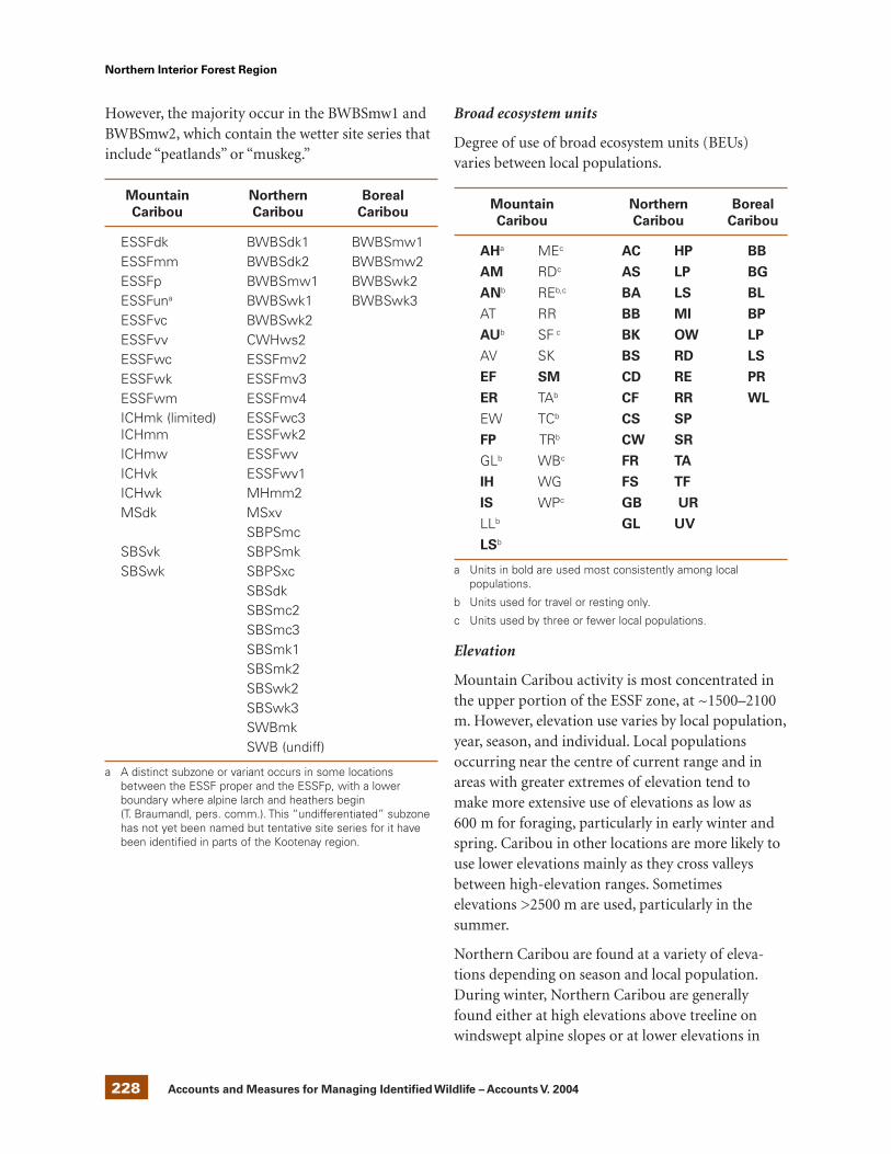
228 Accounts and Measures for Managing Identified Wildlife – Accounts V. 2004
Northern Interior Forest Region
However, the majority occur in the BWBSmw1 andBWBSmw2, which contain the wetter site series thatinclude “peatlands” or “muskeg.”
Mountain Northern Boreal
Caribou Caribou Caribou
ESSFdk BWBSdk1 BWBSmw1ESSFmm BWBSdk2 BWBSmw2ESSFp BWBSmw1 BWBSwk2ESSFuna BWBSwk1 BWBSwk3ESSFvc BWBSwk2ESSFvv CWHws2ESSFwc ESSFmv2ESSFwk ESSFmv3ESSFwm ESSFmv4ICHmk (limited) ESSFwc3ICHmm ESSFwk2ICHmw ESSFwvICHvk ESSFwv1ICHwk MHmm2MSdk MSxv
SBPSmcSBSvk SBPSmkSBSwk SBPSxc
SBSdkSBSmc2SBSmc3SBSmk1SBSmk2SBSwk2SBSwk3SWBmkSWB (undiff)
a A distinct subzone or variant occurs in some locationsbetween the ESSF proper and the ESSFp, with a lowerboundary where alpine larch and heathers begin(T. Braumandl, pers. comm.). This “undifferentiated” subzonehas not yet been named but tentative site series for it havebeen identified in parts of the Kootenay region.
Broad ecosystem units
Degree of use of broad ecosystem units (BEUs)varies between local populations.
Mountain Northern Boreal
Caribou Caribou Caribou
AHa MEc AC HP BB
AM RDc AS LP BG
ANb REb,c BA LS BL
AT RR BB MI BP
AUb SF c BK OW LP
AV SK BS RD LS
EF SM CD RE PR
ER TAb CF RR WL
EW TCb CS SP
FP TRb CW SR
GLb WBc FR TA
IH WG FS TF
IS WPc GB UR
LLb GL UV
LSb
a Units in bold are used most consistently among localpopulations.
b Units used for travel or resting only.
c Units used by three or fewer local populations.
Elevation
Mountain Caribou activity is most concentrated inthe upper portion of the ESSF zone, at ~1500–2100m. However, elevation use varies by local population,year, season, and individual. Local populationsoccurring near the centre of current range and inareas with greater extremes of elevation tend tomake more extensive use of elevations as low as600 m for foraging, particularly in early winter andspring. Caribou in other locations are more likely touse lower elevations mainly as they cross valleysbetween high-elevation ranges. Sometimeselevations >2500 m are used, particularly in thesummer.
Northern Caribou are found at a variety of eleva-tions depending on season and local population.During winter, Northern Caribou are generallyfound either at high elevations above treeline onwindswept alpine slopes or at lower elevations in

229 Accounts and Measures for Managing Identified Wildlife – Accounts V. 2004 229
Northern Interior Forest Region
forested habitat. Due to the extent of NorthernCaribou range in British Columbia, lower elevationforested habitat can range from about 500 to 1500 mdepending on local population. High elevationwinter habitat generally ranges from 1500 m to over2000 m. Some high elevation winter range alsoincludes subalpine forests. During summer,Northern Caribou may be found as low as 500 m incoastal areas in west-central British Columbia toover 2500 m in mountainous areas in most localpopulation ranges.
Boreal Caribou are found in relatively flat borealforests in northeastern British Columbia where theyoccupy all elevations in that area from about 400 to1200 m.
Life History
Diet and foraging behaviour
The late-winter diet of Mountain Caribou consistsalmost entirely of Bryoria spp., with some Alectoriasarmentosa and possibly Nodobryoria oregana. Theyare able to sustain themselves on this low-proteindiet (Bryoria has only about 4% crude protein;Rominger et al. 1996), for roughly half of the year(Rominger et al. 2000). The dependence on arborealhair lichens is probably the result of several factors.Hair lichens are usually abundant in old forests,which have historically been extensive in the interiorWet Belt, while terrestrial lichens are not. Further-more, deep snowpacks in this region precludecratering for most of the winter while providing liftto allow caribou to reach lichen higher in the trees.The use of forbs and graminoids increases drama-tically in the spring season. Summer food consists ofa wide variety of forbs, graminoids, lichens, fungi,and the leaves of some shrubs. Depending onlocation and year, early winter foraging may belargely restricted to the same hair lichen species asduring late winter, particularly those on windthrowntrees or branches, but generally also includes avariety of winter-green shrubs, forbs, graminoids,and terrestrial lichens.
During winter, Northern Caribou forage primarilyby cratering through the snow for terrestrial lichensof the genera Cladina, Cladonia, Cetraria, and
Stereocaulon. Cladina spp. are preferred but the othergenera are also selected. Northern Caribou also feedon arboreal lichens opportunistically as they travelbetween terrestrial lichen sites or seek arboreallichens in forested wetlands and along wetlandfringes where arboreal lichens are abundant.Arboreal lichen use increases as snow hardnessincreases later in winter with melt/freeze conditions.During milder winters, frequent melt/freeze episodescould make cratering for terrestrial lichens difficultearlier in the winter, especially when ice crusts formclose to the ground, forcing caribou to increase theirreliance on arboreal lichens. Bryoria spp. are themost abundant arboreal lichens on most NorthernCaribou winter ranges. Because of the relatively lowsnowpacks on most Northern Caribou winterranges, caribou can forage on terrestrial lichenseither in low elevation forested habitats, or onwindswept alpine slopes. Similar to MountainCaribou, the use of forbs and graminoids increasesdramatically in the spring season and summer foodconsists of a wide variety of forbs, graminoids,lichens, fungi, and the leaves of some shrubs.
Less is known about Boreal Caribou foragingbehaviour in British Columbia; however, BorealCaribou, like Northern Caribou, also appear toforage primarily on terrestrial lichens and to a lesserextent on arboreal lichens during winter. Winterforaging occurs primarily in very open forests inpeatlands and to a lesser extent in nearby lichen-richpine stands where available. Presumably, summerfood also consists of a wide variety vegetation.
Reproduction
The mating system of Woodland Caribou ispolygynous, with dominant bulls breeding with anumber of cows in late September to mid-October.Rutting group size varies between ecotype with up toa dozen for Mountain Caribou, up to 20 (or more)for Northern Caribou, and generally <5 for BorealCaribou. Woodland Caribou in British Columbiaexhibit a number of anti-predator strategies duringcalving including calving alone in isolated, oftenrugged locations (Mountain, Northern), calving onislands in lakes in low elevation forested habitat(Northern, possibly Boreal), calving in large muskegs

230 Accounts and Measures for Managing Identified Wildlife – Accounts V. 2004
Northern Interior Forest Region
where the number of predators and other prey arelow (Boreal), and dispersing away from othercaribou and prey in low elevation forested areas(Boreal) (Shoesmith and Storey 1977; Bergerud et al.1984a; Bergerud and Page 1987).
The productivity of caribou is low compared withdeer and moose because caribou only have oneyoung per year and calves and most yearlingscommonly are not pregnant. The population growthrate (l) rarely exceeds 1.26, or 26% per year. Preg-nancy rate of females ranges from 90 to 97% (Seipand Cichowski 1996). Gestation is about 230 days,and calves are born in late May or early June. Calvesare notably precocious, moving with their mothersshortly after birth. Calf mortality during the first fewmonths of life is high, often 50% or greater. Causesof calf mortality may include predation, abandon-ment, accidents, and inclement weather. Calvesgenerally make up 27–30% of the population atbirth, but by recruitment age (1 yr old, after whichmortality generally stabilizes to adult levels), theirproportion is generally <20%.
Site fidelity
Fidelity patterns are complex. Some cows calve in thesame location repeatedly, while others shift locationsannually. Similarly, rutting sites may be occupiedeach year or only sporadically. Home ranges rarelyremain fixed throughout an animal’s life. Individualcaribou typically use a predictable series of activitycentres over a season or several years, but mosteventually make temporary or permanent shifts tonew areas. From spring through early winter,
individuals may travel with several other cariboutemporarily, and then shift to another band.Membership in late-winter aggregations is alsoinconsistent between years. At the local populationlevel, fidelity to broad landscapes is stronger, buteven at this scale there are occasional shifts ofindividuals and groups to areas that were not usedfor the past several years. Consistent use of minerallicks has been reported.
Home range
For Mountain Caribou, minimum convex polygonhome ranges of 150–600 km2 are typical, but varyfrom <100 to >800 km2. For Northern Caribou,home range sizes are highly variable depending onlocal population size and the horizontal movementdistance between summer and winter ranges. Innorthern and north-central British Columbia homeranges average 1100–1900 km2 for some localpopulations and 150 km2 for another (Hatler 1986;Terry and Wood 1999; Wood and Terry 1999; Pooleet al. 2000). For Boreal Caribou in Alberta, homeranges averaged 710 km2 (Stuart-Smith et al. 1997).
Movements and dispersal
Mountain Caribou
During late winter (Table 2), Mountain Caribouaggregate in open stands in or near the ESSF park-land, feeding predominantly on Bryoria. While thereis often abundant arboreal lichen at lower elevations,the tendency to use higher elevations may resultfrom a combination of the increased lift and supportprovided by a deeper snowpack, the predominance
Table 2. Approximate dates for Mountain Caribou seasonsa
Approximate dates
Season Stevenson et al. (2001) Simpson et al. (1997)
Late winter mid-January – April mid-January – mid-April
Spring mid-April – late May mid-April – May
Summer June – late October June – October
Early winter late October – mid-January November – mid January
a Seasonal changes are often marked by distinct elevation shifts, and actual dates vary between local-populations, individuals, andyears (see Apps et al. 2001).

231 Accounts and Measures for Managing Identified Wildlife – Accounts V. 2004 231
Northern Interior Forest Region
of Bryoria rather than Alectoria, the near absence ofwolves and cougars (which typically follow the moreabundant ungulates to lower elevations in thewinter), and the improved ability to see remainingpredators (e.g., wolverines) in the open standstypical of higher elevations. During spring, thesnowpack at this elevation loses its ability to supportcaribou, and individuals or small groups move toeither exposed sites in the upper ESSF or AT orsnow-free elevations in the ICH or lower ESSF tofeed on newly emerged green vegetation. In June,pregnant cows ascend individually to high, exposedlocations in the ESSF or AT to calve. Such sites offersafety from most predators and relief from bitinginsects. During summer, caribou typically occur insmall groups within the upper ESSF and AT,although there is periodic summer use of the lowerESSF in many local populations, particularly in lateAugust or early September. From mid-Septemberthrough October, Mountain Caribou beginningaggregating again for the rut. As snow accumulatesin early winter, rut groups break up and most localpopulations shift down slope into the ICH to mid-ESSF, where snow depths are reduced due to lowerelevation and greater canopy closure. Foraging atthis time is variable. Arboreal lichen on windthrowntrees and branches is heavily used, and caribou alsocrater for terrestrial lichens and winter-green forbsand shrubs such as falsebox (Pachistima myrsinites).As snow depth exceeds 50 cm, cratering becomes lessenergetically efficient and caribou move into late-winter habitat. Habitat shifts between early winterand late winter may occur as a series of events, withdownward movement after major snowfalls followedby upward movement as the snow consolidates, untilcaribou more permanently settle into late-winterhabitat in about January.
Most Mountain Caribou appear to stay within thelocal population in which they were born. In fact,the 13 recognized local populations may under-represent the true number of areas between whichthere is no to very limited movement. However,temporary movements are occasionally reportedbetween local populations, from established localpopulations into unused areas, and even into therange of other ecotypes.
Northern Caribou
Although Northern Caribou are characterized byfeeding primarily on terrestrial lichens duringwinter, local populations in British Columbia exhibitvariable seasonal movement and habitat usestrategies. Some local populations migrate longdistances between summer and winter ranges whileothers do not. Use of high elevation versus lowelevation winter ranges differs between local popu-lations, and within local populations betweenwinters. Variation in seasonal behaviour reflectsdifferences in topography, snow accumulation, andavailability of low elevation winter ranges betweenareas. In general, Northern Caribou habitat use inBritish Columbia can be described using fourseasonal time periods similar to Mountain Caribou.Exact dates vary for each population depending onlocal conditions.
Snowfall in November triggers caribou movementout of high elevation summer ranges to lowerelevation early winter ranges. Early winter rangesmay be adjacent to the summer range or somedistance away. At this time, caribou continue to seekout terrestrial forage and avoid deeper snow accum-ulations where terrestrial forages are difficult toaccess. Fall migration between summer and winterranges tends to be diffuse as caribou migrate inresponse to snow accumulation.
During early winter, snow depth at low elevationsmay be highly variable between years. In general,snow depth on low elevation winter ranges is lowestduring early winter and gradually increases as thewinter progresses. Shallower snow depths in earlywinter allow caribou to use the higher and moreopen portions of their forested plateau winter ranges(Itcha-Ilgachuz), or low elevation forested habitats(Wolverine) that are abandoned as snowaccumulates during mid- to late-winter.
By mid- and late-winter, caribou have moved to lowelevation forested winter ranges, or high elevationalpine/subalpine winter ranges to feed primarily onterrestrial lichens. In low elevation forested habitat,caribou prefer forests where terrestrial lichens areabundant; these are often on drier sites or sites with

232 Accounts and Measures for Managing Identified Wildlife – Accounts V. 2004
Northern Interior Forest Region
low productivity and in older forests (80–250 yr).Caribou also feed on arboreal lichens oppor-tunistically as they travel between terrestrial lichensites or seek arboreal lichens in forested wetlandsand along wetland fringes where arboreal lichens areabundant. At higher elevations, caribou preferwindswept alpine slopes for cratering for terrestriallichens. Subalpine forests are also used for arboreallichen feeding, and to a lesser extent, terrestriallichen feeding.
By late April, caribou that migrate between winterand summer ranges begin moving back to calvingand summering areas. Spring migration is moreconcentrated than fall migration both geographicallyand temporally. During spring, caribou migratealong relatively snow-free low elevation routes toreach summer ranges (Cichowski 1993; Johnsonet al. 2002). Caribou that winter at higher elevationsmove to lower elevations in spring to take advantageof an earlier green-up. Spring ranges may be adja-cent to late-winter ranges or may be a function ofmigration patterns. Female caribou reach calvingareas by late May and calve in early June. Mostcaribou calve at higher elevations in alpine orsubalpine habitat where food availability and qualityis relatively poor to reduce predation risk sincepredators focus on other prey that remain at lowerelevations where more nutritious forage is available.
During summer, caribou prefer high elevationhabitats but can be found in a variety of habitats atall elevations because snow does not limit movement,and herb and shrub forage are abundant. Con-sequently, Northern Caribou are highly dispersedduring summer, more so than during any otherseason. During the rut in October, some cariboumove to rutting areas at higher elevations whileothers rut within their summer ranges. Portions ofsome local populations concentrate on ruttingranges, usually in open alpine or subalpine habitat.
Although studies of radio-collared NorthernCaribou populations indicate that range use byadjacent local populations may overlap, especiallyduring winter, all radio-collared caribou return totheir summering areas. Northern Caribou maypotentially be dispersing between local populations
but no studies have yet reported any evidence ofdispersal by radio-collared animals.
Boreal Caribou
Boreal Caribou do not appear to live in discreteherds but exist in small, dispersed, relativelysedentary bands throughout the year (Edmonds1991; Heard and Vagt 1996). Although there is nospecific published information on movements andhabitat use by Boreal Caribou in British Columbia,studies from Alberta provide some general informa-tion that could be extrapolated to British Columbia.Boreal Caribou in northern Alberta make extensivemovements or “wander” throughout the year(Hornbeck and Moyles 1995; Stuart-Smith et al.1997) but most do not appear to make predictableseasonal migrations (Dzus 2001). Therefore, winterand summer ranges typically overlap and habitat usedoes not differ by season (Dzus 2001).
Habitat
Table 3 summarizes habitat characteristics ofWoodland Caribou ranges in British Columbia. Allhabitat features are required to support WoodlandCaribou populations.
Structural stage
For Mountain Caribou, structural stage 7 is consist-ently preferred throughout most of the year forforage, predator avoidance (typically good lines ofsight and only dispersed populations of otherungulates), ease of travel, snow interception in earlywinter, and possibly heat avoidance in the summer(Apps and Kinley 2000a, 2000b, 2000c; Apps et al.2001). Structural stage 6 also provides useful habitat,particularly the older and more open end of thestage. Other structural stages are used to varyingdegrees. Structural stage 1a and 1b are used forcalving sites when occurring in rough terrain (June),predator avoidance (good line of site), insectavoidance (spring and summer), and resting areas.Structural stages 2 and 3a provide moderate to highforage value in spring and summer but also provideforage for other ungulates, especially below treeline.The least valuable stands to caribou are those instages 3b, 4, and 5, where line of site is poor for

233 Accounts and Measures for Managing Identified Wildlife – Accounts V. 2004 233
Northern Interior Forest Region
predator avoidance and forage value is generally lowfor caribou but can be high for other ungulates,especially moose (3b). In some cases, these stagesmay form partial barriers to movement and act toisolate adjacent patches of habitat from one another.Structural stage use by Northern Caribou is similarto Mountain Caribou except that Northern Cariboumay forage in structural stage 5, where, in someareas and ecosystems, forage (terrestrial lichens) maybe abundant. Less is known about Boreal Caribou;however, they appear to prefer structural stages 1a to3a, 6, and 7 within muskeg complexes and 6 and 7 inadjacent pine–lichen forests throughout the year.
Important habitats and habitat features
Security and foraging
Security and foraging habitat are typically the samething for Woodland Caribou on the forestedportions of their ranges, at least at broader spatialscales. For Mountain and Northern Caribou, bothfunctions are provided by large, contiguous patchesof old forest and for Boreal Caribou, both functions
are provided by the older forest component ofpeatland (muskeg) complexes. Specific values ofsuch areas are as follows:
1. There are generally fewer Elk (Cervus elaphus),Deer (Odocoileus spp.) or Moose (Alces alces)within old-growth forests on Mountain andNorthern Caribou ranges and within peatlandcomplexes on Boreal Caribou ranges than in ornear non-forested areas (avalanche tracks,meadows, shrubby riparian zones, recentclearcuts), as this more abundant suite of otherungulate species tends to concentrate in early-seral sites with abundant shrubs and forbs. Thus,the predators of other species also tend to occurless commonly within old forest than at the edgeor outside of old forest or in peatland complexes.For Northern and Mountain Caribou, habitatfragmentation due to the creation of early seralpatches within old forest is likely to bring otherprey species close to caribou, resulting in agreater incidence of predator encounters (Kinleyand Apps 2001). The potential for increased preypopulations on some very dry Northern Caribouranges may be somewhat reduced where shrub
Table 3. General habitat requirements for Mountain Caribou, Northern Caribou, andBoreal Caribou in British Columbia
Feature Mountain Caribou Northern Caribou Boreal Caribou
Winter food supply Access to an adequate Access to an adequate Access to an adequatesupply of accessible supply of terrestrial and supply of terrestrialarboreal lichen arboreal lichens and arboreal lichens
Snow conditions Snow conditions that Snow interception by Snow conditions andallow caribou to travel on forest canopy to allow frozen groundtop of the snowpack in movements within the conditions to allowsubalpine areas where winter range movements throughthey can access arboreal peatlandslichens and whereavalanche danger is low
Winter range Large tracts of winter range where caribou can exist at low densities as an anti-predator strategy and rotate their winter ranges
Calving habitat Relatively undisturbed high Relatively undisturbed high Large tracts ofelevation calving habitat elevation calving habitat or relatively undisturbedwhere caribou can low elevation forested peatland complexdisperse widely and calve calving habitat on islands calving habitat wherein isolation away from where caribou can disperse caribou can dispersepredators widely and calve in isolation widely and calve in
away from predators isolation away frompredators

234 Accounts and Measures for Managing Identified Wildlife – Accounts V. 2004
Northern Interior Forest Region
regeneration following disturbance is lesspronounced (e.g., Itcha-Ilgachuz caribou winterrange). Similarly, in undisturbed areas for BorealCaribou, habitat fragmentation due to thecreation of linear disturbance and the connectionof early seral patches by linear disturbanceswithin peatland complexes is likely to provide“predator trails” and bring other prey speciescloser to caribou, resulting in a greater incidenceof predator encounters (Dyer 1999; Kinley andApps 2001). This pattern is consistent with thatfound among other caribou ecotypes, in whichthe major habitat variable that affects numbers isspace to avoid predation (Bergerud 1980;Bergerud et al. 1984a; Bergerud 1992).
2. Old forests typically have good visibility relativeto younger forests, due to open stand archi-tecture, leading to an improved ability to detectthose predators that do occur there. For BorealCaribou, peatlands also have good visibility.
3. Arboreal hair lichen such as Bryoria are usuallyabundant only in older forests. Terrestrial lichenssuch as Cladina, Cladonia, and Cetraria are oftenmost abundant in mature and older forests butare also abundant in younger forests on somesite types.
4. Old trees with large crowns provide good snowinterception, which facilitates cratering andmovement during early winter (MountainCaribou, Northern Caribou, Boreal Caribou) andwinter (Northern Caribou, Boreal Caribou).
5. For Mountain and Northern Caribou, the morecontiguous that foraging habitat is, the lessenergy is expended in moving between patches.
6. For Mountain Caribou, sunlight is screenedbefore reaching understorey plants in old forestswith heavy canopies, reducing the developmentof unpalatable or harmful compounds in forageplants (Rominger et al. 2000) and increasing theretention of moisture to maintain plant vigourduring summer dry periods.
7. Old forests and peatland complexes provide acooler microclimate during summer.
8. The suite of forage plants in old forest is differentthan that available in other habitat types.
Thus, old forests provide far more than simply lichenfor late-winter foraging, and old forests are selectedacross seasons and a range of spatial scales. OnMountain Caribou ranges, old stands of subalpine
fir (Abies lasiocarpa) and Engelmann spruce (Piceaengelmannii) are widely used among caribou of alllocal populations, including both closed-canopy andparkland stands across a range of soil moistureconditions (see “Broad ecosystem units” above).However, tree species composition shows somevariability between regions. On Northern Caribouranges, old stands of lodgepole pine (Pinus contorta)or lodgepole pine and white spruce (Picea glauca) inlow elevation forested habitat are widely used bymost local populations. Boreal Caribou commonlyuse large patches of peatland with disconnectedold forest.
Mountain Caribou also use alpine habitat duringsummer and Northern Caribou use alpine habitatduring summer and winter. Boreal Caribou do nothave access to alpine habitats and therefore do notuse them. Alpine habitats also provide both forageand security features. During summer, emergentvegetation provides nutritious forage and open vistasprovide good visibility for detecting predators. ForNorthern Caribou, during winter windswept alpineslopes also provide access to terrestrial lichens andgood visibility for detecting predators.
For Woodland Caribou generally, the risk of preda-tion is further reduced by existing at very lowpopulation densities of ~0.03–0.12 caribou/km2
(Edmonds 1988; Seip 1991; Bergerud 1992; Stuart-Smith et al. 1997). The availability of extensive rangespace is thought to be an important habitat charac-teristic that allows Woodland Caribou to avoidpredation (Bergerud 1980; Bergerud et al. 1984). Allthree ecotypes of Woodland Caribou use “space” toavoid predation, especially during calving. Mountainand Northern caribou move into high elevationhabitat, forgoing nutritious forage at lower elevationsto seek out remote locations for calving, separatedfrom other caribou and prey, and predators.
Breeding
Calving sites and rut locations are also vulnerablehabitat elements, but predicting their locations byhabitat type is not feasible. Calving sites aredispersed, may vary between years, and appear to bedefined primarily on the basis of isolation from

235 Accounts and Measures for Managing Identified Wildlife – Accounts V. 2004 235
Northern Interior Forest Region
other caribou, other ungulates, and predators.Rutting sites are likely to be more consistent betweenyears, but can be effectively located only with site-specific knowledge gained by monitoring individualcaribou local populations.
The most critical aspect of Mountain Caribou andNorthern Caribou ranges is access to undisturbedhigh elevation calving range. In fact, access toundisturbed high elevation calving ranges wherecaribou can distance themselves from other prey andpredators, is the common feature among MountainCaribou and Northern Caribou local populationsthat exist today. Historically occurring local popu-lations of Mountain Caribou and Northern Caribouwithout access to high elevation calving ranges nolonger exist in British Columbia.
Mineral licks
Another vulnerable habitat element is mineral licks.Licks are consistently used between years, but can beeffectively located only by monitoring individuallocal populations of caribou.
Conservation andManagement
Status
In British Columbia, Mountain Caribou are on theprovincial Red List, Boreal Caribou are on theprovincial Blue List, and Northern Caribou in theSouthern Mountains National Ecological Area(SMNEA) and in the Northern Mountains NationalEcological Area (NMNEA) are on the provincial BlueList (Table 4). In Canada, all Woodland Caribouwithin the entire SMNEA, including all MountainCaribou and some Northern Caribou local popula-tions in British Columbia, are considered Threatened(COSEWIC 2002). Boreal Caribou are also con-sidered Threatened and Northern Caribou in theNMNEA are considered of Special Concern.
Trends
Population trends
Mountain caribou
About 99% of the world’s 1900 Mountain Cariboulive within British Columbia. The B.C. Ministry ofWater, Land and Air Protection considers MountainCaribou to occur as 13 local populations within ametapopulation of 1900 (Hatter et al. 2002). Six ofthose local populations have 50 or fewer individuals,and 8 are declining; no local populations areincreasing (Table 5).
According to local population risk assessmentcriteria, seven local populations are consideredEndangered, one local population is consideredThreatened, and five local populations areconsidered Vulnerable. About 43% of the historicrange of Mountain Caribou is no longer occupied,and it is believed that populations have been reducedcorrespondingly. One estimate of the pre-colonialpopulation of Mountain Caribou (excluding theUnited States) is 5000–6000 (Demarchi 1999).
Northern caribou
In 2002, there were an estimated 5235 NorthernCaribou within the SMNEA and 11 000 NorthernCaribou within the NMNEA in British Columbia(Table 6). While numbers may have increasedslightly since the late 1970s, it is likely that some ofthe “apparent” increase is from more intensivesurvey effort, combined with recent radio-telemetrystudies, which has enabled a more reliable statusassessment of this ecotype.
Currently, Northern Caribou in the SMNEA aredistributed within 13 local populations, which formtwo metapopulations. The west-central metapopu-lation includes the Charlotte Alplands, Itcha-Ilgachuz, Rainbows, Tweedsmuir-Entiako, and statusof three local populations was unknown. Four localpopulations have 100 or fewer animals. According tolocal population risk criteria, two local populationsare considered Endangered, six local populations areconsidered Threatened, four local populations areconsidered Vulnerable, and one local population isconsidered Not At Risk. An overall increase in

236 Accounts and Measures for Managing Identified Wildlife – Accounts V. 2004
Northern Interior Forest Region
Table 4. Summary of Woodland Caribou status in British Columbia
Status
COSEWIC
Ecotype Global Provincial (May 2002) BC status
Dawson Caribou G5TX SX Extinct Extinct
Mountain Caribou G5T2Q S2 Threatened Red
Northern Caribou (SMNEA) G5T4 S3S4 Threatened Blue
Northern Caribou (NMNEA) G5T4 S3S4 Special Concern Blue
Boreal Caribou G5T? S3 Threatened Blue
Table 5. Current population estimate (2002), trend, risk status, and density of Mountain Cariboulocal populations in British Columbia
Local Local
population Recent population Risk Ranged Density
Local population estimate trenda risk statusb criteria c (km2) (no./1000 km2)
South Selkirks 35 Declining EN A1 1 500 23
South Purcells 20 Declining EN A1 2 962 7
Central Selkirks 130 Declining EN A3 4 813 27
Monashee 10 Declining EN A1 2 082 5
Revelstoke 225 Declining VU A1 7 863 29
Central Rockies 20 Declining EN A1 7 265 3
Wells Gray North 220 Declining VU A1 6 346 35
Wells Gray South 325 Stable VU A1 10 381 31
North Cariboo Mountains 350 Stable VU A1 5 911 59
Barkerville 50 Stable EN A1 2 535 20
George Mountain 5 Declining EN A1 441 11
Narrow Lake 65 Stable TR A1 431 151
Hart Ranges 450 Stable VU A1 10 261 44
TOTAL 1 905 62 791 30
a Recent trend defined as trend over last 7 years (1 generation length). Trend based on >20% change.
b At risk status based on Thomas and Gray (2001), draft guidelines for quantitative risk assessment of local populations.EN = Endangered; NAR = Not at Risk; TR = Threatened; VU = Vulnerable.
c Risk criteria (from Thomas and Gray 2001), see Hatter et al. (2002, Appendix 3).
d Current occupied range.

237 Accounts and Measures for Managing Identified Wildlife – Accounts V. 2004 237
Northern Interior Forest Region
Table 6. Current population estimate (2002), trend, risk status, and density of Northern Cariboulocal populations in British Columbia
Local
Population Recent population Risk Ranged Density
Local population estimate trenda risk statusb criteria c (km2) (no./1000 km2)
Southern Mountains National Ecological Area
Charlotte Alplands 50 Declining EN A1 2 650 19
Itcha-Ilgachuz 2 500 Increasing NAR A1 9 457 264
Rainbows 125 Stable TR A2 3 804 33
Tweedsmuir-Entiako 300 Declining TR A3, C3 12 811 23
Telkwa 55 Increasing EN A1 1 828 30
Quintette 200 Unknown VU A1 1 421 141
Kennedy Siding 170 Increasing VU A1 1 470 116
Moberly 170 Declining TR A2 5 115 33
Wolverine 590 Increasing VU A1 8 315 71
Takla 100 Unknown TR A1 1 850 54
Chase 575 Stable VU A1, A2 11 390 50
Graham 300 Declining TR A3 4 734 63
Belcourt 100 Unknown TR A1 2 045 49
TOTAL 5 235 66 890 78
Northern Mountains National Ecological Area
Pink Mountain 850 Declining VU A1 11 602 73
Finlay 200 Unknown VU A1 3 084 65
Spatsizi 2 200 Stable NAR A1 16 929 130
Mount Edziza 100 Unknown TR A1 1 281 78
Level-Kawdy 1650 Stable NAR A1 12 568 131
Tsenaglode 200 Unknown VU A1 3 015 66
Frog 150 Unknown VU A1 2 421 62
Gataga 250 Unknown VU A1 4 437 56
Muskwa 1 250 Unknown NAR A1 16 786 74
Rabbit 800 Unknown VU A1 5 936 135
Liard Plateau 150 Stable VU A1 5 069 30
Horse Ranch/Cry Lake 850 Stable VU A1 9 499 89
Little Rancheria 1 000 Stable NAR A1 7 431 135
Jennings 200 Unknown VU A1 4 080 49
Atlin East 800 Stable VU A1 7 053 113
Atlin West 350 Stable VU A1 4 398 80
TOTAL 11 000 115 590 95
a Recent trend defined as trend over last 7 years (1 generation length). Trend based on >20% change.
b At risk status based on Thomas and Gray (2001), draft guidelines for quantitative risk assessment of local populations.EN = Endangered; NAR = Not at Risk; TR = Threatened; VU = Vulnerable.
c Risk criteria (from Thomas and Gray 2001), see Hatter et al. (2002, Appendix 3).
d Current occupied range.

238 Accounts and Measures for Managing Identified Wildlife – Accounts V. 2004
Northern Interior Forest Region
Northern Caribou numbers in the SMNEA has beenstrongly influenced by the increase of the Itcha-Ilgachuz caribou population over the last 8 years(from 1400 to 2500; λ = 1.075), which is the largestlocal population in the SMNEA.
Telkwa local populations. The north-central meta-population includes the other eight local popula-tions in the SMNEA. In 2002, four local populationswere declining, two were stable, four were increasing,and the Currently, Northern Caribou in the NMNEAare distributed within 16 local populations. Meta-population structure has not yet been assessed forthese local populations. In 2002, one local popu-lation was declining, seven were stable and the statusof eight local populations was unknown. Six localpopulations have 200 or fewer animals. According tolocal population risk criteria, 12 local populationsare considered Vulnerable and 5 local populationsare considered Not At Risk. Little populationinformation is available for many of the NorthernCaribou local populations in the NMNEA.
Boreal caribou
The only estimate of Boreal Caribou numbers inBritish Columbia is 725 (Heard and Vagt 1996). Thecurrent estimate is based on that number (Table 7);however, the reliability of this estimate is unknown.Currently, there is no information on metapopu-lation structure or on population trend. Accordingto COSEWIC criteria, Boreal Caribou in north-eastern British Columbia are considered Vulnerable.
Habitat trends
There is little quantitative information on WoodlandCaribou habitat trends in British Columbia; how-ever, Woodland Caribou rely on large tracts of olderforests where terrestrial and/or arboreal lichens areabundant and where they can use “space” to avoidpredators. Industrial activities such as forestharvesting and oil and gas development affectWoodland Caribou habitat through fragmentationand conversion of older forests to early seral stands.The current rate of loss and fragmentation ofcaribou habitat through forest harvesting, oil and gasdevelopment, and natural disturbances (fire andforest insects) appears to be greater than the rate ofhabitat recruitment.
Threats
Population threats
Threats to Woodland Caribou populations mayaffect caribou numbers directly through mortality orindirectly through disturbance or displacementresulting in increased energetic costs or mortalityrisks. Direct threats include predation, hunting,poaching, vehicle collisions, and diseases and para-sites. Indirect threats include road development andassociated traffic, persistent recreational activities oncaribou ranges, and habitat alteration that results inincreased mortality risks.
Table 7. Current population estimate (2002), trend, risk status, and density of Boreal Caribou inBritish Columbia
Population Recent Population Risk Ranged Density
Local population estimate trenda risk statusb criteria c (km2) (no./1000 km2)
Boreal Caribou 725 Unknown VU A1 51 541 14
a Recent trend defined as trend over last 7 years (1 generation length). Trend based on >20% change.
b At risk status based on Thomas and Gray (2001), draft guidelines for quantitative risk assessment of local populations.EN = Endangered; NAR = Not at Risk; TR = Threatened; VU = Vulnerable.
c Risk criteria (from Thomas and Gray 2001), see Hatter et al. (2002, Appendix 3).
d Current occupied range.

239 Accounts and Measures for Managing Identified Wildlife – Accounts V. 2004 239
Northern Interior Forest Region
Predation
Woodland Caribou populations in British Columbiaexist within dynamic and complex predator–preysystems. Wolves appear to be the most significantpredator, but bear predation during early summercontributes significant mortality in some areas.Recent studies (see Seip and Cichowski 1996) havefound that predation during the summer can be amajor cause of caribou mortality. The increase inmoose populations in central British Columbiaduring the 1900s has been associated with long-termdeclines in the number of some caribou populationsand extirpation of caribou from previously occupiedareas (Seip and Cichowski 1996). Increased moosepopulations may have led to caribou declinesbecause moose can sustain wolf numbers even whencaribou number decline. In contrast, in a caribou/wolf system, wolf numbers would decline along withany decline in caribou numbers and allow for asubsequent recovery in caribou numbers (Seip1992a). The susceptibility of caribou to predationmay also be influenced by habitat change as favour-able moose browsing conditions in cutblocks resultin widespread distribution of moose and wolves.Disturbance to the forest (forest harvesting, fire,etc.), whether human-caused or natural, alters thedistribution of early seral habitats. Such disturbancecould be detrimental to caribou if it increases theircontact with predators associated with otherungulates that use early seral stands, such as deer,elk, and moose. Seip (1992a) suggested that wolfpredation can eliminate caribou from areas wherethe wolf population is sustained by other preyspecies because there is no negative feedback on thenumber of wolves as caribou numbers decline. Iftrue, this would mean that wolves could persist onmoose as they extirpate local caribou populations.
Within a multiple predator–prey system, it ispossible for predator numbers to remain relativelyhigh even if predation (or human harvest) hasdrastically reduced one of the prey species. Caribouare extremely vulnerable to wolf predation com-pared with most other ungulates (Seip 1991).Caribou usually occur at much lower densities, havelarger home ranges, and do not normally use
habitats frequented by moose or deer. They also donot use escape terrain as efficiently as mountainsheep or mountain goats, and they have a lowreproductive rate relative to moose or mule deer.Therefore, caribou are usually the most vulnerablespecies in a multiple predator–prey system, the firstto decline and the last to recover (Seip 1991). Seip(1992a) suggested that wolf predation can eliminatecaribou from areas where the wolf population issustained by other prey species, because there is nonegative feedback on the number of wolves ascaribou decline in numbers. Thus, wolves couldpersist on moose or deer as they extirpate localcaribou populations.
Human-caused mortalities
Aboriginal people who are hunting within theirtraditional territories may legally hunt caribou.There are no legal hunting seasons on MountainCaribou or Boreal Caribou in British Columbia forresident or non-resident hunters, but poaching and“mistaken identity” shootings probably removesome animals, as do motor vehicle collisions. Theextent of this mortality is unknown, althoughJohnson (1985) found human-caused deaths in theSouth Selkirks Mountain Caribou local populationto equal recruitment in some years. Legal huntingseasons for resident and non-resident hunters existfor most Northern Caribou local populations in theNMNEA. Hunting regulations are generally conser-vative with either a five-point bull, Limited EntryHunt regulation, or a combination of both. Huntingmortality is low for most Northern Caribou localpopulations in the SMNEA with most of the hunterharvest concentrated in the Itcha-Ilgachuz andChase local populations. There are no legal huntingseasons for seven of the 13 local populations in theSMNEA (Charlotte Alplands, Rainbows, Telkwa,Takla, Kennedy-Siding, Wolverine, Belcourt) andfor one of the 16 local populations in the NMNEA(Mount Edziza). Parts of three Northern Caribouranges fall within No Hunting areas or CaribouClosed areas (Atlin West, Spatsizi, Tweedsmuir-Entiako).

240 Accounts and Measures for Managing Identified Wildlife – Accounts V. 2004
Northern Interior Forest Region
Diseases and parasites
There do not appear to be any diseases or parasitesoccurring with enough frequency among MountainCaribou to pose a significant population-level healthrisk. Parasites reported by McTaggart-Cowan (1951)from caribou elsewhere in British Columbia oradjacent areas of Alberta include caribou nostril-flyor caribou bot fly (Cephenemyia trompe = C. nasalis= Oestrus trompe), caribou warble (Hypodermatarandi = Oestrus tarandi = Hypoderma tarandi),thin-necked bladderworm (Cysticercus tenuicollis),the tapeworm Cysticercus krabbei, and pinworm(Skrjabinema oreamni). Other caribou parasites inBritish Columbia include hydatid cysts (Echinococcusgranulosus) and the nematode Parelaphostrongylusodocoilei (H. Schwantje, pers. comm.). Winter ticks(Demacentor albipictus) have been recorded oncaribou in Alberta (Samuel 1993) so likely also occuron B.C. caribou. Besnoitia (Besnoitia tarandi) is aprotozoan that forms cysts in the connective tissueof caribou and other intermediate hosts. It can befatal (Glover et al. 1990) but rarely is, generallyresulting only in dermal damage (H. Schwantje, pers.comm.). This parasite was found in 23% of 320caribou leg pairs examined from British Columbia,but most of the infections were from the far nor-thern part of the province and few had skin lesions(R. Lewis, pers. comm.). Liver flukes (Fascioloidesmagna) have not been recorded from caribou inBritish Columbia, but occur in caribou of northernQuebec and other ungulates in British Columbia.The risk of liver flukes occurring in caribou isgreater when there is overlap with elk or white-taileddeer (F. Leighton, pers. comm.), so their eventualoccurrence in Mountain Caribou can be expecteddue to increasing range overlap with other ungulates.One of the greatest potential risks to WoodlandCaribou from parasites may be the meningeal worm(Parelaphostrongylus tenuis) in areas where it occurs.It is a parasite of white-tailed deer throughouteastern North America. The adult worms live in thespaces around the brain in white-tailed deer andrarely cause disease. However, when other cervids,such as caribou, are infected the worms migrate tothe central nervous system causing severe, usuallyfatal, neurological disease. Fortunately the parasite
has not been found to date west of the Manitoba-Saskatchewan border.
Population size
Within the 12 smallest local populations (localpopulations ≤100 caribou: seven Mountain Cariboulocal populations, five Northern Caribou localpopulations), the most immediate threat is simplylow population size. Low numbers increase theprobability that a random event (i.e., one predator,one emigration movement, one avalanche, oneextreme weather event, a few key animals poached)will remove a large proportion of the breedingpopulation and also increase the chance of creatingan unfavourable sex composition. There are noreliable estimates of the minimum viable populationsize for Woodland Caribou.
Access/Disturbance
One of the major indirect threats to WoodlandCaribou populations is increasing road developmentand access into their habitat (Bergerud 1978;Johnson 1985; Seip 1991). The resulting threat maytake several forms. Improved access to the summercalving range may increase risk of disturbance byhumans during calving; calving areas are the mostsensitive of all habitats for caribou (Seip andCichowski 1996) and require protection. Historically,overhunting was primarily a result of road accessassociated with human industrial and recreationaldevelopment (Bergerud 1978; Stevenson and Hatler1985). While the more accessible Woodland Cariboupopulations are currently not hunted, poachinglosses, which are most common along roads duringhunting season for other game species, remain aconcern. Road kills can also be a concern, such asthose that have occurred with the opening ofHighway 3 across the range of the South SelkirkMountain Caribou local population (Johnson 1976;Simpson et al. 1994).
The effects of disturbance of human activities oncaribou are more difficult to document and remaincontroversial. Hauling by logging trucks in Ontarioapparently caused Woodland Caribou to move outof the haul road areas that were preferentially usedby caribou in the years before and after hauling

241 Accounts and Measures for Managing Identified Wildlife – Accounts V. 2004 241
Northern Interior Forest Region
(Cumming and Hyer 1998). In Alberta, simulatedpetroleum exploration noise was also found toincrease energy expenditure by Woodland Caribou(Bradshaw et al. 1997). Physical disturbance fromsuch exploration, such as roads, drilling sites, andseismic lines resulted in avoidance of habitatswell beyond actual development “footprints”(Dyer et al. 2001).
After noting the absence of studies showing thatdisturbance limits caribou populations, Bergerudet al. (1984b) concluded that disturbance should notpose a major threat provided sufficient space isavailable for caribou to escape unwelcome stimuli.They qualified this conclusion by adding that there islikely an upper limit to the tenacity of caribou towithstand disturbance. Eight years later, Harringtonand Veitch (1992) demonstrated this upper limit forWoodland Caribou in Labrador where calf survivalduring both calving and post-calving periods wasnegatively correlated to the exposure of females tolow-altitude jet flyovers. This led the authors tosuggest that the greatest effects of disturbance oncalf survival occur during critical periods whenother stressors are also acting. Research on stresseffects of recreation specific to caribou requiresfurther development; however, a recent study inYellowstone National Park (Creel et al. 2002)documented a significant increase in stress-relatedhormone levels in elk and wolves during the snow-mobile season. For elk, these levels increased inconcert with the daily number of snowmobiles. Theauthors also noted that despite these stress res-ponses, there was no evidence that current levels ofsnowmobile activity were affecting the populationdynamics of either species.
Recreation
Studies such as Harrington and Veitch (1992) addsupport to a growing concern that excessive levels ofrecreational activity within caribou winter rangemay place animals under stress and displace cariboufrom suitable winter habitats (Stuart-Smith et al.1996). Mountain Caribou local populations andsome or portions of Northern Caribou local popu-lations use subalpine or alpine terrain during winter.
In some areas, Mountain Caribou habitat overlapsnowmobile use areas; areas of heavy use by snow-mobiles may displace caribou into less desirableforaging habitat and where mortality risks(i.e., predation, avalanches) are higher. The creationof trails in an area may also render caribouvulnerable to predators (James and Stuart-Smith2000). Compacted trails such as those created bysnowmobiling and snowshoeing may provide easiertravel corridors for wolves into late winter caribouhabitats (Bergerud 1996). Dumont (1993) foundthat hikers in the Gaspésie disrupted normal cariboubehaviours, and shifted caribou from preferred areason the summit to wooded areas with higherpredation risk.
The increasing interest in recreational snow-mobiling, combined with better access from roads tohigh-elevation cutblocks and more powerfulmachines that are able to access Woodland Caribouranges, is believed to represent a significant threat tomany Mountain Caribou local populations andsome Northern Caribou local populations currently,and a significant threat to other populations in thefuture as access increases into their ranges. A recentreview of the potential impacts of four winterbackcountry recreation activities on MountainCaribou, including snowmobiling, heli-skiing, snow-cat skiing, and backcountry skiing, indicated thatsnowmobiling has the greatest perceived threat toMountain Caribou (Simpson and Terry 2000).Although there is no documentation in BritishColumbia that snowmobiling has permanentlydisplaced caribou off winter ranges, a single occur-rence of snowmobile use in alpine habitat in theTweedsmuir-Entiako caribou winter range displacedradio-collared caribou from that area for theduration of the winter (D. Cichowski, pers. obs.).
Industrial activities
Industrial activities may alter predator–preyrelationships and potentially could increase the totalpredation rate of caribou by:
• producing early seral stages with enhancedunderstorey shrub and forb production whichmay increase the abundance of other ungulates

242 Accounts and Measures for Managing Identified Wildlife – Accounts V. 2004
Northern Interior Forest Region
or change ungulate distribution withinWoodland Caribou habitat; specifically:
– increased shrub production at low elevationsmay increase ungulate populations (e.g., elk,deer, and moose) which in turn may increasepredator populations, leading to morepredator–prey encounters with caribouduring winter;
– increased forb production at higher elevationsmay attract elk, moose, and deer into caribouhabitat during summer; predators followingtheir prey into these higher elevation areasmay come into contact with caribou morefrequently, leading to increased predationrates on caribou during summer;
– restricting caribou into mature forest habitatpatches which may increase the searchefficiency of predators; and/or
– providing easier access, through constructionof roads, for predators to travel into caribouhabitats and prey on caribou (James andStuart-Smith 2000).
In addition, all threats identified below under“Habitat threats” are threats to population size andviability. There is little or no evidence that WoodlandCaribou can be maintained over the long term inareas having relatively high levels of forestry,predation, and recreation activity.
Habitat threats
One of the main long-term threats to WoodlandCaribou habitat is the reduction and fragmentationof contiguous old-growth forest, mainly due toindustrial activities such as forest harvesting. Frag-mentation of old forest and peatland complexes inBoreal Caribou habitat in northeastern BritishColumbia by oil and gas development is also aconcern. Past fires have also contributed to the lossof habitat over large areas, and there are risks offuture large fires. Forest insects are also currentlyplaying a larger role in forest renewal on someNorthern Caribou ranges. Habitat loss has severaleffects:
• It reduces the amount of space available forcaribou, thereby limiting ecological carryingcapacity.
• Terrestrial and arboreal lichen supply (althoughcurrently not limiting) may be reduced. Becauselichen regeneration is often slow, impacts onlichen supply are often long term.
• It may impact caribou movement patterns.
• By fragmenting habitat, it may decrease thechance of caribou using some portions of theremaining habitat, because parcels tend to besmaller and discontinuous. Alternatively, if theremaining parcels are used, caribou may expendmore energy travelling between patches.
• Caribou can become more susceptible topredation as available habitat is compressed andfragmented (see “Population threats”).
Forest harvesting
Forest harvesting has been recognized as the greatestconcern to Mountain Caribou habitat managementover the past 20 years. Early winter habitat in theICH has always been attractive for forest harvestingdue to good forest productivity on those sites. Latewinter ESSF habitat has only recently (last 10 yr)become attractive for forest harvesting. Prior to the1970s there was little industrial activity on lowproductivity Northern Caribou low elevation winterranges in British Columbia. Relatively low-valuepine forests and the remote location of most of thosewinter ranges made them unattractive for forestharvesting. Improved road access, developments inlog processing that resulted in better utilization ofsmaller trees, suitable sites for conducting summerlogging (dry pine sites) which are often in shortsupply, and a growing demand for pulp contributedto increased interest in caribou winter ranges forforest harvesting.
Forest harvesting affects Woodland Caribou winterhabitat at both the stand and landscape levels. At thestand level, some harvesting and silviculturaltechniques disturb lichens. Because lichen regener-ation is slow, forest harvesting has long-termimplications for caribou winter habitat. Harvestingtechniques that minimize disturbance to lichens mayhelp reduce stand level impacts. Although foodsupply (lichens) is currently not a limiting factor,cumulative impacts of forest harvesting over timecould potentially have long-term impacts on food

243 Accounts and Measures for Managing Identified Wildlife – Accounts V. 2004 243
Northern Interior Forest Region
supply. Caribou require an adequate supply oflichens over the landscape to allow for rotation ofwinter ranges. Forest fragmentation couldpotentially result in caribou concentrating onportions of their range, thereby depleting lichenreserves over time.
At the landscape level, forest harvesting results in apatchwork of different forest age classes, which leadsto avoidance and possibly abandonment of thatportion of the winter range (Smith et al. 2000).Caribou populations persist at low densities due to anumber of interacting factors, including predation(Bergerud et al. 1984b; Bergerud and Page 1987).Abandoning a portion of a winter range forcescaribou to concentrate in a smaller area, which maylead to increased predator efficiency by making themeasier for predators to locate (Seip 1991). A patch-work of early seral and mature forests may alsoenhance habitat for other prey species such as moosethat prefer early seral forests, which could lead toincreased predator numbers and increased predationon caribou (Seip 1992a). Potential indirect effects offorest harvesting and habitat fragmentation oncaribou populations through increased energeticcosts and predation risk are discussed in the“Population threats” section.
Although caribou winter habitat must provideadequate amounts of terrestrial lichen, it is nowrecognized that food is not the primary limitingfactor, and that the distribution of both the summerand winter habitats on the landscape, and the abilityof caribou to become spatially separated frompredators, particularly during the summer months,are the most important factors to the long-termpersistence of Northern Caribou (Seip andCichowski 1996). Forest harvesting practices thatproduce a patchwork of different forest age classeslinked with a network of roads may contain enoughlichens to support a caribou population, butprobably will not provide an environment wherecaribou can effectively avoid predators and poachers.The threat from increasing predation may also beexerted at broader scales, independent of issues offine-scale habitat changes. Predation risk hasprobably increased over roughly the past century
due both to larger numbers of predators at theregional level and less spatial separation due tohabitat fragmentation at the stand or landscapelevel. Ongoing forest harvesting by conventionalmeans may make this situation more severe.
The ability of caribou to move through fragmentedhabitats or barriers is not well known. However,Smith et al. (2000) documented that NorthernCaribou avoid portions of their winter range thathave been fragmented by logging. Large human-caused fire-created openings 10–15 km wide haveisolated the Narrow Lake and George Mountainlocal populations of Mountain Caribou (Simpson etal. 1997; Heard and Vagt 1998). Highways and roadsmay also limit caribou movements, particularly tofemale and young caribou moving between seasonalranges (Simpson et al. 1994). Caribou north ofRevelstoke appear unwilling to venture south of theCanadian Pacific Railway tracks and the Trans-Canada Highway, possibly due to the rail andhighway corridors or to the dense, second-growthstands (Simpson et al. 1997). However, caribouappear to regularly cross Highway 16, east of PrinceGeorge, between the North Cariboo Mountains andthe Hart Ranges (D. Heard, pers. comm.), andcaribou elsewhere in the world make regular migra-tions through greatly varied habitat conditions. Evenif caribou do cross fragmented habitats, there maybe costs associated with increased energy expen-diture required to locate isolated foraging patches, aswell as increased exposure to human-causedharassment and mortality.
Although little information is available on BorealCaribou in British Columbia, resource extraction inthe form of forestry, petroleum and natural gasexploration and production, mining (coal, peat, andpotentially diamonds), and agricultural expansionare all recognized as potentially having negativeimpacts on Boreal Caribou in Alberta (Dzus 2001).
Natural disturbances
Fire and forest insects are important disturbancefactors on many Northern Caribou ranges. Firesuppression has resulted in reduced fire impactson most woodland caribou ranges in central

244 Accounts and Measures for Managing Identified Wildlife – Accounts V. 2004
Northern Interior Forest Region
British Columbia over the last 40 years, although firedisturbance has likely had greater impacts oncaribou ranges in the northern part of the province.Recently, mountain pine beetles have affected asignificant portion of the Tweedsmuir-EntiakoNorthern Caribou range. Although the effects ofmountain pine beetles on caribou habitat and winterrange use are not known, mountain pine beetlescould potentially result in increased or decreasedlichen productivity depending on site conditions. Areduction in the forest canopy and consequentlysnow interception could have implications tocaribou movement and foraging during winter.Eventual blowdown of beetle-killed trees could alsohave implications for caribou movement. Largermountain pine beetle outbreaks are often managedthrough increased forest harvesting efforts; extensivesalvage logging also occurs soon after beetle attack.Winter ranges not located in protected areas willlikely be subjected to increased forest harvesting andsalvage if mountain pine beetle outbreaks occur,leading to concerns over the additive effects ofmountain pine beetles, forest harvesting for moun-tain pine beetle management, and salvage logging ofmountain pine beetle killed forests on caribouwinter ranges.
Climate change
Climage change has the potential to affect Caribouhabitat through changes to natural disturbanceregimes and vegetation structure which mayultimately lead to changes in lichen abundance.
Legal Protection and HabitatConservation
All Woodland Caribou in British Columbia areprotected from willful killing, wounding, and taking,and legal harvesting is regulated under the provincialWildlife Act. Hunting of Mountain Caribou andBoreal Caribou is prohibited while hunting for 22 ofthe 29 Northern Caribou local populations iscurrently permitted.
Protected areas, both provincial and federal, providehabitat protection from industrial activities andunroaded wilderness. Some of the larger protected
areas occurring in Woodland Caribou ranges areWells Gray Provincial Park, Glacier National Park,Tweedsmuir Provincial Park, Itcha-IlgachuzProvincial Park, Entiako Provincial Park andProtected Area, Spatsizi Plateau WildernessProvincial Park, Stikine River Provincial Park, andMount Edziza Provincial Park.
Under the results based code, specific regulationsaddress winter range and mineral licks.
Land use plans (LUP) or land and resource manage-ment plans (LRMP) have been developed for allareas where Mountain Caribou and Boreal Caribouregularly occur and for most areas where NorthernCaribou occur (see Cichowski 2003). Resourcemanagement zone (RMZ) objectives from these havebeen or are being considered for designation ashigher level plans or establishment of legal objectivesunder the Land Act.
Mountain caribou
For Mountain Caribou, each LUP or LRMP requiresor allows for:
• zones where there will be no or very limitedtimber harvest;
• zones where modified timber harvest to maintainhabitat values will occur; and
• areas with no special provisions for caribou.
However, guidelines have not been developedaccording to provincial standards, and the level ofhabitat protection varies regionally (Table 8). Thegreat majority of recently occupied MountainCaribou range within the Cariboo-Chilcotin LandUse Plan area is now within (in descending order)provincial parks, no-harvest zones, or modified-harvest zones and the Mountain Caribou Strategyprovides specific and detailed guidance on silvicul-tural systems (Youds et al. 2000). The Prince Georgeand Robson Valley LRMPs have included most of thecaribou habitat within interim deferral areas and toa lesser degree, in parks. The Kamloops LRMP areais immediately adjacent to Wells Gray ProvincialPark so caribou there have habitat security withinWells Gray and a few new parks, and 20–33% of thecaribou zone outside of parks is to be maintained

245 Accounts and Measures for Managing Identified Wildlife – Accounts V. 2004 245
Northern Interior Forest Region
with old-growth attributes. The Okanagan-ShuswapLRMP allots approximately 20% of the caribouresource management zone to Old-GrowthManagement Areas (OGMAs) and about 3% to newor existing parks, with a further 20% deferred asresearch areas. The Kootenay-Boundary Land UsePlan allocates 40–50% of the operable portion ofcaribou management areas for reserves or modifiedharvest, and perhaps 10% of the total occupiedcaribou range is in new or existing provincial andfederal parks.
Mountain Caribou have been a major considerationin the designation of OGMAs, but these oftenoverlap with lands that were already, or wouldotherwise have been, reserved for caribou, sogenerally do not add additional protection. In theOkanagan-Shuswap LRMP, all permanent cariboureserves are OGMAs. Areas that are currently con-sidered inoperable provide additional habitat foreach local population of caribou, but the extent ofthese is likely to be reduced as technological oreconomic conditions change.
Access management approaches and (for mostplans) guidelines for alternative silvicultural systemsare less specific than habitat protection guidelinesand are typically not included in higher level plans.
Local decisions on alternative silviculture willpresumably be guided mainly by the recommen-dations for managers guidebook (Stevenson et al.2001). Interim guidelines for access and disturbancemanagement relative to new commercial recreationtenures have been developed (MELP 2000).
A recovery strategy for the entire Mountain Cariboumetapopulation has recently been completed (Hatteret al. 2002) and a recovery action plan specific to theSouth Purcell local population is currently beingdeveloped (Kinley 2000). Plans for other localpopulations may be developed in the future asdetermined by Regional Action Groups (Hatter et al.2002). The recovery strategy and proposed recoveryaction plan for the South Purcell local population donot create any additional legal obligations. However,they do indicate an intent to maintain MountainCaribou, consistent with the federal-provincialNational Accord for the Protection of Species atRisk, and will provide a benchmark from which tomeasure regional and sub-regional managementplans. Several factors influencing caribou populationviability that do not fall within the results based codeor do so only partially are addressed in recoveryplans, including population goals for predators andalternate prey species, and motorized recreationmanagement.
Table 8. Current approaches to Mountain Caribou habitat management within LRMPs and LUPs
LRMP/LUP Approach
Cariboo-Chilcotin No-harvest and modified-harvest zones, each of which is mapped.
Kootenay-Boundary No-harvest and modified-harvest zones conceptual only. Overallmanagement areas are mapped, but precise locations of zones are not (inprogress).
Prince George No-harvest and modified-harvest zones, each of which is mapped (but no-harvest zones may become available for modified harvest, pending results inareas now designated for modified harvest).
Robson Valley No-harvest and modified-harvest zones, each of which is mapped (but no-harvest zones may become available for modified harvest, pending results inareas now designated for modified harvest).
Kamloops Similar to Kootenay/Boundary but based on the retention of old-growthattributes, not old-growth forests per se, and partial cutting is preferred butnot required in non-reserve areas.
Okanagan-Shuswap Identifies OGMAs to be maintained as reserves and also identifies researchareas, which may later become reserves, conventional harvest areas, ormodified-harvest areas, pending research results.

246 Accounts and Measures for Managing Identified Wildlife – Accounts V. 2004
Northern Interior Forest Region
Northern caribou
Current strategies to protect local populations ofNorthern Caribou and habitat have been mostlydeveloped independently for each population andare reflected in regional land and resource manage-ment plans (Chicowski 2003). Although there is noprovince-wide strategy that guides managementdirection for all local populations of NorthernCaribou, planning efforts have often been co-ordinated between land use planning processes thatshare a common caribou winter range. However,core caribou ranges for some local populations, andcorridor/linkage areas between local populations stillmust be mapped and considered in various plans.
Some form of caribou habitat management guide-line(s) or planning/operational direction is in placein most MWLAP regions that support NorthernCaribou. Currently, an LRMP process is underwayfor the Morice Forest District which includesportions of three Northern Caribou local popula-tions in the SMNEA (Tweedsmuir-Entiako, Telkwa,Takla) and a Strategic Resource Management Plan isbeing developed for the Dease/Liard portion of theBulkley-Cassiar Forest District. Only two areasremain without regional level management plans:the Nass portion of the Kalum Forest District, whichincludes a small portion of the Spatsizi caribou localpopulation’s range; and the Atlin-Taku region of theBulkley-Cassiar Forest District, which includes fourlocal populations (Atlin West, Atlin East, Jennings,Level-Kawdy).
Prescriptions vary by planning area and localpopulations of caribou although communicationbetween planning processes has resulted in mostlyconsistent prescriptions for local populations ofcaribou whose ranges straddle planning areas. Mostplans consist of a combination of protected area orno-harvest zone in portions of each caribou range,with varying degrees of industrial activity within therest of the range. Although unprotected portions ofmost caribou ranges have some special managementstatus, large portions of some ranges are located ingeneral resource management zones or evenenhanced resource management zones.
In most of the land use plans, caribou and caribouhabitat management are a high priority. District-wide Caribou Management Strategies weredeveloped in the Mackenzie, Cassiar-Iskut-Stikine,and Fort St. James LRMPs. In the Lakes, Vanderhoof,and Bulkley LRMPs, caribou management strategiesare concentrated within resource management zonesthat encompass most of the caribou range found inthose districts. The Cariboo-Chilcotin Land UsePlan also defines a regional level Northern CaribouStrategy, that provides specific direction on allaspects of caribou management including mountainpine beetle infestations (Youds et al. 2002). TheDawson Creek, Fort St. John, Fort Nelson, andPrince George LRMPs do not contain specificdistrict wide strategies for managing caribou andcaribou habitat; instead, caribou managementguidelines have been developed for individualresource management zones. However, portions ofthe Fort St. John, Fort Nelson, and Mackenzie LRMPareas are included within the Muskwa-KechikaManagement Area, which includes special provisionsfor access management and resource extraction.Many of the protected areas established under theEnvironmental Land Use Act within the Muskwa-Kechika Management Area contain provisions forroad corridors and most of the area outside ofprotected areas is under special management.
Although large-scale mountain pine beetle outbreakshave occurred or may potentially occur in mostcaribou winter ranges in the central part of theprovince, most of the land use plans provide littleguidance for mountain pine beetle management oncaribou winter ranges. Potential additive effects ofmountain pine beetles, mountain pine beetlemanagement, and salvage logging are of concern.
In general, most Northern Caribou managementprescriptions in these plans focus on:
• avoiding critical habitats through no harvestingor special management;
• providing large contiguous areas of mature andold forest;
• conducting harvesting strategies that emulatenatural disturbances;

247 Accounts and Measures for Managing Identified Wildlife – Accounts V. 2004 247
Northern Interior Forest Region
• maintaining forest structure and age classes closeto natural disturbance patterns;
• creating large forest harvesting openings andconcentrating them in time and space tominimize industrial activity on caribou ranges;
• using forest harvesting and silvicultural systemsthat enhance retention and recovery of terrestriallichens; and,
• developing recreation and access managementstrategies that limit or prohibit recreationalactivities and access in specific areas duringcritical seasons.
Boreal caribou
Boreal Caribou range in British Columbia fallswithin two forest districts with completed LRMPs:the Fort Nelson LRMP and the Fort St. John LRMP.There are no district-wide caribou managementstrategies and strategies for Boreal Caribou areprimarily contained in individual resourcemanagement zones. In the Fort Nelson LRMP, mostof the Boreal Caribou range is in enhanced resourcedevelopment zones with the southwestern portion ingeneral resource development zones; provisions forcaribou are included under general provisions forwildlife. In the Fort St. John LRMP, most of theBoreal Caribou range is in general managementzones with a small portion in enhanced resourcedevelopment, and the southern portion in theagriculture/settlement zone. Provisions for caribouvary between resource management zones with somezones with caribou-specific provisions and otherswith general wildlife provisions. Lack of manage-ment strategies specifically for Boreal Caribou islikely partially due to the lack of knowledge aboutthis ecotype in British Columbia.
Identified Wildlife Provisions
Sustainable resource management andplanning recommendations
A conservation assessment should be conducted forWoodland Caribou metapopulations to determinethe relative risk to long-term persistence of eachmetapopulation and ecotype based on currentmanagement guidelines, and also on a range ofpotentially more or less stringent guidelines.
LRMPs and LUPs provide a suitable scale ofmanagement for Woodland Caribou becauseindividual caribou are wide-ranging and use avariety of sites within and between years, yet eachlocal population occurs within a reasonably well-defined geographic and habitat range. Furthermore,regional differences in Woodland Caribou ecologyand in forest harvesting history indicate that detailedmanagement direction is best provided through aseries of regional plans than through a singleprovincial plan. However, broad approaches are beststandardized at a provincial scale to ensure betterunderstanding of the purpose of areas given specialdesignation for caribou, and to ensure that allregional plans meet the basic requirements ofWoodland Caribou. The followingrecommendations should be considered whenexisting higher level plans are periodically reviewedand revised.
Conduct local conservation assessments(including risk assessments) for the localpopulation or area under consideration. Theassessment should consider risks to theindividual local population and themetapopulation based on current guidelines, andtherefore determine the relative need for no-harvest relative to modified-harvest andconventional-harvest zones, and effects ofresource exploration activities.
Identify areas that should be designated as no-harvest zones, where there will be no or verylimited harvest, and/or modified-harvest zones,where partial cutting that maintains habitatvalues may occur. Within the no-harvest zones,include inoperable areas that are suitable forcaribou, in addition to appropriate operableareas.
Map the final boundaries of no-harvest zones ormodified-harvest zones at 1:20 000.
For Mountain Caribou, where plans currentlyadvocate or permit the use of extended-rotationclearcuts (typically 240 yr), either via conven-tional blocks or strip harvesting, consider a shiftto a mix of permanent no-harvest zones andconventional harvest (no caribou constraint)zones, and formalize this as an option in theplans. The percentage of the plan area potentiallyshifted from long-rotation to no-harvest should

248 Accounts and Measures for Managing Identified Wildlife – Accounts V. 2004
Northern Interior Forest Region
be calculated on the basis of modelling long-termtimber production reductions that would other-wise result from the extended rotation. Theadvantages of smaller permanent no-harvestzones versus larger areas on extended rotationswould be:
– no new economic impact relative to existingextended rotation assumptions, yet retentionof a large portion of the planning area ascaribou habitat;
– a greater assurance that designated habitatwould in fact provide suitable habitat becauseit would be of natural origin and older age,rather than originating as a plantation with amaximum age of 160–240 years;
– fewer roads and off-road access points;
– long-term spatial certainty regarding the areasthat would provide caribou habitat, whichwould simplify planning and allow caribou todevelop traditions of use; and
– overlapping of benefits to other obligates ofvery old forests.
The disadvantage is that less gross area would bemanaged for caribou. This option should also beconsidered in cases where long-rotation group-or single-tree selection is currently planned,although there are likely to be fewer benefits inchanging to the mixed no-harvest/conventionalharvest scenario in such instances. For plans thatcurrently recommend the use of clearcutharvesting with moderate block sizes (~1–40 ha),consider a shift to guidelines requiring partialcutting through single-tree selection or groupselection or, as a secondary option, a mix of verylarge cutblocks and very large reserves as outlinedin Stevenson et al. (2001). This will reduce thedegree of landscape fragmentation relative to anequivalent area of moderate-sized clearcut blocks,and should therefore reduce the enhancement ofhabitat for other ungulates and allow caribou toseparate themselves from predators.
For plans in which habitat-influenced predationrisk is not explicitly identified as an issue relativeto forest harvesting, it should be added to revisedversions of the plans.
Revise existing guidelines for movement routesbased on new research. Add guidelines to planscurrently lacking them. As research indicatesdifferences in habitat requirements for providing
long-term genetic connectivity between localpopulations versus regular local intra- orinterseasonal movement, modify plans to ensurethat the terminology and guidelines areappropriate for the type of movement intendedto be facilitated.
Revise access management guidelines based onnew research. Add access guidelines to planscurrently lacking them. Do not create new roadsor upgrade existing roads in areas where forestshave been reserved as caribou habitat. To theextent possible, deactivate or close existing roadsin areas reserved or managed for caribou whenthe roads are no longer required for industrialactivities. Guidelines for the management of bothcommercial and non-commercial mechanizedbackcountry recreation should be adopted, basedon the interim management guidelinesrecommended by Simpson and Terry (2000).
Ensure a mechanism is included to allow theboundaries or locations of no-harvest andmodified-harvest zones to be modified asadditional information becomes available aboutcaribou distribution, habitat use, risks associatedwith various management options, andrequirements for long-term viability. Thismechanism should also allow boundary changesnecessary for the recovery of currently depressedlocal populations, including augmentation withadditional animals or the establishment of newbands of caribou.
Wildlife habitat area
Goal
To temporarily secure critical Woodland Caribouhabitat features that have not been yet beenaddressed through strategic or landscape levelplanning. As existing plans are amended ordeveloped, WHAs established for Woodland Cariboushould be considered for inclusion within legalobjectives of the revised plans or new plans.
Feature
Establish WHAs at mineral licks, rutting or calvingsites (if used repeatedly), and small areas of “matrix”habitat necessary for connectivity between winterforaging areas (if used repeatedly). Preferably, WHAs

249 Accounts and Measures for Managing Identified Wildlife – Accounts V. 2004 249
Northern Interior Forest Region
should be established in areas of suitable caribouhabitat where:
• no-harvest zones and modified-harvest zones arenot sufficiently large to maintain or restore viablecaribou local populations as indicated by aconservation assessment; or
• there is a high level of uncertainty that this is thecase; or
• critical habitat features not addressed within anexisting regional or sub-regional plans aredetermined to be of high value or high use.
WHAs designated under the provincial timbersupply impact limit (1% by district) for theIdentified Wildlife Management Strategy will only beestablished within threatened or endangered localpopulations, except for sites where there is no timbersupply impact or the site is considered provinciallysignificant and approved by the Director of theBiodiversity Branch, B.C. Ministry of Water, Landand Air Protection. Normally, WHAs will only beestablished to protect critical habitat featuresdeemed important to the long-term persistence ofthe local population.
For matrix habitat connectivity, WHAs should belocated immediately adjacent to protected areas orareas designated under strategic land use plans forcaribou management.
Size
Larger WHAs will almost always be of greater benefitto caribou than smaller WHAs, primarily becauseincreased size improves the ability of caribou toavoid predation. When WHAs are established inmatrix habitat for connectivity, they should beroughly 100–1000 ha. In most cases, calving sites,rutting areas, and mineral licks may be adequatelymanaged in areas of 50–300 ha. For calving sites onislands, the entire island should be considered forinclusion within a WHA. The appropriate size for aWHA will be determined in part by whether it ispossible to link to existing habitat and the degree ofdisturbance that is expected adjacent to the WHA.
Design
Design WHA to minimize the amount of edge, andconsider habitat use and the needs of the localpopulation. The size of the area included within theWHA to reduce disturbance will depend ontopographic barriers and vegetative cover.
General wildlife measures
Goals
1. Minimize predation risk.
2. Maintain critical habitat features (e.g., minerallick, undisturbed travel corridor or calving orrutting areas).
3. Minimize disturbance.
Measures
Access
• Do not construct roads or trails.
Harvesting and silviculture
• Do not harvest WHAs established for minerallicks, rutting, and calving sites. For matrix habi-tat, develop a management plan that is consistentwith the general wildlife measures goals.
Pesticides
• Do not use pesticides.
Recreation
• Do not develop recreation sites or trails.
Additional ManagementConsiderations
Guidelines for the management of both commercialand non-commercial mechanized backcountryrecreation should be adopted, based on the interimmanagement guidelines recommended by Simpsonand Terry (2000). (See MWLAP Web site at http://wlapwww.gov.bc.ca.)
In addition to reducing the effect of predationthrough forest management that minimizesfragmentation and habitat creation for otherungulates, large mammal species should be managedwith the goal of locally reducing the number of otherungulates and associated predators, where suchspecies were historically rare or absent.

250 Accounts and Measures for Managing Identified Wildlife – Accounts V. 2004
Northern Interior Forest Region
If motor vehicle collisions (Highways 3, 5, and 16,Alaska Highway) are identified as a significantsource of mortality in some local populations, andkill locations and timing are consistent, seasonalspeed zones should be instituted.
Information Needs
1. Metapopulation conservation assessment/riskanalysis relative to a range of managementoptions.
2. Long-term suitability of areas cut throughmodified harvest to support caribou, withreference to both forage and predation risk.
3. Relative contribution to predation of regionalincreases in alternate prey numbers versus standlevel or landscape level habitat fragmentation.
References Cited
Apps, C.D. and T.A. Kinley. 2000a. Mountain caribouhabitat use, movements, and factors associated withGPS location bias in the Robson Valley, BritishColumbia. Columbia Basin Fish and Wildl.Compensation Program, Nelson, B.C., and B.C.Environ., Prince George, B.C.
_____. 2000b. Multi-scale habitat associations ofmountain caribou in the southern PurcellMountains, British Columbia. East KootenayEnviron. Soc., Kimberley, B.C., and TembecIndustries Inc., Cranbrook, B.C.
_____. 2000c. Multiscale habitat modeling formountain caribou in the Columbia Highlands andNorthern Columbia Mountains ecoregions, BritishColumbia. B.C. Min. Environ., Lands and Parks,Williams Lake, B.C.
Apps, C.D., B.N. McLellan, T.A. Kinley, and J. Flaa.2001. Scale-dependent habitat selection bymountain caribou in the Columbia Mountains,British Columbia. J. Wildl. Manage. 65:65–77.
Banfield, A.W.F. 1961. A revision of the reindeer andcaribou, genus Rangifer. Natl. Mus. Can., Ottawa,Ont. Bull. No. 177, Biol. Ser. 66.
Bergerud, A.T. 1974. The decline of caribou in NorthAmerica following settlement. J. Wild. Manage.38:757–770.
_____. 1978. The status and management of caribouin British Columbia. B.C. Fish and Wildl. Br.,Victoria, B.C.
_____. 1980. A review of the population dynamics ofcaribou and wild reindeer in North America. InProc. 2nd Int. Reindeer/Caribou Symp. E. Reimers,E. Gaare, and S. Skjennebeg (editors). Roros,Norway, 1979, pp. 556–581.
_____. 1992. Rareness as an antipredator strategy toreduce predation risk for moose and caribou. InWildlife 2001: populations. D.R. McCullough andR.H. Barrett (editors). Elsevier Applied Sci., NewYork, N.Y., pp. 1008–1021.
Bergerud, A.T. 1996. Evolving perspectives on cariboupopulation dynamics, have we got it right yet?Rangifer Spec. Issue No. 9:95–116.
Bergerud, A.T. and R.E. Page. 1987. Displacement anddispersion of parturient caribou at calving asantipredator tactics. Can. J. Zool. 65:1597–1606.
Bergerud, A.T., H.E. Butler, and D.R. Miller. 1984a.Antipredator tactics of calving caribou: dispersionin mountains. Can. J. Zool. 62:1566–1575.
Bergerud, A.T., R.D. Jakimchuck, and D.R. Carruthers.1984b. The buffalo of the north: caribou (Rangifertarandus) and human developments. Arctic37:7–22.
Bradshaw, C.A., S. Boutin, and D.M. Hebert. 1997.Effects of petroleum exploration on woodlandcaribou in northeastern Alberta. J. Wildl. Manage.61:1127–1133.
B.C. Ministry of Environment, Lands and Parks(MELP). 2000. Expanded Kootenay Region interimwildlife guidelines for commercial backcountryrecreation in British Columbia. Wildl. Br.,Victoria, B.C.
Cichowski, D.B. 1993. Seasonal movements, habitatuse, and winter feeding ecology of woodlandcaribou in west-central British Columbia. B.C. Min.For., Victoria, B.C. Land Manage. Handb. No. 79.54 p.
Committee on the Status of Endangered Wildlife inCanada (COSEWIC). 2002. Canadian species atrisk. Available from: http://www.speciesatrisk.gc.ca
Creel, S., J.E. Fox, A. Hardy, J. Sands, B. Garrot, andR.O. Peterson. 2002. Snowmobile activity andglucocorticoid stress responses in wolves and elk.Conserv. Biol. 16:809–814.
Cumming, H.G. and B.T. Hyer. 1998. Experimental loghauling through a traditional caribou winteringarea. Rangifer Spec. Issue No. 10:241–258.

251 Accounts and Measures for Managing Identified Wildlife – Accounts V. 2004 251
Northern Interior Forest Region
Demarchi, D.N. 1999. Population trends of the biggame species in British Columbia. Review draft.B.C. Wildl. Fed. and B.C. Conserv. Found. Note:This report is in draft form and the sponsoringorganizations wish to state that its findings do notnecessarily represent the views of the BCWF or BCCF.
Dumont, A. 1993. The impact of hikers on caribou(Rangifer tarandus caribou) of the GaspésieConservation Park. thesis. Laval Univ., Quebec City,Que. (Translated from French.)
Dyer, S.J. 1999. Movement and distribution ofwoodland caribou (Rangifer tarandus caribou) inresponse to industrial development in northeasternAlberta. MSc. thesis, Dept. Biol. Sci., Univ. Alberta,Edmonton, Alta. 109 pp.
Dyer, S.J., J.P. O’Neill, S.M. Wasel, and S. Boutin. 2001.Avoidance of industrial development by woodlandcaribou. J. Wildl. Manage. 65:531–542.
Dzus, E. 2001. Status of the Woodland Caribou(Rangifer tarandus caribou) in Alberta. AlbertaEnviron., Fisheries and Wildl. Manage. Div., andAlberta Conserv. Assoc. Edmonton, Alta. Wildl.Status Rep. No. 30. 47 p.
Edmonds, E.J. 1988. Population status, distribution,and movements of Woodland Caribou in westcentral Alberta. Can. J. Zool. 66:817–826.
_____. 1991. Status of woodland caribou in westernNorth America. Rangifer Spec. Issue No. 7:91–107.
Glover, G.J., M. Swendrowski, and R.J. Cawthorn. 1990.An epizootic of besnoitiosis in captive caribou(Rangifer tarandus caribou), reindeer (Rangifertarandus tarandus) and mule deer (Odocoileushemionus hemionus). J. Wildl. Dis. 26:186–195.
Harrington, F.H. and A.M. Veitch. 1992. Calvingsuccess of woodland caribou exposed to low-leveljet overflights. Arctic 45:213–218.
Hatler, D.F. 1986. Studies of radio-collared caribou inthe Spatsizi Wilderness Park area, British Columbia.Spatsizi Assoc. For Biol. Res. Rep. No. 3. 202 p.
Hatter, I., D. Butler, A. Fontana, D. Hebert, T. Kinley, S.McNay, B. Nyberg, D. Seip, J. Surgenor, M. Tanner,L. Williams, G. Woods, J. Woods, and J. Young.2002. A strategy for the recovery of MountainCaribou in British Columbia. Version 1.0.Mountain Caribou Tech. Advisory Comm.,Victoria, B.C. 73 p.
Heard, D.C. and K.L. Vagt. 1998. Caribou in BritishColumbia: a 1996 status report. Rangifer Spec. Issue10:117–123.
Hornbeck, G.E. and D.L.J. Moyles. 1995. Ecologicalaspects of Woodland Caribou in the Pedigree areaof northwestern Alberta. Members of the PedigreeCaribou Standing Committee, Calgary, Alta. 66 p.
James, A.R.C. and A.K. Stuart Smith. 2000.Distribution of caribou and wolves in relation tolinear corridors. J. Wildl. Manage. 64:154–159.
Johnson, C.J., K.L. Parker, D.C. Heard, and M.P.Gillingham. 2002. A multiscale behaviouralapproach to understanding caribou the movementsof woodland caribou. Ecol. Appl. 12(6):1840–1860.
Johnson, D.R. 1976. Mountain caribou: threats tosurvival in the Kootenay Pass Region, BritishColumbia. Northwest Sci. 50:97–101.
_____. 1985. Man-caused deaths of mountain caribou,Rangifer tarandus, in southeastern BritishColumbia. Can. Field-Nat. 99:542–544.
Kinley, T.A. 2000. Recovery Action Plan for the southPurcell subpopulation of mountain caribou. Draft.B.C. Min. Environ., Lands and Parks, Victoria, B.C.,Tembec Industries Inc., Cranbrook, B.C., and EastKootenay Environ. Soc., Kimberley, B.C.
Kinley, T.A. and C.D. Apps. 2001. Mortality patterns ina subpopulation of endangered mountain caribou.Wildl. Soc. Bull. 29:158–164.
McTaggart-Cowan, I. 1951. The diseases and parasitesof big game mammals of western Canada. In Proc.5th Ann. Game Convention, pp. 37–64. Reprintedby B.C. Min. Environ. and Parks, Victoria, B.C., in1988.
Poole, K.G., D.C. Heard, and G. Mowat. 2000. Habitatuse by woodland caribou near Takla Lake in centralBritish Columbia. Can. J. Zool. 78:1552–1561.
Rominger, E.M., C.T. Robbins, and M.A. Evans. 1996.Winter foraging ecology of woodland caribou innortheastern Washington. J. Wildl. Manage.60:719–728.
Rominger, E.M., C.T. Robbins, M.A. Evans, and D.J.Pierce. 2000. Autumn foraging dynamics ofwoodland caribou in experimentally manipulatedhabitats, northeastern Washington, USA. J. Wildl.Manage. 64:160–167.
Samuel, W.M. 1993. Parasites and disease. In Hoofedmammals of Alberta. J.B. Stelfox (editor). Lone PinePublishing, Edmonton, Alta., pp. 81–90.
Seip, D.R. 1991. Predation and caribou populations.Rangifer Spec. Issue No. 7:46–52.

252 Accounts and Measures for Managing Identified Wildlife – Accounts V. 2004
Northern Interior Forest Region
_____. 1992a. Factor limiting woodland cariboupopulation and their interrelationships with wolvesand moose in southeastern British Columbia. Can.J. Zool. 70:1494–1503.
Seip, D.R. and D.B. Cichowski. 1996. Populationecology of caribou in British Columbia. RangiferSpec. Issue No. 9:73–80.
Shoesmith, M.W. and D.R. Storey. 1977. Movementsand associated behaviour of woodland caribou incentral Manitoba. Proc. Int. Congr. Game Biol.13:51–64.
Simpson, K. and E. Terry. 2000. Impacts ofbackcountry recreation activities on mountaincaribou. B.C. Min. Environ., Lands and Parks,Wildl. Br., Victoria, B.C. WR-99.
Simpson, K., E. Terry, and D. Hamilton. 1997. Toward amountain caribou management strategy for BritishColumbia – habitat requirements and sub-population status. B.C. Min. Environ., Lands andParks, Victoria, B.C. WR-90.
Simpson, K., J.P. Kelsall, and M. Leung. 1994.Integrated management of mountain caribou andforestry in southern British Columbia. Report toB.C. Min. Environ., Lands and Parks, Victoria, B.C.106 p.
Smith, K.G., E.J. Ficht, D. Hobson, T.C. Sorensen, andD. Hervieux. 2000. Winter distribution ofwoodland caribou in relation to clear-cut logging inwest-central Alberta. Can. J. Zool. 78:1433–1440.
Stevenson, S.K., H.M. Armleder, M.J. Jull, D.G. King,B.N. McLellan, and D.S. Coxson. 2001. Mountaincaribou in managed forests: recommendations formanagers. 2nd ed. B.C. Min. Environ., Lands andParks., Victoria, B.C. Wildl. Rep. R-26.
Stevenson, S.K. and D.F. Hatler. 1985. Woodlandcaribou and their habitat in southern and centralBritish Columbia. Vols. I and II. B.C. Min. For., Res.Br., Victoria, B.C. Land Manage. Rep. No. 23.
Stuart-Smith, A.K., C. Bradshaw, S. Boutin, D. Hebert,and A.B. Rippin. 1997. Woodland caribou relativeto landscape patterns in northeastern Alberta. J.Wildl. Manage. 61(3):622–633.
Stuart-Smith, A.K., D. Hebert, J. Edmonds, and D.Hervieux. 1996. Limiting factors for woodlandcaribou in Alberta. In Alberta’s Woodland CaribouConservation Strategy, Appendix 1, pp. 31–48.
Terry, E.L. and M.D. Wood. 1999. Seasonal movementsand habitat selection by woodland caribou in theWolverine herd, north-central British Columbia.Phase 2: 1994-1997. Peace/Williston Fish andWildlife Compensation Program Rep. No. 204. 36 p.+ appendices.
Thomas, D.C. and D.R. Gray. 2001. Updated COSEWICstatus report on “Forest-Dwelling” WoodlandCaribou Rangifer tarandus caribou. Draft. 115 p.
Wood, M.D. and E.L. Terry. 1999. Seasonal movementand habitat selection by woodland caribou in theOmineca Mountains, north-central BritishColumbia. Phase 1: The Chase and Wolverine herds(1991-1994). Peace/Williston Fish and WildlifeCompensation Program Rep. No. 201. 35 p. +appendices.
Youds, J., J. Young, H. Armleder, M. Folkema, M.Pelchat, R. Hoffos, C. Bauditz, and M. Lloyd. 2000.Cariboo-Chilcotin Land Use Plan MountainCaribou Strategy. Cariboo Mid-Coast InteragencyManagement Committee Special Report. B.C. Min.Water, Land and Air Prot., Williams Lake, B.C. 77 p.
_____. 2002. Cariboo-Chilcotin Land Use PlanNorthern Caribou Strategy. Cariboo-Mid-CoastInteragency Management Committee SpecialReport. B.C. Min. Water, Land and Air Prot.,Williams Lake, B.C. 84 p.
Personal Communications
Braumandl, T. 2001. Min. For., Nelson, B.C.
Heard, D. 2001. Min. Water, Land and Air Protection,Prince George, B.C.
Lewis, R. 2001. Min. Agric., Abbotsford, B.C.
Leighton, F. 2001. Univ. of Saskatchewan, Saskatoon,Sask.
Schwantje, H. 2001. Min. Water, Land and AirProtection, Victoria, B.C.

253 Accounts and Measures for Managing Identified Wildlife – Accounts V. 2004 253
Northern Interior Forest Region
Plant Communities
HYBRID WHITE SPRUCE/OSTRICH FERN
Picea engelmannii × glauca/Matteuccia struthiopteris
Original prepared by J. Pojar, S. Flynn,and C. Cadrin
Plant CommunityInformation
Description
This forested community has a fairly open canopydominated by large hybrid white spruce (Piceaengelmannii x glauca), but also including subalpinefir (Abies lasiocarpa), black cottonwood (Populusbalsamifera ssp. trichocarpa), and paper birch (Betulapapyrifera). Mountain alder (Alnus incana ssp.tenuifolia), red-osier dogwood (Cornus stolonifera),red elderberry (Sambucus racemosa ssp. pubens), anddevil’s-club (Oplopanax horridus) dominate thevigorous shrub layer. The well-developed herb layerincludes an abundance of ostrich fern (Matteucciastruthiopteris), horsetails (Equisetum spp.), stingingnettle (Urtica dioica), enchanter’s-nightshade(Circaea alpina), northern golden-saxifrage(Chrysosplenium tetrandrum), one-leavedfoamflower (Tiarella trifoliata var. unifoliata), andlarge-leaved avens (Geum macrophyllum). Mosscover is low, and consists primarily of leafy mosses(Mnium spp.) and Brachythecium. See DeLong(1996), and Steen and Coupé (1997) for moreinformation.
This community occupies toe and level slopepositions with medium-textured to somewhat fine-textured (sandy to loamy), fluvial deposits. Sites areusually on or near floodplains and subject topersistent seepage and periodic flooding. Soils aremoist to very moist (relative within subzone), andhave a rich to very rich nutrient regime.
Distribution
Global
Restricted to British Columbia, occurring only in theSBSmh, a rather small (ca. 108 000 ha) subzone inthe central interior.
British Columbia
This community is restricted to floodplains and toeslopes of the Fraser River valley, from Alexandriaand Hydraulic north to Prince George, and of theQuesnel River valley downstream of Quesnel Forks.
Forest regions and districts
Northern Interior: Prince George
Southern Interior: Central Cariboo, Quesnel
Ecoprovinces and ecosections
CEI: CAP, QUL
SBI: NEL
Biogeoclimatic unit
SBS: mh/08
Broad ecosystem unit
WR
Elevation
450–750 m
Plant Community Characteristics
Structural stage6: mature forest (some of the more structurally
complex stands, usually >80 years)7: old forest (>140 years)

254 Accounts and Measures for Managing Identified Wildlife – Accounts V. 2004
Northern Interior Forest Region

255 Accounts and Measures for Managing Identified Wildlife – Accounts V. 2004 255
Northern Interior Forest Region
Natural disturbance regime
Frequent stand-initiating events (NDT3) (MOF andMELP 1995), wildfire (although these valley bottomforests are less likely to burn than those on adjacentuplands), major floods, windthrow, and erosion.Overbank floods occur occasionally, as part of thenatural hydrological regime. Fairly frequent directmortality of individual or small groups of trees dueto bark beetles, root rots, and defoliating insects, orindirect mortality via predisposition of attackedtrees to blowdown.
Fragility
Moderately fragile. Soils typically are deep, medium-textured, moist, and nutrient-rich. The soils aremoist to wet, however, and sometimes occur onunstable landforms, and so are susceptible to massmovements and water table changes, especially thosetriggered by land clearing or forestry activity such asroad building. Overbank floods occur occasionally,but are part of the natural hydrological regime. Theecosystems should recover relatively quickly afterstand-destroying disturbances, provided biologicallegacies such as snags and large downed logs persiston site and there has been no damage or displace-ment of soil materials. These rich moist sites areprone to sudden growth of shrubs after majordisturbances, which can result in deciduous “brush”competition with conifers, delays in forestregeneration and slower forest recovery afterdisturbance.
Conservation andManagement
Status
The hybrid white spruce/ostrich fern plant com-munity is on the provincial Red List. In BritishColumbia this community is ranked S2 and itsglobal status is proposed as G2.
Trends
Although widespread, this small, linear ecosystem isuncommon within a localized range. It has beenseriously depleted and old and mature standscontinue to decline in distribution. Ecologistsestimate that <20 high quality occurrences remain.This trend is likely to continue.
Threats
The SBSmh is a small subzone with a history ofdisturbance by humans and many productive forestsites have been logged. Its high value as timber hasresulted in serious depletion. Significant areas of thesubzone (including this community) have also beencleared for agriculture, ranching, and ruralsettlement. Climate change may also be a threat.
Connectivity of old forest habitat in the subzone is aserious conservation issue, especially along themajor riparian corridors where the hybrid whitespruce/ostrich fern community occurs, particularlyon the extensive private timber lands.
Legal Protection and HabitatConservation
There is no legal protection for plant communitiesexcept for those within protected areas and parks.
There may be some representation in Fraser Riverand Fort George Canyon parks, but occurrencesneed verification. The SBSmh as a whole has only2% (~2200 ha) of its area protected.
The Forest Practices Code guidelines for riparianmanagement areas would apply to many of theoccurrences, but may be too narrow to provideadequate protection. Old growth management areasmay protect some occurrences if old forest retentionobjectives cannot be met in the non-timberharvesting land base.

256 Accounts and Measures for Managing Identified Wildlife – Accounts V. 2004
Northern Interior Forest Region
Identified Wildlife Provisions
Sustainable resource management andplanning recommendations
The distribution of this community has always beenpatchy and dynamic, but few old patches nowremain and few young patches are being recruited. Itoccurs as small patch forests and most typically aslinear systems along creeks, streams, and floodplainsof larger rivers. It is recommended to:
maintain water flow and hydrological conditionssupporting this plant community and, wherepossible, preserve or restore natural flood cyclesthat historically maintained this community;
maximize connectivity of old forest within theSBSmh;
maintain or recover at least 20 occurrences ingood condition across the range of the plantcommunity;
maintain or restore occurrences to as close tonatural condition as possible and practical; and
wherever possible, protect remaining occurrencesthrough the placement of old growth manage-ment areas.
Wildlife habitat area
Goal
Maintain or recover known occurrences that couldnot be addressed through landscape level planningand the designation of old growth managementareas.
Feature
Establish WHAs at occurrences that have beenconfirmed by a registered professional in consulta-tion with the B.C. Conservation Data Centre orMinistry of Forests regional ecologists. Priority forWHAs should be any old or mature (structural stage6 and 7) within younger stands to attain a minimum5 ha and in a relatively natural state. As a lowerpriority, establish WHAs within younger, relativelyundisturbed forests and riparian systems that includethis plant community to recover community toclimax condition. Select areas that are or have (inorder of priority):
• the oldest, most structurally complex secondaryforests available;
• intact hydrological processes that are relativelylightly damaged and can be expected to recoverto a more natural state;
• part of a network of reserve areas; and
• adjacent to natural occurrences of other plantcommunities.
Size
The size of the WHA should be based on the extentof the plant community occurrence. Typicallyoccurrences of this plant community are linear andare between 5 and 80 ha along rivers and streams.
Design
The WHA should include the entire occurrence ofthe community plus ±80 m (approximately two treeheights) along the upland side of the linear occur-rence or surrounding the small patch toe slopeoccurrences. Boundaries should be designed tominimize edge effects and to the extent possible, bedelineated along windfirm boundaries.
General wildlife measures
Goals
1. Maintain or restore plant community to a naturalstate (i.e., same species composition, physicalstructure, including coniferous canopy anddeciduous composition, and ecological processesas natural examples of the plant community; seeSteen and Coupé 1997).
2. Maintain or restore the natural hydrologicalregime within WHA. Seepage, fluctuating andseasonally high water tables, and occasionalmajor overbank floods are fundamental to theecology of these riparian ecosystems.
3. Maintain or enhance old forest structure(i.e., large old trees, range of tree sizes, largesnags, down logs, canopy depth and roughness,multiple vegetation strata, horizontal patchinessof understorey) (Spies 1998).
4. Maintain open forest-interior conditions.
5. Prevent physical disturbance, especially of thesoil.
6. Minimize introduction and spread of invasivespecies.

257 Accounts and Measures for Managing Identified Wildlife – Accounts V. 2004 257
Northern Interior Forest Region
Measures
Access
• Do not develop roads or trails.
Harvesting and silviculture
• Do not harvest or salvage except when requiredto create a windfirm edge.
• Do not remove non-timber forest products.
Pesticides
• Do not use pesticides.
Range
• Plan livestock grazing (timing, level of use,distribution) to meet general wildlife measuregoals. Fencing could be required by the statutorydecision maker to meet goals, to recovercommunity, or for restoration treatments.
• Do not place livestock attractants within WHA.
Recreation
• Do not develop recreational sites, trails, orfacilities.
Additional ManagementConsiderations
Minimize impacts to vegetation, soils, and hydrologyin areas immediately surrounding WHA. Theseconsiderations apply particularly to land clearing,and road location, construction, and maintenance.
Information Needs
1. Further inventory and confirmation of classi-fication to clarify the extent of this community.
2. Mapping and assessment of the structural stage,successional dynamics, quality, and integrity ofthe remnant occurrences.
3. Identification of candidate forests forrecruitment.
Cross References
Bull Trout, Fisher
References Cited
B.C. Ministry of Forests and B.C. Ministry ofEnvironment, Lands and Parks (MOF and MELP).1995. Biodiversity guidebook. Victoria, B.C. ForestPractices Code of B.C. guidebook.
DeLong, C. 1996. A field guide for site identificationand interpretation for the southeast portion of thePrince George Forest Region. B.C. Min. For., Res.Br., Victoria, B.C. Draft field guide insert.
Spies, T.A. 1998. Forest structure: a key to theecosystem. Northwest Sci. 72:34–39.
Steen, O. and R. Coupé. 1997. A field guide to forest siteidentification and interpretation for the CaribooForest Region. B.C. Min. For., Victoria, B.C. LandManage. Handb. No. 39.

258 Accounts and Measures for Managing Identified Wildlife – Accounts V. 2004
Northern Interior Forest Region
WESTERN REDCEDAR/DEVIL’S-CLUB/OSTRICH FERN
Thuja plicata/Oplopanax horridus/Matteuccia struthiopteris
Original prepared by J. Pojar, S. Flynn,and C. Cadrin
Plant CommunityInformation
Description
This moist forested community has a canopydominated by western redcedar (Thuja plicata), withsome hybrid white spruce (Picea engelmannii ×glauca), subalpine fir (Abies lasiocarpa), blackcottonwood (Populus balsamifera ssp. trichocarpa),and paper birch (Betula papyrifera). The shrub layeris dominated by devil’s-club (Oplopanax horridus),and has a moderate cover of thimbleberry (Rubusparviflorus). Black gooseberry (Ribes lacustre) andDouglas maple (Acer glabrum) are also present,typically with low cover. The dense herb layer isdominated by oak fern (Gymnocarpium dryopterislatifolia), one leaved-foamflower (Tiarella trifoliatavar. unifoliata), enchanter’s-nightshade (Circaeaalpina), and toothed wood fern (Dryopteriscarthusiana). Ostrich fern (Matteuccia struthiopteris),lady fern (Athyrium filix-femina), commonmiterwort (Mitella nuda), and meadow horsetail(Equisetum pratense) are present with moderatecover. Coastal leafy moss (Plagiomnium insigne)dominates the poorly developed moss layer. SeeMeidinger et al. (1984, 1988) and DeLong et al.(1996) for detailed descriptions.
This community occupies lower, toe, and level slopepositions with medium- to coarse-textured (coarseloamy to sandy) fluvial deposits. Sites are usually onor near floodplains and subject to seepage andperiodic flooding. Most commonly they are middleand high bench fluvial terraces. Soils are moist tovery moist (relative within subzone) with imperfectto poor drainage, and have a medium to richnutrient regime.
Distribution
Global
Western redcedar/devil’s-club/ostrich fern isrestricted to British Columbia, and reportedly occursonly in the ICHvk2, a rather small (ca. 113 640 ha)variant in east-central British Columbia.
British Columbia
This community is sparsely distributed as smallpatches on lower valley walls along the Fraser Riverbetween Dome Creek and the Bowron River, aboveSlim Creek between the Fraser River and TumuchLake, and above Walker Creek/Goodson Creekbetween the McGregor and Torpy rivers. It can alsobe found on southwest aspects above the McGregorRiver between Mount Sir Alexander and GleasonCreek, and along the Torpy River on the lower slopesof the McGregor Range and Bearpaw Ridge.
Forest region and district
Northern Interior: Prince George
Ecoprovinces and ecosections
SBI: MCP, SHR
SIM: BOV, CAM, UFT
Biogeoclimatic unit
ICH: vk2/05
Broad ecosystem units
IH, RR
Elevation
680–1000 m

259 Accounts and Measures for Managing Identified Wildlife – Accounts V. 2004 259
Northern Interior Forest Region

260 Accounts and Measures for Managing Identified Wildlife – Accounts V. 2004
Northern Interior Forest Region
Plant Community Characteristics
Structural stage6: mature forest (more structurally complex
stands, usually >150 years)7: old forest (>250 years)
Natural disturbance regime
Rare stand-initiating events (NDT1) (MOF andMELP 1995) including wildfire (although thesevalley bottom forests are less likely to burn thanthose on adjacent uplands), major floods, insectepidemics (e.g., hemlock looper [Lambdinafiscellaria] and green-striped forest looper[Melanolophia imitate], although they attack westernhemlock primarily), and windthrow. Fairly frequentdirect mortality of individual or small groups oftrees due to root rots, defoliating insects, and barkbeetles, or indirect mortality via predisposition ofattacked trees to blowdown.
Fragility
Very fragile. Soils typically are deep, medium- tocoarse-textured, moist to very moist, and at leastmoderately nutrient rich. Hence these sites are lesssusceptible than finer-textured poorer sites todegradation due to soil compaction, erosion, andnutrient losses. However, their valley bottom loca-tion makes these ecosystems obvious targets for roadlocations and harvesting. The soils are imperfectly topoorly drained and have at least periodically highwater tables, and sometimes occur on unstablematerials, so are susceptible to water table changesand to small mass movements, especially thosetriggered by land clearing or forestry activity such asroad building. Overbank floods occur occasionally,but are part of the natural hydrological regime. Theecosystems rebound vigorously after stand-destroying disturbances. But they take a long time(two to three centuries at least) to attain old-growthconditions, and will do so within the lifetime of aredcedar tree only if biological legacies such as snagsand large downed logs persist on site. These richmoist sites are also prone to outbursts of shrubberyand to growing season frosts after major distur-bances, which can result in deciduous “brush”
competition with conifers, delays in forestregeneration, and slower forest recovery afterdisturbance.
Conservation andManagement
Status
The western redcedar/devil’s-club/ostrich fern plantcommunity is on the provincial Red List in BritishColumbia. In British Columbia this community isranked S1S2. Its global status is proposed as G1G2.
Trends
Perhaps stable for now. Ecologists estimate that <10high quality occurrences remain. The communitywas probably always rare but has been seriouslydepleted and its old structural stage is in peril.Further decline may now be arrested due to somenew protected areas and riparian managementguidelines. But the trend is uncertain and, with sofew occurrences, the risk of losing these old flood-plain forests is very high. Although, the distributionof this community has probably always been patchyand dynamic, few old patches now remain and fewyoung patches are being recruited.
Threats
This community is naturally rare within a smallrange, and typically occurs in small patches or strips.The fairly high timber values of the ICHvk2 ingeneral (including the ICHvk2/05) have resulted inserious depletion of this community by logging.Parts of the subzone (including some of thiscommunity) have been cleared for ranching, forestharvesting and minor human settlement on smallparcels of private land. The subzone is bisected bythe transportation corridor of the CN Railway andHighway 16; the railroad in particular has affectedthese valley bottom ecosystems. Connectivity of oldforest habitat is a serious conservation issue,especially along the major riparian corridors wherethis plant community occurs.

261 Accounts and Measures for Managing Identified Wildlife – Accounts V. 2004 261
Northern Interior Forest Region
Legal Protection and HabitatConservation
There is no legal protection for plant communitiesexcept for those occurring within protected areasand parks.
Some representation in Sugarbowl–Grizzly Den,Slim Creek, and perhaps Kakwa parks. The ICHvk2as a whole has 10% (10 926 ha) of its area protected,but not much of that total would include thisrestricted and rare community.
The Forest Practices Code guidelines for riparianmanagement areas presumably would apply to mostof the occurrences, but could be too narrow toprovide adequate protection. Old growthmanagement areas may protect some occurrencesprovided old forest retention objectives cannot bemet in the non-timber harvesting land base.
Identified Wildlife Provisions
Strategic management recommendationsMaintain water flow and hydrological system ofthe surrounding landscape. The occurrence ofthis community as a linear system dependent onadjacent water flows and upland drainagerequires consideration of the larger landscapecontext.
Maximize connectivity of riparian systems andupland/riparian linkages within the ICHvk2.
Maintain or recover at least 20 occurrences ingood condition across the range of the plantcommunity.
Maintain or restore occurrences to as close tonatural condition as possible and practical.
Wherever possible, protect remainingoccurrences through the placement of old growthmanagement areas and riparian managementguidelines.
Wildlife habitat area
Goals
Maintain or recover known occurrences that couldnot be addressed through landscape level planningand the designation of old growth managementareas.
Feature
Establish WHAs at occurrences that have beenconfirmed by a registered professional in consulta-tion with the B.C. Conservation Data Centre orMinistry of Forests regional ecologists. Priority forWHAs should be any old (structural stage 7)occurrences within a young stand of sufficientstream length and upland buffering to attain aminimum of 5 ha or any mature (structural stage 6)linear occurrences in a relatively natural state andwhere the watercourse is undisturbed for a signifi-cant upstream distance. As a lower priority, establishWHAs within younger, relatively undisturbed forestsincluding this plant community to recover thecommunity to climax condition along stable riversystems. Select areas that are or have (in order ofpriority):
• the oldest, most structurally complex secondaryforests available;
• intact hydrological processes that are relativelylightly damaged and can be expected to recoverto a more natural state;
• part of a network of reserve areas; and
• adjacent to natural occurrences of other plantcommunities.
Size
The size of the WHA should be based on the extentof the plant community occurrence. Typicallyoccurrences of this plant community are between 5and 50 ha.
Design
The WHA should include the entire occurrence ofthe community plus ±100 m (approximately twotree heights) surrounding the occurrence along theupland boundary of the stream. Boundaries shouldbe designed to minimize edge effects and to theextent possible, be delineated along windfirmboundaries. Typically the trees on these sites haveshallow rooting, and the stands are prone towindthrow.

262 Accounts and Measures for Managing Identified Wildlife – Accounts V. 2004
Northern Interior Forest Region
General wildlife measures
Goals
1. Maintain or restore plant community to a naturalstate (i.e., same species composition, physicalstructure, and ecological processes as naturalexamples of the plant community; see Meidingeret al. 1984; DeLong et al. 1996).
2. Maintain or enhance old forest structure(i.e., large old trees, range of tree sizes, largesnags, down logs, canopy depth and roughness,multiple vegetation strata, horizontal patchinessof understorey) (Spies 1998).
3. Maintain or restore the natural hydrologicalregime of the WHAs. Seepage, fluctuating andseasonally high water tables, and occasionalmajor overbank floods are fundamental to theecology of these riparian ecosystems.
4. Maintain open forest-interior conditions.
5. Prevent physical disturbance, especially of thesoil.
6. Minimize introduction and spread of invasivespecies.
Measures
Access
• Do not develop roads or trails.
Harvesting and silviculture
• Do not harvest or salvage except when requiredto create a windfirm edge.
• Do not remove non-timber forest products.
Pesticides
• Do not use pesticides.
Recreation
• Do not develop recreational sites, trails, orfacilities.
Additional ManagementConsiderations
Minimize impacts to vegetation, soils, and hydrologywhen operating adjacent to WHA. These consi-derations apply particularly to land clearing, androad location, construction, and maintenance.
Information Needs
1. Further inventory and confirmation of classifi-cation to clarify the extent of this community.
2. Mapping and assessment of the structural stage,successional dynamics, quality, and integrity ofthe remnant occurrences.
3. Identification of candidate forests forrecruitment.
Cross References
Bull Trout, Fisher, Grizzly Bear
References Cited
B.C. Ministry of Forests and B.C. Ministry ofEnvironment, Lands and Parks (MOF and MELP).1995. Biodiversity guidebook. Victoria, B.C. ForestPractices Code of B.C. guidebook.
DeLong, C., D. Tanner, and M.J. Jull. 1996. Draft fieldguide insert for site identification and interpretationfor the southeast portion of the Prince GeorgeForest Region. B.C. Min. For., Prince George, B.C.
Meidinger, D.V., G.D. Hope, and A.J. McLeod. 1984.Classification and interpretation of someecosystems of the Rocky Mountain Trench, PrinceGeorge Forest Region, British Columbia. B.C. Min.For., Victoria, B.C. Land Manage. Rep. No. 22.
Meidinger, D.V., A. McLeod, A. MacKinnon, C. DeLong,and G. Hope. 1988. A field guide for identificationand interpretation of ecosystems of the RockyMountain Trench, Prince George Forest Region.B.C. Min. For., Victoria, B.C. Land Manage.Handb. 15.
Spies, T.A. 1998. Forest structure: a key to theecosystem. Northwest Sci. 72:34–39.

263 Accounts and Measures for Managing Identified Wildlife – Appendices V. 2004 263
Northern Interior Forest Region
Acronyms
NDT natural disturbance type
OGMA old growth management area
PFA post-fledging area
RBC results based code
RISC Resource InformationStandards Committee
RMA riparian management area
RMZ resource management zone
SD standard deviation
SDM statutory decision maker
s.e. standard error
slv snout-to-vent length
sp. species (singular)
spp. species (plural)
ssp. subspecies
TAC IWMS Technical Advisory Committee
TEM Terrestrial ecosystem mapping
UWR ungulate winter range
WAP watershed assessment procedure
WHA wildlife habitat area
WTP wildlife tree patch
asl above sea level
ATV all terrain vehicle
BEC biogeoclimatic ecosystemclassification
BEU broad ecosystem unit
CCLUP Cariboo-Chilcotin Land Use Plan
CDC Conservation Data Centre
COSEWIC Committee on the Status ofEndangered Wildlife in Canada
CWD coarse woody debris
dbh diameter at breast height
FPC Forest Practices Code
FRPA Forest and Range Practices ActGBMA Grizzly Bear Management Area
GBPU Grizzly Bear Population Unit
GWM general wildlife measure
HLP higher level plan
IWMS Identified WildlifeManagement Strategy
LTAC Long-term Activity Centre
LWD large woody debris
MOF Ministry of Forests
MSRM Ministry of SustainableResource Management
MWLAP Ministry of Water, Land andAir Protection

264 Accounts and Measures for Managing Identified Wildlife – Appendices V. 2004
Northern Interior Forest Region
Glossary
For more definitions, refer to Glossary of Forest Terms web page (http://www.for.gov.bc.ca/hfd/library/documents/glossary/index.htm).
account: Specific information on taxonomy,distribution, life history, status, and managementrecommendations for Identified Wildlife.
age class: Any interval into which the age ranges oftrees, forests, stands, or forest types is divided forclassification and use; forest inventoriescommonly group trees into 20-year age classes.
allospecies: A group within one species composedby differences caused by territorial spread. Theyare becoming a species on there own.
Biogeoclimatic Ecosystem Classification:A hierarchical ecosystem classification systemwhich has three levels of integration—regional,local, and chronological—and which combinesclimatic, vegetation, and site factors.
biogeoclimatic units: Units of a hierarchicalecosystem classification system having threelevels of integration—regional, local, andchronological—and combining climatic,vegetation, and site factors.
biological diversity: The diversity of plants,animals, and other living organisms in all theirforms and levels of organization, including thediversity of genes, species, ecosystems, andevolutionary and functional processes that linkthem.
Blue List: A list, prepared by the Ministry ofSustainable Resource Management, ConservationData Centre, of elements considered to bevulnerable in British Columbia. Vulnerableelements are of special concern because ofcharacteristics that make them particularlysensitive to human activities or natural events.Blue-listed elements are at a lower level of riskthan red-listed elements.
broad ecosystem unit: A permanent area of thelandscape, meaningful to animal use, thatsupports a distinct kind of dominant vegetativecover, or distinct non-vegetated cover. Theseunits are defined as including potential (climax)vegetation and any associated successional stages(for forests and grasslands).
coarse woody debris: Decaying wood on theground that provides special microclimates andbreeding habitat for a wide variety of organisms.
COSEWIC: An organization comprised ofrepresentatives from each provincial andterritorial government wildlife agency whichdetermines the national status of wild species,subspecies, varieties, and nationally significantpopulations that are considered to be at risk inCanada.
costal grooves: A series of vertical grooves on thesides of salamanders, between the fore- and hindlimb.
deactivate: Road deactivation is an engineeringissue that involves application of techniques tostabilize the road prism, restore or maintain thenatural drainage patterns, and minimizesediment transport to protect neighbouringresources at risk from potential landslide andsedimentation events.
desired plant community: A plant community thatproduces the kind, proportion, and amount ofvegetation necessary for meeting or exceeding thestated objectives for a site according to a rangeuse plan. The desired plant community must beconsistent with the capability of the site toproduce the vegetation through management,land treatment, or a combination of the two. Thedesired plant community takes into accountmultiple values, such as economics, biodiversity,water quality, wildlife/fisheries, forage, andrecreation.
diameter at breast height: A measurement taken atapproximately breast height (~1.5 m) and used asthe standard for describing the diameter of a tree.
ecoprovince: An area with consistent climate oroceanography, relief, and plate tectonics.
ecosection: An area with minor physiographic andmacroclimatic or oceanographic variation.
element: A species or a plant community. The term“species” includes all entities at the taxonomiclevel of species, such as subspecies, plant varieties,and interspecific hybrids.

265 Accounts and Measures for Managing Identified Wildlife – Appendices V. 2004 265
Northern Interior Forest Region
Endangered: A COSEWIC designation indicating aspecies facing imminent extirpation orextinction.
epikarst: The uppermost layer of a karstified rock inwhich a large proportion of the fissures have beenenlarged by solutional erosion.
extinct: A species that no longer exists.
follicle: A dry fruit derived from a single carpel,splitting open along the ventral suture atmaturity.
fragility: Ability of the plant community to recoverfrom disturbances.
gravid: When females are carrying fertilized eggs.
general wildlife measure: A management practiceestablished for an area, by order, by the Ministerof Water, Land and Air Protection, for (a) acategory of species at risk, (b) a category ofregionally important wildlife, or (c) a category ofspecified ungulate species.
hyporheic: An area of gravel and other sedimentsunder or next to the streambed with waterflowing through.
Identified Wildlife: A subset of species at risk andregionally important wildlife established by theMinister of Water, Land and Air Protection.
Identified Wildlife Management Strategy: Astrategy enabled under the Forest and RangePractices Act to address the management ofIdentified Wildlife. The Strategy is comprised oftwo companion documents: Accounts andMeasures for Managing Identified Wildlife andProcedures Framework for Managing IdentifiedWildlife.
Indeterminate: A COSEWIC designation for speciesthat have been evaluated, but not enoughinformation about them is available to determinetheir status.
inflorescence: A cluster of flowers.
instar: An insect stage between molts (growth).
invasive species: Species that are non-native or aliento the ecosystem under consideration, and whoseintroduction causes or is likely to cause economicor environmental harm or harm to humanhealth.
karst: Terrain, generally underlain by limestone ordolomite (carbonate rocks), in which thetopography is formed chiefly by the dissolving ofrock, and which may be characterized by
sinkholes, sinking streams, closed depressions,subterranean drainage, and caves.
lacustrine: Pertaining to a lake.
large woody debris: Woody debris in a stream, lake,or wetland setting, during at least part of the year,with a diameter of 10 cm or greater and a lengthof 2 m or greater.
livestock attractant: a substance or structure thatdraws livestock, including salt/minerals, supple-ments, water developments and cattle oilers.
Natural Disturbance Type: An area that ischaracterized by a natural disturbance regime.
NatureServe Explorer: An organization dedicatedto providing reliable information on species andecosystems for use in conservation and land useplanning.
neotene: Amphibian larvae that mature to adult sizewithout losing their external gills. They aresexually mature, obligate water-dwellingindividuals.
Not at risk: A COSEWIC designation for speciesthat have been evaluated and deemed notcurrently at risk.
occurrence: A location representing a habitat thatsustains or otherwise contributes to the survivalof a population (e.g., a south-facing slope thatprovides winter range for 10 elk would beconsidered a single occurrence, not 10).
old field: A field that has been left to grow.
old growth management area: A spatially identifiedarea that is subject to old growth managementobjectives.
ovigerous: Bearing eggs.
oviparous: Reproduces by laying eggs.
ovoviviparous: Reproduces by eggs which remain inthe female’s body until ready to hatch. When theyoung emerge, they are born live.
parotid glands: Paired glands in the form of largebumps. In toads, these are located behind theeyes on the neck and secrete toxic substancesused for defense.
perigynium: Special sac which encloses the achenein sedges; plural, peryginia.
periphyton: Attached algae.
petal: One of the segments of the corolla of a flower.
pinna: A leaflet or primary division of a pinnate leafor frond: plural, pinnae.

266 Accounts and Measures for Managing Identified Wildlife – Appendices V. 2004
Northern Interior Forest Region
pinnate: Compound leaf, with leaflets arranged ontwo sides of a common axis.
plant community: The plant community element,used by the Conservation Data Centre and thisguidebook, is based on the plant associationconcept (V.J. Krajina and students): an abstractunit based on sample plots of climax vegetationthat possess similar vegetation structure andnative species composition, and occur repeatedlyon similar habitats.
platform: With birds, the term is used to describe anest type that is a flat structure (i.e., for MarbledMurrelets platforms are large limbs ordeformities with epiphyte cover).
Predictive Ecosystem Mapping: A method ofpredicting ecosystem occurrence on thelandscape given basic inventory information andexpert knowledge.
properly functioning condition: Refers to: theability of a stream, river, wetland or lake and itsriparian area to (a) withstand normal peak floodevents without experiencing accelerated soil loss,channel movement or bank movement, (b) filterrunoff, and (c) store and safely release water, andwhen uplands associated with the riparian areaexhibit (d) vegetation and biological processes,(e) infiltration rates and moisture storage, and(f) stability that is appropriate to soil, climateand landform.
raceme: An unbranched type of inflorescencepresenting a symmetrical display of stalkedflowers, with older flowers towards the base.
Red List: A list, prepared by the Ministry ofSustainable Resource Management, ConservationData Centre, of elements being considered for oralready designated extirpated, endangered, orthreatened. Extirpated taxa no longer exist in thewild in British Columbia, but occur elsewhere.Endangered taxa are facing imminent extirpationor extinction. Threatened taxa are likely tobecome endangered if limiting factors are notreversed.
regionally important wildlife: A category of speciesunder FRPA (s.105) established by the Ministerof Water, Land and Air Protection, by order, ifsatisfied that the species a) is important to aregion of British Columbia, b) relies on habitatthat requires special management that is nototherwise provided for in this regulation, and
c) is vulnerable to impacts from forest practicesor range practices.
rehabilitation (access measure): Rehabilitation of aroad is typically done in accordance with asilviculture prescription or logging plan, and isnormally carried out concurrently with, orfollowing, deactivation to restore the affectedarea to a productive site for growing crop trees.
rhizome: A rootlike subterranean stem, commonlyhorizontal in position, which usually producesroots below and sends up shoots from the uppersurface.
riparian habitat: The area adjacent to awatercourse, lake, swamp, or spring that isinfluenced by the availability of water and isgenerally critical for wildlife cover, fish foodorganisms, stream nutrients, and large organicdebris, and for streambank stability.
sepal: One of the individual leaves or parts of thecalyx of a flower.
seral stages: The stages of ecological succession of aplant community (e.g., from young stage to oldstage). The characteristic sequence of bioticcommunities that successively occupy andreplace each other by which some components ofthe physical environment become altered overtime.
snag: Standing dead or partially dead tree.
snout-vent length: A standard measurement ofbody length. The measurement is from the tip ofthe snout to the vent and excludes the tail.
Special Concern: A COSEWIC designationindicating a species of special concern because ofcharacteristics that make it particularly sensitiveto human activities or natural events.
Species at risk: A category of species under FRPA(s.105) established by the Minister of Water,Land and Air Protection, by order, if satisfiedthat the species in the category are endangered,threatened or vulnerable.
stalk: Stem or main axis of a plant.
stigma: Part of the pistil (female organ), whichreceives the pollen.
structural stage: Describes current vegetationfocusing on the age class of the ecosystem inquestion. Stuctural stage will depend on subzonedesignation and vegetative species.
supercilium: A line of feathers above the eye.

267 Accounts and Measures for Managing Identified Wildlife – Appendices V. 2004 267
Northern Interior Forest Region
Terrestrial Ecosystem Mapping: The stratificationof a landscape into map units according to acombination of ecological features, primarilyclimate, physiography, surficial material, bedrockgeology, soil, vegetation, and disturbance.
Threatened: A COSEWIC designation indicating aspecies likely to become endangered if limitingfactors are not reversed.
tragus: A flap of skin at the base of the external ear.
watershed assessment procedure: An analyticalprocedure designed to help forest managersunderstand the type and extent of current water-related problems that may exist in a watershed,and to recognize the possible hydrologicalimplications of proposed forestry and relateddevelopment or restoration in that watershed.
wildlife habitat area: The Identified WildlifeManagement Strategy provides foresters andranchers with management practices formanaging habitats for Identified Wildlife. Themanagement practices must be followed withinareas set aside for a particular species or plantcommunities. These areas are called “wildlifehabitat areas” and are officially designated by theMinister of Water, Land and Air Protection.
wildlife habitat feature: A localized featureestablished, by order, by the Minister of Water,Land and Air Protection. Includes features suchas fisheries sensitive features, marine sensitivefeatures, significant mineral licks or wallows, andBald Eagle, Osprey, and Great Blue Heron nests.
wildlife tree: A standing live or dead tree withspecial characteristics that provide valuablehabitat for the conservation or enhancement ofwildlife. Characteristics include large diameterand height for the site, current use by wildlife,declining or dead condition, value as a species,valuable location, and relative scarcity.
wildlife tree retention area: An area specificallyidentified for the retention and recruitment ofsuitable wildlife trees. It can contain a singlewildlife tree or many.
Yellow List: List of vertebrates that are considered“not at risk” within the province.


269 Accounts and Measures for Managing Identified Wildlife – Appendices V. 2004 269
Northern Interior Forest Region
Appendix 1. Technical Advisory Committee
Technical Advisory Committee (TAC)09/99 – 11/02
Non-government representatives
BC Cattlemen’s Association
David BorthBC Endangered Species Coalition/
Federation of BC Naturalists
Elaine GoldsBC Environmental Network
Paula Rodriquez de la Vega (09/99 – 02/02)Colin Campbell (since 03/02)BC Wildlife Federation
Carol Hartwig (to 06/02)BC Mining Association
Ken Sumanik (09/99 – 06/01)Canadian Association of Petroleum Producers
Craig PopoffCoast Lumber Manufacturing Association
Wayne WallCouncil of Forest Industries
Gilbert ProulxKari Stuart-Smith (since 04/02)Federation of BC Woodlot Associations
Bill HaddenUniversity of British Columbia
Geoff Scudder
Government representatives
Ministry of Forests, Range Branch
Doug FraserMinistry of Forests, Forest Practices Branch
Brian Nyberg Wayne Erickson (since 06/01)Ministry of Water, Land and Air Protection,
Biodiversity Branch
Susanne Rautio (09/99 – 09/00)Stewart Guy (since 09/00)Kathy PaigeEric Lofroth (09/99 – 09/00)Ministry of Sustainable Resource
Management, CDC
Andrew HarcombeMinistry of Fisheries, Research
Gordon Haas (09/99 – 09/00)

270 Accounts and Measures for Managing Identified Wildlife – Appendices V. 2004
Northern Interior Forest Region
Appendix 2. Summary of Volume 1 element changes
IWMS priority Included in
Element (2003) IWMS (V. 2003)
American Bittern Lower priority NoAmerican White Pelican Highest priority YesAncient Murrelet Intermediate priority YesBighorn Sheep Intermediate priority YesBobolink Lower priority NoBull Trout Highest priority YesCassin’s Auklet Intermediate priority YesCoastal Tailed Frog Intermediate priority YesDouglas-fir/Alaska Oniongrass Intermediate priority YesFerruginous Hawk Research required NoFisher Intermediate priority YesGrasshopper Sparrow Intermediate priority Yes“Great Basin” Gopher Snake Intermediate priority YesGrizzly Bear Intermediate priority YesKeen’s Long-eared Myotis Highest priority YesLewis’s Woodpecker Intermediate priority YesLong-billed Curlew Intermediate priority YesMarbled Murrelet Highest priority YesMountain Beaver Intermediate priority; No
use wildlife habitat feature designationNight Snake Lower priority NoPacific Water Shrew Intermediate priority YesPonderosa Pine – Black Cottonwood – Lower priority No
Nootka Rose – Poison IvyPonderosa Pine – Black Cottonwood – Lower priority No
SnowberryPrairie Falcon Intermediate priority Yes“Queen Charlotte” Goshawk Highest priority YesRacer Intermediate priority YesRocky Mountain Tailed Frog Intermediate priority YesSage Thrasher Intermediate priority Yes“Sagebrush” Brewer’s Sparrow Intermediate priority YesSandhill Crane Intermediate priority YesTrumpeter Swan Lower priority NoVancouver Island Marmot Highest priority YesWater Birch – Red-osier Dogwood Highest priority YesWestern Grebe Lower priority NoWhite-headed Woodpecker Intermediate priority YesYellow-breasted Chat Intermediate priority Yes
The following yellow-listed species were not assessed at this time: Mountain Goat, Northern Goshawk –atricapillus ssp., and Rubber Boa. These species were considered of lower priority and were not included sothat highter priorities could be addressed. They may be considered once the regionally important wildlife listhas been updated (last update was 1994) and a detailed evaluation and ranking, similar to that done for thered- and blue-listed elements (see Element Selection), is completed.

271 Accounts and Measures for Managing Identified Wildlife – Appendices V. 2004 271
Northern Interior Forest Region
Appendix 3. Ministry of Forestsadministrative boundaries

272 Accounts and Measures for Managing Identified Wildlife – Appendices V. 2004
Northern Interior Forest Region
Appendix 4. Ecoprovince and ecosection codes(Version 1.7)
Code Ecoprovince/Ecosections Code Ecoprovince/Ecosections
COM Coast and Mountains Ecoprovince
CBR Central Boundary Ranges
CPR Central Pacific Ranges
CRU Cranberry Upland
DIE Dixon Entrance
EPR Eastern Pacific Ranges
HEL Hecate Lowland
HES Hecate Strait
KIM Kimsquit Mountains
KIR Kitimat Ranges
MEM Meziadin Mountains
NAB Nass Basin
NAM Nass Mountains
NBR Northern Boundary Ranges
NIM Northern Island Mountains
NPR Northern Pacific Ranges
NWC Northwestern Cascade Ranges
NWL Nahwiti Lowland
OUF Outer Fiordland
QCL Queen Charlotte Lowland
QCS Queen Charlotte Sound
QCT Queen Charlotte Strait
SBR Southern Boundary Ranges
SKP Skidegate Plateau
SPR Southern Pacific Ranges
VIS Vancouver Island Shelf
WIM Windward Island Mountains
WQC Windward Queen Charlotte Mountains
GED Georgia Depression Ecoprovince
FRL Fraser Lowland
GEL Georgia Lowland
JDF Juan de Fuca Strait
LIM Leeward Island Mountains
NAL Nanaimo Lowland
SGI Southern Gulf Islands
SOG Strait of Georgia
SAL Southern Alaska Mountains Ecoprovince
ALR Alsek Ranges
ICR Icefield Ranges
SIM Southern Interior Mountains Ecoprovince
BBT Big Bend Trench
BOV Bowron Valley
CAM Cariboo Mountains
CCM Central Columbia Mountains
COC Crown of the Continent
CPK Central Park Ranges
EKT East Kootenay Trench
ELV Elk Valley
EPM Eastern Purcell Mountains
FLV Flathead Valley
FRR Front Ranges
MCR McGillivray Ranges
NKM Northern Kootenay Mountains
NPK Northern Park Ranges
QUH Quesnel Highland
SCM Southern Columbia MountainsSFH Selkirk Foothills
SHH Shuswap Highland
SPK Southern Park Ranges
SPM Southern Purcell Mountains
UCV Upper Columbia Valley
UFT Upper Fraser Trench
SOI Southern Interior Ecoprovince
GUU Guichon Upland
HOR Hozameen Range
LPR Leeward Pacific Ranges
NIB Nicola Basin
NOB Northern Okanagan Basin
NOH Northern Okanagan Highland
NTU Northern Thompson Upland
OKR Okanagan Range
PAR Pavilion Ranges
SCR Southern Chilcotin Ranges
SHB Shuswap Basin
SOB Southern Okanagan Basin
SOH Southern Okanagan Highland
STU Southern Thompson Upland
THB Thompson Basin
TRU Tranquille Upland

273 Accounts and Measures for Managing Identified Wildlife – Appendices V. 2004 273
Northern Interior Forest Region
Code Ecoprovince/Ecosections Code Ecoprovince/Ecosections
CEI Central Interior Ecoprovince
BUB Bulkley Basin
BUR Bulkley Ranges
CAB Cariboo Basin
CAP Cariboo Plateau
CCR Central Chilcotin Ranges
CHP Chilcotin Plateau
FRB Fraser River Basin
NAU Nazko Upland
NEU Nechako Upland
QUL Quesnel Lowland
WCR Western Chilcotin Ranges
WCU Western Chilcotin Upland
TAP Taiga Plains Ecoprovince
ETP Etsho Plateau
FNL Fort Nelson Lowland
MAU Maxhamish Upland
MUP Muskwa Plateau
PEP Petitot Plain
TLP Trout Lake Plain
SBI Sub-Boreal Interior Ecoprovince
BAU Babine Upland
ESM Eastern Skeena Mountains
HAF Hart Foothills
MAP Manson Plateau
MCP McGregor Plateau
MIR Misinchinka Ranges
NEL Nechako Lowland
NHR Northern Hart Ranges
NSM Northern Skeena Mountains
PAT Parsnip Trench
PEF Peace Foothills
SHR Southern Hart Ranges
SOM Southern Omineca Mountains
SSM Southern Skeena Mountains
BOP Boreal Plains Ecoprovince
CLH Clear Hills
HAP Halfway Plateau
KIP Kiskatinaw Plateau
PEL Peace Lowland
NBM Northern Boreal Mountains Ecoprovince
CAR Cassiar Ranges
EMR Eastern Muskwa Ranges
HYH Hyland Highland
KEM Kechika Mountains
KLR Kluane Ranges
LIP Liard Plain
MUF Muskwa Foothills
NOM Northern Omineca Mountains
SBP Southern Boreal Plateau
SIU Simpson Upland
STH Stikine Highland
STP Stikine Plateau
TAB Tatshenshini Basin
TAH Tagish Highland
TEB Teslin BasinTEP Teslin Plateau
THH Tahltan Highland
TUR Tuya Range
WHU Whitehorse Upland
WMR Western Muskwa Ranges

274 Accounts and Measures for Managing Identified Wildlife – Appendices V. 2004
Northern Interior Forest Region
Appendix 5. Biogeoclimatic ecological classificationunit codes
Code Zone
AT Alpine Tundra
BG Bunchgrass
BWBS Boreal White and Black Spruce
CDF Coastal Douglas-fir
CWH Coastal Western Hemlock
ESSF Engelmann Spruce–Subalpine Fir
ICH Interior Cedar-Hemlock
IDF Interior Douglas-fir
MH Mountain Hemlock
MS Montane Spruce
PP Ponderosa Pine
SBPS Sub-Boreal Pine–Spruce
SBS Sub-Boreal Spruce
SWB Spruce–Willow–Birch
Subzones are designated by 2 letters. The first letterindicates the precipitation regime:
x very dry
d dry
m moist
w wet
v very wet
The second letter indicates continentality on thecoast (CWH and MH):
h hypermaritime
m maritime
s submaritime
and temperature regime in the interior(all other zones):
h hot
w warm
m mild
k cool
c cold
v very cold
For example,
CWHwh Coastal Western Hemlock wethypermaritime subzone
IDFww Interior Douglas-fir wet warmsubzone
BGxh Bunchgrass very dry hot subzone

275 Accounts and Measures for Managing Identified Wildlife – Appendices V. 2004 275
Northern Interior Forest Region
Appendix 6. Broad ecosystem units ofBritish Columbia
Adapted from Standards for Broad Terrestrial Ecosystem Classification and Mapping for British Columbia:Classification and Correlation of the Broad Habitat Classes used in 1:250,000 Ecological Mapping (RIC 1998).See http://srmwww.gov.bc.ca/risc/pubs/teecolo/bei/assets/bei.pdf for more detailed descriptions.
Code Name1 Description BEC units
AB Antelope-brush Shrub/ Typically an open to dense, dry shrubland, generally BGxh1 PPxh1 Grassland lacking trees, that is dominated by drought-tolerant PPdh2
shrubs, most prominently antelope-brush and perennialgrasses. Found at lower elevations, between 250 and700 m; limited to the southern portion of the OkanaganValley, mainly south of Penticton, extending to theU.S. border.
AC Trembling Aspen Copse Typically a dense deciduous or broad-leaved forest with BGxw1 BGxw2a shrub-dominated understorey which includes plant IDFdk1 IDFdk3communities that succeed through shrub thickets to an IDFdk4 IDFxh1edaphic climax of trembling aspen; found in association IDFxh2 IDFxmwith shrub/grasslands or grasslands. Found at lower PPdh2 PPxh1elevations, between 330 and 1150 m, throughout the SBPSmkmajor river valleys of the Fraser Plateau and the SBPSxcThompson–Okanagan Plateau, as well as in theOkanagan Valley and portions of the East Kootenay Trench.
AD Sitka Alder Typically a Sitka alder shrub community with a lush fern ESSFwk1 – Devil’s-club Shrub understorey, which occurs on steep slopes within the ICHmc1 ICHvc
northern portion of the Interior Cedar-Hemlock zone. ICHwcTypically found at lower elevations, between 150 and1000 m, on the leeward side of the Coast Mountains,in river valleys.
AG Alpine Grassland Typically a high elevation, northern, grassland habitat,characterized by lush bunchgrass growth, with forbs,sedges, and terrestrial lichens. This unit is only found inthe alpine tundra (AT) zone in most of the mountainranges in the province.
AH Alpine Heath Typically a high elevation dwarf shrubland habitat,characterized by cold resistant vegetation, consisting ofmountain-heathers, forbs, graminoids, and lichens. Thisunit is only found in the alpine tundra (AT) zone in mostof the mountain ranges in the province.
AM Alpine Meadow Typically a high elevation, herbaceous community,dominated by moisture-loving forbs and/or sedges, onwetter sites in alpine areas. This unit is only found in thealpine tundra (AT) zone in most of the mountain rangesin the province.
1 Broad ecosystem unit names contain the dominant and/or characteristic climax and seral species.

276 Accounts and Measures for Managing Identified Wildlife – Appendices V. 2004
Northern Interior Forest Region
Code Name1 Description BEC units
AN Alpine Sparsely Vegetated Typically a high elevation, sparsely vegetated habitat,characterized by a mixture of rocky slopes and a sparsecover of grasses, lichens, and low shrubs. This unit isonly found in the alpine tundra (AT) zone in most of themountain ranges in the province.
AS Alpine Shrubland Typically a high elevation, shrubland habitat, characterizedby a dense cover of deciduous shrubs with graminoids,forbs, and terrestrial lichens. This unit is only found in thealpine tundra (AT) zone in most of the mountain rangesin the province.
AT Alpine Tundra Typically a high elevation, open to dense herbaceous ordwarf shrubland habitat, characterized by cold-resistantvegetation consisting of low dwarf shrubs, graminoids,hardy forbs, and lichens. This unit is only found in thealpine tundra (AT) zone in most of the mountain rangesin the province.
AU Alpine Unvegetated Typically a high elevation habitat dominated by rockoutcrops, talus, steep cliffs, and other areas with verysparse vegetation of grass, lichens, and low shrubs. Thisunit is only found in the alpine tundra (AT) zone of themountain ranges in the province.
AV Avalanche Track Typically a dense shrub- or herb-dominated ecosystem AT CWHds1where periodic snow and rock slides have prevented CWHds2coniferous forest establishment, and abundant moisture CWHmm2is available for much of the growing season. Avalanche CWHms2tracks characteristically begin in the alpine or subalpine CWHvm1zones where there is abundant snow accumulation and CWHvh2steeply sloping valley walls. There are no definite eleva- CWHvm2tional limits, upper or lower. Slope breaks and snow CWHwmaccumulation determine the downslope extent of each CWHws2avalanche track. CWHxm
MHmm1 MHmm2BWBSdkBWBSmwBWBSvkBWBSwkESSFdc ESSFdkESSFmcESSFmkESSFmm ESSFmvESSFmw ESSFvcESSFwc ESSFwkESSFwm ESSFwvESSFxc ESSFxvICHmc ICHmkICHmm ICHmwICHvc ICHvk1ICHwc ICHwkIDFww MHmm1MHmm2 MHwhMSdk MSxvSBPSmc SBSdhSBSmc SBSmkSBSvk SBSwkSWBdk SWBmk

277 Accounts and Measures for Managing Identified Wildlife – Appendices V. 2004 277
Northern Interior Forest Region
Code Name1 Description BEC units
BA Boreal White Spruce Typically a dense, broad-leaved, mixed, or coniferous BWBSmw1 –Trembling Aspen mixed forest with shrub- and herb-dominated under- BWBSmw2
stories, which includes plant communities that succeedthrough trembling aspen seral forests to a white spruceclimax. Found in the northeastern portion of the province,from the intersection of the Rocky Mountains and theAlberta border north to the Yukon and NorthwestTerritories. Found at lower elevations, between 300 and1050 m, in the more northerly locations. In the southernportions, it occurs at higher elevations, between 750 and1050 m.
BB Black Spruce Bog A bog wetland class that typically is a sparse to open, BWBSdk1treed organic wetland, with a peat moss-dominated BWBSdk2understorey, black spruce and sometimes, tamarack. BWBSmw1Found at low to mid-elevations, between 300 and BWBSmw21250 m. It is common throughout the Taiga and Boreal BWBSwk1Plains, Northern Boreal Mountains, Sub-Boreal Interior, BWBSwk2Nass Basin, Southern Rocky Mountain Trench, and BWBSwk3Fraser Plateau. ICHmc2 ICHmm
ICHvk2 ICHwk3SBPSdc SBPSmcSBPSmk SBSdhSBSdk SBSdw2SBSmk1 SBSdw3SBSmc2 SBSmc3SBSmw SBSvkSBSwk1 SWBmk
BG Sphagnum Bog A bog wetland class that typically is an unforested wet-land, dominated by sphagnum mosses and herbaceousplants, found on poorly drained organic sites. Foundthroughout the province in poorly drained, wet sites,typically areas that are level or depressional. This verylocalized habitat is found at elevations ranging from sealevel on the north coast to higher elevations (< 1800 m)in the Northern Interior. It is found at much higher eleva-tions in the Southern Interior, usually above 1200 m.
BK Subalpine Fir – Scrub Birch Krummholz Typically a northern, high elevation, stunted tree, open SWBdk SWBmk
habitat, characterized by islands of subalpine fir inter- SWBunmixed with a dense shrub cover of willows and scrubbirch. This unit is found at elevations above the upperlimit of the Spruce–Willow–Birch (SWB) zone, approxi-mately 1500 m and below the Alpine Tundra (AT) zone.It occurs throughout the subalpine areas of the NorthernBoreal Mountains; small patches are also present in theNorthern Omineca and Central Canadian RockyMountains, as well as on the Muskwa Plateau.
BL Black Spruce Typically an open coniferous forest with shrub, moss, or BWBSdk1 – Lodgepole Pine terrestrial lichen understories, on gently sloping dry or BSBSdk2
wet sites, usually with lodgepole pine communities that BWBSmw1progress to a black spruce climax. Generally found in the BWBSmw2northern half of the province, north of 53 N. Located BWBSwk1throughout the region east of the Rocky Mountains to BWBSwk2

278 Accounts and Measures for Managing Identified Wildlife – Appendices V. 2004
Northern Interior Forest Region
Code Name1 Description BEC units
the Alberta border and north to the Northwest Territories. SBPSdc SBPSmcIt is also found at lower to mid-elevations of the major SBSdw2 SBSdw3river valleys in the Skeena, Omineca, and Central Rocky SBSmc2 SBSmc3Mountains, as well as in the Fraser Basin, Rocky SBSmk1 SBSmk2Mountain Trench, and northern portions of the Fraser SBSwk1 SBSwk2Plateau. Typically, the elevation ranges between 350 and SBSwk31200 m. The majority of sites are located in cool areas,either low-lying valley floors or on north-facing slopes.
BP Boreal White Spruce Typically a dense, boreal coniferous forest which includes BWBSdk1 – Lodgepole Pine plant communities that succeed through lodgepole pine BWBSdk2
seral forests to a white spruce climax. Found at eleva- BWBSmw1tions ranging from 300 to 1200 m throughout the north- BWBSwk1eastern plains, north of the Rocky Mountain/Alberta BWBSwk2border intersection to the Northwest Territories. It also BWBSwk3occurs extensively along the walls of major valleys in thenorthern Boreal Mountains, including the Northern RockyMountains, Cassiar Ranges, St. Elias Mountains, and allof the adjacent plateaus.
BS Bunchgrass Grassland Typically a dense herbaceous habitat dominated by BGxh1 BGxh2perennial grasses and forbs and generally lacking shrubs BGxh3 BGxw1or trees. Found at elevations ranging from 300 to 1650 m BGxw2 ESSFxcdepending on the amount of moisture present. This unit IDFdk1 IDFdk3occurs extensively throughout the lower to mid-eleva- IDFdk4 IDFdm1tions of the Southern Interior and southern portion of the IDFxh1 IDFxh2Fraser Plateau; including the Fraser River, Thompson and IDFxm MSxkOkanagan basins, as well as the valleys around the PPdh1 PPdh2Fraser River in the Pavilion Ranges, the Nicola River, and PPxh1 PPxh2the Similkameen River. More isolated ecosystems are SBPSdc SBPSmkalso found in the Granby and Kettle River valleys of the SBPSxc SBSdkSouthern Okanagan Highland and in portions of theEast Kootenay Trench.
CB Cedars – Shore Pine Bog A bog wetland class that typically is an open to dense CDFmm CWHdmforest, with moss- and shrub-dominated understories. CWHds1 CWHds2Sites are found in poorly drained outer coastal areas; CWHmm1often containing a varying mixture of western hemlock, CWHmm2western redcedar, yellow-cedar, and shore pine. Found at CWHms1lower elevations throughout the coast and mountains, as CWHms2well as the Georgia Depression, ranging from sea level CWHvh1to 1100 m. CWHvh2
CWHvm1CWHvm2CWHwh1CWHwmCWHws1CWHws2CWHxm
CD Coastal Douglas-fir Typically a dense coniferous forest with shrub-dominated CDFmm CWHdmunderstories, including seral plant communities com- CWHds1posed of Douglas-fir, which progress directly to climax. CWHmm1Occurs from sea level to ~ 700 m in southwest B.C. CWHxmincluding the Gulf Islands, and Vancouver Island, east of CWHds2the Vancouver Island Ranges and south of Kelsey Bay. It CWHmm2is also found in a narrow strip along the Mainland Coast,

279 Accounts and Measures for Managing Identified Wildlife – Appendices V. 2004 279
Northern Interior Forest Region
Code Name1 Description BEC units
south of Bella Coola and in the southern portion of theFraser Valley as well as east and north of Chilliwack intothe drainages of the upper Fraser River and the easternCoast Mountains.
CF Cultivated Field Typically a mixture of farmlands where human agricul-tural practices of plowing, fertilization, and non-nativecrop production have resulted in long-term soil and/orvegetation changes. Generally, cultivated fields arelocated on flat to gently rolling terrain. Soil types andlocal climatic factors influence the types of crops thatcan be grown. The majority of the lower elevationplateaus and floodplains in the province are used foragriculture.
CG Coastal Western Redcedar Typically a dense coniferous forest which includes plant CDFmm – Grand Fir communities that progress through long-lived Douglas-fir
seral stages to a varied climax of western redcedar andgrand fir. Restricted to low elevations (sea level to~150 m) along southeastern Vancouver Island fromBowser to Victoria, the Gulf Islands south of CortesIsland, and a narrow strip along the Sunshine Coast.
CH Coastal Western Hemlock Typically a dense coniferous forest, with shrub-dominated CWHmm1 – Western Redcedar understories, found along outer coastal plains. Occurs in CWHmm2
a narrow fringe (sea level to 600 m) along the outer CWHvh1 CWHvh2coast of southern Vancouver Island widening to cover CWHvm1the northern portion of Vancouver Island, the windward CWHvm2side of the Queen Charlotte Ranges, and the Coast CWHwh1Mountains up the Mainland Coast to the Alaskan border. CWHwh2
CL Cliff Non-alpine, steep unvegetated rock slope. Cliffs aretypically located throughout the province, mainly concen-trated in mountainous regions. Cliffs are most oftenassociated with many of the alpine units as well as thetalus and rocky outcrop units.
CP Coastal Douglas-fir Typically a dry coniferous forest, characterized by plant CWHds1 CWHds2 –Shore Pine communities composed of a sparse shrub layer and a CWHms1
well-developed moss and lichen layer, which proceeds CWHms2to a Douglas-fir climax. Typical elevation ranges from sealevel to approximately 650 m. This unit is found along theSunshine Coast and in the lower Fraser Valley, extendinginland along the major river valleys to its eastern limit inthe Coast Mountains.
CR Black Cottonwood Typically a dense conifer and deciduous or broad-leaved CDFmm CWHdm Riparian Habitat Class forest with shrub-dominated understories, which includes CWHds1
plant communities that progress through a varying CWHds2mixture of shrubs and black cottonwood. Found through- CWHmm1out the province along major rivers where floodplains CWHvm1occur, ranging in elevation from sea level to approxi- CWHxm BGxh1mately 600 m. BGxh2 BGxw2
BGxh3 ICHmc1ICHmc2 ICHvcICHwc IDF PPdh1PPxh2

280 Accounts and Measures for Managing Identified Wildlife – Appendices V. 2004
Northern Interior Forest Region
Code Name1 Description BEC units
CS Coastal Western Hemlock –Subalpine Fir Typically a northern coastal, cold habitat, characterized ICHmc1 ICHmc1a
by dense coniferous forests of western hemlock, sub- ICHmc2 ICHvcalpine fir, and spruce with dense shrub, moss, and lichen ICHwclayers. Occurs in the Coast, Skeena, and Hazeltonmountains, the Nass Basin, and the Stikine Plateau;ranging between 100 and 1100 m in elevation.
CW Coastal Western Hemlock Typically a dense coniferous forest with fern- or shrub- CWHdm CWHds1 –Douglas-fir dominated understories, which includes plant communi- CWHds2
ties that progress through long-lived Douglas-fir seral CWHxmstages to a western hemlock climax. Found in lower tomid-elevations, ranging from sea level to approximately700 m, in the southwestern portion of the province.
DA Douglas-fir – Arbutus Typically a dense coniferous forest with shrub-dominated CDFmm CWHdmunderstories, whose plant communities may pass CWHxmthrough seral stages with arbutus as a major componentafter intense fire, to a Douglas-fir climax. Occurs on theeastern side of Vancouver Island south of Kelsey Bay,on the Southern Gulf Islands, and on some of the islandslocated in Johnstone Strait. It also occurs in the lowerFraser Valley on the south side of the Fraser River as faras Chilliwack and along the Sunshine Coast up toDesolation Sound. It ranges in elevation from sea level toapproximately 700 m.
DF Interior Douglas-fir Forest Typically a dense coniferous forest with grass- or shrub- BGxh3 BGxw2dominated understories, which includes plant communi- IDFdk1 IDFdk2ties that progress directly to a Douglas-fir climax. IDFdk3 IDFdk4Occurs in the Southern Interior at low to moderate eleva- IDFdm1 IDFdm2tions in the Interior Douglas-fir biogeoclimatic zone. IDFmw1 IDFmw2Elevational limits range between 700 and 1100 m. IDFxh2 IDFxm
IDFxw IDFwwSBPSmk SBSdkSBSdw1 SBSdw2SBSmc1 SBSmhICHmk1 ICHmk2ICHmw3 ICHxwMSdk MSdm1MSdm2 MSxk
DL Douglas-fir Typically a dense coniferous forest with shrub- or pine- ICHmk1 ICHmk2 – Lodgepole Pine grass-dominated understories, which includes plant ICHmw1 ICHmw2
communities that progress through a mixture of lodge- ICHmw3 IDFdk1pole pine and Douglas-fir or trembling aspen to a IDFdk2 IDFdk3Douglas-fir climax. Found at lower to middle elevations IDFdk4 IDFww(between 400 and 1600 m) throughout the central and IDFdm1 IDFdm2Southern Interior. MSdc MSdm1
MSdm2 MSxkSBSdh SBSdw1SBSdw2 SBSdw3SBSmh SBSmmSBSmw SBPSmkSBPSxc

281 Accounts and Measures for Managing Identified Wildlife – Appendices V. 2004 281
Northern Interior Forest Region
Code Name1 Description BEC units
DP Douglas-fir – Ponderosa Pine Typically an open to dense coniferous forest with shrub- ICHdw ICHxw
or bunchgrass-dominated understories, which includes IDFmw1 IDFdk1plant communities that progress through a mixture of IDFdk2 IDFdm1Douglas-fir and ponderosa pine to a Douglas-fir climax. IDFdm2 IDFxh1Occurs at low elevations in the valleys of the Southern IDFxh2 IDFxwInterior, including the Okanagan and Nicola valleys, as PPxh1 PPdh1well as the valleys of the North and South Thompson, PPxh2Bonaparte, Fraser, Similkameen, Kettle, and Granby rivers.Typically found at elevations ranging between 450 and1300 m.
EF Engelmann Spruce Typically a dense coniferous forest with shrub-dominated ESSFdc1 – Subalpine Fir understories, which includes plant communities that ESSFdc2 Dry Forested may progress through seral lodgepole pine to a varied ESSFdk ESSFdv
climax of Engelmann spruce and subalpine fir. In the ESSFmcsouthern and central Interior of the province, this unit ESSFmm1represents the highest elevation forested area. It occurs ESSFmkthroughout the Coast Mountains and eastward into the ESSFmwRocky Mountains, ranging in elevation between 1275 ESSFmv1and 2050 m. There is considerable range in upper and ESSFmv2lower elevational limits due to climatic and topographic ESSFmv3variability. ESSFmv4
ESSFwc1ESSFwc2ESSFwc3ESSFwc4ESSFwk1ESSFwk2ESSFwm ESSFvvESSFwv ESSFxcESSFxv MSdc
ER Engelmann Spruce Riparian Typically a dense coniferous forest, with shrub- and forb- ESSFdc1 ESSFdkdominated understories, Engelmann spruce and some- ESSFdv ESSFmctimes black cottonwood; found on floodplains or small ESSFmkriparian areas. Occurs on floodplains and riparian areas ESSFmm1throughout the central, southern, and sub-boreal Interiors,ESSFmv1as well as in the Southern Interior Mountains and the ESSFmv2eastern slopes of the Coast Mountains. Elevational limits ESSFmv3range between 1200 and 2000 m in the south, and 900 ESSFmv4and 1500 m in the north. ESSFmw ESSFvc
ESSFwc1ESSFwc2ESSFwc3ESSFwc4ESSFwk1ESSFwk2ESSFwm ESSFwvESSFxc ESSFxv

282 Accounts and Measures for Managing Identified Wildlife – Appendices V. 2004
Northern Interior Forest Region
Code Name1 Description BEC units
ES Estuary Typically an unforested tidal wetland dominated by per- CDFmm CWHdmsistent emergent herbaceous species, with open spora- CWHmm1dic access to ocean areas and where the seawater is CWHms2periodically diluted with fresh water derived from land CWHvh1 CWHvh2drainage. Estuaries occur along coastal B.C. where CWHvm1perennial rivers flow into the ocean. CWHwh1
CWHwmCWHws1CWHxm1CWHxm2
EW Subalpine Fir Typically a dense coniferous forest with shrub-dominated ESSFmk ESSFmw – Mountain Hemlock understories, which includes plant communities that ESSFvc ESSFvv Wet Forested progress directly to a mixed climax of subalpine fir, ESSFwv
mountain hemlock, and sometimes amabilis fir. Generallyfound in the eastern Kitimat ranges, south/centralHazelton Mountains, southeast Boundary ranges, andnorthwest Skeena Mountains. The elevational limitsrange between approximately 900 and 1800 m. There isalso a limited amount of this unit on the leeward side ofthe Pacific ranges as well as in the western MonasheeMountains, between 1275 and 1675 m.
FB Subalpine Fir Typically a northern, subalpine, open forested habitat, BWBSdk1 – Scrub Birch Forested characterized by stands of subalpine fir and white spruce BWBSdk2
with a dense shrub understorey of willows and scrub BWBSvk SWBdkbirch. This unit is limited to elevations ranging between SWBmk SWBvk1050 and 1500 m. It occurs in the subalpine areas of theNorthern Boreal Mountains including the NorthernOmineca, Cassiar, St. Elias, and Northern RockyMountains, as well as the Stikine, Teslin, and SouthernBoreal plateaus.
FE Sedge Fen A fen wetland class is typically an unforested wetland,dominated by sedges, found on poorly drained organicsites. This very localized ecosystem unit generally occursin small patches throughout all forested zones within theprovince. It is most commonly found on the interiorplateaus and does not occur in the AT zone.
FP Engelmann Spruce Typically a high elevation mosaic of stunted-tree clumps ESSFdc ESSFdk – Subalpine Fir Parkland and herb- or dwarf shrub-dominated openings, occurring ESSFdv ESSFmc
above closed forest ecosystems and below the alpine ESSFmm1communities. In the southern and central Interior of the ESSFmm2province, this unit represents the transition between the ESSFmv1Engelmann Spruce – Subalpine Fir (ESSF) and Alpine ESSFmv2Tundra (AT) zones. It occurs throughout the Coast ESSFmv3Mountains and eastward into the Rocky Mountains, ESSFwc1usually present above the ESSF zone (approximate ESSFwc2elevation 2050 m). Note that there is considerable range ESSFwc3 ESSFvcin the upper and lower elevational limits due to climatic ESSFwk1variability and differing topography. ESSFwk2
ESSFwm ESSFxcESSFxv

283 Accounts and Measures for Managing Identified Wildlife – Appendices V. 2004 283
Northern Interior Forest Region
Code Name1 Description BEC units
FR Amabilis Fir Typically a low elevation, dense coniferous forest with CWHmm1 – Western Hemlock fern- or shrub-dominated understories, which includes CWHmm2
plant communities that may contain western redcedar CWHms1as a long-lived seral species, leading to a mixed western CWHms2hemlock and amabilis fir climax. Commonly occurs at CWHvh1 CWHvh2low to middle elevations, between 500 and 1100 m, CWHvm1occasionally down to sea level. This unit is found exten- CWHvm2sively throughout the major valleys of the windward and CWHws1leeward portions of the Coast Mountains, Vancouver CWHws2Island Ranges, and Queen Charlotte Ranges, as well as ICHmc1aon the outer coast of southern Vancouver Island and theadjacent northern Gulf Islands.
FS Fast Perennial Stream Typically a freshwater riverine habitat contained within achannel that has continuously moving, fast flowing water,that is bounded by banks or upland habitat and has a highgradient. Distributed throughout the province with a largerproportion of fast flowing streams found at higher altitudeswhere there is a larger gradient.
GB Gravel Bar Typically a level, unvegetated, or partially vegetated fluvialarea along an active watercourse. Found extensively alongstreams and rivers throughout the province.
GL Glacier Typically a field or body of snow or ice formed in higher AT BWBSdk1elevations in mountainous terrain where snowfall CWHds1exceeds melting: these areas of snow and ice will show CWHwmevidence of past or present glacier movement. Glaciers CWHws2are generally found above 1800 m in the higher elevation ESSFmm1biogeoclimatic zones throughout the mountain ranges of ESSFmw ESSFxvthe province. MHmm2 SWBdk
SWBmk SWBvkGO Garry Oak Typically a sparse to open mixed forest, with under- CDFmm
stories dominated by mosses and a dense mixture ofspring wildflowers and grasses growing on shallow,rocky sites. This ecosystem is very limited in distribution,occurring at low elevations along southeast VancouverIsland and the Gulf Islands. Elevational limits rangebetween sea level and approximately 150 m.
HB Coastal Western Hemlock Typically a dense mixed forest composed of paper birch, CWHds1 CWHds2 – Paper Birch Douglas-fir, western redcedar, and western hemlock with
shrub-dominated understories. Occurs at low elevationsin submaritime and subcontinental areas north of KnightInlet, ranging in elevation from valley bottom to approxi-mately 500 m.
HL Coastal Western Hemlock Typically an open to dense coniferous forest situated on CWHvh1 CWHvh2 – Lodgepole Pine dry sites with shrub-dominated understories, which CWHvm1
includes plant communities that progress through lodge- CWHvm2pole pine seral stages to a western hemlock climax. This CWHws1 very uncommon ecosystem type is limited to dry ridge- CWHws2 ICHwccrests and rocky outcrops along the outer coast to theAlaskan border, including Vancouver Island, the QueenCharlotte Islands, and any of the small coastal islands.It can also be found throughout the coast, westernHazelton, and Skeena mountains, and the Nass Basin. Itranges in elevation between sea level and 1000 m.

284 Accounts and Measures for Managing Identified Wildlife – Appendices V. 2004
Northern Interior Forest Region
Code Name1 Description BEC units
HP Mountain Hemlock Typically a high elevation, sparse to open mosaic of MHmm1 MHmm2 Parkland stunted tree clumps and herbaceous or mountain- MHwh
heatherdominated openings, that proceeds after distur-bance directly to a climax species mix dominated bymountain hemlock. Found at high elevations along thecoast, this unit represents the transition between theMountain Hemlock (MH) and Alpine Tundra (AT) zones.When present, it occurs above the MH zone on theeastern and western slopes of the Vancouver IslandRanges, Queen Charlotte Mountains, and Coast Mountains,as well as the western slopes of the Hazelton Mountains;elevation approximately 1600 m. Note there isconsiderable range in the upper and lower elevationallimits due to climatic variability and differing topography.
HS Western Hemlock Typically a dense coniferous forest along outer coastal CWHds2 – Sitka Spruce sites with shrub-dominated understories, which usually CWHvh1
succeeds directly to a mixed climax of western hemlock CWHvh2and Sitka spruce. Occurs along the west and north coast CWHwh1of Vancouver Island and the Queen Charlotte Islands. It CWHwh2is also found throughout the windward portion of the CWHwmCoast Mountains, extending from Knight Inlet northwardinto the Boundary Ranges. Typically this unit occurs atelevations ranging between sea level and approximately600 m.
IG Interior Western Redcedar Typically a dense coniferous or mixed forest with exten- ICHxwsive shrub- and herb-dominated understories, whichincludes plant communities that progress through seralDouglas-fir, trembling aspen, and paper birch to a climaxof western redcedar and grand fir. ICHxw has a verylimited distribution in B.C. It is only found in middle,lower, and toe slope positions, as well as along the valleyfloor in the southern extremities of the Selkirk andPurcell mountains. Elevational limits range from 450 to1100 m.
IH Interior Western Hemlock Typically a dense coniferous forest with various shrub- ICHdw ICHmm – Douglas-fir and herb-dominated understories, which includes plant ICHmw1 ICHmw2
communities that proceed through Douglas-fir, western ICHmw3 ICHvk1larch, western white pine, and/or paper birch seral ICHvk2 ICHwk1stages to a mixed climax of western hemlock and ICHwk2 ICHwk3western red-cedar. Found extensively at low to middle ICHwk4elevations throughout the Columbia Mountains andHighland. Typically ranges in elevation between approxi-mately 400 and 1400 m.
IM Intertidal Marine Typically a habitat that consists of ocean overlying the CDFmm CWHdmcontinental shelf and its associated high energy shore- CWHmm1line, with salinities in excess of 18 ppt and a substrate CWHms2that is exposed and flooded by tides (includes associated CWHvh1 CWHvh2splash zone). This unit occurs along the shores of all CWHvm1coastal islands and the mainland, including major inlets, CWHwh1fjords, bays, and open ocean. CWHwm
CWHws1CWHxm1CWHxm2

285 Accounts and Measures for Managing Identified Wildlife – Appendices V. 2004 285
Northern Interior Forest Region
Code Name1 Description BEC units
IN Intermittent Stream Typically a freshwater riverine habitat contained within achannel that only periodically has moving water and isbounded by banks or upland habitat. Occurs throughoutthe province in areas where there is not enough watersupply to support perennial flow.
IS Interior Western Hemlock Typically a dense coniferous forest with shrub- and ICHdw ICHmc2 – White Spruce moss-dominated understories, which includes plant ICHmm ICHmk3
communities that may progress through long-lived seral ICHmw1sub-alpine fir, spruce, and lodgepole pine to a climax of ICHmw2western hemlock and western redcedar. Found exten- ICHmw3 ICHvk1sively at low to middle elevations throughout the ICHvk2 ICHwk1Columbia Mountains and highlands. Typical range of ICHwk2 ICHwk3elevation is between approximately 400 and 1400 m. ICHwk4 ICHxwSmall pockets are also present in the Southern NassBasin and Skeena and Hazelton mountains.
LL Large Lake Typically a fresh deepwater habitat that includes perma-nently flooded lakes, usually found in a topographicaldepression, lacking emergent vegetation except alongshorelines, and usually greater than 60 ha.
LP Lodgepole Pine Typically an open lodgepole pine forest with shrub, BWBSdk1moss, or terrestrial lichen understories on level, nutrient- BWBSdk2poor, coarse-textured soils. Found extensively between BWBSmw1500 and 1600 m, throughout the interior of the province. BWBSmw2It occurs in the Southern Interior Mountains, throughout BWBSwk1the Columbia range, in the sub-boreal, central, and BWBSwk2Southern Interior, as well as throughout the Fraser BWBSwk3Plateau, Fraser Basin, Skeena and Omineca mountains, ICHmc1 ICHmc2Thompson-Okanagan Plateau, and the leeside of the ICHwk1 IDFdk4Pacific Ranges. It is also common within portions of the ESSFdc2Taiga and Boreal Plains and Northern Boreal Mountains, ESSFmv1and along the North Coast. ESSFwc2 ESSFxc
ESSFxv1 MSdkMSdm2 MSdm1MSxv SBPSdcSBPSmc SBPSmkSBPSxc SBSdhSBSdk SBSdw1SBSdw2 SBSdw3SBSmc1 SBSmc2SBSmc3 SBSmk1SBSmk2 SBSmmSBSmw SBSvkSBSwk1 SBSwk2SBSwk3
LS Small Lake Typically a fresh deepwater habitat that includes perma-nently flooded lakes (and sometimes reservoirs), usually8 to 60 ha in a topographic depression, with most of thewater less than 7 m in depth. Small lakes occur through-out the province in small valleys and basins.

286 Accounts and Measures for Managing Identified Wildlife – Appendices V. 2004
Northern Interior Forest Region
Code Name1 Description BEC units
ME Meadow A meadow wetland class that typically is a lower eleva-tion herbaceous community, dominated by moisture-loving species, on imperfectly to poorly drained mineralsoil sites. Occurs, to a limited extent, at lower elevationsthroughout the southern portion of the province, includingVancouver Island, the Mainland Coast, and Okanagan andKootenay regions. It is most commonly found within theFraser Plateau area. Meadows do occur in most southernbiogeoclimatic zones, with the exception of the AT zone.
MF Mountain Hemlock Typically a high elevation, dense coniferous forest with MHmm1 MHmm2 – Amabilis Fir shrub-dominated understories, which proceeds after dis- MHwh
turbance directly to a climax species mix of mountainhemlock, western hemlock, and amabilis fir. This unitoccurs in high elevation areas along the coast, includingthe eastern and western slopes of the Vancouver IslandRanges, Queen Charlotte Mountains, and CoastMountains, as well as the western slopes of the HazeltonMountains. It is limited to elevations ranging between800 and 1600 m. Note there is considerable range in theupper and lower elevation due to climatic variability anddiffering topography.
MI Mine Typically an area where mining exploration is presentlytaking place or where mining has recently been completed.Mining activity occurs in all regions of the province,covering large or small areas, depending on the mineralsthat are desired and the terrain. Open pit mining is com-monly used for mineral extraction. Open pit mines areholes in the ground, varying in size and shape, which areopen to the sky and have been created to extract mineralsor aggregates (including gravel pits). Mines can also be inthe form of complex underground tunnels, with only a fewtunnels that actually connect to the surface, often via acentral mine shaft. Another common feature associatedwith mining activity are mine tailings or rubbly mine spoils.These are areas containing the waste rock or overburdenthat is discarded in the extraction of ore in a mining operation.
MR Marsh A marsh wetland class that typically is permanently orseasonally inundated and that supports an extensive coverof emergent, non-woody vegetation rooting in mineral-richsubstrate. Found in a limited extent throughout lowerelevation sites in the province. Marshes generally occurbelow 800 m.
MS Montane Shrub/Grassland Typically a varied mixture of shrubs, thickets, and herba- BGxh3ceous openings found in steep breaks along lower river BWBSmw1valleys. This type of habitat occurs in a very limited BWBSdk1extent, usually in small patches throughout many of the BWBSdk2 IDFxh1river valleys in the province. It typically ranges in eleva- MSxv SBPSdction between 350 and 1200 m. SBPSmc SBSdk
SBSdw2 SBSmc2SBSmc3

287 Accounts and Measures for Managing Identified Wildlife – Appendices V. 2004 287
Northern Interior Forest Region
Code Name1 Description BEC units
OA Garry Oak – Arbutus Typically a sparse to open mixed forest, with under- CDFmmstories dominated by mosses and a dense mixture of CWHxm1spring wildflowers and grasses, growing on shallow,rocky sites. Restricted to rocky areas of the CoastalDouglas-fir (CDFmm) and Coastal Western Hemlock(CWHxm1) biogeoclimatic subzones of southernVancouver Island and adjacent Gulf Islands, and a fewsites in the southern portions of the Fraser Valley.
OV Orchard/Vineyard Typically an agricultural area used for growing hard andsoft fruit crops, with some form of symmetrical arrange-ment of the trees, shrubs, or vines. Concentrated invery arid regions of the province including the river valleysof the south Fraser, Thompson, and Similkameen rivers;the Okanagan Valley; and southeastern Vancouver Island.Typically orchards and vineyards are associated with theCoastal Douglas-fir, Interior Douglas-fir, Ponderosa Pine,and Bunchgrass biogeoclimatic zones.
OW Shallow Open Water A shallow open water wetland class that typically iscomprised of permanent shallow open water and thatlacks extensive emergent plant cover; water is usuallyless than 2 m in depth, with submerged and floatingaquatic plants present. Generally found throughout theprovince at elevations below 1000 m.
PB Lodgepole/Shore Pine Bog A bog wetland class characterized by a sparse cover of CWHds1 CWHds2stunted shore pine and poorly drained coastal soils. CDFmm1Shrubs and sphagnum moss dominate the understorey. CWHms1Typically found along eastern Vancouver Island south of CWHms2Kelsey Bay, throughout the Lower Mainland and up the CWHxmMainland Coast, including the western slopes of theCoast Mountains, Hecate Lowland, Outer Fiordland,Georgia Lowland, and the southern Gulf Islands, as wellas the islands of Queen Charlotte Strait and the Strait ofGeorgia. The elevational limits of this unit range betweensea level and 700 m.
PO Lodgepole Pine Outcrop Typically a sparse to open lodgepole pine forest, with CWHxm CWHdmunderstories dominated by moss, lichens, and grasses, MSxv SBPSxcgrowing on shallow, rocky sites. Limited to areas withshallow soils over bedrock, within the Pacific Ranges.
PP Ponderosa Pine Typically a sparse to open coniferous forest with shrub- BGxh1 BGxh2or perennial grass-dominated understories, which occurs BGxw1 IDFxh1along the grassland/forest borders, leading to a PPdh1 PPdh2ponderosa pine and Douglas-fir climax. Occurs at low PPxh1 PPxh2elevations in the major valleys of the Thompson/Okanagan Plateau, including the Thompson andOkanagan basins. It also occurs in the East KootenayTrench and in the Fraser Valley from north of Lillooet tojust south of Lytton. Generally found below 500 m inelevation.

288 Accounts and Measures for Managing Identified Wildlife – Appendices V. 2004
Northern Interior Forest Region
Code Name1 Description BEC units
PR White Spruce Typically a dense, deciduous, mixed or coniferous forest, BWBSdk1 – Balsam Poplar Riparian with thick shrub understories, found on or in association BWBSdk2
with fluvial sites; includes plant communities that BWBSmw1succeed through deciduous forests to a white (or hybrid BWBSmw2white) spruce climax. This unit occurs between 300 and BWBSwk11200 m in the northern portions of the province, through- BWBSwk2out the major river valleys of the Northern Boreal SWBdkMountains, Boreal and Taiga Plains, as well as in the SWBmkSouthern Omineca and Central Canadian Rocky SWBvkmountains.
RB Western Redcedar Typically a dense coniferous forest with shrub-dominated ICHdk ICHmk2 – Paper Birch understories, which includes plant communities that ICHmk3 ICHmw3
succeed through deciduous seral stages or through IDFdk2Douglas-fir, lodgepole pine, and western larch(sometimes) to a climax of western redcedar and hybridspruce. Commonly found in valley bottoms and lowerslopes between 800 and 1400 m. Distributed throughoutthe Shuswap, Quesnel, and Okanagan highlands, as wellas the North Thompson Upland, Southern Fraser Plateau,Southern Rocky Mountain Trench, and the leeside of theCascade Mountains.
RD Western Redcedar Typically a dense coniferous forest with shrub-dominated ICHdk ICHmk1– Douglas-fir understories, which includes plant communities that ICHmk3 ICHmm
succeed through Douglas-fir, lodgepole pine, and ICHmw2 ICHwk4western larch (sometimes) to a climax of western IDFmw1 IDFmw2redcedar. Found at low elevations (300–1200 m) in the IDFww IDFxh2Shuswap, Quesnel, and Okanagan Highlands and thesouthern Fraser Plateau. It also occurs in the southernRocky Mountain Trench and the southern Monashee andPurcell mountains, as well as in the leeward Pacific rangeand the southern Chilcotin range.
RE Reservoir Typically a fresh, dammed, deepwater habitat that ispermanently flooded, with variable water levels. Foundall over the province, mainly at lower elevations.
RM Reclaimed Mine Typically a mined area or mine tailings that have plantcommunities composed of a mixture of agronomicgrasses, forbs, and native plants. Mining activity hastaken place in all regions of the province, covering largeand small areas, depending on the minerals that weredesired and the terrain . Reclaimed mines usually containa mixture of native and introduced plant species. Thedensity and composition of these communities is relatedto the age and location of the site, as well as the amountof disturbance that resulted from the mining activities. Insome areas of the province, the disturbances caused bymining activities may have provided the ideal conditionsfor particular native plant species, which have flourishedsince the operation ceased. However, in other heavilydisturbed areas, agronomic species may have beenseeded to stabilize the soils and have subsequently domi-nated these previously mined sites.

289 Accounts and Measures for Managing Identified Wildlife – Appendices V. 2004 289
Northern Interior Forest Region
Code Name1 Description BEC units
RO Rock Typically a mixture of gentle to steep, non-alpine bedrockescarpments and outcroppings with little soil develop-ment and relatively low vegetative cover. Found anywhereexposed bedrock is located in non-alpine regions of theprovince. Occurs extensively in mountainous areas.
RR Western Redcedar Typically a dense coniferous forest with shrub-dominated ESSFvc ESSFwc1 – Black Cottonwood understories, which includes plant communities that may ESSFwc2 ICHdk Riparian succeed either through deciduous seral species or ICHdw ICHmc1
directly to a climax of hybrid spruce, western redcedar, ICHxw ICHmk1and western hemlock. Found extensively throughout ICHmk2 ICHmk3valleys of the Southern Interior Mountains and portions ICHmm ICHmw1of the Northern Thompson Upland and Northern ICHmw2 ICHmw3Okanagan Highland, between approximately 400 and ICHvk1 ICHwk11450 m elevation. It also occurs between 350 and ICHwk2 ICHwk31100 m in the valleys of the Skeena Mountains, Nass ICHwk4 ICHvk2Basin, and Nass Ranges. IDFmw1 IDFmw2
IDFwwRS Western Redcedar Swamp A swamp wetland class that typically is an open forested CDFmm CWHdm
wetland composed of western redcedar and various CWHds1conifers, with a skunk cabbage and fern understorey CWHds2associated with very poorly drained sites. The redcedar CWHmm1swamp is limited in size but has an extensive distribution. CWHmm2It occurs between 400 and 1550 m on the more gentle CWHms1slopes of the Southern Interior Mountains and portions CWHms2of the Northern Thompson Upland and Northern CWHvh1Okanagan Highland. It occurs throughout the Coastal CWHvh2Douglas-fir (CDF) and Coastal Western Hemlock (CWH) CWHvm1biogeoclimatic zones of the Coast Mountains and CWHvm2Vancouver Island regions between sea level and approxi- CWHwmmately 1000 m. CWHwh1
CWHwh2CWHws1CWHws2CWHxm ICHmk1ICHmk2 ICHmk3ICHmw1 ICHmw2ICHmw3 ICHvk1ICHvk2 ICHwk1ICHwk2 ICHwk3IDFmw2 IDFww
SA Sub-boreal White Spruce Typically a dense mixed or coniferous sub-boreal forest – Trembling Aspen with shrub- and herb-dominated understories, which
includes plant communities that succeed throughtrembling aspen seral forests to a white spruce climax.
SB White Spruce – Paper Birch Typically a dense, mixed sub-boreal forest with dense SBSmhshrub-dominated understories, which includes plantcommunities that succeed through paper birch, tremblingaspen, and Douglas-fir seral forests to a white spruceclimax. Found on the lower valley slopes and valleybottoms between the elevations of 450 and 1225 m inthe Rocky Mountain Trench, Fraser Basin, and northernFraser Plateau.

290 Accounts and Measures for Managing Identified Wildlife – Appendices V. 2004
Northern Interior Forest Region
Code Name1 Description BEC units
SC Shrub-Carr A shrub-carr wetland class that typically is dominated byshrubs, found on poorly drained mineral soil sites. Occursalong stream edges, drainage ways, small depressions,and the perimeters of lakes, ponds, and sedge wetlandsin most areas.
SD Spruce – Douglas-fir Typically a dense coniferous forest with soopolallie- or MSdk MSdm1pinegrass-dominated understories, which includes plant SBSdh SBSdkcommunities that progress though a mixture of lodge- SBSdw1 SBSdw2pole pine, Douglas-fir, and western larch to a white SBSdw3 SBSvkspruce and subalpine fir climax; sometimes with lodge- IDFdk1 IDFdk2pole pine or trembling aspen present. Located between IDFdk3 IDFdm1600 and 1600 m in the areas around the Nechako, Fraser, IDFdm2 IDFxh1and Thompson plateaus, as well as in the Okanagan IDFxm IDFxwHighland. It is also located in the southern RockyMountains, southern Rocky Mountain Trench, south-eastern Purcell and Monashee mountains, as well as theleeside of the Cascade Mountains.
SF White Spruce Typically a dense, coniferous sub-boreal forest with ESSFmv3 SBSdh – Subalpine Fir dense shrub- and moss-dominated understories, which SBSdk SBSdw1
includes communities that progress directly to a white SBSdw2 SBSdw3spruce and subalpine fir climax, sometimes with lodge- SBSmc1 SBSmc2pole pine or trembling aspen. This unit is common SBSmc3 SBSmhthroughout the lowland forests found on the Fraser SBSmk1 SBSmk2Plateau, Fraser Basin, Nass Basin, Central Canadian SBSmm SBSmwRocky Mountains, Omineca Mountains, Skeena SBSvk SBSwk1Mountains, and Columbia Highlands. It also occurs to a SBSwk2limited extent in the Southern Rocky Mountain Trench SBSwk3 MSdcand on the Thompson-Okanagan Plateau. In northerly MSdm1 MSdm2areas it commonly occurs between 500 and 1200 m MSxk ICHdkelevation, while more southerly locations occur at higher ICHmk1 ICHmk3elevations between 1000 and 1650 m. ICHvc ICHwc
ICHwk2 ICHwk4SG Subalpine Grassland Typically a high elevation, lush grassland habitat domi- BWBSdk1
nated by perennial grasses and forbs, on dry sites. This SWBmk ESSFdkuncommon unit occurs on isolated, high elevation sites ESSFmv ESSFxcthroughout the Northern Boreal Mountains, Omineca ESSFxvMountains, Central Canadian Rockies, and SouthernInterior Mountains. It is found at elevations rangingbetween 1000 and 1600 m in the north and approximately1600 and 2000 m in the south.
SH Shrub Fen A fen wetland class that is typically dominated by shrubs,found on poorly drained organic sites. Common through-out the interior of the province, with the exception of theBunchgrass (BG), Ponderosa Pine (PP), and Alpine Tundra(AT) zones. Limited to areas that are poorly drained,subhydric, and depressional or level.

291 Accounts and Measures for Managing Identified Wildlife – Appendices V. 2004 291
Northern Interior Forest Region
Code Name1 Description BEC units
SK Spruce – Swamp A swamp wetland class that typically is an open forested IDFdk3 IDFdk4wetland of spruce with an understorey of skunk cabbage SBPSdc SBPSmcand sparse shrubs, found on very poorly drained sites. SBPSmk SBPSxcLocated throughout the interior of the province, east of BWBSdk1the Coast Mountains including the Northern Boreal SBSdw1 SBSmc2Mountains; Taiga and Boreal plains; central, southern, SBSmh SBSvkand sub-boreal Interior; and the Southern Interior ICHdk ICHmc2Mountains. Generally found at mid-elevations between ICHmk1 ICHmk2400 and 1400 m; more northerly locations may occur at ICHmw3 ICHwk4lower elevations while more southerly areas may occur ICHvc ICHwk1at higher elevations.
SL Sub-boreal White Spruce Typically a dense, sub-boreal coniferous forest that SBSdk SBSdw1 – Lodgepole Pine includes plant communities that succeed through lodge- SBSdw2 SBSdw3
pole pine seral forests to a white spruce climax. This unit SBSmc1 SBSmc2occurs extensively in the Southern Rocky Mountain SBSmc3 SBSmhTrench, Fraser Basin, Omineca Mountains, and northern SBSmk1 SBSmk2portion of the Fraser Plateau; elevational limits range SBSwk3 SBPSdcbetween 700 and 1400 m. It is also present at higher SBPSmc SBPSmkelevations between 1200 and 1650 m, and in portions of SBPSxc IDFdk3the southern Fraser and Thompson-Okanagan plateaus. IDFdk4 IDFdm2
MSxk MSxvSM Subalpine Meadow Typically a high elevation meadow community, domi- ESSFdc ESSFdk
nated by moisture-loving herbaceous species, found on ESSFmc ESSFmkwetter sites in the subalpine forested areas. This unit ESSFmm1occurs throughout the province at elevations ranging ESSFmv3between 1000 and 1600 m in the north and 1600 and ESSFmv42000 m in the south. It occurs in the Vancouver Island ESSFmw ESSFvcand Queen Charlotte Islands Ranges, Coast Mountains, ESSFwcSouthern Interior Mountains, and Northern Boreal ESSFwk1Mountains, as well as many of the high elevation ESSFwk2plateaus found in the province. ESSFwm ESSFwv
ESSFxc ESSFxvMHmm1 MHmm2MHwh1 SWBdkSWBmk
SP Slow Perennial Stream Typically a freshwater riverine habitat contained within achannel that has continuously slow-moving water, isbounded by banks or upland habitat, and has a lowgradient; may include channels that form a connectinglink between two bodies of standing water. Distributedthroughout the province with a larger proportion of slow-moving streams found at lower altitudes where thegradient of the stream is reduced.

292 Accounts and Measures for Managing Identified Wildlife – Appendices V. 2004
Northern Interior Forest Region
Code Name1 Description BEC units
SR Sitka Spruce Typically a dense coniferous forest with fern- or shrub- CDFmm CWHdm – Black Cottonwood dominated understories, which may progress through CWHmm1 Riparian plant communities with red alder, black cottonwood, or CWHds1
bigleaf maple to a coniferous mixture of Sitka spruce and CWHds2western hemlock; found on or in association with fluvial CWHvm1sites. Occurs extensively throughout valley bottoms of CWHms1the Coast and Mountains ecoprovince, ranging in eleva- CWHms2tion between sea level and 1000 m. CWHxm CWHvh1
CWHvh2CWHwh1CWHwmCWHws1CWHws2 ICHvcCDFmm CWHdmCWHds1 CWHds2CWHmm1CWHms1CWHms2CWHvh1 CWHvh2CWHvm1CWHvm2CWHwh1CWHwmCWHws1CWHws2CWHxm ICHmc1ICHmc2 ICHvcICHwc
SS Big Sagebrush Typically an open to dense, dry shrubland, dominated by BGxh1 BGxh2 Shrub/Grassland drought-tolerant shrubs and perennial grasses, and BGxh3 BGxw1
generally lacking trees. This unit occurs extensively BGxw2 ESSFxcthroughout the lower to middle elevations of the MSxk IDFdk1Southern Interior and southern portion of the Fraser IDFdm1 IDFxh1Plateau; including the Fraser River, Thompson and IDFxh2 PPxh1Okanagan basins, as well as the valleys around the PPxh2Fraser River in the Pavillion Ranges, Nicola River, and theSimilkameen River. More isolated ecosystems are alsofound in the Granby and Kettle River valleys of theSouthern Okanagan Highland. Elevation ranges from250 to 1300 m with a sagebrush variety change in thehigher elevation subzone (MSxk: 1450 to 1650 m).
ST Subtidal Marine Typically a habitat that consists of open ocean overlying CDFmm CWHdmthe continental shelf with salinities in excess of 18 ppt CWHmm1and a substrate that is continuously submerged. This CWHms2unit occurs adjacent to the intertidal shores of all coastal CWHvh1 CWHvh2islands and the mainland, including major inlets, fjords, CWHvm1bays, and the open ocean. CWHwh1
CWHwmCWHws1CWHxm1CWHxm2

293 Accounts and Measures for Managing Identified Wildlife – Appendices V. 2004 293
Northern Interior Forest Region
Code Name1 Description BEC units
SU Subalpine Shrub/Grassland Typically high elevation, northern habitat, characterized SWBmk SWBunby dense shrubs and bunchgrasses, both inter-mixed andoccasionally dominated by scrub birch, willows, and Altaifescue. Generally limited to the high elevation areas ofthe Northern Boreal Mountains and portions of theOmineca and Central Canadian Rocky Mountains. Eleva-tional limits range between 1000 and 1600 m.
SW Shrub Swamp A swamp wetland class that typically is a tall shrub wet-land, characterized by willows, a sparse cover of spruceand sedges, usually found along stream channels andcomposed of a mixture of mineral and organic material.Occurs at lower to middle elevations, in a limited extentalong creeks and rivers throughout the province.
TA Talus Typically sparsely vegetated, rubbly or blocky colluvialareas, at the base of rock outcroppings, cliffs, or escarp-ments. Found throughout the province in non-alpine areas,usually on steep slopes below rock outcrops or escarp-ments. The weathered bedrock sheds blocks of rubble,which accumulate in draws and across the base of steepslopes and cliffs.
TB Trembling Aspen Typically an open, deciduous subalpine forest found on SWB – Balsam Poplar warm aspects, often in association with shrub/grasslands.
This important habitat occurs on steep, warm aspects inthe Spruce–Willow–Birch biogeoclimatic zone. This unit islimited to elevations ranging between 1050 and 1500 m.It occurs throughout the subalpine areas of the NorthernBoreal Mountains; small patches are also present in theNorthern Omineca and Central Canadian Rocky mountains,as well as on the Muskwa Plateau.
TC Transportation Corridor Typically a linear-shaped land area dedicated to someform of above-ground system for carrying products fromone point to another, including roads and railways.Commonly occurs in low to middle elevation biogeo-climatic units throughout the southern half of the province.In more northerly locations they are not as widespread.Transportation corridors tend to be associated with com-munities, linking one community to another and to resource-related activities.
TF Tamarack Wetland A fen wetland class that typically is an open forested BWBSdkwetland, dominated by tamarack, scrub birch, sedges, BWBSmw1and moss. Found between 300 and 1100 m elevation BWBSmw2throughout the Boreal and Taiga Plains, as well as theLiard Basin.
TR Transmission Corridor Typically a linear-shaped land area dedicated to some formof above or below ground system for carrying productsfrom one point to another, including transmission linesand pipeline. Commonly occurs in low to mid-elevationbiogeoclimatic units throughout the southern half of theprovince. In more northerly locations they are not as wide-spread in occurrence. Transmission corridors tend to beconcentrated around hydroelectric systems.

294 Accounts and Measures for Managing Identified Wildlife – Appendices V. 2004
Northern Interior Forest Region
Code Name1 Description BEC units
UR Urban Typically a mixture of human-influenced habitats thatincludes residential and urban areas, but excludes majoragricultural lands. Urban development is not limited tospecific regions or particular physical environments.However, most urban centres are situated at low eleva-tions and near the coast, large rivers, or lakes.
UV Unvegetated Typically non-alpine, unvegetated areas consisting ofexposed soils and excluding unvegetated bedrock sites.Typically the total cover of vegetation, including trees,shrubs, herbs, and lichens, is less than 5% of the totalsurface area. This limited habitat occurs as a result ofnatural erosion, as well as human activities. Some typicalsources of exposed soils include cutbanks along water-courses and roads, beaches, gravel pits, landings forsorting and loading logs, glacial moraines, mudflats inassociation with dried up lakes and ponds, and steep slopeswhere mudslides and debris torrents commonly occur.
WB Whitebark Pine Subalpine Typically a subalpine habitat of open, whitebark pine ESSFdk ESSFdvforests, inter-mixed with lush bunchgrasses, other ESSFmk ESSFxvperennial grasses, and forbs, on droughty sites. Limitedto south-facing slopes above the Engelmann Spruce –Subalpine Fir (ESSF) zone and below the Alpine Tundra(AT) zone, east of the leeward Coast Mountains into theRocky Mountains. Occurs between 1650 and 2100 melevation in more southerly areas and between 1000 and1800 m in more northerly locations. Note, there is consi-derable range in the upper and lower elevational limitsdue to climatic variability and differing topography.
WG Hybrid White Spruce A bog wetland class that is typically a sparse to open, BWBS IDF MSdk Bog Forest treed organic wetland, composed of hybrid white spruce, MSxv SBPS SBS
with minor amounts of lodgepole pine and moss- ICHdominated understorey. Occurs throughout the interior,east of the Coast Mountains; including the sub-boreal,central and southern interior of the province and into theSouthern Interior Mountains. Elevational limits rangebetween 400 and 1450 m. More northerly locations mayoccur at lower elevations while more southerly locationsmay occur at higher elevations.
WL Wetland Used for any wetland habitat class that cannot berecognized at small mapping scales.
WP Subalpine Fir – Mountain Typically a high elevation mosaic of tree clumps and ESSFmk ESSFmw Hemlock Wet Parkland subalpine meadows or tundra, occurring above the ESSFvc ESSFwv
closed forest and below the alpine. This unit occursabove the Engelmann Spruce – Subalpine Fir (ESSF)zone in the eastern Kitimat Ranges, south/centralHazelton Mountains, southeast Boundary Ranges, andnorthwest Skeena Mountains; elevation is approximately1800 m. There is also a limited amount of this unit foundon the leeward side of the Pacific Ranges, as well as inthe western Monashee Mountains, at approximately1675 m. Note, there is considerable range in the upperand lower elevational limits due to climatic variability anddiffering topography.

295 Accounts and Measures for Managing Identified Wildlife – Appendices V. 2004 295
Northern Interior Forest Region
Code Name1 Description BEC units
WR Hybrid White Spruce Typically a dense deciduous, mixed or coniferous forest ICHdk ICHmc1 – Black Cottonwood with shrub-dominated understories, found on, or in ICHmc2 ICHwk1 Riparian association with fluvial sites; includes plant communities IDFdk1 IDFdk2
that succeed slowly through black cottonwood to poten- IDFdk3 IDFdk4tial hybrid white spruce climax. Occurs throughout the IDFdm1 IDFdm2interior, east of the Coast Mountains; including the sub- IDFxm IDFxwboreal, central, and southern interior and into the IDFxh1 IDFxh2Southern Interior Mountains. Elevational limits range SBPSdc SBPSmcbetween 400 and 1450 m. More northerly locations may SBPSmk SBPSxcoccur at lower elevations while more southerly locations SBSdh1 SBSdh2may occur at higher elevations. SBSdk SBSdw1
SBSdw2 SBSmc1SBSmc2 SBSmc3SBSmh SBSmk1SBSmk2 SBSmmSBSmw SBSvkSBSwk1 SBSwk2SBSwk3 MSdkMSxv PPdh2PPxh1
YB Yellow-cedar Bog Forest Typically an open forest with shrubby yellow-cedar, CWHmm2mountain hemlock, and western hemlock; found on CWHvh1 CWHvh2poorly drained sites. This unit is found on the western CWHvm1slopes of the Coast Mountains, north of the Fraser River CWHvm2through to the Alaskan border and throughout the CWHwh1Hecate Lowlands. It also occurs on the islands along the CWHwh2coast, including the Queen Charlotte Islands and MHmm1Vancouver Island. It is restricted to the windward MHmm2 MHwhportion of southern Vancouver Island and expands tocover all of northern Vancouver Island, north of Kelsey Bay.Typically, the elevational limits of this unit range betweensea level and approximately 1800 m.
YM Yellow-cedar Typically an open scrubby forest with a well-developed MHmm1 MHmm2 – Mountain Hemlock understorey; mountain hemlock and yellow-cedar are the MHwh Forest dominant climax species. Occurs at high elevations on
the Queen Charlotte Islands and in hypermaritime areasof the coast, including major coastal islands north ofSmith Inlet; typically found at elevations ranging from500 to 1100 m.
YS Yellow-cedar Skunk Typically an open forested wetland of yellow-cedar with MHmm1 MHmm2Cabbage Swamp Forest an understorey of skunk cabbage and sparse shrubs MHwh
found on poorly drained mineral sites. Occurs at higherelevations, ranging between 500 and 1600 m, on theQueen Charlotte Islands, Vancouver Island, and theMainland Coast, expanding east into the CoastMountains and north to the Alaskan border.

296 Accounts and Measures for Managing Identified Wildlife – Appendices V. 2004
Northern Interior Forest Region
Appendix 7. Structural stages and codes1
From Standards for Terrestrial Ecosystems Mapping in British Columbia. 1998. Ecosystems Working Group ofthe Terrestrial Ecosystems Task Force, Resources Inventory Committee.
Structural stage Description
Post-disturbance stages or environmentally induced structural development
1 Sparse/bryoida Initial stages of primary and secondary succession; bryophytes and lichens oftendominant, can be up to 100%; time since disturbance <20 years for normal forestsuccession, may be prolonged (50–100+ years) where there is little or no soildevelopment (bedrock, boulder fields); total shrub and herb cover <20%; total treelayer cover <10%.
Substages
1a Sparsea <10% vegetation cover
1b Bryoida Bryophyte- and lichen-dominated communities (>½ of total vegetation cover).
Stand initiation stages or environmentally induced structural development
2 Herba Early successional stage or herbaceous communities maintained by environmentalconditions or disturbance (e.g., snow fields, avalanche tracks, wetlands, grasslands,flooding, intensive grazing, intense fire damage); dominated by herbs (forbs,graminoids, ferns); some invading or residual shrubs and trees may be present; treelayer cover <10%, shrub layer cover <or equal to 20% or <1/3 of total cover, herb-layercover >20%, or >or equal to 1/3 of total cover; time since disturbance <20 years fornormal forest succession; many herbaceous communities are perpetually maintainedin this stage.
Substages
2a Forb Herbaceous communities dominated (>½ of the total herb cover) by non-graminoid-dominateda herbs, including ferns.
2b Graminoid Herbaceous communities dominated (>½ of the total herb cover) by-dominateda grasses, sedges, reeds, and rushes.
2c Aquatica Herbaceous communities dominated (>½ of the total herb cover) by floating orsubmerged aquatic plants; does not include sedges growing in marshes with standingwater (which are classed as 2b).
2d Dwarf shruba Communities dominated (>½ of the total herb cover) by dwarf woody species such asPhyllodoce empetriformis, Cassiope mertensiana, Cassiope tetragona, Arctostaphylosarctica, Salix reticulata, and Rhododendron lapponicum. (See list of dwarf shrubsassigned to the herb layer in the Field Manual for Describing Terrestrial Ecosystems.)
3 Shrub/Herbb Early successional stage or shrub communities maintained by environmentalconditions or disturbance (e.g., snow fields, avalanche tracks, wetlands, grasslands,flooding, intensive grazing, intense fire damage); dominated by shrubby vegetation;seedlings and advance regeneration may be abundant; tree layer cover <10%, shrublayer cover >20% or >or equal to 1/3 of total cover.
Substages
3a Low shrubb Communities dominated by shrub layer vegetation <2 m tall; may be perpetuatedindefinitely by environmental conditions or repeated disturbance; seedlings andadvance regeneration may be abundant; time since disturbance <20 years for normalforest succession.
1 In the assessment of structural stage, structural features and age criteria should be considered together. Broadleaf stands willgenerally be younger than coniferous stands belonging to the same structural stage.

297 Accounts and Measures for Managing Identified Wildlife – Appendices V. 2004 297
Northern Interior Forest Region
Structural stage Description
3b Tall shrubb Communities dominated by shrub layer vegetation that are 2–10 m tall; may beperpetuated indefinitely by environmental conditions or repeated disturbance;seedlings and advance regeneration may be abundant; time since disturbance lessthan 40 years for normal forest succession.
Stem exclusion stages
4 Pole/Saplingc Trees >10 m tall, typically densely stocked, have overtopped shrub and herb layers;younger stands are vigorous (usually >10–15 years old); older stagnated stands (up to100 years old) are also included; self-thinning and vertical structure not yet evident inthe canopy – this often occurs by age 30 in vigorous broadleaf stands, which aregenerally younger than coniferous stands at the same structural stage; time sincedisturbance is usually <40 years for normal forest succession; up to 100+ years fordense (5000–15 000+ stems per hectare) stagnant stands.
5 Young Forestc
Self-thinning has become evident and the forest canopy has begun differentiation intodistinct layers (dominant, main canopy, and overtopped); vigorous growth and a moreopen stand than in the pole/sapling stage; time since disturbance is generally 40–80years but may begin as early as age 30, depending on tree species and ecologicalconditions.
Understorey reinitiation stage
6 Mature Forestc Trees established after the last disturbance have matured; a second cycle of shadetolerant trees may have become established; understories become well developed asthe canopy opens up; time since disturbance is generally 80–140 years forbiogeoclimatic group Ad and 80–250 years for group B.e
Old-growth stage
7 Old Forestc Old, structurally complex stands composed mainly of shade-tolerant and regeneratingtree species, although older seral and long-lived trees from a disturbance such as firemay still dominate the upper canopy; snags and coarse woody debris in all stages ofdecomposition typical, as are patchy understories; understories may include treespecies uncommon in the canopy, due to inherent limitations of these species underthe given conditions; time since disturbance generally >140 years for biogeoclimaticgroup Ad and >250 years for group B.e
a Substages 1a, 1b, and 2a–d should be used if photo interpretation is possible, otherwise, stages 1 and 2 should be used.
b Substages 3a and 3b may, for example, include very old krummholz less than 2 m tall and very old, low productivity stands(e.g., bog woodlands) <10 m tall, respectively. Stage 3, without additional substages, should be used for regenerating forestcommunities that are herb- or shrub-dominated, including shrub layers consisting of only 10–20% tree species, and undergoingnormal succession toward climax forest (e.g., recent cut-over areas or burned areas).
c Structural stages 4–7 will typically be estimated from a combination of attributes based on forest inventory maps and aerialphotography. In addition to structural stage designation, actual age for forested units can be estimated and included as an attributein the database, if required.
d Biogeoclimatic Group A includes BWBSdk, BWBSmw, BWBSwk, BWBSvk, ESSFdc, ESSFdk, ESSFdv, ESSFxc, ICHdk, ICHdw,ICHmk1, ICHmk2, ICHmw3, MS (all subzones), SBPS (all subzones), SBSdh, SBSdk, SBSdw, SBSmc, SBSmh, SBSmk, SBSmm,SBSmw, SBSwk1 (on plateau), and SBSwk3.
e Biogeoclimatic Group B includes all other biogeoclimatic units (see Appendix C).

298 Accounts and Measures for Managing Identified Wildlife – Appendices V. 2004
Northern Interior Forest Region
Appendix 8. Wildlife tree classification forconiferous trees
From: Vegetation Resource Inventory Ground Sampling Procedures. 2002. B.C. Ministry of SustainableResource Management, Terrestrial Information Branch for the Resource Inventory Committee.See http://srmwww.gov.bc.ca/tib/veginv/publications.htm.
����
�����
�� �
����
����
����
���
��
��
��
��
���
����
���
����
!��
��!"�
����
���
����
����
��
����
����
����
��
����
���
�� �
���
� ���
����
����
��
����
����
����
����
���
����
�����
���
����
����
��
���
����
���
����
� ��
����
#!
����!
"���
���
����
���
���
����
���
����
���
������
����
��� �
���
���
����
����
��
� ���
���
����
���
���$
���
����
���
����
�
���
����
� ��
���
� �
���
��
���$
���
����
���
���
�!"
#��
�����
����
��
����
� ��
����
��
���
����
����
�����
��
��
���
���$
��
�
����
���
���
���
��
�� ��
���
���
����
���
���
� �
�����
����
���
� �
����
���$
���
����
����
���
����
�� ��
����
��
���
���
����
����
�����
����
�����
����
���
���
����
����
���
���
�����
��
���
����
����
��
���
����
�� �
����
���
� ��
� �
����
���$
��$
��
������
���
����
���
����
���
������
���
����
�����
���
�����
��
����
���
��
���
�� �
����
����
����
����
����
����
� �
��� �
��%�
���
����
����
�� �
��
���
�
&���
��$
#���
�%�
��
����
�����
&���
'���
���(
���
�&��
�)�
����
����
���
�*
����
���*
����
����
����
����
����
����
����
����
�
%�
���
���
���+
,
����
�-.'
/
����
����
���
��0.
1 2 ����
����
����
����
���
����
���
�3
���
���
�� �
���
����
�
%�
���
���
���,
��
���-
.' ��
0.1
���
�
%�
���
���
���,
����
�-.'
��
���
���
���
�����
�� �
��0.1
���
����
��
�����
�� �
%�
���
���
���
,-.
' ��0
.1 �
�� �
����
����
�
4��
����-
.' �
0.1
���� �
���
����
� �
���
����
� �
���
�����
���
���
���
����
����
�
5� �
����
����
�� �
���
����
� ��
���
��
���
�� ��
���
����
����
�� �
����
����
����
���
���
����
����
�$
����
��
� ��
���
����
����
�� �
5� �
����
����
� �
���
����
� ��
���
��
���
�� �
����
���
����
� ���
���
�� �
������
���
����
����
����
����
���
���
����
�$��/
2��
����
����
����
����
�$��+
/��
����
����
����
��
���$
��+ 2
����
����
����
��
'��
$(
�
)
"(
*�
6���
����
���
7���
���
���
����
����
��
� ��
����
����
���
����
� ��
� �
����
���
�����
�� ��
��� 8
�����
� ��
+-.
'�9�
����
���
����
��$
����
��
/
0.1�
9� �
����
���
����
��
��2
:�� �
���
�����
����
����
�� �
����
����
����
����
��� �
� ��
���
� ��
������
���
0���
����
���
���
����
��
����
�����
����
����
���
�

299 Accounts and Measures for Managing Identified Wildlife – Appendices V. 2004 299
Northern Interior Forest Region
Appendix 9. Coarse woody debris classification
Adapted from: Vegetation Resource Inventory Ground Sampling Procedures. 2002. B.C. Ministry of SustainableResource Management, Terrestrial Information Branch for the Resource Inventory Committee. See http://srmwww.gov.bc.ca/risc/pubs/teveg/vri%20ground%20sampling2k2/vrigro%7e1.pdf.
Dec
ay C
lass
Char
acte
ristic
sof
falle
n
Bar
kin
tact
inta
cttra
ceab
sent
abse
nt
Twig
spr
esen
tab
sent
abse
ntab
sent
abse
nt
Text
ure
inta
ctin
tact
to p
artly
hard
, lar
gesm
all,
soft
soft
and
soft
piec
esbl
ocky
pie
ces
pow
dery
Shap
ero
und
roun
dro
und
roun
d to
ova
lov
al
Colo
ur o
for
igin
alor
igin
alor
igin
allig
ht b
row
n to
red
brow
n to
woo
dco
lour
colo
urco
lour
tore
ddis
h br
own
dark
bro
wn
fade
d
Port
ion
of tr
eetre
e el
evat
edtre
e el
evat
edtre
e sa
ggin
gal
l of t
ree
all o
f tre
eon
gro
und
on su
ppor
ton
supp
ort
near
gro
und
on g
roun
don
gro
und
poin
tspo
ints
but
sagg
ing
slig
htly
Inva
ding
root
sno
neno
nein
sapw
ood
in h
eartw
ood
in h
eartw
ood

300 Accounts and Measures for Managing Identified Wildlife – Appendices V. 2004
Northern Interior Forest Region
Appendix 10. Scientific names of commonly referredto tree and wildlife species
English name Scientific name Code
Alaska paper birch Betula neoalaskana Ea
alpine larch Larix lyallii La
amabilis fir Abies amabilis Ba
balsam poplar Populus balsamifera ssp. balsamifera Acb
bigleaf maple Acer macrophyllum Mb
black cottonwood Populus balsamifera ssp. trichocarpa Act
Douglas-fir Pseudotsuga menziesii Fd
Engelmann spruce Picea engelmannii Se
Garry oak Quercus garryana Qg
grand fir Abies grandis Bg
jack pine Pinus banksiana Pj
limber pine Pinus flexilis Pf
lodgepole pine Pinus contorta Pl
mountain hemlock Tsuga mertensiana Hm
Pacific dogwood Cornus nuttallii Gp
paper birch Betula papyrifera Ep
ponderosa pine Pinus ponderosa Py
poplar Populus balsamifera Ac
red alder Alnus rubra Dr
Sitka spruce Picea sitchensis Ss
subalpine fir Abies lasiocarpa Bl
tamarack Larix laricina Lt
trembling aspen Populus tremuloides At
vine maple Acer circinatum Mv
water birch Betula occidentalis Ew
western hemlock Tsuga heterophylla Hw
western larch Larix occidentalis Lw
western redcedar Thuja plicata Cw
western white pine Pinus monticola Pw
white spruce Picea glauca Sw
whitebark pine Pinus albicaulis Pa
yellow-cedar Chamaecyparis nootkatensis Yc
Pileated Woodpecker Dryocopus pileatus B-PIWO
Northern Flicker Colaptes auratus B-NOFL
Hairy Woodpecker Picoides villosus B-HAWO
Red-breasted Sapsucker Sphyrapicus rubber B-RBSA

301 Accounts and Measures for Managing Identified Wildlife – Appendices V. 2004 301
Northern Interior Forest Region
Appendix 11. NatureServe status
NatureServe is a non-profit and independent organization that provides information on the conservationstatus of the world’s plants, animals, and ecological communities. Formed in 1999 by the NatureConservancy and the Natural Heritage Network, NatureServe uses standard criteria developed byNatureServe, the Nature Conservancy, and the Natural Heritage Network to assign conservation ranks. Theranking system is unique in three key respects: it is based on objective biological criteria; it is applicable atmultiple geographic levels; and it includes ranks not just for species but for ecological communities. Formore information on NatureServe, its methods, and its ranks, visit the NatureServe Web page athttp://www.natureserve.org/explorer/aboutd.htm.
In short, each element is ranked at three geographic levels: global (G), national (N), and subnational (S).The global rank is based on the status of the element throughout its entire range whereas the subnationalrank is based solely on its status within a state, province, or territory. Each element is assigned a rankbetween one and five unless considered extirpated, extinct, historical, or unranked (see descriptions below).The rank is based on the number of extant occurrences of the element, but other factors such as abundance,range, protection, and threats are also considered if the information is available. For information on rankingin British Columbia, visit http://wlapwww.gov.bc.ca/wld/documents/ranking.pdf.
Code Rank Definition
1 Critically Imperiled Extremely rare or some factor(s) makes it especially susceptible to extirpation orextinction. Typically ≤5 existing occurrences or very few remaining individuals.
2 Imperiled Rare or some factor(s) makes it very susceptible to extirpation or extinction.Typically 6 to 20 existing occurrences or few remaining individuals.
3 Vulnerable Rare and local, found only in a restricted range (even if abundant at somelocations), or because of some other factor(s) making it susceptible to extirpationor extinction. Typically 21 to 100 existing occurrences.
4 Apparently Secure Uncommon but not rare, and usually widespread in the province. Possible causefor long-term concern. Typically >100 existing occurrences.
5 Secure Common to very common, typically widespread and abundant, and notsusceptible to extirpation or extinction under present conditions.
X Extirpated or extinct Not located despite intensive searches and no expectation that it will berediscovered; presumed to be extirpated or extinct.
H Historical Not located in the last 50 years, but some expectation that it may be rediscovered.? Unranked Rank not yet assessed.U Unrankable Due to current lack of available information.
In addition to the above ranks, the following ranking modifiers are defined below.
B Associated rank refers to breeding occurrences of mobile animals
E An exotic species or species introduced by humans to the province
N Associated rank refers to non-breeding occurrences of mobile animals
Q Taxonomic status is unclear or is in question
R Reported from the province, but without persuasive documentation for either accepting or rejectingthe report
T A rank associated with a subspecies or variety
Z Occurs in the province but as a diffuse, usually moving population; difficult or impossible to mapstatic occurrences

302 Accounts and Measures for Managing Identified Wildlife – Appendices V. 2004
Northern Interior Forest Region
Appendix 12. Determining wildlife tree dbhrecommendations for cavity-nesters
Resource managers often apply minimum size recommendations (e.g., wildlife tree dbh) to achieve wildlifeconservation objectives. The use of minimum dbh sizes for retention of wildlife trees may not be the bestmanagement practice for cavity-nesters. Larger diameter wildlife trees provide important features includinglarger diameter cavities and thicker insulation around the nest cavity. An alternative approach to minimumsizes is to use the mean plus one standard deviation. Since information is not always available for a specificspecies of cavity-nester, it may be possible to use information from a primary cavity-nester to approximatethe characteristics of the trees that will be selected by the secondary cavity-nester. Both the PileatedWoodpecker (Dryocopus pileatus) and Northern Flicker (Colaptes auratus) are primary cavity nesters andprovide nesting and roosting cavities for many secondary cavity users. A summary of the nestingrequirements of these two species is provided in Tables 12-1 and 12-2.
Table 12-1. Characteristics (mean ± SD) (cm) of Pileated Woodpecker nest trees in coastal andinterior ecosystems
Tree dbh Tree height Nest height
Location Forest type N (cm) (m) (m) Citation
Coastal ecosystems
Western Western hemlock, 27 100.5 39.7 35.2 Aubrey andWashington Pacific silver fir Raley (1996)
Oregon Coast Western hemlock 15 68.9 ± 25 26.5 ± 16 19.9 ± 11 Mellen (1987)Ranges
Oregon Coast Western hemlock 6 67.0 ± 20.3 26.5 ± 14.7 16.7 ± 5.4 Nelson (1988)Ranges
South Cascades Mixed conifer 2 88.0 ± 19.8 40.0 ± 4.2 19.0 ± 4.2 Lundquist (1988)to Douglas-fir
Southeast CWHxm, CDF 7 82 ± 42 22 ± 13.8 17.4 ± 9.3 Hartwig (1999)Vancouver Island
North Vancouver CWHxm, CWHvm, 2 84.2 ± 17.5 36.7 ± 9.1 16.1 ± 3.4 Deal andIsland MHmm Setterington
(2000)
Interior ecosystems
Blue Mountains, Coniferous 105 84 28 15 Bull (1987)Oregon
Okanogan Coniferous 6 84.2 ± 17.5 36.7 ± 9.1 16.1 ± 3.4 Madsen (1985)National Forest
Northern Coniferous 89 73.4 ± 1.9 29.0 ± 1.0 15.9 ± 0.6 McClelland andMontana McClelland
(1999)
South-central B.C. Deciduous (IDF) 20 40.5 ± 7.1 19.2 ± 6.3 9.2 ± 1.8 Harestad andKeisker (1989)
West-central Deciduous 98 44.0 Bonar (1997)Alberta andnorthern B.C.

303 Accounts and Measures for Managing Identified Wildlife – Appendices V. 2004 303
Northern Interior Forest Region
Table 12-2. Characteristics (mean ± SD) of Northern Flicker nest trees in coastal and interiorecosystems
Tree dbh Tree height Nest height
Location Forest type N (cm) (m) (m) Citation
Coastal ecosystems
Northern CWHxm, CWHvm, 85 73.1 ± 3.4 22.6 ± 1.1 Deal andVancouver Island MHmm Setterington
(2000)
Oregon Coast Western hemlock 9 95.8 ± 30.0 38.6 ± 9.6 35.6 ± 10.8 Nelson (1988)Ranges
South Cascades Mixed conifer to 3 127.7 ± 38.5 46.3 ± 15.0 38.7 ± 20.6 Lundquist (1988)Douglas-fir
Interior ecosystems
Okanogan Coniferous 16 70.4 ± 27.2 20.8 ± 11.9 14.3 ± 9.7 Madsen (1985)National Forest
South-central B.C. Deciduous 17 31.9 ± 9.9 14.7 ± 7.8 5.7 ± 3.7 Harestad andKeisker (1989)
Riske Creek, B.C. Deciduous 159 33.87 ± 10.34 3.32 ± 2.82 Wiebe (2001)
Many secondary cavity-nesters depend on more than one primary cavity-excavator for suitable cavities.Thus several data sets can be combined by using a weighted mean, which will give proportional weight tostudies according to their sample sizes. This method may be used to calculate an optimum recommendeddbh tree size for retention in coastal and interior ecosystems (see Table 12-3 for examples or the PileatedWoodpecker and Northern Flicker).
1. Derive recommended mean from mean values from studies on appropriate species of cavity-nesters.
2. Standardize data from studies by converting standard errors to standard deviation. Standard deviation =standard error * √n (Zar 1996).
3. Include data from generally similar ecosystems (i.e., northwestern U.S. and southwestern Canada andseparate interior from coastal studies when appropriate).
4. Give more weight to studies that have larger sample sizes by using a weighted mean. The recommendedmean is a weighted mean that is being used here to combine the means from two or more studies whileadjusting for differences between subgroup frequencies (weighted mean = ∑ x
i * n
i / ∑ n
i). A pooled
standard deviation can be calculated from the studies. Pooled SD = √ [∑ [SDi2 (n
i -1)] / [∑ n
i – G] where
G is the number of groups or studies (R. Davidson, statistics professor, Univ. Victoria, BC, retired).

304 Accounts and Measures for Managing Identified Wildlife – Appendices V. 2004
Northern Interior Forest Region
Table 12-3. Recommendations for optimum size dbh (mean + 1SD) (cm) for Northern Flickerand Pileated Woodpecker in British Columbia based on weighted mean and pooledstandard deviation
Northern Flicker Pileated Woodpecker
Location Coniferous Deciduous Coniferous Deciduous
Interior ecosystems 70–98a or larger 34–44 or larger 74–80 or larger 41–48 or larger
Coastal ecosystems 77–88 or larger 74–102 or larger
a After Madsen (1985) only.
References Cited
Aubrey, K.B and C.M. Raley. 1996. Ecology ofPileated Woodpecker in managed landscapes onthe Olympic Peninsula: Progress rep. In Wildlifeecology team 1995 annual report. U.S. Dep. Agric.For. Serv., Olympia, Wash., pp. 61–64.Unpublished.
Bonar, R.L. 1997. Pileated Woodpecker habitatecology in boreal forests: 1996-1997 ProgressReport. Weldwood of Canada Ltd., Hinton, Alta.43 p.
Bull, E.L. 1987. Ecology of the Pileated Woodpeckerin north-eastern Oregon. J. Wildl. Manage.51:472–481.
Deal, J.D. and M. Setterington. 2000. Woodpeckernest habitat in the Nimpkish Valley, NorthernVancouver Island. Unpubl. rep. prepared forCanfor, Woss, B.C. 67 p.
Harestad, A.S. and D.G. Keisker. 1989. Nest tree useby primary cavity-nesting birds in south-centralBritish Columbia. Can. J. Zool. 67:1067–1073.
Hartwig, C.L. 1999. Effect of forest age, structuralelements, and prey density on the relativeabundance of Pileated Woodpecker onsoutheastern Vancouver Island. M.Sc. thesis.Univ. Victoria, Victoria, B.C. 162 p.
Lundquist, R.W. 1988. Habitat use by cavity-nestingbirds in the southern Washington Cascades.M.Sc. thesis. Univ. Wash., Seattle, Wash. 112 p.
Madsen, S.J. 1985. Habitat use by cavity-nestingbirds in the Okanogan National Forest,Washington. M.Sc. thesis. Univ. Wash., Seattle,Wash. 113 p.
McClelland, B.R. and P.T. McClelland. 1999. PileatedWoodpecker nest and roost trees in Montana:links with old-growth and forest “health.” Wildl.Soc. Bull. 27:846–857.
Mellen, T.K. 1987. Home range and habitat use ofPileated Woodpeckers, western Oregon. M.Sc.thesis. Oregon State Univ., Corvallis, Oreg. 75 p.
Nelson, S.K. 1988. Habitat use and densities ofcavity-nesting birds in the Oregon Coast Ranges.M.Sc. thesis. Oregon State Univ., Corvallis, Oreg.142 p.
Wiebe, K.L. 2001. Microclimate of tree cavity nests:is it important for reproductive success inNorthern Flickers? Auk 118(2):412–421.
Zar, J.H. 1996. Biostatistical analysis. Prentice Hall,Upper Saddle River, N.J. 662 p.

305 Accounts and Measures for Managing Identified Wildlife – Appendices V. 2004 305
X = Present; T = Introduced; I = Irregular/incidental; P = Possible; H = Historic; * = Extirpated in parts
Northern Interior Forest Region
Appendix 13. Northern Interior region IdentifiedWildlife forest district tables
Fort Nelson Forest District
Common
Name CAR CLH EMR ETP FNL HYH KEM LIP MAU MUF MUP PEP SBP SIU TLP
FishBull Trout X X X X X X X X X X X
BirdsBay-breasted X X X X Warbler
Black-throated X X Green Warbler
Cape May X X Warbler
Connecticut X X Warbler
Sandhill Crane X X X X X X X X
Short-eared Owl X X X X
MammalsBoreal Caribou X X X X X X X
Fisher X X X X X X X X X X X X X X X
Grizzly Bear X * X X X X X X X X X X X X X
Northern Caribou X X X X X X X X
Wolverine X X X X X X X X X X X X X X X

306 Accounts and Measures Managing Identified Wildlife – Appendices V. 2004
X = Present; T = Introduced; I = Irregular/incidental; P = Possible; H = Historic; * = Extirpated in parts
Northern Interior Forest Region
Fort St. James Forest District
Common Name BAU ESM MAP NEL NOM NSM SBP SOM SSM
FishBull Trout X X X X X X X X X
BirdsAmerican White Pelican X
Long-billed Curlew P
MammalsFisher X X X X X X X X X
Grizzly Bear X X X X X X X X X
Northern Caribou X X X X X
Wolverine X X X X X X X X X

307 Accounts and Measures for Managing Identified Wildlife – Appendices V. 2004 307
X = Present; T = Introduced; I = Irregular/incidental; P = Possible; H = Historic; * = Extirpated in parts
Northern Interior Forest Region
Kalum Forest District
Common Name BUR CRU ESM KIM KIR MEM NAB NAM NSM SBR
FishBull Trout X X X X P X X X P
AmphibiansCoastal Tailed Frog X X X X
BirdsGreat Blue Heron X X X P X X X
Marbled Murrelet P X X X X X X
Sandhill Crane X X X X X X
MammalsFisher X X X X X X X X
Grizzly Bear X X X X X X X X X X
Wolverine X X X X X X X X X X

308
Acco
un
ts a
nd
Measu
res M
an
ag
ing
Iden
tified
Wild
life –
Ap
pe
nd
ice
s V
. 20
04
X =
Presen
t; T =
Introduced; I = Irregular/in
cidental; P
= Possible; H
= H
istoric; * = Extirpated in
parts
No
rthern
Inte
rior F
ore
st R
eg
ion
Mackenzie Forest District
Common Name BAU CAR EMR ESM KEM MAP MCP MIR NEL NHR NOM PAT PEF SBP SOM WMR
FishBull Trout X X X X X X X X X X X X X X X X
BirdsSandhill Crane X X X X X X X
Short-eared Owl P
MammalsFisher X X X X X X X X X X X X X X X X
Grizzly Bear X X X X X X X X X X X X X X X X
Northern Caribou X X X X X X X X X X
Wolverine X X X X X X X X X X X X X X X X

309 Accounts and Measures for Managing Identified Wildlife – Appendices V. 2004 309
X = Present; T = Introduced; I = Irregular/incidental; P = Possible; H = Historic; * = Extirpated in parts
Northern Interior Forest Region
Nadina Forest District
Common Name BAU BUB BUR KIM KIR MAP NAM NAU NEU
FishBull Trout X X X X X X X X
BirdsGreat Blue Heron X X X X X X X
Sandhill Crane X X X X X X X X
MammalsFisher X X X X X X X X
Grizzly Bear X X X X X X X * X
Northern Caribou X X X X X X X X
Wolverine X X X X X X X X X

310 Accounts and Measures Managing Identified Wildlife – Appendices V. 2004
X = Present; T = Introduced; I = Irregular/incidental; P = Possible; H = Historic; * = Extirpated in parts
Northern Interior Forest Region
Peace Forest District
Common
Name CLH EMR FNL FRR HAF HAP KIP MIR MUF MUP NHR PEF PEL SHR WMR
FishBull Trout X X X X X X X X X X X X X X X
Westslope T Cutthroat Trout
BirdsBay-breasted X X X X Warbler
Black-throated X X X X X X Green Warbler
Cape May Warbler X X X X X
Connecticut X X X X X Warbler
Great Blue Heron X X
Nelson’s Sharp- X X tailed Sparrow
Sandhill Crane X X X X X X X
Short-eared Owl X X X X X
MammalsBighorn Sheep X X X X
Boreal Caribou X X X X X
Fisher X X X X X X X X X X X X X X X
Grizzly Bear * X X X X * * X X X X X H X X
Mountain Caribou X X
Northern Caribou X X X X X X X X X X
Wolverine X X X X X X X X X X X X X X X

311 Accounts and Measures for Managing Identified Wildlife – Appendices V. 2004 311
X = Present; T = Introduced; I = Irregular/incidental; P = Possible; H = Historic; * = Extirpated in parts
Northern Interior Forest Region
Prince George Forest District
Common
Name BAU BOV CAM FRR MCP NAU NEL NHR NPK QUL SHR UFT
FishBull Trout X X X X X X X X X X X X
BirdsGreat Blue Heron X X X X X X
Long-billed Curlew X X X
Sandhill Crane X X X X X X X X X
Short-eared Owl X X
MammalsBighorn Sheep X X X X
Fisher X X X X X X X X X X X X
Grizzly Bear X X X X X * X X X * X X
Mountain Caribou X X X X
Northern Caribou X X X
Wolverine X X X X X X X X X X X X
Plant communitiesHybrid White X X Spruce/Ostrich Fern
Western Redcedar/ X X X X X Devil’s-club/Ostrich Fern

312 Accounts and Measures Managing Identified Wildlife – Appendices V. 2004
X = Present; T = Introduced; I = Irregular/incidental; P = Possible; H = Historic; * = Extirpated in parts
Northern Interior Forest Region
Skeena Stikine Forest District
Common
Name ALR BAU BUB BUR CAR CBR CRU ESM KEM KLR LIP MAP MEM NAB NAM
FishBull Trout X X X X P X X X X X P X X
AmphibiansCoastal Tailed Frog X
BirdsGreat Blue Heron X X X P X
Marbled Murrelet X P X X X
Sandhill Crane X X X X X X X X
Short-eared Owl
MammalsFisher X X X X X X X X X X X X
Grizzly Bear X X X X X X X X X X X X X X
Northern Caribou X X X X X X X X X X X
Wolverine X X X X X X X X X X X X X X
Skeena Stikine Forest District (continued)
Common
Name NBR NSM SBP SBR SSM STH STP TAB TAH TEB TEP THH TUR WHU
FishBull Trout X X X X X X X X X
AmphibiansCoastal Tailed Frog X
BirdsGreat Blue Heron X X X
Marbled Murrelet X X
Sandhill Crane X X
Short-eared Owl X
MammalsFisher X X X X X X X X
Grizzly Bear X X X X X X X X X X X X X
Northern Caribou X X X X X X
Wolverine X X X X X X X X X X X X X

313 Accounts and Measures for Managing Identified Wildlife – Appendices V. 2004 313
X = Present; T = Introduced; I = Irregular/incidental; P = Possible; H = Historic; * = Extirpated in parts
Northern Interior Forest Region
Vanderhoof Forest District
Common Name BAU BUB NAU NEL
FishBull Trout X X X X
BirdsAmerican White Pelican X X X
Columbian Sharp-tailed Grouse X X X X
Great Blue Heron X X X X
Long-billed Curlew X
Sandhill Crane X X X X
MammalsFisher X X X X
Grizzly Bear X X * X
Northern Caribou X X X
Wolverine X X X X
