ab maamar-tayeb, p.e., cfm lucinda soto, p.e., cfm … used hec-ras to model impact for 3 off-system...
TRANSCRIPT

Ab Maamar-Tayeb, P.E., CFMLucinda Soto, P.E., CFM
Design Division Hydraulics Branch

Hydraulic Consultant Precertifications
Introduction to 2D Hydraulic Analysis
Subsurface Utility Design and Analysis (SUDA), Bentley Software Update

10.1.1 Hydrologic Studies
10.2.1 Basic Hydraulic Studies
10.3.1 Complex Hydraulic Design
10.4.1 Pump Stations-Hydraulics
10.4.2 Pump Stations-Electrical
10.4.3 Pump Stations-Structures
10.5.1 Bridge Scour Evaluations and Analysis

Licensed P.E.
At least 2 years experience
Demonstrate how you meet the minimum requirement for the category

Includes:◦ Design of Hydraulic Structures
◦ Analysis using hydrologic/hydraulic models
Does not include:◦ Checking/reviewing hydraulics
◦ Managing/overseeing a hydraulics project
◦ Organizing/drawing the hydraulic sheets

300 characters
120 characters

Insufficient detail of work shown Be descriptive
Include Methodology
Software/equations (method) used
Hand calculations/Spreadsheets
Work described is not in the correct category

Insufficient years of experience shown
Only describes work in “PROJECT GENERAL DESCRIPTION”Should describe work
in “DESCRIPTION OF WORK” for each individual category

Too much abbreviationCan abbreviate but reasonably
Reviewed/managed hydraulic design/analysis done by someone elseOnly describe work personally done by applicant
Use words like designed, analyzed, modeled, computed, etc.


Examples10.1.1 Hydrologic Studies
Category Description Certification Requirements
This category includes rainfall, runoff determination, reservoir routing, and channel routing
The Firm must employ one professional engineer with a minimum of 2 years experience in analysis of complex watersheds
Delineated 15 drainage areas and calculated peak flows using rational method for 5 culverts and 10 ditches.
Developed HEC-HMS models using NRCS, computed curve numbers & Tc’s for 2 bridges and 4 culverts.
Modeled and designed 3 detention ponds in HEC-HMS to mitigate proposed flows using stage storage routing.

10.2.1 Basic Hydraulic Design
Category Description Certification Requirements
This category includes storm drain systems, culverts, sedimentationfiltration systems, and detention/retention ponds
The Firm must employ one professional engineer with a minimum of 2 years experience in hydrologic analysis, hydraulic design and storm water quality evaluation.
Used HY-8 to analyze adequacy of 7 culvert designs.
Calc. channel capacity using HEC-RAS to model 1800’ of proposed roadside channel.
Performed storm drain design using Geopak Drainage for locating and sizing 6 inlets and 1400’ of storm drain.
Examples

10.3.1 Complex Hydraulic Design
Category Description Certification Requirements
This category includes hydraulic design of bridges over waterways, flood plain analysis and channel modifications.
The Firm must employ one professional engineer with a minimum of 2 years experience in river geomorphology, sediment transport and scour analysis, floodplain analysis, river, training techniques, and federal and state regulations and permit compliance.
Examples
Used HEC-RAS to model impact for 3 off-system bridge replacements
Modeled floodplain impact from 2000ft of prop. rdwy. fill encroaching on floodplain using HEC-RAS
Used XP-SWMM for 2D modeling to assess effect of a 40ft rdwy widening along 1.5mi in an urban area

10.4.1 Pump Stations-Hydraulics
Category Description Certification Requirements
This category includes the design of pump stations for conveyance of storm waters
The Firm must employ one professional engineer with a minimum of 2 years experience in hydrologic analysis and storm drain and pump station design.
Examples
Sized a pump station for a rdwy underpass using HEC-RAS
Evaluated performance of 2 area pump stations to determine flood risk of roadway using NRCS with InfoWorks

TxDOT is in the process of updating all of the precertification work categories
◦ Additional hydraulic categories are proposed to be added based on some of the common Non-Listed Categories (NLC)

What is 1D and 2D Analysis?
Hydraulic modeling to compute Water Surface Elevations (flood levels)
When is 2D used?
Complex Riverine/Channel
Urban Shallow Flooding

1D flow: Typically gradually varied and laminar
2D flow: Flow Mixes, Streamlines are not parallel

1D
Uniform Channels
Flows contained in banks
Narrow floodplains
Single and Constant WSEL applies across each cross section
Velocity is constant in calculation of WSEL
2D
Flows paths not well defined
WSEL not constant at cross-section
Velocity changes horizontally
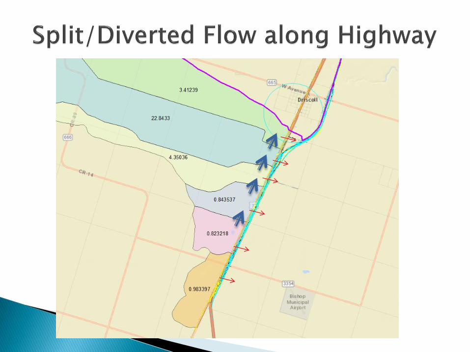
Split/Diverted Flow
Alluvial Fans
Floodplain Analysis (Wide Floodplains)

Source: FHWA HDS #7


Representative cross-section
and reach lengths define
channel
Velocity and depth computed at
each cross-section
Starts with known condition and
solves for unknown conditions
at the next cross-section

Example Cell

Geometry is defined by a network of elements or nodes (mesh).
Each element in the mesh is a horizontal area with 3 or 4 sides.
Velocity varies horizontally and is depth averaged at a point (vertically).
2D modeling lays a mesh over the terrain and the 2D hydraulic computations determine where the water goes directionally.

Disadvantages• Difficult to lay cross-sections (cross-sections must not cross)
• Does not capture complex flow (diverted/split)
• Possibly overestimates depth and velocity due to assumptions (most important outputs)
• Must estimate ineffective areas
Advantages • Geometric input simplified with cross-sections and reach
lengths (easier to make adjustments)
• Faster computational time
• Computes hydraulics through structures (bridges and culverts)
• Easier to troubleshoot

Disadvantages• More data intensive
• Best with reliable and accurate topo/LiDAR
• Longer Computational Time
• Hydraulic structure computations limited (not very good at computing hydraulics through structures)
• Less User Experience
Advantages• Models in 2 directions – dispersive flows. Good for split and
diverted flows.
• Calculates ineffective flow areas (no estimating)
• No cross-section placement (no guess work)
• More informative – better defined flow patterns
• Dynamic mapping

Split flow or flow diverted to adjacent basin (adjacent cross-culvert)
Wide floodplains where velocity and depth vary
Urban areas with complex flow patterns created by numerous cross streets
Inform 1D model – Define ineffective flow areas, contraction and expansion coefficients• Quick 2D by applying rain to mesh to diagnose
problem, establish flow patterns

Rain on Terrain (Mesh) Examples

Software (User Experience, widely used –Errors, bugs, issues can be vetted and corrected) InfoWorks (Riverine and Storm sewer)
XPSWMM (Riverine and Storm sewer)
HecRas 5.01
SRH-2D (aque veo)
HEC-RAS (Riverine)SRH-2D (Riverine)

Currently, no formal TxDOT policy/guidelines to develop a 2D Model or review a 2D Model. Contact Design Division, Hydraulics Branch for Guidance.
FHWA, HDS 7, Hydraulic Design of Safe Bridges
FEMA, Guidelines and Specifications for Flood Hazard Mapping Partners, Appendix C: Guidance for Riverine Flooding Analyses and Mapping


Two components
• Utility Conflict Detection
• Hydraulic Design and Analysis
• Stormsewer Network Design and Analysis
• Culverts

Gas Lines
Water lines

TxDOT developing Cell Library Approximately 50 TxDOT Drainage
Structure Standards Approximately 4500 Cells generated
from Standards Target date for completion of Cell Library
- Summer 2018

Replaces Geopak Drainage in ± 3 years
StormCAD is the hydraulic engine (can be used stand-alone)
Versatile Project Management Tools – Can analyze multiple rainfall events (design frequencies), multiple alternatives and compare results
Currently does not generate sheets. Sheet generation in SUDA being developed for next update (Tentatively early 2018).

Hydraulics Branch Team
• Saul Nuccitelli, PE, CFM 512-416-2219
• Chief Hydraulics Engineer
• Lucinda Soto, PE, CFM 512-416-2949
• Ab Maamar-Tayeb, PE, CFM 512-416-2328
• Kamal Uddin, EIT 512-416-2679
• Hiruy Berhe, EIT 512-416-2346