a9 berriedale braes, berriedale, caithness archaeological
TRANSCRIPT

A9 Berriedale Braes, Berriedale, Caithness
Archaeological Excavation, Phase 1
Data Structure Report
15th October 2018
AOC Project Number: 70324

© AOC Archaeology Group 2018
www.aocarchaeology.com
A9 Berriedale Braes, Berriedale, Caithness
Archaeological Excavation, Phase 1
Data Structure Report
On Behalf of: AECOM Limited
Portwall Place
Portwall Lane
Bristol
BS1 6NA
National Grid Reference (NGR): ND 12054 22791
AOC Project No: 70324
Prepared by: L. Stirling, M. Peteranna, R. Engl
Illustrations by: L. Stirling
Date of Fieldwork: 24th September to 5th October 2018
Date of Report: October 2018
Oasis No: aocarcha1- 331438
Enquiries to: AOC Archaeology Group
The Old Estate Office
Rosehaugh Estate
Avoch
IV9 8RF
Tel. 01463 819 841
Mob. 07972 259255
E-mail [email protected]
This document has been prepared in accordance with AOC standard operating procedures. Authors: Lindsey Stirling, Mary Peteranna, Rob Engl Date: 15/10/2018 Approved by: Mary Peteranna Date: 22/10/2018 Draft/Final Report Stage: Final Date: 25/10/2018
AOC 70324 A9 Berriedale Braes, Berriedale, Caithness: Archaeological Excavation, Data Structure Report
© AOC Archaeology 2018 | PAGE 2 | www.aocarchaeology.com
Contents
Page
SUMMARY ......................................................................................................................................................... 3 1.0 INTRODUCTION .................................................................................................................................... 4 2.0 BACKGROUND ..................................................................................................................................... 4 3.0 OBJECTIVES ......................................................................................................................................... 5 4.0 METHODOLOGY ................................................................................................................................... 8 5.0 RESULTS ............................................................................................................................................. 11 6.0 DISCUSSION ....................................................................................................................................... 26 7.0 CONCLUSIONS AND RECOMMENDATIONS ................................................................................... 26 8.0 REFERENCES ..................................................................................................................................... 28
List of Figures
Figure 1: Location plan
Figure 2: Proposed route of new road, showing the area of investigation
Figure 3: Location of the excavation trenches
Figure 4: The five trenches, showing location of the grids
Figure 5: Trench 1 and Trench 2 section drawings
Figure 6: Plan of Trench 2 showing the location of archaeological features
Figure 7: Section drawings of the pit features
List of Plates
Plate 1: General view of Trench 1, facing west-south-west
Plate 2: General view of Trench 1 showing (103) and removal of (104), facing west-south-west
Plate 3: Post-excavation shot of Trench 1, facing WSW
Plate 4: Trench 2 mid-excavation shot after removal of topsoil (200), facing WSW
Plate 5: Trench 2 post-excavation, showing grids 6A, 7B, 8A and 8C, facing southwest
Plate 6: Trench 2 showing GI disturbance location in front left of photo, facing southwest
Plate 7: Trench 2 Grids 6A-8A, showing feature locations, and stone layer (back) facing southeast
Plate 8: Pits [207], [208], [209], post-excavation, facing northwest
Plate 9: Pit [207] left, pit [208] half-sectioned, and pit [209] (front), facing WNW
Plate 10: ESE-facing trench section, showing location of half-sectioned features in back and unexcavated in situ
features and deposits in front right, facing WNW
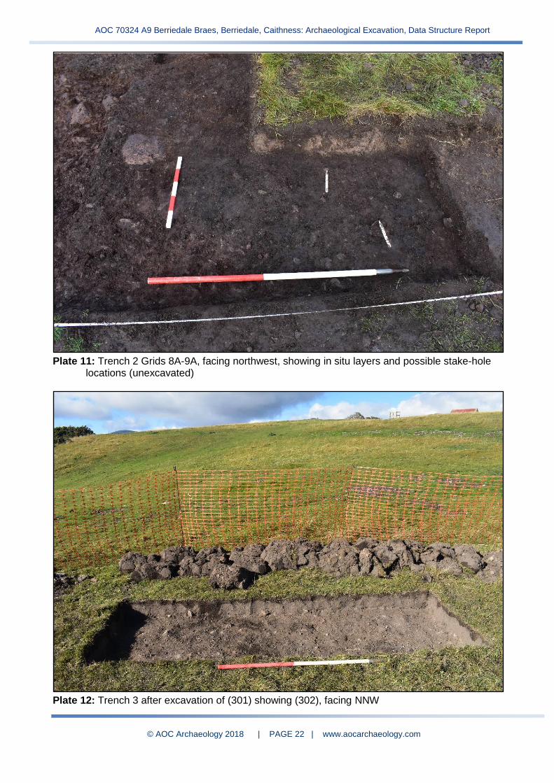
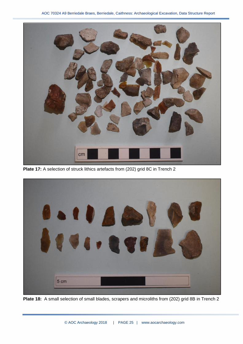
Plate 11: Trench 2 Grids 8A-9A, facing northwest, showing in situ layers and possible stake-hole locations (unexcavated) Plate 12: Trench 3 after excavation of (301) showing (302), facing NNW
Plate 13: Trench 3 Grid 1A post-excavation, facing WSW
Plate 14: Trench 4 after topsoil/turf removal, facing WSW
Plate 15: Trench 4 Post-excavation, facing southwest
Plate 16: Looking over Trench 5 post-excavation, facing west
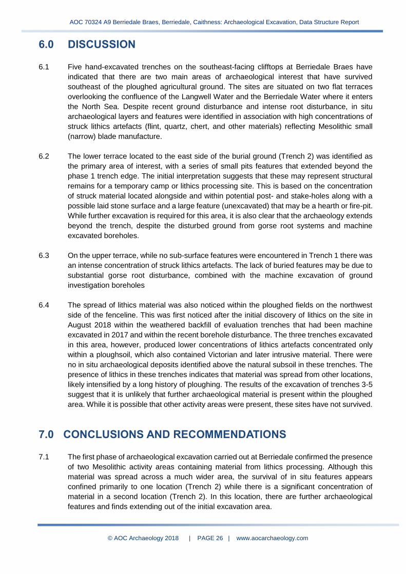
Plate 17: A selection of lithics artefacts (202) grid 8C, Trench 2
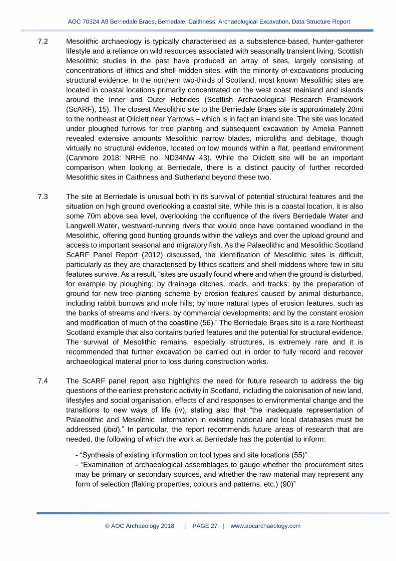
Plate 18: A small selection of lithics artefacts from (202) grid 8B, Trench 2
Appendices
Appendix 1 List of Contexts
Appendix 2 List of Site Photographs
Appendix 3 List of Samples
Appendix 4 List of Small Finds

AOC 70324 A9 Berriedale Braes, Berriedale, Caithness: Archaeological Excavation, Data Structure Report
© AOC Archaeology 2018 | PAGE 3 | www.aocarchaeology.com
SUMMARY
This report details the findings of the first phase of
archaeological excavation carried out in advance of
improvement works to the existing A9 road at
Berriedale Braes in Caithness. The excavation was
required in order to investigate an area where
prehistoric lithic artefacts had been discovered
during a previous phase of investigative fieldwork.
The fieldwork was undertaken between 24th
September and 5th October 2018. Five trenches
were excavated in the planned location of the new
road alignment in order to determine the locations
of lithics artefact concentrations and areas of
archaeological potential. There were two sites of
primary interest are situated on flat terraces on
clifftops overlooking the North Sea. Both areas
revealed an in situ occupation layer containing high
quantities of struck lithics, a variety of stone types
comprising manufacturing debris, cores and
microliths characteristic of the Scottish Mesolithic
period. One area also contained subsurface
features, pits and possible linear cuts, that have
survived within the natural subsoil..
AOC 70324 A9 Berriedale Braes, Berriedale, Caithness: Archaeological Excavation, Data Structure Report
© AOC Archaeology 2018 | PAGE 4 | www.aocarchaeology.com
1.0 INTRODUCTION
1.1 A first phase of archaeological excavation was undertaken on behalf of Transport Scotland in
advance of road re-alignment works for the A9 at Berriedale Braes, near Helmsdale,
Caithness. The works will see alterations made to reduce the steep incline and the angle of
the hairpin bend situated on the north ascent of the Berriedale Braes. Previous archaeological
evaluation and watching brief had taken place on the site during 2017 and 2018, including the
dismantling of a post-medieval structure. This report focuses on the first phase of excavation
of an area of prehistoric lithic scatters that were noticed during the previous archaeological
watching brief.
1.2 The proposed development lies within the scope of works planned by Transport Scotland,
advised by Archaeologist Ed Danaher. It is situated within the administrative area of Highland
Council, which is advised on archaeological matters by Kirsty Cameron, Archaeologist, Historic
Environment Team (HET), Highland Council. Five hand-excavated trenches investigated the
locations where prehistoric lithics had been noticed. The work was in keeping with the policies
outlined in Scottish Planning Policy (2014) and PAN 2/2011 Planning and Archaeology (2011)
in order to record the extent and significance of any archaeological remains which may have
been present within the area.
1.3 The fieldwork was undertaken between 24th September and 5th October 2018. The trenches
revealed two concentrations of worked lithics on flat, clifftop terraces overlooking the
confluence of the Berriedale River and the North Sea. Both areas contained an in situ
occupation horizon rich in Mesolithic lithics, while one area also contained a series of sub-
surface features, likely representing Mesolithic occupation. A second phase of work has been
recommended.
2.0 BACKGROUND
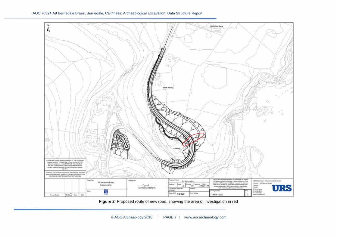
2.1 The scheme is located alongside the A9 roadway at the Berriedale Braes, between Helmsdale
and Dunbeath in Caithness (Figures 1, 2). On the northbound approach, the A9 leads steeply
down to the village of Berriedale across the confluence of the Langwell and Berriedale Waters,
and ascends the north side of the Berriedale Glen with a sharp hairpin bend. The coastline
comprises pastoral agricultural land situated on steep cliffs, with rough heather and moorland
further inland.
2.2 The initial requirement for an archaeological evaluation arose due to the possible preserved
remains of a crofting settlement, Craft, depicted on Roy’s Military map of 1755 existing within
the proposed development area. In addition, further sites of archaeological significance were
located in close proximity to the site. This included a structure shown on historical mapping to
the south side of the township area.
2.3 A walkover survey and full desk-based assessment were carried out by URS as part of the
Cultural Heritage segment of the Environmental Report (URS 2014), the full details of which
can be consulted therein. The URS report noted within a 1km radius of the development site:
four Scheduled Monuments (SAMs), 18 Listed Buildings and one garden registered under the
AOC 70324 A9 Berriedale Braes, Berriedale, Caithness: Archaeological Excavation, Data Structure Report
© AOC Archaeology 2018 | PAGE 5 | www.aocarchaeology.com
Inventory of Gardens and Designed Landscape. These sites include Berriedale Castle (SAM
3438), Langwell Castle (SAM 3437), a broch and post medieval farmstead (SAM577), and a
Neolithic cairn (SAM 460). The majority of listed buildings were 19th century in date and form
the settlement of Berriedale, comprising mills, domestic homes, two Thomas Telford bridges,
two navigation beacon towers, and the parish church. An additional 44 non-designated sites
were also identified. These mostly comprise scattered post medieval crofting settlement sites,
but there were also indications of prehistoric and medieval occupation in the area.
2.4 An archaeological evaluation was carried out by AOC Archaeology in November 2017 across
the agricultural land at the top of the cliffs, as well as two trenches over an unroofed post-
medieval structure on the slopes (Williamson 2017). No archaeological remains were
encountered in the evaluation trenches. Evaluation of the unroofed structure uncovered a well-
preserved cobbled floor with drains likely representing use as a post-medieval animal byre.
2.5 In August 2018, AOC Archaeology returned to the site to monitor and record the final
dismantling of the unroofed building. During this fieldwork archaeologists identified areas of
recent ground disturbance to the east of the cemetery over rough ground along the cliff edge
not assessed during the evaluation. Casual visual inspection of the soil revealed lithics
scattered over the area, representing stone tools of flint and quartz and manufacture debitage.
A series of test pits were dug indicating the presence of a possible undisturbed soil horizon.
Initial identification of the recovered assemblage suggested that the material was most likely
Mesolithic in date (Stirling & Williamson 2018) and further work was recommended to ascertain
the presence or absence of significant archaeology within the road re-alignment footprint.
3.0 OBJECTIVES 3.1 The Chartered Institute for Archaeologists (CIfA 2014a) defines an archaeological excavation
as ‘a programme of controlled, intrusive fieldwork with defined research objectives which
examines, records and interprets archaeological deposits, features and structures and, as
appropriate, retrieves artefacts, ecofacts and other remains within a specified area or site on
land...The records made and objects gathered during fieldwork are studied and the results of
that study published in detail appropriate to the project design.’
3.2 The specific project objectives set out by AECOM in the Written Scheme of Investigation
(AECOM 2018) were:
i) To identify, record and sample excavate any archaeological deposits, features and artefacts which may be present within the development
ii) To characterise and date any anomalies or finds recovered; and to produce a report on
the findings of the works

AOC 70324 A9 Berriedale Braes, Berriedale, Caithness: Archaeological Excavation, Data Structure Report
© AOC Archaeology 2018 | PAGE 6 | www.aocarchaeology.com
Figure 1: Location plan
Current A9
alignment
AOC 70324 A9 Berriedale Braes, Berriedale, Caithness: Archaeological Excavation, Data Structure Report
© AOC Archaeology 2018 | PAGE 7 | www.aocarchaeology.com
Figure 2: Proposed route of new road, showing the area of investigation in red

AOC 70324 A9 Berriedale Braes, Berriedale, Caithness: Archaeological Excavation, Data Structure Report
© AOC Archaeology 2018 | PAGE 8 | www.aocarchaeology.com
4.0 METHODOLOGY
4.1 During previous fieldwork, a series of hand dug test pits along a baseline running northeast
from the cemetery wall indicated that scattered lithics were present in the soil across the
slope, but were in higher concentrations on the flatter terraces (Stirling and Williamson 2018).
As per the Written Scheme of Investigation for the current fieldwork (AECOM 2018), it was
proposed that three open area trenches were excavated by hand, the positions to be
determined by ground conditions on site. Trench 1 (10m by 5m) and Trench 2 (10m by 1m
with a 2m by 3m extension) were opened, targeting the flatter areas of ground with higher
concentrations of lithics (Figures 3, 4). After an on-site meeting with the Transport Scotland
and AECOM archaeologists, it was agreed that additional small trenches (3m by 1m) would
be excavated further uphill to assess the distribution of the lithic scatters.
4.2 All the trenches were excavated by hand and the topsoil was sieved for the recovery of
artefacts. The trenches were divided into 1m grid squares (Figure 4) and after initial topsoil
removal all finds and samples were recorded by context and grid square. Bulk soil samples
for environmental analyses were taken from all significant (in situ) archaeological deposits by
grid square and the remainder of these deposits were sieved for artefact recovery. AOC lithics
expert, Rob Engl, provided on-site excavation advice and an initial assessment of the
recovered artefact assemblage.
4.3 A selection of the archaeological features were excavated by hand in order to establish the
date, nature, extent and state of preservation of the deposits and to inform a second phase
of excavation. Archaeological features and deposits were drawn at a scale of 1:20 and
section drawings were drawn at a scale of 1:10. The trench locations, including feature
locations, were plotted using a Trimble Geo-XR Rover capable of centimetre accuracy. The
archaeological fieldwork was recorded using high resolution digital photography in order to
record the process as well as any features or finds of interest.
4.4 All work was carried out in accordance with the Highland Council Standards for
Archaeological Work (2012) and the Chartered Institute of Archaeologists Code of Conduct
(2014b).

AOC 70324 A9 Berriedale Braes, Berriedale, Caithness: Archaeological Excavation, Data Structure Report
© AOC Archaeology 2018 | PAGE 9 | www.aocarchaeology.com
Figure 3: Location of the excavation trenches
Burial
Ground
AOC 70324 A9 Berriedale Braes, Berriedale, Caithness: Archaeological Excavation, Data Structure Report
© AOC Archaeology 2018 | PAGE 10 | www.aocarchaeology.com
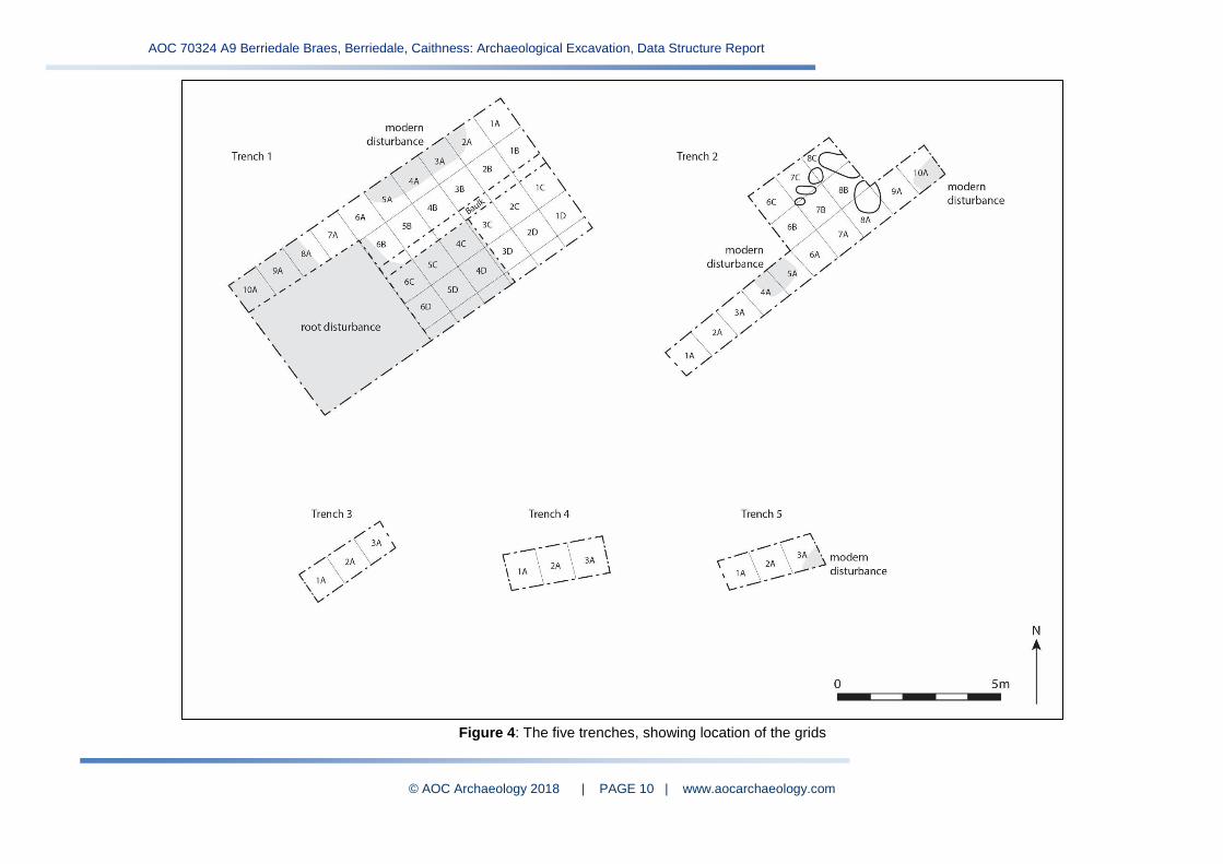
Figure 4: The five trenches, showing location of the grids
AOC 70324 A9 Berriedale Braes, Berriedale, Caithness: Archaeological Excavation, Data Structure Report
© AOC Archaeology 2018 | PAGE 11 | www.aocarchaeology.com
5.0 RESULTS
5.1 Summary
5.1.1 The fieldwork was carried out between 24th September and 5th October 2018. Conditions were
mixed, with some very wet and windy days that caused difficulty for sieving, excavation and
identification of finds and features. Five trenches were excavated by hand and it was
established that the main concentrations of lithics were on two terraces on clifftops outside of
the fenced, improved agricultural ground (Figure 4). Sub-surface archaeological features were
encountered only in Trench 2, comprising a group of small-large pits and a possible linear slot.
Both trenches contained in situ occupation layers that had been heavily disturbed by recent
ground investigation machine excavation and dense gorse root systems. Three small test
trenches were hand excavated inside of the area of improved, ploughed agricultural ground
(north of the fenceline). While significant lithic artefacts recovered from here (Trench 3-5), the
material was recovered from the ploughsoil and no in situ horizons were located, indicating
that these areas were likely not main sites of activity or that extensive ploughing had removed
any surviving in situ archaeological horizons and features.
5.1.2 Over one thousand struck lithics were recovered, representing group of lithics finds collected
from individual layers in grid squares. Several fragments of modern pottery, glass and iron
were also recovered from the ploughsoil or topsoil layers, highlighting the disturbance of the
ground in the upper layers. Initial assessment of the small finds has identified a large amount
of manufacture debitage reflecting narrow blade industry and including cores, blades and
flakes. The assemblage most likely dates to the late Mesolithic period (see Section 5.5).
5.1.3 The sections below detail the results from each trench. A full list of contexts and finds can be
found in Appendices 1 and 4.
5.2 Trench 1
5.2.1 Trench 1 was opened at the northeast end of the development area on a flat terrace
overlooking the sea. An area 10m by 5m was deturfed, but after encountering heavy
disturbance by gorse roots in the south and southeast areas of the trench the excavation
focused primarily on the north and northwest parts (Plate 1).
5.2.2 After the removal of the overlying turf, the trench was shown to have three primary deposits.
Deposit (102) comprised a mixed mid grey-brown silty sand and orange-brown clay. It was
concentrated on the northwest edge of the trench next to the recent ground investigation pit.
Due to the mixed nature of this deposit and the inclusions of modern pottery, glass and gravel,
it was interpreted as recently redeposited material.
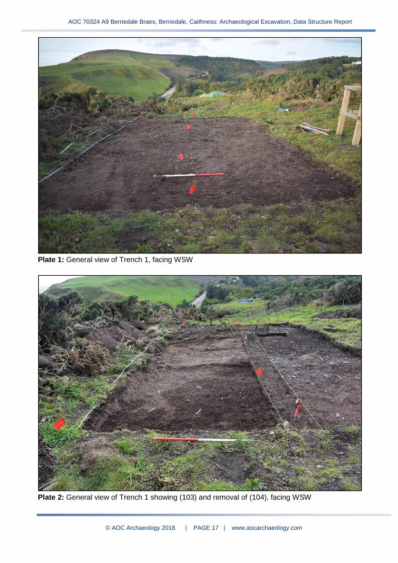
5.2.3 Deposits (103) and (104) (Plate 2), in situ horizons below the turf and topsoil (100), comprised
dark black-brown and mid grey-brown sandy silt, both with high quantities of struck lithics
artefacts. There was no clear distinction between these two deposits, except that (104) was
drier and looser in consistency and much more disturbed by roots. Context (103) was in
comparison less disturbed and contained small charcoal flecks. These two deposits were
interpreted as part of the same layer that has been differentially affected by root disturbance
AOC 70324 A9 Berriedale Braes, Berriedale, Caithness: Archaeological Excavation, Data Structure Report
© AOC Archaeology 2018 | PAGE 12 | www.aocarchaeology.com
and drainage. Due to the high quantities of lithics and visible charcoal flecks, context (103)
was interpreted as an undisturbed in situ occupation horizon.
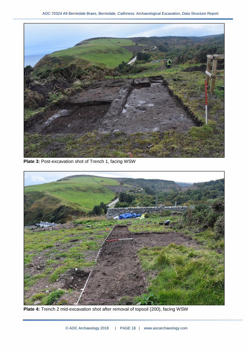
5.2.4 Both contexts (103) and (104) lay above deposit (105), a mid orange-brown sandy silt, which
formed a thin layer over the natural subsoil (101), a dark red/orange-brown, very hard, sandy
silt with frequent stones (Plate 3). These two basal layers consist of the lower undisturbed
natural ground (101) underlying an archaeologically modified natural subsoil (105).
5.2.5 No sub-surface features were identified within Trench 1. However the nature of disturbance by
gorse roots and recent machine excavated ground investigations may have obscured any
features which may have been present.
5.3 Trench 2
5.3.1 Trench 2 was located on a second terrace along the cliff edge immediately to the east side of
the cemetery. A strip 10m by 1m was excavated to assess the overall area with an extension
of 2m by 3m investigating the most level area of ground. A couple of areas, notably grids 4A,
5A and 10A, showed evidence of recent disturbance similar to that seen in Trench 1 (Plate 4).
The deposits in the trench were best preserved in grids 6A-C to 8A-C, while recent ground
investigations work had truncated or disturbed deposits in the rest of the trench.
5.3.2 Deposit (202) formed the main soil horizon across the whole trench: a mid-dark brown sandy
silt containing large amounts of struck lithics artefacts. Below this was deposit (205), a mid
red-brown sandy silt with small flecks of degraded charcoal. Worked lithics were still present
in this deposit, although in much lesser amounts. Deposit (205) lay directly above the natural
subsoil (204), similar to (105) in Trench 1. Upon completion of the initial phase of excavation,
it was clear that there were further in situ horizons extending over and around (205) outside of
the trench edges that have been left for a next phase of fieldwork.
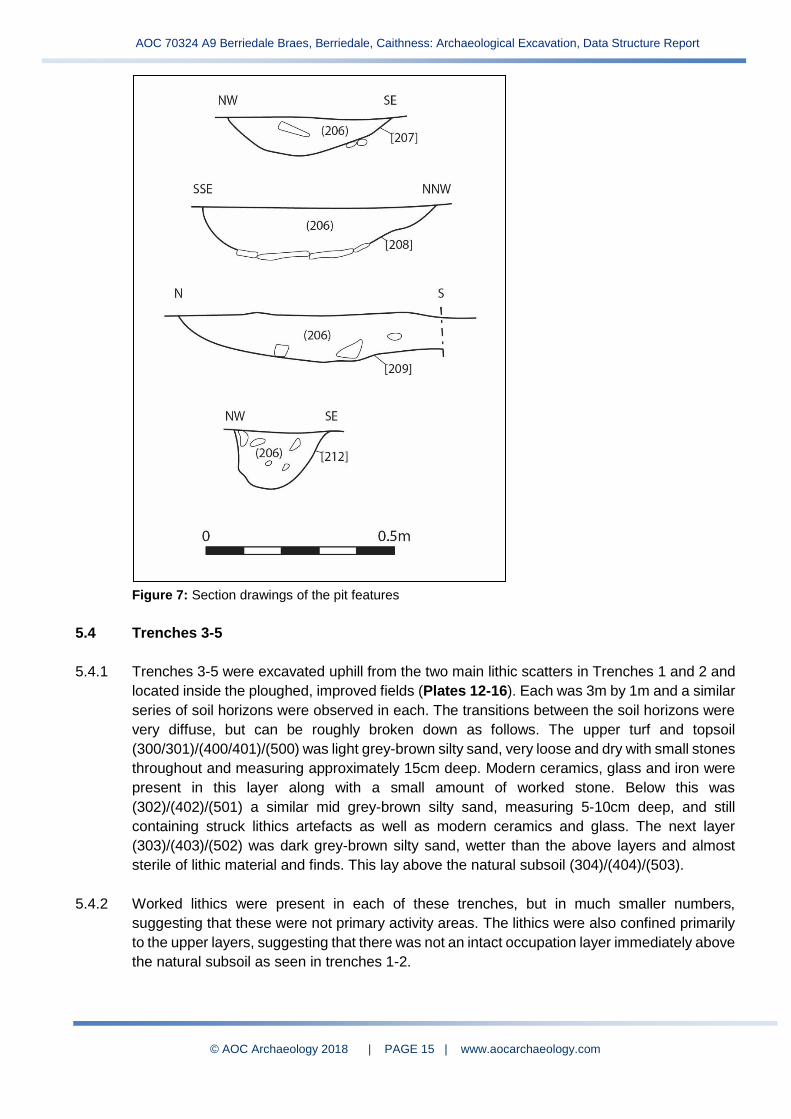
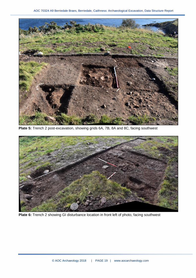
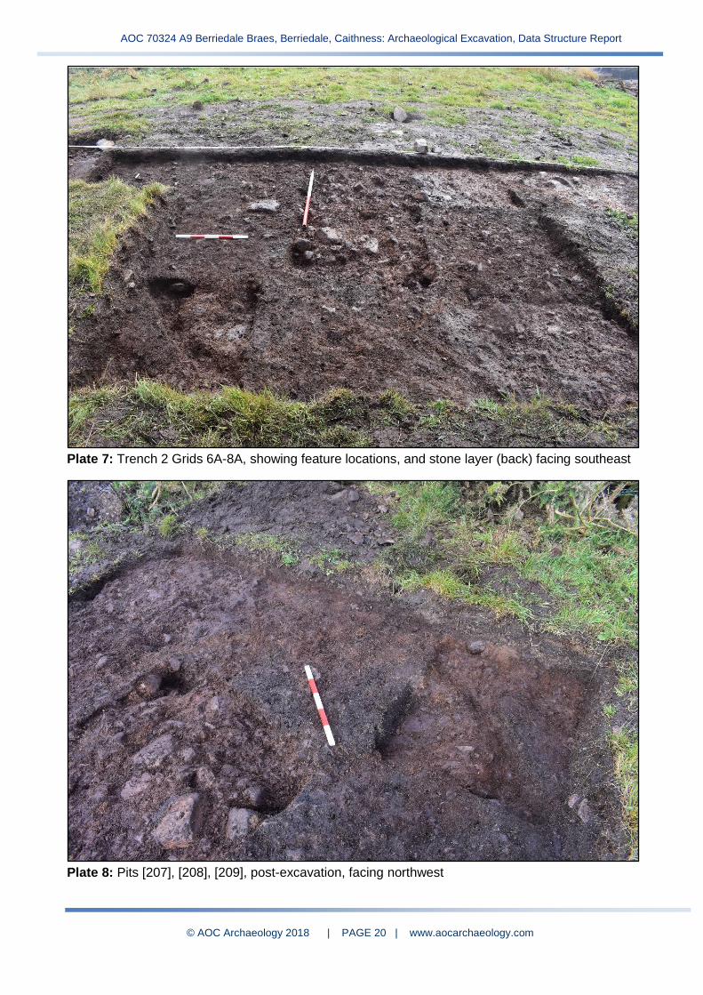
5.3.3 A series of pit features were identified as cuts through layer (205) and through the natural
subsoil (Figure 6, Plates 6-13). Although varied in size and shape, the pits contained similar
fills of dark black-brown sandy silt (206) with occasional small stones and some lithics
artefacts. Pit [207] and pit [208] comprised small sub-circular pits with gently sloping sides and
rounded bases, measuring up to 0.12m deep and between 0.5-0.6m across (Figure 7, Plates
8-10). Pit [212] was a smaller feature, measuring 0.2m diameter and 0.2m deep (Figure 7,
Plates 8-10). This was interpreted as a possible post- or stake-hole as it was lined by small
stones on the sides.
5.3.4 Pit [209] consisted of a possible linear feature, measuring 0.15m deep and 0.5m by 1.1m
before extending outside the trench (Plates 6, 8-10). Another subcircular pit [210] measured
at least 0.6m diameter and extended beyond the trench edge (Plate 11). It was not excavated
along with two possible small stake-holes which appeared in a new in situ surface layer
extending outside of the trench – the overall area of which requires further investigation.
5.3.5 On the south side of the features, the ground surface contained a concentration of sub-angular
stones (211) forming a compact surface within deposit (205). The amount of stone in this area
was much higher than that in the natural subsoil around and therefore was interpreted as a
possible surface relating to the nearby pit features. It was similar to an archaeological horizon
encountered at Scottish Mesolithic site at East Barns in East Lothian (pers comm Rob Engl).

AOC 70324 A9 Berriedale Braes, Berriedale, Caithness: Archaeological Excavation, Data Structure Report
© AOC Archaeology 2018 | PAGE 13 | www.aocarchaeology.com
Figure 5: Trench 1 and Trench 2 section drawings

AOC 70324 A9 Berriedale Braes, Berriedale, Caithness: Archaeological Excavation, Data Structure Report
© AOC Archaeology 2018 | PAGE 14 | www.aocarchaeology.com
Figure 6: Plan of Trench 2 showing the location of archaeological features
AOC 70324 A9 Berriedale Braes, Berriedale, Caithness: Archaeological Excavation, Data Structure Report
© AOC Archaeology 2018 | PAGE 15 | www.aocarchaeology.com
Figure 7: Section drawings of the pit features
5.4 Trenches 3-5
5.4.1 Trenches 3-5 were excavated uphill from the two main lithic scatters in Trenches 1 and 2 and
located inside the ploughed, improved fields (Plates 12-16). Each was 3m by 1m and a similar
series of soil horizons were observed in each. The transitions between the soil horizons were
very diffuse, but can be roughly broken down as follows. The upper turf and topsoil
(300/301)/(400/401)/(500) was light grey-brown silty sand, very loose and dry with small stones
throughout and measuring approximately 15cm deep. Modern ceramics, glass and iron were
present in this layer along with a small amount of worked stone. Below this was
(302)/(402)/(501) a similar mid grey-brown silty sand, measuring 5-10cm deep, and still
containing struck lithics artefacts as well as modern ceramics and glass. The next layer
(303)/(403)/(502) was dark grey-brown silty sand, wetter than the above layers and almost
sterile of lithic material and finds. This lay above the natural subsoil (304)/(404)/(503).
5.4.2 Worked lithics were present in each of these trenches, but in much smaller numbers,
suggesting that these were not primary activity areas. The lithics were also confined primarily
to the upper layers, suggesting that there was not an intact occupation layer immediately above
the natural subsoil as seen in trenches 1-2.

AOC 70324 A9 Berriedale Braes, Berriedale, Caithness: Archaeological Excavation, Data Structure Report
© AOC Archaeology 2018 | PAGE 16 | www.aocarchaeology.com
5.5 Small Finds Assessment
5.5.1 Lithic Assemblage
An initial rapid assessment of the lithic material (examples in Plates 17, 18) at Berriedale by
Rob Engl identified a large chipped stone assemblage of late Mesolithic date. Approximately
a quarter of the recovered material was macroscopically studied. This revealed a narrow blade
assemblage of 1035 artefacts with the majority composed of patinated and heat affected East
Coast (Buchan) flint (n. 939) with substantial supplementary quantities of crystalline quartz (n.
89). Other raw materials identified within the assemblage included fossil wood (n. 7), chert and
chalcedony.
5.5.2 Primary Technology
Twenty-seven platform blade/flake cores were identified including two made on quartz. The
platforms of these items were well worked ranging between 75-100%. The cores appeared to
have been derived from small, waterworn cobbles probably retrieved from the nearby river or
coastline. Many of the cores had been reduced to a small size before being abandoned
suggesting that the flint was maximised. A total of 41 whole and fragmentary blades were
identified alongside a large proportion of regular bladelike flakes. Other significant debitage
classes were represented by 2 core face rejuvenation flakes where the whole of the working
face was removed and six platform rejuvenation flakes where the working platform was
removed by a strike angled across the side of the piece. The remainder of the debitage
consisted of flakes, fragments, chips and chunks. In total 948 artefacts were assigned to these
categories.
5.5.3 Secondary Modification
Eleven artefacts displayed secondary modification. These included seven artefacts displaying
microlithic retouch including two microlithic points, a microlithic rod, two backed bladelets and
a crescent. No scalene microliths were identified. Non microlithic tools included a retouched
quartz flake, a sidescraper, a piercer, a notched blade and a quartz borer.
5.5.4 Conclusion
The material at Berriedale would appear to represent a Late Mesolithic occupation based on
a narrow blade industry that appears to maximise immediate local resources of raw material.
AOC 70324 A9 Berriedale Braes, Berriedale, Caithness: Archaeological Excavation, Data Structure Report
© AOC Archaeology 2018 | PAGE 17 | www.aocarchaeology.com
Plate 1: General view of Trench 1, facing WSW
Plate 2: General view of Trench 1 showing (103) and removal of (104), facing WSW
AOC 70324 A9 Berriedale Braes, Berriedale, Caithness: Archaeological Excavation, Data Structure Report
© AOC Archaeology 2018 | PAGE 18 | www.aocarchaeology.com
Plate 3: Post-excavation shot of Trench 1, facing WSW
Plate 4: Trench 2 mid-excavation shot after removal of topsoil (200), facing WSW
AOC 70324 A9 Berriedale Braes, Berriedale, Caithness: Archaeological Excavation, Data Structure Report
© AOC Archaeology 2018 | PAGE 19 | www.aocarchaeology.com
Plate 5: Trench 2 post-excavation, showing grids 6A, 7B, 8A and 8C, facing southwest
Plate 6: Trench 2 showing GI disturbance location in front left of photo, facing southwest
AOC 70324 A9 Berriedale Braes, Berriedale, Caithness: Archaeological Excavation, Data Structure Report
© AOC Archaeology 2018 | PAGE 20 | www.aocarchaeology.com
Plate 7: Trench 2 Grids 6A-8A, showing feature locations, and stone layer (back) facing southeast
Plate 8: Pits [207], [208], [209], post-excavation, facing northwest

AOC 70324 A9 Berriedale Braes, Berriedale, Caithness: Archaeological Excavation, Data Structure Report
© AOC Archaeology 2018 | PAGE 21 | www.aocarchaeology.com
Plate 9: Pit [207] left, pit [208] half-sectioned, and pit [209] (front right), facing WNW
Plate 10: ESE-facing trench section, showing location of half-sectioned features in back and
unexcavated in situ features and deposits in front right, facing WNW
AOC 70324 A9 Berriedale Braes, Berriedale, Caithness: Archaeological Excavation, Data Structure Report
© AOC Archaeology 2018 | PAGE 22 | www.aocarchaeology.com
Plate 11: Trench 2 Grids 8A-9A, facing northwest, showing in situ layers and possible stake-hole
locations (unexcavated)
Plate 12: Trench 3 after excavation of (301) showing (302), facing NNW

AOC 70324 A9 Berriedale Braes, Berriedale, Caithness: Archaeological Excavation, Data Structure Report
© AOC Archaeology 2018 | PAGE 23 | www.aocarchaeology.com
Plate 13: Trench 3 Grid 1A post-excavation, facing WSW
Plate 14: Trench 4 after topsoil/turf removal, facing WSW

AOC 70324 A9 Berriedale Braes, Berriedale, Caithness: Archaeological Excavation, Data Structure Report
© AOC Archaeology 2018 | PAGE 24 | www.aocarchaeology.com
Plate 15: Trench 4 post-excavation, facing southwest
Plate 16: Looking over Trench 5 post-excavation, facing west
AOC 70324 A9 Berriedale Braes, Berriedale, Caithness: Archaeological Excavation, Data Structure Report
© AOC Archaeology 2018 | PAGE 25 | www.aocarchaeology.com
Plate 17: A selection of struck lithics artefacts from (202) grid 8C in Trench 2
Plate 18: A small selection of small blades, scrapers and microliths from (202) grid 8B in Trench 2
AOC 70324 A9 Berriedale Braes, Berriedale, Caithness: Archaeological Excavation, Data Structure Report
© AOC Archaeology 2018 | PAGE 26 | www.aocarchaeology.com
6.0 DISCUSSION
6.1 Five hand-excavated trenches on the southeast-facing clifftops at Berriedale Braes have
indicated that there are two main areas of archaeological interest that have survived
southeast of the ploughed agricultural ground. The sites are situated on two flat terraces
overlooking the confluence of the Langwell Water and the Berriedale Water where it enters
the North Sea. Despite recent ground disturbance and intense root disturbance, in situ
archaeological layers and features were identified in association with high concentrations of
struck lithics artefacts (flint, quartz, chert, and other materials) reflecting Mesolithic small
(narrow) blade manufacture.
6.2 The lower terrace located to the east side of the burial ground (Trench 2) was identified as
the primary area of interest, with a series of small pits features that extended beyond the
phase 1 trench edge. The initial interpretation suggests that these may represent structural
remains for a temporary camp or lithics processing site. This is based on the concentration
of struck material located alongside and within potential post- and stake-holes along with a
possible laid stone surface and a large feature (unexcavated) that may be a hearth or fire-pit.
While further excavation is required for this area, it is also clear that the archaeology extends
beyond the trench, despite the disturbed ground from gorse root systems and machine
excavated boreholes.
6.3 On the upper terrace, while no sub-surface features were encountered in Trench 1 there was
an intense concentration of struck lithics artefacts. The lack of buried features may be due to
substantial gorse root disturbance, combined with the machine excavation of ground
investigation boreholes
6.4 The spread of lithics material was also noticed within the ploughed fields on the northwest
side of the fenceline. This was first noticed after the initial discovery of lithics on the site in
August 2018 within the weathered backfill of evaluation trenches that had been machine
excavated in 2017 and within the recent borehole disturbance. The three trenches excavated
in this area, however, produced lower concentrations of lithics artefacts concentrated only
within a ploughsoil, which also contained Victorian and later intrusive material. There were
no in situ archaeological deposits identified above the natural subsoil in these trenches. The
presence of lithics in these trenches indicates that material was spread from other locations,
likely intensified by a long history of ploughing. The results of the excavation of trenches 3-5
suggest that it is unlikely that further archaeological material is present within the ploughed
area. While it is possible that other activity areas were present, these sites have not survived.
7.0 CONCLUSIONS AND RECOMMENDATIONS 7.1 The first phase of archaeological excavation carried out at Berriedale confirmed the presence
of two Mesolithic activity areas containing material from lithics processing. Although this
material was spread across a much wider area, the survival of in situ features appears
confined primarily to one location (Trench 2) while there is a significant concentration of
material in a second location (Trench 2). In this location, there are further archaeological
features and finds extending out of the initial excavation area.
AOC 70324 A9 Berriedale Braes, Berriedale, Caithness: Archaeological Excavation, Data Structure Report
© AOC Archaeology 2018 | PAGE 27 | www.aocarchaeology.com
7.2 Mesolithic archaeology is typically characterised as a subsistence-based, hunter-gatherer
lifestyle and a reliance on wild resources associated with seasonally transient living. Scottish
Mesolithic studies in the past have produced an array of sites, largely consisting of
concentrations of lithics and shell midden sites, with the minority of excavations producing
structural evidence. In the northern two-thirds of Scotland, most known Mesolithic sites are
located in coastal locations primarily concentrated on the west coast mainland and islands
around the Inner and Outer Hebrides (Scottish Archaeological Research Framework
(ScARF), 15). The closest Mesolithic site to the Berriedale Braes site is approximately 20mi
to the northeast at Oliclett near Yarrows – which is in fact an inland site. The site was located
under ploughed furrows for tree planting and subsequent excavation by Amelia Pannett
revealed extensive amounts Mesolithic narrow blades, microliths and debitage, though
virtually no structural evidence, located on low mounds within a flat, peatland environment
(Canmore 2018: NRHE no. ND34NW 43). While the Oliclett site will be an important
comparison when looking at Berriedale, there is a distinct paucity of further recorded
Mesolithic sites in Caithness and Sutherland beyond these two.
7.3 The site at Berriedale is unusual both in its survival of potential structural features and the
situation on high ground overlooking a coastal site. While this is a coastal location, it is also
some 70m above sea level, overlooking the confluence of the rivers Berriedale Water and
Langwell Water, westward-running rivers that would once have contained woodland in the
Mesolithic, offering good hunting grounds within the valleys and over the upload ground and
access to important seasonal and migratory fish. As the Palaeolithic and Mesolithic Scotland
ScARF Panel Report (2012) discussed, the identification of Mesolithic sites is difficult,
particularly as they are characterised by lithics scatters and shell middens where few in situ
features survive. As a result, “sites are usually found where and when the ground is disturbed,
for example by ploughing; by drainage ditches, roads, and tracks; by the preparation of
ground for new tree planting scheme by erosion features caused by animal disturbance,
including rabbit burrows and mole hills; by more natural types of erosion features, such as
the banks of streams and rivers; by commercial developments; and by the constant erosion
and modification of much of the coastline (56).” The Berriedale Braes site is a rare Northeast
Scotland example that also contains buried features and the potential for structural evidence.
The survival of Mesolithic remains, especially structures, is extremely rare and it is
recommended that further excavation be carried out in order to fully record and recover
archaeological material prior to loss during construction works.
7.4 The ScARF panel report also highlights the need for future research to address the big
questions of the earliest prehistoric activity in Scotland, including the colonisation of new land,
lifestyles and social organisation, effects of and responses to environmental change and the
transitions to new ways of life (iv), stating also that “the inadequate representation of
Palaeolithic and Mesolithic information in existing national and local databases must be
addressed (ibid).” In particular, the report recommends future areas of research that are
needed, the following of which the work at Berriedale has the potential to inform:
- “Synthesis of existing information on tool types and site locations (55)”
- “Examination of archaeological assemblages to gauge whether the procurement sites
may be primary or secondary sources, and whether the raw material may represent any
form of selection (flaking properties, colours and patterns, etc.) (90)”
AOC 70324 A9 Berriedale Braes, Berriedale, Caithness: Archaeological Excavation, Data Structure Report
© AOC Archaeology 2018 | PAGE 28 | www.aocarchaeology.com
- “Development of work on use-wear/residue analysis for lithic assemblages and more
frequent application to excavated material (90)”
- “Understanding the dynamics of the formation of occupation deposits as well as
identifying specific craft or processing activities within sites through the application of a
range of methodologies to artefactual analyses, including use wear and contextual
analysis (90)”
- “Analysis of the relationship between inland and coastal communities (112)”
- “Further work on structural remains and community size (112)”
7.5 In particular, the Berriedale site provides the opportunity to study Mesolithic features, possible
structural remains. The potential evidence for structures would provide new information to
look at during research on mobility patterns of the post-glacial early settlers – looking at the
patterns of movement as compared to temporary camps associated with foragers or more
long-term bases that are returned to frequently. Furthermore, while the narrow (small) blade
industry is typically associated with the late Mesolithic, this is not without debate by
researchers (ScARF, 24-25). Work on the Berriedale site will also provide new opportunities
for environmental sampling for both radiocarbon dating and climate/environment analyses.
7.6 During a second phase of work, it is recommended that hand excavation is concentrated
around Trench 2, to include extension of the trench edges on the north side, in order to fully
uncover the area of archaeological significance for the purpose of full excavation of deposits
and features. Machine stripping of the turf and topsoil further around Trench 1 as well as
Trench 2 is recommended in order to determine the location of any further surviving buried
archaeological horizons within the development footprint. All in situ archaeological deposits
and features uncovered would require hand excavation prior to their loss during development.
8.0 REFERENCES
AECOM 2018. A9 Berriedale Braes: Written Scheme of Investigation for Archaeological
Excavation. Unpublished AECOM report.
Chartered Institute for Archaeologists (CIfA) 2014 (a). Standards and guidance:
Archaeological excavation.
Chartered Institute for Archaeologists (CIfA) 2014 (b). Code of Conduct.
Highland Council 2012. Standards for Archaeological Work
Scottish Archaeological Research Framework (ScARF) 2012. Palaeolithic and
Mesolithic Scotland: ScARF Panel Report.
Scottish Government 2014. Scottish Planning Policy.
Scottish Government 2011. PAN 2/2011 Planning and Archaeology.
AOC 70324 A9 Berriedale Braes, Berriedale, Caithness: Archaeological Excavation, Data Structure Report
© AOC Archaeology 2018 | PAGE 29 | www.aocarchaeology.com
Stirling, L and Williamson, S 2018. A9 Berriedale Braes, Berriedale, Caithness
Archaeological Watching Brief Data Structure Report. Unpublished AOC Archaeology
report.
URS 2014 A9 Berriedale Braes Improvement Environmental Report.
Williamson, S. 2017. A9 Berriedale Braes, Berriedale, Caithness, Archaeological
Evaluation Data Structure Report. Unpublished AOC Archaeology report.

AOC 70324 A9 Berriedale Braes, Berriedale, Caithness: Archaeological Excavation, Data Structure Report
© AOC Archaeology 2018 | PAGE 30 | www.aocarchaeology.com
Appendix 1 List of Contexts
Context No.
Trench No.
Type Description Filled
by Fill of
Cut by
Cuts Over Under Same
As Interpretation
100 1 Deposit
Dark grey-brown silty sand, loosely compacted. Upper turf and soil, heavily disturbed by GI works (machine
movement) and gorse roots. Contains scattered lithics and modern ceramics/glass.
- - - - 102, 103
- 200 Disturbed topsoil.
101 1 Deposit Dark red/orange brown hard gravel and sandy silt,
with frequent small to medium stone, very compact. Natural subsoil.
- - - - - 103, 105
204, 304, 404, 503
Natural subsoil.
102 1 Deposit
Mixed mid grey-brown silty sand and orange-brown clayey sand. Forms a thin layer on the NW side of the trench. Modern gravel, glass and ceramics within the
fill. Probably redeposited material from GI works.
- - - - 103 100 -
Redeposited material from
previous groundworks.
103 1 Deposit
Dark black-brown sandy silt with friable compaction. Contains small stones (5%), charcoal flecks and
frequent lithics. Deposit is damp, possibly from wet conditions and poor draining subsoil. Mostly on the N
and NW side of the trench.
- - - - 105 100, 102
104? In situ
occupation horizon.
104 1 Deposit
Mid grey-brown sandy silt, with loose compaction. Predominantly on the S and SE side of the trench. Heavily root disturbed, but rich in lithics. Possibly
same as (103) but better draining.
- - - - 105 100 103? Root disturbed
occupation horizon.
105 1 Deposit Mid orange-brown sandy silt with some gravel, friable compaction. Possible old forest soil/modified natural
overlying the natural (101). - - - - 101
103, 104
-
Old forest soil/modified natural below
occupation horizon.
200 2 Deposit
Dark grey-brown silty sand, loosely compacted. Upper turf and a mix of topsoil and disturbed subsoil. Varies in depth up to 10cm. Turf mostly intact in grids 8B/C
7B/C.
- - - - 201, 202
- 100 Disturbed topsoil.

AOC 70324 A9 Berriedale Braes, Berriedale, Caithness: Archaeological Excavation, Data Structure Report
© AOC Archaeology 2018 | PAGE 31 | www.aocarchaeology.com
Context No.
Trench No.
Type Description Filled
by Fill of
Cut by
Cuts Over Under Same
As Interpretation
201 2 Deposit Transition layer between upper mixed topsoil (200)
and in situ layers (202). - - - -
202, 205
200 - Transition
between (200) and (202).
202 2 Deposit
Mid brown, dry, gritty sandy silt with thin roots and frequent lithics. Present in grids 8B/C and 7B/C but
mostly truncated across the rest of the trench. Where disturbed/truncated it is mid-dark brown claggy silt. Contains small stones and gravel throughout (10-
15%). Present between 10-18cm depth.
- - - - 204, 205
200, 201
- In situ horizon with frequent
lithics.
203 2 Deposit Backfill material from previous ground investigation
pits. - - - - 200 -
Redeposited material from
previous groundworks.
204 2 Deposit Mid red-brown hard gravelly sand with medium red-
black stones throughout. - - - - -
205, 206
101, 304, 404, 503
Natural subsoil.
205 2 Deposit
Mid red-brown sandy silt with 5-10% gravel and small stones. Some blackened patches and possible flecks of degraded charcoal. It is disturbed in places and has
a small amount of lithics but not as frequent as in (202).
- - - - 206 202 - In situ horizon
with some lithics.
206 2 Deposit Dark black-brown sandy silt with occasional small
stones and some lithics. Fill of pits 207, 208, 209, 210, 212.
-
207, 208, 209, 212
- - 204 205 - Fill of pits 207, 208, 209, 210,
212.
207 2 Cut Cut for a subcircular pit measuring 0.6m by 0.3m and up to 0.1m deep. Gently sloping sides curving onto a
rounded base. 206 - -
204, 205
204 206 - Possible
Mesolithic pit.
208 2 Cut
Cut for a subcircular pit measuring 0.5m by 0.45m and up to 0.12m deep. Gently sloping sides curving onto slightly rounded base. Some thin stone slabs at the
base.
206 - - 204, 205
204 206 - Possible
Mesolithic pit.
AOC 70324 A9 Berriedale Braes, Berriedale, Caithness: Archaeological Excavation, Data Structure Report
© AOC Archaeology 2018 | PAGE 32 | www.aocarchaeology.com
Context No.
Trench No.
Type Description Filled
by Fill of
Cut by
Cuts Over Under Same
As Interpretation
209 2 Cut Cut for a possible linear feature cut which extends out
with the trench. Measures approximately 1.1m by 0.5m and 0.15m deep.
206 - - 204, 205
204 206 - Possible
Mesolithic pit.
210 2 Cut
Cut for a probable pit (unexcavated) measuring 0.6m diameter. It has a silty fill with visible charcoal
patches. It is within a possible in situ soil/floor layer and has two possible stake holes to the east side of it.
- - - - - 202 - Possible
Mesolithic pit.
211 2 Deposit An area in grids 6A-9A within deposit (205) with a
concentrated spread of subangular stones, possibly forming a compact stone surface.
- - - - 205 205 - Possible stone
surface.
212 2 Cut Cut for small sub oval pit measuring 0.2m diameter and up to 0.2m deep. Steeply sloping sides curving
onto a rounded base. Possible post/stake hole. 206 - -
204, 205
204 206 -
Possible post/stake hole.
Possibly Mesolithic.
300 3 Deposit
Upper topsoil/turf. Mid grey brown silty sand, very loose with stones throughout. Contains worked lithics and modern pottery/glass. (300)/(301) are up to 15cm
deep.
- - - - 301 - 400, 500
Upper topsoil/turf.
301 3 Deposit
Lower topsoil with diffuse transition to (302) below. Light grey-brown silty sand, very loose and stony. Contains worked lithics and modern pottery/glass.
(300)/(301) are up to 15cm deep.
- - - - 302 300 401 Lower topsoil.
302 3 Deposit
Mid grey-brown silty sand containing natural stones and worked lithics. Possibly still a mixed/transition
layer. Contains modern pottery/glass/iron. From 15cm to 22cm deep.
- - - - 303 301 402, 501
Upper soil horizon.
303 3 Deposit Dark grey-brown silty sand containing natural stones throughout. Very similar to (302), however wetter and almost sterile of worked lithics. From 22-28cm deep.
- - - - 304 302 403, 502
Lower soil horizon.
304 3 Deposit Dark red-brown/black compact sandy clay and gravel with subangular stones throughout. Natural subsoil.
- - - - - 303
101, 204, 404, 503
Natural subsoil.

AOC 70324 A9 Berriedale Braes, Berriedale, Caithness: Archaeological Excavation, Data Structure Report
© AOC Archaeology 2018 | PAGE 33 | www.aocarchaeology.com
Context No.
Trench No.
Type Description Filled
by Fill of
Cut by
Cuts Over Under Same
As Interpretation
400 4 Deposit
Upper topsoil/turf. Mid grey brown silty sand, very loose with stones throughout. Contains worked lithics and modern pottery/glass. (400)/(401) are up to 15cm
deep.
- - - - 401 - 300, 500
Upper topsoil/turf.
401 4 Deposit
Lower topsoil with diffuse transition to (400) above and (402) below. Light grey-brown silty sand, very
loose and stony. Contains worked lithics and modern pottery/glass. (400)/(401) are up to 15cm deep.
- - - - 402 400 301 Lower topsoil.
402 4 Deposit
Mid grey-brown silty sand containing natural stones and worked lithics. Possibly still a mixed/transition
layer. Contains modern pottery/glass/iron. From 15cm to 20cm deep.
- - - - 403 401 302, 501
Upper soil horizon.
403 4 Deposit
Dark grey-brown silty sand with natural stones and gravel. Contains a small amount of modern
pottery/glass and some worked lithics. From 20-28cm deep.
- - - - 404 402 303, 502
Lower soil horizon.
404 4 Deposit Dark red-brown/black compact sandy clay and gravel with subangular stones throughout. Natural subsoil.
- - - - - 403
101, 204, 304, 503
Natural subsoil.
500 5 Deposit Turf and topsoil. Mid grey brown silty sand, very loose with stones throughout. Contains worked lithics and
modern pottery/glass. Up to 12cm deep. - - - - 501 -
300, 400
Topsoil.
501 5 Deposit Mid brown sandy silt with 10% gravel and small
stones. Contains modern pottery and worked lithics. - - - - 502 500
302, 402
Upper soil horizon.
502 5 Deposit Mid-dark grey-brown silty sand with rare worked
lithics. From 12-20cm deep. - - - - 501 503
303, 403
Lower soil horizon.
503 5 Deposit Dark red-brown, hard, silt and gravel with stones
throughout. - - - - - 502
101, 204, 304, 404,
Natural subsoil.

AOC 70324 A9 Berriedale Braes, Berriedale, Caithness: Archaeological Excavation, Data Structure Report
© AOC Archaeology 2018 | PAGE 34 | www.aocarchaeology.com
Appendix 2 List of Site Photographs
Photo No.
Trench/ Feature
Description Direction Facing
Date
1 T1 General view of trench 1 WSW 25/09/2018
2 T1 General view of trench 1 WSW 25/09/2018
3 T1 Working shot of trench 1 SW 26/09/2018
4 T1 Working shot of trench 1 SW 26/09/2018
5 T1 Working shot of sieving - 26/09/2018
6 T1 Working shot of sieving - 26/09/2018
7 T1 Working shot of sieving - 26/09/2018
8 T2 Working shot of trench 2 WSW 26/09/2018
9 T1 Grids 1A, 1B, 2A and 2B onto natural subsoil (101) WSW 26/09/2018
10 T1 Working shot of trench 1 SW 26/09/2018
11 T1 Working shot of trench 1 SW 26/09/2018
12 T2 Trench 2 mid-excavation shot after removal of topsoil
(200) SW 26/09/2018
13 T2 Trench 2 mid-excavation shot after removal of topsoil
(200) WSW 26/09/2018
14 T2 Trench 2 mid-excavation shot after removal of topsoil
(200) SSW 26/09/2018
15 T1 General view of topsoil removal in trench 1 ENE 26/09/2018
16 T1 General view of the root disturbed/unexcavated area in
trench 1 SE 26/09/2018
17 T1 Trench 1 grids 1A, 1B, 2A, 2B, 3A, 3B showing natural
subsoil (101) and in situ occupation layer (103) WSW 26/09/2018
18 T1 Trench 1 grids 1A, 1B, 2A, 2B, 3A, 3B showing natural
subsoil (101) and in situ occupation layer (103) WSW 26/09/2018
19 T1 Trench 1 grids 1A, 1B, 2A, 2B, 3A, 3B showing natural
subsoil (101) and in situ occupation layer (103) NW 26/09/2018
20 T3 Trench 3 after excavation of (301) showing (302) WSW 26/09/2018
21 T3 Trench 3 after excavation of (301) showing (302) WSW 26/09/2018
22 T3 Trench 3 after excavation of (301) showing (302) NNW 27/08/2018
23 T3 Trench 3 after excavation of (301) showing (302) ENE 27/08/2018
24 T3 Trench 3 after excavation of (301) showing (302) WSW 27/08/2018
25 T3 Trench 3 after excavation of (301) showing (302) SW 27/08/2018
26 T4 Trench 4 after topsoil/turf removal WSW 27/08/2018
27 T4 Trench 4 with Trench 3 in background WSW 27/08/2018
28 T1 Trench 1 showing in situ occupation layer (104) left and
(103) right WSW 27/08/2018
29 T1 Trench 1 showing in situ occupation layer (104) left and
(103) right WSW 27/08/2018
30 T3 Trench 3 Grid 1A post-excavation WSW 27/08/2018
31 T3 Trench 3 Grid 1A post-excavation WSW 27/08/2018
32 T3 Trench 3 Grid 1A post-excavation SW 27/08/2018
33 T3 Trench 3 Grid 1A post-excavation WSW 27/08/2018
34 T3 Trench 3 Grid 1A post-excavation SE 27/08/2018
35 T4 Trench 4 general view of (403) in grids 1A and 3A (402)
in grid 2A WSW 28/09/2018

AOC 70324 A9 Berriedale Braes, Berriedale, Caithness: Archaeological Excavation, Data Structure Report
© AOC Archaeology 2018 | PAGE 35 | www.aocarchaeology.com
Photo No.
Trench/ Feature
Description Direction Facing
Date
36 T1 General view of trench 1 showing (103) and removal of
(104) WSW 28/09/2018
37 T1 General view of trench 1 showing (103) and removal of
(104) S 28/09/2018
38 T4 Trench 4 grid 1A post-excavation NW 01/10/2018
39 T4 Trench 4 grid 1A post-excavation N 01/10/2018
40 T4 Trench 4 Post-excavation SW 01/10/2018
41 T4 Trench 4 grid 3A post-excavation N 01/10/2018
42 T4 Trench 4 grid 3A post-excavation N 01/10/2018
43 T4 Trench 4 Post-excavation SW 01/10/2018
44 T5 Looking over trench 5 post-excavation W 01/10/2018
45 T5 Looking over trench 5 post-excavation W 01/10/2018
46 T5 Looking over trench 5 post-excavation W 01/10/2018
47 T5 Looking over trench 5 post-excavation S 01/10/2018
48 T5 Looking over trench 5 post-excavation S 01/10/2018
49 T2 Trench 2 Grid 8C showing (205) and (206) WSW 01/10/2018
50 T2 Trench 2 Grid 8C showing (205) and (206) NSN 01/10/2018
51 T2 Trench 2 Grid 6C post-excavation showing natural (204) ENE 01/10/2018
52 T2 Working shot of trench 2 ENE 01/10/2018
53 T2 Working shot of trench 2 ENE 01/10/2018
54 T2 Working shot of trench 2 WSW 01/10/2018
55 T2 Trench 2 Grid 6A post-excavation N 02/10/2018
56 T2 Trench 2 Grid 7B post-excavation NNW 02/10/2018
57 T2 Trench 2 Grid 7B post-excavation NNE 02/10/2018
58 T2 Trench 2 post-excavation, showing grids 6A, 7B, 8A and
8C SE 02/10/2018
59 T2 Trench 2 post-excavation, showing grids 6A, 7B, 8A and
8C SW 02/10/2018
60 T1 Working shot of trench 1 SW 03/10/2018
61 T1 Working shot of trench 1 SW 03/10/2018
62 T2 Record shot of [207] and [208], showing the features in
north half of trench 2 SE 03/10/2018
63 T2 Record shot of [207] and [208], showing the features in
north half of trench 2 SW 03/10/2018
64 T2 Overview of trench 2, showing the location of features ENE 04/10/2018
65 T2 Overview of trench 2, showing the location of features WSW 04/10/2018
66 T2 Overview of trench 2, showing the location of features SW 04/10/2018
67 T2 Trench 2 showing GI disturbance in front left of photo SW 04/10/2018
68 T2 Trench 2 Grids 6A-8A SE 04/10/2018
69 T2 Trench 2 Grids 6A-8A NW 04/10/2018
70 T2 Probable pit [210], showing stake hole location NW 04/10/2018
71 T2 Location shot of pit [210] WNW 04/10/2018
72 T2 Location shot of pit [207] left, pit [208] half-sectioned, and
showing pit [209] WNW 04/10/2018
73 T2 SE-facing section of pits [207] right and [212] left NW 04/10/2018
74 T2 ENE-facing section of pit [208] WNW 04/10/2018
75 T2 WSW-facing trench baulk showing half section of pit [209] NW 04/10/2018
AOC 70324 A9 Berriedale Braes, Berriedale, Caithness: Archaeological Excavation, Data Structure Report
© AOC Archaeology 2018 | PAGE 36 | www.aocarchaeology.com
Photo No.
Trench/ Feature
Description Direction Facing
Date
76 T2 SE section of trench 2 WSW 04/10/2018
77 T2 Location shot of trench 2 ENE 04/10/2018
78 T2 Location shot of trench 2 ENE 04/10/2018
79 T1 Post-excavation shot of trench 1 SW 04/10/2018
80 T1 Post-excavation shot of trench 1 SW 04/10/2018
81 T1 Post-excavation shot of trench 1 SW 04/10/2018
82 T1 Post-excavation shot of trench 1 WNW 04/10/2018
83 T1 Post-excavation shot of trench 1 WNW 04/10/2018
84 T1 Post-excavation shot of trench 1 S 04/10/2018
85 T1 Post-excavation shot of trench 1 WSW 04/10/2018
86 T1 Post-excavation shot of trench 1 WSW 04/10/2018
87 T1 Post-excavation shot of trench 1 SW 04/10/2018
88 T4 Trench 4 backfilled W 04/10/2018
89 T5 Trench 5 backfilled WSW 04/10/2018
90 T3 Trench 3 backfilled SW 04/10/2018
91 T2 Trench 2 terram covered NE 04/10/2018
92 T2 Trench 2 terram covered N 04/10/2018

AOC 70324 A9 Berriedale Braes, Berriedale, Caithness: Archaeological Excavation, Data Structure Report
© AOC Archaeology 2018 | PAGE 37 | www.aocarchaeology.com
Appendix 3 List of Samples
Area Context Volume
T2, 7B 201 1 tub
T2, 8B 201 1 tub
T2, 6B 201 1 tub
T2, 7B 206 1 tub
T1, 3B 103 1 tub
T4, 3A 403 1 tub
T1, 7A 103 1 tub
T2, 7A 205 1 tub
T1, 5A 103 1 tub
T2, 7A 205 1 tub, 1 bag
T1, 4B 103 1 tub
T1, 6A 102 1 tub
T1, 6B 105 1 tub
T2, 7B 205 1 tub, 1 bag
T3 302 1 tub
T1, 3B 102 1 tub
T1, 2D 104 1 tub
T4, 1A 402 1 tub
T1, 1D 104 1 tub
T1, 3A 402 1 tub
T1, 3D 104 1 tub
T1, 3A 102 1 tub
T1, 1C 103 1 tub
T1, 3C 103 1 tub
T1, 2C 103 1 tub
AOC 70324 A9 Berriedale Braes, Berriedale, Caithness: Archaeological Excavation, Data Structure Report
© AOC Archaeology 2018 | PAGE 38 | www.aocarchaeology.com
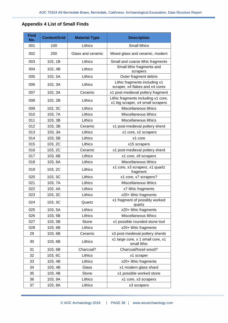
Appendix 4 List of Small Finds
Find No.
Context/Grid Material Type Description
001 100 Lithics Small lithics
002 200 Glass and ceramic Mixed glass and ceramic, modern
003 102, 1B Lithics Small and coarse lithic fragments
004 102, 4B Lithics Small lithic fragments and
scrapers
005 102, 5A Lithics Outer fragment debris
006 102, 3A Lithics Lithic fragments including x1
scraper, x4 flakes and x4 cores
007 102, 3A Ceramic x1 post-medieval pottery fragment
008 102, 2B Lithics Lithic fragments including x1 core, x1 big scraper, x4 small scrapers
009 102, 3C Lithics Miscellaneous lithics
010 103, 7A Lithics Miscellaneous lithics
011 103, 3B Lithics Miscellaneous lithics
012 103, 3B Ceramic x1 post-medieval pottery sherd
013 103, 3A Lithics x1 core, x2 scrapers
014 103, 5B Lithics x1 core
015 103, 2C Lithics x15 scrapers
016 103, 2C Ceramic x1 post-medieval pottery sherd
017 103, 6B Lithics x1 core, x9 scrapers
018 103, 6A Lithics Miscellaneous lithics
019 103, 2C Lithics x1 core, x3 scrapers, x1 quartz
fragment
020 103, 3C Lithics x1 core, x7 scrapers?
021 103, 7A Lithics Miscellaneous lithics
022 102, 4A Lithics x7 lithic fragments
023 103, 3C Lithics x20+ lithic fragments
024 103, 3C Quartz x1 fragment of possibly worked
quartz
025 103, 5A Lithics x20+ lithic fragments
026 103, 5B Lithics Miscellaneous lithics
027 103, 5B Stone x1 possible rounded stone tool
028 103, 6B Lithics x20+ lithic fragments
29 103, 6B Ceramic x3 post-medieval pottery sherds
30 103, 6B Lithics x1 large core, x 1 small core, x1
small lithic
31 103, 6B Charcoal? Charcoal/fossil wood?
32 103, 6C Lithics x1 scraper
33 103, 4B Lithics x20+ lithic fragments
34 103, 4B Glass x1 modern glass shard
35 103, 4B Stone x1 possible worked stone
36 103, 9A Lithics x1 core, x3 scrapers
37 103, 8A Lithics x3 scrapers

AOC 70324 A9 Berriedale Braes, Berriedale, Caithness: Archaeological Excavation, Data Structure Report
© AOC Archaeology 2018 | PAGE 39 | www.aocarchaeology.com
Find No.
Context/Grid Material Type Description
38 103, 8A Stone x1 worked stone
39 103, 4A Lithics x1 core, x20+ lithics
40 103, 4A Quartz Possible worked quartz
41 103, 6A Lithics x4 cores, x4 scrapers
42 103, 2B Lithics Mixed lithics including x10
scrapers, x1 core
43 104, 2D Lithics Miscellaneous lithics
44 104, 2D Quartz Miscellaneous quartz
45 104, 10A Lithics x8 flint scrapers
46 104, 5C Lithics x5 scrapers
47 104, 3D Lithics x20+ lithic fragments
48 104, 3D Glass x1 modern glass shard
49 104, 3D Quartz Possible worked quartz
50 104, 5D Lithics Mixed lithic fragments, lithic debris
51 104, 1D Lithics Mixed lithics
52 104, 3D Lithics Miscellaneous lithics
53 104, 1D Lithics Mixed lithics
54 104, 2D Lithics Miscellaneous lithics
55 201, 1A Quartz Quartz fragments
56 201, 6C Flint Miscellaneous lithics
57 201, 8C Lithics Miscellaneous lithics
58 201, 8C Quartz x1 rounded quartz pebble
59 201, 3A Quartz Miscellaneous quartz
60 201, 3A Lithics x1 lithic fragment
61 206, 7B Lithics Miscellaneous lithics
62 206, 7B Stone x1 possible worked stone
63 202, 6A Quartz and stone Quartz and possible worked stone
64 202, 6A Flint Mixed scrapers and cores
65 202, 6A Ceramic Modern ceramic
66 201, 5A Lithics Mix of cores and scrapers
67 205, 6C Stone x3 possible worked stones
68 205, 7B Lithics Mixed lithics
69 205, 7D Quartz and stone Possible worked quartz and stone
70 205, 7B Ceramic Modern ceramic
71 201, 4A Flint x1 core, x2 scrapers
72 201, 4A Flint Mix of flint including x2 cores, x15
scrapers
73 202, 8C Flint Mix of flint including x2 cores, x20
scrapers
74 201, 8A Flint Mix of flint
75 205, 8A Flint x1 scraper
76 201, 8B Flint Mix of flint including x3 cores, x12
scrapers
77 205, 8B Flint x20+ flint fragments

AOC 70324 A9 Berriedale Braes, Berriedale, Caithness: Archaeological Excavation, Data Structure Report
© AOC Archaeology 2018 | PAGE 40 | www.aocarchaeology.com
Find No.
Context/Grid Material Type Description
78 205, 8C Quartz and stone Possible worked stone and quartz
79 205, 8C Stone Rounded beach stones/pebbles
80 205, 6A Flint x2 scrapers
81 206, 8C Quartz and stone Worked stone and quartz
82 206, 8C Lithics Mix of lithics
83 201, 7A Lithics Mix of lithics including x10
scrapers, x2 cores
84 301 Stone Worked stone
85 302, 1A Metal Fe object
86 302, 3A Lithics Miscellaneous lithics
87 302, 3A Metal Fe object
88 302, 3A Ceramic x2 modern ceramic sherds
89 202, 8C Quartz and stone Possible worked stone and quartz
90 301 Quartz x1 quartz pebble
91 300 Ceramic Modern ceramic
92 Spoil Lithics Worked quartz scraper
93 302, 2A Lithics x1 core
94 300 Quartz Worked quartz
95 302, 1A Quartz Possible worked stone and quartz
96 301 Stone Possible worked stone?
97 500 Stone Possible worked stone?
98 500 Ceramic Modern ceramic
99 502, 2A Lithics Miscellaneous lithics
100 502, 2A Quartz and stone Possible worked stone and quartz
101 502, 2A Plastic/glass/amber? Plastic/glass/amber Bead
102 501 Lithics Miscellaneous lithics
103 501 Ceramic Modern ceramic
104 501 Stone Miscellaneous lithics
105 402, 1A Lithics Miscellaneous lithics
106 402, 1A Ceramic Modern ceramic
107 200 Lithics Miscellaneous lithics
108 205, 7A Lithics Miscellaneous lithics
109 201 Lithics Miscellaneous lithics
110 302, 1A Lithics Mixed lithics
111 303, 1A Lithics Mixed lithics
112 308 Lithics Mixed lithics
113 502, 1A Lithics Mixed lithics
114 201, 7A Slag x1 piece of slag
115 201, 7B Lithics Mixed lithics
116 201, 6B Lithics Mixed lithics
117 201, 7C(?) Lithics Mixed lithics
118 200 Lithics Mixed lithics

AOC 70324 A9 Berriedale Braes, Berriedale, Caithness: Archaeological Excavation, Data Structure Report
© AOC Archaeology 2018 | PAGE 41 | www.aocarchaeology.com
Find No.
Context/Grid Material Type Description
119 401 Lithics Mixed lithics
120 205, 7C Lithics Mixed lithics
121 201, 10A Lithics Mixed lithics
122 202, 7A Lithics Mixed lithics
123 201, A2 Lithics Mixed lithics
124 202, 7B Lithics Mixed lithics
125 201, 7A Lithics Mixed lithics
126 202, 8B Lithics Mixed lithics
127 202, 9A Lithics Mixed lithics
128 202, 8A Lithics Mixed lithics
129 202, 2-5A Lithics Mixed lithics
130 402, 3A Ceramic Mixed ceramic
131 205, 6B Lithics Mixed lithics
132 403, 1A Ceramic Mixed ceramic
133 205, 8A Lithics x1 flint flake
134 402, 3A Lithics Mixed lithics
135 403, 1A Lithics Mixed lithics
136 402, 3A Stone Mixed stone
137 403, 1A Lithics Mixed lithics
138 403, 3A Lithics Mixed lithics
139 100 Stone Coarse stone
140 200 Slag Possible slag
141 Spoil Lithics Miscellaneous lithics
142 Spoil Lithics From disturbance on N side of
fence line
143 200 Stone Possible stone tools
144 200 Stone Possible worked stone
145 200 Stone Possible stone tool
146 100 Quartz Miscellaneous quartz
147 501 Ceramic Modern ceramic
148 401 Ceramic Modern ceramic
150 201 Ceramic Modern ceramic
151 205, 7B(?) Lithics Miscellaneous lithics
152 402, 3A Lithics Miscellaneous lithics
153 402, 3A Ceramic Modern ceramic
154 403, 3A Quartz and stone Worked stone and quartz
155 400 Lithics Miscellaneous lithics
156 400 Ceramic Modern ceramic
157 400 Quartz Miscellaneous quartz
158 400 Metal Fe object
159 103, 6B Quartz x1 rounded quartz pebble
160 201, 6C Stone x1 rounded pebble

AOC Archaeology Group, The Old Estate Office, Rosehaugh Estate, Avoch, IV9 8RF
| tel: 01463 819841 | mob: 07972 259255 | e-mail: [email protected]