a study on groundwater and solute transport modeling … · visual modflow 3.0 package was used. it...
TRANSCRIPT

International Journal of Science and Research (IJSR) ISSN (Online): 2319-7064
Index Copernicus Value (2015): 78.96 | Impact Factor (2015): 6.391
Volume 6 Issue 6, June 2017
www.ijsr.net Licensed Under Creative Commons Attribution CC BY
A Study on Groundwater and Solute Transport
Modeling Using Visual Modflow
Sumit Kumar Gautam1, Vipin Kumar Swaroop
2
1M. Tech. Student, CED, KNIT Sultanpur
2M.Tech.Student, CED, IET Lucknow
Abstract: For solving problems of pollution source identification in groundwater. Groundwater modeling is a tool that can help to
analyze many groundwater problems. The numerical simulations of flow and contaminant solute transport in groundwater were carried
out using MODFLOW. Numerical groundwater models are an important tool for solving the groundwater hydrologist problem. In now a
day, many computer techniques and programms are popular and extensively used in ground water modeling. visual modflow are one of
them popular software that use finite difference method to solve the equation. modflow can be used to simulate the behavior of complex
problem of aquifers including the effects of irregular boundaries, heterogeneity and different processes such as groundwater flow and
contaminants transport in the ground system. This study aims to reveals that the suitability of modflow software under various
groundwater conditions. The groundwater system may be disturbed by some natural processes or artificially. To predict the groundwater
system behavior, visual modflow is the easy to use modeling environment for 2-D and 3-D groundwater flow and contaminant solute
transport simulations.
Keywords: ANN, 2D flow modeling, 3D flow modeling
1. Introduction
Groundwater is a vital source of water due to its availability
and good quality, the use of groundwater aquifers is
increasing as both a source of water supply and a medium
for transport the various hazardous wastes in the ground. As
the usage of groundwater increase, our knowledge of
groundwater systems must also expand. The Numerical
groundwater modeling is a tool that can help in studying
groundwater problems and helps us in understanding of
groundwater systems. Numerical models have been broadly
utilized for groundwater stream, groundwater investigation,
quality and amount adjustment and for groundwater
administration rehearses. Models are utilized for prescient
studies to estimate future field behavior of groundwater.
Except this, models are useful for studying different types of
flow behavior by examining hypothetical groundwater
problem. Before endeavoring such studies, we must be
known about groundwater modeling concepts, usage and its
limitation.
1.1 Groundwater model
A model is a disentangled variant of a genuine framework
that around mimics the pertinent excitation-reaction relations
of this present reality framework. Diverse arrangements of
rearranging suspicions will bring about various models, each
approximating the examined ground-water framework in an
unexpected way. The initial phase in the displaying
procedure is the development of an applied model
comprising of an arrangement of suppositions that verbally
depict the framework's piece, the vehicle forms that happen
in it, the instruments that oversee them, and the important
medium properties. This is imagined or approximated by the
modeler with the end goal of developing a model proposed
to give data to a particular issue.
1.2 Numerical Models
Once the conceptual model is convert into a mathematical
model in the form of governing equations, with associated
initial and boundary conditions, a solution can be obtained
by converting it into a numerical model and writing a
computer program for solving it using a computer.
2. Methodology
2.1 Visual modflow
MODFLOW is a computer program and it is developed by
the U.S. Geological Survey. modflow simulates 3-D
groundwater flow using a finite difference technique for
solving the governing flow equations. MODFLOW used to
solves both confined and unconfined flow equations in an
irregular flow system to simulate the groundwater flow
systems under several types of natural and artificial sources.
The flow area is subdivided into many block in which the
medium properties are assumed to be uniform. Generally, In
plain view the grid are made of mutually perpendicular lines
that may be variably spaced. Model layers can have different
thickness. A flow equation is written for each block known
as cell. Several solvers are available for solving the resulting
matrix problem in mudflow. The user can choose the best
solver for solve the particular problem. Cumulative volume
and Flow-rate for all type of inflow and outflow are
computed for each time step. Flow from external sources,
such as flow to wells, evapotranspiration, areal recharge,
flow to drains, and flow through riverbeds, seepage are
simulated. Hydraulic conductivities or transmissivities may
different for different area and be anisotropic, and the
storage coefficient may be homogeneous or heterogeneous.
Specified head, head dependent flux and specified flux
boundaries can be simulated.
Paper ID: ART20174067 546
International Journal of Science and Research (IJSR) ISSN (Online): 2319-7064
Index Copernicus Value (2015): 78.96 | Impact Factor (2015): 6.391
Volume 6 Issue 6, June 2017
www.ijsr.net Licensed Under Creative Commons Attribution CC BY
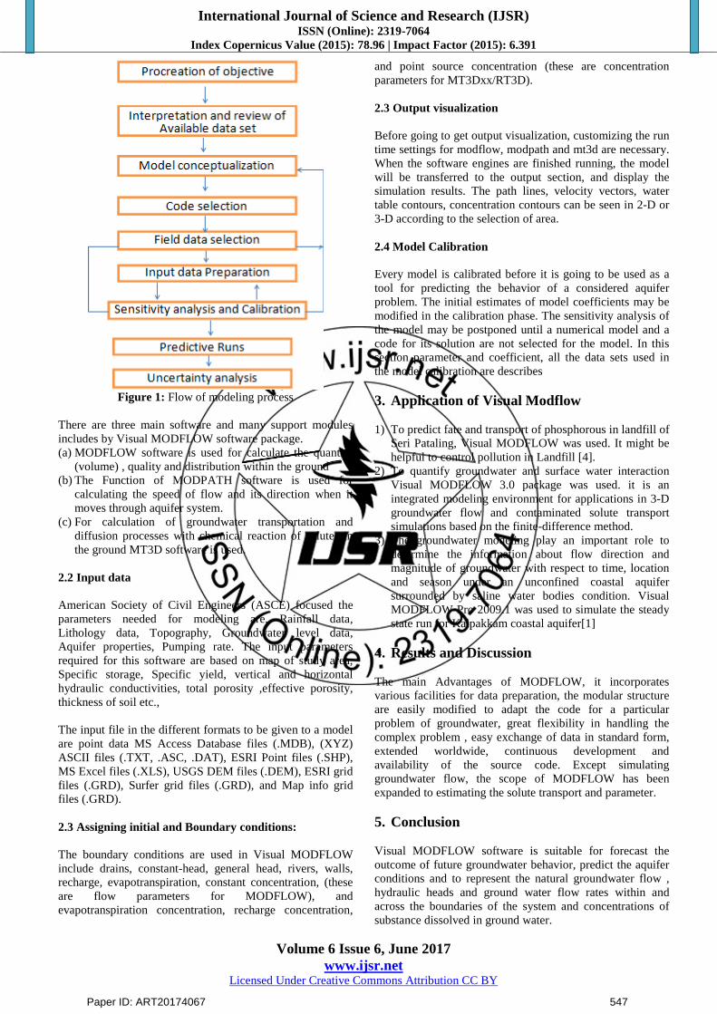
Figure 1: Flow of modeling process
There are three main software and many support modules
includes by Visual MODFLOW software package.
(a) MODFLOW software is used for calculate the quantity
(volume) , quality and distribution within the ground
(b) The Function of MODPATH software is used for
calculating the speed of flow and its direction when it
moves through aquifer system.
(c) For calculation of groundwater transportation and
diffusion processes with chemical reaction of solutes in
the ground MT3D software is used.
2.2 Input data
American Society of Civil Engineers (ASCE) focused the
parameters needed for modeling are, Rainfall data,
Lithology data, Topography, Groundwater level data,
Aquifer properties, Pumping rate. The input parameters
required for this software are based on map of study area,
Specific storage, Specific yield, vertical and horizontal
hydraulic conductivities, total porosity ,effective porosity,
thickness of soil etc.,
The input file in the different formats to be given to a model
are point data MS Access Database files (.MDB), (XYZ)
ASCII files (.TXT, .ASC, .DAT), ESRI Point files (.SHP),
MS Excel files (.XLS), USGS DEM files (.DEM), ESRI grid
files (.GRD), Surfer grid files (.GRD), and Map info grid
files (.GRD).
2.3 Assigning initial and Boundary conditions:
The boundary conditions are used in Visual MODFLOW
include drains, constant-head, general head, rivers, walls,
recharge, evapotranspiration, constant concentration, (these
are flow parameters for MODFLOW), and
evapotranspiration concentration, recharge concentration,
and point source concentration (these are concentration
parameters for MT3Dxx/RT3D).
2.3 Output visualization
Before going to get output visualization, customizing the run
time settings for modflow, modpath and mt3d are necessary.
When the software engines are finished running, the model
will be transferred to the output section, and display the
simulation results. The path lines, velocity vectors, water
table contours, concentration contours can be seen in 2-D or
3-D according to the selection of area.
2.4 Model Calibration
Every model is calibrated before it is going to be used as a
tool for predicting the behavior of a considered aquifer
problem. The initial estimates of model coefficients may be
modified in the calibration phase. The sensitivity analysis of
the model may be postponed until a numerical model and a
code for its solution are not selected for the model. In this
section parameter and coefficient, all the data sets used in
the model calibration are describes
3. Application of Visual Modflow
1) To predict fate and transport of phosphorous in landfill of
Seri Pataling, Visual MODFLOW was used. It might be
helpful to control pollution in Landfill [4].
2) To quantify groundwater and surface water interaction
Visual MODFLOW 3.0 package was used. it is an
integrated modeling environment for applications in 3-D
groundwater flow and contaminated solute transport
simulations based on the finite-difference method.
3) The groundwater modeling play an important role to
determine the information about flow direction and
magnitude of groundwater with respect to time, location
and season under an unconfined coastal aquifer
surrounded by saline water bodies condition. Visual
MODFLOW Pro 2009.1 was used to simulate the steady
state run for Kalpakkam coastal aquifer[1]
4. Results and Discussion
The main Advantages of MODFLOW, it incorporates
various facilities for data preparation, the modular structure
are easily modified to adapt the code for a particular
problem of groundwater, great flexibility in handling the
complex problem , easy exchange of data in standard form,
extended worldwide, continuous development and
availability of the source code. Except simulating
groundwater flow, the scope of MODFLOW has been
expanded to estimating the solute transport and parameter.
5. Conclusion
Visual MODFLOW software is suitable for forecast the
outcome of future groundwater behavior, predict the aquifer
conditions and to represent the natural groundwater flow ,
hydraulic heads and ground water flow rates within and
across the boundaries of the system and concentrations of
substance dissolved in ground water.
Paper ID: ART20174067 547
International Journal of Science and Research (IJSR) ISSN (Online): 2319-7064
Index Copernicus Value (2015): 78.96 | Impact Factor (2015): 6.391
Volume 6 Issue 6, June 2017
www.ijsr.net Licensed Under Creative Commons Attribution CC BY
References
[1] R. Kaviyarasan, H. Seshadri, P. Sasidhar, (2013)
“Assessment of groundwater flow model for an
unconfined coastal aquifer”, International Journal of
Innovative Research in Science, Engineering and
Technology Volume 2, Special Issue 1, December 2013,
ISSN (Online) : 2319 – 8753 ISSN (Print) : 2347 – 6710.
[2] G Saner, W. Barclay Shoemaker (2004) “Important
Observations and Parameters for a Salt Water
Intrusion Model”, GROUND WATER, Vol. 42 No. 6,
November–December 2004, pp 829–840
[3] Jemaneh Shibru Wake,(2008) “Surface water
interaction modeling using visual MODFLOW and
GIS” Groundwater –, June 2008.
[4] Seyed Reza Saghravani and Sa’ari Mustapha, (2011)
“Prediction of Contamination Migration in an
Unconfined Aquifer with Visual MODFLOW: A Case
Study”, World Applied Sciences Journal 14 (7): 1102-
1106, 2011 ISSN 1818-4952 © IDOSI Publications,
2011
[5] Seyed reza saghravan, (2009) “Prediction of
phosphorus concentration in an unconfined aquifer
using visual mudflow”, University Putra publication
Malaysia, May 2009.
[6] http://www.sciencedirect.com/modflow
[7] http://www.google.com/visual Modflow
Paper ID: ART20174067 548