a proposed revision to the definition of … proposed revision to the definition of “derecho ......
TRANSCRIPT

A revised, more physically based definition of “derecho” is proposed that is more specific to the
type of intense convective windstorm that first inspired the term in the late-nineteenth century.
A PROPOSED REVISION TO THE DEFINITION OF “DERECHO”
by Stephen F. CorFidi, MiChael C. Coniglio, ariel e. Cohen, and Corey M. Mead
AFFILIATIONS: CorFidi, Cohen, and Mead—NOAA/National Weather Service/Storm Prediction Center, Norman, Oklahoma; Coniglio—NOAA/National Severe Storms Laboratory, Norman, OklahomaCORRESPONDING AUTHOR: Stephen F. Corfidi, NOAA/NWS/NCEP/Storm Prediction Center, 120 Boren Blvd., Suite 2030, Norman, OK 73026E-mail: [email protected]
The abstract for this article can be found in this issue, following the table of contents.DOI:10.1175/BAMS-D-14-00254.1
In final form 18 August 2015
O n 4–5 April 2011, an expansive quasi-linear convective system (QLCS) crossed the southern and eastern United States accompanied by a
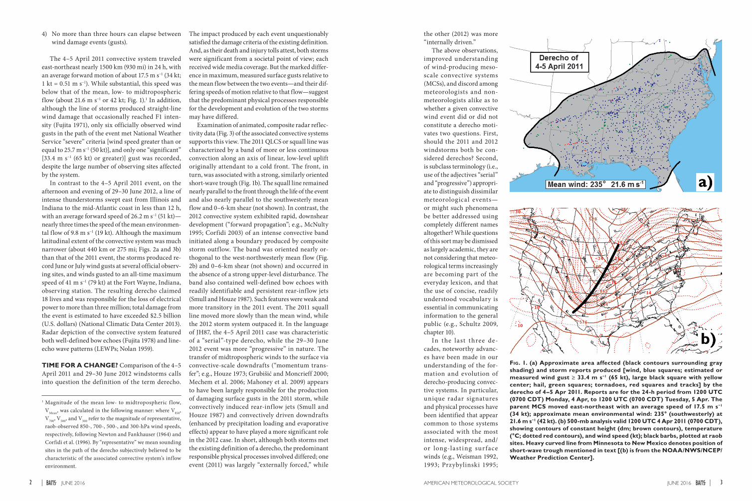
broad swath of strong winds that produced a record number (1096) of nonduplicate damaging wind reports and nearly four-dozen tornadoes in a 24-h period (Figs. 1a and 3a). The windstorm extended more than 1000 km (620 mi) from the Ohio River southward to the Gulf Coast and was responsible for several deaths, at least 30 injuries, and millions of dollars in damage, mainly to trees and power lines.
Collectively, the spatial and temporal extent of the damage easily met the definition of a “derecho” as given by Johns and Hirt (1987, hereafter JH87): "Any family of downburst clusters associated with an
extratropical mesoscale convective system," a defini-tion that only has been slightly modified in more recent years (American Meteorological Society 2014):
A widespread, convectively induced straight-line windstorm, more specifically, any family of down-burst clusters produced by an extratropical meso-scale convective system.
The event also satisfied the following supplemen-tary criteria established by JH87 based on Fujita and Wakimoto (1981) to identify derecho events in Storm Data and in the National Severe Storms Forecast Center (predecessor to the Storm Prediction Center) database:
1) There must be a concentrated area of reports con-sisting of convectively induced wind damage and/or convective gusts > 25.7 m s−1 (50 kt). This area must have a major axis of at least 400 km (250 mi).
2) The reports within this area must also exhibit a nonrandom pattern of occurrence; that is, the reports must show a pattern of chronolog ical progression, whether as a singular swath (pro-gressive) or a series of swaths (serial).
3) Within the area there must be at least three reports, separated by 64 km (40 mi) or more, of either F1 or greater damage (Fujita 1971) and/or “significant” convective gusts of 33.4 m s−1 (65 kt) or greater.
1JUNE 2016AMERICAN METEOROLOGICAL SOCIETY |
4) No more than three hours can elapse between wind damage events (gusts).
The 4–5 April 2011 convective system traveled east-northeast nearly 1500 km (930 mi) in 24 h, with an average forward motion of about 17.5 m s−1 (34 kt; 1 kt = 0.51 m s−1). While substantial, this speed was below that of the mean, low- to midtropospheric flow (about 21.6 m s−1 or 42 kt; Fig. 1).1 In addition, although the line of storms produced straight-line wind damage that occasionally reached F1 inten-sity (Fujita 1971), only six officially observed wind gusts in the path of the event met National Weather Service “severe” criteria [wind speed greater than or equal to 25.7 m s−1 (50 kt)], and only one “significant” [33.4 m s−1 (65 kt) or greater)] gust was recorded, despite the large number of observing sites affected by the system.
In contrast to the 4–5 April 2011 event, on the afternoon and evening of 29–30 June 2012, a line of intense thunderstorms swept east from Illinois and Indiana to the mid-Atlantic coast in less than 12 h, with an average forward speed of 26.2 m s−1 (51 kt)—nearly three times the speed of the mean environmen-tal flow of 9.8 m s−1 (19 kt). Although the maximum latitudinal extent of the convective system was much narrower (about 440 km or 275 mi; Figs. 2a and 3b) than that of the 2011 event, the storms produced re-cord June or July wind gusts at several official observ-ing sites, and winds gusted to an all-time maximum speed of 41 m s−1 (79 kt) at the Fort Wayne, Indiana, observing station. The resulting derecho claimed 18 lives and was responsible for the loss of electrical power to more than three million; total damage from the event is estimated to have exceeded $2.5 billion (U.S. dollars) (National Climatic Data Center 2013). Radar depiction of the convective system featured both well-defined bow echoes (Fujita 1978) and line-echo wave patterns (LEWPs; Nolan 1959).
TIME FOR A CHANGE? Comparison of the 4–5 April 2011 and 29–30 June 2012 wind storms calls into question the definition of the term derecho.
Fig. 1. (a) Approximate area affected (black contours surrounding gray shading) and storm reports produced [wind, blue squares; estimated or measured wind gust ≥ 33.4 m s−1 (65 kt), large black square with yellow center; hail, green squares; tornadoes, red squares and tracks] by the derecho of 4–5 Apr 2011. Reports are for the 24-h period from 1200 UTC (0700 CDT) Monday, 4 Apr, to 1200 UTC (0700 CDT) Tuesday, 5 Apr. The parent MCS moved east-northeast with an average speed of 17.5 m s−1 (34 kt); approximate mean environmental wind: 235° (southwesterly) at 21.6 m s−1 (42 kt). (b) 500-mb analysis valid 1200 UTC 4 Apr 2011 (0700 CDT), showing contours of constant height (dm; brown contours), temperature (°C; dotted red contours), and wind speed (kt); black barbs, plotted at raob sites. Heavy curved line from Minnesota to New Mexico denotes position of short-wave trough mentioned in text [(b) is from the NOAA/NWS/NCEP/Weather Prediction Center].
1 Magnitude of the mean low- to midtropospheric f low, VMean, was calculated in the following manner: where V850, V700, V500, and V300 refer to the magnitude of representative, raob-observed 850-, 700-, 500-, and 300-hPa wind speeds, respectively, following Newton and Fankhauser (1964) and Corfidi et al. (1996). By “representative” we mean sounding sites in the path of the derecho subjectively believed to be characteristic of the associated convective system’s inflow environment.
The impact produced by each event unquestionably satisfied the damage criteria of the existing definition. And, as their death and injury tolls attest, both storms were significant from a societal point of view; each received wide media coverage. But the marked differ-ence in maximum, measured surface gusts relative to the mean flow between the two events—and their dif-fering speeds of motion relative to that flow—suggest that the predominant physical processes responsible for the development and evolution of the two storms may have differed.
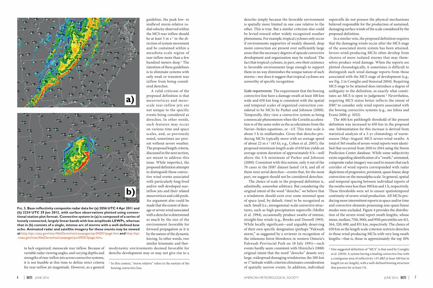
Examination of animated, composite radar reflec-tivity data (Fig. 3) of the associated convective systems supports this view. The 2011 QLCS or squall line was characterized by a band of more or less continuous convection along an axis of linear, low-level uplift originally attendant to a cold front. The front, in turn, was associated with a strong, similarly oriented short-wave trough (Fig. 1b). The squall line remained nearly parallel to the front through the life of the event and also nearly parallel to the southwesterly mean flow and 0–6-km shear (not shown). In contrast, the 2012 convective system exhibited rapid, downshear development (“forward propagation”; e.g., McNulty 1995; Corfidi 2003) of an intense convective band initiated along a boundary produced by composite storm outf low. The band was oriented nearly or-thogonal to the west-northwesterly mean flow (Fig. 2b) and 0–6-km shear (not shown) and occurred in the absence of a strong upper-level disturbance. The band also contained well-defined bow echoes with readily identifiable and persistent rear-inflow jets (Smull and Houze 1987). Such features were weak and more transitory in the 2011 event. The 2011 squall line moved more slowly than the mean wind, while the 2012 storm system outpaced it. In the language of JH87, the 4–5 April 2011 case was characteristic of a “serial”-type derecho, while the 29–30 June 2012 event was more “progressive” in nature. The transfer of midtropospheric winds to the surface via convective-scale downdrafts (“momentum trans-fer”; e.g., Houze 1973; Grubišić and Moncrieff 2000; Mechem et al. 2006; Mahoney et al. 2009) appears to have been largely responsible for the production of damaging surface gusts in the 2011 storm, while convectively induced rear-inf low jets (Smull and Houze 1987) and convectively driven downdrafts (enhanced by precipitation loading and evaporative effects) appear to have played a more significant role in the 2012 case. In short, although both storms met the existing definition of a derecho, the predominant responsible physical processes involved differed; one event (2011) was largely “externally forced,” while
the other (2012) was more “internally driven.”
The above observations, improved understanding of wind-producing meso-scale convective systems (MCSs), and discord among meteorologists and non-meteorologists alike as to whether a given convective wind event did or did not constitute a derecho moti-vates two questions. First, should the 2011 and 2012 windstorms both be con-sidered derechos? Second, is subclass terminology (i.e., use of the adjectives “serial” and “progressive”) appropri-ate to distinguish dissimilar meteorological events—or might such phenomena be better addressed using completely different names altogether? While questions of this sort may be dismissed as largely academic, they are not considering that meteo-rological terms increasingly are becoming part of the everyday lexicon, and that the use of concise, readily understood vocabulary is essential in communicating information to the general public (e.g., Schultz 2009, chapter 10).
In the last three de-cades, noteworthy advanc-es have been made in our understanding of the for-mation and evolution of derecho-producing convec-tive systems. In particular, unique radar signatures and physical processes have been identified that appear common to those systems associated with the most intense, widespread, and/or long-last ing sur face winds (e.g., Weisman 1992, 1993; Przybylinski 1995;
3JUNE 2016AMERICAN METEOROLOGICAL SOCIETY |2 JUNE 2016|

Radar-1988 Doppler (WSR-88D) radar imagery and are distinguishable from QLCSs or “squall lines” whose me-sobeta- and mesogamma-scale (≥20 and ≥2 km, re-spectively; see Orlanski 1975) elements typically are oriented more parallel to their direction of motion, and move more nearly with the speed of the mean wind. The serial derechos in JH87 primarily were associated with QLCSs; the proposed definition would in most cases exclude wind events produced by QLCSs from being considered derechos unless the convective sys-tems contained sustained, progressive-type elements.
Rear-inflow jets may not be easily identifiable in radar imagery if the main axis of the jet is orthogonal to the radar beam. However, the proposed definition only requires evidence of a me-soscale rear-inf low jet at some point during the pe-riod when bow echoes are apparent in the plan-view re-flectivity imagery. With the requirement that the main axis of wind reports pro-duced after the MCS stage of the system has been attained extend at least 650 km (ap-proximately 400 mi), and the fact that systems deemed to be progressive derechos almost always move faster than 18 m s−1 (35 kt) (Cohen et al. 2007), in areas well covered by Doppler radar, at least one radar site typically will sample the along-jet component of the wind at some point in the feature’s lifetime. Although it is rea-sonable to assume that an organized mesoscale bow-echo structure is accompanied by a rear-inflow jet, the requirement for evidence of a rear-inflow jet is made to eliminate systems that have bow-shaped leading edges
but do not result from the mesoconvective bow-echo organization described in Weisman (1993). For ex-ample, large, spreading cold pools sometimes initiate long, arc-shaped bands of convective cells, particularly in environments with low levels of free convection. These types of multicellular systems, however, tend
Fig. 2. (a) As for Fig. 1, except for the derecho of 29–30 Jun 2012. Reports are for the 24-h period from 1200 UTC (0700 CDT) Friday, 29 Jun, to 1200 UTC (0700 CDT) Saturday, 30 Jun. Areal outline dashed in Iowa and part of Illinois to reflect the derecho’s origin from convection in that region that did not immediately produce continuous derecho-like conditions. Areal outline also dashed in North Carolina to reflect that many of the damaging wind gusts there occurred south of the thunderstorms that produced them. The parent MCS moved east-southeast with an average speed of 26.2 m s−1 (51 kt); ap-proximate mean environmental wind: 300° (west-northwesterly) at 9.8 m s−1 (19 kt). (b) 500-mb analysis valid 1200 UTC 29 Jun 2012 (0700 CDT), showing contours of constant height (dm; brown contours), temperature (°C; dotted red contours), and wind speed (kt); black barbs, plotted at raob sites. [(b) is from NOAA/NWS/NCEP/Weather Prediction Center.]
Klimowski et al. 2003; Trapp and Weisman 2003; Weisman and Trapp 2003; Wakimoto et al. 2006; Atkins and St. Laurent 2009). In addition, severe weather reporting capabilities and strategies have changed considerably since the mid-1980s (e.g., Weiss et al. 2002; Trapp et al. 2006), when JH87, building on the work of Hinrichs (1888) and Fujita and Wakimoto (1981), formally reintroduced the word “derecho” to the meteorological community and established the severe-wind report criteria that remain in use today. Considering all the above, and the fact that wind-storms of notably different character and evolution are given the same name, it seems appropriate at this time to review the present definition of “derecho”—and perhaps consider a revision.
A PROPOSAL. A proposed revision to the defini-tion of “derecho” follows below. The primary aims of the revision are to make the definition somewhat more restrictive and physically based. This proposal is not intended to be final or all encompassing, but rather an initial step toward an improved taxonomy that, at some point, also could include other forms of damaging wind-producing mesoscale convective sys-tems based on the predominant physical process(es) responsible for their development and maintenance.
Derecho: A family of damaging downburst clusters associated with a forward-propagating, mesoscale convective system (MCS) that, during part of its existence, displays evidence of one or more sus-tained bow echoes with mesoscale vortices and/or rear-inflow jets. The damage swath must be nearly continuous, at least 100 km (~60 mi or about 1° latitude) wide along most of its extent, and 650 km (~400 mi) long. The damage also must occur after any preliminary storms have organized into a cold-pool-driven MCS.
The proposed definition reflects the belief that the term “derecho” should be reserved for particularly notable damaging windstorms produced by highly organized and longer-lasting MCSs, most of which would be classified as progressive-type events using the JH87 criteria. “Forward-propagating,” “rear-in-flow jet,” and “cold pool” are mentioned specifically, as both observational and numerical studies suggest that long-lived convective windstorms most often are associated with MCSs that feature rapid, downshear (forward) propagation of intense thunderstorms along an elongating cold pool’s gust front, augmented by the presence of a bow echo and rear-inflow jet. “Forward propagating” implies that the damaging
winds occur sequentially in a direction roughly paral-lel to the parent convective system’s motion, that the convective system’s major axis is oriented at a large angle (often nearly orthogonal) to that motion, and that the system moves faster than the mean wind. The proposed definition, therefore, reflects a view that only convective systems characterized by the unique, mesoscale organization of bowing convec-tive line segments with sustained rear inflow such as those described in Fujita (1978), Weisman (1993), and Weisman (2001) should be considered candidates for producing derechos.2
Physical criteria. A weakness of any physically based definition of a meteorological phenomenon is that the actual mechanisms responsible for the phenomenon (in this case, for the production of severe surface winds) never are completely known, either during or after an event. In addition, such processes typically vary over space and time. For example, the high winds observed over Kansas during the so-called Super Derecho of 8–9 May 2009 were associated with a clas-sic bow echo and book-end vortex that subsequently evolved into a larger-scale, warm-core circulation with more widespread wind damage downstream across the Ozarks and Mississippi Valley (Coniglio et al. 2011; Weisman et al. 2013; Evans et al. 2014). Furthermore, the mere presence of a larger-scale embedded circulation or mesoscale convective vortex does not guarantee that the parent convective system will produce damaging wind; for example, because of near-surface stable layers and other factors, long-lived bow echoes occasionally occur in the absence of widespread, damaging surface winds. For these reasons, the source of strong wind production in the proposed definition is not explicitly stated but rather is implied though use of the terms “bow echo” and “forward propagating.”
Even though not all aspects of their development and evolution are understood, the presence of bow echoes and forward propagation in an MCS neverthe-less provide inferences regarding the kinematic pro-cesses likely involved in the system’s development and its propensity for damaging wind. Bow echoes and forward-propagating line segments are readily ap-parent in animated, plan-view Weather Surveillance
2 While it is intended that these criteria be followed as closely as possible, consideration occasionally must be given to situations where the criteria are not strictly met owing to nonmeteorological factors such as population density, num-ber of observing sites, and geography, as will be discussed in “Use of storm reports.”
5JUNE 2016AMERICAN METEOROLOGICAL SOCIETY |4 JUNE 2016|
to lack organized, mesoscale rear inflow. Because of variable radar viewing angles, and varying depths and strengths of rear-inflow jets across convective systems, it is not feasible at this time to define strict criteria for rear-inflow jet magnitude. However, as a general
Fig. 3. Base reflectivity composite radar data for (a) 2056 UTC 4 Apr 2011 and (b) 2234 UTC 29 Jun 2012, with surface observations plotted using conven-tional station plot format. Convective system in (a) is composed of a series of loosely connected, largely linear bands with low-amplitude LEWPs, whereas that in (b) consists of a single, intense arc of storms with a well-defined bow echo. Animated radar and satellite imagery for these events may be viewed at http://spc.noaa.gov/misc/AbtDerechos/casepages/apr042011page.htm and http://spc .noaa.gov/misc/AbtDerechos/casepages/jun292012page.htm.
derecho simply because the favorable environment is spatially more limited in one case relative to the other. This is true. But a similar criticism also could be levied toward other widely recognized weather phenomena. For example, tropical cyclones only occur if environments supportive of weakly sheared, deep moist convection are present over sufficiently large areas that the necessary degrees of upscale convective development and organization may be realized. The fact that tropical cyclones, in part, owe their existence to favorable environments large enough to support them in no way diminishes the unique nature of such storms—nor does it suggest that tropical cyclones are unworthy of specific recognition.
Scale requirements. The requirement that the bowing convective line have a damage swath at least 100 km wide and 650 km long is consistent with the spatial and temporal scales of organized convection con-sidered to be MCSs by Parker and Johnson (2000). Temporally, they view a convective system as being a mesoscale phenomenon when the Coriolis accelera-tion is of the same order as the accelerations from the Navier–Stokes equations, or ~1/f. This time scale is about 3 h in midlatitudes. Given that derecho-pro-ducing MCSs typically move with an average speed of about 22 m s−1 (43 kt; e.g., Cohen et al. 2007), the proposed minimum length scale of 650 km yields an average system duration of approximately 8 h—well above the 3-h minimum of Parker and Johnson (2000). Consistent with this notion, only 4 out of the 70 cases in the JH87 dataset lasted ≤4 h, and all of them were serial derechos—events that, for the most part, we suggest should not be considered derechos.
The choice of scale in the proposed definition is, admittedly, somewhat arbitrary. But considering the original intent of the word “derecho,” we believe that a windstorm should exist over some minimal span of space (and, by default, time) to be recognized as such. Small (i.e., mesogamma)-scale convective struc-tures, such as high-precipitation supercells (Moller et al. 1994), occasionally produce swaths of intense, straight-line winds (e.g., Brooks and Doswell 1993). While locally significant—and arguably deserving of their own specific designation (perhaps “Pakwash storm,” as suggested by a reviewer in recognition of the infamous forest blowdown in western Ontario’s Pakwash Provincial Park on 18 July 1991)—such events hardly seem consistent with Hinrichs’s (1888) original intent that the word “derecho” denote very large, widespread damaging windstorms; the 100-km or 1° latitude width criterion eliminates consideration of spatially narrow events. In addition, individual
supercells do not possess the physical mechanisms believed responsible for the production of sustained, damaging surface winds of the scale considered by the proposed definition.
In a similar vein, the proposed definition requires that the damaging winds occur after the MCS stage of the associated storm system has been attained. Severe-wind-producing MCSs often develop from clusters of more isolated storms that may them-selves produce wind damage. When the reports are plotted chronologically, it sometimes is difficult to distinguish such wind damage reports from those associated with the MCS stage of development (e.g., see Fig. 2 in Coniglio and Stensrud 2004). Requiring MCS stage to be attained does introduce a degree of ambiguity to the definition, as exactly what consti-tutes an MCS is open to judgement.4 Nevertheless, requiring MCS status better ref lects the intent of JH87 to consider only wind reports associated with the bowing convective systems (e.g., see Johns and Evans 2000, p. 1052).
The 400-km pathlength threshold of the present definition was increased to 650 km in the proposed one. Substantiation for this increase is derived from statistical analysis of a 5-yr climatology of warm-season (May–August) MCS severe-wind swaths. A total of 365 swaths of severe-wind reports were identi-fied that occurred from 2010 to 2014 using the Storm Prediction Center database. While some subjectivity exists regarding identification of a “swath,” animated, composite radar imagery was used to ensure that each corridor of wind reports corresponded with radar depictions of progressive, persistent, quasi-linear, deep convection on the mesoalpha scale. In general, spatial and temporal spacing between individual reports of the swaths were less than 100 km and 1 h, respectively. These thresholds were set to ensure spatiotemporal continuity of severe-wind production. All MCSs pro-ducing more intermittent reports in space and/or time and convective elements possessing non-quasi-linear modes were excluded. Figure 4 provides the distribu-tion of the severe-wind report swath lengths, whose mean, median, 75th, 90th, and 95th percentiles are 411, 364, 520, 690, and 851 km, respectively. The choice of 650 km as the length scale criterion restricts derechos to those wind-producing MCSs with very long swath lengths—that is, those in approximately the top 10%
3 In this context, “storm relative” refers to the motion of the bowing convective line.
guideline, the peak low- to midlevel storm-relative ra-dial velocity observed within the MCS rear inflow should be at least 5 m s−1 in the di-rection of system movement and be contained within a mesobeta-scale region of rear inflow more than a few hundred meters deep.3 The intention of these guidelines is to eliminate systems with only weak or transient rear inf low from being consid-ered derechos.
A valid criticism of the proposed definition is that mesovortices and meso-scale rear-inf low jets are not unique to the specific events being considered as derechos. In other words, such features may occur on various time and space scales, and, as previously noted, sometimes are pres-ent without severe weather. The proposed length criteria, discussed in the next section, are meant to address this issue. While imperfect, the proposed definition attempts to distinguish those convec-tive wind events associated with particularly long-lived and/or well-developed rear-inflow jets and their related mesovortices and cold pools. An argument also could be made that the extent of dam-age or severe wind associated with a derecho is determined as much by the size of the environment favorable for forward propagation as it is by the nature of the dynamic forcing. In other words, two similar kinematic and ther-
modynamic environments deemed favorable for derecho development may or may not give rise to a
4 One suggested definition of “MCS” is that used by Coniglio et al. (2010): A system having a leading convective line with a contiguous area of reflectivity ≥35 dBZ at least 100 km in length (or arc length), with a well-defined bowing structure that persists for at least 3 h.
7JUNE 2016AMERICAN METEOROLOGICAL SOCIETY |6 JUNE 2016|

or 15% of the swath-length climatology. This cutoff yields roughly 25 derechos in the period from 2010 to 2014—approximately 5 per year. While the percentile ranking and corresponding swath-length selections may be viewed as arbitrary, the method provides at least a partially objective basis for the proposed thresh-old.5 Furthermore, because the proposed definition eliminates the requirement of three or more 33.4 m s−1 (65 kt) or greater wind gusts (discussed later in “Use of storm reports”), if the 400-km length criteria were retained, far more wind events would be deemed derechos—the median of the swaths over the 5-yr pe-riod was approximately 400 km. Therefore, the length criterion was increased to ensure that only persistent, comparatively rare, severe-wind-producing MCS events are labeled as derechos.
The term “derecho” recently has come into more widespread use by the general public, especially since the noteworthy 29 June 2012 event that struck parts of the Ohio Valley and mid-Atlantic states. The increased use of the word highlights the fact that an ideal defini-tion should be not only scientifically sound but also societally relevant. The 650-km damage swath require-ment ensures that a severe-wind-producing convective system of even modest width likely will produce appre-ciable human impact, particularly in those parts of the world where convective windstorms most often occur. On the other hand, convective wind events that satisfy all of the derecho criteria in the proposed definition except for the 650-km length scale occur on a fairly regular basis. A question that necessarily arises is how such smaller events are best addressed, particularly from a societal impacts point of view. In keeping with the desire to adopt a more physically based nomencla-ture of severe convective windstorms, yet recognizing that the proposed length scale, while necessary, also is somewhat arbitrary, we propose that systems of more limited extent be referred to as “mini” or “pocket” derechos. Such terminology conveys the notion that severe and/or damaging winds may accompany a storm system whose dimensions fall short of those typically considered derechos. Use of these terms (or similar ones) also could obviate the counterproductive, poste-vent debate regarding the derecho or “nonderecho” status of given storms. At the very least, this approach
acknowledges that natural phenomena often do not lend themselves to convenient categorization!
Use of storm reports. The first author, as a colleague of Messrs. Johns and Hirt at the National Severe Storms Forecast Center during their preparation of JH87 in the mid-1980s, can attest that “typical” warm-season derechos (e.g., those over the mid-Mississippi or Ohio Valleys in July) at that time rarely garnered more than several dozen severe-wind or damage reports. By contrast, weak wind-producing convective systems today frequently tally several times that number, ref lecting, in part, improved data-gathering and verification techniques (e.g., Johns and Evans 2000, 1050–1051). In addition, the ratio of measured-to-reported severe-wind events is much lower over the eastern United States compared to areas farther west (Smith et al. 2013). Such factors make it difficult to place a given derecho in historical perspective or to assess its meteorological significance using storm reports alone. These observations are a major part of the motivation to include radar-observed storm structures and implied physical processes in the pro-posed derecho definition—a change that, by default, places somewhat less emphasis on severe weather (storm) reports.6
Deemphasizing report coverage reduces the influ-ence of nonmeteorological factors like population density, land use, vegetation type, and evolving severe weather reporting strategies that are inherent in the present definition and places the proposed one on a more firm scientific foundation. It also reflects the perhaps idealistic view that, at some future point, poststorm analysis will be more focused on the meteorological processes responsible for the severe and/or damaging winds rather than on the “second guessing” of damage reports—some of which are of questionable quality and show a considerable range of significance (e.g., “small branches downed” vs “widespread structural damage”).
Nevertheless, despite numerous misgivings re-garding the severe-wind and damage report database, it is not feasible, nor desirable, to eliminate altogether the use of severe weather reports. Most obviously, convective systems would be of little human interest
if some did not pro-duce severe or dam-aging wind. But given that some bow-shaped MCSs produce little or no damage, while long-lived convective wind events occasionally oc-cur in the absence of bows, it is clear that meteorological under-standing has not yet progressed to the point that convective systems may be classified based on physical character-istics alone. Therefore, until high-resolution, dua l-Doppler radar data become available on a nationwide basis and knowledge is more complete, arguably one of the best ways to estimate a storm system’s strength and, indirectly, its physical nature, is through examination of its wind and damage reports.
Because of the coarse nature of the surface-obser-vation network, and in an attempt to minimize the effects of variable population density, the requirement for three or more measured, significant severe-wind gusts [≥33.4 m s−1 (65 kt)] and/or evidence of F1 damage was dropped. Coniglio and Stensrud (2004) showed that derecho climatology changed substan-tially (i.e., the number of identified events increased) when three or more significant gusts were not re-quired. However, their climatology included both progressive and serial derechos and also included wind reports from before the events reached the MCS stage of development; the proposed definition would eliminate most serial events and would include only those gusts and/or damage reports that occurred following attainment of MCS structure. Because the proposed definition requires a bowing system with evidence of a sustained rear-inflow jet and also in-troduces a width criterion, the number of events up for consideration as derechos likely will be reduced relative to the present.
It should be noted that the significant wind gust reports used to satisfy the JH87 criteria often are estimated and not measured (Coniglio and Stensrud 2004). Ideally, the proposed definition would include a measured significant wind gust criterion to ensure that only the most intense MCS-produced wind-storms were called derechos, as originally intended
by JH87. But the density of surface-observation sites remains coarse relative to the scale of MCSs and especially to the scale of sub-MCS features (e.g., me-soscale convective vortices or macrobursts) known to be responsible for much of the most intense damage within bowing convective systems (Miller and Johns 2000; Miller et al. 2002; Wakimoto et al. 2006; Atkins and St. Laurent 2009). Furthermore, in the spirit of trying to limit the impact of the large uncertainties present in the storm-report database, elimination of the significant gust criterion reduces the influence of overestimation bias—a factor known to be char-acteristic of humans exposed to very strong winds (Agdas et al. 2012).
Additional motivation for not including a mea-sured significant gust requirement is illustrated by the two long-lived damaging wind events shown in Figs. 5 and 6. The first event (Fig. 5) was associated with a convective system that formed over eastern Kentucky and southwest Virginia on the evening of 10–11 May 2011. The MCS subsequently moved rapidly south-southeastward with a speed approximately twice that of the mean environmental flow before moving off the South Carolina coast after 0800 UTC 11 May. Although the storm produced a nearly continuous, 700-km (435 mi) swath of wind damage and was re-sponsible for two deaths (due to falling trees), only one official severe gust [27.8 m s−1 (54 kt) at Greer, South Carolina] was recorded. In addition, no significant gusts were observed. Therefore, the event would not be considered a derecho by the present definition. A cross section of the bow-shaped convective system
Fig. 4. Histogram of report swath lengths for the 365 wind-producing MCSs examined over the continental United States during May through Aug of the years 2010–14. Length (in 100-km bins) on horizontal axis; number of events on vertical axis.
5 The length tabulations obtained in this study necessarily un-derestimated the horizontal extent of those wind-producing MCSs that moved offshore or into neighboring countries be-yond the borders of the continental United States. However, such systems represented less than 5% of the total population of events and are not believed to have significantly skewed the data.
6 While not part of the current definition of a derecho, we also suggest eliminating the “3-h elapse” criteria (criteria 4 in JH87) in future derecho studies as it is very unlikely for a 3-h report gap to exist during the passage of a derecho-producing convective system today except, perhaps, in very sparsely populated areas, like eastern Montana or the western Dakotas.
9JUNE 2016AMERICAN METEOROLOGICAL SOCIETY |8 JUNE 2016|
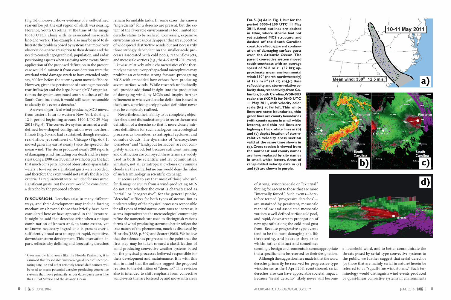
(Fig. 5d), however, shows evidence of a well-defined rear-inflow jet, the exit region of which was nearing Florence, South Carolina, at the time of the image (0640 UTC), along with its associated mesoscale line-end vortex. This example also may be used to il-lustrate the problem posed by systems that move over observation-sparse areas prior to their demise and the need to consider geographical, population, and radar positioning aspects when assessing some events. Strict application of the proposed definition in the present case would eliminate it from consideration were the overland wind damage swath to have extended only, say, 600 km before the storm system moved offshore. However, given the persistence of a strong mesoscale rear-inflow jet and the large, bowing MCS organiza-tion as the system continued south-southeast off the South Carolina coast, it would still seem reasonable to classify this event a derecho.7
An even longer-lived wind-producing MCS moved from eastern Iowa to western New York during a 12-h period beginning around 1400 UTC 29 May 2011 (Fig. 6). The convective system assumed a well-defined bow-shaped configuration over northern Illinois (Fig. 6b) and had a sustained, though elevated, rear-inf low jet southwest of Chicago (Fig. 6d). It moved generally east at nearly twice the speed of the mean wind. The storm produced nearly 200 reports of damaging wind (including one death and five inju-ries) along a 1300 km (700 nmi) swath, despite the fact that much of its path included observation-sparse lake waters. However, no significant gusts were recorded, and therefore the event would not satisfy the derecho criteria if a requirement were included for measured significant gusts. But the event would be considered a derecho by the proposed scheme.
DISCUSSION. Derechos arise in many different ways, and their development may include forcing mechanisms beyond those that brief ly have been considered here or have appeared in the literature. It might be said that derechos arise when a unique combination of known and, to some extent, yet unknown necessary ingredients is present over a sufficiently broad area to support rapid, repetitive, downshear storm development. This observation, in part, reflects why defining and forecasting derechos
remain formidable tasks. In some cases, the known “ingredients” for a derecho are present, but the ex-tent of the favorable environment is too limited for derecho status to be realized. Conversely, expansive environments occasionally appear that are supportive of widespread destructive winds but not necessarily those strongly dependent on the smaller-scale pro-cesses associated with cold pools, rear-inflow jets, and mesoscale vortices (e.g., the 4–5 April 2011 event). Likewise, relatively subtle characteristics of the ther-modynamic setup or perhaps cloud microphysics may prohibit an otherwise strong forward-propagating MCS with embedded bow echoes from producing severe surface winds. While research undoubtedly will provide additional insight into the production of damaging winds by MCSs and inspire further refinement to whatever derecho definition is used in the future, a perfect, purely physical definition never may be completely realized.
Nevertheless, the inability to be completely objec-tive should not dissuade attempts to revise the current definition of a derecho so that it more closely mir-rors definitions for such analogous meteorological processes as tornadoes, extratropical cyclones, and cumulus clouds. The dynamics of “mesocyclone tornadoes” and “landspout tornadoes” are not com-pletely understood, but because sufficient meaning and distinction are conveyed, these terms are widely used in both the scientific and lay communities. Similarly, not all extratropical cyclones or cumulus clouds are the same, but no one would deny the value of such terminology in scientific exchange.
It seems safe to say that most of those who suf-fer damage or injury from a wind-producting MCS do not care whether the event is characterized as “serial” or “progressive”; for the general public, “derecho” suffices for both types of storms. But as understanding of the physical processes responsible for all types of windstorms continues to increase, it seems imperative that the meteorological community refine the nomenclature used to distinguish various forms of wind-producing storms to better reflect the true nature of the phenomena, much as discussed by Hinrichs (1888, p. 309) and Scorer (1963). We believe that the science has progressed to the point that the first step may be taken toward a classification of wind-producing convective weather systems based on the physical processes believed responsible for their development and maintenance. It is with this aim in mind that the authors suggest the proposed revision to the definition of “derecho.” This revision also is intended to shift emphasis from convective wind events that are fostered by and move with areas
7 Over narrow land areas like the Florida Peninsula, it is assumed that reasonable “meteorological license” incorpo-rating satellite and other remotely sensed data sources will be used to assess potential derecho-producing convective systems that move primarily across data-sparse areas like the Gulf of Mexico and the Atlantic Ocean.
Fig. 5. (a) As in Fig. 1, but for the period 0000–1200 UTC 11 May 2011. Areal outlines are dashed in Ohio, where storms had not yet attained MCS structure, and dashed off the South Carolina coast, to reflect apparent continu-ation of damaging surface gusts over the Atlantic Ocean. The parent convective system moved south-southeast with an average speed of 26.8 m s−1 (52 kt); ap-proximate mean environmental wind: 330° (north-northwesterly) at 12.5 m s−1 (24 kt). (b),(c) Base reflectivity and storm-relative ve-locity data, respectively, from Co-lumbia, South Carolina, WSR-88D radar site (KCAE) for 0640 UTC 11 May 2011, with velocity color scale (kt) at far left. Thin white lines are state boundaries, thin green lines are county boundaries (with county names in small white letters), and thin red lines are highways. Thick white lines in (b) and (c) depict location of storm-relative velocity cross section valid at the same time shown in (d). Cross section is viewed from the southeast, and county names are here replaced by city names in small, white letters. Areas of range-folded velocity data in (c) and (d) are shown in purple.
of strong, synoptic-scale or “external” forcing for ascent to those that are more “internally forced.” Such events—here-tofore termed “progressive derechos”—are sustained by persistent, mesoscale rear-inf low and associated mesoscale vortices, a well-defined surface cold pool, and rapid, downstream propagation of new updrafts along the cold pool gust front. Because progressive-type events tend to be the most damaging and life threatening, and because they arise within rather distinct and sometimes seemingly benign environments, it seems appropriate that a specific name be reserved for their designation.
Although the suggestion here made is that the word derecho primarily be reserved for progressive-type windstorms, as the 4 April 2011 event showed, serial derechos also can have appreciable societal impact. Because “serial derecho” likely never will become
a household word, and to better communicate the threats posed by serial-type convective systems to the public, we further suggest that serial derechos (or those that are mainly serial in nature) herein be referred to as “squall-line windstorms.” Such ter-minology would distinguish wind events produced by quasi-linear convective systems in environments
11JUNE 2016AMERICAN METEOROLOGICAL SOCIETY |10 JUNE 2016|

Fig. 6. (a) As in Fig. 1, but for the period 1200 UTC 29 May–0600 UTC 30 May 2011. The parent convective system moved east-northeast with an average speed of 28.3 m s-1 (55 kt); approximate mean environmental wind: 250° (west-southwesterly) at 15.5 m s−1 (30 kt). (b),(c) Base reflectivity and storm-relative velocity data, respectively, from Chicago, Illinois, WSR-88D radar site (KLOT) for 1710 UTC 29 May 2011, with velocity color scale (kt) at far left. Thin white lines are state boundaries, thin green lines are county boundaries (with county names in small white letters), and thin red lines are highways. Thick white lines in (b) and (c) depict location of storm-relative veloc-ity cross section valid at the same time shown in (d). Cross section is viewed from the southwest, and county names are replaced here by city names in small, white letters. Areas of range-folded velocity data in (c) and (d) are shown in purple.
of strong, synoptic-scale forcing from progressive “derechos” and could be used in forecasts to highlight such threats to the general public. “Squall line” has been in use since at least the nineteenth century to denote lines of convection accompanied by strong, low-level outflow winds capable of damage; relative familiarity of the term could hasten acceptance of “squall-line windstorms.” Meteorologists and other
more technical users, meanwhile, would come to associate squall-line windstorms with bands of damaging wind produced by quasi-linear, externally forced convection, with the convection exhibiting a relative absence of persistent, well-defined, bow-ing segments and mesoscale circulations. Used in this way, “squall line” would real-ize a renaissance of sorts; the term also would come to be associated with a more distinct meteorological phenomenon than in years past. At first glance, appending “windstorm” after squall line may seem redundant given that “squall” implies
the presence of strong wind. Nevertheless, because derecho is meant to distinguish the windstorm pro-duced by certain mesoscale convective systems, for consistency, “windstorm” should accompany “squall line” to distinguish the wind produced by a squall-line convective system from the convective system itself.
Gradations exist in real-world storm systems, and damaging wind-producing mesoscale convective
wind events will continue to occur that seemingly defy classification. Furthermore, at least for the foreseeable future, radar siting issues will, at times, hamper iden-tification of rear-inflow jets and/or render coverage of an event to be less than ideal. Thus, the proposed definition is meant only as a first step toward a more precise, physically based definition of “derecho.” At the same time, it cannot be assumed that the intro-duction of more precise meteorological terminology necessarily will yield vastly improved public commu-nication about derechos. For example, as shown by the 29 June 2012 event in North Carolina (Fig. 2a), derecho outflow winds sometimes advance well ahead of their associated thunderstorms. In such cases, the damag-ing winds may be experienced long before the onset of lightning and thunder, complicating the public’s understanding of derecho-related hazards. The pro-posed definition obviously is not intended to specifi-cally address such details of a derecho’s public impact. But improved public communication could, perhaps, be given greater consideration in future versions of the definition. At the very least, the current proposal hopefully will stimulate conversation on the tax-onomy of severe convective windstorms. Considering the queries received by the Storm Prediction Center on its About Derechos website (www.spc.noaa.gov/misc /AbtDerechos/derechofacts.htm), and the discussions that appear in weather-related blogs following damag-ing convective wind events, there exists today both in the lay and severe weather communities considerable interest in derecho-producing convective systems. Coupled with the limited scientific basis of the present definition of “derecho,” a review and possible revi-sion of the definition seems warranted at this time. Constructive criticism on the proposal is welcome.
ACKNOWLEDGMENTS. The authors acknowledge the use of Gibson Ridge radar data display software in assisting with this effort and Greg Carbin, Jeremy Grams, Aaron Gleason, Israel Jirak, Liz Leitman, and Steven Weiss for providing valuable internal commentary. We are also grateful to Morris Weisman and to two anonymous re-viewers whose detailed, insightful comments significantly strengthened the manuscript.
REFERENCESAgdas, D., G. D. Webster, and F. J. Masters, 2012: Wind
speed perception and risk. PLoS One, 7, e49944, doi:10.1371/journal.pone.0049944.
American Meteorological Society, 2014: Derecho. Glos-sary of Meteorology. [Available online at http:// glossary.ametsoc.org/wiki/Derecho.]
Atkins, N. T., and M. St. Laurent, 2009: Bow echo mesovortices. Part I: Processes that influence their damaging potential. Mon. Wea. Rev., 137, 1497–1513, doi:10.1175/2008MWR2649.1.
Brooks, H. E., and C. A. Doswell, 1993: Extreme winds in high-precipitation supercells. Preprints, 17th Conf. on Severe Local Storms, St. Louis, MO, Amer. Meteor. Soc., 173–177.
Cohen, A. E., M. C. Coniglio, S. F. Corfidi, and S. J. Corfidi, 2007: Discrimination of mesoscale convec-tive system environments using sounding observa-tions. Wea. Forecasting, 22, 1045–1062, doi:10.1175 /WAF1040.1.
Coniglio, M. C., and D. J. Stensrud, 2004: Interpreting the climatology of derechos. Wea. Forecasting, 19, 595–605, doi:10.1175/1520-0434(2004)019<0595:ITCOD>2.0.CO;2.
—, J. C. Hwang, and D. J. Stensrud, 2010: Environmen-tal factors in the upscale growth and longevity of MCSs derived from Rapid Update Cycle analyses. Mon. Wea. Rev., 138, 3514–3539, doi:10.1175/2010MWR3233.1.
—, S. F. Corfidi, and J. S. Kain, 2011: Environment and early evolution of the 8 May 2009 derecho-producing convective system. Mon. Wea. Rev., 139, 1083–1102, doi:10.1175/2010MWR3413.1.
Corfidi, S. F., 2003: Cold pools and MCS propaga-tion: Forecasting the motion of downwind-de-veloping MCSs. Wea. Forecasting, 18, 997–1017, doi:10.1175/1520-0434(2003)018<0997:CPAMPF >2.0.CO;2.
—, J. H. Merritt, and J. M. Fritsch, 1996: Predicting the movement of mesoscale convective complexes. Wea. Forecasting, 11, 41–46, doi:10.1175/1520 -0434(1996)011<0041:PTMOMC>2.0.CO;2.
Evans, C., M. L. Weisman, and L. F. Bosart, 2014: Development of an intense, warm-core mesoscale vortex associated with the 8 May 2009 “super derecho” convective event. J. Atmos. Sci., 71, 1218–1240, doi:10.1175/JAS-D-13-0167.1.
Fujita, T. T., 1971: Proposed characterization of tornadoes and hurricanes by area and intensity. SMRP Research Paper 91, Dept. of Geophysical Sciences, University of Chicago, 42 pp.
—, 1978: Manual of downburst identification for project NIMROD. Satellite and Mesometeorology Research Paper 156, Dept. of Geophysical Sciences, University of Chicago, 104 pp.
—, and R. M. Wakimoto, 1981: Fives scales of airflow associated with a series of downbursts on 16 July 1980. Mon. Wea. Rev., 109, 1438–1456, doi:10.1175/1520 -0493(1981)109<1438:FSOAAW>2.0.CO;2.
Grubišić, V., and M. W. Moncrieff, 2000: Parameterization of convective momentum transport in highly
13JUNE 2016AMERICAN METEOROLOGICAL SOCIETY |12 JUNE 2016|

baroclinic conditions. J. Atmos. Sci., 57, 3035–3049, doi:10.1175/1520-0469(2000)057<3035:POCMTI >2.0.CO;2.
Hinrichs, G., 1888: Tornadoes and derechos. Amer. Meteor. J., 5, 306–317, 341–349. [Available online at www.spc.noaa.gov/misc/AbtDerechos/hinrichs/amj_hinrichs.pdf.]
Houze, R. A., Jr., 1973: A climatological study of vertical transports by cumulus-scale convection. J. Atmos. Sci., 30, 1112–1123, doi:10.1175/1520 -0469(1973)030<1112:ACSOVT>2.0.CO;2.
Johns, R. H., and W. D. Hirt, 1987: Derechos: Widespread convectively induced windstorms. Wea. Forecasting, 2, 32–49, doi:10.1175/1520-0434(1987)002<0032:DWCIW>2.0.CO;2.
—, and J. S. Evans, 2000: Comments on “A climatology of derecho-producing mesoscale convective systems in the central and eastern United States, 1986-95. Part I: Temporal and spatial distribution.” Bull. Amer. Meteor. Soc., 81, 1049–1054, doi:10.1175/1520 -0477(2000)081<1049:COACOD>2.3.CO;2.
Klimowski, B. A., M. J. Bunkers, M. R. Hjelmfelt, and J. N. Covert, 2003: Severe convective windstorms over the northern High Plains of the United States. Wea. Forecasting, 18, 502–519, doi:10.1175/1520 -0434(2003)18<502:SCWOTN>2.0.CO;2.
Mahoney, K. M., G. M. Lackmann, and M. D. Parker, 2009: The role of momentum transport in the motion of a quasi-idealized mesoscale convec-tive system. Mon. Wea. Rev., 137, 3316–3338, doi:10.1175/2009MWR2895.1.
McNulty, R. P., 1995: Severe and convective weather: A Central Region forecasting challenge. Wea. Forecasting , 10 , 187–202, doi:10.1175/1520 -0434(1995)010<0187:SACWAC>2.0.CO;2.
Mechem, D. B., S. S. Chen, and R. A. Houze Jr., 2006: Momentum transport processes in the stratiform regions of mesoscale convective systems over the western Pacific warm pool. Quart. J. Roy. Meteor. Soc., 132, 709–736, doi:10.1256/qj.04.141.
Miller, D. J., and R. H. Johns, 2000: A detailed look at extreme wind damage in derecho events. 20th Conf. on Severe Local Storms, Orlando, FL, Amer. Meteor. Soc., 4.3. [Available online at https://ams.confex.com/ams /Sept2000/techprogram/paper_15800.htm.]
—, D. L. Andra Jr., J. S. Evans, and R. H. Johns, 2002: Observations of the 27 May 2001 high-end derecho event in Oklahoma. 21st Conf. on Severe Local Storms, San Antonio, TX, Amer. Meteor. Soc., 1.4. [Available online at https://ams.confex.com/ams/SLS_WAF _NWP/techprogram/paper_46863.htm.]
Moller, A. R., C. A. Doswell III, M. P. Foster, and G. R. Woodall, 1994: The operational recognition
of supercell thunderstorm environments and storm structures. Wea. Forecasting, 9, 327–347, doi:10.1175/1520-0434(1994)009<0327:TOROST >2.0.CO;2.
National Climatic Data Center, 2013: Billion-dollar weather and climate disasters. National Oceanic and Atmospheric Administration, accessed 22 Au-gust 2014. [Available online at www.ncdc.noaa.gov /billions/events.]
Newton, C. W., and J. C. Fankhauser, 1964: On the move-ment of convective storms, with emphasis on size discrimination in relation to water budget require-ments. J. Appl. Meteor., 3, 651–668, doi:10.1175/1520 -0450(1964)003<0651:OTMOCS>2.0.CO;2.
Nolan, R. H., 1959: A radar pattern associated with tor-nadoes. Bull. Amer. Meteor. Soc., 40, 277–279.
Orlanski, I., 1975: A rational subdivision of scales for atmospheric processes. Bull. Amer. Meteor. Soc., 56, 527–530.
Parker, M. D., and R. H. Johnson, 2000: Organizational modes of mid-latitude mesoscale convective systems. Mon. Wea. Rev., 128, 3413–3436, doi:10.1175/1520 -0493(2001)129<3413:OMOMMC>2.0.CO;2.
Przybylinski, R. W., 1995: The bow echo: Observa-tions, numerical simulations, and severe weather detection methods. Wea. Forecasting, 10, 203–218, doi:10.1175/1520-0434(1995)010<0203:TBEONS >2.0.CO;2.
Schultz, D. M., 2009: Eloquent Science: A Practical Guide to Becoming a Better Writer, Speaker, and Atmospheric Scientist. Amer. Meteor. Soc., 412 pp.
Scorer, R. S., 1963: Cloud nomenclature. Quart. J. Roy. Me-teor. Soc., 89, 248–253, doi:10.1002/qj.49708938005.
Smith, B. T., T. E. Castellanos, A. C. Winters, C. M. Mead, A. R. Dean, and R. L. Thompson, 2013: Measured severe convective wind climatology and associated convective modes of thunderstorms in the contiguous United States, 2003–09. Wea. Forecasting, 28, 229–236, doi:10.1175/WAF-D-12-00096.1.
Smull, B. F., and R. A. Houze, 1987: Rear inflow in squall lines with trailing stratiform precipitation. Mon. Wea. Rev., 115, 2869–2889, doi:10.1175/1520 -0493(1987)115<2869:RIISLW>2.0.CO;2.
Trapp, R. J., and M. L. Weisman, 2003: Low-level mesovo-rtices within squall lines and bow echoes. Part II: Their genesis and implications. Mon. Wea. Rev., 131, 2804–2823, doi:10.1175/1520-0493(2003)131<2804:LMWSLA>2.0.CO;2.
—, D. M. Wheatley, N. T. Atkins, R. W. Przybylinski, and R. Wolf, 2006: Buyer beware: Some words of cau-tion on the use of severe wind reports in postevent as-sessment and research. Wea. Forecasting, 21, 408–415, doi:10.1175/WAF925.1.
Wakimoto, R. M., H. V. Murphey, C. A. Davis, and N. T. Atkins, 2006: High winds generated by bow echoes. Part II: The relationship between the mesovortices and damaging straight-line winds. Mon. Wea. Rev., 134, 2813–2829, doi:10.1175/MWR3216.1.
Weisman, M. L., 1992: The role of convectively gener-ated rear-inflow jets in the evolution of long-lived mesoconvective systems. J. Atmos. Sci., 49, 1826–1847, doi:10.1175/1520-0469(1992)049<1826:TROCGR>2.0.CO;2.
—, 1993: The genesis of severe, long-lived bow echoes. J. Atmos. Sci., 50, 645–670, doi:10.1175/1520 -0469(1993)050<0645:TGOSLL>2.0.CO;2.
—, 2001: Bow echoes: A tribute to T.T. Fujita. Bull. Amer. Meteor. Soc., 82, 97–116, doi:10.1175/1520 -0477(2001)082<0097:BEATTT>2.3.CO;2.
—, and R. J. Trapp, 2003: Low-level mesovortices within squall lines and bow echoes. Part I: Over-view and dependence on environmental shear. Mon. Wea. Rev., 131, 2779–2803, doi:10.1175/1520 -0493(2003)131<2779:LMWSLA>2.0.CO;2.
—, C. E. Evans, and L. Bosart, 2013: The 8 May 2009 su-perderecho: Analysis of a real-time explicit convective forecast. Wea. Forecasting, 28, 863–892, doi:10.1175 /WAF-D-12-00023.1.
Weiss, S. J., J. A. Hart, and P. R. Janish, 2002: An examina-tion of severe thunderstorm wind report climatology: 1970–1999. 21st Conf. on Severe Local Storms, San An-tonio, TX, Amer. Meteor. Soc., 11B.2. [Available on-line at https://ams.confex.com/ams/SLS_WAF_NWP/techprogram/paper_47494.htm.]
15JUNE 2016AMERICAN METEOROLOGICAL SOCIETY |14 JUNE 2016|

ABSTRACTThe word “derecho” was first used by Gustavus Hinrichs in 1888 to distinguish the widespread damaging wind-
storms that occurred on occasion over the mid–Mississippi Valley region of the United States from damaging winds associated with tornadoes. The term soon fell into disuse, however, and did not reappear in the literature until Robert Johns and William Hirt resurrected it in the mid-1980s.
While the present definition of derecho served well during the early years of the term’s reintroduction to the meteo-rological community, it has several shortcomings. These have become more apparent in recent years as various studies shed light on the physical processes responsible for the production of widespread damaging winds. In particular, the current definition’s emphasis on the coverage of storm damage reports at the expense of identifying the convective structures and physical processes deemed responsible for the reports has led to the term being applied to wind events beyond those for which it originally was intended.
The revised definition of a derecho proposed herein is intended to focus more specifically on those types of wind-storms that are most damaging and potentially life threatening because of their intensity, sustenance, and degree of organization. The proposal is not intended to be final or all encompassing, but rather an initial step toward ultimately realizing a more complete, physically based taxonomy that also addresses other forms of damaging-wind-producing convective systems.