a proposal to the town of brookhaven m v u c
TRANSCRIPT

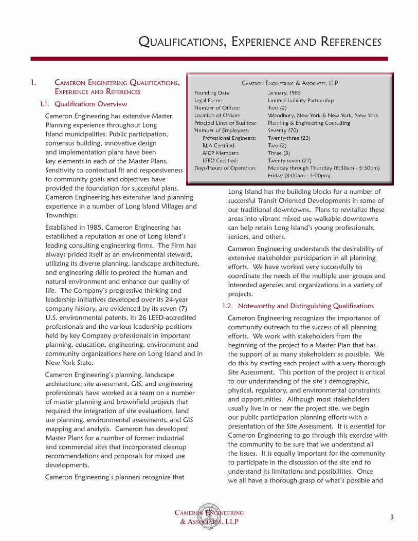
CAMERON ENGINEERING & ASSOCIATES, LLP
MEDFORD VISION UPDATE & COMMUNITY CORRIDOR REVITALIZATION PLAN
Prepared by:
FEBRUARY 2009
A PROPOSAL TO THE TOWN OF BROOKHAVEN
Courtesy of www.pedbikeimages.org

CAMERON ENGINEERING & ASSOCIATES, LLP 2
TABLE OF CONTENTS
Cameron engineering QualifiCations, experienCe and referenCes.................................................1. 3Qualifications Overview....................................................................................................................................1.1. 3Noteworthy and Distinguishing Qualifications 1.2. ..................................................................................................3Similar Work for Municipalities..........................................................................................................................1.3. 4References........................................................................................................................................................1.4. 4Contracts in Default or in Litigation...................................................................................................................1.5. 4staffing and projeCt organization..........................................................................................2. 5Overview..........................................................................................................................................................2.1. 5Work plan, teChniCal serviCes, and approaCh...........................................................................3. 6Study Area........................................................................................................................................................3.1. 6Medford Background........................................................................................................................................3.2. 6Study Goals......................................................................................................................................................3.3. 6Working Group Formation and Meetings...........................................................................................................3.4. 8Document Review.............................................................................................................................................3.5. 8Site Reconnaissance and Land Use Assessment....................................................................................................3.6. 9
Land Uses.............................................................................................................................................3.6.1. 9Zoning................................................................................................................................................13.6.2. 0Environmental Contamination..............................................................................................................13.6.3. 1Niche Community Concepts.................................................................................................................13.6.4. 2Identification of Parcels for Development.............................................................................................13.6.5. 2Identification of Parcels for Preservation and Recreation.......................................................................13.6.6. 3Wastewater Infrastructure Evaluation...................................................................................................13.6.7. 5Transportation Infrastructure Evaluation...............................................................................................13.6.8. 5
F3.7. irst Public Meeting.........................................................................................................................................16Conceptual Vision Update and Revitalization Plan...........................................................................................13.8. 7
Transit Oriented Development Overlay District and Conceptual Plan...................................................13.8.1. 7Mobility and Safety Improvements.......................................................................................................13.8.2. 7Architectural and Streetscape Improvements.........................................................................................13.8.3. 8
S3.9. econd Public Meeting......................................................................................................................................18 Implementation Recommendations and Final Report.......................................................................................13.10. 8
CAMERON ENGINEERING & ASSOCIATES, LLP 3
Cameron engineering QualifiCations, 1. experienCe and referenCes
Qualifications Overview 1.1.
Cameron Engineering has extensive Master Planning experience throughout Long Island municipalities. Public participation, consensus building, innovative design and implementation plans have been key elements in each of the Master Plans. Sensitivity to contextual fit and responsiveness to community goals and objectives have provided the foundation for successful plans. Cameron Engineering has extensive land planning experience in a number of Long Island Villages and Townships.
Established in 1985, Cameron Engineering has established a reputation as one of Long Island’s leading consulting engineering firms. The Firm has always prided itself as an environmental steward, utilizing its diverse planning, landscape architecture, and engineering skills to protect the human and natural environment and enhance our quality of life. The Company’s progressive thinking and leadership initiatives developed over its 24-year company history, are evidenced by its seven (7) U.S. environmental patents, its 26 LEED-accredited professionals and the various leadership positions held by key Company professionals in important planning, education, engineering, environment and community organizations here on Long Island and in New York State.
Cameron Engineering’s planning, landscape architecture, site assessment, GIS, and engineering professionals have worked as a team on a number of master planning and brownfield projects that required the integration of site evaluations, land use planning, environmental assessments, and GIS mapping and analysis. Cameron has developed Master Plans for a number of former industrial and commercial sites that incorporated cleanup recommendations and proposals for mixed use developments.
Cameron Engineering’s planners recognize that
Long Island has the building blocks for a number of successful Transit Oriented Developments in some of our traditional downtowns. Plans to revitalize these areas into vibrant mixed use walkable downtowns can help retain Long Island’s young professionals, seniors, and others.
Cameron Engineering understands the desirability of extensive stakeholder participation in all planning efforts. We have worked very successfully to coordinate the needs of the multiple user groups and interested agencies and organizations in a variety of projects.
Noteworthy and Distinguishing Qualifications1.2.
Cameron Engineering recognizes the importance of community outreach to the success of all planning efforts. We work with stakeholders from the beginning of the project to a Master Plan that has the support of as many stakeholders as possible. We do this by starting each project with a very thorough Site Assessment. This portion of the project is critical to our understanding of the site’s demographic, physical, regulatory, and environmental constraints and opportunities. Although most stakeholders usually live in or near the project site, we begin our public participation planning efforts with a presentation of the Site Assessment. It is essential for Cameron Engineering to go through this exercise with the community to be sure that we understand all the issues. It is equally important for the community to participate in the discussion of the site and to understand its limitations and possibilities. Once we all have a thorough grasp of what’s possible and
QUALIFICATIONS, EXPERIENCE AND REFERENCES

CAMERON ENGINEERING & ASSOCIATES, LLP 4
what’s not, real, implementable, planning can occur.
Cameron Engineering has been an active supporter of Vision Long Island for many years. The organization has been an advocate of Transit Oriented Development, a key element of Smart Growth, for over ten years. Vision is recognized in many communities as an advocate for real community engagement in redevelopment projects. Cameron Engineering will reach out to the organization for summaries of any work it may have conducted in the Medford hamlet.
Cameron Engineering has conducted visionings, public forums, charettes, and community outreach meetings in a number of Long Island communities. We will build on the results of prior planning and visioning efforts early in the project to solidify the expectations of the community with respect to the growth and character of a real downtown and the future of its major corridors.
Similar Work for Municipalities1.3.
The firm is conducting a planning study for the Gordon Heights community, just north of the Medford Hamlet. The effort is an outgrowth of community planning efforts conducted by Vision Long Island (VLI) in conjunction with the Town. The effort is similar to what is required for the Medford Hamlet in a number of ways. Gordon Heights is a community without a real downtown. They worked closely with VLI to envision two new centers, one on Middle Country Road and the other by Granny Road and Mill Road. Cameron Engineering with VLI and ADLIII Architecture is working with the community under the direction of the Town to advance the development of these centers into real new ‘downtowns.’ Although not based around a train station, the centers would have many of the same characteristics as a rail TOD. They would be walkable, provide a variety of housing types including affordable units, offer retail and commercial space. Community recreation and gathering space will be integrating into the centers as well as easy pedestrian and bicycle access to adjacent residential areas. These are many of the same features that will be important to the Medford TOD.
Cameron Engineering designed pedestrian and traffic improvements for the area around the Rockville Centre train station. The plans included better and more aesthetically appealing lighting, roundabouts to improve traffic flow, sidewalk improvements such as bulb-outs and brickwork to make the pedestrian experience safer and more pleasing, and street furniture to encourage more activity.
Within a quarter mile of the Rockville Centre train station, Cameron Engineering developed plans for a TOD on a former industrial site approximately. The plans included environmental remediation to overcome the environmental challenges resulting from its former use. The project involved extensive community interaction and is currently in development.
Cameron Engineering has been engaged by Suffolk County to study the feasibility of sewering the Rocky Point ‘downtown.’ The County recognizes the critical relationship of sewers to the re-growth and revitalization of its many traditional downtowns. Rocky Point is one such community. It values its open space, recreational opportunities, and quiet ambiance. The community recognizes, however, that it could better define its character and could create a more vibrant downtown where its residents could live, walk to retail shops, eat at local restaurants, and meet friends. Cameron Engineering will develop a comprehensive plan for developing the downtown business district. We will estimate potential build out and its impact on assessed evaluations, tax revenues, community services, and the environment.
References1.4.
See Appendix C (Forms).
Contracts in Default or in Litigation1.5.
Cameron Engineering & Associates, LLP has not been in default or litigation for any contracts.
QUALIFICATIONS, EXPERIENCE AND REFERENCES

CAMERON ENGINEERING & ASSOCIATES, LLP 5
staffing and projeCt organization2. Overview2.1.
This project would be overseen by Kevin McAndrew, RLA, Partner in Charge, and Director of the Site Development and Landscape Architecture department. Janice Jijina, P.E., AICP, Director of Planning & Environmental Services, would provide quality control. David Berg, AICP, an environmental analyst and urban planner would serve as Project Manager. He would lead the public participation planning process and would author with Mr. Svadlenka the project planning documents. Walter Sieber would be responsible for the landscape architecture and street design aspects of the project. Rebecca Goldberg, P.E., transportation engineer, would be responsible for the mobility portion of the project. Robert Svadlenka, AICP, an urban planner, is the Director of Cameron Engineering’s Geographic Information Systems (GIS) department. Mr. Svadlenka would be responsible for data collection and analysis, GIS mapping and planning analyses.
STAFFING AND PROJECT ORGANIZATION

CAMERON ENGINEERING & ASSOCIATES, LLP 6
Work plan, teChniCal serviCes, and 3. approaCh
The following sections provide Cameron Engineering’s approach to the requested services. At the end of each section is a summary of the deliverables for that particular task. The 1994 Comprehensive Plan and 1996 Comprehensive Plan Update are referenced as 1994 CP and 1996 CP.
Study Area3.1. The hamlet of Medford is centrally located within the Town of Brookhaven. Figure 1 depicts the study area, bounded by major thoroughfares as follows:
North - Granny Road•
South - Woodside Avenue (County Road 99)•
East - Station Road to County Road 101 south to •Woodside Avenue (County Road 99)
West - County Road 83 (North Ocean Avenue)•
Produced with our GIS, Figure 1 provides important reference information, including basic geographic features such as the street network, the Long Island Rail Road right-of-way and Medford Station and aerial photography (Year 2007). These are just a few of the multiple spatial data layers that will be overlaid in our GIS for analysis and demonstration purposes.
Cameron Engineering will employ our GIS throughout the project for a range of tasks as follows:
Demonstrate spatial features and relationships. •Example analyses include the number of households within walking distance of train station or the distribution of retail, service and restaurant establishments along a major corridor
Conduct site selection analysis. GIS is an efficient •tool for identifying and prioritizing land parcels for preservation, either through acquisition or conservation easements.
Depict potential land use scenarios. A variety •of possible land use scenarios may be quickly generated based on proposed zoning schemes in a GIS.
Medford Background3.2. Cameron Engineering recognizes that Medford is a community in need of an improved sense of place. That identity could come from the creation of a real downtown centered on the recently renovated Medford Long Island Railroad Station, the Veterans Memorial Park, and the newly built main Medford Firehouse.
The primary roadway corridors of Medford include: NYS Route 112, Long Island Avenue, Horseblock Road (CR 16), Sills Road (CR 101), North Ocean Avenue (CR 83), Woodside Avenue (CR 99), Peconic Avenue and the Long Island Expressway (Interstate 495). The roadways of major importance to a potential transit oriented development around the train station include NYS Route 112, Long Island Avenue, and Peconic Avenue.
Existing commercial centers include the areas near the intersection of NYS Route 112 and Horseblock Road and the intersection of North Ocean Avenue (CR 83) and Horseblock Road. The SR 112 / Horseblock Road area is characterized by large shopping malls and the CR 83 / Horseblock Road area by a large shopping mall and warehouse.
Cameron Engineering will collect the background demographic, transportation, land use, and environmental information necessary to understand existing conditions in the Medford hamlet. As described below, we will prepare an assessment of Medford’s major corridors with a focus on the area surrounding the train station. The assessment will be critical to the public participation planning process as it will detail the opportunities and constraints presented by current conditions and their relationship to the development of a successful transit oriented development.
Study Goals3.3.
The Town of Brookhaven and the Medford Taxpayers and Civic Association prepared the Medford Hamlet Comprehensive Plan (94 CP) in 1994. A February 22, 1989 Newsday story suggested that this plan would answer the question, “Where is Medford?” The Plan set out the following goals:
WORK PLAN, TECHNICAL SERVICES, AND APPROACH

CAMERON ENGINEERING & ASSOCIATES, LLP 7
•Createa“senseofplace”inMedfordthrougha designed center in the vicinity of the railroad station.
•Createstrongeconomicactivitytoprovidejobsand an adequate tax base.
•Developappropriatezoningregulatingtoinsureproper development. Bring zoning into compliance with the Hamlet Comprehensive Plan.
•Enforceexisting,codesandordinancesforsandand gravel removal, trees, signs, commercial vehicles, noise and junk yards.
•Developinnovativelanddevelopmenttechniquesto insure maintenance of open space including clustering and transfer of development rights.
•Providereceivingsitesforthetransferofdevelopment rights for the “core areas.”
•Provideopenspaceandrecreationalfacilities,connected with green belts to provide bike and walkways.
•Concentrateactivitywheneverpossibletoencourage public transportation usage.
•Supportappropriateroadwayimprovementstoadequately serve adjacent land use. Insure that improved roadways are aesthetically attractive.
•Provideaffordablehousingforallsegmentsofthepopulation particularly senior citizens.
•Eliminatedeteriorationandobsolescence.
Although these are still appropriate goals, Cameron Engineering would encourage a somewhat different focus for this 2009-2010 effort. Since the 1994 (and a 1996 update), urban planning has evolved to include smart growth and transit-oriented development initiatives. These concepts, though present in the nineties, have evolved with the realization that many older suburban communities have lost their identities as residents relied almost exclusively on their vehicles to travel to shopping, recreation, and work. Those traditional downtown functions are now dispersed over larger areas and transit options are few and far between. The smart growth movement recognizes the need to revitalize
existing downtowns and in some cases, such as in Medford, create new ones. As Long Island is home to a large commuting population, it makes sense to consider railroad stations as the places for new residential and commercial development. Such ‘transit-oriented developments’ are consistent with the goals of smart growth as they allow residents to live within walking distance of rail-to-work, downtown shopping, and restaurants.
Medford’s existing commercial/industrial centers (CR 83 and SR 112 intersections with Horseblock Road) do not lend themselves to the development of pedestrian-friendly ‘downtown’ areas where residential and commercial uses coexist. These areas do not provide a sense of place, are not pedestrian friendly, and would require major transformations to create the kind of traditional downtown that gives a place an identity.
Cameron Engineering believes that area near the train station may be the most conducive to the development of a new downtown for Medford. This area might support new and denser residential development alongside supportive retail, office and other commercial uses. We would examine the other major corridors of the Medford hamlet and report on their potential. However, our focus would be on the LIRR station and the SR 112 corridor, particularly the portions just north and south of the train station. Cameron Engineering’s project goals would include the following (some of which remain the same as the 1994 goals):
•Determinehowa“senseofplace”couldbecreatedin Medford by developing a new downtown center around the railroad station.
•Recommendappropriatezoningtosupportsuchtransit oriented development (TOD).
•Protectopenspaceandsensitiveenvironmentalareas by encouraging clustering and transfer of development rights.
•SuggestlinksfromanewTODtoopenspaceandrecreational facilities, connected with green belts to provide bike paths and walkways.
•ReviewexistingSR112conditionsandproposed
WORK PLAN, TECHNICAL SERVICES, AND APPROACH

CAMERON ENGINEERING & ASSOCIATES, LLP 8
improvements for supporting transit oriented development by the LIRR station and pedestrian and bicycle connections.
•Provideaffordablehousingintheconceptualplansfor a TOD.
•Reuseinfillsitesandcleananddeveloppotentiallycontaminated sites (brownfields) rather than utilizing undeveloped properties (greenfields).
Deliverables:
•PreparedraftProjectGoalsforreviewbyTownand discussion by Working Group (see below).
•PreparefinalProjectGoalsfollowingthefirstWorking Group meeting.
Working Group Formation and Meetings3.4. A key element of successful community outreach is careful attention to the composition of the Project Working Group. A Working Group would be assembled by Cameron Engineering in consultation with the Town of Brookhaven and community leaders. The Group’s membership would be selected to insure that the project team includes representatives from all community ‘stakeholders.’ Working Group members would include representatives from all the groups mentioned above (from the RFP). The Medford Taxpayers and Civic Association would play a key role as a representative of the community.
Cameron Engineering has worked successfully with Vision Long Island (VLI), a smart growth advocacy organization that has conducted visioning workshops across Long Island. We would invite VLI to serve as a community/stakeholder liaison, public meeting facilitator, and smart growth/TOD proponent. The organization would serve as a subcontractor to Cameron Engineering if the Town and community were supportive of their participation.
Typically, at the first meeting of a Working Group, Cameron Engineering explains the Group’s role as project advisor, the scope of the project, the schedule, and the deliverables. After Town review, draft project documents would be circulated to the Group for comments. Group members would be
encouraged to attend all the public portions of the project.
Access to documents, maps, photographs, and background information is important to informing the stakeholder community. Cameron Engineering has worked with web developers to create project websites to keep information flowing to stakeholders. Project websites could be added to the Town’s website, to Cameron Engineering’s website, or a project website created and hosted by a third party service such as Google Sites. Other web-based applications can be used for project information, such as Google Docs or Microsoft Office Live. A Project e-mail list service would manage email and make it easy for the public to subscribe. Cameron Engineering would utilize iContact (www.icontact.com), which also offers online surveys, which are useful for public planning projects.
All community outreach would include the Project Website address and would request that stakeholders and other interested parties subscribe to the iContact Project email list to receive background information, read Steering Committee minutes, and stay informed of Project meetings, workshops, and new postings.
Deliverables:
•Attendfour(4)WorkingGroupmeetingsandprepare meeting agendas and minutes.
•SetupiContactProjecte-mailserviceforupto250e-mail messages per month.
•Providecontentforuptothree(3)webpages.Hosting to be determined by Town.
Document Review3.5. Cameron Engineering planners and engineers will review all available and pertinent documents, maps, plans, ordinances, and data sources from the Town, County, LIRR, NYS DOT and others.
Deliverables:
•Providesummariesofrelevantdocuments,pendingprojects and plans, and LIRR initiatives
•ProvideGISbasemapfromdatasuppliedbytheTown
WORK PLAN, TECHNICAL SERVICES, AND APPROACH

CAMERON ENGINEERING & ASSOCIATES, LLP 9
Site Reconnaissance and Land Use Assessment3.6. Land Uses3.6.1.
The Long Island Index (www.longislandindex.org/) has assembled information on land use, demographics, housing, and economics. Most of their information is from the US Census and from Nassau and Suffolk Counties. They issue annual reports with a wealth of data in charts, tables, and maps. The Index now has an online mapping service. Figure 1 is a land use map of the Medford hamlet.
According to the Long Island Index (www.longislandindex.org/), approximately half of Medford is occupied by residential uses. The next largest land use categories are vacant lands and recreation/open space lands, covering about
15 and 12 percent, respectively, of the area of Medford. Industrial uses (8 percent of total area) are mostly concentrated along the Long Island Rail Road – east of NY Route 112 – and along the west side of Belport Ave. Meanwhile, commercial uses (7 percent of total area) are situated mostly along major roads such as NY 112 and Horseblock Road. The remaining land area of Medford, i.e., less than 8 percent of the total, comprises transportation, community services, utilities and other uses.
Cameron Engineering has determined that the land use data from the Long Island Index require: 1) an update to current conditions and 2) disaggregation in order to provide greater differentiation in land uses in focus areas. The source data for the Long Island Index is based upon an existing GIS parcel data layer that was developed by the Town of Brookhaven and incorporates information from the Suffolk County Tax Assessor’s Office, including land use and assessed value. The land use attribute of the database classifies tax parcels into almost eighty (80) different land use types. Cameron Engineering will reclassify this list into two different land use classifications. One broad classification will be developed for the entire study are; the other classification shall be more differentiated, offering a more detailed list of land uses for focus areas. Cameron Engineering will revise the land use data for the study area as necessary based on field surveys and aerial photography (Year 2007).
WORK PLAN, TECHNICAL SERVICES, AND APPROACH
Figure 1. Land Use from the LI Index

CAMERON ENGINEERING & ASSOCIATES, LLP 10
Cameron Engineering will summarize demographic and economic data from the latest US Census in order to properly characterize the study area. Cameron Engineering will utilize GIS to demonstrate the spatial variation of selected demographic and socioeconomic characteristics.
One of the goals of the Revitalization Plan is to examine the feasibility of establishing a Transit Oriented Development (TOD) near the railroad station. Typically, TOD’s include apartment dwellings in multifamily complexes. Yet, Medford is home to minimal multifamily housing as evidenced by the chart from the Long Island Index shown below.
Figure 2. Medford Multifamily Housing (from LI Index)
Although 85 percent of Long Islanders live in single-family homes, more than one-third of them would prefer an alternative such as a condominium, townhouse, or apartment (according to the LI Index). Most seniors and a large number of ‘empty-nesters’ favor housing that is close to a downtown or a neighborhood where you can walk to stores and neighbors live close together (from LI Index data). The 18-34 year-old demographic wants a vibrant downtown close to transit. Many older Long Island downtowns have seen new life as this age group selects them as preferred places to live, shop, recreate, and often work. Townhouse, condominium, and apartment living is also more affordable.
Vibrant downtowns require people and the demand they create for shops, recreation, and entertainment. However, until recently, support has been limited for the higher residential densities necessary to support these kinds of communities. The LI Index reports that, “Solid majorities support inclusionary housing, as well as increased density and more rental apartments in downtown areas.
Fifty percent support raising building heights in downtowns, and fifty-six percent support state incentives to localities to encourage greater housing density.”
Cameron Engineering will provide the following work products:
Deliverables:
•Providelandusemapsforthegreaterstudyareabased on a general classification system and another for the study focus areas (i.e., train station and vicinity, highway corridors) using a more detailed classification system.
•Summarizedemographicandeconomicdataforthe study focus area.
•Conductanalysisoflandusesintheareanearthe train station based on existing uses and demographic and economic data available through the US census.
•Providerecommendationsforfuturelanduseinthe study focus areas.
•DevelopTODconceptualplanforareaneartrainstation.
Zoning3.6.2. Land use in the area around the train station is a mix of commercial, industrial, and community services (Figure 3). The zoning in this area should support the uses typical of a downtown including office, commercial, retail, and multifamily residential. The appropriate zoning may be J6 (Main Street Business District) as the Town adopted design and architectural standards for the J-6 district, many of which are suitable for TOD. It may be more appropriate, however, to create a TOD overlay district that would allow a greater mix of uses.
WORK PLAN, TECHNICAL SERVICES, AND APPROACH

CAMERON ENGINEERING & ASSOCIATES, LLP 11
Figure 3. Land use near the Medford train station (from LI Index)
Cameron Engineering will map the current zoning in the area near the train station as well as the other major corridors from data/mapping supplied by the Town. We will discuss the consequences of retaining the existing zoning in these areas and the possible benefits of a change of zone. A map of proposed zone changes will be produced based on recommendations achieved through stakeholder consensus.
Deliverables:•Mapofexistingzoning.•Summaryofproposedzonechangesandrelevantbenefits
Environmental Contamination3.6.3. Redevelopment and revitalization can be hampered by the presence, or perceived presence, of contamination. On the other hand, some of these properties may qualify as ‘brownfields,’ which would make them eligible for the NYS Department of Environmental Conservation’s (DEC’s) Brownfield Cleanup Program (BCP). According to the DEC, “The goal of the BCP is to enhance private-sector cleanups of brownfields and to reduce development pressure on greenfields.” A search of the DEC’s spills database for 2006 alone revealed 24 spills Cameron Engineering’s Environmental Services department is integrated with the firm’s multi-disciplinary engineering and planning services. It provides a wide range of environmental services to the private sector and government agencies including environmental due diligence, site investigation and remediation, and brownfield redevelopment.
Cameron Engineering would order a Standard Environmental Database Report from Toxics Targeting, Inc for the area centered on the train station. A check on the firm’s website mapping utility reveals that there are a number of potential environmental hazards in the area (Figure 4). Significant potential hazards would be identified in our report and mapped in the project GIS.
WORK PLAN, TECHNICAL SERVICES, AND APPROACH

CAMERON ENGINEERING & ASSOCIATES, LLP 12
Figure 4. Potential environmental hazards near the train station (from Toxics Targeting, Inc.)
Cameron Engineering will employ other techniques to identify potential brownfield sites. Such sites may already have been identified through previous mapping efforts by the Town of Brookhaven or Suffolk County. For example, based on our previous experience with the Town’s tax parcel layer, “abandoned industrial sites” are one of the land use classifications used in the land use database field. The Suffolk County Tax Assessor’s office may have a list of property owners that are delinquent in their tax payments and the affected property(s). Properties in urbanized areas that have been tax delinquent for a number of years are strong candidates for brownfield sites.
Deliverables:
•ProvideGISmapofsignificantenvironmentalhazardsinthevicinityofthetrainstationfromdatasuppliedbyToxics Targeting, Inc. or similar environmental database supplier.
•Includediscussionintheprojectreportonsignificantenvironmentalhazardsasrevealedbytheenvironmentaldatabase report. Discuss the implications of the hazards to potential redevelopment.
Niche Community Concepts3.6.4. Cameron Engineering shall consider the market area for Medford in its evaluation of potential niche markets and concepts. The term niche is broad, encompassing market demand and lifestyle considerations. Some of the more successful niches build upon an area’s existing strengths, e.g., multiple stores for a specific retail sector or a particular socioeconomic group. A summary of this investigation shall be included in the plan.
Identification of Parcels for Development3.6.5. A recent windshield survey of the study area revealed a number of properties that offer development and redevelopment opportunities in the study focus areas. These include vacant and underutilized properties and infill sites. Such sites could be developed to their highest and best use, potentially accommodating multi-family housing or mixed uses. Such developments interact positively and synergistically with existing activity centers, transportation facilities and other trip generators. Moreover, the concepts of urban development and “densification” strategies are now considered viable alternatives to sprawl development in many suburban areas. Such approaches offer appropriate and affordable housing alternatives to young couples as well as empty-nesters.
The identification of parcels for development/redevelopment would be conducted for the train station vicinity. For residential development, Cameron Engineering would identify: 1) vacant residential-zoned sites; 2) vacant
WORK PLAN, TECHNICAL SERVICES, AND APPROACH

CAMERON ENGINEERING & ASSOCIATES, LLP 13
non-residential-zoned sites that allow residential development; 3) underutilized residential-zoned sites capable of being developed at a higher density or with greater intensity; and 4) non-residential-zoned sites that can be redeveloped for and/or rezoned for residential use. Meanwhile, on the commercial side, vacant and underutilized sites and parking lots may be identified for use as mixed-use commercial developments. Cameron Engineering may also find abandoned industrial sites that may best be refurbished for use as high-technology or “green” technology incubators.
The identification of parcels for development (or redevelopment) can be achieved through a combination of GIS database query techniques and a walking/windshield survey. Cameron Engineering will employ a GIS-based methodology for 1) inventorying vacant parcels and 2) identifying parcels that are underdeveloped according to existing zoning. Aerial and windshield surveys can easily identify vacant sites. The latter, i.e., underdeveloped parcels, would be determined by comparing maximum lot cover or gross floor area with actual, i.e., as-built, building areas. A threshold can be set for the yield currently extant on the parcel, e.g., actual floor area to gross floor area. Parcels that fall below a certain threshold would be considered excellent candidates for redevelopment. Other criteria may be used to prioritize a final selection of such parcels, including distance to train station, lot size, access to infrastructure, community concerns and realistic development capacity. Cameron Engineering will facilitate a discussion/debate stakeholders the over the final selection of parcels for development and redevelopment.
Deliverables:
•AGIS-producedmapofpropertiesrecommendedfordevelopmentorredevelopmentinthetrainstationarea.
•AGISdatabaseofpropertiesrecommendedfordevelopmentandredevelopment;thisdatabasecompriseparcelsselected from the Town GIS tax parcel layer.
•Discussionintheprojectreportofpropertiesrecommendedfordevelopmentorredevelopment.
Identification of Parcels for Preservation and Recreation3.6.6. The Medford hamlet is home to a number of parcels that are either vacant or classified as ‘recreation and open space’ (see Figure 1). A long strip of land runs north-south just west of SR 112. The Town has an acquisition plan for this property and others that will ultimately create a greenway that will stretch almost to SR 347.
Figure 5. Central Pine Barrens Area
The northeastern portion of the Medford hamlet lies inside the Compatible Growth Area of the Long Island Central Pine Barrens (CPB). This area can function as a ‘receiving area’ for density transferred from the CPB ‘core area.’
Medford has a number of large undeveloped parcels, particularly in northern Medford, south of Granny and
WORK PLAN, TECHNICAL SERVICES, AND APPROACH

CAMERON ENGINEERING & ASSOCIATES, LLP 14
Mill Roads. Other large undeveloped parcels are found along Munsells Road and north and south of Long Island Avenue.
Figure 6. Northern portion of Medford (from Microsoft Live Maps)
Figure 7. Southern portion of Medford (from Microsoft Live Maps)
Cameron Engineering would map all significant undeveloped and public lands inside and immediately adjacent to the Medford hamlet. We would overlay sensitive environmental features (e.g., wetlands, critical areas, surface waters, etc.) mapping from the NYS Department of Environmental Conservation (DEC), the NYS Natural Heritage Program, and the Natural Resources Conservation Service. Revitalization planning would be designed to avoid these areas. We would identify undeveloped parcels that could provide passive and active recreational opportunities and will determine if pedestrian and bicycle connections between green spaces and other significant sites in the community might be possible. Parcels of forested or fallow land that are contiguous would be grouped into large conservation areas. This analysis would also identify major landowners in preparation for negotiating land acquisition deals or purchase of development rights.
WORK PLAN, TECHNICAL SERVICES, AND APPROACH

CAMERON ENGINEERING & ASSOCIATES, LLP 15
The various criteria (e.g., natural heritage assets, exceptional ecological, wildlife, recreational, scenic, and historical values, contiguity of parcels for habitat preservation and connectivity for recreational uses) that were compiled for parcels and/or parcel grouping in our GIS, would be summarized into a matrix format. Using the criteria matrix, Cameron Engineering would facilitate a stakeholder discussion to establish conservation priorities.
Deliverables:
•Providemapofpotentialopenspaceparcelssuitable for active or passive recreation and potential green space links. Include potential connections to public facilities, population centers, transportation, and parking,
•Providemapofenvironmentallysensitiveparcels,
•Includeintheprojectreport,recommendationsto preserve and enhance parcels either for environmental preservation or for easily accessible public recreational spaces.
Wastewater Infrastructure Evaluation3.6.7. The typically higher residential densities that are required for a successful transit-oriented development (TOD) are more easily achieved when collection systems are available to transport wastewater to a treatment plant. The Medford hamlet does have a wastewater collection system in its eastern portion connected to a South Shore treatment plant. That plant may have unused capacity that could absorb additional flow from other areas in the hamlet. Cameron Engineering will report on the sanitary system implications of a potential TOD near the train station and potential collection system connection options.
Deliverables:
•Discusswastewaterregulations/optionsastheypertain to a potential TOD
•Providemapofpotentialcollectionsystemconnection to existing wastewater system
Figure 8. Proximity of Sewer District (hatched area from LI Index)
Transportation Infrastructure Evaluation3.6.8. Cameron Engineering will conduct an infrastructure evaluation of the transportation system for the study focus areas as depicted in Figure 1. The evaluation shall consist of an inventory of local roads, pedestrian facilities, and public transportation facilities combined with an assessment of their condition, i.e., with respect to safety, mobility and multi-modal connectivity. Recommendations for improvements to the transportation infrastructure, discussed in Section 3.8.3. below, will be based upon this evaluation. The evaluation will be compiled through a combination of existing data sources, discussions with stakeholders and site visits.
GIS Mapping and Data Compilation. Cameron Engineering will organize the infrastructure inventory within the project GIS, providing both graphic and tabular formats for review and analysis. Cameron Engineering will map available data on an aerial photo with various base map features. By mapping the transportation infrastructure in our project GIS, we can spatially identify deficiencies (e.g., lack of pedestrian connectivity to activity centers) in the transportation system as well as opportunities for improvements (e.g., installation of sidewalks). Accident history data will be obtained, where available, for overall rates as well as the rates of specific types of accidents, paying particular attention to factors that helped cause the most
WORK PLAN, TECHNICAL SERVICES, AND APPROACH

CAMERON ENGINEERING & ASSOCIATES, LLP 16
serious accidents (i.e., those involving a fatality or multiple injuries). High accident locations shall be mapped in the project GIS.
Stakeholder Input. Cameron Engineering will seek input from the project stakeholders and the public regarding vehicular and pedestrian mobility and safety issues in the study focus areas. Stakeholder input will be added to the base map as a component of the transportation infrastructure evaluation.
Site Visits. A transportation planner and engineer from our staff will conduct a qualitative field assessment of existing conditions at key locations within the study focus. The field information will complement our GIS-based inventory of transportation facilities and deficiencies. The field team will assess sidewalk availability, universal accessibility, street lighting, pavement striping, and any other impediments to pedestrian access. The site visit will include of a windshield survey of the focus area corridors with an emphasis on vehicular access issues and safety concerns. Finally, the site visit team will examine conditions at the Medford Train Station with a focus on safety issues, station amenities, and multi-modal connectivity. Information will be transferred to our project GIS for further spatial analysis and presentations.
Deliverables:
Provide a map that depicts the transportation •infrastructure of the study focus areas and its mobility and safety issues. The evaluation shall be presented at the First Public Meeting.
Provide a written assessment, including tabular •summaries of existing conditions for inclusion in the Final Report.
First Public Meeting3.7. A critical element of successful outreach is the use of multiple avenues and media types to reach as many community stakeholder groups as possible. Cameron Engineering uses the traditional methods such as advertisements/articles in local newspapers, flyers at community centers, libraries, and municipal buildings, and mailings by the municipality where
the number of stakeholders is relatively small.
We would also use the email service, iContact, to keep stakeholders informed. They would have the option to subscribe or unsubscribe and would be directed to the project website for project information, documents, and maps. The project website (see section 3.4) would be referenced on all notices, flyers, articles, and related websites (such as the Town’s, Medford government representatives, and others).
Successful community outreach also relies on the collection and presentation of the Site Analysis. Stakeholders make more informed decisions in direct proportion to amount of information they are given. Cameron Engineering prides itself on the depth and breadth of its site analyses. We collect all available engineering, environmental, legal, municipal, and usage information for the site and its environs. A PowerPoint presentation is typically assembled from the information gathered, summarizing data in text, map, and sketch form. The development of community supported plans is guided by the opportunities and constraints presented in the site analysis.
The Cameron Team in cooperation with the Working Group, would host the first public meeting to present the Site Analysis and recognized opportunities and constraints and seek input from the stakeholders and general public on revitalization options. The workshop would be advertised in advance through all the means described above.
Deliverables:
•Prepareforandadvertisethefirstpublicmeeting.
•Presentsiteassessment,opportunitiesandconstraints,and TOD options at one (1) weekday evening public venue. Solicit community input in smaller breakout groups supplied with relevant materials.
WORK PLAN, TECHNICAL SERVICES, AND APPROACH
CAMERON ENGINEERING & ASSOCIATES, LLP 17
Conceptual Vision Update and Revitalization Plan3.8. Transit Oriented Development Overlay 3.8.1. District and Conceptual Plan
The 1994 Comprehensive Plan made recommendations for areas identified as A – W on a map of the Medford hamlet. The Plan said of the area around the railroad station (area ‘W’):
“Parcel W represents the last opportunity to create a center in Medford around the fire station, Memorial Park and the railroad station.”
Cameron Engineering would review and summarize the recommendations of the 1994 Comprehensive Plan and the 1996 update. We would map the areas that are referenced in the Plan and discuss the relevance of each of the recommendations.
We would similarly review other planning documents such as the 1996 Brookhaven Comprehensive Plan and the on-going Brookhaven 2030 Plan. The conceptual plan developed for a Medford TOD should be compatible with the recommendations of the 2030 Plan.
Deliverables:•GISmapofTODoverlaydistrictandconceptualplan
for major corridors.•SummarydocumentofTODoverlaydistrictand
conceptual plan for major corridors and compatibil-ity with 1996 Brookhaven Comprehensive Plan and Brookhaven 2030 Plan.
Mobility and Safety Improvements3.8.2. Based upon the infrastructure evaluation, discussed in Section 3.8.2 above, Cameron Engineering will recommend a set of mobility and safety improvements for both pedestrians and motor vehicles within the study focus areas as shown in Figure 1. These may include the following:
•Designationofbicyclelaneswithpossiblewideningof roadway
•Narrowingorroadwaysfortrafficcalmingandpedestrian safety
•Sidewalkimprovementsincludingwideningandregrading
•Accessimprovementsandnewamenitiesfortherailstation
•Installationofpedestrian-friendlystreetlighting
•Busandparatransitserviceenhancements
•Changesincodetosupportpedestrianandbicycle-friendly modes (e.g., speed limit reductions)
•Identificationofsafelocationsforbicycleracks
•Aestheticimprovementssuchaslandscaping,publicart, street furniture
•Improvedsignage
•Newsidewalksforpedestrianorpathsforcombinedbicycle and pedestrian use.
Cameron Engineering will present proposed improvements for review by the stakeholders and the public. Stakeholder input will be gathered during the Second Public Meeting. Based on input from these groups, the list may be reduced or optimized to establish a set of priorities for implementation.
Deliverables:An aerial map with superimposed locations of the •mobility and safety improvements.A written description of the each recommended im-•provement for incorporation in the Final Report.
WORK PLAN, TECHNICAL SERVICES, AND APPROACH
CAMERON ENGINEERING & ASSOCIATES, LLP 18
Architectural and Streetscape Improvements3.8.3. The character of a downtown, neighborhood centre or Main Street is largely defined by the scale and massing of buildings, the width of roadways, width of pedestrian walkways and the associated streetscape treatment. All of these physical attributes need to be planned and guided in a cohesive manner to create a sense of place and a desirable community identity.
The presence of civic open space areas (i.e. – Village Greens, Commons, Plazas) are also key ingredients to establishing a sense of place. Integrating open space and building around open space areas provide destination places.
Corridors and streets which are too wide facilitate and encourage speeding traffic. Streets with narrow sidewalks and no furnishings are unfriendly to pedestrians. Blocks of buildings with different styles, materials, scale, height, etc. often contribute to visual blight.
Often historic references, events or physical features in a community provide possible design cues to identifying a character that a community would like to “build upon”. Our team will evaluate these considerations as well as provide examples of successful built hamlet centers and streetscapes in establishing a community consensus for a preferred architectural character.
The Cameron Team will develop architectural guidelines and streetscape guidelines to provide the ability in establishing a community with a sense of place and positive identity.
Deliverables
•Prepareoverlayaerialexhibitidentifyingspecifictargeted areas for both architectural regulation, streetscape enhancement and possible open space integration.
•Preparegraphicandelectronicrepresentationsofproposed treatments (i.e. – plan and cross-section details) and as-built photo images of successful hamlet and streetscape projects
•Preparenarrativesummaryofrecommended
architectural and streetscape guidelines including building scale, façade articulation, materials, street/property line setbacks, street furnishings, signage, lighting, landscaping, etc.
Second Public Meeting3.9. Cameron Engineering in cooperation with the Working Group, would host the second public meeting to present the Draft Conceptual Revitalization Plan and seek input from the stakeholders and general public. The workshop would be advertised in advance through all the means described above. The Plan would be presented along with any alternatives in the form of a PowerPoint presentation describing how the Plan was developed from the Site Analyses and all other elements of the project. Following the presentation, Plan maps describing all its elements would be displayed around the room on easels. Cameron Engineering project staff would be present at each of the multiple presentation boards to facilitate discussion by stakeholders and the public. Red and green stickers would be available for participants to indicate elements of the Plan that they like and dislike. Facilitators would be present to engage the attendees in a discussion of the Plan. All comments would be recorded on paper. The Draft Conceptual Revitalization Plan would be modified following the Public Meeting based on public comments into a Final Conceptual Revitalization Plan.
Deliverables:
•Prepareforandadvertisethesecondpublicmeeting.
•PresenttheDraftConceptualRevitalizationPlanat one (1) weekday evening public venue. Solicit community input in smaller breakout groups supplied with relevant materials.
Implementation Recommendations and Final Report3.10. Planning documents are useful if there is community support and there is a mechanism for their implementation. Cameron Engineering will make recommendations for Town code changes, code enforcement, zone changes, floating zones, transfer of development rights, historic district review, establishment of design criteria, and other planning tools to help facilitate implementation of the Plan recommendations.
WORK PLAN, TECHNICAL SERVICES, AND APPROACH

CAMERON ENGINEERING & ASSOCIATES, LLP 19
A key factor in the implementation of the Final plan is the availability of funding. Cameron Engineering has a successful record obtaining funding for municipalities for a variety of projects. We will prepare a list of available local, Town, County, State, and Federal funding sources for the next phase of the Project.
Key in the ultimate implementation of the project will be the participation of the private development community. The project must be economically viable or must include government incentives to bridge gaps. Cameron Engineering works closely with the development community and will recommend incentives that could be useful in this phase of the project.
Deliverables:
•ConceptualVisionUpdateandRevitalizationPlanfinal report including all land use, zoning, mobility, redevelopment, implementation, and funding recommendations.
•ElectronicandprintprojectGIS,
•Tenboundcolorcopies,anunboundreproduciblecolor copy, and a CD-ROM of the text and all computer graphics, compatible with those programs utilized by the Town will be provided,
WORK PLAN, TECHNICAL SERVICES, AND APPROACH

www.cameronengineering.com
100 Sunnyside BoulevardSuite 100
Woodbury, New York 11797(P) 516-827-4900(F) 516-827-4920
260 Madison AvenueEighth Floor
New York, New York 10016(P) 212-324-4000(F) 646-216-2001