a project to identify, survey and record archaeological ...s3.spanglefish.com/s/12654/documents/site...
TRANSCRIPT

A Project to Identify, Survey and Record Archaeological Remains at Mulchaich Farm, Ferintosh,
Ross-shire
February 2009 – May 2010
With the kind permission of the Dalgetty Family, Mulchaich Farm

Report of a Project to Identify, Survey and Record Archaeological remains at Mulchaich Farm, Ferintosh,
Ross-shire by the North of Scotland Archaeological Society
March 2009 to May 2010
Members of the team
Beth Blackburn, Adrian Clark, Anne Coombs, David and Susan Findlay, George Grant, Jonie Guest, Phillipa Hammond, Elspeth Kennedy,
Hazel Kiero, Linda Lamb, Nick Lindsay, Cait MacCullagh, Allan Mackenzie, Meryl Marshall, John and Trina Wombell.
Acknowledgements
NOSAS would particularly like to acknowledge the help and support of Morris Dalgetty, the farmer at Mulchaich, and his family. In addition we would like to thank NOSAS members Jim Bone for his aerial
photography, Susan Kruse and her WEA team for their historical research, the staff of the Dingwall Library for their help and the many local people who showed interest in the project.
This report was compiled and edited by Meryl Marshall for NOSAS
Scotland’s Rural Past is a five-year nationwide project that has been set up to support local communities to research, record and raise awareness of abandoned rural settlements. The project is
hosted by RCAHMS, with partnership funding from the Heritage Lottery Fund, Historic Scotland, Highlands and Islands Enterprise and The National Trust for Scotland.
Front cover: main picture - Scotlands Rural Past training session in progress at the west settlement and, inset - aerial photo of the east settlement

Contents
1. Location of Mulchaich 2 2.1 Introduction 3 2.2 Method 3 2.3 Historical Background 5 3.1 Results and Interpretation 8 3.2 Gazetteer 3.2.1 West Mulchaich settlement 9 3.2.2 East Mulchaich settlement 11 3.2.3 Mulchaich Chambered cairn 12 3.2.4 Additional sites in the area 13 3.3 Selected Photographs 19 3.4 List of Photographs 23
1

1. Location of Mulchaich
2

2.1 Introduction Mulchaich Farm, in the former barony of Ferintosh, is situated on a NW facing slope above the Cromarty Firth in the western part of the Black Isle facing Ben Wyvis and Dingwall. It is just two miles NE of Conon Bridge on a secondary road between Easter Kinkell and Alcaig. Within the bounds of the farm and just 400m from each other on intensively farmed agricultural land, are the remains of two interesting settlements. Each comprises several buildings and associated features; the upper eastern site, NH55NE 007, has been scheduled by Historic Scotland, and the lower western site is, as yet, unrecorded. Oral tradition has it that this unrecorded settlement was the former Ferintosh distillery. The remains of the two settlements are unusual in that they have been preserved in an area which has seen intensive agricultural improvement when most of the former settlements depicted on old maps have been swept away. The sites at Mulchaich seemed worthy of more detailed study and were very suitable for a NOSAS recording and surveying project which was to be part of the Scotlands Rural Past scheme. The sites were targeted during a Scotlands Rural Past training course in surveying and recording techniques which took place in March 2009. East Mulchaich, NH55NE 007, at NH 579 569, was described on the record;
“Some six turf-covered footings survive in a reasonable condition on a small stony eminence in an arable field, and there are two or three others mutilated by quarrying. The wall footings are spread to 1.0 m and 0.3 m high”.
West Mulchaich, at NH 577 568, was unrecorded but in some respects was the more interesting site. The remains of at least 6 buildings were seen, but the site was overgrown with gorse bushes and grossly trampled by cattle. The farmer and other local people including the former estate owner, a descendent of Forbes of Culloden, believe that this was the site of the former Ferintosh distillery. Certainly there is a large building beside a bog and there appears to have been a well too. On a knoll just to the southeast of the site there is a scheduled chambered cairn, NH55NE 002, which has a cup marked stone incorporated into its kerb. Neither of the settlements is depicted on the 1st Edition OS survey of 1870, but the Roy map of c1750 has a densely populated area at Ferintosh, with at least 7 large townships. Mulchaich is not mentioned by name but it is almost certainly one of the townships and it is possible that the two targeted settlements are all that remains of these townships. 2.2 Method The project commenced in February 2009 and the majority of the work was executed in the Spring and summer of that year, but the project was not fully completed until 2011 when a planetable survey of the scheduled chambered cairn was included, this had not originally been one of the objectives. In February 2009 the whins were cleared from the area of the west settlement. This enabled us to get a better look at the buildings and their relationship to each other and also for aerial photographs to be taken. We are very grateful to NOSAS member Jim Bone who managed to take some excellent pictures in the winter of 2010-2011. Blackthorn and bracken were also cleared from the scheduled cairn after permission had been received from Historic Scotland. The lower west settlement and the SW half of the east settlement were targeted in a weekend training course of surveying techniques in March 2009 attended by over 30 NOSAS members. It was just as well that we had cleared the west settlement of vegetation as, with this number, we were able to spread ourselves over the two sites. We had specifically asked for training in surveying using taped offsets and in hachuring, so we separated into teams of 3 and after a demonstration set to work. We did not expect to finish surveying the whole site on this weekend, we were after all, there to learn and make the most of the presence of our instructors. It was the view of most that the complex west site would have probably been better surveyed using 3 or 4 planetables linked together, but we persevered and at the end of the weekend the two ranges of buildings at the south end of the east site had been completed and all the buildings at the west site were surveyed it remained for them just to be plotted in on one sheet so that the relationship to each other could be seen, this was done using two planetables. When we returned to complete the rest of the east site in July we found, much to our surprise, that the dockens and thistles had grown up to knee height, obscuring much of the detail and the subtle changes in slope. Nevertheless two buildings were planetabled on this occasion and the remaining two buildings plus enclosures were completed in May 2010. The chambered cairn was completed using 4 planetables linked together by a large squad of 14 in April 2011 The field between the two settlements was ploughed in April 2010 and 12 members “fieldwalked” it shortly afterwards. On the whole the results were disappointing; the only interesting find being a very worn George III penny (1813-1819).
3

1st Edition OS survey, 1875, of the area of Mulchaich Farm and Ryefield House
Oral tradition has it that their may be other distillery sites in the area, at Ryefield House and at Gallowhill for example, so the wider area of Ferintosh was explored for further archaeological evidence of settlements. Ryefield House was visited and we are very grateful to Duncan Forbes for his help, Gallowhill, Alcaig and several other sites marked as ruins on the 1st Edition OS map of 1876 were also investigated. Measured sketches were made of some of the sites and are included in the results but no direct evidence of distilling sites was found. Historical and documentary research was ongoing throughout the project and we are grateful to NOSAS member Susan Kruse and her WEA group for giving us a good start. There was good help from NOSAS members for clearing the whins and vegetation at both the lower settlement and on the chambered cairn; in all it took 6 days. Several days were spent by 2 or 3 people exploring the area and six full survey days (training included) were attended by between 30 and 10 members. Regular updates on progress were posted in the NOSAS Newsletter and this report will be will be lodged with Historic Scotland, HC Historic Environment Record, RCAHMS, Dingwall Museum, Dingwall Library and the NOSAS Library.
4

2.3 Historical Background Mulchaich Farm and Ferintosh are situated in the modern parish of Urquhart, which includes the old parishes of Urquhart and Wester Logie, the two being united in 1669 (Watson, p113). In the 18th century there were three landowners in the parish, the largest being the Forbes Family of Culloden who held Ferintosh in the central part of the parish. The extent of Ferintosh is seen on the Thomson map of 1830 where it is marked as “Part of Nairn”.
Barony of Ferintosh, marked as “part of Nairn” on the Thomson map of 1830
In 1430 the king had confirmed the “lands of Estirkynkelle and the mill of Alcok, in the county of Ross” to Donald, Thane of Caldore (Cawdor in Nairn-shire) and in 1476 the king extended the thanage, granting it the liberties and privileges of a barony, it was known as Ferintosh. At this time it also included “the two Kinkells, Kindeas, Invermarky, Mulquhaich and Drumvourny in the county of Ross” and was granted to “his faithful William, Thane of Caldor”. The Gaelic ”toisigheachd” or “toiseach” translates as “thaneship” in the language of feudalism. Thus the name “Ferintosh” refers to the “land of the thane” (Watson p114). “Mulcach” is first mentioned in the Exchequer Rolls of 1456, it then appears as “Mulquhaich” in 1476 and “Mulquaisch” in 1507. Pont recorded the place in the late 1500s but his map does not survive. Mulchaich again appears in 1670 when an act is passed in favour of John Forbes of Culloden granting him the right to hold an annual fair at Mulchaich
“grants to the supplicant the foresaid two yearly fairs to be held at Mulchaich in the said barony of Ferintosh yearly, the one to begin the first Tuesday of March, and the other the third Tuesday of November yearly, and each one of the said fairs to continue for the space of three days, for buying and selling of horse, nolt, sheep, meal, malt and all other merchant ware necessary and useful in the country, with power to the said supplicant to collect, uplift and receive the tolls, customs and duties of the said fairs” (1670/7/28 - Records of the Parliaments of Scotland available on website www.rps.ac.uk)
Clearly Mulchaich was a reasonably important settlement at that time, but very few references were found to it in subsequent maps and documents. This historical background will therefore concentrate on the background of Ferintosh, which as will be seen, gained notoriety as a centre for the production of whisky. Mulchaich almost certainly played a significant part. In 1670 the Ferintosh and Bunchrew estates were acquired by the Forbes of Culloden family and in 1690 Duncan Forbes of Culloden (1644 – 1704) secured the privilege of distilling whisky free of duty on his Ferintosh Estate for services rendered to the Crown during the religious unrest of the late 17th century. His estate at Ferintosh had been sacked by the Jacobites in 1689. The privilege was enjoyed by the Forbes family without interruption until 1786 on payment of 400 merks annually. They continued
5
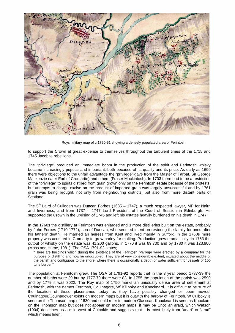
Roys military map of c.1750-51 showing a densely populated area of Ferintosh to support the Crown at great expense to themselves throughout the turbulent times of the 1715 and 1745 Jacobite rebellions. The “privilege” produced an immediate boom in the production of the spirit and Ferintosh whisky became increasingly popular and important, both because of its quality and its price. As early as 1690 there were objections to the unfair advantage the “privilege” gave from the Master of Tarbat, Sir George Mackenzie (later Earl of Cromartie) and others (Fraser Mackintosh). In 1703 there had to be a restriction of the “privilege” to spirits distilled from grain grown only on the Ferintosh estate because of the protests, but attempts to charge excise on the product of imported grain was largely unsuccessful and by 1761 grain was being brought, not only from neighbouring districts, but also from more distant parts of Scotland. The 5th Laird of Culloden was Duncan Forbes (1685 – 1747), a much respected lawyer, MP for Nairn and Inverness, and from 1737 – 1747 Lord President of the Court of Session in Edinburgh. He supported the Crown in the uprising of 1745 and left his estates heavily burdened on his death in 1747. In the 1760s the distillery at Ferintosh was enlarged and 3 more distilleries built on the estate, probably by John Forbes (1710-1772), son of Duncan, who seemed intent on restoring the family fortunes after his fathers’ death. He married an heiress from Kent and lived mainly in Suffolk. In the 1760s more property was acquired in Cromarty to grow barley for malting. Production grew dramatically, in 1763 the output of whisky on the estate was 41,200 gallons, in 1770 it was 89,700 and by 1780 it was 123,900 (Moss and Hume, 1981). The OSA 1791-92 states;
“There are buildings which during the existence of the Ferintosh privilege were erected by a company for the purpose of distilling and now lie unoccupied. They are of very considerable extent, situated about the middle of the parish and contiguous to the shore, where there is occasionally a depth of water sufficient for vessels of 100 tuns burden”
The population at Ferintosh grew. The OSA of 1791-92 reports that in the 3 year period 1737-39 the number of births were 29 but by 1777-79 there were 83. In 1755 the population of the parish was 2590 and by 1779 it was 3022. The Roy map of 1750 marks an unusually dense area of settlement at Ferintosh, with the names Ferntosh, Coulnagore, Wr Killboky and Knocknard. It is difficult to be sure of the location of these placenames today as they have possibly changed or been moved; Coulnagour/Coulnagower exists on modern maps but it is outwith the barony of Ferintosh. W Culboky is seen on the Thomson map of 1830 and could refer to modern Glasccar. Knocknard is seen as Knockard on the Thomson map but does not appear on modern maps; it may be Cnoc an araid, which Watson (1904) describes as a mile west of Culbokie and suggests that it is most likely from “anart” or “arad” which means linen.
6

The OSA of 1790-91 has; “The houses in Ferintosh are extremely numerous. There is an oak wood on this estate of considerable extent. It abounds with delightful walks and adds much to the ornament of the place. But the oaks in this parish attain not in general to any considerable size and are much retarded in their growth from not being enclosed…….Such as are engaged in the business of distilling use partly coal, but chiefly peats got from other parishes on each side of the firth and at high prices”
It was said that around 1,000 people were involved in distilling whisky with few men being left to cultivate the land. In 1782 there was an increase in whisky sent to the English market and a warehouse specifically for the Ferintosh spirit was opened in London. A large distillery, which produced over 5,000 gallons of spirits in 6 months, is reported as being constructed at Ferintosh in 1782. This was the last straw; there was an outcry from the Lowland distillers against the flood of whisky produced in Ferintosh and from the local legal distillers who could not compete. In 1786 action was finally taken by the government and the privilege was withdrawn. Forbes of Culloden received a compensatory payment of £20,000. Robert Burns in his poem “Scotch Drink”, 1786, devoted a verse to Ferintosh whisky, lamenting:
“Thee Ferintosh! O sadly lost! Scotland lament frae coast to coast! Now colic grips, an’ barkin’ hoast May kill us a’; For loyal Forbes’ charter’d boast Is taen awa’!”
The large population at Ferintosh was left without a means of supporting itself. The OSA reports that the poor people were attached to their place of birth and “being given encouragement in their little improvements, began to settle in the moor grounds in the skirts of the parish rather than to seek subsistence by emigration”. Many did move away seeking employment elsewhere, their skills from other distillers in other parts of the country were in great demand. For a time there was a decrease in the population of the parish; from 3022 in 1779 it drops to 2597 in 1789. But the decrease was short lived. In a few years the population numbers began to rise again as legal distilleries were established in the Highlands. By the time of the OSA in 1791-92 there were 29 legal distilleries in the parish. Distilleries are reported at Taynahinch/Tighnabinch (1814-15, 1817-21 and 1825-28), Braes of Dunvorny (1821), Drumcuden (1798-99) Findon (1798-99), Tornabulag/Ternabuig (1798-99)(location as yet unidentified) and Ryefield(1798-99) Dunverny/Dunvornie (1798-99 and 1816-26) (Moss and Hume 1981). But most of them seem to have been short lived. At this time the legislation governing the production of whisky was complex and constantly changing, it was not always viable for Highland distillers to continue in production. The legislation attempted to respond to differing economic situations in the country, to the political circumstances brought about by the Napoleonic Wars (1793 to 1814) and to the climatic conditions in the Highlands which had resulted in a series of bad harvests. The fortunes of the legal distillers were very much in the balance. In 1815 John Fraser of the Tighnahinch distillery was sequestered almost certainly because his stills did not meet minimum requirements. At this time the legislation more or less encouraged illicit production and the rise of the illicit distillers in the Highlands was attributed to it. The first 20 years of the 1800s, providing a golden opportunity for smugglers in the glens on the fringes of The Black Isle and the law was flouted on a massive scale. The market was flooded with illicit spirit and the legal distillers in the area could not compete. Many were forced to close and by 1821 there were only 3 left in Easter Ross. But by 1823, following a Parliamentary Enquiry in 1822 and a complete overhaul of the legislation, illicit distilling also was doomed and the legal distilleries could once more start producing. Building on the reputation of Forbes of Culloden in previous days, many producers in the later 19th century sold their whisky under the name of Ferintosh and in 1893, the Ben Wyvis distillery in nearby Dingwall, built in 1879, took the name of Ferintosh. Bibliography Alston, David My Little Town of Cromarty 2006. Calder, Rev. Charles. Old Statistical Account (OSA), 1790-91 Mackintosh Charles Fraser, Antiquarian Notes 1864 - discussion on roll of Ferintosh p80-83 MacDonald. Rev. John. New Statistical Account (NSA), 1840 Moss Michael and Hume John, The Making of Scotch Whisky 1981 Mowat, Ian R M. Easter Ross 175-1850. The Double Frontier. 2003. Reports from the House of Commons Vol XI . 1782-1799 (printed 1803) 2nd Report from the Committee on Illicit Practces used in defrauding the Revenue (March 1784) p267-269 and p448-449 Watson, W.J. Place names of Ross and Cromarty, 1904
7

3.1 Results and interpretation Frustratingly no firm documentary evidence could be found linking the two settlements at Mulchaich with the production of Ferintosh whisky and there was no reference to Mulchaich in the area marked as densely settled at Ferintosh on the Roy map of 1750. There was a comprehensive account of the origins and progress of the whisky industry in Urquhart Parish in the Old Statistical Account of 1791-92 with reference to the building of distilleries in Ferintosh, but as has been seen the area of Ferintosh covers a much wider area than Mulchaich and there was no reference to Mulchaich. When we started the project much of the west settlement was hidden under overgrown whin bushes and it was difficult to see the extent of the buildings. We felt sure that one of the buildings was a kiln which had had its bowl filled in, probably for safety reasons, but other buildings disappeared under the thick undergrowth. Once the vegetation had been removed the solid foundations of the buildings became much clearer. Several of the buildings had been completely overwhelmed by whins, we were surprised, for example, to find a further kiln built into a steep slope. Certainly local knowledge is quite clear that the west settlement was a distillery and from the solid nature of the structures and their uniformity it is quite possible that the majority of the buildings had been constructed at the same time and to a plan, making a positive case for this site being one of the distilleries that John Forbes built in the 1760s. If it was a distillery then the marshy area at the centre of the site and its possible well would have been significant; this area was probed as part of the project but no stone settings could be found. A case can be made, from the scale and composition of the different structures, for the use of the site for distilling on an industrial scale; there are two large kilns with barns attached, two of the buildings appear to have opposing entrances and may have housed drying floors. The lowest building in the marsh is situated across the marsh and has several compartments; it may have played a significant part in the process. The building in the NW corner had several compartments and wide entrances; it may have been a byre for horses No clearance of vegetation was needed on the east settlement. This settlement is most likely an earlier township and it may well have been the case that the workers at the lower site lived here. However one of the buildings poses problems in interpretation and may have been involved in the distillation of whisky itself. This building, site 26, in the NE corner of the settlement, is unusual in having two outshots apparently positioned for a specific purpose. What that purpose was is difficult to discern. Building 26 may well have been a still house; it is at the lowest corner of the settlement and in the past probably had a source of water, now in field drains, flowing close by. The George III penny, found just 50m south of the east settlement during the fieldwalking, indicates possible activity at the site in the early 1800s. The plans of the two sites were drawn up using OCAD, software designed for drawing orienteering maps with the symbols specifically created for archaeological features. The three other outlying sites were drawn up similarly. Photographing the sites was difficult and some attempts were made at kite photography but on the whole the results were disappointing. Jim Bone, NOSAS member, was able to fly the two sites in the wintertime and the aerial photographs taken in the winter of 2010-2011 were particularly good.
8

3.2 Gazeteer Mulchaich Farm, West Settlement – GR centred on NH 5763 5688 The site is located to the N of the farm of Mulchaich on the slopes of the Black Isle opposite the town of Dingwall just 1km from the shore of the Cromarty Firth. These slopes are NW facing and intensively farmed, but the site itself appears to have been neglected and is heavily overgrown with gorse and whins; the small patches of grass that remain free of gorse are grossly trampled by cattle. The settlement covers an area of 100m x 70m and is situated on two steep spurs of ground which enclose a marsh. The majority of the buildings are on the north most of these spurs. The site comprises the remains of 7 buildings, a large enclosure and several working areas. The remains of six substantial buildings are very obvious. A seventh building on the south spur is barely discernable; this building continues into a neighbouring garden where it has been enhanced to form a platform for a garden seat. Apart from these 7 buildings the site also comprises an enclosure and several working areas. A quarry and some of the worked areas in the NE part of the site may be relatively recent. See plan for layout. Five of the six buildings are of similar construction. They have the remains of solid stone footings, the walls probably robbed of much of their stone, on substantial turf and stone platforms. The platforms have underbuild of as much as 1m height at their lower ends, buildings 04, 05 and 06 for example. The wall footings are generally of stone and turf, although in some places they have double faced stonework with a rubble core. The walls vary from 0.5m to 0.7m height externally and 0.2m to 0.5m internally. Two of the six buildings are kilns with barns. The upper one, site 07, is constructed into a steep bank and is much more wasted than the lower one, site 02. This is more substantially constructed and has 3 compartments; the upper compartment being a kiln bowl which has been filled in. Two of the buildings, sites 03 and 05, have opposing entrances, although in both cases one of the entrances is not very convincing. Site 01, straddles the lowest part of the marsh and has 4 compartments, the south one of which extends into the neighbouring garden where its limits are undiscernible. Site 06 also has 4 compartments each having a wide entrance in the east wall.
Mulchaich Farm, west settlement and chambered cairn – Aerial photo taken from the north
9

The enclosure, site 09, too has the remains of quite substantial surrounding walls and slopes gently towards the NW. The quarry, site 12, has a south and west face of 1.5m deep, the NE bank is 0.7m deep and appears to respect the adjacent enclosure, but it is difficult to say whether or not it is contemporary with the settlement, it may well have been in use at a later date. The working areas, sites 10 and 11, slope gently to the west and are bounded on their west sides by an embankment of 0.5m to 0.8m height. A possible trackway descends the slope towards the marsh
10

Mulchaich Farm, East Settlement – GR centred on NH 57966 56957 This township is located 400m to the NE of Mulchaich Farm in intensively farmed land. It is on a NW facing slope above the Cromarty Firth and has extensive views towards the town of Dingwall and Ben Wyvis. The site is in the middle of a field on an elongated flat knoll and does not appear to have been ploughed. It is grazed by cattle or sheep but in the summer is overgrown with dockens and thistles. An area of marsh to the SE has what may be a spring within it, although this may be the outflow of a field drain. The water runs in a ditch down the east side of the site before entering a further field drain. The site covers an area of 100m x 50m. The remains of nine buildings, two enclosures and several other features are apparent as earth or earth and stone banks, which are 0.3m to 0.5m in height with a spread of between 1 and 1.5m. Some of the buildings have distinct stone edges to their footings, others have substantial earth underbuild on their lower sides. Many of the buildings have multiple compartments. Buildings 13 and 14 and buildings 15, 16 and 17 in the SW part of the site form two parallel ranges, which stretch for a length of approximately 50m and enclose an elongated quadrangle, with building 19, set at right angles in the central part of the site, forming the north limit. Building 19 has more stone composition in its wall footings and has two compartments, with a stone slab set on edge between them. To the east there is an earthen square structure, 20, and to the west a platform, 18, which is enclosed by a stone and turf bank on its north side, this is open to the west where the ground slopes away abruptly. The north part of the site has two single compartment buildings, both with enclosures, 22-23 and 24-25. A complex building, 26, occupies the NE corner of the site. The main part of this building is just 6m x 2.5m internally and there are two outshots, with communicating openings into the main compartment, abutting each of the west most corners; both are at a higher level by some 0.3m; the south most also has an entrance to the outside in the south. A cup marked stone was found amongst clearance material to the north of building 26. The stone measures 84cms x 69cms x c30cms and has 16, possibly 17 cups. On the NW side of the site there is a complex series of terraces with, in one part, a steep bank, 21, which is faced with cobbles; this is 5m in length x 1m in height. Two areas of quarrying are seen as deep indentations into the side of the knoll, one into the NW side and the other, a smaller one, into the SE side. An earth and stone bank which has been truncated by the NW quarry may have defined an enclosure
11 Mulchaich Farm east settlement, NH55NE 007, aerial photo taken from the SW

12

Mulchaich Farm, Chambered Cairn, GR centred on NH 5766 5679, NMRS No NH55NE 0002, A plane table survey and profiles of this scheduled chambered cairn were completed by NOSAS members in April 2011. The cairn is situated on a knoll which has a steeper drop to the SW and is unusual in that it has two kerbs. The height difference between the two kerbs is 1.5m-2m although on the SW side it is 4m. The inner kerb surrounds the top of the knoll and is roughly circular, c.17m diameter edge to edge; some of the stones of the kerb have been displaced and there are gaps but the kerb is clearly traceable as a change in slope and is generally 0.5m high. The cup marked stone is at the south edge of this kerb. The outer kerb is elliptical and 50m diameter NW-SE, 40m NE-SW. The stones here are generally smaller than those in the upper kerb and many have been displaced. The height of this kerb varies from 0.3-0.5m to 1m although it is barely discernable in places.
13

Additional sites in the area of Mulchaich One of the original aims of the project was to explore the wider area for further archaeological evidence of the manufacture of whisky, prospecting the surrounding area and other possible distillery sites in the neighbourhood. Oral tradition has it that the site at Mulchaich Farm was not the only site of a former distillery in the area, three other sites were believed to be involved too; one at Ryefield House, one at Gallowhill and one at Easter Alcaig - the OSA 1790-91 makes mention of a former distillery next to the waterfront (?Alcaig) .Six sites within 1 kilometre of Mulchaich Farm were explored. At three of the sites there was no evidence of distilling but at three sites, the three mentioned above, the evidence was inconclusive and it was not ruled out that they could have been used as distilling sites. 1. Gallowhill Farmstead and enclosure at GR - NH 57587 56207, NMRS No NH55NE 37 This site is situated in rough marshy ground at the upper end of a field 400m to the S of Mulchaich Farm. It has a NW aspect and is surrounded by intensively farmed land. The site is on a terrace which is roughly 50m2. Much of the ground is marshy, there being two possible wells in the south part; the one in the SE corner appears to be deeply excavated. An excavated earth face at the south end of the site is up to 3m in height and may have been a quarry – two large boulders lie in front of the face. The site comprises the stone footings of two buildings, the main one quite complex and the other much more wasted, two enclosure and two wells. The 1st Edition OS survey has two buildings, one enclosure and “wells” marked. The SW compartment of the building is marked as being roofed. The site has been previously recorded during the FESP project of 1998. The main structure is on a NE-SW alignment, measures 25m x 6.5m and possibly comprises two buildings which may or may not be contiguous. The larger south building is more substantial and has two compartments and the smaller building on the same alignment may be a byre. Both sit on a levelled terrace which has significant underbuild on the lower side and a slope of between 0.5m and 0.9m immediately to the NW. The main compartment of the south building measures 9m x 4.2m internally and has wall footings of turf covered stonework which are generally 0.6m thick and between 0,2m and 0.3m high. The SW end wall is 1.4m thick and the NE end wall is 0.9m high. The smaller compartment to the NE is at a level 0.5m higher; it measures 4.5m x 3.8m internally and has the stone footings of a small compartment measuring 1.8m x 2.5m within it. There is a wide entrance in the SE wall which is mostly tumble. The contiguous building to the NE measures 4.2m x 3.5m internally and is less well preserved having stone walls of just 0.2m height. The NE wall and the wide entrance here have become water-logged.
14

The smaller wasted building to the east is on a NNW-SSE alignment and is less well preserved with stone walls that are not continuous. It measures 14m x 5m overall although it narrows at the SE end where the walls are quite substantial and 0.7m high. The walls are generally low and 0.7m thick although the spread of the NE wall is 1.2m, and the height here is 0.3-0.4m. There are two entrances in the SW wall, the north one being 2.6m wide and waterlogged. The enclosure abuts the main building to its SW and measures 20m x 25m. It is surrounded on its east side by turf covered stone footings, 0.7m thick and generally 0.4m high, on its lower NW side by a turf edge and on its SW side by a small burn with a short steep slope containing the burn. 2, Ryefield House Building at NH 5690 5642- not previously recorded and not marked on 1st Edition OS survey. Within the wooded grounds of Ryefield House the remains of this building are 80m east of the main house and are grossly overgrown with rhododendrons to the point where it is difficult to determine its extent. The site has probably been enhanced as a garden feature with a recess for a garden seat in the remains of its SW wall The remains of this rectangular building are quite substantial, mounded, and on a NW-SE alignment. The NW end wall is higher being 0.8m height internally and 1m externally with a curving stone face. The SE end is squared and the obvious footings of the stone wall are just 0.3m height. The building is thought by the owner of Ryefield House to be a former distillery. There is no nearby water source, but the rounded end suggests a kiln, possibly a malt kiln; a roofed building to the SE, marked on the FES, may have had a malt floor
1st edition OS map of Ryefield House with building marked
3. Ryefield (Alternative names North Ryefield) Farmstead and enclosures - GR centred on NH 57103 56927 This site is situated in rough sloping ground in the middle of a field 500m to the SE of the small village of Alcaig. It has a NW aspect although the main building slopes to the NE. The site comprises the stone footings of a single building on a NE-SW alignment, two terraced enclosures and a possible midden pit. The building is aligned NE-SW, measures 15m x 6.6m overall and has two compartments. That to the SW/upper end is the main compartment, it measures 6.5m x 4.5m internally and has an entrance 1m in width in the SE wall. The turf covered stone wall footings are 0.6m thick and generally 0.3m height apart from the short SW wall which is 1.4m thick and 0.6m high. The compartment to the NE is at a lower level
15

and measures 5.2m x 4.5m. The NE and SE wall footings only are extant, the NW side is bounded by a steep slope with a 0.6m drop to the terraced enclosure below. The E corner of this compartment has an entrance 2m width with a possible midden pit just 2 metre distant down the slope to the east. This pit is roughly circular, 1m deep and 4.4m diameter. There are two terraced enclosures to the NW of the building. The one nearest the building is 11m x 6m and enclosed on its NE and NW sides by the remains of a well constructed wall 0.5 to 0.6m high externally and 0.2m internally. This enclosure may continue to the SE but is less well defined and more sloping. The lower enclosure to the NW is more sloping and measures 18m x 9m, it is defined on its NW side by a steepening of the slope, parts of which have a stone edge. The SW compartment of the building is marked on the 1st Edition OS survey as being roofed and there is just one small enclosure to the NW. The stone wall footings of the building are very well constructed with significant underbuild on the lower side. The north part of the adjacent enclosure with its well constructed stone wall footings and levelled area may originally have been part of a building 4. Lower Ryefield Farmstead and enclosure GR centred on NH 56922 56862 This site is situated in scrubby ground 400m to the SE of the small village of Alcaig close to a minor road. It has a NW aspect and is within dense scrubby bushes and grazed by cattle. The site is marked on the 1st Edition OS survey as being roofed and has a small enclosure to the SE but there was no evidence of this enclosure. The site has not previously been recorded The site comprises the low footings of a single building on a NE-SW alignment. The building is on a slightly raised platform and has an internal measurement of 10m x 4m. The SE wall footings have not survived but the remains of the other walls are of intermittent stones set in a low turf bank which is 0.3 to 0.5m thick and just 0.2m high. 5. Easter Alcaig Possible distillery site, GR at NH 5675 5733 The 1st Edition OS survey of 1881 marks a large building next to the shore and a corn and flour mill at Easter Alcaig. The OSA 1791-92 states;
“There are buildings which during the existence of the Ferintosh privilege were erected by a company for the purpose of distilling and now lie unoccupied. They are of very considerable extent, situated about the middle of the parish and contiguous to the shore, where there is occasionally a depth of water sufficient for vessels of 100 tuns burden”
The HER record, MHG32603, for Alcaig Mill - a threshing/grain mill at NH5632 5726, records the memories of a participant in the Black Isle Heritage Memories project – “Water Mill serving large area of Black Isle. Possibly also the site of a distillery. Became knackery in 1960s” The area of Easter Alcaig has been developed relatively recently with at least 6 modern houses and gardens taking the place of the large building next to the shore and the corn and flour mill. 4 of these houses with gardens are fronting the shore where there is a steep bank to the HWM and tidal mud flats. The watercourse marked on the 1st Edition OS as running down the side of the large building now runs
16
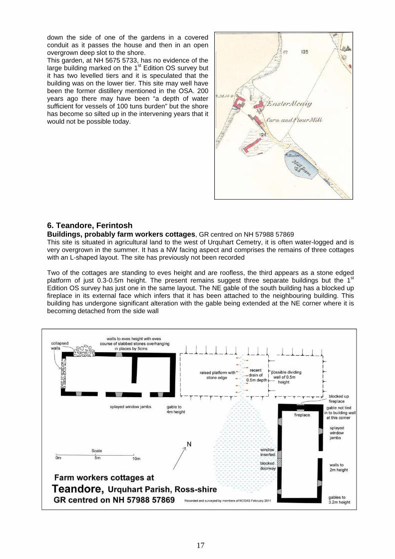
down the side of one of the gardens in a covered conduit as it passes the house and then in an open overgrown deep slot to the shore. This garden, at NH 5675 5733, has no evidence of the large building marked on the 1st Edition OS survey but it has two levelled tiers and it is speculated that the building was on the lower tier. This site may well have been the former distillery mentioned in the OSA. 200 years ago there may have been “a depth of water sufficient for vessels of 100 tuns burden” but the shore has become so silted up in the intervening years that it would not be possible today. 6. Teandore, Ferintosh Buildings, probably farm workers cottages, GR centred on NH 57988 57869 This site is situated in agricultural land to the west of Urquhart Cemetry, it is often water-logged and is very overgrown in the summer. It has a NW facing aspect and comprises the remains of three cottages with an L-shaped layout. The site has previously not been recorded Two of the cottages are standing to eves height and are roofless, the third appears as a stone edged platform of just 0.3-0.5m height. The present remains suggest three separate buildings but the 1st Edition OS survey has just one in the same layout. The NE gable of the south building has a blocked up fireplace in its external face which infers that it has been attached to the neighbouring building. This building has undergone significant alteration with the gable being extended at the NE corner where it is becoming detached from the side wall
17

3.3 Selected Photographs
Above and left - clearing vegetation from the west settlement Below – training sessions from the Scotlands Rural Past team in progress
19

West settlement – surveying the kiln and barn 02 during the training session
West settlement – surveying building 03 during the training session
20

East settlement, building 19 viewed from the east East settlement – building 26 viewed from the NW and, right, the cup marked stone found in clearance
21

The chambered cairn viewed from the south The chambered cairn viewed from the east and, right, the cup marked stone in the south part of the inner kerb
22
3.4 List of Photographs General Views 1. Aerial photograph Viewed from NW 2. Aerial photograph Viewed from SW Mulchaich Farm West settlement 1. Aerial photograph From NNW Partial veg clearance 2. Aerial photograph From N Post veg clearance 3. Building 01 From N SRP training 4. kiln and barn 02 From NE Pre veg clearance 5. kiln and barn 02 From E 6. kiln and barn 02 From E 7. kiln and barn 02 S part from E 8. kiln and barn 02 S end/bowl from S 9. Building 03 From N SRP training 10. Building 03 From E 11. Buildings 03 and 02 From E 12. Buildings 05 and 06 From S SRP training 13. Building 05 From ESE Whin clearing 14. Buildings 05 and 06 From ESE Whin clearing 15. Building 05 From E 16. Building 06 From S Whin clearing 17. building 06 From S 18. building 06 From SSW 19. building 06 From S 20. kiln and barn 07 From WNW 21. Trackway From NE Mulchaich Farn East settlement 1. Aerial photograph From E 2. Aerial photograph From SW 3. General view From E 4. General view South part of site From E
5. General view North part of site From E
6. General view North part of site From E
7. Buildings 13-14 From SSW 8. Building 14 From NE 9. Building 15 From SW 10. Building 15 From W 11. Building 19 From ESE 12. Buildings 22-23 From SSW 13. Building 22 From SSW 14. Building 25 From SSW 15. Building 26 From SE 16. Building 26 From WSW
23

17. NW quarry From E 18. SE Quarry From SW 19. Cup marked stone 20. George III penny 21. George III penny Reverse side Mulchaich Farm Chambered Cairn 1. From S 2. From E 3. From E 4. From E 5. From E 6. From E 7. S part inner kerb 8. W part inner kerb 9. Cup marked stone
Working shots Vegetation Clearing 1 - 4 Chambered Cairn Pre veg clearance 5 - 8 Whin clearing in progress 9 - 12 Chambered Cairn Post veg clearance SRP training – May 2009 1 - 8 West settlement Training in progress HAF Walk Oct 2010 1 - 2 Viewing cup marked stones Additional Sites Gallowhill 1. West building Central part from SE 2. West building From E 3. West building NE part from SW 4. West building SW part from NE 5. West building NW terracing 6. East building From E 7. Enclosure From N 8. SE well From N 9. Marsh and boulders From E Ryefield House Building 1. NW end From NW 2. Internal NW end From SE 3. SE end From SE 4. SW wall Recess/?garden seat Ryefield N Farmstead 1. General view From NE 2. Main building From SW
24

25
Teandore 1. General view From S 2. East building NE side from E 3. East building SW wall from SW 4. East building SW wall S 5. East building SW wall from S 6. East building SW wall detail 7. East building NW gable from N 8. East building NE corner from ENE 9. West building NE part from SE 10. West building NE part from S