a guide to evaluating forest stands as terrestrial lichen
TRANSCRIPT

A Guide to Evaluating Forest Stands
as Terrestrial Lichen Forage Habitat for Caribou
by
Art N. Lance & Warren G. Eastland Industrial Forestry Service Ltd.
1595 Fifth Avenue Prince George BC.
V2L 3L9
for
MINISTRY OF ENVIRONMENT, LANDS AND PARKS Wildlife Branch
1011 Fourth Avenue Prince George BC
V2L 3H9
March 2000
1
A Guide to Evaluating Forest Stands as Terrestrial Lichen Forage Habitat for Caribou
Art N. Lance & Warren G. Eastland
Industrial Forestry Service Ltd., 1595 Fifth Avenue, Prince George BC. V2L 3L9 PURPOSE OF THIS GUIDE This Guide gives a simple way to evaluate forest stands for their potential as foraging sites for northern woodland caribou. It is designed for use in routine timber reconnaissance, in wildlife habitat surveys, as an adjunct to timber cruising, or as part of site assessments for silviculture prescriptions. The method consists of assigning scores to a set of readily observable stand attributes. No specialized equipment is required other than maps, aerial photographs, and a soil pit spade. The Guide is focussed on the types of stands in which terrestrial lichens are abundant on the forest floor. Terrestrial lichens, of the genus Cladina in particular, are the mainstay of the northern woodland caribou diet, especially during winter. Caribou also eat arboreal lichens, but methods already exist for assessing these. If arboreal lichens are abundant in the stand, they are treated as a supplementary factor in this Guide. BACKGROUND Caribou are unique among ungulates (deer, sheep, and goats) for their ability to subsist on lichens. Lichens are low in protein and minerals but relatively high in carbohydrates (energy). The ability to digest lichens relatively efficiently enables caribou to overwinter in habitats where other ungulates cannot. Caribou locate lichens beneath snow by smell, and obtain them by scraping through the snow with their large hooves, making characteristic crater-like excavations. Caribou routinely ‘crater’ through snow as deep as 1m, sometimes more if the snow is soft and uncompacted, but hard-crusted snow can act as a barrier, even when shallow. If terrestrial lichens become inaccessible, caribou move to places with less snow or crusting, or they resort to searching for lichen-bearing trees. The relative advantage of each option depends on its cost-efficiency in terms of forage gained from effort spent. Foraging efficiency varies with the amount of lichen available, and its sparseness or density. Sparsely scattered lichen requires more effort to obtain, regardless of the total amount present in the stand. Thus, for stand assessment purposes, the relevant questions are: how much lichen, of either type, does the stand contain, and how is it distributed? BASIC RATIONALE The procedure in this Guide has a stepwise, hierarchical structure, starting with a screening stage to eliminate forest stand types that are unlikely to need inspection in the field. The rest of the process is then applied to just those sites at which a direct estimate of lichen abundance is required.
2
Relationship to the BGC and Natural Disturbance Types (NDT) Except for the Alpine Zone (NDT 5), terrestrial forage lichen-bearing sites are almost wholly confined to BGC subzone variants that are classed as NDT 3 or 4. These variants are very widespread in BC, occurring in parts of six different BGC Zones: the BWBS, SBS, SBPS, MS, IDF, and ESSF. As this breadth of distribution indicates, the higher levels of the BGC are therefore of little use as a guide to the occurrence of sites with the types and amounts of lichen that are sought by caribou. The relevant level instead is the Site Series (SS). The evidence from caribou studies to-date is that these forage lichen sites are confined almost exclusively to SS 02, 03, and 04. The great majority are SS 02 (Photos 1, 2; Appendix A) , and they share the following basic characteristics:1
1 From Lance & Mills (1996); additional details therein.
Topography: flat or undulating, seldom >20% slope. Eskers, drumlins, moraines, and glacial outwash gravels are common substrates.
Aspect: generally SE to SW-facing Soil type: free-draining, with a thin organic layer (<5cm), low moisture content, and high coarse
fragment content (gravel or cobble >20%). Forest cover: Semi-open lodgepole pine, commonly AC 4 to 8 with a low Site Index, low crown
closure (< 50%), and stem density < 1500 per ha, typically much less. Sometimes with spruce-minor (< 20% of stems).
General vegetation: herbaceous, with a few low shrubs scattered over a cryptogam mat in which either mosses or lichens may be dominant.
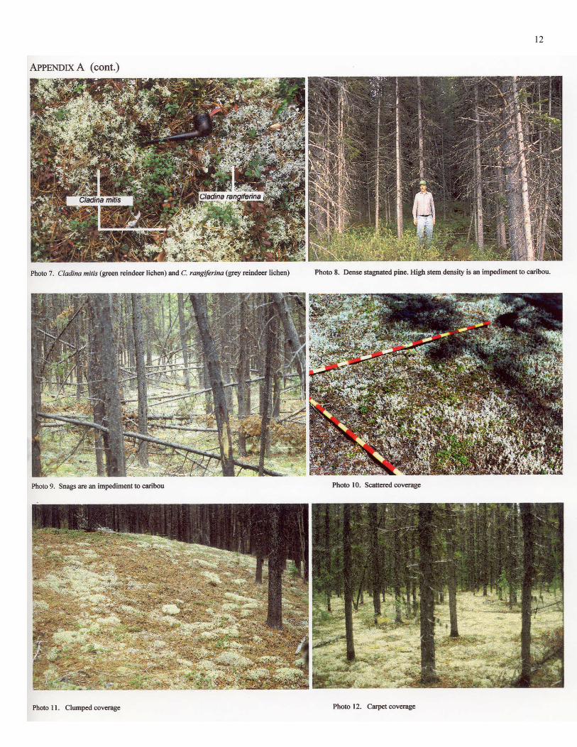
Generally, sites of this type are contained within single, well-defined stands and occupy only a portion of them. Typically the stands are even-aged and fire-derived. Small ‘lichen sites’ (< 5ha) are more common than large ones, but an individual stand may contain several such sites, found wherever the soil and terrain are suitable. In fire-derived stands, lichen sites are often found near the stand boundary where the fire came to a halt and burned slowly, destroying the soil’s organic layers before dying out. Larger sites tend to occur on extended terrain features such as glacial gravel terraces, beds of coarse till, drumlin ‘fields’, and elongated eskers. Not all sites that contain lichens are suitable to caribou, and not all lichens are of equal forage value to caribou. Although eaten, the lichen genera Cladonia (Photos 3, 4), Stereocaulon (Photo 5), and Peltigera (Photo 6) are less favoured than lichens of the genus Cladina (Photo 7). Thickets of short dense pine (Photo 8) or tangled snags (Photo 10) receive little use by caribou, regardless of the lichen they may happen to contain. On the other hand, lichen sites that are clustered together or are near to other kinds of feeding sites receive more use than sites that are singular and isolated. Sites near to black spruce muskegs or willow/sedge swamp-meadows are a prime example of this. Lastly, lichen-bearing sites that are at an early or late stage of seral succession may have little current value to caribou, but their future value may increase with time or suitable management. Factors such as these are used as adjustments in the scoring system below.
3
In reality, the value of lichen-bearing sites for caribou is a continuum between ‘nil’ and ‘high’, but for the purposes of comparing site with site, most can be placed with acceptable accuracy into one of four groupings: Value to caribou Lichen status and modifying factors Nil No lichen-forage value to caribou. Low Lichens present but sparse and/or mainly of less-favoured types, or the site is small, isolated, or impenetrable. Moderate Favoured lichens are abundant but thinly distributed or patchy. Good Forage lichens are extensive and dense, and the site is large and/or juxtaposed
with other foraging sites. PROCEDURE FOR ASSESSING STAND ATTRIBUTES A. Initial screening The first step is to focus the search onto the most likely candidate stands by screening maps and aerial photographs. Since the relevant stand conditions are quite specific, parts of the area that are unlikely to need assessment in the field can be eliminated quickly at this stage. 1. Forest Cover 1.1 Determine the species composition, age class, site class, and crown closure (if
known). These attributes can be obtained directly from the forest cover map or file (FC1). If the stand does not consist of at least 20% lodgepole pine of age class 4 or greater on a site that is classed as Low or Poor, it is unlikely to contain enough terrestrial forage lichen to interest caribou.
1.2 Determine the context of the stand: adjoining forest cover types and ages;
presence/absence of wetlands and open water, and the distance of the stand from these; distance from caribou travel routes (if known).
2. BGC Site Series 2.1 Determine the ecotypes within the stand. If the stand does not contain any SS 02,
03, or 04, it can be dropped from further consideration. If no Site Series map or classification is available, the ecotype(s) will need to be determined in the field (see below).
4
3. Airphotos 3.1 If the forest cover and Site Series criteria have been met, examine the stand on
aerial photographs. Lichen-bearing sites can often be identified as whitish or greyish places in sparsely timbered parts of the stand (crown closure <50%, often much less). Outline these places for further reference.
Any stand comprising >20% lodgepole pine with <50% crown closure on a Low or Poor site and/or 02 - 04 Site Series will qualify for assessment in the field.
B. Site visit On-site assessment is done in stepwise fashion, applying the scores to the Key in Appendix B. 4. Presence/absence of lichen-bearing ground 4.1 Verify the forest cover type(s) determined at Step A. 4.2 Using the stand map or aerial photographs, locate the potential lichen-bearing
portions of the stand. Walk these places to verify the presence or absence of lichen-bearing ground. If none, the stand requires no further consideration.
4.3 Determine the soil type and ecosystem type (Site Series), using the Forest Service
Field Guide for the BGC subzone variant concerned. If the Site Series is 03 or 04, terrestrial lichens should be present but they may be sparse. If the Site Series is 02, they should be abundant.
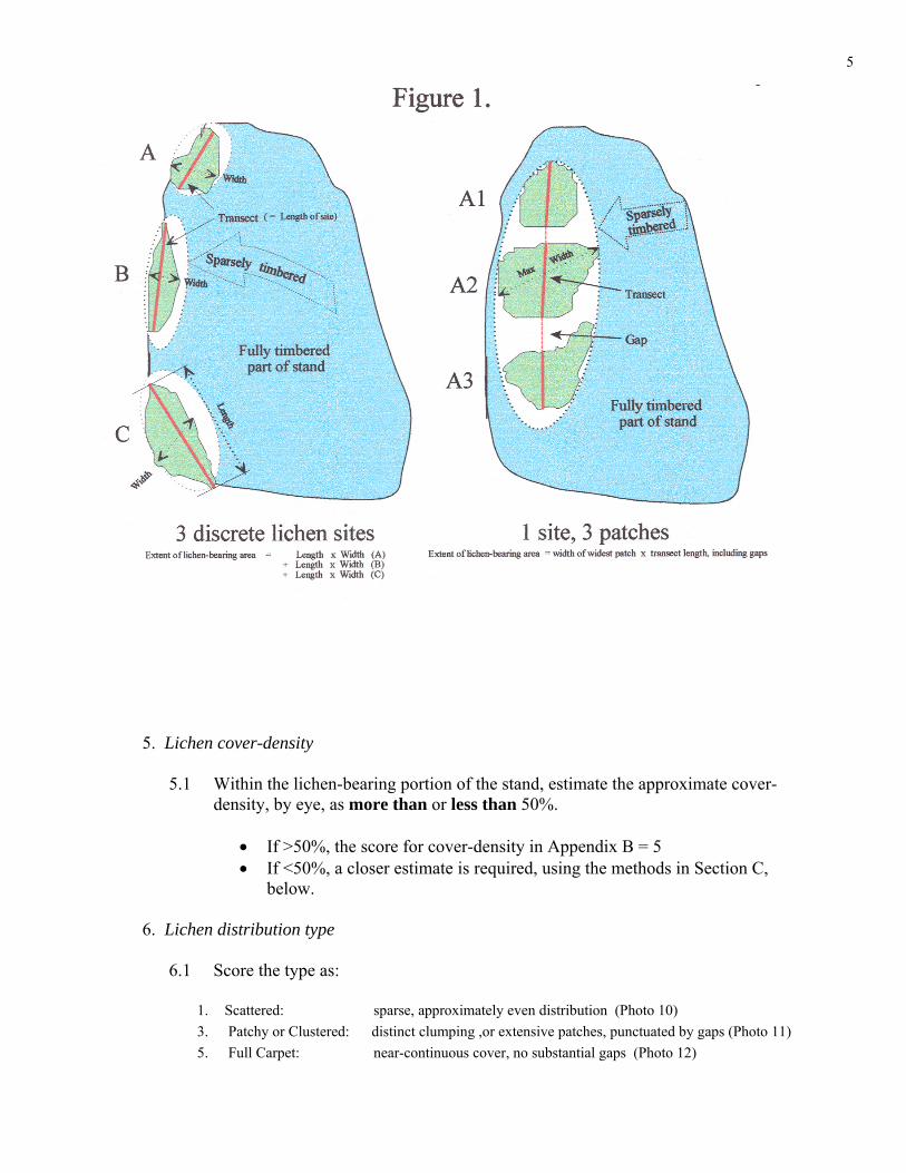
4.4 Determine the extent of lichen-bearing ground by pacing or string-box. Outline
the extent on the stand map or aerial photograph, and record the maximum length and width of each lichen site. Some stands may contain several sites with timbered ground between. In others, the lichen may occur in patches with gaps between (Fig 1). If the stand contains more than one discrete site, add the sites together to give the total extent of lichen-bearing ground. If the lichen occurs in patches within a site, the size of the site includes the gaps between the patches, as well as the patches themselves. Some stands may contain both types of distribution, in which case both methods of calculation will need to be combined.
5
5. Lichen cover-density 5.1 Within the lichen-bearing portion of the stand, estimate the approximate cover-
density, by eye, as more than or less than 50%.
• If >50%, the score for cover-density in Appendix B = 5 • If <50%, a closer estimate is required, using the methods in Section C,
below. 6. Lichen distribution type 6.1 Score the type as: 1. Scattered: sparse, approximately even distribution (Photo 10) 3. Patchy or Clustered: distinct clumping ,or extensive patches, punctuated by gaps (Photo 11) 5. Full Carpet: near-continuous cover, no substantial gaps (Photo 12)
6
7. Identify the predominant lichen genera, using a field guide 2 or the photos in
Appendix A.
Preferred forage genera (Cladina, Cladonia, Cetraria)
Less-preferred genera (Stereocaulon, Peltigera) All other genera normally ignored by caribou: (eg, Hypocenomyce, Hypogymnia,
Rhizocarpon); ‘leafy’ lichens other than Peltigera (eg, Lobaria). 7.1 Estimate the proportion consisting of Cladina, Cladonia, and Cetraria spp. as: % of total lichen cover Score <10 1 10-20 2 20-50 3 >50 4 8. Site impediments Assess the presence of impediments to access by caribou. If you cannot walk
freely through all parts of the site, neither can caribou. 8.1 Score the degree of impediment as: 2 Nil. No physical barriers to access 1 Minor: Occasional leaning snags or closely-spaced trees. 0 Major: Cross-tangled snags, or close tree spacing (<1m between stems), or dense
interlaced branching (dead or alive) at head-height or below. 8.2 Score the percentage of site affected: 2 <10% of site 1 10-25% of site 0 >25% of site 8.3 Add these two scores together to give a combined score for impediments.
2 All of the more common genera are illustrated in Plants of Northern British Columbia (MacKinnon et al.,1992).

7
9. Arboreal lichens 9.1 Note the general abundance-level of arboreal ‘beard’ lichens in the stand, using
the Forest Service photographic guide.3 If most of the trees score no higher than 1 or 2 according to the guide, record the abundance-level as ‘Low’.
9.2 If substantial numbers of trees score 3 or higher, a structured survey should be
done. Use the methods in Forest Service Land Management Handbook 43.4 10. Score the stand for proximity to wetlands, open water (ponds, lakes), or
neighbouring stands with forage lichen sites. Distance <100m to next nearest site: score 3 Distance 100 - 500m to next nearest site: score 2 Distance 500m - 1km to next nearest site: score 1 Distance >1km to next nearest site: score 0 11. Site photography Take 3 site photos: one for the predominant or ‘average’ condition of the site, and
one each for the upper and lower ends of the range of lichen cover-abundance. Parts of the site with impeded access should also be photographed, and the impeded places should be marked on the airphoto or stand map.
C. Quantifying lichen cover-density when the initial estimate is less than 50%
If the assessment is being done for stand management planning purposes, use the ‘step-point’ method (C1 or C2). If the assessment is being done for habitat research purposes, use the more precise ‘tape-transect’ method (C3).
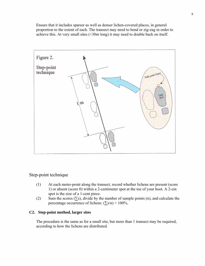
C1. Step-point method, small sites (< 1 ha)
Traverse the lichen-bearing portion of the stand along its long axis, by pacing out a transect at approximately 1-meter intervals, two paces per meter, as shown in Fig. 2. Ensure that the transect fully spans the site, or is at least 30m long, whichever is greater.
3 Land Management Handbook Field Guide Insert 7.
4 Estimating the Abundance of Arboreal Forage Lichens: User’s Guide (Sec. 5, Reconnaissance, or Sec. 6, Planning at the Block Level).
8
Ensure that it includes sparser as well as denser lichen-covered places, in general proportion to the extent of each. The transect may need to bend or zig-zag in order to achieve this. At very small sites (<30m long) it may need to double back on itself.
Step-point technique
(1) At each meter-point along the transect, record whether lichens are present (score
1) or absent (score 0) within a 2-centimeter spot at the toe of your boot. A 2-cm spot is the size of a 1-cent piece.
(2) Sum the scores (∑s), divide by the number of sample points (n), and calculate the percentage occurrence of lichens: (∑s/n) × 100%.
C2. Step-point method, larger sites
The procedure is the same as for a small site, but more than 1 transect may be required, according to how the lichens are distributed.
9
(1) If the lichen cover is relatively continuous (no large gaps), a single transect can suffice. If the lichen density is relatively uniform, 30 sample points will be sufficient; otherwise, the transect should fully traverse the site, to ensure that the variation in lichen cover is taken into account. Sum the scores and calculate the % cover as in 1 and 2 above.
(2) If the lichen cover is distributed in patches, and the patches differ in lichen
density, more than 1 transect will be required. Each patch with a distinctly different lichen density from any other patch should have a separate transect. Each transect should fully traverse the patch or be at least 30m long, whichever is greater.
2.a Traverse the transects, sum the scores over all transects (∑s), and express
as percentage occurrence (%C) as in 2 above.
2.b The percentage occurrence of lichen on the transects will need to be adjusted by the percentage of ground consisting of gaps with no lichens present or very sparse (<1% cover). This can be estimated from the site map or airphoto, or by measuring (pacing) the size of the gaps between patches.
• If estimated from map or photo: multiply the percentage occurrence (%C) of
lichen on the transects by the proportion of ground covered by lichen-bearing patches (p). Thus %C × p = net percentage cover of lichen at the site.
• If estimated by pacing the gaps between patches: sum the number of double-paces
between patches, and add the total to the number of transect sample points (∑n). The net percentage cover of lichen = (∑s B/ B∑n) ×100%.
C3. Tape-transect method To estimate lichen coverage with more precision and accuracy, a tape-measure should be used instead of pacing the transect lines. If the estimates are for research purposes, a randomization procedure should be used for choosing the transect routes.TP
5PT If the lichen is distributed in patches,
separate transects will be required, as in B2 above. Lichen cover is measured by recording canopy intercept-points along the tape. Species with a clump-like growth form (eg, the Cladinas) are recorded as clump-widths. Species with a ‘leafy’ growth form (eg, Peltigera) are recorded as ‘leaf’-widths. Species with a singular stem-like growth form (eg, the Cladonias) are recorded as individual stem-widths or as 1 mm, whichever is greater (ie, the smallest interval recorded is 1 mm). The intercept-measures are summed and expressed as a percentage of transect length. Gaps between patches are dealt with as described in B2.
TP
5PT See Luttmerding et al. (1990) for suitable ways of doing this.
10
CONCLUDING REMARKS This classification Guide pertains to caribou wintering habitat. Stands that have few or no lichens for winter foraging may have plants that caribou eat at other times of year, but assessment of these is beyond the scope of this Guide. Most weight (ie, widest range of scores) in the Scoring Key is given to lichen type (genus), size of site, and completeness of lichen cover, since these are considered the attributes most important to caribou. At sites which score low for their lichen attributes, however, factors such as impediments and proximity to wetlands carry more relative weight in the total score. As knowledge of caribou site selection becomes more refined, these weightings may become subject to future adjustment. Users should also bear in mind that the integer values on which the Key is based are a simplification for the sake of practical convenience. They disguise the fact that the underlying variables are continuous, not discrete. As well, the use of a simple arithmetic scale ignores the likelihood that some of these factors operate in a non-linear way. As such, score-values at the higher end of the scale may under-estimate a factor’s importance to caribou. Therefore, a site whose score-total happens to fall near the boundary with the next higher class should be given the benefit of the doubt and be assigned to the higher class. The Key in Appendix B is based on the current state of the stand, and does not take seral changes into account. In late-seral stands of lodgepole pine or mixed pine and spruce (AC 6-8), lichens are often sparser than at otherwise similar sites. As the crown closure, shading, and humidity has increased, mosses have become dominant instead. Stands such as these have lost much of their forage value to caribou, and will likely score ‘Low’ in the Key in Appendix B. However, if the overstorey closure can be reduced by selection harvesting, the succession from lichens to moss may be reversed - in effect, rejuvenating the stand to an earlier seral stage. Other stands may be improved by removing barriers to access (Photo 9). The potential to improve a stand in value to caribou should not be overlooked when assessing stands for planning purposes. ACKNOWLEDGEMENTS We thank Doug Heard, BC Environment, Prince George, and Susan K Stevenson, Silvifauna Research, Prince George, for useful comments during preparation of this Guide. REFERENCES Armleder, H.M., Stevenson, S.K., & Walker, S.D. (1992). Estimating the Abundance of Arboreal Forage Lichens.
Land Management Handbook Field Guide Insert 7. B.C. Ministry of Forests, Victoria. Lance, A.N. & Mills, B. (1996). Attributes of woodland caribou migration habitat in west-central British Columbia.
Rangifer, Special Issue 9; 355-364. Luttmerding, H.A., Demarchi, D.A., Lea, E.C., Meidinger, D.V., & Vold, T. (eds) (1990). Describing Ecosystems in
the Field. Ministry of Environment, Manual 11. BC. Ministry of Environment, Victoria. MacKinnon, A., Pojar, J., & Coupé, R. (1992). Plants of Northern British Columbia. Lone Pine Publishing,
Edmonton AB. Stevenson, S.K., Lance, A.N., & Armleder, H.M. (1998). Estimating the Abundance of Arboreal Forage Lichens:
User’s Guide. Land Management Handbook 43. B.C. Ministry of Forests, Victoria.

11
12
13
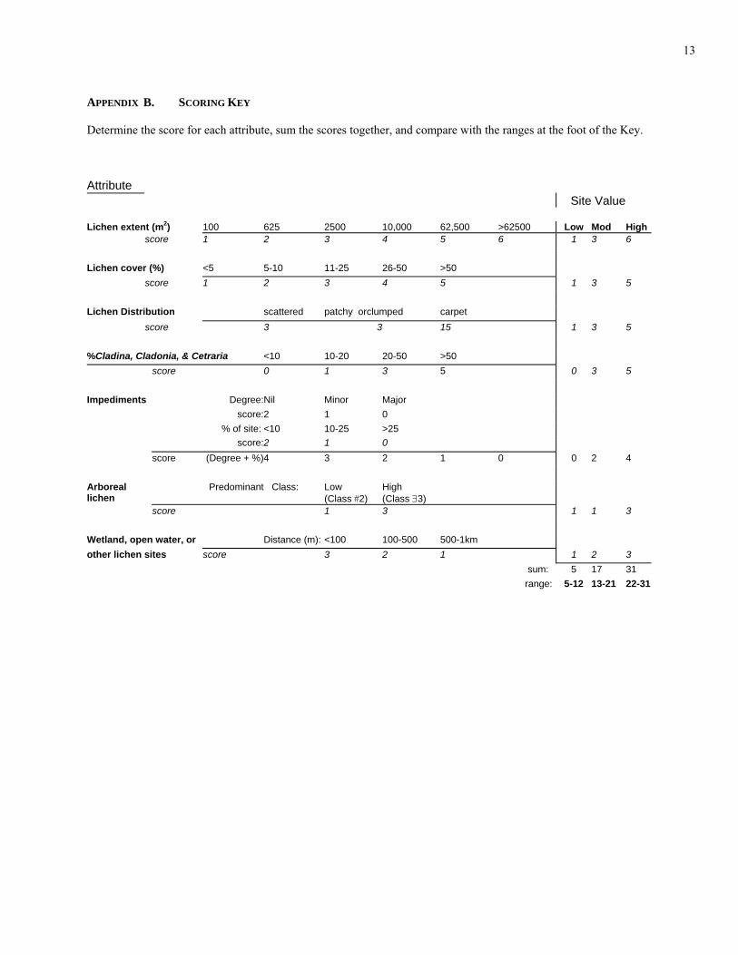
APPENDIX B. SCORING KEY Determine the score for each attribute, sum the scores together, and compare with the ranges at the foot of the Key. Attribute
Site Value Lichen extent (mP
2P) 100 625 2500 10,000 62,500 >62500 Low Mod High
score 1 2 3 4 5 6 1 3 6 Lichen cover (%) <5 5-10 11-25 26-50 >50 score 1 2 3 4 5 1 3 5 Lichen Distribution scattered patchy orclumped carpet score 3 3 15 1 3 5 %Cladina, Cladonia, & Cetraria <10 10-20 20-50 >50 score 0 1 3 5 0 3 5 Impediments Degree: Nil Minor Major score: 2 1 0 % of site: <10 10-25 >25 score: 2 1 0 score (Degree + %) 4 3 2 1 0 0 2 4 Arboreal lichen
Predominant Class: Low (Class #2)
High (Class ∃3)
score 1 3 1 1 3 Wetland, open water, or Distance (m): <100 100-500 500-1km other lichen sites score 3 2 1 1 2 3 sum: 5 17 31 range: 5-12 13-21 22-31