a gamification-based social collaborative architecture to increase
TRANSCRIPT
A Gamification-based Social Collaborative Architecture toincrease resilience against natural disasters
Flávio E. A. Horita1, Luiz F. F. G. Assis1, Raul E. S. Castanhari1, Seiji Isotani1,Wilmax M. Cruz1, João Porto de Albuquerque 1
1Institute of Mathematics and Computer Science (ICMC) – University of São Paulo(USP)
Postal Code 668 – 13.560-970 – São Carlos – SP – Brazil{horita, luizffga, raul, sisotani, wilmcruz, jporto}@icmc.usp.br
Abstract. Natural disasters have led to the need for urgent measures tomitigate the effects of these accidents. The question of awareness is extremelyimportant in dealing with disasters, and collaborative systems are veryserviceable for this. In this context, the aim of this work is to outline agamification-based social collaborative architecture (GSCA) to increaseresilience against natural disasters. We have combined techniques to produceand share information through the interaction of a large number of people,such as those employed in social media and serious games. This architecturewas evaluated and analyzed using the Voluntary in Action, a web platformwhich applies the components defined in the GSCA. The results suggest thatgamification is a system with a great potential to help increase the knowledgeof a community about disasters.
1. Introduction
The increasing occurrence of natural disasters around the world has attracted theattention of various global agencies (Mendiondo, 2010), and led to the adoption of anumber of preventive and responsive measures (Baharin et al., 2009), such as givingpriority to key information to allow management strategies to be employed to deal withthese accidents (Bui et al., 2000), (Lu et al., 2006).
In assisting government agencies to cope with disaster management, there havebeen a number of volunteers who have provided valuable and updated information tocommunity organizations and thus helped them in their recovery (Goodchild, 2007),(Gill and Bunker, 2012). However, it is difficult to manage young volunteers during adisaster because they usually act in a flexible and task-based manner in new socialmedia, which means that the results of their participation can be seen immediately(Neubauer et al., 2013).
For this reason, collaborative systems have been employed to gather a largenumber of people together to carry out various tasks for several purposes, exchangeexperiences with each other and tackle serious problems in a distributed way (Doan etal., 2011).
This paper aims to outline an architecture to assist in the management of naturaldisasters. In undertaking this, common features found in collaborative andrecommendation systems, social networks and geoinformatics are used for thedissemination of knowledge. These features are enhanced by gamification techniqueswhich increase the interaction that occurs in the activities carried out by volunteers.
The remainder of the paper is divided into four sections: Section 2 outlines thebackground, Section 3 describes the Gamification-based Social CollaborativeArchitecture (GSCA), Section 4 shows its evaluation and analysis, and Section 5 makessome final considerations and recommendations for future work.
2. Background
2.1. Natural Disaster Management
In recent years, increasing attention has been paid to environmental risks and theirpotential impact on natural disasters, particularly in light of the frequency with whichthey occur. A natural disaster is an occasion when a society is afflicted by a naturalevent and the damage is so great that external assistance is required (De Longueville etal., 2010).
The events in Haiti, Chile, Pakistan in 2010, Queensland between 2010-11 andJapan and Christchurch in 2011 are examples of recent disasters. Together, theyaccounted for 333,944 victims and economic losses estimated at U$199-327 billion. Inaddition, disasters and climate change that occurred in China in 2008 caused damage ofapproximately U$111 billion to its economy (Tu et al., 2009).
One way to mitigate this damage is the adoption of countermeasures to prevent asimple event from turning into a catastrophe (Baharin et al., 2009), (Poser and Dansch,2010). Disaster management is an important alternative to help in this kind of situation(Baharin et al., 2009).
The information that is relied on for disaster management is of crucialimportance and must be accurate, timely, and complete with regard to the current stateof environmental variables, so that it can be used to support predictions about upcomingchanges and associated impacts (Baharin et al., 2009).
However, owing to the specific needs and preferences of each person or officialagency, a good deal of information related to disasters and climate change is scatteredover different areas and is disconnected of poor quality (Tu et al., 2009). As a result,several issues affect the way information is created and shared, and when critical“success factors” are analyzed, there is clearly a failure to give priority to keyinformation required for disaster management (Bui et al., 2000), (Lu et al., 2006).
2.2. Collaborative Systems
The growth of the web has provided some important benefits, such as the creation of anenvironment where teams that are scattered in geographical terms can carry outactivities in a collaborative manner (Bafoutsou and Mentzas, 2002). To achieve this,collaborative computing relies on computers to support coordination and cooperationbetween two or more people who come together to solve a problem (Borenstein, 1992),(Schooler, 1996). The study of these systems forms part of a large area of interdisciplinary research, Computer Supported Cooperative Work (CSCW).
Commercial products are often mentioned such as CSCW groupware. Accordingto Ellis et al. (1991), this term more commonly refers to the computer-based systemsthat support groups of people engaged in a common task (or goal) and that provide aninterface to a shared environment". On the other hand, Schooler (1996) states that theessential feature of groupware are the creation of shared workspaces among employees.

According to Bafoutsou and Mentzas (2002), in the literature there are severalapproaches that provide taxonomies and classifications of collaborative systems. Theseclassifications and taxonomies are designed to separate these systems on the basis oftheir properties and characteristics.
2.3. Crowdsourcing and Voluntereed Geographic Information (VGI)
The emergence of Web 2.0 and evolution of mobile devices that allow content creation,have become the basis for the emergence of a new paradigm, where users in general,(i.e. citizens) become established as producers of data and information (Niko et al.,2011), which in many cases, is more detailed and of a higher quality than thatprovided by official agencies (Goodchild, 2007), (Elwood, 2008), (De Longueville etal., 2010), (Ostermann and Spinsati, 2011).
Heipke (2010) invented the term “crowdsourcing” for this phenomenon whichinvolves content production being carried out by a third party, that is assigned tointelligence and knowledge. It is based on the experience of volunteers, who areindependent in the way they use their free time and are located in remote and diverseareas.
In a similar context, but more closely linked to geographical issues, Goodchild(2007) used the term VGI which he defined as a collection of digital spatial dataproduced by individuals and informal institutions, as well as by ordinary citizens whouse appropriate tools to gather and publish their observations and geographicalknowledge on the web.
Some of the systems which employ these concepts are Wikimapia,OpenStreetMap, Mechanical Turk, CloudCrowd, and Wikipedia, and together theycompose a set of systems defined as Crowdsourcing Systems which enlist volunteers toassist in building long- term artifacts that are beneficial to the whole community (Doanet al., 2011).
In this context, Doan et al. (2011) raised some important challenges thatcrowdsourcing systems have to face. First, how should these systems recruit volunteersand maintain their assistance. Second, what different kinds of support can users provideand how they can be combined. Finally, although this huge amount of data is useful toobtain knowledge, it causes several problems with regard to its quality (Elwood, 2008),(Goodchild and Li, 2012).
2.4. Gamification
Deterding et al. (2011) states that the term "Gamification" was coined by the digitalindustry. The first record of the use of this term was around 2008, but it was mostwidely employed in 2010. Moreover, several parallel terms that are still being used, canbe found in the literature, and new terms are still being incorporated , such as:“productivity games”, “surveillance entertainment”, “funware”, “playful design”,“behavioral games”, “game layer” or “applied gaming”. As a result, the definition ofgamification is "the use of game design elements in non-game contexts".
The identification of game elements is still a question that is much discussed,and in the literature, there are a few works that offer definitions such as "classic gamemodel" of Juul (2005) and "Ten Ingredients of Great Games" of Reeves and Read(2009). Interpretations that are either very strict or very tolerant of these elements, canmake the game either very limited or unlimited. One solution provided by Deterding et
al. (2011) is to restrict the scope of the term, by only considering the elements that arefound in most games, but not necessarily all of them.
2.5. Related Works
Tools and technologies based on social media concepts, have been widely employed toassist in activities and procedures related to disaster management (Pohl et al., 2012),(Horita et al., 2013). Among these, there are works whose main goal is to employextensive data analysis techniques and information generated by Twitter, Facebook,Flickr and YouTube (Kaewkitipong et al., 2012), (Sinnappan et al., 2010), (Pohl et al.,2012), (Ahmed, 2011). There are also those based on the features that characterizecrowdsourcing systems (Doan et al., 2011).
One group, in particular, stands out in the way it displays collaborative featuresto allow the fast creation and easy sharing of geographic content. The interactive mapscreated by the Ushahidi platform is one of the examples because they offer resourcesthat can support the gathering and sharing of information with a view to solvingproblems emerging from an environment of uncertainty (Okolloh, 2009). Similarly, wealso include platforms like Elva, Google Crisis Map, and LRA Crisis Tracker in thiscategory. On the other hand, OpenStreetMap and Wikimapia are open technologies thatprovide resources for producing general street maps and georeferenced elements in acollaborative way (Haklay and Weber, 2008), (Goodchild, 2007).
In addition, there are several tasks which are hard for computer systems toexecute but can be easily performed by humans, such as image recognition (Von Ahnand Dabbish, 2008). There are also technologies to recruit volunteers to conduct ananalysis with the aid of aerial images taken in the affected areas like MapMill andTomnod.
This study seeks to set out an architecture for providing resilience againstnatural disasters by using concepts and features of social media, collaboration, andcrowdsourcing systems, all of which are combined with gamification techniques(Deterding et al., 2011) and recommender systems (Melville and Sindhwani, 2010) toincrease the interaction, participation and assistance of members of communities.
3. Gamification-based Social Collaborative Architecture (GSCA) to increase resilience to natural disasters
According to Neubauer et al. (2013), voluntarism is the main pillar of disaster relief andoccurs when people show a willingness to help communities without any financialself-interest. It should be noted that most volunteers are between 30 and 50 years oldand married. This means there is a need to increase the participation of those youngerthan 30 and a good strategy is to offer flexible and task-based activities in new socialmedia, where the results of their involvement can be seen in an immediate manner.
To address this question, the aim of this study is to develop a collaborative socialarchitecture, with elements of gamification and social media components, called GSCA.This architecture is designed to create communities that are resilient to natural disasters,and hence reduce the extent of the damage that they cause. According to Pohl et al.(2012), these components can encourage the use of architecture, because people oftenuse social media to document situations that they are involved in.
Elements of gamification, as well as social media, are coupled with GSCA witha view to encouraging volunteers to participate further (Deterding et al., 2011). For
example, volunteers at GSCA can take part in special missions, which include thefeatures of games like scores, badges and rankings which reflect the abilities andachievements of the participants. This architecture is based on Crowdsourcing (Doan etal., 2011) and Volunteered Geographic Information (VGI), which provide content tosupport the acquisition of knowledge.
According to Goodchild (2007), formerly relevant geographic information wasonly provided by official agencies; however, with the emergence of Web 2.0 andevolution of mobile devices, this geographic information has often come to be shared. Itis known that communities have shared a good deal of information, and althoughindividual information was often imprecise, a collective analysis of the data has oftenhad a considerable effect.
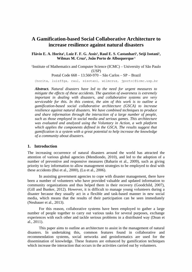
Three specific objectives must be attained before this architecture can beimplemented into a platform: (1) Providing knowledge to communities about naturaldisasters; (2) Mapping the reactions of communities to natural disasters; and, (3)Assisting emergency agencies in natural disaster management.
Figure 1. Components of GSCA
As can be seen in Figure 1, the volunteers are the central component of thearchitecture because, as shown earlier, it is they who both evaluate and increase theamount of information available and extend its range. The four other components,communication, missions, knowledge, and profile, provide mechanisms to support thecentral element and the volunteers, as well as enabling them to carry out their activities.The following sections outline each of these components in detail.
3.1. Communication Component
Communication between users occurs in three ways: (1) they can exchange messagesindividually or collectively, synchronously or asynchronously, (2) they can createforums to discuss ideas, which should address specific issues related to natural disastermanagement, and (3) they can create communities by bringing together individuals withcommon interests.
3.2. User Profiles Component
The profile of the volunteers is characterized by personal information, their degree ofinterest in forums and communities, and their network of volunteers (friends).Moreover, users can find out about recent activities from other users and news related to
natural disasters.
As well as this, volunteers can participate in missions with different purposes,where they can be awarded points for their level of performance. The possession ofperformance skills denotes that a volunteer is able to carry out some kind of task andcan thus be designated as a fireman, policeman, soldier, and so on.
A system of overall ranking is employed for all the participants, and thisencourages them to become more full involved in a spirit of competitiveness (Von Ahnand Dabbish, 2008). In addition, the “missions” performed by specific users are listedchronologically in their profile to ensure more control of their activities, and this systemcan be applied to all the participants.
3.3. The Missions Component
This component of the architecture enables users to perform interactive activities whileat the same time, allowing them to generate and acquire knowledge related to naturaldisasters. The goal of these activities is to encourage the participation of a large numberof people as well as to ensure that they will continue to assist societies to becomeresilient to accidents such as floods or tornadoes.
This can be accomplished by offering the activities in the form of "missions", inwhich the participants volunteer to fulfill certain tasks with specific goals and rewards.These missions are conducted collaboratively with maps that represent real or fictitiousregions, for example, forests, cities or risk areas. The architecture can also recommendspecific missions for determined volunteers depending on their scores and proven skills.
3.4. Knowledge Component
The knowledge component is composed of three main elements: (1) news related tonatural disasters, (2) exchange of experiences between volunteers and (3) missions.
News related to natural disasters serves to centralize information and keepparticipants updated. The exchange of experiences (related to disaster management)between participants occurs via the “Communication Component”. Finally, missionshelp volunteers to increase their knowledge through some tasks related to naturaldisaster management (as described in the “Missions Component”).
4. Evaluation and Analysis
In this section, the assessment and analysis of the outlined architecture are described indetail.
4.1. Potential Scenario: Voluntary in Action Platform
In a disaster situation, all the information related to the local context is important forfaster and more accurate decision-making (Baharin et al., 2009). However, due toadverse structural and organizational factors, it is difficult for emergency agencies(EAs) to have proper information. According to Vivacqua and Borges (2012), availableservices enable communities to provide data about their region in a voluntary way. Forexample, an emergency scenario about the availability of active hydrants in a region,can be solved by using volunteer information.
However, this approach causes some difficulties. The quantity and quality ofreported information depends on the number of volunteers willing to help with datarelated to their community (Goodchild and Li, 2012). Moreover, three important factors
arise from this: (1) personal motivation; (2) professional volunteers; and (3) thepossibility of creating and sharing information maliciously or for criminal purposes(Coleman et al., 2009). Finally, there is also the need to adopt mechanisms to recruitvolunteers so that they can provide useful assistance to the EAs (Vivacqua and Borges,2012).
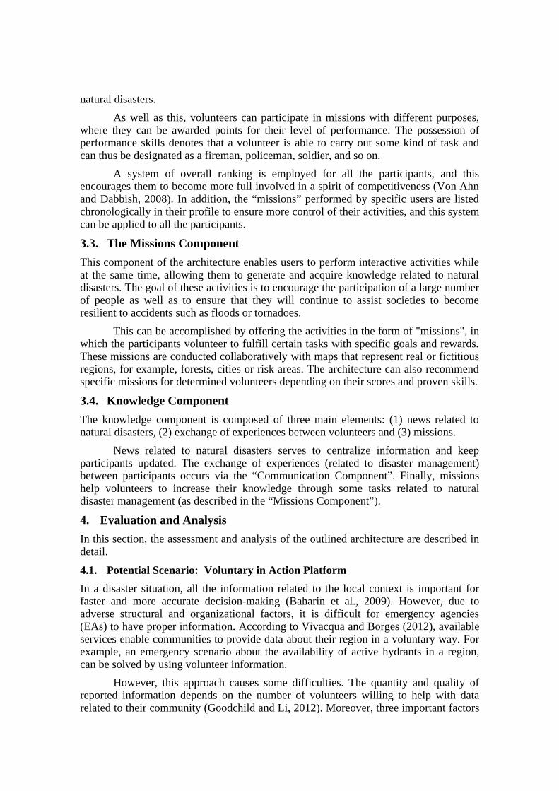
One solution could be achieved via the integration of gamification techniquesthat involve practices of collaborative systems, the main objective of GSCA. Thus, aweb platform called Voluntary in Action is displayed as an implementation of thisarchitecture. Figure 2 shows an example of mapping performed on the platformmission.
Figure 2. Components of GSCA
This mission allows the tagging of geographic features shown on a particular map. Inthe scenario outlined by Vivacqua and Borges (2012), this platform enables volunteersto navigate a map and by using specific components, create the reference points ofexisting elements in the real world, such as parks, schools and fire hydrants.
In addition, the volunteer can see the score of the volunteers of his team, hisbadge, overall ranking and ranking mission. These implemented elements are defined asfunctionalities of gamification. Thus, (as shown in Figure 2), by tagging the element,the volunteer earns some points and this allows him to improve his rankings and themerit of his badges, as well as encouraging him to compete with other volunteers. It alsoencourages him/her to participate in diverse activities and increase the quantity ofgeoreferenced elements.
The platform also stores data related to how volunteers interact with each otherusing a chat line to achieve the mission. Through the platform, it is possible to detectfactors that may influence the achievement of future actions related to disasters, andcarry out missions as a basis to make recommendations and improvements.
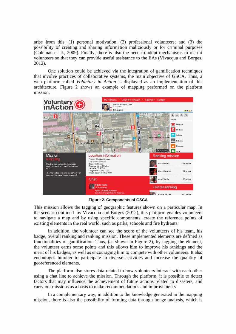
In a complementary way, in addition to the knowledge generated in the mappingmission, there is also the possibility of forming data through image analysis, which is
conducted by volunteers or by shared web tools such as Google Street View. Thismeans that Figure 3 has another mission platform, (georeferencing), which carries outan analysis of random images to define locations where there is evidence of usefulelements in disaster management.
Figure 3. Georeferencing Mission
As can be seen in Figure 3, in this mission a random image is displayed, andincludes a magnifying glass feature, which aims to answer some of the availablequestions shown on the left-hand side. In the context described by Vivacqua and Borges(2012), this question was linked to the presence or absence of fire hydrants. Thegamification resources, such as rankings and scores for created elements are employedto encourage volunteers to get involved.
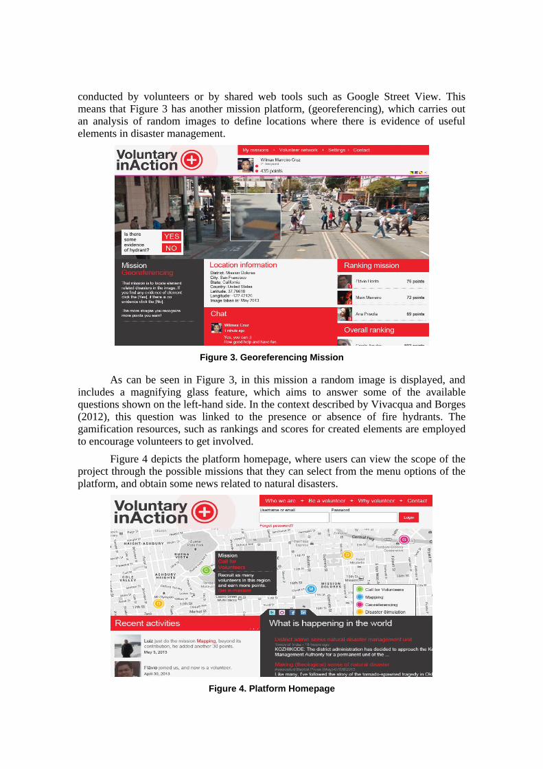
Figure 4 depicts the platform homepage, where users can view the scope of theproject through the possible missions that they can select from the menu options of theplatform, and obtain some news related to natural disasters.
Figure 4. Platform Homepage
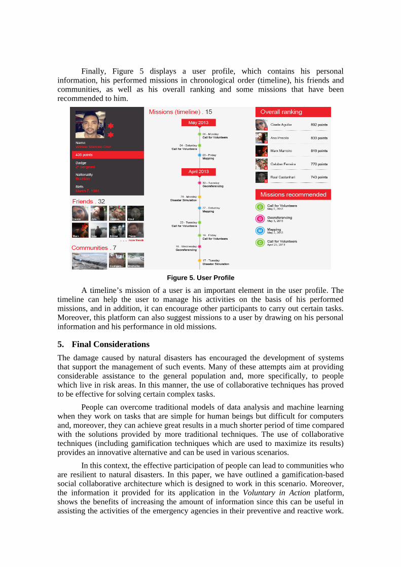
Finally, Figure 5 displays a user profile, which contains his personalinformation, his performed missions in chronological order (timeline), his friends andcommunities, as well as his overall ranking and some missions that have beenrecommended to him.
Figure 5. User Profile
A timeline’s mission of a user is an important element in the user profile. Thetimeline can help the user to manage his activities on the basis of his performedmissions, and in addition, it can encourage other participants to carry out certain tasks.Moreover, this platform can also suggest missions to a user by drawing on his personalinformation and his performance in old missions.
5. Final Considerations
The damage caused by natural disasters has encouraged the development of systemsthat support the management of such events. Many of these attempts aim at providingconsiderable assistance to the general population and, more specifically, to peoplewhich live in risk areas. In this manner, the use of collaborative techniques has provedto be effective for solving certain complex tasks.
People can overcome traditional models of data analysis and machine learningwhen they work on tasks that are simple for human beings but difficult for computersand, moreover, they can achieve great results in a much shorter period of time comparedwith the solutions provided by more traditional techniques. The use of collaborativetechniques (including gamification techniques which are used to maximize its results)provides an innovative alternative and can be used in various scenarios.
In this context, the effective participation of people can lead to communities whoare resilient to natural disasters. In this paper, we have outlined a gamification-basedsocial collaborative architecture which is designed to work in this scenario. Moreover,the information it provided for its application in the Voluntary in Action platform,shows the benefits of increasing the amount of information since this can be useful inassisting the activities of the emergency agencies in their preventive and reactive work.
This architecture can lead to the generation, acquisition and dissemination of necessaryknowledge and thus reduce the frequency and intensity of natural disasters, by fosteringhealth and safety awareness among people who live in a risk area.
In future work, the platform could provide specific features for professionals ofemergency agencies, will be added. In this way, they can create their own missions toincrease the knowledge generated by the platform, and thus eliminate the problem of apossible lack of information. Furthermore, there will be a chance to locate professionalswho are working in risk areas through maps processed in real time, and thus aid thecoordination of field activities.
References
Ahmed, A. (2011). Use of social media in disaster management. In ICIS2011Proceedings.
Bafoutsou, G., and Mentzas, G. (2002). Review and functional classification ofcollaborative systems. International Journal of Information Management 22, 4, 281 –305.
Baharin, S., Shibghatullah, A., and Othman, Z. (2009). Disaster management inMalaysia: An application framework of integrated routing application for emergencyresponse management system. In International Conference of Soft Computing andPattern Recognition (SOCPAR), pp. 716 –719.
Balabanovic, M., and Shoham, Y. (1997). Fab: content-based, collaborativerecommendation. Commun. ACM 40, 3, pp. 66–72.
Borenstein, N. S. (1992). Computational mail as network infrastructure forcomputer-supported cooperative work. In Proceedings of the 1992 ACM conferenceon Computer-supported cooperative work, CSCW ’92, ACM, pp. 67–74.
Bui, T., Cho, S., Sankaran, S., and Sovereign, M. (2000). A framework for designing aglobal information network for multinational humanitarian assistance/disaster relief.Information Systems Frontiers 1, 4, 427–442.
Coleman, D. J., Georgiadou, Y., Labonte, J., Observation, E., and Canada, N. R. (2009).Volunteered Geographic Information : the nature and motivation of producers.International Journal of Spatial Data Infrastructures.
De Longueville, B., Luraschi, G., Smits, P., Peedell, S., and De Groeve, T. (2010).Citezens as sensors for natural hazards: a VGI integration workflow. Geomatica 1.
Deterding, S., Dixon, D., Khaled, R., and Nacke, L. (2011). From game design elementsto gamefulness: defining "gamification". In Proceedings of the 15th InternationalAcademic MindTrek Conference: Envisioning Future Media Environments (NewYork, NY, USA, 2011), ACM, pp. 9–15.
Doan, A., Ramakrishnan, R., and Halevy, A. Y. (2011). Crowdsourcing systems on theworld-wide web. Commun. ACM 54, 4, 86–96.
Ellis, C. A., Gibbs, S. J., and Rein, G. (1991). Groupware: some issues and experiences.Commun. ACM 34, 1, 39–58.
Elwood, S. (2008). Volunteered geographic information: future research directionsmotivated by critical, participatory, and feminist GIS. GeoJournal 72, 3-4, 173–183.
Goodchild, M. F. (2007). Citizens as sensors: the world of volunteered geography. InGeojournal, pp. 1–12.
Goodchild, M. F., and Li, L. (2012). Assuring the quality of volunteered geographicinformation. Spatial Statistics 1, 0, 110–120.
Haklay, M., and Weber, P. (2008). Openstreetmap: User-generated street maps.Pervasive Computing, IEEE 7, 4, 12–18.
Heipke, C. (2010). Crowdsourcing geospatial data. ISPRS Journal of Photogrammetryand Remote Sensing 65, 6, 550–557.
Horita, F. E. A., Degrossi, L. C., de Assis, L. F. G., Zipf, A., and de Albuquerque, J. P.(2013). The use of volunteered geographic information (VGI) and crowdsourcing indisaster management: a systematic literature review. In 19th Americas Conference onInformation Systems (AMCIS).
Juul, J. (2005). Half-Real: Video Games between Real Rules and Fictional Worlds. TheMIT Press.
Kaewkitipong, L., Chen, C., and Ractham, P. (2012). Lessons learned from the use ofsocial media in combating a crisis: A case study of 2011 Thailand flooding disaster.In Thirty Third International Conference on Information Systems.
Lu, D.-K., Pettit, S., and Beresford, A. (2006). Critical success factors for emergencyrelief logistics. WHAMPOA - An Interdisciplinary Journal 51, pp. 177–184.
Mendiondo, E. M. (2010). Reducing vulnerability ti water-related disasters in urbanareas of the humid tropics. In Integrated Urban Water Management Humid Tropics,Paris, France, pp. 109–127.
Melville, P., and Sindhwani, V. (2010). Encyclopedia of Machine Learning. Springer,ch. Recommender Systems, pp. 829–838.
Niko, D. L., Hwang, H., Lee, Y., and Kim, C. (2011). Integrating user-generatedcontent and spatial data into web gis for disaster history. Computers,Networks,Systems, and Industrial Engineering 2011.
Neubauer, G., Nowak, A., Jager, B., Kloyber, C., Flachberger, C., Foitik, G., andSchimak, G. (2013). Crowdtasking – A New Concept for Volunteer Management inDisaster Relief. Internation Symposium on Environmental Software Systems,345-356.
Okolloh, O. (2009). Ushahidi or “testimony”: Web 2.0 tools for crowdsourcing crisisinformation. Participatory Learning and Action 59, 65–70.
Ostermann, F. O., and Spinsanti, L. (2011). A Conceptual Workflow For AutomaticallyAssessing The Quality Of Volunteered Geographic Information For CrisisManagement. In The 14th AGILE International Conference on GeographicInformation Science.
Pohl, D., Bouchachia, A., and Hellwagner, H. (2012). Supporting crisis management viasub-event detection in social networks. In 2012 IEEE 21st International Workshopon Enabling Technologies: Infrastructure for Collaborative Enterprises (WETICE).
Poser, K., and Dransch, D. (2010). Volunteered geographic information for disastermanagement with application to rapid flood damage estimation. Geomatica 64, 1, pp.89–98.
Reeves, B., and Read, J. L. (2009). Total Engagement: Using Games and VirtualWorlds to Change the Way People Work and Businesses Compete. Harvard BusinessSchool Press.
Schooler, E. Conferencing and collaborative computing. Multimedia Systems 4 (1996),pp. 210–225.
Sinnappan, S., Farrell, C., and Stewart, E. (2010). Priceless tweets! a study on twittermessages posted during crisis: Black Saturday. In ACIS 2010 Proceedings.
Tu, Y., Li, Q., and Liu, R. (2009). A geospatial information portal for emergencymanagement of natural disasters. In 2009 IEEE International Geoscience and RemoteSensing Symposium (IGARSS), vol. 2, pp. 404–407.
Vivacqua, A. S., and Borges, M. R. (2012). Taking advantage of collective knowledgein emergency response systems. Journal of Network and Computer Applications 35,1, 189 – 198.
Von Ahn, L., and Dabbish, L. (2008). Designing games with a purpose. Commun. ACM51, 8, pp.58–67.