a feasibility study on use of generic mobile laser
TRANSCRIPT
A FEASIBILITY STUDY ON USE OF GENERIC MOBILE LASER SCANNING SYSTEM
FOR DETECTING ASPHALT PAVEMENT CRACKS
Xinqu Chena, Jonathan Lia* a Mobile Sensing and Geodata Science Lab, Department of Geography and Environmental Management, University of Waterloo, 200
University Avenue West, Waterloo, Ontario N2L 3G1, Canada – (x383chen, junli)@uwaterloo.ca
Commission I, ICWG I/Va
KEY WORDS: Mobile Laser Scanning, Point Cloud, Pavement Crack, Automated Detection, Urban Road
ABSTRACT:
This study aims to automatically detect pavement cracks on urban roads by employing the 3D point clouds acquired by a mobile
laser scanning (MLS) system. Our method consists of four steps: ground point filtering, high-pass convolution, matched filtering,
and noise removal. First, a voxel-based upward growing method is applied to construct Digital Terrain Model (DTM) of the road
surface. Then, a high-pass filter convolutes the DTM to detect local elevation changes that may embed cracking information. Next, a
two-step matched filter is applied to extract crack features. Lastly, a noise removal process is conducted to refine the results. Instead
of using MLS intensity, this study takes advantages of the MLS elevation information to perform automated crack detection from
large-volume, mixed-density, unstructured MLS point clouds. Four types of cracks including longitudinal, transvers, random, and
alligator cracks are detected. Our results demonstrated that the proposed method works well with the RIEGL VMX-450 point clouds
and can detect cracks in moderate-to-severe severity (13 - 25 mm) within a 200 m by 30 m urban road segment located in Kingston,
Ontario, at one time. Due to the resolution capability, small cracks with slight severity remain unclear in the MLS point cloud.
INTRODUCTION
In Canada, trucks transport 90% of all exports to the United
States. About 11 million trucks cross the Canada-United States
border every year (Smith et al., 2001). In terms of traffic loads,
these trucks have a significant impact on pavement performance
and can result in pavement cracking and deformation. These
heavy loads combined with warm summers and cold winters,
result in very demanding requirements for frequent pavement
inspection of Canada’s aging transportation infrastructure,
particularly in those border areas. According to Public Works
Canada, over 10 billion dollars are spent on pavements annually
in Canada. Frequent inspection and proper maintenance are
highly recommended to ensure driver’s safety and extend
pavement’s life. Pavement condition is traditionally assessed by
in-situ measurements which rely heavily on manual data
collection followed by visual evaluation based on given
pavement condition rating manuals. Such pavement condition
survey is often time-consuming, subjective, dangerous, and
expensive that demands heavily for professional evaluators.
Current practices have widely adopted image-based technology,
which captures photo logging by high resolution
vehicle-mounted cameras, to achieve automated data collection.
However, the quality of digital images varies with lighting
conditions and existence of shadows which requires high-level
image processing methods to overcome.
With the blooming of vehicle-borne mobile laser scanning
(MLS) techniques in recent years, MLS applications have
developed rapidly in every part of urban road management.
Especially, MLS data provides valuable 3D road information to
transportation agencies. By extracting road objects from MLS
point clouds along the vehicle trajectory, it has great aid in
monitoring pavement condition, traffic safety and road sign
system (Yu et al., 2016a; 2016b). In our previous publications,
we have presented several methods for extraction of various
road surface’s objects such as road boundaries (Wang et al.,
2015), road markings (Yang et al., 2012; Guan et al., 2014;
Guan et al., 2015; Yu et al., 2015c), pavement cracks (Guan et
al., 2015), road manholes (Yu et al., 2014; Yu et al., 2015a),
traffic signs (Wen et al., 2016; Yu et al., 2016b), street light
poles (Yu et al., 2015b; Wu et al., 2016), and parking cars (Yu
et al., 2016c). Traditionally, digital images were the preferred
source of road crack surveying which can derive road cracks in
millimetre width. (e.g., Xu and Huang, 2003). However, image
qualities often depend on weather, traffic, and image
photogrammetry techniques (Nguyen et al., 2011). Pavement
crack detection using MLS point clouds becomes a new
research topic recently. The idea was basically to make the 3D
information of MLS data aid in pavement distress analysis.
However, the large volume, mixed-density and irregular
distribution of 3D MLS points make road surface’s object
extraction very challenging and difficult. Our efforts have been
placed on development of novel algorithms and software tools
for accurate and robust object extraction. To achieve this goal,
current MLS road crack extraction methods rely on converting
3D pavement information into 2D image-based data and crack
delineation is performed using image processing approaches.
Previous studies on pavement cracks detection can achieve
precision in centimetre using direct detection from 3D point
clouds. Guan et al. (2014) proposed an iterative tensor voting
algorithm to detect road cracks from geo-referenced images.
The iterative tensor voting based crack detection achieved
completeness as 96% and correctness as 85%. It could well
detect road cracks with width larger than 2 cm. Tsai and Li
(2012) implemented a dynamic-optimization-based crack
segmentation method on high-resolution 3D continuous
transverse pavement profiles. The continuous transverse
pavement profiles acquired from a MLS system could aid in
detecting road cracks with widths greater than 2 mm. It enabled
crack detection under low intensity contrast and lighting
conditions with above 95% score of precision. The installation
of both downward camera and the 360 degrees laser scanning
could be available to traffic safety maintenance.
Currently, generic MLS system such as RIEGL VMX-450 has
demonstrated its potential in pavement inspection. The system
is capable of collecting high-density and high-accuracy 3D
point clouds covering the road corridors at a normal driving
speed. Generic MLS systems have several advantages over the
The International Archives of the Photogrammetry, Remote Sensing and Spatial Information Sciences, Volume XLI-B1, 2016 XXIII ISPRS Congress, 12–19 July 2016, Prague, Czech Republic
This contribution has been peer-reviewed. doi:10.5194/isprsarchives-XLI-B1-545-2016
545
Automatic Road Analyzer (ARAN), a specifically designed
mobile pavement condition mapping system, in terms of
scanning range and application diversity. Still, it is needed to
address that whether generic MLS systems could meet the
Ministry of Transportation Ontario (MTO)’s requirements for
pavement condition mapping or not. This study aims to
automatically detect pavement cracks by employing the 3D
point clouds covering a typical urban street in Kingston, Ontario,
acquired by a RIEGL VMX-450 system.
STUDY AREA AND DATA ACQUISITION
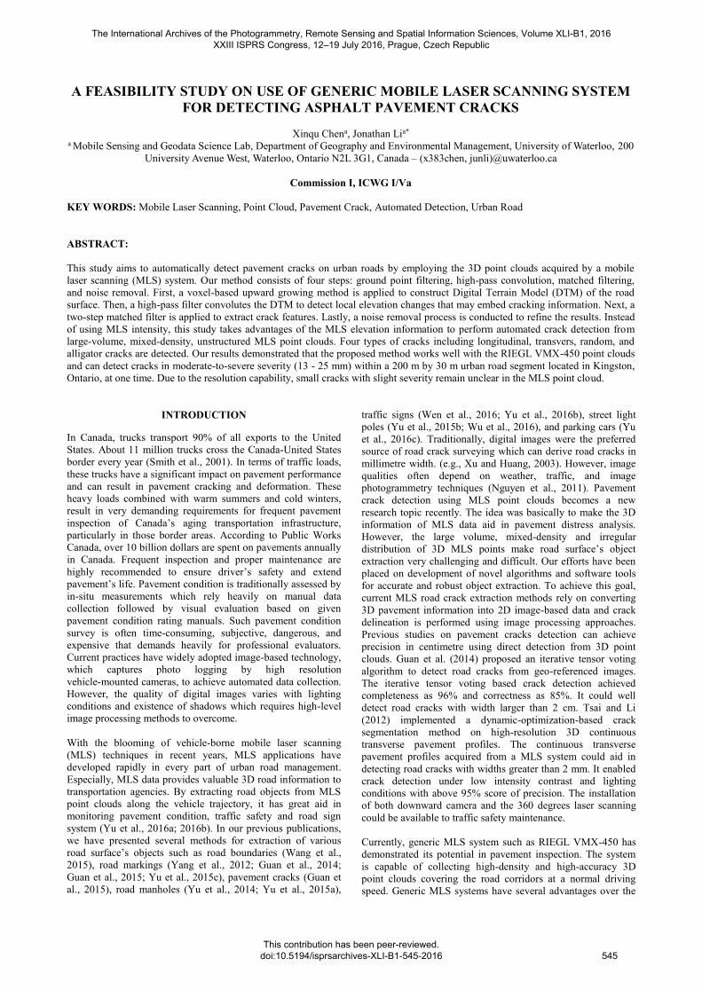
The study area consists of one part of the Front Road in the City
of Kingston, Ontario, Canada (76°33'22.57"W, 44°13'7.40"N,
and see Figure 1). The road segment is approximately 200 m
long and 12 m, containing four lanes (two lanes at each
direction) (see Figure 2). The MLS point clouds covered the
study area were acquired by a RIEGL VMX-450 system on
August 29, 2013. It collected a total of 25,544,329 points and
captured images from four side views along the road survey.
The point spacing is 3.4 cm/point.
Pavement cracks are presented in the study area including
longitudinal, transverse, longitudinal, transvers, and random
cracks (see Figure 3).
Figure 1. Location of the study area, Kingston, Ontario, Canada
PAVEMENT CRACK DETECTION
The proposed method mainly consists of four steps: ground
point filtering, DTM high-pass convolution, matched filtering,
and post noise removal. First, a voxel-based upward growing
method (Yu et al., 2015b) is applied to detect the ground points
(see Figure 4). The point cloud will be first segmented into a
series of blocks according to a user-defined width as shown in
Figure 4(a). The voxel-based upward growing algorithm is
performed on each segment. Within each block, points are
spatially grouped into voxels (see Figure 4(b)). A voxel is
defined as a ground voxel is it has nine neighbours. For instance,
as shown in Figure 4(c), V1 has nine neighbours: L1, L2 …, L9.
The ground point filtering is an upward growing process which
will stop if either no more voxels will have nine neighbours or
Figure 2. Point clouds acquired by RIEGL VMX-450.
Figure 4. Principle of the voxel-based upward-growing
algorithm (Adapted from Yu et al., 2015b): (a) segmented raw
point cloud, (b) octree spatial index in a local block, and (c)
voxel-based upward-growing pattern
the elevation between the top and the bottom voxel exceeds the
user-defined threshold. In the next step, a DTM raster data was
generated by rasterizing all the ground points into 4 cm grids by
assigning the minimum height within the grid as the pixel value.
For the grids which had no point filled in, the grid values were
interpolated linearly by searching the neighbours. In this way,
the points that represent the cracks could be largely reserved.
Next, a 5 5 high-pass filter convolutes the DTM to detect local
elevation change. Since the pavement surface with no cracks
will have even roughness and complete coverage, the use of a
high pass filter can amplify the magnitude of a small elevation
jump or detect the surface that is rougher than the rests. These
features may embed cracking information. Hence, the ideal high
pass filter is applied to the DTM (see Figure 5) and the absolute
value of the convolution result is taken. The ideal high-pass
filter assigns the difference between the centre grid and the
mean of its 24 neighbours. The window size is determined by
Figure 3. A pavement image taken by the digital camera.
The International Archives of the Photogrammetry, Remote Sensing and Spatial Information Sciences, Volume XLI-B1, 2016 XXIII ISPRS Congress, 12–19 July 2016, Prague, Czech Republic
This contribution has been peer-reviewed. doi:10.5194/isprsarchives-XLI-B1-545-2016
546
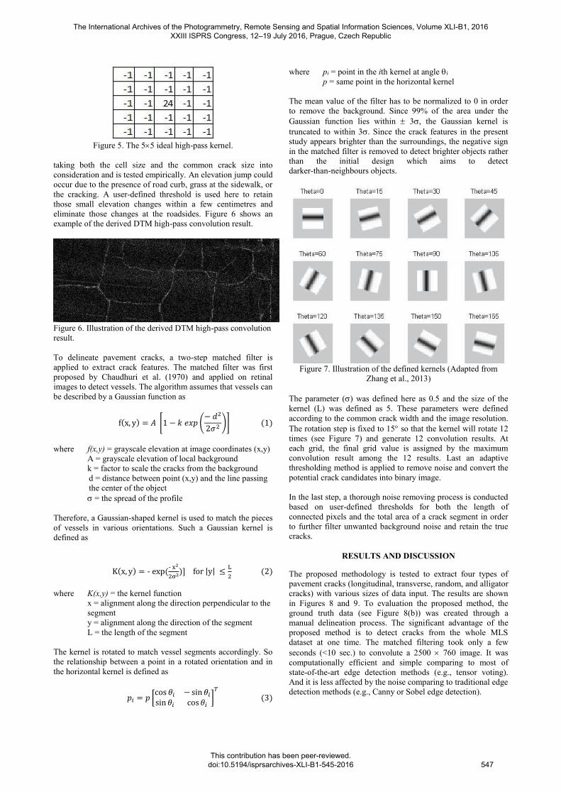
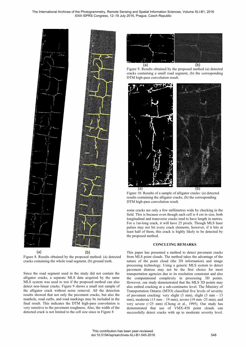
Figure 5. The 55 ideal high-pass kernel.
taking both the cell size and the common crack size into
consideration and is tested empirically. An elevation jump could
occur due to the presence of road curb, grass at the sidewalk, or
the cracking. A user-defined threshold is used here to retain
those small elevation changes within a few centimetres and
eliminate those changes at the roadsides. Figure 6 shows an
example of the derived DTM high-pass convolution result.
Figure 6. Illustration of the derived DTM high-pass convolution
result.
To delineate pavement cracks, a two-step matched filter is
applied to extract crack features. The matched filter was first
proposed by Chaudhuri et al. (1970) and applied on retinal
images to detect vessels. The algorithm assumes that vessels can
be described by a Gaussian function as
f(x, y) = 𝐴 [1 − 𝑘 𝑒𝑥𝑝 (− 𝑑2
2𝜎2 )] (1)
where f(x,y) = grayscale elevation at image coordinates (x,y)
A = grayscale elevation of local background
k = factor to scale the cracks from the background
d = distance between point (x,y) and the line passing
the center of the object
= the spread of the profile
Therefore, a Gaussian-shaped kernel is used to match the pieces
of vessels in various orientations. Such a Gaussian kernel is
defined as
K(x, y) = - exp (- x2
2σ2)] for |y| ≤L
2 (2)
where K(x,y) = the kernel function
x = alignment along the direction perpendicular to the
segment
y = alignment along the direction of the segment
L = the length of the segment
The kernel is rotated to match vessel segments accordingly. So
the relationship between a point in a rotated orientation and in
the horizontal kernel is defined as
𝑝𝑖 = 𝑝 [cos 𝜃𝑖 − sin 𝜃𝑖
sin 𝜃𝑖 cos 𝜃𝑖]
𝑇
(3)
where pi = point in the ith kernel at angle i
p = same point in the horizontal kernel
The mean value of the filter has to be normalized to 0 in order
to remove the background. Since 99% of the area under the
Gaussian function lies within 3, the Gaussian kernel is
truncated to within 3. Since the crack features in the present
study appears brighter than the surroundings, the negative sign
in the matched filter is removed to detect brighter objects rather
than the initial design which aims to detect
darker-than-neighbours objects.
Figure 7. Illustration of the defined kernels (Adapted from
Zhang et al., 2013)
The parameter () was defined here as 0.5 and the size of the
kernel (L) was defined as 5. These parameters were defined
according to the common crack width and the image resolution.
The rotation step is fixed to 15 so that the kernel will rotate 12
times (see Figure 7) and generate 12 convolution results. At
each grid, the final grid value is assigned by the maximum
convolution result among the 12 results. Last an adaptive
thresholding method is applied to remove noise and convert the
potential crack candidates into binary image.
In the last step, a thorough noise removing process is conducted
based on user-defined thresholds for both the length of
connected pixels and the total area of a crack segment in order
to further filter unwanted background noise and retain the true
cracks.
RESULTS AND DISCUSSION
The proposed methodology is tested to extract four types of
pavement cracks (longitudinal, transverse, random, and alligator
cracks) with various sizes of data input. The results are shown
in Figures 8 and 9. To evaluation the proposed method, the
ground truth data (see Figure 8(b)) was created through a
manual delineation process. The significant advantage of the
proposed method is to detect cracks from the whole MLS
dataset at one time. The matched filtering took only a few
seconds (<10 sec.) to convolute a 2500 760 image. It was
computationally efficient and simple comparing to most of
state-of-the-art edge detection methods (e.g., tensor voting).
And it is less affected by the noise comparing to traditional edge
detection methods (e.g., Canny or Sobel edge detection).
The International Archives of the Photogrammetry, Remote Sensing and Spatial Information Sciences, Volume XLI-B1, 2016 XXIII ISPRS Congress, 12–19 July 2016, Prague, Czech Republic
This contribution has been peer-reviewed. doi:10.5194/isprsarchives-XLI-B1-545-2016
547
(a) (b)
(a) (b)
(a) (b)
Figure 8. Results obtained by the proposed method: (a) detected
cracks containing the whole road segment, (b) ground truth.
Since the road segment used in the study did not contain the
alligator cracks, a separate MLS data acquired by the same
MLS system was used to test if the proposed method can also
detect non-linear cracks. Figure 9 shows a small test sample of
the alligator crack without noise removal. All the detection
results showed that not only the pavement cracks, but also the
manhole, road curbs, and road markings may be included in the
final result. This indicates the DTM high-pass convolution is
very sensitive to the pavement roughness. Also, the width of the
detected crack is not limited to the cell size since in Figure 8
Figure 9. Results obtained by the proposed method (a) detected
cracks containing a small road segment, (b) the corresponding
DTM high-pass convolution result.
Figure 10. Results of a sample of alligator cracks: (a) detected
results containing the alligator cracks, (b) the corresponding
DTM high-pass convolution result.
some cracks are only a few millimetres wide by checking in the
field. This is because even though each cell is 4 cm in size, both
longitudinal and transverse cracks tend to have length in metres.
For a 1m-long crack, it will have 25 pixels. Though MLS laser
pulses may not hit every crack elements, however, if it hits at
least half of them, this crack is highly likely to be detected by
the proposed method.
CONCLUING REMARKS
This paper has presented a method to detect pavement cracks
from MLS point clouds. The method takes the advantage of the
nature of the point cloud (the 3D information) and image
processing technology. Using a generic MLS system to detect
pavement distress may not be the first choice for most
transportation agencies due to its resolution constraint and also
the computational complexity in processing 3D points.
However, our study demonstrated that the MLS 3D points may
also embed cracking at a sub-centimetre level. The Ministry of
Transportation Ontario (MTO) classified five levels of severity
of pavement cracking: very slight (3 mm), slight (3 mm - 13
mm), moderate (13 mm – 19 mm), severe (19 mm -25 mm), and
very severe (>25 mm) (Chong et al., 1995). Our study has
demonstrated that use of VMX-450 point clouds can
successfully detect cracks with up to moderate severity level.
The International Archives of the Photogrammetry, Remote Sensing and Spatial Information Sciences, Volume XLI-B1, 2016 XXIII ISPRS Congress, 12–19 July 2016, Prague, Czech Republic
This contribution has been peer-reviewed. doi:10.5194/isprsarchives-XLI-B1-545-2016
548
Cracks with very slight and slight severity remain unclear in the
MLS point cloud.
The intensity of MLS point clouds have already been applied in
the applications of pavement feature detection (such as road
marking, manhole, and cracks). The major difference between
the present study and others is the use of elevation jumps that
are embedded in the 3D points rather than the intensity. This
study also reveals that the 3D information could facilitate a
series of application in relation to pavement inspection even
though the data has been transformed from 3D to 2D. Besides
pavement distresses, the pavement roughness would be an
important factor that affects transportation safety. The generic
MLS system could potentially be the equipment that can
achieve all these purposes and replace the traditional surveys.
REFERENCES
Chaudhuri, S., Chatterjee, S., Katz, N., Nelson, M., Goldbaum,
M., 1989. Detection of blood vessels in retinal images using
two-dimensional matched filters. IEEE Transactions on
Medical Imaging, 8(3), pp.263–269.
Chong, G.J., Phang, W.A., Wrong, G.A., 1995. “Manual for
Condition Rating of Flexible Pavements”. Distress
Manifestations, Research and Development Branch, Ministry of
Transportation Ontario, Toronto, Canada. http://www.ogra.org/-
files/REDUCED%20FILE%20SP024%20Manual%20for%20C
ondition%20Rating%20of%20Flexible%20Pavements%20(1).p
df (12 March 2016)
Guan, H., Li, J., Yu, Y., Wang, C., Chapman, M.A., Yang, B.,
2014. Using mobile laser scanning data for automated
extraction of road markings. ISPRS Journal of Photogrammetry
and Remote Sensing, 87, pp. 93-107
Guan, H., Li, J., Yu, Y., Wang, C., Chapman, M., Yang, B.,
2014. Using mobile laser scanning data for automated
extraction of road markings. ISPRS Journal of Photogrammetry
and Remote Sensing, 87, pp. 93-107.
Guan, H., Li, J., Yu, Y., Ji, Z., Wang, C., 2015. Using mobile
LiDAR data for rapidly updating road markings. IEEE
Transactions on Intelligent Transportation Systems, 16(5),
pp.2457-2466.
Guan, H., Li, J., Yu, Y., Chapman, M.A., Wang, H., Wang, C.,
Zhai, R., 2015. Iterative tensor voting for pavement crack
extraction using mobile laser scanning data. IEEE Transactions
on Geoscience and Remote Sensing, 53(3), pp.1527-1537.
Smith, T., Tighe, S., Fung, R., 2001. Paper presented at the
2001 Annual Conference of the Transportation Association of
Canada, Halifax, Nova Scotia http://www.cement.ca/images/st-
ories/concrete_pavements_in_canada_-usage_and_performance.
pdf (12 March 2016).
Tsai, Y.C.J., Li, F., 2012. Critical assessment of detecting
asphalt pavement cracks under different lighting and low
intensity contrast conditions using emerging 3D laser
technology. Journal of Transportation Engineering, 138(5), pp.
649-656.
Wang, H., Luo, H., Wen, C., Cheng, J., Chen, Y., Wang, C., Li,
J., 2015. Road boundaries detection based on local normal
saliency from mobile laser scanning data. IEEE Geoscience and
Remote Sensing Letters, 12(10), pp.2085-2089.
Wen, C., Li, J., Luo, H., Yu, Y., Cai, Z., Wang, H., Wang, C.,
2016. Spatial-related traffic sign inspection for inventory
purposes using mobile laser scanning data. IEEE Transactions
on Intelligent Transportation Systems, 17(1), pp. 27-37.
Wu, F., Wen, C., Guo, Y., Wang, J., Yu, Y., Chen, Y., Wang,
C., Li, J., 2016. Rapid localization and extraction of street light
poles in mobile LiDAR point clouds: a supervoxels-based
approach, IEEE Transactions on Intelligent Transportation
Systems, under revision.
Xu, B., Huang, Y., 2003. Development of an Automatic
Pavement Surface Distress Inspection System, Center for
Transportation Research, The University of Texas at Austin,
Report No. FHWA/TX-05/7-4975-1.
Yang, B., Fang, L., Li, Q., Li, J., 2012. Automated extraction of
road markings from mobile lidar point cloud. Photogrammetric
Engineering & Remote Sensing, 78(4), pp.331-338.
Yu, Y., Li, J., Guan, H., Wang, C., 2014. Automated detection
of road manhole and sewer well covers from mobile LiDAR
point clouds. IEEE Geoscience and Remote Sensing Letters,
11(9), pp.1549-1553.
Yu, Y., Guan, H., Ji, Z., 2015a. Automated detection of urban
road manhole covers using mobile laser scanning data. IEEE
Transactions on Intelligent Transportation Systems, 16(6), pp.
3258-3269.
Yu, Y., Li, J., Guan, H., Wang, C., Yu, J., 2015b.
Semi-automated extraction of street light poles from mobile
LiDAR point-clouds. IEEE Transactions on Geoscience and
Remote Sensing, 53(3), pp.1374 -1386.
Yu, Y., Li, J., Guan, H., Jia, F., Wang, C., 2015c. Learning
hierarchical features for automated extraction of road markings
from 3-D mobile LiDAR point clouds. IEEE Journal of
Selected Topics in Applied Earth Observations and Remote
Sensing, 8(2), pp.709-726.
Yu, Y., Li, J., Guan, H., Wang, C., Wen, C., 2016a.
Bag-of-contextual-visual-words for road scene object detection
from mobile laser scanning data. IEEE Transactions on
Intelligent Transportation Systems, 13(4), pp.520-524.
Yu, Y., Li, J., Wen, C., Guan, H., Luo, H., Wang, C., 2016b.
Bag-of-visual-phrases and hierarchical deep models for traffic
sign detection and recognition in mobile laser scanning data.
ISPRS Journal of Photogrammetry and Remote Sensing, 113,
pp.106–123.
Yu, Y., Li, J., Guan, H., Wang, C., 2016c. Automated detection
of three-dimensional cars in mobile laser scanning point clouds
using DBM-Hough-Forests. IEEE Transactions on Geoscience
and Remote Sensing, 99, pp.1-13..
Zhang, A., Li, Q., Wang, K., Qiu, S., 2013. Matched filtering
algorithm for pavement cracking detection. Journal of the
Transportation Research Board, 2367, pp. 30-42.
The International Archives of the Photogrammetry, Remote Sensing and Spatial Information Sciences, Volume XLI-B1, 2016 XXIII ISPRS Congress, 12–19 July 2016, Prague, Czech Republic
This contribution has been peer-reviewed. doi:10.5194/isprsarchives-XLI-B1-545-2016
549