a conceptual model for the representation of …
TRANSCRIPT
A CONCEPTUAL MODEL FOR THE REPRESENTATION OF LANDFORMS USINGONTOLOGY DESIGN PATTERNS
Eric Guilberta,∗, Bernard Moulinb and Andres Cortes Murciaa
a Dept. of Geomatics Sciences, Laval University, Quebec, G1V 0A6 (QC) Canada - [email protected] Dept. of Computer Sciences and Software Engineering, Laval University, Quebec, G1V 0A6 (QC) Canada
Commission II, WG II/2
KEY WORDS: Digital terrain model, landform, ontology design pattern, multiple representation
ABSTRACT:
A landform is an area of a terrain with its own recognisable shape. Its definition is often qualitative and inherently vague. Hence land-forms are difficult to formalise in view of their extraction from a DTM. This paper presents a two-level framework for the representationof landforms. The objective is to provide a structure where landforms can be conceptually designed according to a common modelwhich can be implemented. It follows the principle that landforms are not defined by geometrical characteristics but by salient featuresperceived by people. Hence, these salient features define a skeleton around which the landform is built. The first level of our modeldefines general concepts forming a landform prototype while the second level provides a model for the translation of these conceptsand landform extraction on a DTM. The model is still under construction and preliminary results together with current developmentsare also presented.
1. INTRODUCTION
Landforms are defined as “any physical feature of the Earth sur-face having a characteristic, recognisable shape” (MacMillan andShary, 2009). Although such definition is quite clear and themeaning expressed by landforms is commonly understood by hu-mans, they are difficult to formalise in a logical model that can beimplemented. Their description is often qualitative, using fuzzyterms, and is not unique as it depends on people’s perception,domain of expertise and cultural background.
According to (Deng, 2007), landform classification falls into twogroups: on one hand set theory where components are morpho-metric points (more than often pixels) yielding a segmentation ofthe terrain, and on the other hand category theory where land-forms are identified as objects. On topographic maps, landformsare mainly qualitative objects which are not explicitly portrayedon the map but interpreted by the map reader. The reader willlook for salient features on the map that characterise these land-forms. Currently, the problem is mainly tackled by defining ded-icated generalisation methods related to a type of map such as(Palomar-Vazquez and Pardo-Pascual, 2008)’s method of topo-graphic map spot height selection for recreational purpose andisobath smoothing methods (Guilbert and Saux, 2008, Peters etal., 2014) for nautical charts.
A first step to move towards the automatic classification of land-forms is to provide a conceptual description of these landformsfor their instantiation on the map. However, landforms do notcorrespond to crisp areas of the terrain and the uncertainty of theirboundaries is still a modelling issue (Smith and Mark, 2003).Their description cannot be quantitative and may be instead qual-itative as they can be represented in multiple ways according tothe user’s understanding and the type of representation. The prob-lem is often tackled by developing a domain ontology formalisinglandform definitions. But, such an ontology would be specific to agiven representation. Therefore, we propose a framework wherelandforms are described at two levels. At the conceptual level,
∗Corresponding author
landforms are defined from concepts designed in a common land-form prototype. At the representation level, the properties fromthe conceptual level are translated into geometrical and topologi-cal properties that can be implemented according to the requiredtype of representation (e.g. raster or vector map).
This paper contributes to landform classification and multiplerepresentation of terrain models by presenting a framework forqualitative description of landforms which could be used for dataenrichment (where landforms can be added as objects in the to-pographic database) and for spatial qualitative reasoning wherelandforms can be described and represented according to a pur-pose or a context.
The remaining of the paper is organised as follows. Section 2 re-views recent works on qualitative aspects of landform represen-tation, including landform definitions and ontologies. The newframework is proposed in Section 3. It is divided into a conceptuallevel, where the landform prototype is introduced, and a repre-sentation level where landform concepts are translated followingexisting data structures. The last two sections present preliminaryresults and discuss further developments.
2. A REVIEW OF LANDFORM REPRESENTATION
2.1 Qualitative description of landforms
Following (Strobl, 2008), terrain segmentation methods are tra-ditionally data-centric approaches while the object perception isbased on semantic-centred concepts with a strong link betweenvisual perception of landforms and natural language. Landformsare usually associated with salient terrain features and not withtheir boundaries which are not always well-defined. For example,the presence of a mountain is easily associated with the existenceof a peak significantly higher than its surroundings but there isno consensual definition of its spatial extent or of the differencebetween a hill and a mountain.
Semantic concepts describing landforms are usually fuzzy anddifficult to conceptualise although the meaning they express is
ISPRS Annals of the Photogrammetry, Remote Sensing and Spatial Information Sciences, Volume III-2, 2016 XXIII ISPRS Congress, 12–19 July 2016, Prague, Czech Republic
This contribution has been peer-reviewed. The double-blind peer-review was conducted on the basis of the full paper. doi:10.5194/isprsannals-III-2-15-2016
15
commonly understood by humans. This gap is addressed by(Mark and Smith, 2004) as the qualitative-quantitative divide.Furthermore, landforms are not perceived in the same way andit is not possible to provide a common set of landforms with uni-versal definitions since the meaning of each term depends on theperception of the readers, which is related to their cultural back-ground, past experience and the current context.
This problem is illustrated in (Harris et al., 2014) who providea classification of the ocean geomorphology from a grid modelof the ocean floor. For each type of feature considered, differentdefinitions such as for sills and basins may be provided accordingto the area of interest. As an example, submarine canyons are notdefined in the same way on the west coast and the east coast ofNorth America: while a canyon can “extend over a depth rangeof at least 1000 m and to be incised at least 100 m into the slopeat some point along their thalweg” (Harris et al., 2014), in the St-Lawrence estuary, canyons are much shorter, with a depth below300 m (Normandeau et al., 2015).
The definition can also evolve within a domain. In its stan-dardisation of undersea feature names, the International Hydro-graphic Organisation defined in 2008 a caldera as “a collapsedor partially-collapsed seamount, commonly of annular shape”(IHO, 2008). In its later definition (IHO, 2013), a caldera is“a roughly circular, cauldron-like depression generally charac-terized by steep sides and formed by collapse, or partial collapse,during or following a volcanic eruption”. While the feature de-scribed is the same, the definitions rely on the interpretation ofdifferent terms and so on different implicit knowledge. The sec-ond definition gives also more importance to genetic implicationsrequiring some geological or geophysical evidences.
Indeed, a main difficulty is that, as defined in naive geography(Egenhofer and Mark, 1995), “while many spatial inferences mayappear trivial to us, they are extremely difficult to formalise sothat they could be implemented on a computer system”. Amongthe different elements of naive geography taken from (Egenhoferand Mark, 1995), some of them require specific attention for thedefinition of landforms:
• Geographical information is frequently incomplete. Peoplecan reason and compensate for missing information. As saidabove, landforms are perceived from their salient featureswithout a complete spatial description. Landform represen-tation also includes inferences from thematic properties (e.g.geomorphological processes) and implicit knowledge.
• People use multiple conceptualisations of the geographicalspace. These conceptualisations come from differences be-tween cognitive spaces as perceptions vary with individuals.They may also relate to a context: a submarine canyon is notconceived in the same way by a geomorphologist (who seesit as the result of a geomorphological process) and a fisher-man (who sees it as a potential fishing area) but also fromthe scale at which the observation is carried out.
• Geographical space has different levels of detail; these lev-els can be levels of granularity or levels of scale at whichphenomena are represented. Levels of representation are de-fined by the user’s context and the purpose of the represen-tation. Granularity in landforms is expressed in taxonomiesyielding general and specialised landforms usually organ-ised in a lattice. For example, the mountain and hill con-cepts can be defined as two specialisations of a prominenceconcept.
2.2 Landform ontologies
A solution to address qualitative reasoning and description oflandforms is the use of ontologies to provide conceptual defini-tions tractable by a computer system. Much work focused on do-main ontologies characterising specific landforms, for examplevalleys (Straumann and Purves, 2011), bays (Feng and Bittner,2010) and prominences (Sinha and Mark, 2010). They define foreach landform geometrical variables that can be measured froma map or a terrain model. However, these variables are specificto each landform category where a specific context was identifiedpreviously and cannot be generalised into a common framework.
National mapping agencies have worked on the development ofontologies describing cartographic objects (Gomez-Perez et al.,2008). However, these ontologies focus on data integration fromdifferent sources and do not provide a formal description for rea-soning. In the hydrographic domain, (Yan et al., 2014) define anontology of undersea features following the International Hydro-graphic Organisation terminology (IHO, 2008) according to theframework defined by (Fonseca, 2001). Its purpose is to allowfor the automatic classification of undersea features on nauticalcharts. It is divided into a domain ontology which describes un-dersea features from the IHO nomenclature by a series of shapeproperties and topological relationships, and a representation on-tology where features are elements of the chart as portrayed byisobaths and soundings. The set of undersea features is organisedinto a taxonomy providing descriptions at different levels of gran-ularity. (Yan et al., 2014) explicitly separate the representationfrom the definition, but feature definitions are based on glossesfrom the IHO with ambiguities from natural language definitionand where implicit knowledge is not expressed. Both ontologiesare defined for specific contexts and modifying the context re-quires the definition of new ontologies.
In order to facilitate the development of such ontologies, a frame-work shall be provided so that ontologies can be generated fol-lowing a common pattern. Therefore, the objective of this pa-per is to propose a conceptual framework that helps constructinglandform ontologies from a generic landform prototype that canbe categorised according to the context.
3. A FRAMEWORK FOR LANDFORMREPRESENTATION
3.1 Overall view
The proposed framework is based on the fact that landform def-initions depend on the context including the user’s field of ex-pertise and the purpose of the representation. Therefore, eachdomain ontology of landforms as observed in the previous sec-tion does not provide an absolute description of landforms but arepresentation associated with a frame of reference within whichthe description is used.
We propose a framework defined in two levels. First, the con-ceptual level describes the main concepts structuring landformsand the context. Landforms are derived from a landform pro-totype which is defined as an Ontology Design Pattern (ODP), asmall and easily reusable ontology (Gangemi and Presutti, 2009).Elements specifying the context define a frame of reference thatcharacterises the type of representation in a similar approach tomap generalisation where map specifications are inferred fromuser requirements (Balley et al., 2014). Second, the represen-tation level introduces concepts required to represent the land-forms on a DTM relying on the inherent topological structure ofthe DTM. The objective of this framework is to move towards
ISPRS Annals of the Photogrammetry, Remote Sensing and Spatial Information Sciences, Volume III-2, 2016 XXIII ISPRS Congress, 12–19 July 2016, Prague, Czech Republic
This contribution has been peer-reviewed. The double-blind peer-review was conducted on the basis of the full paper. doi:10.5194/isprsannals-III-2-15-2016
16

Domain knowledgeContext
Landform lattice
Landform representation
translation
Conceptual level
Representation level
Elementary Landform
ODP
DTM ODP
Surface Network
ODP
Ontology design
patterns
DTM
Complex Landform
ODP
abstraction
Figure 1: The framework with landform description at conceptualand representation levels.
a model allowing first for the generation of domain ontologieswhere a lattice of landforms can be designed from a context andsecond for the instantiation of these ontologies. The framework issummarised in Figure 1 and its main characteristics are discussedin the following section.
3.2 Conceptual level
3.2.1 Context and domain knowledge The objective of theframework at the conceptual level is to define a conceptual modeldescribing all the landforms to be considered. Landforms are ob-tained by abstracting the knowledge defined in the domain knowl-edge and the context and are specialisations of the landform pro-totype from the ODP. The result is a landform lattice forming aconcept hierarchy where the landform prototype is the root.
The domain knowledge contains the terminology specific to acommunity of users. Depending of the level of expertise, it can bea terminology agreed upon and used by domain experts or can betaken from common language definitions related to a purpose. Asan example, in the maritime community, the terminology pushedforward in (IHO, 2013) can be used as a reference as it has beenagreed upon by experts. In other domains, specifically address-ing non expert users, the terminology may come from a corpusof terms collected from users or from definitions from resourcessuch as Geowordnet (Giunchiglia et al., 2010) which providesa series of concepts reducing the ambiguity of natural languagedefinitions.
The context relates to the purpose and user profile. The purposeis related to the task the representation is designed for, narrow-ing the domain and fixing the level of expertise. The user profileshall include the cultural context such as the language or culturalbackground of the user. Setting the context defines the frame ofreference in which the representation is done, providing knowl-edge on the information content (Luscher et al., 2007). It includesthe different levels of detail (or scale) at which landforms are de-scribed. Scale can refer to different terms describing spatial datacharacteristics. For (Dungan et al., 2002), scale includes the reso-lution of the observation, the grain and the cartographic ratio. Wethink that these terms need to be instantiated from the context.Granularity also relates to the map purpose and depends on theuser’s level of expertise and on the language used.
3.2.2 The landform ODP As mentioned in the previous sec-tion, although landforms are not clearly delineated, they are char-acterised by salient features which are perceived by people, and
vague landform
core region A°
wide boundary cA
Figure 2: Location of a landform in a regional partition (adaptedfrom (Bittner, 1999)).
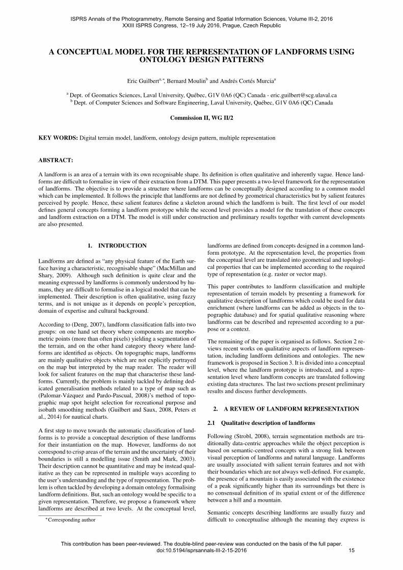
hence reveal their existence. In order to provide a formal de-scription that applies to different contexts, a landform prototypeis defined in an ontology design pattern as a reusable ontology.Two kinds of landforms are considered: elementary and complexlandforms; hence two prototypes sharing similar properties aredefined.
Elementary landforms are defined by their salient features only.For example, a mountain is characterised by its summit while acanyon is located on the map by its course line. We considerthat these salient features are intrinsic structural components onwhich landforms lie and whose definition agrees with the prin-ciple of naive geography. Skeletons are mainly points or lineswhich would correspond to topographical features such as sum-mits or ridge lines. They can also be lines defining a break ofslope or delineating an homogeneous area as in a cirque or in aplateau where the skeleton can be a ring surrounding the flat up-land part.
Complex landforms are not characterised by their saliences but bya specific arrangement observed over a terrain. This is mostly thecase for compound groups of landforms such as mountain rangeswhose existence depends on the existence of several individualmountains. Mountains are characterised by their summits andconnected by their ridge lines. Hence, a skeleton is also defined inthese landforms as it provides a topological structure supportingthe landform from which shape characteristics can be extractedsuch as the orientation. Skeletons also provide the support fora topological structure connecting landforms together and allow-ing for further reasoning based on the spatial configuration theyprovide.
However useful skeletons can be in landform characterisation,they are not sufficient for a full description of landforms. Peoplethink mostly about space in terms of regions rather than pointsand lines (Hobbs et al., 2006). They would not locate the summitor the course line as a point or a line but as regions built aroundthese elements. Hence these salient features are perceived assalient regions built around the landform skeletons. A salient re-gion does not cover the whole landform but only a part of it. Theremaining of the landform belongs to the vague region where theboundary is located. As a way to handle vagueness and indeter-minacy of locations, (Bittner, 1999) located vague objects withina partition in three regions: the core, the wide boundary and theexterior. These three regions are used to provide the rough lo-cation of a landform (Figure 2). The wide boundary does notcorrespond to a fuzzy boundary but rather to a region in whichthe boundary is included but whose location is not known.
The core concepts of our landform ODP are summarised in Fig-ure 3. The skeleton is defined by a geometrical shape and byspatial constraints. Constraints reflect spatial properties and rela-tionships that apply to the skeleton which need to be expressedin a formal language. The core region and wide boundary ofa complex region is not the union of its composing elementary
ISPRS Annals of the Photogrammetry, Remote Sensing and Spatial Information Sciences, Volume III-2, 2016 XXIII ISPRS Congress, 12–19 July 2016, Prague, Czech Republic
This contribution has been peer-reviewed. The double-blind peer-review was conducted on the basis of the full paper. doi:10.5194/isprsannals-III-2-15-2016
17
Landformprototype
Complexlandform
Elementarylandform
Wideboundary
CoreregionSkeleton Wide
boundaryCoreregionSkeleton
Figure 3: The proposed landform ODP
landforms but have their own definitions consistent with their se-mantics. For example the core region of a mountain range canenclose the wide boundary of a mountain.
As landforms can be characterised by their spatial relationshipswith other landforms, a set of elementary relationships needs tobe defined in the ODP. Similarly to landforms, new relationshipsshall be defined by refining the definitions based on the domainrequirements. These relationships are defined from the spatial re-lationships between their components, i.e. relationships betweenskeletons and between core regions and wide boundaries.
Due to the vagueness of their definition, the basic set of relation-ships applied to core regions and wide boundaries is limited tothe RCC-5 set (Cohn et al., 1997). For a landform A, we denoteA◦ its core region, ∂A its wide boundary and A = A◦ ∪ ∂A thearea occupied by both its core region and wide boundary. For twolandforms A and B we identify the following three relationships:
A is fully contained within B ⇔A is a proper part of B◦ (1)A overlaps B ⇔A◦ partially overlaps B◦ (2)
A is adjacent to B ⇔(∂A partially overlaps ∂B)∧¬(A◦ is discrete from B◦)
(3)
These three relationships provide the core set of relationships de-fined in our ODP from which further relationships can be derived.Derivation can be done by composing or by specialising the rela-tionships, but also by including contextual elements and renam-ing the relationships according to the domain.
3.3 Representation level
Once the conceptual model is designed, the next step in theframework is to move to the representation level where landformsand their components can be identified from a DTM. Dependingon the representation, this DTM can be a raster grid, a TIN or aset of contours and spot heights for example. The main role of theproposed DTM ODP is to provide an interface so that the trans-lation between the conceptual level and the representation levelcan be conducted similarly for any kind of representation.
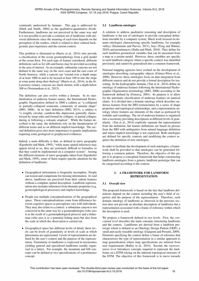
The first concern at this level is to translate the skeleton defini-tions so that they are extractable from the DTM. Skeletons aretopological structures joining critical points and lines of the ter-rain that shall be extracted from the DTM. The most commontopological data structures that fit with the definition of the skele-ton are the surface network and the Reeb graph (Guilbert et al.,2014). The surface network is a planar graph formed by the crit-ical points (peaks, pits, saddles) and the critical lines (ridge linesand valley lines) of the terrain (Figure 4). The Reeb graph is thedual of the surface network and provides a hierarchical structure
5
4
3
2
3
2 0
1
3
D
O
D
X
D
X
X
D
D – Peak O – Pit X – Pass
Ridge line Valley line
2
4
3
2
1
2 2
5
0
3 3
Figure 4: Surface network and its corresponding contour tree.
of the critical points. The Reeb graph is also topologically equiv-alent to the contour tree hence such kind of topological structurecan be extracted from any kind of DTM representation.
As a topological structure, the surface network has to observesome constraints related to the meaning carried by its criticalpoints and lines. Hence, a ridge line always connects a saddleand a peak and a valley line always connects a saddle and a pit.Another rule to observe is the Euler-Poincare rule stating that:
#peak + #pit−#saddle = 2 (4)
Several algorithms were developed to extract the surface networkof a terrain model. Most of them apply to TIN. They usually workby extracting first critical points and second critical lines joiningthe critical points or by growing regions whose boundaries are thecritical lines. These different approaches are discussed in (Comicet al., 2014).
(Sinha et al., 2014) provide a surface network ODP where theyuse descriptive logic to define the ontology concepts and expresstopological constraints. Such an ontology can be adapted to ourframework but hierarchical relationships between landforms needto be considered as they affect the classification. For example, apeak can be the summit of two prominences which correspondto two representations at different scales. The surface networkmust be extracted while considering the scale defined in the con-text. However, since the context can include different levels ofrepresentation, the model shall be able to handle landforms repre-sented at different levels and relationships between these levels.For that purpose, the ODP shall be extended to include multi-ple representation and make available simplification tools such asthose proposed in (Rana and Morley, 2000) and (Danovaro et al.,2003). Simplification is done by removing points considered notrelevant and adjacent critical lines to maintain the topology. Forexample, if a peak is removed, a pass has to be removed.
For each kind of landform, the definitions of its core region andwide boundary can be refined since they relate to its shape andcomplexity. For example, in a valley, the core region can be de-fined by the valley floor and the wide boundary by the sides of thevalley, which fits with the fact that the boundary shall be locatedon its sides without a precise location (Straumann and Purves,2011). As another example, the core region of a plateau wouldbe the flat horizontal table while the wide boundary would be de-fined by the areas corresponding to its steep slopes. However thedefinition may vary with the representation and the accepted de-gree of vagueness. The landform limit is contained in this wideboundary. The wider the boundary, the more vague the locationof the limit. Definitions of both regions would be based on someterrain descriptor, on contours or on some critical lines. For ex-ample, in the case of a prominence, one can directly use the valley
ISPRS Annals of the Photogrammetry, Remote Sensing and Spatial Information Sciences, Volume III-2, 2016 XXIII ISPRS Congress, 12–19 July 2016, Prague, Czech Republic
This contribution has been peer-reviewed. The double-blind peer-review was conducted on the basis of the full paper. doi:10.5194/isprsannals-III-2-15-2016
18
Canyon
Wideboundary-slope:verysteep-extent:boundedbyflatterrainorridge
Coreregion-centredonskeleton-narrow-slope:flat-extent:boundedbysteepslopes
Skeletonline-thalweg-length:kilometre-posi>on:acrossthecon>nentalslope-heightdifference:below300m
Skeletonline-startpoint:saddle-endpoint:pit-length:lmin<l<lmax
Canyon
Wideboundary-slope:>alpha-limit:ridgelineorbreakofslope
Coreregion-cross-sec>onslope:<epsilon-width:<wmax
Figure 5: Canyon concept (above) and its representation (below).
lines surrounding the summit to define a crisp boundary (whichwould be a polygonal line) and a core region delineated by theseboundaries as in (Sinha et al., 2014). Boundaries can also be de-fined by a contour line around the summit related to a given levelof detail (Guilbert, 2013) or related to a morphometric classifica-tion (Chaudhry and Mackaness, 2008).
4. PRELIMINARY RESULTS
We currently work on an application of our conceptual frameworkto submarine geomorphology. The objective is to characterisesubmarine canyons and other kinds of valleys in the St-Lawrenceestuary on the east coast of Canada using bathymetric data. Datawere obtained from multibeam sounding and cleaned to producea 25m resolution image of the bathymetry. Current work consistsin developing the domain knowledge with the assistance of ge-omorphologists. The context is mainly set by the area of studysince canyon dimensions as well as the scale at which to workare fixed by the estuary dimensions.
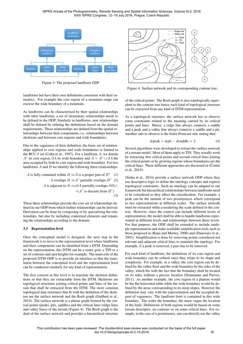
Starting from a qualitative description, a conceptual definitionwas built (Figure 5). It is based on general terms that can charac-terise the canyon in comparison with other undersea features ac-cording to our landform ODP (Figure 3). A canyon is perceivedas a long narrow steep-sided valley that we decompose mainlyinto its bottom marked by a thalweg line and its walls. The skele-ton is hence defined by the thalweg line which provides the lo-cation and orientation of the canyon. In the St-Lawrence estuary,canyons are short with a height difference of no more than 300m.The core region corresponds to the narrow band around the thal-weg line and shall have a relatively flat cross-section. Finally, thewalls around the bottom define the wide boundary which may ex-tend to the next ridge line or to some significant break of slope.This bounding line does not necessarily mark the boundary of thecanyon but a noticeable topographic element that marks a limit oris outside the canyon.
Translation to the terrain model is done by identifying the skele-ton, core region and wide boundary of the canyons on the DTM.Both conceptual model and representation were obtained throughdiscussion with geomorphologists. Definitions were tested andadapted in order to match with manual classifications they pro-vided. Currently, full extraction has not been completed and only
Peak Pit Saddle Regularpoint
Figure 6: Detection of critical points. Black points: elevation islower than the red point. White points: elevation higher than thered point.
skeleton extraction has been implemented. The process first ex-tracts the surface network of the whole area and second simplifiesthe network to the appropriate representation level.
The raster image was transformed into a triangulated irregularnetwork by selecting VIP points in order to have a topologicalvector structure. Algorithms from (Takahashi et al., 1995) wereapplied to extract critical points and lines. Critical points (peaks,pits and passes) were first identified by classifying neighbouringpoints which are higher or lower (Figure 6). If all neighboursare higher, the point is a pit; if they are all lower, it is a peak.Passes are points whose neighbours can be lower or higher thanthe point but which are organised so that when marching around,we move at least twice from one point lower to a point higherthan the saddle. A saddle can be of different multiplicities. Asimple saddle connects two ridge lines and two valley lines. Adouble saddle connects three ridge lines and three valley linesand so on. In the case two neighbour points were at the sameelevation, a priority rule was set, choosing always the further rightpoint as the highest. This arbitrary but simple rule guaranteed therobustness of the algorithm in order to validate the Euler-Poincarerule (equation 4). This rule applies to domains forming a close2D manifold, homogeneous to the surface of a sphere,. As ourdomain of study contains holes, corresponding to islands, virtualpits were added to close the domain.
Ridge lines are extracted by starting from a saddle point and mov-ing along the TIN edges from one point to a higher neighbouralong the steepest slope until reaching a peak. Similarly, valleylines are extracted by moving downward along the steepest slopeuntil reaching a pit. We also applied the algorithm from (Taka-hashi et al., 1995) although we did not use the elevation differenceas a criterion but the steepest slope as in (Bremer et al., 2003).
Simplification was done by applying the approach of (Rana andMorley, 2000) where non significant critical points are removedleading to the removal or the merge of critical lines (both val-ley and ridge) in order to maintain the topology. Only the net-work structure was simplified, the triangulation was not modified.Simplification is done by measuring the difference of elevationbetween each peak (respectively pit) and each saddle connectedby a ridge line (respectively valley line). If this difference is toosmall, the peak (respectively pit) and the saddle are removed. Thepurpose of this step is to remove elements corresponding to toosmall variations of the terrain and preserve variations at the ap-propriate scale.
Valley lines that can belong to a canyon are identified by mea-suring the differences with the surrounding peaks. Skeletons arebuilt by aggregating consecutive valley lines meeting this defi-nition. Starting points and ending points of the skeleton are as-signed by checking the slope difference between the valley liens.Let’s note one pit p1 connected to two saddles s0 and s1 by twovalley lines and the two pits p0 and p2 connected to these sad-dles (Figure 7). We note d0 and d1 the average slopes between
ISPRS Annals of the Photogrammetry, Remote Sensing and Spatial Information Sciences, Volume III-2, 2016 XXIII ISPRS Congress, 12–19 July 2016, Prague, Czech Republic
This contribution has been peer-reviewed. The double-blind peer-review was conducted on the basis of the full paper. doi:10.5194/isprsannals-III-2-15-2016
19

Figure 7: Construction of the skeleton by valley line aggregation.×: saddle, H: pit
p0 and p1 and between p1 and p2. If the ratio d0d1
is close to one,the slope is homogeneous on both lines, and the saddle can beremoved; otherwise it indicates a change of slope correspondingto the transition between the shelf and the slope or between theslope and the floor of the estuary and the saddle must be kept.Due to the lack of a precise quantitative definition and the influ-ence of several parameters on the definition of valley lines, theapproach was iterative where parameters are refined after beingevaluated by geomorphologists.
Figure 8: Original surface network extracted from the seafloor.
Figure 8 presents the original surface network extracted from theseafloor on the northern part of the St Lawrence estuary. Thelarge number of points in the upper part of the figure correspondto points along the coastline forming the boundary of the domain.Slopes on the sides of the estuary are relatively steep and becomegentler when moving closer to the bottom. As it can be seen fromthe contours, canyons cut through the slope towards the bottom.
Figure 9 shows the same area after simplification. Critical pointsthat do not fit with the scale were removed and valley linesmerged together to identify thalwegs that fit with the skeletondefinition of Figure 5. Indeed, thalwegs identified on Figure 9correspond to all skeleton lines of canyons, but also to other kindsof channels whose skeleton definition also matches the canyon’sdefinition. Further distinction between them shall be made byextracting the core region and wide boundary as channel core re-gion shall be larger and their boundaries shall not be as steep asfor canyons.
Figure 9: Simplified thalwegs are canyon skeleton candidates.
The skeletons extracted in our approach were shorter than thoseidentified manually. This difference comes from the definitionchosen for the conceptual model: canyons being defined by theheight difference, only the part located on the continental slopewas identified. The extension of the canyon in the flat seabedof the estuary was not considered. This extension is not explicitin the definition however it still is a part of the canyon wheresediments are transported. Hence although the current definitionseems appropriate for the extraction of canyons in a general con-text, a more elaborated definition may be required when address-ing the needs of experts in submarine geomorphology.
5. PERSPECTIVES
Landforms classification from a terrain model is still a difficulttask because of the subjectivity of their definition. Consider-ing that landforms are indeed always described within a givencontext, this paper proposes an organisational pattern for land-form representation where landforms are structured at two levels.At the conceptual level, landforms are abstracted from a domainknowledge according to a context. The main idea is that land-forms follow a prototype built upon three components: the skele-ton, the core and the wide boundary of the landform. At the rep-resentation level, the model is translated into concepts related to aparticular kind of representation. The purpose is to provide a log-ical model that can be implemented in order to extract landformsfrom a DTM.
Preliminary results show that the surface network is a robuststructure to extract salient features forming the skeletons of theconsidered landforms. Further work is still required for the defi-nition of the core region and wide boundary. The objective here isnot only to fix a set of parameters for canyons but also to identifyand qualify the list of parameters in the current context in orderto use them in the classification of other landforms. The modelwill then be extended to the general definition of landforms.
For that purpose, a more rigorous description could be providedusing a formal description language to avoid current ambiguities.At this point, we only addressed the main concepts. Our nextobjective is to provide concepts and relationships to formalise acomplete terminology. Once such a model is defined, mecha-nisms translating the conceptual model to the representation levelshall be investigated with the objective to automate the process asmuch as possible.
ISPRS Annals of the Photogrammetry, Remote Sensing and Spatial Information Sciences, Volume III-2, 2016 XXIII ISPRS Congress, 12–19 July 2016, Prague, Czech Republic
This contribution has been peer-reviewed. The double-blind peer-review was conducted on the basis of the full paper. doi:10.5194/isprsannals-III-2-15-2016
20
ACKNOWLEDGEMENTS
Authors would like to thank Patrick Lajeunesse and AlexandreNormandeau for their assistance. Data were provided by theCanadian Hydrographic Service.
REFERENCES
Balley, S., Baella, B., Christophe, S., Pla, M., Regnauld, N. andStoter, J., 2014. Map specifications and user requirements. In:D. Burghardt, C. Duchene and W. Mackaness (eds), Abstract-ing geographic information in a data rich world, Lecture notes ingeoinformation and cartography, Springer-Verlag, Berlin Heidel-berg, pp. 17–52.
Bittner, T., 1999. On ontology and epistemology of rough lo-cation. In: C. Freksa and D. M. Mark (eds), Spatial Informa-tion Theory - Cognitive and Computational Foundations of Ge-ographic Information Science, Lecture Notes in Computer Sci-ence, Vol. 1661, Springer, pp. 433–448.
Bremer, P.-T., Edelsbrunner, H., Hamann, B. and Pascucci, V.,2003. A multi-resolution data structure for two-dimensionalmorse-scale functions. In: Proceedings of the 14th IEEE Visu-alization Conference, pp. 139–146.
Chaudhry, O. and Mackaness, W., 2008. Creating mountains outof mole hills: Automatic identification of hills and ranges usingmorphometric analysis. Transactions in GIS 12(5), pp. 567–589.
Cohn, A. G., Bennett, B., Gooday, J. and Gotts, N. M., 1997.Qualitative spatial representation and reasoning with the regionconnection calculus. Geoinformatica 1, pp. 275–316.
Comic, L., De Floriani, L., Magillo, P. and Iuricich, F., 2014.Morphological Modeling of Terrains and Volume Data. Springer-Briefs in Computer Science, Springer.
Danovaro, E., De Floriani, L., Magillo, P., Mesmoudi, M. M. andPuppo, E., 2003. Morphology-driven simplification and multires-olution modeling of terrains. In: E. Hoel and P. Rigaux (eds), The11th International Symposium on Advances in Geographic Infor-mation Systems, ACM press, pp. 63–70.
Deng, Y., 2007. New trends in digital terrain analysis: landformdefinition, representation, and classification. Progress in PhysicalGeography 31(4), pp. 405–419.
Dungan, J. L., Perry, J. N., Dale, M. R. T., Legendre, P., Citron-Pousty, S., Fortin, M.-J., Jakomulska, A., Miriti, M. and Rosen-berg, M. S., 2002. A balanced view of scale in spatial statisticalanalysis. Ecography 25, pp. 626–640.
Egenhofer, M. J. and Mark, D. M., 1995. Naive geography. In:A. U. Frank and W. Kuhn (eds), Spatial Information Theory: ATheoretical Basis for GIS, Lecture Notes in Computer Science,Vol. 988, pp. 1–15.
Feng, C.-C. and Bittner, T., 2010. Ontology-based qualitativefeature analysis: Bays as a case study. Transactions in GIS 14(4),pp. 547–568.
Fonseca, F. T., 2001. Ontology-driven geographic informationsystems. PhD thesis, The University of Maine.
Gangemi, A. and Presutti, V., 2009. Ontology design patterns. In:S. Staab and R. Studer (eds), Handbook on Ontologies, pp. 221–243.
Giunchiglia, F., Maltese, V., Farazi, F. and Dutta, B., 2010. Ge-owordnet: A resource for geo-spatial applications. In: L. Aroyo,G. Antoniou, E. Hyvonen, A. ten Teije, H. Stuckenschmidt,L. Cabral and T. Tudorache (eds), 7th Extended Semantic WebConference, ESWC 2010, Heraklion, Greece, Springer, pp. 121–136.
Gomez-Perez, A., Ramos, J., Rodrıguez-Pascual, A. and Vilches-Blazquez, L., 2008. The IGN-E case: Integrating through a hid-den ontology. In: A. Ruas and C. Gold (eds), Headway in SpatialData Handling, Springer, pp. 417–435.
Guilbert, E., 2013. Multi-level representation of terrain featureson a contour map. Geoinformatica 17(2), pp. 301–324.
Guilbert, E. and Saux, E., 2008. Cartographic generalisation oflines based on a B-spline snake model. International Journal ofGeographical Information Science 22(8), pp. 847–870.
Guilbert, E., Gaffuri, J. and Jenny, B., 2014. Terrain generalisa-tion. In: D. Burghardt, C. Duchene and W. MacKanness (eds),Abstracting Geographic Information in a Data Rich World, Lec-ture notes in geoinformation and cartography, Springer-Verlag,Berlin Heidelberg, pp. 227–258.
Harris, P., Macmillan-Lawler, M., Rupp, J. and Baker, E., 2014.Geomorphology of the oceans. Marine geology 352, pp. 4–24.
Hobbs, J., Blythe, J., Chalupsky, H. and Russ, T. A., 2006. A sur-vey of geospatial resources, representation and reasoning. Tech-nical report, University of Southern California.
IHO, 2008. Standardization of undersea feature names. 4th edn,International Hydrographic Organization, Monaco.
IHO, 2013. Standardization of undersea feature names. 4.1 edn,International Hydrographic Organization, Monaco.
Luscher, P., Burghardt, D. and Weibel, R., 2007. Ontology-drivenenrichment of spatial databases. In: Workshop of the ICA com-mission on generalisation and multiple representation.
MacMillan, R. and Shary, P., 2009. Landforms and landformelements in geomorphometry. In: T. Hengl and H. I. Reuter(eds), Geomorphometry Concepts, Software, Applications, De-velopments in Soil Science, Vol. 33, Elsevier, chapter 9, pp. 227– 254.
Mark, D. M. and Smith, B., 2004. A science of topography:From qualitative ontology to digital representations. In: M. P.Bishop and J. F. Shroder (eds), Geographic Information Scienceand Mountain Geomorphology, Praxis Publishing, pp. 75–100.
Normandeau, A., Lajeunesse, P. and St-Onge, G., 2015. Sub-marine canyons and channels in the lower St. Lawrence Estu-ary (Eastern Canada): Morphology, classification and recent sed-iment dynamics. Geomorphology 241, pp. 1–18.
Palomar-Vazquez, J. and Pardo-Pascual, J., 2008. Automatedspot heights generalisation in trail maps. International Journal ofGeographical Information Science 22(1), pp. 91–110.
Peters, R., Ledoux, H. and Meijers, M., 2014. A voronoi-basedapproach generating depth-contours for hydrographic charts. Ma-rine Geodesy 37(2), pp. 145–166.
Rana, S. and Morley, J., 2000. Surface networks. Working papersseries 43, UCL centre for advanced spatial analysis.
Sinha, G. and Mark, D. M., 2010. Cognition-based extractionand modelling of topographic eminences. Cartographica 45(2),pp. 105–112.
ISPRS Annals of the Photogrammetry, Remote Sensing and Spatial Information Sciences, Volume III-2, 2016 XXIII ISPRS Congress, 12–19 July 2016, Prague, Czech Republic
This contribution has been peer-reviewed. The double-blind peer-review was conducted on the basis of the full paper. doi:10.5194/isprsannals-III-2-15-2016
21

Sinha, G., Kolas, D., Mark, D. M., Romero, B. E., Usery, E. L.,Berg-Cross, G. and Padmanabhan, A., 2014. Surface networkontology design patterns for linked topographic data. SemanticWeb Journal.
Smith, B. and Mark, D. M., 2003. Do mountains exist? towardsan ontology of landforms. Environment and Planning B: Planningand Design.
Straumann, R. K. and Purves, R. S., 2011. Computation and elic-itation of valleyness. Spatial cognition and computation 11(2),pp. 178–204.
Strobl, J., 2008. Segmentation-based terrain classification. In:Q. Zhou, B. Lees and G.-A. Tang (eds), Advances in Digital Ter-rain Analysis, Lecture Notes in Geoinformation and Cartography,Springer, pp. 125–139.
Takahashi, S., Ikeda, T., Shinagawa, Y., Kunii, T. L. and Ueda,M., 1995. Algorithms for extracting correct critical points andconstructing topological graphs from discrete geographical ele-vation data. Computer Graphics Forum 14, pp. 181–192.
Yan, J., Guilbert, E. and Saux, E., 2014. An ontology for subma-rine feature representation on charts. In: J. Parsons and D. Chiu(eds), Advances in conceptual modeling, Lecture notes in com-puter science, Vol. 8697, Springer, pp. 91–100.
ISPRS Annals of the Photogrammetry, Remote Sensing and Spatial Information Sciences, Volume III-2, 2016 XXIII ISPRS Congress, 12–19 July 2016, Prague, Czech Republic
This contribution has been peer-reviewed. The double-blind peer-review was conducted on the basis of the full paper. doi:10.5194/isprsannals-III-2-15-2016
22