a 4-day geological field trip in the western · pdf filea 4-day geological field trip in the...
TRANSCRIPT

Geo.Alp, Vol. 8, S. 76–118, 2011
A 4-DAY GEOLOGICAL FIELD TRIP IN THE WESTERN DOLOMITES
Rainer Brandner1 & Lorenz Keim2
With 28 Figures
76
1 Institut für Geologie & Paläontologie, Universität Innsbruck, Innrain 52, A-6020 Innsbruck; E-mail address: [email protected]
2 Amt für Geologie & Baustoffprüfung/Ufficio Geologia e prove materiali, Autonome Provinz Bozen – Südtirol/Provincia Autonoma di Bolzano-Alto Adige, Eggentalerstr./Via Val d’Ega 48, I-39053 Kardaun/Cardano; E-mail address: [email protected]
Introduction and geological setting of the Dolomites
The Dolomite Mountains are known for their spectacular seismic scale outcrops showing Triassic carbonate platforms and build-ups preserved with their clinoforms and slope facies in primary transition to adjacent basi-nal areas. The juxtaposition of Middle and Upper Triassic reefs and basins are preserved due to the lack of strong tectonic deformation and is strengthened by erosion to form the extraordinary landscape as seen today. Since the outstanding studies of Richthofen (1860) and Mojsisovics (1879), who correctly recognized the primary geometries of the build-ups (“Überguss-Schichtung”) in transition to the basins, the Dolomites are the type area for heteropic facies developments. Bosellini (1984) presented the first modern synthesis of depositional geometries of the build-ups. Regional sequence stratigraphy was firmly established with the revision of the chronostratigraphic framework by Brack & Rieber (1993), De Zanche et al. (1993) and Mietto & Manfrin (1995). In addition, a better understanding was developed of progradation and retrogradation geometries of carbonate platform development in context with sea level changes (Gianolla et al., 1998, with further references). A new 1:25.000 scale geological map (Geologische Karte der Westlichen Dolomiten) was provided in 2007 for the whole area of the Western Dolomites on the basis of extensive field work and detailed stratigraphic investiga-tions and structural analyses.
The Dolomites are part of the south alpine retro wedge of the Alpine chain. The Neogene S-vergent thrust- and fold belt is located south of the Periadriatic Lineament (Pustertal Fault), east of the Giudicaria fault system and north of the Valsugana thrust (Fig. 1). All these faults are inherited structures which were remobilized at different times since their installation in the Early Permian (see below). Within this framework of major faults, the Dolomites form a Neogene pop-up structure with only weak tectonic deformation (Doglioni, 1987). North of the Pustertal Line, more exactly north of the hinge of the Tauern Window antiform, Austroalpine and Penni-nic nappes are thrusted toward the north in the Paleogene.

77 Geo.Alp, Vol. 8, 2011
Fig. 1: Regional geologic overview with location of the excursion area in the Dolomites (rectangular).

78Geo.Alp, Vol. 8, 2011
order cycles (sequences) and cycles of higher order (e. g. Werfen Fm.):
1. Early Permian volcanic deposits with interca-lated fluvio-lacustrine sediments of the Athesian Volcanic Group enclose ca. 10 Ma from 285 to 275 Ma (Marocchi et al., 2008). The up to 3 km thick se-quence rests on a basal conglomerate, covering the Variscan crystalline basement by a main unconfor-mity and was deposited in the Bozen/Bolzano intra-continental basin.
2. After a marked stratigraphic gap of ca. 10 Ma, the Gröden/Val Gardena alluvial red beds were depo-sited on top of the volcanic group as well as on top of the Variscan basement. With the cooling of the crust, sedimentation of Gröden sandstone was very spaci-ous and shallow marine deposits of the Bellerophon Fm and Werfen Fm prograded stepwise westward on a very gentle ramp. This second megacycle ends with Lower Anisian shallow-water carbonates of the Lo-wer Sarldolomite.
3. A second period of rifting starts in the Middle/Upper Anisian with strong block tilting in several pha-ses followed by the “Middle Triassic thermal event” in the Ladinian. Strong subsidence created space for the upward growth of buildups and carbonate platforms adjacent to up to 800 m deep marine basinal areas. Ladinian volcanics infilled basinal depressions and onlapped carbonate platform slopes. With the waning of rifting activity and volcanism thermal subsidence controlled once more the sedimentary development with spacious progradation of carbonate platforms. Minor pulses of rifting still occurred in the Upper Carnian, but in the Norian the accentuate relief was levelled out by the spacious carbonate platform of the Dolomia Principale/Hauptdolomit.
During the Upper Triassic and Jurassic the Sout-halpine and Austroalpine domains were involved in a new system of rifting processes (Bertotti et al., 1993). Starting from the Atlantic with the Central Atlantic Magmatic Province (CAMP) at the end of the Triassic, the Atlantic propagated north-eastward to form the Alpine Tethys, i.e. the Ligurian/Penninic Ocean (Frizon de Lamotte et al., 2011). Apulia was now surroun-ded by two different domains, the “Neo-Tethys” in the east and the “Alpine Tethys” in the west, thus forming a terrane or a microcontinent. The Southern Alps with the Dolomites in their heart have been in-
Both, Austroalpine and Southalpine units are part of the passive continental margin of the Apu-lia microplate with a comparable geodynamic deve-lopment since the Lower Permian. Early continental rifting processes associated with the break-up of Pangea during the Lower and Middle Permian gave way to the stepwise propagation of the Neo-Tethys from SE. Pulses of distinct rifting tectonics in the Dolomites in the Early Permian and Middle Triassic are closely associated with voluminous plutonic and volcanic rocks deposited largely in the same place. Both, Permian and Triassic magmatic rocks display typical calc-alkaline trends and the geochemical and isotopic composition indicate that the melts origi-nated from the interaction of upper mantle and lo-wer crust (Barth et al., 1993, Visonà et al., 2007). The marked orogenic signature is not compatible with the conventional rifting model. But also for the sub-duction related model, proposed by Castellarin et al. (1988), unequivocal geological field evidences in the Southern Alps and surroundings are still missing. Ne-vertheless, in many plate reconstructions we still find a Triassic active margin in prolongation of the closing Paleotethys south of the Southern Alps (e. g. Stampf-li & Borel, 2002). New paleomagnetic data advocate an intra-Pangea dextral megashear system of >2.000 km to avoid the crustal misfit between Gondwana and Laurasia in the Early Permian (Muttoni et al., 2003). Within this scenario, lithosphere-scale exten-sion enables mantle melt injections in the lower crust to generate hybridisation of magmas (Schaltegger & Brack, 2007). This model represents a good possibili-ty to unravel the large-scale geodynamic context of Permian and Triassic particularities of the Southern Alps.
Permian and Triassic rifting tectonics are more intensive in the Southalpine realm than in the Aus-troalpine, where during this time period magmatism and volcanism are nearly absent. This different evo-lution requires a transcurrent shearing system in bet-ween the two realms to facilitate different stretching of the lithosphere. Therefore, we assume already for the Permo-Triassic time span a forerunner of the dif-ferentiation of Apulia N and Apulia S, separated by a Paleo-Insubric Line, which proposed Schmid et al. (2004) for the Jurassic.
The Permo-Triassic succession of the Dolomites can be subdivided into three tectonically controlled 2nd order megacycles, which are superposed by 3rd
79 Geo.Alp, Vol. 8, 2011
matic decoupling from the Austroalpine. Froitzheim et al. (2011) propose a sinistral strike-slip zone as a Paleo-Insubric Line, boardering the Austroalpine nap-pe stack with Late Cretaceous extensional Gosau ba-sins toward the south. The only indication of eoalpine orogenesis nearby the Southalpine is documented by a drastic change in the Upper Cretaceous marine se-dimentation in the still existing extensional basins with the input of siliciclastics, Flysch-like deposits with rare chrome spinell (Castellarin et al., 2006).
During the Paleogene compressional deformation occurred and the Dolomites became a foreland basin, a process related to the Dinaric post-collisional oro-geny. Predominantly the eastern Dolomites have been affected by a WSW- to SW-vergent thin-skinned thrust belt (Doglioni, 1987). Toward NE (Comelico, Carnia) also the crystalline basement was involved in the frontal ramp tectonics (Castellarin et al., 2004, 2006).
With the Neogene Valsugana structural system, i.e. the alpine retrowedge, the Venetian basin beca-
volved in various processes related to these two rif-ting systems for a long period of time lasting from the Early Permian to the Upper Cretaceous.
The above mentioned three megacycles are super-posed by the global mass extinction events at the Permian Triassic boundary (PTB), in the Carnian and at the Triassic Jurassic boundary (TJB). All three events strongly affected the reef growth and the carbonate factory, especially the PTB and the Carnian event ef-fectively controlled the sedimentary development in the Dolomites.
The convergent tectonics of the Southalpine is,
however, quite different from that of the Austroal-pine: W- to NW-vergent thrusting and folding star-ted in the Austroalpine just in the Late Jurassic with the closing of the Meliata Ocean in the SE (Gawlick et al., 1999) heralding the eoalpine orogenesis during the Late Cretaceous (for an comprehensive overview see Schmid et al., 2004). These eoalpine compressive events with metamorphism, do not have any record in the Southalpine, and thus require a kind of kine-
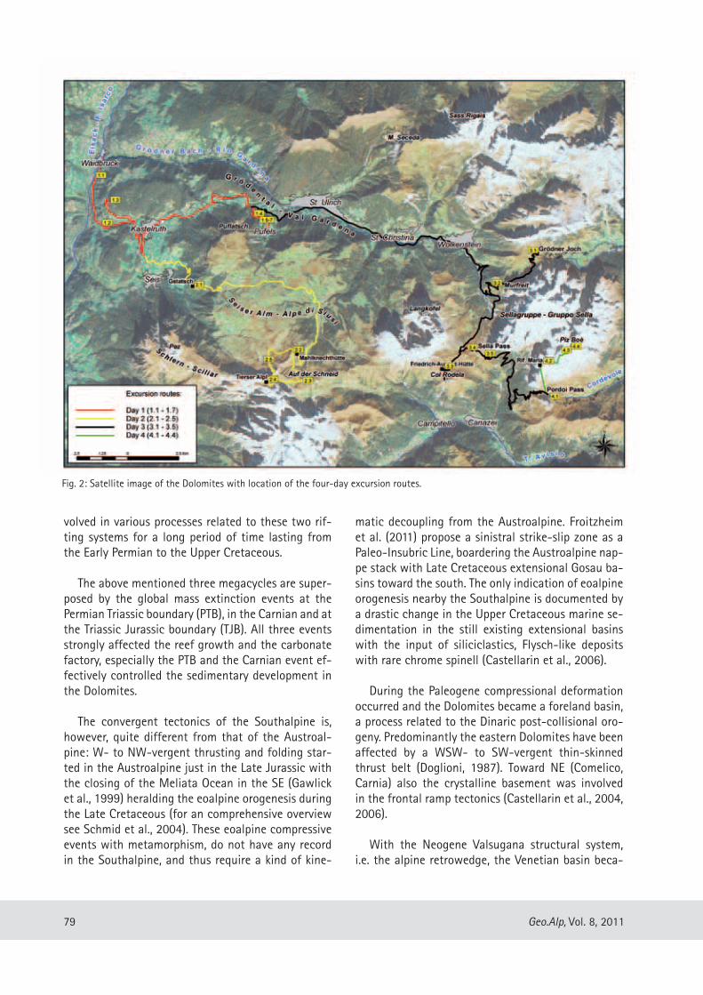
Fig. 2: Satellite image of the Dolomites with location of the four-day excursion routes.

80Geo.Alp, Vol. 8, 2011
The Bozen/Bolzano basin is confined by a system of NNE and ESE striking, normal or transtensive faults. The most prominent faults are the Giudicarie fault in the west, the Pustertal fault in the north, the Calisio line in the southwest and the Valsugana line in the southeast (Fig. 3). All these Permian paleo-lines were reactivated several times later on, but at different de-formation regimes. The Lower Permian age of similar striking faults of other volcanic basins is shown by the fact that these faults are sealed with intercalated se-diments or volcanic formations (Brandner et al., 2007, Marocchi et al., 2008). Detailed field mapping indicates half-graben geometries, for instance, in the area of Waidbruck-Villnöß and Meran 2000 with block-tilting toward NW. With the new geochronological data of the volcanic sequence it is now possible to recognize a temporal polarity within the Permian fault pattern (Marocchi et al., 2008), i.e. a younging trend of the volcanic formations from the northwestern margin of the basin to the central part in the southwest. These data imply, together with the half graben geometries, an opening trend of the basin in a NW–SE direction. Because of the geometries of the Lower Permian fault pattern, a transtensional opening of the basin would only be possible in a sinistral shearing system, which is in contrast with the timing of plate tectonic models of Muttoni et al. (2003) and Cassinis et al. (2011). At this point it is essential to mention, that the Bozen/Bolzano volcanic basin formation does not correspond to the first transtensional event in the Southern Alps. In the Carnic Alps, the up to 2000 m thick filling of the transtensional Naßfeld/Pramollo basin, with the mixed siliciclastic-carbonate sediments of the Auer-nig, Rattendorf and Trogkofel Groups, spanning a time period from the Upper Carboniferous to the Artinskian in the Early Permian (Venturini, 1991, Krainer et al., 2009), occurs i.e. circa 20 Ma earlier than the Bozen/Bolzano megacycle. Thus, we speculate, that the basic change in plate kinematics took place within the peri-od of Lower Permian magmatism that largely affected Paleo-Europe.
The AVG is subdivided into a lower part with main-ly andesitic and rhyodacitic volcanic products and an rhyolithic upper part. The change of the geochemical composition is closely related to a volcano-tectonic collapse. Cogenetic subvolcanic rhyodacitic intrusions along fractures are described by Morelli et al. (2007) near Terlan/Terlano. Five kilometres to the south, a second important collapse fracture is mentioned by the authors, producing a considerable depression. Ac-
me the foreland of the Dolomites. Strong overthrusts in a SSE direction are indicated by uplifting of the hanging wall of the Valsugana thrust of approximate-ly 4 km in the upper Miocene (Castellarin et al., 2004, with references). Remnants of the Oligocene/Miocene coastline are preserved at ca. 2.600 m altitude at the southern flank of Monte Parei in the Eastern Dolo-mites (Keim & Stingl, 2000).
The four-day excursion focuses on the geodynamic and stratigraphic evolution of the Permian– Triassic and presents with its spectacular outcrops the most representative key sections of the Western Dolomites (Fig. 2). Triassic extensional vs. alpine compressional tectonics of the Col Rodela imbricate zone as well as the “Gipfelüberschiebungen” (= summit thrusts), i. e. Dinaric thrusts on top of the Triassic Sella atoll-reef, Raibl Group, Hauptdolomit and Lower Jurassic drow-ning of the shallow-water platform, are further im-pressive targets of the excursion.
DAY 1
The Permian volcanic event and the upper Permian to lower Triassic stratigraphic succession
The Bozen/Bolzano basin, filled by a succession of up to 3 km thick volcanics and intercalated sediments, documents the development of a new tensional re-gime in the interior of Pangea after the end of Varis-can orogeny. The fundamental plate boundary reorga-nisation is seen in the context of the above mentioned intra-Pangea dextral megashear system at the transi-tion of an Early Permian Pangea “B” to a Late Permian Pangea “A” configuration (see Muttoni et al., 2003), contemporary to the opening of the Neotethys Ocean.
The thick volcanic sequence, in the older literature known as “Bozner Quarzporphyr”, ranges from basal-tic andesites to rhyolithes and spans a period lasting from ca. 285 Ma to 275 Ma. The sequence is now defined as Athesian Volcanic Group (AVG) (see Carta Geologica d’Italia, 2007, Marocchi et al., 2008). High-precision extrusion ages combined with detailed field mapping over extended areas of the AVG were provi-ded by Morelli et al. (2007) and Marocchi et al. (2008). Mapping of several newly established and well-dated volcanic stratigraphic units enables for the first time the reconstruction of the three-dimensional emplace-ment history within the strongly tectonically influ-enced basin development.

81 Geo.Alp, Vol. 8, 2011
shallow-shelf carbonates of the Bellerophon Fm. After the end Permian mass extinction mixed shallow-mari-ne carbonates and terrigenous sediments of the Wer-fen Fm. are characterised by the long lasting biogenic recovery, lacking carbonate producing organisms. The first carbonate bank produced by calcareous algae is of Lower Anisian age (Lower Sarl/Serla Fm) and forms the top of the 2 megacycle.
Excursion route
Stops 1.1–1.3 are located along the classic geolo-gical section at Waidbruck/Ponte Gardena on the road to Kastelruth/Castelrotto crossing the whole sequen-ce from the basal conglomerate, volcanoclastic sedi-ments, andesitic and dacitic block lavas to rhyodacitic and rhyolithic ignimbrites.
Stops 1.4 to 1.7 are dedicated to the Permian-Tri-assic sequence of the Pufels/Bulla key-section along the abandoned road to Pufels/Bulla (Fig. 2).
cording to Morelli et al. (2007) more than 1000 m of pyroclastic flow deposits accumulated, i.e. ignimbrites of the Auer/Ora Formation. A similar scenario can be observed along the road from Waidbruck/Ponte Gar-dena to Kastelruth/Castelrotto at stop 1.2 with the collapse escarpment of the WNW–ESE striking Bund-schuh normal fault (Figs. 4, 5). We recognize here the sealing of the fault with ignimbrites of the Auer/Ora Formation (Brandner et al., 2007). The volcanic activity is interrupted at different stratigraphic levels marked by alluvial conglomerates, sandstones and la-custrine deposits with plant remains (Hartkopf-Fröder et al., 2001).
The volcano-sedimentary Lower Permian mega-sequence is unconformably overlain by the spacious cover of continental clastic deposits of the Gröden/Val Gardena Fm., which forms the basis of the 2nd me-gacycle and is devoid of volcanics. Thermal subsidence dominated the sedimentary development of this cycle, which is evident by widespread interfingering of con-tinental and shallow-marine facies. The general ma-rine transgression of the Neotethys to the west took place in several third-order sequences ranging from coastal plain environments with sabkha evaporates to
Fig. 3: (a) Distribution of present-day Permian and Ladinian plutonic and volcanic rocks. The formation of Permian volcanics seems to be connected to synvolcanic extensional tectonics with NW-SE and NE-SW trending faults with half graben geometries. Configuration of the Permian faults could be related to an overall sinistral megashear associated with the beginning of the opening of the Neo-Tethyan Ocean in the Far East. Data on Permian faults based on own field mapping, Carta Geologica d’Italia (2007, sheet “Appiano-Epp-an”), Carta Geologica d’Italia (2010, sheet “Merano-Meran”), Selli (1998) and Morelli, C. (pers. comm., 2011).The Ladinian magmatites in the Dolo-mites are located close to the Permi-an ones – thus a genetic connection, i.e. a similar uplifted position of the mantle as in the Permian, could be proposed. The Anisian master fault serves as an example and shows the inheritance of the Permian fault pat-tern in the Triassic and Jurassic. CL = Calisio paleo-line, VL = Val Sugana paleo-line (modified after Selli, 1998).

82Geo.Alp, Vol. 8, 2011
1989). Fluvial conglomerates with quartz pebbles and sporadic metamorphic clasts from the basement are locally interbedded. The mixed volcaniclastic/volcanic-terrigenous sequence is overlain by 60–80 m thick, finely crystalline andesitic lavas (Trostburg Fm., Brandner et al., 2007). Visonà et al. (2007) deter-mined from this lava flow a SHRIMP U-Pb zircon age of 290.7+/-3 Ma indicating that the andesitic lavas of the northern region preceded the general onset of the volcanism of the AVG with 284.9+/-1.9 Ma (Marocchi et al., 2008) in the Etsch/Adige valley.
Stop 1.2 – First turn of the road, near the locality Zoll: the Bundschuh fault, a Permian normal fault
The Bundschuh normal fault is situated in a small valley in between the farmsteads Planötsch and Bundschuh (Figs. 4, 5). The Permian age of the fault is expressed by its sealing with rhyolithic ignimbrites of the Auer/Ora Fm at the top of the AVG. The fault has been reactivated insignificantly several times later on. The Bundschuh fault crosses the Eisack/Isarco valley in WNW-ESE direction and delimits in the lower sec-tion the crystalline basement toward thick sequences of ignimbrites of the Gargazon and Torggl Fms in the hanging wall located in the south. The remarkable dif-ference in the thickness of the fluvial sediments of the St. Vigil Fm of about 70 m on both sides of the fault is interpreted by levelling of the strong relief created by faulting.
The Bundschuh fault and the Villnöß/Funes paleo-fault mark together with the Meran 2000 fault system the northern margin of the Lower Permian Bozen/Bolzano basin.
Stop 1.1 – Waidbruck/Ponte Gardena Conglomerate
The classic geological section along the road to Ka-stelruth/Castelrotto starts with the well-known out-crop of the Waidbruck/Ponte Gardena Conglomerate at the basis of the volcanics of the AVG (Fig. 4). The unconformable contact with the underlying crystal-line basement is covered by Quaternary debris. The thickness of the basal conglomerate differs strongly, in some places it reaches 50 m, while at others the conglomerate is lacking. Geological field mapping showed an abrupt pinching out of the conglomerates along NW-SE and NE-SW striking Permian normal faults.
Krainer (1989) studied the section in detail (Fig. 6) and recognized three lithofacies types: (1) massive, poorly sorted and matrix-rich conglomerates with a matrix-supported grain fabric, (2) crudely bedded, clast-supported conglomerates filling up to 1 m deep erosive channels and (3) fine-grained, cross bedded conglomerates, filling smaller channels. The conglo-merates consist of poorly rounded clasts of rocks of the crystalline basement, predominantly quartz phyl-lite and better rounded quartz pebbles. The quartz pebbles and grains are covered by a reddish thin film of hematite indicating semiarid to arid climatic condi-tions. Mature quartz pebbles with a long transporta-tion history and angular, immature phyllite pebbles are mixed in the poorly sorted debris flow sediments. They testify, in combination with the poorly sorted channel fills, an ephemeral stream environment with wadi channels. Higher up in the section, the amount of volcanic pebbles and sandstones increases to turn into a ca. 70 m thick pyroclastic/volcanic sequence with block lavas, tuffs, explosion breccias, irregular-ly intercalated in the lava flows (Di Battistini et al.,
Fig. 4: Schematic lithostratigraphic model of the Permian Athesian Volcanic Group east of the Eisack valley, based on Geologische Karte der Westlichen Dolomiten 1:25.000 (2007) and Brandner et al. (2007). The location of the schematic section is shown in Fig. 3.

83 Geo.Alp, Vol. 8, 2011
décor stone. The vitrophyre is characterized by nearly unaltered glass (a petrographic peculiarity for an age of 275 Ma) in the groundmass, which is responsible for the black colour. Eutaxitic microstructures and perlithic fracturation can be observed under the microscope, as well as scattered crystals of quartz, sanidine, plagio-clase and biotite (Mostler, 1982, Bargossi et al., 1998).
The vitrophyre is overlain with a sharp boundary by red rhyolithic ignimbrites of the Auer/Ora Fm. The petrographic composition and structure are similar to the vitrophyre, the difference is only the altered, red coloured groundmass. Intercalated are aphyric, red and black lithoclasts. Typical are juvenile aphanitic in-clusions with flame structures (“fiamme”). The sharp boundary with the yellowish horizon on top of the vi-trophyre is interpreted by Mostler (1982) and Bargossi et al. (1998) as a weathering horizon (spherical wea-thering).
Stop 1.3 – Tisens, little quarry near Lieg Inn: typical succession at the base of the Auer/Ora ignimbrite formation.
The section starts along the access road with a sedi-mentary sequence of the St. Vigil Fm with sandstones and conglomerates of reworked volcanic rocks, ran-domly also quartz grains and phyllites occur of the cry-stalline basin. The sandstones are cross bedded and are arranged in small channels with graded channel fillings typical for point bar sequences. A 2 m thick sandstone bank marks the top of the sequence. After a non ex-posed part in the outcrop a black vitrophyric rhyoli-thic tuff of 8–12 m thickness follows at the base of red coloured ignimbrites of the Auer/Ora Fm. The whole volcanic succession is exposed in a quarry. The vitro-phyre is known in the older literature as “Pechstein-porphyr von Tisens” and is still used as building and
Fig. 5: Panoramic view of the Permian volcanics between Waidbruck/Ponte Gardena and Kastelruth/Castelrotto. A major upper Permian syn-volcanic, WNW-ESE running, steep normal fault between Bundschuh-Planötsch is present. This fault also causes the abrupt thickness change of the epiclastic sediments of the St. Vigil Fm. Numbers correspond to the facies model of Fig. 4. (after Brandner et al., 2007). Numbers 1 and 2 = excursion stops.

84Geo.Alp, Vol. 8, 2011
The Pufels/Bulla road section: from the Permian-Triassic Boundary (PTB) to the Induan-Olenekian Boundary (IOB)1
1 The following chapter is basically a reproduction of the pu-blished field guide by Brandner et al. (2009).
General remarks
The Pufels/Bulla section offers an excellent oppor-tunity to study the Permian-Triassic boundary (PTB) and the Lower Triassic Werfen facies and stratigra-phy in a nearly continuous section that reaches from the PTB to the Induan/Olenekian boundary (IOB) lo-cated within the Campill Member (Fig. 7). Based on this key-section at Pufels/Bulla we want to stimulate the discussion on questions of the “system earth”, i.e. genetically related correlations of lithofacies, sea-level changes, anoxia and stable carbon and sulphur isotope curves. Magnetostratigraphy enables a direct comparison with continental sedimentary sequences of the German Zechstein and Buntsandstein to un-derstand sequence stratigraphy, cycles and regional climatic influences.
The Pufels/Bulla section is well known for its ex-cellent outcrop quality as well as findings of cono-donts constraining the Upper Permian, PTB and Lower Triassic succession. Investigations on lithostratigra-phy and biostratigraphy have been carried out by Mostler (1982), Perri (1991) and Farabegoli & Perri (1998). Integrated studies of lithostratigraphy, ma-gnetostratigraphy and chemostratigraphy have been carried out by Scholger et al. (2000), Korte & Kozur (2005), Korte et al. (2005), Farabegoli et al. (2007) and Horacek et al. (2007a). A comprehensive review is given by Posenato (2008).
Lithostratigraphy and depositional environments
The shallow marine sediments of the topmost Bel-lerophon Fm and Werfen Fm were deposited on a very gentle, NW–SE extending ramp. The coastal plain en-vironment of the upper Gröden Fm was present in the west while a shallow marine, mid and outer ramp environment of the Bellerophon Fm could be found in the east. The Bellerophon Fm shows several cycles representing 3rd order sequences within a general westward prograding sedimentary wedge. The over-
Fig. 6: Measured section of the Ponte Gardena (Waidbruck) Con-glomerate and the lower part of the volcanic sequence along the road from Waidbruck to Kastelruth, after Krainer (1989). Reworked clasts of the Ponte Gardena (Waidbruck) Conglo-merate consist essentially of quartz phyllite of the underlying metamorphic basement. Upsection, these conglomerates are gradually replaced by conglomerates and sandstones with abun-dant and well rounded volcanic clasts.

85 Geo.Alp, Vol. 8, 2011
ment thickness of 200 m in the Pufels section results in a sedimentation rate of 1 m/6.5 ka, uncorrected for compaction. This rather high sedimentation rate not only suggests a high frequency of storm events (hurricanes), but also stresses the exceptional en-vironmental conditions during this period and may indicate a lack of dense vegetation in the hinterland.
Since the 19th century several attempts have been made to subdivide the Werfen beds into mapable li-thostratigraphic units: (1) in a first step, Wissmannn, 1841 (lit. cit. in Posenato, 2008) made a simple sub-division according to the grey and red colours of the interbedded marls in Seisser Schichten and Campiler Schichten; (2) Recent research in sedimentology and biostratigraphy by Bosellini (1968), Broglio Loriga et al. (1983, 1990) and others enabled a division of the Werfen Formation – still an informal unit – into 9 members (Tesero, Mazzin, Andraz, Siusi/Seis, Gas-tropodenoolith, Campill, Val Badia, Cencenighe, San Lucano) which correspond pro parte to depositional sequences (De Zanche et al., 1993). In general, the Werfen Formation is characterized by subtidal sedi-ments, but intra- to supratidal levels with evaporitic intercalations are present within the Andraz, Gastro-podenoolith, the base of Val Badia, Cencenighe and San Lucano members.
Stratigraphic terminology
The historical lithostratigraphic units “Seiser Schichten” and “Campiler Schichten” are now con-sidered members (Siusi/Seis Mb (“Siusi” is the Italian translation of the German name of the village Seis) and Campill Mb) but with different usage of the lo-wer and upper boundaries depending on the indivi-dual research groups. This mismatch of lithostrati-graphic definitions has been ignored by some authors especially from outside of Italy, which resulted in wrong and confusing correlations of biostratigraphy, magneto- and chemostratigraphy (for further infor-mation see the review of Posenato, 2008).
Due to relative sea-level changes, facies belts shift on the gentle ramp in time and space, with the consequence that lithologies are arranged in cycles and therefore are repetitive. In such a situation it is rather obvious, that members as lithostratigraphic units also shift in time. Hence the defined boundari-es of the members are not always isochronous. More stratigraphic studies, which are independent of local
lying Werfen Formation consists of a strongly varying sequence of mixed terrigenous siliciclastic and car-bonatic lithofacies, organized in T/R-cycles of diffe-rent order and frequency. These 3rd order depositional sequences (see De Zanche et al., 1993, Gianolla et al., 1998) are composed of 4th order cycles of storm layers (thickening or thinning upward) and may have been orbitally forced. For detailed descriptions of li-thology and biostratigraphy see Broglio Loriga et al. (1983). The PTB mass extinction of carbonate produ-cing organisms prevented the evolution of a rimmed shelf area during the entire Lower Triassic. After this exceptionally long lasting recovery period of reefal buildups in the whole Tethys area, the first appea-rance of reef building organisms occurred in the lo-wer Middle Triassic, the nearby situated Olang/Valda-ora Dolomites (Bechstädt & Brandner, 1970).
The lack of reefal buildups and binding organis-ms may have caused the extreme mobility of vast amounts of loose carbonate and siliciclastic sedi-ments that have been removed repeatedly by storm-dominated, high-energy events. These processes generated a storm-dominated stratification pattern that characterises the specific Werfen facies. App-lying the concept of proximality of storm effects (Aigner, 1985), i. e. the basinward decrease of storm-waves and storm-induced currents, we tried to inter-pret relative sea-level changes from the stratigraphic record. Proximal and distal tempestite layers are ar-ranged in shallowing-upward cycles (parasequences) but also in deepening-upward cycles depending on their position within the depositional sequences. Ho-wever, numbers of cycles and cycle stacking patterns vary from section to section according to the positi-on on ramp. The main control for these sedimentary variations seems to be the ratio between accom-modation space and sediment supply, which follows the variable position of the base level (see base level concept from Wheeler, 1964). Variations in base level determine the geometry of progradational, aggrada-tional and retrogradational stacking patterns of the individual sedimentary cycles. Base level, however, does not automatically correspond to sea level.
Reviewing the published data of magnetostra-tigraphy and chemostratigraphy, calibrated with bio-chronostratigraphy, Posenato (2008) assigned radiometric ages to the Lower Triassic sequence of the western Dolomites. Assuming that the duration from PTB to IOB is roughly 1.3 Ma, the total sedi-

86Geo.Alp, Vol. 8, 2011
the Austroalpine (Krainer, 1987) and Lower/Middle Buntsandstein of Central Germany (Szurlies et al., 2003). The term “Gastropodenoolith” will be used only as remarkable facies type but not as an indi-vidual lithostratigraphic unit (see Geologische Karte der Westlichen Dolomiten, 2007).
The Pufels/Bulla road section exposes the whole sequence from the PTB to the supposed IOB, i. e. up-permost Bellerophon Fm and Werfen Fm with Tese-ro Mb, Mazzin Mb, Andraz Mb, Seis Mb and lower Campill Mb. Younger members of the Werfen Fm are lacking in this area due to block tilting and erosion during the Upper Anisian (Fig. 7).
Stop 1.4 – Permian/Triassic Boundary
Bellerophon Fm: the outcrop at the starting point of the section only shows the top of the formation with gray calcareous dolomite mudstones, and with vertical open tubes, interpreted as root traces (Fig. 8a). The dolomites belong to the top of the “Ostracod and peritidal dolomite unit” described by Farabogoli et al. (2007). They are covered by 4-cm thick, orange to green coloured marls, which probably represent a hiatus that represents a sequence boundary. The se-quence “Ind 1” starts with a sequence consisting of dm bedded, grey to dark grey fossiliferous packstones that are intercalated with irregular cm-thick layers of black carbonaceous marlstones. Bedding planes are wavy due to strong bioturbation. This 155 cm thick sequence is termed Bulla Mb (Farabegoli et al., 2007).
facies developments, such as magnetostratigraphy and chemostratigraphy, are needed for a better un-derstanding of the sedimentary evolution and corre-lation of the successions.
Practicality for field mapping: detailed lithostra-tigraphic divisions are important for 3-D understan-ding of palaeogeography, but also for the resoluti-on of tectonic structures. By mapping large areas in the eastern and western Dolomites we always en-countered the problem of the correct determination of the “Gastropodenoolith Member”, particularly in areas with isolated outcrops or tectonic disturbances. This member is characterised by a high lateral vari-ability in facies and thickness (Broglio Loriga et al., 1990) with storm layers of oolithic grainstones with microgastropods, and occasionally intraformational conglomerates (“Kokensches Konglomerat”). As the-se lithotypes occur in different positions in the Seis/Siusi and Campill Mbs, the boundaries of the “Gas-tropodenoolith Member” have been defined diffe-rently depending on the authors. For geologic map-ping in the field we used a practicable solution by defining the lower boundary of the Campill Mb at the appearance of the first observable sandstone- or calcareous sandstone layers (unit D on top of the Si-usi Mb defined by Broglio Loriga et al., 1990). This terrigenous input marks a distinct break in the sedi-mentary development of the Werfen Formation and has a very wide palaeogeographical distribution. The stronger clastic input in the overall marine Werfen Fm is genetically correlatable with the boundaries between Unterer/Oberer Alpiner Buntsandstein in
Fig. 7: Geological cross section along the abandoned road to Pufels/Bulla with location of the single excursion stops (1.4−1.7). PTB = Permian-Triassic Boundary (after Brandner et al., 2009).

87 Geo.Alp, Vol. 8, 2011
With the Tesero Oolite, at the base of the Lower Triassic Werfen Formation, we observe a fast, several tens of kilometres, westward shift of the shoreline that shows a typical onlap configuration, i. e. trans-gression and not regression as described from other areas in the world. The topmost Bellerophon Forma-tion (cycle A in Brandner, 1988; Bulla Member sensu Farabegoli et al., 2007) and the Tesero Oolite record severe environmental changes at the event stratigra-phic boundary of the PTB and includes profound bio-tic extinctions, which coincide more or less with the well known negative carbon isotope excursion (Fig. 8a). The event-stratigraphic boundary of PTB is situ-ated ca. 1.3 m below the FAD of the conodont Hin-deodus parvus, defining the base of the Triassic (see Mostler, 1982 and Fig. 3 in Farabegoli et al., 2007).
Werfen Fm: The Werfen Fm starts with the Tese-ro Oolite Mb within bed number 12 of the detailed section (Fig. 8a). Fossiliferous packstones are over-lain with a sharp contact by well washed, fossilife-rous grainstones, 4 to 5 cm thick (Fig. 8b), grading to grainstones with superficial ooids (5 cm thick bed) and cross bedded oolites (20 cm thick bed) on the top of the beds. The detailed description of this im-portant environmental change was made possible by sampling the entire 40 cm thick bed in order to pre-pare a polished slab comprising the entire bed and 5 large thin sections. In contrast to the black carbon-aceous marlstone layers of the Bulla Member, centi-metre intercalations in the Tesero Oolite Member are composed of greenish terrigenous silty marlstones.
Fig. 8: The Perm-Triassic Boundary: (a) detailed measured section of the PTB with litho-, bio-, chemo- and magnetostratigraphy. Conodonts and position of the PTB after Mostler (1982) and Farabegoli et al. (2007), magnetic declination after Scholger et al. (2000); (b) Three thin-section photomicrographs from the uppermost Bellerophon Formation and the lowermost Werfen Formation. The lower thin section shows a fossil rich, skeletal packstone with typical fusulinids (Fu), red algae (gymnocods, Gy) and bivalves (Bi). The middle thin section shows a variably sharp contact between the fossiliferous packstone to a grainstone along a firm ground. An increase of hydrodynamic energy is documented by outwash of mud and reworking of intraclastic grains. Only a part of the grains is reworked (e. g. fusulinids). Contrary to Farabegoli et al. (2007) we do not see evidence for subaerial exposure. The uppermost image shows a typical oolitic grainstone from the Tesero Oolite (after Brandner et al., 2009).

88Geo.Alp, Vol. 8, 2011
Synchronously to the pronounced increase in hy-drodynamic energy in the shallow water environment at the event-stratigraphic boundary of the PTB, an increase in humidity and freshwater discharge is do-cumented at the beginning of the continental Bunt-sandstein facies. This interpretation is based on the magnetostratigraphic correlation of the Pufels/Bulla section and sections of the continental facies realm of the Germanic Trias (Szurlies et al., 2003, Hug & Gaupp, 2006).
Mazzin Member
The contact of the Tesero Oolite to the Mazzin Member is transitional (Figs. 8a, 9); some beds of Te-sero Oolite occur intercalated within dm-bedded, ne-arly unfossiliferous grey limestones (structurless mu-dstones, sometimes microbial structures). The oolite intercalations are interpreted as sand waves or sheets of ooid sand accumulating in a mid to outer ramp po-sition. They are fed by about 10 meter thick sand bars which are preserved in the depositional environment as a barrier island and outcrop in the Tramin/Termeno sec-tion, about 40 km SW of Pufels (Brandner et al., 2009). The repeated migration of oolitic sand to the shelf area may have been controlled by cyclic sea-level lowstands and storm-dominated transport. Oolitic grainstone la-yers disappear upward in the section, emphasizing the transgressive trend of the depositional sequence.
A very characteristic lithotype that occurs in the middle part of the section are “streaked” mudstones: beds of grey limestones or marly limestones with low content of silty quartz and micas with mm- to cm thick planar laminae of graded bioclastic packstones (mostly ostracods). They are interpreted as distal storm layers. Streaked mudstones alternate with structureless, bio-turbated mudstones generating meter-scaled symme-trical cycles. Mudstones with strong bioturbation cor-respond to the time-equivalent vermicular limestones in Iranian sections (e. g. Horacek et al., 2007), or the Lo-wer Anisian “Wurstelkalke” in the Austroalpine realm.
The upper part of the section shows an increase in terrigenous input. Meter-scale cycles with thickening storm layers of bioclastic packstones are capped by greenish marlstones suggesting a shallowing-up trend (Fig. 9). This trend results in the predominance of mul-ticoloured laminated siltstone with wave ripples and mud crack structures at the top of the depositional se-quence (Ind 1).
The transition from fossiliferous packstones of the Bellerophon Fm to the barren grainstones of the Te-sero Oolite is characterized by a stepwise increase in the hydrodynamic energy (see bed 12, Fig. 8a and “current event” of Brandner, 1988). These steps are recorded in three 4−5 cm thick storm layers without a significant unconformity or signs of subaerial expo-sure. Petrographic evidence suggests friable-cemen-ted firm grounds on the sea floor. Borings show only poorly defined walls (Fig. 8b). The uneven surface of the firmground only shows little erosion by storm waves. There is no evidence for vadose diagenesis. For a different interpretation see Farabegoli et al. (2007).
On the contrary, ooids are not leached (such as the oomoldic porosity of the Miami Oolite) but have nuclei of calcite crystals and sparry calcite cortices encrusted by micritic laminae. Calcite crystals show borings of endolithic algal filaments underlining their primary precipitation on the sea floor. Further inve-stigations are needed to verify the possible primary low-magnesium calcite precipitation on the Permi-an-Triassic sea floor. The factors known to control the precipitation of calcium, i. e. low Mg/Ca ratios and faster growth rates (Chuodens-Sánchez & González, 2009), would shed an interesting light on the assu-med unusual seawater chemistry at the PTB.
Some ooids contain coatings of finely dispersed pyrite, but pyrite is also common in intergranular po-sitions (in agreement with Wignall & Hallam, 1992, Bond & Wignall, 2010). Enhanced oxygen depletion in the surface water may have been caused by glo-bal warming and ocean heating (Shaffer et al., 2009). These processes would lead to an increase in alkalini-ty within a reducing, subtidal environment. The drop of the carbon isotope curve correlating with the Te-sero Oolite may indicate an increase of isotopically depleted bicarbonate ions in seawater caused by the activity of sulphate reducing bacteria in a stratified ocean (Tethys as a “giant Black Sea”, see Korte et al., 2004, Horacek et al., 2007b). An increase in the amount of HCO3¯ forces precipitation of calcite on the sea bottom. The synchronous rise of 34S in corre-lative sections nearby (Seis/Siusi, Newton et al., 2004 and Tramin/Termeno, Brandner, 1988, Horacek et al., 2010) supports this model. Carbonate seafloor crusts and fans and special types of oolites and oncolites are widespread in different levels of the Lower Trias-sic and are often connected to perturbations of the carbon isotope curve (Pruss et al., 2006, Horacek et al., 2007a, b).

89 Geo.Alp, Vol. 8, 2011
Fig. 9: Measured section through the Werfen Formation along the abandoned road to Pufels/Bulla. The top of the section shows alpine ramp folds which can be restored bed by bed. Upper Anisian conglomerates unconformably overlie the lower part of the Campill Member recor-ding upper Anisian uplift and erosion (after Brandner et al., 2009).

90Geo.Alp, Vol. 8, 2011
Campill Member, complicating the definition of the Gastropod Oolite Member (see above).
Tempestite proximality (thick-bedded tempestites are more proximal (= shallower) than thinner bedded tempestites (= deeper)) enables the grouping of beds in thickening- or thinning upward cycles on the scale of few meters (Fig. 9). The lithofacies comprise both the upper shoreface and the offshore environment. Hummocky cross stratification and gutter casts indi-cate the lower shoreface facies and offshore facies of a high-energy type of coast (Fig. 10).
The Seis Member overlies the Andraz Member with a well-preserved erosional unconformity which is interpreted as SB at the base of the depositional sequence Ind 2 (Fig. 9). The sequence starts with a transgressional package of well-bedded tempestites characterized by rip up clasts (flat pebbles), micro-gastropodes and glauconite.
The onset of reddish marlstone in the upper part of the member signalizes a better oxidation of the sea bottom, which may be a consequence of a lo-wer sedimentation rate or better circulation of bot-tom water. Reddish marlstones in the upper part of the Seis Member are distributed in the western and eastern Dolomites, but their isochronous onset is not demonstrated. Toward the boundary with the Campill Member the predominance of offshore facies in the cycles shifts once more to a shoreface facies with thickening of shell tempestites and scour fillings.
Biostratigraphic remarks: The Seis/Siusi Member in the Dolomites is known for the abundance of Cla-raia specimens defining the Claraia Zone (Fig. 11). The subzones with Cl. wangi-griesbachi, C. clarai and C. aurita occur in the upper Mazzin, lower and upper Seis members (Broglio Loriga et al., 1990, Posenato, 2008). In the Pufels/Bulla sections several findings of Claraia specimens have been documented by Mostler (1982).
Stop 1.6 – Siliciclastic input, climate signal
Campill Member
The start of the Campill Member is defined here with the first distinct occurrence of quartz/mica sandstones. Half meter- to meter-thick calcareous sandstone beds with hummocky cross stratification and a remarkable glauconite accumulation represent the transgressive phase of sequence Ind 3. The beds
Stop 1.5 – Supratidal/subtidal facies
Andraz Member
The peritidal unit consists of a cyclic alternation of marly-silty dolomites, locally cellular, laminated silty marls and siltstones with a typical mud-flat facies. As there is no clear interruption in the sequence, we propose that progradation of the coastal tidal flat facies rather than a distinct drop of the sea level for-med this sequence.
New artificial outcrops of the Andraz Member (this unit is usually completely covered) that were excavated along the abandoned road and those that were made during the construction of the gallery of the new road to Pufels enabled the measurement of a detailed section and high-resolution sampling for magnetostratigraphy and carbon isotope analyses (Fig. 9).
Seis/Siusi Member
The Seis Member is a sequence of interbedded limestones and silty marlstones with a greenish co-lour in the lower and reddish one in the upper part. The ubiquitous content of terrigenous quartz and micas, always in the same silt grain size, reveal an air blown silt transport from the hinterland in the west. Limestone beds show textures typical for tem-pestites. In general they consist of graded litho- and bioclastic packstones and wackestones (often shell tempestites) with bed thicknesses ranging between centimetres and a few decimetres. The base of the beds mostly is sharp and erosional, scours and gut-ter casts are present. Wave-ripples with wavelengths up to 100 cm are common often causing a lenticular shape of the beds. Hummocky cross stratification oc-curs at the base of the rippled beds.
A special lithotype is the “Gastropodenoolith”. Indi-vidual tempestite beds consist of reddish grainstones and packstones with oolites and microgastropodes (often with internal sediments or ferroan dolomite spar fillings and glauconite which do not correspond to the matrix of the packstones). Another one is the “Kokensches Konglomerat”, an old term used by Ger-man authors, which consists of a conglomerate with flat pebbles. Both lithologies are handled as “leading facies types” for the Gastropod Oolite Member. Un-fortunately both types are to be found in the lower and upper part of the Seis Member as well as in the

91 Geo.Alp, Vol. 8, 2011
the Induan-Olenekian Boundary in Mud (Spiti, Hima-laya) (Krystyn et al., 2007). Peritidal cycles are made up of greenish to reddish silty and sandy marls with wave ripples and mud cracks alternating with dm-bedded silty bioclastic limestones and a few yellowish oolitic dolomites and marly dolomites. Posenato (2008) ter-med this unit “lithozone A” of the Gastropod Oolite Mb in the definition of Broglio Loriga et al. (1990). Two thinning upward cycles with some dm-thick amalga-mated hummocky cross-stratified silty limestone beds at their base represent the transgressive phase of se-quence “Ole 1” (accepting the strong negative carbon isotope excursion as a proxy for the IOB). The back-ground sedimentation is still composed of red silty and sandy marlstones. Rare dark gray to black laminated marlstones may indicate short intervals of decreasing oxygen at the sea bottom.
The road section ends with the upper Anisian ero-sional unconformity on top of the lower part of the Campill Member. Upper Anisian Conglomerates (Vol-tago-/Richthofen Conglomerate) directly overlie red siltstones, sandstones and silty marls.
grade to thinner bedded storm layers (bioclastic shell tempestites) forming thinning upward cycles on the scale of several meters (Fig. 9). U-shaped burrows in-terpreted as Diplocraterium burrows, microripples and wrinkle structures are remarkable sedimentary struc-tures in this part of the section. Most typical are “Kin-neyia” structures, mm-scale winding ridges resembling small-scale interference ripples. After Porada & Bouo-ugri (2007) these structures formed underneath mi-crobial mats and are usually preserved on flat upper surfaces of siltstone or sandstone beds.
From ca. 152 m to 186 m section along the road is mostly covered. The next outcrops at the top of the section show some folding and ramp folds, but exact balancing of the stratigraphy by retrodeformation is possible.
The last 20 meters of the section are important for two reasons: (1) a prominent change is present in fa-cies development from peritidal to subtidal offshore environment, and (2) this change is accompanied by a strong negative shift in the carbon isotope curve which is correlatable to the proposed GSSP section of
Fig. 10: Schematic model for the deposition of the Werfen Formation on an east-dipping ramp. Sedimentation is essentially controlled by storms; the coast line is supposed to be far to the west near the Como Lake. Mud deposits, now red and green marls, alternate with layers of sand with bivalve and gastropod shells. Each limestone bed is the product of a storm event and is deposited within some days. Storms generate energy-rich, seafloor-touching waves, which, especially in the coastal zone, are eroding and swirling up the mud and sand on the seafloor. Consequently, bivalve and gastropod shells are washed out and enriched sepa¬rately forming coquina beds (see Fig. 11) (after Brandner & Keim, 2011).

92Geo.Alp, Vol. 8, 2011
preserved in the Pufels section). This would imply that the profound changes in the global carbon cycle in the Lower Triassic are forced by eustatic sea-level changes. The TSTs of the sequences Ind 2 and Ind 3 are not clearly mirrored by the carbon isotope curve at Pufels.
Only in the transition towards more terrigenous input, i.e. at the base of the Campill Member, irregu-larities in the trend of the carbon isotope curve are present. More conspicuous is a negative shift in the Iranian sections (Horacek et al. 2007). On the other hand, the regional importance of the terrigenous in-put signal is evidenced by the magnetostratigraphic correlation with the continental facies of the German Triassic. Equivalent to the terrigenous Campill event in the Southalpine and the Upper Buntsandstein in the Austroalpine, the Volpriehausen Formation at the base of the Middle Buntsandstein starts with the first basin-wide influx of coarse grained sands (Szurlies, 2004). These distinct breaks in sedimentation style indicate a climate change to a more humid environ-ment with increased rainfall and continental runoff.
Stop 1.7 – The Pufels/Bulla overthrust
This point offers a unique panorama of the Pufels overthrust – an alpidic structure due to N-S com-pression (Fig. 12). The whole pile of rocks, comprising the sequence between Außerraschötz and Piz Culac, is tilted towards the south. However, from Piz Culac to Col dala Dodesc the whole succession between the Bellerophon Fm and the Ladinian lavas is tectonically repeated.
The Pufels (Bulla) overthrust originated from a sheared, overturned syncline: the Contrin Dolomite southwest of Piz Culac shows this folding structure very clearly. Due to gradual compression the S-shaped folding was finally cut through. The whole upper rock package moved further to the north leading to the above cited repetition of the succession.
The basal shear plane of the Pufels thrust probably runs at the border between the Gröden and Belle-rophon Fms and subsequently ascends the Werfen Fm presumably to the Schlern Dolomite, which is not preserved in the area.
The Pufels thrust is temporarily connected to the so-called “Val Sugana phase”; this deformation phase was active in the Southern Alps from 13 to 7 million years ago and caused the strongest uplift of the Do-lomite Mountains (Castellarin & Cantelli, 2000).
Summary
The lithostratigraphic and sedimentologic study has enabled the identification of meter-scale trans-gressive-regressive cycles (parasequences) in periti-dal to subtidal depositional environments. Associa-tions of the parasequences constitute, with varying stacking patterns, four depositional sequences that may have regional significance as shown by Horacek et al. (2007) who carefully correlated the stratigraphy of several sections in the Dolomites and Iran (). The main excursions of the carbon isotope curve can be correlated to sequence stratigraphic boundaries: (1) transgressive systems tract (TST) of sequence Ind 1; (2) TST of Ole 1 (see also Krystyn et al., 2007); and (3) the TST at the base of the Val Badia Member (not
Fig. 11: Thin section photomicrographs of typical tempestite beds with grading and coquinas with Claraia clarai (after Brandner & Keim, 2011).

93 Geo.Alp, Vol. 8, 2011
Fig. 12: Geological cross section of the N-vergent Pufels/Bulla overthrust, which developed from the sheared syncline at Piz Culac. The virtual extension of the cross section in the air shows the south dipping clinoforms of the Geisler/Odles on the upper left side. 63 = Southalpine metamorphic Basement, 62 = Waidbruck Conglomerate., 54 = ignimbrites undifferentiated of the Athesian Volcanic Group, 53 = Gröden Fm, 52 = Bellerophon Fm, 50 = Mazzin Mb, 49 = Andraz Mb, 48 = Seis/Siusi Mb, 47 = Campill Mb, 44 = Peres Fm (Voltago/Richthofen Conglomerate), 43 = Morbiac Fm, 40 = Contrin Fm, 39 = Buchenstein Fm, 35 = lavas, 25 = Wengen Fm, 24 = St. Cassian Fm, 5k = till, 1h = alluvial deposits, 1b = talus deposits (after Brandner & Keim, 2011, based on Geologische Karte der Westli-chen Dolomiten 1:25.000 (2007)). Foto: H. Rier.
94Geo.Alp, Vol. 8, 2011
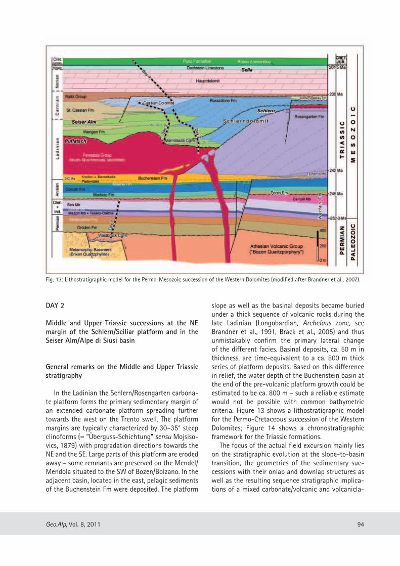
slope as well as the basinal deposits became buried under a thick sequence of volcanic rocks during the late Ladinian (Longobardian, Archelaus zone, see Brandner et al., 1991, Brack et al., 2005) and thus unmistakably confirm the primary lateral change of the different facies. Basinal deposits, ca. 50 m in thickness, are time-equivalent to a ca. 800 m thick series of platform deposits. Based on this difference in relief, the water depth of the Buchenstein basin at the end of the pre-volcanic platform growth could be estimated to be ca. 800 m – such a reliable estimate would not be possible with common bathymetric criteria. Figure 13 shows a lithostratigraphic model for the Permo-Cretaceous succession of the Western Dolomites; Figure 14 shows a chronostratigraphic framework for the Triassic formations.
The focus of the actual field excursion mainly lies on the stratigraphic evolution at the slope-to-basin transition, the geometries of the sedimentary suc-cessions with their onlap and downlap structures as well as the resulting sequence stratigraphic implica-tions of a mixed carbonate/volcanic and volcanicla-
DAY 2
Middle and Upper Triassic successions at the NE margin of the Schlern/Sciliar platform and in the Seiser Alm/Alpe di Siusi basin
General remarks on the Middle and Upper Triassic stratigraphy
In the Ladinian the Schlern/Rosengarten carbona-te platform forms the primary sedimentary margin of an extended carbonate platform spreading further towards the west on the Trento swell. The platform margins are typically characterized by 30–35° steep clinoforms (= “Überguss-Schichtung” sensu Mojsiso-vics, 1879) with progradation directions towards the NE and the SE. Large parts of this platform are eroded away – some remnants are preserved on the Mendel/Mendola situated to the SW of Bozen/Bolzano. In the adjacent basin, located in the east, pelagic sediments of the Buchenstein Fm were deposited. The platform
Fig. 13: Lithostratigraphic model for the Permo-Mesozoic succession of the Western Dolomites (modified after Brandner et al., 2007).
95 Geo.Alp, Vol. 8, 2011
of ca. 350 m in the east was postulated (Brandner, 1984). This block rotation occurred in three individu-al phases during the Late Anisian and is interpreted as a new extensional rift tectonics after the Lower Permian.
The 3rd order depositional sequences after this major unconformity in the Western Dolomites are controlled by tectonics, independently form possible eustatic sea-level fluctuations. The genetically con-nected transgressive-regressive succession above the Anisian unconformity include the continental-mar-ginal marine Peres Fm and the shallow marine Mor-biac and Contrin Fms. The three units form a classi-cal depositional sequence (“An 4”) with LST, TST and HST. The top of this sequence is again bordered by an unconformity related to extensional tectonics. The carbonate banks of the Contrin Fm break up locally and form megabreccias along extensional faults. The resulting depressions and cavities were filled by ano-xic, finely laminated sediments (Moena Fm).
The created submarine relief by this Late Anisian extensional tectonics has as determining influence on the following carbonate platform development of the
stic depositional realm. The tectonically undeformed large-scale outcrops of the slope-to-basin transition zone can be easily compared with seismic sections and thus may help in the interpretation of seismic lines. So straightforward the outcrop situations are, however, so different are the geological interpreta-tions of the patterns seen (see Bosellini, 1984, Sarg, 1988, Brandner 1991, Yose, 1991).
The underground of the platform-to-basin en-semble is well exposed in the well-known section in the Frötschbach/Rio Freddo situated at the northern flank of the Schlern. Here, the sedimentary successi-on starts with the Lower Triassic Seis/Siusi and Cam-pill Mb. of the Werfen Fm, which is unconformably overlain by Anisian conglomerates of the Peres Fm, comparable with the Pufels/Bulla road section. This Anisian unconformity is widespread in the entire We-stern Dolomites and the succeeding conglomerates overlie the Upper Permian Bellerophon in the east (ca. Badia valley) and the Lower Anisian Lower Sarl-dolomit in the west (Etsch/Adige valley). Based on this erosional cut from young to old a block tilting of a ca. 75 km wide crustal segment with an uplift
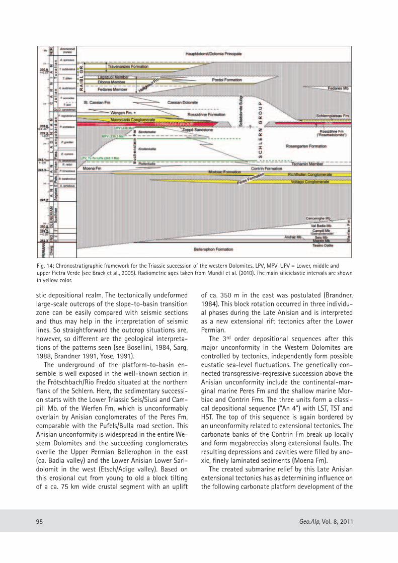
Fig. 14: Chronostratigraphic framework for the Triassic succession of the western Dolomites. LPV, MPV, UPV = Lower, middle and upper Pietra Verde (see Brack et al., 2005). Radiometric ages taken from Mundil et al. (2010). The main siliciclastic intervals are shown in yellow color.
96Geo.Alp, Vol. 8, 2011
under a thick volcanic sequence. The total thickness of the platform edifice is in the order of 850 m – the stratigraphic top is eroded –, the distance over which progradation took place ca. 5,5 km. Similar values can be assumed for the Schlern/Sciliar platform.
The lowermost deposits of the Buchenstein Fm, the so-called Plattenkalke, consist of finely lamina-ted, bituminous limestones with radiolarian micrites that interfinger with the gently dipping slope depo-sits of the Tschamin-Member. This unit consists of dolomitized, reefal grainstones with stromatactoid cavities. The postulated interfingering zone is located near the drowning structural high zone at the Vajo-lettürme. The gently dipping slope of the Tschamin Mb is overlain by steep clinoforms of the Rosengar-ten Fm marking the start of the progradational phase at the transition from the TST to the HTS. In the ba-sinal succession this change of sedimentation style is shown by the transition from the Plattenkalke to the Knollenkalke of the Buchenstein Fm. The succee-
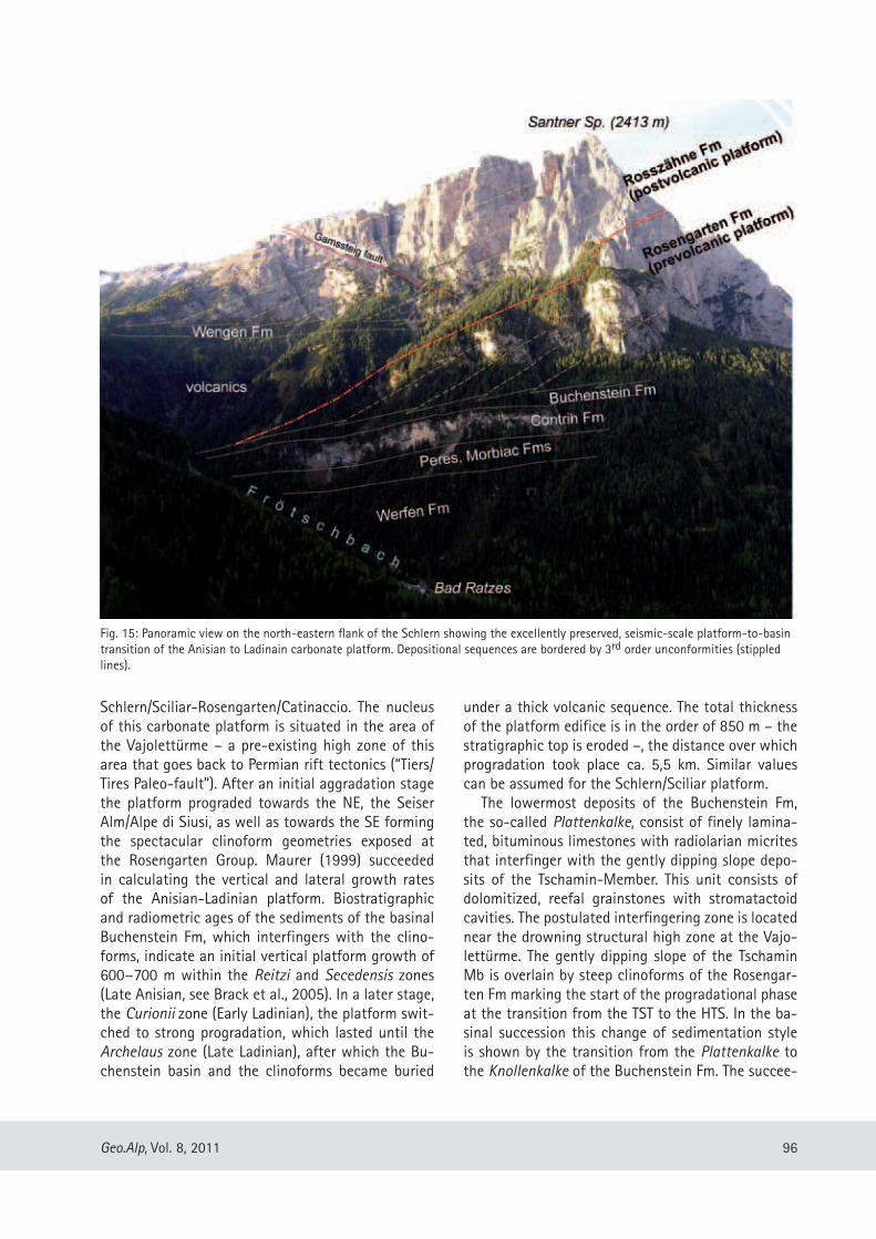
Schlern/Sciliar-Rosengarten/Catinaccio. The nucleus of this carbonate platform is situated in the area of the Vajolettürme – a pre-existing high zone of this area that goes back to Permian rift tectonics (“Tiers/Tires Paleo-fault”). After an initial aggradation stage the platform prograded towards the NE, the Seiser Alm/Alpe di Siusi, as well as towards the SE forming the spectacular clinoform geometries exposed at the Rosengarten Group. Maurer (1999) succeeded in calculating the vertical and lateral growth rates of the Anisian-Ladinian platform. Biostratigraphic and radiometric ages of the sediments of the basinal Buchenstein Fm, which interfingers with the clino-forms, indicate an initial vertical platform growth of 600−700 m within the Reitzi and Secedensis zones (Late Anisian, see Brack et al., 2005). In a later stage, the Curionii zone (Early Ladinian), the platform swit-ched to strong progradation, which lasted until the Archelaus zone (Late Ladinian), after which the Bu-chenstein basin and the clinoforms became buried
Fig. 15: Panoramic view on the north-eastern flank of the Schlern showing the excellently preserved, seismic-scale platform-to-basin transition of the Anisian to Ladinain carbonate platform. Depositional sequences are bordered by 3rd order unconformities (stippled lines).
97 Geo.Alp, Vol. 8, 2011
Excursion route
From Bula/Pufels to Seiser Alm/Alpe di Siusi to the Mahlknechthütte/Rif. Molignon by bus, then hiking to the Mahlknecht cliff, walk to Auf der Schneid/Cresta Alpe di Siusi, walk to Tierser Alpl Hütte, Ross-zahnscharte/Forc. di Denti di Terra Rossa, walk down to the Wiedner Woadn and back to Mahlknechthütte.
Stop 2.1 – Gasthof Gstatsch
General Explanation of the panorama at the NE-flank of the Schlern (Fig. 15). The interruption of the carbonate platform development by the intercalati-on of Upper Ladinian volcanics is clearly visible. The volcanic rocks form an onlap onto the paleoslope of the Rosengarten Fm (Schlern Group) and wedge out towards the SW. Contemporaneous, thinner layers of volcanics are present on the platform top as well (not visible from here). The growth of the post-volcanic platform started directly on top of the pre-volcanic one without any distinct unconformity in between. Therefore we assume that the interruption of the platform growth was only of minor duration. The post-volcanic platform (Rosszähne Fm) is characte-rized by a stronger progradational geometry compa-red to the pre-volcanic Rosengarten Fm. At the plat-form top there is hardly any accommodation space available for aggradation. The major part of the Sch-lern massif consists of the pre-volcanic Rosengarten Formation. Due to the rapid fill of the ca. 800 m deep Buchenstein basin by a ca. 450 m thick volcanic se-quence – towards the SE the thickness of the volca-nics increases with the formation of islands (eroded) in the area of the Marmolada – the former submarine topography was completely remodeled. This topogra-phic change led also to profound changes of the se-dimentation pattern.
Stop 2.2 – Mahlknechthütte/Rif. Molignon
This spectacular outcrop of the Mahlknecht wall shows the sedimentation on the slope and toe-of-slope of the Rosszähne reef. A varicoloured succes-sion of megabreccias, calcarenites, volcaniclastic sandstones and conglomerates (Marmolada Conglo-merate) directly overlie well-preserved pillow lavas that occur on top of the thick volcanic sequence,
ding Bänderkalke show a coarsening-upward trend with overlying toe-of-slope breccias beds, and cor-responds to a rapid progradational phase during the late HST. The volcanics of the Fernazza Group above show different thicknesses and are characterized by a distinct relief at the top. The volcanics devide the carbonate platforms of the Schlern Group into the pre-volcanic Rosengarten Fm and the post-volcanic Rosszähne Fm and Cassian Dolomite. For a diverse stratigraphic terminology, however, see Carta Geolo-gica d’Italia (1972, 1977), Brondi et al. (1976), Bo-sellini (1984), and De Zanche et al. (1993). At the north face of the Schlern/Sciliar the volcanics wedge out on the lower/middle platform slope (Figs. 13, 15); upslope the clinoforms of the post-volcanic Rosszäh-ne Fm directly overly those of the pre-volcanic Ro-sengarten Fm without any recognizable interruption. The post-volcanic basinal deposits of the Wengen Fm are locally characterized by strong gravity sheddings of volcaniclastic and epiclastic sediments (Marmo-lada Conglomerate), which probably derived from a volcanic island near the Marmolada (Bosellini, 1996).
In the interfingering zone of the Wengen Fm with the Rosszähne Fm at the north-eastern flank of the Schlern/Sciliar and at the Mahlknechtwand three distinct progradational cycles of reef tongues with intercalated volcanoclastic sandstones and conglo-merates are present. Within the single cyclothems the amount of volcanic detritus decreases gradually upsection and becomes almost absent at the tran-sition to the St. Cassian Fm. At this time the relief of the debris delivering volcanic hinterland is almost levelled out and re-flooded of this area occurs again as a consequence of the general subsidence after the Mid-Triassic rifting period. The rather complex, but intriguing interactions between subsidence, sea-level fluctuations and sediment input from two contra-sting sources (carbonate platform vs. volcanic island) into the marine basin are discussed on the second day at the Mahlknechtwand (Stop 2.2).
At the platform top itself (Schlern/Sciliar plateau) there was hardly any accommodation space availa-ble and several subaerial exposures with karst and soil formation (iron ore) were formed. After a further depositional gap in the Lower Carnian sedimentati-on proceeded in some shallow-marine depressions with the deposition of thin black marls and shales of the Raibl Group (Fedares Mb) and finally the Norian Hauptdolomit/Dolomia Principale.
98Geo.Alp, Vol. 8, 2011
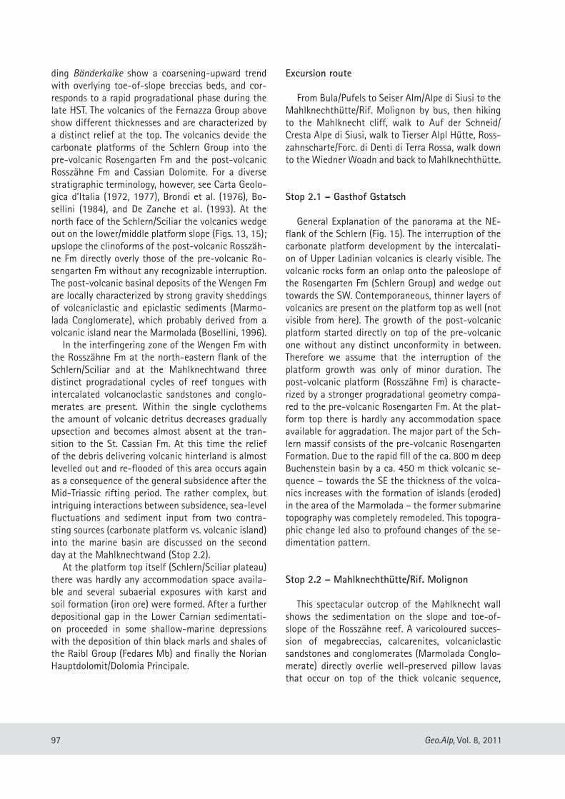
very well-preserved depositional fabrics and shells, partially still with their original aragonite composi-tion. Thus the growth fabrics and reef building or-ganisms can be studied in detail in these rocks. The dominating constituents are bindstones and baffles-tones with peloidal micite crusts, various festooned crusts as well as masses of Tubiphytes and other microproblematica (Brandner et al., 1991). Corals, calcareous sponge bafflestones or oncolites, which could have derived from the platform margin, are rare. Most of the limestone boulders originate from the middle and upper slope (Brandner et al., 1991, Flügel, 1991). Growth cavities of centimetre - to decimetre-size that are filled with internal sediments in various phases (tilted geopetals), and fibrous and botryoidal cements are common (Fig. 16). These mi-crobial boundstones were indurated upon formati-on and combined with syndepositional cementation these processes resulted in the formation of semi-stabilized clinoforms. The formation of breccias and megabreccias tongues calls for multiphase gravita-tional mass movements with repeated encrustation and cementation. The single clasts or boulders may consist of other, smaller breccia clasts, i.e. the overall fabric is that of breccias within other breccias with a trend of enlargement of the clasts. These data point to multiple interactions of platform shedding, in situ carbonate precipitation and microbial encrustation on the clinoforms, geopetal infill, early cementation, breccia formation due to oversteepening or seismic shocks, microbial encrustation and stabilization, ce-mentation, geopetal infill, renewed brecciation, and so on (Fig. 17). Moving down slope, the thickness of the breccia beds increases significantly. Isolated megabreccias at the toe-of-slope and the proximal basin, known as Cipit boulders, are therefore not the product of erosion of the platform margin common-ly related to sea-level lowstands. None of the Cipit boulders shows dissolution pores or vadose cements, indicative of subaerial exposition. We postulate that the main reasons for the gravitative mass movements of the prograding reef tongues are the different rhe-ological characteristics and thus the instability of the slope succession: the rapidly cemented carbo-nate breccia beds overlie water-saturated volcanic-lastic sediments which were not yet cemented. This alternation reduces distinctly the shear strength and any earthquake may lead to the downslope sliding of the rigid carbonate layers (“hard” on “soft”) along a discrete shear surface (= clinostratification). At the frontal side of the mass movement body the carbo-
which itself succeeds the Buchenstein Fm and the Rosengarten Fms.
In the interstitial pores and cooling cracks of the pillows locally radiolarian micrites with sponge spi-culae occur. These remnants of pelagic deposits cor-respond to a ca. 20 m thick succession of the lower-most Wengen Fm in a similar facies in the Tschapid creek, located ca. 2.5 km to the west, with conodonts and Daonellae of the Longobardian substage (Arche-laus zone, Brandner, 1991). The thickness variation results from an onlap geometry onto the very irre-gular, ca. NW-dipping surface of the volcanics. The sedimentary succession is dominated by megabrec-cias with the so-called “Cipit boulders”. They result from high-density, clast-supported gravitative debris flows, and formed the distinct relief of the outer sur-face of the debris stream. The Cipit boulders exhibit
Fig. 16: Thin section photomicrographs of Cipit boulders from the Mahlknechtwand: (a) Thrombolitic boundstone with Tubi-phytes and microbial encrustations and large cavities filled with internal sediment; (b) Boundstone with clotted peloidal micrite, festooned crusts, Tubiphytes, botryoidal cements and various generations of tilted geopetal sediment infills. Scale in mm.

99 Geo.Alp, Vol. 8, 2011
certain rhythmicity, whose control mechanisms are still a matter of debate. The peculiarity of the depo-sitional environment is the different provenance of the sediments: the carbonates were formed on the Rosszähne platform itself, whereas the volcaniclastic sediments were transported from a far away situated volcanic island (surroundings of Marmolada?). The regularity in the sedimentary successions suggests that sea-level fluctuations were the controlling pa-rameter. There is, however, no consensus whether the megabreccias together with the Cipit boulders were formed during a sea-level lowstand (LST) or high-stand (HST) (see Yose, 1991). We postulate that more arguments are in favor of the transport of the volca-niclastics during a sea-level lowstand, whereas the progradation of the reef tongues with shallow water grains (oolites) occurred during sea-level highstands.
nate banks turn into single boulders (Fig. 17). In the distal part the megabreccias turn into dm bedded cal-citurbidites with shallow-water derived grains. Ooids and coated grains testify their provenance from the flooded platform top.
Well-bedded sedimentary intervals with volca-niclastic detritus overlie the platform tongues and form an onlap geometry onto the paleo-slope (see also Stop 2.3). The succession is made up of sand-stones and conglomerates as channel fills (Marmo-lada Conglomerate). They are epiclastic sediments with well-rounded pebbles originating from fluvial transport. Their actual position on the lower reef slo-pe and in the deep basin resulted from gravitative re-deposition. The volcaniclastic intervals are repeatedly interbedded with the reef tongues, but not by chan-ce. The carbonate/volcaniclastic succession shows a
Fig. 17: Schematic model for steeply dipping, prograding carbonate slopes. The formation of breccias and megabreccias on the slope requires multiple interactions of platform shedding, in situ carbonate preci-pitation and microbial encrustation, geo-petal infill, early cementation, break up of already hardened sediments by gravitational mass-movements that were triggered by oversteepening or seismic shocks, followed by renewed encrustation and cementation, etc. The clinostratification corresponds par-tially to discrete submarine shear planes.

100Geo.Alp, Vol. 8, 2011
form and slope – the exact timing is not known, but a first stage of dolomitization during the Ladinian du-ring subaerial exposure and a second one during bu-rial seem plausible – affected only the still connected carbonate tongues, which were permeable for dolo-mitization fluids. The further transported boulders in the basin were isolated by the fine grained sedimen-tary matrix and thus escaped the dolomitization.
Stop 2.5 – above Wiedner Woadn
Exemplary outcrop in a little gully: Marmolada Conglomerate and volcaniclastic sandstones form an onlap onto the steeply dipping paleoslope of the Rosszähne carbonate platform.
Stop 2.3 – Auf der Schneid/Cresta di Siusi
Panorama of the seismic-scale outcrops of the entire slope domain of the post-volcanic Rosszähne platform (Fig. 18). The wedging out of the volcanicla-stic sequence onto the post-volcanic carbonate slope at the transition to red beds at the Roterd Sp./Cima di Terra Rossa, which may reflect intermittent subaerial exposure of the platform top, is clearly visible. Abo-ve it follows the downlap surface of the prograding Rosszähne reef tongues of the early highstand. South of the Tieser Alpl the onlap of the volcanics is well exposed within the Rosengarten massif. The steeply dipping Tierser Alpl fault does not significantly di-sturb the platform geometry and the stratigraphic successions.
Stop 2.4 – Tierser Alpl Hütte and Rosszahn Scharte
General explanation of the spectacular panorama and of the isolated Langkofel/Plattkofel carbonate platform with its W dipping paleoslope. Between the Rosengarten/Schlern and the Langkofel/Plattkofel reef a narrow seaway can be assumed, but its actual extension does not correspond exactly to the origi-nal, Triassic, one: during the Alpine deformation the Langkofel/Plattkofel platform was sheared off its un-derground and thrusted towards the north.
At the Rosszahn Scharte the ca. 30° steep N dip-ping paleoslope with the above described phenomena of gravitative submarine sliding of carbonate banks and megabreccia formation can be observed (Fig. 19). The later dolomitization of the entire carbonate plat-
Fig. 18: Panoramic view from “Auf der Schneid” (Cresta di Siusi) to the Rosszähne and Mahlknechtwall showing the interfingering bet-ween prograding reef slope deposits of the Rosszähne Fm (Rz1, 2) and volcaniclastic sandstones and conglomerates (V1). Wedging-out of volcaniclastics onto the upper carbonate slope (= onlap) as well as the succeeding downlap surface (DLS) of reef tongue 2 are clearly visible. The natural cut of the Mahlknechtwand runs obliquely to the depositional dip of the clinoforms, therefore the true dip-angle is steeper. V = volcanics (Fernazza Group) which cover the paleo-slope of the pre-volcanic Rosengarten Fm (Ro) to the south of the Tierser Alpl (after Brandner et al., 2007).
Fig. 19: Outcrop photo of steeply N-dipping clinoforms west of the Rosszahn Scharte with typical slope breccia tongues.

101 Geo.Alp, Vol. 8, 2011
The upper part of the Sella is formed by the well-bedded Hauptdolomit/Dolomia Principale, an approx. 250 m thick succession of peritidal deposits, which are overlain by some tens of meters of Rhaethian Dachstein limestone. At the summit of the Sella, the Piz Boè (3152 m), the stratigraphic succession termi-nates with red nodular limestones (Ammonitico Ros-so, Jurassic) and hemipelagic marlstones (Puez Marls, Cretaceous, see Fig. 13).
Lithostratigraphy of the Sella platform
The lithostratigraphic units used in this guidebook follow the “Geologische Karte der Westlichen Dolo-miten – Carta geologica delle Dolomiti Occidentali 1:25.000”. The lithostratigraphic terms of the Ladi-nian-Carnian deposits differ in some way from the names used so far in this region (e.g. Carta geologica d’Italia, F. “Marmolada”, 1977, Bosellini, 1991):
Basinal sediments: Wengen Fm, St. Cassian Fm: lithologic interfingering of each other.
Carbonate platform: Selladolomite Subgroup: postvolcanic Schlerndolomite undifferentiated; lo-cally the Selladolomite can be subdivided into an ol-der platform, termed Rosszähne Fm (like at the Sch-lern massif, see day 2), which interfingers with the Wengen Fm, and a younger platform, the Cassian Do-lomite, which interfingers with the St. Cassian For-mation. The “Gardena Megabreccia” sensu Bosellini & Neri (1991) belongs to the Rosszähne Formation.
Post-carbonate platform sediments: Pordoi For-mation (the former “Raibl beds”).
Biostratigraphy
The biostratigraphic data are derived from vari-ous basinal sections (Wengen and St. Cassian Fms.) around the Sella and from the Pordoi Fm. overlying the platform top. Ammonoid faunas (Reithofer, 1928, Mietto & Manfrin, 1995, Mietto et al., 2008) obtained from the basinal successions indicate an Upper Ladinian (Regoledanus Zone) to Lower Carni-an age. The topmost part of the section above the so-called “Gardena Megabreccia” to the south of the Gardena Pass (Col de Frea) was assigned by Mietto & Manfrin (1995) to the Daxatina cf. canadensis subzo-
DAY 3
Geology of the Sella platform and Col Rodela
Introduction
The third day is dedicated to the Sella massif as well as to the Col Rodela. The Sella Group, one of the most prominent mountains of the Dolomites, is located in the central Dolomites and is orographically bordered by the four, well-known passes: the Gröden/Gardena Pass (2121 m) in the north, the Campolongo Pass (1875 m) in the east, the Pordoi Pass (2239 m) in the south and the Sella Pass (2244 m) in the west (Fig. 2). From a geological point of view, the Sella massif can be subdivided into two parts: (1) a lower one that consists of the Late Ladinian to Early Carnian carbonate platform in the strict sense; (2) an upper one that essentially comprises the Norian Hauptdo-lomite and a thin cover of Rhaetian to Cretaceous se-diments. These two major carbonate bodies are sepa-rated by the Carnian “Raibl beds”, forming the typical recessively weathering ledge at the outer rim of the massif. The lower carbonate edifice consists of post-volcanic, platform and flank deposits (Selladolomite Subgroup: Rosszähne Fm and Cassian Dolomite) and exhibits excellently-preserved, steep clinoforms (ca. 35°) on all sides. It exhibits a sub-round shape in plan view, measures 7–8 km in diameter and interfingers on all sides with basinal sediments of the Wengen and St. Cassian Formations, respectively. This atoll-like geometry of the Sella platform thus has become one of the classical examples in the study of large-scale depositional geometries of isolated carbonate platforms (Leonardi & Rossi, 1957, Bosellini, 1984, Kenter, 1990, Bosellini & Neri, 1991, Keim & Schla-ger, 1999, 2001).
The growth of the Sella platform came to a stand-still in the Early Carnian and was subsequently co-vered by a sequence of mixed carbonate-siliciclastic deposits, the “Raibl beds” Auct., hereafter termed Pordoi Formation. It consists of volcanoclastic sand-stones at the base, followed by peritidal dolomites interbedded with marlstones. The sedimentation pattern of the Pordoi Fm was strongly influenced by synsedimentary tectonics (Doglioni, 1992, Keim & Brandner, 2001). Extensional tectonics led to local fissures, block-tilting, graben structures and breccia deposits. Towards the centre of the mountain, the thickness of the Pordoi Fm decreases distinctly and is locally reduced to zero.

102Geo.Alp, Vol. 8, 2011
cession at the northern part of the Sella was folded along the E-W trending Plan-Grödnerjoch/Passo Gar-dena anticline and was tilted towards the south by 15°−20°. The Sella S-side is involved into the E-W running Padon anticline and thus the succession is tilted towards the north.
Additionally, the entire Sella massif is dissected by numerous NE-SW and NW-SE running transcurrent faults, the most prominent one is the sinistral strike slip fault along the Val de Mesdì to the Pordoi Pass.
Platform-basin transition: geometry and sedimen-tology
The entire platform shows pervasive dolomitiza-tion. In contrast to the hundreds of meters thick cli-noforms, the topset beds at the outer rim of the Sella reach only some tens of meters. Towards the centre of the Sella the thickness of the topsets increases considerably. Based on the height of the clinoforms, the thickness of the Selladolomite Subgroup ranges between 400 to 700 m. The transition between top-sets and steep slope occurs within tens of meters. The clinoforms show a primary depositional angle of 30–35° and interfinger on all sides with basinal deposits (Bosellini, 1984). Intensive downslope transport is indicated by debris aprons at the toe of the clino-forms; they consist of turbidites, debris-flow brec-cias and swarms of meter-size boulders (Bosellini & Neri, 1991, Mastandrea et al., 1997). In addition, the basins were fed with volcanoclastics (conglomerates, sandstones, siltstones) and terrigenous mud.
The topsets show horizontal, planar bedding with bed-thicknesses between 0.1 and 1 m. Occasionally, patches of cross-bedded are¬ni¬tes as well as meter-size tepees occur (e.g. in Val de Mesdì). At Pisciadù, within the topsets coral colonies of the type Thecos-milia have been found in growth position. The con-tent of skeletal grains from the measured section at Pisciadù is generally less than 5% and consists pre-dominately of echinoderm debris, bivalves, foramini-fera, dasycladacean and solenoporacean fragments, Tubiphytes?, cyanophyta, such as Rivularia, Cayeuxia or Hedstroemia and uncertain sphinctozoan spon-ges (Keim & Schlager, 2001). The skeletal grains in most cases are totally recrystallized and often show micritic encrustations. The most striking observati-on is the presence of automicrite facies in all diffe-rent platform domains, although the amount varies considerably (Keim & Schlager, 1999, 2001). Most of the samples from the margin-upper slope consist of automicritic boundstones with large cement-filled cavities in-between (“evinosponges”-like structures).
ne, nowadays termed Canadensis zone = base of the Carnian stage (Broglio Loriga et al., 1999, Mietto et al., 2008). Conodonts of the Wengen and St. Cassian Fms (Mastandrea et al., 1997) around the Sella (Bu-durovignathus group) belong to the diebeli assem-blage zone sensu Krystyn (1983), which corresponds to the standard Regoledanus zone (Upper Ladinian).
The youngest basinal deposits, time-equivalent to the final platform growth, are exposed at the eas-tern side of the Sella, at the foot of Crep de Munt. A preliminary pollen study from dark marls of the St. Cassian Fm, showed a rich fauna containing among others the taxa Concentricisporites cf. bianulatus and Gordonispora fossulata (Keim & Roghi, 2006). These findings confirm a Lower Carnian age (Julian 1/II = aonoides zone). Pollen from the uppermost Pordoi Fm at Piccolo Pordoi, just a few metres below the Hauptdolomit (Dolomia Principale) contained the taxa Vallasporites ignacii, Duplicisporites verrucatus, Pseudoenzonalasporites summus, Patinasporites den-sus, P. cf. densus, Ovalipollis pseudoalatus, Camaro-zonosporites cf. rudis and Hevizipollenites sp.. This association indicates a late Julian age (Austriacum zone) and thus correlates with the basal Heiligkreuz Fm. in the eastern Dolomites. Thus a major stratigra-phic gap, which probably occupies most of the Tuva-lian, has to be assumed to exist between the topmost Pordoi Fm and the overlying Hauptdolomit.
Alpine tectonic deformation
Alpine deformation of the Sella Group is rather weak and thus the Triassic submarine paleo-topogra-phy is still well preserved. The oldest, pre-alpine de-formation patterns are Carnian extensional structures with numerous, nearly N-S trending fissures, grabens and halfgrabens, which became sealed by the Nori-an Hauptdolomite (Doglioni, 1992, Keim & Brandner, 2001). These structures are present all around the Sella massif, but especially at the E-side. The most conspicuous alpine deformation structures are also exposed at the eastern side with overthrusts in a ramp-flat system (Doglioni, 1985, 1992) leading to the so-called “Gipfelüberschiebung” (summit thrusts) at Piz Boè; here the Rhaetian Dachstein limestone, the Jurassic Ammonnitico Rosso and the Cretaceous Puezmarls are strongly folded and overthrusted by several slices of Hauptdolomit. This deformation is of Paleogene age and was correlated with the Dinaric, W-vergent compression (Doglioni, 1992). The suc-

103 Geo.Alp, Vol. 8, 2011
Fig. 20: The geological situation at Grödner Joch/Passo Gardena: (a) The geological cross section illustrates the antiformal deformed lower slope megabreccias (“Gardena megabreccia”) and basinal deposits during alpine tectonics along the E-W trending Plan-Grödner Joch/Passo Gardena anticline; (b) close up view of the “Gardena megabreccia” (= Rosszähne Fm) wedging out in the basinal sediments of the Wengen Formation. See text for explanation. 37 = “Caotico eterogeneo”, 35 = lava, 37 = Hyaloclastites, 31 = pre-volcanic Schlerndolomite (Rosengarten Fm), 30 = post-volcanic Schlerndolomite (Rosszähne Fm), 29 = Cassian Dolomite, 28 = Selladolomite Subgroup (post-volcanic platform carbonates undiff.), 25 = Wengen Fm, 24 = St. Cassian Fm, 22 = Pordoi Fm (“Raibl beds”), 16 = Hauptdolomit/Dolomia Principale.
Fig. 21: Geologic cross section at Campani de Murfreit. Alpine antiformal deformation of the entire stratigraphic succession up to the Norian Hauptdolomite clearly shown. 40 = Contrin Fm; for a detailed legend see Fig. 20.
104Geo.Alp, Vol. 8, 2011
by interfingering with the basinal Wengen Formati-on and outrunner blocks (“Cipit boulders”) which are clearly visible in the basin sediments. The “Gardena Megabreccia” mainly consists of tongues of boulders with diameters of up to several meters and interca-lations of some dm-thick beds of calciturbidites. The boulders are largely composed of automicritic bound-stones, with microproblematica like Tubiphytes, scar-ce metazoans (sponges, corals), peloidal to skeletal packstones and cement-filled cavities (Russo, in Bo-sellini & Neri, 1991). The “Gardena Megabreccia” was interpreted by Bosellini (1982) and Bosellini & Neri (1991) as channelized megabreccia as the result of multiple collapses of a “pre-existing carbonate plat-form, rather than a buildup”. De Zanche & Gianolla (1995) regarded it as the lowstand prograding com-plex of their Car1 depositional sequence.
We do not share these interpretations and regard the “Gardena Megabreccia” as folded lower slope breccia tongues of the Rosszähne Fm (Keim & Neri, 2004, Brandner et al., 2007). The strong thickness va-riation (0−200 m) of the megabreccia body is related to the oblique erosive cut of the proximal-distal parts of these lower slope deposits. The variation of the dip-angle of the megabreccia (flat-lying, SE-dip) is the result of alpine tectonic deformation along the ca. E-W trending Plan-Grödnerjoch anticline: the former N-dipping, lower slope deposits, which inter-finger with the basinal sediments of the Wengen Fm were tilted by 15−30° and are actually part of the southern limb of the above mentioned Plan-Grödner-joch/Passo Gardena anticline.
In the surroundings of the Grödnerjoch/Passo Gar-dena, the Cassian Dolomite situated above the “Gar-dena Megabreccia” does not show this tilting and is characterized by the classical 30−35° steep clinofor-ms and horizontal lying topsets. At this location the folded part of the platform and slope has simply been eroded away (Fig. 20). Further to the SW, however, at the Murfreit Towers, the topset beds of the Cassi-an Dolomite, the overlying Carnian Pordoi Fm (“Raibl beds”) as well as the Norian Hauptdolomite are tilted 15−20° towards the S-SE (Fig. 21). These data clearly point to folding at the N-NW side of the Sella Group during alpine deformation.
Skeletal grains from the margin-upper slope may include Tubiphytes, Macrotubus, Girvanella, serpu-lids?, and occasionally some bivalve filaments, os-tracods and gastropods. The high cement content of the samples comprises mainly fibrous cements in the form of botryoids or even druses. All cements are al-tered to dolomite. Fibrous cements are inclusion-rich and may form cm-thick isopachous layers. The vo-lumetrically most important cement type are isopa-chous layers of former radiaxial fibrous calcites. The breccia tongues of the lower slope contain abundant boulders up to several m in diameter. The planar sha-pe and steep angle of the clinoforms, however, indi-cate that the large-scale geometry of the slope was controlled by non-cohesive layers of sand and rubble piled up to the angle of repose (Kenter, 1990, Keim & Schlager, 1999, 2001, Schlager & Reijmer, 2009).
Excursion route
During the excursion, we will approach the Sella from the Gardena Valley and continue in a counter-clockwise direction. From the Gardena Pass we will pass the Sella Pass, walk to Col Rodela, turn back to the Sella Pass, and then proceed to the Pordoi Pass.
Stop 3.1 – Grödnerjoch/Passo GardenaThe N-front of the Sella platform, including the
outcrops at Meisules dala Biesces/Murfreit, is one of the most controversial examples in terms of depositi-onal geometries (e.g. Leondari & Rossi, 1957, Boselli-ni, 1982, Bosellini & Neri, 1991). The platform shows a subdivision which is twofold (Fig. 20): (1) a lower unit, the so-called “Gardena Megabreccia” (Bosellini, 1982, Bosellini & Neri, 1991), which is covered by basinal sediments (Wengen and St. Cassian Fms.) and (2) an upper unit, composed of steeply inclined slope deposits and thin flat-lying top-set beds of the Sella platform proper (Cassian Dolomite). The megabreccia body is distinctly stratified: at Gardena Pass the beds are nearly horizontal, at Meisules/Murfreit, however, the boulder beds dip with ca. 20° to SE. The same dip angle is present in the underlying Wengen Fm and also in the platform-top sediments at the Meislues/Murfreit Towers (Fig. 21). Locally, the basinal St. Cas-sian Fm between the “Gardena Megabreccia” and the above lying Cassian Dolomite wedge out, causing the two units to be weld together. The thickness of the “Gardena Megabreccia” varies between about 200 m at Meisules/Murfreit and zero at the Gardena Pass. At Gardena Pass, the megabreccia tongues pinch out

105 Geo.Alp, Vol. 8, 2011
tonics. At the southern flank of Col Rodela a highly complex, repeated series of successions of the upper Permian Bellerophon Fm and the upper Ladinian “Ca-otico eterogeneo” are present. It is one of the are-as, where ca. 30 years ago the idea of Middle Trias-sic compressional or transpressional tectonics with folding and overthrusting was born (e.g. Pisa et al., 1980, Castellarin et al., 1982, 1988, Doglioni, 1987). According to these authors this tectonic model is essentially based on two field observations: (1) at Col Rodela the tectonic sheet stacks are sealed by the undisturbed upper Ladinian Marmolada Conglo-merate, and (2) in the Valle di San Nicolò south of Col Rodela the evaporitic Bellerophon Fm is strongly folded and cross-cut by volcanic dikes. Therefore, the folds, which were believed to result from compressi-onal tectonics, predate the volcanic event.
But ca. 20 years later, Castellarin et al. (1998, 2004) abandoned the model of Ladinian compressi-onal tectonics at Col Rodela and re-interpreted the entire sheet stack as a diapiric mélange in connec-tion with the formation of breccias and megabreccias
Stop 3.2 – Hotel Gerhard, at the foot of Meisules dala Biesces
This short stop on the road again impressively shows the tilted Rosszähne Fm (“Gardena Megabrec-cia”) with distinctly SE dipping breccia beds (Fig. 21); this alpine folding with formation of the Plan-Gröd-nerjoch/Passo Gardena anticline affected also the younger stratigraphic units including the Hauptdo-lomite. Furthermore, the facies interfingering of the lower slope breccias and the basinal sediments of the Wengen Fm is clearly expressed by the alternation of calciturbidites, marls, sandstones and a ca. 20 m thick dolomitized limestone breccia tongue.
From Sella Pass to Col Rodela: geological intro-duction
The area of Col Rodela is one of the most in-teresting examples in the Dolomites that allows for a controversial interpretation of stratigraphy and tec-
Fig. 22: Simplified tectonic map of the area between Canazei (Val di Fassa) and Col Rodela, based on the Geologische Karte der West-lichen Dolomiten 1:25.000 (2007). Tectonic repetition of the stratigraphic succession is caused by a two-phased alpine, an early and a late Dinaric deformation phase.

106Geo.Alp, Vol. 8, 2011
sediments (Buchenstein Fm) at its base (Figs. 23, 24). This reef-slope-basin pair is underlain by some meter thick polymict breccias of the “Caotico etero-geno”, which themselves rest on the Lower Triassic Campill Member (Werfen Formation). The “Caotico eterogeneo” essentially consists of submarine scarp megabreccias and mass flow deposits. The Marmo-lada limestone of Col Rodela is a giant block inside the “Caotico eterogeneo” (Mutschlechner, 1935, Pisa et al., 1980, Bosellini et al., 1982, Castellarin et al., 1988, 1998, 2004). The entire succession is overlain by upper Ladinain lavas breccias, lavas and by the Marmolada Conglomerate (Wengen Formation) and dips with ca. 15−30° towards the NE. The boundary surface between the Campill Mb. and the breccias of the “Caotico eterogeneo” is interpreted herein as a Ladinian extensional fault or as a submarine sliding plane, respectively (Fig. 23). The stratigraphic loss at this boundary includes the Anisian conglomerates (Peres Fm) and the above following transgressive de-posits of the Morbiac and Contrin Formations with a total thickness of about 100 m. Since the bounda-
of the “Caotico eterogeneo”. Only extensional faults were regarded to represent Ladinian faults.
In the course of our geologic mapping project of the Western Dolomites also the area between Campi-tello and Col Rodela has been mapped again (Geolo-gische Karte der Westlichen Dolomiten, 2007). Based on these new field data we reached the following conclusions: (1) confirmation of various Ladinian, synsedimentary normal faults with formation of the “Caotico eterogeneo” and (2) two-phase alpidic com-pressional tectonics with folding and thrust struc-tures (Fig. 22).
Stop 3.3 – August-Friedrich-Hütte
This stop offers a good view to the N- and W-side of Col Rodela and invites the visitor to discuss its tectono-stratigraphic setting. The Col Rodela (2484 m) itself consists of a ca. 100 m thick remnant of Anisian-Ladinian reef slope limestone (Marmola-da limestone) with some meter thick coeval basinal
Fig. 23: Panoramic view of the southern flank of Col Rodela with outline of the most important tectonic structures. BEL = Bellero-phon Fm, WER = Werfen Fm, CTR = Contrin Fm, CAET = “Caotico eterogeneo”, BUC = Buchenstein Fm, ML = Marmolada Limestone (olistolithe).

107 Geo.Alp, Vol. 8, 2011
Fig. 24: Schematic model for the development of the “Caotico eterogeneo” for the area of Col Rodela during the Late Ladinian. The formation of breccias and megabreccias with reworking of sediments down to the Werfen Fm requires multiple extensional tectonic processes with steep and flat lying normal faults and/or gliding planes in connection with the volcanic activity. The breccias and me-gabreccias resulted essentially from submarine mass flow deposits. The presence of Ladinian normal faults combined with a complex stratigraphic succession of the “Caotico eterogeneo” with local olistoliths complicates the interpretation of the succession at the southern flank of Col Rodela. Alpidic thrust planes cut through various stratigraphic levels and younger rocks, which were downfaulted during the late Ladinian, may have been thrusted over older rocks during the alpine (Dinaric) deformation.

108Geo.Alp, Vol. 8, 2011
Stop 3.4 – Sella Pass
At this stop the facies interfingering in the basinal deposits (Wengen and St. Cassian Fms) as well as the W-dipping clinoforms of the Sella platform can be observed. The basinal deposits are characterized by a alternation of volcaniclastic and carbonate domi-nated successions (Fig. 25). The entire succession has been described by Bosellini & Neri (1991) and Ma-standrea et al. (1997). The typical dark coloured marls, shales, sandstones and fine conglomerates with typi-cal intercalated Cipit boulders of the Wengen Fm are replaced upsection by beige marls and light coloured calcarenites of the St. Cassian Fm. direct at the Hotel Maria Flora. This carbonate rich interval is about 40 m thick and is again covered by volcaniclastic sand-stones and conglomerates of the Wengen Fm, ca. 50 m thick; this clastic interval is overlain essentially by calcarenites, rudstones and breccia beds of the pro-grading platform. This upper part of the St. Cassian Fm contains one more volcaniclastic layer, ca. 2 m thickness, which occurs just below the “Locomotiva” (Fig. 25). This lithofacies variation in the basin is the response to a different amount of clastic input de-rived from a volcanic hinterland and carbonate grains that were exported by the producing carbonate plat-form. This variation in sediment input to the basins may be governed by sea-level fluctuations, climatic or tectonic processes that resulted in the interfinge-ring between Wengen and St. Cassian Fm. The final dominance of light coloured marls and calcarenites of the St. Cassian Fm goes hand in hand with the complete flooding of the debris delivering volcanic island, supposed to be located in the area west of Marmolada.
The W-dipping clinoforms of the Cassian Dolomite (Selladolomite Subgroup) are distinctly flattening out towards the basin and their dip angle decreases in the progradational direction from about 30° in the Val Lasties to 20° at the Sella towers (Kenter, 1990). The topsets are only 10−20 m thick; the transition zone to the steeply dipping clinoforms is rather mas-sive to structureless.
ry surface between the Campill Mb and the “Cao-tico eterogeneo” is a rather stratiform surface over considerable distances, the dip angle of the inferred Ladinian extensional fault or submarine sliding pla-nes, must have been very gentle or nearly horizontal, at least in the surroundings of Col Rodela (Fig. 24). However, further to the N/NW, another steep nor-mal fault must have existed in order to create the necessary space for the submarine gliding mass. This extensional tectonic process was multiphased and obviously related to the contemporaneous basic volcanism/magmatism in the central western Dolo-mites (Val di Fassa, Gröden/Val Gardena). The brec-cias and megabreccias of the “Caotico eterogeneo” with reworked clasts and blocks of Lower Triassic to Ladinian successions including reworked volcanic clasts are the response to this volcano-tectonics.
Alpine tectonic deformation
The repetitions of the sedimentary successions at the southern flank of Col Rodela are interpreted he-rein as a two phased Dinaric (Paleogene) WSW and SW directed thrust tectonics and folding. The new mapping (Fig. 22) shows three slices, the Campitello slice in the footwall, the Elbetina slice in the middle and the Rodela slice in the hanging wall. All three slices comprise incomplete sequences spanning from Bellerophon Fm, operating as lower detachment, to the Contrin Fm and the heterogenous Fernazza Group (“Caotico eterogeneo”). The thicknesses are variable due to Upper Anisian and Ladinian normal faulting and erosion. The Pozzates thrust with the Canazei branch thrust are interpreted as early Dinaric top to the WSW thrust planes which were folded subse-quently by the late Dinaric SW–NE compression. In the roof of the antiformal deformed slice stack the Monte da Gries thrust brings up the Rodela slice. Due to Ladinian normal faulting, volcanic rocks of the footwall slice are overthrusted by similar volcanocla-stic sequences in the hangingwall Rodela slice abo-ve Canazei. Therefore it is difficult to recognize the trace of the thrust plane toward the SE. The whole duplex structure is gently dipping to the E and dis-appears therefore below the thick sequence of the Fernazza Group, Wengen and St. Cassian Fms to the east of Canazei.

109 Geo.Alp, Vol. 8, 2011
one of the most spectacular panoramic views over the entire Dolomites.
Stop 4.1 – Pordoi Pass
The area of the Pordoi Pass represents a Carnian seaway between the S-prograding Sella platform flanks in the north and the N-prograding Sas Becè platform located in the south. Actually, the lower-most clinoforms of both platforms are separated by a narrow basin zone of ca. 330 m width only. This distance, however, probably was shortened by alpine, N-S-directed compressional tectonics (Fig. 26). Addi-tionally, the NE-SW running sinistral strike slip fault of the Val de Mesdì passes just west of the Pordoi Pass and has caused the formation of intense frac-ture zones within the Cassian Dolomite. The basinal sediments of the St. Cassian Fm are rather badly ex-posed and consist of beige-brown marls and calcare-nites and occasionally some Cipit boulders. Beds of the St. Cassian Fm dip ca. 20–30° towards the north as a result of the above mentioned alpine deformati-on. Therefore also the actual dip angle of clinoforms of Sas Becè is too steep with respect to their original
Stop 3.5 – road curve just below the Sella Pass
This stop offers an excellent panoramic view of the WNW-exposed wall of Sass Pordoi, shows topsets and clinoforms of the Selladolomite Subgroup, and gives some insights into the nucleus of the Sella plat-form in the Val Lasties. In addition, the thinning out of the Pordoi Fm towards the centre of the platform, the overlying stratified Hauptdolomite as well as the youngest sediments at Piz Boè can be observed.
DAY 4
Stratigraphy and tectonics at the southern side of the Sella Group
Excursion route
This day is dedicated to the general geology at the Pordoi Pass itself and to the tectonic deformation at the summit Piz Boè (3152 m). From the Pordoi Pass we ascent to Sas Pordoi by cable car, walk to the Piz Boè (3152 m), and turn back to Sas Pordoi und de-scend by cable car. The Sass Pordoi and Piz Boè offer
Fig. 25: Interpretative cross section between Piz Ciavaces and Passo Sella. The subdivision of the platform and slope deposits into the Rosszähne Fm and Cassian Dolomite, such as at the Grödner Joch/Passo Gardena, is not possible here. Therefore the term Selladolo-mite-Subgroup is used. The two-fold repetition of the Wengen and St. Cassian Fms originates from the different input of carbonate vs. volcaniclastic material into the basin. 25 = Wengen Fm (incl. Marmolada Conglomerate), 24 = St. Cassian Fm, 28 = Selladolomite Subgroup, 22 = Pordoi Fm, 16 = Hauptdolomit/Dolomia Principale.

110Geo.Alp, Vol. 8, 2011
Stop 4.2 – Sas Pordoi and walk to Piz Boè
The spectacular panoramic view at Sas Pordoi (2950 m) enables to see most of the prominent Trias-sic carbonate platforms in the Dolomites. Along the trail to Piz Boè, the Norian Hauptdolomite with its typical peritidal cyclothemes can be observed. The basic cycles include a subtidal unit of dolomicrites with gastropods and megalodontid bivalves, an inter-tidal unit with laminated, stromatholitic layers with fenestral fabrics and bird’s eyes, and, occasionally, a thin supratidal unit composed of teepee structures, intraclastic breccias, desiccation cracks and gree-nish dolomitized mudstones. In the upper part of the Hauptdolomit the frequency of intraclast breccias and subaerial exposure surfaces increases. At the base of the overlying Dachstein Limestone a distinct level, ca. 80 cm thick, of intraclast breccias with black pebbles is present. The Dachstein Limestone is about 40 m thick and consists of some decimeter thick calcareous beds interbedded with green marls.
depositional angle. North of the Pordoi Pass, the ba-sinal sediments of the St. Cassian Fm cover the entire area to the M. Forcia (2356 m). This is the highest point with basinal sediments at the S-side of the Sel-la platform, but unfortunately, the contact with the above lying platform dolomites is not exposed. The outcrop at M. Forcia is located about 140 m high-er than the interfingering zone between clinoforms and basinal sediments exposed NW and ENE of the Pordoi Pass. This difference in height can been ex-plained in two ways: (1) an onlap geometry of the St. Cassian Fm onto the clinoforms during standstill of platform growth and thus basin filling or (2) N-vergent overthrusting of the St. Cassian Fm, possibly over the S-dipping clinoforms. Based on the actual state of knowledge, we prefer a combination of both mechanisms (Fig. 26).
The ascent to Sas Pordoi by cable car offers unique views on the platform geometry with steep clinofor-ms and topsets as well as the sharply overlying Pordoi Fm and the Hauptdolomit/Dolomia Principale.
Fig. 26: Interpretative N-S cross section across Passo Pordoi. See text for explanation. 28 = Selladolomite Subgroup, 26 = Marmolada Conglomerate, 25 = Wengen Fm,, 24 = St. Cassian Fm, 22 = Pordoi Fm, 16 = Hauptdolomit/Dolomia Principale, 1b = talus deposits.

111 Geo.Alp, Vol. 8, 2011
Fig. 27: Foto and line drawings of the southern flank at Piz Boè showing a stack of W vergent thrust slices. PD = Pordoi Fm, HD = Hauptdolomite, DK = Dachstein Limestone, RA = Rosso Ammonitico, Pzm = Puez Marls.
Fig. 28: Geologic cross section of the Piz Boè-Piz da Lech overthrust sub-parallel to the Dinaric NE-SW directed compression. The footwall is dissected by numerous steeply dipping normal faults of Carnian (Car) and late Cretaceous?-Paleogene (Pal) age associated with the formation of graben structures. Note the strong thickness variation of the Carnian Pordoi Fm (“Raibl beds”). At Pizes dl Valun the thickness of the Hauptdolomit/Dolomia Principale is distinctly reduced due to an erosional surface of probably Jurassic age. Based on this cross section the transport width of the uppermost slice of Hauptdolomit from the eastern side of Piz da Lech to Piz Boè can estimated to be at least 3 km. 28 = Selladolomite Subgroup (= Cassian Dolomite in the present case), 22 = Pordoi Fm, 23 = breccias (Pordoi Fm), 16 = Hauptdolomit/Dolomia Principale, 14 = Dachstein Limestone, 12 = Gardenacia Fm (breccias, dolosparites), 11 = Rosso Ammonitico, 9 = Puez Marls.

112Geo.Alp, Vol. 8, 2011
clearly related to the WSW to SW directed, Dinaric compression. A classical ramp-flat geometry of the thrust plane as well as an overturned, NW-SE tren-ding syncline in the Dachstein Limestone is well visible (Fig. 27, see also Doglioni, 1985, 1990). The presence of slices of the Pordoi Fm at the base of the overthrusted Hauptdolomit/Dolomia Principa-le wedge suggests that the basal shear plane of the main thrust plane is located within the Pordoi For-mation further to the east – an area, which today is completely eroded away (Fig. 28). Interestingly, none of such slices of the Pordoi Fm are present along this Dinaric thrust plane at Piz da Lec, which is the pro-longation of the Piz Boè overthrust to the NE (Dogli-oni, 1985, 1990; see Fig. 28). Thus we assume that the shortening along of the Piz Boè summit thrust is by far greater than the calculated 0.7 km of Do-glioni (1990). At Piz da Lac, the Dinaric thrust pla-ne shows a distinct ramp-flat geometry within the Hauptdolomit/Dolomia Principale and cuts an older, ca. N-S trending graben structure in the Hauptdolo-mit/Dolomia Principale with down faulted Cretacous Puez Marls (Doglioni, 1992). A similar graben struc-ture with down faulted Puez Marls crops out at the Eissee/Lago Gelato at the E-side of Piz Boè. At the eastern flank of Piz Boè, Dinaric thrust planes and intense folding of the Jurassic-Cretaceous sediments are well developed between Cresta Strenta and Piz Lech Dlace/Eisseespitze.
Stop 4.4 – Piz Boè (3152 m)
The summit of the Sella Group offers a unique panoramic view over the entire Dolomites and some more insights on the complex tectonic structures on the eastern side of Piz Boè.
Acknowledgements
Thanks to John Reijmer (VU University Amsterdam and TU Delft) for critically reading the text and Karl Krainer (Univ. Innsbruck) for editorial handling.
The succession was described in detail by Bosellini & Broglio Loriga (1965), and contains locally abundant foraminifera, among others the age diagnostic Triasi-na hantkeni (Maizon) for the late Triassic (Rhaetian).
Piz Boè summit thrust – some general remarks
The thrust structures at the summit of the Sel-la Group, the so-called “Gipfelüberschiebungen” (= summit thrust) at Piz Boè, were described already 100 years ago by Ogilvie Gordon (1910). Generally spoken, several slices of Hauptdolomit/Dolomia Principale are thrusted over the Rhaetian Dachstein Limestone, the Jurassic Rosso Ammonitico and the Cretaceous Puez Marls. A first detailed geological map and de-scription of these structures was presented by Reit-hofer (1928). Doglioni (1985, 1990) re-interpreted the thrust structures by applying modern structural analyses as “Klippen” of an eroded, WSW-directed Dinaric overthrust in a ramp-flat system. Most of the hanging wall of the ramp at the eastern slope of the Sella is now eroded. Doglioni (1990) presented a detailed geological map of the Piz Boè area and calculated a total shortening by the overthrusts of ca. 0.7 km based on balanced cross sections. Accor-ding to the author the thrust plane is irregular along the strike and shows lateral and oblique ramps. Along these ramps fold-bend folding is common with ENE to E-W trending axes. As such, these fold-bend fold axes trend in the direction of the maximum, Dinaric compression (ENE-WSW) and should not be confused with another perpendicular tectonic phase (Doglioni, 1990).
Based on our geological mapping we agree mostly with the observations and interpretations made by Doglioni (1985, 1990), but question some of his cross sections, since he did not recognize or neglected the presence of slices of the Pordoi Fm (“Raibl beds”) at the base of the ENE dipping, main thrust plane.
Stop 4.3 – Southern flank of Piz BoèFrom this viewpoint some of the main tectonic
structures can be observed: the Piz Boè overthrust consist of several (3–4) thrust planes, which are

113 Geo.Alp, Vol. 8, 2011
Bosellini, A. & Neri, C. (1991): The Sella Platform (Up-per Triassic, Dolomites). - Dolomieu Conference on Carbonate Platforms and Dolomitization, Guide-book Excursion B, 30 pp, Ortisei (Italy).
Bosellini, A., Castellarin, A., Doglioni, C., Guy, F., Luc-chini, F., Perri Cristina, M., Rossi, P.L., Simboli, G. & Sommavilla, E. (1982): Magmatismo e tettonica nel Trias delle Dolomiti. - In: Castellarin, A. & Vai, G.B. (Eds) Guida alla Geologia del Sudalpino Centro-Orientale. Soc. Geolog. Italiana, 189-210, Bologna
Brack, P., & Rieber, H. (1993): Towards a better definiti-on of the Anisian/Ladinian boundary: new biostrati-graphic data and correlations of boundary sections from the Southern Alps. – Eclogae Geol. Helv., 86 (2): 415-527.
Brack, P., Rieber, H. & Nicora, A. & Mundil, R. (2005): The Global boundary Stratotype Section and Point (GSSP) of the Ladinian Stage (Middle Triassic) at Bagolino (Southern Alps, Northern Italy) and its im-plications for the Triassic time scale. - Episodes, 28 (4): 233-244.
Brandner, R. (1984): Meeresspiegelschwankungen und Tektonik in der Trias der NW-Tethys. - Jb. Geol. B.-A., 126: 435-475, Wien.
Brandner, R. (1988): The Permian-Triassic Boundary in the Dolomites (Southern Alps, Italy), San Antonio Section. - Ber. Geol. B.-A., 15: 49-56, Wien.
Brandner, R. (1991): Geological Setting and Stratigra-phy of the Schlern-Rosengarten Buildup and Seiser Alm Basin. - In: Brandner, R., Flügel, E., Koch, R. & Yose, L.A (Eds.) The Northern Margin of the Schlern/Sciliar-Rosengarten/Catinaccio Platform. Dolomieu Conference on Carbonate Platforms and Dolomiti-zation, Guidebook Excursion A, Ortisei (Italy), 61 pp.
Brandner, R. & Keim, L. (2011): Geotrail Bula - Pufels - Bulla. - Amt für Geologie & Baustoffprüfung/Uf-ficio Geologia e prove materiali, Autonome Provinz Bozen-Südtirol/Provincia Autonoma di Bolzano-Alto Adige, 44 pp.
Brandner, R., Flügel, E. & Senowbari-Daryan, B. (1991): Biotic and microfacies criteria of carbonate slo-pe builders: implications for the reconstruction of source areas (Middle Triassic: Mahlknecht Cliff, Do-lomites). - Facies, 25: 279-296, Erlangen.
Brandner, R., Gruber, A. & Keim, L. (2007): Geologie der Westlichen Dolomiten: von der Geburt der Neotet-hys im Perm zu Karbonatplattformen, Becken und Vulkaniten der Trias. Geo.Alp, 4: 95-121, Innsbruck-Bozen.
References
Aigner, T. (1985): Storm depositional systems. - Lec-tures Notes in Earth Sciences 3, 175 p, Springer.
Bargossi, G.M., Rottura, A., Vernia, L., Visonà, D. & Tran-ne, C.A. (1998): Guida all’escursione sul Distretto Vulcanico Atesino e sulle plutoniti di Bressanone-Chiusa e Cima d’Asta. - Mem. Soc. Geol. It., 53: 23-41, Roma.
Barth, S., Oberli, F., Meier, M., Blattner, P., Bargossi, G. M., & Di Battisti, G. (1993): The evolution of a calc-alcaline basic to silicic magma system: geochemical and Rb-Sr, Sm-Nd, and 18O/16O isotopic evidence from the late Hercynian Atesina-Cima d’Asta volca-nic-plutonic complex, Northern Italy. – Geochim. Cosmochim. Acta 57: 4285-4300.
Bechstädt, T. & Brandner, R. (1970): Das Anis zwischen St. Vigil und dem Höhlensteintal (Pragser und Olan-ger Dolomiten, Südtirol). - Festband d. Geol. Inst., 300-Jahr-Feier Univ. Innsbruck, 9-101, Innsbruck.
Bertotti, G., Picotti, V., Bernoulli, D. & Castellarin, A. (1993): From rifting to drifting: Tectonic evolution of the South-Alpine upper crust from the Triassic tot he Early Cretaceous. - Sedimentary Geology, 86: 53-76, doi: 10.1016/0037-0738(93)90133-P.
Bond, D.P.G. & Wignall, P.B. (2010): Pyrite framboid study of marine Permian–Triassic boundary sec-tions: A complex anoxic event and its relationship to contemporaneous mass extinction. - GSA Bulle-tin, 122: 1265-1279.
Bosellini, A. (1968): Paleogeologia pre-anisica delle Dolomiti centrosettentrionali. - Atti Accad. Naz. Lincei, Mem. Cl. Sci. Fis. Mat. Nat., Sez. 9 (8): 1–33.
Bosellini, A. (1982): Geologia dei Passi dolomitici cir-costanti il Gruppo di Sella. - In: Castellarin, A. & Vai. G.B. (Eds) Guida alla Geologia del Sudalpino centro-orientale. Guide geologiche regionali della Soc. Geol. It., 267-272, Bologna.
Bosellini, A. (1984): Progradation geometries of car-bonate platforms: example from the Triassic of the Dolomites, Northern Italy. - Sedimentology, 32:1-24.
Bosellini (1991): Geology of the Dolomites. An intro-duction. - Dolomieu Conference on Carbonate
Platforms and Dolomitization. Ortisei (Italy), 43 pp.Bosellini, A. (1996): Geologia delle Dolomiti. - Athesia,
192 pp, Bozen.Bosellini, A. & Broglio Loriga, C. (1965): Gli „Strati a
Triasina“ nel Gruppo di Sella (Dolomiti Occidenta-li). - Mem. Geol. Pal. Univ. Ferrara, Fasc. II, N. 6/1: 159-190, Ferrara.

114Geo.Alp, Vol. 8, 2011
Castellarin, A., Guy, F. & Selli, L. (1982) Geologia dei dintorni del Passo di S. Nicolò e dalla Valle di Contrin (Dolomiti). – In: Castellarin, A. & Vai. G.B. (Eds) Guida alla Geologia del Sudalpino centro-ori-entale. Guide geologiche regionali della Soc. Geol. It., 231-242, Bologna.
Castellarin, A., Lucchini, F.A., Rossi, P.L., Selli, L. & Sim-boli, G. (1988): The Middle Triassic magmatic-tec-tonic arc development in the Southern Alps. - Tec-tonophysics, 146: 79-89.
Castellarin, A., Selli, L., Picotti, V. & Cantelli, L. (1998): Tettonismo e diapirismo medio triassico delle Dolo-miti. - Mem. Soc. Geol. It., 53: 145-169, Roma.
Castellarin, A., Cantelli, L., Picotti, V. & Selli, L. (2004): Structure of the Italian Dolomites, partilally along the southern section of the Transalp profile. - 32nd
International Geological Congress, Florence (Italy), Field Trip Guide Book – P54, 40 pp, Firenze.
Castellarin, A., Nicolich, R., Fantoni, R., Cantelli, L., Sel-la, M. & Selli, L. (2006): Structure of the lithosphere beneath the Eastern Alps (southern sector of the TRANSALP transect). - Tectonophysics, 414: 259-282.
Chuodens-Sánchez , V. de & González, L. A. (2009): Calcite and Aragonite precipitation under con-trolled instantaneous supersaturation: elucidating the role of CaCO3 saturation state and Mg/Ca ratio on calcium carbonate polymorphism. – J. Sed. Res., 79: 363-376.
De Zanche, V. & Gianolla, P. (1995): Litostratigrafia al limite Ladinico-Carnico (Sudalpino orientale). Ann. Univ. Ferrara, Sci. Terra, 5 (suppl.): 41-48, Ferrara.
De Zanche, V., Gianolla, P., Mietto, P., Siorpaes, C. & Vail, P. R. (1993): Triassic sequence stratigraphy in the Dolomites (Italy). - Mem. Sci. Geol., 45: 1-27, Padova.
Di Battistini, G., Gallo, F., Riammetti, F. & Vernia, L. (1989) Permian Andesites from Val d’Isarco and Val di Funes volcanic sequence (Bolzano, northern Ita-ly). Miner. Petrogr. Acta, 32: 133-147, Bologna.
Doglioni, C. (1985): The overthrusts in the Dolomites: ramp-flat systems. Eclog. Geol. Helv., 78: 335-350, Basel.
Doglioni C. (1987): Tectonics of the Dolomites (Southern Alps-Northern Italy). J. Struct. Geol., 9: 181-193.
Doglioni, C. (1990): Anatomy of an overthrust. Annales Tectonicae, 4: 68-82.
Brandner, R., Horaceck, M., Keim, L. & Scholger, R. (2009): The Pufels/Bulla road section: deciphering environmental changes across the Permian-Triassic to the Olenekian by integrated litho-, magneto- and isotope stratigraphy. A field trip guide. - Geo.Alp, 6: 116-132, Innsbruck-Bozen.
Broglio Loriga, C., Masetti, D. & Neri, C. (1983): La Formazione di Werfen (Scitico) delle Dolomiti occi-dentali: sedimentologia e biostratigrafia. - Riv. Ital. Paleont., 88 (4): 501-598, Milano.
Broglio Loriga, C., Goczan, F., Haas, J., Lenner, K., Neri, C., Scheffer, A.O., Posenato, R., Szabo, I. & Mark, A.T. (1990): The Lower Triassic sequences of the Dolo-mites (Italy) and Trasnsdanubian Mid-Mountains (Hungary) and their correlation. - Mem. Sc. Geol. Padova, 42: 41-103, Padova.
Broglio Loriga, C., Cirilli, S., De Zanche, V., Di Bari, D., Gianolla, P., Laghi, G. F., Lowrie, W., Manfrin, S., Mastradrea, A., Mietto, P., Muttoni, G., Neri, C., Posenato, R., Reichichi, M., Rettori, R., & Roghi, G. (1999): The Prati di Stuores/Stuores Wiesen Section (Dolomites Italy): a candidate Global Stratotype Section and Point for the base of the Carnian stage. - Riv. It. Paleont. Strat., 105: 37-78, Milano
Brondi, A., Fuganti, A., Lunz, L., Mittempergher, M, Murara, G., Nardin, N., Nascimben, P., Perna, G., Rossi, D., Scudeler Baccelle, L., Sommavilla, E. & Zi-poli, G. (1976): Commento al foglio geologico 027 Bolzanao, scala 1:50.000 (ed. 1973). - Studi Trent. Sc. Nat., 53: 109-218, Trento.
Carta Geol. d’Italia (1972): Servizio geologico d’Italia, Foglio 025 “Bolzano”, 1:50000, Firenze.
Carta Geol. d’Italia (1977): Servizio geologico d’Italia, Foglio 028 “La Marmolada”, 1:50000, Firenze.
Carta Geol. d’Italia (2007): ISPRA - Servizio geologi-co d’Italia, Foglio 026 “Appiano-Eppan”, 1:50000, Roma.
Carta Geol. d’Italia (2010): ISPRA - Servizio geologi-co d’Italia, Foglio 013 “Merano-Meran”, 1:50000, Roma.
Cassinis, G., Perotti, C.R. & Ronchi, A. (2011): Permian continental basins in the Southern Alps (Italy) and peri-mediterranean correlations. – Int. J. Earth Sc. (Geol. Rundschau), DOI 10.1007/s00531-011-0642-6.
Castellarin, A. & Cantelli, L. (2000): Neo-Alpine evolu-tion of the Southern Eastern Alps: Journal of Geo-dynamics, 30: 251–274.

115 Geo.Alp, Vol. 8, 2011
Hartkopf-Fröder, C. Wood, G.D. & Krainer, K. (2001): Palynology of the Permian Bolzano Volcanic Com-plex, Southern Alps, Italy, part 1: miospore preser-vation, quantitative spore color and quantitative fluorescence microscopy. In: Goodman, D.K. & Clar-ke, R.T. (Eds.) Proceedings of the IX International Pa-lynological Congress, Houston, Texas, U.S.A., 1996. – Am. Ass. Strat. Palynolog. Found: 79-97.
Horacek, M., Brandner, R. & Abart, R. (2007a): Carbon isotope record of the P/T boundary and the Lower Triassic in the Southern Alps: evidence for rapid changes in storage of organic carbon; correlation with magnetostratigraphy and biostratigraphy. - Palaeogeography, Palaeoclimatology, Palaeoecolo-gy, 252: 347-354.
Horacek, M., Richoz, S., Brandner, R., Krystyn, L., Spötl, C. (2007b): Evidence for recurrent changes in Lo-wer Triassic oceanic circulation of the Tethys: The δ13C record from marine sections in Iran. - Palaeo-geography, Palaeoclimatology, Palaeoecology, 252: 355-369.
Horacek, M., Povoden, E., Richoz, S. & Brandner, R. (2010): High-resolution carbon isotope changes, litho- and magnetostratigraphy across Permian-Triassic Boundary sections in the Dolomites, N-Italy. New constraints for global correlation. - Palaeoge-ography, Palaeoclimatology, Palaeoecology, 290: 58-64.
Hug, N. & Gaupp, R. (2006): Palaeogeographic re-construction in red beds by means of genetically related correlation: results from the upper Zech-stein (Late Permian). - Z. dt. Ges. Geowiss., 157(1): 107-120.
Keim, L. & Schlager, W. (1999): Automicrite Facies on Steep Slopes (Triassic, Dolomites, Italy). - Facies, 41: 15-26, Erlangen.
Keim, L. & Stingl, V. (2000): Lithostratigraphy and Fa-cies architecture of the Oligocene conglomerates at Monte Parei (Fanes, Dolomites, Italy). – Riv. It. Strat. Paleont., 106: 123-132, Milano.
Keim, L. & Brandner, R. (2001): Facies interfingering and synsedimentary tectonics on late Ladinian-ear-ly Carnian carbonate platforms (Dolomites, Italy). - Int. J. Earth Sciences (Geol. Rundsch.), 90: 813-830.
Keim, L. & Schlager, W. (2001): Quantitative compo-sitional analyses of a Triassic carbonate platform (Southern Alps, Italy). - Sediment. Geol., 139: 261–283.
Doglioni, C. (1992): Relationships between Mesozoic extensional tectonics, stratigraphy and Alpine in-version in the Southern Alps. Eclog. Geol. Helv., 85: 105-126, Basel.
Farabegoli, E. & Perri, C. M. (1998): Permian/Triassic boundary and Early Triassic of the Bulla section (Southern Alps, Italy): lithostratigraphy, facies and conodont biostratigraphy. - Giornale di Geologia, 60 (Spec. Issue ECOS VII Southern Alps Field Trip Guidebook): 292-311.
Farabegoli, E., Perri, C. M. & Posenato, R. (2007): Envi-ronmental and biotic changes across the Permian-Triassic boundary in western Tethys: The Bulla para-stratotype, Italy. - Global and Planetary Change, 55: 109-135.
Flügel, E. (1991) Environmental analysis of allochtho-nous carbonate blocks and autochthonous mounds at the northern margin of the Schlern-Rosengarten (Sciliar-Catinaccio) platform. - In: Brandner, R., Flü-gel, E., Koch, R. & Yose, L.A. (Eds) The Northern Mar-gin of the Schlern/Sciliar-Rosengarten/Catinaccio Platform. Dolomieu Conference on Carbonate Plat-forms and Dolomitization, Guidebook Excursion A, 41-55 pp, Ortisei, Italy.
Froitzheim, N., Weber, S., Nagel, T. J., Ibele, T. & Furrer, H. (2011): Late Cretaceous extension overprinting a steep belt in the Northern Calcareous Alps (Sche-saplana, Rätikon, Switzerland and Austria): Int. J. Earth Sci. (Geologische Rundschau), DOI 10.1007/s00531-011-0717-4.
Frizon de Lamotte, D., Raulin, C., Mouchot, N., Wro-bel-Daveau, J. C., Blanpied, C., & Ringenbach, J.-C. (2011): The southernmost margin of the Tethys re-alm during the Mesozoic and Cenozoic: Initial geo-metry and timing of the inversion processes. – Tec-tonics, 30, TC3002, doi: 1029/2010TC002691.
Gawlick, H.-J., Frisch, W., Vecsei, A., Steiger, T. & Böhm, F. (1999): The change from rifting to thrusting in the Northern Calcareous Alps as recorded in Jurassic sediments. - Geologische Rundschau, 87: 644–657.
Geologische Karte der Westlichen Dolomiten 1:25.000. (2007): Autonome Provinz Bozen – Südtirol. - Amt für Geologie u. Baustoffprüfung, Bozen/Kardaun.
Gianolla, P., De Zanche, V. & Mietto, P. (1998): Triassic sequence stratigraphie in the Southern Alps (Nort-hern Italy): definition of sequences and basin evolu-tion. - SEPM Special Publication, 60: 719-747.

116Geo.Alp, Vol. 8, 2011
Krystyn, L., Richoz, S. & Bhargava, O. N., (2007): The Induan-Olenekian Boundary (IOB) – an update of the candidate GSSP section M04. - Albertiana, 36: 33-45.
Leonardi, P. & Rossi D. (1957): La scogliera corallige-na del Sella nelle Dolomiti Occidentali. - Ann. Univ. Ferrara, Sci. Terra, 3: 1-26, Ferrara.
Marocchi, M., Morelli, C., Mair, V., Klötzli, U. & Bargos-si, G. M. (2008): Evolution of Large Silicic Magma Systems: New U-Pb Zircon Data on the NW Permi-an Athesian Volcanic Group (Southern Alps, Italy). - The Journal of Geology, 116: 480-498.
Mastandrea, A., Neri, C. & Russo, F. (1997): Conodont biostratigraphy of the S. Cassiano Formation sur-rounding the Sella Massif (Dolomites, Italy): impli-cations for sequence stratigraphic models of the Triassic of the Southern Alps. - Riv. Ital. Paleont. Strat., 103: 39-52, Milano.
Maurer, F. (1999): Wachstumsanalyse einer mittel-triassischen Karbonatplattform in den westlichen Dolomiten (Südalpen). - Ecl. Geolog. Helv., 92: 361-378, Basel.
Mietto, P. & Manfrin, S. (1995): La successione del-le faune ad ammonoidi al limite Ladinico-Carnico (Sudalpino, Italia). - Ann. Univ. Ferrara, 5 (Suppl.): 13-35, Ferrara.
Mietto, P., Manfrin, S., Preto, N. & Gianolla, P. (2008): Selected ammonoid fauna from Prati di
Stuores/Stuores Wiesen and related sections across the Ladinian-Carnian boundary (Southern Alps, Ita-ly). - Riv. It. Strat. Paleont., 114 (3): 377-429, Mi-lano.
Mojsisovics, E.M. von (1879): Die Dolomit-Riffe von Südtirol und Venetien: Beiträge zur Bildungsge-schichte der Alpen. - A. Hölder, 551 pp, Wien.
Morelli, C., Bargossi, G.M., Mair, V., Marocchi, M. & Moretti, A. (2007): The Lower Permian volcanics along the Etsch valley from Meran to Auer (Bozen). - Mitt. Österr. Miner. Ges., 153: 195-218.
Mostler, H. (1982): Bozener Quarzporphyr und Wer-fener Schichten. - In: Mostler, H. (Ed.), Exkursions-führer zur 4. Jahrestagung der Österreichischen Ge-ologischen Gesellschaft, 43-79, Innsbruck.
Mundil, R., Pàlfi, J., Renne, P.R. & Brack, P. (2010): The Triassic timescale: new constraints and a review of geochronological data. - In: Lucas, S.G. (ed) The Tri-assic Timescale. Geol. Soc. London Spec. Publ., 334: 41-60, London.
Mutschlechner, G. (1935): Geologie der Langkofel-gruppe. Jb. Geol. B-A, 85: 21-49, Wien.
Keim, L. & Neri, C. (2004): The Sella Platform. - In: Ste-fani, M., Brack, P., Gianolla, P., Keim, L., Maurer, F., Neri, C., Preto, N., Riva, A., Roghi, G. & Russo, F.: Tri-assic carbonate platforms of the Dolomites: carbo-nate production, relative sea-level fluctuations and the shaping of the depositional architecture. 32nd International Geological Congress, Florence (Italy), Field Trip Guide Book – P44, 25-33, Firenze.
Keim, L. & Roghi, G. (2006): The age of the Sella plat-form (Triassic, Dolomites): new insights from paly-nological studies. - Pangeo Austria, Innsbruck Uni-versity Press, 140-141, Innsbruck.
Kenter, J.A.M. (1990): Carbonate platform flanks: slo-pe angle and sediment fabric. - Sedimentology, 37: 777-794.
Korte, C. & Kozur, H. W. (2005): Carbon isotope strati-graphy across the Permian/Triassic boundary at Jol-fa (NW-Iran), Peitlerkofel (Sas de Pütia, Sas de Pu-tia), Pufels (Bula, Bulla), Tesero (all three Southern Alps, Italy) and Gerennavár (Bükk Mts., Hungary). - Journal of Alpine Geology/Mitt. Ges. Geol. Berg-baustud. Österr., 47: 119-135.
Korte, C., Kozur, H. W., Joachimsky, M. M., Strauss, H., Veizer, J. & Schwark, L. (2004): Carbon, sulfur, and strontium isotope records, organic geochemistry and biostratigraphy across the Permian/Triassic boundary in Abadeh, Iran. - Int. J. Earth Sci. (Geol. Rdsch.), 93: 565-581.
Korte, C., Kozur, H. W. & Veizer, J. (2005): δ13C and δ18O values of Triassic brachiopods and carbonate rocks as proxies for coeval seawater and palaeo-temperature. - Palaeogeography, Palaeoclimatolo-gy, Palaeoecology, 226: 287-306.
Krainer, K. (1987): Zusammensetzung und fazielle Ent-wicklung des Alpinen Buntsandsteins und der Wer-fener Schichten im westlichen Drauzug (Kärnten/Osttirol).- Jb. Geol. B.-A, 130: 61-91, Wien.
Krainer, K. (1989): Composition and evolution of Lo-wer Permian molasse sediments (Ponte Gardena Conglomerate) at the base of the Bolzano Volcanic Complex, Southern Alps (N Italy). - N. Jb. Geol. Pa-läont. Mh., 7: 400-424, Stuttgart.
Krainer, K. Sanders, D. & Schaffhauser, M. (2009): Early Permian Shelf Margin Retreat and Carbonate De-position, Zweikofel Massif, Carnic Alps (Austria). – Austrian Journal of Earth Sciences, 102/2: 134-148.
Krystyn, L. (1983) Das Epidaurus-Profil (Griechenland) – ein Beitrag zur Conodonten-Standardzonierung des tethyalen Ladin und Unterkarn. Schriftenr. Erd-wiss. Komm. Österreich. Akad. Wiss., 5: 231-258.

117 Geo.Alp, Vol. 8, 2011
Schaltegger, U. & Brack, P. (2007): Crustal-scale mag-matic systems during intracontinental strike-slip tectonics: U, Pb and Hf isotopic constraints from Permian magmatic rocks of the Southern Alps. - Int. J. Earth Sci (Geol Rundsch), 96: 1131-1151.
Schmid, S.M., Fügenschuh, B., Kissling, E. & Schuster, R. (2004): Tectonic map and overall architecture of the Alpine orogen. - Eclogae Geol. Helv., 97: 93-117.
Scholger, R., Mauritsch, H. J. & Brandner, R. (2000): Permian-Triassic boundary magnetostratigraphy from the Southern Alps (Italy). - Earth and Planeta-ry Science Letters, 176: 495-508.
Selli, L. (1998): Il lineamento della Valsugana fra Tren-to e Cima d’Asta: cinematica neogenica ed eredità strutturali permo-mesozoiche nel quadro evolutivo del Subalpino Orientale (NE-Italia). - Mem. Soc. Geol. It., 53: 503-541, Roma.
Shaffer, G., Olsen, S. M. & Pederson, O. P. (2009): Long-term ocean oxygen depletion in response to carbon dioxide emissions from fossil fluids. - Nature Ge-oscience, 2: 105-109.
Stampfli, G.M. & Borel, G.D. (2002): A plate tectonic model for the Paleozoic and Mesozoic constrained by dynamic plate boundaries and restored synthetic oceanic isochrons. Earth and Planetary Science Let-ters, 196 (1): 17–33.
Szurlies, M. (2004): Magnetostratigraphy: the key to a global correlation of the classic Germanic Trias-case study Volpriehausen Formation (Middle Bunt-sandstein), Central Germany. - Earth and Planetary Science Letters, 227: 395-410.
Szurlies, M., Bachmann, G. H., Menning, M., Nowaczyk, N. R. & Käding, K. C. (2003): Magnetostratigraphy and high-resolution lithostratigraphy of the Permi-an-Triassic boundary interval in Central Germany. - Earth and Planetary Science Letters, 212: 263-278.
Venturini, C. (1991): Introduction to the geology of the Pramollo Basin (Carnic Alps) and its surroundings. - Giorn. Geologia, sr. 3, 53: 13-47.
Visonà, D., Fioretti, A. M., Poli, M. E., Zanferrari, A. & Fanning, M.(2007): U-Pb SHRIMP zircon dating of andesite from the Dolomite area (NE Italy): geo-chronological evidence for the early onset of Per-mian Volcanism in the eastern part oft he Southern Alps. - Swiss J. Geosci. 100: 313-324.
Wheeler, H. E. (1964): Baselevel, lithosphere Surface, and Time-Stratigraphy. - Geol. Soc. Amer. Bull., 75: 599-610.
Muttoni, G., Kent, D.V., Garzanti, E., Brack, P., Abra-hamsen, N. & Gaetani, M. (2003): Early Permian Pangea „B“ to Late Permian Pangea „A“. - Earth and Planetary Science Letters, 215: 379-394.
Newton, R. J., Pevitt, E. L., Wignall, P.B. & Bottrell, S. H. (2004): Large shifts in the isotopic compositi-on of seawater sulphate across the Permo-Triassic boundary in northern Italy. - Earth and Planetary Science Letters, 218: 331-345.
Ogilvie Gordon, M.M. (1910) Die Überschiebung am Gipfel des Sellamassivs in Südtirol. – Verh. der k. u. k. Geol. Reichsanst., Wien.
Perri, C. M. (1991): Conodont biostratigraphy of the Werfen Formation (Lower Triassic), Southern Alps, Italy. - Boll. Soc. Pal. Ital., 30/1: 23-45.
Pisa, G., Castellarin, A., Lucchini, F., Rossi, P.L., Simboli, G., Bosellini, A. and Sommavilla, E.
(1980): Middle Triassic magmatism in Southern Alps. I. A review of general data in the Dolomites. - Riv. Ital. Paleontol. Stratigr., 85: 1093-1110, Milano.
Porada, H. & Bouougri, H. (2007): Wrinkle structures – a critical review. - Earth Science Reviews, 81: 199-215.
Posenato, R. (2008): Global correlations of mid Early Triassic events: The Induan/Olenekian boundary in the Dolomites (Italy). - Earth Science Reviews, 91: 93-105.
Pruss, S. B., Bottjer, D. J., Corsetti, F. A. & Baud, A. (2006): A global marine sedimentary response to the end-Permian mass extenction: Examples from southern Turkey and western United States. - Earth Science Reviews, 78: 193-206.
Reithofer, O. (1928): Geologie der Sellagruppe (Süd-tiroler Dolomiten). - Jb. Geol. B.-A., 78: 529-580, Wien.
Richthofen, F. v. (1860): Geognostische Beschreibung der Umgebung von Predazzo, Sanct Cassian und der Seisser Alpe in Süd-Tirol. Perthes Gotha.
Sarg, J.F. (1988): Carbonate Sequence Stratigraphy. - In: C.K. Wilgus, B.S. Hastings, C.G.S.C,
Kendall, H.W. Posamentier, C.A. Ross & J.C. Van Wago-ner (Eds) Sea level changes: an integrated approach. SEPM Spec. Publ. 42: 155-182.
Schlager, W. & Reijmer, J.J.G. (2009): Carbonate plat-form slopes of the Alpine Triassic and the Neogene - a comparison. – Austrian Journal of Earth Sciences, 102: 4-14, Vienna.

118Geo.Alp, Vol. 8, 2011
Wignall, P. B. & Hallam, T. (1992): Anoxia as a cause of the Permian/Triassic mass extinction: facies evi-dence from northern Italy and the western United States. Palaeogeography, Palaeoclimatology, Pa-laeoecology 93: 21-46.
Yose, L.A. (1991): Sequence stratigraphy of mixed car-bonate/volcaniclastic slope deposits flanking the Sciliar (Schlern) – Catinaccio buildup, Dolomites, Italy. - In: Brandner, R., Flügel, E., Koch, R. & Yose, L.A (Eds.) The Northern Margin of the Schlern/Sci-liar-Rosengarten/Catinaccio Platform. Dolomieu Conference on Carbonate Platforms and Dolomiti-zation, Guidebook Excursion A, Ortisei (Italy), 71-39 pp.
Manuscript submitted: 14.11.2011Manuscript accepted: 17.11.2011

119 Geo.Alp, Vol. 8, 2011