939 ellis street san francisco, ca 94109 mr. doug … · mr. doug tolar, baaqml) march 30,2017...
TRANSCRIPT
Lawrence Livermore National Laboratory
March 30. 2017
Mr. Doug TolarBay Area Air Quality Management District939 Ellis StreetSan Francisco, CA 94109
Subject: Prescribed Burning Smoke Wanage,,,eut Plan, Lawrc,,ce Livermore NationalLuboraton — Site 300
Dear Mr. Tolar:
Lawrence Livermore Nulional Laboratory (LLNL) has attached for your review and approval the“Prescribed Burning Smoke Management Plan, Lawrence Livermore National Laboratory —
Site 300” for 2017, which is unchanged in scope from the 2016 Plan.
As identified in Figure 2 ofthe attached 2017 Plan, only 131.6 acres of Plot 16 and 7.5 acres ofPlot II are located within Alameda County, and thus under the purview of the Bay Area AirQuality Management (BAAQMD). LLNL would like to be allowed to burn the entire139.1 acres in a single day.
If you have any questions regarding the 2017 Plan or require additional information, pleasecontact Wit[ie Monternavor at (925 423-I [52.
cerelv
Gretchen Gallegos. roup LeaderVatcr. Air, Monitoring & AnalysisEnvironmental Functional AreaEnvironment. Safety & Health
Enclosure: Prescdbcd Burning Smoke Management Plan, LLNL—Site 300
Distribution ‘v’enclosure;Grim, Tom (NNSA’LFO)
ESH-EFA-AQ-l7-l4534 — GGS[-l jr
An Equal Opportunity Employ.r Lawrence Livernore National Securily LLC Operated for the US Oeparlment of CnctgyP0 Box EQS Livermore. Cslilornia 94551.C803 Teleptiene W25) 422.l1IO . htp llwtn.llnl goy

Mr. Doug Tolar, BAAQML) March 30,2017l’rcscrihcd BUrHUIg Smoke Management Plan, LLNL — Site 300 Page 2
Distribution w!cnclosure (PDF/paper copy):Caner, Randall (ACFD) (I paper copy)Hall, Steve (I paper copy)\Voollctt. Jim (I paper copy)Montemavor. Willie (I paper copy)Sliarnc John (ACFD) (I paper copy)Wilson, Scott (3 paper copies)
Distribution v/enclosurc (PDF only):Aiston, FrancesBrigdon, ShariDamba, Darwin (NNSA/LFO)DaRosa, LizDibley, ValericEdwards, MaLtGrccnc. Tom (NNSA/LFO)Hempel, JennyKato, ThomMishra. Vijav (NNSA;LFO)Paterson, LisaPerkins. . BrianScott. JohnThomas. Sharon\Vegrecki, Anthony
Site 300 Prescribed Rum FileUCM: Site 300, Prescribed Rum
ESH-EFA-AQ-17-14533 — GG/SI-I:ar
Prescribed Burning Smoke Management Plan Lawrence Livermore National Laboratory – Site 300
John A. Sharry
March 2017
UCRL-AR-154173-REV-14

This work performed under the auspices of the U.S. Department of Energy by Lawrence Livermore National Laboratory under Contract DE-AC52-07NA27344.

UCRL-AR-154173-REV-14
Prescribed Burning Smoke Management Plan, LLNL, Site 300
ESH-EFA-AQ-17-14534 – GG/SH:ar 1
PRESCRIBED BURNING SMOKE MANAGEMENT PLAN LAWRENCE LIVERMORE NATIONAL LABORATORY – Site 300
GENERAL INFORMATION
PREPARER’S NAME & ADDRESS (street, city, zip) DATE John A. Sharry, Fire Marshal March 1, 2017 P.O. Box 808, L-388 Livermore, CA 94551 PREPARER’S AFFILIATION PHONE # Lawrence Livermore National Laboratory (925) 423-1802 PRIMARY RESPONSIBLE PERSON PHONE # John A. Sharry (925) 423-1800 LAND OWNER(S) & MAILING ADDRESS (street, city, zip) PHONE # Department of Energy (DOE) (925) 422-0758 P.O. Box 808, L-001 Livermore, CA 94551 FIELD CONTACT NAME & 24-HOUR PHONE Randy Carter (925) 422-4350 (925) 422-7595
PROJECT DESCRIPTION 1. LOCATION Lawrence Livermore National Laboratory – Site 300 Corral Hollow Road Tracy, CA 95376 Latitude: 37 39.59 Longitude: 121 33.13 Legal Description All that land delineated on the following filed maps: Map of Survey, United States Atomic Energy Commission Property, Counties of Alameda and San Joaquin, State of California, filed in Book 4 of Surveys, Page 3, in the Office of the County Recorder, Alameda County, and filed in Book 11 of Surveys, Page 34, in the Office of the County Recorder, San Joaquin County; Map of Survey, United States Atomic Energy Commission Property, County of San Joaquin, State of California, filed in Book of Surveys, Volume 10, Page 118, in the Office of the County Recorder, San Joaquin County; EXCLUDING that parcel of land described in Quitclaim Deed from the United States of America to Robert F. & Carol J. Burns in Book 3887 of Official Records, page 369, San Joaquin County Records; INCLUDING that parcel of land described in

UCRL-AR-154173-REV-14
Prescribed Burning Smoke Management Plan, LLNL, Site 300
ESH-EFA-AQ-17-14534 – GG/SH:ar 2
Grant Deed for Connolly Ranch, Inc. to the United States of America, Department of Energy in Instrument Number 91-020198, San Joaquin County Records. Containing approximately 6,800 acres. General Description Lawrence Livermore National Laboratory’s (LLNL’s) Site 300 is in the California Coast Ranges, which is characterized by low rugged mountains and relatively narrow intervening valleys. It is situated 15 miles east of the Livermore Valley near the eastern edge of the Altamont Hills, close to the western boundary of San Joaquin County. Elevations range from 500 feet at the southern boundary to 1,800 feet at the higher peaks in the northwestern areas. Site 300 covers approximately 6,800 acres (about 11 square miles) of land in eastern Alameda County and western San Joaquin County. Site 300 was acquired in 1953; since then all grazing and other agricultural activities have been terminated. The location of Site 300 is identified in Figure 1. Prescribed fires and suppression activities for all fires are done with recognized wildfire safety parameters to assure minimal impacts on the environment. These include avoidance measures of sensitive and protected species and habitats; pre- and post-fire surveys for impacts to sensitive species; protection of and post-fire evaluation of groundwater monitoring wells and groundwater remediation facilities and equipment; and watershed post-fire assessment and rehabilitation as necessary (e.g., sediment reduction, channel treatments) to stabilize biotic communities, and to prevent degradation of critical known natural and cultural resources. Figure 2 identifies the prescribed burn acreage of each of the 24 plots that are to be burned at LLNL’s Site 300. Most the acreage falls under the jurisdiction of the San Joaquin Valley Air Pollution Control District (SJVAPCD). The acreage that specifically falls under the jurisdiction of the Bay Area Air Quality Management District (BAAQMD) is approximately 7.5 acres of Plot 11 and 131.6 acres of Plot 16.

UCRL-AR-154173-REV-14
Prescribed Burning Smoke Management Plan, LLNL, Site 300
ESH-EFA-AQ-17-14534 – GG/SH:ar 3
Figure 1. Location of Site 300.

UCRL-AR-154173-REV-14
Prescribed Burning Smoke Management Plan, LLNL, Site 300
ESH-EFA-AQ-17-14534 – GG/SH:ar 4
Figure 2. Site 300 Fire trail Access Map with Burn Area Index.

UCRL-AR-154173-REV-14
Prescribed Burning Smoke Management Plan, LLNL, Site 300
ESH-EFA-AQ-17-14534 – GG/SH:ar 5
2. OBJECTIVES Specific Management Objectives • Develop a smoke management plan consistent with California Air Resources Board’s
“Smoke Management Guidelines for Agricultural and Prescribed Burning” (CCR, 2001).
• Use prescribed burns and mechanically maintain and/or treat the Site’s developed areas to reduce the threat of unwanted fires. Continue to maintain defensible space in accordance with National Fire Protection Association (NFPA) 1144, “Standard for Reducing Structure Ignition Hazards from Wildland Fire,” around all critical facilities at Site 300.
• Meet the Bay Area Air Quality Management District’s (BAAQMD’s) regulatory rules and policies as they pertain to prescribed burns and smoke management (BAAQMD, 2008).
• Minimize the occurrences of fires that could leave the Site 300 boundaries and impact LLNL’s neighbors.
• Manage and enhance plant biodiversity and wildlife habitat at Site 300 through the judicious use of prescribed fires.
• Provide a fire-safe barrier to prevent wildfires from entering Site 300.
• Minimize the occurrence of unnaturally intense fires by reducing the amount of vegetation that can fuel larger, more catastrophic fires.
• Protect air quality for LLNL’s neighbors by limiting the extent of prescribed fires.
• Use minimum-impact prescribed burns and fire suppression techniques and rehabilitate disturbed areas to protect natural and cultural resources from adverse impacts attributable to fire suppression activities.
• Conduct all fire management activities commensurate with applicable laws, policies, and regulations (DOE, 2012 and LLNL, 2013).
• Cooperate extensively with adjacent landowners to facilitate safe and prompt suppression of wildfires.
• Suppress all wildfires in accordance with recognized wildfire safety parameters to assure minimal impacts on the environment and cultural resources.
• Engender understanding among fire fighters about the impacts of fire suppression on sensitive resources. Cutting of all firebreaks, fuel reduction, and fire suppression will be done to minimize the impact on the ecosystem from soil erosion.
Other Management Objectives • Provide for the safety of employees, visitors, and neighbors during all phases of the wildland
fire management process.
• Preserve and extend the capability to safely test explosives while protecting the environment.
• Provide opportunities for public understanding of fire ecology principles, smoke management, and prescribed fire program objectives.

UCRL-AR-154173-REV-14
Prescribed Burning Smoke Management Plan, LLNL, Site 300
ESH-EFA-AQ-17-14534 – GG/SH:ar 6
3. PROJECTED ACREAGE Figure 2 identifies the prescribed burn acreage of each of the 24 plots that are to be burned at LLNL’s Site 300. Most the acreage falls under the jurisdiction of the SJVAPCD. The acreage that specifically falls under the jurisdiction of the BAAQMD is as follows: Plot 11: 7.5 acres Plot 16: 131.6 acres Plots 11 and 16 are characterized as ungrazed annual grassland. 4. PROJECTED TONNAGE The fuel loading for the project is ungrazed annual grassland, estimated to be up to 1 ton per acre (depending on the grass height, distribution, and density), and is based on the Albini (1976) and National Fire Danger Rating System (NFDRS) fuel models for annual grass. Plot 11: 7.5 tons (based on 7.5 acres at 1 ton per acre) Plot 16: 131.6 tons (based on 131.6 acres at 1 ton per acre) 5. TYPE(S) AND ARRANGEMENT OF VEGETATION TO BE BURNED
Vegetation Type % of Unit Fuel Model Albini (1976)
Fuel Model NFDRAS
Annual Grass 100% 1 A Plots 11 and 16 are characterized as ungrazed annual grassland. The grass is approximately 4 to 24 inches (averaging less than 12 inches) in height with a uniform horizontal continuity and thin to moderate density. 6. FUEL CONDITION Plots 11 and 16 are characterized as ungrazed annual grassland, which is natural standing. 7. COMBUSTION The annual grass is considered a light, flashy fuel, and is expected to burn at approximately 100%. 8. PROJECTED BURN SCHEDULE Proposed Ignition Dates: May 1 – August 1, 2017

UCRL-AR-154173-REV-14
Prescribed Burning Smoke Management Plan, LLNL, Site 300
ESH-EFA-AQ-17-14534 – GG/SH:ar 7
9. EXPECTED DURATION OF PROJECT Of the two plots, 7.5 acres of Plot 11 and 131.6 acres of Plot 16 fall under the jurisdiction of the BAAQMD. Given the size of Plots 11 and 16, it is estimated that the duration of the prescribed burn for both plots, under favorable conditions, can be completed in one (1) or two (2) days. However, due to weather conditions, burn day approval, acreage allocations, spare the air days, resource availability, staffing, and requirements for U.S. Department of Energy (DOE) approval, the prescribed burns may take longer and may be completed by burning over a series of days that may or may not be consecutive.
(a) IGNITION Plot 11: 15 minutes to 120 minutes for each day of burn Plot 16: 15 minutes to 60 minutes for each day of burn (b) COMBUSTION Plot 11: 10 minutes to 30 minutes for each day of burn Plot 16: 10 minutes to 30 minutes for each day of burn (c) BURN DOWN Plot 11: 20 minutes to 60 minutes for each day of burn Plot 16: 20 minutes to 60 minutes for each day of burn
SMOKE MANAGEMENT COMPONENTS
10. DIRECTIONS AND DISTANCES TO NEARBY SENSITIVE RECEPTOR AREAS The National Atmospheric Release Advisory Center (NARAC) at LLNL conducted smoke dispersion simulation modeling to better understand the atmospheric dispersion of smoke from prescribed burns at Site 300, and to examine how smoke behavior might differ for different burns and burn-plot terrain. The report on the simulations is entitled “Smoke Dispersion Simulations for Prescribed Burns at Site 300, Lawrence Livermore National Laboratory.” The report provides persuasive evidence that there were no air quality problems caused by the prescribed burns for which smoke dispersion was simulated. Furthermore, it is expected from the report that future prescribed burns will not adversely impact sensitive receptors in the areas surrounding LLNL’s Site 300. A summary of the report, “Smoke Dispersion Model Report Summary,” was submitted to the BAAQMD in May 2002, and again in the “2003 Prescribed Burning Smoke Management Plan, Lawrence Livermore National Laboratory – Site 300.” As noted in the Report Summary, the simulated near-surface smoke plume extends in generally a southeasterly to a south-southeasterly direction from the Site 300 burn sites. Figure 3, Sensitive Receptors within a 20-mile Radius of Site 300, identifies the sensitive receptors within a 20-mile radius of LLNL’s Site 300. The map was updated in March 2012 and includes urban areas (i.e., cities), major roads, hospitals, nursing homes, schools, daycare centers, and airports.

Prescribed Burning Smoke Management Plan, LLNL, Site 300 UCRL-AR-154173-REV-14
ESH-EFA-AQ-17-14534 – GG/SH:ar

UCRL-AR-154173-REV-14
Prescribed Burning Smoke Management Plan, LLNL, Site 300
ESH-EFA-AQ-17-14534 – GG/SH:ar
9
11. METEOROLOGICAL PRESCRIPTION Range Optimum Observed Temperature (F) 55-100 80 Relative Humidity % 20-75 35 Wind Speed (mph) 5-20 15 Wind Direction All NW Fuel Moisture 1 hour (%)
3-16 7
Minimum Forecasted Mixing Height (ft.)
500 NA
12. SPECIFICATIONS FOR MONITORING AND VERIFICATION OF
METEOROLOGICAL CONDITIONS AND SMOKE BEHAVIOR BEFORE AND DURING THE BURN
Personnel and Equipment All burns will be conducted with personnel and equipment as set forth in the Alameda County Policy: Site 300 Prescribed Burn. A minimum of ten (10) chief officers, captains, and firefighters will be present at all burns.
Staffing 1 Incident Commander Chief Officer or Captain 1 Safety Officer Chief Officer or Captain 2 Division Officers Captains or Acting Captains 2 Torch Company Officers Captains or Acting Captains 2 Torch Persons Firefighters 2 Observation Personnel Firefighters
Equipment
1 Command Vehicle 4 Type 3 or Type 6 Engines
Ignition Operations At the beginning of each burn day, a small test ignition at the burn site will be conducted with a drip torch to observe ignition combustion rates and smoke behavior. Fire behavior and smoke conditions will be visually monitored to achieve compliance with the conditions set in the burn plan. All conditions, including the burn prescription, will be satisfied before the Incident Commander decides to continue burning. Ignition operations will be conducted using those set forth in the Alameda County Fire Department Procedure: Site 300 Prescribed Burn. Strip firing, head firing, and backing fire ignition patterns will be used to ignite the plot. Firing patterns and directions could change depending on safety, wind direction, other weather parameters, or smoke management concerns.

UCRL-AR-154173-REV-14
Prescribed Burning Smoke Management Plan, LLNL, Site 300
ESH-EFA-AQ-17-14534 – GG/SH:ar
10
Duration of project ignition will last approximately 15 minutes to 120 minutes for each plot. Combustion and burn-down times are minimal due to the light flashy fuels. Smoke Management Smoke volume from the project should not have a significant impact upon the surrounding communities. Due to the proximity of Corral Hollow Road, the southernmost perimeter trail along Corral Hollow Road is expected to be burned during non-commute hours (that is, between 0900 hours and 1400 hours). Winds from the north occasionally create decreased visibility hazards along Corral Hollow Road; these hazards can be minimized by partial closures and postings on the road. Smoke emission and behavior will be visually monitored on a continual basis. Any significant change in smoke emissions and/or column behavior will be reported to the Incident Commander. The Incident Commander will manage the project in a manner that will minimize impact to sensitive areas and the public. The project size, firing tactics, and burn duration will be adjusted to meet these goals. Monitoring and Evaluation Procedures At 0645 hours on the day of the burn, the Fire Captain at the Alameda County (ALCO) Fire Station 21 will log onto the LLNL web page at www-metdat.llnl.gov and select the “Site 300” link under the “Current Conditions” heading to obtain the current weather at Site 300. From there, the Fire Captain can click the “Expanded” link next to “Instruments” in the upper right corner to review the following (click on the plot icon to review plot charts): • Air Temperature, • Dew Point, • Peak Wind Gust, • Relative Humidity, • Wind Direction, and • Wind Speed. Additional weather readings will be obtained at the site of the burn with portable instrumentation (Kestrel 4000). During the burn, on-site monitoring will be conducted and the Incident Commander will observe weather, smoke, and fire behavior. On the day of the burn, the Fire Captain at ALCO Fire Station 21 will enter the following information into the incident report for the controlled burn: • Staffing and positions, • Duration of burn, • Plots burned, • Weather as captured at the start of the burn, and • Total acreage burned for the day.
UCRL-AR-154173-REV-14
Prescribed Burning Smoke Management Plan, LLNL, Site 300
ESH-EFA-AQ-17-14534 – GG/SH:ar
11
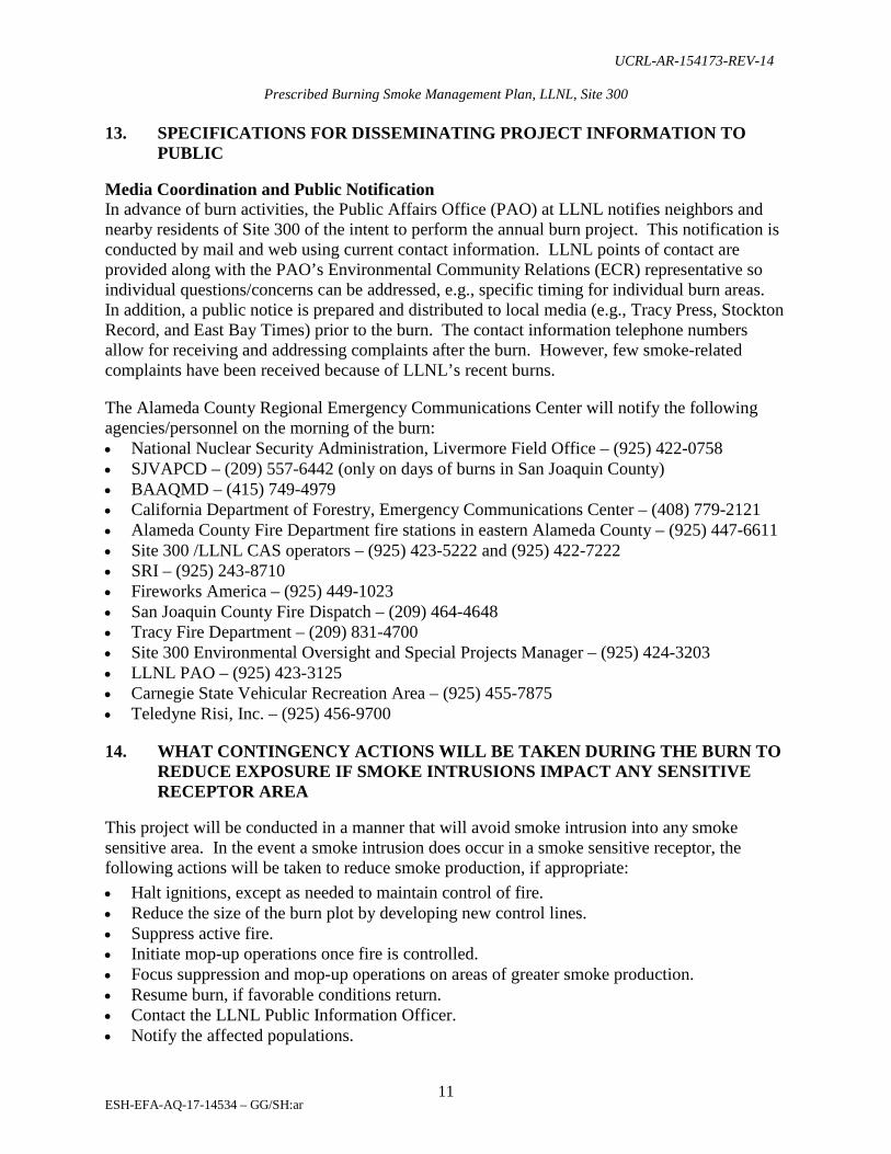
13. SPECIFICATIONS FOR DISSEMINATING PROJECT INFORMATION TO PUBLIC
Media Coordination and Public Notification In advance of burn activities, the Public Affairs Office (PAO) at LLNL notifies neighbors and nearby residents of Site 300 of the intent to perform the annual burn project. This notification is conducted by mail and web using current contact information. LLNL points of contact are provided along with the PAO’s Environmental Community Relations (ECR) representative so individual questions/concerns can be addressed, e.g., specific timing for individual burn areas. In addition, a public notice is prepared and distributed to local media (e.g., Tracy Press, Stockton Record, and East Bay Times) prior to the burn. The contact information telephone numbers allow for receiving and addressing complaints after the burn. However, few smoke-related complaints have been received because of LLNL’s recent burns. The Alameda County Regional Emergency Communications Center will notify the following agencies/personnel on the morning of the burn: • National Nuclear Security Administration, Livermore Field Office – (925) 422-0758 • SJVAPCD – (209) 557-6442 (only on days of burns in San Joaquin County) • BAAQMD – (415) 749-4979 • California Department of Forestry, Emergency Communications Center – (408) 779-2121 • Alameda County Fire Department fire stations in eastern Alameda County – (925) 447-6611 • Site 300 /LLNL CAS operators – (925) 423-5222 and (925) 422-7222 • SRI – (925) 243-8710 • Fireworks America – (925) 449-1023 • San Joaquin County Fire Dispatch – (209) 464-4648 • Tracy Fire Department – (209) 831-4700 • Site 300 Environmental Oversight and Special Projects Manager – (925) 424-3203 • LLNL PAO – (925) 423-3125 • Carnegie State Vehicular Recreation Area – (925) 455-7875 • Teledyne Risi, Inc. – (925) 456-9700 14. WHAT CONTINGENCY ACTIONS WILL BE TAKEN DURING THE BURN TO
REDUCE EXPOSURE IF SMOKE INTRUSIONS IMPACT ANY SENSITIVE RECEPTOR AREA
This project will be conducted in a manner that will avoid smoke intrusion into any smoke sensitive area. In the event a smoke intrusion does occur in a smoke sensitive receptor, the following actions will be taken to reduce smoke production, if appropriate: • Halt ignitions, except as needed to maintain control of fire. • Reduce the size of the burn plot by developing new control lines. • Suppress active fire. • Initiate mop-up operations once fire is controlled. • Focus suppression and mop-up operations on areas of greater smoke production. • Resume burn, if favorable conditions return. • Contact the LLNL Public Information Officer. • Notify the affected populations.

UCRL-AR-154173-REV-14
Prescribed Burning Smoke Management Plan, LLNL, Site 300
ESH-EFA-AQ-17-14534 – GG/SH:ar
12
In the unlikely event that a prescribed fire leaves Site 300 and enters a neighbor’s grazing land, it is expected that it would be extinguished with the resources described herein. Lands that border Site 300 on the west, east, and north are used for cattle grazing. These grasses are like those found at Site 300, except for the grass height. Grasses that have been grazed are usually less than three inches tall and will not support a credible fire spread. For a wildfire to reach a populated area, a fire would have to burn unchecked for approximately nine miles, through the grazed grass, jump Interstate 580, jump two aqueducts, and burn through fields of irrigated crops before reaching the City of Tracy. LLNL contracts with the Alameda County Fire Department to provide emergency response services for fire, emergency medical, technical rescue, and hazardous materials incidents on LLNL property. The Alameda County Fire Department staffs both LLNL fire stations with security cleared, trained, firefighters and firefighter/paramedics. The primary fire suppression responsibility for the area described in this document lies within the jurisdiction of Alameda County Fire Station 21 (formerly LLNL Fire Station 2). Response is also provided from Alameda County Fire Station 20 (formerly LLNL Fire Station 1). The response is supported by a strong secondary response from the City of Tracy, all the Alameda County fire departments and the California Department of Forestry and Fire Protection (CAL Fire). Mutual aid agreements between the various agencies have been in place since 1960. A Mutual Threat Zone Agreement is also in place with CAL Fire. This agreement provides aircraft, helicopters, and air command aircraft in addition to their basic response of eight engines, two bulldozers, and a battalion chief. 15. ATTACH A COPY OF THE ENVIRONMENTAL IMPACT ANALYSIS
PREPARED FOR THE BURN PLAN THAT INCLUDES AN EVALUATION OF ALTERNATIVES TO BURNING, IF SUCH AN ANALYSIS IS REQUIRED BY STATE OR FEDERAL LAW OR STATUTE
The DOE’s principal vehicle for compliance with the National Environmental Policy Act (NEPA) at LLNL and Site 300 is the “2005 Final Site-wide Environmental Impact Statement for Continued Operation of Lawrence Livermore National Laboratory and Supplemental Stockpile Stewardship and Management Programmatic Environmental Impact Statement,” (DOE, 2005) California Environmental Quality Act (CEQA) compliance is addressed by the 1992 Final Environmental Impact Statement and Environmental Impact Report (EIS/EIR) (DOE, 1992) and the 1997 Environmental Impact Report Addendum. These NEPA compliance (EIS) and CEQA compliance (EIR) documents were prepared to analyze the impacts of the proposed action of continued operation of LLNL and Site 300. Prescribed burning is discussed in these documents appropriate to the context, including safety, environmental impacts and wildfire prevention, Site 300 testing requirements, natural resource impact, and potential impact to neighbors and planned adjacent communities. NEPA reviews occur through annual pre-burn meetings attended by LLNL’s Environmental Stewardship, Planning and Monitoring Program (responsible for NEPA compliance) and preparation of formal evaluations as to the adequacy of the EIS/EIR documents if a given burn varies from impacts previously evaluated.

UCRL-AR-154173-REV-14
Prescribed Burning Smoke Management Plan, LLNL, Site 300
ESH-EFA-AQ-17-14534 – GG/SH:ar
13
LLNL environmental policy requires that all Laboratory operations be conducted in compliance with applicable governmental regulations and DOE Orders (DOE, 2004 and LLNL, 2009). LLNL previously submitted to the BAAQMD a copy of a Final Summary Document for Controlled Burning at Site 300. The document describes the measures LLNL has taken to ensure the effectiveness and safety of its controlled burn operations at Site 300, and includes additional measures taken considering the Cerro Grande Fire in New Mexico. The document summarizes reviews and analyses of the LLNL prescribed burn program from LLNL procedures and NEPA documents. A full range of alternatives to burning has been considered, all of which modify approved land use, destroy wildlife habitat, create erosion, or are unsafe. Those alternatives include:
• Grazing, • Sterilization, • Planting fire resistive, non-native vegetation, • Disking, and • Mowing
16. PROJECT FUEL LOADING ESTIMATE (TONS VEGETATION/ACRE) BY
VEGETATION TYPE(S) AND A DESCRIPTION OF THE CALCULATION METHOD
The fuel loading for the project is ungrazed annual grassland estimated to be up to 1 ton per acre (depending on the grass height, distribution, and density), and is based on the Albini (1976) and National Fire Danger Rating System (NFDRS) fuel models for annual grass. Plot 11: 7.5 tons (based on 7.5 acres at 1 ton per acre) Plot 16: 131.6 tons (based on 131.6 acres at 1 ton per acre)
Vegetation Type % of Unit Fuel Model Albini (1976) Fuel Model NFDRAS Annual Grass 100% 1 A

UCRL-AR-154173-REV-14
Prescribed Burning Smoke Management Plan, LLNL, Site 300
ESH-EFA-AQ-17-14534 – GG/SH:ar
14
17. PARTICULATE MATTER EMISSIONS ESTIMATE INCLUDING REFERENCED EMISSION FACTOR(S) AND A DESCRIPTION OF THE CALCULATION METHOD USED
EPA’s Compilation of Air Pollutant Emission Factors (AP-42) PM 10 = 10 g/kg Fuel Load = 1 ton/acre PM 10 g/acre = 1 ton/acre × 2,000 lbs./ton × 1 kg/2.2 lbs. × 10g/kg = 9090.91 g/acre = 9.091 kg/acre PM 10 tons/acre = 9.091 kg/acre × 2.2 lbs./1 kg × 1 ton/2,000 lbs. = 0.010 ton/acre Plot 11: 7.5 acres × 0.010 ton/acre = 0.075 ton (PM 10) Plot 16: 131.6 acres × 0.010 ton/acre = 1.316 tons (PM 10)

UCRL-AR-154173-REV-14
Prescribed Burning Smoke Management Plan, LLNL, Site 300
ESH-EFA-AQ-17-14534 – GG/SH:ar
15
CERTIFICATION 18. I HEREBY CERTIFY, AS A QUALIFIED PROFESSIONAL RESOURCE
ECOLOGIST, BIOLOGIST, OR FORESTER, THAT THE PROPOSED BURNING DESCRIBED ABOVE IS NECESSARY TO ACHIEVE THE SPECIFIC MANAGEMENT OBJECTIVE(S) OF THE SMOKE MANAGEMENT PLAN PREPARED FOR THIS BURN PROJECT
Signature Date Name (print) Lisa Paterson Title (print) Wildlife Biologist

UCRL-AR-154173-REV-14
Prescribed Burning Smoke Management Plan, LLNL, Site 300
ESH-EFA-AQ-17-14534 – GG/SH:ar
16
References Albini, Frank A. 1976. Estimating wildfire behavior and effects. Gen. Tech. Rep.
INT-30. Ogden, UT: U.S. Department of Agriculture, Forest Service, Intermountain Forest and Range Experiment Station.
Bay Area Air Quality Management District Regulation 5. 2008 “Open Burning.” Department of Energy. 2012. O 420.1C “Facility Safety.” Department of Energy and University of California. 2005. Final Site-wide Environmental
Impact Statement for Continued Operation of Lawrence Livermore National Laboratory and Supplemental Stockpile Stewardship and Management Programmatic Environmental Impact Statement, Livermore, CA.
Department of Energy and University of California. 1992. Final Environmental Impact Statement and Environmental Impact Report for Continued Operation of Lawrence Livermore National Laboratory and Sandia National Laboratories, Livermore, CA.
Lawrence Livermore National Laboratory. April 2016 “Wildland Fire Management Plan,” Rev 4.0.
Title 17 California Code of Regulations, Subchapter 2. 2001 “Smoke Management Guidelines for Agricultural and Prescribed Burning”, Sections 80100-80330.