52°north annual report 2018€¦ · processing platforms (e.g. codede) and modern communication...
TRANSCRIPT

exploring horizons
52north
Annual Report 2018New Concepts and Technologies for Spatial Information Infrastructures
Annu
al R
epor
t 201
852
°Nor
th

1
Preface
The 52°North Annual Report provides an overview of 52°North’s activities and its contributions to tech no logy development. Each year, this report serves as the basis for review by the Scientific and Technical Advisory Board (December), the 52N Days strategy discussion (February), and the Shareholders’ meeting, which completes the review and planning cycle in March.
2018 was – once again – an eventful and exciting year for 52°North. 52°North became an official AGILE member (Association of Geographic Information Laboratories in Europe – https://agileonline.org/) and an official member of DDGI (German Umbrella Organization for Geographic Information – www.ddgi.de).
After a stronger focus on Earth Observation projects in 2017, this trend continued in 2018. The challenges of efficiently processing large volumes of geospatial data, integrating sensor data from orbit with hete rogeneous insitu data, or automating the generation of nearrealtime information products requires the development and evaluation of new concepts and technologies. 52°North can make a significant contribution here.
Dr. Benedikt Gräler, a proven geostatistics expert, has strengthened our team. He is expanding the geoanalytics work area and focusing on work in the field of data science at 52°North. With the appointment of Martin Pontius, another employee with indepth knowledge about numerical modeling techniques and the application of HPC infrastructures has joined. Nicole Eymelt has taken over the central secretarial tasks as of June 2018. In total, 52°North currently has 24 employees (16.4 FTEs), of which five are employed as student assistants.
52°North has reviewed and justified the privacy processes according to the new EU General Data Privacy Regulation (EUGDPR). We understand this as a continuous task to improve our efforts to respect privacy and give it an appropriate value for our users (staff, stakeholders, partners, customers, etc.).
Due to a change of tenants at the MartinLutherKingWeg, 52°North had the opportunity to expand the premises. We set up another meeting room and a coworking space that is ideally suited for ad hoc collaboration with partners and project teams.
We look forward to 2019 and to the productive and inspiring collaboration with our partners both in the 52°North network and the R & D projects.
Münster, December 5, 2018
Prof. Dr. Albert Remke Prof. Dr. Andreas Wytzisk-Arens

2
About 52°North
52°North – Initiative for Geospatial Open Source Software GmbH is a private research organization and the 52°North R&D network’s legal body and service center (https://52north.org/). The organization serves as initiator and contributor in many of the network’s activities.
52°North’s mission is to innovate the methods, technologies and applications for spatial information infrastructures (SII), which are an essential foundation for the sustainable development of our economies. The R&D activities are currently focused on smart sensing, smart analytics, and efficient processing of spatio temporal data as well as its applications in various domains, such as disaster management, environmental monitoring, water management, agriculture and sustainable mobility.
Our team of geoinformation scientists and skilled IT professionals contributes to the network’s research activities and provides professional services such as software development, consulting and training.
All software contributions are published under a Free and Open Source Software License. This gives potential users maximum degrees of freedom to use, adapt and redistribute the software and derivative works in any combination with other software.
The 52°North GmbH is a nonprofit organization, i.e. the shareholders receive neither profit shares nor other payments from company funds.

3
Table of Contents
Preface 1 About 52°North 2 Project Work 5 Research and Development 7 WaCoDiS 7 SenSituMon 10 MuDakWRM 12 RIESGOS 14 COLABIS 16 ODIP 2 18 SeaDataCloud 20 BRIDGES 22 Creating Interfaces 24 prospective.HARVEST 26 OGC Testbed 14 28 ec4BIT 30 CITRAM 32 KUBAS 34Professional Services 37 LIST/GSTAT 37 DaKaMon 39 EDP 2 40 CDI NRW 41 Professional Services Projects 42 Mentoring 43Theses Supervision/Mentoring 4552°North Student Innovation Prize 46Google Summer of Code 47
Community Activities 49Community Support 51 Developers 51 PR/Marketing 51 Meeting & Conferences Hosted by 52°North 52 Webinars 52Sensor Web 53 Software Development 55 Selected Workshops 56
Geoprocessing 57 Software Development 57 Standardization Activities 58Geostatistics 59Earth Observation 60 Capacity Building 60 Infrastructure Development 61 ILWIS Webinar 62 ILWIS Software Development 62 Toolbox Software Development and Documentation 63 Copernicus Relays 633D Visualization 64 enviroCar 65 Software Development 65 Projects 66 Dissemination 66Security and GeoRM 67 Publications 69Journals 71Book Chapters 71Magazines 72Reports 72Proceedings/Papers 73Presentations 74Posters 77Conference Workshops 78Project Workshops 79Project Meetings 79Webinars 79
Legal Notice 80

5
Project Work
The 52°North R&D team contributes to many research and
innovation projects. About 70% of 52°North’s chargeable
hours are spent on projects funded by national or European
research and innovation programs. Professional Service (PS)
projects are an important means to unlock the value of
research activities in practice. In addition, the fully funded
PS projects are important to cover the overhead costs of
the privately funded nonprofit research organization.

7
Research and Development
WaCoDiS
The WaCoDiS research project aims to implement a geoinformation infrastructure for river basin management monitoring tasks, which has been specifically optimized to account for water quality control, water protection and protection of access to clean drinking water. For this purpose, remote sensing data from the Copernicus Program, weather data (i.e. from the German Weather Service, DWD) and insitu sensor data for monitoring water bodies will be combined, merged and analyzed via innovative and automated tech niques. Input data, results, and the developed functionalities will be provided and crosslinked via interoperable services.
Based on a detailed analysis of user requirements, as well as the technical and scientific status quo, a WaCoDiS architecture and system design will be developed. Special consideration will be given to the integration of potentially large remote sensing data sets (i.e. from the Copernicus Program), the integration of cloudbased processing platforms (e.g. CODEDE) and modern communication patterns ensuring the timely delivery of information.
The WacCoDiS activities also comprise the evaluation, preparation and persistence of appropriate Sentinel data and DWD data, the development of automated analysis algorithms, and the implementation of interoperable data processing and access services. Complementary to this, essential hydrological models will be adapted and developed.
52°North’s activities focus on supporting the requirements analysis, developing the system architecture (in close cooperation with the Bochum University of Applied Sciences), and implementing integrating system components. Furthermore, 52°North evaluates different approaches for enabling efficient processing of Copernicus data, interoperable provision of domainspecific processing and analysis models, as well as new technologies for data sharing. The 52°North contribution particularly focuses on eventdriven communication patterns in spatial data infrastructures and cloudbased data processing approaches. Complementary work
Copernicus-based services for monitoring material inputs in watercourses and dams

8
comprises the contribution of results and experiences gained during WaCoDiS to the international standardization process and the evaluation of recent and ongoing standardization activities regarding their relevance to WaCoDiS (e.g. OGC Publish/Subscribe standard, OGC SensorThings API).
Overview of the WaCoDiS system architecture
The WaCoDiS project began in the summer of 2017. In 2018, the main focus of activities was on requirements analysis and the development of a comprehensive system architecture enabling the efficient integration of insitu and remote sensing (i.e. Copernicus) data. The main results achieved in 2018 are summarized as follows:
_ Architecture design with a special focus on enabling a harmonized data access and distri buted data processing: This includes the definition of necessary components as well as communication flows. Special consideration was given to eventdriven architecture patterns, for example, to trigger data analysis processes as soon as new, suitable data sets are available.
_ Paper on the concept of eventdriven spatial data infrastructures: Based on the architecture development activities and the cooperation with other projects (e.g. COLABIS, TaMIS), several findings and ideas introducing the idea of eventdriven spatial data infrastructures were published in a joint journal paper. Rieke, M. Bigagli, L., Herle, S., Jirka, S., Kotsev, A., Liebig, T., Malewski, C., Paschke and C. Stasch (2018): Geospatial IoT – the Need for EventDriven Architectures in Contemporary Spatial Data Infrastructures. ISPRS Int. J. GeoInf. 2018, 7(10), 385; doi:10.3390/ijgi7100385, https://www.mdpi.com/22209964/7/10/385/
_ Insitu data model: For optimizing the integration of insitu observation data, several activities were conducted (in cooperation with the MuDakWRM project) to improve the efficiency of how to handle observation data within data access components (e.g. increasing the efficiency of the data model of the 52°North SOS and Sensor Web RESTAPI).
_ OGC SensorThings API: Based on experiences gained in previous projects (e.g. COLABIS), 52°North identified the OGC SensorThings API as an additional, potentially useful component for the WaCoDiS architecture. Evaluation of the SensorThings API continued, which resulted in an open source implementation of the core functionality defined by this specification. This will serve as the basis for further evaluation of Internet of Things technologies (including protocols such as MQTT).
PrOjeCt WOrk

9
PrOjeCt WOrk
PrOjeCt FaCtS
Acronym: WaCoDiSTitle: Wasserwirtschaftliche CopernicusDienste zur Bestimmung von Stoffeinträgen in Gewässer und Talsperren im Rahmen des Umweltmonitorings (Copernicusbased services for monitoring material inputs in watercourses and dams)Duration: 08/2017 – 07/2020Project Web site: https://wacodis.fbghsbo.de/
PARTNERS > Bochum University of applied Sciences, Coordinator, https://www.hochschulebochum.de/ > Wupperverband, https://www.wupperverband.de/ > eFtaS Fernerkundung technologietransfer GmbH, https://www.eftas.de/ > 52°North Initiative for Geospatial Open Source Software GmbH, https://52north.org/
FuNDiNGFunded by the German Federal Ministry of Transport and Digital Infrastructure (BMVI) as part of the of the mFUND program
Group photo of the annual WaCoDiS project meeting hosted by 52°North

10
SenSituMon
The goal of the SenSituMon Project is the development and testing of innovative methods and technologies for the generation of nearrealtime information products for the largescale monitoring of flood areas from satellite and insitu sensor data. The research results will serve as a basis for the development and commercialization of operational services based on the Copernicus Earth Observation system and other satellite missions.
The developments are based on the requirements of insurance companies, which rely on uptodate information on the location, intensity and duration of floods for the rapid response to floodrelated damage events. In addition, the history of the flooding needs to be documented so that detailed infor mation about the occurrence, frequency and duration of flooding events for the affected areas is available. This information can be used, for example, to validate flood risk assessments.
In addition, requirements for monitoring flooded areas for further applications in agriculture and water management will be analyzed. Work initially focuses on the North RhineWestphalia in Germany. Based on the results of this project phase, the scalability of the approach for the area of Germany and Europe will be assessed.
52°North develops and evaluates new methods for the automatable spatiotemporal delineation of flood events from meteorological and hydrological measurement and observation data. In addition, 52°North is developing an eventbased and highly scalable stream processing approach for the efficient and distributed processing of observation and measurement data. This forms the technical basis for the integration of insitu data, which are merged „onthefly“ from different data sources (data fusion) and integrated into the automated processing processes. 52°North is responsible for the development of the overall architecture and contributes significantly to the integration and validation of the solution’s approach.
Integration of satellite and in-situ sensor data to improve the automated large-scale monitoring of floodplains
PrOjeCt WOrk

11
PrOjeCt WOrk
After project initialization in 11/2017, a detailed analysis of the requirements and the available data, as well as the creation of an architecture concept for the entire system, took place. Subsequently, the critical components of the overall system were prototypically implemented and integrated (technical prototype). This served to test the feasibility of the architectural concept and to evaluate alternative solutions. The development of scalable process chains for the processing of satellite and insitu data with BigData technologies such as Apache Spark, Apache Kafka, Docker and Kubernetes formed the focus of the work. Implementations also explored the usability of the Copernicus CODEDE and Mundi Web Services platforms as well as the link with Esri’s ArcGIS platform.
PrOjeCt FaCtS
Acronym: SenSituMonTitle: Integration of satellite and insitu sensor data to improve the automated largescale monitoring of floodplains.Duration: 11/2017 – 10/2019
PARTNERS > con terra GmbH, Coordinator, https://www.conterra.de/ > eFtaS Fernerkundung technologietransfer GmbH, https://www.eftas.de/ > 52°North Initiative for Geospatial Open Source Software GmbH, https://52north.org/
ASSOCiATED PARTNERS
> VdS Schadenverhütung GmbH, https://vds.de/ > CLaaS GmbH & Co. kG, https://www.claas.de/ > Wupperverband, https://www.wupperverband.de/
FuNDiNGFunded by the German Federal Ministry of Economic Affairs and Energy (BMWi)
SenSituMon architecture – technology view

12
PrOjeCt WOrk
MuDak-WrM
Water is a highly valuable good worldwide. It must be managed with care in order to fulfill the needs of diverse consumers. The quality of a water reservoir not only depends on the reservoir itself, but is also influenced by the surrounding environment and the entire catchment. While insitu monitoring of a reservoir provides detailed data, it is also very costly. The MuDakWRM project aims to identify proxies that provide insights into the quality of a reservoir that are detailed enough for a midrange management and applicable worldwide.
Specific goals are the complexity reduction of current water reservoir (management) models, their parameterization based on a minimal data set, the development of a central data delivering service, wrapping models in web processing services (WPS) and a common visual webbased water quality exploration tool. A key constraint is the parameterization based on Sentinel data and a minimum of additional insitu measurements in order to achieve a globally applicable but nevertheless sensible monitoring framework.
The technical driver of this development is a central data access point that provides and merges insitu and remote sensing data. 52°North’s core contribution is the development of an open source service that grants access to spatial and spatiotemporal data from insitu sensors, measurement campaigns, drones and Sentinel missions. A key challenge originates from the different spatial and temporal resolutions of the data, where autonomous insitu sensors continuously report measurements within minutes at fixed locations, field campaigns can produce data acquired in seconds along 3dimensional trajectories and remote sensing data is collected on a daily scale with a large 2dimensional coverage.
In the prototypical development, gridded data is stored in array databases (SciDB, Rasdaman) to allow fast retrieval of pixel time series. The access is facilitated via web coverage and web map services (WCS and WMS by the OGC). Insitu measurement data is provided by the sensor observation service (SOS by the OGC). Models built on the centralized data and developed by the consortium are provided via web processing services (WPS by the OGC). A joint interface to the reservoir data is developed together with the project partner Wupperverband.
Multidisciplinary Data acquisition as the key for a globally applicable Water Resource Management

13
PrOjeCt WOrk
Work accomplished in 2018 covers extensions of the SOS data model to serve multidimensional data (i.e. depth profile and spectral data), direct data submission of TriOs sensors to the SOS, the development of a WMS service providing access to remote sensing data stored in SciDB, as well as extensions of the SOSImporter to feed multidimensional data in the SOS.
WMS overlay for the
Passauna reservoir.
the corresponding raster
data is stored in a SciDB
and access is granted via
a WMS that is based on
WPS processes.
PrOjeCt FaCtS
Acronym: MuDaKWRMTitle: Multidisciplinary data acquisition as the key for a globally applicable water resource management.Duration: 04/2017 – 03/2020Project Web site: http://www.mudakwrm.kit.edu/
PARTNERS > karlsruher Institut für technologie (kIt), http://www.kit.edu/ > Universität koblenz Landau, https://www.unikoblenzlandau.de/de > Hydron GmbH, https://www.hydrongmbh.de/dienstleistungen/ > 52°North Initiative for Geospatial Open Source Software GmbH, https://52north.org > Wupperverband, https://www.wupperverband.de/ > eFtaS Fernerkundung technologietransfer GmbH, https://www.eftas.de/ > Sanepar, http://site.sanepar.com.br/ > Universidade Federal Do Paraná (UFPr), http://www.ufpr.br/portalufpr/ > Universidade Positivo, https://www.up.edu.br/ > eMater, http://www.emater.pr.gov.br/ > Instituto das Águas do Paraná (auguas Paraná), http://www.aguasparana.pr.gov.br/ > agência Nacional De Águas (aNa), http://www.aguasparana.pr.gov.br/
FuNDiNGFunded by the German Federal Ministry of Education and Research (BMBF)

14
PrOjeCt WOrk
rIeSGOS
The RIESGOS project addresses challenges of increased risks to society caused by natural hazards. For this purpose it aims at more efficient risk management based on more reliable information. A particular strength is that it addresses complex interactions, such as cascading effects of certain hazards/risks as well as many of the underlying sources of uncertainty.
RIESGOS will develop novel scientific approaches related to the assessment of different hazards and risks. This includes the analysis of dynamic exposure, vulnerability and the modelling of cascading effects and possible failures.
Modular Web services integrated into a flexible and scalable multirisk information system demonstrator will be the foundation of the RIESGOS software architecture. As a result, endusers from civil protection and disaster management authorities will receive tools to simulate and analyze complex multirisk scenarios. These are complemented by the development and investigation of strategies for informationbased and dialoguebased risk communication.
The main goal of 52°North’s activities in the RIESGOS project is the conceptual design and implementation of an interoperable architecture for a multirisk analysis and information system for the Andes region. The 52°North tasks comprise:
_ Requirements analysis _ Development of a software architecture following international standards to ensure
interoperability (e.g. INSPIRE, OGC) _ Implementation of selected components (data access, data analysis and processing, communicaton) _ Integration of components into demonstrators _ Contribution to market analysis and development of exploitation perspectives
(focus on the publication as open source software) _ Dissemination
Multi-risk analysis and information system components for the Andes region

15
PrOjeCt WOrk
In 2018, 52°North’s efforts focused on the collection and analysis of requirements. The most important activity in this context was the participation in a series of onsite stakeholder meetings in Chile, Ecuador, and Peru. Requirements gathered during these meetings provided the basis for analysis of relevant standards and the assessment of their relevance for the RIESGOS project. Finally, these activities resulted in a first version of a system architecture and the implementation of several processing services that encapsulate specific thematic functionalities developed by the RIESGOS partners GFZ and DLR.
PrOjeCt FaCtS
Acronym: RIESGOSTitle: MultiRisk Information and Early Warning System in Cooperation with Chile Duration: 11/2017 – 10/2020 Project Web site: http://www.riesgos.de/en/
PARTNERS > Deutsches Zentrum für Luft- und raumfahrt (DLr), Coordinator, https://www.dlr.de/ > Helmholtz-Zentrums Potsdam Deutsches GeoForschungsZentrum (GFZ), https://www.gfzpotsdam.de/ > alfred Wegener Institut (aWI), https://www.awi.de/ > technische Universität München (tUM), https://www.tum.de/ > geomer GmbH, https://www.geomer.de/ > eOMaP GmbH & Co. kG, https://www.eomap.com/ > plan + risk consult, http://www.planriskconsult.de/ > DIaLOGIk, http://www.dialogikexpert.de/ > 52°North Initiative for Geospatial Open Source Software GmbH, https://52north.org/
ASSOCiATE PARTNERS
> GIZ GmbH, https://www.giz.de > UNOOSa, http://www.unoosa.org/ > UN-SPIDer, http://www.unspider.org/
FuNDiNGFunded by the German Federal Ministry of Education and Research (BMBF) as part of the funding measure “BMBF CLIENT II – International partnerships for sustainable innovations” of the framework program “Research for Sustainable Development (FONA)”.
> UNeSCO, https://en.unesco.org/ > Munichre, https://www.munichre.com/de/
the rIeSGOS processing workflow
for earthquake simulations

16
PrOjeCt WOrk
COLaBIS
The COLABIS project aimed to design and implement a Web platform that enables and eases the development of urban early warning systems, specifically focusing on information fusion derived from sensors, crowdsourcing, geosimulations, as well as administrative and historical data. The project focused not only on local heavy rain, flooding and cascading events affecting urban water and sewage infrastructures, but also on traffic infrastructures. Pilot applications served as proofofconcepts and helped to develop best practices. To support decision makers with timely and value added information, input data from various sources needs to be combined. This data fusion comprises data retrieval, enhancement, harmonization, similarity measures, matching, conflict detection and resolving. The consistency and reliability of results essentially depends on the underlying data quality, which varies over the different data sources. Therefore, quality metrics play a major role in COLABIS. 52°North’s role in the project comprised a contribution to architecture development on the one hand, and the conceptual design and implementation of several building blocks of the COLABIS infrastructure on the other.
Collaborative Early Warning Information Systems for Urban Infrastructures
Overview of the COLaBIS case study (Source: https://colabis.de/)
The following aspects constitute the 52°North team’s core activities: _ Contribution to the architecture development _ Design and development of the COLABIS RESTAPI for simplifying the development of applications
based on the COLABIS infrastructure: This comprises not only an important contribution to the development of the 52°North Sensor Web RESTAPI, but also to the GeoCure project (proxy component for RESTbased integration of content from WMS and WFS servers), the 52°North Eventing API (subscription to certain events in observation data streams), and the advancement of the RESTbinding of the OGC WPS 2.0 standard.
_ CKANHarvester: Component for harvesting different types of geospatial data from CKAN Servers for publication via the COLABIS REST Platform. This includes support for the Schema Descriptors

17
PrOjeCt WOrk
concept developed within the COLABIS consortium in order to support the interpretation of geospatial data sources based on a formal description of their structure.
_ Application development: Supporting the fast and easy development of lightweight spatial applications based on reusable JavaScript building blocks (Helgoland Toolbox)
_ Contribution to standardization (i.e. OGC): Discussion about RESTbased interfaces for facilitating application development, evaluation of new standards for eventbased communication flows (i.e. OGC Publish/Subscribe standard), and evaluation of the OGC SensorThings API through a first prototype implementation
52°North’s achievements in 2018 mainly comprise the integration of COLABIS components into demonstrators and showcase implementations. Contribution to international standardization activities continued, however the 52°North team completed the development of new concepts and architecture building blocks in the previous years.
COLaBIS tool for simula t-
ing the distribution of
pollutants within the
sewage system
PrOjeCt FaCtS
Acronym: COLABISTitle: Collaborative Early Warning Information Systems for Urban InfrastructuresDuration: 07/2015 – 11/2018Project Web site: https://colabis.de/
PARTNERS > technische Universität Dresden, Coordinator, https://tudresden.de/ > Fraunhofer IGD, https://www.igd.fraunhofer.de/en > 52°North Initiative for Geospatial Open Source Software GmbH, https://52north.org/
FuNDiNGFunded by the German Federal Ministry of Education and Research (BMBF) as part of the of the Geotechnologien program
GEOtechnologien

18
PrOjeCt WOrk
ODIP 2
The Ocean Data Interoperability Platform strives to facilitate more efficient sharing of data across scientific domains and international boundaries. For this purpose, all the major organizations engaged in ocean data management in Europe, the USA, and Australia joined the ODIP partnership.
The ODIP 2 project comprised the organization of international workshops focusing on promoting standards and developing prototypes to evaluate potential standards and interoperability solutions. ODIP also offered a platform to harmonize the diverse regional systems while advancing the European contribution to the global system.
The products and services developed by ODIP were actively promoted at an international level through IOC/IODE, the Research Data Alliance (RDA), and GEOSS. Thus, ODIP 2 aimed at interoperability on a global level, reaching beyond the project framework itself. ODIP additionally facilitated the dissemination of best practice recommendations and the transfer of new, emerging technology.
52°North’s main responsibilities in the project were related to Sensor Web technologies. As part of this role, 52°North was entrusted with the coordination of one of the five ODIP 2 prototype development activities: ODIP 2 Prototype 3+: Sensor Web Enablement (SWE) for the marine and ocean domain. This entailed the following activities:
_ Coordination of and contribution to the development of marine Sensor Web Enablement profiles to harmonize the application of the corresponding standards in the marine domain (https://odip.github.io/MarineProfilesForSWE/)
_ Investigation of how semantic interoperability can be improved for marine Sensor Web applications by relying on common vocabularies (i.e. the NERC Vocabulary Server)
_ Support for the provision of sensor metadata through interoperable standards and dedicated metadata editing tools
_ Integration of Internet of Things technologies and protocols (e.g. MQTT data streams)
_ Evaluation of alternative, more lightweight technologies, such as JSON
_ Development of strategies for efficiently handling and processing large observation data sets (in close cooperation with the AlfredWegenerInstitut, AWI)
Extending the Ocean Data Interoperability Platform
architecture of the a near real-time SOS using
different data stores for data and metadata

19
PrOjeCt WOrk
The ODIP 2 project ended in March 2018. Thus, 52°North's main activities in this year comprised the finalization of prototypes (i.e. integration of MQTTbased data sources into the 52°North Sensor Web components) and further input to the development of Marine Sensor Web Profiles. This has laid a foundation for continuing the work initiated by ODIP 2 in future research activities.
PrOjeCt FaCtS
Acronym: ODIP 2Title: Extending the Ocean Data Interoperability Platform Duration: 04/2014 – 03/2018Project Web site: http://www.odip.eu
PARTNERS > Natural environment research Council (NerC), Coordinator, https://nerc.ukri.org/ > alfred Wegener Institute Helmholtz Centre for Polar and Marine research (aWI),
http://www.awibremerhaven.de > all-russia research Institute of Hydrometeorological Information – World Data Centre
(rIHMI-WDC) National Oceanographic Data Centre (NODC), http://nodc.meteo.ru > British Geological Survey, http://www.bgs.ac.uk > British Oceanographic Data Centre, http://www.bodc.ac.uk/ > CNr, Institute for atmospheric Pollution (IIa), http://www.iia.cnr.it > CSIC-UtM/ Marine technology Unit, http://www.utm.csic.es/ > eNea Centro ricerche ambiente Marino, http://www.santateresa.enea.it/ > Flanders Marine Institute, http://www.vliz.be/ > German Oceanographic Datacentre (DOD), https://www.bsh.de/DE/DATEN/
Ozeanographisches_Datenzentrum/ozeanographisches_datenzentrum_node.html > Hellenic Centre for Marine research, Hellenic National Oceanographic Data Centre (HCMr/HNODC),
http://hnodc.hcmr.gr > Ieee France Section, http://hnodc.hcmr.gr > IFreMer/IDM/SISMer – Scientific Information Systems for the Sea, http://www.ifremer.fr/sismer/ > Marine Information Service (MarIS), https://www.maris.nl > OGS (Istituto Nazionale di Oceanografia e di Geofisica Sperimentale), http://www.ogs.trieste.it/ > royal Belgian Institute of Natural Sciences, Operational Directorate Natural environment,
Belgian Marine Data Centre, http://www.bmdc.be > SOCIB/ Balearic Islands Coastal Observing and Forecasting System, http://www.socib.es > tNO Geological Survey of the Netherlands, https://www.tno.nl/en/ > University of Liege, GeoHydrodynamics and environment research, http://modb.oce.ulg.ac.be/ > 52°North Initiative for Geospatial Open Source Software GmbH, https://52north.org/
FuNDiNGFunded by the Horizon 2020 Framework Programme for Research and Innovation (H2020INFRASUPP20142) of the European Union under grant agreement number 654310.
Co-funded by the Horizon 2020 programme of the European Union

20
SeaDataCloud
The panEuropean SeaDataNet infrastructure has been developed by national oceanographic data centers and major research institutes from 34 countries. It connects more than 100 marine data centers providing data discovery and access functionality for researchers. Furthermore, SeaDataNet is a key element supporting the European Marine Observation and Data network (EMODnet), which was initiated by the EU DGMARE. It also complements the Copernicus Marine Environmental Monitoring Service.
In order to provide more efficient and faster data access for researchers, several upgrades and enhancements to reflect recent technological developments are needed. These comprise aspects such as new types of sensors as well as international IT concepts (e.g. cloud infrastructures) and interoperability standards (e.g. INSPIRE guidelines for observation data). SeaDataCloud aims to improve the current SeaDataNet infrastructure by adopting cloud and high performance computing technology. For this purpose, SeaDataCloud cooperates with EUDAT, a network of computing infrastructures that develops and operates a common frame work for managing scientific data across Europe.
The SeaDataCloud project results in researchers receiving not only an improved access to research data, but also a comprehensive collection of services and tools developed to cover their specific needs. These services and tools support marine research and enable the generation of addedvalue products.
Within the SeaDataCloud consortium, 52°North investigates new approaches on how to enhance the SeaDataNet infrastructure with capabilities to handle near realtime observation data. This comprises two main tasks:
_ SWE Ingestion Service: In order to facilitate the publication of observation data streams, 52°North has worked on a concept and prototypical implementation of a Web service architecture that comprises a plugandplay approach for sensor data publication. A first step includes the description of sensor interfaces, sensor data streams (e.g. delivered through internet of things protocols such as MQTT) and other sensor data repositories (e.g. CSCbased data stores). This is complemented by tools for editing such sensor data stream descriptions (including the semantics of the data) as well as
Further developing the pan-European infrastructure for marine and ocean data management
PrOjeCt WOrk
SWe Ingestion Service
architecture
21
PrOjeCt WOrk
PrOjeCt FaCtS
Acronym: SeaDataCloudTitle: Further developing the panEuropean infrastructure for marine and ocean data management Duration: 11/2016 – 10/2020Project Web site: https://www.seadatanet.org/Aboutus/SeaDataCloud
PARTNERS > Institut Français de recherche pour l’exploitation de la Mer (IFreMer), Coordinator > 56 partners and 5 sub-contractors from 32 countries
FuNDiNGFunded by the Horizon 2020 Framework Programme for Research and Innovation (H2020INFRAIA20161) of the European Union under grant agreement number 730960.
an interpreter that relies on the sensor data stream descriptions for pushing the available data into the SeaDataCloud infrastructure.
_ SWE Viewing Service: 52°North explores new approaches to user friendly visualization of previously published sensor data streams. In addition to the display of the data itself, this comprises new ideas to increase the discoverability of the broad range of published sensor data streams.
52°North is also involved in networking activities to promote and further test the SeaDataCloud developments and to incorporate the feedback into international standardization activities.
The 52°North activities in 2018 concentrated mainly on the SWE Ingestion Service. Not only did 52°North evaluate relevant technologies (e.g. Spring Cloud Data Flow), but we also performed prototypical implementations to integrate several types of data sources (e.g. MQTT data streams as well as file based data repositories). 52°North presented the findings of this activity at the IMDIS 2018 conference:
_ Jirka, S. & Autermann, C. (2018). Facilitating the publication of realtime marine observation data: the SeaDataCloud SWE Ingestion Service. IMDIS 2018 International Conference on Marine Data and Information Systems, November 2018, Barcelona, Spain. Online: https://imdis.seadatanet.org/content/download/121493/file/IMDIS2018_Proceedings.pdf
At the end of 2018, the conceptual work on the SWE Viewing Service started via interaction with partners from different marine research organizations.
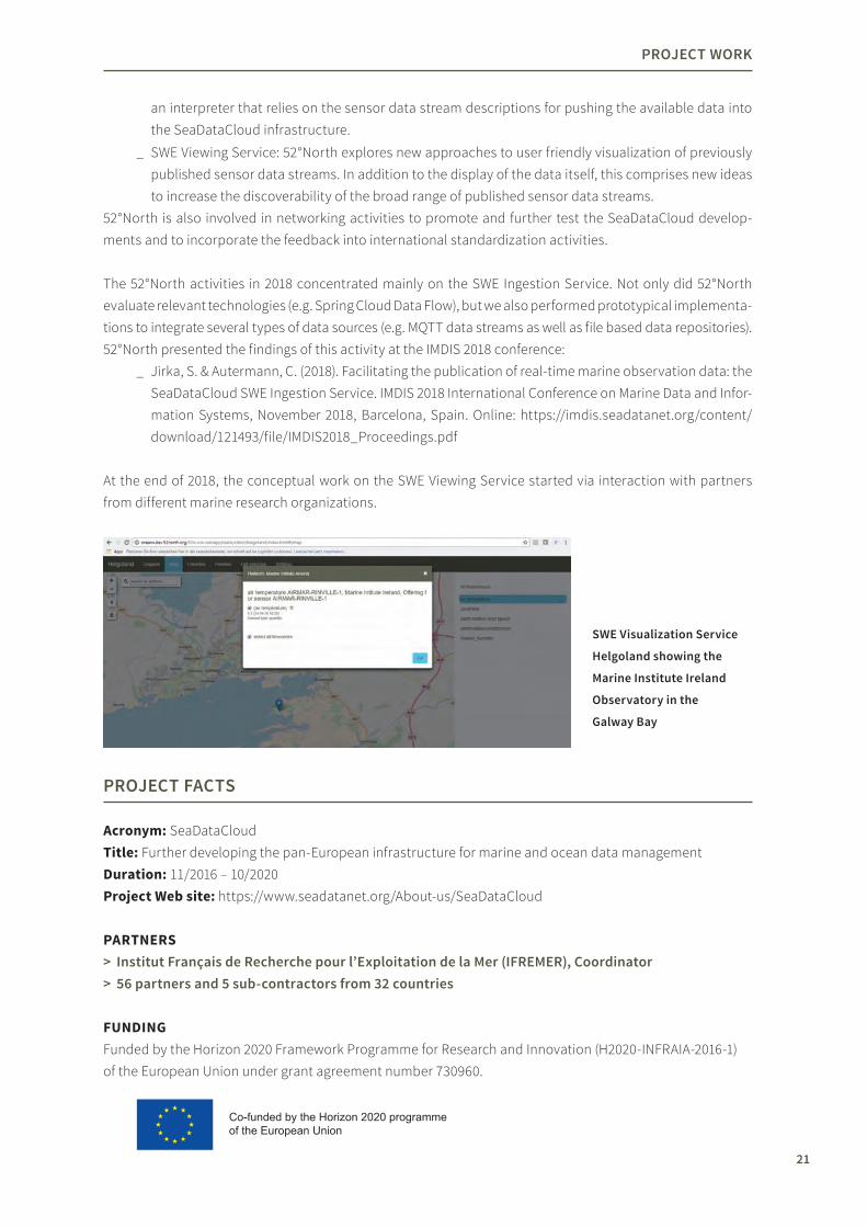
SWe Visualization Service
Helgoland showing the
Marine Institute Ireland
Observatory in the
Galway Bay
Co-funded by the Horizon 2020 programme of the European Union

22
BrIDGeS
BRIDGES (Bringing together Research and Industry for the Development of Glider Environmental Services) aims to develop an innovative glider platform to support further understanding, improved monitoring and responsible exploitation of the marine environment while assuring its longterm preservation. Factors such as robustness, costeffectiveness, relocatability, versatility and easy deployment motivate the development of the intended ocean glider. This glider will support autonomous, longterm, insitu exploration of the deep ocean at large spatiotemporal scales.
Special engineering challenges for the glider development comprise the adaptation of an existing glider platform (the sole European underwater glider SeaExplorer) to deep basins of up to 5000 m depth and a flexible payload architecture for increased autonomy and support of a broader range of sensing capabilities. To achieve the ability to execute unmanned underwater operations and to ensure an efficient integration of the collected observation data, one of the project’s dedicated work packages deals with interoperability and data infrastructure challenges.
Bringing together Research and Industry for the Development of Glider Environmental Services
In the BRIDGES project, 52°North is responsible for the design and standardization of a Webbased architecture for integrating autonomous ocean gliders deployed as sensor platforms. 52°North has made a major contribution by specifying and designing a Sensor Web infrastructure that is especially tailored to the needs of marine gliders and researchers working with the collected data. In addition to the definition of corresponding metadata profiles, we contributed approaches for achieving a certain level of semantic interoperability (in close cooperation with the British Oceanographic Data Centre that operates a comprehensive vocabulary server) and the enablement of eventbased data flows.
PrOjeCt WOrk
Glider data management
workflow within the Sensor Web

23
PrOjeCt WOrk
In 2018, 52°North focused on the refinement of the specified Sensor Web architecture based on partner feedback (i.e. from marine research centers and glider developers). 52°North was also able to perform further work on the evaluation of concepts and tools for enabling the eventbased delivery of observation data streams and their analysis.
PrOjeCt FaCtS
Acronym: BRIDGESTitle: Bringing together Research and Industry for the Development of Glider Environmental Services Duration: 3/2015 – 2/2019Project Web site: http://www.bridgesh2020.eu/
PARTNERS > association pour la recherche et le Développement des Méthodes et Processus Industriels
(arMINeS), Coordinator, https://www.armines.net/fr > Christian Michelsen research (CMr), https://cmr.no > eNIteCH GmbH, www.enitech.de > HYDrOPtIC, www.hydroptic.com > BMt Isis, www.bmt.org > eCOrYS, https://www.ecorys.nl/ > Université Pierre et Marie Curie (UPMC), https://www.upmc.fr > albatros Marine technologies, http://albatrosmt.com/home/ > Society for Underwater technology (SUt), https://www.sut.org/ > the Hebrew University of jerusalem (HUjI), https://new.huji.ac.il/en > Cyprusubsea Consulting and Services C.S.C.S. Limited (CSCS), https://cyprussubsea.com > University of Cyprus (UCY), https://www.ucy.ac.cy/en/ > aLSeaMar alcen, http://www.alseamaralcen.com > Universidade do Porto (UPorto), www.uporto.pt > 52°North Initiative for Geospatial Open Source Software GmbH, https://52north.org/ > IrIS, http://www.iris.no/ > Natural environment research Council (NerC), https://nerc.ac.uk/ > Ocean Scan Marine Systems & technology (MSt), www.oceanscanmst.com > University of Southampton (UoS), www.southampton.ac.uk
FuNDiNGFunded by the Horizon 2020 Framework Programme for Research and Innovation (H2020BG20142) of the European Union under grant agreement number 635359.
Overview of the SensorML
Profile for marine sensors
(here: description of
platform types)
Co-funded by the Horizon 2020 programme of the European Union
Glider data management
workflow within the Sensor Web

24
Creating Interfaces
This project explores sociotechnical interfaces at the foodwaterenergy (FWE) nexus in cities near water. Aiming to increase urban sustainability, resilience, and quality of life, this project works to build local capacity through innovative approaches in coordinated knowledge creation, governance and exchange. A multidisciplinary and transdisciplinary international team represents natural and social sciences, humanities, engineering, data and computer sciences, and urban planning, as well as civil society and business actors. They conduct research on stakeholder interactions and decisionmaking in the FWE sectors. The team explores data governance and investigates novel approaches in participatory knowledge generation and citizen science and their implementation. The project helps answer central questions surrounding the integration of such novel means of citizendriven knowledge creation into the governance process and urban infrastructure planning procedures. Common research frameworks and a close inter disciplinary and transdisciplinary cooperation provide a basis for comparative analysis and coproduction of transformative knowledge. Development of sociotechnical interfaces and decision support tools are informed by the needs of stakeholders, the FWE actors, and members of the public following an Urban Living Lab framework. This approach involves an integrative, interactive, and iterative process of stakeholder engagement to develop innovative interfaces and achieve the goals mentioned above .
52°North’s role is mainly focused on the development of interoperable Citizen Science and decision support workflows for providing data collection and analysis functionality as part of the different Urban Living Labs and Citizen Science approaches in the three partner cities: Tulcea (Romania), Wilmington (USA) and Slupsk (Poland). To this extent, 52°North evaluates existing Citizen Science concepts, advances the baseline components identified and contributes its findings to international standardization activities aiming at increased interoperability among Citizen Science projects.
52°North focused on requirements analysis in 2018. This comprised, for example, the collection of information about Citizen Science data sets that partners require and the identification of possible approaches
Building capacity for integrated governance at the food-water-energy-nexus in cities on the water
PrOjeCt WOrk
Creating Interfaces project structure overview

25
PrOjeCt WOrk
PrOjeCt FaCtS
Acronym: CreatingInterfacesTitle: Building capacity for integrated governance at the foodwaterenergynexus in cities on the water – development of interoperable citizen science and decision support componentsDuration: 05/2018 – 04/2021Project Web site:: https://creatinginterfaces.eifer.kit.edu/
PARTNERS > european Institute for energy research (eIFer), Coordinator, https://www.eifer.kit.edu/ > University of Delaware, https://www.udel.edu/ > National Center for atmospheric research (NCar), https://ncar.ucar.edu/ > University of Warwick, https://warwick.ac.uk/ > Pracowina Zrównoważonego Rozwoju (PZR), http://www.pzr.org.pl/ > Plantagon, http://www.plantagon.com/ > Nicolaus Copernicus University, https://www.umk.pl/ > Danube Delta National Institute for research and Development (DDNI), http://ddni.ro/wps/ > 52°North Initiative for Geospatial Open Source Software GmbH, https://52north.org/ > ktH royal Institute of technology, https://www.kth.se/
FuNDiNGFunded by the German Federal Ministry of Education and Research (BMBF) as part of the the Sustainable Urbanisation Global Initiative (SUGI)/FoodWaterEnergy Nexus. This program is jointly established by the Belmont Forum and the Joint Programming Initiative Urban Europe. The cooperation was established in order to bring together research and expertise across the globe to find innovative new solutions to the FoodWaterEnergy Nexus challenge.
to collect and handle these data sets. These activities provide the basis for upcoming 52°North contributions that will deal with establishing data analysis and processing workflows for different types of Citizen Science data. Furthermore, 52°North actively contributes to the OGC Citizen Science Interoperability Experiment.
Creating Interfaces
kick-off meeting in
karlsruhe

26
prospective.HarVeSt
The goal of the prospective.HARVEST project is the realization of an infrastructure to provide proactive support for agriculture processes, taking silage maize harvesting as an example of use. Therefore, an open, serviceoriented architecture will be specified and developed. It will provide novel services for planning and controlling the harvesting campaign and proactive adjustment of the harvester by utilizing additional data sources, such as the machines themselves, Copernicus satellite data or other external data sources.
52°North develops methods and technologies to support the predictive planning and control of cooperative agricultural processes exemplified by the harvest of silage maize. Explicitly, 52°North specifies the prospective.HARVEST ecosystem, i.e. the service architecture. In addition, we design and implement the base component of such an ecosystem and plan the integration and evaluation of the different components in three different field tests.
Digital logistic chain management forharvesting silage maize
In 2018, 52°North focused on the specification of the prospective.HARVEST ecosystem’s general architecture, prototypical implementation and setup. This included the definition of a common data model, the specification of services APIs to offer flexibility and processability throughout the architecture, and the general setup for base architectural components. The set up enables architectural requirements, such as service discovery, centralized logging and configuration, as well as eventdriven and realtime exchange of information between the components (e.g. data coming from machines). In addition, 52°North designed and developed basic processing services, such as a routing service for agricultural machines and a service for computing time/distance matrices between a set of fields and field access points based on OpenStreetMap data.
PrOjeCt WOrk
prospective.HarVeSt project consortium and allocation of tasks

27
PrOjeCt WOrk
Moreover, 52°North was responsible for the deployment environment in the Open Telekom Cloud. The 52°North team set up a dockerized deployment environment that enables the partners to continuously deploy their components with little effort.
PrOjeCt FaCtS
Acronym: prospective.HARVESTTitle: prospective.HARVESTDuration: 8/2016 – 11/2019 Project Web site: https://www.prospectiveharvest.de/de/startseite.html
PARTNERS > CLaaS e-Systems GmbH & Co kG, Coordinator, http://www.claasesystems.com/ > CLaaS Selbstfahrende erntemaschinen GmbH, https://www.claas.de/ > green spin GmbH, https://www.greenspin.de/ > 365FarmNet GmbH, https://www.365farmnet.com/en/ > Deutsches Forschungszentrum für künstliche Intelligenz GmbH, https://www.dfki.de/web/ > Hochschule Bochum, https://www.hochschulebochum.de/ > 52°North Initiative for Geospatial Open Source Software GmbH, https://52north.org/
FuNDiNGFunded by the Federal Ministry of Food and Agriculture (BMEL) in accordance with the parliamentary resolution of the German Parliament, Grant no.: 2815700915
by decision of theGerman Bundestag
With support from

28
OGC testbed 14
“OGC Testbeds are the largest Open Geospatial Consortium (OGC) Innovation Program activities. The OGC Innovation Program (OGC IP) provides global, handson, collaborative prototyping for rapid development and delivery of geospatial IT solutions. All results are publicly available once approved by the OGC Technical Committee. Testbeds provide a unique platform where sponsors can outsource the rapid generation of prototypes and test environments with a number of leading organizations in their field. Testbeds result in more than just new and updated standards. Outcomes include guides, overviews, and best practices for solving leadingedge geospatial problems.” (http://www.opengeospatial.org/projects/initiatives/testbed14)
Testbed14 addressed challenges in the following domains: _ Machine Learning, Deep Learning & Artificial Intelligence: exploring AI in standardized environments _ Next generation OGC web services & Web APIs: OpenAPI data access _ Exploitation platforms and Big Data cloud processing: Application handling close to Big Data _ Information registries & semantic enablement: Strong semantics in distributed environments _ Federated clouds: Accessing services and data across clouds _ Security & secure workflows: Authorisation mediation across platforms _ Complex feature handling: Complex data structures at Web interfaces _ Swath data encodings as coverages: Opening the full potential of satellite data _ Application schema modeling and conversion _ LiDAR point cloud data handling _ CityGML and augmented reality _ Portrayal: Enhanced visualization of geospatial data _ MapML: Native map support in browsers _ Quality of service & experience: How to find the best services offering _ Compliance and interoperability testing.
52°North contributed to the development of a Machine Learning system. In particular, 52°North specified and implemented a Web Processing Service that enables the training and running of Machine Learning algorithms. The system is prototypically implemented using a Decision Tree Classifier for detecting different land use types from satellite images provided by NGA. The underlying image and feature data is stored in an Image and Feature Repository that 52°North implemented based on the OGC Web Map Server and Web Feature Service. Metadata of the algorithms are stored in a Machine Learning Knowledge Base that has been developed by a third party.
In addition to the Machine Learning System, 52°North also provided a Web Processing Service for Webbased access to an analysis tool provided by NGA. This tool is used in Testbed 14’s Geospatial Workflows thread. Furthermore, 52°North edits the Transactional Web Processing Service (WPST) engineering report that specifies an interface for deploying new geoprocessing functionality provided as docker containers.
Training and running machine learning algorithms with WPS
PrOjeCt WOrk

29
PrOjeCt WOrk
PrOjeCt FaCtS
Acronym: OWS14Title: OGC Testbed14Duration: 04/2018 – 11/2018 Project Web site:: http://www.opengeospatial.org/projects/initiatives/testbed14
PARTNERS > Open Geospatial Consortium, http://www.opengeospatial.org/ > 52°North Initiative for Geospatial Open Source Software GmbH, https://52north.org/
FuNDiNG > atos, https://atos.net/en/ > Defence Science and technology Laboratory (dstl),
https://www.gov.uk/government/organisations/defencescienceandtechnologylaboratory > european Space agency (eSa) / CGI, https://www.esa.int/ESA https://www.cgi.com/en > european Union Satellite Centre (SatCen), https://www.satcen.europa.eu/ > Federal aviation administration (Faa) System Wide Information Management (SWIM) Program,
https://www.faa.gov/air_traffic/technology/swim/ > Geonovum, https://www.geonovum.nl/ > Natural resources Canada (NrCan), https://www.nrcan.gc.ca/ > https://www.nrcan.gc.ca/home (OS), https://www.ordnancesurvey.co.uk/ > US Geological Survey (USGS), https://www.usgs.gov/ > US National aeronautics and Space administration (NaSa), https://www.nasa.gov/ > US National Geospatial-Intelligence agency (NGa), https://www.nga.mil/
Overview of the machine learning architecture

30
ec4BIt
BIG IoT is a European H2020 project aiming at Bridging the Interoperability Gap of the Internet of Things (http://bigiot.eu). The objective is to enable cross standard, crossplatform, and crossdomain IoT services and applications. In the context of several calls for proposals from the BIG IoT consortium, 52°North had the opportunity to participate in BIG IoT with the eC4BIT project.
52°North designed and implemented a bridge between enviroCar and the BIG IoT marketplace, an open marketplaceforIoTplatforms,tocreateofferingsofdatagatheredinenviroCar.Userscaneasilydiscoverthetrack statistics and utilize them in their applications by means of the BIG IoT marketplace.
The main project work was carried out in 2017. In 2018, the work was finalized and presented in a final report at the BIG IoT First Open Call Final Meeting in January 30, 2018.
Connecting enviroCar and the BIG IoT marketplace
PrOjeCt WOrk
ec4BIt – extended architecture

31
PrOjeCt WOrk
PrOjeCt FaCtS
Acronym: ec4BITTitle: Connecting enviroCar and the BIG IoT marketplaceDuration: 09/2017 – 02/2018Project Web site: t.b.d.
PARTNERS > Big Iot, http://bigiot.eu/ > 52°North Initiative for Geospatial Open Source Software GmbH, https://52north.org/
FuNDiNGFunded via BIG IoT by the Horizon 2020 Framework Programme for Research and Innovation of the European Union
Co-funded by the Horizon 2020 programme of the European Union

32
CItraM
The CITRAM project develops new concepts and technologies that will help improve the provision of information for traffic management as well as the development of environmentally aware driving behavior. At the heart of this development is the coupling of system components that enable scientists, traffic engineers and citizens to collaborate on gaining knowledge about driving in motorized traffic (Citizen Science for sustainable mobility). The urban institute provides data from the municipal information infrastructure (IoT platform Urban Pulse) and develops a traffic light phase assistant (EcoMat), which takes into account the dynamic control of traffic light systems. Deggendorf University supports the integration of electric vehicles. 52°North complements the existing Citizen Science platform enviroCar (https://envirocar.org) with interfaces to the urban information infrastructure and electric vehicles, develops new and improved analysis functions, and supports nearrealtime communication with the rest of the system components. Based on the data generated by the system components of the partners, TSC Traffic Engineering develops valueadded services for municipal traffic management. The concepts and developments are evaluated through measurement campaigns and practical tests in the cities of Krefeld, Hamm and Chemnitz.
52°North’s main task is the development of new and improved analysis methods for XFCD trajectories. New features include the realtime aspect of data processing, the support of data from electric vehicles, and the enhancement of MapMatching and HotSpot analysis for road networkrelated data (such as energy consumption). The efficient integration of the Citizen Science platform enviroCar into an open landscape of data providing systems (e.g. Urban Pulse, motorized vehicles, drivers as sensors) and information retrieving systems (e.g. QAD Services, driver assistance systems) calls for new architectural concepts that cover the aspects of event driven systems, scalable process chains and lightweight microservices.
The kickoff workshop took place in November 2018. After the project initialization, the first phase of the project focused on the requirements analysis and on developing an architectural description of the overall system with its components and interfaces (computational model).
Citizen Science for Traffic Management
PrOjeCt WOrk

33
PrOjeCt WOrk
PrOjeCt FaCtS
Acronym: CITRAMTitle: Citizen Science for Traffic ManagementDuration: September 2018 – August 2020Project Web site: https://citram.de/
PARTNERS > the urban institute, Coordinator, https://www.ui.city/en/ > 52°North Initiative for Geospatial Open Source Software GmbH, https://52north.org/ > tSC Beratende Ingenieure für Verkehrswesen, https://www.mvup.de/ > technische Hochschule Deggendorf (tHD), https://www.thdeg.de/ > Stadt Chemnitz, https://www.chemnitz.de/ > Stadt krefeld, https://www.krefeld.de/ > Stadt Hamm, https://www.hamm.de/startseite.html
FuNDiNGFunded by the German Federal Ministry of Transport and Digital Infrastructure (BMVi) as part of the mFUND program

34
PrOjeCt WOrk
kUBaS
Emergency management & communication workflows
the high-level inter actions of volunteers, task forces and control centers as designed in the kUBaS
system architecture.
The KUBAS (Koordination ungebundener vorOrtHelfer zur Abwendung von Schadenslagen) project aims to improve the coordination of voluntary helpers, relief workers, operation control centers and emergency task forces through communication workflow optimizations. As a subcontractor of Esri Deutschland, 52°North helped to design a messagedriven system (based on the BPMN engine Camunda and ArcGIS technologies) to support the communication between professional relief workers and voluntary helpers during flooding situations. In particular, a messenger component based on the ArcGIS GeoEvent Server was designed to support various communication channels. This allows the helpers to get updated information on missions and tasks as well as monitor the availability and location of volunteer resources in nearreal time.
In 2018, 52°North supported the project partners in executing several field studies based on the KUBAS system architecture. The gathered findings and specific feedback by attendees helped to improve the communication workflow models.

35
PrOjeCt FaCtS
Acronym: KUBASTitle: Koordination ungebundener vorOrtHelfer zur Abwendung von Schadenslagen Duration: April 2016 – April 2019Project Web site: https://kubas.unihalle.de/
PARTNERS > Martin Luther University of Halle-Wittenberg, Coordinator, https://www.unihalle.de/ > esri Deutschland, https://www.esri.de/ > con terra GmbH, https://www.conterra.de/ > Universität regensburg, https://www.uniregensburg.de/ > 52°North Initiative for Geospatial Open Source Software GmbH, https://52north.org/ > Stadt Halle (Saale), http://www.halle.de/
FuNDiNGFunded by the German Ministry for Science and Education (BMBF)
PrOjeCt WOrk

37
LISt/GStat
The Luxembourg Institute of Science and Technology (LIST) commissioned 52°North to support their activities on modelling the effects of extreme rainfall events on sewage treatment plants. 52°North’s core contribution is in the extension of the R package gstat for geostatistics in space and time. The extensions focus on fast, unconditional and conditional simulation algorithms for spatial and spatiotemporal random fields facilitated through circulant embedding and the use of the turning layer and turning bands approaches. Furthermore, the disaggregation based on areatopoint kriging is raised to the spatiotemporal context.
Effects of extreme rainfall events on sewage treatment plants
Unconditional spatio-temporal simulation using the new implementation of gstat based on circulant embed ding
for an artificial separable spatio-temporal covariance model (see corresponding demo in gstat).
Professional Services

38
PrOjeCt WOrk
52°North also supports LIST to apply the new gstat developments in their case study, in which a time series of rainfall radar images is disaggregated to point support and simulated. These results serve as input for the model assessing the effect on sewage treatment plants. The aim of the project conducted by LIST is to quantify the uncertainty in the overall model.
PrOjeCt FaCtS
Acronym: LIST/GSTATTitle: Effects of extreme rainfall events on sewage treatment plantsDuration: 6/2018 – 12/2018Project Web site: n.a.
FuNDiNGFunded by the Luxembourg Institute of Science and Technology (LIST), https://www.list.lu/

39
DakaMon
The Institute for Water and River Basin Management (IWG) of the Karlsruhe Institute of Technology (KIT) asked for support on a project concerning monitoring sewage treatment plants. 52°North developed tools to enhance a default SOS database with webbased csv input and output components. The default SOS data model was considerably extended to serve the needs of the IWG, in particular to store additional metadata on features of interest (e.g. properties such as number of households emitting to the sewage treatment plant). This additional data is stored in extended standard tables, as well as additional tables in the underlying database. The main motivation for using the SOS database is its ability to provide the data according to the INSPIRE regulations. We created the webbased front end using an R Shiny server and Shiny apps for importing data and viewing/exporting data. Communication with the database mainly builds on a direct SQL link, but uses 52°North’s SOSImporter. The benefit of using R as a driver for the front end is that the user can easily introduce summary statistics of selected data to the GUI on the fly.
The system is designed for the needs of the IWG within their waste water treatment plant monitoring project, but technically not limited to this specific purpose and could serve as a general framework to store and manage monitoring data. The entire developments are licensed under GPLv2.
Building a data management structure for sewage treatment plant monitoring
PrOjeCt WOrk
Start page of the DakaMon data portal
PrOjeCt FaCtS
Acronym: DaKaMonTitle: Aufbau einer Datenhaltungsstruktur zu Kläranlagen MonitoringDuration: 11/2017 – 10/2018 Project Web site: n.a.
FuNDiNGInstitute for Water and River Basin Management (IWG) of the Karlsruhe Institute of Technology (KIT), https://isww.iwg.kit.edu/

40
PrOjeCt WOrk
eDP 2
The European Data Portal is intended as a core component for the public sector data infrastructure that has been set up by the European Union and its member states. This portal offers discovery functionality for and access to public data resources across Europe (at the time of the project start it comprised 800.000 datasets from 34 countries). The portal development itself is complemented by networking activities to support member states in publishing further datasets via the portal, as well as to promote the use of open data.
The EDP 2 project will continue a previous project that has resulted in a first version of the EDP. The main challenges during the EDP 2 project comprise aspects, such as the migration of the metadata storage to new linked databased approaches, as well as the integration of new types of data sources, such as near realtime data streams. A further challenge is the support of all official EU languages within its metadata search functionality.
52°North contributes to two main activities: _ Investigation of new approaches to enhance the European Data Portal with the inclusion of near real
time data streams as a complementary source of information. This, in particular, will comprise two different examples of near realtime data sources: INSPIRE compliant Sensor Observation Service instances delivering observation data, as well as the FIWARE Context Broker.
_ Advancement of the geovisualization component by upgrading to a new version of con terra map.apps; investigate mechanisms for robust handling of external data sources that may not be fully compliant to standards
The 52°North activities in 2018 mainly comprised preparatory tasks for the integration of realtime data streams into the EDP. First interactions with FIWARE representatives were organized by the European Commission in order to discuss options for integrating the FIWARE Context Broker into the EDP. Further activities included requirement analysis as well as first development activities to advance the con terra map.apps based geovisualization.
European Data Portal
PrOjeCt FaCtS
Acronym: EDP 2Title: European Data PortalDuration: 02/2018 – 05/2021Project Web site: https://www.europeandataportal.eu/
PARTNERS > Capgemini Invent, main contractor,
https://www.capgemini.com/service/invent/ > Sogeti, https://www.sogeti.com/ > INtraSOFt Intl. S.a., https://www.intrasoftintl.com/ > Fraunhofer FOkUS, https://www.fokus.fraunhofer.de/ > con terra GmbH, https://conterra.de/
FuNDiNGThe development of the European Data Portal is funded by the European Union.
> University of Southampton, https://www.southampton.ac.uk/
> tIMeLeX, https://www.timelex.eu/en > the Lisbon Council,
https://lisboncouncil.net/

41
CDI NrW
The State Agency for Information and Technology of the state of North RhineWestphalia (Landesbetrieb Information und Technik NordrheinWestfalen – IT.NRW) and the State Office for Nature, Environment and Consumer Protection of North RhineWestphalia (LANUV) have begun to develop a Copernicus data infrastructure for the purposes of the state administration, which integrates into the geodata infrastructure of North RhineWestphalia (GDI NRW). Concepts and technologies of the CDI NRW will be developed incrementally on the basis of concrete application cases during pilot projects. A first project deals with the statewide detection of orchards using Sentinel data (S1 and S2), digital terrain and surface models, as well as orthophotos.
con terra GmbH (main contractor), EFTAS GmbH (subcontractor) and 52°North (subcontractor) are involved in the work. 52°North’s contribution focuses on the analysis of the requirements and the development of the architecture concept for the CDI NRW. In the implementation, the efficient processing of large amounts of geospatial data (parallel processing) and the use of ML techniques play a special role.
After the kickoff in November 2018, the work focused on the requirements analysis and architecture concept.
Piloting the Copernicus Data Infrastructure North Rhine-Westphalia
PrOjeCt WOrk
PrOjeCt FaCtS
Acronym: CDI NRWTitle: Copernicus Data Infrastructure North RhineWestphaliaDuration: 11/2018 – 06/2019Project Web site: n.a.
PARTNERS > con terra GmbH (main contractor), https://conterra.de/ > eFtaS Fernerkundung technologietransfer GmbH (subcontractor), https://www.eftas.de/ > 52°North GmbH (subcontractor), https://52north.org/
FuNDiNGThe project is funded by the NRW State Agency for Information and Technology (Landesbetrieb Information und Technik NordrheinWestfalen – IT.NRW) and the NRW State Agency for Nature, Environment and Consumer Protection of North RhineWestphalia (Landesamt für Natur, Umwelt und Verbraucherschutz NordrheinWestfalen – LANUV).

42
Miscellaneous PS Projects
Professional Services Projects
52°North has conducted a range of professional services projects, which are not described in detail. These comprise different software development activities (e.g. customization of Sensor Web tools for the Umweltforschungszentrum (UFZ), support for con terra GmbH in specific developments, such as map.apps projects and ArcGIS for INSPIRE), and consulting services (e.g. for the AlfredWegenerInstitut).
PrOjeCt WOrk
Mentoring
52°North is mentoring Geoinformatics students to support
their personal development and professional careers.
We share our knowledge and experience and benefit from
their curiosity and creativity.

45
theses Supervision/Mentoring
52°North promotes higher education in cooperation with, among others, the Institute for Geoinformatics at the University of Münster, ITC at the University of Twente and Bochum University of Applied Sciences. In 2018, we supervised the following master theses and mentored a DAAD Scholar.
MASTER ThESiS SuPERViSiON > Vogt, arne (2018): SDI Architectures for Cloud Environments (Bochum University of Applied Sciences) > kirstein, Verena (2018): Stream processing and Eventbased Architectures for Agricultural
Applications (Bochum University of Applied Sciences) > kiesow, Martin (2018): Comparative evaluation of emerging and existing Sensor Web and Internet
of Things standards (ifgi, University of Münster) > adlan, Chaidir (2018): Linked Spatial Data: Beyond the Linked Open Data Cloud (ITC, University of Twente)
> Frimpong, joseph (2018): The Design and Prototyping of an Ontology for Integrating Citizen Science Datasets (ITC, University of Twente)
> Götza, Marlena (2018): Automatic Detection of Field boundaries and the working width of agricultural machines from CLAAS Telematics GPS Data (ifgi, University of Münster)
DAAD SChOLAR 52°North mentored a DAAD scholar from February – March, 2018. Georgia Lazoglou, a PhD student in climatology at the Aristotle University of Thessaloniki (AUTh) in Greece, joined Dr. Ben Gräler to work on modeling temperature and precipitation using copulas.
Sharing knowledge and experience on the application of methods and techniques of scientific work
MeNtOrING
46
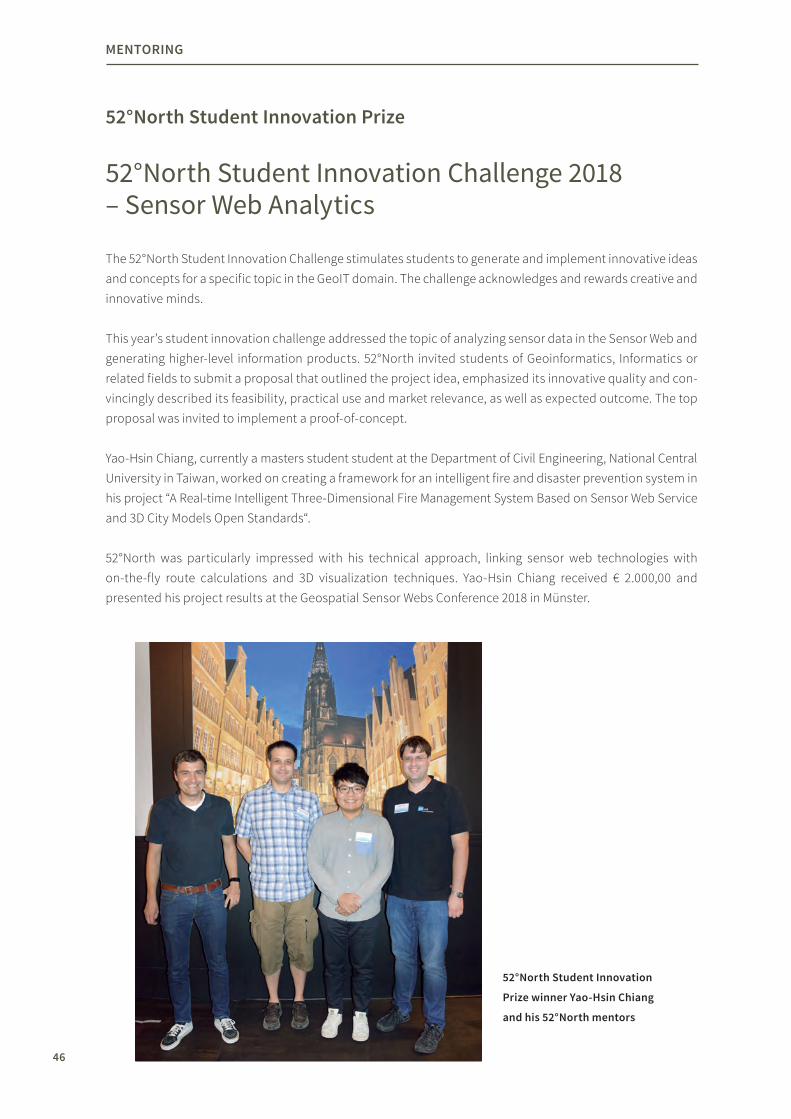
52°North Student Innovation Prize
The 52°North Student Innovation Challenge stimulates students to generate and implement innovative ideas and concepts for a specific topic in the GeoIT domain. The challenge acknowledges and rewards creative and innovative minds.
This year’s student innovation challenge addressed the topic of analyzing sensor data in the Sensor Web and generating higherlevel information products. 52°North invited students of Geoinformatics, Informatics or related fields to submit a proposal that outlined the project idea, emphasized its innovative quality and convincingly described its feasibility, practical use and market relevance, as well as expected outcome. The top proposal was invited to implement a proofofconcept. YaoHsin Chiang, currently a masters student student at the Department of Civil Engineering, National Central University in Taiwan, worked on creating a framework for an intelligent fire and disaster prevention system in his project “A Realtime Intelligent ThreeDimensional Fire Management System Based on Sensor Web Service and 3D City Models Open Standards“.
52°North was particularly impressed with his technical approach, linking sensor web technologies with onthefly route calculations and 3D visualization techniques. YaoHsin Chiang received € 2.000,00 and presented his project results at the Geospatial Sensor Webs Conference 2018 in Münster.
52°North Student Innovation Challenge 2018 – Sensor Web Analytics
MeNtOrING
52°North Student Innovation
Prize winner Yao-Hsin Chiang
and his 52°North mentors

47
Google Summer of Code
The Google Summer of Code (GSoC) offers students stipends to write code for Open Source projects. Recipients receive a stipend for 3 months of software development. The amount is calculated based on location.
52°North has been a successful mentoring organization for several years. This year, our 7th year in a row, 52°North was one of 206+ open source organizations chosen to host one of the 1,264 student projects in the Google Summer of Code 2018. 52°North mentored Sai Krishna Chowrigari, who added plain GPSbased track recording to the enviroCar Android application in his project Plain GPSbased Recording for enviroCar.
The enviroCar platform focuses on collecting car driven tracks. The challenge of the project was to ensure that the plain GPSbased tracks were collected from cars. To this aim, the student successfully exploited activity recognition features from Google’s new Transition APIs for Android to detect the driving state of the user. First evaluations showed that the average time of the state switch recognition is less than 1 minute, which is a promising characteristic for a productive integration.
In addition to these developments, the student integrated further improvements that went far beyond the original project call. He redesigned the look and feel of some parts of the app according to newer material design concepts, updated all libraries, and integrated several adaptations resulting from the use of newer Android versions.
MeNtOrING
New enviroCar app look
Gaining practical experience in software engineering techniques and real-world Open Source software projects

Community Activities
The 52°North R & D Partner Network consists of a number
of communities, each with a specific thematic focus.
Some of the communities are moderated by 52°North staff
members, others are coordinated by partners.

51
DevelopersThe 52°North developer network currently has 125 registered contributors. In 2018, four new developers signed CLAs. The contributors are located in the following countries:
Australia, Austria, Belgium, Egypt, France, Germany, Hungary, India, Italy, Kenya, Malaysia, New Zealand, Romania, Russia, Serbia, Spain, Sri Lanka, The Netherlands, Turkey, UK, USA.
The 52°North team provides technical and organizational resources as well as communication and outreach support to foster joint R & D work and the development of collaborative open source software.
Community Support
PR /MarketingActivities in PR/Marketing included newsflashes (http://52north.org/), blog posts (http://blog.52north.org/), tweets (https://twitter.com/FiveTwoN), press releases and notices to internal and external mailing lists. Flyers and a banner were updated and produced. Proof reading support for community blogs and papers is frequently used. 52°North has been represented and promoted by its partners at the national and international conferences/workshops listed below.
_ January 22 – 25: EUDAT Conference 2018, Porto, Portugal _ March 13 – 15: Oceanology International (AtlantOS Training Workshop), London, England _ March 19 – 23: OGC TC Meeting March 2018, Orleans, France _ March 21 – 24: FOSSGIS 2018, Bonn, Germany

52
COMMUNItY SUPPOrt
Meetings & Conferences Hosted by 52°North
Webinars
52°North organizes and hosts informative meetings and think tanks for its communities. The following meetings were held:
_ February 8 – 10: 52N Days _ July 6: Earth Observation and Processing Think Tank Meeting _ September 3 – 5: Geospatial Sensor Webs Conference 2018 _ December 10: 52°North Scientific and Technical Advisory Board Meeting 2018
52°North introduced the GI Innovation Webinar Series with the idea to promote and inform the public about new developments and relevant work within the 52°North network.
_ July 12: How to Apply Sensor Web Technologies to Provide INSPIREcompliant Download Services for Observation Data. Alexander Kotsev (JRC), Sylvain Grellet (BGRM), Mickael Beaufils (BGRM) and Simon Jirka (52°North) discussed how to publish observation data via the SOS within the context of INSPIRE.
_ November 29: Exploiting Copernicus Data with ILWIS4 – from download to display. Diana Chavarro Rincon, Rob Lemmens, Martin Schouwenburg (ITC) demonstrated how to use Copernicus satellite image data in ILWIS4, a new version of the wellknown open source GIS software.
_ April 8 – 13: EGU 2018, Vienna, Austria _ April 18 – 19: Earth Observation & Copernicus Technologies and Solutions for User Applications,
Bochum, Germany _ April 27: ThementagCopernicus, Steinfurt Germany _ May 3 – 4: Earth Observation Exploitation Platform Hackathon 2018, Darmstadt, Germany _ June 4 – 8: OGC Technical Committee Meeting, Fort Collins, Colorado, USA _ June 12 – 15: AGILE Conference 2018, Lund, Sweden _ June 25 – 27: Symposium “Neue Perspektiven der Erdbeobachtung“, Cologne, Germany _ August 28 – 31: FOSS4G conference, Dar es Salaam, Tanzania _ September 10 – 14: OGC TC Meeting, Stuttgart, Germany _ September 18 – 21: INSPIRE Conference 2018, Antwerpen, Belgium _ October 9 – 11: OGRS 2018, Lugano, Switzerland _ October 16 – 17: mFUNDKonferenz 2018, Berlin, Germany _ October 24: Geo IT Wherecamp Conference 2018, Berlin, Germany _ November 5 – 7: IMDIS 2018, Barcelona, Spain _ November 27 – 29: Nationales Forum für Fernerkundung und Copernicus 2018, Berlin, Germany _ December 4: GDIForum NordrheinWestfalen 2018, Düsseldorf, Germany _ December 5: Ordentliche Mitgliederversammlung des DDGI.DE, Wuppertal, Germany

53
The Sensor Web Community conducted several projects and activities during 2018. Highlights comprise the following activities:
_ Geospatial Sensor Webs Conference: The series of Sensor Web Workshops/Conferences continued in 2018. Approximately 50 participants attended the event hosted by the Institute for Geoinformatics, University of Münster from September 3rd – 5th. Based on the positive feedback, 52°North has begun planning for the 2019 edition.
_ Marine Sensor Web projects: Whereas the ODIP 2 project ended in early 2018, the SeaDataCloud and BRIDGES projects continue beyond 2018. The community achieved further results on the creation of common marine Sensor web profiles (i.e. integration of vocabularies) in the BRIDGES project. As part of the SeaDataCloud project, 52°North designed and developed a prototype of a SWE Ingestion service. This service is intended to facilitate the publication of sensor data streams (delivered by sensors, via internet of things protocols such as MQTT, or through conventional CSV files) in Sensor Web infrastructures.
_ MuDakWRM and WaCoDiS: These two projects have made good progress towards a better integration of insitu and remote sensing data. Both projects evaluated different conceptual and technological approaches and started in 2018 with first development steps.
_ Helgoland Toolbox: The Helgoland Sensor Web viewer has been a key element of the Sensor Web software suite for the last several years. In 2018, the modularization of this JavaScript project was continued and resulted in the Helgoland Toolbox. This flexible framework allows the easy creation of different Sensor Web related applications (e.g. a demonstrator for the COLABIS project, Sensor Web viewers for the WaCoDiS and MuDakWRM projects, and the BelAir air quality app). Furthermore, the Federal Maritime and Hydrographic Agency (Bundesamt für Seeschifffahrt und Hydrographie, BSH) became a new Helgoland Sensor Web Viewer user at the end of 2018.
_ Event Processing: The handling of eventbased data flows of observation data was an important research topic for the 52°North Sensor Web community in the projects BRIDGES, COLABIS, and WaCoDiS. Different experiments and prototype implementations have resulted in a broad range of experiences that were published in a corresponding journal paper: Rieke, M. Bigagli, L., Herle, S.,
Sensor Web
Sharing, visualizing, and analyzing observation data

54
COMMUNItY aCtIVItIeS
Jirka, S., Kotsev, A., Liebig, T., Malewski, C., Paschke and Stasch, C. (2018): Geospatial IoT – the Need for EventDriven Architectures in Contemporary Spatial Data Infrastructures. ISPRS Int. J. GeoInf. 2018, 7(10), 385; doi: 10.3390/ijgi7100385, https://www.mdpi.com/22209964/7/10/385/htm.
In addition to these achievements, new users joined the activities of the 52°North Sensor Web community (e.g. the ODYSSEA H2020 project). 52°North was also able to further expand its user base in several domains, such as marine sciences and hydrology.
Visualization of different types of observation data with the 52°North Helgoland
Sensor Web Viewer: trajectory and time series data

55
The software development activities in 2018 were focused on the following components:
Sensor Observation Service (SOS), Sensor Web REST-APi, SensorThings APi _ Continuation of the SOS 5.0 implementation: Migration to use the new 52°North Arctic Sea
framework _ Harmonization of data model between SOS and Sensor Web REST API; a first near final version was
accomplished in late 2018 _ Development of a new module for supporting the OGC SensorThings API standard
Eventing APi _ Implementation of an API aligned to the OGC Publish/Subscribe standard (offering a REST/JSON
binding instead of the SOAP/XML binding defined by the standard) _ Additional functionality for handling higher level information derived during event processing
workflows (e.g. alerts derived from raw data streams)
helgoland (JavaScript Sensor Web Viewer) _ Ongoing development to migrate to a modularized architecture; this has resulted in the publication of
the Helgoland Toolbox _ First functionality for supporting event detection/processing functionality _ Prototypical connections to data processing components _ Customized client applications such as the BelAir air quality app and dedicated applications for different research projects
smle _ JavaScriptbased editor for SensorMLbased sensor metadata _ Continued development as part of the SeaDataCloud project; main focus was on the integration
of vocabulary servers and the better description of sensor interface
sos4R and sensorweb4R _ sos4R upgrade for SOS 2.0 and O&M 2.0 support and an usability improvement through convenience
functions (NIWA project)
SOS importer _ Focus on maintenance activities
Marine Sensor Web Profiles: Within the projects SeaDataCloud and BRIDGES, 52°North continued its active contribution to the development of a common profile describing how to apply Sensor Web technology in marine sciences.
internet of Things and iNSPiRE: 52°North continued its support of the activity coordinated by the JRC to discuss potential applications of the OGC Sensor Things API standard in the context of INSPIRE. This has resulted in a joint journal paper: Kotsev, A., Schleidt, K., Liang, S., van der Schaaf, H., Khalafbeigi, T., Grellet, S., Lutz, M., Jirka, S. and Beaufils, M. (2018): Extending INSPIRE to the Internet of Things through Sensor Things API. Geosciences, 8(6), 221. doi:10.3390/geosciences8060221, https://www.mdpi.com/20763263/8/6/221
Software Development
COMMUNItY aCtIVItIeS

56
Webinar: “Providing INSPIREcompliant Download Services for Observation Data“ with Alexander Kotsev (JRC), Sylvain Grellet (BGRM), Mickael Beaufils (BGRM) and Simon Jirka (52°North) on the 12th of July. This Webinar demonstrated and discussed how to publish observation data via the OGC SOS standard within the context of INSPIRE.
52°North Geospatial Sensor Webs Conference 2018 in Münster (September 2018)The Geospatial Sensor Webs Conference 2018 welcomed Sensor Web researchers and practitioners to Münster. From September 3rd – 5th approximately 50 participants from research, industry and public administration exchanged ideas on practical applications, emerging trends, user requirements, and future developments.
The opening session of this year’s conference addressed the challenges of using remote and insitu earth observation data and detailed interesting research activities. Preconference tutorials introduced newcomers to Sensor Web, Webbased geoprocessing technologies and data analysis with R/Shiny. The conference track promoted a wide scientific exchange on status, emerging trends and future directions of the technologies. Additional workshop sessions provided a format for indepth discussions on specific Sensor Web topics, such as eventbased data delivery, or the comparison of different Sensor Web specifications, such as OGC SOS and SensorThings API.
Conference presentations illustrated the broad applicability of Sensor Web technology in a variety of domains. Examples of Sensor Web applications included air quality monitoring, crisis management, hydrological data flows, marine observation data, smart cities and citizen science. A special focus of many applications included topics, such as new lightweight approaches for data delivery and exchange, and new standards, such as the OGC SensorThings API. The tutorials and presentations are available online.
Lively discussions also concerned future directions for the Sensor Web community. Eventbased architectures, realtime data flows, Internet of Things technologies, geosemantics, as well as linking Sensor Web components with data processing and analysis tools (e.g. R) offer new perspectives for more powerful Sensor Web infrastructures in the future.
The 52°North Team is pleased with the success of the event and has begun preparations for the 2019 edition.
Selected Workshops
COMMUNItY aCtIVItIeS

57
The Geoprocessing community conducted several projects and activities in 2018 to focus on the following enhancements for Webbased Geoprocessing:
Geoprocessing Workflows: Novel concepts for defining, describing, exchanging and executing geoprocessing workflows have been developed and evaluated (OGC Testbed 14).
REST APis: Different REST bindings for encapsulating Geoprocessing functionality have been developed and evaluated in several research projects including TAMIS, COLABIS and RIESGOS.
Coupling Sensor Web and Geoprocessing: Work continued on coupling Sensor Web and Geoprocessing technologies.
Geoprocessing
On the software development side, work on a new version of the WPS continued throughout 2018. This version will be based on the 52°North Iceland project and will incorporate many new features, such as support for the WPS 2.0 standard, a new administration application and coupling with the SOS. A first version was released at the end of 2017.
Together with Esri Inc., the work on a new release of the WPS Client for ArcGIS continued.
52°North supervised the continuing process of standardizing the Geoprocessing REST API within the OGC WPS 2.0 SWG. On several occasions, the progress was presented at facetoface meetings. Work also continued on new versions of the WPS Javascript API and client.
Software Development
Efficient processing of Geospatial information

58
COMMUNItY aCtIVItIeS
Benjamin Pross is chair of OGC WPS 2.0 Standardization Working Group (SWG). In 2018, the SWG worked on a WPS 2.0 REST/JSON Binding Extension and a transactional WPS (WPST) extension. The SWG works closely together with the OGC Workflow Domain Working Group (DWG). Joint facetoface meetings of both groups were held in March, June and September during the respective OGC Technical Committee meetings.
52°North successfully participated in the following OGC activities:
OGC Testbed-14 _ 52°North developed concepts and implementations on the Workflow and Machine Learning subtasks.
Earth Observation Exploitation Platform hackathon 2018 _ 52°North was involved in the implementation of a Application Deployment and Execution Service
(ADES).
Standardization Activities
WPS _ Work continued on _ a WPS 2.0 reference implementation based on the Iceland project (javaPS), version 1.0.0 was
released end of 2017 _ a new beta release version 4.0.0beta.6
WPS REST/JSON extension for javaPS _ Based on the draft WPS 2.0 REST/JSON documents, an extension for javaPS was implemented.
WPS Java Client library _ A standalone Java library for communicating with WPS 1.0 and 2.0 was implemented in 2018 and is
used by the ArcMap client.
WPS ArcMap Client _ Work continued on WPS 2.0.0 support. _ A release of version 2.0 is planned for the end of 2018. _ The WPS ArcMap Client has been adapted to the javaPS framework.
WPS4R _ Work comprised bug fixing and enhancements. _ The WPS4R has been adapted to the javaPS framework.
WPS JavaScript client _ Work continued on the new Javascript API and client based on AngularJS. _ Enhancements were implemented based on requirements from the RIESGOS project.

59
Geostatistics has emerged as a crosssectional topic that has taken effect in several new and running projects. The main contributions can be found in the project funded by LIST in which the R package gstat has been extended. In addition, the geostatistics group has upgraded the sos4R R package in close contact with the wider community. New research proposals have been developed that address the themes and tools in data analytics in different ways.
Two tutorials were given in 2018 in which the entire workflow from data retrieval to data analysis was demonstrated. One tutorial took place at the FOSSGIS Konferenz in Bonn, April 21st – 24th, and the second one at the Geospatial Sensor Webs Conference September 3rd 5th. Furthermore, help has been provided to several community members via 52°North’s Geostatistics mailing list, RsigGeo and upon personal contact.
Modeling and statistical analysis of geospatial and spatiotemporal data
Geostatistics

60
Earth Observation
The Earth Observation Community’s capacity building involves training in developing countries, thus much of the work involved the organization and execution of various workshops and dedicated training. We are currently executing the following projects:
GiACiS: Geodata for Innovative Agricultural Credit Insurance Schemes (G4AW project in Ethiopia). GIACIS is a remote sensingbased insurance system developed by ITC to help Ethiopian farmers to become less vulnerable to weather and climaterelated risks. http://g4aw.spaceoffice.nl/en/Projects/G4AWprojects/64/Geodata forInnovativeAgriculturalCreditInsuranceSchemesGIACIS.html
EO4SD: An ESA Project on Water Resources Management for Sustainable (http://eo4sdwater.net/). ITC has the Capacity Building role, organizing and executing the following workshops.
Training Date Nr of participants Countries Local organizer
Myanmar June 11 15, 2018 30 1 Satintelligence
Malawi October 1 5, 2018 16 8 ZAMCOM
Bolivia October 15 19, 2018 18 4 ADB
Niger December 17 21, 2018 21 Agrhymet
Total 64 13
Capacity Building
Enabling near realtime use of Earth Observation data

61
The EO community made the following modifications required to continue operating EUMETCast reception systems:
iTC license reception infrastructure: _ Ku reception of EUMETCast Basic Service and High Volume service 1 on reception station 1 _ Ku reception of EUMETCast High Volume service 2 on reception station 2
52N license reception infrastructure:
_ CBand reception of EUMETCast Africa1 Service Other infrastructures:
_ Updating of services and products and appropriate Data Management; _ Assistance in transition to DVBS2/ EUMETCast for the Africa Service1 reception for various users in
Africa; _ Development automated routines to process relevant information for Water Resources Manage
ment from a global numerical weather prediction model (GFS) – 10 day forecast – on a daily basis; _ Started development of a mobile app to use forecasting data/products
GEONETCast and the tools developed play an important role for all projects.
CLiMDEV: Develop and use agro, hydro and bio (health) meteorological warnings and advisory tools.The project is executed on behalf of African Development Bank
_ Training of trainer workshop, October 22 – 26, 2018: There were about 20 participants from the National Meteorological Agency (NMA). It took place at NMA headquarters in Addis Ababa, Ethiopia.
_ Validation workshop, October 31, 2018: The discussion on tools developed, also with NMA higher management. It took place at the Capitol Hotel in Addis Ababa, Ethiopia.
_ Workshop for CLIMDEV tools developed, November 1012, 2018: It was a regional workshop for NMA members from regional branch offices and took place in Beshoftu, Ethiopia.
AFRiALLiANCE: A network of AfricanEuropean waterrelated organizations initiated the AfriAlliance to prepare Africa for future climate change challenges by having African and European stakeholders work together in the areas of water innovation, research, policy, and capacity development. A “Roadshow” Special Session on October 31, 2018 was organized and dealt in particular with the Work Package WP4 led by ITC. It exposed the main outputs of the WP4:
_ the Handbook of Data Collection (by AKVO project partner) _ the Afrialliance Triple Sensor Toolbox, conceived and developed by ITC.
ITC also organized a user “handson” workshop on using the Afrialliance Triple Sensor webapp and the new ILWIS Open AA Triple Sensor Toolbox, developed within the H2020 AAproject (http://afrialliance.itc.utwente.nl/triplesensor/).
Infrastructure Development
COMMUNItY aCtIVItIeS

62
As part of the new GI Innovation free Webinar Series, the ILWIS Team created and hosted the webinar “Exploiting Copernicus Data with ILWIS4 – From download to display”. It had an international attendance of 230 people, who joined to learn about how to use Copernicus satellite image data in ILWIS4, a new version of the wellknown open source GIS software. The attendees:
_ were shown how to download and preprocess satellite image data with the Sentinel Application Platform.
_ received a short introduction to the ILWIS4 software. _ could follow a stepbystep guide of how to display Sentinel2 data and a demonstration of simple
raster operations.
Most of the work focused on further developing the next generation ILIWS.
iLWiS-Objects: Further development of the command line client continues.
iLWiS4: ILWIS4 is the desktop client on top of ILWISobjects. During 2018, the following work has been carried out:
_ Development of the Workflow Builder as part of the AfriAlliance project for creating workflows. _ Support for the core education (entry level for students at ITC).
ILWIS Webinar
ILWIS Software Development
COMMUNItY aCtIVItIeS
ILWIS4 – a modular application framework

63
52°North is a member of the GeoIT Round. Table NRW – a free association of institutions from business, science and administration (https://www.geoportal.nrw/geoit_round_table ). The aim of the GeoIT Round Table is to develop the geoinformation infrastructure in North RhineWestphalia by adapting new concepts and technologies, as well as developing best practices. The integration of Copernicus into the GDI NRW plays a special role in this context. The GeoIT Round Table is one of the regional Copernicus Relays in Europe. As a member of the GeoIT Round Table NRW steering committee, 52°North is responsible for the coordination of the Copernicus Relayrelated activities.
Copernicus Relays
COMMUNItY aCtIVItIeS
Due to the ILWIS 3.8.6. release, bug fixing and routine testing was carried out.
New/Modified stand alone applications
MSG Data Retriever: The new version also supports MSGIndian Ocean Data Coverage (MSG at 41.5 degree).METOP AVhRR Retriever: This stand alone application enables users to read METOP AVHRR data disseminated through EUMETCast, using appropriate radiometric coefficients and geometric information.
Toolboxes
GEONETCast Toolbox: There is currently prototypical development under Python34. Since it is under development, it has not yet been released.*new* EO4SD Toolbox (based on Python in conjunction with “ILWIS Objectsbeta3.1 for Python“) ftp://ftp.itc.nl/pub/52n/EO4SD/. An EO4SD Toolbox user guide was also created. ftp://ftp.itc.nl/pub/52n/EO4SD/Sentinel_toolbox.pdf)*new* Triple Sensor Monitoring Demo Toolbox: Version 1.0 was released. An EO4SD Toolbox user guide was created. ftp://ftp.itc.nl/pub/52n/AfriAlliance/documents/Triplesensor_Demo_Userguide_v1.0.pdfWFS_Ethiopia Toolbox: Version 2. The WFS_Ethiopia Toolbox User Guide was updated accordingly. (ftp://ftp.itc.nl/pub/52n/WFSEthiopiaTB2/WFSE_Toolbox_UGV1.0_XML2.0.pdf)
Toolbox Software Development and Documentation

64
3D Visualization
The 3Dcommunity currently prepares a software toolbox consisting of ArcPy functions that support geologists to bring 3D models into the GIS world. As a first step, we provide a collection of functions for importing geologic layer models and borehole information into ESRI’s ArcGIS Pro environment. Additional Java implementations, which run independently from ArcGIS Pro, will be available at a next step.
The project idea has been presented at various workshops and conferences, such as the 1st meeting of the German usergroup “3D Geology and GIS” on April 12th in Berlin, and the 48th meeting of the ArcGIS usergroup NorthrhineWestfalia, on October 5th in Arnsberg. We also intend to present the new 52°North component at the 2nd meeting of the German usergroup “3D Geology and GIS” on January 23, 2019 in Berlin.
We have migrated the existing repository from github.com/bogeo/GeologicToolbox to https://github.com/52North/GeologicToolbox. Contributions to the project come from the Bochum University of Applied Sciences, Geovisualization Lab (Prof. B. Schmidt and Till Riemenschneider); Johannes Ruban (currently active as a freelancer); ESRI Germany (Dipl.Geol. H. Lipke); and the Hessian Agency for Nature Conservation, Environment and Geology (HNLUG, Dr. R. Lehné).
Applications and services visualizing 3D geoobjects with Triturus

65
Website _ The enviroCar Team implemented a new version of the landing page. It provides all information
about enviroCar in one place and uses stateoftheart technologies
enviroCar server _ Track statistics have been extended.
Software Development
enviroCar
enviroCar (https://envirocar.org/) is a joint Citizen Science project of 52°North and the ifgi, University of Münster. Partners are TU Dresden and con terra. Global Sponsors are Esri Inc & Esri Germany. This project continues the work done in the enviroCar study project to establish and extend a citizen science platform. This year, the platform has benefitted from the Google Summer of Code 2018. This project thoroughly updated the App, extending it with a pure GPSbased recording mode without linking to the OBDAdapter (see chapter 2.3 Google Summer of Code). enviroCar is also the key platform in the relatively new citizen science project CITRAM (see chapter 1.1.13 CITRAM).
New actors have joined the community and the database has grown significantly. The number of tracks at the end of 2018 was approximately 16.500 (> 5 million measurements).
Citizen Science tools for sustainable mobility

66
Prof. Dr. Albert Remke presented enviroCar at the 8th GeoIT Wherecamp conference in Berlin on October 24, 2018.
Dissemination
COMMUNItY aCtIVItIeS
The enviroCar platform has been used in a quality analysis for synchronized traffic lights in the city of Mönchengladbach. As a successor of the project, a new project evaluating measures based on the results of the first project was implemented. It demonstrated that the measures taken have improved the overall traffic flow. The Traffic System Consulting (TSC), a traffic consulting agency located in Essen, carried out the project. 52°North was a project subcontractor.
The Google Summer of Code student Sai Krishna Chowrigari has successfully completed his enviroCar project on plain GPS based recording for enviroCar. It significantly improved the enviroCar app’s user interface and added functionality to record plain GPS tracks with automated driving recognition.
Projects
envioCar talk at the GeoIt Wherecamp Conference 2018, Berlin

67
Activities in the Security and GeoRM community were focused on improving the WS Security API. Security APi: general improvements to the API;
_ Advanced languagelevel to Java 8 _ branch v 2.3 and 2.4 received a couple of bug fixes and API improvements.
Enabling business and access control processes for geospatial services and spatial data infrastructures
Security and GeoRM

Publications
This section provides a list of publications addressing
52°North software/architecture developments and concepts
from members of the 52°North communities. It also provides
an overview of talks and presentations given at various
conferences, workshops and seminars.

71
Sensor Web
del Rio Fernandez, J., Toma, D. M., Martinez, E., Jirka, S. and O’Reilly, T. (2018). From Sensor to User Interoperability of Sensors and Data Systems. In: Delory, E., & Pearlman, J. (Eds.) (2018). Challenges and Innovations in Ocean In Situ Sensors: Measuring Inner Ocean Processes and Health in the Digital Age. Elsevier. https://www.elsevier.com/books/challengesandinnovationsinoceaninsitusensors/delory/9780128098868
Jirka, S., Stasch, C. and Rieke, M. (2018). From Sensors to Users: A Global Web of Ocean Sensors and Services. In: Delory, E., & Pearlman, J. (Eds.). (2018). Challenges and Innovations in Ocean In Situ Sensors: Measuring Inner Ocean Processes and Health in the Digital Age. Elsevier. https://www.elsevier.com/books/challengesandinnovationsinoceaninsitusensors/delory/9780128098868
analytics
Hengl, T., Nussbaum, M., Wright, M. N., Heuvelink, G. B. and Gräler, B. (2018): Random forest as a generic framework for predictive modeling of spatial and spatiotemporal variables. PeerJ, 6, e5518.
Sensor Web
Rieke, M. Bigagli, L., Herle, S., Jirka, S., Kotsev, A., Liebig, T., Malewski, C., Paschke and Stasch, C. (2018): Geospatial IoT – the Need for EventDriven Architectures in Contemporary Spatial Data Infrastructures. ISPRS Int. J. GeoInf. 2018, 7(10), 385; doi: 10.3390/ijgi7100385, https://www.mdpi.com/22209964/7/10/385/htm.
Santoro, M., Andres, V., Jirka, S., Koike, T., Looser, U., Nativi, S., Pappenberger, F., Schlummer, M., Strauch, A., Utech, M. and Zsoter, E. (2018): Interoperability challenges in river discharge modelling: A cross domain application scenario. Computers & Geosciences, 115, 6674; doi:10.1016/j.cageo.2018.03.008, https://www.sciencedirect.com/science/article/pii/S0098300418302036
Kotsev, A., Schleidt, K., Liang, S., van der Schaaf, H., Khalafbeigi, T., Grellet, S., Lutz, M., Jirka, S. and Beaufils, M. (2018): Extending INSPIRE to the Internet of Things through SensorThings API. Geosciences, 8(6), 221. doi:10.3390/geosciences8060221, https://www.mdpi.com/20763263/8/6/221
Book Chapters
Journals
PUBLICatIONS

72
engineering reports
Pross, B. and Stasch, C. (2018): OGC Testbed13: Workflows ER, OGC Public Engineering Report, available online: http://docs.opengeospatial.org/per/17029r1.html
Pross, B. and Stasch, C. (2018): OGC Testbed13: Asynchronous Services ER, OGC Public Engineering Report, available online: http://docs.opengeospatial.org/per/17028.html
technical reports
Busskamp, R., Elvert, C., Förster, C., Jirka, S., Kappler, W., Prangenberg, D., Schüttenberg, T. and Stasch, C. (2018): DWA Sonderveröffentlichung: Standardisierte Bereitstellung und Nutzung von wasserwirtschaftlichen Messdaten – Eine Heranführung an Sensor WebTechnologien. DWA Deutsche Vereinigung für Wasserwirtschaft, Abwasser und Abfall e. V.
Busskamp, R., Elvert, C., Förster, C., Jirka, S., Kappler, W., Prangenberg, D., Schüttenberg, T. and Stasch, C. (2018): DWA Sonderveröffentlichung – Kurzfassung (Supplement to „Korrespondenz Wasserwirtschaft“ – May 2018): Standardisierte Bereitstellung und Nutzung von wasserwirtschaftlichen Messdaten – Eine Heranführung an Sensor WebTechnologien. DWA Deutsche Vereinigung für Wasserwirtschaft, Abwasser und Abfall e. V..
Project reports
Rieke, M. and Jirka, S. (2018): BRIDGES D3.4 – Interface standards for applications of deep and ultradeep gliders. BRIDGES Project Deliverable. Submitted for internal review on October 15, 2018.
1Mannaerts, C., Maathuis, B., when, U., Gerrets, T., Riedstra, H., Becht, R. and Lemmens, R. (2018): Constraints and opportunities for Water Resources Monitoring and Forecasting using the Triple Sensor approach. Review paper for AfriAlliance project, WP4.
Reports
PUBLICatIONS
1 ITC
enviroCar/Citizen Science
Herold, J., Klöpper, R., Lippe, S., Stasch, C. and Wulfius, H. (2018): Untersuchung der Qualität des Verkehrsablaufs auf Hauptverkehrsstraßen mithilfe von Bürgerinnen und Bürgern. Aus der BSVI Fachinformationen, Straßenverkehrstechnik 1.2018, pp. 6265.
Magazines

73
aGILe 2018
Drost, S., Wytzisk, A. and Remke, A. (2018): Geocoding of Crisis Related Social Media Messages for Assessing Voluntary Help Efforts as a Contribution to Situational Awareness. AGILE Conference 2018, June 12 – 15, 2018, Lund, Sweden.
Rieke, M., Drost, S., Jirka, S. and Betke, H. (2018): A Platform for Coordinating Voluntary Helpers in Disaster Response. AGILE Conference 2018, June 12 – 15, 2018, Lund, Sweden.
Mäs, S., Henzen, D., Bernard, L., Jirka, S., Müller, M. and Senner, I. (2018): Generic Schema Descriptions for CommaSeparated Values Files of Environmental Data. AGILE Conference 2018, June 12 – 15, 2018, Lund, Sweden.
FOSS4G 2018
2Lemmens, R., Toxopeus, B., Boerboom, L., Schouwenburg, M., Retsios, B., Nieuwenhuis, W. and Mannaerts, C. (2018): Implementation of a Comprehensive And Effective Geoprocessing Workflow Environment. Paper presented to the FOSS4G 2018 : Academic Track (Volume XLII4/W8) 29 – 31 August 2018, Dar es Salaam, Tanzania: ISPRS 2018. Brovelli, M. A. & Namangaya, A. H. (eds.). International Society for Photogrammetry and Remote Sensing (ISPRS), Vol. XLII4/W8, p. 123127 (International Archives of the Photogrammetry, Remote Sensing and Spatial Information Sciences).
International Conference on Natural Hazards and risks in a Changing World
Schoepfer, E., Geiß, C., Lauterjung, J., Rakowsky, N., Krautblatter, M., Straub, D., Stasch, C., Jäger, S., Knauer, K., Greiving, S., León, C., Spahn, H. and Riedlinger, T. (2018): From singlehazard to multihazard risk assessment including the analysis of dynamic exposure and vulnerability aimed at the modelling of cascading effects. Paper presented to the International Conference on Natural Hazards and Risks in a Changing World, Potsdam, October 5, 2018. https://publishup.unipotsdam.de/frontdoor/index/index/docId/41661
IMDIS 2018
Jirka, S. and Autermann, C. (2018): Facilitating the publication of realtime marine observation data: the SeaDataCloud SWE Ingestion Service. IMDIS 2018, November 5 – 7, 2018, Barcelona, Spain. Online: https://imdis.seadatanet.org/content/download/121493/file/IMDIS2018_Proceedings.pdf
Proceedings/Papers
PUBLICatIONS
2 ITC

74
Open Geospatial Consortium (OGC)
Stasch, C. (2018): SOS Result Filtering Extension. OGC TC Meeting, March 19 – 23, 2018, Orleans, France.
Proß, B. (2018): WPS REST/JSON Binding, Introduction to relevant Testbed14 Topics. OGC TC Meeting, March 19 – 23, 2018, Orleans, France.
Proß, B. (2018): 52°North’s concept for the Application Deployment and Execution Service (ADES). Earth Observation Exploitation Platform Hackathon Kickoff. OGC TC Meeting, March 19 – 23, 2018, Orleans, France.
Proß, B. (2018): WPS REST/JSON Binding – general update and discussion. OGC TC Meeting, June 4 – 8, 2018, Fort Collins, Colorado, USA.
Jirka, S. (2018): WaCoDIS and COLABIS. OGC TC Meeting, September 10 – 14, 2018, Stuttgart, Germany.
Proß, B. (2018): WPS 2.0 REST/JSON Binding and Testbed14 topics. OGC TC Meeting, September 10 – 14, 2018, Stuttgart, Germany.
Proß, B. (2018): WPST. OGC TC Meeting, September 10 – 14, 2018, Stuttgart, Germany.
Jirka, S. (2018): Sensor Things API. OGC TC Meeting, September 10 – 14, 2018, Stuttgart, Germany.
Jirka, S. (2018): SensorThingsAPI Implementations. OGC Summit on the SensorThings API – Technology and Applications, September 11, 2018, Stuttgart, Germany.
Jirka, S. (2018): WaterInnEU, WaCoDiS, MuDaKWRM. OGC Hydrology Domain Working Group Meeting 2018, September 17, 2018, Geneva, Switzerland.
Proß, B. (2018): Update on WPS REST/JSON Binding. OGC TC Meeting, December 10 – 14, 2018, Charlotte, North Carolina, USA.
Proß, B. (2018): OGC Testbed14: WPST Engineering Report. OGC TC Meeting, December 10 – 14, 2018, Charlotte, North Carolina, USA.
FOSSGIS 2018
Proß, B. and Stasch, C. (2018): WPS 2.0 REST/JSON Extension. FOSSGIS Conference 2018, March 21 – 24, 2018, Bonn, Germany.
eGU General assembly 2018
Stasch, C., Pross, B., and Jirka, S. (2018): Standardizing the Description and Execution of Geoprocessing Workflows. European Geosciences Union (EGU), April 8 – 13, 2018, Vienna, Austria.
Jirka, S., Autermann, C., Kokkinaki, A., Rieke, M. and Schaap, D. (2018): Sensor Web Developments in the ODIP II Project. European Geosciences Union (EGU), April 8 – 13, 2018, Vienna, Austria.
Gräler, B., Stasch, C., Jirka, S., Malewski, C., Förster, C. and Remke, A. (2018): Combining remote sensing and insitu data for water body monitoring. European Geosciences Union (EGU), April 8 – 13, 2018, Vienna, Austria.
Presentations
PUBLICatIONS

75
Autermann, C. and Jirka, S. (2018): Interoperable Publication of Sensor Observation Data: The SeaDataCloud SWE Ingestion Service. European Geosciences Union (EGU), April 8 – 13, 2018, Vienna, Austria.
Pross, B., Gräler, B., Stasch, C., Malewski, C., Förster, C. and Jirka, S. (2018): A dam information and monitoring system rooted in the sensor web. European Geosciences Union (EGU), April 8 – 13, 2018, Vienna, Austria.
Remke, A., Rieke, M., Stasch, C., Autermann, C., de Wall, A., Wulffius, H. and Jirka, S. (2018): Open Traffic Analysis. PICO Session at European Geosciences Union (EGU), April 8 – 13, 2018, Vienna, Austria.
Schoepfer, E., Lauterjung, J., Kreibich, H., Rakowsky, N., Krautblatter, M., Straub, D., Stasch, C., Jäger, S., Knauer, K., Greiving, S., León, C., Spahn, H. and Riedlinger, T. (2018): Research towards improved management of natural disasters including strategies to reduce cascading effects. EGU General Assembly 2018, Vol. 20, EGU201814801.
earth Observation & Copernicus technologies and Solutions for User applications
Remke, A. (2018): Monitoring flooding by integrating satellite data and insitu measurements. Workshop „Change Detection – Monitoring land use and land coverage“ at Earth Observation & Copernicus Technologies and Solutions for User Applications, April 18 – 19, 2018, Bochum, Germany.
Copernicus thementag Geonetzwerk Münsterland
Remke, A. (2018): Die Copernicus Geodateninfrastruktur. Thementag Geonetzwerk Münsterland: Copernicus, April 27, 2018, Steinfurt, Germany.
Symposium “Neue Perspektiven der erdbeobachtung”
Remke, A. (2018): SenSituMon – Integration von Satelliten und InsituSensordaten zur Verbesserung des automatisierten großflächigen Monitorings von Überflutungsflächen. Neue Perspektiven der Erdbeobachtung – Das Symposium zur angewandten Satellitenerdbeobachtung, June 25 – 27, 2018, Cologne, Germany
Geospatial Sensor Webs Conference 2018
Remke, A. and de Wall, A. (2018): SensituMon – Large Scale Monitoring of Open Surface Water. Geospatial Sensor Webs Conference 2018, September 3 – 5, 2018, Münster, Germany.
Jirka, S. (2018): Current Developments in the Sensor Web Community. Geospatial Sensor Webs Conference 2018, September 3 – 5, 2018, Münster, Germany.
Gräler, B. (2018): R Analysis/Shiny. Tutorial at Geospatial Sensor Webs Conference 2018, September 3 – 5, 2018, Münster, Germany.
Proß, B. and Stasch, C. (2018): Introduction to Webbased GeoProcessing. Tutorial at Geospatial Sensor Webs Conference 2018, September 3 – 5, 2018, Münster, Germany.
Jirka, S. (2018): Introduction to Sensor Web Technology. Tutorial at Geospatial Sensor Webs Conference 2018, September 3 – 5, 2018, Münster, Germany.
PUBLICatIONS

76
INSPIre Conference 2018
Rieke, M., Jirka, S., Malewski, C., Förster, C., Tscheu, T. and Stasch, C. (2018): Webbased Event Detection for Water Resource Management. INSPIRE Conference 2018, September 18 – 21, 2018, Antwerp, Belgium. Nominated for the INSPIRE Golden Pineapple Award.
Stasch, C., Jirka, S., Schaap, D., Kokkinaki, A., Autermann, C. and Rieke, M. (2018): Development of Interoperable Infrastructures for Marine Real – Time Observation Data. INSPIRE Conference 2018, September 18 – 21, 2018, Antwerp, Belgium.
Fechner, T, Illes, R. and Stasch, C. (2018): SenSituMon: Using Open Data, INSPIRE, and Copernicus Data to Automatically Calculate Flood Masks. INSPIRE Conference 2018, September 18 – 21, 2018, Antwerp, Belgium.
Hohman, M., Fechner, T. and Jirka, S. (2018): Streamlining PRTR data provision for INSPIRE and eReporting duties. INSPIRE Conference 2018, September 18 – 21, 2018, Antwerp, Belgium.
Oceanology International
Jirka, S. and Autermann, C. (2018): Interoperability Technologies for Sharing Ocean Instruments and RealTime Data. Oceanology International, March 13 – 15, 2018, London, England
mFUND-konferenz 2018
Jirka, S., Drost, S. and Vogt, A. (2018): WaCoDiS – Entwicklung einer verteilten Architektur zur effizienten Integration und Verarbeitung von insitu und Fernerkundungsdaten. mFundKonferenz 2018, October 16 – 17 2018, Berlin, Germany.
GDI-Forum Nordrhein-Westfalen 2018
Rieke, M. (2018): Ereignisgesteuertes Wasserressourcenmanagement auf Basis von Sensormessungen. GDIForum NordrheinWestfalen 2018, December 4, 2018, Düsseldorf, Germany.
Ordentliche Mitgliederversammlung des DDGI
Rieke, M. (2018): Ereignisgesteuertes Wasserressourcenmanagement auf Basis von Sensormessungen. Ordentliche Mitgliederversammlung des DDGI, December 5, 2018, Wuppertal, Germany.
PUBLICatIONS

77
Open Science Conference
3Mäs, S., Henzen, D. und Bernard, L. (2018): Getting closer to the researcher’s desk from acquisition and management to publishing scientific data. Open Science Konferenz, March 19 – 20, Berlin, Germany.
eGU General assembly 2018
Mäs, S., Henzen, D., Jirka, S. and Bernard, L. (2018): A Research Data Management Platform to Support the Daily Tasks of Environmental Researchers. European Geosciences Union (EGU), April 8 – 13, 2018, Vienna, Austria.
INSPIre Conference 2018
Jirka, S., Mäs, S., Henzen, D., Bredel, h., Bernard, L., Rieke, M. und Stasch, C. (2018): A Lightweight Platform for Facilitating Web Application Development on top of INSPIRE Services. INSPIRE Conference 2018, September 18 – 21, 2018, Antwerp, Belgium.
Jirka, S. (2018): WaCoDiS – Identifying Element Inputs in Water Bodies relying on INSPIRE and Copernicus. INSPIRE Conference 2018, September 18 – 21, 2018, Antwerp, Belgium.
Stasch, C., Pross, B., and Jirka, S. (2018): WPS REST – a simplified way for integrating processing facilities in Spatial Data Infrastructures. INSPIRE Conference 2018, September 18 – 21, 2018, Antwerp, Belgium.
Posters
PUBLICatIONS
3 TU Dresden

78
Conference Workshops
PUBLICatIONS
4ITC
FOSSGIS 2018
Gräler, B. (2018): Gewinnung von Informationen durch die Fusion von Geo und Statistikdaten mit R. Workshop at FOSSGIS Conference 2018, March 21 – 24, Bonn, Germany.
eGU General assembly 2018
Gräler, B., Bernard, L., Bigagli, L., Jirka, S., Kokkinaki, A., Máso, J. and Menard, L. (2018): Webbased Exchange and Processing of Environmental Data. Workshop at European Geosciences Union (EGU), April 8 – 13, 2018, Vienna, Austria.
aGILe 2018
Mäs, S., Henzen, D., Bernard, L., Senner, I. and Jirka, S. (2018): Research Data Management and Reference Datasets for the Environmental Sciences. Workshop at AGILE Conference 2018, June 12 – 15, 2018, Lund, Sweden.
INSPIre Conference 2018
Kotsev, A., Schleidt, K., van der Schaaf, H., Grellet, S., Jirka, S., Beaufils,M., Rinne, I., Millard, K. and Bartoli, F. (2018): SDIs for the Internet of Things. The integration of spatiotemporal data in INSPIRE. Workshop at INSPIRE Conference 2018, September 18 – 21, 2018, Antwerp, Belgium.
Workshop on Interoperability technologies and Best Practices in environmental Monitoring
Rieke, M. (2018): SWE Implementation Tools. Workshop at SeaTechWeek 2018, October 10 – 12, 2018, Brest, France.
OGrS 2018
4Lemmens, R., Chavarro Rincon, D., Schouwenburg, M., Retsios, V., Mannaerts, C., Nieuwenhuis, W. and van der Kwast, H. (2018): Building your own GIS workflows with ILWIS software – A triple sensor approach to combat climate change and water challenges in Africa. Workshop at the Open Source Geospatial Research and Education Symposium OGRS 2018, October 9 – 11, 2018, Lugano, Switzerland.

795ITC
Kotsev, A., Grellet, S., Beaufils, M. and Jirka, S. (2018): How to Apply Sensor Web Technologies to Provide INSPIREcompliant Download Services for Observation Data. 52°North GI Innovation Webinar Series, July 12, 2018. https://www.youtube.com/watch?v=jyQJrTN4pjk&feature=youtu.be
Roosen, N., Rieke, M. and Jirka, S. (2018): Web Crawler for Hydrological Data. ECMWF Summer of Weather Code Week of Webinars, September 20, 2018. https://www.youtube.com/watch?v=LCSLqWG6Czc&feature=youtu.be
5Lemmens, R., ChavarroRincon, D. and Schouwenburg, M. (2018): Exploiting Copernicus Data with ILWIS4 – from download to display. 52°North GI Innovation Webinar Series, November 29, 2018. https://player.vimeo.com/external/303267906.hd.mp4?s=ac12ddd41206808e3681774431b595a89bdb2cf4&profile_id=175
Webinars
Project WorkshopsSeaDataCloud
Autermann, C. and Jirka, S. (2018): SWE Ingestion Service. SeaDataCloud Annual Meeting, EUDAT Conference 2018, January 23, 2018, Porto, Portugal.
Project Meetings Autermann, C. and Jirka, S. (2018): The SeaDataCloud SWE Ingestion Service. SeaDataCloud Technical Task Group Meeting 4, April 25 – 26, 2018, Sopot, Poland.
Autermann, C. and Jirka, S. (2018): The SeaDataCloud SWE Ingestion Service. SeaDataCloud Technical Task Group Meeting 5, September 10 – 11, 2018, Espoo, Helsinki, Finland.
Autermann, C. and Jirka, S. (2018): Developing Sensor Web Enable (SWE) standards and online SWE ingestion service. SeaDataCloud Scientific Committee Workshop, October 16 – 17, 2018, Isola dei Pescatori (Stresa), Italy.
Autermann, C. and Jirka, S. (2018): The SeaDataCloud SWE Ingestion Service and SOS Viewing Services. SeaDataCloud 2nd Annual Meeting, November 8 – 9, 2018, Barcelona, Spain.
PUBLICatIONS

80
Legal Notice
52°North initiative for Geospatial Open Source Software Gmbh
MartinLutherKingWeg 24 48155 Münster, Germany https://52north.org T +49 251 3963710
Copyright
The layout, graphics and pictures used, as well as the collection of individual contributions, are protected by copyright. 52°North Initiative for Geospatial Open Source Software GmbH reserves all rights including the rights of photo mechanical reproduction, the duplication and distribution via special processes (e.g. data processing, data carriers, data networks).
The following pictures are copyrighted as follows.
The photo on page 14 is licensed under the CC BYSA 3.0 license. Attribution: TMbux.
The graphic on page 57 contains data from “Sentinel2 cloudless – https://s2maps.eu by EOX IT Services GmbH (Contains modified Copernicus Sentinel data 2017 & 2018)” and is licensed under a Creative Commons AttributionNonCommercialShareAlike 4.0.
The photo composite on page 12 is based on a photo by M. B. Scheer.
The photo composites on pages 7 and 69 are based on shutterstock photos.
The cover photo is licensed by F1online.
© February 2019, 52°North Initiative for Geospatial Open Source Software GmbH

52°North – Initiative for Geospatial Open Source Software GmbHMartin-Luther-King-Weg 24, 48155 Münster, Germanyhttps://52north.org, T +49 251 396371-0