5.0 the duffins and carruthers creek watersheds past · with nature, for water is the lifeblood of...
TRANSCRIPT

35
5 . 0 T H E D U F F I N S A N D C A R R U T H E R SC R E E K W A T E R S H E D S – P A S T
Human heritage provides a context and background for our management, use, and enjoyment ofthe watersheds of today. Human heritage features include archaeological resources, architecturalresources, and cultural and heritage landscapes. Each of these are critical aspects of the water-sheds’ past, and together tell of the use of the Duffins and Carruthers creeks waterscapes andlandscapes. By uncovering and appreciating the complexities of historic interactions betweenpeople and the natural environment, we can inspire a vision for the future where society interactswith the environment in a symbiotic relationship.
C H A P T E R
5
For the first 11,000 years of Aboriginal settlement, human impacts on the watersheds wereminimal, the result of low population densities and a way of life harmonious with the natural world. Within the first 50 years of European settlement however, the landscape was signifi-cantly transformed.
The history of human occupation in the watersheds starts some 12,000 years ago with the retreatof the Wisconsinan Ice Sheet. At that time, this area may have been inhabited by only a fewdozen nomadic bands of hunters and gatherers. Not until the climate warmed and horticulturewas adopted did people become more sedentary and the population increase. First Nations, andlater settlers from the United States and various parts of Europe, were attracted by the naturalfeatures and resources of Duffins and Carruthers creeks.
Knowledge of Aboriginal occupation in southern Ontario comes from three sources of data: thearchaeological record of their material culture including artifacts, human remains, and traces ofcampsites and villages; the oral traditions of First Nations, and the historical record that begins inthe 1600s including documents, maps, and drawings made by missionaries and other (European)travelers.
For details of First Nations and of 18th to 19th century settlers see Chapter Three: "HumanHeritage" in the State of the Watershed Reports.
Augustus Jones, surveyor of the area in 1791, noted that the native name for Duffins Creekwas sin.qua.trik.de.que.onk which he described as meaning "pine wood on side." The earliest French name for Duffins Creek was "Riviere au Saumon" named for the Atlantic salmon, which annually migrated upstream to spawn (Rouge, Duffin, Highland, Petticoat Valley Conservation Report, 1956:11).
Carruthers Creek bears the family name "Carruthers" who owned 202 acres along its banks.Richard Carruthers was born in Cumberland, England in 1819. He settled on part of Lots 4and 5, Concession 1, having purchased these lands in January 1856 and September 1862, as well as purchasing part of the road allowance from the township in June 1875. The land remained in the Carruthers family until at least the 1940s.
Human Heritage Chapter, Appendix D, Duffins Creek and Carruthers Creek State of the Watershed Reports.
36

37
5 . 1 T H E D U F F I N S A N D C A R R U T H E R S C R E E KW A T E R S H E D S – P R E S E N T
In June 2002, the Duffins Creek and Carruthers Creek State of the Watershed (SOW) Reportswere completed. These two reports, combined with the technical component studies outlined inChapter Six, provide the knowledge base for preparing this Watershed Plan.
This chapter has drawn on information from the SOWs and summarizes the existing conditionsfor the Carruthers Creek and the Duffins Creek. Section 5.6 provides a summary of CarruthersCreek current conditions from a land use perspective followed by details under the headings ofwater, (including groundwater, and surface water quality and quantity), habitats (aquatic and ter-restrial), and public use. The same format is followed for Duffins Creek beginning with section 5.7.
5 . 2 C O M M O N I S S U E S
Climate, climate change, and air quality are reviewed in detail in the SOW reports and a summaryis provided below as issues common to both watersheds.
TRCA is currently preparing a Natural Heritage Strategy. This strategy and its components is asignificant departure from the Environmentally Significant Areas (ESA) study from the early1980s. Until such time as the Natural Heritage Strategy is completed, the ESA criteria are usedas a planning tool for TRCA plan review comments. The ESA Study and the Natural HeritageStrategy, common elements for both watersheds, are outlined below.
“ Water is life … water binds together the fates of nations with shared watersheds and river basins, and diverse users drawing from common water resources. It also links society with nature, for water is the lifeblood of ecosystems and the wider community of life”
Tellus Institute, Halfway To The Future: Water In A Thirsty World. 2001.
Watersheds, like other natural systems, have a capacity to adapt to change. However, like all liv-ing systems, watersheds can tolerate only so much stress before detrimental change affects water-shed function. It is imperative that the issues facing the watersheds be identified and understoodso that collaborative and proactive actions can be taken.
5 . 3 C L I M A T E A N D C L I M A T E C H A N G E
The watersheds of Duffins Creek and Carruthers Creek experience a Great Lakes moderated con-tinental climate typical of southern Ontario. In an average year, approximately 800 to 850 mm
of precipitation falls across the two watersheds. For the most part, there is little variation inmonthly precipitation. Only two months, January and February, average less than 60 milimetres,whereas August and September average more than 60 milimetres of precipitation.
Over the last century, mean air temperatures across southern Ontario have increased by approxi-mately 0.5 Celsius. A change likely caused by the release of significant amounts of carbon diox-ide and methane gas to the atmosphere. Models used to predict the climate of the 21st centuryfor Southern Ontario forecast air temperature to rise two to five degrees Celsius. The greatestchanges are expected in the winter months resulting in a shorter snow season and a longer grow-ing season. With respect to precipitation changes, there is generally less agreement among themodels — some predict more and others less. Because higher temperatures will result inincreased evaporation, problems arising from moisture deficits are expected to become more fre-quent and severe, other models predict extra precipitation to occur in extreme events, increasingthe risk of flooding and flood vulnerable areas.
5 . 4 A I R Q U A L I T Y
Air quality represents the cumulative effect of contaminants in the atmosphere from human andnatural activities and their atmospheric interactions. Air quality in the Duffins Creek andCarruthers Creek watersheds is affected by local, regional, and global factors. The Ministry ofEnvironment (MOE) has three monitoring stations in and around the two watersheds that pro-vide data for assessing air quality conditions. The Stouffville Station is located on Highway 47just east of Highway 48. The Oshawa and Scarborough monitoring stations are located to theeast and west of the watersheds respectively. Although the assessment focuses on these three sta-tions, the "atmospheric region of influence" or "airshed" for the area extends far beyond thewatersheds. Long range transport of high levels of pollutants is known to originate Statesidesouthwest of the Duffins Creek and Carruthers Creek watersheds.
Data from MOE’s air quality monitoring network in 1997 and 1998 were studied to representcurrent air quality conditions in the watersheds. The contaminants evaluated include: groundlevel ozone, suspended particles, nitrogen oxides, sulphur dioxide, carbon monoxide, and volatileorganic compounds. The sources and effects of these pollutants are discussed in greater detail inthe State of the Watershed Reports. Air quality assessment also includes information on the AirQuality Index (AQI), which is based on groups of pollutants that have adverse effects on humanhealth and the environment. Trends in the AQI over time were evaluated using data for themost recent ten year period, 1988 to 1997.
Overall, the Duffins Creek and Carruthers Creek watersheds have good air quality conditionsmost of the time. In 1998, air quality was moderate five per cent of the time and good to verygood 94 per cent of the time. Less than one per cent of the time, air quality fell into the poor orvery poor range. Recent reports in air quality advisories indicate conditions are not improving.
38

5 . 5 E N V I R O N M E N T A L L Y S I G N I F I C A N T A R E A S A N D T E R R E S T R I A L N A T U R A L H E R I T A G E A P P R O A C H
5.5.1 ENVIRONMENTALLY SIGNIFICANT AREAS (ESA)
TRCA’s Environmentally Significant Areas (ESA) study was first initiated in the late 1970s in anattempt to develop a more coordinated and comprehensive approach to land use planning andresource management in the region. Due to the overall size of the jurisdiction and limitedresources, the study focussed on the major valley systems, Lake Ontario, and parts of the OakRidges Moraine.
Field inventories were used to determine whether an area met at least one of seven designationcriteria. The criteria included:
• significant landforms;• ground water recharge/discharge/storage, linkages between significant systems, or required
for a significant population or concentration of species;• exceptional or high quality habitats;• habitats with limited representation;• habitats with high diversity;• presence of rare species; or • habitats that were large enough to support species that require extensive blocks of habitat.
The study identified 126 ESAs in 1982. These ESAs were also recognized as priorities withinTRCA’s land acquisition program.
Inventory work as part of the 1990s ESA Study update highlighted trends in the populations anddistribution of species and communities within TRCA’s jurisdiction. For, example some specieswere no longer found within the urban portions of the watersheds even when apparently suitablehabitat was available. With ongoing urban expansion in the region there was a concern thatthese conditions would also extend farther north.
In its Terrestrial Natural Heritage program, TRCA has become more proactive in ensuring thatthe losses of species and habitats do not continue, and instead are attempting to redress some ofthe species losses. These species are also indicators of overall environmental health. The shiftaway from just focussing on rare species and habitats, and instead looking at a preventativeapproach (taking into account the ecological needs and sensitivities as well as the distribution andabundance of species and habitats), is fundamental to TRCA’s Terrestrial Natural HeritageApproach.
TRCA advocates the protection of the ESAs. Figure 5.1 shows the locations of the ESAs withinthe Duffins and Carruthers watersheds.
39

40
FIGURE 5.1

5.5.2 TERRESTRIAL NATURAL HERITAGE APPROACH
Terrestrial Natural Heritage includes flora and fauna species, community types and the patternsand the interactions of habitat patches across the landscape. Across the Greater Toronto Area,natural areas have been reduced to small fragments. Clearly a new approach – one that maintainsbiodiversity and ecosystem health – is needed. TRCA is developing the Terrestrial NaturalHeritage Approach to address this need.
The Terrestrial Natural Heritage Approach examines the condition of natural cover in the wholewatershed and links it to adjoining watersheds. Instead of focussing on natural areas individually(e.g., Environmentally Significant Areas, Areas of Natural and Scientific Interest and ClassifiedWetlands), the Terrestrial Natural Heritage Approach recognizes the interconnectedness of allparts of the natural system. Therefore, it evaluates the function of the natural cover in theDuffins Creek watershed as one entity which can be conceived of as an "environmentally signifi-cant system." Furthermore, the approach is based on the relationship the natural heritage systemhas with the rest of the watershed. It recommends that decisions at the site level be madeaccording to that premise, considering the whole system and the relationship with its context.
Natural heritage system data is collected at three scales (from large to small): the landscape, vege-tation communities, and species scales. At the landscape level, terrestrial habitat patches aremapped according to four broad habitat categories: forest, wetland, meadow, and beach/bluff.Vegetation communities are mapped according to the province’s Ecological Land ClassificationSystem (ELCS). Species of concern within TRCA’s jurisdiction (to prevent rarity) are mappedaccording to TRCA’s field data collection protocols.
Using these data, six indicators and 20 measures were examined to determine the health of thenatural system as a functioning unit. Landscape, vegetation community and species data weresummarized under each of the six indicators. These indicators are quantity, distribution, size andshape, matrix influence, connectivity, and biodiversity.
5 . 6 T H E C A R R U T H E R S C R E E K W A T E R S H E D – C U R R E N T C O N D I T I O N S
Land use in the Carruthers Creek watershed is divided between rural and agricultural uses thatdominate the northern portion of the watershed, and urban uses that prevail in the southernreaches.
Currently only 20 per cent of the Carruthers Creek watershed is developed. One-third of thewatershed is scheduled for urban use. Under the City of Pickering’s Natural Areas designation,the headwater streams in the Carruthers Creek watershed are protected as part of the Open SpaceSystem. As well, the most northern lands in this area have been protected under a ProvincialMinister’s Zoning Order to restrict development adjacent to the Pickering Airport lands that are
41

located to the west. North of Taunton Road, land use is rural with agricultural practices domi-nating the landscape. Tributaries of Carruthers Creek are surrounded by natural areas (i.e., wet-lands located along the Lake Iroquois Shoreline). Between Taunton Road and the 5thConcession, the Town of Ajax has established a permanent countryside dominated by open fields,forest and a functional natural system. From Taunton Road to Kingston Road, most of the landis either vacant or used for agriculture, with lands to the east designated for rural uses. Whilethese lands will remain rural, lands west and north to Taunton Road are designated for residentialand employment uses to accommodate future urban expansion.
Major transportation routes (i.e., Highway 401, CNR tracks) cross the watershed between BaylyStreet and Kingston Road. Highway 401 is currently being widened with new highway inter-changes planned at Carruthers Creek Parkway/Salem Road and Lake Ridge Road.
Almost the entire valley system surrounding the mouth of the creek at Lake Ontario constitutesProvincially Significant Wetlands known as the Carruthers Creek Wetland Complex. Portions ofthese areas have been designated as Areas of Natural and Scientific Interest and EnvironmentallySignificant Areas (ESA) by the provincial government and TRCA. On the shores of LakeOntario is the Carruthers Creek Marsh ESA. Approximately 38 hectares in size, this marsh ishome to numerous species of mammals, fish, migratory birds, as well as rare birds and plants.Adjacent to the valley system, land use consists of low density residential development with somemedium and high density residential areas north of the shoreline.
5.6.1 WATER
5.6.1.1 Groundwater
An understanding of the groundwater flow system is vital to watershed management rangingfrom the delineation of the sustainable yield for water supply purposes to programs to maintainthe flow of groundwater discharge to streams. There is a paucity of data directly relating to thegroundwater flow system within the Carruthers Creek watershed. The hydrogeologic under-standing of the Carruthers Creek study area, as outlined below, has been applied by using infor-mation for the neighbouring Duffins Creek watershed.
5.6.1.2 Geologic Setting
The landforms and geologic deposits of the Carruthers Creek watershed were formed by a suc-cession of glacial periods (when the climate was cooler than present) and interglacial periods(when the climate was similar to the present climatic conditions). The headwaters of CarruthersCreek originate within the South Slope physiographic region, which occurs south of an elevatedlandform known as the Oak Ridges Moraine. Surficial geologic deposits of the South Slopelargely consist of till, which is a mixture of materials ranging in size from clay particles to boul-ders deposited directly by a glacier. Till deposits are often covered by a thin veneer of sand, silt,and clay deposited in former lakes, and by watercourses within the present day Carruthers Creek
42
valley. A second prominent landform near the middle of the Carruthers Creek watershed is anescarpment known as the Lake Iroquois Shoreline. This escarpment delineates the shoreline ofan ancestral Lake Ontario formed approximately 10,000 years ago when lake levels were up to 60metres higher than the present lake level. Deposits situated south of the Lake Iroquois Shorelineinclude till consisting of beach sands, gravels, silt, and clay.
Beneath the surficial deposits, the geologic layering is a series of alternating till and lake (sand,silt, and clay) or river (sand and gravel) units overlying the bedrock surface. The bedrock withinthe study area is composed of Late Ordovician shales of the Whitby Formation, which weredeposited more than 400 million years ago. This till is covered by a thin layer of sand, silt, andclay. The Halton Till is underlain by a more dense, silty sand till known as the Northern orNewmarket Till, which occurs directly above bedrock at these two locations. More geologicunits are expected to be present in the northern part of the watershed where the soil thicknessabove bedrock is greater.
5.6.1.3 Hydrogeology
Aquifer Units and Groundwater RechargeAquifers within the Carruthers Creek watershed are designated as upper, middle, and loweraquifer systems, which occur within the unconsolidated sediments lying on bedrock. Groundwaterflow within all three aquifer systems is predominantly south to southeast from the highlandstoward Lake Ontario. The upper aquifer system and the water table occur within sediments situ-ated above the Northern/Newmarket Till and is largely unconfined. The middle and loweraquifer systems occur within deposits situated beneath the Northern/Newmarket Till and are pri-marily recharged by vertically downward groundwater flow from the overlying aquifer systems.In the southern part of the watershed, south of the Lake Iroquois shoreline where the sedimentthickness is less, groundwater flow from the deeper aquifer systems is vertically upwards coinci-dent with groundwater discharge from these aquifers systems to the river network.
Groundwater recharge rates for the Carruthers Creek watershed have not been determined. It isestimated that direct unit recharge rates to surficial till deposits are approximately 50 to 150 mil-limetres per year. Recharge areas characterized by surficial sand and gravel will have higher unitrecharge rates. In order to define recharge rates it is necessary to prepare a water budget for theCarruthers Creek watershed. A continuous streamflow gauge has been installed south of BaylyStreet. Streamflow data will allow for calibrated estimates of groundwater recharge and overlandrunoff to be conducted for the Carruthers Creek watershed. For preliminary non-calibrated esti-mates, see the Carruthers Creek State of the Watershed Report.
Groundwater DischargeGroundwater flows with lower velocities than water flowing overland (runoff). The distributionand amount of groundwater discharging into a stream is important for maintaining annualstreamflow, and supporting aquatic life. The groundwater discharge component of streamflowvaries gradually in response to long-term changes in the groundwater flow system. In contrast,
43

the runoff component of streamflow is a short-term response to rainfall or snowmelt events andleads to sharp short peaks of flow.
To determine the spatial distribution of groundwater discharge within a watershed, streamflowwas measured at various points throughout the Carruthers Creek watershed during the summerof 2000, after it had not rained for extended periods. Flow within the creek at this time isassumed to be contributed mainly from groundwater sources. Significant discharge was observedalong two stream reaches within the watershed. The first area is north of Highway 7; thisincreased streamflow is expected to represent groundwater discharge mainly from the upperaquifer system. The second area is between Taunton Road and Highway 401 south of the LakeIroquois Shoreline, in the central part of the watershed. This area of significant groundwater dis-charge is estimated to represent a significant component of discharge from the lower aquifer system.
Groundwater Quality The quality of groundwater in the Carruthers Creek watershed is largely unknown. Based oninformation from the Duffins Creek watershed we found groundwater in the shale bedrock haspoor quality, with elevated levels of sodium and sulphate. Groundwater within the unconsolidat-ed deposits above bedrock appears to be of generally good quality for domestic use. Local occur-rences of naturally high hardness and iron concentrations have been reported along with locallyelevated levels above drinking water criteria for nitrates and chloride. The surface waters associat-ed with the Carruthers Creek marsh indicate impacts from contaminants, such as pesticides, roadsalt, and fertilizers (Ministry of Environment Provincial Water Quality Monitoring Network(PWQMN)).
5.6.1.4 Surface Water Quality
Water quality data provide a basis for assessing the historic surface water quality in the CarruthersCreek watershed. Current water quality data are not available, since the Provincial Water QualityMonitoring Network (PWQMN) ceased to operate in 1993. For this study, monitoring datafrom 1983 to 1993 were analyzed. In 2002, with municipal funding support, TRCA has startedto monitor water quality in the watershed.
Eight water quality parameters were selected for assessment including: phosphorus, nitrogencompounds, suspended solids, chlorides, bacteria (E.coli and faecal coliform), biological oxygendemand, dissolved oxygen, and temperature. Heavy metals and persistent organic pollutants(e.g., pesticides) were estimated using data from adjacent, similar watersheds. When compared toneighbouring watersheds in the TRCA jurisdiction, water quality conditions in the CarruthersCreek are generally better. However, according to Provincial Water Quality Guidelines andObjectives, some water quality parameters are elevated. To protect aquatic life and ensure safepublic use of water bodies, Provincial Water Quality Guidelines and Objectives are very stringent.
High bacterial levels in water can create health risks. Bacterial levels monitored through thePWQMN in Carruthers Creek fail to meet objectives for water recreation 55 per cent of the time.
44

This estimate is likely low, given that water quality sampling is biased toward dry weather whenbacteria levels tend to be lower. During and shortly after rain storms, it is not unusual for bacte-ria levels to be several orders of magnitude higher, even in pristine watercourses. Bacterial levelsin the Carruthers Creek watershed suggest that swimming should occur only at public waterfrontbeaches. Although Carruthers Creek is generally not deep enough for swimming, it may beinviting to children for wading and streamside playing. Escherichia coli (E. coli) and other faecalcoliform bacteria indicate the presence of human and/or animal faecal matter and can also sug-gest the presence of other bacteria, viruses, or pathogens that could infect humans, pets, andother warm-blooded animals.
Bacterial loadings from Carruthers Creek contribute to high bacterial levels in the nearshore zoneof the lake. Pickering Beach is located on Lake Ontario just west of the mouth of the creek and isinfluenced by the water quality of Carruthers Creek. In 1999, data collected by the DurhamRegional Health Department showed Pickering Beach closed 31 per cent of the swimming season(June to September). To the west of Pickering Beach, Rouge Beach and Bluffer’s Park Beachwere posted unsafe more than 95 per cent of the time during the same year – evidence of the westernmovement of nearshore currents that result in beach closures along the Lake Ontario waterfront.
This assessment of Carruthers Creek revealed that water quality was not toxic to aquatic commu-nities. Temperature and nutrient enrichment are more likely to be limiting factors affectingaquatic health. Nutrient levels (phosphorus and nitrates) are elevated in the Carruthers Creekwatershed. Since the 1970s, phosphorus concentrations have been decreasing in response tolower numbers of agricultural operations, and the adoption of modern agricultural practices. InCarruthers Creek, concentrations of total phosphorus tend to be higher in wet weather condi-tions and failed to meet the interim provincial guidelines of 0.03 milligrams per litre over two-thirds of the time. These high concentrations result from lawn and garden fertilizers and erodedsoil particles coming from construction sites, stream banks, and agricultural activities. Highnitrate levels are a concern, since they can contribute to excessive plant growth (nutrient enrich-ment) and may contribute to aquatic stress. Ammonia, a toxic form of nitrogen, is a componentof human and animal sewage and also forms from decomposition of organic matter. Results from1988 to 1993 suggest that ammonia levels in Carruthers Creek met the Provincial Water QualityObjectives (PWQO) for protecting aquatic life.
Other water quality factors are suspended solids and turbidity (water clarity); these tend to behigh in Carruthers Creek during wet weather. Suspended solids find their way into water by sus-pension of sediment previously deposited on the stream bottom and soil particles transportedoverland to the creek. While levels of suspended solids in Carruthers Creek do not pose a threatto aquatic life, the highest concentrations occur during March and April when spring rains andsnowmelt increase soil erosion. Another concern for water quality is turbidity. Turbidity is ameasure of water clarity, and in Carruthers Creek, these levels have been relatively stable overtime, with two exceptions. During the 1970s, turbidity levels were elevated because of farmingoperations and livestock in the creek. Turbidity levels were elevated again in the late 1980s whenhousing construction expanded in the watershed, leaving soil exposed and subject to erosion.
45
Other measures of water quality affecting aquatic habitat include Biological Oxygen Demand(BOD) and Dissolved Oxygen (DO) in the creek. BOD is a measure of the amount of oxygen-consuming organic materials washed into the watercourse. High measurements of BODs indi-cate that dissolved oxygen levels in the watercourse are at risk. In natural settings, BOD levelsare low, indicating good oxygen levels. Until the mid-1970s, BOD was elevated, resulting fromthe number of small farming operations and manure running into the creek. Since the mid-1970s, BOD has declined as the landuse changed. In response, DO levels increased and, to date,remain good. While DO fluctuates throughout the year in relation to temperature (i.e., warmerwater is capable of holding less dissolved oxygen and, hence, the lowest DO levels in CarruthersCreek occur in July and August), levels remain above the minimum required for either cold orwarm water fishery.
Chlorides indicate human disturbance in the watershed. Strong seasonal trends happen because amajor source of chlorides is from road salt associated with snowmelt. Over time, chloride con-centrations have increased in response to the conversion of rural land (meadows, forest stands,and agriculture) to more urban uses (characterized by more vehicular traffic, paved surfaces, anda dense road network). Currently, chloride levels are around 65 miligrams per litre, with winterconcentrations appearing as high as 200 miligrams per litre. Background levels were less thanfive miligrams per litre.
Persistent toxins were not assessed (pesticides, polychlorinated biphenyls (PCBs), polynuclear aro-matic hydrocarbons (PAHs) or heavy metals) in Carruthers Creek because of a lack of data. TheMinistry of Environment (MOE) completed a stream study in 1991-1992 along Toronto’s water-front and a tributary toxics study for Duffins Creek in 2000-2001. While Carruthers Creek wasnot included in the study, results for this watershed are expected to be similar to, or better than,conditions reported for the Rouge River watershed, where levels were lower than all otherToronto tributaries. Findings from these studies suggest that contaminant concentrations are sig-nificantly higher in wet weather conditions for suspended solids, total phosphorus, E. coli, alu-minum, iron and most organic compounds. The MOE 2000 – 2001 study for neighbouringDuffins Creek found few traces of organic pollutants and of those that were detected, alloccurred in trace amounts – less than a few parts per billion, which is well below aquatic andhuman health standards.
5.6.1.5 Fluvial Geomorphology
Fluvial geomorphology assesses the shape and form of watercourses and quantifies processesoccurring within the stream. This knowledge is used to develop guidelines for watershed man-agement to ensure that processes within stream systems are protected. A number of factorsimpact the form and function of streams and watercourses. Climate and watershed geology arekey factors. Other factors include beaver activity, location, and extent of stream-side vegetation,construction of dams, weirs and channelization, as well as changes in land use.
46

An analysis of stream patterns at a watershed scale allows us to understand how climate influencesthe amount and distribution of water, and how watershed geology affects how water is deliveredthroughout the watershed. Stream assessments are completed, grouping channels into segments(reaches) that reflect their slope and physical characteristics. Reaches are then examined usingdetailed topographic mapping and historical information to understand rates of erosion andmovement patterns. Field studies provide cross-section information about the stream bottomand banks.
Carruthers Creek has a long main branch with a small number of tributaries spaced widely apart.The main channel is fairly straight but south of Highway 401 where the watershed slope becomesrelatively flat, the creek meanders.
5.6.1.6 Surface Water Quantity
Water quantity is the movement of surface water through the Carruthers Creek watershed undervarious dry weather, rainfall, and snowmelt conditions. Many complex factors determine theamount of precipitation that flows into Carruthers Creek. These factors include: soil types (withvarying abilities to hold and transfer water), topography, and land use.
Monitoring precipitation, and surface and groundwater levels are essential components of waterquantity management. Human uses in the watershed have significant impact on all componentsof the water cycle, thereby affecting the water budget. Changes in volume and pathways of sur-face water flowing into Carruthers Creek can alter the size and shape of stream channels, the sta-bility of streambanks, and affect dependent fish and wildlife habitats.
While the Duffins Creek and Carruthers Creek watersheds are very different in terms of drainagearea and watershed shape, they respond in a similar way to large storm events. The DuffinsCreek watershed is more than eight times larger in area than the Carruthers Creek watershed.Carruthers Creek, by comparison, is long and narrow with a gentle slope, which helps to accom-modate flows within the watershed.
Carruthers Creek currently has a "rural watershed response," in that high runoff conditions thatpose serious flooding concerns in other urban watersheds do not occur as frequently. Thisresponse is attributed to natural and terrain features that promote infiltration and reducestormwater runoff. Historically, flood damage has been restricted to poor landform drainageissues in the south end of the watershed. Current flood mapping reveals that 12 structures andnine roads are susceptible to flooding within the Carruthers Creek watershed under theRegulatory Flood Standard.
47

The Regulatory Flood Standard, as defined by the MNR and MMA:
"It is the policy of the Province of Ontario that:The flood standards used to define flood plain limits for regulatory purposes are:a) the flood resulting from one of the following storm centred events:
- Hurricane Hazel storm (1954)- Timmins storm (1961)
b) 100 year flood; and c) an observed flood event, subject to the approval of the Minister of Natural Resources".
Reference: Flood Plain Planning Policy Statement, Implementation Guidelines,Ministry of Natural Resources and Ministry of Municipal Affairs, October, 1988.
5.6.1.7 Stormwater Management
Stormwater management practices have evolved over the past 20 years in response to advances intechnology and a better understanding of the benefits of stormwater management. Prior to the1980s, stormwater management had one objective — flood control. Management strategies ofthe day looked at conveying runoff to local watercourses as quickly and efficiently as possible. Asa result, watercourses were modified through armouring or concrete lining to accommodate anincrease in flow volume and velocity. These measures were largely reactionary and led to adecline in the health of river ecosystems through a reduction in terrestrial and aquatic habitat,reduced water quality levels and increased rates of erosion in downstream watercourses.
When we realized that urban stormwater runoff was a key factor affecting the health of river sys-tems, we changed stormwater management practices. Flood control remains a key objective ofstormwater management, but management practices today provide a higher level of protectionfor the environment, property, and residents by incorporating provisions for water quality, fishhabitat protection, groundwater, and erosion controls.
Factors affecting stormwater control include land use designations, flood vulnerable areas, ero-sion sites, and environmental factors (i.e., baseflow, groundwater resources, terrestrial, and aquat-ic habitat). Stormwater criteria are usually defined through watershed or subwatershed studiesand are applicable to all greenfield development and, to the extent possible, re-development pro-posals. Management criteria and performance targets, backed by comprehensive modelling stud-ies, need to be straight forward for contractors and developers to implement in their managementplans.
In 1991, the Town of Ajax retained the consulting engineering firm of Totten Sims Hubicki(TSH) to develop a Master Drainage Plan for the Carruthers Creek watershed, taking intoaccount both existing and proposed development as outlined in the Durham Region Official
48
Plan. In 1995 and 1997, the Master Drainage Plan was updated by TSH to consider additionaldevelopment pressures. The results of these studies are discussed in the Stormwater Managementchapter of the State of the Watershed Report. Briefly, the watershed was subdivided into 29 sub-catchment areas. Specific parameters relating to soil conditions, land cover, land use, and slopewere calculated and incorporated into the model. A representative rainfall event was distributedover the watershed to determine the stream flow at specific locations or flow points within thewatershed. At the time of the study, there were no stream flow gauges in the watershed and themodel was not calibrated. A comparison was made between pre- and post-development flows tounderstand the impact of proposed development on peak flows within the watershed. Based onthe study findings, stormwater management criteria were developed to:
• mitigate potential adverse impacts; and, where possible, • maintain pre-development conditions throughout the watershed.
Stormwater management criteria have been implemented in the Carruthers Creek watershed forboth flooding and erosion (water quantity and water quality) control. As described previously,efforts are underway to collect streamflow data needed to update the TSH model. Results fromthe revised watershed hydrology model will be used to update stormwater management criteriafor the Carruthers Creek watershed.
Figure 5.2 illustrates the existing and proposed development, the corresponding level of control,as well as the location of existing stormwater management facilities within the Duffins andCarruthers Creek watersheds. Approximately two-thirds of the urban/developed areas havestormwater controls in place, which meet current TRCA criteria (e.g., quality, quantity, and ero-sion control). The variation in the level of control indicates the timing of development withinthe watershed and reflects the change in stormwater management approaches that have occurredto date.
5 . 6 . 2 H A B I T A T S
5.6.2.1 Aquatic Habitat and Species
Carruthers Creek is one of the smallest (containing only 61 kilometres of streams) and least stud-ied watersheds in TRCA’s jurisdiction. Historically, portions of the Carruthers Creek watershedwould have supported coldwater fisheries including brook trout, Atlantic salmon and otherspecies like slimy sculpin and mottled sculpin that are associated with coldwater streams. Otherthan mottled sculpin, however, these coldwater fish species are now absent. In total, 31 speciesof fish have been identified from Carruthers Creek. Of these, only two species, rainbow troutand common carp, are non-native. A survey (2000) of the fish community, and the Marsh(2002), found 18 fish species, including rainbow trout and common carp. A lower samplingeffort may be one reason that helps to explain the few species found. A key method of determin-ing the health of aquatic communities involves calculating an Index of Biotic Integrity (IBI).
49

50
FIGURE 5.2
This index is used to determine the ecological condition of fish communities by examining theabundance of fish, the presence of certain "indicator" species, assessments of habitat features, anevaluation of the food chain, and species diversity. Based on six sites surveyed in the watershed,IBI results for Carruthers Creek suggest that the aquatic system is in fair condition.
In-stream barriers to fish movement in the watershed adversely impact the aquatic system by lim-iting access to feeding and spawning areas, increasing water temperature, and impacting sedimenttransport. In addition, some in-stream structures increase water velocities to the point where fishpassage is prevented. Structures that act as barriers to fish passage include dams, weirs, levelcrossings, and some culverts. Within the Carruthers Creek watershed most of these occur northof Taunton Road.
An eight-hectare coastal marsh is located at the mouth of the creek. This important transitionzone between the lake and river is historically home to 24 fish species. Species found hereinclude warmwater species such as largemouth bass and northern pike as well as lake species, suchas white bass, white perch, gizzard shad, and alewife. This area is important to lake and river fishspecies because it provides spawning grounds and the dense plant growth affords important coverfor juvenile fish. Protecting and enhancing this coastal marsh is critical. The health of this wet-land is contingent on the condition of the upstream watershed.
5.6.2.2 Terrestrial Natural Heritage
Quantity and Distribution (of Natural Cover)The Carruthers Creek watershed is in the Great Lakes-St. Lawrence Mixed Forest Zone.Dominant tree species here include sugar maple, American beech, white pine, and eastern hem-lock. Historically, the region was cleared of most of its dominant forest cover by European set-tlers. Clearing of the forest occurred in three stages: the tall white pine was first used for shipmasts, and ash from clearing and burning slash was used for potash production. Finally, clearedland was used for agriculture. With commercial and industrial expansion, Carruthers Creekwatershed is now starting to feel the pressure of urbanization. Further incremental loss anddegradation of natural habitats could result if action is not taken.
Natural cover has increased in the Carruthers Creek watershed over the last 40 years. The Carruthers Creek watershed has 25 per cent natural cover, comprised of 13 per cent forest, 10per cent meadow and two per cent wetlands. It should be noted that municipal and provincialpolicies do not afford protection opportunities for meadows. For forested areas and wetlands, agreater level of protection is provided to provincially significant wetlands, ESAs, and regionallysignificant woodlots.
Consisting of open habitats dominated by grasses and wildflowers, meadows are actually consid-ered old fields (fallow agricultural fields), areas which once were cleared for agriculture but haverecently been allowed to naturalize. Meadows support a range of native flora and fauna species,but in a forest bioregion revert back to forest on their own. Beach habitats are found at the
51

mouth of the Carruthers Creek watershed, some being dynamic sandy beaches with speciesendemic to the Great Lakes shoreline.
5.6.3 PUBLIC USE
5.6.3.1 Greenspace, Trails, and Recreation
TRCA lands within the Carruthers Creek watershed comprise a total of 25 hectares and are locat-ed around the Carruthers Marsh at the mouth of the creek. Although somewhat fragmented,publicly-owned lands in the watershed offer a starting point for connected greenspaces. Linkinggreenspace areas will improve watershed health and will provide outdoor recreational opportuni-ties for residents.
Two golf courses are currently located within the watershed: Deer Creek (located in the Town ofAjax) and Hawthorne Valley (located in the City of Pickering). For recreational fishing, a varietyof fish including white and yellow perch, bass, pike, and carp can be found at different times ofthe year in Carruthers Creek, although these tend to predominate in the lower reaches of thewatershed in and around Carruthers Marsh.
There are a number of existing and proposed trail systems that connect the natural, cultural,recreational, and educational features in the watershed with destinations further afield. One com-prehensive trail system has been outlined in the Town of Ajax’s Bicycle and Leisure Trail SystemPlan prepared in 2001. In 2003 the Town of Ajax will be revisiting its Waterfront Plan in con-sultation with the Waterfront Regeneration Trust and TRCA.
5 . 7 T H E D U F F I N S C R E E K W A T E R S H E D –C U R R E N T C O N D I T I O N S
The headwaters of the Duffins Creek arise on the Oak Ridges Moraine in the Township ofUxbridge and the Town of Whitchurch-Stouffville. The Oak Ridges Moraine (ORM) is an eco-logically and hydrologically sensitive landform that stretches as a ridge of hilly terrain for 160kilometres. In 1991, the province recognized the importance of the moraine by identifying thisas an area of provincial interest and releasing a set of Interim Implementation Guidelines.Although these guidelines were reflected in local Official Plans and applied to development appli-cations, the provincial position on the ORM was never clarified. In response to growing devel-opment pressure on the moraine, the Regions of Peel, York, and Durham collaborated and pub-lished a 1999 paper recommending development of a long-term ORM strategy in conjunctionwith the province.
In response to this regional initiative, and as a result of interest from local groups and the public,the provincial government, in 2001 placed a six-month development moratorium on the ORMto establish a protection strategy for the area. An advisory panel was formed, and in November2001 the province introduced the Oak Ridges Moraine Conservation Act along with an ORM
52

Conservation Plan. The ORM Conservation Plan provides for four land-use designations withassociated permitted uses: Natural Core Area (38 per cent of the ORM), Natural Linkage Area(24 per cent of the ORM), Countryside Area (30 per cent of the ORM) and Settlement Area(eight per cent of the ORM). The ORM Conservation Plan protects the moraine by allowingnew urban growth to occur only within existing settlement boundaries.
A key landowner, the federal government, controls approximately 24 per cent (7,500 hectares) ofthe land in the Duffins Creek watershed. Located in the City of Pickering, the Town ofMarkham, and the Township of Uxbridge, lands north of Highway 7 were expropriated by thefederal government in the early 1970s and intended as the site of a new international airportwithin the Greater Toronto Area. Plans for the airport were put on hold in 1975, but federalownership of these lands has been maintained ever since.
The federal government announced on March 23, 2001, "it will take immediate action to furtherprotect the federally owned portion of the Oak Ridges Moraine and areas around the Rouge Parkas green space." The Oak Ridges Moraine – located on the northern portion of the PickeringLands – will preserve approximately 2,251 hectares. In addition, the alternate Rouge ParkCorridor along the western boundary will preserve another 800 hectares (Figure 5.3).
On April 5, 2001, Transport Canada asked the Greater Toronto Airports Authority (GTAA) toconduct, on behalf of the federal government, interim planning setting the stage for a decision onwhether to proceed with an airport on the Pickering Lands. Pursuant to this announcement theGTAA is preparing/undertaking:
• examination of the region’s aviation supply and demand;• social and environmental impacts of a possible airport;• economic viability of an airport; and• full range of alternatives.
In September 2002, the GTAA released its Financial Assessment Analysis Report. This reportprovided a framework for the GTAA to begin more detailed work toward a Master Plan that willthen be subject to a full Environmental Assessment. Ultimately, the Government of Canada mustdecide whether an airport is to be built in the Duffins Creek watershed.
The middle reaches of the watershed are defined as those lands between the Township ofUxbridge/City of Pickering Townline and Taunton Road in the south. Current land use in themiddle reaches of the watershed is predominantly agricultural. Several rural hamlets are alsofound here, including Claremont and Balsam as well as the Spring Creek Country Residentialarea. Areas of high aggregate potential have also been identified along the Lake Iroquois Shorelineand are protected from incompatible development under the Durham Region Official Plan.
53

54
FIG
UR
E 5
.3

Along the Highway 7 corridor are the hamlets of Green River, Brougham, and Greenwood. Tothe south, land uses are mainly rural with a substantial area designated to allow for low - andsome medium–density residential uses to accommodate future population growth. Also locatedin this portion of the watershed are the Seaton lands. The Seaton lands were secured to build anew city of 250,000 residents adjacent to the proposed international airport. To compile theseland holdings, 11 per cent of the Duffins Creek watershed was purchased or expropriated by theprovincial government in the early 1970s. When plans for the airport were put on hold, theprovince determined that only lands east of the West Duffins Creek would be considered forurban development for a community of up to 90,000 people and 45,000 jobs. Since the 1980s,development of the Seaton lands has been debated.
The lower reaches of the Duffins Creek watershed are primarily urban consisting of mixed useand commercial corridors. The City of Pickering and the Town of Ajax are located in the lowerreaches, defined as land from Taunton Road south to Lake Ontario. Low - and medium-densityresidential housing and employment areas surround the urban centres and a range of urban-typeland uses can be found here. A recent study was completed by the City of Pickering and theTown of Ajax to review and designate appropriate land uses adjacent to Duffins Creek in theNotion Road area.
Drinking water supplies in the urban areas of the Duffins Creek watershed are Lake Ontariobased. The Town of Whitchurch-Stouffville is on a municipal well supply for drinking water. Anindustrial park in the Township of Uxbridge is also on a municipal well. Both of these municipal-ities are currently preparing a Well Head Protection Plan for these supplies. Hamlets such asGreenwood, Green River, and Claremont, as well as rural residents are all on private wells fordrinking water. Protecting groundwater resources from contamination is critical, because DuffinsCreek drains into Lake Ontario and groundwater performs a critical water supply function in therural areas of the watershed.
Development proposals, including the Highway 407 extension, the proposed airport, and theSeaton lands initiative are expected to lead to further urbanization. This area is home to a num-ber of significant natural features, including lands within the Greenwood Conservation Area, val-ley and stream corridors, Environmentally Significant Areas, wetlands, and groundwater rechargeareas. It is also home to several existing and former waste disposal sites (e.g., Brock West LandfillSite, which is designated as a Multi-Use area), the Trans-Canada Gas Pipeline, and CP Rail line.
The Duffins Creek corridor has an Environmental Protection Area designation, which protectsnatural areas, such as stream and valley corridors and the Rouge-Duffins Wildlife Corridor, thatpasses through the urban areas. Portions of the developed areas are located within the floodplainand have been designated as "Special Policy Areas" in the City of Pickering Official Plan to allowfor continued development in existing communities. Duffins Creek enters Lake Ontario at theDuffins Marsh. The Duffins Marsh and Lake Ontario shoreline consist of publicly-owned landsadjacent to the valley system, which are protected by the Town of Ajax and City of PickeringOfficial Plans as Environmental Protection Areas (EPA) and Natural Areas (NA), respectively.
55
56
5.7.1 WATER
5.7.1.1 Groundwater
An understanding of the groundwater flow system is vital to many aspects of watershed manage-ment, ranging from the delineation of the sustainable yield for water supply purposes to programsto maintain the flow of groundwater discharge to streams. The hydrogeologic understanding ofthe Duffins Creek watershed is one of the most complete for all of Southern Ontario. The infor-mation provided below for the Duffins watershed is based on detailed studies conducted by theOntario Ministry of Environment (MOE), the University of Toronto, the Geological Survey ofCanada, Regional Municipality of Durham, and Toronto and Region Conservation.
5.7.1.2 Geologic Setting
In order to assess a groundwater flow system, it is first necessary to determine the extent andthickness of the subsurface rock and soil deposits. This three-dimensional architecture of thesubsurface provides a framework within which to incorporate the hydraulic properties of the vari-ous geologic formations encountered. The landforms and geologic deposits of the Duffins Creekwatershed are all related to a succession of glacial periods (when the climate was cooler than pres-ent) and interglacial periods (when the climate was similar to the present climatic conditions).One of the dominant landforms of the watershed is the height of land known as the Oak RidgesMoraine, which is in the northern part of the study area. This ridge of sand and gravel wasdeposited approximately 12,000 years ago and marks the meeting place of two glacial lobes; onefrom the north, known as the Simcoe lobe, and one from the south, known as the Lake OntarioLobe, out of the Lake Ontario watershed.
South of the Oak Ridges Moraine lies the South Slope physiographic region where surficialdeposits mainly consist of till, a mixture of materials ranging in size from clay particles to boul-ders and deposited directly by a glacier. The till deposits are often covered by a thin veneer ofsand, silt and clay deposited in former lakes, and by watercourses within the present day DuffinsCreek river valleys. A second prominent landform situated near the middle of the Duffins Creekwatershed is an escarpment known as the Lake Iroquois shoreline. This escarpment delineatesthe shoreline of Lake Iroquois, ancestor of Lake Ontario formed approximately 10,000 years agowhen lake levels were up to 60 metres higher than the present lake level. Deposits situated southof the Lake Iroquois shoreline include till consisting of beach sands, gravels, silt, and clay.
Beneath the surficial deposits, the geologic layering is a series of alternating till and lake (sand,silt, and clay) or river (sand and gravel) units overlying the bedrock surface. The bedrock withinthe study area is composed of Late Ordovician shales of the Whitby Formation, which weredeposited more than 400 million years ago. The topography of the top of the bedrock surfacedeclines southward from beneath the Oak Ridges Moraine to Lake Ontario.

57
5.7.1.3 Hydrogeology
Aquifer Units and Groundwater RechargeAquifers within the Duffins Creek watershed are designated as upper, middle, and lower aquifersystems that occur within the unconsolidated sediments lying on bedrock. Groundwater flowwithin all three aquifer systems is predominantly south to southeast from the highlands associatedwith the Oak Ridges Moraine toward Lake Ontario. The upper aquifer system and the watertable occur within sediments situated above the Northern/Newmarket Till and are largely uncon-fined. The main body of the upper aquifer system is associated with Oak Ridges Morainedeposits in the northern part of the study area. The middle and lower aquifer systems occurwithin deposits situated beneath the Northern/Newmarket Till and are primarily recharged byvertically downward groundwater flow from the overlying aquifer systems. Note that groundwaterflow also occurs across the watershed boundary into and out of the Duffins Creek watershed. Inthe southern part of the watershed south of the Lake Iroquois Shoreline where the sedimentthickness is generally less than 30 metres, groundwater flow from the deeper aquifer systems isvertically upwards coincident with groundwater discharge from these aquifer systems to the rivernetwork (Figure 5.4).
Groundwater recharge occurs over most of the area of the Duffins Creek watershed excludingstream reaches and areas of increased topographic gradients generally associated with the southslope of the Oak Ridges Moraine and the Lake Iroquois shoreline. Approximately 25 to 30 percent of the total annual precipitation (900 milimetres per year) recharges the groundwater flowsystem. The Oak Ridges Moraine forms the major recharge zone for the study area, coveringone-quarter of the total recharge area but contributing greater than 50 per cent of the watershedrecharge. Significant recharge also occurs over the till plain situated south of the Oak RidgesMoraine. While this area has a lower unit recharge rate, these deposits cover one-third of thewatershed and contribute one-third of the total watershed recharge.
Numerical Groundwater Flow System AnalysisA groundwater flow model developed for the Duffins Creek watershed provides an understandingof the groundwater flow system. Specifically, this model assesses the amount of flow within eachaquifer system and explains patterns of groundwater discharge to the various parts of the riversystem. This model can also be used to calibrate recharge estimates for the watershed.
The model used information from various sources including:
• an existing groundwater monitoring network;• Ministry of Environment (MOE) water well records;• historical streamflow data from 17 gauging stations; and • measurements of low streamflow conditions.
Details and results from this model can be found in the Hydrogeology Chapter of the DuffinsCreek State of the Watershed Report.

58
FIG
UR
E 5
.4

Groundwater DischargeGroundwater velocities are relatively slow compared with water flowing overland (runoff) to astream. The distribution and amount of groundwater discharging into a stream is important formaintaining annual streamflow and supporting aquatic life. This groundwater discharge compo-nent of streamflow varies gradually in response to long-term changes in the groundwater flowsystem. In contrast, the runoff component of streamflow is a short-term response to rainfall orsnowmelt events and leads to sharp, short peaks on a streamflow hydrograph.
Deposits of the Oak Ridges Moraine include the upper aquifer and form the major recharge zonewithin the Duffins Creek watershed. A major discharge zone exists to the south of the Morainewhere this upper aquifer system thins and is overlain by Halton Till. Groundwater dischargealong this topographic break in slope forms headwater streams and accounts for approximately 60per cent of the entire watershed groundwater discharge. The headwaters of two stream reaches,West Duffins Creek and East Duffins Creek, receive the majority of this groundwater discharge.
Another major groundwater discharge zone is along Duffins Creek south and east of Claremont,associated with, and south of, the Lake Iroquois Shoreline. Groundwater discharge along thisreach comes from all three aquifer systems within the watershed, but mainly from the middle andlower aquifer systems. The majority of the groundwater discharge to streams within the water-shed is contributed from the upper aquifer system and the water table (75 to 80 per cent).Approximately 20 per cent of the watershed groundwater discharge to streams is contributed toby the middle aquifer system with only two to three per cent of the watershed groundwater dis-charge coming from the lower aquifer system.
Groundwater Travel TimesPrecipitation falling on the ground surface infiltrates to the water table and recharges the ground-water flow system. While most of the groundwater recharge to the Oak Ridges Moraine dis-charges along the South Slope creating the headwater streams, some of this recharge flows to thedeeper aquifer system and takes a longer route before discharging into a stream. Estimatedgroundwater travel times from recharge to discharge areas ranges from weeks to thousands ofyears. The shorter estimated travel times represent water that has recharged to and dischargedfrom shallow deposits situated near a stream reach. The longer travel times represent rechargewaters that travel through the subsurface to the deeper aquifer systems and discharge to streamsin the southern part of the watershed along and south of the Lake Iroquois shoreline. Estimatedtravel times for water particles that recharge near the moraine crest, which flow to and within thedeeper aquifer systems and that discharge in the southern part of the watershed are approximately2,500 to 3,000 years.
Groundwater Quality The first extensive study of groundwater quality in the Duffins Creek watershed was conductedby the MOE in 1970 and 1974 and involved the analysis of 44 groundwater samples from theDuffins Creek and Rouge River watersheds. The groundwater within the shale bedrock had poorwater quality with elevated levels above drinking water guidelines for sodium and sulphate. This
59

observation is consistent with subsequent analyses conducted for landfill investigations and byresearchers at the University of Toronto.
Groundwater within the unconsolidated deposits above bedrock are generally good quality fordomestic use. Local occurrences of naturally high hardness and iron concentrations have beenreported along with locally elevated levels above drinking water criteria for the bacteria, nitrates,and chloride (MOE). A subsequent analysis of 260 groundwater samples in the Duffins Creekand Rouge River watersheds (1982 and 1984, University of Toronto) revealed the presence ofelevated chloride and nitrate levels, which were attributed to road salt and nitrate fertilizer,respectively. Protocols and suggestions aimed at helping to protect rural water supplies withinthe Duffins Creek watershed will be provided as part of the 2003 Groundwater ManagementSource Protection Plan, to be initiated by TRCA in 2003.
5.7.1.4 Surface Water Quality
Water quality data from the Ministry of Environment’s Provincial Water Quality MonitoringNetwork (PWQMN) provide a basis for assessing the surface water quality in the Duffins Creekwatershed. Water quality data has been used from six monitoring stations for a 20-year period,baseflow chemistry data (collected at 110 stations during 1995 and 1996 by the Ministry ofEnvironment, and the Geological Survey of Canada), and data from 10 monitoring stations thatoperated in the watershed from 1975 to 1978, which were evaluated on the basis of stream flowand suspended solids measurements by the Water Survey of Canada.
The tributaries of Duffins Creek have exhibited the best water quality conditions of all streams inthe Toronto region. Water quality conditions are described in terms of the implications forswimming, aquatic, and human health. Eight water quality parameters were selected, includingphosphorus, nitrogen compounds, suspended solids, chlorides, bacteria (E.coli and faecal col-iform), biological oxygen demand, dissolved oxygen, and temperature.
Swimming in Duffins Creek is encouraged only at public waterfront beaches. Duffins Creek isnot well suited for swimming or wading given its soft bottom, shallow depth, and naturally cooltemperatures. Escherichia coli (E. coli) and other faecal coliform bacteria indicate the presence ofhuman and/or animal faecal matter and can suggest the presence of other bacteria, viruses, orpathogens that could infect humans, pets, and other warm-blooded animals. High bacterial levelsnecessitate the closure of swimming beaches and can result in health risks. Bacterial levels moni-tored through the PWQMN in the upper watershed areas (e.g., Stouffville Creek, Reesor Creek,Brougham Creek) fail to meet objectives for water recreation 35 to 45 per cent of the time.Levels increase toward the lower reaches of the watershed, failing to meet water recreation objec-tives 65 to 75 per cent of the time. These estimates are considered low, given that sampling isbiased toward dry weather, when bacterial levels tend to be lower. During and shortly after rain-storms, it is common for bacterial levels to be significantly higher, even in pristine watercourses.
60
Bacteria loadings from Duffins Creek contribute to high bacterial levels in the nearshore zone ofthe lake. Rotary Park Beach is located on Lake Ontario near the mouth of Duffins Creek. In1999, data collected by the Durham Regional Health Department indicated that Rotary ParkBeach was closed 55 per cent of the swimming season, which runs from June to September, as aresult of excessive bacterial levels. Nearby western beaches including the Rouge Beach andBluffer’s Park Beach were posted unsafe more than 95 per cent of the time during the same year;evidence of the movement of nearshore currents and the impact this has on waterfront bacterial levels.
Phosphorus and nitrates come from lawn, garden, and agricultural fertilizers as well as erodedsoils from construction sites, stream banks, and agricultural fields. Phosphorus attaches itself tosoil particles and ends up in creeks when soil particles are washed off during storm events.Nutrient levels (phosphorus and nitrates) are elevated in the Duffins Creek watershed duringrainfall and snowmelt conditions. When it is not raining, phosphorus concentrations meet theinterim provincial total phosphorus guidelines of 0.03 miligrams per litre throughout the water-shed, with the exception of Urfe Creek, lower Stouffville Creek, and West Duffins Creek.Around 1980, phosphorus concentrations dropped significantly in the West and Lower branchesof Duffins Creek in response to Stouffville Sewage Treatment Plant improvements, improvedriparian vegetation, and changes in farming practices throughout the watershed. The decommis-sioning of the Stouffville Sewage Treatment Plant is planned for 2004 and improvements in waterquality are expected to follow.
In the urban areas of the watershed, nutrient levels could once again rise as pollutant loads fromstormwater runoff increases unless effective best management practices are applied. In DuffinsCreek, concentrations of phosphorus tend to be higher after rainstorms or snowmelt. On a sea-sonal basis, nutrient levels are generally high from late fall to spring as a function of tillage prac-tices, limited crop cover in the watershed, and spring snowmelt and rainfall. High nitrate levelsfuel eutrophication (nutrient enrichment) and may also have an indirect toxicity role by con-tributing to aquatic stress. Ammonia levels in Duffins Creek usually meet the Provincial WaterQuality Objectives (PWQO) for protecting aquatic life, with the only exception from 1988 to 1994at monitoring sites on the West Duffins Creek, Reesor Creek, and Brougham Creek tributaries.
Other water quality factors are suspended solids and turbidity (clarity). Suspended solids findtheir way into water by suspension of sediment previously deposited on the stream bottom andthe accumulation of particles transported overland to the creek. In the upper reaches of theDuffins Creek watershed total concentrations of suspended solids tend to be low, due to signifi-cant forested land area, good riparian vegetation, and stable streambanks. In the lower reaches,streams pass through the Lake Iroquois Shoreline and enter urban areas, which act as sources ofsediment. Concentrations of suspended solids tend to be higher during wet weather conditionsand in late winter and early spring when soils are exposed (particularly in the agricultural areas).High snowmelt and rainfall combined with low rates of evaporation increase the volume of sus-pended solids entering the creek. During the summer months, crop cover slows down overlandrunoff and rates of suspended solids tend to be lower.
61
Another technique for understanding patterns and trends in water quality is to examine waterturbidity. Water turbidity refers to the clarity of the water in the watercourse, and in DuffinsCreek these levels have been relatively stable over time.
Other measures of water quality affecting aquatic habitat include Biological Oxygen Demand(BOD) and Dissolved Oxygen (DO) in the creek. BOD is a measure of the amount of oxygen-consuming organic materials washed into the watercourse. High measurements of BODs are anindication that dissolved oxygen levels in the watercourse are at risk. In natural settings BODlevels are low, indicating good oxygen levels. BOD levels are elevated in Stouffville Creek andLower West Duffins Creek relative to other Duffins Creek tributaries. The main reason for theelevated BODs in this part of the watershed is organic loads in effluent from the StouffvilleSewage Treatment Plant (STP). Farm runoff or leaching from septic systems are the primary fac-tors affecting BOD in Ganatsekiagon and Urfe Creeks. Upgrades at the STP to improve effluentquality resulted in a reduction of BOD levels in the early 1980s. As a result of a continueddecline in BOD, levels of DO have increased. While DO fluctuates throughout the year in rela-tion to temperature (i.e., warmer water is capable of holding less dissolved oxygen and, hence,the lowest DO levels in Duffins Creek occur in July and August), current BOD and dissolvedoxygen levels remain within the acceptable range for aquatic life.
Chlorides indicate human disturbance in the watershed. The major source of chlorides is roadsalt and, as a result, a strong seasonal pattern exists. Septic fields, sewage treatment plants andlandfill leachates also contribute to chloride concentrations found in watercourses. Chloride con-centrations have been gradually increasing in the watershed in response to the conversion of ruralland (meadows, forest stands, and agriculture) to more urban uses (characterized by greater den-sities, more paved surfaces, and a more detailed road network). In the rural areas of the water-shed, chloride levels remain low, but are elevated above background levels. From 1988 to 1993,levels of chlorides at Bayly Street and in Stouffville Creek (downstream of the STP) exceeded lev-els of concern for aquatic life two per cent of the time.
Pesticides, polychlorinated biphenyls (PCBs), and polynuclear aromatic hydrocarbons (PAHs) aresubstances not found naturally in the environment. Their detection in water is, therefore, a causefor concern. Heavy metals (e.g., zinc, cadmium, copper) are released at excessive levels as aresult of various land use activities. Many pesticides have been banned for use based on their per-sistence and tendency to bioaccumulate through the food chain. In addition, many of these sub-stances have been linked to chronic health effects on aquatic organisms and humans.Environmental effects in aquatic life include physical deformities, tumors, lesions, and overallpopulation decline. Compounds such as dieldrin and benzo(a)pyrene are believed to be carcino-genic to humans. Some researchers are concerned that exposure to toxic substances at thehuman embryo stage may affect learning capacity later in life and may disrupt the function of thehormone or endocrine system, which could result in birth defects, depressed immune systems,and behavioural changes.
62
The MOE conducted a priority pollutant study in 1991-1992 along Toronto’s waterfront andfound that contaminant concentrations were significantly higher in wet weather conditions forsuspended solids, total phosphorus, E. coli, aluminum, iron, and most organic compounds.While Duffins Creek was not included in the study, results for this watershed were expected to besimilar to, or better than, conditions reported for the neighbouring Rouge River watershed,where levels were lower than all other Toronto area tributaries.
During 2000-2001, an innovative sampling program was undertaken by MOE to provide datafor a number of heavy metals and trace organic contaminants (e.g., organochlorine pesticides,chlorobenzene, PAHs, and volatile organic compounds) in Duffins Creek. An assessment of thepresence of pesticides, PCBs, or metals has not been made in the past because of limitations inwater quality sampling methods or simply a lack of data. Few traces of organic pollutants werefound and, of those that were detected, all occurred in very trace amounts (less than a few partsper billion). Metal concentrations were also found to be within the normal range.
Based on other biological indicators, there is no particular evidence of water quality conditionsbeing toxic to aquatic or fish communities. The Guide to Eating Ontario Sport Fish (MOE,2001) recommends the minimum restriction on consuming brook trout from the East and WestDuffins Creeks. The guide places greater restrictions on consuming fish from the Duffins CreekMarsh; contaminant levels in this part of the watershed could be influenced by conditions in LakeOntario. Another technique to evaluate the biomagnification potential of pollutants is to testminnows, which are food sources for game fish. In 1997, biomonitoring of minnows foundsmall amounts of PCBs and DDT although levels were well below guidelines. No other contami-nants were detected in minnow samples from Duffins Creek. Since these fish spent their entirelives in the marsh, these results suggest the creek has low levels of these pollutants.
5.7.1.5 Fluvial Geomorphology
A number of factors impact the form and function of streams and watercourses. Climate condi-tions and watershed geology are key factors. Other factors include beaver activity, the locationand extent of riparian vegetation, the construction of dams, weirs and channelization, as well aschanges in landuse. Fluvial geomorphology assesses the shape and form of watercourses andquantifies processes occurring within the stream. This knowledge is used to develop guidelinesfor watershed management to ensure that channel processes within stream systems are protected.
An analysis of stream patterns at a watershed scale allows us to understand how climate influencesthe amount and distribution of water, and how watershed geology affects how water is deliveredthroughout the watershed. Stream reach assessments group channels into segments (reaches)that reflect their similar slope and planform characteristics. Reaches are then examined usingdetailed topographic mapping and historical information to understand rates of erosion andmigration patterns. Field studies provide cross-section information about the stream bottom andbanks.
63

An assessment of stream pattern was completed for the Duffins Creek watershed. Results indicat-ed that the watercourse has a number of well-branched tributaries. Additional information aboutDuffins Creek was obtained from data collected at nine locations within the southern portion ofthe watershed, Highway 7 to Rossland Road. For Urfe, Ganatsekiagon, Whitevale, andBrougham Creeks, various levels of channel degradation were noted. This degradation can beattributed to previous modifications, including channel straightening, loss of riparian vegetation,and the construction of on-line ponds that had occurred previously. Evidence of channel erosionwas also observed along portions of the West Duffins Creek south of Highway 7, but geomor-phic data for Duffins Creek tends to be limited and somewhat site-specific. TRCA has initiated afluvial geomorphic assessment and baseline erosion-monitoring program for West Duffins Creek,Whitevale Creek, Ganatsekaigon Creek, and Urfe Creek. The information collected will be usedto characterize the existing streams and determine the condition-controlling factors and sensitivi-ty to change.
5.7.1.6 Surface Water Quantity
Water quantity is the drainage of water through the Duffins Creek watershed under various dryweather, rainfall, and snowmelt conditions. Many complex factors determine the amount of pre-cipitation that flows into Duffins Creek. These factors include soil types (with varying abilities tohold and transfer water), topography, and land use. This is one of the last watersheds within theTRCA jurisdiction that exhibits the characteristics of a typical rural watershed. Factors includethe small amount of urbanization, the large number of natural features, the predominance ofsandy soils, and the extensive forest cover and wetlands, which promote infiltration and reducedstormwater runoff.
Duffins Creek has two main branches, which join approximately one kilometre upstream ofHighway 2. The west branch originates northeast of the Town of Whitchurch-Stouffville anddrains an area of approximately 135 square kilometres. The east branch originates northeast ofClaremont on the Oak Ridges Moraine and drains an area of approximately 143 square kilome-tres. Both the east and west branches have a number of tributaries:
West Duffins Creek: Reesor Creek, Stouffville Creek, Wixon Creek. The lower reaches of West Duffins Creek near Highway 401 have been channelized.
East Duffins Creek: Brougham Creek, Ganatsekiagon Creek, Mitchell Creek, Urfe Creek.
Millers Creek, which originates in the lower eastern section of the watercourse, drains a 17hectare area and joins the main branch between Highway 2 and Highway 401. The lower reach-es of this watercourse in the Town of Ajax have been channelized.
The rural nature of the Duffins Creek watershed is demonstrated by the hydraulic response of thewatershed. This response was observed during a large rainfall event that occurred on May 13,2000, when 50 to 60 milimetres of rain fell in the watershed. The stream flow gauge located on
64

Duffins Creek, above Church Street, indicated that water levels took 13 hours to peak, with flowsranging from five to 83 cubic metres per second for the beginning of the storm to the peak dis-charge, respectively. By comparison, the Don River, an urban watershed of similar shape andonly a slightly larger drainage area, peaked in approximately four to five hours with flows morethan double those of Duffins Creek. While these watersheds have size differences, enough physi-cal similarities exist to demonstrate the different hydrologic response between a relatively ruralwatershed like Duffins Creek and one that is predominantly urban. Moreover, on an annualbasis, Duffins Creek displays the hydrology of a typical rural watershed with annual peak flowsoccurring solely in the spring. As watersheds urbanize, peak runoff periods are more evenly dis-tributed throughout the entire year, as evidenced by other watersheds in the Greater TorontoArea that are primarily urban, such as the Don River or Highland Creek.
An extensive stream flow monitoring network exists in the Duffins Creek watershed. This net-work, coupled with low flow investigations and a detailed understanding of the hydrogeology,geology, and geomorphology, provides an excellent position from which to manage the waterresources of Duffins Creek.
Peak flows associated with existing land uses have been established over 20 flow nodes within theDuffins Creek watershed. The existing flow rates will represent targets to be maintained withfuture land use change. The "unit flow" concept has been introduced in other TRCA watershedsto provide a consistent means of pre-development peak flow estimation and ensure target peakflows are met within individual sub basins. This approach has been applied to the Duffins Creekwatershed to provided pre-development peak flows, which can be determined based on the loca-tion in the study area and the drainage area (Figure 5.5).
A hydrology study was undertaken by Aquafor Engineering Limited in 1991, and updated byAquafor Beech Ltd. in 2002. Both of these studies examined current and future land uses andassessed the hydrologic impact they could have on the watershed. Historical accounts of floodingwithin Duffins Creek are scattered and rare. Ice jams and large intensive storm events have beenthe key causes of flooding in the past. Current mapping reveals 64 structures and 55 roads thatare susceptible to flooding in the watershed.
TRCA recently developed a water budget model for the entire Duffins Creek watershed. Coupledwith the updated hydrology model, these studies were used to establish infiltration targets, flood,and erosion control criteria as well as to establish design targets for stormwater management systems.
5.7.1.7 Stormwater Management
Stormwater management practices have evolved over the past 20 years in response to advances intechnology and a better understanding of the benefits of stormwater management. Prior to the1980s, stormwater management had one objective — flood control. Management strategies ofthe day looked at conveying runoff to local watercourses as quickly and efficiently as possible. Asa result, watercourses, such as Millers Creek, were deepened, made wider, and modified through
65
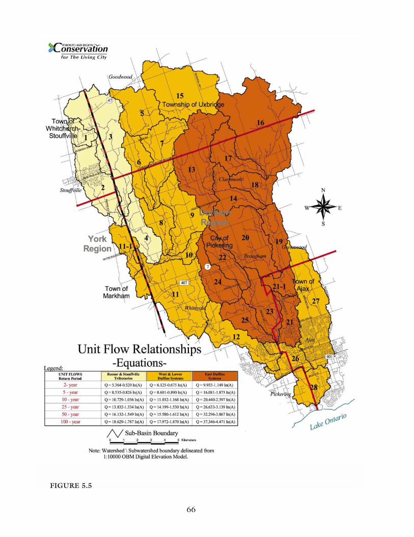
66
FIGURE 5.5
armouring or concrete lining to accommodate an increase in flow volume and velocity. Thesemeasures were largely reactionary and led to a decline in the health of river ecosystems through areduction in terrestrial and aquatic habitat, reduced water quality levels, and increased rates oferosion in downstream watercourses.
When it was realized that urban stormwater runoff was a key factor affecting the health of riversystems, stormwater management practices changed. Flood control remains a key objective ofstormwater management, but management practices today provide a higher level of protectionfor the environment, property, and residents by incorporating provisions for water quality, fishhabitat protection, and in-stream erosion controls.
The Duffins Creek watershed is unique in that only seven per cent of the watershed is currentlydeveloped. Existing development within the watershed is concentrated within the City ofPickering, the Town of Ajax, and the Town of Whitchurch-Stouffville. A number of scientificstudies document the physical, ecological and hydrologic impacts resulting from older forms ofurban development. As natural landscapes were modified and paved to accommodate residential,industrial, or commercial development, the health of the local ecosystem declined. Currentstormwater management practices are designed to mitigate these impacts.
The most significant change to the natural environment during the process of urbanization is theconversion of natural pervious surfaces to impervious surfaces, which prevent water from infiltrat-ing the soil. Impervious surfaces include roads, sidewalks, driveways, rooftops, and parking lots.Studies in Maryland, U.S.A. reveal that channel instability and habitat degradation begins tooccur when the percentage of impervious cover in a watershed reaches 10 to 15 per cent. Anincrease in impervious cover is associated with increased runoff volume and velocity and a declinein infiltration potential. These in turn lead to increased instream erosion and a reduction ingroundwater recharge and annual baseflow within local water courses.
Changes to the hydrologic regime affect not only water quantity but water quality as well. Anumber of urban non-point source pollutants exist in stormwater, including heavy metals (e.g.,zinc, cadmium, copper), pesticides, nutrients (e.g., phosphorous), toxic contaminants, pathogens(e.g., E. coli), and debris. Stormwater management plays a crucial role in removing these pollu-tants and ensuring a safe and dependable water supply for the millions of GTA residents who relyon Lake Ontario or private wells for water supply.
Best Management PracticesA wide variety of structural and non-structural best management practices are used in the devel-opment of stormwater management strategies. For details regarding Best Management Practices,refer to the Stormwater chapters of the State of the Watershed Reports.
Factors affecting stormwater control criteria include land use designations, flood vulnerable areas,erosion sites, and environmental factors (i.e., baseflow, groundwater resources, terrestrial, andaquatic habitat). An updated hydrology model has been developed to reflect changes in land use
67

designations and analyze various future development scenarios. The new model was recalibratedusing rainfall data from Environment Canada and additional data collected at stream flow gaug-ing stations installed within the watershed subsequent to the 1991 hydrology study. Given thatthe Duffins Creek watershed contains more flow gauging stations than any other watershed insouthern Ontario, sufficient data exists to ensure that the new model is an accurate reflection ofthe watershed and local flow data is available for design purposes. The updated watershedhydrology model was used to revise the current stormwater management criteria for the DuffinsCreek watershed.
TRCA criteria for stormwater management (water quality, water quantity, and erosion control)are met in one-third of the Duffins Creek watershed. In the remaining older developed areasthat should be treated, only a small percentage has quantity control. These differences in thelevel of control are indicative of the age of development within the watershed and also reflect thechange in stormwater management approaches that has occurred. TRCA, in partnership with theCity of Pickering and the Town of Ajax, recently initiated Stormwater Retrofit Studies for theexisting urban area that does not meet current water quality and quantity control criteria.
5.7.2 HABITATS
5.7.2.1 Aquatic Habitat and Species
Of all the watersheds in the Toronto region, Duffins Creek has one of the healthiest fish commu-nities and may have the best potential for successful reintroduction of Atlantic salmon. Over thepast 50 years, many riparian areas that were once deforested have been left to naturally regener-ate. Today, because there has been little development in the middle and upper reaches, theaquatic community is in fairly good condition overall.
Currently, Duffins Creek is dominated by cold water aquatic communities including sculpin,brook trout, and rainbow trout. Based on records there have been 50 riverine species of fishfound in the Duffins Creek watershed. From this list, extirpated species include Atlantic salmon,while introduced species include rainbow trout, brown trout, coho salmon, chinook salmon,alewife, common carp, and sea lamprey. In the 2000 survey of the Duffins Creek fish communi-ty, 33 species were identified, including three introduced species: chinook salmon, rainbow trout,and brown trout.
The ecological health of a fish community can be estimated through the calculation of an Indexof Biotic Integrity (IBI). The IBI determines the health of the fish community by examining theabundance of fish, the presence of certain "indicator" species, trophic balance, and species rich-ness. Based on IBI assessments from the mid-1980s, the aquatic system was in good to excellentcondition in many locations throughout the watershed. Surveys in the 1990s had similar results.From the 1950s to the 1990s, there was an increase in the number of species and a generalincrease in the distribution of trout species throughout the watershed. In 2000, IBI scores weregenerally fair to good, indicating a relatively healthy aquatic community.
68

In the upper and middle reaches of Duffins Creek, coldwater streams provide habitat for brooktrout, slimy sculpin, and mottled sculpin as well as species of concern, such as redside dace. Inthe lower reaches of East and West Duffins Creek, coldwater habitat supports a healthy, self-sus-taining population of rainbow trout and brown trout. It is suspected that chinook salmon spawnsuccessfully in the lower reaches, as well. Migratory salmon and trout are separated from nativebrook trout populations by several in-stream barriers that prevent their up-stream movement.Studies suggest that migratory salmonid species would out-compete native brook trout if theirdistributions were allowed to overlap.
The Duffins Creek coastal marsh of 41 hectares is an Environmentally Significant Area (ESA) aswell as a Provincially Significant Wetland because of its importance to fish, plants, and otherwildlife species. There are several attributes that make the marsh an important area for fish.First, it serves as a transition zone between Duffins Creek and Lake Ontario. This transitionzone provides ideal spawning and rearing conditions for some fish. Low gradient in this part ofthe watershed creates a wide floodplain that is seasonally covered with water. The marsh histori-cally supported dense aquatic plant growth that provided excellent cover for minnows and juve-nile fish, which are a much needed food source for predatory fish. In total, 27 species have beenrecorded for the marsh including creek and lake species, such as northern pike, yellow perch, giz-zard shad, alewife, white bass, and white perch. Eighty per cent of the 27 species found in themarsh use this area for spawning or rearing their young.
5.7.2.2 Terrestrial Natural Heritage: Quantity and Distribution (of Natural Cover)
Historically, the forest cover was cleared by European settlers. Clearing of the forest occurred inthree stages: the tall white pine was first used for ship masts, and ash from burning slash was usedfor potash. Finally, cleared land was used for agriculture. By the end of the 19th century, natu-ral cover was already highly fragmented and, by the early part of the 20th century, sandy areas onthe Oak Ridges Moraine were subject to severe erosion and dust-bowl-like conditions. Toaddress the severe erosion issues, much of this area was reforested with conifer plantations. Withcommercial and industrial expansion, the Duffins Creek watershed is now starting to feel thepressure of urbanization. Further incremental loss and degradation of natural habitats couldresult if action is not taken.
The Duffins Creek watershed drains an area of 283 square kilometres. Unlike other southernOntario watersheds, the Duffins Creek watershed has 37 per cent of natural cover (forest, mead-ow, and wetlands), and only seven per cent urban land use. This is by far the highest percentageof natural and the lowest percentage of urban of any of the watersheds within the TRCA jurisdic-tion. Agriculture covers about 54 per cent of the watershed and is recognized as having animportant local economic role. Natural habitat is more abundant in the northeastern part of thewatershed because of the extensive concentration of forest cover in the Glen Major area.
The Duffins Creek watershed is found within the Great Lakes-St. Lawrence Mixed Forest Zone.Dominant tree species include sugar maple, American beech, white pine, and eastern hemlock.
69

Based on 1999 digital orthophotography, the total forest cover area in the Duffins Creek water-shed was approximately 70 square kilometres, which amounts to about 24.5 per cent of the sur-face area. In comparison to other watersheds in the TRCA jurisdiction, forest cover is moreevenly distributed throughout the Duffins Creek watershed, because the east and west branchesof the creek are well forested in the middle reaches.
While 24.5 per cent appears high compared with more urbanized watersheds like the Don River(seven per cent) and the Highland Creek (6.2 per cent), it is still small considering that the totalarea would have been originally close to 100 per cent forest cover. While this suggests that up to75 per cent of the original forest cover has been lost, the Duffins Creek watershed is in relativelygood condition compared to the minimum guideline of 30 per cent forest cover suggested byEnvironment Canada.
Forest cover could reach or exceed a target 30 per cent coverage if protection and restorationefforts are implemented. In fact, forest cover increased in the 20th century due to reforestationefforts on the moraine and the reduced agricultural intensity there and in the vicinity of the LakeIroquois Shoreline. This reduction in agricultural use is attributed to the abandonment of mar-ginally productive lands, to improved practices and the acquisition of the Pickering Airport landsin the 1970s.
It is difficult to differentiate swamps from forest, and meadow marshes from meadows in air photos, so reporting on wetland quantity and distribution is contingent upon field data collec-tion. Additional wetland data has been collected for the Duffins Creek watershed. These collec-tions need to be studied to determine an accurate evaluation of wetland quantity and distribu-tion. Most of the wetland areas are associated with forest cover, including headwater areas on theOak Ridges Moraine as well as groundwater discharge areas associated with the Lake IroquoisShoreline. Kettle wetlands are well distributed on the moraine. Abandoned quarries on theLake Iroquois Shoreline leave behind meadow marshes with many plant species of concern as wellas emergent marshes. Duffins Creek mouth holds an estuarine wetland with a coastal character.Other wetlands, such as kettle marshes and thicket swamps, are scattered throughout the watershed.
Consisting of open habitats dominated by grasses and wildflowers, meadows are actually consid-ered old fields (fallow agricultural fields), areas that were once cleared for agriculture, but haverecently been allowed to naturalize. Meadows support a range of native flora and fauna species,but in a forest bioregion revert back to forest on their own. Meadows cover 4.1 square kilome-tres (406.6 hectares) and successional areas cover 5.3 square kilometres (529.4 hectares) of theDuffins Creek watershed. Together, these areas account for 3.3 per cent of the watershed andhave short-term restoration potential. Beach habitats are found in two zones in the DuffinsCreek watershed: along the modern Lake Ontario shoreline at the mouth of the creek, and alongthe ancient glacial Lake Iroquois Shoreline. Some of the modern beaches are dynamic, sandybeaches with species endemic to the Great Lakes shoreline. The remnant beaches from the gla-cial lake are composed of sand and gravel and, in certain areas such as the Whitevale Corridor andthe Seaton ESA, substantial bluffs mark this habitat along the West Duffins Creek branch.
70

5.7.2.3 Habitat Size and Shape
Size and shape of habitat patches significantly influence the diversity of plant and animal species.Generally speaking, the larger a habitat patch, the more diverse the vegetation and animal speciesfound within. Larger habitats generally mean larger and more resilient populations. Within theentire TRCA jurisdiction the headwaters of the Duffins Creek watershed is one of the few placeswhere many of the most sensitive flora and fauna can achieve sustainable populations.
Habitat shape is also significant. Large habitat patches, particularly those that tend to be morecircular than linear in shape, have more interior habitat. Forest interior, an increasingly rare habi-tat in the Greater Toronto Area, is found in many of the larger forest patches in the watershed.Forest interior refers to that area of the forest considered to be free from negative external influ-ences or "edge effects." The combination of several edge effects, including wind damage, inva-sion of exotic plant species, songbird nests being taken over by parasitic bird species (such as thebrown-headed cowbird) and the prevalence of fauna species that use both forest and human-dominated landscapes, has the ability to influence the unique make-up of forest interior areas.The degree to which these edge effects can penetrate a patch determines how a forest can bedivided into edge or interior. A minimum 100 metres from the outside edge of a patch is a wide-ly accepted figure for defining where interior habitat begins. Cowbirds can penetrate over 400metres; hence, forests with interior beyond this point are clearly more desirable but rarely occurin a fragmented landscape.
Within the Duffins Creek watershed, numerous forest patches containing interior forest habitatexist beyond 100 metres. There are several with more than 300 metres of forest interior andparts of the Glen Major complex exceed even 400 metres interior. Species associated with thesepatches reflect the quality of this habitat. Red-shouldered hawk, scarlet tanager, Canada warbler,and black-and-white warbler, as well as forest interior species including veery, black-throated bluewarbler, and ovenbird all occur here.
Size and shape are also significant in terms of wetland habitat although even small, linear wet-lands can contribute significantly to ecological health and biodiversity, particularly if they are con-nected to other natural habitat. Small wetlands were part of the original forested landscape andnative wetland species have adapted to them. Habitat size and shape should be considered aftertotal habitat cover. Where natural cover falls below 30 per cent, as is often the case at the subwa-tershed scale, habitat patches remain valuable, no matter what size and shape they are, even ifthey lack interior.
Natural System ConnectivityNatural habitats that are well linked, or in close proximity, support more biodiversity and moreviable populations than those that are widely separated. A cluster of smaller individual patchesclose together may support viable populations, which could not occur in individual, isolated frag-ments. This is particularly important for certain species with low mobility. Linkages betweenforest and wetland are important for certain amphibians (e.g., wood frog, red-spotted newt) that
71

breed in wetlands and spend part of their life cycle in forests. Many species that find too manyperils to move through urban areas can disperse and migrate across agricultural areas.
Most forest in the Duffins Creek watershed is directly connected to valley and stream corridors.Across the watershed, there is a level of connectivity via these natural corridors, but also a lack oftableland forest, evident for that section of the watershed below the Oak Ridges Moraine on thesouth slope. An exception is the East branch of Duffins Creek, which provides an almost contin-uous wooded corridor along most of its length. The West branch of Duffins Creek also has con-tinuous habitat over a large area (the Whitevale Corridor).
Another interesting feature is the east-west corridors between the branches of the Duffins Creekacross the Oak Ridges Moraine and along the old Lake Iroquois Shoreline. These corridorsextend west to the Rouge River, and east to Carruthers Creek and the Heber Downs conserva-tion lands under the jurisdiction of the Central Lake Ontario Conservation. The high level ofconnectivity in the Duffins watershed is reflected in the fact that ruffed grouse, a sensitive speciesof low mobility, is found along most of the valley right down to the lake.
Matrix InfluenceMatrix influence is a measure of the effects that the surrounding environs exert on a habitatpatch. The Terrestrial Natural Heritage Approach defines the matrix as anything within two kilo-metres from a patch’s edge and is divided into three types of land uses: natural, agricultural, andurban.
Matrix influence ranges from edge effects to beneficial influences. In urbanized areas, edge effectimpacts on forested areas include trampling, dumping of garbage, impacts from pets, raccoonsand the like. Adjacent urban development can degrade a habitat, even if the site is "protected"from development and from direct elimination.
Habitat patches are the building blocks of the natural system. The health of the natural system isdetermined by the combined influence of the matrix on these individual patches. Matrix influ-ence is at the core of the Terrestrial Natural Heritage Approach, which examines the relationshipof the natural system to the rest of the watershed. The relationship between habitat patches andthe surrounding urban, agricultural, and natural land uses is complex. A natural system that isprotected is not necessarily guaranteed to have high habitat quality and biodiversity, becausethese characteristics are influenced by the surrounding land use. At the same time, certain fea-tures in a watershed can overwhelm the health of its natural system and its ability to perform eco-logical functions. That depends on the ratio of natural, agricultural, and urban areas. If the ratiois in balance, the urban heat island effect is reduced and runoff is reduced in favour of infiltra-tion, resulting in more groundwater and less flooding. Air quality is also improved and there isless competition for quality recreational open space.
72

5.7.3 PUBLIC USE
5.7.3.1 Greenspace, Trails, and Recreation
TRCA properties have been acquired over the years to protect Environmentally Significant Areas,and Areas of Natural and Scientific Interest, as well as those properties with strategic ecologicalwatershed attributes, public use functions or the potential to connect greenspaces. ConservationArea Management Plans are being prepared to ensure sustainability of these resources into thefuture for both public use and to protect ecological functions. The development of managementplans for the Duffins Creek Headwaters, Duffins Marsh and the Greenwood Conservation Areaare underway by TRCA in partnership with local municipalities and residents. Future initiativesthat may help to link these areas include proposed extensions to the Trans Canada Trail, the OakRidges Moraine Trail, the Waterfront Trail, and trail planning proposed by local municipalities.There are a number of existing and proposed trail systems that connect the natural, cultural,recreational, and educational features in the study area with one another and other designationsoutside of the watershed. The following trails are located within the Duffins Creek watershedand are described in more detail in the State of the Watershed Report. Efforts are underway tolink these trails providing a loop system within the two watersheds with connections to theneighbouring Rouge Park.
• Waterfront Trail• Inter-Regional Trail (proposed)• Trans Canada Trail (proposed)• Oak Ridges Moraine Trail• Great Pine Ridge Equestrian Trail• Seaton Hiking Trail
Duffins Creek is well known as a recreational fishing spot and it is recognized for its excellentaquatic habitat. South of Highway 7, Duffins Creek has large runs of migratory rainbow troutand salmon. The headwater areas contain brook trout, while the mouth and marsh areas of thewatercourse are popular for warmwater species fishing. There has also been a report of a run ofwalleye south of Highway 401, although it has not been officially documented. A variety of fishcan be found in the creek at different times of the year including white perch, yellow perch, bass,and carp.
There are a number of elementary and secondary schools within the watershed that contribute topublic uses through their outdoor sports facilities and fields, playgrounds, open spaces, and link-ages to other greenspace areas. Often schools are clustered with other public facilities and arelocated adjacent to valley and stream corridors. The Claremont Field Centre (residential) and theDuffins Creek Environmental Education Centre (day use) are outdoor education centres locatedwithin the watershed. These field centres offer environmental programming and dormitory facili-ties for students.
73

Due to the rural nature of the northern two-thirds of this watershed, perhaps the most enjoyablerecreational activities involve cycling or hiking to the rolling hills on the Oak Ridges Moraine.Hamlets and villages scattered throughout the watershed contain beautiful historic buildings andcemeteries. Self-guided walking tours of historic downtown Stouffville or the Whitevale HeritageConservation District, for example, are enjoyable and educational. Within these areas, trails andfishing spots provide focal points for outdoor recreation. In other areas of the watershed, recre-ational facilities, golf courses, and ski resorts allow for more active recreational pursuits.
74